Content:
Presentation type:
GD – Geodynamics

EGU23-3978 | Orals | MAL11 | Augustus Love Medal Lecture

On convective memory 

Thorsten Becker

Plate tectonics is the surface expression of mantle convection, but many aspects of our present-day tectonic setting depend on how the solid Earth system has evolved over time. I touch on work across a range of spatio-temporal scales addressing how convective memory can be used to validate tectonic scenarios to better understand plate boundary evolution. Seismic anisotropy in the upper mantle is one recorder of convective deformation, and the duration over which textures are reworked controls the lifespan of memory. This means that the lithosphere may allow distinguishing between different plate tectonic scenarios over the last ~50 Ma. Uncertainties about those scenarios and slab rheology imply that our understanding of subduction mass transport remains incomplete, leading to ambiguities about the deep mantle record of subduction. One particular issue is how slabs are deformed upon bending in the trench. I discuss results from convection models with rheological memory which affects subduction dynamics and plume-slab interactions. Within global, plate generating convection models, reactivation of damage zones increases the frequency of plate reorganizations, and hence reduces the dominant periods of surface heat loss fluctuations. Inheritance of lithospheric damage dominates surface tectonics over any local boundary stabilizing effects of rheological weakening. Progressive generation of weak zones may counteract any effects of reduced convective vigor throughout planetary cooling, with implications for the frequency of orogeny throughout Wilson cycles. I close by a consideration of the effects of local rheological damage weakening vs. the longest recorder of geological history of all, the continental lithosphere.

How to cite: Becker, T.: On convective memory, EGU General Assembly 2023, Vienna, Austria, 23–28 Apr 2023, EGU23-3978, https://doi.org/10.5194/egusphere-egu23-3978, 2023.

EGU23-9109 | ECS | Orals | MAL11 | GD Division Outstanding Early Career Scientist Award Lecture

Mantle flow around subduction zones: evolution through time 

Ágnes Király

When cold and dense oceanic lithosphere sinks into the mantle at subduction zones, it pushes weaker asthenospheric mantle away, creating specific flow patterns. Traditionally mantle flow is divided into two components: trench-perpendicular poloidal flow operating in a vertical plane and 3D toroidal flow around the slab edges. In the past years, we have learned that both poloidal and toroidal mantle flow around slabs effectively connects nearby subduction zones, deforming their slabs and upper plates, and modifying their patterns of volcanism and uplift/subsidence. In turn, the two-way dynamic interaction between the subduction zones also affects the flow pattern, and thus impacts the volcanism, surface uplift and lithospheric deformation (Király et al., 2021).

At present, our best constraints on mantle flow patterns around subduction zones originate from seismic anisotropy observations, which can be interpreted based on 3D geodynamic models. In the mantle, seismic anisotropy originates from crystallographic preferred orientation (CPO), which derives from the anisotropic nature of olivine crystals. Due to olivine’s orthorhombic symmetry and the different strengths of its three slip systems, olivine crystals are anisotropic in their elastic and viscous properties. Hence, when many olivine crystals are aligned within mantle rock (i.e., CPO is developed in an area of the mantle), the mantle will deform anisotropically, both for seismic wave transmission and viscous flow. Since CPO occurs as a response to deformation, seismic anisotropy directions are often read as the recent mantle flow direction in an area. However, there are a few complications to this simple one-to-one interpretation. First, because the CPO depends on the deformation history of the mantle, it might not reflect the current flow orientation if the deformation direction has changed through time (Ribe, 1989). Second, CPO formation depends on stress and on water content (Korenaga and Karato, 2008), which in some cases allows texture to form with a fast axis perpendicular to the deformation direction. Third, the interpretation of seismic anomalies is often difficult because geodynamic models do not incorporate enough complexity to model all the intricacies of the flow. This problem can occur due to complex anisotropic signals from crustal layers, from more complicated geodynamic settings (e.g., multiple slabs), or from a modified flow pattern that arises due to the viscous anisotropy associated with the texture itself.

In this presentation, I will use the Mediterranean area to highlight how including multiple slabs and accounting for viscous anisotropy can eventually help us to interpret the seismic observations from this geodynamically complex region.


References:

Király, Á., Funiciello, F., Capitanio, F.A., and Faccenna, C., 2021, Dynamic interactions between subduction zones: Global and Planetary Change, p. 103501, doi:10.1016/j.gloplacha.2021.103501.

Korenaga, J., and Karato, S., 2008, A new analysis of experimental data on olivine rheology: Journal of Geophysical Research, v. 113, p. 1–23, doi:10.1029/2007JB005100.

Ribe, N.M., 1989, Seismic Anisotropy and Mantle Flow: Journal of Geophysical Research, v. 94, p. 4213–4223.

How to cite: Király, Á.: Mantle flow around subduction zones: evolution through time, EGU General Assembly 2023, Vienna, Austria, 23–28 Apr 2023, EGU23-9109, https://doi.org/10.5194/egusphere-egu23-9109, 2023.

GD1 – Mantle Dynamics and Plate Tectonics

Earth's dynamic evolution is controlled by the interplay between mantle convection and plate tectonics. While subducted plates stir the mantle, upwelling plumes can lubricate, push, and break up plates. As the surface expression of upwelling plume dynamics, the plume buoyancy flux is traditionally estimated as the cross-sectional area of the hotspot swell multiplied by plate velocity (for intraplate hotspots) or multiplied by the full-spreading rate (for ridge-centred hotspots).

This classical approach implies two big assumptions: that the swell is fully isostatically compensated by the hot ponding plume material at the base of the lithosphere; and that this plume material spreads at exactly the same speed as the overriding plate moves. However, geophysical observations and numerical models demonstrate that those assumptions are wrong. Hotspot swells are largely dynamically instead of fully isostatically compensated; to some extent, swells are further compensated by sublithospheric erosion [1]. Moreover, at least some plumes spread faster than plate motion [2]. For example, evidence in the North Atlantic from prominent V-shaped ridges, ephemeral landscapes, and off-axis uplift of oceanic gateways suggests that along-axis asthenospheric velocities can be an order of magnitude faster than the full plate-spreading rate near Iceland [3]. Thus, classical estimates for the buoyancy fluxes of deep-seated mantle upwellings may be strongly biased by surface-plate velocities [4]. Alternative estimates of plume buoyancy flux assume a constant swell decay timescale [4] but without any physical underpinning. As detailed estimates of dynamic seafloor topography are now available [5], it is time to revisit the buoyancy fluxes and, thereby, the mass and heat fluxes carried by mantle plumes.

Here, we explore high-resolution regional-scale geodynamic models with a free surface to study plume-ridge interaction and swell compensation. We consider composite diffusion-dislocation creep in our models. We investigate the effects of plume temperature/radius, plate velocity (or spreading rate for ridge-centred hotspots), and mantle rheological parameters on plume-lithosphere interaction and swell support. Preliminary results demonstrate that plume spreading is significantly faster than plate motion for intermediate-to-large plumes at realistic rheological conditions. From this result, we update estimates of plume buoyancy fluxes, showing that the total heat flux carried by plumes across the core-mantle boundary is significantly larger than previously thought.


Reference List

1. Cadio et al., 2012; doi:1016/j.epsl.2012.10.006

2. Ribe & Christensen, 1999; doi:10.1016/S0012-821X(99)00179-X

3. Poore et al., 2011; doi: 10.1038/ngeo1161

4. Hoggard et al., 2020; doi: 10.1016/j.epsl.2020.116317

5. Hoggard et al., 2016; doi: 10.1038/ngeo2709

How to cite: Ma, Z. and Ballmer, M.: New Insights into Global Plume Buoyancy and Heat Fluxes from Numerical Models of Plume-Lithosphere Interaction, EGU General Assembly 2023, Vienna, Austria, 23–28 Apr 2023, EGU23-467, https://doi.org/10.5194/egusphere-egu23-467, 2023.

EGU23-711 | ECS | Posters virtual | GD1.1

Resolving Late Cretaceous intra-plate magmatism emplacement models and plate motion on the West Iberian Margin 

Bruno Araújo, Ricardo Pereira, João Duarte, and João Mata

The West Iberian Margin (WIM) was a locus of significant post-rift Late Cretaceous magmatism coeval with multiple intraplate magmatic events on the Central-North Atlantic. The effects of the migration of the Iberian microplate on the location of the distinct magmatic occurrences are here investigated.

At the WIM and within this magmatic cycle, the Sintra, Sines and Monchique intrusive massifs, the Lisbon Volcanic Complex and distinct sill complexes were emplaced on the onshore continental margin. Several coeval oceanic seamounts, are also evaluated in terms of age and location for the assessment of how plausible the combined effects of plate motion and underlying mantle contributions are to their origin.

Using GPlates software we assess the different mantle mechanisms that can explain magmatic upwelling in the region, including: 1) plume, whether static or mobile ones; 2) edge-driven convection; or 3) stationary superplume with secondary plumelets.

The preliminary results suggest that a stationary superplume emitting distinct secondary plumelets is the preferred model for the distinct and diachronous magmatic features that pierced the crust as the Iberian microplate moved along a non-linear path.


This work was funded by the Portuguese Fundação para a Ciência e a Tecnologia (FCT) I.P./MCTES through national funds (PIDDAC) – UIDB/50019/2020- IDL and UIDB/04035/2020- GeoBioTec.

How to cite: Araújo, B., Pereira, R., Duarte, J., and Mata, J.: Resolving Late Cretaceous intra-plate magmatism emplacement models and plate motion on the West Iberian Margin, EGU General Assembly 2023, Vienna, Austria, 23–28 Apr 2023, EGU23-711, https://doi.org/10.5194/egusphere-egu23-711, 2023.

EGU23-1366 | ECS | Orals | GD1.1 | Highlight

Residence time of crystals in a thermally convecting magma reservoir 

Vojtěch Patočka, Nicola Tosi, and Enrico Calzavarini

The dynamic behaviour of crystals in convecting fluids determines how magma bodies solidify. In particular, it is often important to estimate how long crystals stay in suspension in the host liquid before being deposited at its bottom (or top, for light crystals and bubbles of volatiles). We perform a systematic 3D numerical study of particle-laden Rayleigh-Benard convection, and derive a robust model for the particle residence time. For Rayleigh numbers higher than 107, inertial particles' trajectories exhibit a monotonic transition from fluid tracer-like to free-fall dynamics, the control parameter being the ratio between particle Stokes velocity and the mean amplitude of the fluid velocity. The average settling rate is proportional to the particle Stokes velocity in both the end-member regimes, but the distribution of residence times differs markedly from one to the other. For lower Rayleigh numbers (<107), an interaction between large-scale circulation and particle motion emerges, increasing the settling rates on average. Nevertheless, the mean residence time does not exceed the terminal time, i.e. the settling time from a quiescent fluid, by a factor larger than four. An exception are simulations with only a slightly super-critical Rayleigh number (~104), for which stationary convection develops and some particles become trapped indefinitely. 2D simulations of the same problem overestimate the flow-particle interaction - and hence the residence time - for both high and low Rayleigh numbers, which stresses the importance of using 3D geometries for simulating particle-laden flows. We outline how our model can be used to explain the depth changes of crystal size distribution in sedimentary layers of magmatic intrusions that are thought to have formed via settling of a crystal cargo, and discuss how the micro-structural observations of solidified intrusions can be used to infer the past convective velocity of magma.

How to cite: Patočka, V., Tosi, N., and Calzavarini, E.: Residence time of crystals in a thermally convecting magma reservoir, EGU General Assembly 2023, Vienna, Austria, 23–28 Apr 2023, EGU23-1366, https://doi.org/10.5194/egusphere-egu23-1366, 2023.

EGU23-2386 | Orals | GD1.1

Hydrous secondary plumes: towards understanding the enigmatic «finger» structures in the intraplate lithospheric mantle 

Sierd Cloetingh, Alexander Koptev, Alessio Lavecchia, István Kovács, and Fred Beekman

Many vertical seismic velocity anomalies originate in the transition zone between the upper and lower mantle (410–660 km) and form so-called secondary plumes. These anomalies are interpreted as the result of thermal effects of large-scale thermal upwelling (primary plume) in the lower mantle and/or deep dehydration of fluid-rich subducting oceanic plates. We present the results of thermo-mechanical modelling to investigate the dynamics of such small-scale thermal and chemical (hydrous) anomalies rising from the lower part of the Earth’s upper mantle. Our goal is to determine the conditions that allow thermo-chemical secondary plumes of moderate size (initial radius of 50 km) to penetrate the overlying lithosphere, as detected in seismo-tomographic studies in such intra-continental areas as the Tengchong volcano in south-western China and the Eifel volcanic fields in north-western Germany. To this end, we investigate the effect of the compositional deficit of the plume density due to the presence of water and hydrous silicate melts. In our models, secondary plumes of purely thermal origin do not penetrate the overlying plate, but flatten at its base, forming “mushroom”-shaped structures at the level of the lithosphere-asthenosphere boundary. On the contrary, plumes with enhanced density contrast due to a chemical (hydrous) component are shown to be able to penetrate upward through the lithospheric mantle to shallow depths near the Moho. Our findings can explain the enigmatic observations of columnar (“finger”-shaped) anomalies in the intraplate lithospheric mantle discovered in Europe and China. We argue that a chemical component is a characteristic feature not only of conventional hydrous plumes developed in the big mantle wedge over presently descending oceanic slabs, but also of upper mantle plumes in other tectonic settings.

How to cite: Cloetingh, S., Koptev, A., Lavecchia, A., Kovács, I., and Beekman, F.: Hydrous secondary plumes: towards understanding the enigmatic «finger» structures in the intraplate lithospheric mantle, EGU General Assembly 2023, Vienna, Austria, 23–28 Apr 2023, EGU23-2386, https://doi.org/10.5194/egusphere-egu23-2386, 2023.

Although the geoid is usually displayed with respect to the reference ellipsoid, the difference between geoid and the Earth's hydrostatic equilibrium figure is geodynamically more meaningful, and has its deepest low in the Ross Sea area. Nearby in West Antarctica, there is also a residual topography high. This region is characterized by thin lithosphere, and a mantle plume has been suggested beneath. Hence upper mantle viscosity could be regionally reduced, allowing for faster rebound than elsewhere upon melting of the West Antarctic Ice Sheet (WAIS) which is one of the tipping elements of the global climate system. To study the possible causes of the geoid low / topography high combination, we compute the effects of density anomalies with the shape of a cylindrical disk of a given radius and depth range. With a density anomaly of -1% we find that a geoid low of the right size and magnitude can be explained with a disk radius of about 10° of arc and the base of the disk in the lower transition zone or even lower mantle; with a shallower base the amplitude is under-predicted. On the other hand, if in this case the top of the disk is shallower than ~150 km, dynamic topography amplitude is over-predicted. The fact that the residual topography high (more sensitive to density anomalies at shallower depth) is laterally displaced relative to the geoid low (more sensitive to greater depths) could indicate a plume or upwelling that is tilted due to large-scale flow. Alternatively, there may be two separate disks somewhat laterally displaced, one just below the lithosphere and mainly causing a dynamic topography high and one below the transition zone causing the geoid low.
In order to test the feasibility of such density models, we perform computations of a plume that enters at the base of a box corresponding to a 3300 km x 3300 km region in the upper mantle, as well as some whole-mantle plume models, with the Aspect mantle convection code. However, these plume models have typically a narrow conduit (much narrower than ~10° of arc) and the plume tends to only become wider as it spreads beneath the lithosphere, i.e.\ at depths typically shallower than about 300 km, hence it would tend to rather under-predict the amplitude of the geoid compared to dynamic topography. We discuss how to possibly overcome the discrepancy between what is required to explain geoid and dynamic topography, and the outcome of numerical forward models.

How to cite: Steinberger, B.: The deepest geoid low on Earth and its possible relation to the instability of the West Antarctic Ice Sheet, EGU General Assembly 2023, Vienna, Austria, 23–28 Apr 2023, EGU23-2410, https://doi.org/10.5194/egusphere-egu23-2410, 2023.

EGU23-2770 | Orals | GD1.1

Hydrous aluminous silicas as major water hosts in the lower mantle 

Tomoo Katsura, Takayuki Ishii, Giacomo Criniti, Eiji Ohtani, Narangoo Purevjav, Hongzhan Fei, and Ho-kwang Mao

The H2O incorporation into minerals changes the properties of minerals and rocks and affects the dynamics and evolution of the Earth’s interior. The higher H2O contents in plume-related magmas than in mid-oceanic ridge magmas suggest that deeper regions store more significant amounts of H2O than shallower regions in the mantle. Paradoxically, however, the H2O solubility in the lower-mantle minerals in ultramafic systems is limited. Therefore, we expect basaltic fragments of subducted slabs to store H2O in the lower mantle. It has been suggested that silica minerals can be H2O hosts in the basaltic systems under lower-mantle conditions, and alumina incorporation enhances their H2O solubility. To determine the stability and water solubility of silica minerals under top-most lower-mantle conditions, the current study synthesised silica minerals in the SiO2-Al2O3-H2O systems at pressures of 24 and 28 GPa and temperatures of 1000 to 2000°C using a multi-anvil press. We identified phases present in the run products using a micro-focused X-ray diffractometer and measured their water solubility using an FT-IR spectrometer.

We found that the Al2O3 contents in the silica minerals increased with increasing temperature from 0.7~0.8 wt.% at 1000~1200°C to 10 wt.% at 2000°C. Their H2O contents also increased with increasing temperature from 0.3 at 1700°C to 1.0~1.1 wt.% at 1900°C. The silica mineral was stishovite at temperatures lower than 1600~1700°C, whereas it was CaCl2-structured silica, referred to as post-stishovite, at higher temperatures. Thus, post-stishovite contained much more significant amounts of H2O than stishovite whose water content is consistent with previous reports.

The concomitant increases in H2O and Al2O3 contents suggest that H2O is incorporated via charge-coupled substitution of Si4+ — Al3++H+ in these silica minerals. The current stability of post-stishovite in H2O- and Al2O3-bearing systems is located at much lower pressures than in pure SiO2 and H2O-poor, Al2O3-bearing systems. In addition, the OH bands are more intense in the E//[010] direction than in the E//[100] direction. These observations imply that tilting of (Si, Al)O6 octahedra around the c axis by the hydrogen bonding in the [010] direction may have stabilised poststishovite at lower pressures.

The increases in H2O solubility in aluminous stishovite and poststishovite with temperature have a tremendous impact on the H2O storage and transport in the mantle. The H2O solubility in the other nominally anhydrous minerals decreases with increasing temperature. Dense hydrous magnesium silicates decompose with increasing temperature. Therefore, these minerals cannot be H2O hosts or carriers in the deep mantle except for cold subduction zones. On the other hand, hydrous stishovite and poststishovite can store and transport H2O in ambient mantle and even in plumes.

It has been considered that the stishovite-poststishovite transition causes seismic scattering in the mid-mantle. However, many seismic scatterers are located at 700 to 1900 km depths, which are too shallow for the stishovite-poststishovite transition in the pure SiO2 system. However, we found that the Al2O3 and H2O incorporations lower the transition pressure to 24 GPa, i.e., 700 km depth. Hence, observing the seismic scatterers in the mid-mantle supports significant H2O storages in aluminous poststishovite.

How to cite: Katsura, T., Ishii, T., Criniti, G., Ohtani, E., Purevjav, N., Fei, H., and Mao, H.: Hydrous aluminous silicas as major water hosts in the lower mantle, EGU General Assembly 2023, Vienna, Austria, 23–28 Apr 2023, EGU23-2770, https://doi.org/10.5194/egusphere-egu23-2770, 2023.

Geothermal Heat Flow (GHF) is a crucial boundary condition governing ice sheet stability, due to the positive relationship between thermal input into the ice sheet and basal sliding rates. Tectonic history biases the crustal distribution of heat-producing elements, and the pattern of mantle convection influences regional thermal structure, leading to significant intracontinental variations in Antarctic GHF of order 100 mW/m2.  However, extensive ice cover across Antarctica severely limits the ability to directly measure GHF or crustal composition. Geophysical proxies are therefore required to access information pertaining to the lateral structure of GHF and its potential impact on ice sheet dynamics.

Previous studies have used geomagnetic data to infer the depth above which ferromagnetic structure is locked in, corresponding to the ~850 K isotherm. Others have relied on the sensitivity of seismic velocity to thermal structure to model local variations in surface temperature gradient. Both approaches require assumptions on crustal properties, which are typically chosen ad-hoc, and may affect GHF estimates in a significant and non-systematic manner. Other studies have used the observed covariation between lithospheric seismic velocity and GHF in regions with high measurement densities (e.g., continental USA) to map Antarctic seismic structure into GHF. This introduces a dependency of inferred Antarctic GHF on the range of tectonic environments sampled by the continental region used to derive the empirical relationship.

Here, we adopt a distinct approach, in which Monte Carlo sampling is used to include crustal conductivity and heat production as free parameters in a numerical modelling procedure that fits theoretical geotherms to new probabilistic seismic inferences of upper mantle temperature structure beneath Antarctica. By integrating empirical constraints on crustal conductivity derived from P-wave velocity data, we are able to build distributions of covarying crustal conductivity, heat production, and GHF. This allows us to generate a model of Antarctic GHF which is complementary to that of other studies, and includes an estimate of lateral uncertainty structure based on the sensitivity of thermal gradients to crustal composition and anelastic deformation at seismic frequencies.

How to cite: Hazzard, J., Richards, F., and Roberts, G.: Refining Estimates of Antarctic Geothermal Heat Flow Using Seismological Constraints on Crustal Composition and Lithospheric Thermal Structure, EGU General Assembly 2023, Vienna, Austria, 23–28 Apr 2023, EGU23-3400, https://doi.org/10.5194/egusphere-egu23-3400, 2023.

EGU23-3846 | ECS | Orals | GD1.1

Downwelling dense mantle residues and hotspot magmatism 

Jordan J.J. Phethean, Martha Papadopoulou, Alex L. Peace, and Jeroen van Hunen

The geodynamic origin of melting anomalies found at the surface, often referred to as hotspots, is classically attributed to mantle plume processes. The coincidence of hotspots and regions of relatively thin lithosphere, however, questions the necessity for mantle plumes in driving hotspot magmatism, especially as the ability of mantle plumes to thin strong mantle lithosphere is disputed. Here, we propose a new mechanism for the self-sustained generation of magmatism at hotspots where the lithosphere-asthenosphere boundary occurs at < ~100 km. By considering the effects of both chemical and thermal density changes during partial melting of the mantle (using appropriate latent heat and depth-dependent thermal expansivity parameters), we find that mantle residues experience an overall instantaneous increase in density when melting occurs at < ~3 GPa. This controversial finding is due to thermal contraction of material during melting, which outweighs chemical buoyancy effects when melting at shallow pressures (where thermal expansivity is high, at ~4.91 x 10⁻⁵ K-1). These dense mantle residues have a tendency to sink beneath melting regions, driving the return flow of fertile mantle into the melting region and locally increasing magmatic production. This mechanism presents an alternative to the upwelling of hot mantle plumes for the generation of excess melt at hotspots and the genesis of large igneous provinces during continental breakup. We model the development of magma-rich margins using geodynamic numerical models and find a close match between modelled volcanic crustal thicknesses and real-world observations. “Hot”-spots and large igneous provinces, therefore, may not require the elevated temperatures commonly invoked to account for excess melting.

How to cite: Phethean, J. J. J., Papadopoulou, M., Peace, A. L., and van Hunen, J.: Downwelling dense mantle residues and hotspot magmatism, EGU General Assembly 2023, Vienna, Austria, 23–28 Apr 2023, EGU23-3846, https://doi.org/10.5194/egusphere-egu23-3846, 2023.

EGU23-4570 | ECS | Orals | GD1.1

Multi-scale anisotropy in NE China: Implications for intra-plate volcanism 

Cunrui Han, James Hammond, and Maxim Ballmer

Northeast China is a very typical area for studying intra-plate volcanism in the back-arc setting. It is commonly proposed that the subduction of the Pacific plate has been responsible for widespread Holocene volcanoes in NE China. Yet, how this process drives volcanism remains a topic of vigorous debate. Investigation of seismic anisotropy can provide important evidence for the cause-and-effect relationship between mantle flow, lithospheric deformation and shallow structures. In this study, using seismic data from four networks across NE China and north Korea, we analyze shear wave splitting in converted P- to S-waves at the Moho (Pms), S-waves from the subducted slab interface (local S), and SKS phases. The Pms phases show a relatively weak crustal anisotropy (~0.25 s), with fast polarization directions aligned sub-parallel to major tectonic features. For the local S and SKS phases, fast polarization directions show significant lateral variations. We further perform a quantitative inversion to show that the depth of the anisotropy is ~150 km, thus driven by flow within the asthenosphere associated with Pacific subduction. However, the presence of many null SKS splitting phases, together with scattered local S-wave anisotropy suggests a localized region of vertical flow directly beneath Changbaishan volcano. Such patterns correspond well to regional upper-mantle seismic velocity structure, and suggest that a localized upwelling with a relatively deep origin drives volcanism in the Changbaishan region. Furthermore, we infer that mantle upwelling is deflected to the SW beneath Changbaishan and spreads asymmetrically at the base of the lithosphere, possibly because of the long history of volcanism in the region.

How to cite: Han, C., Hammond, J., and Ballmer, M.: Multi-scale anisotropy in NE China: Implications for intra-plate volcanism, EGU General Assembly 2023, Vienna, Austria, 23–28 Apr 2023, EGU23-4570, https://doi.org/10.5194/egusphere-egu23-4570, 2023.

EGU23-5041 | Posters on site | GD1.1

Numerical modeling of the formation of extensive intraplate volcanism 

Jianfeng Yang, Manuele Faccenda, and Liang Zhao

The occurrence of mantle melting is generally attributed to high temperature, decreased pressure, and/or the presence of volatiles such as water. Volcanism away from plate boundaries is ascribed to intraplate or anorogenic volcanism, which may reveal important dynamics of the deep mantle. Two of the most striking intraplate volcanism are oceanic plateaus (OPs) and large igneous provinces (LIPs), which often have an extremely thick crust and vast areas. However, the origin of the extremely thick crust is debated, and several mechanisms are proposed: cataclysmic melting of a thermal plume (Richards et al., 1998; Larson, 1991); shallow asthenospheric melting during plate separation (Anderson et al., 1992); melting of the fertile or primitive mantle (Korenaga, 2005; Kerr & Mahoney, 2007); and asteroid impact (Rogers, 1982). Although mantle plume theory is widely accepted and is also often invoked to explain the formation of the OPs and LIPs. However, another school of people interrogates the deep mantle plume origin, which requires extremely high mantle temperature and a wide plume head. In contrast, recent numerical models provide a novel mechanism by linking a hydrous mantle transition zone (MTZ) and a retreating subducting plate for the formation of intraplate volcanism in northeast China and petit-spot volcanism offshore Japan (Yang & Faccenda, 2020). Such a mechanism has been applied to many other present-day and fossil subduction zones. Here we use 2D thermomechanical numerical models to investigate mantle melting and melt extraction processes leading to the formation of large volumes of basaltic crust. Two groups of models have been tested: a purely thermal plume model and a hydrous plume model. Our model results show that an excess mantle potential temperature of 200-300 oC likely produces >20 km thick crust if the lithosphere is <80 km. While the presence of >0.5-1 wt% water in a cold plume can result in similar thickness. Our models may explain some oceanic plateaus and large igneous provinces as related to the melting of volatile-rich domains from mid-mantle.


References

Anderson, D. L., Zhang, Y.-S. & Tanimoto, T., 1992. Plume heads, continental lithosphere, flood basalts and tomography. In: Storey, B.C., Alabaster, T., and Pankhurst, R.J. (eds.) Magmatism and the Causes of Continental Break-up, Geological Society, London, Special Publications, 68, 99-124.

Kerr, A.C., Mahoney, J.J., 2007. Oceanic plateaus: Problematic plumes, potential paradigms. Chemical Geology 241, 332-353.

Korenaga, J., 2005. Why did not the Ontong Java Plateau form subaerially? Earth and Planetary Science Letters 234, 385-399.

Richards, M. A., Duncan, R. A. & Courtillot, V., 1989. Flood basalts and hot-spot tracks: plume heads and tails. Science, 246, 103-107.

Rogers, G.C., 1982. Oceanic plateaus as meteorite impact signatures. Nature 299, 341–342.

Larson, R. L., 1991. Latest pulse of the earth: evidence for a mid-Cretaceous superplume. Geology, 19, 547-550.

Yang, J., Faccenda, M., 2020. Intraplate volcanism originating from upwelling hydrous mantle transition zone. Nature 579, 88-91.

How to cite: Yang, J., Faccenda, M., and Zhao, L.: Numerical modeling of the formation of extensive intraplate volcanism, EGU General Assembly 2023, Vienna, Austria, 23–28 Apr 2023, EGU23-5041, https://doi.org/10.5194/egusphere-egu23-5041, 2023.

EGU23-5459 | Orals | GD1.1

Global and tectonic-type physical reference models of the upper mantle 

Yihe Xu, Sergei Lebedev, Chiara Civiero, and Javier Fullea

Physical 1D-average reference models of the Earth offer valuable summaries of the radial variations in rock properties and a reference for geophysical studies. PREM, in particular, has been used widely for >40 years and comprises Vp, Vs, density, radial anisotropy and attenuation profiles, while also fitting the Earth’s mass and moment of inertia. Many of PREM’s features have proven remarkably accurate, despite the limited amount of data used to construct it, but some features are inconsistent with now available data. Also, the upper mantle structure differs so much between Earth’s different tectonic environments that a global average is not quite representative of any of them.  The recent growth in seismic station coverage yields very dense data sampling, globally and over different tectonic environments. Here, we use a large global dataset to construct ten 1D, multi-parameter, reference models of the upper mantle, for the globe and for 9 basic tectonic types: cratons; stable platforms; Phanerozoic continents with normal (<46.5 km) and thick (>46.5 km) crust; rifts and continental hotspots; old oceans; intermediate oceans; young oceans; backarcs.

The dataset comprises Love and Rayleigh-wave phase velocities, measured using waveform inversion and all available data since 1990s; surface heat flow measurements; topography/bathymetry. With tomography-based tectonic regionalization, we identify areas within each tectonic environment and compute average dispersion curves in the 20-30 to 310 s period range, which constrain shear velocity and anisotropy in the entire upper mantle.

We then use computational-petrology-based inversion to calculate 1D physical models for the globe and the 9 basic tectonic types. Our non-linear gradient search converges to true best-fitting models. The main unknowns in the inversion are the depth of the lithosphere-asthenosphere boundary (LAB); the geotherm from the LAB down to 400 km depth; radial anisotropy (0-800 km). The steady-state geotherm in the lithosphere is computed from the LAB depth and the radiogenic heat production and thermal conductivity profiles by solving the conductive heat transfer equation. Rock composition and the geotherm determine the density, seismic velocities and attenuation down to 400 km. Seismic velocities in the crust, transition zone (410-660 km) and shallow lower mantle can vary to fit the data. Density below 410 km and all parameters in the core and most of the lower mantle are from PREM. Like PREM, our reference models honour the Earth's mass and moment of inertia.

Small phase-velocity errors and relative data-synthetic misfits (<~0.1%) are necessary to resolve radial trade-offs in the upper-mantle structure. We achieved this by obtaining very accurate dispersion curves and by meticulously tuning the inversion, its parameterisation and regularisation.

The best-fitting models have slightly depleted lithospheric mantle and fertile asthenosphere for most tectonic types. In Archean and Proterozoic continents, the mantle lithosphere is more depleted. No other compositional heterogeneities are required to fit the data. Isotropic-average seismic velocities decrease monotonically from the Moho to the LAB. The geotherms follow the mantle adiabatic temperature gradient in the asthenosphere. Our results provide useful, accurate new reference models for global and regional seismic imaging and other geophysical studies. 

How to cite: Xu, Y., Lebedev, S., Civiero, C., and Fullea, J.: Global and tectonic-type physical reference models of the upper mantle, EGU General Assembly 2023, Vienna, Austria, 23–28 Apr 2023, EGU23-5459, https://doi.org/10.5194/egusphere-egu23-5459, 2023.

EGU23-6574 | Orals | GD1.1

Relationships between upper mantle thermal structure and crustal deformation in Western and Central Europe – new interpretations of seismic tomography models 

Judith Bott, Magdalena Scheck-Wenderoth, Ajay Kumar, Mauro Cacace, Sebastian Noe, and Jan Inge Faleide

Mantle shear-wave velocity models derived from seismic full waveform inversion methods reveal a very heterogeneous lithosphere-asthenosphere system beneath intracontinental Western and Central Europe north of the Alps. To better understand the physical state of the upper mantle in this region, we convert shear-wave velocity models to thermodynamically consistent temperature and density configurations using a Gibbs's free energy minimization approach. The inferred physical state of the lithosphere-asthenosphere system is then investigated for its consequences on past and present-day crustal deformation. For instance, a thermal lithosphere-asthenosphere boundary that varies in depth between > 200 km in the southern North Sea and < 80 km close to the Alpine deformation front raises important questions regarding the causes for this thermal disequilibrium and its effects on the thermomechanical stability of the crust. In particular, we will discuss the imaged mantle thermal anomalies in light of the inherited crustal structure and its effects on ongoing deformation (including seismicity) in this intracontinental setting.

How to cite: Bott, J., Scheck-Wenderoth, M., Kumar, A., Cacace, M., Noe, S., and Faleide, J. I.: Relationships between upper mantle thermal structure and crustal deformation in Western and Central Europe – new interpretations of seismic tomography models, EGU General Assembly 2023, Vienna, Austria, 23–28 Apr 2023, EGU23-6574, https://doi.org/10.5194/egusphere-egu23-6574, 2023.

EGU23-6820 | ECS | Orals | GD1.1

Geodynamic-mineralogical predictions of mantle transition zone seismic structure 

Isabel Papanagnou, Bernhard S. A. Schuberth, and Christine Thomas

The mantle transition zone (TZ) is expected to influence vertical mass flow between upper and lower mantle as it hosts a complex set of mineral phase transitions and an increase in viscosity with depth. Still, neither its seismic structure nor its dynamic effects have conclusively been constrained. The seismic discontinuities at around 410 and 660 km depth ('410' and '660') are classically associated with phase transitions between olivine polymorphs, the pressure of which is modulated by lateral temperature variations. Resulting discontinuity topography is seismically visible and can thus potentially provide insight on temperature and phase composition at depth. Besides the olivine phase changes, the disassociation of garnet may additionally impact the 660 at higher temperatures. However, the volume of material affected by this garnet transition and its dynamic implications have not yet been quantified.

This study presents hypothetical realizations of TZ seismic structure and major discontinuities based on the temperature field of a published 3-D mantle circulation model for a range of relevant mineralogies, including pyrolite and mechanical mixtures (MM). Systematic analysis of these models provides a framework for dynamically informed interpretations of seismic observations and gives insights into the potential dynamic behaviour of the TZ. Using our geodynamic-mineralogical approach we can identify which phase transitions induce specific topographic features of 410 and 660 and quantify their relative impact. Areal proportions of the garnet transition at the 660 are ∼3 and ∼1 per cent for pyrolite and MM, respectively. This proportion could be significantly higher (up to ∼39 per cent) in a hotter mantle for pyrolite, but remains low (< 2 per cent) for MM. In pyrolite, both slabs and plumes are found to depress the 660 —with average deflections of 14 and 6 km, respectively— due to the influence of garnet at high temperatures indicating its complex dynamic effects on mantle upwellings. Pronounced differences in model characteristics for pyrolite and MM, particularly their relative garnet proportions and associated topography features, could serve to discriminate between the two scenarios in Earth.

How to cite: Papanagnou, I., Schuberth, B. S. A., and Thomas, C.: Geodynamic-mineralogical predictions of mantle transition zone seismic structure, EGU General Assembly 2023, Vienna, Austria, 23–28 Apr 2023, EGU23-6820, https://doi.org/10.5194/egusphere-egu23-6820, 2023.

Geophysical methods such as seismology, magnetotellurics and gravity are key to reconstructing the structure of the upper mantle and inferring its composition. However, the relationship between composition and geophysical parameters, e.g. seismic velocity, resistivity or density, is complex and depends on other factors such as temperature, for example. This makes it difficult to untangle the various effects from inversions based on single parameters. Joint inversion establishes quantitative relationships between different geophysical parameters and thus provides additional information that can be interpreted in terms of composition and temperature. I use 3D joint inversion of surface wave, gravity and magnetotelluric data to construct integrated models in a data driven way. The relationship between the different quantities is recovered as part of the inversion through a Variation of Information based constraint. This constraint aims at establishing a one-to-one relationship between each parameter pair. Results from the western United States, Germany, Southern Africa and Australia show that this approach can retrieve highly detailed and strongly coupled results that can be interpreted, for example, in terms of hydration of the lithosphere. Comparison of results from different geologic domains indicates significantly different relationships depending on formation age. I will discuss how we can use data driven parameter relationships to infer the state of the lithosphere. In addition, I will outline the road towards robust quantitative inference based on these relationships.

How to cite: Moorkamp, M.: The structure and composition of the upper mantle from joint inversion derived parameter relationships, EGU General Assembly 2023, Vienna, Austria, 23–28 Apr 2023, EGU23-7037, https://doi.org/10.5194/egusphere-egu23-7037, 2023.

EGU23-8343 | Orals | GD1.1 | Highlight

Dispersed East Africa-Arabia volcanism fed by a star-shaped mantle plume head 

Chiara Civiero, Sergei Lebedev, and Nicolas L. Celli

Hot mantle plumes, the thermo-chemical instabilities rising from Earth’s deep mantle, are believed to form large, round heads, followed by narrow tails. The impact of a plume onto the continental lithosphere causes uplift, rifting, and flood basalt volcanism. The resulting large igneous provinces (LIPs) are thought to be emplaced rapidly above the plume head as it arrives and spreads, as a circle, beneath the plate. However, LIP eruptions often span up to tens of millions of years in time and are scattered unevenly over areas a few thousand kilometres across, which is inconsistent with this conventional view. Here, we use seismic waveform tomography and obtain clear images of interconnected corridors of hot, partially molten rock beneath the areas of uplift and volcanism in the East Africa-Arabia region. The spatial continuity of the hot rock corridors and the temporal continuity of the volcanism since ~45 million years ago suggest that we are witnessing an extant, integral plume head that was morphed into a three-pointed star by the topography of the lithosphere-asthenosphere boundary. Eruption ages and plate reconstructions indicate that the plume head spread south-to-north, and tomography shows it being currently fed by three upwellings beneath Kenya, Afar, and Levant. Star-shaped plume heads within thin-lithosphere valley systems can account for the enigmatic dispersed and protracted volcanism in LIPs and are, probably, an inherent feature of plume-continent interaction.

How to cite: Civiero, C., Lebedev, S., and Celli, N. L.: Dispersed East Africa-Arabia volcanism fed by a star-shaped mantle plume head, EGU General Assembly 2023, Vienna, Austria, 23–28 Apr 2023, EGU23-8343, https://doi.org/10.5194/egusphere-egu23-8343, 2023.

EGU23-8416 | ECS | Orals | GD1.1

Obtaining robust estimates of the Vs/Vp ratio in the Earth’s lowermost mantle 

Federica Restelli, Paula Koelemeijer, and Christophe Zaroli

Seismic tomography provides valuable insights into the structure, composition and evolution of the mantle. However, the origin of structures like the Large-Low-Velocity-Provinces (LLVPs) in the lowermost mantle remains debated. Their velocity anomalies have been interpreted to be due to purely thermal or also compositional variations, with implications for mantle circulation, the evolution of the core and the Earth’s heat budget.

To uniquely interpret seismic structures such as the LLVPs, it is crucial to constrain the relationships between different seismic observables, e.g. the ratio between shear-wave velocity (Vs) and compressional-wave velocity (Vp) variations. Joint inversions of seismic velocities have been performed, but their velocity amplitudes may be biased, uncertainties are typically not provided, and the resolution of Vs and Vp structures generally differs in existing models.

To overcome these issues, we make use of the recently developed SOLA method (Zaroli, 2016), which is based on a Backus-Gilbert philosophy. Instead of finding a model with a particular data fit, we aim to construct model averages of the true Earth with uncertainties, whilst having a control on the model resolution. This direct control on resolution enables us to build Vs and Vp models that sample the same parts of the mantle, and therefore to robustly constrain the Vs/Vp ratio.

Here, we test this philosophy by applying the SOLA method to normal modes. These free oscillations of the Earth are particularly useful to study the relationships between seismic velocities as they are directly sensitive to multiple physical parameters, including Vs, Vp as well as density. We illustrate our approach and discuss the trade-off between uncertainties and resolution using synthetic tests for both Vs and Vp, before showing real data inversions. Finally, we discuss the implications of our results for the Vs/Vp ratio in terms of mantle temperature and composition.

How to cite: Restelli, F., Koelemeijer, P., and Zaroli, C.: Obtaining robust estimates of the Vs/Vp ratio in the Earth’s lowermost mantle, EGU General Assembly 2023, Vienna, Austria, 23–28 Apr 2023, EGU23-8416, https://doi.org/10.5194/egusphere-egu23-8416, 2023.

EGU23-8438 | Posters on site | GD1.1

Pdiff  Coda Waves as the Result of Distributed Whole-Mantle Scattering 

Christoph Sens-Schönfelder, Tuo Zhang, Marcelo Bianchi, and Klaus Bataille

Seismic energy that follows the theoretical arrival time of the Pdiff phase is usually regarded as Pdiff coda. This implies its generation by scattering of diffracted P-waves. Such waves can theoretically be observed in the core shadow from 100° up the antipode in the time window extending from the theoretical arrival of the Pdiff phase until the arrival of the next direct phase which is PP or a core phase.

However, scattered energy is also observed at frequencies above 1Hz where diffraction is inefficient. We present observations of scattered energy arriving more than 100s prior to PKP at distances exceeding 150° with an emergent shape and in the complete absence of a direct Pdiff arrival. These observations exclude a connection to a diffracted P-wave. Modelling of the seismic energy propagation with radiative transfer theory in an independently established model of mantle heterogeneity confirms that the scattered seismic energy in the Pdiff coda time-distance window has its origin in scattering of P-waves in the whole mantle. We demonstrate that different depth layers contribute to different arrival times in the scattered wave train which explains the emergent shape of the wave train and provides means to improve the depth resolution of current heterogeneity models. 

These findings confirm earlier interpretations that connected Pdiff coda with mantle scattering. They are also compatible with array observations that show an extinction of the direct P_diff phase towards 107° above 1Hz, because even the seemingly direct arrival of Pdiff at distances shortern than 130° can be mimicked by mantle scattering, as our modelling shows. The observed energy is thus more directly related to P-coda or PP-precursors than to the Pdiff phase.

How to cite: Sens-Schönfelder, C., Zhang, T., Bianchi, M., and Bataille, K.: Pdiff  Coda Waves as the Result of Distributed Whole-Mantle Scattering, EGU General Assembly 2023, Vienna, Austria, 23–28 Apr 2023, EGU23-8438, https://doi.org/10.5194/egusphere-egu23-8438, 2023.

EGU23-9854 | Orals | GD1.1 | Highlight

Reactive Crystallization of the Basal Magma Ocean: Consequences for present-day mantle structure 

Maxim Ballmer, Rob Spaargaren, and Mohamed Ismail

Terrestrial planets evolve through multiple magma-ocean stages during accretion and differentiation. Magma oceans become progressively enriched upon fractional crystallization (FC), which should be dominant at least in the upper mantle. The resulting upwards enrichment of the cumulate package drives gravitational overturn(s), and ultimately stabilizes a FeO- and SiO2-enriched basal magma ocean (BMO) [1]. Alternatively, a ~pyrolitic BMO may be formed due to a liquid-solid density crossover at high pressures [2,3]. In any case, the slowly cooling BMO is very likely to freeze by FC. However, we find that the consequences of FC of the BMO are inconsistent with geophysical constraints for Earth (Ismail+, this meeting). For FC, the final-stage cumulates are expected to be strongly FeO-enriched (~eutectic), stabilizing a layer at the base of the mantle with density anomalies >2,000 kg/m³. Such a layer should be extremely long-lived, but is not detected by seismic imaging.

Using a thermodynamic model [4], we here investigate the chemical consequences of an alternative scenario, in which the BMO interacts with (partially) molten basaltic material in the lower mantle. We refer to such a scenario as reactive crystallization (RC). Even in the present-day, the core-mantle boundary may be hotter than the solidus of subducted basalt [5]. Accordingly, any recycled Hadean/Archean is likely to have undergone (partial) melting in the lowermost mantle, and mixed with the BMO. This scenario is attractive, because large volumes of crust may be readily delivered to the lowermost mantle, and will produce dense magmas there, which sink into the BMO to promote efficient reaction.

We find that the first BMO cumulates due to RC are Mg-rich bridgmanite (~MgSiO3). With progressive addition of basaltic material, Al2O3 becomes enhanced in the BMO to promote FeO-disproportionation, leading to loss of elemental Fe to the core and crystallization of FeAlO3. With ongoing cooling, the BMO starts effectively shrinking, and final BMO cumulates are similar in composition than, and slightly enriched compared to, basalt. The associated intrinsic density anomalies are 300~350 kg/m³, i.e., much more moderate than for FC of the BMO. These predicted densities and cumulate compositions (bridgmanitic with high FeAlO3) are in very good agreement with the geophysical signatures of large low-velocity provinces [6]. In turn, the predicted final composition of the BMO itself may correspond to that of seismically-detected ultra-low velocity zones.

Our results imply that large rocky planets such as Earth, Venus or even Super-Earths may host only a rather short-lived BMO due to efficient crustal recycling. In turn, small stagnant-lid planets with limited crustal recycling, such as e.g. Mars, may host longer-lived BMOs (Cheng+, this meeting). These predictions have important implications for the long-term thermal and chemical evolution of terrestrial planets.


[1] Ballmer+, G-cubed, 2017; [2] Labrosse+, nature, 2007; [3] Caracas+, EPSL, 2019; [4] Boukare+, JGR Solid Earth, 2015; [5] Adrault+, science 2014; [6] Vilella+, EPSL, 2021

How to cite: Ballmer, M., Spaargaren, R., and Ismail, M.: Reactive Crystallization of the Basal Magma Ocean: Consequences for present-day mantle structure, EGU General Assembly 2023, Vienna, Austria, 23–28 Apr 2023, EGU23-9854, https://doi.org/10.5194/egusphere-egu23-9854, 2023.

Seismic velocity anomalies observed in the mantle can have several origins, the main contributions being anomalies of temperature and composition. The difference between P- and S-wave models has been used to separate thermal and compositional contributions in imaged seismic structures and identify large-scale compositional heterogeneity in the Earth's mantle. According to our two-step Machine Learning (ML) analysis of 28 P- and S-wave global tomographic models, P- and S-models differences are not intrinsic and can be reduced by changing the models in their respective null spaces. Because we find, P- and S-wave images of mantle structure are not necessarily distinct from each other, a purely thermal explanation for seismic structure is sufficient at present; significant mantle compositional heterogeneities do not need to be invoked. In this study, 28 commonly used tomographic models are examined, ranging from ray theory (e.g., UU-P07, MIT-P08) to Born scattering (e.g., DETOX) and full-waveform techniques (e.g., CSEM, GLAD). Combined Varimax Principal Component Analysis is used to reduce the dataset's dimensionality (by 82%) while preserving the relevant information of each tomographic model (94% of the original variance). Reduced-sized models are followed by a hierarchical clustering analysis (HC) using Ward’s method to categorize all the models into a hierarchy of groups based on their similarities. HC divided the set of tomographies into two main clusters: the first cluster, which we named "Pure P-wave", is composed of six P-wave models that only use longitudinal body wave phases (e.g., P, PP, Pdiff); the second cluster "Mixed" includes both P- and S-wave models; P-wave models in this cluster use inversion methods that include inputs from other geophysical and geological data sources, that cause them to be more similar to S-wave models than to pure P-wave models without a significant loss of fitness to P-wave data. Results suggest that the differences between some individual P-wave and S-wave models are smaller than the differences between grouping of models that are only P-wave or S-wave. These variable differences clearly convey that no consistent separation exists between the P- and S-wave models. We have also calculated the Distance Matrices along the Principal Components. Comparing clustering results with Distance Matrices shows that the differences between the "Pure P-wave" and "Mixed" clusters are mainly in the upper mantle. Accordingly, our results indicate that P-wave structures do not need to be very distinct from a thermal interpretation of S-wave structures and support a relatively “Homogenous” mantle.

How to cite: Rahimzadeh Bajgiran, M., Colli, L., and Wu, J.: Comparing 28 global P- and S- wave tomography models by Machine Learning analysis for the interpretation of the Earth’s mantle structures, EGU General Assembly 2023, Vienna, Austria, 23–28 Apr 2023, EGU23-10123, https://doi.org/10.5194/egusphere-egu23-10123, 2023.

EGU23-10441 | ECS | Orals | GD1.1 | Highlight

The role of plume-ridge decoupling on rapid plate motion and intraplate volcanism 

Ben Mather, Maria Seton, Simon Williams, Joanne Whittaker, Rebecca Carey, Maëlis Arnould, Nicolas Coltice, and Bob Duncan

The migration of mid-ocean ridges is driven by asymmetric plate motions on either ridge flank transmitted from far-field subduction forces. Within this model, the geometry and location of mid-ocean ridges are independent of lower-mantle dynamics. However, this fails to recognise the attraction between mid-ocean ridges and mantle plumes. Using numerical models of mantle convection, we show that plumes with high buoyancy flux (> 6000 kg/s) can capture mid-ocean ridges within a 1000 km radius and anchor them in place. If the plume buoyancy flux wanes below 1000 kg/s the ridge may be released, potentially resulting in rapid migration rates that trigger a major plate reorganisation. Plume-ridge interactions are commonly preserved as conjugate large igneous provinces (LIPs), which form on each flank of a mid-ocean ridge as new crust is created. The decoupling of ridges from plumes are demarcated by a switch from conjugate LIPs, formed by a plume beneath a spreading ridge, to trails of intraplate hotspot volcanoes signifying the plume and ridge have separated. We demonstrate that the waning buoyancy flux of the Kerguelen plume, inferred from the geochemistry of eruption products, resulted in its decoupling with the SE Indian Ridge spurring rapid northward migration of the Australian plate. Our modelling predicts that following plume-ridge decoupling, the waning plume can tilt 15° within the upper mantle towards the migrating ridge, providing an explanation for diffuse volcanism and low eruption volumes along the Kerguelen Archipelago. Our results have significant implications for other plume-ridge interactions globally such as the Iceland, Tristan, and Easter plumes, and the generation of intraplate hotspot volcanoes proximal to mid-ocean ridges.

How to cite: Mather, B., Seton, M., Williams, S., Whittaker, J., Carey, R., Arnould, M., Coltice, N., and Duncan, B.: The role of plume-ridge decoupling on rapid plate motion and intraplate volcanism, EGU General Assembly 2023, Vienna, Austria, 23–28 Apr 2023, EGU23-10441, https://doi.org/10.5194/egusphere-egu23-10441, 2023.

EGU23-10559 | ECS | Orals | GD1.1 | Highlight

3-D Modelling of the Dynamical Mechanisms Driving Continental Intra-Plate Volcanism 

Thomas Duvernay and Rhodri Davies

Volcanic provinces within Earth's continents exhibit a wide range of characteristics that reflect the intricate nature of the dynamic interactions at their origin. To improve our understanding of the driving mechanisms at play, we address the generation of intra-plate continental volcanism by modelling the 3-D interaction between an upwelling mantle plume and a thick lithospheric block. We examine scenarios with and without plate motion and assess the spatio-temporal distribution and intensity of produced melts. Our findings demonstrate the critical role of lithospheric thickness in determining the location and volume of plume-driven magmatic provinces. Building on these results obtained using simplified lithospheric structures, we further apply our numerical methodology to simulate the inferred interaction between the Cosgrove plume and eastern Australia during the past 35 Myr. We design the Australian continent using available 3-D lithospheric architecture determined through seismic tomography and impose the inferred plate motion associated with this region. Our models incorporate updated peridotite melting parameterisations to provide quantitative estimates of generated melt volume and composition. We find that plume-driven and shallow edge-driven melting processes, modulated by the lithospheric thickness of the Australian continent, combine to explain the observed volcanic record. Our preliminary results agree well with surface observations and provide further insight into the geodynamics of eastern Australia.

How to cite: Duvernay, T. and Davies, R.: 3-D Modelling of the Dynamical Mechanisms Driving Continental Intra-Plate Volcanism, EGU General Assembly 2023, Vienna, Austria, 23–28 Apr 2023, EGU23-10559, https://doi.org/10.5194/egusphere-egu23-10559, 2023.

EGU23-10682 | Posters on site | GD1.1

Volatiles Release from Metal-Silicate Interactions in Magma Oceans During Planetary Accretion 

Gabriele Morra, Leila Honarbakhsh, and Peter Mora

During planetary accretion, impacts vary in mass, velocity, and angle, producing magma oceans of different sizes and temperatures. Large impactors, more common in the late accretionary stages, contain iron cores that can emulsify into extremely small drops, which then rain down into the rocky planetary core. During its descent, metal and silicate chemically react, stripping the mantle of siderophile (iron-loving) elements and leaving lithophile (rock-loving) elements behind. To estimate the fraction of volatiles remaining in the magna ocean vs. the one stored into the core is essential to model the properties of the atmosphere of newly formed rocky planets. Further, the composition of the atmosphere influences the cooling rate of the magma ocean itself. A single simulation that can quantify this entire dynamics is presently beyond existing techniques. Using a newly developed fluid-dynamic numerical approach, based on the Lattice Boltzmann Method for fluid-dynamics, and Rothman-Keller approach for multiphase flow, we model the fate of the metal-silicate fluid dynamics in response to a wide range of realistic magma ocean scenario, considering impactors falling a different angles, iron continent, speed. Our approach tracks the descent of diapirs, each representing a coherent cloud of iron drops, through an entire magma ocean, identifying the descent environment (Pressure and Temperature vs depth, collective speed, volume of the magma ocean entrained into the cloud of diapirs). 

How to cite: Morra, G., Honarbakhsh, L., and Mora, P.: Volatiles Release from Metal-Silicate Interactions in Magma Oceans During Planetary Accretion, EGU General Assembly 2023, Vienna, Austria, 23–28 Apr 2023, EGU23-10682, https://doi.org/10.5194/egusphere-egu23-10682, 2023.

EGU23-12268 | ECS | Orals | GD1.1 | Highlight

Plume driven plate tectonics: new insights from the Australia/Antarctica separation 

Ingo L. Stotz, Sara Carena, Berta Vílacis, Hans-Peter Bunge, and Jorge N. Hayek

It is well accepted that convection in the Earth’s mantle provides the torques to drive vertical and horizontal plate motions. Yet the precise nature of the interaction between flow and plates remains incomplete, because the strength of plates allows them to integrate over a presumably complex flow field in the mantle beneath – making it difficult to get a glimpse even on the recent Cenozoic mantle flow. Over the past years a pressure driven, so-called Poiseuille, flow model for upper mantle flux in the asthenosphere has gained increasing geodynamic attention – for a number of fluid dynamic arguments. This elegantly simple model makes a powerful testable prediction: Poiseuille flow induce plate motion changes should coincide with regional scale mantle convection induced elevation changes.

Here I will focus on Australia, which undergoes a profound directional change from westward to northward motion in the early Cenozoic. At the same time there is evidence for early Cenozoic high dynamic topography in the western part of the continent. Thus, suggesting a high-pressure source in the upper mantle to the west of Australia. Altogether these geological and geophysical observations indicate that the separation of Australia from Antarctica was largely driven by plume push torque from the Kerguelen plume.

How to cite: Stotz, I. L., Carena, S., Vílacis, B., Bunge, H.-P., and Hayek, J. N.: Plume driven plate tectonics: new insights from the Australia/Antarctica separation, EGU General Assembly 2023, Vienna, Austria, 23–28 Apr 2023, EGU23-12268, https://doi.org/10.5194/egusphere-egu23-12268, 2023.

EGU23-13261 | ECS | Posters on site | GD1.1

Non-Henrian behavior of hydrogen between plagioclase and silicate melt 

Yongjiang Xu, Yanhao Lin, and Wim Westrenen

Hydrogen reported in lunar plagioclase (one of nominally anhydrous minerals) was used to quantify the water concentration of the late stage of Lunar Magma Ocean (LMO) based on an oft-cited fixed value of partitioning coefficient between plagioclase and silicate melt. However, the partitioning coefficient of hydrogen between plagioclase and silicate melt has been poorly constrained, especially at the lunar conditions. We conducted a series of water-bearing experiments to determine plagioclase-melt partition coefficients of hydrogen under the late stage of LMO conditions. The water concentrations of plagioclase and coexisting melt were analyzed using Fourier Transform Infrared Spectroscopy. Our new results show that the partitioning behavior of hydrogen between plagioclase and melt does not obey a classical Henry’s law at the water concentration in melt lowering than ~0.7 wt.%, and that the hydrogen partition coefficients do systematically increase with decreasing the water concentrations of the coexisting silicate melt, consistent with the re-evaluating all of the previous data of hydrogen partitioning coefficients between plagioclase and silicate melt. This indicates that the water concentration of silicate melt plays a dominant role in controlling hydrogen partitioning between plagioclase and coexisting silicate melt. This finding suggests that hydrogen partitioning between nominally anhydrous minerals and silicate melt could be far more complicated than previously thoughts, and indicates that it should be in caution when using plagioclase as a watermeter.

How to cite: Xu, Y., Lin, Y., and Westrenen, W.: Non-Henrian behavior of hydrogen between plagioclase and silicate melt, EGU General Assembly 2023, Vienna, Austria, 23–28 Apr 2023, EGU23-13261, https://doi.org/10.5194/egusphere-egu23-13261, 2023.

EGU23-14411 | Posters on site | GD1.1

Intraplate Lithospheric Deformation Forms Large Volcanic Regions 

César R. Ranero, Laura Gomez de la Peña, Manel Prada, Estela Jimenez, Patricia Cadenas, Alejandra Neri, Irene Merino, Arantza Ugalde, and Ingo Grevemeyer

Large igneous systems form either in areas of thin lithosphere at or near plate boundaries or by mantle-melting anomalies in intraplate settings with comparatively thicker lithosphere. Decompression melting or flux melt dominate at plate boundaries. Intraplate magmatism relates to thermal or compositional anomaly in the mantle. Although questions remain open, our understanding of the fundamental driving processes of these systems has dramatically improved during the last 50 years. However, some intraplate large volcanic regions display a complex distribution of magmatic activity that spans a large age range and does not appear easily explained by semi-stable mantle-melting anomalies. 

The Madeira-Tore Rise (MTR) is often associated to excess magmatism forming thick oceanic crust at Cretaceous time. However, the ~1000 km long MTR broad bathymetric swell contains numerous individual volcanic constructions of different dimensions and age, across a hundreds-of-km wide swath. The MTR and volcanic constructions origin is unclear. The MTR magmatic event is inferred to be associated to the seafloor-spreading magnetic lineation named the J-anomaly, and the MTR is often referred as J-anomaly ridge. However, when analysed in detail, the magnetic J-anomaly is located east of the rise. Many volcanoes are inferred hot-spot related.

Seismic data collected in 2018 & 2022 show that the basement ridge of the MTR swell is unrelated to thick crust but to long-wavelength lithospheric flexure. The lithospehre deformation is expressed by folding, faultiong and large-scale tilting indicated by regional angular stratigraphical uncorformities. The spatial and temporal coincident of deformation with the MTR volcanic region support that long-lived volcanism may be related to lithospheric-scale intraplate deformation unrelated to hot spot activity.

How to cite: Ranero, C. R., Gomez de la Peña, L., Prada, M., Jimenez, E., Cadenas, P., Neri, A., Merino, I., Ugalde, A., and Grevemeyer, I.: Intraplate Lithospheric Deformation Forms Large Volcanic Regions, EGU General Assembly 2023, Vienna, Austria, 23–28 Apr 2023, EGU23-14411, https://doi.org/10.5194/egusphere-egu23-14411, 2023.

EGU23-14630 | Posters on site | GD1.1

Can mantle convection by distant rifting induce intraplate volcanism? 

Min-Seok Jang and Byung-Dal So

Rifting is a large-scale planetary evolution process that forms a new oceanic crust with mid-ocean ridges in an extensional environment. In this process, mantle convection occurred and material circulates, forming a volcano in the surrounding area. It is well known that mantle flow of rifting causes volcanism, but most of the volcanic processes are concentrated in the mid-ocean ridge and rift center axis. Recently, many of theory (lithosphere delamination, edge-driven convection, slab tearing, etc.) have been discussed to explain intra-plate volcanic mechanisms at non-plume and non-extension conditions. However, has been rarely studying the correlation between intra-plate volcanism and distant rifting. To identify the origin of occurring volcanoes in the continental margin and intra-plate is necessary studying to evolution mechanism and lower mantle. The formation of rifting and continental margin is closely related, and it is assumed that mantle convection significantly affects intra-plate volcanism. Well known through previous studies that mantle convection Along the rifting axis affects various evolution such as rift propagation, ridge jump, rift fail or end tip with transform fault. In this study, we estimate the possibility mantle convection can induce intra-plate volcanism at rifting end tip and continental beyond the margin. We adopt the open-source finite element geodynamics software, ASPECT, which makes a 3-D rifting model for observing the evolution process and mantle convection below the continental margin. 

How to cite: Jang, M.-S. and So, B.-D.: Can mantle convection by distant rifting induce intraplate volcanism?, EGU General Assembly 2023, Vienna, Austria, 23–28 Apr 2023, EGU23-14630, https://doi.org/10.5194/egusphere-egu23-14630, 2023.

EGU23-15035 | Orals | GD1.1

The carbon cycle in the mantle below intra-continental rift settings 

Andrea Luca Rizzo, Federico Casetta, Barbara Faccini, Luca Faccincani, Andres Sandoval-Velasquez, Alessandro Aiuppa, and Massimo Coltorti

The investigation of mantle-derived products coming from Sub Continental Lithospheric Mantle (SCLM) is crucial for understanding its geochemical features and evolution, the mantle-crust interaction, and the volatiles composition. In this respect, mineral-hosted fluid inclusions (FI) in mantle xenoliths play a fundamental role, as their composition provides useful insights about the extent and timing of mobilization of volatiles during melt extraction and melt/fluid-rock reactions in the mantle, especially when their composition is combined with the information extracted from mineral chemistry and texture.

Peridotite xenoliths sampled by the intra-continental rift magmatism at West Eifel (Germany) and northern Victoria Land (Antarctica) are extremely rich in FI, and bear witness to multiple metasomatic modifications taking place in the local SCLM (Rizzo et al. 2021; Casetta et al. 2022). In this study, the concentration and isotopic signature of CO2 in mineral-hosted FI in peridotite rocks was coupled to mineral chemistry and thermo-oxy-barometric modelling, with the aim of exploring if, and how, the provenance and mobilization of C-bearing species are related to the main melt extraction and metasomatic processes that took place in the local SCLM domains or to the recycling into the mantle of old crustal material. Our findings show that the concentration of CO2 in FI varies from 0 up to 162 µg/g, being higher in West Eifel than in Antarctica samples, and also higher in pyroxenes- than in olivine-hosted inclusions. A correlation between the CO2 content in FI and the Mg#, Al2O3   and TiO2 concentrations in mineral phases is observed. The δ13C ratio of CO2 in pyroxene-hosted FI spans a wide range, from typical mantle values of -6‰ to -4‰ in peridotites from Antarctica up to higher values (-2‰ to +2‰) in peridotites from West Eifel that overlap the range of carbonates. Interestingly, a clear correlation between the δ13C ratio of the FI and the Al2O3 concentration of their host pyroxenes is displayed by all xenoliths, indicating that the signature of fluids is related to the chemical evolution of the host mineral phases. Consistently, the δ13C ratio is positively correlated to the temperature recorded by both olivine-spinel and orthopyroxene-clinopyroxene pairs (T = 850-1200°C) in xenoliths from both localities.

Besides potentially widening the range of δ13C ratios of mantle-derived products, our results confirm that coupling the chemistry of FI to that of the host mineral phases in mantle peridotites is one of the best ways to explore the cause and effects of the melt/fluid-rock reactions taking place in the SCLM.

REFERENCES

Casetta, F., Rizzo, A. L., Faccini, B., Ntaflos, T., Abart, R., Lanzafame, G., ... & Coltorti, M. (2022). CO2 storage in the Antarctica Sub-Continental Lithospheric Mantle as revealed by intra-and inter-granular fluids. Lithos, 416, 106643.

 Rizzo, A. L., Faccini, B., Casetta, F., Faccincani, L., Ntaflos, T., Italiano, F., & Coltorti, M. (2021). Melting and metasomatism in West Eifel and Siebengebirge Sub-Continental Lithospheric Mantle: Evidence from concentrations of volatiles in fluid inclusions and petrology of ultramafic xenoliths. Chemical Geology, 581, 120400.

How to cite: Rizzo, A. L., Casetta, F., Faccini, B., Faccincani, L., Sandoval-Velasquez, A., Aiuppa, A., and Coltorti, M.: The carbon cycle in the mantle below intra-continental rift settings, EGU General Assembly 2023, Vienna, Austria, 23–28 Apr 2023, EGU23-15035, https://doi.org/10.5194/egusphere-egu23-15035, 2023.

EGU23-15626 | Posters on site | GD1.1 | Highlight

'G-cubed' joint inversions for the thermochemical environment and melting regime beneath intra-plate volcanic regions 

Juan Afonso, Anqi Zhang, Marti Burcet, Beñat Oliveira, Heather Handley, and Marthe Klöcking

Although intra-plate volcanism is commonly attributed to the presence of thermal anomalies in the sublithospheric mantle (e.g. deep mantle plume, small-scale convection), recent geodynamic and geochemistry studies have emphasized the role of the thermochemical structure of the overlying lithosphere in dictating the type, timing and volume of surface volcanism in intra-plate environments. From the observational point of view, however, it has been difficult to formally link geophysical imaging techniques (e.g. seismic tomography) with geochemical data from erupted lavas to obtain an internally-consistent image of the thermochemical environment and melting regime responsible for intra-plate volcanism. Here we present the first geochemical-geophysical-geodynamic (‘G-cubed’) joint inversion approach capable of inverting both major and trace element lava compositions together with multiple geophysical datasets within a fully probabilistic framework. The result of this inversion is a complete thermo-chemical-dynamical model of the subsurface, including the melting regime. We illustrate the benefits and limitations of the method with a case study in eastern China. We show that our approach can successfully derive a thermochemical model that is fully consistent with all the inverted geochemical and geophysical data sets, providing fundamental constraints on the nature of the intra-plate volcanism and the underlaying mantle dynamics.  

How to cite: Afonso, J., Zhang, A., Burcet, M., Oliveira, B., Handley, H., and Klöcking, M.: 'G-cubed' joint inversions for the thermochemical environment and melting regime beneath intra-plate volcanic regions, EGU General Assembly 2023, Vienna, Austria, 23–28 Apr 2023, EGU23-15626, https://doi.org/10.5194/egusphere-egu23-15626, 2023.

EGU23-17502 | Posters on site | GD1.1

Strength and anisotropy of hexagonal Fe-Si-C alloy in planetary cores 

Efim Kolesnikov, Ilya Kupenko, Arno Rohrbach, Stephan Klemme, Jasper Berndt, Xiang Li, Susanne Müller, Hanns-Peter Liermann, and Carmen Sanchez-Valle

The observed density of planetary cores is lower than in pure iron-nickel alloy at corresponding conditions. Therefore, the cores of terrestrial planets should be composed of iron-nickel alloyed with some lighter elements. These elements should be abundant in the solar system, siderophile, and compatible with iron at high-pressure high-temperature conditions. Si and C comply with these requirements and could be planetary core constituents. Seismic observations of the Earth's inner core revealed anisotropy of seismic wave propagation. For instance, compressional waves travel 1-3% faster along the polar axis compared to waves travelling in the equatorial plane. One of the hypotheses of the origin of the anisotropy is the plastic deformation and development of textures in inner-core materials under pressure. We employed Fe-Si-C alloy to study its yield strength and anisotropy at high-pressure high-temperature conditions to compare its properties with those observed in the Earth's core. The experiments were conducted by radial X-ray diffraction coupled with resistively heated diamond anvil cells that acted as a deformation apparatus. We performed experiments up to 120 GPa pressure with temperatures exceeding 1100 K. The strength values of Fe-Si-C alloy are higher than the strength of pure Fe and Fe-Si alloys. Our results show lower anisotropy of sound-wave velocities in hexagonal Fe-Si-C alloy compared to the seismic observations. We detected the change in main texture orientation upon compression from [0001] to  in Fe-Si-C alloy. In our presentation, we will discuss the dominant mechanisms of plastic deformation, responsible for these observations, and the overall effects of carbon and silicon on the strength and anisotropy of hexagonal iron alloys in planetary cores. 

How to cite: Kolesnikov, E., Kupenko, I., Rohrbach, A., Klemme, S., Berndt, J., Li, X., Müller, S., Liermann, H.-P., and Sanchez-Valle, C.: Strength and anisotropy of hexagonal Fe-Si-C alloy in planetary cores, EGU General Assembly 2023, Vienna, Austria, 23–28 Apr 2023, EGU23-17502, https://doi.org/10.5194/egusphere-egu23-17502, 2023.

EGU23-434 | Posters on site | GD1.3

Neogene Mantle Dynamics of Western Mediterranean Region Constrained by Basalt Geochemistry and Residual Depth Anomalies 

Chia-Yu Tien, Nicky White, John Maclennan, Benedict Conway-Jones, and Megan Holdt

There is considerable interest in combining a range of geophysical, geochemical and geomorphic observations with a view to estimating the amplitude, wavelength and depth of mantle thermal anomalies on a global bases. Here, we wish to explore how forward and inverse modelling of major, trace and rare earth elements can be exploited to determine melt fraction as a function of depth for a mantle peridotitic source. Our focus is on an area that includes the Iberian Peninsula where previous work shows that long-wavelength topography is probably generated and maintained by sub-plate thermal anomalies which are manifest by negative shear-wave velocities. Geological and geomorphic studies suggest that this dynamic support is a Neogene phenomenon. 48 newly acquired Neogene basaltic samples from Spain were analyzed and combined with previously published datasets. Both major element thermobarometry and rare earth element inverse modelling are applied to estimate melt fraction as a function of depth. In this way, asthenospheric potential temperature and lithospheric thickness can be gauged. These estimates are compared with those obtained from calibrated shear-wave tomographic models. Our results show that potential temperatures and lithospheric thicknesses are 1250-1300 °C and 65-70 km, respectively. These values broadly agree with calibrated tomographic models which yield values of 1300-1350 °C and 45-70 km. We conclude that a region encompassing Iberia is dynamically supported by a combination of warm asthenosphere and thinned lithosphere. This conclusion broadly agrees with independently obtained residual depth anomalies which indicate that the Western Mediterranean region probably has moderately positive dynamic support.

How to cite: Tien, C.-Y., White, N., Maclennan, J., Conway-Jones, B., and Holdt, M.: Neogene Mantle Dynamics of Western Mediterranean Region Constrained by Basalt Geochemistry and Residual Depth Anomalies, EGU General Assembly 2023, Vienna, Austria, 23–28 Apr 2023, EGU23-434, https://doi.org/10.5194/egusphere-egu23-434, 2023.

EGU23-650 | ECS | Posters on site | GD1.3

Dynamic mantle support beneath West Antarctica's Ice Sheets: Insights from geophysical and geochemical observations 

Aisling Dunn, Nicky White, Robert Larter, Simon Stephenson, and Megan Holdt

Transient mantle processes generate and maintain topographic variations which cannot be accounted for by crustal isostatic effects.  Accurately constraining the importance of dynamic topography across Antarctica will yield valuable insights into spatial and temporal patterns of mantle convection that inform studies of key boundary conditions for ice sheet models, such as heat flux and palaeotopography. Global studies largely neglect Antarctica because of complications associated with ice cover. In contrast, regional studies tend to oversimplify the problem by exploiting gridded datasets that ignore crustal density variations. Residual elevations, calculated by isolating and removing isostatic contributions to observed topography, enable the amplitude and wavelength of dynamic support to be gauged. Here, the results of analysing legacy (i.e. refraction) and modern (i.e. wide-angle) seismic experiments, onshore receiver functions, as well as a regional shear-wave crustal tomographic model are presented. In this way, a comprehensive suite of spot measurements (n = 195) across West Antarctica are calculated which, in conjunction with a recently augmented database of residual depths in the surrounding Southern Ocean (n = 1106), permit spatial variations of residual topography to be quantified. Positive residual anomalies (1 - 2 km) from the Transantarctic Mountains, Marie Byrd Land and the Antarctic Peninsula are consistent with regions of slow shear-wave velocity anomalies within the upper mantle, positive free-air gravity anomalies, and Cenozoic intraplate basaltic volcanism, indicating that topographic support is attributable to mantle convective processes. Lithospheric thicknesses derived from inverse modelling of basaltic rare-earth element concentrations show that elevated topography coincides with thinned lithosphere, further attesting to the relationship between positive residual elevation and mantle convective upwelling. Steepened geothermal gradients associated with regions of plate thinning have significant implications for the delivery of heat flux to the base of the West Antarctic Ice Sheet.

How to cite: Dunn, A., White, N., Larter, R., Stephenson, S., and Holdt, M.: Dynamic mantle support beneath West Antarctica's Ice Sheets: Insights from geophysical and geochemical observations, EGU General Assembly 2023, Vienna, Austria, 23–28 Apr 2023, EGU23-650, https://doi.org/10.5194/egusphere-egu23-650, 2023.

EGU23-773 | ECS | Orals | GD1.3

The influence of mantle-lithosphere interaction on the evolution of relief formation and drainage networks 

Fabian Christopher Dremel, Jörg Robl, Bjarne Friedrichs, and Christoph von Hagke

Remnants of the Variscan mountain belt can be found today throughout North America, North Africa, Europe, and Asia, which are typically characterized by hilly to mountainous topography. Since the topography of the Variscan orogen was already levelled in the Permian by post-orogenic erosion and thermal subsidence, processes independent of Variscan convergent tectonics must be responsible for the observed high topography. Central Europe encompasses several landscapes showing extensive post Variscan relief rejuvenation, including from west to east the Massif Central, the Vosges Mountains and Black Forest, and the Bohemian Massif. However, despite their spatial proximity, the underlying processes that led to uplift and relief rejuvenation could not be more different. For the Massif Central, mantle plume activity has been proposed, while continental rifting has been held responsible for uplift of the Black Forest and Vosges Mountains. Uplift of the Bohemian Massif has been attributed to the forebulge of the Alpine orogeny, or slab dynamics in the eastern Alps, respectively.

The aim of this study is to investigate the relationship between different uplift scenarios, relief formation and the response of the drainage system to spatial and temporal variations in uplift rates, focusing on the Massif Central, Black Forest and Vosges as well as the Bohemian Massif. The spatial and temporal succession of uplift rates as well as denudation rates in response to post orogenic uplift will be analysed based on an extensive compilation of low-temperature thermochronological data. Geomorphological analyses include the plan view and profile geometry of river networks, i.e., normalised steepness indices, across divide χ gradients and river orientation.

Although the underlying processes are different, relief rejuvenation is a striking feature in these mountain ranges. Low relief surfaces at higher elevations contrast with lower reaches, with deeply incised rivers and migrating knickpoints indicating temporal variations in uplift rates over the last millions of years. Furthermore, the organisation of river networks varies within the mountain ranges, highlighting the influence of underlying processes on the evolution of drainage networks. The Massif Central shows a radial, star-shaped drainage pattern with rivers steepening towards the centre of the plume related uplift. The Upper Rhine Graben is dominated by rift flank retreat governing drainage divide migration. This is expressed by short, steep rivers draining into the graben and long, low gradient rivers on the side facing away from the rift valley. The Bohemian Massif features a bowl-shaped topography, with tributaries of the Moldau (Vltava) draining north. However, the southern side of the Bohemian Massif drains into the Danube in short tributaries with steep lower reaches. These analyses in combination with thermochronometry pave towards constraining timing and spatial extent of the rejuvenation signal. Ultimately, this will allow for making inferences on the underlying driving mechanisms.

How to cite: Dremel, F. C., Robl, J., Friedrichs, B., and von Hagke, C.: The influence of mantle-lithosphere interaction on the evolution of relief formation and drainage networks, EGU General Assembly 2023, Vienna, Austria, 23–28 Apr 2023, EGU23-773, https://doi.org/10.5194/egusphere-egu23-773, 2023.

EGU23-788 | ECS | Posters on site | GD1.3

Observed Dynamic Topography and Cenozoic Magmatism of the Eastern Seaboard of Australia 

Philippa Slay, Nicky White, Megan Holdt, and Simon Stephenson

Topography and bathymetry on Earth is both isostatically and dynamically supported. The isostatic signal is dominantly controlled by variations in the thickness and density of crust and lithospheric mantle. Therefore the challenge is to identify the dynamic component of topographic support, which is caused by sub-plate density anomalies arising from convective mantle processes. Here, we exploit an observationally-led approach to determine residual (i.e., dynamic) topography across the Australian continent and its margins. Compilations of receiver function analyses, wide-angle/refraction seismic surveys and deep seismic reflection profiles are used to determine both crustal velocity structure and depth to Moho. A published compilation of laboratory measurements is used to convert crustal velocity into density. In this way, residual topography is carefully isolated and combined with existing offshore measurements. Australia’s isolation from plate boundaries combined with rapid northward translation suggest that long-wavelength dynamic topography is controlled primarily by the interaction of sub-plate convection and plate motion. Large-scale positive dynamic topography occurs along the eastern seaboard, which coincides with slow shear-wave velocity anomalies, positive long-wavelength gravity anomalies and Cenozoic basaltic magmatism. Geochemical modelling of both age-progressive and age-indepedent basalts suggests that the eastern seaboard is underlain by positive asthenospheric temperature anomalies and dramatically thinned lithosphere. These inferences are consistent with calibrated tomographic models, which show that the lithosphere is 60 km thick. In general, the pattern of continental dynamic topography is consistent with residual bathymetric anomalies from oceanic lithosphere surrounding Australia.

How to cite: Slay, P., White, N., Holdt, M., and Stephenson, S.: Observed Dynamic Topography and Cenozoic Magmatism of the Eastern Seaboard of Australia, EGU General Assembly 2023, Vienna, Austria, 23–28 Apr 2023, EGU23-788, https://doi.org/10.5194/egusphere-egu23-788, 2023.

EGU23-843 | ECS | Posters on site | GD1.3

Global Analysis of lithosphere-asthenosphere dynamics using a revised plate cooling model 

Megan Holdt, Nicky White, and Fred Richards

A global understanding of the evolution of oceanic lithosphere yields key insights about lithosphere-asthenosphere interaction. An important starting point is that age-depth and heatflow measurements provide the fundamental constraints for progressive cooling of oceanic lithosphere. When jointly inverting these measurements to identify an optimal plate model, the robustness of the result is predicated upon their quality, number and global distribution. Here, we exploit a revised and extensively augmented database of accurate age-depth measurements (n = 10,874) and a published database of heatflow measurements (n = 3,753). These databases are jointly modelled using both analytical and numerical methodologies to obtain a plate model, which has an average asthenospheric temperature of 1325±50oC and a lithospheric thickness of 105±10 km. These recovered values agree with independent geochemical and seismic constraints of mantle potential temperature and lithospheric thickness. This revised plate cooling model is used to improve our understanding of lithosphere-asthenosphere interaction.  First, we use plate cooling to measure residual depth anomalies, which are a reliable proxy for mantle dynamic topography. Our results demonstrate that dynamic topography varies on wavelengths as short as 1000 km with amplitudes of ±1 km. Secondly, we combine plate cooling with the depth distribution of oceanic intraplate earthquakes to identify the isothermal surface above which brittle elastic behaviour occurs. Finally, we demonstrate that age-depth and heatflow measurements exhibit a sustained flattening from ~60 Ma, suggesting that resupply of heat from the asthenosphere is an essential component of the lithosphere-asthenosphere system. Our database of accurate residual depth measurements is used to explore links between mantle dynamics, asthenospheric temperature anomalies extracted from earthquake tomographic models, and basaltic melting. 

How to cite: Holdt, M., White, N., and Richards, F.: Global Analysis of lithosphere-asthenosphere dynamics using a revised plate cooling model, EGU General Assembly 2023, Vienna, Austria, 23–28 Apr 2023, EGU23-843, https://doi.org/10.5194/egusphere-egu23-843, 2023.

EGU23-1257 | ECS | Orals | GD1.3

Separation of signal components in global gravity models 

Betty Heller-Kaikov, Roland Pail, and Martin Werner

Vertical movements of the Earth’s surface represent mass displacements, which cause a temporal gravity signal that can be measured by dedicated satellite gravity missions such as the GRACE or GRACE-FO missions. Especially observations of vertical movements that are caused by mantle dynamic processes would enable to constrain numerical mantle convection models using geodetic data sets, thereby improving our understanding about the physical behavior of the Earth’s interior.

Using satellite gravity data to observe the above-mentioned vertical movements poses two main challenges:

First, the small amplitudes of the geoid trend signals induced by mantle dynamic signals require data accuracies and record lengths that will only be met by future satellite gravity missions. Indeed, it is known from previous simulation studies that temporal gravity signals produced by mantle convection will be detectible in future double-pair satellite gravity missions such as the planned Mass Change and Geoscience International Constellation (MAGIC).

The second challenge to make use of gravity data sets for constraining geophysical mantle models is the extraction of the signal of interest from the total gravity signal. While temporal gravity data sets include the cumulative mass displacement signal, the problem of how to separate the superimposed signals produced by phenomena in the hydrosphere, cryosphere, atmosphere, oceans and solid Earth is still unsolved.

In this contribution, using the gravity signals given by the updated ESA Earth System Model, we address the task of signal separation in temporal gravity data and present two approaches for it. To this end, the knowledge of the spatial and temporal characteristics of the individual signal components is exploited by applying principal component analysis as well as a machine learning approach.

How to cite: Heller-Kaikov, B., Pail, R., and Werner, M.: Separation of signal components in global gravity models, EGU General Assembly 2023, Vienna, Austria, 23–28 Apr 2023, EGU23-1257, https://doi.org/10.5194/egusphere-egu23-1257, 2023.

How the surface plates link to mantle slabs is fundamental for paleo-tectonic reconstructions and has implications on mantle dynamics. Assuming a simplified, vertical sinking slab, many tomography-based studies have vertically projected the surface features into the mantle, arguing for the tectonic explanations of mantle structures or vice versa. In contrast, geodynamic models continue to suggest that slabs can be laterally transported by a few hundred kilometers up to ~6000 km near the core-mantle boundary. The dynamics of mantle slabs remain controversial.

The Caribbean mantle has recently been suggested for vertical slab sinking. However, a vertically sinking slab at a near-stationary eastern Caribbean trench would require slab buckling in the mantle, because at least 1,200 km subduction needs to be accommodated within the upper 660 km mantle. Yet, mantle tomographies show expected (~100 km) slab thickness with limited slab thickening or buckling. With no need for a priori assumption on mantle dynamics, here, we used a slab-unfolding approach to restore and re-interpret the slab structures of the Lesser Antilles slab underneath the Caribbean. Our results show that the slab structure can be alternatively explained with limited intra-plate deformation if the slab was transported northwestward by ~900 km after subduction. Such lateral transportation in the mantle is possibly due to the physical connection with the North American plate, whose northwestward motion since the Eocene has been dragging the slab toward the same direction. We also provided our tectonic explanations on the edges and gaps of the slabs, supporting previous work that pre-existing weak zones and plate boundaries determine the fragmentation of the Lesser Antilles slab. The slab unfolding approach used in this study has the potential to be applied to other subduction zones, with no need for a priori assumption on mantle dynamics (i.e., vertical slab sinking) for future tomography-based analysis.

How to cite: Chen, Y.-W. and Wu, J.: Lesser Antilles slab reconstruction suggests significant northwestwards lateral slab transportation underneath the Caribbean, EGU General Assembly 2023, Vienna, Austria, 23–28 Apr 2023, EGU23-1352, https://doi.org/10.5194/egusphere-egu23-1352, 2023.

EGU23-1983 | ECS | Posters on site | GD1.3

Cenozoic history of North Atlantic surface motions: Implications for asthenosphere flow processes 

Zhirui Ray Wang, Giampiero Iaffaldano, and John Hopper

Mantle convection is a fundamental process that shapes Earth’s surface, as it provides driving and resisting forces for horizontal motions of tectonic plates, as well as for inducing non-isostatic vertical motion --- commonly termed “dynamic topography”. Growing geologic constraints of past plate motion variations and dynamic topography have led to better understanding of the history of mantle flow induced surface expression. Ultimately, the existence of a thin, mechanically weak asthenosphere allows geodynamicists to link such observables to mantle flow properties in the context of Couette/Poiseuille flow. Here we utilize publicly available geological and geophysical data sets to study Cenozoic plate kinematic changes and the spatial-temporal evolution of dynamic topography in the North Atlantic region. We employ quantitative, analytical Couette/Poiseuille flow models to link the inferred surface motion history to asthenosphere flow properties underneath. Our efforts aim at disentangling the role of asthenospheric channelized flow in influencing the Cenozoic surface expression of North Atlantic region.

How to cite: Wang, Z. R., Iaffaldano, G., and Hopper, J.: Cenozoic history of North Atlantic surface motions: Implications for asthenosphere flow processes, EGU General Assembly 2023, Vienna, Austria, 23–28 Apr 2023, EGU23-1983, https://doi.org/10.5194/egusphere-egu23-1983, 2023.

EGU23-2575 | ECS | Orals | GD1.3

Pressure-driven upper-mantle flow in the Indo-Atlantic Realm since the Upper Jurassic inferred from continent-scale hiatus surfaces and oceanic spreading rate variations 

Berta Vilacís, Jorge N. Hayek, Ingo L. Stotz, Hans-Peter Bunge, Anke M. Friedrich, Sara Carena, and Stuart R. Clark

Mantle convection is a fundamental process responsible for shaping the tectonic evolution of the Earth. It is commonly perceived that mantle convection is difficult to constrain directly. However, it affects the horizontal and vertical motion of the lithosphere. The former is observed in the spreading rates, while the latter leaves various imprints in the geological record. In particular, the positive surface deflections driven by mantle convection create erosional/non-depositional environments, which induce gaps (hiatus) in the stratigraphic record (i.e., an absence or thinning of a sedimentary layer). Modern digital geological maps allow us to map long-wavelength no-/hiatus surfaces at continental scale systematically.

Here we compare our continent-scale hiatus mapping to plate motion variations in the Atlantic and Indo-Australian realms from the Upper Jurassic onward. In general, we find the datasets correlate except when plate boundary forces may play a significant role. There is a timescale on the order of a geologic series, ten to a few tens of millions of years (Myrs), between the occurrence of continent-scale hiatus and plate motion changes. This is consistent with the presence of a weak upper mantle. Furthermore, we find significant differences in the spatial extent of hiatus patterns across and between continents, which means they cannot simply be explained by eustatic variations but should be linked to variations in the upper-mantle flow.

Our results highlight the importance of geological datasets to map the temporal evolution of geodynamic processes in the deep Earth. Also, they imply that different timescales for convection and topography in convective support must be an integral component of time-dependent geodynamic Earth models. Studies of horizontal and vertical motion of the lithosphere to track past mantle flow would provide powerful constraints for adjoint-based geodynamic inverse models of past mantle convection.

How to cite: Vilacís, B., Hayek, J. N., Stotz, I. L., Bunge, H.-P., Friedrich, A. M., Carena, S., and Clark, S. R.: Pressure-driven upper-mantle flow in the Indo-Atlantic Realm since the Upper Jurassic inferred from continent-scale hiatus surfaces and oceanic spreading rate variations, EGU General Assembly 2023, Vienna, Austria, 23–28 Apr 2023, EGU23-2575, https://doi.org/10.5194/egusphere-egu23-2575, 2023.

It is generally accepted that East Asian mantle dynamics has been dominated by subduction and downwelling since Mesozoic times (e.g. Müller et al. (2016)). However, seemingly in contrast to this history, a variety of observations indicate a presence of anomalously hot asthenospheric material beneath East Asia during the late Cenozoic. First of all, tomographic models consistently reveal an extensive network of seismically slow anomalies at asthenospheric depths, which align spatially with a recent (< 30 Ma) phase of intraplate volcanism. The influence of this positively buoyant material at the surface is further highlighted by induced dynamic uplift, which is recorded in the geological record through an inter-regional sedimentary hiatus during the late Eocene—Oligocene. Residual topography studies additionally find swells of dynamic uplift throughout this region in the present day. Global mantle circulation models (MCMs) show that these observations can be reproduced in a subduction-dominated region by the spillover of anomalously hot asthenospheric material from the adjacent Pacific domain during ridge subduction events. In particular, the subduction of the Izanagi-Pacific ridge at ~55 Ma provides a large window through which Pacific asthenosphere could have flowed into East Asia. We test this hypothesis by comparing these MCMs to a variety of geological observations, including the distribution of sedimentary hiatus and intraplate volcanism during the late Cenozoic. We additionally compare the present-day distribution of hot material predicted by these models with the recently published full waveform inversion tomographic model of the region, Sinoscope 1.0, which highlights the distribution of seismically slow anomalies beneath the region. We find an encouraging match between asthenospheric flow predicted by these models and the observations considered, showing this to be a viable new hypothesis in explaining these observations. The mechanism of hot asthenospheric build-up during subduction and release during slab window opening may not be limited to East Asia, and could reconcile observations of intraplate volcanism and dynamic uplift in convergent regions more generally. 

How to cite: Brown, H., Ma, J., Colli, L., and Bunge, H.-P.: The influence of slab window asthenospheric flow on intraplate volcanism, dynamic uplift, and present-day mantle heterogeneity in East Asia, EGU General Assembly 2023, Vienna, Austria, 23–28 Apr 2023, EGU23-3213, https://doi.org/10.5194/egusphere-egu23-3213, 2023.

Geological maps contain a large amount of information that can be used to constrain geodynamic models, but which has been often overlooked by the geodynamic community. Particularly significant are unconformable geologic contacts at continental scales: what is usually perceived as a lack of data (material eroded or not deposited) becomes instead part of the signal of dynamic topography.

We were able to use geological maps to constrain the dynamic processes in the mantle beneath Africa by understanding its Cenozoic elevation history, and by using it to distinguish between different uplift and subsidence scenarios. This was accomplished by mapping the spatio-temporal patterns of geological contacts at the series level using continental-scale geological maps, under the assumption that continental-scale unconformable contacts are proxies for vertical motions and for paleotopography. We also mapped the present-day elevation of marine sediments for each series.

We found that significant differences exist in interregional hiatus surfaces. For example, the total unconformable area at the base of the Miocene expands significantly compared to the base of the Oligocene, strongly suggesting that most of Africa underwent uplift in the Oligocene. In southern Africa there are no marine Oligocene or Pleistocene sediments, suggesting that this region reached a high in the Oligocene, subsided in the Miocene and Pliocene, and has been high again since late Pliocene to Pleistocene. More generally, to reproduce the pattern of marine sedimentation in Africa that we mapped, sea level increases between 300 and at least 500 m above present level would be required. These are well in excess of the maximum 150 m eustatic sea level rise that has been postulated by several authors for the Cenozoic. Our results therefore support a dynamic origin for the topography of Africa. Specifically, the time-scale of geologic series (at most a few tens of millions of years) is comparable to the spreading-rate variations in the south Atlantic, which have been linked to African elevation changes through pressure-driven upper mantle flow.

How to cite: Carena, S., Friedrich, A., and Bunge, H.-P.: Geological hiatus surfaces across Africa in the Cenozoic: implications for the timescales of convectively-maintained topography, EGU General Assembly 2023, Vienna, Austria, 23–28 Apr 2023, EGU23-3508, https://doi.org/10.5194/egusphere-egu23-3508, 2023.

It is well known that increasing pressure and temperature along upper-mantle geotherms combine to produce a zone of low seismic wave speeds. Beyond such behaviour arising from the anharmonicity of the crystal lattices of the constituent minerals, viscoelastic relaxation may result in further reduction of the wave speeds, along with appreciable attenuation of seismic waves. In order to better constrain such sub-solidus relaxation in olivine-dominated lithologies, we have recently prepared and tested in torsional forced oscillation several new specimens of synthetic polycrystalline olivine (Fo90 olivine buffered by ~5 wt% En90). These specimens were prepared by hot pressing sol-gel precursor powder encapsulated within metal foils (of Ni70Fe30 or Pt) at high temperature (1200-1350ºC) and pressure (300 MPa). Enclosure within Ni-Fe foil yields relatively reducing anhydrous conditions and average grains sizes d ≤ 5 μm. The more oxidising and hydrous conditions associated with Pt encapsulation are conducive to grain growth to at least 20 μm. Our forced-oscillation methods have been refined by replacement of the polycrystalline alumina control specimen with single-crystal sapphire, discontinuation of the use of Ni-Fe foils at the ends of the specimens in favour of direct contact with alumina torsion rods, and selective use of austenitic stainless steel as an alternative to the usual mild-steel material for the enclosing jacket. Such testing of fine-grained olivine polycrystals at periods of 1-1000 s and shear strain amplitudes < 10-5 has consistently revealed an essentially monotonically period- and temperature-dependent high-temperature background. The onset of high-temperature anelastic relaxation involves a superimposed dissipation peak of only modest amplitude plausibly attributed to elastically accommodated grain-boundary sliding. Grain-size sensitivity is incorporated into a Burgers type creep-function model fitted to the (G,Q-1) data for multiple specimens through power-law grain size dependencies of the key characteristic times. The Maxwell time τM, varying as d-mV, defines the transition from anelastic to viscous background behaviour, and τP ~ d-mA, the centre of the distribution of relaxation times for the dissipation peak. The data for the newly prepared pure synthetic specimens of 4-22 mm grain size, tested with the refined experimental methodology, require mV ~ 3 and mA < 1.5. These inferences are consistent with micromechanical models for grain-boundary sliding, but yield markedly stronger grain-size sensitivity than previously reported. However, mapping of the tested samples by electron back-scattered diffraction indicates that the density of geometrically necessary dislocations, responsible for lattice curvature, decreases systematically with increasing grain size, raising the possibility that any contribution from dislocation damping might enhance the apparent grain-size sensitivity. A preliminary extrapolation of the new model for grain-size sensitive viscoelastic relaxation in dry, melt-free dunite to upper-mantle conditions of grain size and pressure suggests shear modulus relaxation < 2% and dissipation Q-1 < 0.01 – thus unable to account for seismological observations of the mantle beneath young oceanic lithosphere and in subduction zones. Uncertainties in such extrapolation will be discussed, along with other factors that might enhance sub-solidus viscoelastic relaxation including the segregation of trace-element impurities to olivine grain boundaries, and the influence of oxygen and water fugacities. 

How to cite: Jackson, I., Qu, T., and Faul, U.: Seismic wave dispersion and attenuation within the asthenosphere: the role of sub-solidus viscoelastic relaxation revisited, EGU General Assembly 2023, Vienna, Austria, 23–28 Apr 2023, EGU23-4014, https://doi.org/10.5194/egusphere-egu23-4014, 2023.

EGU23-4053 | Orals | GD1.3 | Highlight

Influence of the Asthenosphere on Earth Dynamics and Evolution 

Mark Richards, Lawrence Cathles, Willy Fjeldskaar, Adrian Lenardic, Barbara Romanowicz, and Johnny Seales

The existence of a thin, weak asthenospheric layer beneath Earth’s lithospheric plates is consistent with existing geological and geophysical constraints, including Pleistocene glacio-isostatic adjustment, modeling of gravity anomalies, studies of seismic anisotropy, and post-seismic rebound. Mantle convection models suggest that a pronounced weak zone beneath the upper thermal boundary layer (lithosphere) may be essential to the plate tectonic style of convection found on Earth. The asthenosphere is likely related to partial melting and the presence of water in the sub-lithospheric mantle, further implying that the long-term evolution of the Earth, including the apparently early onset and persistence of plate tectonics, may be controlled by thermal regulation and volatile recycling that maintain a geotherm that approaches the wet mantle solidus at asthenospheric depths.

How to cite: Richards, M., Cathles, L., Fjeldskaar, W., Lenardic, A., Romanowicz, B., and Seales, J.: Influence of the Asthenosphere on Earth Dynamics and Evolution, EGU General Assembly 2023, Vienna, Austria, 23–28 Apr 2023, EGU23-4053, https://doi.org/10.5194/egusphere-egu23-4053, 2023.

EGU23-4232 | Orals | GD1.3

Geophysical modelling of vertical motion processes constrained by geodetic and geological observations (UPLIFT) 

Hans-Peter Bunge, Yi-Wei Chen, Anke Friedrich, and Roland Pail and the UPLIFT Team

Vertical motion of the Earth’s lithosphere (uplift) occurs on different spatial and temporal scales. Commonly assumed to be primarily related to plate tectonic mechanisms and isostatic adjustment, it has become clear that mantle related forcing and in particular mantle plumes are a significant contributor to uplift events in many regions of the world, making vertical motions a powerful probe into sublithospheric processes. Significant improvements of observational methods (e.g. satellite missions) and publicly-accessible databases (e.g. digital geological maps) make it now feasible to map vertical motions from geodetic to geologic time scales. This in turn provides invaluable constraints to inform key, yet uncertain, parameters (e.g. rheology) of geodynamic models. Such models also contribute powerful insight into complex landscape evolution processes at interregional to continental scales. Here we report on a new (starting date April 2022) Research Training Group (RTG) 2698, with 10 individual dissertation projects and a Post-doc project, funded by the German Research Foundation. An interdisciplinary approach of Geodynamics, Geodesy and Geology aims to answer questions related to how the interaction of exo- and endogenic forcing shapes a diverse array of earth processes from landscape evolution to the occurrence of earthquakes. The RTG uses a combined interpretation of interdisciplinary observations with different spatial and temporal sensitivity, in conjunction with physical models, to disentangle different uplift mechanisms, including the plume, plate and isostatic mode, based on their specific spatial and temporal patterns. We will give an overview on the key philosophy and main architecture of the RTG. Core components include an integrated geophysical process model, composed of an adjoint geodynamic model that accounts for seismic tomography and mineralogy, coupled with a landscape evolution model, with the lithosphere as a filter function, and targeted observations that include geodetic (geometric and gravimetry) data to reflect contemporary uplift processes combined with high precision, geological, magnetostratigraphic and geomorphologic data to reflect uplift processes and sedimentation rates on geological time scales. The modeling will be complemented by a thorough uncertainty analysis and an enhanced visualization of the key results.

How to cite: Bunge, H.-P., Chen, Y.-W., Friedrich, A., and Pail, R. and the UPLIFT Team: Geophysical modelling of vertical motion processes constrained by geodetic and geological observations (UPLIFT), EGU General Assembly 2023, Vienna, Austria, 23–28 Apr 2023, EGU23-4232, https://doi.org/10.5194/egusphere-egu23-4232, 2023.

EGU23-4286 | ECS | Orals | GD1.3 | Highlight

Meteorological Tools for Assessing Mantle Flow-related Dynamic Topography Maps 

Ayodeji Taiwo, Hans-Peter Bunge, and George Craig

Construction of robust mantle flow trajectories plays an important role in understanding the parameters that govern mantle convection and relating them to geologic observables. In the past, the assessment of constructed trajectories focused majorly on metrics targeted at the mantle volume whilst neglecting the surface manifestations of mantle convection in the form of dynamic topography. However, an increasing amount of interest is being built around linking convection to surface effects, including dynamic topography. As such, it is vital to study ways in which mantle flow trajectories can be assessed via their dynamic topography predictions. Commonly used assessment and comparison metrics such as root-mean-square errors, suffer from the so-called double penalty problem --- a dynamic topography prediction that does not match a reference observation one-to-one is penalized twice: first as a miss and second as a false alarm. It is therefore attractive to investigate metrics that overcome this problem. Here, we introduce an object-based approach, first applied in meteorology, and show that this approach is not only amenable to studying dynamic topography, but that it also overcomes the double penalty problem whilst providing accurate model assessment.

How to cite: Taiwo, A., Bunge, H.-P., and Craig, G.: Meteorological Tools for Assessing Mantle Flow-related Dynamic Topography Maps, EGU General Assembly 2023, Vienna, Austria, 23–28 Apr 2023, EGU23-4286, https://doi.org/10.5194/egusphere-egu23-4286, 2023.

EGU23-4326 | ECS | Posters on site | GD1.3

TerraNeo: Ongoing development of a scalable mantle convection code for exascale computing 

Eugenio D'Ascoli, Hamish Brown, Nils Kohl, Marcus Mohr, and Hans-Peter Bunge

Simulating the Earth’s mantle convection at full convective vigor on planetary scales is a fundamental challenge in Geodynamics even for state of the art high- performance computing (HPC) systems. Realistic Earth mantle convection simulations can contribute a decisive link between uncertain input parameters, such as rheology, and testable preconditions, such as dynamic topography. The vertical deflections predicted by such models may then be tested against the geological record. Considering realistic Earth-like Rayleigh numbers (∼ 108) a resolution of the thermal boundary layer on the order of ∼ 10 km is necessary considering the volume of the Earth’s mantle. Simulating Earth’s mantle convection at this level of accuracy requires solving sparse indefinite systems with more than a trillion degrees of freedom, computational feasible on exascale HPC systems. This can only be achieved by mantle convection codes providing high degrees of parallelism and scalability. Earlier approaches from applying a prototype framework using hierarchical hybrid grids (HHG) as solvers for such systems demonstrated the scalability of the underlying concept for future generations of exascale computing systems. In consideration of the TerraNeo project, here we report on the progress of utilizing the improved framework HyTeG (Hybrid Tetrahedral Grids) based on matrix-free multigrid solvers in combination with highly efficient parallelization and scalability. This will allow to solve systems with more than a trillion degrees of freedom on present and future generations of exascale computing systems. We also report on the advances in developing the scalable mantle convection code TerraNeo using the HyTeG framework to realise extreme-scale mantle convection simulations with a resolution on the order of ∼ 1 km.

How to cite: D'Ascoli, E., Brown, H., Kohl, N., Mohr, M., and Bunge, H.-P.: TerraNeo: Ongoing development of a scalable mantle convection code for exascale computing, EGU General Assembly 2023, Vienna, Austria, 23–28 Apr 2023, EGU23-4326, https://doi.org/10.5194/egusphere-egu23-4326, 2023.

EGU23-5023 | ECS | Posters on site | GD1.3

A theory for mega-dyke propagation as driven by hotspot topography. 

Timothy Davis and Richard Katz

How can mega-dykes propagate hundreds of kilometres laterally through the crust? These blade-shaped dykes are enormous geological structures characterised by widths up to 100 metres. Ernst and Baragar (1992) showed that mega-dykes propagate away from a point at the centre of the dyke swarm. The magma for such dykes is believed to originate from a hotspot impinging on the base of the lithosphere, and this process typically precedes rifting events (Ernst, 2001; Srivastava et al., 2019). Current models do not adequately explain the mechanisms driving the propagation and termination of mega-dykes. We hypothesise that mega-dyke propagation is driven by the gradient in gravitational potential energy associated with the topography of a hotspot swell.

We present an analytical model linking the length of mega-dykes to the dimensions of a topographic swell above a hotspot. Our model accounts for various energy sources, including magma-source pressure and gravitational potential energy, and energy sinks such as viscous dissipation, elastic wall-rock deformation, and fracturing at the dyke tip. We define the ground surface deformation above a hotspot using an analytical model (Morgan, 1965) and demonstrate, in this context, that the dyke width scales with distance from the magma source. The final dyke length is computed by finding the point at which the sum of energy sources becomes less than the energy sinks. Furthermore, we explore the trade-offs between parameters controlling the swell size and the final length of a mega-dyke. We tentatively apply our findings to observed mega-dyke swarms and investigate the hot-spot sizes required to produce the observed lengths of these structures.

References

Ernst, R.E. and Baragar, W.R.A., 1992. Evidence from magnetic fabric for the flow pattern of magma in the Mackenzie giant radiating dyke swarm. Nature, 356(6369), pp.511-513. doi:10.1038/356511a0

Ernst, R.E., 2001. The use of mafic dike swarms in identifying and locating mantle plumes. Geological Society of America Special Papers, 352, p.247-265. doi:10.1130/0-8137-2352-3.247

Morgan, W.J., 1965. Gravity anomalies and convection currents: 1. A sphere and cylinder sinking beneath the surface of a viscous fluid. Journal of Geophysical Research, 70(24), pp.6175-6187. doi:10.1029/JZ070i024p06175

Srivastava, R.K., Ernst, R.E. and Peng, P. eds., 2019. Dyke swarms of the world: A modern perspective. Springer Geology. doi:10.1007/978-981-13-1666-1

How to cite: Davis, T. and Katz, R.: A theory for mega-dyke propagation as driven by hotspot topography., EGU General Assembly 2023, Vienna, Austria, 23–28 Apr 2023, EGU23-5023, https://doi.org/10.5194/egusphere-egu23-5023, 2023.

EGU23-5621 | Orals | GD1.3

How post-Caledonian burial, exhumation and peneplanation shaped the scenery of Fennoscandia 

Peter Japsen, Paul F. Green, Johan M. Bonow, James A. Chalmers, Ian R. Duddy, and Ilmo Kukkonen

The evolution of Fennoscandia following the early Devonian collapse of the Caledonian mountains is a matter of debate, due largely to the scarcity of post-Caledonian cover rocks. The preserved geological record therefore provides limited documentation of the post-Caledonian history. But a more complete understanding can be obtained by also considering evidence of rocks that were formerly present but have since been removed (‘missing section’).

We report apatite fission-track data and associated thermal history constraints in 331 samples of Precambrian basement, Phanerozoic sediments and igneous rocks from outcrops and boreholes (up to 6 km depth) from Norway, Sweden and Finland, which define multiple episodes of cooling over the last billion years.

We are therefore able to establish a post-Caledonian history of Fennoscandia involving repeated episodes of kilometer-scale burial and exhumation with key episodes of exhumation beginning during late Carboniferous, Middle Triassic, Middle Jurassic, mid-Cretaceous and early Miocene. The effects of these episodes are documented in the stratigraphic record and as prominent peneplains. Major offsets in Mesozoic paleotemperatures over short distances define kilometre-scale differential vertical displacements, emphasizing the tectonic nature of the history.

Results from Finland record events also recognized in Norway and Sweden (though less pronounced) and are thus not consistent with long-term cratonic stability. We interpret the lack of preserved Phanerozoic sedimentary cover in Finland to be due to complete removal during multiple episodes of denudation. For example, our results show that about 2 km of Cambrian to Middle Triassic sediments covered the Sub-Cambrian Peneplain in southern Finland prior to the onset of Middle Triassic exhumation. In southern Scandinavia, Miocene exhumation led to formation of a peneplain which in Pliocene times was uplifted and dissected, producing the modern landscape, also by exhuming older peneplains from below their protective cover rocks.

The Carboniferous to Cretaceous exhumation episodes affected Fennoscandia as well as East Greenland, however, post-breakup episodes affected the conjugate margins of the NE Atlantic differently. Whereas Neogene uplift began in the early Miocene in Fennoscandia, it began in the late Miocene in Greenland. Pliocene uplift affected both margins at about the same time. Far-field transmission of plate-tectonic stress and/or mantle processes may explain the vertical movements described here.


References

Bonow & Japsen, 2021, Peneplains and tectonics in North-East Greenland after opening of the North-East Atlantic. GEUS Bulletin.

Green et al., 2022a, Episodic kilometre-scale burial and exhumation and the importance of missing section. Earth-Science Reviews.

Green et al., 2022b, The post-Caledonian thermo-tectonic evolution of Fennoscandia. Gondwana Research.

Japsen & Chalmers, 2022, The Norwegian mountains: the result of multiple episodes of uplift and subsidence. Geology Today. https://doi.org/10.1111/gto.12377

Japsen et al., 2018, Mountains of southernmost Norway: uplifted Miocene peneplains and re-exposed Mesozoic surfaces. Journal of the Geological Society, London.

Japsen et al., 2021, Episodic burial and exhumation in North-East Greenland before and after opening of the North-East Atlantic. GEUS Bulletin.

Lidmar-Bergström et al., 2013, Stratigraphic landscape analysis and geomorphological paradigms: Scandinavia as an example of Phanerozoic uplift and subsidence. Global and Planetary Change.

How to cite: Japsen, P., Green, P. F., Bonow, J. M., Chalmers, J. A., Duddy, I. R., and Kukkonen, I.: How post-Caledonian burial, exhumation and peneplanation shaped the scenery of Fennoscandia, EGU General Assembly 2023, Vienna, Austria, 23–28 Apr 2023, EGU23-5621, https://doi.org/10.5194/egusphere-egu23-5621, 2023.

EGU23-6676 | ECS | Orals | GD1.3

Ray-theoretical and finite-frequency seismic traveltime predictions for tomographic filtering of 3D mantle circulation models 

Roman Freissler, Bernhard S.A. Schuberth, and Christophe Zaroli

Linking geodynamic models to observations from seismology is essential for improving our understanding of the present-day thermodynamic state of the mantle. From the geodynamic perspective, 3D mantle circulation models (MCMs) yield physically relevant predictions of the global distribution of buoyancy forces, while complementing information is available from seismic data and tomography that can reveal the location and morphology of mantle heterogeneity. Investigating this powerful interplay in a fully synthetic framework has great potential. It allows us to make robust interpretations of mantle structure provided that quantitatively meaningful comparisons can be made. This especially relates to the magnitudes of heterogeneity that can not be effectively constrained by the individual modelling approaches.

Following this general concept, there are two possible links: 1) synthetic seismic data can be predicted from the MCM and statistically be compared against observed data. 2) the MCM gets modified by a tomographic operator (informing us about spatially variable seismic resolution and, if applicable, model uncertainty), and subsequently this filtered version gets compared against the corresponding tomographic image from real observations.

Here, we discuss these two strategies together based on observed data for S-wave cross-correlation traveltime residuals that have been applied to global seismic tomography. Taking the same set of source-receiver configurations, synthetic traveltime predictions are computed in a state-of-the-art MCM using ray theory (RT), paraxial finite-frequency kernels (FFK), as well as cross-correlation measurements on synthetic seismograms (SPECFEM). The latter requires computationally demanding 3D-wavefield simulations using SPECFEM3D_GLOBE for an earthquake catalog comprising over 4,200 teleseismic events.

These data sets can be used for tomographic filtering by application of the generalized inverse operator of the actual tomographic model. Filtered MCMs derived from the differently predicted data sets appear largely similar on a global scale with regards to the shape and amplitudes of imaged mantle heterogeneity. This is observed despite the lack of more accurate wave physics in RT or FFK and possible measurement errors for the SPECFEM data that, although being computed in a synthetic case, can not be completely ruled out. Stronger differences between filtered models appear in regions of higher image resolution where model uncertainty by propagated data errors can play a more prominent role.

We discuss the impact of the different filtering strategies by comparing filtered models to the original MCM and synthetic traveltime residuals to the underlying real observations. The results strongly highlight the need for incorporating both resolution and model uncertainty in combined tomographic-geodynamic studies.

How to cite: Freissler, R., Schuberth, B. S. A., and Zaroli, C.: Ray-theoretical and finite-frequency seismic traveltime predictions for tomographic filtering of 3D mantle circulation models, EGU General Assembly 2023, Vienna, Austria, 23–28 Apr 2023, EGU23-6676, https://doi.org/10.5194/egusphere-egu23-6676, 2023.

EGU23-7226 | ECS | Posters on site | GD1.3

The effect of asthenosphere’s rheology on mantle and surface tectonics : the role of composite rheology 

Maelis Arnould, Tobias Rolf, and Antonio Manjón-Cabeza Córdoba

Earth’s upper mantle rheology controls lithosphere-asthenosphere coupling and thus its surface tectonics. Although rock deformation experiments and seismic anisotropy measurements indicate that dislocation creep can occur in the Earth's uppermost mantle, the role of composite rheology (including both diffusion and dislocation creep) on global-scale mantle dynamics and surface tectonics remains largely unexplored.

Here, we investigate the influence of composite rheology on the planform of convection and on the planetary tectonic regime as a function of the lithospheric yield strength in numerical models of mantle convection with plate-like tectonics. We show that the consideration of composite rheology in the upper mantle leads to the self-generation of a discontinuous asthenosphere evolving fast, with a low-viscosity and a maximal thickness that depend on the rheological parameters for diffusion and dislocation creep. In mobile-lid models, the spatio-temporal evolution of the asthenosphere is mainly controlled by the location of slabs and plumes that generate regions of mantle deforming dominantly through dislocation creep. Moreover, the low upper-mantle viscosities caused by composite rheology produce substantial and contrasting effects on surface dynamics. For a strong lithosphere (high yield stress), the large lithosphere-asthenosphere viscosity contrasts promote stagnant-lid convection, while the increase of upper-mantle convective vigor enhances plate mobility for low lithospheric strength (small yield stress). We further show that composite rheology does not facilitate the onset of plate-like behavior at large lithospheric strength due to decoupling between the asthenosphere and the lithosphere.

How to cite: Arnould, M., Rolf, T., and Manjón-Cabeza Córdoba, A.: The effect of asthenosphere’s rheology on mantle and surface tectonics : the role of composite rheology, EGU General Assembly 2023, Vienna, Austria, 23–28 Apr 2023, EGU23-7226, https://doi.org/10.5194/egusphere-egu23-7226, 2023.

EGU23-8412 | Orals | GD1.3

Shallow Asthenospheric Volumes Beneath Cenozoic Volcanic Provinces in the Circum-Mediterranean: Evidence From Seismic Tomography And Integrated Geophysical-Petrological Thermochemical Modelling 

Amr El-Sharkawy, Thor H. Hansteen, Carlos Clemente-Gomez, Javier Fullea, Sergei Lebedev, and Thomas Meier

During the Cenozoic, the Circum-Mediterranean has experienced extensive and widespread igneous magmatism (i.e. intraplate, subduction-related and mixed-origin) that reflects the response of the upper mantle to the geodynamic evolution of this area. The exact origin of the volcanic activities and its relation to the underlying thin lithosphere especially in the continental regions have been long-lasting debated. We investigate the structure of the lithosphere and the sub-lithospheric mantle in the Circum-Mediterranean using regional high-resolution 3-D surface wave tomography and integrated geophysical-petrological thermochemical modelling of the temperature field and explore the relation to the occurrence intraplate and mixed-origin volcanic provinces (IMVPs).

We define 9 shallow asthenospheric volumes (SAVs) across the Circum-Mediterranean upper mantle that form an almost interconnected belt of reduced shear wave velocities starting from the western Mediterranean to the Middle East and surrounding the Calabrian, Adriatic, Alpine slabs, however only interrupted by the eastern Mediterranean thick oceanic lithosphere. The SAVs are characterized by pronounced variations in shear-wave velocity not only laterally but also vertically between 70 and 300 km depths. Results from integrated geophysical-petrological thermochemical modelling show that the low velocities of the SAVs correspond to areas of thinned lithosphere (i.e., 1300 ºC at about 60-80 km depth) and anomalously warm asthenosphere (down to 300 km approximately) with respect to the average ambient mantle geotherm. A remarkable correlation between these areas and locations of IMVPs is observed with a mean lateral distance of < 100 km separating any SAV to the neighboring IMVP. The maximum separating distances are in order of ~ 350 km indicating a dense network of volcanic provinces above the shallow SAVs.

The origin of the SAVs is related either to asthenospheric upwelling caused by slab rollback and decompressional melting during the formation of the back-arc basins (i.e., Agean-Anatolia, Pannonian, Moesian, Western Mediterranean) or to lithospheric thinning and rifting (Middle East and Rhone-Rheine areas). For the origin of the remaining SAVs (Adriatic, Central European, North Africa), other processes, i.e. thermal erosion feed by input from deep mantle sources, are suggested. According to the oldest ages of the IMVPs in the Circum-Mediterranean, the development of the SAVs started at least about ~ 60 - 70 Ma ago and accelerated in the Neogene.

How to cite: El-Sharkawy, A., Hansteen, T. H., Clemente-Gomez, C., Fullea, J., Lebedev, S., and Meier, T.: Shallow Asthenospheric Volumes Beneath Cenozoic Volcanic Provinces in the Circum-Mediterranean: Evidence From Seismic Tomography And Integrated Geophysical-Petrological Thermochemical Modelling, EGU General Assembly 2023, Vienna, Austria, 23–28 Apr 2023, EGU23-8412, https://doi.org/10.5194/egusphere-egu23-8412, 2023.

EGU23-9490 | Orals | GD1.3

Coupling Models of Plate Motion History, Mantle Convection and the Geodynamo to explain long-term Geomagnetic Field Behavior 

Juliane Dannberg, Daniele Thallner, Rene Gassmoeller, Courtney Sprain, Frederick LaCombe, and Chloe Ritchie

Mantle convection and plate tectonics are crucial mechanisms for keeping conditions at the Earth’s surface in a suitable range for life. One important mantle process is the transport of heat out of the Earth’s outer core, which impacts the geodynamo that generates Earth’s magnetic field. This interaction makes it possible to use changes in the paleomagnetic record to infer the past dynamics of the Earth’s mantle and core.

We here couple a plate reconstruction, 3d global mantle convection models, and geodynamo simulations to quantify the largest possible influence of mantle heat transport on the magnetic field at the Earth’s surface. To constrain the core-mantle boundary heat flux, we set up compressible global mantle convection models using the geodynamic modeling software ASPECT, with material properties computed based on a mineral physics database. We prescribe the velocities at the surface using a plate reconstruction that describes plate motion history throughout the last 1 billion years, encompassing the complete cycle of supercontinent assembly and dispersal. This boundary condition imposes the location of subducted slabs in the model, which then sink down and interact with the thermal/thermochemical boundary later at the base of the mantle, affecting the amplitude and pattern of the heat flux out of the core and how it changes over time. Our models show that the distribution of hot and cold regions changes in terms of location, shape and number throughout the supercontinent cycle, depending on subduction location. Our results indicate that structures at the core-mantle boundary fluctuate and might have looked very differently throughout Earth’s history.

We then select endmember scenarios of core-mantle boundary heat flux patterns and amplitudes to apply them as boundary conditions to thermally driven numerical geodynamo simulations. To assess how well these simulations reproduce Earth’s long-term magnetic field behavior, we apply the Quality of Paleomagnetic Modeling criteria. This allows us to systematically explore the impact of the most extreme variations of CMB heat flux on the geodynamo and to determine if extreme anomalies in the paleomagnetic record, like the extreme weak field period in the Ediacaran, could be caused by mantle dynamics alone or if they require other mechanisms, such as the nucleation of the Earth’s inner core.

Our work shows how integrating multidisciplinary datasets into modeling studies improves our understanding of the mantle’s role in regulating the magnetic field throughout Earth's history, allowing us to re-evaluate the causes of variations in paleomagnetic data.

How to cite: Dannberg, J., Thallner, D., Gassmoeller, R., Sprain, C., LaCombe, F., and Ritchie, C.: Coupling Models of Plate Motion History, Mantle Convection and the Geodynamo to explain long-term Geomagnetic Field Behavior, EGU General Assembly 2023, Vienna, Austria, 23–28 Apr 2023, EGU23-9490, https://doi.org/10.5194/egusphere-egu23-9490, 2023.

EGU23-9743 | ECS | Posters on site | GD1.3

Linking thermal and seismic mantle structure in the light of uncertain mineralogy and limited tomographic resolution 

Gabriel Robl, Bernhard Schuberth, Isabel Papanagnou, and Christine Thomas

Mantle convection is primarily driven by gravitational forces acting on thermally buoyant structures in Earth's interior. The associated vertical stresses generate phases of uplift and subsidence of the surface, leaving observable traces in the geologic record. Utilizing new data assimilation techniques, geodynamic inverse models of mantle flow can provide theoretical estimates of these surface processes, which can be tested against geologic observations. These so-called mantle flow retrodictions are emerging as powerful tools that have the potential to allow for tighter constraints on the inherent physical parameters.

To contain meaningful information, the inverse models require an estimate of the present-day buoyancy distribution within the mantle, which can be derived from seismic observations. By using thermodynamically self-consistent models of mantle mineralogy, it is possible to convert the seismic structure of global tomographic models to temperature. However, both seismic and mineralogical models are significantly affected by different sources of uncertainty and often require subjective modelling choices, which can lead to different estimated properties. In addition, due to the complexity of the mineralogical models, the relation between temperature and seismic velocities is highly nonlinear and not strictly bijective: In the presence of phase transitions, different temperatures can result in the same seismic velocity, further complicating the conversion between the two parameters.


Using a synthetic closed-loop experiment, we investigate the theoretical ability to estimate the present-day thermal state of Earth's mantle based on tomographic models. The temperature distribution from a 3-D mantle circulation model with earth-like convective vigour serves as a representation of the "true" temperature field, which we aim to recover after a set of processing steps. These steps include the “forward and inverse” mineralogical mapping between temperatures and seismic velocities, using a thermodynamic model for pyrolite composition, as well as applying a tomographic filter to mimic the limited resolution and uneven data coverage of the underlying tomographic model. Owing to imperfect knowledge of the parameters governing mineral anelasticity, we test the effects of changes to the anelastic correction applied in forward and inverse mineralogical mapping. The mismatch between the recovered and the initial temperature field carries a strong imprint of the tomographic filter. Additionally, we observe systematic errors in the recovered temperature field in the vicinity of phase transitions. Our results highlight that, given the current limits of tomographic models and the incomplete knowledge of mantle mineralogy, amplitudes and spatial scales of a temperature field obtained through global seismic models will deviate significantly from the true state. Strategies to recover the present-day buoyancy field must be carefully selected in order to minimize additional uncertainties.

How to cite: Robl, G., Schuberth, B., Papanagnou, I., and Thomas, C.: Linking thermal and seismic mantle structure in the light of uncertain mineralogy and limited tomographic resolution, EGU General Assembly 2023, Vienna, Austria, 23–28 Apr 2023, EGU23-9743, https://doi.org/10.5194/egusphere-egu23-9743, 2023.

EGU23-10217 | ECS | Posters on site | GD1.3

High-resolution mantle flow models reveal importance of plate boundary geometry and slab pull forces on generating tectonic plate motions 

Arushi Saxena, Juliane Dannberg, and Rene Gassmoeller

Plate tectonics can explain several geological and geophysical phenomena on Earth, and a number of mantle flow models have been developed to investigate the underlying plate tectonic forces. However, these models have come to contradictory conclusions on the balance between the resisting and driving forces. Additionally, they have used the same simplified model to represent the geometry of the plates, and therefore the impact of plate boundary geometry on surface deformation remains unknown.

To address these issues, we have developed high-resolution global instantaneous mantle convection models based on recent geophysical constraints with a heterogeneous density and viscosity distribution and weak plate boundaries prescribed using different plate boundary configurations. We find a good fit to the observed GPS data for models with plate boundaries that are 3 to 4 orders of magnitude weaker than the surrounding lithosphere and low asthenospheric viscosities between 5×10¹⁷ and 5×10¹⁸ Pa s for all plate boundary configurations. We also find that the model with plate boundaries defined by the Global Earthquake Model (GEM, Pagani et al., 2018)—featuring open plate boundaries with discrete lithospheric-depth weak zones in the oceans and distributed crustal faults within continents—achieves the best fit to the observed GPS data with a directional correlation of 95.1% and a global point-wise velocity residual of 1.87 cm/year. These results show that Earth’s plate boundaries are not uniform and better described by more discrete plate boundaries within the oceans and distributed faults within continents.

Our models also quantify the contributions to the plate driving forces originating from heterogeneities in the upper mantle and the lower mantle, respectively, finding that the slab-pull in the top 300 km alone contributes ~70% of the total plate speeds. Noting the importance of slab pull as a major plate driving force, we further investigate the influence of subduction zone and slab geometry on surface plate motions and their fit to GPS data. Specifically, our models compare a simplified slab structure to a more detailed representation of slabs based on the Slab2 database (Hayes et al., 2018), and reaffirm that a realistic slab geometry is a crucial factor in the transmission of slab pull forces to the plate.

How to cite: Saxena, A., Dannberg, J., and Gassmoeller, R.: High-resolution mantle flow models reveal importance of plate boundary geometry and slab pull forces on generating tectonic plate motions, EGU General Assembly 2023, Vienna, Austria, 23–28 Apr 2023, EGU23-10217, https://doi.org/10.5194/egusphere-egu23-10217, 2023.

EGU23-10292 | ECS | Posters on site | GD1.3

Earth’s Wandering Rotation Axis as a Diagnostic for Global Mantle Convection Models 

Christopher M. Calvelage, Lorenzo Colli, Jonny Wu, and Yi-An Lin

Dynamic topography is the change in topography that arises from viscous flow within the Earth’s mantle. As such, dynamic topography is sensitive to past mantle flow states. Making predictions of dynamic topography through time often relies on complex mantle convection models. To better constrain mantle convection models, we compare their implied True Polar Wander (TPW) paths for a range of model parameters. TPW is the re-orientation of a planetary solid body with respect to its rotation axis and may be produced by large scale mass redistributions on the Earth’s surface or within the mantle that perturb the Earth’s moment of inertia.

Here we compare TPW histories estimated from two global plate tectonic reconstructions that were assimilated into the TERRA mantle convection code: (1) the widely-used Earthbyte global plate model (‘corrected R’ Matthews et al., 2016); and (2) TOMOPAC-22, a newly developed global plate tectonic model of the circum-Pacific using structurally-restored slabs from mantle seismic tomography (Wu et al., 2022). The time series of geodynamically-modeled mantle states are used to calculate synthetic TPW paths from perturbations in components of Earth’s moment of inertia from mass redistribution within the mantle; multiple (>10) viscosity-depth profiles were considered. We test these modeled TPW paths by comparing them against published paleomagnetic observations (Torsvik et al., 2012; Besse and Courtillot, 2002). Predicted TPW for plate Model 1 ranges widely (~90°) in azimuth from 120°W to 59°E with no consistent pattern across viscosity profiles. TPW rates reach maximums of 1.1°/Myr with excursions of ~25°. In contrast, predicted paths for Model 2 cluster within a smaller ~30° azimuthal range centered around ~29°E irrespective of the viscosity profile.  Predicted maximum rates were up to ~2°/Myr with excursions of up to 30°. Temporally, predicted paths for Model 2 drift toward northern Russia and then veer towards Greenland. Depending on the viscosity profile used some predicted TPW paths undergo stillstands from ~80 to ~30 Ma.  Ultimately, most model scenarios show longitudinal misfits up to 60° with observed paleomagnetic data; modeled TPW rates were within observed and theoretical ‘speed limits'. We discuss similarities and differences between our preliminary TPW history results and paleomagnetic observations, with a goal of developing an effective TPW test for constraining geodynamic parameters, plate tectonic reconstructions, and dynamic topography through time.

How to cite: Calvelage, C. M., Colli, L., Wu, J., and Lin, Y.-A.: Earth’s Wandering Rotation Axis as a Diagnostic for Global Mantle Convection Models, EGU General Assembly 2023, Vienna, Austria, 23–28 Apr 2023, EGU23-10292, https://doi.org/10.5194/egusphere-egu23-10292, 2023.

EGU23-10376 | Posters on site | GD1.3

Daisy chain method applied to mapping the asthenosphere 

Lawrence Cathles, Willy Fjeldskaar, and Aleksey Amantov

The discovery of very rapid uplift rates under areas recently de-glaciated and the realization that such rapid uplift can stabilize ice sheets has generated interest in determining the properties of the asthenosphere.  The asthenosphere is also important to plate tectonics, and to the proper interpretation many important Earth observations.  The current approach to determining the properties of the asthenosphere is to calculate the observed rate of uplift in an area for a great many deglaciation and earth models, calculate the difference between the observed and calculated uplift rates and histories, and find the earth model (with error bars) that best matches the observations.  A faster, simpler, and in some ways better assessment method is to compute the isostatic adjustment response to a loading history consisting of linear segments.  This method determines the central response time from the dimensions of the load, the loading history, the lithosphere flexural rigidity (often not important), and the present rate of uplift.  The last can be easily measured today with GPS in INSAR.  Asthenosphere properties are indicated by the central response time so determined. The Daisy chain method will be described, evaluated against data and conventional modeling in northern Norway, and then applied to infer asthenosphere properties in a number recently-deglaciated continental localities.

How to cite: Cathles, L., Fjeldskaar, W., and Amantov, A.: Daisy chain method applied to mapping the asthenosphere, EGU General Assembly 2023, Vienna, Austria, 23–28 Apr 2023, EGU23-10376, https://doi.org/10.5194/egusphere-egu23-10376, 2023.

EGU23-11908 | ECS | Posters on site | GD1.3

Imaging 3-D electrical conductivity structure under US constrains lateral variations in the mantle water content 

Federico Daniel Munch and Alexander Grayver

Electrical conductivity variations provide unique constraints on chemistry, mineralogy, and physical structure of the crust and mantle. As a physical property, conductivity is highly sensitive to the presence of even small amounts of melt and water (i.e., hydrogen). Here, we present a new 3-D electrical conductivity model (MECMUS-2022) derived by inverting data from ~1300 USArray MT stations covering ∼80% of the contiguous United States on a quasi-regular 70-km grid. The use of a novel multi-scale imaging approach and locally refined meshes allows us to consistently incorporate a large range of spatial scales and image 3-D electrical conductivity distribution from the surface down to mantle transition zone. We find conductivity variations that correlate with known continental structures such as due to the active tectonic processes within the western United States (e.g., Yellowstone hotspot, Basin and Range extension, and subduction of the Juan de Fuca slab) as well as the presence of deep roots beneath cratons. We further interpret conductivity variations in terms of the upper mantle water content by coupling electrical conductivity with constrains on mantle thermo-chemical structure derived from the analysis of seismic data (in the form of P-to-s and S-to-p receiver functions). Further, we explore the links between electrical conductors and lithospheric controls on occurrence of critical mineral deposits.

How to cite: Munch, F. D. and Grayver, A.: Imaging 3-D electrical conductivity structure under US constrains lateral variations in the mantle water content, EGU General Assembly 2023, Vienna, Austria, 23–28 Apr 2023, EGU23-11908, https://doi.org/10.5194/egusphere-egu23-11908, 2023.

EGU23-14852 | Orals | GD1.3 | Highlight

Whole Mantle Convection with Two Structures and Timescales of Flow 

Jason P. Morgan, Ya-Nan Shi, and Paola Vannucchi

Mantle convection has often been debated to be either a mode of ‘top-to-bottom’ whole mantle convection, or flow within separated geochemical ‘reservoirs’ such as a denser layer often proposed to be the origin of lower mantle LLSVPs. Here we propose a straightforward resolution in which plate tectonic downwelling is linked to a ~3000 km-broad N-S circumglobal ‘ring’ of higher-than-average seismic wavespeeds in the lower mantle that has been recognized since the first global models of non-radial seismic structure. In the high-viscosity lower mantle, subduction-linked downwelling occurs at speeds of <~1.3 mm/yr, which is the origin of the long-known ~1.7Ga ‘isochrons’ seen in both hotspot and mid-ocean ridge volcanism.  This ~3000 km-wide great-circle ring of slow downward flow is associated with two antipodal axial spokes of twice-as-fast but still very slow largescale upward flow in the ‘LLSVP’ regions. In addition to this background pattern of large-scale lower mantle circulation, upward counterflow to plate subduction preferentially takes material from a warmer D’’ thermal boundary layer at the core-mantle boundary through ~10-20 mantle plumes that feed a sublithospheric plume-fed asthenosphere. In the lower mantle, the relatively warmer and lower viscosity plumes preferentially rise through and are slowly attracted towards the LLSVP regions by the low-order mode of slow lower mantle flow, with plume-conduits further warming their surrounding LLSVP lower mantle.

In this contribution we review the seismological and geochemical observations that support this scenario of two interlocking modes of whole mantle convection with very slow flow in the lower mantle that is linked to and pierced by much faster flow in a D’’-plume-asthenosphere upward flow circuit. We then present 3-D thermomechanical models designed to elucidate under what conditions this mode of flow can arise from a highly variable viscosity mantle with both internal heating and significant heatflow across the core-mantle boundary. Finally we briefly touch on some further implications of this scenario for Earth’s radial mantle structure, supercontinent evolution, the geoid, and the geodynamo.

How to cite: Morgan, J. P., Shi, Y.-N., and Vannucchi, P.: Whole Mantle Convection with Two Structures and Timescales of Flow, EGU General Assembly 2023, Vienna, Austria, 23–28 Apr 2023, EGU23-14852, https://doi.org/10.5194/egusphere-egu23-14852, 2023.

EGU23-15266 | ECS | Posters on site | GD1.3

Testing Dynamic Topographic Predictions of Mantle Convection Models Using Global Palaeobiological Datasets 

Conor O'Malley, Gareth Roberts, James Panton, Huw Davies, and Victoria Milanez Fernandes

Over geological timescales, aside from isostatic processes arising from crustal thickness variations, flow within the mantle has long been recognised to generate a significant component of Earth's topography, i.e. "dynamic topography". Therefore, geological and geophysical evidence of Earth's surface deflection can provide spatio-temporal evidence of deep Earth processes, if tectonic/crustal processes are accounted for. Mantle convection models can be used to calculate past and present dynamic topography in a number of ways, with the aim of matching surface observations to improve our understanding of mantle properties and flow characteristics. We analyse the global spatio-temporal patterns of dynamic topography predicted by a suite of models run using the TERRA code, which solves the Stokes and energy equations for mantle flow within a spherical shell. Both compressible/incompressible models are analysed, for a range of mantle viscosity structures. We calculate dynamic topography using two widely-used methods, focussing on the present-day where the pattern of dynamic topography is constrained in greatest detail. First, we examine dynamic topography using instantaneous surface stress calculated from full-resolution 3-D TERRA output. Secondly, model output is transformed into the spherical harmonic domain, and density anomalies at depth are propagated to surface stress variations, and therefore topographic deflections, using analytic sensitivity kernels i.e. the propagator matrix method. Each method makes subtly different assumptions about boundary conditions and mantle structure and properties. We demonstrate that uplift predictions calculated using each method can be compared with observational estimates derived from palaeobiological data, oceanic residual depth measurements, and continental gravity anomalies. We highlight key similarities and differences between dynamic topographic predictions from each method across a suite of mantle convection models, and identify correlation/misfit with observational constraints.

How to cite: O'Malley, C., Roberts, G., Panton, J., Davies, H., and Milanez Fernandes, V.: Testing Dynamic Topographic Predictions of Mantle Convection Models Using Global Palaeobiological Datasets, EGU General Assembly 2023, Vienna, Austria, 23–28 Apr 2023, EGU23-15266, https://doi.org/10.5194/egusphere-egu23-15266, 2023.

EGU23-15494 | ECS | Posters on site | GD1.3

Dynamic topography and satellite gravity data joint inversion using Reduced Order Models (DYGIRO) 

Olga Ortega-Gelabert, Javier Fullea, Mariano S. Arnaiz-Rodríguez, and Sergio Zlotnik

Geophysical observables, such as surface elevation, gravity field anomalies, seismic data, surface heat flow, etc, are essential pieces of information used to make inferences about the structure and dynamics of the Earth’s interior. Simultaneously fitting different observable datasets is crucial in order to obtain consistent models. Among geophysical data, gravity data from ESA’s GOCE satellite mission provides key information in properly constraining the Earth’s density distribution. WINTERC-G is a new global thermochemical model of the lithosphere and upper mantle (currently being extended into the transition zone and lower mantle) based on terrestrial and satellite gravity data (Fullea et al., 2021). The inversion procedure behind WINTERC-G has two main steps. In step 1, a 1D column-wise inversion of surface wave tomographic, surface elevation (isostasy) and heat flow data is performed. Then, in step 2, the output model from step 1 is used as prior information for the inversion of the gravity field data (filtered geoid anomalies and gravity gradients from GOCE at satellite height) to refine the 3D crustal density and upper mantle composition. The model predicts a residual, non-isostatic topography that can be considered as a proxy for dynamic topography.

However, within a rigorous framework, dynamic topography cannot be simply taken as a non- isostatic residual, but it should be explicitly computed (i.e. solving the Stokes equation for a given rheological and density distribution) and consistently integrated into the joint inversion of the gravity field and the terrestrial observation with feedback from both the static and dynamic parts. The goal of DYGIRO project is to add a third step into the global WINTERC-G inversion scheme that consistently integrates dynamic topography as an additional model constrain.

We present here the first steps of such integration at global scale. To do that, the dynamic topography is computed by solving the Stokes flow problem associated with the current WINTERC-G model down to the transition zone. The dynamic topography thus obtained is coupled with the static thermochemical model constrained by gravity and seismic data within an iterative scheme where the observed surface elevation coincides with the model’s isostatic plus dynamic elevation contributions. The high computational cost associated with the large- scale 3D flow computations will be alleviated by means of Reduced Order Models. Such models are based on the idea of creating surrogate models that approximate the solution at a much lower computational cost.


Fullea, J. Lebedev, S., Martinec, Z., Celli, N. L. (2021). WINTERC-G: mapping the upper mantle thermochemical heterogeneity from coupled geophysical-petrological inversion of seismic waveforms, heat flow, surface elevation and gravity satellite data, Geophysical Journal International, 226(1), 146–191.

How to cite: Ortega-Gelabert, O., Fullea, J., Arnaiz-Rodríguez, M. S., and Zlotnik, S.: Dynamic topography and satellite gravity data joint inversion using Reduced Order Models (DYGIRO), EGU General Assembly 2023, Vienna, Austria, 23–28 Apr 2023, EGU23-15494, https://doi.org/10.5194/egusphere-egu23-15494, 2023.

EGU23-15545 | ECS | Orals | GD1.3

Amplification of sub-lithospheric dynamics by melt migration during plume-lithosphere interaction 

Björn H. Heyn, Grace E. Shephard, and Clinton P. Conrad

The interaction of mantle plumes with continental or cratonic lithosphere can result in (large-scale) volcanism and continental breakup, but these consequences seem to be limited to tectonic settings with pre-existing weak zones. In contrast, most parts of continental plume tracks, or their hypothesized tracks, show no extrusive magmatism. To reconcile this, our previous work has shown that even in the absence of melt, sustained plume-lithosphere interaction leads to lithospheric thinning, followed by elevated surface heat flux about 40-140 million years after the thermal anomaly in the mantle disappears. Therefore, melt-free continental plume tracks can be initially identified by a reduced lithosphere thickness, and later by an increased surface heat flux that temporally and spatially follows the thinned lithosphere.

Yet, even if melt is not erupted, variable amounts of melt may still be generated at the base of the lithosphere above the plume, and this melt can impact local dynamics. In order to assess the role of melt in plume-lithosphere interactions, we have developed a recent suite of numerical models of mantle convection that include melting/freezing and melt migration. Our results indicate a much stronger time-dependence of models with melt compared to models without melt. In particular, small-scale convection at the base of the lithosphere becomes more vigorous, which leads to patterns that feature more localized and larger amplitude lithospheric removal and stronger asymmetry across the plume track. The generation of melt in a thinned area has a self-enhancing effect; more melt thins the lithosphere faster, resulting in more melt generation. However, the effect of thinning for a moving plate is limited, both with respect to the affected area and the time during which this local thinning can be sustained. As a result, the surface heat flux pattern, which is a long-pass filtered image of the lithosphere thinning, does not change significantly compared to a case without melt. However, melt migration brings heat closer to the surface, which increases the amplitude of the heat flux anomaly, and reduces the delay time following lithosphere thinning. The amplification of local dynamics by melt migration is especially pronounced if the plume interacts with pre-existing topography of the lithosphere-asthenosphere boundary (LAB), e.g. steps in lithospheric thickness. Depending on the LAB topography, multiple events of melt generations and magmatic intrusion can be generated by a single plume over tens of millions of years . Such a scenario may explain the pulse-like prolonged activity of the High Arctic Large Igneous Province (HALIP; which erupted between 130-85 Ma) and potentially an early phase of an Iceland plume track under Greenland (pre-62 Ma).

How to cite: Heyn, B. H., Shephard, G. E., and Conrad, C. P.: Amplification of sub-lithospheric dynamics by melt migration during plume-lithosphere interaction, EGU General Assembly 2023, Vienna, Austria, 23–28 Apr 2023, EGU23-15545, https://doi.org/10.5194/egusphere-egu23-15545, 2023.

EGU23-15705 | Orals | GD1.3

Analyzing geological maps at the continental scale 

Anke M Friedrich

Geological maps are essential products of geological work that display the results of generations of field geologists’ work. Most original geological maps are generated and utilized at local scales. At regional scales, geological maps have gained practical significance ever since William Smith’s 1815 geological map of England exemplified the robust nature of mapping and correlating strata beyond local scales. However, by comparison, geological maps compiled at continental scales appear to be of limited use outside of geological circles. They are often oversized, inhibiting their practical use, so they decorate our geoscience hallways and lecture halls with their beautiful colors and general esthetic appearance. Few outsiders can even read these maps. Their unique color-coding, the multiple non-diverging color schemes, and their complex legends further inhibit non-geologists from being able to recognize the enormous knowledge stored in these maps. I present an analysis of continent-scale geological maps by visualizing time not represented by the rock record (hiatus) and examining the dimensions of hiatal surfaces at interregional scales. The maps yield significant variability in sizes and space-time patterns of hiatal surfaces, a behavior expected in light of interregional-scale processes induced by both the plate and the plume mode of mantle convection. However, to rigorously test models of mantle convection, the temporal resolution of continent-scale maps must be increased to stages level, i.e., the temporal scale at which tectonic processes occur. In addition, synthesis of geological data on continent-scales requires the development and application of event-based stratigraphic-framework mapping.

How to cite: Friedrich, A. M.: Analyzing geological maps at the continental scale, EGU General Assembly 2023, Vienna, Austria, 23–28 Apr 2023, EGU23-15705, https://doi.org/10.5194/egusphere-egu23-15705, 2023.

EGU23-16368 | ECS | Orals | GD1.3

Can Correcting for Mantle Dynamics Reconcile Divergent Plio-Pleistocene Sea-Level Estimates? 

Fred Richards, Sophie Coulson, Mark Hoggard, Jacqueline Austermann, Blake Dyer, and Jerry Mitrovica

Estimates of global mean sea level (GMSL) during past warm periods provide a key constraint on ice-sheet sensitivity to future climate change and inform projections of long-term sea-level rise. Measurements from the most recent periods of enhanced warmth are especially valuable since these intervals represent the closest climatic analogues to near-future conditions. Considerable focus has therefore been placed on reconstructing sea-level during the Mid-Pliocene Warm Period (MPWP; 3.3–3.0 Ma) and the Last Interglacial (~129–116 ka), periods characterised by mean temperatures 2­–3 °C and ~1 °C above preindustrial levels, respectively. Many GMSL estimates have been obtained from palaeoshoreline deposits since these geomorphic proxies provide a more direct and potentially more precise constraint on past sea-level than stable isotope records. However, estimates from different sites differ by several metres due to spatially variable vertical crustal motions caused by geodynamic processes, including glacial isostatic adjustment and dynamic topography.

To tackle this issue, we integrate a suite of Australian sea-level markers and geodynamic simulations into a probabilistic inverse framework to quantify and remove the effect of vertical crustal motions at a continental scale. We find that dynamic topography accounts for most of the observed MPWP sea-level marker deflection and is also significant for the LIG. After correcting for this process and glacial isostatic adjustment, we obtain a revised MPWP GMSL estimate of +16.0/10.4–21.5 m (50th/16th–84th percentiles). We also find that post-LIG dynamic topography may account for several metres of relative displacement across the Great Barrier Reef, potentially reconciling discrepant GMSL estimates from this region. Recalibration of sea-level projections with these revised estimates suggests a more stable Antarctic Ice Sheet under future warming scenarios and appears to rule out recent high-end forecasts.

How to cite: Richards, F., Coulson, S., Hoggard, M., Austermann, J., Dyer, B., and Mitrovica, J.: Can Correcting for Mantle Dynamics Reconcile Divergent Plio-Pleistocene Sea-Level Estimates?, EGU General Assembly 2023, Vienna, Austria, 23–28 Apr 2023, EGU23-16368, https://doi.org/10.5194/egusphere-egu23-16368, 2023.

EGU23-16771 | Orals | GD1.3

Feedbacks between sea-floor spreading,trade winds and precipitation in the Southern Red Sea 

Kurt Stüwe, Jörg Robl, Syed Turab, Pietro Sternai, and Fin Stuart

Feedbacks between climatic and geological processes are highly controversial
and testing them is a key challenge in Earth sciences. The Great Escarpment of
the Arabian Red Sea margin has several features that make it a useful natural
laboratory for studying the effect of surface processes on deep Earth. These
include strong orographic rainfall, convex channel profiles versus concave
swath profiles on the west side of the divide, morphological disequilibrium in
fluvial channels, and systematic morphological changes from north to south
that relate to depth changes of the central Red Sea. Here we show that these
features are well interpreted with a cycle that initiated with the onset of
spreading in the Red Sea and involves feedbacks between orographic precipitation,
tectonic deformation, mid-ocean spreading and coastal magmatism.
It appears that the feedback is enhanced by the moist easterly trade
winds that initiated largely contemporaneously with sea floor spreading in the
Red Sea.

How to cite: Stüwe, K., Robl, J., Turab, S., Sternai, P., and Stuart, F.: Feedbacks between sea-floor spreading,trade winds and precipitation in the Southern Red Sea, EGU General Assembly 2023, Vienna, Austria, 23–28 Apr 2023, EGU23-16771, https://doi.org/10.5194/egusphere-egu23-16771, 2023.

EGU23-17312 | ECS | Posters on site | GD1.3

Using Earth’s free oscillations to assess mantle circulation models 

Anna Schneider, Bernhard Schuberth, Paula Koelemeijer, Federica Restelli, and Christophe Zaroli

For a thorough understanding of the impact of mantle convection on vertical motions of the lithosphere, computational modeling plays a crucial role. Mantle circulation can be modeled by solving the equations of motion of a fluid using Earth-like input parameters assimilating plate motions at the surface in discrete steps through time. Thus, a realistic Earth model relies on the robustness of the inserted information. However, apart from the general difficulty of inferring deep Earth’s properties, also the plate tectonic model introduces uncertainty. Especially the linking of relative plate motions to absolute position relies on controversial assumptions such as fixity of structures in the mantle (e.g., plumes or Large-Low-Shear-Velocity Provinces) or the association between subducted plates at depth and high velocity regions in tomographic images. The latter specifically are restricted by non-uniqueness and the need to regularize the inversions, distorting structures and damping heterogeneity amplitudes.

In order to infer secondary results from an MCM, it is thus important to validate the model against independent observations. Here, we employ Earth’s free oscillations that feature global sensitivity to 3-D structure for model assessment, complementing our earlier work using seismic body wave data. To this end, the temperature field of a published MCM is converted to seismic velocity with the help of a thermodynamic model of mantle mineralogy. An effective forward approach for the computation of normal mode data from synthetic Earth models is the calculation of splitting functions, describing the distortion of characteristic frequency peaks in the spectrum induced by even degree structural heterogeneity. A general problem is that the sensitivity of normal modes with depth often shows oscillatory behaviour preventing a straight forward relation of frequency shifts to structure in a certain depth range. This can be mitigated by combining kernels of several modes via a Backus-Gilbert approach to obtain focused sensitivity in pre-specified depth ranges of the mantle. For testing the significance of relevant model differences in splitting function data, geometrical alterations mimicking changes in the absolute reference frame and viscosity were applied to a pre-computed MCM. Current results indeed indicate that normal mode data are sensitive to such model changes within their respective uncertainty ranges.

How to cite: Schneider, A., Schuberth, B., Koelemeijer, P., Restelli, F., and Zaroli, C.: Using Earth’s free oscillations to assess mantle circulation models, EGU General Assembly 2023, Vienna, Austria, 23–28 Apr 2023, EGU23-17312, https://doi.org/10.5194/egusphere-egu23-17312, 2023.

EGU23-17452 | ECS | Orals | GD1.3

Retrodicting flow of the early Cenozoic mantle: perspectives from an adjoint modelling approach 

Siavash Ghelichkhan, Hans-Peter Bunge, and Jens Oeser

Convection in the mantle provides the primary forces that shape the long wavelength structure of the Earth's surface
through dynamic topography. These forces have long been known as the cause of key events in the Cenozoic era: the
termination of large-scale marine inundation in North America in the Palaeocene, the late Tertiary rise of Africa
relative to other continents and the long-wavelength tilting of Australia since the late Cretaceous. It is an
overarching goal in geodynamics to construct reliable models that can retrodict (make predictions about the past)
these key events correctly. This year marks the 20th anniversary since the introduction of adjoint modelling as a
powerful method to retrodict mantle flow. Using the adjoint method, various datasets are assimilated to optimize
dynamic earth models by deriving the necessary gradient information. Here we explore a suite of eight high-resolution
(about 670 million finite elements), compressible, global mantle flow retrodictions going back to 50 Ma. Our
retrodictions involve the dynamic effects from an upper mantle low-viscosity zone, assimilate a past plate-motion
model for the tangential surface velocity field, probe the influence of two different present-day mantle state
estimates derived from seismic tomography, and acknowledge the rheological uncertainties of dynamic Earth models
by taking in four different realizations for the radial mantle viscosity profile, two of which were published
previously. The retrodictions show for the first time that key Cenozoic events emerge jointly as part of global
Cenozoic mantle flow histories. We show that the retrodicted mantle flow histories are sensitive to the present-day
mantle state estimate and the rheological properties of the Earth model, meaning that this input information is
testable with inferences gleaned from the geological record. Retrodictions allow one to track material back in
time from any given sampling location, making them potentially useful, for example, to geochemical studies. Our
results call for improved estimates of non-isostatic vertical motion of the Earth’s surface — provided, for
instance, by basin analysis, seismic stratigraphy, landform studies, thermochronological data or the sedimentation
record — to constrain the recent mantle flow history and suggest that mantle flow retrodictions may yield synergies
across different Earth science disciplines.

How to cite: Ghelichkhan, S., Bunge, H.-P., and Oeser, J.: Retrodicting flow of the early Cenozoic mantle: perspectives from an adjoint modelling approach, EGU General Assembly 2023, Vienna, Austria, 23–28 Apr 2023, EGU23-17452, https://doi.org/10.5194/egusphere-egu23-17452, 2023.

GD2 – Melts, Volatiles and Chemistry of the Mantle (in partnership with GMPV)

EGU23-3560 | PICO | GD2.2

Mineralogical and geochemical characteristics of lamproite minerals of the Murunsky massif. 

Igor Ashchepkov, Nikolai Vladykin, Irina Sotnikova, Nikolai Medvedev, Nikolai Karmanov, and Natalia Alymova

Minerals from leucite lamproites of the Murunsky alkaline massif (Vladykin, 2000; 2005; Vladykin, 2009) were analyzed by electron microscopy in the sections of 700 grains of minerals (IGM SB RAS) and LA ICP MS (IIC SB RAS) - 40 grains. Pyroxenes, amphiboles, various micas including varieties of the Ba type, leucites and nephelines, Ba and K feldspars, eudialyte, barite, stroztianite, ilmenites, Cr- spinelides, Ti magnetites, apatites, tourmaline, and various carbonates and sulfides: pyrrhotite, petlandite, chalcopyrite, murunite, smithsonite, galena.


Pyroxenes are divided into 3 groups from diopsides to augites and aegirines, revealing a continuous series of compositions according to MgO (Fig. 1). Amphiboles K-richterites and arfversonites, and Ca-Fe ackermanites. Complete ranges from phlogopites to biotites have been established among micas. The proportion of Ba micas is significant. In the diagram  genetic digram (Minchell, 1995 )(Fig. 2) falls into the field of ailikites or orangeites,  and lamproites. Leucites and nephelines occurs  friquiently. Numerous apatites are characterized by Ca-Sr substitution and noticeable F contents (to 3%). K-type eudialytes and a mineral close to priderite were found.


In the TRE diagrams (Fig.3), pyroxenes are characterized by La-enriched ~200-250 weakly inclined spectra of La/Ybn (2-3) that spread out in the HREE wing. Amphiboles of the K-Na-Ca are characterized show inclined spectra with Ho-Tm depression,  LILE peaks elevated Zr, Hf, Y and Ta-Nb minima. The more alkaline amphiboles are characterized by reduced REE concentrations, more  elevated Zr-Hf. Ultra-alkaline amphiboles (richterite and arfvedsonite) have higher REE contentswith characteristic U-shaped spectra, very high LILE contents high peaks of Sr, Zr, Hf. Phlogopites have oblique U-shaped spectra with a sharp peak Eu interference Ti. Very high LILE with a peak at Va, Sr, Y, Pb are typical.

Low REE and especially LREE with a peak of Eu are characteristic of leucites. U, Sr, Pb peaks are also characteristic, and HFSE vary. The REE spectra of K-Ba feldspars are similar to those of phlogopite. High peaks of LILE, Sr, Pb, Y are expressed on spiderdiagrams

Judging by the peculiarities of mineral trends, lamproites are the result of low degrees melting  under the influence of plume melts of a mantle deeply metasomatized by subduction processes. Pyroxenes are end–to-end minerals, at an early stage their compositions were controlled by fractionation of olivine and then saturated SiO2 silicates. Further fractionation led to enrichment with rare elements P, Sr, F. In amphiboles, the growth of REE was accompanied by the accumulation of Zr, Hf, while Nb, Ta were removed during the deposition of T-magnetite. Grant RBRF 19-05-00788.

How to cite: Ashchepkov, I., Vladykin, N., Sotnikova, I., Medvedev, N., Karmanov, N., and Alymova, N.: Mineralogical and geochemical characteristics of lamproite minerals of the Murunsky massif., EGU General Assembly 2023, Vienna, Austria, 23–28 Apr 2023, EGU23-3560, https://doi.org/10.5194/egusphere-egu23-3560, 2023.

EGU23-3860 | PICO | GD2.2 | Highlight

Mineralogy and geochemistry of the kimberlite xenocrysts from the Anabar region, Yakutia, Russia 

Sergey Kostrovitsky, Igor Ashchepkov, Nikolai Medvedev, Nikolai Karmanov, and Natalia Alymova

Kimberlitic xenocrysts: garnets, pyroxenes, ilmenites, spinels from Anabar region were analyzed by EPMA and LAICPMS.

Reconstructed mantle sections of t Anabar region published (Ashchepkov et al., 2001; 2016; 2019; 2022 show in general, the relative rarity of sub-Ca pyropes  in lower part of the section and the frequency of wehrlite associations in the upper part. Pyroxenite -eclogite lens from 3 to 5 GPa is widely represented in most sections. Ilmenite trends are not long. In several pipes amphiboles from Cr-hornblendes to Cr-richterites were detected.

In the Anabar region (Khardakh and Staro-Rechensky fiedls) The REE patterns of  garnets are characterized by high variations in the spectra, with elevated LREE and HFSE minima, peaks of U, Pb, associated with subduction fluid flows. Pyroxenes are characterized by inclined REE spectra of La/Ybn ~15 to 20 and with varying HREE with subduction-related Ba, U, Pb peaks. But pyroxenes with plume related spectrums of with smooth spider diagrams (SD) are often found in pyroxenite lens.

Garnets from the Kuranakh field (Malokuonamskaya, Losi, Trudovaya, Universitetskaya etc) are divided into dunite-garburgite with low REE and LREE enrichment and wehrlite with convex REE maximum Gd, Eu and high concentrations of HREE often enriched in Th , U varying Ta-Nb and always low Zr-Hf.  Clinopyroxenes from the Malokuonamskaya pipe often have a local minimum of HREE and variations in the slope and enrichment of the REE spectra. On the CD, the peaks of Ba are varying, they show Ta, Nb enrichment and minima in Zr-Hf.

The garnets from the Universitetskaya pipe are mainly lherzolite-harzburgite with signs of subduction genesis (U peaks), and wide variations of HFSE sometime with Zr–Hf enrichment, due aqueous metasomatism. Clinopyroxenes are generally more diverse in REE spectra, Nb peaks with wide variations of Ba, Th-U and HFSE are common on CD

The Losi dike has a high content of perovskites, with highly enriched spectra with a slope with a decrease in highly charged and Pb and ilmenites with high and inclined REE spectra due to fractionation of proto-kimberlite (essentially carbonatite) melt. The eclogitic minerals with Eu anomalies and peaks of U, Ba and low HFSE are common.

In most mantle sections, ancient subduction sings are recorded in pyrope garnets, an partially adakite metasomatism in pyroxenes. Later they were modified by the action of plume carbonatite melts. The middle pyroxenite-eclogite lens originated as the boundary of the crust in ancient Archaic times. The upper wehrlitic part of the section arose during the melting of the pyroxene lens in the middle part and the migration of melts to the upper part. Protokimberlite metasomatism is not very pronounced. No signs of the supposed delamination of the lithosphere (Griffin et al, 2005) were found in the sections, which was also proved by Opx-Gar thermobarometry under the Duken field (Ashchepkov, 2003). The lower part of the section is depleted  so garnet and pyroxenes are rare and reflect low-temperature geotherm.


Grant RBRF 19-05-00788.


How to cite: Kostrovitsky, S., Ashchepkov, I., Medvedev, N., Karmanov, N., and Alymova, N.: Mineralogy and geochemistry of the kimberlite xenocrysts from the Anabar region, Yakutia, Russia, EGU General Assembly 2023, Vienna, Austria, 23–28 Apr 2023, EGU23-3860, https://doi.org/10.5194/egusphere-egu23-3860, 2023.

EGU23-6727 | PICO | GD2.2 | Highlight

Geochemical interaction between slab-derived melts and mantle at high pressure in subduction zones 

Nadia Malaspina, Giulio Borghini, Stefano Zanchetta, and Simone Tumiati

The fate of crust-derived melts at warm subduction zones and the transport mechanism of crustal components to the supra-subduction mantle is still matter of debate. Borgo outcrop of Monte Duria Area (Adula-Cima Lunga unit, Central Alps, Italy) is an excellent case study of melt-peridotite interaction occurred under a deformation regime at high pressure, that enabled the combination of porous and focused flow of eclogite-derived melts into garnet peridotites. Migmatised eclogites are in direct contact with retrogressed garnet peridotites and experienced a common high pressure (2.8 GPa - 750 °C) and post-peak (0.8–1.0 GPa - 850 °C) static equilibration. The contact is marked by a tremolitite layer, also occurring as boudins parallel to the garnet layering in the peridotites, derived from a garnet websterite precursor after the interaction between eclogitic melts and peridotites at high pressure. LREE concentrations of retrogressed websterites along a 120 m length profile starting from the eclogite-peridotite contact to the inner part of the peridotite, show a progressive enrichment coupled with a peculiar fractionation. Numerical modelling assuming the eclogitic leucosome as the starting percolating melt reproduces the REE enrichment and LREE-HREE fractionation observed in retrogressed websterites bulks within the first 30 m by two steps of melt-peridotite reaction: a high peridotite assimilation at eclogite-peridotite boundary, followed by reactive melt percolation within the peridotite assuming variable amounts of olivine assimilation and pyroxene + amphibole/phlogopite crystallisation. The numerical simulation aims to model the effect of interaction between crust-derived melts produced by partial melting of mafic slab component with suprasubduction mantle peridotites at sub-arc depths. The comparison between the REE composition of the retrogressed garnet websterites along the profile and the result of our model suggests that reactive melt infiltration at HP is a plausible mechanism to modify the REE budged of mantle peridotites that lie on top of the subducting crustal slab, which show peculiar LREE “spoon-like” fractionations. Moreover, the melt/peridotite interaction and the percolation of slab-derived melts into the overlying mantle may strongly modify the overall REE abundance and LREE/HREE fractionation (e.g., CeN/YbN) of the residual crustal melt within the first 30 m of slab/mantle interface.

How to cite: Malaspina, N., Borghini, G., Zanchetta, S., and Tumiati, S.: Geochemical interaction between slab-derived melts and mantle at high pressure in subduction zones, EGU General Assembly 2023, Vienna, Austria, 23–28 Apr 2023, EGU23-6727, https://doi.org/10.5194/egusphere-egu23-6727, 2023.

EGU23-6901 | ECS | PICO | GD2.2 | Highlight

Three-dimensional Lithospheric Resistivity Structure and Thermal State of the North China Craton 

Baochun Li and Gaofeng Ye*

The North China Craton (NCC) has been affected by the subduction and roll-back of the Paleo-Pacific Plate in the Mesozoic. To study the thinning of the lithosphere and the melting of the NCC, a three-dimensional (3-D) resistivity model of the lithosphere is obtained from a magnetotelluric sounding (MT) deployed in the NCC (Figure 1). In addition, the cause of the low resistivity of the upper mantle of the NCC can be solved by the Nernst-Einstein Equation and the Arrhenius Equation which is used to establish the relationship between the resistivity and temperature. Moreover, the Hashin-Shtrikman (HS) boundary conditions limit the range of electrical conductivity of mixed minerals (Figure 2). Based on the 3D resistivity structure, the temperature and melt fraction model, the lithospheric resistivity of the north of 37.5°N in the Ordos Block (OB), the southern Taihang Uplift (THU) and the Luxi Uplift (LXU) are as low as 1 Ωm which the upper mantle temperature is in the range of 1400 - 1550 °C, and the melt fraction is 1-10% in the high-temperature regions. According to the resistivity model and the thermal state, the westward subduction and roll-back of the Paleo-Pacific Plate provided conditions for upper mantle melting in the LXU and the Bohai Bay Basin (BBB). It also made the Tanlu Fault Zone (TLFZ) and THU channels for the upwelling, and the front of the Paleo-Pacific Plate stagnant slab is blowing the THU. With the remote tectonic stress of the Paleo-Pacific Plate and the Indian Plate, anticlockwise rotation of the OB induced the low resistivity of grabens and rifts around the OB (Figure 3). Moreover, upper mantle volatiles (H2O and CO2) and slight carbonatite melts significantly lower the mantle melting temperature.

* This work was supported by National Natural Science Foundation of China (Grants 41974112 and 40434010) and project SINOPROBE on sub-project SINOPROBE-01.

Reference:

Dong, S..T. Li. (2009). SinoProbe: the exploration of the deep interior beneath the Chinese continent. Acta Geologica Sinica, 83(7), 895-909.

Hirschmann, M. M. (2010). Partial melt in the oceanic low velocity zone. Physics of the Earth and Planetary Interiors, 179(1), 60-71.

Zhao, G..M. Zhai. (2013). Lithotectonic elements of Precambrian basement in the North China Craton: Review and tectonic implications. Gondwana Research, 23(4), 1207-1240.

Figure 1 Simplified s tectonic map of the North China Craton (modified from Zhao and Zhai (2013)); Map of MT profiles and sites, in which blue dots represent MT stations in this study, supported by the “SINOPROBE” project (Dong and Li, 2009). TNCO: Trans-North China Orogen 

Figure 2 Schematic diagram of dynamic changes of water and carbon dioxide during heating and melting of upper mantle minerals. NAMs means nominally anhydrous minerals; the “Calculate” in the dashed box is the calculation category of this study; the criterion for determining the interconnection of melts was proposed by Hirschmann (2010).

Figure 3 Schematic diagram of the possible formation mechanisms of the North China Craton inferred from the crustal and upper mantle 3-D resistivity model derived from this research.

How to cite: Li, B. and Ye*, G.: Three-dimensional Lithospheric Resistivity Structure and Thermal State of the North China Craton, EGU General Assembly 2023, Vienna, Austria, 23–28 Apr 2023, EGU23-6901, https://doi.org/10.5194/egusphere-egu23-6901, 2023.

EGU23-8651 | PICO | GD2.2

Ancient mantle metasomatism in West Ykukite field Northern Yakutia 

Denis Iudin, Igor Ashchepkov, Svetlana Babushkina, Oleg Oleinikov, and Nikolai Medvedev


In the subcratonic lithospheric mantle (SCLM) beneath Leningrad pipe (West Ukukit field), Yakutia garnet thermobarometry allows us to identify seven horizons (paleo subduction slab). Microprobe data for Cr-bearing amphiboles >500 grains from mantle xenoliths and concentrates reveal a broad range of compositions changing from Cr- pargasitic hornblendes to pargasites, edinites, kataforites, К-richterites with increasing pressure determined with new amphibole thermobarometer.  The low pressure (LP) Cr-hornblendes and pargasites compiles the high-temperature branch (90-60 mw/m2) from 3.5 GPa to Moho traced by basaltic cumulates. In the middle part of SCLM edinites mark 35 to 40 mw/m2 geotherms. In the middle part of SCLM edinites mark 35 to 40 mw/m2 geotherms. At high pressures kataforites also vary in thermal conditions. Richterites near the lithosphere base trace both low –and high temperature convective branches.

 Age samples of aillikites estimated by 40Ar/39Ar age using the method described in detail by A. Travin et al. [40]. Quartz ampoules with samples were irradiated in the Cd-coated channel of a reactor (BBP-K type) at the Tomsk Polytechnic Institute. The gradient of the neutron flux did not exceed 0.5% of the sample size. Step-heating experiments were carried out in a quartz reactor with an external heater. The blank for 40Ar (10 min at 1200°C) was not higher than 5×10⁻¹⁰ cm3. Ar was purified using Ti and ZrAl SAES getters. The isotopic composition of Ar was measured on a Micromass Noble Gas 5400 mass spectrometer (analyst Yudin D.S.). The results of the dating of the phlogopite grains and amphiboles occurred in the intergroup with the Phl are shown the (Figure 1). The phlogopie from the spinel lherzolite 2665 Ma corresponding to the final stge of the craton formation. Similar age was determined for the Phl from Udachnaya. The age of the intergrowth of the Amph-Phl from the sample Ol-151 is splitting. The high temperature part with the age 1368Ma may be reffered to the global activization of the plume and accretion magmatism activity found in many World regions [42] including Siberia. The more yanger plateo is close to the 380-400 Ma which is just corresponds to the Devonian plume magmatism? And the small plateau ~210 Ma refer to Triassic The . As well in the sample Ol-112 the older one 370 Ma plateo just give Devonian age. And one of the younger 160 Ma corresponds to the Jurassic stage of kimberlite volcanism.

Presence of the Phl with the 2.6 Ga referring to the major event of the crust generaion corresponding to the beginning of mertasomatic H2O bearing metasomatic processes recorded in the mantle xenoliths in the World proves the common model of the appearance of water in the mantle  at the last stages of the continental growth, The other two peaks  400 -380 Ma and 160 Ma may be referred to the plume kimberlite magmatism and even to the protokimberlite stage (latest one). 

RBRF grant 19-05-00788

How to cite: Iudin, D., Ashchepkov, I., Babushkina, S., Oleinikov, O., and Medvedev, N.: Ancient mantle metasomatism in West Ykukite field Northern Yakutia, EGU General Assembly 2023, Vienna, Austria, 23–28 Apr 2023, EGU23-8651, https://doi.org/10.5194/egusphere-egu23-8651, 2023.

The small plutons of anorthosite and associated gabbronorite exposed near Barabar hills form a component of Chotanagpur granite gneiss complex (CGGC) in eastern India. Plagioclase (>90 vol %) make up the majority of anorthosite rock with minor mafic minerals (amphibole, mica), while orthopyroxene (>40 vol %), plagioclase (40-50 vol %) and clinopyroxene (>20 vol %) make up the associated gabbronorite. These are cumulate rocks with anorthosite and gabbronorite showing adcumulate and mesocumulate textures, respectively. Compositionally, plagioclase ranges from anorthite to labradorite (An60-96) in anorthosite and from oligoclase to bytownite (An50-70) in gabbronorite. In gabbronorite, the clinopyroxene composition ranges from diopside to augite (En36-43 Fs12-15 Wo43-47), and the orthopyroxenes are hypersthene (Wo39-40 En46-50 Fe10–21).

Anorthosite show enrichment of LILE (Rb, Ba, Sr, Th, Pb) with respect to the HFSE (Zr, Ti, Nb and display enrichment in LREE ((La/Yb) N = 2.78-15.29) with positive Eu anomaly (Eu/Eu* = 1.29-3.45) and variable MREE. A flat to depleted trend for HREE ((Sm/Yb) N = 1.02-2.95) is observed for anorthosites. Associated gabbronorites show enrichment of LREE ((La/Yb) N=1.99-4.93), depleted HREE ((Sm/Yb) N = 0.88-3.24) with negative to positive Eu anomaly (Eu/Eu* = 0.78-2.95). Also, the gabbronorite shows enrichment of LILE (Rb, Ba, Sr, Th, Pb) compared to HFSE (Zr, Ti, Nb). Clinopyroxenes of gabbronorite have low REE abundances (53.29-60.29 ppm). Clinopyroxenes are depleted in light rare earth elements (LREEs) (La/Yb) N = 0.75–0.80 and depleted in LILEs such as Ba, Sr. and also exhibit negative anomalies in Zr and Ti.

REE composition of gabbronorite clinopyroxene is constrained between TMF = 15-30% calculated using the equilibrium distribution method (EDM). This is substantiated by whole rock parental melt REE composition calculated using the concentration ratio approach (Nernst equation), the result of which is consistent with those made using EDM. In chondrite normalized plot, the estimated parental melt display (1) near-horizontal trend from Lu to Gd at rock/chondrite = ~100, (2) negative anomaly at Eu, (3) gradual rise from Sm to Ce and (4) slight dip from Ce to La.

How to cite: Negi, P., Belousov, I., Danyushevsky, L. V., Saikia, A., and Ahmad, M.: Anorthosite and associated gabbronorite plutons of Barabar hills in Chotanagpur granite gneiss complex (CGGC), eastern India: Estimation of parental melt for gabbronorite using equilibrium distribution method (EDM), EGU General Assembly 2023, Vienna, Austria, 23–28 Apr 2023, EGU23-10859, https://doi.org/10.5194/egusphere-egu23-10859, 2023.

The suggested olivin thermometry for mantle peridotite and zenolith (Hoog et al., 2010, Bussweller et al., 2017) allow correct estimation of the temperatures using high precision data obtained by LA ICP MA or even EPMA inn hjigh resolution. IN this version we tried to obtain the pressure eestimates using the inversion of the Ol thermometer to barometer. And also we substituted the CaO by MnO withe essential correction. In this variant  I received the pair of the Ol thermometer and Mn - in - olivine barometer which allow to work not only with the high resolution data but with the routine analyses and obtain not bad estimates for the see of data for the Udachnaya, Zarnotsa, Aykhal and other pipes (Ashchepkov et al., 2010-2021) and even fo the diamond inclusions (Ashchepkov et al., 2021-2023). RBRF grant 19-05-007888

How to cite: Ashchepkov, I.: New formulation of the olivine thermobarometer for mantle xenoliths, EGU General Assembly 2023, Vienna, Austria, 23–28 Apr 2023, EGU23-12275, https://doi.org/10.5194/egusphere-egu23-12275, 2023.

The study of mantle xenoliths from kimberlite pipes allows to establish the composition, evolution processes and thermal condition of the lithospheric mantle under ancient cratons. The Mirny kimberlite field belongs to the diamond-bearing kimberlite fields in the center of the Siberian craton. The collection of mantle xenoliths from the Mir pipe (57 samples) was investigated by authors. Four main petrographic groups were identified: peridotites (Grt lherzolites), Grt websterites, Grt clinopyroxenites and eclogites. The pyroxenite xenoliths attract the special attention.   

Garnets from lherzolites and websterites are also characterized by a relatively high Mg# content (75–83) and low TiO2 contents (up to 0.2 wt %). Eclogites are characterized by high-calcium (3.78 - 9.46 wt.%) and high-iron (7.77 - 17.20 wt.%) composition of garnet getting into the ​​wehrlite paragenesis area. Thus, the lithospheric mantle under the Mirny kimberlite field differs from the lithospheric mantle under other diamondiferous fields (for example, Udachnaya kimberlite pipe). The Mirny mantle xenoliths are characterized by the pyroxenites widespread development (up to 50%), the low-Ti composition and deformed lherzolites absence.

In addition, websterites and lherzolites show a wide range of crystallization parameters (600 - 1200°C; 2 - 6 GPa) probably due to their gradual cooling after magmatic crystallization and the exsolution structures formation. Clinopyroxenites are characterized by narrow variations in the P-T crystallization parameters (812 - 960°C; 3-4 GPa) indicated their later crystallization from asthenospheric melts. Eclogites are characterized by relatively low calculated temperature parameters (720–840°C; 2.2–3.7 GPa) confirming their origin in subduction zones at shallow depths. The sporadic calculated values for websterites and clinopyroxenites are locating within the diamond stability area. The use of the Opx - thermobarometer (in samples founding Opx) revealed 2 trends in the crystallization of orthopyroxene. Crystallization of individual Opx grains in websterites occurred earlier than Cpx with higher P-T parameters - higher by ~100С and ~0.5 Ha. The second trend (pressure reduction with a slight decrease in temperature) notes the formation of Opx decay structures in an initially homogeneous crystal of monoclinic pyroxene. Minerals from pyroxenites demonstrate a wide development of melting processes in the lithospheric mantle in the south of the Siberian craton Craton and the formation of megacrystalline pyroxene cumulates. The origin of eclogites is assumed from subducted oceanic crust marking the subduction component in the process of formation of the lithospheric mantle.

The research was supported by Russian Science Foundation grant № 22-77-10073.

How to cite: Kalashnikova, T. and Kostrovitsky, S.: The metasomatic processes and thermal condition of lithosphere mantle under the center of Siberian craton: evidences of pyroxenite xenoliths from Mir kimberlite pipe , EGU General Assembly 2023, Vienna, Austria, 23–28 Apr 2023, EGU23-12888, https://doi.org/10.5194/egusphere-egu23-12888, 2023.

EGU23-16857 | PICO | GD2.2

Tracing of evolution of carbonatite and silicate melts of the Belo-Ziminsky alkaline-ultrabasic carbonatite massif by mineralogy and geochemistry 

Sergey Zhmodik, Igor Ashchepkov, Olga Kiseleva, Dmitry Belyanin, Irina Sotnikova, Nikolai Medvedev, and Nikolai Karmanov

The Belo-Ziminsky alkaline-ultrabasic carbonatite massif contain dolomite, and calcite ankerite carbonatites essential part , syenites, melteigites and iolites cut by aillikite dikes of several generations (Ashchepkov et al., 2020; Doroshkevich et al., 2014-2021 etc). We analyzed  >4000 mineral grains by electron microscope in all types of rocks and >230 grains by  LA ICP MA  All rocks of the massif are derived from one type of mantle melt that was close to aillikite and formed at a level of >5 GPa in the mantle.

According to the nature of the PGE spectra –  and by serpentinized xenoliths in aillikites, this melt drained metasomatized enriched peorvskites and hydrogenated mantle and was initially very rich in HFSE. Above, at the level of the crust and the upper part of the mantle, the melt began to separate under liquation. In the lower and middle crust, several (3) magmatic chambers were probably formed sequentially, which separated various carbonate and silicate melts, and from dolomite to ankerite melts, judging by the slope, the number of grains in the source decreased, that is, the melts became less deep and more fractionated.

These trends are reflected both in the composition of pyroxenes from aillikites  and in the PTX diagram . All this led to significant variations in rocks and their rare-earth spectra of all rocks


How to cite: Zhmodik, S., Ashchepkov, I., Kiseleva, O., Belyanin, D., Sotnikova, I., Medvedev, N., and Karmanov, N.: Tracing of evolution of carbonatite and silicate melts of the Belo-Ziminsky alkaline-ultrabasic carbonatite massif by mineralogy and geochemistry, EGU General Assembly 2023, Vienna, Austria, 23–28 Apr 2023, EGU23-16857, https://doi.org/10.5194/egusphere-egu23-16857, 2023.

The chemical differentiation of mantle-derived magmas in subduction zones during the generation, transport, and emplacement has always been a concern, which is closely related to the petrogenesis of calc-alkaline granitoids. A systematic study of petrography, mineralogy, and geochemistry is conducted on typical arc granitoids and associated mafic microgranular enclaves (MME) from the Chinese Altai, Central Asian Orogenic Belt. Magma hybridization modeling using major and trace element compositions suggests that the parental magma of granitoids is a mixture of a mafic and a felsic endmember. The sharp decrease of plagioclase An values from cores to rims (e.g., from ca. 80 to 40) implies polybaric crystallization of water-saturated magmas accompanied by degassing. Petrographic evidence and plagioclase in situ Sr isotopic compositions ((87Sr/86Sr)i = 0.7053–0.7071) show the involvement of isotopically different magmas during the mineral crystallization. The positive zircon εHf(t) values of MME (+2.3 to +5.4) and granitoids (+0.6 to +4.6) further show that the mafic melts are mantle-derived, while felsic melts should originate from juvenile lower crust with the slightly more evolved isotopic composition. An evolution scenario of the mantle-derived mafic magma and formation of enclave-bearing calc-alkaline plutons in arc settings is demonstrated: Hydrous mantle melts rose to the deep crustal-mantle boundary, where they effectively mixed with juvenile lower crustal melts to form the hybrid parental magma of the granitoids. In the high crustal-level chambers, decompression-dominated crystallization, mingling, and limited mixing of mafic magma blobs and enclosing granitic melts ultimately determined the rock texture, mineral composition, and enclave morphology. This work was financially supported by Hong Kong RGC GRF (17302317), National Key R&D Program of China (2017YFC0601205), NSFC Projects (41730213, 42072264, 41902229, and 41972237).

How to cite: Cui, X., Sun, M., Zhao, G., Zhang, Y., Yao, J., and Wong, J.: Petrogenesis of the enclave-bearing granitoids from the Chinese Altai: implications for the differentiation of mantle-derived magmas and formation of calc-alkaline plutons in subduction zones, EGU General Assembly 2023, Vienna, Austria, 23–28 Apr 2023, EGU23-177, https://doi.org/10.5194/egusphere-egu23-177, 2023.

EGU23-2116 | Orals | GMPV7.3

Flow differentiation in dykes and sills NOT limited by intrusion width 

Curt Koenders and Nick Petford

Dispersive grain pressure (Bagnold, 1954) is commonly used to explain the observed axial concentrations of phenocrysts in dykes and sills via flow differentiation (Komar, 1972). The idea was formulated for particle fractions exceeding 0.13 by volume. A dispersive pressure is proposed that is greatest near the intrusion walls, forcing crystals to move inward, towards the centre of the magmatic flow where shear strains are low. However, Barriere (1979) argued that this phenomenological ‘Bagnold effect’ should be confined only to narrow (<<100 m) wide intrusions. His reasoning was that in larger channels, the wall effect driving the dispersive pressure diminishes swiftly, nullifying the dispersive pressure. This is true where the relevant length scale of the problem scales with the ratio W/d, where W is the full channel width and d is particle diameter.

Here we show that for congested magma (0.5 > Φ > 0.8), with the rheology decomposed into scalar and vector components, particle fluctuations (in velocity) are dependent critically on the distance gap (h) between nearest neighbour that imparts a particle pressure. Thus, the critical ratio becomes d/h. It is fluctuations in the interparticle gap distance arising during shear in the flowing suspension that causes migration, irrespective of the channel width. We show that for a fixed particle size, d/h scales with crystal fraction (Φ) and the migration effect is enhanced as W/d increases.   We focus here on particle (crystal) migration as opposed to segregation or particle size sorting, although the latter are both amenable to analysis through modifications to our mathematical model.    

Flow differentiation via particle migration is likely to be just as effective in wider channels (W >> 100m) than in narrow ones, eliminating the need to invoke other fluid dynamical or thermal explanations (convection, multiple intrusion, gravitational settling) to explain the central concentration of phenocrysts in dykes and sills exceeding several metres in width.  As the (multiphase) migration effect exerts a strong control on both magma rheology and composition, flowage differentiation as a mechanism for compositional variation during magma emplacement in large intrusions is open for re-evaluation. 


References

Bagnold, RA, (1954). Experiments on gravity-free dispersion of large solid spheres in a Newtonian fluid under shear. Proc. Roy. Soc. London 225, 49-63.

Barriere, M, (1976). Flowage differentiation: limitation of the Bagnold effect to the narrow intrusions. Contrib. Min. Pet. 55, 139-145. 

Komar, P, (1972). Mechanical interactions of phenocrysts and flow differentiation of igneous dykes and sills. Geol. Soc. Amer. Bull. 83, 973-988.

How to cite: Koenders, C. and Petford, N.: Flow differentiation in dykes and sills NOT limited by intrusion width, EGU General Assembly 2023, Vienna, Austria, 23–28 Apr 2023, EGU23-2116, https://doi.org/10.5194/egusphere-egu23-2116, 2023.

EGU23-5441 | ECS | Orals | GMPV7.3 | Highlight

A 3D finite element magma reservoir simulator 

Haiyang Hu, Pablo Salinas, and Matthew Jackson

IC-FEMRES (Imperial College Finite Element Magma REservoir Simulator), is a finite-element based numerical code for simulating the 3D dynamic behaviour of a two-phase, multi-component magma reservoir with chemical reaction.  The code is built upon the open-source IC-FERST package (http://multifluids.github.io/) which includes advanced numerical features such as dynamic mesh optimization, to allow fine-scale solution features to be captured while simulating in a large domain.

The model solves for velocity using a finite-element approach, and for transport using a control-volume scheme to ensure the conservation of energy, mass, and components.  Solid, melt and volatile phases are modelled as Stokes fluids with very different Newtonian viscosities.  Individual crystals in the solid matrix are incompressible, but the solid phase is compressible to account for changes in melt fraction.  The formulation captures viscous compaction and convection of the solid matrix, and flow of melt and volatiles via a Darcy-type formulation at low melt fraction, and a hindered-settling type approach at high melt fraction.  It also captures heat transport by conduction and advection, and component transport by advection.  A chemical model is used to calculate phase fraction and composition.  The numerical package sequentially solves for: 1. Melt and solid velocity (mass and momentum conservation); 2. Enthalpy and component transport (energy and component conservation); 3. Phase fraction and composition (chemical model).  Material properties such as density and viscosity can be coupled to solution fields such as melt fraction and composition to yield a highly non-linear system of coupled equations that are solved iteratively.

We demonstrate here the validation of the formulation against well-constrained test cases, and example results for a magma reservoir in the continental crust obtained using a simple two-component chemical model created by fitting a binary phase diagram to experimental melting data.  Solutions show significant deviations from the predictions of 1- and 2D thermal models, or 1D models that include magma dynamics, and may explain some hitherto poorly understood aspects of magma reservoir formation, dynamics and chemical differentiation. 

How to cite: Hu, H., Salinas, P., and Jackson, M.: A 3D finite element magma reservoir simulator, EGU General Assembly 2023, Vienna, Austria, 23–28 Apr 2023, EGU23-5441, https://doi.org/10.5194/egusphere-egu23-5441, 2023.

EGU23-6783 | Orals | GMPV7.3

Links Between Volcanic Eruptions and Magma Body Geometry Revealed by Seismic Reflection Imaging at the East Pacific Rise 

Milena Marjanovic, Suzanne Carbotte, Alexandre Stopin, Satish Singh, René-Édouard Plessix, Miloš Marjanović, Mladen Nedimović, Juan Pablo Canales, Hélène Carton, John Mutter, and Javier Escartín

The structure of the magmatic system beneath subaerial volcanos, including the architecture and distribution of the bodies where magma is stored and the network of conduits that transport melt between these accumulations and the surface, plays a fundamental role in all aspects of volcano construction and evolution, from igneous differentiation to hazard assessment. However, due to inaccessibility, little is known about the geometry of the magma bodies residing beneath subaerial volcanos. 

Mid-ocean ridges host the most extensive magmatic system on Earth, with 98% of its length below the ocean surface, which makes them an ideal target to be scanned by controlled-source marine seismic techniques. Beneath some portions of this vast system, the shallowest magma bodies are present and represented by long-linear Axial Magma Lenses (AML). It is at these shallow-most AMLs where dikes nucleate and connect the magma accumulations to the surface to result in an eruption. To explore the magma plumbing systems at mid-ocean ridges, we use 3-D multichannel seismic data across a mid-ocean ridge environment and apply advanced marine seismic techniques to develop the highest resolution reflection images of the AMLs so far. The data were collected across a magmatically dynamic portion of the East Pacific Rise at 9°50’N with documented dike intrusion and eruptions in 1991/1992 and 2005/06.

The observations indicate that the magma reservoirs in the shallow crust are not represented by smooth bodies, but show strongly lineated topography that is spatially linked to the distribution of eruptive fissures and erupted lavas above. In the detailed topography, we find evidence for: 1) a dike root zone beneath where a caldera-like axial eruptive fissure zone is present, 2) deep excavation of this root zone within the primary eruption site for the last documented eruption, and 3) dikes rupturing from edges as well as the center of magma lenses. We also demonstrate that the distribution of additional, off-axis crustal magma accumulations further impact the stresses and melt budget at shallow-level magma accumulations leading to more frequent eruptions. Our results show that the mechanism behind eruptions along mid-ocean ridges is predominantly bottom-up and not fundamentally different from the eruptions’ mechanism at subaerial volcanoes. Considering the fine-scale morphology of shallow magma bodies will be critical for future generations of more realistic numerical models to aid in effective global volcanic hazard assessment and mitigation.

How to cite: Marjanovic, M., Carbotte, S., Stopin, A., Singh, S., Plessix, R.-É., Marjanović, M., Nedimović, M., Canales, J. P., Carton, H., Mutter, J., and Escartín, J.: Links Between Volcanic Eruptions and Magma Body Geometry Revealed by Seismic Reflection Imaging at the East Pacific Rise, EGU General Assembly 2023, Vienna, Austria, 23–28 Apr 2023, EGU23-6783, https://doi.org/10.5194/egusphere-egu23-6783, 2023.

EGU23-7287 | ECS | Posters on site | GMPV7.3

Constraining the rates of olivine crystal growth with diffusion chronometry 

Annalena Stroh, Evangelos Moulas, and Roman Botcharnikov

Xenocrysts in magmatic rocks are often found having gradients in their composition. These compositional gradients are commonly interpreted as the result of mass fractionation during crystal growth and it is quite common that these gradients are also influenced by intra-crystalline chemical diffusion. Since the interplay between element diffusion and crystal growth in the magma controls the final composition of magmatic minerals, it is not possible to uniquely constrain the high-temperature history of a zoned crystal. To address this problem, we present a numerical model that can be used in an inverse manner to constrain the rate of olivine growth in basaltic magma. The model addresses a classic moving boundary problem, whilst solving the intra-crystalline diffusion of Ca in olivine. Our model is created to account for the growth of a spherical olivine crystal in a finite (or infinite) reservoir. The diffusion equation is solved with a forward Euler scheme and we use a conservative, regridding approach to account for changes in crystal size. The model was tested against experimentally determined olivine growth rates. Our results show that the inferred growth rates agree within an order of magnitude to the results from experiments at fixed pressure, temperature and oxygen-fugacity conditions.

How to cite: Stroh, A., Moulas, E., and Botcharnikov, R.: Constraining the rates of olivine crystal growth with diffusion chronometry, EGU General Assembly 2023, Vienna, Austria, 23–28 Apr 2023, EGU23-7287, https://doi.org/10.5194/egusphere-egu23-7287, 2023.

EGU23-7430 | ECS | Posters on site | GMPV7.3

Mafic microgranular enclaves trace the origin of post-collisional magmatism 

Daniel Gómez Frutos and Antonio Castro

Mafic microgranular enclaves (MME) appear associated with most post-collisional batholiths around the world. Together with the mafic-intermediate (sanukitoid) and granitic suites, it constitutes one of the most common features of post-collisional magmatism. MME are considered to represent a mafic endmember with mantle affinity related to granite petrogenesis. Hence, they constitute an ideal tracer of the mantle involvement in crustal-scale processes. However, their exact relationship with the host granitic post-collisional suite and the role of such mantle remains unclear. In this regard, abundant MME in Los Pedroches batholith (Iberian Massif) can provide valuable constrains to this problem. Using new MME data, we provide a comparative study between MME and the mafic-intermediate (sanukitoid) suite of post-collisional batholiths, revealing an accurate overlap between the two groups. A common geochemical signature consisting of high MgO and K2O and low CaO is evidenced, pointing to a potential genetic link between MME and the sanukitoid suite in a modified mantle source. Further information provided by cotectic experimental liquids and petrographical evidence point to cotectic differentiation and orthopyroxene restite self-contamination as the main responsible mechanisms for the particular geochemistry of the series. Once the role of the mantle in MME formation and their magmatic evolution are characterized, their potential relationship with the host granites is established using isotopic criteria. Implications for post-collisional batholith petrogenesis is then discussed in a qualitative manner, suggesting a heterogeneous yet common origin for all post-collisional magmatism.

How to cite: Gómez Frutos, D. and Castro, A.: Mafic microgranular enclaves trace the origin of post-collisional magmatism, EGU General Assembly 2023, Vienna, Austria, 23–28 Apr 2023, EGU23-7430, https://doi.org/10.5194/egusphere-egu23-7430, 2023.

EGU23-7627 | ECS | Posters on site | GMPV7.3

Modelling three-phase magma dynamics during assimilation: Insights into the formation of low-δ18O rhyolites at Krafla, Iceland 

Pascal Aellig, Tobias Keller, Olivier Bachmann, and Juliana Troch

The discovery of 18O-depleted igneous rocks at Krafla, Iceland, suggests that the system interacted with crustal rocks that experienced high-temperature hydrothermal alteration by a meteoric fluid to deviate from the expected mantle signature (δ18O = 5.5 ‰). Such assimilation is documented in low-δ18O settings worldwide, however, the mechanisms of this dynamic process remain poorly understood.  Due to intense drilling activity and exploration at Krafla, both hydrothermally altered crustal rocks and parental magma are comparably well characterized, making Krafla a great case study for the application of a numerical model that can further advance the understanding of the formation process of low-δ18O magmas. In this study, we use a new three-phase two-component thermo-chemical-mechanical model to simulate the effect of variable crustal compositions on the assimilation process and the magma chamber dynamics.  We define the simplified square-shaped magma chamber (10 x 10 m) of magma with initially basaltic composition (1250 °C) that assimilates the crustal rock (500 °C) at the top and bottom. Our results indicate that convective behaviour and the formation of cumulate layers can significantly hinder the assimilation process. While the crystal settling Stokes speed scale is the dominant driver for the formation of this boundary layer, depending on the assimilation timescales, the mushy chamber margins are able to grow to sufficient thickness to prohibit additional assimilation of low-δ18O crustal material. Density and buoyancy contrasts produce three types of convection: chamber convection, layered convection and plume driven convection. Final magma compositions in our preliminary model outputs range from mafic to intermediate but are not able to reach the felsic compositions encountered at Krafla. This suggests that evolution towards the erupted low-δ18O rhyolitic products involved multiple stages or included additional factors not yet accounted for in our model. Further refining of this and similar thermo-chemical-mechanical model setups may provide important new insights into the assimilation dynamics in the Krafla volcanic field and other low-δ18O settings worldwide.


How to cite: Aellig, P., Keller, T., Bachmann, O., and Troch, J.: Modelling three-phase magma dynamics during assimilation: Insights into the formation of low-δ18O rhyolites at Krafla, Iceland, EGU General Assembly 2023, Vienna, Austria, 23–28 Apr 2023, EGU23-7627, https://doi.org/10.5194/egusphere-egu23-7627, 2023.

Silicate melt inclusions (SMI) in rhyolitic volcanic rocks in the ~2699 – 2697 Ma Bousquet Formation, Subprovince, Québec were studied through integration of a variety of microanalytical methods (petrography, laser Raman microspectroscopy, LA-ICP-MS) to explore links between magmatic metal/volatile endowment and the high gold content of mineral deposits in the world-class Doyon-Bousquet-LaRonde mining district. The study is the first to present melt inclusion data from felsic volcanic rocks of Archean age.

Rhyolitic SMI of primary origin were characterized from magmatic quartz phenocrysts from tholeiitic rhyolite sills and calc-alkaline flows near gold-rich volcanogenic massive sulfide deposits. Silicate melt inclusion trace element chemistry records a continuous transition from ocean ridge to volcanic arc tectonic affinity. SMI Sr-Y-La-Yb systematics are  inconsistent with Archean tonalite-trondhjemite-granodiorite (TTG; “adakitic”) compositional domains; rather, they are consistent with post-Archean TTG (“calc-alkaline”) suggesting significant compositional modification of TTG magmas through contamination and/or plagioclase fractionation during magma storage and ascent.  Thermobarometry suggests prolonged phenocryst residence at depth prior to eruption with SMI entrapment at ~10-12 km depth. Concentrations of Au in the SMI are variable and up to two orders of magnitude higher than in the host bulk volcanic rocks. This demonstrates that whole rock data are not representative of the composition of the original magmatic liquids and, thus, cautioning the traditional use of whole rock data as a proxy for volcanic assemblage fertility in such Archean environments. Moreover, SMI show melt co-entrapment with an immiscible, high density, carbonic fluid (CO2-dominant), indicating that rhyolitic melts were saturated in CO2. Saturation of this fluid phase may explain, in part, the variability observed in SMI metal contents, and demands consideration of the relative importance of early separation of magmatic volatile phases versus seafloor hydrothermal leaching of volcanic products in controlling the magmatic metal endowment of Archean exhalative ore-forming systems.  

How to cite: Hanley, J., Meagher, D., Neyedley, K., Mercier-Langevin, P., and Zajacz, Z.: First insight into gold enrichment associated with Archean magmatic processes in the deep crust through melt inclusion studies: an example from the Abitibi Subprovince, Québec, Canada, EGU General Assembly 2023, Vienna, Austria, 23–28 Apr 2023, EGU23-8045, https://doi.org/10.5194/egusphere-egu23-8045, 2023.

EGU23-9712 | ECS | Posters on site | GMPV7.3

Ba, Sr and Rb feldspar/melt partitioning in the basanite-phonolite suite from Teide-Pico Viejo volcanic complex, Tenerife. 

Olaya Dorado, John A. Wolff, Frank Ramos, and Joan Marti

The behaviour of Group I and II elements during the petrogenesis of felsic igneous rocks is largely controlled by feldspar-liquid relationships and processes. Numerous experimental studies have addressed plagioclase/melt element partitioning, with fewer studies devoted to potassium feldspar, and very few to albite-rich ternary-composition feldspar (An ~ Or < Ab). However, the partition coefficient for Ba is known to increase at least 10-fold through the crystallization sequence sodic plagioclase – anorthoclase – potassium feldspar that is typical of sodic alkaline suites. Consequently, melt Ba concentrations may drop by orders of magnitude along such a liquid line of descent. Feldspars, glasses and whole rocks in such suites may exhibit strong enrichments and depletions in Ba that can be used to track processes of crystal fractionation, cumulate formation, and cumulate recycling.

Here, we review experimental feldspar/melt partitioning data for Ba, Sr and Rb as a function of feldspar composition. Regression of available experimental data offers the basis for expressions that appear to provide a working description for the compositional dependence of partition coefficients for albite-rich compositions. We have applied this model to feldspar and melt compositions of the products of several Holocene eruptions (Pico Viejo C, Pico Viejo H, Teide J2, Lavas Negras, Arenas Blancas, Montaña Rajada and Montaña Reventada) of the basanitic-phonolitic suite of the Teide-Pico Viejo volcanic system (Tenerife, Spain). Comparing feldspar/groundmass pairs obtained by EMPA and LA-ICP-MS analyses with predicted partition coefficients obtained with the models allows us to attribute an antecrystic or xenocrystic origin to some of the feldspars. The results confirm the existence of a distinct population of cumulate feldspars, that had undergone multiple fusion and recrystallization events, in Lavas Negras and Arenas Blancas flows. In addition, the trachytic composition of Montaña Reventada is due to melting of a feldspar-dominated cumulate. Application of these techniques to active magmatic systems will allow us a better understanding of different pre-eruptive processes, and ultimately improve volcanic hazard assessment.

This research was funded by the Intramural CSIC grant MAPCAN (Ref. 202130E083). OD was supported by an FPU grant (FPU18/02572) and a complementary mobility grant (EST19/00297) from the Ministry of Universities of Spain.

How to cite: Dorado, O., Wolff, J. A., Ramos, F., and Marti, J.: Ba, Sr and Rb feldspar/melt partitioning in the basanite-phonolite suite from Teide-Pico Viejo volcanic complex, Tenerife., EGU General Assembly 2023, Vienna, Austria, 23–28 Apr 2023, EGU23-9712, https://doi.org/10.5194/egusphere-egu23-9712, 2023.

EGU23-12573 | ECS | Orals | GMPV7.3

Post-collision Extension in the Eastern Central Asian Orogenic Belt: Insight from the Late Triassic High-Mg Andesites 

Liying Zhang, Feng Huang, Jifeng Xu, and Xijun Liu

Central Asian Orogenic Belt (CAOB) with multiple blocks and suture zones is a key locality for understanding the process of plate tectonics. Extensive studies are mainly on the western CAOB, but less on the eastern side. Many questions remain unclear due to the lack of obvious structural records and ophiolite assemblages. In this study, we report the andesites sampled from Laolongtou Formation in the eastern CAOB with detailed geochronology and geochemistry analyses. The andesites are characterized by high Mg# values at their intermediate SiO2 contents, which are defined as typical high Mg# andesites. Zircon U-Pb ages show they erupted at the Late Triassic (~236 Ma) and the Ti-in-zircon thermometer indicates a potential high primary magma temperature. Geochemically, they show relatively high contents of Al2O3, Na2O, Cr, and Ni, with enrichment in light rare earth elements and depletion in high field strength elements. Besides, they are markedly depleted in Nb and Ta, enriched in Sr, Ba contents, and significantly differentiated in Th and U contents. They have homogeneous depleted Sr-Nd isotopic compositions that fall into the range of MORB and mantle-derived ranges. Together with the depleted zircon Hf isotopic compositions, showing the possible addition of a hot and depleted component. We propose that they were formed by interactions of components derived from a subducting slab and the overlying mantle wedge. The slab-derived components are most likely a low degree of partial melting of subducted oceanic crust that was able to stabilize garnet and rutile, without plagioclase in the melt residue. They subsequently interacted with the overlying mantle wedge, which resulted from an post-collisional setting related to the final closure of Paleo-Asian Ocean. The upwelling of the upper mantle triggered by the oceanic slab break-off may explain the genesis of the high Mg# andesites and the formation of the continental crust in northeast China.


How to cite: Zhang, L., Huang, F., Xu, J., and Liu, X.: Post-collision Extension in the Eastern Central Asian Orogenic Belt: Insight from the Late Triassic High-Mg Andesites, EGU General Assembly 2023, Vienna, Austria, 23–28 Apr 2023, EGU23-12573, https://doi.org/10.5194/egusphere-egu23-12573, 2023.

EGU23-12617 | ECS | Orals | GMPV7.3

Evidence for long-lived continental intraplate magmatism: A case study from Mongolia 

Martha Papadopoulou, Tiffany L. Barry, Batulzii Dash, Alison M. Halton, Sarah C. Sherlock, and Alison C. Hunt

The closure of the Mongol-Okhotsk Ocean in Jurassic – Cretaceous times led to the final amalgamation of the interior of Eastern Asia, thus placing Mongolia in an intraplate tectonic setting. Small and widespread volcanic fields of Mesozoic and Cenozoic age are known through Eastern Asia, attributed to both post-collisional and intraplate mechanisms. In Mongolia, intraplate volcanic fields are scattered across the central and eastern parts of the country. Although several models have been proposed to explain the origin of this late Mesozoic – Cenozoic intraplate magmatism in Mongolia, there is still on-going debate about the process(es) that lead to it. Moreover, there are no temporal reconstructions on the extent of post-collisional magmatism in the area preceding intraplate magmatic activity, nor any hypotheses on the timing of the onset of the latter. In this study, we differentiate between post-collisional and intraplate magmatism in Mongolia using a set of geochemical, isotopic, palaeomagnetic and zircon data, and define the onset of intraplate magmatic activity at 107 Ma. Through evaluation of nearly 700 published radiometric data from the various volcanic fields across Mongolia along with newly-obtained age constraints, we reveal a complex temporal and spatial evolution of the magmatism that runs parallel in different volcanic fields through time, and we identify the extent of hiatuses in the magmatic activity. Based on the assessed data we discuss the source of bias in our understanding of the magmatic history of Mongolia and evaluate the various proposed models for the origin of the Mongolian magmatism. Finally, we suggest that asthenospheric upwellings were induced through a delamination event beneath Mongolia in the late Mesozoic. This initiated the intraplate magmatism, the temporal evolution of which is prolonged due to enhanced mantle flow related to northward progression of Tethys and the Indian plate.

How to cite: Papadopoulou, M., Barry, T. L., Dash, B., Halton, A. M., Sherlock, S. C., and Hunt, A. C.: Evidence for long-lived continental intraplate magmatism: A case study from Mongolia, EGU General Assembly 2023, Vienna, Austria, 23–28 Apr 2023, EGU23-12617, https://doi.org/10.5194/egusphere-egu23-12617, 2023.

EGU23-12867 | ECS | Posters on site | GMPV7.3

Numerical modeling of magmatic transport processes, using the pseudo-transient method 

Dániel Kiss, Evangelos Moulas, Boris Kaus, Nicolas Berlie, and Nicolas Riel

One of the continuing trends in geodynamics is to develop codes that are suitable to model magmatic processes with an increasing level of self-consistency. Developing such models is particularly challenging as most magmatic processes are multiphysics problems, and require coupling between thermal, porous, mechanical and chemical processes.

Here we consider reactive flow in a deformable porous medium coupled to thermo-mechanical processes. We present a thermodynamically self-consistent set of governing equations, describing such processes. The governing equations consists of the conservation of mass, momentum, and energy in two phases. One phase represents the solid skeleton, which deforms in a poro-visco-elasto-plastic manner. The second phase represent low viscosity melts, percolating through the solid skeleton, that is described by Darcy’s law. As melt migrates through the rock skeleton we can quantify the chemical evolution of melts due to partial melting and crystallization. The system of equations is solved numerically, using the pseudo transient method, that is well suited to solve highly non-linear problems. We are going to discuss a few key end-member results, such as melt migration along dykes and fractures, along self-localized channels or by magmatic diapirism. We will discuss how the coupling between thermo-mechanical processes and melt migration might affect the chemical evolution of percolating melts.

All the codes presented here are written within a modular Julia framework, developed within the MAGMA ERC project, that permits easy future integration of the currently stand-alone software.

How to cite: Kiss, D., Moulas, E., Kaus, B., Berlie, N., and Riel, N.: Numerical modeling of magmatic transport processes, using the pseudo-transient method, EGU General Assembly 2023, Vienna, Austria, 23–28 Apr 2023, EGU23-12867, https://doi.org/10.5194/egusphere-egu23-12867, 2023.

EGU23-13409 | ECS | Posters on site | GMPV7.3

Modes and impact of crustal contamination: Example of the Sondalo gabbroic complex (Central Alps, SE Switzerland - N Italy) 

Mérédith Morin, Benoît Petri, and Marc Ulrich

Keywords: magmatic system, crustal contamination, diffusion, hybridization, partial melting

Magmatic differentiation requires a variable combination of fractional crystallization and/or crustal contamination that influences the liquid line of descent, as well as the composition and the final paragenesis of resulting magmatic rocks. However, the vectors of crustal contamination and how they influence the magmatic differentiation remain poorly constrained, notably because the depth at which they are active are usually hardly accessible. Several processes have been invoked in the literature: (1) small-scale diffusion; (2) energetically costly partial melting of crustal material coupled with magma hybridization; (3) The dissolution of crustal rocks by reactive bulk assimilation. Instead of focusing on the deepest crustal levels, we here explore crustal contamination processes active in the intermediate continental crust. We use the example of the Sondalo gabbroic complex that intruded the metasedimentary Campo unit, both exposed in the Central Alps.

The Sondalo gabbroic complex is a Permian intrusion of tholeiitic affinity (troctolite and norite, 300±12 and 280±10 Ma by Sm-Nd) that evolved towards calc-alkaline intermediate bodies (diorite and granodiorite, 289±4 - 285±6 Ma by U-Pb on Zrn). Mafic melts intruded the Campo unit composed of fertile amphibolite-facies micaschist and paragneiss (Ms-Bt-St-Grt-Pl stable), attesting of a (supposed) Carboniferous prograde P-T paths (5.5 - 6 kbar/600°C-650°C). The emplacement of this intrusion caused a HT-contact metamorphism reaching partial melting of host rocks at 289±4 – 288±5 (U-Pb on Zrn) Ma and in-situ formation of Crd-Grt-Sil-Spl granulite-facies restite composing large septa. Field and petrological observations coupled with geochemical bulk rock major and trace element analyses show the contribution of host-rock contamination, by: (1) mafic magmas of tholeiitic affinity becoming progressively calc-alkaline; (2) the increase in modal amount of garnet, biotite and cordierite in magmatic rocks around metasedimentary septa, stabilized by the influx of some major elements (e.g., SiO2, K2O, Al2O3 and H2O) in the noritic mush; (3) liquid line of descent departs from theoretically predicted compositions (with both equilibrium and fractional crystallization) with enrichment in elements typical for crustal rocks (i.e., K2O and Al2O3 at high Mg#).

Field observations and bulk rock major and trace elements composition highlight that crustal contamination is achieved through a combination of vectors having a variable spatial extent. Their respective weight is, however, still difficult to constrain. The middle crust seems to be the ideal location for crustal assimilation because host-rocks are fertile and the mafic magmas benefit from a high and durable thermal regime that appears to favor physical and chemical interactions. Further constraints will be brought by in-situ trace element analyses and Sr-Nd isotopes to estimate their respective influence on hybridization.

How to cite: Morin, M., Petri, B., and Ulrich, M.: Modes and impact of crustal contamination: Example of the Sondalo gabbroic complex (Central Alps, SE Switzerland - N Italy), EGU General Assembly 2023, Vienna, Austria, 23–28 Apr 2023, EGU23-13409, https://doi.org/10.5194/egusphere-egu23-13409, 2023.

EGU23-13522 | Orals | GMPV7.3

Disequilibrium during mush evolution in the Bárðarbunga volcanic system, Iceland 

John Maclennan, Xenia Boyes, and Euan Mutch

The prevalence, durability and physical significance of crystal mushes in crustal magmatic systems is a topic of current interest in igneous petrology. Fragments of mushes brought to the surface by basaltic eruptions provide a snapshot of the temporal evolution of crustal magmatic systems.  Petrographic and geochemical analysis of such fragments give valuable insights into basaltic magma reservoirs, including information about magma storage conditions and possible eruption triggers. A detailed petrological and geochemical study was carried out on gabbroic mush nodules from the Brandur, Fontur and Saxi tuff cones to understand the processes that occur before large fissure eruptions in the Bárðarbunga system, Iceland.

Petrographic studies of the mush nodules, from QEMSCAN images, reveal a bimodal phenocryst population in a glassy vesicular groundmass. Probe analyses confirm the bimodal population consists of a primitive and evolved assemblage. The former is composed of large equant crystals of high-anorthite plagioclase (An~88), high-forsterite olivine (Fo~86) and high Mg# clinopyroxene (Mg#~86) forming an interconnected solid framework. The evolved assemblage consists of low-anorthite plagioclase (An~75), low-forsterite olivine (Fo~77) and low Mg# clinopyroxene (Mg#~79) crystallising in the pore space of the mush framework and on the rims of the primitive macrocrysts. The textures and compositions seen suggest the nodules experienced two stages of crystallisation: primitive macrocrysts crystallised first and were stored in crystal mushes. Then a later event caused a change in PTX conditions and triggered relatively rapid crystallisation in the pore-spaces of the mushes.

The quenched glass in the pore spaces of the nodules has the composition of a basaltic liquid that in chemical equilibrium with the evolved assemblage of crystals. Thermobarometry based on equilibrium between this liquid and the phases indicates that the final stage of crystallisation occurred at pressures of ~2 kbar. A putative interstitial liquid composition was reconstructed under the assumption of closed system growth of the evolved assemblage by using the QEMSCAN pixel maps to add the evolved crystals to the interstitial glass composition. This reconstructed liquid is far from chemical equilibrium with the primitive crystals in the mush framework, indicating that the assumption of simple closed system crystallisation from an initial mush liquid in equilibrium with the primitive solids is not correct. Therefore, the phase mapping and compositional relationship provide constraints on open-system processes in mushes.

The failure of the closed system models to match the observations is significant in two ways. First, the lack of equilibrium between mush liquid and cumulus plagioclase is consistent with the expected sluggish diffusion of NaSi-CaAl in plagioclase. This disequilibrium poses challenges for numerical models of magmatic systems that use the assumption of crystal-melt equilibrium to link temperature, melt fraction and phase compositions.  Second, bubble expansion during pre-eruptive ascent forces mush liquid out of solid framework in the nodules and may provide observational constraints on the physics of multiphase flow in deep magmatic systems.

How to cite: Maclennan, J., Boyes, X., and Mutch, E.: Disequilibrium during mush evolution in the Bárðarbunga volcanic system, Iceland, EGU General Assembly 2023, Vienna, Austria, 23–28 Apr 2023, EGU23-13522, https://doi.org/10.5194/egusphere-egu23-13522, 2023.

EGU23-14990 | Orals | GMPV7.3

Deep magmatic processes beneath an active collision zone: Petrological and geochemical evidence from the volcanic plateaus in northeastern Türkiye and western Georgia 

Mehmet Keskin, Namık Aysal, İsak Yılmaz, Nurullah Hanilçi, Avtandil Okrostsvaridze, Hayrettin Koral, Cem Kasapçı, Fatma Şişman Tükel, and Giorgi Bochenko

In NE Türkiye, an almost 30,000 km2 area is covered by young volcanic rocks, ranging in age from Miocene to Quaternary and spanning the whole compositional spectrum from basanites/tephrites to high silica rhyolites. The region exhibits a plateau morphology, known as the Erzurum-Kars Plateau,  at ~2 km above sea level. That volcanic plateau continues far beyond the state border into Georgia (ie., the Samtskhe-Javakheti plateaus). Although there are a few studies, the petrological evolution of the these volcanic plateaus is still not well known. To better understand the origin, magmatic history, and geodynamic setting of the volcanism on these plateaus, we, Turkish and Georgian researchers, have been conducting a joint cross-border research project (i.e., TÜBİTAK- SRGNSF project #118Y272) across the region. The volcanic units making up those plateaus are composed of numerous volcanic cones of different shapes and sizes, lava domes, pyroclastic layers, and widespread plateau-forming lavas.

Preliminary findings of our research have revealed that the composition and structure of the lithospheric domains below the plateau might have significant effects on the geochemical character and the lithological features of the volcanics. The volcanic succession covering the Pontide Block in the north is dominated by Late Miocene-Pliocene calc-alkaline andesitic and dacitic lavas, which mostly form medium-sized volcanic edifices. These edifices are partially overlain by Upper Pliocene to Quaternary aged low-viscosity, plateau-forming basic lavas which are also calc-alkaline. Notably, pyroclastics are scarce in the north.

The portion of the plateau that overly the Northeastern Iranian Block and the ophiolitic mélange in the south consists of a much wider variety of lava and pyroclastic lithologies. It starts with a ~5.5 Mys old acid pyroclastic layer at the base, consisting of rhyolitic pyroclastics, domes, and obsidian. It is overlain by the plateau-forming basic to intermediate lavas, Pliocene in age. In turn, the plateau sequence is overlain by a previously unknown caldera-like volcanic complex, which we named “the Digor volcanic complex”, located between Kars and Digor. It has a diameter of ~60 km and consists of lavas and pyroclastics of Late Pliocene to Quaternary in age, displaying both calcalkaline and alkaline character.

All those volcanics contain a clear inherited subduction signature from previous subduction events (i.e., Pontide Arc in the north). Our petrological melting modellings revealed that the magmas were possibly derived from two contrasting metasomatized lithospheric mantle sources: (1) a spinel peridotite with or without minor amphibole and, (2) a pyroxenitic mafic source with a minor amount of phlogopite. Our data indicate that the melts derived from these two sources were mixed into each other en route to the surface. Most of the plateau lavas might have been derived from the first type (i.e., spinel-peridotite) while the younger alkaline Digor volcanics were dominantly from the second type (i.e., pyroxenite). The thinning of the lithospheric mantle by delamination and the gradual increase of heat coming from the upwelling asthenospheric mantle might be responsible for these variations. Our FC and AFC models show that plateau lavas experienced intense amphibole±garnet fractionation and moderately assimilated continental crust.

How to cite: Keskin, M., Aysal, N., Yılmaz, İ., Hanilçi, N., Okrostsvaridze, A., Koral, H., Kasapçı, C., Şişman Tükel, F., and Bochenko, G.: Deep magmatic processes beneath an active collision zone: Petrological and geochemical evidence from the volcanic plateaus in northeastern Türkiye and western Georgia, EGU General Assembly 2023, Vienna, Austria, 23–28 Apr 2023, EGU23-14990, https://doi.org/10.5194/egusphere-egu23-14990, 2023.

EGU23-15245 | Orals | GMPV7.3 | Highlight

Melt Detection and Estimation of the Current Magma Intrusion Rate beneath the East Eifel Volcanic Field, Germany 

Joachim Ritter, Mohsen Koushesh, and Dario Eickhoff

Deep low-frequency seismic events are detected in the East Eifel Volcanic Field (EEVF) since 2013. To well detect and locate such events the Deep Eifel Earthquakes Project - Tiefe Eifel Erdbeben (DEEP-TEE) started in July 2014 which now is composed of ca. 10 permanent and 15 mobile recording stations. Up to now, the DEEP-TEE seismic dataset contains eight years of continuous seismic records and the network has been reconfigured and continuously developed to achieve an optimum configuration regarding detection and location of seismic events.

In order to detect the weak deep low-frequency (DLF) events we developed a seismic event detector and found ca. 330 localizable DLF events in 2014-2021. The DLF hypocenter distribution outlines a near-vertical structure close to the Laacher See Volcano (LSV) which erupted about 13,079 years ago. The hypocenters are as deep as ca. 45 km, close to the assumed lithosphere-asthenosphere boundary, and reach to about 5-8 km depth. Most events occur close to the Moho and in the lower crust what is interpreted as magmatic underplating and deep crustal intrusion. In the same depth range but further to the west, we find seismic reflections with a negative polarity. These are also interpreted as magmatic pockets in the lower crust and the Moho region.

We try to estimate the mass flux (magma and volatiles) which is related with the seismicity. For this we apply Aki et al.'s model (JVGR, 1977) for describing the magma movement (a so-called chain of cracks connected by narrow channels) and estimate the related magma intrusion volume rate in the EEVF lithosphere. We assume an initial set of model parameters and evaluate the sensitivity and stability of the modelling results by allowing a reasonable range of each individual input parameter. Our results give an estimate of about 2,000-16,000 cubic meters of melt per year which is transported in the lithosphere.

How to cite: Ritter, J., Koushesh, M., and Eickhoff, D.: Melt Detection and Estimation of the Current Magma Intrusion Rate beneath the East Eifel Volcanic Field, Germany, EGU General Assembly 2023, Vienna, Austria, 23–28 Apr 2023, EGU23-15245, https://doi.org/10.5194/egusphere-egu23-15245, 2023.

EGU23-16113 | Posters on site | GMPV7.3

The construction of a composite magma intrusion underneath “The Geysers” geothermal reservoir (California) based on zircon ages, trace elements, and isotopic compositions 

Axel K Schmitt, Carlos Angeles-De La Torre, Oscar M Lovera, Henja Gassert, Axel Gerdes, and Janet C Harvey

One the world’s largest geothermal reservoirs, “The Geysers” in the California Coast Ranges, is underlain by a composite granitic pluton at shallow depth (~1–3 km, based on geothermal well penetration). Published U-Pb zircon geochronology indicates that this Geysers Plutonic Complex (GPC) intruded between c. 1.8 and 1.1 Ma in three major pulses: the oldest formed a cap of orthopyroxene-biotite microgranite porphyry, followed by orthopyroxene-biotite granite and hornblende-biotite-orthopyroxene granodiorite dominating at deeper levels. Lavas and minor pyroclastic deposits of the overlying Cobb Mountain Volcanic Center erupted between c. 1.2–1.0 Ma. The Geysers-Cobb Mountain plutonic-volcanic association shares common magmatic origins rooted in asthenospheric upwelling into a migrating slab window, where lower-crustal hybridization of mantle-derived magmas was followed by upper-crustal intrusion and differentiation. When and how shallow intrusions or eruptions were fed from this common source, however, remains unclear. This can be reconstructed from crystal-scale analysis of trace elements, oxygen and hafnium isotopes in zircon that can uniquely track magmatic processes in an evolving, long-lived magma system.

GPC microgranite zircons display strongly negative Eu anomalies, high levels of incompatible trace elements, and near-solidus Ti-in-zircon temperatures (~670 °C for aTiO2 = 0.55 and aSiO2 = 1). This is distinct from zircons from GPC granite and granodiorite that have moderately negative Eu anomalies, inconspicuous trace element enrichments, and variable Ti-in-zircon temperatures (~850–700 °C). Unlike trace elements, O and Hf isotopes in zircon are indistinguishable between GPC microgranite porphyry and the main population of granite-granodiorite zircons (δ18O = +4.76 to +9.18; εHf = +1.4 to +10.7). There is, however, a subgroup of zircon in GPC granite and granodiorite with elevated δ18O (~8.05) and lower εHf (~4.4) indicating that some late-stage melts experienced higher degrees of assimilation compared to the other magma types. Zircons from Cobb Mountain lavas are similar to those from the GPC granite and granodiorite, but distinct from the granophyre.

We set up a thermal model for zircon crystallization to satisfy the following observations: (1) evolved magma from which zircon crystallized was continuously present between c. 2.1 and 1.1 Ma, and (2) crystal recycling from the GPC microporphyry stage in subsequent intrusive or eruptive pulses was negligible. A magma reservoir at ~7 km depth which incrementally grew in three stages matches requirements imposed by zircon ages and compositions: (1) initial magma accumulation at low recharge fluxes starting at 2.1 Ma (0.1 km3/ka), (2) a brief flare-up at 1.6 Ma (4 km3/ka for 50 ka), (3) a return to low recharge fluxes (0.1 km3/ka) between 1.3 and 1.1 Ma. The total injected magma volume amounts to ~300 km3, three times the volume of the GPC as constrained by geothermal wells. According to this model, magma accumulation was long-lived, thus capable of sustaining protracted geothermal activity, but the main igneous growth occurred almost instantaneously. One implication is that accumulation of large volumes of magma can be rapid, and may require special circumstances that are only realized ephemerally despite overall long-lived magmatic activity.

How to cite: Schmitt, A. K., Angeles-De La Torre, C., Lovera, O. M., Gassert, H., Gerdes, A., and Harvey, J. C.: The construction of a composite magma intrusion underneath “The Geysers” geothermal reservoir (California) based on zircon ages, trace elements, and isotopic compositions, EGU General Assembly 2023, Vienna, Austria, 23–28 Apr 2023, EGU23-16113, https://doi.org/10.5194/egusphere-egu23-16113, 2023.

EGU23-243 | ECS | Orals | GMPV2.1

Reappraisal of the geodynamic evolution of the mantle massifs of the Ivrea-Verbano Zone based on new field, petrochemical and geochronological data 

Abimbola Chris Ogunyele, Mattia Bonazzi, Alessio Sanfilippo, Alessandro Decarlis, and Alberto Zanetti

The Ivrea-Verbano Zone (IVZ) is the westernmost sector of the Southern Alps. It is constituted by granulite-to-amphibolite-facies continental crust representing the basement of the Adria plate. The IVZ contains many orogenic mantle peridotites. The largest mantle bodies are aligned along the Insubric Line at the lowest stratigraphic units, in contact with mafic-ultramafic crustal intrusives. Mantle bodies in the central and southern sectors of IVZ are spinel lherzolites with spinel dunites and variable amount of clinopyroxenite, websterite and subordinate anhydrous/hydrous gabbroic bodies (e.g. the Baldissero, Balmuccia, Premosello peridotites). Conversely, modally-metasomatised spinel harzburgites with large dunite bodies and phlogopite-and-amphibole-bearing websterites (e.g. the Finero peridotite) crop out in the northern IVZ.

The constant association of the IVZ mantle peridotites with High-T shear zones suggests that none of them was emplaced into the crust by mantle diapirism. Alternative hypotheses involve emplacement at the crustal level at the onset of the Mesozoic extensional regime or tectonic addition to accretionary wedges of Paleozoic subduction zones. Recent gravimetric and seismic data converge in indicating that high-density rocks are very close to the surface near the Insubric Line, thus supporting the possibility that the largest mantle peridotites may be a direct expression of the underlying subcontinental mantle.

This contribution focuses on new field, petrographic, geochemical and geochronological data, to address some relevant issues, such as the nature of the spinel lherzolite (refractory residue vs. refertilised mantle), the origin of pyroxenites and gabbros, the relationships with the associated crustal intrusives and the record of Mesozoic tectono-magmatic events.

The final goal is to provide new insights into the geodynamic evolution of the mantle bodies and the mantle-crust systems at the Laurasia-Gondwana margin, defining in particular how the mantle heterogeneity acquired during Paleozoic may have governed the rifting process of the Adria margin in Jurassic times.

How to cite: Ogunyele, A. C., Bonazzi, M., Sanfilippo, A., Decarlis, A., and Zanetti, A.: Reappraisal of the geodynamic evolution of the mantle massifs of the Ivrea-Verbano Zone based on new field, petrochemical and geochronological data, EGU General Assembly 2023, Vienna, Austria, 23–28 Apr 2023, EGU23-243, https://doi.org/10.5194/egusphere-egu23-243, 2023.

Even though the southern Indian Dharwar craton hosts several kimberlites, lamproite, and lamprophyre fields of the Mesoproterozoic age, mantle-derived peridotitic xenoliths are very rare and are often highly altered and poorly preserved. Due to these constraints, xenolith-based direct mantle investigations have been limited beneath the Indian cratons. In this study, we report extensive geochemical analyses on peridotite xenoliths from the P3 kimberlite pipe of the Wajrakarur kimberlite field from the Eastern Dharwar craton (EDC). With the help of major and trace element compositions of the garnets and clinopyroxenes, this study aims to characterize the mantle below EDC and to comment on its evolution.

During this study, 57 peridotite xenoliths were identified. P-T estimates were carried out using garnet compositions. Based on the vertical distribution of garnets on a projected depth, it is observed that the upper part of the lithosphere is composed mostly of lherzolites(G9) with few harzburgites (G10), whereas the base of the lithosphere is dominated by Ti-Metasomatized garnets(G11).

Garnet compositions show an anomaly in the TiO2 content, which is marked by a sudden increase in TiO2 at ~160 km of depth. This depth coincides with an increased concentration of G11 garnets. Zr/Hf vs Ti/Eu plot for garnets shows that carbonatitic and kimberlitic fluids are involved in metasomatizing the SCLM. The Mg# and Cr# values suggest that the lithosphere gets more depleted with increasing depth. Clinopyroxene compositions show the presence of two types. Type 1 is enriched in LREE than the Type 2 clinopyroxenes showing the metasomatic enrichment.

The depth range of the studied peridotite xenoliths indicates sampling of the mantle from ~170 to 190 km of depth, indicating a 190 km thick LAB at 1.1 Ga. However, geophysical studies show a present-day estimate of a ~110 to 120 km thick lithosphere. This further indicates about 70-80 km of delamination of the lithospheric keel in post-Mesoproterozoic times. Such large-scale delamination of the lithosphere might be possible due to the increased frequency of mantle plumes, convective erosion, and the heavily metasomatized nature of the SCLM.

How to cite: Daimi, Z. and Dongre, A.: Evolution of the lithospheric mantle beneath Eastern Dharwar craton of Southern India: constraints from peridotite xenoliths from P3 kimberlite pipe of the Wajrakarur, EGU General Assembly 2023, Vienna, Austria, 23–28 Apr 2023, EGU23-293, https://doi.org/10.5194/egusphere-egu23-293, 2023.

EGU23-2720 | Orals | GMPV2.1

Preservation of the water concentration in mantle xenoliths. The cases of Peylenc & Ray Pic volcanoes (FMC) 

Jannick Ingrin, Konstantinos Thomaidis, and Maria Drouka

The ability of xenoliths to preserve water lithospheric signatures remains an unsolved question for many years. We report water content in olivine and pyroxenes of peridotite xenoliths from Peylenc and Ray Pic volcanoes (French Massif central, FMC). On each site xenoliths were sampled from products of an explosive eruption (volcanic breccia and pyroclastic deposit) and an effusive eruption (frozen magma chamber and a lava flow).

In Peylenc, the xenoliths from the breccia have systematically more water than the xenoliths from the basalt quarry: ol 1-9, opx 60-95 and cpx 250-380 wt. ppm H2O versus ol <0.2, opx 20-55 and cpx 110-240 wt. ppm H2O.

In Ray Pic, water content in xenoliths from the lava flow is independent of its location in the lava: ol < 1, opx 190-270 and cpx 430-640 wt. ppm H2O. Results suggest that the cooling and solidification of the lava had no impact on water content.

The xenoliths from the pyroclastic deposit have systematically more water: ol 3-12, opx 330-460 and cpx 810-890 wt. ppm H2O. These values are either comparable with or lower than the values reported previously from the same locality1.

The study shows that xenoliths recovered from explosive eruptions have higher water content than the ones from effusive eruptions, but also that water content can be different from one explosive event to another.

Conclusion is that water content can rapidly be reset during magma degassing prior to eruption. Degassing controls water content of xenoliths.

Among the xenoliths studied, several have spectral signatures different from others. This different spectral signature has also been reported from other volcanoes2, 3. The coexisting of different spectral signatures, which have not been erased during degassing, are probably the only OH signatures fully preserved from depth.

1 Azevedo-Vannson S.,et al. Chemical Geology 575 120257 (2021)

2 Denis C.M.M. et al. Lithos 226 256-274 (2015)

3 Patkó L. et al. Chemical Geology 507 23-41 (2019)

How to cite: Ingrin, J., Thomaidis, K., and Drouka, M.: Preservation of the water concentration in mantle xenoliths. The cases of Peylenc & Ray Pic volcanoes (FMC), EGU General Assembly 2023, Vienna, Austria, 23–28 Apr 2023, EGU23-2720, https://doi.org/10.5194/egusphere-egu23-2720, 2023.

EGU23-2760 | Posters on site | GMPV2.1

Geology, geochemical typification and petrogenic model of formation of Middle Paleozoic metabasites of the Khrami crystalline massif (Georgia) 

David Shengelia, Tamara Tsutsunava, Giorgi Beridze, and Irakli Javakhishvili

The Khrami crystalline massif is located in the northern part of the Lesser Caucasus, in the Black Sea - Transcaucasian terrane. The massif outcrops Middle Paleozoic metabasites, which crosscut the Precambrian gneiss-migmatite complex and, in turn, are cut by Late Variscan granites. These metabasites have not experienced Precambrian prograde HT/LP (720-770°C, P<1.5 kbar) regional metamorphism, although retrograde LT/LP (T≈430-5100C, P≈0.6-1 kbar) metamorphism, associated with the Sudetian orogeny has been recorded. According to the presented geological data, the age of metabasites is within the Cambrian and Upper Paleozoic. Considering the analogy between the metabasites spread in the Dzirula crystalline massif, which is exposed in the same terrane, and the metabasites of the Khrami massif, the age of the latter is most likely Middle Paleozoic (Shengelia et al., 2022). The metabasites of the Khrami massif are represented by veins (1-60 m) and stock-shaped bodies (80-800 m) of fine-grained ophitic gabbro, gabbro-diabases and diabases of various thicknesses. They are cut by numerous granite veins and penetrated by thin quartz-feldspar injections. The paragenesis of the high-temperature magmatic stage - Cpx+Pl78-84 has been preserved in metabasites in some places; Further, under the conditions of greenschist facies, the paragenesis Ab+Act(Tr)+Chl+Ep±Qz develops. According to the petrogenic diagrams Na2O+K2O – SiO2, the metabasites of the Khrami massif belong to the formations of the subalkaline series (Irvine and Baragar, 1971), correspond to basalts and andesite-basalts (Le bas et al., 1986) and basalts and picrites (Cox et al., 1979). This is confirmed by the data of diagrams Zr/Ti-Nb/Y (Pearce, 1996) and Zr/TiO2 – Yb/Y (Winchester, Floyd, 1977). According to the Na2O+K2O–FeO*-MgO (Irvine and Baragar, 1971), a great part of the metabasites is of tholeiitic composition, and only a small part is of calc-alkaline composition. On the diagram Fe*-SiO2 (Frost et al., 2008) the dots denoting metabasites are completely disposed in the magnesian field. According to the TiO2 - Zr/(P2O5*104) diagram (Winchester, Floyd, 1976), the metabasites correspond to tholeiite basalts. According to the diagram V-Ti/1000 (Shervias, 1982), the metabasites belong to the MORB genetic formation, and according to the diagram Cr-Y (Pearce, 1982), they belong mainly to the VAB, and also to the MORB. According to the ratio MnO-TiO2/10-P2O5 (Mullen, 1983), dots of mafic rocks are located in the island-arc tholeiitic field. Thus, the Middle Paleozoic metabasites of the Khrami crystalline massif are represented by shallow subvolcanic magmatites predominantly of andesite-basalt and tholeiite-basalt groups of the tholeiitic series. They correspond to the MORB and VAB genetic groups.

How to cite: Shengelia, D., Tsutsunava, T., Beridze, G., and Javakhishvili, I.: Geology, geochemical typification and petrogenic model of formation of Middle Paleozoic metabasites of the Khrami crystalline massif (Georgia), EGU General Assembly 2023, Vienna, Austria, 23–28 Apr 2023, EGU23-2760, https://doi.org/10.5194/egusphere-egu23-2760, 2023.

EGU23-2878 | Posters on site | GMPV2.1

Peridotite xenoliths from Stöpfling in Hessian Depression (Germany) revisited 

Jacek Puziewicz, Sonja Aulbach, Magdalena Matusiak-Małek, Theodoros Ntaflos, and Małgorzata Ziobro-Mikrut

The Hessian Depression in Germany represents the northern continuation of the Upper Rhine Graben and is known for Cenozoic alkaline basaltic lavas. Many of these carry peridotite xenoliths of mantle origin, which were studied mainly in the  80-ies of the XX century (Hartmann & Wedepohl 1990 and references therein). These studies documented mantle lithosphere melting followed by metasomatism. Here we describe the xenoliths from the Stöpfling quarry near Homberg upon Efze. The quarry has been recultivated and sampling is not possible now, our samples come from the archival collection of the Department of Geochemistry of the University of Göttingen. In this abstract, we give an overview of newly collected major- and trace-element mineral-chemical data from 11 xenoliths.

The xenoliths from Stöpfling are spinel-facies lherzolites and harzburgites. They consist of aggregates of few coarse (typically 4-6 mm across) grains of olivine and orthopyroxene embedded in fine-grained matrix of olivine, ortho- and clinopyroxene and spinel. Coarse-grained aggregates represent fragments of protogranular texture and are volumetrically prevailing. Spinel is commonly interstitial and has amaeboidal morphology. Locally, centimetre-thick layers of websterites cross-cut the peridotites. Hartmann & Wedepohl (1990) report traces  (<1 vol. %) of phlogopite in 2 of 12 lherzolites they studied.

The major element composition of olivine is strikingly homogeneous in all studied rocks (91±0.5 % forsterite and 0.40 wt. %. NiO), Ca content is < 500 ppm. Orthopyroxene is mildly aluminous (0.10-0.17 atoms of Al per formula unit, [pfu]) as is clinopyroxene (0.12-0.25 atoms Al pfu). Spinel Cr# [= Cr/(Cr+Al)] varies from 0.18 to 0.46. Clinopyroxene coexisting with spinel of low Cr# is Al-rich and contains 1600-2200 ppm Ti, whereas that coexisting with spinel of higher Cr# is less aluminous and contains 600-1200 ppm Ti. Clinopyroxene coexisting with spinel of Cr# 0.46 is extremely impoverished in Ti (50 ppm). The REE patterns of clinopyroxene in most samples are above the primitive-mantle (PM) level, are LREE-enriched and flat at MREE-HREE. Those extremely depleted in Ti show a decrease from HREE towards MREE, the contents of which are below PM level, and are strongly LREE-enriched.

Peridotites from Stöpfling consist of olivine which chemical homogeneity  across the xenolith suite supposedly records melt depletion. The variable content of Al in orthopyroxene from different samples probably is due to subsequent refertilization event(s) involving silicate melt, whereas the REE characteristics of clinopyroxene suggests that it was additionally cryptically  metasomatized. The unaffected olivine composition indicates low ratio of metasomatic agent to protolith.

Acknowledgements. JP is grateful to G. Wörner for enabling access to the xenoliths from Stöpfling that were originally collected by H. Wedepohl and are now archived at the Geochemistry and Isotope Geology Division of the Geoscience Center at University Göttingen (GZG).

Funding. This study originated thanks to the project of Polish National Centre of Research 2021/41/B/ST10/00900 to JP.

References:

Hartmann G., Wedepohl. K.H. (1990): Metasomatically altered peridotite xenoliths from the Hessian Depression (Nortwest Germany). Geochim. Cosmochim. Acta 54: 71-86.

How to cite: Puziewicz, J., Aulbach, S., Matusiak-Małek, M., Ntaflos, T., and Ziobro-Mikrut, M.: Peridotite xenoliths from Stöpfling in Hessian Depression (Germany) revisited, EGU General Assembly 2023, Vienna, Austria, 23–28 Apr 2023, EGU23-2878, https://doi.org/10.5194/egusphere-egu23-2878, 2023.

EGU23-4252 | Orals | GMPV2.1

Evidence for the effects of subduction in Triassic lavas from the Northern Peloponnese (Greece): A mineralogical, geochemical and isotopic (Sr-Nd) approach 

Petros Koutsovitis, Konstantinos Soukis, Sotirios Kokkalas, Andreas Magganas, Theodoros Ntaflos, Yirang Jang, and Sanghoon Kwon

Triassic volcanism in Greece is mainly associated with the rift phase of the Neotethys that resulted in the formation of E-MORB and OIB alkali basalts, which are widespread throughout the Hellenic mainland[1]. In most of the outcrop localities (e.g. Pindos, Koziakas, Othris, Argolis) these basalts are closely related in the field with other more differentiated volcanics that display a clear subduction signature [1,2]. In the Northern Peloponnese and specifically from the localities of Drakovouni, Palaiohouni and Perachora, three types of lavas were identified: basaltic andesites, andesites and rhyodakites, which are fine to medium grained and displaying either porphyritic or even equigranular textures in the more felsic varieties. These lavas were classified based on their Si, Na and K contents, as well as their Nb/Y vs. Zr/Ti ratios, which were subjected to rather restricted metasomatic processes (LOI:1.1-3.7, partial albitization and uratilization). Based on their potassium contents, as well as upon the AFM geochemical ternary plot and their FeO/MgO ratios, they are geochemically classified as calc-alkaline volcanics, clearly being affected by subduction-related processes. The latter is confirmed by: presence of magmatic magnesiohornblende in all types of lavas at variable amounts, enhanced Th/Yb contents (2.4-4.1), LREE enrichments [(La/Yb)CN=6.2-10.0], lower normalized values of Th and U compared to Nb and Ta, positive K and Pb anomalies, negative Ti anomalies in the PM-normalized diagrams, noticeable LILE enrichments (e.g. Cs, Rb, Ba).

Fractional crystallization played a significant role in the differentiation processes. This is confirmed by: presence of primary clinopyroxene and amphibole in the basaltic andesites whose modal composition significantly decreases in the andesites and rhyodakites (only accessory amphibole), relatively strong correlation between Sc/Y with CaO/Al2O3 (R2 = 0.91), positive correlation between P2O5/TiO2 and (La/Yb)N (R2 = 0.87), higher Cr and Ni contents in the least differentiated lavas, increase of Nb/Yb in the highly fractionated lavas, increasing Eu negative anomalies from the compositionally basic to the felsic varieties (basaltic andesites EuCN/Eu*= 0.73-0.80; andesites EuCN/Eu* = 0.63-0.74, rhyodakites EuCN/Eu* = 0.51-0.61). Apart from fractional crystallization, crustal assimilation (AFC processes) likely played an additional role during differentiation, shown by the strongly positive correlation between SiO2 and Nb/Yb (R2 = 0.92). The Sr-Nd isotopic data further confirm the effect of crustal contamination and AFC processes, with lower 143Nd/144Nd and higher 87Sr/86Sr ratios for the rhyodakites compared to the andesites and basaltic andesites.

References: [1]Koutsovitis, P., Magganas, A., Ntaflos, T., Koukouzas, N., Rassios, A.E., Soukis, K., 2020. Petrogenetic constraints on the origin and formation of the Hellenic Triassic rift-related lavas. Lithos 368-369, 105604, [2] Pe-Piper, G., Piper, D.J.W., 2002. The Igneous Rocks of Greece. Borntraeger, Stuttgart, pp. 1–645.

How to cite: Koutsovitis, P., Soukis, K., Kokkalas, S., Magganas, A., Ntaflos, T., Jang, Y., and Kwon, S.: Evidence for the effects of subduction in Triassic lavas from the Northern Peloponnese (Greece): A mineralogical, geochemical and isotopic (Sr-Nd) approach, EGU General Assembly 2023, Vienna, Austria, 23–28 Apr 2023, EGU23-4252, https://doi.org/10.5194/egusphere-egu23-4252, 2023.

EGU23-4404 | ECS | Orals | GMPV2.1

First noble gases measurements in lherzolites from Mt Vulture volcano: new constraints on the mantle below Italy 

Laura Italiano, Antonio Caracausi, Gabriele Carnevale, Michele Paternoster, and Silvio G. Rotolo

Mount Vulture is a stratovolcano (age 0.75-0.14 Myr) located in southern Italy, which despite being at the same latitude of Vesuvius and Phlegreian Fields, has several peculiarities about its setting and erupted magma composition. Indeed, if compared to other Italian Quaternary volcanoes, it is the only one located east of the Apennine Front, about 100 km off the axis of the Campanian Magmatic Province (Peccerillo et al., 2017). Furthermore, although being a quiescent volcano (last eruption dated 0.14 Myr), previous studies (e.g., Caracausi et al., 2015, Bragagni et al., 2022) have shown extremely high CO2 emissions (4.85 × 10⁸ mol yr-1), which are likely related to the carbonatitic volcanism of its final phase of activity, as well as some petrological aspects in the erupted products pointing to a mantle source metasomatism.

Recently, investigations on Vulture mantle xenoliths (Carnervale et al., 2022) revealed CO2-rich fluid inclusions (FIs) that indicate a primary depth of bubbles entrapment in olivine and pyroxene phenocrysts coinciding with the regional crust-mantle boundary (27-30km).

This research focuses for the first-time noble gases isotopes (He, Ne, Ar) in FIs from lherzolite enclaves from Mt. Vulture tephra. The He isotopic ratios (as R/Ra; R is the 3He/4He ratio of the sample and Ra the same ratio in air), are between 6.2 and 5.4 ± 0.08. These values are lower than the signatures of the MORB upper mantle (8 ± 1Ra) and overlap the values of the Sub Continental Lithospheric Mantle (SCLM, 6.1 ± 0.9Ra). The Ne isotopic signatures (20Ne/22Ne and 21Ne/22Ne) are in the field of the MORB values.

The He-Ne-Ar systematics is consistent with a SCLM source feeding the magmatism of the Vulture volcano. However, considering the noble gases He-Ne-Ar, in Vulture xenolites this mantle source has affinities with that feeding the volcanic activities of Mt. Etna (Nakai et al., 1997; Correale et al., 2014). This inference bears some evidence about the similitudes of the mantle below these two volcanic systems that is affected by mantle metasomatism, which is likely also responsible for the large CO2 fluxes and the carbonatitic magmatism (Bragagni et al., 2022). New measurements of the noble gases in free gases from the two volcanoes together with a detailed comparison between the geochemistry and petrography of the Vulture and Etna most primitive products will provide new constraints on the mantle typology below the two volcanoes and its relationship with the geodynamical evolution of the central Mediterranean.

References

Bragagni et al., 2021, Geology

Carnevale et al. (2022). Geophys. Res. Lett.

Caracausi et al. (2015). Earth Planet. Sci Lett.

Correale et al., 2014. Lithos

Nakai et al., (1997). Earth Planet. Sci Lett.

Peccerillo, A. (2017). Advances in Volcanology. Springer, Cham.

How to cite: Italiano, L., Caracausi, A., Carnevale, G., Paternoster, M., and Rotolo, S. G.: First noble gases measurements in lherzolites from Mt Vulture volcano: new constraints on the mantle below Italy, EGU General Assembly 2023, Vienna, Austria, 23–28 Apr 2023, EGU23-4404, https://doi.org/10.5194/egusphere-egu23-4404, 2023.

EGU23-4569 | ECS | Posters on site | GMPV2.1

The origin of hydrous amphibole in the subcontinental lithospheric mantle beneath the Southern Alps of New Zealand 

Nadine Cooper, James Scott, Marco Brenna, Marshall Palmer, Malcolm Reid, Claudine Stirling, and Petrus le Roux

Peridotite xenoliths provide valuable insight into lithospheric mantle conditions, composition, and evolution. The origin of amphibole in the lithospheric mantle and whether amphibole melts to produce alkaline intraplate magmas is a highly debated topic. Large areas of the lithospheric mantle forming Earth’s youngest continent, Zealandia, have chemical compositions comparable to Archean mantle lithosphere but Re-Os isotope and bulk rock data indicate that lithosphere stabilisation occurred in the Mesozoic. Some areas of this refractory lithospheric mantle have been metasomatized, with one of the clearest occurrences being MARID-like veins in xenoliths in alkaline intraplate magmas in the Southern Alps of New Zealand. These xenoliths contain abundant veinlets composed of amphibole, phlogopite, clinopyroxene and apatite in rocks that have average olivine compositions exceeding Mg# 92 and spinel Cr# 70. The latter indicates that these peridotites have undergone >25% partial melting prior to metasomatism.

Using a combination of quantitative scanning electron beam methods, trace element and in-situ laser ablation inductively coupled mass spectrometry (LA-ICP-MS) analysis, and conventional 87Sr/86Sr isotope analysis by solution, we seek to establish the origin of hydrous phases in this mantle lithosphere. The benefit of inspecting formerly highly depleted peridotites is that the chemistry of the metasomatic agent, which is typically enriched in incompatible elements, is less diluted than in the cases where melts infiltrate fertile lithosphere. Although minor Fe-diffusion has occurred within the studied host rock, the bulk compositions of the veins are picro-basaltic. The mica separates, measured by solution chemistry, are today more radiogenic than the in-situ diopside and amphibole analyses, however, we find that the age-corrected ~25 Ma, 87Sr/86Sr initials fall in a tight cluster of very depleted mantle-like ratios from 0.7027 to 0.7056. Although the fluids appear to have sub-alkaline bulk compositions, the amphibole trace elements are enriched in HFSE and lack depleted Nb components.

The data suggests that these basaltic veins are not arc-related and do not derive from melting of subducted sediment, but also have no direct genetic link to the host alkaline melts. If this latter interpretation is correct, then the injection of hydrous veins was not part of a continuous process that resulted in alkaline magmatism, although they may have been subsequently melted to give rise to alkaline magmas with depleted mantle-like isotopic characters. 

How to cite: Cooper, N., Scott, J., Brenna, M., Palmer, M., Reid, M., Stirling, C., and le Roux, P.: The origin of hydrous amphibole in the subcontinental lithospheric mantle beneath the Southern Alps of New Zealand, EGU General Assembly 2023, Vienna, Austria, 23–28 Apr 2023, EGU23-4569, https://doi.org/10.5194/egusphere-egu23-4569, 2023.

EGU23-4686 | ECS | Posters on site | GMPV2.1

Evolution of the African Mantle Domain and its enriched signal: perspective from pre-200 Ma ophiolites 

Piero Azevedo Berquo de Sampaio, Zheng-Xiang Li, Luc Serge Doucet, and Hamed Gamaleldien

Earth’s mantle is highly heterogeneous, with mantle-derived rocks sampling depleted and enriched domains both in intraplate settings and along spreading ridges. The most notorious isotopic anomaly is the DUPAL anomaly, where an overall strong recycled isotopic signature occurs. Studies on Tethyan and Paleo-Tethyan ophiolites have shown the persistence of “DUPAL signature” in those oceans, which paleogeographic reconstructions place on approximately the same position as the present-day Indian Ocean and thus argue for a long-lived “DUPAL signature” in the mantle. The origin of the DUPAL anomaly is controversial, with many studies pointing to it being a primordial feature. More recently, however, it has been shown that plume products in the African Mantle Domain (AMD), of which the DUPAL anomaly region is a part of, generally bear a more enriched signal than plume-related rocks in the Pacific Mantle Domain. This observation has been hypothesized to be related to the formation of the Pangea supercontinent above the present-day AMD, and therefore offering a geodynamic scenario capable of explaining the origin of the enriched isotopic signature of the AMD. However, present-day ocean crust record is limited in time, extending to 200 Ma at maximum, younger than the formation of Pangea at ca. 320 Ma. To investigate the oceanic record of mantle enrichment further back in time and test the influence of supercontinent cycle on the composition of the AMD, it is necessary to utilise preserved oceanic terranes in orogenic belts. In this study we compiled isotopic data from preserved oceanic terranes related both to the formation of the AMD, starting from the assembly of Gondwana till the duration of Pangea, including that of the Mozambique, Adamastor, Goias-Pharusian, Iapetus, Rheic, Qilian-Shangdan, Paleo-Tethys, Meso-Tethys and Neo-Tethys paleo-oceans. Neodymium isotopic data is the most widely available for these ophiolites. The Nd isotopic data indicates a progressively more depleted signal before Gondwana formation until it reaches a maximum and stays relatively stable until shortly after Pangea break-up, where noticeable decrease in depletion occurs. Lead isotopic data is less readily available, existing data nevertheless allow to observe an increase in Th/U ratio during Gondwana formation. Taken together, these observations indicate an increase in recycled continental components in the mantle source of the AMD ophiolites. We envisage this to be evidence for mantle enrichment during the formation of Gondwana and Pangea within the AMD. New isotopic analyses are still needed to paint a clearer picture of the interplay between the supercontinent cycle and mantle geochemistry.

How to cite: Azevedo Berquo de Sampaio, P., Li, Z.-X., Doucet, L. S., and Gamaleldien, H.: Evolution of the African Mantle Domain and its enriched signal: perspective from pre-200 Ma ophiolites, EGU General Assembly 2023, Vienna, Austria, 23–28 Apr 2023, EGU23-4686, https://doi.org/10.5194/egusphere-egu23-4686, 2023.

EGU23-4995 | ECS | Posters on site | GMPV2.1

The composition and origin of sulfides in peridotitic xenoliths from Ruddon’s Point (Fife, Scotland) 

Hubert Mazurek, Magdalena Matusiak-Małek, Hannah S.R. Hughes, and Brian J.G. Upton

Permian mafic volcanic rocks occurring in southern terrains of Scotland (United Kingdom) are rich in peridotitic xenoliths providing insight into the composition of the Subcontinental Lithospheric Mantle (SCLM) beneath this area. Peridotites from the Ruddon’s Point (Fife) xenolith suite form four textural groups: (1) protogranular and (2) porphyroclastic lherzolites, (3) equigranular wehrlites and (4) lherzolites transitional between protogranular and equigranular peridotites. The SCLM beneath southern Scotland was affected by reaction with an alkaline melt resulting in clinopyroxene crystallization (wehrlitization) and decrease of Fo in olivine from primary (protogranular and porphyroclastic) lherzolites (Fo88.5-90.0) through transitional to equigranular (Fo80.0-85.0) peridotites (Matusiak-Małek et al., 2022).

The sulfides occurring in the peridotites form oval, elongated or irregular grains enclosed in pyroxenes and olivine, or interstitial between these phases. The abundance of sulfides  increases from the transitional lherzolites (mean = 0.009 vol.‰), through equigranular and porphyroclastic peridotites (0.026 and 0.029 vol.‰, respectively) to protogranular lherzolites (0.050 vol.‰). Sulfide minerals present in all textural groups are pentlandite (Pn) and chalcopyrite (Ccp). There is generally an absence of pyrrhotite (Po), but protogranular and “transitional” lherzolites contain minor amounts. Porphyroclastic lherzolites occasionally contain millerite (Mlr) and covellite (Cv). The sulfides from the equigranular and protogranular peridotites are more enriched in Cu-, and depleted in Ni-phases (Po0Pn71Ccp29 and Po4Pn68Ccp27, respectively) in comparison to sulfides from the porphyroclastic and transitional peridotites (Po0Pn80Ccp20 and Po6Pn83Ccp12, respectively). The Cu/(Cu+Fe) is homogenous in sulfides of all the textural types, whereas Ni/(Ni+Fe) in pentlandite is homogenous only in transitional and equigranular peridotites (0.64–0.65 and 0.55–0.59, respectively) in contrast to porphyroclastic and protogranular ones (0.54–0.68 and 0.52–0.64, respectively). The only significant difference in trace element composition of sulfides appears in the concentrations of Co and Zn which  are  4894 ppm and 2214 ppm, respectively, in the protogranular peridotites, compared to 30090 ppm and 1391 ppm, respectively, in the transitional peridotites.

The more primitive protogranular and porphyroclastic lherzolites  are characterized by the highest sulfide abundances in comparison to the sulfides from melt-metasomatized equigranular wehrlites, with no significant differences  in sulfide mineral and chemical (major and trace elements) composition between groups. Thus, activity of the alkaline silicate melts responsible for wehrlitization of the primary lherzolites seems not to influence the sulfide enrichment in the SCLM beneath S Scotland. The presence of Cv and Mlr in lherzolites suggests alteration by hydrothermal, post-volcanic activity, affecting the xenoliths after the exhumation to the surface by basaltic lavas.

Matusiak-Małek, M., Kukuła, A., Matczuk, P., Puziewicz, J., Upton, B.J.G., Ntaflos, T., Aulbach, S., Grégoire, M., Hughes H.S.R. (2022). Evolution of upper mantle and lower crust beneath Southern Uplands and Midland Valley Terranes (S Scotland) as recorded by peridotitic and pyroxenitic xenoliths in alkaline mafic lavas. 4th EMAW TOULOUSE 2021 Book of Abstracts.

How to cite: Mazurek, H., Matusiak-Małek, M., Hughes, H. S. R., and Upton, B. J. G.: The composition and origin of sulfides in peridotitic xenoliths from Ruddon’s Point (Fife, Scotland), EGU General Assembly 2023, Vienna, Austria, 23–28 Apr 2023, EGU23-4995, https://doi.org/10.5194/egusphere-egu23-4995, 2023.

EGU23-9276 | ECS | Orals | GMPV2.1

Unlocking the secrets of the Archean cratonic mantle through garnet Lu-Hf geochronology 

Kira Musiyachenko, Matthijs Smit, Maya Kopylova, and Andrey Korsakov

The sub-continental lithospheric mantle (SCLM) of Archean cratons represents the depleted and buoyant residue left behind after crust extraction. The history of the SCLM is notably complex in all cratons, often recording multiple episodes of melting and metasomatism. Garnet is a prime target for studying this history, as it provides thermobarometric constraints and hosts incompatible trace elements that can help identify melting and refertilization. Placing the rich geological record of mantle garnet in time is crucial for resolving cratonic evolution. Robust age constraints from garnet have nevertheless been difficult to obtain. Isolating enough analyte material for Lu-Hf or Sm-Nd chronometry is challenging for small xenoliths of highly depleted mantle rock. Age estimates are typically based on external or two-point isochrons with limited statistical robustness and geological interpretability. Moreover, chronometer systematics are principally not well constrained for the conditions and processes of the mantle. The question of which assemblages and chemical features of the Archean SCLM are actually of the Archean age is often left unanswered. To address this, we used ultralow-blank Lu-Hf chronometry, in concert with trace element analysis, on a targeted analysis of texturally and compositionally different mantle xenoliths from three Archean cratons (Slave, Kaapvaal, and Siberian Cratons).

The samples analyzed in this study represent a variety of garnet-bearing lithologies: clinopyroxene-rich fertile lherzolite, harzburgite (both granular and sheared), and orthopyroxenite with pyrope in exsolution lamellae. These samples were chosen, as they capture various stages of mantle evolution, from initial melting and subsolidus equilibration to shearing and metasomatic re-equilibration. We were able to obtain multi-point internal Lu-Hf isochrons for all lithologies, including those with extremely depleted compositions. The Lu-Hf ages span the history of the SCLM, from the Mesoarchean to the ages of kimberlite eruption. The oldest ages were obtained from lithologies depleted in Ca and clinopyroxene, i.e., exsolved orthopyroxenites and harzburgites from the Kaapvaal and Siberian Cratons. Lherzolites provided younger ages corresponding to metasomatic events, some of which could be linked to synchronous magmatic episodes in the overlying crust.

The data show that compositional and geochronological signatures in garnet can be retained on billion-year time scales. Static and dynamic recrystallization, and metasomatism – rather than temperature alone – control these signatures in garnet. The exsolution of pyrope in Ca-depleted Kaapvaal and Siberian orthopyroxenites is now confirmed to have occurred in the Archean. The geochemistry and petrology of these particular samples thus can constrain the P-T evolution that led to the development of the early continents.

How to cite: Musiyachenko, K., Smit, M., Kopylova, M., and Korsakov, A.: Unlocking the secrets of the Archean cratonic mantle through garnet Lu-Hf geochronology, EGU General Assembly 2023, Vienna, Austria, 23–28 Apr 2023, EGU23-9276, https://doi.org/10.5194/egusphere-egu23-9276, 2023.

EGU23-10026 | Posters on site | GMPV2.1

Geochemical characteristics of mafic rocks from the Edessa ophiolite (North Greece): Implications for their petrogenesis 

Aikaterini Rogkala, Petros Petrounias, Petros Koutsovitis, Panagiota P. Giannakopoulou, Panagiotis Pomonis, and Konstantin Hatzipanagiotou

The Edessa ophiolite complex represents remnants of oceanic lithosphere which was thrust out of one or more ocean basins during Upper Jurassic to Lower Cretaceous time. Petrographic, geological and geochemical evidences indicate that this ophiolite complex consists of both mantle and crustal suites. It includes lherzolites, serpentinised harzburgites with high degree of serpentinisation, diorites, gabbros, diabase dolerites and basalts. We present here new data on mineral compositions and geochemistry in mafic rocks. The basalt displays N-MORB composition, having enhanced TiO2 (1.9-2.4 wt.%) and flat REE patterns, whereas the gabbros show E-MORB affinities, having moderate to high Ti content (TiO2 = 1.1-1.2 wt.%) with strong LREE-HREE fractionations. Such geochemical enrichment from N-MORB to E-MORB composition indicates mixing of melts derived from a depleted mantle and fertile mantle source at the spreading centre. On the other hand, diorites and partially diabase dolerites display SSZ-type composition with low Ti content (TiO2 = 0.1-0.7 wt.%) and depleted LREE pattern with respect to HREE. They also display high Ba/Zr, Ba/Nb and Ba/Th ratios relative to primitive mantle, which strongly represents the melt composition generated by partial melting of depleted lithospheric mantle wedge influenced by hydrous fluids derived from subducting oceanic lithosphere in a forearc setting. Based on these geochemical evidence, we suggest that mid ocean ridge (MOR) type mafic rocks (basalts and gabbros) from the Edessa ophiolite represent the section of older oceanic crust which was generated during the opening of the Axios Ocean. Conversely, the diorites and diabase dolerites represent the younger oceanic crust which was formed at the forearc region by partial melting of the depleted mantle wedge modified by hydrous fluids released from the subducting oceanic slab.

How to cite: Rogkala, A., Petrounias, P., Koutsovitis, P., Giannakopoulou, P. P., Pomonis, P., and Hatzipanagiotou, K.: Geochemical characteristics of mafic rocks from the Edessa ophiolite (North Greece): Implications for their petrogenesis, EGU General Assembly 2023, Vienna, Austria, 23–28 Apr 2023, EGU23-10026, https://doi.org/10.5194/egusphere-egu23-10026, 2023.

EGU23-10058 | Posters on site | GMPV2.1

A monazite- and REE-rich apatite-bearing mantle xenolith from Pleiku, central Vietnam 

Christoph Hauzenberger, Jürgen Konzett, Bastian Joachim-Mrosko, and Hoang Nguyen

Primitive mantle rocks usually contain rare earth elements (REE) in very low concentrations. Here we report an occurrence of monazite associated with REE-rich apatites in a carbonate-bearing wehrlite xenolith from Pleiku, central Vietnam. The sampled xenolith displays an equigranular matrix of rounded olivine grains. Texturally primary orthopyroxene, clinopyroxene and spinel are notably absent. Scattered within the olivine matrix two types of domains are present: domain-I contains numerous blocky clinopyroxene grains within a matrix of quenched silicate melt and is associated with a second generation of olivine, small euhedral spinel and rare grains of carbonates. Both apatite and monazite may be present. Domain-II typically contains abundant irregularly shaped patches of carbonate associated with quenched silicate melt, secondary olivine, spinel, and clinopyroxene. No phosphate phases are observed within type-II domains. Monazite occurs in different generations: monazite I is found as very small rounded to elongate grains included in primary olivine, partly crosscut by fine melt veinlets, monazite II as large grains up to 300 x 200 µm in size with embayed grain boundaries and monazite III as very small euhedral and needle-like crystals in silicate melt pools. For apatite two textural types occur: apatite I forms lath-shaped to rounded crystals up to 200 x 50 µm in size, apatite II is present within silicate melt pools of type-I domains where it forms euhedral needle-like to equant grains. Some of the apatite II crystals may have cores of monazite III. Monazites show compositional variation mainly with respect to ∑REE2O3 (63-69 wt%) and ThO2 (1.1-5.3 wt%) and only minor variations in P2O5 (29-32 wt%) SiO2 (<0.05-0.4 wt%) and CaO (0.2-0.4 wt%) Apatites are characterized by strongly variable and high REE2O3 and SiO2 contents (4-27 wt% ∑REE2O3,0.6-6.8 wt% SiO2) as well as with significant Na2O (0.3-1.5 wt%), FeO (0.1-1.8 wt%), MgO (0.2-0.6 wt%) and SrO (0.2-0.9 wt%) contents. F and Cl contents are in the range 1.9-3.0 wt% and 0.2-0.8 wt%, respectively. Based on textural evidence and chemical composition of the metasomatized mineral phases an initial stage of metasomatism is proposed which was triggered by a P-REE-CO2-rich agent with low aH2O resulting in the co-precipitation of carbonates as patches and along micro-veins and of phosphates in a peridotite assemblage. A subsequent second stage is characterized by pervasive infiltration of an alkali-rich basaltic melt into the carbonate + phosphate-bearing assemblage. The presence of monazite prior to silicate melt infiltration is indicated by narrow melt veins crosscutting monazite I grains. Reactions of the silicate melt with the pre-existing phases led to the formation of domains-I and -II and changed the composition of the infiltrating melt towards phonolitic-trachytic composition. The second stage led to partial breakdown and recrystallization of monazite and apatite.

How to cite: Hauzenberger, C., Konzett, J., Joachim-Mrosko, B., and Nguyen, H.: A monazite- and REE-rich apatite-bearing mantle xenolith from Pleiku, central Vietnam, EGU General Assembly 2023, Vienna, Austria, 23–28 Apr 2023, EGU23-10058, https://doi.org/10.5194/egusphere-egu23-10058, 2023.

EGU23-12712 | ECS | Orals | GMPV2.1

Peridotite xenoliths from the Udachnaya-East kimberlite: windows onto the evolution of the Siberian sub-cratonic lithospheric mantle 

Federico Casetta, Igor Ashchepkov, Luca Faccincani, Rainer Abart, and Theodoros Ntaflos

Peridotite xenoliths from kimberlites are useful tools for exploring the architecture and composition of the thick sub-cratonic lithosphere, and thus understanding the long-term evolution of the Earth’s mantle. However, the continuous infiltration of kimberlite-related melts and fluids prior to - and during - the transport of mantle-derived fragments towards the surface makes it difficult to extract information about the original texture and chemistry of the mantle rocks and the deep-seated metasomatic processes.

In this study, fresh spinel- to garnet-bearing peridotite xenoliths from Udachnaya-East were studied to unveil the nature and composition of the lithospheric mantle beneath the Siberian craton. The studied samples have mostly harzburgitic to dunitic composition, even though lherzolites and rare wehrlites are also found. Occasionally, harzburgites are orthopyroxene-rich (up to 40 vol.%) or garnet-rich (up to 30 vol.%). The texture of the peridotites is extremely variable, ranging from protogranular to highly recrystallized and/or sheared. In spinel-bearing rocks, primary olivine is Mg- and Ni-rich (Fo90-93; NiO = 0.34-0.46 wt%), orthopyroxene has Mg# of 92-94 and Al2O3 in the range of 0.3-3.0 wt%, while clinopyroxene is Mg-rich (Mg# 94-96), with Al2O3 comprised between 1.0 and 3.5 wt%. In garnet-bearing peridotites, olivine ranges from Mg- and Ni-rich (Fo92; NiO = 0.45 wt%) to Fe-rich and Ni-poor (Fo87; NiO = 0.25 wt%), while pyroxenes have Mg# from 93 to 87-88 and comparatively low Al2O3 contents (orthopyroxene: 0.5-1.1 wt%; clinopyroxene: 0.8-2.2 wt%). High-precision electron microprobe analyses complemented by thermo- and oxy-barometric models were used to reconstruct the thermo-chemical log of the Siberian sub-cratonic mantle, in comparison to what proposed by Liu et al. (2022). Textural-compositional studies of the reaction zones enabled to discriminate the secondary-formed minerals with composition ascribable to the liquid line of descent of kimberlite-related melts at Udachnaya (Casetta et al. 2023) from those formed during melt/fluid-rock reactions taking place in the mantle before xenoliths’ entrainment by the host kimberlites. Altogether, our results enable to trace the P-T-X evolution experienced by the Siberian mantle, opening a window onto the comprehension of the interactions between kimberlitic-related fluid/melts and the sub-cratonic lithosphere.


Casetta, F., Asenbaum, R., Ashchepkov, I., Abart, R., & Ntaflos, T. (2023). Mantle-Derived Cargo vs Liquid Line of Descent: Reconstructing the P–T–fO2–X Path of the Udachnaya–East Kimberlite Melts during Ascent in the Siberian Sub-Cratonic Lithosphere. Journal of Petrology, 64(1), egac122.

 Liu, Z., Ionov, D. A., Nimis, P., Xu, Y., He, P., & Golovin, A. V. (2022). Thermal and compositional anomalies in a detailed xenolith-based lithospheric mantle profile of the Siberian craton and the origin of seismic midlithosphere discontinuities. Geology.

How to cite: Casetta, F., Ashchepkov, I., Faccincani, L., Abart, R., and Ntaflos, T.: Peridotite xenoliths from the Udachnaya-East kimberlite: windows onto the evolution of the Siberian sub-cratonic lithospheric mantle, EGU General Assembly 2023, Vienna, Austria, 23–28 Apr 2023, EGU23-12712, https://doi.org/10.5194/egusphere-egu23-12712, 2023.

EGU23-13627 | ECS | Posters on site | GMPV2.1

The impact of melt impregnation on the genesis of mantle peridotites from Puke Massif (Mirdita Ophiolite, Albania) revealed by geochemical data 

Jakub Mikrut, Magdalena Matusiak-Małek, Michel Gregoire, Georges Ceuleneer, Kujtim Onuzi, and Jacek Puziewicz

The Mirdita Ophiolite (N Albania) consists of two meridional belts of different geochemical affinities: supra-subduction zone for the Eastern belt and mid-ocean ridge (MOR) for the western belt. Puke Massif described in this study is a mantle dome belonging to the MOR belt.

Structurally, the Puka Massif is interpreted as an Oceanic Core Complex formed of harzburgites cross-cut by dunitic channels grading to mylonitized plagioclase and amphibole bearing lherzolites with minor dunites and chromitites at the top of the section. The massif experienced an intense magmatic activity evidenced by gabbroic and pyroxenitic dykes. Field and petrographic evidences revealed that plagioclase, clinopyroxene and amphibole in lherzolitic mylonites crystallized from impregnating melts (Nicolas et al. 1999, 2017). Scientific question behind our study is whether this conclusion is confirmed by geochemical data.

Clinopyroxene from magmatic veins cross-cutting mylonites, has trace elements (TE) composition identical to that from the host peridotite. In general, 3 types of TE patterns can be identified in the veins and mylonites: 1. Strongly depleted (Yb=0.3-0.6x primitive mantle, PM, McDonough & Sun 1995); 2. Intermediate (Yb=1.1-4xPM); 3. Enriched (Yb=5-11xPM). The group 1 comprises only pyroxenites. Two relatively undeformed harzburgites occurring in the lowermost section of the mantle dome contain TE-poor clinopyroxene. One, which is amphibole-bearing, exhibits TE pattern resembling that in group 1, while the other one shows even more depleted signature, with Yb=0.8-1.3xPM and La <0.001xPM. Intrusive rocks from groups 2 and 3 are widespread in the whole massif while the occurrences of the depleted group are restricted to the lowermost sections. Rocks from different groups may occur within a single outcrop.

The TiO2 content in clinopyroxene mimics the TE-based division of the rocks. Clinopyroxene in the group 1 and harzburgites has TiO2<0.1 wt.%, whereas that from group 2 and 3 has 0.1<TiO2<0.5 wt.% and TiO2>0.5 wt.%, respectively. Similar relationships are observed in the composition of spinel, which has TiO2<0.1 wt.% in group 1 rocks, 0.1 - 0.25 wt.% in group 2 and between 0.1 and 2.0 wt.% in the group 3 rocks.

As magmatic rocks and deformed peridotites share common clinopyroxene TE trends, as well as similar Ti variations in clinopyroxene and spinel, geochemical data support impregnating origin of mylonites. Impregnating melts, differing in enrichment level, were active within whole massif; only the most depleted seem to be restricted to some of its parts. Only internal or easternmost harzburgites could have escape magmatic impregnations; these samples are relatively undeformed and have depleted melting-like TE trends. These findings are in agreement with melt impregnation origin of mylonites. Presence of the depleted lithologies supports primarily harzburgitic origin of the massif, later followed by mylonitization of some of its part. 

This study was financed as a project within program “Diamond Grant” (DI 024748).

How to cite: Mikrut, J., Matusiak-Małek, M., Gregoire, M., Ceuleneer, G., Onuzi, K., and Puziewicz, J.: The impact of melt impregnation on the genesis of mantle peridotites from Puke Massif (Mirdita Ophiolite, Albania) revealed by geochemical data, EGU General Assembly 2023, Vienna, Austria, 23–28 Apr 2023, EGU23-13627, https://doi.org/10.5194/egusphere-egu23-13627, 2023.

EGU23-14795 | ECS | Posters on site | GMPV2.1

The lithospheric mantle beneath Devès volcanic field – case study of mantle xenoliths from Mt. Briançon (Massif Central, France) 

Małgorzata Ziobro-Mikrut, Jacek Puziewicz, Sonja Aulbach, and Theodoros Ntaflos

The 3.5-0.5 Ma Devès volcanic field is located in the “southern” mantle domain of the French Massif Central (MC), which originated by partial melting, likely followed by refertilization by melts from the upwelling asthenosphere [1, 2]. However, the extent of melting versus degree of refertilization remains unclear. In order to obtain new insights into this fundamental question, we studied a large mantle xenolith population (n – 21) from a cinder cone in the NW of Devès, the Mt. Briançon nepheline basanite. Extensive use of EMPA and LA-ICP-MS allowed us to gather a comprehensive and representative dataset. Here, we present preliminary interpretations. Ongoing EBSD analyses will provide further data to confirm or correct our hypothesis.

The lithospheric mantle (LM) beneath the Devès is heterogeneous. It contains lherzolite with clinopyroxene (cpx) exhibiting REE patterns with relatively flat Lu-Eu and variable LREE-depletion. The coexisting spinel (spl) is highly aluminous (Cr# 0.09-0.15). By analogy with prior work [2], we suggest that cpx and spl were added to the rock by a MORB-type melt [2]. Those lherzolites probably represent refertilized LM similar to the Lherz massif [3], which obscures the original degree of depletion.

A distinct mantle region below the Devès is represented by harzburgites and cpx-poor lherzolites containing cpx with REE patterns that show moderately increasing Lu-Sm and steeply increasing towards La. The coexisting spl has medium to high Cr# (0.17-0.28). We suggest that this lithology was not refertilized by MORB-like melts, but records some other metasomatic event(s).

A single harzburgite xenolith contains LREE-enriched cpx similar to those described above, but of significantly lower element abundances. This harzburgite is the most magnesian in the entire suite, with olivine Fo ~91.2% and Mg# in pyroxenes ~0.92 (vs Fo 88.5-90.4% and Mg# 0.88-0.91 for other peridotites). Pyroxenes have the lowest Al, Fe, Ti, Na contents in the whole suite and spinel is the most chromian (Cr# ~0.43). This rock resembles harzburgites from the northern domain of the MC, interpreted as a relatively depleted residue of partial melting [4].

This study was funded by Polish National Science Centre to MZM (UMO-2018/29/N/ST10/00259).

References:

[1] Lenoir et al. (2000). EPSL 181, 359-375.

[2] Puziewicz et al. (2020). Lithos 362–363, 105467.

[3] Le Roux et al. (2007). EPSL 259, 599–612.

[4] Downes et al. (2003). Chem Geol 200, 71–87.

How to cite: Ziobro-Mikrut, M., Puziewicz, J., Aulbach, S., and Ntaflos, T.: The lithospheric mantle beneath Devès volcanic field – case study of mantle xenoliths from Mt. Briançon (Massif Central, France), EGU General Assembly 2023, Vienna, Austria, 23–28 Apr 2023, EGU23-14795, https://doi.org/10.5194/egusphere-egu23-14795, 2023.

EGU23-16528 | Posters on site | GMPV2.1

Megacryst suites in kimberlite 

Daniel Schulze

Large, single crystals (> 1cm) are a familiar component of mantle xenolith suites of many kimberlites.  Confusion between different suites exists in the literature, however, which affects petrogenetic models, and some clarification is warranted.  Megacrysts of the Cr-poor suite[1] are most common.  Cr-poor silicates (garnet, clinopyroxene, orthopyroxene, olivine) are characterized by lower Mg/(Mg+Fe) and Cr2O3 and higher TiO2 values than typical mantle peridotite minerals.  Strong geochemical trends in most occurrences of Cr-poor megacryst suites (e.g., concomitant decrease in Mg/(Mg+Fe) and Cr2O3) are interpreted by most authors as the result of fractional crystallization of a kimberlite, or kimberlite-like, magma.   

The Cr-rich megacryst suite, comprising garnet, clinopyroxene, orthopyroxene and olivine, but not ilmenite, was described from the Sloan/Nix kimberlites in northern Colorado[1].  Constituent minerals, all four of which are essential to the definition of the suite, are characterized, in part, by high and restricted values of Mg/(Mg+Fe) and wt% Cr2O3 (e.g., 0.791 to 0.837 and 6.1 to 13.0, respectively, in garnet [2]).  Elsewhere, large crystals with Mg/(Mg+Fe) and Cr2O3 values higher than Cr-poor suite minerals do occur, but none correspond to the Sloan-Nix Cr-rich suite in paragenesis, size and/or composition[2].  For example, almost no garnet megacrysts described as “Cr-rich” or “high-Cr” from other localities (e.g., refs 3-6) contain >6 wt% Cr2O3 and even garnets with <2 wt% Cr2O3 are termed “Cr-rich” or “high-Cr”.  Most, or all, of these so-called “Cr-rich garnet megacrysts” are simply xenocrysts from coarse-grained peridotite. 

The “Granny Smith” suite, first described from Kimberley and Jagersfontein [7], is dominated by Cr-clinopyroxene associated with phlogopite (and ilmenite at Kimberley), with uncommon olivine or rutile.  Garnet and orthopyroxene do not occur in this suite, which is neither equivalent to nor a subset of the Cr-rich megacryst suite.  Other suites dominated by Cr-clinopyroxene, also not shown to coexist with garnet and orthopyroxene, have been described from Orapa and Bobbejaan [6] and Grib [8], though analogies have been drawn with the Cr-rich megacryst suite despite compositional and paragenetic differences.  A similar megacrystalline assemblage (Cr-cpx, ilmenite, phlogopite, olivine) has been described from Attawapiskat [9] and at Balmoral megacrysts of Cr-cpx occur with ilmenite, Nb-Cr rutile and zircon [10].

All of these suites of Cr-cpx +/- ilmenite, rutile, phlogopite, olivine, zircon (lacking garnet/opx), though varied, have more in common with each other than with the Cr-rich megacryst suite.  All might be best termed “Granny Smith”, and may have common origins.  The only feature they share with the Sloan-Nix Cr-rich megacryst suite is the presence of large chromian clinopyroxene.  Use of such populations as equivalents of the Sloan-Nix Cr-rich megacryst suite in mantle petrogenetic schemes can lead to faulty conclusions. 

References:  1) Eggler et al. (1979) The Mantle Sample, 2) Schulze (2022) Goldschmidt Conf. Abstr., 3) Hunter and Taylor (1984) Am. Min., 4) Kopylova et al. (2009) Lithos, 5) Bussweiller et al. (2018) Min. Pet., 6) Nkere et al. (2021) Lithos, 7) Boyd et al. (1984) GCA, 8) Kargin et al. (2017) Lithos, 9) Hetman (1996) MSc., 10) Schulze, unpub. data. 

How to cite: Schulze, D.: Megacryst suites in kimberlite, EGU General Assembly 2023, Vienna, Austria, 23–28 Apr 2023, EGU23-16528, https://doi.org/10.5194/egusphere-egu23-16528, 2023.

Integrating petrography and mineral chemistry data with the determination of volatiles concentration and isotopic fingerprint in fluid inclusions (FI) in ultramafic xenoliths is a novel approach which provides crucial information on the nature and evolution of the lithospheric mantle, together with important insight into how and where volatiles are stored and/or migrate through the lithosphere.

In this work, we investigated a new suite of ultramafic peridotite xenoliths from the Massif d’Ambre by integrating petrography, mineral and glass chemistry and the concentrations of volatiles [CO2 and noble gases (He, Ne and Ar)] in fluid inclusions (FI) hosted in olivine (Ol), orthopyroxene (Opx) and clinopyroxene (Cpx). The Massif d’Ambre is a Cenozoic stratovolcano located in northern Madagascar originated upon intense volcanic activity from ~12 to ~0.85 Ma, and the area is characterized by the widespread occurrence of mantle xenoliths, mostly, but not restricted to, spinel lherzolites and subordinately pyroxenites, which are hosted in mafic volcanic rocks. The new suite comprises 18 lherzolites, 11 harzburgites, 2 dunites, 3 wehrlites and 1 Ol-clinopyroxenite. Based on their petrographic and textural features, the suite was divided into five distinct groups: group 1A (protogranular to porphyroclastic textures), group 1B (large and porphyroclastic olivines), group 2 (infiltrated dunites and wehrlites), group 3 (cumulate-textured wehrlites) and group 4 (Ol-clinopyroxenite). Xenoliths are modally and compositionally heterogeneous and a clear separation can be observed between groups 1A-1B and groups 2-3, as testified by the large forsterite range of olivine (Fo88.4 – 93.2 vs Fo78.7 – 89.1, respectively), the Mg# of orthopyroxene (89.5 – 93.2 vs 82.7 – 87.3, respectively) and clinopyroxene (90.9 – 95.2 vs 81.4 – 89.9, respectively). This systematics corroborates the distinct origin of the groups, with xenoliths belonging to 1A-1B having the most refractory character and reflecting high extents (up to 30%) of melt extraction, while groups 3-4 xenoliths reflecting less depleted or re-fertilized mantle portions. Based on glass analyses, we propose that a carbonatitic or carbonated alkaline agent may have interacted with some portion of the source mantle, in agreement with Coltorti et al. (2000). The noble gases in FI hosted in Ol, Opx and Cpx exhibit 3He/4He ratio corrected for air contamination (Rc/Ra values) ranging from 5.90 Ra to 7.05 Ra, which is below the typical MORB-like upper-mantle value (8 ± 1 Ra). Furthermore, the great majority of xenoliths exhibits 4He/40Ar* ratios between ca. 0.2 to 0.8.

The major element distribution in mineral phases together with the systematic variations in FI composition will be used to place constraints on the origin and evolution (in terms of melting and metasomatism) of this portion of the mantle below the Massif d’Ambre and will be exploited to obtain a possible timeline for the petrological events that have characterized this lithospheric mantle portion.

Coltorti M., Beccaluva L., Bonadiman C., Salvini L. & Siena F. 2000. Glasses in mantle xenoliths as geochemical indicators of metasomatic agents. Earth Planet Sc. Lett., 183, 303–320.

Keywords: mantle xenoliths; lithospheric mantle; metasomatism; Massif d’Ambre

How to cite: Faccini, B., Faccincani, L., Rizzo, A. L., Casetta, F., and Coltorti, M.: Combining volatiles measurements in fluid inclusions with petrology of ultramafic xenoliths from the Massif d'Ambre: unravelling the nature and evolution of the northern Madagascar Sub-Continental Lithospheric Mantle, EGU General Assembly 2023, Vienna, Austria, 23–28 Apr 2023, EGU23-16798, https://doi.org/10.5194/egusphere-egu23-16798, 2023.

EGU23-17587 | Orals | GMPV2.1

Crustal rhyolite melts at mantle depths 

Luigi Dallai, Gianluca Bianchini, Riccardo Avanzinelli, Mario Gaeta, Etienne Deloule, Claudio Natali, Andrea Cavallo, and Sandro Conticelli

Melts with rhyolite compositions originate from partial melting of crustal rocks or extensive differentiation of basaltic melts, at temperatures in the range of 800 °C. Accordingly, they are confined to the shallow continental crust. Nevertheless, experimental studies have demonstrated that dacite-rhyolite melts can be generated at higher temperature (> 1000°c) and pressure (>2 GPa), by partial melting of continental crustal lithotypes, but direct evidence for their occurrence has never been found. This implies that rhyolite melts may be produced at mantle conditions either by subduction of sedimentary material or exhumation of subducted continental crust.

Ephemeral rhyolite melt inclusions were found preserved in peridotite xenoliths from Tallante (Betic Cordillera, southern Spain) that are remnants of a supra-subduction mantle wedge. Here, the interaction of silica-rich melts with peridotite generated hybrid mantle domains, characterized by the occurrence of millimetre-sizes felsic veins with crust-like Sr-Nd-Pb-O- isotope compositions. The “Tallante” composite xenoliths were found among a wide population of peridotitic xenoliths, and display extreme compositional and isotopic heterogeneities both within the ambient peridotite and within the felsic veins. The latter consist of orthopyroxene, plagioclase, and quartz, and they are separated from the surrounding peridotite by an orthopyroxene-rich reaction zone. In their mineral phases, rhyolite glass inclusions and interstitial films associated to quartz crystals were observed. Petrological evidence and thermodynamic modelling indicate that rhyolite melts were originated by partial melting of near an-hydrous garnet-bearing metapelites at temperatures above 1000 °C. Partial melting was likely triggered by near-isothermal decompression during rapid exhumation of previously subducted crustal slivers. The melts reacted with the ambient lithospheric mantle at lower temperature (900 °C) and produced orthopyroxene, followed by plagioclase, quartz, and phlogopite. On the basis of chemical characteristics, it is hypothesized that potassic (HK-calc-alkalic to shoshonitic) and  ultrapotassic magmas may originate from metasomatic mantle sources generated from the interaction of crustal rhyolitic melts with mantle peridotite.

How to cite: Dallai, L., Bianchini, G., Avanzinelli, R., Gaeta, M., Deloule, E., Natali, C., Cavallo, A., and Conticelli, S.: Crustal rhyolite melts at mantle depths, EGU General Assembly 2023, Vienna, Austria, 23–28 Apr 2023, EGU23-17587, https://doi.org/10.5194/egusphere-egu23-17587, 2023.

Natural processes and anthropogenic activities often generate changes in the stress state of the crust, and, consequently, measurable surface deformation. Volcanic activity produces surface displacements as a result of phenomena including magma recharge/deployment and migration, and fluid flow. The accurate measurement of surface deformation is one of the most relevant parameters to measure tectonic stress accumulation and for studying the seismic cycle. Improved monitoring capabilities also capture surface deformations related to coastal erosion and its connection to climate change, landslides and deep seated gravitational slopes, and other hydrogeological hazards. In addition, anthropogenic activity such as mining and water pumping cause measurable soil displacement.

Ground deformations are measured by space and terrestrial techniques, reaching sub-millimetric accuracy. Synthetic Aperture Radar (SAR) satellites have been quickly developing in the last decades. GNSS data allows to map nearly 3D deformation patterns, but often the network consists of few benchmarks. The joint use of SAR and GNSS data compensate the intrinsic limitations of each technique. Levelling measures the geodetic height of a benchmark. Borehole dilatometers and clinometers provide derivative measurements of the surface displacements.

Theoretical models of deformation sources are commonly employed to investigate the surface displacements observed, for example, in volcanic areas or related to a seismic event. A volcanic source can be represented by a confined part of crust with a certain shape inflating/deflating because of a change in the internal magma/gas pressure. The static seismic source is ideally represented by a tabular discontinuity in the crust undergoing relative movement of both sides. Furthermore, gas reservoir exploitation, water pumping and soil consolidation, can be represented using the same models.

Volcanic and Seismic source Modelling (VSM) is an open-source Python tool to model ground deformation detected by satellite and terrestrial geodetic techniques. It allows the user to choose one or more geometrical sources as forward model among sphere, spheroid, ellipsoid, fault, and sill. It supports geodetic from several techniques: interferometric SAR, GNSS, levelling, Electro-optical Distance Measuring, tiltmeters and strainmeters. Two sampling algorithms are available, one is a global optimization algorithm based on the Voronoi cells and the second follows a probabilistic approach to parameters estimation based on the Bayes theorem. VSM can be executed as Python script, in Jupyter Notebook environments or by its Graphical User Interface. Its broad applications range from high level research to teaching, from single studies to near real-time hazard estimates. Potential users range from early career scientists to experts. It is freely available on GitHub (https://github.com/EliTras/VSM). In this contribution I show the functionalities of VSM and test cases.

How to cite: Trasatti, E.: Volcanic and Seismic source Modelling (VSM) - An open tool for geodetic data modelling, EGU General Assembly 2023, Vienna, Austria, 23–28 Apr 2023, EGU23-2589, https://doi.org/10.5194/egusphere-egu23-2589, 2023.

EGU23-3344 | Orals | GMPV8.1

Late complex tensile fracturing interacts with topography at Cumbre Vieja, La Palma 

Thomas R. Walter, Edgar Zorn, Pablo Gonzalez, Eugenio Sansosti, Valeria Munoz, Alina Shevchenko, Simon Plank, Diego Reale, and Nicole Richter

Volcanic eruptions are often preceded by episodes of inflation and emplacement of magma along tensile fractures. Here we study the 2021 Cumbre Vieja eruption on La Palma, Canary Islands, and present evidence for tensile fractures dissecting the new cone during the terminal stage of the eruption. We use synthetic aperture radar (SAR) observations, together with drone images and time-lapse camera data, to determine the timing, scale and complexities associated with the fracturing event, which is diverging at a topographic ridge. By comparing the field dataset with analogue models, we further explore the details of lens-shaped fractures that are characteristic for faults diverging at topographic highs and converging at topographic lows. The observations made at Cumbre Vieja and in our models are transferrable to other volcanoes and add further evidence that topography is substantially affecting the geometry and complexity of fractures and magma pathways, and the locations of eruptions.

How to cite: Walter, T. R., Zorn, E., Gonzalez, P., Sansosti, E., Munoz, V., Shevchenko, A., Plank, S., Reale, D., and Richter, N.: Late complex tensile fracturing interacts with topography at Cumbre Vieja, La Palma, EGU General Assembly 2023, Vienna, Austria, 23–28 Apr 2023, EGU23-3344, https://doi.org/10.5194/egusphere-egu23-3344, 2023.

EGU23-5046 | Posters on site | GMPV8.1

Volcanism and tectonics unveiled in the Comoros Archipelago between Africa and Madagascar 

Isabelle Thinon, Anne Lemoine, Sylvie Leroy, Fabien Paquet, Carole Berthod, Sébastien Zaragosi, Vincent Famin, Nathalie Feuillet, Pierre Boymond, Charles Masquelet, Anais Rusquet, and Nicolas Mercury and the SISMAORE and COYOTES teams

Geophysical and geological data acquired during the 2020–2021 SISMAORE oceanographic cruise reveal a corridor of recent volcanic and tectonic features 200 km wide and 600 km long within and north of Comoros Archipelago in the North Mozambique Channel. More than 2200 submarine volcanic edifices, comparable to the Fani Maoré volcano, have been identified. Most of them are distributed according to two large submarine tectonic-volcanic fields: the N’Drounde province oriented N160°E north of Grande-Comore Island, and the Mwezi province oriented N130°E north of Anjouan and Mayotte Islands. The presence of popping basaltic rocks sampled in the Mwezi suggests post-Pleistocene volcanic activity. The geometry and distribution of recent structures observed on the seafloor are consistent with a current regional dextral transtensional context. Their orientations change progressively from west to east (∼N160°E, ∼N130°E, ∼EW). In the western part, the volcanism could be influenced by the pre-existing structural fabric of the Mesozoic crust. The wide tectono-volcanic corridor underlines the incipient Somalia–Lwandle dextral lithospheric plate boundary between the East-African Rift System and Madagascar. For details see Thinon et al. (2022;  doi 10.5802/crgeos.159).

How to cite: Thinon, I., Lemoine, A., Leroy, S., Paquet, F., Berthod, C., Zaragosi, S., Famin, V., Feuillet, N., Boymond, P., Masquelet, C., Rusquet, A., and Mercury, N. and the SISMAORE and COYOTES teams: Volcanism and tectonics unveiled in the Comoros Archipelago between Africa and Madagascar, EGU General Assembly 2023, Vienna, Austria, 23–28 Apr 2023, EGU23-5046, https://doi.org/10.5194/egusphere-egu23-5046, 2023.

EGU23-5163 | ECS | Posters on site | GMPV8.1

The long-term evolution at Krafla Volcanic System, Iceland, by time-lapse microgravity. 

Ana Martinez Garcia, Joachim Gottsmann, and Alison Rust

The Krafla Volcanic System (KVS) in the Northern Volcanic Zone (NVZ) in Iceland last erupted between 1975 and 1984, during an eruptive period called “the Krafla Fires”. The KVS is composed of a restless caldera, an array of scoria cones along a fissure swarm and is among the best-studied volcanic systems due to the exploitation of its geothermal potential. In 2009, the Icelandic Deep Drilling Project (IDDP) encountered a shallow rhyolitic magma body at 2.1 km depth beneath the caldera. To date, no geophysical method has been able to image this magma body at Krafla within the top 4 km of the crust.

  Here we present new micro-gravity data collected in June and July 2022 across a 14-station network of benchmarks in the KVS. Micro-gravimetry is a relative method that records changes in gravity between a reference and a series of benchmarks over both space and time to investigate subsurface mass or density changes via time-series analysis and modelling.

  Our 2022 survey highlights negative gravity differences of benchmarks located in the centre of the caldera with respect to a reference located to the south and outside the caldera. The most negative values are found in its eastern part. Positive gravity differences can be found south of the southern caldera wall along a set of past eruptive fissures.

  The next steps in data processing include data reduction for deformation effects to link the new data to previous joint deformation and micro-gravity surveys conducted at the KVS since 1965. This should enable us to quantify the long-term evolution of the KVS over more than 50 years providing unprecedented insights into its inner workings.

How to cite: Martinez Garcia, A., Gottsmann, J., and Rust, A.: The long-term evolution at Krafla Volcanic System, Iceland, by time-lapse microgravity., EGU General Assembly 2023, Vienna, Austria, 23–28 Apr 2023, EGU23-5163, https://doi.org/10.5194/egusphere-egu23-5163, 2023.

EGU23-5317 | Posters on site | GMPV8.1

Forecasting the fate of unrest at basaltic calderas 

Valerio Acocella, Federico Galetto, Andrew Hooper, and Marco Bagnardi

Forecasting eruption is the ultimate challenge for volcanology. While there has been some success in forecasting eruptions hours to days beforehand1, reliable forecasting on a longer timescale remains elusive. Here we show that magma inflow rate, derived from surface deformation, is an indicator of the probability of magma transfer towards the surface, and thus eruption, for basaltic calderas. Inflow rates ≥0.1 km3/year promote magma propagation and eruption within 1 year in all assessed case studies, whereas rates less than 0.01 km3/year do not lead to magma propagation in 89% of cases. We explain these behaviours with a viscoelastic model where the relaxation timescale controls whether the critical overpressure for dike propagation is reached or not. Therefore, while surface deformation alone is a weak precursor of eruption, estimating magma inflow rates at basaltic calderas provides improved forecasting, substantially enhancing our capacity of forecasting weeks to months ahead of a possible eruption.

How to cite: Acocella, V., Galetto, F., Hooper, A., and Bagnardi, M.: Forecasting the fate of unrest at basaltic calderas, EGU General Assembly 2023, Vienna, Austria, 23–28 Apr 2023, EGU23-5317, https://doi.org/10.5194/egusphere-egu23-5317, 2023.

EGU23-5609 | Posters on site | GMPV8.1

Regional-scale ground monitoring of 80 East African Rift volcanoes using Sentinel-1 SAR interferometry 

Fabien Albino, Juliet Biggs, Milan Lazecký, Yasser Maghsoudi, and Samuel McGowan

Countries with low to lower-middle income have limited resources to deploy and maintain ground monitoring networks. In this context, satellite-based techniques such as Radar interferometry (InSAR) is a great solution for detecting volcanic ground deformation at regional-scale. With the launch in 2014 of Sentinel-1 mission, regional monitoring of volcanic unrest becomes easier as SAR data are freely available with a revisit time of 6-12 days. Here, we develop a tuned processing workflow to produce Sentinel-1 InSAR time series and to automatically detect volcanic unrest over 80 volcanic systems located along the East African Rift System (EARS). First, we show that the correction of atmospheric signals for the arid and low-elevation EARS volcanoes is less important than for other volcanic environments. For a 5-year times series (between Jan. 2015 and Dec. 2019), we show that statistically uncertainties in InSAR velocities are around 0.1 cm/yr, whereas uncertainties associated with the choice of reference pixel are typically 0.3–0.6 cm/yr. For the automatic detection, we found that volcanic unrest can be detected with high confidence in the case the cumulative displacements exceed three times the temporal noise (threshold of 3σ). Based on this criterion, our survey reveals ground unrest at 16 volcanic centres among the 38 volcanic centres showing historical evidence of eruptive or unrest activity. A large variety of processes causing deformation occurs in the EARS: (1) subsidence due to contraction of magma bodies at Alu-Dalafilla, Dallol, Paka and Silali; (2) subsidence due to lava flows compaction at Kone and Nabro; (3) subsidence due to fluid migration at Olkaria and Aluto or fault-fluids interactions at Haludebi and Gada Ale; (4) rapid inflation due to magma intrusions at Erta Ale and Fentale; (5) short-lived inflation of shallow reservoirs at Nabro and Suswa; (6) long-lived inflation of large magmatic systems at Corbetti, Tullu Moje and Dabbahu. Except Olkaria and Kone, all these volcanoes were identified as deforming by previous satellites missions (between late 90’s and early 2000), which is an indication of the persistence of activity over long-time scales (>10 years).  Finally, we fit the time series using simple functional forms and classify seven of the volcano time series as linear, six as sigmoidal and three as hybrid, enabling us to discriminate between steady deformation and short-term pulses of deformation. We found that the characteristics of the unrest signals are independent of the expected processes, which means that additional information (structural geology, seismicity, eruptive history and source modelling) will be necessary to characterize the processes causing the unrest. Our final objective will be to improve the transfer of this information to local scientists in Africa, which can be achieved by integrating our tools to an existing monitoring system and by developing web-platform where the InSAR products can be freely available.

How to cite: Albino, F., Biggs, J., Lazecký, M., Maghsoudi, Y., and McGowan, S.: Regional-scale ground monitoring of 80 East African Rift volcanoes using Sentinel-1 SAR interferometry, EGU General Assembly 2023, Vienna, Austria, 23–28 Apr 2023, EGU23-5609, https://doi.org/10.5194/egusphere-egu23-5609, 2023.

Investigation of the dynamic magma movement beneath the volcanos could provide critical information about the mechanism of volcanic eruption and therefore enhance the accuracy of eruption forecast.  Axial Seamount is an active submarine volcano located at the intersection of the Juan de Fuca Ridge and the Cobb hotspot.  Through its submarine surveillance network of Ocean Observatories Initiative (OOI), we observed magmatic activities that occurred before and during its latest eruption on April 24, 2015, as well as the following unrest events from the temporal variations of shear-wave velocity beneath Axial Seamount.


In this study, we applied the Rayleigh-wave admittance method, which uses the frequency-domain transfer function between seismic displacement and water pressure, to invert for shear-wave velocity changes beneath the submarine seismic stations.  The results illustrated that a large magma upwelling event happened beneath the AXEC2 (southeastern caldera of Axial Seamount) several weeks prior to its 2015 eruption, implying the magma movement through a pathway near the southeastern caldera and possibly triggered the subsequent eruption.  However, another magma upwelling event beneath the AXID1 station (southern caldera) between December 2016 and June 2017 occurred without triggering any noticeable eruption event. These magmatic activities demonstrate that the eruption of Axial Seamount is controlled by a complicated magma plumbing system.  The eruption probably depends on not only the magma influx but also the status of the plumbing system and the overlying crustal layer.  With the Rayleigh-wave admittance method and the real-time data from the OOI network, we can continuously monitor the status of Axial Seamount and provide more information for the next eruption.

How to cite: Wang, L. and Ruan, Y.: Dynamic magma movements beneath the Axial Seamount revealed by Rayleigh-wave Admittance Method, EGU General Assembly 2023, Vienna, Austria, 23–28 Apr 2023, EGU23-5843, https://doi.org/10.5194/egusphere-egu23-5843, 2023.

EGU23-5994 | Orals | GMPV8.1

Reworking processes during monogenetic eruptions. The case of the Parícutin volcano 

Xavier Bolós, José Luis Macias, Yam Zul Ocampo-Díaz, and Claudio Tinoco

One of the best-known examples worldwide of monogenetic volcanism is the Parícutin volcano. The eruption began its formation in the middle of a cornfield in February 1943 and lasted until March 1952. Parícutin is the youngest edifice of the Michoacán-Guanajuato Volcanic Field, which was witness initially by local inhabitants, and later by scientists and other observers. Observations of the eruption documented the remobilization of primary ashfall by rainfall and wind. Despite these observations, the resulting reworked deposits have not yet been described in the stratigraphic sequence. The distinction between primary pyroclastic and reworked deposits is critical for the geological understanding of eruptive processes and related hazards because of their different origins, frequencies, and environmental impacts. This categorization is not always obvious and needs a detailed study to characterize the complex interbedding of both types of deposits that coexist in the volcanic sequence. Referenced to these, we conducted new field reconnaissance, coupled with laboratory analyses of the ejecta ash fraction. The detailed composite stratigraphy obtained consists of six widely dispersed fallout deposits interbedded with seven reworked units. These reworked deposits display sedimentary structures produced by tephra remobilization due to lahars and stream flows. In addition, some layers show dunes and ripples generated by duststorms. By using GIS tools, we integrated the existing data with our new composite stratigraphic column and the distribution map of the syn-eruptive reworked deposits. This analysis reveals that more than 70% of the total thicknesses correspond to syn-eruptive reworked deposits. Therefore, previous studies had overestimated the distribution of primary tephra from the Parícutin explosive phases. The lowest and flattest areas with wide rill networks, which are located 4 to 6 km north of the volcano, are composed of up to 90% reworked deposits. In contrast, proximal locations with gentler slopes located at medium altitudes better preserve pyroclastic deposits. To that end, we constructed a new isopach map of the pyroclastic deposits based on the distribution of the reworked deposits. This study brings new light to understanding the sedimentary processes that occur during volcanic eruptions and highlights the importance of recognizing pyroclastic and reworked deposits during monogenetic eruptions.

How to cite: Bolós, X., Macias, J. L., Ocampo-Díaz, Y. Z., and Tinoco, C.: Reworking processes during monogenetic eruptions. The case of the Parícutin volcano, EGU General Assembly 2023, Vienna, Austria, 23–28 Apr 2023, EGU23-5994, https://doi.org/10.5194/egusphere-egu23-5994, 2023.

EGU23-6118 | Orals | GMPV8.1

Variation in Elastic Thickness along the Emperor Seamount Chain 

Paul Wessel, Tony Watts, Chong Xu, Brian Boston, Phillip Cilli, Robert Dunn, and Donna Shilington

The Hawaii-Emperor seamount chain stretches westward from the “Big Island” of Hawaii for over 6000 km until the oldest part of the Emperor chain is subducted at the Kuril and Aleutian trenches. Still regarded as the iconic hotspot-generated seamount chain it has been sampled, mapped, and studied to give insights into numerous oceanic phenomena, such as seamount and volcano formation and associated intraplate magma budgets, the past absolute motions of the Pacific plate and the drift of the Hawaiian plume, and the thermal and mechanical properties of oceanic lithosphere. Much early work on determining the flexural rigidity and equivalent elastic plate thickness that supports the large volcano loads that comprise the chain was focussed on the Hawaiian Ridge, with a major multichannel seismic expedition to the Hawaiian Islands in 1982 providing clear and direct evidence of plate flexure, as well as the indirect effect this deformation has on Earth’s gravity field. Numerous studies have since followed. However, the older part of the chain, beyond the ~50 Ma “bend”, has been much less well studied due to its remoteness, but recent expeditions have provided new marine seismic data to allow an estimation of elastic thickness along the Emperor chain and how they compare to the information we have along the Hawaiian Ridge. Here, we present preliminary work on determining the elastic thickness beneath the Emperor Seamounts. Unlike the Hawaiian Ridge, where the age of the lithosphere at the time of loading (i.e., the difference in age between the underlying seafloor and the formation age of a seamount or oceanic island) is remarkably constant, along the Emperor chain there are major variations in the age of loading, compounded by higher uncertainty due to limited seamount age sampling and the chain’s location within the Cretaceous Quiet Zone. Thus, models with variable elastic thickness as a function of location along the Emperor chain are required. In this presentation, we discuss several models that seek to account for the new seismic imaging of the top and base of flexed oceanic crust (i.e. Moho) at Jimmu guyot while at the same time honouring the characteristic gravimetric signature of the Emperor seamount edifices and their flanking moats. The Optimal Regional Separation (ORS) method is used to isolate the flexural loads, while seismic tomography and different velocity/density relations are explored for assigning suitable load and infill densities that vary spatially, and we search for optimal density and elastic parameters which minimize the misfit to both the residual gravity as well as the seismically observed flexure in the vicinity of Jimmu guyot. The first-order result is a clear thinning of the elastic thickness as we move from south to north: the implications of which we examine here for the tectonic evolution of the northwest Pacific Ocean and the long-term (>106 a) mechanical properties of oceanic lithosphere.

How to cite: Wessel, P., Watts, T., Xu, C., Boston, B., Cilli, P., Dunn, R., and Shilington, D.: Variation in Elastic Thickness along the Emperor Seamount Chain, EGU General Assembly 2023, Vienna, Austria, 23–28 Apr 2023, EGU23-6118, https://doi.org/10.5194/egusphere-egu23-6118, 2023.

EGU23-6230 | ECS | Orals | GMPV8.1

Dyke-sill propagation in glacial-volcanotectonic regimes: The case study of Stardalur laccolith, SW Iceland 

Kyriaki Drymoni, Alessandro Tibaldi, Federico Pasquaré Mariotto, and Fabio Luca Bonali

Dykes (Mode I extension fractures) supply magma from deep reservoirs to the surface and subject to their propagation paths, they can sometimes reach the surface and feed volcanic eruptions. Most of the times they mechanically stall in the heterogeneous crust or deflect through pre-existing fractures forming sills. Although several studies have explored dyking in heterogeneous regimes, the conditions under which dykes propagate in glacial-volcanotectonic regimes remain unclear.

Here, we coupled field observations with FEM numerical modelling using the software COMSOL Multiphysics (v5.6) to explore the mechanical and geometrical conditions that promote (or not), dyke-sill propagation in glacial-tectonic conditions. We used as a field example the Stardalur cone sheet-laccolith system, located in the Esja peninsula proximal to the western rift zone. The laccolith is composed of several vertical dykes that bend into sills and form a unique stacked sill ‘flower structure’. We modelled a heterogeneous crustal segment composed of lavas (top) and hyaloclastites (bottom). We then studied the emplacement of a dyke with varied overpressure values (Po = 1-10 MPa) and regional extension (Fe = 0.5-3 MPa) loading conditions at the lava/hyaloclastite contact. In the second stage, we added an ice cap as a body load to explore dyking subject to unloading due to glacier thickness variations (0-1 km).

Our results have shown that the presence of the ice cap can affect the dyke-sill propagation and the spatial accumulation of tensile and shear stresses below the cap. The observed field structure in non-glacial regimes has been formed either due to the mechanical contrast (Young’s modulus) of the studied contact, a compressional regime due to pre-existing dyking or faulting, or finally, high overpressure values (Po  ≥ 5 MPa). Instead, in a glacial regime, the local extensional stress field below the ice cap encourages the formation of the laccolith when the ice cap becomes thinner (lower vertical loads). Our models can be applied to universal volcanoes related to glacier thickness variation and sill emplacement.

How to cite: Drymoni, K., Tibaldi, A., Pasquaré Mariotto, F., and Bonali, F. L.: Dyke-sill propagation in glacial-volcanotectonic regimes: The case study of Stardalur laccolith, SW Iceland, EGU General Assembly 2023, Vienna, Austria, 23–28 Apr 2023, EGU23-6230, https://doi.org/10.5194/egusphere-egu23-6230, 2023.

EGU23-6552 | ECS | Orals | GMPV8.1

New constraints on Middle-Late Pleistocene large-magnitude eruptions from Campi Flegrei 

Giada Fernandez, Biagio Giaccio, Antonio Costa, Lorenzo Monaco, Paul Albert, Sebastien Nomade, Alison Pereira, Niklas Leicher, Federico Lucchi, Paola Petrosino, Alfonsa Milia, Donatella Insinga, Sabine Wulf, Rebecca Kearney, Daniel Veres, Diana Jordanova, and Gianluca Sottili

Assessing the history, dynamics and magnitude of pre-historic explosive volcanic eruptions relies heavily on the completeness of the stratigraphic records, the spatial distribution, and the sedimentological features of the pyroclastic deposits. Near-vent volcanic successions provide fundamental but often patchy information, both in terms of record completeness (e.g., scarce accessibility to the older deposits) and of the spatial variability of the sedimentological features. Hence, medial to distal sections increasingly represent essential integrative records.

Campi Flegrei (CF) is among the most productive volcanoes of the Mediterranean area, with a volcanic history comprised of well-known caldera-forming eruptions (e.g., Campanian Ignimbrite, CI, ~40 ka; Neapolitan Yellow Tuff, NYT, ~14 ka). Furthermore, recent studies correlated a well-known widespread distal ash layer, the so-called Y-3, with a poorly exposed proximal CF pyroclastic unit (Masseria del Monte Tuff, 29ka), allowing a re-assessment of the magnitude of this eruption, now recognized as a third large-magnitude (VEI 6) eruption at CF. The discovery of this large eruption reduces drastically the recurrence intervals of large-magnitude events at CF and has major implications for volcanic hazard assessment.

While the most powerful Late Pleistocene (e.g., post-NYT and partially post-CI) eruptions at CF have been the subject of extensive investigations, less is known about its earliest activity. Motivated by this knowledge gap, we have reviewed the research on Middle-Late Pleistocene eruptions from the CF (~160-90 ka) in light of new compositional (EMPA + LA-ICP-MS), grain-size distribution (dry/wet sieving and laser) and morphoscopy (SEM) data of tephra layers from proximal and distal settings, including inland and offshore records. Our study provides a long-term overview and cornerstone that will help provide future eruptive scenarios, essential for the quantification of recurrence times of explosive activity and in volcanic hazard assessment in the Neapolitan area. This overview sets the basis for modelling dispersion as well as eruptive dynamics parameters of pre-CI large-magnitude eruptions, needed to better understand the behavior of the CF caldera with a long-term perspective.

How to cite: Fernandez, G., Giaccio, B., Costa, A., Monaco, L., Albert, P., Nomade, S., Pereira, A., Leicher, N., Lucchi, F., Petrosino, P., Milia, A., Insinga, D., Wulf, S., Kearney, R., Veres, D., Jordanova, D., and Sottili, G.: New constraints on Middle-Late Pleistocene large-magnitude eruptions from Campi Flegrei, EGU General Assembly 2023, Vienna, Austria, 23–28 Apr 2023, EGU23-6552, https://doi.org/10.5194/egusphere-egu23-6552, 2023.

EGU23-6906 | Posters on site | GMPV8.1

The Relationship Between Moderate Earthquakes and Ayazakhtarma Mud Volcano Using the InSAR Technique in Azerbaijan 

Fakhraddin Gadirov (Kadirov) and Bahruz Ahadov

In this research, the Interferometric Synthetic Aperture Radar (InSAR) method is used to evaluate the connection between earthquakes and volcano dynamics in Azerbaijan. InSAR provides a robust technique for defining the complexity of earthquakes in spatial dimensions and provides more precise information about the effects of earthquakes than traditional methods. We assessed pre-, co-, and post-seismic scenarios to find the possible triggering relationships between moderate earthquakes and the Ayazakhtarma mud volcano. The Ayazakhtarma volcano is located 46 km from the 2021 Shamakhi and 67 km from the 2019 Basqal earthquakes, respectively. In this study, comprehensive deformation time series and velocities for the volcano using Sentinel 1A/B data between 2014 and 2022 were produced from LiCSAR products using LiCSBAS. At the same time, a radar line-of-sight (LOS) displacement map was generated based on results from the GMT5SAR for pre-, co-, and post-seismic deformation of earthquakes. Based on our observations of the following earthquakes, our results show that moderate earthquakes (Mw≤5) cannot trigger large mud volcano eruptions. In particular, the study of the Ayazakhtarma mud volcano revealed significant LOS changes that were positive and negative in the western half and eastern half of the site, respectively. Our research helps us comprehend how earthquakes impact eruptive processes. In two different situations, the interferograms enable the detection of ground displacement associated with mud volcano activity. At the Ayazakhtarma, faults also play a fairly important role in the deformation pattern. Interestingly, the observed fault system primarily exists in the region that divides sectors with various rates of subsidence. The interferometric data have been studied, providing new information on the deformation patterns of the Ayazakhtarma mud volcano.

How to cite: Gadirov (Kadirov), F. and Ahadov, B.: The Relationship Between Moderate Earthquakes and Ayazakhtarma Mud Volcano Using the InSAR Technique in Azerbaijan, EGU General Assembly 2023, Vienna, Austria, 23–28 Apr 2023, EGU23-6906, https://doi.org/10.5194/egusphere-egu23-6906, 2023.

EGU23-7141 | ECS | Orals | GMPV8.1

Hydroacoustic monitoring of Mayotte underwater volcanic eruption 

Aude Lavayssière, Sara Bazin, Jean-Yves Royer, and Pierre-Yves Raumer

Mooring networks of hydrophones is an effective way to monitor the ocean soundscape and its sources, and it is particularly efficient to better understand underwater volcanic eruptions. In October 2020, four continuous hydrophones were moored in the SOFAR channel around Mayotte Island, in the North Mozambique Channel, to monitor the Fani Maoré 2018-2022 submarine eruption. This eruption created a new underwater seamount at 3500 m below sea level, 50 km east of Mayotte. Since 2020, the MAHY hydrophones record sounds generated by the volcanic activity and the first results have evidenced earthquakes, underwater landslides, and impulsive signals that we related to steam bursts during lava flow emplacement. An automatic detection of these specific impulsive signals is being developed for a better monitoring but also a better understanding of their source. The hydroacoustic catalog obtained characterize the Mayotte lava flow activity and will help quantify the risk for Mayotte population. This detection could be used by Mayotte’s and other volcano observatories to monitor active submarine eruptions in the absence of regular seafloor imaging.

How to cite: Lavayssière, A., Bazin, S., Royer, J.-Y., and Raumer, P.-Y.: Hydroacoustic monitoring of Mayotte underwater volcanic eruption, EGU General Assembly 2023, Vienna, Austria, 23–28 Apr 2023, EGU23-7141, https://doi.org/10.5194/egusphere-egu23-7141, 2023.

EGU23-7166 | Orals | GMPV8.1

Towards monitoring phreatic eruptions using seismic noise 

Corentin Caudron, Társilo Girona, Thomas Lecocq, Alberto Ardid, David Dempsey, and Alexander Yates

Phreatic and hydrothermal eruptions remain among the most difficult to forecast. The frequent absence of clear precursor signals challenges volcanologists' ability to provide timely and accurate hazard advice. They remain poorly understood and have recently caused human fatalities. It is therefore paramount to better investigate such eruptions by integrating new methodologies to fully understand the preparatory processes at play and improve our ability to forecast them.

Among the different approaches to monitor volcanoes, seismology forms the basis, and most active volcanoes are nowadays equipped with at least one seismometer. Seismology is unique amongst the Earth Science disciplines involved in volcano studies, as it provides real-time information; as such, it is the backbone of every monitoring program worldwide. With data storage capabilities expanding over the last decades, new data processing tools have emerged taking advantage of continuous seismic records. Recent advances in volcano monitoring have taken advantage of seismic noise to better understand the time evolution of the subsurface. 

The well-established seismic interferometry has allowed us to detect precursory changes (dv/v or decorrelation) to phreatic eruptions at different volcanoes, thereby providing critical insights into the triggering processes. More recent approaches have provided insights into the genesis of gas-driven eruptions using seismic attenuation (DSAR: Displacement seismic amplitude ratio) and correlation with tidal stresses (LSC). Yet, puzzling observations have been made at different volcanoes requiring the use of numerical models and machine learning-based approaches, as well as complementary dataset to reach a more comprehensive understanding. This presentation will review recent insights gained into precursory processes to phreatic eruptions using seismic noise and how we could possibly forecast them. These tools are freely available to the community and have the potential to serve monitoring and aid decision-making in volcano observatories.

How to cite: Caudron, C., Girona, T., Lecocq, T., Ardid, A., Dempsey, D., and Yates, A.: Towards monitoring phreatic eruptions using seismic noise, EGU General Assembly 2023, Vienna, Austria, 23–28 Apr 2023, EGU23-7166, https://doi.org/10.5194/egusphere-egu23-7166, 2023.

EGU23-7174 | Orals | GMPV8.1

Dealing with hydrothermal unrest in active calderas by jointly exploiting geodetic and seismic measurements: the 2021-22 Vulcano Island (Italy) crisis case study 

Federico Di Traglia, Valentina Bruno, Francesco Casu, Ornella Cocina, Claudio De Luca, Flora Giudicepietro, Riccardo Lanari, Giovanni Macedonio, Mario Mattia, Fernando Monterroso, and Eugenio Privitera

Active calderas are typically characterized by shallow magmatic systems associated with marked geothermal anomalies and significant fluid releases. Ground deformation are generally associated with uplift or subsidence, induced by recharges or emptying/cooling of the magmatic storage system, by expansions or contractions of hydrothermal systems, or by combinations of these factors. The pressure variations in the hydrothermal systems can lead to an increase in the fumarolic and distributed soil degassing activity or in the sudden release of gas, leading to phreatic explosions, even to violent ones.

The Island of Vulcano (Italy), part of the Aeolian archipelago (southern Tyrrhenian Sea), contains an active caldera (La Fossa caldera) showing a widespread degassing and fumarolic activity, mainly localized in the main active volcano (La Fossa cone) and in other emissions zones within the caldera. The La Fossa caldera has shown signs of unrest since September 2021 and to date monitoring parameters have not returned to background levels.

Accordingly, the geophysical measurements obtained through the Vulcano Island monitoring infrastructures, which include geodetic and seismic data, were analysed. GNSS and DInSAR data, the former processed using the GAMIT-GLOBK software to calculate both time series and velocities of every remote station of the 7-stations network in Vulcano and Lipari islands, the latter processed through the P-SBAS technique, were used to identify the source of deformation. The seismic network data were exploited to discriminate the seismicity induced by regional tectonics from that induced by the magmatic or hydrothermal system (VT, VLP, tremor).

The inversion of the ground deformation measurements made possible to investigate the source within the hydrothermal system of the Fossa cone. Moreover. the seismic data analysis reveals the activation of regional crustal structures during the hydrothermal unrest, as well as the flow of hydrothermal fluids within the caldera structures linked to the presence of a pressurized hydrothermal system.

The presented results will provide a general overview of the main findings relevant to the Vulcano Island geodetic and seismic data inversion and analysis.

How to cite: Di Traglia, F., Bruno, V., Casu, F., Cocina, O., De Luca, C., Giudicepietro, F., Lanari, R., Macedonio, G., Mattia, M., Monterroso, F., and Privitera, E.: Dealing with hydrothermal unrest in active calderas by jointly exploiting geodetic and seismic measurements: the 2021-22 Vulcano Island (Italy) crisis case study, EGU General Assembly 2023, Vienna, Austria, 23–28 Apr 2023, EGU23-7174, https://doi.org/10.5194/egusphere-egu23-7174, 2023.

EGU23-7218 | ECS | Orals | GMPV8.1

Dike-arrest vs dike-propagation and associated surface stresses: an example from the Younger Stampar eruption (13th century), Reykjanes Peninsula, SW Iceland 

Noemi Corti, Fabio Luca Bonali, Elena Russo, Federico Pasquarè Mariotto, Agust Gudmundsson, Kyriaki Drymoni, Alessandro Tibaldi, Rosario Esposito, and Alessandro Cavallo

Understanding the factors that affect dike propagation and dike arrest in the shallow crust, and subsequently control the associated dike-induced surface deformation is fundamental for volcanic hazard assessment. In this work, we focus on two dike segments associated with the Younger Stampar eruption (1210-1240 AD) on the Reykjanes Peninsula (SW Iceland). Both segments (spaced 30 m apart horizontally) were emplaced in the same heterogeneous crustal segment composed of lavas and tuffs. Here, the first dike to be emplaced fed a lava flow, while the second dike became arrested 5 m below the free surface without producing any brittle surface deformation. Therefore, this area represents an ideal case study to analyse the conditions that promote dike arrest or, alternatively, dike propagation to the surface. The outcrop also provides further examples of the absence of brittle deformation around a dike arrested just below the surface. 

For this work, we collected structural data from the dikes and the heterogeneous layers as well as from the nearby crater rows associated with the Stampar eruptions. We integrated our field observations with a high-resolution 3D model reconstructed from UAV-collected pictures through Structure-from-Motion photogrammetric techniques. These 3D model data were then used as inputs for Finite Element Method (FEM) numerical models through the COMSOL Multiphysics® software (v5.6). We performed a range of sensitivity tests to investigate the role of dike overpressure (Po= 2 - 4 MPa), the mechanical properties of the host rock (e.g., Young’s modulus), and the layering of the crustal segment subject to horizontal extension and compression boundary conditions.

Our multidisciplinary structural analyses show that the Stampar crater rows is consistent in strike with the orientation of the volcanic system of the Reykjanes Peninsula, as well as the other historic and prehistoric eruptive fissures in the region. Furthermore, our numerical models indicate that the layering and the dissimilar mechanical properties of the host rock contributed to the arrest of non-feeder dike and the associated absence of brittle deformation at and above its tip. In particular, the layering (stiff lava flow on top of soft tuff) magnifies (concentrates) the compressive stress induced by the earlier feeder dike which cuts through an existing lower part of the surface lava flow. The horizontal compressive stress, in turn, is one reason for the very low overpressure of the non-feeder when it approached the tuff-lava contact, hence its arrest at the contact. Our studies can be applied to other dike-fed volcanic areas in Iceland and worldwide.

How to cite: Corti, N., Bonali, F. L., Russo, E., Pasquarè Mariotto, F., Gudmundsson, A., Drymoni, K., Tibaldi, A., Esposito, R., and Cavallo, A.: Dike-arrest vs dike-propagation and associated surface stresses: an example from the Younger Stampar eruption (13th century), Reykjanes Peninsula, SW Iceland, EGU General Assembly 2023, Vienna, Austria, 23–28 Apr 2023, EGU23-7218, https://doi.org/10.5194/egusphere-egu23-7218, 2023.

EGU23-7374 | ECS | Orals | GMPV8.1

Bayesian modeling of velocity break points in GNSS time series and the effect of noise on their estimation: Did velocity anomalies in the Krafla volcanic system, north Iceland, precede the Bárðarbunga-Holuhraun 2014-2015 rifting episode? 

Yilin Yang, Freysteinn Sigmundsson, Halldór Geirsson, Chiara Lanzi, Sigrún Hreinsdóttir, Vincent Drouin, Xiaohui Zhou, and Yifang Ma

Correct estimation of the timing of velocity changes (break points) and associated uncertainties in ground deformation observed with Global Navigation Satellite System (GNSS) coordinate time series is crucial for understanding various Earth processes and how they may couple with each other. To simultaneously estimate break points, velocity changes and their uncertainties, we implement Bayesian modeling with Markov Chain Monte Carlo algorithm for GNSS time series. As the presence of white noise (WN) and time-correlated flicker noise (FLN) in GNSS time series was found to affect velocity estimation, synthetic data experiments are first conducted to investigate their effect on break point estimation. The results indicate that reliable estimates are obtained only when the value of velocity change is larger than FLN amplitude. With the presence of WN and FLN, whose amplitudes are one twentieth and one fourth of the velocity-change value, the estimation bias and uncertainty are <0.5 mm/yr and ~5 mm/yr for velocity change, and <30 d and ~100 d for break point, respectively. In this case the uncertainty is one magnitude larger than that with only the presence of WN. Then the proposed method is applied to model two velocity changes detected manually during 2014-2015 at the Krafla volcanic system, North Volcanic Zone (NVZ), Iceland. Similar accuracy and precision as the synthetic data experiments can be expected in east component of the real data as the velocity-change values are 6.9-16.5 times of the WN amplitudes and 2.5-4.0 times of the FLN amplitudes from preliminary analysis. Considering the uncertainty estimated with 95% confidence interval, the first break point at the three continuous GNSS stations in the Krafla area suggests a change in extension pattern across the NVZ prior to the beginning of a major rifting episode that started on 16 August 2014 at the Bárðarbunga volcanic system, which is ~130 km south of Krafla. The first break point at KRAC station in the Krafla caldera occurs on 2-4 July 2014, with 95% confidence interval being 4 May to 13 August 2014. The first velocity change is about 7.6 to 9.8 mm/yr to the west with its uncertainty ranging from 4.5 to 14.4 mm/yr. The velocities approximately resume to the original level after the second change at the end of 2014 or early 2015, whose chronological relationship with the end of Bárðarbunga-Holuhraun episode cannot be asserted because of uncertainties. The results may indicate coupling of activities between the volcanic systems in the NVZ via processes not well understood. Further work is needed to confirm these results and their significance.

How to cite: Yang, Y., Sigmundsson, F., Geirsson, H., Lanzi, C., Hreinsdóttir, S., Drouin, V., Zhou, X., and Ma, Y.: Bayesian modeling of velocity break points in GNSS time series and the effect of noise on their estimation: Did velocity anomalies in the Krafla volcanic system, north Iceland, precede the Bárðarbunga-Holuhraun 2014-2015 rifting episode?, EGU General Assembly 2023, Vienna, Austria, 23–28 Apr 2023, EGU23-7374, https://doi.org/10.5194/egusphere-egu23-7374, 2023.

EGU23-7530 | ECS | Orals | GMPV8.1

Mechanical controls on caldera slope morphology and failure 

Claire Harnett, Robert Watson, Eoghan Holohan, and Martin Schöpfer

Volcanic calderas are delimited by a ‘caldera wall’ which can be several hundred meters in height. This represents the degraded scarp of a fault that accommodates roof subsidence. Here, we assess the roles of friction and cohesion on caldera wall morphology by: (i) analysing the slope properties of several young natural calderas in the ALOS-3D global digital surface model (DSM), and (ii) comparing those observations to the results of a text-book analytical solution and of new Distinct Element Method (DEM) modelling.

Our analysis of the DSM suggest that caldera wall heights are not as closely linked to slope angle as previously suggested. Slope angles range from 20 – 65° and slope heights range from 99 m - 1085 m. We find that the smaller slope heights are not robustly tied to greater slope angle. When compared to analytical predictions, these slope-height data yield expected rock mass cohesion values of less than 0.25 MPa for all calderas, which is 2-3 orders of magnitude less than typical laboratory-scale values.

The DEM models explicitly simulated the process of progressive caldera collapse, wall formation and destabilisation, enabling exploration of the emergence of slope morphology as a function of increasing subsidence and of mechanical properties. Results confirm that low bulk cohesion values <0.5 MPa are required to reproduce the observed ranges of slope angles and slope heights, and they indicate that friction is the dominant control on slope evolution. Different failure mechanisms resulted as a function of cohesion and friction during early collapse: (1) granular flow with low friction and cohesion, and (2) block toppling at high friction and cohesion. During later collapse, shear failure dominates regardless of cohesion. At higher cohesion and/or friction values, the models resulted in non-linear concave-upward slope profiles that are seen at many natural calderas.

How to cite: Harnett, C., Watson, R., Holohan, E., and Schöpfer, M.: Mechanical controls on caldera slope morphology and failure, EGU General Assembly 2023, Vienna, Austria, 23–28 Apr 2023, EGU23-7530, https://doi.org/10.5194/egusphere-egu23-7530, 2023.

EGU23-7704 | Posters on site | GMPV8.1

Flank collapse and magma dynamics interactions on stratovolcanoes: InSAR and GNSS observations at Mt. Etna (Italy) 

Giuseppe Pezzo, Mimmo Palano, Lisa Beccaro, Cristiano Tolomei, Matteo Albano, Simone Atzori, and Claudio Chiarabba

Spatial-temporal ground deformation patterns of volcanoes is one of the major and more impressive observations of the volcanic dynamic. Cause of his numerous volcanic, seismic, and gravitational phenomena, Mt. Etna is one of the more studied volcanoes worldwide. We processed and analyzed GNSS and InSAR dataset from January 2015 - March 2021 period. In addition to inflation and deflation displacement pattern, we observe a spectacular velocity modulation of the superfast seaward motion of the eastern flank. Rare flank motion reversal indicates that short-term contraction of the volcano occasionally overcomes the gravity-controlled sliding of the eastern flank. On the other hand, fast dike intrusion guided the acceleration of the sliding flank, potentially evolving into sudden collapses, fault creep, and seismic release. These observations can be of relevance for addressing short term scenarios and forecasting of the quantity of magma accumulating within the plumbing system.

How to cite: Pezzo, G., Palano, M., Beccaro, L., Tolomei, C., Albano, M., Atzori, S., and Chiarabba, C.: Flank collapse and magma dynamics interactions on stratovolcanoes: InSAR and GNSS observations at Mt. Etna (Italy), EGU General Assembly 2023, Vienna, Austria, 23–28 Apr 2023, EGU23-7704, https://doi.org/10.5194/egusphere-egu23-7704, 2023.

EGU23-8378 | ECS | Orals | GMPV8.1

Strain Localization at Volcanoes Undergoing Extension: Investigating Long-term Subsidence at Krafla and Askja in North Iceland 

Chiara Lanzi, Freysteinn Sigmundsson, Halldór Geirsson, Michelle Maree Parks, and Vincent Drouin

Localized ground deformation at volcanoes in extensional setting may occur because of strain localization. The magmatic system of a volcano with its liquid magma, magma mush, and hot crust will cause a rheological anomaly, where material properties may be very different from surrounding crust and mantle. Numerical models based on the Finite Element Method (FEM) are used to explore ground deformation at volcanoes in extensional environments, considering realistic volcano models with heterogeneous multi-layered structure, with both elastic and viscoelastic rheology. The effects of localized lateral and vertical variations in terms of geometry and material properties of the crust are explored, in a model domain undergoing stretching applied perpendicular to the lateral domain boundaries of one and two-layers model (at a rate of 17.4 mm/yr applied in our models). A one-layer model displays the same elastic feature throughout the whole domain except for a localized upper volume with lower elastic properties, compared to the surrounding crust, to simulate the shallow magmatic system. In a two-layer model, the top elastic layer overlies a viscoelastic layer that locally reaches shallower levels to symbolize the deep magmatic system beneath the shallow low-rigidity volume previously introduced. A localized surface subsidence signal is a characteristic feature of magmatic system with a large body of localized viscoelastic rheology at shallow depth. The subsidence signal is strongly dependent on the viscosity and volume of the up-doming viscoelastic material. A model with viscosity of 5 × 10¹⁹ Pa s in the up-doming material, and a 7 – 15 km-thick elastic layer, show a small subsidence rate, ~0.1 – 0.4 mm/yr. Our models show an increase of the localized subsidence rate, from 1.9 to 5.5 mm/yr, as the viscosity decreases from 1018 Pa s to 1016 Pa s in the up-doming material. Lower viscosities (<1016 Pa s) show no further change in subsidence rate when compared to the 1016 Pa s solution. We apply three-dimensional FEM models to improve understanding of the subsidence at the Krafla and Askja volcanic systems (1989-2018 and 1983-2018, respectively) in the Northern Volcanic Zone of Iceland. The two subsiding areas (roughly 9 × 10 km each) lie in about 50 km-wide zone which marks the North America-Eurasia divergent plate boundary. The rate of subsidence at Krafla was ~1.3 cm/yr in 1993-2000 and slowed down to 3-5 mm/yr in 2006-2015. The rate of subsidence at Askja decayed more slowly than Krafla. During the 1983-1998 the subsidence rate was ~5 cm/yr; in 2000-2009, geodetic monitoring showed that the subsidence slowed down to ~2.5 cm/yr. Comparison of FEM models to geodetic data in North Iceland suggests that plate divergence processes may account for part of the observed subsidence, dependent on how extensive rheological anomalies in relation to magma are beneath the volcanoes.

How to cite: Lanzi, C., Sigmundsson, F., Geirsson, H., Maree Parks, M., and Drouin, V.: Strain Localization at Volcanoes Undergoing Extension: Investigating Long-term Subsidence at Krafla and Askja in North Iceland, EGU General Assembly 2023, Vienna, Austria, 23–28 Apr 2023, EGU23-8378, https://doi.org/10.5194/egusphere-egu23-8378, 2023.

EGU23-9104 | ECS | Orals | GMPV8.1

Sudden shallow dyke intrusion at São Jorge Island (Azores) after 60 years of repose 

João D'Araújo, Andy Hooper, Milan Lazecky, Freysteinn Sigmundsson, Teresa Ferreira, Rita Silva, João Gaspar, and Rui Marques

Eruptions at long-inactive volcanoes are usually preceded by days to months of unrest as magma migrates gradually to shallower depths. This is built into plans by civil protection agencies for societal response. Here we show that at São Jorge, Azores, after 60 years of repose, magma reached almost the surface in a vertical dike intrusion within a few hours of the seismicity onset with no previous precursory signals. São Jorge lies in a rift zone where extensional stress is expected to be built over time to accommodate magma at depth. Recent eruptions at São Jorge have produced pyroclastic density currents, and the potential for an eruption to occur with little warning poses a significant risk. Deformation associated with the event reached other neighboring islands over a distance of at least 45 km away from São Jorge. Deformation was high on the first day of activity (>50 mm within March 19-20) and significantly decreased afterward. The combined analysis of GNSS and InSAR data allows using a model of segmented rectangular dislocations with multiple patches for data inversion. A maximum opening of 1.7 m at 4-6 km depth is inferred from the modeling. We interpret the cause of the initial vertical shallow injection to be due to host rock failure conditions triggered by deviatoric stresses. We investigate why lateral spreading of the dike occurred soon after the initial injection. Using a FEM simulation, we show how the tension at the tip of a vertical propagating dike is high at the start and decreases with shallower depths, reaching similar levels of tension found at the lateral parts of the dike and increasing the probability of lateral propagation.

How to cite: D'Araújo, J., Hooper, A., Lazecky, M., Sigmundsson, F., Ferreira, T., Silva, R., Gaspar, J., and Marques, R.: Sudden shallow dyke intrusion at São Jorge Island (Azores) after 60 years of repose, EGU General Assembly 2023, Vienna, Austria, 23–28 Apr 2023, EGU23-9104, https://doi.org/10.5194/egusphere-egu23-9104, 2023.

EGU23-10409 | ECS | Posters on site | GMPV8.1

Testing the Sensitivity of Shear Wave Splitting to Volcanic Inflation, A Case Study from Askja, Iceland 

Jamie McCann, Tom Winder, Conor Bacon, and Nicholas Rawlinson

Askja is an active volcano situated in the Northern Volcanic Zone of Iceland that last erupted in 1961. Since then, long-term geodetic studies of Askja’s caldera complex have tracked the deflation at a decaying rate associated with a shallow source. However, in August 2021, a rapid reversal of this trend indicated the onset of re-inflation, which, as of January 2023, has resulted in 45cm of uplift near the centre of the primary caldera. While several techniques have been used to measure the geodetic signal associated with this inflation, including gravity and InSAR data, there has yet to be a detailed examination of the seismic response. We observe a definitive increase in the rate of seismicity associated with the onset of re-inflation in August 2021. In this study we examine the sensitivity of shear wave splitting, a phenomenon arising due to seismic anisotropy in the crust, to the changing stress state of the crust within and surrounding Askja associated with this new phase of inflation. We estimate the fast orientation and delay time, which parameterise the orientation and magnitude of seismic anisotropy respectively, from split shear wave arrivals across our local network of seismometers. We leverage an extensive catalogue of microearthquakes in and around Askja spanning 2007 to 2022 in order to compare the variation in pre- and post-inflation delay times and strength of anisotropy, to better understand the sensitivity of shear wave splitting to stress changes during periods of volcanic inflation. This will give valuable information on whether shear wave splitting can be used as a proxy for stress changes when other geodetic observations cannot be performed in volcanic and other settings, as well as the role shear wave splitting has in combination with these other techniques.

How to cite: McCann, J., Winder, T., Bacon, C., and Rawlinson, N.: Testing the Sensitivity of Shear Wave Splitting to Volcanic Inflation, A Case Study from Askja, Iceland, EGU General Assembly 2023, Vienna, Austria, 23–28 Apr 2023, EGU23-10409, https://doi.org/10.5194/egusphere-egu23-10409, 2023.

EGU23-10489 | ECS | Orals | GMPV8.1

On the 2021 Volcanic Paroxysmal Activity of Mount Etna: a Ground Deformation Analysis Using InSAR 

Alejandra Vásquez Castillo, Francesco Guglielmino, and Giuseppe Puglisi

Measuring how the surface deforms in time and space plays a crucial role, not only for understanding volcanic mechanisms, but also for hazard assessment, risk mitigation and supporting crisis management. Mount Etna, one of the most active volcanoes in the world, with a growing population in its vicinity, has experienced an intense period of activity in recent years, mainly characterized by continuous degassing and recurring lava fountains. Due to this activity, continuous deformation can be observed at Mount Etna.

The summit craters showed brisk activity in the last months of 2020, accompanied by increasing seismicity. A period of paroxysms started in December 2020 and intensified in February 2021, with brief but violent eruptive lava-fountaining episodes, that continued throughout all the year. The focus of this study is to understand the dynamics of the near-surface feeding system by constraining the sources responsible for the observed paroxysms. To localize and describe the time-dependent ground deformation, we examine surface deformation at Mount Etna by means of an Interferometric Synthetic Aperture Radar time series analysis utilizing Sentinel-1 data between the second half of 2020 and the end of 2021. The onset of the paroxysms was preceded by an inflation period and deflation episodes were observed during the paroxysms period, which suggests a link between the volcano activity and the observed deformation. The findings may contribute to the discussion on the distribution and dynamics of magma reservoirs that form Mount Etna's conduit system and its interaction with the local tectonic regime.

How to cite: Vásquez Castillo, A., Guglielmino, F., and Puglisi, G.: On the 2021 Volcanic Paroxysmal Activity of Mount Etna: a Ground Deformation Analysis Using InSAR, EGU General Assembly 2023, Vienna, Austria, 23–28 Apr 2023, EGU23-10489, https://doi.org/10.5194/egusphere-egu23-10489, 2023.

EGU23-10631 | ECS | Orals | GMPV8.1

Microstructure linking external forcing to supereruption 

Boda Liu and Chao Qi

Large rhyolitic eruptions with ejecta of transcontinental scale have catastrophic effects on the environment. Despite its importance in volcanic hazard assessment and potentially influencing climate, the triggering of supervolcanoes remains enigmatic. Many valid mechanisms for mobilizing an eruptible magma reservoir exist, however, the fundamental question of how to initially form the magma reservoir responsible for a supereruption is unknown. Here we show that the deformation microstructure of partially molten rock could accelerate melt extraction and assemble a large eruptible magma reservoir. By modeling observed shape and orientation of melt pockets in deformed samples, we predict that deformation microstructure forms a melt network that enhances melt flux by up to 30 times. Our results suggest that compressing a crystal-rich magmatic mush in volcanic arcs or under glacial loading can assemble a large crystal-poor magma reservoir in a few thousand years, a timescale in consistent with petrological evidence of rapid assembly. Because external stress is common to most magmatic systems, deformation microstructure could be a ubiquitous catalyst for magmatic activities including supereruptions.

How to cite: Liu, B. and Qi, C.: Microstructure linking external forcing to supereruption, EGU General Assembly 2023, Vienna, Austria, 23–28 Apr 2023, EGU23-10631, https://doi.org/10.5194/egusphere-egu23-10631, 2023.

EGU23-12087 | ECS | Posters on site | GMPV8.1

Flank collapse, sediment failure and flow-transition: the multi-stage deposition of a volcanic sector collapse offshore Montserrat, Lesser Antilles 

Michel Kühn, Christian Berndt, Sebastian Krastel, Jens Karstens, Sebastian Watt, Steffen Kutterolf, Katrin Huhn, and Tim Freudenthal

Volcanic sector collapses generated some of the most voluminous mass transport deposits on Earth and triggered devastating tsunamis with numerous casualties. The associated sector collapse deposits occur around many volcanic islands all over the world. The shelf around the volcanic island of Montserrat (Lesser Antilles) and the adjacent Montserrat-Bouillante-Graben host more than ten surficial or buried landslide deposits with most of them classified as volcanic debris avalanche deposits by previous studies. The most intensively studied deposit (Deposit 2) is associated with a landslide that occurred at ~ 130 ka and comprises a volume of 10 km³, including remnants of the volcanic flank and secondarily mobilized seafloor sediments. Here, we present new 2D and 3D seismic data as well as MeBo drill core data from Deposit 2 that reveal multi-phase deposition including an initial blocky volcanic debris avalanche followed by secondary seafloor failure and a late- erosive event. Late-stage erosion is evidenced by a channel-like incision on the hummocky surface of Deposit 2 about 15 km from the source region. Erosional incisions into the top of sector collapse deposit have also been reported from Ritter Island, Papua New Guinea – the only other volcanic landslide deposit that was studied at similarly high resolution. This may imply that late stage erosive turbidites are a common process during volcanic sector collapse. This requires geological and oceanographic processes that can create high flow velocities close to the source of the collapse area leading to a late down-slope acceleration of sediments that were suspended in the water column.

How to cite: Kühn, M., Berndt, C., Krastel, S., Karstens, J., Watt, S., Kutterolf, S., Huhn, K., and Freudenthal, T.: Flank collapse, sediment failure and flow-transition: the multi-stage deposition of a volcanic sector collapse offshore Montserrat, Lesser Antilles, EGU General Assembly 2023, Vienna, Austria, 23–28 Apr 2023, EGU23-12087, https://doi.org/10.5194/egusphere-egu23-12087, 2023.

EGU23-12116 | ECS | Posters on site | GMPV8.1

Major volcanic events from Mohéli, Anjouan and Mayotte Island edification in the Comoros Archipelago at Northern Mozambique Channel inferred by seismic reflection data. 

Charles Masquelet, Sylvie Leroy, Daniel Sauter, Matthias Delescluse, Nicolas Chamot-Rooke, Isabelle Thinon, Louise Watremez, and Anne Lemoine

The timing of volcanic events at the Comoros archipelago (North Mozambique Channel) are currently only known by dating samples from the onshore islands. According to these data, the oldest lavas from the Comoros are 10 Ma and several distinct volcanic periods are inferred (Michon, 2016). However, the onset of the volcanism within the archipelago cannot be constrained by these data. Here we use two different datasets of wide angle, and  high resolution multichannel seismic reflexion profiles to provide insights on the birth and early evolution of the volcanism around the islands of Mohéli, Anjouan and Mayotte, in the Comoros basin (SISMAORE cruise, ANR COYOTES project, (Thinon et al., 2022)).

The seismic interpretation revealed several distinct volcanic horizons within the sedimentary cover, that could be related to the formation of the Jumelles Ridge, Geyser bank, Mohéli, Anjouan and Mayotte volcanic island. We identify the onset of the main volcanic event that led to the formation of Mayotte island. We show that the corresponding seismic volcanic horizon is located at different depths in the north and the south of Mayotte island. This indicates at least two different major volcanic phases of the Mayotte island edification. Seismic profiles also show  the presence of a magmatic feeder complex underneath. Using known regional stratigraphy, we finally propose a chronology of all the volcanic episodes in the regional volcanic context of the construction of the Comoros archipelago.

Michon, L., 2016. The Volcanism of the Comoros Archipelago Integrated at a Regional Scale, in: Bachelery, P., Lenat, J.-F., Di Muro, A., Michon, L. (Eds.), Active Volcanoes of the Southwest Indian Ocean, Active Volcanoes of the World. Springer Berlin Heidelberg, Berlin, Heidelberg, pp. 333–344. https://doi.org/10.1007/978-3-642-31395-0_21

Thinon, I., Lemoine, A., Leroy, S., Paquet, F., Berthod, C., Zaragosi, S., Famin, V., Feuillet, N., Boymond, P., Masquelet, C., Mercury, N., Rusquet, A., Scalabrin, C., Van der Woerd, J., Bernard, J., Bignon, J., Clouard, V., Doubre, C., Jacques, E., Jorry, S.J., Rolandone, F., Chamot-Rooke, N., Delescluse, M., Franke, D., Watremez, L., Bachèlery, P., Michon, L., Sauter, D., Bujan, S., Canva, A., Dassie, E., Roche, V., Ali, S., Sitti Allaouia, A.H., Deplus, C., Rad, S., Sadeski, L., 2022. Volcanism and tectonics unveiled in the Comoros Archipelago between Africa and Madagascar. Comptes Rendus. Géoscience 354, 1–28. https://doi.org/10.5802/crgeos.159

How to cite: Masquelet, C., Leroy, S., Sauter, D., Delescluse, M., Chamot-Rooke, N., Thinon, I., Watremez, L., and Lemoine, A.: Major volcanic events from Mohéli, Anjouan and Mayotte Island edification in the Comoros Archipelago at Northern Mozambique Channel inferred by seismic reflection data., EGU General Assembly 2023, Vienna, Austria, 23–28 Apr 2023, EGU23-12116, https://doi.org/10.5194/egusphere-egu23-12116, 2023.

Unrests at calderas are usually characterized by surface uplift, which is often driven by the pressurization of a sill-like reservoir. If an unrest ends up with an eruption, the location and timing for the opening of the eruptive vent are difficult to predict. In fact, when a reservoir fails, a magmatic dyke nucleates and starts propagating towards the surface, following a direction that results from the interplay between magma pressure, local stress, and regional tectonic. Where and how a sill reservoir will fail is one of the most uncertain factors in such a pre-eruptive scenario. In order to study the transition between an inflating sill and a dyke intrusion, we developed an original analogue model set-up: We shaped the surface of a solidified gelatin block, reproducing a simplified topography of Campi Flegrei caldera (Italy). This provides our model with the local unloading stress due to the presence of the caldera. In addition, we introduced a variable horizontal extension by expanding the gelatin block in one direction, providing a regional extension. We placed a sill-type reservoir below the caldera, scaling its dimensions based on previous deformation studies at Campi Flegrei. In our experiments, the reservoir was progressively pressurized through the injection of air from the bottom of the gelatin block, simulating a process of shallow sill-reservoir activation by a deeper “feeder dyke”. Depending on the ratio between the local unloading stress and the regional extension, we observed two main behaviors for the nucleation of a shallow dyke: I) if the local stress dominates over the regional extension - when the sill overpressure reaches a critical value - we observed the lateral growth of the sill, followed by the progressive re-orientation of the intrusion towards vertical, thus forming a dike which fed a circumferential vent on the rim of the caldera; II) if the extension dominates, the sill-to-dyke nucleation still occurs at the edge of the sill, but with a vertical dyke opening in the direction of the regional extension (on the same plane as the feeder dyke). The intrusion grows towards the surface, leading to a radial fissure located at the edge of the caldera.

Previous estimates for the stress state at Campi Flegrei caldera from Rivalta et al. (2019) would suggest that the most relevant mechanism for Campi Flegrei may be the one dominated by the local stress rather than the regional extension (type I).

How to cite: Maccaferri, F., Gaete Roja, A., and Mantiloni, L.: Sill to dyke transition beneath a caldera: the competition between local stress and regional extension. Insights from analogue experiments applied to Campi Flegrei caldera, Italy., EGU General Assembly 2023, Vienna, Austria, 23–28 Apr 2023, EGU23-12143, https://doi.org/10.5194/egusphere-egu23-12143, 2023.

EGU23-12339 | Orals | GMPV8.1

Pressure drop as a forecasting tool of eruption duration: 2021 La Palma eruption 

Maria Charco, Pablo J. González, Laura Garcia-Cañada, and Carmen del Fresno

One of the main goals of the modern volcanology is produce accurate eruption forecastings. Not only from a scientific point of view, but considering that approximately 30 million people live in the vicinity of active volcanic areas and tens of thousands of people have lost their lives as a result of the direct effects of historical eruptions. Thus, in 2017 "The US National Academies of Sciences, Engineering and Medicine" considered the forecast of eruptions as one of the great challenges of Volcanology. Generally, the focus is on forecasting the eruption onset, however, forecasting the style, size and duration becomes relevant and properly manage long-duration eruption, e.g., during the 2021 La Palma (Canary Islands) eruption, whose main hazards were air pollution, ash fall and lava flows. In particular, the 2021 eruption of La Palma lava flows caused extensive devastation to the surrounding community: more than 2800 buildings and almost 1000 hectares of banana plantations and farmland were destroyed. In this study, we use co-eruptive GNSS series of deformation data to estimate the eruption's end. The forecast was based on the relationship between displacements and pressure changes provided by a purely elastic model of the medium. We also estimated the location of a magma reservoir. A depth of 10-15 km is inferred. This reservoir is consistent with the main seismogenic volume during the eruption. We interpret that the reservoir pressure dropped due the progressive withdrawal of magma that fed the eruption. We assumed that the magmatic plumbing responsible for the eruption was a closed system and that the magma contributions in this zone do not cause detectable deformations. Thus, we used the pressure drop as an indicator of the end of an eruption. With the benefit of the hindsight, we extensively tested our model considering different deformation time series spams in order to evaluate the feasibility of making near-real time predictions of the duration of the eruption, and derive some constraints about the magma system.

How to cite: Charco, M., González, P. J., Garcia-Cañada, L., and del Fresno, C.: Pressure drop as a forecasting tool of eruption duration: 2021 La Palma eruption, EGU General Assembly 2023, Vienna, Austria, 23–28 Apr 2023, EGU23-12339, https://doi.org/10.5194/egusphere-egu23-12339, 2023.

EGU23-12984 | Posters on site | GMPV8.1

Dynamic strain anomalies detection at Stromboli from 2007 eruptive phase using machine learning 

Pierdomenico Romano, Bellina Di Lieto, Agata Sangianantoni, Silvia Scarpetta, Giovanni Messuti, and Roberto Scarpa

The characterization of volcano state is not a simple task due the complexity of physics processes underway. Understanding their evolution prior to and during eruptions is a critical point for identifying transitions in volcanic state. Recent developments in the field of Machine Learning (ML) have proven to be very useful and efficient for automatic discrimination, decision, prediction, clustering and information extraction in many fields, including volcanology. In Romano et al. (2022) the use of ML algorithms led to classify strain VLP families related with changes in volcano dynamics prior of paroxysmal eruptions: algorithms have been able to discriminate little differences in VLPs shape and to find a correspondence among a higher number of families and volcanic phenomenologies. For paroxysmal events occurring outside any long-lasting eruption, the initial success of our approach, although applied only to the few available examples, could permit us to anticipate the time of alert to several days, instead of few minutes, by detecting medium-term strain anomalies: this could be crucial for risk mitigation for inhabitants and tourists. 

The neural network method used in previous analysis has been extended to a wider (2007-2022) period to verify that families found in the previous narrower time interval were still present. We tried, then, to associate families with volcanic activity, confirming the conceptual model previously introduced (Mattia et al., 2021 and   Romano et al., 2022), capable of explaining the changes found. Our innovative analysis of dynamic strain, systematically conducted on several years of available data, may be used to provide an early-warning system also on other open conduit active volcanoes.

Valuable information is embedded in the data used in the current work, which could be used not only for scientific purposes but also by civil protection for monitoring reasons. Such a variety of possible usage needs the setting of principles and legal arrangements to be implemented in order to ensure that data will be properly and ethically managed and in turn can be used and accessed by the scientific community.

How to cite: Romano, P., Di Lieto, B., Sangianantoni, A., Scarpetta, S., Messuti, G., and Scarpa, R.: Dynamic strain anomalies detection at Stromboli from 2007 eruptive phase using machine learning, EGU General Assembly 2023, Vienna, Austria, 23–28 Apr 2023, EGU23-12984, https://doi.org/10.5194/egusphere-egu23-12984, 2023.

EGU23-13107 | Posters on site | GMPV8.1

Modeling of volcanic sources and evolution of stress and strain rate at Campi Flegrei caldera (Italy) from GNSS data (2000-2022) 

Valentina Bruno, Prospero De Martino, Mario Dolce, Mario Mattia, and Emily K. Montgomery-Brown

The Campi Flegrei caldera (southern Italy) is one of the most populated volcanic areas on the Earth. It is characterized by intense uplift episodes followed by subsidence phases. Following the 1982–1984 unrest, there was about 21 years of subsidence,  followed by a new phase of inflation started in 2005 and, with increasing uplift rates over time, is still ongoing. Since 2005, the total vertical ground displacement is about 1 m near the city of Pozzuoli.

We analyze the evolution of the volcanic sources that caused the measured ground deformations since 2000 by modelling the Global Navigation Satellite System (GNSS) data from the permanent monitoring network in the caldera. Based on changes in slope in the GNSS displacement time series, we divide the recent inflation period into different phases. During time periods characterized by a near-linear trend, we can infer that a stationary pressure source is active inside the caldera. Using this inference, we describe the ground deformations of the last two decades through different sub-intervals, as “snapshots” that are the result of the time evolution of the inner volcano-dynamics.

Furthermore, over the investigated period we analyze the evolution of surface stresses from an ellipsoidal source model and the strain rate patterns from the horizontal GNSS velocities. In particular, we compute areal strain rates, shear strain rate magnitudes, associated with a strike-slip component of deformation, and rotation rates, and this helps us to infer surface manifestations of subsurface deformations.

How to cite: Bruno, V., De Martino, P., Dolce, M., Mattia, M., and Montgomery-Brown, E. K.: Modeling of volcanic sources and evolution of stress and strain rate at Campi Flegrei caldera (Italy) from GNSS data (2000-2022), EGU General Assembly 2023, Vienna, Austria, 23–28 Apr 2023, EGU23-13107, https://doi.org/10.5194/egusphere-egu23-13107, 2023.

EGU23-13251 | ECS | Posters on site | GMPV8.1

Volcanic activity of Campi Flegrei Caldera (Italy) during 2013-2020 from surface deformation mapping and modeling 

Ana Astort, Elisa Trasatti, Marco Polcari, Mauro Antonio Di Vito, and Valerio Acocella

The current unrest phase at Campi Flegrei Caldera, Italy from 2000 to present is evidenced by increasing seismicity rates and magnitude, gas emissions and remarkable ground deformation. We consider multi-technique geodetic data to constrain the recent surface deformations and study the possible hazard implications. Time-series from the COSMO-SkyMed satellite mission and GNSS data in the period 2013-2020 show an increasing rate of uplift at the caldera center, reaching a total of about 1 m in the town of Pozzuoli during 2010-2020. Horizontal deformation confirms the inflationary trend. Also, new GNSS seafloor measurements, located in the Gulf of Pozzuoli and available from 2017 to 2020, show a nearly radial pattern. The use of these data in the analysis, in addition to the inland GNSS and InSAR data, helps constraining the 3D pattern of deformation also in the submerged part of the Campi Flegrei caldera.

3D finite element models are developed including the elastic heterogeneous structure of the medium based on the newest seismic tomography of the area of Campi Flegrei. We consider the potential action of a plumbing system composed of a general (without fixing the shape a-priori) “central” source, and a deep tabular layer placed at 7.5 km depth.

The results show that the central source is placed below the caldera floor, at 4.5 km depth, and has a shape of a thick spheroid with axes ratio of about 0.8 and 0.5. The use of the sill-like source, as suggested by several previous studies for the 2011-2013 time window, lead to three-four fold higher misfits. We interpret our solution as a thickened sill for which the vertical dimension is not negligible such as for the sill-like source, but has a finite dimension of about half the horizontal extension.

No significant contributions from the deep tabular layer are evidenced by the inversions,  but the hypothesis of a deep reservoir cannot be fully ruled out, since its activity may be masked by the central shallower source. Also, the implementation of seafloor measurements leads to results compatible with the inland GNSS data alone. 

In order to understand the evolution of the current inflation process, the results are compared to previous models from the beginning of the present unrest phase (2011 - 2013) and also previous unrest phases (1980-1984).


This work is part of the multidisciplinary project LOVE-CF, financed by the Istituto Nazionale di Geofisica e Vulcanologia, to study the dynamics of Campi Flegrei caldera.

How to cite: Astort, A., Trasatti, E., Polcari, M., Di Vito, M. A., and Acocella, V.: Volcanic activity of Campi Flegrei Caldera (Italy) during 2013-2020 from surface deformation mapping and modeling, EGU General Assembly 2023, Vienna, Austria, 23–28 Apr 2023, EGU23-13251, https://doi.org/10.5194/egusphere-egu23-13251, 2023.

Typically surface displacements, as a consequence of magmatic movements, are calculated by implementing either a data inversion model or an analytical model comprising of loosely constrained, generalised rock properties and simplified source geometries. In fact, these analytical models are commonly characterised by a pressurised point source embedded within a homogeneous, isotopic, flat, elastic half space (i.e. the Mogi-McTigue Models). The Mogi model, in particular, provides a quick and relatively accurate estimation of the symmetric, radial displacement patterns from a predefined pressure source. However, limitations arise from the assumptions behind the parameterisation of the model (Masterlark, 2007), namely defining the elastic moduli of the matrix and failing to account for the influence that the topography exerts on the volcanic system. 

This work seeks to address these limitations by employing GALES (GAlerkin LEast Squares), a Multiphysics finite element software (FEM) that was developed by INGV, Sezione di Pisa. GALES consists of various geophysical solvers, including, but not limited to: computational fluid dynamics, computational solid dynamics and fluid solid interaction (Garg & Papale, 2022). The GALES software is tailored towards high performance computing (HPC), on cluster machines, and has been used regularly since its inception; contributing to several significant studies pertaining to magma transport and rock deformation. Thus, GALES is seen as the ideal software platform to introduce geophysical and spatial heterogeneities to these established analytical models - this time with the topography of the volcano at the forefront of its consideration. 

As 3D simulations of this extent are computationally expensive, the open-source softwares MESHER (Marsh et. al., 2018) and GMSH were used to generate a dynamic computational mesh, of variable resolution, for the simulations by deriving a triangulated irregular network (TIN) from the Tinitaly Digital Elevation (~10 m resolution - see Tarquini et. al., 2007) and GEBCO (2022) Bathymetry datasets (~500 m resolution). Significantly, it was also possible to avail of the INGV’s extensive monitoring network by including the positions of the signal receivers stationed across a vast computational domain of 100 km x 100 km x -50 km. The integration of these receiver stations not only allows for a direct and comprehensive comparative analysis of the modelled synthetic deformation signals against the catalogues of empirical data, but also significantly, the extent of its coverage is beneficial as we can obtain deformation patterns from a variety of different source locations, both in the near-field and far-field ranges. 

Therefore, whilst recording volcanic deformation signals and distinguishing its sources at significant depths within the Earth’s crust can prove to be complex, challenging and even elusive, the combination of these numerical models, high-resolution datasets along with continuous monitoring, simulations such as these have the potential to provide new insights into the existence, behaviour and evolution of deep magmatic bodies (Dzurisin, 2003), as well as, constraining the geophysical characteristics of the medium by which they are emplaced. 

How to cite: McCluskey, O., Papale, P., Montagna, C., and Garg, D.: Integrating high-resolution topography data of Mount Etna to produce numerical simulations of surface deformation patterns associated with deep rooted magmatic pressure sources, EGU General Assembly 2023, Vienna, Austria, 23–28 Apr 2023, EGU23-13482, https://doi.org/10.5194/egusphere-egu23-13482, 2023.

In 2018, four deadly (Mw 6.2 to 6.9) earthquakes struck the north coast of Lombok Island, on 28 July, 5August, and 19 August, distributed between the Flores back-arc thrust and the Rinjani-Samalas volcanic complex, causing hundreds of fatalities and extensive damage. We performed a comprehensive analysis of relocated aftershocks, static coulomb stress changes, and co-seismic and post-seismic deformation, to improve our understanding of this earthquake sequence. The fault geometries and slip distributions of the three mainshocks are modelled by inverting the co-seismic deformation imaged using an interferometric analysis of Sentinel-1 synthetic aperture radar (InSAR) measurements, based on rectangular dislocations embedded in a multi-layered elastic half-space. The earthquake sequence aftershocks were analysed using an unsupervised learning method (ST-DBSCAN) to cluster these relocated aftershocks so that we can identify the source of each aftershock. We used a time-series consisting of 658 descending and 370 ascending Sentinal-1 InSAR interferograms to investigate the time-dependent post-seismic deformation in the two years following the Lombok 2018 earthquake sequence, deriving a combined model that simulates the viscoelastic relaxation and afterslip simultaneously. The Coulomb stress change modelling based on the co-seismic and post-seismic rupture models indicates about 1 MPa of extensional stress change at 10 to 20 km of depth and 0.5 Mpa extensional stress change at 15 to 25 km of depth around the Barujari Crater region, respectively, which affects the open of the magma conduct, reflected as caldera-scale deflation and inflation. To quantify the influence of the earthquake sequence on the spatiotemporal deformation pattern of the volcano edifice, we extended our InSAR time-series range forward to the year 2014, just prior to the two eruptions that occurred on 25th October 2015 and 1st August 2016, and perform Principal Component Analysis to investigate the time-dependent inflation and deflation signals. We modelled the volume change and the location of the volcano pressure source for a better understanding of how changes in the magma body and magma movement may have been influenced by the 2018 Lombok earthquake sequence. A double-source compound model is used to invert the parameters of the magma chamber, including a shallow Moji point pressure source centred at 1.3 km north of the Barujari cone, and a deep source centred at 1.5 km northeast of the Rinjani cone, at ~3.9 km and ~3.5 km depth below the sea level respectively. We also used a uniform sill and dike combined model to interpret the co-eruptive signals surrounding the observed eruptive fissures. Our best-fit dike is nearly vertical, reaching a depth of 2 km below sea level with an opening of 8.5 cm, and the sill is at the depth of 3.1 km with a contraction of 40 cm.

How to cite: Zhao, S., McClusky, S., Miller, M., and Cummins, P.: The impact of the 2018 Lombok earthquake sequence, Indonesia on the unrest Rinjani-Samalas volcanic complex inferred from the time-dependent seismic and volcanic source models, EGU General Assembly 2023, Vienna, Austria, 23–28 Apr 2023, EGU23-13534, https://doi.org/10.5194/egusphere-egu23-13534, 2023.

EGU23-13580 | Posters on site | GMPV8.1

Nature of polygenetic to monogenetic transition of volcanism of Gegham volcanic ridge (Armenia) 

Gevorg Navasardyan, Ivan Savov, Edmond Grigoryan, Jean-Philippe Metaxian, Lilit Sargsyan, Elya Sahakyan, Avet Galstyan, and Khachatur Meliksetian

In this contribution we discuss the geological structure, temporal and spatial relationships of Gegham upland between polygenetic and monogenetic volcanic activity as well as transitions from one to another as well as geochemical features of magma generation processes.

Armenia is situated in the NE part of the Anatolian-Armenian-Iranian plateau, an intensely deformed segment of the Alpine-Himalayan belt. The complex geological structure of the region is represented by a mosaic of tectonic blocks comprising fragments of volcanic arcs, continental crust and exhumed oceanic crust of the Mesozoic Tethys ocean basin (Meliksetian, 2013). The Gegham volcanic upland is located in the center part of the Neogene-Quaternary volcanic belt formed within the territory of the Armenian Highland. The duration of volcanism within the Gegham ridge spans from the Late Miocene to the Holocene (Karakhanyan et al. 2003, Karakhanyan et al. 2002). Temporal and spatial relationships between polygenetic and monogenetic volcanic activity as well as transitions from one to another are among fundamental problems in volcanology. Geological evidence such as presence of thick (abouth 500m) Vokhchaberd volcanoclastic suite at foothills of Gegham volcanic ridge suggests presence of stratovolcano (caldera-?) activity in Late Miocene-Pliocene (K-Ar dating data 3.4-6.7Ma; Bagdasaryan and Ghukasyan 1985) in Gegham, that was switched later to monogenetic activity and crater (or caldera) and slopes of former stratovolcano covered by monogenetic vents and their lava flows. After the polygenic volcanism the volcanism of Gegham upland is accompanied by fissure (plateau basalt) and monogenic volcanism.

Plateau basalts of Gegham upland distributed within town Gavar and Kotayk plateau, gorg of Hrazdan river up to village Parakar and age of these are 40Ar/39Ar 2.37±0.03 Ma (Neill et al., 2015). According to K. Karapetyan (1962, 1973) the youngest, Upper Pleistocene-Holocene volcanism of the upland is confined to the watershed part of the upland and the Eratumber plateau. According to Meliksetian (2017), there are data from extended flows from the Gegam upland - Argavand (221.1±5.0 Ka), Gutansar (314.1±16.2 Ka), Garni columnar flow of basaltic trachyandesites (127.7± 2.6 Ka) and lavas overlapping the Garni flow (49.9±9.2 Ka), which show the chronological and stratigraphic position volcanic activity of Gegham upland.

Taking into account the available and new reliable data, it is obvious that the volcanism of the Gegham upland continued from the Late Miocene-Early Pliocene time and up to the Upper Pleistocene and Holocene, and at the turn of the Pliocene-Quaternary period, due to changes in volcano-tectonic conditions, a change occurred in polygenic explosive-effusive volcanism to predominantly effusive areal.

Geochemical typification of the volcanic series of the Gegham upland indicates the predominance of "subduction" related fingerprints in them, however, some transitional to "intraplate" geochemical features are also found. The geochemical features and the petrogenetic model of the evolution of the volcanic series of the Gegham upland suggest a single magma-generating source and similar conditions for the evolution of melts within the entire Gegham upland.


How to cite: Navasardyan, G., Savov, I., Grigoryan, E., Metaxian, J.-P., Sargsyan, L., Sahakyan, E., Galstyan, A., and Meliksetian, K.: Nature of polygenetic to monogenetic transition of volcanism of Gegham volcanic ridge (Armenia), EGU General Assembly 2023, Vienna, Austria, 23–28 Apr 2023, EGU23-13580, https://doi.org/10.5194/egusphere-egu23-13580, 2023.

EGU23-13854 | Orals | GMPV8.1

Using analogue experiments to explore fundamental processes during magma ascent 

Janine Kavanagh and Caitlin Chalk

The propagation mechanics and fluid dynamics of magma-filled fractures, such as dykes and sills, are fundamental to the generation of sub-surface signals which indicate magma is on the move. Dykes play a major role transporting magma from depth to the surface, and modelling the dynamics of dyke growth remains a primary objective to improve the interpretation of a wide range of geophysical, petrological and geochemical evidence of magma ascent. We present results from scaled analogue experiments using Liverpool’s new Medusa Laser Imaging Facility to quantify the fluid flow dynamics and solid deformation during magma ascent in dykes. Our results detail the characteristics of dyke ascent from inception to eruption, with magma flow regimes and host-rock deformation mode dependent on dyke geometry, host-rock properties, density contrasts and magma rheology. Our results pose new conceptual models upon which the signals of magma movement in nature should be interpreted.

How to cite: Kavanagh, J. and Chalk, C.: Using analogue experiments to explore fundamental processes during magma ascent, EGU General Assembly 2023, Vienna, Austria, 23–28 Apr 2023, EGU23-13854, https://doi.org/10.5194/egusphere-egu23-13854, 2023.

EGU23-16329 | Posters on site | GMPV8.1

Unsteady thermo-fluid-dynamics modelling of Timanfaya volcanic area (Lanzarote,Canary Islands) and present-day ground deformation 

Umberto Tammaro, Vittorio Romano, Josè Arnoso, Maite Benavent, Umberto Riccardi, Fuensanta Montesinos, Emilio Velez, and Michele Meo

Lanzarote is the most northeast and together with Fuerteventura is the oldest island of the Canarian Archipelago (Spain), which is located on a transitional zone, a passive margin, between oceanic and continental crust. The last volcanic eruption in Lanzarote was a 7 years voluminous eruptive cycle, occurred during the 18th century. Historical seismicity registered in the region, is customarily attributed to diffuse tectonic activity.

This study is intended to contribute to understanding the surface thermal anomalies and the active tectonics on Lanzarote island, mainly in the Timanfaya volcanic area, which is located to the southwest of the island and covers the land extension generated by the last eruption..

First, we describe the steps taken to implement a thermo-fluid-dynamics model to study the surface thermal anomalies detected at the Timanfaya volcanic area after the volcanic activity that took place between 1730 and 1736. The origin of these anomalies is acknowledged to be due to the intrusion of a magma body and its consequent cooling, but which still might have very high temperature. This hypothesis is based on the fact that the cooling of basaltic magma, which has an initial temperature of 1200 °C, takes about 104 ÷105 years, as indicated by some authors. Our physical model consists of a cooling magma body, with a radius of 300 m, located at a depth of 4 km and with a temperature of 800 degrees (1073,15 K).

The model was developed in three steps: 1) accounting for the energy balance only, 2) both the energy and the momentum balance are accounted for, 3) mass balance is accounted too.

The three thermo-fluid dynamic models are based on a finite element modelling (FEM). The novelty of our model consists in including both the steady and unsteady (transient) phase, not considered in analytical solutions under purely stationary conditions developed in past modelling by other authors.

Second, we describe a detailed geodetic continuous monitoring in Timanfaya volcanic area, where, as mentioned, the most intense geothermal anomalies of Lanzarote are located.

We report on the analysis of about 6 years of CGNSS data collected on a small network consisting in 9 permanent stations, spread over Timanfaya area in Lanzarote Island. The GNSS stations are operated by several owners: the Institute of Geosciences, IGEO, DiSTAR, the Geodesy Research Group of University Complutense of Madrid, the Cartographical Service of the Government of Canary Islands and the National Geographic Institute of Spain.

Finally, we attempt to interpret the thermo-fluid dynamic model and the observed ground deformations in light of the tectonic framework derived from state-of-the-art geophysical studies.

How to cite: Tammaro, U., Romano, V., Arnoso, J., Benavent, M., Riccardi, U., Montesinos, F., Velez, E., and Meo, M.: Unsteady thermo-fluid-dynamics modelling of Timanfaya volcanic area (Lanzarote,Canary Islands) and present-day ground deformation, EGU General Assembly 2023, Vienna, Austria, 23–28 Apr 2023, EGU23-16329, https://doi.org/10.5194/egusphere-egu23-16329, 2023.

EGU23-17100 | Orals | GMPV8.1

Volcano processes at the remote South Sandwich Islands of Zavodovski and Saunders observed from air and space 

Nicole Richter, Francesco Massimetti, Tom Hart, Oliver Cartus, Silvan Leinss, Allan Derrien, Edgar Zorn, Alina Shevchenko, Paul Wintersteller, Martin Meschede, and Thomas Walter

Under polar and subpolar climatic conditions, volcano edifice growth and stability are affected by extreme erosion rates, mass wasting, glacier loading (and unloading), and permafrost soil conditions. Relatively small changes in temperature can lead to very different snow and ice conditions in relation to all of the above. Therefore active, shallow magmatic plumbing systems and magmatic pathways might react sensitively to even minor changes of their surrounding environmental conditions. Almost constant degassing from the summit crater of Mount Curry (Zavodovski Island) and the presence of an active lava lake within the summit crater of Mount Michael (Saunders Island) suggest the existence of shallow magmatic plumbing systems at both volcanoes. They therefore represent exceptional study sites for investigating volcano processes under subpolar climatic conditions. Because of their remoteness, none of these islands are equipped with permanently installed ground-based instruments. We observe and quantify surface displacements related to volcanic activity, fumarolic activity, tectonic activity in the Scotia arc, as well as glacier flow from high-resolution combined TerraSAR-X and PAZ interferometry and amplitude offsets. Multi-temporal topographic data are available through the TanDEM-X SAR satellite mission and photogrammetric surveys conducted in April-Mai 2019 at Saunders Island and in January-February 2023 on Zavodovski Island. Here we introduce the first results of combining and exploring UAV photogrammetry with SAR satellite data. We present a geomorphological and structural analysis of Zavodovski Island and the outer subaerial and shallower submarine flanks of Saunders Island. We also estimate the glacier volume and volume change over time on Saunders as well as surface dynamics at Zavodovski. With this study we highlight the unprecedented detail and the valuable information that can be retrieved from tasked and targeted TerraSAR-X, TanDEM-X, and PAZ satellite acquisitions coupled

How to cite: Richter, N., Massimetti, F., Hart, T., Cartus, O., Leinss, S., Derrien, A., Zorn, E., Shevchenko, A., Wintersteller, P., Meschede, M., and Walter, T.: Volcano processes at the remote South Sandwich Islands of Zavodovski and Saunders observed from air and space, EGU General Assembly 2023, Vienna, Austria, 23–28 Apr 2023, EGU23-17100, https://doi.org/10.5194/egusphere-egu23-17100, 2023.

EGU23-17466 | ECS | Orals | GMPV8.1

GNSS and InSAR study of the ground deformation of the eastern flank of Mount Etna from 2016 to 2019 

Francesco Carnemolla, Alessandro Bonforte, Fabio Brighenti, Pierre Briole, Giorgio De Guidi, Francesco Guglielmino, and Giuseppe Puglisi

The geodynamic framework of Mount Etna volcano (Italy) is characterised by two superimposed tectonic domains: a compressional one, oriented N-S, and an extensional one, oriented approximately WNW-ESE. The combination of these two domains and the volcano activity, has generated a complex system of faults prevalently on the eastern flank of the volcano. The eastern flank is the most active area of the volcano in terms of deformation and seismicity. The velocities there are at least one order of magnitude greater than in the rest of the volcano flanks due to the eastward sliding of the eastern flank.

The monitoring and analysis of the acceleration occurring on the eastern flank of Mount Etna is the keystone to understand the volcano-tectonic dynamics that, apart from the tectonic and magmatic processes, involves the instability of this flank in a densely inhabited area.

In order to monitor the deformation, Istituto Nazionale Geofisica e Vulcanologia – Osservatorio Etneo (INGV-OE) and the GeoDynamic & GeoMatic Laboratory of the University of Catania integrate GNSS and InSAR products with twofold objective: to characterize the dynamics of the area and to analyse the deformation transients, this last in view of a possible use in the framework of an alert system.

Here, we analyse the ground deformation that occurred between 2016 and 2019 across the faults of the south-eastern flank of Mount Etna. On the south-eastern flank the deformation is accommodated by several faults which have different kinematics and behaviours. We discriminate the deformation transient and the activity of the Belpasso-Ognina lineament, Tremestieri, Trecastagni, San Gregorio-Acitrezza, Linera, Nizzeti and Fiandaca faults. The latter generated the 26 December 2018 earthquake, two days after the eruption of 24 December, which induced a clear post seismic deformation, detected by GNSS and InSAR data. In particular, we discriminate the deformation occurred along the San Gregorio-Acitrezza fault, which is accommodated by the Nizzeti fault, and we analyse the post seismic deformation along the Linera fault. We analyse the Slow Slip Events (SSE) that are observed in the GNSS and InSAR time series in the vicinity of the Acitrezza fault and we quantify and discuss the tectonic origin of the Belpasso-Ognina lineament that we interpreted as a tear fault.

How to cite: Carnemolla, F., Bonforte, A., Brighenti, F., Briole, P., De Guidi, G., Guglielmino, F., and Puglisi, G.: GNSS and InSAR study of the ground deformation of the eastern flank of Mount Etna from 2016 to 2019, EGU General Assembly 2023, Vienna, Austria, 23–28 Apr 2023, EGU23-17466, https://doi.org/10.5194/egusphere-egu23-17466, 2023.

GD3 – Dynamics and Evolution of Earth and Terrestrial Planets (in partnership with PS)

EGU23-76 | Posters on site | GD3.1

Artificial chemical weathering of basaltic rock under the earth surface conditions of the present and the Proterozoic era 

Shoichi Kobayashi, Yukiko Takahashi, and Jun Naohara

In order to compare the mineral chemical effects of acid rain on surface materials under the present oxygen level and the early Proterozoic or late Archean low oxygen (before the GOE) environmental conditions, artificial chemical weathering experiments using an improved Soxhlet extraction apparatus were conducted for basalt, which had already been covered on the early earth’s surface. Some dozens of polished basalt plates put in the extraction chamber were reacted to HCI, H2S04 and HN03 solutions at pH 4, and CO2 saturated water, and distilled water at 50℃ for a different period of time up to 950 days in an open system. In the experiment under the low oxygen condition (5×10⁻⁴ PAL), the whole extraction apparatus was placed in the acrylic glove box, and oxygen was removed by the deoxidizer, and it was carried out in the nitrogen gas flow. The basalt was composed mainly of olivine as a phenocryst, and plagioclase, clinopyroxene, ilmenite and glass as a groundmass. The extracted sample solutions were collected, and analyzed using ICP-MS. Morphological, chemistry and altered product of each mineral surface were studied by SEM, EPMA, XRD and microscopy techniques.

Under both the low oxygen before the GOE and the present oxygen concentration conditions, SEM images showed remarkable dissolution of olivine surface by the H2SO4, HNO3 and HCl solutions. The (Mg + Fe)/Si on the olivine surface and (Na + Ca + K)/ (Al + Si) on the plagioclase surface decreased significantly with increasing experimental period. In chemistry of the extracted solutions, molar ratios of many elements such as Mg, K and Zn tend to be high in the three acidic solutions at pH 4, and low by the CO2 saturated water and distilled water. The molar ratio is calculated by dividing the cumulative total mole of each extracted element by the mole of individual element in the unaltered basaltic rock. The ratios of Fe, Mg, Ni, Zn and Co near 70 pm in ionic radius are high, and reflect the dissolution from the octahedral coordination of olivine. The ratios of Ca, Na, Sm, Ce, La and Sr near 110 pm are high, and reflect the dissolution from the cavities within the framework of plagioclase. Under the low oxygen condition, major elements such as Fe and Mn, and minor ones such as Zn tend to dissolve easily in all extraction solutions. Ce and Eu in REE, and Nb, Ti, Y and Zr in HFS elements are soluble in pH 4 HCl and H2SO4, CO2 saturated water and distilled water under the low oxygen condition. The results suggest that easily extracted elements under the low-oxygen condition of the early Proterozoic or late Archean influenced the evolution of continental crust, land and ocean, and may have contributed to the formation of the early Earth's surface environment.

How to cite: Kobayashi, S., Takahashi, Y., and Naohara, J.: Artificial chemical weathering of basaltic rock under the earth surface conditions of the present and the Proterozoic era, EGU General Assembly 2023, Vienna, Austria, 23–28 Apr 2023, EGU23-76, https://doi.org/10.5194/egusphere-egu23-76, 2023.

The Proterozoic orogenic belts incorporated in and around the present-day continents preserve complex magmatic, metamorphic, and geophysical signatures of the ancient supercontinents. One such orogenic belt, the Eastern Ghats Belt (EGB) is amalgamated with the Archean cratons of India along a crustal-scale suture zone known as the Terrane Boundary Shear Zone (TBSZ). The continental margin – orogenic belt interfaces, such as the TBSZ, are the black boxes of ancient tectonic processes, since they are rheologically weakened crustal discontinuities that undergo intense deformation and metamorphism recording the complete orogenic history. There have been two schools of thought on the age of final amalgamation of the EGB with the Bastar craton, as the TBSZ records two major tectonothermal events at ~950Ma and ~550Ma, coeval with the formation of supercontinents Rodinia and Gondwana, respectively. The age and mechanism of this amalgamation have implication on the crustal architecture of the Proterozoic supercontinents.

Recent studies confirmed the presence of felsic and mafic granulites of Archean Sm-Nd model ages (3.3 – 3.1 Ga) from the TBSZ that have undergone high-pressure granulite facies metamorphism. It is speculated that these rocks are of Bastar craton in origin and the underthrusting of the Bastar craton beneath the EGB, during the final collision, led to the high-pressure metamorphic conditions. In this communication, we have carried out a comparative petrological and geochemical investigation of the Archean felsic rocks (Grt-bearing charnockites) from the TBSZ and the Hbl-Bt granites from the adjacent regions of the Bastar craton to understand origin and tectonic significance of the charnockites. The garnet-bearing charnockites from the TBSZ are characterised by coarse grained Grt + Opx + Pl + Qz + Kfs + Hbl + Bt ± Ilm. The Hbl-Bt granites of the Bastar craton, adjacent to the TBSZ, are characterized by coarse grained Hbl + Bt + Qz + Kfs + Pl, with small Opx grains forming around Hbl in few places at the interface. The Grt-bearing charnockites and the Hbl-Bt granites are both ferroan and metaluminous to slightly peraluminous in nature. The high concentrations of trace elements, high Y/Nb (>1.2) ratio and pronounced negative anomalies of Eu, Sr and Ti in both the rocks are characteristic of A2-type within plate granitoids, similar to the other reported granitoids from the Bastar craton. The strong similarity in the geochemistry of Grt-bearing charnockites and Hbl-Bt granites along with the available Archean model ages of the charnockites indicate that the Grt-bearing charnockites of the TBSZ are granulite-facies equivalents of the Hbl-Bt granites and hence represent the remnants of cratonic margin in the TBSZ. This geochemical study along with the Tonian ages (~950 Ma) from monazite cores and inclusions in garnet within the co-exposed metapelites in the suture zone indicate that the Bastar craton underthrusted beneath the EGB during the formation of Rodinia. The ~500 Ma ages reported from the strongly recrystallized monazite rims might represent the reactivation of the intracontinental suture zone due to the far-field stress from the Kuunga orogeny (~530 – 490 Ma) during the formation of East Gondwana.

How to cite: Padmaja, J., Sarkar, T., and Dasgupta, S.: Geodynamic significance of the Archean A-type granites exposed along the western margin of a Proterozoic orogenic belt: Insights on the final docking of the Eastern Ghats Belt with the Indian subcontinent, EGU General Assembly 2023, Vienna, Austria, 23–28 Apr 2023, EGU23-363, https://doi.org/10.5194/egusphere-egu23-363, 2023.

EGU23-377 | ECS | Posters on site | GD3.1

How flat subduction and the upper plate rheology control the deformation of the North China craton 

Açelya Ballı Çetiner, Oğuz Göğüş, and Jeroen van Hunen

The longevity of the cratonic lithosphere is controlled by its buoyancy, strength, and the viscosity contrast with that of the underlying sub-lithospheric mantle. A number of geodynamic models show that the style and characteristic of lithospheric removal/thinning mechanisms over cratons (i.e. whether delamination, drip, or hydration weakening) are accounted by their geological history and geodynamic evolution. For example, the question of which process(es) control lithospheric removal from beneath the Wyoming and North China cratons still enigmatic. To address this problem, we are using 2D numerical models to investigate how lithospheric mantle of the North China Block has been thinned in which geological, geophysical and petrological studies refers the areas as key example of cratonic destruction/removal that occurred (120-80 Ma). Considering the geological evolution of North China region, the main focus of the study is to investigate the effects of a set of parameters (e.g., viscosity, buoyancy and thickness) for the base of cratons which is likely weakened by fluids released from the subducting oceanic plate. Our preliminary results show that movement of the subducting plate is sensitive to the parameters affecting the stability of the lithosphere whereas overriding plate is mainly affected by viscosity. If the base of the cratonic lithospheric mantle is dense, thick and relatively less viscous, it forces oceanic slab to rollback, else the overlying plate slides through the base of the cratonic mantle. The model results with stagnated oceanic plate at the transition zone with low viscosity cratonic base is responsible for the deformation of the cratonic roots.

How to cite: Ballı Çetiner, A., Göğüş, O., and van Hunen, J.: How flat subduction and the upper plate rheology control the deformation of the North China craton, EGU General Assembly 2023, Vienna, Austria, 23–28 Apr 2023, EGU23-377, https://doi.org/10.5194/egusphere-egu23-377, 2023.

EGU23-1941 | Orals | GD3.1 | Highlight

Giant impacts and the origin and evolution of continents 

Tim Johnson, Christopher Kirkland, Yongjun Lu, Hugh Smithies, Michael Brown, and Michael Hartnady

Earth is the only planet known to have continents, although how they formed and evolved is not well understood. Using the oxygen isotope compositions (SIMS) of dated magmatic zircon, we show that the Pilbara Craton in Western Australia, Earth’s best-preserved Archaean (4.0–2.5 Ga) continental remnant, was built in three stages. Stage 1 zircons (3.6–3.4 Ga) form two age clusters with one-third recording submantle δ18O, indicating crystallization from evolved magmas derived from hydrothermally-altered basaltic crust similar to that in modern-day Iceland. Shallow melting is consistent with giant meteor impacts that typified the first billion years of Earth history. Giant impacts provide a mechanism for fracturing the crust and establishing prolonged hydrothermal alteration by interaction with the globally extensive ocean. A giant impact at around 3.6 Ga, coeval with the oldest low-δ18O zircon, would have triggered massive mantle melting to produce a thick mafic–ultramafic nucleus. A second low-δ18O zircon cluster at around 3.4 Ga is contemporaneous with spherule beds that provide the oldest material evidence for giant impacts on Earth. Stage 2 (3.4–3.0 Ga) zircons mostly have mantle-like δ18O and crystallized from parental magmas formed near the base of the evolving continental nucleus. Stage 3 (<3.0 Ga) zircons have above-mantle δ18O, indicating efficient recycling of supracrustal rocks. That the oldest felsic rocks formed at 3.9–3.5 Ga, towards the end of the so-called late heavy bombardment, seems unlikely to be a coincidence.

How to cite: Johnson, T., Kirkland, C., Lu, Y., Smithies, H., Brown, M., and Hartnady, M.: Giant impacts and the origin and evolution of continents, EGU General Assembly 2023, Vienna, Austria, 23–28 Apr 2023, EGU23-1941, https://doi.org/10.5194/egusphere-egu23-1941, 2023.

EGU23-2083 | ECS | Posters on site | GD3.1

Waveform Tomography of the Antarctic Plate 

Ee Liang Chua and Sergei Lebedev

The Antarctic continent is a complex assemblage of geological units, ranging from Archean cratons in the east to a Cenozoic assembly of Mesozoic terranes in the west. Present are also the failed Lambert rift system, the inactive West Antarctic rift system and intraplate volcanism in Marie Byrd Land. Covered almost entirely by ice sheets, Antarctica's highly heterogeneous lithospheric structure and its upper mantle are among the least well-studied regions of the Earth’s interior.

The past two decades have seen a significant rise in the number of seasonal and temporary deployments as well as new permanent stations, supplementing and improving the still sparse station coverage in Antarctica. This provided a considerable improvement in both the quantity and quality of seismic data available for the Antarctic continent and its surrounding regions. We assemble a very large dataset of 0.8 million waveform fits, comprising all publicly accessible broadband data in the Southern Hemisphere, with sparser coverage elsewhere, for the best possible sampling of the Antarctic Plate’s crust and the upper mantle.

The new S-wave velocity tomographic model of the crust and upper mantle of Antarctica is computed using the Automated Multimode Inversion (AMI) scheme. AMI first extracts structural information from the surface, S- and multiple S-waves as sets of linearly independent equations. These equations are then combined into a single large linear system that is solved to obtain a tomographic model of the Antarctic crust and upper mantle. We observe the clear delineation of East and West Antarctica by a strong velocity gradient that bisects the continent extending from Coats Land to Victoria Land, following the Transantarctic Mountains. West Antarctica is observed to be underlain by low S-wave velocity anomalies connecting the Antarctic Peninsula, the Amundsen Sea Coast and Marie Byrd Land. The highest S-wave velocity anomalies are observed in central-eastern Antarctica, most of which is underlain by thick, cold cratonic lithosphere. Our tomography maps the boundaries of Antarctica’s cratonic lithosphere and, also, substantial intra-cratonic heterogeneity. It also reveals the patterns of the lithosphere-asthenosphere interactions beneath the cratons and the neighbouring Cenozoic terranes and offers new evidence on the origins of the Transantarctic Mountains and the intraplate volcanism in West Antarctica.

How to cite: Chua, E. L. and Lebedev, S.: Waveform Tomography of the Antarctic Plate, EGU General Assembly 2023, Vienna, Austria, 23–28 Apr 2023, EGU23-2083, https://doi.org/10.5194/egusphere-egu23-2083, 2023.

The Acasta Gneiss Complex (AGC) in northwestern Canada is home to the oldest known evolved (felsic) rocks on Earth, dating back to around 4.03 billion years (Ga). These rocks preserve evidence for multiple episodes of magmatism, metamorphism, and deformation, offering insights into the geological processes that shaped the Earth's crust throughout the Archean and late Hadean. However, the metamorphic pressure–temperature (P–T) conditions of this complex remain poorly constrained. In this study, we use phase equilibria modelling and in situ garnet Lu-Hf geochronology to analyse two garnet-bearing tonalitic gneisses in the AGC, providing the first quantitative P–T constraints for a late Paleoarchean tectono-metamorphic event in the AGC. Our results indicate metamorphic peak conditions of approximately 725-780°C and 4.5-6.2 kbar, with limited partial melting (<7 vol.%) of the felsic gneisses at these crustal levels. In situ Lu-Hf garnet geochronology suggests that this metamorphic event occurred between 3.3-3.2 Ga, consistent with previous findings of high-grade metamorphism at that time. Isotopic disturbance of garnet at approximately 1.9 Ga is interpreted to reflect partial resetting of the Lu-Hf systematics in response to fluid-present re-equilibration during the Paleoproterozoic Wopmay orogeny. Our study extends the limited dataset of published P–T data for Mesoarchean and older metamorphic rocks and shows that tonalitic gneisses in the AGC evolved along a high apparent thermal gradient of 125-150°C/kbar.

How to cite: Kaempf, J., Johnson, T., Clark, C., Brown, M., and Rankenburg, K.: Pressure–temperature conditions and age of metamorphism in the Archean Acasta Gneiss Complex: constraints from phase equilibrium modelling and in situ garnet Lu-Hf geochronology, EGU General Assembly 2023, Vienna, Austria, 23–28 Apr 2023, EGU23-2207, https://doi.org/10.5194/egusphere-egu23-2207, 2023.

EGU23-2391 | ECS | Posters virtual | GD3.1

Cratonic Lithosphere Delamination and Relamination Explain the Temporal Variation of Cratons 

Lihang Peng, Lijun Liu, and Liang Liu

Cratonic lithosphere delamination has been frequently suggested in recent studies. However, the fate of the delaminated Sub-Cratonic Lithospheric Mantle (SCLM) has not been thoroughly investigated. Here, we use 2D numerical models to study the evolution of initially delaminated SCLM whose density is initially larger than that of the ambient mantle. Our simulations reveal that after the dense lithospheric segments sink into the hot mantle, the increase of thermal buoyancy and/or removal of the dense components reverse their trajectory, and most of these segments eventually relaminate to the base of the above lithosphere. The time needed for the relamination process to complete is 100-300 Myr since initial delamination, with the exact value depending on the buoyancy of the SCLM and the mantle viscosity. Both delamination and relamination could generate a rapid hundred-meter to kilometer scale surface uplift. After the relamination, the subsequent cooling of the SCLM causes gradual subsidence by ~2 km. This model provides a novel explanation for the observed Phanerozoic vertical motion of many cratons as well as the origin of the enigmatic intracratonic basins, arches, and domes in the upper cratonic crust. According to our models, the delamination-to-relamination evolution mode could occur repeatedly during the past one billion years, as could reconcile the apparent long-term intactness of cratonic crusts and the temporal variations of cratonic topography.

How to cite: Peng, L., Liu, L., and Liu, L.: Cratonic Lithosphere Delamination and Relamination Explain the Temporal Variation of Cratons, EGU General Assembly 2023, Vienna, Austria, 23–28 Apr 2023, EGU23-2391, https://doi.org/10.5194/egusphere-egu23-2391, 2023.

EGU23-2404 | ECS | Orals | GD3.1

Using banded iron formations to understand habitable conditions on the early Earth 

Claire Nichols, Benjamin Weiss, Athena Eyster, Craig Martin, Adam Maloof, Nigel Kelly, Mike Zawaski, Stephen Mojzsis, Bruce Watson, and Daniele Cherniak

Earth is the only known inhabited world in our solar system. Criteria essential for planetary habitability include surface liquid water, a stable atmosphere, and a magnetic field. While the rock record suggests Earth has fulfilled these criteria for at least 4 billion years (Ga), both its environment and life have evolved over time. The Great Oxygenation Event (GOE), which occurred ~2.5 Ga ago, drastically altered the chemistry of the oceans and atmosphere. Decoding environmental and magnetic signals recorded in rocks prior to the GOE is essential for understanding the conditions under which life first emerged.

An ideal target for investigating surface conditions prior to the GOE are banded iron formations (BIFs), which precipitated directly from ancient oceans. However, BIFs have been significantly altered since their formation, and it is unclear whether a record of their depositional environment remains.  The present day mineralogy is dominated by magnetite, but it remains to be established how this relates to the precipitates deposited on the seafloor. Additionally, in spite of magnetite's ideal magnetic properties, BIFs are avoided for paleomagnetic analysis because the timing of magnetization is uncertain. It is vital to constrain the magnetic field record leading up to the GOE because it may have influenced atmospheric hydrogen loss, contributing to rapid surface oxidation.

We present paleomagnetic field tests from the Isua Supracrustal Belt that suggest a record of Earth’s 3.7-billion-year (Ga) old (Eoarchean) magnetic field is preserved in the banded iron formation in the northernmost northeast region of the belt. Our results are supported by radiometric Pb-Pb dating of magnetite from the same banded iron formation.  We show that the Pb-magnetite system has a closure temperature below 400 °C for the magnetite grain size range observed in the banded iron formation, suggesting the rocks have not been significantly heated since magnetization was acquired. This temperature range is well below the Curie temperature of magnetite (580 °C), suggesting Eoarchean magnetization has not been thermally overprinted by subsequent metamorphism.  Passed paleomagnetic field tests suggest the rocks have also avoided chemical overprints. We recover an ancient magnetic field strength, supporting previous studies that argue Earth’s magnetic field has been active throughout most of its history although variations in its strength remain poorly constrained.

How to cite: Nichols, C., Weiss, B., Eyster, A., Martin, C., Maloof, A., Kelly, N., Zawaski, M., Mojzsis, S., Watson, B., and Cherniak, D.: Using banded iron formations to understand habitable conditions on the early Earth, EGU General Assembly 2023, Vienna, Austria, 23–28 Apr 2023, EGU23-2404, https://doi.org/10.5194/egusphere-egu23-2404, 2023.

EGU23-2429 | Orals | GD3.1 | Highlight

The Malolotsha Klippe: Large-Scale Subhorizontal Tectonics Along the Southern Margin of the Archean Barberton Greenstone Belt, Eswatini 

Christoph Heubeck, Tonny Bernt Thomsen, Benjamin D. Heredia, Armin Zeh, and Philipp Balling

Whether Archean tectonics were horizontally or vertically dominated is controversially discussed because arguments bear on the kinematics and thermal state of the Archean mantle and constrain the mode of formation of the earliest continental crust. Highly deformed strata of Archean greenstone belts figure prominently in this debate because they record long periods of time and multiple deformation phases. Among the best-preserved greenstone belts counts the Barberton Greenstone Belt (BGB) of southern Africa. Geological mapping of part of the southern BGB in Eswatini (Swaziland), combined with U-Pb zircon dating, shows that the region preserves a tightly re-folded imbricate thrust stack in which metavolcanic and -volcaniclastic strata of the Onverwacht Group, deposited at 3.34–3.29 Ga, have been thrust on top of ca. 3.22 Ga siliciclastic strata of the Moodies Group. The structurally highest element, the Malolotsha Syncline, forms a tectonic klippe of substantial size and is >1,450 m thick. Forward modeling of a balanced cross section indicates that this thrust stack was part of a northwestward-verging orogen along the southern margin of the BGB and records a minimum horizontal displacement of 33 km perpendicular to its present-day faulted, ductily strained and multiply metamorphosed margin. Because conglomerate clasts indicate a significantly higher degree of prolate strain which extends further into the BGB than at its northern margin, late-stage tectonic architecture of the BGB may be highly asymmetrical. Our study documents that the BGB, and perhaps other Archean greenstone belts, preserves a complex array of both vertically- and horizontally-dominated deformation styles that have interfered with each other at small regional and short temporal scales.

How to cite: Heubeck, C., Thomsen, T. B., Heredia, B. D., Zeh, A., and Balling, P.: The Malolotsha Klippe: Large-Scale Subhorizontal Tectonics Along the Southern Margin of the Archean Barberton Greenstone Belt, Eswatini, EGU General Assembly 2023, Vienna, Austria, 23–28 Apr 2023, EGU23-2429, https://doi.org/10.5194/egusphere-egu23-2429, 2023.

We present the result of an integrated petrological and geophysical 3D modelling of the lithospheric mantle over the West and Central African rift system. For modelling, the integrated geophysical and petrological forward modelling software LitMod3D has been used. The initial geometry of the model is based on the Moho depth and base lithosphere of the global model WINTERC-G, and the sediment thickness from the global model Crust1.0 and the available seismic Moho depth have been used for validation. The model is fitted to satellite gravity gradients and the Bouguer anomaly calculated from the XGM2019e-2190 model. Different classes of mantle composition data have been considered and by iteratively trying to compute the best fitting between different modelled and observed signals, the final models of density, velocity and temperature distributions have been estimated. 

The model shows lateral transitions curved shape, extending horizontally for about 50km, between the West and Central African rift system, and the surrounding Congo craton and West African craton. More in detail, the results show the lateral and vertical variation of density, temperature and velocity in respect between the different lithospheric mantle domains. We notice the absence of a clear signature of the Saharan meta-craton, making this area more similar to the West and Central African rift system than the bordering cratons. Moreover, the modelled density profile shows a continuous depth dependent gradient under the rift system, but three steps in the depth profile under the cratons, suggest a layering of the lithospheric mantle with respect to its density gradient, which can be interpreted as metasomatism of the lower lithospheric mantle.

How to cite: Fosso Teguia M, E. E. and Ebbing, J.: Integrated 3D modelling of the lithospheric mantle under the West and Central African rift system and surronding., EGU General Assembly 2023, Vienna, Austria, 23–28 Apr 2023, EGU23-3477, https://doi.org/10.5194/egusphere-egu23-3477, 2023.

EGU23-4246 | ECS | Orals | GD3.1 | Highlight

When and how did Earth’s earliest continents first emerge above the oceans? 

Priyadarshi Chowdhury, Peter A. Cawood, and Jacob A. Mulder

The emergence of continents above sea-level marks a pivotal junction in Earth’s evolution that fundamentally changed the chemistry of the atmosphere and oceans, which was critical to establishing a habitable planet. However, when and how the first subaerial continental landmasses formed remains contentious. Abrupt changes in proportion of submarine vs subaerial volcanism and in the oxygen isotopic ratios of shales and zircons at the Archean-Proterozoic transition (2.5 billion years ago, Ga) are invoked to argue for global continental emergence around that time (e.g., Kump and Barley, 2007; Bindeman et al., 2018). However, direct evidence for an earlier episode of continental emergence comes from ~3.0-2.7 Ga paleosols (like the Nsuze paleosol) and terrestrial sedimentary strata that formed atop stable cratons (cf. Eriksson et al., 2013). This attests continental emergence > 2.5 Ga, at a time when the operation of modern plate tectonics is debated.

To help resolve these issues, we focussed on the cratons like the Singhbhum and Kaapvaal cratons since they host widespread Mesoarchean terrestrial to shallow marine clastic strata and paleosols, which suggests early (> 2.5 Ga) continental emergence on Earth. We studied how crustal thickness and composition of these cratons evolved through time leading to their emergence, by linking the Paleo-to-Mesoarchean sedimentary and magmatic records of these cratons (Chowdhury et al., 2021). First, we studied the conglomerate-sandstone-shale successions that are uncomforably lying on the cratonic basement and determined their depositional ages to constrain the timing of the continental emergence. Then we analysed the chemistry of the tonalite-trondhjemite-granodiorite (TTG) suite of felsic rocks and performed petrogenetic modelling to quantify the evolution of crustal thickness and P-T conditions of crust formation, which elucidated the underlying mechanism and tectonic environment of emergence.

Our results show that the studied cratons became emergent between ca. 3.3-3.1 Ga due to progressive crustal thickening and maturation driven by granitoid magmatism. The cratonic crust  became chemically mature and extremely thick (45-50 km) by 3.2-3.1 Ga, such that isostatic compensation led to their rise about the sea level. Modelling of the TTG chemistry further elucidated that these TTGs formed at hotter thermal conditions characteristic of a thickened Archean crust atop a zone of rising mantle. Hence, we propose that emergence of stable continental crust began at least during the late Paleoarchean to early Mesoarchean and was driven by the isostatic rise of their magmatically thickened, SiO2-rich crust without the help of plate tectonics (Chowdhury et al., 2021). We further surmise that such early episodes of emergence caused important changes in Earth’s early surficial environments including promoting transient atmospheric-oceanic oxygenation (O2-whiffs) and CO2 drawdown leading to glacial events.

Reference:

Bindman et al., 2018. Nature 557, 545–548.

Chowdhury et al., 2021. PNAS 118, e2105746118.

Eriksson et al., 2013. Gondwana Research 24, 468–489.

Kump and Barley, 2007. Nature 448, 1033–1036.

How to cite: Chowdhury, P., Cawood, P. A., and Mulder, J. A.: When and how did Earth’s earliest continents first emerge above the oceans?, EGU General Assembly 2023, Vienna, Austria, 23–28 Apr 2023, EGU23-4246, https://doi.org/10.5194/egusphere-egu23-4246, 2023.

EGU23-4566 | Posters on site | GD3.1

On tectonic modes of the early Earth 

Peter Cawood, Priyadarshi Chowdrury, Jack Mulder, Chris Hawkesworth, Fabio Capitanio, Prasanna Gunawardana, and Oliver Nebel

The Earth has evolved into a habitable planet through ongoing and complex cycling. Decades of field studies, geochemical analyses and computational approaches to integrate data into feasible geodynamic models reveal that Earth’s evolution was not linear but evolved in discrete phases. The timing of changes between these phases, their loci within Earth’s crust or between discrete cratonic terranes, and most importantly the drivers or tipping point for these changes, remain elusive.

Integrating the record from the continental archive with knowledge of the ongoing cooling of the mantle and lithospheric rheology (parametrized for its evolving thermal state) allows us to determine that a number of different tectonic modes operated through the early history of the Earth. The temporal boundaries between these proposed different phases in tectonic mode are approximate, transitional, and correspond with the first recording of a key feature of that phase.

Initial accretion and the moon forming impact resulted in a proto-Earth phase (ca. 4.57-4.45 Ga) likely characterized by a magma ocean. Its solidification produced the primitive Earth lithosphere that extended from ca. 4.45-3.80 Ga, which based on the very minor fragments preserved in younger cratons provides evidence for intra-lithospheric reworking, but which also likely involved intermittent and partial recycling of the lid through mantle overturn and meteoritic impacts. Evidence for craton formation and stabilization during the primitive (ca. 3.8 Ga to 3.2 Ga), and juvenile (ca. 3.2 Ga to 2.5 Ga) phases of Earth evolution likely reflects some degree of coupling between the convecting mantle and a lithosphere initially weak enough to favour an internally deformable, squishy-lid behaviour. These regions of deformable lithosphere likely oscillated spatially and temporally with regions of more rigid, plate like, behaviour leading to a transition to global plate tectonics by the end of the Archean (ca. 2.5 Ga). Evidence for assembly of rigid cratonic blocks in the late Archean along with their subsequent rifting and breakup followed by their reassembly along major linear orogenic belts in the Paleoproterozoic marks the clear inception of the supercontinent cycle in response to a plate tectonic framework of oceans opening and closing.

Since solidification of the magma ocean early in Earth history, the available record suggests some degree of mantle-lithosphere coupling. The development and stabilization of cratons from 3.8-2.5 Ga provides evidence for the progressive development of rigid lithosphere and represents the inexorable precursor to the development of plate tectonics.

How to cite: Cawood, P., Chowdrury, P., Mulder, J., Hawkesworth, C., Capitanio, F., Gunawardana, P., and Nebel, O.: On tectonic modes of the early Earth, EGU General Assembly 2023, Vienna, Austria, 23–28 Apr 2023, EGU23-4566, https://doi.org/10.5194/egusphere-egu23-4566, 2023.

EGU23-4744 | ECS | Orals | GD3.1 | Highlight

Pb isotope heterogeneities in the mantle and links to the supercontinent cycle 

Sheree Armistead, Bruce Eglington, Sally Pehrsson, and David Huston

Isotopic proxies such as Hf, Nd and Pb are widely used to understand the evolution of Earth’s crust and mantle. Of these, Pb isotopes are particularly sensitive to crustal influences, and the extraction of mantle melts. We present a global compilation of Pb isotope data from syngenetic Volcanogenic Massive Sulphide (VMS) deposits, which allow us to track the evolution of Pb isotopes in deposits that are associated with dominantly back-arc and extensional oceanic settings through time.

Unradiogenic Pb isotope signatures, specifically low model source µ (238U/204Pb) values, in some Archean cratons have long been recognised, yet their origin remains elusive. For example, sulphides from the c. 2.7 Ga Abitibi Belt in the Superior Province of Canada require long-lived (> 500 my) evolution of a source component to generate the Pb isotope signatures observed. Other isotope systems, such as Lu-Hf and Sm-Nd, show relatively juvenile signatures for the Abitibi Belt, suggesting decoupling of the different systems. Low µ values are evident in ore deposits and rocks from the Archean to modern settings but are most prominent in Archean settings because of their associated low 207Pb/204Pb values, unlike for younger times.

Pb isotope data at a global and broad temporal scale show that periods with distinct low µ values have a marked cyclicity that coincides with the supercontinent cycle. We propose that during supercontinent assembly, portions of older unradiogenic, Pb-rich mantle are tapped and incorporated into VMS deposits. Pb, possibly enriched in sulphides, can explain the apparent decoupling of Pb from silicate-controlled isotope systems like Hf and Nd. We suggest that the source of this unradiogenic mantle component formed during the previous supercontinent cycle when large volumes are extracted from the mantle to form (radiogenic) crust and an unradiogenic residue, which most likely resides in the lithospheric mantle although some may also be present as discrete ‘pods’ in the circulating mantle. This process provides a mechanism to explain isolation of source regions for several hundred million years, as required to generate the low µ values, until later tapping during a subsequent supercontinent amalgamation cycle.

The low µ values in the c. 2.7 Ga Abitibi Belt represent the best-known Archean occurrence of this signature, indicating that their unradiogenic source relates to a major mantle extraction event that would have occurred at least 500 my earlier, i.e. at about 3.2 Ga.

How to cite: Armistead, S., Eglington, B., Pehrsson, S., and Huston, D.: Pb isotope heterogeneities in the mantle and links to the supercontinent cycle, EGU General Assembly 2023, Vienna, Austria, 23–28 Apr 2023, EGU23-4744, https://doi.org/10.5194/egusphere-egu23-4744, 2023.

EGU23-5476 | Orals | GD3.1

Hydrated komatiites as a source of water for TTG formation in the Archean 

Jörg Hermann, Renée Tamblyn, Derrick Hasterok, Paulo Sossi, Thomas Pettke, and Sukalpa Chatterjee

Water plays a crucial role in the formation of new crust on modern Earth. Today, new continental crust is created through arc magmatism by fluid-fluxed mantle melting above subduction zones. The aqueous fluid is derived from the breakdown of hydrous phases in subducted oceanic crust as a result of a delicate interplay between phase stability and the cold thermal conditions in the slab. Hydrated and subducted ultramafic (mantle) rocks play a key role in supplying the water needed for wet mantle melting and provide an important link between the Earth’s deep water cycle and formation of crust with an average andesitic composition.

Archean felsic crust consists of the typical Tonalite-Trondhjemite-Granite (TTG) Series, which were likely produced from melting of altered basaltic precursors. Previous studies suggest that the water-present partial melting of metamorphosed basalt at temperatures of 750–950 °C is required to produce large volumes of partial melt with TTG compositions. However, the source of such water is unknown and exposed serpentinised mantle rocks likely played a negligible role in the early Earth’s water cycle.

We propose that hydrated komatiites played a vital role in TTG genesis. Using petrology, mineral chemistry and phase equilibria modelling of representative komatiite samples, combined with analysis of a global geochemical dataset of komatiites and basaltic komatiites, we show that during metamorphism hydrated komatiites can release at least 6 wt. % mineral-bound water. The great majority of this water is released by breakdown of chlorite and tremolite at temperatures between 680 and 800 °C. As the temperatures of komatiite dehydration are above the wet basalt solidus, the released water can trigger voluminous partial melting of basalt to ultimately create TTG batholiths. This considerable hydration potential of komatiites is due to their high XMg, which stabilises hydrous minerals during oceanic alteration on the seafloor, but also extends the stability of Mg-rich chlorite to high temperatures. During prograde metamorphism, the XMg, CaO and Al2O3 content of the reactive rock composition determines the proportion of chlorite vs amphibole, and therefore the volume of water which can be transported to temperatures of > 750 °C. Therefore, we suggest that water released from dehydrating komatiites - regardless of the prograde P–T path (i.e., tectonic scenario) they experienced - provided the free water necessary to partially melt large volumes of basalts to form the prominent and expansive TTG suits in the Archean. Even though komatiites make up moderate portions of greenstone belts, they thus likely played a key role in early crustal formation and the Earths’ early water cycle.

How to cite: Hermann, J., Tamblyn, R., Hasterok, D., Sossi, P., Pettke, T., and Chatterjee, S.: Hydrated komatiites as a source of water for TTG formation in the Archean, EGU General Assembly 2023, Vienna, Austria, 23–28 Apr 2023, EGU23-5476, https://doi.org/10.5194/egusphere-egu23-5476, 2023.

EGU23-5805 | ECS | Posters on site | GD3.1

Forms and evolution of plate tectonics on the Archean Earth 

Jian Kuang, Gabriele Morra, Dave Yuen, and Shihua Qi

It is hotly debated when plate tectonics began to operate on the earth, believed to happen sometime during the Archean. We study here the relationship between metamorphism and drip and plate tectonics during the Archean. We examined metamorphic proxy, and tracked tectonic forms and processes over the Archean by synthesizing (i) zircon U-Pb age spectra and isotopes of samarium and neodymium, (ii) compiling events associated with continental crustal growth and reworking, and (iii) integrating various proxies connected to plate tectonics and special magmatism/tectonics. We propose that plate tectonics started at the latest in the Eoarchean and occurred in the form of accretion or collision without subduction around 3.7 billion years ago (Ga); suggest that 3.3-3.1 Ga and 3.0-2.9 Ga were the time of local subduction initiation and the onset of the global plate tectonics, respectively; confirm the assembly of Kenorland supercontinent at 2.8-2.5 Ga. We finally established a secular evolution model to visualize the evolution of Archean plate tectonics from stagnant to local, regional, and global scales.

How to cite: Kuang, J., Morra, G., Yuen, D., and Qi, S.: Forms and evolution of plate tectonics on the Archean Earth, EGU General Assembly 2023, Vienna, Austria, 23–28 Apr 2023, EGU23-5805, https://doi.org/10.5194/egusphere-egu23-5805, 2023.

Archean cratons have thick, cold lithosphere that is remarkably stable, thanks to its compositional buoyancy and mechanical strength. Despite this stability, cratonic lithosphere can, sometimes, be modified and eroded, following the impact of a mantle plume, episodes of subduction and continental collision, or stretching and rifting. Although the chemical modification and removal of the Archean lithospheric material are permanent, there is intriguing evidence for re-growth in cratonic lithosphere’s thickness in some locations. In order to understand the enigmatic lithospheric evolution of cratons and continental blocks adjacent to them, we need the knowledge of the thermo-chemical structure of the lithosphere and of the dynamics of the lithosphere-asthenosphere interaction.

Seismic surface waves yield abundant evidence on the thermal structure and thickness of the lithosphere and on the temperature of the underlying upper mantle. Tomographic maps resolve in fine regional detail the boundaries between high-velocity (cold) cratons and lower-velocity (warm) neighbouring blocks. The radial structure and thickness of the lithosphere, however, are not resolved by tomographic models quite as well, due to their non-uniqueness. As a result, seismic-velocity profiles from tomographic models are normally incompatible with plausible geotherms. How, then, can we determine the structure and thickness of the lithosphere?

Recently developed methods for computational-petrology-powered inversion (e.g., Fullea et al. 2021) relate seismic, topography, heat-flow and other data directly to temperature and composition of the lithosphere and underlying asthenosphere. The misfit valleys in the surface-wave-dominated parameter space are still broad, and it is essential to have accurate measurements and low data-synthetic misfits. Here, we achieve remarkably low misfits of ~0.1% of the surface-wave phase-velocity values by precise tuning of the petrological inversion, its parameterisation and regularisation. The data are fit closely by models with depleted harzburgite mantle compositions within the lithosphere of cratons. The inversions tightly constrain the thickness of cratonic lithosphere, which we find to vary in the ~150-300 km range over different cratons. The plume-lithosphere interactions and the associated surface uplift and volcanism are controlled, to a large extent, by the lithospheric thickness  (e.g., Civiero et al. 2022), which, in turn, evolves with time, influenced by the processes. High-resolution seismic imaging and the petrological inversion of the resulting data yield exciting new discoveries on the evolution of continental lithosphere and its interactions with the underlying mantle.

References

Civiero, C., Lebedev, S., Celli, N. L., 2022. A complex mantle plume head below East Africa-Arabia shaped by the lithosphere-asthenosphere boundary topography. Geochemistry, Geophysics, Geosystems, 23, e2022GC010610.

Fullea, J., Lebedev, S., Martinec, Z., Celli, N.L., 2021. WINTERC-G: mapping the upper mantle thermochemical heterogeneity from coupled geophysical–petrological inversion of seismic waveforms, heat flow, surface elevation and gravity satellite data. Geophysical Journal International, 226(1), 146-191.

How to cite: Lebedev, S., Xu, Y., Davison, F., and Fullea, J.: Continental lithosphere and its interactions with the asthenosphere: New insights from seismic imaging and petrological inversion, EGU General Assembly 2023, Vienna, Austria, 23–28 Apr 2023, EGU23-7113, https://doi.org/10.5194/egusphere-egu23-7113, 2023.

EGU23-7623 | ECS | Orals | GD3.1

Did Earth surface processes promote stabilization of the central Indian Bundelkhand craton? 

Cody Colleps, N. Ryan McKenzie, Wei Chen, and Mukund Sharma

The impact that ancient Earth surface processes had on long-term thermal regimes remain uncertain despite their potentially important role in fostering craton stabilization and preservation. The distribution and redistribution of heat producing elements (HPEs) during craton development plays a major role in lithospheric cooling and strengthening. Whereas the redistribution of HPEs via erosion has theoretically been suggested to alter the long-term geotherm and contribute to Moho cooling, direct temporal constraints from the field are lacking to adequately assess the role that ancient Earth surface processes may have had on long-term thermal regimes. Here, we used apatite U-Pb thermochronology to assess the thermal evolution of the Archean Bundelkhand craton of central India immediately following its amalgamation and final phase of silicic magmatism at ~2.5 Ga. Apatite from both ~3.4 Ga granitic gneisses and ~2.5 Ga granitoids collected across the ~250 km-wide craton yielded near-uniform apatite U-Pb dates between ~2.4–2.3 Ga, indicating that the craton was broadly exhumed through mid-crustal depths shortly following shallow granitoid emplacement. Unroofing of the craton at this time is further corroborated by the presence of a distinct ~2.5 Ga detrital zircon U-Pb age peak obtained from ~2.2–2.3 Ga sandstones in direct non-conformable contact with Bundelkhand granitoids. We speculate that a two-step redistribution of HPEs largely contributed to the stabilization of the Bundelkhand craton. First, the concentration of HPEs within shallowly emplaced granitoids at ~2.5 Ga reduced the heat production of the lower-most crust. Second, post-emplacement exhumation of HPE-enriched Bundelkhand granitoids further modified the heat source distribution to a thermal regime that promoted cooling of the lower-crust. Although the mechanism driving exhumation through mid-crustal depths remains uncertain, temporal relationships from the Bundelkhand craton suggest that erosional processes may have had a significant role in promoting the craton’s stability and longevity.

How to cite: Colleps, C., McKenzie, N. R., Chen, W., and Sharma, M.: Did Earth surface processes promote stabilization of the central Indian Bundelkhand craton?, EGU General Assembly 2023, Vienna, Austria, 23–28 Apr 2023, EGU23-7623, https://doi.org/10.5194/egusphere-egu23-7623, 2023.

Characterizing the internal lithospheric architecture of Archean cratons is key to establishing the large-scale tectonic controls that contributed to their nucleation and formation and may play an important role in identifying the occurrence and distribution of mineral deposits. As many Archean cratons have experienced a polygenetic history, including multiple magmatic, metamorphic, and/or hydrothermal events, the primary architecture of cratonic crust may be reworked and obscured. The Rae craton in northern Canada, is no exception in that it grew through the accretion of Neoarchean (dominantly 2.58-2.75 Ga) crustal blocks followed by its amalgamation with the Slave, Hearne, and Superior cratons during <2.0 Ga Palaeoproterozoic orogenic events.

Hafnium (Hf) and oxygen (O) isotopic analysis of zircon in crustal rocks has proven to be a powerful tool to elucidate crustal architecture by identifying spatial and/or temporal changes in isotopic composition that directly relate to distinct crustal age and compositional domains within a craton. Specifically, Hf isotopic data addresses the age (and compositions) of the source to igneous rocks, including degree of contamination of juvenile magmatism, while O isotope compositions monitor the extent of recycling of hydrothermally altered or weathered crust. However, systematic Hf and O isotopic data for different bedrock source terranes within Archean terranes of northern Canada is not widely available limiting the ability to refine lithospheric structures that may be preserved in the crustal column.

In this study, we present preliminary in-situ U-Pb-Hf-O-trace element data from 115 Archean samples from across the Rae craton that were selected from the geochronology archive at the Geological Survey of Canada. All samples have been previously dated and were selected to cover the full spatial and temporal breadth of the craton with priority given to those preserving the highest quality zircon with the most unimodal age distributions. A small number of grains per sample were first dated by secondary ion mass spectrometry (SIMS) to confirm prior age determinations and to identify key grains for subsequent O and Hf isotope/trace element analysis by SIMS and laser ablation – inductively coupled plasma mass spectrometry, respectively. Collectively, these data will help refine petrological models of Rae crust formation, differentiate crustal domains that may or may not have experienced contrasting processes of formation, and contribute to identifying potential boundaries between isotopically different crustal blocks representing cryptic tectonic transitions within the cratons.

How to cite: Cutts, J. and Davis, W.: Delineating the lithospheric architecture of the Rae cratons using Hf and O isotopes and trace elements in zircon, EGU General Assembly 2023, Vienna, Austria, 23–28 Apr 2023, EGU23-9348, https://doi.org/10.5194/egusphere-egu23-9348, 2023.

EGU23-9440 | ECS | Posters on site | GD3.1

Deeply rooted inversion tectonics in the southern Baltic Sea 

Małgorzata Ponikowska, Sergiy Stovba, Stanisław Mazur, Michał Malinowski, Piotr Krzywiec, Yuriy Maystrenko, Quang Nguyen, and Christian Hübscher

We performed reinterpretation of the DEKORP-BASIN’96 offshore deep reflection seismic profiles PQ-002 and PQ-004-005 running ENE-WSW in the South Baltic area through the transition zone between the East European Craton (EEC) in the NE and the Palaeozoic Platform in the SW. These profiles intersect the Teisseyre-Tornquist Zone (TTZ) and the Sorgenfrei-Tornquist Zone (STZ) to the south and north of the Bornholm Island, respectively. While the STZ is considered to be an intra-cratonic structure within the EEC, the TTZ is often believed to represent the actual edge of the Precambrian craton. Regardless of their origin and tectonic position, both zones are characterized by intense compressional deformations associated with the Alpine inversion of the Permian-Mesozoic basins at the transition from the Cretaceous to Paleogene.

Our research aimed to explain the structure of the transition zone between the EEC and the Palaeozoic Platform and check whether its structure differs north and south of Bornholm. We also aimed at documenting the nature of the Late Cretaceous deformations and their relationship to the STZ and TTZ, as well as the marginal zone of the EEC.

Both PQ profiles show a continuation of the EEC crust toward the WSW beyond the STZ and TTZ. The cratonic crust has a considerable thickness and is characterized by a deep Moho position along the entire length of the profiles. The depth of Moho is in our interpretation much greater than that postulated in previous interpretations. Consequently, numerous reflections once interpreted as upper mantle reflections occur within the lower crust in our opinion.

The most spectacular feature of both PQ profiles is related to the zones of thick-skinned compressional deformation associated with the Alpine inversion along the STZ and TTZ. Crustal-scale, ENE-vergent thrusts have been traced from the top of the Cretaceous down to the Moho in terms of the detachment faults through the entire crust. They are accompanied by back thrusts with vergence toward the WSW, which also reach the Moho. The Late Cretaceous deformation resulted in the uplift of a block of cratonic crust as a pop-up structure, bounded by thrusts and back thrusts, and displacement of the Moho within the STZ and TTZ. It also led to the formation of the Late Cretaceous syn-inversion troughs on both sides of the uplifted wedge providing evidence for the age of deformation.

The STZ and TTZ, imaged by the PQ profiles, appear as zones of the localised Late Cretaceous thick-skinned deformation that is superimposed on the EEC crust and its sedimentary cover. Within these zones, the Moho is faulted in several places and a large block of the basement is uplifted as a crustal-scale pop-up structure. A similar crustal architecture characterises the Dnieper-Dontes Paleorift, which was also inverted in the Late Cretaceous. A special position is occupied by the island of Bornholm, located in the middle of the pop-up structure, which owes its formation to the Late Cretaceous inversion of the sedimentary basin in this place.

This study was funded by the Polish National Science Centre grant no UMO-2017/27/B/ST10/02316.

How to cite: Ponikowska, M., Stovba, S., Mazur, S., Malinowski, M., Krzywiec, P., Maystrenko, Y., Nguyen, Q., and Hübscher, C.: Deeply rooted inversion tectonics in the southern Baltic Sea, EGU General Assembly 2023, Vienna, Austria, 23–28 Apr 2023, EGU23-9440, https://doi.org/10.5194/egusphere-egu23-9440, 2023.

EGU23-9487 | ECS | Orals | GD3.1

Uivak II augen gneiss from the Saglek Block, Labrador: the current state of play 

Tanmay Keluskar, Monika A. Kusiak, Daniel J. Dunkley, Martin J. Whitehouse, Simon A. Wilde, Keewook Yi, and Shinae Lee

Interpreting Archean geology is often challenging due to the rocks having obscure field relationships and polymetamorphic histories (Kusiak et al. 2019; Dunkley et al. 2020). In such circumstances, U-Pb isotopic analysis of zircon is crucial for revealing the geological history. This study investigates Archean gneisses from the Saglek Block in Canada, which record magmatic and metamorphic history between ca 3.9 Ga and 2.5 Ga. The predominant lithology is the Uivak gneiss which is primarily composed of tonalite-trondhjemite-granodiorite (TTG) with subordinate intermediate to mafic components. Uivak gneiss is traditionally divided into Uivak I and Uivak II, where Uivak I is grey gneiss and Uivak II is characterized by augen texture and Fe-rich geochemistry (Collerson and Bridgwater, 1979). Ages for the magmatic protoliths of Uivak I are >3.6 Ga, whereas Uivak II ages vary between ca 3.6-3.3 Ga (Sałacińska et al. 2019; Wasilewski et al. 2021 and references therein). 

This study presents geochemical and U-Pb zircon geochronology from Mentzel and Maidmonts Islands. Augen gneiss on Mentzel Island fits the definition of Uivak II augen gneiss and yield a U-Pb zircon age of ca 3.3 Ga. A similar age was reported for Maidmonts gneiss (Sałacińska et al. 2019) and Illuilik gneiss (Wasilewski et al. 2021). On Mentzel Island, granitic bodies intruded the augen gneiss at ca 2.7 Ga and 2.5 Ga during high-T metamorphism. New dating confirms that augen gneiss on Mentzel Island and elsewhere in the Saglek Block belongs to Uivak II gneisses of ca 3.3 Ga. Variations in rare earth element concentration between different ca 3.3 Ga rocks can be attributed to the involvement of different crustal components in the magmatic protolith. On Maidmonts Island, the augen gneiss intrudes grey gneiss with a protolith age of ca 3.7 Ga, which confirms deformation and metamorphism of Uivak I gneiss before ca 3.3 Ga. 

This research was funded by NCN grants UMO2019/34/H/ST10/00619 to MAK.                  

References:
Collerson, K.D. & Bridgwater, D. 1979. Metamorphic development of early Archaean tonalitic and trondhjemitic gneisses: Saglek area, Labrador. In: Barker, F. (Ed.), Trondhjemites, Dacites, and Related Rock. Elsevier, Amsterdam, 205–271.

Dunkley et al. 2020. Journal of the Geological Society, 177 (1), 31–49.

Kusiak et al. 2018. Chemical Geology, 484, 210–223.

Sałacińska et al. 2019. International Journal of Earth Sciences, 108, 753-778.

Wasilewski et al. 2021. Precambrian Research, 359, 106092.

How to cite: Keluskar, T., Kusiak, M. A., Dunkley, D. J., Whitehouse, M. J., Wilde, S. A., Yi, K., and Lee, S.: Uivak II augen gneiss from the Saglek Block, Labrador: the current state of play, EGU General Assembly 2023, Vienna, Austria, 23–28 Apr 2023, EGU23-9487, https://doi.org/10.5194/egusphere-egu23-9487, 2023.

EGU23-10278 | Orals | GD3.1

Hadean to Eoarchean stagnant lid tectonics recorded by the paleomagnetism of zircons 

John Tarduno, Rory Cottrell, Richard Bono, Francis Nimmo, and Michael Watkeys

Because Earth is the only known planet to host both plate tectonics and life it is sometimes concluded that the two phenomena are related. While life is thought to have originated by the Eoarchean (or earlier), the onset of plate tectonics remains unknown, with proposed initiation ages ranging as old as the Hadean. Paleomagnetism can be used to distinguish between mobile and fixed lithospheres, but studies have been impeded by the high-grade metamorphism and deformation that makes most rocks older than Paleoarchean in age unsuitable for analysis. However, select detrital zircons can preserve primary magnetizations, providing an opportunity to conduct direct tests. Here we examine the zircon paleomagnetic history recovered from Western Australia which provides evidence for near constant paleolatitudes between ca 3.9 and ca. 3.4 Ga. We further assess this record with select zircons bearing primary magnetic inclusions from South Africa, which yield magnetizations consistent with this history. The simultaneous recordings of the magnetic field by zircons from two continents with vastly different Phanerozoic geologic histories provide further support for the primary record of the zircon magnetizations, and for a pre-Paleoarchean stagnant lid regime of Earth. These data also indicate that life on Earth originated and was sustained without plate tectonic-driven geochemical cycling.

How to cite: Tarduno, J., Cottrell, R., Bono, R., Nimmo, F., and Watkeys, M.: Hadean to Eoarchean stagnant lid tectonics recorded by the paleomagnetism of zircons, EGU General Assembly 2023, Vienna, Austria, 23–28 Apr 2023, EGU23-10278, https://doi.org/10.5194/egusphere-egu23-10278, 2023.

The Northwest Indian shield (NWIS) comprises of Archean Bundelkhand, Marwar and Dharwar cratons, Proterozoic mobile belts of Aravalli Delhi fold belts (ADFB) and Central Indian tectonic zone (CITZ), and the basins such as Vindhyan (VB), Cambay (CR) and the Kutch (KR). The major area of the NWIS is covered by the Cretaceous Deccan Volcanic Province (DVP) that makes it difficult to assess the lithosphere structure in this region. Here we present the seismically constrained multi-scale geopotential field interpretation of  gravity, magnetic and geoid across the major Precambrian terrains of NWIS to delineate the lithosphere structure and further to understand the evolution of these terrains. The Bouguer gravity anomaly map shows overall high gravity values except the Bundelkhand and Dharwar cratonic parts over the NWIS region. The subsurface extension of the Precambrian  terrains of the NWIS are indicated by the distinct anomaly signatures in regional gravity anomaly map. The residual gravity anomaly map is able to delineate the shallow source bodies and boundaries between various terranes that correlat well with the surface geological expressions. The constrained geopotential modelling carried out along SW-NE trending profile across the region reveals that the Moho and  Lithosphre Asthenosphere Boundary (LAB) below the DVP and CR is relatively shallow as compared to the ADFB. It has also been noticed that a high density layer at the base of the lower crust, represents the presence of  underplated crust. The shallower lithosphere structure observed below the CR region might indicate the Cretaceous reworking. The imprints of the Deccan magmatism through intrusive bodies and the modelled structure below NWIS have implications on the lithosphere evolution in the region. 

How to cite: Sathapathy, S. K. and Radhakrishna, M.: Delineation of lithosphere structure below Northwest Indian Shield (India) through constrained geopotential field modelling : geodynamic evolution, EGU General Assembly 2023, Vienna, Austria, 23–28 Apr 2023, EGU23-11348, https://doi.org/10.5194/egusphere-egu23-11348, 2023.

The Earth is a dynamic planet that has been evolving ever since it was formed. The formation of protocontinents and their amalgamation to supercontinents and later dispersals are one of the fascinating geologic events during the course of the evolution of Earth. Studies on the assembly and dispersals, therefore, provide insights into the mechanisms of extraction of mantle materials at different time periods, the formation of mountain belts, the recycling of crustal materials, magmatism, metamorphism, etc. The recent supercontinent assembly, namely "Gondwanaland," took place during one of the most dynamic periods of the earth's history, and almost all of the existing continental fragments have records of this great geological event. The Southern Granulite Terrane (SGT) of South India is made up of a variety of crustal blocks and collisional sutures/shears that developed during the period of multiple orogenic cycles from the Mesoarchean to the late Neoproterozoic-Cambrian, including that of Gondwana period. Among this, the Palghat Cauvery Shear Zone (PCSZ) marks a major Neoproterozoic structure of crustal accretion, and it is considered the extension of major terrain boundaries identified in Madagascar and Sri Lanka in the final stages of the Gondwana assembly. Even though there have been plenty of studies carried out to understand the nature of the lower crust, terrain assembly, and shear sense indicators along the PCSZ, most of them are concentrated on the eastern side of the shear zone, and only a few have been carried out in the high-grade western terrain; therefore, unequivocal evidence showing collisional orogenesis is lacking from this terrain. The present study attempts to infer the geochemical characteristics of charnockites from the western parts of the PCSZ in terms of accretionary and/or collision tectonics. The geochemistry suggests that the charnockites are tonalitic to granodioritic in composition and have calc-alkaline affinity, indicating an origin related to collision tectonics. These are the products of granulite-facies metamorphism, most probably of an I-type granitic magma, with a low Rb/Sr ratio and a high Ba/Rb ratio suggesting resemblance with Archaean tonalites, and as a product of the remelting of protoliths of tonalite–trondhjemite–granodiorite (TTG) composition. The whole-rock major and trace element compositions indicate that charnockites are formed as the product of partial melting of garnet amphibolite or eclogite-facies basaltic crust during granulite-grade metamorphism at a lower crustal level during a collisional event.

How to cite: Nandan T, N. and Chettootty, S.: A geochemical perspective on the petrogenesis of charnockites from the western parts of the Palghat-Cauvery Shear Zone, southern India: implications for collisional geodynamics, EGU General Assembly 2023, Vienna, Austria, 23–28 Apr 2023, EGU23-11847, https://doi.org/10.5194/egusphere-egu23-11847, 2023.

EGU23-12192 | ECS | Posters on site | GD3.1

Greenland’s lithospheric structure from integrated modelling of potential field data 

Agnes Wansing, Jörg Ebbing, Max Moorkamp, and Björn Heincke

Greenland’s tectonic history is complex, and the resulting lithospheric structure is, although extensively studied, not well constrained. Most models agree regarding the location of the North Atlantic Craton in South Greenland, and the most recent surface heat flow model also predicts a cold lithosphere for that area. However, the velocity anomaly from the regional tomography NAT2021 shows two additional cratonic blocks in North Greenland that are not included in geological maps and previous lithospheric models.  

To resolve these differences, we built a lithospheric model for Greenland that is compatible with multiple observables and focuses on data integration. In the first step, a background model is set up that uses petrological information of the mantle to model coherent seismic velocities, densities, and temperatures down to a depth of 400 km. The lithospheric model is then adjusted to reproduce the seismic velocities from NAT2021, the gravity field from satellite data and the isostatic elevation. In a second step, we jointly inverted the residual gravity field data from the lithospheric background model together with airborne magnetic data to estimate the crustal density and susceptibility structure. Both rock properties are coupled with a variation of information coupling constraint that establishes a distinct parameter relationship. To assess the compatibility of the thermal structure of our model with the most recent geothermal heat flow model for Greenland, we perform a grid search for the crustal radiogenic heat production, which would be necessary to reproduce this recent geothermal heat flow map. Finally, the results from the different steps are combined by cluster analysis and compared with petrophysical data from a newly established database of Greenland.

The iterative workflow provides novel insights into the sub-ice geology of Greenland. We can model three cratonic blocks with LAB depths greater than 200 km and simultaneously fit the gravity, magnetic and elevation data in Greenland and the most recent geothermal heat flow model. 

How to cite: Wansing, A., Ebbing, J., Moorkamp, M., and Heincke, B.: Greenland’s lithospheric structure from integrated modelling of potential field data, EGU General Assembly 2023, Vienna, Austria, 23–28 Apr 2023, EGU23-12192, https://doi.org/10.5194/egusphere-egu23-12192, 2023.

EGU23-12838 | ECS | Posters on site | GD3.1

Numerical modeling of north china craton Thinning and destruction. 

Ming-Jun Zheng, Yuan-Hsi Lee, and Eh Tan


The North China Craton is located on the Eurasian continental margin. Since the Mesozoic, the Izanagi and Pacific plates are subducting westward with the trench retreating eastward over time. This process is accompanied by extensive magmatism, development of rift basins, and the formation of the Japan sea. The lithosphere of the North China Craton, which is about 220 km thick, gradually becomes thinner from west to east down to around 60-80 km.


Due to extensive magmatism between 140-120Ma, we believe that the North China Craton was positioned at the back-arc area of the Eurasian continental margin where the Izanagi plate currently subducts, and the trench gradually migrated eastward. We assume that the subduction event formed a large-scale high-temperature weak zone, similar to the high-temperature back-arc region mentioned in (Currie & Hyndman, 2006). By using thermo-mechanical modeling, we simulated the Craton break-up process. Following a continuous eastward extension model characterized by normal faulting and lithospheric thinning, we approximated the observed lithospheric variations. If the extension of the Japan sea is not considered, lithospheric thickness was simulated to decrease from 220 km to 60 km eastward. Within 600 km of tension, continuous lithospheric thinning will eventually lead to the formation of oceanic crust (Japan sea).

        We tested the mechanism affecting lithosphere thinning and found that a large-scale initial high-temperature weak zone and a low-viscosity mantle (with a large amount of fluid participation) are the key factors for the break-up of the North China craton.

How to cite: Zheng, M.-J., Lee, Y.-H., and Tan, E.: Numerical modeling of north china craton Thinning and destruction., EGU General Assembly 2023, Vienna, Austria, 23–28 Apr 2023, EGU23-12838, https://doi.org/10.5194/egusphere-egu23-12838, 2023.

EGU23-12866 | Orals | GD3.1

Environmental controls on the distribution of life in shallow seas on the early Earth in the 3.33 Ga Josefsdal Chert, Barberton Greenstone Belt 

Frances Westall, Jean Bréhéret, Keyron Hickman-Lewis, Kathleen Campbell, Diego Giudo, Frédéric Foucher, and Barbara Cavalazzi

The 3.33 Ga Josefsdal Chert in the Barberton Greenstone Belt, South Africa, records a sequence of sediments deposited under shifting energy conditions in a nearshore paleoenvironment (1, 2). At the base, volcanoclastic sediments were deposited under somewhat dynamic conditions on top of pillow basalt and hydrothermal chert. They grade gradually upwards into alternating deposits of chemical silica and very fine scale microbialites tabular phototrophic mats) formed under very quiet conditions frequently interrupted by storm currents, which then transitioned sharply into thinly bedded tuffs with much hydrothermal activity at the base. Growth faults permitted thick sequences of very shallow sediments to accumulate. While the REE data show the global, background Eu signature of hydrothermal influence throughout, local Sm/Yb:Eu/Sm ratios document local hydrothermal hot spots. Fluvial inflow is documented by flat REE patterns in the middle to upper sequences (2).

Within this environmental background, microbialites abound, their nature (phototrophic/chemotrophic), distribution and preservation being influenced by environmental factors, such as water depth (phototrophy), sedimentation flux, and hydrothermal vents and activity. Phototrophic activity was abundant during the middle, volcanically quiet period and was present also during the lower and upper volcanoclastic depositional periods, with biofilms and mats forming on the tops of individual fining upwards layers (3,4). Chemotrophic colonies were abundant in the vicinity of hydrothermal vents (5). Amost instantaneous silicification of both sediments and the microbialites resulted in excellent preservation, although the organo-geochemical signatures are heavily diluted (SiO2 contents ranging from ~ 90-99.9%). Biogenicity of the different microbialites was evaluated on the basis of their morphology, interactions with the immediately surrounding sediment and environmental conditions (e.g.current flow), organic carbon and δ13C compositions, as well as their transition element compositions and the presence of minerals precipitated as by-products of microbial metabolism (e.g. aragonite, sulphate). Periodic exposure of some of the phototrophic biofilms, as indicated by desiccation and entrapped layers of pseudomorphed evaporite minerals (aragonite, calcite, gypsum, and halite)(3,4), as well as desiccation texture on certain bedding planes, indicates a littoral, on shore environment of formation.

(1) Westall, F. et al., 2015, Geology, 43, 615; (2) Westall, F., Bréhéret, J. et al. in prep.; (3) Westall, F. et al., 2006, Phil. Trans. Roy. Soc. Lond. B., 361, 1857; (4) Westall, F. et al., 2011, Earth Planet. Sci. Lett., 310, 468; (5) Hickman-Lewis, K., et al. 2020, Sci Rep 10, 4965.

How to cite: Westall, F., Bréhéret, J., Hickman-Lewis, K., Campbell, K., Giudo, D., Foucher, F., and Cavalazzi, B.: Environmental controls on the distribution of life in shallow seas on the early Earth in the 3.33 Ga Josefsdal Chert, Barberton Greenstone Belt, EGU General Assembly 2023, Vienna, Austria, 23–28 Apr 2023, EGU23-12866, https://doi.org/10.5194/egusphere-egu23-12866, 2023.

EGU23-13221 | Orals | GD3.1

Modes of crustal growth and construction for the southwestern Congo Craton in the Mesoproterozoic 

Jeremie Lehmann, Grant M. Bybee, Lorenzo Milani, Trishya M. Owen-Smith, Ben Hayes, Ezequiel Ferreira, and Hielke Jelsma

A major contribution to the crustal growth and construction of the Congo Craton was the addition and preservation of the ≤ 45 000 km2 Kunene AMCG Complex (KC), which straddles the international border between Angola and Namibia. KC magmatism encompasses dominantly juvenile anorthositic rocks (anorthosite, leuco-gabbro, -norite, -troctolite) and A-type granitoids (Red Granite Suite) of mixed crustal and juvenile signature. High-precision U-Pb dates of zircon and baddeleyite from the exposed western parts of the KC (~15 000 km2) in between 1500 and 1360 Ma indicate that both the anorthosites and Red Granites were pulsed and exceptionally long-lived. The remaining eastern portion of the KC can only be imaged using potential field geophysical methods as it is covered by a thin (≤ 300 m) cover of Cenozoic Kalahari sediments. Field mapping and recent remote sensing in the exposed part of the complex, together with airborne geophysics of the entire KC, indicate that the anorthosites were emplaced in up to 12 layered or massive batholiths, which are elliptical in a NNE-SSW or E-W direction. They are commonly separated by relatively thin and elongated KC granitoid bodies and are in tectonic or intrusive contact with Paleoproterozoic basement rocks.

Regional horizontal contraction in the Angolan portion of the KC is dated by U-Pb in zircon and Ar-Ar in micas at 1400-1370 Ma. Contraction formed N-S to NE-SW-striking, cm- to km-wide, discrete, syn- to post-magmatic thrust zones mainly localised in KC granitoids. The shear zones are parallel to magmatic foliation in the granitoids and magmatically layered anorthosites. A compilation of crystallisation ages (n = 60) suggests that the regional shortening triggered the magmatism that formed ~ 60% of the exposed KC by mobilising magmas from deep crustal mush zones. In contrast, the southern part of the KC in Namibia exhibits E-W- to ENE-WSW-striking magmatic layering, gneissic foliations and shear zones formed at amphibolite to greenschist facies conditions. These are compatible with north-directed ductile to brittle thrusting over the Angolan KC. Northward thrusting post-dates KC emplacement and is broadly constrained in between 1360 and 1330 Ma by Ar-Ar dating of micas. Airborne aeromagnetic and satellite gravimetric data indicate that the southern KC is parallel to and overlies a crustal and continental-scale geophysical lineament, which is interpreted as the relic of a linear Mesoproterozoic orogenic belt extending to the Kibaran Belt of Central Africa. The orogenic activity was terminated by 1127 Ma, which is the oldest age of a suite of mafic dykes crosscutting post-KC and undeformed capping siliciclastic units. U-Pb dates of detrital zircon and Hf-in-zircon data for these siliciclastic rocks overlap with those of the KC granitoids, indicating local recycling of KC rocks between 1360 and 1127 Ma.

Our results highlight that the 1500-1360 Ma period of the Congo Craton was a time of significant crustal growth in the form of voluminous Kunene Complex magmatism. The assembly of the entire KC magmatic edifice was facilitated by syn- to post-magmatic contractional deformation that juxtaposed distinct crustal domains during two newly defined Mesoproterozoic orogenic events.

How to cite: Lehmann, J., Bybee, G. M., Milani, L., Owen-Smith, T. M., Hayes, B., Ferreira, E., and Jelsma, H.: Modes of crustal growth and construction for the southwestern Congo Craton in the Mesoproterozoic, EGU General Assembly 2023, Vienna, Austria, 23–28 Apr 2023, EGU23-13221, https://doi.org/10.5194/egusphere-egu23-13221, 2023.

EGU23-13831 | ECS | Orals | GD3.1

Polymetamorphism and zircon preservation in the Itsaq Gneiss Complex, SW Greenland 

Marcin J. Mieszczak, Monika A. Kusiak, Daniel J. Dunkley, Simon A. Wilde, Martin J. Whitehouse, Keewook Yi, and Shinae Lee

Our understanding of the geological history of early Archean crust is limited by poor preservation of igneous features in rocks that have experienced multiple metamorphic and deformation events. Thus, regions with the best preserved Eoarchean rocks, as for example, the northern part of the Itsaq Gneiss Complex (IGC) of Greenland, have been the most intensively studied. The IGC underwent metamorphism at ca 3.6 and 2.7 Ga (Nutman & Bennett 2018). The grade of 2.7 Ga metamorphism varies from granulite facies in the southern part of the IGC (Fӕringehavn terrane) to lower amphibolite facies in the north (Isukasia terrane). This study compares the preservation of zircon in rocks from both terranes of the IGC.

Zircon grains from granitic gneisses in the Fӕringehavn terrane have rounded igneous cores with weak oscillatory zoning, surrounded by well-developed light-CL metamorphic rims. The 207Pb/206Pb zircon age obtained by in situ Secondary Ion Mass Spectrometry (SIMS) of these grains is ca 3.64 Ga for the cores, with metamorphic rims recording an age of ca 2.7 Ga. The Isukasia terrane extends either side of the Isua Supracrustal Belt (ISB), rock samples were collected from both the outer (SSE of the ISB) and inner (NNW of the ISB) Isukasia sub-terranes (Nutman & Bennett 2018). Zircon grains from the outer sub-terrane have well preserved igneous morphologies with evidence of metamictisation and fluid alteration but little to no metamorphic rims. The 207Pb/206Pb zircon ages are scattered towards 2.7 Ga, interpreted as the time of metamorphism, with a subgroup at ca 3.79 Ga that is interpreted as a minimum age for magmatic zircon. However, as the samples collected in the vicinity yielded an age of 3.82 Ga (Nutman et al. 1999, Kielman et al. 2018), the age of ca 3.79 Ga may have been disturbed by subsequent events. Zircon grains from the inner sub-terrane of Isukasia have well-preserved igneous cores with oscillatory zoning. Rounding of pyramidal terminations and thin rims are due to metamorphism. The age of crystalization of the protolith as recorded by igneous zircon is ca 3.71 Ga. 

The difference in the degree of the metamorphism at 2.7 Ga is visible in the structures and preservation of zircon grains. In this example, rounded cores and well-developed metamorphic rims characterize granulite facies, whereas well-preserved cores with oscillatory zoning and thin metamorphic rims represent lower amphibolite facies.

This research was funded by NCN grant UMO2019/34/H/ST10/00619 to MAK

References
Kielman, R., Whitehouse, M.,Nemchin, A., & Kemp, A., (2018). A tonalitic analogue to ancient detrical zircon. Chemical Geology, 499, 43-57.
Nutman, A.P. & Bennett, V.C., (2018). The 3.9-3.6 Ga Itsaq Gneiss Complex of Greenland. In: Van Kranendonk, M.J., Bennett, V.C. & Hoffmann, J.E., (Eds.). Earth’s Oldest Rocks (2nd ed.), Elsevier, 375-399.
Nutman, A.P., Bennett, V.C., Friend, C.R. & Norman, M.D., (1999). Meta-igneous (nongneissic) tonalites and quartz-diorites from an extensive ca. 3800 Ma terrain south of the Isua supracrustal belt, southern West Greenland: constraints on early crust formation. Contrib. Mineral. Petrol. 137, 364–388.

How to cite: Mieszczak, M. J., Kusiak, M. A., Dunkley, D. J., Wilde, S. A., Whitehouse, M. J., Yi, K., and Lee, S.: Polymetamorphism and zircon preservation in the Itsaq Gneiss Complex, SW Greenland, EGU General Assembly 2023, Vienna, Austria, 23–28 Apr 2023, EGU23-13831, https://doi.org/10.5194/egusphere-egu23-13831, 2023.

EGU23-13945 | Posters on site | GD3.1

The origin of early Archean barite deposits on the Kaapvaal and Pilbara cratons 

Desiree Roerdink, Paul Mason, Mark van Zuilen, and Dylan Wilmeth

Sulfate minerals are rare in the geological record prior to the oxygenation of the Earth’s atmosphere circa 2.4 billion years ago (Ga). An exception to this are a few isolated occurrences of early Archean (3.6-3.2 Ga) barite (BaSO4), hosted in volcano-sedimentary rocks in South Africa, India and Western Australia. The origin of these barite deposits is controversial, despite having been studied over decades. Here, we combine field observations and geochemical data from a multi-year investigation into barite occurrences on the Kaapvaal and Pilbara cratons to derive a holistic model for the formation of early Archean barite. Studied deposits include the 3.52 Ga Londozi deposit in Eswatini and the 3.49 Ga North Pole deposit in Western Australia that are hosted in volcanic rocks, and the 3.26-3.23 Ga Barite Valley deposit in South Africa and possibly time-equivalent but little-known Cooke Bluff deposit in Western Australia that are found in sedimentary successions. Our field observations indicate that barite is closely associated with chert on both the Kaapvaal and the Pilbara cratons, although the scale of barite mineralization is much larger in the Pilbara and cross-cutting barite veins are only observed at North Pole and Cooke Bluff. These findings suggest that the fluids from which the chert precipitated are the same as the fluids from which the barite formed, and geochemical data support an origin for these barium-rich fluids that is related to low-temperature hydrothermal circulation of seawater. Barite precipitation could have been triggered by silica removal from these fluids. The ubiquity of chert in the early rock record suggests that these settings may have been common in the early Archean and that barite formation was therefore limited by sulfate abundance, and could only occur in settings where hydrothermal circulation and local sulfate enrichment occurred together.

How to cite: Roerdink, D., Mason, P., van Zuilen, M., and Wilmeth, D.: The origin of early Archean barite deposits on the Kaapvaal and Pilbara cratons, EGU General Assembly 2023, Vienna, Austria, 23–28 Apr 2023, EGU23-13945, https://doi.org/10.5194/egusphere-egu23-13945, 2023.

The present-day thermochemical structure of the subcontinental mantle holds key information on its origin and evolution and informs exploration strategies, natural hazard management and evolutionary model of the Earth system. As such, unravelling the nature of the continental lithosphere, its modification through time and its interactions with the sublithospheric mantle and the atmosphere/hydrosphere constitute some of the main goals of modern geoscience. Despite its fundamental importance, imaging the fine-scale thermochemical structure of the lithosphere using indirect (remote) data is plagued with difficulties, which has traditionally left the analysis of xenoliths and xenocrysts as the only reliable approach.

In recent years, however, ‘simulation-based’ inverse methods that integrate multiple geophysical and geochemical datasets within an internally- and thermodynamically-consistent platform have opened new and promising ways to address this ‘grand challenge’. In this presentation, I will discuss i) some recent progress, case studies and future directions on the mapping of the thermochemical structure of the continental lithosphere, and ii) their predictive power for the energy and critical minerals sectors and possible implications for planetary exploration in general.

How to cite: Afonso, J. C.: Unravelling the thermochemical structure and evolution of cratonic lithosphere with multi-observable probabilistic inversions, EGU General Assembly 2023, Vienna, Austria, 23–28 Apr 2023, EGU23-14694, https://doi.org/10.5194/egusphere-egu23-14694, 2023.

EGU23-16587 | ECS | Orals | GD3.1

Upper Mantle Structure in the NE Sino-Korean Craton Based on Nuclear Explosion Seismic Data 

Xiaoqing Zhang, Hans Thybo, Irina M. Artemieva, Tao Xu, and Zhiming Bai

We interpret the crustal and upper mantle structure along ~2500 km long seismic profiles in the northeastern

part of the Sino-Korean Craton (SKC). The seismic data with high signal-to-noise ratio were acquired with a nuclear

explosion in North Korea as source. Seismic sections show several phases including Moho reflections (PmP)

and their surface multiple (PmPPmP), upper mantle refractions (P), primary reflections (PxP, PL, P410), exceptionally

strong multiple reflections from the Moho (PmPPxP), and upper mantle scattering phases, which we

model by ray-tracing and synthetic seismograms for a 1-D fine-scale velocity model. The observations require a

thin crust (30 km) with a very low average crustal velocity (ca. 6.15 km/s) and exceptionally strong velocity contrast

at the Moho discontinuity, which can be explained by a thin Moho transition zone (< 5 km thick) with

strong horizontal anisotropy. We speculate that this anisotropy was induced by lower crustal flow during delamination

dripping. An intra-lithospheric discontinuity (ILD) at ~75 km depth with positive velocity contrast is

probably caused by the phase transformation from spinel to garnet. Delayed first arrivals followed by a long

wave train of scattered phases of up to 4 s duration are observed in the 800–1300 km offset range, which are

modelled by continuous stochastic velocity fluctuations in a low-velocity zone (LVZ) below the Mid-Lithospheric

Discontinuity (MLD) between 120 and 190 km depth. The average velocity of this LVZ is about 8.05 km/s, which

is much lower than the IASP91 standard model. This LVZ is most likely caused by rocks which are either partially

molten or close to the solidus, which explains both low velocity and the heterogeneous structure.

How to cite: Zhang, X., Thybo, H., Artemieva, I. M., Xu, T., and Bai, Z.: Upper Mantle Structure in the NE Sino-Korean Craton Based on Nuclear Explosion Seismic Data, EGU General Assembly 2023, Vienna, Austria, 23–28 Apr 2023, EGU23-16587, https://doi.org/10.5194/egusphere-egu23-16587, 2023.

EGU23-326 | ECS | PICO | GD3.2

Thermal constraints on the ureilite parent body (UPB): Evidence from the refractory spinel in polymict ureilite EET 87720 using in situ SIMS 

Yaozhu Li, Phil J. A. McCausland, Roberta L. Flemming, and Noriko T. Kita

Ureilites are ultramafic achondrite meteorites that likely represent a large parent body. Large olivine and pyroxene grains display a high degree of textural equilibrium, forming “triple-junction” contacts at their grain boundaries. However, ureilites also have primitive characteristics, for example high siderophile and carbon content, high noble gas content, and unequilibrated olivine and pyroxene compositions. So far, the origin of ureilites and their parent body are still debated as it is difficult to explain the observation of textural equilibrium juxtaposed with such primitive properties. Conventionally, ureilites are considered to be mantle residues from within an unknown, large rocky body. Because feldspar is completely depleted from most ureilite samples, it has been thought that the parent body accreted early and experienced extensive igneous differentiation processes, with primary heating attributed to short-lived 26Al decay in the early solar system. Here we report on polymict ureilite breccia Elephant Moraine 87720. We found that the sample has several unusually magnesian-rich olivine clasts with mg# (Mg/(Mg+Fe)) up to 98.7 and calcium-poor pyroxene with Wo as low as to 1.0. Moreover, we discovered two coarse-grained aluminous spinel grains with over 56.4-58.7 wt% Al2O3 and 11.3-11.8wt% Cr2O3, in contact with olivine and pyroxene grains. These aluminous spinel clasts are unique among ureilite samples. To determine the provenance of the spinel grains and other clasts (e.g., high magnesian olivine and low calcium pyroxene) in this sample, we conducted in situ oxygen 3-isotope analyses by Secondary Ion Mass Spectrometry SIMS (IMS 1280), University of Wisconsin-Madison. SIMS mineral data plot along the slope ~1 line in the oxygen 3-isotope diagram, similar to those of bulk ureilites (Greenwood et al., 2017, Chemie der Erde 77, 1-43) including ureilitic samples found in Almahata Sitta, with the same range of ∆17O (from –2.3‰ to –0.2‰). These grains follow the Fe-loss/addition trend defined by a molar plot of Fe/Mn versus molar Fe/Mg, showing a near constant and chondritic Mn/Mg ratio, falling in among common ureilitic compositions. We conclude that the origin of these clasts, including the aluminous spinel, is primarily ureilitic, but they extend the δ18O measurement for ureilites up to 9.7 ‰. We hypothesize a magmatic origin for these clasts that they were formed under low-oxygen fugacity, in a high Al/Si ratio hot melt, favouring the crystallization of Al-spinel instead of a Cr-rich endmember. The clasts in this EET 87720 specimen may possibly represent a new type of high Al, low Ca, low Cr lithic material within the ureilite parent body. Finally, we calculated a possible crystallization temperature of 1379 K using spinel-olivine equilibrium crystallization (Roeder et al 1979, Contrib. Min. Petrol. 6, 325-334). Our estimate corresponds well with the theoretical model proposed by Goodrich et al. (2004, Chemie der Erde 64, 283-327) that the UPB was hot, with a temperature above 1100 °C (1373 K). Our results are consistent with other petrological evidence and olivine-pigeonite-melt thermometry (Singletary and Grove, 2003, Met. Planet. Sci. 38, 95-108) which constrain smelting temperatures within the ureilite parent body.

How to cite: Li, Y., McCausland, P. J. A., Flemming, R. L., and Kita, N. T.: Thermal constraints on the ureilite parent body (UPB): Evidence from the refractory spinel in polymict ureilite EET 87720 using in situ SIMS, EGU General Assembly 2023, Vienna, Austria, 23–28 Apr 2023, EGU23-326, https://doi.org/10.5194/egusphere-egu23-326, 2023.

     Constraining thermo-chemical evolution for the interior of terrestrial planets is substantial to understanding their evolutionary path. Thermo-chemical processes is controlled by stages of large-scale melting, or magma oceans (MO), due to the energy released during accretion, differentiation, radioactive decay of heat-producing elements and crystallization of the melt. Previous work shows that one of the product of considering fractional crystallization (FC) for  MO is a FeO-enriched molten layer or basal magma ocean (BMO) which is stabilized at the core-mantle boundary for a few billion years. The BMO is expected to freeze by FC because it cools very slowly. FC always yield a highly iron-enriched BMO and last stage cumulates. Other crystallization mode could be dominated and has not yet been systemically explored – at least for the Earth-like planets.

To explore the fate of the BMO cumulates in the convecting mantle, we explore 2D geodynamic models with a moving-boundary approach. Flow in the mantle is explicitly solved, but the thermal evolution and related crystallization of the BMO are parameterized. The composition of the crystallizing cumulates is self-consistently calculated  in the FeO-MgO-SiO2 ternary system according to Boukaré et al. (2015). In some cases, we also consider the effects of Al2O3 on the cumulate density profile. We then investigate the  entrainment and mixing of BMO cumulates by solid-state mantle convection over billions of years as a function of BMO initial composition and volume, BMO crystallization timescales, distribution of internal heat sources, and mantle rheological parameters (Ra# and activation energy), . We varied the initial composition of BMO by manipulating the molar fraction of FeO, MgO, and SiO -based on published experiments- to model different BMO-compositions: Pyrolitic composition, After 50% crystallization of Pyrolitic composition Boukaré et al. (2015), After 50% crystallization of Pyrolitic composition Caracas et al. (2019), and Archean Basalt.

For all our model cases, we find that most of the cumulates (first ~90% by mass) are efficiently entrained and mixed through the mantle. However, the final ~9% of the cumulates are too dense to be entrained by solid-state mantle convection, and rather remain at the base of the mantle as a strongly FeO-enriched solid layer. We conclude that this inevitable outcome of BMO FC – at least for Earth - leads to inconsistent evolutionary path comparing to recent geophysical constraints. FC substantially change the compositional, thermal, and geometrical properties for the lower mantle structures.  An alternative mode of crystallization may be driven by an efficient reaction between a highly-enriched last-stage BMO with the overlying mantle due to chemical disequilibrium. 

How to cite: Ismail, M. and Ballmer, M.: The Consequences of Fractional Crystallization for Basal Magma Ocean on the Long-term Planetary Evolution, EGU General Assembly 2023, Vienna, Austria, 23–28 Apr 2023, EGU23-723, https://doi.org/10.5194/egusphere-egu23-723, 2023.

EGU23-2786 | ECS | PICO | GD3.2

Differentiation of the Martian Highlands during its formation. 

Valentin Bonnet Gibet, Chloé Michaut, Thomas Bodin, Mark Wieczorek, and Fabien Dubuffet

The Martian crust is made up of sedimentary and volcanic rocks that are mainly mafic in composition. Nevertheless, orbital and in-situ observations have revealed the presence of felsic rocks (Payré et al, 2022), all located in the southern hemisphere, where the crust is thicker. These rocks likely formed by differentiation of a basic protolith. On Earth, this process occurs at plate boundaries and is linked to active plate tectonics. But on Mars, we have no evidence of active or ancient plate tectonics.

On one-plate planets, there exists a positive feedback mechanism on crustal growth: the crust being enriched in heat-producing elements, the lithosphere is hotter and thinner where the crust is thicker, which implies a larger melt fraction at depth and therefore a larger extraction rate and a larger crustal thickening where the crust is thicker. We proposed that this mechanism could have been at the origin of the Martian dichotomy (Bonnet Gibet et al, 2022). This mechanism further implies that regions of thicker crusts, characterized by a larger amount of heat sources, a thinner lithosphere and an increased magmatism, are also marked by higher temperatures. Here we investigate whether crustal temperatures in regions of thick crust may be maintained above the basalt solidus temperature during crust construction, which would allow for the formation of partially molten zones in the crust and hence differentiated rocks by extraction of the melt enriched in water and silica. In this scenario, felsic rock formation would be concomitant to crustal construction and dichotomy formation on Mars.

We use a bi-hemispheric parameterized thermal evolution model with a well-mixed mantle topped by two different lithospheres (North and South) and we account for crustal extraction and magmatism in these two hemispheres. We formulate a Bayesian inverse problem in order to estimate the possible scenarios of thermal evolution that are compatible with constraints on crustal thickness and dichotomy amplitude derived from the InSight NASA mission. The solution is represented by a probability distribution representing the distribution on the model parameters and evolution scenarios. This distribution is sampled with a Markov chain Monte Carlo algorithm, and shows that a non-negligible range of scenarios allows for partial melting at the base of the Southern crust below the Highlands during the first Gyr of Mars' evolution. On the contrary, partial melting of the base of the northern crust is insignificant. Models that fit InSight constraints and allow for differentiation of a fraction of the Southern crust point to a relatively low reference viscosity (~1020 Pa.s) that can be explained by a wet mantle at the time of crust extraction.

How to cite: Bonnet Gibet, V., Michaut, C., Bodin, T., Wieczorek, M., and Dubuffet, F.: Differentiation of the Martian Highlands during its formation., EGU General Assembly 2023, Vienna, Austria, 23–28 Apr 2023, EGU23-2786, https://doi.org/10.5194/egusphere-egu23-2786, 2023.

Zircon is an important silicate mineral to help understand the evolution of geochemistry and genesis of magma in early planets. The composition of evolved magma can be deduced from the concentrations of elements in zircon and their partition coefficients between zircon and silicate melt. Although the phosphorus (P) contents range from ~100 to ~100000 ppm in extraterrestrial zircon, the effects of P on REE partition coefficients between zircon and silicate melt are still debated. Here we have studied the effect of P contents on the partition coefficients of elements between zircon and silicate melt using high-temperature experiment. With the increase of phosphorus content, the partition coefficients of alkaline elements and Al between zircon and silicate melt show a negative and positive trend, respectively, and there is no effect on itself and Ti. It is worth mentioning that phosphorus content has a negligible effect on REE partitioning, indicating that the REE partition coefficients in this study can be applied to extraterrestrial zircon even with varying P concentrations. After filtering out altered zircon and combining the experimentally updated partition coefficients of REE, the characteristic of evolved melt equilibrated with early protogenetic zircon can thus be yielded and then help to understand early magmatism on the planets. 

How to cite: Shang, S. and Lin, Y.: Experimentally revisiting the REE partition coefficients between zircon and silicate melt, EGU General Assembly 2023, Vienna, Austria, 23–28 Apr 2023, EGU23-3076, https://doi.org/10.5194/egusphere-egu23-3076, 2023.

EGU23-3530 | PICO | GD3.2

Implications of Bouguer Gravity Structure Under Major Lunar Basins 

David E Smith, Sander Goossens, and Maria T Zuber

Analysis of the lunar Bouguer gravity field under major basins reveals how gravity varies with spherical harmonic degree L and, potentially, with depth (to relate the two we use a relationship based on point masses).  We have studied 19 lunar basins based upon a GRAIL 1200 degree and order gravity model (GRGM1200B).  The vertical component of Bouguer gravity shows how the gravity is distributed in spherical harmonic degree between the lowest degree, 2, and the highest degree, 1200. Under each basin, this gravity spectrum of accelerations per individual spherical harmonic degree shows a benign region for L from 800 to 100, a range of approximately 20 km immediately below the surface, consistent with the observation that the upper crust is largely homogenous (Zuber et al., 2013). A region of more varied gravity signal occurs down to L~20, approximately 60 km deeper. The basin gravity signal merges with the deep interior at L~10, approximately 150 km below the surface. A set of profiles over latitude or longitude through an individual basin anomaly shows how the magnitude of the gravity signal changes with depth as it passes from the annular moat to the central high of the anomaly; all of which takes place between L~100-20, a depth range estimated to be ~20-80 km.  However, all basins are different to some extent. Outside of the basin anomaly the gravity spectra are relatively benign from just below the surface to L~40, a depth of approximately 45 km and consistent with the approximate average thickness of the lunar crust.  An exception to the general characteristics of the spectra of basins is South Pole-Aitken (SPA) which indicates a structure with few variations that is very similar to the regions that have near zero Bouguer gravity at the surface with no large anomalies in the top 100 km. We interpret this result for SP-A as a result of its largely compensated state.

How to cite: Smith, D. E., Goossens, S., and Zuber, M. T.: Implications of Bouguer Gravity Structure Under Major Lunar Basins, EGU General Assembly 2023, Vienna, Austria, 23–28 Apr 2023, EGU23-3530, https://doi.org/10.5194/egusphere-egu23-3530, 2023.

EGU23-3622 | ECS | PICO | GD3.2

Topographic signatures and statistics of different tectonic regimes and application to terrestrial planets 

Diogo Louro Lourenço, Michael Manga, and Paul Tackley

A tectonic regime is the surface expression of interior dynamics in a planet. With the help of numerical models, different tectonic regimes have been proposed. Some of these are: (1) plate tectonics or mobile lid, (2) stagnant lid, (3) episodic lid, (4) plutonic-squishy lid, (5) and heat pipe (e.g., Lourenço et al., G3 2020). Over time, a tectonic regime shapes the surface of a planet, including its surface topography. Using the numerical models, we can compute the topographies associated with different tectonic regimes including spatial and temporal measures of variations. In this study, we compute statistics for the topography formed by different tectonic regimes in numerical models and compare with the statistics of observed topography of different terrestrial planets, with the aim of linking a planet to a tectonic regime at the present-day. Venus’ topography is better matched by topography distributions obtained for plutonic-squishy lid models than those for stagnant- or episodic-lid models, while Earth’s oceanic topography is best matched by mobile-lid models.

How to cite: Louro Lourenço, D., Manga, M., and Tackley, P.: Topographic signatures and statistics of different tectonic regimes and application to terrestrial planets, EGU General Assembly 2023, Vienna, Austria, 23–28 Apr 2023, EGU23-3622, https://doi.org/10.5194/egusphere-egu23-3622, 2023.

In this work, we test the hypothesis of surface-erosion controlled plate tectonics preceded by plume-induced retreating subduction tectonic regime on Earth proposed by Sobolev and Brown (2019) using 2D global compressible convection models. To simulate the effect of increased sediment supply as a result of surface erosion after the emergence of continents in the late Archean and after the Neoproterozoic "snowball Earth" glaciation, we decrease the effective frictional strength of the oceanic lithosphere in models spanning the age of the Earth. These StagYY models self-consistently generate oceanic and continental crust while considering both plutonic and volcanic magmatism (Jain et al., 2019). Pressure-, temperature-, and composition-dependent water solubility maps calculated with Perplex (Connolly, 2009) are also utilised, which control the ingassing and outgassing of water between the mantle and surface (Jain et al., 2022). The core cools with time and different initial mantle potential temperature values are tested within the range of 1750-1900 K (Herzberg et al., 2010; Aulbach and Arndt, 2019).

Models that consider a more realistic upper mantle rheology (diffusion creep and dislocation creep proxy) show higher recycling of denser basaltic-eclogitic (oceanic) crust, efficient cooling of the planet, and higher mobilities (ratio of surface to mantle rms velocities) (Tackley (2000); Lourenço et al. (2020)). These models exhibit intermittent episodes of long-lasting mobile-lid regime and short-lived plutonic-squishy-lid regime in the Hadean and the early Archean accompanied by extensive subduction leading to rapid production and recycling of the continental crust. Models that consider adaptive frictional strength (to mimic sedimentation post glaciation and continental emergence) predict the transition to continuous plate tectonics in the late Archean, reproduce features of supercontinent cycles, and appear to be consistent with cooling history of the Earth inferred from petrological observations (Herzberg et al., 2010). 

The thermo-compositional evolution can vary between models due to the inherent randomness arising from the initial thermal perturbations and the initial positions of the tracers/particles. Accordingly, we intend to run multiple instances of every model considered in our parameter space to present statistically robust results. We also aim to test more realistic models where the lithospheric frictional strength adapts with the surface topography.

How to cite: Jain, C. and Sobolev, S.: Exploring the interplay between continent formation, surface erosion, and the evolution of plate tectonics on Earth, EGU General Assembly 2023, Vienna, Austria, 23–28 Apr 2023, EGU23-4755, https://doi.org/10.5194/egusphere-egu23-4755, 2023.

EGU23-6480 | ECS | PICO | GD3.2

Melting relations for putative mantles of Mercury and the compositional diversity of the crust 

Peiyan Wu, Yongjiang Xu, Yanhao Lin, and Bernard Charlier

The compositional diversity of volcanic rocks revealed by NASA’s MESSENGER at the surface of Mercury has been interpreted to result from partial melting of a heterogenous sulfur-rich Mercurian mantle. However, melting relations and the composition of partial melts for iron-free and sodium-rich mantle, together with the effect of sulfur as a key volatile, have not yet been studied in detail. In this study we present results from high-pressure and high-temperature experiments on the mineralogical and geochemical evolution of the mantle residue and melting products of primitive deep Mercury’s mantle with two starting compositions differing by their Mg/Si ratios. Both compositions have sulfur added as FeS. Experiments were conducted using a multi-anvil press under reduced conditions (by controlling the Si/SiO2 ratio of the starting composition) at pressures of 3 and 5 GPa.

The residual mantle of Mercury with the lower Mg/Si ratio of 1.02 contains olivine + orthopyroxene above ~15 wt% melting at 3 and 5 GPa, and olivine disappears at melting over ~30 wt.% at 5 GPa. The Mercurian mantle with the Mg/Si of 1.35 contains olivine + orthopyroxene in the residue above ~15 wt% melting at 3 and 5 GPa, and olivine only when the melting degree is over ~50 wt.%. Our experiments also show that the majority of chemical composition of the High-Magnesium region (HMR) can result from ~25±15 wt.% melting of a deep primitive mantle. Further work will enable us to evaluate the compositional diversity of the mantle that is needed to explain the broad range of surface lavas. We also aim at understanding the role of the highly refractory residual mantle as a controlling factor for the end of major volcanic activity on Mercury at 3.5 Ga.

How to cite: Wu, P., Xu, Y., Lin, Y., and Charlier, B.: Melting relations for putative mantles of Mercury and the compositional diversity of the crust, EGU General Assembly 2023, Vienna, Austria, 23–28 Apr 2023, EGU23-6480, https://doi.org/10.5194/egusphere-egu23-6480, 2023.

EGU23-7732 | PICO | GD3.2

Grain growth kinetics of bridgmanite under topmost lower-mantle 

Hongzhan Fei, Ulrich Faul, Maxim Ballmer, Nicolas Walte, and Tomoo Katsura

The absence of seismic anisotropy in most regions of the lower mantle suggests that diffusion creep may be the dominant mechanism in the lower mantle. Because the diffusion-creep rate is inversely proportional to the 2~3 power of grain size, knowledge of the grain-growth kinetics is crucial for studying lower-mantle dynamics. For these reasons, this study determined the grain-growth kinetics of bridgmanite at a pressure of 27 GPa using advanced multi-anvil techniques.

We first measured the grain sizes of bridgmanite in an olivine bulk composition with various annealing durations at 2200 K. The results were fitted to an equation dnd0n = kt, where d and d0 are the final and initial grain sizes, respectively, n is the grain-size exponent, t is the annealing duration, and k is the growth-rate constant. This fitting yielded n = 5.2 ± 0.3, which is much smaller than given by a previous study [Yamazaki et al., 1996], n = 10.6 ± 1.1. This discrepancy may be because Yamazaki et al.’s [1996] olivine starting material may have contained adhesive water, which enhanced grain growth at the beginning of annealing. We then conducted runs at various temperatures, yielding the activation energy of 260 ± 20 kJ/mol. These results suggest that the bridgmanite grain sizes over 0.1 – 1 Gyr should have grain sizes of 150-230 μm, which is one order of magnitude larger than Yamazaki et al.’s [2006] estimation. Consequently, the lower mantle should be much harder than previously considered.

Furthermore, we measured the grain-growth kinetics as a function of the fraction of coexisting ferropericlase. Although the grain-growth kinetics is almost independent of the ferropericlase fraction down to 20 vol.%, it rapidly increases with decreasing ferropericlase fraction at lower fractions. Over 0.1~4.5 Gyr, the bridgmanite grain sizes in pure-bridgmanite rock should be 2 ~ 3 orders of magnitude larger than those coexisting with 20 vol.% of ferropericlase. These results suggest that pure-bridgmanite rock has 4 ~ 9 orders of magnitude lower flow rates than pyrolite if the diffusion creep is dominant. Since the diffusion creep rate in pure-bridgmanite rock is so low, the dislocation creep should dominate in pure-bridgmanite rock. We estimated that the pure-bridgmanite rock should have 1 ~ 2.5 orders of magnitude more viscous than pyrolite if the stress condition is 0.1~0.5 MPa in the lower mantle. This variation may interpret the viscosity variation in the lower mantle inferred from the geoid analysis [Rudolph et al., 2015], subduction speed [van der Meer et al., 2018], and plume morphology [French & Romaniwicz, 2016].

How to cite: Fei, H., Faul, U., Ballmer, M., Walte, N., and Katsura, T.: Grain growth kinetics of bridgmanite under topmost lower-mantle, EGU General Assembly 2023, Vienna, Austria, 23–28 Apr 2023, EGU23-7732, https://doi.org/10.5194/egusphere-egu23-7732, 2023.

EGU23-7777 | ECS | PICO | GD3.2

Exploring the effects of terrestrial exoplanet bulk composition on long-term planetary evolution 

Rob Spaargaren, Maxim Ballmer, Stephen Mojzsis, and Paul Tackley

New terrestrial exoplanets are being discovered at an ever faster pace, and each discovery leads to a widening of our understanding of planetary diversity. A key aspect in the quest to better quantify terrestrial planet diversity is to gain information on plausible bulk compositions, as this physical-chemical quantity determines the planet's structure, which in turn controls physical properties of the its layers (core, mantle, crust, atmosphere). Recent insights in the expected range of bulk planet compositions allow us to investigate how this fundamental parameter affects the evolution of the planetary interior and surface, and consequently to guide next-generation ground- and space-based telescopic observations of exoplanet properties, such as atmospheric composition.

Here, we first simulate mantle mineralogies for exoplanets with various bulk compositions, using a Gibbs energy minimization algorithm, Perple_X. Using mineralogy and resulting physical properties, we employ a 2D global-scale model of thermochemical mantle convection to investigate the variations between Earth-sized exoplanets of different compositions in terms of interior evolution. We include the effects of composition on planet structure, mantle physical properties, and mantle melting. We investigate how composition affects thermal evolution, and whether it has an effect on the propensity of a planet towards plate tectonics-like behaviour.

In general, Earth tends to have an average composition for most elements, except for iron, which it is relatively rich in, and therefore it has an above average core size. Our preliminary results show that core size (and thus iron abundance) affects convective vigor, and thus thermal evolution of the interior. We further find major differences for planets with different ratios of Mg-silicates, as these minerals control mantle viscosity, and thereby thermal evolution. Planets with lower Mg/Si than Earth will have a significantly stronger mantle, impeding cooling on planetary lifetimes, while planets with much higher Mg/Si have weaker upper mantles, impacting surface mobility. Stellar Mg/Si is a good indicator of the relative abundances of these minerals, and can be an important source of information. Therefore, the host stellar abundances seem to be an indicator of rocky planet properties, and can be used in the target selection for future missions.

How to cite: Spaargaren, R., Ballmer, M., Mojzsis, S., and Tackley, P.: Exploring the effects of terrestrial exoplanet bulk composition on long-term planetary evolution, EGU General Assembly 2023, Vienna, Austria, 23–28 Apr 2023, EGU23-7777, https://doi.org/10.5194/egusphere-egu23-7777, 2023.

The short-lived isotope systems, including 146Sm-142Nd (half-life = 103 Ma) and 182Hf-182W (half-life = 8.9 Ma), provide evidence for mantle differentiation events in early Earth, as both the daughter nuclides are more incompatible than the parent nuclides. For the 146Sm-142Nd system, both positive and negative μ142Nd measurements are observed in Hadean-Archean mantle-derived rocks, which possibly indicates a major differentiation event of the silicate Earth before the extinction of 146Sm (e.g., Boyet and Carlson, 2005, Science). The diminishing trend of μ142Nd between Hadean and Archean, on the other hand, suggests continuous mantle mixing during this period. However, for the 182Hf-182W system, Hadean-Archean mantle-derived rocks often show positive μ182W anomalies followed by a decline in at 2.5~3.0 Ga ago without a mixing trend (e.g., Carlson et al., 2019, Chem. Geol.). Also, μ142Nd and μ182W often show no or negative correlation in Hadean-Archean mantle derived rocks (e.g., Rizo et al. 2016, Geochim. Cosmochim. Acta), which requires a mechanism to decouple these two isotopic systems.

In this study, we implement both 182Hf-182W and 146Sm-142Nd system in a global thermochemical geodynamic model, StagYY (Tackley, 2008, PEPI), to track the evolution of these isotope systems through Earth’s mantle evolution. Based on the particle-in-cell method, the geodynamic model incorporates melting and magmatic crust production that allow us to track both fractionation (by melting and crustal production) and mixing (through mantle convection) of trace elements through time. We discuss in detail how (1) the ‘basalt barrier’ at the base of the mantle transition zone (Davies, 2008 EPSL), (2) crustal delamination from intrusive magmatism, or plutonic-squishy-lid tectonics (Lourenco et al., Nat. Geo. 2018; GCubed 2020), and (3) late accretion could affect the tectonics of early Earth, and the preservation of geochemical heterogeneities and decoupling of two isotopic systems in the mantle through time.


How to cite: Tian, J. and Tackley, P.: Long-term preservation of geochemical heterogeneities in early Earth: tracking short-lived isotopes in geodynamic models, EGU General Assembly 2023, Vienna, Austria, 23–28 Apr 2023, EGU23-8965, https://doi.org/10.5194/egusphere-egu23-8965, 2023.

EGU23-9100 | ECS | PICO | GD3.2

Effect of grain-size evolution on the lower mantle dynamics 

Jyotirmoy Paul, Gregor Golabek, Antoine Rozel, Paul Tackley, Tomo Katsura, and Hongzhan Fei

Grain-size evolution is a crucial controlling factor for the lower mantle rheology. Notably, one order of grain size change can produce a viscosity change of the order of 100-1000 times. As diffusion creep dominates in the lower mantle, grain growth of lower mantle mineral assemblages, e.g., bridgmanite and ferropericlase, increase viscosity considerably. It has been quite challenging to constrain the grain-size evolution parameters for lower mantle mineral assemblages until recently; a new high-pressure experimental study (27 GPa, cf. Fei et al, 2021, EPSL) parameterised them. The experimental data found a slower grain growth of bridgmanite-ferropericlase phases than of the upper mantle mineral phases, e.g., olivine and spinel. Using the most updated knowledge of grain-size evolution, we develop 2-D spherical annulus numerical models of self-consistent mantle convection using the finite volume code StagYY and explore how grain-size evolution affects the lower mantle dynamics. We test our models with different heterogeneous grain size evolution and composite rheology that evolve self-consistently for 4.5 billion years. Our preliminary models show the self-consistent formation of thermochemical piles at the base of the core-mantle boundary where the grain size is maximum (~3 times than the surroundings). Even though the bridgmanite-ferropericlase grain growth is slower, a slight increase in the grain size of thermochemical piles can make them ~100-1000 times viscous, subsequently helping them to achieve morphological stability over billion years. In some of our models, we find sweeping stability of the piles for ~500 million years. 

How to cite: Paul, J., Golabek, G., Rozel, A., Tackley, P., Katsura, T., and Fei, H.: Effect of grain-size evolution on the lower mantle dynamics, EGU General Assembly 2023, Vienna, Austria, 23–28 Apr 2023, EGU23-9100, https://doi.org/10.5194/egusphere-egu23-9100, 2023.

EGU23-10101 | ECS | PICO | GD3.2

The Heterogeneous Earth Mantle: Numerical Models of Mantle Convection and their Synthetic Seismic Signature 

Matteo Desiderio, Anna J. P. Gülcher, and Maxim D. Ballmer

Our understanding of the compositional structure of Earth's mantle is still incomplete. Heterogeneity in the lower mantle, documented by both geochemical and geophysical observations, has not yet been explained within a definitive geodynamic framework. Moreover, the origin, geometry and interaction of such heterogeneities remain controversial. In the “marble cake” mantle hypothesis, slabs of basaltic Recycled Oceanic Crust (ROC) are subducted and deformed but never fully homogenized in the convecting mantle. Conversely, MgSiO3-rich primordial material may resist convective entrainment due to its intrinsic strength, leading to a “plum pudding” mantle. While previous geodynamic studies have successfully reproduced these regimes of mantle convection in numerical models, the effects of the physical properties of ROC on mantle dynamics have not yet been fully explored. Furthermore, predictions from numerical models need to be tested against geophysical observations. However, current imaging techniques may be unable to discriminate between these two end members, due to limited resolution in the lower mantle.

Here, we model mantle convection in a 2D spherical-annulus geometry with the finite-volume code StagYY. We investigate the style of heterogeneity preservation as a function of the intrinsic density and strength (viscosity) of basalt at lower-mantle conditions. Additionally, we use the thermodynamic code Perple_X and the spectral-element code AxiSEM to compute, respectively, seismic velocities and synthetic seismograms from the predictions of our models.

Our results fall between two end-member regimes of mantle convection: low-density basalt leads to a well-mixed, "marble cake"-like mantle, while dense basalt aids the preservation of primordial blobs at mid-mantle depths as in a "plum pudding". Intrinsically viscous basalt also promotes the preservation of primordial material. These trends are well explained by lower convective vigour of the mantle as intrinsically dense (and viscous) piles of basalt shield the core. In order to test these results, we translate the predicted compositional, temperature and pressure fields to seismic velocities for two opposite end-member cases. These two synthetic velocity maps are first analysed and compared in terms of their respective radial correlation matrices and spherical harmonic spectra. Then, we use AxiSEM to simulate wave propagation through the two velocity models. Finally, we discriminate between the two end-members by comparing statistical properties of the corresponding ensembles of synthetic seismograms. Our results highlight how the interplay between primordial and recycled heterogeneities shape the evolution of the thermal and compositional structure of the lower mantle. Furthermore, they provide a framework for relating the style of heterogeneity preservation in the Earth's lower mantle with specific features of the seismic waveforms.

How to cite: Desiderio, M., Gülcher, A. J. P., and Ballmer, M. D.: The Heterogeneous Earth Mantle: Numerical Models of Mantle Convection and their Synthetic Seismic Signature, EGU General Assembly 2023, Vienna, Austria, 23–28 Apr 2023, EGU23-10101, https://doi.org/10.5194/egusphere-egu23-10101, 2023.

An advanced understanding of how tectonic plates have moved since deep time is essential for understanding how Earth’s geodynamic system has evolved and interacted with the plate tectonic system, i.e., the longstanding question of what “drives” plate tectonics. In this work, we take advantage of the rapidly improving database and knowledge about the Precambrian world, and the conceptual breakthroughs both regarding the presence of a supercontinent cycle and possible dynamic coupling between the supercontinent cycle and mantle dynamics, to establish a full-plate global reconstruction back to 2000 Ma. We utilise a variety of global geotectonic databases to constrain our reconstruction, and use palaeomagnetically recorded true polar wander events and global plume records to help evaluate competing geodynamic models regarding the origin and evolution of first-order mantle structures, and provide new constraints on the absolute longitude of continents and supercontinents. After revising the configuration and life span of both supercontinents Nuna (1600–1300 Ma) and Rodinia (900–720 Ma), we present here a 2000–540 Ma animation featuring the rapid assembly of large cratons and supercratons (or megacontinents) between 2000 Ma and 1800 Ma after billion years of dominance by many small cratons, that kick started the ensuing Nuna and Rodinia supercontinent cycles and the emergence of hemisphere-scale (long-wavelength) degree-1/degree-2 mantle structures. We further use the geodynamically-defined type-1 and type-2 inertia interchange true polar wander (IITPW) events, which likely occurred during Nuna (type-1) and Rodinia (type-2) times as shown by the palaeomagnetic record, to argue that Nuna assembled at about the same longitude as the latest supercontinent Pangea (320–170 Ma), whereas Rodinia formed through introversion assembly over the legacy Nuna subduction girdle either ca. 90° to the west (our preferred model) or to the east before the migrated subduction girdle surround it generated its own degree-2 mantle structure. Our interpretation is broadly consistent with the global LIP record. Using TPW and LIP observations and geodynamic model predictions, we further argue that the Phanerozoic supercontinent Pangaea assembled through extroversion on a legacy Rodinia subduction girdle with a geographic centre at around 0°E longitude before the formation of its own degree-2 mantle structure, the legacy of which is still present in present-day mantle.   

How to cite: Li, Z.-X., Liu, Y., and Ernst, R.: A geodynamic framework for 2 billion years of tectonic evolution: From cratonic amalgamation to the age of supercontinent cycle, EGU General Assembly 2023, Vienna, Austria, 23–28 Apr 2023, EGU23-10404, https://doi.org/10.5194/egusphere-egu23-10404, 2023.

EGU23-11284 | ECS | PICO | GD3.2

Basin evolution and crustal structure on Mercury from gravity and topography data 

Claudia Camila Szczech, Jürgen Oberst, Hauke Hussmann, Alexander Stark, and Frank Preusker

Introduction:

Available gravity and topography data derived from MESSENGER mission provide a great opportunity to investigate the surface and the interior structures of Mercury’s impact basins. In contrast to previous studies, which focused on image data, topography, or gravity alone, we use the complementary data sets to obtain a more comprehensive picture of basins and possibly their related subsurface structures.

Methods:

In this study we use image, gravity and topography data obtained by the MESSENGER spacecraft, from the Mercury Dual Imaging System (MDIS), the Mercury Laser Altimeter (MLA) as well as a radio science experiment for gravity field modelling. Digital Terrain Models from stereo images (150m/px) [1] were used in combination with mosaiced image data (166m/px) [2] to support identification of the basins. Using the most recent gravity model [3], combined with a topography model [4], we calculated Bouguer anomalies [5] and determined a crustal thickness model[6].

Results:

We created an inventory of 319 impact basins (>150 km) classifying their morphological and gravitational characteristics, including measurements of gravity disturbance, Bouguer anomaly, crustal thickness and morphometrical measurements (Fig 1). Basins tend to undergo relaxation processes over time, which would explain the high number of modified basins.

Fig 1: A classification scheme was chosen according to rim preservation state, appearance of terraces, filling of the basin floor, depth and diameter.


With increasing diameter, basins were found to show more complex gravity signatures (Fig 2).  In both gravity anomalies, gravity disturbance as well as Bouguer anomaly, strong centred anomalies reflect high mass and/or density concentrations inside the impact basins, that were caused by an uplift of mantle material after the crater excavation phase [8]. The negative collar of the Bouguer anomaly profile suspected to be a consequence of depression of crust-mantle boundary, i.e. thickening of the crust. Consequently, profiles of Bouguer anomaly reflect profiles of the crust-mantle boundary.  With increasing diameter, the crustal thickness is showing a decrease in rim and centre proving a link between crustal thinning and impact basin formation (Fig 3). 

Fig. 2: [a]Gravity disturbance are mostly negative for small basins, but become positive for larger basins. [b] Bouguer anomaly showing positive centre and negative rim area (bullseye pattern).


Fig. 3: Bouguer anomaly contrast and crustal thickness ratio from centre and rim area. 

References:

[1]   Preusker F. et al., (2017). Planetary and Space Science, 142, 26–37.doi: 10.1016/j.pss.2017.04.012. [2] Hawkins, S.E., III, et al., (2007). Space Sci Rev 131: 247–338, DOI 10.1007/s11214-007-9266-3. [3] Konopliv, A., Park, R., & Ermakov, A. (2020). Icarus, 335, 113386 doi: 10.1016/j.icarus.2019.07.020. [4]  Neumann et al., (2016). 47th Annual Lunar and Planetary Science Conference (p. 2087). [6] Wieczorek et al., (2015). Treatise on Geophysics (pp. 153–193). Elsevier. doi: 10.1016/B978-0-444-53802-4. [7] Beuthe et al., (2020). Geophysical Research Letters, 47. doi: 10.1029/2020GL087261. [8] Melosh et al., (2013). Science, 340, 1552–1555.515 doi: 10.1126/science.1235768. 

How to cite: Szczech, C. C., Oberst, J., Hussmann, H., Stark, A., and Preusker, F.: Basin evolution and crustal structure on Mercury from gravity and topography data, EGU General Assembly 2023, Vienna, Austria, 23–28 Apr 2023, EGU23-11284, https://doi.org/10.5194/egusphere-egu23-11284, 2023.

EGU23-11648 | ECS | PICO | GD3.2

Long-term effect of a basal magma ocean on Martian mantle convection 

Kar Wai Cheng, Maxim Ballmer, and Paul Tackley

It has been proposed that a basal magma ocean (BMO) may have existed, or even still exists, at the base of the Martian mantle [1]. One formation scenario for such a BMO involves a mantle-scale overturn just after the crystallization of the main magma ocean. In this case, the BMO would be enriched in iron and heat-producing elements (HPE), and hence gravitationally stable at the base of the mantle, with potential effects on the efficiency of mantle convection. The Insight mission has allowed geophysical investigation of the Martian interior and has indeed provided seismic evidence of a basal liquid silicate layer just above the core-mantle boundary. It is thus crucial to understand the effect of such a layer on the long-term evolution of the interior of Mars.

Here, we model thermochemical mantle convection and crust production for a Mars-sized planet in a 2D spherical annulus geometry using code StagYY.  Assuming that the top of the BMO is at ~1800 km radius, we parameterize the basal magma ocean as a ‘primordial layer’ with a low viscosity and a high effective thermal conductivity to account for the enhanced effective heat flux in a liquid layer due to turbulent flow. HPE are preferentially partitioned into the silicate liquid layer following a mass balance equation assuming an interstitial porosity.  We systematically vary BMO thickness and interstitial porosity in order to study the outcome of the different HPE distributions.  The liquid density, which is attributed by the different degrees of iron enrichment, is also examined to explore the mechanical stability and entrainment of the BMO.

We present results of our models, comparing our present-day temperature profiles with areotherms deduced from seismic observation [2,3].  We find that the interstitial porosity is an important factor that determines the thermal structure of the mantle throughout Martian evolution. A value of ~50% provides the best fit with crustal production history, crustal thickness, HPE enrichment in the crust, as well as the seismically-constrained present-day areotherm. This result suggests that the initial HPE partitioning has not been controlled by end-member fractional crystallization of the main magma ocean (for which interstitial porosity would be close to 0%), and/or that some re-equilibration occurred during subsequent overturn. Meanwhile, the BMO thickness, within the uncertainties from seismic inversion, does not strongly influence Mars thermal evolution.


[1] Samuel et al. (2021) doi:10.1029/2020JE006613

[2] Khan et al. (2021) doi: 10.1126/science.abf2966

[3] Duran et al. (2022) doi: 10.1016/j.pepi.2022.106851

How to cite: Cheng, K. W., Ballmer, M., and Tackley, P.: Long-term effect of a basal magma ocean on Martian mantle convection, EGU General Assembly 2023, Vienna, Austria, 23–28 Apr 2023, EGU23-11648, https://doi.org/10.5194/egusphere-egu23-11648, 2023.

EGU23-12628 | ECS | PICO | GD3.2

The automatic detection of tectonic plates in 3D mantle convection models and plate motion changes 

Alexandre Janin, Nicolas Coltice, Julien Tierny, and Nicolas Chamot-Rooke

The rigid surface of the Earth is divided into a jigsaw puzzle of about 50 tectonic plates separated by boundaries. Nowadays, three-dimensional spherical mantle modelling manages to produce self-consistently a stiff surface fragmented into several rigid caps that exhibit a plate-like behaviour. It thus becomes possible to analyse the dynamics of these models through the prism of plate tectonics theory and compare it to plate reconstruction models for the Earth. Such an analysis requires a robust method to automatically detect plates and their boundaries from continuous geophysical fields. The method should further recognize diffuse plate boundaries, as observed on Earth and reproduced in mantle convection models. We propose here a method to automatically detect and track plates through time, based on a trans-disciplinary approach combining a geodynamical and kinematic analysis with applied mathematics and computer sciences. This analysis is performed using the free and open-source software Paraview and the open-source software platform TTK (Topology ToolKit) designed for an efficient topological analysis of scalar fields. We apply our method to a three-dimensional spherical mantle convection model generating Earth-like plate tectonics at its surface. Our results show that, as for the Earth, the motion of modelled plates is stable over million-years-long periods separated by abrupt reorganizations occurring in less than 5 Myrs. The full plate-motion analysis over 262 Myrs in the model allows us to discuss the spatial extent of kinematic changes and shows that a plate reorganization can have regional to global effects on the plate network.

How to cite: Janin, A., Coltice, N., Tierny, J., and Chamot-Rooke, N.: The automatic detection of tectonic plates in 3D mantle convection models and plate motion changes, EGU General Assembly 2023, Vienna, Austria, 23–28 Apr 2023, EGU23-12628, https://doi.org/10.5194/egusphere-egu23-12628, 2023.

EGU23-14366 | PICO | GD3.2

Exploration of the lunar deep interior through global deformation modeling. 

Arthur Briaud, Clément Ganino, Agnès Fienga, Nicolas Rambaux, Anthony Mémin, Hauke Hussmann, Alexander Stark, and Xyanyu Hu

The Moon is the most well-known extraterrestrial planetary body thanks to observations from ground-based, space-borne instruments and lunar surface missions. Data from Lunar Laser Ranging (LLR), magnetic, gravity, surface observations and seismic Apollo ground stations help us to quantify the deformation undergone by the Moon due to body tides. These observations provide one of the most significant constraints that can be employed to unravel the deep interior. The Moon deforms in response to tidal forcing exerted by, to first order, the Earth, the Sun and, to a lesser extent, by other planetary bodies. We use the degree-2 tidal Love number as a tool for studying the inner structure of our satellite. Based on measurements of the tidal Love numbers k2 and h2 and quality factors from the GRAIL mission, LLR and Laser Altimetry on board the LRO spacecraft, we perform a random walk Monte Carlo samplings for combinations of thicknesses and viscosities for models of Moon with and without inner core. By comparing predicted and observed parameters of the lunar tidal deformations, we infer constraints on the outer core viscosity, for a Moon with a thin outer core and a thick inner core, and a Moon with a thicker outer core but a denser and thinner inner core. In addition, by deducing the temperature and assuming the chemical composition of the low-viscosity zone, we obtain stringent constraints on its radius, viscosity and density. 

How to cite: Briaud, A., Ganino, C., Fienga, A., Rambaux, N., Mémin, A., Hussmann, H., Stark, A., and Hu, X.: Exploration of the lunar deep interior through global deformation modeling., EGU General Assembly 2023, Vienna, Austria, 23–28 Apr 2023, EGU23-14366, https://doi.org/10.5194/egusphere-egu23-14366, 2023.

EGU23-14392 | ECS | PICO | GD3.2

Magma ocean crystallization model coupling fluid mechanics and thermo-chemistry: application to the lunar magma ocean. 

Laurine Rey, Tobias Keller, Ying-Qi Wong, Paul Tackley, Christian Liebske, and Max Schmidt

Understanding the dynamics of magma ocean crystallisation during planetary cooling can elucidate the initial mantle structure and subsequent evolution of early planetary bodies. However, most studies on magma ocean crystallisation focus on either the thermo-chemistry (e.g., Johnson et al. 2021) or the fluid dynamics of a cooling magma ocean (e.g., Maurice et al. 2017). This precludes investigations into coupled thermo-mechanical processes, such as the effect of convection and phase segregation on chemical differentiation. However, coupled models are challenging to implement due to their numerical complexity and limited experimental constraints on magma ocean crystallisation for model calibration.

We develop a two-phase, 6-component model in a 2D rectangular domain based on a multi-phase, multi-component reactive transport model framework (Keller & Suckale, 2019). Magma ocean convection is modelled using Stokes equations while crystal settling is calculated using a form of hindered Stokes law. The fluid mechanics model is coupled with a thermo-chemical model of evolving temperature, phase proportions, and phase compositions to form a reactive transport model, following Keller & Katz (2016). We apply this model to the lunar magma ocean (LMO) by describing the melt and crystal compositions with 6 pseudo-components (approximating forsterite-fayalite, orthopyroxene-clinopyroxene and anorthite-albite mineral systems). To calibrate the melting temperature and composition of each component, we fit data from fractional crystallisation experiments for a Taylor Whole Moon composition (Schmidt & Krättli 2022) using a transitional Markov Chain Monte Carlo method.

The 6-component melting model calibrated to experimental data is successfully implemented in the reactive transport model. First results indicate the importance of crystal settling speed and magma convection speed on convective mixing, magma ocean stratification, and crystal cumulate formation. The small size of the Moon and its relatively well-constrained magma ocean history, make the LMO an excellent case study to apply the model. However, with the aid of new experimental data for larger and chemically different planets, such as Mars, this model can provide more general insight into the early evolution of terrestrial bodies.

REFERENCES: Maurice et al. (2017) doi:10.1002/2016JE005250, Johnson et al. (2021) doi: 10.1016/j.epsl.2020.116721,  Keller & Suckale (2019) doi:10.1093/gji/ggz287, Keller & Katz (2016)  doi: 10.1093/petrology/egw030,  Schmidt & Krättli (2022) doi:10.1029/2022JE007187

How to cite: Rey, L., Keller, T., Wong, Y.-Q., Tackley, P., Liebske, C., and Schmidt, M.: Magma ocean crystallization model coupling fluid mechanics and thermo-chemistry: application to the lunar magma ocean., EGU General Assembly 2023, Vienna, Austria, 23–28 Apr 2023, EGU23-14392, https://doi.org/10.5194/egusphere-egu23-14392, 2023.

Upon melting inside planetary upper mantles, trace elements which are incompatible in the solid rock – such as heat producing elements or volatiles - are redistributed into the melt. If the melt is less dense than the surrounding material, the melt transports the elements towards the surface, where it enriches the crust and leaves a depleted upper mantle behind. In the case of heat producing elements, this process can affect the thermal evolution and crust production of a planet, whereas in the case of volatiles, the outgassing and atmosphere evolution can be influenced. With the help of mineral/melt partition coefficients, we are able to quantify the amount of the redistributed elements and can therefore infer the impact on the aforementioned planetary processes. Mineral/melt partition coefficients depend highly on pressure, temperature, and composition. However, due to a lack of high-pressure experiments and models, they were typically taken as constant in mantle evolution models.

In this study, we developed a 1D interior evolution model and included a pressure, temperature, and melt composition dependent mineral/melt partition coefficient model that is applicable for higher pressures (Schmidt & Noack, 2021). We apply the model to the five planetary bodies Mercury, Venus, Earth, Moon, and Mars and show that the planet size has a significant effect on the partition coefficients and therefore on the redistribution of heat producing elements and volatiles. This makes most partition coefficients based on low-pressure experiments with an Earth-based composition quite inaccurate in interior evolution models. We quantify the resulting effects on the thermal evolution, crust production, and outgassing rate. Additionally, we vary other starting parameters and compare how this affects the amount of the elements that were redistributed into the crust or outgassed into the atmosphere. These findings help us to understand the effect of depth-dependent redistribution for different types of rocky planets and might be relevant for a wide range of mantle evolution models which include mantle melting and trace element redistribution.

Schmidt, J.M. and Noack, L. (2021): Clinopyroxene/Melt Partitioning: Models for Higher Upper Mantle Pressures Applied to Sodium and Potassium, SysMea, 13(3&4), 125-136.

How to cite: Schmidt, J. M. and Noack, L.: Planet size controls the redistribution of heat producing elements and volatiles from mantle to crust, EGU General Assembly 2023, Vienna, Austria, 23–28 Apr 2023, EGU23-14685, https://doi.org/10.5194/egusphere-egu23-14685, 2023.

EGU23-15144 | ECS | PICO | GD3.2

The behaviour of S in reduced systems and its application to Mercury 

Stefan Pitsch, Paolo A. Sossi, Max W. Schmidt, and Christian Liebske

Sulfide liquids in terrestrial environments are near mono-sulfidic and are FeS-rich with varying amounts of other chalcophile elements. At highly reducing conditions, such as on Mercury, elements like Ca, Mn and Mg can also form major components of sulfides and coexist with FeS [1].
Studies on the binary and ternary phase diagrams of the MgS-FeS-CaS systems have been conducted (separated from the influence of silicic melts) , owing to the limited amount of data on these systems [2,3]. With this study we also re-examine the behaviour of sulfur-enriched, highly reduced silicate melts (komatiitic and basaltic compositions) to asses formed phases as well as their gravitationally possible separation during the magma ocean stage of Mercury. The effect of and on the formation of phases is evaluated at 1 atm, similarly to a limited amount of foregone experiments conducted by [4]. We use both the acquired sulfide-phase diagram data and the information on the sulfide-silicate-melt interaction to assess mechanisms of sulfur accumulation on the surface of Mercury by gravitational separation within the magma ocean [5].   
Experiments were performed with stoichiometric mixes of pure components in graphite capsules sealed in evacuated silica tubes at ~10-5 bar. Quenched samples were prepared under anhydrous conditions, and phase compositions determined by energy-dispersive spectroscopy (binary and ternary phase diagrams) and electron probe micro-analysis (EPMA) (silicate-melt experiments).      
The solubility of FeS in oldhamite (CaS) is higher than previously reported, reaching 2.5 mol% at 1065°C. The eutectic is located at 8 ± 1 mol % CaS, significantly poorer in CaS than previously suggested [6], at 1065 ± 5 °C. Our data suggests that solid-solution compositions in the MgS-FeS binary are in accord with those reported in the only other study on this system [7]. However, we find the system to be eutectic in nature, with the eutectic point being located at 1180°C ± 2 °C and 0.3 mol% MgS. Formed liquids have been found to contain much higher concentrations of FeS than previously reported.

Our data show that Ca dissolves extensively in sulfides under graphite-saturated conditions at low pressures, which may have prevailed during crust formation on Mercury [8]. However, in silicate-melts, liquid FeS and solid niningerite (MgS) phases dominate for all investigated silicate compositions (komatiitic and basaltic compositions).  The produced solid phases are not light enough to be able to float in a Hermean magma ocean. Formed oldhamite solid solutions are small and interspersed in liquid FeS, which prohibits their effective separation of these dense phases.


[1]          Skinner + Luce (1971) AmMin

[2]          Nittler + Starr et al., (2011) Science

[3]          Dilner + Kjellqvist + Selleby (2016) J Phase Equilibria Diffus

[4]          Namur + Charier et al., (2016) Earth Planet. Sci. Lett

[5]          Malavergne et al. (2014) Earth Planet. Sci. Lett.

[6]          Heumann (1942) Arch Eisenhuttenwes

[7]          Andreev et al. (2006) Russ. J. Inorg. Chem.

[8]          Vander Kaaden + McCubbin (2015) J. Geophys. Res. Planets


How to cite: Pitsch, S., Sossi, P. A., Schmidt, M. W., and Liebske, C.: The behaviour of S in reduced systems and its application to Mercury, EGU General Assembly 2023, Vienna, Austria, 23–28 Apr 2023, EGU23-15144, https://doi.org/10.5194/egusphere-egu23-15144, 2023.

Terrestrial exoplanets, ranging in size up to approximately twice Earth-size (10 Earth masses), may have a range of characteristics that are not found in solar system planets, including but not limited to: larger size, different bulk composition (possibly resulting in being core-less), being tidally-locked to their host star, and being covered by water layers. Larger size has been proposed to result in sluggish deep-mantle convection and also (for stagnant-lid exoplanets) lower magmatism and outgassing, but internal differentiation is still expected to take place. Different bulk composition may lead to different viscosity (among other physical properties), modified melting behaviour and different core size (including the possibility of having no core). Tidally-locked exoplanets likely have hemispherical tectonics and internal structures, but the asymmetry would be reduced if they are continuously reorienting due to true polar wander. We are pursuing a range of studies investigating most of these different aspects using thermo-chemical convection models that include self-consistent lithospheric dynamics, partial melting and crustal production, using the code StagYY. Some of these studies are presented elsewhere at this meeting; this presentation will focus on additional interesting results.

How to cite: Tackley, P.: Studies of terrestrial exoplanet thermo-chemical-magmatic mantle and lithosphere dynamics and evolution, EGU General Assembly 2023, Vienna, Austria, 23–28 Apr 2023, EGU23-16119, https://doi.org/10.5194/egusphere-egu23-16119, 2023.

EGU23-3592 | Posters on site | PS4.2

Magma oceanography of the dense, ultrashort-period sub-Earth GJ 367b 

Gregor Golabek, Tim Lichtenberg, and Paul Tackley

The dawn of high-resolution observations with the James Webb Space Telescope will enable spatially resolved observations of ultrashort-period rocky exoplanets. Some of these planets orbit so closely to their star that they lack an atmosphere [1], which gives direct access to their surfaces and opens a window to infer their geodynamics [2]. The physical parameters of the ultrashort-period sub-Earth GJ 367b have been observationally constrained to a planetary radius of about 0.72 to 0.75 Earth-radii and a mass between 0.48 and 0.55 Earth-masses, implying a density of 6200 to 8500 kg/m3 [3, 4], which puts this planet in a Mercury-like interior regime with a thin mantle overlying a fractionally large core.
The dayside temperature ranges between 1500 to 1800 K, thus suggesting the presence of a permanent magma ocean or dayside magma pond on the surface, induced by stellar irradiation. The large uncertainty on the age of the stellar system, between 30 Myr [4] and about 8 Gyr [3], however, introduce severe uncertainties related to the compositional and thermal evolution of the planetary mantle. In this study we perform global 2D spherical annulus StagYY simulations [5, 6] of solid state mantle convection and surface melting with the goal to constrain the geometric and compositional properties of
the planet. Constraining the spatial dimensions of thermodynamic properties of partially molten, atmosphere-less planets like GJ 367b offers unique opportunities to constrain the compositional fractionation during magma ocean epochs and provides avenues to constrain the delivery and loss cycle of atmophile elements on strongly irradiated exoplanets.

References:
[1] L. Kreidberg and 18 co-authors. Absence of a thick atmosphere on the terrestrial exoplanet LHS 3844b. Nature, 573:87–90, August 2019.
[2] T. G. Meier, D. J. Bower, T. Lichtenberg, P. J. Tackley, and B.-O. Demory. Hemispheric Tectonics on LHS 3844b. Astrophys. J. Lett., 908:L48, February 2021.
[3] K.W.F. Lam and 78 co-authors. GJ 367b: A dense, ultrashort-period sub-earth planet transiting a nearby red dwarf star. Science, 374:1271–1275, 2021.
[4] W. Brandner, P. Calissendorff, N. Frankel, and F. Cantalloube. High-contrast, high-angular resolution view of the GJ367 exoplanet system. Mon. Notices Royal Astron. Soc., 513:661–669, June 2022.
[5] J. W. Hernlund and P. J. Tackley. Modeling mantle convection in the spherical annulus. Phys. Earth Planet. Int., 171:48–54, 2008.
[6] P. J. Tackley. Modelling compressible mantle convection with large viscosity contrasts in a three-dimensional spherical shell using the yin-yang grid. Phys. Earth Planet. Int., 171:7–18, 2008.

How to cite: Golabek, G., Lichtenberg, T., and Tackley, P.: Magma oceanography of the dense, ultrashort-period sub-Earth GJ 367b, EGU General Assembly 2023, Vienna, Austria, 23–28 Apr 2023, EGU23-3592, https://doi.org/10.5194/egusphere-egu23-3592, 2023.

EGU23-4231 | ECS | Orals | PS4.2

Radar backscattering properties of lava flows on Earth and Venus 

Allegra Murra, Marco Mastrogiuseppe, Giovanni Alberti, Letizia Gambacorta, and Roberto Seu

VERITAS mission, recently selected as part of NASA's Discovery program, will allow the investigation of the geological history of Venus, the mapping of its surface to study volcanic and tectonic processes and giving to scientists a unique opportunity to understand its geological activity. The spacecraft will carry the instrument VISAR, an interferometric X-band synthetic aperture radar (SAR) that will provide global 30 m medium resolution imagery of the surface and topographic maps with a spatial resolution of 250 m and a height accuracy of 5 m.

Looking at VERITAS mission, our work combines information obtained both from Digital Elevation Models (DEM) and SAR data acquired over time, in order to study terrestrial lava flows properties. We selected the Pacaya volcano in Guatemala and, supported by the corresponding geological maps, we identified and isolated some of its relevant lava flows. We used  SENTINEL-1 SAR data acquired at C band and surface local incidence angle obtained from high resolution DEMs,  to study lava flows backscattering coefficient behavior with respect to the incidence angle variation, along with EM formulation. Through fitting theoretical models, scattering laws provided us an estimate for lava flows dielectric properties and roughness. Our research shows a backscattering behavior which changes among different lava flows, in addition we find a seasonal behavior of the backscattering as function of the wet/dry periods of Pacaya. This behavior would not have been detectable without the initial lava flows segmentation, performed before the overall analysis. This selection indeed made possible the study of backscattering coefficient of regions with separately uniform and stationary surface parameters.

How to cite: Murra, A., Mastrogiuseppe, M., Alberti, G., Gambacorta, L., and Seu, R.: Radar backscattering properties of lava flows on Earth and Venus, EGU General Assembly 2023, Vienna, Austria, 23–28 Apr 2023, EGU23-4231, https://doi.org/10.5194/egusphere-egu23-4231, 2023.

EGU23-7105 | Orals | PS4.2

Venus Atmospheric Structure Investigation (VASI) on the DAVINCI Probe 

Ralph Lorenz and the VASI Team

The only near-surface temperature/pressure profile of the atmosphere of our twin planet, Venus, was obtained in 1985 by the VEGA-2 lander. The handful of other probe missions have very limited vertical resolution, or sensor failures in the lowest few km.  Unlike altitudes above 40km, which have been relatively well-surveyed by radio occultation profiles from orbiter missions, the fine temperature structure of lowest part of the Venus atmosphere must be interrogated by direct measurement. This structure is important in several respects. First, the structure and composition reflects the interactions between surface and atmosphere of an ‘exoplanet in our back yard’ which may be much more typical than are those of Earth. Secondly, there are indications that particularly interesting phenomena may occur on Venus, not seen in the atmospheres of Earth, Mars or Titan (but analogous to aspects of ocean stratification on Earth): the VEGA-2 profile is impossible to reconcile with a profile that is both convectively stable and compositionally uniform. A favored hypothesis is that the lowest few kilometers are compositionally denser (lower N2). The supercritical thermodynamics of carbon dioxide add to the rich possibilities in this region.

The exchange of angular momentum between the retrograde, slowly-rotating Venus and its dense atmosphere is reflected in the wind profile, which can now be interpreted by global circulation models. Again, while cloud-top (60-70km) winds are now well-known from Akatsuki and preceding missions, very little data exist on winds in the hidden lowest 40km.  Doppler tracking, turbulence measurements, and trajectory reconstruction from descent imaging will shed unprecedented light on the lower atmospheric dynamics.

DAVINCI was selected for flight in 2021 and is presently under development for launch in 2029. This presentation will review how the VASI’s measurements of pressure, temperature and wind, far superior in resolution and/or quantity to those of previous missions, may improve our understanding of Venus and complement DAVINCI’s composition measurements and imaging.

How to cite: Lorenz, R. and the VASI Team: Venus Atmospheric Structure Investigation (VASI) on the DAVINCI Probe, EGU General Assembly 2023, Vienna, Austria, 23–28 Apr 2023, EGU23-7105, https://doi.org/10.5194/egusphere-egu23-7105, 2023.

EGU23-7619 | Posters on site | PS4.2

First long-term study of the Venus' Cloud Discontinuity with uninterrupted observations 

Javier Peralta, António Cidadão, Luigi Morrone, Clyde Foster, Mark Bullock, Eliot F. Young, Itziar Garate-Lopez, Agustín Sánchez-Lavega, Takeshi Horinouchi, Takeshi Imamura, Emmanuel Kardasis, Atsushi Yamazaki, and Shigeto Watanabe

The discontinuity/disruption is a recurrent atmospheric wave observed to propagate during decades at the deeper clouds of Venus (47-56 km above the surface), while its absence at the top of the clouds (~70 km) suggests that it might dissipate at the upper clouds and contribute to the puzzling atmospheric superrotation through wave-mean flow interaction.

Thanks to a campaign of ground-based observations performed in coordination with JAXA's Akatsuki mission since December 2021 until July 2022, we aimed to undertake the longest uninterrupted monitoring of the cloud discontinuity up to date to obtain a pioneering long-term characterization of its main properties and better constrain its recurrence and lifetime. The dayside upper, middle and nightside lower clouds were studied with images taken with suitable filters acquired by Akatsuki/UVI, amateur observers and NASA's IRTF/SpeX, respectively. Hundreds of images were inspected in search of discontinuity events and to measure properties like its dimensions, orientation or rotation period.

We succeeded in tracking the discontinuity at the middle clouds during 109 days without interruption. The discontinuity exhibited properties nearly identical to measurements in 2016 and 2020, with an orientation of 91º±8º, length of 4100±800, width of 500±100 km and a rotation period of 5.11±0.09 days. Ultraviolet images during 13-14 June 2022 suggest that we have witnessed for the first time a manifestation of the discontinuity at the top of the clouds during ~21 hours, facilitated by an altitude change in the critical level for this wave due to slower zonal winds.

How to cite: Peralta, J., Cidadão, A., Morrone, L., Foster, C., Bullock, M., Young, E. F., Garate-Lopez, I., Sánchez-Lavega, A., Horinouchi, T., Imamura, T., Kardasis, E., Yamazaki, A., and Watanabe, S.: First long-term study of the Venus' Cloud Discontinuity with uninterrupted observations, EGU General Assembly 2023, Vienna, Austria, 23–28 Apr 2023, EGU23-7619, https://doi.org/10.5194/egusphere-egu23-7619, 2023.

EGU23-8270 * | Orals | PS4.2 | Highlight

Exo-Venus, Exo-Earth, Exo-Dead in the Trappist-1 System? 

Michael Way

Since the discovery of the Trappist-1 system a number of studies have explored which of these planets are within the canonical habitable zone with Trappist-1e the most likely Exo-Earth-like of the bunch [e.g. 1,2,3,4]. At the same time they also tend to indicate that Trappist-1d is likely an exo-Venus.  Using the ROCKE-3D General Circulation Model [5] we investigate whether Trappist-1d is likely to be an Exo-Venus, an Exo-Earth, or is a bare rock (Exo-Dead). We apply our previous approach to understand the climate history of Venus [6] to explore Trappist-1d.

[1] Wolf, E.T. (2017) ApJ 839:L1

[2] Turbet et al. (2018) A&A 612, A86

[3] Krissansen-Totton, J. and Fortney, J.J. (2022) PSJ 933:115

[4] Kane, S.R. et al. (2021) AJ 161:53 

[5] Way, M.J. et al. (2017) ApJS 213:12

[6] Way, M.J. and Del Genio, A.D. (2020) JGR Planets, 125, e2019JE006276

How to cite: Way, M.: Exo-Venus, Exo-Earth, Exo-Dead in the Trappist-1 System?, EGU General Assembly 2023, Vienna, Austria, 23–28 Apr 2023, EGU23-8270, https://doi.org/10.5194/egusphere-egu23-8270, 2023.

EGU23-8312 | ECS | Posters on site | PS4.2

Characterisation of the sensitivity to bias using a gain matrix formulation for the VeSUV/VenSpec-U instrument onboard ESA’s EnVision mission 

Lucile Conan, Emmanuel Marcq, Benjamin Lustrement, Ann Carine Vandaele, and Jörn Helbert

Selected in 2021 as the fifth class M mission of ESA’s “Cosmic Vision” programme, EnVision is one the three next exploration mission of Venus, alongside NASA’s VERITAS and DAVINCI. EnVision will bring a holistic approach, by studying the surface and subsurface, different layers of the atmosphere, past and present volcanic activity, as well as coupling processes. To that end, the payload will include a synthetic aperture radar for surface mapping (VenSAR, NASA), a subsurface radar sounder and a radioscience experiment to monitor gravimetric and atmospheric properties.

Finally, the spectrometer suite VenSpec will investigate the surface and atmospheric compositions to analyse their relations with internal activity, using the thermal IR imager VenSpec-M and the high-resolution IR spectrometer VenSpec-H. The UV channel of the suite VenSpec-U, also called VeSUV, will focus on the atmosphere above the clouds, and aims more specifically at characterising the abundance and variability of sulphured gases such as SO and SO2, and the unidentified UV absorber. To do so, VeSUV will operate in pushbroom mode in the 190-380 nm range with an improved spectral resolution between 205 and 235 nm, and will observe the backscattered sunlight on the dayside of Venus at a spatial sampling ranging from 3 to 24 km.

In order to characterise the instrument’s performances, the sensitivity to bias is analysed using a gain matrix formulation. A perturbation is locally introduced on a synthetic spectrum and a fitting algorithm involving the same radiative transfer model is used to retrieve the atmospheric parameters, for several values of perturbation. As they are small, the assumption of a linear relation between the perturbation and the resulting error on the estimated parameters is made, their ratio corresponding to the matrix element. This method allows a conversion between the measured signal and the atmospheric parameters independently from the bias spectrum (e.g. straylight, calibration error, contamination during mission), as it is computed separately for each wavelength.

How to cite: Conan, L., Marcq, E., Lustrement, B., Vandaele, A. C., and Helbert, J.: Characterisation of the sensitivity to bias using a gain matrix formulation for the VeSUV/VenSpec-U instrument onboard ESA’s EnVision mission, EGU General Assembly 2023, Vienna, Austria, 23–28 Apr 2023, EGU23-8312, https://doi.org/10.5194/egusphere-egu23-8312, 2023.

EGU23-8703 * | Orals | PS4.2 | Highlight

Venus as a natural laboratory to infer observational prospects of close-in-orbit rocky exoplanets with a 3D model 

Gabriella Gilli, Diogo Quirino, Thomas Navarro, Martin Turbet, Lisa Kaltenegger, Thomas Fauchez, Jeremy Leconte, Sebastien Lebonnois, and Luisa Lara

Venus is in the spotlight of the public and scientific community after the selection of 3 missions: DAVINCI and VERITAS by NASA and EnVision by ESA/NASA. It remains an open question how Venus and the Earth started so similar but become such different worlds. Thus, studying Venus is essential for understanding the links between planetary evolution and the habitability of terrestrial planets, including those outside our Solar System. Several Earth-sized exoplanets have been recently detected in short-period orbits of a few Earth days around low-mass stars [1]. Those planets have stellar irradiation levels of several times that of the Earth, suggesting that a Venus-like climate is more likely than an Earth-like [2]. Consequently, the atmosphere of our closest planet Venus represents a relevant case to address observational prospects of rocky close-in orbit exoplanets.

In this work we used the Generic Planetary Climate Model (historically known as the LMD Generic GCM), a 3D model developed for exoplanet and paleoclimate studies ([3], [4], [5], [6], [7]), to simulate the atmosphere of two potential Venus’s analogues: TRAPPIST-1c [1] and LP 890-9c [8], both orbiting M-dwarf stars. We assumed that the planets are tidally-locked, and they have evolved into a modern Venus-like atmosphere (e.g. CO2-dominated, 92-bar surface pressure), with an H2SO4 prescribed cloud layer following Venus Express observations ([9]). Our 3D climate simulations show the presence of an eastward equatorial superrotation jet for Trappist-1c (Quirino et al. in preparation), in agreement with previous prediction of highly irradiated synchronous rotators (e.g., [10]), and an effective day-to-night heat redistribution by three superrotation jets (one equatorial and two high-latitudes) for Speculoos-2c (Quirino et al. MNRAS, submitted).

The results will be shown in terms of simulated temperature/wind fields and the potential characterization of the atmosphere of those planets by JWST and future instrumentations discussed. For instance, under the hypothesis that the planets evolved in a modern Venus, our predicted transmission spectra show that even the strongest CO2 bands around 4.3 μm will be challenging to be detected by the JWST (10 ppm for LP 890-9c and around 40 ppm for Trappist-1c). Those simulations provide new insights for JWST proposals and highlight the influence of clouds on the spectra of hot rocky exoplanets.

References:

[1] Gillon et al. 2017 Nature 542, [2] Kane et al. 2018 ApJ. 869, [3] Forget & Leconte, 2014 Phil. Trans R. Soc.A372., [4] Turbet et al. 2016 A&A 596. A112, [5] Wordsworth et al. 2011 ApJL 733. L48, [6] Leconte et al. 2013, Nature, 504, 286, [7] Turbet et al. 2020 Space Sci. Rev. 216, 100 [8]  Delrez et al. 2022, A&A,Vol.667, id.A59, [9] Haus et al. 2015, PSS, 117, 262, [10] Showman & Polvani 2011, ApJ, 738,71.

Acknowledgments: GG is funded by the Spanish MCIU, the AEI and EC-FEDER funds under project PID2021-126365NB-C21, and IAA’s team acknowledges financial support from the grant CEX2021-001131-S funded by MCIN/AEI/ 10.13039/501100011033

How to cite: Gilli, G., Quirino, D., Navarro, T., Turbet, M., Kaltenegger, L., Fauchez, T., Leconte, J., Lebonnois, S., and Lara, L.: Venus as a natural laboratory to infer observational prospects of close-in-orbit rocky exoplanets with a 3D model, EGU General Assembly 2023, Vienna, Austria, 23–28 Apr 2023, EGU23-8703, https://doi.org/10.5194/egusphere-egu23-8703, 2023.

EGU23-8806 | ECS | Posters on site | PS4.2

The effects of water and intrusive magmatism on the evolution and dynamics of Venus 

Marla Metternich, Paul Tackley, Diogo L. Lourenço, and Cedric Thieulot

Observations of Venus reveal tectonic expressions and recent volcanism, showing that the planet is still active. Tectonically deformed areas such as ridges or tesserae indicate surface mobility, however, no signs of active plate tectonics like on Earth have been found. The tectonics and volcanism of Venus and other terrestrial planets are defined by the active mantle convection mode. A key component of tectonics is rheology, which is affected by water as shown by numerous studies[1].  However, the effects of water have been mostly ignored when studying Venus because its interior has been assumed to be dry. This notion is being challenged by indications of strong hydrodynamic escape to space that requires volcanic replenishment[2]. Therefore, water should be present in Venus’ interior, even if its content is not known. Importantly, the potential effects of water in the dynamics and evolution of Venus are poorly understood. This calls for the consideration of complex dynamic thermo-magmatic models that track water and take into account intrusive and extrusive magmatism.

In this study, we use the code StagYY to perform state-of-the-art 2D numerical models in a spherical annulus geometry to assess the effects of water on the tectono-magmatic evolution of Venus[3]. Particular attention will be given to changes in mantle viscosity, melt generation and crustal properties such as thickness and surface age. We explore model settings related to melting, intrusive magmatism, and water presence. Results show that intrusion depth influences the thermal evolution and related magmatism. Moreover, preliminary results show that the rate of water outgassing is directly related to changes in the thermo-magmatic evolution of Venus. Water outgassing rates have further implications on surface conditions and atmospheric compositions over time. In the future, coupling these improved mantle convection models to atmospheric evolution models may unveil new insights into the thermal and tectonic history that has shaped Venus into the planet we observe today.

How to cite: Metternich, M., Tackley, P., Lourenço, D. L., and Thieulot, C.: The effects of water and intrusive magmatism on the evolution and dynamics of Venus, EGU General Assembly 2023, Vienna, Austria, 23–28 Apr 2023, EGU23-8806, https://doi.org/10.5194/egusphere-egu23-8806, 2023.

EGU23-8996 * | Orals | PS4.2 | Highlight

Thermal evolution and interior structure of Venus 

Ana-Catalina Plesa, Michaela Walterová, Julia Maia, Iris van Zelst, and Doris Breuer

The dense atmosphere of Venus and the planet’s young surface, dominated by volcanic features, bear witness to its past and potentially ongoing volcanic activity. While unique among the terrestrial planets of our Solar System, Venus is likely similar to a myriad of extrasolar worlds [1]. Thus, investigating Venus’s interior structure, thermal history, and magmatic processes may guide our understanding of the evolution and present-day state of an entire class of exoplanets.

The present-day geodynamic regime of Venus’s mantle is still debated, but models agree that magmatism played a major role in shaping the atmosphere and surface that we observe today [2]. In this contribution we will summarize the evidence for recent and possibly ongoing magmatic activity in the interior of Venus and show how we can combine current and future observations with thermal evolution models to constrain the planet’s present-day interior structure, dynamics, and magmatic activity. 

We calculate the tidal deformation and moment of inertia in our models to provide estimates on deep interior parameters. While the tidal Love number k2, which is sensitive to the size and state of the core, has been determined from Magellan and Pioneer Venus Orbiter tracking data with large uncertainties [3], the phase lag of the deformation, whose value is particularly sensitive to the thermal state of the interior, has not yet been measured. A rough estimate of the core size of 3500 km with large (>500 km) uncertainties comes from the moment of inertia factor that was determined from Earth-based radar observations [4].  

Our models address the recent volcanic activity that was suggested by several observations [e.g., 5]. In particular, we focus on investigating the constraints coming from estimates of the elastic lithosphere thickness, which is linked to the thermal state of the lithosphere at the time of the formation of geological features. Gravity and topography analyses indicate small elastic thicknesses for a variety of locations including coronae [6], steep-sided domical volcanoes [7], and crustal plateaus [8]. The young age of many surface features on Venus suggests a warm lithosphere at present-day, potentially linked to partial melting in the interior. Moreover, a recent study found that the inferred heat flux at 75 locations on Venus associated with recent volcanic and tectonic activity is similar to the values measured on Earth in areas of active extension [9].  

Future measurements of the NASA VERITAS and ESA EnVision missions aim to constrain present-day volcanic and tectonic activity as well as the thickness of major layers (crust, mantle, and core) in the interior of Venus. These measurements will provide unprecedented information to address the interior structure and thermal history of our neighbor, who can teach us about the diversity of evolutionary paths that rocky planets around other stars might have followed.

[1] Kane et al., 2019. [2] Rolf et al., 2022. [3] Konopliv and Yodder, 1996. [4] Margot et al., 2021. [5] Smrekar et al., 2010. [6] O’Rourke & Smrekar, 2018. [7] Borrelli et al., 2021. [8] Maia and Wieczorek, 2022. [9] Smrekar et al., 2022. 

How to cite: Plesa, A.-C., Walterová, M., Maia, J., van Zelst, I., and Breuer, D.: Thermal evolution and interior structure of Venus, EGU General Assembly 2023, Vienna, Austria, 23–28 Apr 2023, EGU23-8996, https://doi.org/10.5194/egusphere-egu23-8996, 2023.

EGU23-9086 | ECS | Orals | PS4.2

Estimating the seismicity of Venus by scaling Earth’s seismicity 

Iris van Zelst, Julia Maia, Moritz Spühler, Ana-Catalina Plesa, Raphaël F. Garcia, Richard Ghail, Anna J. P. Gülcher, Anna Horleston, Taichi Kawamura, Sara Klaasen, Philippe Lognonné, Csilla Orgel, Mark Panning, Leah Sabbeth, and Krystyna Smolinksi

With the selection of multiple missions to Venus by NASA and ESA planned to launch in the coming decade, we will greatly improve our understanding of Venus as a planet. However, the selected missions cannot tell us anything about the seismicity on Venus, which is a crucial observable to constrain the tectonic activity and geodynamic regime of the planet, and its interior structure. 

Here, we provide new, preliminary estimates of Venus’ global annual seismic budget and the expected frequency of venusquakes per year. We obtain this estimate by scaling the seismicity of the Earth recorded in the CMT catalogue. We test different potential scaling factors based on e.g., the difference in mass, radius, potential seismogenic volume, etc. We also sort the earthquakes into their respective tectonic settings, which allows us to exclude irrelevant tectonic settings present on Earth, but most likely not on Venus from our analysis. This enables us to present a range of potential seismic budgets and venusquake frequencies per tectonic setting on Venus.  

This then provides a new estimate of the potential amount of seismicity on Venus. However, it is uncertain how valid this simple scaling approach is from Earth to Venus. Indeed, previous attempts of scaling the volcanism of Earth to Venus (Byrne & Krishnamoorthy, 2022; Van Zelst, 2022) resulted in numbers that aligned with independent estimates, but are still unconstrained and hard to verify until the announced missions fly. Therefore, in order to provide a more robust and holistic view of Venus’ anticipated seismicity, estimates using various different, independent methods should ideally be considered.

To provide exactly that, we set up the ISSI team ‘Seismicity on Venus: Prediction & Detection’. This is an interdisciplinary team of experts in seismology, geology, and geodynamics. Together we aim to assess the seismic activity on Venus from a theoretical and instrumental perspective. In addition to presenting our preliminary seismicity estimates from scaling Earth to Venus, we therefore also use this contribution to briefly introduce the team and its goals and present the preliminary findings from our first, week-long, dedicated in-person meeting aimed at further characterising Venus’ seismicity. 

References

Byrne, Paul K., and Siddharth Krishnamoorthy. "Estimates on the frequency of volcanic eruptions on Venus." Journal of Geophysical Research: Planets 127.1 (2022): e2021JE007040.

van Zelst, Iris. "Comment on “Estimates on the Frequency of Volcanic Eruptions on Venus” by Byrne & Krishnamoorthy (2022)." Journal of Geophysical Research: Planets (2022): e2022JE007448.

How to cite: van Zelst, I., Maia, J., Spühler, M., Plesa, A.-C., Garcia, R. F., Ghail, R., Gülcher, A. J. P., Horleston, A., Kawamura, T., Klaasen, S., Lognonné, P., Orgel, C., Panning, M., Sabbeth, L., and Smolinksi, K.: Estimating the seismicity of Venus by scaling Earth’s seismicity, EGU General Assembly 2023, Vienna, Austria, 23–28 Apr 2023, EGU23-9086, https://doi.org/10.5194/egusphere-egu23-9086, 2023.

EGU23-9112 | ECS | Posters virtual | PS4.2

The effect of a climatic thermal runaway on the tectonic regime of Venus 

Antonio Manjón-Cabeza Córdoba and Tobias Rolf

The origin of the observed differences between Earth and Venus remains a mystery. On Earth, surface deformation is focused at narrow plate margins resulting in plate tectonics (or a mobile-lid regime). On Venus, a global network of connected plate margins is absent, but the surface is young and has preserved evidence of at least regional crustal mobility. Therefore, the planet must be in a yet-to-be-defined regime distinct from plate tectonics, for example an episodic-lid regime. The array of Venus missions planned for the next decade provides us with an unprecedented chance to refine our knowledge of this tectonic regime, but to use the upcoming data, we need hypotheses to test and a physical framework in which to contextualize the data. To explain the discrepancy on the tectonic regime, a popular hypothesis is that Venus’ higher surface temperatures foster a stiffer lithosphere due enhanced grain growth. Thermally assisted grain growth is supposed to increase the lithospheric viscosity, since diffusion creep depends on grain size, and therefore subduction becomes less efficient. In a previous work [Manjón-Cabeza Córdoba, A., Rolf, T., and Arnould, M: Feasibility of the mobile-lid regime controlled by grain size evolution. EGU General Assembly 2022], we showed that high grain reduction can decrease the interval of yield stresses for which the episodic regime applies, but the results on grain growth were not too conclusive. Here, we present a new set of convection models in spherical annulus geometry using different surface temperatures to specifically address the differences between Earth and Venus. Our results suggest that the effect of the climate thermal runaway depends on the strength of the lithosphere. For yield stresses that yield Earth-like behaviors at lower surface temperatures, an increase in surface temperature does not result in the episodic regime, but rather a sluggish-dripping regime with relatively low plateness. We conclude that either Venus is not in an episodic-regime, or a different explanation must be put forward for the tectonic regime of Venus (e.g., lack of liquid water at the surface).

How to cite: Manjón-Cabeza Córdoba, A. and Rolf, T.: The effect of a climatic thermal runaway on the tectonic regime of Venus, EGU General Assembly 2023, Vienna, Austria, 23–28 Apr 2023, EGU23-9112, https://doi.org/10.5194/egusphere-egu23-9112, 2023.

EGU23-9783 | ECS | Posters virtual | PS4.2

Constraining Venus’ convection regime from Baltis Vallis topography 

Nathan McGregor, Francis Nimmo, Cedric Gillmann, Gregor Golabek, Alain Plattner, and Jack Conrad

Baltis Vallis (BV) is a 6,800-km long lava channel on Venus with a present-day uphill flow direction. The apparently uphill flow must be a consequence of deformation changing the topography after flow emplacement. The topography of BV thus retains a record of Venus’ convection history, as mantle convection causes time-dependent surface deformation. Venus’ mean surface age is likely in the range 300-500 Ma. The observed deformation of BV indicates that mantle convection was active over the past ∼400 Myr and provides constraints on the length scales and vertical amplitudes involved. We place constraints on Venus’ present-day internal structure and dynamics by comparing dynamical topography produced by numerical convection codes with the topography of BV.

We simulate time-dependent stagnant-lid mantle convection on Venus with a suite of coupled interior-surface evolution models for a range of assumed mantle properties. We compare the simulated topographies of model BV profiles to the actual topography of BV using two metrics. The first metric is the root-mean-square (RMS) height. A model is considered successful if its RMS height is similar to the RMS height of BV. The second metric is the “decorrelation time”. Given a particular model time τ, the correlation between model BV topography at a later time τ2 and an earlier time τ1 is calculated. When this correlation first falls to zero, the decorrelation time is then τ2 – τ1. The decorrelation time is inspired by the observation of BV’s present-day uphill flow and the inference that the present-day topography must be uncorrelated with the original topography when BV formed flowing downhill. We compare this decorrelation time to the surface age of Venus (∼400 Ma). A model is considered successful if the decorrelation time is less than the surface age of Venus.

From 14 mantle convection models, each initialized with different parameters, we identified two convection models that best fits our metrics. These models have a viscosity contrast ∆η of 108 and 107, respectively, and both have a Rayleigh number Ra of 108. Although Venus’ heat flux is highly uncertain, our model fluxes are consistent with some inferred heat fluxes. Models with higher total surface heat fluxes tend to yield lower decorrelation times; our favored models have some of the highest heat fluxes. We also find that models with a higher Ra tend to have a lower RMS height, in agreement with Guimond et al. (2022).

Our favored models have vigorous convection beneath a stagnant lid, and high surface heat fluxes. The viscosity of the lower mantle in these models is ∼1020 Pa s, roughly two orders of magnitude lower than that of Earth’s. The majority of the surface heat flux is due to melt advection, indicating high rates of volcanic resurfacing. While current data are insufficient to test these predictions, once paired with forthcoming observations from several new Venus missions, our work will be able to bring Venus’ interior into sharper focus.

How to cite: McGregor, N., Nimmo, F., Gillmann, C., Golabek, G., Plattner, A., and Conrad, J.: Constraining Venus’ convection regime from Baltis Vallis topography, EGU General Assembly 2023, Vienna, Austria, 23–28 Apr 2023, EGU23-9783, https://doi.org/10.5194/egusphere-egu23-9783, 2023.

EGU23-9889 * | Orals | PS4.2 | Highlight

EnVision: a Nominal Science Phase Spanning Six Venus Sidereal Days 

Thomas Widemann, Anne Grete Straume, Adriana Ocampo, Thomas Voirin, Lynn Carter, Scott Hensley, Lorenzo Bruzzone, Joern Helbert, Ann Carine Vandaele, Emmanuel Marcq, and Caroline Dumoulin

EnVision was selected as ESA’s 5th M-class mission, targeting a launch in the early 2030s. The mission is a partnership between ESA and NASA, where NASA provides the Synthetic Aperture Radar payload. The scientific objective of EnVision is to provide a holistic view of the planet from its inner core to its upper atmosphere. The mission phase B1 started in December 2021 to complete trade-offs, consolidate requirements, interfaces and system specifications. Phase B1 will be concluded with the Mission Adoption Review planned in fall 2023, followed by Mission Adoption in 2024. To meet its science objectives, the EnVision mission needs to return a significant volume of science data to Earth, with a large distance-to-Earth dynamic range (from 0.3 to 1.7 AU), from a low Venus polar orbit, in the hot Venus environment (exacerbated by the operation of highly dissipative units), while operating three spectrometers in an almost cryogenic level environment. This needs to be achieved within constraints on the spacecraft mass as well as Agency programmatic boundaries. Achieving the science objectives under these multiple constraints without oversizing the spacecraft calls for a careful planning of science operations, making the science planning strategy a critical driver in the design of the whole mission, against which the spacecraft and ground segment are then sized.

The payload reference operations scenario simulation demonstrates that all identified surface targets can be imaged with VenSAR, with a performance fully compliant with the science requirements. The first two cycles allow imaging once 80% of the identified Regions of Interest (RoIs) at 30 m resolution. The following two cycles are mostly devoted to 2nd observations of these areas for stereo-topography mapping and the two last cycles to 3rd observations of the “activity” type. Dual polarization and high resolution SAR observations can be performed at any longitude at least once across the 6 cycles. Our strategy is to obtain the widest range of data types that enables us to put the highest resolution datasets into regional and global context. Similarly, understanding atmospheric processes requires a combination of global-scale mapping with targeted observations resolving smaller-scale processes.

How to cite: Widemann, T., Straume, A. G., Ocampo, A., Voirin, T., Carter, L., Hensley, S., Bruzzone, L., Helbert, J., Vandaele, A. C., Marcq, E., and Dumoulin, C.: EnVision: a Nominal Science Phase Spanning Six Venus Sidereal Days, EGU General Assembly 2023, Vienna, Austria, 23–28 Apr 2023, EGU23-9889, https://doi.org/10.5194/egusphere-egu23-9889, 2023.

According to laboratory experiments and geomorphological observations, it is likely that the very large Artemis coronae is an exemple of plume-induced subduction. As an hot mantle plume  breaks the denser lithosphere and flows above it, it forces it to sink. So the subduction trenches are localized along the rim of the plume and strong roll-back is observed. Predicted roll-back velocities are between 1 and 10 cm/yr for Artemis case. Subduction always occurs along partial circles, which is due to the brittle character of the upper part of the lithosphere. As roll-back subduction proceeds, the coronae expands and an accreting ridge system develops inside the coronae. 

Laboratory experiments show that the ridge shape is governed primarily by the axial failure parameter  \Pi_F , which depends on the spreading velocity, the mechanical strength of the lithospheric material and the axial elastic lithosphere thickness. Experiments with the largest  \Pi_F  present quite unstable ridge axis with a large lateral sinuosity, transform faults, numerous microplates, and axis jumps. Some of the latter can even cause subduction onset along the abandoned section of the ridge axis. Due to Venus hot surface temperature, this large  \Pi_F regime is the most likely inside Artemis. Magellan data indeed shows a large feature, Britomartis Chasma, that has already  been proposed to be an accretion ridge.  It displays a large sinuosity, comparable to what is predicted by the laboratory experiments. The topography data resolution is not good enough to see transform faults, though. But their presence would explained some of the largest axis offsets. Moreover, the center of Britomartis presents a deep trough, next to a very tall hill. This may be due to core complex formation, but also to the initiation of subduction following an axis jump. Only high-resolution data, such as provided by VERITAS mission, will be able to discriminate between the two options. 

How to cite: Davaille, A.: Conditions for accretion and subduction initiation inside Venus Artemis Coronae, EGU General Assembly 2023, Vienna, Austria, 23–28 Apr 2023, EGU23-12356, https://doi.org/10.5194/egusphere-egu23-12356, 2023.

EGU23-12463 | Posters on site | PS4.2

Correlations between minor species in the Venus mesosphere from the SOIR/Venus Express spectrograph 

Arnaud Mahieux, Aaron Yangambi Libote, Séverine Robert, Ariana Piccialli, Loïc Trompet, and Ann Carine Vandaele

The Solar Occultation in the Infrared (SOIR) instrument was an infrared echelle grating spectrometer on board the Venus Express spacecraft of ESA that sounded the Venus mesosphere using the solar occultation technique [1] from 2006 to 2014. Working at very high resolution, it performed 500+ solar occultations during which many species could be targeted, wherein CO [1], H2O [2], HDO [3], HCl, HF [4], SO2 [5], OCS, SO3, H2S, CS [6], etc., aside from CO2 [7], the main atmosphere constituent. From the measured spectra, we could derive vertical profiles covering the 65 to 160 km region at maximum extent, each species being detected in specific altitude ranges, depending on the strength of their respective spectral absorption bands and concentrations. Temperature profiles were also derived considering the CO2 vertical profiles and the hydrostatic equation [7]. During each solar occultation, SOIR could measure up to four spectral intervals corresponding to the diffraction orders of the echelle grating, allowing us to simultaneously target specific species in different altitude regions.


In this work, we are seeking correlations between the concentrations of the minor species, and between the minor species and the temperature profiles, that were measured simultaneously. We will summarize those possible concentration dependencies focusing on possible latitude or time trends. We will also report on possible temperature dependence on the concentrations of those species.


[1] Vandaele , A.C., et al. (2016), Icarus, 272.

[2] Chamberlain, S., et al. (2020), Icarus, 346.

[3] Fedorova, A., et al. (2008), J. Geophys. Res., 113.

[4] Mahieux, A., et al. (2015), Planet. Space Sci., 113-114.

[5] Mahieux, A., et al. (2015), Planet. Space Sci., 113-114.

[6] Mahieux, A., et al. (2023), Icarus, Under review.

[7] Mahieux, A., et al. (2015), Planet. Space Sci., 113-114.

How to cite: Mahieux, A., Yangambi Libote, A., Robert, S., Piccialli, A., Trompet, L., and Vandaele, A. C.: Correlations between minor species in the Venus mesosphere from the SOIR/Venus Express spectrograph, EGU General Assembly 2023, Vienna, Austria, 23–28 Apr 2023, EGU23-12463, https://doi.org/10.5194/egusphere-egu23-12463, 2023.

EGU23-14293 | ECS | Posters on site | PS4.2

3D Venusian Ionosphere model: Venus PCM 

Antoine Martinez, Jean-Yves Chaufray, and Sébastien Lebonnois

For twenty years, a Planetary Climate Model (PCM) has been developed for the Venus atmosphere at “Institut Pierre-Simon Laplace” (IPSL), in collaboration between LMD and LATMOS, from the surface up to 250 km altitude (Lebonnois et al., 2010; 2016; Martinez et al., 2023). Recently, the Venus PCM (former IPSL Venus GCM) has been updated with the addition of photoionization and ion-neutral chemistry to simulate the Venusian ionosphere at altitudes where the photoequilibrium assumption is valid (below 180-200 km at dayside), based on the Martian ionospheric model described in González-Galindo et al., 2013.

By simulating the ionosphere and comparing the results with observations from spacecraft missions, we have been able to better understand the processes at work in the Venusian ionosphere. Here, we will focus on the main ion species (O+, CO2+, O2+, H+, CO+) and on the modeling of the Venusian ionosphere by Venus PCM through the comparison of the ionosphere composition with Pioneer Venus observation (PV-OIMS, PV-OETP). We also explore the effects of the addition of ambipolar diffusion on the vertical density profile of the main ions, based on the work of Chaufray et al., 2014 for the Martian ionosphere.

References:

  • Chaufray, J.-Y., Gonzalez-Galindo, F., Forget, F., Lopez-Valverde, M., Leblanc, F., Modolo, R., Hess, S., Yagi, M., Blelly, P.-L., and Witasse, O. (2014), Three-dimensional Martian ionosphere model: II. Effect of transport processes due to pressure gradients, J. Geophys. Res. Planets, 119, 1614– 1636, doi:10.1002/2013JE004551.
  • Lebonnois, S., Hourdin, F., Eymet, V., Crespin, A., Fournier, R., Forget, F., 2010. Superrotation of Venus’ atmosphere analyzed with a full general circulation model. J. Geophys. Res. (Planets) 115, 6006. https://doi.org/10.1029/2009JE003458.
  • Lebonnois, S., Sugimoto, N., Gilli, G., 2016. Wave analysis in the atmosphere of Venus below 100-km altitude, simulated by the LMD Venus GCM. Icarus 278, 38–51. https://doi.org/10.1016/j.icarus.2016.06.004.
  • González-Galindo, F., J.-Y. Chaufray, M. A. López-Valverde, G. Gilli, F. Forget, F. Leblanc, R. Modolo, S. Hess, and M. Yagi (2013), Three-dimensional Martian ionosphere model: I. The photochemical ionosphere below 180 km, J. Geophys. Res. Planets, 118, 2105–2123, doi:10.1002/jgre.20150.
  • Martinez, A., Lebonnois, S., Millour, E., Pierron, T., Moisan, E., Gilli, G., Lefèvre, F., Exploring the variability of the Venusian thermosphere with the IPSL Venus GCM, Icarus, 2023, 115272, 0019-1035, https://doi.org/10.1016/j.icarus.2022.115272

How to cite: Martinez, A., Chaufray, J.-Y., and Lebonnois, S.: 3D Venusian Ionosphere model: Venus PCM, EGU General Assembly 2023, Vienna, Austria, 23–28 Apr 2023, EGU23-14293, https://doi.org/10.5194/egusphere-egu23-14293, 2023.

EGU23-15108 | ECS | Posters on site | PS4.2

Evolution of Venusian rifts: Insights from Numerical Modeling 

Alessandro Regorda, Cedric Thieulot, Iris van Zelst, Zoltán Erdös, Julia Maia, and Susanne Buiter

Venus is a terrestrial planet with dimensions similar to the Earth and, although it is generally assumed that it does not host plate-tectonics, there are indications that Venus might have experienced, or still does experience, some form of tectonics. In fact, there are widespread observations of rifts on Venus called ‘chasma’ (plural ‘chasmata’), from radar-image interpretation of normal-fault-bounded graben structures (Harris & Bédard, 2015).

The rifts on Venus have been likened to continental rifts on Earth such as the East African (e.g., Basilevsky & McGill, 2007) and Atlantic rift system prior to ocean opening (Graff et al., 2018), even if they are commonly wider than their terrestrial equivalent (e.g., Foster & Nimmo, 1996). However, despite being a prominent feature on its surface, little is known about the mechanisms responsible for creating rifts on Venus beyond the assumption that they are extensional features (Magee & Head, 1995).

Since rifting on Earth in both continental and oceanic settings has been extensively studied through modeling, we adapted 2D thermo-mechanical numerical models of rifting on Earth to Venus in order to study how rifting structures observed on the Venusian surface could have been formed. More specifically, we investigated how rifting evolves under the high pressure and temperature conditions of the Venusian surface and the lithospheric structure proposed for Venus.

Our results show that a strong crustal rheology such as diabase is needed to localize strain and to develop a rift under the harsh surface conditions of Venus. The evolution of the rift formation is predominantly controlled by the crustal thickness, with a 25 km-thick diabase crust required to produce mantle upwelling and melting. Lastly, we compared the surface topography produced by our models with the topography profiles of different Venusian chasmata. We observed a good fit between models characterised by different crustal thicknesses and the Ganis and Devana Chasmata, suggesting that differences in rift features on Venus could be due to different crustal thicknesses.


References

Basilevsky, A. T., & McGill, G. E. (2007). Surface evolution of Venus. In Exploring Venus as a terrestrial planet (p. 23-43). American Geophysical Union. doi: 10.1029/176GM04

Foster, A., & Nimmo, F. (1996). Comparisons between the rift systems of East Africa, Earth and Beta Regio, Venus. Earth and Planetary Science Letters, 143 (1), 183-195. doi: 10.1016/0012-821X(96)00146-X

Graff, J., Ernst, R., & Samson, C. (2018). Evidence for triple-junction rifting focussed on local magmatic centres along Parga Chasma, Venus. Icarus, 306 , 122-138. doi: 10.1016/j.icarus.2018.02.010

Harris, L. B., & Bédard, J. H. (2015). Interactions between continent-like ‘drift’, rifting and mantle flow on Venus: gravity interpretations and Earth analogues. In: Volcanism and Tectonism Across the Inner Solar System. Geological Society of London. doi: 10.1144/SP401.9

Magee, K. P., & Head, J. W. (1995). The role of rifting in the generation of melt: Implications for the origin and evolution of the Lada Terra-Lavinia Planitia region of Venus. Journal of Geophysical Research: Planets, 100 (E1), 1527-1552. doi: 10.1029/94JE02334

How to cite: Regorda, A., Thieulot, C., van Zelst, I., Erdös, Z., Maia, J., and Buiter, S.: Evolution of Venusian rifts: Insights from Numerical Modeling, EGU General Assembly 2023, Vienna, Austria, 23–28 Apr 2023, EGU23-15108, https://doi.org/10.5194/egusphere-egu23-15108, 2023.

EGU23-16340 | Posters on site | PS4.2

VERITAS gravity investigations: measuring Venus’ rotational state, moment of inertia, Love numbers, and atmospheric tides 

Luciano Iess, Fabrizio de Marchi, Gael Cascioli, Erwan Mazarico, Joseph Renaud, Daniele Durante, Sander Goossens, and Suzanne Smrekar

The key scientific objective of the NASA/JPL Discovery-class mission VERITAS (Venus Emissivity, Radio science, INSAR, Topography And Spectroscopy) is understanding the links between the interior, surface, and atmospheric evolution.

After a 6-months cruise and a 11-months aerobraking phases, VERITAS is planned to operate during four Venus cycles (4x243 Earth days) in a near circular polar orbit (180x255km in altitude at 85.4 deg. inclination) providing gravity science data thanks to the 2-way X/Ka band Doppler link and VISAR (Venus Interferometric Synthetic Aperture Radar) instrument.

The radio science data and VISAR landmark features (tie points) will allow a precise determination of the rotational state of Venus: we show that the precession rate can be measured with an accuracy of 13’’/cy. From this result, the moment of inertia factor (MOIF) C/MR2, can be estimated with a 0.3% accuracy (10x improvement). Moreover, the expected accuracy of the tidal Love number measurement is 0.2%: this will allow to resolve the ambiguity of the core state (solid/liquid) and to distinguish between different interior models (core radius, mantle viscosity) [1].

The atmosphere of Venus is subject to a time-dependent mass redistribution due to pressure and temperature variations induced by solar heating. This phenomenon is called “thermal tide" and it moves eastward along the Venus’ surface with a 117d period (i.e. about a Venus solar day).

Thermal tides can be detected as a time-variable perturbation to the Venus gravity field due to 1) the moving atmospheric masses (direct effect) and to 2) the planet’s response to the variations of the surface loading (indirect effect, parametrized through the load Love numbers).

We show that VERITAS radio science and VISAR data can also be used to measure the load Love numbers up to degree 4 with good accuracy (4% for degree 2). In particular, the degree 2 coefficient can provide independent, and complementary, information on the mantle viscosity and composition.

Moreover, a simultaneous measurement of the degree 2 tidal (k2, h2) and loading (k2') Love numbers can be used to provide finer bounds on the mantle viscosity and possibly to constrain the mantle rheology.

[1] G. Cascioli, S. Hensley, F. De Marchi, D. Breuer, D. Durante, P. Racioppa, L. Iess, E. Mazarico and S. E. Smrekar (2021) Planet. Sci. J. 2 220

How to cite: Iess, L., de Marchi, F., Cascioli, G., Mazarico, E., Renaud, J., Durante, D., Goossens, S., and Smrekar, S.: VERITAS gravity investigations: measuring Venus’ rotational state, moment of inertia, Love numbers, and atmospheric tides, EGU General Assembly 2023, Vienna, Austria, 23–28 Apr 2023, EGU23-16340, https://doi.org/10.5194/egusphere-egu23-16340, 2023.

EGU23-17505 | Orals | PS4.2

Venus as an Exoplanet: Effect of varying stellar, orbital, planetary and atmospheric properties upon composition, habitability and detectability 

John Lee Grenfell, Benjamin Taysum, Fabian Wunderlich, Jörn Helbert, Gabriele Arnold, Konstatin Herbst, Miriam Sinnhuber, and Heike Rauer

The newly selected Venus missions EnVISION and VERITAS (Venus Emissivity, Radio Science, InSAR, Topography, and Spectroscopy) by ESA and NASA offer new opportunities for studying Venus but will also contribute to furthering our knowledge of Venus as an exoplanet. Hot, rocky planets are favoured exoplanet targets due to generally more frequent transits than cooler Earth-like objects. In our work presented here, we simulate Venus as an exoplanet using our coupled climate-photochemical model 1D-TERRA. In the simulations, we vary stellar, orbital, planetary and atmospheric parameters and study the effect of these parameters upon atmospheric composition, climate and spectral detectability with forthcoming missions. 

How to cite: Grenfell, J. L., Taysum, B., Wunderlich, F., Helbert, J., Arnold, G., Herbst, K., Sinnhuber, M., and Rauer, H.: Venus as an Exoplanet: Effect of varying stellar, orbital, planetary and atmospheric properties upon composition, habitability and detectability, EGU General Assembly 2023, Vienna, Austria, 23–28 Apr 2023, EGU23-17505, https://doi.org/10.5194/egusphere-egu23-17505, 2023.

EGU23-288 | ECS | Orals | GM9.1 | Highlight

Climatic control on the location of continental volcanic arcs 

Veleda Astarte Paiva Muller, Pietro Sternai, Christian Sue, Pierre Valla, and Thibaud Simon-Labric

Orogens and volcanic arcs at continental plate margins are primary surface expressions of convergent plate tectonics. Although it is established that climate affects the shape, size, and architecture of orogens via orographic erosion gradients, the ascent of magma through the crust and location of volcanoes along magmatic arcs have been considered insensitive to erosion. However, available data reveal westward migration of late-Cenozoic volcanic activity in the Southern Andes and Cascade Range where orography drives an eastward migration of the topographic water divide by increased precipitation and erosion along west-facing slopes. Thermomechanical numerical modeling shows that orographic erosion and the associated leeward topographic migration may entail asymmetric crustal structures that drive the magma ascent toward the region of enhanced erosion. Despite the different tectonic histories of the Southern Andes and the Cascade Range, orographic erosion is a shared causal mechanism that can explain the late-Cenozoic westward migration of the volcanic front along both magmatic arcs. Because volcanic arcs provide a substantial contribution to the evolution of climate across timescales, this recognition provides additional evidence of the tight coupling between climate, surface processes, magmatism, and plate tectonics.


How to cite: Paiva Muller, V. A., Sternai, P., Sue, C., Valla, P., and Simon-Labric, T.: Climatic control on the location of continental volcanic arcs, EGU General Assembly 2023, Vienna, Austria, 23–28 Apr 2023, EGU23-288, https://doi.org/10.5194/egusphere-egu23-288, 2023.

EGU23-383 | Posters on site | GM9.1

The topographic growth of Tibetan Plateau in Oligocene-Early Miocene: constraints on the paleo-geography and Yellow River drainage evolution 

Xiaoqin Jiao, Massimiliano Zattin, Valerio Olivetti, Jianqiang Wang, Heng Peng, and Silvia Cattò

The timing of outward migration of deformation and topographic growth of the Tibetan Plateau remains a debated point. This project is aimed to identify the related uplift and exhumation processes through a combination of techniques (fission-track and U-Pb ages, trace element analysis) on apatite detrital grains collected from modern rivers and Oliog-Miocene sedimentary successions at the south-west margin of the Ordos basin. The results show that the sediments from the Yellow River and the sampled sedimentary sections sourced from the West Qinling Mountain and/or North Qilian Mountain, which, on their turn, imply that outward migration of the Tibetan Plateau was occurring at least since Early Cenozoic. The detrital signature clearly shows the evolution of different drainages, as testified by the different age patterns observed on sediments from the Wei and the Yellow Rivers. Our data demonstrate that these drainages were already identified and completely disconnected since the Oligocene-Early Miocene, thus corroborating the idea of a progressive eastward migration of the Tibetan Plateau since then.

How to cite: Jiao, X., Zattin, M., Olivetti, V., Wang, J., Peng, H., and Cattò, S.: The topographic growth of Tibetan Plateau in Oligocene-Early Miocene: constraints on the paleo-geography and Yellow River drainage evolution, EGU General Assembly 2023, Vienna, Austria, 23–28 Apr 2023, EGU23-383, https://doi.org/10.5194/egusphere-egu23-383, 2023.

EGU23-729 | ECS | Posters on site | GM9.1

Active tectonics of Spil Mountain, Western Anatolia: Implications from morphometric and paleoseismic studies 

Taner Tekin, Taylan Sançar, Erhan Altunel, Hüsnü Serdar Akyüz, and Bora Rojay

The internal deformation of Anatolia, where neotectonic provinces are characterized, are formed by the structures that are controlling the geodynamic evolution. One of the main provinces is known to be Aegean Extensional Province under which evolution has controlled mainly by the interaction of northward subducting African plate beneath the Anatolian continental fragment and extrusion caused by relative motion of two major continental transform faults, dextral North Anatolian Fault (NAF) and sinistral East Anatolian Fault (EAF). The extrusion resultant crustal extension formed almost E-W trending horst and grabens. One of which is known to be The Gediz-Alaşehir Graben (GAG) where southwestern part of the graben is bounded by NW-SE trending active fault called Manisa Fault of Spil Mountain Horst. The faulted margins of the horst have preserved overprinted slip surfaces which makes the faulted margins target for paleoseismic and morphometric applications.

The study of dynamic morphology along Spil Mountain Horst is being displayed by river profiles and catchment responses. To process dynamic effects, total of 66 drainage basins are selected and morphometric indices are applied to selected catchments. Preliminary results from both Hypsometric Integral, Hypsometric Curve and Relief Ratio are indicating the young topography. Mountain front sinuosity and Valley floor width to valley floor ratio indicates that the faults exist on both side of the horst have different rate of deformation. Moreover, indicators related to basin asymmetry, transverse topographic symmetry factor and asymmetry factor, show weak signals of fault control. Similarly, Concavity, Chi Analysis and Knickpoint distribution point out that basin bounding faults have less prominent effect in the area which is consistent with basin asymmetry. Five paleoseismic trenches along Manisa Fault represent similar outcomes with preliminary results from morphometric analyses. The ages from ongoing dating of the samples are going to assist for better understanding about the active tectonics of Spil Mountain Horst.

The dynamic topography of Spil Mountain Horst is most likely reflecting the influence of regional tectonics rather than the basin bounding faults based on morphometric and paleoseismological studies.

Key words: Aegean Extensional Province, Spil Mountain Horst, morphometric indices, paleoseismic trench

How to cite: Tekin, T., Sançar, T., Altunel, E., Akyüz, H. S., and Rojay, B.: Active tectonics of Spil Mountain, Western Anatolia: Implications from morphometric and paleoseismic studies, EGU General Assembly 2023, Vienna, Austria, 23–28 Apr 2023, EGU23-729, https://doi.org/10.5194/egusphere-egu23-729, 2023.

EGU23-811 | ECS | Posters on site | GM9.1

Quantifying long-term vs short-term uplift and exhumation of the Calabrian Arc - insights into the underlying driving mechanisms 

Nicolas Villamizar-Escalante, Bjarne Friedrichs, and Christoph von Hagke

Distinguishing the drivers that control mountain building, such as tectonic, climatic, and geodynamic forces of rock uplift at different time scales, forms the basis to understand landscape evolution through time.

In this study, we quantify the Cenozoic rock uplift and landscape evolution of the Calabrian Arc, located above the subducting Ionian-oceanic lithosphere in Southern Italy. Here, the Cenozoic rock uplift history has been strongly influenced by the retreat of the Ionian slab southwards, in which the Calabro-Ionian subduction zone shows a roll-back process that has been ongoing since Paleogene times. Some authors have linked rock uplift in the Calabrian arc to (i) tearing of the slab and subsequent toroidal mantle circulation, followed by vertical motion triggered by the detachment of the Ionian slab as a product of elastic rebound, controlling the last exhumation episodes followed by rapid uplift rates in the southern section of the Calabrian arc. (ii) In contrast, others argue that the vertical motion of the slab could also be related to mantle dynamics caused by roll-back inducing mantle upwelling around the Ionian slab edge. (iii) Third, based on thermochronological data, it has been claimed that base-level changes produced by climate change influence the last stage of exhumation. In order to evaluate the possible role of the different driving forces, we present a new compilation of the long-term (low-temperature thermochronology) and short-term uplift and exhumation data (uplift terraces-derived) in combination with new geomorphological data. We focus on three different tectonic blocks (Sila Massif, Serre-Aspromonte Massif and Peloritani Mountains), where the exhumation rates varied from north to south, with the highest long-term exhumation rates to the south (~1 km/Ma). The data is supported by the geomorphological analysis, which agrees with high values of Ksn mean (>250)  in the south and central section but contradicts the surprisingly high Ksn mean values (>250) in the north section. We discuss the landscape history on the long-short term and the possible geodynamic factors that could control the evolution of the Calabrian arc.

How to cite: Villamizar-Escalante, N., Friedrichs, B., and von Hagke, C.: Quantifying long-term vs short-term uplift and exhumation of the Calabrian Arc - insights into the underlying driving mechanisms, EGU General Assembly 2023, Vienna, Austria, 23–28 Apr 2023, EGU23-811, https://doi.org/10.5194/egusphere-egu23-811, 2023.

EGU23-847 | ECS | Posters on site | GM9.1

Chronology of Himalayan valley fills: a key to assessing the fluvial geomorphic response to climate change 

Vaishanavi Chauhan, Sanjay Kumar Mandal, and Manoj K Jaiswal

Fluvial landforms reflect a balance between tectonics, climate, and their interaction through erosion and sediment deposition. The occurrence of thick valley fills straddling the major Himalayan rivers testify an imbalance between sediment supply and river transport capacity. Whether the aggradation is related to enhanced sediment supply or reduced stream capacity is a matter of debate. The changes in runoff can qualitatively be determined from the paleoclimatic records but the changes in hillslope sediment supply are more difficult to measure and often remain speculative. In-situ produced cosmogenic nuclide inventories in fluvial sediments provide an estimate of catchment-averaged erosion rates. When applied to chronologically-constrained valley fill sediments, this method has the potential to provide paleo-erosion rate and, by implication, sediment discharge from the catchment hillslopes. The paleoerosion rate data in conjunction with the chronology of valley aggradation and paleoclimatic proxy records would allow assessing the impact of monsoon rainfall change on both the hillslope erosion rates and transport capacity of streams. We have applied this approach to the ~90-m thick Beas River valley fills that are exposed near the town of Kullu in Himachal Pradesh, northwestern India. Here, we present preliminary sediment depositional ages determined using the OSL and IRSL methods. Our new luminescence ages suggest that the aggradation of exposed deposits occurred between ̴ 155± 36.99 ka and 58.61± 12.98 ka. These ages when compared with other Himalayan River valleys, indicate a much older and prolonged phase of aggradation. We speculate that the observed discrepancy in depositional ages indicates that either the deposition began significantly earlier in the Beas river valley pointing towards the diachronous valley filling within the Himalaya or the river has incised at a comparably faster rate, resulting in the excavation of older valley fill deposits. We also observed a potential linkage between the terrace formation and monsoon variability where the existing aggradation phase correlates well with the higher rainfall trend when compared with the existing paleoclimate records. The results from our study are in well agreement with already existing depositional age models from other river valleys of Himalayas. 

How to cite: Chauhan, V., Mandal, S. K., and Jaiswal, M. K.: Chronology of Himalayan valley fills: a key to assessing the fluvial geomorphic response to climate change, EGU General Assembly 2023, Vienna, Austria, 23–28 Apr 2023, EGU23-847, https://doi.org/10.5194/egusphere-egu23-847, 2023.

EGU23-1274 | ECS | Posters on site | GM9.1

Assessing the Pliocene–Recent erosion history of New Zealand's eastern Southern Alps using cosmogenic radionuclides, tracer techniques and grain size analyses 

Juergen Oesterle, Kevin Norton, Claire Lukens, Fritz Schlunegger, Matthew Sagar, Klaus Wilcken, and Ningsheng Wang

The Southern Alps / Kā Tiritiri o te Moana in Aotearoa New Zealand have attracted scientists to study the interactions between climate and tectonics for decades. It has long been argued that tectonic uplift of this orogen is approximately balanced by erosion. The prevailing westerly airflow at the latitudes of the Southern Alps has created a strong orographic effect with precipitation decreasing sharply across the orogen’s main divide. The signature of this orographic effect is apparent in erosion rates that decrease from west to east, and from the dominant types of erosional processes that operate on either side of the orogen’s main divide. Most studies quantifying erosion over geologic timescales have focussed on the wetter—but areally significantly smaller—side of the orogen. Here, we seek to quantify the Pliocene–Recent erosion history of the Southern Alps’ much larger and drier eastern side using cosmogenic radionuclides (10Be and 26Al), tracer techniques (U–Pb) and a grain size analysis on fluvial deposits in the Canterbury region that record concomitant erosion of this mountain range. Cosmogenic radionuclides provide a powerful tool to constrain catchment-scale erosion rates on timescales of 100–100,000 years, which is the temporal range at which tectonic and climatic forcings overlap and meso-scale stratigraphic architecture is created, thereby offering critical insights into the dynamics between tectonics, climate, and surface processes. Detrital grain U–Pb analysis of the fluvial deposits will be used to establish the sediment’s provenance, while a grain size analysis of the river sediments will provide insights into associated past stream dynamics. With this multi-method study, we seek to constrain both spatial patterns and catchment-scale rates of erosion of the eastern Southern Alps, as well as their changes through time and see if erosion has been affected by major climatic shifts during the Pliocene and Pleistocene epochs. Finally, this research will provide a benchmark for assessments of anthropogenically influenced erosion of the eastern Southern Alps. Preliminary results from 10Be and 26Al analyses and dating of fluvial terraces will be presented.

How to cite: Oesterle, J., Norton, K., Lukens, C., Schlunegger, F., Sagar, M., Wilcken, K., and Wang, N.: Assessing the Pliocene–Recent erosion history of New Zealand's eastern Southern Alps using cosmogenic radionuclides, tracer techniques and grain size analyses, EGU General Assembly 2023, Vienna, Austria, 23–28 Apr 2023, EGU23-1274, https://doi.org/10.5194/egusphere-egu23-1274, 2023.

EGU23-2764 | ECS | Orals | GM9.1

Southeastern Tibetan Plateau growth revealed by inverse analysis of landscape evolution model 

Xiaoping Yuan, Ruohong Jiao, Guillaume Dupont-Nivet, and Xiaoming Shen

The Cenozoic history of the Tibetan Plateau topography is critical for understanding the evolution of the Indian-Eurasian collision, climate, and biodiversity. However, the long-term growth and landscape evolution of the Tibetan Plateau remains ambiguous, it remains unclear if plateau uplift occurred soon after the India-Asia collision in the Paleogene or later in the Neogene. As the landscape evolution is controlled mainly by mountain uplift and surface processes, the present-day river profiles and the drainage basin geometries preserve important information that can be extracted to infer the long-term history of mountain uplift with numerical models. Here we focus on the southeastern (SE) Tibetan Plateau where three of the world’s largest rivers draining the Tibetan Plateau (the Yangtze, Mekong, and Salween Rivers, i.e., Three Rivers) have incised deep valleys with distinctive geomorphic signatures. We reproduce the uplift history of the SE Tibetan Plateau using a 2D landscape evolution model, which simultaneously solves fluvial erosion and sediment transport processes in the drainage basins of the Three Rivers region. Our model was optimized through a formal inverse analysis with a large number of forward simulations, which aims to reconcile the transient states of the present-day river profiles. The modeling results were ultimately compared to existing thermochronologic and paleoelevation datasets to help decipher between competing tectonic models that predict contrasting topographic evolutions. Our results suggest initially low elevations during the Paleogene, followed by a gradual southeastward propagation of topographic uplift of the plateau margin until present day. The modeling thus does not support Paleogene formation of the SE Tibetan Plateau with a major subsequent degradation via upstream fluvial erosion. The scenario with pre-existing high-elevation plateau or plateau degradation will result in much wider river channels with knickpoints that propagated upstream much further away from the plateau margin compared to observed river profiles. The quantitative constraints on landscape evolution achieved based on drainage patterns in SE Tibet indicate a powerful tool potentially applicable to other regions to infer important implications for the evolution of Indian-Eurasian collision, Asian monsoons, and biodiversity, as well as the geodynamic forces involved in collisional orogens.

How to cite: Yuan, X., Jiao, R., Dupont-Nivet, G., and Shen, X.: Southeastern Tibetan Plateau growth revealed by inverse analysis of landscape evolution model, EGU General Assembly 2023, Vienna, Austria, 23–28 Apr 2023, EGU23-2764, https://doi.org/10.5194/egusphere-egu23-2764, 2023.

Glacial-interglacial cycles have repeatedly perturbed climate and topography in many mid-latitude mountain ranges during the Quaternary. Glacial erosion can move drainage divides and induce fluvial adjustment downstream. Today and in the past, north-facing slopes in the Qilian Shan have accumulated more ice because they receive less solar insolation and more precipitation than south-facing slopes. The larger glaciers that form on north-facing slopes may enhance erosion and drive southward migration of drainage divides, particularly during glacial periods. We combine numerical simulations with topographic analyses to examine the influence of glacial erosion on divide mobility and postglacial landscape response to drainage reorganization. Our analyses suggest that asymmetric glaciation in the Qilian Shan has caused southward migration of the main drainage divide, prompting river channels below the extents of ice on north-facing slopes to become oversteepened relative to their drainage area. This oversteepening should accelerate postglacial fluvial incision, even in this region where topography has not been directly modified by glacial erosion. Numerical modeling suggests this enhanced incision persists for millions of years – much longer than the duration of recent glacial-interglacial cycles – implying a widespread and enduring influence of intermittent glaciations on landscape evolution in mid-latitude mountain ranges during the Quaternary.

How to cite: Lai, J. and Huppert, K.: Asymmetric glaciation, divide migration, and postglacial fluvial response times in the Qilian Shan, EGU General Assembly 2023, Vienna, Austria, 23–28 Apr 2023, EGU23-3099, https://doi.org/10.5194/egusphere-egu23-3099, 2023.

EGU23-3502 | ECS | Orals | GM9.1

Controls on valley-floor width across the Himalayan orogen 

Fiona Clubb, Simon Mudd, Taylor Schildgen, Peter van der Beek, Rahul Devrani, and Hugh Sinclair

Himalayan rivers transport approximately 103 Mt of sediment annually from their source in the steep topography of the High Himalaya to ocean basins. However, the journey from source to sink is not necessarily a smooth one: on the way, sediment can become trapped in montane storage systems, such as river valleys or floodplains. While sediment is stored in valleys, climate and erosional signals that we may wish to read from the final sedimentary record can be modified or even destroyed. We therefore need to understand the spatial distribution, volume and longevity of these valley fills. However, controls on Himalayan valley location and geometry are unknown, and sediment volume estimates are based on relatively untested assumptions of valley widening processes.

In this work we use a new method of automatically detecting valley floors to extract 1,644,215 valley-floor width measurements across the Himalayan orogen. We use this dataset to explore the dominant controls on valley-floor morphology, and to test models of valley widening processes. We use random forest regression to estimate the importance of potential controlling variables, and find that channel steepness, a proxy for rock uplift, is a first-order control on valley-floor width. We also analyse a newly compiled dataset of 1,797 exhumation rates across the orogen and find that valley-floor width decreases as exhumation rate increases. We therefore suggest that valley-floor width is adjusted to long-term exhumation, controlled by tectonics, rather than being controlled by water discharge or bedrock erodibility. We also hypothesise that valley widening predominantly results from sediment deposition along low-gradient valley floors, controlled by the ratio of sediment to water discharge, rather than lateral bedrock erosion.

How to cite: Clubb, F., Mudd, S., Schildgen, T., van der Beek, P., Devrani, R., and Sinclair, H.: Controls on valley-floor width across the Himalayan orogen, EGU General Assembly 2023, Vienna, Austria, 23–28 Apr 2023, EGU23-3502, https://doi.org/10.5194/egusphere-egu23-3502, 2023.

EGU23-4241 | ECS | Orals | GM9.1

Interaction between tectonics and climate encoded in the planform geometry of stream networks on the eastern Tibetan Plateau 

Minhui Li, Hansjörg Seybold, Baosheng Wu, Yi Chen, and James W. Kirchner

Stream networks are highly abundant across Earth’s surface, reflecting the tectonic and climatic history under which they have developed. Prior studies suggest that stream branching angles are strongly correlated with climatic aridity, with a tendency toward wider branching angles in more humid climates. However, branching angles are also shaped by topography and thus by tectonic forcing. The importance of climate relative to tectonics, especially in tectonically active regions, remains ambiguous. Here we evaluate the relative dominance of climatic aridity and channel slope in shaping the branching angles of stream networks on the eastern Tibetan Plateau, a region with complex tectonics, variable climate, and diverse landscapes. Climatic aridity and channel slopes vary systematically from the relatively flat, dry interior to the steep, wet margin. Our analysis shows that the correlation between branching angles and climatic aridity reverses between the relatively flat interior and the steep eastern margin and the shift is observed in the transitional zone at intermediate topographic slopes. In the flat interior, branching angles are wider in wetter climates, consistent with previous studies in other regions. As one approaches the Tibetan Plateau’s eastern margin, however, branching angles become narrower as climate becomes wetter and topographic gradients simultaneously become steeper. These general patterns also persist after removing side-branches. These results indicate that climatic controls on branching angles are gradually overwhelmed by tectonic controls as one goes from the relatively flat terrain of the interior to the steeper terrain of the tectonically active eastern margin. Our findings demonstrate the joint influence of tectonic forcing and climate in shaping river network morphology.

How to cite: Li, M., Seybold, H., Wu, B., Chen, Y., and Kirchner, J. W.: Interaction between tectonics and climate encoded in the planform geometry of stream networks on the eastern Tibetan Plateau, EGU General Assembly 2023, Vienna, Austria, 23–28 Apr 2023, EGU23-4241, https://doi.org/10.5194/egusphere-egu23-4241, 2023.

EGU23-5117 | ECS | Posters on site | GM9.1

Drainage development in an intra-continental mountain belt: A case study from the south-Central Tian Shan 

Lingxiao Gong, Peter van der Beek, Taylor Schildgen, Edward Sobel, and Simone Racano

As the highest intra-continental orogen in Central Asia, with summits above 7000 m, the Tian Shan orogenic belt has experienced multiple phases of orogeny, and has been reactivated since the early Cenozoic in response to the India-Asia collision. In the south-Central Tian Shan, sedimentary and thermochronology records suggest that Cenozoic deformation initiated from the late Oligocene to the early Miocene, leading to the building of widely-spaced mountain ranges. The Kyrgyz south-Central Tian Shan is characterized by a significant contrast between a longitudinal (i.e., strike-parallel) drainage pattern in the west and a transverse (i.e., strike-perpendicular) drainage in the east. However, it is not clear how the drainage pattern, a key topographic feature in orogenic belts, responded to Cenozoic structural reactivation and uplift of individual ranges.

We focus here on the transition area between the regions of longitudinal and transverse drainage: the anomalously large Saryjaz catchment, which drains the highest part of the south-Central Tian Shan and shows a complex and peculiar drainage pattern. Through geomorphic observations and existing geological (i.e., structural and lithological) data, we analyze drainage characteristics, including longitudinal profiles in χ-space, knickpoints, and normalized channel steepness to understand the possible controls on the observed drainage pattern. We discriminate between knickpoints of different origin: tectonic (potentially linked to active faults), lithologic, glacial and linked to transient waves of incision.

We find a series of transient knickpoints in tributaries downstream of a sharp U-shaped bend along the main stem of the Saryjaz catchment, which also shows a striking increase in channel steepness. Both observations indicate recent incision along this reach. The incision depth and the elevation of knickpoints both show a decreasing trend downstream. These results suggest that incision is driven “top-down” by a large-magnitude capture event rather than “bottom-up” by a base-level drop. We link this capture to ongoing replacement of the longitudinal drainage system to the west by the transverse one to the east, consistent with inferred patterns of drainage development in other intra-continental mountain belts and suggesting a more mature stage of drainage development in the east.

How to cite: Gong, L., van der Beek, P., Schildgen, T., Sobel, E., and Racano, S.: Drainage development in an intra-continental mountain belt: A case study from the south-Central Tian Shan, EGU General Assembly 2023, Vienna, Austria, 23–28 Apr 2023, EGU23-5117, https://doi.org/10.5194/egusphere-egu23-5117, 2023.

EGU23-5154 | ECS | Posters on site | GM9.1

Controls of Andean valley-floor width 

Stefanie Tofelde and Fiona J. Clubb

River-valley cross sections range from deeply incised gorges with narrow or no floodplains to wide valley floors of kilometer wide, densely populated plains. The diversity of valley geometries is the product of the interplay between tectonic uplift and erosion by rivers. Rivers deepen valleys through vertical incision into underlying bedrock or sediment deposits and widen valley floors by lateral erosion of enclosing valley walls. While the rate of incision is thought to mainly compensate tectonic uplift, comparably little is known about processes and controls of valley widening and valley-floor width. Due to this knowledge gap, we are currently unable to reproduce the wide range of valley shapes that we observe in nature and fail to predict valley floor and floodplain evolution under changing environmental conditions.

Field measurements of valley floors are sparse, but generally indicate that valleys are narrower at sites of enhanced uplift and grow wider with greater river discharge and in softer lithologies. However, order of magnitude scatter in those datasets suggest further, so far unknown controls on valley-floor width. Here, we systematically quantify valley-floor widths of 82 river valleys draining the Western Andes between 5°S and 38°S. At each site, we estimate potential control parameters on valley-floor width including river discharge, rock erodibility, uplift rates, total sediment discharge, and lateral sediment supply from valley walls. The respective influence of each of these parameters on valley-floor widths is investigated using a random-forest approach. A better understanding of controls on valley-floor evolution will both enhance future prediction of floodplain response to climate change and enable past climate and tectonic reconstructions from valley topography.

How to cite: Tofelde, S. and Clubb, F. J.: Controls of Andean valley-floor width, EGU General Assembly 2023, Vienna, Austria, 23–28 Apr 2023, EGU23-5154, https://doi.org/10.5194/egusphere-egu23-5154, 2023.

EGU23-5318 | ECS | Posters on site | GM9.1

Landscapes on the edge: solving the river intermittency puzzle 

Jonah S. McLeod, Alexander C. Whittaker, Rebecca E. Bell, Gary J. Hampson, Stephen E. Watkins, Sam A. S. Brooke, Nahin Rezwan, Joel Hook, and Jesse R. Zondervan

Water and sediment transport in rivers are not uniform through time. In perennial rivers, sediment may be in motion for much of the year. However, intermittent rivers only transport bedload material during the most significant flow events, therefore changes in precipitation patterns have a large impact on these sensitive systems. Understanding intermittency is thus a key challenge in the Earth Sciences due to the vulnerability of landscapes in a changing climate. Here, we generate new constraints on modern fluvial intermittency factors based on field measurements in the Gulf of Corinth, Greece, including hydraulic geometry, sediment grain size and well-constrained Holocene accumulation rates into a closed basin. Results reveal that these rivers are extremely intermittent, requiring only 1 - 5 hours of active bedload transport per year in order to fulfil their annual bedload sediment budgets. Historical data reinforce these results, suggesting that the channels draining into the Gulf are only active in large, infrequent storms associated with rainfall rates > 50 mm/d; this hydroclimate is typical of large areas of Mediterranean landscape. Furthermore, climate models predict precipitation extremes (i.e., storminess) will increase across Europe. Therefore, as the threshold of sediment transport is surpassed more frequently, we predict annual sediment budgets will increase significantly by the year 2100. As storminess increases, source-to-sink dynamics in intermittent river systems across the globe are likely to be the most impacted by environmental change in the near future.

How to cite: McLeod, J. S., Whittaker, A. C., Bell, R. E., Hampson, G. J., Watkins, S. E., Brooke, S. A. S., Rezwan, N., Hook, J., and Zondervan, J. R.: Landscapes on the edge: solving the river intermittency puzzle, EGU General Assembly 2023, Vienna, Austria, 23–28 Apr 2023, EGU23-5318, https://doi.org/10.5194/egusphere-egu23-5318, 2023.

EGU23-5452 | ECS | Orals | GM9.1

Building the inorganic carbon budget of a young, actively extending carbonate-rich mountain range:  the interplay between chemical weathering and tectonics 

Erica Erlanger, Aaron Bufe, Guillaume Paris, Ilenia D'Angeli, Luca Pisani, Preston Kemeny, Jessica Stammeier, Negar Haghipour, and Niels Hovius

Mountain building has classically been linked with CO2 drawdown from silicate weathering in the critical zone, although recent views on mountain building recognize the importance of rock-derived CO2 emissions from other organic and inorganic carbon sources. However, the focus on critical zone weathering reactions during mountain building does not consider the emission of metamorphic CO2 from subduction processes in the crust and mantle. Such deep carbon sources could outpace the surficial drawdown and release of carbon, in particular in actively extending mountain ranges that subduct large volumes of carbonate rock. Thus, accounting for weathering processes at depth and in the critical zone in parallel is crucial to fully assess how mountain-range uplift impacts the carbon cycle. Here, we quantify the exchange of CO2 between rock and the atmosphere from subduction-related processes and from critical zone weathering reactions in two major river systems in the central Apennine Mountains of Italy. The catchments straddle a geodynamic gradient across the subduction zone that is expressed as changes in surface heat flow and crustal thickness, whereas climatic boundary conditions are relatively constant.  At the regional scale, we find that metamorphic CO2 sources outpace critical zone inorganic carbon sources and sinks by 2 orders of magnitude above a window in the subducting slab that is characterized by high heat flow and low crustal thickness, and could have driven efficient degassing over the last 2 Ma. In contrast, surficial weathering processes dominate the carbon budget where crustal thickness is greater and heat flow is lower. Importantly, the difference in metamorphic degassing fluxes across the geodynamic gradient is multiple orders of magnitude larger than the difference in critical zone weathering fluxes. Thus, modulations of metamorphic decarbonation reactions are the most efficient process by which tectonics can regulate the inorganic carbon cycle in the Apennines. Both near-surface and deep sources of CO2 must be considered when constructing the carbon budget of orogenic systems that include the subduction of carbonate rock.

How to cite: Erlanger, E., Bufe, A., Paris, G., D'Angeli, I., Pisani, L., Kemeny, P., Stammeier, J., Haghipour, N., and Hovius, N.: Building the inorganic carbon budget of a young, actively extending carbonate-rich mountain range:  the interplay between chemical weathering and tectonics, EGU General Assembly 2023, Vienna, Austria, 23–28 Apr 2023, EGU23-5452, https://doi.org/10.5194/egusphere-egu23-5452, 2023.

EGU23-6738 | Posters on site | GM9.1

Does the Middle Miocene rise of the Greater Himalaya cause the slow down of Southern Tibet exhumation? 

Rasmus Thiede, Dirk Scherler, and Christoph Glotzbach

The Himalaya is the highest and steepest mountain range on Earth and forms today efficient north-south barrier for moisture-bearing winds. 1D-thermokinematic modeling of new zircon (U-Th)/He bedrock-cooling ages and >100 previously published mica 40Ar/39Ar, zircon and apatite fission track ages from the Sutlej Valley document a consistent rapid decrease in exhumation rates that initiated at ~17-15 Ma across the entire Greater and Tethyan Himalaya and the north-Himalayan Leo Pargil dome. We observe a rapid decrease from >1 km/Myr to <0.5 km/Myr. Simultaneous changes in the hanging and footwall of major Miocene shear zones suggest that cooling is associated to surface erosion and not due to tectonic unroofing such as due to E-W extension. We explain the middle Miocene deceleration of exhumation with major tectonic reorganization of the Himalayan orogen, probably coincident with the onset of basal accretion, which resulted in accelerated uplift of the Greater and Tethyan Himalaya above a mid-crustal ramp and the establishment of a new efficient orographic barrier. The period of slow exhumation in the upper Sutlej Valley coincides with a period of internal drainage in the south-Tibetan Zada Basin farther upstream, which we interpret to be a consequence of tectonic damming. Exhumation rates in the upper Sutlej Valley accelerate again at ~5-3 Ma, and allowed the Sutlej River to re-establish external drainage of the Zada Basin. Comparison with other data from the Himalaya and Southern Tibet along strike suggests that by ~15 Ma, southern Tibet was high, located in the rain shadow of the High Himalaya and eroding slowly for at least 10 Ma, before erosion accelerated again by ~5-3 Ma, most likely due to climatic changes. Our new finding document that the location of tectonic deformation processes controls the first order spatial pattern of both climatic zones and erosion across the orogen. Therefore, we think that the rise of Greater Himalaya is linked to the deceleration of exhumation in Southern Tibet.

How to cite: Thiede, R., Scherler, D., and Glotzbach, C.: Does the Middle Miocene rise of the Greater Himalaya cause the slow down of Southern Tibet exhumation?, EGU General Assembly 2023, Vienna, Austria, 23–28 Apr 2023, EGU23-6738, https://doi.org/10.5194/egusphere-egu23-6738, 2023.

EGU23-6921 | ECS | Orals | GM9.1

Testing age models for sedimentary sequences based on growth strata and the exhumation history of adjacent mountain ranges 

Feng Cheng, Andrew Zuza, Jolivet Marc, and Zhaojie Guo

Determination of the depositional age of sediments provides the basis for much of the current understanding of tectonic processes, paleoclimate, and other aspects that relate to time. Integrated the high-resolution magnetostratigraphy with independent means of age control (e.g., biostratigraphy, tephrostratigraphy), the age model of the sedimentary sequences can generally be constrained. However, as the paleomagnetic correlation to the Geomagnetic Polarity Time Scale (GPTS) is usually non-unique, magnetostratigraphy alone usually leads to dramatically different age models for the siliclastic sequences in the absence of fossils or volcanic ash layers, likely resulting in diverse tectonic and paleoclimate reconstructions. This challenge presented by different age models is well-exemplified in the debated Cenozoic terrestrial strata in Central Asia, resulting in competing models that account for the growth of the Tibetan plateau and its association with aridification history of Central Asia. Here we develop a new approach to evaluate the age model of the tephras- and fossils-free strata by checking the potential link between syntectonic sedimentation in the basin and the rapid exhumation of basement rocks. By comparing the initiation of growth strata with the onset timing of the rapid exhumation revealed by the low-temperature thermochronology, we validate this method in the regions (e.g., Zagros fold-and-thrust belt and Ruby Mountains metamorphic core complex) where the age models for the strata have been well-constrained. Applying this approach to the debated age models of the strata in the Tarim and Qaidam basins, we constrain the depositional age of Paleogene syntectonic strata, indicating a Paleocene-Eocene initial and an Oligocene-Miocene intensified mountain building process along the northern margin of the Tibetan plateau. Integrating the timing of Paleogene tectonism along the northern Tibetan plateau with Proto-Paratethys Sea fluctuations history, we highlight the significant role of tectonism in the retreat of proto-Paratethys Sea as well as its influence on the aridification in Central Asia.

How to cite: Cheng, F., Zuza, A., Marc, J., and Guo, Z.: Testing age models for sedimentary sequences based on growth strata and the exhumation history of adjacent mountain ranges, EGU General Assembly 2023, Vienna, Austria, 23–28 Apr 2023, EGU23-6921, https://doi.org/10.5194/egusphere-egu23-6921, 2023.

EGU23-7337 | ECS | Posters on site | GM9.1

Palaeoenvironmental and drainage network evolution of the Oligocene Western Alpine Foreland Basin 

Bastien Huet, Eric Lasseur, Justine Briais, Nicolas Bellahsen, Nicolas Loget, Jean-Loup Rubino, and Jean-Pierre Suc

The Western Alpine Foreland Basin ("French Molasse Basin") is located along the Western Alps and is composed of Oligo-Miocene formations resulting, at least to some extent, from the erosion of the alpine range. The distribution of sedimentation area, drainage network and sedimentary sources have strongly varied during its development. Late Eocene and Miocene marine formations are well-constrained as longitudinal basins with some transverse sedimentary transfer: the Eocene turbiditic basin was fed from the South, whereas the Miocene molasse basin was flowing southward. The Oligocene time period corresponds to the beginning of continental collision and to the exhumation of internal crystalline massifs. The erosion of first Alpine landforms causes the transport of sedimentary materiel in the basin with the transition from flysch (underfilled) to molasse (overfilled) deposits. The paleoenvironment is mainly continental and sediments are preserved in both internal and external position, which attests of a complex drainage network. Oligocene is therefore an important period of reorganisation in the foreland basin but has been poorly studied at the scale of the whole Western Alps and remains under-documented, mainly because of scarce outcrops probably due to early deformation in the basin. Here, we provide a new tectono-sedimentary study of these deposits based on new field work, seismic and well data interpretations, palynological analyses and bibliographic synthesis. This work led us to propose an exhaustive synthesis of the Oligocene foreland basin (or sub-basins) with synthetic logs and detailed palaeoenvironmental maps. Our results show that the Oligocene Western Alpine Foreland Basin can be divided in two main sedimentation areas: (1) an internal area which is mainly influenced by the alpine range evolution and (2) the Rhône Valley which has been structured by both the European Rift and the Pyrenean orogeny ("Pyrenean-Provence phase") and receives autochthonous sediments but also erosional products from the Massif Central, the Pyrenean Chain and the Alps. Palaeoenvironments and nature of sedimentation have strongly changed during the entire Oligocene. The internal basins (i.e., in the footwall of the Penninic Frontal Thrust) are connected with the South Rhône Valley since the early Rupelian thanks to E-W transverses valleys possibly inherited from the Pyrenean orogeny. Sedimentary supply remains mixt (Massif Central/Alps) until the end of Oligocene. A final longitudinal system set up at the beginning of the Aquitanian in which all the Alpine material was flowing to the south and the Mediterranean Sea. Two episodes of marine incursion have been identified (Early Rupelian and Early Chattian) thanks to biostratigraphy in the Rhone Valley which was probably already connected to the Mediteranean Sea before the Miocene. To sum up, the West Alpine Foreland Basin experienced during Oligocene (and Early Miocene) times transient basin dynamics with sub-basins controlled by westward propagation of the wedge front due to frontal accretion, a complex transverse routing system along with global flow inversion from north to south.

How to cite: Huet, B., Lasseur, E., Briais, J., Bellahsen, N., Loget, N., Rubino, J.-L., and Suc, J.-P.: Palaeoenvironmental and drainage network evolution of the Oligocene Western Alpine Foreland Basin, EGU General Assembly 2023, Vienna, Austria, 23–28 Apr 2023, EGU23-7337, https://doi.org/10.5194/egusphere-egu23-7337, 2023.

EGU23-7595 | Orals | GM9.1

Topographic signature of tectonics in glacial landscapes 

Dirk Scherler and Argha Banerjee

An interplay of rock uplift and glacial erosion shapes glacierized mountains across the globe. Under the simplifying assumption that subglacial bedrock erosion is proportional to the local ice flux, a steady balance between uplift and erosion is used to theoretically predict the elevation distribution (hypsometry) of glacier cover above the long-term snowline. When snow accumulation rates increase linearly with elevation, the theory predicts a half-normal distribution with a range that is proportional to the million-year scale local uplift rate. The theoretical form fits well the present-day hypsometry of glacier cover in glacierized mountain ranges across the globe, which may indicate a prevailing approximate long-term balance between glacial erosion and uplift. The fits obtain realistic estimates of the spatial patterns of uplift, which align well with geologic boundaries, and explain global variations in the maximum height of mountain peaks measured from the long-term local snowline. However, a comparison of hypsometry-derived uplift rates with thermochronology-derived exhumation rates yields large residuals, likely due to the simplifying assumptions and a poorly calibrated erosion law. Despite the limitations, the steady-state theory presented successfully describes both the glacier-cover hypsometry and the peak heights on a global scale, connecting them to the million-year scale local uplift rates.

How to cite: Scherler, D. and Banerjee, A.: Topographic signature of tectonics in glacial landscapes, EGU General Assembly 2023, Vienna, Austria, 23–28 Apr 2023, EGU23-7595, https://doi.org/10.5194/egusphere-egu23-7595, 2023.

EGU23-7903 | Posters on site | GM9.1

Assessing geologic inheritance and strain partitionning in an intraplate block corner junction area. Insights from high-resolution topographic data and multiple Quaternary dating methods in the Arpa Basin. 

Magali Rizza, Léa Pousse, Jules Fleury, Régis Braucher, Sultan Baikulov, Erkin Rahimdinov, and Kanatbek Abdrakhmatov

In the central Tien Shan, the largest intracontinental strike-slip fault is the northwest-trending Karatau-Talas-Fergana Fault (TFF), the southern extent of which remains debated. It is proposed that the TFF terminates in the Atushi Basin or continues southwards into the Tarim Basin.

We investigated the Arpa Basin, where the southernmost TFF segment intersects the South Tien Shan suture (STSs). High-resolution topographic data (derived from photogrammetry using SPOT 6/7 and drone images) reveal clear evidence of recent faulting along two parallel, reverse segments running at the toe of the mountain range and within the basin. Detailed mapping also revealed offsets in moraines and uplifted, abandoned alluvial surfaces. The combination of multiple dating methods (10Be, 26Al, 36Cl, OSL and 14C) at four sites across the Arpa Basin allows us to constrain late Quaternary slip rates for the last 100 ka.

In addition, the contradiction between the southwards TFF’s geological trace, which is easily observed on satellite images, and the absence of Quaternary surface ruptures associated with recent faulting leads us to propose that the two fault segments in the Arpa Basin reactivated the STSs and presently mark the southern termination of the active TFF in a horsetail thrust fault system.


How to cite: Rizza, M., Pousse, L., Fleury, J., Braucher, R., Baikulov, S., Rahimdinov, E., and Abdrakhmatov, K.: Assessing geologic inheritance and strain partitionning in an intraplate block corner junction area. Insights from high-resolution topographic data and multiple Quaternary dating methods in the Arpa Basin., EGU General Assembly 2023, Vienna, Austria, 23–28 Apr 2023, EGU23-7903, https://doi.org/10.5194/egusphere-egu23-7903, 2023.

EGU23-7931 | ECS | Orals | GM9.1

Drainage divide asymmetry as an indicator of large-scale landscape transience on the Southeast Tibetan Plateau 

Katrina D. Gelwick, Sean D. Willett, and Yanyan Wang

Landscapes are sculpted by a complex response of surface processes to external forcings, such as climate and tectonics. Several major stream captures have been documented on the Southeast Tibetan Plateau, leading to the hypothesis that the region experiences exceptionally high rates of drainage reorganization driven by horizontal shortening and propagating uplift. Here we determine the prevalence, intensity, and spatial patterns of ongoing drainage reorganization on the Southeast Tibetan Plateau and evaluate the relative time scales of this transience by comparing drainage divide asymmetry for four geomorphic metrics that operate at different spatial and temporal scales. Specifically, we evaluate drainage divide asymmetry in catchment-restricted topographic relief, hillslope gradient, normalized channel steepness (ksn), and χ. ksn and χ are both precipitation-corrected to account for the strong precipitation gradient across the region. We calculate the migration direction and Scherler & Schwanghart (2020)’s divide asymmetry index (DAI) in each metric for drainage divides across the entire region in order to analyze how well the asymmetry in these metrics agree along divides and where consistent divide movement is inferred. We find a high incidence of strongly asymmetric divides in all metrics across the entire Southeast Tibetan Plateau. While the magnitude of asymmetry varies significantly between metrics, a majority of divides agree on divide migration direction across all metrics. Divides with higher magnitudes of asymmetry are more likely to agree on migration direction across multiple metrics. While χ agrees least often with the other metrics on migration direction, it agrees on direction >90% of the time when low DAI divides are excluded. We also establish that disagreement in predicted divide migration directions between χ and the other geomorphic metrics can be interpreted as evidence of localized variations in tectonic uplift or erodibility, glacial alteration, or recent lateral stream capture. Our work confirms the high incidence of drainage reorganization across the Southeast Tibetan Plateau and highlights both transient and stable areas in the landscape with unprecedented resolution. In addition, we propose how to combine geomorphic metrics to ascertain how drainage divides migrate across different timescales and identify local deviations in tectonic uplift and erodibility.

How to cite: Gelwick, K. D., Willett, S. D., and Wang, Y.: Drainage divide asymmetry as an indicator of large-scale landscape transience on the Southeast Tibetan Plateau, EGU General Assembly 2023, Vienna, Austria, 23–28 Apr 2023, EGU23-7931, https://doi.org/10.5194/egusphere-egu23-7931, 2023.

EGU23-8198 | Posters on site | GM9.1

Quantifying complementary measures of climate-driven sediment dynamics on alluvial fans 

Alexander Whittaker, Sam Brooke, and Mitch D'Arcy

The effects of environmental change on eroding landscapes and their sedimentary products remains poorly understood. While sediment routing systems at the Earth’s surface can record changes in past environmental boundary conditions, the extent to which landscapes can buffer signals of climate change—of varying magnitude and timescale— is contentious. Mountain catchments and their alluvial fans offer one way to address this question, as they form accessible sediment routing systems in which source and sink are closely coupled and sediment budgets can be closed. Here we consider the extent to which sediment granulometry in stream-flow-dominated alluvial fans records signals of past environmental change. We focus on well-constrained field examples in Death Valley, California, such as the Hanaupah Canyon Fan, which have experienced climate forcing associated with late Pleistocene glacial-interglacial cycles. Using field-derived measures of grain size, we compare three complementary methods that can be used to reconstruct sediment dynamics on alluvial fans. First, we use a self-similarity analysis of sediment calibre to reconstruct sediment mobility on fans over time. Second, we use a downstream-fining model to evaluate the extent to which different depositional units on the fans may record changing sediment fluxes from source catchments. Third, we adopt a palaeohydrological approach to reconstruct unit discharges, bed shear stresses and instantaneous sediment transport capacities for fans, based on field measures of hydraulic geometry and grain size. We evaluate the extent to which these three methods provide consistent results, and we quantify how grain mobility, water and sediment discharge scale with documented variations in the regional climate. Our work demonstrates the potential for using alluvial-fan sedimentology as an archive of information about palaeo-environmental changes, including quantitative measures of past hydroclimate.

How to cite: Whittaker, A., Brooke, S., and D'Arcy, M.: Quantifying complementary measures of climate-driven sediment dynamics on alluvial fans, EGU General Assembly 2023, Vienna, Austria, 23–28 Apr 2023, EGU23-8198, https://doi.org/10.5194/egusphere-egu23-8198, 2023.

EGU23-8624 | ECS | Posters on site | GM9.1

The Mountain Front Fault in the Lorestan region of the Zagros belt (Iran): coupling tectonic uplift and structural inheritance in a Mass Rock Creep deforming slope 

Michele Delchiaro, Marta Della Seta, Salvatore Martino, Mohammad Moumeni, Reza Nozaem, Gian Marco Marmoni, and Carlo Esposito

A Deep-seated Gravitational Slope Deformation (DGSD) affects the SE slope of the Siah-Kuh anticline in the Lorestan arc (Zagros Mts., Iran), upstream to the intersection between the Mountain Front Fault (MFF) and the Balarud fault zone. The DGSD is driven by a Mass Rock Creep (MRC) process and involves an area of about 8 km2. The DSGD is strictly related to the evolution of the Dowairij River drainage system as well as to the tectonic and structural setting of the MFF.  

Nevertheless, such instability has not been documented in any study, and the amplitude of the coupling among time-dependent rock mass deformations, tectonics and landscape evolution rates remain unresolved. 

In this regard, we present an integrated study, based on quantitative geomorphic analysis, optically stimulated luminescence (OSL) dating, and InSAR techniques to assess the long-term to present-day landscaping processes. 

In detail, we semi-automatically extracted the fluvial treads to which we associated an elevation above the thalweg based on the Relative Elevation Model (REM) allowing the order definition. Then, OSL technique was used to date two strath terraces located across the MFF, whose plano-altimetric distribution has been correlated along the river longitudinal profile, allowing the estimate of an uplift rate of 2.8±0.2 mm yr-1. InSAR techniques were performed by processing 279 satellite Sentinel-1 (A and B) radar images of the ascending and descending orbit spanning from 06 October 2014 to 31 March 2019. A maximum ground displacement rate of 6 mm yr-1 associated with tension cracks and scars involving the limestone caprock in the upper slope has been observed. Consequently, the role of the inherited Jurassic extensional fault pattern in the rock damaging has been documented. 

How to cite: Delchiaro, M., Della Seta, M., Martino, S., Moumeni, M., Nozaem, R., Marmoni, G. M., and Esposito, C.: The Mountain Front Fault in the Lorestan region of the Zagros belt (Iran): coupling tectonic uplift and structural inheritance in a Mass Rock Creep deforming slope, EGU General Assembly 2023, Vienna, Austria, 23–28 Apr 2023, EGU23-8624, https://doi.org/10.5194/egusphere-egu23-8624, 2023.

EGU23-8712 | ECS | Posters on site | GM9.1

Deciphering the patterns and controls on long-term basin-averaged erosion rates from in-situ 10Be in Madagascar using random within-between modelling 

Liesa Brosens, Rónadh Cox, Benjamin Campforts, Liesbet Jacobs, Veerle Vanacker, Paul Bierman, Vao Fenotiana Razanamahandry, Steven Bouillon, Amos Fety Michel Rakotondrazafy, Tantely Razafimbelo, Tovonarivo Rafolisy, and Gerard Govers

Cosmogenic nuclide analysis of river sediment provides insight into erosion and catchment dynamics. Studies on factors controlling spatial variations in long-term erosion rates have often focussed on tectonically active mountainous areas, where strong linkages with topographic variables like catchment gradient and normalized river steepness have been found. Less is known about rates and controls in tropical areas with deeper soils in tectonically less active regions which are often intensively used by people. Information on long-term erosion rates is crucial if human impact on landscape dynamics is to be understood in these areas.

Here, we investigate spatial patterns and controls on 10Be-inferred erosion rates in Madagascar, a moderately seismically active island surrounded by passive margins, with considerable relief and a climate that varies from humid tropical to semi-arid. We use a dataset of 99 detrital in-situ 10Be measurements from a wide range of catchments (combining new measurements with data from the literature), covering more than 30% of the country and including a wide range of topographic, bioclimatic, and geological characteristics. Overall, 10Be erosion rates are very low (2.4 - 51.1 mm kyr-1) but clear differences were found between different geomorphic regions with some of the highest rates on the eastern escarpment while most catchments in the central highlands had extremely low erosion rates. The latter shows that, under (sub-) tropical climax vegetation catchments can be very stable, despite a pronounced topography with convex slopes exceeding 30° and the presence of a thick and erodible regolith mantle covered by a protective laterite. Statistical tests indicate that 27% of the observed variation in 10Be erosion rates is associated with elevation (lower rates for higher catchments) and an additional 18% of the variation is associated with river concavity, seismicity, and lithological erodibility (higher rates for more convex, more seismically active and more erodible catchments). An additional test using random within-between (REWB) analysis, in which different geomorphic regions are also considered as independent variables, shows that the main variations in 10Be-inferred rates between the different regions are linked to river concavity, seismicity and gully abundance, where additional variation within geomorphic regions is linked with seismicity only. The random within-between model explained 73% of the observed variation, suggesting that differences between regions are indeed important, yet are only partly explained by the environmental controls we considered in our analysis. The fact that the association between topographical controls and 10Be-inferred erosion rates is weaker in Madagascar in comparison to tectonically (very) active areas is likely to be related to the long time scale considered and the fact that sediment buffering as well as individual random events may have a more important impact on 10Be-inferred erosion in relatively stable environments such as the ones we studied in Madagascar.


How to cite: Brosens, L., Cox, R., Campforts, B., Jacobs, L., Vanacker, V., Bierman, P., Razanamahandry, V. F., Bouillon, S., Rakotondrazafy, A. F. M., Razafimbelo, T., Rafolisy, T., and Govers, G.: Deciphering the patterns and controls on long-term basin-averaged erosion rates from in-situ 10Be in Madagascar using random within-between modelling, EGU General Assembly 2023, Vienna, Austria, 23–28 Apr 2023, EGU23-8712, https://doi.org/10.5194/egusphere-egu23-8712, 2023.

EGU23-8721 | ECS | Posters on site | GM9.1

Southwestward tilting of the Ordos Loess Plateau, central China: topographic response to India-Asia convergence deduced from drainage systems 

Mengyue Duan, Franz Neubauer, Jörg Robl, Xiaohu Zhou, Moritz Liebl, Anne-Laure Argentin, Yunpeng Dong, and Flora Boekhout

The Ordos Loess Plateau with its iconic fluvial incision pattern represents an uplifted but internally stable plateau crustal block on the eastern fringe of the Tibetan Plateau. The Ordos Loess Plateau deeply incised river landscapes and hence its inaccessibility helped to protect ancient China from invading nomads from the north. The Ordos Block is internally free of seismicity but its boundaries feature severe high-magnitude earthquakes. Due to the ongoing India-Asia convergence, the northeastward expansion of the Tibetan Plateau leading to the eastward lateral extrusion of fault-bounded blocks. The Ordos Loess Plateau is part of one of these blocks and is still affected by lateral eastward motion along crustal scale faults and large surface uplift from Late Miocene to present. In this study, we investigated the effect of fault activity on the morphological evolution of the Ordos Loess Plateau. To quantify the effect of uplift gradients on the drainage systems, we investigated topographic patterns and landform metrics through field surveys and topographic analysis based on digital elevation models. Field surveys show that the southern boundary of the Ordos Loess Plateau to the Weihe Graben is still tectonically active (evidence for faulting in quaternary sediments). We found that the drainage is consistently directed towards the Weihe Graben in the southeast. Fluvial channels are in a state of morphological disequilibrium, with steep channel segments towards the Weihe Graben and meandering low gradient rivers in the central Ordos Loess Plateau. Over substantial portions, the shape of the longitudinal channel profile in the Ordos Loess Plateau is straight and deviates from usual graded longitudinal channel profiles. We further found that the degree of erosion and plateau incision is pronounced in the eastern part of the Ordos Loess Plateau, while the southwestern part is less incised. The drainage network indicated that the drainage basins are tilted toward the Liupanshan Mountains overthrust in the southwest. We conclude that the far-field influence of the Cenozoic uplift of the Tibetan Plateau activated the southwestern and southern boundary faults around the Ordos Loess Plateau. The drainage systems reorganized to a principal southern flow direction and thereby progressively incised in the Ordos Loess Plateau, causing severe soil erosion.

How to cite: Duan, M., Neubauer, F., Robl, J., Zhou, X., Liebl, M., Argentin, A.-L., Dong, Y., and Boekhout, F.: Southwestward tilting of the Ordos Loess Plateau, central China: topographic response to India-Asia convergence deduced from drainage systems, EGU General Assembly 2023, Vienna, Austria, 23–28 Apr 2023, EGU23-8721, https://doi.org/10.5194/egusphere-egu23-8721, 2023.

EGU23-9275 | Orals | GM9.1

Revealing the hidden signature of fault slip history in the morphology of degrading scarps 

Philippe Steer, Regina Holtmann, Rodolphe Cattin, and Martine Simoes

Multiple uplift events, either by discrete earthquakes or creep, will steepen and thus apparently rejuvenate fault scarps, raising the possibility that fault slip history leaves a hidden morphological signature. Here we explore this idea by proposing a new analytical formulation to simulate the scarp degradation generated by faulting at regular intervals. Our formulation fills the gap between the single rupture and the creeping fault proposed solutions. We show that the morphology of degrading fault scarps generated by one major or multiple minor earthquakes with the same final total uplift deviates by as much as 10-20%. Our inversion approach highlights the importance of trade-offs between fault slip history and erosion intensity. An identical topographic profile can be obtained either with a stable creep and an intense erosion or with a single seismic event and a weak erosion. Finally, our findings reveal that the previously noticed variation of the diffusion coefficient with time may be an artifact related to the kinematics of faulting. These inferences, derived from the simplest possible diffusion model, are likely to be even more pronounced in nature.

How to cite: Steer, P., Holtmann, R., Cattin, R., and Simoes, M.: Revealing the hidden signature of fault slip history in the morphology of degrading scarps, EGU General Assembly 2023, Vienna, Austria, 23–28 Apr 2023, EGU23-9275, https://doi.org/10.5194/egusphere-egu23-9275, 2023.

EGU23-9652 | ECS | Posters on site | GM9.1

Mind the gap: leveraging wind-gaps to identify competing river piracy events in southwestern Germany 

Daniel Peifer, Alexander Beer, Christoph Glotzbach, and Todd A. Ehlers

Stream piracy has been central in explaining landscape evolution since W. M. Davis first introduced the concept. Reconstructions of drainage histories routinely invoke rerouting of an antecedent river to a lower adjacent stream. However, despite decades of analytical and computational progress, inferring discrete river reorganisation events remains challenging. In this contribution, we document how the transient drainage history of a region can be reconstructed using digital topography. Our premise is that previous topographic analyses neglect older stream piracy events. For example, in a typical retreating escarpment scenario, such as in southwestern Germany, erosion is concentrated in steep escarpment-draining rivers that occasionally capture plateau areas. These captures are readily detectable using topographic archives such as paired "area-gain/area-loss" profiles in χ-elevation space and mobile knickpoints at or upstream of capture points. However, such topographic archives decay as channels adjust to changes in drainage area, and thus many captures remain 'undetected' after escarpment retreat.

Here we use wind-gaps, a unique post-capture landform that is more prone to persist due to its position as a drainage divide, to identify otherwise 'undetectable' prior piracy events. We take advantage of TopoToolbox's DIVIDEobj algorithm to extract the drainage divide network of a landscape as a whole (i.e., every ridgeline separating neighbouring streams). From this, we calculate the ratio between the elevation of a segment in the divide network and the average elevation of neighbouring divides. We identify wind-gaps as (i) low-elevation divides confined on both sides by neighbouring higher divide segments, which (ii) are also characterised by low across-divide differences in relief. This approach provides insight into the drainage evolution history of South German Scarplands. The tectonic development of the Upper Rhine Graben led to an incipient northwest-oriented drainage that became progressively more erosive, especially since the Late Miocene. These northwest-draining rivers, such as the Neckar River, expanded their drainage areas via multiple discrete piracy events. This sequence of capture events led to the reversal of southern German rivers that originally drained to the southeast (towards the Danube). Our results identify tens of piracy events considerably downstream of the current divide separating the Neckar and Danube catchments that otherwise would not have been identified and put in temporal context. These results are in contrast to previous approaches that could only identify capture events in the vicinity of the current divide. In areas adjacent to wind-gaps and along 'reversed' and 'beheaded' streams, we explore the morphological relationships with the relative timing of the stream piracy events. Taken together, these results lead to a more comprehensive treatment of drainage history from topographic data.

How to cite: Peifer, D., Beer, A., Glotzbach, C., and Ehlers, T. A.: Mind the gap: leveraging wind-gaps to identify competing river piracy events in southwestern Germany, EGU General Assembly 2023, Vienna, Austria, 23–28 Apr 2023, EGU23-9652, https://doi.org/10.5194/egusphere-egu23-9652, 2023.

EGU23-9690 | ECS | Orals | GM9.1 | Highlight

Erosion through ancient geologic structures as a mechanism for freshwater fish speciation in a post-orogenic mountain range 

Maya Stokes, Daemin Kim, J. Taylor Perron, and Thomas Near

The legacy of tectonic deformation affects geomorphic and biological dynamics, even in post-orogenic mountain ranges. As ancient geologic structures originally created through tectonic deformation are exhumed through erosion, rocks with different chemical and physical properties are exposed at the surface of the landscape. We propose that this process not only influences landscape dynamics but is also a mechanism for speciation in freshwater fish.  As rivers erode through layers of different kinds of rock, the spatial distribution of rocks at the surface of the landscape changes. For fish with habitat specificity linked to rock type, erosion can progressively expose either favorable or unfavorable rock types, creating either barriers to or corridors for dispersal. The underlying structural geology will dictate which of those scenarios occurs. We present two case-studies that illustrate each scenario from the southeast United States, a freshwater biodiversity hotspot. First, we show that populations of the Greenfin Darter (Nothonotus chlorobranchius) are genetically isolated within tributaries flowing over the metamorphic rocks making up the thrust sheets of the Blue Ridge geologic province. In contrast, they are not found in rivers flowing over sedimentary rock of the Valley and Ridge. We show that over time, more sedimentary rock has been exposed, which has progressively isolated N. chlorobranchius populations from one another. In this case, river incision is introducing more barriers (sedimentary rock) into the landscape, leading to lineage diversification (i.e., speciation). In the second case-study, we explore the diversification of the Vermilion Darter complex that includes the federally endangered Vermilion Darter (Etheostoma chermocki) and the closely related Warrior Darter (E. bellator). Unique lineages of this species complex are restricted to tributaries flowing over carbonate rocks in the Black Warrior River. In contrast to the N. chlorobranchius case-study, here river incision is progressively expanding habitat by exposing more carbonate rock, driving dispersal-mediated allopatric speciation within the Vermilion Darter complex. Our results suggest that in bedrock-dominated rivers found throughout much of the Appalachian Mountains, erosion through ancient geologic structures can drive the diversification of freshwater fish, highlighting links between tectonic deformation, surface processes, and biological evolution in an ancient mountain range.

How to cite: Stokes, M., Kim, D., Perron, J. T., and Near, T.: Erosion through ancient geologic structures as a mechanism for freshwater fish speciation in a post-orogenic mountain range, EGU General Assembly 2023, Vienna, Austria, 23–28 Apr 2023, EGU23-9690, https://doi.org/10.5194/egusphere-egu23-9690, 2023.

EGU23-12157 | Orals | GM9.1

Drivers of eastern Andean Plateau incision from integrated thermochronology and thermo-kinematic modelling 

Sarah Falkowski, Chloë Glover, Victoria Buford Parks, Nadine McQuarrie, Nicholas Perez, and Todd A. Ehlers

Proposed drivers of eastern Andean Plateau river incision in the Pliocene include climate change, dynamically driven plateau uplift, and long-wavelength surface uplift above deep basement structures. However, the evaluation of each mechanism has been hampered in previous studies due to the lack of along-strike data on the timing and extent of canyon incision. In addition, the magnitude of exhumation, permissible structural geometries, and integration of the long-term deformation, erosion, exhumation, and sedimentation histories remain poorly understood.

This presentation focuses on two balanced geologic cross-sections and thermochronologic bedrock sample transects across the Andean Plateau, Eastern Cordillera, and Subandes in southern Peru. Based on (i) age-distance and age-elevation patterns of >80 new thermochronologic dates (apatite and zircon (U-Th)/He and fission-track) from plateau, interfluve, and canyon sample locations; (ii) inverse thermal history model results; and (iii) flexural and thermo-kinematic modeling, we highlight similarities and differences in thermochronometric age patterns, exhumation magnitude, structural geometries, and shortening rates between each section.

Results show that the first-order thermochronometric age pattern is a function of rocks' vertical and lateral movement over basement ramps and resulting exhumational erosion. This pattern is superimposed with a regional and synchronous incision-related exhumation signal since the Pliocene. While this incision occurred independent of structural deformation, the exhumation magnitude and difference in interfluve and canyon thermochronometric ages require the presence of a tectonic contribution to exhumation. We conclude that uplift over a basement ramp in the Eastern Cordillera and a decrease in shortening rates since ~10 Ma set the stage for climate-enhanced incision to occur in southern Peru.

How to cite: Falkowski, S., Glover, C., Buford Parks, V., McQuarrie, N., Perez, N., and Ehlers, T. A.: Drivers of eastern Andean Plateau incision from integrated thermochronology and thermo-kinematic modelling, EGU General Assembly 2023, Vienna, Austria, 23–28 Apr 2023, EGU23-12157, https://doi.org/10.5194/egusphere-egu23-12157, 2023.

EGU23-12490 | Orals | GM9.1

Channel concavity controls drainage network complexity 

Liran Goren and Eitan Shelef

The first-order morphology of mountain ranges is controlled by the topologic complexity of the channel networks that drain them. Some networks are characterized by simple flow paths that follow the regional topographic gradient. Other networks are more complex, showing tortuous flow paths and asymmetric distribution of drainage area with respect to the main trunks. The degree of network complexity controls the distribution of slope magnitude and aspect, as well as the local relief of mountainous terrains, placing a strong control over their geomorphic, hydrologic, and ecologic functionality. 

Some of the variability in network complexity could be attributed to the level of heterogeneity in the environmental and boundary conditions. Spatial gradients in tectonics, climate, and lithology are likely linked to more complex network topology. However, previous numerical studies of landscape evolution showed that variability in complexity appears even when the environmental and boundary conditions are uniform. This means that drainage complexity could emerge from autogenic network dynamics.

To explore the controls over network complexity, we adopt a new metric that quantifies complexity as the distribution of differences in flow length between pairs of flow paths that diverge from a common divide and merge downstream. Symmetric flow lengths indicate low complexity, and increased flow-length asymmetry is indicative of a complex network. Consistent with previous numerical studies, we show, for the first time for natural mountain ranges, that plan-view network complexity, as expressed by lengthwise asymmetry, is a strong function of the concavity index that characterizes channel long profiles.

An analytic model of channel pairs that diverge from a stable drainage divide and obeys Hack’s law predicts that low concavity channels can sustain a stable divide only if they are lengthwise symmetric. In contrast, high concavity channels can sustain stable divides under a range of lengthwise symmetry conditions. The analytic model explains the increase in asymmetry (complexity) median and variance with increased channel concavity documented in both natural and numerical mountain ranges.

An optimal channel network perspective provides further intuition. Starting from a random network, the energy gain of reducing network complexity is high only when the concavity is low. Therefore, high-concavity, complex networks have a lower energetic incentive to reduce their complexity via changes in network topology. In contrast, complex networks of medium and low concavity tend to change their topology via drainage divide migration to achieve a less complicated and lower energy configuration.

Our findings provide a way to quantify channel concavity by evaluating the plan-form network complexity. Our results further imply that reduction in channel concavity, due to, for example, a transition to a drier climate, is expected to induce a phase of drainage reorganization that reduces the network complexity. In contrast, increased concavity is likely to cause minor or no changes in network topology and complexity.

How to cite: Goren, L. and Shelef, E.: Channel concavity controls drainage network complexity, EGU General Assembly 2023, Vienna, Austria, 23–28 Apr 2023, EGU23-12490, https://doi.org/10.5194/egusphere-egu23-12490, 2023.

EGU23-13304 | Orals | GM9.1 | Highlight

Groundwater-surface water interactions manifested on stream network geometry across United States 

Elham Freund, Hansjörg Seybold, Scott Jasechko, and James Kirchner

The branching angles of stream network are the fingerprint of the processes that shape our landscape. However, the mechanisms that give rise to stream network patterns on Earth are not fully understood. Recent studies have shown controls of climate, tectonics, and lithology on channel incision and the planform geometry of stream networks. Our analysis of one million river junctions and over 4.2 million groundwater well observations across the contiguous United States shows for the first time that stream network branching angle vary systematically with the degree to which streams and groundwater interact.  Streams that are losing their water to groundwater exhibit narrow branching angles while streams that are gaining water from groundwater exhibit wide branching angles on average. We show that the correlation between branching angle and fraction of losing streams is stronger than branching angle and other controls of stream network planform geometry. The systematic relationship between branching angle and losing fraction persist across a range of topographic gradient and across several stream orders. Our findings brings forward a mechanistic linkage between previously shown correlation between branching angles and climate.

How to cite: Freund, E., Seybold, H., Jasechko, S., and Kirchner, J.: Groundwater-surface water interactions manifested on stream network geometry across United States, EGU General Assembly 2023, Vienna, Austria, 23–28 Apr 2023, EGU23-13304, https://doi.org/10.5194/egusphere-egu23-13304, 2023.

EGU23-13359 | Posters on site | GM9.1

Drivers of Topography in Fold-thrust Belts: A Perspective from Central Nepal 

Paul R. Eizenhöfer, Nadine McQuarrie, Suryodoy Ghoshal, Sebastian G. Mutz, and Todd A. Ehlers

Topography in compressional mountain ranges represents an interface at which tectonic and climatic forces interact. Understanding the relative contribution of these two components to mountain formation has been at the forefront of research over the last two decades. The theory underlying the mechanics that govern these interactions has been built on Coulomb wedge mechanics, i.e., mechanical failure and rock uplift occur everywhere along the wedge and the orogen. Observed rock displacement along single, discrete fault planes, including the translation of uplifted topography laterally, appears to be counter to such mechanics. However, a critically tapered topography across fold-thrust belts still emerges. If a critically tapered topography along an orogenic wedge can be produced by the sequential evolution of the subsurface fault geometry and the associated motion of bedrock over discrete fault planes, then a mechanical failure everywhere is not required. Here, the geomorphic evolution of the fold-thrust belt in central Nepal since the Miocene is investigated using a numerical surface processes model whereby the structural geometry, location and magnitude of fault motion are prescribed and based on observations. In addition, end-member climatic scenarios are adopted, i.e., uniform precipitation and climatic change over geologic time as predicted by atmospheric general circulation models. The experiments reproduce the first-order topography of central Nepal. Our modelling results indicate a dynamic variability of erosional efficacy that promotes the interplay of two modes of orogenic wedge behaviour and are contrary to a mechanical failure everywhere along the wedge: (mode 1) phases of lateral translation of uplifted topography and in-sequence propagation of deformation fronts, and (mode 2) phases of hinterland incision during out-of-sequence fault activity. The successful replication of first-order geomorphic indices in central Nepal in our experiments confirms an unusually long-lasting Miocene to Pliocene activity of the Main Boundary Thrust in central Nepal. This period is followed by Late Pleistocene hinterland incision coeval with out-of-sequence fault activity prior to the onset of rock displacement along the Main Frontal Thrust during a time of increased precipitation relative to today.               

How to cite: Eizenhöfer, P. R., McQuarrie, N., Ghoshal, S., Mutz, S. G., and Ehlers, T. A.: Drivers of Topography in Fold-thrust Belts: A Perspective from Central Nepal, EGU General Assembly 2023, Vienna, Austria, 23–28 Apr 2023, EGU23-13359, https://doi.org/10.5194/egusphere-egu23-13359, 2023.

EGU23-13392 | ECS | Posters virtual | GM9.1

Low-temperature thermochronology shows distinct Late Pleistocene cooling peak in valley bottom samples from the Dent-Blanche Nappe (Austroalpine, Aosta valley, Italy) 

Lorenzo Gemignani, Julian Hülscher, Michele Zucali, Edward R. Sobel, Klaudia Kuiper, Johannes Glodny, and Manuel Roda

The potential role of tectonic and climatic change as mechanisms governing the Late Cenozoic tectonic and topographic evolution of the Western Alps has been strongly debated. There, the Neogene climate cooling effect expressed through glacial erosion and sediment mobilization has been interpreted to produce high rates of isostatically-driven rock uplift. However, these inference remains challenging to test, and data confirming this relationship are spatially confined. Furthermore, the role of glacially-driven erosion at high elevation, compared to erosion of the landscape in the valley bottom where more sediments are mobilized, and major Neogene fault systems occur, remains elusive.

Here, we aim to quantify the relative contribution of tectonically- and climatically-driven erosion on the present-day landscape of the Austroalpine Dent-Blanche Nappes and surrounding Penninic units in the Western Alps. We sampled two ~NW-SE oriented transects crossing the Dent-Blanche (sinsu stricto), Mont Mary and Valpelline units in Aosta Valley (Italy) with sample elevations between ~800 m and 3000 m. We analyzed 18 samples with apatite and zircon (U-Th-Sm)/He thermochronology (ZHe and AHe). We will complement the analysis with 40Ar/39Ar dating from muscovite grains (MAr) collected from the same samples.

Preliminary AHe and ZHe ages span from ~60 to ~1.8 Ma. A Late Pleistocene age is found in a lower elevation sample in Valpelline units in both AHe and ZHe. In contrast, Pliocene to Miocene ages are found in samples in the Dent-Blanche and Mont Mary units at similar elevations. These spatial differences in cooling ages do not agree with the idea of a uniform increase of relief due to post-glacial rebound in the Western Alps. If confirmed by further analysis, it seems to suggest episodic pulses of spatially confined exhumation driven by crustal wedging and glacial erosion at the valley bottoms. Such locally confined processes post-date the ~30 Ma collision and subsequent European slab break-off under the western Alps as imaged by high-resolution tomography (e.g., Kästle et al., 2020). To assess the evolution of the topography of the Dent-Blanche nappe and surrounding areas in the Cenozoic, we will apply an inverse numerical thermal-kinematic model with the new and published data coupled with a landscape evolution model.  


References:

Kästle, E.D., Rosenberg, C., Boschi, L., Bellahsen, N., Meier, T., El-Sharkawy, A., 2020, Slab break‑offs in the Alpine subduction zone, In: International Journal of Earth Sciences, pp. 1-17.

How to cite: Gemignani, L., Hülscher, J., Zucali, M., Sobel, E. R., Kuiper, K., Glodny, J., and Roda, M.: Low-temperature thermochronology shows distinct Late Pleistocene cooling peak in valley bottom samples from the Dent-Blanche Nappe (Austroalpine, Aosta valley, Italy), EGU General Assembly 2023, Vienna, Austria, 23–28 Apr 2023, EGU23-13392, https://doi.org/10.5194/egusphere-egu23-13392, 2023.

EGU23-14188 | ECS | Orals | GM9.1

Frontal fault growth and megafan construction control drainage development in the western Himalaya 

Jonas Kordt, Saptarshi Dey, Bodo Bookhagen, Georg Rugel, Johannes Lachner, Carlos Vivo-Vilches, and Rasmus Thiede

The evolution and course of Himalayan rivers when exiting the orogen is controlled by the interplay between tectonics, climate, and associated sediment flux. We investigate these interactions by studying a Late Pleistocene deflection of the Sutlej River at the southern margin of the western Himalayan. This part of the Himalaya is also referred to as Kangra Recess. Late Quaternary faulting and folding along the Main Frontal Thrust and related back thrusts has created anticlinal structures in the south and piggyback basins in the north. Combined field observations and chronological constraints have shown that the anticline evolved as multiple fault segments, which grew through lateral propagation and led to the permanent deflection of the Sutlej River by ~ 50 km to the southeast. In this work, we present new luminescence and cosmogenic nuclide chronologies combined with previously published data to better identify the sedimentation history. Most importantly, we focus on the cause and final timing of the permanent river deflection. We show evidence for widespread aggradation and sediment deposition by the Sutlej River megafan and its tributaries starting before 47 ka and continuing until ~ 26 ka. Our 10Be and 26Al results in combination with available OSL data document the last widespread throughflow of the Sutlej at ~ 30-25 ka. We argue that a combination of climate and tectonic factors, especially the variability of monsoonal strength, led to major changes in sediment supply at short time scales and therefore affected the course of the Sutlej River system.

How to cite: Kordt, J., Dey, S., Bookhagen, B., Rugel, G., Lachner, J., Vivo-Vilches, C., and Thiede, R.: Frontal fault growth and megafan construction control drainage development in the western Himalaya, EGU General Assembly 2023, Vienna, Austria, 23–28 Apr 2023, EGU23-14188, https://doi.org/10.5194/egusphere-egu23-14188, 2023.

EGU23-14524 | ECS | Posters on site | GM9.1

Low-temperature thermochronology history of the Kyrgyz Range – Western Tien Shan (Kyrgyzstan) 

Apolline Mariotti, Taylor Schildgen, Ed Sobel, and Johannes Glodny

Constraining the effect of global climatic changes on earth surface’s processes is crucial to our understanding of landscape evolution. One debated question is the impact of the Late Cenozoic cooling and subsequent Quaternary glaciations on the erosion of mountain ranges.

Low-temperature bedrock thermochronology is widely used to measure rock exhumation/erosion rates in mountain ranges across the world. Specifically, the (U-Th)/He system measured in apatite (AHe) can record low temperature (<100 ◦C) cooling histories and thus has the sensibility to detect million-year timescale changes in erosion rates in glaciated regions.


The Kyrgyz Range, part of the Tien Shan and situated in northwest Kyrgyzstan, spans east-west over 400 km and present strong glacial features in the northern flank. Previous thermochronology studies in the Kyrgyz Range have identified an increase of exhumation rates over the last 3 Ma which could be the result of enhanced glacial erosion (Bullen et al., 2003; Sobel et al., 2006). Furthermore, a global analysis of published thermochronology data found the Kyrgyz Range as one of the few locations with the potential to record the effect of Quaternary glaciations (Schildgen et al., 2018).


In this study, we present new AHe ages for 6 samples collected along a vertical profile in the glacial valley of Ala Archa. Samples cover an elevation difference of 1850m and were collected on granite outcrops. These results will build on the previous thermochronology dataset by Bullen et al., 2003 (3 AHe ages) by adding both lower and higher elevation samples. Future work includes apatite fission track ages for the same vertical profile.

How to cite: Mariotti, A., Schildgen, T., Sobel, E., and Glodny, J.: Low-temperature thermochronology history of the Kyrgyz Range – Western Tien Shan (Kyrgyzstan), EGU General Assembly 2023, Vienna, Austria, 23–28 Apr 2023, EGU23-14524, https://doi.org/10.5194/egusphere-egu23-14524, 2023.

EGU23-14798 | Orals | GM9.1 | Highlight

The impact of vegetation on erosion in the East-African Rift System: New insights from Chew Bahir, southern Ethiopia 

Bodo Bookhagen, Asfaw Erbello, Hella Wittman, Daniel Melnick, and Manfred Strecker

Past studies indicate that landscape evolution on various timescales is influenced by vegetation cover. However, the linkages between vegetation, type, and species distribution and erosion processes and their relationships between landscape steepness and climate are not well understood. In this study, we focus on the active tectonic setting of the East-African Rift System and its complex climatic and biotic environment to explore linkages between millennial-scale denudation rates and landscape steepness, climate, and vegetation. We specifically focus on spaceborne vegetation-height and biomass measurements that may better reflect the impact of vegetation on geomorphic processes when compared to generally used vegetation cover measurements. We present 12 new in situ 10Be catchment-averaged denudation rates from the tectonically active Chew Bahir area in southern Ethiopia. The sampled catchments comprise a range of denudation rates over one order of magnitude from 0.01 to 0.1 mm/y and largely correlate with rainfall-weighted landscape steepness. We analyze the rates in comparison to previous studies (a) that evaluated the drier central and northern areas of the Kenya Rift to the south of Chew Bahir and (b) that measured denudation rates in the wetter, densely vegetated Rwenzori mountains in Uganda to the west. Rock-strength values between the sites are comparable, although the Rwenzori mountains have undergone rapid Miocene-Pliocene exhumation processes that may have been aided by ubiquitous fractured bedrock. Importantly, we observe a clear impact of biomass on denudation rates. For example, catchments with the same denudation rate and erosional integration timescale but higher biomass can sustain steeper fluvial channels as indicated by their river-steepness indices. We argue that high vegetation heights characterized by deep root structures lead to a stabilization of hillslopes and ultimately allow the formation of steeper channels. This in turn results in lower denudation rates comparable to less vegetated terrain where hillslopes destabilize more rapidly. We analyze the spatial distribution of hillslopes, river-steepness, rainfall, and vegetation biomass within catchments to elucidate their relative impact. This allows us demonstrate the usefulness of vegetation height and biomass measurements for assessing impacts on erosion rates and we explore different weighting schemes for digital elevation model analysis.


How to cite: Bookhagen, B., Erbello, A., Wittman, H., Melnick, D., and Strecker, M.: The impact of vegetation on erosion in the East-African Rift System: New insights from Chew Bahir, southern Ethiopia, EGU General Assembly 2023, Vienna, Austria, 23–28 Apr 2023, EGU23-14798, https://doi.org/10.5194/egusphere-egu23-14798, 2023.

EGU23-15122 | ECS | Orals | GM9.1

Ice sheet induced salt tectonics – the example of surface cracks in northern Germany 

Jacob Hardt, Ben Norden, Klaus Bauer, Tim Dooley, and Michael Hudec

The underground of the northern German lowlands, located in the Central European Basin System (CEBS), is characterized by numerous Permian Zechstein salt structures, which are found at depths of up to more than 2000m. The lowlands were transgressed several times by the Scandinavian Ice Sheet during the Pleistocene glacial cycles. Several researchers have noted that there seems to be a spatial correlation between the positions of Weichselian end moraines in Northern Germany and subsurface salt structures. Thus, it was assumed that the pressure of the advancing ice sheet triggers salt tectonic movements, which in return influences the spatial configuration of the ice extent.

Using high resolution laser scan digital elevation models, we have recently mapped more than 150 linear negative landforms (up to several km in length, up to 20 m in depth and up to more than 100 m in width) in northern Germany that we term “surface cracks” and which we interpret as surface expansion ruptures caused by ice sheet induced salt movements related to the last glacial cycle (Weichselian glaciation). This interpretation is based on: (1) geomorphological analyses, which also allow for a relative geochronological classification; (2) a reassessment of existing theoretical models on ice sheet induced salt movement, and; (3) new physical modeling experiments. Our results shed a new light on the geomorphology of the northern German young morainic landscapes, illustrating an active interplay between climate (glaciations) and loading-induced subsurface motions (buried salt structures).

How to cite: Hardt, J., Norden, B., Bauer, K., Dooley, T., and Hudec, M.: Ice sheet induced salt tectonics – the example of surface cracks in northern Germany, EGU General Assembly 2023, Vienna, Austria, 23–28 Apr 2023, EGU23-15122, https://doi.org/10.5194/egusphere-egu23-15122, 2023.

EGU23-17217 | Orals | GM9.1

An assessment of the most suitable DEM for tectonogeomorphic analysis in tectonic basins 

Willem Viveen, Maria del Rosario González-Moradas, Raúl Andrés Vidal-Villalobos, and Juan Carlos Villegas-Lanza

Digital Elevation Models (DEMs) are a fundamental data source for the calculation of tectonogeomorphic indices in areas with active tectonic deformation. There are, however, hardly any studies available that compared the strength and weaknesses of the various, freely available medium-resolution DEMs for these kinds of applications. As such, it is difficult for researchers to make a well-informed choice regarding the most suitable DEM for their specific study. We have therefore carried out an exhaustive analysis of the five, most commonly used medium-resolution DEMs. These are the 30-m SRTM v.3.0, AW3D30, ASTER GDEM3, Copernicus and the 12-m TanDEM-X. We have analysed the performance of these DEMs by calculating the most commonly used tectonogeomorphic indices for 22 river basins in two geographically contrasting tectonic basins in the Peruvian Andes. Calculated metrics included drainage basin areas, fluvial network length and position, longitudinal profile and knickpoint representation, concavity indices θ and m/n, the normalised steepness index ksn and the Hypsometric integral. We also performed a mapping exercise of fluvio-tectonic landforms such as fluvial terraces, folds and fault traces. Statistical analysis were carried out to highlight similarities and differences in performance between the five DEMs. Copernicus and TanDEM-X were the best performing DEMs across the whole range of analysed metrics, closely followed by AW3D30. SRTM3 v. 3.0 and ASTER GDEM3 performed well in some of the tests, but lacked in other areas and are therefore not recommended. 

How to cite: Viveen, W., del Rosario González-Moradas, M., Vidal-Villalobos, R. A., and Villegas-Lanza, J. C.: An assessment of the most suitable DEM for tectonogeomorphic analysis in tectonic basins, EGU General Assembly 2023, Vienna, Austria, 23–28 Apr 2023, EGU23-17217, https://doi.org/10.5194/egusphere-egu23-17217, 2023.

GD4 – Subduction and Orogeny

Shallowing of slabs during their descend into the upper ~200 km of the mantle, i.e. flat subduction, can be associated with extensive geochemical, structural, and dynamic modification of the continental lithosphere. Anomalously buoyant oceanic lithosphere, overthrusting, and interactions with cratonic keels have been suggested to explain flat slabs, but the dynamics of flat slab subduction remain to be fully understood. Here, we explore self-consistent flat-slab subduction using the finite element code ASPECT with adaptive mesh refinement and a free surface boundary condition. We focus on the role of the structure of the overriding continental plate including the role of keels. Results show that flat slabs arise when the subduction interface is weak and the overriding continental lithosphere is positively buoyant, leading to trench rollback. Substantiating previous work, we also observe that a strong continental keel further enhances flat slab formation. Our results also indicate that as the slab flattens, regions of pronounced subsidence and extension develop within the foreland region, on top of more typical, larges-scale subsidence recorded within the continental interior. Regional uplift and subsidence of the overriding plate are not only linked to flat slab emplacement and removal, but also affected by slab dynamics of the shallow upper mantle. Our work can contribute to a better understanding of continental deformation including sediment transport on continent-wide scales.

How to cite: Grima, A. G. and Becker, T.: Modeling the interactions between slab dynamics and continental overriding plate deformation during flat subduction, EGU General Assembly 2023, Vienna, Austria, 23–28 Apr 2023, EGU23-1322, https://doi.org/10.5194/egusphere-egu23-1322, 2023.

EGU23-1559 | Orals | GD4.2

Horizontal and vertical slab tearing as different stages of a self-sustaining process developing in a non-collisional setting with oblique subduction 

Alexander Koptev, Nevena Andrić-Tomašević, Giridas Maiti, Taras Gerya, and Todd Ehlers

Slab break-off is usually referred to as an early collisional process driven primarily by the slowing of the subduction rate as negatively buoyant oceanic lithosphere detaches from positively buoyant continental lithosphere that is attempting to subduct. In this context, slab tearing (or slab break-off propagation) is traditionally attributed to continental corner dynamics, when the subducting plate first detaches in the area of continental collision and then the slab window opens toward the adjacent segment of the convergence boundary, where ocean-continent subduction continues. Another important process, previously thought to be independent of slab break-off and horizontal slab tearing, is a fragmentation of the subducting slab along vertical planes perpendicular to the convergence direction. Previous numerical studies have linked this vertical slab tearing to pre-existing weakness within the subducting plate and/or abruptly changing convergence rates along the trench.

In our study, we use a 3D thermo-mechanical numerical approach to study slab tearing in a non-collisional geodynamic context. The effects of subduction obliquity angle, age of oceanic slab, and partitioning of boundary velocities have been investigated. We show, for the first time, that horizontal and vertical slab tearing are different stages of the same process, which can develop in a self-sustained manner in a non-collisional environment of oblique ocean-continent subduction. Even with an initially absolutely homogeneous oceanic plate and laterally unchanging and temporally constant boundary velocities, the obliquity of the active margin appears to be a sufficient factor to trigger complex system evolution, which includes the transition from horizontal to vertical slab tearing along with additional processes such as retreat and rotation of the trench, decoupling of the overriding and downgoing plates by upwelling asthenosphere in the mantle wedge (also termed “delamination”), initiation of new subduction, and formation of a transform fault.

Our results show striking similarities with several features – such as trench curvature, subduction zone segmentation, magmatic production, lithospheric stress/deformation fields, and associated topographic changes – observed in many subduction zones (e.g., Marianas, New Hebrides, Mexico, Calabrian).

How to cite: Koptev, A., Andrić-Tomašević, N., Maiti, G., Gerya, T., and Ehlers, T.: Horizontal and vertical slab tearing as different stages of a self-sustaining process developing in a non-collisional setting with oblique subduction, EGU General Assembly 2023, Vienna, Austria, 23–28 Apr 2023, EGU23-1559, https://doi.org/10.5194/egusphere-egu23-1559, 2023.

Subduction of oceanic lithosphere has been proposed as the main driving mechanism for plate tectonics for decades and it represents a key process for the geochemical cycles on Earth. However, the physical processes and melting that occur as the subduction zone began foundering and evolved to reach a mature stage is still debated. The Izu-Bonin-Mariana (IBM) intra-oceanic subduction zone, that represents the boundary between the Pacific Plate and the Philippine Sea, is an ideal natural laboratory to study subduction zone processes from their inception to their stabilization. The rock record produced in IBM reveals a rapid compositional variability in slab-fluid tracers as well as in mantle depletion-enrichment over a short timescale (within 1 to 5 Ma of subduction inception). Despite this geochemical evolution, it is still highly debated whether IBM initiated as a forced or spontaneous subduction zone, i.e. induced by or in the absence of horizontal forcing, respectively.

Here, we conducted 2D high-resolution petrological-thermomechanical subduction models that include spontaneous deformation, erosion, sedimentation and slab dehydration processes, as well as melting, assuming a visco-plastic rheology using the i2VIS code. We aimed to model the initiation and the early stage of IBM with ultra-low horizontal forcing and inception triggered by transform collapse. Our new numerical model proposes a viable scenario for the transition from juvenile to mature subduction zone. This evolution includes initiation by gravitational collapse of the slab and the development of a near-trench spreading, the gradual build-up of a return flow of asthenospheric mantle and the progressive maturation of the volcanic arc. Our numerical results of mantle depletion within the mantle wedge and the overall subduction history of IBM are compared further with seismological and geochemical evidences.

How to cite: Ritter, S., Balázs, A., Ribeiro, J., and Gerya, T.: Magmatic Fingerprints of Subduction Initiation and Mature Subduction of the Izu-Bonin-Mariana Subduction Zone: Numerical Modelling and Observations, EGU General Assembly 2023, Vienna, Austria, 23–28 Apr 2023, EGU23-2071, https://doi.org/10.5194/egusphere-egu23-2071, 2023.

EGU23-2103 | Orals | GD4.2

Scaling of Free Subduction on a Sphere 

Neil Ribe, Alexander Chamolly, Gianluca Gerardi, Stephanie Chaillat, and Zhong-hai Li

Because Earth's tectonic plates are doubly curved shells, their mechanical behavior during subduction can differ significantly from that of flat plates. We use the boundary-element method (BEM) to study free (gravity-driven) subduction in axisymmetric and 3-D geometry, with a focus on determining the dimensionless parameters that control the dynamics. The axisymmetric model comprises a shell with thickness h and viscosity η1 subducting in an isoviscous planet with radius R0 and viscosity η2. The angular radius of the trench is θt. Scaling analysis based on thin-shell theory reveals two key dimensionless parameters: a `flexural stiffness' St = (η12)(h/lb)3 that is also relevant for flat plates, and a new `dynamical sphericity number' ΣD = (lb/R0)cotθt that is unique to spherical geometry. Here lb is the `bending length', or the sum of the lengths of the slab and of the seaward flexural bulge. The definition of ΣD implies that the dynamical effect of sphericity is greater for small plates than for large ones; we call this the `sphericity paradox'. By contrast, the purely geometric effect of sphericity is opposite, i.e. greater for large plates than for small ones. The dynamical and geometrical effects together imply that sphericity significantly influences subduction at all length scales. We confirm the scaling analysis using BEM numerical solutions, which show that the influence of sphericity on the slab sinking speed (up to a few tens of percent) and on the hoop stress (up to a factor of 2-3) is largest for small plates such as the Juan de Fuca, Cocos and Philippine Sea plates. We next study a 3-D model comprising a plate bounded by a ridge and a semicircular trench subducting in a three-layer earth consisting of an upper mantle, a lower mantle and an inviscid core. We examine the linear stability of the shell to longitudinal perturbations corresponding to buckling, and determine a scaling law for the most unstable wavelength that we compare with the observed shapes of northern/western Pacific trenches. 

How to cite: Ribe, N., Chamolly, A., Gerardi, G., Chaillat, S., and Li, Z.: Scaling of Free Subduction on a Sphere, EGU General Assembly 2023, Vienna, Austria, 23–28 Apr 2023, EGU23-2103, https://doi.org/10.5194/egusphere-egu23-2103, 2023.

EGU23-2573 | ECS | Posters on site | GD4.2

Numerical modelling of mantle exhumation in inverted rift systems 

Frank Zwaan, Sascha Brune, Anne Glerum, John Naliboff, and Dylan Vasey

The tectonic exhumation of mantle material is a well-known phenomenon and may occur during both rifting and subsequent (large-scale) basin inversion. However, the processes leading to the exhumation of dense and therefore negatively buoyant (sub-)lithospheric mantle material remain poorly understood. We therefore conducted a series of thermomechanical simulations using the geodynamics code ASPECT (coupled with FastScape for the inclusion of surface processes) testing the impact of various parameters on mantle exhumation in inverted rift systems.

We find that rift duration strongly impacts mantle exhumation, both during the rift phase, as well as during subsequent inversion. When only limited rifting is applied, the dense mantle material cannot reach the surface as the overlying crustal layers remain connected. Basin inversion then tends to create a symmetric pop-up structure by reactivating rift boundary faults, and the dense mantle material is forced down by the thickening of low-density crustal layers on top of it. Only after certain amount of extension, the crust is sufficiently thinned so that mantle material can be exhumed. This mantle material may then remain near the surface or be further exhumed during basin inversion. Such further mantle exhumation is favoured if asymmetric reactivation of the rift basin occurs, so that mantle material is thrust on top of the downgoing plate.

The establishment of such asymmetric orogenic systems allowing for efficient mantle exhumation is further promoted by having only short-lived tectonic quiescence between rifting and inversion, so that no thermal equilibration of the exhumed mantle domain can occur. As a result, the rift basin remains a weakness that is readily exploited during inversion. Longer periods of tectonic quiescence restore the strength of the lithosphere, so that delayed inversion generates more symmetric structures, with limited opportunities for mantle exhumation.

Within this tectonic context, erosion efficiency is another key factor. First, more efficient erosion during inversion removes crustal material so that the mantle can be exhumed (even in symmetric orogenic systems). Second, efficient erosion also leads to the development of asymmetric orogenic systems, thus doubly contributing to mantle exhumation. Somewhat similarly, high plate velocities during inversion introduce larger amounts of crustal material into the system, which erosion cannot remove in a timely manner, whereas slow plate velocities allow erosion more time to remove material. Hence, mantle exhumation is positively correlated to erosion efficiency, and is negatively correlated to plate velocities during inversion

Finally, serpentinization of mantle material can occur close to the Earth’s surface (i.e. in the uppermost kilometres) and strongly reduces the material’s density and brittle strength. Although our models so far only show a limited effect of serpentinization, the overall weakness of serpentinized mantle material at the rift basin floor seems to reduce localization of inversion-related deformation, thus generating more symmetric inversion systems with limited mantle exhumation.

How to cite: Zwaan, F., Brune, S., Glerum, A., Naliboff, J., and Vasey, D.: Numerical modelling of mantle exhumation in inverted rift systems, EGU General Assembly 2023, Vienna, Austria, 23–28 Apr 2023, EGU23-2573, https://doi.org/10.5194/egusphere-egu23-2573, 2023.

The Mariana convergent margin provides the environment where a natural process brings materials from great depths directly to the surface. The Mariana forearc contains the only current active serpentine mud volcanism in a convergent margin setting. Here, serpentinite mud volcanoes are numerous, large (averaging 30 km diameter and 2 km high) and active. They are composed principally of unconsolidated flows of serpentine muds containing clasts of serpentinized mantle peridotite and several other lithologies, such as blueschist materials derived from the subducting slab.

IODP Expedition 366 recovered cores from three serpentinite mud volcanoes at increasing distances from the Mariana trench subduction zone along a south-to-north transect: Yinazao (Blue Moon), Fantangisña (Celestial), and Asùt Tesoru (Big Blue). These cores consist of serpentinite mud containing lithic clasts and minerals derived from the underlying forearc crust and mantle, as well as from the subducting Pacific Plate. Fluids upwell within these mud volcanoes at a rate that is in excess of the mud matrix. Such fluids originate from the downgoing plate but are highly altered, are reducing and have pH values in the range of 9 to 12.5.

For the purposes of this study ultramafic and mafic rock clasts from the flanks and summits of both Asùt Tesoru and Fantangisña Seamounts were analyzed in order to reconstruct processes of fore-arc mantle alteration, fluid activity and fluid-rock interaction. Additionally, several samples from Asùt Tesoru Seamount consisting of cryptocrystalline serpentine mud with commonly occurring lithic clasts (>2 mm) in different amounts and size were investigated.

In general the mineral paragenesis of the serpentinized peridotite clasts, including mainly lizardite and chrysotile serpentine group minerals, along with brucite as well as andradite, and the apparent absence of high-temperature phases such as antigorite and anthophyllite, tentatively constrains an upper temperature limit of 200 – 300 °C. However, the presence of fine-grained matrix antigorite associated with lizardite suggests metamorphic temperature of at least 340 °C.

Hydrogarnet is a common secondary, hydrothermal mineral phase in the studied samples and it defines a serpentinization temperature of c. 230 °C. Garnet crystals with subhedral habitus and almost pure andraditic composition are found within a carbonate matrix. However, also Cr-rich garnets are common within the serpentinite clasts. They are subhedral to anhedral and contain chromite inclusions with similar composition to the unaltered chromites in the same sample. These textural observations suggest a secondary origin for the Cr-rich garnets as well, most probably related to hydrothermal fluids that infiltrated the ultramafic protolith. The formation of Cr-rich garnet after Cr-rich spinel is usually associated with hydrothermal or metasomatic reactions, although the precise mechanism of formation remains unclear. Generaly Cr-rich hydrogarnets in serpentinites crystallize below 400 °C, which is in line with the obtained metamorphic conditions and indicate an overall evolution of a hydrothermal fluid from c. 350 °C (antigorite in serpentinites) to c. 100 °C and below.

How to cite: Kurz, W., Miladinova, I., Krenn, K., and Hilmbauer-Hofmacher, T.: Fore-arc mantle alteration, fluid activity and fluid-rock interaction revealed from Serpentinite Mud Seamounts at the Mariana Convergent Margin System (IODP Expedition 366), EGU General Assembly 2023, Vienna, Austria, 23–28 Apr 2023, EGU23-2657, https://doi.org/10.5194/egusphere-egu23-2657, 2023.

EGU23-2981 | Orals | GD4.2

Magmatic response to the subduction initiation of Early Cretaceous Nidar Ophiolite Complex, eastern Ladakh, NW Himalaya 

Takeshi Imayama, Akinori Sato, Dripta Dutta, Yasuaki Kaneda, Shota Watanabe, Takeshi Hasegawa, Masayo Minami, Yuki Wakasugi, Shigeyuki Wakaki, and Yi Keewook

Early Cretaceous Nidar Ophiolite Complex (NOC, eastern Ladakh) is associated with the north-dipping supra-subduction of the Neo-Tethyan Ocean along the Indus suture zone. The supra-subduction zone ophiolite formed in the forearc setting records the magmatic response to the subduction initiation, but the magmatic evolution in the NOC is poorly constrained. The low-Ti gabbros have low SiO2 in whole-rock composition and high Mg# in clinopyroxene. They also record highly depleted magma In contrast, dolerites and basalts have relatively higher SiO2 in whole-rock composition and lower Mg# in clinopyroxene, with flat REE patterns accompanied by fractional crystallization. Significant variation in Yb content relative to Tb/Yb ratio also supports fractional crystallization from gabbros to basalts. In Th/Yb-Nb/Yb diagram, all samples plot in the region from the MORB type to the island arc tholeiite. The Nd-Sr isotopes and high Ba/La ratio suggest that the NOC was originally derived from a single depleted mantle source similar to the MORB and was subsequently affected by hydrothermal alteration, resulting in greenschist- to lower amphibolite-facies overprint to form albite, actinolite, epidote and chlorite. Detrital zircon U-Pb ages from volcanic sediments associated with the NOC concentrated at ca. 136 Ma, representing the timing of the main magmatic phase in the NOC. Our data, combined with the geochronological and geochemical data in previous studies, suggest that the low-Ti, highly depleted magma in the NOC was firstly generated at extensional spreading in the upper plate during subduction initiation, and then changed to island arc tholeiite composition with the development of the subduction zone during Early Cretaceous.

How to cite: Imayama, T., Sato, A., Dutta, D., Kaneda, Y., Watanabe, S., Hasegawa, T., Minami, M., Wakasugi, Y., Wakaki, S., and Keewook, Y.: Magmatic response to the subduction initiation of Early Cretaceous Nidar Ophiolite Complex, eastern Ladakh, NW Himalaya, EGU General Assembly 2023, Vienna, Austria, 23–28 Apr 2023, EGU23-2981, https://doi.org/10.5194/egusphere-egu23-2981, 2023.

EGU23-3130 | ECS | Orals | GD4.2

Micro to Macroscale: the three-dimensional network characteristics of serpentinite dehydration veins 

Austin Arias, Andreas Beinlich, Lisa Eberhard, Marco Scambelluri, Timm John, Alissa Kotowski, and Oliver Plümper

On Earth, subduction zones facilitate the cycling of volatiles between the Earth’s surface and interior. Volatile cycling has significant effects on the long-term state of the Earth’s climate and tectono-magmatic events, including volcanism and earthquakes. A key stage in the volatile cycle is the devolatilization of the subducting oceanic lithosphere, in which volatiles can escape the previously hydrated rocks. However, it is not well known how efficiently volatiles are transported at this stage. To better understand how volatiles escape at these conditions, we have analyzed the dehydration-related vein networks of the Erro-Tobbio meta-serpentinites (ET-MS), Italy. The ET-MS display well preserved networks of metamorphic olivine veins. These veins are the result of the dehydration reaction of antigorite and brucite to produce H2O and olivine. However, due to the low permeability of serpentinite at depth, the dehydration reaction requires the formation of self-organizing vein networks to allow the produced fluid to escape [1]. Thus, the metamorphic olivine veins in ET-MS may be used as a proxy for fluid flow pathways. We took a multiscale approach to analyzing the network architectures. For microscale (~16 µm voxel size) and mesoscale (~200 µm voxel size) resolutions, X-ray tomography methods are sufficient to visualize the three-dimensional structure of the networks. However, for large scale observations these methods are inapplicable. To solve this, we apply a novel workflow to analyze outcrop scale (~10 m) network systems in three dimensions using only two-dimensional data. By training a generative adversarial network (GAN) with two-dimensional data conditioned by spatial orientation, we can generate statistically representative three-dimensional networks that mimic those of the ET-MS. These representations also display similar characteristics in their respective pore-network-models. With this method, it is possible to produce reasonable three-dimensional approximations of the ET-MS vein networks using only photogrammetry data of the outcrops. In turn, this allows us to extract metrics, such as permeability, that describe the volatile transport efficiency of the ET-MS, and further, how these characteristics change at a broad range of scales.  

[1] Plümper et al. (2017) Nature Geoscience 10(2), 150-156. 

How to cite: Arias, A., Beinlich, A., Eberhard, L., Scambelluri, M., John, T., Kotowski, A., and Plümper, O.: Micro to Macroscale: the three-dimensional network characteristics of serpentinite dehydration veins, EGU General Assembly 2023, Vienna, Austria, 23–28 Apr 2023, EGU23-3130, https://doi.org/10.5194/egusphere-egu23-3130, 2023.

EGU23-4422 | Posters on site | GD4.2

From Subduction Initiation to Polarity Reversal: Zircon Age and Geochemical Constraints from Solomon Islands 

Rashmi Battan, Truong Tai Nguyen, Sun-Lin Chung, Tsuyoshi Komiya, Shigenori Maruyama, Andrew Tien-Shun Lin, Hao-Yang Lee, and Yoshiyuki Izuka

Intra-oceanic arc’s collision with an oceanic plateau plays a crucial role in the development of complex tectonic setting and induce subduction polarity reversal. Despite several studies and investigations, the origin and timing of subduction initiation in Solomon Island Arc (SIA) is still ambiguous. This study presents first robust zircon U-Pb ages and in-situ Hf isotope data from Choiseul, Santa Isabel (SI) and New Georgia Group (NGG), three major islands of SIA. Magmatic zircons and Hf isotope data from one gabbro sample, geochemically identical to N-MORB with Nb, Ta depletion in spidergram yielded 46 ± 1 Ma, which we decipher as the timing of Stage I magmatism by subduction of Pacific plate and subduction initiation in Choiseul. Six Choiseul andesites gave a mean age 206Pb/238U of 0.7 Ma, with εHf(t) values from +9 to +15 which represents the youngest crystallization age of Stage II magmatism with typical island arc-like signatures and a depleted mantle source. Detrital zircons from two sand sample yielded a population of mean age ranging from 0.3-0.7 Ma, 10 Ma and 48-46 Ma with εHf(t) values +9 to 15, +11 to +12 and +11 to +14 respectively and third sample has yielded a mean age 207Pb/206Pb 2.6 Ga and 500-1600 Ma with εHf(t) values -8 to +9, probably associated with Australian-type source indicating presence of a continental fragment beneath SIA. 

Similar ages of ca. 2.6 Ma have been obtained from inherited zircons from three gabbroic dyke sample from Santa Isabel with εHf(t) values +1 to +9 whereas one gabbroic dyke sample yields 110 ± 1 Ma, with εHf(t) values +14 to + 16 which we interpret as the basement age of SI.

U-Pb dating of zircons from mafic to felsic rocks along NGG, covered mostly by Quaternary eruptive lavas. The youngest age population indicate Late Pliocene-Pleistocene 206Pb/238U ages, 2.5-1.5 Ma, interpreted as  zircon crystallization ages of Stage II arc magmatism resulting from subduction of the Solomon Sea plate, as those of Choiseul Andesite. The first U-Pb age from ca. 36.8±0.5 Ma granite on Ghizo Island in New Georgia Group, revealing Late Eocene-aged magmatic zircon. This age represents the magmatic emplacement as the basement of plutonic rock from NGG that has not been reported before.

We conclude that, (i) The Solomon Islands has a Cretaceous basement preserved in SI. (ii) The timing of subduction initiation and Stage I N-MORB type tholeiitic magmatism in SIA is 46 Ma followed by episodic eruptions from the early Eocene to late Eocene. (iii) Oligocene (30-20 Ma) magmatic hiatus, probably the time of subduction polarity reversal from subduction of Pacific plate to subduction of Solomon Sea plate. (iv) Stage II island arc magmatism initiated at 20-18 Ma in NGG to youngest emplacement age of Pliocene to Pleistocene in Choiseul as well as in NGG. (v)Abundant Archean zircons are present in samples from all three islands, indicate presence of micro-continent beneath Islands of Solomon. We are still working on the whole rock isotopic analysis to better constrain the tectonic and magmatic evolution of SIA.

How to cite: Battan, R., Nguyen, T. T., Chung, S.-L., Komiya, T., Maruyama, S., Lin, A. T.-S., Lee, H.-Y., and Izuka, Y.: From Subduction Initiation to Polarity Reversal: Zircon Age and Geochemical Constraints from Solomon Islands, EGU General Assembly 2023, Vienna, Austria, 23–28 Apr 2023, EGU23-4422, https://doi.org/10.5194/egusphere-egu23-4422, 2023.

EGU23-4644 | ECS | Orals | GD4.2

Are the long-lasting isotope trends in central Patagonia independent from slab dynamics and upper-plate architecture? 

Marie Genge, César Witt, Massimiliano Zattin, Delphine Bosch, Olivier Bruguier, and Stefano Mazzoli

Shifts in isotopic and trace element composition in magmatic zircon are commonly related to internal forcing independent of plate parameters (e.g., crustal thickness, delamination), or external factors that are governed by parameters of the down-going plate, particularly the slab dip. U-Pb geochronology, trace elements and Hf-O isotope analyses on detrital zircon from central Patagonia (45 °S – 48 °S) were used in this study as fingerprint for monitoring slab dip variations and related processes (e.g., arc migration, slab rollback) as well as upper-plate stress regime evolution. According to literature, main geodynamic events include: (i) two shallow slab episodes during late Triassic and late Early Cretaceous – early Paleogene times, the latter characterized by significant contraction; (ii) two phases of slab rollback during Jurassic – Early Cretaceous and late Paleogene, associated to a steep slab configuration, extensional processes and crustal thinning; (iii) a slab window episode during the Paleogene; and (iv) a Miocene contractional phase following an increase of plate convergence rates. Although slab dynamics seems structurally related with upper-plate architecture, it appears to exert little to null control on the magmatic arc reservoirs. Indeed, our results, integrated with published data from a larger area (40 °S – 52 °S), show long-lasting trends ( > 70 Ma) in the isotopic and trace elements record, that are mostly independent of these events. We thus consider that other processes, eventually coeval, controlled the enrichment of magmas and may overtake the influence of slab dip and upper-plate architecture on the isotopic and trace elements signature. These other processes include subduction erosion, ridge subduction, subduction of a younger slab, potential slab tearing, and/or change in convergence rates that affects mantle flow. 

How to cite: Genge, M., Witt, C., Zattin, M., Bosch, D., Bruguier, O., and Mazzoli, S.: Are the long-lasting isotope trends in central Patagonia independent from slab dynamics and upper-plate architecture?, EGU General Assembly 2023, Vienna, Austria, 23–28 Apr 2023, EGU23-4644, https://doi.org/10.5194/egusphere-egu23-4644, 2023.

EGU23-4710 | Orals | GD4.2

Controls on the Dynamics of Subducting Slabs in a 3-D Spherical Shell Domain 

Rhodri Davies, Fangqin Chen, Saskia Goes, and Lior Suchoy

It has long been recognised that the shape of subduction zones is influenced by Earth’s sphericity, but the effects of sphericity are regularly neglected in numerical and laboratory studies that examine the factors controlling subduction dynamics: most existing studies have been executed in a Cartesian domain, with the small number of simulations undertaken in a spherical shell incorporating plates with an oversimplified rheology, limiting their applicability. There are therefore many outstanding questions relating to the key controls on the dynamics of subduction. For example, do predictions from Cartesian subduction models hold true in a spherical geometry? When combined, how do subducting plate age and width influence the dynamics of subducting slabs, and associated trench shape? How do relic slabs in the mantle feedback on the dynamics of subduction? These questions are of great importance to understanding the evolution of Earth's subduction systems but remain under explored.

In this presentation, we will target these questions through a systematic geodynamic modelling effort, by examining simulations of multi-material free-subduction of a visco-plastic slab in a 3-D spherical shell domain. We will first highlight the limitation(s) of Cartesian models, due to two irreconcilable differences with the spherical domain: (i) the presence of sidewall boundaries in Cartesian models, which modify the flow regime; and (ii) the reduction of space with depth in spherical shells, alongside the radial gravity direction, the impact of which cannot be captured in Cartesian domains, especially for subduction zones exceeding 2400 km in width. We will then demonstrate how slab age (approximated by co-varying thickness and density) and slab width affect the evolution of subducting slabs, using spherical subduction simulations, showing that: (i) as subducting plate age increases, slabs retreat more and subduct at a shallower dip angle, due to increased bending resistance and sinking rates; (ii) wider slabs can develop along-strike variations in trench curvature due to toroidal flow at slab edges, trending toward a `W'-shaped trench with increasing slab width, and (iii) the width effect is strongly modulated by slab age, as age controls the slab's tendency to retreat. Finally, we will show the diverse range of ways in which remnant slabs in the mantle impact on subduction dynamics and the evolution of subduction systems.

How to cite: Davies, R., Chen, F., Goes, S., and Suchoy, L.: Controls on the Dynamics of Subducting Slabs in a 3-D Spherical Shell Domain, EGU General Assembly 2023, Vienna, Austria, 23–28 Apr 2023, EGU23-4710, https://doi.org/10.5194/egusphere-egu23-4710, 2023.

EGU23-5078 | Posters virtual | GD4.2

Subduction of bathymetric irregularities along active margins: insights from numerical modeling 

Vlad Constantin Manea, Marina Manea, and Lucian Petrescu

Oceanic plates are far from homogeneous, and a large number of bathymetric discontinuities such as seamounts of different sizes are transported along by plate motion towards the mid ocean trenches and beyond. Seamounts currently colliding with plate margins show a major role in shaping the forearc morphology, and several studies even suggest that they might be related with seismicity. However, it is not clear what happens after seamounts are subducted, they can be accreted to the forearc, carried down into the subduction zone and recycled into the deep mantle, or a mix of the two scenarios. Using high-resolution two-dimensional thermomechanical numerical simulations, we investigate subduction processes of oceanic plates with a heterogeneous structure marked by a series of basaltic seamounts arranged in a chain like structure. We solve the 2D momentum, continuity and energy equations with the finite differences coupled with PIC (particle-in-cell) method. Our models also incorporate a depth-dependent, realistic non-Newtonian visco-elasto-plastic rheology, and plasticity is implemented using a yield criterion which limits the creep viscosity. Preliminary results show that initially seamounts preserve they structure when impacting with the trench. Their integrity is partially conserved until they subduct to a depth of about 25-30 km when they finally start to succumb to the great deformations and stresses along the slab interface. We observed that the lower part of the seamount continuously deforms and amalgamates along the slab interface. The upper part is detached and incorporated into the forearc structure. The subsequent seamounts that trail the first seamount, follow the same deformation pattern, and the top of them are maintained in the highly deformed forearc region. Our preliminary modeling results confirm that seamount subduction represent a key tectonic process that influences on a long-term time scale the structure and evolution of subduction zones.

How to cite: Manea, V. C., Manea, M., and Petrescu, L.: Subduction of bathymetric irregularities along active margins: insights from numerical modeling, EGU General Assembly 2023, Vienna, Austria, 23–28 Apr 2023, EGU23-5078, https://doi.org/10.5194/egusphere-egu23-5078, 2023.

The subduction zone interface is a shear zone of varying thickness that defines the boundary between the subducting slab and overriding plate. The rheology of this shear zone controls several important aspects of subduction dynamics, but accurately estimating its rheology can be complex due to the wide range of subduction materials and their varying rheological properties. Of particular importance is the relative strengths of metasedimentary and metabasic rocks at various temperature and pressure conditions. To better understand these rheological contrasts in naturally deformed rocks, we are conducting field and microstructural work in the Eclogite Zone in the Tauern Window, Austria. The eclogite zone preserves intercalated metamafic (metabasalt and metagabbro) and metasedimentary (quartzite, garnet mica schist, marble and calc-schist) rocks that were subducted and exhumed to the surface as a single structural unit. Using high resolution drone imaging, 2D structural mapping, and 3D structural modeling, we have documented map-scale relationships between metamafic and metasedimentary rocks in the Eissee region near Matrei. Our mapping demonstrates that the mafic eclogites consistently define slabs, lenses and boudins of up to 2 km in along-strike length and 0.2 km in thickness, embedded within the metasedimentary units, all of which are relatively uniformly deformed to very high strain. This suggests that eclogitized metamafic rocks persisted as rheological heterogeneities within the subduction channel through both the subduction and exhumation paths. Additionally, we are using microstructural observations to document the deformation mechanisms of individual rock units and to understand the weakening mechanisms that allowed some of the eclogites to break down from boudins to strongly foliated layers intercalated with the metasediments. At the interface between select metasedimentary and eclogite units there is a marked rheological change in eclogite rheology, likely due to fluids leached from the metasedimentary rocks, resulting in strain localization and increased foliation development within eclogite layers from meter to micron length scales. Integration of our mapping, outcrop, and microstructural observations will provide insights into the length scales of rheological heterogeneity on the deep interface and large-scale geodynamics of subduction through influencing the bulk viscosity of the interface.

How to cite: Tokle, L., Behr, W., Braden, Z., and Cisneros, M.: Persistence of initial lithological heterogeneity to deep subduction conditions: Implications for the rheology of the subduction zone interface, EGU General Assembly 2023, Vienna, Austria, 23–28 Apr 2023, EGU23-5162, https://doi.org/10.5194/egusphere-egu23-5162, 2023.

EGU23-5221 | ECS | Orals | GD4.2

The role of sediments on subduction dynamics and geometry: insights from numerical modeling 

Silvia Brizzi, Thorsten Becker, Claudio Faccenna, Whitney Behr, Iris van Zelst, Luca Dal Zilio, and Ylona van Dinther

It is widely recognized that sediments play a key role for subduction. For example, sediments subducted along the shallow seismogenic plate interface are thought to influence seismic coupling and the occurrence of megathrust earthquakes, as well as the morphologies of accretionary prisms. Due to their weakening and/or lubricating effect, subducted sediments are also thought to promote faster plate speeds. However, global observations are not clear-cut on the relationship between the amount of sediments and plate motion. Here, we use 2D thermomecanical models to investigate how incoming plate sediments can influence subduction dynamics and geometry. We find that thick sediments can promote slower subduction due to an increase of the shear stress along the plate interface as the accretionary wedge gets wider, and a decrease of slab pull as more buoyant material is subducted. Our results also show that the larger interface shear stress and slab buoyancy due to thick sediments increase the slab bending radius. This study offers a new perspective on the role of sediments on large-scale subduction dynamics, suggesting that sediment buoyancy and wedge geometry might also affect plate motion and geometry.

How to cite: Brizzi, S., Becker, T., Faccenna, C., Behr, W., van Zelst, I., Dal Zilio, L., and van Dinther, Y.: The role of sediments on subduction dynamics and geometry: insights from numerical modeling, EGU General Assembly 2023, Vienna, Austria, 23–28 Apr 2023, EGU23-5221, https://doi.org/10.5194/egusphere-egu23-5221, 2023.

EGU23-5229 | ECS | Posters on site | GD4.2

Modeling fluid-driven seismic cycles in subduction zones 

Betti Hegyi, Luca Dal Zilio, Whitney Behr, and Taras Gerya

Various geological and geophysical observations from different subduction zones attest to the importance of pore pressure fluctuations and fluid flow in triggering regular earthquakes, slow slip events and tectonic tremors. We use the Hydro-Mechanical Earthquake Cycle (H-MEC) code to model fluid-driven earthquake cycles in a subduction megathrust environment. The code uses  a finite differences-marker in cell method, and couples solid rock deformation with fluid flow. The code solves the mass and momentum conservation equations for both solid and fluid phases, with the addition of gravity and temperature-dependent viscosity. The brittle/plastic deformation is resolved through a rate-dependent strength formulation and the development of slip instabilities is governed by compaction-induced pore fluid pressurization. With such code we can demonstrate how the fluid pressurization can lead to localisation of deformation with slip rates up to m/s in a fully compressible poro-visco-elasto-plastic media. The models can reproduce all slip modes observed in nature from regular earthquakes to transient slow slip phenomena to aseismic creep. Here we investigate various controls on dominant slip mode and their expected distributions and interactions along a subduction interface model setup. Our initial results show that the dominant slip mode depends on porosity, permeability, plastic dilatation and viscosity of the matrix. An increase in the porosity will lead to aseismic deformation in the form of slow slip events and creep. We also investigate the effects of inclusions (clasts) along the subduction channel, acting as stress heterogeneities, with physical properties different from the subduction channel. We attempt to understand the role of inclusions with different viscosities and permeabilities embedded in the matrix. With this numerical framework, we can better understand fluid-driven seismicity, and the effects of fluids on long-term geodynamic processes. Our study also contributes to better understand the role of fluid pressure cycling in seismic and aseismic deformation in subduction zone environments, as well as provides new insights in the role of stress heterogeneities within the frictional-viscous shear zone. 

How to cite: Hegyi, B., Dal Zilio, L., Behr, W., and Gerya, T.: Modeling fluid-driven seismic cycles in subduction zones, EGU General Assembly 2023, Vienna, Austria, 23–28 Apr 2023, EGU23-5229, https://doi.org/10.5194/egusphere-egu23-5229, 2023.

EGU23-5747 | Orals | GD4.2

Subduction invasion polarity switch (SIPS):  A new mechanism of subduction initiation, with an application to the Scotia Sea region 

Wouter P. Schellart, Vincent Strak, Anouk Beniest, Joao C. Duarte, and Filipe M. Rosas

The initiation of subduction remains an enigmatic process and a variety of conceptual models has been proposed to explain such initiation. Conceptual models have been tested with geodynamic models and have been applied to various subduction settings around the globe. None of these tested models, however, are applicable to the Scotia subduction zone in the Southern Atlantic (also referred to as South Sandwich subduction zone), where subduction started in the Late Cretaceous/Early Cenozoic in a pristine ocean basin setting devoid of other subduction/collision zones. How this subduction zone initiated remains intensely debated, as exemplified by the variability of published plate tectonic reconstructions. We present new tectonic reconstructions of the Scotia region involving a relatively simple middle-Late Cretaceous plate boundary configuration that involves a new mechanism of subduction initiation, Subduction Invasion Polarity Switch (SIPS). SIPS involves a long-lived, wide and deep subduction zone (South American-Antarctic subduction zone) that imposes major horizontal trench-normal compressive deviatoric stresses on the overriding plate. The overriding plate consists of a narrow continental lithospheric (land) bridge at the trench (Cretaceous-Early Cenozoic Antarctica-South America land bridge) with oceanic lithosphere behind it (Weddell Sea-Atlantic Ocean). The stresses cause shortening and thrusting at the continent-ocean boundary in the backarc region of the overriding plate, forcing oceanic lithosphere under continental lithosphere, starting the subduction initiation process, and eventually leading to a new, self-sustaining, subduction zone (Scotia subduction zone) with an opposite polarity (dipping westward) compared to the long-lived subduction zone (dipping eastward). The model thus involves invasion of a new subduction zone into a pristine ocean basin (Atlantic Ocean), with the primary driver being a long-lived subduction zone in another ocean basin (Pacific Ocean). To test the physical viability of the SIPS model, we have conducted numerical geodynamic simulations of buoyancy-driven subduction. Numerical results demonstrate that the SIPS model is viable, with compressive stresses in the overriding plate resulting from strong trenchward basal drag induced by subduction-driven whole-mantle poloidal return flow and compression at the subduction zone plate boundary due to the high resistance of the subduction zone hinge of the long-lived subduction zone to retreat westward. Subduction initiation starts in the overriding plate after ~100 Myr of long-lived subduction, eventually resulting in the formation of a new, opposite-dipping, subduction zone. Notably, this new subduction zone develops at the continent-ocean boundary for models without and with a pre-imposed weak zone. Apart from the Scotia Sea region, the SIPS model might also be applicable to subduction initiation that has occurred elsewhere in the geological past (e.g. the New Caledonia, Lesser Antilles-Puerto Rico, Rocas Verdes and Arperos subduction zones), and that is presently in a very early stage of development in the Japan Sea.

How to cite: Schellart, W. P., Strak, V., Beniest, A., Duarte, J. C., and Rosas, F. M.: Subduction invasion polarity switch (SIPS):  A new mechanism of subduction initiation, with an application to the Scotia Sea region, EGU General Assembly 2023, Vienna, Austria, 23–28 Apr 2023, EGU23-5747, https://doi.org/10.5194/egusphere-egu23-5747, 2023.

EGU23-6155 | Orals | GD4.2

Dynamics of multiple microcontinent accretion during oceanic subduction 

Zoltán Erdős, Susanne Buiter, and Joya Tetreault

Microcontinent accretion during oceanic subduction is one of the main contributors to continental crustal growth. Many of the continental mountain belts we find today were built from accretionary orogenesis, for example, the Cordillera of the west coast of the Americas, the European Alps, and the Australian Lachlan orogen. Continental growth can also be observed in modern accretionary orogens such as the Pacific accretionary belt, with the collision of the Philippine microplate, and the Taiwan-Luzon-Minduro Belt. In many of these systems, multiple bathymetric highs, such as microcontinental terranes, island arcs, or oceanic plateaus, are accreted before full oceanic closure, thus significantly altering the subduction zone before continental collision occurs.
The process of accretion implies a complex balance of multiple geodynamic forces that can result in either microcontinent subduction, microcontinent accretion, or subduction stalling (which could lead to the initiation of an altogether new subduction zone). The most important driving forces in this system are the slab-pull force arising from the negative buoyancy of the down-going slab and the far-field force which is the result of large-scale plate-motions external to the subduction zone. These forces are counteracted (among others) by friction along the subduction interface and the buoyancy of the downgoing microcontinent. The resulting net forces control the overall stress-field of the overriding plate as well as the state of stress and potential deformation of any further microcontinents embedded within the oceanic lithosphere that are not yet in the subduction zone. 
When multiple microcontinents are embedded in the subducting oceanic plate, the friction along the subduction interface and its temporal variations can take a crucial role. The accreting microcontinents have a first order effect on the length and the rheology of the subduction channel, thereby controlling the interface friction. The fate of the microcontinents (e.g. full or partial accretion, or subduction) also affects the overall buoyancy of the slab, altering the balance of forces through the slab-pull.
Using 2D thermo-mechanical experiments with the finite-element software SULEC-2D, we explore the roles of the structure and rheology of multiple accreting microcontinents (controlling their integrated strength) as well as the velocity of the subducting plate (controlling the far-field and the slab-pull force) to better understand how accretion of crustal units can modify the subduction zone and affect later continental collision. Our setup is comprised of a subducting oceanic basin surrounded by two continents. In this setup the oceanic plate is either “empty” or one or two microcontinents are embedded within it.
Our first results show that microcontinent accretion is promoted by the presence of a weak rheological detachment layer within the microcontinent. In turn, strong coupling of the microcontinental crust to its host-lithosphere promotes terrane subduction and may ultimately lead to the stalling of subduction. Moreover, the behavior of the microcontinents during accretion and subsequent continental collision has a first order effect on the structural style of the resulting orogen as the rheology of the microcontinents controls the degree of localization of deformation in the subduction channel.

How to cite: Erdős, Z., Buiter, S., and Tetreault, J.: Dynamics of multiple microcontinent accretion during oceanic subduction, EGU General Assembly 2023, Vienna, Austria, 23–28 Apr 2023, EGU23-6155, https://doi.org/10.5194/egusphere-egu23-6155, 2023.

EGU23-6363 | ECS | Posters on site | GD4.2

200 Ma of magmatism along the northern border of the West African Craton during Pan-African convergence 

Alex Bisch, Antoine Triantafyllou, Gweltaz Mahéo, Jamal El Kabouri, Olivier Bruguier, Delphine Bosch, Julien Berger, Jérôme Ganne, and Frédéric Christophoul

Convergence zones are marked by a variety of settings that may follow each other in modern-day tectonics, including compressive phases such as subduction, obduction, collision but also extensive ones such as back-arc opening or stress-relaxation during orogenesis. Hence, the protracted evolution leading to a super-continent block amalgamation may be difficult to decipher and so may be the forcings on external enveloppes such as volcanism or erosion caused by the different phases.

This question arises critically at the time of the Pan-African Orogenesis (1-0.5 Ga) assembling Gondwana, a time of supposedly dramatic and diachronical changes for external envelopes: glaciations of debated scales, deposition of various Banded Iron Formations, first (Ediacarian) fauna, replacement by Cambrian faunas. Our goal is to explore in detail the geodynamical succession leading to the amalgamation of blocks along the northern margin of the West African Craton (WAC), outcropping in the Central Anti-Atlas region, Morocco. This region is characterized by the occurrence of extended convergence-related magmatism, ophiolite emplacement and basins fillings (including BIF) during Cryogenian and Ediacaran periods.

Data obtained from compilation of cartographic work, whole-rock geochemistry and datation reveals a polyphased but still poorly constrained evolution through proxies of continentality (εNd) and of crustal thickness (Sr/Y ratio). We present new data spanning metamorphic petrology, basin stratigraphy, coupled datation and trace element analysis in detrital zircons in order to better understand the evolution of the geodynamic, magmatic and drainage systems. We propose a geodynamic scenario based on these data:

  • Development of an early oceanic arc (760-720 Ma) with juvenile magmatic signature (3<εNd(t)<7), its accretion on the WAC is followed by an episode of calc-alkaline magmatism (710-700 Ma).

  • Second arc development (700-670 Ma) only seen in detrital and inherited zircons, its accretion at 670 Ma is followed by late-orogenic magmatism (660-650 Ma) associated with decreasing crustal thickness (from 70 to 25 km).

  • Third arc development on the newly formed continent margin (640-600 Ma) until oceanic closure and collision. Intense late orogenic magmatism occurs (590-570 Ma), coeval with the decreasing crustal thickness (from 100 to 30 km).

  • A late phase of calc-alkaline is recorded (570-550 Ma) at constant and regular crustal thickness (25 km). A 550 Ma compressive event is recorded, very few calc-alkaline follows.

  • The onset of Cambrian with the development of a large passive margin capping the whole region. This change coincides with disappearance of ice-house climate evidence from the global sedimentological record.

How to cite: Bisch, A., Triantafyllou, A., Mahéo, G., El Kabouri, J., Bruguier, O., Bosch, D., Berger, J., Ganne, J., and Christophoul, F.: 200 Ma of magmatism along the northern border of the West African Craton during Pan-African convergence, EGU General Assembly 2023, Vienna, Austria, 23–28 Apr 2023, EGU23-6363, https://doi.org/10.5194/egusphere-egu23-6363, 2023.

EGU23-6505 | ECS | Posters on site | GD4.2

Global inversion and parametrization for building tomographic velocity models 

Umedzhon Kakhkhorov, Børge Arntsen, Wiktor Waldemar Weibull, and Espen Birger Raknes

Traveltime tomography is applied to investigate seismic structures of the Earth's subsurface. An accurate tomographic velocity model is important for a high-resolution waveform velocity building and its availability is one of the main components to mitigate the nonlinear inverse problem. We present a new methodology of obtaining velocity models for traveltime tomography studies. We found a way to get a highly accurate first-arrival traveltime tomography in combination with global optimization. The role of global optimization is twofold: to find initial solutions that are close to ‘truth’, and to guide tomographic inversion towards a geologically consistent model that explains the data. The main advantage of our workflow is a data-driven approach avoiding the use of a conventional layer-based parameterization and incorporation of manual interpretations into the velocity model. 

To date, a few geophysical studies have been focused on developing data-driven and a labour non-intensive regional tomographic velocity model building workflow. In our study, we present the tomographic velocity model building workflow as a combination of first-arrival traveltime tomography and global optimization. Global optimization allows to search for velocity parameters and depth to interfaces in the larger search area with a higher chance of convergence. After defining the geometry of main layers and general velocity trends, traveltime tomography with a bi-cubic B-spline model parameterization can be fitted to further update the velocity model. Our approach allows obtaining a highly accurate velocity model which can be used for seismic depth migration and as a starting model for a FWI seismic imaging. The workflow is developed and applied to synthetic and field regional seismic datasets. 

The developed methodology is applied for a shallow seismic engineering data and regional Ocean Bottom Seismic data. We identify four key components that lead to building an accurate tomographic velocity model: (i) understanding prominent horizons and possible velocity distribution of a layer within the study area. (ii) Performing ray penetration test to define offset ranges which carry the velocity information for the defined layers. (iii) Determining inversion schema to a perform global search for the velocity trends and major boundaries, and a local search to update lateral velocity variation. (iv) Iteratively update a set of defined layers (i.e., sediment, igneous crust and basement) in a top-down manner. 

How to cite: Kakhkhorov, U., Arntsen, B., Weibull, W. W., and Raknes, E. B.: Global inversion and parametrization for building tomographic velocity models, EGU General Assembly 2023, Vienna, Austria, 23–28 Apr 2023, EGU23-6505, https://doi.org/10.5194/egusphere-egu23-6505, 2023.

Intermediate-depth earthquakes in many subduction zones occur in two distinct layers, forming an upper and a lower seismic zone separated vertically by an aseismic or weakly seismic region. This setting is widely known as Double Seismic Zone (DSZ). Notably, intermediate-depth seismicity in Northern Chile shows a pattern of intraslab seismicity which is distinct from the aforementioned conventional DSZ. Here, two parallel seismicity planes are present in the updip part of the slab, but at a depth of ∼80–90 km, there is a sharp transition to a highly seismogenic volume of 25–30 km thickness, which closes the gap between the two seismicity planes.

While such an observation is unique to Northern Chile, understanding the processes behind the formation of this feature should provide important constraints on the mineral processes that govern seismicity in DSZs as well as the role and involvement of fluids. As seismic velocities contain important information about mineralogy and fluid content, we aim at a high-resolution characterization of the seismic wavespeeds of the Northern Chile subduction zone, mainly focusing on the subducting Nazca slab. Data from the seismic stations of the permanent IPOC (Integrated Plate boundary Observatory Chile) deployment in the Northern Chile forearc form the backbone of the dataset, but are complemented by several temporary deployments that span shorter time sequences as well. We use the seismicity catalog of Sippl et al. (2018) that contains >100,000 earthquakes and 1,200,404 P- and 688,904 S-phase picks for the years 2007 to 2014, and limit our analysis to events that have more than 14 P-arrivals as well as more than 7 S-arrivals. Constraining the hypocentral depth range to 40-155 km and the longitude range to 68° W- 72°W, we perform local earthquake tomography using the FMTOMO algorithm (Rawlinson et. al., 2006) with a dataset of 10102 events comprising 163,359 P- and 113,036 S- phase picks.

We present first 3D models of P- and S-wavespeeds from the Northern Chile forearc between about 18.5° S and 24.5° S, as well as images of ray coverage, relocated seismicity and synthetic resolution tests. Tomography models for different choices of grid spacing and damping-smoothing parameters are compiled and compared in order to derive the optimal settings for the inversion.


The presented seismic velocity distribution will eventually be compared with theoretical wavespeeds that are forward calculated assuming different mineralogical compositions in order to narrow the range of possible reactions that may be occurring at depth.


How to cite: Hassan, N. and Sippl, C.: Looking deep into the subducting Nazca plate under the Northern Chile forearc with local earthquake tomography, EGU General Assembly 2023, Vienna, Austria, 23–28 Apr 2023, EGU23-6845, https://doi.org/10.5194/egusphere-egu23-6845, 2023.

EGU23-7182 | Orals | GD4.2

Upper-plate shortening and Andean-type mountain-building in the context of mantle-driven oceanic subduction 

Robin Lacassin, Tania Habel, Anne Replumaz, Benjamin Guillaume, Martine Simoes, Thomas Geffroy, and Jean-Jacques Kermarrec

To explore the conditions that lead to mountain-building in the case of an oceanic subduction, we conduct analog experiments (with silicon putty upper and lower plates, glucose syrup upper mantle) where subduction is driven by slab pull but also by an underlying mantle flow. Here, plate displacement is not imposed as in most models, but is controlled by the overall balance of forces in the system. We simulate three scenarios: no mantle flow (slab-pull driven subduction), mantle flow directed toward the subducting plate, and mantle flow directed toward the overriding plate. In the case of this latter scenario, we also test the influence of pre-existing rheological contrasts in the upper plate to best reproduce natural cases where inheritance is common. Our experiments show that when plate convergence is also driven by a background mantle flow, the continental plate deforms with significant trench-orthogonal shortening (up to 30% after 60 Myr), generally associated with thickening. We further identify that upper plate shortening and thickening is best promoted when the mantle flow is directed toward the fixed overriding continental plate. The strength of the upper plate is also a key factor controlling the amount and rates of accommodated shortening. Deformation rates increase linearly with decreasing bulk strength of the upper plate, and deformation is mostly localized where viscosity and strength are lower. When compared to the particular natural case of the Andes, our experiments provide key insights into the geodynamic conditions that lead to the building of this Cordilleran orogen since the Late Cretaceous - Early Cenozoic.


How to cite: Lacassin, R., Habel, T., Replumaz, A., Guillaume, B., Simoes, M., Geffroy, T., and Kermarrec, J.-J.: Upper-plate shortening and Andean-type mountain-building in the context of mantle-driven oceanic subduction, EGU General Assembly 2023, Vienna, Austria, 23–28 Apr 2023, EGU23-7182, https://doi.org/10.5194/egusphere-egu23-7182, 2023.

EGU23-7188 | ECS | Orals | GD4.2

How a subducting plateau impacts regional and global tectonics? 

Yang Liu, Nicolas Coltice, Laetitia Le Pourhiet, and Ziyin Wu

Plateau subduction is a common process at different plate convergent margins, and they often modify subduction and affect slab behaviour. However, fewer studies have been conducted in the intraoceanic subduction context, and the physical and rheological parameters involved imply a strong hypothesis on the initial conditions (thermal state, no flow in the mantle, no interaction with the tectonic network). Here, we use global three-dimensional spherical mantle convection models to investigate the potential impacts of a subducting plateau on subduction zones and plate reorganization from regional to global scales in a fully self-consistent plate-like tectonics system. Our models show that plateaus with different sizes (length, width and thickness) can locally slow down the trench retreat rate. A larger plateau prevents trench migration, eventually terminating the subduction. The buoyancy of plateaus is found to influence the shape of the trench. Low buoyancy plateaus do not deform the trench as they subduct while in models with buoyant plateaus, the trench advances landward in front of a plateau forming an arcuate shape in the map. This arcuate shape of the trench is further enhanced with decreasing buoyancy and increasing viscosity. If the oceanic plateau has a higher yield stress, it will always drive the formation of the arcuate trench before fully subducted, regardless of the buoyancy. The simulations suggest that any single plateau rheology variable (buoyancy, or yield stress) except the viscosity can influence trench migration behaviour on a regional scale. We will also explore how plateau subduction modifies the global tectonic evolution over 100 My.

How to cite: Liu, Y., Coltice, N., Le Pourhiet, L., and Wu, Z.: How a subducting plateau impacts regional and global tectonics?, EGU General Assembly 2023, Vienna, Austria, 23–28 Apr 2023, EGU23-7188, https://doi.org/10.5194/egusphere-egu23-7188, 2023.

EGU23-7211 | Orals | GD4.2 | Highlight

How do subduction zones spread over Atlantic-type oceans? 

João C. Duarte, Nicolas Riel, Patricia Cadenas, Filipe M. Rosas, J. Kim Welford, and Boris Kaus

There is a long-standing mystery regarding how subduction zones enter internal Atlantic-type oceans to complete their Wilson cycle. While the process of subduction initiation is challenging to tackle, the Atlantic is a natural laboratory that allows understanding of some of the different stages of the process of invasion of new subduction zones. Three different subduction zones seem to be entering the Atlantic from different edges: the Caribbean Arc, the Scotia Arc and around the Iberia Peninsula. While the first two examples constitute fully developed subduction zones, it is unknown how they will propagate in the future. Will they spread intra-oceanically or will the subduction migrate along the Atlantic passive margins? Iberia is a good place to investigate the processes involved in the formation of new subduction zones. There have been places of aborted subduction (along the Cantabrian margin), places of incipient subduction (North, West and Southwest Iberia) and there is a subduction arc currently propagating into the Atlantic Ocean (the Gibraltar Arc). We will focus on this last case. Last year, we presented a numerical model that showed that the Gibraltar Arc may indeed further propagate into the Atlantic. This year, we present new models that investigate the factors controlling such propagation. We test different parameters such as the presence of weak zones in the adjacent margins and in the oceanic lithosphere (fracture zones) to obtain insights into the main factors controlling the first stages of propagation of new subduction zones in Atlantic-type oceans.


This work was funded by the Portuguese Fundação para a Ciência e a Tecnologia (FCT) I.P./MCTES through national funds (PIDDAC) – UIDB/50019/2020- IDL

How to cite: Duarte, J. C., Riel, N., Cadenas, P., Rosas, F. M., Welford, J. K., and Kaus, B.: How do subduction zones spread over Atlantic-type oceans?, EGU General Assembly 2023, Vienna, Austria, 23–28 Apr 2023, EGU23-7211, https://doi.org/10.5194/egusphere-egu23-7211, 2023.

EGU23-7314 | ECS | Orals | GD4.2

Trench retreat rates in narrow subduction zones controlled by overriding plate thickness 

Pedro J. Gea, Flor de Lis Mancilla, Ana M. Negredo, and Jeroen van Hunen

Subducting slabs are the main drivers of plate motion and flow in Earth’s mantle. Thus, much effort has been put into understanding the main factors controlling slab dynamics and subduction-induced mantle flow. Slab width (W) has been shown to have a major role in controlling the subduction dynamics and more specifically, the trench motion (e.g., Stegman et al., 2006; Schellart et al., 2007). Both numerical modelling experiments and retreat velocities observed in wide subduction zones show that the trench retreat velocity (VT) decreases as the slab is wider. However, observations on natural narrow subduction zones (W ≤ 1000 km, e.g. Calabria, Gibraltar, Scotia) do not show a direct relation between W and VT, thus indicating that other factors, still poorly understood, may play a more relevant role on trench retreat velocities. The aim of this work is to identify which are these factors that exert a dominant control. To accomplish this, we use self-consistent 3D numerical subduction models to systematically evaluate the effect of slab width, strength of coupling with the lateral plate and overriding plate thickness on trench motion. In contrast to what happens in moderate to wide subduction zones, our simulations show that slab width has little influence on trench retreat velocity for narrow subduction zones, which is a robust result for different viscous couplings at the lateral slab edge.  On the contrary, our results indicate that the major influence is exerted by the thickness of the overriding plate, with the trench retreat velocities decreasing noticeably as the plate thickness increases. These results are in agreement with retreat velocities observed in narrow subduction zones showing no direct relation with slab width, but an inverse dependence on overriding plate thickness.


References

Schellart, W. P., Freeman, J., Stegman, D. R., Moresi, L., and May, D. (2007). Evolution and diversity of subduction zones controlled by slab width, Nature, 446(7133), 308–311. doi:10.1038/nature05615

Stegman, D. R.; Freeman, J.; Schellart, W. P.; Moresi, L.; May, D. (2006). Influence of trench width on subduction hinge retreat rates in 3-D models of slab rollback, Geochemistry Geophysics Geosystems, 7(3), Q03012–. doi:10.1029/2005gc001056

How to cite: Gea, P. J., Mancilla, F. D. L., Negredo, A. M., and van Hunen, J.: Trench retreat rates in narrow subduction zones controlled by overriding plate thickness, EGU General Assembly 2023, Vienna, Austria, 23–28 Apr 2023, EGU23-7314, https://doi.org/10.5194/egusphere-egu23-7314, 2023.

EGU23-7467 | ECS | Posters on site | GD4.2

Combined natural and numerical-modeling constraints on subduction interface strength at deep metamorphic conditions 

Ana Lorena Abila, Whitney Behr, and Jonas Ruh

The integrated stress magnitude or bulk effective viscosity of subduction interface shear zones is a key component of both long- and short-term subduction dynamics. Current constraints on average subduction interface viscosity come from laboratory flow laws for subduction-related rock types and range from 1018 Pa.s (quartz-rich lithologies) to 1023 Pa.s (metabasaltic lithologies) for typical subduction strain rates and viscous subduction interface conditions (e.g. T between 400-900 °C). However, this viscosity range is based on end-member flow laws, which means it likely overestimates the true range in viscosity that is possible along the subduction interface. In nature, subduction shear zones are commonly a mixture of multiple rock types in various distributions (e.g. clast-matrix melanges); and furthermore, natural shear zones show a range in width from place to place, suggesting varying strain rates. Our goal in this study is to place more precise bounds on the global range of shear zone viscosity (or integrated shear stress) for natural subduction shear zones at deep subduction conditions. To do so, we curated a set of 9 geologic maps of eclogite facies shear zones from existing literature, focusing on those that a) show minimal retrogressive overprint, b) have defined shear zone widths, and c) have well-constrained PT conditions. These maps were digitized and implemented in a simple shear visco-elasto-plastic numerical model with constant strain rate (10-12 s-1) boundary conditions and experimentally constrained flow laws assigned to each rock type, including eclogite (eclogite mafic blocks), wet quartz (quartz-rich blocks, schists, gneisses), blueschist (blueschist mafic blocks), wet olivine (peridotites), antigorite (serpentinites), and aragonite (calcareous blocks). Numerical experiments  ran for a restricted amount of time steps to assure  steady-state stress/viscosity (<10 ky). Resulting integrated shear stresses and viscosities were then compared for the different example shear zones. Initial results indicate that natural shear zones should exhibit effective viscosities that vary by at least 1-2 orders of magnitude at a specific temperature, depending on the distribution of weak vs. strong blocks and the matrix rheology. Additional results and statistical analysis of all of the shear zones will be presented at the meeting. 

How to cite: Abila, A. L., Behr, W., and Ruh, J.: Combined natural and numerical-modeling constraints on subduction interface strength at deep metamorphic conditions, EGU General Assembly 2023, Vienna, Austria, 23–28 Apr 2023, EGU23-7467, https://doi.org/10.5194/egusphere-egu23-7467, 2023.

EGU23-8492 | Orals | GD4.2

Understanding the role of structural inheritance and flat slab geometry in Central Andes 

Michael Pons, Constanza Rodriguez Piceda, Stephan V. Sobolev, Magdalena Scheck-Wenderoth, and Manfred R. Strecker

The Sierras Pampeanas (29 - 35°S) located south of the Altiplano-Puna plateau above the Chilean subduction zone, consist of uplifted foreland basement blocks that are an expression of the eastward propagation of compresive deformation. Their presence is one of the most enigmatic features of the Andes. The formation of these ranges is considered an end member of the thick-skinned foreland deformation style, which involves the deformation of the sedimentary cover and the crystalline basement. At 33°S, the onset of compression occurs at 22Ma, and the change between thin and thick skinned deformation style at 16Ma. However, the mechanism responsible for this evolution remains controversial. Two main hypotheses have been proposed to explain this evolution. The first one atributes the change in foreland deformation style to the setting of the Pampean flat slab at 12 Ma, which is contemporanous to the southward migration and subduction of the Juan Fernandez hotspot ridge at 33S. Alternatively, it has been proposed that the reactivation of pre-existing structures inherited from pre-Neogen tectonic events could better explain the onset of deformation about 10 Ma before the arrival of the flat-slab. To resolve this controversial debate, we have developed a data-driven 3D geodynamic model using the FEM geodynamic code ASPECT. We incorporated the present-day geometrical and thermal configuration of the southern central Andes and the flat-slab from previous models. This approach allowed us to study the structural and thermomechanical factors responsible for the location of deformation in the Sierras Pampeanas (e.g., topography, temperature and composition, strength of the lithosphere and velocity of the plates).  Moreover,  we investigated the role of the geometry of the Nazca plate on the foreland deformation, and proposed a new mechanism ("flat slab conveyor)" that reconciles the timing of the main geological events (onset of shortening, change in tectonics style of deformation of the foreland, growth of the topography, cessation of volcanic activity, uplift of the basement, and propagation of the deformation). This work expands our understanding of how plates interact at convergent boundaries, in particular at the subduction zones, and how and where deformation is expressed at the surface of the the upper continental plate.

How to cite: Pons, M., Rodriguez Piceda, C., Sobolev, S. V., Scheck-Wenderoth, M., and Strecker, M. R.: Understanding the role of structural inheritance and flat slab geometry in Central Andes, EGU General Assembly 2023, Vienna, Austria, 23–28 Apr 2023, EGU23-8492, https://doi.org/10.5194/egusphere-egu23-8492, 2023.

EGU23-8670 | Posters on site | GD4.2 | Highlight

The role of subduction in the formation of Pangean oceanic large igneous provinces 

Philip Heron, Erkan Gün, Grace Shephard, Juliane Dannberg, Rene Gassmöller, Erin Martin, Aisha Sharif, Russell Pysklywec, R. Damian Nance, and J. Brendan Murphy

Large igneous provinces (LIPs) have been linked to both surface and deep mantle processes related to supercontinent formation. During the formation, tenure, and breakup of Pangea, the most recent supercontinent, there is a noted contemporaneous increase in the number of emplacement events of both continental and oceanic LIPs. There is currently no clear consensus on the origin of LIPs, but the most widely recognized hypothesis relates their formation to crustal emplacement of hot plume material originating in the deep mantle. The interaction of subducted slabs with the lowermost mantle thermal boundary and subsequent return-flow is a key control on plume generation. This mechanism has been explored for LIPs below the interior of a supercontinent (e.g., continental LIPs). However, a number of LIPs related to Pangea formed at the supercontinent’s exterior (e.g., Ontong Java Plateau in the Pacific Ocean), with no consensus on their formation mechanism. In this research, we consider the dynamics of global-scale supercontinent processes resultant from numerical models of mantle convection, and analyse whether circum-supercontinent subduction could generate both interior (continental) and exterior (oceanic) deep-mantle plumes. Our 2-D and 3-D numerical models show that subduction related to the supercontinent cycle can reproduce the location and timing of the Ontong Java Plateau, Caribbean LIP, and potentially the Shatsky Rise, when relating these LIPs to a deep mantle exterior plume. The findings here highlight the importance of taking into consideration mantle dynamics in every stage of the supercontinent cycle.

How to cite: Heron, P., Gün, E., Shephard, G., Dannberg, J., Gassmöller, R., Martin, E., Sharif, A., Pysklywec, R., Nance, R. D., and Murphy, J. B.: The role of subduction in the formation of Pangean oceanic large igneous provinces, EGU General Assembly 2023, Vienna, Austria, 23–28 Apr 2023, EGU23-8670, https://doi.org/10.5194/egusphere-egu23-8670, 2023.

EGU23-8910 | ECS | Orals | GD4.2

Intra-Plate Deformation of the Pacific: Evidence from Oceanic Plateaux and Geodynamic Models 

Erkan Gün, Russell Pysklywec, Philip Heron, Gültekin Topuz, and Oğuz Göğüş

The theory of plate tectonics acknowledges that drifting lithospheric plates are rigid and do not undergo substantial deformation except near or at plate boundaries. However, studies have shown that intra-plate deformation is a feature for continental lithosphere and can originate from different mechanisms such as lithospheric drips, delamination, and in-plane stresses. On the other hand, there is not well-known understanding of tectonic deformation within the interior of ocean plates. We compile data to show there is geological and geophysical evidence documenting that the drifting Pacific plate has been undergoing appreciable extensional deformation at the locations of its oceanic plateaux. Namely, the Ontong Java, Shatsky Rise, Hess Rise, and Manihiki plateaux show extensive evidence for normal faults, horst-graben structures, and extension related magmatic activity at a significant distance from plate boundaries. Furthermore, this deformation occurred after the initial emplacement of their associated large igneous provinces (LIPs) and before their arrival to subduction zones.

We present numerical geodynamic experiment results demonstrating that terranes embedded in ocean plates can undergo extensional deformation prior their accretion to the overriding plate due to slab-pull (e.g., a “subduction pulley”).  Our numerical models show that the subduction pulley is also a valid mechanism for the extensional deformation of the Pacific oceanic plateaux even at remote locations from the plate boundaries. For instance, tensional stress originated from down-going slabs can be transmitted through strong oceanic lithosphere over long distances (>1000 km) and deform the plate at its weak oceanic plateaux regions. The numerical experiments further demonstrate that high crustal thickness reduces the bulk strength of ocean lithosphere at the location of oceanic plateaux and makes them susceptible to slab-pull related extension—manifesting on the surface as intra-ocean plate deformation.

How to cite: Gün, E., Pysklywec, R., Heron, P., Topuz, G., and Göğüş, O.: Intra-Plate Deformation of the Pacific: Evidence from Oceanic Plateaux and Geodynamic Models, EGU General Assembly 2023, Vienna, Austria, 23–28 Apr 2023, EGU23-8910, https://doi.org/10.5194/egusphere-egu23-8910, 2023.

Although positive buoyancy of young lithosphere near spreading centers does not favor spontaneous subduction, subduction initiation occurs easily near ridges due to their intrinsic rheological weakness when plate motion reverses from extension to compression. It has also been repeatedly proposed that inherited detachment faults may directly control the nucleation of new subduction zones near ridges subjected to forced compression. However, recent 3D numerical experiments suggested that direct inversion of a single detachment fault does not occur. Here we further investigate this controversy numerically by focusing on the influence of brittle-ductile damage on the dynamics of near-ridge subduction initiation. We self-consistently model the inversion of tectonic patterns formed during oceanic spreading using 3D high-resolution thermomechanical numerical models with strain weakening of faults and grain size evolution. Numerical results show that forced compression predominantly reactivates and rotates inherited extensional faults, shortening and thickening the weakest near-ridge region of the oceanic lithosphere, thereby producing ridge swellings. As a result, a new megathrust zone is developed, which accommodates further shortening and subduction initiation. Furthermore, brittle/plastic strain weakening has a key impact on the collapse of the thickened ridge and the onset of near-ridge subduction initiation. In contrast, grain size evolution of the mantle only slightly enhances the localization of shear zones at the brittle-ductile transition and thus plays a subordinate role. Compared to the geological record, our numerical results provide new helpful insights into possible physical controls and dynamics of natural near-ridge subduction initiation processes recorded by the Mirdita ophiolite of Albania.

How to cite: Liu, M. and Gerya, T.: Forced subduction initiation near spreading centers: effects of brittle-ductile damage, EGU General Assembly 2023, Vienna, Austria, 23–28 Apr 2023, EGU23-9669, https://doi.org/10.5194/egusphere-egu23-9669, 2023.

EGU23-9814 | Orals | GD4.2

Molybdenum Isotope Systematics of the Kamchatka Subduction Zone System 

Matthias Willbold and Gerhard Wörner

Molybdenum (Mo) isotopes in magmatic rocks are a promising tool in high-temperature isotope geochemistry. In particular, basalts from subduction zones that are geochemically controlled by mass transfer through slab-fluid addition have systematically higher δ98Mo values (i.e. measured 98Mo/95Mo ratio in a sample relative to that in a standard) than the depleted mantle (δ98Mo = –0.21‰). In these rocks, the elevated δ98Mo values are linked to high Pb/Ce and high (238U/230Th) ratios and can be reconciled by the addition of isotopically heavy Mo via a slab fluid component1,2. So far, these systematics are best expressed in subduction zone basalts from the Mariana and Izu arc systems that also form coherent mixing trends between fluid-enriched mantle domains in δ98Mo versus 143Nd/144Nd and 176Hf/177Hf space1,2.

The Kamchatka arc system represents the northernmost expression of the W-Pacific convergent margin. Volcanic front lavas are dominated by slab-to-mantle mass transfer through fluid transport, whereas subduction of the Emperor seamount ridge gives rise to back-arc basalts with a geochemical and isotopic affinity to within-plate basaltic rocks3.

Here, we report δ98Mo data for 47 basalts from an E-W transect across the Kamchatka peninsula that have previously been analysed for their major, trace element, radiogenic and stable isotope data. The δ98Mo data extent the trend defined by samples from the Marianas and Izu arcs starting from moderately high δ98Mo and Pb/Ce values towards sub-depleted mantle δ98Mo and mantle-like Pb/Ce ratios that indicate the presence of a source component formed by partial melts of a rutile-bearing mafic crust4.

The common geochemical and isotopic trends formed by the combined Mariana – Izu – Kamchatka datasets suggest a surprisingly uniform Mo isotope composition of a subduction zone fluid endmember for more than 5000 km along-strike of the Circum-Pacific subduction zone system. Our data also confirm the presence of an enriched source component in the Kamchatka mantle wedge, possibly originating from the subducted Emperor seamount chain5.

1Freymuth, H., et al., EPSL 432, 176-186 (2015). 2Villalobos-Orchard, J., et al., GCA 288, 68-82 (2020). 3Churikova, T., et al. JPet 42, 1567-1593 (2001). 4Chen, S., et al., Nat. Comm. 10, 4773 (2019). 5Shu,Y., et al.,Nat. Comm. 13, 4467 (2022).

How to cite: Willbold, M. and Wörner, G.: Molybdenum Isotope Systematics of the Kamchatka Subduction Zone System, EGU General Assembly 2023, Vienna, Austria, 23–28 Apr 2023, EGU23-9814, https://doi.org/10.5194/egusphere-egu23-9814, 2023.

EGU23-9902 | ECS | Orals | GD4.2

Origin of S-type granites in the forearc accretionary complex of the East Kunlun Orogenic Belt, northern Tibetan Plateau 

Xiang Ren, Yunpeng Dong, Dengfeng He, and Christoph Hauzenberger

A forearc environment is usually characterised by a relatively low geothermal gradient and hence little magmatic activity occurs. However, S-type granites were discovered within the forearc accretionary complex of the East Kunlun Orogenic Belt. The S-type granites intruded into an upper amphiolite facies partially migmatitic crystalline basement in form of dikes and sills at ca. 440 Ma which corresponds to the transition of the Proto-Tethyan to the Paleo-Tethyan realm in the northern Tibetan Plateau. The observed granites contain either garnet + biotite + muscovite or garnet + muscovite: (1) muscovite granite is strongly peraluminous with an aluminous saturation index (ASI) of more than 1.1 (ASI = molar [Al2O3/(Na2O+K2O+CaO]) and has high-K calc-alkaline characteristics, low Sr/Y (1.9–16.1) and LaN/YbN (1.85–13.2) ratios. (2) Two-mica granite is moderately peraluminous (ASI = 1.02–1.09), has high Ca and low K contents as well as high Sr/Y (16.8–67.7) and LaN/YbN(10.9–33.3) ratios. Other trace element contents and their ratios also show striking differences with high Sr (207–324 ppm) content and CaO/Na2O (0.47–0.96) ratio, and a low Rb/Sr (0.04–0.32) ratio for two-mica granite, but low Sr (63–126 ppm) content and CaO/Na2O (0.08–0.20) ratio, and a high Rb/Sr (0.56–2.53) ratio for muscovite granite. The observed differences are due to different protolith chemistries and melting mechanisms. Based on melting experiments of metasedimentary rocks (Patiño Douce and Harris, 1998), muscovite granite was most likely produced by dehydration melting of a metapelitic source and the two-mica granite by H2O-fluxed melting of a metagreywacke. Zircon Hf isotopes of the two S-type granites have εHf(440 Ma) values of -6.85 to +12.02 indicating the involvement of a mantle-derived magma which probably triggered the anatexis of supracrustal rocks deposited in a forarc regime. Coveal adakites with a younging westward trend as well as mafic rocks have been reported in this accretionary complex, which together with anatexis and metamorphism of accreted material support the occurrence of a slab window beneath the forearc accretionary complex of the East Kunlun Orogenic Belt during subduction of the Tethyan oceanic slab.


References

Patiño Douce, A.E., Harris, N., 1998. Experimental constraints on Himalayan anatexis. Journal of Petrology 39, 689–710.

How to cite: Ren, X., Dong, Y., He, D., and Hauzenberger, C.: Origin of S-type granites in the forearc accretionary complex of the East Kunlun Orogenic Belt, northern Tibetan Plateau, EGU General Assembly 2023, Vienna, Austria, 23–28 Apr 2023, EGU23-9902, https://doi.org/10.5194/egusphere-egu23-9902, 2023.

EGU23-10756 | Orals | GD4.2

Time dependent slab temperatures, metamorphism, and mechanical properties: Insights from dynamic subduction models 

Adam Holt, Cailey Condit, Valeria Turino, Gabe Epstein, Ryan Stoner, and Victor Guevara

The thermal structure of subduction zones enacts a first-order control on many geological processes and properties, including the locus and degree of slab devolatilization, and the associated densities and strengths of subducting material. Modeling studies with fixed subduction geometries and plate velocities have been used to map out how various subduction parameters affect the pressure-temperature conditions of slabs and, in turn, the depths of major dehydration reactions. However, there is abundant geological evidence that slab properties, and the associated temperatures, evolve over few-Myr timescales. In this study, we use numerical subduction models to target this time dependence. Specifically, we focus on the styles and drivers of thermal transience and the imprint of this on subducting slab dehydration and slab strength.

Specifically, we have developed 2-D and 3-D subduction models that enable slab properties to evolve through time in a dynamically consistent fashion using the ASPECT finite element code1-3. We use these models to investigate: i) the extent to which slab thermal conditions – and the associated metamorphic reactions and slab strength – evolve throughout the lifetime of a subduction zone, ii) the effects of first-order subduction zone properties on this evolution, and iii) the degree to which three-dimensionality (i.e., the presence of a slab edge) impacts this evolution. Regardless of imposed basic subduction parameters (e.g., plate ages, crustal strengths), our model subduction zones exhibit highly time-dependent thermal evolutions. The slab top, for example, exhibits rapid cooling during initiation and slower cooling subsequently, with along-strike temperature variations of up to ~40°C in the 3-D models. This thermal transience has fundamental implications for the geophysical and geochemical evolution of subduction zones; it manifests in a strong time dependence of dehydration depths and magnitudes and, in turn, substantial variability in slab strength. 


1: Bangerth, W., Dannberg, J., Gassmoeller, R., & Heister, T. (2020). ASPECT v2.1.0, Zenodo. https://doi.org/10.5281/ZENODO.3924604

2: Heister, T., Dannberg, J., Gassmöller, R., & Bangerth, W. (2017). High accuracy mantle convection simulation through modern numerical methods - II: Realistic models and problems. Geophys. J. Int., 210(2), https://doi.org/10.1093/gji/ggx195

3: Holt, A. F., & Condit, C. B. (2021). Slab temperature evolution over the lifetime of a subduction zone. Geochem., Geophys., Geosys., 22, doi:10.1029/2020GC009476.

How to cite: Holt, A., Condit, C., Turino, V., Epstein, G., Stoner, R., and Guevara, V.: Time dependent slab temperatures, metamorphism, and mechanical properties: Insights from dynamic subduction models, EGU General Assembly 2023, Vienna, Austria, 23–28 Apr 2023, EGU23-10756, https://doi.org/10.5194/egusphere-egu23-10756, 2023.

EGU23-10847 | Posters on site | GD4.2 | Highlight

Reconstructing slab dip through deep time to explain pulses in kimberlite eruptions 

Ben Mather, Dietmar Müller, Christopher Alfonso, Maria Seton, and Nicky Wright

The recycling of oceanic lithosphere at subduction zones constitutes the largest driving force of plate tectonic motion. The angle at which subducting plates enter the mantle influences the magnitude of this force, the distribution of subduction-related earthquakes, intensity of volcanism, and mountain building. However, the factors that control subduction angle remain unresolved. We develop a novel formulation for calculating the subduction angle based on trench migration, convergence rate, slab thickness, and plate density which reproduces the present-day dynamics of global subduction zones. Applying this formulation to reconstructed subduction boundaries from the Jurassic to present day, we relate subduction angle combined with slab flux to pulses in kimberlite eruptions. High rates of subducting slab material trigger mantle return flow that stimulates fertile reservoirs in the mantle. These convective instabilities transport slab-influenced melt to the surface at a distance inbound from the trench corresponding to the subduction angle. Our deep-time slab dip formulation has numerous potential applications including modelling the deep carbon and water cycles, and an improved understanding of subduction-related mineral deposits.

How to cite: Mather, B., Müller, D., Alfonso, C., Seton, M., and Wright, N.: Reconstructing slab dip through deep time to explain pulses in kimberlite eruptions, EGU General Assembly 2023, Vienna, Austria, 23–28 Apr 2023, EGU23-10847, https://doi.org/10.5194/egusphere-egu23-10847, 2023.

EGU23-10944 | ECS | Orals | GD4.2

Seismic Evidence of Slab Segmentation and Melt Focusing Atop the 410-km Discontinuity in NE Asia 

Jung-Hun Song, Seongryong Kim, and Junkee Rhie

The geometry of subducting slabs is largely controlled by mantle rheology and time evolving processes of surface plate boundaries. Imaging of a detailed slab distribution and its surrounding can provide information of physical, chemical, and dynamical properties of the upper mantle. Based on new high-resolution 3-D tomography of subducting Pacific slab in northeast Asia, we revealed a prominent gap within the stagnant portions of the slab showing an abrupt change in its lateral trends that follow the trace of plate junctions associated with plate reorganization at the western Pacific margin during the Cenozoic. Focused partial melting above the slab gap was inferred based on the spatial coincidence between the high Vp/Vs anomaly and the negative reflectivities above the 410-km discontinuity from local receiver function studies. The slab gap is possibly filled with low-velocity anomalies within the MTZ as evidenced by wavefield focusing of teleseismic body waves and absolute velocity imaging from previous studies. We explain the spatial coincidence between the low-velocity anomaly within the MTZ and the focused melt layer above the MTZ by the process of mantle dynamics related with secular variation of slab geometries by tearing. Isolated low-velocity anomalies within the MTZ imaged by seismic tomography without previous thermal disturbances (e.g., hot plume) are suggested to be the products of distinct MTZ compositions disturbed by former nearby slab subductions. Our results suggest a close dynamical relationship between the subducting slab and the MTZ, which promotes the formation of multi-scale chemically distinct domains in the deeper upper mantle.

How to cite: Song, J.-H., Kim, S., and Rhie, J.: Seismic Evidence of Slab Segmentation and Melt Focusing Atop the 410-km Discontinuity in NE Asia, EGU General Assembly 2023, Vienna, Austria, 23–28 Apr 2023, EGU23-10944, https://doi.org/10.5194/egusphere-egu23-10944, 2023.

EGU23-11018 | ECS | Posters on site | GD4.2

Magmatic arc compositions governed by climate change: A biogeodynamic perspective from the Eastern Equatorial Pacific 

Carlos Errázuriz-Henao, Arturo Gómez-Tuena, Mattia Parolari, and Marion Weber

Magmatic arcs modulate global climate over geological timescales through outgassing and rock weathering, but recognizing the fingerprints of climate change in arc magmas remains challenging. Based on a detailed reconstruction of oceanographic, atmospheric, and climatic processes since the middle Miocene, as well as an extensive geochemical database of Miocene and active arc-front magmas from the Trans-Mexican Volcanic Belt, Central American Volcanic Arc, and the North Andean Colombian Arc we developed a conceptual framework by which biogeochemical proxies in oceanic sediments can be tracked down to the composition of arc magmas. Using this framework, we show that the well-documented increases in biologically mediated authigenic Ba and U contents of seafloor sediments from the Eastern Equatorial Pacific (EEP) at the onset of the so-called “carbonate crash” (12–9 Ma) were triggered by an escalation in biological productivity and an augmented efficiency of respiratory carbon storage. We suggest that the temporal modification of the oceanic carbon cycle was regulated by the synchronous formation of three wind-powered seasonal upwellings systems —Tehuantepec, Papagayo, and Panama— that developed in the context of steepening meridional temperature gradients, intensified atmospheric circulation and global climate cooling since the Middle Miocene. Sediments deposited in the context of these newly established upwelling systems became anomalously enriched in authigenic U and Ba not only in comparison to older sediments, but also with respect to geographically adjacent areas of the EEP where vigorous upwellings are absent. These peculiar environmental conditions thus produce a heterogeneous ocean floor that upon subduction and eventual interaction with the mantle wedge creates arc volcanoes with compositional fluctuations that mimic those of the ocean sediments. These findings indicate that the oceanographic and biogeochemical effects of climate change can be engraved on the continental crust and mantle.

How to cite: Errázuriz-Henao, C., Gómez-Tuena, A., Parolari, M., and Weber, M.: Magmatic arc compositions governed by climate change: A biogeodynamic perspective from the Eastern Equatorial Pacific, EGU General Assembly 2023, Vienna, Austria, 23–28 Apr 2023, EGU23-11018, https://doi.org/10.5194/egusphere-egu23-11018, 2023.

EGU23-11540 | ECS | Orals | GD4.2

Slab to back-arc to arc: fluid and melt pathways through the mantle wedge beneath the Lesser Antilles 

Stephen Hicks, Lidong Bie, Catherine Rychert, Nicholas Harmon, Saskia Goes, Andreas Rietbrock, Songqiao Wei, Jenny Collier, Timothy Henstock, Lloyd Lynch, Julie Prytulak, Colin Macpherson, David Schlaphorst, Jamie Wilkinson, Jonathan Blundy, George Cooper, Richard Davy, and John-Michael Kendall

Volatiles expelled from subducted plates promote melting of the overlying warm mantle, feeding arc volcanism. However, debates continue over the factors controlling melt generation and transport and how these determine the placement of volcanoes. To broaden our synoptic view of these fundamental mantle wedge processes, we image seismic attenuation beneath the Lesser Antilles arc, an end-member system that slowly subducts old, tectonised lithosphere. Punctuated anomalies with high ratios of bulk-to-shear attenuation (Qκ-1/Qµ-1 > 0.6) and VP/VS (>1.83) lie 40 km above the slab, representing expelled fluids that are retained in a cold boundary layer, transporting fluids towards the back-arc. The strongest attenuation (1000/QS~20), characterising melt in warm mantle, lies beneath the back-arc, revealing how back-arc mantle feeds arc volcanoes. Melt ponds under the upper plate and percolates toward the arc along structures from earlier back-arc spreading, demonstrating how slab dehydration, upper plate properties, past tectonics, and resulting melt pathways collectively condition volcanism.

How to cite: Hicks, S., Bie, L., Rychert, C., Harmon, N., Goes, S., Rietbrock, A., Wei, S., Collier, J., Henstock, T., Lynch, L., Prytulak, J., Macpherson, C., Schlaphorst, D., Wilkinson, J., Blundy, J., Cooper, G., Davy, R., and Kendall, J.-M.: Slab to back-arc to arc: fluid and melt pathways through the mantle wedge beneath the Lesser Antilles, EGU General Assembly 2023, Vienna, Austria, 23–28 Apr 2023, EGU23-11540, https://doi.org/10.5194/egusphere-egu23-11540, 2023.

EGU23-11688 | ECS | Posters on site | GD4.2

Numerically modelling along-strike rheologic variations in 3D subduction zones 

Derek Neuharth, Whitney Behr, and Adam Holt

Because subduction zones can extend thousands of kilometers along-strike, many previous studies have used 2D subduction models which inherently assume homogeneity along-strike. However, in nature we see that subduction zones are often heterogeneous along-strike and can exhibit significant variations in the subducting plate age, thickness, and viscosity, trench location, as well as in the geometry of the overriding plate. While 2D models can test large system-wide changes to these parameters by assuming homogeneity along-strike, how variabilities in the geometry and rheology interact with each other in a three-dimensional setting is poorly understood.

To understand how along-strike variations affect an evolving subduction zone, we developed self-consistent 3D subduction models using the finite element code ASPECT. The models include a thermally-defined subducting plate and overriding plate, and a constant-viscosity crust/interface. We vary two primary parameters along-strike: 1) the viscosity of the interface shear zone and 2) the thickness of the overriding plate, which affects the interface shear zone length. We explore how varying each of these parameters affects the subduction, convergence, and trench rollback velocities, slab morphology, and the stress distribution and topography formation within the overriding plate.

We find that along-strike variations to the interface viscosity or overriding plate thickness has only minor effects on the slab morphology and convergence velocities, but largely affects the surface stress distribution. While variations in the overriding plate thickness or interface viscosity do not affect the convergence velocity along-strike, having a thicker overriding plate or stronger interface leads to a reduction in the system-wide convergence velocity. Despite the similar velocities along-strike, slab morphology changes along-strike, with lower dips seen in regions with a greater overriding plate thickness or weaker interface viscosity. Most importantly, along-strike changes to either parameter results in significant differences in the surface stress distribution. Higher stresses build within the side that has a thicker overriding plate or stronger interface. This increase in stresses results in greater topography, with a maximum variation along-strike of up to ~1.2 km.

How to cite: Neuharth, D., Behr, W., and Holt, A.: Numerically modelling along-strike rheologic variations in 3D subduction zones, EGU General Assembly 2023, Vienna, Austria, 23–28 Apr 2023, EGU23-11688, https://doi.org/10.5194/egusphere-egu23-11688, 2023.

EGU23-13467 | Orals | GD4.2

Processes related to the rift-to-collision transition in the eastern Betics as revealed by low-temperature thermochronology on magmatic, U-Pb dating and clumped isotopes on calcite-filled veins 

Frédéric Mouthereau, Marine Larrey, Louise Boschetti, Nicolas Beaudoin, Stéphanie Brichau, Nick Roberts, Damien Huyghe, Matthieu Daëron, Véronique Miegebielle, and Sylvain Calassou

The Alboran margin in the Betics formed as a result of backarc crustal thinning oblique to the direction of the slab retreat. The history of sediment infill, subsidence and faulting reveals extension at upper crustal levels operated from the Serravallian-early Tortonian to the late Tortonian (14-8 Ma) synchronously with Ca-K magmatism. Only recently, around 8 Ma, the retreating slab detached resulting in the onset of the tectonic inversion of the margin. Here we report new apatite (U-Th)/He thermochronological analyses from Cabo de Gata magmatic province, and new U-Pb dating, Oxygen (O) and carbon (C) stable isotopic analyses of calcite-filled veins from the Tabernas basin combined with fluid temperatures determined by clumped isotope D47 analyses. U-Pb ages from 8.56 ± 0.21 to 4.88 ± 0.45 Ma are remarkably synchronous with late alkaline Tortonian-Messinian magmatic events and post-Messinian uplift. Low-temperature thermochronology confirms that magmatic edifices cooled below sea-level at around 8-7 Ma, and then slowly exhumed onshore during shortening along the Carboneras fault and regional kinematic reorganisation associated with slab detachment. C and O isotopic compositions (-17.23‰ to -9.08‰ for O and -15.77‰ to -1.60‰ for C, in V-PDB) of calcite veins are close to carbonates endmember of the Alpujárride basement. The O and C isotopes trend highlights a burial where all δ18O and δ13C calcite have depleted values compared with host rocks indicating a higher temperature of calcite precipitation (estimated at 83.7°C) and an increasing organic matter degradation with depth. The concordance on ages suggests that deep processes including mantle delamination and hot mantle triggered CaCO3 fluid precipitation and uplift during the transition from extension to onset of tectonic inversion. The deep mantle processes related to the 8 Ma event impacted not only the uplift of the Alboran basin that caused the Messinian Salinity Crisis that is well recorded in the Betics, but also the recent uplift of Iberia and Western Europe.

How to cite: Mouthereau, F., Larrey, M., Boschetti, L., Beaudoin, N., Brichau, S., Roberts, N., Huyghe, D., Daëron, M., Miegebielle, V., and Calassou, S.: Processes related to the rift-to-collision transition in the eastern Betics as revealed by low-temperature thermochronology on magmatic, U-Pb dating and clumped isotopes on calcite-filled veins, EGU General Assembly 2023, Vienna, Austria, 23–28 Apr 2023, EGU23-13467, https://doi.org/10.5194/egusphere-egu23-13467, 2023.

EGU23-13615 | ECS | Orals | GD4.2

Lithospheric Controls on the Distribution of Porphyry Copper Deposits 

Simon Stephenson, Mark Hoggard, Marcus Haynes, Karol Czarnota, and Krystian Czado

Lithospheric structure in subduction settings controls the distribution of thermal, compositional and rheological interfaces.  It therefore plays a key role in the generation, fractionation and transport of subduction-related melts that are a vital ingredient of the formation of porphyry copper deposits.  Renewed efforts to understand the linkage between lithospheric structure and the location, grade and endowment of porphyry copper deposits has raised the possibility of using crustal and lithospheric mantle structure as an exploration tool.  One example is a suggested relationship between the genesis of porphyry copper deposits – known to be associated with evolved, silica-rich magmas – and the thickness of the crust.  Here, using a new compilation of spot measurements, we explore the utility of crustal thickness as an exploration tool for porphyry copper deposits.

How to cite: Stephenson, S., Hoggard, M., Haynes, M., Czarnota, K., and Czado, K.: Lithospheric Controls on the Distribution of Porphyry Copper Deposits, EGU General Assembly 2023, Vienna, Austria, 23–28 Apr 2023, EGU23-13615, https://doi.org/10.5194/egusphere-egu23-13615, 2023.

EGU23-13902 | ECS | Posters on site | GD4.2

Multi-scale numerical modelling of subduction interface rheology 

Paraskevi Io Ioannidi and Wouter Pieter Schellart

The physical nature and the rheology of the subduction interface play an important role in the deformation of the overriding plate, the degree of locking of the subduction zone plate boundary, and the rate of subduction. Here, we employ the Finite Element Method (FEM) to determine the effect of matrix rheology on the bulk interface deformation. We use the open-source particle-in-cell FEM code Underworld (Moresi et al., 2007) to create synthetic 2D visco-plastic models of the subduction interface that deform by simple shear. The models comprise meter-scale blocks of continental affinity encompassed within a metasedimentary matrix. We investigate the effect of constant, Newtonian, and non-Newtonian matrix viscosities on the deformation and stress distribution in the models for large finite shear strains. We vary the percentage of block concentration from 10% to 65%, as well as the shear velocity while making sure the strain rates produced remain within the interseismic range, and we calculate strain localization and stresses within the models. Finally, we use the same viscosity formulations in large-scale 2D models of a subduction zone to investigate their influence on upper plate deformation and subduction rate during the interseismic stage. With this multi-scale analysis, we gain insight into how the same rheological law can affect deformation at different scales.

How to cite: Ioannidi, P. I. and Schellart, W. P.: Multi-scale numerical modelling of subduction interface rheology, EGU General Assembly 2023, Vienna, Austria, 23–28 Apr 2023, EGU23-13902, https://doi.org/10.5194/egusphere-egu23-13902, 2023.

EGU23-14047 | ECS | Posters on site | GD4.2

The growth of Turkish – Iranian Plateau and comparative models for understanding the deformation on the overriding plate during plateau formation 

Uğurcan Çetiner, Jeroen van Hunen, Oguz H. Gogus, Mark B. Allen, and Andrew P. Valentine

The Arabia-Eurasia collision, which started during Late Eocene (~35 Ma) or afterward across the Bitlis-Zagros suture, resulted in the formation of the Turkish – Iranian Plateau. Even though the average elevation throughout the plateau is around 2 km, the lithospheric structures between East Anatolian and the Iranian parts may be different. For instance, seismological studies suggest that East Anatolia is underlain by anomalously low-speed anomalies/hot asthenosphere whereas the Iranian part is associated with a rather thick (>200 km in some places) and strong lithosphere. Therefore, the area may be regarded as two distinct regions, namely, the East Anatolian Plateau and the Iranian Plateau. The growth of the plateau is mostly attributed to slab break-off combined with crustal shortening. Other processes often associated with the collision are lithospheric delamination and tectonic escape of microplates. These hypotheses suggested for the growth of the plateau are yet to fully explain the dualistic nature of the lithosphere in a region where elevations are roughly similar. In this work, by using 2D numerical experiments we aim to investigate the physical, geometric, and rheological parameters affecting the deformation of the plate during pre-, syn-, and post-collision. Our preliminary model results show an extension (up to ~70 km) on the terrane that is dragged behind the subducting plate, while the overriding plate undergoes shortening during the collision. The collision results in ~100 km of underthrusting in 50 Myrs which is in the range for the measured amounts of underthrusting across the plateau. We aim to expand the study by creating comparative model sets (i.e., models representing East Anatolia vs. models representing Iran) with a parameterization of varying lithospheric structures (e.g., different crust and mantle thicknesses), and strength profiles, which will help us to understand the kinematics and dynamics of such orogenic growth.

How to cite: Çetiner, U., van Hunen, J., Gogus, O. H., Allen, M. B., and Valentine, A. P.: The growth of Turkish – Iranian Plateau and comparative models for understanding the deformation on the overriding plate during plateau formation, EGU General Assembly 2023, Vienna, Austria, 23–28 Apr 2023, EGU23-14047, https://doi.org/10.5194/egusphere-egu23-14047, 2023.

EGU23-14049 | Orals | GD4.2

A 3-D numerical investigation of the impact of buoyant features on subduction dynamics and stress 

Lior Suchoy, Saskia Goes, Fangqin Chen, and D. Rhodri Davies

The subduction of positively buoyant features has been suggested to cause flat or shallow dipping slabs, the formation of cusps in trench geometry and periods of reduction or full cessation of arc magmatism. Additionally, recent earthquake data indicates that the subduction of the Hikurangi plateau near New Zealand causes a rotation of intraplate stresses. In this study, we present a series of multi-material 3-D simulations of free subduction to investigate how subduction of buoyant elongated features, or ridges, impact downgoing plate velocities, trench motions, slab morphology and intraplate stress regime. We examine how these parameters are affected by the age of the subducting plate and the relative buoyancy and position of the buoyant ridge. We find that buoyant ridges change slab sinking and trench retreat rates and locally rotate intraplate stresses. These, in turn, modify the evolution of slab morphology at depth and trench shape at the surface, as trench retreat is reduced, or switches to trench advance, where the ridge subducts. These effects depend strongly on downgoing plate age: on young and weak plates, the change in trench shape is more localised than on old and strong plates. We observe slab shallowing around the ridge only in young plates, while the stronger pull by the more negatively buoyant old plates causes slab steepening near the buoyant ridge. Buoyant ridges on old plates which are located near stagnating or advancing regions, typical in wide slabs, modify trench behaviour more strongly than ridges in other regions of the trench. Bending-related intraplate earthquakes are more likely in older plates where higher stress is accumulated and the rotation due to the buoyant ridge is more widespread than for younger plates. The combined effects of buoyant feature location, subducting plate age and overriding plate properties can result in a range of responses: from mainly trench deformation, through local slab shallowing, to the formation of a flat slab, a variation in expressions also observed on Earth.

How to cite: Suchoy, L., Goes, S., Chen, F., and Davies, D. R.: A 3-D numerical investigation of the impact of buoyant features on subduction dynamics and stress, EGU General Assembly 2023, Vienna, Austria, 23–28 Apr 2023, EGU23-14049, https://doi.org/10.5194/egusphere-egu23-14049, 2023.

EGU23-14144 | ECS | Orals | GD4.2

Insights into slab detachment dynamics from 0D to 3D numerical experiments   

Andrea Piccolo, Marcel Thielmann, and Arne Spang

Slab detachment is a process that has been invoked to explain rapid uplift, deep seismicity and magmatic activity in several active orogens (e.g., Alps, Himalaya). The negative buoyancy force associated with a slab at depth and its progressive removal during detachment results in a reorganization of forces within the lithosphere and the detaching slab. However, it is not yet clear to which extent slab detachment is the primary cause of the different observations. Deciphering the impact of slab detachment on the observations mentioned above therefore requires a thorough understanding of the physical processes controlling deformation within and around the detaching slab. 

Here, we employ numerical models to investigate the nonlinear coupling between mantle flow and slab detachment. Due to the three-dimensional nature of slab detachment and the variety of involved processes, it is difficult to pinpoint the first order controls on the time scale of this process. As a first step, we therefore develop a simplified 0D necking model that describes the temporal evolution of the thickness of a detaching slab, additionally taking into account the effects of the nonlinear coupling between upper mantle and detaching slab. This allows us to derive a set of nondimensional numbers which ultimately control the slab detachment process.  

Based on these findings, we then use 2D and 3D numerical models to further determine higher dimensional geometrical effects on slab detachment. Results show that the predictions from the 0D experiments predict the 2D and 3D experiments sufficiently well if simple slab geometries are used. For more complex slab geometries, higher dimensional results deviate from the 0D predictions. Nevertheless, the combination of 0D and 2D/3D numerical models allows to efficiently determine first order controls on slab detachment and thus also on specific geological observations such as seismicity and surface response. 

How to cite: Piccolo, A., Thielmann, M., and Spang, A.: Insights into slab detachment dynamics from 0D to 3D numerical experiments  , EGU General Assembly 2023, Vienna, Austria, 23–28 Apr 2023, EGU23-14144, https://doi.org/10.5194/egusphere-egu23-14144, 2023.

Continental collision zones form at convergent plate boundaries after negatively buoyant oceanic lithosphere subducts entirely into the Earth's mantle, whereafter collision ensues, and colliding continents are sutured together. In models of free subduction, the volume of the preceding and adjacent negatively buoyant oceanic lithosphere controls the system's driving force and dynamics. To investigate the dynamics of long-term continental subduction, indentation and collisional boundary migration and associated slab dynamics we designed large-scale numerical models of subduction-and-collision including two sets of modelled depths: whole mantle (2880 km) and upper mantle + partial lower mantle (960 km) and varying the trench parallel length ratio (1.5 - 2) of the indenting continental lithosphere (~2300 km) and adjacent oceanic lithosphere. In this contribution, we present the contrasting evolution of continental subduction and indentation coupled with adjacent oceanic slab rollback focusing on the different slab dynamics observed by varying the depth of the mantle in the models. Intriguingly, the whole mantle models show sustained continental indentation and concurrent deep continental subduction to mid-low upper mantle depths resulting in deep slab tearing at the subducted continental margin and shallow slab tearing at the trench parallel boundaries of the continental plate. In addition, the models also show continental underthrusting beneath the overriding plate and underplating of the continent, coeval with indentation and adjacent oceanic slab rollback. Together, these results provide insights into the India-Eurasia collision zone where the prolonged northward indentation of India during the last 50 Myrs and the rollback of the Sunda slab appear linked.

How to cite: Laik, A., Schellart, W., and Strak, V.: Protracted continental subduction, indentation and collisional boundary migration coupled with adjacent oceanic slab-rollback and slab detachment in large-scale buoyancy-driven 3D whole-mantle scale numerical models of subduction-and-collision., EGU General Assembly 2023, Vienna, Austria, 23–28 Apr 2023, EGU23-14232, https://doi.org/10.5194/egusphere-egu23-14232, 2023.

EGU23-15571 | Orals | GD4.2 | Highlight

Sharpening our community research on the initiation of subduction zones 

Fabio Crameri

Current research on how, when, and where subduction zones initiate (one of the key, long-lasting open questions in the Earth Sciences) spans a multitude of (if not all) Earth and Planetary Science disciplines, engages most geoscientists at least once during their career, occupies research vessels and supercomputers, remains a steady appearance in overarching science journals, and often is considered the holy grail of our field.

It is maybe not surprising that the study of subduction zone initiation (SZI) has therefore created a multitude of different research approaches and divided sub-disciplines applying specific methodologies and field-specific jargons and terms, of which neither is understood across sub-discipline boundaries any longer. To make it worse, a few leading SZI researchers have stopped acknowledging each other’s work, even scientifically.

Within all sub-disciplines that exploit the rock record, plate reconstructions, geophysical measurements like seismic tomography, and theoretical and numerical modelling, we have never learned more about the formation of subduction zones than in the past couple of years. As a community, however, we failed to bring the dispersed knowledge (and sources of information) to a common ground and progress: Numerous numerical models on passive margin SZI made some geoscientists believe that it is the most likely place for SZI to occur. Misleading terminology made others believe that SZI can occur "spontaneously" or that "fore-arc basalts" (FABs) are formed in fore-arcs.

With the community-based, community-driven, community-accessible Subduction-Zone Initiation (SZI) Database (www.SZIdatabase.org), we turn the helm towards a more unified, collaborative approach again. We provide the most extensive and detailed collection of current, trans-disciplinary SZI data (and from just this, a wealth of new insights), suggest a commonly-accessible SZI-related terminology, and offer a platform for community-wide, always-on discussion (see Crameri et al., 2020).

Everything is put in place to reunite, and not loose track of, all our individual efforts and advances, so we, as a community, can learn and understand more about this enigmatic, truly cross-disciplinary hallmark of our fascinating planet.


Crameri, F., V. Magni, M. Domeier, G.E. Shephard, K. Chotalia, G. Cooper, C. Eakin, A.G. Grima, D. Gürer, A. Király, E. Mulyukova, K. Peters, B. Robert, and M. Thielmann (2020), A transdisciplinary and community-driven database to unravel subduction zone initiation, Nature Communications, 11, 3750. doi:10.1038/s41467-020-17522-9

How to cite: Crameri, F.: Sharpening our community research on the initiation of subduction zones, EGU General Assembly 2023, Vienna, Austria, 23–28 Apr 2023, EGU23-15571, https://doi.org/10.5194/egusphere-egu23-15571, 2023.

EGU23-2098 | ECS | Orals | GD4.3

Unravelling the deep sulfur cycle: isotopic signatures of ophiolitic rocks 

Valentina Brombin, Emilio Saccani, and Gianluca Bianchini

Sulfur (S) is one of the key volatiles in Earth’s chemical cycles as it affects biological, climate, ore-deposits, and redox processes. It is known that S stored in the crust is recycled into the mantle at subduction zones. However, some aspects of the S cycle in the deep Earth such as S speciation, flux, and isotope composition and fractionation processes still remain unclear. Most of the S isotopic studies investigate the melt inclusions, which potentially preserve the original budget and isotopic signature of the magma. However, these researches are limited, as melt inclusions are rare. Studying ophiolites represent a valid alternative to investigate contents and isotopic features of S with the aim to reconstruct its cycle in different geodynamic settings. Ophiolites are fragments of ancient oceanic lithosphere that were tectonically emplaced into orogenic belts and, according to the Dilek and Furnes (2014) classification, they can be discriminated as subduction-unrelated and subduction-related magmatic rocks. In this work we compiled a global dataset of both subduction-unrelated and subduction-related ophiolitic basalts, and we measured their whole rock S contents and the relative S isotopic ratio (34S/32S) through using an elemental analyzer coupled with a mass spectrometer (EA-IRMS). The considered samples are Mid-Ocean Ridge Basalts (MORBs) from Corsica, Romania, Albania, and North Macedonia; ii) Island Arc Tholeiites (IAT) from Albania and Greece; iii) Calc-Alkaline Basalts (CAB) from Greece, Romania, North Macedonia, and Iran already constrained from a petrological and geochemical point of view by different studies (Moberly et al., 2006; Saccani et al., 2011; Brombin et al., 2022). In the studied basalts, the S contents range from 200 and 300 ppm. Despite the different areas of provenance, for most of the samples the S isotopic signatures are similar in rocks having similar geochemical affinity. The average S isotopic ratios are –0.7‰, +5.8, and +7.4‰, for MORBs, IATs, and CABs, respectively. It is evident that only MORBs preserved the typical S signature of the Earth mantle (i.e., from –2‰ to 0‰). The subduction related magmatic rocks (i.e., IATs and CABs) show positive S isotopic values, probably due to the contamination of i) enriched-34S subducting sediments in the magma sources or ii) fluids released by serpentinized rocks of the slab, which typically have comparatively more positive S signature.

In summary, this work allowed the definition of: i) the S isotope compositions in both subduction-unrelated and subduction-related magmatic rocks; ii) the possible causes which modify the original S signature (e.g., contamination by subducting sediments). This research is therefore essential to understand the global S cycle.


References

Dilek Y., Furnes H., 2014. Elements, 10: 93-100.

Moberly R., et al., 2006. Proc. ODP, Sci. Results, 203: 1-36.

Saccani E., et al., 2011. Lithos, 124: 227-242.

Brombin V., et al., 2022. Ofioliti, 47: 85-102.

How to cite: Brombin, V., Saccani, E., and Bianchini, G.: Unravelling the deep sulfur cycle: isotopic signatures of ophiolitic rocks, EGU General Assembly 2023, Vienna, Austria, 23–28 Apr 2023, EGU23-2098, https://doi.org/10.5194/egusphere-egu23-2098, 2023.

EGU23-4276 | ECS | Posters on site | GD4.3 | Highlight

Processes of seamount materials accretion in subduction complexes: The example of the Durkan Complex (Makran Accretionary Prism, SE Iran) 

Edoardo Barbero, Maria Di Rosa, Luca Pandolfi, Morteza Delavari, Asghar Dolati, Federica Zaccarini, Emilio Saccani, and Michele Marroni

Seamounts are topographic highs of the oceanic plates, and they are passively carried toward convergent margins where they may interact with the frontal part of the subduction complexes, modifying their shape and influencing the operating tectonic processes. In this tectonic setting, seamount fragments can be transferred from the subducting plate to the accretionary prism with different mechanisms, including deformation within the subduction channel, accretion via decapitation of the seamount summit by the basal décollement of the prism, and offscraping and underplating of thrust-bounded assemblages at both shallow (4-8 km) and deep (20-30 km) structural levels of the prism. In this complex tectonic scenario, it is not completely clear which are the factors controlling deformation mechanisms and localization of the basal décollement below, inside, or above the subducting seamount. Detailed geological mapping, stratigraphic-structural analysis and petrological studies are promising tools to better understand the mechanism of seamount materials accretion, providing data to recognize the role of subducting seamounts for the geodynamic evolution of exhumed accretionary and collisional orogenic belts.

We present here new structural and thermobarometric data on the Durkan Complex to discuss how Late Cretaceous seamount materials has been accreted into the Makran accretionary prism (SE Iran) during the Late Cretaceous – Paleocene subduction-accretionary stages. Throughout a map- to micro-scale structural studies of the western part of this Complex, we describe its structural and tectono-metamorphic evolution using crosscutting relationships between structural elements and stratigraphic unconformities.

Our results indicated that seamounts material has been incorporated in the prism as imbricated tectonic units separated by NNW-striking thrust zones. During the accretion, seamounts successions are folded by sub-isoclinal folds, associated with a blueschist facies axial plane foliation and shear zones along the limbs. These shear zones show block-in-matrix fabric and are mainly composed of volcaniclastic material from the seamount slope successions indicating that the seamount stratigraphy play a key role in controlling the position of the basal décollement of the prism during underplating. Thermobarometric estimates indicate that the accretion took place at T = 160-300 °C and P = 0.6-1.2 GPa, corresponding to a depth of 25–40 km. This data indicates the incorporation of seamount materials via underplating at blueschist facies conditions within the Makran subduction complex. The folds and shear zones formed during the accretionary stage are later deformed by open to close folds associated with normal faults, recording the progressive exhumation of the accreted seamount materials at shallower levels of the Makran Accretionary Prism. The unconformable deposition of upper Paleocene – Eocene turbiditic successions onto the exhumed seamount materials of the Durkan Complex constrain the accretionary stages during the Late Cretaceous – early Paleocene evolution of the Makran Accretionary Prism.

How to cite: Barbero, E., Di Rosa, M., Pandolfi, L., Delavari, M., Dolati, A., Zaccarini, F., Saccani, E., and Marroni, M.: Processes of seamount materials accretion in subduction complexes: The example of the Durkan Complex (Makran Accretionary Prism, SE Iran), EGU General Assembly 2023, Vienna, Austria, 23–28 Apr 2023, EGU23-4276, https://doi.org/10.5194/egusphere-egu23-4276, 2023.

The Tasmanides of eastern Australia record a complex geological history. The central, and southern Tasmanides have been widely interpreted to reflect long-lived, accretionary-style convergent tectonics. The northernmost Tasmanides, which extend into north Queensland, are more poorly understood, but considered highly prospective for numerous styles of mineralization. The region contains several slices of mafic-ultramafic rocks, situated along major regional structures. The mafic-ultramafic complexes record strong, oceanic geochemical signatures, and are structurally interleaved within high grade, strongly deformed, Paleozoic basement metamorphic assemblages. Along the Clarke River Fault, the Running River Metamorphics, which host ophiolitic mafic-ultramafic rocks, also record evidence of diamond facies, ultra-high pressure (UHP) metamorphism. The discovery of diamond facies metamorphism, in conjunction with convergent margin ophiolites, suggests that the Clarke River Fault may represent a continental suture zone. This is the first indication of continent suturing in the Tasmanides, and challenges the idea that the Tasmanides, and greater Terra Australis Orogen, represent a simple accretionary system.

How to cite: Edgar, A., Sanislav, I., Dirks, P., and Spandler, C.: Neoproterozoic-Paleozoic Convergent Margins in Northeast Queensland, Australia - New Ideas from the Discovery of Metamorphic Diamonds and Ophiolites., EGU General Assembly 2023, Vienna, Austria, 23–28 Apr 2023, EGU23-4669, https://doi.org/10.5194/egusphere-egu23-4669, 2023.

Basaltic samples from Nagaland-Manipur Hill Ophiolite (NHMO) complex in north-eastern India comprise predominantly of plagioclase with small amounts of pyroxene and exhibit porphyritic texture. In whole rock Zr/Ti vs. Nb/Y discrimination diagram, these rocks are classified as basalt (TiO2 < 2 wt.%) and alkali basalt (TiO2 < 2 wt.%). Based on whole rock and clinopyroxene composition, basalt and alkali basalt show tectonic affinities to MORB and WPB, respectively. In N-MORB normalized trace element plot, basalt display near-horizontal trend at rock/N-MORB = ~1 and show positive anomalies at Pb, Th and Sr, whereas alkali basalt display increasing enrichment from left to right with marked negative anomalies at Ti and Sr. In chondrite normalized REE plot, basalt display near-parallel horizontal pattern similar to average N-MORB, whereas alkali basalt show parallel but increasing enrichment pattern from HREE to LREE similar to average OIB. Incompatible trace element ratios Sm/Yb, La/Sm, TiO2/Yb and Nb/Yb suggest N-MORB- and OIB-type parental magma for basalt and alkali basalt, respectively.

Dynamic melting inversion model for alkali basalt suggests melting of OIB-like spinel lherzolite composition (S1) at F = ~5%, with S1 being more enriched in MREE, LREE, Nb and Zr as compared to DMM. Non-modal batch melting model for basalt suggests melting of N-MORB-like spinel lherzolite composition (S2) at F = ~5 - 10%, with S2 being very similar to DMM. Constraints from trace elements indicate that basalt with N-MORB signatures is believed to be part of an ophiolite suit, whereas the alkali basalt with OIB signatures is likely due to some localized plume activity.

How to cite: Saikia, A. and KIso, E.: Origin of basaltic rocks of Nagaland-Manipur Hill Ophiolite (NMHO) complex in North-Eastern India: Inferences from mantle melting models., EGU General Assembly 2023, Vienna, Austria, 23–28 Apr 2023, EGU23-4786, https://doi.org/10.5194/egusphere-egu23-4786, 2023.

EGU23-5270 | Posters on site | GD4.3

Nature and evolution of the Middle East Neotethys: New constraints from geochemistry and age of ophiolites and metaophiolites from the Makran Accretionary Prism (SE Iran) 

Emilio Saccani, Edoardo Barbero, Luca Pandolfi, Morteza Delavari, Asghar Dolati, Michele Marroni, Rita Catanzariti, and Marco Chiari

Ophiolites may originate in a variety of oceanic settings such as mid-ocean ridges, intra-oceanic and continental margin volcanic arc, marginal basins, and seamounts. Ophiolites from different settings show distinctive lithological features and geochemical fingerprinting, so that they can conversely be used to identify their geodynamic setting of formation. Therefore, ophiolite geochemistry coupled with geochronological data represents an effective tool for tracking the magmatic events occurring during the life of an oceanic basin and surrounding continental margins. The northern part of the Makran Accretionary Prism in south Iran is characterized by extensive occurrence of tectonically imbricated ophiolitic, metaophiolitic, and ophiolitic mélange units, which represent or incorporate remnants of the Neotethys Ocean located between the Lut block and the Arabian Plate and of its northern continental margin. In this contribution we present a review of geochemistry and age data of volcanic rocks from these units with the aim of defining the nature and tectono-magmatic evolution of the Middle East sector of the Neotethys.

The North Makran ophiolitic units are from north to south (from the structural top to bottom): 1) the Ganj Complex; 2) the Northern Ophiolites including Band-e-Zeyarat/Dar Anar, Remeshk-Mokhtarabad, and Fannuj-Maskutan units: 3) the Deyader Complex; 4) the Bajgan Complex; 5) the Durkan Complex; 6) the Sorkhband-Rudan ophiolites; 7) the Coloured Mélange. The Deyader, Bajgan, and Durkan Complexes show variable extents of HP-LT metamorphic imprint.

The Ganj Complex consists of island arc tholeiitic (IAT) and calc-alkaline (CAB) volcanic sequences showing Turonian-Coniacian age (biostratigraphic data). This unit represents a Late Cretaceous volcanic arc that was likely forming at the southern margin of the Lut Block. Units of the Northern Ophiolites and the Bajgan metaophiolites show similar geochemistry and age. They are largely represented by mid-ocean ridge basalts (MORB) showing either normal (N-) and enriched (E-) compositions. Biostratigraphic and zircon U/Pb radiometric datings suggest Early Cretaceous and Late Jurassic-Early Cretaceous ages for the Northern ophiolites and the Bajgan Complex, respectively. The Durkan and Deyader Complexes are both Late Cretaceous in age. The Deyader metaophiolites range in composition from N-MORB to E-MORB and comparatively more enriched plume-type MORB (P-), whereas the Durkan metaophiolites show P-MORB and very enriched alkaline affinities and have been interpreted as remnants of a seamount chain. The Coloured Mélange includes volcanic arc basalt of both Early and Late Cretaceous age, as well as Late Cretaceous enriched oceanic plateau basalts and alkaline basalts (all ages based on biostratigraphic data).

This study indicates that the North Makran ophiolites and metaophiolites represent fragments of a unique Late Jurassic – Cretaceous oceanic basin, which was increasingly affected by mantle plume activity from Early to Late Cretaceous and experienced different extents of plume-ridge interaction in different times and areas. The different ophiolitic units represent distinct portions of the oceanic basin including plume proximal and plume distal mid-ocean ridges, seamounts. From Late Cretaceous, this basin subducted below the Lut Block forming the Ganj volcanic arc. 

How to cite: Saccani, E., Barbero, E., Pandolfi, L., Delavari, M., Dolati, A., Marroni, M., Catanzariti, R., and Chiari, M.: Nature and evolution of the Middle East Neotethys: New constraints from geochemistry and age of ophiolites and metaophiolites from the Makran Accretionary Prism (SE Iran), EGU General Assembly 2023, Vienna, Austria, 23–28 Apr 2023, EGU23-5270, https://doi.org/10.5194/egusphere-egu23-5270, 2023.

EGU23-7405 | ECS | Orals | GD4.3

A systematic investigation of ophiolite obduction resulting from the closure of small oceanic basins. 

Iskander Ibragimov and Evangelos Moulas

Ophiolite obduction, the process by which part of the oceanic crust overlaps the continental margin, is challenging when it comes to the geodynamic reconstruction of lithospheric processes. The oceanic crust is, on average, denser than the upper continental lithosphere. This density difference makes the obduction of the oceanic crust difficult, if not impossible, when only buoyancy forces are considered. To overcome the difficulties posed by the negative buoyancy, the initial configuration of the oceanic basins must have specific thermal and geometric constraints. Here we present a systematic investigation of the geometrical/geodynamical parameters which control the ophiolite emplacement process. We used the LaMEM finite-difference code and acounted for petrologically consistent density structure of the oceanic and continental regions. Our study reveals which parameters are the most important during ophiolite emplacement and which are the most optimal geometries that favor ophiolite emplacement.

Our current study focuses on “Tethyan” ophiolites which are characterized by relatively small inferred basin size and are commonly found in Mediterranean region. Based on a combination of various parameters, our study identified the most susceptible configurations for ophiolite obduction. Our models demonstrate, in agreement to geological data, that the obducted lithosphere must be young (<10Myr) and the length of the nature of Ocean-Continent-Transition (OCT) must be relatively sharp (length of initial OCT zone < 60 km) in order to achieve ophiolite obduction. In addition, our results show that the presence of a weak zone separating two parts of the oceanic lithosphere has a profound influence on the subduction initialization and final ophiolite obduction.

How to cite: Ibragimov, I. and Moulas, E.: A systematic investigation of ophiolite obduction resulting from the closure of small oceanic basins., EGU General Assembly 2023, Vienna, Austria, 23–28 Apr 2023, EGU23-7405, https://doi.org/10.5194/egusphere-egu23-7405, 2023.

EGU23-8023 | ECS | Posters on site | GD4.3

Blueschists and blue amphibole gneisses in the Nan suture zone, NE Thailand 

Pornchanit Sawasdee, John E. Booth, Etienne Skrzypek, and Christoph A. Hauzenberger

The Nan River mafic-ultramafic belt was identified when detailed geological mapping of NE Thailand began in the 1970s, and suspected to represent a suture zone. However, in the absence of an obvious ophiolite, its tectonic status was not confirmed until two short papers (Barr et al., 1985 and Barr & Macdonald, 1987) reported the discovery of associated  blueschists. Unfortunately military restrictions on access to detailed topographic maps meant they that they did not state an exact location and the outcrops were “lost” to Thai geologists and no further research was conducted. The two “lost” blueschist localities (south of Nan and west of Uttaradit) were recently re-discovered and related winchite – barroisite schist units identified. Additionally, garnet – glaucophane/riebeckite – white mica – quartz – magnetite – titanite – rutile ± albite ± stilpnomelane bearing gneisses were found among the bedload of a stream cutting through these schists. These gneisses are believed to be derived from “exotic” blocks in a mapped, but poorly exposed thrust sheet of tectonic melange, but to date no in place examples have been found. Similar blueschists/greenschists, gneisses and related garnet – white mica schists have been found further north as cobbles on point bars of the Wa river (west Nan), which cuts through a different section of the mafic – ultramafic unit in a mountainous and inaccessible national park.

At both in-place blueschist locations the schists have undergone two episodes of deformation, producing well developed schistosities and tight folding. The blue amphiboles are crossitic in composition. They do not contain garnet nor lawsonite, but abundant epidote and white mica with elevated phengite content. They are interbanded with winchite – barroisite bearing schists. The observed mineral assemblages are poorly suited to apply well established geothermobarometers. However, a PT window of the metramorphic overprint could be established with ca. 450 to 550 °C and 0.6 to 1.0 GPa. Geothermobarometry of the blue amphibole and garnet bearing exotic gneisses from the first blueschist locality (south Nan) indicates peak T conditions of ca. 550°C and a max. P of ca. 1 GPa. Comparable blue amphibole and garnet bearing gneisses from the second locality (Wa river) indicate similar peak PT conditions.

In-situ U-Pb zircon analyses from 6 blue amphibole – phengite bearing gneiss samples gave weighted mean 206Pb/238U dates ranging from 312 to 326 Ma, which is interpreted as the age of the protolith. Accessory phases within the blueschists and gneisses include variously zircon, titanite, rutile, allanite and monazite. Planned analysis of these phases should provide the age of HP/LT metamorphism.

How to cite: Sawasdee, P., Booth, J. E., Skrzypek, E., and Hauzenberger, C. A.: Blueschists and blue amphibole gneisses in the Nan suture zone, NE Thailand, EGU General Assembly 2023, Vienna, Austria, 23–28 Apr 2023, EGU23-8023, https://doi.org/10.5194/egusphere-egu23-8023, 2023.

Blocks of fault-bounded imbricate stacks of Devonian limestones, a diagnostic feature for a tectonic origin of chaotic rock fabrics in the Harz Mountains (Eastern Rhenohercynian Belt, Germany).

Friedel, C.-H.1, Cunäus, E.L.2, Kreitz, J.3, Leiss, B.4, Stipp, M.5

1) Karl-Marx-Str. 56, 04158 Leipzig, chfriedel@gmx.de; https://orcid.org/0000-0002-3380-5193
2) Baugrunduntersuchung Naumburg GmbH, Wilhelm-Franke-Str. 11, 06618 Naumburg, info@baugrunduntersuchung-naumburg.de
3) Smart Asphalt Solutions GmbH, Goethestraße 2, 37120 Bovenden, j.kreitz@smart-asphalt- solutions.de
4) Geowissenschaftliches Zentrum der Universität Göttingen, Strukturgeologie und Geodynamik,     Goldschmidtstr. 3, 37077 Göttingen, bleiss1@gwdg.de
5) Institut für Geowissenschaften und Geographie, Martin-Luther-Universität Halle-Wittenberg, Von‑Seckendorff‑Platz 3, 06120 Halle,  michael.stipp@geo.uni-halle.de


The distinction between sedimentary and tectonic processes in the formation of chaotic rock units (mélanges, broken formation) is especially difficult in ancient orogenic belts, where sedimentary structures are usually overprinted by tectonic deformation (e.g. Fiesta et al. 2019). This also applies to the chaotic rock units, which are widespread in the allochthonous domain of the Harz Mountains, an exposed part of the Eastern Rhenohercynian Belt in Germany. For these units, it has been previously assumed that their chaotic rock fabric was initially sedimentary in origin and was merely tectonically overprinted by subsequent Variscan deformation. In contrast, it could be shown, that tectonic deformation is crucial for the formation of the "chaotic" texture (Friedel et al. 2019). This is particularly evident in the structural characteristics of Devonian limestone blocks.

Within the allochthonous domain of the Harz Mountains, blocks of predominantly hemipelagic, condensed limestone of different ages and up to several tens of metres in size are widespread incorporated in a slaty clayey matrix. So far, the blocks were mostly regarded as olistholites and thus considered as clear evidence for a sedimentary origin of the chaotic rock units (olistostromes). However, our investigations show that the limestone blocks are fault-bounded, folded and internally imbricated stacks of limestone strata, i.e. tectonically sheared blocks formed during Variscan collisional deformation whose final fragmentation and isolation occurred subsequently to folding.  Like rootless folds, also blocks of fault-bounded imbricate stacks of rock strata are a diagnostic feature to identify a strong tectonic overprint or even a tectonic origin of chaotic rock fabrics, provided that the tectonic character of folding and faulting is sufficiently proven (Blanc et al. 2010, Friedel et al. 2022). Since such blocks of imbricated limestone stacks are regionally widespread, they support, together with other criteria, a predominantly tectonic origin of the chaotic rock units in the Harz Mountains.

References:
Blanc et al. 2010, Geogazeta, 48, 187-190,
Fiesta et al. 2019, Gondwana Research, 74, 7-30
Friedel et al. 2019, Intern. Journal of Earth Science, 108, 2295-2323
Friedel et al. 2022, Hallesches Jahrb. f. Geowissenschaften, Beiheft 51, 47-53 


How to cite: Friedel, C.-H.: Blocks of fault-bounded imbricate stacks of Devonian limestones, a diagnostic feature for a tectonic origin of chaotic rock fabrics in the Harz Mountains (Eastern Rhenohercynian Belt, Germany)., EGU General Assembly 2023, Vienna, Austria, 23–28 Apr 2023, EGU23-9188, https://doi.org/10.5194/egusphere-egu23-9188, 2023.

EGU23-9587 | Orals | GD4.3 | Highlight

Subobduction: subduction plate boundary hiccups revealed by blueschists, eclogites and ophiolites 

Philippe Agard, Mathieu Soret, Guillaume Bonnet, Dia Ninkabou, Alexis Plunder, Cécile Prigent, and Philippe Yamato

Fragments of ancient oceanic lithosphere preserved in mountain belts, though volumetrically subordinate, provide essential insights into past geodynamics and formation and destruction of oceanic lithosphere. This contribution shows how the two types of oceanic fragments, blueschists and eclogites, on one hand, and ophiolites on the other, preserve crucial information on the dynamics of oceanic convergence, i.e. subduction and obduction.

Their mutual relationships, as well as the similarities and differences in the mechanisms leading to their preservation, allow tracking the evolution of the subduction process through time, from the onset of intra-oceanic subduction to the cessation of continental subduction – and, in some cases, to the obduction of ophiolites.

Fragments located at the base and immediately below unmetamorphosed (true) ophiolites represent witnesses of intra-oceanic subduction initiation and reveal, in particular, initial mechanical resistance to subduction, subsequent cooling and gradual strain localization. Subducted fragments of oceanic lithosphere metamorphosed as blueschists and eclogites, scraped off the downgoing slab episodically, at shallow or great depths, provide direct access to the composition, structure and rheology of rocks at the plate interface.

Both types reflect the mechanical behavior and 'hiccups' of the subduction plate boundary, during subduction initiation and mature subduction respectively.

How to cite: Agard, P., Soret, M., Bonnet, G., Ninkabou, D., Plunder, A., Prigent, C., and Yamato, P.: Subobduction: subduction plate boundary hiccups revealed by blueschists, eclogites and ophiolites, EGU General Assembly 2023, Vienna, Austria, 23–28 Apr 2023, EGU23-9587, https://doi.org/10.5194/egusphere-egu23-9587, 2023.

EGU23-9853 | Posters on site | GD4.3 | Highlight

Significance of ophiolitic mélanges and chaotic rock units in the evolution of subduction complexes and orogenic belts 

Andrea Festa, Edoardo Barbero, Yildirim Dilek, Francesca Remitti, Kei Ogata, and Gian Andrea Pini

Most ophiolitic mélanges and chaotic rock units in exhumed subduction zone complexes and orogenic belts are commonly interpreted as the products of tectonic processes (e.g., underplating and return flow) acting at intermediate to great depths (depth > 10–15 km, T > 250 °C) at convergent margins. Conversely, observations from modern and ancient, non- to poorly metamorphosed subduction–accretion complexes (recognized as mélanges and chaotic rock units) around the world show that these rock associations: (1) likely formed at shallow structural levels first, and (2) were later subducted and became tectonically reworked. As such, they mainly consist of broken formations (> 21.5%), and sedimentary (c. 20%), polygenetic (> 13.7%) and/or diapiric (c. 6.7%) mélanges. Tectonic mélanges are limited to <3.0% (in surface distribution), suggesting that tectonic processes do not make efficient mixing mechanisms at shallow structural levels. Subduction of structural inheritances (e.g., ocean-continent transition zones, and lithological and structural heterogeneities in ocean plate stratigraphy – OPS – assemblages) plays a more significant role in forming mélanges and chaotic rock units at shallow depths; it can also control the origin and location of plate interface and the dynamics of the wedge front (i.e., tectonic accretion vs. erosion). However, not all chaotic rock units that formed at shallow structural levels may become subducted; but, if subducted, their fate might be different depending on whether they become part of the plate interface or if they become part of the lower plate. Our global field observations, suggesting that most mélanges and chaotic rock units form at shallow depths, have significant implications for the tectonic evolution of subduction zone complexes and orogenic belts.

How to cite: Festa, A., Barbero, E., Dilek, Y., Remitti, F., Ogata, K., and Pini, G. A.: Significance of ophiolitic mélanges and chaotic rock units in the evolution of subduction complexes and orogenic belts, EGU General Assembly 2023, Vienna, Austria, 23–28 Apr 2023, EGU23-9853, https://doi.org/10.5194/egusphere-egu23-9853, 2023.

EGU23-10113 | ECS | Orals | GD4.3

Establishing the structure of the Cretaceous Neotethyan Orhaneli ophiolite, NW Turkey 

Yunus Can Paksoy, Nefise Paksoy, and Gültekin Topuz

Orhaneli ophiolite is a Late Cretaceous ophiolitic suite, obducted over the Late Cretaceous high-pressure rocks of the Tavşanlı Zone that represents the subducted part of the southern passive continental margin. It is part of the Neotethyan ophiolites related to the Izmir-Ankara-Erzincan Suture. The present work aims to decipher the inner structure of the Orhaneli ophiolite. This implies constructing the geometrical relationships between structural elements and to evaluate their original positions relative to the paleo-horizontal and paleo-ridge axis.

The Orhaneli ophiolite comprises three tectonic domains separated from each other by N-S trending east-vergent thrusts. The middle domain comprises mantle harzburgite, dunite, pyroxenite, and crustal layered gabbro and cumulate peridotite. The Moho transition zone is represented by a 1 km thick, highly sheared zone that consists of serpentinite and mylonitic gabbro. Mylonitic gabbro has a layered-laminated structure and is very well lineated. Mantle structures (compositional layerings and foliations) are dominantly sub-vertically dipping with the N-S trend. While the layered gabbros are dipping to the east with 65° near the Moho, the dip direction progressively changes to the west stratigraphically upward. The eastern domain is the tectonic repetition of the mantle section of the middle domain. Foliations and compositional layerings strike N-S and sub-vertical dips. The western domain corresponds to relatively lower parts of the mantle which consists of harzburgite and dunite. The absence of pyroxenites distinguishes the mantle rocks of this domain from the others.

It is observed that (1) there is a low-angle relationship between the mantle structures and the lower parts of the layered gabbro, (2) layered gabbros are progressively steepening stratigraphically upward, (3) the boundary between the lithospheric mantle and the crust is strongly sheared.

How to cite: Paksoy, Y. C., Paksoy, N., and Topuz, G.: Establishing the structure of the Cretaceous Neotethyan Orhaneli ophiolite, NW Turkey, EGU General Assembly 2023, Vienna, Austria, 23–28 Apr 2023, EGU23-10113, https://doi.org/10.5194/egusphere-egu23-10113, 2023.

EGU23-12006 | ECS | Posters on site | GD4.3

Study of tectonic mélanges from a fossil plate interface: probing geodynamic phenomena 

Michele Locatelli, Laura Federico, Paola Cianfarra, Danilo Morelli, and Laura Crispini

Mélanges are abundant in both accretionary and collisional orogenic belts. Their chaotic, block-in-matrix structure can have different origins: sedimentary mélanges can be overprinted by later metamorphic and deformative events or, conversely, tectonic mélanges can form directly at the plate interface, at different tectonic levels and either in prograde (i.e. during underplating) or retrograde (i.e. during exhumation) conditions.

The HP-metaophiolitic Voltri Massif (W Alps, Italy), considered as an exhumed piece of the plate interface of the Alpine orogen, includes various, well-preserved examples of tectonic mélanges at different scales (from m- to km-scale). Here, we investigate a 100 meters-thick tectonic mélange, where blocks of various metamorphic lithologies (e.g. metagabbro, eclogite, serpentinite, calchschist and qtz-micaschist) and sizes (0,1-m- to 10-m scale) are dispersed within an intensely foliated, lithologically heterogeneous matrix made of a mixture among serpentinite-schist, chlorite-actinolite schist and graphitic schist, predominantly equilibrated at grenschist facies conditions.

Preliminary field investigations reveal a pronounced strain and metamorphic partitioning between the matrix and the blocks. These latter show internal metamorphic layering, shear zones and extensional veins discordant to the pervasive s-c-fabric and folding that characterize the enclosing matrix. Locally, eclogitic blocks show progressive internal fragmentation (e.g., fracturing/veining) up to pervasive brecciation. Petrographic/microanalytical investigations on the most preserved (Fe-Ti-bearing) metagabbro and metabasalt blocks indicate prograde peak metamorphism either in eclogite (grt + omp + rt ± Na-amp ± ph assemblage) or blueschist-facies (Na-amp + ttn + chl ± ep ± ph assemblage); some eclogites show either a retrograde syn-tectonic stage in blueschist facies or a static greenschist overprint. PT estimates on eclogitic blocks indicate a peak stage at P = 18,6 ± 1,0 Kbar (gnt-ph-cpx geobarometer) and T = 530 ± 10°C. The block-matrix transition is characterized by dm- to cm-thick metasomatic rinds rich in hydrous minerals, such as tremolitic amphiboles, biotite, chlorite and minor titanite, tourmaline, adularia and sulphides. Locally, tensile fractures filled by a polymineralic gouge material with the same mineral composition (±biotite) and syntectonic extensional veins with fibrous amphibole depart from the rinds and intrude the prisitne blocks. Abundant hydrothermal fluid circulation is suggested, among other, by peculiar microstructures, i.e. the growth of chlorite in vermicular form.

The block-in-matrix structures and microstructures (shear zones and extensional cracks repeatedly crosscuting eachother) point to the occurrence of a cyclic deformation characterised by episodic switch between brittle and ductile regimes and changes in the rehological properties of blocks and matrix. The occurrence of (i) abundant mélange matrix, (ii) metasomatic rinds digesting blocks with (iii) sets of veins/cracks irradiating inside the intact rocks suggest the key-role played by fluids in the evolution of the Piota River mélange.

The evidence recorded in the studied lithologies, such as episodic switch between deformation regimes assisted by transient exceed of the rock tensile strenght by pore fluids overpressure, would permit to better understand the mechanisms controlling slow earthquake generation at shallow plate interface. Morover, this study, combined with studies of other melange occurrences of the Voltri Massif, will help to better understand the complex geodynamic phenomena acting on collisional orogens.

How to cite: Locatelli, M., Federico, L., Cianfarra, P., Morelli, D., and Crispini, L.: Study of tectonic mélanges from a fossil plate interface: probing geodynamic phenomena, EGU General Assembly 2023, Vienna, Austria, 23–28 Apr 2023, EGU23-12006, https://doi.org/10.5194/egusphere-egu23-12006, 2023.

EGU23-12802 | ECS | Posters on site | GD4.3

Coherent subduction underplating of CBU-correlative blueschist-facies metasedimentary slices, Pelion, Greece 

Emily R. Hinshaw, Daniel F. Stockli, and Konstantinos Soukis

Studies of exposed high pressure-low temperature (HP-LT) metamorphic complexes are critical for advancing our understanding of subduction processes, such as underplating, metamorphism, and exhumation. Exhumed blueschist-facies metasedimentary and volcanic rocks exposed on the Pelion peninsula (eastern Thessaly, Greece) represent one of the largest coherent exposures of subduction-complex rocks in the eastern Mediterranean and are key for understanding early Cenozoic Hellenic subduction processes. In this study, we present new detrital zircon and apatite U-Pb data to reconstruct the stratigraphic anatomy and provenance of these rocks and to understand their correlation with other Aegean (Cycladic) HP-LT rocks and the Pelagonian Zone of mainland Greece.

Detailed new U-Pb zircon and apatite data show two distinct, coherent, and stratigraphically upright structural slices, with (1) the South Pelion slice consisting of Permian-Late Cretaceous strata overlying Carboniferous basement and (2) the North Pelion slice comprising Triassic-Late Cretaceous strata overlying Neoproterozoic basement. Both slices exhibit Late Cretaceous strata at the top of the section characterized by cosmopolitan detrital zircon (DZ) signatures. Zircon U-Pb data of rim overgrowths suggest subduction-metamorphism occurred during the early Cenozoic with temperatures not reaching >450°C, as indicated by non-reset or -recrystallized apatite U-Pb ages and the absence of garnet.

Comparison of compiled DZ data from the CBU and our data from the Pelion blueschists supports a correlation in the pre-subduction paleogeography, with protolith deposition during Permo-Carboniferous intra-arc extension and early Mesozoic Adria-Pindos rifting. The data show that the Pelion blueschists, representing lateral equivalents of the CBU, are comprised of two coherently underplated upper-crustal slivers, separated by Late Cretaceous flysch, and metamorphosed during Cenozoic Hellenic subduction beneath the Pelagonian convergent margin.

How to cite: Hinshaw, E. R., Stockli, D. F., and Soukis, K.: Coherent subduction underplating of CBU-correlative blueschist-facies metasedimentary slices, Pelion, Greece, EGU General Assembly 2023, Vienna, Austria, 23–28 Apr 2023, EGU23-12802, https://doi.org/10.5194/egusphere-egu23-12802, 2023.

EGU23-14650 | ECS | Posters virtual | GD4.3

Genesis and tectonic setting of podiform chromitites in the Hegenshan and Solonker ophiolites, Inner Mongolia, southeastern Central Asian Orogenic Belt 

Qunye Qian, Bo Huang, Dong Fu, Man Liu, Timothy Kusky, and Lu Wang

Ophiolite is the remnants of ancient oceanic crust and mantle, which can reveal the tectonic evolution of paleo-oceanic basins. Podiform chromite deposit in ophiolites can retain the original information of petrogenesis and mineralization during the later deformation and metamorphism process, and it is a key object that can be used to decipher the origin and tectonic setting of ophiolites and the evolution of paleo-oceanic basins. Ophiolite suites are widely developed in Hegenshan and Solonker tectonic belts, the Inner Mongolia segment of the southern Central Asian Orogenic Belt. However, the genesis and tectonic environment of ophiolite and associated podiform chromitites remain debated, which restrict the understanding of the tectonic evolution and metallogenic background of the orogenic belt. Here, we conducted a detailed study of field, petrography, and mineral chemistry on the podiform chromitites in the Hegenshan and Solonker ophiolites in Inner Mongolia to explore their origin and tectonic environment. Petrographic results show that the Hegenshan chromites contain abundant high-pressure, hydrous mineral inclusions of sodic amphibole, white mica, and clinopyroxene, along with previously reported ultra-high pressure minerals (e.g., diamond); whereas the Solonker chromite contains minor white mica inclusions. Mineral chemical analysis shows that the Hegenshan ophiolite is dominated by high-Al type spinels with subordinate high-Cr type spinels; whereas the Solonker ophiolite mainly contains High-Cr type spinels. Accordingly, we suggest that the Hegenshan chromitites formed initially in a mid-ocean ridge (MOR) setting of a backarc ocean basin, then experienced modification in a suprasubduction zone (SSZ) setting, with deep mantle recycling and two stages of melt-peridotite interactions due to backarc subduction initiation; and the Solonker chromitites formed by boninitic melt-peridotite reaction in the SSZ forearc setting probably due to slab roll-back or subduction re-initiation following ridge subduction. These findings provide important constraints on the petrogenesis of chromites/ophiolites, regional tectonic evolution and mineralization background of chromitites in the Inner Mongolia segment of the Central Asian Orogenic belt.

How to cite: Qian, Q., Huang, B., Fu, D., Liu, M., Kusky, T., and Wang, L.: Genesis and tectonic setting of podiform chromitites in the Hegenshan and Solonker ophiolites, Inner Mongolia, southeastern Central Asian Orogenic Belt, EGU General Assembly 2023, Vienna, Austria, 23–28 Apr 2023, EGU23-14650, https://doi.org/10.5194/egusphere-egu23-14650, 2023.

EGU23-17195 | ECS | Orals | GD4.3

The timing of Dun Mountain Ophiolite emplacement via Rb-Sr isotope dating of metasomatic reactions along the basal Livingstone Fault in New Zealand 

Marshall Palmer, James Scott, Steven Smith, Petrus le Roix, Chris Harris, Marianne Negrini, and Matthew Tarling

Juxtaposition of oceanic and continental lithosphere along terrane boundary faults is an important tectonic process that can occur during closure of an ocean basin; however, the timing of faulting can be difficult to constrain. Here, we show that a spectacular exposure of the basal fault (Livingstone Fault) to the Dun Mountain Ophiolite in New Zealand may be dated using 87Sr/86Sr isotopes. At this boundary, quartzofeldspathic schist is faulted against the ultramafic base (peridotites and serpentinites) of the ophiolite and has resulted in metasomatic alteration of the schist, driven by the significant geochemical contrast between the contrasting rock types. We show that metasomatic alteration of the schist resulted in near complete removal of Rb due to the loss of mica, an increased modal abundance of metasomatic actinolite and appearance of metasomatic garnet and hedenbergite. Because Rb was removed from the metasomatized schist, its 87Sr/86Sr composition was essentially frozen at the time of metasomatism, while the 87Sr/86Sr composition of unaltered schist evolved due to the radioactive decay of 87Rb. Back calculating the present day 87Sr/86Sr composition of the unaltered schist to the frozen 87Sr/86Sr composition of the metasomatized schist yields a date of 170 Ma + 5 Ma. This date is broadly consistent with geological reconstructions of the Triassic-Jurassic Zealandia margin and provides a minimum age constraint on the timing of juxtaposition of the Dun Mountain Ophiolite against the crustal rocks and therefore the closure of the vast ocean basin along the eastern margin of Gondwana. Similar metasomatic reactions are described in similar settings elsewhere and so this method may be applied outside of this example.

How to cite: Palmer, M., Scott, J., Smith, S., le Roix, P., Harris, C., Negrini, M., and Tarling, M.: The timing of Dun Mountain Ophiolite emplacement via Rb-Sr isotope dating of metasomatic reactions along the basal Livingstone Fault in New Zealand, EGU General Assembly 2023, Vienna, Austria, 23–28 Apr 2023, EGU23-17195, https://doi.org/10.5194/egusphere-egu23-17195, 2023.

Ophiolites are interpreted to form in a variety of plate tectonic settings including oceanic spreading ridge, ocean island, oceanic plateau, intra-oceanic volcanic arc, continental volcanic arc, forearc, and back-arc. Therefore, ophiolites preserve records of tectono-magmatic events that occurred during distinct phases of development of an oceanic basin and its conjugated continental margins. Recognition of the tectono-magmatic setting of formation of ophiolites is fundamental to resolve major questions of Earth evolution through time, such as how, when, and where ancient oceanic basins formed and consumed. Geochemical fingerprinting of ophiolitic basalts was a fundamental tool in reconstructing ancient oceans as they represent the best record of the Earth's mantle composition and evolution. Since the 1970s, many methods of fingerprinting ophiolitic basalts have been proposed. At the beginning, fingerprinting was mainly performed using triangular diagrams based on immobile elements. Subsequently, there has been a trend towards using binary diagrams plotting elemental ratios, (e.g., Th/Yb, Ta/Yb, Nb/Yb, Zr/Y, Nb/Y); though the use of absolute concentrations (e.g., Ti, V, Y, Cr) has also been proposed. Despite the wide range of fingerprinting methods, most methodologies are not entirely satisfactory either because often failing to correctly classify data, or because considering a restricted number of all possible basaltic types. Some authors proposed basalt fingerprinting based on statistical calculation, which, though very effective, but difficult to be used because of complex calculations. Saccani (2015; http://dx.doi.org/10.1016/j.gsf.2014.03.006) proposed a very simple binary diagram for discriminating ten different ophiolitic basaltic types based on absolute contents of Th and Nb. This diagram was obtained using >2000 ophiolitic basalts (from Proterozoic to Cenozoic) and was tested using ~560 modern rocks from known tectonic settings. Two types of basaltic varieties that have never been considered before were included: a) medium-Ti basalts (MTB) generated at nascent forearc settings; b) Alpine-type mid-ocean ridge basalts showing garnet signature (G-MORB). In this diagram, basalts generated in subduction-unrelated settings can be distinguished from subduction-related basalts with a misclassification rate <1%. Subduction-unrelated basalts show a continuous chemical variation from depleted compositions to progressively more enriched compositions reflecting, in turn, the degree of enrichment of mantle source by plume-type components. Enrichment in Th relative to Nb is dependent on crustal input via subduction slab contamination. Basalts formed at continental margin volcanic arcs can be distinguished from those generated in intra-oceanic arcs (SSZ) with a misclassification rate <1%. SSZ basalts characterized by chemical contribution from subduction-derived components (forearc and island arc tholeiite and boninite) can be distinguished from those with no contribution from subduction-derived components (nascent forearc MTB and depleted-MORB). Since 2015 many geologists effectively used this diagram; however, since that time the dataset of ophiolitic basalts has increased significantly. Therefore, after eight years a check-up for testing its validity with new data would be certainly welcome. The aim of this contribution is, therefore, to present an eight-years check-up of the Saccani (2005) Th-Nb discrimination diagram.


How to cite: Saccani, E.: Discriminating ophiolitic basalts and their tectonic setting of formation using Th-Nb systematics: The eight-years check-up, EGU General Assembly 2023, Vienna, Austria, 23–28 Apr 2023, EGU23-17224, https://doi.org/10.5194/egusphere-egu23-17224, 2023.

The Shangdan suture zone (SDZ) in the Qinling Orogenic Belt is a key to understanding the East Asia tectonic evolution. The SDZ gives information about convergent processes between the North China Block (NCB) and South China Block (SCB). In the Late Mesozoic, several shear zones evolved along the SDZ boundary that helps us comprehend the collisional deformation between the NCB and SCB, which was neglected in previous studies. These shear zones play an essential role in the tectonic evolution of the East Asia continents. This study focuses on the deformation and geochronology of Maanqiao shear zone (MSZ) distributed along the SDZ. The shear sense indicators and kinematic vorticity numbers (0.54–0.90) suggest MSZ have sinistral shear and simple shear deformation kinematics. The quartz’s dynamic recrystallization and c-axis fabric analysis revealed that the MSZ experienced deformation under green-schist facies conditions at ∼400–500 °C. The 40Ar/39Ar (muscovite-biotite) dating of samples provided a plateau age of 121~123 Ma. Together with previously published data, our results concluded that Qinling Orogen Belt was dominated by compressional tectonics during the late early Cretaceous. Moreover, we suggested that the Siberian Block move back to the South and Lhasa-Qiantang-Indochina Block to the North, which promoted intra-continental compressional tectonics.

How to cite: Sheir, F. and Li, W.: Structural Geology and Chronology of Maanqiao Shear Zone along the Shangdan Suture in Qinling Orogenic Belt: Implications for Late Mesozoic Intra-Continental Deformation of East Asia, EGU General Assembly 2023, Vienna, Austria, 23–28 Apr 2023, EGU23-1587, https://doi.org/10.5194/egusphere-egu23-1587, 2023.

EGU23-3506 | Orals | GD4.4

Mississippian synorogenic sedimentation in the Variscan belt: Why are NW and SW Iberia flysch basins so different and yet so similar? 

Ícaro Dias da Silva, Manuel Francisco Pereira, and Emilio González Clavijo

Devonian-Carboniferous synorogenic sedimentation is described across the Variscan orogen, as well-preserved exposures in late orogenic structures between continental blocks. Variscan marine sedimentary sequences are described in both colliding continents: Gondwana representative of the southern subducting super-plate, and Laurussia considered as the overriding block. The Variscan synorogenic basin distribution on both sides of the alleged Rheic Ocean suture zone raised questions regarding the basin geodynamic classification and possible geographycal and temporal connections. The Devonian-Carboniferous turbiditic basins of the Variscan belt have been classified as foreland, forearc, or backarc, in line with their relative geographical position in the convergent plate boundary. However, the same Variscan basin may have different classifications depending on the proposed tectonic model and its current geographic position. The standard classification of the Variscan synorogenic basins fails due to a poor understanding of their relationship with the tectono-metamorphic and magmatic evolution of their basement, which means ambiguity and controversy in defining global tectonic models.

As a world-class natural laboratory, the Iberian Massif (Portugal and Spain), at the westernmost tip of the Variscan Belt, presents itself as a place to study orogenic processes, from depth (ductile deformation, metamorphism and plutonism) to shallow (synorogenic sedimentation and volcanism) crustal levels. Recent studies in NW and SW Iberia have revealed a regional-scale relationship between Mississippian turbiditic (flysch) basins and magmatic flare-ups. Although there are many similarities between the stratigraphy of NW and SW Iberia synorogenic basins and the tectono-metamorphic and magmatic evolution of their basements, there are still many unexplored features that must be envisaged to get a better understanding of the tectonic evolution of the Variscan belt. The Mississippian basins of NW and SW Iberia show the typical rhythmic sedimentation of turbiditic sequences that are locally disturbed by large olistostrome bodies bearing different-sized olistoliths derived from the previously deformed metamorphic basement. While NW Iberia Variscan flysch-type basins have been associated with the formation of an accretionary wedge, later incorporated at the base of an unrooted slice of allochthonous units, those from SW Iberia seem to reflect their original position, only locally detached at the base due to the relative motion of their basement. SW Iberia flysch basins are also contemporaneous with voluminous bimodal volcanism, more important but not confined to the base of the synorogenic sequences. The Mississippian volcanic rocks are one of the primary sources of Variscan flysch, as evidenced by the widespread occurrence of weakly deformed olistoliths of mafic and felsic volcanic rocks and the significant input of Mississippian zircon grains found in the flysch sequences, when compared with their NW Iberia correlatives. So, considering the geological information that is known and may be used for a preliminary comparative analysis of the Mississippian NW and SW Iberia flysch basins, the following doubt stands: Did they have a common spatial and temporal geodynamic evolution? If so, what is the geological meaning of this assumption?

This work was supported by the Grant PID2020-117332GB-C21funded by MCIN/AEI/10.13039/501100011033, by the FCT-Estímulo ao Emprego Científico (Norma Transitória), by the FCT grants FCT/UIDB/50019/2020-IDL and FCT/UIDB/04683/2020- ICT.

How to cite: Dias da Silva, Í., Pereira, M. F., and González Clavijo, E.: Mississippian synorogenic sedimentation in the Variscan belt: Why are NW and SW Iberia flysch basins so different and yet so similar?, EGU General Assembly 2023, Vienna, Austria, 23–28 Apr 2023, EGU23-3506, https://doi.org/10.5194/egusphere-egu23-3506, 2023.

EGU23-4175 | ECS | Posters on site | GD4.4

Arc splitting and back-arc spreading evolution: the control of hydration and melts 

Ana Gomes, Attila Balázs, and Taras Gerya

While there has been a lot of work focusing on improving our understanding of divergent and convergent plate boundaries, the complex nature of the back-arc region, where convergent margins transition into large-scale extension in the upper plate, is yet to be investigated fully. Indeed, why and how extensional basins open near the boundaries between convergent plates, followed by their tectonic inversion, have long been outstanding questions in plate tectonics.

Here we investigate a wide range of factors that influence the development of back-arc extension using 2D thermo-mechanical code I2VIS employing visco-plastic rheologies, hydration and dehydration processes, melting and surface processes. We systematically vary several parameters to determine their roles and respective importance, including a)  fluid and melt induced weakening, b) upper plate geothermal gradient and c) amount of sediment in the accretionary wedge. The fluid and melt induced weakening is implemented by using the Mohr–Coulomb yield criterion that limits the creep viscosity, altogether yielding an effective visco-plastic rheology, and controlled via the melt/fluid pore fluid pressure parameters, λfluid and λmelt. The upper plate geothermal gradient is controlled by the parameter TMoho . Finally, the amount of sediment in the accretionary wedge is changed through the parameter Sedlev, which controls the minimum y-coordinate sediments can occupy, throughout the model. The higher the Sedlev, the less the height of sediment that can accumulate in the accretionary wedge.

Our extensive series of high-resolution models led to the following conclusions:

  • a) a higher upper plate geothermal gradient predictably leads to a more ductile rheology, which then results in an initial wider rift, followed by enhanced melting and earlier arc splitting; 
  • b) higher erosion and sedimentation rates lead to increasing hydration of the mantle wedge and enhancing mantle melting, and decreasing the stress transfer from the lower to the upper plate; 
  • c) λfluid controls arc rifting to a greater extent, relative to λmelt, and for λfluid smaller than 0.2, arc rifting occurs. This means that the fluid induced weakening has to be high, in order to produce arc rifting.

These initial results suggest that the upper plate geotherm has the highest magnitude effects in modulating arc rifting, but fluid and melt induced weakening are also major controls in rift development, in the sense that they regulate whether it happens at all, or not. The height of the accretionary wedge works with the fluid weakening of the upper plate, facilitating arc rifting. 

How to cite: Gomes, A., Balázs, A., and Gerya, T.: Arc splitting and back-arc spreading evolution: the control of hydration and melts, EGU General Assembly 2023, Vienna, Austria, 23–28 Apr 2023, EGU23-4175, https://doi.org/10.5194/egusphere-egu23-4175, 2023.

EGU23-4323 | ECS | Posters on site | GD4.4

2D Geothermal model across the Peru-Chile trench and the Andean Cordillera above the Nazca Ridge subduction 

Sara Ciattoni, Matteo Basilici, Mazzoli Stefano, Megna Antonella, and Santini Stefano

The Nazca Ridge is a wide aseismic ridge subducting beneath the South American margin at latitude about 15°. The buoyancy of the thickened oceanic crust of the Nazca Ridge produces localized flat subduction influencing the geometry and the geological history of the whole area.  With the aim of analysing the spatio-temporal evolution of the deformation and uplift/subsidence history of the lithosphere above the Nazca Ridge flat slab, we have started from the study of the geothermal structure of the upper plate. We have built a crustal section with a length of 1000 km that reaches a depth of about 130 km. The section runs from the top of the Nazca Ridge in the west to the Amazonian Basin in the east, progressively crossing the Peru-Chile trench, the East Pisco Basin and the Andean Cordillera. Thereafter we have elaborated a 2D geothermal model based on the crustal section. We have considered the whole lithosphere composed of two main geological units: (i) crystalline basement, (ii) sedimentary cover (including the whole lithostratigraphic succession). For each unit we have assigned the following parameters: thickness, density, heat production and thermal conductivity. Moreover, we have also taken into account the friction coefficient, the convergence rate of the plates, the heat flux of the Moho, and the slip rate of the megathrust. Model parameters have been set up in order to obtain the best simulation of the heat flow contribution due to the large reverse fault responsible for the coastal seismic event of November 12, 1996, with epicentre on the section trace. Using these parameters and applying an analytical methodology we have calculated isotherms and geotherms. The resulting model may provide an important contribution on the investigation of the effects of the Nazca Ridge subduction and the associated flat slab geometry on the tectonic evolution of the area.

How to cite: Ciattoni, S., Basilici, M., Stefano, M., Antonella, M., and Stefano, S.: 2D Geothermal model across the Peru-Chile trench and the Andean Cordillera above the Nazca Ridge subduction, EGU General Assembly 2023, Vienna, Austria, 23–28 Apr 2023, EGU23-4323, https://doi.org/10.5194/egusphere-egu23-4323, 2023.

EGU23-4610 | ECS | Posters on site | GD4.4

Tectonostratigraphic evolution of the Hupo Basin in the western margin of the Ulleung back-arc basin, the East Sea 

Yongjoon Park, Nyeonkeon Kang, Boyeon Yi, Gwangsoo Lee, and Donggeun Yoo

The tectonostratigraphic evolution in the western margin of the Ulleung back-arc basin was reconstructed based on the seismic reflection data. According to our stratigraphic and structural analysis, the study area developed via four tectonostratigraphic stages, one extensional and two subsequent tectonic inversions. Together with the back-arc opening of the East Sea, most fault-controlled depocenters (e.g., half-grabens) were formed mainly in the western margin of the Ulleung Basin during the Early–early Late Miocene. This syn-extensional sedimentation occurred in non-marine to deep-marine environments analogous to typical rift-related linked depositional systems. During the early Late Miocene, the Ulleung back-arc basin had changed entirely into a compressive regime (NW–SE compression). Under the inversion tectonics, NNE–SSW and N–S trending extensional faults were mainly reactivated as reverse faults. The Hupo Basin was likely created by the regional flexural response to the crustal or thrust loading. As the formation of the Hupo Basin began, hemipelagic sedimentation accompanied by episodic gravity-controlled slope failures prevailed in the deep-water environment. Since the late Early Pliocene, the subsidence of the Hupo Basin was enhanced by the crustal shortening. The sedimentary condition became shallower gradually upward and coarse-grained terrigenous input into the Hupo Basin began, leading to deposition in shallow- to deep-marine environments. During the Quaternary, although the tectonic activity was subdued, the Hupo Fault was reactivated as a reverse fault, maintaining the uplift of the Hupo Bank and coeval flexural subsidence of the Hupo Basin. During this depositional period, shallow- to deep-marine deposition continued but a greater quantity of coarse-grained terrestrial sediments was transported into the Hupo Basin. The Quaternary depositional systems are likely the result of the interplay between tectonics and eustasy.

How to cite: Park, Y., Kang, N., Yi, B., Lee, G., and Yoo, D.: Tectonostratigraphic evolution of the Hupo Basin in the western margin of the Ulleung back-arc basin, the East Sea, EGU General Assembly 2023, Vienna, Austria, 23–28 Apr 2023, EGU23-4610, https://doi.org/10.5194/egusphere-egu23-4610, 2023.

EGU23-4690 | ECS | Posters on site | GD4.4

The formation and evolution of northeastern ends of the ECSSB, South Sea of Korea, and its significance for petroleum exploration 

Eul Roh, Yirang Jang, Areum Woo, and Sanghoon Kwon

 The South Sea of Korea has three offshore concession blocks, including a Joint Development Zone(JDZ) that is set up by the license agreement between Korea and Japan. The geological research of the offshore South Sea of Korea is insufficient to define the evolution history and its significance for petroleum accumulation. In this study, evolution of the Xihu Sag within the JDZ area at the South Sea of Korea is tackled based on re-interpretation of the seismic and well data, and are correlated tectonically with that of the ECSSB(East China Sea Shelf Basin). The ECSSB has been initially developed as a back-arc basin over the over-riding Paleo-Pacific plate, and experienced complex tectonic history by successive subduction of the tectonic plates including the Paleo-Pacific (Izanagi) Plate, the Pacific plate, and the Philippine plate since Late Cretaceous in age. The results indicate that the study area can be subdivided into three tectonic domains: Western Slope Belt, Central Uplift Belt, and East Slope Belt. The structural similarity with those of the ECSSB, although the details of structural characteristics are different in different localities, under regional influence of successive subductions of the same tectonic plates, resulting in the conclusion that the area can be assigned into the northeastern ends of the Xihu Sag of the northeastern ECSSB. This might be a common feature of oil–gas accumulation in the eastern ECSSB, and highlights the potential for petroleum exploration at the study area, although further studies on the play concept and complex petroleum system of the area are required.

How to cite: Roh, E., Jang, Y., Woo, A., and Kwon, S.: The formation and evolution of northeastern ends of the ECSSB, South Sea of Korea, and its significance for petroleum exploration, EGU General Assembly 2023, Vienna, Austria, 23–28 Apr 2023, EGU23-4690, https://doi.org/10.5194/egusphere-egu23-4690, 2023.

EGU23-4773 | Orals | GD4.4

A tale of two orogens- Taiwan and Mindoro 

Yuan-Hsi Lee, Lucas Mesalles, and Teresito Bacolcol

The Taiwan and Mindoro islands are located on the northern and southern ends of the Malina trench, and both orogens result from the deformation of the continental margin of the Eurasia plate. Comparing the exhumation histories of both orogens allow us to discuss the mechanism of mountain building of two orogens.
In Taiwan orogen, the timing of the mountain building starts from ca. 6-8 Ma, which can be identified using ZrnFT, Ar-Ar, and the timing of the developing foreland basin. 
For Mindoro island, we combine with ZrnFT, ApaFT, and ZrnHe to constrain the timing of the exhumation. It shows oldest ZrnFT ages are ca. 6-7 Ma. We further constrain that the latest stage of granite age in the rifted continental crust is ca. 13Ma indicating the collision should be later than this age. In addition, the ApaFT and ZrnHe ages for the granite are ca. 6Ma inferring a rapid cooling age which is consistent with regional ZrnFT dates. Those data imply the timing of mountain building of Mindoro orogen is ca. 6-7Ma which is similar to the Taiwan orogen.
Considering both orogens have similar timing of mountain building, we suggest that while the Philippine Sea changes the motion to NW trending at ca. 7-8Ma and Eurasia continental margin subducts to the Philippine Sea plate and Philippine Mobile belt, respectively, that results in both orogens deforming simultaneously.

How to cite: Lee, Y.-H., Mesalles, L., and Bacolcol, T.: A tale of two orogens- Taiwan and Mindoro, EGU General Assembly 2023, Vienna, Austria, 23–28 Apr 2023, EGU23-4773, https://doi.org/10.5194/egusphere-egu23-4773, 2023.

EGU23-5077 | Orals | GD4.4 | Highlight

Back-arc basins: A global view from geophysical synthesis and analysis 

Irina M. Artemieva

This global study of 31 off-shore back-arc basins (BABs) identifies their principal characteristics based on a broad spectrum of geophysical and subduction-related parameters. My synthesis is used to identify trends in the evolution of BABs for improving our understanding of subduction systems in general. The analysis, based on the present plate configuration, demonstrates that geophysical characteristics and fate of the BABs are essentially controlled by the tectonic type of the overriding plate, which controls the lithosphere thermo-compositional structure and rheology. The type of the plate governs the length of the extensional zone in back-arc settings along the trench, the efficiency of lithosphere stretching, and the crustal structure, buoyancy and bathymetry of the BABs. Subduction dip angle apparently controls the location of the slab melting zone and the efficiency of slab roll-back with feedback links to other parameters. By the tectonic nature of the overriding plate (the downgoing plate is always oceanic) the back-arc basins are split into active BABs formed by ocean-ocean, arc-ocean, and continent-ocean convergence, and extinct back-arc basins. By geophysical characteristics, BABs formed on continental plates are subdivided into active BABs with and without seafloor spreading, and extinct BABs are subdivided into the Pacific BABs, possibly formed on oceanic plates, and the non-Pacific BABs with reworked continental or arc fragments. Six types of BABs are distinctly different. Extension of the overriding oceanic plate above a steeply dipping old oceanic plate, preferentially subducting nearly westwards, forms large deep back-arc basins with a thin oceanic- type crust. In contrast, BABs on the overriding continental or arc plates form at small opening rates and often by shallow subduction of younger oceanic plates with a random subduction orientation; these BABs have small sizes, shallow bathymetry, and hyperextended or transitional ~20 km thick arc- or continental-type crust typical of passive margins. The presence of a 2–5 km thick high-Vp lowermost crustal layer, characteristic of BABs in all settings, indicates the importance of magmatic underplating in the crustal growth. Conditions required for the initiation of a back-arc basin and transition from stretching to seafloor opening depend on the nature of the overriding plate. BABs formed on oceanic plates always evolve to seafloor spreading. BABs formed on continental or arc plates require long spreading duration with large (>8 cm/y) opening rates and a large crustal thinning factor of 2.8–5.0 to progress from crustal extension to seafloor spreading. On the present Earth such transition does not happen in the BABs formed behind a shallow subduction (<45o) of a young (<40 My) oceanic plate. The nature of the overriding plate also determines the fate of back-arc basins after termination of lithosphere extension: the extinct Pacific BABs with oceanic-type crust evolve towards deep old “normal” oceans, while the shallow non-Pacific BABs with low heat flow and thick crust are likely to preserve their continental or arc affinity. BABs do not follow the oceanic cooling plate model predictions. Distinctly different geophysical signatures for mid-ocean ridge spreading and for back-arc seafloor spreading are caused by principally different dynamics. https://doi.org/10.1016/j.earscirev.2022.104242

How to cite: Artemieva, I. M.: Back-arc basins: A global view from geophysical synthesis and analysis, EGU General Assembly 2023, Vienna, Austria, 23–28 Apr 2023, EGU23-5077, https://doi.org/10.5194/egusphere-egu23-5077, 2023.

EGU23-6572 | Posters virtual | GD4.4

Comparative analysis of U-Pb dating of zircons from Early Carboniferous volcanites and Middle Triassic alkaline granitoids of the Magnitogorsk zone (Southern Urals) 

Alexander Tevelev, Natalia Pravikova, Alexandra Borisenko, Petr Shestakov, Egor Koptev, Ivan Sobolev, Ekaterina Volodina, Alexey Kazansky, and Anastasia Novikova

Introduction. Determination of the age of igneous roc Comparative analysis of U-Pb dating of zircons from Early Carboniferous volcanites and Middle Triassic alkaline granitoids of the Magnitogorsk zone (Southern Urals)

ks by the U-Pb isotope method using zircons is currently one of the main dating methods. Here we present new isotopic data of zircons from alkaline granitoids of the Cheka massif and zircons from acidic volcanites of the lower Carboniferous of the Magnitogorsk zone (Southern Urals).

Materials and methods. The Middle Triassic isotopic age of the Cheka massif was determined by the Rb-Sr isochron method. Currently, we obtained new seven U-Pb dates based on zircons isolated from various phases of the massif. Early Carboniferous volcanites are represented by a contrast moderately alkaline series. Volcanites have been sampled at two points. The U-Pb dating was performed at the All-Russian Geological Research Institute using SHRIMP-II.

Results. At least two zircon populations of early Carboniferous isotopic age have been identified in acid volcanites. The first population is represented by full   crystals and their fragments 100-200 microns in size. They have a short-prismatic habit and a clear oscillatory zonation. This population is predominant in all samples. Zircons have a moderate content of U and Th. The population is homogeneous with average concordant age is 348.5 ± 3.1 Ma.

Zircons of the second population were found in all samples. They are small (about 50 microns), perfectly faceted crystals with an increased content of U and Th. Their isotopic ages (344 and 351 Ma) are entirely fit the age range of the first population. Thus, completely different in morphology and composition, zircons have the same isotopic age.

Two most representative samples of alkaline granitoids, provide zircons 150-250 microns in size. They are light in the cathodoluminescent image, with a clear fine oscillatory zonation and weakly expressed sectorial. The range of isotopic ages of these zircons in is 342.6–376.6 Ma, and their average concordant age is almost the same: 353.9±4.0 and 352.7±3.9 Ma.

Discussion. U-Pb dating of zircons from acidic volcanites confirmed their Tournaisian age. The morphology and composition of zircons turned out to be an important key to understanding the age of volcanites intruded by the alkaline granitoids.

Inherent zircons in alkaline granitoids may not be crystallized at all, since all zirconium should be concentrated in alkaline dark-colored minerals. In this case, only the inherited zircon will remain in the rock. In addition, the dissolution of inherited zircons can also occur in alkaline melts.

Early Carboniferous zircon grains in all samples of alkaline granitoids are similar to those from volcanites. They have a typically magmatic appearance and zonation and the concentration and ratio of uranium and thorium are also typical. At the same time, alkali-rich fluid-saturated magmatites are usually characterized by a Th/U ratio close to or significantly higher than 1. Uranium and thorium concentrations are usually very high. The described features most likely indicate the xenogenic nature of Early Carboniferous zircons in relation to granitoids.

Financial support. The research has been funded by RFBR (research project № 19-55-26009).

How to cite: Tevelev, A., Pravikova, N., Borisenko, A., Shestakov, P., Koptev, E., Sobolev, I., Volodina, E., Kazansky, A., and Novikova, A.: Comparative analysis of U-Pb dating of zircons from Early Carboniferous volcanites and Middle Triassic alkaline granitoids of the Magnitogorsk zone (Southern Urals), EGU General Assembly 2023, Vienna, Austria, 23–28 Apr 2023, EGU23-6572, https://doi.org/10.5194/egusphere-egu23-6572, 2023.

EGU23-6778 | ECS | Posters on site | GD4.4

Arc and forearc rifting in the Tyrrhenian subduction system 

Marta Corradino, Attila Balazs, Claudio Faccenna, and Fabrizio Pepe

The evolution of backarc and forearc basins is usually treated separately, as the volcanic arc represents a clear barrier between them. We analyse their spatial and temporal relationships in the Tyrrhenian subduction system, using seismic profiles and numerical modelling. Our results highlight that the Marsili volcano, commonly interpreted as the spreading centre of the Marsili backarc basin, was instead a part of an old (Pliocene) volcanic arc associated with the development of the Vavilov backarc basin (4.3-4.1 to 2.6 Ma). The old volcanic arc was successively affected by arc rifting. This process caused the shift of the Marsili volcano eastwards and the formation of an oceanic backarc basin (~ 1.8 Ma) located between the Marsili volcano and the old remnant arc, which remained fixed. The eastern side of the Marsili basin, previously considered as the other half of the oceanic backarc basin, is instead a part of the forearc domain floored by serpentinised mantle. As slab rollback continued, volcanism migrated towards the trench and a new volcanic arc (Aeolian Island) formed at ~1 Ma in the forearc domain. The formation of the new volcanic arc represents the onset of the forearc-rifting that could lead to the opening of a new backarc basin between the old and young volcanic arc, resulting in the decrease of the initial forearc region extension.

The example of the Tyrrhenian Sea illustrates how the evolution of forearc and backarc domains is intimately interconnected. Fluids, released from the downgoing plates, control lithospheric hydration and mantle serpentinisation as well as asthenospheric mantle melting. Fluids and melts induce weakening of the volcanic arc region and drive the arc-rifting that led to the backarc basin formation. Later, the slab rollback causes the trench-ward migration of volcanism that led to the forearc- rifting under the control of fluids released from the downgoing plate.

How to cite: Corradino, M., Balazs, A., Faccenna, C., and Pepe, F.: Arc and forearc rifting in the Tyrrhenian subduction system, EGU General Assembly 2023, Vienna, Austria, 23–28 Apr 2023, EGU23-6778, https://doi.org/10.5194/egusphere-egu23-6778, 2023.

EGU23-7375 | ECS | Posters on site | GD4.4

Geological evolutionary model of the Costa Rica subduction margin 

Fabrizio Parente and Attilio Sulli

The Middle American Trench (MAT) is one of the most complex subduction margins all over the earth surface. Its geodynamical complexity is due to the interaction between five major lithospheric plates: North America, Caribbean, Cocos, Nazca and South America; between them is the Panama microplate.
We focused on the Costa Rica subduction margin, which is a portion of the MAT and it is characterized by some peculiarities with respect to the other portions of the MAT. Along the Costa Rica offshore the subduction of the Cocos Plate is currently developing towards NE, beneath both the Caribbean Plate and the Panama Microplate, with a rate that increases from NW (87 mm/yr), in correspondence of the Nicoya Peninsula, to SE (92-95 mm/yr), in correspondence of the Osa Peninsula.   
The Cocos Plate formed, together with the Nazca Plate, about 28 Ma from the Farallon Plate fragmentation in turn due to the formation of the East Pacific Rise (EPR). The subduction process is extremely seismogenetic and caused some earthquakes up to 7.8 Mw (1950): one of the most recent hits Nicoya on September 5th, 2012 (Mw 7.6). The migration of the Cocos Plate towards the Galapagos plume generated, about 14 Ma, the Cocos Ridge, a strip of oceanic ridge that is currently subducting beneath the southeastern margin of Costa Rica, in correspondence of the Osa Peninsula. The beginning of subduction, dated between 8 and 1 Ma, generated an isostatic rebound that gave rise to a general uplift generating the Cordillera de Talamanca, which emerged between 4.5 and 3 Ma and representing the extinct portion of the volcanic arc.    
The main aim of this study is to provide a reliable model about the evolution of the Costa Rica subduction margin, paying attention on the Cocos Ridge subduction and to understand how this affects the evolution of the margin. Through the seismostratigraphic interpretation of several multichannel seismic reflection profiles, together with morphobathymetric data, well data from ODP Leg 170, focal mechanisms and oceanic crust age variation chart along the MAT, as well as the Costa Rica geological map, produced by USGS, we recognized some evidence and mechanisms responsible for the uplift that affected the area (e.g. underthrusting process and strike-slip faults) and how this could be related to the subduction of the Cocos Ridge and of several seamounts recognized along the Costa Rica subduction margin. The Cocos Ridge subduction is also responsible for the magmatism recognized along the Nicoya Peninsula offshore, as well as of the variation of the slab geometry recognized through the realization of a 3D model of the Wadati-Benioff Plane.

How to cite: Parente, F. and Sulli, A.: Geological evolutionary model of the Costa Rica subduction margin, EGU General Assembly 2023, Vienna, Austria, 23–28 Apr 2023, EGU23-7375, https://doi.org/10.5194/egusphere-egu23-7375, 2023.

EGU23-8131 | ECS | Orals | GD4.4

Role of variable plate kinematics history in the back-arc deformation regime along the western Pacific margin (Japan Sea) 

Eleonora Ficini, Marco Cuffaro, Taras Gerya, and Carlo Doglioni

Extension at back-arc basins generally occurs behind arc-trench systems and the mechanisms which act at its origin, as well as the deformation regime developed, are strongly related to the subduction of oceanic lithosphere. Here, we examine the Japan Sea back-arc basin evolution using numerical simulations along the western margin of the Pacific plate, where the subduction processes have been responsible for the deformation style during the last 57 Ma. We carried out 2D high-resolution thermo-mechanical numerical models of subduction dynamics in this area, increasing the simulation complexity integrating into the computations i) the kinematic variability of the Pacific plate over the geological past with respect to a fixed Eurasia, ii) a Low-Viscosity Zone within the asthenosphere, iii) a horizontal eastward mantle flow. Our results show a main kinematic control of the subduction trench position, which advances and retreats in time, providing stages of compression and extension in the Japan Sea back-arc basin. The obtained deformation regime is comparable with the tectonic evolution history occurred along the Eastern Eurasian margin and with analyses on paleo-volcanic front position and paleo-stress reconstructions in the Japan Sea area.

How to cite: Ficini, E., Cuffaro, M., Gerya, T., and Doglioni, C.: Role of variable plate kinematics history in the back-arc deformation regime along the western Pacific margin (Japan Sea), EGU General Assembly 2023, Vienna, Austria, 23–28 Apr 2023, EGU23-8131, https://doi.org/10.5194/egusphere-egu23-8131, 2023.

EGU23-8471 | Posters on site | GD4.4

Numerical modelling of opposing subduction in the Western Mediterranean 

Mireia Peral Millán, Manel Fernàndez, Jaume Vergés, Sergio Zlotnik, and Ivone Jiménez-Munt

The geodynamic evolution of the Western Mediterranean related to the closure of the Ligurian-Tethys ocean is not yet fully resolved. We present a new 3D numerical model of double subduction with opposite polarities fostered by the inherited segmentation of the Ligurian-Tethys margins and rifting system between Iberia and NW Africa. The model is constrained by plate kinematic reconstructions and assumes that both Alboran-Tethys and Algerian-Tethys plate segments are separated by a NW-SE transform zone enabling that subduction polarity changes from SE-dipping in the Alboran-Tethys segment to NW-dipping in the Algerian-Tethys segment. The model starts about late Eocene times at 36.5 Ma and the temporal evolution of the simulation is tied to the geological evolution by comparing the rates of convergence and trench retreat, and the onset and end of opening in the Alboran Basin. Curvature of the Alboran-Tethys slab is imposed by the pinning of its western edge when reaching the end of the transform zone in the adjacent west-Africa continental block. The progressive curvature of the trench explains the observed regional stress reorientation changing from N-S to NW-SE and to E-W in the central and western regions of the Alboran Basin. The increase of the retreat rates from the Alboran-Tethys to the Algerian-Tethys slabs is compatible with the west-to-east transition from continental-to-magmatic-to-oceanic crustal nature and with the massive and partially synchronous calc-alkaline and alkaline magmatism.

How to cite: Peral Millán, M., Fernàndez, M., Vergés, J., Zlotnik, S., and Jiménez-Munt, I.: Numerical modelling of opposing subduction in the Western Mediterranean, EGU General Assembly 2023, Vienna, Austria, 23–28 Apr 2023, EGU23-8471, https://doi.org/10.5194/egusphere-egu23-8471, 2023.

The Black Sea Basin has been a focus of interest due to its economically promising hydrocarbon reserves and complex tectonic history. Several different theories were proposed to decipher its enigmatic basin formation and tectonic evolution processes.

One important characteristic of the Black Sea Basin that makes it unique is its isolation from the world oceans, and global sea level changes for long periods during the geological time. This provides a good realm to correlate tectonic episodes with rapid sedimentation patterns in its thick sedimentary section. With the aim of modelling this sequence of events, we reviewed and reinterpreted previously proposed scenarios. We focus on the back-arc rifting and subsequent tectonic inversion that led the surrounding mountain belts to form. By reinterpreting 24 long-offset 2D seismic lines acquired by GWL in 2011, we propose a new structural framework for the Black Sea Basin.

Our structural geology analyses show that in addition to basin-bounding normal faults and inversion tectonics, numerous flower structures occur in both the western and eastern Black Sea subbasins. These flower structures are typical indicators of strike-slip fault systems and in the Black sea Basin case, the orientation of these fault systems is roughly east-west. Our interpretations align with the hinge model that Stephenson and Schellart (Geological Society London Special Publications, 2010) proposed to explain the opening of the Black Sea Basin as one basin rather than the conventional interpretation of a two separate rifted basin configuration. The proposed tectonic framework sheds light on the geometry of the Black Sea Basin’s bounding faults, complex faulting and folding recognized in the sedimentary section, and complex ridge-depression geometry.

How to cite: Kaykun, A. and Pysklywec, R.: Existence and Distribution of Basin-Wide Strike Slip Fault Systems in an Asymmetrical Back Arc Rift System: The Black Sea Basin, EGU General Assembly 2023, Vienna, Austria, 23–28 Apr 2023, EGU23-9647, https://doi.org/10.5194/egusphere-egu23-9647, 2023.

EGU23-10333 | ECS | Orals | GD4.4

The history of Nepluyevka batholith: A glimpse into Laurussia-Kazakhstania interactions during the Early Carboniferous 

Egor Koptev, Alexey Kazansky, Alexander Tevelev, Natalia Pravikova, and Borisenko Alexandra

Introduction. The Early Carboniferous Nepluyevka polyphase granitic batholith is situated in the East Ural zone. Its emplacement happened during the Sudetian orogeny, which initially shaped the structure of the southwestern segment of the Ural-Mongolian fold belt. As such, the pluton is a repository of information on tectonic evolution and geodynamics of said orogen, which can be used to enhance our understanding of interactions between Laurussia and the microcontinent of Kazakhstania during the Early Carboniferous.

Methods and materials. We have investigated the existing data on the petrology, petrochemistry, isotope systems, and U-Pb geochronology of Nepluyevka batholith, and performed our own analysis of the trace element distribution of the constituting rocks using ICP-MS method. The mechanism of emplacement and its kinematic setting were investigated through an analysis of oriented fabrics and anisotropy of magnetic susceptibility (AMS) for each phase. Paleomagnetic methods were employed for establishing the position of pluton’s host terrain during its emplacement. A total of five specimen, characterizing all of the phases of the batholith, were chosen for petrochemical analyzes, and 186 oriented specimen from 16 sites were used for rock- and paleomagnetic studies.

Results. Combinations of 87Sr/86Sr (0,70491–0,70504) and εNd (-0,29-0,5) ratios for different phases indicate that both depleted mantle and crustal sources were involved in petrogenesis. Trace element distribution is characteristic of subduction settings. AMS parameters’ spatial distribution and observed fabric features show that the batholith was emplaced in a kinematic setting of sinistral transtension. Virtual geomagnetic poles (VGPs) obtained from ChRM components of remanent magnetization do not fall anywhere on the Carboniferous-Quaternary sections of apparent polar wander paths (AWP) for Eastern Europe or Siberia.

Discussion. Combined data on geological structure of the pluton, isotope systems, petrochemistry, and rock magnetic properties of rocks lead us to the conclusion that the batholith had developed as a part of a magmatic system associated with an oblique subduction setting. Paleotectonic reconstructions of pluton’s host terrane Visean location derived from our paleomagnetic data contradict the traditional models for the region. We suggest a model featuring rotation of the host terrane in a strike-slip displacement zone to deal with the contradiction. A paleotectonic reconstruction corrected for such a rotation puts the host terrane into the Visean paleo-position of Kazakhstanian microcontinent. This reconstruction agrees well with the the model proposed by Sengor, Natalin and Burtman in [Sengor et al., 1993], featuring a single subduction system (“Kipchak arc”) stretching from Laurussia to Siberia, which existed through much of the Paleozoic and controlled the crustal growth and development of what is now known as Ural-Mongolian fold belt.

Financial support. The research has been funded by RFBR and CNF as a part of the research project № 19-55-26009 with the use of materials of the "Geoportal" Center of the Lomonosov Moscow State University.

How to cite: Koptev, E., Kazansky, A., Tevelev, A., Pravikova, N., and Alexandra, B.: The history of Nepluyevka batholith: A glimpse into Laurussia-Kazakhstania interactions during the Early Carboniferous, EGU General Assembly 2023, Vienna, Austria, 23–28 Apr 2023, EGU23-10333, https://doi.org/10.5194/egusphere-egu23-10333, 2023.

Melt production at subduction zones depends on numerous variables, including mineral composition, water content, age of the plate, dip angle of the plate subducting, rate of convergence, age of the slab, and forearc dimensions. To evaluate the importance of individual variables and their interaction with each other, we constructed 2D numerical models of subduction, tracking temperature, mantle flow, and melt production. This project examines differences in batch and fractional melting sensitivity to the changes of the different variables. Variables include modal clinopyroxene (cpx) and its exhaustion, mantle hydration, dip angle, convergence rate, and forearc depth. Models tracked total melt as parameters were altered. For this project, the dip angle of the slab varied from 45 to 60°, rate of the slab between 20 and 90 km/Myr, age of the plate between 20 and 90 Myr, forearc depth between 40-50 km, and hydration between 0.01 and 0.1 wt%. The slab age and initial modal cpx levels are held constant throughout all the trials at 60 Myr and 15%, respectively. With batch melting, melting peaks for models set with hydration content > 0.1%, a dip angle at 60°, the highest convergence rates, and the youngest ages. Melting decreases with greater ages and lower convergence rates. In both fractional and batch melting, increasing the hydration leads to an increase in melt production overall. For fractional melting with hydration less than 0.05wt%, the difference in amount of melt compared to batch melting is negligible. At greater initial hydration the difference becomes greater with less produced under fractional melting. Changes in forearc extent also affect total melt with longer forearcs resulting in less melt than shorter ones. Additionally, we explored the effects of permeability on the melt production. Most notably, a secondary region of melt begins to form for when permeability is about 0.02 or greater. The secondary region encompasses melting above the harzburgite solidus. While two melting regions were nearly always observed under batch melt conditions, typically only one region of melting was observed under fractional melt conditions. In both cases, hydration and the dip of subducting slab have the most effect on melt production, while the convergence rate and the depth of the forearc have a smaller effect on melt production.

How to cite: Burkett, F. and Conder, J.: Melt Production beneath subduction zones: Using numerical models to evaluate melt production under batch and fractional melt conditions, EGU General Assembly 2023, Vienna, Austria, 23–28 Apr 2023, EGU23-10992, https://doi.org/10.5194/egusphere-egu23-10992, 2023.

EGU23-12780 | Orals | GD4.4

Rapid large-amplitude vertical motions generated by subduction slab roll-back in back-arc basins (Valencia Trough, Western Mediterranean) 

Julie Tugend, Penggao Fang, Nick Kusznir, Geoffroy Mohn, and WeiWei Ding

The formation and evolution of back-arc basins is complex controlled by subduction dynamics, lithosphere delamination, magmatism, slab roll-back and extension. In such a complex geodynamic context, it is difficult to decipher the mechanisms which controls sedimentary basin subsidence history and distinguish the contribution of lithosphere tectonics from dynamic topography.

Here we focus on one of the main basins of the Western Mediterranean, the Valencia Trough, which formed in the Cenozoic in relation with the slab roll-back of the Tethyan oceanic lithosphere. More specifically, we investigate the subsidence and geodynamic context related to the formation of a regionally observed unconformity, which separates Mesozoic from latest Palaeogene to Neogene sediments, and here referred to as the Miocene Unconformity.

Using a dense grid of seismic reflection data, well data and 3D flexural backstripping, we show that the Miocene Unconformity subsided by more than 1.5 km from ~17 Ma to the present day at an average rate of 90 m/Myr in the SW Valencia Trough. The absence of Cenozoic extensional faults affecting the basement shown by seismic data indicates that this rapid subsidence is not caused by Cenozoic rifting. This subsidence cannot be explained by flexural loading related to the adjacent thin-skin Betic fold and thrust belt either, which only affects subsidence observed near the deformation front. Subduction dynamic subsidence generated by the positive mass anomaly of the subducting slab in the mantle is another mechanism that can control the subsidence evolution of back-arc basins. However, since the formation of the Miocene unconformity, the subduction has propagated westwards and southwards and has slowed or ceased under the Valencia Trough, which would have resulted in the progressive diminution of subduction dynamic subsidence, generating a relative uplift rather than subsidence.

We propose an alternative mechanism and interpret the 1.5 km subsidence of the Miocene Unconformity as the collapse of a back-arc transient uplift event. Erosion during the uplift, resulting in the formation of the unconformity, is estimated to exceed 4 km. This transient uplift was likely caused by heating of back-arc lithosphere and asthenosphere, combined with mantle dynamic uplift, both caused by segmentation of Tethyan subduction resulting in slab tear. Rapid subsidence subsequently resulted from the removal of mantle flow dynamic support from the Tethyan subduction slab roll-back and thermal equilibration.

Our observations and interpretation of rapid back-arc kilometre-scale uplift and collapse might have global applicability to explain some of the observed vertical motions and the subsidence evolution of other back-arc regions experiencing subduction segmentation and slab tear during subduction slab roll-back.

How to cite: Tugend, J., Fang, P., Kusznir, N., Mohn, G., and Ding, W.: Rapid large-amplitude vertical motions generated by subduction slab roll-back in back-arc basins (Valencia Trough, Western Mediterranean), EGU General Assembly 2023, Vienna, Austria, 23–28 Apr 2023, EGU23-12780, https://doi.org/10.5194/egusphere-egu23-12780, 2023.

Introduction. This study examines the structural position and genesis of the Middle-Devonian Yarlykap jasper complex and associated manganese mineralization (Southern Urals).

Materials and methods. The studied sites are Gubaidullino and Mamilya potential manganese ore occurrences. They are located in the West Magnitogorsk paleovolcanic belt and are confined to the Middle Devonian sealing wax-red and grayish-yellowish jaspers and tuff sandstones of the Yarlykap formation. The Yarlykap formation is distributed as narrow extended bands and outliers stretching along the Irendyk mountain ridge, Southern Urals. The age of the Yarlykap formation is defined as the Eiffelian, which is proved by conodont finds.

Our complex study includes geochemical, geophysical (magnetic and electrical exploration) and structural (measurements of mesostructure elements).

Results. It was shown that the rock association at both sites of the Yarlykap formation underwent a single stage of deformation, while the jaspers experienced dislocations similar in type and intensity.

 Structurally, the group of Mamiliya ore occurrences is generally confined to a monocline complicated by folded-thrust mesostructures of the north-northeast strike and western vergence. It is assumed that the Yarlykap formation is limited from the east by the thrust of the western vergence.

The Gubaidullino ore occurrence is a synform complicated by a series of small folds.  Among them, there are both practically isoclinal structures and more open asymmetric folds of western vergence.

The structure of both sites can be clearly recognized according to the electrical survey data. At the Gubaidullino site, several submeridional elongated folded zones are obvious by the change of the pattern of apparent resistance. On the Mamiliya site, the isoanomals are stretched into a single submeridional zone.

Geochemical data indicates that the deficiency of light lanthanides and the Eu and Ce minima may serve as an indicator of deposits of metalliferous hydrotherms typical for volcanically active regions of the oceans.

 Discussion. Thus, a new model of formation of siliceous strata and associated manganese mineralization can be proposed. These sites represent areas of volcanic unloading of active areas of the ocean floor associated with hydrothermal vents. Most likely, the volcanoes were located to the east of the described ore occurrences, and now they are located under the allochthon composed of the Late Devonian tufopsamite strata. 

Differences in the structure of ore occurrences are probably related to differences in their position within the West-Irendyk thrust pack, which includes these fragments. Thus, the Gubaidullino site is confined to the frontal part of the thrust and the Mamiliya site is located in the rear part of this thrust, which results in its simpler structure.

Jasper formation occurred in a developed island arc environment with an intermittent chain of volcanic structures, and they were already deformed in the Late Paleozoic, during the Ural collision.

Financial support. The study was prepared with partial financial support of the RFBR, grant No. 19-55-26009.

How to cite: Borisenko, A., Gaintsev, I., and Tevelev, A.: Composition, structure and formation conditions of the Yarlykap complex of jasper of the West Magnitogorsk paleovolcanic belt (Southern Urals), EGU General Assembly 2023, Vienna, Austria, 23–28 Apr 2023, EGU23-14180, https://doi.org/10.5194/egusphere-egu23-14180, 2023.

EGU23-14925 | ECS | Posters virtual | GD4.4

Sources of material drift into the Ural foredeep at the beginning of collision (Southern Urals) 

Ekaterina Volodina, Alexander Tevelev, Alexandra Borisenko, Egor Koptev, Petr Shestakov, Natalia Pravikova, and Anastasia Novikova

Introduction. This work is devoted to the study of the sources of   drift material during the formation of Late Paleozoic deposits of the southern part of the Pre-Ural trough. Sample for the study was taken in a quarry near the Urgala region, Bashkortostan area. The section is represented by conglomerates with a sand matrix. These deposits belong to Ural forland basin. The age of this conglomerate formation – Moscovian (Middle Carboniferous).

Materials and methods. The most reliable determination of sources is possible due to U-Pb zircon dating. We also analyzed some thin sections for detailed studying of sandstone composition.

Results and discussion. Zircon grains vary greatly in shape and size. In some grains, the core and edges are clearly visible; others are full of inclusions, cracks, and zones of metamict decay. The size of the crystals varies from 60 to 400 microns. Most of the ages obtained fall in the interval from the Ordovician to the Devonian, less on the Lower and Middle Riphean. Single grains are of Cambrian, Vendian and Late Riphean age. Early Proterozoic and Archean grains are absent in the sample.

The most difficult interval is from the Cambrian to the Devonian, it accounts for the majority of the ages (410-430 Ma). Within the studied territory, the volcanic rocks closest to the sampling site are located in Nyazepetrovsk and Bardym allochthons, as well as in the Tagil arc. In addition, Devonian granitoids are found within the Ufalei anticlinorium. The largest number of Precambrian dates falls on the Middle Riphean. The source of zircons during the middle Riphean could be the Mashak formation, whose age is 1350-1346 Ma, however, there are no grains with the age of the Mashak formation in the sample.

A relatively large number of grains have the early Riphean age of 1650-1500 Ma, which correlates perfectly with the age of the Ai formation. However, almost all Riphean formations, including the Ai formation, contain zircons with the peak at 2050 Ma (the age of migmatization in the Taratash block),but  the studied sample contains no zircons of 2050 million years age or older. This means that the Taratash block and the surrounding Riphean formations were not exposed at that time.

Also, the largest number of lithoclasts in the studied sandstones are represented by siliceous rocks. The similar rocks compose the Ordovician-Devonian section of the Mayaktau Allochthon, which is located closely to the sampling site. Also, the thickness Aziam  formation   increases towards Mayaktau Allochthon. In addition to the sources described above, there is jne more source – Asha series (Vendian), because there are quite a large number of Middle-Riphean dates in the sample, which are typical for the rocks of the Asha series.

Financial support. The research has been funded by RFBR and CNF as a part of the research project № 19-55-26009 Czechia_a

How to cite: Volodina, E., Tevelev, A., Borisenko, A., Koptev, E., Shestakov, P., Pravikova, N., and Novikova, A.: Sources of material drift into the Ural foredeep at the beginning of collision (Southern Urals), EGU General Assembly 2023, Vienna, Austria, 23–28 Apr 2023, EGU23-14925, https://doi.org/10.5194/egusphere-egu23-14925, 2023.

EGU23-15948 | ECS | Posters on site | GD4.4

Records of continent-continent collisions in the Paleoproterozoic: exploring the effects of convergence obliquity and temperature on P-T-t paths 

Leevi Tuikka, Bérénice Cateland, David Whipp, and Miisa Häkkinen

In the Paleoproterozoic era (2.5-1.6 Ga ago), the mode of the plate tectonics was shifting from Archean plume-lid tectonics to modern tectonics, with colder and deeper subduction due to a decreasing mantle potential temperature. Hence, the geodynamic regime was different as well; subduction was more episodic and characterised by frequent slab breakoffs, while weaker lithosphere resulted in wider and lower-relief orogens. Metamorphic rocks also recorded a fingerprint of these conditions, generally lacking evidence of UHP metamorphism and indicating higher temperatures in the lithosphere.

However, studying Paleoproterozoic orogens is challenging, as metamorphic rocks at the present-day erosional level often represent the middle-to-lower crustal orogenic interior. We aim to overcome this issue using pressure-temperature-time (P-T-t) paths extracted from generic, geodynamic continent-continent collision models and comparing them to P-T-t paths reconstructed from metamorphic minerals. The models are loosely based on Paleoproterozoic Svecofennian orogen, which formed the majority of the bedrock in southern Finland. It is well studied by number of geological and geophysical means, but physics-based geodynamical models are still lacking.

The models were run using the 3D thermo-mechanical, finite-element geodynamic modeling code DOUAR (Braun et al., 2008), which uses the PETSc version of the direct matrix equation solver MUMPS and the landscape evolution model FastScape. The work explored the effects of various continental collision obliquity angles, temperature conditions, and crustal thicknesses in a set of 13 different models. The spatial dimensions of the models are 1000×1000×70 km and crustal thickness values of 35 km and 45 km were used. In the Svecofennian orogeny, continent-continent collision was an event between colder and hotter continental blocks, which is implemented in the models by including a temperature difference of 100ºC along the model base at 70 km depth. Along this boundary, heat production is varied laterally to explore three different temperature scenarios. The convergence obliquity angle is also varied between 0º, 30º and 60º, while the subduction dip angle is constant at 45º.

With the thinner 35 km crust, the models do not show much difference in the dynamics between the temperature scenarios, as the crust is too thin to develop wide orogens, and eventual partitioning of strain due to oblique collision. Similarly, the P-T-t paths represent only straightforward retrograde metamorphism, due to simple model dynamics and the lack of large-scale internal orogenic heating. Increasing the crustal thickness to 45 km significantly affects the orogenic development. The Paleoproterozoic temperature scenario with a 45 km crust creates both wide and lower-relief orogens, also producing clear strain partitioning for the 60º obliquity angle. This difference in dynamics further results in more variation in the recorded P-T-t paths, suggesting potential for their use to explore Paleoproterozoic orogen dynamics. Ongoing work is exploring which stable mineral assemblages these P-T-t paths would correspond in metamorphic rocks.

How to cite: Tuikka, L., Cateland, B., Whipp, D., and Häkkinen, M.: Records of continent-continent collisions in the Paleoproterozoic: exploring the effects of convergence obliquity and temperature on P-T-t paths, EGU General Assembly 2023, Vienna, Austria, 23–28 Apr 2023, EGU23-15948, https://doi.org/10.5194/egusphere-egu23-15948, 2023.

GD5 – Rifting and Mid Ocean Ridges

EGU23-1612 | Posters on site | GD5.1

Mesozoic structural characteristics and exploration potential of the offshore Indus Basin 

Lei Baohua, Gong Jianming, Liao Jing, Liang Jie, Chen Jianwen, and Li Sen

Due to the lack of drilling confirmation and the poor imaging quality of the early seismic data in deeper part, there was a great controversy on the understanding of the strata under the Cenozoic in the offshore Indus Basin: some scholars thought that the Deccan volcanic rocks were widely distributed; It is also believed to be Mesozoic sedimentary strata, but its stratigraphic framework, distribution and structural characteristics are not clear. This directly affects the evaluation of exploration potential in this area. Using the latest multi-channel seismic data, we have clearly identified Mesozoic sedimentary strata in the offshore Indus Basin. The offshore Indus basin is composed of the underlying Mesozoic rifting basin and the overlying Cenozoic passive continental margin sedimentary basin. It is a two-stage superimposed basin developed on the stretched and thinned crust of the Indian plate, drifting from the southern hemisphere to the present position together with the Indian continent. Through correlation of sea and land strata, it is found that the Mesozoic offshore Indus Basin is an offshore extension of the lower Indus Basin, and has similar stratigraphic distribution characteristics and structural characteristics to the lower Indus Basin. The correlation of seismic wave sets indicates that the Jurassic, Sembar Formation and Lower Goru Formation of Lower Cretaceous and the Upper Goru Formation of Upper Cretaceous were also deposited in the sea area. The Jurassic and Lower Cretaceous have the stratigraphic characteristics of eastern faulted and western overlapped, and the Upper Cretaceous has the characteristics of east-west double faulted. The basin rifting area expanded westward continuously during the Mesozoic. The Mesozoic strata were controlled by nearly N-S trending faults,the northern near-shore strata partially reformed by Cenozoic near E-W fault, and the western strata was influenced by the near N-S uplifting and strike-slip structure of Murray Ridge. The average thickness of Mesozoic strata is about 2000m, and the thickest can reach 12000m. The Mesozoic major depocenter is located in the southeast of the basin, the second one is in the northwest. The favorable structural types such as faulted nose, faulted anticline and anticline are mainly developed. These structures were mainly formed during the late Mesozoic compressive uplift period. Therefore, the Mesozoic in the Offshore Indus Basin has the material basis and structural geological conditions for the formation of oil and gas fields. If the favorable structure in Mesozoic can be configured with the depocenter, it will be conducive to hydrocarbon near-source charging. Like the Lower Indus Basin, the Mesozoic is also a favorable direction for petroleum exploration.

How to cite: Baohua, L., Jianming, G., Jing, L., Jie, L., Jianwen, C., and Sen, L.: Mesozoic structural characteristics and exploration potential of the offshore Indus Basin, EGU General Assembly 2023, Vienna, Austria, 23–28 Apr 2023, EGU23-1612, https://doi.org/10.5194/egusphere-egu23-1612, 2023.

EGU23-1937 | Posters on site | GD5.1

Fault Transportation and Hydrocarbon Accumulation in Offshore Indus Basin 

Gong Jianming, Liao Jing, Lei Baohua, Liang Jie, Chen Jianwen, and Li Sen

According to the geotectonic analysis and seismic data interpretation, the Offshore Indus Basin is the extension of the Lower Indus Basin in the sea area, with a double-layer structure of "lower fault and upper depression" similar to that of the Lower Indus Basin in the land area. That is, the Mesozoic is a fault basin and the Cenozoic is a depression basin. On the 2D seismic profile, the Mesozoic strata are characterized by many faults, large fault throw, steep dip angle and the development of transport system. There is a great difference between the shallow water area of the northern continental shelf and the deep water area of the southern part of the Cenozoic strata. In the northern part, there are more gravity slumping faults, larger fault throw, and more developed transport systems, while in the southern part, there are fewer faults, smaller fault throw, and less developed transport systems. By comparing and analyzing the small normal faults in the passive continental margin basin of Guyana, South America, and their reservoir forming models, it can be inferred that there may be many "invisible" normal faults with small fault throw, large density and steep dip angle developed in the Cenozoic slope break area of the offshore Indus Basin. In addition, in the strike slip area of Murray Ridge in the west of the basin, the Mesozoic and Cenozoic fault transport systems are developed. The results of sea land correlation and offshore drilling core analysis show that there may be three sets of widely distributed source rocks in the Offshore Indus Basin, which are Cretaceous, Paleo-Eocene and Lower Miocene mudstones. According to comprehensive analysis, the formation of oil and gas reservoirs in the Offshore Indus Basin is mainly controlled by Mesozoic large fault transportation, Mesozoic-Cenozoic fault relay transportation, Cenozoic collapse fault transportation and "hidden" fault transportation. The types of oil and gas pools may mainly include Mesozoic "self generated and self stored" or "side generated and side stored", Cenozoic "lower generated and upper stored" in the north and east of the basin, and "lower generated and upper stored" and "self generated and self stored" in the west of the basin.

How to cite: Jianming, G., Jing, L., Baohua, L., Jie, L., Jianwen, C., and Sen, L.: Fault Transportation and Hydrocarbon Accumulation in Offshore Indus Basin, EGU General Assembly 2023, Vienna, Austria, 23–28 Apr 2023, EGU23-1937, https://doi.org/10.5194/egusphere-egu23-1937, 2023.

EGU23-2710 | ECS | Orals | GD5.1

Deformable plate reconstructions of Atlantic Canada and its conjugates back to the Paleozoic 

Michael King, J. Kim Welford, and John Waldron

Atlantic Canada and its conjugate margins, the Irish, Iberian, and Moroccan margins, were subject to rifting and eventual breakup during the Mesozoic, following prior Appalachian Orogenesis from the early to mid-Paleozoic. The complexities of that older orogenesis, involving accretion and collision of Laurentian and peri-Gondwanan terranes during the closing of the Iapetus Ocean, contributed to the heterogeneous pre-rift template of the modern southern North Atlantic Ocean and the timing and extent of subsequent rift-related deformation.

In this work, we present newly-derived offshore and onshore present-day crustal thickness estimates of Atlantic Canada that are calculated using constrained 3-D gravity inversion and later reconstructed back to the onset of rifting and beyond, using GPlates and pyGPlates. In addition, deformable plate reconstructions are also used to reconstruct present-day magnetic anomalies, both onshore and offshore, back through time to track Appalachian orogenic trends beyond what can be deduced from geological field mapping alone. With the pre-rift template of the southern North Atlantic Ocean restored, we then attempt to extend these reconstructions further back in time to the Paleozoic to investigate strain localization within and between Appalachian terranes. Our results clearly reveal the fundamental influence of orogenic inheritance on subsequent rift events and the present-day variations in the crustal architecture that are observed along rifted margins. This study also provides the first quantitative assessment of Atlantic Canada’s crustal evolution from a compressive regime, to an extensional regime, to passive margin development.

How to cite: King, M., Welford, J. K., and Waldron, J.: Deformable plate reconstructions of Atlantic Canada and its conjugates back to the Paleozoic, EGU General Assembly 2023, Vienna, Austria, 23–28 Apr 2023, EGU23-2710, https://doi.org/10.5194/egusphere-egu23-2710, 2023.

EGU23-2721 | Orals | GD5.1

Unbending connects sea level to faulting at fast-spreading mid-ocean ridges 

Richard F. Katz and Peter Huybers

Topographic spectra of abyssal hills from fast-spreading mid-ocean ridges have concentrations of power at Milankovitch frequencies and, in particular, around 1/(41 ka) [1].  This frequency corresponds to variations in Earth’s obliquity and is prominent in many climate records, including Pleistocene sea-level variations. Sea-level variations are understood to induce variations in magma supply to the ridge axis [2]. How might these magma-supply variations pace the faulting that creates abyssal hills?  We hypothesise that magma-supply variations introduce a perturbation to elastic plate thickness that is correlated with crustal thickness [3]. Building on Roger Buck’s theory for plate unbending and faulting at fast-spreading ridges [4], we show how thickness perturbations lead to concentrations in bending stresses in thinner parts of the plate.  These concentrations can be significant relative to background unbending stresses and may therefore pace faulting, depending on their amplitude and wavelength.  Using perturbation analysis and numerical solutions of Euler-Bernoulli beam theory, we develop predictions for fault spacing as a function of spreading rate, amplitude of magma supply variations, and other physical parameters.

[1] Huybers, Peter, et al. "Influence of late Pleistocene sea-level variations on mid-ocean ridge spacing in faulting simulations and a global analysis of bathymetry." PNAS https://doi.org/10.1073/pnas.2204761119 

[2] Cerpa, Nestor G., David W. Rees Jones, and Richard F. Katz. "Consequences of glacial cycles for magmatism and carbon transport at mid-ocean ridges." EPSL https://doi.org/10.1016/j.epsl.2019.115845 

[3] Boulahanis, Bridgit, et al. "Do sea level variations influence mid-ocean ridge magma supply? A test using crustal thickness and bathymetry data from the East Pacific Rise." EPSL https://doi.org/10.1016/j.epsl.2020.116121 

[4] Buck, W. Roger. "Accretional curvature of lithosphere at magmatic spreading centers and the flexural support of axial highs." JGR https://doi.org/10.1029/2000JB900360 

How to cite: Katz, R. F. and Huybers, P.: Unbending connects sea level to faulting at fast-spreading mid-ocean ridges, EGU General Assembly 2023, Vienna, Austria, 23–28 Apr 2023, EGU23-2721, https://doi.org/10.5194/egusphere-egu23-2721, 2023.

The conceptual models of magma-poor rifted margins are greatly influenced by the continent-to-ocean transition structure of the archetypal magma-poor West Iberia Margin. Some previous works with West Iberia magnetic data have been used to constrain the structure and interpret the transition from the exhumed mantle domain to the oceanic crust formed at a spreading center. However, it is found that the resolution uncertainty of the geophysical data was generally overlooked, leading to over-detailed interpretations. In this work we use synthetic magnetic modelling to show that magnetic data acquired at sea-level cannot resolve sub-horizontal lithological layering in deep-water continental margins. Then, we present a new magnetic model guided by a refined velocity model of the wide-angle seismic IAM-9 profile in the Iberia Abyssal Plain. This new model supports that the J-anomaly is caused by a ~6 km thick oceanic crustal structure with locally increased magnetization compared to regular oceanic crust. This J-anomaly crust abuts the exhumed mantle across a nearly vertical boundary, and is the oldest accreted oceanic crust. These results support that mantle exhumation was abruptly terminated by the accretion of oceanic crust. Mantle melting creating oceanic crust was probably not driven by gradual lithospheric thinning and asthenospheric upwelling, but may be the result of seafloor spreading center propagation cutting across the lithosphere and creating the abrupt structure.

This work was funded by the Portuguese Fundação para a Ciência e a Tecnologia (FCT) I.P./MCTES through national funds (PIDDAC) – UIDB/50019/2020- IDL. Support from FCT (PTDC/CTA-GEF/1666/2020), Spanish Ministry of Science and Innovation (CTM2015-71766-R, PID2019-109559RB-I00) and Spanish Research Agency (CEX2019-000928-S) is also acknowledged.

How to cite: Neres, M. and R. Ranero, C.: An appraisal using magnetic data of the Continent to Ocean Transition Structure West of Iberia, EGU General Assembly 2023, Vienna, Austria, 23–28 Apr 2023, EGU23-3394, https://doi.org/10.5194/egusphere-egu23-3394, 2023.

The mid-ocean ridges of the Atlantic and Indian oceans remain essentially fixed with respect to a constellation of mantle plumes throughout Gondwana dispersal.  The Bouvet plume is central to the dispersal process.  A model for the complex early Bouvet (Africa-Antarctica-South America) triple junction provides a link between the relatively simple tectonic histories of the South Atlantic and Indian oceans.  The model is based on interpretation of ocean-floor topography and repeated, meticulous and iterative animation in ‘Atlas’ plate-modelling software.

East and West Gondwana started to separate at   ̴184 Ma (Toarcian) with a 2000-km-long dextral transtensional rift between Africa and Antarctica.  The earliest triple junction was initiated south of Africa as the Malvinas plateau started to move west along the Agulhas fault at   ̴165 Ma (Callovian).  Limpopia, a micro-fragment, at first remained attached to Antarctica while the Maurice Ewing Bank (MEB) retained its attachment to Africa.  New dynamism initiated rifting in the South Atlantic Ocean and between India and Antarctica-Australia early in the Cretaceous.  Complex reorganisation of micro-fragments near the Bouvet plume head led, by   ̴129 Ma (Hauterivian), to a triple junction configuration with the present outline of South America intact (including the MEB fixed off the Malvinas plateau) and with Limpopia, the continental core of the Mozambique Ridge (supplemented by copious Cretaceous volcanism) fixed to Africa.  This configuration was to prove long-lived.

It is interesting to speculate whether the large Morokweng meteorite impact in southern Africa (J/K boundary) could have triggered tectonic acceleration.

The model is illustrated in animation at https://www.reeves.nl/gondwana/aac-anim-1

How to cite: Reeves, C.: The Bouvet triple junction: a model of Gondwana fragmentation in Jurassic and Early Cretaceous times, EGU General Assembly 2023, Vienna, Austria, 23–28 Apr 2023, EGU23-5784, https://doi.org/10.5194/egusphere-egu23-5784, 2023.

EGU23-6339 | ECS | Posters on site | GD5.1

Complex seafloor spreading Knipovich Ridge and its crustal structure: insights from aeromagnetic data 

Marie-Andrée Dumais, Laurent Gernigon, Odleiv Olesen, Ståle E. Johansen, and Anna Lim

The interest for the polar regions and complex continental margins and ocean has increased during the last few decades. New technologies allow to conduct research in this hostile environment, permitting to investigate the tectonic and geodynamic history of the North Atlantic and Arctic oceans. In particular, the crustal and lithospheric structure of the Fram Strait and the transition from the Knipovich Ridge to the Barents Sea shelf and Svalbard are still poorly understood. Several multi-geophysical investigations from various campaigns since the 90s along the Western Barents Sea margin and the Northeast Greenland margin resulted in limited and contradicting interpretations of the crust and upper mantle. In this work, we study the spreading of the Knipovich Ridge and the regional tectonic of the Fram Strait and the Svalbard Margin.

Our new KRAS-16 aeromagnetic data survey the complexity of the seafloor spreading history of the Fram Strait region. The high-resolution data identified the magnetic isochrons around the Knipovich Ridge and suggest the presence of several oceanic fracture zones and lineaments in the Fram Strait. The Knipovich ridge spreading initiated at C6 (20 Ma) and a ridge jump occurred at C5E. The oceanic crustal domain was consequently delineated. This new survey suggests that the continent-ocean boundary on the east Barents margin should be relocated up to 150 km farther west compared to previous studies. A 3-D magnetic inversion modelling identified zone with weak magnetization along the rift valley correlated with the absence of volcanic or bathymetric rise evidence. Combined with seismicity data available along the Knipovich Ridge, amagmatic and magmatic accretions show a segmentation of the seafloor spreading that correlates with the variation in magnetization along the rift valley. Furthermore, the new location of the continent-ocean boundary prompted to revise the existing 2-D seismic interpretations in terms of crustal interpretation and tectonic. This is tested further using joint 2-D gravity and magnetic field modelling and electromagnetic/magneto-telluric (CSEM/MT) data. A wide transition lithospheric domain likely comprising an exhumed lower crust or mantle is delineated from our interpretation. These results provide insights of the regional and structural nature of the Knipovich Ridge and its intricate development.

How to cite: Dumais, M.-A., Gernigon, L., Olesen, O., Johansen, S. E., and Lim, A.: Complex seafloor spreading Knipovich Ridge and its crustal structure: insights from aeromagnetic data, EGU General Assembly 2023, Vienna, Austria, 23–28 Apr 2023, EGU23-6339, https://doi.org/10.5194/egusphere-egu23-6339, 2023.

EGU23-6881 | ECS | Posters on site | GD5.1

Continental breakup and slab pull driving force 

Tiphaine Larvet, laetitia le Pourhiet, Philippe Agard, and Manuel Pubellier

Although slab pull is recognized as the main driving force of tectonic plates, marginal basins formation is generally explained by slab roll back or mantle plume impingement. The link between the slab pull force and the continental breakup of the lower plate is still poorly investigated, maybe due to the scarcity of proven examples? The goal of this study is to identify the mechanical conditions for which the slab pull force can be transmitted to the continental lithosphere of the lower plate and generates a continental rifting and breakup. The first condition requires to transfer the slab pull force across the oceanic domain and generate tensional setting into the attached continental margin. Then the ocean needs to be free of any Mid-oceanic ridge, which means that the continental breakup of the lower plate can only happen after the subduction or the inactivation of the ridge. The other conditions cannot be assessed as easily, and therefore motivates our modelling.

We perform a set of 2D thermo-mechanical regional-scale simulations of ridge-free subduction with slab pull evolving self-consistently during the sinking of the slab. The aim is to understand how, when and where slab pull can lead to continental breakup. Two parametric studies are presented. One investigates the tectonic plates kinematic relatively to the upper mantle and another one focused on the strength of both the oceanic and the continental part of the lower plate. In the simulations, the continental rifting is driven by tensional forces internally generated by the subduction zone. Kinematic conditions are only prescribed to the boundaries of the simulation domains to simulate convergent setting and promote subduction. Our numerical simulations reveal that a significant increase of the slab pull induced by the crossing of the 410 km phase transition is responsible for the lower plate breakup. If the oceanic domain is weaker than the continental margin, the slab pull leads to the slab break-off. On the contrary, if the continental domain is weaker, we observe a continental breakup at around 500 km apart from the passive margin. If the lower plate moves compared to the asthenosphic mantle below it, the horizontal basal shear at the LAB prevents the localization of the deformation and leads to an aborted rift.

To synthetize in natural examples, we show that the slab pull can lead to continental breakup when the Mid-oceanic ridge is already subducted, the continental domain is weaker than the oceanic domain, and the horizontal displacement of the lower plate is the same as that of the astenospheric mantle underneath. In light of this new constrains, we discuss the plate reconstruction models proposed for (1) the Cimmerian blocks detachment from the Gondwana during the Permian and (2) the Oligocene South China Sea opening.

How to cite: Larvet, T., le Pourhiet, L., Agard, P., and Pubellier, M.: Continental breakup and slab pull driving force, EGU General Assembly 2023, Vienna, Austria, 23–28 Apr 2023, EGU23-6881, https://doi.org/10.5194/egusphere-egu23-6881, 2023.

The Flemish Pass Basin is a Mesozoic basin offshore Newfoundland in Eastern Canada. This basin has proven petroleum systems, and formed via multiple rifting episodes as a part of the wider North Atlantic rift system during Pangaea’s disintegration. We utilise the Bay du Nord 3D seismic survey to derive 3D fault models, which include throws profile. The aim of this was to investigate fault nucleation and growth history, and how this may relate to previous interpretations of multi-stage rifting, plus the possible role of structural inheritance in controlling basin evolution.

Through our interpretation of the 3D volume, we identified three fault systems (1: NE-SW, 2: NW-SE & 3: NNE-SSW), plus one distinctive basin-bounding fault (trending E-W). The NE-SW basement-involved system typically comprises 12 – 17 km long faults dipping 10–25o, with throws of 250–1250 m. This fault system exhibits throws of 600–1250 m between the hanging wall and footwall of the interpreted Pre–Mesozoic cut–off horizon. We interpret this observation of large throw values to relate to the initiation of extension following the Pre-Mesozoic horizon, which likely coincides with the previously interpreted regional Late Triassic–Early Jurassic rift phase. Moreover, although lower throws (≤200 m) were recorded between the Base Upper Tithonian and Late Jurassic horizons, evidence of reactivation of this fault system is interpreted from the throw values, which range from 300–750 m between the Base Upper Tithonian and the Aptian horizons. We interpret this to result from further reactivation due to the previously interpreted 2nd regional rift phase in the Late Jurassic – Early Cretaceous. The NW-SE fault system constitutes 3 – 10 km long planar normal faults, with throws ranging from 50–300 m scattered between the Base Upper Tithonian and Late Cretaceous cut-off lines. We interpret that this fault set propagated downward and linked with pre-existing basement-involved faults, and that the nucleation of this fault set occurred during the 2nd rift phase. The NNE-SSW planar normal fault system is interpreted to be younger based on stratigraphic relationships and comprises 2–8 km long faults. This fault system was interpreted to correspond with the 3rd rift phase during the Cretaceous, and has throw values between the Base Upper Tithonian and the Base Cretaceous horizons ranging from 100–350 m. Finally, the distinct E-W striking basin-bounding normal fault revealed throws of 250–4000 m. This fault acts as a sub-basin confinement on the southern part of the 3D survey area, with throw variation distributed in the Pre-Mesozoic horizon from 1000–4000 m and between Base Upper Tithonian–Aptian Cretaceous horizons with values of 250-800 m.

Overall, our results demonstrate that: 1) in the Flemish Pass basin, there are three fault systems, and one distinctive basin-bounding fault, all of which display variable throw values corresponding to three rift phases (Late Triassic-Early Jurassic, Late Jurassic–Early Cretaceous, and Cretaceous) and 2) pre-existing structures influenced basin development by providing an initial seed for subsequent faulting and may have possibly formed a mechanical link aiding propagation.

How to cite: Guna, A. G. and Peace, A. L.: Geometries and kinematics of fault systems in the Flemish Pass Basin: Insights from the Bay du Nord 3D seismic survey, offshore Newfoundland, Eastern Canada, EGU General Assembly 2023, Vienna, Austria, 23–28 Apr 2023, EGU23-7509, https://doi.org/10.5194/egusphere-egu23-7509, 2023.

EGU23-8472 | ECS | Posters on site | GD5.1

A Pseudo-Gravity Magnetic Anomaly Transformation Map for the Central South Atlantic: Implications for Ocean Development after Breakup 

Michelle Graça, Nick Kusznir, and Natasha Stanton

We have processed the EMAG2v3 observed full field magnetic anomaly (Meyer et al., 2017) using the magnetic potential transformation to make a pseudo-gravity anomaly map for the South Atlantic between 15° S and 40° S. A pseudo-gravity transformation attempts to remove the dipolar complexity of a magnetic anomaly and produce the equivalent gravity anomaly assuming a constant ratio of magnetization to density contrast. We assume that magnetization is induced. Our South Atlantic study area encompasses the major bathymetric features of the Rio Grande Rise (RGR) and Walvis Ridge (WR), as well as the Brazilian and African rifted margins.

On the Brazilian continental margin, there are high positive pseudo-gravity anomalies on the São Paulo Plateau (SPP) in the Santos Basin, as well as on the Florianópolis Ridge (FR). The distal Campos Basin also shows high positive pseudo-gravity anomaly. The southern Pelotas Brazilian rifted margin shows negative pseudo-gravity anomaly becoming positive oceanward on the Torres High. In the oceanic domain the Rio Grande Rise (RGR) shows three units of high positive pseudogravity anomalies. Although the RGR presents high amplitude pseudo-gravity anomalies, they are not homogeneous. The Eastern RGR has the most intense and linear N-S anomaly, while its Central unit has a circular pseudo-gravity anomaly and is more constrained in area. The Western RGR has a lower amplitude pseudo-gravity anomaly. The C34 magnetic anomaly region, separating the Eastern and Central RGR, shows a negative pseudo-gravity anomaly. Negative pseudo-gravity anomalies indicate that the assumption of entirely induced magnetization used in the pseudo gravity transformation is invalid and that significant long wavelength remnant magnetization exists. This may indicate heterogeneity of the magnetized layer as well as the effects of magnetic field reversals.

On the African plate, very strong positive pseudo-gravity anomalies occur on the inner WR and the SW African continental margin. The positive pseudo-gravity anomalies of the WR and the beginning of the outer SW trending WR “tail” create a very strong continuous positive pseudo-gravity anomaly. Together with the South African rifted margin, it forms a strong positive anomaly with a “7” shape. Westwards of the C34 magnetic anomaly there are no significant large amplitude pseudo-gravity anomalies.

The map of the pseudo-gravity has been restored using the GPlates reconstruction software. At 110 Ma, the SPP is near the inner WR and both show high amplitude positive pseudo-gravity anomalies. At 110 Ma, the FR is close to the most distal portion of the inner WR, both showing positive pseudo-gravity anomalies. At 85 Ma, the Central RGR, the western extremity of the inner WR and the start of the WR “tail” show conjugate positive pseudo-gravity anomalies. After the C34 anomaly, seen as an intense negative pseudo-gravity anomaly, the Eastern RGR and its conjugate WR “tail” both show positive pseudo-gravity anomalies and separate at ~ 65 Ma. The pseudo-gravity anomaly map indicates that the RGR and WR comprise distinct units which are correlated across the ocean and which correspond to the multiple oceanic ridge jumps reported in Graça et al. (2019).

How to cite: Graça, M., Kusznir, N., and Stanton, N.: A Pseudo-Gravity Magnetic Anomaly Transformation Map for the Central South Atlantic: Implications for Ocean Development after Breakup, EGU General Assembly 2023, Vienna, Austria, 23–28 Apr 2023, EGU23-8472, https://doi.org/10.5194/egusphere-egu23-8472, 2023.

EGU23-8482 | Posters on site | GD5.1

Thermal inheritance in continental rifting. 

Laetitia Le Pourhiet, Thomas Francois, Anthony Jourdon, and Tiphaine Larvet

While a lot of literature exist modelling the effect of former tectonic structure faults, stacking of different lithologies with a dip or former lacolithes, little has been done in modelling the effect of heterogeneous thermal properties in the lithosphere and particularly in the crust and these contributions are old enough that some of their main results need to be reminded and extended using current modelling tools.  

I will first recall how much periodic variations in heat production rate in the crust may affect the temperature at the Moho and the thickness of the lithosphere using analytical solution, I will then use thermo-mechanical simulation to demonstrate how important are these effects in 2 and 3D at tectonic timescale especially while reactivating former post orogenic collapse structures such as metamorphic core complexes and migmatite domes. I will illustrate how the simulation might apply to the West European rift, the Menderes massif or the South China Sea.

I will finally show using 2D numerical simulations how much the repartition of heat production in the crust influences the long-term survival of mobile belts and can explain partly why the European lithosphere keeps large heat flow despites its thermos-tectonic age.

How to cite: Le Pourhiet, L., Francois, T., Jourdon, A., and Larvet, T.: Thermal inheritance in continental rifting., EGU General Assembly 2023, Vienna, Austria, 23–28 Apr 2023, EGU23-8482, https://doi.org/10.5194/egusphere-egu23-8482, 2023.

EGU23-9465 | ECS | Orals | GD5.1

A revision of the Newfoundland Margin: new results from revisited legacy seismic datasets 

Laura Gómez de la Peña, César R. Ranero, Manel Prada, Valentí Sallares, and Donna Shillington

Models of continental margins evolution are largely based on incomplete information, much of it built on research that is now >20 years old. Recent developments in parallel computing and novel geophysical approaches provide now the means to obtain a new look at the structure with radically superior resolution seismic models and a mathematically-robust analysis of the data uncertainty, that was formerly difficult, if not unfeasible, to achieve.

We focused on the Newfoundland margin and applied bleeding-edge methodologies to a high-quality dataset acquired in 2000. The SCREECH data includes three primary transects with coincident multichannel seismic reflection data acquired on a 6-km streamer and wide-angle data recorded by short-period OBS and OBH spaced at ~10-20 km. This dataset was processed >15 years ago with now outdated methodologies. This re-processing in an HPC environment provided the high-resolution images that are needed to fulfill the characterization of this margin.

In particular, we performed the join inversion of multichannel and wide-angle seismic data, which radically improved the resolution of the velocity model and allow to perform a Pre-Stack Depth Migration of the multichannel data. The higher resolution of these images allows to characterize the different crustal domains of the margin in detail, as well as the tectonic structure.

Our results support a more complex structure than previously suggested, with crustal characteristics that change over short distances. In addition, reprocessing of the MCS data allowed to a better understanding of the crustal structure, as the Moho is imaged for the first time along the necking domain. Altogether, these results provide the high-resolution images needed to understand the formation and evolution of the Newfoundland margin.

Comparison of these results on the Newfoundland margin with the most novelty data on the West Iberian margin, acquired during the cruises FRAME (2018) and ATLANTIS (2022) (PI: C. Ranero, streamer data and coincident closely-spaced OBS data), provides a unique opportunity to further understand the evolution of the North Atlantic opening.

How to cite: Gómez de la Peña, L., R. Ranero, C., Prada, M., Sallares, V., and Shillington, D.: A revision of the Newfoundland Margin: new results from revisited legacy seismic datasets, EGU General Assembly 2023, Vienna, Austria, 23–28 Apr 2023, EGU23-9465, https://doi.org/10.5194/egusphere-egu23-9465, 2023.

EGU23-9908 | Orals | GD5.1

Quantification and Restoration of the Pre-Drift Extension Across the NE Atlantic Conjugate Margins During the Mid-Permian-Early Cenozoic Multi-Rifting Phases 

Mansour M. Abdelmalak, Sébastien Gac, Jan Inge Faleide, Grace E. Shephard, Filippos Tsikalas, Stéphane Polteau, Dmitry Zastrozhnov, and Trond H. Torsvik

The formation of the NE Atlantic conjugate margins is the result of multiple rifting phases spanning from the Late Paleozoic and culminating in the early Eocene when breakup was accompanied with intense magmatic activity. The pre-breakup configuration of the NE Atlantic continental margins is controlled by crustal extension, magmatism, and sub-lithospheric processes, all of which need to be quantified for the pre-breakup architecture to be restored. Key parameters that need to be extracted from the analysis of crustal structures and sediment record include stretching factors, timing of rifting phases, and nature of the deep crustal structures. The aim of this study is to quantify the pre-drift extension of the NE Atlantic conjugate margins using interpreted crustal structure and forward basin modeling. We use a set of eight 2D conjugate crustal transects and corresponding stratigraphic models, constrained from an integrated analysis of 2D and 3D seismic and well data. The geometry and thickness of the present-day crust is compared to a reference thickness which has experienced limited or no crustal extension since Permian time allowing the quantification of crustal stretching. Based on the eight conjugate crustal transects, the total pre-drift extension is estimated to range between 181 and 390 km with an average of 270–295 km. These estimates are supported by the results of forward basin modeling, which predict total extension between 173 and 325 km, averaging 264 km. The cumulative pre-drift extension estimates derived from basin modeling are in turn used to calculate the incremental crustal stretching factors at each of the three main rifting phases between the conjugate Greenland-Norwegian margins. The mid-Permian early Triassic rifting phase represents 32% of the total extension, while the equivalent values are 41% for the mid-Jurassic to mid-Cretaceous and 27% for the Late Cretaceous-Paleocene rifting phases. These values are used to establish and present at first, a full-fit palinspastic plate kinematic model for the NE Atlantic since the mid-Permian and will be the base for future work on more elaborated models in order to build accurate paleogeographic and tectonic maps.

How to cite: Abdelmalak, M. M., Gac, S., Faleide, J. I., Shephard, G. E., Tsikalas, F., Polteau, S., Zastrozhnov, D., and Torsvik, T. H.: Quantification and Restoration of the Pre-Drift Extension Across the NE Atlantic Conjugate Margins During the Mid-Permian-Early Cenozoic Multi-Rifting Phases, EGU General Assembly 2023, Vienna, Austria, 23–28 Apr 2023, EGU23-9908, https://doi.org/10.5194/egusphere-egu23-9908, 2023.

Earthquakes in the offshore Grand Banks region of Newfoundland pose a risk to lives and property in nearby coastal communities and to crucial commercial infrastructure and operations in offshore areas. The 1929 M7.2 Grand Banks earthquake, which was associated with a tsunamigenic landslide, devastated the coastal communities in southern Newfoundland and ruptured several trans-Atlantic telecommunications cables. Despite this event, we still know little about the structural setting and neotectonics of the area. In this study, we identified potentially active tectonic structures, and associated secondary deformation features, affecting the youngest strata and the seabed in this region through the interpretation of offshore two-dimensional (2D) seismic reflection profiles. Analysis of these profiles also allowed us to interpret the relationship of the younger, potentially seismogenic structures to inherited passive margin structures at depth. Our findings on the locations and geometries of potentially active faults can be utilized as a basis for seismic hazard inputs for the modelling of earthquake scenarios, which are useful for estimating the potential impacts of the rupture of faults/fault segments on certain populations and assets.

How to cite: Rimando, J., Alexander, P., Guna, A. G., and Goda, K.: Subsurface evidence for potentially seismogenic structures in the offshore Grand Banks region of Newfoundland, eastern Canada: present-day reactivation of inherited passive margin structures, EGU General Assembly 2023, Vienna, Austria, 23–28 Apr 2023, EGU23-10392, https://doi.org/10.5194/egusphere-egu23-10392, 2023.

EGU23-11824 | Posters on site | GD5.1

Two decades of seismicity in the West Iberian Margin: current hypothesis and new ideas 

Gabriela Fernandez Viejo, Carlos Lopez-Fernandez, and Patricia Cadenas

The analysis of two decades (2003-2022) of seismicity recorded by the Spanish and Portuguese seismic networks along the West Iberian passive margin results in a picture of the clustered and moderate seismicity observed in this intraplate submarine area.

The study precise the trend of specific alignments, providing an accurate depiction of event distribution along two stripes 700 km long through the ocean floor in WNW-ESE direction. These alignments are parallel to the Africa-Eurasia plate boundary, but distinctly separated from its related seismicity ≈300 and ≈700 km respectively, enough distance to be considered as intraplate.

When trying to relate this seismicity to structural, and/or geophysical features, it doesn’t arise a conclusive picture. The earthquakes occur indiscriminately across thinned continental, hyperextended, and exhumed mantle rift domains. They fade out in the proximity of undisputed oceanic crust, but some events extend beyond. The hypocentral depths signal a considerable amount of events nucleating in the upper mantle. The focal mechanisms are predominantly strike-slip and a superposition of the event map with geophysical data shows a puzzling lack of affinity with any of them.

Considering these observations, different hypothesis are discussed to explain this relatively anomalous distribution of seismicity. Some of them previously advanced in the literature do not portray convincing arguments. Others are too unspecific. None of them are completely flawless, suggesting that maybe there is several factors at play. Despite being one of the most probed passive margins in the world, the present geodynamical state of the West Iberian Margin manifested in its modern seismicity, seems to remain unknown.

Interpreting these data within a global tectonic plate framework, together with the potential addition of sea bottom seismometers may give the key to understand this activity along one of the most archetypical margins of the Atlantic Ocean.

How to cite: Fernandez Viejo, G., Lopez-Fernandez, C., and Cadenas, P.: Two decades of seismicity in the West Iberian Margin: current hypothesis and new ideas, EGU General Assembly 2023, Vienna, Austria, 23–28 Apr 2023, EGU23-11824, https://doi.org/10.5194/egusphere-egu23-11824, 2023.

EGU23-12199 | ECS | Posters on site | GD5.1

Strike-slip influenced rift systems: the case study of the Moroccan Atlas system 

Athanasia Vasileiou, Mohamed Gouiza, Estelle Mortimer, and Richard Collier

The High Atlas is an aborted rift system along NW Africa that formed during the Mesozoic break-up of Pangaea and was inverted during the Alpine Orogeny. In contrast to the well-studied inversion, the Triassic-Jurassic rifting, synchronous to the Atlantic and the Tethyan opening, is still not fully understood. Orthogonal rifting is proposed to be active during the Triassic to early Early Jurassic, and was followed by an oblique extensional phase. The timing of this change in the kinematic of rifting is poorly constrained. Restoration of the Atlantic-Tethys triple junction suggests sinistral motion during the Middle Jurassic, which reactivated NE-SW trending Hercynian structures in a transtensional manner.

The Atlas system is a great field analogue to study and analyse extensional systems influenced by strike-slip tectonics since the well exposed syn-rift structures and sediments have been weakly affected by the contraction during the late Cenozoic Alpine inversion.

This work investigates the kinematic and geometry of the oblique rifting phase, the stress and strain variation lengthwise along the Atlas rift system, the relationship between the Triassic-Early Jurassic orthogonal rift structures, the Middle Jurassic strike-slip structures, and the potential synchronous volcanism occurring during the Middle Jurassic. This contribution highlights the fieldwork results of significant outcrops that we used to constrain the restoration of the rift system, evaluate extension and transtension, and produce a conceptual model of how strike-slip tectonics can influence the evolution of continental rifting.

How to cite: Vasileiou, A., Gouiza, M., Mortimer, E., and Collier, R.: Strike-slip influenced rift systems: the case study of the Moroccan Atlas system, EGU General Assembly 2023, Vienna, Austria, 23–28 Apr 2023, EGU23-12199, https://doi.org/10.5194/egusphere-egu23-12199, 2023.

EGU23-12301 | Posters on site | GD5.1

Onshore-offshore relationship and anatomy of a necking zone: insights from high-resolution aeromagnetic survey on the Finnmark Platform (Norwegian Barents Sea) 

Laurent Gernigon, Claudia Haase, Sofie Gradmann, Marie-Andrée Dumais, Trond Slagstad, Frode Ofstad, Aziz Nasuti, and Marco Bronner

We integrated high-resolution aeromagnetic data and 2D/3D seismic data from the Norwegian Southwestern Barents Sea. The main objective is to address the long-standing question on the role of pre-existing basement structures in controlling strain accommodation and extension in the Finnmark Platform and adjacent rift basins. The thorough qualitative analysis of the high-resolution magnetic data reveals fault geometries, regional kinematics, magmatism and inheritance of older Precambrian/Caledonian structures. Through the application of second order derivative filters and depth-to-magnetic-source modelling, the trends of the Caledonian metamorphic fabrics are identified and correlated with the structure of buried basement faults and shear zones also imaged at the same level of resolution on 2D/3D seismic data. The magnetic data reveal an unprecedented detail of the basement fabrics dominated by high-frequency NW-SE trending magnetic lineaments associated with the semi-regional Sørøya-Ingøya Shear Zone. The high-frequency magnetic lineaments are superimposed by lower frequency NNW-SSE trending magnetic lineaments that reflect the inheritance of older Precambrian structures. At the edge of the Tromsø Basin, the new magnetic data highlight sill intrusions also visible on seismic data. Fault geometries, regional kinematics, and spatial distribution of the magnetic sources suggest that old detachments and younger Mesozoic faults reactivated the basement fabrics found along the graben borders. Focusing of strain accommodation at the edge of the Hammerfest Basin is helped as well as modulated by the presence of back-thrusted Caledonian nappes interpreted on the Finnmark Platform. Offshore, surface ruptures associated with graben formation align with the dominant NNW-SSE trending magnetic lineaments defining steeper normal faults that are characterised by right-stepping segments along the southern flank of the Hammerfest Basin. Based on potential field models, we finally quantify the crustal architecture of the rift and platform system. At upper crustal level, we test the presence and significance of potential Palaeozoic basin preserved at the edge of the basement hinge-zones. Potential field modelling also highlights and quantifies several rift domains defined by moderate to extreme thinning of the crust (low-β stretched domain, necking, and high-β hyperextended regions). The development of the necking zone is clearly influenced by the existence of former first-order and multi-scale inherited basement features preserved in the Finnmark Platform.

How to cite: Gernigon, L., Haase, C., Gradmann, S., Dumais, M.-A., Slagstad, T., Ofstad, F., Nasuti, A., and Bronner, M.: Onshore-offshore relationship and anatomy of a necking zone: insights from high-resolution aeromagnetic survey on the Finnmark Platform (Norwegian Barents Sea), EGU General Assembly 2023, Vienna, Austria, 23–28 Apr 2023, EGU23-12301, https://doi.org/10.5194/egusphere-egu23-12301, 2023.

EGU23-12348 | ECS | Posters on site | GD5.1

Local seismicity in the obliquely spreading setting of Fram Strait constrained from ocean bottom seismometers: Implications for fluid flow and methane seepage 

Przemyslaw Domel, Vera Schlindwein, Andreia Plaza-Faverola, and Stefan Bünz

The Fram Strait opening is associated with a complex stress regime that results from the oblique relation between two ultra-slow spreading mid-ocean ridges, the Molloy ridge (MR) and the Knipovich Ridge (KR), offset by the Molloy Transform Fault (MTF). Gas-charged thick sedimentary deposits developed over both oceanic and continental crust. Sedimentary faulting reveals recent stress transfer into the sub-surface. However, the mechanisms by which stress accommodates across the west Svalbard margin and its effect on fluid flow and seepage dynamics remain poorly understood. An analysis of earthquake occurrence and focal mechanisms can shed light on the present state of tectonic forces in the area, their origin and potential influence on nearby faults. Conventional studies using land instrumentation provide incomplete seismological records even for such comparatively land proximal settings, due to still large distances to the nearest permanent observatories and a poor azimuthal coverage. We deployed 10 ocean bottom seismometers (OBS) for 11 months between 2020-2021 about 10 km north of the northern termination of KR to investigate patterns of stress transfer off the ridge and the influence on the sedimentary system. OBSs are spaced by about 10 km around an area characterized by fault-related seepage and sedimentary slumps visible on the bathymetry. Using partially automated routines we built a catalogue of local earthquakes and computed their epicenters and magnitudes. Earthquake locations roughly follow the plate boundaries and better focus seismicity along their bathymetric imprint versus the land observations. Along the MTF, we observe that the earthquakes are concentrated southwards on the North American plate and seismicity across the west-Svalbard margin is limited. A large number of earthquakes extend beyond the MTF and KR corner and concentrate at a bathymetric depression, adjacent to the recently revised continental-oceanic transition boundary. Focal mechanisms from past observations show a gradual change from strike-slip movement along the MTF to extensional faulting at the corner. The distribution of earthquakes correlates with highly faulted sedimentary overburden interpreted in high resolution seismic data, and with major structures in gravity and magnetic maps. This suggests an efficient stress release at the plate boundary and little to no transfer northward from the KR termination onto the Eurasian plate. We detected only a few events recorded along the Vestnesa contourite drift and on the continental shelf. These earthquakes may indicate reactivation of crustal faults under the weight of thick sedimentary deposits or other processes such as glacial isostacy. The inferred stress distribution in the region has implications for understanding fault-related gas transport and methane seepage at Arctic margins.

How to cite: Domel, P., Schlindwein, V., Plaza-Faverola, A., and Bünz, S.: Local seismicity in the obliquely spreading setting of Fram Strait constrained from ocean bottom seismometers: Implications for fluid flow and methane seepage, EGU General Assembly 2023, Vienna, Austria, 23–28 Apr 2023, EGU23-12348, https://doi.org/10.5194/egusphere-egu23-12348, 2023.

EGU23-13753 | ECS | Orals | GD5.1

The Central Afar region as an analogue for the development of oceanic plateaus? 

Valentin Rime, Anneleen Foubert, Joël Ruch, and Tesfaye Kidane

Oceanic plateaus are traditionally considered as oceanic crust thickened by magmatic processes. In the last decades, however, continental material significantly older than the surrounding oceanic crust has been recovered from drillings on oceanic plateaus (e.g. Rio Grande Rise, Mauritius and Mascarene Plateau, Elan Bank), leading to numerous questions about the origin of these structures.

The Central Afar region is part of the Afro-Arabian Rift System. It witnessed the eruption of the Ethiopian Flood Basalts approx. 30 My ago followed by rifting. Mapping, plate kinematic modelling and geophysical data show that, despite important extension, the area features relatively thick crust. This crust is characterized by important magmatic underplating, intrusions, and volcanic material with isolated continental fragments. Therefore, it might represent an analogue for the development of oceanic plateaus. Numerous rift jumps and magma-compensated thinning linked to the presence of the Afar hotspot can explain the structure of the Central Afar. Unlike Central Afar, the Danakil Depression in northern Afar shows more classical structures and will probably develop into a magma-rich margin. The Afar depression thus constitute a unique example of the early development of different types of passive margins and oceanic plateaus.

How to cite: Rime, V., Foubert, A., Ruch, J., and Kidane, T.: The Central Afar region as an analogue for the development of oceanic plateaus?, EGU General Assembly 2023, Vienna, Austria, 23–28 Apr 2023, EGU23-13753, https://doi.org/10.5194/egusphere-egu23-13753, 2023.

The Fram Strait (North-eastern Atlantic Ocean) developed along a narrow transform margin that separates the Arctic Basin in the north from the Atlantic Basins in the south. The transform margin developed from the Miocene to Present Day and provided the first oceanic gateway between the Arctic Basin and the Atlantic Basins, allowing the ventilation of a previously closed Arctic Basin and a dramatic shift in global ocean circulation. Existing tectonic models are over-simplified and do not account for new data acquired from 2017 onward. Understanding the tectonic complexity of the Fram Strait and reconciling the fine details in a globally robust plate model is critically important for global ocean circulation models but may also provide an important insight into the development of paleo-transform margins further back in time.  

Potential fields data provide a particularly useful screening tool, especially at high latitudes where sea-ice makes the acquisition of seismic and well data more difficult. Detailed analysis of the structural and crustal architecture of the Fram Strait was conducted using potential fields data for structural mapping, 2D gravity and magnetic models, and 3D inversions for depth-to-basement and depth-to-Moho; these all combine for a new, high-resolution, tectonic model for the region. The results reveal the geometries of ocean basins under transtension, where the ultra-slow and non-volcanic opening have no currently established thermal driver. The crust is low-density and formed by faulting, exhumation and serpentinization of deeper mantle layers.  This mode results from tectonically forced opening where transtension accommodates plate motion at established offset spreading ridges to the north in the Arctic Basin and to the south in the North-eastern Atlantic Ocean.  

Of particular importance is the arrangement of early fracture zones and the location of bathymetric ridges, which illustrate the segmented nature of early transform margins and variability of crustal type and evolution within individual segments. This variability has dramatically affected paleo-bathymetry and, therefore, has exerted significant control on ocean circulation and sediment transport.  

An incomparable advantage of globally available gravity and magnetic data is the ability to draw upon global analogues when investigating new or frontier areas. Analogues can be made between conjugate margins, but also between different systems around the planet. Younger, developing tectonic systems may provide important insights into the early evolution of more complicated areas, where poly-phase tectonic histories may have since matured or been subsequently overprinted. The Fram Strait model shares similarities with other examples of global transform margins, such as the Equatorial Atlantic. This provides an opportunity to re-examine the crustal architecture and structural relationships within other transform margin settings, using the Fram Strait as an analogue for early opening history.  

How to cite: Hill, C., Webb, P., and Masterton, S.: Challenging our understanding of the early evolutionary history of transform margins using a revised, high-resolution model of the Fram Strait, North-eastern Atlantic Ocean. , EGU General Assembly 2023, Vienna, Austria, 23–28 Apr 2023, EGU23-15682, https://doi.org/10.5194/egusphere-egu23-15682, 2023.

EGU23-16556 | ECS | Posters on site | GD5.1

The Jurassic rifted margins and ocean basin, offshore Guyana-Suriname-Demerara and its link with Gulf of Mexico opening 

Júlia Gómez-Romeu, Nick Kusznir, Andy Alvey, and Emmanuel Masini

The Guyana-Suriname-Western Demerara (G-S-WD) continental margins are located at the junction of the Central Atlantic and proto-Caribbean oceanic basins as they developed in the Jurassic. The emplacement of the later Caribbean subduction partly destroyed the Jurassic record of the proto-Caribbean basin which implies that the Jurassic kinematics of this region are still debated. However, the G-S-WD margins escaped from subduction and preserve most of the Jurassic record. We investigate the architecture of the G-S-WD margins and the distribution of Jurassic oceanic crust. This allows us to determine the margins tectonic styles and gain insights into the Jurassic regional plate kinematics during the southward propagation of the Central Atlantic, the opening of the proto-Caribbean basin and its link with the development of the Gulf of Mexico (GoM).

We use 3D gravity inversion to map Moho depth, crustal basement thickness and continental lithosphere thinning factor. Input data for the gravity inversion is sediment thickness from seismic reflection grids, satellite free-air gravity data and digital bathymetry. From the resulting 3D Moho depth volume we produce margin crustal cross-sections to determine the structure and architecture of the G-S-WD margins. The Guyana segment shows a transform architecture, the Suriname segment a rift-transform architecture and the Western Demerara segment a magma-rich rifted margin with SDRs up to 20 km thick.

We also use crustal thickness mapping from gravity inversion together with regional magnetic anomaly superimposed satellite gravity anomaly data to determine the extent of Jurassic oceanic crust and delineate its boundary with Cretaceous Equatorial Atlantic oceanic crust. The boundary between Jurassic and Cretaceous oceanic crust is identified as running from the NW corner of the Demerara Plateau to Barbados. This boundary has the same orientation as the Guyana transform margin.

Plate reconstructions of crustal thickness from gravity inversion have been used to examine the relationship between the Jurassic opening of the Central Atlantic, the development and opening of the GoM and the formation of the Jurassic crust offshore G-S-WD.

A new plate reconstruction of the opening of the GoM based on transform fault small circles observed in satellite free-air gravity data shows that before the rotational opening of GoM at ~165 Ma, the early GoM and oceanic crust offshore G-S-WD formed a co-linear linked rift/sea-floor spreading system offset by a sinistral transform to the west of Florida.

How to cite: Gómez-Romeu, J., Kusznir, N., Alvey, A., and Masini, E.: The Jurassic rifted margins and ocean basin, offshore Guyana-Suriname-Demerara and its link with Gulf of Mexico opening, EGU General Assembly 2023, Vienna, Austria, 23–28 Apr 2023, EGU23-16556, https://doi.org/10.5194/egusphere-egu23-16556, 2023.

EGU23-16613 | Posters on site | GD5.1

Iceland: mantle plume or microcontinent? A zircon study 

Alexander Peace, Jordan Phethean, Yang Li, and Gillian Foulger

In recent years, unexpected continental crust in areas presumed to be purely oceanic in nature has been discovered, indicated by the presence of Paleozoic zircons in rock samples. Notable examples include the Rio Grande Rise, Mauritius, and potentially also the Comoros islands, which have all previously been interpreted as mantle plume edifices. Iceland is also often interpreted as a hotspot of mantle plume origin, however the presence of a deep seated consistent thermal anomaly with depth has long been challenged, with implications for the wider regional geodynamic evolution.

Previous reports of Mesozoic and Paleozoic zircons from Iceland may allude to the presence of continental material at depth, although these are sometimes suggested to be the result of contamination. Nonetheless, geochemical evidence from erupted material at Öræfajökull may indicate a continental contribution to melts beneath SE Iceland, and the nearby Jan Mayen microcontinent readily demonstrates the ability of continental material to make its way to the ocean interior, coincident with hotspot volcanism. Furthermore, continental material in the NE Atlantic Ocean is perhaps more common than previously thought, with recent work suggesting that substantial components of the Greenland-Iceland-Faeroes region may be continental in nature.

Here, we test the hypothesis that the basaltic upper crust of Iceland is underlain by older continental crust. To do this, we have undertaken extensive, targeted sampling of Icelandic rocks and sediments using robust collection approaches to eliminate the possibility of contamination. Over a 3-week period in summer 2022, we collected samples from across the entirety of Iceland. We sampled both intrusive and extrusive rocks with a wide range of ages (both felsic and mafic, but with an emphasis on felsic rocks), as well as river sediments from above 250 m elevation (to avoid potential contamination from Greenland glacial debris). Zircons will be separated from these samples using contamination-safe approaches, and then U-Pb and Hf isotopic age analysis will be completed. The results from this preliminary study will be used to guide further sampling in summer 2023, allowing evaluation of the competing hypothesises for the origin of Iceland.

How to cite: Peace, A., Phethean, J., Li, Y., and Foulger, G.: Iceland: mantle plume or microcontinent? A zircon study, EGU General Assembly 2023, Vienna, Austria, 23–28 Apr 2023, EGU23-16613, https://doi.org/10.5194/egusphere-egu23-16613, 2023.

At mid-oceanic ridges, mantle temperature and magma supply influence the structure of the neo-volcanic zone. Due to the large Romanche offset, a strong “cold edge” effect is present at its eastern intersection with the Mid-Atlantic Ridge. This effect decreases with the distance from the transform fault, making this region an ideal area to study the impact of the thermal gradient on the architecture of the neo-volcanic zone. We analyzed seafloor videos and photos from submersible dives, as well as bathymetry and backscatter data collected during the SMARTIES cruise (2019), from the Ridge-Transform Intersection (RTI) to approximately 80 km to the south of it. We produced maps at local and regional scales and quantified the morphology of volcanoes (height, diameter, height/diameter ratio, volume and surface). Visual observations have showed that the seafloor is mainly made up of pillows or elongated pillows and rare massive lava flows. Within 30 km of the RTI, the neo-volcanic area is characterized by clusters of volcanoes, affected by faults trending N120-130° E, oblique to the extension and to the transform fault orientation, and by faults trending E-W. At 30 km to 50 km from the RTI, the Central segment displays a robust volcanic ridge oriented N150°E built by a pilling of volcanoes and narrow ridges. Its eastern and southern parts are old and characterized by oblique faults and narrow ridges (N130-140°E), while the northwest portion is more recent, faults and ridges are almost normal to the extension. The southernmost segment, located at 80 km from the RTI, is orthogonal to the spreading direction and asymmetric, bounded at the west by a detachment fault. Recent volcanic edifices were observed from the center of the segment to the base of the detachment. Our observations suggest that the neo-volcanic area is fed by more and more magma from north to south. This increase in magma supply is marked by a more structured volcanic axis, volcanoes that are more voluminous and a change in the orientation of the segments and faults. Changes in the orientation of faults and off-axis abyssal hills also reveal variations in the magmatic supply over time.

How to cite: Grenet, L., Maia, M., Hamelin, C., Briais, A., and Brunelli, D.: Construction of the neo-volcanic area of a slow-spreading ridge in a cold mantle context: Mid-Atlantic Ridge Eastern Intersection with Romanche Transform Fault, EGU General Assembly 2023, Vienna, Austria, 23–28 Apr 2023, EGU23-742, https://doi.org/10.5194/egusphere-egu23-742, 2023.

EGU23-869 | ECS | Orals | GD5.2

Gravity signature in the mid-ocean ridge-transform system: Insights from deep mantle rheology and shallow crustal structure 

Sibiao Liu, Zhikui Guo, Lars Rüpke, Jason P. Morgan, Ingo Grevemeyer, and Yu Ren

Gravity signals over the mid-ocean ridge-transform system reflect the distribution of underlying crustal and upper mantle mass anomalies. The gravity measurement, especially ‘residual’ gravity anomalies, relies on the gravitational corrections of both seafloor relief and lithospheric thermal structure. Lithospheric thermal correction typically uses a 1D plate cooling approximation or a 3D passive flow model that assumes isoviscous mantle rheology. As this rheological approximation is oversimplified and physically complex, how sensitive gravity anomalies are to an increasingly complex/accurate approximation for mantle rheology is still unresolved. Here we systematically examine the residual gravity anomaly discrepancies caused by assumptions of different mantle rheologies on 16 natural ridge-transform systems ranging from ultraslow- to fast-spreading. Our calculations show that estimated residual gravity anomalies are significantly lower (e.g., ~21 mGal lower at mid-ocean ridges) in the isoviscous flow models than in the static plate cooling models, primarily due to the effects of lateral heat advection and conduction. When the assumed mantle rheology is changed from uniform viscosity to a non-Newtonian viscosity with brittle weakening in cooler (faulting) regions, the mantle upwelling intensifies and local near-surface temperature generally increases, resulting in an increase in the residual anomaly. This increase is distributed uniformly along the ultraslow-and slow-spreading ridge axes, but is concentrated along transform faults at intermediate- and fast-spreading ridges. The amount of the rheology-induced gravity difference is most closely linked to transform age offset instead of spreading rate or transform offset length alone. Our analysis reveals that oceanic transform faults exhibit higher gravity anomalies than adjacent fracture zones, which may reflect thinner crust in the transform deformation zone.

How to cite: Liu, S., Guo, Z., Rüpke, L., Morgan, J. P., Grevemeyer, I., and Ren, Y.: Gravity signature in the mid-ocean ridge-transform system: Insights from deep mantle rheology and shallow crustal structure, EGU General Assembly 2023, Vienna, Austria, 23–28 Apr 2023, EGU23-869, https://doi.org/10.5194/egusphere-egu23-869, 2023.

EGU23-1567 | ECS | Orals | GD5.2 | Highlight

Evolution of Icelandic rift zones geometry as result of MOR-plume interaction 

Viacheslav Bogoliubskii, Evgeny Dubinin, and Andrey Grokholsky

Rift zones of Iceland large igneous province (LIP) have complicated interior geometric pattern expressing in several parallel extension centers. It significantly differs from adjacent Reykjanes (RR) and Kolbeinsey (KR) mid-oceanic ridges (MOR) that only have small overlappings between separate neovolcanic centers. At small scale, rift zones connect with each other by broad transform zones with distributed strain pattern instead of typical narrow transform faults. Those transform zones have very different structure varying from simple book-shelf fault zones of South Iceland seismic zone to sophisticated system of magmatic and amagmatic structures of Tjörnes transform zone. The whole system drastically differs from typical structure and geometry of ultra-slow MOR. Iceland rift zone evolution commenced at 25 Ma and strongly influenced by thermal pulses of Iceland plume each 6-7 My and slightly asymmetric spreading. Another challenge of this region lies in asymmetric thermal influence of Icelandic plume. RR is affected by plume at distance of at least 800 km, whereas Kolbeinsey ridge at distance of ca. 600 km. To reveal the ridge-plume interaction through Iceland evolution and possible causes of Icelandic plume influence asymmetry we used a method of physical modelling. The extending setting comprises mineral oils mixture that have numerical resemblance with oceanic crust in density, shear modulus and thickness. Two-layered model have elastic bottom layer, brittle top one and local heating source (LHS) corresponding to Icelandic plume pulses. The first experiment type configuration includes two sections corresponding to RR and KR. At their joint, the LHS melts the modelling lithosphere creating analogue of LIP. The LHS periodically switched on and transported to another position, which is similar to plume pulses in asymmetric spreading conditions. The general pattern of each cycle is as following. Initially within LIP two rift branches propagate to each other forming an overlapping. A block between two rift branches rotates as horizontally as vertically. These blocks express in Iceland topography as uplifted peninsulas of its northwestern part. In some time, overlapping transforms to oblique transfer zone and rift zones change their structure of several extension centers to one-axis structure and have direct connection. Then new plume pulse rejuvenates the cycle. If incipient offset between rift branches is quite small, then overlapping structure passes to oblique transform zone with several extension centers and small overlappings. Thermal pulses of less volumes have considerable influence as well, but current data cannot permit to correctly them. As a result, we created a conceptual model of Iceland rift zones evolution also using data of other researchers. The second model had the same initial configuration, but thermal pulses extend downward to modelling Reykjanes ridge. This migration caused by density heterogeneities of upper layers due to deep thermal differences. The resulting geometry is very similar to natural one. There are different segmentation pattern at both spreading ridges and some rift zones. Developed transform zones confine rotating blocks and have structure varying from book-shelf fault zone to overlapping as in nature. We infer that modeled asymmetry and origination can reflect the natural ones.

How to cite: Bogoliubskii, V., Dubinin, E., and Grokholsky, A.: Evolution of Icelandic rift zones geometry as result of MOR-plume interaction, EGU General Assembly 2023, Vienna, Austria, 23–28 Apr 2023, EGU23-1567, https://doi.org/10.5194/egusphere-egu23-1567, 2023.

EGU23-1879 | Posters on site | GD5.2

Ocean Bottom Seismic Survey in the Knipovich Ridge area 

Wojciech Czuba, Rolf Mjelde, Yoshio Murai, and Tomasz Janik

The structure of the oceanic crust generated by the ultraslow-spreading mid-ocean Knipovich Ridge still remains relatively uninvestigated compared to the other North Atlantic spreading ridges further south. The complexity of the Knipovich Ridge, with its oblique ultraslow-spreading and segmentation, makes this end-member of Spreading Ridge Systems an important and challenging ridge to investigate. The aim of this work is to better understand the lithospheric structure beneath the rare ultraslow-spreading ridges, using as example the Knipovich Ridge along its spreading direction. Ultraslow spreading ridges are characterized by a low melt supply. At spreading rates below 20 mm/y, conductive cooling effectively reduces the mantle temperature and results in less melt produced at larger depths. The Ocean Bottom Seismometer (OBS) data along a refraction/reflection profile (~280 km) crossing the Knipovich Ridge off the western Barents Sea was acquired by use of RV G.O. Sars on July 24 - August 6, 2019. The project partners are University of Bergen, Institute of Geophysics, Polish Academy of Sciences, and Hokkaido University. The seismic energy was emitted every 200 m by an array of air-guns with total volume of 80 l. To receive and record the seismic waves at the seafloor, ocean bottom seismometers were deployed at 12 positions with about 15-km spacing in 2 deployments. All the stations were recovered and correctly recorded data. Seismic energy from airgun shots were obtained up to 50 km from the OBSs. The profile provides information on the seismic crustal structure of the Knipovich Ridge and oceanic and continental crust in the transition zone. This profile is a prolongation of the previously acquired profile AWI-20090200 (Hermann & Jokat 2013) and together allow for the modeling of ~535 km long transect crossing the Knipovich Ridge from the American to the European plate. Seismic record sections were analyzed with 2D trial-and-error forward seismic modeling. This work is supported by the National Science Centre, Poland according to the agreement UMO-2017/25/B/ST10/00488. The cruise was funded by University of Bergen.


Hermann, T. and Jokat, W., 2013. Crustal structures of the Boreas Basin and the Knipovich Ridge, North Atlantic. Geophys. J. Int., 193, 1399–1414, doi: 10.1093/gji/ggt048


How to cite: Czuba, W., Mjelde, R., Murai, Y., and Janik, T.: Ocean Bottom Seismic Survey in the Knipovich Ridge area, EGU General Assembly 2023, Vienna, Austria, 23–28 Apr 2023, EGU23-1879, https://doi.org/10.5194/egusphere-egu23-1879, 2023.

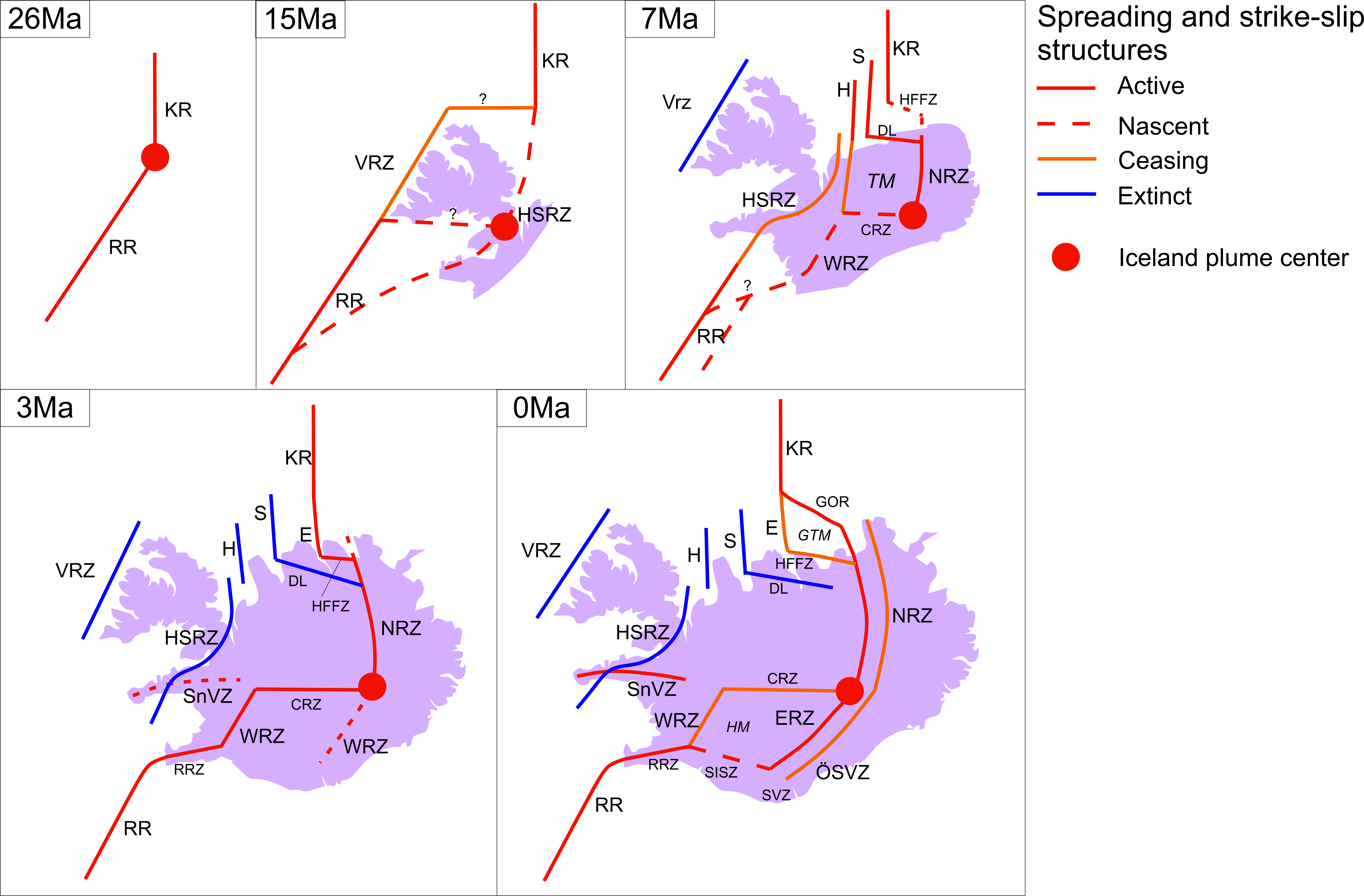
EGU23-2230 | ECS | Orals | GD5.2 | Highlight

Highly Asymmetric Seismicity in a System of Tectonic Extension and Hydrothermal Venting at the Mohn-Knipovich Ridge Bend 

Matthias Pilot, Marie Eide Lien, Vera Schlindwein, Lars Ottemoeller, and Thibaut Barreyre

In recent years hydrothermal vent systems were found in unexpectedly high abundance along ultraslow spreading ridges, despite their overall decreased magma supply. Thin oceanic crust and resulting shallow heat sources can drive hydrothermal fluid circulation and detachment faults can act as fluid pathways, resulting in e.g., serpentinization of the oceanic crust. So far, no long-term recording of seismicity around hydrothermal vent systems along ultraslow spreading ridges have been reported. Here, we present results from a ~1-year local Ocean Bottom Seismometer deployment between 2019 - 2020 at Loki’s Castle hydrothermal vent field (LCVF) along the Arctic Mid Ocean Ridge. LCVF is located at a water depth of ~2500m on top of the axial volcanic ridge (AVR) at the Mohn-Knipovich Ridge bend where spreading is highly asymmetric from west to east.

For the processing we use a combination of an automatic event detection algorithm (Lassie), a deep-learning phase picking model (PhaseNet) and partial manual re-evaluation of phase picks. Additionally, selected clusters of events are cross-correlated and relocated using hypoDD. The resulting earthquake catalogue consists of a total of 12368 events with 6719 manually re-evaluated and 5649 automatically picked events.

From the results we see that most of the plate divergence at the Mohn-Knipovich Ridge bend is accommodated by a young detachment fault west of the AVR. Most of the seismicity occurs between depths of ~2-8km in a bended band that steepens up to 70° with depth and follows the local topography. However, the described detachment fault differs from reported mature detachment faults at the Mid-Atlantic Ridge or Southwest Indian Ridge. Within the footwall we observe episodical, clustered seismicity with extensional faulting mechanisms, indicating that the detachment could be cross-cut by normal faults. Along strike, the seismicity of the fault plane appears highly heterogeneous, with the central part showing only sparse seismicity at depths below 3km while other segments show episodical shallow seismicity. Towards LCVF seismicity below the AVR increases and the maximum depth of earthquakes shallows by about ~2km. This could indicate the presence of a shallow heat source below LCVF as a driving factor for the hydrothermal circulation.

How to cite: Pilot, M., Lien, M. E., Schlindwein, V., Ottemoeller, L., and Barreyre, T.: Highly Asymmetric Seismicity in a System of Tectonic Extension and Hydrothermal Venting at the Mohn-Knipovich Ridge Bend, EGU General Assembly 2023, Vienna, Austria, 23–28 Apr 2023, EGU23-2230, https://doi.org/10.5194/egusphere-egu23-2230, 2023.

The significant discrepancy between the observed conductive heat flow and predictions by thermal models for oceanic lithosphere younger than 50 Ma is generally interpreted to result from hydrothermal circulation between basement outcrops. Numerical simulations of fluid flow between such outcrops performed in previous studies revealed that establishing horizontal pressure gradients to sustain a hydrothermal siphon requires high aquifer permeabilities and a contrast in the outcrops’ transmittance, which is the product of the outcrop permeability and the area of outcrop exposure. However, most previous studies focused on the model parameters needed to sustain a hydrothermal siphon, while the physical processes that create the horizontal pressure gradients in the first place remain poorly constrained.

In order to shed more light on the physics behind outcrop-to-outcrop flow, a simple synthetic 2D model of two outcrops connected by a permeable aquifer was set up. Fluid flow modelling was done by using hydrothermalFoam, a hydrothermal transport model, that is based on the open-source C++ computational fluid dynamics toolbox OpenFOAM. Our initial simulations focus on variations of the permeability of the outcrops and the aquifer. The results reveal two key points that are essential to generate a flow: First, the outcrops permeability has a fundamental effect on its average pressure. High permeabilities lead to a rather "cold" hydrostatic pressure regime with lower temperatures and hence higher average pressures. Lower outcrop permeabilities are accompanied with a rather "warm" hydrostatic pressure regime characterized by higher temperatures and lower average pressures. Secondly, fluid convection in the aquifer is necessary to establish a siphon flow. Therefore, the aquifer permeability must be sufficiently high to overcome Darcy resistance and yet low enough to prevent the flow from being solely diffusive.

How to cite: Kremin, I., Guo, Z., and Rüpke, L.: The effect of permeability on the pressure regime in 2D outcrop-to-outcrop submarine hydrothermal flow models, EGU General Assembly 2023, Vienna, Austria, 23–28 Apr 2023, EGU23-2737, https://doi.org/10.5194/egusphere-egu23-2737, 2023.

The Earth System appears increasingly interconnected and hydrothermal discharge at back smoker vent sites is not only visually appealing, it also sustains unique ecosystems, generates large polymetallic sulfide deposits, and modulates ocean biogeochemical cycles. At slow spreading ridges, fault zones seem to provide stable preferential fluid pathways resulting in the formation of the ocean’s largest sulfide deposits. The TAG hydrothermal mound at 26°N on the Mid-Atlantic Ridge (MAR) is a typical example located on the hanging wall of a detachment fault. It has formed through distinct phases of high-temperature fluid discharge lasting 10s to 100s of years throughout at least the last 50,000 years and is one of the largest sulfide accumulations on the MAR. Yet, the mechanisms that control the episodic behavior, keep the fluid pathways intact, and sustain the observed high heat fluxes of possibly up to 1800 MW remain poorly understood. Previous concepts involved long-distance channelized high-temperature fluid upflow along the detachment but that circulation mode is thermodynamically unfavorable and incompatible with TAG's high discharge fluxes. Here, based on the joint interpretation of hydrothermal flow observations and 3-D flow modeling, we show that the TAG system can be explained by episodic magmatic intrusions into the footwall of a highly permeable detachment surface. These intrusions drive episodes of hydrothermal activity with sub-vertical discharge and recharge along the detachment. This revised flow regime reconciles problematic aspects of previously inferred circulation patterns and allows to identify the prerequisites for generating substantive seafloor mineral systems.

How to cite: Guo, Z., Rüpke, L., and Tao, C.: Detachment-parallel recharge explains high discharge fluxes at the TAG hydrothermal field-Insights from 3D numerical simulation, EGU General Assembly 2023, Vienna, Austria, 23–28 Apr 2023, EGU23-2767, https://doi.org/10.5194/egusphere-egu23-2767, 2023.

EGU23-3138 | ECS | Orals | GD5.2

Oceanic transform faults offshore São Tomé and Príncipe highlighted by integrated density and magnetic modeling of the crust 

Peter Haas, Myron Thomas, Christian Heine, Jörg Ebbing, Andrey Seregin, and Jimmy van Itterbeeck

The Eastern Gulf of Guinea hosts several buried Cretaceous-aged oceanic fracture zones. 3D broadband seismic data acquired offshore São Tomé and Príncipe revealed a complex crustal architecture. Mapped oceanic fracture zones show low-angle reflectors that detach onto or eventually cross through the Moho boundary, overlain by strong reflectors that are interpreted as transform process related extrusive lava flows. Here, we use a high resolution shipborne free-air gravity and total field intensity magnetic data set to reassess whether previously defined seismic models of the crust are in conformity with potential field data. The study area is located offshore São Tomé with a size of c. 150x150 km. Using the software IGMAS+, we model the gravity and magnetic properties of the crust (i.e. density and susceptibility) in 3D. Long record length seismic sections plus mapped seismic horizons, which include bathymetry, sediments, upper and lower crust, are used as constraints. While the general trend of the free-air anomaly can be explained within a range of expected crustal densities, the magnetic field anomaly reflects high residuals that are predominantly oriented parallel to the transform faults. This indicates that gravity and magnetic data cannot be explained by the same simple source geometry. Therefore, we first perform sensitivity tests to isolate the source of the residual magnetic anomaly, followed by a structural analysis along the transform faults with special emphasis to the extrusive lava flows in the crustal domain. Our final model reconciles seismic horizons and potential field data and will stimulate a discussion on the architecture and evolution of transform faults and their signatures in different data sets.    

How to cite: Haas, P., Thomas, M., Heine, C., Ebbing, J., Seregin, A., and van Itterbeeck, J.: Oceanic transform faults offshore São Tomé and Príncipe highlighted by integrated density and magnetic modeling of the crust, EGU General Assembly 2023, Vienna, Austria, 23–28 Apr 2023, EGU23-3138, https://doi.org/10.5194/egusphere-egu23-3138, 2023.

EGU23-3562 | ECS | Posters on site | GD5.2

Deformation along the Oceanographer Transform Fault from fault mapping and thin section analysis 

Anouk Beniest, Katharina Unger Moreno, Lizette Dedecker, Bente Schriever, and Thor Hansteen

The Oceanographer Transform Fault is an oceanic transform fault that offsets a segment of the Atlantic Mid-Oceanic Ridge (MOR), southwest of the Azores. We investigate how deformation is accommodated along an active transform through the interpretation of fault patterns and geomorphological features on high resolution bathymetry and a petrological and kinematic analysis of thin sections.

The bathymetric interpretation yielded six different domains which consisted of 1) the main transform zone with E-W running strike-slip faults, 2) the NNE-SSW oriented MOR valley, 3) the abyssal domain hosting NNE-SSW oriented normal faults that bound the abyssal hills, 4) the abyssal domain hosting NE-SW oriented faults, oriented obliquely to the mid-oceanic ridge and the main transform valley, 5) a volcano- and lava flow rich domain and 6) a shallow domain with corrugations oriented perpendicular to the MOR with little volcanic cover.

The thin section analysis reveals a complete ophiolitic sequence, including serpentinized peridotite, gabbro and basalt with varying degrees of alteration. Samples retrieved from depths >3500 m show that deformation occurs mainly in the ductile domain through bulging and sub-grain rotation of plagioclase, lamellar feldspar formation (in gabbro), shearing and recrystallisation of gabbro and serpentinization of peridotite. Brittle deformation manifests itself through fracturing of crystals, displacement of plagioclase sub-crystal domains and veining. Especially gabbroic samples show a decrease in serpentinized veins with decreasing depth. Basalts are found only at shallow depth, seemingly covering gabbro, appearing not to be affected by deformation at all, only occasional cracks filled with pristine calcite are observed.

The combination of geomorphological features identified on high-resolution bathymetry maps and the petrological and kinematic analysis of thin sections showed that deformation along the transform fault differs from the deformation that happens at the MOR. Deformation at the MOR is characterized by 1) axis-parallel normal faulting, pulses of volcanism, resulting in elongated ridges and volcanic cones on the ocean floor and the formation of dykes under magma-rich circumstances, and core complex exhumation during magma-starved periods that occurred between 1.8 – 4.2 Ma and around 7.5 Ma along the southwestern MOR segment of the OTF and 2) heavily sheared zones that extend obliquely from the MOR-transform intersection into the adjacent older plate. Deformation at the transform fault is accommodated through serpentinization at depths deeper than 3000 m, leading to pop-up structures in the main transform zone and causing fracturing in the overlying gabbro, allowing hydrothermal fluids to heavily alter deeper rocks and migrate to shallower depths with decreasing alteration of the oceanic crust with decreasing depth.

We hypothesize that the transform fault itself at depth accommodates stresses to a large extent via serpentinization processes in response to strike-slip tectonic activity in a very narrow band in the active, deepest part of the main transform zone. Deformation patterns other than serpentinization and serpentinite veining that are observed in rock samples along the transform fault are the result of earlier tectonic activity that took place during or shortly after the formation of the rock at the MOR.


How to cite: Beniest, A., Unger Moreno, K., Dedecker, L., Schriever, B., and Hansteen, T.: Deformation along the Oceanographer Transform Fault from fault mapping and thin section analysis, EGU General Assembly 2023, Vienna, Austria, 23–28 Apr 2023, EGU23-3562, https://doi.org/10.5194/egusphere-egu23-3562, 2023.

EGU23-4289 | Posters on site | GD5.2 | Highlight

Oceanic crustal structure at ODP Site 1256 from seismic wide-angle tomography and down-hole logging 

Ingo Grevemeyer, Timothy J. Henstock, Anke Dannowski, Milena Marjanovic, Helene-Sophie Hilbert, Yuhan Li, and Daman A. H. Teagle

Our view on the structure of oceanic crust is largely based the interpretation of seismic refraction and wide-angle experiments, revealing that the upper basaltic crust (layer 2) is a region of strong velocity gradients. In contrast, the lower gabbroic crust (layer 3) is relatively homogeneous, although it generally displays a gentle increase in velocity with depth. Furthermore, the upper crust has been sub-divided into layer 2A, composed of extruded basalts, and layer 2B, formed by basaltic sheeted dikes. Site 1256, drilled during the Ocean Drilling Program (ODP) into the upper crust and later extended into the uppermost gabbroic crust during the Integrated Ocean Drilling Program (IODP), is among the deepest drill sites sampling intact oceanic crust. It is the only site world-wide that crossed the entire basaltic upper crust, reaching plutonic rocks at ~1.35 km below the top of the basement, recovering 150 m of dominantly gabbroic rocks at the base of the hole. Three campaigns of down-hole logging at hole 1256D provided a unique set of high-resolution sonic-log velocities of seismic layer 2 and from the uppermost top of seismic layer 3. However, Hole 1256D was drilled at a site with rather limited seismic data coverage, especially lacking seismic refraction and wide-angle profiling. During a seismic survey of the RRS JAMES COOK in the Guatemala Basin in December of 2022, a seismic profile with 12 Ocean-Bottom-Seismometers spaced at 7 km intervals, receiving signals from a tuned airgun array of 4500 cubic-inches shot at 150 m spacing was collected. The data provide excellent seismic records to derive a detailed sound-velocity model of the oceanic crust at the drill site from tomographic travel time inversion of first arrivals (Pg, Pn) and a prominent wide-angle reflection from the crust-mantle boundary (PmP) or seismic Moho. The results show that the seismic structure along the 115 km long line is extremely homogeneous. The velocity-depth profile from tomography further provides an excellent low-frequency match of the down-hole logging observations, supporting that modern seismic data are a powerful remote sensing tool to study the oceanic crust and lithosphere. An interesting observation is that the thickness of the oceanic crust at Site 1256 is extremely thin at only 4.6 to 5.1 km, compared to a global average thickness of about 6 km. This appears to be a regional feature supported by another seismic profile about 150 km north-eastwards. The thin crust agrees with a weak seismic event at ~6.8 s two-way travel time (twtt), i.e., ~1.6 s twtt below basement obtained from re-processing 6-km-long streamer data from the ODP pre-site survey at Site 1256.


How to cite: Grevemeyer, I., Henstock, T. J., Dannowski, A., Marjanovic, M., Hilbert, H.-S., Li, Y., and Teagle, D. A. H.: Oceanic crustal structure at ODP Site 1256 from seismic wide-angle tomography and down-hole logging, EGU General Assembly 2023, Vienna, Austria, 23–28 Apr 2023, EGU23-4289, https://doi.org/10.5194/egusphere-egu23-4289, 2023.

EGU23-4327 | ECS | Posters on site | GD5.2

High-resolution upper crustal structure from OBH data at the TAG Hydrothermal Field, 26°N on the Mid-Atlantic Ridge 

Szu-Ying Lai, Gaye Bayrakci, Bramley Murton, and Tim Minshull

The Trans-Atlantic Geotraverse (TAG) segment at 26°N on the Mid Atlantic Ridge (MAR) is notable for hosting hydrothermal mounds and seafloor massive sulphide deposits. At the slow-spreading MAR, detachment faulting plays an important role in controlling the seafloor morphology. In this study, we investigate the seismic velocity in the upper crust at a finer scale than previously possible, and its relationship to fault structures.

We used short-offset ocean bottom hydrophone (OBH) data collected during the Meteor 127 cruise in 2016. The survey was designed mainly to study the hydrothermal mounds. We chose a NW-SE trending, 11-km long wide-angle seismic profile that crosses a detachment breakaway identified from AUV bathymetry and seismic reflection profiles. The source was a G-gun array of 760 c. inch towed at 6 m depth. The shot spacing was 12 s (15-20 m) with four OBHs at 1.3 km spacing.

A two-dimensional P-wave velocity model was generated by first-arrival travel-time tomography using the TOMO2D code. We used as our starting model the average 1D velocity depth function of a slice along our profile through Zhao et al’ s (2012) three-dimensional velocity model. Our final tomographic model reveals crustal velocities from 3.4 km/s to 5 km/s for the upper 600 m below seabed. Most of the profile lies beneath the eastern valley wall, where a corrugated detachment surface crops out. Beneath the detachment surface in our profile, we observed an increased velocity of 6.5 km/s at 1.5 km below seabed. Our velocity model suggests that the west-dipping normal fault exhumes lower crust of velocity up to 6.5 km/s.

How to cite: Lai, S.-Y., Bayrakci, G., Murton, B., and Minshull, T.: High-resolution upper crustal structure from OBH data at the TAG Hydrothermal Field, 26°N on the Mid-Atlantic Ridge, EGU General Assembly 2023, Vienna, Austria, 23–28 Apr 2023, EGU23-4327, https://doi.org/10.5194/egusphere-egu23-4327, 2023.

EGU23-5648 | Posters on site | GD5.2

Temporal variation in spreading processes at the Eastern Romanche-Mid-Atlantic Ridge intersection 

Marcia Maia, Anne Briais, Lorenzo Petracchini, Marco Cuffaro, Marco Ligi, Daniele Brunelli, Lea Grenet, and Cédric Hamelin

We studied the east intersection between the Romanche transform fault (TF) and the Mid-Atlantic ridge using bathymetry and gravity anomalies, to investigate the temporal evolution of the ultra-cold ridge-transform intersection. Our results reveal a complex ridge axis, with evidence of a significant decrease in the along-axis melt supply towards the RTI but also since ~10 Ma.

Over a 100 km distance south of the RTI, the ridge axis is formed by three spreading segments offset by large non-transform discontinuities. Large detachment faults mark the present-day spreading style at the RTI, while magma supply increases away from the Romanche intersection. Axial and near-axis fault patterns reveal a marked obliquity, especially in the north and center of the study area.In lithosphere older than 10 Ma, the ridge axis appears to form a single spreading segment between the Romanche and Chain TFs, perpendicular to the spreading direction, with relatively regular abyssal hills. From around 10 to 3 Ma, oceanic core complexes (OCCs) developed in the northern part of the ridge axis south of the Romanche TF.  The complexity of the ridge axis appears to have increased in the last 3 Ma, with ridge obliquity accompanying axial instabilities and ridge jumps.  At least three eastward ridge relocations were identified immediately south of the Romanche TF, rupturing a series of OCCs located in the African plate, east of the ridge axis. This pattern could reflect a progressive decrease in the melt supply, in particular since 3-5 Ma. This may be related to a significant reduction of the ridge spreading rate as seen from kinematic models which allowed the cooling effect of the large offset Romanche TF to dominate the spreading processes in the area.

How to cite: Maia, M., Briais, A., Petracchini, L., Cuffaro, M., Ligi, M., Brunelli, D., Grenet, L., and Hamelin, C.: Temporal variation in spreading processes at the Eastern Romanche-Mid-Atlantic Ridge intersection, EGU General Assembly 2023, Vienna, Austria, 23–28 Apr 2023, EGU23-5648, https://doi.org/10.5194/egusphere-egu23-5648, 2023.

The eastern Southwest Indian Ridge (SWIR) is a melt-poor end-member region of the global MOR system. The available magma focuses to axial volcanoes, leaving >50 km-wide, nearly amagmatic ridge sections, where seafloor spreading occurs via large offset detachment faults. We present map to outcrop scale observations of the deformation associated to one of these detachments, in the 64°35'E region of the SWIR. This active detachment fault presently has a horizontal offset of ~4 km (Cannat et al., 2019), and accommodates nearly all the plate divergence (14 km/million year; Patriat and Segoufin, 1988). We focus on the lower slopes of the footwall, where this active fault currently emerges at an angle of ~35°. The emergence is traceable across a length of ~20 km on side-scan sonar and shipboard bathymetry data. It locally shows undulations at a wavelength of ~1-4 km. High-resolution bathymetry at and near the emergence area shows two morphological domains. In one domain, the exhumed fault surface bears distinct corrugations that trend at an 18° to 33° angle to the spreading direction, extends up to 300 m, are spaced by ~15-300 m, and are ~1 m to ~40 m in amplitude. In the other domain, the exhumed fault is not corrugated. Remotely operated vehicle (ROV) dive observations at the outcrop scale show discrete planar fault planes and brecciated and fractured rock forming the top ~1-4 meters of the corrugated exposures. In contrast, the non-corrugated fault exposures show up to ~8 m of gouge-bearing micro-brecciated domains, including several up to 1 m thick horizons of semi-brittle sheared serpentinites. Dive observations further suggest that: (1) there are several sigmoidal intercalations of such gouge-bearing horizons forming the upper few tens of meters of the non-corrugated fault zone, and (2) the horizons of sheared serpentine originated as brittle cracks that served as hydrous fluid pathways into the fault damage zone. We propose: (1) that the absence of corrugations is related to the overall weaker semi-brittle rheology of the emerging fault in this domain, compared to the purely brittle corrugated domain; and (2) that the two domains represent damage developed in distinct conditions of temperature and hydrothermal fluid availability. At the broader map scale, the non-corrugated domain to the east emerges about 1.2 km farther south than the corrugated domain, and the trace of emergence thus draws an indentation between the two domains. Given the ~35° fault emergence angle in the two domains, we infer that their across-fault distance is ~650 m. The detachment damage zone may thus be at least that broad, and comprised of distinct, probably anastomosing domains of more localized deformation, which would preferentially be exposed at the seafloor. This damage zone anatomy would be consistent with seismic refraction observations (Momoh et al., 2017) in the area.

How to cite: Mahato, S. and Cannat, M.: Anatomy of a detachment fault damage zone at a nearly amagmatic mid-ocean ridge: observations from outcrop to map scale, EGU General Assembly 2023, Vienna, Austria, 23–28 Apr 2023, EGU23-6200, https://doi.org/10.5194/egusphere-egu23-6200, 2023.

EGU23-7119 | ECS | Posters on site | GD5.2

Immature transform plate boundaries in the Northeast Pacific: Constraints from ocean bottom seismology 

Yu Ren, Dietrich Lange, and Ingo Grevemeyer

Plate tectonics defines oceanic transform faults as long-lived tectonics features. In the Pacific Ocean their traces, called fracture zones, can easily be identified as several thousands of kilometer-long features in bathymetric and gravity field data. However, today none of the fracture zones in the North Pacific are directly linked to any mid-ocean ridge-transform fault. This feature is related to the subduction of the Farallon spreading center and a major change in the direction of plate motion several millions of years ago. Consequently, ridge segmentation is adjusting to a new tectonic framework. The Blanco transform fault system (BTFS) in the northwest off the coast of Oregon is one of the newly evolving transform faults. It is highly segmented and shows strong similarities with other segmented oceanic transform systems, such as the Siqueiros in the East Pacific Rise, which developed from a pre-existing transform fault subjected to a series of extensional events due to a documented change in spreading direction. However, plate tectonic reconstructions suggested that the BTFS developed from at least two large ridge offsets rather than a single transform fault, emerging from a series of ridge propagation events after the plate reorientation at ~5 Ma.
We used one year of ocean-bottom-seismometer data from the Blanco Transform OBS Experiment (2012-2013) and high-resolution multibeam bathymetry, aeromagnetic, and gravity datasets to study the seismotectonic behavior and tectonic evolution of the BTFS. Interestingly, all available datasets provide no evidence for the existence of either transform faults or fracture zones around the BTFS before 2 Ma, supporting that there were no pre-existing transform faults before the initiation of the BTFS. Therefore, we suggest the BTFS developed from two broad transfer zones instead of pre-existing transform faults. We present seismicity and focal mechanisms for stronger manually-picked events.  Furthermore, the seismic data were picked with a phase picker learned with a large OBS training dataset. The resulting seismicity of ~8,000 events reveals the present-day deformation of the fault system with very high spatial resolution, and supports substantial along-strike variations, indicating different slip modes in the eastern and western BTFS. Seismic slip vectors suggest that the eastern BTFS is a mature transform fault system accommodating the plate motion. At the same time, the western BTFS is immature as its re-organization is still active. The BTFS acts as a natural laboratory to yield processes governing the development of transform faults away from continental rift zones.

How to cite: Ren, Y., Lange, D., and Grevemeyer, I.: Immature transform plate boundaries in the Northeast Pacific: Constraints from ocean bottom seismology, EGU General Assembly 2023, Vienna, Austria, 23–28 Apr 2023, EGU23-7119, https://doi.org/10.5194/egusphere-egu23-7119, 2023.

EGU23-7479 | Posters on site | GD5.2 | Highlight

Off-axis compression triggered by a seafloor spreading event on the Northern Mid-Atlantic Ridge, 54ºN 

Jean-Arthur Olive, Göran Ekström, W. Roger Buck, Zhonglan Liu, Javier Escartín, and Manon Bickert

Mid-ocean ridges are quintessential sites of extensional deformation, where large-magnitude compressional seismicity is rare and typically confined to transpressional ridge-transform intersections. Here we report on a recent, unusual seismic sequence that included 12 thrust faulting events with magnitudes up to 6, ~25 km off-axis on both sides of the Mid-Atlantic Ridge (MAR) at 54ºN. These compressional events were preceded by a rapidly-migrating swarm of extensional on-axis earthquakes with M≥4.2. We relocated a total of 124 earthquakes and calculated their focal mechanisms using a surface wave-based method. We then modeled the stress state of the ridge flanks to construct a mechanically-consistent interpretation of the sequence, and discuss its significance in terms of seafloor spreading processes.

The sequence started on September 26th, 2022 at 6:07 UTC with a M4.8 normal faulting earthquake at 54º01’N on the Northern MAR, ~125 km north of the Charlie-Gibbs fracture zone. Over 80 normal faulting earthquakes (4.5≤M≤5.8) occurred over the next 3.5 days, with locations steadily migrating southward at ~0.6 km/hr. Earthquake locations form a narrow band that closely follows the axial valley of the symmetric, abyssal hill-bearing 53º30N segment, which is bound by non-transform offsets both to the north and south. Extensional seismicity continued in this band for ~27 more days without a clear propagation pattern. 80 hours into the earthquake swarm, a magnitude-5.7 thrust earthquake occurred ~25 km east of the extensional band. Between September 29, 2022 and January 4, 2023, 11 more thrust events occurred on N-S striking planes east and west of the axis, outlining two narrow bands ~25 km away from the neovolcanic zone. Some of these events seem well aligned with off-axis normal fault scarps, suggesting a possible reactivation of these faults on both flanks.

To better understand this remarkably symmetric pattern of off-axis compression, we model the absolute stress state of the ridge flanks, and the relative stress changes imparted by the on-axis extensional event. 2-D visco-elasto-plastic simulations of slow mid-ocean ridges show that unbending of the lithosphere as it moves out of the axial valley imparts horizontal compression in the cross-axis direction within ~10 to ~40 km away from the ridge axis, and down to ~3 km below seafloor. While this deviatoric compression can reach the brittle yield stress, the associated strain rates are so low that a seismic manifestation of this phenomenon should be extremely rare. On the other hand, the on-axis intrusion of a vertical dike up to a depth of ~5 km below seafloor can put the shallow axis in tension while imparting excess compression on the shallow lithosphere ~25 km off-axis on both sides. Our preferred interpretation is therefore that the extensional swarm represents the southward migration of a blind dike within the neovolcanic axis, which drove both ridge shoulders to compressional failure. Off-axis shortening may thus be an integral component of seafloor spreading that usually operates aseismically, but can be highlighted by certain types of on-axis intrusion events.

How to cite: Olive, J.-A., Ekström, G., Buck, W. R., Liu, Z., Escartín, J., and Bickert, M.: Off-axis compression triggered by a seafloor spreading event on the Northern Mid-Atlantic Ridge, 54ºN, EGU General Assembly 2023, Vienna, Austria, 23–28 Apr 2023, EGU23-7479, https://doi.org/10.5194/egusphere-egu23-7479, 2023.

EGU23-7653 | ECS | Posters on site | GD5.2

Earthquake relocations and three-dimensional VP, VS and VP/VS along the fast-slipping Gofar oceanic transform fault, East Pacific Rise. 

Clément Estève, Yajing Liu, Gong Jianhua, and Wenyuan Fan

Fast-slipping mid-ocean ridge transform faults are characterized by quasi-periodic seismic cycles with typical inter-event times of 5 to 8 years. In particular, the Gofar transform fault (GTF) of the East Pacific Rise, generates a MW ~ 6 earthquake every 5 to 6 years on short (~20 km) along-strike segments separated by a barrier zone. Therefore, the GTF presents the opportunity to investigate the relation between fault structure and material properties of this fault to earthquake processes. Here, we perform a joint inversion of P- and S-wave arrival times from local earthquakes to develop three-dimensional seismic velocity models (VP, VS and VP/VS) of the easternmost and westernmost segments (G1 and G3, respectively). The velocity models reveal that G3 is characterized by a more heterogeneous fault zone velocity structure compared to G1. Sharp velocity contrasts are observed along G3 interpreted to reflect along-strike variations in material properties. G1 is characterized by large low-velocity anomaly extending through the entire oceanic crust with subtle along-strike variations. The 2020 Mw 6.1 earthquake occurred within a low VP, low VS and high VP/VS patch along G1 whereas the 2008 Mw 6 earthquake occurred on sharp VP, VS and VP/VS contrast. We also note similarities between the two fault segments. In particular, rupture barrier zones are characterized by a high rate of seismicity and a rapid decrease following the mainshock. We also note the occurrence of deep seismicity in low VP/VS patches beneath the rupture barrier zones, which may indicate sea-water infiltration at 10 to 14 km depth below sea level.


How to cite: Estève, C., Liu, Y., Jianhua, G., and Fan, W.: Earthquake relocations and three-dimensional VP, VS and VP/VS along the fast-slipping Gofar oceanic transform fault, East Pacific Rise., EGU General Assembly 2023, Vienna, Austria, 23–28 Apr 2023, EGU23-7653, https://doi.org/10.5194/egusphere-egu23-7653, 2023.

The domal structure in the core of the Troodos ophiolite exposes lower crustal (gabbro suite) and mantle rocks (ultramafic province). This structure is part of a fossil ridge-transform intersection (RTI), where an extinct spreading axis meets the fossil oceanic transform, namely the Arakapas transform. A major feature in the RTI system is the Troodos Forest-Amiandos Fault (TAF), an off-axis and axis parallel fault that was active during the Cretaceous seafloor spreading. Here we investigate the deformation across the TAF by measuring paleomagnetic vectors from 34 sites in the gabbro suite around the domal ultramafic core. Special emphasize was along an E-W transect that crosses the TAF south of the sheeted dike complex and north of the ultramafic province. We also compiled dike dips along an E-W strip (6 km wide) north of the gabbro suite. All results were compared to previous paleomagnetic studies from the sheeted dikes and the gabbro suite. Accordingly, we have found that rotations in the gabbro are very similar to those in the sheeted dikes, suggesting coupling of the upper and the lower oceanic crust during axial deformation of seafloor spreading. All rotation axes were horizontal and parallel to the dike strikes, i.e., parallel to the extinct spreading axis. Rotations increase gradually towards the TAF from both sides, eastward in the footwall and westward in the hanging wall. The most plausible scenario is an upward and downward deflection in the footwall and the hanging wall, respectively, similarly described theoretically for the early stages of detachment development. The orientations of the rotation axes of all paleomagnetic vectors indicate spreading-related deformation. This suggests that the relative uplift of the deep-seated rocks was by the development of a young detachment during seafloor spreading rather than serpentinite diapirism. The detachment occurrence in the outside-corner is explained here by the shift from orthogonal to curved axis, inferred from sheeted dike orientations.

How to cite: Abelson, M., Kamahaji, L., Shaar, R., and Agnon, A.: Lithosphere deflection on a juvenile oceanic detachment during seafloor spreading promoted the exposure of the mantle rocks of the Troodos ophiolite – inferences from gabbro paleomagnetism, EGU General Assembly 2023, Vienna, Austria, 23–28 Apr 2023, EGU23-8330, https://doi.org/10.5194/egusphere-egu23-8330, 2023.

EGU23-9093 | Orals | GD5.2 | Highlight

Oceanic transform faults revisited with models and data 

Lars Ruepke, Ingo Grevemeyer, Zhikui Guo, Sibiao Liu, Ming Chen, Jason Morgan, and Colin Devey

Plate tectonics describes oceanic transform faults as conservative strike-slip boundaries, where lithosphere is neither created nor destroyed. Seafloor accreted close to ridge-transform intersections (RTI) has therefore been expected to follow a similar subsidence trend with age as lithosphere that forms away from RTIs. Our recent combined analysis of high-resolution bathymetric data, satellite gravity, and three-dimensional numerical models from transform faults segmenting mid-ocean ridges across the entire spectrum of spreading rates challenges this concept.  One striking observation is that transform faults are systematically deeper than their adjacent fracture zones. Gravity data suggests that the underlying reason may be changes in crustal thickness, with transform valleys having thin and fracture zones ‘normal’ crustal thicknesses. Another observation is that outside corner crust often shows symmetric abyssal hills with intact flat top volcanoes, while the inside corner regions show intense and oblique tectonic deformation. Furthermore, so-called J-shaped ridges, volcanic ridges that bend towards the active transform, show that magmatic accretion occurs predominantly along the spreading axis, ‘feeling’ the rotating stress field only in the direct vicinity of the RTI. While these observations do show some dependence on spreading rate, they can be identified across a wide range of opening rates, suggesting that they are expressions of processes inherent to transform faulting.

In this contribution, we will review these observations before presenting numerical 3-D thermo-tectono-magmatic models designed to elucidate the underlying processes. These models use a dilation term to mimic magmatic accretion and resolve visco-elasto-plastic deformation. The simulations show that the tectonic deformation axis, the axis of plate separation, becomes oblique at depth resulting in extension and crustal thinning within the transform deformation zones. Complementing simulations that account for magmatic accretion and hydrothermal cooling show that a skew can develop between this oblique deformation axis and the axis of magmatic accretion, implying a possible disconnect between the main diking direction and the direction of tectonic deformation. Taken all evidence together, oceanic transform faulting appears to be much more complex than pure strike-slip motion. It shows a surprisingly complex pattern of tectonic faulting and hints at spill-over magmatism at the RTI.  Crustal accretion at ridge transform intersections may therefore be fundamentally different to accretions elsewhere along mid-ocean ridges.

How to cite: Ruepke, L., Grevemeyer, I., Guo, Z., Liu, S., Chen, M., Morgan, J., and Devey, C.: Oceanic transform faults revisited with models and data, EGU General Assembly 2023, Vienna, Austria, 23–28 Apr 2023, EGU23-9093, https://doi.org/10.5194/egusphere-egu23-9093, 2023.

EGU23-9241 | ECS | Orals | GD5.2

Geological overview of the Oceanographer Transform Fault 

Katharina A. Unger Moreno, Colin W. Devey, Lars Rüpke, Anouk Beniest, Thor H. Hansteen, and Ingo Grevemeyer

Recent studies on oceanic transform faults, one of the three fundamental types of plate boundaries, has suggested that they may not be purely conservative features and that the crust formed adjacent to them (on the "inside corners" of the ridge-transform intersection) may differ in structure and composition significantly from outside-corner crust. Here we present a geological map of the Oceanographer Transform (Atlantic Ocean, southwest of the Azores) created by combining an interpretation of multibeam bathymetry, rock sampling and seafloor visual observations. We find that outside- and inside-corner crust at the ridge transform intersection have distinctive morphologies and petrography: the outside corner shows rough seafloor, from which only pillow basalts are recovered, extending all the way to the fracture zone. The inside corners, in contrast, are characterized by both rough, basaltic seafloor and regions that are much smoother, from which serpentinized peridotite are often recovered. The width of the inside-corner region showing this variable morphology, bathymetry and petrography seems to vary over time from 10 to 25 km. In two places, oceanic core complex crust is recognized close to the transform in this inside-corner region. We emphasize that plate production at the inside corner appears to occur via a variety of magmatic and amagmatic processes.

How to cite: Unger Moreno, K. A., Devey, C. W., Rüpke, L., Beniest, A., Hansteen, T. H., and Grevemeyer, I.: Geological overview of the Oceanographer Transform Fault, EGU General Assembly 2023, Vienna, Austria, 23–28 Apr 2023, EGU23-9241, https://doi.org/10.5194/egusphere-egu23-9241, 2023.

EGU23-9688 | Orals | GD5.2

Segmented Mantle Melting, Lithospheric Rheology and Transform Fault Formation 

Fernando Martinez and Richard Hey

Mantle melting along mid-ocean ridges occurs in a segmented manner.  Melting and melt extraction are greatest within ridge segment interiors but near segment ends mantle upwelling decreases, cooling increases and melt extraction becomes inefficient.  Owing to the strong influence of water on mantle rheology, these effects have important consequences for the strength of oceanic lithosphere.  Residual mantle formed in ridge segment interiors is melt-depleted and dehydrated forming strong rheological bands.  Near segment ends, however, the formation of low-degree hydrous melts predominates, and these are inefficiently extracted from the mantle.  On solidification, these hydrous melts can re-fertilize surrounding mantle with water due to the high diffusivity of hydrogen in mantle material. This results in weak hydrous bands of mantle material near segment ends.  Thus, segmented mantle melting creates a corresponding segmented oceanic mantle rheological structure that favors the localization of shear deformation in the weak bands near segment ends.  Further strain localization within these weak zones may then facilitate additional weakening processes along discrete narrow transform fault zones. We Illustrate our model with geophysical observations from the Reykjanes Ridge and northern Mid-Atlantic Ridge south of Iceland.  The Reykjanes Ridge is a ~1000 km long linear axis without transform faults.  Rapid propagation of melting anomalies along its linear axis precludes a stable magmatic segmentation as shown by its linear mantle Bouguer anomaly.  Immediately south of the Reykjanes Ridge, the northernmost segments of the Mid-Atlantic Ridge have prominent mantle Bouguer anomaly lows indicating stable cells of segmented mantle melting. Transform and non-transform discontinuities immediately form at the ends of the mantle Bouguer anomaly lows.  This model can be extended to explain the occurrence (or absence) of transform faults over the full range of spreading rates from ultra-slow to ultra-fast ridges.

Reference: Martinez, F., and R. Hey (2022), Mantle melting, lithospheric strength and transform fault stability: Insights from the North Atlantic, Earth and Planetary Science Letters, 579, doi:10.1016/j.epsl.2021.117351.

How to cite: Martinez, F. and Hey, R.: Segmented Mantle Melting, Lithospheric Rheology and Transform Fault Formation, EGU General Assembly 2023, Vienna, Austria, 23–28 Apr 2023, EGU23-9688, https://doi.org/10.5194/egusphere-egu23-9688, 2023.

Lithospheric inheritance is known to strongly influence the spatial and temporal patterns of continental deformation in all geodynamic contexts, emphasizing the role of rheological feedbacks between time-spaced geodynamic events. In principle, the transition from continental rifting to sea-floor spreading at diverging plate boundaries marks a threshold beyond which these long-term feedbacks no longer apply. This is because sea-floor spreading is accompanied by the creation of new lithosphere from melting and cooling of the underlying and uprising mantle, which should make lithospheric inheritance negligible at oceanic plate boundaries. However, whether and how lithospheric inheritance continues to affect oceanic plate boundary processes after the continental rifting to sea-floor spreading transition is reached has so far not been explored in detail.

As a young oceanic rift that broke up the Arabia-Nubia Shield and its mosaic of Proterozoic accreted blocks, the Red Sea (RS) represents an ideal case to study these specific lithospheric inheritance effects. We performed a quantitative morpho-structural analysis designed to track along-axis variations of the magmato-structural architecture of the RS plate boundary and to explore its relationships with the inherited structures of the rifted continental plates. Specifically, faults and sea-floor morphology have been mapped over the post-5.3Ma extent of oceanic crust from Global Multiresolution Synthesis (including multibeam surveys) bathymetry. The structural and magmatic patterns have then been extracted by quantifying four metrics: the axial depth, the slope of the central-trough flanks, the proportion of exposed volcanic sea-floor, and the distribution of normal-fault offsets.

This analysis reveals that anomalously deep segments bounded by steeper-than-average flanks bound the central RS in the North and South. Furthermore, it shows that this specific axial topography occurs where the structural pattern locally switches from regularly-spaced and moderate-displacement (~400m) normal faults to one dominant large-displacement (~1200m) fault as well as coinciding with a lower proportion of volcanic sea-floor (15-20% versus 70% on average along the rest of the axis). This distinct magmato-structural signature is commonly interpreted to reflect a decreased fraction of plate separation accommodated magmatically along slow and ultra-slow spreading ridges, in agreement with tectono-magmatic interaction models: individual faults that form near the axis remain active longer and accumulate more displacement when this fraction decreases. On the other hand, a decreased magma input would result in a thinner crust, and thus isostatically account for the anomalous depth of these segments.

The location of these two magma-starved segments appears unrelated to variations in spreading rate or to the segmentation of the RS axis, but stands in the prolongation of two major Proterozoic suture zones within the Arabia-Nubia Shield. On the Arabian side, both of these two inherited structures coincide with a rise of the lithosphere-asthenosphere boundary (LAB) as mapped from S-to-P receiver functions. We therefore propose that on-axis magma starving results from local outward spreading of the upper-mantle upwelling, in turn driven by its off-axis channeling along the LAB topographic highs. Thereby, heat and eventually melts would be transferred from beneath the axis to beneath the onshore suture zones, possibly fueling the Plio-Pleistocene volcanic activity observed there.

How to cite: Moulin, A. and Jónsson, S.: Lithospheric inheritance controls on early sea-floor spreading: new insights from magmato-structural patterns along the Red Sea axis, EGU General Assembly 2023, Vienna, Austria, 23–28 Apr 2023, EGU23-11070, https://doi.org/10.5194/egusphere-egu23-11070, 2023.

EGU23-11239 | ECS | Posters on site | GD5.2

Characteristics of the George V and Tasman Transform Fault systems, South-East Indian Ridge, and implications for mantle dynamics. 

Rim Jbara, Anne Briais, Etienne Ruellan, Georges Ceuleneer, and Marcia Maia

The George V and Tasman Transform Fault Systems (TFS) are major, right-stepping offsets of the South-East Indian Ridge between 140°E and 148°E. The George V TFS (~140°E) has an offset of about 300 km, and the Tasman TFS (~148°E) an offset of about 600 km. These TFS have multiple shear zones with intra-transform ridge segments (ITRS), mostly unmapped yet. We present the results of the analysis of geophysical and petrological data collected during the STORM cruise (South Tasmania Ocean Ridge and Mantle), completed with global data sets including satellite-derived gravity and bathymetry, and earthquake distribution. The swath bathymetry data cover some parts of the shear zones and only a few of ITRSs. They reveal a complex interaction between tectonic processes at the plate boundary and near-axis volcanic activity along and across the transform faults. In both the George V and Tasman TFS the western ITRS are shallower than the eastern ones, and they appear to receive a lot more magma supply. These western ITRS display off-axis volcanism observed on swath bathymetry or suspected from free-air gravity anomaly highs. In both TFS also, the western shear zone consists of two segments separated by a tectonic massif which we interpret to represent a push-up resulting from transpression along the transform. The mechanism involved in generating the transpression is a lengthening of the western ITRS to the west due to its high magma supply, leading to an overlap between the ITRS and the ridge segment immediately to the west of the TFS, that is in a mechanism similar to the processes currently uplifting the mylonitic massif along the St. Paul TF in the Equatorial Atlantic. The bathymetric and backscatter maps of the western George V TFS also reveal a series of recent off-axis oblique volcanic ridges. Rocks dredged on one of these ridges consist of picrites (i.e. basalts rich in olivine phenocrysts). These observations suggest that both TFS are not magma starved like many mid-ocean ridge transforms, but are the locus of significant primitive melt supply. Such an unexpected production of high-Mg melt might be related to the presence of a mantle thermal anomaly beneath the easternmost SEIR, the result of regional extension following clockwise rotations of the spreading direction, and/or to a western flow of mantle across the TFS. Some of the ITRS actually appeared after changes in the Australia-Antarctic plate motion.

How to cite: Jbara, R., Briais, A., Ruellan, E., Ceuleneer, G., and Maia, M.: Characteristics of the George V and Tasman Transform Fault systems, South-East Indian Ridge, and implications for mantle dynamics., EGU General Assembly 2023, Vienna, Austria, 23–28 Apr 2023, EGU23-11239, https://doi.org/10.5194/egusphere-egu23-11239, 2023.

EGU23-11852 | Orals | GD5.2 | Highlight

Accretion of fast-spreading oceanic crust: benefits from large-scale sampling in the Oman ophiolite in combination with cores drilled by the ICDP Oman Drilling Project 

Jürgen Koepke, Dieter Garbe-Schönberg, Dominik Mock, and Sven Merseburger

Based on a newly established profile through fast-spreading oceanic crust of the Oman ophiolite and on cores drilled within the ICDP Oman Drilling Project (OmanDP), we present here the results of 12 years research, focusing on the nature of the magmatic accretion of the deep crust beneath fast-spreading mid-ocean ridges. We established a 5 km long profile through the whole plutonic crust of the Oman ophiolite by systematic outcrop sampling in the Wadi Gideah (Wadi Tayin Block near Ibra), providing the reference frame for the 300 to 400 m long OmanDP drill cores GT1 and GT2 (lower crust, mid-crust), as well as CM1 and CM2 (crust-mantle boundary) drilled into the same area.
The results allow implication on the mechanism of accretion of fast-spreading lower oceanic crust. Depth profiles on bulk rock and mineral compositions, crystallization temperature and microstructures combined with petrological modeling reveal insights into the mode of magmatic formation of fast-spreading lower oceanic crust, implying a hybrid accretion mechanism. The lower 2/3 of the crust (mainly layered gabbros) was formed via the injection of melt sills and in situ crystallization. Here, upward moving fractionated melts mixed with more primitive melts through melt replenishments, resulting in an upward differentiation trend. Since the fraction of crystallization is only small, upmoving melts could easily transport the latent heat produced by deep crystallization upward. The upper third of the gabbroic crust is significantly more differentiated, in accord with a model of downward differentiation of a parental melt originated from the axial melt lens sandwiched between the gabbroic crust and the sheeted dike complex. While the 5 km long profile shed light on the overall magmatic accretion process, the Oman DP drill cores showing ~ 100% recovery allowing high density sampling provide incredible details on the magmatic accretion process. Examples are the identification of individual melt sills from which the layered gabbro section has been formed (drill core GT1) or the detailed observation of olivine accumulation at the base of the crust (drill cores CM1/CM2).

How to cite: Koepke, J., Garbe-Schönberg, D., Mock, D., and Merseburger, S.: Accretion of fast-spreading oceanic crust: benefits from large-scale sampling in the Oman ophiolite in combination with cores drilled by the ICDP Oman Drilling Project, EGU General Assembly 2023, Vienna, Austria, 23–28 Apr 2023, EGU23-11852, https://doi.org/10.5194/egusphere-egu23-11852, 2023.

EGU23-12073 | Orals | GD5.2

Tectonics controls on melt production and crustal architecture during nearly amagmatic seafloor spreading 

Leila Mezri, Javier García-Pintado, Marta Pérez-Gussinyé, Zhonglan Liu, Wolfgang Bach, and Mathilde Cannat

At ultra-slow ridges, tectonics, hydrothermalism, serpentinization and magmatism interact to build the oceanic crust. How this heterogenous crust forms and relates to faulting remains poorly understood, but is key for elucidating hydrothermal flow patterns and their implications for ocean-lithosphere element exchange. Along the melt-poor Southwest Indian Ridge (SWIR) at 64°30' East, crustal thickness varies across the ridge strike, with crustal thickening attributed to serpentinization extending downward along detachment faults, DFs. This observation calls into question the commonly assumed relationship between local crustal thickening and magma-supply increase. Here we use 2D numerical models to analyze how coupled tectonics, mantle melting, magma emplacement and serpentinization interact. Our model includes hydrothermal cooling, ocean loading, and the oceanic crust density. We reproduce the observed bathymetry at SWIR, 64°30'E, which is shaped by alternating DFs formed in flip-flop mode. Our results show that the offset and duration of DFs are controlled by ocean loading and crustal density. Importantly, shallow faulting and deeper mantle flow are coupled: long-lived DFs result in relatively slower mantle upwelling, lower melt supply, but crustal thickening due to deeper serpentinization, ~5 km, consistent with the observed thick ultramafic crust in nature. In between alternating DFs, mantle upwelling is faster, melt supply higher, and serpentinization shallower, < 2km. Since magmatic crustal thickness is overall very small, 1.5-2 km, changes in faulting-induced serpentinisation depth, are the main cause for observed variations in crustal thickness, 2-7 km. We conclude that, at melt-poor ridges, tectonics controls both crustal thickness variations and melt supply oscillations.

How to cite: Mezri, L., García-Pintado, J., Pérez-Gussinyé, M., Liu, Z., Bach, W., and Cannat, M.: Tectonics controls on melt production and crustal architecture during nearly amagmatic seafloor spreading, EGU General Assembly 2023, Vienna, Austria, 23–28 Apr 2023, EGU23-12073, https://doi.org/10.5194/egusphere-egu23-12073, 2023.

The ultramafic Rainbow Massif hosts the high-temperature (HT) Rainbow hydrothermal site, venting H2, CH4 and Fe-rich fluids that support unique macro- and microbial ecosystems. This Massif also sustained low-temperature (LT) hydrothermal circulation associated to fossil bivalve communities, identified at two sites, Clamstone and Ghost City, with 14C and U-Th dates of 25.5 and 110 kyrs, respectively. Furthermore, the Massif is also underlain by seismic reflectors interpreted as stacked melt lenses, the potential heat source for fossil and active hydrothermal outflows. To understand the diversity, controls, and history of ultramafic-related hydrothermal circulation, and how these different systems are sustained over time, the Arc-en-Sub cruise (May 2022) conducted (1) a compliance experiment to determine if deep-seated reflectors are melt-bearing at depth, (2) extensive bathymetric mapping (70 km2) and magnetic surveying with the Autonomous Underwater Vehicle (AUV) IdefX, and (3) extensive geological observations, sampling, and seafloor imaging (3D and photomosaicing) with the Remotely Operated Vehicle (ROV) Victor, along ~100 km of bottom tracks.

Preliminary cruise results reveal corrugated detachment fault surfaces along its western flank, and confirm that the massif is associated with a detachment system rooting westwards, along the S-AMAR ridge segment. The AUV microbathymetry also shows a complex tectonic history of oblique high-angle normal faulting, small-scale detachment faulting, and late strike-slip deformation, with temporal changes yet to be analyzed.

ROV observations and sampling confirmed the dominance of ultramafic rocks in the massif substrate, and revealed previously unknown hydrothermal sites, both active and fossil. First, in addition to Rainbow, we have identified several active sites of a new type, with LT fluids venting at temperatures from a few degrees above ambient seawater, and up to 70°C. This discovery significantly extends the style and areal exposures of present-day activity well beyond the HT Rainbow hydrothermal field (> 10 km2). Second, we have identified numerous fossil carbonate and sulfide hydrothermal chimneys at various locations on the massif that are sometimes in close spatial association, suggesting a temporal evolution of local hydrothermal style. Third, fossil bivalve communities are found over much broader areas than previously described (hundreds of m2), extending along the summit of the Massif and its western flank, demonstrating an extensive, and pervasive diffuse flow in the past. Dating of these sites within a detailed structural framework will constrain the timing and duration of these different hydrothermal events to better evaluate their relationships and their links to the magmatic and structural evolution of the massif. These preliminary cruise results already show complex spatio-temporal dynamics of fluid flow, resulting in a far more varied and widespread hydrothermal activity than expected on ultramafic-hosted environment along mid-ocean ridges. These results also provoke further consideration of the impact of ultramafic hydrothermal systems on thermal and chemical ocean-lithosphere exchanges.


How to cite: Escartin, J. and Andreani, M. and the Arc-en-Sub Science Party: Diversity and dynamics of ultramafic-hosted hydrothermal activity at mid-ocean ridges : first results from the Arc-en-Sub oceanographic cruise, Rainbow Massif, 36°14’N MAR, EGU General Assembly 2023, Vienna, Austria, 23–28 Apr 2023, EGU23-13265, https://doi.org/10.5194/egusphere-egu23-13265, 2023.

EGU23-13725 | ECS | Posters on site | GD5.2

Detachment fault growth modulated by brittle softening and ductile flow in amagmatic (ultra)slow-spread oceanic lithosphere 

Antoine Demont, Jean-Arthur Olive, and Mathilde Cannat

Large-offset detachment faults are common at slow-spreading mid-ocean ridges (MORs). They are typically thought to form in ridge portions that receive a moderate supply of magma. However, they are also found along certain sections of ultraslow-spreading MORs that are largely amagmatic, and feature unusually cold and thick (>15 km) brittle lithosphere. Here we combine geological observations and numerical simulations to assess how these unusual conditions enable and modulate the growth of detachments.

We simulate amagmatic seafloor spreading using 2-D thermo-mechanical models with self-consistent thermal evolution. The brittle lithosphere is modeled as a Mohr-Coulomb elasto-plastic material whose friction decreases with accumulated plastic strain. Ductile deformation is parameterized through experimentally-derived olivine flow laws.

We first investigate how the strength contrast between the fault zone and surrounding lithosphere affects tectonic styles. Geological observations suggest fault zones have lower effective friction coefficients due to serpentinization and fluid circulation.  Evidence for grain size reduction in  ultramafic rocks also suggests additional ductile weakening. In our simulations, varying the strength contrast between faults and lithosphere leads to 3 regimes:  (1) a stable detachment that migrates toward its hanging wall; (2) the sequential growth of horsts bound by two active antithetic faults; and (3) “flip-flopping” detachments that cross-cut each other, comparable to those documented in the natural case. A greater contrast in friction and/or cohesion favors the stable detachment mode, which is consistent with previous studies.

We next focus on the specific effect of a strong, viscous lower lithosphere on brittle deformation in the upper lithosphere. We do so by comparing simulations that use dry olivine flow laws for rocks hotter than ~700ºC with models in which the brittle lithosphere sharply transitions into a low-viscosity asthenosphere. We find that a strong lower lithosphere favors more distributed faulting and shifts the transition to the stable detachment regime to greater strength contrasts.

We also investigate the impact of pervasive fluid circulation in the shallow axial lithosphere, which manifests as active hydrothermal sites. We parameterize its mechanical and thermal effect, i.e., reducing the effective normal stress through a hydrostatic fluid pressure and efficiently cooling young lithosphere. While the latter strongly modulates the depth to the brittle-ductile transition, we find that the former has small effect on tectonic styles, akin to a slight weakening of unfaulted lithosphere.

Finally,  extensive mass wasting is also documented at mid-ocean ridge detachments, but its potential effect on tectonics remains poorly known. We implement diffusive erosion of the model's free surface, which promotes a transition from the stable to flip-flopping detachment regime. This is possibly due to a modulation of topographic stresses.

Overall, because of the delocalizing effect of a strong ductile lithosphere, the growth of detachments at cold, amagmatic MOR sections requires some degree of rheological weakening, both in the brittle and ductile domains. We find, however, that even moderate frictional weakening (e.g., a friction coefficient of 0.4) which can be attributed to serpentinization of the fault zone, can be sufficient to promote large-offset faulting, a process that may be aided by mass redistribution at the seafloor.

How to cite: Demont, A., Olive, J.-A., and Cannat, M.: Detachment fault growth modulated by brittle softening and ductile flow in amagmatic (ultra)slow-spread oceanic lithosphere, EGU General Assembly 2023, Vienna, Austria, 23–28 Apr 2023, EGU23-13725, https://doi.org/10.5194/egusphere-egu23-13725, 2023.

EGU23-13813 | Posters on site | GD5.2

Morphological and geochemical evolution of the eruptive activity along axial volcanic ridges in the Northern section of the Reykjanes ridge. 

Morgane Le Saout, Colin W. Devey, Dominik Palgan, and Thorsten S. Lux

The Reykjanes Ridge is a segment of the slow-spreading Mid-Atlantic Ridge interacting with the Iceland plume. The 900 km long segment consists in “en echelon” axial volcanic ridges. They are typically 3-6 km wide, 20-30 km long, 200-500 m high, and overlap with each other over a distance of, on average, 1/3 of their length.  The Reykjanes ridge AVRs have been the subject of several studies and are the base of numerous models of AVRs evolution. However, most of these studies are based on bathymetry with a resolution > 20 m and sidescan data > 5 m, with no geochemical component. Thus, small temporal variations of the accretionary processes, especially changes in eruptive activity and magma composition, are still not well constrained. We here retrace the development of AVRs using high-resolution data combined with lava flow composition. During the MSM75 expedition in 2018, four AVRs between 62.95ºN and 63.20ºN were mapped at the resolution of 5 m. At the 63.08ºN AVR, bathymetric and backscatter data are combined with side-scan sonar data (with a 50 cm resolution) acquired with an autonomous underwater vehicle (AUV Abyss from GEOMAR) and near-bottom video from six remotely operated vehicle dives (ROV Phoca from GEOMAR) to: 1) delineate individual lava flows and tectonic structures, 2) determine flow morphologies (i.e., lobate flows, hummocky flows, hummocky ridges, seamounts), 3) locate extrusion sources, and 4) determine the chronology of the geological events. In addition, the composition of samples collected via ROV and wax corer is used to determine the geochemical evolution of the AVR. Around 200 flow units with distinct morphologies and stages of sedimentation were delineated. Our study reveals that major changes in the flow morphology at 63.08ºN is correlated with changes in flow composition. The AVR development appears to have initiated with the emplacement of seamounts aligned along an eruptive fissure. This was followed by a period of relatively high-extrusion rate / low viscosity eruptions leading to the emplacement of lobate flows. A decrease in extrusion rate and/or increase in viscosity results in the transition from lobate to hummocky morphology. In the last stage, the volcanic activity focuses along numerous narrow hummocky ridges. The similarity of the morphology distribution on several neighboring AVRs in this region indicates comparable evolutions.

How to cite: Le Saout, M., Devey, C. W., Palgan, D., and Lux, T. S.: Morphological and geochemical evolution of the eruptive activity along axial volcanic ridges in the Northern section of the Reykjanes ridge., EGU General Assembly 2023, Vienna, Austria, 23–28 Apr 2023, EGU23-13813, https://doi.org/10.5194/egusphere-egu23-13813, 2023.

EGU23-13869 | Posters on site | GD5.2

High-resolution geomorphological studies of a Red Sea Rift segment in Hadarba Deep 

Nico Augustin, Morgane Le Saout, Cora K. Schiebener, and Froukje M. van der Zwan

The mid-ocean rift in the Red Sea is recently regaining attention in the geosciences due to the possibility of investigating this young ocean in more detail than ever by state-of-the-art methods and modern deep-sea instrumentation. During the first AUV surveys of the Red Sea rift in Spring 2022, we collected multibeam bathymetry, backscatter, sub-bottom, and water column data over a 9 km long ridge segment in the Hadarba Deep between 22.49°N and 22.56°N to investigate the volcano-tectonic processes of this mid-ocean ridge. This area's total spreading rate of about 12 mm per year is defined as ultra-slow spreading. The high-resolution hydroacoustic data of the used Kongsberg Hugin Superior AUV (operated by Fugro) revealed more than 100 individual lava flows with different stages of sedimentation. The oldest lava flows are buried under 3-4 m of sediment, indicating ages of up to 28 ka. A dome volcano with a 2.5 km diameter and an average height of 300 m dominates the mapped area but has been inactive for at least ~8.4 ka. Several younger lava flows show recent episodes of volcanism along the rift axis. However, their sediment cover is below the vertical sub-bottom-profiler resolution of about 10 cm and thus might be only a few hundred years old or younger. We will present our geomorphological maps, analyses, and statistics that reveal a moderately faulted, ultra-slow spreading MOR segment in the Red Sea with a surprisingly large amount of magmatic extension and show implications for the formation history of this ridge segment.

How to cite: Augustin, N., Le Saout, M., Schiebener, C. K., and van der Zwan, F. M.: High-resolution geomorphological studies of a Red Sea Rift segment in Hadarba Deep, EGU General Assembly 2023, Vienna, Austria, 23–28 Apr 2023, EGU23-13869, https://doi.org/10.5194/egusphere-egu23-13869, 2023.

EGU23-14327 | Orals | GD5.2

Seismic constraints on the evolution of hydrothermal circulation beneath Lucky Strike volcano, Mid-Atlantic Ridge 

Soumya Bohidar, Wayne Crawford, and Mathilde Cannat

Lucky Strike volcano is the central edifice of the Lucky Strike segment, Mid-Atlantic Ridge. Its summit overlies an axial magma chamber (AMC), 3-3.8 km beneath the seafloor, and hosts one of the largest known deep-sea hydrothermal fields. Local seismicity beneath the hydrothermal field has been monitored since 2007 as a part of the EMSO (European Multidisciplinary Seafloor and water column Observatory)-Azores observatory by 5 OBSs with yearly redeployments. In a 12-year (2007-2019) earthquake catalog (noncontinuous), we observe continuous low magnitude seismicity (ML ~ -1 to 0), focused mainly 0.5-2 km above the AMC, suggesting that thermal contraction of rocks, possibly combined to deformation induced by volume changes during hydrothermal alteration, at the base of a single limb along-axis hydrothermal cell is the primary source of this seismicity. We thus interpret the seismicity clusters, with horizontal extent 1200 to 1800 m2, as zones of enhanced heat extraction, in the lower part of the hydrothermal downflow zone.

We present the evolution of this hydrothermally-induced seismicity over the 12 years of the catalog. We observe three lateral 400-800 m shifts of the main seismicity clusters. The first and second shifts are small and could be explained by a fortuitous combination of network-based biases, picking error and/or change in the shallow seismic velocity structure of the volcano. The third shift, occurring during a catalog gap between June 2013 and April 2015, is ~800 m eastward and corresponds to a change in the seismicity distribution from a patch above the AMC to a vertical pipe-like pattern, indicating a real change in the hydrothermal circulation. We propose that this shift is driven by recent magmatic injections above the AMC, and/or to the opening of new tectonic cracks, enhancing local permeability and allowing for more efficient cooling above the shallower region of the AMC roof.

We also observe three Higher Seismic Activity (HSA seismic rate > 18 events/week) periods: April-June 2009, August-September 2015, and April-May 2016. The 2009 HSA period was the most intense: it lasted ~13 weeks, starting with a relatively higher magnitude event (ML = 1.7), and culminating in June after another higher magnitude (ML = 1.8) event. Most of the events clustered 0 to 1 km above the AMC reflector, with a few deeper events (down to only 800 m below the AMC reflector) during the culmination period. Although we do not have focal mechanisms to test this hypothesis, we propose that this HSA period resulted from tectonic events opening enhanced local permeability channels for downgoing hydrothermal fluids, and leading to higher heat extraction by the hydrothermal system.

How to cite: Bohidar, S., Crawford, W., and Cannat, M.: Seismic constraints on the evolution of hydrothermal circulation beneath Lucky Strike volcano, Mid-Atlantic Ridge, EGU General Assembly 2023, Vienna, Austria, 23–28 Apr 2023, EGU23-14327, https://doi.org/10.5194/egusphere-egu23-14327, 2023.

EGU23-14452 | Posters on site | GD5.2

Spatial association between talc-rich mineralization and sulfide-bearing deposits in a newly discovered inactive and weakly actie fields (Mid-Atlantic Ridge) 

Ewan Pelleter, Cecile Cathalot, Stéphanie Dupré, Mathieu Rospabe, Thomas Giunta, Boissier Audrey, Sandrine Cheron, Mickael Rovere, Robin Bonnet, Paco Ferrand, Laetitia Leroy, Yoan Germain, Vivien Guyader, Jean-Pierre Donval, and Yves Fouquet and the Ewan Pelleter

Since 1977 and the discovery of the first high temperature (HT) hydrothermal vent, more than 300 sites are known (about 600 including inferred ones). Among these hydrothermal sites, the talc-rich deposit is the most recent class of hydrothermal system discovered on the seafloor [1]. Only three talc-rich deposits have been described so far: (i) the active Von Damm Vent Field (VDVF), (ii) the inactive St Paul’s and (iii) Conrad fracture zones deposits [2]. These hydrothermal sites are associated with lower crustal rocks and/or serpentinized peridotites and might be widespread at slow or ultraslow spreading ridge. However, no clear spatial or temporal relationship of this new class of hydrothermal system and the “black smoker”-like system has been highlighted.

 During the HERMINE (March-April 2017) and HERMINE2 (July-August 2022) cruises [3], [4], two hydrothermal areas with talc-rich deposits have been discovered during Nautile HOV dives. The first one (23°N) is an inactive hydrothermal area located 28km northwest of the Snake Pit vent field (25km west of the axial rift). At least two deposits have been observed: (i) a talc-silica deposit and (ii) a fully oxidized SMS-type deposit characterized by copper concentrations up to 3.3wt.%. The second hydrothermal area (26°N) is composed of one large and weakly-active deposit composed of silica-sulfides rocks and at least two small talc-silica deposits. To our knowledge, this is the first time that such a spatial relationship has been described between these two classes of deposits. The preliminary results on these newly discovered hydrothermal field will be presented here.


[1] Hodgkinson et al. (2015) Nat.. Commun 6:10150

doi: 10.1038/ncomms10150 .

[2] D’Orazio et al. (2004) Eur. J. Mineral. 16, 73-83

[3] Fouquet and Pelleter (2017), https://doi.org/10.17600/17000200

[4] Pelleter and Cathalot (2022),

https://doi.org/10.17600/18001851

How to cite: Pelleter, E., Cathalot, C., Dupré, S., Rospabe, M., Giunta, T., Audrey, B., Cheron, S., Rovere, M., Bonnet, R., Ferrand, P., Leroy, L., Germain, Y., Guyader, V., Donval, J.-P., and Fouquet, Y. and the Ewan Pelleter: Spatial association between talc-rich mineralization and sulfide-bearing deposits in a newly discovered inactive and weakly actie fields (Mid-Atlantic Ridge), EGU General Assembly 2023, Vienna, Austria, 23–28 Apr 2023, EGU23-14452, https://doi.org/10.5194/egusphere-egu23-14452, 2023.

EGU23-15377 | ECS | Orals | GD5.2

Significant variability in 87Sr/86Sr and d88/86Sr in Hess Deep Rift lithologies due to hydrothermal alteration. 

Utpalendu Haldar, Simontini Sensarma, and Ramananda Chakrabarti

Hydrothermal alteration of seafloor basalts alters its elemental and isotopic composition. Studies on dredged basalts and ophiolite sequences using stable O, K, and radiogenic Sr [1,2,3] isotopes have documented the effect of seafloor alteration on such lithologies. Experimental studies of basalt-seawater interaction have also demonstrated exchange of Sr isotopic signatures between these two phases [4] while limited data for altered oceanic crust suggests incorporation of heavier Sr isotopes [5]. To further our understanding of the behaviour of Sr during seafloor alteration in natural settings, we measured 87Sr/86Sr and δ88/86Sr in a suite of variably altered lithologies from Hess Deep Rift (HDR), which include basalt, norite, gabbro and troctolite.

Radiogenic Sr (87Sr/86Sr) was measured using TIMS (Thermo Scientific, Triton Plus), using internal normalization while stable Sr isotopes (δ88/86Sr, reported relative to NIST SRM 987) were measured using a double spike (84Sr-87Sr) TIMS technique, both at the Centre for Earth Sciences, IISc, Bangalore. The δ88/86Sr values of the HDR samples (0.308-0.810 ‰) are higher than the bulk silicate Earth (BSE) value (0.27 + 0.05 ‰) [6]; some samples show δ88/86Sr values higher than modern-day seawater value (0.386 ‰) [e.g., 7]. The 87Sr/86Sr varies from ~0.703 in unaltered samples to ~0.709 in altered samples, the latter close to the modern-day seawater value. Overall, our data suggests incorporation of heavier isotopes of Sr in altered oceanic crustal samples; the heavier than seawater δ88/86Sr values observed in some samples reflect formation of new mineral phases, consistent with high δ88/86Sr observed in anhydrite formed in laboratory experiments of basalt-seawater interaction[4].

[1]. Lamphere et al. (1981) Journal of Geophysical Research: Solid Earth86(B4), pp.2709-2720; [2]. McCulloch et al. (1981) Journal of Geophysical Research: Solid Earth86(B4), pp.2721-2735; [3]. Parendo et al. (2017) Proceedings of the National Academy of Sciences114(8), pp.1827-1831; [4]. Voigt et al. (2018) Geochimica et Cosmochimica Acta240, pp.131-151; [5] Klaver et al. (2020) Geochimica et Cosmochimica Acta288, pp.101-119; [6] Moynier et al. (2010) Earth and Planetary Science Letters300(3-4), pp.359-366; [7]. Ganguly and Chakrabarti 92022) Journal of Analytical Atomic Spectrometry37(10), pp.1961-1971.

How to cite: Haldar, U., Sensarma, S., and Chakrabarti, R.: Significant variability in 87Sr/86Sr and d88/86Sr in Hess Deep Rift lithologies due to hydrothermal alteration., EGU General Assembly 2023, Vienna, Austria, 23–28 Apr 2023, EGU23-15377, https://doi.org/10.5194/egusphere-egu23-15377, 2023.

EGU23-16161 | Orals | GD5.2 | Highlight

The role of magma supply in fragmentation of oceanic lithosphere 

Adina E. Pusok, Yuan Li, Richard F. Katz, Tim Davis, and Dave A. May

Observations suggest that the oceanic lithosphere is shaped by dike intrusions and faulting in proportions that depend on the spreading rate (Carbotte et al., 2016). Yet it remains unclear how the interplay between magmatism and faulting during seafloor spreading affects mid-ocean ridge (MOR) axial morphology, fault spacing, and the pattern of abyssal hills (Buck et al., 2005, Huybers et al., 2022). Here we present two-phase flow numerical models of oceanic lithosphere extension that reconcile the nonlinear brittle behaviour of the lithosphere with mantle melting and magma transport through the lithosphere. 

Fast-spreading ridges show symmetric normal faulting and axial highs, while slow-spreading ridges show an asymmetric fault pattern and axial valleys. Previous work has focused on explaining the MOR fault pattern by tectonic or magmatic-induced deformation. In the first scenario, faults result from tectonic stretching of the thin axial lithosphere during amagmatic periods (Forsyth 1992), while in the second scenario, dike-injection may create stresses that activate extensional faults (Carbotte et al., 2016). Current state-of-the-art models (i.e., Buck et al., 2005) use a single-phase formulation for the deformation of oceanic lithosphere in which a prescribed axial dike may accommodate both magmatic and tectonic extension. In these models, the fault pattern depends on M – the fraction of plate separation rate that is accommodated by magmatic dike opening. While M-models are able to explain a number of observations, M represents a simple parameterization of complex fracture dynamics of sills, dikes, and faults. In particular, M-value models neglect fault–dike interaction and other modes of melt transport and emplacement in the lithosphere (Keller et al., 2013). 

Here we build a 2-D oceanic lithosphere extension model that incorporates a new poro- viscoelastic–viscoplastic theory with a free surface (Li et al., in review) to robustly simulate plastic representations of dikes and faults in a two-phase magma/rock system. We hypothesise that magma supply controls the pattern of dike–fault interaction in oceanic extension settings. We present simplified model problems to compare results with those from M-value models. These enable us to address the significance of M in terms of fundamental magma and lithospheric processes. We then focus on development of fault patterns, magma pathways and crustal production at fast-/slow-spreading ridges.


References

Buck et al., 2005, Nature, doi:10.1038/nature03358.

Carbotte et al., 2016, Geol. Soc. London, doi:10.1144/SP420.

Forsyth, 1992, Geology, doi:10.1130/0091-7613(1992)020<0027:FEALAN>2.3.CO;2.

Huybers et al., 2022, PNAS, doi:10.1073/pnas.2204761119.

Keller et al., 2013, GJI, doi:10.1093/gji/ggt306.

Li, Y., Pusok, A., Davis, T., May, D., and Katz, R., (in review). Continuum approximation of dyking with a theory for poro-viscoelastic–viscoplastic deformation, GJI.

How to cite: Pusok, A. E., Li, Y., Katz, R. F., Davis, T., and May, D. A.: The role of magma supply in fragmentation of oceanic lithosphere, EGU General Assembly 2023, Vienna, Austria, 23–28 Apr 2023, EGU23-16161, https://doi.org/10.5194/egusphere-egu23-16161, 2023.

On-going work on the Samail Ophiolite Volcanogenic Massive Sulfide (VMS) deposits and Oman Drilling Project (OmanDP) drill cores provide insights on sulfur and metal cycling during hydrothermal alteration and critical differences between ophiolitic and modern oceanic crust.

The volcanic section is pervasively overprinted by low-T oceanic metasomatism leading to variably depleted sulfur in sulfide (TSsulf) concentrations reflecting leaching and oxidation of magmatic sulfides. Secondary sulfides incorporated mostly basaltic sulfur with minor sulfur addition via open-system bacterial sulfate reduction (BSR).

The sheeted dyke-gabbro transition (OmanDP GT3 drillhole) records a change from BSR open-system processes (d34S>-12.8‰) towards addition of heavy hydrothermal sulfur via thermochemical sulfate reduction ~4km above the Moho Transition Zone-MTZ. Downward progression from d34S=+13.6‰ to ~MORB values suggest decreasing water/rock ratios during hydrothermal alteration. Here, near complete recrystallization under greenschist/amphibolitic facies conditions (no magmatic sulfides), coupled with strong sulfur (TSsulf>2 ppm) and copper leaching (>1 ppm), document the high-T reaction zone of the hydrothermal system overlying the axial melt lens, where S and metals are sourced to form VMS deposits. Although multiple sulfur isotope systematics for Oman VMS ores indicates a deep S-source within the range of GT3 reaction zone (d34S ~4‰), REE patterns and trace metal endowments in the ores suggest that the footwall lavas are also a source of metals, in addition to those leached from the deep reaction zone. Crucially, metal leaching and S-isotopic shifts are far more extensive than those reported on in-situ oceanic crust, implying a net addition of seawater-S ~30% to the upper crustal section.

Differences between in-situ and ophiolitic lower crustal sections are seemingly less pronounced: the foliated and layered gabbros (GT2-GT1 drillholes) preserve small S-isotopic shifts relative to MORB, implying that formation of secondary sulfides involved minor S-seawater input (~7%) and mostly redistribution of magmatic-S. Wide fault zones of convincing oceanic origin preserve sulfates with composition similar to Cretaceous seawater (d34S~+18‰) supporting the role of focused fluid flow corridors during deep crustal cooling. TSsulf and Cu+Ni concentrations increase throughout the lower crust while strong Cu+S leaching characterize tectonized and low-T hydrothermally overprinted domains. Above the MTZ, the primitive layered gabbros and intercalated ultramafics (CM1 drillhole- Sequence SI) record metal and TSsulf enrichments related with magmatic sulfide saturation/segregation from mantle melts upon entering the crust. Incompatible element rich pegmatoidal dikelets crosscutting SI include late, high-fS2 sulfides formed during low-T BSR (δ34S>-25.8‰).

The MTZ comprises 90m of fully serpentinised dunite (SII) underlain by dunite with rodingitized gabbro (SIII). The SII-dunites show vanishing TSsulf and Cu concentrations, consistent with desulfurization producing alloy-bearing mineral assemblages formed during extremely low fS2-fO2 conditions, typical of early serpentinization stages. The dunites mark the onset of increasing S-isotopic shifts towards the SIII-rodingites The occurrence of both sulfides (δ34S=+1.4, +56.9‰) and sulfates (δ34SSO4=+19.4, +36.5‰) with δ34S>>Cretaceous seawater sulfate can be explained by input of fluids at the top of SII-dunites which composition progressed towards extreme heavy values during closed-system, multi-staged evolution.

AJ acknowledges WWU International Visiting Scholars and EU-H2020 Marie Sklodowska-Curie #894599 Fellowships, and FCT I.P./MCTES PIDDAC–UIDB/50019/2020- IDL.

How to cite: Jesus, A. P.: Sulfur and metal fluxes in the oceanic crust: the Samail  ophiolite as proxy for fast spreading ridges., EGU General Assembly 2023, Vienna, Austria, 23–28 Apr 2023, EGU23-17478, https://doi.org/10.5194/egusphere-egu23-17478, 2023.

EGU23-291 | ECS | Orals | TS5.1 | Highlight

How multiple stage rifting influences the planning of geothermal systems: a case study from the West Netherlands Basin 

Annelotte Weert, Francesco Vinci, Kei Ogata, Jerome Amory, and Stefano Tavani

In rift basins, the spatial arrangement of extensional faults can influence the facies and the thickness distribution of the syn- and post-sedimentary infill, which can harbour good potential for geothermal systems. In this framework, unravelling the tectono-stratigraphic evolution of a rift basin is decisive, as it can influence one of the key parameters for planning geothermal doublets: aquifer thickness.

In our study, the West Netherlands Basin, located in one of the Netherlands most densely populated areas, is used as a case study. Up to 2022, 14 geothermal doublets were realized in the area, with the main target being the syn-rift deposits of the Late Jurassic Nieuwerkerk Formation. As a NW-SE  oriented transtensional basin, the West Netherlands Basin developed as consequence of Mesozoic extensional tectonics, after which it became inverted during the Late Cretaceous and Cenozoic. Using publicly available seismic 3D and well data, our renewed interpretation of the study area shows two important rift events. The first one during the Early-Mid Jurassic and the second one, partly controlled by structures of the former, during the Late Jurassic, coinciding with the deposition of the Nieuwerkerk Formation.

Our study adds to the understanding of a multiple stage rifting history in the West Netherlands Basin. This is important, as the process influences reservoir thicknesses and with that, the amount of MW that can be extracted from geothermal aquifers. Therefore, this study forms a bridge between providing an integrated picture of the West Netherlands Basin and how the basins geological history affects its geothermal resources.

How to cite: Weert, A., Vinci, F., Ogata, K., Amory, J., and Tavani, S.: How multiple stage rifting influences the planning of geothermal systems: a case study from the West Netherlands Basin, EGU General Assembly 2023, Vienna, Austria, 23–28 Apr 2023, EGU23-291, https://doi.org/10.5194/egusphere-egu23-291, 2023.

EGU23-682 | ECS | Posters on site | TS5.1

Does the Kutch offshore basin record India's Continental breakup history from Africa to Seychelles? 

Pattabhiram Kondepudi, Kanchan Pande, and Radhakrishna Munukutla

The breakup of Gondwanaland led to the creation of many rift basins, of which the Kutch basin is one. Previous geochronological studies of the Kutch onshore rocks have established multiple episodes of magmatism ranging from 124-60 Ma. The wells drilled on the Kutch offshore basin also encountered magmatic rocks at various depths, but their temporal relationship is not constrained.

                The present study reports the Ar-Ar ages of 5 igneous rocks from the Kutch offshore wells. As determined by petrographical and geochemical analysis, these samples comprise two basalts(b), two dolerites(d), and a rhyolite(r). The plateau ages of the samples are 80.5 ± 0.5(b), 81.4 ± 0.5(r), 100.3 ± 0.6(b), 72.6 ± 0.4(d), and 67.1 ± 0.6(d) (errors quoted at 2σ level). These ages establish magmatism offshore from 100 to 67 Ma. There are several levels where magmatic rocks occur in these wells. Dolerite stringers in Early Cretaceous to middle Jurassic sedimentary rocks have been reported from a few wells.

                The geochronology data from the Kutch onshore and adjoining areas in Rajasthan show a magmatic record from 190-60 Ma. There is a possibility that some magmatic rocks in the Kutch offshore basin encountered in different wells may also record the older magmatism and events from the break-up of Gondwana to Seychelles, thereby unfolding the tectono-magmatic history of this region.

How to cite: Kondepudi, P., Pande, K., and Munukutla, R.: Does the Kutch offshore basin record India's Continental breakup history from Africa to Seychelles?, EGU General Assembly 2023, Vienna, Austria, 23–28 Apr 2023, EGU23-682, https://doi.org/10.5194/egusphere-egu23-682, 2023.

EGU23-961 | Orals | TS5.1

Evolution of the East African Rift System from trap-scale to plate-scale rifting 

Laurent Michon, Vincent Famin, and Xavier Quidelleur

Many continental rifts are subjected to volcanism in tandem with rifting, which has raised a long-standing debate about whether magmatism is the cause or the consequence of plate fragmentation. To re-evaluate this chicken-and-egg question, we took advantage of five decades of research on the East African Rift System (EARS), the largest active continental rift on Earth, to explore the spatial and temporal relationship between rifting and magmatism. By comparing the co-occurrence of tectonics and volcanism since the Eocene with the present-day seismicity, we delimit the EARS as a ~ 5000 km-wide zone of volcano-tectonics made of four branches affecting not only East Africa but also the Mozambique channel and Madagascar. We then developed a quality filtering procedure of published radiometric ages in order to build two independent, robust, and comprehensive age compilations for magmatism and rifting over this extended EARS. Our thorough quality-checked selection of ages reveals that the EARS presents two distinct regimes of volcanism. Since the Upper Eocene, the rift system was affected by (1) pulses of volcanism in 500–1000 km-wide areas, and (2) a discontinuous but remarkably simultaneous volcanic activity, scattered along the four branches of the EARS since 25–27 Ma. Combining this spatio-temporal evolution of volcanism with a critical review of the timing of rifting, we show that the tectonics of the EARS evolves through time from trap-scale to plate-scale rifting. Until the Middle Miocene, extension structures first developed following flood basalt events and plateau uplifts. Then, volcanism resumed synchronously all over the EARS at ca. 12–12.5 Ma, followed by a general extensional deformation. This evolution, which cannot be explained by the sole action of a plume or of tectonics, is therefore interpreted in an intermediate way in which the EARS results from (1) extensive stresses acting on the African lithosphere in the long-lived context of the Gondwana breakup and (2) an overall complex mantle upwelling dynamics arising from the African Large Low Shear Velocity Province (LLSVP). We propose that extension stresses affecting the African lithosphere also modulate the melting of mantle anomalies and/or the collection of magma through the Pan-African belts. This influence explains the synchronous occurrence of many magmatic and tectonic events in the EARS and at the boundaries of the Nubia and Somali plates. Finally, our results suggest that the source of extension stresses affecting the African plate probably evolved from a dominant far-field origin to prevailing variations of gravitational potential energy (GPE) and a diverging basal shear of the Nubia and Somali litho- sphere. This change would stem from an increase of the mantle flux in the Middle Miocene, yielding a change in the EARS’ dynamics from trap-scale to plate-scale rifting.

How to cite: Michon, L., Famin, V., and Quidelleur, X.: Evolution of the East African Rift System from trap-scale to plate-scale rifting, EGU General Assembly 2023, Vienna, Austria, 23–28 Apr 2023, EGU23-961, https://doi.org/10.5194/egusphere-egu23-961, 2023.

EGU23-2548 | ECS | Orals | TS5.1

New insight for genesis of megacorrugations in detachment fault: combined control of accommodation fault and magmatism 

Wei Guan, Lei Huang, Chi-yang Liu, Xu-dong Wang, Li-li Zhang, and Zhe Wu

Detachment faults are developed in different tectonic settings and can record several important tectonic events, such as the rifting and breakup of continents and the spreading of mid-ocean ridges. Megacorrugation is a special structural feature of the detachment fault, characterized by gently domed, overall turtleback shape and prominent undulations of the fault surface that parallel the fault slip direction, corresponds to specific formation conditions. However, the formation mechanism of megacorrugation is still controversial.

To date, there are many controversies regarding the formation mechanism of megacorrugations. Most of these existing models come from the analysis of submarine geomorphic data and onshore field outcrops, lacking direct observation of three-dimensional structures. Therefore, the limitation of adequate datasets might be the main reason for the controversial understanding of the genesis of megacorrugations.

In this study, we finely image the detachment fault in the northern continental margin of the South China Sea using 3D seismic data. Typical megacorrugations are identified on the detachment fault surface. We find that megacorrugations are the result of the superposition of extension-parallel and extension-perpendicular uplifts, and these uplifts are successively controlled by two stages of magma during detachment fault activity. Meanwhile, several accommodation faults, as the key factor controlling the formation of megacorrugations, are discovered on the detachment fault surface for the first time. These accommodation faults control the distribution of early magma and determine the style of megacorrugations. Consequently, the megacorrugations have a formation mechanism dominated by both tectonism and multistage magmatism. This formation mechanism is consistent with the characteristics of the intermediate-type margin. The megacorrugations are the structural features of intermediate-type margins, which are different from the type of magma-poor and magma-rich margins, providing a new constraint for the classification of passive continental margins. Furthermore, we infer that accommodation faults may be widespread in the megacorrugations of mid-ocean ridges; thus, the formation mechanism proposed in this paper is likely common in megacorrugations.


References

Brun, J. P. et al. Crustal versus mantle core complexes. Tectonophysics 746, 22–45 (2018).

Cannat, M., Sauter, D., Escartín, J., Lavier, L. & Picazo, S. Oceanic corrugated surfaces and the strength of the axial lithosphere at slow spreading ridges. Earth Planet. Sci. Lett. 288, 174–183 (2009).

Gao, J. et al. The continent–ocean transition at the mid-northern margin of the South China Sea. Tectonophysics 654, 1–19 (2015).

Lister, G., Etheridge, M. A. & Symonds, P. A. Detachment faulting and the evolution of passive continental margins. Geology 14, 246–250 (1986).

Smith, D. K., Cann, J. R. & Escartín, J. Widespread active detachment faulting and core complex formation near 13° N on the Mid-Atlantic Ridge. Nature 442, 440–443 (2006).

Tucholke, B. E., Lin, J. & Kleinrock, M. C. Megamullions and mullion structure defining oceanic metamorphic core complexes on the Mid-Atlantic Ridge. J. Geophys. Res. 103, 9857–9866 (1998).

Whitney D. L., Teyssier C., Rey P. & Buck W. R. Continental and oceanic core complexes. Geol. Soc. Am. Bull. 125, 273–298 (2013).

Zhang, C. et al. Syn-rift magmatic characteristics and evolution at a sediment-rich margin: Insights from high-resolution seismic data from the South China Sea. Gondwana Res. 91, 81–96 (2021).

How to cite: Guan, W., Huang, L., Liu, C., Wang, X., Zhang, L., and Wu, Z.: New insight for genesis of megacorrugations in detachment fault: combined control of accommodation fault and magmatism, EGU General Assembly 2023, Vienna, Austria, 23–28 Apr 2023, EGU23-2548, https://doi.org/10.5194/egusphere-egu23-2548, 2023.

EGU23-2867 | ECS | Orals | TS5.1 | Highlight

Early onshore basaltic alteration and its natural hydrogen potential in the Asal–Ghoubbet rift, Republic of Djibouti. 

Gabriel Pasquet, Mathieu Duttine, and Isabelle Moretti

The East African Rift (EAR) is a large opening system that allows the observation of all stages of rift evolution from continental opening in the south to oceanization in the north (Ethiopia-Djibouti). Also, the Asal–Ghoubbet active rift, in the Republic of Djibouti, is composed of a magmatic crust and tends to evolve into an oceanic crust. It’s a site of interest for geothermal energy and natural hydrogen. Previous studies have indicated that dihydrogen (H2) emanates from this rift. However, the well-known serpentinization reaction is not the mechanism generating H2 at this site. Rather, the H2 is generated as follows: (1) by alteration of basaltic lava at depth via reaction with seawater flowing from Ghoubbet Bay towards Lake Asal; (2) by simple degassing of the volcanic chamber located a few kilometers below the Fiale Caldera in the rift axis; or (3) as a result of pyritization processes via the oxidation of H2S.

Drill cuttings from the Fiale 1 (F1) and Gale le Goma 1 (Glc1) geothermal wells (located on the inner and outer rift margins, respectively) were analyzed to determine where H2 is generated. Total rock analyses indicated distinct zones at depths of 464 m and 280 m for F1 and Glc1, respectively, representing the boundary between the Asal and Stratoïd Basalts. 57Fe Mössbauer analyses show a decrease in the percentage of Fe3+ at depth, indicating that Fe2+-rich material, particularly in the Stratoïd Basalts, may be a source of H2.

Based on well data from the rift center and the outer rift margin, it is evident that H2 is present at the surface in the rift axis and that this area offers good remnant potential because of the presence of Fe-rich chlorite. Conversely, few H2 emissions were measured at the surface on the outer rift margins, although well data showed some H2 (~0.25%) at depth. The presence of a cap rock in the rift axis has not yet been proven; however, the high loss on ignition and the mineralogy in well Glc1 may indicate that the rocks are sufficiently altered to offer potential as a seal. If so, the rift margins would offer greater exploration potential than the rift center.

How to cite: Pasquet, G., Duttine, M., and Moretti, I.: Early onshore basaltic alteration and its natural hydrogen potential in the Asal–Ghoubbet rift, Republic of Djibouti., EGU General Assembly 2023, Vienna, Austria, 23–28 Apr 2023, EGU23-2867, https://doi.org/10.5194/egusphere-egu23-2867, 2023.

EGU23-3123 | ECS | Orals | TS5.1

The Inception and evolution of wide salt-bearing rifted margins – insights from numerical modelling and natural systems 

Leonardo Pichel, Ritske Huismans, Rob Gawthorpe, Jan Inge Faleide, and Thomas Theunissen

Rifted margins are often associated with widespread and thick evaporite (salt) deposits, typically formed during the latest stages of rifting, immediately prior to continental breakup. These margins are also characterized by pronounced salt tectonics, which is commonly attributed to gravity-driven salt flow and characterized by kinematically-linked domains of updip extension, translation and downdip shortening. The precise spatial and temporal links between these processes, their relative contributions and the role of rifting and rifted margin architecture on salt deposition and tectonics are still a topic of debate on many margins. We apply 2D thermo-mechanically coupled finite-element modelling of lithospheric extension to investigate the evolution of salt basins along wide rifted margins and the interplay between rifting and salt basin geometry with syn- to post-rift salt tectonics. The models use a geodynamically self-consistent approach where the geometries of the lithosphere and salt basins are not prescribed. They show that late syn-rift salt basins form as a single large basin across both conjugate margins that are later separated by continental breakup and oceanic spreading. This produces syn-depositional salt flow and stretching of the distal salt over an outer margin trough with emplacement of a syn-breakup allochthonous salt nappe over newly-formed seafloor (i.e., oceanic crust and/or exhumed mantle). The post-rift evolution is characterized by updip extension that is balanced by downdip diapir shortening, and pressure-driven nappe advance, which is largely independent of the other two processes. The results are comparable to examples from various salt-bearing rifted margins, including the South Atlantic and Gulf of Mexico, and help us understand their genesis and evolution.

How to cite: Pichel, L., Huismans, R., Gawthorpe, R., Faleide, J. I., and Theunissen, T.: The Inception and evolution of wide salt-bearing rifted margins – insights from numerical modelling and natural systems, EGU General Assembly 2023, Vienna, Austria, 23–28 Apr 2023, EGU23-3123, https://doi.org/10.5194/egusphere-egu23-3123, 2023.

EGU23-3935 | ECS | Orals | TS5.1

Detailed Architecture of the Manda Hararo Magmatic Segment in Afar, Ethiopia: 

Yafet Gebrewold Birhane, Raphael Pik, Nicolas Bellahsen, Lydéric France, Jessica Flahaut, Irene Schimmelpfennig, Dereje Ayalew, and Gezahegn Yirgu

The Afar depression at the northern end of the East African Rift system is the only analog on earth where magmatic continental rifting and associated ongoing break-up processes are exposed onshore. This unique active system presents the key advantage to expose extensional structures related to ocean-continent transition, with magmatic rift segments characterized by contrasted morphologies, and magmato-tectonic styles. The main goal of this study is to identify the location and investigate the functioning and persistence of magma reservoirs at the active magmatic segments in the central Afar depression (Manda Hararo, northern Tendaho grabben), in order to (i) highlight their relationships and potential control with the first- and second-order local segmentation, and (ii) understand the interplay between magmatic and tectonic processes during the generation of such magmatic crust. We combine remote sensing, field investigations, precise and comprehensive mapping of volcanic and tectonic structures, cosmogenic (36Cl) exposure dating of lava surfaces, and geochemical analysis to constrain the temporal frame and the dynamics of magmatic and tectonic processes. The first result of remote sensing analysis allows us to identify two active and self-consistent axial rift subsegments within this extensional system, map detailed lava flow fields which form these segment surfaces and investigate their relationships with caldera formation and focussed fissural activity. Geochemical analysis and dating of lava flows from this Manda Hararo rift system will be conducted to test the integrity of this model of contiguous subsegments.

How to cite: Birhane, Y. G., Pik, R., Bellahsen, N., France, L., Flahaut, J., Schimmelpfennig, I., Ayalew, D., and Yirgu, G.: Detailed Architecture of the Manda Hararo Magmatic Segment in Afar, Ethiopia:, EGU General Assembly 2023, Vienna, Austria, 23–28 Apr 2023, EGU23-3935, https://doi.org/10.5194/egusphere-egu23-3935, 2023.

EGU23-4140 | Orals | TS5.1

Linking rifted margin crustal shapes with the timing and volume of magma emplacement 

Gianreto Manatschal, Simon Tomasi, Pauline Chenin, and Nick Kusznir

The binary magma-rich vs. magma-poor classification of rifted margins was introduced to distinguish between margins showing markedly different crustal architectures, in particular related to the occurrence of magmatic products: the “magma-poor” qualifier is attributed to margins that display a domain of exhumed mantle and whose crustal wedge is exclusively made of continental material, while margins whose continental crust is heavily intruded and overlain by extrusive magmatic flows (e.g., seaward dipping reflections (SDRs) in seismic sections) are regarded as “magma-rich”. Yet, distinguishing between inherited continental crust, newly created magmatic crust and serpentinized mantle in seismic data is challenging due to the comparable geophysical properties (density and seismic velocity). The only interfaces that can usually be identified with some confidence on seismic images are the top of the pre-rift basement and seismic Moho, which allow the determination of the first-order crustal shape of rifted margins. We investigate what the shape of rifted margins can tell us about the timing and volume of magma emplacement during rifting. We use a simple geometric/kinematic model to explore how the volume of magma and the timing of emplacement relative to crustal thinning impact the crustal shape and discuss how this approach may help us to better interpret and understand the tectono-magmatic processes at play during rifting.

We show that crustal shape and inflection points at distal margins can be used to identify magma-poor rifted margins and the occurrence of exhumed mantle. Moreover, the crustal shape and inflection points of magma-poor rifted margins provide direct insights into the dominant processes controlling crustal thinning (e.g., pure-shear stretching, viscoplastic necking, and Coulomb controlled hyperextension) and also the delay of magma emplacement with respect to crustal thinning (e.g., inherited depleted subcontinental mantle, extension rate).

In contrast, shapes of magma-rich margins are more challenging to interpret due to the difficulty to distinguish between continental and magmatic material. We show that different factors may impact the budget and/or timing of magma emplacement and control their distinctive shape, including: (1) the initial conditions from inheritance (e.g., mantle temperature, fertility, and water content); (2) the mode of lithosphere extension (e.g., pure shear vs. depth-dependent lithosphere thinning); and (3) external rift-independent factors (e.g., elevated temperature from mantle plumes).

Crustal shapes allow us to define modes and conditions of crustal thinning at so-called magma-poor rifted margins. In contrast, to interpret crustal shapes of so-called magma-rich rifted margins and understand their tectono-magmatic evolution requires additional information such as timing and budget of magma-emplacement in the crustal wedge, paleo-bathymetry and subsidence history.

How to cite: Manatschal, G., Tomasi, S., Chenin, P., and Kusznir, N.: Linking rifted margin crustal shapes with the timing and volume of magma emplacement, EGU General Assembly 2023, Vienna, Austria, 23–28 Apr 2023, EGU23-4140, https://doi.org/10.5194/egusphere-egu23-4140, 2023.

EGU23-4733 | ECS | Posters on site | TS5.1

Laccadive Ridge as a Continental Fragment: Pre-rift Geometry, Rifting style and Volcanism based on Multi-channel Seismic and Gravity Interpretation 

Gilbert M George, Munukutla Radhakrishna, and Kanchan Pande

Laccadive Ridge located off the southwest continental margin of India, is identified as part of highly extended continental crust that is heavily intruded by volcanics or as an aseismic ridge formed by the Reunion hotspot trace. Although there is a growing body of evidence suggesting it as a continental fragment, there has not been a clear identification of rift related structures at the margin. In this study, we use multichannel seismic and gravity data to decipher the nature of the Laccadive Ridge. The multichannel seismic reflection data reveal fault structures in the Laccadive Basin which separates the Laccadive Ridge from the western continental margin of India indicating that the basin is underlain by extended continental crust. Two rifting directions are evident from the seismic data that are aligned with the Precambrian NW-SE to NNW-SSE Dharwar trend and the ENE-WSE Satpura trend of the Indian shield. These trends are conformable with the trends in the gravity anomaly map which matches very well with the identified graben structures on the Ridge. We suggest that the magma travelled through the faults in the highly extended crust and gave rise to the numerous intrusions which are present all along the ridge. To restore the pre- India Madagascar geometry of the Laccadive Ridge, the gravity anomalies have been inverted to estimate the depth to Moho beneath the ridge. The volcanic addition to the crust due to magmatism and possible underplating was calculated using the adiabatic decompression melt generation models, and used to estimate the final crustal thickness. Stretching factors were calculated from these crustal thickness values and used to understand the pre-rift extent of the continental fragment. The results altogether give important information about the rift-related structures along the ridge and insights into the importance of this continental fragment in the evolution of India and Madagascar. 

How to cite: George, G. M., Radhakrishna, M., and Pande, K.: Laccadive Ridge as a Continental Fragment: Pre-rift Geometry, Rifting style and Volcanism based on Multi-channel Seismic and Gravity Interpretation, EGU General Assembly 2023, Vienna, Austria, 23–28 Apr 2023, EGU23-4733, https://doi.org/10.5194/egusphere-egu23-4733, 2023.

EGU23-5462 | Orals | TS5.1

New ocean spreading beneath the Arabian Shield controlled by LAB-structure 

Hans Thybo, Irina Artemieva, and Haibin Yang

Formation of new oceans by continental break-up is traditionally understood as a continuous evolution from rifting to ocean spreading. Here we show that already the break-up phase may involve a jump of extensional axis, as earlier observed in e.g. the mature North Atlantic Ocean. The Red Sea is one of few locations on Earth where a new plate boundary presently forms. The new plate boundary is already active in the southern Red Sea oceanic spreading centre, but the north-central segment is still in a continental rifting stage, and the associated magmatism is offset by ca 300 km into Arabia.

This situation is similar to the Baikal Rift Zone, where the rift-related magmatism in the north is offset by 200-300 km into the Sayan-Baikal Fold Belt, but not offset in the south. Our earlier numerical modelling has shown that the location of the magmatism may be controlled by thinning of the lithosphere from the Siberian Craton into the fold belt, whereas the rift location is controlled by pre-existing crustal scale weakness zones (Yang et al., 2018).

Here, we propose a new geodynamic model for the evolution of the Red Sea region which is consistent with all geological and geophysical observations. We demonstrate that the north-central rift is a transient feature that will not develop into coincident ocean spreading. Instead, a new plate boundary forms across Arabia. Our numerical experiments predict that in 1–5 Myr the north-central extensional axis will jump ~300 km eastward into Arabia. The existing Ad Damm strike-slip fault, perpendicular to the central Red Sea rift axis, will evolve into a transform fault between the on-going ocean spreading in the southern Red Sea and the future spreading in north-central Arabia.

We demonstrate that crustal-scale weakness zones can control lithosphere extension and lead to long-distance jumps of extensional axes in continental lithosphere not affected by hotspots. Therefore, our model also provides theoretical basis for understanding dynamics and mechanisms of the transition from rifting to continental break-up at passive continental margins not affected by hotspots.

How to cite: Thybo, H., Artemieva, I., and Yang, H.: New ocean spreading beneath the Arabian Shield controlled by LAB-structure, EGU General Assembly 2023, Vienna, Austria, 23–28 Apr 2023, EGU23-5462, https://doi.org/10.5194/egusphere-egu23-5462, 2023.

EGU23-5793 | ECS | Posters on site | TS5.1

Rift and COT structure of the Brazilian Equatorial Margin 

Julia C. L. G. Fonseca, César R. Ranero, Paola Vannucchi, Helenice Vital, and David Iacopini

    The formation of the >1000 km long Brazilian Equatorial Margin (BEM) is not yet understood. Limited accessibility of data has caused its classification as a transform margin based on its geodynamic situation during the separation of Africa and South America. However, a newly available grid of seismic reflection lines imaging the entire crust along ~500 km of the BEM provides a comparatively high-resolution map of its structure that questions the classic interpretation of the system, but also does not agree with end-member models of Atlantic Margin rifting. The dataset consists of ~10k  km of 2D seismic reflection lines and several exploration wells provided by the Brazilian National Agency of Petroleum, Natural Gas and Biofuels (ANP). The area covered by the grid extends from the south of the Romanche Fracture Zone to Touros High. The imaged domains extend under the continental shelf, the continental slope, and the deep-water basin. The aim of this work is to discuss the crustal structure, the distribution and age of syn-rift sediment and how syn-rift deformation styles vary along the BEM

     We have interpreted and mapped the Moho reflection along most of the region, as well as the base of the sediment cover, defining the geometry of the possibly crystalline basement. The basement thickness thins from ~7-4 s Two-Way Time (TWT) under the continental shelf to ~4-2 s TWT under the continental slope and from ~2.0-1.5 s TWT to under the deep-water basin where the basement thickness ranges 4.9-2.2 s (TWT). We have mapped and age-calibrated syn-rift sediment deposits from under the continental shelf to the deep-water basin.

   The style of deformation and distribution of syn-rift strata changes from south to north along the study region. At the Touros High Plateau, the southernmost region of the Equatorial Margin, the basement and syn-rift strata across the continental slope and deep-water basin are cut by steep faults with a deformation pattern that may indicate a strike-slip transform-type kinematic opening. On the central to northern sectors of the study area, syn-rift strata fill the space created by normal faults. These faults, that define a complex pattern, can dip landward or seaward and cause blocks to be tilted. Apparently, most faults exhibit small offsets and only a few cut and offset (>0.3 s TWT) the top of the basement by a significant amount.

     The style of crustal thinning and the syn-tectonic strata and fault geometry indicate that only the southernmost sector of Touros High contains structures supporting transform tectonics. The central and north sectors display a gradual seaward crustal thinning and lack evidence of significant syn-rift magmatism. The often-well-imaged Moho suggests a deep-water margin floored by a fairly constant-thickness basement, which indicates the lack of mantle exhumation. The seismic structure supports a transition from faulted and gradually thinned crust overlaid by syn-rift strata to a constant-thickness basement that lacks significant faulting and syn-tectonic deposits, which may be interpreted as the first formed oceanic crust during the Cretaceous Magnetic Quiet Zone.


How to cite: Fonseca, J. C. L. G., Ranero, C. R., Vannucchi, P., Vital, H., and Iacopini, D.: Rift and COT structure of the Brazilian Equatorial Margin, EGU General Assembly 2023, Vienna, Austria, 23–28 Apr 2023, EGU23-5793, https://doi.org/10.5194/egusphere-egu23-5793, 2023.

The continental lithosphere stretches and ultimately splits during extension resulting in rifted margins that may transform into passive margins depending on their mechanical and thermal state. The heating and thinning of the continental lithosphere during the rifting process causes contemporaneous subsidence that accumulates syn-rift deposits. The extension of the lithosphere plays a critical role in plate dynamics as it occurs both in oceans and continents. The passive margin of northeast Arabia provides a unique geodynamic system for the full development of a continental rift into a mature passive margin. Here, this margin is buried under 5-7-kilometer-thick foreland basin sequences. The basement beneath the passive margin sequences has not been imaged by seismic nor sampled by deepest exploration wells. Therefore, the evolution remains enigmatic due to the lack of resolving data and the deep burial cover. This signifies the need for a powerful innovative approach to characterize the lithospheric stretching that occurred and its ever-since evolution. Here we integrate seismic reflection profiles and 3D seismic volumes, with compiled biostratigraphic data from 260 exploration wells to remove the sediment and water loads effect to acquire terms due to tectonic mechanisms. Seismic stratigraphy loosely identifies the top of the passive margin sequences based on the seismic reflection configurations, reflector geometry, and reflection termination. The bottom of these rifted sequences however cannot be determined. Additionally, the structural configuration of the rifting that occurred was severely obscured by the Ophiolite emplacement in the Late Cretaceous and the collision along the Zagros suture in the Miocene. As result, the faults were highly inverted negatively due to the emplacement of significant orogenic loads and crustal shortening. On the basis of backstripping, we suggest the occurrence of at least two phases of continental rifting during the Permian-Jurassic time spanning combined age of ~147 Ma. The initial phase commenced in the Early Permian (ca. 272 Ma) and is linked to the initial Tethys opening. The final rifting phase took place in the Late Jurassic (ca. 160 Ma) and is associated with the culmination of the continental break-up of Gondwana. The anomalous tectonic subsidence coupled is related to the heating and thinning that caused the thermal contraction of the crust. A uniform depth extension model implies that the lithosphere was thinned to 88% during the initial rifting and by 1% during the final rifting based on modeled stretching factors of 1.13 to 1.27 and 1.11 to 1.17, respectively. Spatial modeling of the stretching factors yielded critical insight into the lithospheric and crustal necking that occurred in the area. The identified evolution of northeast Arabia’s passive margin and its implications contributes to efforts in determining the hydrocarbon prospectivity of deep plays in the area.

How to cite: Jabir, M. and Ali, M.: Evolution from continental rifting to passive margin in northeast Arabia; evidence from exploration wells in the United Arab Emirates, EGU General Assembly 2023, Vienna, Austria, 23–28 Apr 2023, EGU23-6197, https://doi.org/10.5194/egusphere-egu23-6197, 2023.

EGU23-7518 | ECS | Posters on site | TS5.1

From orogeny to rifting: the role of inherited structures during the formation of the South China Sea 

Kai Li, Sascha Brune, Derek Neuharth, Geoffroy Mohn, Anne Glerum, and Zoltan Erdös

Cenozoic rifting in the South China Sea developed after a Mesozoic Andean-type orogeny (i.e., Yanshanian orogen) which led to structural, compositional, and thermal inheritance.These inherited lithospheric weaknesses can control the inception and evolution of rifting, as well as the final architecture of the rifted continental margin. In order to better understand these processes, recent studies have utilized seismic profiles, drill cores, and geochronological analysis to identify Mesozoic strata, magmatic rocks related to a former arc, and pre-Cenozoic fault systems in the region. These findings reveal that the pre-rift lithosphere was heterogeneous and that inherited structures affected the subsequent Cenozoic rift evolution.

Here we use multi-stage models to investigate the impact of tectonic inheritance on the spatiotemporal evolution and final rift margin architecture in the South China Sea. We employ a numerical forward model that includes a two-way coupling strategy (Neuharth et al., 2022) linking the geodynamic code ASPECT and the landscape evolution model FastScape. We reproduce the first-order kinematic evolution of the South China Sea by imposing accordion type models of continental collision, followed by extension. We present a reference model that incorporates orogenic topography, thrust fault distribution, and the architecture of the rifted margin, while also accounting for realistic crustal thicknesses, heat flow, and lithosphere-asthenosphere boundary (LAB) properties. This model was derived by conducting a systematic evaluation of a suite of models that varied in terms of lithosphere rheology, convergence velocity, heat production, erosion rate, and random initial noise distribution.

Our reference model reproduces a range of observations including continental collision, post-orogenic collapse, continental rifting and lithospheric breakup. During orogeny, the lithosphere undergoes thrust faulting, and crustal thickening, leading to the formation of inherited weakness in the crust. From orogenic collapse to continental rifting, pre-existing thrust faults serve as nucleation sites for normal faults, and their interaction with later rift-related normal faults can locally modify the regional stress field. During rifting, low-angle detachment faults which connect the reactivated thrust faults contribute to the overall deformation of the lithosphere. In this model, crustal thickening led to increasing temperature, which resulted in a more ductile lower crust with a rheological transition from brittle to ductile deformation. This thermal weakening of the lower crust allows for increased deformation and strain accommodation during lithospheric stretching. The presence of pre-existing thrust faults and a more ductile lower crust ultimately led to the formation of wide rifted margin of the South China Sea. We suggest that this finding is applicable to other post-orogenic, wide rifts worldwide, such as the Basin and Range Province, the Aegean Sea and the West Anatolian extensional system.

[1] Neuharth, D., Brune, S., Wrona, T., Glerum, A., Braun, J., & Yuan, X. (2022). Evolution of rift systems and their fault networks in response to surface processes. Tectonics, 41(3), e2021TC007166.

How to cite: Li, K., Brune, S., Neuharth, D., Mohn, G., Glerum, A., and Erdös, Z.: From orogeny to rifting: the role of inherited structures during the formation of the South China Sea, EGU General Assembly 2023, Vienna, Austria, 23–28 Apr 2023, EGU23-7518, https://doi.org/10.5194/egusphere-egu23-7518, 2023.

EGU23-7681 | ECS | Orals | TS5.1

Unraveling the Transcrustal Magmatic Mush and Geothermal Systems of Aluto and Corbetti Volcano in the Main Ethiopian Rift using Magnetotellurics  

Luise Dambly, Friedemann Samrock, Alexander Grayver, and Martin Saar

Active continental rifting in Ethiopia has led to formation of numerous volcanoes and geothermal systems with associated socio-economic potential for generating clean energy.

Aluto and Corbetti are two silicic volcanoes in the Central Main Ethiopian Rift (CMER) that have been closely examined. Past studies provided insights into their formation in the extensional magma-tectonic context of the CMER, into causes of volcanic unrest and surface deformation and seismic activity, as well as their geothermal systems. However, many aspects about the structure of the volcanoes’ underlying transcrustal magmatic system remained unanswered.

Here, we present new 3-D electrical conductivity models of these volcanoes, obtained from inversions of magnetotelluric (MT) data, providing the most detailed images of the associated magmatic and geothermal systems across multiple scales so far.

The models from Aluto and Corbetti provide evidence for several hypothesized properties of the associated magmatic systems. The cross-rift model, enclosing Aluto, shows that the volcano’s lower crustal melt source, west of the rift axis, also feeds volcanos in the western part of the rift, which has been debated in the past.  Our Corbetti model confirms the existence of a shallow magmatic intrusion, as it has been modelled from InSAR and gravimetry studies.

We estimate thermodynamically constrained melt fractions and interpret geothermal flow structures. The inferred melt fractions indicate crystalline magmatic mush systems in rheological lock-up, where melt is extracted slowly through buoyancy processes, while mechanical trapping explains the observed compositional gaps.

How to cite: Dambly, L., Samrock, F., Grayver, A., and Saar, M.: Unraveling the Transcrustal Magmatic Mush and Geothermal Systems of Aluto and Corbetti Volcano in the Main Ethiopian Rift using Magnetotellurics , EGU General Assembly 2023, Vienna, Austria, 23–28 Apr 2023, EGU23-7681, https://doi.org/10.5194/egusphere-egu23-7681, 2023.

Continental rifting is one of the four fundamental geological processes of the Wilson cycle. Rifting results from the continuous stretching of a continental mass and involves mechanical, thermodynamic, and rheological processes. It may last several tens Myrs and be followed by a catastrophic breakup stage (drifting), which determines cessation of continuous deformation and the final separation of a continent into two distinct tectonic plates that grow by accretion of oceanic lithosphere. To date, the transition to sea-floor spreading and the conditions for the development of a new ocean have not been fully understood. We present numerical experiments showing that a nonlinear viscoelastic model of the cratonic lithosphere, allowing accumulation of elastic strain over several Myrs, may explain the major features of the rift-drift transition. The model incorporates thermodynamic effects associated with viscous shearing, showing how thermal anomalies generated in the lithosphere during rifting play a major role in the break-up style. A fundamental result of the experiments is that extension is always accompanied by transverse material waves in the lithosphere, with wavelengths of the order of thousands km and periods of several tens kyrs. These waves induce an oscillating topography and could be responsible for high−frequency transgressive–regressive cycles in rift lakes. At sufficiently high extension rates, deformation localizes and these ultra-slow waves determine cyclic shear failure, with formation of X-shaped cross structures through the lithosphere that prelude to the final rupture. A comparison with the Red Sea evolution shows that onset of extension could be older than the widely accepted age of 27-30 Ma and that an older phase of uniform stretching without localization could have preceded the formation of a rift valley.

How to cite: Schettino, A. and Ranalli, G.: Ultra-slow transverse waves during continental extension: A numerical model of the rift-drift transition, EGU General Assembly 2023, Vienna, Austria, 23–28 Apr 2023, EGU23-8326, https://doi.org/10.5194/egusphere-egu23-8326, 2023.

EGU23-8328 | ECS | Posters virtual | TS5.1

Quantification of the scale of Miocene extension in the Danube Basin based on 2D balancing 

Kitti Váradi, László Fodor, Márk Szijártó, and László Bereczki

The Danube Basin is a prominent sub-basin of the Pannonian Basin, forming a transitional zone of the Eastern Alps and the Western Carpathians on the border of Slovakia, Hungary, and Austria. During the Miocene, the lithosphere of the Pannonian Basin underwent extensive rifting, leading to the formation of the Danube Basin (Tari, 1994). During this process, several grabens and half-grabens were opened, the timing of which has been investigated by previous studies (Tari et al., 2020; Šujan et al., 2021; Váradi and Bereczki, 2022) in both the Slovakian, the Austrian and the Hungarian part of the Basin.

The aim of this research was to quantify the extension that took place in the Danube Basin during the Miocene. Using seismic sections crossing the particular grabens which were interpreted in previous research (Váradi and Bereczki, 2022), we carried out 2D balancing of the sections, which is an area-preserving structural modeling method used for the reconstruction of the status of the geological layers before its deformations.

With the outcome of this research, we were able to define the scale of the horizontal lengthening along the sections in meters and percentages, thereby giving an estimation of the scale of the stretching of the upper crust suffered in the study area during the Miocene rifting. Based on the preliminary results, the scale of the extension can be estimated at approximately 20­–40%. This value is in line with the results of Bereczki et al. (2018), and can be compared with the results of Lenkey (1999) and Horváth (2007). In the future, our result can be refined by integrating balanced outcrop sections and by 3D balancing for the entire area.

The research was supported by the National Research, Fund of Hungary (NKFIH) OTKA in framework of projects No. PD 142660 and No. 134873.


References:

Bereczki, L., G. Markos, D. Gärtner, Z. Friedl, B. Musitz, B. Székely, and G. Maros, 2018, Structural modelling of some synrift sub-basins in the Pannonian Basin: EGU General Assembly Conference Abstracts, 13144.

Horváth, F., 2007, A Pannon-medence geodinamikája - Eszmetörténeti tanulmány és geofizikai szintézis. Dissertation, Eötvös Loránd University, 240 p.

Lenkey, L., 1999, Geothermics of the Pannonian basin and its bearing on the tectonics of basin evolution. PhD Thesis, Vrije University, Amsterdam, 215 p.

Šujan, M., S. Rybár, M. Kováč, M. Bielik, D. Majcin, J. Minár, D. Plašienka, P. Nováková, and J. Kotulová, 2021, The polyphase rifting and inversion of the Danube Basin revised: Global and Planetary Change, 196, 103375.

Tari, G., 1994, Alpine tectonics of the Pannonian basin. PhD Thesis, Rice University, Houston (Texas), 510 p.

Tari, G. C., I. Gjerazi, and B. Grasemann, 2020, Interpretation of vintage 2D seismic reflection data along the Austrian-Hungarian border: Subsurface expression of the Rechnitz metamorphic core complex: Interpretation, 8, SQ73–SQ91.

Váradi, K., and L. Bereczki, 2022, The polyphase Miocene extensional formation of the Hungarian and Slovakian part of the Danube Basin: Young Researchers in Structural Geology and Tectonics (Yorsget) 2022 Abstract Book, 37.

How to cite: Váradi, K., Fodor, L., Szijártó, M., and Bereczki, L.: Quantification of the scale of Miocene extension in the Danube Basin based on 2D balancing, EGU General Assembly 2023, Vienna, Austria, 23–28 Apr 2023, EGU23-8328, https://doi.org/10.5194/egusphere-egu23-8328, 2023.

From the end of the Carboniferous onwards, the over-thickened and hot Variscan crust collapsed (late-orogenic collapse), accompanied by the rise of high-grade metamorphic domes along low-angle detachment faults and the development of mainly half-graben or pull-apart type asymmetric intramountain coal basins.

These Carboniferous-Permian late orogenic basins widely developed around 300 Ma and were filled with siliciclastic continental material, accompanied by a widespread intrusive and extrusive magmatic activity. These basins crop out in the internal parts of the belt south of the Variscan Front in several limited locations in and around the Variscan basement of Western Europe (Massif Central, Vosges-Black Forest, Alps, Harz). They occur as small isolated and disconnected “basins” with incomplete sedimentary series. Their present-day area does not reflect their initial extent and thickness, which can be explored by studying their subsurface prolongation beneath their Meso-Cenozoic sedimentary covers.

We propose a geological overview of the late Variscan Carboniferous-Permian Brécy basin (SW Paris basin, France), based on the reprocessing and interpretation of vintage seismic lines and related deep boreholes. We aim (i) to discuss its sedimentary filling, which is hidden beneath the Meso-Cenozoic cover of the Paris basin, (ii) to present thickness maps of its 3.9 km-thick sedimentary filling, and (iii) to describe its structural extensional features related to a syn- to post-rift tectonic scenario. We finally compared our new results to other Carboniferous-Permian deposits in France (to discuss its lateral correlation with neighboring basins) and northwest Europe, suggesting that the Brécy Basin may represent - due to its thickness and location - a missing link between late Variscan basins in southern and northern Europe.

How to cite: Beccaletto, L. and Bourquin, S.: The 3.9 km-thick Carboniferous-Permian Brécy Basin (SW Paris Basin, France), a missing link between late Variscan basins in southern and northern Europe, EGU General Assembly 2023, Vienna, Austria, 23–28 Apr 2023, EGU23-9265, https://doi.org/10.5194/egusphere-egu23-9265, 2023.

EGU23-9514 | ECS | Orals | TS5.1

How lithospheric thickness and strength variations facilitate the rifting of ancient cratonic lithosphere 

Malte Froemchen, Ken McCaffrey, Jeroen van Hunen, Mark Allen, and Thomas Phillips

Geodynamic models can aid understanding the evolution of rifting in North China and other rift systems. The North China Craton (NCC) formed by the collision of two Archean blocks in the Paleoproterozoic resulting in a broad collision zone known as Trans-North China Orogen. The NCC shows two different modes of extension that are separated by space and time. Wide, distributed rifts formed during the Paleogene above the Eastern NCC, in the Neogene migrated to the Western NCC forming narrow, localised rifts near the Paleoproterozoic orogens. However, the mechanism that led to development of these fundamentally different rifts and the migration of rifting remains debated. Here we use the geodynamical tool ASPECT to perform 2D thermo-mechanical modelling to explain the role of variable lithospheric strength and inherited lithospheric weaknesses in the development of rift systems. We found that a wide, distributed rift develops over non-cratonic lithosphere, while the adjacent cratonic lithosphere will accommodate little strain. To explain rift migration in North China we require 1.) a period of tectonic quiescence that strengthens the lithosphere following distributed initial rifting 2.) a specific range of relative lithospheric thickness variations and 3) presence of a lithosphere scale weak zone, i.e., an inherited feature. Our results show how lithospheric thickness and strength variations as well as discrete zones of lithospheric weaknesses can influence the style of rifting and facilitate the breakup of an ancient craton. These results are applicable to other multiphase rift systems around the world such as the North Atlantic.

How to cite: Froemchen, M., McCaffrey, K., van Hunen, J., Allen, M., and Phillips, T.: How lithospheric thickness and strength variations facilitate the rifting of ancient cratonic lithosphere, EGU General Assembly 2023, Vienna, Austria, 23–28 Apr 2023, EGU23-9514, https://doi.org/10.5194/egusphere-egu23-9514, 2023.

EGU23-9826 | Posters on site | TS5.1

Time-space variations in the East African Rift magmatism: the role of different mantle domains 

Eleonora Braschi, Alessandro Bragagni, Andrea Orlando, Luisa Guarnieri, Giacomo Corti, and Simone Tommasini

The East African Rift System (EARS) is the classic example of an active continental rift where extensional tectonics and lithospheric thinning have been closely associated to the generation of large volumes of magmas and represents the environment with the largest range of erupted magma types all over the world. The geochemical signature of erupted magmas testifies the involvement of different mantle domains and depths (i.e., subcontinental lithosphere, asthenosphere and deeper mantle sources). The aim of this contribution is to investigate the variable involvement of different mantle domains in the genesis of the EARS magmas through space and time, considering not only the geochemical signature of erupted magmas but also the geochemical message of mantle xenoliths. The main goal is to provide a large-scale view of the common process driving the origin of magmas in the EARS beyond the local peculiarities linked to specific settings. We screened an exhaustive geochemical database of basalts and mantle xenoliths from the EARS, together with original trace elements and Sr-Nd isotope data of new samples collected from the Main Ethiopian Rift and Turkana depression, subdivided according to spatial and temporal criteria. From a spatial point of view, the samples were ascribed to five groups (Afar, Ethiopia, Turkana, Eastern Branch, and Western Branch) and from a temporal point of view, the magmatic activity of the EARS was subdivided into three main temporal intervals (45-25 Ma, 25-10 Ma and 10-0 Ma). The geochemical and radiogenic isotope (Sr, Nd, Pb) signature of the selected basalts denotes the variable contributions of a mantle plume, a more depleted asthenospheric mantle (DMM), and different SubContinental Lithospheric Mantle (SCLM) domains, depending on their temporal and spatial distribution. The geochemistry of the selected basalts shows a marked correspondence with the compositional heterogeneity of mantle xenoliths, whose isotopic systematics (Sm-Nd, Re-Os) indicates the formation of the local SCLM in the Archean and during the Pan-African orogeny. Both SCLM domains contributed significantly to magma genesis in the Western Branch (whose signature points towards a contribution of the Pan-African lithosphere) and Eastern Branch (which is also affected by Archean SCLM domains) magmas. We outline that the contribution of the SCLM generally increases with time, possibly related to an increase of the geothermal gradient in response to the arrival and flattening of the plume head at the base of the lithosphere and later extension, thinning and shallower melting. Our interpretation supports a pivotal role of the different SCLM domains in magma genesis that is able to fully explain the large compositional heterogeneity of the EARS basalts and represents a reasonable alternative to the putative presence of multiple mantle plumes or a heterogeneous mantle upwelling.

How to cite: Braschi, E., Bragagni, A., Orlando, A., Guarnieri, L., Corti, G., and Tommasini, S.: Time-space variations in the East African Rift magmatism: the role of different mantle domains, EGU General Assembly 2023, Vienna, Austria, 23–28 Apr 2023, EGU23-9826, https://doi.org/10.5194/egusphere-egu23-9826, 2023.

EGU23-9970 | ECS | Posters virtual | TS5.1

2D Seismic Analysis for unraveling the structural and tectonostratigraphic evolution of the Gippsland basin, southern Australia. 

Ghizlane Jarif, Khalid Amrouch, Abderrahmane Soulaimani, Mark Bunch, and Hamza Skikra

The Gippsland basin is part of the Australian southern margin rift system. It is a world class oil and gas producing province located about 200 km east of the city of Melbourne, and covers about 46 000 km2 onshore and offshore. The offshore part is a post orogenic continental margin basin formed during Jurassic-cretaceous resulting from the breakup of Gondwana supercontinent in the Mesozoic and the separation of Antarctica and Australia. A second rifting phase occurred with a NE-SW associated with the development of the Tasman Sea. Gippsland basin is filled by three major lithostratigraphic groups, namely: the Strzelecki group, Latrobe and Seaspray groups. The sedimentary fill unconformably overlies a Paleozoic basement made up of igneous and folded sedimentary rocks of the Lachlan orogenic. The objective of this study is to help constraining the tectonostratigraphic evolution and the structural evolution model of the basin based on 2D seismic interpretation as reflection seismic data.  The interpretation of seismic reflection data is a fundamental method for determining the geometry and displacement of faults in the subsurface which is primordial in studying structural events in sedimentary basins.

How to cite: Jarif, G., Amrouch, K., Soulaimani, A., Bunch, M., and Skikra, H.: 2D Seismic Analysis for unraveling the structural and tectonostratigraphic evolution of the Gippsland basin, southern Australia., EGU General Assembly 2023, Vienna, Austria, 23–28 Apr 2023, EGU23-9970, https://doi.org/10.5194/egusphere-egu23-9970, 2023.

EGU23-10023 | Orals | TS5.1

Palaeobathymetry and anomalous subsidence at rifted margins: Observations from the magma-rich and magma-poor Nova Scotian margin 

Julie Tugend, Nick Kusznir, Geoffroy Mohn, Mark Deptuck, Kristopher Kendell, Fraser D. Keppie, and Natasha Morrison

The isostatic evolution and bathymetry of rifted margins depends on thinning of continental crust, the volume of magmatic additions, lithosphere thermal perturbation during rifting and its post-rift re-equilibration, and sediment loading. Additionally, at some margins, bathymetric evolution may also be affected by basin isolation, where eustatic variations are not controlled by global sea-level changes, and mantle plume dynamic uplift and its collapse. The relative influence of these contributors to rifted margin bathymetric evolution varies from example to example.

Here we investigate the parameters controlling the palaeobathymetric evolution of the Nova Scotian rifted margin during the early stages of the opening of the Central Atlantic Ocean, following Triassic rifting, salt deposition and early Jurassic continental breakup. We use a 3D flexural backstripping technique which incorporates decompaction and post-breakup reverse thermal subsidence modelling to provide palaeobathymetric predictions through the Cretaceous down to the Late Triassic base salt.

Quantitative analysis of seismic reflection and gravity anomaly data together with residual depth anomaly analyses have also been used to determine variations of crustal thickness and crustal type as well as volumes of magmatic addition emplaced during rifting and continental breakup. We show the magma-rich to magma-poor transition of the Nova Scotian margin, characterized by seaward dipping reflectors (SDRs) in the SW, while in the NE mantle is possibly exhumed.

Comparison of our palaeobathymetric predictions with seismic observations and palaeoenvironments deduced from biostratigraphy of drill samples are in good agreement over the continental shelf. As expected, discrepancies exist more distally related to salt withdrawal and sediment gravity-driven sliding. Palaeobathymetries predicted seaward, on the first oceanic crust, range from 2 to 2.5 km; values in the range of those observed at young oceanic ridges.

The oceanic crust of the SW Nova Scotian margin shows well developed sequences of SDRs. Their morphology resembles that of inner SDRs of volcanic margins like the Norwegian and Greenland margins (North Atlantic), where drilling results indicate that they correspond to lava-flows emplaced near or above sea-level. Our predicted palaeobathymetry of top SDRs at breakup is nearly ~2km deeper than the expected near sea-level. This discrepancy suggests that the subsidence of this thick oceanic crust with SDRs requires an additional mechanism in addition to post-rift thermal subsidence.

Mantle plume uplift and collapse likely occurs at volcanic margins and has a long wavelength of the order of 500 km or more. However, the subsidence discrepancy we observe has a shorter wavelength and seems focused along the nascent spreading axis. Thinning of the thick oceanic crust after SDR emplacement by oceanward lateral flow of molten and ductile lower crust is an alternative possibility and may be a common occurrence at volcanic rifted margins after continental breakup.

How to cite: Tugend, J., Kusznir, N., Mohn, G., Deptuck, M., Kendell, K., Keppie, F. D., and Morrison, N.: Palaeobathymetry and anomalous subsidence at rifted margins: Observations from the magma-rich and magma-poor Nova Scotian margin, EGU General Assembly 2023, Vienna, Austria, 23–28 Apr 2023, EGU23-10023, https://doi.org/10.5194/egusphere-egu23-10023, 2023.

EGU23-10156 | Orals | TS5.1

East Africa's elusive LAB 

Ian Bastow and Tyrone Rooney

A consensus has emerged over the past two decades that significant extension at crustal depths in the northern East African Rift is achieved not by ductile stretching but by magma intrusion. The implications of this for crustal structure and Moho architecture have all been the focus of intense study. East Africa's deep convecting mantle has also been the focus of intense research, with most workers now accepting of the super-plume model over traditional 'Morgan' plumes (albeit with some ongoing discussion concerning the precise internal architecture of the superplume).  In contrast, our understanding of East Africa's lithospheric mantle and, in particular, the depth to the lithosphere-asthenosphere boundary (LAB), remains remarkably poor.  For example, some studies have postulated that no lithospheric mantle exists below large parts of Afar and the Ethiopian rift where magma-assisted rifting is now underway; others have argued to the contrary, asserting that a melt-rich lithospheric mantle is essential to explain first order observations including mantle seismic anisotropy, and the depth at which melts last re-equilibrated with the mantle prior to eruption. Here we will review some of the seismological and petrological evidence that has featured in this debate, including critically assessing the efficacy of different seismological techniques for determining LAB depth in magmatic versus non-magmatic sectors of the EAR.  We show that petrology contributes strongly to the EAR LAB debate, with the added benefit that it allows the assessment of plate thickness through time.  Finally, we look to recent observations from the Turkana Depression, where a lithosphere thinned during multiple, superposed episodes of rifting, offers the chance to assess lithosphere-asthenosphere interactions in more detail than can be achieved elsewhere along the rift.

How to cite: Bastow, I. and Rooney, T.: East Africa's elusive LAB, EGU General Assembly 2023, Vienna, Austria, 23–28 Apr 2023, EGU23-10156, https://doi.org/10.5194/egusphere-egu23-10156, 2023.

During rifting, continental crust necks, leading to significant thickness reduction in a few tens of kilometres. However, deformations associated with the necking process remain elusive due to few outcrop examples and a lack of seismic data coverage that clearly images crustal architecture at depth. Here we use deep, high-resolution seismic data across a well-developed necking zone in the northeastern South China Sea passive margin to show the structural style associated with the crustal necking. Seismic stratigraphy in the necking domain can be divided into pre-, syn- and post-rift sequences based on the nature of sequence-bounding unconformities and their relation with faults. Seismic expression of continental crust exhibits two types of reflection characteristics – homogeneous upper crust and layered lower crust. The necking domain shows significant thinning that reduced its thickness from ~30 km to less than over 10 km in a distance of about ~50 km and is characterised by seaward removal of layered lower crust, while the homogeneous upper crust thickness remains largely unchanged in thickness. The necking domain is bounded by inner and outer breakaway complexes that define a portion of flexed crust. Crustal flexure is evidenced by progressive tilting of the necking domain that gradually increases the pre-rift sequence dip from 0° to 10°. Within the tilted necking domain, densely-spaced, landward-dipping minor faults and fractures are organised in a domino configuration, implying a top-to-the-continent movement and a simple shear deformation of the whole continental crust. We suggest that the flexed necking domain could be home to fractured reservoir providing that it is effectively sealed by post-rift sequences.

How to cite: Deng, H.: Crust necking of the northeastern South China Sea: Insights from deep seismic data, EGU General Assembly 2023, Vienna, Austria, 23–28 Apr 2023, EGU23-11694, https://doi.org/10.5194/egusphere-egu23-11694, 2023.

EGU23-12341 | Posters on site | TS5.1

Fault Geometry Evolution During Hyper-Extension: Formation of Sub-horizontal Reflectors and Allochthons  

Nick Kusznir and Júlia Gómez-Romeu

The geometry and evolution of extensional faults with large offsets during rifting leading to continental breakup is hotly debated. We examine, using flexural isostatic modelling, extensional fault geometry evolution within the hyperextended domain and the transition to exhumed mantle during magma-poor rifted margin formation. Flexural response modelling is used to predict the isostatic rotation and bending of the active fault plane and also the geometries of earlier faults within footwall and hanging-wall. Faults are assumed to have an initial steep dip of 60 at the surface. In the case of progressive in-sequence faulting, we show that sub-horizontal reflectors imaged on seismic reflection data, often interpreted as seismically active low angle faults, can be generated by the flexural isostatic rotation of faults with initially high angle geometry; modelling results show that there is no requirement for sub-horizontal active faulting. With increase in fault extension, flexural isostatic rotation results in the decrease in fault dip at the point of footwall emergence (i.e. the rolling hinge effect). The emergence angle  decreases to asymptotic values of ~ 30 , the precise value depending on Te and whether the initial fault geometry is listric or planar. Shallow emergent fault angles result in fault locking and the development of new high-angle short-cut fault segments within the hanging-wall. This results in the transfer and isostatic rotation of triangular pieces of hanging-wall onto exhumed fault footwall, forming extensional allochthons which our modelling predicts are typically limited to a few km in lateral extent and thickness. Our modelling results show that a sequence of extensional listric or planar faults with identical parameters (i.e. location, heave, surface dip, Te) produce very similar sea-bed bathymetric relief. This indicates that sea-bed relief cannot be used to distinguish listric from planar fault geometry. Listric and planar fault geometries do however produce distinct Moho and allochthon shapes. Extensional faulting and thinning of hyper-extended continental crust may eventually lead to mantle exhumation. Where extensional faulting is in-sequence, this results in a smooth bathymetric transition from thinned continental crust to exhumed mantle. In contrast out-of- sequence faulting results in a transition to exhumed mantle with bathymetric relief. We illustrate these model predictions with examples from seismic reflection data.

How to cite: Kusznir, N. and Gómez-Romeu, J.: Fault Geometry Evolution During Hyper-Extension: Formation of Sub-horizontal Reflectors and Allochthons , EGU General Assembly 2023, Vienna, Austria, 23–28 Apr 2023, EGU23-12341, https://doi.org/10.5194/egusphere-egu23-12341, 2023.

Mapping and characterisation of crustal faults represent one of the contemporary challenges for both tectonic understanding and seismic hazard assessment. Given the high resolution of satellite-derived digital elevation models and remote-sensing imagery, the development of an automatic method of fault extraction is a critical turning point. Here we present a Python-based, open-source workflow,  which is able to extract and characterize individual faults as well as entire fault networks from various datasets. 

Our workflow consists of four main steps: (1) The DEM contains different types of noise, which we reduce using Gaussian smoothing. (2) Then we use the Canny edge detection to highlight topographic discontinuities, such as faults. (3) These edges are simplified in single pixel-wide lines through the skeletonization algorithm. (4) Finally, we create a network consisting of nodes and edges from this skeleton. After a few post-processing steps we obtain a fault network of the sample area. 

We use the toolbox to study faulting in the East African Rift system, especially the Magadi Natron basin. The workflow was applied to a TanDEM-X digital elevation model with 12 m horizontal resolution and the Copernicus GLO-30 dataset with 30 m average horizontal resolution. The strike analysis shows four main directions from distinct fault populations. Moreover, we derive the fault displacement distribution throughout the basin, which allows us to calculate the total orthogonal extension of each geological unit and to compute the overall amount of extension of the region during geologically recent times.

Our workflow is designed to evaluate topographic data of target sites in nature, it can, however, also be used to analyze analogue models and numerical simulations. To this aim, specific functions can be added in a modular way to suit the particularity of the area and of available data types. This workflow allows us to imagine a very wide range of applications and subjects of interest.

How to cite: Gayrin, P., Wrona, T., and Brune, S.: Semi-automated fault extraction and quantitative structural analysis from DEM data, a comprehensive tool for fault network analysis, EGU General Assembly 2023, Vienna, Austria, 23–28 Apr 2023, EGU23-12595, https://doi.org/10.5194/egusphere-egu23-12595, 2023.

EGU23-12655 | ECS | Orals | TS5.1

Seismic Imaging of Heterogeneous Lithosphere Beneath the Unusually Broad Turkana Depression, East Africa 

Rita Kounoudis, Ian Bastow, Cynthia Ebinger, Fiona Darbyshire, Martin Musila, Christopher Ogden, Atalay Ayele, Rebecca Bendick, Garrett Sullivan, Freddie Ugo, Nicholas Mariita, and Gladys Kianji

Continental rifting is currently active in East Africa, where breakup of the African continent is generally occurring in relatively focused rift zones within two uplifted plateaus, with magma intrusions the primary mechanism for strain accommodation throughout the crust and mantle lithosphere. Linking the two narrow rift valleys is the low-lying, and as-yet poorly studied Turkana Depression - an unusually broad 300km-wide region of diffuse faulting, seismicity and magmatism. How the East African Rift has developed here remains elusive and is complicated by the fact the Depression was variably stretched by several superposed episodes of failed rifting since the Mesozoic.


Utilising data from the NSF-NERC-funded TRAILS seismic network, we produce the first detailed crustal and uppermost-mantle shear-wave velocity model below the Turkana Depression, illuminating Moho and lithosphere-asthenosphere boundary topography that ultimately shed light on rift development in a multiply-rifted region. We find Turkana’s lithosphere is relatively melt-poor, unlike the Ethiopian rift and Plateau further north, which have undergone extensive lithospheric modification by voluminous Cenozoic flood-basalt magmatism and magma-assisted rifting. The lower crust below rift zones in Turkana is not associated with markedly slow (melt) or fast (cooled gabbroic intrusions) wavespeeds suggesting magmatic extension has not dominated rift development in Turkana. Throughout the Depression, the thinnest crust resides within failed Mesozoic rift zones which the present-day East African Rift appears to circumnavigate, not exploit. Fast uppermost mantle wavespeeds below the thinnest crustal regions indicate post-Mesozoic rifting, re-equilibrated and possibly melt-depleted mantle lithosphere, which now renders the plate stronger and more refractory than regions not previously rifted. Refractory Proterozoic lithosphere also present in southern Ethiopia may have influenced strain localisation and the broad, complex rift zone between Ethiopia and Kenya.

How to cite: Kounoudis, R., Bastow, I., Ebinger, C., Darbyshire, F., Musila, M., Ogden, C., Ayele, A., Bendick, R., Sullivan, G., Ugo, F., Mariita, N., and Kianji, G.: Seismic Imaging of Heterogeneous Lithosphere Beneath the Unusually Broad Turkana Depression, East Africa, EGU General Assembly 2023, Vienna, Austria, 23–28 Apr 2023, EGU23-12655, https://doi.org/10.5194/egusphere-egu23-12655, 2023.

EGU23-13096 | Posters on site | TS5.1

3D structure of low-angle normal faulting and related tectono-sedimentary processes in the SE South China Sea 

Geoffroy Mohn, Etienne Legeay, Jean-Claude Ringenbach, William Vetel, and François Sapin

This contribution explores the formation and evolution of hyper-extended basins controlled by low-angle normal faults active at <30°. Such extensional structures are documented worldwide in different geodynamic settings (e.g., continental passive margins, collapsing orogens) but contradict classical fault mechanic models questioning how such extensional structures can form. Based on a recent industrial 3D seismic reflection survey along Sabah (southern margin of the SCS, Dangerous Ground), here we investigate the 3D structure of low angle normal faults and the related pre-, syn- and post-tectonic stratigraphic architecture of hyper-extended rift basins. We mapped and analyzed in 3D the surface of several normal fault systems active at low-angle associated with the interpretation of an array of seismic profiles across the basins.

The mapped faults show an average dip angle of 30° and appear planar, characterized by continuous reflections with no clear steepening at depth and sole-out at variable depths. They controlled the formation of two main depocenters (southern and northern basins) filled by up to 6 km of sediments including pre- to post-rift sequences. Intra-basement seismic reflectors dipping towards the north-west are observed, onto which extensional structures often seem to sole out. These reflectors are interpreted as interleaved thrust sheets from a dismantled accretionary wedge of the former Mesozoic active margin (Yanshan Arc).

Results show polyphased syn-rift infill during the development of the low-angle normal faults. The first syn-tectonic sequence appears as chaotic and discontinuous packages that has been dismembered during the activity of extensional structures. The second syn- tectonic sequence represent the main filling succession associated with numerous second order normal faults that become gradually younger towards the central depocenter. Antithetic to the main extensional structure, secondary normal fault soling out at the top of the pre-rift succession is observed. It controls the formation of growth strata showing a thickening opposite to the low-angle normal faults. The overall structure describes the geometry of an extensional fishtail.

Our results provide some key new elements on the 3D mechanisms of low-angle normal faulting and its control on sedimentary evolution as well as coeval crustal deformation.

How to cite: Mohn, G., Legeay, E., Ringenbach, J.-C., Vetel, W., and Sapin, F.: 3D structure of low-angle normal faulting and related tectono-sedimentary processes in the SE South China Sea, EGU General Assembly 2023, Vienna, Austria, 23–28 Apr 2023, EGU23-13096, https://doi.org/10.5194/egusphere-egu23-13096, 2023.

EGU23-13153 | ECS | Posters on site | TS5.1

Diffuse Cretaceous-Cenozoic rifting in the Southern Ross Sea: the influence of inheritance and kinematics 

Alberto Pastorutti, Magdala Tesauro, Carla Braitenberg, Florence Colleoni, Laura De Santis, and Martina Busetti

Continental Rift systems often involve narrow regions, which accommodate all the stretching. In some cases, the initial extension occurs with a diffuse style and may successively produce a narrow rift. An example is the West Antarctica Rift System, bearing evidence of the concurrent formation of multiple basins normal to the rift axis. This rift system has undergone extension between the Cretaceous and the middle Neogene age (105 to 11 Ma [1, 2]), due to the sea floor spreading in the northwestern Ross Sea. It is composed of three main basins (Victoria Land Basin, Central Trough, and Eastern Basin), which cover a present-day length of 900-1000 km, encompassing the lateral contact between the cratonic domains of East Antarctica and West Antarctica Phanerozoic lithosphere. The different basins, bounded by structural highs, exhibit significant variations in the thickness and thinning of the underlying crust and lithosphere. This multiple-basin pattern suggests that, at least for some part of the rifting, the deformation occurred in a diffuse way, instead of being localized in a small portion of the rift system [3].

The factors controlling these deformation styles have been identified in the inheritance of structures and thermal/rheological heterogeneities [4], which acted concurrently with the extensional kinematics in shaping the present-day rift architectures. Therefore, an improved knowledge on how different thermo-structural initial conditions (e.g. lateral contacts, thermal transients, accumulated strain softening) influence the outcome of rifting may help identify the most likely state at the onset of rifting. To this purpose, we implement a series of numerical models, testing several starting structural conditions (rheology, temperature, prior damage) and distribution of extensional velocity (a single phase or multiple pulses, for the same total extension) that could trigger this peculiar diffuse deformation pattern.

To build a 2-D simplified geometry of the structures of the rift system, we took as a reference the seismic profiles BGR-02 and ACRUP2, normal to the rift axis, along the 77° S parallel [5].  We assumed an initial crustal thickness of about 50 km and a kinematic pattern consisting of two main distinct extension phases, covering the Cretaceous-Cenozoic interval [1, 6].

Modelling was carried out using the open source Underworld2 code [7], which relies on Lagrangian integration point finite element approach and provides a Python API to construct, run, and visualize the output of geodynamic models. The results show that the models that are more consistent with the observations require the existence of peculiar a-priori inherited features. In addition to the role of inheritance, diffuse patterns are favoured, for the same extension amount, by slow and long-lasting rifting phases, with respect to fast and short time pulses.

This work was carried out in the context of PNRA project "Onset of Antarctic Ice Sheet Vulnerability to Oceanic conditions (ANTIPODE)".

[1] Behrendt et al. (1991) https://doi.org/10.1029/91TC00868

[2] Granot & Dyment (2018) https://doi.org/10.1038/s41467-018-05270-w

[3] Huerta & Harry (2007) https://doi.org/10.1016/j.epsl.2006.12.011

[4] Perron et al. (2021) https://doi.org/10.1051/bsgf/2020038

[5] Trey et al. (1999) https://doi.org/10.1016/S0040-1951(98)00155-3

[6] Davey & De Santis (2006) https://doi.org/10.1007/3-540-32934-X_38

[7] Mansour et al. (2020) https://doi.org/10.21105/joss.01797

How to cite: Pastorutti, A., Tesauro, M., Braitenberg, C., Colleoni, F., De Santis, L., and Busetti, M.: Diffuse Cretaceous-Cenozoic rifting in the Southern Ross Sea: the influence of inheritance and kinematics, EGU General Assembly 2023, Vienna, Austria, 23–28 Apr 2023, EGU23-13153, https://doi.org/10.5194/egusphere-egu23-13153, 2023.

EGU23-13192 | Orals | TS5.1

Oblique continental rifting. Insights from 3-D forward coupled geodynamic-surface process modelling and application to the Equatorial passive margins formation. 

Thomas Theunissen, Ritske S. Huismans, Delphine Rouby, Sebastian Wolf, and Dave May

Continental rifting is often oblique to the rift axis or plate boundary, comprising many active rifts and mature rifted margins on Earth. Previous research has identified the role of vertical strike-slip and transform structures in oblique extension but has also shown that the initiation of long-distance syn-rift vertical strike-slip motion requires preexisting weaknesses. The Southern part of the Equatorial passive rifted conjugate margins is a typical example that exhibits orthogonal rift segments separating with transform faults with different lengths and orientation. We aim in this study to 1) understand the influence of these inherited weaknesses on the pattern of faulting, 2) to evaluate the consequences of oblique margin formation for rift related topography, and 3) to explore the interaction between tectonic and surface processes in the context of oblique rifting. We use most recent advances in 3-D forward geodynamic modeling coupled with surface processes. Preliminary results support the importance of inherited weak zones in shaping segmented oblique continental margins, with highly contrasting tectonic and subsidence histories in the orthogonal and transform segments. These results compare well with observations from the Equatorial passive rifted conjugate margins and provide insight into the factors that may drive the timing and magnitude of vertical motions and associated sediment flux.

How to cite: Theunissen, T., Huismans, R. S., Rouby, D., Wolf, S., and May, D.: Oblique continental rifting. Insights from 3-D forward coupled geodynamic-surface process modelling and application to the Equatorial passive margins formation., EGU General Assembly 2023, Vienna, Austria, 23–28 Apr 2023, EGU23-13192, https://doi.org/10.5194/egusphere-egu23-13192, 2023.

EGU23-14948 | ECS | Orals | TS5.1

The role of rift axis faulting in the final stages of magma-rich rifting: the Danakil Depression, Afar 

Gareth Hurman, Derek Keir, Jonathan Bull, Lisa McNeill, Adam Booth, and Ian Bastow

Traditionally interpretations assume that as magma-rich rift settings mature, the magmatism accommodates greater amounts of extension at the expense of mechanical deformation. However, the importance of faulting in the final stages of magma-rich rifting remains poorly constrained, with the data (e.g. structural geological mapping, seismic reflection and borehole data) from rifts near to break-up a rarity. The Danakil Depression (Northern Afar), is undergoing the final stages of continental break-up, thus providing the ideal natural laboratory to conduct high resolution, quantitative analysis on the architecture, extension and subsidence facilitated by faulting in an active rift setting before seafloor spreading initiates. >500 rift axis faults were identified using remote sensing data (satellite imagery, DEMs), with quantitative analysis showing an increase in fault density, length and connectivity away from magmatic segments. Kinematic and earthquake focal mechanism data demonstrate a transition from transtensional opening in the northern and central sub-regions of the rift to oblique opening in the southern Giulietti Plain and Tat-Ali sub-regions of the Danakil Depression. The oblique opening is attributed to the along-axis step between the Erta-Ale and Harak sub-regions. Integration of seismic reflection and borehole data with the mapped faults shows that extension is primarily accommodated by magmatism within the rift center, with faulting more significant towards the ends of the rift. ~30% of crustal extension is accommodated by axial faulting in areas of low magmatism, highlighting the importance of faulting even in the final stages of magma-rich rifting. Comparing our findings with spreading ridge morphology and structure, which is relevant due to the rift maturity and extensive magmatism present, we conclude that the Danakil Depression is in a transitional stage between continental rifting and seafloor spreading. Spatial changes in the importance of faulting and magmatism in accommodating extension, alongside rift morphology, resemble the relationships observed along spreading ridges. From our observations we have shown that axial faulting still plays a vital role in the final stages of break-up despite the increased importance of magmatism.

How to cite: Hurman, G., Keir, D., Bull, J., McNeill, L., Booth, A., and Bastow, I.: The role of rift axis faulting in the final stages of magma-rich rifting: the Danakil Depression, Afar, EGU General Assembly 2023, Vienna, Austria, 23–28 Apr 2023, EGU23-14948, https://doi.org/10.5194/egusphere-egu23-14948, 2023.

EGU23-15242 | Posters on site | TS5.1

Crustal structure of the NE continental margin of the South China Sea 

Mateus Rodrigues de Vargas, Julie Tugend, Geoffroy Mohn, and Nick Kusznir

The wide rifting mode that preceded the opening of the South China Sea in the Cenozoic generated a complex network of sedimentary basins, whose structure is currently being investigated. Until now, most studies focused on the Pearl River Mouth segment. Comparatively, towards Taiwan, the crustal structure of the north-easternmost part of the South China Sea margin (Tainan-Taixinan Basin sensu lato) is less explored.

To investigate the crustal structure of this segment, an extensive open access data set was used, including (a) 07 offshore well logs with biostratigraphic information, (b) over 15,000-line km of two-dimensional reflection seismic (c) over 4,100-line km of refraction seismic, (d) satellite free-air gravity anomaly data, and (e) bathymetry (GEBCO 15 seconds grid in meters). We interpreted seismic data together with the results of a gravity inversion scheme that provides three-dimensional variations of Moho depth and crustal thickness. The joint inversion of interpreted seismic and gravity-inverted Moho enabled the determination of crustal basement density variations along a set of 2D profiles.

This integrated approach enables us to distinguish at least five crustal domains from the continental shelf towards the ocean (i.e., north to south) showing contrasted stratigraphic and structural style, crustal thicknesses, and basement densities. (a) The proximal margin is characterized by a continental basement between 19 and 37 km thick, likely including thick Mesozoic to Paleozoic sediments and numerous intrusive rocks. (b) The necking zone is associated with the deepening of the top basement and increasing crustal thinning. This domain widens toward the northeast and is controlled by counter-regional faults that created half grabens filled by polyphasic syn-rift sediments. (c) To the south, the hyper-thinned crust (<~10 km thick) is controlled by regional low-angle normal faulting related to rifting prior to the South China Sea opening in the Oligocene. These rift structures seem to control the formation of NE trending wedge-shaped basins infilled by thin syn-rift deposits, possibly of Eocene and younger age. (d) Seawards, a domain of thicker crust is observed (10 to 16 km thick), characterized by an average high-density crust (>2900 kg/m-3), the scarceness or absence of faulting, and the onlap of Miocene sediments. The transition towards the unambiguous oceanic domain is characterized by an array of outer highs of likely dominantly magmatic origin. (e) Unambiguous oceanic crust is characterized by chaotic high-amplitude crust with an average thickness of ~6 km, passively draped by post-Oligocene sediments.

This segment of the South China Sea margin is characterized by the presence of a failed rift axis, underlain by hyper-thinned crust. The age of rifting is not directly constrained, but this basin likely preserves the oldest rift phase preceding the opening of the South China Sea. Further south, the peculiar high-average density crustal domain appears most likely of magmatic origin, where Mesozoic to Cenozoic basalts have been dredged.

These new results on the crustal structure of the north-easternmost part of the South China Sea margin point toward a polyphase magmatic activity and more complex tectonic history than previously assumed.

How to cite: Rodrigues de Vargas, M., Tugend, J., Mohn, G., and Kusznir, N.: Crustal structure of the NE continental margin of the South China Sea, EGU General Assembly 2023, Vienna, Austria, 23–28 Apr 2023, EGU23-15242, https://doi.org/10.5194/egusphere-egu23-15242, 2023.

EGU23-15687 | Posters on site | TS5.1

New constraints on the geodynamics of the Gulf of Aden from gravity field analysis 

Anna Maria Marotta, Riccardo Barzaghi, Arcangela Bollino, Alessandro Regorda, and Roberto Sabadini

We perform a new gravity analysis in the Gulf of Aden with the aim to find new constraints on the geodynamic evolution of the area. Our analysis is developed within the frame of the new GO_CONS_EGM_TIM_RL06 global gravity model solution (Brockmann et al., 2021) that reflects the Earth’s static gravity field as observed by GOCE (Gravity field and steady-state Ocean Circulation Explorer). We analyzed the solution at different harmonic degree, to account for different depths of the sources. Terrain correction has been performed by means of a spherical tesseroidal methodology (Marotta and Barzaghi, 2017) and the obtained residual gravity pattern has been compared to the gravity disturbance predicted by means of a 2D visco-plastic finite element thermo-mechanic model that simulates the evolution of the Gulf of Aden, from rifting to oceanization, for different crust thickness and initial thermal configuration of the lithosphere (Bollino et al., 2022). The formation of oceanic crust and serpentinite due to the hydration of the uprising mantle peridotite has been also accounted. To be compliant with the geodetic residual gravity, we define a model normal Earth in terms of a horizontally uniform density distribution that, vertically, coincides with the density distribution predicted at the sides of the 2D model domain at the same time of the comparison. In order to perform the comparison between observed and predicted gravity features, data have been extracted along six profiles crossing the Gulf of Aden at different sectors, from the south-east to the north west. Our preliminary results indicate that the Gulf of Aden developed as a slow passive rift of a hot lithosphere with a thick crust, fixing the upper bound of crustal thickness in the surrounding of the Gulf of Aden to 40 km.

References

Bollino, A., Regorda, A., Sabadini, R., & Marotta, A. M. (2022). From rifting to oceanization in the Gulf of Aden: Insights from 2D numerical models. Tectonophysics838, 229483.

Brockmann, J. M., Schubert, T., & Schuh, W. D. (2021). An improved model of the Earth’s static gravity field solely derived from reprocessed GOCE data. Surveys in Geophysics42(2), 277-316.

Marotta, A. M., & Barzaghi, R. (2017). A new methodology to compute the gravitational contribution of a spherical tesseroid based on the analytical solution of a sector of a spherical zonal band. Journal of Geodesy91(10), 1207-1224.

How to cite: Marotta, A. M., Barzaghi, R., Bollino, A., Regorda, A., and Sabadini, R.: New constraints on the geodynamics of the Gulf of Aden from gravity field analysis, EGU General Assembly 2023, Vienna, Austria, 23–28 Apr 2023, EGU23-15687, https://doi.org/10.5194/egusphere-egu23-15687, 2023.

EGU23-16077 | ECS | Posters on site | TS5.1

Moroccan Central Atlantic Margin: Paleoenvironment reconstruction of a late syn-rift series (Berrechid sub-basin) 

Soukaina Ajrhough, Manuel Garcia-Avila, Houssine Boutarouine, José B. Diez, and El Hassane El Arabi

The Berrechid sub-basin contains records of the opening history of the Central Atlantic Margin (CAM) during the late Triassic-Early Jurassic. This syn-rift sub-basin encompasses (i) a Lower Salt-Mudstone Formation (LSM Fm), (ii) tholeiitic basalt flows related to the Central Atlantic Magmatic Province (CAMP), and (iii) an Upper Salt-Mudstone Formation (USM Fm). Significant tectonic, sedimentary, and climatic episodes have determined the depositional environment of the (USM Fm) which remains a matter of debate. We thoroughly investigate the sedimentological and mineralogical features of core materials, mine, and field outcrops covering the Hettangian evaporites, dated recently using palynological assemblage, and red beds of the Lower and Upper Members that constitute the (USM Fm). The following interpretations were based on the identified lithology, mineralogy, sedimentary structures, and textures. Particular consideration was also given to the lithostratigraphic variation along the sub-basin.

The Lower Member comprises a repetitive sequence of alternating primary bedded halite and syn-depositional displacive halite, whereas the Upper Member consists of bedded anhydrite/gypsum and siliciclastic mudstone. The bedded halite displays chevron and cumulate crystals, implying precipitation in shallow saline brines. The displacive halite encloses cubic crystals, randomly oriented in mudstone, suggesting the deposition in a wet saline mudflat. The siliciclastic mudstone associated with the bedded anhydrite/gypsum has various sedimentary aspects, characteristic of a subaerial dry mudflat environment. The distinct diagenetic features recognizable throughout the (USM Fm) include grey reduction spots and dissolution pipes filled with blocky clear halite cement. All these lithologies have registered periods of flooding, evapoconcentration, and desiccation, suggesting deposition in an arid continental setting. The absence of distinctive marine lithofacies and the lack of carbonates are additional evidence for our inference.

Both Lower and Upper Members are affected by a network of NNE-SSW to NE-SW normal faults. They show a varying thickness along the cores and outcrops, indicating the syn-sedimentary tectonic character of the studied Formation during the Early Jurassic time. The lateral migration of the paleoenvironments mentioned above is hence mainly controlled by the sub-basin’s architecture as half-graben jointly with the ongoing subsidence and sediments supply.

These interpretations of the USM Fm’s paleoenvironment highlight the continental context of the series during the Early Jurassic time. These results provide new insights on the paleogeography of the late syn-rift phase of the Moroccan Central Atlantic Margin.

How to cite: Ajrhough, S., Garcia-Avila, M., Boutarouine, H., B. Diez, J., and El Arabi, E. H.: Moroccan Central Atlantic Margin: Paleoenvironment reconstruction of a late syn-rift series (Berrechid sub-basin), EGU General Assembly 2023, Vienna, Austria, 23–28 Apr 2023, EGU23-16077, https://doi.org/10.5194/egusphere-egu23-16077, 2023.

EGU23-17194 | ECS | Posters on site | TS5.1

Tectono-magmatic evolution of Central Afar since 5 Ma: late syn-rift and break-up processes 

sarah gommery, nicolas Bellahsen, Raphael Pik, Alain Rabaute, and Sebastien Nomade

Central Afar (Ethiopia) is an active example of the final stages of continental rifting. The Stratoid magmatic series (ages between 5 and 1 Ma) were emplaced in a large fissural volcanic province, following an episode of thinning by normal faulting and detachment at 5-6 Ma (Stab et al., 2016). The Gulf Basalt series (0.9-0.4 Ma) later emplaced in more restricted areas attesting for the localisation of the deformation. Current active magmatic axes are even more localized and the most recent lava geochemistry attests for very little crustal contamination (Ayalew et al., 2018) along with recent dyking episodes. This suggests that Central Afar is currently in a late syn-rift stage, possibly close to continental break-up with divergence accommodated by magmatic accretion. The detailed study of the tectono-magmatic evolution of the region will allow us to better constrain the break-up processes active during volcanic margin formation.

Our new mapping of Central Afar has consisted in defining Stratoid sub-series to better follow the interplay between magmatism and deformation during continent-ocean transition. This map is supported by field data, new mapping using satellite multispectral images, and new Ar/Ar dating. We defined three new units: the old Stratoid (5-3 Ma), the intermediate (3-2 Ma) and the young Stratoid (2-1 Ma). This mapping shows that the localisation processes started during the old Stratoid emplacement, which we interpret as an equivalent of Seaward Dipping Reflectors described in magma-rich margins. The detailed mapping of the normal faults in Central Afar is used to quantify the amount of deformation through space and time and discuss the mechanism of divergence accommodation (dyke vs normal faults) in order to track the timing and controlling parameters of the eventual switch from rifting to break-up processes. In the next future, we will study the chemical signature of each series to determine the evolution of magma sources and conditions of melting during the Stratoid phases we defined. Moreover, new dates will provide much needed data on this volcanic series's continuous vs discrete (with pulses) nature.

How to cite: gommery, S., Bellahsen, N., Pik, R., Rabaute, A., and Nomade, S.: Tectono-magmatic evolution of Central Afar since 5 Ma: late syn-rift and break-up processes, EGU General Assembly 2023, Vienna, Austria, 23–28 Apr 2023, EGU23-17194, https://doi.org/10.5194/egusphere-egu23-17194, 2023.

The Arabian Margin experienced intense volcanism over the last 10 Ma, including volcanic eruptions as recent as 600 years ago. What is more, two earthquakes with magnitude > 5 have been recently reported with normal faulting along the Arabian Margin, suggesting that the Arabian Margin is undergoing active deformation. Due to the limited number of GPS stations within the Arabian plate, investigating the intraplate deformation was challenging. A new set of GPS data with 87 stations is used in this work to investigate the Arabian margin rigidity and intraplate deformation (Aldaajani et al., 2021). This new GPS velocities show higher residuals along the Arabian margin that produces dilatational strain rate pattern within the Arabian margin, in the vicinity of the Makkah-Madinah Transtensional zone. The causes of these GPS residuals along the Arabian Margin are unknown. In this work, we use the finite element modeling approach to highlight the mechanical deformation processes along the Arabian margin and test their driving forces. These candidate forces are related either to the edge forces as introduced by the Red Sea rift, the Arabian Margin interior forces as introduced by calculating the Gravitational Potential Energy, or the basal tractions as driven by sub-lithospheric topography and mantle flow. Our results indicate that the GPS residuals are not likely linked with the Gravitational Potential Energy forces. Instead, the basal tractions along an asthenospheric channel, which aligns geographically with the Makkah Madinah Volcanic Line, is the potential driving force for the observed deformation along the Arabian margin.

How to cite: Aldaajani, T. and Furlong, K.: On the driving forces of the rifting processes along the Makkah-Madinah Transform Zone, Western Arabia, EGU General Assembly 2023, Vienna, Austria, 23–28 Apr 2023, EGU23-17406, https://doi.org/10.5194/egusphere-egu23-17406, 2023.

GD6 – Crust, Lithosphere and Asthenosphere

EGU23-218 | ECS | Orals | GD6.4 | Highlight

Oscillating tidal stress loading on the lithosphere 

Davide Zaccagnino and Carlo Doglioni

It is well known that oscillating stress sources play a relevant role in the stability of mechanical systems. The Earth is routinely subject to stress loading due to tides, hydrological cycles, atmospheric pressure variations and anthropical activities. However, the shallow part of our planet is far from being a simple system, so each component showcases a different response to perturbations depending on its physical properties. Macroscopically, the outer layers of the Earth form a two-tier system with respect to periodic stress changes: the brittle crust reacts forthwith to additional loads; conversely, the viscous lithosphere behaves as a low-pass filter. Such a dichotomy produces a wide range of different geodynamic, tectonic, and seismological processes. Seismicity becomes more and more sensitive to stress perturbations as strain accumulates so that earthquakes tend to occur, on average, during phases close to stress peak. We analyse the effect of solid and liquid tides in modulating seismicity during the seismic cycle in several regions of tectonic interest. Our study shows that the correlation between the amplitude of tidal CFS and seismic energy rate usually increases before large shocks, while it undergoes drops during foreshock activity and after the mainshock. A preseismic phase, featured by increasing correlation, is detected before large and intermediate (Mw > 4.5) shallow earthquakes in about 2/3 of cases. The duration of the anomaly T appears to be related to the seismic moment M of the future mainshock via the relationship T ∝ M^0.3 if the magnitude of the largest event is below 6.5. This power exponent, 1/3, is typical of seismic nucleation scaling of single seismic events; therefore, the increase of correlation between seismic rates and tidal stress on fault may be understood in the light of diffuse nucleation phases throughout the crust due to incoming large-scale destabilization. We also consider tremors and low-frequency earthquakes in the Cascadia region along the West coasts of British Columbia, Washington, Oregon and Northern California and the Nankai thrust in Japan. Their sensitivity to stress perturbations increases as the surrounding fault interface is seismically locked, showing an analogous response to fast seismic events. On the other hand, viscous layers of the lithosphere are almost unresponsive to high-frequency stress perturbations (e.g., at least up to annual periods); however, they can flow plastically under the action of long-lasting loading: it is the case of low-frequency Earth tides (e.g., lunar nodal 18.61-years-long cycle) which can be detected as millimetric modulations in relative plate velocities using single-station- and baseline- modes GNSS time series. On the light of thin ultralow viscosity zones spreading at the lithosphere-asthenosphere boundary and inside the asthenosphere, and of thermally active small-cell stratified convection in the super-adiabatic zones of the upper mantle, it is reasonable that such modulations may have geodynamic implications. This conclusion is also supported by several observations proving a worldwide asymmetry in global geodynamics such as the westerly oriented motions of plates which follow a mainstream with a 0.2-1.2°/Myr drift relative to the sub-asthenospheric mantle in the hotspot reference frame.

How to cite: Zaccagnino, D. and Doglioni, C.: Oscillating tidal stress loading on the lithosphere, EGU General Assembly 2023, Vienna, Austria, 23–28 Apr 2023, EGU23-218, https://doi.org/10.5194/egusphere-egu23-218, 2023.

EGU23-526 | ECS | Orals | GD6.4

Investigation of Lithospheric Structure in NE India Based on Love Wave Data 

Nongmaithem Menaka Chanu, Naresh Kumar, Sagarika Mukhopadhyay, and Amit Kumar

We analyzed 228 earthquake data of 5≤Mw≤6.9 to estimate the Love wave group velocity tomographic image and investigate the lithosphere structure of NE-India. These events of 2001-2015 were recorded by 26 seismic stations of IMD, India, and IRIS. Multiple Filtering Technique is used to estimate fundamental mode Love wave group velocity dispersion curves between 4s and 70s for 846 paths. Then, we constructed Love wave group velocity maps at different periods from 6 s to 60 s through inversion over a 1°×1° grid indicating group velocity variations between ~2 km/s and 4.6 km/s in this part of the India-Eurasia and India-Burma collision zones. Tomographic maps at lower periods show good correlations with surface features. Group velocities at 6s to 16s are sensitive to the uppermost crust. They show high variation related to local geological features like sedimentary basins, basement rocks, Precambrian, and metamorphic rocks. Bengal-Basin and Indo-Burma Ranges have lower group velocities at periods ≤16s compared to those located at Shillong Plateau, Mikir Hills, and the Eastern Himalayan ranges. Low-velocity zone systematically shifts eastward towards the southern part of the Indo-Burma Range for periods from 16 to 38s. A prominent increase in group velocity from 38s is observed along a line trending in the NE direction through the Shillong Plateau, Mikir Hills, and Assam syntaxis. At periods >50s, low velocity is observed in the Tibetan plateau. Inversion of Love wave group velocity was carried out and a tomographic image of SH velocity variation was obtained for the study area. It shows a significant variation in the SH velocity for the crust and upper mantle region of the study area. Based on the estimated Love wave group velocity and SH velocity tomograms we came to the following conclusions. The sedimentary basins like the Bengal Basin, and Brahmaputra River Basin show up as low-velocity zones in both group and SH velocity tomograms. In the Bengal Basin, sedimentary layer thickness varies from 5km in the western part to 15km in the eastern part. Maximum thickness was observed in the SE part of the basin near the Indo-Burma Ranges. The Moho depth below the Bengal Basin varies between 28 km and 32km and 35km and 45km below NE India. The NE trending region showing high group and SH velocity values passing through the Shillong Plateau, Mikir Hills, and Assam syntaxis represent a zone where the Indian plate has buckled upward. This is caused by it being in a vice-like grip between the Eastern Himalayas towards its north and the Indo-Burma Ranges towards its east. The crust below the Tibet and Lasha block is much thicker (up to ~85 km) compared to other parts of the study area. A low-velocity zone is observed in the mid-to-lower crust beneath southern Tibet. This is caused by partial melting in this zone. Mostly the Love wave inversion result matches with previously observed Rayleigh wave inversion and discrepancies in some sections highlight the existence of radial anisotropy.


How to cite: Chanu, N. M., Kumar, N., Mukhopadhyay, S., and Kumar, A.: Investigation of Lithospheric Structure in NE India Based on Love Wave Data, EGU General Assembly 2023, Vienna, Austria, 23–28 Apr 2023, EGU23-526, https://doi.org/10.5194/egusphere-egu23-526, 2023.

The parallel linear landforms, frequent phenomena in many places on the Earth's crust surface, were systematically assessed in the area of central Europe (~3,000 km longitudinally, ~2,000 km latitudinally). In total, we estimated yet ~24,000 items. Several (>5) variously oriented large systems (networks) of such topographic features pervade fairly regularly the region.

Our study using the LiDAR or SRTM data (1) allowed to outline spatial distribution of the occurring lines, mostly by considering basic complex surface geometries or directional trends (including chaining of landforms of different types) instead of simple linear elements (valley sections, slopes, ridges) commonly applied during automatic extraction procedures. Primarily created in the Czech national conformal conic S-JTSK projection as straight features, the landforms are displayed as slightly bended curves in the WGS geographical coordinates. Usually, a general trend of some important regional fault system of Palaeozoic or Mesozoic origin served as primary direction at searching for analogous surface elements within the particular linear network in the surroundings. However, most of the linear landforms do not correspond to geological boundaries since the topographic features of all the distinguished directions are dispersed across many of regional geological units. But the elongated element clusters (zones) can accord with significant geological structures (basins, mountain ranges, or their margins) and some linear topographic features fairly correspond with current spatial limits of young sedimentary formations (covers).

(2) A plenty of other regional or local natural phenomena in the present-day landscape are closely associated with the linear landform systems. The regional features include general orientation and detailed shape of river and valley network sections (abundant deflections into the main directions), dense block segmentation of the topographic structure (separation of lower and higher surface levels) or location of concentrated surface erosion; all the main linear systems are followed by the same such expressions. Locally, smaller landforms like related saddles, cuestas, anomalously shaped meanders, river terrace risers, land slide or even cirque elements have evolved. Thus, the linear networks strongly influenced upper parts of the Earth's crust.

Besides aspects of the subject presented, a discussion on various development stages of linear landforms and related features in the deeper Earth's crust possibly including also some plate tectonics elements, as precursors of the focused surface expressions, is called for to provide proper explanation of the extensive phenomenon.

How to cite: Roštínský, P. and Nováková, E.: Regularly directed complex linear landforms in central Europe: a large-scale disperse or zone distribution, and indication of associated landscape phenomena, EGU General Assembly 2023, Vienna, Austria, 23–28 Apr 2023, EGU23-2680, https://doi.org/10.5194/egusphere-egu23-2680, 2023.

EGU23-2901 | ECS | Orals | GD6.4

Implications of zircon Th/U for global continental crustal evolution and geodynamics 

Yujing Wu, Xianjun Fang, and Jianqing Ji

The continental crust is formed by the mantle’s successive crystallization differentiation and then aggregation, which is the result of the continuous energy acquisition and evolution of the mantle. This process has been objectively recorded in the growth of zircons which are widely present in the continental crust, owing to the close relationship between the zircon Th/U ratio and the crystallization temperature of zircons. As shown by theoretical calculations, phenomenon statistics, and/or crystallization simulations, higher zircon Th/U generally indicates higher zircon (re)crystallization temperature in metamorphic and magmatic systems. Here, we compiled ~600,000 zircon Th/U data from the global continental crust and obtained the time series of zircon Th/U ratios. The average level of the Th/U ratio in global zircons has a slow growth trend from old to new and fluctuates quasi-periodically around 0.5. There are two significant cycles of zircon Th/U ratios, ca. 600 and 120 Myr, which are associated with the supercontinent cycle and whole-mantle convection, respectively. It is inferred that the zircon Th/U periodicity is related to the periodic thermal state changes in the mantle, which might be regulated by tidal energy dissipation.

How to cite: Wu, Y., Fang, X., and Ji, J.: Implications of zircon Th/U for global continental crustal evolution and geodynamics, EGU General Assembly 2023, Vienna, Austria, 23–28 Apr 2023, EGU23-2901, https://doi.org/10.5194/egusphere-egu23-2901, 2023.

We use P-wave receiver function (P-RF) analysis and joint inversion with Rayleigh wave group velocity dispersion data to model the shear-wave velocity (Vs) structure of sub-continental lithospheric mantle (SCLM) discontinuities beneath northeast (NE) India. The most prominent SCLM discontinuity is the Hales Discontinuity (H-D) observed beneath the Eastern Himalayan Foreland Basin (Brahmaputra Valley) and Shillong Plateau. The P-to-SV converted phase from the H-D (Phs) is a positive amplitude arrival at ∼10–12 s and has positive move out with increasing ray-parameter. From joint inversion, the H-D is modeled at a depth range of 90–106 km, with 9–12% Vs increase beneath the Brahmaputra Valley. Beneath the Shillong Plateau the H-D is at a depth range of 86–102 km, with 6–9% Vs increase. An intra-lithospheric discontinuity (ILD) has been identified in the Shillong Plateau station P-RFs, as a positive amplitude PILDs phase, arriving at 8–8.5 s. This is modeled at a depth range of 65–75 km with Vs increase of ∼7±4%. We construct 2D profiles of depth-migrated common conversion-point stack of P-RFs to distinguish the SCLM discontinuity arrivals from crustal phases. 3D spline-interpolated surface of the H-D has been constructed to visualize its lateral variations. We use xenolith data from the Dharwar Craton, which has similar geological age, petrology and seismic structure as the Shillong Plateau, to petrologically model the SCLM H-D and ILD Vs structure in NE-India. From the calculated Vs structure we conjecture that the H-D is a petrological boundary between mantle peridotite and kyanite-eclogite, with its origin as metamorphosed paleo-subducted oceanic-slab, similar to other global observations. We further speculate that the shallower ILD could be formed as a contact between frozen asthenosphere-derived metasomatic melts within the SCLM.

How to cite: Chaudhury, J. and Mitra, S.: Sub-Continental Lithospheric Mantle Discontinuities beneath the Eastern Himalayan Plate Boundary System, NE India, EGU General Assembly 2023, Vienna, Austria, 23–28 Apr 2023, EGU23-4829, https://doi.org/10.5194/egusphere-egu23-4829, 2023.

EGU23-5213 | Posters on site | GD6.4

Multiscale geophysical characterization of the continental crust of the Central Asian Orogenic Belt 

Alexandra Guy, Karel Schulmann, Christel Tiberi, and Jörg Ebbing

The Central Asian Orogenic Belt (CAOB) is a Paleozoic accretionary-collisional orogen located at the eastern Pangea in between the Siberian Craton to the north and the North China and Tarim cratons to the south. Several contradictory geodynamic models were proposed to explain the tectonic assemblage: oroclinal bending and strike-slip duplication of a giant intraoceanic arc or a progressive lateral accretion of linear continental and oceanic terranes towards the Siberian Craton. However, none is generally accepted. A multidisciplinary and multiscale approach integrating potential field analysis and modelling provides new insights into understanding the crustal structures beneath the CAOB.

First, we present a synthesis of the previous geophysical studies, which constitute the constraints for the modelling. Second, based on global gravity and magnetic anomaly grids, the large-scale statistical analysis of their lineaments reveals the distribution of the contrasting tectonic zones. Then, the topography of the Moho is determined by 3D forward modelling of the GOCE gravity gradients, which is then integrated into 2D and 3D crustal scale models of southern and central Mongolia. A geodynamic model is derived from the resulting crustal architectures. Thus, the combination of these methods allows us to: (1) unravel the existence and distribution of suspect terranes in accretionary systems; (2) correlate the contrasting tectonic zones with the gravity and magnetic signals and the thickness of the crust, thereby revealing the inheritance of Paleozoic and Mesozoic orogenic history; and (3) determine the significance and possible origin of the major anomalies, which are related to tectonic processes such as lower crustal relamination, presence of deep-seated fault zones and sutures, or delimitation of main tectonomagmatic domains. Finally, with the case study of Central Mongolia, we demonstrate the real benefit and the significant progress, which can be achieved by using potential field analysis combined with seismic receiver function and geological analyses.

How to cite: Guy, A., Schulmann, K., Tiberi, C., and Ebbing, J.: Multiscale geophysical characterization of the continental crust of the Central Asian Orogenic Belt, EGU General Assembly 2023, Vienna, Austria, 23–28 Apr 2023, EGU23-5213, https://doi.org/10.5194/egusphere-egu23-5213, 2023.

EGU23-6029 | ECS | Posters virtual | GD6.4

Estimation of the Moho depth in the Bay of Bengal using gravity data and understanding of its tectonic implications 

Priyank Pathak, William Kumar Mohanty, and Prakash Kumar

At the beginning of the Cretaceous period, India and Antarctica started breaking apart. There were major changes to the seafloor in the Bay of Bengal (BOB) and geodynamic processes after this episode. Therefore, it is interesting to detailed understanding of the tectonics of the BOB. The BOB is surrounded by Bangladesh to the north, the Andaman-Sumatra arc to the east, and the eastern coast of India to the west. Bouguer gravity anomaly, elevation, and sediment thickness data are used in this study to determine the gravity Moho and Isostatic Moho topography of the BOB. The gravity effects of sediments are calculated by using the recent GlobSed model. Gravity Moho is derived from the inversion of sediments corrected gravity data using the Parker‐Oldenburg method. Generally, it is observed that the thin crust is associated with the BOB while the thicker crust is associated with two aseismic ridges: Ninetyeast and 85°E ridges, situated in the eastern and central parts of BOB, respectively. This suggests that these ridges may have formed due to the interaction of the plume-spreading centre. The thick depressed crust beneath the northernmost part of BOB, implies that it is due to a load of sediments, and abrupt ~12 km deepening of gravity Moho from eastern BOB (Sumatra trench) to Andaman Arc. The consequences of the difference between gravity and isostatic Moho for the isostatic state of the crust are examined in order to understand the geodynamics of the study area. The isostatic analysis of crust, which takes into account the difference between the two types of Moho, shows that all of the regions except for the north of Bengal fan, Ninetyeast ridge, and southern region of 85°E ridge are compensated. The Moho of the Andaman Arc and the north of Bengal fan, are overcompensated, which should be uplifted, while the Moho of the Sumatra trench, Ninetyeast ridge, and the southern region of 85°E ridge become depressed. In order to make isostatic compensation of the region, an additional upper mantle density variation between 47 to 62 kg/m3 has to be added. This implies an additional compensation mass is needed under the Ninetyeast ridge and the southern region of 85°E ridge is 47 kg/m3 and 56 kg/m3, respectively, for providing isostatic equilibrium.

How to cite: Pathak, P., Kumar Mohanty, W., and Kumar, P.: Estimation of the Moho depth in the Bay of Bengal using gravity data and understanding of its tectonic implications, EGU General Assembly 2023, Vienna, Austria, 23–28 Apr 2023, EGU23-6029, https://doi.org/10.5194/egusphere-egu23-6029, 2023.

EGU23-6580 | ECS | Posters on site | GD6.4

Lithospheric evolution of eastern Arabia 

Lars Wiesenberg, Christian Weidle, Andreas Scharf, Philippe Agard, Amr El-Sharkawy, Frank Krüger, and Thomas Meier

The geology of eastern Arabia is dominated by a vast cover of mostly Phanerozoic sedimentary rocks and little was known about the architecture of the middle and lower crust. On the easternmost margin, obduction of the Semail Ophiolite during late Cretaceous times is the youngest first-order tectonic process that shapes the present-day geology across the Oman Mountains in northern Oman and the eastern United Arab Emirates. Within the obducted units, Neoproterozoic to Cretaceous autochthonous rocks of the Arabian shelf are exposed in two tectonic windows and provide a detailed view of the geodynamic evolution of the shallow Arabian continental crust during and after obduction. A new, unprecedented 3-D anisotropic shear-wave velocity (Vs) model reveals that - prior to obduction - the assembly of the eastern Arabian lithosphere in Neoproterozoic times and its modification during the Permian breakup of Pangea strongly control the present-day lithospheric architecture. Building upon previous geodynamic models that were restricted to the upper crust, reconstruction of the entire lithospheric evolution resolves some key unknowns in eastern Arabia’s geodynamics:

  • The NNE-striking Semail Gap Fault (SGF) is primarily an upper crustal feature but another NE-striking deep crustal boundary zone west of the Jabal Akhdar Dome segments the Arabian continental crust in two structurally different units.

  • While Permian Pangea rifting occurred on both eastern and northern margins of eastern Arabia, large-scale mafic intrusions occurred mostly east of the SGF. Eastward crustal thinning localizes at the eastern limit of obducted units, east of which the lower crust is strongly intruded and likely underplated.

  • Late Cretaceous exhumation and overthrusting at the end of ophiolite obduction is the likely cause for crustal thickening below today‘s topography of the Oman Mountains.

  • Lithospheric thickness is ~200-250 km in central Arabia but only ~100 km below the Oman Mountains. Thinning of the continental lithosphere is attributed to late Eocene times, which explains contemporaneous basanite intrusions into the continental crust and provides a plausible mechanism for observed crustal-scale extension and the broad, margin-wide emergence of the Oman Mountains. Thus, uplift of the mountain range might be unrelated to Arabia-Eurasia convergence.

How to cite: Wiesenberg, L., Weidle, C., Scharf, A., Agard, P., El-Sharkawy, A., Krüger, F., and Meier, T.: Lithospheric evolution of eastern Arabia, EGU General Assembly 2023, Vienna, Austria, 23–28 Apr 2023, EGU23-6580, https://doi.org/10.5194/egusphere-egu23-6580, 2023.

EGU23-6733 | ECS | Orals | GD6.4

The Case of the Missing Diamonds: New global and regional thermo-compositional models of cratonic lithosphere 

Felix Davison, Sergei Lebedev, Yihe Xu, Javier Fullea, and Sally Gibson

Cratons are the ancient cores of continents, stable over billions of years. The thermochemical properties of their lithosphere are debated, with a number of open questions regarding their composition, the presence of volatiles and the degree of metasomatism.  Cratonic mantle lithosphere is thought to be dominated by depleted mantle peridotites, primarily harzburgites, which can provide chemical buoyancy and, therefore, long-term stability. Some recently proposed models, however, featured substantially metasomatised shallow mantle lithosphere, modified by the addition of volatiles (Eeken et al. 2018) or significant proportions of eclogite and diamond within the lithosphere (Garber et al. 2018). The broad range of the compositions proposed highlights the persisting uncertainty over what cratons are made of.


Arguments for cratonic lithosphere complexity often follow from difficulties in fitting seismic velocity profiles (taken from tomographic models beneath cratons) using peridotitic compositions. Some Rayleigh-wave inversions have also found difficulty fitting phase velocity dispersion curves without significant metasomatism, including models with up to 5wt% CO2.


Recently developed methods of petrological inversion can relate geophysical and geological observations directly to the thermochemical structure of the lithosphere and asthenosphere. Here, we invert Rayleigh and Love surface wave phase velocities, elevation and heat flow data for temperature and composition at depth (Fullea et al. 2021) beneath a selection of cratons around the world and a global craton average. We aimed to assemble the most accurate surface-wave dispersion data, with broad period ranges and small errors. The models fit the data within 0.1-0.2% of the phase-velocity values. This accuracy is important in order to extract the information on the radial structure of the lithosphere from the dispersion data.


Our models use a harzburgitic (depleted peridotite) composition with major oxide weight percentages taken from prior global modelling (Fullea et al. 2021) and produce very close fits for the Rayleigh and Love dispersion curves averaged over cratons globally, as well as the Rayleigh and Love dispersion data measured in several cratons around the world. The cratonic lithospheric thicknesses range from 180 km (Guyana) to almost 300 km (Congo). We demonstrate that these new models can also be produced by careful regularisation of purely seismic inversions of the same data.


Our results do not rule out extensive metasomatism in the cratonic uppermost mantle but suggest that it is likely to be a rare anomaly in particular locations, rather than a common occurrence. Ubiquitous presence of substantial quantities of eclogite and diamond in cratonic lithosphere is not required by the data.


References:


Eeken, T., et al., 2018. Seismic evidence for depth-dependent metasomatism in cratons. Earth Planet. Sci. Lett. 491, 148-159.


Fullea, J., Lebedev, S., Martinec, Z. et al., 2021. WINTERC-G: mapping the upper mantle thermochemical heterogeneity from coupled geophysical–petrological inversion of seismic waveforms, heat flow, surface elevation and gravity satellite data. Geophys. J. Int. 226, 146-191.


Garber, J.M., et al., 2018. Multidisciplinary constraints on the abundance of diamond and eclogite in the cratonic lithosphere. Geochem., Geophys., Geosyst. 19, 2062-2086. 

How to cite: Davison, F., Lebedev, S., Xu, Y., Fullea, J., and Gibson, S.: The Case of the Missing Diamonds: New global and regional thermo-compositional models of cratonic lithosphere, EGU General Assembly 2023, Vienna, Austria, 23–28 Apr 2023, EGU23-6733, https://doi.org/10.5194/egusphere-egu23-6733, 2023.

EGU23-6967 | Posters on site | GD6.4 | Highlight

Continental and oceanic upper mantle thermochemical heterogeneity an density in the European – North Atlantic region. 

Alexey Shulgin and Irina Artemieva

We present a joint continental-oceanic upper mantle density model based on 3D tesseroid gravity modeling. On continent lithospheric mantle (LM) density shows no clear difference between the cratonic and Phanerozoic Europe, yet an ~300‐km‐wide zone of a high‐density LM along the Trans‐European Suture Zone may image a paleosubduction. Kimberlite provinces of the Baltica and Greenland cratons have a low‐density (3.32 g/cm3) mantle where all non‐diamondiferous kimberlites tend to a higher‐density (3.34 g/cm3) anomalies. LM density correlates with the depth of sedimentary basins implying that mantle densification plays an important role in basin subsidence. A very dense (3.40–3.45 g/cm3) mantle beneath the superdeep platform basins and the East Barents shelf requires the presence of 10–20% of eclogite, while the West Barents Basin has LM density of 3.35 g/cm3 similar to the Variscan massifs of western Europe. In the North Atlantics, south of the Charlie Gibbs fracture zone (CGFZ) mantle density follows half‐space cooling model with significant deviations at volcanic provinces. North of the CGFZ, the entire North Atlantics is anomalous. Strong low‐density LM anomalies (< −3%) beneath the Azores and north of the CGFZ correlate with geochemical anomalies and indicate the presence of continental fragments and heterogeneous melting sources. Thermal anomalies in the upper mantle averaged down to the transition zone are 100–150 °C at the Azores and can be detected seismically, while a <50 °C anomaly around Iceland is at the limit of seismic resolution. Presented results is a further development of the EUNA-rho model (doi:10.1029/2018JB017025)

How to cite: Shulgin, A. and Artemieva, I.: Continental and oceanic upper mantle thermochemical heterogeneity an density in the European – North Atlantic region., EGU General Assembly 2023, Vienna, Austria, 23–28 Apr 2023, EGU23-6967, https://doi.org/10.5194/egusphere-egu23-6967, 2023.

EGU23-8306 | ECS | Orals | GD6.4

Crustal Features of Eastern Anatolia based on a Joint Grid Search Performed over Receiver Functions and P-wave Coda Autocorrelation 

Hazal Aygün, Tuna Eken, Derya Keleş, Tülay Kaya-Eken, Fabio Cammarano, Jonathan R. Delph, and Tuncay Taymaz

The complex tectonic structure of eastern Anatolia results from the superposition of subduction and collisional structures along a long-lived convergent margin between the Gondwanan (Arabian) and Eurasian plates. The geodynamic processes shaping the tectonic setting and uplifting history of the region still remain enigmatic despite the fact that the number of geophysical, geological, and petrographic-based models/interpretations in recent years has increased notably. Further issues, i.e., how the spatiotemporal patterns of seismic activity are controlled by pre-existing deformational zones in the lithosphere and/or modern convergent stresses, and how magmatism is related to the lithospheric variability along the margin, are unclear. Models of seismological features of the Earth’s interiors provide insights on isotropic heterogeneity that are of great importance for constraining the current physical and chemical conditions, as they likely control the localization of structures. For this purpose, the present study aims to constrain lateral variations of crustal thickness, Moho topography, and average seismic velocities (Vp, Vp/Vs) by leveraging information from both teleseismic scattered (receiver function) and reflected (autocorrelation) waves (H-k-Vp stacking). Incorporating teleseismic autocorrelation waveforms from the P-wave coda, we can better constrain average crustal P-wave velocities (Vp) by highlighting the amplitude term of the Moho-reflected Pmp phase. Our dataset consists of digital waveforms extracted from 512 teleseismic events (within the epicentral distance range from 30° to100° and with Mw>6) observed at 33 permanent broadband seismic stations operated under the KOERI network between 2013 and 2022 and will result in a new map of crustal architecture and its physical properties (crustal thickness, Vp, and Vp/Vs) below eastern Anatolia. Preliminary results indicate a thickening crust from south to north reaching down to depths of ~50 km. High Vp/Vs ratios mark volcanic provinces as well as fault damage areas presumably characterized by highly fractured rocks with high amounts of water content. Lateral variations of P-wave velocities along two continental fault zones (EAFZ and NAFZ) of the region imply that the degree of shear deformation and resultant seismic activity is well-correlated with density/seismic wave speed variations. Moho depth variations across the NAFZ further suggest a much narrow and localized distribution of deformation in the lower crust and upper mantle compared to the EAFZ. Further analysis of these results will lead to a better understanding of the controlling mechanisms behind seismicity and magmatism in the Eastern Anatolian Plateau.

How to cite: Aygün, H., Eken, T., Keleş, D., Kaya-Eken, T., Cammarano, F., Delph, J. R., and Taymaz, T.: Crustal Features of Eastern Anatolia based on a Joint Grid Search Performed over Receiver Functions and P-wave Coda Autocorrelation, EGU General Assembly 2023, Vienna, Austria, 23–28 Apr 2023, EGU23-8306, https://doi.org/10.5194/egusphere-egu23-8306, 2023.

EGU23-11855 | Posters on site | GD6.4

Crustal structure beneath the Nógrád-Gömör Volcanic Field from 3D density modelling 

Jaroslava Pánisová, Miroslav Bielik, Vladimír Bezák, and Dominika Godová

During the last 21 Ma, widespread and geo-chemically variable volcanism took place in the Pannonian Basin and surrounding areas. The Nógrád-Gömör Volcanic Field (NGVF) is the northernmost Neogene monogenetic alkali basalt volcanic field of the Carpathian–Pannonian region, where the magma transported numerous upper mantle xenoliths to the surface. Alkaline basalt volcanism in this area represents a typical intraplate association, which is a result of decompression melting at the interface of the mantle and asthenosphere. The deep structure of this area has long been of interest to the geologists, volcanologists, geophysicists and geochemists.


Long period MT data collected along a ~50 km long NNW-SSE profile helped to explain the electric conductivity behaviour of the lithospheric rocks and to indicate the LAB too (Patkó et al. 2021). A massive conductive wehrlitic cumulates were indicated at ~30-60 km depths which arose as a product of the mantle metasomatism. Wehrlite-bearing xenolith suites found in the central part of the NGVF supports this interpretation. We are aiming to understand the crustal architecture and interpret the rather complicated gravity field of the NGVF. Therefore, a robust 3D density model was constructed using the 3D potential field modelling tool IGMAS+.


Only the gridded gravity data were utilized in the modelling, as the amplitudes of multiple magnetic anomalies aligned in a belt formation indicates rather shallow sources related to basalt volcanism along the Hurbanovo-Diósjenő fault. To be able image the deeper structures we have constructed bigger starting 3D model containing all important geological interfaces, i.e. pre-Cenozoic basement, UC/LC boundary, Moho and LAB. Then all available geophysical and geological constraints (seismic, MT, faults positions, main tectonic units) were applied to produce a more detailed, structural model in the central part of the studied area.


The Hurbanovo-Diósjenő fault is confirmed to be a steep and deeply penetrating tectonic zone beneath the central part of the NGVF, separating the Trans-danubian Range and Bükk units from the Veporic and Gemeric units of the Inner Western Carpathians. Thanks to a higher density of wehrlite (3 350 kg/m3; Aulbach et al. 2020) we could identify the deep-seated geobody (located in a depth range of 30-55 km) through the gravity modelling. We assume that this mantle lithosphere geobody is closely related to alkaline basalt volcanism in the NGVF. It contributes with a smaller gravity effect of +5.7 mGal maximally to the overall positive gravity anomaly over the volcanic field. The observed Bouguer anomalies contain superimposed effects of the following upper crustal units too: Gemeric, South Veporic and crystalline basement probably of the Cadomian age.


Acknowledgement:

This work was supported by the projects Nos. APVV-16-0482, APVV-16-0146 and VEGA projects Nos. 2/0002/23 and 2/0047/20.


References:

Aulbach S. et al. 2020: Wehrlites from continental mantle monitor the passage and degassing of carbonated melts. Geochemical Perspective Letters 15, 30–34.

Patkó L. et al. 2021: Effect of metasomatism on the electrical resistivity of the lithospheric mante – An integrated research using magnetotelluric sounding and xenoliths beneath the Nógrád-Gömör Volcanic Field. Global and Planetary Change 197, 103389.

How to cite: Pánisová, J., Bielik, M., Bezák, V., and Godová, D.: Crustal structure beneath the Nógrád-Gömör Volcanic Field from 3D density modelling, EGU General Assembly 2023, Vienna, Austria, 23–28 Apr 2023, EGU23-11855, https://doi.org/10.5194/egusphere-egu23-11855, 2023.

EGU23-14376 | ECS | Posters on site | GD6.4

Imaging the South American Continental Interior with Waveform Tomography 

Bruna Chagas de Melo, Sergei Lebedev, Nicolas Celli, Janneke De Laat, and Marcelo Assumpção

The South American continent consists of an active mountain range on the west, formed by the subduction of the oceanic Nazca slab, and a large stable platform region, mainly composed of the Precambrian basement. Within South America, we find the cratons, blocks of differentiated continental lithosphere, characterized by their cold and buoyant behavior, and surrounding the cratons, mobile belts mostly from the Neoproterozoic form a complex collage network. The lithosphere and asthenosphere underlying a continent record most past tectonic events as much as control the different dynamic episodes of current deformation, magmatism, assembly, and large-scale rifting leading to break-up. However, our understanding of South America and how it has been affected by the underlying mantle processes is limited by the availability of both geophysical and geological data, hindered by the presence of thick sedimentary covers, dense forests, and large water masses.

Seismic tomography can resolve the 3D distribution of seismic-wave velocity, sensitive to temperature and composition in the crust and upper mantle. Until recently, seismic data sampling in South America was highly uneven, and high-resolution models were obtained mainly regionally. Here, we assembled all available seismic data including the data from the FAPESP “3-Basins Thematic Project.” The massive dataset includes data from the temporary deployments in South America that became available recently and is complemented by data from all over the globe.

We compute a new S-velocity tomographic model of the upper mantle of South America and surrounding oceans using the Automated Multimode Inversion of surface, S- and multiple S-waves. The increase in the data coverage of the model combined with the optimized tuning of the inversion parameters on the continent allows us to identify for the first time the fine details present in the lithospheric structure. We observe that regions of thinner lithosphere inside cratons correspond to areas where rifting has been proposed in previous tectonic cycles. Inside the boundaries of the Amazon craton, we image two cratonic blocks, separated by the Amazon basin. In this area, an aborted rift system preceded the formation of the Amazon basin in the Neoproterozoic, and rift reactivation occurred with the break-up of Pangea in the Mesozoic. Similarly, in the São Francisco Craton, we image a significantly thinner lithosphere in the Paramirim Aulacogen area, a Paleoproterozoic intracontinental rift system. We also image high-velocity lithospheric blocks under sedimentary basins. East of the Amazon craton, we image a high-velocity anomaly known as the Parnaíba block, and under the Paraná basin, a fragmented Paranapanema block. Finally, by imaging an accurate boundary of the cratonic units, we can analyze the distribution of magmatic events and large igneous provinces and how they correlate with our model’s seismic velocities at lithospheric and asthenospheric depths.

How to cite: Chagas de Melo, B., Lebedev, S., Celli, N., De Laat, J., and Assumpção, M.: Imaging the South American Continental Interior with Waveform Tomography, EGU General Assembly 2023, Vienna, Austria, 23–28 Apr 2023, EGU23-14376, https://doi.org/10.5194/egusphere-egu23-14376, 2023.

The Beibu-Gulf Basin is one of the important petroleum-bearing basins in offshore South China Sea. Decades of exploration has found great petroleum resource potential in it, but the overall petroleum geological reserves level is not very high when it comes to specific structure unit. Traditional petroleum exploration was concentrated on the shallower sediment geological conditions, however some studies have shown that there is a close relationship between petroleum resources and deep earth structures, especially the Moho interface or the crust. In this abstract we calculated the depth of Moho interface in Beibu Gulf Basin by dual-interface fast inversion algorithm and the thickness of crust with satellite potential field data. It shows that the depth of Moho shallows from the land to sea area and reaches its highest value up to 46.5 km in the northwest land area, while there is an obviously uplift in the southwest Yinggehai Basin in which the depth only comes to 12.7 km, and ranges greatly from different sags in Beibu Gulf Basin. Based on these results, we researched the quantitative relationship between the distribution of petroleum-rich sags and the fluctuation deviation of Moho depth and its horizontal gradient, together with the stretch factor of crust. We also found that there is a strong correlation among the uplift zone of the Moho or the thinning area of crust (stretch factor>1.0) and the oil and gas sources or gathering places, which will produce a beneficial temperature, pressure, chemistry as well as structure condition for organic matter to form oil and gas. So this research will offer a perspective about the controlling mechanism of the differential distribution in petroleum-rich sags due to the deep earth structure, and help for the further selection of target areas in Beibu Gulf Basin.

How to cite: Wang, L., Wang, W., and Zhang, Y.: Study of the Moho interface and its controlling mechanism on petroleum-rich sag in Beibu Gulf Basin by satellite potential field data, EGU General Assembly 2023, Vienna, Austria, 23–28 Apr 2023, EGU23-14956, https://doi.org/10.5194/egusphere-egu23-14956, 2023.

EGU23-15239 | ECS | Orals | GD6.4

Crustal Structure across Central Scandinavia along the Silver-Road refraction profile 

Metin Kahraman, Hans Thybo, Irina Artemieva, Alexey Shulgin, Peter Hedin, and Rolf Mjelde

The western edge of the Baltic Shield is covered by the northeast – southwest oriented, 2500 m high mountain range, the Scandes at the northwestern Atlantic Ocean. This mountain range is located far from any active plate boundary and lack of sedimentary sequences precludes direct knowledge of the timing of uplift.

We present a crust and upper mantle scale velocity model, obtained along thea 600 km long Silver-Road seismic profile, which extends in a WNW to ESE direction in the northeastern Baltic Shield perpendicular to the coast between 8oE and 20oE. The profile has a 300 km long offshore section on the continental shelf and the deep ocean as well as a 300 km onshore section across Caledonian to Svecofennian units. The seismic data were acquired with 5 onshore explosive sources and offshore air gun shots from the vessel Hakon Mosby along the whole offshore profile. Data was acquired by 270 onshore stations at nominally 1.5 km distance and 16 ocean bottom seismometers on the shelf, slope and oceanic environment. The results of this study will provide new input to interpretation of the anomalous topography the Scandes and continental shelf in the northeast Baltic Shield.

We present results of ray tracing and gravity modeling along the profile. The vertical crustal structure in the upper, middle and lower crust are almost constant across the Caledonian and Svecofennian parts of the profile. The crust is 45 km thick along the whole onshore profile and abruptly thins to 25 km thickness in the continental shelf. Pn velocity is low ~7.6-7.8 km/s below the high topography areas with Caledonian nappes, whereas it is 8.4 km/s below the Svecofennian parts. Our gravity models, based on the seismic velocity structure, suggest a low density 3.20 g/cm3 for the low Pn zone below the high Caledonian topography in contrast to the very high density 3.48 g/cm3 below the Svecofennian parts with relatively low topography. We interpret these bodies as eclogitizised basaltic crustal material at different metamorphic grades. Isostatic calculation with a 60 km depth compensation depth predicts 2 km high topography which is ~1 km higher than observed. We therefore propose that the low-grade metamorphic unit below the high topography is underlain by a sequence with relatively high mantle density to 120 km depth.

How to cite: Kahraman, M., Thybo, H., Artemieva, I., Shulgin, A., Hedin, P., and Mjelde, R.: Crustal Structure across Central Scandinavia along the Silver-Road refraction profile, EGU General Assembly 2023, Vienna, Austria, 23–28 Apr 2023, EGU23-15239, https://doi.org/10.5194/egusphere-egu23-15239, 2023.

EGU23-15662 | ECS | Posters on site | GD6.4

Crustal Structures Across The Northern Scandinavia Along The SENJA OBS SURVEY Profile 

Rafet Ender Alemdar, Metin Kahraman, Alexey Shulgin, Rolf Mjelde, Irina Artemieva, and Hans Thybo

The Senja onshore-offshore seismic profile is located in the north-western part of Europe across the Norwegian coast into the North Atlantic ocean. A number of terranes and microcontinents collided to form this region from the Archean to the Paleoproterozoic. The Sveconorwegian (Grenvillian) and Caledonian orogenies significantly affected this region and created the major Caledonian mountain belt. Despite being far from any active plate boundaries, the Baltic Shield contains a mountain range called the Scandes that reaches heights of up to 2500 meters. This mountain range is oriented northeast-southwest and mainly correlates with the deformed Caledonian and Sveconorwegian part of the western North Atlantic coastal region.

We present a crustal scale seismic profile along the northwest-to-southeast-directed Senja OBS Survey Profile in northern Scandinavia between 12°E and 20°E. This profile extends offshore and onshore for a total of ~300 kilometres across the Norwegian shelf in the North Atlantic Ocean, the Senja Island and into mainland Norway. The seismic sources were airgun shots from the vessel Hakon Mosby along the offshore profile. The seismic data set was collected by 68 onshore stations located at 1.3 kilometer distance and 5 ocean bottom seismometers located on the shelf, slope, and within the oceanic environment. The results of this investigation will provide new data for interpretation of the cause of the unusual onshore topography and offshore bathymetry at the North Atlantic Ocean's edge. We present the results from ray tracing modelling of a seismic P-wave velocity section  along the profile.


How to cite: Alemdar, R. E., Kahraman, M., Shulgin, A., Mjelde, R., Artemieva, I., and Thybo, H.: Crustal Structures Across The Northern Scandinavia Along The SENJA OBS SURVEY Profile, EGU General Assembly 2023, Vienna, Austria, 23–28 Apr 2023, EGU23-15662, https://doi.org/10.5194/egusphere-egu23-15662, 2023.

EGU23-15669 | Orals | GD6.4

A study of the mantle flow field and lithospheric deformation beneath the Kuril-Kamchatka subduction zone using seismic anisotropy 

Ayoub Kaviani, Georg Rümpker, Christoph Sens‐Schönfelder, Abolfazl Komeazi Abolfazl Komeazi, and Nikolai Shapiro

We investigate the flow field and deformation in the mantle wedge and subslab mantle beneath the Kuril-Kamchatka subduction zone using seismological data from a recently deployed seismic network around the Klyuchevskoy Volcanic Group (KVG) complemented by data from previous temporary deployments and permanent stations to reach a total number of 145 seismic stations covering a region defined in the geographic coordinates 150°-167°E and 50°-61°N.

We perform splitting analysis of both local and core-refracted (SKS) shear waves to study mantle seismic anisotropy as a proxy for the pattern of the mantle flow field and deformation. Anisotropy in the mantle wedge is studied by shear splitting analysis (SWS) of waveform data from local mantle events that occurred along the subducting slab (Wadati-Benioff-Zone) and in the mantle wedge. Crustal anisotropy is also studied by SWS analysis of crustal events. The combined data set (SKS and local) allows us to discriminate the source of mantle anisotropy (sub-slab, mantle wedge, or crust). Shear-wave splitting measurements from the local shear waves give small delay times independent of the depth of the events suggesting that the mantle wedge is characterized by a weak anisotropic fabric. The fast directions of mantle wedge anisotropy are predominantly parallel to the strike of the slab indicating either a trench-parallel flow or B-type seismic anisotropy in the mantle wedge. The relatively small delay times from local shear waves suggest that SKS waves are less affected by potential anisotropy in the mantle wedge and that the results of the SKS-splitting analysis are mainly representative of the sub-slab anisotropy. Our SKS-splitting measurements indicate a trench-normal mantle flow beneath the eastern edge of the Kamchatka peninsula that converts to a more complex pattern beneath the KVG region. We argue that this pattern of fast polarization direction suggests the rotational mantle flow beneath the slab that may be related to the change in slab geometry at the junction between the Kuril-Kamchatka and Aleutian arcs. The observation of relatively strong sub-slab anisotropy against weak mantle-wedge anisotropy suggests that slab termination causes some disturbance in mantle flow; however, no significant component of an around-slab flow occurs in the mantle wedge.

How to cite: Kaviani, A., Rümpker, G., Sens‐Schönfelder, C., Abolfazl Komeazi, A. K., and Shapiro, N.: A study of the mantle flow field and lithospheric deformation beneath the Kuril-Kamchatka subduction zone using seismic anisotropy, EGU General Assembly 2023, Vienna, Austria, 23–28 Apr 2023, EGU23-15669, https://doi.org/10.5194/egusphere-egu23-15669, 2023.

EGU23-16052 | Orals | GD6.4

Analysis of shear-wave splitting to infer the seismic anisotropy of the lithosphere-asthenosphere system – inversion ambiguities, automatization, and machine-learning approaches 

Georg Rümpker, Ayoub Kaviani, Frederik Link, Miriam Reiss, Megha Chakraborty, Johannes Faber, Jonas Köhler, and Nishtha Srivastava

Seismic anisotropy provides a unique link between directly observable surface structures and the more elusive dynamic processes in the mantle below. The ability to infer the vertically- and laterally-varying anisotropic structures is of great significance for the geodynamic interpretation of surface-recorded waveform effects.

In the first part of this presentation, we assess the capabilities of different observables for the inversion XKS phases to uniquely resolve the anisotropic structure of the upper mantle. For this purpose, we perform full-waveform calculations for simple models of upper-mantle anisotropy. In addition to waveforms, we consider the effects on apparent splitting parameters and splitting intensity. The results show that, generally, it is not possible to fully constrain the anisotropic parameters of a given model, even if complete waveforms are considered. We also discuss advantages and disadvantages of using the different observables.

Recent technological advances have prompted implementations of large-scale seismic experiments producing huge amounts of seismic data. Standard processing procedures, thus, require automatization to facilitate fast and objective data processing. This also applies to the analysis of shear-wave splitting. A recent extension of the SplitRacer software code allows for an automatization of the analysis by choosing a time window based on spectral analyses and by categorization of results based on different splitting methods.

Finally, we will present new results from the application of Neural Networks to the analysis of shear-wave splitting. Our initial approach involves training based on synthetic data and deconvolution of the real waveforms. Current limitations and possibilities for extension will be discussed.

How to cite: Rümpker, G., Kaviani, A., Link, F., Reiss, M., Chakraborty, M., Faber, J., Köhler, J., and Srivastava, N.: Analysis of shear-wave splitting to infer the seismic anisotropy of the lithosphere-asthenosphere system – inversion ambiguities, automatization, and machine-learning approaches, EGU General Assembly 2023, Vienna, Austria, 23–28 Apr 2023, EGU23-16052, https://doi.org/10.5194/egusphere-egu23-16052, 2023.

EGU23-16446 | ECS | Posters on site | GD6.4

Observations of Regional Seismic Discontinuities in the Earth’s Upper Mantle from SS- and PP- precursors 

Lauren Waszek, Thuany Costa de Lima, Benoit Tauzin, Hrvoje Tkalčić, and Maxim Ballmer

The physical properties of regional seismic discontinuities in the upper mantle yield insights into lateral and radial thermochemical variations, with implications for our understanding of magmatism and convection in the mantle.The global distribution of the 300-km discontinuity (termed the “X” discontinuity) is relatively poorly resolved, as it is detected infrequently, likely due to its small impedance contrast. Reflectors observed near this depth are usually local and primarily detected beneath continent and subduction zones. Several mechanisms suggest that the X is associated with mineral transformations that occur in basalt-enriched material. Thus, imaging the X-discontinuity holds the key to mapping subducted oceanic crust remnants.

Another discontinuity, at around 520 km depth, is detected more frequently and sometimes observed to be split into two signals. Its existence is predicted by the wadsleyite to ringwoodite mineral phase transition. However, the variations in ambient thermochemistry, which influence its visibility, depth variation, reflectivity, and/or splitting, are not fully understood, necessitating further investigations. Improved constraints on the nature of the 520 will inform regarding thermal and compositional gradients within the mantle transition zone.

In this study, we use large global datasets of SS and PP precursors to obtain new maps of these discontinuities. Our observations indicate regionally weak yet clear signals at both depths, linked to variations in basalt fraction and potential temperature. We perform mineral physics modeling and investigate the characteristic temperature and composition associated with the signatures of these signals. These results provide insight into our understanding of the chemical segregation and plume stagnation in the upper mantle.

How to cite: Waszek, L., Costa de Lima, T., Tauzin, B., Tkalčić, H., and Ballmer, M.: Observations of Regional Seismic Discontinuities in the Earth’s Upper Mantle from SS- and PP- precursors, EGU General Assembly 2023, Vienna, Austria, 23–28 Apr 2023, EGU23-16446, https://doi.org/10.5194/egusphere-egu23-16446, 2023.

A robust temporal constraint on the timing and duration of metamorphism is paramount for correctly interpreting the geodynamic evolution of orogenic belts. The Madurai Block of the Southern Granulite Terrane, India has garnered much attention on account of regional-scale ultrahigh-temperature metamorphism. Although there has been a comprehensive characterization of the conditions of metamorphism from various rock types, the timing and especially the duration of metamorphism remain ambiguous, resulting in diverse geodynamic interpretations. Here, we investigate the charnockites and associated sapphirine-bearing semipelitic granulites from the eastern part of Madurai Block by integrating texturally controlled in-situ monazite geochronology with petrology, thermobarometry and phase-equilibria modelling. The integrated petrochronological approach provides a petrographic context for the monazite ages, which enables obtaining a detailed chronological-metamorphic evolution of the rock suites to confidently constrain the P-T-t evolution and timescale of metamorphism.

Conventional exchange thermobarometry yields peak P-T conditions of 970-950°C at 10-11kbar pressure for both rock types. Peak ultrahigh-temperatures are further confirmed by feldspar solvus thermometry (950-980°C at 10kbar) in the semipelites and P-T pseudosection (MnNCKFMASHTO) contoured for compositional and modal isopleths of major minerals phases in both the rock types. Subsequent decompression-cum-cooling has led to the formation of coronal Opx+Pl in the charnockite and symplectic Opx±Crd±Spr±Pl in the semipelite, at the P-T range of 950-820°C and 9.0-6.5kbar. This was followed by cooling to sub-solidus conditions. Based on the obtained P-T estimates, preserved reaction textures, and phase equilibria modelling, a clockwise P-T evolution with decompression-cum-cooling is inferred for both rock types.

The in-situ U-Th-Pb ages and compositional characteristics of monazite grains are strongly correlated to their textural association, providing a temporal control on the obtained P-T path. The core of the matrix monazite in the charnockite and semipelite, having low Th, Y and extreme HREE depletion, yielding weighted mean ages of 590-582 Ma, date the prograde evolution. The rim of matrix monazite in charnockite and mantle in the semipelite, having relative Th enrichment than core, yielding weighted mean ages of 557-552 Ma, date extensive dissolution-reprecipitation from melt at the peak stage. The relatively Th and Y enriched and moderately HREE depleted rim of matrix monazite in the semipelite, yielding weighted age of 516 Ma, date initial garnet breakdown during post peak melt-crystallization. In contrast, the Th-poor and Y- and HREE-rich symplectic monazite, yielding weighted mean age of 490 Ma, date extensive garnet breakdown during final stages of melt crystallization. Our findings point to a collision initiation at ~590 Ma, where the peak conditions were attained at ~550 Ma followed by extensional collapse at ~520-490 Ma, resulting in rapid upliftment of lower crustal rocks to mid-crustal levels in sustained UHT conditions, followed by cooling to reach a stable geotherm. Our results suggest a long-lived hot orogeny in the Madurai Block, where the UHT conditions were sustained for at least 60 MYr. The UHT conditions were most likely attained in the core of a long-lived hot orogen by the combined effect of conductive heating through radioactive decay and mantle heat supply, with the former being the primary driver.

How to cite: Tiwari, A. K., Sarkar, T., Sorcar, N., and Mukherjee, S.: Petrochronological appraisal on the timing and duration of ultrahigh-temperature metamorphism in southern India: Insights from charnockite and sapphirine bearing semipelitic granulites from the Madurai Block , EGU General Assembly 2023, Vienna, Austria, 23–28 Apr 2023, EGU23-472, https://doi.org/10.5194/egusphere-egu23-472, 2023.

EGU23-771 | ECS | Orals | GMPV6.1

Disentangling serpentinization events at the massif scale through microstructural and B isotope characterization. 

Francesco Ressico, Alberto Vitale Brovarone, Samuele Agostini, Nadia Malaspina, Enrico Cannaò, and Orlando Sébastien Olivieri

The process of peridotite hydration, or serpentinization, is known to generate reducing conditions through the production of H2-CH4-rich fluids. The release of these abiotic energy sources has attracted a broad scientific attention spanning natural energy research, carbon cycling, and deep subsurface microbiology and astrobiology. Serpentinization is documented at various geological settings including sub-seafloor hydrothermal systems and at much higher pressures and temperatures in subduction zones. Determining the conditions at which serpentinization and H2 release occur is crucial to comprehensively understand the geochemical cycle of life-essential, redox-sensitive elements such as C in subduction zones and the potential supply of energy to the deep subsurface biosphere. However, especially at convergent margins, ultramafic rocks may record multiple serpentinization events ranging from seafloor to subduction metamorphic conditions, which challenges the study of this key geological process. Petrographic and geochemical tracers, such as δ11B, have been used to disentangle multiple serpentinization events taking place at different geodynamic settings and/or from different fluid sources. However, petrographic features may be of ambiguous interpretation, and boron isotope data may show significant overlap among different serpentinization conditions.

To tackle these open questions, we adopted a high-resolution approach at the massif scale within the blueschist-facies Monte Maggiore ultramafic body, Alpine Corsica, France. This massif recorded the critical conditions of the lizardite/antigorite transition, which makes it an ideal case to study preserved and structurally controlled serpentinization events. We collected more than 150 samples of partially to fully serpentinized peridotites over an area of about 1Km2. The samples were selected and processed for petrographic analysis, Raman Spectroscopy, major and trace elements and δ11B with the aim of reconstructing a massif-scale distribution of multiple serpentinization events. Four main serpentine generations were identified: lizardite/chrysotile, lizardite/antigorite, sole antigorite, and late chrysotile. These generations show characteristic and systematic features, and their association defines a limited number of sample types at the massif scale. Bulk δ11B  analyses show a wide range of values, from -2.51 to 23.33 ‰, which overlap with both slab and ocean derived fluids. When compared with petrographic data, it appears that samples belonging to the same sample type, therefore sharing common mineralogical and microstructural features characteristic of a specific serpentinization process, show substantially different boron isotopic values.

Our results indicate that large petrographic and δ11B variability may exist within a single serpentinized ultramafic massif, and also among samples plausibly belonging to the same serpentinization event. This high-resolution study of serpentinization events at the massif scale calls for caution while interpreting large-scale serpentinization processes through the study of individual samples or small sample sets inferred to represent large geodynamic contexts.

How to cite: Ressico, F., Vitale Brovarone, A., Agostini, S., Malaspina, N., Cannaò, E., and Olivieri, O. S.: Disentangling serpentinization events at the massif scale through microstructural and B isotope characterization., EGU General Assembly 2023, Vienna, Austria, 23–28 Apr 2023, EGU23-771, https://doi.org/10.5194/egusphere-egu23-771, 2023.

Mafic granulites occur as enclaves within host mylonitized felsic rocks along the WNW-ESE trending, northerly dipping (40°-80°) Mahanadi Shear Zone (MSZ) of the Eastern Ghats Province (EGP), eastern India. Mafic granulite enclaves are characterized by the mineral assemblages Grt+Cpx+Pl+Qtz±Opx±Hbl±Bt (type-1) and Opx+Cpx+Pl+Hbl±Bt (type-2). The type-1 mafic granulite is the focus of the present study and this rock occurs as small enclaves (up to a few tens of meters in maximum size) within mylonitic augen gneiss, finer grained felsic gneiss (Qtz+Kfs+Pl+Bt±Grt), and type-2 mafic granulite. The type-1 mafic granulite is partially to completely recrystallized, massive to crudely foliated rock containing the peak metamorphic assemblage of coarse granoblastic garnet (Grt), clinopyroxene (Cpx), plagioclase (Pl) and quartz (Qtz). Coarse Grt contains inclusion of hornblende (Hbl) which suggests that the peak assemblage was formed by Hbl-dehydration melting. While the peak assemblage is stable in most of the samples, coarse Grt shows partial decomposition to a symplectic intergrowth of Cpx+Pl±Opx (orthopyroxene) in a few samples. Phase chemical data suggest that the rim compositions of coarse Grt show small but significant drop in pyrope content (ΔPrp = 2-3 mole%) from the core, while the coarse Cpx shows more magnesian core (XMg = 0.76) than the rim (XMg=0.68). Plagioclase core is more albitic (XAb = 0.40) compared to the rim composition (XAb=0.16). Geothermobarometric calculations show that the peak pressure of metamorphism was 14-12 kbar at a temperature of ~760-840°C, whereas the rim compositions of Grt in association of coarse Cpx+Pl+Qtz and symplectic Cpx+Pl±Opx yield pressure of 8-9 kbar at ~700-750°C. This suggest a near-isothermal (ΔT=60-90°C) decompression (ΔP=3-6 kbar) of the thickened lower crust indicating exhumation related to thrusting. This regional-scale thrusting was followed by an event of cooling that produced Hbl- and Bt-bearing assemblages. Combining the inferred prograde and retrograde histories, we reconstruct a clockwise P-T path from the studied type-1 mafic granulites. Identification of such clockwise P-T path with characteristic high-temperature decompression from the MSZ is a first of its kind from the interior of the EGP which is otherwise characterized by ca. 1000-900 Ma ultrahigh temperature metamorphism (UHTM; T>900°C) at 7-8 kbar pressure. This study thus shows convincing evidence of a hitherto unrecognized early (> 1000-900 Ma) collisional tectonometamorphic history of the MSZ vis-à-vis the EGP, and hints that the former could represent a fossilized suture zone linked with possible terrane accretion and collision between India and East Antarctica.

How to cite: Karmakar, S., Bose, S., Ghosh, G., Sorcar, N., and Mukherjee, S.: Evidence of high-pressure metamorphism along the Mahanadi Shear Zone in the Eastern Ghats Province, eastern India: implications on tectonics and continental assembly involving India and East Antarctica., EGU General Assembly 2023, Vienna, Austria, 23–28 Apr 2023, EGU23-2040, https://doi.org/10.5194/egusphere-egu23-2040, 2023.

EGU23-3045 | ECS | Orals | GMPV6.1

Constraining fluid-rock alteration and temperature history using multi-mineral argon spectra and conjoint T–t-Δ inversion 

Yoli Wu, Marnie Forster, Geoff Fraser, David Kelsey, and Gordon Lister

Metamorphic rocks record the imprint of the tectonic processes that shaped the lithosphere and record the effects of their journey through time and space. The record can be interrogated by using a number of different geochronological techniques. The 40Ar/39Ar geochronology method is particular useful when it comes to extracting information from the major rock-forming minerals such as mica and feldspar, commonly filling the temporal gap between the ages obtained by U–Pb dating of accessory minerals and the application of low-temperature thermochronometers. Here we present a case study illustrating a novel and innovative way to investigate metamorphic processes across tectonic settings and geologic time, involving metamorphic petrology, geochronology, geochemistry, numerical modelling and tectonics.

The method involves quantitative modelling of 40Ar/39Ar age spectrum morphologies, constrained by conjointly using information from white mica, biotite and potassium feldspar from a single Proterozoic gneiss. Temperature-controlled step-heating diffusion experiments provide estimates of the relevant diffusion parameters using Multi-Domain Diffusion (MDD) models to invert Arrhenius data. Computer modelling and simulation then allows the production of admissible temperature-time paths for all three minerals used in this study, allowing the identification of previously unrecognised episodes of mineral growth and/or periods of cryptic metasomatism. In this way, 40Ar/39Ar geochronology enables estimates for the timing of a sequence of mineral growth events and the veriation of ambient temperature through time.

Two examples are provided from Palaeoproterozoic gneisses from northern Australia. Typically, the morphology of each age spectrum (for biotite, white mica, and potassium feldspar) required a minimal two-component microstructure to explain the mixing pattern. In each mineral, a MDD model is needed to explain the pattern of gas release during furnace step-heating. Estimates of the diffusion parameters using the Arrhenius data allow the inference that both phengite-poorer muscovite and phengite-richer muscovite existed in the white mica aliquot. Quantitative modelling of the age spectrum morphology allowed constraints to be placed on possible temperature-time-growth (T-t-Δ) paths followed by the rock sample in the natural environment, spanning a duration of more than a billion years.

How to cite: Wu, Y., Forster, M., Fraser, G., Kelsey, D., and Lister, G.: Constraining fluid-rock alteration and temperature history using multi-mineral argon spectra and conjoint T–t-Δ inversion, EGU General Assembly 2023, Vienna, Austria, 23–28 Apr 2023, EGU23-3045, https://doi.org/10.5194/egusphere-egu23-3045, 2023.

EGU23-3230 | ECS | Orals | GMPV6.1

Dating fossil lower-crustal earthquakes by in-situ apatite U-Pb geochronology 

Sascha Zertani, Luca Menegon, Martin Whitehouse, and Bjørn Jamtveit

The only accepted evidence in the rock record for fossil earthquakes are pseudotachylytes, quenched frictional melts produced during seismic slip. Specifically, earthquakes in the lower continental crust recently have received increased attention, because they occur at depths where the lower continental crust is expected to flow rather than fracture. Nevertheless, lower crustal seismicity is also reported from active settings, for example, below the Himalaya. In order to properly address how and why they occur, pseudotachylytes exhumed from lower-crustal terranes are used as analogues. However, in order to fully understand lower-crustal seismicity, it is important to constrain the tectonic setting in which pseudotachylytes formed, which requires determining their age. Rapid melting and quenching, re-crystallization, and extremely fine grain sizes make age dating difficult. In this context, apatite may provide useful information, as it is known to quickly reset U-Pb ages during recrystallization.

We present the first reported in-situ U-Pb ages from lower crustal pseudotachylytes. The analyses were performed on samples from the Lofoten archipelago (Northern Norway) that exposes a block of lower continental crust with only minor overprint from the Caledonian orogeny. Field observations indicate that some of the exposed amphibolite-facies pseudotachylytes in the area have been overprinted by amphibolite-facies ductile shear zones. We couple in-situ U-Pb analysis (SIMS) with cathodoluminescence (CL) and electron backscatter diffraction (EBSD) to ensure full microstructural control of the ages. Analysis was conducted on variably mylonitized pseudotachylytes. All apatites originated from the Paleoproterozoic host rock and are either preserved in the immediate damage zone within the host rock or as survivor clast within the pseudotachylytes. Our analysis reveal that apatite in pristine pseudotachylytes deformed only by fragmentation and was subsequently annealed. Apatite in mylonitized pseudotachylytes displays evidence that deformation occurred dominantly by grain-boundary sliding after fragmentation, while grains in the host rock show evidence of crystal-plasticity and recrystallization. SIMS analyses yield a bimodal age distribution at ~450 and ~350 Ma. Combination of the ages with the microstructural evidence shows that the former captures the age of the earthquake, while the latter is related to late fluid infiltration, which was localized in the pseudotachylyte-bearing faults embedded in an otherwise dry and impermeable lower-crustal block.

How to cite: Zertani, S., Menegon, L., Whitehouse, M., and Jamtveit, B.: Dating fossil lower-crustal earthquakes by in-situ apatite U-Pb geochronology, EGU General Assembly 2023, Vienna, Austria, 23–28 Apr 2023, EGU23-3230, https://doi.org/10.5194/egusphere-egu23-3230, 2023.

EGU23-3529 | ECS | Posters on site | GMPV6.1

Structural and metamorphic features of a Permian lower crust section from the Western Italian Alps (Valpelline Unit, Valle d’Aosta) 

Fabiola Caso, Michele Zucali, Antonella Strambini, Chiara Benedetta Piloni, and Marco Filippi

High temperature (HT) processes culminating in granulitization and partial melting significantly contribute to the growth and internal differentiation of the continental crust. These processes may be activated in different geodynamic contexts, under both extensional and compressional regimes. The exhumed HT metamorphic rocks are thus crucial to unveil the P–T–d–t and compositional evolution of the lowest crustal levels, which are not accessible in any other way. Permian lithospheric extension led to an HT regime that affected the Variscan crust, which is nowadays fragmented and widespread worldwide, and within the Alpine belt, and is not always well-preserved. The Valpelline Unit (Dent-Blanche Tectonic System, Western Italian Alps) represents a spectacular exposure of a pre-Alpine lower continental crust section; it has almost totally escaped the Alpine-age metamorphic imprint perfectly preserving Permian HT metamorphic assemblages and structures. This unit comprises migmatitic gneiss displaying heterogeneous mineral assemblages (i.e., Grt-Bt-Crd, Grt-Bt-Opx, Grt-Sil-Bt) and complex structural relationships, together with minor migmatitic amphibolites, basic granulites and marbles. Therefore, the Valpelline Unit represents a rare opportunity to explore the evolution of the lower crustal levels during the Permian lithospheric extension. Mostly for these reasons, several works (Diehl et al., 1952; Nicot, 1977; Gardien et al., 1994; Manzotti & Zucali, 2013) have dealt with the HT evolution of the Valpelline Unit in the past decades, but a full description of the rock types and structures is still lacking. This kind of information, coupled with a clear overview of the melt-present deformation and its resulting fabric relationships, is necessary to start an extensive multidisciplinary study (e.g., P–T–d paths, geochronology and geochemical surveys) aimed to unveil the processes of crustal differentiation and make interpretations regarding the Permian HT tectonics affecting these deep continental fragments. This contribution provides (i) a detailed litho-structural overview of the rocks exposed in the Valpelline Unit and (ii) preliminary thermometric and barometric estimations (e.g., by combining Zr–in–rutile and Ti–in–biotite geothermometers with quartz–in–garnet elastic geobarometry) related to HT metamorphism and melt production stages to check pressure and temperature variations among different types of migmatites (e.g., Crd– vs. Opx–bearing) in different sectors of the studied area.  

Diehl E.A., Masson R. & Stutz A.H. (1952). Contributo alla conoscenza del ricoprimento della Dent Blanche. Memorie degli Istituti di Geologia e Mineralogia dell’Università di Padova, 17, 1-52.

Gardien V., Reusser E. & Marquer D. (1994). Pre-Alpine metamorphic evolution of the gneisses from the Valpelline series (Western Alps, Italy). Schweiz. Minerla. Petrogr. Mitt., 489-502.

Manzotti P. & Zucali M. (2013). The pre-Alpine tectonic history of the Austroalpine continental basement in the Valpelline unit (Western Italian Alps). Geol. Mag., 150, 153–172.

Nicot E. (1977). Les roches meso et catazonales de la Valpelline (nappe de la Dent Blanche, Alpes italiennes). (Doctoral dissertation, éditeur inconnu).

How to cite: Caso, F., Zucali, M., Strambini, A., Piloni, C. B., and Filippi, M.: Structural and metamorphic features of a Permian lower crust section from the Western Italian Alps (Valpelline Unit, Valle d’Aosta), EGU General Assembly 2023, Vienna, Austria, 23–28 Apr 2023, EGU23-3529, https://doi.org/10.5194/egusphere-egu23-3529, 2023.

EGU23-4230 | Orals | GMPV6.1

Dynamic Pressure Variations in the Lower Crust Caused by Localized Fluid-Induced Weakening 

Bjørn Jamtveit, Evangelos Moulas, and Boris Kaus

When continents collide, the Earth’s crust experiences structural and metamorphic transformations that control the geodynamic evolution of the orogen. Metamorphism of dry, lower crust requires fluid supply and produce mechanically weaker rocks. Metamorphism is often localized in shear-zones, which provide the available fluid pathways. Several field-based studies show that shear zone development is preceded by brittle faults, frequently portraying evidence for seismic slip rates and introduction of externally derived fluids. However, despite the extensive documentation of lower crustal metamorphism and associated deformation features, a unifying model coupling deformation to fluid migration and metamorphic reactions does not exist. Here, we present a visco-elasto-plastic model where the most pertinent features observed in transformed lower crust emerge from basic mechanical principles during the deformation of a coherent rock volume with associated fluid introduction. Characteristic features include a strikingly dynamic and heterogeneous pressure distribution in the reacting and deforming rock volumes. Lower crustal pressure variations may reach 1 GPa at any given depth. This will have first order effects on the pattern of fluid migration in the lower crust, and may also explain the apparent discrepancies between the relevant tectonic settings and petrologically-inferred burial depths. An additional petrological consequence of the positive pressure variations is the generation of fluid-undersaturated high-pressure assemblages. For common bulk-rock compositions that are observed in the Bergen Arcs (Norway), and for finite amounts of fluid, phase equilibria modelling results suggest that the quasi-isothermal pressurization will lead to the formation of H2O-undersaturated metamorphic rocks. These results highlight the importance of coupling between metamorphic reaction progress and deformation at high-grade conditions.


Acknowledgements:

This project was supported by a research award from the Alexander von Humboldt foundation to BJ, by ERC Advanced Grant Agreement n°669972 to Jamtveit and ERC Consolidator Grant Agreement n°771143 to Kaus from the European Union’s Horizon 2020 Research and Innovation Programme. Parts of this research were conducted using the supercomputer MOGON2 and/or advisory services offered by Johannes Gutenberg University Mainz (hpc.uni-mainz.de), which is a member of the AHRP (Alliance for High Performance Computing in Rhineland Palatinate, www.ahrp.info) and the Gauss Alliance e.V. Andrew Putnis and Håkon Austrheim are acknowledged for numerous discussions.


References:

Moulas, E., Kaus, B., Jamtveit, B., 2022. Dynamic pressure variations in the lower crust caused by localized fluid-induced weakening. Communications Earth & Environment 3, 157. https://doi.org/10.1038/s43247-022-00478-7

How to cite: Jamtveit, B., Moulas, E., and Kaus, B.: Dynamic Pressure Variations in the Lower Crust Caused by Localized Fluid-Induced Weakening, EGU General Assembly 2023, Vienna, Austria, 23–28 Apr 2023, EGU23-4230, https://doi.org/10.5194/egusphere-egu23-4230, 2023.

EGU23-4889 | ECS | Posters on site | GMPV6.1

The Genesis of Nephrite— Geochemical Constraints by B isotopes, Sr isotopes and Trace Elements 

Ju-lien Pi, Huei-Fen Chen, and Hung-Chun Chao

Nephrite had long been mined as resources of gemstone in eastern Taiwan. It outcrops in the orogenic mountain, the Central Range, where the black schist dominates and the ultramafic serpentinites distribute sparsely. The orogeny has occurred when the subduction (South China Sea subducted to the Philippine Sea Plate) ceased and collision began at about 5 Ma. Observations shows the nephrite occurred at the interface of serpentinite and the Clinozoisite schist, enriched in Cr, Ni, but also Ca. The genesis of nephrite had been thought as a result of a series of complex reactions include the metasomatism of ultramafic rock and its surroundings and succeeding fluid interactions. This study conducts B isotopes, Sr isotopes and trace elemental measurement to give further geochemical constraints on the genesis of nephrite. Samples include rocks--black schist, clinozoisite schist, serpentinite, and associated minerals—nephrite, diopside, calcite, tremolite asbestos, cat’s eye nephrite and talc. The Sr element are enriched in clinozoisite schist, calcite, black schist (1005 ppm, 285 ppm~545 ppm, 150 ppm, respectively), and rather depleted in nephrite, diopside, cat’s eye nephrite, tremolite asbestos, serpentinite (4.3 ppm, 5.6 ppm, 3.2 ppm, 2.5 ppm, 2.0 ppm, respectively). Despite the huge difference in Sr contents, the 87Sr/86Sr ratios of all the samples are in the range of 0.71424 ~ 0.71815, with the highest in serpentinite (0.718151) and lowest in clinozoisite schist, nephrite and clacite (0.714240, 0.714788, 0.714951~ 0.715925, respectively), indicate the Sr source from continental crust majorly. The B concentrations and δ11B values are: in serpentinite ~21 ppm and -0.5 ‰, in nephrite ~5 ppm and -6.1 ‰, in clinozoisite schist ~2.5 ppm and -5.9 ‰. The B isotopes characterize the serpentinite as of “subduction zone type”. The isotopes study provides constraints to the genesis of nephrite and thus a possible viewpoint: although the immobile elements, e.g. Cr, Ni, shows the nephrites origin from serpentinite, its different 87Sr/86Sr ratios from serpentinite indicates later flushing by fluids which are similar to those in clinozoisite schist and calcite. And the nephrite’s lower B concentrations and δ11B values than in serpentinite may result from the flushing (replacement) of later fluids or dehydration processes, or both. Further discussions combining the viewpoints of mineralogy would be necessary to make more comprehensive interpretations.

How to cite: Pi, J., Chen, H.-F., and Chao, H.-C.: The Genesis of Nephrite— Geochemical Constraints by B isotopes, Sr isotopes and Trace Elements, EGU General Assembly 2023, Vienna, Austria, 23–28 Apr 2023, EGU23-4889, https://doi.org/10.5194/egusphere-egu23-4889, 2023.

EGU23-4953 | ECS | Orals | GMPV6.1

Formation and evolution of inversely-zoned “complex feldspar” in the lower crust 

Kristina G. Dunkel and Bjørn Jamtveit

Within and near lower crustal shear zones, plagioclase grains frequently exhibit a peculiar compositional zonation: Albite-rich single crystals contain anorthite-rich lamellae and smaller, polygonal grains show an increase in anorthite-content from core to rim. This is the opposite of the zonation that develops during fractional crystallization in magmatic systems. Both the changes in plagioclase compositions and associated grain size reductions may affect rock rheology. Therefore, these microstructures may potentially provide valuable information about shear zone development and the behaviour of plagioclase-rich lower crustal rocks during an orogeny.

Next to shear zones in gabbronorites of the Ramberg section (Lofoten, Northern Norway), we observe both endmember microstructures (anorthite-rich inclusions in larger single crystals and zoned polygonal grains) as well as transitions between them. These were investigate in detail with scanning electron microscopy, including electron backscatter diffraction, and transmission electron microscopy.

The microstructures range from isolated, anorthite-rich lamellae in the host albite-richer plagioclase, via connected networks of anorthite-rich plagioclase within plagioclase single-crystals, to polygonal plagioclase grains with anorthite-rich rims close to the shear zones. These grains occur in clusters of similar orientation (presumably representing pre-existing larger grains). Preliminary work suggests that the plagioclase experienced an overall enrichment in Ca, which implies that fluid introduction played an important role during the reaction. The orientations of the anorthite-rich lamellae do not appear to be influenced by the crystallography of the host grain. Additionally, the density of the lamellae is highest in areas between grains of other phases than plagioclase, suggesting a stress-control on the reaction.

Ongoing transmission-electron microscopy work will help to understand whether the transition between the different microstructures is only spatial, or also temporal: Did the polygonal microstructure develop from the lamella-type microstructure, or are they expressions of the same event at different stress levels and/or fluid contents?

How to cite: Dunkel, K. G. and Jamtveit, B.: Formation and evolution of inversely-zoned “complex feldspar” in the lower crust, EGU General Assembly 2023, Vienna, Austria, 23–28 Apr 2023, EGU23-4953, https://doi.org/10.5194/egusphere-egu23-4953, 2023.

The Cryogenian gabbros of the Ambatondrazaka region belong to the Imorona-Itsindro plutonic suite that originated from an upper mantle source after the eastward subduction of the Mozambican oceanic lithosphere beneath the Precambrian Malagasy basement from 0.8–0.7 Ga. These gabbros exhibit a particular coronitic texture where each corona consists of a core of forsteritic olivine surrounded by three successive rims. The first rim is formed by clinoenstatite, the second is formed by the clinoenstatite-diopside intergrowth with some exsolutions of pleonaste and pyrope garnet. However, the last is formed by symplectites of pargasite with exsolutions of pleonaste. Assuming that the temperature gradually decreases and that the pressure remains constant or also gradually decreases, the coronitic texture is the result of three successive stages of mineral reactions. In the first stage at rim one, the crystallization of clinoenstatites was favored by the diffusion of Fe2+ and Mg2+ from the forsteritic olivine being rich in Mg2+ while the supply of Si and Al comes from the surrounding labradorite. During the second stage in rim two, the formation of the clinoenstatite-diopside intergrowth follows the same crystallization process as that in rim one, but the calcium input from the surrounding labradorite favored the crystallization of diopside. Additionally, the supply of Mg and Fe from olivine and Al from labradorite resulted in the formation of pleonaste and pyrope garnet exsolutions. In the last stage at rim three, the formation of pleonaste exsolutions is identical as in stage two, while the supply of H2O favored the crystallization of pargasite symplectites. Overall, the coronitic texture is the result of a solid-state metamorphic reaction due to orogenic uplift related to the Pan-African Orogeny (0.58 – 0.51 Ga). The anhydrous phases of the reaction in the upper mantle formed the pyroxenes, spinels, and garnet in rims one and two, while the hydrous phase in the continental crust favored the formation of pargasites in rim three. 

How to cite: Rarivoarison, H.: Petrographic and mineralogical studies of the formation of coronitic gabbros in the Ambatondrazaka region, central Madagascar, EGU General Assembly 2023, Vienna, Austria, 23–28 Apr 2023, EGU23-5499, https://doi.org/10.5194/egusphere-egu23-5499, 2023.

EGU23-6324 | ECS | Posters on site | GMPV6.1

Pressure-Temperature-time-deformation (P-T-t-d) constraints on dome formation in the HTLP Pan-African Damara Belt, Namibia 

Robyn Ormond, Jérémie Lehmann, Pavlína Hasalová, and Marlina Elburg

The Pan-African Damara Belt in southern Africa is a trench-trench-trench triple junctions orogen that formed at 590-470 Ma during the Gondwana Supercontinent assembly. The Damara Belt records up to granulite facies HTLP metamorphism in the core, upper plate of the orogen. However, the cause of this metamorphism is not well understood. To tackle this problem, we focus on the ENE-WSW-trending Namibfontein-Vergenoeg (NV) migmatitic domes. We use P-T-t-d data to investigate the temporal relationships of deformation fabrics, metamorphism and melting.

The NV domes formed through the superposition of four folding events. We use LA-(Q/MC)-ICP-MS U-Pb dating of monazite from structurally controlled granitoids and leucosomes to define the relative timing of the deformation phases. These include 1) an early phase of E-W shortening forming upright F1 folds and steep N-S-striking S1 deformation fabrics. D1 was active between ~559 and 530 Ma. 2) N-S shortening followed, forming dome-scale F2 anticlines with steep E-W-striking deformation fabrics at ~527 Ma. 3) Local inclined folding of S1 and S2 fabrics formed shallow NW-dipping S3 fabrics that was active before ~520 Ma. Lastly, 4) NE-SW shortening produced F4 folds and associated moderately NE-dipping S4 deformation fabrics at ~520-500 Ma.

Rocks of the NV domes are metamorphosed to upper amphibolite facies. Melt (up to 10%) exists within and defines structures of all four deformation phases. All deformation fabrics show similar mineral assemblage; cordierite + sillimanite + biotite + K-feldspar + quartz + melt ± garnet and plagioclase with accessory amounts of apatite, monazite, zircon, ilmenite, and magnetite. Matrix consists of sillimanite, garnet, cordierite, biotite, quartz, k-feldspar, plagioclase, ± ilmenite, magnetite, monazite, zircon, and apatite. Two distinct garnet porphyroblasts occur, i) an earlier large (1-2 mm) poikiloblastic garnet (with sillimanite, biotite, and quartz inclusions) partly replaced by cordierite occurring mostly in D1 and D2 samples, and ii) smaller (up to 1 mm sized), peritectic garnet. Pseudosection modelling shows that rocks of the NV domes record HTLP conditions (740-760 °C, 4-4.5 kbar). The overgrowth of cordierite on early garnet in the presence of melt supports the HTLP conditions along the retrograde path.

The rocks at the NV domes were deformed, in the presence of melt, four times over at least ~60 Ma under the same HTLP amphibolite facies conditions, during which granitic magmatism was prevalent. The absence of HP inclusions in porphyroblasts (either not preserved or never developed) and deformation structures supporting orogenic collapse, exclude decompression melting as a mechanism for crustal anatexis. Rather these data suggest the rocks continuously melted during crustal shortening, likely during the collisional phase of the orogen.

How to cite: Ormond, R., Lehmann, J., Hasalová, P., and Elburg, M.: Pressure-Temperature-time-deformation (P-T-t-d) constraints on dome formation in the HTLP Pan-African Damara Belt, Namibia, EGU General Assembly 2023, Vienna, Austria, 23–28 Apr 2023, EGU23-6324, https://doi.org/10.5194/egusphere-egu23-6324, 2023.

The consideration of mass balance to loss of elements from metamorphic rocks during devolatilization and anatexis reveals some principal constraints that must be considered in any model of element redistribution in metamorphic processes. During devolatilization, the changes in rock composition with the increase of metamorphic grade are a result of loss of fluid, produced by devolatilization reactions. Fluid, characterised by low viscosity and density, can be effectively extracted from a rock. Metamorphic devolatilization on average results in loss of 1-4 wt. % of the rock mass to the fluid and typically the average loss is <2 wt. %. This relatively small mass fraction mandates that in order to decrease the content of an element significantly (small percentage loss will not be visible on sediment heterogeneity) the concentration of an element in fluids must be much greater than in the protolith. For example, for 50% extraction of an element by 2% fluid, the fluid should have 25 times higher content than the protolith and loss of 50% of element with 0.5% of fluid require fluid with 100 times enrichment (Stepanov 2021).

Anatexis produce granitic melt with high viscosity and density lower than restite. The experimental data suggest that melt extraction could occur when melting degrees >10%. For a completely incompatible element enrichment by 10 times relative to protolith could is maximum achievable in anatectic process. Many elements are concentrated in residual phases and completely incompatible behaviour is rarely observed, hence reducing the efficiency of enrichment. The closes examples of incompatible behaviour during anatexis are restites produced by high-T anatexis, when accessory minerals experienced complete dissolution in melt, such as restites of the Kokchetav complex and septa from Ivrea Verbano Zone (Ewing et al., 2014). However, higher melting degree produce less enriched melt even for incompatible elements. For compatible element melt loss increase content in restite, but loss of 10% melt increase only by 11%, and 50% of melt loss (which could be considered as maximum) increase incompatible element by factor of 2. The mass balance constraints show limits of the possible effect of fluid/melt loss on rock composition and suggests that fluid loss could produce higher enrichment factors than melt loss.

References

Stepanov A.S., A review of the geochemical changes occurring during metamorphic devolatilization of metasedimentary rocks. Chemical Geology, 568 v, 120080, 2021.

Ewing, T.A., Rubatto, D., Hermann, J., 2014. Hafnium isotopes and Zr/Hf of rutile and zircon from lower crustal metapelites (Ivrea–Verbano Zone, Italy): Implications for chemical differentiation of the crust. Earth and Planetary Science Letters 389, 106–118.

How to cite: Stepanov, A.: The mass balance constraints on the depletion of elements during metamorphic devolatilization and anatexis, EGU General Assembly 2023, Vienna, Austria, 23–28 Apr 2023, EGU23-7897, https://doi.org/10.5194/egusphere-egu23-7897, 2023.

EGU23-8405 | Posters on site | GMPV6.1

Cryogenian tectonothermal events in the Madurai Block of the Southern Granulite Terrane, India: Characterization and implications. 

Tapabrato Sarkar, Ashish Kumar Tiwari, and Arpita Singha

Over the last one decade, it has become increasingly clear that a distinct tectonothermal event has affected the entire Southern Granulite Terrane of India during the Cryogenian (850-635 Ma), however, the evidence is more predominant from the Madurai Block. Characterization of this tectonothermal event through multi-dimensional petrochronological studies is crucial in understanding the Proterozoic crustal evolution of southern India in particular, and the thermal evolution of continental crust, in general.

In the Madurai Block, the oscillatory-zoned elongated magmatic zircon grains, with unzoned metamorphic rims, from the porphyritic charnockites, intruding the massive mafic rocks and enderbites, yield a Cryogenian (~800 Ma) magmatic emplacement age and an Ediacaran-Cambrian metamorphic overprint (~570 Ma). Detailed geochemical study reveal that the precursors of these charnockites were ferroan A-type granite plutons that were most likely emplaced in a riftogenic setting. Texturally controlled in-situ dating of monazite grains from the associated garnet-biotite-sillimanite bearing metapelitic granulites, occurring north and west of the Sirumalai Hills near Dindigul city, yield weighted mean ages of 845-815 Ma from the core and mantle, dating the age of peak metamorphism. The chemically distinct, recrystallized thin rims, sometimes cutting across both core and mantle, yield a weighted mean age of ~615 Ma, signifying Ediacaran-Cambrian metamorphic overprint. Detailed petrological and thermobarometric study, complemented by thermodynamic modelling, constrain the peak P-T conditions of these rocks at ~800-850°C, 7.5-8.0 kbar. The age of the peak metamorphism, obtained from the monazite cores and mantles, is coeval with the extensive A-type felsic magmatism in the Madurai Block, suggesting that the metamorphic event was linked to the enhanced heat input through rift related felsic magmatism. However, the trigger behind the widespread Cryogenian thermal events needs to be ascertained to place them in context of the global tectonic framework.

The Mesoproterozoic supercontinent Rodinia, which assembled between 1300 and 900 Ma, broke apart during the Cryogenian between 830 and 650 Ma. The Indian continent, being an integral part of all Rodinia reconstructions, was largely affected by the magmatic and metamorphic events related to Rodinia breakup, and the Southern Granulite Terrane is no exception. In summary, we suggest that the pre-Cryogenian crust of the Madurai Block has been affected by widespread and voluminous A-type magmatism and associated granulite facies metamorphism in response to rifting and crustal extension during the breakup of the Rodinia supercontinent. Subsequent compression and crustal thickening related to Gondwana amalgamation during Ediacaran-Cambrian resulted in high- to ultrahigh-temperature metamorphism. This metamorphic event was long and strong enough to overprint, and sometimes obliterate, the signals of the Cryogenian thermal event.

The Cryogenian thermal events have also been recorded from the Nilgiri-Namakkal Block, north of the Palghat Cauvery Shear Zone. The strikingly similar geochemical characteristic and close spatial association of the Cryogenian rocks across the perceived terrane boundary, i.e. the Palghat Cauvery Shear Zone, negates the hypothesis of Cambrian amalgamation of the Southern Granulite Terrane with the Dharwar craton along the Palghat Cauvery Shear Zone.

How to cite: Sarkar, T., Tiwari, A. K., and Singha, A.: Cryogenian tectonothermal events in the Madurai Block of the Southern Granulite Terrane, India: Characterization and implications., EGU General Assembly 2023, Vienna, Austria, 23–28 Apr 2023, EGU23-8405, https://doi.org/10.5194/egusphere-egu23-8405, 2023.

EGU23-8984 | ECS | Posters virtual | GMPV6.1

Deformation and metamorphic evolution of Chotanagpur Gneissic Complex (CGC), East Indian Shield 

Subha Kundu and Sudheer Kumar Tiwari

Formation and Evolution of different rock types during growth of Indian shield and mobile belts gives us opportunity to understand tectono-metamorphic implications of Indian subcontinent in Precambrian time. CGC is one such well-preserved fold belt formed during Proterozoic time period which serves valuable knowledge about the evolutionary history of Peninsular India through its rock record. It is located in the eastern part of Indian subcontinent and vastly occupied by Precambrian granite gneiss. From our field observation along Purulia shear zone (PSZ) and published data from different parts of CGC, we observed six stages of deformational and metamorphic evolution based on overprinting relationship of deformation, metamorphic and igneous intrusions.

During stage-I, oldest 1870 Ma Ultra High Temperature (UHT) Metamorphic event (M1) happened and it is observed in form of granulite enclaves in E and SE regions of CGC. In stage-II, high-grade metamorphism (M2) defines by regional UHT metamorphism and partial melting of supracrustals during collisional orogeny that causes formation of migmatitic charnockite gneiss by intrusion of granitoid into older M1 granulites. In Northern part of CGC gray granites (porphyritic) intruded into unknown felsic basement with pelitic/calc-silicate supracrustals at 1750-1660 Ma. In this stage S1 gneissic band developed in the regionally extensive gneisses during D1 deformation. Stage-III is defined by post-D1 magmatism where gabbro-anorthosite, porphyritic granitoid, syenite within ∼1650 Ma high grade basement gneiss intruded at ~1550-1500 Ma. In Stage-IV, Paleoproterozoic basement along with the post D1 intrusive deformed under granulite facies metamorphism (M3) in continent-continent collisional setting causes development of regional thin gneissic banding (S2) along E-W related to D2 and D3 deformations during 1000–950 Ma. Stage-V is defined by Post- D3 Intrusion of nepheline syenite, alkali syenite, porphyritic granite and mafic dyke during rifting stage of Grenvillian basement crosscutting all the preexisting fabrics during 950-900 Ma. Stage-VI is defined by upper amphibolite-facies metamorphism (M4) to produce amphibolite, foliated granite and augen gneiss. Pegmatite & leucogranite emplaced parallel to the axial planes of F1-F3 folds interpreted from the mafic dykes in the eastern part of CGC. This causes development of the S3 fabric in N-S orientation overprinted early granulite fabrics because of dominant F2 folding indicates strong E-W compression during 850-780 Ma & 870-780 Ma.

How to cite: Kundu, S. and Tiwari, S. K.: Deformation and metamorphic evolution of Chotanagpur Gneissic Complex (CGC), East Indian Shield, EGU General Assembly 2023, Vienna, Austria, 23–28 Apr 2023, EGU23-8984, https://doi.org/10.5194/egusphere-egu23-8984, 2023.

EGU23-9034 | ECS | Orals | GMPV6.1

Metamorphic reactions in deformed mafic rocks:  timing, fluid percolation and equilibrium scales from undeformed gabbros to mylonites 

Laura Airaghi, Hugues Raimbourg, Toyoshima Tsuyoshi, Laurent Jolivet, Benoît Bévillard, Laurent Arbaret, and Guillaume Richard

Within the Earth crust metamorphic reactions strongly participate to strain partitioning and localization. However, the timing of metamorphism relative to viscous deformation, the spatial scale of metamorphic processes and mineral re-equilibration remain elusive, with metamorphic reactions and associated fluid percolation generally considered as syn-kinematic. We investigate how, where and when (relative to viscous deformation) metamorphic reactions occurred in deformed gabbros of the Poroshiri Ophiolite of Hokkaido (Japan), in the core of a plate-boundary dextral shear zone. In these rocks, low and high strain areas preserve evidences of amphibolitization that occurred at 850-950°C (~5 kbar), triggered by fluid influx during fracturing (active in supra solidus conditions) and predating the viscous deformation. The abundance, composition heterogeneity of amphibole and the location of amphibole nucleation sites were regulated by water availability and by different reaction mechanisms as epitaxial growth or dissolution-reprecipitation observed at the nanoscale which controlled the magnitude and pathways of element supply (especially Fe and Mg). Pre-shearing metamorphism was accompanied by the local partial melting at grain boundaries and along crystallographic discontinuities of igneous clinopyroxene and resulted in grain size reduction of two orders of magnitude and formation of a patchwork of domains with different composition, where local chemical equilibria prevailed at the scale of 100-500 µm.  Shearing occurred along the retrograde path, at 650-750°C and was coeval with amphibole and plagioclase recrystallization in high strain areas and in late fractures. Although fluid influx and amphibolitization reactions continued during shearing as attested by variations in major element content between high and low strain areas, mineral composition heterogeneities inherited from the pre-shearing metamorphic stage were largely preserved despite high strain and temperature, indicating in mylonites equilibrium scales shorter than 500 µm. Minor variations in amphibole modal abundance between inside and outside shear zones indicate that amphibolitization largely predated shearing and was controlled by fluid availability (through fracturing) rather than being strain-driven, with shearing mainly reworking the size and chemistry of amphibole grains. While throughout tectonic evolution, fluid infiltration primarily resulted from brittle fracturing active before and during viscous deformation, areas of pre-shearing amphibolitization appeared as preferential loci for strain localization and mineral re-equilibration during shearing. Pre-shearing metamorphism influenced strain localization and mineral re-equilibration during shearing also by controlling (i) the grain size reduction, (ii) the degree of phase mixing, (iii) the distribution of hydrated phases (and therefore of stored fluid) and (iv) the strain partitioning among the inherited metastable mineralogical domains.

How to cite: Airaghi, L., Raimbourg, H., Tsuyoshi, T., Jolivet, L., Bévillard, B., Arbaret, L., and Richard, G.: Metamorphic reactions in deformed mafic rocks:  timing, fluid percolation and equilibrium scales from undeformed gabbros to mylonites, EGU General Assembly 2023, Vienna, Austria, 23–28 Apr 2023, EGU23-9034, https://doi.org/10.5194/egusphere-egu23-9034, 2023.

EGU23-9369 | Orals | GMPV6.1

Metamorphic methane degassing: questions and challenges 

Alberto Vitale Brovarone

Metamorphic fluids have been central in the evolution of our planet and may also control the evolution and habitability of other planetary bodies. Although a large body of literature has focused on metamorphic carbon dioxide (CO2), from its sources to its emissions into the atmosphere, methane (CH4) may also be a fundamental species in metamorphic fluids in a large variety of rock systems and produced through multiple processes. However, the geology of metamorphic methane is still largely unexplored.

This study centers on metamorphic methane formation and transformation through a variety of processes and chemical systems from literature data and unpublished results, including open and closed systems in meta-sedimentary, meta-basic, and meta-ultrabasic rocks. Particular attention will be given to the types of methane that may be formed in metamorphic rocks and their classification, their distribution and abundance, and their abiotic or biotic interpretations.

This contribution highlights the importance of metamorphic methane – it is more common than generally considered – and identifies a series of fundamental open questions on the topic that still need to be addressed by future work.

This work is part of project that has received funding from the European Research Council (ERC) under the European Union’s Horizon 2020 research and innovation programme (Grant agreement No. 864045).  

How to cite: Vitale Brovarone, A.: Metamorphic methane degassing: questions and challenges, EGU General Assembly 2023, Vienna, Austria, 23–28 Apr 2023, EGU23-9369, https://doi.org/10.5194/egusphere-egu23-9369, 2023.

EGU23-9403 | ECS | Orals | GMPV6.1

Corona texture: a complex interplay of evolving P-T conditions, equilibration volume and chemical potential landscape 

Anindita Dey, Sirina Roy Choudhury, and Pulak Sengupta

‘Equilibration volume’ (EV) is the part of a rock volume over which the chemical potential of its components is spatially equivalent and thus the minerals present within that rock volume is presumed to be in equilibrium with each other. With metamorphism, the size of the EV for each component changes spatially and temporally as a function of a number of parameters (e.g. diffusivity of components, temperature, time, presence/absence of fluid/melt, grain size etc.) leading to a continuous evolution of the chemical potential landscape (CPL). The micro-textures present in a metamorphic rock bear the first-hand testimonies of its CPL evolving through time and space. Thus, unless the dynamic evolution of the EV with changing P-T path is taken into account, complete understanding on the generation and preservation of many mineral textures, like corona, may remain elusive.

Here we study a suite of Mg-Al rich ortho-amphibole-cordierite gneiss from the Cauvery Shear System in the Granulitic Terrane of South India. The rock features aluminosilicate porphyroblasts successively surrounded by an inner symplectic corona of sapphirine + cordierite, and an outer mono-mineralic corona of cordierite. Locally, corundum + cordierite grow along the interface of aluminosilicate and the inner symplectic corona. This double corona separates the aluminosilicate grains from a matrix of ortho-amphibole ± quartz. Based on detailed petrography and composition of individual minerals, the following corona-forming reactions were identified:

R1: Ortho-amphibole + aluminosilicate + quartz = cordierite

R2: Ortho-amphibole + aluminosilicate = sapphirine + cordierite

R3: Sapphirine + aluminosilicate = corundum + cordierite

We calculated quantitative petrogenetic grids within the MgO-Al2O3-SiO2-H2O (MASH) system taking pressure (P), temperature (T), and chemical potential (µ) of multiple diffusive components as variables to constrain the physico-chemical conditions of the corona formation. The results show that the formation of the corona-bearing assemblage in the studied rock occurred in response to decompression (at lower granulite facies conditions) and continuously changing µMgO- µSiO2 gradients around the primary aluminosilicate crystals. The calculated grid quantitatively models the evolution path of the CPL for the corona-bearing micro-domain in the P-µMgOSiO2 (isothermal) space. The path demonstrates that during retrogression, a sequential change of equilibrium mineral assemblage occurred through a series of reactions (R1-R3) in response to the continuously changing µMgO- µSiO2 gradients around the primary aluminosilicate crystals. Those equilibrium assemblages were preserved in typical spatial arrangement in the form of multiple layers of corona due to the progressively shrinking EV around the central aluminosilicate. The path quantifies the formation of corona-bearing assemblage and their typical spatial arrangement as a function of decompression and decreasing mobility of diffusing elements during retrogression.

How to cite: Dey, A., Roy Choudhury, S., and Sengupta, P.: Corona texture: a complex interplay of evolving P-T conditions, equilibration volume and chemical potential landscape, EGU General Assembly 2023, Vienna, Austria, 23–28 Apr 2023, EGU23-9403, https://doi.org/10.5194/egusphere-egu23-9403, 2023.

EGU23-9493 | Posters on site | GMPV6.1

White mica Rb/Sr geochronological records of high-pressure/low-temperature rocks in the Cycladic Blueschist Unit (Syros, Greece), revealed by in-situ laser ablation ICP-MS/MS 

Christopher J. Barnes, Thomas Zack, Michał Bukała, Delia Rösel, and David A. Schneider

In-situ laser ablation ICP-MS/MS is becoming a widespread approach for white mica Rb/Sr geochronology. This technique allows determination of single-spot dates using an initial 87Sr/86Sr composition measured from Ca-bearing phases (Rösel & Zack 2022; GGR 46). The dates can be correlated with microstructural position and chemistry of white mica to discern complex tectonic histories. To demonstrate the power of in-situ white mica Rb/Sr geochronology, the technique was applied to four high-pressure/low-temperature (HP/LT) lithologies of the Cycladic Blueschist Unit (CBU) on Syros, Greece, which reached ~22 kbar and ~550°C at c. 53-45 Ma (e.g., Laurent et al. 2018; JMG 36). The CBU along the southern coast contains foliated eclogitic blocks that are wrapped by retrograde, foliated blueschists. At the western coast, the CBU possesses non-foliated HP skarn blocks similarly surrounded by retrograde, foliated blueschists. In the eclogite and blueschists, alignment of white mica defines the foliation along with glaucophane, epidote, and titanite. The southern blueschist also bears white mica grains with mineral cleavage oblique to the foliation. In the skarn, white mica are undeformed and sometimes exhibit a radial habit. White mica chemistry is relatively homogeneous in the eclogite (XCel: 0.33-0.39) and skarn (XCel: 0.36-0.50) compared to the blueschists from the western (XCel: 0.26-0.50) and southern (XCel: 0.33-0.57) exposures. Single-spot Rb/Sr dates are not correlated with microstructure nor chemistry for the eclogite and skarn, yielding weighted averages of 58.1 ± 4.3 Ma (MSWD: 1.3; n: 38) and 43.8 ± 2.8 Ma (MSWD: 1.1; n: 30), respectively. The blueschists show dispersions of dates that correlate with chemical variations, proxied by high-Ti (>1300 µg/g) and low-Ti (<1000 µg/g) domains. For the western blueschist, high-Ti domains yield a weighted average of 44.8 ± 3.4 Ma (MSWD: 0.93; n: 14), whereas low-Ti zones are 35.5 ± 2.9 Ma (MSWD: 1.4; n: 22). For the southern blueschist, high-Ti regions yield dispersed Cretaceous to Eocene dates, predominantly defined by the oblique white mica. The low-Ti domains gave a weighted average of 39.8 ± 2.1 Ma (MSWD: 0.99; n: 19). Altogether, white mica Rb/Sr geochronology records the timing of HP/LT metamorphism in the eclogitic block, followed by HP metasomatism in the skarn, and subsequent retrograde deformation events recorded by the low-Ti mica domains in both blueschist samples. The dates from high-Ti zones of the western blueschist reflect partial retention of the metasomatic history. The dates from high-Ti domains from the southern blueschist are older than HP/LT metamorphism and are interpreted as partial retention of 87Sr from the blueschist’s protolith. The older events in the blueschist, and the metamorphic record of the eclogite, were not recorded by white mica 40Ar/39Ar geochronology on the equivalent rocks from the same exposures, which instead preserve the retrograde events (Laurent et al. 2021; GCA 311). These results demonstrate that Rb/Sr geochronology is a dynamic tool when coupled with structural and chemical data to extract metamorphic, metasomatic, deformation, and possibly detrital/magmatic records of white mica in rocks metamorphosed below ~600°C.

Funding provided by the National Science Center of Poland project nr. 2021/40/C/ST10/00264

How to cite: Barnes, C. J., Zack, T., Bukała, M., Rösel, D., and Schneider, D. A.: White mica Rb/Sr geochronological records of high-pressure/low-temperature rocks in the Cycladic Blueschist Unit (Syros, Greece), revealed by in-situ laser ablation ICP-MS/MS, EGU General Assembly 2023, Vienna, Austria, 23–28 Apr 2023, EGU23-9493, https://doi.org/10.5194/egusphere-egu23-9493, 2023.

The emerging field of “in-situ beta decay dating” has enormous potential for Earth Sciences. Here, the Rb-Sr system is the most advanced, although other systems (e.g., K-Ca, Lu-Hf, Re-Os) promise exciting opportunities as well. In this contribution, I want to first highlight several analytical and conceptual advances made with regard to in-situ Rb-Sr geochronology, and in particular utilizing the mica group (mostly biotite, muscovite and glauconite): (1) the community (e.g., Redaa et al, 2022) has made important progress characterizing the reference material Mica-Mg (from CRPG) for Rb-Sr ratios and Sr isotope composition, used as a nanopowder pellet, it currently serves in most laboratories as a primary reference material; (2) several new natural mica samples have been distributed to several laboratories to serve as secondary reference materials (Rösel & Zack, 2022). Both these activities serve not only to improve precision and accuracy of this technique, but in general allows better comparison of results of different studies. Furthermore, (3) many micas are almost devoid of Sr when forming, which allows treating them similar to zircon in the U-Pb system, meaning that the common Sr can simply be estimated, making the isochron approach obsolete (Rösel & Zack, 2022). This has important practical implication; so-called single spot ages can be utilized to map out age distribution within single crystals, target crystals of different textural context or even used in provenance studies of detrital mica (Rösel et al., this conference). Finally, (4) as most analytical facilities where in-situ beta decay dating is possible employ a quadrupole ICP-MS, selecting isotopes for spot analysis are not limited to Rb and Sr isotopes, but can set to cover all elements of interest from Li to U. With sufficient care in the choice of calibration material, it is possible to not only couple age information with trace element signatures, but even calculate mica mineral formula with surprising accuracy. In my presentation I want to illustrate how in-situ Rb-Sr mica geochronology can be utilized in the field of metamorphic petrology. For further applications in metamorphic settings, please also see Barnes et al. (this session).

How to cite: Zack, T.: Prospects for in-situ Rb-Sr mica geochronology in metamorphic petrology, EGU General Assembly 2023, Vienna, Austria, 23–28 Apr 2023, EGU23-11635, https://doi.org/10.5194/egusphere-egu23-11635, 2023.

The Southern Granulite Terrane (SGT) of southern India being a regional granulite-facies terrane with exposed mid- to lower-crustal rocks has been the attention of several studies focusing on amalgamation of Gondwana supercontinent. It comprises of a collage of several crustal blocks bisected by crustal scale shears [1]. Among these, the Madurai Granulite Block (MGB) forms the central and largest block in SGT, bounded by Palghat-Cauvery Shear Zone (PCSZ) to the north and Achankovil shear zone (AKSZ) in the south. Within the MGB, a V-shaped shear zone extending towards SW direction from Karur to Kambam, then taking a sharp NW turn at Painavu Shear Zone (KKPTSZ) in the central region of the MGB. Previous studies, however, contradict on the nature and evolution of the KKPTSZ [2,3]. The lithological makeup north of the shear zone is more comparable to the counterparts of Dharwar Craton, while the rocks south of the KKPTSZ are more akin to those of the Eastern Ghats. A recent tectonic model suggests the extension of Karur–Kambam lineament up to the AKSZ, and demarcated it as Kambam ultrahigh-temperature (UHT) belt [2] This has been interpreted to mark a fundamental collisional crustal boundary between eastern and western MGBs. Though, the newly suggested eastern and western crustal block model has greatly aided in understanding the evolution of the HP-UHT belt in north-central MGB, it suffered with inadequate data in identifying basement characteristics and age variations in southern part of the MGB. The present study attempts to synthesize multifarious geological information across the terrain integrated with new petrological, geochemical data for a comprehensive understanding of tectonic and metamorphic processes and thereby crustal evolution in the central Madurai block.  The petrological and geochemical characteristics of the granulite-facies rocks suggest igneous origin of the protolith by partial melting of the source region. They are enriched in Na2O over K2O, thus the K2O/Na2O ratio is less than one suggesting it is Tonalitic charnockite [4]. The K/Rb values of the charnockite vary between 81 and 400 with an average of about 245. Ba/Rb ratios in the charnockites are high, between 3.95 and 27.58 (average 12.23) indicating that they are not derived directly from a mantle melt, rather suggesting the role of internal differentiation of a pre-existing TTG-type crust through intra-crustal melting [5]. The result gives similarity to arc granitoid, while from the major and trace element data it is inferred that the formation is during a collisional event. With limited isotope geochronology data and field evidence, the argument of KKPTSZ as a possible terrain boundary is withered. Therefore, more convincing field-based data, integrated with petrological, geochronological, and phase equilibria models are required from this belt for a comprehensive understanding of the crustal evolution in Madurai Block.

[1] Braun & Kriegsman (2003) Spec. Publ., Geol. Soc., London, 206:169–202.

[2] Brandt et al (2014) Precambrian Research, 246: 91–122.

[3] Plavsa et al (2014) Geol. Soc. of America Bulletin, 126: 791–811.

[4] Ravindra Kumar & Sreejith (2016) Lithos, 262: 334–354.

[5] Elis Hoffmann et al (2014) Earth & Planetary Sciences Letters, 388: 374-386.


How to cite: Mohan Sheela, P. and Chettootty, S.: Karur–Kambam–Painavu–Trichur Shear Zone (KKPTSZ) as a possible terrane boundary in Madurai Granulite Block, Southern India: Current understanding and future perspectives, EGU General Assembly 2023, Vienna, Austria, 23–28 Apr 2023, EGU23-11846, https://doi.org/10.5194/egusphere-egu23-11846, 2023.

EGU23-11972 | ECS | Posters on site | GMPV6.1

Unravelling polymetamorphism in greenschist- and amphibolite-facies rocks using thermodynamic modeling and in situ U-Pb dating of REE-minerals (Austroalpine Unit, Eastern Alps, Austria) 

Marianne Sophie Hollinetz, Benjamin Huet, David A. Schneider, Christopher R. M. McFarlane, Gerd Rantitsch, and Bernhard Grasemann

Precise thermobarometric and geochronologic data are crucial to correctly interpret the timing of metamorphism and identify complex polymetamorphic histories. We present new P-T-t-D data from samples collected in two Austroalpine nappes exposed in the Eastern Alps, Austria: the structurally upper greenschist-facies Schöckel Nappe (“Graz Paleozoic,” Drauzug-Gurktal Nappe System) and the structurally lower amphibolite-facies Waxenegg Nappe (Koralpe-Wölz Nappe System). In the latter, polymetamorphism was previously inferred. However, the timing of metamorphism is poorly resolved and only limited geochronology exists in the Schöckel Nappe.

Detailed petrographic investigations of chloritoid-bearing phyllite and micaschist samples collected at two localities at the base and in a higher structural level of the Schöckel Nappe revealed complex phase relations of REE-minerals, involving multiple REE-epidote generations that may be associated with monazite, xenotime, apatite and zircon. In garnet-bearing micaschist of the Waxenegg Nappe, we observed large (up to 500 µm) monazite exhibiting distinct core-rim chemical zoning. From careful documentation of the microstructural phase relations, thermodynamic modeling, Raman spectroscopy of carbonaceous matter and in-situ LA-ICPMS U-(Th)-Pb dating of REE-epidote and monazite we show that rocks in all three localities were affected by LP metamorphism (0.3 – 0.4 GPa) during the Permian event (250 – 282 Ma) with peak temperatures decreasing from 560°C in the lower to 475°C in the upper nappe. During the Eo-Alpine event, overprinting at c. 90 Ma occurred under conditions of ~550°C and 1.0 – 1.1 GPa in the Waxenegg Nappe. At the base of the Schöckel Nappe, peak metamorphism at ~450 – 470°C and 0.4 – 0.7 GPa and cooling below 300°C likely took place before 110 Ma. Towards higher structural levels, only limited Eo-Alpine overprinting at low P-T conditions (<400°C, 0.3 – 0.5 GPa) is evident, thus the observed mineral assemblage reflects mostly Permian metamorphism.

Our results demonstrate that the main metamorphic signature in the Schöckel Nappe can be resolved as the Permian event and that the Eo-Alpine overprint is relatively lower grade than previously proposed. We observe a marked increase in Eo-Alpine peak conditions (~80 – 100°C, 0.3 – 0.5 GPa) across the nappe contact with higher grade rocks in the footwall compared to the hanging wall. The metamorphic pattern is consistent with the existence of a major normal fault between the Drauzug-Gurktal Nappe and Koralpe-Wölz Nappe systems in the easternmost part of the Austroalpine Unit, as already identified in its central and western parts. Finally, our study highlights that coupling modern thermobarometric analytical approaches with high spatial resolution geochronology on accessory minerals is critical to improve our understanding of the fundamentally important low-grade units of orogens.

How to cite: Hollinetz, M. S., Huet, B., Schneider, D. A., McFarlane, C. R. M., Rantitsch, G., and Grasemann, B.: Unravelling polymetamorphism in greenschist- and amphibolite-facies rocks using thermodynamic modeling and in situ U-Pb dating of REE-minerals (Austroalpine Unit, Eastern Alps, Austria), EGU General Assembly 2023, Vienna, Austria, 23–28 Apr 2023, EGU23-11972, https://doi.org/10.5194/egusphere-egu23-11972, 2023.

EGU23-13576 | ECS | Posters on site | GMPV6.1

Petrology and Th-U-Total Pb Monazite Ages from The Inthanon Core Complex, Thailand 

Srett Santitharangkun, Christoph Hauzenberger, Etienne Skrzypek, and Daniela Gallhofer

The Inthanon Zone is regarded as the main suture between the Indochina and Sibumasu blocks and comprises ultramafic rocks, marine sediments and crystalline basement rocks. The gneissic basement is exposed in two different structural domains: (1) the Inthanon core complex located to the west of the Chiang Mai basin, and (2) the Mae Ping shear zone located to the south of the core complex. Here, we present new petrological and geochronological results from gneisses and schists of the Inthanon zone. Four different mineral assemblages can be recognised in gneisses and schists: (1) garnet–muscovite–biotite±sillimanite±chlorite schist, (2) garnet–muscovite–biotite–plagioclase–K-feldspar gneiss, (3) tourmaline-bearing muscovite–biotite– orthogneiss, and (4) migmatitic biotite gneiss. These rocks typically contain accessory ilmenite, pyrite, apatite, tourmaline, monazite, xenotime, and zircon. In-situ Th-U-total Pb dating of monazite reveals at least two metamorphic events, one in the Early Jurassic and another one in the Early Paleocene. A garnet–muscovite–biotite–sillimanite schist sample shows matrix micas and fibrolithic sillimanite wrapped around garnet porphyroblasts. Multi-equilibrium thermobarometry using Tweequ (Berman, 1996) yields metamorphic peak conditions of 0.5 GPa and 570 °C. Monazite dating yields two age populations at 189±5 and 61±7 Ma. A second sample belonging to this group contains chlorite instead of sillimanite and has a main schistosity with tightly folded relicts of a former fabric. Garnet porphyloblasts exhibit pressure shadows with quartz and mica.  Monazite dating gives a single age population of 65±6 Ma. Garnet–muscovite–biotite–plagioclase–K-feldspar gneiss samples show corona textures with plagioclase, quartz, biotite, and muscovite around garnet porphyroblasts, indicative of pressure decrease. P–T conditions of 0.6–0.7 GPa and 680–700 °C were calculated using the garnet-biotite-plagioclase-quartz and garnet-biotite geothermobarometers. The formation of coronae around garnet occurred during exhumation at slightly lower conditions of 0.4–0.5 GPa and 640–660 °C. Monazite dating yields a main population at 189±5 Ma with few 50-70 Ma dates. Tourmaline-bearing muscovite–biotite–plagioclase–K- feldspar gneiss samples are characterized by an ultramylonitic texture. Large K-feldspar augen and tourmaline porphyroclasts are surrounded by a fine-grained, foliated matrix of quartz, and feldspar. The mineral assemblage indicates middle amphibolite grade. Monazite dating of this sample yields two populations at 192±3 and 58±4Ma.  Migmatitic biotite–gneiss samples preserve a biotite–plagioclase–K-feldspar–quartz assemblage in both the melanosome and leucosome. Monazite dating provides a single population of 61±2 Ma. Two tectono-metamorphic events are revealed by our data: a widespread medium P-T regional metamorphic phase, and a younger overprint of unclear grade (low to high T assemblages are found) but significant spatial extent. While the first event was coeval with abundant plutonism during Sukhothai-Sibumasu collision (~185 Ma), the second one (~60 Ma) does not appear to be connected with regional plutonic activity and might be related to large scale shearing as seen in the Mae Ping and Three Pagoda shear zones.

How to cite: Santitharangkun, S., Hauzenberger, C., Skrzypek, E., and Gallhofer, D.: Petrology and Th-U-Total Pb Monazite Ages from The Inthanon Core Complex, Thailand, EGU General Assembly 2023, Vienna, Austria, 23–28 Apr 2023, EGU23-13576, https://doi.org/10.5194/egusphere-egu23-13576, 2023.

EGU23-15332 | Posters on site | GMPV6.1

Hidden metamorphic discontinuities in the NE Baidrag block, Mongolia, reveal anticlockwise metamorphic paths at c. 890−790 Ma indicating peri-Rodinian back-arc compression followed by c. 560–520 Ma burial 

Pavla Stipska, Vít Peřestý, Igor Soejono, Karel Schulmann, Stephen Collett, Andrew R. C. Kylander Clark, and Carmen Aguilar

The Barrovian type metamorphism affecting the Precambrian microcontinents of peri-Siberian tract of the Central Asian Orogenic Belt is mostly dated indirectly on zircon from (syn-tectonic) magmatic rocks as Late Proterozoic – Ordovician. However, in-situ monazite geochronology in micaschists and migmatite gneisses at the northern part of the Precambrian Baidrag block, central Mongolia, revealed that the Baikalian Late Proterozoic – Early Cambrian cycle overprints an earlier Tonian phase of metamorphism. The apparent Barrovian-type zoning ranging from garnet, staurolite, kyanite to kyanite/sillimanite migmatitic gneisses is thus false and points to hidden metamorphic discontinuities and mixed metamorphic histories from different times. Therefore, to decipher and interpret the record of different tectono-metamorphic events it is necessary to unravel complete P–T–t paths from individual samples. Two localities with Tonian-age monazite show anticlockwise P–T paths: 1) Grt−Sil−Ky gneiss records burial to the sillimanite stability field (~720°C, 6.0 kbar) followed by burial to the kyanite stability field (~750°C, 9 kbar) and, 2) The Grt−St schist records burial to the staurolite stability field (~620°C, 6 kbar), further followed by almost isothermal burial (~590°C, 8.5 kbar). Based on monazite textural position, internal zoning, and REE patterns, the time of prograde burial under a thermal gradient of 27–32°C/km is estimated at c. 890−853 Ma and further burial under a geothermal gradient of 18–22°C/km is dated at c. 835−815 Ma. On the other hand three localities with Late Proterozoic to Cambrian monazite ages show clockwise metamorphic paths at variable P–T gradients: 3) P–T conditions of the Grt schist reaches ~5 kbar and 500 °C and 4) the Grt−St−Ky schist reaches conditions of 9 kbar and 670 °C, indicating burial under a geothermal gradient of 20–26 °C/km. 5) Grt–Sil gneiss shows peak of 6–7 kbar and 700–750 °C, indicating melting conditions at 30–32 °C/km gradient. Monazite included in porphyroblasts and in the matrix indicate that these P–T conditions reached under variable geothermal gradient were semi-contemporaneous and occurred between 570 and 520 Ma.  By correlation with published zircon ages of 600–530 Ma from granitoid magmatic rocks we suggest that the areas with higher geothermal gradient may be explained by closer vicinity of magmatic intrusions. These P−T and geochronology data from a continuous Barrovian metamorphic section suggest that anticlockwise P−T evolution from c. 930 to 750 Ma can be interpreted as a result of thickening of peri-Rodinian supra-subduction extensional and hot edifice.  This metamorphic event was followed by a clockwise P−T evolution from c. 570 to 520 Ma possibly related to shortening of the northern Baidrag active margin and incipient collision with with peri-Siberian continental mass further north.

How to cite: Stipska, P., Peřestý, V., Soejono, I., Schulmann, K., Collett, S., Kylander Clark, A. R. C., and Aguilar, C.: Hidden metamorphic discontinuities in the NE Baidrag block, Mongolia, reveal anticlockwise metamorphic paths at c. 890−790 Ma indicating peri-Rodinian back-arc compression followed by c. 560–520 Ma burial, EGU General Assembly 2023, Vienna, Austria, 23–28 Apr 2023, EGU23-15332, https://doi.org/10.5194/egusphere-egu23-15332, 2023.

The Dacia megaunit in the Eastern part of Serbia comprises Getic and Supragetic nappe systems and corresponds to E-W striking Balkan Mountains (Sredna Gora and East Balkan units; sensu Schmid et al., 2020). The area of our study is located between Danube River to the East and Mlava to the West (Homoljske Mts., a part of Balkan Mts.) and consist of low to medium grade metamorphic rocks of Late Proterozoic to Early Paleozoic ages.

Two different metamorphic units were sampled:

(1) northern, low-grade metamorphic sequence is characterized by numerous types of chlorite sheets containing chlorite, epidote, muscovite, actinolite, hornblende and garnets together with quartz, albite and secondary calcite and fine-grained illite. Accessory minerals are titanite, rutile, ilmenite and apatite.   

The sampled schists were recognized as belonging to low and lower part of medium grade Barrovian metamorphic assemblages, characterized by zonal distribution of the index–minerals: chlorite, epidote, biotite, amphibole and garnet.

(2) southern, medium-grade metamorphic sequence is characterized by different amphibolite rocks, with amphiboles (28-60 vol.%) ranging from tchermakite and magnesiohornblende to actinolite. Additionally, these rocks contain 17 – 40 vol.% of oligoclase, 5-22 vol% of quartz; 5 – 13 vol% chlorite (ripidolite), 0,4 – 13 vol% of Al-Fe epidote and 0,1-0,7 vol% of andradite garnet.

Multielement diagrams normalized to N-MORB of low-grade metamorphic sequence show enrichment of LILE relative to HFSE with negative Nb and positive K, U and Pb anomalies, while medium-grade metamorphic sequence shows a disturbed pattern with LILE >> HFSE, positive Pb anomaly and in some cases U, Th, while Nb, Ti and Sr are negative. Both sequences show significant crustal influence.

Medim-grade metamorphic sequence originate from an igneous precursor (andesite-subalkaline basalt protolith). Using Zr-Ti plot after Pearce, these rocks belong to volcanic arc basalts and within plate tholeiites. According to Meschede (1986) Zr/4-2Nb-Y and Wood (1980) Th-Hf/3-Ta plots, they display normal to enriched MORB characteristics similar to basalts from volcanic arc setting.

Geothermobarometric calculations were made for garnet-amphibole-plagioclase assemblage from medium-grade metamorphic sequence using values of titanium in amphibole and aluminum in chlorites. Obtained temperature range between 600 and 750 °C while pressure range between 7 and 9 Kb, corresponding to the recognized amphibolite facies of medium grade metamorphism. A direction of increase of pressure and temperature conditions within the prograde metamorphic sequence towards the south is proposed.

References:

Schmid SM, Fügenschuh B, Kounov A, Maţenco L, Nievergelt P, Oberhänsli R, Pleuger J, Schefer S, Schuster R, Tomljenović B, Ustaszewski K, van Hinsbergen DJJ (2020) Tectonic units of the Alpine collision zone between Eastern Alps and western Turkey. Gondwana Res 78:308–374.

Meschede, M. (1986) A Method of Discrimination between Different Types of Mid-Ocean Ridge Basalts and Continental Tholeiites with the Nb-Zr-Y Diagram. Chemical Geology, 56, 207-218.

Wood, D.A. (1980) The Application of a Th-Hf-Ta Diagram to Problems of Tectonomagmatic Classification and to Establishing the Nature of Crustal Contamination of Basaltic Lavas of the British Tertiary Volcanic Province. Earth and Planetary Science Letters, 50, 11-30.

How to cite: Borojević Šoštarić, S. and Anzulović, A.: Getermobarometry of the late Proterozoic to Paleozoic Barrovian metamorphic sequence in the Dacia megaunit: case study Eastern Serbia, EGU General Assembly 2023, Vienna, Austria, 23–28 Apr 2023, EGU23-16783, https://doi.org/10.5194/egusphere-egu23-16783, 2023.

GD7 – Rheology and Multiscale Mineralogy in Geodynamics

Surface waves contain critical information on seismic azimuthal anisotropy, which is directly related to underground geological dynamics. However, despite seismic azimuthal anisotropy, the topographic variation may also contribute to the azimuthal dependence of surface wave speed. To our knowledge, most surface wave traveltime tomography methods ignore the topographic variation in forward modeling. Furthermore, the theoretical propagation path is also calculated in isotropic media with flat surface. Undoubtably, inaccurate forward simulations could introduce artefacts to imaging results 

To address these problems, we develop a novel surface wave tomography method which tracks the surface wave propagation path in anisotropic media and incorporates the topographic variation. An elliptically anisotropic eikonal equation is used to describe the traveltime field of surface wave propagation, and sensitivity kernels with respect to shear wave velocity and azimuthal anisotropy are derived using the adjoint-state method. This new tomography method is tested and verified in Po Basin and adjacent regions, including the central Alps and northern Apennines.  

How to cite: Hao, S., Tong, P., and Chen, J.: Adjoint-State Surface Wave Tomography for Azimuthally Anisotropic Media: Eikonal Equation-Based Methods and Incorporation of Surface Topography, EGU General Assembly 2023, Vienna, Austria, 23–28 Apr 2023, EGU23-2522, https://doi.org/10.5194/egusphere-egu23-2522, 2023.

The singularity points are very important for elastic waves propagation in low-symmetry anisotropic media (Stovas et al., 2021a). Being converted into the group velocity domain, they result in internal refraction cone with anomalous amplitudes and very complicated polarization fields. In elastic orthorhombic (ORT) media, there is always one singularity point in the essential symmetry plane, (0,1,2) singularity points in remaining non-essential symmetry planes and (0,1) points in-between the symmetry planes (Stovas et al., 2021b).

I analyze the conditions for existence of a singularity point in-between the symmetry planes.

In order to do that I fix the diagonal elements of the stiffness coefficient matrix, cjj , j=1,6, and introduce new variables d12 = c12 +c66, d13 = c13 +c55 and d23 = c23 +c44. I also assume that the symmetry plane 2-3 is the essential one by introducing the inequality c55 < c44 < c66 . If c66 < c44 < c55, the 2-3 plane is still essential one but the properties of non-essential planes will interchange. In case of other inequalities for “S wave” stiffness coefficients, the corresponding properties of singularity points can be obtained by a cyclic rotation of stiffness coefficients and symmetry planes (Stovas et al., 2023).

For selected essential symmetry plane (2-3), I propose to fix two variables d12 and d13, and set the variable d23 as a free variable. By changing d23 only, I can define the trajectory of a singularity point in-between the symmetry planes. This trajectory is given by a continuous line connecting the symmetry planes. Then I define the traces of this trajectory on symmetry planes (maximum two points for each plane) by a specific value of the variable d23. These 6 values can be used for intervals of d23 where the singularity point in-between the symmetry planes exists. Analysis shows that there are 7 zones in (d12 , d13) plane with different intervals of d23, which guarantee the existence of singularity point in-between the symmetry planes. There are 3 intervals of d23 in one zone, two intervals in two zones and one interval in three zones. There is no singularity point in-between the symmetry planes for any d23 in remaining zone. These zones are separated by three straight lines that defined by d12 = d12(critical) , d13 = d13(critical)  and d13 = α d12, where α guarantees that trajectory of singularity point meets the essential symmetry plane.

 References

Stovas, A., Roganov, Yu., and V. Roganov, 2021a, Geometrical characteristics of P and S wave phase and group velocity surfaces in anisotropic media, Geophysical Prospecting, 68(1), 53-69.

Stovas, A., Roganov, Yu., and V. Roganov, 2021b, Wave characteristics in elliptical orthorhombic medium, Geophysics, 86(3), C89-C99.

Stovas, A., Roganov, Yu., and V. Roganov, 2023, On singularity points in elastic orthorhombic media, Geophysics, 88(1), C11-C32.

How to cite: Stovas, A.: On singularity point in-between the symmetry planes in elastic orthorhombic media, EGU General Assembly 2023, Vienna, Austria, 23–28 Apr 2023, EGU23-2613, https://doi.org/10.5194/egusphere-egu23-2613, 2023.

Talc and chloritoid are common metamorphic minerals observed in mafic-ultramafic rocks and/or high-pressure metapelitic rocks comprising subducting slabs. Crystallographic preferred orientations (CPOs) of elastically anisotropic minerals have been known to be important for interpreting seismic anisotropy observed in subduction zones. However, studies on the CPOs of talc and chloritoid have been very limited. In this study, CPOs of talc and chloritoid in garnet-chloritoid-talc schist samples from ultrahigh-pressure Makbal Complex (Tianshan, Kazakhstan-Kyrgyzstan) which has been regarded as a part of subducting slab were measured using SEM/EBSD technique. CPO-induced seismic properties of both talc and chloritoid were analyzed and compared. The results showed that both talc and chloritoid displayed strong CPOs characterized by the [001] axes aligned subnormal to the foliation (see also Lee et al., 2021). CPO-induced seismic properties of polycrystalline talc and chloritoid were calculated and they showed that both P-wave anisotropy (AVp = 5 – 72 %) and high S-wave anisotropy (AVs = 10 – 24 %) of talc and chloritoid were much higher than those of garnet (AVp = 0.4 %, AVs = 0.9 – 1.0 %). In addition, the AVp of polycrystalline talc was much higher than that of polycrystalline chloritoid. Analysis of S-wave delay time and fast-polarization direction based on the modelling study of subduction zone geometry showed that the CPOs of talc and chloritoid induced a long delay time of 0.3 – 0.5 s and trench-parallel polarization direction for high dip-angle subduction, which is consistent with the observation of strong trench-parallel seismic anisotropy in subduction zones. Our results suggest that the strong CPOs of talc and chloritoid would influence trench-parallel seismic anisotropy induced by subducting slab in subduction zones. Lee et al., 2021, Seismic anisotropy in subduction zones: evaluating the role of chloritoid, Frontiers in Earth Science, 9, 1-16.

How to cite: Lee, J. and Jung, H.: Crystallographic preferred orientations of talc and chloritoid and implications for seismic anisotropy in subduction zones, EGU General Assembly 2023, Vienna, Austria, 23–28 Apr 2023, EGU23-3136, https://doi.org/10.5194/egusphere-egu23-3136, 2023.

EGU23-3947 | ECS | Orals | GD7.1

Slab-driven transport of ultra-low velocity material in the deep mantle 

Jonathan Wolf and Maureen D. Long

It has been suggested that the present-day locations of ultra-low velocity zones (ULVZs), which are thin features just above the core-mantle boundary (CMB), are influenced by mantle convection; however, apart from their preferential locations, there is little direct evidence for this connection. Observations of deep mantle anisotropy can be used to infer mantle dynamics but are not usually jointly analyzed with ULVZ structure. We newly detect and characterize a ULVZ beneath the Himalaya, located approximately at the edge between an (almost) isotropic and a large anisotropic region in the lowermost mantle. Using global wavefield simulations to model realistic mineral physics scenarios, we show that the seismic anisotropy is indicative of northeast-southwest flow directions. The southwestwards flow is likely induced by slab remnants at the CMB, and the ULVZ is located at the southwestern edge of the anisotropic province, which is indicative of slab-induced ULVZ displacement. 

How to cite: Wolf, J. and Long, M. D.: Slab-driven transport of ultra-low velocity material in the deep mantle, EGU General Assembly 2023, Vienna, Austria, 23–28 Apr 2023, EGU23-3947, https://doi.org/10.5194/egusphere-egu23-3947, 2023.

EGU23-4746 | ECS | Orals | GD7.1

Full-wave anisotropy tomography for the upper mantle of Northeast China using SKS splitting intensities 

Junliu Suwen, Yi Lin, Li Zhao, and Qi-Fu Chen

Northeast (NE) China is located in the eastern Central Asian Orogenic Belt, and has a complex deformation history. The evolution of NE China has been controlled by the (Paleo-)Pacific Plate since the late Mesozoic and was affected by the closure of the Paleo-Asian and Mongol–Okhotsk oceans. Meanwhile, large strike-slip faults and extensive intraplate volcanisms characterize active tectonics in NE China. Different mechanisms have been proposed to interpret the origin of the intraplate volcanism, such as interactions between the lithosphere and the big mantle wedge, and the subduction-induced upwelling within the gap of the stagnant Pacific slab.

Seismic anisotropy describes the directional dependence of the seismic velocities. In NE China, seismic anisotropy not only reveals the past and present deformations in the lithosphere but also helps us clarify the possible intraplate volcanism. In this study, we apply the full-wave multi-scale anisotropy tomography method to investigate the seismic anisotropy in NE China. We measure the splitting intensities of SKS waves, which can be linearly inverted for the 3D variation of anisotropy. We employ broadband seismograms recorded at ~450 regional seismic stations (including ~250 temporary stations deployed for 2 years) of unprecedented density from teleseismic events of magnitudes greater than 5.5 occurring in 2009-2018. We obtain a total of 4249 splitting intensity measurements, and perform the multi-scale inversion using sensitivity kernels computed by normal-mode summation. The resulting 3D anisotropic model of the upper mantle in NE China shows a dominant NW-SE fast axis, which highlights a strong correlation between the intraplate volcanoes and upper-mantle seismic anisotropy, and indicates that NE China is still mainly controlled by the Pacific Plate.

How to cite: Suwen, J., Lin, Y., Zhao, L., and Chen, Q.-F.: Full-wave anisotropy tomography for the upper mantle of Northeast China using SKS splitting intensities, EGU General Assembly 2023, Vienna, Austria, 23–28 Apr 2023, EGU23-4746, https://doi.org/10.5194/egusphere-egu23-4746, 2023.

EGU23-5235 | ECS | Orals | GD7.1

Azimuthal Anisotropy in the Eastern Alpine Crust from Ambient Noise Tomography 

Emanuel D. Kästle and the AlpArray Working Group

Making use of the dense AlpArray and SwathD networks in the eastern Alps, a large dataset of Rayleigh phase-velocity measurements is extracted. This dataset is the basis for a 3D azimuthally anisotropic shear-velocity model of the Alpine crust. A 2-step inversion approach is followed: First, phase-velocity maps are created which are inverted for the shear velocity structure at depth in a second step. In both steps, a Bayesian (rjMcMC) approach is used to find the posterior distribution of anisotropic models. The model uncertainties are propagated from the phase-velocity maps to the depth inversion to make sure that the data is not overfitted. The final model shows a 2 layer anisotropy in the Alpine crust, the upper crustal layer is mostly orogen parallel and follows the major fault structures. The lower crustal to uppermost mantle layer shows orogen-perpendicular fast axis in the Alps and an anisotropy following the curvature of the Alps in the northern foreland. The importance of microfabric such as microcracks and oriented mineral grains is difficult to estimate from the presented model on the effective regional-scale anisotropy. But the results suggest that the azimuthal anisotropy may be largely controlled by macro-scale structures. The transition from upper to lower crustal anistotropy takes place at approx. 20 km depth which is unlikely to be due to the brittle-ductile transition. But it could indicate that upper and lower crust are only weakly coupled underneath the Alps.

How to cite: Kästle, E. D. and the AlpArray Working Group: Azimuthal Anisotropy in the Eastern Alpine Crust from Ambient Noise Tomography, EGU General Assembly 2023, Vienna, Austria, 23–28 Apr 2023, EGU23-5235, https://doi.org/10.5194/egusphere-egu23-5235, 2023.

EGU23-6183 | ECS | Orals | GD7.1

Novel Application of Receiver Function Analyses Dependent on Splitting Measurement: Crustal Anisotropy along the NAFZ 

Derya Keleş, Tuna Eken, Pan Wang, Zhouchuan Huang, and Tuncay Taymaz

Crustal scale deformation along the fault zone and dipping Moho structures can be constrained by azimuthal seismic anisotropy. Reliable knowledge of the geometry of fault and its vertical extent in the crust and uppermost mantle that often controls observed seismic anisotropy parameters is of great importance for proper seismic hazard assessments in active tectonic settings. The North Anatolian Fault Zone (NAFZ) extending from Karlıova Triple Junction in the east to the Aegean Sea in the west poses actively deforming areas. To elucidate the crustal anisotropy along the NAFZ we will apply a novel receiver function method that simultaneously measures the Moho orientation and average bulk crustal anisotropy. It employs an algorithm in which transverse polarization component minimization (TPCM) applied on the Pms (Moho converted phase) is being integrated into a joint objective method (JOF). The method is advantageous as it restrains the random and coherent noise in the data. Prior to raw data-based anisotropic parameter estimations, we performed synthetic tests mainly considering two hypothetic models devised to be analogous to the NAFZ case. Model-1 assumes S-anisotropy in the crust oriented along N45°E with 4% of strength with flat Moho. The Model 2 involves the same anisotropic properties but with 25° of dipping Moho. Our synthetic tests show that this new approach is able to exactly resolve true model parameters assumed for Model 1 resulting in a 0.987 per cent of model accuracy. The resultant 0.225 s of time delay corresponds to ~4% of anisotropic strength considering a crustal thickness with 30 km and 4.8 km/s average isotropic S-wave velocity for the medium. Our results obtained for Model-2 still tend to converge the true model parameters but show slight discrepancies, in particular, for anisotropic parameters resolved with 0.3 s of time delay and N40°E oriented fast wave azimuth. The test for Model-2 achieves 27.5° as the dipping angle of Moho which is fairly close to its true model parameter. We observe relatively low model accuracy with 0.710 per cent in the case of Model-2. At the further stage of this work, we will utilize digital waveforms of teleseismic earthquakes recorded at the KOERI and AFAD permanent seismic station networks along the NAFZ.   

How to cite: Keleş, D., Eken, T., Wang, P., Huang, Z., and Taymaz, T.: Novel Application of Receiver Function Analyses Dependent on Splitting Measurement: Crustal Anisotropy along the NAFZ, EGU General Assembly 2023, Vienna, Austria, 23–28 Apr 2023, EGU23-6183, https://doi.org/10.5194/egusphere-egu23-6183, 2023.

EGU23-7321 | ECS | Posters on site | GD7.1

Testing the splitting intensity methodology to retrieve average, dipping, and depth dependent anisotropy from a complex subduction model 

Judith M. Confal, Paola Baccheschi, Silvia Pondrelli, Brandon P. VanderBeek, Foivos Karakostas, and Manuele Faccenda

Seismic anisotropy measurements provide a lot of information on the deformation and structure of the Earth’s interior, in particular of the upper mantle. Conventional methods of measurement of anisotropy have their limitations, especially regarding depth resolution. Splitting intensity (SI) is a seismic observable, related to the amount of energy on the transverse component waveform and, to a first order, it is linearly related to the elastic perturbations of the medium through the 3-D sensitivity kernels, that can be therefore inverted, allowing a high-resolution image of the upper-mantle anisotropy. Starting from synthetic SKS waveforms, we first derived high-quality SKS splitting intensity measurements; then we used the splitting intensity data as input into tomographic inversion. This approach enables high‐resolution tomographic images of horizontal upper‐mantle anisotropy through recovering vertical and lateral changes in anisotropy and represents a propaedeutic step to the real cases of subduction settings. Additionally, this approach was able to detect regions of strong dipping anisotropy by allowing a 360° periodic dependence of the splitting vector. Single and thick layers of dipping angles between 30 and 60° are clearly represented with a high dt2 value, while double layers or nearly vertical dips are more difficult to identify.

How to cite: Confal, J. M., Baccheschi, P., Pondrelli, S., VanderBeek, B. P., Karakostas, F., and Faccenda, M.: Testing the splitting intensity methodology to retrieve average, dipping, and depth dependent anisotropy from a complex subduction model, EGU General Assembly 2023, Vienna, Austria, 23–28 Apr 2023, EGU23-7321, https://doi.org/10.5194/egusphere-egu23-7321, 2023.

EGU23-7527 | ECS | Posters on site | GD7.1

The Memory of the Mantle: The Influence of a Time Varying Flow Field on Present Day Observations of Seismic Anisotropy 

James Ward, Andrew Walker, Andy Nowacki, James Panton, and Huw Davies

Seismic anisotropy in the lowermost mantle is thought to be caused by the non-random alignment of anisotropic crystals from texturing from the mantle flowfield. Therefore, seismic anisotropy observations are commonly interpreted in the context of mantle flow. It is unclear, however, how much of an influence the history of mantle convection has on lowermost mantle seismic anisotropy and whether the present-day flowfield is sufficient for interpretation.  

We investigate this by comparing the predicted anisotropy from an Earth-like mantle convection model, which includes plate motion histories from 600 Ma and a Rayleigh number of approximately 108. Therefore, these models should contain structures on similar length scales and in similar locations to the Earth. We create maps of anisotropy 50 km above the CMB using the present-day flowfield in one case and allowing the flowfield to change with time in another. For each point, we model the texture development of 500 post-perovskite crystals on their journey through the mantle to the location of interest. We then use single-crystal elastic constants to compute the full elastic tensor from the texture. To investigate what influences material properties have on the memory of mantle texture, we use three different deformation systems where we vary how easily texture can develop. 

We compare the two maps by taking the difference between radial anisotropy parameters ξ = VSH2/VSV2 and φ = VPV/VPH as this is what is often analysed from seismic tomography. We also present the difference in the final elastic tensors at each location because observations such as from shear wave splitting will be sensitive to more of the full elastic tensor. We find that no matter the deformation model, some regions show very different radial anisotropy strength (>10 % difference). Outside of these regions, there is little effect of a time-varying flowfield (<1 % difference) when assuming post-perovskite is easy to texture. If post-perovskite is hard to texture, the influence of mantle flowfield history has a greater effect on the final texture and therefore the anisotropy (>1 % difference). We find a similar pattern when comparing the full elastic tensors, though most regions do show some small differences. Comparing the most complex paths and quantifying the memory of the mantle shows varying results depending on the deformation models of post-perovskite and the flowfield sampled. Assuming an easy-to-deform material, the memory of the mantle was approximately 10 Ma along some paths. However, along other paths, the final texture is sensitive to flow it sampled at 125 Ma. These results show that, while a time-varying flowfield makes a significant difference along complex paths with difficult-to-texture minerals, a time-varying flowfield produces similar results to those when assuming the present-day flowfield. This work represents progress toward an understanding of the relationship between lower mantle seismic anisotropy and mantle convection.  

How to cite: Ward, J., Walker, A., Nowacki, A., Panton, J., and Davies, H.: The Memory of the Mantle: The Influence of a Time Varying Flow Field on Present Day Observations of Seismic Anisotropy, EGU General Assembly 2023, Vienna, Austria, 23–28 Apr 2023, EGU23-7527, https://doi.org/10.5194/egusphere-egu23-7527, 2023.

Despite the well known anisotropic structure of Earth’s upper mantle, the effect of seismic anisotropy on the construction of body wave shear velocity models remains largely ignored. Ignoring anisotropic heterogeneity can introduce significant model artefacts that may be misinterpreted as compositional and thermal heterogeneities. While effective anisotropic imaging strategies that improve model reconstruction have been developed for P-wave delay times, no such general framework exists for S-waves partly because, unlike P-waves, there is not a simple ray-based methodology for predicting S-wave travel-times through anisotropic media. Here, we apply a new methodology for the inversion of relative shear wave delay times and splitting intensity measurements for arbitrarily oriented hexagonally anisotropic model parameters using data collected across the western United States and Cascadia subduction system. We detail the data analysis procedure required for making measurements of shear wave observables suitable for anisotropic inversions (e.g. determination of incoming polarisation directions). We then present a preliminary anisotropic shear wave velocity model for Cascadia and compare the results to purely isotropic images. The imaged anisotropic heterogeneity is compared to the well-established patterns in shear wave splitting parameters observed in the study area.

How to cite: VanderBeek, B., Lo Bue, R., and Faccenda, M.: Imaging Upper Mantle Anisotropic Structure Using Teleseismic Shear Wave Delays and Splitting Intensity: Application to the Cascadia Subduction Zone, EGU General Assembly 2023, Vienna, Austria, 23–28 Apr 2023, EGU23-7790, https://doi.org/10.5194/egusphere-egu23-7790, 2023.

EGU23-8129 | Posters on site | GD7.1

High-resolution imaging of the deep structure of Italy through SKS anisotropy tomography 

Paola Baccheschi, Judith M. Confal, Silvia Pondrelli, Manuele Faccenda, Brandon P. VanderBeek, and Zhouchuan Huang

Seismic anisotropy is a fundamental key to gain knowledge of the mantle dynamics and structure. The image of seismic anisotropy over the upper mantle can be obtained with several methods, including surface waves and SKS splitting measurements. Taken together, these anisotropic measurements contribute to extensively catch anisotropy at different depths, yielding insights into the structure and dynamics of the crust and upper mantle. Nevertheless, mantle images resulting from surface waves result in poor lateral resolution, while the nearly vertically propagating SKS waves, when interpreted in a ray-based framework, results in little or no depth resolution, not allowing to easily image the distribution of the anisotropy through depth. Though the anisotropic seismic nature of the upper mantle is well established by a wealth of observational research, most of common teleseismic body-wave tomography studies neglect P- and S-wave anisotropy, thus producing artefacts in tomographic models in terms of amplitude and localization of heterogeneities. To overcome this problem different tomographic methods have been implemented to invert SKS splitting observations for anisotropic structures, most of which based on finite-frequency sensitivity kernels that relate elastic model perturbations to splitting observations. In this study we adopted the tomographic method relying on the inversion of the splitting intensity, a measure of the amount of energy on the transverse component of the waveform. Since is linearly related to the elastic perturbations of the medium through the 3-D sensitivity kernels, SI can therefore be easily inverted, providing the basis for a better interpretation of shear wave splitting measurements. In this study, we first compute the splitting intensity (SI) and splitting parameters using teleseismic shear-wave recorded at 824 available permanent and temporary stations in Italy and surrounding regions. Then, the dataset of SI has been used as an input for the tomographic inversion. The results obtained show changes of the anisotropic properties with depth, especially for the strength of anisotropy. A progressive depth-increase in anisotropy intensity has been recovered over Italy, affecting the bulge of the Alps and Apennines chain and the southern Tyrrhenian subduction system. On the contrary, weaker anisotropy characterizes the transition zone from the Apenninic to Alps domain beneath the Po plain and the Adriatic domain. The anisotropic tomography models obtained in this study allowed us to recover for the first time a new 3D-imaging of seismic anisotropy of Italy down to the deeper layers, allowing to better understand the dynamic of asthenospheric mantle flow and its relation with subducting plate, as well as the rheology of the continental lithosphere.

How to cite: Baccheschi, P., Confal, J. M., Pondrelli, S., Faccenda, M., VanderBeek, B. P., and Huang, Z.: High-resolution imaging of the deep structure of Italy through SKS anisotropy tomography, EGU General Assembly 2023, Vienna, Austria, 23–28 Apr 2023, EGU23-8129, https://doi.org/10.5194/egusphere-egu23-8129, 2023.

EGU23-8301 | ECS | Posters on site | GD7.1

Seismic anisotropy tomography: new insight into upper mantle structure and dynamics beneath the Mediterranean region 

Francesco Rappisi, Brandon Paul VanderBeek, and Manuele Faccenda

The Mediterranean region is an active plate margin characterized by the presence of both oceanic and continental lithosphere. Its tectonic history is marked by intense seismic and volcanic activity triggered by episodes of continental collision and slab rollback leading to the formation of mountain ranges and extensional basins. Our understanding of the structural heterogeneity and tectonic complexity of this region requires accurate imaging of the subsurface. Seismic anisotropy is a key parameter commonly used to study flow in the mantle and its relations with plate motions. In this study we present a three-dimensional anisotropic seismic tomography of the entire Mediterranean area performed using travel time from the new “Global Catalog of Calibrated Earthquake Locations” by Bergman et al. (2023). We present purely isotropic and anisotropic solutions. Compared to isotropic tomography, it is found that including the magnitude, azimuth, and, importantly, dip of seismic anisotropy in the inversions simplifies isotropic heterogeneity by reducing the magnitude of slow anomalies while yielding anisotropy patterns that are consistent with regional tectonics. The isotropic component of our preferred tomography model is dominated by numerous fast anomalies associated with retreating, stagnant, and detached slab segments. In contrast, relatively slower mantle structure is related to slab windows and the opening of back-arc basins. The anisotropic patterns reveal the deformation history of the area which has been characterized by intermittent phases of collision and tectonic relaxation. A diversity of dip angles is observed with near-horizontal and more steeply dipping fabrics found in different areas of the Entire Mediterranean, probably reflecting the entrainment effect of horizontal or vertical asthenospheric flows, respectively. We interpreted the high velocity zones of our best solution as subducting lithosphere and starting from this interpretation we built a 3D reconstruction of the main slabs found in the study region. To perform the tomography, we used the method proposed by Vanderbeek and Faccenda (2021) and already used by Rappisi et al. (2022) in a similar study on the Central Mediterranean area. This work returns the first anisotropic tomography of the entire Mediterranean and demonstrates the importance of seismic anisotropy to better constrain the upper mantle.

Bergman, E. A., Benz, H. M., Yeck, W. L., Karasözen, E., Engdahl, E. R., Ghods, A., ... & Earle, P. S. (2023). A Global Catalog of Calibrated Earthquake Locations. Seismological Society of America, 94(1), 485-495.

Rappisi, F., VanderBeek, B. P., Faccenda, M., Morelli, A., & Molinari, I. (2022). Slab Geometry and Upper Mantle Flow Patterns in the Central Mediterranean From 3D Anisotropic P‐Wave Tomography. Journal of Geophysical Research: Solid Earth, 127(5), e2021JB023488.

VanderBeek, B. P., & Faccenda, M. (2021). Imaging upper mantle anisotropy with teleseismic P-wave delays: insights from tomographic reconstructions of subduction simulations. Geophysical Journal International, 225(3), 2097-2119.

How to cite: Rappisi, F., VanderBeek, B. P., and Faccenda, M.: Seismic anisotropy tomography: new insight into upper mantle structure and dynamics beneath the Mediterranean region, EGU General Assembly 2023, Vienna, Austria, 23–28 Apr 2023, EGU23-8301, https://doi.org/10.5194/egusphere-egu23-8301, 2023.

EGU23-8453 | Posters on site | GD7.1

Effects of large-scale layering and small-scale mineral fabric on the seismic anisotropy of Ivrea-type lower continental crust 

Zheng Luo, Othmar Müntener, György Hetényi, and Klaus Holliger

Most information on the P-wave seismic velocity of the lower continental is based on controlled-source wide-angle seismic experiments, for which the direction of wave propagation in the target region is largely horizontal. Following the common practice of interpreting such data in an isotropic framework, too high P-wave velocities would therefore be inferred in an anisotropic lower continental crust, for which the long axis of the anisotropy ellipsoid is roughly aligned with the horizontal direction. This, in turn, would result in a bias of the interpretation of the lower crustal bulk composition towards the mafic side and potentially also lead to incorrect estimations of crustal thickness. Anisotropy of this type can arise from the small-scale sub-horizontal alignment of anisotropic minerals and/or from large-scale sub-horizontal layering. To assess the likely importance of lower crustal anisotropy in general and the respective contributions of mineral fabric and layering in particular in Ivrea-type lower continental crust, we analyze a range of layered canonical models. The individual layers are parameterized based on published laboratory measurements of seismic velocities from pertinent rock samples. Our preliminary results indicate that anisotropy related to the mineralogical composition and fabric prevails over the corresponding effects of layering. For the considered canonical models, these effects are particularly prominent in the presence of metapelitic rocks, where a petrological interpretation of the inferred average horizontal P-wave velocity could indeed lead to a notable overestimation of the mafic component. Conversely, our initial results also indicate that in the absence of metapelitic rocks, the anisotropy-induced velocity bias may be sufficiently benign to allow for a reasonably reliable interpretation of the bulk composition of the lower continental crust based on the P-wave velocity inferred from wide-angle seismic data.

How to cite: Luo, Z., Müntener, O., Hetényi, G., and Holliger, K.: Effects of large-scale layering and small-scale mineral fabric on the seismic anisotropy of Ivrea-type lower continental crust, EGU General Assembly 2023, Vienna, Austria, 23–28 Apr 2023, EGU23-8453, https://doi.org/10.5194/egusphere-egu23-8453, 2023.

EGU23-8563 | ECS | Posters on site | GD7.1

Joint Active and Passive P-wave Tomography reveals Mt. Etna's Seismic Anisotropy 

Rosalia Lo Bue, Manuele Faccenda, Ornella Cocina, Francesco Rappisi, and Brandon Paul Vanderbeek

 Characterized by persistent eruptive activity associated with a complex interaction between magma in its plumbing system and an articulated tectonic and geodynamic context, Mt. Etna (Sicily, Italy) is one of the most hazardous and monitored volcanoes in the world. Since the late 1990s, several seismic and tomographic experiments have been performed to obtain accurate images of the shallow-intermediate P-wave velocity structures of the volcano. Unfortunately, seismic tomography models, in particular those derived from body waves, typically relies on the approximation of seismic isotropy. This is a poor assumption considering that P-waves exhibit strong sensitivity to anisotropic fabrics and neglecting anisotropic heterogeneity can introduce significant velocity artefacts that may be misinterpreted as compositional and thermal heterogeneities (VanderBeek & Faccenda,2021; Lo Bue et al, 2022). Here, we discard the isotropic approximation and invert for P-wave isotropic (mean velocity) and anisotropic (magnitude of hexagonal anisotropy, azimuth and dip of the symmetry axis) parameters using the methodology proposed by VanderBeek & Faccenda (2021). We use active and passive seismic data collected by the TOMO-ETNA experiment (Ibanez et al. 2016a, b; Coltelli et al. 2016) between June and November 2014. We present 3D anisotropic P-wave tomography models of Etna volcano and compare them with purely isotropic images. Discriminating the anisotropic structures from the velocity artifacts allows to better recover the isotropic and anisotropic crustal structures and to improve our understanding on the major regional fault systems and on the processes that control magma and fluids ascent beneath the volcanic edifice.


Coltelli, M., Cavallaro, D., Firetto Carlino, M., Cocchi, L., Muccini, F., D'Aessandro, A., ... & Rapisarda, S. (2016). The marine activities performed within the TOMO-ETNA experiment. Annals of Geophysics.

Ibáñez, J. M., Prudencio, J., Díaz-Moreno, A., Patanè, D., Puglisi, G., Lühr, B. G., ... & Mazauric, V. (2016a). The TOMO-ETNA experiment: an imaging active campaign at Mt. Etna volcano. Context, main objectives, working-plans and involved research projects. Annals of Geophysics, 59(4), S0426-S0426.

Ibáñez, J. M., Díaz-Moreno, A., Prudencio, J., Patené, D., Zuccarello, L., Cocina, O., ... & Abramenkov, S. (2016b). TOMO-ETNA experiment at Etna volcano: activities on land. Annals of Geophysics, 59(4).

Lo Bue, R., Rappisi, F., Vanderbeek, B. P., & Faccenda, M. (2022). Tomographic Image Interpretation and Central-Western Mediterranean-Like Upper Mantle Dynamics From Coupled Seismological and Geodynamic Modeling Approach. Frontiers in Earth Science, 10, 884100.

VanderBeek, B. P., & Faccenda, M. (2021). Imaging upper mantle anisotropy with teleseismic P-wave delays: insights from tomographic reconstructions of subduction simulations. Geophysical Journal International, 225(3), 2097-2119.


How to cite: Lo Bue, R., Faccenda, M., Cocina, O., Rappisi, F., and Vanderbeek, B. P.: Joint Active and Passive P-wave Tomography reveals Mt. Etna's Seismic Anisotropy, EGU General Assembly 2023, Vienna, Austria, 23–28 Apr 2023, EGU23-8563, https://doi.org/10.5194/egusphere-egu23-8563, 2023.

EGU23-9453 | ECS | Posters on site | GD7.1

Appraisal of D-Rex parameterization in simulating olivine crystallographic preferred orientation (CPO) evolution using microstructural properties 

Srivatsan Vedavyas, Menno Fraters, Magali Billen, and Yuval Boneh

Olivine is a major phase in the upper mantle and its crystallographic preferred orientation (CPO) carries strong implications for the interpretation of seismic anisotropy and geodynamic models of the upper mantle. The computational model D-Rex (Kaminski et al., 2004) is often used to depict the evolution of olivine CPO under various flow patterns. In its tracing of the crystallographic orientation of olivine and orthopyroxene aggregate D-Rex includes the process of dynamic recrystallization, a fundamental process associated with deformation under dislocation creep. Dynamic recrystallization and deformation mechanism are incorporated in D-Rex via different parameters - the efficiency of nucleation of new grains, grain boundary mobility, and the threshold value below which the grains deform by grain boundary sliding (GBS) (i.e., deformation does not result in rotation or recrystallization). These parameters were benchmarked with experiments to fit the overall CPO evolution. While D-Rex is set to predict the CPO, an appraisal of other pivotal microstructural properties like grain size, dislocation density, and recrystallization fraction has been neglected. Here, we use the implementation of D-Rex within ASPECT to model the shearing of grain to first trace the microstructural properties and further test how they are affected by the dynamic recrystallization parameters. We synthesize the results of tens of runs under a range of parameter space and strains. We observe that for grain size distribution, as the nucleation and threshold value for GBS increase the spread of grain sizes is relatively low while increasing mobility causes a large spread of grain size associated with a small group of grains that dominate the overall CPO. At low strains, the intermediate-sized grains are the major contributor to the CPO while with increasing strain, a smaller fraction of large grains dominate the CPO. Further, we find that the biggest grains keep growing bigger, while the smallest grains oscillate around the GBS threshold. Our analysis highlights the gap between the natural evolution of olivine microstructure and the microstructural properties evolution in D-Rex. The use and implications of different suggested parameters will be discussed. 

  Kaminski, É., Ribe, N. M., & Browaeys, J. T. (2004). D-Rex, a program for calculation of seismic anisotropy due to crystal lattice preferred orientation in the convective upper mantle. Geophysical Journal International, 158(2), 744–752. https://doi.org/10.1111/j.1365-246X.2004.02308.x

How to cite: Vedavyas, S., Fraters, M., Billen, M., and Boneh, Y.: Appraisal of D-Rex parameterization in simulating olivine crystallographic preferred orientation (CPO) evolution using microstructural properties, EGU General Assembly 2023, Vienna, Austria, 23–28 Apr 2023, EGU23-9453, https://doi.org/10.5194/egusphere-egu23-9453, 2023.

EGU23-9927 | ECS | Orals | GD7.1

Reversible-Jump, Markov-Chain Monte Carlo seismic tomographic inversion for anisotropic structure in subduction zones 

Gianmarco Del Piccolo, Brandon VanderBeek, Manuele Faccenda, Andrea Morelli, and Joseph Byrnes

The implementation of stochastic methods in seismic tomography arises as a response to the limitations introduced by traditional non-linear optimization solvers. Since tomographic problems are generally ill-conditioned, additional constraints on the model are set in the misfit function, and the weight given to each minimization term has a level of arbitrariness; different solutions are obtained with different choices for the damping/smoothing factors. Non-linear optimization solvers are based on a perturbative approach which linearizes the forward modelling locally around a reference model, updated at each iteration until convergence. These methods need the evaluation of the derivatives of the predictions with respect to the parameters of the model, which is not always an easy task, and they generally do not provide the uncertainties associated with the solution model.
The Reversible-Jump Markov-Chain Monte Carlo is a stochastic method which performs a random walk in the model space sampling the posterior probability distribution associated with the model in the light of the observations. This method is a trans-dimensional Metropolis-Hastings where the number of parameters used to represent the continuous fields (as interpolation nodes) is treated as a parameter itself of the inversion, as the positions of the nodes. Using statistical estimators on the ensemble of models produced by the algorithm it is possible to extract a reference model, typically as an average of the ensemble. With this method no regularization is needed, and uncertainty can be estimated using the ensemble of models sampled. The limitations of non-linear optimization solvers are overcome at the cost of an increase in the computational time required.

The presented applications of this method involve seismic tomography in subduction zones, where the anisotropic component of the seismic velocity field is relevant, and the inversion of seismological data could provide an interesting insight into the dynamics of these regions. 

How to cite: Del Piccolo, G., VanderBeek, B., Faccenda, M., Morelli, A., and Byrnes, J.: Reversible-Jump, Markov-Chain Monte Carlo seismic tomographic inversion for anisotropic structure in subduction zones, EGU General Assembly 2023, Vienna, Austria, 23–28 Apr 2023, EGU23-9927, https://doi.org/10.5194/egusphere-egu23-9927, 2023.

EGU23-10061 | ECS | Posters on site | GD7.1

Modelling of seismic anisotropy in the lowermost mantle with rheologically constrained geodynamic setup 

Poulami Roy and Bernhard Steinberger

Seismic anisotropy is an observation that is believed to yield information on the flow pattern in the mantle. There are many studies of anisotropy in the upper mantle; however, the lower mantle is still underexplored, due to problems in seismic imaging and complexities of modelling of flow laws of
different minerals. In this study, we modelled the radially anisotropic behavior of two different geodynamic setups, one is the rising of a mantle plume from the core-mantle boundary to the surface, and another is subduction of a slab reaching the lowermost mantle. We use ASPECT for modelling large scale mantle flow and ECOMAN to simulate the development of lattice preferred orientation of mantle fabric. We use the slip system of Bridgmanite following the previous experimental study by Mainprice et al. (2008). We then couple the results from ASPECT to ECOMAN for modelling the radial anisotropy and maximum shear wave splitting direction. We show that in the part of the lowermost mantle surrounding the plume horizontally polarized shear waves (Vsh ) are faster than the vertically polarized ones (Vsv ) while the inside of the plume tail shows opposite signature. However, Vsh becomes greater than Vsv when the plume flattens out at the surface. We also find that the maximum splitting direction is horizontal outside the base of the plume and it becomes vertical inside the plume tail and again becomes horizontal at the surface. This result corroborates previous seismic observations (Wolf et al., 2019) of the Iceland plume at the core-mantle boundary. Moreover, our result for the slab setup reveals that as the slab reaches the lowermost mantle, Vsh becomes higher than Vsv and maximum splitting is horizontal at the base of the slab.


References
Wolf, J., Creasy, N., Pisconti, A., Long, M.D., Thomas, C., 2019. An investigation of seismic anisotropy in the lowermost mantle beneath Iceland. Geophys. J. Int. 219, S152–S166.


Mainprice, D., Tommasi, A., Ferré, D., Carrez, P., Cordier, P., 2008. Predicted glide system and crystal preferred orientations of polycrystalline silicate Mg-
perovskite at high-pressure: implicaitons for the seismic anisotropy in the lower mantle. Earth Planet. Sci. Lett. 271, 135–144.

How to cite: Roy, P. and Steinberger, B.: Modelling of seismic anisotropy in the lowermost mantle with rheologically constrained geodynamic setup, EGU General Assembly 2023, Vienna, Austria, 23–28 Apr 2023, EGU23-10061, https://doi.org/10.5194/egusphere-egu23-10061, 2023.

EGU23-10460 | Orals | GD7.1

Detecting Anisotropy from Back-Azimuth Amplitude Dependence of Sp Converted Waves 

Jeffrey Park, Xiaoran Chen, and Vadim Levin

Many researchers have used S-to-P (Sp) converted waves to detect the Moho discontinuity, the lithosphere-asthenosphere boundary (LAB) and mid-lithospheric discontinuities (MLD). The anisotropy of Earth’s lithosphere is typically constrained with shear-wave birefringence.  Both theory and reflectivity computations, however, argue for a substantial influence of anisotropy on the initial amplitude of the Sp converted wave.  The effects of compressional anisotropy on initial Sp amplitudes are stronger than the effects of shear anisotropy for anisotropy with a tilted axis of symmetry, a geometry that is often neglected in birefringence interpretations.  This Sp behavior is not typically studied, but it has the potential to test the hypothesis that the seismic lithosphere-asthenosphere boundary (LAB) is caused by a transition in anisotropic layering at the base of Earth’s tectonic plates.

We develop and apply multiple-taper correlation estimates for Sp receiver functions, applicable to either SV or SH incoming polarization, or for a linear combination of SV and SH. In the context of incoming SV-polarized body waves, e.g., SKS phases, algorithms from multiple-taper Ps RFs can be borrowed to apply moveout corrections before the Fourier transform to target a particular interface depth in the crust or mantle.  With synthetic seismograms, we find that SH “receiver functions” can be computed from incoming SV waves, promising a diagnostic detecting SKS birefringence and to estimate an average splitting signal from a station. The SV and SH waveforms can be “unsplit” in the frequency domain by the estimated average birefringence to reconstruct the S waves that impinge the lithosphere from the deep mantle.  We will report analyses with data from permanent stations of the Global Seismographic Network and the USGS ANSS.

How to cite: Park, J., Chen, X., and Levin, V.: Detecting Anisotropy from Back-Azimuth Amplitude Dependence of Sp Converted Waves, EGU General Assembly 2023, Vienna, Austria, 23–28 Apr 2023, EGU23-10460, https://doi.org/10.5194/egusphere-egu23-10460, 2023.

EGU23-10928 | ECS | Posters on site | GD7.1

Upper crustal anisotropy in the southeastern Korean Peninsula from shear wave splitting of local earthquakes 

June Baek, Tae-Seob Kang, Dabeen Heo, Jin-Han Ree, Kwang-Hee Kim, Junkee Rhie, and YoungHee Kim

Shear wave splitting (SWS) is a widely used technique to study the anisotropic properties of the Earth’s interior. The geological structure of the southeastern Korean Peninsula is represented as the Yangsan fault and Ulsan fault, which is controlled by the present-day compressional stress regime in the ENE-WSW direction. We analyzed shear wave splitting to understand the anisotropic features of the upper crust above the hypocentral depth in the southeastern Korean Peninsula using the local earthquake data from the Gyeongju Hi-density Broadband Seismic Network (GHBSN). The GHBSN is a dense array composed of 200 broadband stations, which covers an area of about 60×60 km2 in the southeastern Korean Peninsula. We used the MFAST program (Savage et al., 2010) to measure the SWS parameters of fast polarization and delay time from shear waves of local earthquakes from January 2019 to December 2020. In addition, the TESSA program (Johnson et al., 2011) was employed to inspect the spatial variation in the anisotropy of the study region. To obtain reliable measurements of SWS parameters, rigorous constraints including quality control of the original waveforms were applied, and then, cycle-skipped measurements were manually removed. In final, we obtained the SWS measurements of 4260 records. Because the seismicity in the region is concentrated at the epicentral region of the 2016 Gyeongju earthquake sequence and the hanging wall of the Ulsan fault, raypaths are limited to a narrow azimuthal range. Both the raw and spatially averaged fast-polarization directions are dominant to be parallel either to major faults (structural anisotropy) or to the ENE-WSW (stress-induced anisotropy). Also, some stations and regions show bi- or multi-modal rose diagram of the SWS, representing that there is more than one factor of anisotropy to induce the SWS. The delay time of the SWS showed the right-skewed distribution. Tomographic result of the SWS delay time shows that, relatively high anisotropy is observed at the epicentral region of the 2016 Gyeongju earthquake sequence and the hanging wall of the Ulsan fault. It implies that microcracks at these regions are better developed compared to the remaining regions.

How to cite: Baek, J., Kang, T.-S., Heo, D., Ree, J.-H., Kim, K.-H., Rhie, J., and Kim, Y.: Upper crustal anisotropy in the southeastern Korean Peninsula from shear wave splitting of local earthquakes, EGU General Assembly 2023, Vienna, Austria, 23–28 Apr 2023, EGU23-10928, https://doi.org/10.5194/egusphere-egu23-10928, 2023.

EGU23-11721 | ECS | Orals | GD7.1

Radially anisotropic shear-wave velocity structure of northern India, Himalaya and Tibet 

Monumoy Ghosh, Arijit Chakraborty, Siddharth Dey, Inashua Kharjana, Shubham Sharma, Sankar N. Bhattacharya, and Supriyo Mitra

3-component regional waveforms for ~14700 raypaths sampling India, Himalaya and Tibet, have been used for multi-taper polarization analysis of surface waves between periods of 10 and 120 s. Rayleigh (LR) and Love (LQ) wave energy arriving at the station within +/- 10 degree of the theoretical back azimuth have been used to compute 1D path average fundamental mode group velocity dispersion. Theoretical dispersion of fundamental and first two higher modes have been computed using each 1D path average velocity structure constructed from CRUST1.0 over IASP91 mantle model. These are compared with the observed dispersion dataset to identify and remove those periods with higher mode overlap with the observed fundamental mode picks. The shortlisted dispersion datasets consist of ~90% of the original dataset. To ascertain the lateral variation in the group velocity, the observed dispersion has been used to compute 2D tomography maps of LR and LQ group velocities at discrete periods between 10 and 120 s. From these maps, seven 2D profiles across northern India, Himalaya and Tibet have been extracted for modeling the radially anisotropic shear-wave velocity structure of the lithosphere. Haskell-Thompson (H-T) matrix method is used to calculate synthetic LQ dispersion. For the LR dispersion, the H-T method with reduced delta matrix has been used, considering Vph≠Vpv and Eta≠1. The inversion scheme uses genetic algorithms (GA) to search the model space parameterized using Vsh, Vph, Xi and thickness for 3 crustal layers and 2 mantle layers underlain by a mantle half-space. Synthetic tests have been performed using theoretical LR and LQ dispersion curves, computed from global models with 5% and 10% anisotropy, introduced in the mantle layers. The fit to the synthetic LR and LQ dispersion data and the model recovery using GA inversion is satisfactory for such tests. This inversion scheme is being applied to the observed LR and LQ dispersion data from the seven profiles and the results will be presented.

How to cite: Ghosh, M., Chakraborty, A., Dey, S., Kharjana, I., Sharma, S., Bhattacharya, S. N., and Mitra, S.: Radially anisotropic shear-wave velocity structure of northern India, Himalaya and Tibet, EGU General Assembly 2023, Vienna, Austria, 23–28 Apr 2023, EGU23-11721, https://doi.org/10.5194/egusphere-egu23-11721, 2023.

EGU23-12807 | ECS | Orals | GD7.1

Slab tear and rotation imaged with core-refracted shear wave anisotropy 

Laura Petrescu, Andrei Mihai, and Felix Borleanu

We investigate the complex flow field around the Vrancea slab in Romania, a steeply sinking seismogenic lithospheric block that experienced lateral tear-off and possible rotation. The Vrancea slab is located beneath the South-East Carpathians and generates frequent seismicity despite its remote location from active collisional boundaries. We analyse core-refracted shear wave (SKS) splitting recorded by permanent broadband seismic stations from the Romanian Seismic Network for periods up to 10 years, and compare our results with seismic tomography of the upper mantle. We identify several stations with large backazimuthal variations of SKS fast axis polarization and delay times both in the slab hinge zone, the back-arc and the circumslab region, indicating complex mantle deformation patterns. To investigate the effect of a two-level rotated slab we invert SKS waveforms using cross-convolutional misfit combined with a neighbourhood search algorithm to model two layers of anisotropy. In the shallow mantle, anisotropy aligns with the upper slab strike and reorients along the strike of the lower slab at depths below the hinge zone. In the backarc trench-perpendicular anisotropy switches to trench-parallel, due to the recent retreat and roll-back of the slab. Our results have important implications for understanding SKS interference from subducted slab fragments and provide evidence of the recent retreat, break-off and rotation of two Vrancea slab levels sinking into the upper mantle.

How to cite: Petrescu, L., Mihai, A., and Borleanu, F.: Slab tear and rotation imaged with core-refracted shear wave anisotropy, EGU General Assembly 2023, Vienna, Austria, 23–28 Apr 2023, EGU23-12807, https://doi.org/10.5194/egusphere-egu23-12807, 2023.

EGU23-13670 | Orals | GD7.1

Towards constraining mantle flow through imaging of radial anisotropy, with full uncertainty quantification 

William Sturgeon, Ana M.G. Ferreira, and Matthew Fox

The seismic imaging of radial anisotropy can be used as a proxy for the direction of mantle flow. Previous studies have imaged radial anisotropy throughout the mantle on a global scale and are starting to show some consistent features. However, the interpretation of existing models is hindered by the lack of uncertainties provided from the employed inversion method. To address this, we build a new global radially anisotropic model of the Earth’s upper mantle which consists of two main stages. Firstly, we build global Rayleigh and Love wave phase and group velocity maps using ~47 million measurements, including fundamental mode and up to 5th overtone measurements, and compute their associated uncertainties. Weights according to similar paths and data uncertainties are employed in the inversions. We construct a total of 310 2D maps, at periods between T16-375 s, expanded in spherical harmonics up to degree lmax=60 and observe many relevant small-scale structures, such as e.g. the curvature of the Tibetan plateau at T~40s (fundamental mode). As expected, uncertainties are higher in regions of poor data coverage (e.g., southern hemisphere and oceans). Then, we invert for 1D profiles of radial anisotropy using two Monte Carlo based inversion methods: the Neighbourhood Algorithm (NA) and the Reversible-Jump Markov Chain Monte Carlo algorithm (RJMCMC). The NA has been widely used for seismic inversion, as it efficiently explores the parameter space. However, the advantage of the RJMCMC is that in addition to constraining e.g. radial anisotropy, it can also constrain e.g. layer thickness. We compare the 1D profiles from both methods, and their associated uncertainties, which will lead to a new global 3D model of radial anisotropy.

How to cite: Sturgeon, W., Ferreira, A. M. G., and Fox, M.: Towards constraining mantle flow through imaging of radial anisotropy, with full uncertainty quantification, EGU General Assembly 2023, Vienna, Austria, 23–28 Apr 2023, EGU23-13670, https://doi.org/10.5194/egusphere-egu23-13670, 2023.

EGU23-15722 | ECS | Posters on site | GD7.1

Effect of olivine anisotropic viscosity in advancing and retreating subduction settings 

Yijun Wang, Agnes Kiraly, Clinton Conrad, Lars Hansen, and Menno Fraters

Lattice preferred orientation (LPO) of olivine crystals occurs due to deformation in the mantle. Different parts of the upper mantle can undergo a large variety of deformation paths. During simple processes, such as simple shearing below oceans due to the movement of tectonic plates, the LPO will reflect the direction of the movement of tectonic plates. On the other hand, in areas, such as around subduction zones, the mantle undergoes more complex deformation paths, resulting in a less easily predictable LPO. Seismic anisotropy has been used as a proxy for mantle flows and the LPO formed in the mantle. To interpret the seismic anisotropy observations more accurately, we need to understand how LPO forms in different regions of subduction.

LPO has been implemented in many numerical modelling tools to predict seismic anisotropy, which places constraints on mantle dynamics. However, a few recent studies have linked olivine texture development to viscous anisotropy, resulted from the summed effect of individual crystals that are deforming anisotropically. Anisotropic viscosity can affect deformation and in turn the resulting LPO. To study the effect of anisotropic viscosity (AV) and LPO evolution in geodynamics processes, it is important to know the role of AV on LPO and the differences between the numerical methods that calculate them.

We choose three methods of olivine texture development to examine in this study. D-Rex is a polycrystal LPO model that is relatively balanced in computational efficiency and accuracy. From previous studies, D-Rex has been shown to produce faster texture development and stronger texture compared to other methods, including our second choice, the modified director method (MDM). The MDM parameterizes the olivine LPO formation as relative rotation rates along the slip systems that participate in the rotation of olivine grains due to finite deformation. We also couple the MDM with a micromechanical model for olivine AV (which makes our third choice MDM+AV), to allow the anisotropic texture to modify the viscosity and in turn affect the formation of LPO.

Here we compare the LPO evolution under subduction settings with a slowly advancing trench and a retreating trench, with and without the effect of AV. Since the mantle flow pattern in subduction zones is not homogeneous, different particles experience a variety of deformation paths. We place 60 particles in each subduction model around the slab to track the deformation and resulting olivine texture. We compute olivine texture using the above-mentioned three different methods (D-Rex, MDM, MDM+AV). With the particles, we can identify characteristic textures developed in key regions such as the mantle wedge, sub-slab area, and lateral slab edge. We then run a statistical analysis on the texture parameter and anisotropic properties of the particles from both retreating and advancing subduction models, to study where anisotropic viscosity has the largest effect on the mantle flow. We expect AV to have a larger effect in a retreating slab setting since the mantle flows feeding material to the sub-slab region is more intensive.

How to cite: Wang, Y., Kiraly, A., Conrad, C., Hansen, L., and Fraters, M.: Effect of olivine anisotropic viscosity in advancing and retreating subduction settings, EGU General Assembly 2023, Vienna, Austria, 23–28 Apr 2023, EGU23-15722, https://doi.org/10.5194/egusphere-egu23-15722, 2023.

EGU23-15771 | Orals | GD7.1 | Highlight

Anistropy in the Earth's inner core 

Arwen Deuss, Hen Brett, and Jeroen Tromp

The Earth's inner core is one of the most strongly anisotropic regions of our planet. On average, the anisotropy appears to be aligned with the Earth's rotation axis with a larger wave velocity in the polar (North-South) direction than in the equatorial (East-West) direction. Over de last few decades, seismic studies of inner core anisotropy have revealed regional variations with ever increasing detail, suggesting that the top 60-80 km of the inner core is isotropic, the western hemisphere is more strongly anisotropic than the eastern hemisphere and that the anisotropy in the innermost inner core has an anomalous slow direction. Most previous studies assumed that the symmetry axis of the anisotropy is aligned with the rotation axis axis and then attributed regional variations to variations in the magnitude of the anisotropy. 

Here, we make a tomographic model of inner core anisotropy using seismic body waves observations using a different approach. We assume that the inner core is made of cylindrically symmetric anisotropy crystals that all have the same magnitude of anisotropy, and instead we allow the symmetry axis to vary. We find that our model fits the body wave data equally well as models in which the magnitude varies, with the advantage that our model requires fewer parameters. In our model, the anisotropy in the central part of the inner core is still mainly aligned with the rotation axis. In the upper part of the inner core we find two caps around South-East Asia and Central America with anisotropy aligned parallel to the inner core boundary.

Inner core anisotropy is most likely due to alignment of hcp iron crystal  formed either (i) during solidification at the inner core boundary or (ii) afterwards by deformation deeper in the inner core. Thus, our new model may be related to flow in the inner core or solidification processes at the inner core boundary and constrain geodynamic processes in the inner core. 

How to cite: Deuss, A., Brett, H., and Tromp, J.: Anistropy in the Earth's inner core, EGU General Assembly 2023, Vienna, Austria, 23–28 Apr 2023, EGU23-15771, https://doi.org/10.5194/egusphere-egu23-15771, 2023.

EGU23-15777 | ECS | Orals | GD7.1

Signatures of the subduction/obduction processes in the lithosphere and asthenosphere beneath the Semail Ophiolites in Oman revealed by seismic anisotropy 

Abolfazl komeazi, Ayoub Kaviani, Georg Rümpker, Christian Weidle, and Thomas Meier

The obduction of the Semail Ophiolite onto the Arabian continental margin during the convergence of the Arabian and Eurasian plates has left a significant impact on the lithospheric structure beneath the Oman Mountains. However, there remains a degree of uncertainty concerning the extent to which the inherited structures (pre-existing features of the lithosphere) contribute to the obduction of ophiolites. To gain a deeper understanding of the impact of the obduction process on the mantle structure beneath northern Oman, we analyze seismic anisotropy beneath this region using splitting analysis of teleseismic shear wave data collected from a dense network of 40 seismic stations that have been operational for approximately 3 years since 2013. 

Based on azimuthal distribution of the shear wave splitting (SWS) parameters, φ and δt, we are able to divide the study area into two subregions. The stations located to the west of the Semail gap exhibit relatively azimuthally invariant SWS parameters suggesting a single anisotropic layer. On the other hand, at most of the stations located in the central and eastern regions we observe a 90-degree periodicity versus back-azimuth, indicative of a depth-dependent anisotropic medium. 

In the western part, the fast axes are aligned with the strike of the collision between the continental and oceanic plates, where the oceanic lithosphere is believed to be obducted over the continental lithosphere. We also invert the azimuthal variation of the SWS parameters from the central and eastern stations for two layers of anisotropy. The fast axes of the upper layer exhibit a predominantly NW-SE trend, in good agreement with the anisotropy directions of the one-layer models obtained in the western region. The fast axes of the lower layer display a NE-SW trend, possibly representative of the large-scale mantle flow resulting from the present-day plate motion. 

How to cite: komeazi, A., Kaviani, A., Rümpker, G., Weidle, C., and Meier, T.: Signatures of the subduction/obduction processes in the lithosphere and asthenosphere beneath the Semail Ophiolites in Oman revealed by seismic anisotropy, EGU General Assembly 2023, Vienna, Austria, 23–28 Apr 2023, EGU23-15777, https://doi.org/10.5194/egusphere-egu23-15777, 2023.

EGU23-16313 | ECS | Orals | GD7.1

Seismic Anisotropy in the Upper Mantle Beneath the Anatolian Plate and Surroundings Inferred from Shear wave Splitting Analyses 

Ceyhun Erman, Seda Yolsal-Çevikbilen, Tuna Eken, and Tuncay Taymaz

The eastern Mediterranean which is one of the most tectonically active collisional regions where Eurasian, African and Arabian plates converge, provides an excellent opportunity to investigate the evolution of various scales of deformation throughout the Earth. In such a region with highly complex and active tectonic structures, a detailed study of geodynamic processes and related mantle kinematics is required to better understand the development of complex structures at the surface. For example, the region of study, the Anatolian plate and surroundings host several complicated deformation regimes with two large transform faults (North and East Anatolian Faults; NAF and EAF, respectively), regions of extensional and compressional tectonics in the west and east of Anatolia. Seismic anisotropy provides a robust link between seismic observations and geodynamic processes which play a key role for controlling the past and/or present deformations in the mantle lithosphere and asthenosphere. In this study, we perform shear wave splitting analyses on teleseismic core-refracted S-waves (e.g. SKS and SKKS phases) recorded by ~600 broad-band seismic stations located in the region. We estimate seismic anisotropy parameters (e.g., fast polarization direction; FPD and delay time; DT) beneath each seismic station by employing conventional shear wave splitting (e.g., transverse energy minimization and eigenvalue) and splitting intensity approaches. Exploiting a large earthquake dataset, spanning through 2000-2022 with Mw ≥ 5.5 events, that covers a wide range of back-azimuths enables the reliable estimates of complex anisotropic models, such as two-layer and dipping anisotropy models. Our preliminary results largely indicate the NE-SW directed FPDs throughout the study area, except for SW Turkey (NW-SE) and central parts of Anatolia (E-W) that can be mainly explained by the lattice-preferred orientation (LPO) of olivine minerals in the upper mantle induced by the mantle flow related to the roll-back process of the Hellenic slab. Findings from our two-layer grid search algorithm indicated strong evidences for two-layer anisotropy models beneath the seismic stations in eastern Aegean and western Anatolia, in particular close to the western branches of NAF in the Aegean.

How to cite: Erman, C., Yolsal-Çevikbilen, S., Eken, T., and Taymaz, T.: Seismic Anisotropy in the Upper Mantle Beneath the Anatolian Plate and Surroundings Inferred from Shear wave Splitting Analyses, EGU General Assembly 2023, Vienna, Austria, 23–28 Apr 2023, EGU23-16313, https://doi.org/10.5194/egusphere-egu23-16313, 2023.

The Śnieżnik Massif forms the eastern part of the Orlica-Śnieżnik Dome (OSD), located in the north-eastern part of the European Variscan Belt. The OSD, which exposes the root zone of the Variscan Orogen, comprises mostly orthogneisses containing small bodies of ultra-high pressure (UHP) eclogites. Previous studies on the metamorphic conditions recorded by these eclogites yielded inconsistent results. Some authors suggest that they were metamorphosed in conditions of ~1.9-2.2 GPa and ~700-750 °C 1. Others, however, argue that the eclogites experienced nearly-UHP peak metamorphic conditions of ~2.6-3.0 GPa and 800-930 °C.2

This study provides the first evidence of UHP metamorphic episode recorded in eclogites from the OSD, as coesite inclusions were discovered in garnet and omphacite grains. This finding is consistent with our results obtained using Grt-Cpx-Ky-Ph-Coe/Qtz geothermobarometry and phase equilibria modelling, which both indicated conditions of peak metamorphism of ~2.8 – 3.2 GPa and ~830-870 °C, partially overlapping the coesite stability field.

We also applied quartz-in-garnet elastic barometry to provide additional constraints on the pressure conditions of metamorphism. About 60 inclusions of quartz were identified using Raman spectroscopy. The residual pressure calculated from the spectral shifts of 464 cm-1 characteristic quartz Raman band reaches a maximum of ~0.73 GPa. This corresponds to the entrapment pressure of ~2.1 GPa, calculated based on the elastic solution for an isotropic spherical inclusion. This estimation contradicts the results coming from methods based on equilibrium thermodynamics. Moreover, such low peak pressure would not explain the presence of the observed coesite inclusions. We hypothesize that the discrepancy might be related to viscous relaxation of garnet host grains under such high peak metamorphic temperatures.


References

[1]     Štípská, P. et al. The juxtaposition of eclogite and mid-crustal rocks in the Orlica-Śnieżnik Dome, Bohemian Massif. J. Metamorph. Geol. 30, 213–234 (2012).

[2]     Majka, J. et al. Integrating X-ray mapping and microtomography of garnet with thermobarometry to define the P-T evolution of the (near) UHP Międzygórze eclogite, Sudetes, SW Poland. J. Metamorph. Geol. 37, 97–112 (2019).

How to cite: Nowak, M., Szczepanski, J., and Dabrowski, M.: Discrepancy between equilibrium thermodynamics-based P-T calculations and quartz-in-garnet elastic barometry in coesite-bearing eclogite (Śnieżnik Massif, NE Bohemian Massif), EGU General Assembly 2023, Vienna, Austria, 23–28 Apr 2023, EGU23-785, https://doi.org/10.5194/egusphere-egu23-785, 2023.

EGU23-3323 | Posters on site | GD7.2

Effective rheology of (de)compacting reactive porous media 

Viktoriya Yarushina, Yury Podladchikov, and Hongliang Wang

Deformation, chemical reactions, fluid flow in geological formations, and many engineering materials, such as cement, are coupled processes. Most existing models of chemical reactions coupled with fluid transport assume the dissolution-precipitation process or mineral growth in rocks. However, dissolution-precipitation models predict a very limited extent of reaction hampered by pore clogging and blocking reactive surfaces, which will stop reaction progress due to limited fluid supply to reactive surfaces. Yet, field observations report that natural rocks can undergo 100% hydration/carbonation. Mineral growth models, on the other hand, preserve solid volume but do not consider its feedback on porosity evolution. In addition, they predict an unrealistically high force of crystallization on the order of several GPa that must be developed in minerals during the reaction. Yet, experiments designed to measure the force of crystallization consistently report values on the order of hundreds of MPa, which is close to the failure limits for most rock types. Recent experimental and observational studies suggest that mineral replacement is a coupled dissolution-precipitation process that preserves porosity and is associated with the change in the solid volume. Volume change associated with chemical reactions has multiple practical implications. It might be hazardous, causing damage to building materials or deterioration of caprock permeability and leakage of waste fluids, at least along the injection wellbore. Or it might be useful. For example, reaction-driven mineral expansion associated with the hydration of some solid additives may be utilized in plugging and abandonment of old petroleum wells to prevent leakage between plug and caprock or between plug and casing. In a geological context, mineral expansion plays an important role in pseudomorphic replacement and vein formation. Here, we propose a new model for reaction-driven mineral expansion, which preserves porosity and limits unrealistically high build-up of the force of crystallization by allowing inelastic failure processes at the pore scale. First, we look at fluid-rock interaction at the pore scale and derive effective rheology of a reacting porous media. We use a two-phase continuum medium approach to investigate the coupling between reaction, deformation, and fluid flow on a larger scale. Our micromechanical model based on observations assumes that rock or cement consists of an assembly of solid reactive grains, initially composed of a single, pure phase. The reaction occurs at the fluid-solid contact and progresses into the solid grain material. We approximate the pores and surrounding solid material as an idealized cylindrical shell to simplify the problem and obtain tractable results. We derive macroscopic poroviscoelastic stress-strain constitute laws that account for chemical alteration and viscoelastoplastic deformation of porous rocks. Our model explains many experimental observations on natural and engineering geomaterials, such as the possibility of achieving a complete reaction, preservation of porosity during chemical reactions, moderate values of the force of crystallization, and dependence of mechanical rock properties on fluid chemistry.

How to cite: Yarushina, V., Podladchikov, Y., and Wang, H.: Effective rheology of (de)compacting reactive porous media, EGU General Assembly 2023, Vienna, Austria, 23–28 Apr 2023, EGU23-3323, https://doi.org/10.5194/egusphere-egu23-3323, 2023.

EGU23-3681 | ECS | Posters on site | GD7.2

Fluid-mineral equilibrium under stress: insight from molecular dynamics 

Mattia Luca Mazzucchelli, Evangelos Moulas, Boris Kaus, and Thomas Speck

The interpretation of phase equilibria and reactions in geological materials is underpinned by standard thermodynamics that assumes that the stress in the systems is hydrostatic and homogeneous (i.e., the same for all the phases involved). However, stress gradients and non-hydrostatic stresses are common in rocks, and can be developed even in porous systems with coexisting solid minerals and fluids. In rocks with interconnected porosity, a fluid will always experience a hydrostatic stress gradient. On the contrary, the solid grains will experience different levels of stress due to the changes in the contact area between the grains. Therefore, rocks that are porous or have a granular structure will always experience stress gradients at the small scale, even if their macroscopic stress state is “lithostatic”.

The presence of a heterogeneous-stress distribution at the grain scale casts doubts on the predictive power and accuracy of existing multiphase thermodynamic models. However, currently there is still not an accepted theory which extends thermodynamics to include the effect of non-hydrostatic stress on reactions, and the use of several thermodynamic potentials in stressed geological system is still debated (e.g. [1-3]). Even experiments have not been conclusive, because the direct effect of the applied non-hydrostatic stress on the thermodynamics of the reactions cannot be separated from the indirect effect caused by local stress concentrations [4].

We have investigated the problem of the direct effect of a homogeneous non-hydrostatic stress on the solid-fluid equilibrium with molecular dynamics simulations. With such simulations the energy of the system, the pressure of the fluid and the stress of the solid can be monitored until the stressed system reaches the equilibrium conditions. Our results show that for simple systems at the stress range expected in the lithosphere, the shift of the pressure and temperature of the fluid-solid equilibrium is small for geological applications, consistent with theoretical predictions [5,6]. On the contrary, the mean stress of the solid is largely affected by the applied non-hydrostatic stress and can deviate substantially from the pressure of the fluid. These results suggest that hydro-mechanical-chemical models should not use the pressure of the fluid as a proxy of the mean stress of the solid, and therefore should not equate the thermodynamic pressure of the reaction to the mean stress of the solid. However, our analysis does not take into account the indirect effect of stress heterogeneities at the sample scale. Spatial variations of stress can reach GPa level and can therefore indirectly affect phase equilibria.

MLM is supported by an Alexander von Humboldt research fellowship.

References

[1] Wheeler, J. Geology 42, 647–650 (2014);

[2] Hobbs, B. et al. Geology 43, e372 (2015);

[3] Tajčmanová, L. et al. Lithos 216–217, 338–351 (2015)

[4] Cionoiu, S., et al. J. Geophys. Res. Solid Earth 127, e2022JB024814 (2022)

[5] Sekerka, R. et al. Acta Mater., 52(6), 1663–1668 (2004)

[6] Frolov, T. et al. Phys. Rev. B Condens. Matter Mater. Phys. 82, 1–14 (2010)

How to cite: Mazzucchelli, M. L., Moulas, E., Kaus, B., and Speck, T.: Fluid-mineral equilibrium under stress: insight from molecular dynamics, EGU General Assembly 2023, Vienna, Austria, 23–28 Apr 2023, EGU23-3681, https://doi.org/10.5194/egusphere-egu23-3681, 2023.

EGU23-3909 | Posters on site | GD7.2

Numerical and analytical solutions for the large-strain elastoplastic Lame problem and its geological applications 

Evangelos Moulas, Anatoly Vershinin, Konstantin Zingerman, Vladimir Levin, and Yuri Podladchikov

Minerals and multiphase rocks in general may have non-trivial material models (constitutive relations) with respect to their volume change as a response of changing pressure and temperature (P-T) conditions. However, natural minerals within rocks do not freely expand/contract. When mineral phases are enclosed by phases that have different thermoelastic properties, a difference in volumetric strain develops upon the loading/unloading of the host-inclusion system. The difference of the volumetric strain between the two phases can lead to the significant stress build up in the vicinity of the host-inclusion interface. This behavior is in fact expected in geological scenarios where mineral reactions and phase transitions are responsible for significant volumetric changes. One of the most classical problems in elasticity theory is the Lame problem of an internally and externally pressurized thick cylinder. When adapted for spherical symmetry, this problem has been extensively used in geological applications in order to evaluate the stress distribution around a pressurized rock or mineral. Using linear elasticity theory and standard mineral properties it can be shown that the level of stresses that can develop around pressurized inclusions may be in the order of ~ 1 GPa. Such stress predictions are well beyond typical values of the yield stress of rocks which leads to large plastic deformations. Therefore, the incorporation of plasticity and finite strains is crucial in such models.

Here we present new analytical and numerical solutions for the classic host-inclusion problem assuming hyperelastic-plastic materials that follow a Drucker-Prager (non-associative) plasticity model under finite strains. Our analytical solution is based on the recently published solution of Levin and others (2021) that reduces to the Murnaghan model for purely hydrostatic loading. Our solutions have been developed to consider the effects of physical and geometrical non-linearities in deforming geomaterials. For stiff mineral hosts that can support GPa-level differential stresses, non-linear formulations provide accurate stress predictions even if the effects of geometrical non-linearities are ignored. For systems that reach the plastic yield, a plastic zone develops that can lead to the reduction of the pressure difference between the host and the inclusion phase. Nevertheless, the development of a plastic zone is occurring simultaneously to the development of pressure variations at the mineral hosts. Therefore, the development of pressure gradients in host-inclusion systems from the mineral to the outcrop scale are to be expected when the host material reaches the yield conditions.

Acknowledgments:

E.M. would like to acknowledge the Johannes Gutenberg University of Mainz for financial support. Y.P., K.Z., A.V. and V.L. were financially supported by Russian Science Foundation (project No. 19-77-10062) in the part related to the geomechanical problem statement and its analysis, and by Ministry of Education and Science of Russian Federation (grant №075-15-2019-1890) in the part related to the development of analytical and numerical algorithms for problem solving.

How to cite: Moulas, E., Vershinin, A., Zingerman, K., Levin, V., and Podladchikov, Y.: Numerical and analytical solutions for the large-strain elastoplastic Lame problem and its geological applications, EGU General Assembly 2023, Vienna, Austria, 23–28 Apr 2023, EGU23-3909, https://doi.org/10.5194/egusphere-egu23-3909, 2023.

Despite the occurrence of high-grade metamorphic rocks next to and along crustal-scale shear zones, the temporal character of their formation and evolution is difficult to extract. We utilize the major-element diffusion in the compositional re-adjustment of garnet from metapelites in two crustal-scale shear zones as a complementary method to extract cooling rates from deforming/reacting rocks. The two thrust zones, the Nestos Thrust Zone (NTZ) in Rhodope, Greece, and the Main Central Thrust (MCT) in Sikkim, Himalaya, exhibit inverted metamorphic zonation. We applied phase equilibria modelling and geothermometry to constrain the peak- and the post-peak-temperature conditions relevant for the cooling-rate estimates. Results are 50–80 ◦C/Myr in the footwalls of both thrust zones, in consistency with published estimates using geochronology methods for MCT. However, results are much less (~0.5–5◦C/Myr) for the base of the MCT hanging wall. The estimated cooling rates are between 300 and 2500 ◦C/Myr for the NTZ hanging wall. The exceedingly fast cooling rates indicate the operation of transient and proximal thermo-mechanical processes consistent with the contribution of thrust related viscous heating during metamorphism. The very slow cooling rate of the MCT hanging wall may reflect a complex thermal history or other overlooked processes.


References:

Burg, J.-P., Moulas, E., 2022. Cooling-rate constraints from metapelites across two inverted metamorphic sequences of the Alpine-Himalayan belt; evidence for viscous heating. Journal of Structural Geology 156, 104536. https://doi.org/10.1016/j.jsg.2022.104536

How to cite: Burg, J.-P. and Moulas, E.: Cooling-rate constraints from metapelites across two inverted metamorphic sequences of the Alpine-Himalayan belt; evidence for viscous heating, EGU General Assembly 2023, Vienna, Austria, 23–28 Apr 2023, EGU23-4185, https://doi.org/10.5194/egusphere-egu23-4185, 2023.

EGU23-6362 | Posters on site | GD7.2

Alpha-Beta quartz transition in the lower continental crust: perspective from diffraction and acoustic data at high P-T conditions 

Giulia Mingardi, Julien Gasc, Arefeh Moarefvand, Wilson A. Crichton, and Alexandre Schubnel

Quartz is a common constituent of most rocks in the Earth continental crust and it undergoes the α-β transition at depths controlled by the geotherm. Despite the α-β quartz transition representing one of the most well-known and largely studied phase transitions in geological sciences, only few works report the behaviour of this transformation at high pressure (i.e. in the relevant conditions of the deep crust). Hence, it is important to investigate this transformation through an experimental approach at lower-crust pressure and temperature (P-T) conditions.

In this study, we performed deformation experiments at high P-T conditions on novaculite (quartzite) samples using a Griggs apparatus equipped with acoustics and a multi-anvil press at the European Synchrotron Radiation Facility (ESRF, beamline ID06). Experiments were performed at 1-3 GPa and up to 1000°C.

Measurements in the Griggs apparatus indicate that the expected P-wave velocity increase in the β-field is not observed at high pressure. Diffraction data from ESRF show that the transition becomes smoother at high pressure and results in a smaller crystal lattice change than it does at low pressure, consistently with the P-wave velocity measurements in the Griggs apparatus.

In addition, on the temperature-up path we are able to observe the expected negative thermal expansion of β-quartz but, interestingly, this behaviour is not visible on the cooling path. As a possible explanation, we suggest a competing effect of stress and temperature on the crystal lattice parameters. Moreover, at the transition, in a short temperature range, the intensity of quartz diffraction peaks decreases significantly. Acoustic measurements seem to indicate that this could be also related to a transient increase in attenuation. Further experiments will be performed at the ESRF coupling X-ray diffraction and acoustic measurements to assess the relationship between crystal structure and Vp changes.

Our results question the interpretation of seismic contrasts in the deep crust as due to the α-β quartz transition. However the existence of a high attenuation region might reflect the presence of this transformation.

How to cite: Mingardi, G., Gasc, J., Moarefvand, A., Crichton, W. A., and Schubnel, A.: Alpha-Beta quartz transition in the lower continental crust: perspective from diffraction and acoustic data at high P-T conditions, EGU General Assembly 2023, Vienna, Austria, 23–28 Apr 2023, EGU23-6362, https://doi.org/10.5194/egusphere-egu23-6362, 2023.

EGU23-7206 | Posters on site | GD7.2

A 3D numerical model for chimney formation in sedimentary basins 

Magnus Wangen, Hongliang Wang, and Viktoriya Yarushina

We propose a 3D model for pipe and chimney formations in tight rocks in sedimentary basins. It is an adaption of a model for hydraulic fracturing in an anisotropic stress field by fluid injection (fracking). The trigger for chimney formation is high overpressure in permeable units, such as reservoirs or aquifers. The permeable units serve as a source of high-pressure fluid that drives the chimney formation. The numerical model is based on cells that “fracture” when the fluid pressure exceeds the least compressive stress and random rock strength. The locally highest points in the reservoir rock become the most likely places for chimney formation. Fracturing implies that cells have their permeability changed from their initial value to a value that represents an average permeability of an open fracture network. Chimney growth appears as chains of cells (branches) emanating from the base of the cap rock. These chains of cells grow towards the surface. The branches have an enhanced permeability during ascension because the fluid pressure in the fracture network is greater than the least compressive stress. The fluid pressure keeps the fracture network open. When the branches reach the hydrostatic surface, the fluid pressure drops below the least compressive stress and the fracture network closes. The model produces pipe structures and chimneys as accumulations of branches that reach the surface. The degree of random rock strength controls how pipe-like the chimneys become. The chimney, which is formed by branches of the fractured cells, drains the reservoir for overpressured fluid. Chimney formation stops when the overpressure in the reservoir is reduced below the least compressive stress at the base of the caprock. The fracture permeability of the chimney branches controls how many branches are produced, and thereby how wide the chimney becomes. A “low” permeability produces wide chimneys with many branches, and a “high” permeability gives narrow chimneys made of just a few branches. The model is demonstrated in a setting similar to the chimneys observed in the cap rock over the Utsira aquifer in the North Sea. By using the proposed model, the permeability of such chimneys is estimated to be of the order of 10 micro-Darcy.

How to cite: Wangen, M., Wang, H., and Yarushina, V.: A 3D numerical model for chimney formation in sedimentary basins, EGU General Assembly 2023, Vienna, Austria, 23–28 Apr 2023, EGU23-7206, https://doi.org/10.5194/egusphere-egu23-7206, 2023.

EGU23-8545 | ECS | Posters on site | GD7.2

Transient rheology of feldspar 

Sagar Masuti and Erik Rybacki

Transient creep of the lower crustal minerals such as feldspar is important to explain postseismic deformation following a large continental earthquake. However, transient creep of feldspar is poorly understood and the flow law parameters are unknown so far. Therefore, we performed constant strain rate deformation experiments on synthetic fine-grained anorthite aggregates under wet conditions using a Paterson-type gas deformation apparatus. We conducted tests at temperatures from 1000 ºC to 1200 ºC and confining pressure of 400 MPa. Typical strain rates in our experiments were 1x10⁻⁴ s-1, 2.5x10⁻⁴ s-1, 5x10⁻⁴ s-1, and 7.5x10⁻⁴ s-1, including some strain rate stepping experiments. In general, the transient creep accounted for 6-8% of the total strain (~10-15%), which is high compared to 2-3 % transient deformation observed in previous experiments on anorthite, quartz, and olivine aggregates. Inspection of the microstructures of deformed samples using transmission electron microscopy reveal dislocation activity and antiphase domain boundaries. Analysis of steady-state creep data indicates that the samples were deformed at the boundary between diffusion and dislocation creep with a power law stress exponent of ~1.4 and an activation energy of 272 kJ/mol. Because a constitutive equation for transient creep of feldspar is not well established, we estimated transient creep flow law parameters using inter-granular and intra-granular models. In the intergranular model for a polycrystalline aggregate, where grains are randomly oriented,  it is assumed that low strain (i.e., transient creep) is accommodated by individual grains with soft/easy slip orientation and high strain (steady-state creep) is accommodated by grains with hard/strong slip orientation. In contrast, in the intra-granular model, both transient creep and steady-state deformation are dominated by intragranular processes, such as long-range elastic interactions of dislocations. In the intragranular approach, we find that the full stress vs. strain curve (i.e., including transient and steady-state creep) can be modelled using a stress exponent of ~1.5 and an activation energy of ~200 kJ/mol. Applying the intergranular model, we get a stress exponent of ~3 and an activation energy of ~130 kJ/mol for transient creep of anorthite aggregates. Extrapolated to natural strain rates, these two approaches will have different implications in modelling postseismic deformation.

How to cite: Masuti, S. and Rybacki, E.: Transient rheology of feldspar, EGU General Assembly 2023, Vienna, Austria, 23–28 Apr 2023, EGU23-8545, https://doi.org/10.5194/egusphere-egu23-8545, 2023.

EGU23-9047 | ECS | Orals | GD7.2

On the sensitivity of inclusion pressures after entrapment: the drastic effect of aqueous fluid on garnet viscous relaxation 

Xin Zhong, David Wallis, Phillip Kingsbery, and Timm John

Elastic geo-thermobarometry has become an important technique in determining the pressure-temperature (P-T) conditions of entrapment during metamorphism. A prerequisite is that the inclusion’s over- or under-pressure is not reset during exhumation. This would be the case if the host-inclusion pair interacts elastically only, which is an oversimplification. It is thus not yet been fully understood how fast the inclusion pressure may become reset. In this study, we performed heating experiment on an almandine-rich (from an eclogite) and a spessartine-rich garnet (gem-stone) under 1) graphite (dry), 2) forming gas (5% H2 and 95% N2) and 3) water vapour (wet) buffered conditions at high T and room P. Raman spectroscopy is used to measure the same quartz and zircon inclusions at room T before and after different heating times. In wet and forming gas conditions, the Raman band wavenumber changes are dependent on time, decreasing for quartz and increasing for zircon inclusions. Under dry condition, the Raman band wavenumber exhibits a small amount of shift and becomes stable shortly. Raman mappings reveal that the stress heterogeneity of the garnet host develops stronger at the early stage of the wet heating experiments and fade away afterward, potentially indicating a diffusion-like behaviour of the dislocation density. A visco-elastic model is performed to fit the measured data. The calculated flow law parameters of garnet around quartz inclusions is comparable to the flow law extracted from deformation experiments, while zircon shows substantially faster relaxation rate. This study highlights that fluid can be an important trigger for fast viscous relaxation together with temperature, time and inclusion mineralogy. The study may have implications for elastic thermobarometry, garnet rheology, and the preservation of coesite inclusions.

How to cite: Zhong, X., Wallis, D., Kingsbery, P., and John, T.: On the sensitivity of inclusion pressures after entrapment: the drastic effect of aqueous fluid on garnet viscous relaxation, EGU General Assembly 2023, Vienna, Austria, 23–28 Apr 2023, EGU23-9047, https://doi.org/10.5194/egusphere-egu23-9047, 2023.

EGU23-9717 | Posters on site | GD7.2

Mechanisms of pressure buildup in magma reservoir: insights from numerical experiments 

Yury Podladchikov, Ivan Utkin, and Liudmila Khakimova

Understanding mechanisms leading to volcanic eruptions are of fundamental importance in geology and volcanology. A prerequisite to a volcanic eruption is the generation of sufficient overpressure in a magma reservoir, enough to exceed the strength of the rock, potentially triggering the volcanic eruption. In geological models, the pressure buildup in magma reservoir is often linked to magma recharge and volatile exsolution. Another mechanism, that is often overlooked in conventional geological models, is related to the isochoric rise of gas bubbles in almost incompressible magma saturated with volatiles. Predicting volcanic eruptions using numerical models is complicated by the need to solve coupled physical processes spanning multiple temporal and spatial scales.

We present a coupled thermo-chemo-hydromechanical mathematical model for predicting the pressurization of a magmatic reservoir. The model predicts porous and free convection of partially crystallized magma due to thermal and compositional heterogeneities, and compaction of crystals due to density difference between solid and liquid phases. We describe thermodynamic equilibrium and thermo-mechanical properties of phases using the nonlinear equation of state obtained through direct Gibbs energy minimization. We resolve the multi-scale processes within the magma reservoir using high-resolution numerical modeling based on supercomputing.

We demonstrate through numerical experiments that the two mechanisms, volatile exsolution due to retrograde boiling, and rising of gas bubbles in a  nearly isochoric system, could lead to pressure buildup in a magma reservoir, sufficient to exceed rock strength. We study systematically the relative importance of these mechanisms in a simplified problem setup.

How to cite: Podladchikov, Y., Utkin, I., and Khakimova, L.: Mechanisms of pressure buildup in magma reservoir: insights from numerical experiments, EGU General Assembly 2023, Vienna, Austria, 23–28 Apr 2023, EGU23-9717, https://doi.org/10.5194/egusphere-egu23-9717, 2023.

EGU23-12140 | ECS | Posters on site | GD7.2

Nonlinear Multi-Component Maxwell-Stefan Diffusion Model In Deforming Rocks: Chemo-Mechanical Coupling 

Lyudmila Khakimova, Evangelos Moulas, Ivan Utkin, and Yury Podladchikov

Widely accepted model of Fickian linear diffusion of inert or trace-like elements is restricted to ideal solution models of components with equal molar mass. Simultaneous diffusion of multiple concentrations without mechanical stresses is well-described by the classical Maxwell-Stefan model, which is limited to the use of concentration gradients. Quantitative predictions of concentrations evolution in real mixtures should be treated instead by modified Maxwell-Stefan closure relations, which result in a correct equilibrium limit due to the use of the chemical potential gradients instead of concentration gradients. There is no linearity and tensorial homogeneity assumptions on flux-force relationships of classical irreversible thermodynamics. Coupling the multicomponent diffusion to mechanics results in pressure gradients that contribute to the Gibbs-Duhem relationship. Note, it was demonstrated that current models used for describing chemical diffusion in presence of stress gradient don’t remain invariance with respect to the choice of units, such as mole and mass, and the thermodynamic admissibility is doubted [1].

We develop a new thermodynamically admissible model for multicomponent diffusion in viscously deformable rocks. Thermodynamical admissibility of this model ensures non-negative entropy production, while maintaining invariance with respect to the choice of units and reference frame. We demonstrate the correct Fickian limit and equilibrium limit with zero gradients of chemical potentials of individual components instead of concentration gradients in classical Maxwell-Stefan model. The model satisfies conventional Gibbs-Duhem and Maxwell relationships under pressure gradients and represents the natural coupling to the viscous multi-phase models featuring spontaneous flow localization.

For numerical purposes, we develop the optimal pseudo-transient scheme for diffusion fluxes coupled to viscoelastic bulk deformation. This new effective damping techniques are compared to analytical solutions. The developed model is applied for radial garnet growth with multicomponent diffusion under pressure gradient, hydration porosity waves and melt transport in the Earth’s crust.

1. Tajčmanová, L., Podladchikov, Y., Moulas, E., & Khakimova, L. (2021). The choice of a thermodynamic formulation dramatically affects modelled chemical zoning in minerals. Scientific reports, 11(1), 1-9.

How to cite: Khakimova, L., Moulas, E., Utkin, I., and Podladchikov, Y.: Nonlinear Multi-Component Maxwell-Stefan Diffusion Model In Deforming Rocks: Chemo-Mechanical Coupling, EGU General Assembly 2023, Vienna, Austria, 23–28 Apr 2023, EGU23-12140, https://doi.org/10.5194/egusphere-egu23-12140, 2023.

EGU23-12371 | ECS | Posters on site | GD7.2

Deformation of epidote and plagioclase in the semi-brittle regime 

Sarah Incel, Katharina Mohrbach, and Jörg Renner

In the plagioclase-rich lower continental crust, hydrous epidote-group minerals will, among other phases, replace plagioclase in the presence of minor amounts of fluids. It has previously been shown that this reaction has a significant impact on the strength of plagioclase aggregates, with reacting aggregates being much weaker than their unreacted counterparts (Stünitz and Tullis, 2001). Hence, reactions taking place in the lower continental crust may have a strong influence on its deformation behaviour and thus on its strength. Yet, it still remains unclear if the observed weakening is due to the nucleation and growth of inherently weaker product phases, e.g., epidote-group minerals, or due to inhibited grain growth in a polyphase aggregate as a result of Zener pinning. We experimentally investigated the relative strength of pure epidote and pure plagioclase aggregates at a confining pressure of 1 GPa, two different temperatures (550 and 650 °C) and two different strain rates (5·10-5 and 5·10-6 s-1) using a solid-medium Griggs-deformation apparatus. Furthermore, we also investigated potential strength differences due to differences in grain size by deforming aggregates with a grain-size range of either 90-135 μm or <25 μm. After deformation under 650 °C, the epidote aggregates reveal the nucleation and growth of new phases indicating that epidote was no longer stable. The amount of product phases found in the epidote aggregates scales with the duration of deformation. At the explored experimental conditions, the compressive strength of plagioclase and epidote aggregates depends on temperature and strain rate with a decrease in strength with an increase in temperature or a decrease in strain rate. At identical conditions, the epidote aggregates are either significantly stronger or show a similar strength as the plagioclase aggregates. Microstructural analyses of the recovered samples reveal that deformation in both aggregates was almost exclusively accommodated by grain fracturing and occasionally slip along cleavage planes, and remained non-localized except for the epidote aggregate deformed at 650 °C with a strain rate of 5·10-6 s-1, exhibiting kinetically-controlled faulting due to reaction.


Stünitz, H. and Tullis, J. (2001). Weakening and strain localization produced by syn-deformational reaction of
plagioclase. International Journal of Earth Sciences, 90(1):136{148.

How to cite: Incel, S., Mohrbach, K., and Renner, J.: Deformation of epidote and plagioclase in the semi-brittle regime, EGU General Assembly 2023, Vienna, Austria, 23–28 Apr 2023, EGU23-12371, https://doi.org/10.5194/egusphere-egu23-12371, 2023.

EGU23-12498 | ECS | Orals | GD7.2 | Highlight

How to hydrate almost non-permeable, dry and mafic crust – A mechanistic view on the Kråkenes Gabbro (Western Gneiss Region, Norway) 

Saskia Bläsing, Timm John, and Johannes C. Vrijmoed

Fluid-rock interaction is one of the most important factors regarding the evolution of the Earth’s crust, as it is strongly affecting its petrophysical properties and enabling chemical transport. Therefore, its impact on the Earth’s crustal chemical reservoirs and geodynamic processes can be significant. Fluid-mediated mineral reactions are dependent on the availability of fluids and their capability to percolate through the rock and interact with the minerals, often through pre-existing fluid pathways.

The Kråkenes Gabbro is a mafic enclave, embedded in the felsic gneisses of the Western Gneiss Region in Norway. Although the whole region reached (ultra-)high pressure metamorphic conditions, the gabbro remained in a metastable state and preserved its igneous textures and magmatic minerals. The dry and low permeability gabbro is cut by a N-S-trending fracture network of mode-I cracks, which opened during exhumation. These fractures served as fluid pathways for an aqueous fluid to infiltrate the rock and trigger mineral reactions. Along these fractures the dry gabbro is “hydrated” under amphibolite-facies conditions. The resulting amphibolite reaction front is sharp on outcrop scale and propagates on dm-scale into the gabbro. A complete profile of rock spanning 32 cm in length was taken perpendicular to the vein, including sample material from the vein, the alteration zone, and the mostly pristine gabbroic wall rock.

The gabbro-amphibolite-transition is displayed by the development of a hydrous mineral assemblage, accompanied with a densification and therefore porosity formation. The main cause of this is a drop in the abundance of plagioclase during the amphibolitization. Thermodynamic analysis using Thermolab were done to predict the amphibolite mineral assemblage from the original bulk rock composition of the gabbro. The calculations reveal that mainly H2O is added to the system and minor further element transport is needed. Furthermore, we observe that even the most reacted amphibolite still contains unaffected gabbroic mineral relicts and the main chemical reactions during amphibolitization are limited to a few minerals. The incoming fluid is consumed as soon as the hydrous phases of the amphibolite are formed. As amphibolitization favors porosity formation, a free fluid phase remains in the pore space as soon as the gabbro at the reactive surface of the affected minerals is completely transformed. The fluid progresses through the newly formed pore space and advances as a sharp the amphibolitization front.

In order to test our hypothesis, we formulate a reactive flow model based on local equilibrium thermodynamics, mass balance and Darcy flow, that simulates the hydration of the dry gabbro to amphibolite including the porosity and fluid pressure evolution. Results confirm the formation of a sharp reaction front and the decrease in porosity during the hydration as a potential physical explanation for the observations without the further need for kinetically delayed reactions. We conclude that the metastability of gabbro is mostly controlled by the availability of fluid to the rock.

How to cite: Bläsing, S., John, T., and Vrijmoed, J. C.: How to hydrate almost non-permeable, dry and mafic crust – A mechanistic view on the Kråkenes Gabbro (Western Gneiss Region, Norway), EGU General Assembly 2023, Vienna, Austria, 23–28 Apr 2023, EGU23-12498, https://doi.org/10.5194/egusphere-egu23-12498, 2023.

We study the systematics of reaction fronts in multi-component systems using Thermolab. The methodology is based on a finite difference approach for solving the transport problem in combination with lookup tables generated from precomputed thermodynamic equilibria covering the compositional space. The lookup tables generated from Gibbs minimization using linear programming combined with a discrete compound approach are validated against full analytical solutions of the Gibbs minimization problem. We focus on ternary ideal fluid or melt solutions in equilibrium with pure phases as exact solutions are feasible. We show that linear programming techniques yield similar results as a complete analytical solution and that both can be used in stable reactive transport codes.

How to cite: Vrijmoed, J. C. and Podladchikov, Y. Y.: Reaction fronts in multi-component fluid-rock interaction using analytical solutions of the Gibbs minimization problem from Thermolab, EGU General Assembly 2023, Vienna, Austria, 23–28 Apr 2023, EGU23-13988, https://doi.org/10.5194/egusphere-egu23-13988, 2023.

EGU23-14012 | Orals | GD7.2

Hydration versus dehydration reactions: increase versus decrease of solid density with pressure rise 

Stefan Markus Schmalholz and Yury Podladchikov

Hydration and dehydration reactions as well as the associated fluid flow are important features of geodynamic processes. For example, hydration of rocks can significantly decrease rock strength and generate shear localization or fluids liberated by dehydration reactions in subducting rocks can flow into the mantle wedge and cause melting and magmatism. However, several aspects of (de)hydration related fluid flow and the propagation of (de)hydration reaction fronts remain unclear.

Here, we study hydration and dehydration reactions with hydro-chemical numerical models based on continuum mechanics and local equilibrium thermodynamics. For simplicity, we mainly consider 1D isothermal models. We focus on the propagation velocity and direction of the (de)hydration reaction front. We define hydration as an increase of chemically, or lattice, bound water in the solid phase. Therefore, hydration requires fluid flow towards the hydration reaction front. Contrary, dehydration is a decrease of chemically bound water in the solid phase. Hence, dehydration requires fluid escape from the dehydration reaction front.

Our models show that hydration requires a negative sign of the solid volume change with pressure increase across the reaction boundary, whereas dehydration requires a positive sign of solid volume change with pressure increase across the reaction boundary. The reason for this difference in sign is due to the fluid flow associated with the (de)hydration reaction which is driven by the fluid pressure gradient following Darcy’s law. Thus, for hydration to happen it must occur on the lower fluid pressure side of the reaction front compared to the side with more porous fluid. Porosity is directly related to the solid density change, so it is larger on the high solid density side of the reaction front. Therefore, the hydration reaction requires that the rock that should be hydrated is on the lower fluid pressure side of the front. Opposite can be reasoned for the dehydration front. We also include in our models the case of zero porosity, and hence zero permeability, on one side of the (de)hydration reaction front. This zero-permeability limit involves a singularity at the reaction front due to the multiplication of zero permeability with an infinite pressure gradient. We resolve this singularity in our numerical algorithm by applying a fully conservative form of the governing equations. Resolving this zero-permeability limit is in agreement with the well-established theory of non-linear degenerate parabolic equations. We apply our model to two natural settings: First, eclogite shear zones in the Bergen Arcs, Norway, where hydration of dry granulite formed eclogite. Second, olivine veins in the Erro-Tobbio unit, Ligurian Alps of Italy, where dehydration of serpentinite during subduction formed olivine.

How to cite: Schmalholz, S. M. and Podladchikov, Y.: Hydration versus dehydration reactions: increase versus decrease of solid density with pressure rise, EGU General Assembly 2023, Vienna, Austria, 23–28 Apr 2023, EGU23-14012, https://doi.org/10.5194/egusphere-egu23-14012, 2023.

The strength of the lithosphere strongly influences the plate tectonics and mantle convection. The flow behavior of the lithospheric mantle is largely controlled by low-temperature plasticity of olivine, the dominant mineral in the upper mantle. Many experimental studies have explored the low-temperature rheological behaviors of olivine but result in strengths that are highly variable when extrapolated to geological conditions. Kumamoto et al. (2017) performed nanoindentation experiments using Berkovich and spherical indenters on olivine at room temperature and proposed that the strength of olivine depends on the length scale of deformation, with experiments on smaller volumes of material exhibiting larger yield stress, that is, the indentation size effect (ISE). However, their nanoindentation tests were done at room temperature, while traditional creep tests were often done at elevated temperatures of ⩾400°C, the temperature dependence in the ISE must be considered in synthesizing experimental results from different studies. Here, we conducted nanoindentation experiments on a single crystal of Fe-free olivine, eliminating the influence from grain size, using a diamond Berkovich indenter at temperatures of 28, 100, 200, 400 and 600°C. In all tests, the hardness decreases with increasing contact depth that is characteristic of the ISE. Taking our data into the classic hardness-depth relationship of H = H0(1+h*/hc)1/2, where H is hardness, H0 is the so-called “infinite hardness”, corresponding to the hardness at the infinite indentation depth, hc is contact depth, and h is the material length scale parameter. We found hdecreases with increasing temperature, which can be attributed to an increase of the storage volume of geometrically necessary dislocations during nanoindentation test. The decrease of hmeans that the ISE weakens with increasing temperature, suggesting that at lithospheric temperatures the size effect is not strong enough to explain the disagreements between different experiments and between experiments and geophysical observations. Other aspects, such as grain size effect (Hall-Petch effect) and strain-weakening mechanisms may contribute significantly and need to be revisited.

How to cite: Qi, C. and Wang, Q.: Temperature dependence of indentation size effect in olivine and its implications to low-temperature plasticity, EGU General Assembly 2023, Vienna, Austria, 23–28 Apr 2023, EGU23-17012, https://doi.org/10.5194/egusphere-egu23-17012, 2023.

EGU23-17232 | ECS | Orals | GD7.2

Fluid-pressure induced eclogitisation of a dry granulite: Insights from Hydro-Chemical model 

Erwan Bras, Philippe Yamato, Thibault Duretz, Stefan Schmalholz, and Yury Podladchikov

Eclogitization constitutes one of the most emblematic transformations in continental subduction zones, where conversion of initially dry lower crustal rocks into eclogite facies rocks correlates with the occurrence of seismogenic events. This reaction is generally considered to occur at high pressure conditions during hydration of dry granulite. Several models using « ad hoc » diffusion equation exist to model this hydration process and the consequences of reaction-induced changes in terms of rheology and density. However, to our knowledge, there is no quantitative model allowing to physically explain how fluids propagate inside a dry rock (i.e. with no porosity at all) and how reaction-induced alteration front widens over time. In this study, we therefore propose a new fully coupled hydro-chemical model wherein a two-phase flow model is coupled with the eclogitization reaction. We use a mass conservative approach, solving total mass and solid mass equations, in a closed isothermal system. Fluid and solid densities are calculated with lookup tables from equilibrium thermodynamics. Our model shows that a fluid pressure pulse generates a pressure gradient that can be associated with the densification reaction when the pressure required for the eclogitization is reached. This reaction generates a large increase in porosity (0 to ~16%) and subsequent porous fluid flow inside the initially dry granulite. This process is then sustained as long as the fluid pulse is maintained, and ends shortly after the fluid pressure pulse stops. However, high pressure within the reacted area can persist for a long period of time. A parametric study allowing to constrain both the duration and the widening of the reaction area is proposed as well as an application to the emblematic case study of the eclogitized granulites of Holsnoy (Bergen Arcs, Norway).

How to cite: Bras, E., Yamato, P., Duretz, T., Schmalholz, S., and Podladchikov, Y.: Fluid-pressure induced eclogitisation of a dry granulite: Insights from Hydro-Chemical model, EGU General Assembly 2023, Vienna, Austria, 23–28 Apr 2023, EGU23-17232, https://doi.org/10.5194/egusphere-egu23-17232, 2023.

EGU23-17238 | Orals | GD7.2

What controls the preservation of hydration interfaces in high grade metamorphic rocks? 

Andrew Putnis, Jo Moore, and Yury Podladchikov

The hydration of initially dry, lower crustal metamorphic rocks during orogenesis is a commonly observed phenomenon and hydration/reaction interfaces are also often preserved, providing a unique insight into the evolution of the lithosphere. Often the interfaces between unreacted and reacted rock are very sharp, even on a thin section scale, and various explanations have been proposed to account for the abrupt changes in mineral assemblage on such a small spatial scale. Common to a wide range of specific examples is the role of an infiltrating aqueous fluid that is generally assumed to be required for the reaction to take place, although other features of such reaction fronts can differ widely in terms of density changes and the apparent difference in metamorphic grade across a sharp interface. 

The examples discussed here all involve the hydration of basement granulite rocks formed during the Caledonian Orogeny and now exposed in the Bergen Arcs in Norway. All stages of hydration can be observed from totally unreacted dry granulites with a wide range of composition to either eclogite facies or amphibolite facies overprints. In these cases the density changes across the interface can either be positive (in the case of eclogite formation from anorthosite granulites), can be negative (in the amphibolitisation of basic rocks) or virtually zero (during the amphibolitisation of garnet bearing anorthosites). The preservation of volume across such interfaces has led to investigations of the coupling between the consequent stress generation and mass transfer, which in turn focusses on the evolution of porosity/permeability in the parent dry rock. The extent of hydration in the Bergen Arcs as a whole ( 90% hydration of ~105 km3 of granulite) suggests a plentiful supply of aqueous solution introduced seismically by fracturing and the consequent generation of shear zones from which hydration fronts spread. The hydration to either eclogite or amphibolite, often observed at the same structural level (i.e. depth in the crust) continues to be an enigma.

Although the details of the reactions and density changes are different, a common feature is the need for an infiltrating aqueous solution and hence the question of what drives the fluid and the hydration reaction and finally why the reaction stops at the sharp interfaces observed in the field. Terminated reactions can be studied by the extent of alteration around fracture planes by modelling the likely fluid pressure gradients that drive Darcy flow from the fluid source towards the reaction interface. Fracture planes represent zones of localised high permeability that facilitate the infiltration of fluid. The difference in fluid saturation between the fracture plane and the alteration halo is thought to be responsible for both the degree of reaction and the difference in assemblage. Additionally, the width of the initial fracture plane is thought to be proportional to the extent of the alteration halo. Examples will be given of hydration fronts associated with amphibolite facies shear zones as well as the observation of eclogite fingers within a partly hydrated granulite host. Combined reaction-fluid flow models attempt to explain these phenomena.

How to cite: Putnis, A., Moore, J., and Podladchikov, Y.: What controls the preservation of hydration interfaces in high grade metamorphic rocks?, EGU General Assembly 2023, Vienna, Austria, 23–28 Apr 2023, EGU23-17238, https://doi.org/10.5194/egusphere-egu23-17238, 2023.

EGU23-17245 | ECS | Orals | GD7.2

A porous-media model for reactive fluid-rock interaction in a dehydrating rock 

Andrea Zafferi, Konstantin Huber, Dirk Peschka, Johannes Vrijmoed, Timm John, and Marita Thomas

We discuss a model for temperature-induced rock dehydration that features fluid liberation through mineral reactions, diffusion of chemically released species, and flow through porous media. This model can be derived either by considering standard conservation laws and flux definitions (Pl¨umper et al.[2017], Beinlich et al. [2020]) or, alternatively, using the variational framework of GENERIC (General Equations for Non-Equilibrium Reversible Irreversible Coupling)(Zafferi et al. [2021]) introduced by M. Grmela and H.C. ¨ Ottinger. The latter approach is based on the abstract definition of thermodynamical driving potential and operators characterizing the reversible and dissipative contributions of the processes. By doing so we can show that local equilibrium assumptions are recovered as fast limit of irreversible processes. Ultimately, we rigorously prove that the PDE model so derived admits solutions using a discretization strategy that imitates the numerical implementations.

References

Andreas Beinlich, Timm John, Johannes C Vrijmoed, Masako Tominaga, Tomas Magna, and Yuri Y Podladchikov. Instantaneous rock transformations in the deep crust driven by reactive fluid flow. Nature Geoscience, 13(4):307–311, 2020.

Oliver Plümper, Timm John, Yuri Y Podladchikov, Johannes C Vrijmoed, and Marco Scambelluri. Fluid escape from subduction zones controlled by channel-forming reactive porosity. Nature Geoscience, 10(2):150–156, 2017.

Andrea Zafferi, Dirk Peschka, and Marita Thomas. Generic framework for reactive fluid flows. ZAMM-Journal of Applied Mathematics and Mechanics/Zeitschrift für Angewandte Mathematik und Mechanik, page e202100254, 2021.

How to cite: Zafferi, A., Huber, K., Peschka, D., Vrijmoed, J., John, T., and Thomas, M.: A porous-media model for reactive fluid-rock interaction in a dehydrating rock, EGU General Assembly 2023, Vienna, Austria, 23–28 Apr 2023, EGU23-17245, https://doi.org/10.5194/egusphere-egu23-17245, 2023.

EGU23-17278 | ECS | Posters on site | GD7.2

Oscillatory zoning during the growth of single crystals; a comparison of chemical potential and concentration gradient driven numerical models 

Jo Moore, Liudmila Khakimova, Yury Podladchikov, and Lukas Baumgartner

Oscillatory zoning occurs in a multitude of minerals growing in both magmatic systems (e.g. zircon, plagioclase, clinopyroxene) and in solid rock (e.g. garnet). Despite the ubiquity of oscillatory growth zoning in minerals, the processes responsible for such compositional zoning remain enigmatic. It has been argued that such zones may form in response to fluctuations in intensive properties, such as temperature, pressure, and magma/fluid chemistry, and/or extensive properties such as surface reaction rates and the creation of a compositional boundary layer during diffusion. However, numerical models that simulate the evolution of a growing crystal remain relatively rare. Here we aim to provide insight to the conditions that attribute to oscillatory mineral zoning of major elements during crystal growth by presenting forward models of diffusion-controlled crystal growth, incorporating multicomponent diffusion and local equilibrium thermodynamics. Two methods are presented, one each in chemical potential and concentration space. These models further constrain the conditions that allow for oscillatory growth zoning. Allowing better insight into the processes occurring during crystal growth in the crust.

How to cite: Moore, J., Khakimova, L., Podladchikov, Y., and Baumgartner, L.: Oscillatory zoning during the growth of single crystals; a comparison of chemical potential and concentration gradient driven numerical models, EGU General Assembly 2023, Vienna, Austria, 23–28 Apr 2023, EGU23-17278, https://doi.org/10.5194/egusphere-egu23-17278, 2023.

EGU23-17302 | Orals | GD7.2 | Highlight

Garnet microstructures suggest ultra-fast decompression of ultrahigh-pressure rocks 

Thibault Duretz, Cindy Luisier, Lucie Tajčmanová, and Philippe Yamato

Radial microcracks surrounding retrogressed SiO2 inclusions in UHP garnets are key microstructural observations allowing to constrain the mechanisms of exhumation of ultra-high-pressure (UHP) rocks. The major challenge lies in identifying whether the microstructures formed during their ascent from mantle depths, or as a consequence of transient variations in the tectonic regime. By combining petrographic observations, petrochronological data and numerical thermo-mechanical modelling, we show that radial cracks around SiO2 inclusions in ultrahigh-pressure garnets from Dora Maira are caused by ultrafast decompression during the early stage of exhumation (< 0.5 Ma). Decompression rates higher than 10-14 s-1 are, for the first time, inferred from natural microstructures independently of current petrochronological estimates1. We demonstrate that the SiO2 phase transition generates shear stresses sufficiently large to trigger plastic yielding, resulting in the generation and propagation of radial and bent shear bands, mimicking the fractures observed in UHP garnet. Our results question the traditional interpretation of the exhumation from great depth of ultrahigh-pressure tectonic. Instead, we propose that such ultrafast decompression rates are related to transient changes in the stress state of the buried continental lithosphere, favoring an exhumation mechanism involving nappe stacking.


1 Rubatto, D. & Hermann, J. Exhumation as fast as subduction? Geology 29, 3–6 (2001).

How to cite: Duretz, T., Luisier, C., Tajčmanová, L., and Yamato, P.: Garnet microstructures suggest ultra-fast decompression of ultrahigh-pressure rocks, EGU General Assembly 2023, Vienna, Austria, 23–28 Apr 2023, EGU23-17302, https://doi.org/10.5194/egusphere-egu23-17302, 2023.

EGU23-17411 | ECS | Orals | GD7.2 | Highlight

How high can mechanical stresses be within lithospheric materials? 

Thomas P. Ferrand

Thanks to plate tectonics, the Earth lithosphere is composed of very different lithologies, most of which consisting of peridotites, usually covered by either oceanic or continental crust. Depending on several parameters including composition, pressure, temperature, and strain rate, lithospheric materials can deform smoothly and silently or generate seismic ruptures. Collision belts and subduction systems, including subducted materials being heated and sheared in the mantle transition zone, are characterized by intense seismicity; in contrast, the bottom of lithospheric plates, known as lithosphere-asthenosphere boundary (LAB), is not associated with any seismicity, giving the impression that oceanic plates have the intrinsic ability to maintain their basal stress at relatively low values. Comparing results from experimental geophysics, field geology, geodynamics modelling and seismology, I discuss the representativity of experimental findings and potential consequences on our understanding of the rheology of the lithosphere.

The idea that lithospheric materials at intermediate depths or deeper cannot support high deviatoric stresses is still supported by many studies in geosciences or physics. Plenty of authors start by recalling that brittle failure cannot occur at high pressure, and thus conclude that deep earthquakes and their shallow counterparts should consist of totally different events relying on totally different physical processes. Yet, deep seismicity is characterized by double-couple mechanisms and thus is an actual proof of seismic ruptures at great depths. Here I recall achievements from experiments under synchrotron radiation, suggesting that differential stresses can reach several gigapascals within subducting slabs at intermediate depths (30-300 km). In either peridotites or lawsonite blueschists, high-energy X-rays reveal differential stresses above 2 GPa for confining pressures of 1-1.5 GPa, and reaching ≈ 3 GPa for confining pressures of 2.5-3.5 GPa. This is further supported by both field geology studies and numerical modelling.

While mean stresses in seismogenic zones exhibit severe deviations from lithostatic pressure, the base of lithospheric plates deforms in a way that never triggers seismicity. The coupling between lithospheric plates and the underlying asthenosphere is still a matter of debate. According to global dynamics modelling, a basal shear stress as low as only 10-100 MPa would suffice to allow decoupling at the LAB. While partial melting has recently been favoured as an explanation for plate motion, experimental results on an analogue (germanium peridotite) suggest a solid-state lubrication process, involving grain-boundary disordering, and would confirm that mechanical stresses do not exceed 200 MPa at the LAB (60-120 km).

How to cite: Ferrand, T. P.: How high can mechanical stresses be within lithospheric materials?, EGU General Assembly 2023, Vienna, Austria, 23–28 Apr 2023, EGU23-17411, https://doi.org/10.5194/egusphere-egu23-17411, 2023.

Natural faults host various types of migrating slow earthquake phenomena, with migration speeds much lower than seismic wave speeds and different moment-duration scaling from regular earthquakes. To advance the obtained quantitative understanding of the migration process and long duration of slow earthquakes,  I study a chain reaction model in a population of brittle asperities based on a rate- and state-dependent friction on a 3-D subduction plate boundary. Simulation results show that the migration speed is quantitatively related to frictional properties by an analytical relation derived here. By assuming that local pore water in front of the migration drives rapid tremor reversal and is so local as to hold a constant stress drop, the application of the analytical solution to observational results suggests that (i) the temporal changes of observed migration speeds for the rapid tremor reversal could be explained by about 70% reduction of the effective normal stress; (ii) effective normal stress for the deeper extension of seismogenic segment in the western part of Shikoku is about 1.5 times greater than that in the central part. Applying rupture time delay between slow earthquake asperities for a duration longer than the regular earthquake, I also conclude that (iii) the characteristic slip distance of rate-and-state friction for low-frequency earthquakes is roughly between 30 μm and 30 mm; (iv) the stress and strength drops of very low-frequency earthquakes is much smaller than 1 MPa.

References:

Ariyoshi, K. (2022). Extension of aseismic slip propagation theory to slow earthquake migrationJournal of Geophysical Research: Solid Earth127, e2021JB023800. https://doi.org/10.1029/2021JB023800

How to cite: Ariyoshi, K.: Physical interpretation of slow earthquake migration process based on a friction law, EGU General Assembly 2023, Vienna, Austria, 23–28 Apr 2023, EGU23-204, https://doi.org/10.5194/egusphere-egu23-204, 2023.

With the growing need for CO2 storage, risk management is essential to secure the storage sites; these risks include fault reactivation, ground surface deformation/sea-bottom (uplift), well and caprock integrity, and CO2 leakage; managing these risks could be achieved by understanding the hydromechanical behaviors of rock induced by the reservoir pressure build-up caused by CO2 injection. However, this remains a crucial challenge because the rock's mechanical and hydraulic properties are poorly constrained. Moreover, the conventional monitoring methods usually consider CO2 plume migration only, which is not enough to understand the induced pressure front that occurs far beyond the real pressure plume. Although several techniques could image the geomechanical deformation and investigate the surface deformation well, these monitoring methods do not provide a complete image regarding the deformation migration from the subsurface to the surface due to the limited measurement points in addition to the cost issue.

 In this paper, we will introduce Rayleigh scattering-based Distributed Optical Fiber Strain Sensing (DFOSS) as an effective tool for subsurface and surface geomechanical monitoring to track the dynamic responses at each spatial location along the cable due to the deformation caused by injection; this technology could overcome other conventional methods' limitations including continual spatiotemporal measurements, cost-effective installation: vertically along the wellbore and horizontally into the ground surface, covered area and sea bottom. We will review several laboratory and field experiments from our previous studies. First, we will show the laboratory results from the first laboratory test to track the movement of the CO2 plume as it enters the clay-rich critical regions in the reservoir–caprock system using DFOSS and monitoring of the injected water in a sandstone sample using DFOSS in the second test. Both results demonstrated that DFOSS could provide high-resolution information on deformation and fluid activity. Next, we will show our subsurface monitoring field results, where we conducted several water injection tests in a shallow well. We monitored the injection process by installing DFOSS in a monitoring well. Our outcome confirmed that DFOSS could provide critical information for rocks' properties and fluid migrations by geomechanical monitoring, and it could be a real-time and permanent monitoring tool for wellbore, caprock integrity, and CO2 leakage. Finally, we will show the surface deformation monitoring results, where we installed the fiber cable into the surface horizontally in a shallow trench; the airbag inflation and deflation tests were conducted under the fiber cable to simulate uplift and subsidence caused by the fluid injection and production in the subsurface. The results suggested that DFOSS could locate any anomaly along the cable.

 Our results demonstrate that installation of DFOSS in fiber cables horizontally into the surface around the injection site and vertically in a well to incorporate well-based strain sensing with surface monitoring, allowing geomechanical monitoring (horizontally into the surface and vertically in the subsurface) in three dimensions via a cost-effective, real-time and permanent monitoring system.

How to cite: Amer, R., Xue, Z., and Hashimoto, T.: Geomechanical Monitoring at CO2 storage sites with Distributed Fiber Optic Strain Sensing: Insights from laboratory and Field experiments, EGU General Assembly 2023, Vienna, Austria, 23–28 Apr 2023, EGU23-1507, https://doi.org/10.5194/egusphere-egu23-1507, 2023.

EGU23-1637 | ECS | Posters on site | TS1.3

Numerical simulation provides conditions for interpreting the groundwater response to Earth tides 

Jose Bastias, Gabriel Rau, and Philipp Blum

Earth tides exert small gravitational variations in the subsurface which lead to pore pressure changes and water level fluctuations in groundwater monitoring wells. This groundwater response to Earth tides has been used to estimate subsurface hydraulic and geomechanical properties. However, existing approaches are based on simplifying assumptions and their reliability has not been tested for realistic conditions. To simulate how Earth tides affect the subsurface, we developed and verified a numerical model that couples hydraulic and geomechanical theories. We modelled the response of a semi-confined aquifer which exchange water with an observation well for the dominant M2 Earth tide component. We reveal that undrained (i.e., groundwater does not flow in response to stress) and confined (i.e., groundwater is under pressure) conditions are necessary for the analytical solution to be valid. For the M2 frequency we assess that this occurs at depths ≤ 50 m and requires specific storage at constant strain sε ≥ 10-6 m-1, hydraulic conductivity of the aquitard kl ≤ 5 • 10-5 ms-1 and aquifer kl ≥ 1 • 10-4 ms-1, respectively. Further, we illustrate that established analytical solutions are valid in unconsolidated systems, whereas consolidated systems require additional consideration of the compressibility ratio between the porous medium and the porous skeleton (i.e., inclusion of the Biot coefficient). Overall, we find that a priori knowledge of the subsurface system increases the reliability of the groundwater response interpretation. Our results improve understanding of the effect of Earth tides on groundwater systems and provide a framework for evaluating subsurface properties.

How to cite: Bastias, J., Rau, G., and Blum, P.: Numerical simulation provides conditions for interpreting the groundwater response to Earth tides, EGU General Assembly 2023, Vienna, Austria, 23–28 Apr 2023, EGU23-1637, https://doi.org/10.5194/egusphere-egu23-1637, 2023.

EGU23-2823 | ECS | Posters on site | TS1.3

Experimental evidence for viscous deformation and strain localization in fractured granitoid rocks 

Natalia Nevskaya, Weijia Zhan, Holger Stünitz, Alfons Berger, and Marco Herwegh

According to well-established hypotheses based on field observations of natural faults, viscous deformation may localize following pre-existing brittle fractures. The weak behaviour can be explained by brittle grain size reduction and phase mixing, which may activate grain size sensitive processes in the viscous field. To prove this hypothesis, it is necessary to perform experiments to observe the strain and stress evolution in faulted and non-faulted rocks. Pec et al. (2012) performed experiments on granitic rocks by shearing manually crushed granitic powder between coarse solid granitic forcing blocks. However, in their study, there are unavoidable boundary conditions between the forcing blocks and the gouge, and a comparison to an intact rock without fracture is difficult.

In our study, we reduce the boundary conditions to a minimum and can directly compare the stresses and microstructural evolution during deformation of intact and fractured granitic ultramylonites at 650°C, confining pressure of 1.2GPa, and a constant displacement rate of 10-8m/s. We perform these experiments on initially solid cylindrical samples in two experimental sets: In set A, we slowly apply the load and confining pressure, to ensure an intact rock sample is deformed. In set B, we create fractures before the experiment starts but already in the closed system of the experimental setup. Once experimental P/T conditions are reached, both experimental sets are deformed to different finite strains to investigate the associated microstructural evolution. The deformation is disseminated in the set A experiments, but localizes strongly along the fracture in experimental set B. The strain is accommodated by viscous granular flow incorporating an impressive grain size reduction of up to 1000x and dissolution/precipitation processes. In addition, the stress records show that in experiments A, initially a 30% higher yield stress has to be overcome before steady state flow, while in set B steady state flow is reached directly without a strain softening increment. In both sets, steady state stresses range around 300MPa, i.e. far below the confining pressure.

Applying microstructural observations and mechanical data of our experiments to deformation of granitoid crust in nature reveals that fractures serve to reach mechanical steady state earlier compared to non-fractured crust. As a matter of strain, however, both settings may yield at the same mechanical strengths of resulting shear zones. It is important to note that polymineralic fine-grained ultramylonites are up to four times weaker than monomineralic quartz, presenting an important behaviour of efficient strain localization and rheological properties substantially below those of the end member minerals.


Pec, M., Stünitz, H. and Heilbronner, R., 2012. Semi-brittle deformation of granitoid gouges in shear experiments at elevated pressures and temperatures. Journal of Structural Geology, vol. 38, pp. 200-221. https://doi.org/10.1016/j.jsg.2011.09.001

How to cite: Nevskaya, N., Zhan, W., Stünitz, H., Berger, A., and Herwegh, M.: Experimental evidence for viscous deformation and strain localization in fractured granitoid rocks, EGU General Assembly 2023, Vienna, Austria, 23–28 Apr 2023, EGU23-2823, https://doi.org/10.5194/egusphere-egu23-2823, 2023.

The present mean convergence rate of Himalaya is ~ 15 mm/year. In comparison to the convergence and stress accumulation, only few stress release events represented by greater than M5+magnitude earthquakes in the Himalayan region have been observed. Understanding the constraints leading to the disparity in stress accumulation and stress release, is crucial to understand the stress accommodation mechanism and seismicity in the Himalayas. The current active subduction boundary is marked by Main Frontal Thrust separating the sub-Himalayas and the Gangetic alluvial plains. The rock types within the Main Frontal Thrust sheet show two primary types of sandstone protoliths, and gouges exhibiting cataclastic to foliated microstructural features. In this study, we have performed rotary-shear velocity step experiments on the powdered samples of the sandstone within the Main Frontal Thrust to determine their frictional properties at slow (creep) to fast (seismic) velocity under 10 MPa effective normal stress condition.  We discuss these results and their implications on seismic nucleation in Himalayan Main Frontal Thrust.

How to cite: Sarkar, D. P. and Hirose, T.: Frictional properties of sandstone gouges within Himalayan Main Frontal thrust: constraints on seismicity of shallow crustal deformation, EGU General Assembly 2023, Vienna, Austria, 23–28 Apr 2023, EGU23-3062, https://doi.org/10.5194/egusphere-egu23-3062, 2023.

EGU23-3401 | ECS | Posters on site | TS1.3

Ambient Stress in Subduction Forearcs Constrained by Numerical Models and Earthquake Static Stress Drop Values 

Gian Maria Bocchini, Armin Dielforder, Kilian B. Kemna, Rebecca M. Harrington, Andrea Hampel, and Onno Oncken

Stress in active subduction forearcs is controlled primarily by friction along the megathrust and the gravitational force. The competing deviatoric compressive and tensional stresses generated by megathrust friction and gravity, respectively, are of the same order of magnitude and result in very low deviatoric stress in the forearc. The near neutral stress state in subduction forearcs is supported by observations of stress reversal, that is a change from deviatoric compression to deviatoric tension, caused by very small megathrust shear stress drops (<10MPa) after recent large megathrust earthquakes. However, studies that quantify and compare the stress state in subduction forearcs at various stages of the seismic cycle are still limited. Here, we use two-dimensional finite-element force-balance models to quantify and constrain forearc stresses at different locations along the Chilean and Japanese subduction margins that are at different stages of the seismic cycle. The models consider forearc topography, slab geometry, crustal thickness, and water load to quantify the elastic stress in the forearc due to gravity and friction along the megathrust. The models indicate low deviatoric stress values (10s of MPa) in the subduction forearcs, which imply a weak forearc crust in areas of active seismic deformation. We validate the model results by estimating seismic stress drop values of forearc earthquakes from high-quality seismic waveform recordings. We estimate spectral corner frequency using both single-spectrum and spectral-ratio estimates and depth-dependent shear-wave velocity models. Spectral-ratio estimates provide more robust corner-frequency estimates that we employ to validate and interpret the increasing stress drop trend down to depths of ~50-60 km. The slight depth dependency of seismic stress drop values is consistent with depth dependency of deviatoric stress obtained from the finite-element models. Moreover, we find that average seismic stress drop values are systematically lower or similar to maximum deviatoric stress obtained from our models, which is consistent with a partial stress release during earthquakes in the forearc. Our results suggest a relation between seismic stress drop values and ambient stress in subduction forearcs.

How to cite: Bocchini, G. M., Dielforder, A., Kemna, K. B., Harrington, R. M., Hampel, A., and Oncken, O.: Ambient Stress in Subduction Forearcs Constrained by Numerical Models and Earthquake Static Stress Drop Values, EGU General Assembly 2023, Vienna, Austria, 23–28 Apr 2023, EGU23-3401, https://doi.org/10.5194/egusphere-egu23-3401, 2023.

EGU23-4865 | ECS | Posters on site | TS1.3

Rotation of borehole breakouts by the effect of fractures/faults: observation and numerical model study 

Minzy Kang and Chandong Chang

Borehole breakouts, rock compressive failure at the wellbore wall, are one of the most widely utilized stress indicators, providing useful site-scale in situ stress states for a variety of geo-engineering projects. A 1 km deep vertical borehole drilled to study earthquakes in southeast Korea showed borehole breakouts rotated in azimuth at several depths by as much as 35° from the average azimuth, enlarging uncertainty in representative stress orientation. These breakouts developed in a highly fractured tuffaceous rock at a depth range from 840 m to 1000 m and breakout rotation always occurred adjacent to fractures and faults. While breakout rotation adjacent to fractures/faults has often been observed previously, there are several issues that have to be addressed regarding such a rotation, that is, would it be a local perturbation associated with drilling that can be ignored when assessing representative in situ stress states?; what aspect of fracture perturbs the stress indicator? To address these questions, we carried out a series of 3D finite element modeling, in which the rock mass consists of a single competent rock type (metamorphosed tuff) with a thin and soft planar fracture crossing the model. A borehole penetrates the center of the model vertically. The fracture orientation was varied from model to model for a given far-field boundary stress condition. The model results show that the rotation of breakouts increases generally (but with wide scattering) with an increase in slip tendency of the fracture. A more detailed analysis shows that the azimuthal rotation of breakouts tends to increase in a clearer manner with an increase in the horizontal shear displacement (or shear strain) component along fracture having relatively high slip tendency. For the reasonable values of mechanical properties assumed in the model, the breakout rotation can be as high as ~34° from the boundary stress orientation imposed in the model. Such stress rotation occurs throughout the extent of the fracture and is reflected in breakout rotation. The model results are quite comparable to the breakout rotations observed in the borehole. Our study suggests that breakout rotation is not just a local feature around the borehole but reflects a site-scale stress rotation associated with the presence of fractures having specific orientations and slip direction.

How to cite: Kang, M. and Chang, C.: Rotation of borehole breakouts by the effect of fractures/faults: observation and numerical model study, EGU General Assembly 2023, Vienna, Austria, 23–28 Apr 2023, EGU23-4865, https://doi.org/10.5194/egusphere-egu23-4865, 2023.

We explore the strength of the lithosphere beneath the Graham Land region (Antarctic Peninsula) using numerical modeling which simulate lithospheric deformation as a function of geological and geophysical parameters. First, we process 21 GNSS time series data spanning 1997–2022 provided by the Nevada Geodetic Laboratory, to produce a robust tectonic velocity solution and calculate a new geodetic strain rate model using an optimal mesh grid definition of 0.5 x 0.5 degrees that best fits our study area. Second, we combine our new geodetic strain rate model with the Moho depth and rheological parameters such as geothermal heat flow (GHF), heat productions and thermal conductivity previously published in the literatures to determine yield strength envelope (YSE) along three profiles (A, B and C respectively) beneath Graham Land. The lithospheric strength values are in a range from 0 to 500 MPa and depend more on strain-rates at the surface and thermal regime (GHF) than on crustal thickness. The highest values for the crust (500 MPa) are mostly concentrated in the profile A, near Cape Alexander, where the second invariant of the strain rate present the smaller value (5-15 μstrain/yr) and the principal strain rates are compressive approximately in the N-S directions. In contrast, the highest values for the mantle mainly depend on the thermal structure of the lithosphere and Moho depth and the highest values are concentrated in the profiles B (297 MPa) and C (279 MPa), in the Trinity Peninsula. Here, the second invariant of the strain rates, present the larger value (50-80 μstrain/yr) and the principal strain rates are extensive in the W-E directions, with a maximum value of 30 μstrain/yr. The results of our study demonstrate that both “jelly sandwich” and “crème brûlée” models are valid for the Graham Land lithosphere, depending on specific thermal and rheological conditions considered.

How to cite: Linsalata, F. and Spada, G.: Strength of the lithosphere derived by geological and geophysics data: the Graham Land (Antarctic Peninsula) case study, EGU General Assembly 2023, Vienna, Austria, 23–28 Apr 2023, EGU23-5060, https://doi.org/10.5194/egusphere-egu23-5060, 2023.

EGU23-5935 | ECS | Posters on site | TS1.3

A stress field model for the Unterhaching geothermal plant: Challenges and solutions in local model calibration 

Sophia Morawietz, Moritz Ziegler, Karsten Reiter, Oliver Heidbach, Inga Moeck, Ingmar Budach, Hartwig von Hartmann, and Jennifer Ziesch

The stress field of Earth's upper crust is crucial for geodynamic processes and of key importance in planning and managing the utilization of the subsurface, such as geothermal energy extraction, stimulation of enhanced geothermal systems, or safety assessment of deep geological repositories. The contemporary 3-D stress state also provides the basis to assess the impact of induced stress changes which can lead to the reactivation of pre-existing faults, the generation of new fractures, or subsidence due to long-term depletion.

However, information on the stress state of Earth's crust is sparse and often not available for the areas of interest. So far, the stress tensor orientations and stress regimes have been systematically compiled and provided by the World Stress Map (WSM) project in a public-domain database. Yet, the acquisition of stress tensor orientations is not necessarily accompanied by the determination of the stress magnitudes, which, however, are required when investigating questions related to stability and hazard mitigation strategies of georeservoirs. To estimate the 3-D stress state, geomechanical-numerical modelling is applied. For the calibration of such models, stress magnitude data are essential. A major challenge is to bridge the scale gap between the widely scattered data that is required for model calibration and the high-resolution small-scale geological model in the target area. Ziegler et al. (2016) presented a multistage approach to resolve this challenge. For this, two successively calibrated models are created – one large-scale model with coarse resolution but available stress magnitude data for calibration, and one local model with fine resolution, e.g., based on a 3-D seismic survey of the target area, but without any stress data. Synthetic data obtained through the large-scale model is used to calibrate the small-scale local model.

First, we validated the multistage approach by means of generic models to rigorously quantify the associated introduced uncertainties. For this purpose, we implemented a highly simplified model lithology with only vertical stratification and no lateral changes. In a second step, we applied the multistage approach in a real-world setting and demonstrated the applicability on a local model of Unterhaching, south of Munich/Germany, where a geothermal district heating plant is located. Here, a local high-resolution model based on a 3-D seismic survey (Budach et al., 2018) has been successfully calibrated on a regional-scale stress model of the Bavarian Molasse Basin. The results of the local-scale model agree with the large-scale model. At the same time, stress change due to rock property variability, only resolved in the local-scale model, is shown.

How to cite: Morawietz, S., Ziegler, M., Reiter, K., Heidbach, O., Moeck, I., Budach, I., von Hartmann, H., and Ziesch, J.: A stress field model for the Unterhaching geothermal plant: Challenges and solutions in local model calibration, EGU General Assembly 2023, Vienna, Austria, 23–28 Apr 2023, EGU23-5935, https://doi.org/10.5194/egusphere-egu23-5935, 2023.

EGU23-6297 | ECS | Posters on site | TS1.3

New steps toward estimating the driving and resistive forces on the Eurasian plate 

Renato Gutierrez Escobar, Candela Garcia Sancho, and Rob Govers

We aim to quantify the likely ranges of magnitudes and directions of forces that may explain present-day natural stresses within the Eurasian plate. We first focus on one of the driving forces, horizontal gravitational stresses (HGSs) resulting from lateral variations in gravitational potential energy, which are particularly relevant in the context of the Eurasian plate because there are no major slabs attached to it (i.e., no slab pull force). We show that different published models of lithospheric density including lateral variations in the lithosphere-asthenosphere boundary result in significantly different HGSs. Other driving forces are mantle convective tractions including dynamic topography, and plate interaction tractions with bounding plates. Second, we include observed major faults into a 2D spherical cap elastic model of the Eurasian plate. We show results of forward FEM calculations based on the best model parameters of Warners et al. (2013) and compare them with observed stress directions. We propose different objective functions that quantify the (relative contributions to the) misfit of the modelled and observed stresses, fault slip directions, and magnitudes, the deviation of the net torque on the plate from zero, and the model representation error. Our study represents a stepping stone towards a Bayesian inference workflow to constrain the dynamics of the Eurasian plate of which we show preliminary results.

Warners-Ruckstuhl, K. N., R. Govers, and R. Wortel, 2013, Tethyan collision forces and the stress field of the Eurasian Plate: Geophys. J. Int., v. 195, no. 1, p. 1–15, doi:10.1093/gji/ggt219.

How to cite: Gutierrez Escobar, R., Garcia Sancho, C., and Govers, R.: New steps toward estimating the driving and resistive forces on the Eurasian plate, EGU General Assembly 2023, Vienna, Austria, 23–28 Apr 2023, EGU23-6297, https://doi.org/10.5194/egusphere-egu23-6297, 2023.

EGU23-6615 | ECS | Posters on site | TS1.3

Weakening of granitoid gouge in hydrothermal ring shear experiments 

Weijia Zhan, Natalia Nevskaya, André Niemeijer, Alfons Berger, Chris Spiers, and Marco Herwegh

Fault gouges of granitoid composition represent the principal non-cohesive tectonites within fault zones in the continental crust. The spatial distribution and strength of granitoid fault gouges is therefore crucial for understanding how weak the upper continental crust could be due to the formation of fault zones. Although several laboratory investigations reported the mechanical weakening of granitoid gouges in shear experiments, the deformation mechanism responsible for such behavior remains not well understood.

To address this issue, we conducted two series of shear experiments on granitoid gouges by using a ring shear apparatus. The starting gouge powders were derived from crushed granitoid mylonite with a median grain size of 45 μm. In a first set of experiments, gouges were sheared at a sliding velocity of 100 μm/s for a displacement of 15 mm. Temperatures explored ranged from 20°C to 650°C in order to determine the temperature dependence of gouge strength. The second set of experiments is identical to the first ones, except that the applied sliding velocity was set at 1 μm/s to study how fault slip rate influences the strength of gouges.

We observe that differences in gouges strengths as a function of sliding velocity and temperature: At a sliding velocity of 100 μm/s, the steady-state shear stress (τ) remains relatively constant at τ=76-82 MPa over the entire temperature range. Contrastingly, at a sliding velocity of 1 μm/s the steady-state shear stress remains temperature-insensitive with τ≈75 MPa up to tempertures of 450°C, but decreases then to τ≈50 MPa at 650°C (Fig.1 a). Furthermore, the amount of decrease of shear stress is strain dependent (Fig.1 b). At even slower sliding velocity of 0.1 µm/s, the shear stresses decrease further to τ≈38 MPa.

Microstructurally, all gouges deformed at T≦450°C show typical cataclastic features, where angular clasts with grain size of ~10 μm are surrounded by a fine-grained matrix. Intergranular fracture arrays in Riedel- and Y-shears are well developed over the entire cross section, indicating homogeneous bulk deformation. In contrast, gouges sheared at 650°C with τ≈50 MPa show strain localization in a principal slip zone. It is shear plane parallel with widths up to ~50 µm. Inside the principal slip zone, all grains are dramaticly reduced to nm-size and tightly packed. No intergranular fracture arrays are observed. Outside the principal slip zone, rounded grains with size of ~5 μm are loosely packed, with meniscus cement growing in between. The aforementioned strain localization is enhanced at temperature above 450°C and slip rate below 1μm/s, suggesting that viscous creep mechanisms (e.g. pressure solution) control the deformation process at slow sliding velocities, which is not the case in fast rate experiments. Our results show that the activation of viscous creep mechanisms leads to significant fault zone weakening, while contrasts in grain size keep deformation localized.

Figure 1 Shear stress plotted as a function of temperature. Shear stress data collected at (a) 15mm displacement in steady-state, and at (b) 5mm displacement.

How to cite: Zhan, W., Nevskaya, N., Niemeijer, A., Berger, A., Spiers, C., and Herwegh, M.: Weakening of granitoid gouge in hydrothermal ring shear experiments, EGU General Assembly 2023, Vienna, Austria, 23–28 Apr 2023, EGU23-6615, https://doi.org/10.5194/egusphere-egu23-6615, 2023.

The North Alpine Thrust Front (NATF) is an example of the classical onshore fold-and-thrust belt and foreland system [1]. There are ongoing heat production projects in this area. However, complex compaction and stress fields require detailed investigation for safe and economical drilling activities. Previous field investigation of the wedge and foredeep shed light on the possible driving mechanisms for overpressure generation in the wedge, foredeep and footwall in the SE of Germany. To do this, 20 deep wellbores are selected in this area and their geophysical and drilling data are investigated [2]. This study is a complementary work to find possible explanations for observations through numerical modeling. Examining the mechanics behind these complex deformations is beyond the capabilities of the critical taper theory. However, a large strain geomechanical numerical simulator coupled with critical state soil mechanics constitutive model can provide useful insights in this regard. Geomechanical forward modeling requires boundary conditions at far distances. Also, except some basic geometrical features, other deformations are not predefined and they are developing during the simulation. Therefore, it is not only insightful regarding the final shape of the system, but also progressive development of the deformations is trackable [3].  A plane-strain framework is implemented to simulate the interested processes through the Elfen software [4]. A quasistatic criterion is assumed throughout the simulation to decrease the possible boundary effects of the loading. Adaptive-remeshing helps to capture the large-strain behavior of the system in a reasonable computational time. Data from different sources of the drilling, geophysical tools and field observation is used to tune the model and test the capability of the model to estimate the required properties. Numerical simulations result in a similar geometry which is observed in the field works. Obtained stress values and pore pressure are comparable to the field data.  The differences between the simulation results and field observations can be attributed to the assumptions which were made during the simulation. For example, thermal impacts and possible diagenetic processes are neglected during the simulation. Also, a homogeneous material is assumed for the different layers, while in the real case, there are heterogeneities inside the layers.

1. Pfiffner, O, A. (1986) “Evolution of the North alpine Foreland Basinn in the central Alps”, Foreland Basins, 219-228.

2. Drews, M., Duschl, F. (2022) “Overpessure, vertical stress, compaction and horizontal loading along the North Alpine Thrust Front, SE Germany”, Marine and Petroleum Geology, 143, 105806.

3. Albertz, M., Sanz, P, F. (2012) “Critical state finite element models of contractional fault-related folding: Part 2. Mechanical analysis”, Tectonophysics, 150-170

4. Rockfield (2017) “Elfen explicit manual (Version 4.10)”, Swansea, UK, Rockfield Software.

How to cite: Mahmoodpour, S., Drews, M., and Duschl, F.: Geomechanical forward modeling of the stress field, pore pressure and compaction in the North Alpine Thrust Front, SE Germany, EGU General Assembly 2023, Vienna, Austria, 23–28 Apr 2023, EGU23-7038, https://doi.org/10.5194/egusphere-egu23-7038, 2023.

EGU23-7497 | Orals | TS1.3

Shear resistance and near-field stresses on rough faults 

Yuval Tal and Lior Wise

Natural faults are rough at all scales and can be described with fractal geometry. This deviation from planarity results in geometric asperities and a heterogeneous stress field. Analytical and numerical studies have shown that roughness introduces additional shear resistance on the fault and promotes failure in the medium surrounding the fault because of the elevated stresses. These studies generally assume a small slip on the fault, i.e., much smaller than the minimum roughness wavelength, λmin. It is important to examine the effects of roughness on shear resistance and near-fault stresses at large sliding, as well as the assumptions incorporated in the derivation of the analytical solutions.

In this study, we examine the effects of fault geometry on the shear resistance and near-fault stresses at large sliding numerically, using a method that is based on the mortar finite element formulation, in which non-matching meshes are allowed across the fault, and the contacts are continuously updated. This enables modeling slip larger than λmin and the overriding of asperity contacts. We begin with simulations of an elastic medium and show that, indeed, the roughness results in large and heterogeneous stresses on and off the faults, which increase with the roughness level. However, except for small slip values, the increase of shear resistance with slip is much smaller than the linear increase predicted by the analytical models, which assume small and uniform slip. For self-similar geometry, with Hurst exponent of H = 1, the average shear resistance increases with slip at a decreasing rate. For self-affine geometry, with H < 1, it initially increases with slip, then decreases at a slip larger than λmin /2. Although overriding of asperities is allowed in the simulations, as slip increases, significant stress concentrations are developed on the fault, which may not be realistic for natural rock surfaces. To account for that, we implement wear laws into the method and model the evolution of stresses during a quasistatic slip and cycles of dynamic earthquakes. The wear process redistributes and bounds the stresses on the fault and allows a more realistic characterization of stress distribution near the fault.

How to cite: Tal, Y. and Wise, L.: Shear resistance and near-field stresses on rough faults, EGU General Assembly 2023, Vienna, Austria, 23–28 Apr 2023, EGU23-7497, https://doi.org/10.5194/egusphere-egu23-7497, 2023.

EGU23-8377 | ECS | Orals | TS1.3

Structural and frictional control on the transient deepening of the seismogenic zone following major earthquakes in Central Italy 

Giuseppe Volpe, Maria Eugenia Locchi, Giacomo Pozzi, Elisa Tinti, Marco Scuderi, Chris Marone, and Cristiano Collettini

After many large earthquakes aftershocks activity can reach depths greater than the base of the seismogenic zone that is defined by background seismic activity. This observation is generally explained by strain rate induced embrittlement associated with the increase of post-mainshock strain rate, which favors a transition from ductile to brittle behavior. However, the underlying physical processes are not well understood. Here we integrate geological and geophysical data for the 2016–2017 Central Italy seismic sequence with laboratory experiments to provide a geological and physical interpretation for the post-mainshock transient deepening of the base of the seismogenic zone.

The base of the seismogenic zone in the central-northern Apennines is set typically at 9-10 kilometers and corresponds to the top of the phyllitic basement. Structural studies on exhumed basement rocks highlight a heterogeneous basement fabric consisting of competent, 10 to 200 m wide, quartz-rich lenses surrounded by an interconnected and frictionally weak phyllosilicate-rich matrix. The matrix controls the overall rheology of the basement due to its interconnectivity, and promotes aseismic deformation because its rate-strengthening behavior.

Following each major (Mw > 5.5) event of the 2016–2017 sequence, a dramatic and abrupt increase in seismic rate is observed below 10 km, hence within the basement. Here we document the presence of seismicity clusters made of more than 4 earthquakes and characterized by small magnitude (Mw < 2.5), small dimensions (< 500 meters), small temporal duration (< 14 days) and a swarm-like behavior. Furthermore, these clusters are often represented by multiple or repeating earthquakes with a cross correlation coefficient higher than 0.7 for all the three components. These observations suggest that the increase of shear stressing rate within the basement is responsible for deepening of seismicity. To further explore this idea, we performed laboratory experiments on rocks from exhumed outcrops of basement rocks. We found that shear stressing rate promotes accelerated creep on the phyllosilicate-rich matrix and dynamic instabilities on the quartz-rich gouge belonging to the lenses.     

Our integrated analysis suggests that the mainshocks of the 2016-2017 seismic sequence promoted an increase of shear stressing rate within the basement allowing the phyllosilicate-rich matrix to creep faster hence favoring the loading and the repeated failures of locked seismogenic patches represented by the quartz-rich lenses.

How to cite: Volpe, G., Locchi, M. E., Pozzi, G., Tinti, E., Scuderi, M., Marone, C., and Collettini, C.: Structural and frictional control on the transient deepening of the seismogenic zone following major earthquakes in Central Italy, EGU General Assembly 2023, Vienna, Austria, 23–28 Apr 2023, EGU23-8377, https://doi.org/10.5194/egusphere-egu23-8377, 2023.

EGU23-8980 | ECS | Orals | TS1.3

Continental lithosphere deformation is a response to its thermodynamically controlled critical crustal thickness 

Ajay Kumar, Mauro Cacace, and Magdalena Scheck-Wenderoth

We study the present-day thermo-mechanical state of the Alpine Himalayan Collision Zone to understand the physics controlling the observed crustal differentiation and the underlying continental-wide geodynamics. We found that the stability of the lithosphere is regulated by a thermodynamically controlled critical crustal thickness (Cr), which is close to the average thickness of the continental crust. Regions with thickness higher than Cr, representing orogenic lithosphere, and higher than average potential energy undergo weakening and dissipate the acquired internal energy, compared to their foreland lithospheres that have crustal thickness close to Cr. A weaker orogenic lithosphere deforming in a dissipative mode to release the acquired potential energy manifests as zones of diffused rather than focused deformation. We additionally find that the energy dissipation path that the orogenic lithosphere takes to either attain Cr (cratonization) or to undergo runaway instability (rifting) is modulated by the feedback between the thermal and mechanical relaxation of the lithosphere. The internal energy stored in the crust from heat-producing elements, fastens the dissipation of the acquired potential energy.

How to cite: Kumar, A., Cacace, M., and Scheck-Wenderoth, M.: Continental lithosphere deformation is a response to its thermodynamically controlled critical crustal thickness, EGU General Assembly 2023, Vienna, Austria, 23–28 Apr 2023, EGU23-8980, https://doi.org/10.5194/egusphere-egu23-8980, 2023.

EGU23-10150 | ECS | Orals | TS1.3

SpannEnD – Prediction of the recent crustal stress state of Germany using a 3D geomechnical-numerical model 

Steffen Ahlers, Karsten Reiter, Tobias Hergert, Andreas Henk, Luisa Röckel, Sophia Morawietz, Oliver Heidbach, Moritz Ziegler, and Birgit Müller

For the safe usage of the subsurface the stress state is of great importance, e.g., for borehole stability, mitigation of induced seismicity or the search and long-term safety of a high-level nuclear waste deposit. However, the state of knowledge concerning the stress state in Germany is limited as only unevenly distributed stress measurements are available which frequently provide only one component of the stress tensor. The SpannEnD (Spannungsmodell Endlagerung Deutschland) project aims to improve this knowledge with the help of a 3D geomechanical-numerical model. The model is calibrated on available stress magnitudes and enables a continuum-mechanics based prediction of the stress state and its local variability for Germany.

The 3D geomechanical-numerical model comprises the upper lithosphere and contains 22 lithological units parametrized with individual mechanical properties (Young’s modulus and Poisson’s ratio) and densities. Linear elasticity is assumed and the finite element method (FEM) is used to solve the equilibrium of forces. Overall, the model contains about 11 million hexahedral elements resulting in a lateral resolution of 2.5 x 2.5 km2 and a vertical resolution of up to 250 m. The model is calibrated by adaptation of displacement boundary conditions with magnitudes of the minimum (Shmin) and maximum horizontal stresses (SHmax). The model results show an overall good fit with these stress magnitudes used for calibration indicated by a mean of the absolute stress differences of 4.6 MPa for Shmin and 6.4 MPa for SHmax. Furthermore, the results agree well with additional data sets excluded from calibration but used for validation, e.g., with a mean of the absolute stress differences of 1.1 MPa for vertical stress magnitudes and an absolute mean deviation of the orientation of SHmax with regard to World Stress Map data of 11.9°.

How to cite: Ahlers, S., Reiter, K., Hergert, T., Henk, A., Röckel, L., Morawietz, S., Heidbach, O., Ziegler, M., and Müller, B.: SpannEnD – Prediction of the recent crustal stress state of Germany using a 3D geomechnical-numerical model, EGU General Assembly 2023, Vienna, Austria, 23–28 Apr 2023, EGU23-10150, https://doi.org/10.5194/egusphere-egu23-10150, 2023.

An essential feature of plate tectonics is that lithospheric deformation is localized at plate boundaries with substantially larger magnitude than that in plate interiors, suggesting that lithospheric rheology is weaker at plate boundaries than in plate interiors. Numerous mantle convection modeling studies that approximate this empirically derived lithospheric rheology using different formulations or proxies (e.g., pre-existing weak zones, faults, reduced coefficient of friction or yield stress, …) have largely reproduced the observed features of lithospheric deformation. While the rheological formulations in theoretical modeling studies have become increasingly more sophisticated often with an expressed goal to understand the cause of plate tectonics and initiation of subduction, it is important to place constraints on lithospheric rheology using in-situ observations including flexural (i.e., vertical motion) and seismic response to different forcings. Laboratory studies indicate that lithospheric deformation is controlled by frictional sliding, low-temperature plasticity (LTP) and high-temperature creep with increasing temperature. Observations of lithospheric flexure and seismicity at Hawaiian Islands (i.e., plate interior setting) in response to volcanic construction suggest that internal frictional coefficient µf is 0.25, while LTP is significantly weaker than that derived from laboratory studies [e.g., Mei et al., 2010], based on modeling studies of loading response of Hawaiian lithosphere with realistic elasto-frictional-plastic-viscous rheology [Zhong and Watts, 2013]. Further studies [Bellas and Zhong, 2021; Bellas et al., 2020; 2022] showed that µf is 0.3 and activation energy of LTP needs to be reduced from laboratory derived value of 320 KJ/mol to 190 KJ/mol to fit the flexural and seismic deformation at Hawaii, and that the same rheological parameters reproduce the observed elastic thickness at other oceanic islands and seamounts on lithosphere of different ages. The Japan subduction zone shows characteristic features of subducting lithosphere with its outer rise and trench topography and transition from shallow normal/extensional faulting to deep reverse/compressional faulting seismic deformation (i.e., neutral plane) [e.g., Craig et al., 2014]. Dynamic deformation models of subduction have been formulated, using realistic slab buoyancy force and elasto-frictional-plastic-viscous rheology, to interpret the observations of trench-outer rise topography and neutral planes [Han et al., 2022]. The modeling indicated that the observed neutral plane in the Japan subduction zone is consistent with the rheology for subducting lithosphere with LTP activation energy of ~220 KJ/mol and µf~0.3, which are similar to that inferred for the plate interior at Hawaii. The modeling also found that µf<0.1 that is required to generate mobile-lid or plate tectonic convection in mantle convection models [e.g., Moresi and Solomatov, 1998] would not generate the extensional to compressional stress transition (i.e., neutral plane) in the Japan subducting lithosphere, further suggesting the importance of in-situ observational constraint on lithospheric rheology and dynamics of plate tectonics. 

How to cite: Zhong, S., Han, S., and Bellas, A.: Constraints of Flexural and Seismic Observations on Lithospheric Rheology at Plate Interior and Plate Boundary Settings, EGU General Assembly 2023, Vienna, Austria, 23–28 Apr 2023, EGU23-11786, https://doi.org/10.5194/egusphere-egu23-11786, 2023.

EGU23-12847 | ECS | Posters on site | TS1.3

Slip tendency analysis of 3D faults in Germany 

Luisa Röckel, Steffen Ahlers, Sophia Morawietz, Birgit Müller, Karsten Reiter, Oliver Heidbach, Tobias Hergert, Moritz Ziegler, Andreas Henk, and Frank Schilling

For many underground operations such as geothermal energy exploitation, mining, oil and gas production or the storage of high-level radioactive waste, active tectonic or induced seismicity is of concern. Seismicity usually occurs on pre-existing faults that are reactivated under adequate stress conditions. Thus, an assessment of the reactivation potential of faults can aid in the identification of areas particularly prone to the occurrence of seismic events or such areas where adequate geotechnical measures have to be taken to avoid anthropogenic fault reactivation. A tool for the assessment of the fault reactivation potential is the so called slip tendency, which is the ratio between the maximum resolved shear stress on the fault plane and the normal stress. Such an analysis requires information about the stress field acting on the fault plane and information about the fault geometry, fault orientation and frictional properties. Information about these parameters can be very limited, since 3D fault geometries are often only extrapolated from geological surface data. Furthermore, stress data is usually sparse, only available pointwise and unevenly spatially distributed. Geomechanical-numerical modelling can be used to derive a spatially comprehensive description of all six independent components of the stress tensor from the available stress data.   

For Germany, an estimate of the stress tensor is provided by the geomechanical-numerical model by Ahlers et al. (2022). Furthermore, fault geometries as part of geological models of the German federal states are available for large parts of Germany. We use both the stress data derived from the geomechanical-numerical model and the fault geometry data from the federal state models to calculate slip tendencies for more than 10.000 faults and fault segments. The resulting slip tendency is generally the highest in the northern Upper Rhine Graben area where it routinely reaches values of 0.7 and more. In the Alpine and Alpine Foreland region the slip tendency is generally the lowest with values only very rarely exceeding 0.3. In North Germany slip tendency values range mainly between 0.3 and 0.6 but with both higher and lower values being fairly common. In general, faults striking in NNE-SSW direction and NW-SE direction display the overall highest slip tendencies whereas faults striking in ENE-WSW direction show very low slip tendencies. With increasing depth slip tendencies generally decrease strongly. However, there are still major areas in Germany where either no fault geometries or only insufficient fault geometries are available. Furthermore, pore pressure has a major influence on the slip tendency. For our calculations, we assume hydrostatic pore pressure. While overpressured pore fluid is documented for example for the Molasse Basin in South Germany, no spatially comprehensive pore pressure data set is currently available for the whole of Germany.

How to cite: Röckel, L., Ahlers, S., Morawietz, S., Müller, B., Reiter, K., Heidbach, O., Hergert, T., Ziegler, M., Henk, A., and Schilling, F.: Slip tendency analysis of 3D faults in Germany, EGU General Assembly 2023, Vienna, Austria, 23–28 Apr 2023, EGU23-12847, https://doi.org/10.5194/egusphere-egu23-12847, 2023.

EGU23-13718 | Posters on site | TS1.3

If you get the stress data, you've always asked for 

Karsten Reiter, Oliver Heidbach, Moritz Ziegler, Silvio Giger, Rodney Garrard, and Jean Desroches

The upper Earth crust is increasingly used by mankind, to extract, transport, store or dispose materials, energy, or waste. Regardless of the objective, long term safety and stability is essential and thus, the contemporary stress state of the upper crust is one of the key variables. To estimate a continuous description of the 3‑D stress tensor, geomechanical numerical models are used. The most important parameters to set up such models are the knowledge of the underground structures, the distribution of rock properties as well as the stress data, on which the models are calibrated. In the model, the vertical stress results from the gravitational volume forces due to the density distribution and the horizontal stresses from the Poisson effect as well as appropriate lateral displacement boundary conditions. The latter are determined by finding a best-fit with respect to given stress magnitude data of the maximum and minimum horizontal stress SHmax and Shmin, respectively.

A unique dataset of stress magnitude data has been recently acquired within the exploration phase for deep geological repository of radioactive waste in Switzerland. Nine cored boreholes in three potential siting areas have been drilled and besides a wide range of logging runs, and laboratory tests of rock properties, more than 120 Mini-Hydraulic Fracturing (MHF) and Sleeve Re-Opening (SR) tests were successfully performed in different stratigraphic units to estimate the magnitudes of Shmin and SHmax

Here, we present a 3‑D geomechanical-numerical model that shows both, the best-fit to the measured stress magnitudes as well as the range of stress magnitude variability in the volume of the different stratigraphic units. This variability results from MHF/SR measurements uncertainties and from the variation of rock properties within the lithologies. Furthermore, one has to assess how representative each MHF/SR measurement is for a larger rock volume. To represent the stress variability within the lithologies, many model simulations that cover the distribution of possible rock parameters were performed. The distribution is given by the cumulative density function (CDF) for the Youngs modulus and the Poisson number for each stratigraphic unit. Based on the range of model simulations we visualize the variation of the stress components along virtual well paths in analogy to the statistical variation. Such plots allow to quantify and visualize the potential variation of the present-day stress state within the stratigraphic column because of the petro-physical variability within the stratigraphic units. Furthermore, using the CDF, we can assign to each model simulation a probability that allows us also to estimate a probability distribution of the stress variability in the different units.

How to cite: Reiter, K., Heidbach, O., Ziegler, M., Giger, S., Garrard, R., and Desroches, J.: If you get the stress data, you've always asked for, EGU General Assembly 2023, Vienna, Austria, 23–28 Apr 2023, EGU23-13718, https://doi.org/10.5194/egusphere-egu23-13718, 2023.

EGU23-13795 | Orals | TS1.3

Integrated stress determination at the KTB deep crustal laboratory 

Carolin Boese, Marco Bohnhoff, Oliver Heidbach, and Georg Dresen

One main goal of the Continental Deep Drilling Program (KTB) of the Federal Republic of Germany was to establish a continuous stress profile from the surface to the final drilling depth of 9.1 km. To characterize stresses with depth, several independent methods were applied: analyses of borehole failure such as borehole breakouts/drilling-induced tensile fractures; hydraulic fracturing mini-tests at several intervals ≤3 km depth as well as two modified hydraulic tests at 6 and 9 km depth; and core disking and strain retardation of core samples. Focal mechanisms of induced seismic events from fluid injection experiments were inverted for stress estimates at different depths. Since then, the KTB is known as a world-class site with regard to crustal stress data. In particular, stress magnitude estimates are still among the deepest and fewest high-quality estimates derived at crustal depth.

The GEOREAL fluid injection experiment aims to characterize the geothermal potential at the KTB site at 4 km depth and to refine the adaptive reservoir stimulation concept employing near-real-time microseismic monitoring with direct feedback on hydraulic parameters. Additionally, a goal of GEOREAL is to investigate spatial and temporal stress variations at this depth. We noticed new borehole breakouts in the open hole section of the pilot well KTB-VB, likely due to the massive fluid production and injection experiments between 2002 and 2005. Together with new logging and seismic data from GEOREAL, these stress estimates will be used to further characterize the stress field from the borehole to the reservoir scale.

The GEOREAL hydraulic stimulation will include a series of hydraulic tests at ≥3.9 km to investigate the effect of pressure build-up and release, the role of continuous and periodically varying flow rates, the effect of relaxation phases and maximum injection pressure on the spatio-temporal propagation of induced seismicity. Induced events will be monitored with high precision using a 12-level geophone chain in the KTB main hole at only ~300 m distance to the stimulation interval. This will be used to determine stress estimates from focal mechanism inversion of induced events on a 100-m source scale.

To better understand the role of the local stress field we use a 3-D geomechanical-numerical model (10 x 10 x 10 km3) of the KTB. This offers a unique opportunity to utilize the detailed knowledge of the subsurface at the KTB site, in particular due to the existing 3-D structural model, high-quality rock property estimates from laboratory work, high-quality stress magnitude data, and new information from GEOREAL. The model provides a continuous description of the 3-D stress field including its changes due to the variability of rock properties to assess the in-situ stability of the intact rock mass and faults. This allows for further detailed studies that require the undisturbed in-situ stress state as one key observable and input parameter to characterize deep geothermal reservoirs and associated processes such as induced seismicity.

How to cite: Boese, C., Bohnhoff, M., Heidbach, O., and Dresen, G.: Integrated stress determination at the KTB deep crustal laboratory, EGU General Assembly 2023, Vienna, Austria, 23–28 Apr 2023, EGU23-13795, https://doi.org/10.5194/egusphere-egu23-13795, 2023.

EGU23-13955 | Posters on site | TS1.3

The 3D stress field of Nordland, northern Norway - insights from numerical modelling 

Sofie Gradmann, Marie Keiding, Odleiv Olesen, and Yuriy Maystrenko

The Nordland area in NW Norway is one of the tectonically most active areas in Fennoscandia. It exhibits patterns of extension, which are in contradiction to the first-order regional stress pattern that reflects compression from ridge-push. The regional stress field stems from the interaction of ridge push and GIA (glacial isostatic adjustment); the local stress field mainly results from gravitational stresses, as well as the flexural effects of sediment erosion and re-deposition.

We develop 3D finite element numerical models of crustal scale, using existing geometric constraints from previous geophysical studies. Internal body forces, induced by variations in density, topography or Moho depth, already yield significant deviatoric stresses, which are often omitted in stress models. We show that these can strongly influence the near-surface stress regime, in particular for the continental-margin setting we are considering. Similarly, existing weakness zones (such as faults) control the local stress field.

We apply the far-field stress fields (GIA, ridge-push, sediment redistribution) as effective force boundary conditions to the sides or base of the model. This way, we can account for all stress sources at once, but can also vary them separately in order to examine their relative contributions to the observed stress and strain rate fields.

We compare our models to the stress and strain observations derived from different recent seismological and geodetic data sets. These point to a correlation of seismicity with major changes in the crustal geometry.

How to cite: Gradmann, S., Keiding, M., Olesen, O., and Maystrenko, Y.: The 3D stress field of Nordland, northern Norway - insights from numerical modelling, EGU General Assembly 2023, Vienna, Austria, 23–28 Apr 2023, EGU23-13955, https://doi.org/10.5194/egusphere-egu23-13955, 2023.

EGU23-14316 | Posters virtual | TS1.3

Lithospheric rheology and strength in La Palma Island (Canary archipelago) 

Silvia Martín-Velázquez, David Gomez-Ortiz, Tomás Martín-Crespo, Cristina De Ignacio, José Arnoso, and Fuensanta G. Montesinos

The Canary Islands are an archipelago of eight islands and several islets in the Atlantic Ocean that have been built up by intraplate magmatism. The more recent subaerial eruption took place in La Palma Island during the last four months of 2021 (September 19th to December 13th). This volcanic activity formed the Tajogaite volcanic vent and several minor vents following an eruptive fissure roughly trending N310ºE. The eruption was preceded by intense shallow (<12 km depth) volcanotectonic activity that continued during the whole eruptive process, reaching more than 11,000 earthquakes located. After the first shallow pre-eruptive seismic swarm, the seismicity was mainly located at two different depth levels with hypocenters located at 10-15 and 30-40 km depth.

Seismicity record in the island for previous historical eruptions is very scarce and we have used this seismic episode to explore the lithospheric strength in this intraplate geodynamic setting corresponding to an old (~156 Ma) oceanic lithosphere. Geotherms and brittle and ductile rheological laws with different thermo-mechanical properties have been used to calculate strength envelopes. We have combined the study of the lithospheric strength and the vertical distribution of the seismicity from that period to estimate the extension of the brittle mechanical layer that conditioned the hypocentral locations.

How to cite: Martín-Velázquez, S., Gomez-Ortiz, D., Martín-Crespo, T., De Ignacio, C., Arnoso, J., and Montesinos, F. G.: Lithospheric rheology and strength in La Palma Island (Canary archipelago), EGU General Assembly 2023, Vienna, Austria, 23–28 Apr 2023, EGU23-14316, https://doi.org/10.5194/egusphere-egu23-14316, 2023.

EGU23-14361 | ECS | Posters on site | TS1.3

Evidence of Synorogenic Extension in the Upper-Middle Crust in Central Taiwan  

Olivia Lozano Blanco, Björn Lund, Puy Ayarza, Joaquina Álvarez-Marrón, Dennis Brown, and Yih-Min Wu

The active Taiwan mountain belt is located in a complex geodynamic setting that involves two subduction processes. To the northeast, the Philippine Sea Plate subducts northward beneath the Eurasian Plate at the Ryukyu Trench, while in the southwestern part, the Eurasian Plate subducts eastward under the Philippine Sea Plate, where it obliquely collides with the Luzon Volcanic Arc. The Taiwan thrust-and-fold belt is created as a result of this ongoing arc-continent collision. Regardless of the predominance of compression in the overall structure of the island, several studies have also reported normal faulting. This study aims to estimate the local and regional stress field using earthquake focal mechanism data to contribute to a better understanding of crustal deformation in the complex tectonic setting of Taiwan.

Manually clustered earthquake focal mechanisms are inverted to obtain an estimate of the principal stress (σ1, σ2, σ3) orientations and the stress ratio (σ12)/(σ13), from which the direction of the maximum horizontal stress (SH) is calculated. The initial data set contains 11,587 earthquake focal mechanisms compiled from several sources dating between 1990 and 2020. All deep earthquakes in the Ryukyu subduction zone were removed from the data set. The Chi-Chi 1999 and other major earthquakes and aftershocks were also removed as they may reflect a distorted stress field. After preprocessing, a database consisting of 8,510 events with focal depths between 1-144 km and magnitudes ML=0.7-5.9 was used in the inversion. Depth division was performed in a regular 7 km grid up to 28 km depth, all events deeper than 28 km being considered in the same layer.

Preliminary results show that, to the southwest, the notable clockwise rotation of SH from SW-NE to a W-E direction and a change in the fault type from strike-slip to reverse to the east coincides with the interaction between the ENE-striking reactivated inherited structures of the Eurasian continental margin and the NNE-striking thrust faults of the foreland thrust-and-fold belt. To the centre-east, results show normal faulting in the upper crust, which changes to reverse faulting with depth, suggesting that there is a stress transition at approximately 14 km. Beneath that depth, there is a general state of compression. Ongoing research aims at integrating these results with those of numerical modelling and with field data in an effort to understand the locus of deformation and the occurrence of extensional tectonics in compressional settings, here and in other mountains belts worldwide.

This research is part of project PGC2018-094227-B-I00 funded by the Spanish Research Agency of the Ministry of Science and Innovation of Spain. Olivia Lozano acknowledges funding from the same agency through contract PRE2019-091431. Funding from SERA European Union H2020 INFRAIA-2016-2017 Agreement, 170522 is also acknowledged.


How to cite: Lozano Blanco, O., Lund, B., Ayarza, P., Álvarez-Marrón, J., Brown, D., and Wu, Y.-M.: Evidence of Synorogenic Extension in the Upper-Middle Crust in Central Taiwan , EGU General Assembly 2023, Vienna, Austria, 23–28 Apr 2023, EGU23-14361, https://doi.org/10.5194/egusphere-egu23-14361, 2023.

EGU23-15990 | ECS | Orals | TS1.3

Flooding Induced Seismicity in the Ruhr Area – a geomechanics numerical modelling approach 

Thomas Niederhuber, Martina Rische, Thomas Röckel, Birgit Müller, and Frank Schilling

The Ruhr region is characterized by centuries of coal mining at depths reaching more than 1000 meters. After the closure of the last mines, their controlled flooding started. The Floodrisk project investigates ground uplift, stress changes due to pore pressure changes and the reactivation potential of faults to explain induced seismicity. We focused on monitoring the eastern Ruhr area and are investigating in detail the relationship between mine water rise, tectonic stress and induced seismicity in the Haus Aden drainage area.

In the region of the former "Bergwerk Ost", which had the highest seismicity in the Ruhr area during active mining, the RUB has installed a network of up to 30 short-period seismic stations. Continuous monitoring of seismicity and mine water levels is available for this region from the active mining phase through the post-mining phase to flooding. The temporal evolution of the mine water level after the pumps were shut down in mid-2019 shows a strong correlation with the temporal evolution of the observed microseismicity. Over 2200 induced events have been located since the beginning of flooding, showing spatial clustering. A comparison of the mine galleries, which today serve as the main underground waterways, with the localizations of the events shows that most of the events occur about 300 m below the main pillars located between the longwall panels.

This study provides a compilation of the regional stress state in the eastern Ruhr area based on the mine measurements, which were re-evaluated to derive the regional stress component and compared with stress orientations from independent sources (information on stresses in deep boreholes and earthquake focal mechanisms). The spatial distribution of stress orientations in the Ruhr region shows a rather homogeneous stress pattern with only very few locations where stress orientations differ significantly from the average.

Based on the geometry of the pillars, shafts and longwall panels, a generic numerical FE-model was developed using the compiled stress data for model calibration. The results indicate increased vertical stresses within and below the pillars as a result of stress arching. The horizontal stress changes are minor, thus differential stress increases in the vicinity of the event localizations.

How to cite: Niederhuber, T., Rische, M., Röckel, T., Müller, B., and Schilling, F.: Flooding Induced Seismicity in the Ruhr Area – a geomechanics numerical modelling approach, EGU General Assembly 2023, Vienna, Austria, 23–28 Apr 2023, EGU23-15990, https://doi.org/10.5194/egusphere-egu23-15990, 2023.

GD8 – Core Dynamics

Planetary magnetic field production mechanism may require consideration of fermi electrons. While avoiding the Boussinesq approximation and considering a presence of Fermi electrons in a planetary core, a new hypothesis how the planetary magnetic field may operate is proposed. The overall topology concerns both the core’s north hemisphere (NH) and south hemisphere (SH) that produce its own magnetic polarities due to a sense of the Earth’s rotation (Coriolis effect). Magnetism can be generated due to the electric current form the core’s fermi electrons that follow the more conducting spiraling plumes from the convection heat exchange. NH produces magnetic flux directed toward the north (reversed polarity) while SH produces magnetic flux directed to the south (normal polarity). When NH is more buoyant than SH, the overall dipolar reversed polarity is produced. When SH of the core is more buoyant, the overall normal magnetic polarity is produced. Overall planetary magnetic field is then generated from a core’s heat exchange competition between its NH and SH. For this hypothesis supports is found from the theoretical arguments, from the topology of finite element modeling, and from the evidence of a historical magnetic reversal record. Calculations considering the presence of Fermi electrons in the core allow for heat gradient generated magnetic flux estimate between 0.1 mT and 3 mT inside the liquid core. Finite element modeling topology of simulated magnetic dipoles near inner/outer core boundary (IOB) oriented only northward in NH and southward in SH supported that todays’ surface magnetic field observations are consistent with the outer core fields between 0.1 mT and 3 mT. Individual treatment of normal and reversed polarity durations supported that a predominance of magnetic polarity durations relates to the existing temperature models near the core/mantle boundary (CMB) that have a consistent effect on the heating exchange within the core.

How to cite: Kletetschka, G.: Origin of the Earth’s magnetic field from the Fermi electrons, EGU General Assembly 2023, Vienna, Austria, 23–28 Apr 2023, EGU23-2458, https://doi.org/10.5194/egusphere-egu23-2458, 2023.

Differential rotation of Earth’s inner core relative to the mantle above plays an important role in core dynamics and the core-mantle coupling. The rotation has been inferred from temporal changes of repeating seismic waves traversing the inner core. In our recent study1, we report remarkable observations that all the paths previously with significant temporal changes have now exhibited little changes over the recent decade. The consistent global pattern suggests strongly that the inner core rotates as a whole and the rotation has paused in the recent decade with a net torque of ~1016 Nm. Furthermore, the recent pattern seems associated with a gradual turning-back as a part of a long-period (about seven decades) oscillation with another turning point in the early 1970s. The multidecadal periodicity coincides with changes in several other geophysical observations, including the global mean temperature2, the global mean sea level rise3, and especially the length of day (LOD) and magnetic field variations4, pointing to a common resonating system of the Earth. Our observation provides important constraints to geodynamo models and the mantle-inner core gravitational coupling and offers key evidence for dynamic interactions between the Earth’s layers from the deepest interior to the surface.

References:


1. Yang, Y., & Song, X. (2023). Multidecadal variation of the Earth’s inner-core rotation. Nature Geoscience (in press). https://doi.org/10.1038/s41561-022-01112-z

2. Zotov, L., Bizouard, C., & Shum, C. K. (2016). A possible interrelation between Earth rotation and climatic variability at decadal time-scale. Geodesy and Geodynamics, 7(3), 216–222. https://doi.org/10.1016/j.geog.2016.05.005

3. Ding, H., Jin, T., Li, J., & Jiang, W. (2021). The contribution of a newly unraveled 64 years common oscillation on the estimate of present-day global mean sea level rise. Journal of Geophysical Research: Solid Earth, 126(8). https://doi.org/10.1029/2021JB022147

4. Roberts, P. H., Yu, Z. J., & Russell, C. T. (2007). On the 60-year signal from the core. Geophysical and Astrophysical Fluid Dynamics, 101(1), 11–35. https://doi.org/10.1080/03091920601083820

How to cite: Yang, Y. and Song, X.: Multidecadal variation of the inner core rotation and implications for global dynamics, EGU General Assembly 2023, Vienna, Austria, 23–28 Apr 2023, EGU23-2826, https://doi.org/10.5194/egusphere-egu23-2826, 2023.

Core surface flow inversion using physics-informed neural networks

Jinfeng Li (1) and Yufeng Lin (1)

(1) Department of Earth and Space Sciences, Southern University of Science and Technology, Shenzhen 518055, China.

Physics-informed neural networks (PINNs) have recently been widely used to solve PDEs or ODEs. An attractive feature of this method is that it can calculate the derivatives without truncation errors by the automatic differentiation method (Lu et al., 2021). Another advantage is that it can solve the inverse problem with slightly modified code for solving the forward problem (Raissi et al., 2020). In this study, we use the PINN to inverse the core surface flow from the geomagnetic observations. We start from the radial component of the induction equation under the frozen-flux approximation (Robert and Scott, 1965) and tangentially geostrophic flows assumption (Hills, 1979). Instead of using the large-scale approximation, which assumes the flows that generate the observed secular variation (SV) are large-scale, we model the flow field in the physic space and construct the unobserved magnetic field based on the power spectrum of numerical dynamo simulations. We examine the nonuniqueness of the inversion results by pre-setting the different initial parameters of the neural network. Our tests show that the uncertainty of large-scale flow field is small and the inversion scheme is robust.

We retrieve the core surface flow field between 2000 and 2020 using the core magnetic field model CHAOS-7 (Finlay et al., 2020). We then perform the dynamic mode decomposition method (DMD) (Schmid, 2010) of the retrieved core flow. This method decomposes the flow field and SV into several eigenmodes with time evolution. The consistency time evolution between the flow and the SV modes indicates the inversion algorithm is stable. Moreover, we calculate the secular acceleration (SA) of the magnetic field for each dynamic modes and find the mode with 8 years period can match the jerk events occurred in the equatorial region.

Reference

  • C. Finlay, C. Kloss, N. Olsen et al. 2020, The CHAOS-7 geomagnetic field model and observed changes in the South Atlantic Anomaly, Earth Planets Space, 72, 156.
  • G. Hills, 1979, Convection in the Earth’s Mantle Due to Viscous Shear at the Core-Mantle Interface and Due to Large-Scale Buoyancy. PhD Thesis, New Mexico State University, Las Cruces.
  • Lu, X. Meng, Z. Mao and G. E. Karniadakis, 2021, DeepXDE: A Deep Learning Library for Solving Differential Equations, SIAM Review, 63, pp. 208-228.
  • Raissi, A. Yazdani and G. E. Karniadakis, 2020, Hidden fluid mechanics: Learning velocity and pressure fields from flow visualizations, Science, 367, pp. 1026-1030.
  • H. Robert and S. Scott, 1965, On analysis of the secular variation. 1: A hydromagnetic constraint: Theory, Journal of Geomagnetism and Geoelectricity, 17, pp. 137-151.
  • J. Schmid, 2010, Dynamic mode decomposition of numerical and experimental data, J. Fluid Mech, 65, pp. 5-28.

How to cite: Li, J.: Core surface flow inversion using physics-informed neural networks, EGU General Assembly 2023, Vienna, Austria, 23–28 Apr 2023, EGU23-3710, https://doi.org/10.5194/egusphere-egu23-3710, 2023.

EGU23-7723 | ECS | PICO | GD8.1

Did the dynamo cease during the Ediacaran Period prior to inner core nucleation? 

Tinghong Zhou, John Tarduno, Kenneth Kodama, Rory Cottrell, and Richard Bono

Models and paleointensity data continue to consistently point to the Ediacaran Period as the most likely time for the onset of inner core nucleation (ICN). The geodynamo models of Driscoll (2016) and Driscoll and Davies (2022) predict a weak field state, where core kinetic energy exceeds magnetic energy, prior to ICN. The paleomagnetic record of the Ediacaran Period shows a hyper-reversal frequency and unusually high secular variation. But the most telling characteristic of the Ediacaran magnetic field that suggests the dynamo approached the weak field state is its time-averaged ultralow paleointensity, more than 10 times weaker than today (Bono et al., 2019). The field subsequently regained strength in the early Cambrian (Zhou et al., 2022), consistent with Ediacaran ICN. Here, we investigate the possibility that the magnetic field may have ceased completely for some part of the Ediacaran Period. We report new field strength values from whole rocks that are less than 1-2 microTesla. These values are amongst the lowest terrestrial fields ever recorded, heightening the possibility of environmental effects due to the weakened magnetosphere that may have in turn influenced biotic evolution. But even these ultralow field values may overestimate the true ambient field strength because of subsequent thermal viscous magnetic overprints carried by nonideal magnetic carriers in whole rocks. We will discuss our efforts to use single crystal paleointensity methods to isolate ideal magnetic carriers to resolve this question.

How to cite: Zhou, T., Tarduno, J., Kodama, K., Cottrell, R., and Bono, R.: Did the dynamo cease during the Ediacaran Period prior to inner core nucleation?, EGU General Assembly 2023, Vienna, Austria, 23–28 Apr 2023, EGU23-7723, https://doi.org/10.5194/egusphere-egu23-7723, 2023.

EGU23-8209 | PICO | GD8.1

Low frequency eigenmodes of the Earth's fluid core 

Santiago Triana, Jeremy Rekier, Felix Gerick, and Veronique Dehant

Earth's rotation period varies over many time scales ranging from diurnal to several milennia, in addition to its secular increase due to tidal friction. These variations in the rotation period imply an exchange of angular momentum between the mantle and other fluid layers of the Earth, such as the atmosphere, oceans, and the fluid outer core. In order to disentangle the role of the outer core, a good understanding of its low frequency eigenmodes is necessary. We attempt to build a relatively simple model of the Earth's fluid core including gravitational, viscous, and magnetic coupling with the mantle and the solid inner core. Our goal is to assess whether observed length-of-day variations can be partially attributed to outer core eigenmodes, and if that is the case, to explore the implications related to the outer core-mantle and outer-inner core coupling mechanisms.

How to cite: Triana, S., Rekier, J., Gerick, F., and Dehant, V.: Low frequency eigenmodes of the Earth's fluid core, EGU General Assembly 2023, Vienna, Austria, 23–28 Apr 2023, EGU23-8209, https://doi.org/10.5194/egusphere-egu23-8209, 2023.

The thermal conductivity values through Earth’s core and planetary cores have important implications for the thermal evolution and magnetism of these bodies. For the outer cores of small terrestrial planetary bodies, this study constrains the thermal conductivity of liquid Fe-8wt%S-4.5wt%Si at pressures 2-5 GPa. Thermal conductivity was estimated using the Wiedemann-Franz Law from electrical resistivity measurements of a small Fe alloy sample at high pressures and high temperatures in a 1000-ton cubic anvil press. The powder samples were prepared by mixing powders of three compositions: Fe, FeS, and Fe-9wt%Si. Electron microprobe analysis and micro X-ray diffraction verified the elemental composition and crystallographic structure of the sample material both before and after pressurization.

Resistivity-temperature plots of the Fe-8wt%S-4.5wt%Si data display trends common to Fe mixed with significant amounts of Si: a general rise in resistivity to a peak, a drop in resistivity through the melt, and a leveling of resistivity through the liquid state. Two reversals in slope occur between 800 K and 1000 K. At each integral pressure value between 2-5 GPa, an electrical resistivity in the range 300±100 μΩ·cm was found. Using the Sommerfeld value of the Lorenz number, thermal conductivities in the range 15±5 W/m/K were estimated. Comparative plots including resistivity data of Fe, Fe-4.5wt%Si, Fe-17wt%Si, and Fe-20wt%S are instructive to illuminate the relative effects of S and Si on the resistivity and thus the thermal conductivity and adiabatic heat flow of core mimetic Fe alloys. If the pressure at the top of the core is constrained using the assumptions of hydrostatic equilibrium and a bulk silicate mantle, then these thermal conductivity results may be applied to a number of known small terrestrial bodies, such as Io, in the case of a dominantly Fe-S-Si liquid outer core.

How to cite: Lenhart, E., Yong, W., and Secco, R.: Outer Core Heat Flux in Small Terrestrial Bodies from Electrical Resistivity Measurements of Liquid Fe-8S-4.5Si at High Pressure, EGU General Assembly 2023, Vienna, Austria, 23–28 Apr 2023, EGU23-10229, https://doi.org/10.5194/egusphere-egu23-10229, 2023.

Recent satellite missions provide accurate measurement of the time derivative of the Gaussian coefficients from which the secular variation spectrum can be calculated. The ratio of the magnetic energy spectrum to the secular variation spectrum gives a typical scale τ for the temporal variation of the geomagnetic field as a function of the spherical harmonics degrees l. There is much interest in the scaling of τ with l: τ ~ l β. Numerical simulations and the frozen flux hypothesis suggest the simple relation τ ~ l -1 while observational studies give a diverse range of value for β. A question here is whether the frozen flux hypothesis is applicable. It is plausible that magnetic diffusion can be neglected inside the outer core. However, the situation in a boundary layer under the core-mantle boundary (CMB) is less clear. A related question is whether τ observed at the Earth's surface is relevant to what is happening in the interior of the outer core as the form of the magnetic field above the CMB is constrained by the boundary conditions at the CMB. Here we use a numerical dynamo model to investigate these questions. We extend the definition of τ to the inside of the outer core. We find that in our simulations the exponent β undergoes a sharp transition just beneath the CMB, magnetic diffusion plays a role in the scaling of τ above the CMB and the frozen flux hypothesis is not applicable here.

How to cite: Tsang, Y.-K.: Scaling of the geomagnetic secular variation time scales, EGU General Assembly 2023, Vienna, Austria, 23–28 Apr 2023, EGU23-10439, https://doi.org/10.5194/egusphere-egu23-10439, 2023.

EGU23-10448 | ECS | PICO | GD8.1

Turbulent Dissipation in the Boundary Layer of Precession Driven Flow in a Sphere 

Sheng-An Shih, Santiago Andrés Triana, and Véronique Dehant

The energy dissipation in the fluid flow near the boundary separating the core and the mantle (i.e. the CMB) of a planet or moon with a fluid interior is a crucial parameter to understand its rotational dynamics. This boundary layer is typically very small compared to the core radius, and can become turbulent under certain conditions, which presents a challenge for global scale simulations of the flow in the fluid core. Here we construct a local Cartesian model to study the boundary layer of a precessing planet or moon. The solutions we derive in the laminar regime, i.e. where the Reynolds number Re is small and the non-linear term is neglected, are consistent with previous studies. This gives us confidence to push the model further into the turbulent regime. We solve numerically the governing equations, i.e., the Navier-Stokes equation and the continuity equation for an incompressible fluid in a rotating frame. We observe that, when the flow is turbulent, the boundary layer dissipation is increased, compared to its laminar counterpart, as expected. Moreover, we found that the velocity profile agrees with the law of the wall, a theory developed to study turbulent flow near a solid boundary. Based on our numerical results, we further construct a turbulence model using similarity theory. Last but not least, due to chemical interaction on the planetary core-mantle boundary, small-scale topography or surface roughness might exist. To investigate this topographic effect, we impose a sinusoidal topography in our local model. Preliminary results show further increase of the dissipation. Our results may provide valuable insight into the boundary layer dissipation near the CMB for both the Earth and the moon.

How to cite: Shih, S.-A., Triana, S. A., and Dehant, V.: Turbulent Dissipation in the Boundary Layer of Precession Driven Flow in a Sphere, EGU General Assembly 2023, Vienna, Austria, 23–28 Apr 2023, EGU23-10448, https://doi.org/10.5194/egusphere-egu23-10448, 2023.

Modern observations show that the fast fluctuations in geomagnetic acceleration and fluid core surface flow motions always occur at the equatorial regions, which may arise from the rapidly hydromagnetic waves atop the Earth’s core. But, the exact origins of these waves are still unclear, though the so-called eMAC waves may provide a potential mechanism. Given that the physical expressions of describing the physical properties (e.g., equatorial confinement and latitudinal distribution, damping rate, eigen-period) and the perturbed magnetic fields of the eMAC waves have not been given before, this work carefully revisits the currently eMAC wave theory and firstly gives the systematically analytical expressions for these physical properties. Importantly, the perturbation analysis indicates that the eMAC wave model can own the high accuracy (i.e., the relative errors are less than 5%) to describe the low-latitude waves with latitude below 25 degrees, which can cover the regions where the equatorial waves mainly locate. In summary, this work provides an important complement for the currently eMAC wave theory. The results of this work are significant to understand the physical mechanism responsible for the origins of the inferred equatorial waves, their physical properties and the dynamics of the Earth’s equatorial regions.

How to cite: Duan, P.: Analytical model of the equatorial Magnetic-Archimedes-Coriolis waves propagating at Earth’s core surface and the potential implications, EGU General Assembly 2023, Vienna, Austria, 23–28 Apr 2023, EGU23-12751, https://doi.org/10.5194/egusphere-egu23-12751, 2023.

EGU23-15288 | ECS | PICO | GD8.1

The dipole–multipole transition in planetary dynamos 

Debarshi Majumder, Binod Sreenivasan, and Gaurav Maurya

We investigate the dipole–multipole field transition in rapidly rotating dynamos in the low-inertia regime relevant to planetary cores. Here, the Rossby number is small on the planetary core depth as well as on the length scale of core convection. Attention is focused on the dynamics of slow Magnetic-Archimedean-Coriolis (MAC), or magnetostrophic, waves generated in the energy-containing scales of the dynamo. The suppression of the slow MAC waves in a strongly driven dynamo is dynamically similar to the excitation of these waves in a moderately driven dynamo evolving from a small seed magnetic field. While the former regime causes polarity reversals, the latter regime produces the axial dipole field from a multipolar state. For either polarity transition, a Rayleigh number based on the mean wavenumber of the energy-containing scales bears the same linear relationship with the peak Elsasser number measured at the transition. This self-similarity can provide an estimate of the Rayleigh number that admits polarity reversals.

How to cite: Majumder, D., Sreenivasan, B., and Maurya, G.: The dipole–multipole transition in planetary dynamos, EGU General Assembly 2023, Vienna, Austria, 23–28 Apr 2023, EGU23-15288, https://doi.org/10.5194/egusphere-egu23-15288, 2023.

EGU23-15588 | ECS | PICO | GD8.1

Constraints for Mercury’s Inner Core Size by Dynamo Modelling 

Patrick Kolhey, Daniel Heyner, Johannes Wicht, Thomas Gastine, and Ferdinand Plaschke

Mercury possesses an internally generated global magnetic field which significantly differs from Earth’s magnetic field in geometry and strength. While being much weaker (1% of Earth’s surface field strength), Mercury’s magnetic field is strongly aligned to the rotation axis and the magnetic equator is offset towards north. These characteristics of the field have been a challenging task for dynamo modelling. Current dynamo models for Mercury suggest that a stably stratified layer below the core-mantle boundary is necessary to explain the the weak, axisymmetric and offset dipole magnetic field. Although, having different geophysical measurements by NASA’s MESSENGER mission the inner core size of the planet is barely constrained. While interior models from geodetic measurements suggests an inner core sizes which can occupy half of the total core, dynamo models which generate a Mercury-like magnetic field have mostly a rather small inner core of around 400 km. In this study we performed dynamo simulations with a stably stratified layer below the core-mantle boundary which are able to reproduce Mercury’s magnetic field characteristics and we vary the inner core size in these models systematically. First results of the study reveal, that only dynamo models with a small inner core well below 750 km radius are capable of reproducing a Mercury-like magnetic field, while models with a larger inner cores cannot reproduce the offset magnetic equator.

How to cite: Kolhey, P., Heyner, D., Wicht, J., Gastine, T., and Plaschke, F.: Constraints for Mercury’s Inner Core Size by Dynamo Modelling, EGU General Assembly 2023, Vienna, Austria, 23–28 Apr 2023, EGU23-15588, https://doi.org/10.5194/egusphere-egu23-15588, 2023.

EGU23-16047 | ECS | PICO | GD8.1

New constraints on shear properties of the Earth’s inner core from the global correlation wavefield 

Thuany Costa de Lima, Thanh-Son Pham, Xiaolong Ma, and Hrvoje Tkalčić

Seismological observations of J-phases, the seismic waves traversing the Earth’s inner core (IC) as shear waves, are critical to understanding the inner core shear properties. That, in turn, will shed light on the solidification process and the evolution of the inner core and our planet. Most body-wave detections of the J waves have been controversial due to their small amplitudes, which involve energy conversion from P- to S- and vice versa at the inner core boundary. Recent advances in understanding the nature of the late coda correlation offer a new way to sample the deep Earth, including the shear properties of the Earth’s inner core. The correlation-based features provide the sensitivity of the periods between 15 and 50 s, placing it between the body waves and normal mode data. Therefore, the observations of late coda correlation are vital in refining the shear properties of the IC, such as velocity, anisotropy, and attenuation.

This study employs several uninvestigated J-wave correlation features detected in the global coda-correlation wavefield building on the study of Tkalčić and Pham (2018) that determined the shear wave speed reduction of 2.5% relative to PREM. The correlation features observed in the coda-correlation wavefield arise from similar seismic phases in which one contains a shear-wave leg in the IC. Improved data selection process and knowledge acquired from recent theoretical and observational developments in understanding the anatomy of coda correlation wavefield enable significant improvements in the data quality. We benchmark the waveforms of observed correlation features using numerical modeling, confirm the observations of J waves and inner core solidity and update its shear properties’ values, including shear-wave speed and Poisson’s ratio.

How to cite: Costa de Lima, T., Pham, T.-S., Ma, X., and Tkalčić, H.: New constraints on shear properties of the Earth’s inner core from the global correlation wavefield, EGU General Assembly 2023, Vienna, Austria, 23–28 Apr 2023, EGU23-16047, https://doi.org/10.5194/egusphere-egu23-16047, 2023.

EGU23-16247 | ECS | PICO | GD8.1

Precipitation of light elements from Earth’s liquid core: Can exsolution power the ancient geodynamo? 

Alfred Wilson, Monica Pozzo, Dario Alfè, Andrew Walker, Anne Pommier, Sam Greenwood, and Chris Davies

Earth’s core currently sustains a geodynamo through chemical convection in the liquid outer core. This power source originates from the growth of the solid inner core, where light elements are partitioned to the liquid at the lower most outer core. The inner core is expected to be ~1 Gyr old, meaning that for most of Earth history, the geodynamo required alternate power sources to produce a magnetic field. The paleomagnetic record shows that the field has been persistent for the last 3.5 Gyrs. Secular cooling is not capable of providing sufficient power for the geodynamo to remain active during this time if conductive heat transport is large. Recent experiments and calculations find that the thermal conductivity of the core is high, suggesting that the power available for geodynamo action would have been exhausted significantly before inner core growth began. Of the alternate power sources available to supplement secular cooling, precipitation of light elements is the most hopeful. We explore the solubility of silicon and other candidate light elements in iron-rich liquids of the core through ab initio calculations of partitioning. We apply these results to a thermodynamic model of partitioning, informed by experimental partitioning. When incorporated into thermal history models of the deep Earth, we find that the geodynamo can be sustained by silicon precipitation, provided that the oxygen concentration of the ancient core is less than 1.1 wt%. These results highlight the importance of the initial composition of the core and interaction between light elements on the available precipitative power in the core.

How to cite: Wilson, A., Pozzo, M., Alfè, D., Walker, A., Pommier, A., Greenwood, S., and Davies, C.: Precipitation of light elements from Earth’s liquid core: Can exsolution power the ancient geodynamo?, EGU General Assembly 2023, Vienna, Austria, 23–28 Apr 2023, EGU23-16247, https://doi.org/10.5194/egusphere-egu23-16247, 2023.

GD9 – Geodynamics of Specific Regions

EGU23-66 | ECS | Posters virtual | GD9.1

The time and geodynamics for the final large-scale lateral accretion of the southern Central Asian Orogenic Belt 

Hai Zhou, Guochun Zhao, Yigui Han, Donghai Zhang, and Xianzhi Pei

During Carboniferous time, tremendous juvenile arc crust was formed in the southern Central Asian Orogenic Belt (CAOB), although its origin remains unclear. Our work presented zircon U-Pb-Hf and whole-rock geochemical and Sr-Nd isotopic data for a suite of volcanic and pyroclastic rocks from the Khan-Bogd area in southern Mongolia. These Carboniferous pyroclastic rocks generally have some early Paleozoic zircons, probably derived from the granitic and sedimentary rocks of the Lake Zone and the Gobi-Altai Zone to the north, indicative of a continental arc nature. In addition, they have a main zircon U-Pb age of ca. 370–330 Ma, positive Hf and Nd isotopes, and mafic-intermediate arc affinity, similar to the coeval arc magmatism. Moreover, the pyroclastic rocks of the northern area have more mafic and older volcanic components with depositional time (ca. 350–370 Ma; Visean and Bashkirian stages) earlier than that in the southern area (mainly ca. 350–315 Ma; Serpukhovian and Bashkirian stages). Combining a preexisting northward subduction supported by the available magnetotelluric data with a slab rollback model of the main oceanic basin of the Paleo-Asian Ocean (PAO) during Carboniferous and Triassic times, we infer that the Carboniferous arc magmatism was probably derived from a backarc ocean triggered by slab rollback. Thus, the juvenile arc volcanism of Mongolia, together with other areas (e.g., Junggar) in the southern CAOB, represented a significant lateral accretion that terminated after the Carboniferous due to a significant contraction of the PAO. This research was financially supported NSFC Project (42102260, 41890831, 42072267, and 41972229), Hong Kong RGC GRF (17307918), and HKU Internal Grants for Member of Chinese Academy of Sciences (102009906) and for Distinguished Research Achievement Award (102010100).

How to cite: Zhou, H., Zhao, G., Han, Y., Zhang, D., and Pei, X.: The time and geodynamics for the final large-scale lateral accretion of the southern Central Asian Orogenic Belt, EGU General Assembly 2023, Vienna, Austria, 23–28 Apr 2023, EGU23-66, https://doi.org/10.5194/egusphere-egu23-66, 2023.

EGU23-343 | ECS | Posters on site | GD9.1

Seismicity and active tectonics:  New insights from Sikkim Himalaya 

Mita Uthaman, Chandrani Singh, Arun Singh, Abhisek Dutta, Arun Kumar Dubey, and Gaurav Kumar

The Himalayas, which formed as a result of the impactful collision of the Indian plate with Eurasian plate, is a tectonically complex and seismically active region. It has been a hotspot for many great earthquakes in the past. The continued collision coupled with the complex structural features has led to the persistent seismic activity of the region. The progressive collision led to the formation of distinct tectonic units bounded by thrust faults. The northeastern state of Sikkim in India, which is sandwiched between Nepal and Bhutan in the Himalayas, has been prone to frequent great earthquakes. The deployment of a dense seismic network consisting of 27 broadband seismometers, across Sikkim Himalayas and the northern part of West Bengal, since April 2019 has enabled us to monitor the seismic activity in the study region.

Here, we present a study which aims at understanding the seismotectonic activity of the study region using local earthquakes (epicentral distance < 200km) recorded by the network between April 2019 and September 2022. The progressively improved relocation of local earthquakes recorded in the study region shows a diffuse cloud of micro-seismicity concentrated along a diagonal region extending from north of Assam in the southeast to south of Tibet in the northwest. From south to north we have observed clusters of earthquakes with a gradual increase in their hypocentral depths.

The upper-crustal earthquakes (~0-25km) are located near the down-dip end of the locked part of the Main Himalayan Thrust (MHT), along which India underplates Tibet. We also observe prominent lower crustal earthquakes at depths greater than 30 km. These earthquakes are possibly originating at the junctions of different blocks in an imbricated crust in response to active shortening. We also observe a mid-crustal seismicity pattern following the DCFZ (Dhubri-Chungthang Fault Zone), supporting observations from earlier studies. Striking variations are observed in the faulting mechanisms and orientation of stress axes along the north-south and east-west profiles, and also with depth. We plan to further investigate if these variations imply the presence of possible segmentation, its depth, extent, surface expression and determine its relation to the geodynamics of the region. Integrating the results obtained from the various studies and interpreting them will help in delineating the seismotectonic activity of the study region. Quality data recorded by the dense network will further complement in enhancing the resolution of the results obtained.

How to cite: Uthaman, M., Singh, C., Singh, A., Dutta, A., Kumar Dubey, A., and Kumar, G.: Seismicity and active tectonics:  New insights from Sikkim Himalaya, EGU General Assembly 2023, Vienna, Austria, 23–28 Apr 2023, EGU23-343, https://doi.org/10.5194/egusphere-egu23-343, 2023.

EGU23-349 | ECS | Orals | GD9.1

Cretaceous magmatism from the Sava-Vardar Zone of the Balkans 

Kristijan Sokol, Dejan Prelević, and Ana Radivojević

Кеy words: Upper Cretaceous magmatism, Sava Vardar Zone, Adria, basalts

The complex geodynamic evolution of the northernmost Neotethys is the subject of a long-living controversy. The most perplexing issues are related to the waning stage(s) of the Tethyan ocean(s) in the Balkans and the timing of the Europe-Adria collision. Some authors consider this collision to have occurred in the Late Jurassic, whereas others envisage that have happened at the end of the Cretaceous along the Sava-Vardar Zone. The second model assumes this zone contains a relic suture between Africa- and Europe-derived units.

Late Cretaceous magmatism along the Sava-Vardar Zone includes several centers of small-volume transitional to alkaline Na-basalt (with subordinate rhyolitic rocks) and rare ultrapotassic lavas. This volcanism occurs in both Europe- and Africa- derived units of the collisional zone. The geochemical and isotope compositions of the Late Cretaceous lavas suggest that they are not a part of dismembered ophiolite sequences, but represent intracontinental magmas derived from variably enriched mantle sources. The transitional to alkaline Na-basaltic lavas show a clear “within plate” geochemical signature with typical mantle-like 87Sr/86Sri, 143Nd/144Ndi and 206Pb/204Pbi ratios with relatively high HFSE/LILE ratios, and without orogenic geochemical signatures such as high LILE/HFSE ratios, positive Pb and negative Ti–Nb–Ta anomalies, whereas the ultrapotassic lavas are lamprophyres demonstrating enriched 87Sr/86Sri, 143Nd/144Ndi and 206Pb/204Pbi ratios, LILE enrichment, and orogenic geochemical signatures. A broad range of MREE/HREE ratios in these locations suggests polybaric mantle melting.

Our working melting model is that the mafic melts were generated as a continuum with low-degree melting in the asthenospheric mantle within the garnet stability field and high-degree melting of the freshly metasomatized lithospheric mantle in the spinel stability field. The ultimate trigger of the mantle melting along the Sava-Vardar Zone should be localized extension during transtensional tectonics, in a system of pull-apart basins (Köpping et al., 2019).

Acknowledgments: This research was financed by the Science Fund of the Republic of Serbia through project RECON TETHYS (7744807).

Köopping, J., Peternell, M., Prelevi_c, D., Rutte, D., 2019. Cretaceous tectonic evolution of the Sava-Klepa Massif, Republic of North Macedonia e results from calcite twin based automated paleostress analysis. Tectonophysics 758. https://doi.org/10.1016/j.tecto.2019.03.010.

Please insert your abstract HTML here.

How to cite: Sokol, K., Prelević, D., and Radivojević, A.: Cretaceous magmatism from the Sava-Vardar Zone of the Balkans, EGU General Assembly 2023, Vienna, Austria, 23–28 Apr 2023, EGU23-349, https://doi.org/10.5194/egusphere-egu23-349, 2023.

The majestic Himalayan-Tibetan mountains raised due to doubling of the continental crust during the India-Asia collision, which is commonly assumed to occur by under-thrusting of the Indian crust directly below the Asian crust. However, this model implies rheologically weak subducting and upper plate lithospheres and, thus, a collision system that is unable to support a high plateau and whose deformation style is inconsistent with the gross structural and metamorphic architecture of the Himalayan-Tibetan system. Numerical models show that collision between relatively stiffer plates generates strain and metamorphic structures as well as elevations more similar to those observed, but crustal doubling occurs by stacking the subducting crust underneath the rigid upper plate mantle lithosphere. A marked mantellic signature in fluids outflowing the suture zone, the geochemistry of south Tibetan mantle xenoliths, and long wavelength buckling of the Tibetan lithosphere further support the presence of intra-crustal mantle between the Indian and Asian continental crusts. Reconciling the available geophysical evidence with this new model of crustal doubling in the Himalayan-Tibetan range will entail profound implications for our understanding of mountain building during continental subduction and collision.

How to cite: Sternai, P.: Intra-crustal mantle underneath the Himalayan-Tibetan range, EGU General Assembly 2023, Vienna, Austria, 23–28 Apr 2023, EGU23-1665, https://doi.org/10.5194/egusphere-egu23-1665, 2023.

EGU23-2259 | Posters on site | GD9.1

Frequency dependent attenuation and relative site response of western Tibet 

Chandrani Singh, Ashwani Kant Tiwari, Eric Sandvol, Shirish Bose, Namrata Jaiswal, Niptika Jana, and Arun Kumar Gupta

We have formulated frequency dependent Lg and Pg attenuation tomographic models to investigate the
crustal Q values and its tectonic implications beneath western Tibet. The frequency dependent
behaviour of both Lg and Pg are studied for the frequency bands of 0.2-0.6, 0.6-1.0 and 1.0-1.4 Hz at
central frequencies of 0.4, 0.8, and 1.2 Hz, respectively, implementing both Two-Station Method
(TSM) and Reverse Two-Station Method (RTSM). The amplitudes of both the waves are fundamentally
sensitive to the crustal structures and are controlled by both scattering and intrinsic attenuation. The
frequency dependent characteristics of QLg and QPg are consistent in nature for the region. Moderate to
high Q values evident in the Lhasa terrane could supplement the trace of underthrusting Indian
lithosphere beneath the region. The average Q values for both Lg and Pg increase with increasing
frequency. The frequency dependent parameter η shows quite high values, for both the waves using
TSM and RTSM, which may indicate strong heterogeneities present in the crust. Subsequently, relative
site responses at each station are studied using RTSM for the central frequencies of 0.4, 0.8, and 1.2
Hz. Weak to negative site responses are mostly dominant in western Tibet. Relative site responses are
found to vary with frequency which could be associated with the sampling depth. We found no
correlation of site responses with the elevation.

How to cite: Singh, C., Tiwari, A. K., Sandvol, E., Bose, S., Jaiswal, N., Jana, N., and Gupta, A. K.: Frequency dependent attenuation and relative site response of western Tibet, EGU General Assembly 2023, Vienna, Austria, 23–28 Apr 2023, EGU23-2259, https://doi.org/10.5194/egusphere-egu23-2259, 2023.

EGU23-2463 | Posters on site | GD9.1

Seismic constraints on the nature and geometry of the downwelling Indian crust beneath Sikkim Himalaya 

Arun Singh, Gaurav Kumar, Chandrani Singh, M. Ravi Kumar, Mita Uthaman, Dipankar Saikia, and Arun Kumar Dubey

  The exact role of subducting Indian continental crust in the formation of Himalaya-Tibet collision zone remains enigmatic. The mass budget estimates describing shortening across the orogen is partly derived from the observations made from seismic imaging of deep earth. Here using data from 38 broadband seismic stations covering Sikkim Himalaya, we produce high resolution seismic images in order to fill the crucial gaps in our understanding of the formation of Himalayan collision zone. We have used 11,594 high quality receiver functions using earthquakes of magnitude >5.5 in the distance range of 30-100°. Our data demonstrates a highly imbricated and heterogeneous crust beneath Sikkim Himalaya. The Main Himalayan thrust responsible for large scale earthquakes in the Himalayan collision zone is not so vivid in the migrated images, but is observed intermittently. The main cluster of earthquakes at shallower depths linked to the Main Himalayan thrust is marked by low amplitude arrivals. Overall trend suggests a gently dipping Moho attaining crustal depths of ∼60 km beneath Higher Himalaya compared to ∼40 km in the Himalayan foredeep. Moho as we see in this segment of Himalaya is with possible offsets and overlapping segments. Imbrication is well reported in the Himalayan orogenic wedge forming upper crust, we also observe this in the lower crust indicating lithospheric imbrication in response to collision. Interestingly, the lower crustal clusters of earthquakes fall at the juncture of offsets in the Moho. The offset positions at lower crustal depths seem more prone to earthquakes in response to active shortening. Seismic images reveal differences in amplitude of receiver functions and presence of conversions at deeper depths in the lithospheric mantle across Dhubri-Chungthang Fault Zone, possibly related to the segmentation of Himalaya.  

How to cite: Singh, A., Kumar, G., Singh, C., Kumar, M. R., Uthaman, M., Saikia, D., and Dubey, A. K.: Seismic constraints on the nature and geometry of the downwelling Indian crust beneath Sikkim Himalaya, EGU General Assembly 2023, Vienna, Austria, 23–28 Apr 2023, EGU23-2463, https://doi.org/10.5194/egusphere-egu23-2463, 2023.

EGU23-2521 | Orals | GD9.1

Early Indosinian magmatism in the West Qinling orogen and its tectonic implication 

Meng Wang, Xianzhi Pei, Zuochen Li, Ruibao Li, Lei Pei, Youxin Chen, Chengjun Liu, and Shaowei Zhao

The West Qinling Orogen (WQO), which is bounded by the Qilian Orogenic Belt, Qaidam Block and the Songpan-Ganzi Block, is the western extension of the Qinling Orogenic Belt, and experienced complex tectonic evolution processes, involving the opening, subduction and closure history of the Proto- and Paleo-Tethys Oceans. The WQO features widespread Indosinian magmatic rocks, which are crucial to constrain the tectonic evolution of the WQO. The Indosinian magmatic rocks were formed mainly in two stages, 250 to 240 Ma and 225 to 210 Ma. The Early Indosinian magmatic rocks (250 to 240 Ma) are mainly distributed in the west and middle northern WQO. In comparison, the Late Indosinian magmatic rocks are mainly exposed in the eastern WQO, but also in the western WQO and the Bikou terrane. Controversy has existed for a long time on the petrogenesis and tectonic setting of the Early Indosinian magmatic rocks. We selected four respective plutons, including the Heimahe pluton, the Ren’ai pluton, the Daerzang pluton and the Ganjiagongma pluton. Detailed field investigation, petrology, LA-ICP-MS zircon U-Pb dating, zircon Lu-Hf isotope analyses, whole rock geochemistry and Sr-Nd isotope analyses, and mineral EPMA analyses were conducted for the studied plutons. The studied plutons were emplaced between 246 to 241 Ma according to zircon U-Pb dating results. Based on detailed studies on petrology, geochronology and geochemistry, we emphasis the significance of magma mixing in the petrogenesis of the Early Indosinian granitic rocks. The high Mg# signature of the Early Indosinian granitic rocks were generated by magma mixing between mafic and felsic magmas, but not result of direct fractional crystallization of mafic rocks. The granitic rocks with high Sr/Y values in the WQO, represented by the Ganjiagongma pluton, were not derived from thickened continental crust. No evident continental thickening occurred in the WQO during the Early Indosinian. Combining with regional geological evidence, we propose an alternative tectonic model to explain the evolution history of the WQO during the early Mesozoic. The A’nimaque-Mianlue ocean subducted northward with low angle, then the subducted slab rolled back during the Late Permian to Middle Triassic, and the ocean closured in the Late Triassic. This model can explain the spatial and temporal distribution characteristics of the magmatic rocks and sedimentary rocks, as well as Late Triassic uplift and deformation event in the WQO.

How to cite: Wang, M., Pei, X., Li, Z., Li, R., Pei, L., Chen, Y., Liu, C., and Zhao, S.: Early Indosinian magmatism in the West Qinling orogen and its tectonic implication, EGU General Assembly 2023, Vienna, Austria, 23–28 Apr 2023, EGU23-2521, https://doi.org/10.5194/egusphere-egu23-2521, 2023.

EGU23-2622 | Orals | GD9.1

Synced deformation of the Talesh-Alborz-Kopet Dagh belt and formation of the Iranian Plateau 

Yang Chu, Bo Wan, Ling Chen, Wei Lin, Morteza Talebian, Xiaofeng Liang, and Liang Zhao

Plate convergence has continued for over 25 Myr after the Arabia initially collided with the Eurasia, causing vast intracontinental deformation within the Central Iran Block at the southern margin of the Eurasia. During the same period, the Iranian Plateau grew as tectonic stress from continental collision propagated northwards, accompanied by strong deformation, crustal shortening and rapid rock exhumation, but the process of the plateau formation remains less discussed. From west to east, the Talesh-Alborz-Kopet Dagh (TAK) situates at the northern front of the Iranian Plateau and suffers intense folding and thrusting that creates the highest mountain range in Iran, so its tectonic evolution history carries important clues for the building of the current plateau.

To better constrain the spatial and temporal patterns of deformation and exhumation, we carried out comprehensive structural analysis and new geochronology-thermochronology dating for the TAK. As a first order feature of the collision zone, the TAK records an immediate response to the initial collision. Oligocene deformation is well documented but unevenly exhumed different segments of the belt along-strike. The Talesh and westernmost Alborz preserves late Neoproterozoic basement rocks (~570 Ma) and old, Mesozoic zircon U-Th/He ages (150-90 Ma), acting as a relatively rigid part resistant to Oligocene deformation. In contrast, the main part of Alborz was remarkedly shortened by folds and thrusts and exhumed rapidly, while the Kopet Dagh shows a simply folded belt dominated by box folds in deca-kilometer scale. All the TAK experienced enhanced exhumation since 20 Ma, peaked at the Late Miocene, suggesting the deformation was synced around 7 Ma when the internal tectonic organization along the belt and within the Central Iran Block had been much reduced. This Late Miocene switch reflects a reorganization of Arabia-Eurasia plate convergence. The causes could include that elevation increased to a level at which the Iranian Plateau was built and resisted further thickening, or internal heterogeneity was decreased and the whole region began to evolve as a single tectonic unit, causing deformation to be accommodated in other regions. The growth model of Iranian Plateau can also enlighten us on how Tibetan Plateau developed and expanded at its early stage.

How to cite: Chu, Y., Wan, B., Chen, L., Lin, W., Talebian, M., Liang, X., and Zhao, L.: Synced deformation of the Talesh-Alborz-Kopet Dagh belt and formation of the Iranian Plateau, EGU General Assembly 2023, Vienna, Austria, 23–28 Apr 2023, EGU23-2622, https://doi.org/10.5194/egusphere-egu23-2622, 2023.

EGU23-3799 | Orals | GD9.1

NW Iran under pressure: Cristallization and metamorphic ages of the Shanderman eclogites. 

Daniel Pastor-Galán, Tatsuki Tsujimori, Alicia López-Carmona, and Keewook Yi

The Tethyan oceans are the internal sotry-tellers of the amalgamation, tenure and break up of Pangea. All tethyan oceans have been mostly consumend and only remnants of them occur now along the margins of the Atlantic, Mediterranean, Black and Caspian seas, as well as in the Alpine-Himalayan and adjacent orogens. The Rheic (~500 to ~300 ma, some-times Ran or Proto-Tethys) closed during the amalgamation of Pangea and the Neo-Tethys (~270 to ~20 ma) is the main witness of its break-up. The Paleotethys is the ocean that shared an internal position during most of Pangea’s tenure. There is no consensus about its origin, some suggest that opened during the latest stages of Pangea’s amalgamation (Devonian-Carboniferous) whereas others considert it a remnant of the mostly subducted Rheic ocean after Gondwana-Laurussia collision.

We have studied the Shanderman eclogites (NW Iran) and put them into their context within other HP rocks in the area because they a potential candidate to represent the Paleotethys ocean. They are metamorphosed oceanic rocks (protolith oceanic tholeiitic basalt with MORB composition). Eclogite occurs within a serpentinite matrix, accompanied by mafic rocks resembling a dismembered ophiolite. The eclogitic mafic rocks record different stages of metamorphism during subduction and exhumation.

In this contribution we will show the new petrological, geochemical and geochronological results from this eclogites to shed light on the evolution of the tethyan oceans during the Paleozoic. The protolithic oceanic crust of Shanderman crystallized ~350 Ma, metamorphic age suggest that this piece of ocean subducted soon after forming, representing, perhaps, a subduction initiation or a ride-subduction event. We also found a metasomatic event at ~280 ma. Considering its relation with other HP rocks in Iran, we interpret that the Shanderman ophiolites are not a fragment of the Paleotethys but a fragment of the Rheic (Ran/Prototethys) ocean.

How to cite: Pastor-Galán, D., Tsujimori, T., López-Carmona, A., and Yi, K.: NW Iran under pressure: Cristallization and metamorphic ages of the Shanderman eclogites., EGU General Assembly 2023, Vienna, Austria, 23–28 Apr 2023, EGU23-3799, https://doi.org/10.5194/egusphere-egu23-3799, 2023.

EGU23-3845 | Posters on site | GD9.1

Orogenic Gold Mineralization and its Relationship to Tectonic Evolution of the Kalamaili Area, East Junggar, Northwest China 

Xuexiang Gu, Yongmei Zhang, Zhanlin Ge, Weizhi Chen, and Liqiang Feng

There are many lode gold deposits and occurrences in the Kalamaili area of the East Junggar, Northwestern China. The deposits are confined to a narrow zone between the regional NW- to NWW-trending Kalamaili and Qingshui-Sujiquan shear zones and are structurally controlled by secondary, high-angle faults of the regional shear zones. The orebodies occur in the Middle Devonian and Lower Carboniferous strata that are largely composed of zeolite to lower greenschist facies clastic sedimentary and pyroclastic rocks. Gold mineralization occurs as auriferous quartz-sulfide±tourmaline veins/veinlets and disseminated ores in the immediate altered wall rocks. The ore mineralogy is relatively simple and dominated by quartz with minor to trace amounts of sulfides (pyrite and arsenopyrite, typically <5% in volume), sericite, calcite, and gold. The hydrothermal alteration halos are characterized by a proximal, 0.5–5 m wide zone composed mainly of quartz-sericite (-tourmaline)-sulfide (-gold) and a distal, several to tens of meters wide zone with a calcite-chlorite-epidote assemblage. Hydrothermal processes essentially involve a pre-ore stage of barren quartz, a main-ore stage of quartz-sulfide-gold (±tourmaline), and a post-ore stage of barren quartz-calcite (±sericite).

Fluid inclusion microthermometry, stable isotopes, and hydrothermal zircon U-Pb dating were combined to constrain the nature and source of ore fluids, the timing of mineralization, and the mechanism of gold precipitation. The ore-forming fluid of the main-ore stage is uniformly characterized by a medium to high homogenization temperature (mostly 240° to 330℃), low salinity (typically <6 wt % NaCl equiv), reduced, and CO2-rich-H2O-NaCl±CH4 fluid. The hydrogen and oxygen isotope data (δ18OH2O=+8.4 to +17.3‰, δDH2O=–99 to –62‰) indicate a metamorphic origin for the mineralizing fluid. The majority of δ34S values of the sulfides range between 0 and +10‰ with a mean of +2‰ (n=62), indicative of a largely sedimentary rock reservoir of sulfur in the ore-forming fluids. LA-ICP-MS U-Pb isotope dating of the hydrothermal zircons from auriferous quartz veins yielded a weighted mean 206Pb/238U age of ~313 Ma.

Combined geological and geochemical evidence indicates that the transition from compressional to transcurrent deformation during the late- to post-orogeny in the late Carboniferous played a vital role for the gold-bearing fluid flow along regional shear zones and subsequent channeling into the second- and third-order faults. On a deposit scale, fault-valve behavior during seismic fault activity is a key mechanism that caused episodic changes in fluid pressure and the resultant phase separation of ore fluids and precipitation of gold. Sulfidation of wall rocks due to fluid-rock interaction is another important mechanism for the gold precipitation. Later since the Permian, the N-S compression resulted in uplift and exhumation of the East Junggar terrane and deformation of the orebodies. Target gold exploration in this region is suggested to focus on the northeast side of the Kalamaili fault zone, where there exist suitable faults that connect with the first-order fault zones at depth and lead to focused fluid flux into depositional sites at shallower levels.

How to cite: Gu, X., Zhang, Y., Ge, Z., Chen, W., and Feng, L.: Orogenic Gold Mineralization and its Relationship to Tectonic Evolution of the Kalamaili Area, East Junggar, Northwest China, EGU General Assembly 2023, Vienna, Austria, 23–28 Apr 2023, EGU23-3845, https://doi.org/10.5194/egusphere-egu23-3845, 2023.

Epithermal base and precious veins are typically structurally controlled, and structures are fundamental to fluid flow and mineralization in hydrothermal deposits. In recent mineral explorations in east Kerman, especially in the northeast of the Shahr-e Babak area, it was found that structures play a key role in the mineralization of epithermal gold deposits. Shahr-e Babak epithermal gold deposit is located at 30°27'54.80'' N, 54°31'47'' E in the southeast of the Sanandaj Sirjan Zone, east of Kerman. The lithological outcrops of the Shahr-e Babak deposit area consist of Cretaceous felsic to mafic intrusive and extrusive rocks, Eocene micrite limestone and sandstone intruded by hornblende diorite, granodiorite, and microgranite stocks and dykes. Gold mineralization with an average grade of 1.5 g/t, is associated with anomalous Ag, Mo, Pb, and Sb and is usually concentrated in jasperoids with argillic and silicification alteration halos which are < 120 m in length and average about 10 m in width within east-west trending structures.  

The Shahr-e Babak deposit area is located in a restraining bend of the Shahr-e Babak fault. There is a strike-slip duplex and E-W trending fault lens with an approximate 5×7 kilometers area related to the young movements of the Shahr-e Babak fault. For these reasons, the rocks in the deposit area have been ruptured and crushed which are not associated with extensive hydrothermal alterations. According to measurements, faults can be divided into three main groups. The first group is the main faults with 80–90-degree trending, the second group consists of faults with 100–120-degree trending and the last category is minor faults with NE-SW and NW-SE trending. A combination of field observations, measurements of faults and fractures, and drill core logging indicates that gold-bearing jasperoids are formed along strike-slip faults with a 100–120-degree trend in lens-shaped fault zones that change in thickness with depth. 

The recent discovery of the Shahr-e Babak epithermal gold deposit, located on a restraining bend of the Shahr-e Babak fault, highlights the exploration potential for epithermal gold mineralization in East Kerman. In addition, undiscoverable epithermal gold deposits may be hidden below the regionally extensive Quaternary cover.

How to cite: Shafiee, S., Niroomand, S., and Soleymani, M.: Identifying the Role of Structures in the Mineralization of Shahr-e Babak Epithermal Gold Deposit: Implications for Epithermal Gold Exploration in East Kerman, Southeastern Iran, EGU General Assembly 2023, Vienna, Austria, 23–28 Apr 2023, EGU23-3961, https://doi.org/10.5194/egusphere-egu23-3961, 2023.

High-pressure and ultrahigh-pressure minerals tend to be preserved in mafic and ultramafic metamorphic rocks, such as eclogites and garnet amphibolites, rather than felsic rocks. Generally, the garnet amphibolites preserve particular porphyroblastic and corona textures that provide important information of geological processes. Therefore, identification of garnet amphibolite might hint that subduction or collision processes were likely to have occurred.

The Yili Block is one microcontinent in southwest of Central Asian Orogenic Belt, with Precambrain basement rocks exposed in the northern and southern margin. The Middle to Late Ordovician arc-type magmatic rocks were identified in the northern margin of the Yili Block with a subduction-related calc-alkaline affinity infer that the southward subduction of the Junggar Ocran beneath the Yili Block, but the record of coeval metamorphism is rarely reported. The Toksai garnet amphibolites idientified from the Wenquan Group in the northern margin of Yili Block records a clockwise P-T-t path. Its near isothermal depressive retrogressive metamorphism was typical characteristic of the Western Alps P-T path, recording the process of subduction and collision. The protolith belongs to tholeiite, with high TiO2 and low K2O+Na2O contents (3.10~3.89 wt.%, 0.76~2.01 wt.% respectively), enrichment of large ionic lithophile elements and depletion of high field strength elements, and enrichment of rare earth elements, showing the geochemical characteristics of tholeiite in intra-continental rift setting (Th/Ta=1.70~2.76, Ta/Hf=0.23~0.37). The geochemical characteristics reveal that the magmatic rocks derived from an OIB-like mantle source. The garnet amphibolites also has low contents of MgO (4.82~6.40 wt.%), Cr (70.8~224 ppm), Ni (9.68~65.7 ppm) and low values of Mg# (34.0~41.3), Nb/U (14.3~36.3), Nb/Ta (9.70~16.2), indicating that their protolith are not primitive magma, were formed by separate crystallization of different mineral phases with a small amount of crustal contamination. The zircon U-Pb dating results suggest that the garnet amphibolites protolith was formed in the middle to late Neoproterozoic, and the metamorphic age is end of Late Ordovician (450~440 Ma). The zircon and monazite from surrounding rocks also record the coeval tectonic thermal event. Consequently, it is inferred that the protolith of the garnet amphibolites may have formed in an intraplate rifting setting as a result of the breakup of Rodinia, and indicating that the Yili Block maybe a continental fragment separated from the Tarim Block during the middle to late Neoproterozoic. In the Middle to Late Ordovician, the Wenquan Group as a part of Aktau-Wenquan contineantal domain was involved in the continental–arc collision and continuing accretion in north of the Yili/Kazakhstan Block with the southward subduction of the Junggar–Balkhash oceanic lithosphere, and experience high amphibolite facies metamorphism in the end of Ordovician.

How to cite: Chen, Y., Wang, M., and Pei, X.: Chronology, geochemistry, metamorphic evolution and its tectonic implications of the Toksai garnet amphibolites in the northern margin of Yili Block, EGU General Assembly 2023, Vienna, Austria, 23–28 Apr 2023, EGU23-4041, https://doi.org/10.5194/egusphere-egu23-4041, 2023.

EGU23-4091 | ECS | Orals | GD9.1

Late Mesozoic continental arc in East China Sea: Constraints from detrital zircons 

Yuling Deng and Changhai Xu

The Late Mesozoic subduction of Izanagi beneath East Asia formed large-scale intraplate magmatism in SE China and subduction mélanges from SW Japan to eastern Taiwan (Müller et al., 2016; Wang et al., 2008; Wakita and Metcalfe, 2005), but the accompanying arc remains uncertain. The East China Sea (ECS) is settled between the intraplate and trench, in which previous studies have found some arc indications (Xu et al., 2017). ECS domains share a unified basement with, or are regarded as an exotic microcontinent of Cathaysia block, which is still up for debate.

Discerning delta facies and litharenite types of sediment samples support a typical proximal environment of Lishui-Jiaojiang sag, SW ECS. As its provenances, nearby Zhemin and Yandang swells provide Late Mesozoic voluminous felsic suites with minor metabasite materials. We conducted LA-ICP-MS U-Pb zircon dating and trace element analyses of proximal sandstones in the SW ECS to track a Jurassic to Cretaceous magmatic arc, which advantages over the use of a few drilled igneous rocks. Newly acquired data reveal an evolved magmatic arc in SW ECS from Jurassic to Cretaceous (200–86 Ma), which developed predominantly in episodes of 150–124 Ma and 124–102 Ma. Arc magmatism exhibits characteristics of low-T and continental zircon types, yielding high Th/U, U/Yb, Sc/Yb, and Th/Nb ratios and low Nb/Yb and Nb/Hf ratios. Trace elements U and Th in arc zircons indicate a decline in subduction fluids addition due to slab rollback and a rise in lower crustal addition owing to fluid-fluxed crustal melting from Jurassic to Cretaceous.

The swells of Yushan, Zhemin, Haijiao, and Hupijiao outline a Late Mesozoic magmatic arc in the West ECS. This magmatic arc, in conjunction with the SE China intraplate, and subduction mélanges, spatially forms a Late Mesozoic trench-arc-intraplate architecture in response to the Izanagi subduction beneath East Asia. Its identified tectonic scenarios mainly include slab strike-slip subduction (200–170 Ma), slab stagnation and intraplate foundering (170–150 Ma), slab rollback and removal of the thickened arc root (150–102 Ma), and trench retreat with arc migration (102–86 Ma). Detrital zircon data suggest that the West ECS and Cathaysia block share a unified basement that formed at ca. 2.44 Ga and ca. 1.85 Ga, which was reworked at ca. 780 Ma, ca. 442 Ma, and ca. 240 Ma. The West ECS magmatic arc evolved on this Cathaysia-type basement.

Keywords: magmatic arc; detrital zircon; Late Mesozoic; Izanagi subduction


Müller, R.D., et al., 2016. Ocean basin evolution and global-scale plate reorganization events since Pangea breakup. Annual Review of Earth and Planetary Sciences, 44(1), 107138.

Wakita, K., and Metcalfe, I., 2005. Ocean plate stratigraphy in East and Southeast Asia. Journal of Asian Earth Sciences, 24(6), 679–702.

Wang, Y.J., et al., 2008. Sr-Nd-Pb isotopic constraints on multiple mantle domains for Mesozoic mafic rocks beneath the South China Block hinterland. Lithos, 106(3–4), 297–308.

Xu, C.H., et al., 2017. Tracing an Early Jurassic magmatic arc from South to East China Seas. Tectonics, 36, 466–492.

How to cite: Deng, Y. and Xu, C.: Late Mesozoic continental arc in East China Sea: Constraints from detrital zircons, EGU General Assembly 2023, Vienna, Austria, 23–28 Apr 2023, EGU23-4091, https://doi.org/10.5194/egusphere-egu23-4091, 2023.

EGU23-4201 | ECS | Orals | GD9.1

Reassessment of the Phanerozoic net crustal growth: U–Pb and Hf zircon data for the Central Asian Orogenic Belt 

Ariuntsetseg Ganbat, Tatsuki Tsujimori, Daniel Pastor-Galán, and Alexander Webb

The Central Asian Orogenic Belt (CAOB) consists of several continental blocks, was assembled during the Phanerozoic, and preserves large volumes of Phanerozoic granitoids with juvenile Nd and Hf isotope characteristics, and thus regarded as the largest site of Phanerozoic continental growth on Earth. Nonetheless, it remains disputed whether the significant crustal additions occurred during the Phanerozoic. We compiled available zircon U–Pb geochronological and Hf-in-zircon isotopic data for granitoids from the orogenic segments of CAOB. Using this data, we estimated the percentage of juvenile versus evolved crustal portions in different Phanerozoic time slices of the CAOB.     

The areal distribution of Hf isotopic information shows a younging trend in the Hf model age and radiogenic Hf values from northeast to southwest. For many orogenic segments of the CAOB, the range of hafnium isotope signatures for the granitoids shifted towards more radiogenic compositions over time. We interpret these findings to indicate that the lower crust and lithospheric mantle beneath the CAOB continental blocks were largely removed during continuous oceanic subduction and replaced by juvenile crust. Melts of this crust display the radiogenic hafnium signature. The juvenile versus evolved crustal portion estimations in different time slices show that the crustal growth has taken place in a steady-state mode, and the rate of the radiogenic crustal generation is close to overall global averaged rates of crust generation. It follows that Phanerozoic net crustal growth in accretionary orogens, as exemplified by the CAOB, may have been overestimated as it has been compensated by crustal destruction.

How to cite: Ganbat, A., Tsujimori, T., Pastor-Galán, D., and Webb, A.: Reassessment of the Phanerozoic net crustal growth: U–Pb and Hf zircon data for the Central Asian Orogenic Belt, EGU General Assembly 2023, Vienna, Austria, 23–28 Apr 2023, EGU23-4201, https://doi.org/10.5194/egusphere-egu23-4201, 2023.

EGU23-4461 | Posters on site | GD9.1

Thermochronologic constraints on exhumation associated with the Main Pamir Thrust 

Edward Sobel, Jonas Kley, Johannes Rembe, Rasmus Thiede, Johannes Glodny, Lennart Grimm, Maximilian Rometsch, Asil Newigy, Nowrad Ali, Wafaa Altyeb, and Daniela Espinoza Tapia

The Pamir orogen forms the northwest prolongation of the Tibetan plateau. The most important surficial structure bounding the northern and northwestern margin is the Main Pamir Thrust (MPT); however, despite the importance of the structure, surprisingly little is known about the displacement history of the fault. Together with the younger, foreland-oriented Pamir Frontal thrust system (PFT), displacement estimates range from 50 to over 300 km. The larger estimates are based on the estimated Cenozoic northward indentation of the Pamir with respect to Tibet as well as the length of the intracontinental Pamir seismic zone. However, recent work suggests that some of the indentation predates the Cenozoic or is related to an original Paleozoic embayed paleogeography and other studies have suggested that the seismic zone is not related to intracontinental subduction. Shortening estimates in the hanging walls of the MPT and PFT suggest more modest amounts: between 30 and 75 km in the north, with higher values for SE-NW shortening in the Tadjik depression.

Constraining the onset of deformation has proven challenging. Most publications suggest a late Oligo-early Miocene onset age. Cenozoic stratigraphic sequences are unfossiliferous and poorly dated. We have attempted to resolve this question by collecting samples for thermochronologic analysis from many locations along the arcuate margin. In general, zircon (U-Th-Sm)/He (ZHe) samples yield ages between ~60 and 17 Ma. Many are likely to be partially reset. Ages are slightly older in the east, which could reflect an overall westward increase in exhumation. The relatively small amount of exhumation in the north supports our structural interpretation that the MPT there has a low dip angle and might not have produced pronounced topography. Apatite fission track (AFT) and apatite (U-Th-Sm)/He (AHe) are often much younger; often between <15 and 10 Ma in the MPT hanging wall and < 10 Ma in the footwall. These younger ages may reflect the activation of a second pulse of exhumation linked to motion along the PFT. We are modeling these data sets using QTQt to try to better constrain the exhumation history of the fault system. In turn, these should help constrain shortening estimates.

How to cite: Sobel, E., Kley, J., Rembe, J., Thiede, R., Glodny, J., Grimm, L., Rometsch, M., Newigy, A., Ali, N., Altyeb, W., and Espinoza Tapia, D.: Thermochronologic constraints on exhumation associated with the Main Pamir Thrust, EGU General Assembly 2023, Vienna, Austria, 23–28 Apr 2023, EGU23-4461, https://doi.org/10.5194/egusphere-egu23-4461, 2023.

The active deformation field between northern Tibet and central Mongolia is dominated by diffuse sinistral transpressional reactivation of the southern Altaids Phanerozoic terrane collage.   The angular relationship between NE-directed SHmax and pre-existing basement trends is the dominant control on Quaternary fault kinematics.  Along Tibet’s northern margin, the Altyn Tagh system is widening northwards by transpressional duplexing.  The Nanjieshan and Sanweishan comprise sinistral oblique-slip thrust ridges within a regional asymmetric flower structure centered on the Altyn Tagh Fault.  In the southern Beishan, interconnected lensoidal domains of transpressional and transtensional faulting are subtly indicated by Quaternary fault scarps, low-relief rejuvenated landscapes and alluvial sedimentation.  The SE Beishan and western Hexi Corridor region contain numerous Late Quaternary fault systems including the Heishan-Jinta'Nanshan sinistral strike-slip corridor and the Helishan-Longshoushan fault array that connects eastwards with the transtensional grabens of the Yabrai and Langshan in the eastern Alxa Block.  Further north, the Paleozoic terrane collage of the Gobi Corridor was repeatedly reactivated during the Permo-Triassic, Jurassic, Cretaceous and Neogene.  Late Cenozoic reactivation was likely facilitated by thermal weakening of the crust due to Jurassic-Miocene volcanism, and diffuse Cretaceous rifting and crustal thinning.  Although terrane boundaries and other faults are reactivated in many areas, thrust and oblique-slip reactivation of WNW striking shallowly dipping sedimentary bedding and metamorphic fabrics is equally important.  Conversely, modern E-W trending strike-slip faults in the Gobi Altai typically crosscut older basement trends. In the Altai and Gobi Altai, the Late Cenozoic fault array has created a transpressional  basin and range physiographic province.  Coalescence of separate ranges into topographically continuous mountain belts in the Altai, Gobi Altai and easternmost Tien Shan is an important mechanism of transpressional mountain building not predicted by classical plate tectonic models.  Throughout the vast deforming region north of Tibet, tectonic loading is shared amongst a diffuse fault network challenging assumptions about earthquake recurrence intervals and seismic hazard forecasting.

How to cite: Cunningham, D., Yang, H., and Zhang, J.: Late Cenozoic Crustal Reactivation of the North Tibetan Foreland, Western Hexi Corridor, Beishan, and Gobi Corridor: Implications for Intraplate Fault Networks, Mountain Building Processes and Earthquake Hazards in Slowly Deforming Regions of Central Asia, EGU General Assembly 2023, Vienna, Austria, 23–28 Apr 2023, EGU23-4597, https://doi.org/10.5194/egusphere-egu23-4597, 2023.

EGU23-4737 | ECS | Posters on site | GD9.1

Geophysical evidence of large-scale silica-rich fluid flow above the continental subduction interface 

Yuantong Mao, Liang Zhao, Marco Malusà, Stefano Solarino, Silvia Pondrelli, Baolu Sun, Coralie Aubert, Simone Salimbeni, Elena Eva, and Stéphane Guillot

Continental subduction zones are crucial tectonic settings where subducted slabs exchange crustal materials with the mantle, and geochemical changes occur with the participation of fluids at increasing temperatures and pressures. The occurrence of pervasive networks of quartz veins in exhumed sections of the Alpine subduction wedge provides evidence for major silica-rich fluid circulation in the shallowest levels of the subduction zone. However, the occurrence of silica-rich fluids at greater depths above the subduction interface remains speculative.

Rocks involved in the subduction zone experience variable temperature and pressure conditions and show a wide range of densities and seismic velocities that are not necessarily correlated. An integrated analysis of seismic velocities, Vp/Vs ratios and rock densities may provide a viable tool to detect compositional variations in the Earth’s interiors and infer the impact of large-scale fluid flows on the intrinsic physical properties of subducted rocks. We tackle this issue from a geophysical perspective, by applying H-κ stacking, receiver function analysis, and waveform and gravity modelling. We found a belt of high Vp/Vs ratios >1.9 in the rear part of the Alpine subduction wedge, consistent with a partly serpentinized upper-plate mantle, and a belt of unusually low Vp/Vs ratios <1.7 in the frontal part of the subduction wedge that we interpret as the effect of a pervasive network of silica-rich veins above the subduction interface. Laboratory experiment shows that Vp/Vs ratios are generally higher for serpentinite (2.0-2.2), and much lower for quartz (1.46-1.48).

Our results suggest a dominant role of silica-rich fluids in the subduction wedge. These silica-rich fluids rose within the subduction wedge until the change in ambient conditions precipitated the formation of a widespread network of quartz veins, as observed in the field. And this pervasive quartz-vein network changes the physical properties of the subduction-wedge rocks, implying a major impact on rheology favoring crustal deformation during continental subduction.

How to cite: Mao, Y., Zhao, L., Malusà, M., Solarino, S., Pondrelli, S., Sun, B., Aubert, C., Salimbeni, S., Eva, E., and Guillot, S.: Geophysical evidence of large-scale silica-rich fluid flow above the continental subduction interface, EGU General Assembly 2023, Vienna, Austria, 23–28 Apr 2023, EGU23-4737, https://doi.org/10.5194/egusphere-egu23-4737, 2023.

EGU23-5179 | Posters on site | GD9.1

New constraints on the geological evolution of the SE corner of the Arabian Plate (NE Oman) 

Wilfried Bauer, Joachim Jacobs, Ivan Callegari, Andreas Scharf, and Frank Mattern

The Saih Hatat Dome is a tectonic window in northeastern Oman with a NW-SE extension of <95 km and an E-W extension of <50 km, rimmed by the allochthonous Samail Ophiolite and the underlain nappes composed of sedimentary rocks from the Neo-Tethyan Hawasina Basin. Rocks within the window were affected by an upper Cretaceous high- to ultra-high pressure/low-temperature eclogite- and blueschist-facies metamorphism.

Stratigraphically, the Saih Hatat Dome contains a several kilometer thick basal (“Autochthonous A”) sequence from what is believed Cryogenian Hatat schists to the Ediacaran Hiyam dolostone, unconformably overlain by 3400 m Cambro-Ordovician siliciclastics. This basal sequence is separated by a so-called ‘Hercynian’ unconformity from Permian to Jurassic overall shelf carbonates (“Autochthonous B”). In the eastern part of the window, intense Cretaceous deformation and metamorphism makes it difficult to identify this stratigraphic subdivision.

New U-Pb zircon LA-ICP-MS data from a quartzdiorite dyke, intruding the basal part of the Hatat schists gave a crystallization age of 845 +2/-4 Ma. Thus, the basal part of the Hatat schists is Tonian in age and older than the Cryogenian/Ediacaran strata of the nearby Jebel Akhdar Dome and Huqf area, 40 km to the west and 300 km to the south, respectively.

Two blueschist-facies tuffites from eastern Saih Hatat contain concordant detrital zircons, ranging in age between c. 530 and 2872 Ma with age clusters around 750 to 850 Ma and 1010 to 1164 Ma. The latter ages are not known from a source on the Arabian Plate and might be derived from an Indian source.

Based on the new results, we suggest a subdivision of the Saih Hatat stratigraphy with a Tonian accretionary wedge (Hatat schist) which might be coeval with igneous intrusion from the Ja’alab area, an Ediacaran carbonate platform, and a Cambrian sedimentary basin, unconformably overlain by upper Cambrian/Ordovician quartzites.

How to cite: Bauer, W., Jacobs, J., Callegari, I., Scharf, A., and Mattern, F.: New constraints on the geological evolution of the SE corner of the Arabian Plate (NE Oman), EGU General Assembly 2023, Vienna, Austria, 23–28 Apr 2023, EGU23-5179, https://doi.org/10.5194/egusphere-egu23-5179, 2023.

EGU23-5946 | ECS | Posters virtual | GD9.1

Slab geometry and a diffuse plate boundary beneath Sumatra: constrained using a new receiver function analysis method 

Mingye Feng, Ling Chen, Shengji Wei, Xin Wang, Xu Wang, and Zimu Wu

Geometry and structure of the subducting plate boundary are key to understanding geodynamic processes of subduction and related geological phenomena. Located between the obliquely converging Indo-Australian and Sunda plates, the Sumatran subduction zone is featured by a strongly deformed slab coupling with the overlying plate, and complicated slab-mantle interactions, leading to frequent occurrence of great megathrust earthquakes (e.g., 2004 Mw9.2 and 2005 Mw8.7 events) and extremely intensive magmatism (e.g., Toba supervolcano). Previous seismic studies reveal a rugged slab surface with seamounts, and slab folding and tearing beneath Sumatra, both of which govern the features of earthquake rupture and magma generation associated with fluid release and mantle wedge hydration. However, the details of the slab geometry (e.g., along-strike variation of dip direction and dip angle) and the “slab dehydration-mantle hydration” process across the subducting plate boundary remain poorly known, due to limited data coverage and resolution of these studies.

To better reveal the geometry of the slab and the feature of “slab dehydration-mantle hydration” during the oblique subduction, in this study, we develop a Dip Direction Searching (DDS) method to constrain the dipping structure of slab and the nature of the slab upper boundary. In this method, we estimate dip directions of velocity discontinuities by grid search based on the back azimuthal variation of radial receiver functions (RFs). DDS is a single-station-based method thus applicable in the areas with sparse seismic instruments. Synthetic tests demonstrate that the DDS method has higher resolution (with uncertainty of several degrees) in dip direction estimation than traditional RF analysis approaches and is applicable to the cases with strong white noise contamination, incomplete/uneven back azimuthal coverage, <5%-10% crustal and mantle anisotropy, and their compound effects. The method also provides constraints on the thickness and depths of dipping layers.

Applying the DDS method, we find a dipping Low Velocity Layer (LVL) commonly beneath the forearc areas and constrain its depths, thickness, and dip directions. The depth and dip direction estimates are highly consistent with the Slab2 model, indicating that the LVL is at the subducting plate boundary. We interpret the lower boundary of the LVL as the subducting oceanic Moho, which is less deformed so its dip direction can represent the dip direction of the whole slab. The slab dip direction gradually increases from 47±5.3˚ in southern Sumatra to 70±10.7˚ in northern Sumatra, indicating an along-strike bending of slab, which is possibly related to the oblique subduction. We find that the dip directions at the upper and lower boundaries of the LVL differ up to 23˚ beneath central Sumatra, indicating the two boundaries are locally unparallel. The thickness of the LVL is estimated to be 10-14 km, larger than those of regular oceanic crusts (~7 km). These observations imply that the LVL is composed by not only the oceanic crust but also a low-velocity serpentinized mantle layer at the top. Therefore, the upper boundary of the LVL represents the serpentinization front, indicating a diffuse plate boundary.

How to cite: Feng, M., Chen, L., Wei, S., Wang, X., Wang, X., and Wu, Z.: Slab geometry and a diffuse plate boundary beneath Sumatra: constrained using a new receiver function analysis method, EGU General Assembly 2023, Vienna, Austria, 23–28 Apr 2023, EGU23-5946, https://doi.org/10.5194/egusphere-egu23-5946, 2023.

Abstract:

The development of faults governs the kinematics of continental deformation. The Songliao Basin, located at the central part of late Mesozoic lithospheric thinning province in East Asian region, experienced intense rifting during Early Cretaceous epoch and formed an intricate syn-rift fault system. However, the geometric and kinematic relationships inherent in the fault system have not yet been satisfactorily explained, hampering the understanding of basin formation and related marginal plate tectonic processes. Here, theories for polymodal faulting were applied to evaluate the faulting evolution of the Songliao Basin, based on which a quantitively deformation reconstruction was developed. Our reconstruction shows that the basin formation during the syn-rifting period was subdivided into three main stages: late Valanginian–Barremian(133-118.2Ma) initiation of extension, Aptian(118.2-113.9M) extension climax, and Albian(113.9-100.5Ma) extension wanning and initiation of post-extensional subsidence. The deformation of the Songliao Basin is spatially heterogeneous. Faulting analyses revealed a three-dimensional strain filed with a dominating horizontal ESE-WNW extension, a minor horizontal near N-S extension, and a large vertical shortening in the Northern Songliao Basin (NSL). The 3-D non-plane strain with non-zero intermediated extension(ε2) magnitude controlled the synchronous displacement of a NNE–SSW-striking fault set and a NNW–SSE-striking fault set in orthorhombic pattern to create the characteristic rhomboidal fault geometry. Whereas, the Southern Songliao Basin (SSL) deformed under a 2-D plane strain filed with a horizontal ESE-WNW extension and vertical shortening. The plane strain condition is interpreted as a special case with no intermediated strain(ε2), and produces a pair of near N-S-striking fault sets in conjugate symmetry. Our results illustrate that this particular three-dimensional deformation result in the intricate fault system in the Songliao Basin and that the fault geometry is controlled by the ratios of the principal strains, especially the relative magnitude of the intermediate strain. We argue that the three-dimensional strain field in the NSL reflected the trench retreat in the Paleo-Pacific subduction zone and the gravitational collapse of the thickened lithosphere, and that the extension of the SSL is merely the consequence of the trench retreat.

Keywords:

Songliao Basin, three-dimensional strain, orthorhombic fault, syn-rift deformation, quantitative reconstruction

How to cite: xing, H.: Late Mesozoic rift evolution and deformation reconstruction of the Songliao Basin, northeastern China, EGU General Assembly 2023, Vienna, Austria, 23–28 Apr 2023, EGU23-6117, https://doi.org/10.5194/egusphere-egu23-6117, 2023.

The stratigraphy of the southern half of Afghanistan has been studied and the timing of first order events have been established in some detail. By contrast, the structural evolution has not been treated with the same discernment. We here report the existence of a marginal fold and thrust belt within the Logar Syncline (western Afghanistan) that was detached along a décollement surface at the base of the Cambrian, mainly between Zargaran dolomites and polymictic conglomerates filling the underlying depressions. The basement consists of Pan-African magmatic and metamorphic rocks including volcanic tuffs making up the Loy Khwar Series. Some of this material has been worked into the conglomerates of the Loy Khwar. The overlying sedimentary package reaches from the Cambrian to the Permian and has been deformed into concentric folds. Nowhere do these folds expose the underlying Pan-African basement which crops out in the extreme SW, in a kind of root zone wherein the décollement separating the sedimentary package from the basement seems to root. Having a décollement within dolomites seems unexpected due to their presumed strength but a similar case has been reported from the Keystone Thrust of the Sevier Belt in Nevada. This phenomenon seems to be more widespread than previously thought.

How to cite: Lom, N. and Şengör, A. M. C.: The discovery of a Palaeozoic décollement in SW Afghanistan: orogenic events along the Tethyan edge of Gondwana-Land, EGU General Assembly 2023, Vienna, Austria, 23–28 Apr 2023, EGU23-6614, https://doi.org/10.5194/egusphere-egu23-6614, 2023.

EGU23-7091 | ECS | Orals | GD9.1

Cenozoic Southwestern Tian Shan: Timing of Mountain Building, Intra-montane Basin Inversion, and Relation to Lithospheric Mantle Indentation 

Florian Trilsch, Sanaa Reuter, Ratschbacher Lothar, Shadi Ansari Jafari, Raymond Jonckheere, Birk Härtel, Christoph Glotzbach, and Bastian Wauschkuhn

Cenozoic reactivation of the Paleozoic thick-skinned fold-thrust belt of the southwestern Tian Shan has—as the Afghan-Tajik Basin inversion—been interpreted to reflect Indian mantle-lithosphere indentation underneath the Pamir. New low-temperature thermochronologic data, i.e. apatite fission-track (AFT), apatite (AHe), and zircon (ZHe) (U-Th)/He ages, reveal the exhumation history of the SW-Tajik Tian Shan along two N-S-transects. We date the reactivation and explore its temporal and spatial variations. Three domains emerged. In the Central Domain (Zeravshan-Gissar and Vashan), AFT data—aided by Raman-spectroscopic chemical-composition discrimination of detrital apatite samples and vitrinite-reflectance temperature estimates—record a ~10-13 Ma onset of shortening and >4 km exhumation. The Northern Domain, where the N-Zeravshan Fault constitutes a major Cenozoic structural divide reactivating the Paleozoic Zirabulak Suture, exhumed from <4 km, but apatite AHe ages outline a similar reactivation history as in the Central Domain. The synchronous structural reactivation implies rapid shortening propagation from the Pamir indenter across the Afghan-Tajik fold-thrust belt into and across the Tian Shan. In the Southern Domain (Gissar Batholith), ~7‒9 Ma AFT and ~4 Ma AHe ages suggest a southward shortening propagation from the northern Domains and anew thrust generation. In the hanging wall of major thrusts, ~3‒7 Ma-old AFT ages record significant and persistent exhumation but ZHe data limit it to <6 km. Most of the Southern and Central Domains cooled monotonously but temperature-time models indicate northward-decreasing reheating by syn-orogenic deposition, consistent with stratigraphic data.

How to cite: Trilsch, F., Reuter, S., Lothar, R., Ansari Jafari, S., Jonckheere, R., Härtel, B., Glotzbach, C., and Wauschkuhn, B.: Cenozoic Southwestern Tian Shan: Timing of Mountain Building, Intra-montane Basin Inversion, and Relation to Lithospheric Mantle Indentation, EGU General Assembly 2023, Vienna, Austria, 23–28 Apr 2023, EGU23-7091, https://doi.org/10.5194/egusphere-egu23-7091, 2023.

EGU23-7378 | ECS | Posters on site | GD9.1

Towards understanding the crustal response of slab tearing and detachment: inferences from the Dinarides-Hellenides transition 

Nikola Randjelovic, Liviu Matenco, Maja Maleš, Nemanja Krstekanic, Uros Stojadinovic, Branislav Trivić, and Marinko Toljić

Convergence zones are often characterized by numerous subduction- to collision-related dynamics in many orogenic areas worldwide. Processes such as continental indentation, extrusion and slab roll-back can occur simultaneously along orogens as a consequence of different rates of convergence. Such along-strike variability accross the orogen can lead to migration of deformation from partly detached slab to the still active oceanic or continental subduction. These conditions create slab tearing often followed by rotation, rapid roll-back of the attached slab and/or exhumation of previously buried crust in the upper plate above the already detached slab. The main mechanism that explains transition from slabs with contrasting kinematics to the crustal level strain partitioning is still not fully understood.

One very good example of strain partitioning associated with indentation, slab-detachment and slab-tearing is the junction between the Dinarides and Hellenides in southeastern Europe. Following the Jurassic – Eocene closure of the Neotethys Ocean and subsequent Adria – Europe collision, the Dinarides - Hellenides orogen has recorded a significant extensional deformation. This extension was driven by the Oligocene – early Miocene slab detachment of the Dinarides slab, while the Hellenides segment continued its evolution until the present day.

We have performed a field kinematic and structural study in the less understood area of Montenegro near Dinarides - Hellenides transition to determine the influence of Oligocene – early Miocene deformation on Dinarides composite nappes. The results imply that Oligocene – early Miocene slab detachment followed by slab tearing was accommodated in crustal domain by bi-directional extension associated with the exhumation of mid-crustal levels in the footwall of both orogen-parallel and orogen-perpendicular faults, reactivation of inherited Cretaceous-Paleogene nappe contacts and formation of extensional klippen.

How to cite: Randjelovic, N., Matenco, L., Maleš, M., Krstekanic, N., Stojadinovic, U., Trivić, B., and Toljić, M.: Towards understanding the crustal response of slab tearing and detachment: inferences from the Dinarides-Hellenides transition, EGU General Assembly 2023, Vienna, Austria, 23–28 Apr 2023, EGU23-7378, https://doi.org/10.5194/egusphere-egu23-7378, 2023.

EGU23-7625 | Orals | GD9.1

Sinking-slab triggered formation of the giant Ordos basin in central China 

Neng Wan, Shaofeng Liu, and Zhang Bo

The giant Late Triassic Ordos basin, developed along northern Tethyan margin where prolonged terrane amalgamation and accretion occurred, is characterized by rapid subsidence rate along its southwestern margin, but slow and uniform subsidence rate within its interior. Its formation mechanism still remains poorly understood. Here, we use flexural simulation and 4D-geodynamic modeling to explore the potential role of basin adjacent mountain belts and deep mantle processes towards basin subsidence, respectively. Flexural backstripping of stratigraphic record spanning from 245-201 Ma, along two SW-NE trending well sections perpendicular to the southwestern margin of Ordos basin clearly demonstrates that there were long wavelength anomalous subsidence components, here termed residual subsidence, in addition to those induced by thrust loads and sediment loads. From 245-201 Ma, residual subsidence increases from 0 m to ca. 500 m and gradually decreases from southwest towards northeast. Our results indicate that basin adjacent thrust loads could act as the dominant driver for subsidence of foredeep but have limited control towards basin interior. Other mechanism is required to explain the basin-wide anomalous residual subsidence. Long-wavelength nature of residual subsidence and its general agreement, regarding both the magnitude and trend, with dynamic topography predicted by an independently designed geodynamic model suggest that the anomalous subsidence component might be of dynamic origin. We attribute this excess residual subsidence as dynamic subsidence induced by the sinking slab beneath North China plate during and after the oblique closure of Mianlue ocean between North China plate and South China plate. We argue that the Ordos basin is triggered by subduction related mantle processes while modulated by flexural loading along its margin. Our findings may also shed light on formation mechanisms of other giant basins with similar settings in East Asia.

How to cite: Wan, N., Liu, S., and Bo, Z.: Sinking-slab triggered formation of the giant Ordos basin in central China, EGU General Assembly 2023, Vienna, Austria, 23–28 Apr 2023, EGU23-7625, https://doi.org/10.5194/egusphere-egu23-7625, 2023.

Since Late Palaeozoic, the North China Block (NCB) experienced a unique tectonic process in which sequential plate subduction and collision took place around this once stable and rigid craton. Due to this multi-direction convergent setting and its small size, the NCB was characterized with intensive intracontinental deformation and associated depositional processes and magmatism during Mesozoic. However, conflicting debates on the timing and kinematics of the intracontinental deformations are still open to the geologist community and hamper the understanding of the driving forces. Our works focus on the syn-tectonic depositions, including syn-tectonic conglomerates and growth strata, in Mesozoic sedimentary basins in the Yanshan belt of northern NCB, and the high-precision zircon U-Pb geochronological data. Previously reported stratigraphic levels of regional unconformities and isotopic ages of igneous rocks in the Yanshan belt were also compiled in this study. Our results suggest that during Middle Triassic-earliest Jurassic (ca. 240-195 Ma), the northern NCB was dominated by nearly N-S compressional regime, leading to formation of large-scale E-W-trending thrust faults and basement-cored buckles. A significant magmatic lull was also witnessed within this period (ca. 210-195 Ma). This N-S crustal shortening was believed to be related with collision between the NCB and the Songliao-Nenjiang terrane along the Solonker suture. During Middle Jurassic-Early Cretaceous (ca. 172-135 Ma), the Yanshan belt underwent strong NW-SE contraction and gave rise to NE-SW-striking thrust faults, asymmetric folds, and reactivation of previous E-W thrust faults with prominent dextral component. Both deformation, deposition, and magmatism showed a westward younging trend in the Yanshan belt during Early Jurassic-Early Cretaceous (ca. 180-140 Ma), indicating their westward migration. However, magmatism turned to migrate toward east after that. All these lines of evidences could be integrated in a tectonic model with westward flat-slab subduction of the Paleo-Pacific/Izanagi plate beneath the East Asian continent. Early Jurassic witnessed an imported and profound transition from closure of the paleo-Asian Ocean to the subduction of the Paleo-Pacific Ocean plate.

How to cite: Lin, C. and Liu, S.: Mesozoic intracontinental deformations of the northern North China Block in a multi-direction convergent setting, EGU General Assembly 2023, Vienna, Austria, 23–28 Apr 2023, EGU23-7701, https://doi.org/10.5194/egusphere-egu23-7701, 2023.

EGU23-7851 | ECS | Orals | GD9.1

Devonian Andean-type orogeny in the southern Dunhuang block (NW China): Petro-structural, geochronological and metamorphic P−T constraints 

Jérémie Soldner, Yingde Jiang, Pavla Štípská, Karel Schulmann, Chao Yuan, Zongying Huang, and Robert Anczkiewicz

The Dunhuang block in NW China preserves Archean to Paleoproterozoic basement rocks that are exposed alongside Paleozoic magmatic and metamorphic rocks. Although both subduction-accretion and collisional processes have been proposed for the formation of Paleozoic metamorphic rocks, links between their metamorphic ages, P−T evolution and deformational history remains ambiguous. Here we present zircon and in-situ monazite U−Pb geochronology linked to P−T modelling of metapelites from the Hongliuxia belt in the southern Dunhuang block. Oriented inclusion trails in garnet from metapelites reveal rare relics of an S1 fabric. The earliest continuous metamorphic fabric is an originally steep N-S striking foliation S2. This fabric was further reworked by upright folds F3 associated with development of an ubiquitous steep, mainly south-dipping, E-W striking axial planar foliation S3. The Bt−Ms−St−Pl−Qz−Tur−Ilm assemblage forming inclusions in garnet is assigned as the D1-M1a event whereas the foliation S1b in metapelites is associated with Grt–Ky–St–Bt–Ms–Pl–Qz–Rt assemblage. The Grt−Ky−St aligned parallel to the S2 matrix in low-strain domains are considered as remnants of a dismembered M1 assemblage, while the S2 foliation is characterized by the Grt–Sil–Bt–Pl–Qz–Rt–Liq in high-strain domains. The S3 foliation is associated with the Grt–Sil–Bt–Ms–Pl–Qz–Kfs–Chl–Ilm assemblage. Altogether, metapelites record similar clockwise P–T evolution an early prograde (M1a) stage starting at 4.5–5 kbar and 500–550°C, metamorphic peak (M1b) stage at ~8 kbar and 700–725°C, decompressional heating to ~6 kbar and ~750°C (M2) and a retrograde stage to 4.5–5.5 kbar and 500–550°C (M3). Zircon U−Pb geochronological investigations suggest that metapelites from the basement record metamorphic ages of 1847 ± 11 Ma and 404 ± 15 Ma.  In-situ U–Pb dating of monazite combined to monazite trace-element composition analysis further suggest that the rock burial most likely started at c. 410 Ma, peak-P conditions M1b were reached at 400–395 Ma, M2 heating occurred at c. 390 Ma and M3 retrogression occurred between c. 384 and 353 Ma. The D1-M1 burial event reflects either underthrusting of the basement below the supra-subduction active margin system or propagation of the deformation front to the south of the Dunhuang block. The D2-M2 event is a consequence of thermal relaxation following crustal thickening, possibly accompanied by convective lithospheric thinning, whereas D3-M3 reflects exhumation during shortening of the system. Combined with the available regional data, it is suggested that the Devonian multi-stage tectono-metamorphic evolution described in the study area corresponds to a polyphase Andean-type deformation of the active margin of the Dunhuang block. Such a process can be regarded as a response to a progressive relocation of the Dunhuang block alongside with the Tarim-North China Collage in the Devonian.


Funding: This research is part of the project No. 2021/43/P/ST10/02996 co-funded by the National Science Centre and the European Union Framework Program for Research and Innovation Horizon 2020 under the Marie Skłodowska-Curie grant agreement No. 945339, as well as the President’s International Fellowship Initiative for Postdoctoral Researchers of the Chinese Academy of Sciences, grant No. 2021PC0013.

How to cite: Soldner, J., Jiang, Y., Štípská, P., Schulmann, K., Yuan, C., Huang, Z., and Anczkiewicz, R.: Devonian Andean-type orogeny in the southern Dunhuang block (NW China): Petro-structural, geochronological and metamorphic P−T constraints, EGU General Assembly 2023, Vienna, Austria, 23–28 Apr 2023, EGU23-7851, https://doi.org/10.5194/egusphere-egu23-7851, 2023.

EGU23-8253 | ECS | Posters on site | GD9.1

Seismic imaging of the lithospheric structures in the Iranian Makran subduction zone 

Zimu Wu, Ling Chen, Haiqiang Lan, Morteza Talebian, Xu Wang, Yifan Gao, Jianyong Zhang, Yinshuang Ai, Mingming Jiang, and Yingjie Yang

The Makran subduction zone (MSZ) is located in between the Zagros mountain belt to the west and Himalayan orogen to the east, forming a transition from oceanic subduction to continental collision on both sides along the Tethyan orogenic belt. The Arabian oceanic plate, a narrow remnant of the Neotethys ocean, is subducting northward beneath the Eurasian plate in Makran. Such a unique tectonic setting makes the MSZ an ideal place to investigate the geodynamic processes in response to subduction-collision transition. Since most of the Neotethys has already dived into the deep mantle and the associated geological records are not always well preserved due to the strong collision, the MSZ also provides a special opportunity to explore the evolution history of the Neotethys in a more direct way.

To better understand the deep dynamics of the subduction-collision transition and evolution of the Neotethys, we investigated the lithospheric structure, especially the depth variation of the lithosphere-asthenosphere boundary (LAB), across the Iranian MSZ by S-wave receiver function (SRF) imaging. The teleseismic data used were acquired from 67 broadband stations that were operational from March 2017 to September 2018 in southeastern Iran. This temporary array constitutes the third phase of seismic observations under the “China-Iran Geological and Geophysical Survey in the Iranian Plateau” project.

Our SRF migration images show clear structural variations of both the upper and lower plates in the MSZ. In the upper plate in the southeastern Iranian plateau, we image a thin lithosphere (70-90 km) with monotonic decrease in LAB depth from the plateau interior to the arc region. This arc-ward thinning is probably caused by the focused thermal and chemical erosion at the LAB by arc magmatism. The LAB of the subducting slab is imaged at ~110-90 km depth near the coast but with an unexpected ~20-km deepening along the trench-parallel direction. Assuming a 25-km-thick accretionary wedge (deduced from active-source data), the observed ~85-65-km-thick slab is consistent with the thermal predictions for a mature oceanic lithosphere. However, the trench-parallel LAB step can hardly be explained by the age difference of the Neotethys but may be a result of the Cretaceous plate-mantle plume interaction. The plume-modified slab could be characterized by low density and high viscosity, and thus play an important role in forming low-angle (<10°) subduction beneath the present-day Makran fore-arc region. Our results also suggest that the thin overriding lithosphere is a persistent feature in both the MSZ and the neighboring continental collision/subduction zone, which favors the idea that the vertical-axis rotation and possible convective thinning dominate the evolution of central-east Iranian microblocks during the late Cenozoic. In addition, we detect an east-dipping structure at 70-90 km depth beneath the Zagros-Makran border, perhaps indicating a relatively sharp contact relationship between the oceanic and continental portions of the Arabian plate. These new observations imply a much more complex tectonic evolution than previously envisaged in the MSZ and adjacent subduction-collision transitional area, which deserves future studies to understand the continuous process from Neotethys subduction to continental collision.


How to cite: Wu, Z., Chen, L., Lan, H., Talebian, M., Wang, X., Gao, Y., Zhang, J., Ai, Y., Jiang, M., and Yang, Y.: Seismic imaging of the lithospheric structures in the Iranian Makran subduction zone, EGU General Assembly 2023, Vienna, Austria, 23–28 Apr 2023, EGU23-8253, https://doi.org/10.5194/egusphere-egu23-8253, 2023.

EGU23-8755 | ECS | Posters virtual | GD9.1

Crustal Deformation of Biga Peninsula and Structural Controls on Porphyry Cu-Au and Epitermal Au Mineralization in Kirazlı Gold Deposit (Türkiye) 

Mehmet Çam, İlkay Kuşcu, Nuretdin Kaymakcı, and Mehtap Karcı

Kirazlı porphyry Cu-Au and epitermal Au mineralization is located in Biga peninsula where the region hosts numerious porphyry- and epithermal- style Au mineralizations within the Tethyan orogenic belt. Crustal deformation in the region is resulted by Cretaceous collusion during the closure of northern branch of Neotethys Ocean, related subduction, post-collusion, Cenozoic extension and following dextral strike-slip deformation regime which is emerged during the westward migration of Anatolian plate. The study includes regional fault mapping, slip data collection from regonal and district scale faults for paleostress analysis, oriented surface sampling of vein hosted deformational zones and micro-structural thin section examinations of oriented samples. Paleostress findings and fault orientations indicates two seperate character of deformations as nearly E-W trending extensional fault systems and subsequent NE-SW striking, steeply dipping dextral strike-slip faults with accompanying NNW-SSE trending left-lateral strike slip and ENE-WSW trending dextral strike-slip and oblique-slip faults. Later tectonic phase related with N-E Dextral strike-slip faults establishes the main deformational trend with accompanying district scale  R (synthetic) ENE-WSW trending dextral and NNW-SSE trending R' (antithetic) sinistral strike-slip faults. Slip data related to  E-W and ENE-WSW faults indicate that these faults are subjected to both N-S trending extensional and NE-SW trending dextral strike-slip tectonic regime. The petrographic and textural studies of oriented thin sections resulted in identification of two predominant vein directions as ENE-WSW and NNW-SSE of porphyry mineralization within the project area. ENE-WSW trending syntaxial, streched-blocky quartz bearing veins indicates multiple N-S extension and crack-seal events and postdated by NNW-SSE trending quartz veins. Also the veins with same orientation which were observed during field studies share similar orientations.

This study presents the early results off Ph.D. thesis "Crustal Extension and its Relationship to Porphyry Cu-Au and Epithermal Au Mineralization in the Kirazlı Gold Deposit (Çan, Çanakkale, Türkiye)" and supported by Alamos Gold Inc..

How to cite: Çam, M., Kuşcu, İ., Kaymakcı, N., and Karcı, M.: Crustal Deformation of Biga Peninsula and Structural Controls on Porphyry Cu-Au and Epitermal Au Mineralization in Kirazlı Gold Deposit (Türkiye), EGU General Assembly 2023, Vienna, Austria, 23–28 Apr 2023, EGU23-8755, https://doi.org/10.5194/egusphere-egu23-8755, 2023.

EGU23-9971 | Orals | GD9.1 | Highlight

The Pacific basal mantle structure could be older than the African one 

Nicolas Flament, Omer Bodur, Simon Williams, Andrew Merdith, Dietmar Muller, John Cannon, Michael Tetley, Xianzhi Cao, and Sabin Zahirovic

Plate tectonics shapes Earth’s surface and is linked to motions within its deep interior. Cold oceanic lithosphere sinks into the mantle, and hot mantle plumes rise from the deep Earth, leading to volcanism. Volcanic eruptions over the past 320 million years have been linked to two large structures at the base of the mantle presently under Africa and the Pacific Ocean. This has led to the hypothesis that these basal mantle structures could have been stationary over geological time, in contrast to observations and models suggesting that tectonic plates, subduction zones, and mantle plumes have been mobile and that basal mantle structures are presently deforming. Here we reconstruct mantle flow from one billion years ago to the present day to show that the history of volcanism is statistically as consistent with mobile basal mantle structures as with fixed ones. In our reconstructions, cold lithosphere sank deep into the African hemisphere between 740 and 500 million years ago, and from 400 million years ago the structure beneath Africa progressively assembled, pushed by peri-Gondwana slabs, to become a coherent structure as recently as 60 million years ago. In contrast, the structure beneath the Pacific Ocean was established between 400 and 200 million years ago. These results confirm the link between basal mantle structures and surface volcanism, and they suggest that basal mantle structures are mobile, and aggregate and disperse over time, similarly to continents at Earth’s surface. This implies that the present-day shape and location of basal mantle structures may not be a suitable reference frame for the motion of tectonic plates.

How to cite: Flament, N., Bodur, O., Williams, S., Merdith, A., Muller, D., Cannon, J., Tetley, M., Cao, X., and Zahirovic, S.: The Pacific basal mantle structure could be older than the African one, EGU General Assembly 2023, Vienna, Austria, 23–28 Apr 2023, EGU23-9971, https://doi.org/10.5194/egusphere-egu23-9971, 2023.

The plate tectonic history of the Pacific Ocean and its predecessor ocean, Panthalassa, are challenging regions on Earth to reconstruct during the Mesozoic-Cenozoic eras. More than 95% of Pacific-Panthalassa crust has been subducted into the Earth’s interior since the Jurassic, and this has created extensive (>9000 km length) plate reconstruction gaps between the Pacific and Eurasia/Laurasia. Here we build four contrasted NW Pacific-Panthalassa global plate reconstructions and assimilate their velocity fields into the global geodynamic models using the code TERRA: Andean-style subduction along East Asia following the corrected ‘R’ Matthews et al. (2016); and, three models that include intra-oceanic subduction within Pacific-Panthalassa with increasing tectonic complexity.   We compare our predicted present mantle structure, synthetic geoid and dynamic topography to Earth observations. P-wave tomographic filtering of predicted mantle structures allows for more explicit comparisons to global tomography.

All three plate reconstructions that include NW Pacific-Panthalassa intra-oceanic subduction fit better to the observed long-wavelength geoid and residual topography.  Correlations between modeled and imaged mantle structure do not systematically favor any single model, and this is attributed to limited tomographic resolution within the central Pacific mantle relative to variability in our modeled mantle structures.  Taken together, our results robustly show the likelihood of intra-oceanic subduction within NW Pacific-Panthalassa.  This presents a challenge to popular plate models of Andean-style subduction along East Asia, which are deeply-embedded into most published plate tectonic, geodynamic and geologic studies.  Our geodynamic models predict significant (>2000 km from Mesozoic to present) southeastwards lateral slab advections within the lower mantle that would confound ‘vertical slab sinking’-style restorations of ancient subduction zones.  Plate reconstructions that can better incorporate intra-oceanic subduction within Pacific-Panthalassa may improve our knowledge of past global CO2, mantle flow, and dynamic topography histories.

How to cite: Wu, J., Lin, Y.-A., and Colli, L.: NW Pacific-Panthalassa intra-oceanic subduction during Mesozoic-Cenozoic times from mantle convection and geoid models, EGU General Assembly 2023, Vienna, Austria, 23–28 Apr 2023, EGU23-10007, https://doi.org/10.5194/egusphere-egu23-10007, 2023.

EGU23-10233 | ECS | Orals | GD9.1 | Highlight

Strong variability in the thermal structure of Tibetan Lithosphere 

Bing Xia, Irina Artemieva, Hans Thybo, and Simon Klemperer

We present a model of thermal lithospheric thickness (the depth where the geotherm reaches a temperature of 1300°C) and surface heat flow in Tibet and adjacent regions based on the new thermal-isostasy method. The method accounts for crustal density heterogeneity, is free from any assumption of a steady-state lithosphere thermal regime, and assumes that deviations from crustal Airy-type isostasy are caused by lithosphere thermal heterogeneity. We observe a highly variable lithospheric thermal structure which we interpret as representing longitudinal variations in the northern extent of the subducting Indian plate, southward subduction of the Asian plate beneath central Tibet, and possible preservation of fragmented Tethyan paleo-slabs. Cratonic-type cold and thick lithosphere (200-240 km) with a predicted surface heat flow of 40-50 mW/m2 typifies the Tarim Craton, the northwest Yangtze Craton, and most of the Lhasa Block that is likely refrigerated by underthrusting Indian lithosphere. We identify a ‘North Tibet anomaly’ with thin (<80 km) lithosphere and high surface heat flow (>80-100 mW/m2). We interpret this anomaly as the result of removal of lithospheric mantle and asthenospheric upwelling at the junction of the Indian and Asian slabs with opposite subduction polarities. Other parts of Tibet typically have intermediate lithosphere thickness of 120-160 km and a surface heat flow of 45-60 mW/m2, with patchy anomalies in eastern Tibet. While different uplift mechanisms for Tibet predict different lithospheric thermal regimes, our results in terms of a highly variable thermal structure beneath Tibet suggest that topographic uplift is caused by an interplay of several mechanisms.

How to cite: Xia, B., Artemieva, I., Thybo, H., and Klemperer, S.: Strong variability in the thermal structure of Tibetan Lithosphere, EGU General Assembly 2023, Vienna, Austria, 23–28 Apr 2023, EGU23-10233, https://doi.org/10.5194/egusphere-egu23-10233, 2023.

A range of interpretations of regional geology have led to diverging models describing the elusive predecessor marginal basin to the South China Sea, with significant implications for interpreting regional extrusion tectonics and volcanic episodes. Interpretations contrast between the presence or absence of the Proto South China Sea, while models arguing for a Proto South China Sea also diverge in the geodynamic origin of the marginal sea as either 1) a trapped piece of Cretaceous-age proto Pacific (namely, Izanagi) crust, or 2) sourced from back-arc opening along the east Asian margin.

I will provide a comparison of proposed models for the Proto South China Sea, and I will argue that the existence of a Proto South China Sea, including in the region north of Borneo, is a necessity for reconciling multiple and independent geological and geophysical constraints. First, a back-arc basin along east Asia in the Late Cretaceous helps explain tectonic subsidence curves, the presence of Late Cretaceous ophiolites on Mindoro, and also the abandonment of Andean-style arc volcanism on the South China continental margin. Second, regional basin histories and even the tectonic structure of Luzon Island and northwest Borneo suggest continental or arc fragments from east Asia were accreted in both settings. And finally, the ~50 to 20 Ma subduction-related volcanic history on Borneo, the presence of mapped sutures, evidence of subducted slabs in seismic tomography, requires significant south-dipping subduction of a Proto South China Sea. However, interpretations of a number of features, including the Billiton Depression, the Bentong-Raub Suture, and the West Baram Line on Borneo, and the origin of the Natuna Islands granites continue to provoke continued divergence in models for the region.

I will present an updated plate tectonic reconstruction in GPlates that incorporates recent spatial and temporal constraints, such as the west-east division of Luzon island (South China and Pacific affinity, respectively), and the timing of Proto South China Sea back-arc opening, closure, and accretion events. To test the new model, I show that the model conforms to plate kinematic constraints (such as reasonable convergence rates, and associated arc volcanism). In addition, I present new forward models of mantle flow in CitcomS, and compare the predictions to high-resolution P-wave tomography models (e.g. MIT-P08, UU-P07).

Although more geochronological and geochemical constraints are needed to establish the nature and age of the sutures on northwest Borneo, a clearer tectonic model for this area is essential in guiding mineral exploration – as established models have proposed there has been no subduction in this region since ~100 Ma. The new model presented here argues that subduction ceased much more recently, likely by ~20-15 Ma, coinciding with the arrival of the Dangerous Grounds block in the northern Borneo Trough, choking subduction, triggering the Sabah Orogeny, the eruption of Sintang-area adakites (related to slab break-off), and the abandonment of seafloor spreading in the South China Sea at ~15 Ma. Reconciling these interpretations will improve our understanding of paleogeography, basin evolution, sedimentary provenance, and regional geodynamics.

How to cite: Zahirovic, S.: The geological, tectonic, and geodynamic fingerprint of the elusive Proto South China Sea back-arc basin in northern Borneo, EGU General Assembly 2023, Vienna, Austria, 23–28 Apr 2023, EGU23-10720, https://doi.org/10.5194/egusphere-egu23-10720, 2023.

EGU23-10968 | ECS | Orals | GD9.1

Sedimentary Basins of Kazakhstan and Occurrence of Copper and Uranium: A Geological Overview and Tectonic Analysis 

Azam Soltani Dehnavi, Reimar Seltmann, and Fereshteh Shabani


Several sedimentary basins (out of 15 basins) in Kazakhstan are characterized by the association of sandstone-type uranium and sedimentary-hosted copper mineralization with oil, gas or coal fields. In central Kazakhstan, the Chu-Sarysu basin (along with Syr-Darya basin), both hosting a multicolored clay–gravel–sandstone sequence, are famous for roll-front type uranium deposits. The Chu-Sarysu basin is also the host of the world-class historical giant deposit of Dzhezkazgan (22 million metric tons) sandstone-hosted copper (by-product of rhenium) as well as smaller deposits of Zhaman-Aibat and the Zhilandy group. The Teniz depression, located in the northern Chu-Sarysu basin, is also prospective for the occurrence of sedimentary copper. Both basins share lithological and structural peculiarities significant to mineralization. The Teniz and Chu-Sarysu basins originated during the development of the Altaid Orogen (Wilhelm, et al., 2012). The Chu-Sarysu and Teniz basins are characterized by a continental-marine-continental depositional cycle from Devonian to Permian. The base of basins includes Early to Middle Devonian intermediate volcanic and volcanoclastic rocks grading upward into Late Devonian red beds (Box et al., 2012; Cossette et al., 2014). The Early Carboniferous is marked by the deposition of lagoonal to marginal-marine salt-bearing strata, which is overlain by Late Carboniferous to Permian alluvial-lacustrine red beds, and a shale-limestone sequence. Both Chu-Sarysu and Teniz basins endured the folding of rocks in the Permian, generating dome-and-basin forms. Both basins are marked by parallel strike-slip lineaments likely related to Permian Kazakhstan oroclinal bending, resulting in a back-arc/rift-graben development. The localization of most of the Cu deposits at the Chu-Sarysu basin is adjacent to the intersection of F2 anticlines (N-NW-trending) with the syn-depositional folding F1 anticlines (E-NE-trending) within the zones of sandstone bleaching. The F1 anticlines locally trapped petroleum fluid deposits. These structures are the pathway of the flow of dense ore brines across the petroleum-bearing anticlines, resulting in ore sulfide deposition via two fluids mixed. Satellite images display the same structural pattern in the Teniz basin, which can assist to narrow down the prospecting regions for copper occurrences. Since the sedimentary-hosted copper systems are complicated in terms of the mineralization events, the comparison of the two basins enables to generate valuable information related to depositional patterns and to guide exploration. Also, non-genetic special relationship between uranium and copper can be postulated.


References

Box, S. E., Syusyura, B., Seltmann, R., Creaser, R. A., Dolgopolova, A., & Zientek, M. L., 2012, Dzhezkazgan and associated sandstone copper deposits of the Chu-Sarysu Basin, Central Kazakhstan. Econ. Geol. Sp. Publ, 16, p. 303-328.


Cossette, P.M., Bookstrom, A.A., Hayes, T.S., Robinson, G.R., Jr., Wallis, J.C., and Zientek, M.L., 2014, Sandstone copper assessment of the Teniz Basin, Kazakhstan: U.S. Geological Survey Scientific Investigations Report 2010–5090–R, 42 p.


Wilhem, Caroline, Windley, B.F., and Stampfli, G.M., 2012, The Altaids of Central Asia—A tectonic and evolutionary innovative review: Earth-Science Reviews, v. 113, p. 303– 341.

How to cite: Soltani Dehnavi, A., Seltmann, R., and Shabani, F.: Sedimentary Basins of Kazakhstan and Occurrence of Copper and Uranium: A Geological Overview and Tectonic Analysis, EGU General Assembly 2023, Vienna, Austria, 23–28 Apr 2023, EGU23-10968, https://doi.org/10.5194/egusphere-egu23-10968, 2023.

EGU23-11327 | ECS | Orals | GD9.1

Paleoelevation Reconstruction of Subduction Zones in Eastern Pacific Continental Margins Quantitatively with Igneous Geochemistry 

Bingxi Liu, Simon Williams, Guochun Zhao, Shan Yu, and Dongchuan Jian

Reconstructing past episodes of mountain building from the geological rock record is one of the main challenges for unravelling the ancient physical geography of Earth’s surface. Mountains and mountain ranges, often situated at convergent plate margins, play a pivotal role in many fields of the Earth, climate, and biological sciences. Established methods for quantifying past elevations traditionally relied on sedimentary rocks, but in recent years, alternative approaches have emerged on the basis that geochemical signatures of magmatic rocks formed in convergent settings correlate with crustal thickness or elevation. These correlations allow for empirical relations of igneous whole-rock ratios such as La/Yb and Sr/Y with Moho depth for modern convergent settings, which can then be used to estimate ancient crustal thickness or paleoelevation. Since a relatively large number of igneous samples are available for pre-Cenozoic times compared to other paleoelevation proxies, these methods have the potential to allow quantitative mapping of past topographic change for times where existing maps are largely based on a qualitative approach.

Here, we investigate the application of paleoelevation estimates derived from geochemistry using the Pacific margin of South America as a case study. We investigate their consistency with independent indicators of past elevations such as stratigraphy, stable isotopes, fossils etc. for Cenozoic samples along the Andean margin. For older times, we compare the estimated paleoelevations with other aspects of the geological record, as well as equivalent values from global paleogeography models widely used in climate modelling studies, to evaluate the extent to which these models are consistent with the igneous geochemical proxies. We derive paleoelevation estimates according to different data filtering schemes, showing that a major consequence of the choice of geochemistry filter is the number of data points left after the filtering. We find that the igneous geochemical proxies yield elevations broadly consistent with traditional results for the Cenozoic, though our results do not resolve some of the rapid uplifts recorded by other proxies. In deeper time, we show that igneous geochemistry quantifies changes in elevation related to documented phases of crustal thickening and thinning, and is thus likely to allow improvements to existing maps of paleotopography. 

How to cite: Liu, B., Williams, S., Zhao, G., Yu, S., and Jian, D.: Paleoelevation Reconstruction of Subduction Zones in Eastern Pacific Continental Margins Quantitatively with Igneous Geochemistry, EGU General Assembly 2023, Vienna, Austria, 23–28 Apr 2023, EGU23-11327, https://doi.org/10.5194/egusphere-egu23-11327, 2023.

EGU23-12290 | Orals | GD9.1

Lithium pegmatites of the Kalba-Narym Belt, East Kazakhstan: Geological overview 

Gleb Smirnov, Reimar Seltmann, and Azam Soltani Dehnavi

The Kalba-Narym Belt is part of the Central Asian Orogenic Belt (CAOB) and formed due to the
continental collision between Kazakhstan and Siberian plates in the Late Paleozoic. Several
plutons comprising the Kalba-Narym granitic batholith are considered post-orogenic. The
commonly accepted theory claims that these intrusive bodies might have been formed due to
the far-spreading influence of the Tarim mantle plume (Khromykh et al., 2019). However, the
volcanic facies, that are normally associated with plume-related activities are present only
sporadically in the Kalba-Narym area, which may imply that the heat source is plume-unrelated
and instead linked to mafic underplating and uplift processes of the crust. Amongst the variable
intrusive rocks formed in this region, highly-fractionated pegmatites are particularly important
but nevertheless remain poorly understood with origin controversially discussed. The
mineralized pegmatites are associated with Phase 1 granites of the Kalba complex, with a
40Ar/ 39Ar age of 297 to 290 Ma (Kotler et al., 2021). The formation of pegmatites, driven either
by the differentiation of granitic melts or by anatectic melting processes, was likely
supplemented by the inputs of volatiles and rare metals with fluids. The rocks of the best-
known pegmatite occurrences located near Asubulak village, such as Yubileynoye and Krasny
Kordon deposits, can be categorized as LCT pegmatites, including three main zones based on
mineralogical and geochemical assemblages of a) microcline-albite with pollucite and petalite
(Ta, Cs, Be, Sn), b) microcline-albite with spodumene (Ta, Nb, Cs, Li, Be, Sn), and c) spodumene-
albite (Li, Ta, Nb, Sn) (D'yachkov et al., 2021).
Apart from the mineralized pegmatites, there are known occurrences of barren pegmatites,
which creates an opportunity for comparison with the mineralized pegmatites specifically via
contrasting geochemical signatures. Aiming at a proper understanding of the pegmatite
genesis, mineralization mechanisms and geochemical approach on a bigger regional scale of the
Greater Altai may open up unique perspectives for the future exploration of the region.
Therefore, this presentation provides an overview and re-evaluation of the detailed geological
characteristics of the Kalba-Narym Belt, continuous into Chinese Altai, and the processes
involved in rare-metal pegmatite mineralization.

References:
D'yachkov, B. A., Bissatova, A. Y., Mizernaya, M. A., Zimanovskaya, N. A., Oitseva, T. A.,
Amralinova, B. B., Aitbayeva, S. S., Kuzmina, O. N., &amp; Orazbekova, G. B. (2021). Specific
Features of Geotectonic Development and Ore Potential in Southern Altai (Eastern
Kazakhstan). Geology of Ore Deposits, 63(5), 383–408.
https://doi.org/10.1134/s1075701521050020


Khromykh, S. V., Oitseva, T. A., Kotler, P. D., D’yachkov, B. A., Smirnov, S. Z., Travin, A. V.,
Vladimirov, A. G., Sokolova, E. N., Kuzmina, O. N., Mizernaya, M. A., &amp; Agaliyeva, B. B.
(2020). Rare-metal Pegmatite Deposits of the Kalba Region, Eastern Kazakhstan: Age,
Composition and Petrogenetic Implications. Minerals, 10(11), 1017.
https://doi.org/10.3390/min10111017

Kotler, P., Khromykh, S., Kruk, N., Sun, M., Li, P., Khubanov, V., Semenova, D., &amp; Vladimirov, A.
(2021). Granitoids of the Kalba Batholith, Eastern Kazakhstan: U–PB Zircon Age,
Petrogenesis and Tectonic Implications. Lithos, 388-389, 106056.
https://doi.org/10.1016/j.lithos.2021.106056

How to cite: Smirnov, G., Seltmann, R., and Soltani Dehnavi, A.: Lithium pegmatites of the Kalba-Narym Belt, East Kazakhstan: Geological overview, EGU General Assembly 2023, Vienna, Austria, 23–28 Apr 2023, EGU23-12290, https://doi.org/10.5194/egusphere-egu23-12290, 2023.

EGU23-12729 | ECS | Orals | GD9.1

Detection and (re)location of earthquakes using Jammu And Kashmir Seismological NETwork 

Sk Shamim, Ayon Ghosh, Supriyo Mitra, Keith Priestley, and Sunil Kumar Wanchoo

Broadband waveform data from the recently established Jammu And Kashmir Seismological NETwork (JAKSNET) has been used to detect and locate earthquakes in the Jammu and Kashmir (J&K) Himalaya. Continuous data recorded by the network between 2015 and 2018 has been used for the analysis. The Coalescence Microseismic Mapping (CMM) algorithm is used to detect and locate hundreds of earthquakes, not reported in regional and global catalogs. These earthquakes are then relocated using a probabilistic relocation method of NonLinLoc (NLL). This produced a subset of earthquakes within 200 km of the network and having spatial uncertainty of less than 10 km. Most of the earthquakes are located beneath the Lesser and Higher Himalaya, with depth less than 25 km. A few earthquakes have depths between 30-60 km and lie across the entire region. The shallow earthquakes occur within the Himalayan wedge and define the locked-to-creep transition (unlocking) zone on the Main Himalayan Thrust. These earthquakes occur in clusters in the Jammu-Kishtwar segment, immediately south of the Kishtwar window, beneath the Kashmir Valley and in the NW Syntaxis, surrounding the 2005 (Mw 7.6) Kashmir earthquake source zone. These events provide the first evidence of the MHT locked segment beneath J&K Himalaya. The deeper events are within the underthrusting Indian crust, which reveal that the entire Indian crust is seismogenic. Double-difference algorithm is being used to improve the relative location of the shallow events to study possible clustering of earthquakes in the MHT.  

How to cite: Shamim, S., Ghosh, A., Mitra, S., Priestley, K., and Wanchoo, S. K.: Detection and (re)location of earthquakes using Jammu And Kashmir Seismological NETwork, EGU General Assembly 2023, Vienna, Austria, 23–28 Apr 2023, EGU23-12729, https://doi.org/10.5194/egusphere-egu23-12729, 2023.

EGU23-13519 | ECS | Posters on site | GD9.1

Effects of strain- vs. strain-rate-dependent faults weakening for continental corner collision: insight from 3D thermomechanical models 

Luuk van Agtmaal, Attila Balazs, Dave May, and Taras Gerya

Geological and geophysical observations have highlighted the multi-stage deformation history of the continental lithosphere. Such inherited heterogeneities, observed from microscopic to kilometre-scales, lead to important mechanical weakening for the subsequent development of orogens. This strain-weakening may be frictional (fault gauge, filled veins), ductile (banding, recrystallisation, etc) or caused by changes in grain-size, and largely determines the response of the lithosphere to stresses (Bercovici & Ricard, 2014). Representing the microstructural weakening mechanisms with the relatively low resolution of regional and global numerical modelling studies has been a longstanding challenge. Mechanisms are often grouped into an “effective” plastic strain weakening implementation, where the frictional strength decreases with increasing accumulated strain. Alternatively, materials can be modelled to weaken depending on the local strain-rate (Ruh et al., 2014), which is characteristic for e.g. coseismic frictional weakening of faults. Here we show key differences of strain- vs. strain-rate-dependent faults weakening in terms of orogenic strain propagation patterns in numerical models of a corner collision setting, based on the eastern corner of the India-Eurasia collision. The numerical model I3ELVIS (Gerya & Yuen, 2007) consists of a finite-difference, marker-in-cell method coupled to a diffusion-advection-based finite-difference surface process model, FDSPM (Munch et al., 2022). We highlight key differences between the results of a model with strain-rate-dependent weakening, and a model with conventional strain-dependent weakening based on accumulated strain. The former shows significantly sharper shear zones, as well as a higher number of thrust faults that are relatively evenly spaced, which is more realistic in natural collision zones. 


Gerya, T. V., & Yuen, D. A. (2007). Robust characteristics method for modelling multiphase visco-elasto-plastic thermo-mechanical problems. Physics of the Earth and Planetary Interiors, 163(1), 83–105. https://doi.org/10.1016/j.pepi.2007.04.015

Bercovici, D., & Ricard, Y. (2014). Plate tectonics, damage and inheritance. Nature, 508(7497), 513–516. https://doi.org/10.1038/nature13072

Ruh, J. B., Gerya, T., & Burg, J.-P. (2014). 3D effects of strain vs. Velocity weakening on deformation patterns in accretionary wedges. Tectonophysics, 615–616, 122–141. https://doi.org/10.1016/j.tecto.2014.01.003

Munch, J., Ueda, K., Schnydrig, S., May, D. A., & Gerya, T. V. (2022). Contrasting influence of sediments vs surface processes on retreating subduction zones dynamics. Tectonophysics, 836, 229410. https://doi.org/10.1016/j.tecto.2022.229410


How to cite: van Agtmaal, L., Balazs, A., May, D., and Gerya, T.: Effects of strain- vs. strain-rate-dependent faults weakening for continental corner collision: insight from 3D thermomechanical models, EGU General Assembly 2023, Vienna, Austria, 23–28 Apr 2023, EGU23-13519, https://doi.org/10.5194/egusphere-egu23-13519, 2023.

EGU23-13642 | ECS | Orals | GD9.1 | Highlight

The Dynamics of the India-Eurasia Collision: A Suite of Faulted Viscous Continuum Models Constrained by New High-Resolution Sentinel-1 InSAR and GNSS Velocities 

Jin Fang, Greg Houseman, Tim Wright, Lynn Evans, Tim Craig, John Elliott, and Andy Hooper

Block versus continuum description of lithospheric deformation in the India-Eurasia collision zone has been hotly debated over many decades. Here we apply the adapted two-dimensional (2-D) Thin Viscous Shell (TVS) approach explicitly accounting for displacement on major faults in Tibet (Altyn Tagh, Haiyuan, Kunlun, Xianshuihe, Sagaing, and Main Pamir Thrust Faults) and investigate the impact of lateral variations in depth-averaged lithospheric strength. We present a suite of dynamic models to explain the key observations from new high-resolution Sentinel-1 Interferometric Synthetic Aperture Radar (InSAR) as well as Global Navigation Satellite System (GNSS) velocities. Comparisons between calculated and observed velocity and strain rate fields indicate: (a) internal buoyancy forces from Gravitational Potential Energy (GPE) acting on a relatively weak region of high topography (~2,000 m) contribute to dilatation of high plateau and contraction on the margins; (b) a weak central Tibet (~1021 Pa s relative to far-field depth-averaged effective viscosity of 1022 to 1023 Pa s) yields the observed long-wavelength eastward velocity variation away from major faults; (c) slip resistance on faults produces strain localization and clockwise rotation around the Eastern Himalayan Syntaxis (EHS). We discuss the tectonic implications for rheology of the lithosphere, distribution of geodetic strain, and partitioning of active faulting and seismicity in light of our best-fit geodynamic solutions.

How to cite: Fang, J., Houseman, G., Wright, T., Evans, L., Craig, T., Elliott, J., and Hooper, A.: The Dynamics of the India-Eurasia Collision: A Suite of Faulted Viscous Continuum Models Constrained by New High-Resolution Sentinel-1 InSAR and GNSS Velocities, EGU General Assembly 2023, Vienna, Austria, 23–28 Apr 2023, EGU23-13642, https://doi.org/10.5194/egusphere-egu23-13642, 2023.

EGU23-14244 | ECS | Posters virtual | GD9.1

The birth of the Mesotethys ocean recorded in the Southern Pamir Triassic basalts  

Jovid Aminov, Denis Mikhailenko, Sharifjon Odinaev, Mohssen Moazzen, Guillaume Dupont-Nivet, Yunus Mamadjanov, Aleksandr Stepanov, Jovid Yogibekov, and Sohibnazar Ashuraliev

The Pamir orogen, the western extension of the Tibetan plateau, formed and uplifted due to Mesozoic terrane amalgamation and Cenozoic India-Asia collision. The Mesozoic history of the amalgamation of Gondwana-derived Cimmerian terranes to the southern margin of Eurasia that produced the crust of the Pamirs is poorly understood. The birth and demise of an oceanic basin that divided Central and Southern Pamir in the early Mesozoic is an example of a gap in the knowledge of Pamir orogen formation throughout the Mesozoic and Cenozoic eras. Termed Mesotethys, this ocean likely originated in the early Permian when the Cimmerian super-terrane broke from Gondwana's northern limit. Geochemistry of early Permian basalts suggests this rifting event was driven by a plume that generated a seamount or series of seamounts that accreted to the Central Pamir before the Mesotethys closed in the late Triassic. Vestiges of the Mesotethys are preserved in the Rushan - Pshart suture zone.   This zone comprises Permian and Triassic marine sedimentary strata and thick layers of volcanic rocks, including the late Triassic basalts. This volcano-sedimentary sequence is intruded by the late Triassic – early Jurassic granites that have subduction-related affinity marking the closure of the Mesotethys. The current work focuses on the geochemical markers of late Triassic volcanism to evaluate whether a plume-related magmatic activity was responsible for the creation of the Mesotethys Ocean.

Our preliminary geochemical results indicate that the SiO2 content of basalts is low, ranging from 36.5 to 47.7 wt.%, which classifies the rocks as mafic and ultramafic. The rocks' TiO2 concentration is exceptionally high, ranging from 1.9 to 4.4 wt.%, which is not typical of arc-related basalts and instead resembles oceanic island basalts. Concentration of Al2O3 (7.5-18.8 wt.%), Fe2O3 (8.3-16.3 wt.%), MgO (2.7 – 14.9 wt.%) and CaO (2.5 – 12.4 wt.%) likewise fluctuate in a large range. Alkalis also vary across a wide range (K2O: 0.2 – 3.1 wt.%; Na2O: 1.4 – 5.5 wt.%) and add up to values (1.7 – 7 wt.%) that define the majority of the examined samples (11) as alkali basalts, with three samples plotting below the sub-alkaline – alkaline dividing line. The rocks' relatively high P2O5 (0.2 to 0.6 wt.%) may further reflect their OIB affinity. Normalized to the primitive mantle, trace element patterns on spidergrams reveal a small enrichment of Large-Ion Lithophile Elements and depletion of High-Field Strength Elements. However, positive anomalies in Nb (14.3 – 29 ppm) and Ti rule out subduction as the cause of the rocks' formation. Moreover, high ratios of Nb/La (1.1–1.7) and La/Yb (6.9–15) also support the non-subductional origin of the basalts. Thus, our collected geochemical data reveal a striking similarity to the basalts of oceanic islands.


How to cite: Aminov, J., Mikhailenko, D., Odinaev, S., Moazzen, M., Dupont-Nivet, G., Mamadjanov, Y., Stepanov, A., Yogibekov, J., and Ashuraliev, S.: The birth of the Mesotethys ocean recorded in the Southern Pamir Triassic basalts , EGU General Assembly 2023, Vienna, Austria, 23–28 Apr 2023, EGU23-14244, https://doi.org/10.5194/egusphere-egu23-14244, 2023.

EGU23-14296 | ECS | Orals | GD9.1

The devastating 2022 M6.2 Afghanistan earthquake: challenges, processes and implications 

Sofia-Katerina Kufner, Lidong Bie, Ya-Jian Gao, Mike Lindner, Hamidullah Waizy, Najibullah Kakar, and Andreas Rietbrock

On June 21th, a Mw6.2 earthquake struck the Afghan-Pakistan-border-region, an area dominated by partitioned deformation related to the India-Asia collision. Despite its moderate size, 1150 deaths were reported, making the event the deadliest earthquake of 2022 so far. We investigate the event’s rupture processes, aiming to understand what made it that fatal. Our InSAR-constrained slip model and regional moment-tensor inversion reveal a sinistral rupture with maximum slip of 1.8 m at 5 km depth on a N20°E striking, sub-vertical fault. Field observations confirm fault location and slip-sense. Based on our analysis and a global comparison, we suggest that not only external factors (e.g. time of the event and building stock) but also fault-specific factors made the event excessively destructive. Surface rupture was favored by the local rock anisotropy (foliation), coinciding with the fault strike. The distribution of Peak Ground Velocity was governed by the sub-vertical fault. The maximum slip was large compared to other events globally and might have resulted in peak-frequencies coinciding with the resonance-frequency of the local one-story buildings. More generally, our study demonstrates the devastating impact of moderate earthquakes, being small enough to be accommodated by many tectonic structures but large enough to cause significant damage.

How to cite: Kufner, S.-K., Bie, L., Gao, Y.-J., Lindner, M., Waizy, H., Kakar, N., and Rietbrock, A.: The devastating 2022 M6.2 Afghanistan earthquake: challenges, processes and implications, EGU General Assembly 2023, Vienna, Austria, 23–28 Apr 2023, EGU23-14296, https://doi.org/10.5194/egusphere-egu23-14296, 2023.

EGU23-14406 | Posters on site | GD9.1

Kinematics of the Pamir orogeny on a lithospheric scale 

Jonas Kley, Edward R. Sobel, Thomas Voigt, Johannes Rembe, and Rasmus Thiede

The south-dipping Benioff zone beneath the Pamir mountains marks the youngest, active slab accommodating India-Asia convergence near the western edge of the Indian indenter (75° E). Seismic tomography suggests the existence of two older slabs farther south, both interpreted as Indian lithosphere detached and sinking: the Tethys slab, broken off around 46 Ma concomitant with early collision and the more northerly and shallower Indian slab, detached around 25 Ma at the longitude considered here (Replumaz et al. 2010). The total length of the three slabs is about 1300 km (Tethys 600 km, India 300 km, Pamir 400 km), substantially less than the distance of more than 2000 km that India has moved north since 46 Ma. This discrepancy implies that either the tomographic record of subduction is incomplete or that Indian mantle lithosphere has underthrust (thin?) Asian lithosphere, with the stacked lithospheres unresolvable by tomography. As a consequence, the rate of slab lengthening and the age of slab initiation in the Pamir are poorly constrained. The absence of asthenosphere between the Pamir slab of Asian provenance and supposedly Indian mantle lithosphere above it suggests that India´s leading edge is advancing at the same rate as rollback of the Pamir slab. This rate could be as high as full India-Asia convergence at ca. 35 mm/yr (Kufner et al. 2016) or as low as present-day Pamir-foreland convergence at 15 mm/yr, corresponding to ages of the 300-400 km long slab of 9-12 Ma or 20-27 Ma. The wide range of possible ages makes it difficult to tie slab initiation to specific geologic events during the Pamir orogeny. Other evidence suggests that the direction and rate of India-Asia convergence may be poor predictors of mantle lithospheric motion above the slab: The shortening direction in the Tajik foreland thrust belt is WNW, and foreland shortening decreases northeastward from a maximum of 150 km in the Tajik belt to 75 and 30 km in the Alai Valley and westernmost Tarim. Slab length follows a similar trend, with a steeply east-dipping Benioff zone in the west and a more gently south-dipping one in the north, traced by earthquakes to depths of 250 km and 150 km, respectively. Also, the longest, NE-striking segment of the slab is relatively straight in map view and parallel to the axis of thickest crust (Schneider et al. 2019). These observations are difficult to reconcile with northward convergence. Instead, they suggest overall northwestward convergence during the Pamir orogeny. We speculate that this could be due to westward deflection at depth of an Indian lithosphere promontory interacting with the NW-trending edge of thick Tarim lithosphere.

Kufner, S.-K., et al. (2016). Deep India meets deep Asia: Lithospheric indentation, delamination and break-off under Pamir and Hindu Kush (Central Asia). Earth and Planetary Science Letters 435: 171-184.

Replumaz, A., et al. (2010). Indian continental subduction and slab break-off during Tertiary collision. Terra Nova 22: 290-296.

Schneider, F. M., et al. (2019). The Crust in the Pamir: Insights from Receiver Functions. Journal of Geophysical Research: Solid Earth 124(8): 9313-9331.

How to cite: Kley, J., Sobel, E. R., Voigt, T., Rembe, J., and Thiede, R.: Kinematics of the Pamir orogeny on a lithospheric scale, EGU General Assembly 2023, Vienna, Austria, 23–28 Apr 2023, EGU23-14406, https://doi.org/10.5194/egusphere-egu23-14406, 2023.

EGU23-14762 | ECS | Posters virtual | GD9.1

Understanding Magma Nature of Post-Collisional Alkaline Granites Around Uludag (NW, Turkiye): Implications for New Geodynamic Scenarios 

Huseyin Kocaturk, Mustafa Kumral, Ali Tugcan Unluer, Mustafa Kaya, Merve Sutcu, Zeynep Doner, Huseyin Sendir, and Amr Abdelnasser

Magmatic Suite around Uludag Massif contains some alkaline (A-type or highly fractionated felsic I-type) granites that developed in post-collisional plate tectonic conditions. Their genesis involved by Eocene calc-alkaline and Oligocene strongly peraluminous granite magmatism. Their emplacement is linked to strike-slip shear movements and/or extension that occur after the Neo-Tethys collisional events. These granites are spatially related to the Izmir-Ankara Suture Zone (IASZ). The majority of these alkaline granites are formed by middle or lower crustal anatexis, extracted melt restite of I-type granites. Previously non-melted mafic meta-tonalites are considered to represent their source rocks. The mechanism for the required high melting temperatures will be well explained by our new model. However, models based on partial delamination of the base of the lithosphere or asthenospheric upwelling due to steepening and breaking of the subducted Tethyan oceanic slab are still consistent. As is the case for many well-known post-collisional regimes, transpressional to transtensional and/or moderately extensional tectonism predominates throughout to region. Although crustal thickening does not appear evident as in the notable arcs and microcontinent collisions, uplifting of particular regions associated with post-collisional calc-alkaline granite emplacement is observable. Understanding the nature of post-collisional highly fractionated granites around Uludag will extend the view of how Western Anatolia was affected by Alpine Orogeny in the Tethyan Realm. The challenge is drawing the geochemistry line for the tectono-magmatic setting between post-collision to post-orogenic. Describing the nature of alkaline magmatism through late-stage orogeny to intra-plate setting may need to be more precise because of trace elements' overprinting. However, a holistic view of the magmatism and source rocks points out a synchronous crustal growth and crustal rework. Our new possible geodynamic scenario suggests crust–mantle decoupling combined with slab retreat results in thinning of the lithospheric mantle. The 75-80 km decoupling depth calculated from obducted blueschists of Tavsanlı Zone confirms the plate motions controlled thermal relaxation temperature is enough at the base of the lithosphere for the geotherm-induced magma generation for the Tavsanlı Zone.

How to cite: Kocaturk, H., Kumral, M., Unluer, A. T., Kaya, M., Sutcu, M., Doner, Z., Sendir, H., and Abdelnasser, A.: Understanding Magma Nature of Post-Collisional Alkaline Granites Around Uludag (NW, Turkiye): Implications for New Geodynamic Scenarios, EGU General Assembly 2023, Vienna, Austria, 23–28 Apr 2023, EGU23-14762, https://doi.org/10.5194/egusphere-egu23-14762, 2023.

Gneiss dome records the deformation and tectonothermal evolution of orogenic belt and lithosphere, which provides a perfect window for studying of collisional orogenic process and tectonic evolution. The North Himalayan Gneiss Domes, trending East-West, as one of the important tectonic units of the Himalayan orogen, experienced deep materials uplifting and lateral flow. Based on the above observations, we suggest that the RBD experienced 4 periods of tectonothermal evolutions (D1-D4) and 2 stages of tectonic background transformations. (1) D1: Crustal thickening, regional metamorphism and anatexis occurred during plate collision in the Eocene (46.3-40.6 Ma). (2) D2: Partial melting of middle-lower crust result in the development of channel flow which reduced the rheology of the middle-lower crust and led to the onset of the STDS and crustal thinning in the early Miocene (26.1-21.0 Ma). Therefore, the tectonic background transformed from N-S compression to N-S extension (the first tectonic background transformation). (3) D3: The ongoing of the STDS contribute to the decompression melting, small-scale diapirism and accompanied magmatic emplacement. The activity of the NSTRs started at mid-Miocene (12.0-10.2 Ma), the tectonic background shifted from N-S extension to E-W extension (the second tectonic background transformation). (4) D4: +With NSTRs’ activity peaking in the late Miocene (8.7-7.6 Ma), further crustal thinning, decompression melting and leucogranite intrusion occurred under extensional condition, which result in the contact metamorphism, and established the final tectonic framework, geometry, and thermalstructure of the RBD. The tectonothermal evolution of the RBD supports the middle-lower crustal channel flow orogenic model.

Fluid inclusion and oxygen isotope data for quartz veins in the Ramba Dome in the North Himalayan Gneiss Domes show limited variations in individual quartz veins, but δ18Oquartz values vary from 12.07 to 18.16‰ (V-SMOW) among veins. The corresponding δ18Ofluid values range from 7.71 to 13.80‰, based on equilibrium temperatures obtained from fluid inclusions. From the footwall to the detachment zone, δ18Ofluid values exhibit a broadly decreasing trend and indicate that the STDS dominated the fluid flux pathway in the crust, with more contributions of meteoric water in the detachment zone. We further quantified the contribution of meteoric fluids to 8–27% using a binary end-member mixing model. These data imply that the fluids were predominantly metamorphic/ magmatic in origin, and were mixed with infiltrating, isotopically light, meteoric water during extensional detachment shearing of the STDS. Based on the above research, we propose that metamorphic dehydration of lower crust and atmospheric precipitation "stimulate" new activity of Himalayan mountain building.

How to cite: Bo, Z.: The multistage extensional structure and excitation mechanism of Himalayan orogeny, EGU General Assembly 2023, Vienna, Austria, 23–28 Apr 2023, EGU23-15394, https://doi.org/10.5194/egusphere-egu23-15394, 2023.

EGU23-16615 | Orals | GD9.1

Crustal Structure of the Jammu and Kashmir Himalaya 

Supriyo Mitra, Swati Sharma, Debarchan Powali, Keith Priestley, and Sunil Wanchoo

We use P-wave receiver function (P-RF) analysis of broadband teleseismic data recorded at twenty stations spanning the Jammu-Kishtwar Himalaya, Pir Panjal Ranges, Kashmir Valley, and Zanskar Ranges in Northwest Himalaya, to model the seismic velocity structures of the crust and uppermost mantle. Our network extends from the Shiwalik Himalaya (S) to the Tethyan Himalaya (N), across major Himalayan thrust systems and litho-tectonic units. We perform depth–Vp /Vs (H-K) stacking of P-RF, common conversion point (CCP) stacking along 2D profiles and joint inversion with surface wave dispersion data. H-K analysis reveals increasing average crustal thickness from the foreland (∼40 km) to the hinterland (∼65 km), with felsic- to-intermediate (Vp /Vs of 1.71–1.80) average crustal composition. In CCPs the Indian crust Moho is marked by a large positive impedance contrast boundary, and the Main Himalayan Thrust (MHT) by a negative phase, indicating a low velocity layer (LVL). The underthrust Indian crust (between the MHT and Moho) has an average thickness of ∼40 km and the Moho dips northward at ∼7–9◦ . Moho flexure (or possible off-set) are observed in across-arc profiles, beneath the Shiwalik Himalaya, Higher Himalaya and the Kishtwar window. The Moho is remarkably flat at ∼55 km beneath the Pir Panjal Ranges and the Kashmir Valley. North of the Kishtwar window (E) and Kashmir Valley (W) the Moho dips steeply underneath the Tethyan Himalaya/Zanskar Ranges from ∼55 km to ∼65 km. The MHT LVL is at a depth of ∼8 km beneath the Shiwalik Himalaya, and dips gradually northeast at ∼7–9◦ , to reach a depth of ∼25 km beneath the Higher Himalaya. The MHT is marked by a frontal ramp beneath the Kishtwar window (E) and north of the Kashmir Valley (W). The MKT, MBT and MCT are marked by LVLs which splay updip from the MHT. To study the 3D variation of the crustal structure, we grid the region into 0.1◦ square grids and jointly model the P-RFs within each grid with Rayleigh wave dispersion data, obtained from regional tomography. The 3D models obtained from this analysis provide variations in Vs and Moho depth. The Kashmir Valley and Zanskar Ranges are underlain by the highest average crustal Vs followed by the Pir-Panjal Ranges. These are also regions of the thickest crust. The Shiwalik Himalaya is underlain by the slowest average Vs , with lateral variations along the MKT, Reasi Thrust and the Kotli Thrust. These are also regions of thinnest crust (~40 km). A remarkable lower Vs region extends SW-NE from Jammu to the Kishtwar window, along the reentrants of the MHT, MBT and MCT. This marks a strong E-W lateral variation in crustal Vs , Moho depth and a possible lateral ramp on the MHT, also highlighted by small-to-moderate earthquake clusters.

How to cite: Mitra, S., Sharma, S., Powali, D., Priestley, K., and Wanchoo, S.: Crustal Structure of the Jammu and Kashmir Himalaya, EGU General Assembly 2023, Vienna, Austria, 23–28 Apr 2023, EGU23-16615, https://doi.org/10.5194/egusphere-egu23-16615, 2023.

EGU23-17000 | Posters virtual | GD9.1

Paleo-Tethyan ocean evolution in the East Kunlun Orogen, northern Tibetan plateau 

Ruibao Li, Xianzhi Pei, Zuochen Li, Lei Pei, Guochao Chen, Zhanqing Liu, Youxin Chen, Chengjun Liu, and Meng Wang

The East Kunlun Orogen on the northern margin of the Tethyan orogenic system records a history of Gondwana dispersal and Laurasian accretion. Based on a synthesis of sedimentary, structural, lithological, geochemical, and geochronological data from the East Kunlun Orogen and adjacent regions, we discusses the spreading and northward consumption of the Paleo-Tethys Ocean during Late Paleozoic-Early Mesozoic times. The main evolutionary stages are: (1) During Carboniferous to Middle Permian, the Paleo-Tethys Ocean (Buqingshan Ocean) was in an ocean spreading stage, as suggested by the occurrence of Carboniferous MORB-, and OIB-type oceanic units and Carboniferous to Middle Permian Passive continental margin deposits; (2) The Buqingshan Ocean subducted northward beneath the East Kunlun Terrane, leading to the development of a large continental magmatic arc (Burhan Budai arc) and forearc basin between ~270-240 Ma; (3) During the late Middle Triassic to early Late Triassic (ca. 240-230 Ma), the Qiangtang terrane collided with the East Kunlun-Qaidam terranes, leading to the final closure of the Buqingshan Ocean and occurrences of minor collision-type magmatism and potentially inception of the Bayan Har foreland basin; (4) Finally, the East Kunlun Orogen evolved into a postcollisional stage and produced major magmatic flare-ups and polymetallic mineral deposits between Late Triassic to Early Jurassic (ca. 230-200 Ma), which is possibly related to asthenospheric mantle upwelling induced by delamination of thickened continental lithosphere and partial melting of the lower crust. Accordingly, we propose that the Wilson cycle-like processes controlled the Late Paleozoic-Early Triassic tectonic evolution of East Kunlun, which provides significant implications for the evolution of Paleo-Tethys Ocean.

How to cite: Li, R., Pei, X., Li, Z., Pei, L., Chen, G., Liu, Z., Chen, Y., Liu, C., and Wang, M.: Paleo-Tethyan ocean evolution in the East Kunlun Orogen, northern Tibetan plateau, EGU General Assembly 2023, Vienna, Austria, 23–28 Apr 2023, EGU23-17000, https://doi.org/10.5194/egusphere-egu23-17000, 2023.

EGU23-17021 | ECS | Orals | GD9.1

Rheological heterogeneities control the non-progressive uplift of the young Iranian plateau 

Yifan Gao, Ling Chen, Jianfeng Yang, and Kun Wang

The Iranian plateau is at the early stage of plateau development and intracontinental deformation in response to the Arabia-Eurasia collision. Its compressive deformation is concentrated in the northern plateau but skips the central counterpart, challenging the common views envisaging the progressive uplift from the collisional front to the hinterland. Based on three-dimensional, crustal-scale numerical models, we present how the rheological heterogeneities common in continents control the deformation of the young Iranian plateau. The weak northern plateau ensures itself a preferential zone in accommodating continental collision. The N-S strike-slip faults within the non-rigid central plateau, formed along the boundaries between the tectonic units with rheological contrast, suppress the shortening of the central plateau while further accentuating the compressive deformation of the northern plateau. Our results suggest a non-progressive intracontinental deformation pattern where rheological boundaries and mechanically weak zones, not necessarily those close to collisional fronts, preferentially accommodate continental convergence.

How to cite: Gao, Y., Chen, L., Yang, J., and Wang, K.: Rheological heterogeneities control the non-progressive uplift of the young Iranian plateau, EGU General Assembly 2023, Vienna, Austria, 23–28 Apr 2023, EGU23-17021, https://doi.org/10.5194/egusphere-egu23-17021, 2023.

EGU23-17123 | Orals | GD9.1 | Highlight

The Nature of the Cimmerian Continent 

A.M. Celâl Şengör, Demir Altıner, Cengiz Zabcı, Gürsel Sunal, Nalan Lom, and Tayfun Öner

We have compiled local stratigraphic, structural, palaeobiogeographical and reliable isotopic age data from the remnants of the Cimmerian Continent from western Turkey to Malaysia with a view to understanding its nature and evolution. Our principal conclusions are the following:

1) The entire northwestern margin of Gondwana-Land was an extensional Pacific-type continental margin much like the present-day western Pacific during the Permo-Carboniferous characterised by typical Gondwana-Land biotas.

2) Beginning with the Permian, the Cimmerian Continent began to pull away from the northeastern margin of Gondwana-Land from Turkey in the west to Malaysia in the east, although in Thailand and Malaysia rifting may have started already during the earlierst Carboniferous.

3) Synchronously with this rifting, the Wašer/Rushan-Pshart/ Banggong Co-Nu Jiang ocean, herein called the Maera, began opening in the Permian isolating the Lhasa/Victoria Land block from the rest of the Cimmerian Continent. In fact, the Himalayan sector of the Neo-Tethys may have opened slightly later than the Maeran ocean.

4) Central Iran consisted of two parts: the northest Iranian extensional area and the multi-block Central Iranian Continent consisting of the Yazd, Posht-e Badam, Tabas and the Lut blocks. These blocks were stacked against one another horizontally as a consequence of the Cimmeride collisions in the Pamirs and Afghanistan while Albors was rifted away from the Sanandaj-Sirjan zone, as the latter was also rifting away from Gondwana-Land, stretching northwestern Iran into its present-day triangular shape.

5) Significant arc magmatism characterised the entire Cimmerian continent from one end to the other during the Permian to the Liassic interval.

We thus maintain that the Cimmerian Continent was the site of supra-subduction extension throughout its history until it collided with Laurasia during the medial to late Jurassic. In some areas the collision may have been earlier. The Maeran ocean remained opened until the Aptian. The best analogue for the evolution of the Cimmerian Continent and its attendant small oceans is the present-day southwest Pacific arc/marginal basin systems from the Tonga-Kermadec system in the east as far west as Australia.

How to cite: Şengör, A. M. C., Altıner, D., Zabcı, C., Sunal, G., Lom, N., and Öner, T.: The Nature of the Cimmerian Continent, EGU General Assembly 2023, Vienna, Austria, 23–28 Apr 2023, EGU23-17123, https://doi.org/10.5194/egusphere-egu23-17123, 2023.

EGU23-1201 | ECS | Posters on site | GMPV10.1

Variscan S-type granitoids in the Tisza Mega-unit (Carpathian–Pannonian region): petrology, geochronology, geotectonic implications, and correlation 

Máté Szemerédi, Zoltán Kovács, István Dunkl, Réka Lukács, Marija Horvat, Barnabás Jákri, and Elemér Pál-Molnár

Two-mica leucogranites and/or granodiorites, often affected by various degrees of post-emplacement deformation and/or metamorphism (i.e., sheared granites, metagranites or orthogneisses), occur in several parts of the Tisza Mega-unit (Carpathian–Pannonian region), including the Apuseni Mts. (Romania), the Papuk Mt. (Croatia), and basement highs of the Pannonian Basin (Battonya–Pusztaföldvár and Algyő–Ferencszállás areas, SE Hungary). Despite the similar petrological characteristics (e.g., mineralogical composition, texture), these formations have not been compared to each other yet for correlational purposes and the scarce geochemical and almost completely lacking geochronological records also demanded further petrological investigations and datings.

Petrographically, granitoids from all the studied areas (SW Apuseni Mts., Papuk Mt. and the previously mentioned basement highs) proved to be similar, medium to coarse-grained monzogranites or granodiorites, containing quartz, plagioclase, K-feldspar, biotite, and muscovite. In some quarries or rarely in drill cores aplites and pegmatites were also found. As accessory components most commonly apatite, zircon, monazite, and xenotime, occasionally garnet were identified. As secondary phases sericite, albite, chlorite, epidote, kaolinite, and calcite appear frequently. Whole-rock geochemistry revealed that despite the various post-magmatic alterations (deformation/metamorphism/fluid effects etc.), the majority of the granitoids preserved their primary major and trace element compositions. All of them proved to be subalkaline, peraluminous, alkali-calcic or calc-alkalic with basically magnesian and S-type (rarely S/I-type) character. Major and trace element distributions, chondrite-normalized REE patterns (with slight negative Eu anomalies) and other relatively immobile trace element (HFSEs) concentrations showed significant similarities among the studied samples suggesting their common origin and local correlation possibilities within the Tisza Mega-unit. Interestingly, samples from the Papuk Mt. geochemically differ from the others as well as the aplites and pegmatites associated with the Codru granitoids (Apuseni Mts.). The former might represent a different source and igneous episode; however, the geochemical distinction of the latter (with more pronounced negative Eu anomaly and lower concentrations in REEs and HFSEs) is rather odd. Trace element-based discrimination diagrams (e.g., Yb vs. Ta, Yb+Ta vs. Rb) suggested that most of the studied rocks are volcanic-arc granites and only a few of them (basically aplites and pegmatites) are syn-collisional despite their typical S-type mineralogy (e.g., muscovite, monazite, garnet) that unequivocally referred to continental crustal sources.

Considering another means of geotectonic discrimination (e.g., Sr/Y and La/Yb ratios) and the ascertainment of Broska et al. (2022) in case of Western Carpathians granitoids, it is feasible that the studied granites bear the geochemical signature of a slab break-off, being crust- and mantle-derived, too, while shallower level melts (aplites and pegmatites) represent purely crustal sources in the Variscan orogeny. The latter corresponds to the calculated zircon saturation temperatures, as well (granites: 740–780 °C, aplites/pegmatites: 580–600 °C).

Preliminary datings (Battonya granitoids, SE Hungary) suggested that the main zircon crystallization period occurred in the Early Carboniferous (356 Ma) that fits well into the regional geological framework of the European Variscides.

This study was financed by NRDIF (K131690).

Broska, I., Janák, M., Svojtka, M., Yi, K., Konečný, P., Kubiš, M., Kurylo, S., Hrdlička, M., Maraszewska, M. (2022). Lithos 412–413:106589

How to cite: Szemerédi, M., Kovács, Z., Dunkl, I., Lukács, R., Horvat, M., Jákri, B., and Pál-Molnár, E.: Variscan S-type granitoids in the Tisza Mega-unit (Carpathian–Pannonian region): petrology, geochronology, geotectonic implications, and correlation, EGU General Assembly 2023, Vienna, Austria, 23–28 Apr 2023, EGU23-1201, https://doi.org/10.5194/egusphere-egu23-1201, 2023.

In mountain belts, one the one hand, the method to restore the paleopositions of landmasses, and thus oceanic domains, is paleomagnetism, combined with high-resolution geochronological data. As far as the Palaeozoic is concerned, we are fortunate to benefit of the so-called unified full plates reconstruction models (i.e. paleomagnetic databases consistent with coherent plate boundaries kinematics, mantle dynamics and geologic features, see for example Domeier and Torsvik, 2017 for a general discussion).

On the other hand, deciphering orogenic polarity requires the combination of different geophysical methods. Regarding the European Variscan belt, a synthetic overview of results and interpretations of various methods of geophysical imagery is now available ( Edel et al, 2018; Schulmann et al., 2022).

These two types of data constitute robust points of reference that any orogenic evolution model must respect at least in the first order.

In the last decade, in the French Variscan belt, significant advances linking petrological and geochronological records have been performed, especially on high to ultra-high pressure metamorphic rocks. In addition, new observations have confirmed the occurrence and extension of magmatic arcs and back-arcs systems active during Devonian and Carboniferous times.

We present and discuss a review of all these new data and their confrontation with the available robust paleomagnetic and geophysical crustal-scale constraints. This analysis leads us to a revision, and sometimes a radical re-evaluation, of the orogenic evolution models hitherto proposed to interpret the evolution of the French part of the European Variscan belt.

References:

Edel JB, Schulmann K, Lexa O, Lardeaux JM. 2018. Late Palaeozoic palaeomagnetic and tectonic constraints for amalgamation of Pangea supercontinent in the European Variscan belt. Earth Sciences Review, 177:589−612

Domeier M, Torsvik TH. 2017. Full-plate modelling in pre-Jurassic time. Geological Magazine, 156(2): 261−280.

Schulmann, K., Edel, J.B., Martinez-Catalàn, J.R., Mazur, S., Guy, A., Lardeaux, J.M., Lexa, O., Ayarza, P., Palomeras, I. 2022. Tectonic evolution and global architecture of the European Variscan belt constrained by geophysical data. Earth Sciences Review, 234, 104195.

How to cite: Lardeaux, J.-M.: Orogenic polarity, paleo-magnetic constraints and updated geochronology of high to ultra high-pressure metamorphism: towards a re-interpretation of the evolution of the French Variscan belt?, EGU General Assembly 2023, Vienna, Austria, 23–28 Apr 2023, EGU23-2583, https://doi.org/10.5194/egusphere-egu23-2583, 2023.

EGU23-2790 | Posters on site | GMPV10.1

New geological map and 3D section of the Loki crystalline massif and surrounding area (the Caucasus) 

Irakli Gamkrelidze, David Shengelia, Tamara Tsutsunava, Tamara Gavtadze, Giorgi Chichinadze, Kakhaber Koiava, Giorgi Beridze, and Irakli Javakhishvili

The Loki crystalline massif and adjacent territories are exposed in South Georgia within the northern marginal part of the Beiburt-Sevan terrane. It is part of the Loki-Karabakh tectonic zone. The Loki massif is a large anticlinal structure with a pre-Alpine crystalline basement exposed in the core surrounded by a Mesozoic-Cenozoic sedimentary cover. According to the complex study of the massif, it was established that it is composed of autochthonous Upper Devonian gneissose quartz-diorites, allochthonous pre-Late Paleozoic Moshevani and Sapharlo-Lok-Jandari overthrust sheets of metasediments, Precambrian Lower Gorastskali ofiolite sheet and Upper Gorastskali mélange sheet. All these rocks are cut by Late Paleozoic, Jurassic and Cretaceous intrusions. All sheets, except for ophiolite one, were metamorphosed during the Caledonian orogeny and then were overthrust during Bretonian and Early Cimmerian orogenies. The Loki massif is a part of the northern active continental margin of the Paleotethys oceanic basin, where supra-subduction regional metamorphism and granite formation occurred during Variscan orogeny. During the Late Bretonian orogeny, the obduction of Precambrian ophiolite rocks and the overthrusting of Paleozoic metamorphic sheets onto the continental margin took place. Later they were intruded by granites. Along the entire perimeter, the crystalline basement and granites are transgressively covered by Mesozoic-Cenozoic deposits. On the basis of detailed studies of terrigenous deposits in the section of the r. Gorastskali gorge on nanoplankton new age data have been obtained. Based on these data, for three lithostratigraphic units – Moshevani (conglomerates and quartz sandstones), Lokchay (mica sandstones) and Jandari (argillites) suites, the following ages were established: Norian - Rhaetian, Hettangian - Low Pliensbachian and Upper Pliensbachian - Aalenian, respectively. Triassic deposits were discovered in this area for the first time. With the accumulation of new data on the Loki massif and surrounding area, a new corrected digital geological map, lithostratigraphic column and 3D section were compiled.

How to cite: Gamkrelidze, I., Shengelia, D., Tsutsunava, T., Gavtadze, T., Chichinadze, G., Koiava, K., Beridze, G., and Javakhishvili, I.: New geological map and 3D section of the Loki crystalline massif and surrounding area (the Caucasus), EGU General Assembly 2023, Vienna, Austria, 23–28 Apr 2023, EGU23-2790, https://doi.org/10.5194/egusphere-egu23-2790, 2023.

The thermal budget of metamorphic terranes with evidence for kilometric-scale partial melting in the shallow crust (< 15 km depth) cannot be solely explained by conductive relaxation of thickened crust. Such high temperature-low pressure (HT-LP) metamorphism demands a prodigious heat supply to overcome the cooling effect of heat loss from the Earth’s surface. In this study, we present results from a systematic monazite and zircon petrochronological investigation of a classic HT-LP terrane: the Variscan-aged Trois Seigneurs Massif, French Pyrenees.

The massif is composed of a progressive metamorphic sequence from chlorite-bearing phyllites to sillimanite-bearing migmatites, culminating in an S-type granitoid body that occupies over one-third of the massif’s area. Phase equilibrium modelling refines established pressure-temperature (PT) conditions of melting and granite formation to 4-6 kbar and >685 °C. Monazite from five metapelitic samples spanning the structural thickness of the massif records an extended period of metamorphism from 330-290 Ma, with only the low-grade andalusite schists recording a significant population of U/Th-Pb dates older than 310 Ma. Higher-grade schists and migmatites preserve dates from 310-295 Ma, constraining the duration of peak metamorphism, which overlaps zircon U-Pb dates obtained from the S-type granitoid (305.1 ± 1.9 Ma). Peak metamorphic conditions and granitoid emplacement dates at the Trois Seigneurs massif overlap with other published dates for HT-LP metamorphism and granitoid emplacement across the entire Variscan Pyrenees. Combining these PT estimates with those derived from proximal Variscan Pyrenean massifs defines a composite ‘dogleg’ geotherm with elevated dT/dz through the shallow crust (>50 °C/km, <12 km) but near-isothermal conditions through the mid-crust (12-25 km).

A simple thermal model is used to show that this ‘dogleg’ thermal structure can be attained in <15 Myr by advection of magmatic heat between the lower and shallow crust. For such a mechanism to operate on orogenic length scales, however, requires a critical combination of: i) a fertile lower crust buffering the deep crust at the wet solidus, ii) attenuated mantle lithosphere during the waning stages of orogenesis, and ii) significant focusing of melt through the crustal column. We speculate that melt-driven HT-LP metamorphism should be present in other orogenic belts where these conditions are met.

How to cite: Connop, C., Smye, A., and Garber`, J.: Heat sources for Variscan high temperature-low pressure metamorphism: constraints from a petrochronological investigation of the Trois Seigneurs Massif, French Pyrenees, EGU General Assembly 2023, Vienna, Austria, 23–28 Apr 2023, EGU23-4504, https://doi.org/10.5194/egusphere-egu23-4504, 2023.

The Devonian to early Carboniferous geodynamic evolution of the Bohemian Massif is largely controlled by a “diffuse cryptic suture zone” (Schulmann et al., 2014), which crops out between the Saxothuringian Zone (forming the lower plate) in the north and the Teplá-Barrandian and Moldanubian Zones (collectively the upper plate) in the south. Oceanic passing to continental subduction within this suture zone has been linked to at least three discrete episodes of high-pressure to ultra-high-pressure metamorphism; the formation and obduction of Devonian age ophiolites; the up to 50 myr building of a continental magmatic arc; and potentially, the large-scale relamination of continental crust beneath the upper plate and its exhumation into the upper plate in the form of trans-lithsopheric diapirs.

Taken together, this would appear to require long-lasting subduction of a vast oceanic domain likely including old and dense oceanic lithosphere. Yet, significant separation between the lower and upper plates during the Early Paleozoic is not consistent with litho-stratigraphic, paleontological, or paleomagnetic data, which indicate a shared peri-Gondwanan shelf derivation of these units. Nonetheless, within the high-grade rocks of the suture zone itself, an exotic assemblage of Cambrian age volcanic-arc related rocks are identified. These rocks have been variably metamorphosed up to eclogite- and granulite-facies conditions during an early phase of the Variscan Orogen, but, also include lower-grade segments that experienced only lower amphibolite- or greenschist-facies conditions. A compilation of whole-rock geochemical, isotopic and zircon U-Pb and Lu-Hf data from this Cambrian arc assemblage is presented to argue for the exotic nature of this terrane including its possible derivation from the Baltica paleo-continent and for an association with old oceanic lithosphere (Stenian-Tonian age) likely captured from the circum-Rodinia Mirovoi Ocean.

Thus, it is proposed that the geodynamic evolution of the Bohemian Massif cannot be reconciled with a single-phase of oceanic passing to continental subduction. Instead, a three stage evolution is proposed involving: (1) initial subduction of an old oceanic crust and extinct Cambrian age arc terrane derived from the Baltica paleo-continent beneath the peri-Gondwanan margin; (2) transcurrent displacement of a strip of peri-Gondwanan crust behind the initial subduction zone; (3) a second phase of oceanic passing to continental subduction of this displaced peri-Gondwanan crust beneath the initial subduction zone.

Schulmann, K., Lexa, O., Janoušek, V., Lardeaux, J.M. and Edel, J.B., 2014. Anatomy of a diffuse cryptic suture zone: an example from the Bohemian Massif, European Variscides. Geology 42, 275–278.

How to cite: Collett, S.: Reconstructing Devonian-Carboniferous subduction in the Northern Bohemian Massif, EGU General Assembly 2023, Vienna, Austria, 23–28 Apr 2023, EGU23-5263, https://doi.org/10.5194/egusphere-egu23-5263, 2023.

EGU23-5275 | ECS | Orals | GMPV10.1

Using petrochronology to re-investigate the age of the HP metamorphism in the French Massif Central 

Luc de Hoÿm de Marien, Pavel Pitra, Marc Poujol, Nathan Cogné, Florence Cagnard, and Benjamin Le Bayon

The P–T–t evolution of eclogite samples from a locality of the French Massif Central where a Silurian age for the high-pressure metamorphism is commonly accepted is reinvestigated. Petrology combined with LA-ICP-MS U-Pb dating and trace-element analysis in zircon and apatite discard the Silurian age and rather reveal an Ordovician (c. 490 Ma) rifting, a Devonian (c. 370 to 360 Ma) subduction and a Carboniferous (c. 350 Ma) exhumation in this part of the French Massif Central.

The petrological study using pseudosection document a prograde evolution in the eclogite facies marked by an increase of pressure above 20 kbar associated with a strong temperature increase from 650 to 850 °C. Peak-temperature and incipient decompression to the high-pressure granulite facies (19-20 kbar and 875°C) were accompanied by partial melting of the eclogite. Further decompression resulted in partial equilibration in the high-temperature amphibolite facies (<9 kbar, 750-850°C). Local fractures filled by analcite and thomsonite testify to late interaction with alkaline fluids. Metamorphic zircon with eclogitic REE patterns (no Eu anomaly, flat HREE) and inclusions (garnet, rutile and probably omphacite) shows concordant apparent ages that spread from c. 370 down to c. 310 Ma. A c. 350 Ma age of apatite attributed to cooling following decompression from the eclogite facies indicates that zircons younger than 350 Ma, were rejuvenated but preserved an apparent eclogitic signature. It is suggested that interaction with alkaline fluids at low temperatures would lead to the recrystallisation of zircon while leaving apatite unaffected.

Comparison with available P–T–t data from eclogites in Western Europe shows that Devono-Carboniferous high-temperature eclogites are also recognized in the Saxo-Thuringian and Moldanubian zones of the Bohemian Massif suggesting they belonged to the same subducting bloc. Devono-Carboniferous trench/arc and arc/back-arc relationships recognized in the Bohemian Massif and the French Massif Central respectively point to a southward subduction in both areas. This comparison challenges the historical interpretation of a northward subduction in France and brings an overall more coherent picture of the Variscan belt.

How to cite: de Hoÿm de Marien, L., Pitra, P., Poujol, M., Cogné, N., Cagnard, F., and Le Bayon, B.: Using petrochronology to re-investigate the age of the HP metamorphism in the French Massif Central, EGU General Assembly 2023, Vienna, Austria, 23–28 Apr 2023, EGU23-5275, https://doi.org/10.5194/egusphere-egu23-5275, 2023.

EGU23-5364 | Orals | GMPV10.1

Tectonic evolution and global crustal architecture of the Variscan crust of the European Variscan belt constrained by geophysical data 

Karel Schulmann, Jean Bernard Edel, José Ramón Martínez Catalán, Stanislaw Mazur, Alexandra Guy, Jean Marc Lardeaux, Puy Ayarza, and Imma Palomeras

Comprehensive set of seismic and potential field data from the whole European Variscan belt is used to interpret the structure and evolution of the European Variscides as defined by Martínez Catalán et al. (2021). The gravity data show the presence of high amplitude, short-wavelength gravity anomalies correlated with the outcrops of eclogites, ultramafic rocks and ophiolites delineating the main body of the Mid-Variscan Allochthon (MVA) and the Devonian Mid-Variscan suture (MVS). The medium amplitude and elongated long-wavelength gravity highs, aligned parallel to the Variscan structural grain, correspond to the low-grade Proterozoic rocks of the MVA and Devonian arc – back-arc system. On the other hand, the short wavelength negative gravity anomalies developed in the central part of the belt coincide with Carboniferous (330–310 Ma) per- to meta-aluminous magmatic bodies. The magnetic data show two belts correlated with Carboniferous Rhenohercynian and Devonian Mid-Variscan magmatic arc granitoids. The Rhenohercynian and Mid-Variscan subduction systems are also well-imaged by moderately dipping primary reflectors in reflection seismic lines. Younger moderately dipping reflectors in the upper-middle crust coincide with outcrops of Carboniferous detachments, limiting granite plutons and core complexes along-strike the core of the Variscan orogeny. Deep crustal reflectors are considered as an expression of lower crustal flow resulting from extensional re-equilibration of the previously thickened Variscan crust. A P-wave velocity logs synthesis shows a high-velocity cratonic crust surrounding a thin Variscan orogenic crust defined by low-velocity lower and middle crusts. The latter crustal type coincides with regional outcrops of 330–310 Ma per- to meta- aluminous granitoids and associated gravity lows along-strike the belt. All these data are used to define the primary polarity of Devonian subduction systems defining the European Variscan belt (Schulmann et al., 2022) and discuss the Carboniferous extension forming specific structure of the Variscan crust. This geodynamic evolution is integrated into a paleomagnetically constrained model of the movements of continental plates and intervening oceans (Edel et al., 2018; Martínez Catalán et al., 2021).

REFERENCES:

Catalan, J.R.M., Schulmann, K. and Ghienne, J.F., 2021. The Mid-Variscan Allochthon: Keys from correlation, partial retrodeformation and plate-tectonic reconstruction to unlock the geometry of a non-cylindrical belt. Earth-Science Reviews, 220, 1–65.

Edel, J.B., Schulmann, K., Lexa, O. and Lardeaux, J.M., 2018. Late Palaeozoic palaeomagnetic and tectonic constraints for amalgamation of Pangea supercontinent in the European Variscan belt. Earth-science reviews, 177, 589-612.

Schulmann, K., Edel, J.B., Catalán, J.R.M., Mazur, S., Guy, A., Lardeaux, J.M., Ayarza, P. and Palomeras, I., 2022. Tectonic evolution and global crustal architecture of the European Variscan belt constrained by geophysical data. Earth-Science Reviews, 234,  p.104195.

How to cite: Schulmann, K., Edel, J. B., Martínez Catalán, J. R., Mazur, S., Guy, A., Lardeaux, J. M., Ayarza, P., and Palomeras, I.: Tectonic evolution and global crustal architecture of the Variscan crust of the European Variscan belt constrained by geophysical data, EGU General Assembly 2023, Vienna, Austria, 23–28 Apr 2023, EGU23-5364, https://doi.org/10.5194/egusphere-egu23-5364, 2023.

EGU23-5532 | Posters on site | GMPV10.1

Re-heating of rhyolitic leftovers in the Halle Volcanic Complex: an insight from zircon ages and composition. 

Anna Pietranik, Elżbieta Słodczyk, and Arkadiusz Przybyło

The Halle Volcanic Complex is composed of rhyolites interpreted as intrusive-extrusive complexes that pierced host sedimentary cover during their vertical growth. Zircon ages from several units vary from 291.7 ± 1.8 Ma to 301 ± 3 Ma suggesting the prolonged evolution of this subvolcanic-volcanic system. In this study, we sampled the Landsberg (301 ± 3 Ma) and the Petersberg (292 ± 3 Ma) laccoliths to better identify the magmatic processes involved in silicic magma formation and their duration.  Altogether seven depths have been analyzed from these two laccoliths including electron microprobe analyses of zircon and apatite and U-Pb SHRIMP dating of zircon. At the first sight, zircon is chemically similar within and between laccoliths. Additionally, SHRIMP ages are scattered over 30 Ma for each sample in Landsberg. These ages overlap with two Concordia ages obtained for the uppermost horizon (289.7±2.8 Ma) and the lowermost horizon (297.1±1.7 Ma) in the Petersberg laccolith. The ages suggest that the volcanic system was active for at least 10 Ma and similar age range is recorded in both laccoliths. The scatter of ages seems to indicate the formation of the laccoliths over a prolonged period of time with periodic reactivation of the magma chamber, but the lead loss cannot be excluded. Also, prolonged formation may indicate either younger pulses reactivating previously formed parts of the magma chamber or multiple unrelated  magma injections amalgamated separately within the system.

The processes involved in the prolonged evolution of the magmatic system in Halle are evident from petrographic analyses of thin sections, where zircon can be imagined in association with other phases. Both zircon and apatite occur almost exclusively within complex glomerocrysts, an assemblage of major phases (variably altered biotite, feldspar, pyroxene). Such glomerocrysts were described in the literature and interpreted as remnants of crystal mush, probably re-mobilized at the final stage (heating episode) before laccoliths emplacement. The glomerocrysts in Petersberg and Landsberg laccoliths are similar leftovers of previous magmatic episodes, but they are special in that they contain abundant zircon and apatite. Such a picture is consistent with the evolution of magma in a long-lived magmatic system that underwent at least one reactivation. The major implication is that in some systems large proportion of zircon may represent the early stages of magma evolution, this context may be missed without detailed textural observations of zircon occurrence and associations.

Acknowledgements: Christoph Breitkreuz is thanked for his constant help with our rhyolitic research. The research has been funded by the NCN research project to AP no. UMO-2017/25/B/ST10/00180

How to cite: Pietranik, A., Słodczyk, E., and Przybyło, A.: Re-heating of rhyolitic leftovers in the Halle Volcanic Complex: an insight from zircon ages and composition., EGU General Assembly 2023, Vienna, Austria, 23–28 Apr 2023, EGU23-5532, https://doi.org/10.5194/egusphere-egu23-5532, 2023.

EGU23-5732 | ECS | Posters on site | GMPV10.1

Variscan and post-Variscan processes in the Central-Sudetic Ophiolite: records from carbonate and silicate rocks. 

Błażej Cieślik, Anna Pietranik, and Jakub Kierczak

The northeastern part of Bohemian Massif is composed of various lithotectonic domains interpreted as microplates, sedimentary basins, and fragments of ancient oceanic lithosphere, which have been amalgamated during the Late Devonian multistage collision. Fragments of the Variscan Central-Sudetic Ophiolite (CSO) preserve information on the nature of the mantle at the onset of Variscan orogeny. They are mainly composed of ultramafic-mafic rocks (UMR) dated at 400 Ma, but these are not the only components. Other lithologies include (a) carbonate veins crosscutting the UMR, (b) dolomite-rich domains associated with clinopyroxenites, and (c) silicic dyke of diorite composition also crosscutting the UMR. The origin of these lithologies may be contemporaneous with UMR or later (Variscan or Cenozoic) and obtaining the ages is the first step to understanding which events they record. Zircons from the diorite yield a concordia age of 378.0 ± 5.0 Ma (SHRIMP) consistent with the diorite representing an early Variscan magmatic episode. The obtained age of the intrusion suggests an affinity with a located nearby outcrop of ultrapotassic syenites (from 378.2 ± 2.4 to 354.7 ± 4.3 Ma). A striking relationship between the two rocks is evident; if certain elements are strongly enriched in one rock they are equally impoverished in the other. Such unusual chemical fractionation can be achieved during the formation of alkaline and carbonatite melts. Also, dolomite domains recently found in clinopyroxenites or puzzling anhydrite inclusions in Ca-amphiboles may support this hypothesis suggesting an enriched mantle as a common source of dioritic, syenitic, and dolomitic lithologies. On the other hand, carbonate veins record another episode. Recently, the U-Pb radiometric dating of calcite sampled from one of the CSO massifs yielded an isochrone age of 15.4 ± 19.7 Ma that generally suits Paleogene and Neogene tropical weathering events, moreover, some parts of CSO contain abundant carbonates mineralization accompanied by plenty of quartz zonal clusters. The co-occurrence of these phases may suggest hydrothermal origin and becomes a foothold for further studies on the carbonation of obducted oceanic lithosphere.
Altogether, it is important to bear in mind CSO’s 400 Ma-long evolution. It seems that Central-Sudetic Ophiolite and associated younger lithologies still have more to tell us about the orogenic and post-orogenic history of the northeastern Bohemian Massif.


Funding: The research is funded by NCN grant PRELUDIUM no. UMO-2022/45/N/ST10/00879 awarded to Błażej Cieślik.

How to cite: Cieślik, B., Pietranik, A., and Kierczak, J.: Variscan and post-Variscan processes in the Central-Sudetic Ophiolite: records from carbonate and silicate rocks., EGU General Assembly 2023, Vienna, Austria, 23–28 Apr 2023, EGU23-5732, https://doi.org/10.5194/egusphere-egu23-5732, 2023.

EGU23-6391 | Posters on site | GMPV10.1

Heterogeneous origin of the magnetic anomalies of the Central-Iberian Arc. Constraints on the source of the Central System Magnetic Anomaly 

Puy Ayarza, José Ramón Martínez Catalán, Juan Gómez Barreiro, Imma Palomeras Torres, Yolanda Sánchez Sánchez, and Mercedes Rivero Montero

The Iberian Massif presents a geometry characterized by two oroclines: the conspicuous and tight Ibero-armorican arc to the north and the older and less pronounced Central Iberian Arc (CIA) to the south. The latter is clearly depicted by low amplitude, short wavelength magnetic anomalies in its external part and long wavelength, higher amplitude magnetic anomalies in its internal part. The origin of these is under study as they seem to be indicators of the deep evolution of this orogen in the Iberian Peninsula.

Three magnetic anomalies stand out in the internal part of the CIA. To the north, the Eastern Galicia Magnetic Anomaly overlaps the Lugo Gneiss Dome, a structure delineated by extensional detachments. Here, the exhumation at high temperatures during late Variscan gravitational collapse triggered the formation of magnetite in metasediments, migmatites and S-type syn-orogenic granites, thus stablishing a clear relationship between tectonics and magnetization. To the west, the Porto-Viseu-Guarda Magnetic Anomaly has still an unclear origin, but it also overlaps an area characterized by extensional tectonics, gneiss domes development and granite intrusion. However, the most magnetic outcropping rocks are late Variscan I-type granites (Lavadores granite) and the Mindelo Migmatitic Complex. None of them shows a relationship between magnetization and extension. Contrarily, magnetic minerals seem to be related to the composition of the resisters in migmatites and to the formation of the Lavadores granite itself. Finally, the Spanish Central System Magnetic Anomaly, at the core of the CIA, also overlaps the exhumed products of late Variscan extension (granites and migmatites). The magnetic anomaly associated to this part of the arc has been studied in the Castellanos Antiform, a discrete extensional dome located in its northern part, where the interaction between high degree metasediments, extension, and migmatization can be revised. New high resolution magnetic and gravity data indicate that the magnetic anomaly coincides with a high Bouguer gravity anomaly, and overlaps an outcrop of granitoids with tonalitic xenoliths and gabbros. The relationship between gravity and magnetic anomalies, together with the lack of outcropping magnetic granitoids and/or migmatites in the Central System, and the high amount of heterogeneous xenoliths, including basic rocks, suggest that in central Iberia, late Variscan extension might have involved deeper levels of the crust and maybe the mantle. Considering the location of this area, in the core of the CIA, and the simultaneity between late Variscan extension and the CIA formation, we suggest that the development of the latter might have played an important role in the supply of mantle material.

Funding:  grant PID2020-117332GB-C21 and projects SA084P20,  MCIN/AEI/10.13039/501100011033 and TED2021-130440B-I00

How to cite: Ayarza, P., Martínez Catalán, J. R., Gómez Barreiro, J., Palomeras Torres, I., Sánchez Sánchez, Y., and Rivero Montero, M.: Heterogeneous origin of the magnetic anomalies of the Central-Iberian Arc. Constraints on the source of the Central System Magnetic Anomaly, EGU General Assembly 2023, Vienna, Austria, 23–28 Apr 2023, EGU23-6391, https://doi.org/10.5194/egusphere-egu23-6391, 2023.

EGU23-6470 | ECS | Posters on site | GMPV10.1

On the track of thrust faults within the Variscan basement of the Western Tatras: structural and geochronological approach 

Ludwik de Doliwa Zieliński, Michał Bukała, Jakub Bazarnik, Mateusz Mikołajczak, Karolina Kośmińska, and Jarosław Majka

The crystalline basement of the Tatra Mountains belongs to the northernmost part of the Tatric unit of the Western Carpathians and is composed of pre-Mesozoic crystalline rocks, overlain by Mesozoic and Cenozoic sedimentary cover and nappes. Metamorphic rocks are the most abundant in the Western Tatra Mts. and display an inverted metamorphic sequence with high-grade rocks in the hanging wall (Upper Unit; peak conditions: 1.6 GPa, 750-800°C; Janák et al. 1996) and lower-grade rocks in the footwall (Lower Unit; peak conditions: 0.6-0.8 GPa, 640-660°C; Janák et al. 1996) separated by mid-crustal thrust fault. Those two basement units of contrasting pressure-temperature evolution are well documented in southern part of basement (i.e. in Slovakia). However, a presence of the Lower Unit in the northern part of the Western Tatras (i.e. in Poland) is highly debated.

To tackle this problem several field campaigns were carried out targeting an inferred thrust fault allegedly separating both basement units in the north. The field studies coupled with the structural analysis revealed presence of a wide high-strain zone, but no significant lithological difference across the zone on question. A set of three metasedimentary and one metaigneous rocks were collected along the profile cross-cutting the high-strain zone (from the bottom to the top: MB21-71, -82, -03, -32), and display a gradual increase in migmatization. The provenance study of detrital zircon shows no significant differences between the samples. The metasediments MB21-71, -82, -32 define prominent peaks at ca. 570-530 Ma, whereas MB21-32 shows additional younger peak at 520-500 Ma. Additionally, minor Palaeozoic (490-460 Ma;not in MB21-71), Proterozoic (ca. 680 Ma, 1500-1400 Ma, 2000 Ma), and Archean peaks (ca. 2800-2500 Ma) are present. The samples exhibit a metamorphic signature around 360-340 Ma too. The metaigneous rock MB21-03 yields U/Pb zircon age of ca. 490-480 Ma with only few Precambrian grains.

Our preliminary results coupled with a similar study from the southern side of the Western Tatras (Kohút et al. 2022) suggest that the observed similarities in the detrital zircon populations could indicate a similar protolith, thereof all samples could represent only one basement unit . This dataset helps to reconcile the nature of the Variscan basement assembly in the Western Tatra Mts. It also shows that the local tectonostratigraphy of the Tatra Mts. needs to be re-visited and re-evaluated.

Research funded by the National Science Centre, Poland, project no. 2021/43/B/ST10/02312 and supported by the Foundation for Polish Science stipend (M. Bukała). We also acknowledge the Tatra National Park for help and permission to conduct fieldwork.

References:

Janák, M., O'Brien, J.P., Hurai, V., & Reutel, C. (1996). Metamorphic evolution and fluid composition of the garnet-clinopyroxene amphibolites from the Tatras Mountains, Western Carpathians. Lithos, 39, 57-79.

Kohút M., Linnemann U., Hofmann M., Gärtner A., Zieger J. (2022) Provenance and detrital zircon study of the Tatric Unit basement (Western Carpathians, Slovakia). International Journal of Earth Sciences 111:2149-2168.

How to cite: de Doliwa Zieliński, L., Bukała, M., Bazarnik, J., Mikołajczak, M., Kośmińska, K., and Majka, J.: On the track of thrust faults within the Variscan basement of the Western Tatras: structural and geochronological approach, EGU General Assembly 2023, Vienna, Austria, 23–28 Apr 2023, EGU23-6470, https://doi.org/10.5194/egusphere-egu23-6470, 2023.

EGU23-6575 | ECS | Posters on site | GMPV10.1

P-T-t-EVOLUTION OF VARISCAN REMNANTS IN THE EASTERN ALPS: THE KAINTALECK METAMORPHIC COMPLEX 

Kevin Karner-Ruehl, Christoph A. Hauzenberger, Etienne Skrzypek, and Harald Fritz

The Eastern Greywacke Zone is composed of three Alpine nappes. From bottom to top these are (1) the Veitsch nappe (Early Carboniferous to Permian molasse), (2) the Silbersberg nappe with intercalated slivers of the Kaintaleck Metamorphic Complex and Permian phyllites and conglomerates as cover, and (3) the Noric nappe (mainly Ordovician to Devonian shelf sediments and Permian cover). All units experienced Eo-Alpine lower greenschist facies metamorphism. Due to the development of ductile shear zones during Alpine nappe stacking, the Kaintaleck Complex was dismembered and emplaced as lens-shaped bodies of 10-100m thickness that stretch from West (Kalwang, Upper Styria) to East (Gloggnitz, Lower Austria) below the Noric nappe of the Eastern Greywacke Zone. Lithologically, the Kaintaleck Complex is represented by a mafic suite, comprising amphibolite, garnet-amphibolite, greenschist and serpentinite, and a felsic suite that consists mostly of gneiss and mica-schist (some of them garnet-bearing). The felsic suite corresponds to metamorphosed clastic sediments and granitoids, whereas the mafic suite represents most likely a former oceanic crust. This work tries to constrain the P-T-t path of the Kaintaleck Metamorphic Complex by applying U-Th/Pb monazite and zircon dating and geothermobarometry. Based on whole rock geochemistry, amphibolites from the locality of Frauenberg represent tholeiitic basalts with an E-MORB affinity, whereas garnet-amphibolites, amphibolites and greenschists from the localities of Prieselbauer, Oberdorf, Unteraich, Kalwang, Arzbach and Schlöglmühl show a T-MORB signature. Samples from the localities of Stübminggraben and Utschgraben have a N-MORB affinity. Garnet-amphibolite samples show distinct plagioclase-epidote-rich symplectitic coronae, which are indicative of decompression from former eclogite-facies conditions. P-T estimations based on Zr-in-rutile thermometry and phengite barometry yield up to 720°C and 19 kbar for the felsic suite, and 700°C and 21 kbar for the mafic suite, both interpreted as peak metamorphic conditions. Monazite dating by EPMA in garnet-mica-schist from the localities of Prieselbauer, Arzbach, Schlöglmühl and Oberdorf, revealed weighted average U-Th-total Pb dates of 351 ± 4 Ma, 358 ± 16 Ma, 349 ± 3 Ma and 362 ± 6 Ma, which are interpreted as reflecting peak Variscan metamorphism. Monazite in these samples is partly replaced by an apatite-allanite-corona, related to monazite-breakdown due to Alpine lower grade metamorphic overprint. Preliminary LA-MC-ICP-MS U/Pb age dating results of zircon grains from a garnet-amphibolite from the Prieselbauer locality yield a Devonian mean date of 400 ± 4 Ma ascribed to the protolith formation.

How to cite: Karner-Ruehl, K., Hauzenberger, C. A., Skrzypek, E., and Fritz, H.: P-T-t-EVOLUTION OF VARISCAN REMNANTS IN THE EASTERN ALPS: THE KAINTALECK METAMORPHIC COMPLEX, EGU General Assembly 2023, Vienna, Austria, 23–28 Apr 2023, EGU23-6575, https://doi.org/10.5194/egusphere-egu23-6575, 2023.

EGU23-7611 | Orals | GMPV10.1

Oroclinal arcs of the Variscan Belt: features and mechanisms 

José R. Martínez Catalán, Karel Schulmann, Puy Ayarza, and Jean-Bernard Edel

Arcuate trace of large structures characterizes many mountain chains. The Variscan Belt is not an exception, and depicts one of the tightest oroclines in the world, the Ibero-Armorican Arc. In addition, the belt features a few more open arcs in the Eastern Moroccan Meseta, Central Iberia, the French Massif Central and the Bohemian Massif. All Variscan arcs are considered oroclines or secondary oroclines according to definitions by Weil and Sussman (2004) and Johnston et al. (2013) respectively. They are also essentially late orogenic features, but their timing and deformation mechanisms differ. Models explaining their origin have been proposed for some individual arcs, and are generally controversial.

This contribution aims at interpreting the ensemble of Variscan arcs paying attention to their age relative to previous orogenic features as well as to those associated with arc development. Such features include first order structures, metamorphism and plutonism, as well as magnetic and gravimetric anomalies. Development of the arcs is viewed as somehow related with late Variscan dextral transpression provoked by the relative displacement of Laurussia to the East relatively to Gondwana during the Pennsylvanian and early Permian (325-290 Ma; Arthaud and Matte, 1977; Shelley and Bossière, 2000; Martínez Catalán et al., 2021). But several mechanisms operated to form the arcs, the most important of them being ductile transcurrent shearing, indentation and shortening perpendicular and parallel to the orogenic trend. These mechanisms acted at different time intervals and their participation or relative importance varies for each arc, as well as their involvement in the development of the structural, metamorphic and igneous features and in the geophysical characteristics.

REFERENCES:

Arthaud, F. and Matte, P. 1977. Late Paleozoic strike-slip faulting in southern Europe and northern Africa: result of a right-lateral shear zone between the Appalachians and the Urals. Geological Society of America Bulletin, 88, 1305-1320.

Johnston, S.T., Weil, A.B. and Gutiérrez-Alonso, G. 2013. Oroclines: Thick and thin. Geological Society of America Bulletin, 125 (5-6), 643-663.

Martínez Catalán, J.R., Schulmann, K. and Ghienne, J.F. 2021. The Mid-Variscan Allochthon: Keys from correlation, partial retrodeformation and plate-tectonic reconstruction to unlock the geometry of a non-cylindrical belt. Earth-Science Reviews, 220, 103700, 1-65.

Shelley, D. and Bossière, G. 2000. A new model for the Hercynian Orogen of Gondwanan France and Iberia. Journal of Structural Geology, 22 (6), 757-776.

Acknowledgement: Spanish Ministry of Science and Innovation, project PID2020-117332GB-C21.

How to cite: Martínez Catalán, J. R., Schulmann, K., Ayarza, P., and Edel, J.-B.: Oroclinal arcs of the Variscan Belt: features and mechanisms, EGU General Assembly 2023, Vienna, Austria, 23–28 Apr 2023, EGU23-7611, https://doi.org/10.5194/egusphere-egu23-7611, 2023.

EGU23-8080 | Posters on site | GMPV10.1

New age and geochemistry data from the Middle Allochthon ophiolitic units of the Morais Complex (Portugal). 

Jérémie Malecki, Stephen Collett, José R. Martínez Catalán, Juan Gómez Barreiro, and Karel Schulmann

The allochthonous complexes of the Galicia-Trás-os-Montes Zone (GTMZ) of the NW Iberian Massif consist of an ensemble of peri-Gondwanan terranes and ophiolitic units stacked during the Variscan orogeny. The Middle Allochthon also known as the ophiolitic complex represents the variscan suture of one or more peri-Gondwanan oceans, and includes Cambro-Ordovician to Lower Devonian units. In the allochthonous Morais Complex (Trás-os-Montes, Portugal), the ophiolitic complex comprises four structural units, which from bottom to top are Macedo de Cavaleiros, Pombais, Izeda-Remondes and Morais-Talhinhas.

The two first units are quite similar to each other and consist of greenschists and metapelites, with metabasites dominating in Pombais and metapelites in Macedo de Cavaleiros. No age data are available for these two units. Their structural position is comparable to that of the Cambro-Ordovician Vila de Cruces Unit in the Órdenes Complex, but also to that of the Lower Devonian Moeche Unit in the Cabo Ortegal Complex, both in Galicia.

The Izeda-Remondes and Morais-Talhinhas units mostly consist of fine grained amphibolites associated with deformed gabbros, mafic cumulates and serpentinized ultramafics. The Izeda-Remondes Unit is structurally the lower and the older of the two, dated by Pin et al. (2006) around 447 ± 24 Ma (Sm-Nd whole rock isochron). The upper ophiolitic Morais-Talhinhas Unit was also dated by Pin et al. (2006) giving U-Pb ages of 405 ± 1 Ma and 396 ± 1 Ma.

This contribution brings new geochronological and geochemical data from the Middle Allochthon providing new understanding of the history of the suture of the Morais allochthonous complex. Zircons have been collected for LA-MC-ICP-MS U–Pb analyses in two felsic intrusions in the Izeda-Remondes Unit giving concordant ages ranging from 422 ± 4 Ma to 432 ± 4 Ma. These ages together with new and previous whole rock geochemical data obtained from basic and felsic igneous samples from the ophiolitic complex are interpreted to date and reflect the formation of igneous protoliths in an oceanic ridge setting forming part of the Rheic oceanic realm, during Silurian to Devonian. The mantle source for the basic rocks of all four units is similar to that of N-MORB with some influence from a subduction zone.

REFERENCE:

Pin, C., Paquette, J. L., Ábalos, B., Santos, F. J., & Gil Ibarguchi, J. I. (2006). Composite origin of an early Variscan transported suture: Ophiolitic units of the Morais Nappe Complex (north Portugal). Tectonics, 25(5).

Acknowledgements: Spanish Ministry of Science and Innovation, project PID2020-117332GB-C21.

How to cite: Malecki, J., Collett, S., Martínez Catalán, J. R., Gómez Barreiro, J., and Schulmann, K.: New age and geochemistry data from the Middle Allochthon ophiolitic units of the Morais Complex (Portugal)., EGU General Assembly 2023, Vienna, Austria, 23–28 Apr 2023, EGU23-8080, https://doi.org/10.5194/egusphere-egu23-8080, 2023.

As a result of the collision of Gondwana, peri-Gondwanan terranes, and Laurussia in the Upper Devonian to early Permian, various Paleozoic oceans are thought to have closed, leading to the formation of the Variscan belt. The belt experienced oroclinal bending in the latter phases of the orogeny, a process that became significant in the Iberian Massif, the westernmost part of the European Variscan belt. There, the belt acquired an S-shaped attitude defined by the Central Iberian Arc (CIA) to the south and the Ibero-Armorican Arc (IAA) to the north. The early Variscan structures, the magnetic anomalies, and the tectonostratigraphic zonation of the Iberian Massif are all bent by both arcs.

The IAA is extensively studied, but the tectonic evolution of the CIA is not well resolved because a large part of it is covered by sediments of the Paleogene Duero basin. Paleomagnetism is a very useful tool used to identify possible vertical axis rotations. Therefore, we carefully searched for outcrops that may record paleomagnetic directions that could shed some light on the development of the CIA.

Weakly metamorphic Cambrian limestones from the southern limb of the CIA were subjected to magnetic and paleomagnetic investigations. 32 sites in 5 outcropping structures in the Urda-Los Navalucillos Formation of Montes de Toledo (Central Iberian Zone, Spain), close to the CIA hinge zone, yielded more than 270 cores. These outcrops were affected by two regional-scale Variscan folding phases, namely C1 and C3, which developed interference patterns. A characteristic paleomagnetic component was found at 19 sites in 4 of the structures. This component reveals different temporal correlations with C3 folds, from syn-folding to certainly post-folding. The resulting mean directions of the magnetic vector, in geographic coordinates, consistently display northward to north-western declinations and negative, low inclinations, indicating that they have been acquired before the geomagnetic reverse polarity Kiaman superchron when Iberia was in the southern hemisphere. Although the inclination of the paleomagnetic mean directions is consistent amongst structures, the declination varies from N to NW, suggesting a vertical axis rotation synkinematic to C3 folding previous to 318 Ma. These directions indicate that the early evolution of the southern limb of the CIA was differentially recorded by the paleomagnetic directions of the different structures and underwent a 42º clockwise rotation during the late Carboniferous. The later development of the IAA was associated with a significant counterclockwise rotation that affected the entire paleomagnetic record. (Research support: SA084P20, PID2020-117332GB-C21, PID2019-108753GB-C21, AEI/10.13039/501100011033, FPU16/00980, PTA2017-14779-I and FJC2019-041058-I)

How to cite: Durán Oreja, M., Calvín, P., Villalaín, J. J., Ayarza, P., and Martínez Catalán, J. R.: Insights for late-Variscan kinematics and oroclinal bending in the Central Iberian Zone from the paleomagnetic characterization of the Cambrian Urda-Los Navalucillos Limestone (Montes de Toledo, Spain)., EGU General Assembly 2023, Vienna, Austria, 23–28 Apr 2023, EGU23-8958, https://doi.org/10.5194/egusphere-egu23-8958, 2023.

In the Italian Alps, the Ivrea-Verbano Zone (IVZ) is known as one of the best preserved, i.e., not re-equilibrated during Alpine metamorphism, Variscan Units and, from SW to NE, it extends from Ivrea to Locarno. The sub-units constituting the IVZ are the Kinzigite Formation (supracrustal metapelites intercalated with marbles and metamafic rocks), the Peridotitic Massifs (Baldissero, Balmuccia and Finero) and the gabbroic Mafic Complex. The well-studied lithologies from Val Strona di Omegna and Val Sesia provide evidence of a nearly completed section from the lower crust (e.g., mafic granulites, metamafic migmatites, migmatitic metapelites) to the middle crust (e.g., amphibolites, marbles, calc-silicates and minor quartzites). In the present work, we focus on the less-studied area around Ivrea town to provide further insights into the P-T-X evolution of the IVZ.

Our field work shows that the main attribute of the Ivrea outcrops is the presence of metamafic rocks intercalated with enderbitic granulites and minor high-grade metapelites (stronalites). The lithologies and their field relationships are compatible with the metamafic septa intercalated with migmatitic meta-sediments of pelitic to psammitic composition and calc-silicates of the Kinzigite Formation described in the Val Strona di Omegna and Val Sesia areas.

The metabasites (orthopyroxene + clinopyroxene + plagioclase + amphibole + spinel + magnetite + ilmenite) are two-pyroxene granulites devoid of garnet. They are characterized by the widespread presence of brown amphibole, whose volume may locally exceed 20% of the rock (point-counting data). The enderbitic granulites consist of orthopyroxene + plagioclase + ilmenite + magnetite, relict calcic plagioclase + K-feldspar ± quartz, and minor retrograde amphibole and biotite. The stronalites are metapelites consisting of garnet + plagioclase + sillimanite + quartz + rutile + relict biotite. Despite the very simple mineralogy, more than one generations of the same mineral assemblage have been identified in the studied rocks by both textural relationships and mineral chemistry. These data suggest a complex metamorphic evolution of the studied area.

Preliminary P-T estimates (winTWQ software) have been obtained for each mineral assemblage of the two-pyroxene granulites. The results suggest a prograde-to-peak evolution under amphibolite- to granulite-facies conditions. Pressure is not higher than 5,5 – 6,5 kbar, in agreement with the absence of garnet. The temperature varies depending on the considered mineral assemblage.

Our data suggest that the Ivrea area belongs to the Kinzigite Formation and corresponds to a lower crust at the transition with a middle crust. The peculiar presence of the enderbitic granulites suggests a more complex evolution of this area with respect to the Val Strona di Omegna and Val Sesia areas.

How to cite: Karastergios, S., Ferrando, S., and Frezzotti, M. L.: Metamorphic evolution of the south-western Ivrea-Verbano Zone (Ivrea Town area, NW Italy): metamorphic textures, mineral assemblages and P-T evolution., EGU General Assembly 2023, Vienna, Austria, 23–28 Apr 2023, EGU23-9350, https://doi.org/10.5194/egusphere-egu23-9350, 2023.

The Permo-Carboniferous magmatism, recorded throughout NW and SW Europe, is related to the late to post-tectonic stages of the Variscan orogeny and constitutes an important period of reorganization of the stress field due to the transition from a compressive/transpressive to extensional/transtensive setting. In northern Portugal, this event manifested through the presence of numerous dykes, sills, and masses of subvolcanic lithologies such as granite porphyries, lamprophyres, and dolerites. The present study is focused on the geochronological results acquired from zircon U-Pb dating of selected dykes, namely the Póvoa de Agrações (PA) and Vila Nova de Foz Côa (VNFC) granite porphyries, the Lamas de Olo (LO) lamprophyre, and the Bolideira quartzdiorite porphyry, and the interpretation of these results from a geodynamic perspective.

Attending only to the most concordant analytical spots (discordance < 5 to 10%) with appropriate ages, corrected for common Pb, weighted means of the 206Pb/238U age yield the following crystallization values: (i) 286 ± 1.5 Ma (MSWD = 0.3) (PA); (ii) 290 ± 6 Ma (MSWD = 2.5) (VNFC); (iii) 295 ± 2 Ma (MSWD = 2.5) (LO); and (iv) 291 ± 5 Ma (MSWD = 3.8) (Bolideira). The porphyries also exhibit two sets of inherited zircon cores, an older one (broadly Paleoproterozoic to Mesoproterozoic) and a younger counterpart (Neoproterozoic (Cryogenian) to Early Silurian), while in the LO lamprophyre, the composing inherited cores are Neoproterozoic (Ediacaran) to Early Ordovician (Floian). For the PA and VNFC dykes, the existence of two inherited core components is possibly associated with the distinct protolith contributions (i.e., metapelites and metagreywacke/orthogneiss) involved in the petrogenesis of these lithotypes, as deduced from the whole-rock geochemistry, whereas the presence of inherited cores in the Bolideira porphyry is most likely related to crustal contamination. Moreover, the inherited cores of the LO lamprophyre are interpreted to have resulted from sediment-induced, metasomatic enrichment of its lithospheric mantle source during subduction.

Based on the aforementioned geochronological constraints, the acid, intermediate and mafic subvolcanic rocks analyzed within the scope of this work are, in fact, late to post-Variscan and, most importantly, (sub)contemporaneous. The prior observation is possibly valid for several other hypabyssal dykes in northern Portugal that have yet to be dated, considering their general orientations and similarities concerning the bulk-rock composition. Therefore, assuming that the regional felsic, intermediate, and mafic (lithosphere-derived and asthenosphere-derived) subvolcanic specimens are roughly coetaneous, the geodynamic evolution of the Central Iberian Zone during the post-Variscan stages is implied to have progressed more rapidly than previously thought, due to the presumed coeval emplacement of distinct mafic melts generated from both lithospheric and asthenospheric sources.

This work was supported by national funding awarded by FCT – Foundation for Science and Technology, I.P., projects UIDB/04683/2020 and UIDP/04683/2020. The main author is financially supported by FCT through an individual Ph.D. grant (reference SFRH/BD/138818/2018). We also acknowledge Professor Pilar Montero (IBERSIMS, University of Granada) for performing the geochronological analyses.

How to cite: Oliveira, A., Martins, H., and Sant'Ovaia, H.: Geochronological constraints on the late to post-Variscan hypabyssal dykes from northern Portugal and their geodynamic implications, EGU General Assembly 2023, Vienna, Austria, 23–28 Apr 2023, EGU23-9470, https://doi.org/10.5194/egusphere-egu23-9470, 2023.

EGU23-9797 | Posters on site | GMPV10.1

Variscan tectonic evolution, magnetic anomalies and metallogenetic potential in the western Central Iberian Zone (Iberian Massif) 

Irene Pérez Cáceres, Irene DeFelipe, Puy Ayarza, Juan Gómez Barreiro, Helena Sant’Ovaia, Cláudia Cruz, Maria dos Anjos Ribeiro, Juan José Villalaín, Manuela Durán Oreja, and José Ramón Martínez Catalán

The Iberian Massif presents a complex Late Paleozoic evolution, with intense compressional tectonics followed by gravitational collapse of the thickened crust and orocline development. In NW Iberia, extensional detachments and associated shear zones developed during high temperature-low pressure metamorphism in relation to partial melting in gneiss domes. These structures also feature a conspicuous relationship with magnetic anomalies that define a curvature, delineating the geometry of the internal part of the Central Iberian Arc. Regardless of the geometry of these anomalies and their relationship to extensional tectonics, their source probably differs from northern to central and western Iberia. While in northern Iberia extensional tectonics triggered oxidation and development of magnetite in migmatites and S-type granites, in central Iberia basic rocks associated with I-type granites seem to be the carriers of the magnetization. This study aims to describe the western branch of the Central Iberian Arc magnetic anomaly: the Porto-Viseu-Guarda Magnetic Anomaly (PVGMA) and its metallogenetic potential previously related with magnetite-type granites.

Polyphase deformation within the Porto-Viseu metamorphic belt later affected by the Douro-Beira shear zone and Porto-Tomar fault presents syn-tectonic staurolite and sillimanite-bearing schists and migmatites (Mindelo Migmatite Complex), great abundance of syn and late S-type two mica-granites, and a post-orogenic porphyritic biotite I-type granite with uncommon high values of magnetic susceptibility (Lavadores granite). These rocks crop out at the northwestern tip of the PVGMA and are thought to be related to it. We sampled migmatites, calc-silicate resisters embedded on them and Lavadores granite for its mineralogical and magnetic characterization.

Anisotropy of the magnetic susceptibility sometimes show stable N-S to N90°E, 0°-20° E to NE plunge magnetic lineations and a WNW-ESE magnetic foliation subparallel to the shearing in the area. In migmatites, thin sections feature the expected high temperature metamorphism manifested by sillimanite and ptygmatic folding. Here, rock magnetism studies show Curie temperatures (Tc) around 300°C and low coercivities indicative of titanomagnetite or some sort of multidomain pyrrhotite. Low to moderate magnetic susceptibilities contrast with very high magnetic remanences leading to Königsberger ratios (Qn) of up to 22 in resisters and 10 in the migmatites. Contrarily, the Lavadores granite has high magnetic susceptibilities and moderate Qn (0.1-2). These rocks feature higher Tc=550° and low coercivities indicative of magnetite. Paleomagnetic results show heterogenous directions for both lithologies implying complicated thermal evolutions and possibly late tilting. Despite their proximity, no relationship seems to exist between the Lavadores granite and the Mindelo Migmatite complex protolith. Contrarily to what it is found in northern Iberia, no relationship has been found between extensional features and magnetic mineralization, so if these rocks are the source of the PVGMA, it is most probably related to the characteristics of the protoliths.

Despite the PVGMA lies on top of the Sn belt across Portugal, geochemical results do not support Lavadores as a potential Sn metallogenetic granite, further indicating the lack of relationship between the formation of magnetite and that of Sn mineralizations.

Acknowledgements: Project SA084P20 (regional CYL government); Grants PID2020-117332GB-C21 funded by MCIN/AEI/10.13039/501100011033 and TED2021-130440B-I00; Projects UIDB/04683/2020 and UIDP/04683/2020 (Portugal).

How to cite: Pérez Cáceres, I., DeFelipe, I., Ayarza, P., Gómez Barreiro, J., Sant’Ovaia, H., Cruz, C., Ribeiro, M. D. A., Villalaín, J. J., Durán Oreja, M., and Martínez Catalán, J. R.: Variscan tectonic evolution, magnetic anomalies and metallogenetic potential in the western Central Iberian Zone (Iberian Massif), EGU General Assembly 2023, Vienna, Austria, 23–28 Apr 2023, EGU23-9797, https://doi.org/10.5194/egusphere-egu23-9797, 2023.

EGU23-10890 | Posters on site | GMPV10.1

Re-assessing the magmatic and metamorphic evolution of the Aar Massif, Central Alpine basement 

Urs Schaltegger, Jürgen Abrecht, Alfons Berger, Richard Spikings, and Michael Wiederkehr

The pre-Alpine evolution of the Central Alpine basement is dominated by magmatic and metamorphic events that occurred during an Ordovician orogenic cycle (ca. 480-440 Ma) and the Variscan orogenic cycle (ca. 350-300 Ma). A detailed zircon U-Pb data and Hf-isotope study of a large set of magmatic and meta-magmatic rocks revealed four magmatic pulses (Ruiz et al. 2022): at 340-350 Ma (calc-alkaline diorite and tonalite from the Surselva Group), 330-335 Ma (shoshonitic diorites, monzonites, granites and syenites of the Rötifirn Group), 307-310 Ma (calc-alkaline diorites, ranging from cumulate-like hornblende gabbros to hornblende-diorites and hornblende- or biotite quartz- monzonite, granodiorites and metaluminous weakly peraluminous I-type granites of the Fruttstock Group), and 297-300 Ma (late-orogenic, calc-alkaline I-type granites of the Haslital Group). High precision U-Pb dates from meta-magmatic rocks indicate a minor, but variable impact of Alpine metamorphism on the U-Pb dates (Gaynor et al. 2022, Ruiz et al. 2022). However, given the poly-cyclic metamorphic record of the country rocks, the relative contributions of the Alpine, Variscan and an earlier Ordovician orogenic cycle are difficult to quantify. More specifically, the physical conditions of the Variscan metamorphic overprint are only weakly constrained, and available radio-isotopic ages are not reliable. However, monazite, rutile, titanite and zircon ages of 329-317 Ma in high-grade metapelites and calcsilicate gneiss indicate a major high grade Variscan metamorphism along the northern rim of the massif (Schaltegger et al., 2003). In addition, frequently found U-Pb dates between 478 and 445 Ma on gabbros, metapelitic to metapsammitic gneisses in the northern part of the Aar massif (Schaltegger et al., 2003) show relics of an older metamorphism in these polycyclic basement units

In order to understand better the temperature-time evolution of this poly-cyclic basement, we will apply detailed U-Pb geochronology on different minerals together with mineralogical, chemical and textural characterization. Combining the mineralogical data with microstructures and petrological data should give better insights in the link of metamorphism and magmatism for the Variscan orogenic cycle. These data will allow placing the Aar massif evolution in a wider framework of the European Variscan orogen. Moreover, they will reveal the existence of one or several pulses of earlier, Ordovician-age high-grade metamorphism, anatexis and magmatism.

References: Gaynor S.P., Ruiz M., & Schaltegger U. (2022) Chem. Geol., 603, 120913; Ruiz M., Schaltegger U., Gaynor S.P., Chiaradia M., Abrecht J., Gisler C., Giovanoli F. & Wiederkehr M. (2022) Swiss J. Geosci., 115, 20; Schaltegger. U., Abrecht J. & Corfu F. (2003) Schweiz. Mineral. Petrogr. Mitt. 83, 183-195


How to cite: Schaltegger, U., Abrecht, J., Berger, A., Spikings, R., and Wiederkehr, M.: Re-assessing the magmatic and metamorphic evolution of the Aar Massif, Central Alpine basement, EGU General Assembly 2023, Vienna, Austria, 23–28 Apr 2023, EGU23-10890, https://doi.org/10.5194/egusphere-egu23-10890, 2023.

EGU23-15192 | Posters on site | GMPV10.1

The GOLDFINGER Project: Imaging a Late-Variscan gneissic dome. Preliminary results. 

Imma Palomeras, Juan Gomez-Barreiro, Puy Ayarza, José R. Martínez-Catalán, David Martí, Mario Ruiz, Santos Barrios, Kelvin Dos Santos, Yolanda Sanchez-Sanchez, Javier Elez, Mariano Yenes, Irene DeFelipe, Irene Pérez-Cáceres, Elena Crespo, and Pedro Castiñeiras

The late Variscan gravitational collapse and coeval magmatism are getting the attention of the community due to their role in the generation of strategic mineral resources. In this regard, the GOLDFINGER project’s main scope is to study how the Variscan orogenic architecture controls the generation of strategic ore deposits (i.e. Sn, W, Nb, Ta, Sc, Au, Sb). With this goal, a 3D model of a gneissic dome with several mineral deposits will be constructed based on high-resolution geophysics (Seismic/Gravity/Magnetism), and regional geology. The study area encompasses the Martinamor gneiss dome which represents a Late-Variscan syn-collisional extensional system with a well-preserved architecture. This gneiss dome structure presents low topography, relatively flat structural geometry in-depth, and contrasting lithotypes regarding seismic, gravity, and magnetic properties. As part of the project, in spring 2022 the area was covered by 30 low-period seismic recorders with 2Hz sensors in a regular grid. The 35x40 km grid consisted of 60 nodes, separated by approximately 4.5 km. To achieve the final node number, the stations were deployed twice, first in a regular grid with nodes each 6 km, and then the grid was moved 3 km to the west and to the south for a second deployment. The seismic stations were continuously recording in the field for up to 40 days in each deployment. We are using a state-of-the-art technique to retrieve high-resolution seismic images of the Martinamor gneiss dome using seismic interferometry applied to seismic background noise (SBN). The preliminary results show that SBN interferometry allows us to 1) detect and track discontinuities that can be related to the structures that control the ore deposits, and 2) identify the location of deep intrusions that are inferred as sources of metallogenic fluids. In this contribution, we present the GOLDFINGER geophysical experiment and the preliminary results.

Funding: grant PID2020-117332GB-C21 funded by MCIN/ AEI /10.13039/501100011033; EIT-Raw Materials project 17024 (SIT4ME: Seismic Imaging Techniques for Mineral Exploration); SA085P20 from the JCYL government, and TED2021-130440B-I00 by MCIN. IP is funded by MCIU and USal (BEAGAL18/00090).

How to cite: Palomeras, I., Gomez-Barreiro, J., Ayarza, P., Martínez-Catalán, J. R., Martí, D., Ruiz, M., Barrios, S., Dos Santos, K., Sanchez-Sanchez, Y., Elez, J., Yenes, M., DeFelipe, I., Pérez-Cáceres, I., Crespo, E., and Castiñeiras, P.: The GOLDFINGER Project: Imaging a Late-Variscan gneissic dome. Preliminary results., EGU General Assembly 2023, Vienna, Austria, 23–28 Apr 2023, EGU23-15192, https://doi.org/10.5194/egusphere-egu23-15192, 2023.

EGU23-16923 | Posters on site | GMPV10.1

The Waldbach Complex of Eastern Alps: An early Paleozoic arc system and its significance for Variscan geodynamics 

Franz Neubauer, Yongjiang Liu, Ruihong Chang, Christoph Hauzenberger, Sihua Yuan, Shengyao Yu, Johann Genser, and Qingbin Guan

The Waldbach Complex is an amphibolite-grade basement unit within the Lower Austroalpine nappes of Eastern Alps, which differs from other Alpine basement units and which represents a magmatic arc-related tectonic setting. For the first time, twenty samples of magmatic and metasedimentary rocks were studied by the LA-ICP U-Pb zircon dating method supplemented by a geochemical survey. Two units are distinguished: (1) The western structurally Lower Waldbach Unit includes phyllonitic micaschist, paragneiss, and quartzites associated with various orthogneisses including augengneisses. Metasedimentary rocks contain mainly Late Ediacaran (550 Ma) detrital zircon populations. Older zircons are rare and include populations at 2.6 Ga (Late Archean) and 700 Ma (Cryogenian). Youngest ages are at ca. 510 Ma constraining the maximum depositional age. Six granitic orthogneisses from distinct lenses were studied and yield ages between 463.4 ± 3.7 Ma and 492.9 ± 3.1 Ma. Abundant inherited Neoproterozoic zircons suggest their S-type origin by remelting of Neoproterozoic crust. A further, granitic, biotite-gneiss intruded at 340 Ma (Early Carboniferous). All data together suggest a late Cambrian metasedimentary succession subsequently intruded by late Cambrian to Middle Ordovician porphyric granites. (2) The Upper Waldbach Unit  is dominated by various types of amphibolites, hornblende-gneisses, coarse-grained garnet-micaschists and sulphidic micaschists. Associated stratiform massive sulphides are exposed as up to two meter thick synsedimentary layers together with black, carbon-rich micaschists. A hornblende-gneiss is interpreted as a tuff and contains a pronounced population at 455 Ma. Coarse-grained garnet-micaschists include zircon populations with ages at 455 Ma and 505 Ma, and youngest ages at 430 and 410 Ma, respectively. Amphibolites vary in their U-Pb zircon ages between 450 and 340 Ma. Both amphibolites and metasedimentary rocks contain zircons with low Th/U ratios between 330 and 315 Ma supported by a chemical  monazite age  at 304.4 ± 7.8 Ma constraining together the age of amphibolite facies metamorphism of the Upper Waldbach Unit. We interpret the Upper Waldbach Unit as a Late Ordovician to Devonian arc system, which was deposited in an anoxic depositional environment with extensive hydrothermal activity leading to stratiform massive sulphides.

Paleogeographically, the Waldbach Complex was located close to Austroalpine-Penninic interface within the Alpine basement and can be likely traced to Carpathians. Tectonically, it is interpreted as the Late Ordovician to Devonian arc system formed during subduction of oceanic lithosphere as also constrained by Devonian eclogites in adjacent Western Carpathians and Devonian blueschists in Southern Carpathians. Consequently, elements of subduction-related settings allow trace a hitherto unknown subduction zone within the Alpine-Carpathian basement, which is potentially part of the Protogonos arc was recently proposed by A. M. Celal Sengör.

How to cite: Neubauer, F., Liu, Y., Chang, R., Hauzenberger, C., Yuan, S., Yu, S., Genser, J., and Guan, Q.: The Waldbach Complex of Eastern Alps: An early Paleozoic arc system and its significance for Variscan geodynamics, EGU General Assembly 2023, Vienna, Austria, 23–28 Apr 2023, EGU23-16923, https://doi.org/10.5194/egusphere-egu23-16923, 2023.

EGU23-16962 | ECS | Orals | GMPV10.1

The Central-Sudetic ophiolites (NE Bohemian Massif) and their geodynamic setting compared with Devonian ophiolites of the Variscan suture in Europe 

Piotr Wojtulek, Bernhard Schulz, Reiner Klemd, Grzegorz Gil, Michał Dajek, and Katarzyna Delura

The Central-Sudetic Ophiolites (CSO) are located in the Sudetes constituting the NE fragment of the Bohemian Massif, one of Variscan basement outcrops in Central Europe. The CSO involve the Ślęża, Braszowice-Brzeźnica, Szklary and Nowa Ruda massifs that are dated at 404.8 ± 0.3 – 401.2 ± 0.3 Ma (Awdankiewicz et al., 2020). These massifs display highly depleted, harzburgite mantle sections containing gabbroic dykes and local occurrences of mostly isotropic, large gabbroic bodies as well as volcanic rocks. The ultramafic rocks locally show melt percolation-derived clinopyroxene-olivine aggregates and chromitites. The low REE composition and depletion in LREE relative to HREE of the clinopyroxene as well as the chromite Cr# and Mg# values point to phases formed from refractory melts occurring in the supra-subduction zone environment. The gabbroic bodies consist of differently evolved, mostly cumulate rocks, while the volcanic rocks form a relatively monotonous basalt sequence. The trace element compositions of both the plutonic and volcanic rocks display depleted N-MORB affinities, their derivation from a refractory mantle source is further reflected by depleted mantle-like Sr-Nd isotopic compositions. The ultramafic and mafic members of the CSO show greenschist- to lower amphibolite facies metamorphic overprints.

The CSO represent an ancient supra-subduction-type oceanic lithosphere that formed in a slow- to intermediate spreading regime. The lithosphere of the CSO is heterogeneous and lacks the structure of a typical layered ophiolitic complex, but rather resembles that of slow spreading oceanic complexes with gabbroic bodies formed due to local magma injections. Melt percolation phases in ultramafic member as well as plutonic and volcanic rocks of the CSO display geochemical signatures accounting for their derivation from a refractory mantle source, typical of N-MORB-type melts depleted in supra-subduction zone settings but lacking subduction-related enrichment. These rocks of the CSO are believed to have formed in a mature, intra-oceanic back-arc basin. Chemical affinities between the CSO and other Devonian ophiolites belonging to the Middle Allochthon (for instance Careón ophiolite in the NW Iberian Massif, Spain or Tisoviţa Iuţi ophiolitic massif in Romania) confirm that a typical MORB-type lithosphere is absent in the European Variscides. Therefore, these ophiolites are thought to constitute fragments of lithosphere that were generated in supra-subduction-zone domains during the amalgamation of Pangea.

Reference:

Awdankiewicz, M., Kryza, R., Turniak, K., Ovtcharova, M., Schaltegger, U., 2020. The Central Sudetic Ophiolite (European Variscan Belt): precise U-Pb zircon dating and geotectonic implications. Geological Magazine 158, 555–556.

How to cite: Wojtulek, P., Schulz, B., Klemd, R., Gil, G., Dajek, M., and Delura, K.: The Central-Sudetic ophiolites (NE Bohemian Massif) and their geodynamic setting compared with Devonian ophiolites of the Variscan suture in Europe, EGU General Assembly 2023, Vienna, Austria, 23–28 Apr 2023, EGU23-16962, https://doi.org/10.5194/egusphere-egu23-16962, 2023.

EGU23-2038 | ECS | Posters on site | TS6.4

Pressure-temperature-time evolution of a blueschist and an eclogite from the Vestgötabreen Complex, Svalbard 

Karolina Kośmińska and Jarosław Majka

The pressure-temperature-time (P-T-t) history of a blueschist and an eclogite from the high pressure-low temperature Vestgötabreen Complex, Svalbard, has been constrained using the conventional geothermobarometry, trace elements thermometry, and elastobarometry coupled with Lu-Hf garnet, U-Pb monazite, and U-Pb zircon dating. Three evolutionary stages for the eclogite have been distinguished thanks to the different textural positions and zoning of major minerals. The prograde growth (M1) happened at 15.9 kbar and 460°C, then the peak-P conditions (M2) 23.5 kbar at 507°C, followed by peak-T conditions (M3) of 21.4 kbar at 553°C. Only peak conditions of ca. 18 kbar at 520-550°C have been estimated for the blueschist. These P-T results indicate a low geothermal gradient of 7-8°C, as suggested by Agard et al. (2005). Secondary ion mass spectrometry (SIMS) analyses of zircon rims from the eclogite yielded the lower intercept of concordia at 478±17 Ma (n=11, MSWD=1.1), which is interpreted as a prograde growth. Monazite from the matrix and inclusions in garnet rim give a 206Pb/238U weighted mean age of 471±6 Ma (n=7, MSWD=1.4). Monazite could have formed due to florencite and/or lawsonite breakdown somewhere between M2 and M3 stages. Garnet in the eclogite is strongly zoned and Lu is concentrated mostly in the rims. Lu-Hf dating yields the age of ca. 471 Ma for the biggest fraction and ca. 466 Ma for smaller garnet separates. Monazite from the blueschist gives a 206Pb/238U weighted mean age of 486±6 Ma (n=4, MSWD=0.32) interpreted as a prograde growth. Lu-Hf dating of garnet from the blueschist provides an age of a peak metamorphism of 471.1±3.8 Ma (n=10, MSWD=2.8). in our opinion, the Vestgötabreen Complex represents the earliest Paleozoic subduction system, which could have developed proximally to the Baltican margin.

This work is supported by the National Science Centre of Poland project no. 2021/43/D/ST10/02305.

References:

Agard P, Labrousse L, Elvevold S, Lepvrier C (2005). Discovery of Palaeozoic Fe–Mg carpholite (Motalafjella, Svalbard Caledonides): a milestone for subduction zone gradients. Geology 33: 761–764.

How to cite: Kośmińska, K. and Majka, J.: Pressure-temperature-time evolution of a blueschist and an eclogite from the Vestgötabreen Complex, Svalbard, EGU General Assembly 2023, Vienna, Austria, 23–28 Apr 2023, EGU23-2038, https://doi.org/10.5194/egusphere-egu23-2038, 2023.

The first larger scale seismic refraction survey over the Swedish Caledonides appears to date back to 1969 as part of the Trans-Scandinavian Deep Seismic Sounding project (Vogel and Lund, 1970). Forty-two receiver locations were occupied between Sundsvall and Trondheim with shot points off the coast of western Finland and in the water near Trondheim. Interpretation of P-wave arrivals and modeling showed a crust that is generally 40-45 km thick below the Baltic Shield, but that thickens some kilometers below the mountain belt, a result consistent with more modern interpretations (c.f. England and Ebbing (2012)). Since then a significant number of additional refraction surveys have been performed over the Swedish Caledonides, as well as larger scale reflection seismic surveying. The Collisional Orogeny in the Scandinavian Caledonides (COSC) reflection profile played a significant role in the siting of the two ICDP boreholes, COSC-1 (2.5 km deep) and COSC-2 (2.275 km deep) that were drilled in the mountain build in 2014 and 2020, respectively. Results from earlier active source seismic experiments will be reviewed in this presentation, as wells as more recent results from the COSC project.


Vogel A. and Lund C.-E., 1970. Combined Interpretation of the Trans-Scandinavian Seismic Profile, section 2-3. Internal Report No. 4, Dept. of Solid Earth Physics, Uppsala University, 25pp.

England R.W. and Ebbing J. 2012. Crustal structure of central Norway and Sweden from integrated modelling of teleseismic receiver functions and the gravity anomaly. Geophys. J. Int., 191, 1–11.

How to cite: Juhlin, C.: Overview of results from active source seismic reflection and refraction surveys acquired in the Swedish Caledonides and vicinity, EGU General Assembly 2023, Vienna, Austria, 23–28 Apr 2023, EGU23-2057, https://doi.org/10.5194/egusphere-egu23-2057, 2023.

EGU23-2089 | Orals | TS6.4

Palinspastic reconstructions constrained by sediment geochemistry; a new approach to correlating structurally dismembered lithostratigraphic units in the Caledonides of N. Scandinavia 

A. Hugh N. Rice, Christa-C. Hofmann, Cornelius Tschegg, Mark Anderson, Gerhard Hobiger, and Thomas Griffiths

Lithostratigraphic units become fragmented during continental collisions and these may then undergo different strain and metamorphic histories. Correlating them subsequently can be difficult, especially where primary variations in thickness occur, and even more so if biostratigraphic constraints are poor or lacking. The resulting uncertainties impact attempts to reconstruct the palaeogeography and basin evolution.

As sediment composition is determined by source area composition, weathering before/during erosion, sorting, and biogenic, aeolian and diagenetic/metamorphic additions/alterations, shale sediments derived from the same source area at the same time should have similar chemical characteristics, differentiating them from other sediments. 

Here, we outline part of a regional study of Neoproterozoic to Cambrian shale compositions in the mid- to lower structural levels of the Finnmark Caledonides and parts of the Norbotten Caledonides to test this hypothesis. The aim was to test the validity of presumed correlations between units separated by very large distances in palinspastic restorations. Do similarities in lithostratigraphic sections (crudely, sand vs. mud) reflect anything more than large-scale sea-level variations? Can different source areas be identified?

Major, trace and REE whole-rock data from 98 samples were compared using principal component analysis after the data had been recalculated to centred log-ratio values to mitigate problems associated with the constant-sum effect (Aitcheson 1982). Standard sediment discriminant methods (CIA, MFW and Zr/Sc-Th/Sc plots) support the interpretations given by the principal component analysis but in themselves generally do not show enough differences to yield reliable correlations on their own.

The results confirm some suggested correlations and indicate previously unsuspected ones: Although separated by ~350 km in branch-line/balanced section restorations, the data indicate that the Airoaivi Group in the west of the restored Gaissa Basin (Lower Allochthon) is a correlative of the Vadsø Group in the Autochthon of East Finnmark: The proposal that the Lille Molvik Formation is not part of the Vadsø Group is supported by its chemical similarities with the Tanafjord Group: Inclusion of the Veidnesbotn Formation within the Tanafjord Group, rather than being the basal unit of the Vadso Group, is confirmed by sediment geochemistry. Although these correlations are mostly small-scale and seem localized in importance, they change our overall understanding of the basin evolution, by making some areas that had different sedimentary histories more similar whilst in others they add to the complexity of the basin evolution.

Finally, geochemical differences between the late Precambrian to early Cambrian rocks in the Gaissa Basin of Finnmark and those ~300 km to the south in the Autochthon in Norbotten (Luo Pakte area) reflect deposition from different source areas, despite their detailed lithostratigraphic continuity.

Application of the approach proposed here could usefully be applied to the whole orogen to establish different sedimentary domains in space and time.

How to cite: Rice, A. H. N., Hofmann, C.-C., Tschegg, C., Anderson, M., Hobiger, G., and Griffiths, T.: Palinspastic reconstructions constrained by sediment geochemistry; a new approach to correlating structurally dismembered lithostratigraphic units in the Caledonides of N. Scandinavia, EGU General Assembly 2023, Vienna, Austria, 23–28 Apr 2023, EGU23-2089, https://doi.org/10.5194/egusphere-egu23-2089, 2023.

EGU23-3271 | Orals | TS6.4 | Highlight

Characterization of fluids in the Lower Allochthon and Baltican basement of the Scandinavian Caledonides (COSC-2 borehole, central Sweden) 

Thomas Wiersberg, Katrin Jaksch, Jochem Kueck, Henning Lorenz, Samuel Niedermann, Simona Pierdominici, Jan-Erik Rosberg, Jessica A. Stammeier, and Franziska D. H. Wilke

The Collisional Orogeny in the Scandinavian Caledonides (COSC) scientific drilling project studies mountain building processes in a major mid-Paleozoic orogen in western Scandinavia by means of two boreholes (COSC-1 and COSC-2) in Åre municipality, Jämtland, central Sweden. The 2276 m deep COSC-2 borehole was completed in 2020. Subsequently, rising gas bubbles were observed in the borehole, rendering COSC-2 a target for downhole fluid sampling to better understand gas and fluid migration in the subsurface.

Seven downhole fluid samples were collected from the COSC-2 borehole with a Leutert Positive Displacement Sampler (PDS) at depths of potentially fluid-conducting fracture zones between 810 and 2081 m. Target depths for fluid sampling were determined by borehole seismic surveys and downhole acoustic logging conducted at COSC-2 from 2020 to 2022.

Downhole fluid samples were analyzed for their gas-to-water ratio, chemical gas composition (N2, H2, CH4, CO2, He, Ar, O2), noble gas isotopes (He, Ne, Ar), and water composition (cations and anions). Gas analyses were also performed on two borehole headspace gas samples. The characterization of the fluids also includes determination of their age based on U/Th-He and K-Ar dating methods, as well as depth of phase separation (degassing) of fluids in the subsurface. These analyses provide valuable information for tracking fluid migration at different scales, i.e., from the microscale (core studies, mm-cm) and mesoscale (borehole studies, dm-m) to the macroscale (seismic, tens of metres-km). The fluid studies are accompanied by mineralogical studies on drill core samples from matching depths to constrain fluid-rock interaction by comparing solid and liquid (gas and aqueous) phases.

Our study of the chemical composition of fluids in the deep crust, as well as their age and interaction with rocks, will provide unique insights into fluid migration processes in a Paleozoic orogen and help understand similar processes in modern/current analogs such as the Himalaya.

How to cite: Wiersberg, T., Jaksch, K., Kueck, J., Lorenz, H., Niedermann, S., Pierdominici, S., Rosberg, J.-E., Stammeier, J. A., and Wilke, F. D. H.: Characterization of fluids in the Lower Allochthon and Baltican basement of the Scandinavian Caledonides (COSC-2 borehole, central Sweden), EGU General Assembly 2023, Vienna, Austria, 23–28 Apr 2023, EGU23-3271, https://doi.org/10.5194/egusphere-egu23-3271, 2023.

EGU23-3572 | Posters on site | TS6.4

Present-day stress field analysis in the COSC-2 borehole, Sweden 

Simona Pierdominici, Wenjing Wang, Douglas Schmitt, Jochem Kueck, Henning Lorenz, and Jan-Erik Rosberg

The Collisional Orogeny in the Scandinavian Caledonides (COSC) scientific drilling project studies mountain building processes in a major mid-Paleozoic orogen in western Scandinavia and its comparison with modern analogues (i.e. Alpine-Himalaya mountain belt) by two boreholes (COSC-1 and COSC-2) in Jämtland, central Sweden. The COSC-2 borehole was drilled from mid-April to early August 2020 with nearly 100% core recovery and reached a total depth of 2276m. COSC-2 drilling encountered, from top to bottom, 780m of turbiditic greywackes, about 50m of a sheared black shale unit followed by sandstones and conglomerates in a turbiditic background sedimentation to about 1250m. Ignimbrites and volcanic porphyries with sporadic intervals of doleritic intrusions dominate the deeper stratigraphic sequence (from 1250 m to the bottom depth). To acquire the petrophysical properties of the rocks, three downhole logging campaigns were carried out by Lund University and the ICDP Operational Support Group from 2020 to 2022. In this study, high-resolution acoustic images of the open borehole below 100m were analysed to identify and interpret past and present tectonic features. Two main categories were detected on the image log: geological structures (i.e. foliation, fractures) and stress-induced alteration of the borehole (i.e. breakout). The latter allows the orientation of the present-day stress field to be constrained. For breakout identification, both manual and automatic peak-detection was deployed. In the manual interpretation, the breakout azimuth is assumed to be the center of each breakout, whereas in the automatic selection, the breakout azimuth is set to the average location of the peak when the minimum location in the filtered amplitude and the maximum location in the filtered radius image logs are close (difference less than 25°), based on the assumption that the breakout shape is symmetric. In the COSC-2 borehole, the breakouts were mainly concentrated between 1600m and 1897m. Only a few and poorly-developed breakouts were manually identified outside of dolerite intrusions and gabbroid rocks. Based on the manual approach, about 104 borehole breakouts were identified for a total length of 93m with an average orientation of the maximum horizontal principal stress (SH) of 160°. Automatic peaking detected 216 breakouts for a total length of 43m with an average SH-orientation of 161°. A high correlation was found between these two methods, and the SH-orientation remains fairly constant among the borehole. We also compared the results of COSC-2 with those of the 2496m deep COSC-1 borehole, located about 20 km to the northwest of COSC-2: 1. the orientation in the two boreholes diverges by about 33° (SH orientation of COSC-1 is 127°), 2. in COSC-2 the breakouts are well developed in width and length, and 3. they show a much greater cumulative length (93m compared to 22m in COSC-1). The paucity of breakouts in the COSC-1 well has been attributed to the type of rocks (metamorphic and crystalline) that are generally elastically stiff and have high mechanical strength, which inhibits the formation of breakouts. In contrast, in COSC-2, the dolerite and gabbroid rocks seem more prone to stress-induced enlargements.

How to cite: Pierdominici, S., Wang, W., Schmitt, D., Kueck, J., Lorenz, H., and Rosberg, J.-E.: Present-day stress field analysis in the COSC-2 borehole, Sweden, EGU General Assembly 2023, Vienna, Austria, 23–28 Apr 2023, EGU23-3572, https://doi.org/10.5194/egusphere-egu23-3572, 2023.

EGU23-5958 | ECS | Posters on site | TS6.4

Tectonic reconstruction of the Lyngen Magmatic Complex 

Marina Galindos Alfarache, Holger Stünitz, Mathieu Soret, Benoît Dubacq, and Guillaume Bonnet

The Lyngen Magmatic Complex (LMC) is the lowest unit of the Lyngsfjellet Nappe (Upper Allochthon, North Norwegian Caledonides). The fabrics of the LMC rocks range from undeformed to mylonitic. The undeformed rock is a gabbro-norite formed primarily by anorthite-rich (93%) plagioclase, enstatite, and augite. Two deformation events are distinguished in the LMC: (D1) an earlier shearing that has produced a N—S trending vertical foliation with sub-horizontal stretching lineation and dextral sense of shear, and (D2) a top-to-SE-directed thrust contact with the lower nappe series at the base of the meta-gabbro-norite. In the thrust contact region, the early vertical foliation is rotated into a flat-lying orientation and shows an ESE-trending stretching lineation. Deformed fabrics of D1 have developed successively from lower amphibolite, to epidote-amphibolite, and to greenschist metamorphic grades, i.e., on a retrograde temperature-path. The fabrics of the thrust contact have also developed from amphibolite to greenschist conditions.

Rock fabrics associated to D1 are dominantly located in the northern portion of the LMC (from Lyngstuva to the north side of the Kjosen fjord). The amphibole compositions of these rocks vary from core to rim, showing a trend from pargasitic to actinolitic composition, consistent with the transition from high- to low-temperature (amphibolite to greenschist facies). U-Pb dating of titanite associated with the greenschist grade in meta-gabbro-norite assemblages indicates a date of 485±9 Ma. This date is interpreted as a deformation/metamorphic age, because the analysed titanite forms from pargasite breakdown and is aligned parallel to the deformed fabric. As this deformation event is synchronous with the crystallization age of the LMC (481±6 Ma, Augland et al., 2014), the deformation associated to the N—S oriented stretching lineation and vertical foliation is linked to sea floor strike slip movements during back-arc spreading of the LMC. D2-rock-fabrics are dominantly located in the southern portion of the LMC and represent typical structures of nappe stacking during the Scandian collisional stage of the Caledonian orogeny. Close to the lower boundary of the LMC, garnet-bearing amphibolites, allow refining the P and T conditions for this unit. Thermobarometric estimates result in conditions of 650°C and 10kbar. This temperature is in contrast with the Raman spectroscopy values averaging around 530°C for the graphite bearing sediments below the lower contact of the LMC, i.e. sediments between the meta-gabbro-norite and the underlying Reisa nappe. The temperature difference between the two deformation events indicates re-heating of the meta-gabbro-norite during the Scandian thrusting.

The D1 structural relationships described in the LMC appears common for supra-subduction zone settings, and could potentially be observed at deeper mantle sections as reported in younger analogue tectonic settings as the Wadi al Wasit area of the Oman ophiolite. D2 appears linked to out-of-sequence thrusting at the base of the LMC with respect to the surrounding nappes, contributing to the north Norwegian Caledonides nappe transport sequence.

How to cite: Galindos Alfarache, M., Stünitz, H., Soret, M., Dubacq, B., and Bonnet, G.: Tectonic reconstruction of the Lyngen Magmatic Complex, EGU General Assembly 2023, Vienna, Austria, 23–28 Apr 2023, EGU23-5958, https://doi.org/10.5194/egusphere-egu23-5958, 2023.

EGU23-6510 | ECS | Posters on site | TS6.4

Metamorphic evolution of a garnet-bearing schist from the Bogegga Formation, Svalbard 

Olga Turek and Karolina Kośmińska

The Bogegga Formation crops out on Oscar II Land in the western part of Svalbard archipelago. It is part of the Kongsvegen Group which belongs to the Southwestern Basement Province. This unit contains garnet-bearing mica schists and gneisses, pegmatites, and calc-schists which experienced up to a medium grade metamorphism (Hjelle et al., 1999). However, the petrological studies including estimation of the pressure-temperature (P-T) conditions have not been performed so far. Here we present the petrological characteristics of the highest grade garnet-bearing mica schist and the P-T estimates using a combined approach.

The studied schist consists of garnet porphyroblasts, white mica, biotite, quartz, and plagioclase. Tourmaline, epidote, allanite, zircon, and zoisite are accessory minerals. Garnet shows two distinctive compositions. Garnet-I forms cores and its composition is Alm76-81Grs6-9Prp8-14Sps2-4. It contains voluminous quartz inclusions. Garnet-II is generally calcium richer and forms rims or fills cracks within garnet-II. Its chemical composition can be characterized as Alm71-72Grs18-23Prp4-7Sps2-3. White mica is muscovite with Si content varying from 3.075 to 3.162 a.p.f.u. Biotite shows chemical zonation between the inclusions within garnet-I (XFe = 0.36 to 0.50) and matrix (XFe = 0.64 to 0.68). Plagioclase is dominated by albite endmember and its composition is Ab77-97An2-22Or1-2. Rims of bigger porphyroclasts are albite rich, whereas cores are enriched in anorthitic component. Two metamorphic phases M1 and M2 were distinguished based on the petrological studies and P-T estimates. Preliminary P-T estimates suggest garnet-I growth at  4.3 – 8.5 kbar and 415 – 560 °C (M1), followed by garnet-II and matrix minerals formation at higher pressures and temperatures of 7.5 – 10.8 kbar and 590 – 675 °C (M2).

Amphibolite facies rocks that experienced similar P-T conditions are known from SW Svalbard (f.E. Müllerneset Formation, Berzeliuseggene unit, Isbjørnhamna Group, Pinkie unit). The correlations of the Boggega Formation with other amphibolite facies units cropping out along southwestern Svalbard require further studies including detailed geochronological analyses. This work was partly funded by the National Science Centre of Poland project no. 2021/43/D/ST10/02305.

References:

Hjelle A., Piepjohn K., Saalmann K., Ohta Y,. Salvigsen O., Thiedig W., Dallmann W.K. (1999). Geological Map, Svalbard 1:100 000, A7G Kongsfjorden, Norsk Polarinstitutt, Tromsø.

How to cite: Turek, O. and Kośmińska, K.: Metamorphic evolution of a garnet-bearing schist from the Bogegga Formation, Svalbard, EGU General Assembly 2023, Vienna, Austria, 23–28 Apr 2023, EGU23-6510, https://doi.org/10.5194/egusphere-egu23-6510, 2023.

EGU23-7360 | Orals | TS6.4 | Highlight

Probing Into the Crust Through eastern Scotland: seismological contraints on the Highland Boundary Fault 

Amy Gilligan, David Hawthorn, Robert Clark, Sophia Baker, Alice Blackwell, David Cornwell, Lukman Gani Inuwa, Heather Kennedy, Katrin Löer, Ahmed Madani, and Emma Watt

The Highland Boundary Fault (HBF) delineates a fundamental division in the topography and surface geology in Scotland, separating 1000-500Ma metamorphic rocks to the north from predominantly ~440-360Ma sedimentary rocks of the Midland Valley to the south. Despite detailed geological mapping of the HBF and surrounding areas, the role(s) of the HBF in the tectonic history of Scotland is contested. On one hand, the HBF may represent a major plate boundary that was active initially as a strike-slip, then reactivated as a high angle thrust fault. On the other hand, some argue that lateral movement on the HBF was limited, and the topographic break seen at the HBF is primarily due to differences in erosion rates. Seismicity on the HBF has been reported in both the instrumental and historical records, including a M4.8 earthquake in Comrie in 1839 and an earthquake swarm in Aberfoyle in 2003. Notably, no seismicity has been observed in northeast Scotland. It may be that there is no seismicity in this region, or that the distribution of seismic instrumentation has been insufficient to detect very small magnitude earthquakes (<M2).


To address these questions, in March-May 2022 we deployed a new network of 10 seismometers in north eastern Scotland as part of the PICTS (Probing Into the Crust Through eastern Scotland) project, which, together with a BGS Seismology permanent station, DRUM, form three transects across the HBF. These instruments form the first dense seismometer deployment in this region and data from them will allow us to place high-resolution constraints on the structure of the crust and uppermost mantle across the HBF, determine crustal thickness in this region, and to investigate if any seismicity is occurring on the eastern portion of the HBF.


Here we present preliminary results from the data recorded on seismometers from the PICTS project, including images of crustal structure from receiver function analysis that show differing crustal structure to the north and south of the HBF.


How to cite: Gilligan, A., Hawthorn, D., Clark, R., Baker, S., Blackwell, A., Cornwell, D., Gani Inuwa, L., Kennedy, H., Löer, K., Madani, A., and Watt, E.: Probing Into the Crust Through eastern Scotland: seismological contraints on the Highland Boundary Fault, EGU General Assembly 2023, Vienna, Austria, 23–28 Apr 2023, EGU23-7360, https://doi.org/10.5194/egusphere-egu23-7360, 2023.

EGU23-7875 | ECS | Orals | TS6.4

Seismic site characterization around the COSC-2 drill hole (Järpen, Sweden) 

Lena Bräunig, Stefan Buske, Rüdiger Giese, Katrin Jaksch, Jochem Kück, Sebastian Krastel, Henrik Grob, Christopher Juhlin, Henning Lorenz, and Bojan Brodic

Within the ICDP-funded project COSC (Collisional Orogeny in the Scandinavian Caledonides), mountain building processes are investigated with the help of two ~2.5 km deep fully cored boreholes in Central Sweden. Drilled in 2014, borehole COSC-1 near Åre studied the emplacement of the high-grade metamorphic allochthons and obtained a section through the Lower Seve Nappe as well as the underlying mylonite zone. The second borehole COSC-2, drilled in 2020 near Järpen/Mörsil, focuses on defining the character and age of deformation of the underlying greenschist facies thrust-sheets, the main Caledonian décollement and the Precambrian basement.

An extended walkaway VSP survey at the COSC-2 drill site was performed in September-October 2021.   This study aims to support the geological interpretation with a high-resolution 3D image of the subsurface in the direct vicinity of the borehole. This allows the determination of the origin of the basement reflections and reveals the nature of the main décollement as well as the degree of basement thrusting.  Two 2D surface seismic lines approximately perpendicular to each other (North to South, West to East) and centered around the COSC-2 drill site were acquired using single (1C) and three-component (3C) geophones at 5-30m intervals. Furthermore, the West-East line was extended by 30 geophones at 100m intervals on each line end to allow the registration of wide-angle shots. A 32 t Vibroseis source operated along both lines with source point distances of 100 m within the central part of the line and 500 m at the wide-angle stations, respectively. Ocean bottom seismometers (OBS) were deployed on the bottom of a lake north of the borehole along a ~1.5 km portion of the North-South line. An airgun source was activated on this part of the profile. Along the entire borehole down to a depth of 2.26 km a 3C geophone chain recorded the seismic wavefield from all source points with a geophone spacing of 10 m, complemented by the recording from one single zero-offset source point with a geophone spacing of 2 m.

The obtained surface seismic and VSP data set exhibits exceptionally good quality and shows many pronounced and clear reflections in the raw gathers. They are observed even at the largest source-receiver offsets (~11 km) and are visible at two-way-traveltimes up to 3-4 s, corresponding to structures at a depth of approximately 11 km. We present results of the ongoing surface seismic data processing and analysis, including a P-wave velocity model obtained from first arrival traveltime tomography, an analysis of seismic anisotropy related to the geological structures in the area and a first imaging result from the surface seismic data.

How to cite: Bräunig, L., Buske, S., Giese, R., Jaksch, K., Kück, J., Krastel, S., Grob, H., Juhlin, C., Lorenz, H., and Brodic, B.: Seismic site characterization around the COSC-2 drill hole (Järpen, Sweden), EGU General Assembly 2023, Vienna, Austria, 23–28 Apr 2023, EGU23-7875, https://doi.org/10.5194/egusphere-egu23-7875, 2023.

EGU23-8445 | ECS | Orals | TS6.4

Tectonic position and evolution of the Balsfjord Series in the North Norwegian Caledonides 

Stephan Höpfl and Jiří Konopásek

The Balsfjord Series in Troms and Finnmark, N-Norway is part of a thrust-related nappe stack emplaced during the Ordovician–Silurian Caledonian orogeny. It overlies the Lyngen Magmatic Complex and Reisa Nappe Complex in the E and is overlain by the Nakkedal and Tromsø nappes in the W. Past research on the geological history of the Balsfjord Series was only undertaken locally and the tectonic meaning of this unit is still poorly understood. This is especially evident considering its role as a low–medium grade unit situated between two high grade complexes with diachronous evolution.

The structural evolution of the Balsfjord Series is characterized by three sets of deformation structures. In low-grade areas, the original bedding S0 was affected by boudinage with generally WSW-ENE-oriented stretching axes. In higher-grade regions, the S0 was folded by tight–isoclinal F1 folds showing flat axial surfaces parallel to the surrounding penetrative metamorphic foliation S1. The FA1 fold axes are parallel with the stretching lineation Ls1, and both show considerable rotation from a NW–SE orientation in the NW towards E–W and ENE–WSW in the SE of the area. The F1 folding was syn-metamorphic as it folded the bedding and simultaneously developed the peak metamorphic assemblage in the S1 fabric. A second deformation phase locally folds the metamorphic fabric S1 and Ls1. It is represented by open–tight F2 folds with flat–moderately dipping fold axial surfaces in higher-grade areas, or by development of deformation bands in low-grade rocks. The latest set of structures is represented by steep F3 folds and associated axial planar cleavage S3. The F3 folding and cleavage development becomes increasingly accentuated closer to the contact of the Balsfjord Series with the Lyngen Gabbro.

Mineral assemblages and P-T estimates show that the Balsfjord Series features an inverse metamorphic gradient with conditions increasing from the SE into higher tectonostratigraphic levels towards the W and NW. Thermodynamic modelling revealed maximum P-T conditions of ~450°C and 6.5 kbar in the garnet-zone of the unit, increasing up to 600 °C and 8 kbar in the staurolite-bearing uppermost levels. U–Pb dating of monazite associated with the peak mineral assemblage yielded ages between ca. 425–435 Ma, coeval with localized deformation of the basement rocks.

Our observations together with published data from the surrounding units suggest a tectonic scenario, which involves two suture/thrust zones. The uppermost Tromsø and Nakkedal nappes reached their metamorphic peak at ca. 450 Ma. Their exhumation to upper crustal levels likely occurred soon after that and there these units remained tectonically dormant. At ~440 Ma, the Nordmannvik Nappe of the Reisa Nappe Complex reached its peak metamorphism as a part of the eastern subduction channel. Final exhumation of the Nordmannvik Nappe and closure of the eastern suture took place at ~430 Ma. This was accompanied/followed by underthrusting of the Balsfjord+Lyngen nappe assembly in the west under the Tromsø+Nakkedal+nappe assembly  causing the deeper burial and peak metamorphism of the Balsfjord Series at around the same time.

How to cite: Höpfl, S. and Konopásek, J.: Tectonic position and evolution of the Balsfjord Series in the North Norwegian Caledonides, EGU General Assembly 2023, Vienna, Austria, 23–28 Apr 2023, EGU23-8445, https://doi.org/10.5194/egusphere-egu23-8445, 2023.

EGU23-8475 | ECS | Posters on site | TS6.4

Monazite U-Th-total Pb dating of migmatites from the Krutfjellet Nappe, Upper Köli Nappes, Swedish Caledonides 

Isabel S. M. Carter, Simon Cuthbert, and Katarzyna Walczak

The Köli Nappe Complex (KNC) in the Scandinavian Caledonides of Sweden originated as terranes within the Iapetus Ocean derived from subduction-related magmatic and basin systems. The Krutfjellet Nappe is part of the Upper Kӧli Nappes in Västerbotten, Sweden. Siliclastic, carbonate and  volcanic protoliths[3] underwent amphibolite facies metamorphism involving extensive migmatisation, which was of a distinctly higher grade than the other Koli Nappes. No modern P-T-t studies have been made in this nappe. Foliations and early folds in the metasediments (D1 and D2) are cut by latest Ordovician to earliest Silurian metagabbros and metagranites. Regional metamorphism and intrusion were syn-to-post D2. All these predate Scandian thrusting over the middle and lower KNC[3]. A trondhjemitic pebble in a metaconglomerate was dated to c. 489 Ma[4] so the main fabric-forming event is constrained to some time in the Ordovician. The mafic intrusions were partially converted to amphibolite and greenschist[2] and the main greenschist-amphibolite metamorphism in the subjacent KNC was early Silurian, followed by early Devonian thrusting[1], so a Scandian metamorphic imprint in the Krutfjellet Nappe is implied.

Four sillimanite and/or kyanite-bearing pelitic migmatite samples from the Norra Storfjället lens of the Krutfjellet Nappe were selected for U-Th-total Pb electron microprobe dating of monazite. Monazites from a variety of fabric elements including matrix, leucosome and inclusions within garnet yielded ages spanning the range 484-390 Ma. The monazites often have complex zoning patterns in Th and Y. However, discrimination of monazite populations based on trace element measurements was not resolvable so zoning appears to be decoupled from ages. There is also no discernable relationship between ages and location of the monazite within fabric elements. Weighted mean specimen ages were found to be 427 ±3.8 Ma, 442.5 ±4.0 Ma, 433.3 ±3.0 Ma and 438.3 ±2.7 Ma.

The large span of ages obtained suggests that more than one metamorphic event is recorded, however, some mixing and/or partial resetting of ages has occurred. The oldest ages (474-484 Ma), often outliers, are close to the early Ordovician conglomerate clast age[4] and may have either been inherited from detrital monazite or formed during an early metamorphic event close to the clast age. The youngest ages (c. 430-400 Ma) are likely to be related to final thrusting of the Scandian nappe assemblage. The predominant age population falling around 445-435 Ma is similar to the ages of nearby early Silurian intrusions[3], so monazite may have been generated or reset by the early Silurian intrusions, or by regionally-enhanced thermal regime associated with this magmatism.


Funded by the National Science Centre (Poland) grants no. 2021/41/N/ST10/04298 and 2021/41/N/ST10/04298.

[1] Bender, H., Glodny, J. and Ring, U. 2019. Lithos, 344–345, 339–359.

[2] Senior, A. and Otten, M.T. 1985. In: Gee, D.G. and Sturt, B.A., 953–978.

[3] Stephens, M.B. 2020. GSL Memoirs, 50, 549–575.

[4] Stephens, M.B., Kullerud, K. and Claesson, S. 1993. GSL, 150, 51–56.


How to cite: Carter, I. S. M., Cuthbert, S., and Walczak, K.: Monazite U-Th-total Pb dating of migmatites from the Krutfjellet Nappe, Upper Köli Nappes, Swedish Caledonides, EGU General Assembly 2023, Vienna, Austria, 23–28 Apr 2023, EGU23-8475, https://doi.org/10.5194/egusphere-egu23-8475, 2023.

EGU23-8838 | Posters on site | TS6.4

Combined surface and borehole seismic investigations at the ICDP COSC-1 and COSC-2 drillholes (Sweden) 

Stefan Buske, Helge Simon, Lena Bräunig, Christopher Juhlin, and Rüdiger Giese

The ICDP funded project COSC (Collisional Orogeny in the Scandinavian Caledonides) is investigating mountain building processes with the help of two ~2.5 km deep fully cored boreholes in Central Sweden. While borehole COSC-1, drilled in 2014, studied the emplacement of the high-grade metamorphic allochthons, borehole COSC-2, drilled in 2020, focuses on defining the character and age of deformation of the underlying greenschist facies thrust-sheets, the main Caledonian décollement and the Precambrian basement.

We have performed combined surface and borehole seismic investigations at both drill sites in order to characterize the Earth’s upper crust in the direct vicinity of the boreholes. Both surveys were designed as multi-azimuthal walkaway VSP surveys that have the potential to yield not only a 3D seismic image around the borehole both also to derive information about seismic anisotropy related to the drilled rock units.

During the COSC-1 survey in 2014, three surface lines were acquired centered radially around the COSC-1 drillsite. In the central part up to 2.5 km away from the borehole a hydraulic hammer was used as the seismic source, while for larger offsets up to 5 km explosives were employed. The wavefield of both source types was recorded using an array of 15 three-component receivers with a spacing of 10 m deployed at 7 different depth levels in the borehole. Simultaneously, the wavefield was recorded at the surface by 180 standalone three-component receivers along each of the three up to 10 km long lines, as well as by a 3D array of single-component receivers in the central part of the survey area around the borehole.

The COSC-2 survey in 2021 comprised two surface lines across the COSC-2 drillsite with densely spaced single- and three-component receivers and maximum source-receiver offsets of ~11 km. The location of the COSC-2 borehole right next to lake Liten made it necessary to design the survey as an amphibious seismic experiment using a 32 t Vibroseis truck and wireless geophones on land along the lake as well as an airgun and three-component OBS along the profile part across the lake. An array of 17 three-component receivers with a spacing of 10 m recorded the seismic wavefields of both sources along the entire borehole length.

In both cases, a 3D velocity model including anisotropy information was obtained from the seismic data by first-arrival traveltime tomography. In the case of COSC-1, the anisotropic velocity model was used to perform an anisotropic prestack depth migration of the surface data, while for COSC-2 this part of the data processing and imaging is still ongoing. We show a comparison of the characteristics of both data sets, compare the obtained results and present lessons learnt for the planning of similar projects in the future.

How to cite: Buske, S., Simon, H., Bräunig, L., Juhlin, C., and Giese, R.: Combined surface and borehole seismic investigations at the ICDP COSC-1 and COSC-2 drillholes (Sweden), EGU General Assembly 2023, Vienna, Austria, 23–28 Apr 2023, EGU23-8838, https://doi.org/10.5194/egusphere-egu23-8838, 2023.

The Pearya Terrane of northern Ellesmere Island is composed of a Tonian crystalline arc, Neoproterozoic to Paleozoic sedimentary successions, an Ordovician island arc complex and related volcaniclastics, and middle Ordovician to Silurian sedimentary rocks. Igneous rocks of the Pearya Succession I, dominated by Tonian gneiss, were targeted for ion microprobe U-Pb zircon dating. Two felsic gneisses yielded Tonian c. 960 Ma and 940 Ma ages, respectively. Another two felsic gneisses gave ages of c. 870 Ma and c. 750 Ma. The latter exhibited common inherited zircon cores dominated by a c. 870 Ma signature. Out of three dated mafic samples, a gabbro yielded an age of c. 470 Ma, while basaltic dykes gave c. 415 Ma and c. 340 Ma. The c. 415 Ma dyke is cutting the c. 940 Ma gneiss, whereas the c. 360 Ma dyke is emplaced within the c. 870 Ma gneiss. While the obtained ages in the range of c. 960-940 Ma are typically reported from the Pearya Succession I, felsic gneisses of c. 870 Ma and 750 Ma, to our knowledge, have not been reported so far. Tentatively, we interpret these two ages as a potential expression of post-Grenville extension, associated with an attempted, repeated, but unsuccessful rifting. The c. 470 Ma gabbro is interpreted to have formed in an active margin environment as a part of the Thores Arc during the main phase of the Caledonian (M’Clintock) subduction and amalgamation. The age of c. 415 of the older mafic dyke somewhat corresponds to other Early Devonian magmatic rocks known from Pearya. Interestingly, it slightly precedes the timing of prograde metamorphism within an adjacent Barrovian sequence of the Petersen Bay Assemblage. Thus, it may represent the earliest expression of a hypothesized igneous heat source for the Barovian sequence (Kośmińska et al. 2022, JPet). Lastly, the c. 340 Ma mafic dyke is coeval with metamorphism and granitic magmatism known from Pearya (Trettin 1998 GSC Bulletin, Estrada et al. 2016 JGeodyn, Powell & Schneider 2022 Tectonics). It is also coeval with regional extension and deposition of the Emma Fiord and Borup formations of the Sverdup Basin. Notably, the latter contains the Audchild basaltic lavas and pyroclastic sediments (Thorsteinsson 1974, GSC Bulletin). Thus, we postulate that the mafic dyke of c. 340 Ma age is closely related with extension and rifting responsible for the formation of the Sverdrup Basin. This discovery calls for much more careful interpretation of numerous undated mafic dykes occurring within the Pearya Succession I.


This research is funded by the National Science Centre (Poland) project no. 2019/33/B/ST10/01728.

How to cite: Majka, J., Kośmińska, K., and Bazarnik, J.: Tonian to Mississippian magmatic pulses recorded within the Pearya Succession I in the vicinity of Yelverton Inlet, Ellesmere Island, Canada, EGU General Assembly 2023, Vienna, Austria, 23–28 Apr 2023, EGU23-8869, https://doi.org/10.5194/egusphere-egu23-8869, 2023.

The Seve Nappe Complex (SNC) is an exhumed high-to-ultra high pressure (HP-UHP) metamorphic unit exposed for >1000 km along the strike of the Scandinavian Caledonides. In the Åre region in Sweden, the SNC is subdivided into the Middle and Lower Seve nappes divided by a shear zone. The Middle Seve is dominated by migmatitic paragneisses metamorphosed in the UHP diamond stability field at c. 455 Ma, and overprinted in granulite facies conditions at c. 442-435 Ma (Gee et al. 2020, Geol. Soc. Lond. Mem. 50, 517-548 and references therein). The Lower Seve is dominated by metasedimentary rocks with minor orthogneisses and amphibolites. Garnet mica schists experienced peak-pressure metamorphism and a subsequent mylonitic overprint in amphibolite facies conditions (Jeanneret et al. 2022, JMG), dated to c. 460-430 Ma (Giuntoli et al. 2020; Tectonics 39, e2020TC006267). Lower Seve shearing is dated to c. 423-417 Ma, similar to the dividing shear zone at c. 424 Ma (e.g. Majka et al. 2012, J. Geosci. 57, 3-23; Giuntoli et al. 2020; Jeanneret et al. 2022).  

In-situ laser ablation and step-heating 40Ar/39Ar geochronology was conducted on white mica and biotite in paragneisses and mylonites from Åreskutan Mt (Middle Seve), as well as orthogneisses and deformed metasediments from the Collisional Orogeny in the Scandinavian Caledonides (COSC-1) deep borehole in the Lower Seve to resolve the timing of exhumation and possible earlier metamorphic event(s).

In the Middle Seve, in-situ laser ablation of biotite included in garnet, located between HP phases, replacing garnet, and within kyanite-sillimanite-biotite lenses produced c. 451 Ma in the UHP gneisses, and c. 453 Ma in both the migmatite and mylonite. Biotite defining the main foliations of these rocks provided c. 440, 437, and 438 Ma, respectively, with the youngest date of c. 428 Ma resulting from deformed biotite. Phengitic white mica defining the foliation in the migmatite provides a date of c. 443 Ma and a range of 430-422 Ma. Step-heating results are overall younger, with biotite plateau dates of c. 430, 420 and 413 Ma from the UHP gneiss, and a white mica date of c. 404 Ma from a migmatite.

In the Lower Seve rocks, the in-situ dates from deformed and undeformed white mica and biotite are more consistent, ranging from 434 to 424 Ma. Only biotite from one metasediment preserved older dates of 441-436 Ma. Similar to the Middle Seve, the step-heating results are younger with biotite yielding plateau ages of c. 414 Ma and 408 Ma, and white mica providing c. 418 Ma, and 407-404 Ma in all rocks.

Altogether, the oldest biotite dates likely inherited records of the Ordovician-Silurian UHP-HT subduction-exhumation events in the K-rich Middle Seve gneisses. In the other rocks from both Middle and Lower Seve nappes, both deformed and undeformed biotite and white mica resolve the timing of Silurian thrusting and exhumation of the nappes, followed by a second Devonian exhumation event, which is primarily recorded by white mica plateau dates.

This work is financially supported by the National Science Centre (Poland) research project no. 2018/29/B/ST10/02315.

How to cite: Klonowska, I. and Barnes, C. J.: 40Ar/39Ar geochronology of the Seve Nappe Complex in central Scandinavian Caledonides: Insights into exhumation processes  , EGU General Assembly 2023, Vienna, Austria, 23–28 Apr 2023, EGU23-9407, https://doi.org/10.5194/egusphere-egu23-9407, 2023.

EGU23-9416 | Posters on site | TS6.4

The Grønfjellet unit – an alkaline volcanic complex of uncertain tectonic affiliation in the eastern Trondheim Nappe Complex, central Scandinavian Caledonides 

Deta Gasser, Gurli Meyer, Anna K. Ksienzyk, Frode Ofstad, Lars Eivind Augland, Trond Slagstad, and Tor Grenne

The Trondheim Nappe Complex (TNC) of the central Scandinavian Caledonides is a key area for understanding the closure history of the Iapetus Ocean prior to the final collision between Laurentia and Baltica. In the western TNC, late Cambrian to early Ordovician oceanic arc formation, followed by arc–continent collision and ophiolite obduction onto a Laurentia-derived microcontinent, is well-documented. Following arc–continent collision, a mid-Ordovician phase of rifting has recently been identified, which produced a peculiar volcanic association of MORB-type basalts and a variety of alkaline, shoshonitic and ultrapotassic volcanic rocks. In the eastern TNC, the volcanic and tectonic evolution is less well constrained, but the Fundsjø Group is traditionally interpreted to represent an immature, ensimatic island arc of late Cambrian age.  

Recent field mapping, geochemistry, and air-borne geophysical work in the eastern TNC has identified a distinctive volcanic complex in the Grønfjellet area, previously mapped as part of the Fundsjø Group. The complex covers at least 7 km2 and comprises a variety of rock types: (1) pyroclastic volcanic deposits with up to 20x10 cm large, subrounded, flattened, fine-grained clasts with feldspar and amphibole crystals in a matrix of similar composition, (2) fine-grained greyish rocks with mm-sized white feldspar aggregates/crystals and/or mm- to cm-sized amphibole crystals, with and without subtle compositional layering, (3) homogeneous, fine- to medium-grained feldspar- and amphibole-rich rock (“micro-gabbro texture”), and (4) very fine-grained, flinty, light-grey-greenish rocks with a homogeneous texture. Along its northern and eastern borders, the complex is associated with abundant marble layers; the western border is associated with brownish-weathering biotite-muscovite schists, whereas the southern continuation of the complex is still unclear.

Preliminary geochemical data from ten fine-grained samples of volcanic origin reveal a peculiar composition: they plot as alkaline rocks in the Nb/Y vs. Zr/Ti diagram; they are enriched in LREE as well as Th, U, Nb and Ta; they plot close to the MORB–OIB array in the Nb/Yb vs Th/Yb diagram; and they do not show significant negative Nb-Ta anomalies typical for island-arc or back-arc settings. Ranging in composition from trachybasalt, through basaltic trachyandesite to trachyandesite, they are very different from the typical island arc tholeiites and back-arc basin basalts of the Fundsjø Group metavolcanic rocks elsewhere, and are more similar to rift-related alkaline rocks from the western TNC. Age dating of the Grønfjellet rocks is ongoing, as is a comparison with newly acquired geochemical data from adjacent areas of the Fundsjø Group, in order to shed light on the tectonic affiliation of this volcanic complex.

How to cite: Gasser, D., Meyer, G., Ksienzyk, A. K., Ofstad, F., Augland, L. E., Slagstad, T., and Grenne, T.: The Grønfjellet unit – an alkaline volcanic complex of uncertain tectonic affiliation in the eastern Trondheim Nappe Complex, central Scandinavian Caledonides, EGU General Assembly 2023, Vienna, Austria, 23–28 Apr 2023, EGU23-9416, https://doi.org/10.5194/egusphere-egu23-9416, 2023.

The rifted continental margins of the modern Atlantic Ocean, spanning from pole to pole, encompass the full gamut of margin types and structural styles, with the Newfoundland-Iberia margins arguably having received the greatest amount of scientific scrutiny and attention. Still, the most interesting segment of the Atlantic appears to correspond to the Newfoundland-Galician conjugates and the Newfoundland-Irish Atlantic conjugates, where classic passive margin templates are suddenly replaced by failed rifts and numerous continental ribbons, still tethered to their continents (e.g., Flemish Cap and Porcupine Bank). This region of increased complexity corresponds exactly with the intersection of the Mesozoic rift with pre-existing, and obliquely-oriented, scars from the Paleozoic Appalachian-Caledonian Orogen, providing a world-class laboratory for investigating the influence of inheritance on rifting.

A recently published numerical modelling study, simulating the interaction of propagating rifts, revealed that such rifts, when laterally offset by approximately 400 km, can successfully generate and rotate continental ribbons away from their respective rifted continental margins. In particular, that study provided a compelling mechanism to explain the rotation of the Flemish Cap. In this work, we argue for the broader extrapolation of those modelling results to explain the rotations of both the Flemish Cap, offshore Newfoundland, and the Porcupine Bank, offshore Ireland, with the first rift corresponding to the northward propagating Atlantic rift and the second apparent rift corresponding to reactivated Appalachian-Caledonian scars. Consistent with the numerical modelling results, this conceptual rifting model results in failed rifts both within the Orphan Basin, offshore Newfoundland, and within the Porcupine Basin, offshore Ireland, with those failed rift features supported by numerous complementary geophysical studies. Future numerical modelling efforts will be dedicated to testing this relatively simple model of rift-inheritance interactions for the southern North Atlantic to confirm that they are sufficient to explain the observed complexity of margin structures between offshore Newfoundland and its conjugates.

How to cite: Welford, J. K., King, M. T., and Yang, P.: Ancient scars and rotating ribbons: how Appalachian-Caledonian orogenic inheritance seeded the rotations of the Flemish Cap and the Porcupine Bank during the Mesozoic rifting of the North Atlantic Ocean, EGU General Assembly 2023, Vienna, Austria, 23–28 Apr 2023, EGU23-10396, https://doi.org/10.5194/egusphere-egu23-10396, 2023.

EGU23-11329 | ECS | Posters on site | TS6.4

Linking laboratory seismic velocity measurements with the minerlogical content and (micro)structures of the COSC-2 drill core, central Scandinavian Caledonides 

Nora Schweizer, Markus Rast, Claudio Madonna, Bjarne Almqvist, and Quinn Wenning

The deep erosion of the Scandinavian Caledonides provides a unique opportunity to study the interior of an orogen. The Collisional Orogeny in the Scandinavian Caledonides (COSC) scientific drilling project aims to better understand orogenic processes and to verify interpretations of the Scandinavian Caledonides based on subsurface geophysical investigations. The second drill hole of the project (COSC-2) is located near Järpen in central Jämtland, Sweden (central Scandinavian Caledonides). Based on seismic images, the ∼2.3 km deep drill hole was assumed to transect the Lower Allochthon, the main décollement located in the Alum shale formation, the footwall sedimentary succession, and the underlying basement. Although a deformation zone in the Alum shale formation is found between ∼775 and ∼820 m depth, its related structures dip moderately towards ESE to E, which does not fit a décollement that is expected to dip gently to the west. The recent detailed description of the COSC-2 core also revealed a mostly continuous sedimentary succession deposited on top of a porphyry sequence, with no abrupt transition from autochthonous to allochthonous units.

The discrepancy between the interpretation of the seismic image and the drilled lithologies highlights the need to determine seismic properties of the drill core. The P-wave and S-wave sonic downhole logging performed after drilling may provide a first indication in high spatial resolution. However, laboratory seismic velocity measurements are required to link seismic velocities with mineralogical composition, (micro)structures, and associated anisotropy. We determine the P- and S-wave velocities of six samples covering main lithologies of the drill core: (1) a sand-to claystone (turbidite) from ∼380 m depth, (2) a sandstone from ∼690 m depth, (3) a phyllitic shale (Alum shale) from ∼815 m depth, (4) a fine grained conglomerate from ∼1175 m depth, (5) a porphyry from ∼1255 m depth, and (6) a dolerite from ∼1655 m depth. The seismic velocities are measured in three mutually perpendicular orientations, at different confining pressures up to 250 MPa. Measurements at pressurized conditions are used to simulate in-situ conditions and to estimate the intrinsic (crack-free) velocities. For all samples, we determine the density and describe the mineralogical composition as well as textures that may lead to seismic anisotropy. With the resulting data, we will be able to constrain the origin of the seismic velocity changes and associated reflections found in the seismic image. Furthermore, we can derive basic petrophysical properties such as seismic anisotropy and dynamic elastic moduli, which may serve as a basis for future studies related to similar tectonic settings.

How to cite: Schweizer, N., Rast, M., Madonna, C., Almqvist, B., and Wenning, Q.: Linking laboratory seismic velocity measurements with the minerlogical content and (micro)structures of the COSC-2 drill core, central Scandinavian Caledonides, EGU General Assembly 2023, Vienna, Austria, 23–28 Apr 2023, EGU23-11329, https://doi.org/10.5194/egusphere-egu23-11329, 2023.

EGU23-12123 | Posters on site | TS6.4

Detrital zircon geochronology of Lower Paleozoic sedimentary rocks from COSC-2 borehole 

Grzegorz Ziemniak, Iwona Klonowska, William McClelland, Oliver Lehnert, Simon Cuthbert, Isabel Carter, Ricardo Callegari, and Katarzyna Walczak

The Caledonian Orogeny in the Scandinavian Caledonides (COSC) project aims to investigate the orogenic processes involving Caledonian allochthons together with the underlying sedimentary cover and Proterozoic igneous basement. The basement comprises Transscandinavian Igneous Belt (TIB) rocks with Hallandian and Central Scandinavian Dolerite Group intrusions and is overlain by a regolith (sub-Cambrian peneplain?). A Lower Cambrian(?) sedimentary succession of conglomerate, carbonate and shale covers this immature soil, followed by coarse-grained gravity flows fining upwards and showing a transition into the Alum Shale Formation. The undisturbed middle part of the formation separates the lower sedimentary cover from its overlying turbiditic part and the Lower Ordovician(?) turbidite sequence fining up to the top of the COSC-2 core.

First results of detrital zircon geochronology from the Cambrian succession show that the basal section of the autochthonous cover is characterized by mainly late Paleoproterozoic (c. 45% of all grains) – early Mesoproterozoic (c. 52%) detrital grains with age signatures of c. 1.77 Ga, 1.66 Ga and 1.44 Ga and a subordinate 1.25 Ga age peak. The middle part of the succession is dominated by late Paleoproterozoic detritus (c. 62% of all grains) with minor Mesoproterozoic (c. 21%) and Archean (c. 11%) input. The main age signatures are c. 1.80 Ga and 1.90 Ga with subordinate age peaks at c. 2.72 Ga, 2.00 Ga, 1.16 Ga. The upper part of Lower Cambrian(?) succession is characterized by Archean to Cambrian detritus. Archean grains constitute 12% of grains with dominant age signature at c. 2.67 Ga. Paleoproterozoic grains (25%) are grouped in 2.15-1.65 Ga interval with peaks at c. 2.12 Ga, 1.80 Ga, 1.76 Ga and 1.67 Ga. The Mesoproterozoic population (41%) is characterized by major age peaks at c. 1.55 Ga and 1.20 Ga. Neoproterozoic – Cambrian group (17%) contains major populations at c. 0.60 Ga and 0.53 Ga and a significant peak at c. 0.72 Ga. The maximum depositional age calculated via the maximum likelihood age algorithm yielded 530.5±4 Ma for the upper part of the Lower Cambrian succession. Two samples from the Ordovician succession show Mesoproterozoic – Neoproterozoic sources (c. 75% of grains), with more than 38% of grains yielding late Mesoproterozoic – early Neoproterozoic (1.2-0.9 Ga) ages. The dominant population of c. 1.06-1.02 Ga is accompanied by c. 1.50-1.47 Ga, 1.15 Ga and 0.99-0.97 Ga age peaks.

The autochthonous Lower to Lower Middle Cambrian passive margin succession in the lower part is dominated by local detritus provided solely from the Eastern Segment of Sveconorwegian Orogen (including the basement investigated by the COSC-2). The provenance shifts up the profile towards TIB-1 and Svecofennian Orogen sources, with the youngest part of the succession characterized by an input of Timanian Orogen detritus, including the uplifted Karelian protocraton. The Ordovician succession is characterized by Meso-Neoproterozoic age populations most likely sourced from the Sveconorwegian Orogen with a minor cratonic contribution. The youngest detritus is early Neoproterozoic, suggesting a passive margin setting with no early Caledonian input present.

This work was funded by the National Science Centre (Poland) projects no. 2019/33/B/ST10/01728 and 2018/29/B/ST10/02315.

How to cite: Ziemniak, G., Klonowska, I., McClelland, W., Lehnert, O., Cuthbert, S., Carter, I., Callegari, R., and Walczak, K.: Detrital zircon geochronology of Lower Paleozoic sedimentary rocks from COSC-2 borehole, EGU General Assembly 2023, Vienna, Austria, 23–28 Apr 2023, EGU23-12123, https://doi.org/10.5194/egusphere-egu23-12123, 2023.

EGU23-13021 | ECS | Posters on site | TS6.4

Magmatism and metamorphism of the Mårma Terrane, Kebnekaise region, northern Swedish Caledonides 

Riccardo Callegari, Karolina Kośmińska, Iwona Klonowska, Christopher J. Barnes, and Jarosław Majka

The Middle Allochthon of the Scandinavian Caledonides represents the Neoproterozoic distal continental passive margin intruded by a dyke swarm with minor Mesoproterozoic and Paleoproterozoic orthogneiss. Locally, it carries early Neoproterozoic plutonic rocks. For this work, we collected geochronological and geochemical data and carried out thermodynamic modelling on a variety of lithologies from the Vássačorru Igneous Complex (VIC) and surrounding rocks of the Mårma terrane of the Seve Nappe Complex (SNC) in the Kebnekaise area, northern Swedish Caledonides.

U-Pb zircon LA-ICP-MS geochronology yielded crystallization ages of c. 864±3 Ma (MSWD=0.92; n=9) and 856±3 Ma (MSWD=2.8; n=10) for the Vistas Granite and a gabbro from the VIC, respectively. A granodioritic intrusion yielded an age of 850±1 Ma (MSWD=1.5; n=38), whereas a granitic dyke and mylonitic orthogneiss yielded ages of 840±7 Ma (MSWD=4.3; n=50) and 835±8 Ma (MSWD=0.71; n=24), respectively. Younger populations of zircon at c. 626–610 Ma were dated in a banded amphibolite and the Aurek gabbro. Rare earth element (REE) geochemistry from felsic lithologies in the VIC indicate lower crustal contamination, while the REE pattern for the VIC gabbro suggests an N-MORB affinity for light REE and enrichment in the heavy REE due to crustal assimilation. The banded amphibolite records pressure-temperature (P–T) conditions in the melt stability field at 10.5–12.0 kbar and 600–680 °C. The Aurek gabbro records high-pressure metamorphism at 11.8–12.6 kbar and 480–565 °C. Phase equilibrium modelling of the peak metamorphic assemblage in the mylonitic orthogneiss yielded 11.2–11.7 kbar and 560–610 °C, while the retrograde assemblage yielded 7.4–8.1 kbar and 615–675 °C. Furthermore, P–T estimates of 6.5–7.5 kbar at 600–625 °C were obtained for the Vistas Granite.

The geochronological data indicate that the Kebnekaise region experienced several magmatic pulses during the Neoproterozoic. These geochronological and geochemical data suggest that the magmatic event responsible for the emplacement of the VIC is related to an attempted break-up of Rodinia between c. 864–835 Ma. The ages obtained from banded amphibolite and the Aurek gabbro represent the emplacement of mafic protoliths during the real break-up at c. 626–610 Ma.

Two metamorphic ages were obtained: one, c. 598 Ma, from the banded amphibolite, is interpreted as the age of the high temperature metamorphism in the melt stability field. The second, c. 443 Ma, from the mylonitic orthogneiss, is interpreted as the age of the amphibolite facies metamorphic condition reached during the collisional stage. The age of the metamorphic peak was not detected. However, the P–T estimates for the mylonitic orthogneiss and the Aurek gabbro are comparable with the results from other lithologies within the Kebnekaise region and in the northern Seve Nappe Complex. For this reason, we hypothesize that the age of the metamorphic peak is at c. 490–480 Ma.

This research is funded by the National Science Centre (Poland) project no. 2019/33/B/ST10/01728 to Majka.

How to cite: Callegari, R., Kośmińska, K., Klonowska, I., Barnes, C. J., and Majka, J.: Magmatism and metamorphism of the Mårma Terrane, Kebnekaise region, northern Swedish Caledonides, EGU General Assembly 2023, Vienna, Austria, 23–28 Apr 2023, EGU23-13021, https://doi.org/10.5194/egusphere-egu23-13021, 2023.

The crystalline basement on Smøla Island, within the Mid-Norwegian Passive Margin of central Norway, exhibits intricate and polyphase brittle deformation feature arrays ideal for characterising fracture networks, tectonic evolution, and fluid flow and basement storage potential. As Smøla Island is considered an onshore analogue of offshore basement structural highs, which are currently poorly constrained in terms of unconventional georesource reservoir potential, this work may have important insights for the resource industry, and additionally for advancing basement-hosted greenhouse gas repository opportunities. In this ongoing study, we are integrating various datasets from four Smøla diamond drill holes and multiscalar surface/subsurface datasets, with K-Ar geochronology, providing a new 3D perspective of brittle deformation evolution through time and in space. We aim to outline a ‘toolbox’ methodology for producing robust deterministic 3D geological, and eventually, stochastic petrophysical models for deformed basement rock. Strike trends of pervasive cross-cutting lineaments over Smøla, identified from airborne magnetic and DTM data prior to their ground-truthing, high-resolution structural data and microscale petrographic analysis from the drill holes, and representative outcrops across Smøla Island provide geometric, kinematic, genetic, and cross-cutting relationships for a variety of multi-scalar deformation features (including brittle-ductile faults, fracture, and vein arrays). Field evidence and petrographic analysis suggest at least four major brittle deformation episodes (locally exploiting ductile precursors) linked to distinct mineral assemblages: I) epidote (3 types)-chlorite, II) chlorite-hematite-sericite, III) prehnite-calcite, and IV) hematite-calcite-zeolite. K-Ar dating results from seven selected oriented fault gouges indicate multiphase authigenic clay growth on faults oriented E-W, NW-SE, and NE-SW from the Late Carboniferous/Early Permian to the Late Triassic-Early Jurassic, and on N-S, NNE-SSW faults from the Late Carboniferous/Early Permian to the Mid-Cretaceous. Paleostress inversion from heterogeneous fault-slip data sorted according to the identified mineral assemblages indicates a polyphase tectonic evolution that broadly correlates with the known rifting and opening of the North Sea, and hyper-extension of the Mid-Norwegian margin. On-going 3D geological modelling of the oriented fault and fracture arrays coated by different mineral assemblages, through time, will provide a spatial and temporal evolution model for rock deformation on Smøla. These 3D deterministic geological models will subsequently be utilised to produce meaningful stochastic models, including discrete fracture network models (DFNs), to determine key petrophysical characteristics of the typical basement rocks and of their evolution through time.

How to cite: Hodge, M., Venvik, G., Knies, J., van der Lelij, R., Schönenberger, J., and Viola, G.: 3D-temporal structural and petrophysical characterisation of crystalline basement rocks on Smøla Island, Central Norway: Insights into onshore-offshore basement highs and post-Caledonian tectonic evolution, EGU General Assembly 2023, Vienna, Austria, 23–28 Apr 2023, EGU23-13330, https://doi.org/10.5194/egusphere-egu23-13330, 2023.

EGU23-13596 | Posters on site | TS6.4

Pyroxene microstructures in eclogite from UHP domains and an interjacent area, Western Gneiss Region, Norway 

Dirk Spengler, Adam Włodek, Xin Zhong, Anselm Loges, and Simon Cuthbert

The Western Gneiss Region (WGR) in W Norway exposes ultrahigh pressure (UHP) metamorphic eclogite of Scandian age in domains that are spatially separated from one another for unknown reasons. We studied five eclogites from the two northern UHP domains and the area in between (at the localities Årsetneset, Fjørtoftvika, Riksheim, Synes, Ulsteinvik) for petrography, mineral chemistry and by Raman spectroscopy. The peak metamorphic mineral assemblages contain garnet, Na-pyroxene (jadeite 0.13–0.46) and – depending on the sample – rutile, ilmenite, quartz, kyanite and/or orthopyroxene. Depending on strain accumulation, the eclogite facies fabric is poikiloblastic or has a foliation formed by elongated grains and grain aggregates of Na-pyroxene and garnet. Secondary processes formed amphibole, biotite and symplectite of plagioclase and diopside. Irrespectively, all samples contain Na-pyroxene with needle-shaped inclusions that are in parallel to the presumed c-axis of the host. These needles are either bi-mineralic (quartz + pargasite) or monomineralic (quartz). Chemically integrated compositions obtained at mineral surfaces with needle exposure using a scanning electron beam yielded lower Ca-Tschermak’s and higher Ca-Eskola components than the host. The molar ratios of these calculated endmembers are consistent with the needles being formed by the reaction: 2 Ca-Eskola = Ca-Tschermak’s + 3 quartz. If Ca-Eskola is regarded to be typical for UHP metamorphism, then the spatial distribution of eclogite with quartz needles does not support a separation of the two northern UHP domains by the interjacent area.

Garnet has minor compositional zoning with smooth gradients at grain rims. Mineral core compositions of garnet and needle-bearing Na-pyroxene suggest minimum metamorphic conditions after needle formation in the ranges of 700-790 °C and 1.0-1.6 GPa, when the calibrations of the Fe–Mg geothermometer of Krogh Ravna (2000) and the jadeite + quartz geobarometer of Carswell & Harley (1990) are applied. Subsequent retrogression partially transformed quartz needles into albite needles with irregular outline in two of the samples (Riksheim, Ulsteinvik) at the expense of jadeite in the proximal host. Rare associated needles of cristobalite and an unknown phase with albite chemistry in these two southernly samples, perhaps as a result of retrogression, were not observed in the three northernly samples. Hence, the evolution of the pyroxene microstructures after formation allows to investigate spatial differences in the retrogression history.

This work is financially supported by the Norwegian Financial Mechanism 2014-2021 and the Polish National Science Centre, project no. 2020/37/K/ST10/02784.

Carswell, D.A. & Harley, S.L. (1990): Mineral barometry and thermometry. In: Carswell, D.A. (ed.) Eclogite Facies Rocks. Glasgow and London: Blackie, 83-110.

Krogh Ravna, E. (2000): The garnet–clinopyroxene Fe2+–Mg geothermometer: an updated calibration. Journal of Metamorphic Geology 18:211-219.

How to cite: Spengler, D., Włodek, A., Zhong, X., Loges, A., and Cuthbert, S.: Pyroxene microstructures in eclogite from UHP domains and an interjacent area, Western Gneiss Region, Norway, EGU General Assembly 2023, Vienna, Austria, 23–28 Apr 2023, EGU23-13596, https://doi.org/10.5194/egusphere-egu23-13596, 2023.

The COSC (Collisional Orogeny in the Scandinavian Caledonides) project is an integral of the International Continental Scientific Drilling Program (ICDP), performed by a multidisciplinary and international team of geoscientists. It focuses on processes related to the Early Palaeozoic continent-continent collision between Baltica and Laurentia. The collision resulted in the final closure of the Iapetus Ocean in the Middle-Late Silurian when the Baltoscandian margin was partially subducted beneath Laurentia, forming a Himalayan-type orogen. In west-central Sweden this collisional mountain belt is deeply eroded and COSC-2 successfully recovered a continuously cored succession to a depth of 2276 m..

Based on seismic profiling, geophysical models and the resulting interpretations, COSC-2 predicted a continuous Lower Palaeozoic allochthonous sedimentary succession, the main Caledonian décollement in the Cambrian Alum Shale Formation, and a Fennoscandian basement. The unexpected core record therefore perfectly underlines the importance of deep continental drilling. Logging and early studies show that the succession intruded by dolerite dykes involves a thick porphyry sequence instead of Paleoproterozoic granitic basement. Drilling shows that an imbricate zone with Proterozoic and Cambrian sandstones, formed in different settings, covers the basement. The basal sandstones are overlain by deformed Alum Shale comprising the main décollement and by Lower Palaeozoic siliciclastics formed in more outboard and deeper environments. This differs significantly from interpretations based on the preliminary site investigations, which also suggested a main detachment hosted in Alum Shale, but close to the top of the basement, overlain by a zone of imbricates.

New detailed core descriptions show that there is a continuous sedimentary succession on top of a weathered basement (saprock and saprolith) covered by regolith (level of the Sub-Cambrian Peneplain?) which is overlain by basal conglomerates and a few meters of heterogeneous sediments (Lower Cambrian?), displaying the unusual development of a basin filled initially by mostly coarse-grained sediment gravity flows grading into finer-grained turbidites. This sedimentation was interrupted by a longer period of Alum Shale deposition (Middle Cambrian through Tremadocian), which transitioned into turbidite sedimentation again. This higher turbidite sequence (Tremadocian and younger) shows fining upward indicating a general deepening and was previously regarded as a much younger foreland basin fill (Föllinge greywackes). However, local sources of the turbiditic sediments below the Alum Shale and the extended time of deposition may rather point to a continuous sedimentation in a long-lived pull-apart basin preserved in a window beneath the Caledonian thrust sheet.

After many delays caused by Covid pandemic restrictions, the core was logged in fall 2021 and afterwards by the sampling party at the BGR Core Repository in Berlin/Spandau (summer 2022). Dating of the sedimentary units is the base of a stratigraphic framework for further correlations of geotectonic events, sea-level fluctuations, evolutionary pulses, climate changes, and the re-interpretation of seismic models. The continuous COSC-2 sequence provides various possibilities for interdisciplinary collaborations and studies performed by the COSC science team. The first scientific results are presented in session TS6.4 "The Caledonian Orogen of the North Atlantic region: insights from geological and geophysical studies".

How to cite: Lehnert, O., Anderson, M., and Cuthbert, S. and the COSC-2 logging team: COSC-2 and the importance of scientific drilling: discovery of an unexpected Proterozoic igneous and Lower Palaeozoic sedimentary succession beneath the Caledonian nappes, EGU General Assembly 2023, Vienna, Austria, 23–28 Apr 2023, EGU23-13822, https://doi.org/10.5194/egusphere-egu23-13822, 2023.

EGU23-15277 | Orals | TS6.4 | Highlight

Heat flow in the COSC-1scientific borehole, implications for the Caledonian paleothermal state 

Christophe Pascal and Niels Balling and the COSC geothermal team

The scientific drilling project “Collisional Orogeny in the Scandinavian Caledonides” (COSC), supported by ICDP and the Swedish Research Council, involved the drilling of two vertical boreholes through carefully selected sections of the Paleozoic Caledonian orogen in Central Sweden. The main objectives of the COSC geothermal team are: a) to determine the vertical variation of the geothermal gradient, heat flow and thermal properties, and to determine the required corrections for shallow (< 1 km) heat flow data; b) to advance basic knowledge about the thermal regime of Palaeozoic orogenic belts, ancient shield areas and high heat-producing plutons; c) to improve understanding of climate change at high latitudes (i.e. Scandinavia), including historical global changes and recent palaeoclimate development (since last ice age); d) to explore the geothermal potential of the Åre-Järpen area; e) to assess to what degree the conductive heat transfer is affected by groundwater flow in the uppermost crust, and f) to determine the heat generation input and impact from the basement and the alum shales.

The present contribution focuses on themes “b” and “f” and evaluates the likely paleothermal state of the lithosphere of Baltica, in the region of the COSC boreholes, at the onset of the Caledonian orogeny. We concentrated on the results obtained from COSC-1, which was drilled, fully cored and repeatedly logged for temperature down to ~2.5 km depth. Average heat generation of the penetrated Caledonian metamorphic rocks was derived from the spectral gamma ray logs. The analysis yields a low average value of 0.8 µW/m3. Thermal conductivities were determined from 105 core samples. On average, thermal conductivity equals 2.8±0.4 W/(m K), down to ~2 km depth, and increases to 4.1±1 W/(m K) in the lowermost section of the borehole. The thermal gradient shows obvious paleoclimatic disturbances but seems largely unaffected below ~2 km depth and no advective signal is detected. The calculated heat flow for the deepest section of the well amounts to ~82 mW/m2. This unusually high heat flow value for cratonic lithosphere reflects, most likely, dominant input from the underlying highly radioactive Transscandinavian Igneous Belt (TIB), which is Late Proterozoic in age. We therefore propose that the lithosphere of Baltica involving the TIB was relatively warm at the time of the Caledonian orogeny. We anticipate that the relatively high temperatures of the margin of Baltica strongly influenced deformation style.

How to cite: Pascal, C. and Balling, N. and the COSC geothermal team: Heat flow in the COSC-1scientific borehole, implications for the Caledonian paleothermal state, EGU General Assembly 2023, Vienna, Austria, 23–28 Apr 2023, EGU23-15277, https://doi.org/10.5194/egusphere-egu23-15277, 2023.

The Western Gneiss Region (WGR) is dominated by orthogneisses and bounded by normal-sense shear zones against overlying allochthons. This vast mass of granitoid rocks underwent subduction and re-emergence from the throat of the subduction channel, possibly rupturing the overlying orogenic wedge to open a tectonic window in the orogenic hinterland [2]. In this contribution I will explore available information regarding the role of buoyancy in driving tectonics during formation of this huge tectonic window (e.g. [5]) as an additional factor to permissive uprise within an externally-imposed kinematic system (e.g. [1], [8]).

The WGR is characterised by foliation domes (culminations) in which orthogneisses emerge from below the Scandian allochthons or UHP domains emerge from below HP rocks [4], [5] [8]. Some are metamorphic core complexes (MCC’s) with solid ductile cores [8] but others, cored by migmatite, resemble gneiss domes [7] such as the eastern part of the WGR, a classic area for the study of gravity tectonics [5]. The domes, ovoidal in plan form, are wrapped by the allochthons; the gneiss cores also over-ride the allochthons to form basement-cored fold-nappes. Ramberg’s analogue models of rising gneiss diapirs generated a similar architecture. A key factor is that the gneisses are initially overlain by a denser lid, which creates gravitational instability; this was possibly represented by the ophiolites and arc rocks of the Trondheim Nappe Complex. The density inversion is enhanced by partial melting in the gneisses. The Oppdal domes area have also been interpreted as giant sheath-folds in a simple-shear field [6]. This may be consistent with a scenario where lateral channel flow is combined with diapiric action [7] where breaching of the lid forms an “aneurism”. MCC’s and gneiss domes are important mechanisms for heat dissipation in orogens; in the eastern WGR metamorphic grade in the nappes flanking the domes increases towards the gneisses and with depth in infolded synformal “keels” [3], [4] suggesting transfer of heat advected by the gneiss into the cover. Inverted metamorphic gradients may be generated where domes over-ride the cover.

Understanding the relative roles of buoyancy as a direct driver of exhumation tectonics in the WGR versus permissive uprise controlled by the shear-zone framework will require more detailed mapping-out of Caledonian-age partial melting and metamorphic patterns in the orthogneisses, and new studies of kinematics of the eastern and northern dome systems of the WGR.

Financial support from the National Science Centre, Poland (grant 2014/14/E/ST10/00321) and from AGH UST, Krakow, Poland.

[1] Bottrill et al. (2014) Geochem. Geophys.Geosyst. doi:10.1002/2014GC005253

[2] Brueckner & Cuthbert (2013) Lithosphere doi:10.1130/L256.1

[3] Goldschmidt (1915) Skrift. Vid.-Selksk. Kristiana I. Mat.-Naturvid. Klasse, 6: 1-38

[4] Krill (1985) In: Gee & Sturt The Caledonide orogen: Scandinavia and Related Areas, pp. 475-483. J. Wiley & Sons Ltd., Chichester.

[5] Ramberg (1966) Bull. geol. Instn. Uppsala 43: 72pp.

[6] Vollmer (1988) Journal of Structural Geology 10, 735-743

[7] Whitney et al. (2004) Geol. Soc. America Special Paper 380: 1-19.

[8] Wiest et al. (2020) Journal of the Geological Society, London doi:10.1144/jgs2020-199

How to cite: Cuthbert, S.: On buoyancy and diapirism as drivers for exhumation of the basement infrastructure in the Western Gneiss Region, southern Scandinavian Caledonides, EGU General Assembly 2023, Vienna, Austria, 23–28 Apr 2023, EGU23-16664, https://doi.org/10.5194/egusphere-egu23-16664, 2023.

EGU23-16708 | ECS | Posters virtual | TS6.4

Scottish Highlands Caledonian Granites: a fresh look at hot zone origins, emplacement and their relationship to Pb-Zn-carbonate mineralisation 

Careen MacRae, Iain Neill, Joshua Einsle, Edward Dempsey, Anna Bird, Eilidh Milne, David Currie, and Chloe Gemmell

Plutons formed during the latter stages of the Caledonian Orogeny are a prominent feature of the landscape of the Northern Highlands of Scotland. Despite their prominence, and in rare cases mineralisation (Strontian) or high heat producing properties (Helmsdale), various intrusions lack critical analysis of their timing, emplacement mechanisms and geodynamic significance. For example, published emplacement ages are typically from small air abrasion isotope dilution studies of the 1970’s-1990’s1. These have recently been argued to risk bias towards high quality grains which potentially grew during lower crustal processing of parental magmas2. Here, we are conducting U-Pb zircon re-dating of six intrusions associated with the Great Glen Fault system: Glen Loy, Linnhe, Abriachan, Cluanie, Strontian and Helmsdale. Through a combination of extensive zircon picking, cathodoluminescence imaging and laser ablation mass spectrometry on multiple points per zircon we aim to reduce this selection bias.  

Initial results, with titanite geochronology to follow, indicate that Glen Loy and Cluanie pre-date Iapetus slab breakoff and are therefore related to subduction beneath the Laurentian margin. All plutons studied so far demonstrate evidence of zircon growth which pre-dates final emplacement. We argue that, Iapetus subduction and Baltica-Laurentia collision were responsible for the generation of a lower crustal hot zone beneath the Northern Highlands. This hot zone lasted from ~450-430 Ma, prior to the upsurge in magmatism which followed slab breakoff. Re-dating of the ‘outer’ granodiorite facies of the Strontian pluton has produced a probable emplacement age at least 10 Myr younger than the previous accepted age of ~425 Ma. This finding raises questions about a) whether previous results reflected antecrystic zircon and titanite and b) the association of pluton emplacement with the timing of left-lateral motion on the Great Glen Fault system. 

In addition, few Northern Highlands plutons are significantly mineralised, except for the Pb-Zn-hosting carbonate veins at the Strontian pluton. However, we do not know the age of mineralisation or its metal distributions, particularly any metals which have been designated as critical to society since surveys in the 1980's. In this study, we have also developed a workflow in collaboration with the Critical Minerals Intelligence Centre of the British Geological Survey to date mineralisation using U-Pb methods on calcite, and to compare results with U-Pb apatite dating of a mafic sub-volcanic dyke at the Strontian pluton, suspected to be Permian-Carboniferous in age. We will further address the distribution of metals using a combination of optical petrology, electron microscopy, laser rastering and focused ion beam nano-tomography. This further addresses the above knowledge gaps with correlative cm- to nano-scale and three-dimensional insights into the mineralisation process, a strategy that can be replicated for other potential critical element bearing deposits. 

How to cite: MacRae, C., Neill, I., Einsle, J., Dempsey, E., Bird, A., Milne, E., Currie, D., and Gemmell, C.: Scottish Highlands Caledonian Granites: a fresh look at hot zone origins, emplacement and their relationship to Pb-Zn-carbonate mineralisation, EGU General Assembly 2023, Vienna, Austria, 23–28 Apr 2023, EGU23-16708, https://doi.org/10.5194/egusphere-egu23-16708, 2023.

EGU23-96 | ECS | Orals | TS3.10

Subduction, uplift and serpentinite in Cyprus: insights from seismicity 

Thomas Merry, Ian Bastow, David Green, Stuart Nippress, Charlie Peach, Rebecca Bell, Sylvana Pilidou, Iordanis Dimitriadis, and Freddie Ugo

Cyprus sits at the plate boundary between Anatolia in the north and Africa in the south, at a transition from oceanic subduction in the west to continental strike-slip and collision tectonics in the east. The nature of the plate boundary at Cyprus has been historically controversial and poorly understood, in part due to a lack of constraints on local seismicity. Ongoing subduction of either oceanic or continental African lithosphere is argued, with some invoking subduction of the Eratosthenes Seamount, a continental fragment to the south of Cyprus rising 2km above the sea floor, as a driver of uplift in Cyprus. At the centre and highest point of the Troodos ophiolite, which dominates the island, is the Mt Olympus mantle sequence, an outcrop of heavily serpentinised peridotite that is associated with a localised gravity low and proposed to be the top of a rising serpentinite diapir. Geophysical constraints to test these hypotheses at depth are lacking. 


We analyse data from a two-year deployment of five broadband seismometers along with the existing permanent network to create a new earthquake catalogue for Cyprus. We use our catalogue to constrain the first formalised 1-D velocity model for the island, improving earthquake locations. Earthquake hypocentres clearly delineate a northward-dipping African slab beneath Cyprus at 20-60 km depth. The most seismically active part of the island is at 15-20 km depth beneath the southern edge of the ophiolite, approximately the expected depth to the plate interface; thrust faulting focal mechanisms here are consistent with ongoing subduction. Hypocentral depths suggest a topography of the slab top, with the shallowest depths in the centre of the island, coincident with the greatest uplift in the overlying plate, supporting hypotheses of uplift driven by subduction of the Eratosthenes Seamount. A lack of seismicity in a 20km-wide zone at this ‘peak’ coincides with the outcropping Mt Olympus mantle sequence, and may be associated with the deep root of the proposed serpentinite diapir. 

How to cite: Merry, T., Bastow, I., Green, D., Nippress, S., Peach, C., Bell, R., Pilidou, S., Dimitriadis, I., and Ugo, F.: Subduction, uplift and serpentinite in Cyprus: insights from seismicity, EGU General Assembly 2023, Vienna, Austria, 23–28 Apr 2023, EGU23-96, https://doi.org/10.5194/egusphere-egu23-96, 2023.

EGU23-3431 | ECS | Posters on site | TS3.10

Investigation the performance of ensemble clustering techniques in latest GPS velocity field of Turkey 

Batuhan Kilic, Seda Özarpacı, and Yalçın Yılmaz

The primary active strike-slip faults in Turkey are the North and East Anatolian Faults (NAF and EAF), as well as the Ölüdeniz Fault. These transform boundaries are the result of various tectonic regimes, including the collapse of the oceanic lithosphere in the Hellenic and Cyprus arcs, continental collisions in the Zagros/Caucasus and Black Sea; Anatolia's related continental escape and expansion in western Turkey; and the Nubian, Arabian, and Eurasian plate interactions, which are Turkey's main tectonic domains. Block modeling may be useful for establishing slip rates for major faults or calculating block movements in order to better understand these regimes and deformations. Previous to block modeling, clustering analysis may be used to identify Global Positioning System (GPS) velocities in the absence of prior data.

Clustering analysis, as an unsupervised learning, is an essential technique to discover the natural groupings of a set of multivariate data. Its aim is to explore the underlying structure of a data set based on certain criteria, specific characteristics in the data, and different ways of comparing data. There have been many studies conducted in the last ten years that determine and investigate cluster/block boundaries without any a priori information by considering the similarity of GPS-derived velocities. With the rapid progress of clustering technology, various partitioning, hierarchical, and distribution-based techniques such as k-means, k-medoids, Balanced Iterative Reducing and Clustering using Hierarchies (BIRCH), Gaussian Mixture Model (GMM), and Hierarchical Agglomerative Clustering (HAC) have been utilized to find appropriate solutions that are acceptable and to determine boundaries before block modeling in geodetic studies.

Although clustering techniques are diverse and span in clustering GPS velocities, there are several common problems associated with clustering, including the inability of a single clustering algorithm to accurately determine the underlying structure of all data sets and the lack of consensus on a universal standard for selecting any clustering algorithm for a specific problem. To overcome this problem, ensemble clustering (consensus clustering) techniques that can employ from gathering the strengths of many individual clustering algorithms has been introduced (Kılıç and Özarpacı, 2022). Therefore, the objective of this study is to explore the performance of ensemble clustering techniques for clustering GPS-derived horizontal velocities. In the direction of this research, we used newly published horizontal velocities inferred from a combination of a dense network of long term GNSS observations in Turkey (Kurt et al., 2022). After that, we tested the number of clusters that best represents the data set using the GAP statistic algorithm, and we clustered GPS velocities using five different clustering techniques, including BIRCH, k-means, mini batch k-means, HAC, and spectral clustering. Then, we investigated the performance of three ensemble clustering techniques such as Cluster-based Similarity Partitioning Algorithm (CSPA), Hybrid Bipartite Graph Formulation (HBGF), and Meta-CLustering Algorithm (MCLA) by combining the strengths of five individual clustering algorithms. The outcome of this study revealed that the MCLA ensemble clustering algorithm can be utilized to determine cluster/block boundaries for this region and give enhanced results compared to single clustering techniques.

Keywords: Clustering analysis, GPS velocities, Ensemble clustering


How to cite: Kilic, B., Özarpacı, S., and Yılmaz, Y.: Investigation the performance of ensemble clustering techniques in latest GPS velocity field of Turkey, EGU General Assembly 2023, Vienna, Austria, 23–28 Apr 2023, EGU23-3431, https://doi.org/10.5194/egusphere-egu23-3431, 2023.

EGU23-4723 | ECS | Orals | TS3.10

New 3D models for the subducted lithosphere of the Eastern Mediterranean Basin 

Sonia Yeung, Marnie Forster, Hielke Jelsma, Adam Simmons, Wim Spakman, and Gordon Lister

We present a new regional three-dimensional (3D) slab reconstruction of the Eastern Mediterranean Basin utilising the UU-P07 global tomography model and two earthquake data packages (GCMT and ISC) to produce 3D slab models to a depth of 2900 km. The model data are permissive of the presence of a south-eastward-propagating horizontal tear in the Aegean slab beneath the Rhodope Massif in the Balkanides extending towards the Thermaic Gulf. Alternatively: i) the local pattern of reduced amplitudes at ~ 200km depth could also reflect a different type of lithosphere; and/ or ii) tearing might have been preceded by down-dip stretching, resulting in abrupt thinning of the lithosphere in the extended zone.

Further to the southeast, beneath the Peloponnese and Crete, the model data support the existence of multiple subduction-transform (or STEP) faults. The subduction–transforms have since themselves begun to founder, and to roll back towards the southeast.  Even further east, beneath Cyprus, the model data appears to support the existence of yet another STEP fault, linking the slab to the east flank of the Arabia indenter.  

The 3D geometry of the subducted slabs demonstrates ‘lithological steps’ that formed as the lithosphere tore and bent while descending. Previous 3D reconstructions of the region’s deep lithospheric geometry confirmed the presence of fragmented segments but details on: i) the vertical extent of the descended slabs; and ii) the correlation between surface deformation structure and geometry at depth had yet to be established. In order to allow such a correlation, the 3D model was floated [or returned to the planet surface] utilizing a wire mesh with a Delaunay tessellation, using the program Pplates. This enabled area-balancing and therefore a more accurate approximation to the areal extent of the slabs prior to their subduction. The floated slab(s) can be incorporated in a 2D+time tectonic reconstruction to provide additional constraints not available using surface geology. The inferred tears correlate with surface structures such as the Strabo and Pliny trenches between the Hellenic Arc (Aegean Trench) and the Cyprian Trench near the Cyprus Arc, as well as with the seaward extent of the East Anatolian Fault separating the Cyprus Arc and the Arabian indenter. Such correlations between surface and deep lithospheric structures have four-dimensional (4D) implications for episodic closure of the West Tethys suture from its Mesozoic onset, through the tectonically active Tertiary to the present-day.

How to cite: Yeung, S., Forster, M., Jelsma, H., Simmons, A., Spakman, W., and Lister, G.: New 3D models for the subducted lithosphere of the Eastern Mediterranean Basin, EGU General Assembly 2023, Vienna, Austria, 23–28 Apr 2023, EGU23-4723, https://doi.org/10.5194/egusphere-egu23-4723, 2023.

EGU23-5380 | ECS | Posters on site | TS3.10

Strike-slip faulting in the western prolongation of the North Anatolian Fault: the Lichades – Oreoi Channel – Skiathos Basin lineament 

Fabien Caroir, Frank Chanier, Dimitris Sakellariou, Fabien Paquet, Julien bailleul, Louise Watremez, Virginie Gaullier, and Agnes Maillard

          The North Anatolian Fault (NAF) is one of the major active structures in the Eastern Mediterranean. Its right-lateral strike-slip fault initiated in eastern Turkey 13 Ma ago. The NAF westward propagation during Neogene and Quaternary times delineates the plate boundary between Eurasia and Anatolia-Aegean. The western termination of NAF is currently located in the North Aegean Trough (NAT) where NAF displays a NE-SW direction. In the NAT, the NAF termination is located near to the Sporades Islands. In the western prolongation of this termination, there is a wide domain characterised by distributed deformation. This major extensional area is mainly constituted by the Corinth rift and the North Evia domain, our study area. The whole zone experience a relative high seismicity with strike-slip focal mechanisms, especially right-lateral displacements along NE-SW-striking faults, which are mainly located between the North Evia domain and the Southern Thessaly.

          Our study is mostly based on new very-high-resolution seismic reflection profiles (Sparker) acquired during the WATER surveys (Western Aegean Tectonic Evolution and Reactivations) in July-August 2017 and 2021, onboard the R/V “Téthys II”. We also analysed several seismicity catalogues in order to connect the recent structures from seismic lines to active tectonics over the region. The interpretations from these datasets emphasize the evolution of the deformation of the North Evia domain, in particular, along the NE-SW striking lineament “Lichades Area – Oreoi Channel – Skiathos Basin” (L-O-S).

          The deformation in the Lichades Area is dominated by numerous active normal faults striking W-E or WNW-ESE and showing metric-scale offsets (up to 5 m.) within the Holocene sequence. One of the largest sub-active to active fault is striking NE-SW, parallel to the Oreoi Channel, and thus strongly oblique to the main rift deformation. The Oreoi Channel is a marine straight linking the Lichades Area and the Skiathos Basin. The seismic profiles highlight normal faults of different ages with a NE-SW direction. In the south-east, the Oreoi Channel is delineated by the Oreoi Fault, a mainly onshore normal fault which is dipping towards north-west. The Skiathos Basin is a newly discovered structure from our seismic dataset that is separated from the Skopelos Basin by a NE-SW striking acoustic ridge. The Skiathos Basin presents two main depocenters individualized by areas of rising acoustic basement. Some normal faults, oriented NE-SW and W-E, have been identified in the basin. Finally, many earthquakes focal mechanisms located in the Skiathos Basin and the Oreoi Channel indicate strike-slip faulting, with a right-lateral motion along the NE-SW direction.

          This detailed structural analysis together with the synthesis of seismic activity allow to propose a tectonic map with new insights on the recent deformation of the key-area “L-O-S” in the south-western prolongation of NAF. The Skiathos basin development shows indications of transtensive deformation. The Oreoi Channel is controlled by NE-SW-striking faults with a right-lateral component and the Lichades Area displays several fault with oblique direction and pure extension. We propose that the L-O-S tectonic system prolongs the NAF system and may progressively evolve as the future plate boundary.

How to cite: Caroir, F., Chanier, F., Sakellariou, D., Paquet, F., bailleul, J., Watremez, L., Gaullier, V., and Maillard, A.: Strike-slip faulting in the western prolongation of the North Anatolian Fault: the Lichades – Oreoi Channel – Skiathos Basin lineament, EGU General Assembly 2023, Vienna, Austria, 23–28 Apr 2023, EGU23-5380, https://doi.org/10.5194/egusphere-egu23-5380, 2023.

Understanding the crustal structure of the Anatolian Plate has important implications for its formation and evolution, including the extent to which its high elevation is maintained isostatically. However, the numerous teleseismic receiver function studies from which Anatolian Moho depths have been obtained return results that differ by <21km at some seismograph stations. Thus, we determine Moho depth and bulk crustal Vp/Vs ratio (K) at 582 broadband seismograph stations across Anatolia, including ~100 for which H-K results have not been reported previously. We use a modified H-K stacking method in which a final solution is selected from a suite of up to 1000 repeat H-K measurements, each calculated using randomly-selected receiver functions and H-K input parameters, with the result quality assessed by ten quality control criteria. By refining Moho depth constraints, including identifying 182 stations, analysed previously, where H-K stacking yields unreliable results (particularly in Eastern Anatolia and the rapidly-uplifting Taurides), our new crustal model (ANATOLIA-HK21) provides fresh insight into Anatolian crustal structure and topography. Changes in Moho depth within the Anatolian Plate occur on a shorter length-scale than has sometimes previously been assumed. For example, crustal thickness decreases abruptly from >40km in the northern Kirsehir block to <32km beneath the Central Anatolian Volcanic Province and Tuz Golu basin. Moho depth increases from 30-35km on the Arabian Plate to 35-40km across the East Anatolian Fault into Anatolia, in support of structural geological observations that Arabia-Anatolia crustal shortening was accommodated primarily on the Anatolian, not Arabian, Plate. However, there are no consistent changes in Moho depth across the North Anatolian Fault, whose development along the Intra-Pontide and Izmir-Ankara-Erzincan suture zones was more likely the result of contrasts in mantle lithospheric, not crustal, structure. While the crust thins from ~45km below the uplifted Eastern Anatolian Plateau to ~25km below lower-lying western Anatolia, Moho depth is generally correlated poorly with elevation. Residual topography calculations confirm the requirement for a mantle contribution to Anatolian Plateau uplift, with localised asthenospheric upwellings in response to slab break-off and/or lithospheric dripping/delamination example candidate driving mechanisms.

How to cite: Ogden, C. and Bastow, I.: The Crustal Structure of the Anatolian Plate: Evidence from Modified H-K Stacking of Teleseismic Receiver Functions, EGU General Assembly 2023, Vienna, Austria, 23–28 Apr 2023, EGU23-5855, https://doi.org/10.5194/egusphere-egu23-5855, 2023.

EGU23-6274 | Posters virtual | TS3.10

InSAR constraints on coseismic and postseismic deformation of the 2021 Ganaveh earthquake along the Zagros Foredeep fault 

Zahra Mousavi, Mahin Jafari, Mahtab Aflaki, Andrea Walpersdorf, and Khalil Motaghi

The moderate magnitude (Mw 5.8) Ganaveh earthquake, as a compressive event. occurred on 2021 April 18 in the southwest of the Dezful embayment of the Zagros Mountain belt, Iran. We process Sentinel-1 SAR images in ascending and descending geometries to investigate the coseismic deformation and its source parameters. The resultant displacement maps indicate a maximum of 17 cm of surface displacement in the satellite line of sight direction with no evidence of surface rupture. The NW-oriented elliptical fringes in coseismic ascending and descending displacement maps are in agreement with the strike of the major Zagros structures. The InSAR displacement map is inverted to evaluate the earthquake source parameters and the inversion results reveal a low-angle NE-dipping fault plane characterized by a maximum dip slip of 95 cm at ~6 km depth and a slight sinistral slip component (2.9 cm). Inversion of 39 earthquake focal mechanism (from 1968 to 2021), including the Ganaveh mainshock and its five larger aftershocks indicate a regional compressional stress regime and applying this stress on the retrieved Ganaveh fault plane leads to a minor sinistral movement confirming the geodetic results. InSAR coseismic displacement and relocated mainshock and aftershocks situate on the hanging wall of the Zagros Foredeep fault. This underlines the ZFF as the causative fault of the Ganaveh earthquake. The occurrence of Ganaveh moderate magnitude earthquake on the Zagros Foredeep fault highlights its role as the western structural boundary for recurrent Mb>5 events in the Dezful embayment.

To examine the possibility of postseismic deformation after such a moderate magnitude earthquake in Zagros, we processed and created the interferograms using the Sentinel-1 SAR images based on the SBAS timeseries analysis approach after the mainshock until the end of 2021. The time series analysis of the constructed interferograms indicates a maximum of 7 cm of postseismic deformation with a similar strike and shape as the coseismic displacement. The short-term postseismic displacement of the Ganaveh earthquake is released seismically by aftershocks. The agreement between the cumulative displacement, cumulative number of aftershocks, and their related moment release through time and the similar pattern and direction of postseismic and coseismic deformation suggest that an afterslip mechanism can be the causative mechanism of the Ganaveh postseismic motion. We estimate a maximum of 30 cm slip at a depth of ~5 km along the coseismic causative fault plane by inverting the postseismic cumulative deformation map.

How to cite: Mousavi, Z., Jafari, M., Aflaki, M., Walpersdorf, A., and Motaghi, K.: InSAR constraints on coseismic and postseismic deformation of the 2021 Ganaveh earthquake along the Zagros Foredeep fault, EGU General Assembly 2023, Vienna, Austria, 23–28 Apr 2023, EGU23-6274, https://doi.org/10.5194/egusphere-egu23-6274, 2023.

EGU23-6612 | ECS | Posters virtual | TS3.10

Seven years of postseismic deformation following Mw 7.7 2013 Saravan intra-slab earthquake from InSAR time series 

Meysam Amiri, Andrea Walpersdorf, Erwan Pathier, and Zahra Mousavi

The 2013 April 16 Mw 7.7 Saravan earthquake, an intra-slab earthquake with a normal faulting mechanism, occurred in the Makran subduction zone, where the Arabian oceanic lithosphere subducts northward under Iran and Pakistan. To examine the postseismic displacement of the Saravan earthquake, we processed one ascending (A13) and one descending track (D122) from 2014 to 2022. We construct 1000 and 504 interferograms for ascending and descending tracks, respectively. We remove the topographic and flatten-earth phase contributions using the 30 m Shuttle Radar Topography Mission Digital Elevation Model and precise orbital parameters. We correct the turbulent component of the tropospheric delay using atmospheric parameters of the global atmospheric model ERA-Interim provided by the European Center for Medium‐range Weather Forecast. Then, we filter the generated interferograms using Goldstein’s filter and unwrapped them with a branch-cut algorithm. Once all interferograms are corrected and unwrapped, we employ an SBAS time-series analysis based on the phase evolution through time for each pixel, to retrieve the mean velocity map and displacement through time. The mean velocity map in the LOS direction indicates a sharp signal close to the Saravan earthquake suggesting that the observed signal belongs to the postseismic phase of this event. The postseismic spatial profile derived from high-quality time series analysis of Sentinel 1-A images has the opposite pattern of displacement with respect to the coseismic profile derived from Radarsat-2 interferograms. Due to the 50-80 km depth of the earthquake, observing such a deformation approximately seven years after the earthquake is interesting and consequently, we decided to study it in detail.

Large earthquakes are usually followed by transient surface deformation which reflects the rheology of the lithosphere and sub-lithospheric mantle following three mechanisms: afterslip, viscoelastic relaxation, and poroelastic rebound. In this study, we investigate the responsible mechanism of Saravan 2013 postseismic deformation through the before mentioned mechanisms. Due to the opposite sense of deformation during co and postseismic periods, we first try to assess the viscoelastic relaxation mechanism using the PSGRN/PSCMP code. We calculate the time-dependent green functions of a given layered viscoelastic-gravitational half-space for our dislocation sources at different depths using the PSGRN code. Then, we use the result as a database for PSCMP, which discretizes the earthquake's extended rupture area into several discrete point dislocations and calculates the co- and post-seismic deformation by linear superposition. For the viscoelastic mechanism modeling, it is important to consider a proper layering and velocity structure of the earth. We use the velocity structure of the GOSH seismic station implemented by the Institute for Advanced Studies in Basic Sciences to define Green’s functions. Finally, we use the distributed fault slip resulting from coseismic linear modeling as a source for viscoelastic relaxation and modeled the surface displacement for different periods after the earthquake. In the next step, we will compare the observed postseismic deformation using InSAR analysis and modeled displacement to examine whether the viscoelastic rules the postseismic movement. ‌Besides, exploring other mechanisms like afterslip and poroelastic rebound is required to fully assess the possible mechanisms.

How to cite: Amiri, M., Walpersdorf, A., Pathier, E., and Mousavi, Z.: Seven years of postseismic deformation following Mw 7.7 2013 Saravan intra-slab earthquake from InSAR time series, EGU General Assembly 2023, Vienna, Austria, 23–28 Apr 2023, EGU23-6612, https://doi.org/10.5194/egusphere-egu23-6612, 2023.

EGU23-7674 | Posters on site | TS3.10

Geometry and kinematics of the active structures along the Latakia Ridge (Cyprus Arc) 

Michelle Vattovaz, Nicolò Bertone, Claudia Bertoni, Lorenzo Bonini, Angelo Camerlenghi, Anna Del Ben, and Richard Walker
 

The eastern Mediterranean has been the locus of catastrophic earthquakes and related tsunamis (e.g., the 365 Crete and 1222 Cyprus earthquakes). The primary sources of these seismic events are structures related to the subduction of the Nubian Plate along the Hellenic and Cyprus arcs.  A detailed identification and description of the potential tsunamigenic sources are required as part of an assessment of earthquake and tsunami hazards. Here we focus on the Cyprus Arc region, in which the oceanic crust is still subducting beneath the Anatolian Plate in the west, whereas in the eastern sector, the oceanic crust has been completely subducted, and the lower plate consists of thinned continental crust. The rates of shortening are higher in the western sector than in the east. During recent decades, new data from extensive hydrocarbon exploration have allowed us to image structures that deform the seafloor and influence the shape of the recent basins in the eastern sector. The Latakia Ridge is the most prominent tectonic structure in the area. The present-day architecture of this ridge is the result of Meso-Cenozoic convergence followed by a transpressive phase related to the northward migration of the Arabian Plate. Therefore, the present geometry of the tectonic structure results from a complex interplay between reverse and strike-slip faults. Our reinterpretation of previously published seismic reflection profiles crossing the Latakia Ridge allows us to reconstruct the geometry of the main active faults and suggests their recent kinematics. Our findings could be crucial for the reassessment of seismic and tsunami hazards in the eastern sector of the Cyprus Arc. 

How to cite: Vattovaz, M., Bertone, N., Bertoni, C., Bonini, L., Camerlenghi, A., Del Ben, A., and Walker, R.: Geometry and kinematics of the active structures along the Latakia Ridge (Cyprus Arc), EGU General Assembly 2023, Vienna, Austria, 23–28 Apr 2023, EGU23-7674, https://doi.org/10.5194/egusphere-egu23-7674, 2023.

EGU23-8525 | ECS | Orals | TS3.10

Geodetic evidence for compressional interseismic deformation onshore Paliki Peninsula, Cephalonia, Greece 

Varvara Tsironi, Athanassios Ganas, Sotiris Valkaniotis, Vassiliki Kouskouna, Ioannis Kassaras, Efthimios Sokos, and Ioannis Koukouvelas

We present new geodetic (InSAR) data (ground velocities) combined with GNSS data over the Paliki Peninsula, western Cephalonia, Greece. Paliki Peninsula suffers from strong, frequent earthquakes due to its proximity to the Cephalonia Transform Fault (CTF). The CTF, a 140 km long, east-dipping dextral strike-slip fault, accommodates the relative motion between the Apulian (Africa) and Aegean (Eurasia) lithospheric plates. The most recent earthquakes of Paliki include two events during early 2014 (Ganas et al. 2015); which occurred on 26 January 2014 13:55 UTC (Mw=6.0) and 3 February 2014 03:08 UTC (Mw=5.9), respectively. Long-term monitoring of active faults through InSAR has been successfully applied in many studies so far, not only towards identifying locked or creeping sections, but also to monitor the spatial and temporal patterns of deformation of the surrounding rocks. The processing of InSAR time series analysis was held by the LiCSBAS, an open-source package. To perform an estimate of the velocity of a surface pixel through time based upon a series of displacement data, we apply an SB (small baseline) inversion on the network of interferograms, in particular we applied the N-SBAS method. Then, we transformed the ground velocities of InSAR into Eurasia-fixed reference frame using the available GNSS station velocities. The time series analysis covers the period 2016-2022. The InSAR results demonstrate that active faults onshore Paliki are oriented approximately N-S and slip with rates between 2-5 mm/yr in line-of-sight (LOS) direction. The InSAR results also show that the horizontal component of movement is dominant, therefore supporting initial evidence of the existence of right-lateral strike slip faulting onshore the peninsula. The velocity pattern of the NW part of the peninsula also reveals a possible post-seismic motion along the ruptured plane of the 3 February 2014 earthquake. In addition, the time series analysis has identified other possible active structures (both strike-slip and thrust) onshore the Paliki peninsula and across the gulf of Argostoli that are confirmed by field geological data. The coastal town of Lixouri undergoes uplift (a few mm/yr) as it observed with positive LOS values in both satellite imaging geometries. Through the East-West velocity cross-sections, we determine several velocity discontinuities (block boundaries?) which are possibly bounded by active faults and/or crustal flexure. Overall, our results indicate a complex deformation pattern onshore the Paliki peninsula.

How to cite: Tsironi, V., Ganas, A., Valkaniotis, S., Kouskouna, V., Kassaras, I., Sokos, E., and Koukouvelas, I.: Geodetic evidence for compressional interseismic deformation onshore Paliki Peninsula, Cephalonia, Greece, EGU General Assembly 2023, Vienna, Austria, 23–28 Apr 2023, EGU23-8525, https://doi.org/10.5194/egusphere-egu23-8525, 2023.

Plate boundary deformation zones represent a challenge in terms of understanding their underlying geodynamic drivers. Active deformation is well constrained by GNSS observations in the SW Balkans, Greece and W Turkey, and is characterized by variable extension and strike slip in an overall context of slow convergence of the Nubia plate relative to stable Eurasia. Diverse, and all potentially viable, forces and models have been proposed as the cause of the observed surface deformation, e.g., asthenospheric flow, horizontal gravitational stresses (HGSs) from lateral variations in gravitational potential energy, and rollback of regional slab fragments. We use Bayesian inference to constrain the relative contribution of the proposed driving and resistive regional forces.


Our models are spherical 2D finite element models representing vertical lithospheric averages. In addition to regional plate boundaries, the models include well-constrained fault zones like north and south branches of the North Anatolian Fault, Gulf of Corinth and faults bounding the Menderes Massif. Boundary conditions represent geodynamic processes: (1) far-field relative plate motions; (2) resistive fault tractions; (3) HGSs mainly from lateral variations in topography and Moho topology; (4) slab pull and trench suction at subduction zones; and (5) active asthenospheric convection. The magnitude of each of these is a parameter in a Bayesian analysis of ~100,000 models and horizontal GNSS velocities. The search yields a probability distribution of all parameter values including model error, allowing us to determine mean/median parameter values, robustly estimate parameter uncertainties, and identify tradeoffs (i.e., parameter covariances).


The average viscosity of the overriding plate is well resolved 4x10^22 Pa.s, which is higher than published models without faults. Westward velocities of Anatolia and significant trench suction forces from the Hellenic slab, including along the Pliny-Strabo STEP Fault, are required to reproduce the observations. Slab pull and convective tractions have a small imprint on the observed deformation of the overriding plate. HGSs are less important for fitting the regional pattern of velocities. Resistive tractions on most plate boundaries and faults are low.

How to cite: Govers, R., Herman, M. W., van de Wiel, L., and Nijholt, N.: Probabilistic Assessment of the Causes of Active Deformation in Greece, western Anatolia, and the Balkans Using Spherical Finite Element Models, EGU General Assembly 2023, Vienna, Austria, 23–28 Apr 2023, EGU23-8603, https://doi.org/10.5194/egusphere-egu23-8603, 2023.

EGU23-8915 | Orals | TS3.10 | Highlight

Aseismic slip behavior along the central section of the North Anatolian Fault: insights from geodetic observations. 

Jorge Jara, Romain Jolivet, Alpay Ozdemir, Ugur Dogan, Ziyadin Çakir, and Semih Ergintav

Recent observations suggest seismogenic faults release elastic energy through a wide variety of slip modes covering a spectrum from sudden rapid earthquakes to slow aseismic slip. Aseismic slip releases energy very slowly without radiating seismic waves and plays an important role in the initiation, propagation, and arrest of large earthquakes. Aseismic slip is thought to be influenced by the presence/migration of fluids, stress interactions through fault geometrical complexities, and/or fault material heterogeneities. Descriptions of occurrences of aseismic slip at the surface and depth are hence required to feed into models and eventually characterize the factors controlling the occurrence of slow, aseismic versus rapid, seismic fault slip.

We focus on the central segment of the North Anatolian Fault, which has been creeping since at least the 1950s. This region was struck by the Mw 7.3 Bolu/Gerede earthquake in 1944, and since then, no earthquake of magnitude greater than 6 has been recorded. During the 1960s, aseismic slip was discovered as a wall built across the fault in 1957 was being slowly offset. Geodetic studies (InSAR, GNSS, and creepmeters) focused on capturing and analyzing aseismic slip around the village of Ismetpasa. Creepmeter measurements during the 1980s and 2010s, along with InSAR time series analysis, suggest that aseismic slip occurs episodically rather than persistently.

We use Sentinel-1 time series and GNSS data to provide a spatio-temporal description of the kinematics of fault slip. We show that aseismic slip observed at the surface is coincident with a shallow locking depth and that slow slip events with a return period of 2.5 years are restricted to a specific section of the fault. We contrast such results with GNSS time series analysis of a local network, confirming our findings. In addition, we discuss the potential rheological implications of our results, proposing a simple alternative model to explain the local occurrence of shallow aseismic slip at this location.

How to cite: Jara, J., Jolivet, R., Ozdemir, A., Dogan, U., Çakir, Z., and Ergintav, S.: Aseismic slip behavior along the central section of the North Anatolian Fault: insights from geodetic observations., EGU General Assembly 2023, Vienna, Austria, 23–28 Apr 2023, EGU23-8915, https://doi.org/10.5194/egusphere-egu23-8915, 2023.

EGU23-9062 | Posters on site | TS3.10

Source Model of the 2022 Mw6.0 Gölyaka, Düzce (Western Turkey) Earthquake 

Ali Ozgun Konca, Sezim Ezgi Guvercin, and Figen Eskikoy

On November 23, 2022 an Mw6.0 earthquake struck northwest Turkey. The location of this earthquake is along the boundary of the northeast striking Karadere and east striking Düzce segments of the North Anatolian Fault. Remarkably the area had already ruptured twice during the 1999 Mw7.4 Izmit and Mw7.1 Düzce earthquakes. In this study we analyzed the seismicity, aftershocks and the co-seismic rupture of the 2022 earthquake. Relocated aftershocks reveal a north dipping rupture plane consistent with the previously known fault segments. We modeled the co-seismic slip using InSAR data from Sentinel-1 satellite and near-source seismic waveforms. The kinematic model shows an up-dip bilateral rupture with majority of the slip to the west of the hypocenter.  While the slip is primarily right-lateral there is significant normal component. The fact that the rupture occurred at the junction of two segments, its depth extent and oblique rake angle implies that the 2012 earthquake ruptured along a geometrical complexity that sustained a remanent slip deficit after the 1999 earthquakes.

How to cite: Konca, A. O., Guvercin, S. E., and Eskikoy, F.: Source Model of the 2022 Mw6.0 Gölyaka, Düzce (Western Turkey) Earthquake, EGU General Assembly 2023, Vienna, Austria, 23–28 Apr 2023, EGU23-9062, https://doi.org/10.5194/egusphere-egu23-9062, 2023.

EGU23-9268 | ECS | Orals | TS3.10

The sprawl of the External Hellenides: from post-Alpine collapse to present-day kinematics 

Simon Bufféral, Pierre Briole, Nicolas Chamot-Rooke, and Manuel Pubellier

During the Neogene, the Aegean domain underwent intense deformation, leading to a thinning by a factor of two or more of the Alpine orogenic prism. Today, tectonic velocity gradients are still among the fastest in Europe due to the Anatolian extrusion induced by the Arabian indentation and by the Hellenic slab retreat. The present-day deformation essentially localizes in the subduction backstop. With respect to the central Aegean, which is almost stable today, this still-thick buttress has remained at a much earlier and brittle deformation stage. This is particularly the case in the ~east–west-extending External Hellenides (Southern Greece), shaped by a series of major NNW–SSE-oriented normal faults.

  • How has the crustal deformation been accommodated by the various fault systems present in the Peloponnese since the Paleogene?
  • Which of those fault systems are still active today?
  • To what extent can boundary forces such as the Hellenic slab pull be sufficient to explain this extension?

Thanks to a significant increase in the GNSS network density in the Peloponnese, we present an updated local strain field. The resulting strain confirms the ~east–west sprawl of the External Hellenides, with extension also, to a lesser extent, in the other directions. Through identifying low-angle detachments by field and satellite morpho-structural analysis, we show that this spreading has been occurring since the Pliocene, mostly by reusing décollement layers of the Alpine nappes as extensional structures. We suggest that the main high-angle normal faults existing in the Peloponnese correspond to a localization of the extension in the weakest azimuth dictated by the Alpine backbone. We propose that this surface sprawl results not only from the Hellenic slab retreat but also from the exhumation of the deep Peloponnesian stacked units, and the subsequent crustal gravity collapse.

How to cite: Bufféral, S., Briole, P., Chamot-Rooke, N., and Pubellier, M.: The sprawl of the External Hellenides: from post-Alpine collapse to present-day kinematics, EGU General Assembly 2023, Vienna, Austria, 23–28 Apr 2023, EGU23-9268, https://doi.org/10.5194/egusphere-egu23-9268, 2023.

EGU23-9851 | ECS | Posters on site | TS3.10

Preliminary Results from Comprehensive Seismic and Geodetic Observations Around the Caucasus Region 

Sezim Ezgi Güvercin, Mironov Alexey Pavlovich, Seda Özarpacı, Hayrullah Karabulut, Vadim Milyukov, Semih Ergintav, Cengiz Zabcı, Ali Özgün Konca, Uğur Dogan, Ruslan Dyagilev, Steblov Grigory Mikhailovich, and Eda Yıldıran

The active deformation and shortening in the Caucasus region are predominantly driven by the collision of Arabian and Eurasian plates where significant differences in the surface uplift, large basins, variations on the plate motion rates along the convergence are observed. To the west of the region the lack of sub-crustal seismic activity, low velocity anomalies in tomographic images and the decreased rate of shortening imply that western Caucasus has different kinematics compared to its east. Previous studies suggested that either slab detachment or lithospheric delamination is responsible for the complex deformation beneath the Caucasus. Large uncertainties due to sparse and non-uniform data coverage for local and regional tomography studies, diffuse seismicity, significant crustal thickness variations and strain field lead to poor understanding on the formation and active deformation of this fold and thrust belt. In this study, we aim to obtain a joint database collected from Turkey and Russia between 2007 and 2020. A waveform data base is created from 37 stations in Russia and more than 60 stations in Turkey. An improved seismicity catalog is built including relocated earthquakes with more than 100 stations. The crustal thickness map of the study region is updated by receiver function analysis using stations both from Turkey and Russia covering the Greater Caucasus. A high resolution Pn tomographic model is computed to determine velocity perturbations in uppermost mantle. The data from GNSS (Global Navigation Satellite System) stations both in Turkey and Russia are processed together for the first time and used to map the updated strain field. The new strain field is correlated with the crustal stress orientations from earthquake source mechanisms. New block models are determined for the Caucasus region in order to better estimate the block boundaries and related slip rates. By the improved azimuthal coverage of the seismic and geodetic stations the uncertainties of vertical and horizontal earthquake locations and the velocity field are reduced, thus; a reliable source for the geometry and kinematics of the faults in the Caucasus region is obtained. With the improved seismological and geodetic observations, reliable inferences on the seismic hazard and earthquake potential is expected for the region.


How to cite: Güvercin, S. E., Pavlovich, M. A., Özarpacı, S., Karabulut, H., Milyukov, V., Ergintav, S., Zabcı, C., Konca, A. Ö., Dogan, U., Dyagilev, R., Mikhailovich, S. G., and Yıldıran, E.: Preliminary Results from Comprehensive Seismic and Geodetic Observations Around the Caucasus Region, EGU General Assembly 2023, Vienna, Austria, 23–28 Apr 2023, EGU23-9851, https://doi.org/10.5194/egusphere-egu23-9851, 2023.

EGU23-9911 | ECS | Posters virtual | TS3.10

Shallow deformation of the Mw 4.9 Khonj earthquake (6 January 2017) in the Zagros Simply Folded Belt, Iran 

Aram Fathian, Cristiano Tolomei, Dan H. Shugar, Stefano Salvi, and Klaus Reicherter

On 6 January 2017, an Mw 4.9 earthquake occurred c. 40 km northeast of the city of Khonj, in the Simply Folded Belt (SFB) of the Zagros, southwestern Iran. Using the JAXA ALOS-2 PALSAR as well as the Copernicus Sentinel-1 SAR images, we applied two-pass Interferometric Synthetic Aperture Radar (InSAR) to acquire the corresponding surface deformation of the Khonj earthquake. The fault plane solutions confirm the thrust mechanism for the earthquake that has a shallow depth of 5 km resulting in a subtle, permanent surface deformation visible through InSAR displacement maps. Concentric fringes on the interferograms in both ascending and descending geometries indicate the rupture has not reached the surface; nonetheless, they indicate shallow seismic deformation within the Zagros SFB. The Khonj earthquake is one of the smallest events with a discernible InSAR deformation field of c. 5–10 cm in the satellite line-of-sight (LOS). The epicenter of the earthquake is located in a plain between the northwestern and southeastern hinges of the Qul Qul and Nahreh anticlines. The source modeling from the InSAR data quantifies an NW-SE-striking fault either dipping to the northeast or the southwest. This shallow event is aligned with a zone in which the only documented surface ruptures in the Zagros—i.e., the Furg and Qir-Karzin earthquakes—are located.

How to cite: Fathian, A., Tolomei, C., H. Shugar, D., Salvi, S., and Reicherter, K.: Shallow deformation of the Mw 4.9 Khonj earthquake (6 January 2017) in the Zagros Simply Folded Belt, Iran, EGU General Assembly 2023, Vienna, Austria, 23–28 Apr 2023, EGU23-9911, https://doi.org/10.5194/egusphere-egu23-9911, 2023.

EGU23-10222 | Posters on site | TS3.10

Broadband seismological analyses in the Eastern Mediterranean: implications for late-stage subduction, plateau uplift and the development of the North Anatolian Fault 

Ian Bastow, Christopher Ogden, Thomas Merry, Rita Kounoudis, Rebecca Bell, Saskia Goes, and Pengzhe Zhou

The eastern Mediterranean hosts extensional, strike-slip, and collision tectonics above a set of fragmenting subducting slabs. Widespread Miocene-Recent volcanism and ~2km uplift has been attributed to mantle processes such as delamination, dripping and/or slab tearing/break-off. We investigate this region using broadband seismology: mantle tomographic imaging (Kounoudis et al., 2020), SKS splitting analysis of seismic anisotropy (Merry et al., 2021), and receiver function study of crustal structure (Ogden & Bastow, 2021). Anisotropy and crustal structure are more spatially variable than recognised previously, but variations correspond well with tomographically-imaged mantle structure. Moho depth correlates poorly with elevation, suggesting crustal thickness variations alone do not explain Anatolian topography: a mantle contribution, particularly in central and eastern Anatolia, is needed too. Lithospheric anisotropy beneath the North Anatolian Fault reveals a mantle shear zone deforming coherently with the surface, while backazimuthal variations in splitting parameters indicate fault-related lithospheric deformation. Anisotropic fast directions are either fault-parallel or intermediate between the principle extensional strain rate axis and fault strike, diagnostic of a relatively low-strained transcurrent mantle shear zone.

How to cite: Bastow, I., Ogden, C., Merry, T., Kounoudis, R., Bell, R., Goes, S., and Zhou, P.: Broadband seismological analyses in the Eastern Mediterranean: implications for late-stage subduction, plateau uplift and the development of the North Anatolian Fault, EGU General Assembly 2023, Vienna, Austria, 23–28 Apr 2023, EGU23-10222, https://doi.org/10.5194/egusphere-egu23-10222, 2023.

EGU23-10733 | ECS | Orals | TS3.10

Asymptomatic lithospheric drip driving subsidence of Konya Basin, Central Anatolia 

Julia Andersen, Ebru Şengül Uluocak, Oguz Göğüş, Russell Pysklywec, and Tasca Santimano

Geological and geophysical observations show instances of surface subsidence, uplift, shortening, and missing mantle lithosphere inferred as manifestations of the large-scale removal of the lower lithosphere. This process—specifically by viscous instability or lithospheric “drips” —is thought to be responsible for the removal or thinning of the lithosphere in plate hinterland settings such as: Anatolia, Tibet, Colorado Plateau and the Andes. In this study, we conduct a series of scaled, 3D analogue/laboratory experiments of modeled lithospheric instability with quantitative analyses using the high-resolution Particle Image Velocimetry (PIV) and digital photogrammetry techniques. Experimental outcomes reveal that a lithospheric drip may be either ‘symptomatic’ or ‘asymptomatic’ depending on the magnitude and style of recorded surface strain. Notably, this is controlled by the degree of coupling between the downwelling lithosphere and the overlying upper mantle lithosphere. A symptomatic drip will produce subsidence followed by uplift and thickening/shortening creating distinct ‘wrinkle-like’ structures in the upper crust. However, the ‘symptoms’ of an asymptomatic drip are subdued as it only yields subsidence or uplift, with no evidence of shortening in the upper crust. Here, we combine analogue modelling results with geological and geophysical data to demonstrate that the Konya Basin in Central Anatolia (Turkey) is one such example of an asymptomatic drip. Global Navigation Satellite System (GNSS) measurements reveal elevated vertical subsidence rates (up to 50 mm/yr) but no well-documented crustal strain or structural features such as fold-and-thrust belts. This work demonstrates that different types of lithospheric drips may exist since the Archean, and there may be instances where the mantle lithosphere is dripping with no distinct manifestations of such a process in the upper crust.

How to cite: Andersen, J., Şengül Uluocak, E., Göğüş, O., Pysklywec, R., and Santimano, T.: Asymptomatic lithospheric drip driving subsidence of Konya Basin, Central Anatolia, EGU General Assembly 2023, Vienna, Austria, 23–28 Apr 2023, EGU23-10733, https://doi.org/10.5194/egusphere-egu23-10733, 2023.

EGU23-11399 | Orals | TS3.10 | Highlight

Geometry and kinematics of active normal faulting on Crete; implications for Hellenic subduction slab retreat 

Andy Nicol, Vasiliki Mouslopoulou, John Begg, Vasso Saltogianni, and Onno Oncken

The eastern Mediterranean island of Crete is located on the overriding plate of the Hellenic subduction thrust which is curved and changes strike from ~170° to ~50° in a west to east direction. Crete is located in the zone of maximum curvature of the subduction thrust. Basin and range topography together with prominent limestone scarps indicate that Quaternary deformation at the ground surface on Crete is dominated by normal faults with slip rates of up to ~1 mm/yr. These active faults comprise two primary sets that strike N-NNE (0-30°) and E-ESE (90-120°), with the more easterly faults dominating in southern Crete. Each fault set is characterised by dip slip and together they accommodate coeval W-WNW and N-NNE crustal extension. The E-ESE normal faults are approximately parallel to the strike of the subducting North African plate and form part of a regional fault system that swings in strike in sympathy with depth contours on the top of the concave northwards plate. By contrast, N-NNE normal faults are sub-parallel to the line of maximum curvature on the subduction thrust. These geometric relationships support the view that normal faulting on Crete formed, at least partly, in response to Cenozoic slab retreat (e.g., Jolivet et al., 2013), which continued into the Quaternary. In this model contemporaneous multi-directional crustal extension on Crete is driven by geologically simultaneous westward and southward retreat of the slab.

 Jolivet, L., Faccenna, C., Huet, B., Labrousse, L., Le Pourhiet, L., Lacombe, O., et al. (2013). Aegean tectonics: Strain localisation, slab tearing and trenchretreat. Tectonophysics, 597–598, 1–33. https://doi.org/10.1016/j.tecto.2012.06.011

How to cite: Nicol, A., Mouslopoulou, V., Begg, J., Saltogianni, V., and Oncken, O.: Geometry and kinematics of active normal faulting on Crete; implications for Hellenic subduction slab retreat, EGU General Assembly 2023, Vienna, Austria, 23–28 Apr 2023, EGU23-11399, https://doi.org/10.5194/egusphere-egu23-11399, 2023.

EGU23-11592 | ECS | Posters on site | TS3.10

High-resolution N-S deformation of active normal faults in SW Turkey derived from Sentinel-1 InSAR time series 

Manuel-L. Diercks, Ekbal Hussain, Zoë K. Mildon, and Sarah J. Boulton

Active tectonics in south-western Turkey is dominated by rapid N-S extension at a rate of 22 mm/a (e.g. Aktug et al., 2009), which is mostly accommodated by several large E-W trending, graben-forming normal fault zones. Seismic activity of these fault zones appears to vary both spatially and temporally (e.g. Leptokaropoulos et al., 2013). Generally, Synthetic Aperture Radar interferometry (InSAR) is a useful technique to assess the recent deformation of fault zones and locate potentially creeping segments. However, as Sentinel-1 satellites orbit the Earth on approximately N-S directed tracks, line-of-sight (LOS) velocities are relatively insensitive to N-S deformation and therefore it can be a challenge to resolve deformation in this direction. With its rapid N-S extension, the SW-Anatolian graben system is a suitable study area to develop an approach to derive a tectonic N-S deformation signal from Sentinel-1 InSAR.

We compute InSAR LOS velocities from Sentinel-1 data for all ascending and descending frames covering the study area. A least-squares inversion is used to decompose the LOS velocities into north, east and up components. To reduce the number of unknowns, we constrain the E-W component with interpolated GNSS velocities, so we effectively only invert for N-S and up components. Mathematically, the inversion requires at least two time series products to be solved, but given the low sensitivity of InSAR to N-S deformation, we use three Sentinel-1 scenes, with at least one from ascending and descending tracks to increase the accuracy. As a result, this approach is limited to regions where either two ascending or two descending tracks are overlapping, which fortunately covers most of the large grabens in Western Turkey. Using our new technique, we compute a smooth velocity field for all three components of motion (N-S, E-W and up-down) on a N-S swath crossing all major E-W-trending normal fault systems in the region, at a pixel resolution of about 100x100 m. With some improvements to come, we are able to calculate swath profiles displaying surface deformation across all fault zones. Our approach resolves both the broad scale velocity field and localised deformation differences across individual fault zones.

Compared to GNSS velocities, InSAR has a much higher resolution, allowing us to infer localised information on surface deformation in the vicinity of major fault zones instead of just quantifying a broad, regional trend. This can be used to assess individual fault zones, quantify changes in N-S surface deformation across faults and compare these results with recorded seismicity to reveal detailed insights into the active deformation of the largest fault zones in the region. Once the technique is established, we aim to expand the studied region. This study shows that overlapping tracks of Sentinel-1 data are a valuable resource, enabling detailed analysis of fault zones that are otherwise hard to assess by InSAR data from N-S orbiting satellite systems.

References:

Aktug et al. (2009). Journal of Geophysical Research, 114(B10), B10404. https://doi.org/10.1029/2008JB006000

Leptokaropoulos et al. (2013) Bulletin of the Seismological Society of America, 103(5), 2739–2751. https://doi.org/10.1785/0120120174

How to cite: Diercks, M.-L., Hussain, E., Mildon, Z. K., and Boulton, S. J.: High-resolution N-S deformation of active normal faults in SW Turkey derived from Sentinel-1 InSAR time series, EGU General Assembly 2023, Vienna, Austria, 23–28 Apr 2023, EGU23-11592, https://doi.org/10.5194/egusphere-egu23-11592, 2023.

EGU23-12210 | Orals | TS3.10

Active extensional tectonics along the Mirabello Gulf – Ierapetra Basin depression (Eastern Crete, Greece) 

Konstantinos Soukis, Stelios Lozios, Emmanuel Vasilakis, Varvara Antoniou, and Sofia Laskari

The present-day geotectonic regime of Crete Island is mainly controlled by the processes occurring along the seismically active Hellenic subduction zone, e.g., the fast convergence between Africa - Eurasian plates (at a rate of 36 mm/yr) and the simultaneous SSW-ward retreat of the subducting slab. The result is a large south-facing orogenic wedge extending from the southern coast of Crete up to the Hellenic subduction trench to the South. Contractional structures (thrusts, folds, and duplexes) have formed in the deeper parts of the wedge and caused the thickening of the crust. This has led to substantial regional uplift and extension of the upper part of the wedge. Hence, two significant arc-parallel and arc-normal sets of active normal faults crosscut the Cretan mainland, affecting the entire alpine nappe pile. These faults have created a characteristic basin and range topography expressed through impressive E-ESE and N-NNE horst and graben structures bounded by fault zones with segments ranging from 5 to more than 20 km.


Detailed fault mapping of the Mirabello Gulf – Ierapetra Basin depression revealed a dominant NNE-SSW fault system, occupying the central and northern part, and a subordinate E-W to ESE-WNW system, observed mainly along the southern coastal zone. In the ESE margin, the deformation is localized mainly along the 30 km long NNE-SSW Kavousi – Ieraptera fault zone. On the other hand, in the WNW margin, the deformation is distributed in a larger population of relatively minor faults, organizing in more complex second-order horst and graben structures. In the southern part of the Ierapetra Basin, the E-W to ESE-WSW faults are significantly less and concern 2-3 specific zones. Specific morphological structures such as the remarkable range high, the deep V-shaped gorges, the large scree thickness, and the prominent post-glacial fault scarps produced along the basin margins indicate the intensive activity of these faults during the Quaternary. The NNE-SSW fault system seems to be younger and more active, given that i) intersects the E-W or ESE-WNW faults of the southern part, ii) produces significant fault scarps and polished fault surfaces in the cemented scree along the fault zone, and iii) kinematically is compatible with the recent and present-day focal mechanisms (e.g., the 2021 Arkalochori earthquakes). In conclusion, the Ierapetra Basin has formed and developed through an overall E-W extension parallel to the present-day geometry of the arc.

How to cite: Soukis, K., Lozios, S., Vasilakis, E., Antoniou, V., and Laskari, S.: Active extensional tectonics along the Mirabello Gulf – Ierapetra Basin depression (Eastern Crete, Greece), EGU General Assembly 2023, Vienna, Austria, 23–28 Apr 2023, EGU23-12210, https://doi.org/10.5194/egusphere-egu23-12210, 2023.

EGU23-12258 | ECS | Orals | TS3.10

A new and uniformly processed GNSS-velocity field for Turkey 

Ali Değer Özbakır, Ali Ihsan Kurt, Ayhan Cingöz, Semih Ergintav, Uğur Doğan, and Seda Özarpacı

The Anatolia–Aegean domain represents a broad plate boundary zone, with the deformation accommodated by major faults bounding quasi-low deforming units. The main characteristics of the Anatolia-Aegean deformation were identified using a GNSS-derived velocity field. Recent advancements in GNSS measurements and networks have improved the spatial resolution of the Anatolia-Aegean deformation field, however, for a better understanding of the deformation, interstation distances that are smaller than fault-locking depth and consistent data processing using a single reference system are needed. Our goal is to address this gap and produce a uniform velocity solution.

In this study, we processed the time series of 836 stations, of which 178 are published for the first time with sub-millimeter accuracy. With a period of up to 28 years, we present the most accurate velocity field with increased spatial and temporal resolution and homogeneity. We used the improved coverage of the velocity field to calculate strain accumulation on the North and East Anatolian Faults.  Modeled slip rates vary between 20 and 26 mm/yr and 9.7 and 11 mm/yr for the North and East Anatolian faults, respectively. Further analysis of the data can help better understand the kinematics of continental deformation in general, and test outstanding hypotheses about the kinematics and dynamics of the Anatolia - Aegean domain in particular.

How to cite: Özbakır, A. D., Kurt, A. I., Cingöz, A., Ergintav, S., Doğan, U., and Özarpacı, S.: A new and uniformly processed GNSS-velocity field for Turkey, EGU General Assembly 2023, Vienna, Austria, 23–28 Apr 2023, EGU23-12258, https://doi.org/10.5194/egusphere-egu23-12258, 2023.

EGU23-12408 | Posters on site | TS3.10

Evaluating the seismic activity of the Adriatic Sea region 

Orecchio Barbara, Debora Presti, Silvia Scolaro, and Cristina Totaro

The seismic activity occurred in the last decades in the Adriatic Sea region has been investigated by means of new hypocenter locations, waveform inversion focal mechanisms and seismogenic stress fields. After a preliminary evaluation of seismic distribution, the Bayloc non-linear probabilistic algorithm has been used to compute hypocenter locations for the most relevant seismic sequences and to carefully evaluate location quality and seismolineaments reliability. We also provided an updated database of waveform inversion focal mechanisms integrating data available from official catalogs with original solutions we properly estimated by applying the waveform inversion method Cut And Paste. This database has been used to compute seismogenic stress fields through different inversion algorithms. The seismic activity, mainly concentrated in the Central Adriatic region, indicates high fragmentation and different patterns of deformation. In particular, our results highlighted the presence of two NW-SE oriented, adjacent volumes: (i) the northeastern one, characterized by pure compressive domain with NNE-trending axis of maximum compression, and mainly W-to-NW oriented seismic sources; (ii) the southwestern one, characterized by a transpressive domain with NW-trending axis of maximum compression, where thrust faulting preferentially occurs on ENE-to-NE oriented planes and strike-slip faulting on E-W ones. We jointly evaluated seismic findings of the present study and kinematic models proposed in the literature for the Central Adriatic region. The present analysis, furnishing new seismological results provide additional constraints useful for better understanding and modeling the seismotectonic processes occurring in the Adriatic Sea region.

How to cite: Barbara, O., Presti, D., Scolaro, S., and Totaro, C.: Evaluating the seismic activity of the Adriatic Sea region, EGU General Assembly 2023, Vienna, Austria, 23–28 Apr 2023, EGU23-12408, https://doi.org/10.5194/egusphere-egu23-12408, 2023.

EGU23-12937 | Posters on site | TS3.10 | Highlight

The North Anatolian Fault: an example to regularity of ‘irregular’ seismic behaviour of continental strike-slip faults 

Cengiz Zabcı, Erhan Altunel, and H. Serdar Akyüz

In the complex puzzling of the lithospheric plates, the transform boundaries and related strike-slip faults are under focus of earth scientists for more than a hundred years not only for their important role in the lithospheric-scale deformation, but also for being sources of destructive earthquakes. Particularly, spatial and temporal seismic behaviour of these faults has been a subject of great curiosity for several decades with a special emphasis on the relationship between their geometry and earthquake recurrence. The North Anatolian Shear Zone (NASZ) is one of these tectonic structures, which makes the northern boundary of the Anatolian Scholle connecting the Hellenic Subduction in the west and the Arabia-Eurasia Collision in the east. This dextral system has a remarkable seismic history, especially in the 20th century, when the westward migrating earthquake sequence generated surface ruptures of about 1100 km with addition of ~140 km from two out of sequence events, 1912 Mürefte and 1949 Elmalı earthquakes, leaving unbroken only Marmara in the west and Yedisu in the east along its most prominent structure, the North Anatolian Fault (NAF).

In this study, we aim to review palaeoseismic studies of more than three decades that provide invaluable information on the earthquake history all along the NAF with an attempt to understand which fault pieces have been involved in any of these palaeoevents. Thus, we decided to use their geometric properties, with an assumption that certain geometric discontinuities play an important role as end-points of an earthquake rupture. Palaeoseismological studies are grouped together according to the NAF’s geometric segments, on which they are located. In this classification, we excluded the ones with incomplete dating records or providing indirect evidence (i.e., cores). Then, we used a Bayesian approach to calculate the probability distributions of each palaeoevent, but applied it not to the individual sites but to the tectonostratigraphic data of merged trenches along the same fault segments. Our analyses suggest an ‘irregular’ seismic behaviour of the NAF although there are still gaps in data especially for the central parts. Large geometric complexities (e.g., Niksar step-over, Çınarcık Basin) significantly control the heterogenous stress conditions, but the ‘irregular’ behaviour is not only restricted to the segments close to these structures, but observed almost along the entire fault. In spite of the compiled 118 trench sites with more than 275 trenches, there is still necessity of further studies in order to increase the spatial and temporal resolution of palaeoseismic data along the NAF, especially for its central segments.

How to cite: Zabcı, C., Altunel, E., and Akyüz, H. S.: The North Anatolian Fault: an example to regularity of ‘irregular’ seismic behaviour of continental strike-slip faults, EGU General Assembly 2023, Vienna, Austria, 23–28 Apr 2023, EGU23-12937, https://doi.org/10.5194/egusphere-egu23-12937, 2023.

EGU23-13568 | ECS | Posters on site | TS3.10

Coseismic and Early Postseismic of 23 November 2022 Mw = 5.9 Düzce Earthquake with InSAR and GNSS Measurements 

İlay Farımaz, Uğur Doğan, Semih Ergintav, Ziyadin Çakır, Cengiz Zabcı, Seda Özarpacı, Alpay Özdemir, Efe Turan Ayruk, Figen Eskiköy, Alpay Belgen, and Rahşan Çakmak

The North Anatolian Fault (NAF) was broken over the last century by a series of Mw > 7 earthquakes, most of which migrated westward, starting from the 1939 Erzincan Earthquake and ending with the 1999 Izmit and Düzce Earthquakes.  For 23 years the area remained silent for destructive earthquakes but also produced relatively small seismic activities until November 23, 2022 Düzce Earthquake, Mw 5.9.

In this study, we aim to investigate the source mechanism for the 23rd November 2022 Düzce Earthquake and associate it to the ruptures of 1999 Izmit and Düzce Earthquakes. For this purpose, in the same day that the earthquake occurred, our team established 8 new continuous GNSS sites covering the area to monitor the postseismic deformation and surveyed the historical sites to estimate coseismic field. Additionally, a stack of interferograms has been interpreted from Sentinel-1 data to densify the deformation fields.

Based on our first order analysis, the earthquake occurred at the overlap of the rupture zones of 1999 Izmit and Düzce Earthquakes (west of Eftani Lake on Düzce segment). Our GNSS and InSAR monitoring showed that the coseismic deformation is around <6 cm in the near field and ~33% of the InSAR coseismic deformation field is related with postseismic deformations.  


Keywords: Düzce earthquake, Coseismic and early postseismic deformation, InSAR, GNSS

How to cite: Farımaz, İ., Doğan, U., Ergintav, S., Çakır, Z., Zabcı, C., Özarpacı, S., Özdemir, A., Ayruk, E. T., Eskiköy, F., Belgen, A., and Çakmak, R.: Coseismic and Early Postseismic of 23 November 2022 Mw = 5.9 Düzce Earthquake with InSAR and GNSS Measurements, EGU General Assembly 2023, Vienna, Austria, 23–28 Apr 2023, EGU23-13568, https://doi.org/10.5194/egusphere-egu23-13568, 2023.

EGU23-13724 | ECS | Posters on site | TS3.10

Kinematics of North Anatolian Fault Under the Constrain of New GNSS Velocity Field 

Efe T. Ayruk, Seda Özarpacı, Alpay Özdemir, İlay Farımaz, Volkan Özbey, Semih Ergintav, and Uğur Doğan

North Anatolian Fault (NAF) is one of the most important transform faults over in World. NAF produced an important earthquake sequence Mw ≥ 7 in the 20th century, that migrates westward between 1939 and 1999. The earthquake sequence has broke the great part of the NAF which is approximately 1000 km. Due to this seismic activity of NAF, it is important to keep strain accumulation up to date and use the recent data. Many precious works have been studied to clarify the kinematics of NAF using the data that collected with geodetic methods (terrestrial and space geodetic).

In this study, we compiled published GNSS data and analyzed it to understand the present strain accumulation of NAF, with TDEFNODE block modelling code using a simple block geometry. The study area extends between Sapanca Lake at the west (Sakarya) to Yedisu at the east (Bingöl) and it stretches out in the north-south direction from the north coast of Blacksea to 130 kilometers south.

The 90% of GNSS velocity field have RMS values less than 2 mm and the accuracy of estimated slip rates is increased. Additionally, with the dense station distributions in the near field, spatial resolution improved, dramatically.

According to the first order results, fault slip rates are estimated as 20.5 mm/yr at the east and 21.6 mm/yr at the west. Locking depth is also estimated as 15 km at the east while the middle and the west part of the study area has shallower locking depth values.

In the presentation, we will demonstrate the power of our new GNSS velocity field and discuss its contribution to the understanding of the NAF kinematics in detail.

keywords: North Anatolian Fault, Block Modelling, Velocity Field

How to cite: Ayruk, E. T., Özarpacı, S., Özdemir, A., Farımaz, İ., Özbey, V., Ergintav, S., and Doğan, U.: Kinematics of North Anatolian Fault Under the Constrain of New GNSS Velocity Field, EGU General Assembly 2023, Vienna, Austria, 23–28 Apr 2023, EGU23-13724, https://doi.org/10.5194/egusphere-egu23-13724, 2023.

EGU23-13785 | Posters on site | TS3.10

Recent kinematics of Crete, observed by InSAR, reveal complex, curved-forearc deformation and aquifers changes 

Sabrina Metzger, Md Aftab Uddin, Vasiliki Mouslopoulou, John Begg, Andy Nicol, Vasso Saltogianni, and Onno Oncken

Located on the overriding plate of the Hellenic subduction margin, the 250 km-long island of Crete offers a unique opportunity to study curved-forearc deformation. The African-Eurasian plate-convergence of ~40 mm/yr (~80 %) is primarily accommodated aseismically, but intense seismicity is recorded at the plate-interface and a reverse splay faults along the Hellenic trough; frequent M6+ earthquakes and (at least one) tsunami-genic event, causing up to 10 m of paleoshoreline uplift in western Crete, are reported. Global Navigation Satellite System (GNSS) data revealed N-S shortening of ~2 mm/yr within western Crete due to pure plate convergence. Further east, the curved subduction trench accommodates increased oblique slip, causing E-W extension of ~2 mm/yr in eastern Crete.

Recently, the European Ground Motion Service published dense InSAR surface deformation data in East and Up direction of whole Europe. The InSAR time-series comprise positioning samples every six days, respectively, every ~50 m, and, in Crete, exhibit long-wavelength deformation signals caused by deep-rooted, tectonic sources that are overlaid by (often seasonally-modulated) signals originating in shallow aquifers. We analyze these time-series in space and time and validate the results using available GNSS rates, a seismic catalog and an active fault data base. Preliminary results suggest a slight eastward tilt of Crete, which is not confirmed by published GNSS rates, and has to be investigated further. Spatially-confined uplift of up to ~5 mm/yr are observed at the karstic Omalos plateau, and up to ~30 mm/yr subsidence in the Messara basin, both probably related to groundwater replenishment/abstraction. Relative eastward motion increases towards eastern Crete, particularly in the fault zones embracing Mirabello bay and east of it, thus confirming the aforementioned E-W extension, and towards the southern coast.

How to cite: Metzger, S., Uddin, M. A., Mouslopoulou, V., Begg, J., Nicol, A., Saltogianni, V., and Oncken, O.: Recent kinematics of Crete, observed by InSAR, reveal complex, curved-forearc deformation and aquifers changes, EGU General Assembly 2023, Vienna, Austria, 23–28 Apr 2023, EGU23-13785, https://doi.org/10.5194/egusphere-egu23-13785, 2023.

EGU23-14310 | ECS | Posters on site | TS3.10

Influence of fault rocks’ mineralogy on fault behaviour: implications from the Palu-Hazar Lake section of the East Anatolian Fault (Elazığ, Türkiye) 

İrem Çakır, Cengiz Zabcı, Mehmet Köküm, Hatice Ünal Ercan, Havva Neslihan Kıray, Müge Yazıcı, Mehran Basmenji, Özlem Yağcı, N. Beste Şahinoğlu, Uğur Doğan, and Semih Ergintav

The multi-disciplinary studies yield a more complicated picture on seismic cycles, especially with the increasing evidence on creeping, slow slip events, tremors and repeating earthquakes. Recent observations support triggering of large earthquakes even by small or slow earthquakes and creeping of different portions of the fault. The Palu-Hazar Lake section of the East Anatolian Fault (EAF) is an example place of such kind of behaviour, where the 24 January Mw 6.8 Sivrice Earthquake was nucleated along the neighbouring segments. This sinistral strike-slip fault forms the eastern boundary of the Anatolian Scholle between Karlıova (Bingöl) in the northeast and Türkoğlu (Kahramanmaraş) in the southwest within the complex tectonic frame of the Eastern Mediterranean.

In this study, we aim to correlate any potential influence of bedrock lithology on this creeping section of the EAF. First, we revised the active fault and geological maps by using the multi spectral satellite images (e.g., Landsat 8 OLI) and high-resolution digital surface models (~0.65 m ground pixel resolution). Then, we determined potential exposures along the EAF and made systematic sampling both from cohesive and incohesive fault rock exposures within our study region. Collected samples are prepared for X-ray diffraction (XRD) measurements, especially for the determination of the fault clay types. Fault rock samples from ophiolitic (mafic and ultramafic) rocks and accretionary complexes (shale, sandstone, volcanics, ophiolite fragments) are mostly made of vermiculite and include minor amounts of smectite and chlorite according to our XRD measurements. Although the low shear strength of vermiculate may trigger aseismic slip at shallow depths with change in pore water pressure, it is possible that there may be no correlation between bedrock lithology and creeping, considering the poorly known seismic history of the EAF.

This study is supported by TÜBİTAK Project no. 118Y435.

Keywords: earthquake, East Anatolian Fault, creep, fault rocks

How to cite: Çakır, İ., Zabcı, C., Köküm, M., Ünal Ercan, H., Kıray, H. N., Yazıcı, M., Basmenji, M., Yağcı, Ö., Şahinoğlu, N. B., Doğan, U., and Ergintav, S.: Influence of fault rocks’ mineralogy on fault behaviour: implications from the Palu-Hazar Lake section of the East Anatolian Fault (Elazığ, Türkiye), EGU General Assembly 2023, Vienna, Austria, 23–28 Apr 2023, EGU23-14310, https://doi.org/10.5194/egusphere-egu23-14310, 2023.

EGU23-14343 | Orals | TS3.10

Paleoseismicity of Northern Cyprus, implications from coastal geomorphology and geochronology 

Cengiz Yildirim, Daniel Melnick, Okan Tüysüz, Cevza Damla Altınbaş, Julius Jara-Munoz, Konstantinos Tsanakas, Orkan Özcan, and Manfred Strecker

The Cyprus Arc is one of the major sources of earthquakes in the Eastern Mediterranean Region. There is limited large-magnitude earthquake activity during the instrumental period. Still, archeoseismological data imply the occurrence of large-magnitude earthquakes that hit the island and gave rise to casualties and destructions. Nevertheless, these data are insufficient to give information about the source of the earthquakes. In this study, we focussed on coastal geomorphology to unravel paleoseismic activity, at least generated by near offshore faults, that released sufficient seismic energy to deform the shoreline in Holocene.

We mapped coseismically uplifted abrasion platforms, tidal notches, fish tanks and a surface rupture implying active near offshore faults in Holocene. The elevation of paleo shorelines varies between 0.4 m to 3 m above sea level, indicating multiple occurrences of paleo earthquakes. Our radiocarbon 14C ages from biological markers (algal rims, etc) indicate that the coseismic uplift of the shoreline starts from 4,5 ka to 1.2 ka BP.

The ages of the paleoearthquakes display non-uniform spatial distribution and show migration of paleoearthquakes from west to east, especially along the island's northern coast. This study is supported by Istanbul Technical University Research Fund (Project No: 37548) and Alexander von Humboldt Foundation, Germany.

How to cite: Yildirim, C., Melnick, D., Tüysüz, O., Altınbaş, C. D., Jara-Munoz, J., Tsanakas, K., Özcan, O., and Strecker, M.: Paleoseismicity of Northern Cyprus, implications from coastal geomorphology and geochronology, EGU General Assembly 2023, Vienna, Austria, 23–28 Apr 2023, EGU23-14343, https://doi.org/10.5194/egusphere-egu23-14343, 2023.

EGU23-15463 | ECS | Orals | TS3.10

Structure and evolution of the Dead Sea Transform 

Jakub Fedorik and Abdulkader M. Afifi

The Dead Sea Transform (DST) extends from the Red Sea to the East Anatolian Fault, displaying various structural styles along its ~1100 km length. In this study, we combine previous work with new mapping of fault patterns and displacements, geochronological data, and analogue and numerical modeling to provide new insights on the temporal evolution of the DST.

In the southern DST, we mapped a 30 km wide distributed shear belt along the eastern margin of the Gulf of Aqaba (GOA), consisting of a distributed shear faulting, similarly to the western belt in Sinai. Total left lateral offset across the eastern distributed shear belt is ~ 15 km, with offset across individual faults ranging from a few meters up to 5.7 kilometers. Ar-Ar dating of sheared basalt dikes and U-Pb dating of calcite cements in faults indicate that the distributed shear system was activate between 22-16 Ma, overlapping with the rifting of the proto Red Sea and Gulf of Suez. This distributed shear is observed along the GOA and the deformed area narrowed along the Arava Valley. Distributed shearing marks the initial stage of continental break-up along the DST, which was abandoned by faulting concentration within the GOA and propagation of the DST towards the north.

The structural analysis of bathymetry data from the GOA and fault mapping along the entire DST highlight various structural styles: rotational transtension within the GOA, narrowing to simple strike-slip faulting of the Wadi Araba and Jordan Valley, and pull-apart basins along the Dead Sea, Sea of Galilee and Hula Basin. These structures are linked at depth to the principal displacement zone, nowadays-active plate boundary. Our analogue model produces similar structural styles and with the seismicity data it confirms that deformed area narrowed in the more recent stage of deformation. We also present an approach based on the boundary element method at the regional scale to test the structural interpretation of a complex transpressional mountain range of Lebanon Restraining Bend. These results are validated by structural evidences and highlight that various structural styles lead to formation of Mt. Lebanon, Anti-Lebanon and Palmyrides structures.

This review study of the DST emphasizes the role of structural styles, inherited structures and relative movement between tectonic plates in the transform continental break-up evolution.

How to cite: Fedorik, J. and Afifi, A. M.: Structure and evolution of the Dead Sea Transform, EGU General Assembly 2023, Vienna, Austria, 23–28 Apr 2023, EGU23-15463, https://doi.org/10.5194/egusphere-egu23-15463, 2023.

EGU23-16089 | ECS | Orals | TS3.10

Monitoring spatio-temporal evolution of aseismic slip along the Ismetpasa segment between 2016-2023 with GNSS measurements 

Alpay Özdemir, Uğur Doğan, Jorge Jara, Semih Ergintav, Romain Jolivet, and Ziyadin Çakır

Aseismic slip (creep) is critical above the onset, propagation, and time of occurrence of large earthquakes on active faults. Also elastic strain in the crust between large earthquakes is controlled by the aseismic slip along the active faults. Key characteristics of aseismic slip behavior is that it is typically very slow and gradual, with the faults moving only a few millimeters or centimeters per year. This type of movement is often difficult to detect and measure, and may not be immediately apparent to observers.

Although it has been determined that the İsmetpaşa segment of the North Anatolian Fault has been slipped aseismically since 1970, without producing an earthquake, there is no reliable and detailed information about the spatial and temporal changes of this movement. After it was first recognized by Ambraseys in 1970, the creep movement is monitored by the researchers with terrestrial and campaign type GNSS measurements in the 6-point geodetic network established in Hamamlı. InSAR observations has made it possible to derive maps of ground velocities over the past 20 years that indicate aseismic slip is present along a ~100 km portion of the fault. Additionally, the aseismic slip rate changes spatially along the strike, peaking at 15–24 km to the east of Ismetpasa. Furthermore, InSAR time series and creepmeter measurements shows that aseismic slip in the Ismetpasa region behaves episodically rather than continuously, with stationary periods alternated with transient episodes of relatively rapid aseismic slip. These observations raise questions about how slip accommodates tectonic stress along the fault, which has important implications for hazard along the seismogenic zone.

To answer these questions, it is necessary to expand terrestrial observation capacity along the creeping segment and to conduct a detailed examination of the change in creep accelerations by associating it with seismological activity. We established ISMENET -Ismetpasa Continuous GNSS Network- in July 2016 to monitor spatial and temporal variations in the aseismic slip rate and to detect slow slip events along the fault. ISMENET stations are located approximately 120 kilometers along strike. Stations are located within 200m to 10 km of the fault to investigate the shallow, fine spatiotemporal behavior of aseismic slip. In addition to this network, 19 GNSS stations belonging to the TUSAGA-Aktif network located in the vicinity of the İsmetpaşa segment have been added to this network. To reduce the influence of non-tectonic noises, we analyze the GNSS time series to extract the signature of creep movement using Multivariate Singular Spectrum Analysis (M-SSA). Initial estimations shows that creep rates change along the fault between 6-8 mm/yr at a 4-5 km depth 10 km east side of the Ismetpaşa town. On the western edge of the Ismetpaşa segment between Bayramören and Ilgaz towns creep rate decreases ~3-4 mm/yr.

In this study, we examine the results of the temporal and spatial variation of the aseismic slip between 2016-2023 from the GNSS stations located in the immediate vicinity of the İsmetpaşa segment.

Ismetpasa, Aseismic slip, GNSS, M-SSA, NAFZ

How to cite: Özdemir, A., Doğan, U., Jara, J., Ergintav, S., Jolivet, R., and Çakır, Z.: Monitoring spatio-temporal evolution of aseismic slip along the Ismetpasa segment between 2016-2023 with GNSS measurements, EGU General Assembly 2023, Vienna, Austria, 23–28 Apr 2023, EGU23-16089, https://doi.org/10.5194/egusphere-egu23-16089, 2023.

EGU23-17079 | Orals | TS3.10 | Highlight

Sequential development of shear zones in a Metamorphic Core Complex: cause and consequences in the Menderes Massif (Western Turkey) 

Vincent Roche, Laurent Jolivet, Stéphane Scaillet, Johann Tuduri, Vincent Bouchot, Laurent Guillou-Frottier, and Erdin Bozkurt

During the Cenozoic, the Menderes Massif (western Turkey) records several tectonic and thermal events from subduction to collision, then back-arc extension. But the detailed timing of the succession of different P-T regimes and deformation until today remains debated. To address this, we targeted the main shear zones, providing for the first time a full picture of the 40Ar/39Ar system across the massif. This approach is combined with Tmax, and P-T estimates tied to kinematic-structural data. Extensive sampling along the large top-S Selimiye shear zone allows constraining the deformation at least between 44 and 33 Ma. This shear zone acted as a thrust and was active under HT-MP (530 - 590 °C and 8.5 - 10 kbar). Conversely, the top-S South Menderes Detachment System is associated with a younging of 40Ar/39Ar ages related to exhumation and strain localization during the Late Oligo-Miocene in the Central Menderes Massif. The Bozdağ top-S shear zone then allowed the exhumation of the Bayındır nappe at ~ 21 Ma from high-temperature metamorphic conditions (590 °C). Based on these new elements, we propose for the first time a detailed scenario of the Menderes Massif evolution from the Late Cretaceous to the Present. We finally discuss why the Menderes Massif belongs currently to the regions with the highest geothermal potential in the world. We propose that geothermal activity here is not of magmatic origin but rather associated with active extensional tectonics (detachments) related to the Aegean slab dynamics (i.e., slab retreat and tearing).

How to cite: Roche, V., Jolivet, L., Scaillet, S., Tuduri, J., Bouchot, V., Guillou-Frottier, L., and Bozkurt, E.: Sequential development of shear zones in a Metamorphic Core Complex: cause and consequences in the Menderes Massif (Western Turkey), EGU General Assembly 2023, Vienna, Austria, 23–28 Apr 2023, EGU23-17079, https://doi.org/10.5194/egusphere-egu23-17079, 2023.

EGU23-3885 | ECS | Orals | SM5.4

S-to-P receiver function analysis in the Alpine-Carpathian-Pannonian system 

Dániel Kalmár, Laura Petrescu, Josip Stipčević, Attila Balázs, and István János Kovács and the the AlpArray Working Group

We perform the first, detailed S-to-P receiver function analysis to determine the depth of the lithospheric thickness in the Eastern Alps, Carpathians, and the Pannonian Basin. The Pannonian Basin hosts deep sedimentary depocentres superimposed on a complex basement structure and it is surrounded by mountain belts. The geophysical data on which investigated the lithospheric thickness was derived in the whole Pannonian Basin, are more than 20 years old. The determination and compilation of a new dataset is timely. This work is the first uniform and comprehensive S receiver function study of the Alpine-Carpathian-Pannonian system. We present our detailed workflow from the data download via quality controls to the calculations and interpretations of the S receiver functions in this study.

We use data from the temporary seismic networks, the permanent stations of the Hungarian National Seismological network, as well as the permanent seismological stations in neighboring countries for the time range between 0.1.01.2002 and 31.01.2022. Owing to the dense station coverage we can achieve so far unprecedented resolution, altogether 389 seismological stations are used in this study. This enables us to provide new, hitherto unknown information about the lithospheric thickness of the region. We apply two different quality control procedures for the downloaded waveforms and the calculated S receiver functions. S receiver functions are determined by the iterative time domain deconvolution approach.

We apply 1D and 2D migration of the S receiver function. We compare our result maps with map from previous geophysical investigation. We show migrated Common Conversion Point cross-sections beneath the Pannonian Basin and Carpathians, and the Eastern Alps–Pannonian Basin transition zone. Furthermore, we would like to provide new information about lithospheric thickness in the eastern part of the investigated region (e.g., Apuseni Mountains, Eastern-, Southern-Carpathians, Moesian Platform and Transylvanian Plateau).

Furthermore, we jointly interpret the S receiver function results with the seismic tomography calculations of the P and S wave

How to cite: Kalmár, D., Petrescu, L., Stipčević, J., Balázs, A., and Kovács, I. J. and the the AlpArray Working Group: S-to-P receiver function analysis in the Alpine-Carpathian-Pannonian system, EGU General Assembly 2023, Vienna, Austria, 23–28 Apr 2023, EGU23-3885, https://doi.org/10.5194/egusphere-egu23-3885, 2023.

EGU23-3927 | Orals | SM5.4

Moho and sub-Moho structure in the larger Alpine area from S-to-P conversions 

Rainer Kind, Stefan Schmid, Felix Schneider, Thomas Meier, Xiaohui Yuan, Ben Heit, and Christian Schiffer

For the understanding of the fate of the lithosphere when continents are colliding, it is necessary to image the structures of the lithosphere. In the case of the Alps, the structure of the Moho is very well known. This is, however, not yet the case for the lower boundary of the lithosphere, the lithosphere-asthenosphere boundary (LAB). We are using S-to-P converted seismic waves to study the structures of the Moho and the LAB beneath the greater Alpine Area with data from the Alparray project and the European networks of permanent seismic stations. Besides a new European Moho map, we present more detailed information about negative velocity gradients (NVG) below the Moho which may be interpreted as LAB. We found the European mantle lithosphere is deepening from about 50°N below the Alps to the Apennines and Dinarides along the entire east-west extension of the Alps. This area has also an east dipping component towards the Pannonian Basin and the Bohemian Massif. In the East and West of this area the European mantle lithosphere is dipping towards the North. We also discuss possible source locations of the volcanoes of the European Cenozoic Rift System in the light of our data.

How to cite: Kind, R., Schmid, S., Schneider, F., Meier, T., Yuan, X., Heit, B., and Schiffer, C.: Moho and sub-Moho structure in the larger Alpine area from S-to-P conversions, EGU General Assembly 2023, Vienna, Austria, 23–28 Apr 2023, EGU23-3927, https://doi.org/10.5194/egusphere-egu23-3927, 2023.

EGU23-5577 | Orals | SM5.4

Where is the Eastern Alpine slab? 

Jaroslava Plomerova, Helena Zlebcikova, and AlpArray Working Group

First images of structure and dynamics of the Alpine orogeny came mostly from recordings of permanent observatories. Though density of permanent observatories has increased substantially since mid of the 20th century, yet it was not enough for detailed structural studies of the lithosphere-asthenosphere system in the complex Alpine-Mediterranean mountain belts. The tomographic images have changed especially during the last three decades, when several both small- and large-scale passive seismic experiments recorded huge amount of high-quality data at dense arrays, composed from both permanent and hundreds of temporarily installed stations. Thus the former monotonous eastward striking bend of the Alpine orogeny split into separated subductions with opposite polarity, one in the Western Alps and one in the Eastern Alps (Babuška et al., Tectonophysics 1990), later confirmed in more detailed tomography by Lippitsch et al. (2003), which included data from the TRANSALP experiment (TRANSALP Working Group, EOS 2001), the first research transect oriented on orogenic processes in the Eastern Alps. Data recorded during international AlpArray experiment, series of its complementary projects (e.g., EASI, SWATH-D, PACASE) as well as several other previous small-scale  experiments (e.g., ALPASS, BOHEMA, CIFALPS, CPB) allowed to unravel details of the Alpine structure and to search geodynamic models of the Alpine subductions. However, new questions arise with the new more precise images of the Alps. Following questions belong among them: 1) what is the origin of the E. Alpine subduction (Adriatic or European, or both); 2) if the E. Alpine slab is attached or detached, or, at which depth it resides; 3) how different methods, particularly crustal models incorporated into the body-wave tomography, disturb the real visualization of the E. Alpine slab. In this contribution we image the E. Alpine slab, evaluate effects of the crustal models on perturbations in the upper 100 km of the mantle and aim at answering the basic questions on the subduction beneath the Eastern Alps.

How to cite: Plomerova, J., Zlebcikova, H., and Working Group, A.: Where is the Eastern Alpine slab?, EGU General Assembly 2023, Vienna, Austria, 23–28 Apr 2023, EGU23-5577, https://doi.org/10.5194/egusphere-egu23-5577, 2023.

EGU23-5849 | Posters on site | SM5.4

Evolutionary 3D Vs crustal model for Central Apennines 

Irene Bianchi, Irene Menichelli, and Claudio Chiarabba

Detailed 3D elastic crustal models are of fundamental relevance to many applications in Geosciences, from geodynamic modelling, to simulation of seismic wave propagation and seismic engineering. However, most of the recent models suffer from two main drawbacks: (1) they are often obtained from interpolation of local 1D models; and (2) they cannot be easily updated, without recomputing the entire model (which, as a corollary, implies the availability of the complete data-set of raw seismic data). The first drawback leads to mainly oversmoothed models on the horizontal scale, where vertical boundaries are not considered either in the 1D models and in the interpolated 3D model. The second disadvantage implies that current models are generally "static" and their updates require a research effort which is often not paying back in terms of outputs.

In this study, we build the framework for an evolutionary elastic model of the Central Apennines. The starting data are represented by a huge data-set of local 1D S-wave velocity models (originally obtained from Receiver Function inversion). We invert such data-set following a Bayesian fusion approach, where the full posterior probability distribution (PPD) of the1D models is exploited to build the 3D elastic model (in absence of the full PPD information, estimators like mean posterior and standard deviation can also be used). The 3D distribution of elastic properties (i.e. a model) is represented by a 3D Voronoi tassellation of the study volume, where the number of 3D Voronoi cells and their positions are unknown. A Markov chain Monte Carlo (McMC) algorithm is used to sample the family of Voronoi models which "fit" the data adequately (here the "data" are the PPD of the 1D models). 

Our results are shown on a regular 5x5x5 km grid down to 100 km depth, and they are consistent with previous models in terms of difference in crustal structure between the Tyrrhenian and Adriatic side of the Apennines. The model shows which of the features are coherent between adjacent stations, and which areas are better resolved. Point of strength over previous models is the possibility of identifying  sub-vertical boundaries, that in a complex region of subduction and neo-formed crust are more likely than a horizontally layered structure. More complementary or additional data (in the form, e.g. of tomographic models or 1D models from dispersion curves) can be easily added to this model, to update it, as new data become available. In fact, new "data" can be either added to the full data-set or can be included modifying the PPD of the 3D Voronoi cells.

How to cite: Bianchi, I., Menichelli, I., and Chiarabba, C.: Evolutionary 3D Vs crustal model for Central Apennines, EGU General Assembly 2023, Vienna, Austria, 23–28 Apr 2023, EGU23-5849, https://doi.org/10.5194/egusphere-egu23-5849, 2023.

EGU23-6047 | Orals | SM5.4

Kinematics of collisional processes in the Western and Central European Alps: Insights from a synthesis of geological data and new geophysical models 

Nicolas Bellahsen, Claudio Rosenberg, Ahmed Nouibat, Jean Baptiste Girault, Bastien Huet, Anne Paul, Loic Labrousse, Laurent Jolivet, Philippe Agard, Matthias Bernet, and Raphael pik

We provide new interpretations of the most recent geophysical models (Vs and Vp tomography mainly) coupled to geological surface information. We show that along-strike significant differences, but also first-order similarities in collision kinematics can be described from the Western to the Central Alps. Moreover, new, precise shortening estimates are obtained, giving some realistic convergence rates since 35 Ma.

In both the Western and Central Alps, after the subduction-collision transition (37-32 Ma), the orogen evolved to a doubly verging wedge with distributed shortening throughout the orogen during a first collision phase (~32-20 Ma) controlling the first mega-sequence of the molasse-type basin. From 20 Ma until recent times, the orogen was structured by localized west- or northwest-verging thrusts in the pro-side below the External Crystalline Massifs controlling the second mega-sequence of the molasse basin. This probably witnesses localization processes in the proximal European crust (i.e., below the Penninic Frontal Thrust) on a 10 Myr timescale. These structures (both distributed and localized ones) root in middle- to lower crustal low velocity (Vs) zones; the low seismic velocity being most probably controlled by fluid circulation, structural anisotropy, and/or metamorphic Alpine paragenesis (amphibolite facies). Balanced cross sections with realistic inherited Mesozoic structures allow locating the different paleogeographical domains at depth and then construction of the pre-collisional geometry.

In the Central Alps, the orogen forms a doubly verging wedge during both phases of collision with a strong amphibolite facies metamorphic imprint in the internal zone. There, the north-alpine foreland basin consists of a thick, large basin recording rather continuous sedimentation. At depth, the crustal root reaches a depth of around 50 km. Below the wedge, the subducting slab in the upper mantle is steep with no clear break-off, but possibly showing an area of attenuation.

In the Western Alps, doubly verging kinematics switch to west-verging kinematics between the two collisional phases and the overall collisional shortening is smaller than in the Central Alps; it is characterized by frontal accretion in the pro-side (while it corresponds to underplating/underthrusting in the Central Alps). As a consequence, the west alpine foreland basin is very segmented and composed of thin sub-basins. At depth, the crustal root is longer than in the Central Alps and underthrusted below the orogen down to at least 70 km. The slab in the upper mantle is moderately East-dipping with a probable break-off at around 120 km depth.

While similarities in terms of deformation localization in both parts of the orogen most likely reflect crustal rheology, the differences allow discussing the influence of both the inherited Mesozoic structure and the kinematics of Adria after the subduction phase.

How to cite: Bellahsen, N., Rosenberg, C., Nouibat, A., Girault, J. B., Huet, B., Paul, A., Labrousse, L., Jolivet, L., Agard, P., Bernet, M., and pik, R.: Kinematics of collisional processes in the Western and Central European Alps: Insights from a synthesis of geological data and new geophysical models, EGU General Assembly 2023, Vienna, Austria, 23–28 Apr 2023, EGU23-6047, https://doi.org/10.5194/egusphere-egu23-6047, 2023.

EGU23-6250 | Orals | SM5.4

Ambient Noise Tomography Analysis in the Polish Sudetes: Preliminary results 

Somayeh Abdollahi, Piotr Sroda, Taghi Shirzad, and AniMaLS Working Group

During the last few years, the determination of the crust and upper mantle structures in southern Poland is the target of passive seismic experiments such as AniMaLS and PACASE. In this research, the area of Sudetes has been focused on that is located at the margin of the Bohemian Massif. This region represents the NE-most part of the Variscan internides between the Elbe Fault in SW and the Odra Fault in NE. The lithosphere of the region is a mosaic of several distinct units/terranes with complex tectonic history ranging from the upper Proterozoic to the Quaternary. 

To provide information about the crust and upper mantle structure beneath the Sudetes region, Ambient Noise Tomography Analysis has been used. As the input, continuous seismic data acquired during about 2 years (2017 to 2019)   have been used. The acquisition involved 41 broadband seismic stations — 23 temporary stations deployed in the area of Sudetes and Fore-Sudetic block in SW Poland, supplemented with the data from 12 permanent seismic stations, operating in this area in the Czech Republic, Germany, and Poland. Furthermore, data from 6 broadband seismic stations of the Alp Array Seismic Network have been used. 

Ambient seismic noise methods are now well-established and used in different period bands for different scales. To retrieve the surface wave dispersion curves from the vertical component of recorded noise for a given station pair, the cross-correlation in the frequency domain and stacking of noise records has been done. Then, the spectra from every combination of station pairs are cross-correlated by selecting the longest common time window available between the two stations and the average inter-station dispersion measurements with respect to the periods that have been retrieved. In the next step, the Multiple Filter Analysis technique was applied to analyze the waveforms and obtain the group velocity dispersion curves. In the final step, we are working on surface wave tomography and applying inversion for the shear (or compressional) velocities in the region. Based on the preliminary results, the depth resolution is between 5-50 km and the average shear velocity that is calculated so far is about 2.8 to 4.5 km/s at these depths. 

 Financial support 

This presentation is supported by the National Science Centre, Poland, according to the agreements UMO-2019/35/B/ST10/01628 and UMO-2016/23/B/ST10/03204. 

Acknowledgments 

"The AniMaLS Working Group comprises: Monika Bociarska, Wojciech Czuba, Marek Grad, Tomasz Janik, Kuan-Yu Ke, Weronika Materkowska, Marcin Polkowski and Monika Wilde-Piórko." 


How to cite: Abdollahi, S., Sroda, P., Shirzad, T., and Group, A. W.: Ambient Noise Tomography Analysis in the Polish Sudetes: Preliminary results, EGU General Assembly 2023, Vienna, Austria, 23–28 Apr 2023, EGU23-6250, https://doi.org/10.5194/egusphere-egu23-6250, 2023.

EGU23-6772 | ECS | Orals | SM5.4

Preliminary 3D isotropic full-waveform inversion model of the Alpine lithosphere from assimilation of AlpArray teleseismic body waves 

Stephen Beller, Najmieh Mohammadi, Vadim Monteiller, and Stéphane Operto

The Alps, which result from the convergence between the African and Eurasian plates, are an ideal natural laboratory to study the dynamics and evolution of continental orogens. This mountain range is indeed well documented both by geology and geophysics, which have notably allowed to highlight the different stages of continental subduction and collision during its formation. Nevertheless, large uncertainties remain about the 3D shape of structures and the internal composition of the Alps at crustal and upper mantle scales. This context motivated the European initiative AlpArray which deployed a dense array of more than 600 seismic sensors in the Alps and its periphery paving the way for the application of advanced seismic imaging techniques such as teleseismic waveform inversion (FWI). FWI is becoming a state-of-the-art method for lithospheric imaging as it allows the determination of various subsurface properties (seismic wavespeed, density, anisotropy or even attenuation) with high resolution and accuracy. In this study, we present the preliminary results of the LisAlps project which aimed at applying teleseismic FWI to the AlpArray  dataset to build isotropic and anisotropic high-resolution seismic models of the Alps from the surface down to the transition zone. Our preliminary application successfully built an isotropic (P and S seismic wave-speeds and density) model of the entire Alpine lithosphere from the assimilation of the first 60 s of the direct P waveforms of 18 teleseismic events within a period band ranging from 30 to 10 seconds. The resulting models recover large crustal structures of the Alpine range. In the crust, it recovers the surroundings sedimentary basins, crustal thickening in the internal part of the Alps as well as crustal thinning in the Ligurian sea and in the Ivrea zone. In the upper-mantle, where only the P wave-speed model is currently resolved, our model recovers large-scale mantle structures of the European and Apennines slabs.

How to cite: Beller, S., Mohammadi, N., Monteiller, V., and Operto, S.: Preliminary 3D isotropic full-waveform inversion model of the Alpine lithosphere from assimilation of AlpArray teleseismic body waves, EGU General Assembly 2023, Vienna, Austria, 23–28 Apr 2023, EGU23-6772, https://doi.org/10.5194/egusphere-egu23-6772, 2023.

EGU23-7713 | Posters on site | SM5.4

New Interpretations of the Deep Structure of the Alps based on 3D Anisotropy 

Silvia Pondrelli, Judith M. Confal, and Paola Baccheschi

In a recent study, a large amount of splitting intensity measurements of the seismic anisotropy for the Central Mediterranean region has been made available, to retrieve an anisotropy tomography (see Baccheschi et al. and Confal et al. posters of session GD7.1). Here we focus on the images obtained for the Alpine region, that strongly benefit of AlpArray and Cifalps1 and 2 data. 
The 3-D distribution of seismic anisotropy, from 70 to 300 km of depth, has been compared with previous SKS shear wave splitting measurements and has been interpreted taking into account remnant and active pieces of slabs. Most of previously defined mantle flows are confirmed, as the asthenospheric toroidal flow around the tip of the slab beneath the Western Alps. Shallower anisotropy pattern show strong relation with main tectonic structures, from the Rhine Graben to the Western Alps arc and so on. However, the no uniqueness of available seismic velocity anomalies mapping keep some part of the interpretation open, as for instance the detectability of proper slab anisotropy. Out of the directional patterns, this splitting intensity tomography gives a map of anisotropy intensity and its variations with depth, with some strong heterogeneities corresponding to regions where previous seismic anisotropy studies described the presence of complex structure, as for the upper mantle beneath the Eastern Alps. All these new information, if integrated with the most recent studies for the Alpine region, may be a relevant support to innovative hypotheses on crust-to-mantle Alpine transition and structure.

How to cite: Pondrelli, S., Confal, J. M., and Baccheschi, P.: New Interpretations of the Deep Structure of the Alps based on 3D Anisotropy, EGU General Assembly 2023, Vienna, Austria, 23–28 Apr 2023, EGU23-7713, https://doi.org/10.5194/egusphere-egu23-7713, 2023.

EGU23-7881 | ECS | Posters on site | SM5.4 | Highlight

Geodynamic inversion to explain the present-day plate motion in the Alpine-Mediterranean area 

Christian Schuler and Boris Kaus

The Alpine-Mediterranean region is area of interest for many studies seeking to better understand the geological evolution as well as the present-day mantle and lithosphere structure. However, despite numerous studies, the geological structure of the upper mantle and the geometry of the different subduction zones remain matter of debate.

Here, we use 3D geodynamic models to investigate the impact of the structure and material properties of the upper mantle and lithosphere on the motion of the Alpine-Mediterranean area. The geodynamic simulations are performed by the finite-difference code LaMEM (Kaus et al. (2016)) and a visco-plastic rheology is used to explore the dynamic behaviour of the upper mantle. In particular, we use the recently developed Julia interface to LaMEM to start simulations and read back the results which simplifies postprocessing and comparing the results to observational constraints.

Specifically, we compare the models with recently compiled GPS velocity data (Serpelloni at al. (2022)). As a result of the geological history in the Mediterranean the density and viscosity structure of the upper mantle is rather complex and influenced by various subduction zones, such that geometry, viscosity and density structures are primary parameters of interest in this study.

First results suggest that the Calabria subduction and the Hellenic subduction explain the fastest horizontal velocities in the Mediterranean whereas the horizontal motion in the Alpine area cannot arise from an active subduction zone but rather from large density and viscosity differences caused by the remnants of older subduction zones.


Kaus B J P, Popov A A, Baumann T S, Pusok A E, Bauville A, Fernandez N, and Collignon M (2016): Forward and inverse modelling of lithospheric deformation on geological timescales. Proceedings of NIC Symposium.

Serpelloni E, Cavaliere A, Martelli L, Pintori F, Anderlini L, Borghi A, Randazzo D, Bruni S, Devoti R, Perfetti P and Cacciaguerra S (2022): Surface Velocities and Strain-Rates in the Euro-Mediterranean Region From Massive GPS Data Processing. Front. Earth Sci. 10:907897. doi: 10.3389/feart.2022.907897

How to cite: Schuler, C. and Kaus, B.: Geodynamic inversion to explain the present-day plate motion in the Alpine-Mediterranean area, EGU General Assembly 2023, Vienna, Austria, 23–28 Apr 2023, EGU23-7881, https://doi.org/10.5194/egusphere-egu23-7881, 2023.

EGU23-9451 | Posters on site | SM5.4

Imaging the upper crust in the eastern Pyrenees with ambient seismic noise 

Sergi Ventosa, Martin Schimmel, Jordi Díaz, and Mario Ruiz

We present here a 3D shear-velocity regional model of the eastern Pyrenees centered at the Cerdanya Basin using seismic ambient noise to image structure of the Iberian and Eurasian uppermost crust. In the context of the SANIMS project, we deployed a network of 24 broadband seismic stations that complement existing permanent stations from the CA, ES and FR networks and previous temporal deployments from the OROGEN project, and aside, a high-density short-period seismic network focused on the study the Cerdanya Basin. For the regional study, we use the broadband dataset to compute symmetric cross-correlations of the seismic noise using the wavelet phase cross-correlation and the time-scale phase weighted stack, then estimate the phase and group velocity of Rayleigh waves between 1.5 – 7 s and 1.5 – 5 s, respectively. Afterwards, we build a 3D S-wave velocity model from path-average velocities in two steps: regionalization and pointwise depth inversion. In the regionalization step, we build velocity maps from the dispersion curves measured using the fast marching method on the forward problem and a hybrid l1 – l2 norm criterion on the inversion to enforce robustness to outliers. In the depth inversion step, we apply transdimensional inference to explore for S-wave velocity profiles with an unknown number of layers of constant velocity and the noise variance of the Rayleigh phase and group velocity maps using a least-square misfit function. The best models show a top low-velocity layer 2 – 3 km thick followed by distinct velocity profiles to the North and to the South, corresponding to the expected differences between the Iberian and Eurasian plates. To the South we observe two layers with a boundary at 6 – 7 km depth and velocities of about 3.2 and 3.5 km/s respectively, while to the North velocities are generally lower, increase much less with depth and there is no clear boundary.

How to cite: Ventosa, S., Schimmel, M., Díaz, J., and Ruiz, M.: Imaging the upper crust in the eastern Pyrenees with ambient seismic noise, EGU General Assembly 2023, Vienna, Austria, 23–28 Apr 2023, EGU23-9451, https://doi.org/10.5194/egusphere-egu23-9451, 2023.

EGU23-9775 | ECS | Orals | SM5.4

A new 3D P-wave velocity model for the greater Alpine Region from 24 years of local earthquakes data. 

Matteo Bagagli, Edi Kissling, Tobias Diehl, and Irene Molinari

The European Alps and its surrounding mountain belts (e.g., the northern Apennines, the northwestern Dinarides, and the western Carpathians) forms a tectonically complex system, referred as the “greater Alpine region” (GAR). Although being extensively  investigated, the evolving dynamic tectonic system and microplates relation are still under debate.

From 2016-2019 the AlpArray project, with its seismic network of ~700 broadband sensors, created an unprecedented chance to uniformly investigate the recorded seismicity in the GAR. After the successful compilation of the AlpArray research seismicity catalog (AARSC, Bagagli et al., 2022) we took a major leap to repick the seismicity reported by the European-Mediterranean Seismological Centre (EMSC) from May 2007 to December 2015. We use the same approach as for the AARSC to repick and consistently relocate 1397 events. Eventually, we consistently and homogeneously re-calculated the local magnitudes on the vertical component only (MLv). This allows a better data selection for the inversion stages, avoiding the magnitude scales mixing reported in bulletins. In addition to these two dataset, we also use the already published dataset for the latest GAR tomography spanning the time-period from January 1996 to May 2007 (Diehl et al., 2009). These three combined dataset have an average picking error observations of 0.2 seconds and provide an unique opportunity to perform a local earthquake tomography (LET) in the GAR.

We select 2343 MLv >=2.5 well-locatable events (azimuthal gap <180 degree, number of P-observations > 7) for the calculation of a new Minimum 1D model for the GAR. For the inversion procedure, we select 2285 events for a total of 84664 rays. The 99% of the rays are shorter than 350 km. We use SIMULPS software to derive the 3D P-wave velocity model using a model parametrization of 20x20x10 km cells in the well-resolved area. 

The preliminary velocity model correctly delineates the GAR major tectonic features, and due to the dense ray coverage it provides excellent resolution of the shallow crustal heterogeneities. This model will help the seismological community push forward the understanding of the GAR geodynamics.

How to cite: Bagagli, M., Kissling, E., Diehl, T., and Molinari, I.: A new 3D P-wave velocity model for the greater Alpine Region from 24 years of local earthquakes data., EGU General Assembly 2023, Vienna, Austria, 23–28 Apr 2023, EGU23-9775, https://doi.org/10.5194/egusphere-egu23-9775, 2023.

EGU23-11633 | Orals | SM5.4

Towards a 3D crustal geomodel of the Western Alps in the French Geological Reference Platform (RGF) 

Anne Gaelle Bader, Philippe Calcagno, Nicolas Bellahsen, and Anne Paul

The French Geological Reference Platform (RGF) is a national programme for acquisition and management of geological data launched in the early 2010’s and coordinated by BRGM (https://rgf.brgm.fr). It involves the geosciences community to develop a new 3D knowledge of the underground to support innovative responses to a wide range of scientific first order questions as well as issues our society is facing. The RGF’s Alps and surrounding basins (Abp) worksite aims at a better understanding of the 3D structure of an emblematic mountain range and at addressing the impact of climate change and geological risk.

Within the RGF’s Abp, we proposed to build a 3D reference geomodel covering the area of the whole worksite ([41.5°N-48°N; 4°E-10°E]; ~350 000 km²) investigating the subsurface down to the Moho. This geomodel aims at federating the geoscientific community and intends to integrate existing data and information, e.g. geology, geophysics, relevant at that scale. It will be updated using the data acquired during the Abp worksite and serve to set up boundary information for local studies.

The geomodel is constructed in a collaborative approach where contributors discuss their data and knowledge and converge to a common interpretation of the investigated major geological boundaries that are the Moho (European lithosphere, Adriatic lithosphere, Ligurian backarc basin) and the boundaries of the subduction wedge.

We present here the state of progress of the geomodel based on the geological interpretive sections established at lithospheric scale by the RGF community (see Bellahsen at al., this session) and the integration of the available geophysical data and models (velocity models Vp and Vs, seismic reflection and refraction, gravimetry, etc.).

This work benefits from the French Geological Reference Platform - Alps and surrounding basins programme funding.

How to cite: Bader, A. G., Calcagno, P., Bellahsen, N., and Paul, A.: Towards a 3D crustal geomodel of the Western Alps in the French Geological Reference Platform (RGF), EGU General Assembly 2023, Vienna, Austria, 23–28 Apr 2023, EGU23-11633, https://doi.org/10.5194/egusphere-egu23-11633, 2023.

EGU23-11792 | ECS | Posters virtual | SM5.4

Mapping the mantle transition zone beneath the Ibero-Maghrebian region with P-wave receiver functions 

Joan Antoni Parera-Portell, Flor de Lis Mancilla, and José Morales

Thermal and compositional anomalies are known to drive changes in the thickness of the mantle transition zone (MTZ), as they modify the P-T conditions under which phase transitions occur. Typically, the phase changes defining the upper and lower boundaries of the MTZ take place at 410 km and 660 km respectively, thus yielding a standard MTZ thickness of 250 km. These phase transitions have opposite Clapeyron slopes, so while a cold temperature anomaly makes the 410 discontinuity shallower and the 660 deeper, a hot anomaly has the contrary effect. In this ongoing study we use P-wave receiver functions to map the MTZ discontinuities below southern Iberia and northwestern Africa and identify anomalous regions that can be linked to regional structures in the mantle. In this area, convergence of the African and Eurasian plates led to the subduction of the ancient Tethys oceanic lithosphere, from which a remnant slab is stalled below the Gibraltar arc, introducing thermal and chemical heterogeneities that alter the MTZ.

Roughly 33000 receiver functions were obtained from 501 seismic stations, from both permanent and temporary deployments, including four seismic profiles with high density of stations (interstation distances from 2 to 10 km). We constructed a grid of N-S and W-E sections with a spacing of 0.25x0.25 degrees by depth-migrating and projecting the receiver functions with a phase-weighted common conversion point stacking method. An algorithm for the automatic detection of the MTZ discontinuities was then used, and the results allowed us to obtain preliminary 2D and 3D maps containing the depth, width and number of peaks of the pulses attributed to the 410 and 660 discontinuities. Overall, the MTZ reaches its maximum thickness under the Alboran basin (290 km), but the region with anomalous thickness extends well into southeastern Iberia. This feature is attributable to a cold temperature anomaly and matches the position where tomographic studies locate the stalled Tethys slab. Two small areas in the Gulf of Cadiz also stand out for displaying a MTZ thickness of 290 km, coinciding with a region where the 410 discontinuity splits in two pulses. On the contrary, the MTZ is generally thinner than usual towards the south and west of the Alboran basin, especially in sections of the Rif and the Strait of Gibraltar where it can reach 205 km. Our results show, though, that while changes in the 410 discontinuity can be correlated with the tectonic configuration of the region and known anomalies in the mantle such as the Tethys slab, the 660 displays a much more unpredictable pattern.

How to cite: Parera-Portell, J. A., Mancilla, F. D. L., and Morales, J.: Mapping the mantle transition zone beneath the Ibero-Maghrebian region with P-wave receiver functions, EGU General Assembly 2023, Vienna, Austria, 23–28 Apr 2023, EGU23-11792, https://doi.org/10.5194/egusphere-egu23-11792, 2023.

EGU23-12284 | Posters on site | SM5.4

AdriaArray Seismic Network – status in April 2023 

Petr Kolínský, Thomas Meier, and the AdriaArray Seismology Group

With the advent of plate tectonics in the last century, our understanding of the geological evolution of the Earth system improved essentially. The internal deformation and evolution of tectonic plates remain however poorly understood. This holds in particular for the Central Mediterranean: The formerly much larger Adriatic plate is recently consumed in tectonically active belts spanning at its western margin from Sicily, over the Apennines to the Alps and at its eastern margin from the Hellenides, Dinarides towards the Alps. High seismicity along these belts indicates ongoing lithospheric deformation. It has been shown that data acquired by dense, regional networks like AlpArray provide crucial information on seismically active faults as well as on the structure and deformation of the lithosphere. The Adriatic Plate and in particular its eastern margin have however not been covered by a homogeneous seismic network yet.

Here we report on the status of AdriaArray – a seismic experiment to cover the Adriatic Plate and its actively deforming margins by a dense broad-band seismic network. Within the AdriaArray region, currently about 990 permanent broad-band stations are operated by more than 40 institutions. Data of 97% of these stations are currently available via EIDA. In addition to the existing stations, 414 temporary stations from 24 mobile pools are deployed in the region achieving a coverage with an average station distance of 50 – 55 km. The experiment is based on intense cooperation between local network operators, mobile pool operators, field teams, ORFEUS, and interested research groups. Altogether, more than 50 institutions are participating in the AdriaArray experiment. We will report on the time schedule, participating institutions, mobile station pools, maps of temporary station distribution with station coverage and main points of the agreed Memorandum of Collaboration. The AdriaArray experiment will lead to a significant improvement of our understanding of the geodynamic causes of plate deformation and associated geohazards.

How to cite: Kolínský, P., Meier, T., and Seismology Group, T. A.: AdriaArray Seismic Network – status in April 2023, EGU General Assembly 2023, Vienna, Austria, 23–28 Apr 2023, EGU23-12284, https://doi.org/10.5194/egusphere-egu23-12284, 2023.

EGU23-12370 | Posters on site | SM5.4

Moho and LAB below the Western Alps from P and S Receiver Function analysis and joint inversion 

Caterina Montuori, Stephen Monna, Francesco Frugoni, Claudia Piromallo, Lev Vinnik, and AlpArray Working Group

We used the data from the dense, broadband AlpArray Seismic Network to derive a set of Receiver Function (RF) measurements on the Moho and Lithosphere-Asthenosphere Boundary (LAB) for a broad region encompassing the Western Alps and including the Ivrea Geophysical Body (IGB), a fragment of mantle emplaced in the lower continental crust. Our analysis fills an information gap since, in spite of numerous active and passive seismological investigations on the Alpine orogen, many of the observations focus on the Moho or the deeper part of the mantle, while reliable information on the LAB below the Alps is scarce. Moreover, our findings provide an additional contribution to resolving the debated topic of the existence of continuous or interrupted continental subduction below the Western Alps.

We derive seismic velocity profiles of the crust-uppermost mantle below each of the 50 analyzed stations down to about 250 km depth, through the joint inversion of P and S RFs. We constrain the lateral variations of the Moho and LAB topographies across the colliding plates, and quantify the errors related to our measurements. Our observations allow us to considerably expand the published data of the Moho depth and to add a unique set of new measurements of the LAB (Monna et al., 2022). 

Our results yield a comparable thickness (on average 90–100 km) of the Eurasia and Adria lithospheres, which are colliding below the IGB; Eurasia is not presently subducting below Adria with vertical continuity. These findings suggest that there is a gap between the superficial (continental) European lithosphere and the deep (oceanic) lithosphere, confirming the discontinuous structure imaged by some seismic tomography models.

the AlpArray Working Group: list on http://www.alparray.ethz.ch/home/

Monna, S., Montuori, C., Frugoni, F., Piromallo, C., Vinnik, L., & AlpArray Working Group (2022). Moho and LAB across the Western Alps (Europe) from P and S receiver function analysis. Journal of Geophysical Research: Solid Earth, 127, e2022JB025141. https://doi.org/10.1029/2022JB025141

How to cite: Montuori, C., Monna, S., Frugoni, F., Piromallo, C., Vinnik, L., and Working Group, A.: Moho and LAB below the Western Alps from P and S Receiver Function analysis and joint inversion, EGU General Assembly 2023, Vienna, Austria, 23–28 Apr 2023, EGU23-12370, https://doi.org/10.5194/egusphere-egu23-12370, 2023.

EGU23-12870 | ECS | Orals | SM5.4

AI based 1D and 3D P- and S-Wave Velocity Models for the Alpine Mountain Chain from Local Earthquake Data 

Benedikt Braszus, Andreas Rietbrock, Christian Haberland, and Trond Ryberg

The increase in seismic data availability as well as the improvement of automated picking algorithms allows us to reassess the seismicity and velocity structure in many regions around the globe with higher accuracy. Using the seismic recordings from a total of more than 1100 stations of the AlpArray Seismic Network and other permanent and temporary stations within the area we work towards a comprehensive 3D P- and S-wave crustal velocity model for the European Alpine region using Local Earthquake Tomography. Phase arrival times of local seismicity are determined by the widely used deep neural network PhaseNet.
We present first a P- & S-wave minimum 1D model of the Greater Alpine region computed with the established linearized inversion algorithm VELEST and compare it to our new 1D model using a bayesian Markov chain Monte Carlo (McMC) algorithm exploring a broader model space. Pg and Pn phase arrivals in the epicentral distance ranges from 0-130km and 300-600km, respectively, are included while picks within the triplication zone from 130-300km are not considered due to difficult phase identification. Both models match within the error margin of the McMC result, while the discrepancy is largest in the lower crust where the resolution decreases due to the chosen epicentral distance ranges. 
With our minimum 1D model as starting model we compute a 3D P-wave model using the SIMULPS code. As the remaining residual distributions of the 1D and 3D model show, the removal of outliers in the pick catalog is more accurate when based on the 3D residuals due to insufficient incorporation of velocity variations along epicentral distance and backazimuth in the 1D model. The most prominent first order structures of the 3D model are in agreement with previous local studies of the area and the model already can be used to consistently improve crustal correction terms on an orogenic scale for teleseimic tomographies and thus sharpen the seismic image of the upper mantle. Furthermore, it will allow to the associate the phases Pg, Pmp & Pn to picked onset times in the crustal triplication zone more accurately. Due to their ray paths these picks are of special importance to the resolution in the lower crust and will contribute significantly to the final 3D P- and S-wave model. Absolute velocities along the Moho interface are higher than in previous studies and therefore in better accordance with values expected from petrology.  

How to cite: Braszus, B., Rietbrock, A., Haberland, C., and Ryberg, T.: AI based 1D and 3D P- and S-Wave Velocity Models for the Alpine Mountain Chain from Local Earthquake Data, EGU General Assembly 2023, Vienna, Austria, 23–28 Apr 2023, EGU23-12870, https://doi.org/10.5194/egusphere-egu23-12870, 2023.

EGU23-12921 | ECS | Posters on site | SM5.4

Spatial and Temporal Patterns in Eastern-Alpine Seismicity 

Rens Hofman, Jörn Kummerow, and Simone Cesca and the AlpArray Working Group

We exploit a new template matching based catalogue to study the spatial
and temporal patterns of seismicity in the Eastern and Southern Alps. Data
from the AlpArray Swath-D network from late 2017 to late 2019 were used to
enhance the resolution of the seismic catalogues provided by local
agencies. The template matching method was implemented using our own
GPU-accelerated algorithm to deal with the large data volume. All events
are relocated using waveform-based picking methods.

Based on this result, we study statistical characteristics of the extended
seismicity catalogue, which now has a magnitude of completeness of Mc=0.6
and contains about 7,500 seismic events. We analyse the main spatial and
temporal features of seismicity revealed by this novel dataset. Finally,
we analyse specific event clusters that originated from the template
matching method, and seek to link event interconnectivity to geometrical
properties of the clusters.

How to cite: Hofman, R., Kummerow, J., and Cesca, S. and the AlpArray Working Group: Spatial and Temporal Patterns in Eastern-Alpine Seismicity, EGU General Assembly 2023, Vienna, Austria, 23–28 Apr 2023, EGU23-12921, https://doi.org/10.5194/egusphere-egu23-12921, 2023.

EGU23-13077 | ECS | Posters on site | SM5.4

Moho map and receiver functions database beneath the European Alps using data from recent large-scale passive experiments 

Konstantinos Michailos and the AlpArray Receiver Function working group

The Alpine orogen is a unique geological formation with a highly variable crustal structure. Despite numerous active and passive seismic investigations in the past, constraints on the crustal structure across the whole Alpine domain are still limited. To improve on this, we use waveform data from four past and ongoing large-scale passive experiments in the broader Alpine region: namely the AlpArray Seismic Network (AASN), which also includes many permanent stations in its footprint, the Eastern Alpine Seismic Investigation (EASI), the China-Italy-France Alps seismic transect (CIFALPS-1) and the Pannonian-Carpathian-Alpine Seismic Experiment (PACASE). This results in a composite seismic network of more than 700 broadband seismic stations, providing unprecedented data coverage.  

We apply a systematic processing workflow to these data and calculate Receiver Functions (RF). After applying strict quality control we obtained 107,633 high-quality RF traces, on average of 122 per station. Next, we developed codes to perform time-to-depth migration in a newly implemented 3D spherical coordinate system using a reference P and S wave velocity model. Finally, we compiled a new detailed Moho map by manually picking the depth of the discontinuity. Our Moho depth estimates generally support the results of previous studies in the region and vary from ca. 20 to ca. 55 km depth with the maximum values observed beneath the Alpine orogen. The RF dataset along with the codes and new Moho map are all open-access. 

The high quality and homogeneously calculated RF dataset, along with the new, coherently derived Moho depth map of the Alpine region, can provide helpful information for interdisciplinary imaging and modeling studies investigating the geodynamics of the European Alps orogen and its forelands (e.g., joint inversions with other geophysical and geological datasets). 

How to cite: Michailos, K. and the AlpArray Receiver Function working group: Moho map and receiver functions database beneath the European Alps using data from recent large-scale passive experiments, EGU General Assembly 2023, Vienna, Austria, 23–28 Apr 2023, EGU23-13077, https://doi.org/10.5194/egusphere-egu23-13077, 2023.

EGU23-13405 | ECS | Posters on site | SM5.4

The Berkovići (BA) 22 April 2022 earthquake sequence – seismological and seismotectonic analysis 

Iva Dasović, Davorka Herak, Marijan Herak, Helena Latečki, Marin Sečanj, Bruno Tomljenović, Snježana Cvijić-Amulić, Marija Mustać Brčić, Tena Belinić Topić, and Josip Stipčević

A strong earthquake, ML = 6.0 (MW = 5.7), occurred on 22 April 2022 at 21:07 UTC with an epicentre near Berkovići in Bosnia and Herzegovina, with focal depth of about 20 km. The earthquake was felt throughout Bosnia and Herzegovina, Montenegro, Croatia (especially Dalmatia), but also in Slovenia, Italy (especially the western coast of the Adriatic), Serbia, Albania and North Macedonia. The maximum intensity of the earthquake was rated as VII–VIII EMS in Berkovići and Ljubinje. A young woman in Stolac lost her life from a rock slide caused by the earthquake. In the wider epicentral area the earthquake caused a number of large or small rock falls, many chimneys were damaged, tiles fell from the roofs, plaster fell off, and there were also large cracks in the walls.

By 31 October 2022, the DuFAULT project researchers located 6220 aftershocks (39 with ML≥ 3.0), with as many as 900 located in the first 12 h of the series. The strongest aftershock, ML = 4.9, occurred on 24 April 2022 at 4:27 UTC with focus at a depth of about 25 km and the epicentre also close to Berkovići. The vast majority of earthquakes have their foci relatively deep for this area, at depths between 15 and 28 km. Most of the epicentres form a compact group slightly elongated parallel to the NW-SE Dinaric strike, however two smaller groups northwest and southeast of the main group stand out with extension perpendicular to the Dinaric strike with somewhat shallower foci. The analysis of the focal mechanism and the hypocentral spatial distribution suggest that the mainshock resulted from the NE-SW directed compression and occurred on a reverse fault, on a moderately NE-dipping plane. Interestingly though, this series is also characterized by earthquakes released by a tension along the NE-SW striking and approximately 45° dipping normal faults, documented in the smaller north-western group.

We will present spatio-temporal analysis of seismicity, resulting focal plane solutions and seismotectonic interpretation.

How to cite: Dasović, I., Herak, D., Herak, M., Latečki, H., Sečanj, M., Tomljenović, B., Cvijić-Amulić, S., Mustać Brčić, M., Belinić Topić, T., and Stipčević, J.: The Berkovići (BA) 22 April 2022 earthquake sequence – seismological and seismotectonic analysis, EGU General Assembly 2023, Vienna, Austria, 23–28 Apr 2023, EGU23-13405, https://doi.org/10.5194/egusphere-egu23-13405, 2023.

EGU23-13742 | ECS | Posters on site | SM5.4

3D high-resolution imaging of lithospheric VP, VS, and density structure in the Alps using full-waveform inversion of the teleseismic P waves 

Najmieh Mohammadi, Stephen Beller, Vadim Monteiller, and Stephane Operto

The convergence between the African and European plates has created the magnificent Alpine chain with a very complex geological structure. This natural laboratory helps researchers to decipher the geotectonic processes imposed on the region. One useful way to understand better the prevailing geodynamics system is to interpret high-resolution crustal and upper-mantle models developed by full wavefield tomographic methods simultaneously. The high density of broadband stations deployed during the AlpArray project allows us to apply Full Waveform Inversion (FWI) on the teleseismic earthquakes recorded in the Alpine region. FWI minimizes the misfit between the entire recorded and simulated seismograms to reconstruct multiparameter models of the Earth’s interior with a resolution close to the wavelength. We used 203 teleseismic earthquakes with 6.8MW7.4 and 8depth630 km recorded by 1232 stations including permanent seismological broadband stations and AlpArray temporary seismic network. To model the propagation of the teleseismic wavefields through the target area, we used a hybrid technique that couples a global wavefield computed by AxiSEM in axisymmetric Earth from the source to the boundaries of the study area to regional wavefield propagating through the lithospheric domain computed by SPECFEM3DCartesian. This target-oriented wavefield injection method mitigates the computational cost of the wavefield simulation at the global scale, hence making high-frequency wavefield simulations in the lithospheric target possible (up to the 1Hz period). We use the AK135 velocity model as the initial model and iteratively inverted the band-pass filtered data at 10-30 s periods using the limited-memory BFGS optimization algorithm to obtain a 3D high-resolution elastic VP, VS, and density model for the crust and upper mantle of the entire Alpine chain. Our results show that the main documented structures of the Alps have been recovered well in the crust and upper mantle and confirm that a reliable geotechnical interpretation in the Alps depends on the consideration of the geodynamical process on Apennine and Dinaric simultaneously.

How to cite: Mohammadi, N., Beller, S., Monteiller, V., and Operto, S.: 3D high-resolution imaging of lithospheric VP, VS, and density structure in the Alps using full-waveform inversion of the teleseismic P waves, EGU General Assembly 2023, Vienna, Austria, 23–28 Apr 2023, EGU23-13742, https://doi.org/10.5194/egusphere-egu23-13742, 2023.

EGU23-14009 | Orals | SM5.4

Geophysical-petrological model for bidirectional mantle delamination of the Adria microplate beneath the Apennines and Dinarides orogenic systems 

Ivone Jimenez-Munt, Wentao Zhang, Montserrat Torné, Jaume Vergés, Estefanía Bravo-Gutierrez, Ana M Negredo, Eugenio Carminati, and Daniel Garcia-Castellanos

In this study we present a geophysical-geochemical integrated model of the thermochemical structure of the lithosphere and uppermost mantle of the Adria and Tisza microplates along two transects running from the Northern Apennines to the Pannonian Basin, and from the Southern Apennines to the Balkanides, respectively. The objectives are to image crustal thickness variations and characterize the different mantle domains. In addition, we evaluate the topographic response of opposed subductions and discuss their implications in the evolution of the region. Results show a more complex structure and slightly higher average crustal density of Adria compared to Tisza microplate. Below the Tyrrhenian Sea and Western Apennines, Moho is much shallower (< 25 km) than along the Eastern Apennines, where it can reach depths of 50-55 km. The LAB depth shows significant lateral variations, from the shallow LAB of the Tyrrhenian Sea and Western Apennines (< 80 km) to the thick LAB underneath the eastern Apennines and Adriatic Sea (150 and 125 km, respectively). Our results are consistent with the presence of two mantle wedges, resulting from the rollback of the Ligurian-Tethys and Vardar-NeoTethys oceanic slabs followed by continental mantle delamination of the eastern and western distal margins of Adria. These two opposed slabs beneath the Apennines and Dinarides are modelled as two thermal sublithospheric anomalies of -200°C. A Tecton garnet lherzolite (Tc_2 of Griffin et al., 2009) for the whole lithospheric mantle allows fitting geoid height and long-wavelength Bouguer anomalies. Most of the elevation along the profile is under thermal isostasy and departures can be explained by regional isostasy with an elastic thickness between 10 and 20 km.

This research has been funded by the GeoCAM Project (PGC2018-095154-B-I00) with the contribution of the China Scholarship Council.

How to cite: Jimenez-Munt, I., Zhang, W., Torné, M., Vergés, J., Bravo-Gutierrez, E., Negredo, A. M., Carminati, E., and Garcia-Castellanos, D.: Geophysical-petrological model for bidirectional mantle delamination of the Adria microplate beneath the Apennines and Dinarides orogenic systems, EGU General Assembly 2023, Vienna, Austria, 23–28 Apr 2023, EGU23-14009, https://doi.org/10.5194/egusphere-egu23-14009, 2023.

EGU23-14741 | ECS | Posters on site | SM5.4

3D Crustal structure of the Basque-Cantabrian Zone (N Spain) through a nonlinear joint inversion of surface wave phase velocities, teleseismic receiver functions and Rayleigh wave ellipticity 

Andrés Olivar-Castaño, David Pedreira, Javier A. Pulgar, Marco Pilz, Alba Díaz-González, and Juan Manuel González-Cortina

The Basque-Cantabrian Zone (BCZ) is a large, inverted Mesozoic basin (the Basque-Cantabrian basin or BCB) forming part of the Pyrenean-Cantabrian mountain belt, in the north of Iberian Peninsula. The Mesozoic basin developed in one of the most subsident regions between the European plate and the Iberian sub-plate during the stage of crustal hyperextension linked to the rifting of the Central-North Atlantic and the opening of the Bay of Biscay. The high subsidence rate led to the accumulation of more than 15 km of sediments according to some estimates, and the significant crustal extension caused the exhumation of the mantle in the easternmost sector of the BCB. The Alpine orogeny caused the closure and inversion of the BCB and its incorporation to the Pyrenean-Cantabrian orogen. In this work, we studied the crustal structure of the BCZ resulting from this long and complex tectonic evolution using five years of continuous seismic recordings gathered by a local network of broadband stations, most of them deployed in the framework of projects SISCAN and MISTERIOS. A total of 66 locations were used (not all of them simultaneously), with an average spacing of ~30 km between stations. From this dataset, we extracted the multi-mode phase velocities of surface waves and the ellipticity of Rayleigh waves from cross-correlations of the seismic ambient noise. This allowed us to retrieve the shear-wave velocity structure of the crust, especially at shallow to intermediate depths. To better constrain the deeper crustal structure, we also extracted teleseismic P-wave receiver functions for all suitable events. Each dataset was carefully analyzed before performing a nonlinear, joint inversion using the simulated annealing technique. The result is a set of 1D shear-wave velocity models that represent a compromise between all three datasets. These 1D models were then used in a linear interpolation to build a 3D model of the BCZ. The main feature of the 3D model is a thickened crust of up to 50 km beneath the Cantabrian Mountains. A discontinuous, intracrustal level of high-velocities is identified in the northern part of the model, coherently with previous geological and geophysical observations, suggesting that the thick crustal root would be caused by the indentation of the Cantabrian Margin lower crust into the Iberian crust, as has been already proposed. This new 3D model fills a gap in the knowledge of the study area, whose seismic characterization was primarily based on active source studies, which often only provide estimates of the P-wave velocities along 2D profiles.

How to cite: Olivar-Castaño, A., Pedreira, D., Pulgar, J. A., Pilz, M., Díaz-González, A., and González-Cortina, J. M.: 3D Crustal structure of the Basque-Cantabrian Zone (N Spain) through a nonlinear joint inversion of surface wave phase velocities, teleseismic receiver functions and Rayleigh wave ellipticity, EGU General Assembly 2023, Vienna, Austria, 23–28 Apr 2023, EGU23-14741, https://doi.org/10.5194/egusphere-egu23-14741, 2023.

The collisional area between the ALCAPA microplate and East European Craton across the Carpathian Orogen, is one of the most intriguing geological areas in Europe.  Here, a variety of tectonic processes are occurring simultaneously, including extensional basins, oceanic subduction, post-collisional volcanism, and active crustal deformation due to the push of the Adria plate or the pull of the actively detaching Vrancea slab, creating it a distinctive tectonic setting.

To explore the lithospheric structure of this collision region, broadband stations operating in the Carpatho-Pannonian area between 2006and 2022 were transformed into virtual sources by cross-correlating simultaneous noise recordings at pairs of stations in the frequency domain and stacking the cross-correlations to obtain one inter-station cross-correlogram per pair (Empirical Green functions). Rayleigh and Love phase velocities, as well as Rayleigh wave attenuation coefficients, were measured and mapped at six discrete periods (5, 10, 15, 25, and 30s) using the latest multiscale seismic imaging algorithms. We used a least-squares inversion approach based on ray theory with adaptive parameterization to map the lateral variations in surface-wave velocity, whereas the attenuation structures were revealed by mapping the frequency-dependent Rayleigh-wave attenuation coefficient.

Our results reveal a strong correlation between geology and tomographic images, suggesting a highly heterogeneous crust. An inverse correlation trend between Rayleigh wave phase velocity and attenuation maps was obtained for all period ranges, revealing a contrast between high attenuation features from the Pannonian Basin, including intra-Carpathian areas, and stable platform regions placed in front of the Carpathians. The shallow crust shear velocity model shows low velocities beneath Neogene and Paleozoic sedimentary basins and volcanic regions and high velocities under collisional fronts. In the middle to lower crust (25–30 km), high shear velocities beneath the Pannonian basin are in agreement with the previous findings.

How to cite: Borleanu, F., Petrescu, L., Magrini, F., and De Siena, L.: Shear wave velocity and attenuation tomography acquired from seismic ambient noise data analysis in a complex collisional area at the edge of the East European Craton, EGU General Assembly 2023, Vienna, Austria, 23–28 Apr 2023, EGU23-15098, https://doi.org/10.5194/egusphere-egu23-15098, 2023.

GD10 – Modelling, Data collection and Inversion

EGU23-1010 | ECS | Posters on site | GD10.1

Global scale numerical geodynamic modelling with a free surface using a volume of fluid method 

Timothy Gray, Paul Tackley, and Taras Gerya

The study of coupled Earth systems, and in particular the coupled interactions between the lithosphere, atmosphere, and biosphere, have received greater attention in recent years (Gerya et al. 2020). Interactions between these systems occur primarily at the surface, and are driven on the large scale by topographic and bathymetric evolution controlled by deep mantle processes. However, due to the large difference in length scales between the mantle and the surface, it is difficult to capture topographic evolution to a high degree of accuracy in existing global mantle convection models including a free surface boundary condition.

Global mantle convection models incorporating a free surface often employ a marker-in-cell technique with a layer of “sticky air” (i.e. material with the density of the air and sufficiently low viscosity, which is still much higher than that of real air) to characterise the surface. However, accurate topographic evolution using this method requires a high density of markers near the surface. This need for additional computational resources motivates alternative methods of tracking the interface between the air and rock layers, as is done frequently in existing multiphase fluid flow codes. A volume of fluid method with piecewise-linear interface reconstruction provides a suitable method for tracking a surface in a performant way with the sub-grid level topographic resolution that is necessary for coupling global scale geodynamic models to models of other Earth systems.

We demonstrate benchmarks of an implementation of a volume of fluid method within the existing advanced mantle convection code StagYY (Tackley, 2008). Our method is applicable to both 2D and 3D geometries, and on both Cartesian and non-Cartesian grids. Models of global scale topography and evolution produced using StagYY may later be used as a tool for further studies on the coupling of mantle dynamics with modelling of the landscape, and the evolution of the atmosphere and biosphere.

How to cite: Gray, T., Tackley, P., and Gerya, T.: Global scale numerical geodynamic modelling with a free surface using a volume of fluid method, EGU General Assembly 2023, Vienna, Austria, 23–28 Apr 2023, EGU23-1010, https://doi.org/10.5194/egusphere-egu23-1010, 2023.

EGU23-1613 | ECS | Orals | GD10.1

Studying the along fault variability of slow earthquake characteristic by modeling a combined viscoelastic and damage rheology 

Sina Massoumi, Véronique Dansereau, Jérôme Weiss, and Nikolai Shapiro

The seismo-tectonic cycle in the subduction zones is largely controlled by the level of coupling between the sliding oceanic and continental plates that strongly varies with depth. Close to the surface, at depths of a few tens of kilometers, the plate interface remains most of time locked and is occasionally broken by large earthquakes. On the other hand, the oceanic lithosphere slips into the mantle continually at large depths. Between these two zones of locked and stable slip, the transient zone is characterized by “slow earthquakes” that are mainly manifested by episodes of silent slip and tectonic tremor that are to some degree correlated in time.


Along-fault changes of the degree of inter-plate coupling are controlled by variations of the fault-zone rheology, which in turn is related by depth-dependent thermo-mechanical conditions and composition of rocks. The brittle-ductile transition and the slow earthquake cycle are often modeled with using the rate-and-state interface rheology. This empirical formulation represents the transition segment by assimilating brittle and frictional processes to the problem of a material interface friction. To this aim, a parametric model is obtained based on experimental studies of the frictional behavior of various materials at the laboratory scale. Although this framework reproduces the transition between a stick-slip cycle and the stable sliding behaviors it cannot represent steady-state relaxation processes and presents a limit to which it can be enriched to include the chemical, mineralogical and hydro-mechanical processes within faults.


To overcome these limitations, we are using a modeling approach based on a continuum volumetric rheology that allow us to model physically-based variations of parameters with depth. Namely, we use a combination of viscoelastic Maxwell and damage rheologies. The resulting model is capable to take into account the localized deformations associated with quasi-brittle processes on short time scales as well as the diffuse deformations associated with the stress relaxation in the bulk of the geophysical system over long time scales. The problem is studied in two dimensions with associated boundary conditions. Along fault variations of the important controlling parameters such as the viscosity, the cohesion coefficients, and the damage recovery time are investigated in order to understand their respective contribution in the slow earthquake cycle.

How to cite: Massoumi, S., Dansereau, V., Weiss, J., and Shapiro, N.: Studying the along fault variability of slow earthquake characteristic by modeling a combined viscoelastic and damage rheology, EGU General Assembly 2023, Vienna, Austria, 23–28 Apr 2023, EGU23-1613, https://doi.org/10.5194/egusphere-egu23-1613, 2023.

EGU23-1845 | ECS | Posters on site | GD10.1

On the statement and numerical solution of the thermal problem within inversion methods for the study of lithospheric structure. 

Mariano Tomás Fernandez, Sergio Zlotnik, and Pedro Díez

One of the goals of geophysicists is mapping and understanding the current structure of the Earth including its variations in composition, temperature and dynamical state. This structure is only accessible via indirect observations and, therefore, the mathematical problem to be solved is of an inverse kind. Within the inverse solver, many forward problems will be tested until finding a configuration compatible with the observations. This work deals with the problem statement and numerical solution of the forward thermal problem that arises from an inverse solver. In this case, we will use a simple parameterization of the Lithosphere-Asthenosphere Boundary (LAB), but the results are useful for other parametric description (e.g. one parameter per each cell). 
A simplified model is used to show the ill-posedness of the mathematical problem arising when the LAB --an isotherm whose location is determined by the input parameters-- is imposed within the domain, over-constraining the forward problem. This is well-known in the community and several authors have proposed different approaches to circumvent it. Nevertheless, the strategies used in practice usually involve some non-physical procedures such as transitional regions where two different temperature fields are made compatible by smearing out differences. Generally, the solution in these regions does not comply with the governing equation and exhibits a non-physical behaviour. 
In this work, we propose a specific problem statement for the temperature with interior essential conditions. The resulting problem is mathematically sound and results in a two-step numerical solver. This guarantees a self-consistent temperature field, in the sense that it respects the thermal governing equations everywhere. 
The numerical domain is divided into two subdomains (lithosphere and asthenosphere) that are solved separately in the same mesh, using an unfitted mesh methodology. First, the temperature of the lithosphere is computed using the essential condition on the LAB. Second, the temperature in the mantle is obtained by minimizing a residual that measures the compatibility between the two subdomains in terms of LAB temperatures and across-LAB fluxes. This is done by adjusting the proper fluxes at the bottom of the numerical domain. 
Several examples are presented showing that the obtained temperature fields are stable and oscillation-free. Moreover, the resulting fluxes at the bottom of the domain are reasonable and compatible with the expected values.

How to cite: Fernandez, M. T., Zlotnik, S., and Díez, P.: On the statement and numerical solution of the thermal problem within inversion methods for the study of lithospheric structure., EGU General Assembly 2023, Vienna, Austria, 23–28 Apr 2023, EGU23-1845, https://doi.org/10.5194/egusphere-egu23-1845, 2023.

EGU23-3521 | ECS | Orals | GD10.1

DEM crack propagation using a FEM-DEM bridging coupling 

Manon Voisin-Leprince, Joaquin Garcia-Suarez, Guillaume Anciaux, and Jean-François Molinari

The behavior of seismic faults depends on the response of the discrete microconstituents trapped in the region between continuum masses, which is usually termed “gouge”. The gouge is a particle region composed of amorphous grains. Conversely, the regions surrounding the gouge can be conceptualized as continua. The study of such system dynamics (slip) requires the understanding of several scales, from particle size to meter scale and above, to properly account for loading conditions. Our final objective in this study is to assess to what extent we can understand friction by leveraging an analogy to fracture. Dynamic friction between sliding surfaces resembles a dynamic mode-II crack, but this equivalence is brought into question when granularity at the interface is considered. Based on the theory of linear-elastic fracture mechanics (LEFM), a stress concentration should be observed at the rupture front if indeed friction can be modeled with the toolkit of LEFM.

Simulating this system numerically remains a challenge, as, in order to capture proper physics, both the continuum and discrete aspects of the system must be harmoniously incorporated and coupled into a single model. An energy-based coupling strategy between the Finite Element Method (FEM), used to resolve the continuum portions, and the Discrete Element Method (DEM), to model the granularity of the interface, is used [2]. In this exploratory study, we begin by modeling a medium with strong inter-granular cohesion [1]. The use of the coupling ensures a large enough effective domain to control nicely the crack propagation.  The linear-elastic properties of both DEM and FEM portions are therefore matched to avoid wave reflections. Both mode-I and mode-II cracks are considered.

How to cite: Voisin-Leprince, M., Garcia-Suarez, J., Anciaux, G., and Molinari, J.-F.: DEM crack propagation using a FEM-DEM bridging coupling, EGU General Assembly 2023, Vienna, Austria, 23–28 Apr 2023, EGU23-3521, https://doi.org/10.5194/egusphere-egu23-3521, 2023.

Two-phase flow, a system where Stokes flow and Darcy flow are coupled, is of great importance in the Earth's interior, such as in subduction zones, mid-ocean ridges, and hotspots. However, it remains challenging to solve the two-phase equations accurately in the zero-porosity limit, for example when melt is fully frozen below solidus temperature. Here we propose a new three-field formulation of the two-phase system and present a robust finite-element implementation, which can successfully solve for the system where zero and non-zero porosity domains are both present. The reformulated equations, with solid velocity (vs), total pressure (Pt), and fluid pressure (Pf) as unknowns, include penalty and regularization to avoid singularities, which exactly recover to the standard single-phase Stokes with penalty at zero porosity. The new formulation is implemented using a 2-D finite-element discretization with Q1P0Q1 elements. We demonstrate the correctness of our implementation based on benchmarks against analytical solutions, which gives expected convergence rates in both space and time. Example experiments, such as self-compaction, falling block, and mid-ocean ridge spreading, show that this formulation can robustly resolve zero- and non-zero-porosity domains simultaneously, and be used for a large range of applications in various geodynamic settings.

How to cite: Lu, G., May, D., and Huismans, R.: Three-field finite-element modelling of coupled two-phase flow for geological problems: Towards the zero-porosity limit, EGU General Assembly 2023, Vienna, Austria, 23–28 Apr 2023, EGU23-6105, https://doi.org/10.5194/egusphere-egu23-6105, 2023.

EGU23-9242 | Posters on site | GD10.1 | Highlight

Using Julia for the next generation of HPC software for geodynamic modelling 

Albert de Montserrat Navarro, Boris Kaus, Ludovic Räss, Ivan Utkin, and Paul Tackley

Following the long-standing paradigm in HPC, computational geodynamic codes have been typically written in high-level statically typed and compiled languages, namely C/C++ and Fortran. The low productivity rates of these languages led to the so-called two-language problem, where dynamic languages such as Python or MATLAB are used for prototyping purposes, before porting the algorithms to high-performance languages. The Julia programming language aims at bridging the productivity and advantages of such dynamic languages without sacrificing the performance provided by static languages. The high performance of Julia, combined with high-productivity rates and other powerful tools, such as advanced meta-programming (i.e. code generation), make Julia a suitable candidate for the next generation of HPC-ready scientific software.

We introduce the open-source and Julia-written package JustRelax.jl (https://github.com/PTsolvers/JustRelax.jl) as a way forward for the next generation of geodynamic codes. JustRelax.jl is a production-ready API for a collection of highly-efficient numerical solvers (Stokes equations, diffusion, etc.) based on the embarrassingly parallel pseudo-transient method. We rely on ParallelStencil.jl (https://github.com/omlins/ParallelStencil.jl), which leverages the advanced meta-programming capabilities of Julia to generate efficient computational kernels agnostic to the back-end system (i.e. Central Processing Unit (CPU) or Graphics Processing Unit (GPU)). Using ImplicitGlobalGrid.jl (https://github.com/eth-cscs/ImplicitGlobalGrid.jl) to handle the MPI and CUDA-aware MPI communication, these computational kernels run seamlessly in local shared-memory workstations and distributed memory and multi-GPU HPC systems with little effort for the front-end user.

Efficient computation of the (local) physical properties of different materials is another key feature required in geodynamic codes, for which we employ GeoParams.jl (https://github.com/JuliaGeodynamics/GeoParams.jl). This package provides lightweight, optimised, and reproducible computation of different material properties (e.g. advanced rheological laws, density, seismic velocity, etc.), amongst other available features. GeoParams.jl is also carefully designed to support CPU and GPU devices, and be fully compatible with other external packages, such as ParallelStencil.jl and existing auto-differentiation packages.

We finally show high-resolution examples of geodynamic models run on multi-GPU HPC systems employing the presented open-source Julia tools.

How to cite: de Montserrat Navarro, A., Kaus, B., Räss, L., Utkin, I., and Tackley, P.: Using Julia for the next generation of HPC software for geodynamic modelling, EGU General Assembly 2023, Vienna, Austria, 23–28 Apr 2023, EGU23-9242, https://doi.org/10.5194/egusphere-egu23-9242, 2023.

EGU23-9515 | ECS | Posters on site | GD10.1

Seismic response to volcanic processes at Mount Etna: coupling thermomechanical simulations with seismic wave-equation modeling 

Michelle Bensing, Sergio Vinciguerra, and Luca De Siena

Mt. Etna, located in the north-eastern area of Sicily (Italy), is one of the most active and hazardous strato-volcano in the world, both in terms of paroxysmal events and continuous effusive activity from the summit area and hazardous flank eruptions. Long-term processes of deep magma recharge and storage within the upper crust, passive magma ascent along pre-existing weaknesses, and forceful dyke intrusions allow magma to rise to the surface. Past studies provided evidence supporting the view that the interplay between magma dynamics and storage and the thermomechanical response of the host medium control magma rise and the brittle seismic response of the volcano basement and edifice.

To further investigate this interplay, we have performed 3D thermomechanical simulations of the present-day state of the volcano using the Lithosphere and Mantle Evolution Model (LaMEM) code. The model is built between the volcanic surface and 30km depth and includes realistic topography. Magma storage zones within the model are inferred from seismic tomography and seismic source studies at ~30km (deep storage) and between 3 and 6 km (shallow storage). The characteristics of the molten zones are calibrated by physical and mechanical properties determined for the main representative lithologies (carbonates, basalts, clays) and the corresponding rheological laws. As we are interested in the present-day dynamics of the volcano, we ran our models for just a few timesteps to gain surface velocity and displacement data.

The LaMEM framework allows retrieving both deformation and gravity responses to the final model. These responses will be fit to real GPS, InSAR, and gravity data to define the most realistic properties of the Etna feeding systems. Future steps will include tectonic forces contributing to the sliding of the eastern volcanic flank in the simulation and propagation of seismic waves in the final model suitable to fit existing seismic data.

How to cite: Bensing, M., Vinciguerra, S., and De Siena, L.: Seismic response to volcanic processes at Mount Etna: coupling thermomechanical simulations with seismic wave-equation modeling, EGU General Assembly 2023, Vienna, Austria, 23–28 Apr 2023, EGU23-9515, https://doi.org/10.5194/egusphere-egu23-9515, 2023.

Orogenic gold systems are flow-controlled thermodynamic systems and typically occur in mid- to upper crustal environments where there is a strong coupling of deformation and fluid flow with attendant heat transfer and chemical reactions. Fluids are generated during metamorphic devolatilization reactions under greenschist to amphibolite/granulite facies conditions and accumulated below 15 km depth from the earth's surface due to the presence of an impermeable layer (‘seismic lid’) that prevents the upward flow of fluid. Here the fluid pressure regime ranges from hydrostatic above the seismic lid to suprahydrostatic value below the seismic lid. The formation of orogenic gold deposits is associated with fluid pressure variation and rupture of the fault. The ‘fault valve’ mechanism that operates during periodic seismic pumping is widely believed to be responsible for gold mineralization in such systems. A 2D model is generated with the help of COMSOL Multiphysics software to describe the fluctuations of fluid pressure based on fault-valve vis-à-vis seismic pumping mechanism taking various assumptions, standard physical and lithological parameters, and governing equations related to Darcy’s law, storage coefficient equation. The rectangular cross-section covers a region of 50 km long and 25 km deep. The 200 m width seismic lid is located at 15 km depth and a fault of infinite length along a strike of 300m width cutting through the seismic lid. Specific sense of movement on the fault and the inferences of tectonic movements are not considered for this study. The intact rocks have low porosity and low permeability and a fixed heat flux is assigned for the bottom boundary and other boundaries are thermally insulated. Based on results obtained from the numerical simulation, the followings can be concluded. (1) The fluctuation of the fluid pressure shows a larger variation below the seismic lid and the zone where the fault penetrates the seismic lid (Fig 1). (2) A high-angle fault seems favourable for fluid flow and may not give rise buildup of supralithostatic fluid pressure that is essential for fault-valve process to operate. On the other hand, orogenic gold deposits are hosted in high angle reverse faults/ shear zones. Therefore the operation of Sibson’s cycle for the origin of lode-type gold deposit is need to be more critically evaluated.


How to cite: Bhuyan, S. and Panigrahi, M. K.: Numerical simulation of fluid pressure build-up below the seismic lid: Implications to ‘fault-valve’ mechanism for lode-type gold deposits, EGU General Assembly 2023, Vienna, Austria, 23–28 Apr 2023, EGU23-11019, https://doi.org/10.5194/egusphere-egu23-11019, 2023.

EGU23-11502 | ECS | Orals | GD10.1

Quantifying Geodynamical Influences through Physics-Based Machine Learning: A Case Study from the Alpine Region 

Denise Degen, Ajay Kumar, Mauro Cacace, Magdalena Scheck-Wenderoth, and Florian Wellmann

Characterizing the influence of geodynamical models is important to improve our understanding of the development and current state of subsurface properties. Which are, in turn, of great societal relevance, for questions such as renewable energy. However, enabling a quantifiable characterization is a major challenge in Geodynamics, due to the high computational cost associated with both the model and the analysis for characterizing the influential parameters. The high cost of the model is caused by a high dimensionality in space, and time and a large number of input parameters. The cost of the probabilistic analyses is related to the large number of individual model solves required for performing the characterization.

To address this computational challenge, we employ the non-intrusive RB method, which combines advanced mathematical algorithms and novel machine learning methods. The method produces models that considerably reduce the dimensionality, yielding an acceleration of several orders of magnitude while maintaining the physical principles. In contrast, to other machine learning methods, the non-intrusive RB method produces explainable models, which is a crucial property for later analyses and predictions.

In this work, we demonstrate how the methodology can be beneficially used for the construction of reliable surrogate models of large-scale geodynamical applications without impacting the underlying physics. Furthermore, we show the benefits of global variance-based sensitivity analysis to quantifiable characterize the influence of the densities and viscosities on both the topography and velocity for the designated case study of the Alpine Region. We employ a global sensitivity analysis to account for possible parameter correlations and nonlinearities.

How to cite: Degen, D., Kumar, A., Cacace, M., Scheck-Wenderoth, M., and Wellmann, F.: Quantifying Geodynamical Influences through Physics-Based Machine Learning: A Case Study from the Alpine Region, EGU General Assembly 2023, Vienna, Austria, 23–28 Apr 2023, EGU23-11502, https://doi.org/10.5194/egusphere-egu23-11502, 2023.

EGU23-11594 | ECS | Posters on site | GD10.1

GPU-based numerical models of rapid ductile strain localization due to thermal runaway 

Arne Spang, Marcel Thielmann, and Daniel Kiss

Strain localization is a crucial process for lithosphere and mantle deformation as it allows for the formation of faults and shear zones that enable plate tectonics. In the crust, strain localization usually occurs via brittle failure (i.e., breaking the rock). The deeper and/or hotter the setting, the less likely brittle failure becomes as the critical stress increases with the increasing overburden pressure while the temperature-dependent rheology of rocks limits the stresses that can be accumulated before being relaxed by slow, viscous flow.

Yet, we do observe fast and localized deformation (i.e., earthquakes) at depths of several hundred kilometers. These deep earthquakes either require local differential stresses of several Gigapascal (GPa) to trigger brittle failure or a different, ductile failure mechanism that significantly reduces rock strength while at the same time creating highly localized shear zones. Here, we investigate the feedback loop of visco-elastic deformation and shear heating to determine whether their combination can lead to a localized viscosity reduction and allow for fast slip.

Modeling this feedback loop and the accompanying strong localization of deformation poses a challenge for continuum modeling approaches, in particular when highly nonlinear rheologies such as dislocation creep and low-temperature plasticity are employed. Here, we present a collection of 1D and 2D numerical codes written in the Julia language which use the pseudo-transient approach and graphical processing unit (GPU) computing to model the process of ductile localization and thermal runaway in a simple-shear setting. Our models employ a nonlinear, visco-elastic rheology, including grain-size-dependent diffusion creep, stress-dependent dislocation creep and low-temperature plasticity. We find that the combination of the aforementioned mechanisms is sufficient for deformation to localize on a small perturbation and then propagate through the model similar to a brittle rupture. Our models show that low-temperature plasticity acts as a stress-limiting mechanism that facilitates numerical stability during thermal runaway. In a systematic series of models, we investigate under which conditions thermal runaway occurs and which role each of the rheological components plays in the localization process.

How to cite: Spang, A., Thielmann, M., and Kiss, D.: GPU-based numerical models of rapid ductile strain localization due to thermal runaway, EGU General Assembly 2023, Vienna, Austria, 23–28 Apr 2023, EGU23-11594, https://doi.org/10.5194/egusphere-egu23-11594, 2023.

Reconstructing the spatial and temporal evolution of Earth’s mantle through the recent geological past stands as one of the grand challenges in Geodynamics. One method to invert for the mantle’s evolution is to reformulate mantle flow as an optimisation problem using the adjoint method, where uncertain properties, such as the mantle’s previous thermo-chemical states, are found by minimising a misfit functional that represents the difference between model predictions and geodynamic inferences from various disciplines, including seismology, geodesy, and geochemistry. While the rapid growth in high-performance computing capacities has underpinned an ever-growing number of such reconstruction models, they often make several simplifying physical assumptions, or are limited in the number of assimilated datasets, thus limiting their applicability.

Here we present our latest attempts at reconstructing the evolution of Earth’s mantle using complex non-linear rheologies. Our approach builds upon a novel algorithmic differentiation method as implemented in dolfin-adjoint, together with state-of-the-art optimisation methods, developed using the Rapid Optimisation Library. Using analytical and synthetic examples, we show that the self-consistent derivation of the adjoint equations in our approach provides a pathway for accurate inversions for past-mantle flow.

How to cite: Ghelichkhan, S. and Davies, R.: Self-consistent Reconstructions of the Earth's Mantle in Space and Time using Nonlinear Rheologies, EGU General Assembly 2023, Vienna, Austria, 23–28 Apr 2023, EGU23-12057, https://doi.org/10.5194/egusphere-egu23-12057, 2023.

EGU23-12450 | ECS | Posters on site | GD10.1

GPU-based finite-difference solution of 3-D stress distribution around continental plateaus in spherical coordinates 

Emilie Macherel, Yuri Podladchikov, Ludovic Räss, and Stefan M. Schmalholz

On Earth, different geodynamic features form in response to a tectonic event. Continental plateaus, such as the Tibetan Plateau, are formed in a collisional environment and they are characterized by an unusually large crustal thickness, which generates lateral variations of gravitational potential energy per unit area (GPE). These GPE variations cause the thickened crust to flow apart and thin by gravitational collapse. Although plateau and lowland are in isostatic equilibrium, the lateral GPE variations must be balanced by horizontal differential stresses, which prevent the plateau from flowing-apart instantaneously. However, the magnitude and distribution of differential stress around plateau corners for three-dimensional (3-D) spherical geometries relevant on Earth remain disputed. Due to the ellipticity of the Earth, the lithosphere is mechanically analogous to a shell, characterized by a double curvature. Shells exhibit fundamentally different mechanical characteristics compared to plates, having no curvature in their undeformed state. Understanding the magnitude and the spatial distribution of strain, strain-rate and stress inside a deforming lithospheric shell is thus crucial but technically challenging. Resolving the stress distribution in a 3-D geometrically and mechanically heterogeneous lithosphere requires high-resolution calcuations and high-performance computing.

Here, we present numerical simulations solving the Stokes equations under gravity. We employ the accelerated pseudo-transient finite-difference (PTFD) method, which enables efficient simulations of high-resolution 3-D mechanical processes relying on a fast iterative and implicit solution strategy of the governing equations. The main challenges are to guarantee convergence, minimize the iteration count and ensure optimal execution time per iteration. We implemented the PTFD algorithm using the Julia language. The Julia packages ParallelStencil.jl and ImplicitGlobalGrid.jl enable optimal parallel execution on mulitple CPUs and GPUs and ideal scalability up to thousands of GPUs.

The aim of this study is to quantify the impact of different lithosphere curvatures on the resulting stress field. To achieve this, we use a simplified plateau geometry and density structure implemented in a spherical coordinate system. The curvature is modified by varying the radius of the coordinates system, without altering the initial geometry. We particularly focus on stress magnitudes and distributions in the corner regions of the plateau.

How to cite: Macherel, E., Podladchikov, Y., Räss, L., and Schmalholz, S. M.: GPU-based finite-difference solution of 3-D stress distribution around continental plateaus in spherical coordinates, EGU General Assembly 2023, Vienna, Austria, 23–28 Apr 2023, EGU23-12450, https://doi.org/10.5194/egusphere-egu23-12450, 2023.

EGU23-12654 | ECS | Orals | GD10.1

Shell vs. plate tectonics: numerical stress quantification in a shortening lithosphere with strain localization 

William R. Halter, Roman Kulakov, Thibault Duretz, and Stefan M. Schmalholz

The mechanical characteristics of a shell, having a double curvature, are fundamentally different to the characteristics of a plate, having no curvature in its undeformed state. Geometrically, the Earth’s lithosphere is a shell rather than a plate. However, most geodynamic numerical models applied to study the deformation of the lithosphere do not consider this curvature. It is currently unclear whether the shell-type geometry of the lithosphere has a significant impact on lithosphere deformation on the scale of few 1000 kilometers. This study investigates the importance of considering lithospheric shells and compares numerical results of a shortening shell-type and plate-type lithosphere. We apply the two-dimensional state-of-the-art thermo-mechanical code MDoodz (Duretz et al. 2021). We consider a shortening lithosphere in an initially curved and in an initially rectangular geometry and calculate the spatio-temporal stress distribution inside the deforming lithosphere. We further present preliminary results on the effects and relative importance of various softening mechanism, leading to strain localization and subduction initiation, such as thermal softening, grain size reduction, or anisotropy generation due to fabric development.


REFERENCES

Duretz T., R. de Borst and P. Yamato (2021), Modeling Lithospheric Deformation Using a Compressible Visco-Elasto-Viscoplastic Rheology and the Effective Viscosity Approach, Geochemistry, Geophysics, Geosystems, Vol. 22 (8), e2021GC009675

How to cite: Halter, W. R., Kulakov, R., Duretz, T., and Schmalholz, S. M.: Shell vs. plate tectonics: numerical stress quantification in a shortening lithosphere with strain localization, EGU General Assembly 2023, Vienna, Austria, 23–28 Apr 2023, EGU23-12654, https://doi.org/10.5194/egusphere-egu23-12654, 2023.

EGU23-13391 | ECS | Orals | GD10.1

High-performance Computing in modeling of Landslide Post-failure Stage using Material Point Method 

Zenan Huo, Yury Alkhimenkov, Flavio Calvo, Marc-Henri Derron, Michel Jaboyedoff, Yury Podladchikov, and Emmanuel Wyser

The post-failure of landslide is a stage where large deformations are present. It is difficult to properly resolve such large deformations using traditional mesh-based numerical methods. Meshless methods, such as the material point method (MPM), can resolve such problems by reducing the dependence on the mesh. However, the time-consuming mapping procedure between the material points and background nodes exists at each time step of MPM, consequently, one needs an efficient implementation taking advantage of modern computer hardware architectures for a high-resolution computational model. In the present study, we develop a high-performance MPM simulation package using Julia language to simulate the landslide post-failure stage. We show both the 2D and 3D computation models. The parallel algorithm on the GPU version is based on the features of MPM through CUDA.jl, a library that natively supports CUDA computing in Julia. To validate the performance of the present simulation package, we perform benchmarks on both CPU and GPU versions of the package. Furthermore, we use the uniform Generalized Interpolation MPM (uGIMP) and apply it to resolve a real problem to demonstrate the capabilities of this package.  The simulation result is in good agreement with the ground truth. HPC simulation is not only reproducing the run-out process but also provides us with a better understanding of the complex mechanisms involved in landslide movements.

How to cite: Huo, Z., Alkhimenkov, Y., Calvo, F., Derron, M.-H., Jaboyedoff, M., Podladchikov, Y., and Wyser, E.: High-performance Computing in modeling of Landslide Post-failure Stage using Material Point Method, EGU General Assembly 2023, Vienna, Austria, 23–28 Apr 2023, EGU23-13391, https://doi.org/10.5194/egusphere-egu23-13391, 2023.

EGU23-13828 | Posters on site | GD10.1

An unconstrained formulation for thermodynamic complex solution phase minimization 

Nicolas Riel, Boris Kaus, and Eleanor Green

While the last decade has seen significant progress in thermo-mechanical modelling of complex multiphase systems, the coupling with petrological thermodynamic modelling approaches, when addressed at all, remains a difficult task. First, most phase equilibria modeling tools have been developed with the primary focus to produce phase diagrams (e.g., Perple_X, Theriak_Domino, geoPS, MELTS) and do not offer useful interfaces for (parallel) geodynamic codes. Second, phase equilibrium modelling is generally achieved by solving a Gibbs energy minimization problem. This problem is computationally challenging as it involves solving a nested optimization problem subject to both equality and inequality constraints. As a result, the single point calculation of stable phase equilibrium is slow, and to our knowledge, >150 milliseconds for a compositional system involving a large number of chemical components. This limitation effectively precludes direct coupling of phase equilibria calculation with geodynamic models, which requires performing 1000s to 100'000s of such calculations every timestep.

We have recently developed a new open-source code, MAGEMin, that improves on part of this. In MAGEMin 75 to 90% of the computation time is dedicated to local minimization of solution models. Therefore, it becomes critically important to improve the minimization time of individual solution phase models to further speed-up phase-equilibria computational time.

Here, we present a reformulation of the solution phase model from Holland et al., (2018) that eliminates both equality and inequality constraints. Eliminating these constraints allows the utilization of faster unconstrained optimization methods, thus yielding much higher performance and stability. We compare the accuracy and performance of several unconstrained gradient-based optimization methods namely the conjugated gradient (CG), the Broyden-Fletcher-Goldfarb-Shanno (BFGS) methods and a hybrid combination (CG-BFGS).

How to cite: Riel, N., Kaus, B., and Green, E.: An unconstrained formulation for thermodynamic complex solution phase minimization, EGU General Assembly 2023, Vienna, Austria, 23–28 Apr 2023, EGU23-13828, https://doi.org/10.5194/egusphere-egu23-13828, 2023.

EGU23-14034 | Posters on site | GD10.1

Towards integrated numerical models of lithospheric-scale magmatic systems 

Boris Kaus, Daniel Kiss, Albert de Montserrat, Nicolas Riel, Nicolas Berlie, and Arne Spang

Understanding the dynamics of magmatic systems requires numerical models that take the physics of the involved processes into account and allows interpreting geophysical and geological data in a consistent manner.  In climate science, a similar venture started over 5 decades ago with the generation of the first quantitative climate models, which has been indispensable in our understanding of the ongoing climate change. A similar effort for magmatic systems does not yet exist, even when many processes can already be described quantitatively.

Here, we will discuss recent progress towards creating a modelling framework to simulate magmatic systems, developed as part of the ERC MAGMA project. We initiated several open-source packages in the Julia programming language that significantly simplifies creating new codes that simulate different processes and run on both workstations and high-performance GPU systems.

This makes it straightforward to create a 3D model of a particular system taking available data into account (using GeophysicalModelGenerator.jl), use that as input for 3D models that link uplift/gravity data with dynamic models (using LaMEM), or simulate the thermal evolution and zircon age distribution following the intrusion of dikes & sills (using MagmaThermoKinematics.jl). One can easily switch the employed rheologies/parameterisations in the FEM or finite difference simulations, create synthetic seismic velocity models from the output (using GeoParams.jl) or account for the evolving chemistry of the magmatic system (using MAGEMin_C.jl).

In this presentation, we will discuss implementation details and show that the use of GeoParams, for example, slows down pseudo-transient codes (as expected) but not substantially, whereas it results in much shorter codes.

How to cite: Kaus, B., Kiss, D., de Montserrat, A., Riel, N., Berlie, N., and Spang, A.: Towards integrated numerical models of lithospheric-scale magmatic systems, EGU General Assembly 2023, Vienna, Austria, 23–28 Apr 2023, EGU23-14034, https://doi.org/10.5194/egusphere-egu23-14034, 2023.

EGU23-14864 | ECS | Posters on site | GD10.1

Generalization of the Nitsche method to apply oblique boundary conditions in regional geodynamic models 

Anthony Jourdon, Dave A. May, and Alice A. Gabriel

Regional geodynamic models require to impose boundary conditions that best represent the physical information exchanged between the modelled and a larger, non-modelled domain. Depending on the nature of the physical information exchange, the internal evolution of the regional system may differ. Nevertheless, the first and foremost observation is that the deformation in tectonic plates boundaries is three-dimensional, i.e., non-cylindrical, oblique.

To model 3D non-cylindrical deformation, regional geodynamic models mostly use initial conditions through oblique or offset weak zones together with cylindrical boundary conditions implying free slip. However, the problem with the free-slip boundary condition is that it enforces cylindrical behaviours in the vicinity of the boundary, limiting the obliquity of the whole system or forcing to consider very large domains to avoid a too strong influence of the boundary condition.

A way to work around this problem is to impose obliquity through boundary conditions. Until now, the main approach to impose oblique boundary conditions involves strong Dirichlet constraints, i.e., directly providing the solution for the velocity (or displacement) along the boundary.

However, the choice of velocity values can lead to arbitrarily imposed velocity gradients particularly in the tangential direction of the boundary when the velocity vectors point in different directions. Such boundary effects can then influence the strain localization and produce non-physical results.

In this work, we propose a formulation to impose oblique boundary conditions by enforcing the velocity direction but without constraining the magnitude of the velocity vectors. We seek to impose a slip-type boundary condition. The formulation is a generalszation of Nitsches’ method (Nitsche, 1971) thereby allowing Navier-slip constraints to be enforced independently of the orientation domain boundary. We refer to this new formulation as the generalised Navier-slip boundary condition..

In order to demonstrate that the method works as well as to illustrate the differences it produces on the evolution of a geodynamic system compared to the use of more classical boundary conditions, we show two 3D oblique rift models. The first uses Dirichlet boundary conditions and the second uses the generalised Navier-slip method to enforce an oblique extension at 45°.

The models show differences not only along and near their boundaries but also in the centre of the modelled domain during its tectonic evolution in terms of strian localization, basin architecture and topography. Moreover, the model using the generalised Navier-slip method to impose oblique extension shows a more natural evolution of the strain localization and tectonic features as the velocity along and near boundaries can vary in time and space to adapt to the internal evolution of the model.

Finally, we show that the generalised Navier-slip method provides a better approach to impose oblique boundary conditions than the classical methods as it does not require to impose an arbitrary velocity function directly into the solution.


Nitsche, J., 1971. Über ein variationsprinzip zur lösung von dirichlet-problemen bei verwendung von teilräumen, die keinen randbedingungen unterworfen sind. Abhandlungen aus dem Mathematischen Seminar der Universität Hamburg 36, 9–15. doi:10.1007/BF02995904.

How to cite: Jourdon, A., May, D. A., and Gabriel, A. A.: Generalization of the Nitsche method to apply oblique boundary conditions in regional geodynamic models, EGU General Assembly 2023, Vienna, Austria, 23–28 Apr 2023, EGU23-14864, https://doi.org/10.5194/egusphere-egu23-14864, 2023.

The Thermal Lattice Boltzmann Method (TLBM) is a powerful numerical method for thermally driven fluid flow simulations that is starting to be applied to geodynamics research. It is based on solving the Boltzmann equations on a discrete lattice and involves two steps of movement and collision of particle number densities carrying mass density and energy density on a discrete lattice. The collision step is achieved by relaxing the distributions to the equilibrium distribution where the relaxation times relate to the kinematic viscosity and thermal diffusivity of the fluid. We present the TLBM algorithm and an optimized HPC implementation of the TLBM where the main code is written in python using MPI for python, and this code calls highly optimized c functions for the kernels which do the heavy computational work. The same code works in 2D or 3D and we calculate the optimal 2D or 3D domain decomposition at the start of each run. Edges of domains are sent and received using optimal unblocking MPI requests, with the send and receive requests and buffers initialized at the start of a run to further optimize the communication costs. We present performance results which show near linear speedup to thousands of cores provided the domain size is not too small. We achieve of order 2-3 Gflops per core which is typically over 50% of peak performance. We show 2D runs using a highly nonlinear rheology which promotes the formation of plate-tectonic like dynamics with upwelling and downwelling plumes with the horizontal motion tending to be constrained to the upper 100km of the model. We also show 2D and 3D runs with temperature dependent viscosities and power law thermal boundary layer scaling with Nusselt number. And we show runs of simulations with high Rayleigh numbers up to 10**12 and Prandtl numbers up to 10**4. The TLBM offers a means to study the effect of highly nonlinear rheologies on geodynamical processes, and may eventually lead to a more complete simulation capability for studies of planet and exoplanet evolution.

How to cite: Mora, P., Morra, G., and Yuen, D.: ­­­HPC implementation and algorithm of the Thermal Lattice Boltzmann Method for geodynamics simulations in 2D and 3D, EGU General Assembly 2023, Vienna, Austria, 23–28 Apr 2023, EGU23-15888, https://doi.org/10.5194/egusphere-egu23-15888, 2023.

EGU23-17169 | Orals | GD10.1

Modeling focused fluid flow with geological heterogeneity 

Lawrence Hongliang Wang and Viktoriya Yarushina

Two-phase flow equations that couple solid deformation and fluid migration have opened new research trends in geodynamical simulations and modeling of subsurface engineering operations. A numerical model based on two-phase flow equations has been used to study the formation of focused fluid flow in ductile/plastic rocks. While the effects of material properties such as permeability, bulk viscosity, shear viscosity, and bulk moduli have been studied with simple models that contain mainly homogenous material, realistic models with geological heterogeneity are scarce. This is partly due to the physical nonlinearity of fluid-rock systems and the strong coupling between flow and deformation. Here we present numerical models with a viscoelastic approach that solves hydromechanics coupling using an efficient pseudo-transient solver, which can model focused fluid flow with sharp material boundaries. First, we study the effects of a less permeable block on the propagation of channelized fluid flow by varying the permeability factor by several orders of magnitude and block size. We found that an obstacle does not stop the propagation of the localized channels but deflects and slows them down. A wide block allows channels to pass through slowly, while a narrow block deflects the channels to the sides.  Second, we study the dynamics of fluid channels reaching a sharp geological boundary that is significantly less permeable. We also adjust the bulk viscosity and permeability exponent for different materials in our models to mimic the real geological materials. This makes it possible to consider more realistic scenarios with intraformational and top-sealing layers relevant to CO2 storage and natural fluid migration.

How to cite: Wang, L. H. and Yarushina, V.: Modeling focused fluid flow with geological heterogeneity, EGU General Assembly 2023, Vienna, Austria, 23–28 Apr 2023, EGU23-17169, https://doi.org/10.5194/egusphere-egu23-17169, 2023.

EGU23-17307 | Posters on site | GD10.1

Modelling lithosphere deformation with non-linear anisotropic constitutive models 

Roman Kulakov, William Halter, Stefan Schmalholz, and Thibault Duretz

The processes that govern rock (trans)formation (deposition, deformation, segregation, metamorphism) can result in the development of layering and rock fabrics. Rocks can thus exhibit extrinsic or intrinsic anisotropy at various spatial scales. Anisotropy has important mechanical consequences, in particular, for strain localisation in the lithosphere. This effect is typically not included in geodynamic models. Mechanical anisotropy can be modelled by explicitly modelled by numerically resolving layers of different strengths. Due to the expensive computational cost, this approach is not suitable for large scale geodynamic models. The latter may rather benefit from an upscaling approach that involves anisotropic constitutive laws.  To model the evolution of such material Mühhlaus, (2002) proposed the use of the director vector which corresponds to a single orientation that is changing throughout the process of deformation. We have implemented visco-elasto-plastic anisotropic constitutive laws and the director vector approach in the geodynamic simulation tool MDoodz7.0. Here we present  the rheological implementation, we show some simple simulations involving anisotropic flow and discuss the potential role of anisotropy for large-scale geodynamic processes.

How to cite: Kulakov, R., Halter, W., Schmalholz, S., and Duretz, T.: Modelling lithosphere deformation with non-linear anisotropic constitutive models, EGU General Assembly 2023, Vienna, Austria, 23–28 Apr 2023, EGU23-17307, https://doi.org/10.5194/egusphere-egu23-17307, 2023.

EGU23-113 | ECS | PICO | TS8.2

Numerical modelling of intra-oceanic rifting: the rift-to-drift transition time frame 

Nuno Rodrigues, Filipe Rosas, João Duarte, Afonso Gomes, Jaime Almeida, and Nicolas Riel

Numerical modelling of rifting has been focused on cases involving extension and breakup of the continental lithosphere. However, the oceanic lithosphere has also been known to undergo rifting in specific geo-tectonic settings, as in the case of the Terceira ridge in the Azores triple junction (N-Atlantic). The rift-to-drift evolution of a segment of oceanic lithosphere potentially bears major implications for the Wilson cycle evolution of an oceanic basin, justifying the importance of carrying out the present numerical modelling study.

We used the Underworld geodynamic code to carry out 2D numerical models of oceanic rifting. To this extent, we systematically tested two main parameters which control the timing of the evolution from initial oceanic extension to breakup and drifting, namely: a) different total extension rates between 4 mm/yr and 160 mm/yr, and b) different oceanic plate ages ranging between 10 Myr and 90 Myr, which act as proxies for the lithospheric thickness.

Our results show that during oceanic rifting, the time required to achieve breakup of the extending oceanic lithosphere decreases logarithmically with an increasing extensional rate (i.e., the time needed to achieve breakup reaches a plateau). Our modelling also shows that lithospheric thickness plays a secondary, yet significant role in the type of oceanic rift that is formed (i.e., its structural configuration). This oceanic rift structure can comprise either a unique major graben or two main grabens, as preferable sites of extensional strain localization. Furthermore, when two main grabens develop, one of them often accommodates the bulk of the deformation, while the other wanes and eventually aborts. In this case, a more distributed pattern of extensional strain (comprising two main grabens) seemingly implies some delay in achieving full oceanic break-up, when compared with the single major graben scenario.

Acknowledgements: numerical modelling was financed by Projeto GEMMA - PTDC/CTA-GEO/2083/2021, Fundação para a Ciência e Tecnologia. This work was funded by the Portuguese Fundação para a Ciência e a Tecnologia (FCT) I.P./MCTES through national funds (PIDDAC) – UIDB/50019/2020- IDL.

How to cite: Rodrigues, N., Rosas, F., Duarte, J., Gomes, A., Almeida, J., and Riel, N.: Numerical modelling of intra-oceanic rifting: the rift-to-drift transition time frame, EGU General Assembly 2023, Vienna, Austria, 23–28 Apr 2023, EGU23-113, https://doi.org/10.5194/egusphere-egu23-113, 2023.

EGU23-122 | PICO | TS8.2

Harmonic dynamic of the Earth (C) 

xianwu xin

Abstract.

In this paper, the physical simulation of the meridional movement of the crust is carried out by experiments; According to the geometry relationship between the peak point of the earth's crust and the earth's rotation under the action of tidal force, a mathematical model of the meridional movement of the crust is established. The velocity field of global continental drift is calculated using the meridional motion equation derived from the model, and is compared with the measured value of ITRF2000. It can be seen from the comparison between adjacent calculated values and measured values that the magnitude and direction of the two velocity vectors are basically the same. It follows that the meridional movement of the crust is a reciprocating harmonic movement. The continent and the ocean floor, under the action of the reciprocating harmonic dynamic process, float back and forth along the meridian. Due to the difference between forward and reverse resistance, there will be fixed displacement in one direction. So far, the series of papers on "Harmonic dynamic of the Earth (C)" have completed the kinematic analysis, driving force calculation, energy conversion calculation and verification of observation results of the earth harmonic dynamic process. Velocity field, driving force and energy consumption are the three basic indicators of mechanical power process. Many possibilities of geophysical evolution mechanism determine that the study of its main dynamic mechanism is inseparable from the detailed discussion of the three major indicators.

How to cite: xin, X.: Harmonic dynamic of the Earth (C), EGU General Assembly 2023, Vienna, Austria, 23–28 Apr 2023, EGU23-122, https://doi.org/10.5194/egusphere-egu23-122, 2023.

EGU23-380 | ECS | PICO | TS8.2

Stress-strain relationships at elongated calderas in extensional settings: what analogue models say 

Daniele Maestrelli, Pietro Facincani, Federico Sani, Marco Bonini, Domenico Montanari, Chiara Del Ventisette, and Giacomo Corti

Collapsed calderas are circular to elongated large depressions originating from the subsidence induced by depletion and/or migration of magma from a shallow or deep reservoir during eruptions. Despite being distributed in all tectonic settings, they are particularly important in extensional settings where are often associated with rifting processes, e.g., the East African Rift System. Therefore, their structural architecture can be strongly perturbed by extensional faults associated with regional extension or related to earlier stages of caldera formation. Calderas often bear an elongated shape in plain view, and have been considered valuable proxies for the regional stress (e.g., Nakamura, 1977) and regional strain (e.g. Casey et al., 2006). Moreover, other authors have related the elongated calderas to the influence of preexisting structures reactivated during extension (Acocella et al., 2003). We therefore aim to investigate the mechanical interactions between collapsed calderas and regional extension leading to elongated edifices. Analogue models of caldera collapse were performed by placing a circular magma chamber (simulated with poly-glycerine) placed below a sand-mixture package. We induced the collapse by draining out the analogue magma from the base, reproducing the classical fault architecture observed at many collapsed calderas (i.e., early inner outward-dipping reverse faults and late outer inward-dipping normal fault). Once completed, the collapsed depression was stretched such that normal faulting produced caldera elongation and segmentation. Finally, we compared the elongation and the structural pattern deriving from the interacting caldera-related and rift-related structures with natural examples from the East African Rift System. Our results suggest that different interacting factors may contribute to the development of elongated calderas, thereby questioning whether elongated calderas can be considered as a fully reliable proxy for the regional strain.

Acocella, V., Korme, T., Salvini, F., and Funiciello, R. (2003). Elliptic calderas in the Ethiopian Rift: control of pre-existing structures. J. Volcanol. Geotherm. Res., 119, 189–203.

Casey, M., Ebinger, C., Keir, D., Gloaguen, R., and Mohamed, F. (2006). Strain accommodation in transitional rifts: extension by magma intrusion and faulting in Ethiopian rift magmatic segments. Geol. Soc. Lond. Spec. Publ., 259(1), 143–163.

Nakamura, K., (1977). Volcanoes as possible indicators of tectonic stress orientation— principle and proposal. Journal of Volcanology and Geothermal Research 2, 1–16

How to cite: Maestrelli, D., Facincani, P., Sani, F., Bonini, M., Montanari, D., Del Ventisette, C., and Corti, G.: Stress-strain relationships at elongated calderas in extensional settings: what analogue models say, EGU General Assembly 2023, Vienna, Austria, 23–28 Apr 2023, EGU23-380, https://doi.org/10.5194/egusphere-egu23-380, 2023.

EGU23-432 | ECS | PICO | TS8.2

analogue modelling of multiple compressive phases deforming and extended margin 

oumaima badraoui, Chiara Del Ventisette, Daniele Maestrelli, Mohamed Najib Zaghloul, and Federico Sani

Earlier extended continental margins are frequently involved into late compressive deformation during mountain building (i.e. orogenesis). This process gives rise to positive inversion of previous extensional faults, but these structures may also play different roles during late compressive phases, interacting in various ways with inherited structures from older tectonic stages.

Moreover, different orientation of compression direction related to different phases affecting extended continental margins may give rise to complex structural settings whose evolution is often difficult to reconstruct. To address this problem, we performed an analogue model experimental series aiming at extending a continental margin and then imposing on the same margin differently oriented compressive phases. Models were quantitatively analyzed through particle image velocimetry (PIV) to highlight fault interaction, and by using Digital Elevation Models reconstructed with Structure from Motion (SfM) techniques. Our results show that well developed and favorably oriented normal fault systems drive the location of successive compressive structure, often through inversion processes, but they also condition the final geometrical setting without inversion. Moreover, an important role is also played by the orientation of the direction of compression (obliquity angle a varied from 0° to 90°), which gives rise to different structural patterns when is superimposed to extensional structures as a first compressive phase or is superimposed to already formed compressive structure as second compressive phase. The resultant complex structural patterns show differently oriented structures cutting each other even at high angles, a feature often seen in nature. Therefore, these experiments may be applied to a variety of natural cases, helping to decipher geological evolution of the analyzed areas basing on the geometrical relationships among structures.

How to cite: badraoui, O., Del Ventisette, C., Maestrelli, D., Zaghloul, M. N., and Sani, F.: analogue modelling of multiple compressive phases deforming and extended margin, EGU General Assembly 2023, Vienna, Austria, 23–28 Apr 2023, EGU23-432, https://doi.org/10.5194/egusphere-egu23-432, 2023.

EGU23-691 | ECS | PICO | TS8.2

Enhanced-gravity Analog Modelling of the Influence of Pre-existing Brittle Fabrics on Continental Rifting 

Yaoyao Zou, Giacomo Corti, Daniele Maestrelli, Chiara Del Ventisette, Liang Wang, and Chuanbo Shen

Along with other parameters (e.g., plate kinematics), the presence of pre-existing structures at all lithospheric scales has been proven to be of primary importance in controlling the evolution and characteristics of continental rifts. Indeed, observations from many natural examples show that even in conditions of orthogonal rifting (when extension should result in simple fault patterns dominated by normal faults orthogonal to the extension vector) the presence of inherited fabrics may result in complex arrangements of differently-oriented extension-related structures.

Here, we explored the influence of pre-existing fabrics on the evolution and pattern of rift-related structures by conducting a series of analogue models deformed in an enhanced gravity field produced by a centrifuge apparatus. The crustal models reproduced a brittle-ductile system and considered the presence of pre-existing discrete fabrics in the upper, brittle crust under conditions of orthogonal narrow rifting. These fabrics were reproduced by cutting the brittle layer at different orientations with respect to the extension direction.

Modelling results show that pre-existing fabrics have a significant influence on the rift-related fault pattern. These fabrics cause curvature of extension-related faults, resulting in S-shaped faults and -in some cases- en-echelon arrangement of oblique fault segments. In addition, the presence of these heterogeneities influences the rift floor subsidence by inducing significant segmentation and development of isolated depocenters. These effects are more visible during initial rifting and less pronounced for more advanced rifting stages. Similarly, increased syn-rift sedimentation tends to decrease the impact of pre-existing structures. Model results show many significant similarities with the fault pattern in many rift basins worldwide, and these findings have important insights into the development of continental rift systems in nature.


How to cite: Zou, Y., Corti, G., Maestrelli, D., Del Ventisette, C., Wang, L., and Shen, C.: Enhanced-gravity Analog Modelling of the Influence of Pre-existing Brittle Fabrics on Continental Rifting, EGU General Assembly 2023, Vienna, Austria, 23–28 Apr 2023, EGU23-691, https://doi.org/10.5194/egusphere-egu23-691, 2023.

EGU23-2782 | ECS | PICO | TS8.2

A systematic study of mantle drag effect on subduction dynamics and overriding plate deformation 

Thomas Geffroy, Guillaume Benjamin, Replumaz Anne, Simoes Martine, Lacassin Robin, Kermarrec Jean-Jacques, and Habel Tania

Plates and the convective mantle interact with each other over geological time scales, leading to mantle flow, plate motion, and deformation along plate boundaries.  At convergent boundaries undergoing subduction, the role played by mantle drag remains poorly understood despite its potential impact on subduction dynamics, and in turn on the deformation regime of the overriding plate. Previous studies were generally conducted in two dimensions, limiting their ability to faithfully reproduce processes taking place on Earth. Instead, in this study, we present 11 three-dimensional analog models of subduction at the scale of the upper mantle, including an overriding plate, and in which we control mantle drag at the base of the lower or upper plate by imposing a controlled unidirectional background mantle flow perpendicular to the trench. We systematically vary the velocity and the direction of the imposed horizontal mantle flow and quantify its impact on horizontal and vertical upper plate deformations, plate and subduction velocities, and the geometry of the slab. The geometry of the slab is only marginally affected by the velocity and direction of the mantle flow. In the absence of mantle flow, slab rolls back and deformation is accommodated by trench-orthogonal stretching in the upper plate. Instead, the addition of a background flow dragging the lower or upper plate toward the trench  systematically results either in the absence of upper plate deformation, or in trench-orthogonal shortening with strain rates that increase linearly with increasing mantle flow. We show that the upper plate strain rate is primarily controlled by the velocity of the free plate in the model, which itself results from the drag exerted by the mantle at the base of the plate. Coupling between mantle and plate is larger for models with flow directed toward the upper plate, resulting in strain rates that are about three times larger than for equivalent models with flow directed toward the lower plate. This systematic study provides a better understanding of the effect of mantle drag on plate displacements and deformation along subduction zones, leading to a better understanding of the ingredients required to form Andean-type mountain ranges.

How to cite: Geffroy, T., Benjamin, G., Anne, R., Martine, S., Robin, L., Jean-Jacques, K., and Tania, H.: A systematic study of mantle drag effect on subduction dynamics and overriding plate deformation, EGU General Assembly 2023, Vienna, Austria, 23–28 Apr 2023, EGU23-2782, https://doi.org/10.5194/egusphere-egu23-2782, 2023.

 Abstract

The Nanchuan region is located on the southeastern margin of the Sichuan Basin, South China. Silurian Wufeng-Longmaxi Formation, buried between 2000-4500m deep in this area, is an important shale gas-producing formation. Influenced by multi-phase tectonic action during Mesozoic- Cenozoic [1], the maximum compressive horizontal principal stress (σHmax) directions are complex and the orientation changes rapidly (55°-135°). Therefore, effectively predicting the maximum compressive horizontal principal stress (σHmax) is important for improving the shale gas production capacity and optimizing the fracturing scheme development.

In this paper, the SHELLS finite element stress field modeling [2] was introduced and used to understand the above problems. Based on the increased and improved resolution of its program, and faults topography, heat flow, petrophysical parameters, and boundary conditions in the shale gas target layer, the σHmax directions in the study area were modeled and calculated. The prediction results show that σHmax directions in the Nanchuan region vary multi-directionally (0-180°), and are consistent with 11 of the 13 drilled wells, with only two drilled wells having minor differences (Figure 1). 85% of the predicted wells are consistent with the measured wells, achieving significant geological results and laying the foundation for the effective development of shale gas production capacity and optimized fracturing schemes in the area.

Keywords: Stress field modeling, maximum compressive horizontal principal stress directions, shale gas, mid-deep, the Nanchuan region

Figure 1 σHmax directions in the Nanchuan region compared to actual drilling

References:

[1] Tang J G., Wang K M., Qin D C., Zhang Y., Feng T., 2021. Tectonic deformation and its constraints to shale gas accumulation in the Nanchuan area, southeastern Sichuan. Bulletin of Geological Science and Technology. 40(5), 11-21. ( in Chinese version).

[2] Bird, P., 1999. Thin-plate and thin-shell finite-element programs for forward dynamic modeling of plate deformation and faulting 1. Comput. Geosci. 25, 383–394.

How to cite: Yang, R., Yang, F., and Hu, P.: Prediction of the maximum compressive horizontal principal stress directions of medium to deep shale gas in the Nanchuan region, China, EGU General Assembly 2023, Vienna, Austria, 23–28 Apr 2023, EGU23-4245, https://doi.org/10.5194/egusphere-egu23-4245, 2023.

Continental transform faults transition to a new plate boundary type when strike-slip, transpression or transtension are no longer the most efficient way to accommodate plate motion. In some instances, rather than the transform fault ‘transforming’ plate motion directly to its connecting plate boundary, the continental transform fault can become ‘misaligned’ with its connecting plate boundary. Where a plate boundary misalignment occurs, plate motion that was localised on the transform fault can become distributed over a broad, intervening transition zone between the two major plate boundary faults. In this study we use scaled analogue models to investigate the development of fault networks in regions of localised and distributed simple shear and the transition between the two. We use digital image correlation (DIC) to analyse the surface deformation of the analogue model experiment and present results as incremental shear strain maps of the surface of the analogue models.  The results are compared to natural examples of plate boundary transition zones (e.g., Alpine Fault, New Zealand; North Anatolian Fault, Turkey; San Andreas Fault, USA).  In our previous analogue model experiments, regions of localised and distributed simple shear have been generated in an analogue shear box using a four-way stretchable fabric to adjust the basal boundary conditions. These experiments were limited by the elasticity of the stretchable material, which cannot deform infinitely. Here we will present preliminary results from a new shear box apparatus that uses carbon fibre rods to adjust the basal boundary conditions. This new apparatus has been designed to minimise the boundary effects caused by the limitations of the four-way stretchable fabric in our previous experiments.

How to cite: Withers, M. and Cruden, A.: A new shear box apparatus for investigating distributed deformation at the termination of continental transform faults, EGU General Assembly 2023, Vienna, Austria, 23–28 Apr 2023, EGU23-4555, https://doi.org/10.5194/egusphere-egu23-4555, 2023.

EGU23-6125 | PICO | TS8.2

The use of collaborative robots (cobots) in an analog modeling laboratory 

Lorenzo Bonini and Nicolò Bertone

During the last decades, analog models have taken extraordinary advantage of new technologies. High-resolution cameras, analytical methods to extract quantitative data from the experiments (e.g., Digital Image Correlation), and new analog materials are only a few examples of the new improvement. The ease of extraction of quantitative data means that the modeling results can be used to provide new views on natural processes. Reducing unwanted uncertainties is crucial to propose robust new theories. One of the main difficulties for analog modelers is reducing the uncertainties related to the initial setup arrangement. Most of these uncertainties are classically referred to the handmade processes, such as handling analog materials. In the Analog Modeling laboratory of the University of Trieste, we tested the use of a cobot (a cobot is a robot for direct physical interaction with a human user within a shared workspace) to simulate pre-existing faults in wet clay boxes. We present two different sets of experiments. The first set has been designed to evaluate the kinematic efficiency of Riedel shears. The second reproduces differently oriented inherited dip-slip faults in an experimental box reproducing extension. In both cases, we reproduced the same setup more than one time. The collaborative robot reduced the variability of the results, demonstrating the effectiveness of the use of cobots in analog modeling laboratories.

How to cite: Bonini, L. and Bertone, N.: The use of collaborative robots (cobots) in an analog modeling laboratory, EGU General Assembly 2023, Vienna, Austria, 23–28 Apr 2023, EGU23-6125, https://doi.org/10.5194/egusphere-egu23-6125, 2023.

EGU23-6318 | ECS | PICO | TS8.2

The coupled evolution of forearc and back-arc basins: inferences from 2D and 3D numerical modelling 

Attila Balazs, Ana Gomes, Claudio Faccenna, and Taras Gerya

The subsidence history of forearc and back-arc basins reflects the relationship between subduction kinematics, mantle dynamics, magmatism, crustal tectonics, and surface processes. The distinct contributions of these processes to the topographic variations of active margins during subduction initiation, oceanic subduction, and collision are less understood.

We conducted a series of 2D and 3D thermo-mechanical numerical models with the codes 2DELVIS and 3DELVIS, based on staggered finite differences and marker-in-cell techniques to solve the mass, momentum and energy conservation equations. Physical properties are transported by Lagrangian markers that move with the velocity field interpolated from the fix Eulerian grid. We discuss the influence of different subduction obliquity angles, the role of mantle flow variations and their connection with sediment transport and upper plate deformation. Furthermore, slab tearing and the gradual propagation of slab break-off is modelled during collision.

The models show the evolution of wedge-top and retro-forearc basins on the continental overriding plate, separated by a forearc high. They are affected by repeated compression and extension phases. Compression-induced subsidence is recorded in the syncline structure of the retro-forearc basin from the onset of subduction. The 2–4 km upper plate negative residual topography is produced by the gradually steepening slab, which drags down the upper plate. Trench retreat leads to slab unbending and decreasing slab dip angle that leads to upper plate trench-ward tilting. Back-arc basins are either formed along inherited weak zones at a large distance from the arc or are connected to the volcanic arc evolution leading to arc splitting. Backarc subsidence is primarily governed by crustal thinning that is controlled by slab roll-back and supported by the underlying mantle convection. High subduction and mantle convection velocities result in large wavelength negative dynamic topography. Collision and continental subduction are linked to the uplift of the forearc basins; however, the back-arc records ongoing extension during a soft collision. During the hard collision, both the forearc and back-arc basins are ultimately affected by the compression. Our modeling results are compared with the evolution of Mediterranean subduction zones.

How to cite: Balazs, A., Gomes, A., Faccenna, C., and Gerya, T.: The coupled evolution of forearc and back-arc basins: inferences from 2D and 3D numerical modelling, EGU General Assembly 2023, Vienna, Austria, 23–28 Apr 2023, EGU23-6318, https://doi.org/10.5194/egusphere-egu23-6318, 2023.

EGU23-6598 | ECS | PICO | TS8.2

Lithosphere-asthenosphere interaction as the source for intraplate deformation in the Gulf of Guinea 

Jaime Almeida, Nicolas Riel, Marta Neres, Hamzeh Mohammadigheymasi, Susana Custódio, and Stephanie Dumont

Despite extensive research, intraplate earthquakes and required intraplate deformation remain relatively unexplained. To explore this problematic, we tested the possibility that these could derive from the dynamic interaction between the lithosphere and the upper mantle. This was performed by conducting a thorough geophysical exploration of a region with both low plate velocities and clear asthenosphere dynamics, specifically the Gulf of Guinea (GOG) and adjacent Western Africa.

In this work, we developed 3D numerical geodynamic models of the asthenosphere-lithosphere interaction in the GOG, ran with the state-of-the-art LaMEM modelling code. To assess the contribution of individual intraplate deformation sources, we tested various initial/boundary conditions namely: (a) the spreading rate of the individual segments of Central Atlantic mid-ocean ridge, (b) the presence/absence of weak zones, such as the Romanche or Central-African shear zones, as well as (c) the stress contribution by an active mantle plume head with varying width. Seismicity data was utilized as a criterion to assess the validity of the modelled stress/strain localization sites.

Our results suggest that intraplate deformation within the GOG is mostly controlled by the spreading rate of the mid-ocean ridge, with different localization sites deriving from their relative proximity to the shear zones and plume head. This work aims to expand our knowledge of intraplate deformation mechanisms and to contribute towards improving seismic hazard assessment away from plate boundaries.

This work was supported by the European Union and the Instituto Dom Luiz (IDL) Project under Grant UIDB/50019/2020, and it uses computational resources provided by C4G (Collaboratory for Geosciences) (Ref. PINFRA/22151/2016). It was also partly supported by the Fundação para a Ciência e a Tecnologia (FCT) in the content of the Project SHAZAM “Sismicidade e Perigosidade da Margem Atlântica sub-Saariana,” with the reference PTDC/CTA/GEO/31475/2017; POCI-01-0145-FEDER-031475, co-financed by FEDER-COMPETE/POCI 2020.

How to cite: Almeida, J., Riel, N., Neres, M., Mohammadigheymasi, H., Custódio, S., and Dumont, S.: Lithosphere-asthenosphere interaction as the source for intraplate deformation in the Gulf of Guinea, EGU General Assembly 2023, Vienna, Austria, 23–28 Apr 2023, EGU23-6598, https://doi.org/10.5194/egusphere-egu23-6598, 2023.

EGU23-7077 | ECS | PICO | TS8.2

Laser-based seismic imaging of analogue models 

Jasper Smits, Fred Beekman, Ernst Willingshofer, and Ivan Vasconcelos

We present and demonstrate our new application of a geophysical seismic technique to acoustically characterise and image layers with different impedance contrast in analogue models. A high-powered pulsed laser in combination with a mirror galvanometer is used to generate a powerful acoustic shockwave at any point of the surface of the analogue model. Reflections, refractions, and diffractions of the acoustic source wave, induced by internal structures inside an analogue model, produce vibrations of the top surface of a model, which are measured by laser vibrometer.

Using our setup, we acquire seismic receiver gathers in less than a minute. Interpretation of the gathers allowed to identify the presence of internal reflecting and refracting material interfaces. In a series of test models, we determined the speed of both P-waves and surface waves in a multitude of brittle analogue materials. In uniform layered models we performed 1D inversion using the gathered waveform data. The results are validated by simulating the test experiments in a finite-difference solver. The novel method will be developed further, aiming to determine stress build-up in the material prior to fault formation or activity.

How to cite: Smits, J., Beekman, F., Willingshofer, E., and Vasconcelos, I.: Laser-based seismic imaging of analogue models, EGU General Assembly 2023, Vienna, Austria, 23–28 Apr 2023, EGU23-7077, https://doi.org/10.5194/egusphere-egu23-7077, 2023.

EGU23-7248 | PICO | TS8.2

Geodynamic modelling of continental subduction beneath oceanic lithosphere 

Filipe Rosas, Afonso Gomes, Nicolas Riel, Wouter Schellart, Joao Duarte, and Jaime Almeida

Subduction of an oceanic plate beneath either an oceanic, or a continental, overriding plate requires two main conditions to occur in a steady state: i) a high enough subduction rate (~5 cm/yr, Schellart in print); and ii) a weak (efficiently softened/lubricated) subduction channel (Gerya and Meilick, 2011). The first requirement prevents thermal diffusive re-equilibrium of the subducting slab within the asthenospheric ambient mantle, maintaining the slab cold and dense enough to provide the slab-pull subduction driving force. The second condition, is achieved with the contribution of a strong dehydration of the serpentinized oceanic plate, with resulting pervasive fluid circulation in the subduction channel significantly promoting its weakening, thus preventing strong coupling between the subducting and the overriding plate. Avoiding such a coupling has been shown to be key to maintain stable subduction, since it generally leads to a halt in the subduction process and to slab break-off (Duarte et al., 2015). Both these conditions are seemingly not favoured in a continental subduction scenario, since continental lithosphere is positively buoyant and much less, or not al all, serpentinized. Hence, the (geo)dynamics governing continental subduction is still not fully understood.

We thus carried out a set of geodynamic numerical modelling experiments to further understand the first order geodynamic constraints governing continental subduction in the specific scenario that considers the subduction of a continental plate beneath an oceanic one, i.e., upon the arrival of a continental plate at an intra-oceanic subduction zone. The 2D numerical experiments were conceived and constructed using the Underworld code (Moresi et al., 2007), to better understand the influence on continental subduction efficiency, as well as on related synthetic ophiolite obduction, of considering either a scenario of dominant trench retreat (roll-back) or trench advance (roll forward) subduction regime. Roll-back subduction was prescribed in our models by fixing the trailing edge of the overriding plate, whereas roll-forward subduction was favoured (allowed) by leaving it free to move. Our experiments ensure dynamic self consistency in all cases.  

Our preliminary results show that, although synthetic obduction is possible to achieve in both situations, the overall first order (geo)dynamic differences implied by the two different simulated regimes, bear important consequences on the timing, overall kinematic configuration and local stress/strain distribution of the considered continental subduction-exhumation cycle in each case.

Acknowledgments

This work was funded by the Portuguese Fundação para a Ciência e a Tecnologia (FCT) I.P./MCTES through national funds (PIDDAC) – UIDB/50019/2020- IDL

References

Duarte, J.C., Schellart, W.P., Cruden, A.R., 2015. How weak is the subduction zone interface? Geophysical Research Letters 42, 2664–2673. doi:10.1002/2014GL062876.

Gerya, T.V., Meilick, F., 2011. Geodynamic regimes of subduction under an active margin: effects of rheological weakening by fluids and melts. Journal of Metamorphic Geology 29, 7–31. doi:0.1111/j.1525-1314.2010.00904.x.

Moresi, L., Quenette, S., Lemiale, V., Mériaux, C., Appelbe, B., Muhlhaus, H.B., 2007. Computational approaches to studying non-linear dynamics of the crust and mantle. Physics of the Earth and Planetary Interiors 163, 69–82. doi:10.1016/j.pepi.2007.06.009.

Schellart, W.P., in print. Subduction zones: A short review, in Dynamics of Plate Tectonics and Mantle Convection, Editor: João Duarte, ISBN: 9780323857338.

How to cite: Rosas, F., Gomes, A., Riel, N., Schellart, W., Duarte, J., and Almeida, J.: Geodynamic modelling of continental subduction beneath oceanic lithosphere, EGU General Assembly 2023, Vienna, Austria, 23–28 Apr 2023, EGU23-7248, https://doi.org/10.5194/egusphere-egu23-7248, 2023.

Flow perturbation can deflect the layering of the host rock around slip surfaces in shear zones resulting in the development of flanking structures. The details of flanking structure geometry can provide important clues about shear sense, flow kinematics, and finite strain, although not without ambiguities. The developing structures share similarities to fault-related folds that play an important role in sedimentary basins.

Mechanical anisotropy has been shown to have a major influence on both the slip rate and flow perturbation. Willis (1964) derived an analytical solution for an elliptical inclusion embedded in a homogeneous anisotropic elastic matrix subject to a uniform load in the far field. The solution can be reduced to the case of an incompressible viscous medium and an arbitrarily oriented inviscid slit (slip line). The reduced solution, which is exact for the initial state of homogeneous planar anisotropy, provides useful insights into the initial stages of deformation and it can be used to approximately study finite strain deformation of a power-law host. However, anisotropic fluids such as ductilely deforming foliated rocks keep a ‘memory’ of deformation due to their evolving microstructure, which affects the flow field. In this study, I will use different numerical modeling techniques to examine the impact of host layering on the perturbing flow and structure development around a slip surface in shear zone.

How to cite: Dabrowski, M.: Numerical modelling of flanking structures in layered viscous media, EGU General Assembly 2023, Vienna, Austria, 23–28 Apr 2023, EGU23-7357, https://doi.org/10.5194/egusphere-egu23-7357, 2023.

EGU23-7370 | ECS | PICO | TS8.2

2D numerical modelling of Tethyan-type ophiolite emplacement: The role of overriding plate age, serpentinization, and OCT width. 

Afonso Gomes, Filipe Rosas, João Duarte, Nicolas Riel, Wouter Schellart, and Jaime Almeida

Ophiolites are exposed remnants of oceanic lithosphere that are emplaced onto a continental domain, and Tethyan-type ophiolites, specifically, are those that are emplaced within a continental passive margin. The emplacement process for this type of ophiolites occurs when a continental passive margin subducts, and subsequently exhumes, beneath an oceanic overriding plate (future ophiolite). It is the exhumation of the passive margin’s crust that triggers both the separation of the ophiolite from the remaining oceanic overriding plate (OP) and its ensuing emplacement within the continental domain.

Analogue and numerical models have demonstrated the feasibility of this process (Chemenda et al., 1996; Duretz et al., 2016; Porkoláb et al., 2021); however, its specific geodynamic constraints are still poorly understood. For example, the geological record appears to be heavily skewed towards the fast emplacement of very young lithosphere, but it is unclear whether it is possible to emplace older lithosphere via the same process. Here we use 2D numerical models to test the sensitivity of this process to three key parameters: a) overriding plate age (10-60Myr), b) width of ocean-continent transition (OCT, 0-500km), and c) existence/absence of a serpentinization layer in the OP. The models use temperature and strain-rate dependent visco-plastic rheologies, are driven by buoyancy forces (without imposed non-zero velocity conditions), and are run using the Underworld code (Moresi et al., 2003).

Preliminary results show that the continental subduction/exhumation cycle and the ophiolite emplacement process are highly sensitive to variations in initial model conditions. Nevertheless, the emplacement process is physically viable under a somewhat wide range of conditions, being optimized for a narrow OCT and adjacent continental margin subducting beneath a young and serpentinized OP. A 10 Myrs old OP leads to a fast continental subduction-exhumation cycle (15-20 Myrs), while a 60 Myrs old OP induces a slow (>30 Myrs) cycle, but still leads to ophiolite emplacement. A long and tapered margin (OCT, 500km) also promotes a slow (>30 Myrs) cycle, with only a thin melange of exhumed crust, which hinders the formation and emplacement of individual ophiolite klippen; the reverse is true for a very short OCT. The existence of a serpentinization layer greatly facilitates the emplacement of the ophiolite klippe.

Acknowledgments

This work was funded by the Portuguese Fundação para a Ciência e a Tecnologia I.P./MCTES through national funds (PIDDAC)–UIDB/50019/2020-IDL and through scholarship SFRH/BD/146726/2019.

References

Chemenda, A., Mattauer, M., Bokun, A. (1996). Continental subduction and a mechanism for exhumation of high-pressure metamorphic rocks: New modelling and field data from Oman. EPSL, 143, 173–182.

Duretz, T., Agard, P., Yamato, P., Ducassou, C., Burov, E., Gerya, T. (2016). Thermo-mechanical modeling of the obduction process based on the Oman Ophiolite case. GR, 32, 1–10.

Moresi, L., Dufour, F., Mühlhaus, H. B. (2003). A Lagrangian integration point finite element method for large deformation modeling of viscoelastic geomaterials. Journal Comp. Physics, 184, 476–497.

Porkoláb, K., Duretz, T., Yamato, P., Auzemery, A., Willingshofer, E. (2021). Extrusion of subducted crust explains the emplacement of far-travelled ophiolites. Nature Commun., 12, 1499.

How to cite: Gomes, A., Rosas, F., Duarte, J., Riel, N., Schellart, W., and Almeida, J.: 2D numerical modelling of Tethyan-type ophiolite emplacement: The role of overriding plate age, serpentinization, and OCT width., EGU General Assembly 2023, Vienna, Austria, 23–28 Apr 2023, EGU23-7370, https://doi.org/10.5194/egusphere-egu23-7370, 2023.

EGU23-10149 | ECS | PICO | TS8.2

Not all basins are created equal: Lithospheric-scale analogue experiments of selective basin inversion 

Anindita Samsu, Weronika Gorczyk, Fatemeh Amirpoorsaeed, Timothy Schmid, Eleanor Morton, Peter Betts, and Alexander Cruden

The inversion of rift basins is commonly associated with the reactivation of normal, basin-bounding faults or shear zones. Analogue models have shown how the reverse reactivation of these pre-existing structures facilitates the uplift of a basin’s sedimentary infill. However, few of these models examine the viscous processes occurring beneath the brittle crust, which may or may not drive basin inversion. In our study, we use lithospheric-scale analogue experiments of orthogonal extension followed by shortening to simulate rifting followed by inversion and orogenesis. Here we explore how the flow behaviours of ductile layers underneath rift basins promote or suppress basin inversion.

In our experiments, we simulate rifting by extending a multi-layer, brittle-ductile lithosphere which floats on a fluid asthenosphere, creating a system of distributed basins. This extension is followed by shortening of the model, during which strain is accommodated by the reactivation of basin-bounding faults and folding or upwelling of the ductile layers. These experiments reveal that the rheology of the ductile lower crust and lithospheric mantle, modulated by the imposed bulk strain rate, determine: (1) how rift basins are distributed during extension and (2) whether all or only some of these basins are inverted during shortening. We interpret that this selective basin inversion is related to the superposition of crustal-scale and lithospheric-scale boudinage during the basin-forming extensional phase. Our findings demonstrate that lithospheric-scale analogue models can be a powerful tool for investigating the interaction between brittle and viscous deformation during basin inversion.

How to cite: Samsu, A., Gorczyk, W., Amirpoorsaeed, F., Schmid, T., Morton, E., Betts, P., and Cruden, A.: Not all basins are created equal: Lithospheric-scale analogue experiments of selective basin inversion, EGU General Assembly 2023, Vienna, Austria, 23–28 Apr 2023, EGU23-10149, https://doi.org/10.5194/egusphere-egu23-10149, 2023.

We present a new numerical method to simulate the structural patterns emerging from the long-term large-deformation tectonic flows in both two and three spatial dimensions.  The domains of different material properties are each represented by a level set function discretized on a Eulerian mesh with the discontinuous Galerkin method. The level sets are advected by a velocity field provided by a coupled Stokes flow solver. Our method accurately captures the material interface by the adaptive mesh refinement, reduces the computational expenses compared to the traditional particle-in-cell method and offers straightforward handling of geometric splitting and merging.  Under the unified finite element framework, our method promises the flexibility in the choice of mesh geometry as well as the potential for extending to complex rheology.  With passive tracers geat and around areas of interest, the finite strain of the flow field can be integrated through any time interval within the total simulation time.  The strain ellipsoids thus obtained offers the possibility for ground-truthing the simulated deformation patterns with the field structural analysis.  Our results demonstrate identical physical behaviour when compared with established structural geology and geodynamic benchmarks.

The style of the crustal dynamics on the Archean Earth has been subject to controversy on whether a vertical tectonic style in the form of Rayleigh-Taylor instability, induced by an inverted density profile, prevails in the early history of the Earth and if so, how the transition to the present-day plate tectonics, characterized by dominantly horizontal movement, is manifested in the rock record.  Equipped with our modelling scheme, we construct numerical models to simulate the lithological distributions and deformation patterns resulted from a synchronous operation of vertical tectonism and horizontal shearing. The latter can be viewed as a possible result of some far-field tectonic boundary condition (e.g. oblique convergence).  Many aspects of the simulation in terms of the map pattern, foliation/lineation trend and strain distribution compare favorably with the field observations in Neoarchean granitoid-greenstone terranes in the Superior Province as well as worldwide.  Therefore, it is concluded that the vertical and horizontal tectonism are not mutually exclusive tectonic regimes  The symbiosis of both tectonic processes is a viable mechanism for establishing the crustal architecture and the deformation pattern we see today in many Neoarchean terranes and might represent a transition from the former to the latter in the Neoarchean.

How to cite: Wu, Q. and Lin, S.: Modelling tectonic flow with discontinuous Galerkin level set method: Case studies and applications  for the Neoarchean crustal dynamics, EGU General Assembly 2023, Vienna, Austria, 23–28 Apr 2023, EGU23-10353, https://doi.org/10.5194/egusphere-egu23-10353, 2023.

The structural style of inverted rift basins is controlled by the inherited structures and stratigraphic elements but also by the presence of salt layers or welded equivalents. Salt acts as a main detachment during extension and, depending on its thickness, different degrees of linkage develop between the basement and overburden. The presence and distribution of salt structures, the linkage between the basement and overburden, and the continuity of salt on these salt-bearing rifted basins have a strong impact on thick- to thin-skinned deformation during inversion. As the weakest rock of the basin infill, salt acts as a contractional detachment and buried diapirs rejuvenate during early inversion. With increasing shortening thick-skinned deformation folds and uplifts the basins while the diapirs are squeezed and welded by thin-skinned deformation.

Using an approach based on systematic analogue models, this work analyses how extensional basins develop above a pre-rift salt layer and how the inherited salt structures evolve during subsequent inversion. A first set of models only affected by extensional deformation was carried out examining how the variation of different parameters such as salt and overburden thicknesses impact the structural style of salt structures developed during thick-skinned extension. Afterwards, some of these models were repeated to understand how pre-existing extensional and salt structures condition the evolution during total inversion tectonics. The experimental apparatus consists of five metal fault blocks simulating a domino basement-fault system that rotate counter-clockwise during extension and clockwise during inversion. Deformation was transferred to the blocks by a motor worm-screw at a constant velocity of 4.6 mm/h until reaching 10 cm of total extension. During the inversion phase, the same velocity was applied until reach total inversion of the basins. A layered unit of sand capped by a uniform-thickness polymer layer and additional layers of sand simulated the pre-kinematic unit. While different sand layers were added during extension, no syn-inversion sedimentation was considered.

The results of this study show that the structural style during inversion is highly conditioned by the inherited extensional configuration but also by the salt thickness that condition the degree of coupling/decoupling of the pre- and syn-kinematic successions. The study also revealed that the thickness of the overburden has a minor impact during the inversion of the basins. Such is the case that in models with either thin or thick overburden succession, the extensional geometry might be preserved if the salt is thick independently of the overburden thickness. Contrary, models with a thin salt layer are characterized by a total inversion of the ramp-syncline basin that as an inversion anticline is developed, crestal collapse extensional faults minimize the developed structural relief. Finally, the analogue modelling allowed to understand how compression caused primary weld reactivation, diapir rejuvenation, salt thickening and/or thrust emplacement. The reactivation of some of these salt-related structures is extremely impacted by the salt thickness distribution that resulted from the extensional phase. Therefore, to characterize structural style and understand the evolution of the basin it is needed an understanding of the inherited salt-related structures.

How to cite: Ferrer, O., Carola, E., and McClay, K.: Experimental approach (analogue modelling) of thin- to thick-skinned inversion of extensional basins with pre-rift salt, EGU General Assembly 2023, Vienna, Austria, 23–28 Apr 2023, EGU23-11040, https://doi.org/10.5194/egusphere-egu23-11040, 2023.

EGU23-11554 | ECS | PICO | TS8.2

Numerical and Analogue Modelling of Salt-Bearing Rifted Margins 

Mahdi Bakhtbidar, Jonas B. Ruh, Pablo Santolaria Otín, Pablo Martinez Granado, and Oscar Gratacos Torra

Due to their high economic (natural resources) and scientific (e.g., global archive of climate changes) potential, rifted margins have been studied using different approaches including sequence stratigraphy, high-resolution mapping, structural analysis, or seismic imaging. Sandbox analogue modelers have also assessed rifted margins and tested the driving and controlling parameters that determine their structural styles and evolution. In this research, we present a series of physical analogue models aimed at testing the influence of downbuilding and dominant gliding instabilities on the evolution and configuration of salt-bearing rifted margins. Being aware of the limitations of this experimental technique we go a step further and use numerical modelling to implement parameters that are not easy to simulate using analogue modelling. Several numerical experiments have been defined to test the main governing mechanisms (differential loading vs dominant gliding) and different key parameters such as the rheology of salt and temperature.

Comparison of the two approaches yields valuable insights into the processes that control the evolution and structural styles of salt-bearing rifted margins as well as clarifies the limitations and complementarity between both techniques. Our models provide stratigraphic, structural and kinematic templates to better understand salt-bearing rifted margins worldwide.

How to cite: Bakhtbidar, M., B. Ruh, J., Santolaria Otín, P., Martinez Granado, P., and Gratacos Torra, O.: Numerical and Analogue Modelling of Salt-Bearing Rifted Margins, EGU General Assembly 2023, Vienna, Austria, 23–28 Apr 2023, EGU23-11554, https://doi.org/10.5194/egusphere-egu23-11554, 2023.

EGU23-13434 | ECS | PICO | TS8.2

The effects of inward and outward dipping craton margin geometry on upper crustal deformation: Insights from analogue modelling 

Fatemeh Amirpoorsaeed, Anindita Samsu, Peter Betts, Alexander Cruden, and Robin Armit

Craton margins undergo intense deformation influenced by the pre-existing crustal and lithospheric architecture, rheology, and far-field kinematics. The role of rheological contrasts and weak zones at the edge of the craton has been discussed, but it is unclear whether deformation in the upper crust is influenced by the geometry of the craton margin itself (i.e., whether the margin dips towards or away from the interior of the craton). Our analogue experiments are aimed at studying the influence of craton margin geometry on structures formed during rifting and inversion, as craton margins are prone to reworking and reactivation during superimposed tectonic events.

The experiments are designed based on the geometries of the eastern and southern margins of the North Australian Craton which has experienced multiple stages of extension and shortening. The inward vs. outward dipping craton margins in these areas were interpreted from crustal-scale seismic reflection data.  In our experiments, we see that strain and deformation style varies with proximity to the craton margin. During the extensional phase of both inward and outward dipping experiments, we observe that rifts are mainly formed by boudinage and necking in the lower crust. The inward dipping model prevents the propagation of a major normal fault at the margin, resulting in a number of smaller faults. Subsequent shortening of the inward dipping model results in modest basin inversion above the craton margin, suggesting that the majority of strain is accommodated by reactivation of normal faults away from the margin. In contrast, the outward dipping model shows the propagation of a single major normal fault along the craton margins, leading to significant thinning of the lower crust. A major rift is also being formed away from the craton margin in this model. Inversion of the outward dipping craton margin model shows more intense inversion at the margin compared to the inward dipping model, with lower strain and smaller reactivation of normal faults away from the margin. We can therefore conclude that the geometry of a craton margin exerts a first-order control on the deformation of the upper crust during rifting and subsequent inversion.

How to cite: Amirpoorsaeed, F., Samsu, A., Betts, P., Cruden, A., and Armit, R.: The effects of inward and outward dipping craton margin geometry on upper crustal deformation: Insights from analogue modelling, EGU General Assembly 2023, Vienna, Austria, 23–28 Apr 2023, EGU23-13434, https://doi.org/10.5194/egusphere-egu23-13434, 2023.

EGU23-14818 | PICO | TS8.2

Dyke propagation and dynamics during rift initiation 

Yuan Li, Adina Pusok, Timothy Davis, Dave May, and Richard Katz

Dykes are tensile fractures that rapidly transport magma from the hot, ductile asthenosphere across the cold, brittle upper lithosphere. They play an important role in tectonic extension settings by drastically reducing the force needed for rifting (Buck, 2004). Yet the balance of mechanisms that drive dyke propagation and how they promote rift initiation remain unclear. Here we investigate the physics of dyke propagation in a two-phase continuum model that can approximate both faults and dykes in an extensional tectonic setting.  

Dykes are fluid-filled fractures, typically modelled as discrete inclusions in an extended elastic continuum.  These models suggest that dyking is dominated by magma buoyancy and that its direction can be altered according to the competition between tectonic stress and the topographic load (Maccaferri et al., 2014). However, this method assumes a constant background stress field in the lithosphere during dyking. Therefore this method cannot capture the interaction between dykes and the long-term deformation of the lithosphere. To resolve this issue, dyking has been prescribed as a weak material in a continuum, one-phase rifting model in which dyking is included in the conservation of mass, momentum and/or energy (Liu and Buck, 2018). This method respects the scale separation between dyking and long-term dynamics, but still neglects the feedback of dyking on the stress field.

We present a geodynamic model that incorporates a novel poro-viscoelastic–viscoplastic rheological formulation with a hyperbolic yield surface for plasticity. With this model, both dyking and faulting can be simulated consistently (Li et al., in review). We validate our theory by comparing the stress field at the tip of the dyke with that from the linear elastic fracture mechanics theory. We then investigate dynamics of dyking in a geodynamic rifting model. We show that dyking assists rifting and its localisation. First, it reduces the yield strength in the brittle layer as the pore pressure balances the compressive stress; second, it promotes the development of near-surface normal faults localised in a relatively narrow rift region near the rift axis. We investigate the physics of dyke propagation with respect to the balance between buoyancy and tectonic forcing, and the effect of topography.

References

Buck, W .R., (2004). Consequences of asthenospheric variability on continental rifting. In Rheology and deformation of the lithosphere at continental margins, chapter 1, pages 1–30. Columbia University Press. doi: 10.7312/karn12738-002.

Maccaferri, F., Rivalta, E., Keir, D., and Acocella, V., (2014). Off-rift volcanism in rift zones determined by crustal unloading. Nature Geoscience 7, 297–300. doi: 10.1038/ngeo2110.

Liu, Z. and Buck, W. R., (2018). Magmatic controls on axial relief and faulting at mid-ocean ridges. Earth and Planetary Science Letters, 491:226–237. doi: 10.1016/j.epsl.2018.03.045.

Li, Y., Pusok, A., Davis, T., May, D., and Katz, R., Continuum approximation of dyking with a theory for poro-viscoelastic–viscoplastic deformation, in review of Geophysical Journal International.

How to cite: Li, Y., Pusok, A., Davis, T., May, D., and Katz, R.: Dyke propagation and dynamics during rift initiation, EGU General Assembly 2023, Vienna, Austria, 23–28 Apr 2023, EGU23-14818, https://doi.org/10.5194/egusphere-egu23-14818, 2023.

EGU23-3351 | ECS | Posters on site | G3.3

Validation of Modelled Uplift Rates with Space Geodetic Data 

Meike Bagge, Eva Boergens, Kyriakos Balidakis, Volker Klemann, and Henryk Dobslaw

Models of glacial isostatic adjustment (GIA) simulate the time-delayed viscoelastic response of the solid Earth to surface loading induced mainly by mass redistribution between ice and ocean during the last glacial cycle considering for rotational feedback, floating ice and moving coastlines. These models predict relative sea level change and surface deformation. The GIA component of present-day uplift is responsible for crustal uplift rates of more than 10 mm/year in areas such as Churchill (Canada) and Angermanland (Sweden). As GIA models have several uncertainties, the model output needs to be validated against observational data. Here, we validate displacements predicted by a GIA model code, VILMA-3D, by using space geodetically observed vertical land motion. We have created a GIA model ensemble using geodynamically constrained 3D Earth structures derived from seismic tomography to consider more realistic lateral variations in the GIA response. To validate the modelled uplift rates, we employ a multi-analysis-centre ensemble of GNSS station and geocentre motion coordinate solutions that have been assimilated into the latest international terrestrial reference frame (ITRF2020). Tectonic and weather signatures were reduced in estimating GNSS-derived velocities, and the trend signal is extracted from these GNSS time series with the STL method (seasonal-trend decomposition based on Loess).  Additionally, uplift rates observed within the ITRF2020 of VLBI, DORIS, and SLR are employed in this study. Because the geodetic stations are unevenly distributed, we employ a weighting scheme that involves the network density and the cross-correlation of the stations’ displacement time series. As measures of agreement for global and regional cases, we employ weighted root mean square error (RMSE) and weighted mean absolute error (MAE). With this validation, we determine the GIA model parameters that are most suitable for modelling present-day uplift rates and identify regions with the best and worst agreement.

The results show an agreement between RMSE and MAE for the global case (all stations are considered) and the majority of regional cases, except for the farfield (away from formerly glaciated regions) and for North America. For the global case and for separate regions covered by the major ice sheets during glaciation (North America, Fennoscandia, Antarctica, Greenland), the best fit is performed by the GIA models with 3D Earth structures which show largest lateral variability in viscosity. For the GIA model with the best global fit, the MAE ranges between 0.03 and 0.98 for the respective regions British Isles, Antarctica, farfield, Fennoscandia and North America. In contrast, for the three regions with the lowest amount of observational data, Patagonia, Alaska and Greenland, the MAE is increased to values between 2.07 and 8.63. In general, the MAE ranges between 0.83 and 0.78 for the different GIA models when all stations are considered. Both the RMSE and the MAE show a larger spread between the regions than between the considered GIA models indicating the relevance of also evaluating regional differences in the model performance.

How to cite: Bagge, M., Boergens, E., Balidakis, K., Klemann, V., and Dobslaw, H.: Validation of Modelled Uplift Rates with Space Geodetic Data, EGU General Assembly 2023, Vienna, Austria, 23–28 Apr 2023, EGU23-3351, https://doi.org/10.5194/egusphere-egu23-3351, 2023.

EGU23-4604 | ECS | Posters virtual | G3.3

The importance of underestimated local vertical land motion component in sea-level projections: A case study from the Oka estuary, northern Spain 

Tanghua Li, Ane García-Artola, Jennifer Walker, Alejandro Cearreta, and Benjamin Horton

Vertical land motion (VLM) is an important component in relative sea-level (RSL) projections, especially at regional to local scales and over the short to medium term. However, VLM is difficult to derive because of a lack of long-term instrumental records (e.g., GPS, tide gauge). Geological data offer an alternative, revealing RSL histories over thousands of years that can be compared with glacial isostatic adjustment (GIA) models to isolate VLM.

Here, we present a case study from the Oka estuary, northern Spain. We apply two GIA models for the Atlantic coast of Europe with different ice model inputs (ICE-6G_C and ANU-ICE) but the same 3D Earth model. Both models fit well with the late Holocene RSL data along the Atlantic coast of Europe, with misfit statistics < 1.5, except the Oka estuary region, where both models show notable misfits with misfit statistics > 4.5. The significant misfits of both models in the Oka estuary region are indicative of local subsidence. The nearby GPS (station SOPU) with 15 years records shows a VLM rate of -0.96 ± 0.57 mm/yr (subsiding) compared to -0.15 ± 0.40 mm/yr to -2.48 ± 0.37 mm/yr elsewhere along the Atlantic coast of Europe. The VLM rate of SOPU accounts for the misfit between the GIA models and late Holocene RSL data, which decreases by ~90% from > 4.5 to ~0.5 after the subsidence correction of the late Holocene RSL data. The VLM rate incorporated in IPCC AR6 projections in Oka estuary is ~0.18 mm/yr (uplifting), which is contradictory in direction. Therefore, the projected sea-level rise rate is underestimated by 19 - 25% by 2030, 14 - 20% by 2050 and 9 - 26% by 2100 under the five Shared Socioeconomic Pathway (SSP) scenarios (SSP1-1.9, SSP1-2.6, SSP2-4.5, SSP3-7.0, SSP5-8.5). Our study indicates the importance of considering local/regional VLM component in sea-level projections.

How to cite: Li, T., García-Artola, A., Walker, J., Cearreta, A., and Horton, B.: The importance of underestimated local vertical land motion component in sea-level projections: A case study from the Oka estuary, northern Spain, EGU General Assembly 2023, Vienna, Austria, 23–28 Apr 2023, EGU23-4604, https://doi.org/10.5194/egusphere-egu23-4604, 2023.

EGU23-6911 | ECS | Posters on site | G3.3

Study of the impact of rheologies on GIA modeling 

alexandre boughanemi and anthony mémin

The Antarctic Ice Sheet (AIS) is the largest ice sheet on Earth that has known important mass changes during the last 26 kyrs. These changes deform the Earth and modify its gravity field, a process known as Glacial Isostatic Adjustment (GIA). GIA is directly influenced by the mechanical properties and internal structure of the Earth and is monitored using Global Navigation Satellite System positioning or gravity measurements. However, GIA in Antarctica remains poorly constrained due to the cumulative effect of past and present ice-mass changes, the unknown history of the past ice-mass change, and the uncertainties of the mechanical properties of the Earth. The viscous deformation due to GIA is usually modeled using a Maxwell rheology. However, other geophysical processes employ the Andrade rheology for tidal deformation or Burgers for post-seismic deformation which could result in a more rapid response of the Earth. We investigate the effect of using these different rheologies to model GIA-induced deformation in Antarctica.
We use the Love number and Green functions formalism to compute the radial surface displacements and the gravity changes induced by the past and present day ice-mass changes. We use the elastic properties and the radial structure of the Preliminary Reference Earth Model (PREM) and the viscosity profile VM5a given by Peltier et al., 2015 and a modified version of it to account for the recent results published regarding the present-day ice-mass changes. Deformations are computed for each rheological laws mentioned above using ICE6g deglaciation model and altimetry data from various satellite missions over the period 2002 to 2017 to represent the past and present changes of the AIS, respectively.
We find that the three rheological laws lead to significant discrepancies in the Earth response. The differences are the largest between Maxwell and Burgers rheologies during the 100 -1000 years following the beginning of the surface-mass change. First using a simple deglaciation model, we find that the deformations rates can be 3 times and 1.5 times greater using the Burgers and Andrade rheologies. However, the ratio between the gravity change rate and the displacement rate are similar for all rheologies (less than 5% difference). Results show that using the Andrade and Burgers rheologies can lead to a 5 and 10m difference in the radial displacement with regards to the Maxwell rheology, on a 200 year period after deglaciation using the ICE6g model. Regarding the response to present changes in Antarctica, the largest discrepancies are obtained in regions with the greatest current melting rates, namely Thwaites and Pine Island Glacier in West Antarctica. Using the Burgers and Andrade rheologies lead to deformations rates respectively 6 times and 2 times greater with respect to Maxwell rheology.

How to cite: boughanemi, A. and mémin, A.: Study of the impact of rheologies on GIA modeling, EGU General Assembly 2023, Vienna, Austria, 23–28 Apr 2023, EGU23-6911, https://doi.org/10.5194/egusphere-egu23-6911, 2023.

EGU23-7921 | ECS | Orals | G3.3

Emulating the influence of laterally variable Earth structure in a model of glacial isostatic adjustment 

Ryan Love, Parviz Ajourlou, Soran Parang, Glenn A. Milne, Lev Tarasov, and Konstantin Latychev

At present, exploring the space of rheological parameters in models of glacial isostatic adjustment (GIA) and relative sea level (RSL) which incorporate laterally variable Earth structure is computationally expensive. A single simulation using the Seakon model (Latychev et al., 2005), using contemporary high-performance computing hardware, requires several wall-days & ≈ 1 core-year for one RSL simulation from late Marine Isotope Stage 3 to present day. However, it is well established that the impact from laterally variable mantle viscosity and lithospheric thickness on RSL and GIA is significant (Whitehouse, 2018). We present initial results from using the Tensorflow (Abadi et al.) framework to construct artificial neural networks that emulate the difference in the rate of change of relative sea level and relative radial displacement between model configurations using spherically symmetric (SS) and laterally variable (LV) Earth structures. Using this emulator we can accurately sample the parameter space (≈ 360 realisations of the background (SS) structure) for a given realization of lateral Earth structure (e.g. viscosity variations derived from shear-wave tomographic models) using ≈ 1/10th the amount of parameter vectors as a training set. Average misfits are O(0.1-1%) of the total RSL signal when using the emulator to adjust SS GIA model output to incorporate the impact from LV. We shall report on two case studies which allow us to examine the influence of lateral Earth structure on inferences of background (i.e. global-mean) viscosity. For these case studies, the emulator, in conjunction with a fast SS GIA/RSL model, is used to determine optimal Earth model parameters (elastic lithosphere thickness, upper and lower mantle viscosities) by calculating the model misfits across the parameter space. The first case study uses the regional RSL database of Vacchi et al. (2018) which spans the Canadian Arctic and East Coast with several hundred sea level index points and limiting points for the early to late Holocene. The second case study uses a global database of several thousand contemporary uplift rates derived from GPS data (Schumacher et al., 2018). For the first case study we find two main features from incorporating LV structures compared to the SS configuration: a decrease in the best scoring misfit and a shift of the misfit distribution in the parameter space to favour a reduced upper mantle viscosity and reduced sensitivity to the lower mantle viscosity.

References
Abadi, M., Agarwal, A., Barham, P., et al.: TensorFlow: Large-Scale Machine Learning on Heterogeneous Systems, https://www.tensorflow. org/.
Latychev, K., Mitrovica, J. X., Tromp, J., et al.: Glacial isostatic adjustment on 3-D Earth models: a finite-volume formulation, GJI, 161, 421–444, https://doi.org/10.1111/j.1365-246x.2005.02536.x, 2005.
Schumacher, M., King, M. A., Rougier, J., et al.: A new global GPS data set for testing and improving modelled GIA uplift rates, GJI, 214, 2164–2176, https://doi.org/10.1093/gji/ggy235, 2018.
Vacchi, M., Engelhart, S. E., Nikitina, D., et al.: Postglacial relative sea-level histories along the eastern Canadian coastline, QSR, 201, 124–146, https://doi.org/10.1016/j.quascirev.2018.09.043, 2018.
Whitehouse, P. L.: Glacial isostatic adjustment modelling: historical perspectives, recent advances, and future directions, Earth Surface Dynamics, 6, 401–429, https://doi.org/10.5194/esurf-6-401-2018, 2018.

How to cite: Love, R., Ajourlou, P., Parang, S., Milne, G. A., Tarasov, L., and Latychev, K.: Emulating the influence of laterally variable Earth structure in a model of glacial isostatic adjustment, EGU General Assembly 2023, Vienna, Austria, 23–28 Apr 2023, EGU23-7921, https://doi.org/10.5194/egusphere-egu23-7921, 2023.

EGU23-9405 | ECS | Orals | G3.3

Quantifying the Impact of Modern Ice Mass Loss on Crustal Strain and Seismicity across Greenland and the European Arctic 

Sophie Coulson, Matthew Hoffman, Kelian Dascher-Cousineau, Brent Delbridge, Roland Bürgmann, and Joshua Carmichael

Ice mass loss from the Greenland Ice Sheet and Arctic glaciers has accelerated over the last three decades due to rapid changes in Arctic climate. This loss of ice from glaciated areas and redistribution of water across the global oceans creates a complex spatio-temporal pattern of crustal deformation due to the load changes on Earth’s surface. We test whether the resulting strain perturbations from this deformation are large enough to influence seismic activity in the Arctic on decade to century timescales.


Using new ice-mass-loss estimates from radar altimetry for the Greenland Ice Sheet and model reconstructions of glaciers across the European Arctic, we predict gravitationally self-consistent sea level changes across the Arctic over the last three decades. These surface loads are then used as input for our deformation model, developed to calculate strain at depth within the crust, using a Love number formulation for a spherically symmetric Earth. Our global model captures both the near-field effects directly beneath ice centers and deformation across the sea floor, allowing us to fully quantify the spatio-temporal perturbations to the regional strain field created by glacial isostatic adjustment (GIA) processes. Using declustered earthquake catalogs of Arctic earthquake activity over the last three decades, we search for correlation between the earthquake record and our modelled strain perturbations. In particular, we focus our search along the Mid Atlantic Ridge and beneath Greenland. In the former, small magnitude GIA-related strains enhance or counteract rapid tectonic background loading, while in the latter intra-plate setting, GIA processes likely dominate the crustal strain field.


While correlations over the last three decades may not be statistically definitive, this framework also allows for prediction of crustal strain patterns for future ice sheet scenarios, as ice mass loss from Greenland accelerates, and therefore predictions of the likelihood and potential geographic variability of climate-change-induced seismicity in the future.

How to cite: Coulson, S., Hoffman, M., Dascher-Cousineau, K., Delbridge, B., Bürgmann, R., and Carmichael, J.: Quantifying the Impact of Modern Ice Mass Loss on Crustal Strain and Seismicity across Greenland and the European Arctic, EGU General Assembly 2023, Vienna, Austria, 23–28 Apr 2023, EGU23-9405, https://doi.org/10.5194/egusphere-egu23-9405, 2023.

EGU23-9697 | ECS | Orals | G3.3

Constraints of Relative Sea Level Change on the Late Pleistocene Deglaciation History 

Kaixuan Kang and Shijie Zhong

In this study, we examine the relationships among mantle viscosity, ice models and RSL data. We analyzed two widely used ice models, the ANU and ICE-6G ice models, and found significant difference between these two models, suggesting that significant uncertainties exist in ice models. For six RSL datasets covered both the near- and far-field from published works [Peltier et al., 2015; Lambeck et al., 2014, 2017; Vacchi et al., 2018; Engelhart et al., 2012, 2015], we performed forward GIA modelling using a 1-D compressible Earth model to seek the preferred upper and lower mantle viscosities that fit each of the six RSL datasets, for each of these two ice models. Our calculations show that viscosity in the lower mantle is significantly larger than the upper mantle for almost all the pairs of RSL datasets and ice models, but the RSL datasets for North America and Fennoscandia by Peltier et al., [2015] can be matched similarly well with a large parameter space of upper and lower mantle viscosities, both relatively uniform mantle viscosity and with large increase with depth. The preferred mantle viscosity using the ANU ice model and Lambeck et al. [2017] RSL data for North America is in a good agreement with that by Lambeck et al. [2017].    By using the GIA model with the preferred viscosity structures, we constructed the spatial and temporal distributions of misfit to different RSL datasets, for both the ICE-6G and ANU ice models. The misfit patterns for the ANU and ICE-6G ice models do not differ significantly in North America, although these two ice models differ greatly in North America. However, due to relatively small ice volume in ICE-6G, it fails to explain the far-field RSL data, reflecting the so-called “missing ice” problem. Guided by the spatial and temporal misfit patterns, we made initial attempts to modify ICE-6G by adding more ice to the ice model to improve the fit to far-field RSL data. The three modified ICE-6G ice models we consider all significantly improve far-field RSL data, while maintaining or even improving misfit for near field RSL data. This shows the promise with our method in improving ice models and fit to RSL data.

How to cite: Kang, K. and Zhong, S.: Constraints of Relative Sea Level Change on the Late Pleistocene Deglaciation History, EGU General Assembly 2023, Vienna, Austria, 23–28 Apr 2023, EGU23-9697, https://doi.org/10.5194/egusphere-egu23-9697, 2023.

EGU23-10493 | Orals | G3.3 | Highlight

New GNSS Observations of Crustal Deformation due to Ice Mass Loss in the Amundsen Sea Region, Antarctica 

Terry Wilson, Demián Gómez, Peter Matheny, Michael Bevis, William J. Durkin, Eric Kendrick, Stephanie Konfal, and David Saddler

Twelve continuous GNSS systems are deployed on bedrock across the Amundsen Embayment region, spanning the Pine Island, Thwaites and Pope-Smith-Kohler (PSK) glacial drainage network of the West Antarctic Ice Sheet.  Continuous daily position time series for these sites range from 4 to 12 years, yielding reliable crustal motion velocity solutions at these fast-moving bedrock sites. Remarkably, multiple stations record sustained uplift of 40-50 mm/yr.  Maximum uplift defined by the current distribution of sites is centered on the Pope-Smith-Kohler glaciers, where rapid thinning and grounding line retreat is well documented. Horizontal bedrock displacements, which are particularly sensitive to the location of changing surface mass loads, show a clear radial pattern with motion outward away from upstream portions of the Pope/Smith glaciers. Several modeling studies suggest there is a viscous deformation response to this decadal mass loss. Our modeling, however, shows that elastic deformation response explains nearly the entire measured signal at the PSK region sites. We will present new modeling results and discuss implications for ongoing cryosphere-solid Earth interactions.

How to cite: Wilson, T., Gómez, D., Matheny, P., Bevis, M., Durkin, W. J., Kendrick, E., Konfal, S., and Saddler, D.: New GNSS Observations of Crustal Deformation due to Ice Mass Loss in the Amundsen Sea Region, Antarctica, EGU General Assembly 2023, Vienna, Austria, 23–28 Apr 2023, EGU23-10493, https://doi.org/10.5194/egusphere-egu23-10493, 2023.

EGU23-10574 | Orals | G3.3

GLAC3: Joint glaciological model and visco-elastic earth model history matching of the last glacial cycle: Greenland and Antarctica components 

Lev Tarasov, Benoit Lecavalier, Greg Balco, Claus-Dieter Hillenbrand, Glenn Milne, Dave Roberts, and Sarah Woodroffe

We present the Antarctic and Greenland components of an extensive
history matching for last glacial cycle evolution and regional earth
rheology from glaciological modelling with fully coupled regional
visco-elastic glacio-isostatic adjustment.  Of further distinction is
the accounting for model structural uncertainty. The product is a high
variance set of joint chronologies and earth model parameter vectors
that are not inconsistent with available constraints given
observational and model uncertainties.

Ensemble parameters are from Markov Chain Monte Carlo sampling with
Bayesian artificial neural network emulators.  The glaciological model
is the Glacial Systems Model with hybrid shallow shelf and shallow ice
physics and a coupled energy balance climate model. It includes a much
larger set of ensemble parameters (34 and 38 respectively for
Greenland and Antarctica) than other paleo ice sheet models to
facilitate more complete assessment of past ice sheet evolution
uncertainty. The history matching is against a large curated set of
relative sealevel, vertical velocity, cosmogenic age, and marine
constraints as well as the present-day physical and thermal
configuration of the ice sheet.

The careful assessment of uncertainties, breadth of modelled
processes, and sampling approach has resulted in NROY (not ruled out
yet) chronologies and rheological inferences that contradict previous
more limited model-based reconstructions.  For instance, in contrast
to most previous inferences for the Antarctic contribution to the last
glacial maximum (LGM) low-stand (with inferred values of about 10 m ice
equivalent sea-level (mESL), our NROY set includes chronologies with
LGM contributions of up to 23 mESL.  This result represents a
potentially significant contribution towards addressing the challenge
of LGM missing ice.

How to cite: Tarasov, L., Lecavalier, B., Balco, G., Hillenbrand, C.-D., Milne, G., Roberts, D., and Woodroffe, S.: GLAC3: Joint glaciological model and visco-elastic earth model history matching of the last glacial cycle: Greenland and Antarctica components, EGU General Assembly 2023, Vienna, Austria, 23–28 Apr 2023, EGU23-10574, https://doi.org/10.5194/egusphere-egu23-10574, 2023.

EGU23-10729 | Orals | G3.3

Observations and modelling of GIA in the Ross Sea region, Antarctica 

Stephanie Konfal, Terry Wilson, Pippa Whitehouse, Grace Nield, Tim Hermans, Wouter van der Wal, Michael Bevis, Demián Gómez, and Eric Kendrick

ANET-POLENET (Antarctic Network of the Polar Earth Observing Network) bedrock GNSS sites in the Ross Sea region of Antarctica surround an LGM load center in the Siple region of the Ross Embayment and record crustal motion due to GIA.  Rather than a radial pattern of horizontal motion away from the former load, we instead observe three primary patterns of deformation; 1) motions are reversed towards the load in the southern region of the Transantarctic Mountains (TAM), 2) motions are radially away from the load in the Marie Byrd Land (MBL) region, and 3) an overall gradient in motion is present, with magnitudes progressively increasing from East to West Antarctica.  We investigate the effects of alternative Earth model and ice loading scenarios, with the goal of understanding these distinct patterns of horizontal bedrock motion and their drivers. Using GIA models with a range of 1D Earth models, alternative ice loading scenarios for the Wilkes Subglacial Basin (LGM time scale) and the Siple Coast (centennial and millennial time scales) are explored.  We find that no 1D model, regardless of the Earth model and ice loading scenario used, reproduces all three distinct patterns of observed motion at the same time.  For select ice loading scenarios we also examine the influence of more complex rheology by invoking a boundary in Earth properties beneath the Transantarctic Mountains.  This approach accounts for the strong lateral gradient in Earth properties across the continent by effectively separating East and West Antarctica into two different Earth model profiles.  Some of our GIA models utilizing 3D Earth structure reproduce predicted motions that match all three observed patterns of deformation, and we find that a multiple order magnitude of change in upper mantle viscosity between East and West Antarctica is required to fit the observations. 

How to cite: Konfal, S., Wilson, T., Whitehouse, P., Nield, G., Hermans, T., van der Wal, W., Bevis, M., Gómez, D., and Kendrick, E.: Observations and modelling of GIA in the Ross Sea region, Antarctica, EGU General Assembly 2023, Vienna, Austria, 23–28 Apr 2023, EGU23-10729, https://doi.org/10.5194/egusphere-egu23-10729, 2023.

EGU23-13583 | ECS | Orals | G3.3

A generalised Fourier collocation for fast computation of glacial isostatic adjustment 

Jan Swierczek-Jereczek, Marisa Montoya, Javier Blasco, Jorge Alvarez-Solas, and Alexander Robinson

Glacial isostatic adjustment (GIA) represents an important negative feedback on ice-sheet dynamics. The magnitude and time scale of GIA primarily depend on the upper mantle viscosity and the lithosphere thickness. These parameters have been found to vary strongly over the Antarctic continent, showing ranges of 1018 - 1023 Pa s for the viscosity and 30 - 250 km for the lithospheric thickness. Recent studies show that coupling ice-sheet models to 3D GIA models capturing these spatial dependencies results in substantial differences in the evolution of the Antarctic Ice Sheet compared to the use of 1D GIA models, where the solid-Earth parameters are assumed to depend on the latitude but not on the longitude and the depth. However, 3D GIA models are computationally expensive and sometimes require an iterative coupling for the ice sheet and the solid-Earth solutions to converge. As a consequence, their use remains limited, potentially leading to errors in the simulated ice-sheet response and associated sea-level rise projections. Here, we propose to tackle this problem by generalising the Fourier collocation method for solving GIA proposed by Lingle and Clark (1985) and implemented by Bueler et al. (2007). The method allows for an explicit accounting of the effects of spatially heterogeneous viscosity and lithospheric thicknesses and is computationally very efficient. Thus, for a continental domain at relatively high spatial resolution (256 x 256 grid points) and a 1-year time step, the model runs with speeds of ca. 200 simulation years per second on a single CPU, while keeping the error low compared to 3D GIA models. As the time step is small enough, the need of an iterative coupling method is avoided, thus making the model easy to couple with ice-sheet models.

How to cite: Swierczek-Jereczek, J., Montoya, M., Blasco, J., Alvarez-Solas, J., and Robinson, A.: A generalised Fourier collocation for fast computation of glacial isostatic adjustment, EGU General Assembly 2023, Vienna, Austria, 23–28 Apr 2023, EGU23-13583, https://doi.org/10.5194/egusphere-egu23-13583, 2023.

EGU23-14958 | Posters virtual | G3.3

Effect of transient deformation in southeast Greenland 

Valentina R. Barletta, Andrea Bordoni, and Shfaqat Abbas Khan

Recent studies have shown that in the area of the Kangerlussuaq glacier, a large GPS velocities residual after removing predicted purely elastic deformations caused by present-day ice loss suggests the possibility of a fast rebound to little ice age (LIA) deglaciation. We previously investigated this area with a Maxwell viscoelastic rheology Earth model and compared the model predictions with GPS residual. We found a match for a rather thick lithospheric thickness and a rather low mantle viscosity structure beneath SE-Greenland. In this study we are going to examine the effect of a Burger model: 1) we compare the results with those from the Maxwell model and 2) we estimate if and where the differences can be discriminated with observational data.
Maxwell models describe a steady state mantle deformation and they are the most commonly model used in post glacial rebound problems. Burgers models, instead, describe a time-varying mantle deformation, which include an initial fast transient components followed by a steady-state phase of mantle deformation. This kind of transient deformation would allow to reconcile the Earth rebound caused by the Pleistocene deglaciation and the faster rebound caused by the recent LIA deglaciation.
We then analyze several scenarios of ice retreat in the last 2000 years in the fiord in front of Kangerlussuaq glacier, in view of the difference between the two rheologies.

How to cite: Barletta, V. R., Bordoni, A., and Khan, S. A.: Effect of transient deformation in southeast Greenland, EGU General Assembly 2023, Vienna, Austria, 23–28 Apr 2023, EGU23-14958, https://doi.org/10.5194/egusphere-egu23-14958, 2023.

EGU23-15597 | ECS | Orals | G3.3

Lateral and radial viscosity variations beneath Fennoscandia inferred from seismic and MT observations 

Florence Ramirez, Kate Selway, Clinton Conrad, Maxim Smirnov, and Valerie Maupin

Fennoscandia is continuously uplifting in response to past deglaciation, a process known as glacial isostatic adjustment or GIA. One of the factors that controls the uplift rates is the viscosity of the upper mantle, which is difficult to constrain. Here, we reconstruct the upper mantle viscosity structure of Fennoscandia by inferring temperature and water content from seismic and magnetotelluric (MT) data. Using a 1-D MT model for Fennoscandian cratons together with a global seismic model, we infer an upper mantle viscosity range of ~1019 - 1024 Pa·s for 1 – 10 mm grain size, which encompasses the GIA-constrained viscosities of 1020 - 1021 Pa·s. The associated viscosity uncertainties of our calculation are attributed to the uncertainties associated with the geophysical data and unknown grain size. We can obtain tighter constraints if we assume that the Fennoscandian upper mantle is either a wet harzburgite (1019.2 - 1023.5 Pa·s) or a dry pyrolite (1020.0 - 1023.6 Pa·s) below 250 km, where pyrolite is ~10 times more viscous than harzburgite. Furthermore, assuming a constant grain size of either 1 mm or 10 mm reduces the viscosity range by approximately 2 orders of magnitude. In northwestern Fennoscandia, where a high-resolution 2-D resistivity model is available, the calculated viscosities are ~10 - 100  times lower than those for the Fennoscandian craton because the mantle has a higher water content, and both pyrolite and harzburgite must be wet. Overall, our calculated viscosities for Fennoscandia that are constrained from seismic and MT observations agree with the mantle viscosities constrained from GIA. This suggests that geophysical observations can usefully constrain upper mantle viscosity, and its lateral variations, for other parts of the world without GIA constraints.

How to cite: Ramirez, F., Selway, K., Conrad, C., Smirnov, M., and Maupin, V.: Lateral and radial viscosity variations beneath Fennoscandia inferred from seismic and MT observations, EGU General Assembly 2023, Vienna, Austria, 23–28 Apr 2023, EGU23-15597, https://doi.org/10.5194/egusphere-egu23-15597, 2023.

EGU23-17095 | Posters on site | G3.3

Glaciations of the East Siberian Sea 

Aleksey Amantov, Marina Amantova, Lawrence Cathles, and Willy Fjeldskaar

The existence and nature of Quaternary glaciations of the eastern part of the Arctic basin is very far from being solved, and many think glaciations there may been absent or very local, even at the Last Glacial Maximum.  It is unlikely under the conditions of permafrost and low precipitation during MIS 2, that the glaciers would have produced significant topographic relief.  However, significant ice loads will produce a significant isostatic response.  In the area of the Novosibirsk Islands, Holocene changes in sea level and transitions from continental to marine sedimentation indicate differences in emergence over the course of the transgression  that suggest the melting of significant grounded ice masses (e.g. Anisimov et al., 2009). Shorelines deviate from those expected from the hydroisostatic component. The best-fit isostatic model suggests significant LGM ice accumulation close to the ocean in the area of the Henrietta and Jeannette islands of the De Long archipelago in the East Siberian Sea. The uplift deviations in the Zhokhov island district are best matched for an effective elastic lithosphere thickness Te ~40 km. The ice accumulations close to the shelf-ocean margin in the last glaciation seem to also have occurred in earlier glaciations of the region.

Anisimov, M.A., Ivanova, V.V., Pushina, Z.V., Pitulko, V.V. 2009. Lagoon deposits of Zhokhov Island: age, conditions of formation and significance for paleogeographic reconstructions of the Novosibirsk Islands region // Izvestiya RAS, Geographical Series. No. 5. pp. 107-119.

How to cite: Amantov, A., Amantova, M., Cathles, L., and Fjeldskaar, W.: Glaciations of the East Siberian Sea, EGU General Assembly 2023, Vienna, Austria, 23–28 Apr 2023, EGU23-17095, https://doi.org/10.5194/egusphere-egu23-17095, 2023.

EGU23-17255 | Posters virtual | G3.3

Sensitivity of Antarctic GIA correction for GRACE data to viscoelastic Earth structure 

Yoshiya Irie and Jun'ichi Okuno

Changes in Antarctic ice mass have been observed as gravity changes by the Gravity Recovery and Climate Experiment (GRACE) satellites. The gravity signal includes both the component of the ice mass change and the component of the solid Earth response to surface mass change (Glacial Isostatic Adjustment, GIA). Therefore, estimates of the ice mass change from GRACE data require subtraction of the gravity rates predicted by the GIA model (GIA correction).

Antarctica is characterized by lateral heterogeneity in seismic velocity structure. West Antarctica shows relatively low seismic velocities, suggesting low viscosity regions in the upper mantle. On the other hand, East Antarctica shows relatively high seismic velocities, suggesting a thick lithosphere. Here we investigate the dependence of the GIA correction on lithospheric thickness and upper mantle viscosity.

The GIA correction for the average viscoelastic structure of West Antarctica is nearly identical to that for the average viscoelastic structure of East Antarctica. There is a trade-off between the lithospheric thickness and the upper mantle viscosity. This trade-off may reduce the effect of the lateral variations in the Earth’s viscoelastic structure beneath Antarctica on estimates of Antarctic ice mass change.

How to cite: Irie, Y. and Okuno, J.: Sensitivity of Antarctic GIA correction for GRACE data to viscoelastic Earth structure, EGU General Assembly 2023, Vienna, Austria, 23–28 Apr 2023, EGU23-17255, https://doi.org/10.5194/egusphere-egu23-17255, 2023.

The GRACE (Gravity Recovery and Climate Experiment) satellites measure the Earth’s geopotential, and we can use this data to monitor spatiotemporal mass load changes in Earth's ice sheets. The geopotential measurements are both resolution-limited by the orbital configurations and subject to the complexities of present-day sea level change; for example, when an ice sheet melts, the accompanying migration of water should lead to a systematic bias in GRACE estimates of ice mass loss (Sterenborg et al., 2013). Indeed, using mascons and an iterative approach, Sutterley et al. (2020) found that variations in regional sea level affect ice sheet mass balance estimates in Greenland and in Antarctica by approximately 5%. Here, we use the sea level equation in our inferences of ice-mass loss both to increase the resolution of those inferences and to include the sea-level response in the analysis of GRACE data. We will test the resolution, implementation, accuracy, and impacts of a constrained least squares inversion of GRACE data. We will then investigate how deformation associated with our estimates of ongoing global surface mass change affects Earth-model inferences from geodetic data and Glacial Isostatic Adjustment modeling, with a focus region of Fennoscandia.

How to cite: Powell, E. and Davis, J.: Using the sea level equation to increase the resolution of GRACE inferences: Implications for studies of Fennoscandian GIA, EGU General Assembly 2023, Vienna, Austria, 23–28 Apr 2023, EGU23-17418, https://doi.org/10.5194/egusphere-egu23-17418, 2023.

EGU23-368 | ECS | PICO | G4.3

Constraining subglacial geology using mutual information inversion of gravity and magnetic data in the Wilkes Subglacial Basin and Transantarctic Mountains of East Antarctica 

Maximilian Lowe, Tom Jordan, Max Moorkamp, Jörg Ebbing, Antonia Ruppel, Nikola Koglin, Chris Green, Mareen Lösing, and Robert Larter

The Wilkes Subglacial Basin hosts potentially the largest unstable sector of the East Antarctica Ice Sheet due to the depth of the ice bed below sea level. Ice covering such basins poses a potentially high, but poorly constrained risk for future sea-level rise, as it is more vulnerable to melting by warming of the surrounding ocean. Such melting could potentially trigger mechanisms of unstable retreat. The neighbouring Transantarctic Mountains are the largest non-contractional mountain range on Earth. Traditionally, the Transantarctic Mountains are viewed as dividing the ancient East Antarctic craton from the younger West Antarctic Rift system. However, petrological samples and previous geophysical mapping suggest that the craton boundary is further west, following the western edge of the Wilkes Subglacial Basin. Subglacial geology influences geothermal heat flow and bed roughness, and therefore to better understand the past, present and possible future behaviour of the East Antarctic Ice Sheet improved understanding of the subglacial geology on which it flows, especially in the Wilkes Subglacial Basin and Transantarctic Mountains region, is important.

We present a new 3D crustal model of the Wilkes Subglacial Basin and the Transantarctic Mountains based on joint inversion of airborne gravity and magnetic data using the mutual information inversion algorithm incorporated in the software JIF3D. Our model shows a large intrusive body located in the interior of the Wilkes Subglacial Basin and suggests a tectonically complex area west of the Basin, which could potentially indicate the transition zone at the margin of the Terre Adélie Craton. Geological units are inferred by clustering of inverted susceptibility and density distribution and are validated against sparse petrological samples from the Transantarctic Mountains region and along the George V Land and Terre Adélie coasts. Our inferred crustal properties model can provide crucial insight into the heterogeneity of subglacial geology in terms of thermal conductivity and crustal heat production, which could influence the geothermal heat flow in this area and therefore make the overlying ice sheet more vulnerable than commonly thought. 

How to cite: Lowe, M., Jordan, T., Moorkamp, M., Ebbing, J., Ruppel, A., Koglin, N., Green, C., Lösing, M., and Larter, R.: Constraining subglacial geology using mutual information inversion of gravity and magnetic data in the Wilkes Subglacial Basin and Transantarctic Mountains of East Antarctica, EGU General Assembly 2023, Vienna, Austria, 23–28 Apr 2023, EGU23-368, https://doi.org/10.5194/egusphere-egu23-368, 2023.

EGU23-684 | ECS | PICO | G4.3

Gravity and magnetic modelling along seismic reflection profiles across the East Shetland Platform (Northern North Sea, UK) 

Mattia De Luca, Paolo Mancinelli, Stefano Patruno, and Vittorio Scisciani

Modelling of potential fields can significantly contribute to the understanding of the subsurface geology, particularly if constrained by field geology, well-data and seismic profiles. This approach becomes crucial to define the subsurface setting when some of such constraints are sparse like in underexplored marine settings. The East Shetland Platform and surrounding basins (i.e. the Dutch Bank Basin, DBB; the East Orkney basin, EOB) are examples of poorly explored areas in the UK Continental Shelf in the northern North Sea. In this area, a laterally discontinuous but locally thick Devonian-to-Tertiary sedimentary succession (up to 7-8 km in thickness) mainly consisting of sandstones, claystones and limestones with locally dolomites and anhydrites, unconformably overlies the Caledonian crystalline basement.

Starting from interpreted seismic profiles, we provide a first-order geophysical characterization through the combined forward modelling of the observed Bouguer gravity and reduced to the pole magnetic anomalies along five regional geological cross-sections. Furthermore, we return an overall tectono-stratigraphic framework of the Devonian-to-Recent sequences and tentatively define the crustal sources for the observed anomalies.

The modelling of the sedimentary sequence was supported by the available few exploration wells data and wireline logging (i.e. lithology, seismic velocity, bulk density) and their geometries were constrained by the time-to-depth conversion of five regional seismic reflection profiles recently acquired and processed.

The first-order contributors to the observed Bouguer gravity anomalies are related to the scattered distribution of the Mesozoic sedimentary sequences. In particular, two gravity lows result from the main Triassic-Jurassic sedimentary successions within the area (i.e. DBB, EOB). On the contrary, the gravity highs are mainly controlled by shallow exposures or structural highs of basement (i.e. Caithness Ridge, Fair Isle Platform) underneath the tertiary cover.

The Caledonian basement and high-susceptibility (up to 0.05 SI units) intrusive bodies are interpreted as the main sources of magnetic anomalies. Such intrusive bodies are modelled both inside the basement and the lower crust. These deeper sources are related with areas of high reflectivity observed in the seismic profiles and could be related to structural paleo-domains connected to the pre-Devonian evolutionary phases of the study area. If confirmed, this interpretation will provide important constraints to the reconstruction of the geodynamic evolution of the area, defining the off-shore extension of the first-order Caledonian and post-Caledonian tectonic lineaments exposed in the Scotland peninsula and surrounding islands.

This integrated forward modelling has proved valuable for the validation of the geometries retrieved after seismic profiles interpretation against the observed gravity and magnetic fields. Furthermore, we provide a more detailed and geologically-consistent reconstruction of the supra-basement sedimentary basins and retrieve location and geometries of the deeper intrusive bodies addressing their nature in the complex geodynamic evolution of the area. Some of such newly defined basins (i.e. the DBB and EOB) could be of interest in the topics of the energy transition and their need further detailed investigations.

How to cite: De Luca, M., Mancinelli, P., Patruno, S., and Scisciani, V.: Gravity and magnetic modelling along seismic reflection profiles across the East Shetland Platform (Northern North Sea, UK), EGU General Assembly 2023, Vienna, Austria, 23–28 Apr 2023, EGU23-684, https://doi.org/10.5194/egusphere-egu23-684, 2023.

EGU23-2629 | PICO | G4.3

Gravimetric network of the Eastern part of the North of Algeria 

yasser bayou, Boualem Bouyahiaoui, Abdeslam Abtout, Mohamed Cherif Berguig, and Rosemary A. Renaut

The northern of Algeria is located between the limit of the African and Eurasian plates. It is known for its geological heterogeneity. This part is experienced with few geophysical data. Among this data, the gravimetric survey can reveal several pieces of information about geological complexity. Although, before any achievement of gravimetric data, it is imperative to perform a gravimetric network. In this work, we present the full steps of implementing the gravimetric network located in the eastern part of the north of Algeria, combined with the processing in detail, using a manual method. The new gravimetric network is situated in the main area of the Guelma basin and its surrounding area (07° 00’; 08° 00 ’E and 36° 00’; 36° 45’N). This network encompasses thirty-nine gravimetric reference stations, linked to the Algerian gravity network. It forms one polygon that is built with 61 triangular loops connected to each other with 99 links. The initiation of the method used, and all stages of the gravity data are described. The average of the gap of gravity values at each station is about 11 µGal. the campaign was carried out using a terrestrial Scintrex CG3 gravimeter. The new gravimetric network of the north eastern part of Algeria is adjusted by means of the ginning method. The principal purpose of the realization of this gravimetric network is to provide a high quality for all future works with respect to the gravimetric studies in the north eastern part of Algeria.

How to cite: bayou, Y., Bouyahiaoui, B., Abtout, A., Berguig, M. C., and A. Renaut, R.: Gravimetric network of the Eastern part of the North of Algeria, EGU General Assembly 2023, Vienna, Austria, 23–28 Apr 2023, EGU23-2629, https://doi.org/10.5194/egusphere-egu23-2629, 2023.

EGU23-4843 | ECS | PICO | G4.3

Apply iTilt-Euler method on the magnetic anomaly at southwest of Penghu. 

Ching Hsu, Shu-Kun Hsu, and Chung-Liang Lo

By checking the magnetic data measured from New Ocean Reacher 3 at 2020/9/21 to 29, we can easily find that there are two anomalies localized south-west of Penghu. In the west, it is located around 119.08°E, 23.46°N and with defect amount 620 nT. The other site is located at 119.34°E, 23.45°N but not as solid as the first one (340 nT).

To understand the magnetic structure below these two sites, this study will use the iTilt-Euler method as the primary method for calculating the depth of these two magnetic anomalies. Before applying iTilt-Euler method, I’ll calculate total horizontal gradient and only use “quality of local maximum” larger than 3 to make sure the input data are around the edge of the source. Following the iTilt-Euler method, we will use the zero-order analytical signal as a constraint to select solutions that are above the structure. Finally, we will use the average of the selected solutions representing the properties of this anomalous site.

After going through the whole process, we discovered that the structure of the western site could be the fault with the top 0.88 km depth and the mean structural index 0.23. And the other site could be the dike, which is 1.8 km depth and has an average structural index of 1.4.

How to cite: Hsu, C., Hsu, S.-K., and Lo, C.-L.: Apply iTilt-Euler method on the magnetic anomaly at southwest of Penghu., EGU General Assembly 2023, Vienna, Austria, 23–28 Apr 2023, EGU23-4843, https://doi.org/10.5194/egusphere-egu23-4843, 2023.

Flexural isostasy is commonly used to understand the relationship between the observed topography, the crustal structure, and the gravity. Compared to local isostasy, flexural models behave like low-pass filters on the crust-mantle interface. Using this methodology different internal structures are revealed showing the geometry of crustal and lithospheric structures. In the current flexure studies it is assumed that the lithosphere has uniform densities. The misfit between this method and the observed gravity data could be used to invert for lateral densities in the lithosphere.  

In this study spectral analysis on the topographic and gravity results from the flexural models is performed to study the effect of lateral variations. For the inversion we use the full tensor of the gravity gradient as they show more sensitivity to the lithosphere structures. The inversion technique is based on spectral kernel models that are able to depict the sensitivity of satellite gravity data. Extensive synthetic analysis is been performed to acquire the best inversion settings and to study the uncertainty of the inversion results with respect to the chosen flexural model. A two-layer lateral density model (crust – upper mantle) is applied to the Sunda Subduction zone to yield more insights into the density structure of the subducting plate.

How to cite: Root, B.: Inversion of the lateral density variations of the lithosphere using the full gravity gradient tensor, EGU General Assembly 2023, Vienna, Austria, 23–28 Apr 2023, EGU23-5562, https://doi.org/10.5194/egusphere-egu23-5562, 2023.

EGU23-6032 | ECS | PICO | G4.3

Modelling 3D subsurface structures using gravity and enhanced gravity gradient method 

Roman Beránek and Jan Mrlina

Keywords: salt structure, gravity inversion, density model

A gravity survey is a good choice to investigate various subsurface structures, including salt domes. We performed numerous gravity survey simulations based on synthetic and analogue geological models, but also on real survey data. We started with forward gravity/density modelling of various shapes of salt diapirs (intrusions), using not only usually measured gravity data, but also gravity gradients. The resulting data mixed with certain levels of noise was then used for the gravity inversion process. We found some limits of sensitivity to selected starting models and extreme significance of the realistic definition of starting models for geologically plausible inversion results.

We applied this experience to real data – we digitized published gravity maps with negative anomalies related to salt structures. Contrary to the publication, we developed a more complex 3D model of the principal salt structure.

Currently, we follow analogue modelling of a simulated salt intrusion process in a laboratory and perform gravity modelling according to the digitized shape of salt (special silicon) intruding homogenous sedimentary (sand) formations.

Besides other methods, we apply 3D deterministic inversion coupled with the estimation of the starting model parameters based on the gravity gradients analysis. These parameters are mainly the dip, depth, and lateral extent. The problem is defined on a discrete rectangular mesh with the possibility of localized refinement to increase or decrease the resolution in certain parts of the model. The results provide a detailed density model of the diapir allowing the estimation of the spatial extent of the salt sheet. The usage of gravity gradients leads to the construction of more reliable starting models of near-surface salt structures for gravity inversion. Our aim is also to achieve a suitable geometrical correlation with magnetotellurics (MT), as such a twin gravity-MT response for various types of salt structures may encourage the application of such twin geophysical methodology.


How to cite: Beránek, R. and Mrlina, J.: Modelling 3D subsurface structures using gravity and enhanced gravity gradient method, EGU General Assembly 2023, Vienna, Austria, 23–28 Apr 2023, EGU23-6032, https://doi.org/10.5194/egusphere-egu23-6032, 2023.

EGU23-6315 | ECS | PICO | G4.3

Sub-surface characteristics of pop-up tectonics through field gravity and magnetic modelling: An example of the Shillong Plateau, NE India 

Suvankar Samantaray, Priyank Pathak, William Kumar Mohanty, and Saibal Gupta

The Shillong Plateau (SP) in NE India is one of the most debatable proterozoic basement in the world due to its complex tectonics. Though it had some collisional histories during the formation of the Gondwanaland associated with the Indo-Australo-Antarctic suture, but the signature of crustal and moho depth models gives a different idea about the modified crust under the SP. Despite its peak elevation at around 2000 m, the moho depth observed from the seismic tomography and satellite gravity data under the SP is not more than 34 km, which is remarkably smaller than the surrounding Bengal basin (⁓44 km) and the Brahmaputra basin (⁓44 km). We have tried to solve the problem related to the moho variation, taking into account the field gravity and magnetic anomaly. The major trends in the gravity anomaly predominant along EW direction conforming to the trends of regional geological structures across most of the SP. As our study area concentrates along an NS profile across two different litho units restricted to the central part of the plateau. The corrected field magnetic anomaly across the study area has a little variation between 0 to -500 nT, although some change in anomaly pattern can be seen along the northern side of the SP reaching towards -3500 nT. Moreover, the southern side of the plateau has very little magnetic anomaly variation. The bouguer gravity anomaly varies from ⁓ -70 mGal at the northern boundary to ⁓ +10 mGal with a steep gradient found across the southern side. The gradual change over to positive anomaly under SP, strong -ve anomaly under the Brahmaputra basin to the north and moderate negative anomaly under the Bengal basin towards the south suggested an uplifted moho under SP, which is demonstrated by the 2D gravity modelling. Closely spaced bouguer anomaly contours along the southern part and EW trending magnetic anomaly along the northern part of the SP, indicating two boundary faults viz. Oldham fault/ Brahmaputra valley fault in the North and Dauki fault in the south, dipping towards each other supported the SP for the formation of the pop-up tectonics.

How to cite: Samantaray, S., Pathak, P., Mohanty, W. K., and Gupta, S.: Sub-surface characteristics of pop-up tectonics through field gravity and magnetic modelling: An example of the Shillong Plateau, NE India, EGU General Assembly 2023, Vienna, Austria, 23–28 Apr 2023, EGU23-6315, https://doi.org/10.5194/egusphere-egu23-6315, 2023.

EGU23-8177 | PICO | G4.3

Density and magnetic architecture of the Gurghiu Mountains volcanoes as inferred from geophysical data 

Lucian Besutiu, Luminita Zlagnean, Anca Isac, and Dragomir Romanescu

The paper is mainly aimed at presenting some results of the geophysical investigations focused on the Gurghiu Mountains volcanism.

The Gurghiu Mountains are located in the central inner (western) part of Eastern Carpathians, Romania. They represents the middle segment of the approx. 160 km long Neogene to Quaternary volcanic chain Călimani-Gurghiu-Harghita (CGH), the southeastern end of the magmatic arc adjoining the Carpathians from Slovakia to Romania. CGH is a typical andesite-dominated calc-alkaline volcanic range. As part of it, Gurghiu Mountains exhibits (with minor exceptions) monotonous volcanic rocks, clearly dominated by andesites and pyroxene andesites.

Several years ago, CGH volcanism was subject to research within a specific project funded by the Romanian National Agency for Scientific Research. During the project, gravity and geomagnetic investigations were conducted in the Gurghiu Mountains areal to help unveiling the composition and structure of the volcanic edifices. Thus, consistent gravity and geomagnetic data sets over the studied area were obtained. Furthermore, various data mining techniques (e.g., Bouguer anomaly for various reference densities, geomagnetic and reduced-to-the-pole geomagnetic anomaly, regional-residual separation through upward/downward continuation and/or polynomial regression, high-order derivatives) were applied in order to create more intuitive images helping in the qualitative interpretation of the geophysics results.

In a second stage, quantitative approaches were employed for unveiling the hidden structure of the shallow part of the crust. Consequently, 2D and 3D models of the density and magnetic structure of the main volcanic forms in the area (e.g., Fâncel-Lăpusna caldera, Seaca-Tătarca, Sumuleu and Ciumani-Fierăstraie crater areas) were inferred from joint inversion of gravity and geomagnetic data.

Finally, based on the inversion results, attempts to construct 3D models of the shallow crust architecture were made by employing the forward modelling approach under constraints provided by rock physics studies and exploration wells.


Key words:  gravity, geomagnetism, density, magnetic susceptibility, inversion, forward modelling, volcanism, Gurghiu Mountains, Eastern Carpathians

How to cite: Besutiu, L., Zlagnean, L., Isac, A., and Romanescu, D.: Density and magnetic architecture of the Gurghiu Mountains volcanoes as inferred from geophysical data, EGU General Assembly 2023, Vienna, Austria, 23–28 Apr 2023, EGU23-8177, https://doi.org/10.5194/egusphere-egu23-8177, 2023.

Lithological interpretation of remote sensing and geophysical data plays a vital role in mineral resource mapping, especially in areas of the limited outcrop. This study applied a Random Forest (RF) classifier to obtain the refined lithological map of the Mundiyawas-Khera mineralized belt of the Alwar basin, India, from remote sensing and potential field data. A total of 540 samples covering the major lithologies were fed to RF for training (80%) and testing (20%), and its performance was evaluated using precision, recall, and accuracy. The degree of uncertainty associated with RF was also computed using the information entropy technique to pinpoint the regions where the refined lithology map is incorrectly classified. The results indicate that RF yields an overall accuracy of 73.15% in classifying all the major lithological units in the region, such as felsic volcanic, carbon phyllite, mica schist, quartzite, and tremolite-bearing dolomite. Among all the five lithologies, RF showed the best precision (84.62%) and recall (90.91%.) for quartzite and M-mica schist respectively and comparable precision/recall values for the felsic volcanic rocks that host Cu mineralization. Whereas other lithologies, dolomite and carbon phyllite, were not accurately predicted by RF, which might be due to the limited number of samples. The results of the class membership probabilities indicate that not all the litho-units predicted by the model are absolute. The study illustrates that RF can be used as a viable alternative in regions with limited outcrops and geochemical information to prepare the new lithology map or refine the existing geological maps. 

Keywords: Machine Learning, Lithology Classification, Gravity and Magnetic Data

How to cite: Singh, B. K. and Rao, G. S.: Random Forest classifier for lithological mapping of the Mundiyawas-Khera mineralized belt of the Alwar basin, India, from remote sensing and potential field data, EGU General Assembly 2023, Vienna, Austria, 23–28 Apr 2023, EGU23-8232, https://doi.org/10.5194/egusphere-egu23-8232, 2023.

In practical problems concerned with an exploration of geological mineral resources, to enhance the resolution for its geological interpretation, downward continuation of the gravity anomaly is usually performed, as downward continuation can highlight local and shallow gravitational sources related to the ore body, which plays a very important role in the following processing and interpretation of gravity data. However, downward continuation is an ill-posed issue and has been a research topic for gravity exploration.

General classical methods for the downward continuation of gravity anomalies mainly include spatial-domain methods, of which, however, their convolution calculations are complicated; frequency-domain methods, the product calculations by Fourier transform from spatial-domain convolution, according to which not only do downward continuation factors have amplification effects, but also errors from the discretization and truncation of the Fourier transform cause oscillations in results. Improved methods, such as regularization filtering methods and generalized inverse methods, according to which although the stabilities of these downward continuations are improved, their downward continuation depths are not significant (generally no more than 5 times the measured interval); the integral iteration method, according to which stable results can be achieved for noise-free data and the depths of its downward continuation are large, but its number of iteration is giant, resulting in the reducing of computational efficiency and the accumulation of noises; Adams-Bashforth methods and Milne methods established by numerical solutions of the mean-value theorem, according to which they are easy to calculate and with greater depth of downward continuation (more than 15 times the measured interval). However, measured vertical derivatives are needed use to improve their accuracy.

As the coverage of measured vertical derivatives is low and their costs are high in real gravity explorations of geological mineral resources, which means it is not always possible to utilize measured vertical derivatives. To widen the real application for downward continuation methods of numerical solutions, instead of the measured vertical derivatives, we use the calculated ones by the ISVD (integrated second vertical derivative) method. At the same time, to improve the accuracy of the result using calculated derivatives, we present two new methods, Adams-Moulton and Milne-Simpson, based on implicit expressions of numerical solutions of the mean-value theorem for gravity anomaly downward continuation. These two methods have mathematical significance for improving the accuracy of numerical solutions. To demonstrate their effectiveness, we compare these four methods for downward continuation in the same degree including an Adams-Bashforth method, a Milne method, an Adams-Moulton method and a Milne-Simpson method by texting on the synthetic and real data of gravity exploration. The results show that the two implicit methods have higher accuracy, which has practical significance for the resolution improvement of gravity anomaly downward continuation in exploration interpretation.

How to cite: Zhang, C., Qin, P., Yan, J., Chen, L., and Wu, L.: Two new methods for gravity anomaly downward continuation based on implicit expressions of numerical solutions of mean-value theorem and their comparison, EGU General Assembly 2023, Vienna, Austria, 23–28 Apr 2023, EGU23-8713, https://doi.org/10.5194/egusphere-egu23-8713, 2023.

EGU23-11094 | PICO | G4.3

Mediterranean Sea Crustal Structure from Potential Fields, Results of XORN Project 

Daniele Sampietro, Martina Capponi, Erwan Thébault, and Lydie Gailler

The Mediterranean Sea crust has been intensely studied both for scientific reasons and for economic activities such as natural resources exploration and exploitation. However, a complete high-resolution numerical model of the crust over the whole region is still missing. In fact, from the one hand, we have global crustal models, which however are usually too coarse to accurately describe this complex area, while on the other hand we have continental scale models, which are obtained by merging different datasets, without an homogeneous analysis.

In the current study we perform a joint inversion of gravity and magnetic field measurements, constrained with seismic profiles, on the whole Mediterranean Sea Area with a spatial resolution of about 15 km in the planar direction and ranging from 200 m to 1200 m in the vertical one, for a total of more than 2-million cells.

The inversion has been carried out within the XORN project (https://xorn-project.eu/) funded by the European Space Agency. The result of the study is a complete three-dimensional (3D) model of the crust beneath the Mediterranean Sea region in terms of density and magnetic susceptibility distributions and geological horizons, completed by an estimate of the predicted accuracy.

Several maps, such as depth of main geological horizons (namely the base of Plio-Quaternary and Messinian sediments, the basement, the Curie isotherm, and the Moho), have been derived, from the 3D model.

The model has been validated through comparisons with local studies, seismic information, heat flow data not used within the inversion.

How to cite: Sampietro, D., Capponi, M., Thébault, E., and Gailler, L.: Mediterranean Sea Crustal Structure from Potential Fields, Results of XORN Project, EGU General Assembly 2023, Vienna, Austria, 23–28 Apr 2023, EGU23-11094, https://doi.org/10.5194/egusphere-egu23-11094, 2023.

EGU23-11137 | PICO | G4.3

New Late Cretaceous and Central Atlantic Magmatic Province magmatic sources off West Iberia revealed by from high-resolution magnetic surveys on the continental shelf 

Pedro Terrinha, Marta Neres, João Noiva, Pedro Brito, Marcos Rosa, Luis Batista, and Carlos Ribeiro

This work investigates the existence and tectonic control of magmatic bodies in the continental shelf of the SW Iberia margin. Magnetic data were densely acquired for a total area of ~4400 km2 and carefully processed. Our new maps reveal a complex magnetic anomaly field, where distinct zones are defined based on the anomaly distribution. A wide number and variety of magmatic bodies are interpreted, from >10 km-scale deeply intruded plutons to small plug-like and dike-like intrusions. Interpretation of magnetic results together with bathymetry and seismic reflection data allows discussing the geometry, extension, and age of the magmatic sources and inferring the faults of fault systems related to their intrusion. The Cabo Raso complex is a densely intruded zone related to the Late Cretaceous alkaline event. The Sines complex comprises the known offshore prolongation of the on-land Sines magmatic rocks but also the newly mapped Côvo and Milfontes anomalies. Côvo is the largest magmatic intrusion recognized in West Iberia. Milfontes intrudes the non-rifted Paleozoic crust and is the first known evidence of a plutonic source of the Central Atlantic Magmatic Province (CAMP) in Iberia. The geographical distribution and geometry of the magmatic bodies are mostly controlled by the crustal tectonic fabric inherited from the Paleozoic Variscan orogeny, which was re-worked during the Mesozoic rifting and the Cenozoic Alpine collision. The magmatic bodies modify the rheological structure of the crust and may affect the strain localization during the Alpine collision and recent tectonics.

This work allowed for mapping not only unknown plutons of Mesozoic age but also to define the eastern limit of the West Iberia Late Cretaceous Alkaline Province (WILCAP), which together with the Madeira-Tore Rise north of the Africa-Eurasia plate boundary cover an area equivalent to a Large Igneous Province (LIP).


This work was funded by the Portuguese Fundação para a Ciência e a Tecnologia (FCT) I.P./MCTES through national funds (PIDDAC) – UIDB/50019/2020- IDL

How to cite: Terrinha, P., Neres, M., Noiva, J., Brito, P., Rosa, M., Batista, L., and Ribeiro, C.: New Late Cretaceous and Central Atlantic Magmatic Province magmatic sources off West Iberia revealed by from high-resolution magnetic surveys on the continental shelf, EGU General Assembly 2023, Vienna, Austria, 23–28 Apr 2023, EGU23-11137, https://doi.org/10.5194/egusphere-egu23-11137, 2023.

EGU23-14551 | ECS | PICO | G4.3

Lithospheric modeling in Iran and the Arabian Peninsula from gravity data including seismic tomographic data: first results. 

Gerardo Maurizio, Carla Braitenberg, Daniele Sampietro, and Martina Capponi

In this presentation we want show our lithosphere density model of a Middle East area encompassing Iran and the Arabian Peninsula, realized through a Bayesian inversion applied to an optimized density model. The starting model used for the inversion was obtained converting seismic velocities interpolated from local and global tomographies and converted in densities using a simplified version of the Brocher’s relation for velocity-to-density conversion, recalculating new coefficients for the relation. This optimization was realized following a Least Squares method, inverting global gravity field data. The model was divided into five parts: water, sediment, crust, mantle, and a separate crustal layer was defined in the Red Sea zone. Specifically, the Moho depth was obtained using the vertical velocity gradient method as presented in Tadiello and Braitenberg (2021), except for the southeastern zone along the Red Sea suture, which had strong velocity anomalies at the surface, and we relied on those to model a faster intrusive body within the crust, while estimation of the density distribution in the mantle was obtained using Perple_X software.  We present the final density model, resulting from the inversion, and discuss it in terms of intra-crustal densification and relation to surface magmatic outcrops, finding that correlations can be identified. These demonstrate the presence of deep-seated crustal density variations which relate to geological provinces identified from surface investigations. A further point to discuss is the rheological properties obtainable from the joint velocity and density model and the relation to the inhomogeneous distribution of seismicity.

How to cite: Maurizio, G., Braitenberg, C., Sampietro, D., and Capponi, M.: Lithospheric modeling in Iran and the Arabian Peninsula from gravity data including seismic tomographic data: first results., EGU General Assembly 2023, Vienna, Austria, 23–28 Apr 2023, EGU23-14551, https://doi.org/10.5194/egusphere-egu23-14551, 2023.

EGU23-15641 | PICO | G4.3

New insights on the ultramafic intrusions surrounding the Kunene Anorthosite Complex (SW Angola) from gravity, magnetic and radiometric data 

Patrícia Represas, Pedro Sousa, Igor Morais, Domingos Cordeiro, João Carvalho, Maria João Batista, Manuel Dito, José Maria Llorente, Fábio Marques, Teodora Mateus, José Feliciano Rodrigues, José Luis Lobón, and Daniel Oliveira

The Kunene Anorthosite Complex (KAC), located in SW Angola, is one of the largest anorthosite structures in the world. Dating from the Mesoproterozoic, its installation process is still not clear. Several mafic and ultramafic outcrops can be found surrounding the KAC. Once considered related with its emplacement, the study of these bodies may help us understand the history of this unique geological feature. While geochronological data show that they are synchronous, or possibly a bit younger, than the embedding granites and migmatites of Paleoproterozoic age, the question arises of whether they are intrusions installed in the host rock or if they are instead recycled remains of older Arch crust. The development of these outcrops in depth provides relevant clues regarding the origin of these bodies and their relationship with the Eburnean (~1.93-2.04 Ga) and Epupa-Namibe (~1.83-1.74 Ga) events. One of these mafic outcrops, designated the Hamutenha outcrop (Huíla Province) exhibits an elongated shape and a NW-SE orientation and is characterized by an internal zonation.  Generally, the innermost part is composed of ultramafic rocks of (mostly harzburgites and dunites), with diorites outcropping in its NW and SE borders. The Hamutenha outcrop was previously identified for potentially bearing Cr, Ni and PGE mineralization.

Therefore, the aim of this study is two-fold. Firstly, it attempts to determine the development at depth of the mafic body to better understand its origin. Secondly, it tries to clarify the emplacement mechanisms responsible for the potential mineralization and to evaluate the likelihood of its economic potential. Aeromagnetic and ground gravimetric data acquired in the framework of project PLANAGEO (National Geology Plan for Angola) of which the National Laboratory of Energy and Geology (Portugal) was one of the partners, was used to create a magnetic vector model and a density contrast model of the Hamutenha body. These 3D models were interpreted in combination with the detailed geological observations and aeroradiometric data also from the PLANAGEO project, providing new insights on the underground lithological differentiation and geometry of this geological structure.

How to cite: Represas, P., Sousa, P., Morais, I., Cordeiro, D., Carvalho, J., Batista, M. J., Dito, M., Llorente, J. M., Marques, F., Mateus, T., Rodrigues, J. F., Lobón, J. L., and Oliveira, D.: New insights on the ultramafic intrusions surrounding the Kunene Anorthosite Complex (SW Angola) from gravity, magnetic and radiometric data, EGU General Assembly 2023, Vienna, Austria, 23–28 Apr 2023, EGU23-15641, https://doi.org/10.5194/egusphere-egu23-15641, 2023.

EGU23-16138 | PICO | G4.3

Accretionary orogen unveiled beneath the Gamburtsev Sublglacial Mountains in East Antarctica 

Guochao Wu, Fausto Ferraccioli, Jinyao Gao, and Gang Tian

The Gamburtsev Subglacial Mountains (GSM) in central East Antarctica are  completely buried beneath the East Antarctic Ice Sheet. The GSM are known to be underlain by anomalously thick crust (~50–60 km) and ~200 km thick Precambrian lithosphere, but their crustal-scale geology remains less well- studied. Little is known about the 3D heterogeneity in crustal architecture beneath the GSM, and how this may relate to larger-scale tectonic processes responsible for Gondwana amalgamation.

Here, we use airborne gravity and aeromagnetic anomalies to explore the crustal architecture of the GSM in unprecedented detail. The gravity and magnetic images show three distinct geophysical domains, and a dense lower crustal root is modelled beneath the northern and central domains. We propose that the root may reflect magmatic underplating, associated with Pan-African age back-arc basin formation and inversion, followed by the collision of Australo-Antarctica and Indo-Antarctica. The high frequency linear magnetic patterns parallel to the Gamburtsev Suture zone, suggest that the upper crustal architecture is dominated by thrust and strike-slip faults, formed within a large-scale transpressional fault system.

We calculated a 2D gravity and magnetic model along a passive seismic profile to investigate the crustal architecture of the GSM, with the aid of depth to magnetic source estimates.   By combining the crustal model with  geological constraints, we propose a new evolutionary model suggesting that the crust of the northern and central GSM domains formed part of a cryptic accretionary orogen, of proposed Pan-African (~650-550 Ma?) age. The inferred accretionary stage was followed by continental collision (~540-520 Ma?) along the Gamburtsev suture, which is linked here to Gondwana amalgamation.

How to cite: Wu, G., Ferraccioli, F., Gao, J., and Tian, G.: Accretionary orogen unveiled beneath the Gamburtsev Sublglacial Mountains in East Antarctica, EGU General Assembly 2023, Vienna, Austria, 23–28 Apr 2023, EGU23-16138, https://doi.org/10.5194/egusphere-egu23-16138, 2023.

GD11 – Geodynamics and society: Short Courses, EDI, and General Interest

EGU23-167 | Posters on site | EOS3.1

The geological period no one talks about: menstruation in the field 

Robyn Pickering and Rivoningo Khosa

A simple Google search for the phrase “period in geosciences” will likely yield reference to geological time. However, ask any woman1 in geosciences, in either academia or industry, and they will have experienced at least one menstrual period in the field, predicted or not. Given the composition of most undergraduate classes, at least half the class are likely to be at risk of experiencing menstruation during field training, and yet, this issue remains unspoken of at best, taboo at worst. This is a global issue, with some Institutions leading the way with innovative policy and practical guidelines2.

To get a sense of the scale of this issue in the South African setting, we ran an informal survey, during the Human Evolution Research Institute’s (HERI) All Womxn Field Camp. This is a three day, two night, women’s only field training camp, which in 2022 had 19 participants from five African countries. Participants ranged from undergarduates, to PhD candidates, post docs and permenant academic staff from the University of Cape Town and Iziko South African Museum. Participants all reported experiencing menstruation at some point during their field training and all expressed issues of discomfort, pain and anxiety affecting their ability to work optimally. Many indicated the inability to openly communicate with lecturers and/or demonstrators about menstruation related issues due to the surrounding stigma.

Following this discussion and referring to best practice guidelines elsewhere2, we propose including sanitary wear in packing lists provided to students. We put together an emergency period kit to accompany every field excursion, containing a range of menstrual products, pain relief, sanitizer etc. We further recommend that bathroom breaks should be planned for and made frequent throughout all field excursion2,3. Finally, we advocate for open communication about this issue and hope that the emergency period kits can help facilitate this. The awkwardness and stigma that surrounds menstruation needs to be tackled head on, and we encourage all lecturers, demonstrators and PIs to actively participate in this endeavor to ensure that all geoscientists have a fair chance to engage optimally in field settings.

References:

1. we refer here to cisgendered women who menstruate; we could also have referred this group as people who menstruate

2. Giles, S., Greene, S., Ashey, K., Dunne, E., Edgar, K., and Hanson, E. Getting the basics right: a field-teaching primer on toilet stops in the field, EGU General Assembly 2020, EGU2020-11723, https://doi.org/10.5194/egusphere-egu2020-11723, 2020

3. Pickering, R., Hasbibi, S., and Tostevin, R. Redesigning field training to provide an informative, safe, and even fun experience for first year students at the University of Cape Town, South Africa., EGU General Assembly 2022, EGU22-522, https://doi.org/10.5194/egusphere-egu22-522, 2022

How to cite: Pickering, R. and Khosa, R.: The geological period no one talks about: menstruation in the field, EGU General Assembly 2023, Vienna, Austria, 23–28 Apr 2023, EGU23-167, https://doi.org/10.5194/egusphere-egu23-167, 2023.

EGU23-1972 | ECS | Orals | EOS3.1

The state of diversity, equity and inclusion in the cloud physics community 

Ulrike Proske, Karin Ardon-Dryer, Zamin A. Kanji, Diana L. Pereira, Zyanya Ramirez-Diaz, Antonia Velicu, and Luis A. Ladino

Diversity in teams improves the quality of scientific research and fosters innovation (Plaut, 2010). In particular, since climate change is a global equity issue, its research demands diverse perspectives. For progress in the understanding of the Earth System, diversity of both scientists and study locations is important. Repeatedly, the geosciences have been shown to be among the least diverse research fields, in which women and other underrepresented groups are exposed to systemic biases (Simarski, 1992; Stokes et al., 2015; Bernard and Cooperdock, 2018). However, assessment of subdisciplines is lacking.

In this project we conduct the first analysis of diversity, equity, and inclusion (DEI) in the cloud physics community. We combine a metadata analysis of 7064 cloud physics papers which were published between 1970 and 2020 with a survey of ~200 participants from the cloud physics community.
The published papers analysis shows that female first author contributions become evident only after 1995. Today, only ca. 17% of studies in the cloud physics field are led by women. However, the relative retention rate for women equals that of men for both entering the field at the same time period. When we asked the participants if they felt included in the cloud physics community, it was encouraging to see that roughly 70% indicated that they felt always or most of the time included, but 30% felt excluded or only included some of the time. This was especially true for young people (<40; 35%), women (37%) and LGBTIQ+ (44%). 33% of those who identified as Asian, Hispanic, Latinx or Black also felt excluded or only included some of the time. Further, of the 200 participants surveyed, 23% identified as part of a minority group. Almost half of those reported that their minority status had a negative impact on their scientific career, particularly in terms of collaborations, promotions, publishing, funding, salary, and citations.
Geographically, authors from the Global North dominate, with less than 5% of studies led by authors with a tropical affiliation. Even where the location of a field study is tropical, the participation of local tropical authors is low, indicating widespread practice of the so-called helicopter or parachute science. However, while there is a consensus among respondents that collaborations with colleagues from tropical latitudes will advance the community, a large fraction of survey respondents are not planning such collaborations .

The data, results, and perspectives from this work can aid the cloud physics community to become aware of its DEI state, as well as to develop new strategies to improve itself and ultimately achieve a better understanding of the climate system.


Bernard, R. E., and E. H. G. Cooperdock. “No Progress on Diversity in 40 Years.” Nature Geoscience (2018), https://doi.org/10.1038/s41561-018-0116-6.

Plaut, V. C. “Diversity Science: Who Needs It?” Psychological Inquiry (2010), https://doi.org/10.1080/1047840X.2010.492753.

Simarski, L. T. “Examining Sexism in the Geosciences.” Eos, Transactions American Geophysical Union (1992), https://doi.org/10.1029/91EO00210.

Stokes, P. J., R. Levine, and K. W. Flessa. “Choosing the Geoscience Major: Important Factors, Race/Ethnicity, and Gender.” Journal of Geoscience Education (2015), https://doi.org/10.5408/14-038.1.

How to cite: Proske, U., Ardon-Dryer, K., Kanji, Z. A., Pereira, D. L., Ramirez-Diaz, Z., Velicu, A., and Ladino, L. A.: The state of diversity, equity and inclusion in the cloud physics community, EGU General Assembly 2023, Vienna, Austria, 23–28 Apr 2023, EGU23-1972, https://doi.org/10.5194/egusphere-egu23-1972, 2023.

EGU23-2595 | Posters on site | EOS3.1 | Highlight

Equality of opportunities in geosciences: The EGU Awards Committee experience 

Thomas Blunier

EGU, the European Geosciences Union, is Europe’s premier geosciences union, dedicated to the pursuit of excellence in the Earth, planetary, and space sciences for the benefit of humanity, worldwide. Every year, the EGU awards and medals programme recognises eminent scientists for their outstanding research contribution in the Earth, planetary and space sciences. In addition, it identifies the awardees as role models for the next generation of early career scientists to foster geoscience research.

Nominations for all the medals and awards are submitted every year online by 15 June by the members of the EGU scientific community. Any person can be nominated except the EGU president, vice-president council members (not including ex- officio members) and chairs of the EGU committees. The EGU Council, the medal and award committees’ members and the Union and division officers are committed to soliciting nominations of deserving individuals by avoiding conflicts of interest. Each EGU medal or award is selected through a rigorous assessment of the candidates and their merits through the respective committee. The procedures for nomination, selection of candidates and the time schedule are described in detail on EGU websites.

It is a strict necessity when recognizing scientific excellence by any scientific association providing equal opportunities and ensuring balance. The processes and procedures that lead to the recognition of excellence has to be transparent and free of gender biases. However, establishment of clear and transparent evaluation criteria and performance metrics in order to provide equal opportunities to researchers across gender, continents and ethnic groups can be challenging since the definition of scientific excellence is often elusive.

This presentation aims to present the experience and the efforts of the European Geosciences Union to ensure equal opportunities. Data and statistics will be presented in the attempt to provide constructive indications to get to the target of giving equal opportunities to researchers across gender, continents and ethnic groups.

How to cite: Blunier, T.: Equality of opportunities in geosciences: The EGU Awards Committee experience, EGU General Assembly 2023, Vienna, Austria, 23–28 Apr 2023, EGU23-2595, https://doi.org/10.5194/egusphere-egu23-2595, 2023.

Scientific evaluation built upon numeric metrics is advantageous: It’s time effective (saving precious research time), fair (directly comparable and less biased by subjective reviewer opinions), and does not require, and cannot be altered by, individual linguistic or other skills (unlike written CVs, for example).

The ruling metric, the h-index, is currently misused widely to rank academics based upon numbers of papers (only papers) published and number of received citations: Who published the most adequately cited papers wins permanent jobs, project funding, and awards. Something that is most easily achieved by an academic, who blends in, and works in, an established research entity and along an established line of research, and does not share methodologies.

I believe that, in stark contrast, a multi-metric profile can end the academic detour past high-quantity low-quality science publication (e.g., “publish or perish”), all-dominant research camps, irreversible scientific views, and inaccessible science. If designed carefully, a numeric multi-metric profile provides a multitude of critical academic incentives. As such it offers a unique opportunity to foster academic diversity, boost disruptive science, and rebuild the bridges with the general public (i.e., academia’s stakeholder); likely the most sensible way forward for science.

Today, the quality of research can – numerically – be valued higher than its quantity; the openness of research, methodologies, and tools can be represented by a single, if also brutally honest number; pivotal academic contributions towards method and tool development, and even to some degree, teaching, and outreach can be recognised in quantified form.

Such a multi-metric professional profile characterises individual academics, instead of purely (and poorly) ranking them. Assembling complementary team or project members becomes easier; more successful research likelier. Individual strengths and weaknesses become clear and allow academics (and supervisors) to make use of them and take steps to improve.

Here, I will introduce, outline, and *make available* the first, ready-to-be-used version of the academic profile, ProAc. It is geared towards making academic evaluation fairer and more time-effective, and science the best it can be: diverse, collaborative, disruptive. ProAc is neither perfect nor complete – it never will be. This is why it is designed for continuous improvements and adjustments. ProAc is crafted with all my heart and your gain in mind, but also with the hope for your feedback and support down along its exciting roadmap.

With love, fury, and a bit of coding. 💫

How to cite: Crameri, F.: Profiling, instead of ranking, academics with the multi-metric academic profile ProAc, EGU General Assembly 2023, Vienna, Austria, 23–28 Apr 2023, EGU23-6465, https://doi.org/10.5194/egusphere-egu23-6465, 2023.

EGU23-7603 | Orals | EOS3.1 | Highlight

How inclusive is the EGU? Editorial boards of EGU journals show a disbalance in European countries of affiliation 

Alida Timar-Gabor, Liviu Matenco, Ivica Vilibić, Johanna Stadmark, Andrea Popp, Ira Didenkulova, Daniel J. Conley, Lisa Wingate, Barbara Ervens, and Claudia Jesus-Rydin

The European Geoscience Union is the largest geoscience society of Europe, representing ~18000 geoscience members from across the world. The EGU engages and serves its community by providing opportunities for members to network, present their research results and exchange ideas at EGU organised conferences, workshops and in their diverse scientific journals. The EGU has also established an EDI Committee to assess the current representation of European countries within the EGU structure and initiatives that reflect and impact the geoscience community. In this context we have conducted a detailed analysis on the geographical representation of European researchers (defined by their country of affiliation) being a member in editorial boards of EGU journals.

Our survey of all 19 EGU journals in 2022, revealed that out of 1176 editors currently 792 editors have an affiliation at a European country, accounting for 67%; scientists with a host institution based in North America were also highly represented (~20%). Most of the editors based in Europe are affiliated to institutions in Germany, UK, France, Switzerland, the Netherlands and Italy. Nordic countries (Denmark, Sweden, and Finland) as well as countries in Southern Europe (Spain, Portugal, and Greece) have a lower representation, with less than 5% of the total number of editors based in each of these European countries.

21 European countries did not have a representative on any of the 19 EGU journal editorial boards. Countries that were not represented include Albania, Andorra, Belarus, Bosnia and Herzegovina, Bulgaria, Estonia, Hungary, Iceland, Ireland, Latvia, Liechtenstein, Lithuania, Malta, Moldova, Monaco, Montenegro, North Macedonia, Romania, San Marino, Serbia, and Slovakia. Other countries with very limited representation included Poland, Czech Republic (3 editors), Slovenia (2 editors) and Croatia and Ukraine with one editor each. Apart from Iceland and Ireland all these severely underrepresented countries are geographically located in Eastern and Central Europe. In total their representation amounts to 1.3% of the total number of EGU journal editors based in Europe. This is extremely low, as the population of these countries represents about 29% of Europe`s population and their scientific productivity based on Scopus indexed articles published currently amounts to 11.6% of Europe`s research output in the field of Earth and Planetary sciences. Collectively, the EGU General Assembly presenters with a host institution based in the above-mentioned severely underrepresented countries represent about 8 % of the European presenters during the last 7 years. We further compared the current data with other performance indicators such as participation in EGU, EGU awards and award nominations. The share of 1.3% in editorial representation was significantly lower than that of award nominations (about 4%) and even lower than the share of EGU awards (1.7%). We will discuss possible reasons for this underrepresentation. We will also show what strategies the Publications Committee has applied so far to increase diversity in their boards and suggest other actions that could be taken to enhance the diversity in editorial boards in EGU and other journals.

How to cite: Timar-Gabor, A., Matenco, L., Vilibić, I., Stadmark, J., Popp, A., Didenkulova, I., Conley, D. J., Wingate, L., Ervens, B., and Jesus-Rydin, C.: How inclusive is the EGU? Editorial boards of EGU journals show a disbalance in European countries of affiliation, EGU General Assembly 2023, Vienna, Austria, 23–28 Apr 2023, EGU23-7603, https://doi.org/10.5194/egusphere-egu23-7603, 2023.

EGU23-7729 | Orals | EOS3.1

Schrodinger’s queers: Are they, or aren’t they? 

Michael Horswell

STEM disciplines have a bad reputation for gender and sexual minority (GSM) inclusion. Both large scale quantitative surveys and more personally focussed qualitative research have shown that most GSM people in STEM disciplines modify, restrict, or manage their self-expression in professional contexts. In educational institutions, relationships are potentially more fraught as the interpersonal complexities of pedagogic interactions make things yet more difficult.

This paper will reflect on a range of contextual literature as a way positioning the personal stories of seven GSM academics at a British university. Undertaken over a period of two years, the reported research involved a series of open discussions with teaching academics across a range of STEM disciplines. Surprisingly, even in the context of a liberal, higher education context, all collaborators adopted impression management strategies in their relationships with colleagues, and noticeably more constrained relationships with students.

The paper concludes with preliminary observations about the impact of institutional equality and diversity policies as a way of promoting an open, and inclusive professional context, and considers the implications of the research for student-facing STEM academics.

How to cite: Horswell, M.: Schrodinger’s queers: Are they, or aren’t they?, EGU General Assembly 2023, Vienna, Austria, 23–28 Apr 2023, EGU23-7729, https://doi.org/10.5194/egusphere-egu23-7729, 2023.

EGU23-8039 | Orals | EOS3.1

Motivations for Engaging in Diversity, Equity, Inclusion and Justice Efforts in the Earth System Science Community 

Rebecca Haacker, Melissa Burt, Patricia Montaño, Marissa Vara, and Valerie Sloan

In the Earth system sciences, the motivations of organizations for pursuing diversity, equity, inclusion and justice (DEIJ) often center on the benefits to the institution or the science enterprise. The argument is known as the “business case for diversity” in which diverse teams are more creative, set high bars for research, and produce ideas that are more innovative than those produced by homogeneous groups. 

While true, as the sole motivation for DEIJ efforts, the business case is insufficient and does not address the harmful workplaces many marginalized scholars encounter. Institutions will make more progress towards diversifying the STEM workforce by understanding and articulating their ethical responsibilities and transitioning to an equity-centered approach. Emphasizing personal motivations to actively engage in DEIJ work resonates with individuals more, rather than engaging with DEIJ to benefit an institution’s goals. 

Two recent studies in the United States support this argument. The first is an alumni study of postdoctoral fellows at the National Center for Atmospheric Research that explored alumni efforts and motivations for engaging in DEIJ work. The second study surveyed attitudes towards DEIJ efforts among STEM graduate students at Colorado State University who took a course on social responsibility in science. Both studies demonstrate the motivations for scientists to support and get involved in these efforts and indicate that the business case is misaligned with the motivations of students and professionals in STEM. Understanding the attitudes and motivations that individuals have for DEIJ in STEM presents an opportunity for how institutions can best learn from and support these motivations for systemic and sustainable change.

How to cite: Haacker, R., Burt, M., Montaño, P., Vara, M., and Sloan, V.: Motivations for Engaging in Diversity, Equity, Inclusion and Justice Efforts in the Earth System Science Community, EGU General Assembly 2023, Vienna, Austria, 23–28 Apr 2023, EGU23-8039, https://doi.org/10.5194/egusphere-egu23-8039, 2023.

EGU23-9648 | Orals | EOS3.1

The Equator Project- how to remove barriers, improve access and enhance experience for ethnic minority students in Geography, Earth and Environmental Science postgraduate research 

Natasha Dowey, Sam Giles, Chris Jackson, Rebecca Williams, Ben Fernando, Anya Lawrence, Munira Raji, Jenni Barclay, Louisa Brotherson, Ethny Childs, Jacqueline Houghton, George Jameson, Anjana Khatwa, Keely Mills, Francisca Rockey, Steven Rogers, and Catherine Souch

Geography, Earth and Environmental Science (GEES) research will play a vital role in addressing the grand challenges of the 21st century, contributing to many of the UN sustainable development goals and the global energy transition. However, geoscience knowledge can only be successfully applied to global problems that impact people from all walks of life if the discipline itself is equitable.

There is a well-documented racial and ethnic diversity crisis in GEES subjects in the Global North1 that leads to inequities in who does environmental research. The Equator project2 set out to increase participation and retention of UK-domiciled Black, Asian and minority ethnic postgraduate research (PGR) students in GEES topics. Our goal was to improve equity and diversity in a research area critical to a more sustainable future; not because of a business case, or for diversity as a resource- but for social justice.

Equator was a six-month project, funded by the Natural Environment Research Council (NERC), that developed three evidence-based interventions targeting different barriers to racial and ethnic diversity in GEES research. To remove barriers to access, a doctoral training working group was formed to share best practices and develop recommendations to make PhD recruitment more equitable. To improve access and participation, a ring-fenced research school for ethnic minority undergraduate, masters and doctoral students was delivered. To increase retention and improve student experience, a targeted mentoring network pairing students with mentors from both industry and academia was created.

Evaluation of interventions took the form of action research with a Theory of Change approach, with surveys used to capture feedback and reflections in each of the three work packages. This occurred alongside collaborative, self-reflective inquiry within the project team and steering committee. The steering committee included grassroots organisations, higher education institutions, professional bodies and an equity, diversity and inclusion (EDI) consultant.

The Equator doctoral training working group developed recommendations to remove barriers to ethnic minority students applying for and being accepted on to PhD programs. These transferable and practical suggestions are designed to be implemented by academics and professional service staff working in doctoral training recruitment, and are broken down into student-facing, procedural and interview/evaluation categories. Themes covered include pre-application support, data collection and reporting, website materials, and standardisation of recruitment materials.

Evaluation of the Equator Research School and Mentoring Network led to the development of recommendations for successful interventions to improve participation and retention in research. Participants in the Equator Research School and Mentoring Network provided very positive feedback both during and following the interventions. The majority of those involved felt a stronger sense of belonging and inclusion in GEES research and were more likely to consider a research career after participating. The evaluation process showed unequivocally that the ring-fenced, discipline-specific, fully-funded nature of the interventions was a critical factor in participants applying to be involved.


1Dowey et al. 2021 Nature Geoscience https://doi.org/10.1038/s41561-021-00737-w

2Dowey et al. 2022 The Equator Project https://doi.org/10.31223/X5793T


How to cite: Dowey, N., Giles, S., Jackson, C., Williams, R., Fernando, B., Lawrence, A., Raji, M., Barclay, J., Brotherson, L., Childs, E., Houghton, J., Jameson, G., Khatwa, A., Mills, K., Rockey, F., Rogers, S., and Souch, C.: The Equator Project- how to remove barriers, improve access and enhance experience for ethnic minority students in Geography, Earth and Environmental Science postgraduate research, EGU General Assembly 2023, Vienna, Austria, 23–28 Apr 2023, EGU23-9648, https://doi.org/10.5194/egusphere-egu23-9648, 2023.

EGU23-9896 | Posters on site | EOS3.1

Analysis of Women Conference Leadership Levels: Convener Impacts on the Science Program Committee 

Andreas Keiling and Beverly Smith-Keiling

Conferences have increasingly come under a spotlight for inclusion and representation of marginalized groups. Here, we retrospectively analyzed perceived binary gender within the internal structure and dynamics of scientific leadership at the Chapman conference series, spanning a period from 2007 to 2019. Chapman conferences are small, focused meetings, under the umbrella of the American Geophysical Union (AGU), in the Earth and space sciences. They follow a centralized, two-leveled scientific leadership model, starting at conference inception by the organizing conveners and their selection of an invited science program committee (SPC). Our main findings were: (1) On average, women in leadership were underrepresented in relation to the total AGU membership number of women. (2) On average, if women were among conveners, the number of women in the SPC increased, reaching equity comparable to AGU membership of women. (3) On average, the women convener ratio was less equitable than the women SPC ratio. In conclusion, targeted efforts for equity–especially at the convener level of the centralized conference model–are needed, as increased representation of women at the convener level improved representation of women at the SPC. Further equity for other marginalized groups such as non-binary gender and other identities can be improved with broader demographic data collection and analysis.

How to cite: Keiling, A. and Smith-Keiling, B.: Analysis of Women Conference Leadership Levels: Convener Impacts on the Science Program Committee, EGU General Assembly 2023, Vienna, Austria, 23–28 Apr 2023, EGU23-9896, https://doi.org/10.5194/egusphere-egu23-9896, 2023.

EGU23-10358 | ECS | Orals | EOS3.1

Using top-down and bottom-up approaches to advance diversity, equity and inclusion 

Lydia O'Halloran and Mažeika Patricio Sulliván

Only when we approach science from multiple perspectives will we accelerate our understanding and protection for the earth we all share. Institutional barriers – such as lack of time, resources, or recognition – can impede academic engagement in diversity, equity, and inclusion (DEI) related activities. To minimize these barriers and effectively promote DEI activities in our institutions, we propose a model across multiple scales of engagement: from the individual/personal scale to working/research groups to administrative units such as departments, schools, and field stations. We provide examples of a combination of both top-down and bottom-up approaches to remove barriers that limit DEI in the geosciences. We highlight ideas for theoretical contemplation as well as concrete action items from the Baruch Institute of Coastal Ecology and Forest Science in South Carolina, USA. Some of these actions include working with local community groups to bridge the gap between scientific needs of the local community and the scientific community at large; grant writing to meaningfully engage with marginalized communities that rely on natural resources; and opening discourse to uncover barriers to more equal representation. The goal is to provide a DEI structure that blends individual contributions and initiative with administrative support and leadership, therein supporting geoscientists across career stages that are diverse in their backgrounds, motivation and intended work arenas to advance science from multiple perspectives for an enriched scientific legacy. 

How to cite: O'Halloran, L. and Patricio Sulliván, M.: Using top-down and bottom-up approaches to advance diversity, equity and inclusion, EGU General Assembly 2023, Vienna, Austria, 23–28 Apr 2023, EGU23-10358, https://doi.org/10.5194/egusphere-egu23-10358, 2023.

EGU23-11524 | Posters on site | EOS3.1

Equitable Letters for Space Physics 

Alexa Halford, Angeline Burrell, McArthur Jones, John Coxon, and Kate Zawdie

 Equitable Letters in Space Physics (ELSP) is an organization that aims to encourage merit-based recommendations and nominations in the space physics community by providing resources and reviews. Recommendation and award nomination letters are a known source of bias that affect education and job opportunities, career progression, and recognition for scientists from underrepresented backgrounds. ELSP was founded to mitigate this bias within the current system by providing a proof-reading service that focuses on identifying phrasing and structure within letters that unintentionally undermines the purpose of the recommendation or nomination. If you are writing a recommendation letter for someone you know professionally, you can send it to us and we will send it out to our reviewers. They will provide recommendations on how you can make your letter more equitable and less biased, using a combination of the techniques and resources described on our site, with the aim to make unbiased recommendation letters more accessible to all. If you are interested in being a reviewer or having your writing reviewed, please reach out to us. We're a relatively young initiative and are keen to engage with and involve many diverse voices. Our website with more information, sample letters, and other resources can be found at https://equitableletterssp.github.io/ELSP/

How to cite: Halford, A., Burrell, A., Jones, M., Coxon, J., and Zawdie, K.: Equitable Letters for Space Physics, EGU General Assembly 2023, Vienna, Austria, 23–28 Apr 2023, EGU23-11524, https://doi.org/10.5194/egusphere-egu23-11524, 2023.

EGU23-11530 | ECS | Orals | EOS3.1

GeoLatinas beyond earth sciences: for an equitable, inclusive, and diverse planetary and space science 

Gabriela Gonzalez Arismendi, Clairet Guerra, Priscilla Nowajewski-Barra, and Humberto Carvajal-Chitty

GeoLatinas in Space is an initiative that fosters scientific literacy in an inclusive environment. For decades access to space-related formation has been precluded to social advantage groups. Minorities have faced low visibility of role models in leadership positions, language barriers, lack of access to resources and information, and ultimately non-inclusive working spaces, resulting in an even more challenging environment. In light of current and historical social challenges that minorities face, GeoLatinas’ visionary purpose offers a platform that aims to empower Latinas in Earth and Planetary sciences. Our community intends to create an inclusive, safe space for scientists from different backgrounds to converge. The new space race is growing exponentially, and occupations in space are becoming more and more relevant. The technology revolution is already here, but it is still centered and constrained by linguistic restrictions. As the new space race gets underway, a need for scientifically competent individuals from other fields will also arise. To promote literacy and communication in planetary sciences, GeoLatinas in Space has established a community that encourages information sharing, makes it approachable, and assures that it is evenly circulated in multiple languages. 

By providing and expanding accessibility to space literacy content and encouraging the creation of professional profiles dedicated to space projects and the cosmos, our goal and efforts are focused on closing knowledge gaps in developing nations, particularly Latin America. By showing that space jobs are feasible today and accessible to those who are interested in pursuing them, we engage a broader audience and work to inspire younger generations.

How to cite: Gonzalez Arismendi, G., Guerra, C., Nowajewski-Barra, P., and Carvajal-Chitty, H.: GeoLatinas beyond earth sciences: for an equitable, inclusive, and diverse planetary and space science, EGU General Assembly 2023, Vienna, Austria, 23–28 Apr 2023, EGU23-11530, https://doi.org/10.5194/egusphere-egu23-11530, 2023.

EGU23-11761 | Posters on site | EOS3.1 | Highlight

Geoscience Access, Inclusion and… Belonging? Making Geoscience Degrees a Place of Belonging for All 

Bethany Fox, Anna Davidson, Rukhsana Din, Manju Patel-Nair, and Vicki Trowler

In the UK, the geosciences are one of the least diverse areas of science at all levels, from school through to senior professionals. This lack of diversity operates on a number of axes, including race, ethnicity, disability, and socioeconomic background. Both universities and learned societies have a range of initiatives to encourage students from under-represented groups to take up geoscience undergraduate degrees. However, merely increasing statistical representation is not sufficient for a truly ethical approach to diversity and inclusion. If we are to progress as a field, we must find ways to make geoscience undergraduate degrees feel like a place of belonging for all.  

We ran a series of workshops for current and recent undergraduates from under-represented groups in geoscience disciplines at UK universities. Groups represented included Black, Asian and minoritised ethnicity students; LGBTQIA+ students; disabled students; students from low-income backgrounds; students who were the first in their family to attend university; students from non-traditional educational backgrounds; international students; and students from a minoritised religious background. Most attendees identified as belonging to more than one of these groups. Geoscience disciplines represented by our attendees included geology, human and physical geography, environmental science and geochemistry.  

During the workshops, we asked participants to tell us about their experiences of geoscience undergraduate degrees and provide practical recommendations for improvements which would increase a sense of belonging. These recommendations covered a range of areas and most can be straightforwardly implemented by individual geoscience lecturers, although some require more institutional buy-in. Here we introduce the findings and recommendations, while full details are available at geoaccess.org.uk. 

How to cite: Fox, B., Davidson, A., Din, R., Patel-Nair, M., and Trowler, V.: Geoscience Access, Inclusion and… Belonging? Making Geoscience Degrees a Place of Belonging for All, EGU General Assembly 2023, Vienna, Austria, 23–28 Apr 2023, EGU23-11761, https://doi.org/10.5194/egusphere-egu23-11761, 2023.

EGU23-12652 | ECS | Posters on site | EOS3.1 | Highlight

Female representation across Copernicus journals 

Andrea Popp, Johanna Stadmark, and Alida Timar-Gabor

In an effort to assess the representation of women across all Copernicus journals, we assigned the apparent gender to each person serving on Copernicus editorial boards (1089 editors in total). Some people are present in more than one journal and can have different roles within one journal, however, we counted them only once per journal in our analysis. We identified the sex of a person by the typical gender association of their first name and by looking at pictures. We are aware that this approach to identifying biological sex can be limited and that gender identity cannot be inferred from this kind of analysis. Our assessment shows that the proportion of apparent female editors across all journals is between 10% and 57% with lower proportions among larger editorial boards. On average, we identified 27% of all editors to be female. We compare these numbers to the average representation of female scientists during EGU General Assemblies (GAs), which serves as a reference for the general gender distribution within the European geosciences community. Based on the self-reported gender of EGU GA participants, senior women constitute about one-third of the EGU participants, while 40% of the ECS participants identify as female. However, commonly more senior scientists are invited to join editorial boards. Thus, our initial assessment indicates that the estimated number of female scientists on editorial boards of Copernic journals nearly reflects the representation of senior female scientists attending EGU GAs. 

How to cite: Popp, A., Stadmark, J., and Timar-Gabor, A.: Female representation across Copernicus journals, EGU General Assembly 2023, Vienna, Austria, 23–28 Apr 2023, EGU23-12652, https://doi.org/10.5194/egusphere-egu23-12652, 2023.

EGU23-13202 | ECS | Posters on site | EOS3.1

The EDIG project: a grassroots initiative working to address systemic inequities in geoscience on a global scale 

Robert A. Watson, Aileen L. Doran, Anna Bidgood, Morgane Desmau, Aaron Hantsche, Amy Benaim, Caroline Tiddy, Evie Burton, Lucy Roberts, Phil Rieger, and William "Iam" Gaieck

In early 2020, a group of geoscientists and other experts came together, within the framework of the Irish Centre for Research in Applied Geoscience (iCRAG), to learn about the challenges experienced by researchers in iCRAG, and to identify ways to work together to create a more inclusive environment. However, it was swiftly realised that these issues were manifest across the geosciences, and that any meaningful changes would need to be structural and widespread. This led to the formation of the Equity, Diversity and Inclusion in Geoscience (EDIG) project: a volunteer-led, virtual initiative, aiming to make geoscience more inclusive, accessible, and equitable. The EDIG project strives to improve awareness of the impact of prejudice, bias, exclusion, discrimination and other experiences within the larger geoscience community and to create strategies and networks to tackle inequities within geoscience.

To help us better understand the challenges faced across the geoscience community, we ran an anonymous survey asking people about their experiences (or lack of) with equality, diversity, and inclusion related topics. The results of the survey helped to structure an online, free conference run over three days in December 2020. This inaugural event aimed to amplify the voices and experiences of underrepresented groups in geoscience in regard to equity, diversity and inclusion, drawing on the knowledge of 17 speakers from geoscience communities around the world.

From the conversations at the 2020 event, we decided to expand outwards, opening our committee up to new volunteers and developing new projects to address barriers and challenges holistically. Many of these projects have involved collaborations with other initiatives and groups, including focused workshops (e.g., early career researcher barriers in Ireland) and are leading to new resources to help reach a wider network. In November 2022, we ran our second virtual conference, which sought to shift the conversation beyond increasing awareness toward strategies for action, and along with our original focus on improving awareness included sessions on data (collection, use, challenges) and how we might influence the future of equity, diversity and inclusion in geoscience.

Going forward, our focus is to grow our network by building greater international links with other like-minded organisations (we’ve discovered that many people want to be involved, which is great!). We want to create a platform for us all to come together to work towards a more equitable and just geoscientific community. We also aim to raise awareness of the vital contributions of minoritized groups to geoscientific knowledge and the damaging consequences of their marginalisation and oppression in the history of our science. Only by creating a global network of supporters and activists can we hope to improve the diversity and inclusivity of our science. Let’s all come together to listen, learn and move forward together.

How to cite: Watson, R. A., Doran, A. L., Bidgood, A., Desmau, M., Hantsche, A., Benaim, A., Tiddy, C., Burton, E., Roberts, L., Rieger, P., and Gaieck, W. ".: The EDIG project: a grassroots initiative working to address systemic inequities in geoscience on a global scale, EGU General Assembly 2023, Vienna, Austria, 23–28 Apr 2023, EGU23-13202, https://doi.org/10.5194/egusphere-egu23-13202, 2023.

EGU23-13710 | Posters on site | EOS3.1 | Highlight

Demographics of presenters and convenors at the EGU General Assemblies 2015-2022 – are there differences between physical, virtual and hybrid meetings? 

Johanna Stadmark, Daniel J. Conley, and Claudia Alves de Jesus-Rydin

The first step for institutions committed to equality, diversity and inclusion is to know their demographics. This presentation includes descriptive statistics for 8 consecutive years (2015–2022) based on presentations and convenorship at the EGU General Assemblies.

In the years 2015-2019, when the meeting was a physical meeting in Vienna, around 90% of the participants gave presentations. In 2020 the meeting was held online at short notice and the registration for participation was free of charge. In 2021 the entire meeting was planned online already at the time of submission of abstracts and the participant fee was lower than for the previous physical meetings. In 2022 the GA was held as a fully hybrid meeting with around 7000 participants in Vienna and 7000 online. This presentation will focus on the gender, career stage, and geographical distribution among presenters and convenors.

The total number of presenters has increased over the time period 2015-2022, and this increase was observed throughout all career stages. The proportion of women presenters has increased from 32% in 2015 to 39% in 2022. A similar trend was observed for the convenors, an increase in total numbers over the years and a higher proportion (40%) of women in 2022 than in 2015 (26%).

In the hybrid meeting in 2022 early career scientists to a higher extent participated physically in the meeting than online. Among more senior researchers a higher proportion attended the meeting virtually. While there were no differences in how women and men participated (online or physically), there are differences connected to the country affiliations. More than half of participants from countries in most of western Europe attended in Vienna, while participants from North America and Asia attended online.

Since EGU General Assembly is the largest geosciences conference in Europe understanding the demographic evolution and their participation to EGU activities, including the GA, of various groups is an important tool for EGU governing body to draw targeted actions to ensure that the current procedures are fair and that all in the community are being and feeling included. We therefore aim to analyse the changes in demographics with regards to gender, career stage as well as to geographical distribution of the presenters and convenors also in coming years to better understand the potential impacts of meetings organized online or physically, or as a combination of both these modes.

How to cite: Stadmark, J., Conley, D. J., and Alves de Jesus-Rydin, C.: Demographics of presenters and convenors at the EGU General Assemblies 2015-2022 – are there differences between physical, virtual and hybrid meetings?, EGU General Assembly 2023, Vienna, Austria, 23–28 Apr 2023, EGU23-13710, https://doi.org/10.5194/egusphere-egu23-13710, 2023.

EGU23-14670 | ECS | Orals | EOS3.1 | Highlight

Unconscious bias in academia: its effects in geoscience and space science research communities and call for actions 

Rungployphan Kieokaew and the IDEEA collaboration

Diversity in the workplace has several benefits including enhancing creativity and collective intelligence – both crucial for problem-solving and unfettered discoveries in scientific collaboration. Geoscience and space science are STEM research fields that attract people from diverse backgrounds across the globe; these research fields have implications far beyond the tackling of climate change issues. Whereas diversity has several benefits, the academic communities, particularly in geoscience and space science, have been demographically skewed. Moreover, discriminations, sexual harassments, and bullying are not unheard of. Unconscious bias deals with stereotyping based on several apparent attributes or more-implicit convictions, such as gender, sexual orientation, race, age, religion, political views, etc. Prejudice against minorities in academia is evidenced in demographic representation at all career stages and gender pay gaps, for instance. By compiling recent studies, I will present the effects of unconscious bias on common academic metrics and practices (e.g., h-index, citation, authorship, and peer-review) and career progression (e.g., progress evaluation and hiring process). As a part of the solution, some action plans by various institutions and local initiatives will be presented. This talk aims to raise awareness of the impacts of unconscious bias in academia, especially in the geoscience and space science communities, and call for collective efforts from local to institutional levels.

How to cite: Kieokaew, R. and the IDEEA collaboration: Unconscious bias in academia: its effects in geoscience and space science research communities and call for actions, EGU General Assembly 2023, Vienna, Austria, 23–28 Apr 2023, EGU23-14670, https://doi.org/10.5194/egusphere-egu23-14670, 2023.

EGU23-15865 | Posters on site | EOS3.1 | Highlight

Is This Really Still Happening?! 

Kirstie Wright, Claire Mallard, Lucia Perez-Diaz, Maëlis Arnould, and Nicolas Coltice

Despite quotas, increased advocacy and movements like Me Too and Time’s Up, sexism in science and the wider world is as prevalent as ever. So why could this be? Is it the expectation that as women and minorities are more common in the workplace, the fight for equality and inclusivity has been “won” or the greater recognition of sexist behaviors and microaggressions? Or is it the rise of “incels” and the encouragement of “masculinity influencers” who subscribe to a brand of extreme misogyny?

Now in its seventh year, the Did This Really Happen?! project provides a safe space for the submission of anonymised testimonies documenting real lived experiences of everyday sexism in scientific environments, including sexist biases and a range of micro and macro aggressions. These are, in turn, converted into comic strips by the DTRH team, as a way to visualize the stories and start a conversation.

Since the project’s inception in 2016, we have received over 150 testimonies which have been turned into about 50 comics, with many more in various stages of preparation. Testimonial topics have ranged from treating women as objects to questioning female competencies and confining males to stereotypical roles (Bocher et al., 2020). 

In this presentation, we will assess if and how the topics of the stories received within our project have evolved since 2016, and we will attempt to reply to the following question, through the lenses of our project: how has the state of sexism evolved in academia since the start of Did this really happen?!. Using a quantitative analysis of all the stories we have received so far, we will prove that (sadly) our project is as relevant today as when it was started. 

How to cite: Wright, K., Mallard, C., Perez-Diaz, L., Arnould, M., and Coltice, N.: Is This Really Still Happening?!, EGU General Assembly 2023, Vienna, Austria, 23–28 Apr 2023, EGU23-15865, https://doi.org/10.5194/egusphere-egu23-15865, 2023.

EGU23-16091 | ECS | Posters on site | EOS3.1

A new EDI Division of the Italian Geological Society 

Chiara Amadori and EDI Division of the Italian Geological Society

The study by Agnini et al. (2020) has described the scenario over the last two decades about the presence of women working in geosciences in the Italian University system. Data show a slightly positive trend in the female percentages of both full (from 9.0% to 18.5%) and associate professors (23.6% to 28.9%). Conversely, the same positive trend is not seen among research fellows/assistant professors, although the PhD population (i.e., the career starting point) shows near gender balance. The under representation of women among permanent researchers is around 35% and 32% for non-permanent researchers. In Italy, the Glass Ceiling Index is alarmingly high, 3.02, and never approached the value of 1 that indicates no difference between women and men in terms of their chances of being promoted. It is clear that more efforts are needed to promote work-life balance policies and a firm discouragement of the prevailing patriarchal mentality would eventually help in reconciling family and work to give equal opportunities to men and women.

On this topic, in 2021, the Italian Geological Society (SGI) created a new Division dedicated to Equity, Diversity and Inclusion, “PanGEA, Geoscienze Senza Frontiere”. This new SGI Division aims to coordinate and promote activities to overcome differences in gender, sexual orientation, ethnic origin, disability, language and age and support inclusiveness in Italian geology. The Division is also conceived as an open environment, intended to create opportunities for communication, mutual support and professional development. To do so, the Division organizes – at least once a year – a national workshop to connect academic geoscientists to professionals from the public and private sectors and teachers. We believe in the need to build supporting and mentoring actions at different levels because geology is a discipline that must evolve to embrace all kinds of diversity. 


Agnini, C., Pamato, M. G., Salviulo, G., Barchi, K. A., and Nestola, F.: Women in geosciences within the Italian University system in the last 20 years, Adv. Geosci., 53, 155–167, https://doi.org/10.5194/adgeo-53-155-2020, 2020.

How to cite: Amadori, C. and of the Italian Geological Society, E. D.: A new EDI Division of the Italian Geological Society, EGU General Assembly 2023, Vienna, Austria, 23–28 Apr 2023, EGU23-16091, https://doi.org/10.5194/egusphere-egu23-16091, 2023.

EGU23-16312 | Orals | EOS3.1

Summary of Actions for a More Diverse Space Physics Research Community 

Michael Liemohn, McArthur Jones Jr, Alexa Halford, John Coxon, Chigomezyo Ngwira, and Xochitl Blanco-Cano

We summarize key perspectives, initiatives, strategies and actions from the papers submitted to the Research Topic special collection, “Driving Towards a More Diverse Space Physics Research Community,” recently closed in Frontiers in Astronomy and Space Sciences. In order to achieve and, more importantly, sustain a diverse environment where all members of the research community can thrive, regardless of race, gender, ethnicity, religious beliefs, or any other discerning factor, we must nurture an inclusive, welcoming and respectful research culture. There are innumerous aspects to the research environment that result in high attrition rates of minority researchers. This is a worldwide problem that is the responsibility of every member of the space physics research community to address. Deep rooted, systemic biases, both implicit and explicit, are present throughout the field of space physics and can result in dramatically different experiences for minority researchers as compared to their majority counterparts. Longstanding systemic biases have led to differences in how groups are treated within a society, such as inequitable service expectations, and therefore tackling the issue of structural equity is necessary to sustain diversity and inclusion within an organization or community. The submissions to this Research Topic range from personal reflections to grassroots efforts to descriptions of formal committee work. It is clear that our community is striving towards a more equitable and inclusive mindset, and yet the community is not diverse nor fully inclusive or equitable. This presentation distills the major elements of insight from these papers as a call to action for the space physics research community.

How to cite: Liemohn, M., Jones Jr, M., Halford, A., Coxon, J., Ngwira, C., and Blanco-Cano, X.: Summary of Actions for a More Diverse Space Physics Research Community, EGU General Assembly 2023, Vienna, Austria, 23–28 Apr 2023, EGU23-16312, https://doi.org/10.5194/egusphere-egu23-16312, 2023.

EGU23-16491 | ECS | Posters on site | EOS3.1 | Highlight

The European Geosciences Community: insights from a survey on workplace diversity and climate 

Anouk Beniest, Andrea Popp, Anita Di Chiara, Derya Gürer, Elenora van Rijsingen, Mengze Li, and Simone Pieber

Although the Geosciences remain one of the least diverse scientific communities, we need more quantitative data to capture how homogeneous or diverse the community actually is. It is also unclear how this non-diverseness translates into workplace safety. Unsafe working conditions are frequently reported in mainstream media, but it remains difficult to develop targeted and effective solutions without knowing who is affected. To obtain data on how different members of the geoscience community experience workplace environments, we released an anonymous survey which can be accessed via:[https://qfreeaccountssjc1.az1.qualtrics.com/jfe/form/SV_6LLqSaXRyLZ3yZg]. The survey interrogates topics affecting workplace safety, such as sexual harassment, discrimination, (un)equal gender treatment. It also includes recommendations and strategies to improve overall workplace safety. Initial findings show that around 40-50% of respondents (n=78) have sometimes experienced a) disrespectful comments or actions, b) people questioning the respondents’ professional expertise, and c) sexist or racist language in their workplace. Such experiences predominantly caused about 40% of total respondents to consider leaving their institutions or changing careers. Our survey also showed that, only around 18% of respondents feel supported by their institutional administrations to report an incident, or trust the reporting system to be fair and unbiased. This preliminary outcome means that there is a major task at hand at the institutional level to transform current working environments into a safe space where geoscientists can thrive. The updated results and insights from this survey will be presented at the EGU General Assembly in 2023.


How to cite: Beniest, A., Popp, A., Di Chiara, A., Gürer, D., van Rijsingen, E., Li, M., and Pieber, S.: The European Geosciences Community: insights from a survey on workplace diversity and climate, EGU General Assembly 2023, Vienna, Austria, 23–28 Apr 2023, EGU23-16491, https://doi.org/10.5194/egusphere-egu23-16491, 2023.

EGU23-16983 | ECS | Posters on site | EOS3.1

Comparing measured and perceived productivity of Earth scientists during COVID-19 work-from-home initiatives 

Sarah Hatherly and Christopher Spencer

Bibliometric and survey-based data are used to evaluate and compare the productivity of Earth scientists. Work-from-home initiatives have led to disproportionate impact among different genders. An individual’s perception of their own productivity is significant in understanding how equity-deserving groups are affected by disruptions to normal routines. Additionally, peer-reviewed publications are a key metric of academic productivity, as they are a vital component of career advancement. Using sex- (female vs. male) and gender-based (women vs. men) methods, this study investigates how both the perceived and measured productivity of women and men was impacted by global COVID-19 work-from-home initiatives. Here we show that in a normal year females publish proportionally to males, and that the proportion of female first authors increased between the 2019-2020 (“pre-pandemic”) and 2020-2021 (“during pandemic”) years. This finding is contrary to the perceived productivity between women and men and indicates that our perceptions may not always match reality. Although women and men are publishing at nearly identical rates based on their proportions within our field, women are harder on themselves. Support structures should be focused on women and early-career researchers as their more negative perception of self-productivity can lead to mental health issues and a lack of confidence.  

How to cite: Hatherly, S. and Spencer, C.: Comparing measured and perceived productivity of Earth scientists during COVID-19 work-from-home initiatives, EGU General Assembly 2023, Vienna, Austria, 23–28 Apr 2023, EGU23-16983, https://doi.org/10.5194/egusphere-egu23-16983, 2023.

EGU23-17006 | Posters on site | EOS3.1

Open Science: Creating a Nurturing, Inclusive Scientific Future 

Cynthia Hall, Yvonne Ivey, and Chelle Gentemann

As life on Earth faces an increasing set of challenges - natural disasters, climate and environmental injustices, and food and water insecurities - it is imperative to have more minds, more hearts, more seats at the table to solve today’s and tomorrow’s challenges. Open science is required to respond to such challenges. For NASA, open science is a collaborative culture within the scientific community and the general public that empowers the open sharing of data, information, and knowledge to accelerate scientific and applications-based research and understanding. Open science creates a more nurturing, diverse, inclusive, and equitable science ecosystem. Open Science accelerates science by promoting a collaborative culture by the open sharing of data, information, and knowledge within the scientific community and the wider public. Open science increases participation of historically underrepresented groups by providing more equitable access to data and information. Open Science empowers communities by making data more accessible, usable, and meaningful for all as a public service

NASA’s Transform to Open Science (TOPS) mission advances the principles of open science, which aims to build trust, understanding, and lead the co-production of knowledge and new discoveries. As we start the Year of Open Science (2023), the TOPS team is developing resources and activities to support and enable user communities as they move towards open science. Join us for an innovative session in which you will: (1) learn more about NASA’s TOPS mission, and (2) mind-map a mosaic in support of a more diverse, inclusive, equitable, and accessible scientific ecosystem. During the session, we want to discuss with attendees their ideas around open science, what role science and accessibility of science data has had on their life and community, and how best to foster a respectful and collaborative environment for future scientists on a global scale.

How to cite: Hall, C., Ivey, Y., and Gentemann, C.: Open Science: Creating a Nurturing, Inclusive Scientific Future, EGU General Assembly 2023, Vienna, Austria, 23–28 Apr 2023, EGU23-17006, https://doi.org/10.5194/egusphere-egu23-17006, 2023.

EGU23-17313 | Posters on site | EOS3.1

Diversity Promotion Activities in the Earth and Planetary Sciences in Japan 

Chiaki Oguchi and Rie Hori

In various fields of science and technology research in Japan, a liaison group of gender-equal academic associations was established by several academic associations around 2000. Since then, the liaison group has become fully active, and the number of participating academic associations has increased, now exceeding 100. JpGU has participated in these activities since their inception. Since the earth sciences encompass many fields, the first step was to recruit people who could cooperate with JpGU through the academic associations that are members of JpGU.  JpGU became a governing committee in charge of the activities of the Liaison Committee at 6th term. The activities of the society include a survey of the current status of female researchers through a large-scale questionnaire once every five years and make proposals and requests based on the results of these survey, and the development of the next generation through the sub-activities (summer school for junior and senior high school girls) for the development of a new generation of female researchers in particulars, etc. JpGU also has done its own activities such as career support counseling during JpGU meeting and made logos representing diversity of session conveners. In this presentation, we will list and briefly introduce the footprints of those who have cooperated in the promotion of diversity, equality, and inclusion through JpGU and liaison groups as a record at this point.

How to cite: Oguchi, C. and Hori, R.: Diversity Promotion Activities in the Earth and Planetary Sciences in Japan, EGU General Assembly 2023, Vienna, Austria, 23–28 Apr 2023, EGU23-17313, https://doi.org/10.5194/egusphere-egu23-17313, 2023.

CC BY 4.0