Content:
Presentation type:
SSP – Stratigraphy, Sedimentology & Palaeontology

Fossils in the mountains: Understanding the relationship between biodiversity and geography during the Early Palaeozoic


The eminent Alpine geologist, Rudolf Trümpy once stated, ‘One bad fossil is worth a good working hypothesis’. Although characterized by poor preservation, fossils have for many decades provided age and geographic constraints on the evolution of the World’s mountain belts. Palaeontological data helped expose horizontal and lateral crustal movements and signalled the importance of continental drift as a planetary-scale process. In Europe and North America the bioregionality of many fossil groups has provided key data for the definition of continents, microcontinents and volcanic arcs and their movements during the Early Palaeozoic. Moreover, identification of species pumps and refugia in the island terranes of the Iapetus and related oceans, now exposed along the length of the Caledonian-Appalachian orogenic belt, has enhanced our knowledge of the Great Ordovician Biodiversification Event and the Late Ordovician Mass Extinction. Mechanisms for the diversification and extinction of taxa can be hypothesized and many terranes hold key evidence on the early evolution and phylogeny of marine animal groups. The movement of most crustal units towards lower latitudes and their carbonate environments during the later Ordovician is correlated with the highest species richness of the period terminated by the intense, short-lived Hirnantian ice age.

How to cite: Harper, D.: Fossils in the mountains: Understanding the relationship between biodiversity and geography during the Early Palaeozoic, EGU General Assembly 2023, Vienna, Austria, 23–28 Apr 2023, EGU23-4207, https://doi.org/10.5194/egusphere-egu23-4207, 2023.

EGU23-11406 | Orals | MAL16 | SSP Division Outstanding Early Career Scientist Award Lecture

Paleoclimate archives as sentinels of future climate change 

Stefanie Kaboth-Bahr

Paleoclimate archives, such as marine and terrestrial sediment cores, provide a valuable record of past climate conditions and can serve as "sentinels" for predicting future climate change. By using methods of sedimentology, stratigraphy, and paleontology, it is possible to reconstruct the physical and biological conditions of the past and gain a deeper understanding of how ecosystem stability has responded to changes in the environment. One excellent example of this is the UNESCO world heritage Messel fossil pit in central Europe, which dates back to the Eocene epoch and provides a glimpse into the potential future climate that may be experienced in 2150. Examining the annually laminated Messel sediments and building upon more than 60 years of paleontological excavations allows for insights into the sensitivity of terrestrial and aquatic ecosystems to environmental change under high greenhouse gas concentrations across orbital to interannual time scales. This can provide new and important constraints on aquatic ecosystem stability and potential teleconnections to the surrounding terrestrial realm in an ever-warming world. Understanding these complex interactions between terrestrial and aquatic ecosystems can inform decision-making and policy development related to climate change mitigation and adaptation.

How to cite: Kaboth-Bahr, S.: Paleoclimate archives as sentinels of future climate change, EGU General Assembly 2023, Vienna, Austria, 23–28 Apr 2023, EGU23-11406, https://doi.org/10.5194/egusphere-egu23-11406, 2023.

SSP1 – General Sessions

Cangdong sag is an important oil-rich sag in Bohai Bay Basin, eastern China. Organic-rich fine-grained sedimentary rocks with a thickness of 400m are developed in the second member of Paleogene Kongdian Formation, which have good shale oil resource potential. However, there are few studies on diagenesis of fine-grained sedimentary rocks in Kong-2 member of Cangdong sag, especially the study on pore-increasing and pore-reducing mechanism based on diagenesis is insufficient, which restricts the fine evaluation of shale oil reservoir performance in different lithofacies and stratigraphic units.

Based on the qualitative analysis of core observation description, rock thin section analysis and scanning electron microscopy of Well G108-8 , Well GD12, and Well GX12X1 in Cangdong sag, combined with quantitative characterization techniques such as XRD whole rock analysis, XRD clay mineral analysis and energy spectrum analysis, it is clear that the diagenesis of fine-grained sedimentary rocks in the second member of Kong in Cangdong sag includes compaction, cementation, dissolution, metasomatism, clay mineral transformation and thermal evolution of organic matter. Because of the widespread development of cristobalite in Cangdong sag, a large number of cristobalite cements are filled in cracks or intergranular pores. The thermal evolution of organic matter is mainly characterized by internal hydrocarbon generation pores and marginal contraction joints. Under the scanning electron microscope, it is observed that the organic matter in the second member of Kong Formation in Cangdong sag is easy to combine with clay minerals to form 'organic matter-clay aggregate'. The conversion process of clay minerals can catalyze the hydrocarbon generation of organic matter, thus promoting the development of organic pores in the aggregate. Corrosion is common in the second member of Kong in Cangdong sag, mainly developed feldspar and carbonate rock corrosion. Under the influence of organic acids released from hydrocarbon generation of organic matter, corrosion pores formed by dissolution are more likely to be seen in unstable minerals in carbonate or clastic lamina adjacent to organic matter.

According to the data of porosity and permeability, pressure porosity and permeability, gas adsorption, high pressure mercury injection and nuclear magnetic resonance, the reservoir characteristics of Kong 2 member in Cangdong sag are analyzed. The results show that the porosity of the fine-grained sedimentary rock reservoir in Kong-2 member of Cangdong sag is between 0.24% and 9.35%, with an average of 2.95%. The permeability is between (0.01-25.3) × 10-3μm2, with an average of 0.613 × 10⁻³μm2, and the overall reservoir is ‘ultra-low porosity and ultra-low permeability’. Pores include inorganic pores, organic pores and micro cracks. The pore size is small, mainly micro-nano pores.

The influence of diagenesis on the reservoir of the second member of Kong Formation in Cangdong sag is complex, including the mechanism of increasing porosity and reducing porosity. The pore-increasing mechanism includes thermal evolution of organic matter, dissolution and clay mineral transformation;compaction and cementation are the main factors affecting the porosity and permeability of the reservoir, which belong to porosity reduction for the reservoir of Kong 2 member in Cangdong sag.

How to cite: Feng, G.: Diagenesis Types of Fine-grained Sedimentary Rocks in the Ek2 of Cangdong sag and Their Influence on Reservoirs, EGU General Assembly 2023, Vienna, Austria, 23–28 Apr 2023, EGU23-256, https://doi.org/10.5194/egusphere-egu23-256, 2023.

EGU23-889 | ECS | PICO | SSP1.1

Experimental and Numerical Study at Parallel Open Channels Confluence 

Mohd Faisal Ansari and Zulfequar Ahmad

Flow near the confluence of two channels is complex and need investigation. The ratio of momentum of flow in the channels and confluent angle are important parameters affecting the flow structures and development of the mixing layers downstream of the confluence. Numerical modelling constitutes an essential tool for studying these complex flow phenomena. The main objective of this study is to investigate flow structure for different momentum in the channels. To achieve this, a Computational Fluid Dynamics model of the parallel open channel confluence was simulated with the help of ANSYS FLUENT and validated with an experimental study. 3D velocities were measured in the confluence region using Acoustic Doppler Velocimetry (ADV). These velocities were compared with the velocities obtained numerically and found to be in good agreement. Transverse development of the turbulent mixing layers in the post confluence region was affected by transverse distribution of the streamwise velocity.

How to cite: Ansari, M. F. and Ahmad, Z.: Experimental and Numerical Study at Parallel Open Channels Confluence, EGU General Assembly 2023, Vienna, Austria, 23–28 Apr 2023, EGU23-889, https://doi.org/10.5194/egusphere-egu23-889, 2023.

Area A is located in the east of Yangjiang Sag in Zhusan Depression, Pearl River Mouth Basin. The Neogene Hanjiang Formation in this area has deposited a large number of sand, silt and mud mixed clastic sediments, with different particle sizes and complex composition. Predecessors have done some research on lithology, sedimentation and reservoir of this Formation, but the understanding of genesis and distribution of high argillaceous sandstone is not clear. In this paper, the genesis and vertical distribution of high argillaceous sandstone in Hanjiang Formation are analyzed by core, logging and analytical test data. Combined with high resolution seismic data, the density and seismic elastic parameters inversion method are used to clarify the plane distribution characteristics. The results show that high argillaceous sandstone is mainly distributed in deltaic front underwater distributary channel, interdistributary bay and distal bar. Sediment deposition rate of deltaic front underwater distributary channel is fast, low energy hydrodynamic can not be fully scoured sediment screening, resulting in high mud content. The hydrodynamic conditions of deltaic front interdistributary bay and distal bar are weak, and fine-grained and argillaceous sediments are deposited in large quantities, so the argillaceous content of sandstone is high.

How to cite: Liu, X.: Sedimentary Genesis and Distribution of High Argillaceous Sandstone, EGU General Assembly 2023, Vienna, Austria, 23–28 Apr 2023, EGU23-979, https://doi.org/10.5194/egusphere-egu23-979, 2023.

The Zhujiang Formation in A oilfield of Yangjiang Sag, Pearl River Mouth Basin has superior reservoir-cap assemblage and good oil accumulation conditions. However, due to the frequent drilling of high-calcareous and low-permeability sandstone, and the unclear understanding of the formation of high-calcareous and low-permeability sandstone and the distribution of sand bodies, the oil and gas exploration progress is restricted. In this paper, the formation and vertical distribution of high calcareous and low permeability sandstone are studied by using core, logging and analysis data combined with the sedimentary background in this area, and seismic inversion of reservoir is carried out by using seismic data combined with permeability, so as to realize the plane distribution prediction of high calcareous and low permeability sandstone. The results show that the Zhujiang Formation in the study area is mainly characterized by underwater river-bay microfacies, which provides abundant carbonate provenance conditions for high calcium content of sand bodies. And the sand bodies in the underwater distributary channel microfacies are closely interlaced with the calcare-rich mudstone at the top-bottom interface, moreover the migration of carbonate from mudstone to sandstone and related chemical reactions occur at the junction, which further increases the calcium content of sand bodies. Combined with the study of permeability inversion model, it is considered that the high-calcareous and low-permeability sandstones are mainly distributed in the underwater distributary channel near the provenance in the northern part of the study area.

How to cite: Zheng, W.: Genesis and Distribution Prediction of High Calcareous and Low Permeability Sandstone, EGU General Assembly 2023, Vienna, Austria, 23–28 Apr 2023, EGU23-999, https://doi.org/10.5194/egusphere-egu23-999, 2023.

EGU23-2891 | ECS | PICO | SSP1.1

The regional Marianian Stage (Cambrian Series 2) of the Ossa-Morena Zone, SW Iberia: trilobite biostratigraphy and international correlation 

Luis Collantes, Sofia Pereira, Eladio Liñán, Eduardo Mayoral, and Rodolfo Gozalo

The Cambrian Series 2 is challenging for biostratigraphy and correlation. In current Europe (mostly West Gondwana), this Series sequences are hard to identify due to the scarcity of its fossil record. An exception is the Ossa-Morena Zone (OMZ), southwestern Iberia, where lower Cambrian fossils are fairly abundant. The OMZ belongs to the southern branch of the Variscan Orogen of the Iberian Peninsula, comprising rocks dating from the latest Proterozoic to the Carboniferous. Its Cambrian sequences are preserved in distinct ‘blocks’, showing a significant change of facies and thicknesses, most likely related to downthrow and tilting along an active growth fault during sedimentation.  Four regional stages were proposed for the Cambrian Series 2: Ovetian, Marianian, Bilbilian and Leonian (lower part). Among these, the Marianian Stage has suffered significant conceptual modifications since its original erection. At the moment, its correlation through the Iberian Peninsula is still a subject of debate.

The OMZ record of trilobite fossils and, therefore, their biostratigraphy, has been hindered due to the limited continuity of trilobite facies in many sections, the poor preservation of the specimens, and tectonic distortion. Based on work carried out in recent years, we present the updated trilobite distribution and contribution for the biostratigraphical subdivision of the Marianian Stage in the OMZ, to improve and refine intra- and inter-regional correlation. The base of the Marianian Stage is characterized by the FAD of Strenuella; being the lower Marianian substage characterized by the co-occurrence of Delgadella souzai, Mimacca? and Saukianda andalusiae. The boundary with the middle Marianian is defined by the FAD of Strenuaeva sampelayoi, and this substage is characterized by D. souzai, S. andalusiae, Alanisia guillermoi, Perrector perrectus, Eops eo, Gigantopygus cf. bondoni, Andalusiana cornuta, Triangulaspis fusca, Callavia choffatiRinconia schneideri, Calodiscus ibericus, Atops calanus, Hicksia elvensis and Termierella sevillana. Finally, the base and top of the upper Marianian are marked, respectively, by the FAD and LAD of Serrodiscus bellimarginatus, being this substage characterized by the presence of T. fusca, Chelediscus garzoni, Protaldonaia morenica, and Pseudatops reticulatus. The new biostratigraphical data strengthens the correlation with Cambrian Series 2 sequences along the western Gondwana margin (e.g. Banian Stage from Morocco and the Charlottenhof Fm from Germany), western and eastern Avalonia (upper Callavia and lower Strenuella sabulosa Biozones), Baltica (lowermost Holmia kjerulfi to lowermost Ellipsostrenua spinosa Biozones) and Siberia (Botoman and lowermost Toyonian Stages). In addition, biostratigraphical correlation with the Dyeran Stage of Laurentia, Elliptocephala asaphoides Biozone from the Taconic Allochthon and Pararaia janeae Biozone from Australia have been improved.

How to cite: Collantes, L., Pereira, S., Liñán, E., Mayoral, E., and Gozalo, R.: The regional Marianian Stage (Cambrian Series 2) of the Ossa-Morena Zone, SW Iberia: trilobite biostratigraphy and international correlation, EGU General Assembly 2023, Vienna, Austria, 23–28 Apr 2023, EGU23-2891, https://doi.org/10.5194/egusphere-egu23-2891, 2023.

EGU23-4059 | ECS | PICO | SSP1.1

Micropaleontological study of the Miocene Dam Formation, Eastern Province of Saudi Arabia 

Septriandi Chan, Michael Kaminski, and John Humphrey

There is relatively little information on the taxonomy of foraminifera found in Saudi Arabia's Cenozoic formations compared with those from the Mesozoic formations. Four outcrops in the Al Lidam area, eastern province of Saudi Arabia have been studied to document the Miocene foraminiferal assemblages. Acetic acid was used to extract foraminifera from lithified carbonate rocks from 80 samples representing seven lithofacies. Results of disaggregation using acetic acid are promising. In total, 46 species of benthic foraminifera have been identified. The foraminifera are dominated by calcareous porcelaneous Miliolina (Coscinospira, Sigmoilinita, Peneroplis, Quinqueloculina, Triloculina), followed by hyaline genera (Ammonia, Cibicides, Discorbinella, Elphidium), a few agglutinated forms (Textularina), but planktonic foraminifera are absent. Borelis melo melo indicates that the studied formation is dated to Burdigalian to Langhian age. Based on the identified species, the studied formation is interpreted as having been deposited in an arid subtropical environment in hypersaline waters that were present on a restricted and very shallow carbonate platform (inner ramp). The foraminiferal faunas of the present-day Arabian Gulf show similarity with the Miocene faunas. Thus, the present-day Arabian Gulf provides a highly suitable modern analog for earlier Cenozoic conditions in the region.

How to cite: Chan, S., Kaminski, M., and Humphrey, J.: Micropaleontological study of the Miocene Dam Formation, Eastern Province of Saudi Arabia, EGU General Assembly 2023, Vienna, Austria, 23–28 Apr 2023, EGU23-4059, https://doi.org/10.5194/egusphere-egu23-4059, 2023.

The development, dissemination, and communication of research findings is a critical element of the journey to completing a graduate degree.

Traditionally, in-person presentations of research at conferences, meetings, and workshops – in the form of posters, oral presentations and, interactive displays (such as PICOS), provides early career scientists with an invaluable opportunity to promote their research, ‘road-test’ hypotheses and solicit feedback in a friendly collegial atmosphere. Meeting attendance exposes early career researchers to the latest research advances, affording an opportunity to network and build collaborations with other researchers. Presentations allow students to develop their proficiency in oral and written communication – critical skills for post graduate employment.

The above may seem obvious yet, for many of us, the significance, importance, and necessity of these ‘traditional’ modes of communication were, perhaps, vastly underappreciated until they were precipitously withdrawn with the global lockdown during the COVID-19 pandemic. For many, the loss of easy access to meetings led to the realization that countless researchers have, in fact, never had the luxury of this interaction – all be it for reasons of geographical, cultural, political, health, mobility or financial isolation from the global scientific community.

The necessity to maintain communications during the pandemic resulted in an explosion in the development of on-line meetings. Among the leaders in this field was Seds Online, an initiative developed in March 2020 aiming to aid, promote, maintain and enhance communication within the global sedimentology community. At inception, Seds Online offered a series of global daily meetings (Coffee Breaks) and weekly Webinars. As the initiative developed, further formats were tried, including Sedimentology Debates and Student Webinars.

Seds Online Student Webinars provide a venue for students, regardless of location, to present their sedimentology-focused research, to the global geoscience community. A theme is selected for each webinar, and submissions are invited from the global sedimentology student community. Applicants provide a brief description of the project purpose, methods, and results, and how these relate to the webinar theme. This approach requires students to synthesize their research, communicate it succinctly, and determine its applicability in a broader geoscience context. To ensure equability, applications are anonymised, before being reviewed and ranked by a committee.

Invited presenters are provided with advice on presentation design followed by post presentation feedback. The format is similar to a ‘normal’ in-person meeting, each presentation is followed by a few questions with an additional 15 minutes at the end of the meeting for open discussion on the topic in hand. The webinar is recorded and uploaded to SedsOnline.com for wider audience viewing. The continued availability of the recorded presentation allows the presentation to be viewed beyond the time constraints of the ‘live’ event, and also serves as an artifact for students to share on their personal webpage, or link to their CV, job applications or grant proposals.

The Seds Online Student Webinar presentation format is low-risk and high-reward for students, enabling presentation of research and building confidence – we hope this format serves as inspiration for student webinars in other realms of geoscience.

How to cite: Lokier, S. and Giles, S.: Seds Online Student Webinars – Creating impactful opportunities for students to share their geoscience research, EGU General Assembly 2023, Vienna, Austria, 23–28 Apr 2023, EGU23-4121, https://doi.org/10.5194/egusphere-egu23-4121, 2023.

Fan delta is an important reservoir for hydrocarbon accumulation.The channel sand bodies of fan-delta front facies are narrow , and the lithologic assemblage changes quickly in space and is sensitive to water depth changes. It is a key and challenging task to accurately identify and characterize the channel with seismic data under the condition of few Wells. In this study, we selected the fan delta deposits of the Shahejie Formation in the Gangzhong area of the Bohai Bay Basin, China as an example to explore the method to accurately characterize the channel in the fan delta system by using seismic multi-attribute fusion technology.Six types of thirty-eight seismic attributes reflecting different geological information are extracted for river channel identification in the target area, and the most sensitive attributes to geological conditions are selected in each class of attributes. The physical meaning of various attributes is analyzed to identify the differences between different river structures. The multi-attribute clustering analysis based on FCM algorithm is used to reduce data dimension and reduce redundancy. Three seismic attributes that reflect the boundaries of geological bodies and lithological characteristics are selected for RGB fusion to highlight the overall characteristics of river distribution in this area, and enhance the characterization of the boundaries of channel sand body. It provides practical value for the next favorable target prediction of channel sand body.

How to cite: Zhou, D.: Application of Multi-attribute fusion Technology in Channel Sand Body Recognition and Boundary Characterization : A Case Study of the Gangzhong Oil Field in Bohai Bay Basin, EGU General Assembly 2023, Vienna, Austria, 23–28 Apr 2023, EGU23-4211, https://doi.org/10.5194/egusphere-egu23-4211, 2023.

EGU23-4531 | PICO | SSP1.1

Palaeoenvironmental changes during the late Badenian - earliest Sarmatian (Middle Miocene) in Central Paratethys inferred from foraminiferal and palynological data 

Danuta Peryt, Przemysław Gedl, Elżbieta Worobiec, Grzegorz Worobiec, and Tadeusz Peryt

The Badenian/Sarmatian boundary in the Central Paratethys has been traditionally identified by the faunal turnover recording an important environmental change possibly controlled by the change from marine to brackish conditions. The strata below the Badenian/Sarmatian boundary in the northern Carpathian Foredeep in Poland are included into the Pecten beds, and those above it into the Syndesmya beds. Foraminiferal study of the Babczyn 2 borehole which is one of the crucial sections in the northern Carpathian Foredeep, well-known for the depositional age of rhyolite tuff within the Pecten beds dated by Śliwiński et al. (2012) at 13.06 ±0.11 Ma, indicated that in fact the boundary occurs within the Syndesmya beds. This conclusion is based upon the rapid change from a stenohaline foraminiferal fauna to a euryhaline one.

Benthic foraminifera and palynofacies from the Upper Badenian  Neobulimina longa, Hanzawaia crassiseptata and lower Sarmatian Elphidium angulatum and Anomalinoides dividens zones have been studied (Peryt et al., 2021).  Benthic assemblages are moderately to highly diversified. The benthic foraminiferal successions in the studied interval suggest normal marine salinity, middle shelf depth basin, with relatively small oxygenation and productivity changes during the late Badenian. The rapid change in the taxonomic composition between the H. crassiseptata and E. angulatum zones reflected by extinction/disappearance of stenohaline taxa from the foraminiferal assemblages and replace them by euryhaline forms resulted from shallowing and decrease in salinity of the Polish Carpathian Foredeep Basin.

Palynofacies is dominated by terrestrial elements represented by palynodebris (black and dark brown phytoclasts and cuticles) and pollen grains. The proportion of marine elements (dinoflagellate cysts, prasinophytes, acritarchs, and rare zooclasts) rarely exceeds 10%. Taxonomic diversity of the dinoflagellate cyst assemblages is low. Majority of samples yielded assemblages dominated by 3–4 species with remaining taxa represented by rare or even single specimens. Qualitative and quantitative analysis of aquatic palynomorphs show that the borehole interval studied accumulated during variable, unstable sedimentary conditions. A short interval that occurs just above the last occurrence of stenohaline foraminifers is characterized by lack of dinoflagellate cysts and flowering of Leiosphaeridiaceae. Lack of dinoflagellate cysts points to conditions disastrous for dinoflagellate cysts. But the most likely reason was salinity increase above the level tolerable even for hypersaline forms (e.g., Polysphaeridium) but still favourable for Leiosphaeridia. These possibly hypersaline conditions were associated with stagnant, possibly stratified waters that led to anoxic conditions in the bottom waters manifested by amorphous organic matter. A cease of these conditions was caused by a possible sea level rise and a gradual return of a less saline water regime. The latter interpretation can be supported by high frequency of Polysphaeridium (a genus known from hypersaline environments).

The study was financed by the National Science Centre, Poland, grant No. UMO-2017/27/B/ST10/01129.

Peryt, D., Garecka, M., Peryt, T.M., 2021: Geological Quarterly, 65: 18, doi: 10.7306/gq.1584; Śliwiński, M., Bąbel, M., Nejbert, K., Olszewska-Nejbert, D., Gąsiewicz, A., Schreiber, B.C., Be-Nowitz, J.A., Layer P., 2012: Palaeogeography Palaeoclimatology Palaeoecology, 326–328: 12–29.

How to cite: Peryt, D., Gedl, P., Worobiec, E., Worobiec, G., and Peryt, T.: Palaeoenvironmental changes during the late Badenian - earliest Sarmatian (Middle Miocene) in Central Paratethys inferred from foraminiferal and palynological data, EGU General Assembly 2023, Vienna, Austria, 23–28 Apr 2023, EGU23-4531, https://doi.org/10.5194/egusphere-egu23-4531, 2023.

Active methane venting in the upper continental slope off western Svalbard results from methane hydrate dissociation caused by bottom water warming. Lithological heterogeneity in the glaciomarine sediments influences fluid migration, accumulation, and methane venting. However, seismic imaging with an airgun source could not resolve glaciomarine stratal architecture in the top 50 m below the seafloor (mbsf). We address this limitation by collecting several deep-towed high-frequency (220–1050 Hz) SYSIF seismic data (vertical and horizontal resolutions 1 and 3 m, respectively). Based on seismic interpretation, we improve the seismic stratigraphic framework and infer the depositional processes controlling the distribution of glaciomarine sediments in the interfan region between the Kongsfjorden and Isfjorden Trough Mouth Fans. We identify six seismic reflectors that separate five seismic units, 1 (youngest)–5 (oldest), characterize the seismic facies, and map the facies distribution in different units. We assign ages to the reflectors based on the results from the drill core GS10-164-09PC collected at 846 m water depth. Basal unit 5 consists of low amplitude, chaotic reflections indicating poorly sorted glacial debris materials above a basal erosional surface. The upper part of this unit is characterized by isolated, parallel, high to moderate-amplitude reflections embedded within low-amplitude chaotic reflections. The overlying unit 4 shows parallel, well-stratified, continuous reflections pinching out upslope. Unit 3 consists of chaotic facies that occur as isolated lenses. Unit 2 consists of moderate amplitude, parallel, well-stratified, continuous reflections. The topmost unit 1 shows low amplitude, parallel, continuous reflection.

The erosional base of unit 5 is a result of incision by strong hyperpycnal flow during the onset of early mid-Weichselian glaciation. The chaotic facies within unit 5 (74–54 ka) is attributed to glacial debris flow (GDF). Glacial advancement to the shelf break led to the formation of a till delta and debris flow as the delta front steepened and failed. On the uppermost slope, eastward dipping toe thrusts within the GDFs formed due to frontal obstruction caused by pre-existing debris mound. The well-stratified layers embedded within the GDFs suggest sediment deposition from turbidity currents that emerge as a result of the mixing of debris flow with water. The well-stratified reflections within uniformly thick unit 4 covering the GDFs are primarily a result of the deposition of hemipelagic materials by contour currents between 54 and 38 ka. The isolated chaotic lens in unit 3 represents debris flow lobes detached from the parent debris unit. Their deposition occurred during the last glacial maxima (38–24 ka) when the ice sheet re-advanced to the shelf break. The well-stratified reflections in unit 2 represent plumite deposition since the last deglaciation (24–15 ka). The low-amplitude reflections in unit 1 indicate finer winnowed sediments (15 ka–Present). The well-stratified contourites and turbidites in units 4 and 5 are suitable reservoirs that can store and transmit fluid more efficiently than the GDFs. The clustering of methane seeps above these shallowest reservoirs indicates flow focusing in those sediments after the methane hydrates have completely melted.

How to cite: Trivedi, A., Sarkar, S., Ker, S., and Minshull, T. A.: An improved Weichselian seismic stratigraphic framework of the Kongsfjorden-Isfjorden Interfan region off western Svalbard from high-frequency deep-towed seismic data and its implication on fluid migration and methane venting, EGU General Assembly 2023, Vienna, Austria, 23–28 Apr 2023, EGU23-4906, https://doi.org/10.5194/egusphere-egu23-4906, 2023.

Ephemeral fluvial systems dominated by seasonal discharge fluctuations and episodic events of rapid flood flows are typical for arid to semi-arid climatic conditions. Dryland fluvial systems have been described from many ancient and modern, predominantly tectonically-controlled sedimentary basins across the globe. The author shows the results of detailed sedimentological analysis and palaeoenvironmental interpretation of the Early Permian (Rotliegend) Krajanów Formation exposed within a continental, fault-bounded Intra-Sudetic Basin (ISB), NE Bohemian Massif. This basin started its development in the middle Viséan (Turnau et al., 2002), as an narrow, intramontane trough and underwent complex evolution from Early Carboniferous to Late Cretaceous. The maximum stratigraphic thickness of the basin infill reaches about 11 000 metres (Nemec et al., 1982). During the Early Permian the ISB constituted a semi-enclosed, south-western outlier of the Polish Rotliegend Basin (Southern Permian Basin of Central Europe). The Permian sedimentary-volanogenic succession of the ISB exhibits distinct, large-scale cyclic structure and comprises successive, fining-upwards continental megacyclothems (megasequences) up to 600 metres thick (Awdankiewicz et al., 2003). Such megacyclic structure is thought to have originated from tectonic activity and is attributed to relatively rapid, fault-controlled subsidence of the basin floor (Nemec et al., 1982; Wojewoda and Mastalerz, 1989).

The Krajanów Formation is composed of fluvial, playa-like and lacustrine deposits which form one of such fining-upwards cyclothems and attain up to 300 m in thickness. Sediments of the lowermost part of the Formation are represented by coarse-grained fluvial red-bed assemblage. Early investigations described these sediments as fluvial in origin. The upper part of the Formation distinguished as the Upper Anthracosia Shale, is characterized by the mudstone-dominated siliciclastics interbedded with fine-grained calcareous deposits which acummulated in a floodplain-to-ephemeral („terminal”) lacustrine setting.

High-resolution sedimentological logging and facies analysis indicate that the Early Permian fluvial system in the study area was dominated by ephemeral fluvial processes influenced strongly by semi-arid to arid climate. Rapid (catastrophic?) flood events led to episodic sedimentation of poorly channelized, laterally extensive sheet-like bodies of sandstone as well as vertically and laterally amalgamated fluvial channel infills, with abundant upper-flow regime structures. The overbank deposits are poorly preserved due to the frequent lateral shifting of the channels. Soft sediment deformational structures formed due to events of river bank collapse as well as debris-flow facies point to high-energy, waning flows. It is concluded that deposition occurred on a broad, terminal-type alluvial fans, probably in their proximal- to medial sub-environments. Petrographic composition and measured paleocurrent directions show that the sediment was sourced from the framing massifs – the Sowie Mts. Block to the east and a hypothetical Southern Massif to the south/south-east.

The research was funded by the Polish National Science Centre (Grant 2017/26/M/ST10/00646).

References

Awdankiewicz, M., Kurowski, L., Mastalerz, K., Raczyński, P., 2003: Geolines 16, 165–183;

Nemec, W., Porębski, S.J., Teisseyre, A.K., 1982: Veröff. Zentralinst. Erde, Potsdam, 267–278;

Turnau, E., Żelaźniewicz, A., Franke, W., 2002: Geologia Sudetica 34, 9–16;

Wojewoda, J., Mastalerz, K., 1989: Przegląd Geologiczny 432, 173–180.

How to cite: Kowalski, A.: Development of an ephemeral fluvial system in continental fault-bounded basin – an example from the Early Permian Krajanów Formation of the Intra-Sudetic Basin (NE Bohemian Massif), EGU General Assembly 2023, Vienna, Austria, 23–28 Apr 2023, EGU23-5008, https://doi.org/10.5194/egusphere-egu23-5008, 2023.

EGU23-5168 | PICO | SSP1.1

Problematic age and stratigraphic position of the volcano-sedimentary Słupiec/Broumov formation in the Permian of the Intrasudetic Basin 

Izabela Ploch, Marek Awdankiewicz, Wojciech Pawlak, Tadeusz Peryt, Paweł Raczyński, Sebastian Voigt, and Magdalena Pańczyk

The Intrasudetic Basin represents one of the larger late- to post-Variscan intramontane troughs of Central Europe. It is situated at the northern margin of the Bohemian Massif. The Basin represents a fault-bounded synclinorial structure and was formed in the late Visean as a depression framed by tectonically active margins. During the Permian, the basin was filled with dominantly fine-grained alluvial to lacustrine deposits, accompanied by volcanic rocks. Volcanic activity evolved with time and comprised emplacement of subvolcanic intrusions, effusion of lava flows as well as deposition of widespread ignimbrites (Awdankiewicz, 1999). These volcano-sedimentary units are known as the Słupiec Formation in the Polish part and the Broumov Formation in the Czech part of the Intrasudetic Basin, respectively. So far, based on generally imprecise biostratigraphic evidence and regional correlations, the Słupiec Formation sedimentary rocks together with the intercalated volcanic rocks were (usually) assigned to the Sakmarian. However, preliminary results of U-Pb SHRIMP zircon dating of the Góry Suche Rhyolitic Tuffs and the Łomnica Rhyolites – a widespread ignimbrite sheet and associated rhyolitic laccoliths intercalated in the Słupiec/Broumov Formation - suggest that these volcanic rocks can be older than supposed by 5-10 My. Such age estimate would assign these ignimbrites and rhyolites to the Asselian, not Sakmarian.

In this contribution the biostratigraphic evidence on the position of the Słupiec/Broumov Formation is re-assessed. The fluvio-lacustrine sedimentary members of these formations accumulated probably in semi-arid palaeoclimatic conditions with seasonally-controlled watertable.Numerous footprints of reptiles and amphibians, aquatic vertebrates: chondrichthyans, actinopterygians and amphibians, also palaeobotanical remains were preserved (e. g.  Jerzykiewicz, 1987; Zajíc, 2000; Stamberg & Zajíc, 2008; Voigt et al., 2012; Opluštil et al., 2016). Unfortunately, they appear only fairly suitable for detailed biostratigraphy as their successions may be environmentally-controlled, and most of them indicate a latest Carboniferous to early Permian age. At this level of knowledge, they are not suitable for detailed biostratigraphy, and thus comprehensive and comparative studies of the Late Carboniferous and Early Permian Central European volcanic-sedimentary basins are necessary to better constrain the stratigraphic position of the Słupiec/Broumov Formation of the Intrasudetic Basin.

This research is funded by the Polish National Science Centre (Grant 017/26/M/ST10/00646).

Awdankiewicz, M. (1999): Geologia Sudetica, 32 (1): 13-47; Jerzykiewicz, J. (1987): Palynology 11: 117-131; Opluštil, S., Schmitz, M., Kachlík, V. & Štamberg, S. (2016): Bulletin of Geosciences, 91: 399–432; Štamberg, S. & Zajíc, J. (2008): Carboniferous and Permian faunas and their occurrence in the limnic basins of the Czech Republic. Museum of Eastern Bohemia; Voigt, S., Niedźwiedzki, G., Raczyński, P., Mastalerz, K. & Ptaszyński, P. (2012): Palaeoclimatology, Palaeoecology, 313-314: 173-180; Zajíc, J. (2000): Courier-Forschungsinstitut Senckenberg, 223: 563-575.


How to cite: Ploch, I., Awdankiewicz, M., Pawlak, W., Peryt, T., Raczyński, P., Voigt, S., and Pańczyk, M.: Problematic age and stratigraphic position of the volcano-sedimentary Słupiec/Broumov formation in the Permian of the Intrasudetic Basin, EGU General Assembly 2023, Vienna, Austria, 23–28 Apr 2023, EGU23-5168, https://doi.org/10.5194/egusphere-egu23-5168, 2023.

EGU23-5495 | PICO | SSP1.1

Lower Permian sediments of the Intrasudetic Basin: a record of cyclic, climatically-controlled transitions from lacustrine to terrestrial conditions 

Tadeusz Peryt, Izabela Ploch, Paweł Raczyński, Sebastian Voigt, Hubert Kiersnowski, and Wojciech Pawlak

The geology of the Intrasudetic Basin (Poland and Czech Republic) in the past was studied separately in both countries. Our project combined data from both parts of the basin to study the development of the limnic basin during the seasonally extreme climate in the Early Permian. The Lower Rotliegend Słupiec Formation (Broumov Formation in the Czech part) red bed deposits appear the most promising for palaeoenvironmental and palaeoclimatic studies. Fine-grained weathering products  (black shales), tuff admixtures and autochthonous components (limestones) in lakes contain many remains of plants, and traces of activity of invertebrates and vertebrates including extraordinarily numerous traces fossils of tetrapods (reptiles and amphibians) (e.g., Voigt et al. 2012) and fish remains (e.g., Stamberg & Zajíc, 2008). The Słupiec Formation is interpreted as a successively finning-upwards megacyclothem consisting, from base to top, of alluvial fan, fluvial and lacustrine deposits (Wojewoda and Mastalerz, 1989; Kurowski, 2004). However, the cyclicity is also clearly marked by successive transitions from lacustrine sediments with preserved fish remains to terrestrial sediments with numerous tracks of terrestrial reptiles and amphibians. This seasonal climate with dominant monsoonal rainy summer and winter seasons with low precipitation is clearly recorded in deposits of alluvial-fluvial plains and lakes. Extreme weather conditions, such as possible night frosts, were also recorded in the sediments, although the basin was located relatively close to the equator.

This research was funded by the Polish National Science Centre (Grant 017/26/M/ST10/00646).

Kurowski, L. (2004); Geologia Sudetica, 36: 21–38; Štamberg, S. & Zajíc, J. (2008): Carboniferous and Permian faunas and their occurrence in the limnic basins of the Czech Republic. Museum of Eastern Bohemia; Voigt, S., Niedźwiedzki, G., Raczyński, P., Mastalerz, K. & Ptaszyński, P. (2012): Palaeogeography, Palaeoclimatology, Palaeoecology, 313-314: 173-180; Wojewoda, J. & Mastalerz, K. (1989): Przegląd Geologiczny, 37: 173–180.

How to cite: Peryt, T., Ploch, I., Raczyński, P., Voigt, S., Kiersnowski, H., and Pawlak, W.: Lower Permian sediments of the Intrasudetic Basin: a record of cyclic, climatically-controlled transitions from lacustrine to terrestrial conditions, EGU General Assembly 2023, Vienna, Austria, 23–28 Apr 2023, EGU23-5495, https://doi.org/10.5194/egusphere-egu23-5495, 2023.

EGU23-6116 | ECS | PICO | SSP1.1

Fossil Onagraceae flower and insects with in situ or adhered pollen from the Eocene of Eckfeld, Germany 

Christian Geier, Johannes M. Bouchal, Silvia Ulrich, Torsten Wappler, and Friðgeir Grímsson

The Onagraceae or evening-primrose family has a fossil record composed mainly of dispersed pollen that has been discovered in Late Cretaceous to Holocene sediments around the globe. The pollen record suggests the family reached a cosmopolitan distribution during the Eocene. Currently, there is no reliable Onagraceae leaf record, and the meagre mesofossil record is composed of only a few fruits/seeds of Circaea and Ludwigia from the Oligocene to Pliocene of Eurasia. There is also a unique fossil Fuchsia flower that was described from the early Miocene of New Zealand, but other than that, there are no fossil Onagraceae flowers known to date. In addition, Onagraceae pollen has never been found adhering to fossil insects, and as such, there is no direct evidence of which insects visited Onagraceae flowers prior to modern times. Here we present an exceptional finding, an Onagraceae flower bud of Eocene age, from Eckfeld in Germany. Due to the flower’s bud stage the stamens were still packed with pollen. Nevertheless, the in situ pollen enabled us to assign the flower to the genus Ludwigia, based on a combination of unique morphological and ultrastructural traits observed with combined LM, SEM, and TEM, making it one of the earliest records of this genus. More importantly, we also discovered the same Ludwigia-type pollen adhering to the exterior of two different fossil beetles, a Buprestidae and Scarabaeidae, from the same locality. These provide the first-ever direct evidence for paleo-flower-insect visitation in Ludwigia and Onagraceae. Interestingly, we did not discover any Ludwigia-type pollen on the several Hymenoptera fossils investigated during this study, but Hymenoptera are the main flower visitors and pollinators of Ludwigia at present. These findings might suggest that beetles were the main flower visitors and potential pollinators of European Ludwigia during the Eocene and that there has been a shift in primary pollinators through the geological record.

How to cite: Geier, C., Bouchal, J. M., Ulrich, S., Wappler, T., and Grímsson, F.: Fossil Onagraceae flower and insects with in situ or adhered pollen from the Eocene of Eckfeld, Germany, EGU General Assembly 2023, Vienna, Austria, 23–28 Apr 2023, EGU23-6116, https://doi.org/10.5194/egusphere-egu23-6116, 2023.

EGU23-6499 | ECS | PICO | SSP1.1

Revisiting the Messel palynoflora using a combined LM and SEM approach 

Johannes M. Bouchal, Christian Geier, Silvia Ulrich, Volker Wilde, Olaf K. Lenz, Reinhard Zetter, and Friðgeir Grímsson

The early to middle Eocene maar lake of Messel is a world-renowned fossil locality. Its oil shale deposits are well-known for their exceptional preservation of vertebrates (e.g., crocodiles, early horses) and invertebrates, especially insects. The makro- and microfossil remains of plants also contributed to providing a more holistic snapshot of this Eocene ecosystem. So far, the palynoflora has mostly been investigated using only conventional LM, and the classic taxonomic qualitative/illustrative work on the palynoflora dates back to the late 1980ies. Here we report on the first results from an ongoing study using combined LM and SEM, and in some cases even TEM, to re-investigate the Messel palynoflora qualitatively. The main goals of our study are to conclude (I) if some of the spores/pollen can be systematically placed with more certainty, (II) if additional spore/pollen types can be discovered, (III) to compare our combined method of investigation with the classic LM-based counting method, and finally (IV) to conclude about the composition and species richness of the palynoflora and how it correlates with the macro- and mesofloras. To accomplish this, we first processed a single sedimentary rock sample without fine-mesh sieving and then extracted and investigated every pollen type encountered using the single-grain method. So far, this sample has produced 30 spore types, 5 gymnosperm pollen types, and about 185 different angiosperm pollen types. The previous LM-based qualitative work identified 173 palynomorphs in an accumulative account from numerous rock samples up-trough the oil shale section. Our study, on a single sample from the lowest part of the oil shale revealed every single pollen type (except for Milfordia (Restionaceae) and Pityosporites microalatus (Cathaya, Pinaceae)) discovered in the accumulative approach using the classic LM counting method. Also, in addition to the c. 140 angiosperm pollen types previously recorded, we can now add at least 45 new pollen types for this locality. Our study shows that when taxonomic resolution and diversity are key, a combined LM and SEM investigation produces higher diversity than relying only on the conventional LM counting method when single samples are compared. In addition, a well-preserved single sample extensively studied using the combined approach is likely to provide the same or even higher number of taxa when compared to conventional LM counting methods analyzing an entire stratigraphic section. The qualitative combined approach will provide a more reliable presence/absence of taxa in the accumulation site hinterland. For quantitative analysis and subtle changes in the surrounding environments conventional counting methods are more appropriate because of the universal availability of light microscopes and difficulties with SEM-counting.

How to cite: Bouchal, J. M., Geier, C., Ulrich, S., Wilde, V., Lenz, O. K., Zetter, R., and Grímsson, F.: Revisiting the Messel palynoflora using a combined LM and SEM approach, EGU General Assembly 2023, Vienna, Austria, 23–28 Apr 2023, EGU23-6499, https://doi.org/10.5194/egusphere-egu23-6499, 2023.

EGU23-6860 | ECS | PICO | SSP1.1

High taxonomic resolution SEM study of pollen and spores from the 21.73 Ma Mush flora, Ethiopia, Africa 

Julia Hoffmann, Bonnie F. Jacobs, Ellen D. Currano, Aaron D. Pan, and Friðgeir Grímsson

The early Miocene Mush flora has the potential to provide exceptional insight into the paleoecology and floral biogeography of East Africa, which is otherwise deprived of fossil plant assemblages from that time. However, at present only three genera within two families, Englerodendron (Fabaceae: Detarioideae), Newtonia (Fabaceae: Mimoseae), and Tacca (Dioscoreaceae), have been described from the plant macrofossil record. The remaining c. 50 leaf morphotypes have been classified on the basis of their morphological features and require additional cuticle analyses and comparative study. Previous work on the palynoflora was based on light microscopy (LM) only and comprised 32 palynomorphs, representing 24 families – ferns (single family) and angiosperms. To assist in the identification of the macrofossils and to establish a more complete picture of the paleovegetation, we are investigating pollen and spores from three (out of six) of the same stratigraphic levels from which leaf macrofossil censuses have been conducted. The primary results from this combined LM and SEM study follows. The palynoflora is composed entirely of fern spores and angiosperm pollen with a notable absence of gymnosperm pollen. So far we have discovered 15 different types of fern spores, and an amazing number of different angiosperm pollen types. Interestingly, monocots are not diverse, and so far we have only identified two types, pollen of Sclerosperma (Arecaceae) and that of Pontederiaceae. The former a typical swamp element in tropical Central West Africa and the latter aquatic plants with a pan-(sub)tropical distribution. The dicot component is the most diverse with 85 different pollen types discovered so far. The highest diversity occurs in the Fabaceae (8 spp.) and the Sapotaceae (7 spp.). Other families, represented by a number of taxa, include Apocynaceae, Araliaceae, Euphorbiaceae, Malvaceae sensu lato, Moraceae, and Vitaceae. This rich angiosperm palynoflora reflects a diverse and complex forest vegetation surrounding the ancient lake. The forest was composed of various trees, shrubs, and woody climbers, thriving under a hot and humid climate. The high terrestrial diversity together with striking wetland and aquatic components hint at vegetation under tropical rainforest-like conditions. Future work will complete the SEM study from the censused levels and provide a reliable illustrated taxonomic list that will be used for pollen/spores counts within the Mush section. This will provide a final quantitative analysis based on the qualitative SEM work now in progress.

How to cite: Hoffmann, J., Jacobs, B. F., Currano, E. D., Pan, A. D., and Grímsson, F.: High taxonomic resolution SEM study of pollen and spores from the 21.73 Ma Mush flora, Ethiopia, Africa, EGU General Assembly 2023, Vienna, Austria, 23–28 Apr 2023, EGU23-6860, https://doi.org/10.5194/egusphere-egu23-6860, 2023.

EGU23-7223 | ECS | PICO | SSP1.1 | Highlight

Automatically dunes mapping and morphometric analysis using Artificial Intelligence 

Jimmy Daynac, Paul Bessin, Stéphane Pochat, and Régis Mourgues

The surface of some planet’s present abundant periodic topographic forms at different scales (mm- km) and in different environments. They are called bedforms and develop at the interface between a moving fluid and a deformable and/or erodible material. Sand dunes are major bedforms in aeolian systems and play an important role in understanding how aeolian environments evolve. Generally grouped in dune fields, their morphological characteristics (e.g. shape, size, patterns of spatial organization) play a critical role understanding how aeolian environments evolve and interact with global changes. Detailed maps of these morphologies are produced by GIS manual digitizing from high-resolution satellite imagery and digital terrain models but this approach remains time-consuming. One way to override these locks is to use Artificial Intelligence (AI) to increase the computational speed, accuracy and reproducibility of mapping.

We here present a GIS automated mapping protocol of aeolian bedforms contours and crestlines based on AI. First, we extract the Residual Relief in order to delete the regional topographic trend and map the different dune generations. Secondly, an unsupervised pixel-based classificator (Deep Learning, U-Net CNN) trained with Residual Relief samples of different dune forms is used to detect and map dunes independently of the bedrock. Thirdly, the dune crests are skeletonized from the identification of high inflection point of the dunes from a Volumetric Obscurance approach. The protocol is repeated for each dune order of magnitude to extract the different superimposed generations of dunes and their relationships.

To illustrate its performance, the protocol was applied on a part of the Rub’Al Khali (220,000 km²) and Namib deserts (115,000 km²) to map the various dune forms and a first morphometric analysis is realized at the scale of the two sand seas. We produced a detailed map of the aeolian morphologies for each desert at two orders of magnitude (kilometer-scale and hectometer-scale dunes). For the Rub’Al Khali desert, more than 78,000 dunes (58,000 km²) and crestlines were mapped in 6 hours of processing and more than 17,000 dunes (12,000 km²) and crestlines for the Namib desert in the same processing time. The first morphometric parameters calculated from the previous results show a spatial variability of the length, width, height and crests orientation for Rub’Al Khali and Namib dunes. Thus, the protocol contributes to provide a digital atlas of the different dune generations (kilometer-scale and hectometer-scale dunes). All of these results allow to visualize the morphological dunes diversity and contribute to understand the relationships between forms and processes at a dune field scale.

How to cite: Daynac, J., Bessin, P., Pochat, S., and Mourgues, R.: Automatically dunes mapping and morphometric analysis using Artificial Intelligence, EGU General Assembly 2023, Vienna, Austria, 23–28 Apr 2023, EGU23-7223, https://doi.org/10.5194/egusphere-egu23-7223, 2023.

EGU23-9849 | PICO | SSP1.1

From flume to field: using analogue modelling to delve into uncertainty in our interpretations of volcanic bedforms and what they tell us about deadly hazards 

Natasha Dowey, Pete Rowley, Rebecca Williams, Nemi Walding, Greg Smith, Matthew Johnson, and Thomas Johnston

Pyroclastic density currents (PDCs) are density-driven flows of gas, ash and rock generated during explosive volcanic eruptions, or by the collapse of volcanic lava domes. They can reach temperatures of >500 °C and are highly mobile, with the ability to travel at speeds of >200 m/s and to scale obstacles hundreds of metres high. PDCs are a devastating volcanic hazard and have killed >90 000 people since 1600 AD1; understanding their behaviour is an important aspect of volcanic disaster risk reduction. Because of their extreme nature, PDCs are difficult to observe and quantify in real time. Volcanologists therefore use field studies and modelling techniques to investigate their dynamics.

As PDCs travel they progressively deposit ignimbrite, a poorly sorted volcanic rock typically rich in pumice and ash. Ignimbrites commonly display a variety of bedforms and stratigraphic architecture; such architecture can be interpreted to unpick the behaviour of the original PDC, and of the evolution of the eruption that created it. However, there is considerable uncertainty involved in ignimbrite bedform interpretation, due to the potential for complexity (such as cryptic bypass, erosion, and hybrid processes) and also due to fundamental gaps in our knowledge of the physical properties of PDCs.

Our work uses analogue modelling of gas-fluidised, dense, granular currents in a laboratory flume together with examples from the field to explore what the dynamics of experimental PDCs (and their resultant bedforms) can tell us about our interpretations of real-world volcanic stratigraphy. The examples presented examine a range of bedforms and processes, including the impact of fluidisation and grainsize on PDC mobility and bedform morphology, the influence of moisture on cohesivity and bedform preservation, and the implications of grading in volcanic stratigraphy. The significant challenges in quantifying the sedimentation of ignimbrites are discussed. This work seeks to improve field interpretations of volcanic bedforms and contribute to the development of volcano risk models.


1: Auker et al. (2013) J Appl. Volcanol. https://doi.org/10.1186/2191-5040-2-2

How to cite: Dowey, N., Rowley, P., Williams, R., Walding, N., Smith, G., Johnson, M., and Johnston, T.: From flume to field: using analogue modelling to delve into uncertainty in our interpretations of volcanic bedforms and what they tell us about deadly hazards, EGU General Assembly 2023, Vienna, Austria, 23–28 Apr 2023, EGU23-9849, https://doi.org/10.5194/egusphere-egu23-9849, 2023.

EGU23-11049 | PICO | SSP1.1

Identifying Sub-environments in a Tidal Flat: An MDS Approach 

Ankur Roy, Tapan Mukerji, and Amitabha Chakrabarti

Ripple marks formed in different sub-environments of a tidal flat are considered helpful in distinguishing such sub-environments from one another owing to the predominance of specific agencies that generate and stabilize these ripples. For example, ripple stabilized in tidal channels are dominated by tidal currents and those in estuarine settings are both wave and current dominated. In order to evaluate the possibility of using ripple morphology in distinguishing between such sub-environments, data on ripple index (RI) from an estuary and tidal channels were analyzed. These data were collected from the east coast of India that provides examples of open-coast tidal flats at Chandipur and 50 km north-east at Digha. It was found that they have overlapping morphological patterns as delineated from RI vs. the percentage fraction for each case of estuarine and tidal channels. So, while RI can broadly define environments, e.g., aeolian and water borne ripples, when it comes to separating wave from current ripples, a fair overlap is seen in tidal flat regions. On the other hand, grain-size study alone is insufficient for the purpose of delineating differences between such sub-environments. This is because it is seen in our analyses that while most estuarine sediments are finer than 3 on the Φ-scale and tidal channel sediments are coarser, much better sorted as well as mostly positively skewed, these values overlap such that a clear distinction cannot be achieved. Therefore, in order to distinguish between such sub-environments, we took into account both grain-size parameters associated with ripple marks and the corresponding RI values. A relative “distance” was calculated between pairs of samples based on RI, mean, sorting, skewness and kurtosis. In other words, this “distance” is a way to determine how similar two samples are in terms of their respective RI and grain-size parameters. A dissimilarity matrix was constructed which, in turn, was translated into a configuration of points in the Euclidean Space via Multidimensional Scaling (MDS). Four different “types” of measure of this “distance” were considered: Euclidean, Standard Euclidean, City Block and Minkowski (P=3). It was observed that the MDS plot based on City Block distance generated two distinct clusters of points for samples collected from estuary and tidal channels. A way forward is to employ Random Forest Analysis and test whether RI in conjunction with grain-size parameters may be used for classifying modern sediments or even rock samples representing paleo-environments as belonging to either estuarine or tidal channel setting.

How to cite: Roy, A., Mukerji, T., and Chakrabarti, A.: Identifying Sub-environments in a Tidal Flat: An MDS Approach, EGU General Assembly 2023, Vienna, Austria, 23–28 Apr 2023, EGU23-11049, https://doi.org/10.5194/egusphere-egu23-11049, 2023.

EGU23-11157 | ECS | PICO | SSP1.1

A sedimentary and foraminiferal record of early to mid-Holocene environmental change from Singapore 

Yu Ting Yan, Adam D. Switzer, Christophe Fontainer, Stephen J. Culver, Stephen Chua, Kyle Morgan, Yama Dixit, and Benjamin P. Horton

In the context of warming climate and rising sea level, records from the early-to-mid Holocene provide important analogues to investigate how the environment responds to such changes. The Sunda shelf provides favourable conditions to reconstruct past environmental change as the presence of numerous large paleo-valley systems and high sedimentation rates allow transgressive deposits from the early-mid Holocene sea-level rise to accumulate continuously in topographic depressions.  To this end, we analysed the sedimentological, geochemical and micropaleontological characteristics of a sediment core (GRBH03) to investigate early-to-mid Holocene environmental changes in southern Singapore. We constrained the chronology with ten radiocarbon dates that were placed in Bchron age-depth model. Using a multi-proxy approach (e.g., grain size distribution, loss on ignition and XRF core-scanning), supported by benthic foraminifera, three sedimentary units were identified in GRBH03. Sedimentary unit I was found at the base of the core. This unit was characterised by a dark grey sandy silt unit deposited from about 9.0 to 8.9 cal ka BP. Few or no foraminifera were found in this unit, likely due to degradation of organic material. Sedimentary unit II was a blue-grey marine mud that was deposited between 8.8 and 5.8 cal ka BP. Within the marine mud unit, foraminiferal assemblages show a transition to shallow marine environment from about 8.8 to 6.4 cal ka BP as open marine species (e.g., Murrayinella murrayi and Bulimina sp. cf. B. marginata) become more abundant up-core. Subsequently, brackish species such as Muyrrayinella globosa and Ammonia veneta started to dominate mud unit assemblages, reflecting a transition from shallow marine to brackish environments, likely associated with decelerating sea level rise. The marine unit is then overlain by the sedimentary unit III, which is a shelly-silt unit deposited after 5.9 cal ka BP. This unit was mostly barren of foraminifera, which may be attributed to a high-energy marginal marine environment where conditions were unfavourable for foraminiferal preservation. Our study show that changes in sedimentary units and foraminiferal assemblages present in GRBH03 are linked to varying rate of relative sea-level rise during the early-to-mid Holocene. 

How to cite: Yan, Y. T., Switzer, A. D., Fontainer, C., Culver, S. J., Chua, S., Morgan, K., Dixit, Y., and Horton, B. P.: A sedimentary and foraminiferal record of early to mid-Holocene environmental change from Singapore, EGU General Assembly 2023, Vienna, Austria, 23–28 Apr 2023, EGU23-11157, https://doi.org/10.5194/egusphere-egu23-11157, 2023.

EGU23-13111 | ECS | PICO | SSP1.1

Miocene Depocenters and  Sediment Supply in the Roer Valley Rift System: Impacts of Tectonics, Eustacy and Climate 

Alexandra Siebels, Johan Ten Veen, Dirk Munsterman, Jef Deckers, Cornelis Kasse, and Ronald Van Balen

The Miocene sequence in the Roer Valley Rift System consists of alternating shallow marine, coastal and fluvio-deltaic deposits. In this study seismostratigraphy and biostratigraphy are used to determine major unconformities and sediment dispersal patterns. This research is important for future studies related to the geothermal energy potential, and for the improvement of cross-border correlations with the German and Belgian stratigraphic framework. Results show that a depocenter developed in the south-eastern part of the Roer Valley Graben above the Early Miocene Unconformity (EMU) during the Early- and Middle Miocene. Clinoforms are present in a limited area here, but show sediment dispersal from the south-east towards the north-west during periods of progradation. From the late Middle Miocene onwards, larger displacement rates occurred along the major bounding fault zones, i.e. the Peel Boundary Fault Zone, the Feldbiss Fault Zone and the Veldhoven Fault. As a result, the depocenter narrowed and shifted to the central part of the Roer Valley Graben, where accumulation rates increased and larger-scale clinoforms start prograding both towards the west-north-west. This phase coincides with the development of a regional hiatus on the structural highs and forced regression in the south-eastern Roer Valley Graben, caused by a major sea-level fall related to the Middle Miocene Climatic Transition. The effects of tectonics, eustacy and climate resulted in the formation of the Mid-Miocene Unconformity (MMU), which represents a series of events related both to tectonics and sea-level fluctuations, and is therefore expressed differently throughout the Roer Valley Rift System. Sedimentation continued through this period in the deeper parts of the Roer Valley Graben and on the Venlo Block, while an erosional hiatus is evident on the Campine Block and Peel Block. During the latest Miocene, the depocenter migrated to the south-western rim of the Roer Valley Graben, where the youngest Miocene sediments are deposited during a latest Tortonian-Messinian sea level fall that led to the formation of the Late Miocene Unconformity (LMU).

How to cite: Siebels, A., Ten Veen, J., Munsterman, D., Deckers, J., Kasse, C., and Van Balen, R.: Miocene Depocenters and  Sediment Supply in the Roer Valley Rift System: Impacts of Tectonics, Eustacy and Climate, EGU General Assembly 2023, Vienna, Austria, 23–28 Apr 2023, EGU23-13111, https://doi.org/10.5194/egusphere-egu23-13111, 2023.

EGU23-14198 | PICO | SSP1.1 | Highlight

Detection, identification and clustering of palynomorphs using AI and machine learning 

Sissa Stefanowicz, Marianne Ask, Cyril Julian, and Sofie Lindström

Palynology is widely used in both academic and industrial research for correlation and interpretation of subsurface geology on both local and regional scales. While most data gathering tools for the subsurface have undergone major technological developments during the last decades, palynological research has, apart from the use of more advanced microscopes, remained virtually unchanged and can be quite time consuming when large data sets are required. With increasing demand for faster, more high resolution and more detailed palynological analyses from the continuously developing technological industry as well as the academic science community, palynology is at risk of being left behind.

The answer could lie in adopting strategies of digitalisation and Artificial Intelligence (AI) originally developed for medical research. The technology of scanning microscope slides into a digital high-resolution image has already been developed, and AI software specifically developed for palynology can be utilised to examine the digital images and detect, identify and quantify the fossil content.

In this project we have designed and developed an AI software for clustering and classification of microfossils based on deep-learning based algorithms for detection of palynomorphs and algorithms based on autoencoders for extracting features predictive of different fossil types. The AI is trained to recognize and identify fossils from different angles, preservation levels and fragmentation stages, as well as partially obscured or folded specimens. The AI can then analyse specimens for morphological parameters such as texture, shape and/or RGB/HSV values and use these parameters to categorize the specimen into clusters. The clustering has many applications, e.g., identifying morphological variations within taxa and recognizing variations in colour and preservation related to reworking or caving during the drilling process. The project also explores the advantages and disadvantages of working with digitally scanned palynological slides and the use of AI software recognition. The project will establish if the digital scans of the palynological samples have the resolution needed to be used for quantitative analyses and develop a preparation process to reliably produce the best digital samples possible.

How to cite: Stefanowicz, S., Ask, M., Julian, C., and Lindström, S.: Detection, identification and clustering of palynomorphs using AI and machine learning, EGU General Assembly 2023, Vienna, Austria, 23–28 Apr 2023, EGU23-14198, https://doi.org/10.5194/egusphere-egu23-14198, 2023.

EGU23-1375 | Orals | ITS2.2/SSP1.2

IODP 302: Dating 'Zebra'; was the Lomonosov Ridge a central Arctic Ocean Island in the Oligocene? 

Henk Brinkhuis, Francesca Sangiorgi, Evi Wubben, and Matt O'Regan

Some fifteen years ago, the pioneering Arctic IODP Expedition 302 (ACEX) drilled, and partly recovered Cenozoic sedimentary successions at the Lomonosov Ridge (LR) close to the North Pole. Of the few intervals recovered, one was regarded to likely encompass the Paleogene-Neogene (P/N) transition. On board and follow up marine palynological (mainly dinoflagellate cyst) studies indicate that within this P/N section, a hiatus lasting ~ 25 Myr likely separates the top of the recovered Paleogene (dated ~44 Ma, mid Eocene) from the locally recovered base of the Neogene (likely dated ~18 Ma, mid Early Miocene).


The hiatus is represented by the boundary between local lithological subunits 1/6 and 1/5. Unit 1/5 is informally often referred to as the “Zebra unit”, owing to its characteristic (cross bedded) black/white colored alternations of silty clays. Palynological and elemental and organic geochemical studies of subunits 1/6 and 1/5 supported the inference of a major hiatus, as the proxies show a sharp change at the subunit boundary, although the reconstructed paleoenvironments of both subunits indicate marginal marine, restricted conditions. This aspect on its own already represents a challenge for geophysical models, which placed the LR at deeper waters at the P/N boundary. A key finding in the “Zebra unit” is a massive occurrence of representatives of a – back then - unknown dinoflagellate cyst genus, later formally described as Arcticacysta. Because of its morphology, akin to typical Neogene dinocyst taxa, it was postulated that the Zebra interval was early Neogene in age, confirming the existence of a major hiatus. However, successive Rhenium‐Osmium (Re‐Os) isochron ages and complementary Os‐isotope measurements from subunits 1/6 and 1/5 led to postulate that the P/N transition was in essence complete, albeit extremely condensed. This data hence challenged the presence of a major hiatus and depicted a very different geological evolution of the LR.


Here we introduce new findings from the lower to mid-Miocene sediments retrieved from the Pennell Basin during IODP Expedition 374 (Ross Sea, Antarctica) in 2018. These now constitute the second known record containing specimens of Arcticacysta. Importantly, these findings now confirm the initial age assignment of the Arctic “Zebra Unit” to the early Miocene and provide decisive evidence for a large hiatus characterizing the P/N transition on the central Lomonosov Ridge. An important corollary is that the central Lomonosov Ridge was likely subaerial or ultra-shallow marine by the end of Oligocene, leading to a totally new perspective of its Cenozoic history.

How to cite: Brinkhuis, H., Sangiorgi, F., Wubben, E., and O'Regan, M.: IODP 302: Dating 'Zebra'; was the Lomonosov Ridge a central Arctic Ocean Island in the Oligocene?, EGU General Assembly 2023, Vienna, Austria, 23–28 Apr 2023, EGU23-1375, https://doi.org/10.5194/egusphere-egu23-1375, 2023.

EGU23-1869 | Orals | ITS2.2/SSP1.2

The COSC-2 scientific drilling project: summary of science, operations, management and legacy 

Henning Lorenz, Jan-Erik Rosberg, and Christopher Juhlin and the COSC-2 operations team

The Collisional Orogeny in the Scandinavian Caledonides (COSC) multi-disciplinary scientific drilling project characterises the structure and orogenic processes involved in a major collisional mountain belt. Located in western central Sweden, the project drilled its second fully cored borehole, COSC-2, during spring and summer 2020. It extends the COSC composite geological section, which above is composed of outcrops at Åreskutan mountain and the COSC-1 scientific borehole (drilled 2014), through the nappes of the Caledonian Lower Allochthon, the main décollement and the upper kilometre of basement rocks. In summary, the retrieved geological section differs partially from the expected geological section with respect to the depth to the main décollement and the expected rock types. COSC-2 targets include the characterisation of orogen-scale detachments, the impact of orogenesis on the basement below the detachment, and the Early to Lower Ordovician(?) palaeoenvironment on the outer margin of palaeocontinent Baltica. This is complemented by research on heat flow, groundwater flow, gas compositions and characterisation of the microbial community in the present hard rock environment of the relict mountain belt.

COSC-2 successfully, and within budget, recovered a continuous drill core to 2276 m depth. On-site scientific investigations on the drill core by experts were impeded by travel restrictions due to the Covid-19 pandemic. Thus, the core was first completely described in late 2021 at the BGR Core Repository for Scientific Drilling (Berlin Spandau, Germany). After further delay, the sampling party was held in mid-2022.

The entire operations, technical and scientific, were conducted on a 1600 m2 drill site. COSC-2 was drilled by the Swedish national research infrastructure for scientific drilling, Riksriggen, with a core recovery close to 100 %. Drilling was performed with water as drilling fluid. Biodegradable polymers were added for drilling in greater depth to reduce friction. Down to 1576 m, HQ triple tube drilling was used (96 mm hole diameter, 61 mm core diameter), followed by NQ triple and double tube drilling to total depth (76 mm hole diameter, 45/48 mm core diameter). Drilling was directly followed by extensive downhole surveying. In autumn 2021, a major surface and borehole seismic survey was conducted, covering approximately an area of 20 km2 around the borehole. In 2022, fluid-conducting zones were investigated and fluids sampled with different methods for geochemical (gas and fluid) and microbiological analysis.

The drill site was restored in 2022, leaving a 35 m long and 4 m wide access road to the borehole. This is sufficient for COSC-2 long-term downhole investigations. The borehole is also available for research that is not part of the original COSC project. However, observations during recent downhole investigations suggest that sedimentation with a rate of several tens of meters per year successively is limiting access to the deepest part of the borehole. Scientific results from the COSC project are presented in session TS6.4 "The Caledonian Orogen of the North Atlantic region: insights from geological and geophysical studies".

How to cite: Lorenz, H., Rosberg, J.-E., and Juhlin, C. and the COSC-2 operations team: The COSC-2 scientific drilling project: summary of science, operations, management and legacy, EGU General Assembly 2023, Vienna, Austria, 23–28 Apr 2023, EGU23-1869, https://doi.org/10.5194/egusphere-egu23-1869, 2023.

EGU23-2139 | Orals | ITS2.2/SSP1.2 | Highlight

CORAL REEF RESPONSE TO EXTREME SEA-LEVEL CHANGE: THE MELTWATER PULSE 1A (14.65 ka and 14.3 ka BP). IODP EXPEDITION #310 ‘TAHITI SEA LEVEL’ 

Gilbert Camoin, Edouard Bard, Pierre Deschamps, Marc Humblet, Juan Carlos Braga, Abel Guilhou, Nadine Hallmann, Jennifer Weil-Accardo, Yoann Fagault, and Bruno Hamelin

Coral reef records related to past higher and/or rising sea levels provide an important baseline for developing projections regarding the response of modern coastal systems to future sea-level rise. Sea-level rise at the end of the current century is expected to range between 5.5 and 10 mm. yr-1 on average, depending on the various scenarios of  global warming [IPCC, 2019]. The Last Deglaciation (23 to 6 kyr B.P.) is seen as a potential recent analogue of the environmental changes that the Earth may face in the near future as a consequence of ocean thermal expansion and the melting of polar ice sheets. The last deglacial record from Barbados suggests a non-monotonous sea-level rise averaging 10 mm.yr-1 and punctuated by two ‘meltwater pulses’ (MWP) characterized by several centuries of extremely rapid sea-level rise related to catastrophic ice-sheet collapse [Fairbanks, 1989, Nature, 342, 637; Bard et al., 1990, Nature, 346, 456; Peltier & Fairbanks, 2006, Quat. Sci. Rev., 25, 3322].

IODP Expedition 310 ‘Tahiti Sea Level’ and land drilling on the modern barrier reef of Papeete have provided unparalleled coral reef records encompassing the period covered by the two MWP identified previously in Barbados. Reefs accreted continuously between 16 and 10 kyr B.P. in Tahiti, mostly through aggradational processes, at growth rates averaging 10 mm yr–1. Changes in the composition of coralgal assemblages coincide with abrupt variations in reef growth rates and characterize the response of the upward-growing reef pile to non-monotonous sea-level rise and coeval environmental changes [Camoin et al., 2012; Geology, 40, 643; Camoin & Webster, 2015; Sedimentology, 62, 401].

While the MWP-1B at approximately 11.3 kyr B.P. in Barbados is absent or very small in Tahiti [Bard et al. 1996; Nature, 382, 241; Bard et al., 2010; Science, 327, 1235; Bard et al., 2016; Paleoceanography, 31], the Tahiti offshore record has provided the opportunity to document the MWP-1A at several drill sites. A sea-level rise of 16±2 m in amplitude has been evidenced between 14.65 and 14.3 kyr B.P., coeval with the Bølling warming [Deschamps et al., 2012, Nature, 483, 559]. The rate of eustatic sea-level rise ranged from 40 to 50 mm.yr-1 during MWP-1A, implying that this episode corresponds to one of the fastest rises in sea level ever documented in Earth history.

This paper documents in unprecedented detail the reef response to extreme sea-level rise during MWP-1A in Tahiti. It is based on new accurate U-series and 14C AMS ages of corals and algae and the reappraisal of the environmental significance and paleowater depth interpretation of various coralgal assemblages. The succession in time and space of successive reef assemblages involved in reef accretion during the MWP-1A leads, for the first time, to reconstruct reef accretion patterns during this dramatic period, which is of prime importance to help forecasting coral reef response to future sea-level change.

How to cite: Camoin, G., Bard, E., Deschamps, P., Humblet, M., Braga, J. C., Guilhou, A., Hallmann, N., Weil-Accardo, J., Fagault, Y., and Hamelin, B.: CORAL REEF RESPONSE TO EXTREME SEA-LEVEL CHANGE: THE MELTWATER PULSE 1A (14.65 ka and 14.3 ka BP). IODP EXPEDITION #310 ‘TAHITI SEA LEVEL’, EGU General Assembly 2023, Vienna, Austria, 23–28 Apr 2023, EGU23-2139, https://doi.org/10.5194/egusphere-egu23-2139, 2023.

EGU23-2476 | Orals | ITS2.2/SSP1.2

Searching for Manicouagan: astrochronological predictions and tests of alternative age models in the Late Triassic Chinle Formation [Colorado Plateau Coring Project-1 (CPCP-1), Arizona, USA]  

Paul Olsen, Dennis Kent, Christopher Lepre, Sean Kinney, Abhishek RoyChowdhury, Clara Chang, David Tibbetts, and Chase Bebo

The age of the ~100 km Manicouagan impact structure (Quebec, Canada) is ~215.5 Ma (1, 2), falling roughly in the middle of the Norian (228-206 Ma) of the Late Triassic, plausibly corresponding to the mid-Norian biotic crisis in the oceans (3) and Adamanian-Revueltian (4) biotic turnover on land. The latter is the largest apparent biotic disruption in the continental Triassic of North America, as documented in the Chinle Formation of the Colorado Plateau and environs in the southwestern USA. Funded by ICDP and NSF (2013-2016), CPCP-1 cored nearly the entire Norian part of the Chinle intersecting what should be the time of the giant impact and biotic transition. Analyses of detrital CA-ID-TIMS U-Pb zircon ages and magnetostratigraphy resulted in two alternative age models for the Chinle in the core (5, 6). Model A emphasized the one-to-one magnetostratigraphic match of polarity zones between the Chinle (5) and the Newark-Hartford Astrochronostratigraphic Polarity Time Scale (N-H APTS) (7) and is consisent with the youngest zircon ages, whereas Model B emphasized the mean of the youngest coherent cluster of ages at a specific level (6). Although both age models agree for the upper stratigraphic core section of the Chinle, they differ dramatically lower down with Model B having three additional accumulation rate segments, one of which is so low as to suggest a hiatus at the Adamanian-Revueltian turnover and Manicouagan impact, similar to a  previous CA-ID-TIMS outcrop study (8). Model A predicts no discernable change in rate or hiatus at the putative event level and only one other accumulation rate segment. Timeseries analysis using Model A reveals significant ~1.8 Myr and 405 kyr cycles in both accumulation rate segments for natural gamma radiation and the elemental XRF ratios, in phase in both segments with the chaotic Mars-Earth and metronomic Venus-Jupiter cycles in the N-H APTS (9). Model B, in contrast, lacks significant cycles at these periods for the lower three accumulation rate segments. Consilience between Model A and the independent astrochronological predictions suggests it is the better model. The discrepancy with Model B is parsimoniously explained by the youngest coherent age clusters tending to be dominated by recycled zircons in the lower part of the core as suggested by LA-ICP-MS data (10). The Adamanian-Revueltian biotic turnover and Manicouagan impact therefore should have a record in the higher accumulation rate part of the Chinle and not be cut out by a hiatus or in a condensed section. Additional coring and denser CA-ID-TIMS ages will be needed to fully test the robustness of this conclusion.

1, Ramezani+ (2005) Geochim, Cosmochim. Acta 69:321. 2, Jaret+ (2018) EPSL 501:78. 3, Onoue+ (2016) Sci. Repts. 6:29609. 4, Parker & Martz (2011) EESTSE 101:231. 5, Kent+ (2019) Geochem. Geophys. Geosyst. 20:4654. 6, Rasmussen+ (2021) GSA Bull. 133:539. 7, Kent+ (2017) Earth-Sci. Rev. 166:153. 8, Ramezani+ (2014) AJS  314:981. 9, Olsen+ (2019) PNAS 116:10664. 10, Gehrels+ (2020) Geochronology 2:257.

How to cite: Olsen, P., Kent, D., Lepre, C., Kinney, S., RoyChowdhury, A., Chang, C., Tibbetts, D., and Bebo, C.: Searching for Manicouagan: astrochronological predictions and tests of alternative age models in the Late Triassic Chinle Formation [Colorado Plateau Coring Project-1 (CPCP-1), Arizona, USA] , EGU General Assembly 2023, Vienna, Austria, 23–28 Apr 2023, EGU23-2476, https://doi.org/10.5194/egusphere-egu23-2476, 2023.

EGU23-3744 | Orals | ITS2.2/SSP1.2

How do long-term climate changes affect the magnitude/frequency of sediment density flows? Insights from the Dead Sea ICDP drilling 

Yin Lu, Ed Pope, Jasper Moernaut, Revital Bookman, Nicolas Waldmann, Amotz Agnon, Shmuel Marco, and Michael Strasser

Sediment density flows (ρflow<ρwater, overflows: flood plumes; ρflow>ρwater, underflows: including turbidity currents and debris flows) are major processes for transporting sediments and organic carbon from rivers, coasts or continental shelves into deep basins. These flows can also have serious socioeconomic consequences such as breaking seabed communications cables and pipelines. Given the potential impacts of climate change, it is important to quantify how sediment density flow processes are impacted by changing environmental conditions.

Lab-simulations and/or field monitoring campaigns on the timescales of seconds to years are helpful for understanding specific triggers for sediment density flows and how their magnitude/frequency may change under different conditions. However, these methods cannot be applied to longer timescales, which are of great interest to geologists and palaeoclimatologists trying to understand the past. It is unclear whether, and if so how, long-term climate changes affect the magnitude/frequency or type of sediment density flows within a specific water body. One approach to answering this question is to analyze a comprehensive geological record that comprises deposits that can be reliably linked to modern sediment flow processes.

To address this question, we analyzed the unique ICDP Core 5017-1 from the Dead Sea (the largest and deepest hypersaline lake on Earth -- ρwater:1240 g/L) depocenter covering MIS 7-1. Based on an understanding of modern sediment density flow processes in the lake, we link homogeneous muds in the core to overflows (surface flood plumes, ρflow<ρwater), and link graded turbidites and debrites to underflows (ρflow>ρwater). Our dataset reveals (1) overflows are more prominent during interglacials, while underflows are more prominent during glacials; (2) orbital-scale climate changes affected the magnitude/frequency of the flows via changing salinity and density of lake brine and lake-level (Lu et al., 2022).

The current research bridges the gap between our understanding of modern sediment density flow processes and deposits preserved in a long-term geological record in the Dead Sea, a tectonically active subaqueous environment (Lu et al., 2020). It has wider implications for turbidite paleoseismology and implies that to develop prehistoric turbidites as a reliable paleoearthquake indicator, comprehensive modern sediment flow monitoring is essential. It also has wider implications for paleoclimate research in a tectonically active subaqueous environment. A sedimentary archive is filtered to remove significant instantaneous event deposits such as turbidites and debrites could help paleoclimatologists to better reconstruct paleoclimate change.


Refs.:

Lu, Y., Wetzler, N., Waldmann, N.D., Agnon, A., Biasi, G.P., and Marco, S., 2020. A 220,000-year-long continuous large earthquake record on a slow-slipping plate boundary. Science Advances, 6 (48), doi: 10.1126/sciadv.aba4170

Lu, Y., Pope E., Moernaut, J., Bookman, R., Waldmann, N., Agnon, A., Marco, S., Strasser, M., 2022. Stratigraphic record reveals contrasting roles of overflows and underflows over glacial cycles in a hypersaline lake (Dead Sea). Earth and Planetary Science Letters, 594, 117723, doi: 10.1016/j.epsl.2022.117723

How to cite: Lu, Y., Pope, E., Moernaut, J., Bookman, R., Waldmann, N., Agnon, A., Marco, S., and Strasser, M.: How do long-term climate changes affect the magnitude/frequency of sediment density flows? Insights from the Dead Sea ICDP drilling, EGU General Assembly 2023, Vienna, Austria, 23–28 Apr 2023, EGU23-3744, https://doi.org/10.5194/egusphere-egu23-3744, 2023.

EGU23-4047 | Orals | ITS2.2/SSP1.2

Drilling and monitoring in Hyuga-Nada: Unveiling effects of ridge subduction on slow earthquakes 

Masataka Kinoshita, Rie Nakata, Yoshitaka Hashimoto, Yohei Hamada, Laura Wallace, Tianhaozhe Sun, Eiichiro Araki, and Yusuke Yamashita

Shallow slow earthquakes, which last minutes to years, are important indicators of subduction megathrust slip behavior and future seismic and tsunami potential. Subducting plate roughness and seamounts have been proposed to promote slow earthquakes by inducing local geomechanical and hydrogeological anomalies. The Hyuga-Nada region offshore Kyushu, Japan is an outstanding locale for drilling and observatory experiments to investigate these effects. In this region, slow earthquakes are repeatedly observed on and near the subducting Kyushu-Palau-Ridge, KPR, chain of seamounts thus providing excellent opportunities to explore the effects of seamounts on geomechanical/hydrological/thermal properties, and ultimately seismic coupling. Long-term monitoring enabled by a planned permanent network (N-net) will allow subsurface processes during frequent (~1 year) periodical slow earthquakes and ~M7 earthquakes (~20-30 year interval) to be captured with high fidelity. Drilling, logging, and coring will provide key constraints on stress state, hydrological processes, and sediment physical properties in the region above the ridge.  We have originally proposed the drilling and monitoring plan to IODP in 2019 (Nakata et al. 2019). In this presentation, we report the updated proposal plan along with initial processing results of new site survey data acquired with JAMSTEC (Miura et al., 2021, Arai et al., 2021, Ma et al., 2021).


We propose to drill and install observatories at three primary locations in Hyuga-Nada to address two hypotheses: 1) Seamount subduction modulates stress and pore pressure, creates fracture networks and influences the thermal and hydrological state of the margin. 2) The spatiotemporal distribution of slow earthquakes is strongly influenced by seamount subduction through the processes outlined in Hypothesis 1. We will drill three primary distinct sites relative to the seamount, to (1) measure physical properties, and (2) describe deformation by LWD, APCT-3, and core analysis to characterize in-situ stress state, fracture density, heat flow, and pore fluid flow. Spatial variations in the upper plate disruption caused by seamount subduction will be revealed by comparing results from sites in the leading and lateral edges, and top of the currently subducting seamount; and these will constrain geomechanical, hydrological, and thermal models. At two of the sites, we will install a “Fiber-CORK” observatory equipped with conventional pressure and temperature sensors and cutting-edge fiber-optic sensors. One site may be connected to the N-net node for real-time data streaming. The combination will fill a gap in slip durations currently observable in this region with seismic and geodetic instrumentation. Fully characterizing slow earthquakes will reveal the degree to which they accommodate plate motion, and whether strain is accumulated for future earthquakes.

How to cite: Kinoshita, M., Nakata, R., Hashimoto, Y., Hamada, Y., Wallace, L., Sun, T., Araki, E., and Yamashita, Y.: Drilling and monitoring in Hyuga-Nada: Unveiling effects of ridge subduction on slow earthquakes, EGU General Assembly 2023, Vienna, Austria, 23–28 Apr 2023, EGU23-4047, https://doi.org/10.5194/egusphere-egu23-4047, 2023.

EGU23-4098 | Orals | ITS2.2/SSP1.2

Microbial cell distribution in the Guaymas Basin subseafloor biosphere, a young marginal rift basin with rich organics and steep temperature gradient 

Yuki Morono, Andreas Teske, Diana Bojanova, Virginia Edgcomb, Nicolette Meyer, Florian Schubert, Laurent Toffin, and Christophe Galerne and the IODP Expedition 385 Scientists

Guaymas Basin is a young marginal rift basin in the Gulf of California characterized by active seafloor spreading and rapid sediment deposition, including organic-rich sediments derived from highly productive overlying waters and terrigenous sediments from nearby continental margins. The combination of active seafloor spreading and rapid sedimentation within a narrow basin results in a dynamic environment where linked physical, chemical, and biological processes regulate the cycling of sedimentary carbon and other elements.

During IODP Expedition 385, eight sites were drilled on the flanking regions and in the northern axial graben of Guaymas Basin, recovering organic-rich sediments with sill intrusions. Those cored samples were examined for their microbial cell abundance in a highly sensitive manner by density-gradient cell separation at the super clean room of Kochi Core Center, Japan, followed by direct counting on fluorescence microscopy. Cell abundance in surficial seafloor sediment (~109 cells/cm3) was roughly 1000 times higher than the bottom seawater (~106 cells/cm3) and gradually decreased with increasing depth and temperature. In contrast to the cell abundance profile observed at Nankai Trough (IODP Exp. 370), the gradual decrease of cell abundance was observed up to around 75ºC, and we detected microbial cells even at hot horizons above 100ºC. The existence of smaller size of microbial cells was uniquely found in this region of subseafloor.

We will present the overview of the microbial cell distribution in the Guaymas Basin and discuss its relation to the current and past environmental conditions, e.g., temperature and sill-intrusion, etc.

How to cite: Morono, Y., Teske, A., Bojanova, D., Edgcomb, V., Meyer, N., Schubert, F., Toffin, L., and Galerne, C. and the IODP Expedition 385 Scientists: Microbial cell distribution in the Guaymas Basin subseafloor biosphere, a young marginal rift basin with rich organics and steep temperature gradient, EGU General Assembly 2023, Vienna, Austria, 23–28 Apr 2023, EGU23-4098, https://doi.org/10.5194/egusphere-egu23-4098, 2023.

EGU23-4104 | Orals | ITS2.2/SSP1.2

ICDP Drilling into Seismogenic zones in South African mines (DSeis; 2016 – onwards) 

Hiroshi Ogasawara and the ICDP DSeis team

Limited access has hindered understanding of seismogenic zone and life at depth (e.g., ICDP Science Plan 2014-2019; 2020-2030). The 2014 M5.5 Orkney earthquake South Africa ruptured the entire vertical depth range, between 3.5 and 7 km of the West Rand Group (2.9 Ga metasedimentary formations with altered mafic/ultramafic sill/dyke complex). We could have a drilling rig at 2.9 km depth in hard-rock formations in West Rand Group at the Moab Khotsong gold mine. During 2017-2018, we accomplished NQ wireline full-core diamond drilling and downhole logging with a total length of 1.6 km (ICDP Thrill to Drill; Ogasawara et al. 2019; Nkosi et al. 2022). We could not make downhole logging at and below the intersections of the structure that hosted the Orkney main- and after-shocks. So, we exported the most critical section of the core to Center for Advanced Marine Core Research, Kochi University/Kochi Core Center (KCC) Japan to log and for further investigation. Mineral/geochemical studies (XRD, XRF, EPMA, SEM-EDS, X-ray CT, friction) at KCC, Hiroshima, Tohoku, Tokyo, and Kyoto Universities, as well as SPring8 elucidate the assemblage with talc and/or associated altered mafic minerals in greenschist facies and their mechano-chemical characteristics (e.g., Miyamoto et al. 2022; Yabe et al. 2023 GeoCongress). Our drilling also intersected the ancient hypersaline brine vein. US geomicrobiology team extensively investigated the brine (Oliver et al. 2022; Nisson et al. 2022). The outstanding outcomes include the age (>1Ga) and the salinity, the end-member in their research history since the 1990s. COVID-19 hindered, in particular, our research activity at 2.9 km depth at Moab Khotsong mine and access to the core during 2020-2021. However, we could log Holes A and B again in 2022 to compare with the previous logging data. This paper overviews the activity mentioned above, as well as prospects.

Our research is financially supported by ICDP, JSPS, JST-JICA, MEXT Japan, US NSF, German DFG, SA NRF, Ritsumeikan Univ., GFZ. Kochi Core Center, Astrobiology Center.

How to cite: Ogasawara, H. and the ICDP DSeis team: ICDP Drilling into Seismogenic zones in South African mines (DSeis; 2016 – onwards), EGU General Assembly 2023, Vienna, Austria, 23–28 Apr 2023, EGU23-4104, https://doi.org/10.5194/egusphere-egu23-4104, 2023.

EGU23-4301 | Posters on site | ITS2.2/SSP1.2

The opening of the Fram Strait and its influence on sediment transport, climate and ocean circulation between the Arctic Ocean and the North Atlantic 

Wolfram H. Geissler, Jens Gruetzner, Jens Matthiessen, A. Catalina Gebhardt, and Michael Schreck

During a long period of its Cenozoic history, the Arctic Ocean was isolated from any global thermohaline circulation system. Thus, the opening and subsequent widening of the Fram Strait, the only deep-water connection between the Arctic and Atlantic oceans, was a fundamental tectonic process with extensive consequences for the global ocean circulation and paleoclimate evolution as well as for sedimentation processes in the adjacent ocean basins and along the continental margins.

In order to reconstruct both the development of the ocean circulation within and the glacial history of the Arctic-Atlantic gateway we interpreted sediment packages imaged in reflection seismic profiles together with updated stratigraphic information from existing Ocean Drilling Program (ODP) holes. Our new, high resolution seismic stratigraphy for the Molloy Basin (central Fram Strait) is based on a revised chronology for ODP Site 909 and on reprocessed seismic reflection data with now better resolution than in previous studies.

An improved core-log-seismic integration for ODP Site 909 and crossing seismic reflection profile AWI-20020300 was substantial in deriving the new seismic stratigraphy as well as characterizing the seismic units lithologically (Gruetzner et al., 2022). The core-seismic integration was combined with a revised magnetostratigraphy calibrated by new palynomorph bioevents which shifts previously used stratigraphies for ODP Site 909 (e.g. Myhre et al., 1995) to significantly younger ages in the time interval from c. 15 Ma to 3 Ma. The new stratigraphy implies that prominent maxima in coarse sand particles and kaolinite, often interpreted as evidence for ice rafting in the Fram Strait occur at c. 10.8 Ma, c. 3 Myr later as previously inferred. In the late Tortonian (< 7.5 Ma), sediment transport became current controlled, most probably through a western, recirculating branch of the West Spitsbergen Current. This current influence was strongly enhanced between c. 6.4 and 4.6 Ma and likely linked to the subsiding Hovgaard (Hovgård) Ridge and the widening of the AAG. Late Pliocene to Pleistocene seismic reflectors correlate with episodes of elevated ice-rafted detritus input related to major phases in Northern Hemisphere ice sheet growth such as the prominent glacial inception MIS M2 and the intensification of Northern Hemisphere glaciation starting at c. 2.7 Ma.

Tracing the most prominent reflectors in a dense net (~5800 km) of re-processed seismic profiles allowed us to extrapolate these events into the western Boreas Basin and towards the adjacent Northeast Greenland continental margin. Subsequently compilations of updated digital isochron and depth-to-horizon maps were used to map depocenter geometries of current controlled sediments and mass-transport deposits within the western part of the Arctic-Atlantic gateway.


References

Gruetzner, J., Matthiessen, J., Geissler, W.H., Gebhardt, A.C., Schreck, M. (2022). A revised core-seismic integration in the Molloy Basin (ODP Site 909): Implications for the history of ice rafting and ocean circulation in the Atlantic-Arctic gateway. Global and Planetary Change, 215, 103876.

Myhre, A. M., Thiede, J., Firth, J. V., Ahagon, N., Black, K. S., Bloemendal, J., et al. (1995). Site 909. Proceedings of the Ocean Drilling Program, Part A: Initial Reports, 151, 159-220.

How to cite: Geissler, W. H., Gruetzner, J., Matthiessen, J., Gebhardt, A. C., and Schreck, M.: The opening of the Fram Strait and its influence on sediment transport, climate and ocean circulation between the Arctic Ocean and the North Atlantic, EGU General Assembly 2023, Vienna, Austria, 23–28 Apr 2023, EGU23-4301, https://doi.org/10.5194/egusphere-egu23-4301, 2023.

EGU23-4430 | ECS | Posters on site | ITS2.2/SSP1.2 | Highlight

The influence of environment on adaptive radiation of diatoms in East African Rift lakes 

Elena Jovanovska, Jeffery Stone, Walter Salzburger, and Friedemann Schrenk

Adaptive radiation is considered to play an important role in the diversification of life on Earth. This is especially true in isolated long-term environments where the largest adaptive radiations have been found and where the adaptive nature of diversification has been best studied. However, the environmental conditions that influence rapid diversification during adaptive radiations and potentially lead to differences in evolutionary trajectories and species richness across the tree of life are still unclear, primarily because there few, if any, fossil records for some of the most iconic examples of vertebrate radiations. Here, we use two diverse groups of diatoms (Diploneis and Afrocymbella) with different lifestyles and great fossilization potential to test the role of environment in adaptive radiation and its impact on evolutionary trajectories between different diatom clades in East African Rift lakes that are home to the world's largest radiations – that of cichlid fishes. We constructed a time-calibrated molecular phylogeny of extant and extinct species, as well as a trait matrix, and show that the two diatom groups evolved within the rift from a common ancestor over a relatively short time, with accelerated diversification leading to much higher species richness in the genus Diploneis. We then correlate the inferred diversification rates and trajectories of trait evolution with biological and environmental variables to determine the influence of the environment on the progression of adaptive radiation. This integration of genetic, morphological, and paleoenvironmental information allowed us to demonstrate the influence of the environment on a key process that has produced much of Earth's biological diversity.

How to cite: Jovanovska, E., Stone, J., Salzburger, W., and Schrenk, F.: The influence of environment on adaptive radiation of diatoms in East African Rift lakes, EGU General Assembly 2023, Vienna, Austria, 23–28 Apr 2023, EGU23-4430, https://doi.org/10.5194/egusphere-egu23-4430, 2023.

EGU23-5598 | Posters on site | ITS2.2/SSP1.2

Comparing lacustrine sedimentation rates and their response to climatic and environmental change 

Christian Zeeden, Luc Grandolas, Mathias Vinnepand, Arne Ulfers, Mehrdad Sardar Abadi, Simona Pierdominici, and Thomas Wonik

Continuous limnic archives may record millions of years of climatic and environmental change at their locality. Typically, such archives reflect environmental conditions in the lakes’ catchments, but also the imprint of large-scale atmospheric systems e.g. related to insolation and/or global ice-sheet dynamics. These parameters may vary considerably in space and time, and our understanding on patterns across continents that relate to this forcing is still incomplete. Comparing sedimentation rates from limnic archives covering fundamental changes in the Earth’s system like the Mid-Pleistocene Transition (change from 41 kyr to 100 kyr cycle world) has potential to shed light into spatial differences in Earth’s climate response, if applied carefully.

In this context, we use age-depth models along with stratigraphic and chronological information e.g. from tephrochronology, magnetostratigraphy and tuning to assess differences in sedimentation rates of limnic geoarchives. We focus on limnic records that have been investigated during International Continental Scientific Drilling Program (ICDP) drilling projects, and specifically assess the influence of the Mid-Pleistocene Transition and the Mid-Brunhes Transition on sedimentation rates.

How to cite: Zeeden, C., Grandolas, L., Vinnepand, M., Ulfers, A., Sardar Abadi, M., Pierdominici, S., and Wonik, T.: Comparing lacustrine sedimentation rates and their response to climatic and environmental change, EGU General Assembly 2023, Vienna, Austria, 23–28 Apr 2023, EGU23-5598, https://doi.org/10.5194/egusphere-egu23-5598, 2023.

The Mariana forearc constitutes the southern sector of the Izu-Bonin-Mariana (IBM) trench-arc system (12° N to 35° N) in the NW Pacific Ocean. It is the only setting where active serpentinite mud volcanism is recorded.

The Mariana forearc hosts several large serpentinite mud volcanoes, among which Fantangisña seamount was cored during International Ocean Discovery Program (IODP) Expedition 366. Lithologies comprise pelagic sediments covering serpentinite mud deposits with ultramafic clasts which derive from the subducting Pacific Plate, forearc crust and mantle. In addition, nannofossil-bearing pelagic sediments and volcanic ash/tephra layers were found at the bottom of the core.

Fantangisña seamount is located in the tropical Pacific region, at low latitudes (16° N) within the latitudinal band of the North Equatorial Current (NEC). The NEC is a warm and nutrient- poor water mass, flowing westward in the tropical Pacific Ocean, driven by trade winds.

In this study, benthic and planktonic foraminifera analyses were performed at Site U1498A, located on the southern flank of Fantangisña serpentinite mud volcano. Most of our analysed interval covers the Early to Late Pleistocene as indicated by previous biostratigraphic investigation on this site. Cluster analyses on Pleistocene planktonic foraminifera resulted in two major clusters based on thermocline-dwelling species (e.g., Globorotalia spp.) to mixed-layer dwellers (e.g., G. ruber, G. rubescens, G. glutinata, Trilobatus spp.) ratio, which infer variations of the depth of the thermocline (DOT) during the Pleistocene. These changes of the DOT can be related to fluctuations in the intensity of the NEC. Our data implies a deep and stable thermocline with an intense NEC during the interval of the Early-Middle Pleistocene Transition (EMPT). In contrast, both thermocline and NEC weakened during the Middle-Late Pleistocene, following the EMPT. Variations in strength of the NEC could be associated with ENSO climate conditions (El Niño/La Niña).

Planktonic foraminifera diversity suggests that the distribution of planktonic assemblages was not affected by the serpentinite mud activity in the area. In addition, our results imply that the preservation of the planktonic tests could be enhanced by rapid burial under the serpentinite mud flows.

High diversity (99 taxa) was recorded for benthic foraminifera before and after the serpentinite mud flow volcanism indicating oligotrophic and well-oxygenated bottom-water conditions. In contrast, benthic species were severely affected by the volcanic activity due to serpentinite mud flows and gas emissions.


How to cite: Del Gaudio, A. V., Piller, W. E., Auer, G., and Kurz, W.: Planktonic and benthic foraminifera assemblages from Fantangisña serpentinite mud volcano in the NW Pacific Ocean during the Pleistocene (IODP Expedition 366), EGU General Assembly 2023, Vienna, Austria, 23–28 Apr 2023, EGU23-5797, https://doi.org/10.5194/egusphere-egu23-5797, 2023.

EGU23-6170 | Orals | ITS2.2/SSP1.2 | Highlight

Pleistocene climatic variability in eastern Africa influenced hominin evolution: the 620,000-year climate record from Chew Bahir 

Verena Foerster, Asfawossen Asrat, Christopher Bronk Ramsey, Erik T. Brown, Alan Deino, Matthew Grove, Annette Hahn, Annett Junginger, Stephanie Kaboth-Bahr, Christine S. Lane, Stephan Opitz, Anders Noren, Helen M. Roberts, Ralph Tiedemann, Ralf Vogelsang, Céline M. Vidal, Andrew S. Cohen, Henry F. Lamb, Frank Schaebitz, and Martin H. Trauth

As a contribution towards a regional environmental context of human-climate interactions, the ICDP co-funded Chew Bahir Drilling Project, a part of the HSPDP (Hominin Sites and Paleolakes Drilling Project), recovered ~280-m long cores of sedimentary strata through continental scientific drilling in southern Ethiopia. The fluvio-lacustrine coring locality in the Chew Bahir basin is situated near key archaeological and paleoanthropological sites, such as the Omo-Kibish where the Omo 1 and 2 Homo sapiens fossils were recovered.

Here we present the 620,000-year environmental record from Chew Bahir that provides an extraordinary opportunity to examine the potential influence of climate variability on hominin evolution, cultural innovation and dispersal during the Middle to Late Pleistocene. The near-continuous Chew Bahir record documents 13 environmental episodes that differ in length and character, potentially inducing habitat changes influencing hominin biological and cultural transformation. We infer that long-lasting and relatively stable humid conditions from ~620,000–275,000 years BP (Episodes 1–6) were interrupted by several abrupt and extreme hydroclimatic oscillations. This phase coincided with the appearance of high anatomical diversity in hominin groups. During Episodes 7–9 (~275,000–60,000 years BP), a pronounced pattern of climatic cyclicity was paralleled by the gradual transition from Acheulean to Middle Stone Age technologies, the emergence of H. sapiens in eastern Africa, and a key phase of human social and cultural innovation. Episodes 10–12 (~60,000–10,000 years BP), marked by high-frequency climate oscillations, is contemporaneous with the global dispersal of H. sapiens, facilitated by continued technological innovation and the alignment of humid pulses between eastern Africa and the eastern Mediterranean.

Prospectively, the Chew Bahir record represents a crucial component for the Middle and Late Pleistocene in the ongoing efforts of the scientific community (future and upcoming ICDP-funded projects) to address questions in Africa  across four topical core areas: paleoclimate, paleoenvironment, basin evolution, and modern lake systems.

How to cite: Foerster, V., Asrat, A., Bronk Ramsey, C., Brown, E. T., Deino, A., Grove, M., Hahn, A., Junginger, A., Kaboth-Bahr, S., Lane, C. S., Opitz, S., Noren, A., Roberts, H. M., Tiedemann, R., Vogelsang, R., Vidal, C. M., Cohen, A. S., Lamb, H. F., Schaebitz, F., and Trauth, M. H.: Pleistocene climatic variability in eastern Africa influenced hominin evolution: the 620,000-year climate record from Chew Bahir, EGU General Assembly 2023, Vienna, Austria, 23–28 Apr 2023, EGU23-6170, https://doi.org/10.5194/egusphere-egu23-6170, 2023.

EGU23-6477 | Orals | ITS2.2/SSP1.2

Middle Eocene to the early Miocene northward migration of northern Zealandia determined from the sedimentary record of IODP Exp. 371 (Tasman Sea) 

Edoardo Dallanave, Rupert Sutherland, Gerald Dickens, Liao Chang, Evdokia Tema, Laia Alegret, Claudia Agnini, Thomas Westerhold, Cherry Newsam, Adriane Lam, Wanda Stratford, Julien Collot, Samuel Etienne, and Tilo von Dobeneck

Northern Zealandia is a continent submerged for more than 90% under the water of the southwest Pacific Ocean and separated from Australia by the Tasman Sea ocean basin. Its absolute position since its drift form Australia in the Cretaceous is determined by means of global absolute plate motion models, as local paleomagnetic constraints are completely missing. We present new absolute paleolatitudes for northern Zealandia using paleomagnetic data from sediments drilled in International Ocean Discovery Program Sites U1507 and U1511 (Expedition 3711,2). After correcting for paleomagnetic inclination shallowing, typical of sediments, we derived five paleolatitude estimates that provide a trajectory of northern Zealandia past position from the middle Eocene to early Miocene, spanning geomagnetic polarity chrons C21n to C5Er (~48–18 Ma). Generally, our results support previous works on global absolute plate motion, including a rapid 6° northward migration of northern Zealandia between the early Oligocene–early Miocene. However, paleomagnetic-determined absolute paleolatitude is systematically lower, and this difference is significant in the Bartonian and Priabonian (C18n–C13r). This discrepancy may be explained by some degree of true polar wander, a solid Earth rotation with respect to the spin axis that can be resolved only using paleomagnetic data. These new paleomagnetic dataset anchors past latitudes of Zealandia to Earth’s spin axis, with implications not only for global geodynamics, but for addressing paleoceanographic problems, which generally require precise paleolatitude placement of proxy data3.

Figure 1. Present-day map of northern and southern Zealandia, enveloped respectively by the yellow and orange dashed line. The yellow stars indicate the location of International Ocean Discovery Program Sites U1507 (26.4886°S, 166.5286°E) and U1511 (37.5611°S, 160.3156°E). Solid and dashed white lines indicate active and inactive subduction zones, respectively, with arrows lying on the overriding plate. LHR = Lord Howe Rise, NCT = New Caledonia trough, NR = Norfolk Ridge, RB = Reinga basin.

(1) Sutherland, R. et al. Proc. Int. Ocean Discov. Progr. 371, 1–33 (2019); (2) Dallanave, E. & Chang, L. Newsletters Stratigr. 53, 365–387 (2020); (3) Dallanave, E. et al. J. Geophys. Res. Solid Earth 127, 1–19 (2022).

How to cite: Dallanave, E., Sutherland, R., Dickens, G., Chang, L., Tema, E., Alegret, L., Agnini, C., Westerhold, T., Newsam, C., Lam, A., Stratford, W., Collot, J., Etienne, S., and von Dobeneck, T.: Middle Eocene to the early Miocene northward migration of northern Zealandia determined from the sedimentary record of IODP Exp. 371 (Tasman Sea), EGU General Assembly 2023, Vienna, Austria, 23–28 Apr 2023, EGU23-6477, https://doi.org/10.5194/egusphere-egu23-6477, 2023.

EGU23-7814 | ECS | Posters on site | ITS2.2/SSP1.2

European Petrophysics Consortium's Contributions to IODP 

Tim van Peer, Andrew McIntyre, Marisa Rydzy, Erwan Le Ber, and European Petrophysics Consortium Team Members

The European Petrophysics Consortium (EPC) is part of the ECORD Science Operator (ESO). EPC comprises the University of Leicester and Géosciences Montpellier and provides petrophysics staff scientists and petrophysicists, as well as expertise in downhole logging and core petrophysics programmes. The EPC has dedicated equipment for core logging and discrete measurements and is involved in data calibration, quality control, evaluation and interpretation of these data. The EPC is also involved in post-expedition activities, the preparation of upcoming expeditions, capability development, and training for IODP MSP expeditions and other key activities, including education and training.

Over the past pandemic years, EPC has been active within expeditions and the community. EPC recognizes the importance of scientific drilling to palaeoclimate studies amongst other key topics, which is also reflected in our new science and operations roadmap: i) hired new staff members with a paleoclimate background; ii) developed a system for knowledge exchange between petrophysics and climate scientists, for instance via the ECORD summer schools; iii) renewed focus to include the development of measurement protocols and data analysis techniques to better serve the IODP community.

EPC also has a website (http://www.le.ac.uk/epc) and will host the next ECORD Summer School Downhole Logging for IODP Science in person in Leicester in summer 2023.


*European Petrophysics Consortium Team Members:

Sarah Davies, Simon Draper, Tim van Peer, Andrew McIntyre, Marisa Rydzy (University of Leicester).

Philippe Pezard, Johanna Lofi, Erwan Le Ber, Laurent Brun (University of Montpellier).

How to cite: van Peer, T., McIntyre, A., Rydzy, M., Le Ber, E., and Team Members, E. P. C.: European Petrophysics Consortium's Contributions to IODP, EGU General Assembly 2023, Vienna, Austria, 23–28 Apr 2023, EGU23-7814, https://doi.org/10.5194/egusphere-egu23-7814, 2023.

EGU23-7938 | ECS | Posters on site | ITS2.2/SSP1.2 | Highlight

Legacy scientific ocean drilling data suggest that subsurface heat and salts cause exceptionally limited methane hydrate stability in the Mediterranean Basin 

Cristina Corradin, Angelo Camerlenghi, Umberta Tinivella, Michela Giustiniani, and Claudia Bertoni

The knowledge of the global reservoir of submarine gas hydrates is of great relevance for understanding global climate dynamics, submarine geohazards, and unconventional hydrocarbon energy resources. Methane hydrate formation and preservation is favored by high pressure and low geothermal gradient and this leads the reservoir to be hosted mostly in cold passive continental margins. Several studies describe the Mediterranean basin's potential to host a Methane hydrate reservoir. However, in spite of the ample evidence of subsurface hydrocarbons, especially biogenic methane, widespread evidence of gas hydrate either from samples or seismic data is missing.  We modeled the theoretical Mediterranean distribution of methane hydrate stability field below the seafloor and in the water column using available geological information provided by 44 Deep Sea Drilling Project (DSDP) and Ocean Drilling Program (ODP) boreholes, measured geothermal gradients, and thermohaline characteristics of the water masses from CMEMS (Copernicus Marine services). We find that the pervasive presence of high-salinity waters in sediments, coupled with the uniquely warm and salty water column, limits the thickness of the theoretical methane hydrate stability zone in the subsurface and deepens its top surface. Because of the homogeneous characteristics of water masses, the top surface in the Mediterranean sea lays uniformly from 1163 to 1391 mbsl, much deeper than the oceanic basins where it lays around 300 - 500 mbsl. The theoretical distribution of methane hydrates coincides well with the distribution of shallow, low-permeability Messinian salt deposits, further limiting the formation of pervasive gas hydrate fronts and controlling their distribution due to the prevention of upward hydrocarbon gas migration. We conclude that the Mediterranean Basin, hosting the youngest salt giant on Earth, is not prone to the widespread formation and preservation of gas hydrates in the subsurface and that the gas hydrate potential of salt-bearing rifted continental margins may be considerably decreased by the presence of subsurface brines. This study was entirely conducted using data (stratigraphy, pore water salinity, and where available downhole temperature measurements) obtained with scientific ocean drilling, thus demonstrating the importance of the legacy data as a source of quality information even decades after their acquisition.

How to cite: Corradin, C., Camerlenghi, A., Tinivella, U., Giustiniani, M., and Bertoni, C.: Legacy scientific ocean drilling data suggest that subsurface heat and salts cause exceptionally limited methane hydrate stability in the Mediterranean Basin, EGU General Assembly 2023, Vienna, Austria, 23–28 Apr 2023, EGU23-7938, https://doi.org/10.5194/egusphere-egu23-7938, 2023.

Borehole temperature measurements can be easily conducted  at the end of a drilling operation during trip out of the drill string (logging while tripping) without the need for additional operational time. After the final drilling depth was reached, an autonomous borehole logging tool including a temperature sensor is placed at the lower end of the drill string with the sensor part having passed the drill bit and sticking out in the open borehole between bottom of the borehole and drill bit. During trip out the logging tool is hooked up together with the drill string inside the borehole and measures the fluid temperature within the borehole. Stationary phases occur at regular intervals during disconnecting drill rods from the drill string. The analysis of the borehole temperatures during these stationary phases allow the investigation of changes of borehole temperatures with depth and with time. These temperature changes are a function of the geothermal gradient and the perturbation of the temperature field by the drilling action. Here we present results of a pilot study (Freudenthal et al., 2022) based on borehole temperature measurements acquired with the sea floor drill rig MARUM-MeBo200. By modeling the temperature evolution from the start of the drilling operation on, it is possible to analyze the impact of the drilling perturbation on the temperature field and to conclude on the regional heat flux.


References:

Freudenthal, T., Villinger, H., Riedel, M., and Pape, T. (2022) Heat flux estimation from borehole temperatures acquired during logging while tripping: a case study with the sea floor drill rig MARUM-MeBo. Marine Geophysical Research 43:37. doi: 10.1007/s11001-022-09500-1

How to cite: Freudenthal, T., Villinger, H., Riedel, M., and Pape, T.: Estimation of regional heat flux based on borehole temperatures acquired during logging while tripping with the sea floor drill rig MARUM-MeBo200, EGU General Assembly 2023, Vienna, Austria, 23–28 Apr 2023, EGU23-7956, https://doi.org/10.5194/egusphere-egu23-7956, 2023.

EGU23-7958 | Orals | ITS2.2/SSP1.2 | Highlight

Implementing the Krafla Magma Testbed (KMT): linking volcanology and geothermal research for future hazard and energy solutions 

Yan Lavallée, Anette Mortensen, Paolo Papale, John Eichelberger, Freysteinn Sigmundsson, Ben Kennedy, Marlène Villeneuve, Philippe Jousset, Donald Bruce Dingwell, Sigurdur Markusson, Vordís Eiríksdóttir, Bjarni Pálsson, Jeff Tester, Sigrún Nanna Karlsdóttir, John Midgley, Hjalti Páll Ingolfsson, and John Ludden

Driven by the need to understand magmatic systems, to improve volcano monitoring strategy, and to develop next-generation, high-enthalpy, geothermal energy, we introduce the Krafla Magma Testbed (KMT) – located in Northeast Iceland. KMT aims to establish the first magma observatory – an international, open access, scientific platform to advance ductile zone to magma research via drilling and novel sensor systems. This frontier undertaking will enable direct, in situ sampling, instrumentation and manipulation, and monitoring of magma and its interface with solid Earth’s crust, vastly advancing models of high-temperature crustal processes. 

This initiative is enabled by past geothermal drilling at Krafla volcano that was serendipitously intersected and thus determined the exact location of magma for the first time. This unprecedented experience, including safe control of the wells, provides the basis for KMT, which stands to transform modern volcanology and geothermic disciplines. 

KMT will develop a long-term infrastructure (>25 years) for the conduct of interdisciplinary scientific, engineering, technological, and educational activities. The Krafla volcano has the advantage of a long history of geological study, volcano monitoring, and drilling as well as supporting surface facilities combining to produce the safest and most efficient base from which to explore Earth beyond the solidus.  

KMT will be the place to develop (1) our science of hot and molten Earth; (2) new ways of understanding and monitoring volcanoes; (3) our ability to extract and exploit geothermal energy sources; and (4) new technology and materials that function in the most extreme conditions in planetary systems. 

The value of potential gains in fundamental understanding of crustal processes is beyond our possibility to estimate. There is the prospect of an order of magnitude gain in geothermal energy productivity. The need to improve understanding of the source of catastrophic eruptions and to better forecast them is a compelling humanitarian one.

How to cite: Lavallée, Y., Mortensen, A., Papale, P., Eichelberger, J., Sigmundsson, F., Kennedy, B., Villeneuve, M., Jousset, P., Dingwell, D. B., Markusson, S., Eiríksdóttir, V., Pálsson, B., Tester, J., Karlsdóttir, S. N., Midgley, J., Ingolfsson, H. P., and Ludden, J.: Implementing the Krafla Magma Testbed (KMT): linking volcanology and geothermal research for future hazard and energy solutions, EGU General Assembly 2023, Vienna, Austria, 23–28 Apr 2023, EGU23-7958, https://doi.org/10.5194/egusphere-egu23-7958, 2023.

EGU23-8462 | Orals | ITS2.2/SSP1.2 | Highlight

A strainmeter array to unravel the Alto Tiberina fault slip behaviour, Central Italy - ICDP STAR Drilling Project 

Lauro Chiaraluce, David Mencin, Rick Bennett, Massimiliano R. Barchi, and Marco Bohnhoff and the STAR team

Earthquakes are complex natural phenomena that involve multiple spatio-temporal scales. To understand the physical/chemical processes responsible for the faulting that earthquakes occur on, a multidisciplinary approach is highly recommended. Near Fault Observatories (NFOs) aim at providing high-precision and spatio-temporally dense multidisciplinary near fault data, enabling the generation of innovative scientific products.

The Alto Tiberina Near Fault Observatory (TABOO-NFO) is a permanent monitoring infrastructure around the Alto Tiberina Fault (ATF). The ATF is a 60 km long very low-angle normal fault (mean dip 20°) located along a 3 mm/yr extending sector of the Northern Apennines (Central Italy). The presence of repeating earthquakes on the ATF, as well as a steep gradient in crustal velocities measured by GNSS stations, suggest that portions of the ATF are creeping aseismically. Both laboratory and theoretical studies indicate that any given patch of a fault can creep, nucleate slow earthquakes, and host large earthquakes, as also documented in nature for some earthquakes (e.g., Iquique, Tohoku and Parkfield earthquakes). Nonetheless, how a fault patch switches from one mode of slip to another as well as the interaction between creep, slow and regular earthquakes are still poorly documented by near field observation.

TABOO is a state-of-the-art dense network, managed by the Istituto Nazionale di Geofisica e Vulcanologia (INGV), with mean inter-distance of about 5 km between multidisciplinary sensors, deployed both at surface and within shallow boreholes (<250m). Stations record and transmit in real time via dedicated Wi-Fi technology; then data is stored in standard formats on open access thematic portals and distributed via web services (http://fridge.ingv.it). With STAR, during the Fall of 2021 and Spring of 2022, INGV in collaboration with UNAVCO, drilled six 80-160 m deep boreholes surrounding the creeping portion of the ATF, to deploy Gladwin Tensor strainmeters and short period seismometers. Each “observatory” is also equipped with surface GNSS, meteorological instruments, and additional seismic sensors. The two deepest boreholes host fibre optic cables for temperature and strain. The strainmeter array (STAR) instruments are four-gauge strainmeters, from which we can resolve the horizontal strain matrix and measure deformation on the order of nanostrain, and bridge timescales encompassed neither by GNSS nor by Seismometers. With this new suite of instruments TABOO will enable the collection and calibration of strain records with exquisitely high precision, allowing for a quantitative characterization of ATF creep (~1 mm over <1 km2), enhanced monitoring of microseismicity (below Mc 0.5), and allowing correlation between degassing (CO2, Rn) measurements and subsurface strain.

Such unique near fault data Illuminating the spatiotemporal characteristics of creep on the ATF including possible stress triggering of larger earthquakes by transient creep events, are needed to address key questions of global importance in the seismic hazards and risk assessment community about the physics that allows for both seismic and aseismic slip on a single fault patch.

After presenting the field campaigns, we give an overview of the new data, showing how they enable us to detect new dynamic and static strain features missed by the other in situ instruments.

How to cite: Chiaraluce, L., Mencin, D., Bennett, R., Barchi, M. R., and Bohnhoff, M. and the STAR team: A strainmeter array to unravel the Alto Tiberina fault slip behaviour, Central Italy - ICDP STAR Drilling Project, EGU General Assembly 2023, Vienna, Austria, 23–28 Apr 2023, EGU23-8462, https://doi.org/10.5194/egusphere-egu23-8462, 2023.

EGU23-8488 | Posters on site | ITS2.2/SSP1.2

Site survey for potential MoHole drilling sites in the Guatemala Basin 

Timothy Henstock, Ingo Grevemeyer, Anke Dannowski, Milena Marjanovic, Helene-Sophie Hilbert, Adam Robinson, Yuhan Li, and Damon Teagle

A founding ambition of scientific ocean drilling is to drill a MoHole that penetrates the entire ocean crust and into the upper mantle at a location representative of normal crustal accretion and evolution. This remains the only way to test many of our key ideas about how new crust forms at mid-ocean ridges, cools and ages through interactions with the oceans. The technical challenges of drilling such a deep hole limit potential locations to a small number of candidate regions, which need to be sufficiently old to be cool at Moho depths but shallow enough for riser drilling.

In December 2022 and January 2023 RRS James Cook expedition JC228 carried out the first site survey to collect complete seismic datasets in one of the candidate regions, the Guatemala Basin. We collected two grids and a long flowline profile of multichannel seismic reflection (MCS) data using a tuned airgun array of 5000 in3 together with a 6 km hydrophone streamer. Airgun shots were simultaneously recorded on 52 ocean-bottom seismometers (OBS) deployed at 84 locations. Shot spacings of 150 m and 75 m were optimised for the different recordings. The survey samples crust formed between 19 and 21 Ma, at present-day water depths of 3200-3400 m, and is approximately along a flowline from the existing ODP/IODP Site 1256, where intact ocean crust has been drilled to the gabbros. Initial processing of the MCS data on board the ship shows a normal incidence reflection Moho that is variable in amplitude over distances of ~10 km, but is present at the intersections of several MCS profiles. Wide-angle PmP reflections on the OBS are clear across the region. There is obvious anisotropy in the Pn upper mantle refraction on the OBS, with a strong and high-velocity arrival along the flowline, and weaker and slower arrivals in the isochron direction at each grid. Overall, the initial observations are extremely promising for identification of multiple viable Mohole drilling locations.

How to cite: Henstock, T., Grevemeyer, I., Dannowski, A., Marjanovic, M., Hilbert, H.-S., Robinson, A., Li, Y., and Teagle, D.: Site survey for potential MoHole drilling sites in the Guatemala Basin, EGU General Assembly 2023, Vienna, Austria, 23–28 Apr 2023, EGU23-8488, https://doi.org/10.5194/egusphere-egu23-8488, 2023.

EGU23-9391 | ECS | Posters on site | ITS2.2/SSP1.2

A proposal for drilling “Geiseltal” – a near complete terrestrial section of the Eocene in Central Europe 

Stefanie Kaboth-Bahr, André Bahr, and Christian Zeeden

As the world warms due to rising greenhouse gas concentrations, the Earth system moves toward climate states without historic precedent, challenging societal adaptation. One way to investigate these unprecedented conditions is to study past climates and ecosystems that shar similarities to our current and future ones. One such period is the Eocene (~56 – 33 Ma), during which the climate changed from a hot-house to a greenhouse state, comprising a wide range of atmospheric CO2 concentrations. However, our knowledge of the Eocene climate evolution is incomplete because of a lack of terrestrial records covering the entire period. To address this gap in our understanding, we propose to obtain drill cores at Geiseltal in Eastern Germany as part of the International Continental Scientific Drilling Program (ICDP).

This former lignite quarry is famous for its exceptionally well-preserved Eocene mammal fossils, but its potential as a climate archive has not yet been explored due to the lack of existing drill cores. By drilling a maximum of three cores, we aim to create a spliced 100-120 m long record comprising the entire Eocene archived in Geiseltal as an alteration of lignite seems intercalated with fluvial strata. High-resolution, multi-proxy analyses of the obtained sediments will allow to generate a unique record of (sub)orbital climate variability under various atmospheric greenhouse gas concentrations. The integration of newly developed paleoclimate records with the existing paleoecological data will further help to inform how the terrestrial ecosystems reacted to long-term as well short-term changes, e.g., during hyperthermals. To advance this project, we welcome scientific input from a wide range of disciplines (e.g., stratigraphy, sedimentology, paleolimnology, paleobotany, paleontology, and organic/inorganic geochemistry) as well as are actively seeking interested groups and individuals to collaborate with us on this project.

How to cite: Kaboth-Bahr, S., Bahr, A., and Zeeden, C.: A proposal for drilling “Geiseltal” – a near complete terrestrial section of the Eocene in Central Europe, EGU General Assembly 2023, Vienna, Austria, 23–28 Apr 2023, EGU23-9391, https://doi.org/10.5194/egusphere-egu23-9391, 2023.

EGU23-9523 | Orals | ITS2.2/SSP1.2 | Highlight

Grinding through the Ediacaran-Cambrian Transition 

Catherine Rose, Tony Prave, Iona Baillie, Marjorie Cantine, Simone Kasemann, Francis Macdonald, Melanie Mesli, Andreas Nduutepo, Sara Pruss, Ricardo Trindade, and Maoyan Zhu

The Neoproterozoic Era (1000 - 541 Ma) is one of the most dramatic in Earth history: metazoans evolved, the supercontinent Rodinia formed and broke apart, the global carbon cycle underwent high-amplitude fluctuations, oxygen concentrations rose and climate experienced at least two episodes of worldwide glaciation. However, the discontinuous and fragmented nature of outcrop-based studies has hindered developing quantitative models of Earth system functioning during that Era. The Geological Research through Integrated Neoproterozoic Drilling (GRIND) project begins to rectify this scientific shortcoming by obtaining 13 cores through the archetype successions that record this environmental and biogeochemical change.


The specific targets are the Ediacaran-Cambrian transition (ECT; c. 560-530 Ma) in south Namibia (Nama Group), strata of west Brazil (Corumbá Group), and South China (Doushantuo, Dengying and equivalent formations). Drilling in Namibia and Brazil is complete, and drilling in China will commence in 2023. The work aims to 1) construct a highly resolved temporal framework that will lead to the development of age models for the ECT; 2) refine the patterns of biotic evolution of organic-walled and mineralised microfossils, metazoans and trace fossils, and identify the links between and test hypotheses about biological evolution and environmental change, and 3) using fresh, unweathered samples, determine the palaeoenvironmental and biogeochemical conditions that led to the rise of oxygen and distinguish cause-and-effect relationships and basin-specific versus global-scale secular trends in geochemical and stable isotope patterns.


We present sedimentological data from the characterised split cores from Namibia and Brazil, which are permanently archived at an in-country repository as well as the Federal Institute for Geosciences and Natural Resources in Germany. All cores will be available for future research, education and national capacity building activities and mark the first step towards creating an on-shore core archive that will match in stature that of the IODP.

How to cite: Rose, C., Prave, T., Baillie, I., Cantine, M., Kasemann, S., Macdonald, F., Mesli, M., Nduutepo, A., Pruss, S., Trindade, R., and Zhu, M.: Grinding through the Ediacaran-Cambrian Transition, EGU General Assembly 2023, Vienna, Austria, 23–28 Apr 2023, EGU23-9523, https://doi.org/10.5194/egusphere-egu23-9523, 2023.

EGU23-9728 | Posters on site | ITS2.2/SSP1.2

Inventory of ice-rafted clasts and sediment constituents that pertain to dynamic ice-margin processes and biological productivity, Amundsen Sea region, Antarctica 

Christine S Siddoway, Stuart N Thomson, Aaron Cavosie, Jan Alfaro, and Nels Iverson

Marine sediments, obtained from cores and captures from deep sea and continental shelf sites of West Antarctica, contain rich records of latest Miocene to Present glacial and deglacial processes and conditions at the margin of the West Antarctic ice sheet (WAIS). The materials we are investigating were recovered from a) Resolution Drift on the Amundsen Sea continental rise (water depths >3900m), b)the continental shelf in the Amundsen Sea, Wrigley Gulf, and Sultzberger Bay (water depths <1000m). Resolution Drift cores were drilled by IODP Expedition 379 (Gohl et al., doi:10.14379/iodp.proc.379.2021) in sediments dominated by compacted clay and silty clay, with conglomeratic intervals of ice-rafted detritus (IRD) and downslope deposits. The shelf sediments were recovered by piston core, trigger core, and Smith McIntyre Grab (SMG) during USA research cruises of the RVIB Nathaniel B Palmer (1999, 2000, 2007) and USCGC Glacier (1983). The shelf samples are non-compacted clay, containing abundant cobbles, pebbles and biogenic fragments.

Our research focuses upon rock clasts, detrital apatite and zircon, felsic volcanic tephra, and micro-manganese nodules separated from marine and glaciomarine clay. The rock clasts and detrital minerals represent samples of continental crust that we characterise according to rock type, petrology, geochemistry, and geo-thermochronology [U-Pb, (U-Th)/He, and fission track methods]. These characteristics illuminate solid Earth processes, including the development of subglacial topography . We compared clasts’ petrology and age data to the exposed onshore geology and thermochronology of bedrock, and determined that ≥90% of clasts likely originated in West Antarctica. Therefore the materials can be used to assign roughness, erodibility, and heat production factors for subglacial bedrock, which constitute boundary conditions used by ice sheet modelers.

Rhyolite ash and fragments provide new evidence for explosive eruptions (dated ca. 2.55 to 2.92 Ma; feldspar 40Ar/39Ar) delivered to sea as airfall, IRD, and possible subglacial water transport. Silicic eruptions produce ash and aerosols that may screen solar energy, and provide bio-available nutrients that produce phytoplankton blooms leading to sequestration of carbon. The rhyolite dates coincide with the end of a Pliocene warm period recorded in IODP379 cores (Gille-Petzoldt et al., 10.3389/feart.2022.976703). Our work in progress seeks to obtain higher resolution geochronology in order to determine whether silicic continental volcanism occurred in response to ice unloading due to deglaciation (cf. Lin et al., 10.5194/cp-18-485-2022) and whether erupted products contributed to latest Pliocene significant cooling and WAIS re-glaciation.

Another distinctive sediment constituent is micro-manganese nodules of unusual form. Whereas typical micro-MN nodules are dark, formed of concentric layers, this form is pale in color, ‘barbell’ shaped, and transparent in transmitted light. Scanning electron microscopy shows these to be microcrystalline Mn-oxide with embedded grains of quartz and feldspar, which likely served as seed material.  Mn-oxides form by authigenesis at/near the seafloor surface, requiring  high oxygen concentrations in the bottom water and low sedimentation rates, generally associated with the end of glacials/during interglacials (Hillenbrand et al. 2021, 10.1029/2021GL093103). Work is in progress to determine whether Mn oxides formed through passive accretion upon seed grains or microbially-mediated precipitation from Mn-oxyhydroxides or colloids, of possible relevance for coastal carbon budgets.

How to cite: Siddoway, C. S., Thomson, S. N., Cavosie, A., Alfaro, J., and Iverson, N.: Inventory of ice-rafted clasts and sediment constituents that pertain to dynamic ice-margin processes and biological productivity, Amundsen Sea region, Antarctica, EGU General Assembly 2023, Vienna, Austria, 23–28 Apr 2023, EGU23-9728, https://doi.org/10.5194/egusphere-egu23-9728, 2023.

EGU23-10280 | Posters on site | ITS2.2/SSP1.2

Recycling mercury at a convergent margin from Nankai Trough to southwest Japan 

Akinori Takeuchi and Harue Masuda

In the southwest Japan, located at the eastern edge of Eurasian plate, dehydrated water from subducting Philippine Sea Plate from the Nankai Trough issues without magmatic activity as thermal brines. Those brines contain high amounts of mantle derived components, and mercury may be one of those components. Mercury contamination is found in shallow groundwaters (>0.1 µg/kg) and soils (>200 µg/kg) along peripheral active faults of Osaka Basin, where subducting slab from the Nankai Trough appears deeper than the surroundings. Occurrence of the mercury contaminated groundwater also corresponds to the areas of deep low frequency tremor, which is known as a phenomenon occurring in relation to dehydration from subducting slab.

In order to specify the source(s) of mercury above described, mercury concentration and stable isotopes were analyzed for the sediments down to 2200 mbsf (meters below seafloor) taken from drilled cores at Kumano-nada basin IODP Site 0002, where accreted oceanic and forearc sediments are deposited. The mercury concentration, ranging 30-240 µg/kg, except three of 330-820 µg/kg of samples taken from ≥2000 mbsf. The range of 30-240 µg/kg is the same as those of surface sediments of ocean bottom of the study area. The high concentrations seemed due to high contribution of volcanogenic materials. The mercury stable isotopes values, –0.26 to –0.83 ‰ for δ202Hg and no shift of Δ199Hg and Δ201Hg, indicating geogenic origin without biogenic and/or photochemical alteration. The isotope values are in the similar range of those in the shallow groundwater in the Osaka Basin. The isotope values of δ202Hg are slightly smaller than that of mantle (0 ‰). These observations would be direct evidence that the mercury deposited in the subducting slab comes up with upwelling fluids.

Ocean scientific drillings have dissolved material cycles and the associating geological phenomenon, especially related to volcanic and seismic activities, at convergent margins related to subduction factory. From the point of views of concentration of useful elements, subduction factory is an important role for formation of ore deposits mainly via magmatic and the associating hydrothermal activities, which also cause the contamination of toxic elements. However, this study gives possible contamination of hydrosphere and pedosphere with toxic elements via non-volcanic tectonic activity.

How to cite: Takeuchi, A. and Masuda, H.: Recycling mercury at a convergent margin from Nankai Trough to southwest Japan, EGU General Assembly 2023, Vienna, Austria, 23–28 Apr 2023, EGU23-10280, https://doi.org/10.5194/egusphere-egu23-10280, 2023.

EGU23-10613 | Posters on site | ITS2.2/SSP1.2

Rare earth elements and Yttrium (REY) abundances and distribution characteristics depending on lithofacies in the South Pacific sediment 

Yuri Kim, Sung Kyung Hong, Yoon-Mi Kim, Changyoon Lee, and Seok-Hwi Hong

Since rare earth elements and Yttrium (REY) were considered critical resources in modern technological and economic industries, deep-sea sediments in the world oceans have started to gain attention as an essential source of REY. In particular, recent studies have discovered that deep-sea sediments in the western North Pacific Ocean near Minamitorishima island have the highest REY concentrations (over 5,000 ppm of REY). In this study, our goals are to identify the existence potential of REY-rich sediment in the South Pacific Ocean and investigate REY abundance and distribution characteristics depending on lithofacies. We acquired the sediment samples from seven sites (U1365, U1366, U1367, U1368, U1369, U1370, U1371) recovered from Integrated Ocean Drilling Project (IODP) Expedition 329. The sediment samples were analyzed for bulk chemical composition, mineral composition, and sedimentary facies. The results indicate that REY concentrations ranged from 53 to 4,177 ppm. U1365 and U1366 sediments showed extremely high REY abundances over 2,000 ppm. On the other hand, U1368 and U1371 sediments showed the lowest contents of REY, less than 200 ppm. Based on the geochemical results, the sediments were divided into six lithofacies: Bioapatite-rich clay, Fe or Mn-rich clay, zeolitic clay, pelagic clay, siliceous ooze, and calcareous ooze. Bioapatite-rich clay with high P2O5 content contained the highest REY peak layers (1,141 ~ 4,177 ppm). We observed abundant fish teeth debris in the sediments composed of biogenic calcium phosphate. Fe or Mn-rich clay contained an average of 1,073 ppm of REY, indicating the second-highest abundance among the six lithofacies. XRD analysis and wet sieving results suggested that Fe or Mn originated mainly from goethite derived from hydrogenous and hydrothermal origins. Zeolitic clay and pelagic clay contained an average of 729 ppm and 344 ppm of REY, respectively. In addition, siliceous ooze and calcareous ooze showed an average of 152 ppm and 130 ppm of REY, respectively. These results imply that clay deposits are expected to have high REY contents than biogenic ooze. In addition, it implies that the main host phases of REY from deep-sea clay in the South Pacific are bioapatite and Fe or Mn (oxyhydr)oxides.

How to cite: Kim, Y., Hong, S. K., Kim, Y.-M., Lee, C., and Hong, S.-H.: Rare earth elements and Yttrium (REY) abundances and distribution characteristics depending on lithofacies in the South Pacific sediment, EGU General Assembly 2023, Vienna, Austria, 23–28 Apr 2023, EGU23-10613, https://doi.org/10.5194/egusphere-egu23-10613, 2023.

EGU23-10649 | ECS | Posters on site | ITS2.2/SSP1.2

High temperature fluid flow through active décollement at the Nankai subduction zone 

Nana Kamiya, Masataka Kinoshita, Weiren Lin, Takehiro Hirose, Yuzuru Yamamoto, Stephen A Bowden, Man-Yin Tsang, and Satoshi Tonai

Temperature is one of the important parameters to understand complex dynamics, because temperature of the crust is changed by some events such as volcanic activities and a passage of high temperature fluid, which affects physical property, chemical cycle and also microbiosphere. Therefore, information about temperature allow us to understand the dynamics of the active subduction zone.

IODP Site C0023, located at the tip of subduction zone in the Muroto transect of the Nankai Trough, was drilled by IODP Expedition 370. There, we measured the vitrinite reflectance which is an index of the maximum temperature experienced by the sediments. Comparing the measured reflectance and the model values calculated by assuming the past heat flow, it was found that Site C0023 experienced a higher heat flow than the present, which was approximately 160 mW/m2. However, the vitrinite reflectance is significantly higher than that in the above model just below the décollement, which suggested that another thermal anomaly originated directly under the décollement in addition to the high heat flow from the basement. With assumptions on the temperature of the heat source and the duration of heating below the décollement, we calculated the vitrinite reflectance in different models.

As a result, it was found that heat source temperature of 200˚C and heat generation duration of 500-1000 years are required just below the décollement to explain the depth distribution of the measured values. At Site C0023, a high pore pressure zone is distributed just below the décollement, which can serve as a path for fluids from deeper part. Considering that the temperature at the depth corresponding to the seismogenic zone in the Muroto area of the Nankai Trough is approximately 200˚C, and that a specific high temperature has not been confirmed just below the décollement of C0023 at present, the origin of the high-temperature fluid would be the deep seismogenic zone. Furthermore, the advection of high-temperature fluids is thought to be intermittent. In other words, the high reflectance just below the décollement is considered to indicate the advection of the high-temperature fluid from deep to shallow areas at the time of past earthquakes.

How to cite: Kamiya, N., Kinoshita, M., Lin, W., Hirose, T., Yamamoto, Y., Bowden, S. A., Tsang, M.-Y., and Tonai, S.: High temperature fluid flow through active décollement at the Nankai subduction zone, EGU General Assembly 2023, Vienna, Austria, 23–28 Apr 2023, EGU23-10649, https://doi.org/10.5194/egusphere-egu23-10649, 2023.

EGU23-10947 | ECS | Posters on site | ITS2.2/SSP1.2

ICDP STAR drilling project in Italy: preliminary analysis of geophysical downhole logging data 

Assel Akimbekova, Massimiliano Rinaldo Barchi, Lauro Chiaraluce, Wade Johnson, M.Teresa Mariucci, Francesco Mirabella, Paola Montone, Simona Pierdominici, and Marco Urbani

The ICDP STAR drilling project (Strain Meter Array) is a joint research project among different institutions that aims to study the fault slip behaviour of the low angle Alto Tiberina Fault (ATF) in the Northern Apennines, Italy. The ATF is an active low-angle normal fault (mean dip 20°) whose activity and mechanics is still debated. Therefore, STAR drilled and instrumented six shallow boreholes, providing an excellent opportunity to study creep at local scale and over periods of minutes to months, poorly constrained by other geophysical instruments.

Two drilling campaigns were made in Fall 2021 and in Summer 2022, drilling a total of six 80-160 m deep vertical boreholes. Each borehole was instrumented with seismometers (three-component (3C) borehole geophones) and strainmeters (Gladwin Tensor Strainmeters, GTSM).  Strainmeters are the only instruments capable of measuring small creep events, as has been demonstrated near other creeping faults, such as the creeping section of the strike-slip San Andreas fault near Parkfield.


Two boreholes drilled the Mesozoic-Paleogene, Umbria-Marche carbonate succession (Maiolica, Marne a Fucoidi, Scaglia Bianca, Scaglia Rossa and Scaglia Variegata formations). The other four boreholes encountered the Neogene marls and turbidite sandstones (Schlier and Marnoso-Arenacea formations). Upon completion of the drilling operations, a suite of downhole logging measurements was performed in each borehole, comprising: total gamma ray, full wave sonic, electrical conductivity and temperature, caliper, resistivity, optical and acoustic borehole images. The sondes recorded data only in the deepest portion (open section) of the wellbore, except for the total gamma ray that run also in the cased section. The objective was to record the physical properties of the rocks in situ, and to reconstruct the spatial distribution and characteristics of the fractures (i.e. partially open, closed, thickness) and their connection with the geological structures mapped on the surface. 


Here we present a preliminary analysis of the logging data. In the carbonate units (i.e. Maiolica and Scaglia Rossa) the gamma ray shows low and flat curve (less than 30 cps) and P-wave velocity about 3 km/s. In the sandstone-marly units (Marnoso-Arenacea), encountered in three boreholes, the gamma ray records high values (about 80-100 cps) correlated mainly to marly intervals and P-wave velocity of 3-3.5 km/s. The hemipelagic marls of the Schlier Formation are characterized by high gamma ray (mean value of 80 cps) and by an average P-wave velocity of 3.5 km/s. These values will be compared with the results of laboratory analysis of samples, collected in similar lithologies, as well as with the results of logging performed in deeper wells drilled for commercial purposes. Through this comparison, we will evaluate the effect of depth (i.e. pressure) on the main physical properties of sedimentary rocks. The physical properties, in combination with the orientation and geometry of the discontinuities (fractures, veins, bedding), acquired by downhole logging, will contribute in building-up improved 3-D geological models of the ATF.


How to cite: Akimbekova, A., Barchi, M. R., Chiaraluce, L., Johnson, W., Mariucci, M. T., Mirabella, F., Montone, P., Pierdominici, S., and Urbani, M.: ICDP STAR drilling project in Italy: preliminary analysis of geophysical downhole logging data, EGU General Assembly 2023, Vienna, Austria, 23–28 Apr 2023, EGU23-10947, https://doi.org/10.5194/egusphere-egu23-10947, 2023.

EGU23-11174 | Orals | ITS2.2/SSP1.2 | Highlight

Preliminary results from the ICDP - DIVE project: Hole DT-1b (Ornavasso, Italy) 

Othmar Müntener, György Hétenyi, Andrew Greenwood, Luca Ziberna, Alberto Zanetti, Mattia Pistone, and Donato Giovanelli and the DIVE Drilling Project Science Team

We report preliminary results from drill cores and logging from the ICDP Drilling the Ivrea-Verbano zonE (DIVE) project, Hole DT-1b in Ornavasso (Val d’Ossola, northern Italy). Characterized by pronounced geophysical anomalies, the exposed Ivrea-Verbano Zone in the Italian Alps represents an archetypal lower continental crust section. The first phase of DIVE is dedicated to the drilling and the petrological and geophysical characterization of the lowermost continental crust. Specifically, Hole DT-1b was set in the in the hinge zone of the Massone Antiform to explore the pre-Permian lithologies of the lower continental crust. Hole DT-1b was drilled using the diamond double tube continuous wireline coring method, from October 6 to December 10, 2022, and the retrieved rock cores were inspected and classified by the DIVE drilling project science team. Core recovery was effectively 100% throughout the entire drill hole. In total, 578m of the upper part of the lower continental crust in the Ivrea-Verbano Zone were drilled and cored.

Here we summarize on site visual core descriptions and preliminary geophysical logging and microbiological investigations. The cores mostly consist of amphibolites and garnet-bearing metapelites with variable presence of migmatitic structures, and with local high and low temperature shear zones, pegmatitic dikes, and open fractures.

Continuous monitoring of borehole fluids and gases (OLGA and miniRuedi devices, see EGU abstract by Dutoit and coworkers), and a suite of borehole logging measurements (see abstract by Li, Greenwood, Caspari and coworkers) were performed. They match very well the core logs performed on site (magnetic susceptibility and natural gamma radiation). The most prominent, directly observable deformation feature was a high-temperature foliation, with a dip angle between 30 and 60° in the upper part of the hole, becoming increasingly steeper in the deeper part.

Along the entire drill hole fractures and open cracks were observed, some of them filled with precipitates of quartz, carbonates, sulphides and oxides. These fractures are potentially promising hosts for microbial communities and are currently under investigation. Additional samples for microbiological studies were taken every 20m from the drill cores and are currently cultivated for further investigations.

Hole DT-1b provides detailed insights into the compositional, structural and geophysical variation of metasedimentary continental lower crust, including the distribution of sulphides. Relamination of metamorphic pelitic and mafic rocks may produce an important reservoir of sulphur bearing minerals in the lower continental crust. Further results emerging between abstract submission and the conference will be presented.

How to cite: Müntener, O., Hétenyi, G., Greenwood, A., Ziberna, L., Zanetti, A., Pistone, M., and Giovanelli, D. and the DIVE Drilling Project Science Team: Preliminary results from the ICDP - DIVE project: Hole DT-1b (Ornavasso, Italy), EGU General Assembly 2023, Vienna, Austria, 23–28 Apr 2023, EGU23-11174, https://doi.org/10.5194/egusphere-egu23-11174, 2023.

EGU23-11373 | ECS | Orals | ITS2.2/SSP1.2

The ostracod clumped-isotope thermometer: A new tool to quantify continental climate change. 

Marta Marchegiano, Marion Peral, Jeroen Venderickx, Koen Martens, Antonio García-Alix, Steven Goderis, and Philippe Claeys

Ostracod shells are small aquatic crustaceans (0.3 - 5 mm) capable of recording climatic and environmental changes at high-resolution in sedimentary archives of modern and ancient lakes. Their stable low-Mg calcite shell mineralogy makes them ideally suited for targeted geochemical analyses. Therefore, ostracods represent the best candidate to develop a new carbonate clumped isotope (∆47) lacustrine paleothermometer that disentangles and quantifies the effects of global climate changes at regional scale. To establish the relationship between 47 and the temperature for ostracod shells, three different species were collected in monitored environments at 4°C and 12°C and one was cultivated in the lab at 23°C. Our results show a linear regression between ostracod-47 and calcification temperature that is in agreement with previous published calibrations. This implies that ostracods are an equally-good recorder of (paleo)temperatures as other carbonaceous micro- or macrofossils from the marine realm. Moreover, we report the absence of a consistent offset between the species Eucypris virens and Bradleystrandesia fuscata coming from the same environment and precipitated at the same temperature. This observation suggests the absence of a vital effect at the genus and species level. Samples from shallow Lake Trasimeno (Italy) cover the last 50000 years and confirm the ability of the ostracod clumped-isotope thermometer as well as the absence of vital effect in the fossil record. The new paleothermometer identifies warmer/colder and humid/dryer conditions during Greenland Interstadial and Greenland Stadial/Heinrich events respectively.

These findings show that the ostracod-47 thermometer has several advantages that makes it an attractive tool for scientific drilling: (i) It is independent of ostracod species and geography. Hence, one can also use endemic species.  (ii) It is applicable throughout geological time, as extinct species can be used. (iii) Temperature reconstructions for all environments where ostracods live are within reach. We emphasize that also high-diversity lacustrine environments are suitable for 47 analysis, by mixing shells of different species together. This is of particular importance when working with small samples size from sediment cores.

The establishment of this new lacustrine proxy enables precise paleoclimatic reconstructions from different climate belts. It opens the door to new high-resolution continental paleoclimate and paleoenvironmental reconstructions and therefore has the potential to be a key tool in future lacustrine drilling in the ICDP framework.

How to cite: Marchegiano, M., Peral, M., Venderickx, J., Martens, K., García-Alix, A., Goderis, S., and Claeys, P.: The ostracod clumped-isotope thermometer: A new tool to quantify continental climate change., EGU General Assembly 2023, Vienna, Austria, 23–28 Apr 2023, EGU23-11373, https://doi.org/10.5194/egusphere-egu23-11373, 2023.

In our study we investigate the subsurface velocity structure of the Cheb Basin (Czech Republic) based on shallow high-resolution 2D seismic data collected in the years 2014-2020. The Cheb Basin is a small intracontinental basin, located in the north-west part of the Bohemian Massif and at the western end of the Cenozoic Eger Rift. The basin and underlying crustal structure are the subject of the ongoing International Continental Scientific Drilling Program (ICDP) “Drilling the Eger Rift''. Our surveys aim to investigate the up to 350-m-thick Miocene and Quaternary sediments and the bedrock, made of Paleozoic Variscan units and post-Variscan granites.

Four datasets were collected, each with a 480-m-long split-spread of single geophones at 2 m spacing. The 2014 dataset was acquired with a 10 m source interval, mainly with a weight-drop source and partly with a SISSY source, resulting in an almost 3 km long profile. The 2017, 2020 line 1 and 2020 line 2 datasets were shot with a buffalo gun at a 20 m source interval. Their lengths are 2 km, 0.8 km and 1 km respectively.

We present the traveltime tomography output for all 4 profiles, which brings important information about the subsurface. The results give us insight into the velocities of the sediments, which in this area mainly range from 600 m/s to 2500 m/s. The bedrock is observed with velocities up to 4500 m/s and is present at a depth of around 250 m below the surface. This velocity information is complimented by the preliminary results of the ongoing reflection processing.

How to cite: Banasiak, N. and Bleibinhaus, F.: Seismic structure of the Cheb Basin from high resolution surveying – traveltime tomography results, EGU General Assembly 2023, Vienna, Austria, 23–28 Apr 2023, EGU23-11508, https://doi.org/10.5194/egusphere-egu23-11508, 2023.

EGU23-11575 | Posters on site | ITS2.2/SSP1.2 | Highlight

Scientific drilling in Northeast Greenland: Greenland Ice Sheet sensitivity to polar amplification and long-term ice-ocean-tectonic interactions 

Lara F. Pérez, Paul C. Knutz, John Hopper, Marit-Solveig Seidenkrantz, and Matt O'Regan

The projections of future scenarios under the current trend of global climate change demand a better understanding of the long-term ice-ocean-tectonic interactions, and in particular the potential meltwater contributions from modern ice sheets. The sensitivity of the Greenland Ice Sheet to polar amplification, changes in ocean heat transport and deteriorating perennial sea ice conditions makes the Northeast Greenland margin one of the most critical locations to understand the impact of future climate change on ice sheet instability and associated sea level rise. The development of oceanic gateways controlling the long-term water mass exchanges between the Arctic and Atlantic oceans, notably the Fram Strait and the Greenland-Scotland Ridge, have played a pivotal role for the Cenozoic evolution of the Northeast Greenland regions. In Northeast Greenland, ice-ocean-tectonic interactions and coupling between the ice sheet, ocean and sea ice are readily observable today, but geological records that can illuminate long-term trends are lacking. Consequently, NorthGreen MagellanPlus workshop was organised at the Geological Survey of Denmark and Greenland in collaboration with Aarhus (Denmark) and Stockholm (Sweden) universities in November 2022 as an international effort to develop Mission Specific Platform (MSP) proposals on Northeast Greenland margins under the umbrella of the European Consortium for Ocean Research Drilling (ECORD). For three days, seventy-one participants (56 in person + 15 online) discussed the key scientific questions and primary targets for scientific drilling in Northeast Greenland. Three pre-proposals have been initiated during the workshop targeting Morris Jesup Rise, Northeast Greenland continental shelf and Denmark Straight.

How to cite: Pérez, L. F., Knutz, P. C., Hopper, J., Seidenkrantz, M.-S., and O'Regan, M.: Scientific drilling in Northeast Greenland: Greenland Ice Sheet sensitivity to polar amplification and long-term ice-ocean-tectonic interactions, EGU General Assembly 2023, Vienna, Austria, 23–28 Apr 2023, EGU23-11575, https://doi.org/10.5194/egusphere-egu23-11575, 2023.

EGU23-11796 | ECS | Posters on site | ITS2.2/SSP1.2

Drilling the Ivrea-Verbano zonE project: DT-1b borehole geophysics 

Junjian Li, Andrew Greenwood, Eva Caspari, Simona Pierdominici, Jochem Kück, Ludovic Baron, and Marco Venier and the DIVE Drilling project Science team

The ICDP Drilling the Ivrea-Verbano zonE project (DIVE), aims at unravelling long-standing fundamental questions on the nature of the continental lower crust, its lithological correlation with geophysical anomalies and the characteristics of the underlying physical and chemical rock properties. Borehole geophysics provides an excellent opportunity and is the method of choice to explore the origin of geophysical anomalies, observed within the Ivrea-Verbano Zone, and their link to lithologies of the lower crust across several spatial scales. The first borehole of the DIVE project DT-1b in Ornavasso, Val’d Ossola (Italy), drilled into the Massone antiform, has been completed in December 2022 at a depth of 578.5 m. Geophysical borehole experiments comprising a suite of downhole logging and vertical seismic profiling (VSP) measurements have been conducted in two stages. A select set of first-look logs were collected to a depth of 315 m and a full suite at the end of drilling. The drilled rock types are metapelite, metapsammite, schist, gneiss, amphibolite, and, in places, migmatite and pegmatite. Several fractures are encountered within the drilled rock mass, exhibiting a NW-SE orientation and a variation of dip angles as identified by acoustic televiewer data. The acoustic televiewer data also show a couple of breakout zones, which may allow to constrain the current stress field orientation after carefully analyzing the impact of the topography. Preliminary results of the wireline logs suggest that they broadly correlate with the different rock types. Notably, the amphibolites as well as some of the more pelitic migmatites and gneiss exhibit locally high values of magnetic susceptibility of the order of 1000 10-6 SI. These values are confirmed by magnetic susceptibility measurements performed on drilled cores on-site with a self-built manual core scanner. Such high values have been reported in previous studies for amphibolites and mafic granulites in the Ivrea-Verbano zone and are most likely related to pyrrhotite and magnetite. Apart from the amphibolites, for most of the other rock types encountered, a weak correlation between magnetic susceptibility and the natural gamma radiation can be observed. The sonic P-wave velocities and preliminary P-wave velocity estimates of the VSP data are generally consistent. The average P-wave velocity estimate from the VSP is 5.3 km/s and slightly lower than the average estimate of 5.6 km/s obtained from the sonic logs. An integrated analysis of the complete set of the borehole geophysical data is currently undertaken to classify the rock mass with respect to their geophysical responses and to systematically delineate the underlying major factors of influence governing these responses.

How to cite: Li, J., Greenwood, A., Caspari, E., Pierdominici, S., Kück, J., Baron, L., and Venier, M. and the DIVE Drilling project Science team: Drilling the Ivrea-Verbano zonE project: DT-1b borehole geophysics, EGU General Assembly 2023, Vienna, Austria, 23–28 Apr 2023, EGU23-11796, https://doi.org/10.5194/egusphere-egu23-11796, 2023.

EGU23-11822 | ECS | Orals | ITS2.2/SSP1.2

Extending the age model for Lake Bosumtwi (Ghana) to reconstruct West African climate and dust dynamics during the last million years 

Mathias Vinnepand, Christian Zeeden, Anders Noren, Stefanie Kaboth-Bahr, William Gosling, Jochem Kück, and Thomas Wonik

Lake Bosumtwi was created after a meteorite impact 1.07 Ma ago in an area that is highly susceptible for climate changes due to shifts of the tropical rain belt, as well as variation in dust dynamics. The sedimentary sequence records such changes in the tension field between the North African Monsoon (humid, wet) and the Harmattan (dry and dusty winds from the Sahara) and has been intensively studied. Drilling in 2004, supported by the International Continental Scientific Drilling Program (ICDP), recovered downhole logging data and sediment cores that allow for the analysis of the complete ~300 m lacustrine sequence. Yet, detailed climatic and environmental reconstructions for the record have not been completed, mostly due to the absence of a robust age model beyond 500 ka. In 2022, we obtained core scanning natural gamma ray data of the ~300 m lacustrine sedimentary sequence. Based on this data, we are generating an astronomical age model that can be directly compared to the independently dated sections, but extends farther back in time. Our age model will provide critical chronologic context for the numerous existing and new proxy data that illuminate past changes in climate, environment, and ecosystems. This breakthrough will allow a robust framework to analyse climatic interferences with archaeological findings that might shed new light on habitat availability for our ancestors in tropical Western Africa.


How to cite: Vinnepand, M., Zeeden, C., Noren, A., Kaboth-Bahr, S., Gosling, W., Kück, J., and Wonik, T.: Extending the age model for Lake Bosumtwi (Ghana) to reconstruct West African climate and dust dynamics during the last million years, EGU General Assembly 2023, Vienna, Austria, 23–28 Apr 2023, EGU23-11822, https://doi.org/10.5194/egusphere-egu23-11822, 2023.

EGU23-11937 | Posters on site | ITS2.2/SSP1.2

The Albian to Turonian record of IODP Site U1407 (SE Newfoundland Ridge) 

André Bornemann, Oliver Friedrich, Kazuyoshi Moriya, and Howie Scher

At IODP Site U1407 (SE Newfoundland Ridge, IODP Expedition 342) a 270-m-thick sedimentary succession of Cretaceous and Paleogene age has been recovered. The two holes U1407A and B contain the transition from the reef basement to fine grained (hemi-)pelagic marls at ~270 mCCSF. The basal, incomplete short-cores of these two holes revealed a number of shallow-water fossils such as gastropods, corals, rudists and larger foraminifera (orbitulinids; Norris et al., 2014) from the top of the reef. In addition, a well-developed Cenomanian-Turonian Boundary (CTB) with its typical black shale expression of the Oceanic Anoxic Event 2 is represented in the cores. Here, we present a high-resolution carbon isotope record of the 40-m-thick succession from the top of the reef to the bathyal CTB black shales. Beside the typical δ13C anomalies associated with the CTB we identified the decline of δ13C values related to the top of the Albian-Cenomanian boundary interval and the Mid-Cenomanian Event. We further present new biostratigraphic results based on calcareous nannofossils as well as 87Sr/86Sr isotope ages for the top of the reef analyzed on Orbitulina. These new data in combination with the identified, stratigraphically well-calibrated events allow for a detailed comparison with other mid-Cretaceous records around the world and provide new insights into the subsidence history of the western Atlantic margin off Newfoundland.

Reference:
Norris, R.D., et al. 2014. Site U1407. Proceedings of the Integrated Ocean Drilling Program, Volume 342, doi:10.2204/iodp.proc.342.108.2014.

How to cite: Bornemann, A., Friedrich, O., Moriya, K., and Scher, H.: The Albian to Turonian record of IODP Site U1407 (SE Newfoundland Ridge), EGU General Assembly 2023, Vienna, Austria, 23–28 Apr 2023, EGU23-11937, https://doi.org/10.5194/egusphere-egu23-11937, 2023.

EGU23-12721 | Orals | ITS2.2/SSP1.2 | Highlight

GEOREAL: An adaptive stimulation experiment at 3.9 km depth at the KTB deep crustal lab, Germany 

Carolin Boese, Georg Dresen, Jochem Kück, Marco Bohnhoff, Ulrich Harms, Said Kamrani-Mehni, Günter Zimmermann, Ingo Sass, and Frank Holzförster

In 2023, the GEOREAL hydraulic stimulation experiment will be conducted at the KTB deep crustal lab in Windischeschenbach/Germany that originated from the Continental Deep Drilling Program of the Federal Republic of Germany (https://www.gfz-potsdam.de/ktb-tiefenlabor/). The two 4 and 9.1 km deep boreholes were drilled between 1987 and 1994, followed by a long-term experimental program between 1996 and 2005, providing key knowledge on in-situ geomechanical processes and the subsurface at the KTB site. This also led to the foundation of the International Continental Scientific Drilling Program (ICDP) in 1996.

GEOREAL aims at addressing research topics relevant for characterizing the geothermal potential of the metamorphic basement. The two KTB wells provide direct access to a petrothermal fluid reservoir at crustal depth and at temperatures ≥100°C at >3 km depth in the low-permeability rock, typical for large parts of the Earth's crust in Germany. These ambient pressure and temperature conditions are representative for a deep geothermal reservoir and have been extensively studied in the past. GEOREAL builds upon three major injection experiments between 1994 and 2005, during which 150–400 microearthquakes were located in close proximity to the stimulation intervals. The largest induced earthquake of M=1.2 occurred during the phase of highest flow rate. Most of the observed events had M∼0.

The GEOREAL hydraulic stimulation experiment aims at further refining the adaptive reservoir stimulation concept employing near-real-time microseismic monitoring with direct feedback on hydraulic parameters. It will include a series of hydraulic tests at depths ≥3.9 km to investigate the effect of pressure build-up and release, the role of continuous and periodically varying flow rates, the effect of relaxation phases and maximum injection pressure on the spatial propagation of induced earthquakes and the temporal evolution of their magnitudes. This procedure was successfully applied during the 2018 and 2020 geothermal stimulations in Helsinki, Finland. Using a double packer assembly, controlled injection in 15–20 m-long depth intervals, identified through logging will be performed. The goal of GEOREAL is to enhance hydraulic reservoir properties in the KTB pilot hole while avoiding noticeable seismic events. A unique seismic monitoring network will be set up with a 12-level geophone chain in the KTB main hole at only ~300 m distance to the stimulation interval to monitor the fluid injection with high precision. In addition, ≤40 seismometers will be installed surrounding the KTB, including several 45–150 m deep boreholes, and their data transmitted in real-time for rapid evaluation. With this setup, we expect a significantly higher number of locatable microearthquakes than observed during previous injection experiments at the KTB and thus more detailed information on the spatio-temporal propagation of the induced seismicity. A further goal of GEOREAL is to improve existing best practices for technical implementation and to reduce potential risks associated with the technology, thus improving the acceptance of deep geothermal energy in Germany.

How to cite: Boese, C., Dresen, G., Kück, J., Bohnhoff, M., Harms, U., Kamrani-Mehni, S., Zimmermann, G., Sass, I., and Holzförster, F.: GEOREAL: An adaptive stimulation experiment at 3.9 km depth at the KTB deep crustal lab, Germany, EGU General Assembly 2023, Vienna, Austria, 23–28 Apr 2023, EGU23-12721, https://doi.org/10.5194/egusphere-egu23-12721, 2023.

EGU23-12837 | ECS | Orals | ITS2.2/SSP1.2

How scientific ocean drilling helps to decode chalcophile trace element behaviour in mid-ocean ridge magmatic systems 

Wiebke Schäfer, Manuel Keith, Marcel Regelous, Reiner Klemd, and Martin Kutzschbach

Immiscible sulphide liquids, preserved as magmatic sulphide droplets, are believed to strongly control the partitioning behaviour of chalcophile trace elements [1-2]. Hence, the chemical composition of sulphide droplets can be used to understand the fractionation processes of chalcophile elements in magmatic systems that reached sulphide saturation. We carried out LA-ICP-MS analysis of sulphide droplets from gabbros of the lower oceanic crust recovered by deep ocean drilling from mid-ocean ridge spreading centres in the Pacific (ODP147), Indian (ODP176, ODP179, IODP360) and the Atlantic (OPD209 and IODP305) Oceans. For comparison, sulphide droplets from mid-ocean ridge basalts from the East Pacific Rise, Mid-Atlantic Ridge and Southwest Indian Ridge were analysed. Our results show that most gabbros host abundant large magmatic sulphide droplets (mostly above 100 µm up to 1 mm) significantly exceeding those from the related lava units [2-4]. The droplets are commonly associated with or incorporated in olivine or clinopyroxene suggesting an early-stage sulphide saturation but are locally also incorporated in Fe-oxides indicating a later-stage formation during magma cooling [4-5]. The Ni contents of sulphide droplets hosted in gabbros from Hess Deep (Pacific Ocean) are highly variable ranging from ~10 µg/g to weight % levels. Nickel is also strongly controlled by olivine fractionation, and thus can be seen as a parameter indicating whether sulphide saturation was reached before or after the onset of olivine crystallisation. Due to the highly variable Ni contents and in combination with petrographic observations, we suggest that the magma reached early sulphide saturation at Hess Deep, as typically seen in mid-ocean ridge magmatic systems. However, the variable Ni contents in the sulphide droplets indicate that the magma was sulphide-saturated over a longer time span. Alternatively, the magma may frequently switch between being sulphide undersaturated and saturated, due to decreasing pressure during magma ascent accompanied by crystal fractionation at different levels in the crust. Generally, the trace element composition of the sulphide droplets hosted by gabbros from the different drill sites overlap. However, there are significant differences in the compositions of sulphide droplets from lava samples and from associated gabbroic xenoliths [4]. Thus, analysis of droplets from lavas alone provide an incomplete picture of the chalcophile element evolution of the magmatic system. We find no clear differences in sulphide composition with spreading rate or degree of melting as suggested for the silicate melt portion. Instead, the composition of sulphide droplets indicates that fractionation during magma ascent in the crust is the main driver that causes the observed chemical variations, which is part of ongoing investigations.

[1] Wood, B. J. and Kiseeva, E. S. (2015), Earth and Planetary Science Letters, 424, 280-294. [2] Patten, C. et al. (2013), Chemical Geology, 358, 170–188. [3] Peach et al. (1990), Geochimica et Cosmochimica Acta, 12, 3379-3389. [4] Keith, M. et al. (2017), Chemical Geology, 451, 67–77. [5] Jenner, F. E. et al. (2010), Journal of Petrology, 51, 2445-2464.

How to cite: Schäfer, W., Keith, M., Regelous, M., Klemd, R., and Kutzschbach, M.: How scientific ocean drilling helps to decode chalcophile trace element behaviour in mid-ocean ridge magmatic systems, EGU General Assembly 2023, Vienna, Austria, 23–28 Apr 2023, EGU23-12837, https://doi.org/10.5194/egusphere-egu23-12837, 2023.

EGU23-13942 | Orals | ITS2.2/SSP1.2

News on ICDP’s data management system mDIS: experiences, adaptions and extensions after three years of field application and core repository installation 

Katja Heeschen, Cindy Kunkel, Henning Lorenz, Vera B. Bender, Holger Kuhlmann, and Knut Behrends

The mobile Drilling Information System (mDIS) is ICDP’s (Internal Continental Scientific Drilling Program) database management software, initially designed for the acquisition of data gained during a drilling campaign. It is now in use for three years and is by far exceeding its intended application. MDIS has now been installed in core repositories with varying requirements and it is currently been tested for the use as a laboratory data collection application.

The system is based on 25 years of sample and data management at ICDP. It is a database backed web application that is entirely based on open-source code, is platform-independent and has a responsive design. Beyond the basic data registration and management, mDIS provides functionality for QR code label-printing, data export and report generation. Application specific XML export supports International Generic Sample Number (IGSN) registration and data visualization in the “Corelyzer” software (https://cse.umn.edu/csd/corelyzer). Third party software can interface the mDIS through its REST application programming interface (API). Version 3 of the mDIS software features an updated, consistent data model and n:m relations.

Driven by the pandemic, the “expedition mDIS” has mostly been installed as a SaaS (software as a service) variant hosted on a shared ICDP server rather than an offline virtual box application on a personal computer. This solution facilitates training and enhanced support by the ICDP-OSG, it provides continuity by the use of a single project database throughout the project lifespan, and it provides uncomplicated data access to scientists that are currently off-site. Next to the design of further print labels, reports and entry masks for borehole measurements, the most significant extension for the “expedition mDIS” is a digital visual core description allowing for printing a stratigraphic column while simultaneously filling the database. Inspired by a user, our next plan is to develop an add-on for managing sample requests in mDIS.

MDIS has now been implemented in several core repositories (“curation mDIS”), amongst them the Bremen Core Repository (BCR) of the International Ocean Discovery Program (IODP), were curators face up to several thousand samples a week during sample parties. The simultaneous input and processing of large amounts of data lead to new challenges in terms of data handling and database performance. The mDIS has been supplemented with modules to curate and store different sample types, to design and adapt sample series, to add a contact data base and adaptable reports. One of the most important add-ons is the so called “sample-sheet”, which facilitates fast data entry and automated printing of sample labels during large sampling parties.

For more information please visit the ICDP homepage (https://www.icdp-online.org/support/data-samples), the mDIS Documentation website (https://data.icdp-online.org/mdis-docs) or contact us directly. MDIS is open source and as such available for all projects and everybody who is interested.   

How to cite: Heeschen, K., Kunkel, C., Lorenz, H., Bender, V. B., Kuhlmann, H., and Behrends, K.: News on ICDP’s data management system mDIS: experiences, adaptions and extensions after three years of field application and core repository installation, EGU General Assembly 2023, Vienna, Austria, 23–28 Apr 2023, EGU23-13942, https://doi.org/10.5194/egusphere-egu23-13942, 2023.

The need for constraining future climate scenarios requires a better understanding of how the cryosphere responded to ocean-climate conditions that were warmer than present. The Greenland shelf margins store thick sedimentary packages that may offer detailed information pertaining to ice-ocean-climate dynamics and Arctic ecosystems. A wealth of seismic data acquired since the early nineties has generated numerous subsurface maps and geomorphic studies of expanded sedimentary archives located proximal to the Greenland Ice Sheet. While paleoclimate reconstructions of ice sheet and ocean dynamics have largely been based on North Atlantic deep-water records, the Greenland continental margin will be the focus of forthcoming International Ocean Discovery Program missions such as Exp. 400, NW Greenland margin. The aim of this presentation is to provide an update of the late Cenozoic marine successions that form key targets for understanding cryospheric behavior during warm climate periods, in particular the Miocene-Pliocene interval characterized by contourite drifts and hemipelagic sequences. The significance for pushing knowledge frontiers on Northern Hemisphere climate evolution and Earth System modelling will be discussed. 

How to cite: Knutz, P., Perez, L., and Nielsen, T.: Late Cenozoic sedimentary systems offshore West Greenland providing new insights to ice-ocean interactions during periods of enhanced climate warming, EGU General Assembly 2023, Vienna, Austria, 23–28 Apr 2023, EGU23-14109, https://doi.org/10.5194/egusphere-egu23-14109, 2023.

EGU23-15184 | ECS | Orals | ITS2.2/SSP1.2

3D Tomography across the Balmuccia Peridotite, Ivrea Zone, Italy - Project DIVE, phase two 

Damian Pasiecznik, Andrew Greenwood, György Hetényi, and Florian Bleibinhaus

The Ivrea Verbano Zone (IVZ) is one of the most complete crust upper-mantle geological references in the world, an area that the Drilling the Ivrea-Verbano zone project (DIVE) aims to study. Associated with the IVZ, the Ivrea Geophysical Body (IGB) is of particular interest, as it is a structure beneath the IVZ characterized by high seismic velocities and a strong gravity anomaly. Recent studies across the IGB indicate that dense mantle rocks are located at depths as shallow as ca. 3 km. Several geological, geochemical and geophysical studies are planned, including the drilling of a 4 km deep borehole that will cross the crust–mantle transition zone, and provide, for the first time, geophysical in situ measurements of the IGB.

In preparation for the drilling campaign, a seismic survey was performed in October 2020 in collaboration with GFZ Potsdam, Université de Lausanne, and Montanuniversität Leoben. In this study, we present results from a shallow seismic survey across the Blamuccia Peridotite, where the prospective drill site is planned. The survey was carried out with a fixed spread of 200 vertical geophones and 160 3C-sensors, spaced at 11 m along three sub-parallel lines 50-80 m apart. Vibroseis source points were at 22 m stations along a 2.2 km line utilizing a 12-140 Hz 10 s linear sweep with 3 s listening time.

Through the application of 3D traveltime tomography, a shallow velocity model was obtained. The model shows a good correlation with the surface geology and can outline the east and west boundaries of the peridotite body; however, it is not deep enough to interpret its relationship with the mantle. Velocity analyses performed through the tomography process show that the peridotite body must have a P-wave velocity at least greater than 7.3 km/s, which is consistent with the high velocities measured in several laboratory studies from samples throughout the area.

Seismic data show a lack of reflectors from the peridotite body, which could be interpreted in two ways: The peridotite body is attached to the mantle, or its structure is such that reflections from its boundaries cannot be detected by our seismic survey due to its limited aperture. However, a deep reflector was observed in some shot gathers, originating from a depth between 2-3 km from sea level. This corresponds well to the depth of the crust-mantle transition estimated from gravity and receiver function surveys. The shallow 3D velocity was used for the application of refraction statics and the development of a deeper velocity model to perform 3D pre-stack depth migration. Extreme topography, high P-wave velocities, and vertical geological structures present a challenge for the imaging process.

How to cite: Pasiecznik, D., Greenwood, A., Hetényi, G., and Bleibinhaus, F.: 3D Tomography across the Balmuccia Peridotite, Ivrea Zone, Italy - Project DIVE, phase two, EGU General Assembly 2023, Vienna, Austria, 23–28 Apr 2023, EGU23-15184, https://doi.org/10.5194/egusphere-egu23-15184, 2023.

EGU23-16019 | Orals | ITS2.2/SSP1.2

Benchmark sedimentary records recovered from the Iberian margin during IODP Expedition 397  

David Hodell, Abrantes Fatima, and Zarikian Carlos and the IODP Expedition 397 Scientists

The Iberian margin is a well-known source of rapidly accumulating sediment that preserves a high-fidelity record of millennial climate variability. Previous studies of piston cores and IODP Site U1385 demonstrated that surface, and deep-water climate signals from the region can be correlated precisely to the polar ice cores in both hemispheres and with European terrestrial sequences. The continuity, high sedimentation rates, and fidelity of the climate signals recorded in Iberian margin sediments make this region a prime target for ocean drilling. The primary objective of IODP Expedition 397 was to extend these remarkable paleoclimate records beyond the range of existing piston and IODP cores -- currently limited to the last 1.5 million years. To this end, we recovered a total of 6176.7 m of core at four sites (U1586, U1587, U1385, and U1588) arranged along a bathymetric transect (4691, 3479, 2590 and 1339 mbsl, respectively) to intersect each of the major subsurface water masses of the eastern North Atlantic. The bathymetric transect provides an opportunity to study the history of deep-water circulation, ventilation and carbon storage in the deep eastern North Atlantic and its relationship to changing atmospheric CO2. Sediments from all sites display strong cyclicity in bulk sediment properties, permitting the development of orbitally-tuned time scales and correlation with classic Mediterranean cyclostratigraphy. We will report on existing results from Site U1385 drilled during Expedition 339, new preliminary results from Expedition 397 sites (including the reoccupation of Site U1385), and discuss the future potential of Iberian margin sediments for providing benchmark paleoclimate records for the late Miocene through Quaternary. 

How to cite: Hodell, D., Fatima, A., and Carlos, Z. and the IODP Expedition 397 Scientists: Benchmark sedimentary records recovered from the Iberian margin during IODP Expedition 397 , EGU General Assembly 2023, Vienna, Austria, 23–28 Apr 2023, EGU23-16019, https://doi.org/10.5194/egusphere-egu23-16019, 2023.

The use of µEDXRF elemental mapping provides access to data on relatively large core sections within a reasonable time at high spatial resolution down to 20 µm, enabling to link macroscopic to microscopic information, and providing an objective tool to select areas of interest for more sophisticated data acquisition by EPMA, LA-ICP-MS etc. Textural features can be visualized, that hardly are identified with the naked eye e.g. interstitial silicates in massive chromitites of the Bushveld Complex, South Africa. The application of automated mineralogy provides access to local paragenetic changes and to modal analyses of selected areas. Automated mineralogy based on µEDXRF has to overcome a number of obstacles due to aspects of diffraction, depth of information and grain boundary effects. Tools have been developed to limit these aspects within an acceptable error frame by combining the information of two opposing detectors to reduce the side effects of diffraction. By applying a supervised endmember based classification using the spectral angle mapper algorithm of the ENVI hyperspectral software, phase distribution maps can be produced. Within a well-known system such as the UG-2 chromitite mineral names can be attributed to the identified phases. Exceptions exist for very fine grained secondary phases which might show mixed signals. Well-identified phases can be segmented and grain size, shape and orientation of individual grains can be obtained supported by diffraction signals of single grains. Chemical information can further be extracted for individual minerals, individual grains and bulk area corresponding to the modal mineralogy for any selected area. This offers a new approach to interprete (Verb fehlt?) complex textures by comparing chemical and mineralogical aspects of individual textural pattern. The example of mottled UG-2 chromite shows that the hosting silicates of the chromititebasically orthopyroxene and anorthite-rich plagioclase, but within stringers phlogopite, anorthite-poor plagioclase, potassic feldspar, amphibole, quartz with local enrichment of apatite and sulphides, show differences in grain size and chemistry of the chromite. EPMA investigations on chromite show that Cr/(Cr+Al), Mg/(Mg+Fe), and Cr/Fe is controlled by the chemistry of its hosting oikocryst silicates plagioclase or orthopyroxene. The appearance of late inter-oikocryst phlogopites induces a metasomatic loss of titanium in the chromite. By applying several steps of µEDXRF data reduction and phase masking, these changes in chromite chemistry can be visualized despite of the relatively large spot size of 20 µm for large areas. Using this information the metasomatic impact within a continuously µEDXRF mapped half drill core can be visualized and quantified. 

How to cite: Rammlmair, D., Nikonow, W., and Goldmann, S.: Highlighting the metasomatic impact on mottled UG-2 chromitites from the Bushveld Complex (South Africa)  by large-scale µEDXRF mapping., EGU General Assembly 2023, Vienna, Austria, 23–28 Apr 2023, EGU23-16429, https://doi.org/10.5194/egusphere-egu23-16429, 2023.

Units of the up to 3.7 km thick Moodies Group (~3.22 Ga) in the Barberton Greenstone Belt, South Africa and Eswatini, comprise some of the oldest well-preserved sedimentary strata on Earth, deposited within only a few million years in pro-deltaic to alluvial settings, with a dominance of tidal deltas and coastal plains. They consist of widespread quartzose, lithic, tuffaceous and arkosic sandstones, polymict conglomerates, common siltstones and shales, and rare BIFs and jaspilites, all interbedded with rare dacitic air-fall tuffs and several lavas. Moodies strata preserve abundant sedimentary structures and represent a very-high-resolution record of Paleoarchean surface processes. Microbial mats, early diagenetic vadose-alteration zones and tidal rhythmites are locally common. Moodies strata provide a unique opportunity to investigate the conditions under which bacterial life spread and thrived in coastal-zone and terrestrial settings on early Earth.

The ICDP Barberton Archean Surface Environments (BASE) Project drilled November 2021 to July 2022 eight inclined boreholes of 280 to 497 m length each through steeply inclined or overturned Moodies Group strata. The unweathered and continuous core record was complemented by sampling in three several-km-long tunnels and by detailed surface mapping. Two to three rigs operated concurrently, delivering twenty to sixty m of high-quality core daily. This core was processed in a large, publicly accessible hall in downtown Barberton. An exhibition provided background explanations for visitors and related this fundamental-geoscience research project to the geology of the Barberton-Makhonjwa Mountains World Heritage Site. The archive half of the core, nearly 3 km total, remained in South Africa, the working half is curated at the ICDP core repository in Berlin, Germany. We show preliminary cross sections, overall core photographs and representative lithologic descriptions.

How to cite: Heubeck, C. and Beukes, N.: Geologic framework and first results from ICDP BASE drilling in the Moodies Group (~3.22 Ga), Barberton Greenstone Belt, South Africa, EGU General Assembly 2023, Vienna, Austria, 23–28 Apr 2023, EGU23-17266, https://doi.org/10.5194/egusphere-egu23-17266, 2023.

EGU23-17472 | Orals | ITS2.2/SSP1.2

Cyclostratigraphic investigations with special emphasis on half-precession signals using XRF-data from ODP Site 663 (Eastern Equatorial Atlantic) 

Arne Ulfers, Christian Zeeden, Stefanie Kaboth-Bahr, Thomas Westerhold, and Ursula Röhl

The characteristics of half-precession (HP) cycles (~9,000 - 12,000 years) are still poorly understood, despite their appearance in numerous records. Previous studies on European terrestrial and marine records indicate a connection of the HP-signal to low latitudes. Here, we investigate HP-cycles in equatorial regions to study the assumed origin of this signal.

Spectral analysis, evolutive approaches and correlation techniques are used on records from ODP Sites 662 and 663 to identify the HP-signal in elemental ratios reflecting e.g. terrigenuous input and/or bioproductivity. Filters have been designed to remove the classical orbital cycles (eccentricity, obliquity, precession), in order to isolate the HP-signal and to determine the temporal evolution of its presence and amplitude.

We present first results of a larger project which has the overall objective to characterize the HP-signal across the Mid-Pleistocene Transition (MPT) at Sites 662 and 663. Over the course of the MPT, the ~100 kyr-eccentricity cycles supersede the 41-kyr obliquity as the primary driver of climate forcing. As precession is modulated by eccentricity, a similar relationship may be assumed for HP and eccentricity. Our preliminary analyses show an enhanced HP-signal in the younger, 100-kyr eccentricity world, but also in the late MPT which is partly influenced by the 41-kyr obliquity cycle. Cyclostratigraphic investigations of high-resolution XRF data will provide a clearer insight into the presence, amplitude and role of HP during the MPT and the late Pleistocene.

How to cite: Ulfers, A., Zeeden, C., Kaboth-Bahr, S., Westerhold, T., and Röhl, U.: Cyclostratigraphic investigations with special emphasis on half-precession signals using XRF-data from ODP Site 663 (Eastern Equatorial Atlantic), EGU General Assembly 2023, Vienna, Austria, 23–28 Apr 2023, EGU23-17472, https://doi.org/10.5194/egusphere-egu23-17472, 2023.

EGU23-17524 | Posters on site | ITS2.2/SSP1.2 | Highlight

The high-resolution paleoclimatic record of the western margin of Svalbard (Proposal IODP 985-Full2) 

Renata Giulia Lucchi, Stefan Buenz, Andreia Aletia Plaza Faverola, Sunil Vadakkepuliyambatta, Jochen Knies, Michele Rebesco, and Kristen St. John

High-resolution depositional archives were identified in the contourite drifts developed on the mid-upper slope of the western continental margin of Svalbard (Bellsund and Isfjorden drifts, Vestnesa and Svyatogor ridges) under the persistent effect of the West Spitsbergen Current (WSC). The sediment drifts contain very similar stratigraphic sequences characterised by depositional marker beds (Heinrich-like and meltwater related deposits) outlining a synchronous, almost simultaneous response of the Svalbard-Barents Sea paleo-ice sheet to changing climatic conditions. These observations strengthened the idea that the WSC, transporting warm Atlantic Waters to the Arctic ,was one of the major drivers of the Arctic climate variability and cryosphere evolution in the area.

The considerations made above, inspired the writing of Proposal IODP 985-Full2 that was motivated by the necessity of retrieving continuous, high-resolution, and datable depositional sequences containing the record of the palaeoceanographic characteristics and cryosphere evolution during the past climatic transitions that followed the opening of the Fram Strait in the Arctic. Such data are greatly needed to better constrain global climate connections, forcing mechanisms and climate models. The general objective of 985-Full2 is the reconstruction of the variability of the WSC and its influence on climate changes particularly during key climate transitions (i.e. the late Miocene–Pliocene transition, late Pliocene–Pleistocene Transition, Mid-Pleistocene Transition, Mid-Brunhes Transition, and sub-orbital Heinrich-like events), its impact on the Arctic glaciations, ice shelves development and stability, and sea ice distribution over last 5.3 Ma.The proposal submitted in April 2020 was approved in May 2022 and scheduled as IODP Exp. 403 (June 4th to August 2nd, 2024).

How to cite: Lucchi, R. G., Buenz, S., Plaza Faverola, A. A., Vadakkepuliyambatta, S., Knies, J., Rebesco, M., and St. John, K.: The high-resolution paleoclimatic record of the western margin of Svalbard (Proposal IODP 985-Full2), EGU General Assembly 2023, Vienna, Austria, 23–28 Apr 2023, EGU23-17524, https://doi.org/10.5194/egusphere-egu23-17524, 2023.

EGU23-710 | ECS | Posters virtual | SSP1.3

Paleoenvironmental implications of interbasaltic volcaniclastic sediments within Late Cretaceous Deccan volcanics, India 

Pragya Singh, Santanu Banerjee, and Kanchan Pande

The Deccan volcanic province is extensively studied for the occurrence of the K–Pg boundary, Cretaceous mass extinction, associated climate change and biotic crises. The Late Cretaceous volcaniclastic sediments occurring in between the lava flow, known as bole beds, are often overlooked. These bole beds, however, are useful to understand the paleoenvironmental conditions during non-eruptive phases of Deccan volcanism. A comprehensive study involving field, petrography and mineralogical investigations focuses on a few cm to a few m-thick bole beds of variable lateral continuity.

Field observations of bole beds reveal red to green colour and variable geometry i.e., massive, bedded, lensoid etc. Petrographic study reveals differences in textural and mineralogical characteristics of red and green boles. Red boles show an incipient to moderate degree of pedogenesis. The incipiently pedogenised red boles show the dominance of volcanic lithic fragments (lathwork, microlitic and vitric), scoria, plagioclase, and pyroxene. The moderately pedogenised red boles, show dominance of altered basaltic clasts (100 μm to 5 mm), iron glaebules, alteromorph and oxidized fragments set in the fine-grained clayey groundmass. The green bole, however, shows poor pedogenesis, with predominance of volcaniclastic fragments, plagioclase, pyroxene and opaques. The volcanic glasses and minerals in green boles are thoroughly replaced by green clay. X-ray diffraction study shows presence of hematite and 14 Å smectite in red bole. The green bole, however, contains 10 Å celadonite and 14 Å smectite as major clay minerals. FTIR and VNIR spectroscopy further confirm the slight difference in composition of smectite associated with bole beds, i.e., Fe, Al-rich smectite in red boles and Fe, Mg-rich smectite in green boles. Although the original material for forming red and green boles is basalt-derived, the distribution pattern of green boles is not as extensive as red boles. This indicates difference in the paleoenvironment of formation of the two bole beds. The study of red bole suggests its formation in oxic, subaerial conditions. The relatively thick red bole units (up to a few m), showing gradational contact with lower basalt and distinct pedogenic features, mark prominent breaks in Deccan eruptions. However, the cm-scaled red bole units, showing uneven boundary with lower basalt, and containing abundant volcaniclastic fragments, indicate minor breaks in volcanism. Green boles, on the contrary, indicate confined suboxic conditions in local depressions on the Deccan lava flow.

How to cite: Singh, P., Banerjee, S., and Pande, K.: Paleoenvironmental implications of interbasaltic volcaniclastic sediments within Late Cretaceous Deccan volcanics, India, EGU General Assembly 2023, Vienna, Austria, 23–28 Apr 2023, EGU23-710, https://doi.org/10.5194/egusphere-egu23-710, 2023.

During the transition from the Paleozoic to the Mesozoic, marine communities went through major changes in clade composition and proportions. A significant shift happened in the proportion between the Paleozoic Evolutionary Fauna and the Modern Evolutionary Fauna. The Permian-Triassic transition also marks the establishment of molluscs as the most diverse and dominant group in marine benthic environments. At the end-Permian, gastropods experienced a mass extinction as all other marine clades, but they showed a remarkable proliferation in the Triassic. As a result, the global species and genus diversity exceeded their maximum diversity during the Permian. However, not all gastropod clades contributed to the remarkable Triassic diversification. Similar to the shift in clade proportions between the Paleozoic and Modern Evolutionary Fauna, the clade proportions within Gastropoda changed at the Permian-Triassic transition as a result of differential diversification and selective extinction. The change in the proportional diversity of individual gastropod clades is most evident in the dwindling of the order Pleurotomariida (Vetigastropoda). Although Pleurotomariida was one of the most diverse and abundant Late Paleozoic gastropod groups, they diversified poorly during the Triassic recovery period compared to other groups. Gastropod diversity peaked in the Carnian (Late Triassic), but many newly evolved Carnian taxa could not pass the upper Carnian boundary, indicating an extinction event in the Carnian. A previous analysis of occurrence data in the Paleobiology Database (PBDB) indicates that among the marine clades, gastropods suffered most from the Carnian biotic crisis. Here, we analyze the generic range through data from the most comprehensive global Triassic gastropod list (2177 species, 429 genera) and the PBDB. The range-through data suggest high extinction rates in the Carnian (45%) compared to extinction rates during previous Triassic ages (5%). The Carnian extinction rates were higher than in the Rhaetian (35%). If singletons are excluded from the analysis, the Carnian still shows the highest extinction rate (16%) when compared with the Early and Middle Triassic ages (1–3%), but lower than in the Rhaetian (33%). Origination rates continuously decrease throughout the Triassic. Shareholder quorum subsampling analysis of the PBDB data indicates that generic extinction rates rose in the Carnian, peaked in the Norian and remained high in the Rhaetian. The analyses of both, range through and occurrence data show persistently high extinction rates throughout the Late Triassic. Altogether the Late Triassic biotic crises seem to impact gastropod diversity as much as the end-Permian mass extinction event.

How to cite: Karapunar, B. and Nützel, A.: Gastropod diversity dynamics at the Paleozoic–Mesozoic transition and the impact of the Carnian biotic crisis on gastropod diversity, EGU General Assembly 2023, Vienna, Austria, 23–28 Apr 2023, EGU23-1070, https://doi.org/10.5194/egusphere-egu23-1070, 2023.

EGU23-2567 | ECS | Posters on site | SSP1.3

Diet diversity might explain the differencial survival of Notosuchia (Crocodyliformes) at the Cretaceous-Palaeogene crisis 

Paul Aubier, Stéphane Jouve, Johann Schnyder, and Jorge Cubo

The 24 species of crocodylians, including crocodiles, alligators, caimans, and the gharial, represent the extant diversity of Crocodyliformes. These species poorly reflect the past diversity of this group. Indeed, extinct crocodyliforms include hundreds of species adapted to semi-aquatic but also to terrestrial and marine environments. Characterization of the factors driving the macroevolutionary history of Crocodyliformes has been difficult partially because of this ecological disparity. Indeed, studies working at a global scale (i.e. at the scale of the Crocodyliformes or more inclusive) have yielded ambiguous or even contradictory results. This highlighted the need for smaller-scaled studies, both from a phylogenetic and stratigraphic point of view.

The work presented here is part of this new framework. It focuses on an extinct group of crocodyliforms, the Notosuchia, at a specific time interval, the Cretaceous-Palaeogene (K-Pg) crisis. This group was chosen because of three characteristics that made it relevant for deciphering the factors explaining extinction/diversification events: (1) it is homogeneous regarding the living environments: almost all notosuchians were fully terrestrial; (2) it exhibits a high degree of ecological diversity with diets ranging from strict herbivory to specialized carnivory, including omnivory; and (3) it crosses a major crisis event, the K-Pg crisis. We tested the impact of body size, using skull length as a proxy, and local palaeotemperature, on the survival/extinction, coded as a binary response variable, at the K-Pg crisis using the phylogenetic logistic regression (PLR). We also investigated the evolution of body size throughout notosuchian evolutionary history and its relationship with diet. The analyses were performed on several sets of dated supertrees of Notosuchia: two different node dating methods were used on two different topologies. Furthermore, each species was dated by randomly picking an age included in its stratigraphic interval and 100 supertrees were produced for each sets (400 in total). This allowed to account for the effect of the stratigraphic and phylogenetic uncertainties. Finally, to assess the effect of the Adamantina Formation, of uncertain age and from which a high number of specimens come from, we performed the PLR analyses on all 4 sets of supertrees, including or not all the species belonging to this formation.

We found that local palaeotemperature does not explain the survival/extinction while body size do when all the species from the Adamantina Fm are considered to have faced the crisis: the larger notosuchians were, the higher their probability of survival was. Furthermore, Notosuchia showed a trend towards larger body sizes during the Cretaceous. This trend is driven by the apparition of specialized carnivorous species having significantly larger body sizes than omnivorous ones. Thus, diet rather than just body size might explain the survival/extinction of notosuchians at the K-Pg crisis. Because the relationship between survival and body size is only significant when all the species belonging to the Adamantina Fm are considered to have faced this crisis, we corroborates previous studies which found this formation to have a Laggerstätten effect.

How to cite: Aubier, P., Jouve, S., Schnyder, J., and Cubo, J.: Diet diversity might explain the differencial survival of Notosuchia (Crocodyliformes) at the Cretaceous-Palaeogene crisis, EGU General Assembly 2023, Vienna, Austria, 23–28 Apr 2023, EGU23-2567, https://doi.org/10.5194/egusphere-egu23-2567, 2023.

EGU23-2881 | Orals | SSP1.3

Volcanos – the gift that keeps on giving 

Stephen Grasby, Jeanne Percival, Rod Smith, Jennifer Galloway, and Manuel Bringué

The Smoking Hills Formation of Arctic Canada represents a Cretaceous metalliferous black shale named after auto-combusting exposures in Ingniryuat, Northwest Territories. This area was also named The Smoking Hills by the Franklin Expedition after the ever-present clouds of sulphuric acid smoke produced. Similar burning Cretaceous mudstones occur in Yukon, and northern Alberta, as well as western Greenland (as recorded in the Viking Sagas). These burning shales reflect deposition during OAE 2 and 3 events across the Arctic region. Metal in the Smoking Hills Formation are enriched over 1000x average shale values. The metal concentrations strongly correlate with heulandite content, an alteration product of volcanic glass, suggesting an origin related to volcanic loading. Abundant bentonite beds in the Smoking Hills Formation support deposition during active volcanism. This is further consistent with the eruption history of the High Arctic Large Igneous Province to the north, or Cretaceous arc related volcanics to the west. These metals are now being recycled into the otherwise modern pristine Arctic environment, generating hyper acidic waters (recording negative pH values) with extremely high metal concentrations orders of magnitude higher than safe drinking levels. Cretaceous eruptions are still driving widespread deleterious environmental impact today.

How to cite: Grasby, S., Percival, J., Smith, R., Galloway, J., and Bringué, M.: Volcanos – the gift that keeps on giving, EGU General Assembly 2023, Vienna, Austria, 23–28 Apr 2023, EGU23-2881, https://doi.org/10.5194/egusphere-egu23-2881, 2023.

EGU23-5127 | ECS | Orals | SSP1.3

PETM onset triggered by intense volcanism in the North Atlantic: evidence from tellurium 

Nils Björn Baumann, Marcel Regelous, Anette Regelous, Thierry Adatte, Nicolas Rudolph Thibault, Bo Pagh Schultz, and Karsten Haase

The Paleocene – Eocene Thermal Maximum (PETM) was a global hyperthermal event during which temperatures increased by 6 - 8° C within a few thousand years at the Paleocene - Eocene boundary, and lasted about 250 ka resulting in ocean acidification, anoxia, and marine extinctions. The PETM coincided with the opening of the North Atlantic and the emplacement of the North Atlantic Igneous Province (NAIP). However, because of the short duration of the PETM compared to NAIP volcanism (several Ma), the contribution of NAIP volcanism to these environmental changes is unclear.

Previous studies have used mercury (Hg) enrichments in Paleocene - Eocene sediments as a proxy to link the timing and intensity of NAIP volcanism to the environmental changes at the PETM. However, published Hg and Hg/TOC profiles across the PETM from various locations are different, indicating that Hg is affected by processes other than volcanism. Here we use tellurium (Te), a volatile trace element that is highly enriched in volcanic gas relative to crustal rocks, as an alternative proxy for NAIP volcanism. Te and other trace element concentrations were measured by ICP-MS in sediments from the Fur Formation in Denmark and DSDP Site 550 in the North Atlantic, which span the PETM. Sediments of both study sites are enriched in Te with averages between 200 to 300 ppb and thus exceeding estimated average crustal concentrations of 1 – 5 ppb drastically. In both locations, Te and Te/Nb ratios increase abruptly at the level of the carbon isotope excursion (CIE) onset, remain high during the PETM ‘body’, and decrease towards the end of the main North Atlantic ash phase. The Te variations are not correlated with trace element proxies for anoxia or productivity. The Te data support recent Hg isotope data indicating a brief intense phase of NAIP volcanism initiating at the onset of the δ13C excursion and lasting for a few 100 ka. The coincidence of the main volcanic pulse and the CIE onset suggests that the source of the light carbon may be volcanic, rather than metamorphic.

How to cite: Baumann, N. B., Regelous, M., Regelous, A., Adatte, T., Thibault, N. R., Schultz, B. P., and Haase, K.: PETM onset triggered by intense volcanism in the North Atlantic: evidence from tellurium, EGU General Assembly 2023, Vienna, Austria, 23–28 Apr 2023, EGU23-5127, https://doi.org/10.5194/egusphere-egu23-5127, 2023.

EGU23-5285 | Orals | SSP1.3

Magma-evaporite interaction in doleritic sills from the Siberian Traps: insights from whole-rock and mineral data 

Sara Callegaro, Henrik H. Svensen, Thea H. Heimdal, Frances M. Deegan, Dougal A. Jerram, Alexander G. Polozov, and Sverre Planke

The Tunguska Basin in East Siberia (Russia) hosts an extensive network of thick sills, part of the Siberian Traps Large Igneous Province. High-precision geochronology links the initial phase of sill emplacement to the end-Permian cascade of environmental catastrophes that almost expunged life on Earth (Dal Corso et al., 2022). The end-Permian atmosphere was impacted by a voluminous cocktail of gases, from CO2 and SO2 to halocarbons. Multiple lines of evidence suggest that sills emplaced within the evaporitic and coal-rich series of the Tunguska Basin acted as major contributors to this outgassing. Basin-scale observations and thermal modelling provide evidence of thermogenic gas production and release (Svensen et al., 2018). For the Tunguska sills, whole-rock geochemistry (Callegaro et al., 2021) and micro-analyses track multiple processes of magma host-rock interaction occurring at different levels across the plumbing system and the volcanic basin. Whole-rock trace elements and radiogenic isotopes reveal assimilation of variable crustal lithologies, from the crystalline basement to evaporites and carbonates in the Tunguska Basin. Assimilation of anhydrite-dominated evaporites is confirmed by whole-rocks sulfur isotopes. Assimilation of halogen-dominated evaporites is tracked by detailed mineral analyses of dolerite sills. We found widespread evolved late-stage pockets among the larger plagioclase and clinopyroxene crystals in the Tunguska dolerites. These pockets filled with an evolved, volatile-rich minerals, dominated by biotite and quartz, with minor K-feldspar, chloro-apatite, Cl-rich amphibole, sulfides and occasional baddeleyite and zircon. Biotite in the pockets is extremely enriched in Cl, especially at the rims. Plagioclase surrounding the pockets shows highly albitic rims. These compositions are widespread across the Tunguska Basin, where sills intruded halite- and anhydrite-rich evaporites, and suggest extensive mobilization of crustal halogens and sulfur associated with the emplacement of the sills, along with previously demonstrated thermogenic carbon production. Notably, most investigated sills are geochemically correlated with the phase of Siberian Traps magmatism coeval with the main extinction horizon (Callegaro et al., 2021).


Callegaro S., Svensen H.H., Neumann E.R., Polozov A.G., Jerram D.A., Deegan F.M. Planke S., Shiganova O.V., Ivanova N.A. & Melnikov N.V., 2021. Geochemistry of deep Tunguska Basin sills, Siberian Traps: correlations and potential implications for the end-Permian environmental crisis. Contrib. Mineral. Petrol., 176, 49.

Dal Corso J., Song H., Callegaro S., Chu D., Sun Y., Hilton J., Grasby S.E., Joachimski M.M. & Wignall P.B. 2022. Environmental crises at the Permian–Triassic mass extinction. Nat. Rev. Earth Environ., 3(3), 197–214.

Svensen H.H., Frolov S., Akhmanov G.G., Polozov A.G., Jerram D.A., Shiganova O.V., Melnikov N.V., Iyer K. & Planke S. 2018. Sills and gas generation in the Siberian Traps. Phil. Trans. R. Soc. A., 376:20170080.

How to cite: Callegaro, S., H. Svensen, H., H. Heimdal, T., Deegan, F. M., Jerram, D. A., Polozov, A. G., and Planke, S.: Magma-evaporite interaction in doleritic sills from the Siberian Traps: insights from whole-rock and mineral data, EGU General Assembly 2023, Vienna, Austria, 23–28 Apr 2023, EGU23-5285, https://doi.org/10.5194/egusphere-egu23-5285, 2023.

EGU23-5465 | ECS | Orals | SSP1.3

Volcanically driven short-term, regional-scale cooling during the early Paleogene Greenhouse? 

Madeleine L. Vickers, Stefano M. Bernasconi, Francien Peterse, Appy Sluijs, Clemens V. Ullmann, Jack Longman, Ella Wulfsberg Stokke, Joost Frieling, David Bajnai, Vincent J. Clementi, Dustin Harper, Mei Nelissen, Henk Brinkhuis, Sverre Planke, Morgan T. Jones, and IODP Expedition Science Party

Sediment cores from the Mid-Norwegian Margin, IODP Expedition 396 recovered several glendonite (calcite) pseudomorphs after cold-water ikaite, CaCO3•6H2O, within sediments deposited during the Paleocene-Eocene Thermal Maximum hyperthermal and the early Eocene greenhouse. This presents an apparent climate paradox, since during this time interval, deep sea bottom water temperatures are not believed to have been lower than c. 10 °C anywhere on Earth, mostly much warmer (Meckler et al., 2022 and references therein), far above temperatures typical for natural ikaite formation (Vickers et al., 2022 and references therein). The glendonites are found in close association with ash horizons from the nearby North Atlantic large igneous province (NAIP), with some actually in the infill of a hydrothermal. This, coupled with the presence of glendonites in sediments of the same age from Svalbard and Denmark (Spielhagen and Tripati, 2009; Vickers et al., 2020), may point to volcanically-driven climate and environmental changes in this region, perhaps on temporal and spatial scales hitherto unresolved by global-scale datasets.


Here, we present reconstructed ikaite crystallisation temperatures from clumped isotope palaeothermometry and biomarker sea surface and air temperature reconstructions from glendonite-bearing horizons in ash-rich sediments at four IODP Expedition 396 sites. We find that the glendonites indicate bottom water temperatures considerably lower than the majority of other localities so far studied for this time interval (0 – 10 °C). The biomarker signals are harder to interpret, but may indicate sea surface and air temperatures significantly lower than many other studies across this time interval. We discuss possible causes and mechanisms for this cooling, and the conditions driving ikaite growth, focussing on whether these both may be linked to NAIP volcanism.

How to cite: Vickers, M. L., Bernasconi, S. M., Peterse, F., Sluijs, A., Ullmann, C. V., Longman, J., Stokke, E. W., Frieling, J., Bajnai, D., Clementi, V. J., Harper, D., Nelissen, M., Brinkhuis, H., Planke, S., Jones, M. T., and Science Party, I. E.: Volcanically driven short-term, regional-scale cooling during the early Paleogene Greenhouse?, EGU General Assembly 2023, Vienna, Austria, 23–28 Apr 2023, EGU23-5465, https://doi.org/10.5194/egusphere-egu23-5465, 2023.

EGU23-5978 | Orals | SSP1.3

Direct evidence for elevated UV-B radiation and ozone layer disruption during the end-Permian mass extinction 

Phillip Jardine, Huiping Peng, John Marshall, Barry Lomax, Benjamin Bomfleur, Matthew Kent, Wesley Fraser, and Feng Lui

The end-Permian mass extinction (EPME) is the largest extinction event of the Phanerozoic, but the specific causal pathways, especially in the terrestrial realm, are unresolved. Malformed pollen and spores recovered from the EPME interval have been taken as indicators of extreme environmental stress in terrestrial ecosystems. However, whether they relate to volcanism-driven ozone-layer deterioration and enhanced ultraviolet-B (UV-B) flux, or volcanogenic toxic pollutants including mercury and acid rain, or some combination of the two, remains unclear. Here, we take advantage of a novel palynological proxy, which utilises the ability of land plants to adjust the concentration of protective UV-B-absorbing compounds (UACs) in the outer wall of their reproductive propagules in response to changes in ambient UV-B flux. We analysed UAC abundances in ca. 800 pollen grains from an independently-dated Permian-Triassic boundary section in southern Tibet, in order to infer changes in UV-B-radiation flux at the Earth’s surface during the EPME. Our data reveal an excursion in UACs that coincides with a spike in mercury concentration and a negative carbon-isotope excursion in the latest Permian deposits, suggesting a close temporal link between large-scale volcanic eruptions, global carbon- and mercury-cycle perturbations, and ozone-layer disruption. Because enhanced UV-B radiation can exacerbate the environmental deterioration induced by massive magmatism, ozone depletion is considered a compelling ecological driver for the terrestrial mass extinction.

How to cite: Jardine, P., Peng, H., Marshall, J., Lomax, B., Bomfleur, B., Kent, M., Fraser, W., and Lui, F.: Direct evidence for elevated UV-B radiation and ozone layer disruption during the end-Permian mass extinction, EGU General Assembly 2023, Vienna, Austria, 23–28 Apr 2023, EGU23-5978, https://doi.org/10.5194/egusphere-egu23-5978, 2023.

EGU23-6742 | ECS | Orals | SSP1.3

Geochemical and palynological evidence for a two-phased end-Triassic mass extinction in the Paris Basin (Lorraine, France) 

Natascha Kuhlmann, Bas van de Schootbrugge, Jean Thein, Sven-Oliver Franz, and Robert Colbach

The Triassic-Jurassic transition, from the Norian to the Hettangian (corresponding to the Rhaetian), was a critical timespan marked by a series of global environmental perturbations, most notably the end-Triassic mass extinction event (201.6 Ma). Here, we present palynological, mineralogical, geochemical, and sedimentological data obtained from new core material spanning the Upper Triassic to Lower Jurassic in the northeastern Paris Basin. Together, these data give new insights into the link between terrestrial and marine extinctions, and their respective driving mechanism. The Boust core (Lorraine, France) provides a complete succession of marginal marine sedimentation. The δ13Corg record from Boust reveals two major C-isotope excursions that, based on the available biostratigraphy, correspond to the Negative-1 (Marshi) and Negative-2 (Spelae) negative isotope excursions. While the Marshi excursion is marked by high abundances of dinoflagellate cysts, the Spelae excursion is marked by an influx of acritarch species. The two excursions bracket an interval of strongly diminished tree pollen abundances and proliferation of fern spore taxa, marking the extinction interval associated with the ETME and forming an equivalent to the Triletes Beds in Germany. This subdivision is confirmed by sedimentological and geochemical results as well as by lithological changes, which are reflecting the development of the depositional environment during the Rhaetian.

How to cite: Kuhlmann, N., van de Schootbrugge, B., Thein, J., Franz, S.-O., and Colbach, R.: Geochemical and palynological evidence for a two-phased end-Triassic mass extinction in the Paris Basin (Lorraine, France), EGU General Assembly 2023, Vienna, Austria, 23–28 Apr 2023, EGU23-6742, https://doi.org/10.5194/egusphere-egu23-6742, 2023.

EGU23-7978 | ECS | Posters virtual | SSP1.3

Extensive anoxia after the end-Triassic mass extinction: uranium isotope evidence from the Triassic-Jurassic boundary section at Csővár 

Anna Somlyay, László Palcsu, Gabriella Ilona Kiss, Matthew O. Clarkson, Emma Blanka Kovács, Zsolt Vallner, Norbert Zajzon, and József Pálfy

The end-Triassic mass extinction (ETE) ranks as one of the ’Big Five’ biotic crises in Earth history. The processes that led to the ecosystem collapse are thought to have been triggered by the volcanism of the Central Atlantic Magmatic Province (CAMP). However, there is an ongoing debate about which environmental effect was the main trigger for the extinction. Our research aimed to produce a new uranium isotope dataset from the Triassic-Jurassic boundary section of Csővár and to carry out Earth system modelling to understand the role of anoxia in driving the extinction and/or delaying the subsequent biotic recovery.

The uranium isotope ratio (δ238U) is a novel paleoredox proxy as its application dates back only a few years. The main advantage of the method is that δ238U measured in limestone is a global proxy, i.e. it provides information on the redox conditions of the whole ocean rather than that of the local basin. It can be used to reconstruct the proportion of the global seafloor that was under anoxic conditions during the deposition of the studied sediment. Our δ238U measurements were performed on the NEPTUNE Plus™ MC-ICP-MS instrument at the Institute for Nuclear Research (ATOMKI) in Debrecen. The obtained data represent only the second δ238U dataset from the Triassic-Jurassic boundary worldwide.

The studied Csővár section is suitable for uranium isotopic analyses as the deposition took place in an oxic environment and was continuous across the boundary interval, as proven by biostratigraphy of multiple fossil groups and cyclostratigraphy. The section is of international importance as it was among the first sections in the world where the TJB event was recognized in the carbon isotope record.

We detected a major negative uranium isotope anomaly immediately below the Triassic-Jurassic boundary, which is a global signal and indicates widespread marine anoxia. This anomaly coincides with the previously detected carbon isotope anomaly and Hg peaks, which are associated with the volcanism of the CAMP and mark the extinction horizon. Our results support the hypothesis that volcanism indirectly induced anoxia in the ocean, which may have played a role in triggering the marine ETE.

Using the geochemical data (δ13C, Hg, δ238U) and the astrochronological age constraints of the section, we modelled the coupled behaviour of carbon, phosphorus and uranium cycles after volcanic carbon emissions. The model allowed us to estimate when the anoxic conditions were the most severe in the ocean. Our results suggest that anoxia did not reach its maximum extent during the extinction but only about 200-250 kyr later, when approximately 13% of the global ocean floor may have been depleted in oxygen. This delayed peak of anoxia is probably the result of the later, extrusive phase of the CAMP marked by the prominent Hg peak of the section. Our geochemical and modelling results suggest that marine anoxia played a key role in hindering the biotic recovery after the end-Triassic extinction.


This research was supported by the National Research, Development and Innovation Fund (Project No. K135309).

How to cite: Somlyay, A., Palcsu, L., Kiss, G. I., Clarkson, M. O., Kovács, E. B., Vallner, Z., Zajzon, N., and Pálfy, J.: Extensive anoxia after the end-Triassic mass extinction: uranium isotope evidence from the Triassic-Jurassic boundary section at Csővár, EGU General Assembly 2023, Vienna, Austria, 23–28 Apr 2023, EGU23-7978, https://doi.org/10.5194/egusphere-egu23-7978, 2023.

EGU23-8959 | ECS | Posters on site | SSP1.3

Geochemical records of environmental change in the central Western Interior Seaway during the Cenomanian–Turonian Oceanic Anoxic Event (OAE 2) 

Lawrence Percival, Niels van Helmond, Guy Plint, Nina Papadomanolaki, Yue Gao, Steven Goderis, and Philippe Claeys

The Cenomanian–Turonian Oceanic Anoxic Event (OAE 2: 94 Ma) marked one of the most severe episodes of climate and environmental change during the Cretaceous Period. The primary feature of this interval was widespread marine anoxia/euxinia, leading to deposition of organic-rich, thinly-bedded, mudstones across the world’s oceans, which in turn caused a pronounced positive shift in δ13C of seawater that is recorded (and characterizes) OAE 2 strata worldwide. The event was also marked by climate warming (with superimposed cooling pulses), biotic stress, and terrestrial perturbations such as increased continental weathering. However, the majority of studied records of OAE 2 were deposited in deep-marine Atlantic and Tethyan settings or European epicontinental basins. Thus, the record of environmental change in other locations or environments is less clear.


The Western Interior Seaway (WIS) represented a marine corridor across North America that connected the Arctic and Atlantic marine realms. Thus, understanding the environmental and oceanographic changes in the WIS during OAE 2 is crucial to resolving the wider impact of the event across the global marine realm. Several previous works have focused on sites towards the southern end of the WIS (e.g., Pueblo, Iona Core). In this study, we present a new multi-proxy geochemical dataset from a site in the central–northern part of the Western Interior Seaway: Pratts Landing (western Alberta, Canada). Previous palynological studies have highlighted a southward migration of boreal dinoflagellates during the Plenus Cold Event midway through OAE 2, as well as increased input of terrestrial organic matter. Here, we correlate these data with information from redox, nutrient, and volcanic proxies, and compare the Pratts Landing record with other deep- and shallow-marine records of OAE 2 to gain a wider perspective over the environmental changes that operated in different settings during that time interval. This viewpoint is key for understanding the differences and complexities in how surface phenomena were disturbed during OAE 2, and interpreting geochemical records of different settings during that time interval.

How to cite: Percival, L., van Helmond, N., Plint, G., Papadomanolaki, N., Gao, Y., Goderis, S., and Claeys, P.: Geochemical records of environmental change in the central Western Interior Seaway during the Cenomanian–Turonian Oceanic Anoxic Event (OAE 2), EGU General Assembly 2023, Vienna, Austria, 23–28 Apr 2023, EGU23-8959, https://doi.org/10.5194/egusphere-egu23-8959, 2023.

EGU23-9038 | Orals | SSP1.3 | Highlight

Atmospheric CO2 history of the late Permian and Early Triassic 

Michael Joachimski, Johann Müller, Timothy Gallagher, Gregor Matthes, Daoliang Chu, Fedor Mouraviev, Vladimir Silantiev, Yadong Sun, and Jinnan Tong

The end-Permian mass extinction, the largest biological crisis in Earth history, is currently understood in the context of Siberian Traps volcanism introducing large quantities of greenhouse gases to the atmosphere. We reconstructed the late Permian to Middle Triassic atmospheric CO2 record by applying the carbonate paleosol pCO2 barometer to soil carbonates from sections in northwest China (Xinjiang Province), north China (Henan and Shanxi Provinces), Russia (South Ural foreland basin), South Africa (Karoo Basin), and the United Kingdom (Dorset). Atmospheric pCO2 shows an approximate 4-fold increase from mean concentrations of 412–919 ppmv in the late Permian (Changhsingian) to maximum levels between 2181 and 2610 ppmv in the Early Triassic (late Griesbachian). Mean CO2 estimates for the later Early Triassic are between 1261–1936 ppmv (Dienerian) and 1063–1757 ppmv (Spathian). Significantly lower concentrations ranging from 343 to 634 ppmv are reconstructed for the latest Early to Middle Triassic (Anisian). In parallel to the reconstructed rise in greenhouse gas levels, low-latitude sea surface temperatures (SST) increased by 7–10 °C, from 25–28 °C to >35 °C (Joachimski et al., 2020). With the decrease in pCO2 in the late Spathian to Anisian, SSTs decreased as well (Sun et al., 2012). Thus, pCO2 as well as SSTs persisted at high levels for almost 5 m.y.

In contrast, pCO2 reconstructed using the photosynthetic carbon isotope fractionation suggest much lower atmospheric pCO2 (e.g. Shen et a. 2022), inconsistent with significant warming, while modeling studies suggest up to a 13-fold increase in pCO2 (e.g. Cui et al. 2021). Most important, the 5 m.y. long episode of elevated pCO2 suggests that negative feedback mechanisms such as silicate weathering, the most effective mechanism by which to extract CO2 from the atmosphere and to buffer Earth’s climate, were not effective enough to reduce atmospheric pCO2 to pre-crisis levels. Instead, marine authigenic clay formation (i.e., reverse weathering) may have been an important component of the global carbon cycle keeping atmospheric pCO2 at elevated levels during this critical time interval.

References: Cui et al. 2021, PNAS, V. 118, No.37, e201470118; Joachimski et al. 2020, GSA Bull., 132, 427-443; Shen et al. 2022, Nat. Geosc., 15, 839-844; Sun et al. 2012, Science, 338, 366-370.

How to cite: Joachimski, M., Müller, J., Gallagher, T., Matthes, G., Chu, D., Mouraviev, F., Silantiev, V., Sun, Y., and Tong, J.: Atmospheric CO2 history of the late Permian and Early Triassic, EGU General Assembly 2023, Vienna, Austria, 23–28 Apr 2023, EGU23-9038, https://doi.org/10.5194/egusphere-egu23-9038, 2023.

EGU23-9228 | ECS | Orals | SSP1.3

Extending the geochronological record of intrusive rocks of the Siberian Traps Large Igneous Province 

André Navin Paul, Jahandar Ramezani, and Urs Schaltegger

A large volume of intrusive sills of the Siberian Traps Large Igneous Province (STLIP) is found in the Tunguska Basin, Siberia. These rocks intrude evaporite, carbonate and siliciclastic lithologies, which are sometimes rich in organic material and bear massive coal layers. The interaction of hot basaltic magma with the cold country rocks is considered to have released large volumes of thermogenic volatiles that altered atmosphere composition and had a serious impact on climate and biodiversity (e.g., Svensen et al. 2019). Previous high precision isotope dilution thermal ionisation mass spectrometry (ID–TIMS) U-Pb dates obtained on zircon, baddeleyite and perovskite suggest that the intrusive activity lasted from ca. 251.9 Ma until 251.0 Ma (Burgess et al., 2017). However, the total duration of the intrusive magmatic history, as well as its spatial extent, are not well explored in terms of high precision geochronology, since zircon from a mere 17 sills have been dated at highest precision by ID-TIMS so far.

To enhance the temporal control on the STLIP intrusive history, we extracted accessory minerals from sill samples of 5 borehole sites that have been characterised geochemically (low-Ti basalt, Callegaro et al., 2021), to perform U-Pb ID-TIMS dating. These boreholes are situated between Bratsk and Tura, in an area for which no ID-TIMS geochronology is available so far. These boreholes will help to fill the gap on the western part of the STLIP dataset presented by Burgess et al. (2017). For three boreholes, we were able to extract baddeleyite and/or zircon from three/four stratigraphic levels. First U-Pb data of baddeleyite indicate predominantly young U-Pb dates, in the range of 251.5 Ma down to 250.0 Ma, with a tendency to minor discordance and a range in dates that exceeds expectation for a single growth population. Curiously, the geochemical characteristics of samples analysed from the same boreholes (Callegaro et al., 2021) are interpreted as potentially earliest stage of the STLIP, a mismatch with our preliminary U-Pb dating results. Given the doubts about the robustness of baddeleyite against Pb-loss during secondary processes, we hope to directly compare baddeleyite and zircon U-Pb dates in selected samples. Should the accuracy of baddeleyite U-Pb dates be confirmed through similarly young zircon U-Pb, this would mean that STLIP intrusive activity and related volatile injection (including Hg) into the atmosphere significantly post-dated the Permo-Triassic Boundary and extended into the Lower Triassic (Griesbachian-Dienerian). This fact would question the assumption that Hg spikes in the sedimentary record of South China are necessarily synchronous and can be used as time markers for the biological crisis at around the PTB.

References:

Burgess, S.D., et al. Initial pulse of Siberian Traps sills as the trigger of the end-Permian mass extinction. Nat Commun 8, 164 (2017). https://doi.org/10.1038/s41467-017-00083-9

Callegaro, S., et al. Geochemistry of deep Tunguska Basin sills, Siberian Traps: correlations and potential implications for the end-Permian environmental crisis. Contrib Mineral Petrol 176, 49 (2021). https://doi.org/10.1007/s00410-021-01807-3

Svensen H.H., et al. Sills and gas generation in the Siberian Traps. Phil. Trans. R. Soc. A. 376 (2018). http://doi.org/10.1098/rsta.2017.0080

How to cite: Paul, A. N., Ramezani, J., and Schaltegger, U.: Extending the geochronological record of intrusive rocks of the Siberian Traps Large Igneous Province, EGU General Assembly 2023, Vienna, Austria, 23–28 Apr 2023, EGU23-9228, https://doi.org/10.5194/egusphere-egu23-9228, 2023.

EGU23-9769 | ECS | Orals | SSP1.3

The late Maastrichtian calcification crisis in Bidart (France): a benthic environment perspective 

Subham Patra, Kebenle Kesen, and Jahnavi Punekar

The final ~0.5m interval of the Cretaceous-Paleogene (K-Pg) boundary at Bidart (France) constitutes the “Deccan benchmark” interval characterized by taphonomic and geochemical proxies of ocean acidification linked with Deccan volcanism. Planktic foraminifera census and morphometric data reveal a concurrence of dwarfed species, thinner test walls, high test fragmentation of planktic foraminifera and increased relative abundance of Guembelitria spp. Together, these evidences point toward severe biotic stress and a likely calcification crisis in planktic foraminifera in the final ~0.5m (~58 ky) of the late Maastrichtian at Bidart.

In the sediment-water interface, the benthic foraminiferal assemblage increase to a dramatic >100,000 tests/gram, indicating a sediment-starved horizon at the KPB. Interestingly, a sharp increase in the relative proportion of heavily calcified genera like Cibicidoides spp. (~51%), Steinsioeina spp. (~10%) and Coryphostoma spp. (~9%) is also recorded at the KPB. The taphonomic angle to such a record is rejected as the benthic foraminifera fragmentation index does not record the ‘acidification’ event as significantly. Similarly, morphometric analysis reveals average sizes of thick-walled genera like Cibicidoides spp., Steinsioeina spp., Gyroidinoides spp., Praebulimina and Coryphostoma spp. increasing at the KPB and ~0.3m below it. A possible explanation for such a biotic advantage for the individuals building heavily calcified tests could be a carbonate super-saturation led by the extinction of pelagic calcifiers at the KPB. In the benchmark, rare occasions of dwarfing and reduced absolute abundances of calcareous benthic foraminifera imply a lower degree of environmental stress. Similarly, census analysis of agglutinated benthic foraminifera records an increased population within the benchmark, indicating a change in community structure.  Whether such a change is a response to acidification or an artifact of preservation is currently under investigation. Our results support an acidification that was restricted to the surface ocean and resulted in severe (planktic) crisis, with limited effect on benthic foraminifera. This is consistent with a lack of benthic foraminifera extinctions across the K-Pg boundary.

How to cite: Patra, S., Kesen, K., and Punekar, J.: The late Maastrichtian calcification crisis in Bidart (France): a benthic environment perspective, EGU General Assembly 2023, Vienna, Austria, 23–28 Apr 2023, EGU23-9769, https://doi.org/10.5194/egusphere-egu23-9769, 2023.

EGU23-11057 | Posters on site | SSP1.3

Timing and Tempo of Deccan volcanism relative to the KPg extinction revealed by Mercury and Tellurium anomalies 

Thierry Adatte, Marcel Regelous, Hassan Khozyem, Jorge E. Spangenberg, Gerta Keller, Uygar Karabeyoglu, Blair Schoene, and Syed F.R. Khadri

Mercury (Hg) and more recently tellurium (Te) are indicator of large-scale volcanism in marine sediments and provide new insights into relative timing between biological and environmental changes, mass extinctions and delayed recovery. Several studies evaluated the relationship between Hg anomalies in sediments and LIP activity across mass extinction horizons. The bulk (80%) of Deccan Trap eruptions occurred over a relatively short time interval in magnetic polarity C29r. U-Pb zircon geochronology reveals the onset of this main eruption phase 350 ky before the Cretaceous-Tertiary (KT) mass extinction. Maximum eruption rates occurred before and after the K-Pg extinction, with one such pulse initiating tens of thousands of years prior to both the bolide impact and extinction, suggesting a cause-and-effect relationship.

We present a comprehensive high-resolution analysis of Deccan Traps Hg-Te loading, climate change and end-Cretaceous (KPB) mass extinction from a transect, which includes 30 sections deposited in both shallow and deep environments. In all sections, results show that Hg concentrations are more than 2 orders of magnitude greater during the last 100ky of the Maastrichtian up to the early Danian P1a zone (first 380 Ky of the Paleocene). Hg anomalies generally show no correlation with clay or total organic carbon contents, suggesting that the mercury enrichments resulted from higher input of atmospheric Hg species into the marine realm, rather than organic matter scavenging and/or increased run-off. Significant and coeval Hg enrichments are observed in multiples basins characterized by proximal and distal, as well as shallow and deep-water settings, supporting a direct direct fallout from volcanic aerosols. Hg isotope data from Bidart confirm a direct Hg fallout from volcanic aerosols. Te/Th ratios measured in the Goniuk (Turkey), Elles (Tunisia), Gubbio (Italy) and Wadi Nukhul (Egypt) sections show the same trend as Hg/TOC and are consistent with a volcanic origin, albeit a minor extraterrestrial contribution of Hg to the boundary cannot be excluded. Te and Hg are however not correlated with iridium contents in the KPg interval and are consequently not related with impact and maximum eruption rates occurred before and after the K-Pg extinction, with one such pulse initiating tens of thousands of years prior to both the bolide impact and extinction

How to cite: Adatte, T., Regelous, M., Khozyem, H., Spangenberg, J. E., Keller, G., Karabeyoglu, U., Schoene, B., and Khadri, S. F. R.: Timing and Tempo of Deccan volcanism relative to the KPg extinction revealed by Mercury and Tellurium anomalies, EGU General Assembly 2023, Vienna, Austria, 23–28 Apr 2023, EGU23-11057, https://doi.org/10.5194/egusphere-egu23-11057, 2023.

EGU23-11099 | ECS | Posters on site | SSP1.3

Glauconitization within the late Cretaceous Mahadek Formation and its stratigraphic implications. 

Dipima Borgohain, Sarat Phukan, and Santanu Banerjee

This study explores sedimentological and stratigraphical implications of glauconites within the upper Cretaceous Mahadek Formation exposed at the Umsohryngkew River section in Meghalaya, India. The succession is overall fining upward, with sandstone dominating the lower part and calcareous shales and limestone bands constituting the upper part of the Mahadek Formation. Glauconite occurs within the impure limestone and shale beds of the upper part of the sequence. The glauconitic section gradationally passes upward to K/Pg boundary above the Mahadek Formation. Textural, mineralogical and chemical analyses were carried out to understand the origin of the glauconite. Petrographic investigation reveals three main types of glauconites, a) pellet b) vermiform c) infilling within bioclasts. The glauconite appears dark green and the long dimension of the glauconite grain averages 200 µm. Occasionally, the glauconite grains may be as long as 500 µm. The glauconite pellets show sharp boundaries and exhibit internal cracks. The content of glauconite grain  is nearly 15-20 % of the rock volume. These are sub-rounded to rounded in shape without showing evidence of transportation. X-Ray Diffraction on air-dried samples reveals very prominent (001) basal reflection at 10.23 Å, with reflections of (020), , , (003) and (060) planes at 4.52 Å, 4.23 Å, 3.66 Å, 3.27 Å, 5.51 Å respectively. On glycolation, the (001) peak shifts from 10.23 Å to 9.95 Å, while  and (003) reflections collapse into one single peak. The peaks get narrower, more symmetrical and sharper after heating the samples at 400oC. Also, the  and (003) reflections show separations into 3.33 Å and 3.30 Å reflections respectively. The X-Ray diffraction characteristics confirm the pure nature of glauconite devoid of any interstratification. FEG-SEM imaging of glauconite grains shows a perfect lamellar structure and corroborates the X-Ray diffraction patterns of glauconites.  Further, the electron microprobe analyses data show average K2O content of the glauconite is 6.5 %, suggesting an evolved variety. The Fe2O3(total) content varies from 2.9 % to 16.8 %, with an average of 9.9 %. While the average content of Al2O3 is 20.3%. The K2O vs Fe2O3 plot (r2= 0.7) shows a strong positive correlation. The inverse correlation (r2 = 0.8) between Fe2O3 and Al2O3 suggests the replacement of Al by Fe at octahedral sites. The averages of MgO, SiO2 are 3.5% and 52.6% respectively. The evolved glauconite within the shelfal Mahadek Formation demarcates the stratigraphic condensation at the top of the transgressive deposits. The formation of glauconite in the late Cretaceous Mahadek Formation is significant because of its stratigraphic preference close to the K/Pg boundary.

How to cite: Borgohain, D., Phukan, S., and Banerjee, S.: Glauconitization within the late Cretaceous Mahadek Formation and its stratigraphic implications., EGU General Assembly 2023, Vienna, Austria, 23–28 Apr 2023, EGU23-11099, https://doi.org/10.5194/egusphere-egu23-11099, 2023.

EGU23-11120 | ECS | Posters virtual | SSP1.3

Eustatic and environmental implications of a microgastropod shell bed in the Cenomanian–Turonian boundary interval in the Narmada Basin (India) 

Sooraj Charthamkudam Prakasan, Jahnavi Punekar, and Brijesh Singh

The Cenomanian–Turonian boundary (CTB; ~94 Ma) marks a period of extreme climate warming, the highest sea-levels of the Phanerozoic, and a turnover in marine microfossils and macroinvertebrates. This boundary interval is marked by black shales that mark a global carbon cycle perturbation and the Oceanic Anoxic Event-2. However, the identification of OAE-2 is complicated by the frequent absence of black shales and/or age diagnostic fossil species, and diagenetic overprinting of δ13C data. This warrants a systematic investigation of other biostratigraphic indicators of the OAE-2 crisis. This study investigates the stratigraphic utility of a microgastropod-dominated shell bed as a key marker within the OAE-2 interval.

A regional lensoidal microgastropod-dominated shell bed (2 to 10 cm thick) is observed in the shallow marine carbonate sequence the of Bagh group of sediments (Narmada basin) in the Karondia, Soyla, Jeerabad, and Rampura outcrops near Manawar, India. Previous reports suggest a Turonian age based on ammonite biostratigraphy. We test the hypothesis that the microgastropods indicate biotic stress in shallow marine environments due to OAE-2. The age diagnostic planktic foraminifera are absent. However, low-diversity benthic and planktic foraminifera assemblages with low oxygen-tolerant species confirm biotic stress in Nodular Limestone Formation. Microfacies studies indicate a low-energy supratidal to upper intertidal environment of deposition for the Nodular Limestone Formation, which bears the microgastropod shell bed. The occurrence of microgastropods in association with opportunist planktic foraminifera (e.g., Muricohedbergella, Planoheterohelix) indicate a pioneering palaeocommunity of generalists that colonized new ecospace on the shelf created by the late Cenomanian-early Turonian transgression in the Eastern Narmada Basin. Similar and coeval microgastropod shell beds have been reported from the Tethyan marginal sites of the Western Saharan Atlas of Algeria (Whiteinella archeocretacea zone, CTB interval), Eastern Desert of Egypt (Vascoceras proprium zones, lowermost Turonian) and Upper Benue Trough, Northeastern Nigeria (Turonian). The diachronous occurrence of microgastropod shell beds at various Tethyan marginal sites may be due to a regional offset in the timing of marine incursion. 

How to cite: Charthamkudam Prakasan, S., Punekar, J., and Singh, B.: Eustatic and environmental implications of a microgastropod shell bed in the Cenomanian–Turonian boundary interval in the Narmada Basin (India), EGU General Assembly 2023, Vienna, Austria, 23–28 Apr 2023, EGU23-11120, https://doi.org/10.5194/egusphere-egu23-11120, 2023.

EGU23-11171 | ECS | Posters on site | SSP1.3

Platinum-group elements of the Kuhjoch section (Austria) link the onsets of weathering of the Central Atlantic Magmatic Province and the end-Triassic mass extinction 

Heiðrikur Mortensen, Rasmus Andreasen, Stéphane Bodin, Hamed Sanei, Thomas Ulrich, Sylvain Richoz, Sofie Lindström, Ambre Luguet, Lawrence Tanner, and Christian Tegner

The end-Triassic mass extinction (ETME; c. 201.6 Ma), one of the so-called “big-five” mass extinctions in the Phanerozoic era, is associated with widespread marine anoxia, ocean acidification, global warming, carbon cycle perturbations (δ13C) and an extinction of diverse marine and terrestrial groups. This extinction is frequently linked to the volcanic activity in the Central Atlantic Magmatic Province (CAMP) which is often cited to explain e.g., the correlative negative carbon excursions across many sections, mutagenesis of land plants by Hg-toxicity, and enrichment of Hg/TOC. Despite this, the exact identification of a volcanic signal in many of these sections is not well constrained. In this study we present high-precision platinum group element (PGE: Ir, Ru, Pt, Pd) and Re data for the Triassic-Jurassic boundary succession at the Kuhjoch section (Austria). These are the first results from our new analytical setup using high-pressure asher digestion, isotope dilution and multi-collector inductively-coupled plasma mass spectrometry for precise determination in low concentration (e.g. ppt) samples such as sediments. The PGE and Re concentrations and patterns vary significantly with stratigraphy. The c. 13 m of clayey sediments above the onset of the extinction (marked by the c. 16 cm thick T-bed) show pronounced enrichment in Pt, Pd and Ir concentrations relative to the under- and overlying carbonate dominated stratigraphy. Their PGE patterns are non-chondritic with Pd/Ir and Pt/Ir similar to CAMP basalts. Normalised for lithology (Al2O3), however, there are no significant variations in Pt, Pd and Ir values below, within and above the clayey sediments. Re and Ru are, however, depleted compared to the other PGEs in the clayey interval, something also observed in some CAMP basalts. One possibility is therefore to interpret the PGE-rich, clayey sediments, including the main extinction interval in the basal portion, as recording increased weathering of CAMP basalts. As the PGE enrichment increases up through the T-bed, this could show that the onset of CAMP weathering and mass extinction would have therefore coincided. However, further work is needed to identify the relative role of CAMP volatile emission during volcanic activity versus post-eruption weathering of basalts.

How to cite: Mortensen, H., Andreasen, R., Bodin, S., Sanei, H., Ulrich, T., Richoz, S., Lindström, S., Luguet, A., Tanner, L., and Tegner, C.: Platinum-group elements of the Kuhjoch section (Austria) link the onsets of weathering of the Central Atlantic Magmatic Province and the end-Triassic mass extinction, EGU General Assembly 2023, Vienna, Austria, 23–28 Apr 2023, EGU23-11171, https://doi.org/10.5194/egusphere-egu23-11171, 2023.

EGU23-11420 | ECS | Orals | SSP1.3

Mercury (Hg) anomalies and carbon isotope excursions as a stratigraphic marker for the Permian – Triassic mass extinction 

Oluwaseun Edward, André N. Paul, Hugo Bucher, Thierry Adatte, Urs Schaltegger, and Torsten Vennemann

Mercury concentration anomalies in sedimentary successions are widely considered as proxies for volcanism and together with negative carbon isotope (δ13C) excursions, are a common feature of many Permian-Triassic boundary (PTB) sections 1,2. On the basis of a temporal overlap of these geochemical excursions with the Permian-Triassic mass extinction (PTME) interval and PTB at the stratigraphically condensed Meishan PTB Global Stratotype Section and Point (GSSP), Hg and/or C- isotope excursions occurring stratigraphically close to the PTB are often used as chemostratigraphic markers for the extinction interval 2. However, several studies indicate that near-PTB Hg anomalies vary in their stratigraphic occurrence and expression 3; a point also noted for PTB δ13C records 4. Permian – Triassic sedimentary successions are also frequently characterized by an unconformity straddling the PTB and/or by stratigraphic condensation, questioning the robustness of PTME correlations based on these geochemical markers. This study investigates the terminal Permian to earliest Triassic Hg and δ13C record, coupled with U-Pb zircon geochronology, for two stratigraphically continuous deep-water marine sections in the Nanpanjiang Basin, South China. The results show an interval of significant Hg enrichment stratigraphically close to the PTB, which is coeval with the nadir of a negative δ13C excursion spanning the Changhsingian to Induan. U-Pb zircon geochronology of volcanic ash beds interbedded with sediments in the studied sections indicate that the onset of this Hg anomaly postdates 251.82 ± 0.060 Ma, and that the peak of the Hg anomaly (and nadir of the negative δ13C excursion) is of Griesbachian age (between 251.59 ± 0.052 Ma and 251.67 ± 0.079 Ma). The peak of the Hg anomaly and nadir of the δ13C excursion in these stratigraphically continuous marine successions post-date both the PTB (251.90 ± 0.024 Ma) and mass extinction interval (251.94 ± 0.037 Ma – 251.88 ± 0.031 Ma) as determined from the Meishan GSSP 5. Our results indicate that stratigraphical correlation of the extinction interval based on Hg anomalies and/or δ13C excursions occurring stratigraphically close to the litho- or bio-stratigraphically determined PTB should be interpreted with caution. Furthermore, this study emphasizes the importance of precise and accurate U-Pb zircon ages for stratigraphic correlation between spatially disparate localities, especially during periods of notable environmental perturbations and biotic turnover such as the Permian-Triassic transition.

References

1             Korte, C. & Kozur, H. W. Carbon-isotope stratigraphy across the Permian-Triassic boundary: A review. J Asian Earth Sci 39, 215-235 (2010). https://doi.org:10.1016/j.jseaes.2010.01.005

2             Shen, J. et al. Evidence for a prolonged Permian-Triassic extinction interval from global marine mercury records. Nat Commun 10, 1563 (2019). https://doi.org:10.1038/s41467-019-09620-0

3             Sial, A. N. et al. Globally enhanced Hg deposition and Hg isotopes in sections straddling the Permian-Triassic boundary: Link to volcanism. Palaeogeogr Palaeocl 540, 109537 (2020). https://doi.org:10.1016/j.palaeo.2019.109537

4             Shen, S.-Z. et al. A sudden end-Permian mass extinction in South China. GSA Bulletin 131, 205-223 (2019). https://doi.org:10.1130/B31909.1

5             Burgess, S. D., Bowring, S. & Shen, S. Z. High-precision timeline for Earth's most severe extinction. Proc Natl Acad Sci U S A 111, 3316-3321 (2014). https://doi.org:10.1073/pnas.1317692111

How to cite: Edward, O., Paul, A. N., Bucher, H., Adatte, T., Schaltegger, U., and Vennemann, T.: Mercury (Hg) anomalies and carbon isotope excursions as a stratigraphic marker for the Permian – Triassic mass extinction, EGU General Assembly 2023, Vienna, Austria, 23–28 Apr 2023, EGU23-11420, https://doi.org/10.5194/egusphere-egu23-11420, 2023.

The Cretaceous-Palaeogene (K-Pg) boundary interval is marked by the mass extinction of more than 50% of the larger more specialized Cretaceous planktic foraminifera, followed by the extinction of ~33% generalist species (short-term survivors) (Keller and Abramovich, 2009 Punekar et al., 2014). Adaptation strategies identified in Cretaceous planktic foraminifera assemblages within this biotic-stress interval include changes in the community structure through shifts in abundance of species and diversity decline. Changes on a species level are reported as inter- and intra- specific dwarfing, malformation and test-wall thinning. Guembelitria cretacea is typically small sized triserial species identified as the only long-term survivor of this event. Through this study, we test the ocean acidification hypothesis of the late Maastrichtian planktic stress by understanding the link between species carbonate demand and their survivorship at the K-Pg boundary.

Four-dimensional X-ray microscopy (FDXRM) scans of pristine Cretaceous planktic morphogroups (the globotruncanids, the rugoglobigerinids and the planoheterohelicids) from pristine late Maastrichtian zone CF4 of DSDP 525A (South Atlantic) yield the most accurate estimation of their respective test calcite volume. The average test weights and the FDXRM reference estimates together suggest that the scaling of calcium carbonate for globotruncanids, planoheterohelicids, rugoglobigerinids, w.r.t. the guembelitrids is 10-269ug, 6-28ug and 9-60ug respectively. This scaling is significant in context of the observed survivorship of these morphogroups across the K-Pg boundary interval. The new results establish a preliminary link between the carbonate demand, ocean acidification related carbonate crisis (especially in the late Maastrichtian biozone CF1) and the survivorship of these morphogroups. However, other detrimental environmental factors in this critical stress interval cannot be ignored.

How to cite: Kesen, K. and Punekar, J.: Survivorship of Planktonic Foraminifera in the Cretaceous-Palaeogene Transition: A Carbonate Demand Perspective, EGU General Assembly 2023, Vienna, Austria, 23–28 Apr 2023, EGU23-11589, https://doi.org/10.5194/egusphere-egu23-11589, 2023.

EGU23-12194 | Orals | SSP1.3 | Highlight

Land plant responses during extinction events linked to large volcanic eruptions – is there a common pattern? 

Sofie Lindström, Jennifer M Galloway, Christian Tegner, Remco Bos, and Bas van der Schootbrugge

Large-scale volcanic activity during the formation of large igneous provinces (LIPs) were contemporaneous with almost every mass extinction event in Earth’s history, and LIP activity is believed to have caused or contributed to at least three, if not all, Big Five mass extinctions. However, compared to the marine fossil record, the effects of the volcanism on the terrestrial plant record is still poorly understood. Extinctions in the animal record during major biotic crises in Earth history are not mirrored by comparable major changes in land plants. Despite being sedentary organisms land plants have evolved adaptations to cope with adverse changes in the environment which may provide autecological advantages compared to animals. Despite their remarkable resilience, land plant communities were still affected in multiple ways during LIP-induced extinction events. During the end-Triassic mass extinction (201.56–201.36 million years ago) emissions of greenhouse gases, sulfur dioxide and aerosols, halocarbons, polycyclic aromatic hydrocarbons, Hg and heavy metals from magmatic activity, as well as sea-level changes, during the emplacement of the Central Atlantic Magmatic Province (CAMP) are considered to have severely stressed land plants. This is exemplified by major changes in ecosystem structure in palynological records, a rise in microscopic charcoal abundance indicating increased wildfire activity, enhanced reworking of palynomorphs indicating increased soil erosion, acid rain damages on macroplant leaves, and increased abundances of abnormal spores and pollen indicating mutagenesis from Hg-toxicity and/or ozone layer depletion. Several of these land plant responses have also been observed during other extinction events contemporaneous to LIP activity. Here, we compare and discuss some of the changes in common between different biotic crises to evaluate whether there is a common pattern or not.

How to cite: Lindström, S., Galloway, J. M., Tegner, C., Bos, R., and van der Schootbrugge, B.: Land plant responses during extinction events linked to large volcanic eruptions – is there a common pattern?, EGU General Assembly 2023, Vienna, Austria, 23–28 Apr 2023, EGU23-12194, https://doi.org/10.5194/egusphere-egu23-12194, 2023.

EGU23-12914 | ECS | Orals | SSP1.3

Climate-driven Hg-remobilisation triggering long-term disturbance in vegetation following the end-Triassic mass-extinction 

Remco Bos, Wang Zheng, Sofie Lindström, Hamed Sanei, Irene Waajen, Isabel Fendley, Tamsin Mather, Appy Sluijs, and Bas van de Schootbrugge

The Central Atlantic Magmatic Province (CAMP) eruptions are generally regarded as the main driver of major environmental change and mass-extinction across the Triassic-Jurassic (T-J) boundary (~201.3 Ma). CAMP emissions have been invoked as the main trigger for the formation of abnormal pollen and spores during the end-Triassic crisis that may have led to forest dieback and proliferation of pioneer species. Proposed scenarios include extensive climate change leading to wildfire activity, acid rain, and increased UV-B radiation due to ozone depletion. More recently, volcanogenic mercury (Hg) has been implicated in the occurrence of mutations in fern spores. However, Hg-dynamics in deep-time remain poorly understood and require further examination. Here, we explore a new long-term (Rhaetian to Sinemurian) bulk Hg-concentration record combined with Hg-isotope data to understand the link between floral turnovers and the Hg-cycle.

Shallow marine sediments sampled from the Schandelah-1 core in northern Germany contain a record of cyclical shifts in malformed fern spores coinciding with fluctuations in carbon isotopes, increased levels of weathering, and Hg-enrichments. Similarly, increased mutagenic spore abundances with accompanying Hg-isotope records confirm the volcanogenic origin of Hg at the T-J boundary, showing a sharp positive excursion in mass-independent fractionation (MIF) of odd-numbered Hg-isotopes. Hettangian cyclicity is clearly reflected in the Hg-isotopic signals, showing positive excursions in mass-dependent/independent fractionation records (d202Hg and D199Hg) during periods of sedimentary Hg-enrichment. In addition, the Hettangian Hg-isotopic signature clearly deviates from Rhaetian signatures, which hints at climate-controlled mechanisms being responsible. Atmospheric Hg-loading via volcanism can explain the synchronous enrichments of Hg concentrations at the T-J boundary interval in multiple sites across the globe. In contrast, the origin of this periodic Hg-loading is more difficult to pinpoint, but it becomes clear that Hg is showing shifts in speciation and closely tied to terrestrial vegetation development. Orbitally induced changes to the regional hydrological regime, resulting in increased wildfire activity, monsoonal intensity, and soil erosion, potentially redistributed Hg stored in soil and/or bedrock reservoirs causing a shift to more mobile Hg-species. Overall, this shows a more dominant role of climate-induced Hg-remobilisation, rather than direct volcanic emissions, to disturbance in terrestrial vegetation.

How to cite: Bos, R., Zheng, W., Lindström, S., Sanei, H., Waajen, I., Fendley, I., Mather, T., Sluijs, A., and van de Schootbrugge, B.: Climate-driven Hg-remobilisation triggering long-term disturbance in vegetation following the end-Triassic mass-extinction, EGU General Assembly 2023, Vienna, Austria, 23–28 Apr 2023, EGU23-12914, https://doi.org/10.5194/egusphere-egu23-12914, 2023.

EGU23-13260 | Posters on site | SSP1.3

Breakup Magmatism and Paleogene Paleoenvironment: Initial Results from IODP Expedition 396 on the Mid-Norwegian Continental Margin 

Sverre Planke, Christian Berndt, Carlos A A Zarikian, Ritske S Huismans, Stefan Bünz, Jan Inge Faleide, Nina Lebedeva-Ivanova, Dmitry Zastrozhnov, and Expedition Scientists

Continental breakup in the NE Atlantic was associated with mafic magmatism recorded by basalt flows, volcanogenic sediments, magmatic underplates, and intrusive sheet complexes in the nearby sedimentary basins and continental crust. The voluminous magmatism is concomitant with the global hot-house climate in the Paleogene, and the injection of magma into organic-rich sedimentary basins is a proposed mechanism for triggering short-term global warming during the Paleocene-Eocene Thermal Maximum (PETM, ~56 Ma). IODP Expedition 396 drilled 21 holes along three transects on the mid-Norwegian continental margin to sample 1) Paleogene sediments along the Vøring Transform Margin and in hydrothermal vent complexes, and 2) basalt deposits from the Vøring Marginal High into the oceanic Lofoten Basin. A total of 2 km of core were recovered, including more than 350 m of basalt, 15 m of granite, and 900 m of late Paleocene to early Eocene sediments. Wireline logging data were recorded in eight holes. All the sites were located on industry-standard 2D and 3D seismic data. In addition, high-resolution seismic data were acquired in 2020 and 2022 over all the 21 Expedition 396 boreholes and 5 legacy ODP/DSDP sites using R/V Helmer Hansen. The seismic surveys included three P-Cable 3D cubes covering the 14 boreholes on the Modgunn (5), Mimir (5), and Skoll (4) transects. A comprehensive core-log-seismic integration program is ongoing for each site, based on an integration of high-resolution biostratigraphy, core and log based petrophysical data, and seismic modelling. The expedition recovered the first sub-basalt cores on the mid-Norwegian continental margin, recovering 15 m of granite. It furthermore collected the first samples from an Outer High at Site U1574, recovering both pillow basalts and hyaloclastites. These cores documented a shallow marine depositional environment of the emergent Eldhø volcano located near the foot of the Vøring Plateau. Finally, we drilled five holes through the upper part of a hydrothermal vent complex with a very expanded Paleocene-Eocene Thermal Maximum (PETM) interval dominated by biogenic ooze and volcanic ash deposits, documenting the temporal correlation of intrusive breakup magmatism in the Vøring Basin and a major hypothermal event. Collectively, the Expedition 396 sample archive offers unprecedented insight into tectonomagmatic processes in the NE Atlantic, including links to both rapid and long-term climate variation in the Paleogene.

How to cite: Planke, S., Berndt, C., Zarikian, C. A. A., Huismans, R. S., Bünz, S., Faleide, J. I., Lebedeva-Ivanova, N., Zastrozhnov, D., and Scientists, E.: Breakup Magmatism and Paleogene Paleoenvironment: Initial Results from IODP Expedition 396 on the Mid-Norwegian Continental Margin, EGU General Assembly 2023, Vienna, Austria, 23–28 Apr 2023, EGU23-13260, https://doi.org/10.5194/egusphere-egu23-13260, 2023.

EGU23-13316 | ECS | Orals | SSP1.3

Marine primary productivity and redox conditions during the Permian-Triassic transition 

Johann Müller, Yadong Sun, Fen Yang, Marcel Regelous, Alicia Fantasia, and Michael Joachimski

The end-Permian mass extinction occurred during an interval of extreme global warming caused by enormous greenhouse gas emissions from Siberian Traps volcanism. A common concomitant effect of global warming is ocean deoxygenation which can be observed in geological and modern times. In the case of the end-Permian mass extinction, marine anoxia has long been postulated as one of the key killing mechanisms. However, causes for the Permian-Triassic (P-T) deoxygenation are under debate. Two frequently invoked scenarios are eutrophication and ocean stagnation.

We present geochemical data from two P-T carbonate sections across the Paleotethys Ocean. Productivity-related proxies (reactive P, TOC and trace elements) indicate high organic matter and P export to the sediments during the late Permian. A decrease in all these proxies during the C. yini conodont Zone suggests a decline of marine primary productivity at the study sites, approximately 30 kyr prior to the main marine extinction interval. Moreover, C/P ratios document a switch from intense P-recycling to efficient P-burial. Above the C. yini conodont Zone, Ce-anomalies (measured on the carbonate fraction of our samples) shift from negative to positive revealing deoxygenation of the local water columns.

Our proxy data imply that low productivity coincided with anoxic conditions at the study sites, hence not supporting a eutrophication scenario as a cause for the intensification of anoxia. Instead, we argue that ocean stagnation caused a stably stratified water column with reduced mixing, upwelling, overturning and ventilation. Regenerated P was trapped in the deeper, aphotic zones of the stagnant Paleotethys Ocean and was not available for photosynthesis.

We suggest that those settings of the Paleotethys Ocean represented by our study sections (deep slope and distal carbonate ramp) were characterized by high productivity and well-ventilated conditions during the relatively cool late Permian. Prior to the marine extinction interval, conditions switched to a low-productivity-anoxic state which persisted into the Early Triassic. This productivity collapse likely resulted in food shortage for higher trophic levels further stressing heterotrophic organisms before and during the extinction event.

How to cite: Müller, J., Sun, Y., Yang, F., Regelous, M., Fantasia, A., and Joachimski, M.: Marine primary productivity and redox conditions during the Permian-Triassic transition, EGU General Assembly 2023, Vienna, Austria, 23–28 Apr 2023, EGU23-13316, https://doi.org/10.5194/egusphere-egu23-13316, 2023.

EGU23-14142 | Orals | SSP1.3 | Highlight

Carbon, sulphur, and mercury geochemistry in a crater lake in the Siberian Traps 

Henrik H. Svensen, Timm John, Alexander G. Polozov, Sara Callegaro, Morgan T. Jones, Robert J. Newton, Kirsten E. Fristad, and Sverre Planke

In the Siberian Traps Large igneous province (LIP), the emplacement of magma in sedimentary strata led to explosive release of volatiles and the formation of large pipe structures with explosion craters. Of the hundreds of pipes present, several still have preserved crater lake sediments, representing the only known end-Permian sedimentary archive proximal to the Siberian Traps. Here we present new data from a core from the best studied crater lake section, the October pipe/crater located west of Bratsk in East Siberia. The S26 core contains 505 meters of sediments and in order to investigate the geochemical processes in the lake and the possible role of brine influx from the breccia pipe below, we have analysed carbon isotopes, the mercury content, δ34S and δ56Fe in pyrite and δ56Fe in magnetite, from the breccia pipe and crater sediments. In addition, reference samples from two other breccia pipes and relevant sedimentary strata from the Tunguska Basin were analysed for comparison. Our previous work has shown that the lake was saline, stratified and anoxic/euxinic, with up to 4 wt.% TOC, and abundant framboidal pyrite. The sediments are dominated by sandstone and siltstone, sourced from the material ejected during the pipe formation, and have not experienced heating above ca. 50 °C. The basal deposits are coarse and contain reworked magnetite-apatite ore that originally precipitated from hydrothermal fluids within the upper parts of the pipe. The sediments are calcite-cemented and the volcanic minerals altered to clays and zeolites, with occasional oxidized zones showing that the water level fluctuated, in accordance with rapid subsidence resulting from dissolution of deeper-seated Cambrian evaporites. New results show a marked shift in the isotope systems from the breccia pipe and into the basal lake deposits. The δ34S shifts from background sedimentary values (+20-30‰) in the pipe breccia, to -7-0‰ in the lower half of the lake sediments followed by an increase to +20 ‰ towards the top of the lake. The trend is evident in the δ56Fe in magnetite as well, with a 0.4 ‰ negative shift from the breccia and into the lake sediments, followed by an upward increase in the stratigraphy. We suggest that basinal brines rich in iron and sulphate were partly reduced in the stratified lake, leading to pyrite precipitation and isotope fractionation. The data shows the interplay between lake processes and fluid seepage from a hydrothermal system, making these deposits unique for understanding the consequences of LIP formation.  

How to cite: Svensen, H. H., John, T., Polozov, A. G., Callegaro, S., Jones, M. T., Newton, R. J., Fristad, K. E., and Planke, S.: Carbon, sulphur, and mercury geochemistry in a crater lake in the Siberian Traps, EGU General Assembly 2023, Vienna, Austria, 23–28 Apr 2023, EGU23-14142, https://doi.org/10.5194/egusphere-egu23-14142, 2023.

EGU23-14240 | ECS | Posters virtual | SSP1.3

Late Maastrichtian climatic shifts and faunal upheavals at DSDP Site 525A (South Atlantic): Understand the K-Pg boundary crisis in the long-term perspective 

Brijesh Singh, Jahnavi Punekar, Jorge Spangenberg, and Gerta Keller

The extensively studied Cretaceous-Palaeogene (K-Pg) boundary mass extinction of planktic foraminifera (~66 Ma) has been linked with two catastrophic triggers: the Chicxulub impact (Gulf of Mexico) and Deccan volcanism (India). All the studies of the past three decades have focused on the climate shifts and faunal stress at the K-Pg boundary, and in the final ~200 ky preceding it. However, it is critical to study the events that precede the age and influence of Deccan volcanism to gain perspective on the true magnitude of the biotic crisis at the boundary. This study presents a new high-resolution (at 20-cm intervals) climate and faunal dataset of the entire late Maastrichtian record at the DSDP Site 525A (Walvis ridge, South Atlantic). The DSDP Site 525A offers a relatively continuous sediment record of the late Maastrichtian with near-pristine planktic foraminifera for faunal and stable isotopic analyses, excellent magnetostratigraphy and potential for cyclostratigraphy.

            Our results reveal sediments spanning biozones CF1 through CF7 of the Maastrichtian, a duration of ~6 myr. The updated biozone boundaries have been used to infer the relative ages of the observed faunal and climate shifts. The seven important late Maastrichtian climatic events (E1-7) are clearly identified in stable isotopic (δ13C and δ18O) records of planktic (Rugoglobigerina rugosa) and benthic foraminifera (Cibicidoides cf.). Of these, events E-2, E-4 and E-6 represent relatively warmer climate, whereas events E-1, E-3, E-5 and E-7 are colder climate. Events E-2, E-4 and E-7 correspond to the globally recognized Deccan warming event, mid-Maastrichtian event (MME) and Campanian-Maastrichtian Boundary Event (CMBE), respectively. Based on isotope records, the late Maastrichtian corresponds with four climate shifts. Faunal analysis reveals these events are bracketed within four biozones (CF1-4) and have a species richness of ~50 planktic foraminifera. The census analysis reveals a slightly decreasing diversity in E-4 followed by a uniform diversity in E-3. Further, E-2 witnessed a sharp fall in the diversity trend that reduced to an all-time low of ~20%. Most planktic species (globotruncanids) get extinct in E-2 following the diversity drop. However, Hedbergella spp., Pseudoguenbelina costulata, P.  hariaensis, Heterohelix globulosa, H. rajagopalani, Globigerinella aspera, and Globotruncana arca manage to survive through E-2 and were present in high abundance (~10%). Our long-term study suggests an overall stress built up in the background that must have aided in the K-Pg boundary mass extinction.

How to cite: Singh, B., Punekar, J., Spangenberg, J., and Keller, G.: Late Maastrichtian climatic shifts and faunal upheavals at DSDP Site 525A (South Atlantic): Understand the K-Pg boundary crisis in the long-term perspective, EGU General Assembly 2023, Vienna, Austria, 23–28 Apr 2023, EGU23-14240, https://doi.org/10.5194/egusphere-egu23-14240, 2023.

EGU23-14272 | ECS | Posters on site | SSP1.3

Ecosystem structure changes following a marine megafaunal Pliocene extinction and the role of continental shelf habitat loss 

Amy Shipley, Tracy Aze, Catalina Pimiento, Andrew Beckerman, Jennifer Dunne, Jack Shaw, and Alexander Dunhill

The end of the Pliocene (~2.5-3 Mya) saw a period of biotic turnover in marine ecosystems with significant losses in marine megafauna (36% of genera globally) including the giant apex predator, Otodus megalodon. This recently identified extinction event coincided with a period of notable climatic change, with glaciation of the Northern Hemisphere causing a drop in global sea level. A positive correlation has been found between extinction probability and those genera that had high energy requirements and were associated with coastal, shelf habitats. As such, it has been hypothesised that these extinctions may have been driven by sea level drop resulting in loss of shelf area and a reduction in the neritic zone, a highly productive feeding habitat.

Megafauna, and particularly apex predators, are known to play important trophic roles in extant communities yet the ecological consequences of losing these large taxa from marine ecosystems in currently not well understood. Using a trait-based inference model, we reconstructed food webs to assess the impact of this Pliocene extinction event on North Atlantic trophic community structure and dynamics. The model distributes trophic links using rules based on optimal foraging theory and functional traits assigned to every trophic species (e.g., body size, depth distribution and feeding habit). Through analysing the differences in food web topology pre- and post- megafaunal extinction event, we identify consistency in structure and connectedness between taxa within the webs. However, diversity changes within trophic levels and a decrease in competition in the Pleistocene indicates this turnover event did result in changes to the marine ecosystem makeup. Furthermore, our results show that the trophic role held by O. megalodon in the Pliocene appears to have been lost in the Pleistocene, with no other taxa taking its place.

In addition to these findings, we also consider alternate hypotheses that may have impacted megafaunal extinction other than shelf loss. As the North Atlantic possesses areas of long continental shelf, neritic zone habitats may have only been shifted, not lost. Consequently, other factors may have played a more significant role.

How to cite: Shipley, A., Aze, T., Pimiento, C., Beckerman, A., Dunne, J., Shaw, J., and Dunhill, A.: Ecosystem structure changes following a marine megafaunal Pliocene extinction and the role of continental shelf habitat loss, EGU General Assembly 2023, Vienna, Austria, 23–28 Apr 2023, EGU23-14272, https://doi.org/10.5194/egusphere-egu23-14272, 2023.

EGU23-14371 | ECS | Orals | SSP1.3

Collapse of Late Permian chert factories in the equatorial Tethys and the nature of the Early Triassic chert gap 

Fen Yang, Yadong Sun, Patrick Frings, Lin Luo, Jingwen Eh, Lina Wang, Yafei Huang, Tan Wang, Johann Müller, and Shucheng Xie

The Permian witnessed the extensive development of cherts from the palaeoequator to the northern high latitudes. However, large-scale chert deposition was abruptly terminated in the latest Permian, resulting in the Early Triassic "chert gap". Deepwater sedimentary successions in South China across the Permian-Triassic transition recorded the shift from radiolarian- and spicule-bearing siliceous units to carbonate/siliciclastic facies in the equatorial Tethys. In order to constrain the onset time of the chert production crisis and understand its nature, we carried out sedimentological, palaeontological, and geochemical analyses on two deepwater sections along the northern margin of the South China Block. Our results suggest that chert production in equatorial latitudes was already weakened in the Clarkina changxingensis conodont zone. The final collapse of the chert factory occurred in the Clarkina yini - Hindeodus praeparvus/Clarkina zhangi Zone and was accompanied by a significant decrease in SiO2 content, which predated the negative carbonate carbon isotope excursion and climate warming but coincided with a sharp decline in primary productivity. Combined with Si box model results, our study suggests that global warming cannot maintain a multi-million-year chert gap. Instead, the loss of siliceous skeleton producers was the primary cause of the Early Triassic chert demise.

How to cite: Yang, F., Sun, Y., Frings, P., Luo, L., Eh, J., Wang, L., Huang, Y., Wang, T., Müller, J., and Xie, S.: Collapse of Late Permian chert factories in the equatorial Tethys and the nature of the Early Triassic chert gap, EGU General Assembly 2023, Vienna, Austria, 23–28 Apr 2023, EGU23-14371, https://doi.org/10.5194/egusphere-egu23-14371, 2023.

EGU23-16993 | ECS | Orals | SSP1.3

Cadmium as a tracer of volcanism at the Cretaceous-Paleogene boundary 

Steffanie Sillitoe-Kukas, Munir Humayun, Thierry Adatte, and Gerta Keller

Major volcanic eruptions like the Deccan have long been invoked as causes of global mass extinctions. Deccan volcanism erupted ~ 600,000 km3 over the span of ~ 700 ka contemporaneously with the end-Cretaceous mass extinction. It has been difficult to establish a correlation between eruption size and extinction intensity because the frequency of eruptions and extent of degassing of individual flows is not well constrained. For example, the eruption of the same amount of lava by high frequency, low effusion flows is less likely to result in a mass extinction than by eruption of low frequency, high effusion flows. This is due to volcanic eruptions outgassing climate perturbing gases SO2 and CO2. When in the atmosphere, SO2 and CO2 could lead to a global climatic catastrophe capable of driving the extinction observed in planktic foraminifera that preceded the end-Cretaceous mass extinction by 200 ka. To determine the role Deccan volcanism played on the extinction it is critical to constrain the eruptive and effusive rates of Deccan eruptions. In addition to SO2 and CO2, volcanoes also emit volatile metals, e.g., Cd, Re, Hg, that form aerosols preserved in contemporaneous sediments. Trace metals, such as Cd, accumulate in sediments, where the excess Cd reflects the intensity of volcanic emissions. In such instances, high frequency, low effusion rate eruptions result in low Cd enrichments, whereas low frequency, high effusion rate eruptions result in high Cd enrichments in sediments. To constrain the eruption tempo of the Deccan, we have performed measurements of elemental abundances on the stratigraphically well-preserved KPg section at Elles, Tunisia. In this report, we conducted a high-resolution study of ~ 90 samples covering ~ 20 ka above the KPg boundary to ~ 350 ka below the KPg boundary. Elemental compositions for ~ 50 elements of Elles sediments were obtained by solution ICP-MS. In some samples, particularly sediments from 100 ka period preceding the boundary, Cd enrichments were eight times that of the upper continental crust (UCC). A lack of correlation between Cd and TOC, Zn, P2O5, and Mo below the boundary suggest the Cd enrichments are not from an influx of biogenic detritus nor from organic burial. Above the boundary, normal shale Cd values representing 25 ka are interpreted here to represent the period between the Ambenali and Poladpur phases. Cadmium as a tracer relates foram-based chronology with the intensity of the Deccan eruption.

How to cite: Sillitoe-Kukas, S., Humayun, M., Adatte, T., and Keller, G.: Cadmium as a tracer of volcanism at the Cretaceous-Paleogene boundary, EGU General Assembly 2023, Vienna, Austria, 23–28 Apr 2023, EGU23-16993, https://doi.org/10.5194/egusphere-egu23-16993, 2023.

EGU23-17314 | Orals | SSP1.3 | Highlight

Wildfires, Weathering and Warming: A High Latitude Southern Hemisphere paleoclimate record of the Triassic from Tasmania 

Aisha Al Suwaidi, Calum P. Fox, Wahyuningrum A. Lestari, Indodeep Ghosal, and Manuel Rigo

Tasmania was located at 62-74° S in the Triassic, a position today occupied by the frozen rocky Antarctic continent. Sedimentary archives of the Triassic from Tasmania present a unique opportunity to examine a high latitude archive of a world that was in a significant state of climatic and environmental flux from the end-Permian mass extinction (~252 Ma) to the Late Triassic, Norian Manicouagen bollide impact, ~214 Ma . Here we present new sedimentological and geochemical data spanning these major events from two core records (~300m each) located in Bicheno, Eastern Tasmania. These cores represent deposition of organic rich sediments in a coastal environment, that spans the Permo–Triassic boundary through the Norian. This data includes new carbon isotopes, charcoalfied wood abundances, sedimentological evaluation and pXRF data. The Permo-Triassic Event (PTE) is marked by a -6‰ excursion in δ13CTOC  with a change from Upper Parmeener Marine sequence limestones to more organic rich Upper Parmeener Freshwater sequences which includes mudstones, volcanic sandstones and tuffs. The Earliest Triassic is relatively condensed suggesting a relatively cold interval, with low sedimentation following on from the PTE. Other notable events include the Carnian Pluvial Event (CPE), with a marked increase in the abundance of charcoalified fossil wood, a -4‰ δ13CTOC excursion and increased weathering suggesting significant changes to the hydrological cycle and the climate during this interval. There is also evidence of the Middle Norian Event with a -4‰ δ13CTOC  excursion. This sedimentological and chemostratigraphic record from Tasmania represents a unique high latitude Southern Hemisphere record of climate change through the Triassic with evidence of significant paleoclimatic and environmental change near the South Pole.

How to cite: Al Suwaidi, A., Fox, C. P., Lestari, W. A., Ghosal, I., and Rigo, M.: Wildfires, Weathering and Warming: A High Latitude Southern Hemisphere paleoclimate record of the Triassic from Tasmania, EGU General Assembly 2023, Vienna, Austria, 23–28 Apr 2023, EGU23-17314, https://doi.org/10.5194/egusphere-egu23-17314, 2023.

EGU23-17344 | Orals | SSP1.3 | Highlight

Chicxulub Impact Predates the KPB Mass Extinction by 200-230 kyr;Deccan Volcanism, Mercury and Climate change are main causes 

Gerta Keller, Stephen Grasby, and Thierry Adatte

Discovery of impact glass in deep water at El Penon, NE Mexico, revealed a 2m thick impact spherule deposit during excavation of an 8m thick late Maastrichtian sequence [1]. The impact spherules are pristine and undisturbed in the late Maastrichtian. Marly sediments prevailed at the base followed mainly by small rip-up clasts overlain by a 10cm thick layer, which consists only of amorphous molten glass containing occasional planktic foraminifera. Large impact glass spherules 3-5mm in size followed and gradually reduced in size. Up-section the impact spherule size gradually reduced (2mm) but remained abundant and devoid of sediments. Near the top, spherules reduced in size and abundance mixed with marls, ending the impact deposit quietly. Marls and marly limestones followed. Preliminary age determinations identified the impact based on various indicators. 1) Biostratigraphy: First appearance of planktic foraminifer Plummerita hantkeninoides zone CF1 age ~200-kyr pre-KPB. 2) U-Pb dating of Deccan volcanism ~230-kyr pre-KPB. 3) Mercury anomalies of Deccan volcanism EE6 ~215-kyr pre-KPB. 4) Cyclostratigraphy ~230-kyr pre-KPB[2]. Impact glass spherules are ubiquitous in the late Maastrichtian of NE Mexico and the impact is believed to be the source. But these spherules are almost always reworked from older into younger sediments, which eliminates age control. Nevertheless, the reworked Chicxulub impact spherules were always believed the source – but this is no longer tenable. The discovery of pristine impact spherules in NE Mexico at the much older age of 200-kyr to 230-kyr places the Chicxulub impact outside the realm of the KPB mass extinction. However, we know since 2003 the Chicxulub crater predates the KPB, although this fact was always neglected. New mercury data from a dozen localities in NE Mexico reveals further evidence that the Chicxulub impact is linked to the older impact crater. Our data supports Deccan volcanism as primary cause for the KPB mass extinction.


References:

[1] Keller et al., 2009, Journal of the Geological Society, London

[2] Keller et al., 2020, Global Planetary Change


How to cite: Keller, G., Grasby, S., and Adatte, T.: Chicxulub Impact Predates the KPB Mass Extinction by 200-230 kyr;Deccan Volcanism, Mercury and Climate change are main causes, EGU General Assembly 2023, Vienna, Austria, 23–28 Apr 2023, EGU23-17344, https://doi.org/10.5194/egusphere-egu23-17344, 2023.

EGU23-17367 | Orals | SSP1.3

Shallow-water hydrothermal venting at the Paleocene-Eocene Thermal Maximum onset 

Morgan Jones, Christian Berndt, Sverre Planke, Carlos Alvarez Zarikian, Joost Frieling, John M. Millett, Mei Nelissen, and Henk Brinkhuis

The Paleocene-Eocene Thermal Maximum (PETM) around 56 Ma was associated with 5-6 °C global warming, resulting from massive carbon release into the ocean–atmosphere system. One potential driver of hyperthermal conditions was the North Atlantic Igneous Province (NAIP), as both volcanic degassing and thermogenic volatile release during contact metamorphism during its emplacement were large potential emitters of carbon. Despite a broad temporal correlation between NAIP activity and the PETM, the exact relationship is obscured by multiple climate forcings, imprecise geochronological data, uncertainties in the timing and magnitude of volatile fluxes from volcanic and thermogenic sources, and limited availability from crucial NAIP localities that could constrain these unknowns. Here we present new seismic and borehole data for the Modgunn hydrothermal vent complex in the Northeast Atlantic (IODP Sites U1567-U1568). Stable carbon isotope stratigraphy and dinoflagellate cyst biostratigraphy reveal a negative carbon isotope excursion coincident with the appearance of Apectodinium augustum in the vent crater infill. Modern examples of submarine explosion craters suggest they have filled in within decades to centuries, so the preservation of the PETM onset within the Modgunn vent suggests an extremely close temporal correlation between the crate formation and the onset of hyperthermal conditions. Furthermore, the majority of the craters across the entire NAIP are likely to have vented in very shallow water, implying that the vast majority of emitted CO2 and CH4 gases directly entered the atmosphere during eruptions. These findings add considerable weight to the hypothesis that thermogenic degassing aided the initiation of the PETM.


How to cite: Jones, M., Berndt, C., Planke, S., Zarikian, C. A., Frieling, J., Millett, J. M., Nelissen, M., and Brinkhuis, H.: Shallow-water hydrothermal venting at the Paleocene-Eocene Thermal Maximum onset, EGU General Assembly 2023, Vienna, Austria, 23–28 Apr 2023, EGU23-17367, https://doi.org/10.5194/egusphere-egu23-17367, 2023.

EGU23-17396 | Posters on site | SSP1.3

Terrestrial Early Eocene Volcanic Paleoenvironment of the Skoll High, Mid-Norwegian Margin, Based on New High-Resolution 3D Seismic Geomorphology 

Nina Lebedeva-Ivanova, Sverre Planke, John M. Millett, Stefan Bünz, Cornelia M. Binde, Ben Manton, Dmitry Zastrozhnov, Christian Berndt, David W. Jolley, and Henk Brinkhuis

Extensive magmatism during the NE Atlantic break-up generated about 6-10 million cubic kilometers of magma in the Paleogene. Magmatic degassing and explosive discharge of thermogenic gases by contact metamorphism is implicated in triggering the Paleocene-Eocene Thermal Maximum (PETM; 56 Ma). In 2022, the CAGE22-5 research cruise collected high-resolution seismic, sub-bottom profiler, and multibeam data across the central and northern Vøring Plateau to tie IODP Expedition 396 Sites U1571 to U1574. One high-resolution P-Cable 3D seismic cube (10.3 by 1.8 km) was collected on the Skoll High, covering both sites U1571 and U1572. The data were fast-track processed with a bin size of 6.1 x 6.1 m. Four Cenozoic sedimentary horizons and the Top Basalt horizon were subsequently interpreted, followed by horizon attribute analyses. The Top Basalt horizon reveals unprecedented details of the nature of the volcanic paleosurface. A faulted and eroded lava horizon characterizes the southeastern part of the cube at 150-250 m below sea floor (bsf) around the U1571 site location. In contrast, in the northwestern part of the cube, the Top Basalt attribute maps reveal a pitted surface and lobate structures with linear ridges with characteristic inter-ridge spacings of a few tens of meters. The pitted basalt surface is mapped in an area of about 5.5 km2 at depths of 250-350 m bsf and drilled by Site U1572. About 270 individual pits have been mapped with radius ranging from about six meters, within the horizontal resolution of the data, to about 50 meters with a mean radius of c. 16 meters. The holes are interpreted as rootless cones, which comprise volcanic craters resulting from the explosive reaction between lava flows which flow over water-saturated sediments. The dimensions of the rootless cones in the Skoll 3D survey are comparable with the field analogue of rootless cones mapped in the Myvatn lake area of NE Iceland. Unlike at Myvatn and at other field analogues, the Skoll3D data allow unique 3D imaging of the rootless cones revealing internal structures and geometries including the base of the cone structures. The cone depths vary from meters to a few tens of meters. The lobate structures are interpreted as separate subaerial lava flows with compressional ridges. These lava flows are similar to outcrop analogue lava flows and compressional ridges imaged by elevation model ISN2016 with a 2x2 m resolution near the Myvatn lake. In conclusion, the interpreted patterns of the basaltic pitted surface within the Skoll3D suggest a wet terrestrial paleoenvironment during effusive volcanism. Unlike in the eastern faulted area of the survey, the extremely well imaged pitted basalt surface of the Skoll3D area did not experience significant erosion, suggesting rapid subsidence and drowning of the paleo-land surface in a low-energy coastal environment. This study demonstrates the unprecedented detail that is possible when high resolution 3D seismic data acquisition is applied to buried volcanic landscapes and opens the potential for unique associated insights in the Northeast Atlantic and further afield.

How to cite: Lebedeva-Ivanova, N., Planke, S., Millett, J. M., Bünz, S., Binde, C. M., Manton, B., Zastrozhnov, D., Berndt, C., Jolley, D. W., and Brinkhuis, H.: Terrestrial Early Eocene Volcanic Paleoenvironment of the Skoll High, Mid-Norwegian Margin, Based on New High-Resolution 3D Seismic Geomorphology, EGU General Assembly 2023, Vienna, Austria, 23–28 Apr 2023, EGU23-17396, https://doi.org/10.5194/egusphere-egu23-17396, 2023.

EGU23-1477 | ECS | Orals | SSP1.4

Microplastic Interaction with Soil Water - Visualization and Quantification with Neutron and X-ray Imaging 

Andreas Cramer, Pascal Benard, Kaestner Anders, Mohsen Zarebanadkouki, and Andrea Carminati

Soil is considered the largest sink of microplastics (MP) in terrestrial ecosystems. Among the expected effects of MP as hydrophobic surface addition is the likelihood that MP enhances soil water repellency. So, crucial for MP fate in soils is the interaction between MP and water. If MP is translocated by water flow and, vice versa, MP impacts water flow, to what extent? Water flow on the pore scale will be impacted with feedbacks on transport and retention of MP. However, we don’t know the extent of and conditions under which MP are transported through porous media and, if deposited, how they interplay with soil water dynamics. We hypothesize that: (i) isolated MP are displaced and translocated by air-water interfaces and (ii) local accumulation of MP is facilitated by bypassing water flow. To approach this question, neutron and x-ray imaging of MP and water in soils was utilized.

Dual neutron and x-ray imaging at the beamlines ICON (Paul-Scherrer-Institute) during repeated wetting-drying cycles was applied to trace MP-water interactions in aluminum cylinders filled with sand (0.7-1.2 mm) and MP (PET, 20-75 µm) in gravimetric contents of 0.35, 1.05 and 2.10%. The contents refer to static contact angle estimations of the mixtures resembling < 90°, 90° and > 90°. First, simultaneous neutron and x-ray tomography captured the initial dry MP configuration in samples. Subsequently, neutron radiographies of deuterated water flow through the sample of 1 ml min-1 were recorded for 200s. After drying, repeated tomography gave insights into MP translocation.

Neutron and x-ray imaging results showed that regions of major MP content are water repellent. Water flow bypasses and MP is mainly retained. Resultant air entrapments lead to reduced water contents. In regions of minor MP content water can infiltrate. Here, the air-water interface collects isolated MP and shifts their distribution towards an enhanced accumulation.

Extrapolation of these results to natural soil systems suggests that vertical transport of MP can be limited especially at hotspots of high MP contents. Water bypasses here. This might limit the water dependent degradation processes of MP due to reductions in hydrolysis, coating and colonization by microorganisms even elongating the process of natural attenuation.

How to cite: Cramer, A., Benard, P., Anders, K., Zarebanadkouki, M., and Carminati, A.: Microplastic Interaction with Soil Water - Visualization and Quantification with Neutron and X-ray Imaging, EGU General Assembly 2023, Vienna, Austria, 23–28 Apr 2023, EGU23-1477, https://doi.org/10.5194/egusphere-egu23-1477, 2023.

EGU23-2559 | ECS | Posters on site | SSP1.4

Leaching of carbon, metals, and additives from microplastics to water 

Katerina Novotna, Lenka Cermakova, and Martin Pivokonsky

The occurrence of microplastics (MPs) has been evidenced worldwide in various aquatic environments, and while quite many studies have been devoted to the quantification and characterisation of these MPs, the knowledge of potential leaching from MPs to water is yet limited. In the current study, a range of different MPs prepared from consumer plastic products were soaked in water for 12 weeks, and variable composition of the water leachates was continuously analysed. Majority of investigated MPs released substantial amounts of dissolved organic carbon, with the maximum of approximately 65 mg per g of MPs after the 12 weeks, and some MPs also released dissolved inorganic carbon. Additionally, up to 10 other elements were detected in individual leachates – including metals (Al, Ba, Ca, Fe, K, Mg, Mn, Na, Zn) and one metalloid (Si). Out of those, Ca, K, and Na occurred most frequently, while Ca reached the highest values (up to approximately 2.5 mg per g MPs). In general, the overall highest leaching was observed in the case of MPs comprising polyurethane, polyvinyl chloride, and acrylonitrile-butadiene copolymer as the main polymers. Another general observation is that the leaching was usually most rapid during the first few weeks of MP contact with water. Further, in order to provide a better insight into composition and properties of the leachates, non-target analysis was conducted, and dozens of chemical individuals were tentatively identified in the leachates. Considering that the amounts of some elements released from MPs were quite high, and that some of the tentatively identified compounds are considered harmful to human health and/or to the environment, the leaching from MPs to ambient water might be important from different perspectives, including toxicology as well as fluxes of carbon and metals.

How to cite: Novotna, K., Cermakova, L., and Pivokonsky, M.: Leaching of carbon, metals, and additives from microplastics to water, EGU General Assembly 2023, Vienna, Austria, 23–28 Apr 2023, EGU23-2559, https://doi.org/10.5194/egusphere-egu23-2559, 2023.

EGU23-2560 | ECS | Posters on site | SSP1.4

Investigating microplastics at two drinking water treatment plants within a river catchment 

Lenka Cermakova, Katerina Novotna, and Martin Pivokonsky

Microplastics (MPs) are emerging globally distributed pollutants of aquatic environments. Nowadays, MPs are being detected in seas, oceans and freshwater bodies worldwide, even in very remote areas. Studies have reported also the occurrence of MPs in potable water. Despite the potential adverse effects on human health are still largely unknown, the presence of MPs in drinking water deserves more attention. Besides the need for elimination of MPs in natural environments, it is necessary to focus also on their fate and removability at drinking water treatment plants (DWTPs) that pose a barrier for MPs to enter water for human consumption. In our study, we decided to provide unique insight into the occurrence of MPs at two different DWTPs situated on the same river but differing in treatment technology. Quantification and characterization of MPs ≥ 1 μm was conducted not only in raw and treated water but also after each technological treatment step. The results showed that the content of MPs varied greatly between the DWTPs. There were 23 ± 2 and 14 ± 1 MPs L−1 in raw and treated water, respectively, at the upstream DWTP. By contrast, 1296 ± 35 and 151 ± 4 MPs L−1 were found in raw and treated water, respectively, at the downstream DWTP. The majority (>70%) of MPs were smaller than 10 μm, and irregular fragment shape prevailed over fibres. Cellulose acetate, polyethylene terephthalate, polyvinyl chloride, polyethylene, and polypropylene were the most frequently occurring materials. Total removal of MPs of 88% was achieved at the DWTP with a higher initial MP number and more complicated treatment technology consisting of coagulation-flocculation-sedimentation, deep-bed filtration through clay-based material, and granular activated carbon adsorption. These steps contributed to MP elimination by 62%, 20%, and 6%, respectively. These results contribute to filling the knowledge gap regarding the removability of different types of MPs by distinct drinking water treatment technologies operating under ordinary conditions.

How to cite: Cermakova, L., Novotna, K., and Pivokonsky, M.: Investigating microplastics at two drinking water treatment plants within a river catchment, EGU General Assembly 2023, Vienna, Austria, 23–28 Apr 2023, EGU23-2560, https://doi.org/10.5194/egusphere-egu23-2560, 2023.

EGU23-2670 | ECS | Posters on site | SSP1.4

Soil susceptibility to wind erosion drives the abundance of microplastics in remote Scottish soils 

Tereza Pavlíková, David Pavlík, Jan Divíšek, and Daniel Nývlt

Microplastics have been found in various places, including not only densely populated areas of China or Germany but also remote high-altitude places like the Himalayas or the Pyrenees. However, the remoteness of a place is not determined only by its altitude. The Outer Hebrides (Scotland), with a low population and minimum industry, are remote in terms of direct pollution. This study aims to analyse the occurrence and spatial distribution of microplastics in soils of the Outer Hebrides to discover the factors driving the abundance of microplastics and to find how much more or less are remote Scottish soils polluted with microplastics than inland soils of populated areas.

In the Isle of South Uist, 123 topsoil samples were collected along the western coastline and in four transects through the isle in the west-east direction. In total, 63 samples were analysed using an optical microscope to quantify the plastic microfibres visually using a semi-automatic algorithm. The amounts of microfibres were statistically processed, and their distribution was modelled for the entire archipelago.

More microplastics are present in inland soils with loamy soil texture, denser vegetation and denser roots (median = 36,900 microfibres/L) than in coastal soils with sandy soil texture, sparse vegetation and low root density (median = 3,580 microfibres/L). Their abundance is mainly influenced by soil texture, vegetation density, and root density.

With the south-western prevailing wind direction, we assume that most microfibres enter the island from the Atlantic Ocean, and the wind transports the microfibres inland to the east. Wind deflates the microfibres from coastal soils, and microfibres are deposited in inland soils. The inland soils are less susceptible to wind erosion, and the microfibres accumulate there.

Thus, the remoteness of the Outer Hebrides does not guarantee low microplastic pollution. Contrarily, the Hebridean soils are extensively more polluted than most so far studied sites. The level of pollution is comparable to only a few studies where the abundance of microplastics in the soils is similar, e.g. Beijing (China), Lower Rhine basin (Germany) or Coimbra (Portugal). However, these sites are much more populated and interconnected, which suggests a great contribution of microplastic pollution from Atlantic Ocean and a great magnitude of wind transport processes in the Outer Hebrides.

How to cite: Pavlíková, T., Pavlík, D., Divíšek, J., and Nývlt, D.: Soil susceptibility to wind erosion drives the abundance of microplastics in remote Scottish soils, EGU General Assembly 2023, Vienna, Austria, 23–28 Apr 2023, EGU23-2670, https://doi.org/10.5194/egusphere-egu23-2670, 2023.

EGU23-2997 | Posters on site | SSP1.4

The circularity of marine microplastics under the influence of climate change 

Chihhao Fan and You-Yi Lee

Since plastics were first made in the early 20 century, global plastic production has increased dramatically and annual plastic use reached 460 million metric tons (Mt) in 2019. Although the advent of plastics creates miraculous economic achievements, it brings about severe pollution at the same time. As the life cycle of plastic use worldwide is still in linear form, mismanaged plastic waste might break into microplastics and accumulate in the environment. Rivers are the main route by which plastics enter the ocean. The process may take years or decades for microplastics to reach the ocean. The ocean surface currents were responsible for the transport of plastic waste and the ocean is its ultimate destination. This study correlated the fate of marine microplastics with economic growth under the influence of climate change. Taking 1960 as a benchmark, the trend of world GDP growth coincided with the growth of annual plastic production, indicating that economic growth heavily relies on plastic-related industries. Plastics emit a high amount of greenhouse gas (GHG) through their life span, enhancing the negative impact of climate change, causing the faster weathering process to form microplastics, and further enabling the leakage into the aquatic environment. According to the OECD statistics, 1.7 Mt of plastics entered the ocean system in 2019, reaching the total accumulation of 30 Mt of plastic waste since 1970. Global warming over past decades enhances the Earth's ocean currents which induced the acceleration of ocean plastic distribution. The accelerated ocean transportation may increase plastic accumulation at the garbage patches within five gyres and the Arctic Ocean which are ultimate sinks for plastic waste in the ocean. The abundance of microplastics in the ocean interferes with the carbon fixation capacity of the ocean, forming a nexus implication between climate change, ocean currents, and marine plastic redistribution. The accumulation of marine microplastic is suggested to be a factor in aggravating the impact of climate change. To deal with the dilemma, economic growth should be decoupled with the massive use of plastic utilization to reduce plastic production and GHG emission. Moreover, higher plastic waste recycling is urgently needed to prevent extra microplastics from entering the ocean.

How to cite: Fan, C. and Lee, Y.-Y.: The circularity of marine microplastics under the influence of climate change, EGU General Assembly 2023, Vienna, Austria, 23–28 Apr 2023, EGU23-2997, https://doi.org/10.5194/egusphere-egu23-2997, 2023.

EGU23-4405 | Orals | SSP1.4 | Highlight

The Plastic Underground: Are Microplastics in the Subsurface a Ticking Time Bomb for Soil and Groundwater Ecosystems? 

Stefan Krause, Uwe Schneidewind, Mohammad Wazne, Anna Kukkola, Iseult Lynch, Lee Haverson, Liam Kelleher, Grace Davies, Andre-Marie Dendievel, Brice Mourier, Florian Mermillod-Blondin, Zoraida Quiñones-Rivera, Laurent Simon, Julia Reiss, Dan Perkins, Anne Robertson, and Jesus Gomez-Velez

Increasing volumes of mismanaged plastic waste have resulted in millions of tons of plastics entering the environment. While recent research has made substantial progress in determining the fate and transport of microplastics (MP) in river systems and their subsequent discharge to the worlds oceans, much less is known about the subsurface fate of MP as they enter soils, (riverine) sediments and global groundwater resources. Initial studies have identified MP in selected groundwater samples and there is great interest to understand entry pathyways of MPs into soils, in particular through agricultural pathways. The mechanisms of MP release from agricultural sources such as seed and agrochemical encapsulations or sewage sludges as well as the total quantity, spatial distribution, residence time scales as well as the impact of MP on soils and subsequently groundwater ecosystems are completely unknown. There is hence a critical need to study the role of soils and groundwater systems as a long-term sink for plastic pollution, including the development of legacy risks.

Here we identify the significance of various entry pathways for MP into subsurface ecosystems, integrating experimental and model based quantifications of MP transport through streambed sediments with quantifications of MP inputs into agricultural soils through irrigation with river water. We present first results of MP impacts on the functioning of subsurface ecosystem services, by the particular example of MP exposure impacts on the behaviour of bioturbating invertebrates and the subsequent consequences for sediment biogeochemical cycling in order to draw attention to the potential risks for vital soil and groundwater ecosystem services.

We complement this site specific mechanistic process understanding with global estimates of mismanaged plastic waste accumulation in river basins to quantify MP catchment wide loads available for leakage into soils and present first results of our recently started participatory approach that aims to develop a baseline of MP pollution in aquifers across the world. Such baseline data is imperative to increase our understanding of MP fate and transport processes, MP uptake by groundwater organisms and the interaction of MP with nutrients and potential co-contaminants. Our specifically tailored protocol allows for standardized MP sampling in boreholes, springs or wells across a wide range of geological settings and land cover classes. We invite and encourage the community to contribute to this global effort in order to enable estimates of the magnitude and expected time scales of soil and groundwater MP contamination.

How to cite: Krause, S., Schneidewind, U., Wazne, M., Kukkola, A., Lynch, I., Haverson, L., Kelleher, L., Davies, G., Dendievel, A.-M., Mourier, B., Mermillod-Blondin, F., Quiñones-Rivera, Z., Simon, L., Reiss, J., Perkins, D., Robertson, A., and Gomez-Velez, J.: The Plastic Underground: Are Microplastics in the Subsurface a Ticking Time Bomb for Soil and Groundwater Ecosystems?, EGU General Assembly 2023, Vienna, Austria, 23–28 Apr 2023, EGU23-4405, https://doi.org/10.5194/egusphere-egu23-4405, 2023.

EGU23-4586 | ECS | Orals | SSP1.4

Spatial distribution and historical trend of microplastic pollution in sediments from enclosed bays of South Korea 

Soeun Eo, Sang Hee Hong, Young Kyoung Song, Youna Cho, Gi Myung Han, and Won Joon Shim

Seafloor sediment is an important sink for microplastics, and vertical profile of microplastic accumulation in a sediment core can provide historical pollution trend. However, microplastic pollution in coastal sediment has not been addressed well, and a few studies have investigated the trends of microplastic pollution in age-dated core sediments. In this study, the microplastics in surface sediments in urban, aquafarm and reference areas of South Korea were analyzed to evaluate the pollution characteristics of microplastic according to different sea area use patterns. In addition, the historical trend of microplastic pollution was investigated in core sediments in the urban and aquafarm areas. The abundance of microplastics in surface sediment were in order of urban area (6,887 ± 6,100 particles/kg d.w.), aquafarm area (5,121 ± 2,428 particles/kg d.w.), and reference area (2,474 ± 522 particles/kg d.w.). Polymer types were diverse in the urban area, and expanded polystyrene used for buoys was dominant in the aquafarm area. Fragment type microplastic was dominant in all three areas, and the proportion of fiber was higher in urban and aquafarm areas than in reference area. The polymer composition of fiber was different in urban (polyester 51% and polypropylene (PP) 29%) and aquafarm areas (PP 84% and polyamide 13%). These results support that the characteristics of microplastic pollution well reflect the sea area use patterns. Historical trend of microplastic pollution has increased since the 1980s and the increasing rate steeply increased around the early and mid-2000s in both the core samples. Their increasing trend reflected the influence of population or surrounding input sources (i.e. effluent discharge amount of a wastewater treatment plant). The clear increasing trend of historical microplastic pollution up to now indicates that more efforts is highly required to reduce the microplastic pollution. 

How to cite: Eo, S., Hong, S. H., Song, Y. K., Cho, Y., Han, G. M., and Shim, W. J.: Spatial distribution and historical trend of microplastic pollution in sediments from enclosed bays of South Korea, EGU General Assembly 2023, Vienna, Austria, 23–28 Apr 2023, EGU23-4586, https://doi.org/10.5194/egusphere-egu23-4586, 2023.

EGU23-5676 | ECS | Orals | SSP1.4

Microplastic distribution characteristics and storage in a multi-species saltmarsh 

Yan Zhang, Yanting Wang, Xiaogang Chen, Peiyuan Zhu, Siyuan Jing, and Ling Li

Plastic has greatly changed modern society, and it has become an indispensable material in our daily lives. Microplastics are now regarded as the serious environmental threats due to the management limitations. Saltmarshes are one of the most productive ecosystems on earth and a high-efficiency blue carbon sink. As an emerging contaminant, the load, transport and fate of microplastics are largely neglected in saltmarshes. Here, we firstly measured the mass concentration of microplastics in the sediment cores of a multi-species saltmarsh by pressurized liquid extraction and modified double-shot pyrolysis gas chromatography-mass spectrometry. The major microplastics in saltmarsh sediments were polyethylene (PE), polyvinyl chloride (PVC), and polypropylene (PP). The microplastic mass concentration in the sediment of Scirpus mariqueter was greater than Phragmites australis and mudflat. As artificial carbon, carbon content of microplastics accounts for 1.15% of total organic carbon. Overall, the results suggest that saltmarsh vegetation can efficiently drive the microplastic settling and retention. Therefore, the microplastic distribution characteristics in saltmarsh can be effected by the vegetation types and their distribution pattern.

How to cite: Zhang, Y., Wang, Y., Chen, X., Zhu, P., Jing, S., and Li, L.: Microplastic distribution characteristics and storage in a multi-species saltmarsh, EGU General Assembly 2023, Vienna, Austria, 23–28 Apr 2023, EGU23-5676, https://doi.org/10.5194/egusphere-egu23-5676, 2023.

EGU23-6323 | ECS | Posters on site | SSP1.4

The impacts of climate change on eroding coastal historic landfills 

Shudan Xue, Kate Spencer, and Stuart Grieve

Impacts of climate change – sea level rise, more frequent storms and coastal flooding will exacerbate coastal erosion, resulting in the erosion of coastal historic landfills. These historic landfills are particularly vulnerable to such erosion as they typically have no lining or leachate management, limited information of the proportion and/or types of waste mixtures they contain and inaccurate records of their location and waste volumes. There are over 1200 coastal historic landfills in England alone, and over 10,000 such sites are at risk of release both solid waste and soluble contaminants across Europe. The contaminated matrix and solid wastes make landfills a major sink and source of microplastics and heavy metal, posing a threat to the coastal and marine environment.

We investigated heavy metal and microplastic pollution on the beach and foreshore in three coastal historic eroding landfills, East Tilbury (n = 32 samples), Lynemouth (n = 33 samples), Northam Burrows Tilbury (n = 33 samples), UK. Samples were collected every 50 meters along the shoreline, with 100g of surface soil from the landfill edge, and 1kg of beach and intertidal sediment collected from each transect. The metal concertation was measured with handheld X-ray Fluorescence (XRF). Microplastics were density separated with a zinc chloride solution (1.5 g cm−3), after the samples were dried and digested with hydrogen peroxide. The extracted microplastics were recorded under stereomicroscope at 50× magnification with a digital camera, and characterized with Fourier-transformed infrared (ATR-FTIR) spectroscopy.

This study is one of the first few to investigate the impacts of eroding historic landfill. Our preliminary findings suggest that eroding landfill are releasing significant amounts of microplastics and heavy metal pollution. These findings will be crucial to assess the impacts of eroding landfills, identify solutions and raise public attention to this environmental problem.

How to cite: Xue, S., Spencer, K., and Grieve, S.: The impacts of climate change on eroding coastal historic landfills, EGU General Assembly 2023, Vienna, Austria, 23–28 Apr 2023, EGU23-6323, https://doi.org/10.5194/egusphere-egu23-6323, 2023.

EGU23-9164 | ECS | Orals | SSP1.4 | Highlight

River plastic during floods: Amplified mobilization, limited river-scale dispersion 

Tim van Emmerik, Roy Frings, Louise Schreyers, Rahel Hauk, Sjoukje de Lange, and Yvette Mellink

Plastic mobilization, transport, and retention dynamics are influenced by hydrological processes and river catchment features (e.g. land-use, vegetation, and river morphology). Increased river discharge has been associated with higher plastic transport rates, although the exact relation between the two can vary over time and space. The precise role of an extreme discharge event on plastic transport is however still unknown. Here, we show that fluvial floods drive floating macroplastic transport and accumulation in river systems. We collected observational evidence during the (return period of 200 years) along the Dutch part of the Meuse. Upstream plastic transport multiplied by a factor of over 100 compared to non-flood conditions (3.3x10⁵ vs 2.3x10²), making the Meuse . Over one-third of the annual plastic transport was estimated to occur within the six-day period of extreme discharge (>3,200 m3/s). Towards the river mouth, plastic transport during the flood decreased by 90%, suggesting that the Plastic transport and accumulation on the riverbanks decreased significantly along the river, corroborating the river's function as a plastic reservoir, rather than conduit for plastic towards the ocean. We demonstrate the crucial role of floods as drivers of plastic transport and accumulation in river systems. Floods amplify the mobilization of plastics, but the effects are local and the river-scale dispersion is limited. We anticipate that our findings serve as a starting point for improving global estimates of river plastic transport, retention, and export into the sea. Moreover, our results provide essential insights for future large-scale and long-term quantitative assessments of river plastic pollution. Reliable observations and a fundamental understanding of plastic transport are key to designing effective prevention and reduction strategies.


Link to preprint

Tim van Emmerik, Roy Frings, Louise Schreyers et al. River plastic during floods: Amplified mobilization, limited river-scale dispersion, 08 August 2022, PREPRINT (Version 1) available at Research Square [https://doi.org/10.21203/rs.3.rs-1909246/v1]

How to cite: van Emmerik, T., Frings, R., Schreyers, L., Hauk, R., de Lange, S., and Mellink, Y.: River plastic during floods: Amplified mobilization, limited river-scale dispersion, EGU General Assembly 2023, Vienna, Austria, 23–28 Apr 2023, EGU23-9164, https://doi.org/10.5194/egusphere-egu23-9164, 2023.

EGU23-10534 | ECS | Orals | SSP1.4

Greenland in the Anthropocene: an archive of microplastic pollution 

Karla B Parga Martinez, Thorbjørn J Andersen, Vitor da Silva, Jakob Strand, and Nicole R Posth

Glacimarine sediment results from glaciers weathering the rock exporting silt and clay into the ocean. Such fine sediments are also exported from the Greenlandic Ice Sheet where new sources of plastic pollution like seasonal ice thawing may be releasing microplastics (MP) back to the environment. MP could be then transported to the seafloor via sediment burial and incorporated into the layers of the geological record. However, the purification and extraction of MP from such a fine-grain matrix is challenging, as the small grains remain in suspension and can form aggregates. In order to look for a footprint of the Anthropocene in Greenland, a sediment core was analyzed to generate a record of MP by comparing a pre- and post-plastic boom period. Using 210Pb and 137Cs dating, the chronology was established from 1861 to 2015 ±5 yrs bridging the plastic boom of the 1950s. Using a 4-step methodology developed for fine-grain matrices, MP particles were characterized via FT-IR imaging. QC/QA protocols were applied throughout the process to reduce the risk of contamination. More than 1000 particles were found in total ranging from 20 µm to 600 µm and going as far back as 1930. Nine polymer types were found, the most common being PE and PP accounting for 84% of all particles. This is the first sediment record of MP pollution in the Arctic, which shows that once thought pristine regions have in fact being polluted for a long time, which in turn implies that the impact might be greater than previously thought. In addition, this long-term accumulation in Greenlandic marine sediment could be compared to global horizons in the search for markers of the Anthropocene.

How to cite: Parga Martinez, K. B., Andersen, T. J., da Silva, V., Strand, J., and Posth, N. R.: Greenland in the Anthropocene: an archive of microplastic pollution, EGU General Assembly 2023, Vienna, Austria, 23–28 Apr 2023, EGU23-10534, https://doi.org/10.5194/egusphere-egu23-10534, 2023.

EGU23-11173 | Posters on site | SSP1.4

Comparison Studies for Surface Water Visual Survey and Surface and Water-Column Trawl for Floating and Suspended Marine Plastic Debris 

Won Joon Shim, Yu Lee Jang, Soeun Eo, Jongwook Jeong, Song Yong Ha, Gi Myung Han, and Sang Hee Hong

A visual survey using a vessel is a representative method to assess the degree of pollution of floating plastic debris in marine environments. However, the visual survey may more easily miss plastic items on and just below water (e.g. plastic bags) than above water (e.g. PET bottles). In addition, there are very limited comparison studies for floating plastic debris on the water surface and suspended plastic debris in the water column. None of the studies quantitatively determined the difference in detection rate by visual and surface trawl surveys. The aim of this study is to evaluate what could be relatively missed and underestimated by surface water visual surveys.

Floating plastic debris was monitored by visual and trawl surveys (depth of 0.5 m) in three coastal areas (rural area, GJ; aquafarm area, JH; urban and near river mouth area, SY) of Korea over the four seasons in 2022. In addition, during the visual survey of floating plastic debris in a fishing area (GH), near the river mouth of Han River, a shrimp beam trawl was used to collect plastic debris in the water column (water depth of 10 m) except for thin surface and bottom layer over three seasons in 2022. The seasonal patterns and composition of floating plastic debris in the surface water of JH, GJ, and SY were similar between the visual and trawl surveys. But, the mean densities of most plastics obtained from trawl surveys were 3 to 7 times higher than those from visual surveys. In particular, it was hard to detect small-sized, submerged, or dark-colored fishing gear with the visual survey. Patches with small items can increase the uncertainty of the visual survey. Therefore, visual surveys may underestimate the amount of marine plastic debris above and just below the water.

Various types of floating plastic debris were observed by visual survey in the surface water of GH: plastic bags/sheets (54%), expanded polystyrene pieces (18%), plastic containers (4%), strapping (3%), plastic bottles/caps (3%), discarded fishing gear (1%), and other hard plastic pieces (14%). In the water column of GH, however, plastic bags/sheets (93%) predominated and followed by strapping (4%), discarded fishing gear (1%), and other plastics (1%). These results indicate that plastic bags/sheets and strapping would mainly submerge in the water column, but expanded polystyrene pieces, plastic containers, plastic bottles/caps, and other hard plastic pieces are more likely to float rather than sink. Thus, the application of only visual surveys for plastic pollution monitoring in water may largely miss and underestimate the plastic items transported on and below water such as plastic bags and sheets.

How to cite: Shim, W. J., Jang, Y. L., Eo, S., Jeong, J., Ha, S. Y., Han, G. M., and Hong, S. H.: Comparison Studies for Surface Water Visual Survey and Surface and Water-Column Trawl for Floating and Suspended Marine Plastic Debris, EGU General Assembly 2023, Vienna, Austria, 23–28 Apr 2023, EGU23-11173, https://doi.org/10.5194/egusphere-egu23-11173, 2023.

EGU23-12344 | ECS | Posters on site | SSP1.4

The submarine Congo Canyon as a conduit for microplastics to the deep sea 

Florian Pohl, Lars Hildebrandt, Joey O’Dell, Peter Talling, Megan Baker, Fadi El Gareb, Jacopo La Nasa, Francesca De Falco, Marco Mattonai, Sean Ruffell, Joris Eggenhuisen, Francesca Modugno, Daniel Proefrock, Ed Pope, Ricardo Silva Jacinto, Maarten Heijnen, Sophie Hage, Stephen Simmons, Martin Hasenhündl, and Catharina Heerema

The increasing plastic pollution of the world’s oceans represents a serious threat to marine ecosystems and has become a well-known topic garnering growing public attention. The global input of plastic waste into the oceans is estimated to be approximately 10 million tons per year and predicted to rise by one order of magnitude by 2025. More than 90% of the plastic that enters the oceans is thought to end up on the seafloor, and seafloor sediment samples show that plastics are concentrated in confined morphologies and sedimentary environments such as submarine canyons. These canyons are occasionally flushed by powerful gravity-driven sediment flows called turbidity currents, which transport vast volumes of sediment to the deep sea and deposit sediment in deep-sea fans. As such, turbidity currents may also transport plastics present in the canyon and bury plastics in deep-sea fans. These fans may therefore act as sinks for seafloor plastics. Here we present a comprehensive dataset showing the spatial distribution of microplastics in seafloor sediments from the Congo Canyon, offshore West Africa. Multicores taken from 16 locations along the canyon, sampled different sedimentary sub-environments including the canyon thalweg, canyon terraces, and distal lobe. Microplastics were extracted from the sediments by density separation and the polymer type, size, and shape of all individual microplastic particles were analysed using laser-direct infrared-spectroscopy (LDIR). Microplastic number concentrations in the sediments of the distal lobe are significantly higher than in the canyon, indicating that the Congo Canyon system is a highly efficient conduit for microplastic transport to the deep sea. Moreover, microplastic concentrations of >20,000 particles per kg of dry sediment were recorded in the lobe, which represent some of the highest ever recorded microplastic number concentrations in seafloor sediments. This shows that deep-sea fans can serve as hotspots and potential terminal sinks for seafloor microplastics.

How to cite: Pohl, F., Hildebrandt, L., O’Dell, J., Talling, P., Baker, M., El Gareb, F., La Nasa, J., De Falco, F., Mattonai, M., Ruffell, S., Eggenhuisen, J., Modugno, F., Proefrock, D., Pope, E., Silva Jacinto, R., Heijnen, M., Hage, S., Simmons, S., Hasenhündl, M., and Heerema, C.: The submarine Congo Canyon as a conduit for microplastics to the deep sea, EGU General Assembly 2023, Vienna, Austria, 23–28 Apr 2023, EGU23-12344, https://doi.org/10.5194/egusphere-egu23-12344, 2023.

EGU23-14119 | ECS | Orals | SSP1.4

Transport and trapping of microplastics in coral reefs: a physical experimental investigation 

Robert Houseago, Freija Mendrik, Christopher Hackney, and Daniel Parsons

Biodiverse coastal ecosystems are vulnerable to microplastic (<5 mm) pollution due to inputs from riverine and shoreline sources which pose ecological threats and have repercussions for social ecosystem services. These ecosystems may contain an aquatic canopy covering the bed, such as seagrass meadows or coral reefs that can trap particles. Despite field measurements revealing the accumulation of plastic debris in a variety of aquatic canopies, the transport and dispositional processes that drive microplastic trapping within such canopies is barely understood. Here, we investigate for the first time the prevalence of biofilmed microplastic retention by sparse and dense branching coral canopies in a hydraulic flume under unidirectional flow. Corals were replicated through 3D-printing using a scan of a staghorn coral Acropora genus, a branching coral that encompasses one-fifth of extant reef-building corals, globally.

Trapping mechanisms by coral canopies were identified, and include: a) interception of particles with the coral acting as a barrier and microplastics and settling to the bed; b) settling of microplastics on the branches or within the structure of the coral and c) accumulation in the downstream region of individual corals. Trapping efficiency was found to depend on bulk velocity and canopy density, with up to 99% of microplastics retained across the duration of the experiments. Surprisingly, sparse reefs may be as vulnerable to microplastic trapping and contamination as denser canopies under certain flow velocities, with the latter found to retain only up to 18% more microplastics than in sparser conditions. Flow velocity profiles provide insights into the relationships between canopy hydrodynamics and microplastic trapping and distribution. The results indicate coral reefs may form areas of accumulation for microplastic pollution through their observed high trapping efficiency that may otherwise have been transported greater distances.

How to cite: Houseago, R., Mendrik, F., Hackney, C., and Parsons, D.: Transport and trapping of microplastics in coral reefs: a physical experimental investigation, EGU General Assembly 2023, Vienna, Austria, 23–28 Apr 2023, EGU23-14119, https://doi.org/10.5194/egusphere-egu23-14119, 2023.

EGU23-14286 | ECS | Posters on site | SSP1.4

Paradise lost: Microplastic pollution on a remote coral island, Vietnam 

Freija Mendrik, Christopher Hackney, Vivien Cumming, Nguyen Hung, Sebastian Hennige, and Daniel Parsons

Despite microplastic pollution now being ubiquitous in natural environments, there remains several unknowns in terms of which zones may act as microplastics sinks. Coral reefs are the most ecologically diverse marine ecosystem, supporting 25% of all ocean species, and have high socio-economic value, offering ecosystem services such as coastal protection and tourism. However, the average cover of tropical reefs has declined by 50-75% in nearly all global regions over the last 30-40 years due to a range of anthropogenic stressors. There is growing evidence that coral reefs can entrap plastics and that microplastic (>5 mm) pollution threatens coral physiology. However, there is a lack of understanding as to the occurrence, accumulation, spatial distribution and impacts of microplastic pollution on coral ecosystems. It is, therefore, necessary that more research is undertaken within coral reefs to understand microplastic contamination levels and ensure effective mitigation measures are in place.

The islands of Con Dao, Vietnam, are 90 km from the Mekong Delta coast and are a designated national park, with a 14,000 ha marine protected area that conserves endangered wildlife and a diverse range of coral that support hundreds of fish species. Although considered pristine, Con Dao it is influenced by the Mekong River, which is one of the top contributors to marine plastic waste worldwide, posing an increasing risk to this biodiversity hotspot. Understanding the volumes and impacts of microplastic pollution in this area will allow insight into the levels of exposure and risk coral reefs in Southeast Asia, including the highly biodiverse Coral Triangle, have from increasing plastic pollution.Here, the occurrence and spatial distribution of microplastics in water and sand samples from Con Dao is presented. Reef health is also provided through photogrammetry whereby 3D reconstruction of reef sites allows analysis of coral cover and diversity, in addition to structural complexity, which is strongly correlated to reef health indicators including biodiversity, especially within tropical reef ecosystems. Potential sources of microplastics are also discussed through polymer identification by FT-IR analysis.

How to cite: Mendrik, F., Hackney, C., Cumming, V., Hung, N., Hennige, S., and Parsons, D.: Paradise lost: Microplastic pollution on a remote coral island, Vietnam, EGU General Assembly 2023, Vienna, Austria, 23–28 Apr 2023, EGU23-14286, https://doi.org/10.5194/egusphere-egu23-14286, 2023.

EGU23-14881 | ECS | Posters virtual | SSP1.4

Modelling the Uptake and Exchange of Microplastics in Marine Ecosystems using a Novel, Integrated System of High-Resolution Numerical Models 

Róisín Coyle, Jennifer McKinley, Gary Hardiman, Matthew Service, and Ursula Witte

Microplastics (mPs), defined as plastic particles that are less in 5mm in size, are ubiquitous within the marine environment. They are difficult to remove from natural water streams and persist for long periods of time, breaking down into continually smaller particles. Since the diversity of organisms that can ingest plastic particles increases as the particle size decreases, microplastics have been identified as an emerging contaminant of concern in the marine environment and the determination of the potential ecological harm caused by mPs is a key objective of the EU Marine Strategy Framework Directive (MSFD 2008/56/EC). However, the completion of a comprehensive risk assessment of this marine pollutant is prevented by the current lack of consensus on the processes influencing mP transport, uptake and exchange in the marine environment. For example, the processes driving the transport of mPs with buoyant polymers to the deepest part of the ocean are surrounded in uncertainty. The potential for mPs to accumulate within organisms and consequently the significance of trophic transfer as an uptake route for mPs is also unclear, particularly at lower trophic levels where contrasting arguments have formed on the risk of trophic transfer of mPs via zooplankton.

In this study, an integrated system of numerical models has been proposed to improve our understanding of mP processes in the marine environment by simulating the transport and ecosystem uptake and exchange of mPs at lower trophic levels in the northwest European continental shelf region. The continued refinement of the mathematical models will be presented, including the results of tests undertaken to evaluate the efficacy of empirical models for the calculation of the vertical settling velocity of irregularly-shaped particles from the perspective of mP transport modelling. Based on the current availability of data on mP distribution and uptake by lower trophic level organisms in the study area, the feasibility of model implementation will be examined as well as the significance of this research in providing information required by policy makers to complete risk assessment and implement suitable management strategies for marine mP pollution.

How to cite: Coyle, R., McKinley, J., Hardiman, G., Service, M., and Witte, U.: Modelling the Uptake and Exchange of Microplastics in Marine Ecosystems using a Novel, Integrated System of High-Resolution Numerical Models, EGU General Assembly 2023, Vienna, Austria, 23–28 Apr 2023, EGU23-14881, https://doi.org/10.5194/egusphere-egu23-14881, 2023.

EGU23-16232 | Orals | SSP1.4

Depositional patterns of microplastics in a meandering river: a case study of the Leie River, Belgium 

Maarten Van Daele, Ben Van Bastelaere, Maaike Vercauteren, Inka Meyer, and Jana Asselman

Following the discovery of microplastics (MPs) in river sediments, the number of MP studies on rivers and other freshwater systems has increased rapidly, revealing that MPs are omnipresent in all freshwater environments. The abundance of MPs in freshwater sediments seems to be affected by population density, urban centers, water flow velocity, water catchment size and position and type of sewage and waste management. However, not all of these relations are consistent. For example, while many studies report good correlations between MP source regions (highly populated and industrialized areas) and MP abundance in river sediments, others do not. This is in contrast to the concentrations in the water itself, for which better links with MP source areas were found. What all these studies have in common, is their large-scale approach, in which sediment samples are obtained over distances of tens to thousands of kilometers along the river; and at each site sediments are than retrieved either from the deepest part of the channel or from the river bank (depending on the study). Here, we study MP distribution in a section of the meandering Leie River, in a rural area, a few kilometers upstream of the city of Ghent (Belgium). Multibeam bathymetry and side-scan sonar images allowed selecting three undisturbed across-channel transects where surface sediments were retrieved. Sediment samples were analyzed for MP content, organic-matter content and grain size of the clastic fraction. Overall the MP concentrations are much (up to an order of magnitude) lower in the thalweg compared to samples near the river banks, resulting in an asymmetric distribution at the bend apex, where the thalweg approaches the outer banks. Furthermore, MP concentrations show strong correlations with the organic matter content and grain-size parameters as expected form hydrodynamic sorting. Exceptions to these correlations are the outer bank samples, where MP concentrations are lower than predicted from sedimentological characteristics. We attribute this to the more erosive character of the current in the thalweg near the outer banks, which inhibits MP deposition, but exposes fine-grained and organic-rich flood plain sediments. We highlight that the different hydrodynamic conditions across a river channel greatly influence MP distribution (with an order of magnitude), but in a sedimentologically predictable manner. Care should thus be taken in environmental studies, as local variability in MP concentration across a river bed may be larger then the large-scale variability.

How to cite: Van Daele, M., Van Bastelaere, B., Vercauteren, M., Meyer, I., and Asselman, J.: Depositional patterns of microplastics in a meandering river: a case study of the Leie River, Belgium, EGU General Assembly 2023, Vienna, Austria, 23–28 Apr 2023, EGU23-16232, https://doi.org/10.5194/egusphere-egu23-16232, 2023.

EGU23-1312 | ECS | Posters on site | SSP1.5

Analyses of Heatwaves in Observational and Modelled Data for Africa 

Katrin Ziegler, Daniel Abel, Torsten Weber, Lorenz König, and Heiko Paeth

The WASCAL WRAP2.0 project LANDSURF aims to calculate and compare different climatological and agrometeorological indices to support stakeholders and farmers in adapting to climate change and its impact in Africa.

This study, which was conducted in the framework of LANDSURF, focuses on the number and duration of heatwaves as rising temperature and resulting heat were found to limit crop yield and thus lower food security in different African regions. We calculated the heat wave duration index (HWDI) for reanalysis data, three regional climate models (RCMs) (REMO2015, RegCM4-7, and CCLM5-0-15) from CORDEX CORE, and their respective forcing data to validate the models over a historical climatological period (1981-2010) and investigate the change of the HWDI for three climatologies of the near-, mid-, and long-term future until 2100 using the two Representative Concentration Pathways (RCPs) 2.6 and 8.5.

How to cite: Ziegler, K., Abel, D., Weber, T., König, L., and Paeth, H.: Analyses of Heatwaves in Observational and Modelled Data for Africa, EGU General Assembly 2023, Vienna, Austria, 23–28 Apr 2023, EGU23-1312, https://doi.org/10.5194/egusphere-egu23-1312, 2023.

EGU23-1586 | Orals | SSP1.5 | Highlight

When the desert was a lake: Tectonics, climate, river piracy and hominids in the Kalahari 

Liviu Giosan, Juan Pablo Canales, Sarah Ivory, Zhixiong Shen, Cindy De Jonge, Timothy Eglinton, Julie Lattaud, Nicole Russo, Negar Haghipour, Florin Filip, Nitesh Khonde, Andrew Carter, Eduardo Garzanti, Sergio Ando, Fulvio Franchi, Koobakile Kgosiemang, Sallie Burrough, David Thomas, Read Mapeo, and Kebabonye Laletsang and the OKAMAK Extended Team

The Okavango rift zone/delta and the Makgadikgadi paleo-megalake form a dynamic system in northern Kalahari, where tectonic activity, climate change, sedimentation, and biota have interacted in a complex pattern. Previous research suggested that the region may have been a hotspot for hominid evolution.

Here we present results from the first scientific deep drilling project (OKAMAK) in the northern Kalahari, Botswana. Two drill cores, OKA (230 meters) and MAK (210 m), were drilled in the Okavango delta and Makgadikgadi paleolake. Cores recovered shallow and deep-water sands, muds and evaporitic lithologies of the Cenozoic Kalahari Group extending across the unconformity into the Cretaceous/Jurassic Karoo Group sandstones.

We discuss initial stratigraphy, chronologies and paleoenvironmental information for this novel sedimentary record, present hypotheses to be tested on the complex climate of the region, history of river piracy, evolution of the delta and infilling phases of Makgadikgadi and assess the international collaborative potential of this yet to be fully understood region within a future multi-platform ICDP-IODP initiative.

How to cite: Giosan, L., Canales, J. P., Ivory, S., Shen, Z., De Jonge, C., Eglinton, T., Lattaud, J., Russo, N., Haghipour, N., Filip, F., Khonde, N., Carter, A., Garzanti, E., Ando, S., Franchi, F., Kgosiemang, K., Burrough, S., Thomas, D., Mapeo, R., and Laletsang, K. and the OKAMAK Extended Team: When the desert was a lake: Tectonics, climate, river piracy and hominids in the Kalahari, EGU General Assembly 2023, Vienna, Austria, 23–28 Apr 2023, EGU23-1586, https://doi.org/10.5194/egusphere-egu23-1586, 2023.

Tectonic activity impacts the environment and identifying the influence of active faulting on environmental factors, such as vegetation growth and soil formation patterns, is valuable in better understanding ecosystem functions. We applied remote sensing techniques to illustrate how tectonic activity and lithology of bedrock influence temporal and spatial patterns of vegetation and soil parameters in a climatically sensitive, fault-controlled river basin in the Kenya-Tanzania transboundary region.

The Mara River Basin lies in a region of previously unrecognised tectonic activity, characterised by subrecent extensional faulting along the Utimbara and Isuria faults. Faulting leads to spatially variable erosion and soil formation rates as well as disruption and modification of drainage systems. All these factors might be expected to exert controls on ecosystem dynamics on a range of lengths and timescales. We investigate tectonic controls on ecological processes in the Mara River Basin using a combination of geospatial mapping and multispectral image analysis. To map fault structures and to reveal signs of recent tectonic activity along the Utimbara and Isuria faults, we use high-resolution digital elevation models derived from 12m TanDEM-X data. To investigate spatiotemporal vegetation patterns and soil formation, we use a 5-year Normalised Difference Vegetation Index (NDVI) time-series, Clay Mineral Ratio (CMR) and Moisture Stress Index (MSI) derived from Sentinel 2 data. 

Whilst lithology does exert some control on ecological properties, we also observe that the downthrown hanging wall of the faults, especially directly adjacent to the escarpment, is consistently associated with a higher degree of vegetation, wetland formation and clay distribution. Analysis of spectral indices shows that the overall spatial pattern of vegetation cover is seasonally low in the flat plains and perennially high in the vicinity of more complex, tectonically influenced structures. The NDVI highlights several locations with permanently healthy vegetation along the escarpment which extend downslope for several kilometres. Our study shows that in the Mara River Basin, active normal faulting is an important stabiliser of vegetation growth patterns. We interpret this effect to be caused by favourable hydrological and pedological conditions along the escarpments and tectonically induced structures such as subrecent surface ruptures and a series of small, fault-bounded alluvial fans exposing systematically high vegetation and clay values. This implies that tectonic activity has a direct beneficial influence on ecological processes in this climatically sensitive region. As future climate change in the area is expected to lead to accelerated habitat desiccation and deterioration of vegetation quality, suitable habitats for wildlife will progressively reduce and will likely be limited to tectonically active locations. Long-term insights into tectonic processes and the interplay between geology and soils can thus be useful for recent and future ecosystem management since the understanding of an area from a geological perspective can complement the understanding of other natural processes within it.

How to cite: Ludat, A. L. and Kübler, S.: The influence of tectonic surface faulting on vegetation growth and soil formation of the Mara River Basin, East Africa, EGU General Assembly 2023, Vienna, Austria, 23–28 Apr 2023, EGU23-1589, https://doi.org/10.5194/egusphere-egu23-1589, 2023.

The study of the ancient anthropological sites of the Levantine Corridor is very significant for understanding the evolution of ancient hominins and the time of their dispersal from East Africa to the Caucasus and Eurasia (Eppelbaum and Katz, 2022a). In such geologically complex regions as the northern Levantine Corridor (in the area of ​​development of the Dead Sea Transform's pluvial basins in the Eastern Mediterranean), the application of single Earth Science methods, as a rule, is ineffective. Therefore, we analyzed in detail, for the first time, an integrated geological-geophysical data set: paleomagnetic correlation, magnetostratigraphy, and paleomagnetic and paleogeographic mapping (considering radiometric data) (e.g., Eppelbaum and Katz, 2022b), event, cyclic and eco-stratigraphy, lithological-facies analysis, and tectonic-geodynamic constructions with the attraction of the hydrospheric disturbances' data. One of the most important sites is the multi-layered site of 'Ubeidiya, located in the Kinnarot Basin. The age of this site was reviewed several times and is now determined as 1.6-1.2 Ma. Based on the numerous geological-paleomagnetic data analysis, the first integrated structural-paleomagnetic-event stratigraphic chart of the northern Levantine ancient hominin sites was developed. The results of the paleomagnetic mapping of the Sea of Galilee, Kinnarot, and Hula basins were used to construct the first palinspastic map for this region (for the period of 3.6 – 2.0 Ma). This map unmasked the tectonic-magmatic evaluation of this area and confirmed our assumption that the 'Ubeidiya Formation belonged to the Gelasian. It has been shown that the correlation of the 'Ubeidiya Formation with the Lower Matuyama Chron (C2r) is most likely correct than with its upper part (close in location to the strata with artifacts from the Evron quarry (Israel)). The correlation with the excellent radiometrically and paleomagnetically dated Zarqa section (western Jordan) (2.52 - 1.98 Ma) testifies that the 'Ubeidiya section most likely cannot be younger than this rock series. First, it follows from the event-stratigraphic and paleomagnetic correlation characteristics. The event-stratigraphic and rhythm-stratigraphic analyses indicate that the 'Ubeidiya and Erq El-Ahmar (Israel) formations do not contain a significant break and form a single sequence of the lacustrine-alluvial cycles of the Gauss and Matuyama Chrons. The analysis of finds of marine foraminifers confirms the paleogeographic relationship between the fluvial-lacustrine stratum (formation) of 'Ubeidiya and the transgressive Middle Akchagylian-Gelasian marine basin located nearby. Thus, the multifactor geological-geophysical analysis indicated that the ages of the most ancient archaeological sites of 'Ubeidiya and Zarqa correspond to the extremum of the Middle Akchagylian-Gelasian hydrospheric maximum (2.6–1.9 Ma) in contrast to the earlier suggested Middle Calabrian (1.6–1.2 Ma) age of the 'Ubeidiya site. The new proposed age may require revising the global process of dispersing hominins from Africa to the north.

References

Eppelbaum, L.V. and Katz, Y.I., 2022a. Combined Zonation of the African-Levantine-Caucasian Areal of Ancient Hominin: Review and Integrated Analysis of Paleogeographical, Stratigraphic and Geophysical-Geodynamical Data. Geosciences (Switzerland), 27, No. 1, 1-23.

Eppelbaum, L.V. and Katz, Y.I., 2022b. Paleomagnetic-geodynamic mapping of the transition zone from ocean to the continent: A review. Applied Sciences, 12, Advances in Applied Geophysics, 1-20.


How to cite: Eppelbaum, L. and Katz, Y.: Combined paleomagnetic, paleogeographic, and event stratigraphy studies increase the age of the anthropological site 'Ubeidiya in the Levantine Corridor (northern Israel) by 1.0 Ma, EGU General Assembly 2023, Vienna, Austria, 23–28 Apr 2023, EGU23-1598, https://doi.org/10.5194/egusphere-egu23-1598, 2023.

EGU23-2109 | ECS | Orals | SSP1.5

Response of benthic foraminiferal assemblages off NW Africa to climate change during the past 27.000 years 

Sofía Barragán-Montilla, Stefan Mulitza, Heather J. Johnstone, and Heiko Pälike

Benthic foraminifera (BF) typically constitute around 50% of the eukaryotic biomass of seafloor environments and are excellent recorders of bottom water environmental and geochemical changes in the past. In the last 27.000 years, major climatic oscillations including the Heinrich Stadial 1 (HS1), Bølling–Allerød (B-A) and Younger Dryas (YD) shaped the climate of a big part of the northern hemisphere. Although the response of the ocean surface to these events is well documented, information about the response of benthic ecosystems is still limited.

To better understand how BF responded to major climatic shifts in the last 27.000 years, we analyzed the benthic foraminifera content from core GeoB9512-5 (15°29.90'N/17°56.88'W, 793 m water depth) off NW Africa. Our high-resolution sediment record covers the last 27.000 years of the eastern North Atlantic, including the Heinrich Stadial 2 (HS2), Last Glacial Maximum (LGM), HS1, B-A and YD.

Taxonomic and quantitative analyses were used to reconstruct changes in bottom water oxygenation and organic matter fluxes and show that BF assemblages shifted in coincidence with the major climatic periods documented for the North Atlantic. After the LGM, Bottom water salinity, oxygenation and quantity/quality of organic matter played a major role in BF distribution and are linked to transient changes in BF diversity in the last 27.000 years.

The LGM showed no major diversity changes for thousands of years, while BF distribution shifted rapidly during HS1, B-A and YD. Low-diversity intervals during the HS1, B-A and the last 6.000 years are typically dominated by stress species in times of oxygen decrease and high organic matter content at bottom waters. These short intervals (typically lasting 500-1300 years) are commonly intercalated by low-duration high-diversity periods, associated with higher bottom water oxygenation and relatively lower organic matter content. Additionally, relatively abundant porcelaneous BF during HS1, LGM and HS1 indicate relatively higher salinity than the observed in the last 14.000 years.

Our results show that BF at intermediate depths at the NE Atlantic off NW Africa are strongly influenced by changes in bottom water paleoenvironmental conditions potentially linked to major climatic events. Bottom water oxygenation played a major role in BF diversity, observed by alternating low-diversity periods in times of low oxic conditions and high-diversity intervals in high oxic bottom waters. At the same time, bottom water salinity favored porcelaneous BF distribution during LGM and HS1 times and increasing hyaline-calcareous BF show decreased salinity in this part of the NE Atlantic after the end of the HS1.

How to cite: Barragán-Montilla, S., Mulitza, S., Johnstone, H. J., and Pälike, H.: Response of benthic foraminiferal assemblages off NW Africa to climate change during the past 27.000 years, EGU General Assembly 2023, Vienna, Austria, 23–28 Apr 2023, EGU23-2109, https://doi.org/10.5194/egusphere-egu23-2109, 2023.

The environmental and living conditions of a region are shaped by its relief, geology and climate, and control factors like hydrology and soil formation. While long-term climatic fluctuations and associated changes in environmental conditions are commonly viewed as the dominant natural factor in human evolution, the role of geological and pedological processes has so far received little attention. However, it makes a big difference to consider the effects of large-scale environmental changes in a homogeneous "static" landscape or to include the multitude of dynamic landscape factors that can lead to strong local effects with regard to the structure of the landscape and the availability of water and food.

The NE Aegean is a key region of Pleistocene hominin presence at the crossroad between Africa, Asia and Europe situated in a geologically highly unstable region. Rodafnidia, an open-air Lower Paleolithic site on Lesbos, has revealed a unique Acheulean assemblage from excavated fluvio-lacustrine deposits dated between 476 and 164 ka BP. This site and its surrounding region represent a key location to study hominin subsistence and mobility and to investigate potential trans-Aegean migration corridors during Pleistocene sea-level lowstands. Geologically, Rodafnidia is situated on middle Pleistocene fluvial sediments consisting mainly of reworked early Miocene ignimbrites, and Pliocene marly limestones and marls, whereas the wider region is characterized by strong geochemical and pedochemical contrasts including nutritionally depleted soils on ophiolitic rocks, highly productive soils on marshy coastal deposits along the Kalloni Gulf, and a series of fault-controlled thermal sulfur springs at Lisvori and Polichnitos. We hypothesize that the attractiveness of Rodafnidia site for hominin presence was influenced by the local geology and tectonic activity controlling the long-term soil nutritional status of the region. We employ a combined geological-pedological study to unravel the paleoenvironmental conditions of the wider region. Our approach offers, in return, valuable insights into hominin-landscape interaction, relevant to landuse, resource exploitation and dispersal potential.

Our systematic sampling and analysis of rocks, soil and water offers clues to the soil nutritional characteristics of the main lithological units exposed in the wider Rodafnidia area. Results reveal distinct differences in the nutritional status of soils developed on different geological substrates. While volcanic soils in the immediate Rodafnidia region and marshy soils along the coast comprise well-balanced nutritional levels, serpentinite soils dominating the ophiolitic highlands display highly problematic properties such as low Ca/Mg ratios and enhanced heavy metal concentrations. Soils on hot spring deposits are puzzling as they display both beneficial characteristics (high soil organic carbon, high calcium) and potentially harmful enhanced heavy metal levels.

In a pedological context, Rodafinidia is located in a narrow zone of highly productive, nutrient rich soils in a wider region of geologically induced nutrient deficiencies. During sea-level lowstands, hominins along with other continental fauna could have crossed terrestrial passages between western Asia and the Eastern Aegean, and sites like Rodafnidia emerge as likely beneficial locations for hominin subsistence strategies. 

How to cite: Kübler, S., Tsakanikou, P., Galanidou, N., and Iliopoulos, G.: Soil nutritional gradients as long-term proxy for hominin subsistence strategies in geologically dynamic settings: the case of Acheulean Rodafnidia on Lesbos island, NE Aegean, EGU General Assembly 2023, Vienna, Austria, 23–28 Apr 2023, EGU23-3287, https://doi.org/10.5194/egusphere-egu23-3287, 2023.

EGU23-4141 | ECS | Posters on site | SSP1.5

Future projection of the African easterly waves in a high-resolution AGCM 

Jerry Raj, Hamza Kunhu Bangalath, and Georgiy Stenchikov

African Easterly Waves (AEWs) are a significant control of West African rainfall and the associated Mesoscale Convective Systems (MCSs) and squall lines embedded within them. More than 40% of the total MCSs over the region are associated with AEWs and these MCSs account for approximately 80% of the total annual rainfall over the Sahel. Approximately 60% of all Atlantic hurricanes and 80% of major hurricanes have their genesis associated with AEWs. Simulating the features of AEWs, such as their westward propagation off the east Atlantic coast, is challenging for coarse-resolution climate models. In this study, we use High-Resolution Atmospheric Model (HiRAM) to simulate AEWs and analyze their future projections by the end of the 21st century. The simulations are performed globally at a horizontal resolution of 25km. The model uses shallow convective parameterization for moist convection and stratiform cloudiness. Future projections are conducted using representative concentration pathway 8.5. AEWs are separated with respect to their periods as 3–5 and 6–9-day period AEWs, and bandpass filtering is used to filter the waves from the mean flow. HiRAM simulates the structure and propagation of the waves well; however, it tends to overestimate the associated precipitation. In the future, the AEW precipitation and intensity of the circulation will considerably increase. The northward extent of the AEW track also shows a significant increase in the future. Enhanced baroclinic overturning and eddy available potential energy generated due to diabatic heating is also observed in the future.

How to cite: Raj, J., Bangalath, H. K., and Stenchikov, G.: Future projection of the African easterly waves in a high-resolution AGCM, EGU General Assembly 2023, Vienna, Austria, 23–28 Apr 2023, EGU23-4141, https://doi.org/10.5194/egusphere-egu23-4141, 2023.

EGU23-5277 | Orals | SSP1.5 | Highlight

Early Warning Signals for the Termination of the African Humid Period(s) 

Martin H. Trauth, Asfawossen Asrat, Markus L. Fischer, Peter O. Hopcroft, Verena Foerster, Stefanie Kaboth-Bahr, Henry F. Lamb, Norbert Marwan, Mark A. Maslin, Frank Schäbitz, and Paul J. Valdes

The study of the mid-Holocene climate tipping point in tropical and subtropical Africa is the subject of current research, not only because there is a comparatively simple but nonlinear relationship between the change in cause (orbital forcing) and the accelerated response of the monsoon system, but also because the African monsoon is an example of a potentially positive evolution of living conditions for humans: modeling results suggest that the Sahel is expanding northward in the wake of human-induced recent global warming, with green belts spreading northward. New literature distinguishes tipping elements such as the African monsoon according to the nature of the cause and the response of the climate system. Research here focuses primarily on tipping points of the type, which is characterized by a critical slowing down and a decreasing recovery from perturbations. The African monsoon, on the other hand, is an example of the tipping point of the type, which is characterized by flickering before the transition. The two types also differ in the nature of their early warning signals (EWS). These EWS are increasingly becoming the focus of research, as they are particularly important for predicting possible tipping of climate in the future of our planet. For the African monsoon system, flickering between two stable states near the transition has been predicted by modeling, but has not yet been demonstrated on paleoclimate time series.

The paleoenvironmental record from the Chew Bahir Basin in the southern Ethiopian Rift, which documents the climate history of eastern Africa of the past ~620 ka with decadal resolution in some parts provides the possibility to examine the termination of the African Humid Period (AHP, ~15–5 kyr BP) with regard to the possible occurrence of EWS. Thanks to six well-dated short sediment cores (<17 m, <47 kyr BP) and two long cores (~290 m, <620 ka BP) we can not only study the last climate transition at ~5.5 kyr BP in detail, but also similar transitions including possible EWS long before the first occurrence of Homo sapiens at ~318 ka BP on the African continent. The analysis of the Chew Bahir record reveals a rapid (~880 yr) change of climate at ~5.5 kyr BP in response to a relatively modest change in orbital forcing that appears to be typical of climate tipping points. If this is the case then 14 dry events at the end of the AHP and 7 wet events after the transition, each of them 20–80 yrs long and recurring every 160±40 yrs, could indeed indicate a pronounced flickering between wet and dry conditions at the end of the AHP, providing significant EWS of an imminent tipping point. Compared to the low-frequency cyclicity of climate variability before and after the termination of the AHP, the flickering occurs on time scales equivalent to a few human generations and it is very likely (albeit speculative) that people were conscious of these changes and adapted their lifestyles to the rapid changes in water and food availability.

How to cite: Trauth, M. H., Asrat, A., Fischer, M. L., Hopcroft, P. O., Foerster, V., Kaboth-Bahr, S., Lamb, H. F., Marwan, N., Maslin, M. A., Schäbitz, F., and Valdes, P. J.: Early Warning Signals for the Termination of the African Humid Period(s), EGU General Assembly 2023, Vienna, Austria, 23–28 Apr 2023, EGU23-5277, https://doi.org/10.5194/egusphere-egu23-5277, 2023.

Which routes did Homo sapiens take when spreading from Africa to Eurasia? The climatic conditions changed and with them the living conditions. Over the past twelve years, a research team has deciphered the complex interplay of cultural innovations, mobility and environmental changes funded by the German Research Foundation (Collaborative Research Center 806 "Our Way to Europe"). Our working group in Bonn specifically investigated when and where migration corridors or barriers existed  from a paleoecological and paleoclimatological point of view. It turned out that the Levant, as the only permanent land bridge between Africa and Eurasia during the Quaternary, was the key region as a migration corridor for modern humans. Cores from the Dead Sea Deep Drilling Project (ICDP) were investigated, in which the environmental and climate history of the last 200 ka is excellently preserved and documented. In particular, pollen analysis allows changes in vegetation cover to be identified and environmental and climatic conditions to be reconstructed. These data illustrate that the Levant could only have served as a corridor when, under more favorable conditions, for example, neither deserts nor dense forests impeded the spread of modern humans.

How to cite: Litt, T.: Paleoecology/paleoclimate of the Levant and its impact on the spread of modern humans from Africa to Europe, EGU General Assembly 2023, Vienna, Austria, 23–28 Apr 2023, EGU23-5707, https://doi.org/10.5194/egusphere-egu23-5707, 2023.

EGU23-5829 | Orals | SSP1.5

Holocene oceanographic variability linked to the Guinea Dome development recorded in a deep-sea sediment core off Cabo Verde 

Irene Pérez-Rodríguez, Thor H. Hansteen, Julie C. Schindlbeck-Belo, Dirk Nürnberg, Steffen Kutterolf, Veerle A.I. Huvenne, Kelsey Archer Barnhill, Erik Simon-Lledó, Susan Evans, Beatriz Vinha, Ángela Mosquera Giménez, and Covadonga Orejas

The Guinea Dome, located in the eastern tropical North Atlantic, is produced by cyclonic circulation associated with the eastward North Equatorial Countercurrent, the northward Mauritanian Current and the westward North Equatorial Current, which causes the uplift of the isotherms in the Guinea Dome. This oceanographic feature is important for the regional atmosphere-ocean dynamics, and its variability was suggested to be linked with precipitation changes in North Africa, at least at a decadal scale. Characterizing the development of the dome through the Holocene will contribute to understand the prominent environmental changes that occurred regionally during this period, as evidenced by the green-to-desert Sahara transition at the end of the African Humid Period (ca. 6,000 years ago).

A 35cm sediment multicore, extracted southwest off Cabo Verde during the iMirabilis2 scientific cruise, at a water depth of 4,394 m, is being investigated. We present planktonic foraminifera counts and X-ray fluorescence (XRF) scanning data to reconstruct palaeoceanographic and sediment input changes during the Holocene. An age-depth model for the sediment core was established with three samples dated by the radiocarbon method, indicating that the sediment was deposited from 11,180 to 1,257 calibrated years before present (cal. BP).

Planktonic foraminifera results show a gradual but important change in the assemblages throughout the core, where the abundance of species preferring warmer waters increase by 44% towards the top of the core. These results are interpreted as warming of the surface water masses during the Holocene, as a result of reduced influence of the Guinea Dome due to its change of location to a more southern position and/or as a consequence of a weakening of the dome. X-ray fluorescence scan variations along the core show that the faunal shift is encompassed by differences in the terrigenous sediment supply, indicating changes in the inland climate regime. For instance, changes in the Ti/Fe, Ti/Al and Al/Ca ratios are proxies for the fluvial/aeolian sedimentary input and the hinterland climate variability. An increase of the high river discharge indicators is displayed between 10 and 6 kyr BP, probably as a consequence of the increased precipitation that took place during the African Humid Period.

Further ongoing geochemical analyses of foraminifera shells will provide information regarding the temperature, salinity and productivity of both, the mixed layer and the sub-thermocline, which will improve the characterization of the variability that the Guinea Dome experienced during the Holocene.

How to cite: Pérez-Rodríguez, I., Hansteen, T. H., Schindlbeck-Belo, J. C., Nürnberg, D., Kutterolf, S., Huvenne, V. A. I., Barnhill, K. A., Simon-Lledó, E., Evans, S., Vinha, B., Mosquera Giménez, Á., and Orejas, C.: Holocene oceanographic variability linked to the Guinea Dome development recorded in a deep-sea sediment core off Cabo Verde, EGU General Assembly 2023, Vienna, Austria, 23–28 Apr 2023, EGU23-5829, https://doi.org/10.5194/egusphere-egu23-5829, 2023.

EGU23-6585 | ECS | Orals | SSP1.5

Influence of climate and atmospheric circulation changes on water balance of Mount Kenya and surroundings 

Martina Messmer, Santos J. González Rojí, Christoph C. Raible, and Thomas F. Stocker

Climate over Kenya is rather heterogeneous and exceptionally dry for a region located in the tropics. This is related to various large-scale drivers, such as Lake Victoria, the complex topography, and the vicinity to the ocean. In consequence water resources are scarce and several stakeholders depend on these. Hence, it is important to understand how precipitation amounts and patterns change under global warming. A special focus is on Mount Kenya, one of the most important freshwater towers in Kenya. To investigate these changes, we employ the Weather Research and Forecasting (WRF) model V3.8.1 to downscale a 30-year period for the present and the future climate, based on global climate simulations. The present period covers the years 1981–2010, and the future is run once for the mitigation scenario RCP2.6 and for the high-emission scenario RCP8.5 for the years 2071–2100.

Changes in precipitation and temperature are well noticeable in the region of Mount Kenya. The projection indicates an increase in precipitation for the two rainy seasons (March to May, and October to November), while precipitation is reduced in the dry season. Extreme precipitation around Mount Kenya shows increases in the future during the rainy season, whereby the two different scenarios show a similar increase in extreme precipitation. This result is a bit surprising and needs further investigation. As expected, temperatures are projected to increase over all of Kenya, and particularly along the slopes of Mount Kenya in all months. For temperature there is a clear difference in the warming between the two scenarios, as RCP8.5 shows a much stronger change in temperature than RCP2.6. The summit of Mount Kenya reaches temperatures in the future that today are found at an elevation of around 3,200 m above sea level (a.s.l.). This warming can substantially affect the endemic vegetation along the slopes of Mount Kenya. Assuming that the tree line is limited by temperature and not precipitation, as the latter is abundant, it could move from around 3,000 m a.s.l. up to 3,700 m a.s.l. The strong increase in temperature further affects the remaining glacier, which is currently an important water storage during dry months. The projected increase in precipitation over entire Kenya will therefore increase water availability and reduce fire danger. Nevertheless, the combined increase in temperature and precipitation could affect human and animal wellbeing, as heat stress may be increased.

All these results are based on a single regional and global climate model. Preliminary results indicate that the rainy season is clearly underestimated in the present simulation, compared to simulations obtained by a downscaling of the reanalysis ERA5. This indicates that important components of the atmosphere are not correctly captured by the model. These could include land-atmosphere interactions, misrepresentation of land cover, biases in sea surface temperatures and related changes in the atmospheric circulations. Thus, the atmospheric circulation and interactions with the land surface have to be assessed in further studies.

How to cite: Messmer, M., González Rojí, S. J., Raible, C. C., and Stocker, T. F.: Influence of climate and atmospheric circulation changes on water balance of Mount Kenya and surroundings, EGU General Assembly 2023, Vienna, Austria, 23–28 Apr 2023, EGU23-6585, https://doi.org/10.5194/egusphere-egu23-6585, 2023.

EGU23-8109 | ECS | Posters on site | SSP1.5

Arid occupation of south-eastern Arabia: A new Late Pleistocene site at Wadi Asklat, south-central Oman—dating and paleoenvironmental reconstruction. 

Roman Garba, Matthew Meredith-Williams, Stephanie Neuhuber, Susanne Gier, and Vitalii Usyk

The Arabian Peninsula was, up until recently, thought to have been depopulated during the more arid phases between MIS5 and Holocene interglacials, and in particular during MIS3 and MIS2. Within the last few years there have been five new sites dated to this arid phase, demonstrating that at the very least there were episodic occupation events on the Arabian Peninsula, and potentially refugial populations. The increasing number of sites potentially lends weight to the hypothesis for a more continuous refugial population on the Arabian Peninsula, as opposed to multiple-short lived events. The human adaptation to harsh environment during transition from humid period is a focus of this research project. Here we present preliminary dates from the newly recorded site at Wadi Asklat in Duqm, south-central Oman, where stratified lithic technology has been identified within a alluvial terrace sediment sequence. Two OSL samples at depth of 100 and 125 cm were taken to understand site chronology together with geomorphic processes. The paleoenvironmental samples were collected for palynological and pedological analyses. The preliminary clay mineral analysis identified palygorskite, illite, chlorite, smectite in layer at depth 90 to 110 cm suggesting a soil formation process. The lithic artifact at depth of 115 cm was preliminarily identified as Kombewa core with two bidirectional negatives made on crested flake. In addition, a several stratified sites have also been identified within the area, however except for the Wadi Asklat site these are at present undated. The association of many of the new sites with river terraces, including Wadi Asklat, indicate an important link between human activity and water which was no doubt heightened during arid phases. The results contribute to our knowledge of population dynamics and settlement patterns in this under-studied region of central Oman. The research is as a joint effort of ARDUQ expedition led by Archaeological Institute Prague (Czechia) and LARiO expedition led by La Trobe University Melbourne (Australia).

How to cite: Garba, R., Meredith-Williams, M., Neuhuber, S., Gier, S., and Usyk, V.: Arid occupation of south-eastern Arabia: A new Late Pleistocene site at Wadi Asklat, south-central Oman—dating and paleoenvironmental reconstruction., EGU General Assembly 2023, Vienna, Austria, 23–28 Apr 2023, EGU23-8109, https://doi.org/10.5194/egusphere-egu23-8109, 2023.

EGU23-10095 | Orals | SSP1.5 | Highlight

Did the North Atlantic Ocean play a role driving Green Sahara conditions during the Late Pliocene and Early Pleistocene? 

Anya Crocker, Amy Jewell, Bryce Mitsunaga, Solana Buchanan, Thomas Westerhold, Ursula Röhl, Chuang Xuan, James Russell, Timothy Herbert, and Paul Wilson

North Africa is one of the most vulnerable regions on Earth to anthropogenically-driven climate change, but also one of the least equipped to deal with the consequences. Predictions of precipitation levels over the forthcoming centuries diverge, not only in magnitude, but also in the sign of change. One key aspect of this uncertainty comes from the role of Atlantic Ocean sea surface temperatures (SST), which are known to exert a strong control over precipitation in North Africa and are implicated in both the major Sahelian drought of the late 20th century and extreme droughts associated with the Heinrich events of the last glacial period.


To better understand how African hydroclimate responds to SST variability across a range of climate states, we reconstruct changes in the ocean and atmosphere through the transition from the Pliocene epoch (when atmospheric CO2 levels were comparable to present) into the cooler Pleistocene. We present data from Ocean Drilling Project Site 659, which is situated in the subtropical North Atlantic beneath the major modern summer Saharan dust plume. Our dust accumulation and X-ray fluorescence core scan data record repeated shifts between highly arid conditions and humid intervals with vegetated or “Green Sahara” conditions over much of northern Africa. The amplitude of these humid events is modulated by both global climate state and variability in solar insolation, with three unusually long intervals of low dust emissions (each lasting ca. 100 kyr) occurring at times when insolation variability was weak. We also present new paired alkenone-derived SST estimates and multi-species planktonic foraminiferal isotope records from 3.5–2.3 Myr ago to explore the role of North Atlantic dynamics in driving African hydroclimate variability. Our records help to develop the environmental framework needed to assess evolutionary outcomes on land and improve our understanding of the mechanisms driving precipitation variability in North Africa.

How to cite: Crocker, A., Jewell, A., Mitsunaga, B., Buchanan, S., Westerhold, T., Röhl, U., Xuan, C., Russell, J., Herbert, T., and Wilson, P.: Did the North Atlantic Ocean play a role driving Green Sahara conditions during the Late Pliocene and Early Pleistocene?, EGU General Assembly 2023, Vienna, Austria, 23–28 Apr 2023, EGU23-10095, https://doi.org/10.5194/egusphere-egu23-10095, 2023.

EGU23-14071 | ECS | Orals | SSP1.5

Variable Hydroclimate in the Suguta-Turkana Valley, Kenya during the Early Middle-Pleistocene Transition 

Elena Robakiewicz, R. Bernhardt Owen, Alan Deino, Martin Trauth, and Annett Junginger

The Early Mid-Pleistocene Transition (EMPT) between 1,200–700 ka represents a major global climate transition from dominantly 41,000-year to 100,000-year glacial cycles. The forces and mechanisms behind this transition, and the response of African environments, is not well understood. The active volcanism and tectonics of the East African Rift System (EARS) add complexity to environmental systems and can erase important proxy records, inhibiting studies of lacustrine dynamics. As a result, there is minimal understanding of how this transition impacted the region’s lake systems, with implications for hominin migration. At paleolake Suguta in the northern Kenya Rift, however, flood basalts cap lacustrine EMPT-aged deposits and help preserve these strata and their valuable paleoenvironmental record. This research presents a high-resolution reconstruction of hydrological change from approximately 930 to 830 ka during the EMPT at the Suguta-Turkana Valley in the northern Kenya Rift. Paleolake dynamics are reconstructed from a 41 m sedimentary section using diatom morphology, sedimentology, and x-ray fluorescence analysis. Lake levels varied during the EMPT, particularly from ~885–830 ka, ranging from deep stratified lakes, shallow, well-mixed lakes, and complete desiccation. This record identifies hydroclimate variability at several thousand year-resolution within the Suguta-Turkana Valley during the EMPT, illuminating a period where generally little is known about terrestrial environmental change.

How to cite: Robakiewicz, E., Owen, R. B., Deino, A., Trauth, M., and Junginger, A.: Variable Hydroclimate in the Suguta-Turkana Valley, Kenya during the Early Middle-Pleistocene Transition, EGU General Assembly 2023, Vienna, Austria, 23–28 Apr 2023, EGU23-14071, https://doi.org/10.5194/egusphere-egu23-14071, 2023.

Climate change is often linked with evolutionary processes, but the effect of this driver is mediated by the environment in which the organisms live. In relation to hominins, climatic conditions play an important role in determining the availability of resources critical to development and evolution, including water, materials for tools, and food. Over the last c. 1 million years the spatial distribution of water and vegetative resources across Africa has shifted dramatically, and in tandem. The most significant change in this time period occurred c. 300,000 years ago when the predominance of wetter conditions, and relatively more abundant vegetative resources, shifted from western to eastern Africa. Around this time Homo sapiens and Middle Stone Age technologies emerged. While the changing landscape of Africa would not have necessarily have excluded hominins from occupying particular regions, they would have altered the chances for interaction between different populations through the creation of new geographic connections. These new connections between hominin populations would have promoted different cultural and genetic exchanges, which consequently could have driven development and evolutionary processes. To understand the environmental backdrop to hominin development and evolution we need to explore the changes that occurred within the landscapes in which they lived. Here landscape scale (site specific) changes in environmental resources are considered from key locations in western and eastern Africa. These insights are then placed within the context of climate and vegetation change across the continent to develop ideas about how the changing landscapes could have facilitated, and driven, cultural development and evolutionary processes in hominins during the Pleistocene.

How to cite: Gosling, W.: Hominin life and evolution across changing African landscapes in the Pleistocene, EGU General Assembly 2023, Vienna, Austria, 23–28 Apr 2023, EGU23-14725, https://doi.org/10.5194/egusphere-egu23-14725, 2023.

EGU23-14878 | Posters on site | SSP1.5

Track and trace: how aeolian dust can help to understand East African climate 

Inka Meyer, Dirk Verschuren, and Marc De Batist

Samples of present-day aeolian dust collected with the help of various kinds of dust sampling devices are currently a widely used resource to measure distinct characteristics of aeolian transported material, such as variations in the amount of dust flux over space and/or time, chemical and mineralogical composition and isotopic signatures of the material to ultimately infer the origin of the aeolian transported sediment, to understand transport pathways and to identify the sensitivity of aeolian dust to changes in local or global climate variability. However, so far the majority of samples captured by dust traps originate from classical desert environments, such as the Saharan desert or the Australian or Asian deserts. Due to smaller sample amounts, longer depositional periods, difficulties in installing the traps, and labor-intensive trap maintenance, continuous dust-trap records from semi-arid regions are rare.

In this study we present a record of aeolian dust deposits from the semi-arid region at Lake Chala, in SE Kenya/ NE Tanzania, comprising a nearly continuous sampling period of 5 years from three different locations. The first dust traps were installed in 2016 during the ICDP DeepCHALLA drilling and deliver a monthly record of dust characteristics in the area. A combination of microscopic investigations, detailed grain-size measurements, as well as mineralogical analysis allows us to infer changes in the amount and characteristics of the monthly deposited aeolian sediments and provide a first insight into seasonal changes and fluctuations of atmospheric forcing factors responsible for dust transport and the deposition in our study area.

How to cite: Meyer, I., Verschuren, D., and De Batist, M.: Track and trace: how aeolian dust can help to understand East African climate, EGU General Assembly 2023, Vienna, Austria, 23–28 Apr 2023, EGU23-14878, https://doi.org/10.5194/egusphere-egu23-14878, 2023.

EGU23-15774 | ECS | Posters on site | SSP1.5

Palaeoproteomics of skeletal fossils reveals hominins evolution and behaviours: several case studies from East Asia 

Huan Xia, Dongju Zhang, and Fahu Chen

The analysis of ancient DNA and paleoproteomics can identify biological materials, such as fossils, construct phylogenetic relationships between extinct and extant species, and has been widely applied in archaeology and paleontology. In general, proteins degrade more slowly than DNA and could be persevered in fossils over 60 million. Although less phylogenetic information was obtained than ancient DNA, paleoproteomics analysis becomes an indispensable method for studying biological evolution and hominins behaviours with its high throughput, low cost, and low contamination. Based on several cases of applying paleoproteomics analysis in archaeological and paleontological sites from East Asia, I will present two main methods, LC-MS/MS and MALDI-TOF MS, and how paleoproteomics reveals the evolutionary history and behaviours of hominins in East Asia, aiming to provide a research background of this field.

How to cite: Xia, H., Zhang, D., and Chen, F.: Palaeoproteomics of skeletal fossils reveals hominins evolution and behaviours: several case studies from East Asia, EGU General Assembly 2023, Vienna, Austria, 23–28 Apr 2023, EGU23-15774, https://doi.org/10.5194/egusphere-egu23-15774, 2023.

EGU23-17267 | Posters on site | SSP1.5

Mid-Pleistocene volcano-tectonic fragmentation of the Turkana-Suguta Megalake 

Annett Junginger, Simon Kuebler, Carolina Rosca, R. Bernhard Owen, Alan Deino, Craig Feibel, Martin. H. Trauth, and Hubert Vonhof

The East African Rift System (EARS) is a key location for studying Plio-Pleistocene paleoclimate and hominin inhabitance. The region experienced profound reorganization during this interval as a response to volcanism, tectonics and climate change, and arguably detailed spatiotemporally coherent climate datasets could provide evidence of causal links between geologic change and hominin evolution.  However, continued tectonism, erosion, burial and volcanism obscures much of this information. Despite its rich fossil record, the Turkana basin in the northern Kenya Rift is no exception. It has been hypothesized that Lake Turkana and paleo-Lake Suguta to its south formed one 530-650 km long mega-lake before 221 ka ago, and was a major barrier for E-W dispersal of hominids and other terrestrial fauna. Here we present new information on basin development based on paleolandscape modeling and 87Sr/86Sr analysis on microfossils of newly discovered paleo-lake sequences in the Suguta Valley, permitting reconstruction of volcano-tectonic processes 900-700 ka ago. Contrary to previous assumptions, results suggest that two to three lakes separated by tectono-volcanic barriers formed instead of one mega-lake. These results have implications for previously formulated hypotheses about mega-lakes preventing W-E migration and exchange and suggest that during the early Middle Pleistocene E-W migrations were possible.

How to cite: Junginger, A., Kuebler, S., Rosca, C., Owen, R. B., Deino, A., Feibel, C., Trauth, M. H., and Vonhof, H.: Mid-Pleistocene volcano-tectonic fragmentation of the Turkana-Suguta Megalake, EGU General Assembly 2023, Vienna, Austria, 23–28 Apr 2023, EGU23-17267, https://doi.org/10.5194/egusphere-egu23-17267, 2023.

EGU23-707 | ECS | Orals | SSP1.7

Polyphased contractions inside the Sicily Channel Rifting Zone: new evidence from seismic reflection profiles analysis and geodynamic implications 

Mariagiada Maiorana, Andrea Artoni, Nicolò Chizzini, Eline Le Breton, Attilio Sulli, and Luigi Torelli

The Sicily Channel, located in the foreland area of the African plate, is a very interesting geological area in the Western-Central Mediterranean, as it has undergone different tectonic processes because of its proximity to the convergence zone with the European plate. Extension and opening of a rift zone (Sicily Channel Rift Zone, including the Pantelleria, Malta, and Linosa grabens) occurred in the lower plate of the subduction zone marked by the Gela Thrust System and the Calabrian Accretionary Wedge, respectively located south and south-east of Sicily, and the Maghrebian chain to the west. We analyzed geological and geophysical data, such as variable penetration seismic reflection profiles integrated with borehole data; these allowed us to investigate subsurface structures down to the crust-mantle boundary. The crustal profile shows a Moho deepening down to 11.8 s/(TWT) under the Gela Thrust System and going up to 8 s/(TWT) under the Linosa Graben. Moreover, the presence of several hyperbolae zones and signal anomalies have been linked to a rise of deep fluids associated with mantle uplift and, upward, to magmatic intrusions. The sub-surface also shows evidence of a N-S oriented zone, from the Gela Thrust System to the Malta and Linosa grabens, which has undergone contractional tectonic events superimposed on previous extensional structures. Throughout this area, from the Early-Middle Miocene to the Early Pliocene, an extensional event occurred in association with the slab roll-back of the African Plate. In this phase, several volcanic intrusions concentrated near the grabens’ rims suggest a relation between the extension, the Moho rising, and the magmatic manifestations.  Afterward, a compressional event in the Madrepore and Malta Grabens was registered. This event has been correlated to the advance of the Gela Thrust Front, which, according to literature bio-chronostratigraphic analysis, had three stages of advancement in Zanclean, Piacenzian and Chibanian. Furthermore, a recent contractional event caused the folding of the seafloor in the central part of the Malta Graben. This latter phase has been related to a potential change in the subduction polarity. These results provide new insights into the regional kinematic setting of the Sicily Channel, suggesting that strain located within the African Plate can be explained through the overlapping of both intra-plate (localized asthenospheric rise) and inter-plate (compression transmitted from surrounding mountain belts) processes ongoing between Europa and Africa. Indeed, the Sicily Channel structural setting resulted from the interplay of the rollback of the African slab, the consequent changes in the asthenospheric flow that caused extension and local magmatic intrusions, and the active subduction front and its potential polarity reversal that caused local and polyphased compressional pulses.

How to cite: Maiorana, M., Artoni, A., Chizzini, N., Le Breton, E., Sulli, A., and Torelli, L.: Polyphased contractions inside the Sicily Channel Rifting Zone: new evidence from seismic reflection profiles analysis and geodynamic implications, EGU General Assembly 2023, Vienna, Austria, 23–28 Apr 2023, EGU23-707, https://doi.org/10.5194/egusphere-egu23-707, 2023.

EGU23-1624 | ECS | Posters on site | SSP1.7 | Highlight

Pre-Miocene Paleomagnetic Data from the Calabrian Block Document a 160° Post-Late Jurassic CCW Rotation 

Gaia Siravo, Fabio Speranza, and Patrizia Macrì

The Calabrian block, along with Alboran, Kabylies and Peloritani, form isolated and enigmatic igneous/metamorphic terranes (AlKaPeCa) stacked over the Meso-Cenozoic sedimentary successions of the Apennines and Maghrebides. The long-lasting debate on the origin and evolution of such crustal terranes include different paleogeographic interpretations. Some authors considered them as: i) remnants of a micro-continent lying between Eurasia and Africa; ii) fragments of the Hercynian margin of Europe separated from Africa during Early Jurassic Alpine Tethys spreading, later detached from Corsica-Sardinia and/or Catalan-Provençal margin, and then stacked over Apennine-Maghrebian sediments during Neogene roll-back episodes; iii) portion of the Africa-Adria paleomargin deformed and involved into the orogenic pile.

Paleomagnetic data are crucial to properly reconstruct the drift of the AlKaPeCa blocks and their lasting geological history, however no paleomagnetic data could be obviously obtained from the Hercynian crystalline rocks of the AlKaPeCa. Besides the well-defined ∼20° clockwise (CW) rotation, constrained between 1 and 2 Ma and related to changes occurring in the roll-back system and spreading episodes in the Tyrrhenian Sea, the tectonic behavior of the Calabrian block during the Early Jurassic rifting episodes, the Early-mid Cretaceous transcurrent tectonics, the Late Cretaceous-early Cenozoic Africa-Europe collision, and Eocene-Miocene counterclockwise (CCW) 90° rotation of the Corsica -Sardinia block, to which Calabria was likely solidly attached, remains completely speculative.

We report on the paleomagnetism of upper Triassic-lower Miocene sedimentary rocks from the Longobucco succession that is transgressive over the crystalline Sila Massif (NE Calabria). Well-defined remanent magnetization directions carried by hematite were isolated in 10 sites (122 samples) in Jurassic rocks. Nine Toarcian and one Tithonian Ammonitico Rosso sites yielded a dual polarity “A” magnetization component whit a direction over 40° from the geocentric axial dipole (GAD) field direction, that supports a positive fold test. Five sites yielded a “B” normal polarity component NE (<40°) of the GAD direction characterized by a negative fold test. We interpret the B component as a Miocene magnetic overprint later clockwise rotated by ∼20° during the Pleistocene (1–2 Ma) rotation of Calabria. When corrected for such rotation, the A component defines a ∼160° CCW rotation of the Calabrian block with respect to Europe. Of these, ∼90° likely occurred along with Corsica-Sardinia block during its Eocene-Miocene rotation from the Provençal margin. Thus, the Calabrian block underwent an additional Cretaceous-Eocene 70° CCW rotation that we relate to Early-mid Cretaceous >500 km left-lateral transcurrent motion between Africa and Europe.

How to cite: Siravo, G., Speranza, F., and Macrì, P.: Pre-Miocene Paleomagnetic Data from the Calabrian Block Document a 160° Post-Late Jurassic CCW Rotation, EGU General Assembly 2023, Vienna, Austria, 23–28 Apr 2023, EGU23-1624, https://doi.org/10.5194/egusphere-egu23-1624, 2023.

EGU23-1865 | Posters virtual | SSP1.7

Neogene synorogenic stratigraphic evolution of southern Apennines 

Sabatino Ciarcia and Stefano Vitale

We present a study of the synorogenic deposits associated with the orogenic construction of the southern Apennines. This orogen is a segment of the Alpine chain system bounding the central-western Mediterranean Sea. Southern Apennines form an orogenic belt consisting of the superposition of some successions of the downgoing Adria plate, made of shallow-water to pelagic sedimentary successions. The synorogenic sedimentation was ruled by the migration of the forebulge-foreland basin system, with the flexure of the continental part of the Adria plate since the Oligocene (forebulge stage), mainly due to the slab retreat process. The thrust front-foredeep-forebulge system migrated toward E/NE until the middle Pleistocene. We focussed our attention on the Foreland Basin System synorogenic deposits mainly consist of back-bulge, foredeep, and wedge-top basin sediments.

How to cite: Ciarcia, S. and Vitale, S.: Neogene synorogenic stratigraphic evolution of southern Apennines, EGU General Assembly 2023, Vienna, Austria, 23–28 Apr 2023, EGU23-1865, https://doi.org/10.5194/egusphere-egu23-1865, 2023.

EGU23-2019 | ECS | Orals | SSP1.7

Cenozoic synsedimentary tectonics in the External Rif Zone (Maghrebian Chain, Northern Morocco) 

Soufian Maate, Rachid Hlila, Ali Maate, Manuel Martin Martin, Francesco Guerrera, Francisco Serrano, and mario tramontana

The Cenozoic tectono-sedimentary evolution of the External Rif Zone (ERZ) has been studied based on an integrated analysis of twenty-two representative stratigraphic successions grouped in seven sectors from N to S: Tangier, Asilah, Chaouen, Zoumi, Ouezzane, Ourtzarh and the Prerifian Ridges. The ERZ is divided classically, from N to S, into Intrarif, Mesorif and Prerif sub-domains. Each sub-domain is subdivided further in to internal and external. The Cenozoic stratigraphic record of the ERZ can be roughly separated into five main stratigraphic intervals bounded by five main unconformities corresponding to the Cretaceous-Paleogene, Eocene-Oligocene, Oligocene-Miocene, Burdigalian-Langhian and middle-late Mioceneboundaries. Each unconformity can be related to a local or regional tectonic events: (1) the Cretaceous-Paleogene boundary unconformity to the tectonic inversion (from extension to compression) occurring in the alpine Tethys domain in the upper Cretaceous ; (2) the Eocene-Oligocene boundary to a flexure phase in the Atlas front; (3) the unconformity that marks the Oligocene-Miocene boundary can result from the starting of the nappes stacking phase in the Internal Zone; (4) the Burdigalian-Langhian boundary unconformity to the end of structuring of the Internal Zone; and (5) the middle-late Miocene boundary unconformity to the nappes stacking phase in the ERZ. The Paleogene evolution can mainly be correlated with the so-called Eo-alpine orogenic phase, while the Miocene one is related to the Mio-Alpine, both recognized in the western Mediterranean area. As a fundamental part of this research, the analysis of synsedimentary tectonics have been performed, considering tectofacies, unconformity implications and subsidence analysis. Tectofacies (such as, turbidites, slumps, mass flow deposits, synsedimentary folds and faults) are checked from the upper Ypresian succession onward, but more frequently during the Oligocene and Miocene, which point out an upward increase in the tectonic activity. Considering the ERZ as a foreland basin, the Eocene foredeep area would correspond to the Internal Mesorif and Internal Prerif sub-domains. This foredeep was represented by a complex of two “sub-geosynclines” separated by a relative bulge located in the External Mesorif. In this way, the Intrarif could represent the relative orogenic front (advanging on the Internal Rif Zone). The Eocene forebulge was located in the External Prerif, while the Gharb Basin was the backbulge of the system. During the Oligocene the depocentral area migrated southward favoring a homogenization of subsidence in the whole ERZ. In this new configuration, the foredeep would be located in the External Mesorif (formerly a relative bulge) while the External Prerif and the Gharb Basin continued to act as the forebulge and the backbulge of the system, respectively. During the early Miocene a new diversification of depocenter took place with the main foredeep in the Internal Mesorif and secondary foredeeps areas in the externalmost and internalmost Intrarif. In this period, the forebulge should be located in the middle Intrarif. Finally, during middle Miocene foredeep were located in the externalmost Intrarif and Internal Prerif while in the late Miocene depocenter migrates southward to the Extenal Prerif-Gharb areas (formerly forebulge and backbulge areas).

How to cite: Maate, S., Hlila, R., Maate, A., Martin Martin, M., Guerrera, F., Serrano, F., and tramontana, M.: Cenozoic synsedimentary tectonics in the External Rif Zone (Maghrebian Chain, Northern Morocco), EGU General Assembly 2023, Vienna, Austria, 23–28 Apr 2023, EGU23-2019, https://doi.org/10.5194/egusphere-egu23-2019, 2023.

EGU23-2648 | ECS | Posters virtual | SSP1.7

A multidisciplinary study of the “Bolle della Malvizza” mud volcanoes (southern Italy) 

Carmela Fabozzi, Stefano Albanese, Maurizio Ambrosino, Sabatino Ciarcia, Domenico Cicchella, Jacopo Natale, Ernesto Paolo Prinzi, Francesco Verrilli, and Stefano Vitale

We present a study on the mud volcanoes of Bolle della Malvizza located in the Irpinia sector of the southern Apennines (southern Italy). These structures are hosted in the Upper Cretaceous-Upper Miocene Fortore succession (Lagonegro-Molise Basin) and emit mud and bubbles of methane and CO2. Mud volcanoes are focused in a narrow area of ca. 5000 m2, consisting of eight main emission centres and several minor craters. We approached this research with a multidisciplinary study, including stratigraphic and structural surveys, geophysical and geochemical investigations and morphometric analyses. This study aims to investigate the origin of fluid migration and shed light on the pathways mainly controlled by faults.

How to cite: Fabozzi, C., Albanese, S., Ambrosino, M., Ciarcia, S., Cicchella, D., Natale, J., Prinzi, E. P., Verrilli, F., and Vitale, S.: A multidisciplinary study of the “Bolle della Malvizza” mud volcanoes (southern Italy), EGU General Assembly 2023, Vienna, Austria, 23–28 Apr 2023, EGU23-2648, https://doi.org/10.5194/egusphere-egu23-2648, 2023.

Most plate kinematic reconstructions concerning the Iberian plate imply a major (>400 km) left-lateral displacement between Iberia and Eurasia during the opening of the Bay of Biscay (Late Jurassic-Early Cretaceous). In the past, authors identified the North Pyrenean Zone (NPZ) as the domain accommodating this lateral displacement, while more recent works tend to distribute the deformation in two or three transtensional corridors located in the NPZ and in the Iberian Chain basins. Nevertheless, field evidence contrasts with such models, since no structure seems to have accommodated such huge amount of displacement. Moreover, debate exists concerning the timing of the left-lateral displacement between Iberia and Eurasia (Late Jurassic vs Early Cretaceous).

We present a review of the tectono-sedimentary and kinematic evolution of rift basins distributed across the wide Iberia-Eurasia plate boundary that recorded the Late Jurassic-Early Cretaceous rifting phase, from the Iberian Chain basins (in the southwest) to the northern part of the Aquitaine domain aligned with the Armorican Margin (to the northeast). To the first order, these basins experienced the same tectonic evolution, with an initial Permian-Triassic rifting phase related to the breakup of Pangea, and a subsequent Late Jurassic-Early Cretaceous rifting phase related to the opening of the Bay of Biscay. For this latter phase, authors have proposed contrasting kinematic models, with opening mechanisms varying between orthogonal rifting and transtensional/pull-apart tectonics. Our review allows to propose a reappraisal of the kinematic evolution of the Iberia-Eurasia diffuse plate boundary during the Late Jurassic-Early Cretaceous rifting, which consists in four phases: (i) a Late Jurassic phase of transtensional deformation localized at the borders of the system (Asturian Basin/Southwesternmost Iberian Chain basins and Armorican Margin), while the rest of the basins underwent orthogonal rifting, contemporaneous with rifting in the Bay of Biscay margins; (ii) a Neocomian phase of generalized marine regression; (iii) a Barremian-Early Albian phase of distributed left-lateral transtension, contemporaneous with crustal breakup in the Bay of Biscay; (iv) an Albian-Cenomanian phase of left-lateral transtension localized in the Basque-Cantabrian/North Pyrenean corridor, contemporaneous with ocean spreading in the Bay of Biscay, while the rest of the rift basins within the plate boundary became tectonically inactive. This evolution highlights a trend of progressive localization of the plate boundary from the Late Jurassic to the Early Cretaceous in response to the different tectonic phases of the Bay of Biscay margins. This work also allows to highlight the role of some rift basins in accommodating part of the deformation between Iberia and Eurasia which have been often disregarded, due to their position below the Cenozoic cover of the Pyrenean foreland basins, such as the Ebro and Aquitaine domains.

How to cite: Asti, R., Saspiturry, N., and Angrand, P.: Progressive localization of a diffuse transtensional plate boundary: the example of the Iberia-Eurasia plate boundary during the opening of the Bay of Biscay (Late Jurassic-Early Cretaceous), EGU General Assembly 2023, Vienna, Austria, 23–28 Apr 2023, EGU23-2691, https://doi.org/10.5194/egusphere-egu23-2691, 2023.

EGU23-4235 | ECS | Posters virtual | SSP1.7

Palaeoenvironmental reconstruction of the Mio-Pliocene succession of the Miscano River: insights on sedimentation after the Messinian salinity crisis in the southern Apennines 

Andrea Infante, Giuseppe Aiello, Diana Barra, Sabatino Ciarcia, Valentino Di Donato, Simona Morabito, Ernesto Paolo Prinzi, and Stefano Vitale

We present a study of a Mio-Pliocene marine to a continental clastic sedimentary succession of the southern Apennines Foreland Basin System well exposed in the Miscano River in the Irpinia sector of the chain. These well-bedded wedge-top basin deposits host a significant angular unconformity between a post-evaporitic succession (uppermost Messinian-lowermost Pliocene), developed on top of the evaporite deposits related to the Messinian Salinity Crisis, and an overlying upper part of the Zanclean sediments. The unconformity witnesses a major tectonic shortening stage of the southern Apennines characterized by out-of-sequence thrusting that involved the Mio-Pliocene wedge-top basin deposits. Meio-microfaunal and nannofloral fossil assemblages were analyzed to define the depositional environments and biostratigraphy of the two successions. In addition, benthic foraminiferal and ostracod assemblages were studied in detail, and their autochthonous/allochthonous provenience was discussed from a paleoecological point of view. The relative response of these assemblages to environmental parameters, such as salinity, oxygenation, paleobathymetry and climatic changes, allowed us to reconstruct the paleoenvironmental evolution of these wedge-top basin deposits.

How to cite: Infante, A., Aiello, G., Barra, D., Ciarcia, S., Di Donato, V., Morabito, S., Prinzi, E. P., and Vitale, S.: Palaeoenvironmental reconstruction of the Mio-Pliocene succession of the Miscano River: insights on sedimentation after the Messinian salinity crisis in the southern Apennines, EGU General Assembly 2023, Vienna, Austria, 23–28 Apr 2023, EGU23-4235, https://doi.org/10.5194/egusphere-egu23-4235, 2023.

EGU23-6232 | ECS | Orals | SSP1.7

Evidence of tectonic inversion in the Northern Apennines Hinterland basins, the example of the Valdera-Volterra basin (Central Tuscany) 

Giovanni Poneti, Nicola Scarselli, Marco Benvenuti, and Jonathan Craig

Hinterland basins are low-lying and often heavily populated areas at the back of orogenic belts which have significant economic and infrastructural importance. The tectonic-stratigraphic and regional characterisation of hinterland basins is fundamental for evaluating their subsurface utilisation and potential geohazards.

This study focuses on the origin and development of the Tuscan hinterland basins of the Northern Apennines. These basins have been associated with a compressional regime lasting until the Late Pliocene-Pleistocene during which out-of-sequence thrusts and back-thrusts in the inner portion of the chain accommodated the compressive stress accumulated in the frontal zones. An alternative interpretation considers the evolution of these basins in an extensional regime as an effect of large-scale back-arc processes or gravitational collapse of thickened crust following the Apennine orogeny since the Early Miocene. In this tectonic regime, the basins have been interpreted as graben, half-graben or bowl-shaped basins evolving into graben.

Our work aims to determine the tectonic-sedimentary evolution of the Valdera-Volterra Basin through the analysis of  ~271.8 km of 2D seismic reflection profiles and wireline logs from two exploration wells. The Valdera-Volterra Basin basin is an NW–SE oriented depocenter ~60 km long ~30 km wide filled with a clastic succession of Miocene-Pleistocene fluvial-lacustrine to marine deposits up to ~2 km thick.

The analysis has revealed a polyphased tectonic history of the basin with a Messinian-Zanclean compressional phase deforming the basin-infill as indicated by seismic imaging of synformal geometries and strongly tilted unconformities. Such deformation is tentatively associated with E/NE vergent blind thrusts and SW vergent blind back-thrusts. During the Piacenzian, the activity of normal border faults and the presence in their hanging wall of associated sedimentary wedges thickening towards NE suggest an extensional phase following the earlier Messinian-Zanclean compression. Broad folding of the shallow Piacenzian units in the hangingwall of the normal faults suggests the occurrence of mild positive inversion at the end of the Piacenzian/Lowermost Pleistocene?.

This tectonic history has been associated with crustal shortening in the Northern Apennines hinterland, accommodated by thrusting, that occurred discontinuously until the end of the Pliocene/Lowermost Pleistocene?. The formation of the border faults during the Piacenzian has been related to a prolongated phase of tectonic quiescence that led to the collapse of the sedimentary pile and the Pre-Neogene substrate. In this setting, the positive inversion occurred at the end of the Piacenzian/Lowermost Pleistocene? represents the last compressive event related to crustal shortening.

How to cite: Poneti, G., Scarselli, N., Benvenuti, M., and Craig, J.: Evidence of tectonic inversion in the Northern Apennines Hinterland basins, the example of the Valdera-Volterra basin (Central Tuscany), EGU General Assembly 2023, Vienna, Austria, 23–28 Apr 2023, EGU23-6232, https://doi.org/10.5194/egusphere-egu23-6232, 2023.

EGU23-7288 | Orals | SSP1.7 | Highlight

Mesozoic evolution of the Atlantic-Tethys junction: a kinematic description 

Gianluca Frasca and Gianreto Manatschal

Diverging plates are reconstructed through well-defined time-steps and direction of motion thanks to oceanic magnetic anomalies and fracture zones. None of these two oceanic features can nevertheless be used if the divergent boundaries are reactivated in orogenic belts. Convergence erases indeed the dense oceanic material and the related kinematic markers and leave as main witnesses suture zones and associated remnants of the former continental margins. The pre-orogenic plate template of the Alps remains debated for this reason, leading to debate on the size of subducted oceanic domains, and on the complex paleogeography at the Tethys-Atlantic junction. Unravelling size and fate of the pre-orogenic domain remains difficult and asks for a new, holistic restoration approach. Here we use a rift domain approach that enables us to quantify width and formation ages of margins of the Iberia-Eurasia-Adria-Africa plate boundaries. We jointly use a global kinematic restoration software (Gplates) and new rift concepts that allow us to propose a tight fit restoration and evolution of the Atlantic Tethys junction during the Mesozoic. Kinematic restorations of the Mesozoic evolution of what is now the Western Mediterranean must build on independent approaches. A first approach is the correct restoration of the major surrounding plates. A second approach is the restoration of the intra-continental extension accommodated in reactivated rifted margins that can be in the order of several hundreds of kilometers. Remnants of the former margins allow to define so-called building blocks and appear as a good base for restoration where vestiges of a standard oceanic crust are missing.

How to cite: Frasca, G. and Manatschal, G.: Mesozoic evolution of the Atlantic-Tethys junction: a kinematic description, EGU General Assembly 2023, Vienna, Austria, 23–28 Apr 2023, EGU23-7288, https://doi.org/10.5194/egusphere-egu23-7288, 2023.

The Empordà basin is located in NE Catalonia (Spain), overprinting the Eastern Pyrenees where this mountain belt reaches the Mediterranean Sea. The area offers an opportunity to study cycles of orogenic evolution, from mountain building to destruction, although with some peculiar features. Following Pyrenean contractional structures that ceased in the Oligocene, earlier than in the Central and Western Pyrenees finished during the lower Miocene, the extension that depressed the Empordà basin seems to be a younger event (late Miocene-Pliocene) than the opening of the Western Mediterranean (Gulf of Lyon and Valencia trough; late Oligocene-Miocene). The regional NE-SW extensional fault systems that dominate from the Gulf of Lion to the Catalan Coastal Ranges and Valencia grabens contrast with the NW-SE normal faults in the Empordà basin, which are also associated with alkali volcanism during the Neogene. This feature is still poorly understood, together with the absence of crustal root in the adjacent relict relief of the Pyrenees despite the relatively high elevation.

To gain insights into these questions and into the detailed geochronology and mechanisms of the transition from convergence to extension, we have revisited the tectono-sedimentary record of the South-Pyrenean and Empordà basins. First, the provenance of the clastic deposits from the Paleogene to the Neogene gives information about the evolution of the sedimentary systems, as well as the tectonic changes in the source regions. This data combined with low-temperature thermochronology of source reliefs and basin sedimentary units allows characterizing part of the geodynamic evolution from the NW Mediterranean realm. Complementary, new structural data from field observations and seismic profile interpretation provide us with inferences on a new structural model of the region.

How to cite: Peris, S., Griera, A., Gómez-Gras, D., and Teixell, A.: The transition from convergence to extension in the NW Mediterranean: insights from the thermochronologic and tectono-sedimentary record in the Eastern Pyrenees and Empordà basin (NE Spain), EGU General Assembly 2023, Vienna, Austria, 23–28 Apr 2023, EGU23-7642, https://doi.org/10.5194/egusphere-egu23-7642, 2023.

During the Burdigalian the North Alpine Foreland Basin, as part of the central and western Paratethys, underwent various paleogeographic and paleoenvironmental changes which led to the deposition of different sedimentary facies. For instance, the Ottnangian regional stratigraphic stage (18.2 – 17.3 Ma) was characterized by a major transgression in the beginning, with the deposition of several littoral facies along the northern coastline of the North Alpine Foreland Basin. Successively, the late Ottnangian documents the final retreat of the Paratethys Sea from the North Alpine Foreland Basin and the deposition of widely distributed fluviatile units. The outcrop Neustift in southeast Germany bears many different siliciclastic facies and shows the transition of the Ottnangian marine realm towards a riverine-deltaic environment. Despite the exceptional size and complexity of the succession, this outcrop is only poorly studied. Anyhow, this section gives unique potential for the understanding of the facies evolution during the terminal Ottnangian. In total a 70 m long and 15 m high sedimentary log was recorded together with several micropaleontological samples (1 kg each) for the reconstruction of the depositional environment and stratigraphic positioning. The micropaleontological samples yielded 164 genera of benthic foraminifera and 144 species of ostracods. Moreover, these deposits are extremely rich in macrofossils (elasmobranchia, mollusca, brachiopoda, echinoidea) which are also poorly studied. We found out, that the lowermost segment of the section belongs to the marine “Littoral Facies of Holzbach-Höch”, which deposited directly on top of a transgressive layer on the crystalline basement. Several of the observed ostracod species are new to these deposits. Large-scale cross-bedding structures show that this shallow marine environment was affected by strong tidal currents along the rocky shoreline. The fine-grained sediments with wavy and lenticular bedding on top of the littoral deposits show an ongoing transgression, with neritic foraminiferal assemblages and bioturbation. They were assigned by biostratigraphy to the uppermost Neuhofen Formation. Finally, the marine deposition is replaced by a large-scale deltaic system, resulting into the deposition of the fluviatile Ortenburg gravel. This preliminary study should draw some more attention to this unique outcrop in the North Alpine Foreland Basin and the potential for further studies in the realm of sedimentology and paleontology. 

How to cite: Drießle, T. and Hofmayer, F.: From shoreface to riverbed – Facies evolution in Burdigalian deposits of the North Alpine Foreland Basin, EGU General Assembly 2023, Vienna, Austria, 23–28 Apr 2023, EGU23-8123, https://doi.org/10.5194/egusphere-egu23-8123, 2023.

Data from the late Miocene site of Cessaniti (Vibo Valentia, Calabria, southern Italy) suggest the existence of a land connected to Africa in the central Mediterranean.

Although the site has been known since the XIX century for the abundant and well-preserved fossil echinoids of Clypeaster, in the last 20 years, Cessaniti released not only abundant remains of the Sirenian Metaxytherium serresii and rare Cetaceans (Odontocetes: Physiteroidea indet.; Mysticetes: Heterocetus cf. guiscardii) but also a consistent record of terrestrial mammals (Stegotetrabelodon syrticus, Bohlinia attica, Samotherium boissier, Tragoportax cf. rugosifrons,  Ceratotherium advenientis, an undetermined Anthracotherid).

The stratigraphic succession outcropping at Cessaniti – “Gentile” Quarry, overlying in unconformity the Paleozoic crystalline basement, is made up of four informal units indicating a transgression from lagoonal to deep-sea environments, dated between 8.1  Ma (Chron C4n) and 7.2 Ma (nannoplankton zone CNM17). The main part of terrestrial mammals comes from the upper part of the shallow sea deposits, locally named “Clypeaster sandstones”, where almost two temporary falls in sea level, probably controlled by tectonics, are testified by the occurrence of soils and fluvial deposits. Only Stegotetrabelodon is also recorded in the underlying lagoonal deposits. The main part of the fossils was collected during quarry works by amateur palaeontologists who summarily recorded their findings. However, they notated the provenance from the upper part of the “Clypeaster sandstones” and noticed the presence of poorly preserved, oxidated echinoids. These letters are typical of the intercalated soils and fluviatile deposits, so the presence of bone beds in fluviatile deposits may be supposed.

The terrestrial mammal association has no insular adaptations nor relationships with the islands of central Italy (Tusco-Sardinian and Apulo-Abruzzi bioprovinces).  The occurrence of Stegotetrabeolodon syrticus represents the only “out of Africa and Arabia” record for the species and has plesiomorphic characters, coherent with an early arrival at Cessaniti. Giraffids suggest a westward expansion of the Pikermian biome from the Greco-Iranian  bioprovince through North Africa (where scanty remains are recorded) and then to Cessaniti. Tragoportax was widely spread in Eurasia and Africa. The new species‘Ceratotheriumadenitis can be related to African Rhinocerontidae. The palaeoecology of the mammal association indicates a mosaic environment with open spaces, probably similar to the modern savannah but less arid, similar to that suggested for the Pikermian biome.

The stratigraphic and taphonomic data, the abundant record of the terrestrial mammals, and their palaeoecology and taxonomy support the hypothesis of a land in terrestrial continuity with North Africa. Therefore, the accumulation of floating carcasses coming from north Africa can be excluded.

How to cite: Marra, A. C.: The Lost World of Cessaniti: palaeogeographic relevance of a Late Miocene mammal assemblage from the  Central Mediterranean area., EGU General Assembly 2023, Vienna, Austria, 23–28 Apr 2023, EGU23-9158, https://doi.org/10.5194/egusphere-egu23-9158, 2023.

In the Peloritani Mountains (North-Eastern Sicily, Italy), evidence of several fractured pebbles and cobbles was found in the coarse-grained siliciclastic deposits of the middle-upper Miocene San Pier Niceto Formation. The pattern of this pebble/cobble fracturing is analogous in type and orientation. These broken pebbles and cobbles appear fractured and affected by normal subparallel faults in a single clastic element, with mm- to cm offset. Such peculiar structures have been commonly associated with active tectonics in recent deposits. 
The present research is therefore devoted to the study of the middle-upper Miocene San Pier Niceto Fm. in Peloritani Mountains for i) characterizing the morphologic properties and orientation of clasts, ii) defining the spatial orientation of faults and principal stresses, iii) understanding their tectono-sedimentary genesis. The goal is to ascertain that broken clasts may or may not represent paleoseismic evidence and coseismic deformation during the initial stages of the extensional tectonics in the still active area of the Calabrian Arc.

How to cite: Maniscalco, R., Somma, R., and Spoto, S. E.: Broken pebbles and cobbles from the middle-upper Miocene siliciclastic deposits of the Peloritani Mountains (Sicily, Italy): evidence of extensional paleotectonics?, EGU General Assembly 2023, Vienna, Austria, 23–28 Apr 2023, EGU23-9397, https://doi.org/10.5194/egusphere-egu23-9397, 2023.

EGU23-11990 | ECS | Posters on site | SSP1.7

Plate interface frozen at the very end of continental subduction 

Kevin Mendes, Philippe Agard, Alexis Plunder, and Clement Herviou

Continental subduction and collision are not merely follow-ups of oceanic subduction but mark the transition from lithospheric-scale deformation localized along the subduction interface to crustal-scale deformation distributed across the orogen. In order to unravel the processes typifying the dynamic changes from oceanic subduction to collision, we have characterized pressure-temperature (P-T) and spatio-temporal evolution of rocks on either side of the tectonic contact (Briançonnais/Liguro-Piemont contact – Br/LP contact) separating the subducted oceanic remnants from the subducted continental fragments along the length of the Western Alps. West of the contact, the Briançonnais zone is considered as a micro-continent composed of pre-Alpine basement and Paleozoic to Meso-Cenozoic cover units. East of the contact, the Liguro-Piemont zone corresponds to a nappe-stack, with three groups of oceanic (upper, middle and lower) units. The Piemont zone is pinched in between the two in the southern part of the Western Alps and correspond to the distal part of the Briançonnais continental margin.

Results indicate that the maximum temperature and pressure difference on each side of the contact is generally < 30°C and < 0.3 GPa, evidencing that (i) no significant metamorphic gap exists between both sides and that (ii) offscraping of the continental fragments occurred at the same depth as the oceanic ones. The dataset also shows a northward increase of peak P-T conditions from ~300°C-1.2 GPa to ~500°C-2.0 GPa. The preservation of similar P-T conditions on both sides of the Br/LP contact can tentatively be assigned to either (1) offscraping of the Liguro-Piemont and later of the Briançonnais at similar depths or (2) entrainment and joint burial of the Liguro-Piemont (previously accreted or subducted) fragments together with the Briançonnais margin. The latter hypothesis, however, is not supported by the ~10 My gap between the peak burial of the Briançonnais and Liguro-Piemont zones. The recurrent depth range of the various units, which reflects systematic variations of slicing and mechanical coupling along the plate interface (Herviou et al., 2022), suggests that (1) similar slicing mechanisms and strain localization prevailed during both oceanic and continental subduction and (2) shows that the Br/LP contact represents a frozen-in subduction interface. The end of high-pressure and low-temperature metamorphism and continental subduction at ~33 Ma would thus mark the stalling of subduction interface dynamics and the onset of strain distribution across the plate interface and into the lower plate.


  • Herviou, C., Agard, P., Plunder, A., Mendes, K., Verlaguet, A., Deldicque, D., Cubas, N., 2022. Subducted fragments of the Liguro-Piemont ocean, Western Alps: Spatial correlations and offscraping mechanisms during subduction. Tectonophysics 827, 229267. https://doi.org/10.1016/j.tecto.2022.229267

How to cite: Mendes, K., Agard, P., Plunder, A., and Herviou, C.: Plate interface frozen at the very end of continental subduction, EGU General Assembly 2023, Vienna, Austria, 23–28 Apr 2023, EGU23-11990, https://doi.org/10.5194/egusphere-egu23-11990, 2023.

EGU23-12441 | ECS | Posters on site | SSP1.7

Extension of a lower plate passive margin coeval with subduction of the adjacent slab: The Western Alps and Maghrebides cases 

Aboubaker Farah, Omar Saddiqi, Moulley Charaf Chabou, and André Michard

The Piemonte-Ligurian-Maghrebian Tethys or “Alpine Tethys” developed at the western tip of the Tethys Ocean between Eurasia and Gondwana. The evolution of the Alpine Tethys during the post-Pangea rifting and oceanic expansion from the Early Jurassic to the Early Cretaceous has been well documented compared to its evolution from the onset of the African-Eurasian convergence during the Late Cretaceous upward. In this contribution, based on our studies and the literature, we try to decipher the evolution of this ocean through the study of its inverted margins during Late Cretaceous-Paleocene times. In the Western Alps, the Briançonnais domain, which constituted the distal European magma-poor passive margin of the Alpine Tethys, was affected by a systemic extension in the Late Cretaceous-Paleocene. This late extension, poorly described so far, operated only a few million years before the Briançonnais encroached the SE-dipping subduction zone under the Adria microplate. In the Maghrebides transects from the Rif belt (Northern Morocco) to the Peloritani Mountains of Sicily (e.g., Bouillin, 1986; Bouillin et al., 1986) the Alkapeca (Alboran-Kabylias-Peloritan-Calabre) terranes were part of south-eastern Iberia until the Early Jurassic opening of the narrow Betic Ocean (Puga et al., 2011) or OCT domain (Jabaloy Sánchez et al., 2019). The Alkapeca blocks preserve in their “Dorsale calcaire” units remnants of the northern margin of the Alpine Tethys and then are southwestern equivalents of the Briançonnais domain, except they were fragmented and carried onto the African and south-eastern Iberia margins during the Tertiary opening of the back-arc Mediterranean basins. We observe that the Dorsale calcaire units testify to extensional deformation like the Briançonnais during the Late Cretaceous-Paleocene, i.e., when Africa-Eurasia-Iberia convergence was active and then subduction of the intervening Tethyan slab must have occurred somewhere. We propose here for the first time that the Late Cretaceous-Paleocene subduction of the Ligurian-Maghrebian slab occurred under the North African margin in the southward continuation of the Alpine subduction. Contrary to some early claims, the North African margin did not experience significant compression during the Late Cretaceous-Paleocene, which compares with the Adria margin case during the same period. During the Eocene, a Subduction Polarity Reversal occurred, which was associated with the relocation of the subduction zone along the Alkapeca blocks. This was the beginning of the Apenninic subduction, which triggered the back-arc opening of the Mediterranean basins and corresponds to the back-thrusting tectonic phase in the Western Alps.

References  

Bouillin J-P, 1986. Le « bassin maghrébin » : une ancienne limite entre l’Europe et l’Afrique à l’ouest des Alpes. Bull. Soc. Géol. Fr. (8) 2 :547-558.

Bouillin JP, et al., 1986. Betic-Rifian and Tyrrhenian Arcs : Distinctive Features, Genesis and Development Stages. Developments Geotect. 21:281-304.

Puga E, et al., 2011. Petrology, geochemistry and U-Pb geochronology of the Betic Ophiolites: Inferences for Pangaea break-up and birth of the Westernmost Tethys Ocean. Lithos 124:265-272.

Jabaloy Sánchez A, et al., 2019. Lithological successions of the Internal Zones and Flysch Trough Units of the Betic Chain. In : Quesada C and Oliveira JT (eds.), The Geology of Iberia: A Geodynamic Approach. Region. Geol. Rev. (Springer Nature Publ.)

How to cite: Farah, A., Saddiqi, O., Chabou, M. C., and Michard, A.: Extension of a lower plate passive margin coeval with subduction of the adjacent slab: The Western Alps and Maghrebides cases, EGU General Assembly 2023, Vienna, Austria, 23–28 Apr 2023, EGU23-12441, https://doi.org/10.5194/egusphere-egu23-12441, 2023.

EGU23-13909 | ECS | Posters on site | SSP1.7

The Messinian Erosion Surface along the Eastern Sardinian Margin, Western Tyrrhenian: New Insights from Very High-Resolution Seismic Data (METYSS 4) 

Romain Sylvain, Virginie Gaullier, Louise Watremez, Frank Chanier, Fabien Caroir, Fabien Graveleau, Johanna Lofi, Agnès Maillard, Françoise Sage, Isabelle Thinon, and Gaia Travan

The Eastern Sardinian margin consists in a hyper-extended rifted margin, located in the western Tyrrhenian Sea, a recent back-arc basin (late Neogene). This area was affected by strong aerial erosion during the Messinian Salinity Crisis (MSC, 5.96 – 5.33 My) associated with the drop of sea level (> 1500 m) which occurred throughout the whole Mediterranean. The Gulf of Orosei and surrounding offshore areas are characterized by small and diffuse drainage systems input, where the Messinian Erosion Surface (MES) has rarely been studied while it has been in large fluvial systems (Rhone, Ebro). The MES was already found in the Cendrino valley (which flows in the Gulf) and in the East-Sardinia Basin but the link between onshore and offshore was never been studied in the area. The “METYSS 4” cruise (June 2019, R/V “Téthys II”) allowed acquiring more than 2000 km of very high-resolution (VHR) seismic data (Sparker), following a dense grid (1.5 km average profile spacing), on the Eastern Sardinian continental shelf, and especially in the Orosei Gulf area, that has been little explored until now. While the main limitation on seismic data (air-gun) interpretation is often due to the occurrence of sea bottom multiple, the limitation for Sparker data may also be due to very short shot intervals at greater water depth. The seismic trace ends where there still is signal of interest. Thus, we applied a simple method to increase investigation depth for short shot intervals (0.333 - 0.533 ms), which allowed interpretation on the continental slope. This approach consists in copying the raw data and concatenating the copied data under the raw data with a shift of 1 shot point. To constrain the MES depth on the continental slope and shelf we compared air-gun seismic data from previous METYSS surveys, where the MES has already been interpreted by a strong erosional discordance between Plio-Quaternary deposits and pre-MSC units, with the new VHR data. The restoration of the morphological features of the Orosei canyon at Messinian times shows that the former Messinian canyon network is very similar to the present-day one. The present-day canyon and its tributaries show sub-marine erosion in the talwegs. The heads of the canyons present gravitational features, highlighted by chaotic deposits near the talweg of the canyon or in-between the Plio-Quaternary strata. Offshore Arbatax, south Orosei, the seismic profiles show no significant Plio-Quaternary deposits (thickness < 0.1 sTWT), which allows polygenic pre-MSC units to occur at the seafloor. In the Gulf, we observe thick deposits (0.4 - 0.5 sTWT) on the right bank of Orosei Canyon, making it more complicated to image the MES in this area. The sedimentation rate on this margin is very low (c.a. 9 cm/ka in the Gulf of Orosei), which is consistent with previous studies on the East-Sardinian basin (3-20 cm/ka). These preliminary results will allow correlating for the first time the MES distribution from the onshore to the offshore continental slope of the Eastern Sardinian Margin in order to improve the MSC understanding in this key area.

How to cite: Sylvain, R., Gaullier, V., Watremez, L., Chanier, F., Caroir, F., Graveleau, F., Lofi, J., Maillard, A., Sage, F., Thinon, I., and Travan, G.: The Messinian Erosion Surface along the Eastern Sardinian Margin, Western Tyrrhenian: New Insights from Very High-Resolution Seismic Data (METYSS 4), EGU General Assembly 2023, Vienna, Austria, 23–28 Apr 2023, EGU23-13909, https://doi.org/10.5194/egusphere-egu23-13909, 2023.

EGU23-13922 | ECS | Posters on site | SSP1.7 | Highlight

Coastal carbonate systems: evolving paleoclimatic and paleoenvironmental proxies to relative sea-level change 

Martina Forzese, Rosanna Maniscalco, Ádám Nádudvari, Dirk Nürnberg, Fabio Speranza, Alessandro Todrani, Udo Zimmermann, and Robert WH Butler

Ancient coastal carbonate depositional systems provide exceptional records of past changes in relative sea level– globally and locally (tectonics) – and of paleoenvironmental variations. Here we present new work on carbonate outcrops within the UNESCO Rocca di Cerere Geopark in central Sicily (Caltanissetta and Enna districts). They show superb sub-vertical cliffs made of Pleistocene packstones with clinoforms which provide a high-resolution record of relative sea-level changes that correlate with precession cycles. Regionally these successions deposited during Plio-Quaternary forced regression caused by late-orogenic uplift. However, their deposition within local thrust top basins was modulated by local uplift and tectonic tilting. Collectively these global, regional, and local processes are recorded by offlapping of successive depositional cycles. Moreover, the high-resolution photogrammetric surveys we developed, revealed that the underlying anticlines tilted the original beds of almost 20°. The packstones are derived from fauna: micro-habitat variations have been here traced by changes in sediment provenance, fossil assemblages, and preservation. The resultant stratal architectures reflect the interplay between the efficiency of this carbonate factory, the environmental conditions, the minute siliciclastic input, and the evolution of accommodation space. Bio- and magneto-stratigraphy were fundamental to date, the parasequences, while organic and inorganic chemistry, benthic foraminifera assemblages, as well as stable isotopes analyses (δ18O and δ13C) are used as environmental and climatic proxies (where possible) to reconstruct coastal dynamics (physical and biological), in relation to the tectonic history and sea-level change.
These outcrops provide analogues to interpret stratal patterns in subsurface examples where these types of strata form important aquifers – and shallow gas reservoirs.

How to cite: Forzese, M., Maniscalco, R., Nádudvari, Á., Nürnberg, D., Speranza, F., Todrani, A., Zimmermann, U., and Butler, R. W.: Coastal carbonate systems: evolving paleoclimatic and paleoenvironmental proxies to relative sea-level change, EGU General Assembly 2023, Vienna, Austria, 23–28 Apr 2023, EGU23-13922, https://doi.org/10.5194/egusphere-egu23-13922, 2023.

EGU23-14651 | ECS | Orals | SSP1.7

Lithosphere-asthenosphere structure and impact on serpentinization processes and topography across the plate boundary between Iberia and Europe 

sepideh pajang, Frederic Mouthereau, Alexandra Robert, and Jean-Paul Callot

The tectonic evolution of the plate boundary between Iberia and Europe since the Variscan and more clearly since the Mesozoic rifting is at the origin of heterogeneities of densities and structure, in the crust and the mantle, which have an impact on the distribution of the current stresses and post-orogenic uplift in the Pyrenees. Here, we investigate the lithosphere structure across the Pyrenees and Western Europe using LitMod2D that integrates geophysical and petrological data sets to produce the thermal, density, and seismic velocity structure of the lithosphere and upper mantle. Of particular interest is the chemical composition of the mantle, including the degree of serpentinization near the North Pyrenean Fault (>10 km), and the shape of the lithosphere-asthenosphere boundary at a larger scale (>100 km). The topography and geophysical constraints, including LAB geometry, Vs, Vp data are well reproduced for a weak fertile Phanerozoic lithosphere. Our results suggest that accounting for serpentinization allows fitting second-order gravity and seismological features in the lithosphere, but not topography which is controlled to first-order by high lateral variability in crustal thickness and lithosphere strength.

How to cite: pajang, S., Mouthereau, F., Robert, A., and Callot, J.-P.: Lithosphere-asthenosphere structure and impact on serpentinization processes and topography across the plate boundary between Iberia and Europe, EGU General Assembly 2023, Vienna, Austria, 23–28 Apr 2023, EGU23-14651, https://doi.org/10.5194/egusphere-egu23-14651, 2023.

In recent decades, reconstructing the geometric and kinematic evolution of fold-and-thrust belts around the Mediterranean region has been one of the priority goals of the scientific community, also with the aim of energy resource retrieval. However, the frequent poor quality of subsurface constraints has sometimes led to the production of even very different geometric-kinematic evolutionary models, characterized by different amounts of shortening and deformation timing, with important implications on the kinematic reconstructions of the Africa-Europe convergence process. In this talk, I intend to propose a journey through a series of fold-and thrust belts around this region, that in recent years have been studied by the team of the Academic Lab of Basin Analysis or Roma Tre, in collaboration with many colleagues around the Mediterranean, through the integration of classical stratigraphic and structural data with the reconstruction of the paleo-thermal evolution of these structures. Particular attention will be paid to thermal modeling, constrained through different parameters of thermal and thermo-chronological evolution of both pre-orogenic and syn-orogenic sedimentary successions.

How to cite: Corrado, S.: Deciphering the Cenozoic evolution of circum-Mediterranean fold-and-thrust belts through the integration of structural and thermal maturity studies of sedimentary basins, EGU General Assembly 2023, Vienna, Austria, 23–28 Apr 2023, EGU23-16943, https://doi.org/10.5194/egusphere-egu23-16943, 2023.

Processes driving orogenic styles and long-term isostatic versus dynamic support of the topography have been largely debated in domains of plate convergence. The tectonic evolution of orogens reflect the interactions between mantle flow driving plates and the inherited rheology and composition of moving plates. Here we show that the tectono-magmatic evolution of the European lithospheric mantle and structure, which inherits past subduction/collision (e.g. Cadomian, Variscan) and rifting events (Tethys/Atlantic), control first-order crust-mantle coupling, plate-mantle coupling, defining Alpine-type orogens. The lack of thermal relaxation needed to maintain rheological contrasts over several hundreds of millions of years requires high mantle heat flux below Central Europe since at least the Permian. A combination of edge-driven convection on craton margins and asthenospheric flow triggered by rift propagation during the Atlantic and Tethys rifting is suggested to be the main source of heat. Timing and rates of exhumation recorded across Western Europe during the Cenozoic convergence reveal an additional control by the architecture of Mesozoic rifted margins that defined a complex array of small continental blocks with European affinity (e.g. S-Iberia, Ebro/Sardinia-Corsica) caught between the East European and West African cratons, and Adria. By 50 Ma the acceleration of orogenic exhumation, from the High Atlas to the Pyrenees, occurred synchronously with the onset of extension and magmatism in the West European Rift. Extension marks the onset of distinct orogenic evolution between Western Europe (Iberia) and the Alps (Adria) in the east, heralding the opening of the Western Mediterranean. While the details of the Cenozoic topographic history of peri-Mediterranean orogens are understood to be controlled by the rheology and architecture of rifted margins combined with changing large-scale kinematic boundary conditions (e.g. Atlas, Betics, Pyrenees, Alps), their post-10 Ma, quaternary to current surface and tectonic evolution appears to illustrate increasing control by magmatism and flow at the asthenosphere-lithosphere boundary.

How to cite: Mouthereau, F. and Angrand, P.: Tectono-magmatic and kinematic evolution of the Africa-Europe plate boundary: from Cadomian subduction to Western Mediterranean tectonics, EGU General Assembly 2023, Vienna, Austria, 23–28 Apr 2023, EGU23-17274, https://doi.org/10.5194/egusphere-egu23-17274, 2023.

EGU23-41 | Orals | CL1.1.3 | Highlight

Variability of the Indonesian Throughflow and Australian monsoon dynamism across the Mid Pleistocene Transition (IODP 363, Site U1483) 

Kenji Matsuzaki, Ann Holbourn, Wolfgang Kuhnt, Li Gong, and Masayuki Ikeda

The Mid-Pleistocene Transition (MPT) between ~1200 and ~800 ka was associated with a major shift in global climate and was marked by a change in glacial/interglacial periodicity from ~41 to ~100 kyr that resulted in higher-amplitude sea-level variations and intensified glacial cooling. The Indonesian Throughflow (ITF), which controls the exchange of heat between the Pacific and Indian Oceans, is a major component of the global climate system. On the other hand, Asian-Australian Monsoon dynamics play a key role in regional primary productivity. Therefore, reconstruction of ITF and Asian-Australian Monsoon variability during the MPT could potentially clarify the impact of the glacio-eustatic sea level changes on the climate and ecosystem of Northwest Australia. The International Discovery Program (IODP) Expedition 363 retrieved an extended, continuous hemipelagic sediment succession spanning the past two million years at Site U1483 on the Scott Plateau off Northwestern Australia.

In this study, we analyzed radiolarian assemblages in core top samples retrieved during the RV Sonne Expedition 257 and downcore samples from IODP Site U1483 to estimate the variability in regional sea surface temperatures (SSTs) during the MPT, and to explore ITF dynamics in relation to glacio-eustatic sea-level variations and tropical monsoon strength. We suggest that glacio-eustatic sea-level variations have been a key factor affecting changes in SSTs at Site U1483, primarily because the shallow and hydrogeographically complex nature of the sea means that SSTs are highly sensitive to glacio-eustatic sea-level variation. Based on comparisons with SST data from the mid latitudes off Northwest Australia and the South China Sea, we suggest that the SSTs at Site U1483 are highly dependent on prevailing climate changes in the northern hemisphere rather than changes in the climate of the Southern hemisphere. In addition, comparisons of radiolarian total abundances with X-ray fluorescence-scanning elemental data suggested that, until the onset of the MPT (~1200 ka), radiolarian productivity was higher during strong summer monsoons during interglacial periods, probably because of the high riverine runoff generated by heavy summer monsoonal precipitation. However, since ~900 ka, there appears to have been a shift in the mode of radiolarian productivity that has resulted in increased radiolarian productivity during glacial periods when the delivery of nutrients is increased due to the enhanced mixing of the upper water column in the shallow sea caused by strong trade winds. 

How to cite: Matsuzaki, K., Holbourn, A., Kuhnt, W., Gong, L., and Ikeda, M.: Variability of the Indonesian Throughflow and Australian monsoon dynamism across the Mid Pleistocene Transition (IODP 363, Site U1483), EGU General Assembly 2023, Vienna, Austria, 23–28 Apr 2023, EGU23-41, https://doi.org/10.5194/egusphere-egu23-41, 2023.

EGU23-464 | ECS | Posters on site | CL1.1.3

Effects of the Pacific Antarctic Circumpolar Current on the extant coccolithophore Emiliania huxleyi 

Ellis Morgan, Mariem Saavedra-Pellitero, and Elisa Malinverno

During the last decades, the Southern Ocean (SO) has been experiencing physical and chemical drastic changes which are affecting the distribution and composition of pelagic plankton communities. Coccolithophores (small-sized haptophyte algae) are the most prolific carbonate-producing phytoplankton group, playing a key role in biogeochemical cycles at high latitudes.

In this work we investigated the biogeographical distribution and calcification patterns of the ecologically dominant species Emiliania huxleyi across a latitudinal transect in the Pacific sector of the SO (from ~40°S to ~54°S). We aimed to assess the response of E. huxleyi to steep environmental gradients across the frontal system of the Antarctic Circumpolar Current.

The plankton samples were collected during International Ocean Discovery Program Expedition 383: Dynamics of Pacific Antarctic Circumpolar Current (DYNAPACC, May-July, 2019) onboard the R/V JOIDES Resolution (https://iodp.tamu.edu/scienceops/expeditions/dynamics_of_pacific_ACC.html). In situ environmental data (such as sea surface temperature, total alkalinity and pH) were measured at each sampling location.

The samples were prepared and analysed at the University of Portsmouth using a combination of electron backscatter diffraction (EBSD), Scanning Electron Microscope (SEM) and light microscopy techniques.

How to cite: Morgan, E., Saavedra-Pellitero, M., and Malinverno, E.: Effects of the Pacific Antarctic Circumpolar Current on the extant coccolithophore Emiliania huxleyi, EGU General Assembly 2023, Vienna, Austria, 23–28 Apr 2023, EGU23-464, https://doi.org/10.5194/egusphere-egu23-464, 2023.

EGU23-1105 | Posters on site | CL1.1.3

The start of the Great Barrier Reef is a result of the increased stability of Temperatures in the Mid to Late Pleistocene. 

Benjamin Petrick, Lars Reuning, Alexandra Auderset, Miriam Pfeiffer, and Lorenz Schwark

The Great Barrier Reef is a unique environmental resource threatened by future climate change. However, it has always been unclear how this ecosystem developed in the Mid to Late Pleistocene. Work has shown that the reef developed between ~ 600-500 ka during MIS 15-13, although some records suggest a start at MIS 11 at 400 ka. There is a lack of Sea Surface Temperature (SST) records for this time for the area around the Great Barrier Reef. Furthermore, the few existing SST records do not show temperature changes during these key periods, leading researchers to suggest that factors other than temperature, such as sea-level change or sediment transport, explain the start of the reef. We used the TEX86 proxy to produce a new SST record starting at 900 ka from ODP Site 820. This core is located next to the northern Great Barrier Reef. In this new record, there are SST changes that seem to match both dates for the start of the Great Barrier Reef. First, there is a period of stable SST between 700-500 ka, with no glacial cooling during this time. This could promote the development of a reef system during this time, allowing the reef more time to evolve from isolated smaller reefs to a continuous barrier reef. However, there is some suggestion based on facies analyses that even though the barrier system developed around MIS 15, the modern coral reef system was not yet fully established. Our records show that glacial temperatures during MIS 14 still are similar to SSTs from records further south. However, this trend shifts around MIS 11 when glacials became warmer. In fact, while before MIS 11, SST at ODP 820 was colder than records from the Western Pacific Warm Pool, afterwards SST was either the same or sometimes warmer than at these sites. Also, unlike other nearby records, the difference in SSTs between glacials and interglacials is reduced after MIS 11. This suggests that the northern Coral Sea might have been protected from the extremes of glacial temperature changes after the MPT. This process might have allowed the development of a continuous coral reef system by encouraging the growth of reefs even during glacials. Therefore, our research suggests that major steps in the development of the Great Barrier Reef system are linked to changes in the SSTs. Our SST record suggests that SST changes are the primary driver of reef development and other non-SST factors are less important.

How to cite: Petrick, B., Reuning, L., Auderset, A., Pfeiffer, M., and Schwark, L.: The start of the Great Barrier Reef is a result of the increased stability of Temperatures in the Mid to Late Pleistocene., EGU General Assembly 2023, Vienna, Austria, 23–28 Apr 2023, EGU23-1105, https://doi.org/10.5194/egusphere-egu23-1105, 2023.

EGU23-1997 | Orals | CL1.1.3

Chemical Weathering in New Guinea since the Mid Miocene 

Peter Clift and Mahyar Mohtadi

Chemical weathering of silicate rocks is a well recognized method by which carbon dioxide is removed from the atmosphere and fixed as calcium carbonates in the sedimentary record. For many years the long term cooling of the Earth during the Cenozoic has been linked to uplift, erosion and weathering of the Himalayas and Tibetan Plateau, however following scientific ocean drilling of the submarine fans in the Asian marginal seas it now seems that this region could not be responsible for cooling, at least during the Neogene. Although other factors such as burial of organic carbon and the rates of degassing during seafloor spreading may also be important, erosion and weathering of other regions may also be important in controlling global CO2 concentrations. In this study we focus on the role of New Guinea, the large (>2500 km long) orogen formed as Australia collided with Indonesia since the Mid Miocene. New Guinea comprises slices of arc and ophiolite rocks that are susceptible to weathering, and is located in the tropics where warm, wet conditions favor rapid weathering. Rainfall exceeds >4 m annually in the island center. Analyses of sediment from Deep Sea Drilling Project Sites 210 and 287 in the Gulf of Papua now allow the weathering and erosion history of the island to be reconstructed. A trend to more continental erosion since 15 Ma reflects uplift and erosion of tectonics slices of the Australian plate. At the same time chemical weathering shows increasing intensity, especially since 5 Ma, as proxied by major element ratios (K/Rb, K/Al) and clay minerals. Greater proportions of kaolinite point to more tropical weathering since the Mid Miocene. Trends to more weathering contrast with Himalayan records that show the reverse, and suggest that New Guinea may be an important component in controlling global climate in the past 15 Ma.

How to cite: Clift, P. and Mohtadi, M.: Chemical Weathering in New Guinea since the Mid Miocene, EGU General Assembly 2023, Vienna, Austria, 23–28 Apr 2023, EGU23-1997, https://doi.org/10.5194/egusphere-egu23-1997, 2023.

EGU23-2105 | Orals | CL1.1.3

Changes in intermediate circulation waters along the tropical eastern Indian Ocean during quaternary climatic oscillations 

Sandrine Le Houedec, Maxime Tremblin, Amaury Champion, and Elias Samankassou

The Indo-Pacific Warm Pool (IPWP) is the warmest and most dynamic ocean-atmosphere-climate system on Earth and has undergone significant climatic changes during the Pleistocene glacial periods (De Deckker et al., 2012; Lea et al., 2000; Russell et al., 2014). During the Last Glacial Maximum, the latitudinal position of the Southern Ocean fronts, both south of Africa and Australia, was shown to be critical in controlling the outflow of warm water of the Agulhas Current from the Indian Ocean and the IPWP area. Yet, there is no direct evidence for such oceanic change on the scale of the Late Pleistocene glacial-interglacial transitions.

Here, we combine sea surface temperature proxies (d18O and Mg/Ca) with the neodymium (Nd) isotopic signature to reconstruct changes in climate and oceanic circulation in the eastern tropical Indian Ocean over the last 500 ka. The most striking feature of our dataset is the oscillating Nd signal that mimics the glacial-interglacial cycles. While interglacial periods are characterized by a more significant contribution from the less radiogenic Antarctic intermediate water mass (AAIW, ~ -7 εNd), glacial periods are marked by more radiogenic water mass of Pacific origin (~ -5 εNd). We argue that under global cooling, the northward penetration of the AAIW has weakened due to the general slowdown of the global thermohaline circulation. Furthermore, the oscillating pattern is also recorded in the sea surface temperature and salinity, indicating the settlement of cooler and more saline surface water masses probably linked to a less expanded IPWP and weaker Leeuwin Current during glacial intervals.

We suggest that under low AAIW a less intense advective mixing occurred, allowing a deepening of both halocline and thermocline in the tropical eastern Indian Ocean. Our new proxy-derived dataset confirms results from models (DiNiezo et al., 2018), suggesting that these ocean conditions could amplify the externally forced climate changes resulting from drier atmospheric conditions and weaken the monsoon during glacial periods in the Indonesian region.

How to cite: Le Houedec, S., Tremblin, M., Champion, A., and Samankassou, E.: Changes in intermediate circulation waters along the tropical eastern Indian Ocean during quaternary climatic oscillations, EGU General Assembly 2023, Vienna, Austria, 23–28 Apr 2023, EGU23-2105, https://doi.org/10.5194/egusphere-egu23-2105, 2023.

EGU23-2802 | Orals | CL1.1.3 | Highlight

The Cenozoic sea surface temperature evolution offshore Tasmania 

Peter Bijl, Frida Hoem, Suning Hou, Lena Thöle, Isabel Sauermilch, and Francesca sangiorgi

During the Cenozoic (66–0 Ma) Tasmania has continuously been at a crucial geographic location. It represented the final tectonic connection between Australia and Antarctica before complete separation of both continents in the late Eocene, and therefore a barrier for circumpolar flow. Since the Eocene-Oligocene transition, the northward drifting Tasmania was bathed by the throughflow of the subtropical front, but remained an obstacle of the ideal flow path of strengthening ocean currents. The sedimentary record around Tasmania thus represents a perfect archive to record the oceanographic consequences of this regional tectonic change. We here present a new TEX86 and UK37-based SST compilation from 4 sediment cores: ODP Site 1172 (East Tasman Plateau), Site 1170 and 1171 (South Tasman Rise) and Site 1168 (western Tasman margin). We paired these reconstructions with microplankton (dinoflagellate cyst) assemblage data which reflect qualitatively the surface water conditions: nutrients, temperature, salinity. Together, the >1.300 samples portray the SST evolution around the island, from the time it was still connected to the Antarctic continent in the Paleocene to its near-subtropical location today. Trends in the SST compilation broadly follow those in benthic foraminiferal stable isotope compilations, but with some interesting deviations. Differences in SSTs on either side of the Tasmanian Gateway are small in the early Paleogene (66–34 Ma), even when the Tasmanian Gateway is considered closed. Widening of the Tasmanian Gateway around the Eocene-Oligocene transition (34Ma) immediately allows throughflow of what later becomes the Leeuwin Current, which warms the sw Pacific. Oligocene and Neogene SST trends follow those of the benthic d18O, and with continuous influence of the proto-subtropical front. While the SST evolution of Tasmania is remarkably stable in most of the Oligocene, prominent cooling steps are inferred in the Late Oligocene (26 Ma), at the MMCT (~14 Ma), in the mid-to-late Miocene (9 Ma, 7 Ma and 5.3 Ma) and in the Pliocene (2.8 Ma). The remarkably strong Neogene cooling of the subtropical front implies expansion of subpolar temperate conditions and probably gradual strengthening of the Antarctic circumpolar current. Pliocene-Pleistocene SST variability is strong over glacial-interglacial cycles. Taken together, the sites portray a complete overview of local environmental change of the subtropical front area, and provides crucial context to the history of Southern Ocean heat transport and regional climate.

How to cite: Bijl, P., Hoem, F., Hou, S., Thöle, L., Sauermilch, I., and sangiorgi, F.: The Cenozoic sea surface temperature evolution offshore Tasmania, EGU General Assembly 2023, Vienna, Austria, 23–28 Apr 2023, EGU23-2802, https://doi.org/10.5194/egusphere-egu23-2802, 2023.

Late Quaternary clay mineral assemblages, radiogenic isotope, and siliciclastic grain size records collected from high sedimentation Site U1483 of the International Ocean Discovery Program (IODP), beneath the path of the modern-day Indonesian Throughflow (ITF) and Leeuwin Current of northwest Australia are studied to reconstruct sediments provenance, transport processes and ocean current behavior, and to evaluate the Australian summer monsoon over the last 500 kyr. Clay minerals are primarily composed of smectite (41–70 %), followed by kaolinite (10–28 %), illite (13.5–25 %), and minor chlorite (3–14 %). Our reconstructed model based on the clay minerals source comparison and radiogenic isotope (Sr-Nd-Pb) records suggest the Victoria and Ord rivers of the Kimberley region as the source over the past 500 kyr for Site U1483. Smectite is mainly derived from the mafic volcanic and smectite-rich Bonaparte Gulf, whereas kaolinite and illite are primarily derived from felsic igneous and metamorphic rocks, respectively, found in the drainage areas of these rivers. Chlorite is primarily contributed by the Indonesian Throughflow (ITF), with a minor contribution from the northwest Australian rivers. Variations in the clay mineral assemblages and grain size records indicate strong glacial-interglacial cyclicity, with small grain size, high smectite, and low kaolinite and illite during glacial periods, while interglacial intervals are marked by a relative increase in kaolinite and illite, mean grain size, and decrease in smectite content. (Kaolinite+illite+chlorite)/smectite and kaolinite/smectite ratios are adopted as proxies for the ITF strength and Australian summer monsoon, respectively. High values of kaolinite/smectite and (kaolinite+illite+chlorite)/smectite ratios during the interglacial intervals indicate a wet summer monsoon with high river discharge and a strong ITF and Leeuwin Current, which has the capacity to transport a relatively high percentage of large-size kaolinite and illite sediments to Site U1483. In contrast, during glacials, the low values of kaolinite/smectite and (kaolinite+illite+chlorite)/smectite ratios imply a dry summer monsoon with low sediment discharge and weak ITF and Leeuwin Current, which can majorly carry the small smectite size particles in its suspension. The mean grain size and clay/silt ratio also indicate that the strength of ITF and Leeuwin Current was weak during glacials and gained high strength during the interglacials. The proxy records’ spectral analysis indicates a strong eccentricity period of 100-kyr, an obliquity period of 41-kyr, and a precession period of 23-kyr, implying that the clay mineral input along the northwest Australian margin is influenced by both high-latitude ice sheet forcing and low-latitude tropical processes.

How to cite: Sarim, M. and Xu, J.: Late Quaternary glacial-interglacial variability of the Indonesian Throughflow and Australian summer monsoon: Evidences from clay mineral and grain size records at IODP Site U1483 of northwest Australia, EGU General Assembly 2023, Vienna, Austria, 23–28 Apr 2023, EGU23-3430, https://doi.org/10.5194/egusphere-egu23-3430, 2023.

EGU23-5655 | ECS | Orals | CL1.1.3

Astronomically-paced changes in paleoproductivity, winnowing, and mineral flux over Broken Ridge (Indian Ocean) since the Early Miocene 

Jing Lyu, Sofía Bar­ra­gán-Mon­til­la, Gerald Auer, Or Bialik, Beth Christensen, and David De Vleeschouwer

Earth’s climate during the Neogene period changed in several steps from a planet with unipolar ice sheets to today’s bipolar configuration. Yet, time-continuous and well-preserved sedimentary archives from this time interval are scarce. This is especially true for those records that can be used for tracing the role of astronomical climate forcing. Ocean Drilling Program (ODP) Site 752 was drilled on Broken Ridge (Indian Ocean) and provides a time-continuous sedimentation history since the early Miocene in its upper portion.  To date, no astronomical-scale paleoclimate research has been conducted on this legacy ODP site. Here, we use X-ray fluorescence (XRF) core scanning data and benthic foraminifera (BF) taxonomic and quantitative analyses to reconstruct the paleoceanographic changes in the Indian Ocean since 23 Ma. Productivity-related elements from the XRF dataset, show higher productivity during the early Miocene and late Pliocene/early Pleistocene. Moreover, we found strong 405-kyr and ~110-kyr eccentricity imprints in the spectral analysis result of this XRF-derived paleoproductivity proxy. Although the precession signal is also quite remarkable in the spectral analysis results, the 4-cm resolution may not be adequate to further test the precession contribution. Bottom water oxygenation reconstructed using BF, suggest no oxygen minimum zone conditions for the late Miocene on site 752. Dissolved oxygen concentrations (DOC) indicate low oxic conditions (⁓ 2 ml/L) during this time, and relatively low stress species distribution (< 32%) along with abundant oxic species like H. boueana, C. mundulus, L. pauperata and Gyroidinoides spp. suggest predominantly high oxic conditions during the late Miocene (DOC > 2 ml/L). Meanwhile, the grain size (> 425µm) record shows an increasing trend at ~5 Ma, which indicates more current winnowing. Therefore, we argue that the drop in Mn is the result of the increase in the current winnowing, instead of the OMZ expansion. On the other hand, high-amplitude changes in Fe content from the lower Miocene to the middle Miocene, cannot be explained by eolian input, suggesting the source might be the neighbor-distanced Amsterdam-St. Paul hot spot. The source of Fe might be the neighbor-distanced Amsterdam-St. Paul hot spot. We conclude that the legacy ODP Site 752 constitutes an excellent paleoceanographic archive that allows us to reconstruct Indian Ocean dynamics since the early Miocene. New drillings on Broken Ridge with state-of-the-art scientific ocean drilling techniques will provide more detailed information and be highly beneficial for paleoclimatic and paleoceanographic research.

How to cite: Lyu, J., Bar­ra­gán-Mon­til­la, S., Auer, G., Bialik, O., Christensen, B., and De Vleeschouwer, D.: Astronomically-paced changes in paleoproductivity, winnowing, and mineral flux over Broken Ridge (Indian Ocean) since the Early Miocene, EGU General Assembly 2023, Vienna, Austria, 23–28 Apr 2023, EGU23-5655, https://doi.org/10.5194/egusphere-egu23-5655, 2023.

The Early Middle Pleistocene Transition (EMPT) represents a fundamental reorganization in Earth’s climate system as the obliquity-dominated glacial/interglacial rhythmicity characterizing the Quaternary got progressively replaced by a high-amplitude, quasi-periodic 100 kyr cyclicity. This critical change in the climatic response to orbital cycles occurred without proportional modifications in the orbital-forcing parameters before or during the EMPT, implying a substantial change internal to the climate system. The EMPT had a severe impact on marine ecosystems. However, the trigger mechanisms and the components of the climate system involved in this global reorganization are still under debate, and high-resolution studies from the equatorial to mid-latitude shelf regions are at present rarely available.

In this study, we analyze the benthic foraminifera assemblage of an expanded section from Site U1460 (eastern Indian Ocean, 27°22.4949′S, 112°55.4296′E, 214.5 meters water depth), collected during International Ocean Discovery Program (IODP) Expedition 356 on the southwestern Australian shelf covering the EMPT. At this site, we provide a new benthic and planktonic foraminifera dataset to better define the response of the Leeuwin Current System during the EMPT on low to mid latitude shelf regions that are strongly sensitive to glacial/interglacial sea-level oscillations. Specifically, benthic foraminifera assemblage and the plankton/benthos (P/B) ratio are used to understand the bottom water community and its reaction to the Leeuwin Current System variations during the EMPT. Additionally, these data will untangle the local impact of eustatic sea-level changes in a highly dynamic setting.

Preliminary data of the microfossil content revealed a polyspecific benthic foraminifera assemblage with high diversity. The most abundant taxa are trochospiral forms (e.g., Cibicides, Cibicidoides, Heterolepa, Nuttallides, Eponides). Triserial and biserial taxa are abundant (e.g., Textularia, Spirotextularia, Gaudryina, Bolivina, Uvigerina). Planispiral tests such as Melonis and Lenticulina are also commonly present, as well as uniserial ones such as Siphogenerina, Lagena, and Cerebrina. Preservation varies significantly between glacial and interglacial intervals. Particularly, benthic foraminifera are poorly to moderately preserved during glacial stages while exhibiting moderate to good preservation in the interglacials. The variations in the P/B ratio allowed to constrain the sea-level changes along the Australian shelf. Specifically, higher and lower values of this ratio indicate highstand and lowstand phases, respectively. In this regard, foraminifera data will be integrated in a multiproxy dataset available for Site U1460 to obtain new insights on sea-level-driven environmental changes in the area during the EMPT. This, in turn, will allow to resolve the impact of local versus global climatic change across the studied interval.

How to cite: Arrigoni, A., Auer, G., and Piller, W. E.: The Leeuwin Current System during the Early Middle Pleistocene Transition (EMPT): foraminiferal assemblage and sea level reconstruction, EGU General Assembly 2023, Vienna, Austria, 23–28 Apr 2023, EGU23-5891, https://doi.org/10.5194/egusphere-egu23-5891, 2023.

EGU23-7477 | Orals | CL1.1.3 | Highlight

Pliocene-Pleistocene evolution of the Agulhas leakage to the Atlantic Ocean 

Erin McClymont, Thibaut Caley, Christopher Charles, Aidan Starr, Maria Luisa Sanchez Montes, Martin West, Linda Rossignol, Ian Hall, and Sidney Hemming

The Agulhas leakage is an important contributor to the global thermohaline conveyor system, adding warm and saline subtropical waters from the Indian Ocean to the South-east Atlantic Ocean. It has been proposed that weaker Agulhas leakage occurred during glacial stages, but that leakage was reinvigorated during deglaciations and was, in turn, potentially important for the development of interglacial warmth.

Little is known about the longer-term evolution of Agulhas leakage during the Pliocene and Pleistocene (the last 5.3 Ma). In the Pliocene, the continental ice sheets were smaller in size, and the position and strength of key ocean and atmosphere circulation systems in the South Atlantic region were different. The Pliocene is also characterised by a series of gateway changes which are argued to have affected North Atlantic climate, but the response of the Agulhas leakage system remains unclear. It is also unclear whether the ‘early deglaciation’ signal is a specific component of the late Pleistocene 100 kyr cycles. Identifying how and when this signal developed could have important implications for understanding the impact of ocean circulation changes on the development of the mid-Pleistocene climate transition (MPT) ~1.2-0.6 Ma, when the period of the glacial-interglacial cycles shifted from ~41 kyr to ~100 kyr.

Here we present initial results from a new Cape Basin site (Site U1479, 35°03.53′S; 17°24.06′E), which was recovered by IODP Expedition 361 in 2016 from the western slope of the Agulhas Bank (Hall et al., 2016). We combine reconstructions of sea surface temperatures (using the alkenone-derived UK37’ index) and sea surface salinity (from alkenone dD analysis) with details of planktonic foraminifera assemblages, to identify and understand variability in Agulhas leakage operating across both orbital and longer timescales. There is an overall cooling of ~4°C since the Pliocene, but it is focussed around ~2 Ma and from 1.2 Ma. Orbital scale and longer-term variability in SST, sea surface salinity and Agulhas leakage fauna are also determined, demonstrating that the Agulhas leakage system has evolved across a range of timescales through the Plio-Pleistocene, especially in association with the MPT.

References

Hall, I.R., Hemming, S.R., LeVay, L.J., and the Expedition 361 Scientists, 2016. Expedition 361 Preliminary Report: South African Climates (Agulhas LGM Density Profile). International Ocean Discovery Program. http://dx.doi.org/10.14379/iodp.pr.361.2016

How to cite: McClymont, E., Caley, T., Charles, C., Starr, A., Sanchez Montes, M. L., West, M., Rossignol, L., Hall, I., and Hemming, S.: Pliocene-Pleistocene evolution of the Agulhas leakage to the Atlantic Ocean, EGU General Assembly 2023, Vienna, Austria, 23–28 Apr 2023, EGU23-7477, https://doi.org/10.5194/egusphere-egu23-7477, 2023.

EGU23-7924 | ECS | Orals | CL1.1.3

Mid-Pliocene subtropical front variability in the Southern Ocean 

Suning Hou, Malte Stockhausen, Leonie Toebrock, Francesca Sangiorgi, Aidan Starr, Melissa Berke, Martin Ziegler, and Peter Bijl

The mid-Pliocene (3.3-3.0 Ma) is a time when the Earth's climate fluctuated between cold glacial conditions (marine isotope stage M2; 3.3 Ma) and periods when global temperatures were ~3°C warmer than the pre-industrial (Mid-Pliocene warm period; 3.3-3.025 Ma) when CO2 concentrations reached ~400 ppm. Thus, the paleoclimate reconstruction of this time interval provides an analogue of the present-day and near-future climate change in a moderate pCO2 increase scenario. Although fluctuations in benthic δ18O in the mid-Pliocene were predominantly associated with Northern Hemisphere glacial dynamics, the contribution of Antarctic ice to mid-Pliocene glacial-interglacial cyclicity is unknown. Moreover, the surface oceanographic response of the Southern Ocean to Pliocene glacial-interglacial climate change is poorly documented

We studied 2 sedimentary records from offshore west Tasmania (ODP Site 1168) and the Agulhas Plateau (IODP Site U1475), both located close to the modern position of the subtropical front (STF) in the Southern Ocean and encompassing the mid-Pliocene. The STF is a crucial surface water mass boundary separating cold, fresher subantarctic waters and warm, more saline subtropical waters and plays a key role in global ocean circulation, ocean-atmosphere CO2 exchange and meridional heat transport.

We use lipid biomarkers, dinoflagellate cyst assemblages and benthic foraminiferal clumped isotopes to reconstruct surface and bottom oceanographic conditions over the mid-Pliocene including the M2 glaciation. We identify similar sea surface temperature (SST) changes at the two sites. Site 1168 SST cools from 18°C to 12°C and at Site U1475 from 21°C to 18°C across the M2 glaciation. Dinoflagellate cyst assemblages suggest strong latitudinal shifts of the subtropical front associated to Pliocene glacial-interglacial climate changes. However, the most profound assemblage shift occurs at the M2 deglaciation stage at both sites, suggesting strong and unprecedented surface water freshening. Preliminary clumped isotope results suggest bottom water temperatures at Site 1168 are stable around 9°C between M2 and mid-Piacenzian warm period, indicating that the enrichment in δ18O across the M2 is mainly contributed by large ice volume changes. We interpret the surface water freshening of the subantarctic zone as signaling major iceberg calving following the M2 glaciation, suggesting that the Antarctic contribution to the M2 glaciation was profound.

How to cite: Hou, S., Stockhausen, M., Toebrock, L., Sangiorgi, F., Starr, A., Berke, M., Ziegler, M., and Bijl, P.: Mid-Pliocene subtropical front variability in the Southern Ocean, EGU General Assembly 2023, Vienna, Austria, 23–28 Apr 2023, EGU23-7924, https://doi.org/10.5194/egusphere-egu23-7924, 2023.

EGU23-9653 | Posters on site | CL1.1.3

Using Legacy Data to Explore the Onset and Development of the Southern Hemisphere Supergyre 

Beth Christensen, Anna Joy Drury, Gerald Auer, David DeVleeschouwer, and Jing Lyu

The Southern Hemisphere Supergyre refers to the strong connections and intertwining of the southern subtropical gyres. Tasman Leakage is a fundamental part of the supergyre, as well as of the  global thermohaline circulation, as it provides a return flow from the Pacific and Indian Oceans to the North Atlantic at intermediate depths.   However, both are only relatively recently documented, and the timing and conditions of onset are not well understood.

This study characterizes the newly identified onset of Tasman Leakage in sedimentary records in and around the Indian Ocean using core descriptions and data derived from sediments.  Since much of this is legacy core material, core photographs were used to develop complementary and more continuous records to help refine the timing of onset.  These newly constructed time series based on core photographs are compared with X-ray Fluorescence time series based on core scanning provide both insight into onset of Tasman Leakage and a first test of the utility of time series based on core photos.

This effort will focus on the intermediate water pathway associated with Tasman Leakage and identify conditions at critical around the basin from at least 8 Ma at Broken Ridge and Mascarene Plateau to understand the role of Indian Ocean intermediate waters in the Southern Hemisphere Supergyre in major climate events of the late Miocene. 

This proposed work provides the first synoptic view of SHS onset using intermediate depth cores, which in turn will provide an important framework for basin-wide synthesis of Indian Ocean drilling, much of which is outside of the main pathway of the SHS.  It will also serve as a test of the utility of legacy material as primary data.

How to cite: Christensen, B., Drury, A. J., Auer, G., DeVleeschouwer, D., and Lyu, J.: Using Legacy Data to Explore the Onset and Development of the Southern Hemisphere Supergyre, EGU General Assembly 2023, Vienna, Austria, 23–28 Apr 2023, EGU23-9653, https://doi.org/10.5194/egusphere-egu23-9653, 2023.

A collapse of the Atlantic Meridional Overturning Circulation (AMOC) could drive widespread changes in tropical rainfall, but the underlying physical mechanisms are poorly understood. Numerical simulations validated against hydroclimate changes during Heinrich Stadial 1(HS1) – the most recent, best-documented AMOC collapse – show a global response driven by cooling over the tropical North Atlantic. This pattern of ocean cooling is key to link changes in rainfall across the tropics with the reductions in AMOC strength. Cooling over the tropical North Atlantic drives changes over the Pacific and Indian oceans that uniquely explain the paleoclimatic evidence. A similar response is active in simulations of future greenhouse warming, but model disagreement regarding the pattern of AMOC-induced tropical cooling produces divergent rainfall predictions across the tropics. Models with responses consistent with the paleodata predict more pronounced rainfall reductions across the tropics, revealing a heightened risk of drought over vulnerable societies and ecosystems worldwide.

How to cite: DiNezio, P.: The tropical response to a collapse of the Atlantic Meridional Overturning Circulation, EGU General Assembly 2023, Vienna, Austria, 23–28 Apr 2023, EGU23-10410, https://doi.org/10.5194/egusphere-egu23-10410, 2023.

EGU23-11089 | Posters on site | CL1.1.3

Understanding the Changes in the Post-Glacial Depositional Environments through High-resolution Geochemical Proxies in the Central Yellow Sea 

Jin Hyung Cho, Byung-Cheol Kum, Seok Jang, Cheolku Lee, Seunghun Lee, Young Baek Son, and Seom-Kyu Jung

Sediment cores (A10 and I06) were analyzed using a high-resolution X-ray fluorescence (XRF) core scanner to understand changes in paleo-sedimentary environments of the study area. Age dating reflects environmental changes from interglacial marine isotope stage 3 (MIS 3) through the last glacial maximum (LGM; MIS 2) to the Holocene. Three layers were identified in the seismic profiles as follows: unit 1 (thickness = ca. 5 m) in a homogeneous sedimentary phase; unit 2 formed by erosion; unit 3, which is parallel and continuous. XRF elemental proxy data indicate anomalous distributions of Ca/Fe, Ca/K, and Fe/Ti caused by organic substances that appear at several depths in the A10 core. Results show that the seafloor was exposed to air during the LGM. The I06 core shows characteristic anomalies at depths of 0.8, 1.5, and 2.5 m, which were caused by sediments supplied from surrounding rivers.

How to cite: Cho, J. H., Kum, B.-C., Jang, S., Lee, C., Lee, S., Son, Y. B., and Jung, S.-K.: Understanding the Changes in the Post-Glacial Depositional Environments through High-resolution Geochemical Proxies in the Central Yellow Sea, EGU General Assembly 2023, Vienna, Austria, 23–28 Apr 2023, EGU23-11089, https://doi.org/10.5194/egusphere-egu23-11089, 2023.

EGU23-11804 | ECS | Posters on site | CL1.1.3

Late Cenozoic oxygenation of the Pacific Ocean, a perspective from planktic foraminiferal I/Ca 

Katrina Nilsson-Kerr, Babette Hoogakker, Dharma Andrea Reyes Macaya, and Helge Arne Winkelbauer

The Pacific Ocean hosts one of the most extensive areas of oxygen deficient waters at present with well-defined areas of oxygen minima existing both north and south of the equator along the eastern basin. This deficiency in oceanic O2 concentrations is mainly due to a combination of upwelling induced high primary productivity and poorly ventilated intermediate waters. Across the Miocene-Pliocene the Pacific Ocean is thought to have been distinctly different with an elevated water column temperature profile, reduced Walker circulation, active deep-water formation in the north Pacific, high primary productivity, and differences in its fundamental configuration with gateway changes occurring at the eastern and western margins. Collectively, and individually, these different factors will have had implications on Pacific Ocean O2 distribution. To better understand the past oxygenation of Pacific waters amidst this backdrop of climatic and geographical changes we reconstruct iodine/calcium ratios from planktic foraminifera across multiple Pacific Ocean sites. Our I/Ca records extending from the mid-late Miocene through to Pleistocene show the progressive reduction in oceanic O2 content across the Pacific. We place these records in the context of changes in the Central American Seaway and the resultant changes in oceanic circulation.

How to cite: Nilsson-Kerr, K., Hoogakker, B., Reyes Macaya, D. A., and Winkelbauer, H. A.: Late Cenozoic oxygenation of the Pacific Ocean, a perspective from planktic foraminiferal I/Ca, EGU General Assembly 2023, Vienna, Austria, 23–28 Apr 2023, EGU23-11804, https://doi.org/10.5194/egusphere-egu23-11804, 2023.

EGU23-12026 | Posters on site | CL1.1.3

Microfossil-based reconstruction of latitudinal thermal gradients in the Southern Ocean during MIS11c 

Iván Hernández-Almeida, Janik Hirt, and Johan Renaudie

The Southern Ocean (SO) is a region particularly sensitive to the anthropogenic global warming because of the raising ocean temperatures, leading to latitudinal shifts of oceanographic fronts which govern the position of the South Westerly Winds (SWW) in the SO. Sediments represent a natural climate archive that allows to observe changes in Earth’s systems only affected by natural forcing. In this sense, Marine Isotope Stage (MIS) 11c (∼426–396 ka) is the most similar climate state to the ongoing climate warming that we are facing today, but quantiative climate reconstructions in the SO for this period are scarce. Radiolarians (zooplankton) live in a wide range of depths in the water column and are very abundant in sediments throughout the Neogene in the SO.  Recent radiolarian databases and transfer functions for the SO (Lawler et al. 2021; Civel-Mazens et al. 2022) enable reconstructing quantitatively past climate. For this, three sediment cores, drilled during IODP Expedition 382 and located along latitudinal gradient in the Atlantic sector of the SO (between 53.2°S and 59.4°S), were studied for their fossil radiolarian assemblage composition for the interval corresponding to MIS 11c. Application of the newly developed radiolarian transfer functions to the fossil radiolarian assemblages in these three cores enabled the reconstruction of ocean temperatures and thermal gradients in the SO during MIS 11c. These reconstructions will be used also to infer the position of the oceanographic frontal zones and the position of the SWW in this sector of the SO in the past, which are important for promoting upwelling nutrient rich bottom waters and degassing of deeply sequestered CO2 during the interglacial maxima.

References:

Civel-Mazens, M., Cortese, G., Crosta, X., Lawler, K. A., Lowe, V., Ikehara, M., & Itaki, T. (2022). New Southern Ocean transfer function for subsurface temperature prediction using radiolarian assemblages. Marine Micropaleontology, 102198.

Lawler, K. A., Cortese, G., Civel-Mazens, M., Bostock, H., Crosta, X., Leventer, A., & Armand, L. K. (2021). The Southern Ocean Radiolarian (SO-RAD) dataset: a new compilation of modern radiolarian census data. Earth System Science Data, 13(11), 5441-5453.

How to cite: Hernández-Almeida, I., Hirt, J., and Renaudie, J.: Microfossil-based reconstruction of latitudinal thermal gradients in the Southern Ocean during MIS11c, EGU General Assembly 2023, Vienna, Austria, 23–28 Apr 2023, EGU23-12026, https://doi.org/10.5194/egusphere-egu23-12026, 2023.

EGU23-12214 | Posters on site | CL1.1.3

Middle to Late Miocene responses of primary producers to monsoonal upwelling in the western Arabian Sea 

Gerald Auer, Or M Bialik, Mary-Elizabeth Antoulas, and Werner E Piller

Today, the western Arabian Sea represents one of the most productive marine areas in the world. The high productivity in this region is governed by upwelling related to the intensity of the South Asian Monsoon (SAM). Previous studies show that high productivity has prevailed since the late Early Miocene (~15 Ma) after establishing a favorable tectonic configuration in the region. Existing productivity records have further demonstrated that upwelling intensity varied in the western Arabian Sea over different time scales. This variability has been attributed mainly to changing monsoonal upwelling intensity linked to global climatic changes. However, the abundance and contribution of individual primary producers (calcareous nannoplankton and diatoms) have never been studied in the context of upwelling and SAM changes. To fully disentangle the variability in the context of local upwelling changes and nutrient availability at ODP Site 722B, we link assemblage-based primary productivity records to the established multi-proxy framework in the region. Quantitative nannofossil assemblage records and absolute diatom abundances are examined in conjunction with existing and new planktonic foraminifer data to better constrain the temporal variation in productivity in the western Arabian Sea.

In our record, the first increase in cool and eutrophic nannofossil taxa (i.e., Coccolithus pelagicus and Reticulofenestra pseudoumbilicus) corresponds to the initial phase of sea surface temperatures (SST) cooling ~13.4 Ma. By ~12 Ma, rare occurrences of diatoms frustules correspond to the maximum abundances of Reticulofenestra haqii and Reticulofenestra antarctica, indicating higher upwelling derived nutrient levels. However, these changes ~12 Ma occur in the absence of coeval high latitude cooling, as shown by deep-sea benthic oxygen isotope records. By 11 Ma, diatom abundance increases significantly, leading to alternating blooms of upwelling sensitive diatom species (Thalassionema spp.) and eutrophic nannoplankton species (e.g., R. pseudoumbilicus). These changes in primary producers are also well reflected in geochemical proxies with increasing δ15Norg. values (> 6‰) and high C/N ratios also confirming high productivity and beginning denitrification at the same time.

Our multi-proxy-based evaluation of Site 722B primary producers thus indicates a stepwise evolution of productivity in the western Arabian Sea related to the intensity of upwelling and forcing SAM dynamics throughout the Middle to Late Miocene. The absence of full correspondence with existing deep marine climate records also suggests that local processes, such as lateral nutrient transport, likely played an important role in modulating productivity in the western Arabian Sea. We show that using a multi-proxy record provides novel insights into how fossil primary producers responded to changing nutrient conditions through time in a monsoon-wind-driven upwelling zone.

How to cite: Auer, G., Bialik, O. M., Antoulas, M.-E., and Piller, W. E.: Middle to Late Miocene responses of primary producers to monsoonal upwelling in the western Arabian Sea, EGU General Assembly 2023, Vienna, Austria, 23–28 Apr 2023, EGU23-12214, https://doi.org/10.5194/egusphere-egu23-12214, 2023.

EGU23-13273 | Posters on site | CL1.1.3

Late Pleistocene-Holocene coccolithophore variations in the Subantarctic South Pacific 

Elisa Malinverno, Mariem Saavedra-Pellitero, Amy Jones, Sofia Cerri, and Tom Dunkley Jones and the IODP-383 Scientific Party

International Ocean Discovery program (IODP) Expedition 383 Dynamics of the Pacific Antarctic Circumpolar Current (DYNAPACC) (Lamy et al., 2019; 2021) drilled a series of cores from the Pacific sector of the Southern Ocean in order to explore atmosphere-ocean-cryosphere glacial-interglacial dynamics their implications for regional and global climate changes. IODP Expedition 383 sites constitute the first continuous drill cores at key locations of the Subantarctic Pacific Southern Ocean extending through the Pleistocene and back into the Pliocene.

Here we focus on coccolith relative and absolute abundance as well as productivity variations for the last 0.5 Million year, in order to understand the nannofloral response to glacial-interglacial cycles and related changes in carbonate production and export. Our data has been generated at IODP Sites U1539 (56°09.0655′S, 115°08.038′W, ~1600 nmi west of the Strait of Magellan at 4070 m water depth) and U1540 (55°08.467′S, 114°50.515′W, ~1600 nmi west of the Strait of Magellan at 3580 m water depth), drilled at a southern and northern location in the central Pacific within the ACC, respectively. Coccolithophore diversity and coccolith numbers change dramatically in the studied cores, ranging from high values during interglacials (up to ca. 1011 coccoliths per gram of sediment, as in MIS11, Saavedra-Pellitero et al., 2017) to low values during the glacials, where they are outcompeted by siliceous microfossils, mostly diatoms.

References

Lamy, F., Winckler, G., Alvarez Zarikian, C.A., and the Expedition 383 Scientists, 2019. Expedition 383 Preliminary Report: Dynamics of the Pacific Antarctic Circumpolar Current. International Ocean Discovery Program. https://doi.org/10.14379/iodp.pr.383.2019

Lamy, F., Winckler, G., Alvarez Zarikian, C.A., and the Expedition 383 Scientists, 2021. Dynamics of the Pacific Antarctic Circumpolar Current. Proceedings of the International Ocean Discovery Program, 383: College Station, TX (International Ocean Discovery Program). https://doi.org/10.14379/iodp.proc.383.2021

Saavedra-Pellitero M., Baumann K.-H., Lamy F., and Köhler P., 2017. Coccolithophore variability across Marine Isotope Stage 11 in the Pacific sector of the Southern Ocean and its potential impact on the carbon cycle. Paleoceanography, 32, 864–880, doi:10.1002/2017PA003156.

How to cite: Malinverno, E., Saavedra-Pellitero, M., Jones, A., Cerri, S., and Dunkley Jones, T. and the IODP-383 Scientific Party: Late Pleistocene-Holocene coccolithophore variations in the Subantarctic South Pacific, EGU General Assembly 2023, Vienna, Austria, 23–28 Apr 2023, EGU23-13273, https://doi.org/10.5194/egusphere-egu23-13273, 2023.

EGU23-17081 | ECS | Posters on site | CL1.1.3

The early to mid-Pliocene latitudinal migration of the Southern Ocean subtropical front (IODP Site U1475, Agulhas Plateau) 

Deborah Tangunan, Ian Hall, Luc Beaufort, Melissa Berke, Leah LeVay, Luz Maria Mejia, Heiko Palike, Aidan Starr, and Jose Abel Flores

The latitudinal migration of the Southern Ocean hydrographic fronts has been suggested to influence oceanographic conditions within the Indian-Atlantic Ocean gateway by restricting the amount of warm, saline water from the Indo-Pacific, transported by Agulhas Current, feeding into the South Atlantic via the Agulhas leakage. The Agulhas Current is an integral part of the global thermohaline circulation system as it acts as potential modulator of the Atlantic Meridional Overturning Circulation, which drives changes in regional and global climate, over at least the last 1.4 million years. However, the dynamics of this frontal system and associated changes in surface ocean biogeochemistry have not been explored beyond this time period due to absence of long continuous records spanning the Pliocene. Using International Ocean Discovery Program Site U1475 located on the southwestern flank of the Agulhas Plateau (41°25.61′S; 25°15.64′E; 2669 m water depth), we present high-resolution palaeoclimate records spanning the early to mid-Pliocene (~2.8 to ~5 Ma), from assemblage composition and morphometry of coccoliths, combined with oxygen and carbon stable isotopes from the bulk coccolith fraction. Our new Pliocene reconstructions offer evidence of the changing position of the subtropical front in the Southern Indian Ocean, driving variations in surface ocean conditions (e.g., nutrients, temperature, stratification), and thus biological productivity. We also explore expressions of coccolith δ13C vital effects from size-separated coccolith fractions together with planktic foraminifer carbon and oxygen stable isotopes from co-registered samples, that have been linked to cell size, growth rate, and calcification degree, providing empirical correlation with aqueous and atmospheric CO2 concentrations.

How to cite: Tangunan, D., Hall, I., Beaufort, L., Berke, M., LeVay, L., Mejia, L. M., Palike, H., Starr, A., and Flores, J. A.: The early to mid-Pliocene latitudinal migration of the Southern Ocean subtropical front (IODP Site U1475, Agulhas Plateau), EGU General Assembly 2023, Vienna, Austria, 23–28 Apr 2023, EGU23-17081, https://doi.org/10.5194/egusphere-egu23-17081, 2023.

EGU23-1186 | Posters on site | SSP1.10

Fish starved to death by Mediterranean water-column stratification and high salinity in pre-evaporitic Messinian 

Konstantina Agiadi, Iuliana Vasiliev, Geanina Butiseaca, George Kontakiotis, Danae Thivaiou, Evangelia Besiou, Stergios Zarkogiannis, Efterpi Koskeridou, Assimina Antonarakou, and Andreas Mulch

The restriction of the Mediterranean–Atlantic marine connection over the Messinian stage, which led to a salinity crisis and the deposition of the youngest salt giant on Earth, impacted the composition and structure of marine biota in unprecedented ways, but its effects on the biological functions of marine organisms remains unchartered territory. By analyzing the stable oxygen and carbon isotopic composition of the otoliths of two carefully selected fish species, a pelagic (surface) and a benthic (bottom-dwelling) one, we were able to infer not only the sea surface and bottom salinity and oxygenation conditions, but also the fishes’ metabolic response to the paleoceanographic changes in the eastern Mediterranean from 7.2 to 6.5 Ma. The high salinity and stratification of the Mediterranean water column during this interval hampered the ability of the marine fishes to grow, particularly those dwelling in the sea bottom. A first event (6.82–6.81 Ma) of high temperature and salinity induced an increase in the metabolism of fishes across the water column, meaning that they consumed and respired more. Subsequent warming, increased salinity and stratification at 6.70–6.69 Ma further intensified the environmental stress for bottom-water fishes. To cope with these extreme conditions at the sea floor, benthic fishes show increased metabolic carbon despite low food availability, which implies that fishes metabolized (i.e. consumed) their own tissue to survive. The disappearance of benthic fishes in the study area after 6.8 Ma further reinforces this conclusion. Our study promotes the importance of otoliths stable isotopic analyses as tools for reconstructing complex paleoenvironmental histories.

How to cite: Agiadi, K., Vasiliev, I., Butiseaca, G., Kontakiotis, G., Thivaiou, D., Besiou, E., Zarkogiannis, S., Koskeridou, E., Antonarakou, A., and Mulch, A.: Fish starved to death by Mediterranean water-column stratification and high salinity in pre-evaporitic Messinian, EGU General Assembly 2023, Vienna, Austria, 23–28 Apr 2023, EGU23-1186, https://doi.org/10.5194/egusphere-egu23-1186, 2023.

EGU23-2922 | ECS | Orals | SSP1.10

Evidence of Mediterranean water in the Atlantic margin during the Messinian 

Francesca Bulian, Francisco J. Jiménez-Espejo, Nils Andersen, Juan C. Larrasoaña, and Francisco J. Sierro

At present, the Mediterranean is connected to the Atlantic Ocean through the narrow Strait of Gibraltar (only 13 km wide). The latter, in the late Miocene, most probably did not exist, and the Mediterranean – Atlantic water exchange took place through the Betic (Southern Spain) and Rifian (Northern Morocco) corridors. Studying the evolution of such gateways is fundamental when investigating the extraordinary event known as the Messinian Salinity Crisis (5.96 – 5.33 Ma), when the connection between the Mediterranean Sea and Atlantic Ocean significantly diminished or even ceased. In this work we present a new high resolution geochemical (XRF and stable isotope) record of the Tortonian – Messinian interval of the Montemayor-1 and Huelva-1 cores located in the Betic corridor, current Guadalquivir Basin. Our new data enabled in the first place the high-resolution tuning of the 7.4 – 5.8 Ma time interval, and consequently to precisely date environmental changes and relate them to Mediterranean and global events.

Our results indicate that, at 7.17 Ma and in concomitance with a shallowing of the basin, the bottom water residence time, temperature and salinity increased. These changes have been associated with a reduction of the Mediterranean Outflow Water reaching the Guadalquivir Basin as a consequence of the restriction of the last strand of the Betic corridor connecting the Mediterranean and the Atlantic. This hypothesis is in line with the analogous changes observed in several Mediterranean Sea locations, where from 7.17 Ma a reduced Mediterranean – Atlantic connection is visible. Nonetheless, even if such reduction of the connection was feasible, the same changes in isotope record and analogous cyclicity observed both in the Guadalquivir and Alboran Basin record imply that the Mediterranean signal was still reaching the Betic gateway to some degree. In addition, the significant offset present between our and North Atlantic oxygen stable isotope records entails how the signal in the Guadalquivir basin could not have been purely Atlantic. Consequently, we conclude that a significant Mediterranean signal was still present in the Betic corridor during the Messinian.

How to cite: Bulian, F., Jiménez-Espejo, F. J., Andersen, N., Larrasoaña, J. C., and Sierro, F. J.: Evidence of Mediterranean water in the Atlantic margin during the Messinian, EGU General Assembly 2023, Vienna, Austria, 23–28 Apr 2023, EGU23-2922, https://doi.org/10.5194/egusphere-egu23-2922, 2023.

EGU23-7273 | Orals | SSP1.10

Neoichnology of high energy deep-sea environments: A tool to improve gateways characterization 

Olmo Miguez Salas and Francisco Rodríguez Tovar

Neoichnology of high energy deep-sea environments: A tool to improve gateways characterization


Olmo Miguez-Salas1, Francisco J. Rodríguez-Tovar2


1Department of Marine Zoology, Senckenberg Research Institute and Natural History Museum, 60325 Frankfurt, Germany.

2 Department of Stratigraphy and Paleontology, University of Granada, 18071 Granada, Spain


Evolution of ocean gateways determines significant changes in deep-water dynamics affecting depositional and ecological conditions. Particularly, variations in deep-water circulation associated to closing and opening gateways induce changes in hydrodynamic energy, rate of sedimentation, organic matter availability, salinity, oxygenation, etc., affecting benthic community. Modern biogenic structures (lebensspuren), as reflecting the behavior of the tracemaker to environmental conditions (i.e., depositional and ecological) reveal as a useful tool to interpret processes affecting deep-sea depositional settings. The exploration of these deep-sea environments and the in-situ observation of tracemakers require the expensive and time-consuming deployment of short-range observation gear, in many cases with inherent limitations, such as restricted fields of view in both spatial and temporal scales. However, in recent years neoichnological information from marine epibenthic lebensspuren (i.e., traces on the seafloor) has been obtained from videos or still images captured by cameras on autonomous and remotely operated underwater vehicles transiting on or above the seafloor. This new information reveals of major interest, especially in high-energy deep-sea environments, which can be correlated with those related to gateways and paleo-gateways.

In this study we present three cases that exemplify how lebensspuren features are related to deep-sea environments that have high-energy conditions: 1) Rosette-shape traces (RST) related to echiuran feeding activities. We study two locations of the Porcupine Abyssal Plain (NE Atlantic) where the seafloor consistency is different due to sporadic high energetic gravity flows as well as the local dominant megabenthos feeding group (e.g., suspension vs. deposit feeders). The seafloor consistency appeared not to affect RST morphology while the dominant feeding group seemed to control rosette areal coverage. 2) At an abyssal site in the NE Pacific ('Station M'), high-energy periods associated with benthic storms have been related to the impoverishment of lebensspuren abundance and diversity. The local-scale erosion and re-suspension of unconsolidated surface sediment inhibits the formation of previous softground traces and led to the redistribution of organic matter resources but the trace maker remained in the deep-sea station. These findings offer a new perspective where absence of traces may not imply tracemakers absence during quick (<1 day) energetic episodes at the deep-sea. 3) At an abyssal site with a dune field in the Bering Sea, lebensspuren abundance and diversity varies from the abyssal area to the dune field. Changes in the abundance of dwelling structures seem to be related to the high energetic conditions typical of deep-sea dunes.


How to cite: Miguez Salas, O. and Rodríguez Tovar, F.: Neoichnology of high energy deep-sea environments: A tool to improve gateways characterization, EGU General Assembly 2023, Vienna, Austria, 23–28 Apr 2023, EGU23-7273, https://doi.org/10.5194/egusphere-egu23-7273, 2023.

EGU23-7669 | ECS | Posters on site | SSP1.10 | Highlight

The demise of Paratethys in the time of the Messinian Salinity Crisis: impact on Eurasian paleogeography and Mediterranean environments 

Dan Valentin Palcu, Hanneke Heida, Ionut Sandric, Sergey Popov, Daniel Garcia Castellanos, and Wout Krijgsman
During the Messinian Salinity Crisis (MSC), as the Mediterranean realm experienced partial desiccation, water levels in Paratethys, a vast waterbody in the middle of Eurasia, remained largely unaffected except in its easternmost domain, the Caspian basin, which experienced a severe partial desiccation. Still, its relation and role in the dynamics of the MSC are controversial.Here we reconstruct the paleogeographic evolution of the Paratethys region during the MSC. We  show that the Paratethys realm irreversibly fragmented into smaller basins (Dacian, Black Sea, Caspian) triggering a reorganization of the Paratethys watershed during the MSC. 
The Paleo-Don River, the main river flowing in Paratethys, was captured by the Black Sea basin enhancing the excess of water was spilled in the Mediterranean and affecting the hydrology of the Mediterranean during the Lago Mare phase of the MSC. 
The Caspian basin, isolated and deprived of major river inflows, became partially desiccated, experiencing a ~400m base level drop. Extensive canyons developed and expanded in the central-northern Caspian Basin forming a new river - the Volga, that would later capture the eastern watershed of the Paleo-Don and partially refill the Caspian basin. 
These findings reveal that the MSC had extensive, continental consequences: destabilizing the Paratethys realm and reorganizing the river networks of Eastern Europe. This paleogeographic reorganization and the shifts in freshwater budgets may represent a key piece of the puzzle of the water balance in the Mediterranean basin during the MSC.

How to cite: Palcu, D. V., Heida, H., Sandric, I., Popov, S., Garcia Castellanos, D., and Krijgsman, W.: The demise of Paratethys in the time of the Messinian Salinity Crisis: impact on Eurasian paleogeography and Mediterranean environments, EGU General Assembly 2023, Vienna, Austria, 23–28 Apr 2023, EGU23-7669, https://doi.org/10.5194/egusphere-egu23-7669, 2023.

EGU23-7864 | Orals | SSP1.10

Limited Mediterranean sea-level drop during the Messinian salinity crisis inferred from the buried Nile canyon 

Zohar Gvirtzman, Hanneke Heida, Daniel Garcia-Castellanos, Oded Bar, Elchanan Zucker, and Yehouda Enzel

The extreme Mediterranean sea-level drop during the Messinian salinity crisis has been known for >50 years, but its amplitude and duration remain a challenge. Here we estimate its amplitude by restoring the topography of the Messinian Nile canyon and the vertical position of the Messinian coastline by unloading of post-Messinian sediment and accounting for flexural isostasy and compaction. We estimate the original depth of the geomorphological base level of the Nile River at ~600-m below present sea level, implying a drawdown 2-4 times smaller than previously estimated from the Nile canyon and suggesting that salt precipitated under 1-3-km deep waters. This conclusion is at odds with the nearly-desiccated basin model (>2 km drawdown) dominating the scientific literature for 50 years. Yet, a 600-m drawdown is ca. five times larger than eustatic fluctuations and its impact on the Mediterranean continental margins is incomparable to any glacial sea-level fall.

How to cite: Gvirtzman, Z., Heida, H., Garcia-Castellanos, D., Bar, O., Zucker, E., and Enzel, Y.: Limited Mediterranean sea-level drop during the Messinian salinity crisis inferred from the buried Nile canyon, EGU General Assembly 2023, Vienna, Austria, 23–28 Apr 2023, EGU23-7864, https://doi.org/10.5194/egusphere-egu23-7864, 2023.

EGU23-8524 | ECS | Orals | SSP1.10

A 5-million-year record of (de)oxygenation and associated changes in basin restriction in the Mediterranean Sea 

Isabel van der Hoeven, Katharine Grant, Eelco Rohling, Diederik Liebrand, Lucas Lourens, Gert-Jan Reichart, and Rick Hennekam

Restricted basins are susceptible to develop anoxia because these land-locked basins can trap nutrients and the water column can easily become stratified. The Mediterranean basin has a limited connection to the open ocean and became increasingly restricted over time, making it suitable to study effect of basin configuration on anoxia development. Enhanced runoff, related to increased North-African monsoon intensity, regularly resulted in increased productivity and/or deep-water anoxia and deposition of organic-rich sediments, the so-called sapropels. Most depositional models for sapropel formation focus on the most recent sapropels (e.g. S1 and S5), outcrop samples or individual Pliocene sapropels from ODP leg 160. Until recently, continuous and high-resolution records were lacking, whereas such records can provide important constraints on the relationship between sapropel deposition and its environmental driving forces, such as climate and basin configuration. Here we present newly acquired XRF-scanning data of redox-sensitive trace elements and estimates for total organic carbon (TOC) from a 5 Myr record of the Eastern Mediterranean Sea (ODP Site 967), where reoccurring sapropels are recorded from 3.2 Ma onwards. Based on our geochemical proxies, we reconstruct (de)oxygenation and associated basin restriction over the last 5 Myr. This record allows us to elucidate which primary processes drove sapropel formation in this basin and whether these processes changed over time. We show that the first preserved Pliocene sapropels (~3.2-3.0 Ma) are highly enriched in redox-sensitive trace elements and have TOC values up to 25%, and likely formed in a much more open (i.e. with increased water renewal) depositional environment. Such a model of Mediterranean sapropel deposition differs significantly from that of the more recent sapropels, which are deposited in a much more restricted environment. Hence, the depositional model for recent sapropel formation cannot be directly extrapolated to these older sapropel deposits.

How to cite: van der Hoeven, I., Grant, K., Rohling, E., Liebrand, D., Lourens, L., Reichart, G.-J., and Hennekam, R.: A 5-million-year record of (de)oxygenation and associated changes in basin restriction in the Mediterranean Sea, EGU General Assembly 2023, Vienna, Austria, 23–28 Apr 2023, EGU23-8524, https://doi.org/10.5194/egusphere-egu23-8524, 2023.

EGU23-9065 | Orals | SSP1.10

Sea Surface Temperatures variations during the Messinian in the Sorbas Basin 

Francesca Lanterna, Iuliana Vasiliev, Francisco Javier Sierro, and Andreas Mulch

In the Mediterranean region, the end of the Miocene is marked by the Messinian Salinity Crisis (MSC; 5.97 - 5.33 Ma), a peculiar event that governed environmental modifications in the region, causing the deposition of large thicknesses of evaporitic rock units, dramatic hydrological and ecological crises that affected both water and land-based habitats. The onset of the MSC has been proven to be synchronous over the Mediterranean basin as demonstrated by astronomical tuning of the pre-evaporitic sedimentary successions. Among these, the Sorbas Basin plays a pivotal role for the understanding of the palaeoceanographic evolution of the Western Mediterranean Sea before the onset of the MSC. Its location within proximity of the Atlantic gateway renders the Sorbas Basin an exceptional recorder of palaeoceanographic changes just prior to the MSC. The pre-evaporitic sequence starts with Tortonian calcarenites (belonging to the Azagador Member) followed by early Messinian clays and diatomites (belonging to the Abad Member). The Lower Abad Member, consists of indurated whitish marls and softer grey marls which contrast sapropel and diatomite alterations of the Upper Abad Member. Here, we present biomarker-based sea surface temperatures (SST) using TEX86 paleotemperatures recorded in the Sorbas basin for the time interval between 7.3 and 6.1 Ma. The TEX86 SST estimates show a generally decreasing trend, with a 7.26 Ma to 7.11 Ma warm phase (averaging 27 °C). This warm phase is followed by ~5°C cooling (to values averaging 22 °C) after 7.11 Ma, with two distinct colder peaks, one centred around 7.09 Ma and one around 6.95 Ma. The cooling after 7.11 Ma follows shallowing and restriction in the Betic and Rifian marine gateways and is most likely controlled by global cooling characterizing the latest Miocene. In a second step, we couple the TEX86 SST estimates with oxygen stable isotope ratios (δ18O) measured on the surface-dwelling planktonic foraminifera Orbulina universa to reconstruct sea surface salinity (SSS) variations at the corresponding stratigraphic levels for the study interval. The newly acquired SST and SSS data from the Sorbas Basin provide a previously unavailable record of changed environmental conditions recorded in the Western Mediterranean Basin that permit direct comparison across the Mediterranean Basin with the recently acquired Messinian Eastern Mediterranean SST and SSS changes.

How to cite: Lanterna, F., Vasiliev, I., Sierro, F. J., and Mulch, A.: Sea Surface Temperatures variations during the Messinian in the Sorbas Basin, EGU General Assembly 2023, Vienna, Austria, 23–28 Apr 2023, EGU23-9065, https://doi.org/10.5194/egusphere-egu23-9065, 2023.

EGU23-9107 | ECS | Posters on site | SSP1.10

Middle Miocene events in the peripheral basins of Central Paratethys (Central Europe): inferences from Tuzla and Lopare basins 

Nevena Andrić-Tomašević, Oleg Mandic, Armin Zeh, Vladimir Simić, and Sejfudin Vrabac

The Central Paratethys Sea occupied the transition between the Alps, Dinarides and Carpathian mountains during Oligocene to Miocene times. However, its spatial and temporal evolution, i.e. southward expansion, subsequent salinity crisis, and governing mechanisms are poorly constrained. Here, we employ radiometric dating to construct the Middle Miocene absolute chronology of the evolution of the successions developed along the southwestern margin of the Central Paratethys flanking the NE Dinarides (NE Bosnia and Herzegovina) and governing mechanisms. We present three U-Pb zircon ages acquired by LA-ICP-MS from volcanic ash layers sampled in Tuzla marginal marine basin (two layers) and neighboring lacustrine Lopare Basin (one layer). Zircon grains from the lowermost ash of the playa lake in Lopare Basin yielded a U-Pb age of 15.143 ± 0.094 Ma. This indicates that despite the warm and humid global climate, the Lopare Basin and many lakes in the internal part of the Dinarides hosting similar salina-type successions recorded regional arid climatic conditions during Middle Miocene. Furthermore, this age implies synchronicity of arid with humid lakes (e.g., Sinj, Gacko) developed in the internal and external Dinarides, respectively which are orographically controlled. The U-Pb zircon age of the middle ash layer (14.12 ± 0.077 Ma) places new constraints on the marine flooding in the Tuzla Basin, i.e. along the southwestern margin of the Central Paratethys. Considering age data from previous studies the new age implies south-southeastward marine expansion of the Central Parathetys over a period of 3-4 Myrs, along the N, NE-ward flanks of the Dinarides. The demise of the Dinarides affected by the rift climax in the neighbouring Pannonian Basin and associated block rotations provided a space for the S/SE-ward marine expansion. Deposition of the uppermost ash layer sampled at the top of marine salt succession in Tuzla Basin is constrained by a U-Pb zircon age of 13.88 ± 0.11 Ma. This indicates that Salinity Crisis in Badenian was affecting the entire Central Parathehys coevally. Therefore, we correlate the evaporitic event in the Tuzla basin with the sea-level fall controlled by the global climatic Mi3b event.

How to cite: Andrić-Tomašević, N., Mandic, O., Zeh, A., Simić, V., and Vrabac, S.: Middle Miocene events in the peripheral basins of Central Paratethys (Central Europe): inferences from Tuzla and Lopare basins, EGU General Assembly 2023, Vienna, Austria, 23–28 Apr 2023, EGU23-9107, https://doi.org/10.5194/egusphere-egu23-9107, 2023.

EGU23-9969 | ECS | Orals | SSP1.10

Secular evolution of boron isotope composition of seawater archived in evaporites? 

Hana Jurikova, Fernando Gázquez, Oscar Branson, David Evans, Matthew Dumont, Eszter Sendula, Robert Bodnar, Mebrahtu Weldeghebriel, Tim Lowenstein, and James Rae

The boron isotope composition of the ocean is homogeneous, but varies on multi-million year time scales, given its residence time of approximately 10 million years. To date, the secular evolution of the oceanic boron isotope budget has been difficult to constrain. The lack of knowledge on past boron isotope composition of seawater (δ11Bsw) poses a major uncertainty for reliable boron-based pH and CO2 reconstructions from Earth’s geologic past and critically limits our understanding of the global biogeochemical cycling of this important element through time. Evaporitic minerals bearing fluid inclusions – and halites in particular – present a highly appealing archive for reconstructing δ11Bsw given their direct origin from seawater. However, the interpretation of their boron isotope signatures is not straightforward due to the possibility of fractionation during evaporation and crystallisation. Here we present first insights into boron isotope evolution during evaporite formation from laboratory experiments and natural modern evaporitic settings. These data enable us to place constraints on boron fractionation in ancient evaporites, offering new insights into δ11Bsw during some of the key periods of the Phanerozoic.

How to cite: Jurikova, H., Gázquez, F., Branson, O., Evans, D., Dumont, M., Sendula, E., Bodnar, R., Weldeghebriel, M., Lowenstein, T., and Rae, J.: Secular evolution of boron isotope composition of seawater archived in evaporites?, EGU General Assembly 2023, Vienna, Austria, 23–28 Apr 2023, EGU23-9969, https://doi.org/10.5194/egusphere-egu23-9969, 2023.

EGU23-12101 | Orals | SSP1.10

The impact of Indian Ocean - Mediterranean gateway closure on the current and nutrient regime in the Eastern Mediterranean during the early to middle Miocene 

Or M Bialik, Jesus Reolid, Denise K Kulhanek, Carola Hincke, Nicolas D Waldmann, and Christian Betzler

During the early and middle Miocene, the Mediterranean became a restricted marginal sea with the contraction of the Mesopotamian Gateway and ultimate loss of connectivity to the Indian Ocean. Leading to the transformation of the Mediterranean into a restricted marginal marine sea . Low latitude circumglobal circulation through the basin characterized the basin for most of the Cretaceous and Paleogene. With the loss of this supply of surface and subsurface waters, dramatic changes occurred to the heat, energy, and nutrient budgets across the Mediterranean. The most affected area was the eastern basin. , As is well evidenced by the onset of sapropel formation, many other aspects of the sedimentary system changed in response to this ocean circulation rearrangement. Hemipelagic successions in southwestern Cyprus offer a window into the changes in the subsurface waters occurring in the Eastern Mediterranean through the closure of the gateway to the Indian Ocean. Dated to the late Aquitanian to the early Serravallian (22.5–14.5 Ma), this sequence is carbonate-dominated and overall continues. It exhibits sedimentation with mass transport contribution from shallow water carbonates to deeper facies. The succession exhibits fluctuation of bottom current activity, which was disrupted in the early Burdigalian by mass transports and temporarily halted during the Langhian. Phosphates are present through the entire succession, but most notably in the Langhian. Combined, these lithological characteristics indicate changes in bottom current energy and seafloor ventilation that point to two key intervals of connectivity restriction through the Mesopotamian gateway.

How to cite: Bialik, O. M., Reolid, J., Kulhanek, D. K., Hincke, C., Waldmann, N. D., and Betzler, C.: The impact of Indian Ocean - Mediterranean gateway closure on the current and nutrient regime in the Eastern Mediterranean during the early to middle Miocene, EGU General Assembly 2023, Vienna, Austria, 23–28 Apr 2023, EGU23-12101, https://doi.org/10.5194/egusphere-egu23-12101, 2023.

EGU23-13297 | Posters on site | SSP1.10

A drier Mediterranean region at the Miocene to Pliocene transition 

Iuliana Vasiliev, Konstantina Agiadi, Jens Fiebig, and Andreas Mulch

Between 5.97-5.33 Ma, kilometre-thick evaporite units were deposited in the Mediterranean Basin during the so-called Messinian Salinity Crisis (MSC). The MSC was marked by a strongly negative hydrological budget, with a net evaporative loss of water exceeding precipitation and riverine runoff. Knowledge about the contemporary changes in continental and marine circum-Mediterranean environments are still limited to qualitative descriptions in terms of temperature and humidity. Here we reconstruct continental mean annual temperatures (MAT) using branched glycerol dialkyl glycerol tetraether (brGDGT) biomarkers for the time period corresponding to MSC Stage 3 (5.55-5.33 Ma) and compare them with values obtained from Δ47 clumped isotope geochemistry measured on paleosol carbonate nodules found at few locations in the Mediterranean basin. Additionally, for the same time interval, we estimate sea surface temperatures (SSTs) of the Mediterranean Sea using the isoprenoidal GDGT-based TEX86 proxy. The excellently preserved organic biomarkers were extracted from outcrops onshore (Malaga, Sicily, Cyprus) and offshore (DSDP core holes 124 and 134 from the Balearic abyssal plane, hole 374 from the Ionian Basin and hole 376 drilled west of Cyprus) covering a rather vast portion of the Mediterranean Basin.

Calculated MATs for the 5.55 to 5.33 Ma time interval show values around 16 to 19 ºC for the Malaga, Sicily and Cyprus outcrops. The MAT values calculated for DSDP Leg 13 holes 124, 134 and Leg 42A holes 374 and 376 are lower, around 13 to 16 ºC. Comparing the brGDGT-MAT values with Δ47-MAT values from carbonate nodules, shows high congruence between both approaches. For the northern Mediterranean Δ47-MAT is 20 ºC and brGDGT-MAT is 19 ºC. For Cyprus Δ47-MAT is 21 ºC and brGDGT-MAT is 18 ºC. Given the very different type of the used paleoproxies, the similarity of the obtained MAT values provides a strong indication of their (cross)validity in sampled sections. Additionally, the measured δ18O values of ~33‰ (VSMOW) for the carbonate nodules used for the Δ47-MAT indicate highly evaporative conditions for the two onland sites where these were collected (Northern Apennines and Cyprus).

For samples where the branched and isoprenoid tetraether index was lower than 0.4 we could calculate TEX86 derived SSTs averaging around 27 ºC for all sampled locations, reaching the higher end of the values obtained in the Mediterranean region for the pre-MSC through Uk37 and TEX86 derived SSTs of Tzanova et al. (2015), Vasiliev et al. (2019) and Kontakiotis et al. 2022. Independent of pitfalls that may arise in using molecular biomarkers as temperature proxies, both SST estimates independently hint towards much warmer Mediterranean Sea water during the latest phase, Stage 3 of the MSC. These elevated temperatures coincide with higher δ2H values measured on alkenones and long chain n-alkanes (both records indicating more arid and/or warmer conditions than today between 5.55 and 5.33 Ma). We conclude that between 5.55 to 5.33 Ma the temperatures in the Mediterranean region was similar to present-day conditions, yet the region has suffered from excess evaporation as indicated by combined high δ18O values from carbonate nodules δ2H values from biomarkers.

How to cite: Vasiliev, I., Agiadi, K., Fiebig, J., and Mulch, A.: A drier Mediterranean region at the Miocene to Pliocene transition, EGU General Assembly 2023, Vienna, Austria, 23–28 Apr 2023, EGU23-13297, https://doi.org/10.5194/egusphere-egu23-13297, 2023.

EGU23-13517 | Posters virtual | SSP1.10

Contourites and paleo-gateways: An integrative ichnological and sedimentological approach 

Francisco Javier Rodriguez Tovar, Francisco Javier Hernandez Molina, and Olmo Miguez-Salas

Closing and opening of ocean paleo-gateways strongly influenced the tectono-stratigraphic and sedimentary evolution of basins, affecting global ocean circulation, climate, sedimentary processes, and living biota. Particularly, closing and opening of ocean paleo-gateways determine significant changes in ocean dynamic affecting deepwater circulation, and then deepsea sedimentary facies and benthic community. Changes in bottom-current dynamic and their effects (e.g., erosion, nondeposition and variable rate of deposition) can cause changes in substrate features that might exert a major effect on the benthic habitat. To improve knowledge of paleo-gateways, involved oceanographic processes, and variations in the depositional systems, detailed analysis of the Contourite Depositional Systems and associated sediments controlled by deep-water circulation processes reveals of major interest. In this context an integrative ichnological and sedimentological approach is proved as a useful strategy.

This study focuses in the application of an integrative sedimentological (i.e., primary sedimentary structures, grain size analysis, microfacies, etc.) and ichnological approach to improve characterization of contourites and differentiation from other deep-sea facies associated to paleo-gateways. Examples from middle Miocene contourite deposits in Cyprus associated to the Indian Gateway, the late Miocene contourites Morocco related to the Rifian Corridor and from the Pliocene and Quaternary deposits in the Gulf of Cadiz related to the Strait of Gibraltar are presented. Changes in paleoenvironmental (ecological and depositional) conditions induced by gateways evolution, as hydrodynamic energy, rate of sedimentation, organic matter availability, affecting tracemaker community are interpreted based on integration of sedimentological and ichnological features.

How to cite: Rodriguez Tovar, F. J., Hernandez Molina, F. J., and Miguez-Salas, O.: Contourites and paleo-gateways: An integrative ichnological and sedimentological approach, EGU General Assembly 2023, Vienna, Austria, 23–28 Apr 2023, EGU23-13517, https://doi.org/10.5194/egusphere-egu23-13517, 2023.

EGU23-15310 | Orals | SSP1.10

Migrating straits, basins and archipelagos: open questions about the Neogene paleographic evolution of the Westernmost Mediterranean 

Guillermo Booth-Rea, Cesar Ranero, Jose Miguel Azañón, Carlos J. Garrido, and Fernando García-García

Paleogeographic reconstructions of the Western Mediterranean are often based on the present location of sedimentary outcrops. However, most geodynamic and biogeographic models for the region have highlighted the importance of up-to-hundreds of km of horizontal displacements of the terrains forming the western Mediterranean orogenic arcs since the early Miocene until the Pliocene. Here we update the known paleogeographic evolution for the westernmost Mediterranean, considering published biogeographic and recent new geological constraints, including paleontological, stratigraphic, tectonic kinematic data, seismic reflection lines, low-temperature thermochronological dating, detrital zircon age populations, among others. During the Burdigalian to Langhian the rocks of the Betic hinterland, corresponding to the Alboran domain, where exhumed in a forearc setting as far East as Mallorca, now located 450 to 700 km of their present outcrops. Those exhuming rocks floored sedimentary basins among an island archipelago. The land connection between Mallorca and Alboran domains continued until the Serravallian as attested by the shared fossils of vertebrate insular fauna and biogeographic data of different taxa including trap-door spiders, beetles and fresh-water planarians. The westward migration of the Alboran forearc archipelago and its overlying basins (currently forming the Betic intramontane and western Alboran basins) was concomitant to the Langhian to Tortonian opening of the Algero-Balearic back-arc basin and the retreat of the Betic-Rif subducted slab. At a smaller scale, the Granada supra-detachment intramontane basin moved > 100 km between the Tortonian and Present, implying that previously interpreted, emerged domains, like the Sierra Nevada island where either inexistent or in a different location during the Tortonian. Sediment interpreted to represent marine gateways around and through the Alboran archipelago in the westernmost Mediterranean, may have being partially deposited as far East as Mallorca, and probably migrated westwards from the Langhian to the late Pliocene in the Gibraltar straits. Of particular interest, is the Late Messinian to Late Pliocene westward migration of the Gibraltar straits documented by sedimentary onlap over erosive channels in the Western Alboran basin and marine terraces along its Betic and Rif shores. The above proposals are evolving questions concerning the Neogene paleogeographic evolution of the Western Mediterranean that may be tested by future work and drilling.

How to cite: Booth-Rea, G., Ranero, C., Azañón, J. M., Garrido, C. J., and García-García, F.: Migrating straits, basins and archipelagos: open questions about the Neogene paleographic evolution of the Westernmost Mediterranean, EGU General Assembly 2023, Vienna, Austria, 23–28 Apr 2023, EGU23-15310, https://doi.org/10.5194/egusphere-egu23-15310, 2023.

EGU23-15668 | Orals | SSP1.10

Late Miocene to Quaternary Contourites Depositional Systems in the Gulf of Cadiz and West Portugal related to the Mediterranean - Atlantic exchange evolution: decoding bottom currents behaviour and oceanographic processes associated with gateways 

F. Javier Hernández-Molina, Zhi. L Ng, Debora Duarte, Estefanía Llave, Cristina Roque, Francisco J. Sierro, Wouter de Weger, Sandra de Castro, Sara Rodrigues, F. Javier Rodríguez-Tovar, Luis Miguel Fernández-Salas, Margarita García, Álvaro Arnaiz, David Roque, Miguel Bruno, and Ricardo F. Sánchez-Leal

Contourite depositional systems (CDS) represent the sedimentary records of paleoceanographic circulation and paleoclimatic changes throughout the geological timescale. These records offer expanded but contingent information relative to their adjacent marine gateways, documenting changes in the intensity and the direction of modern-day and paleo-current pathways on multi-centennial, millennial and million-year timescales. This study investigates the late Miocene to Quaternary CDSs from the Gulf of Cadiz towards the West Iberian margin after the exit of the past Betic and Rifian corridors and most recent Strait of Gibraltar, the key gateways for the Mediterranean – Atlantic exchange trough time. A summary of the key results is presented as a representative study case for decoding the long- and short-term behaviour of oceanographic processes related to gateways and their associated overflows.

In the study area, it is well known that the Mediterranean Outflow Water (MOW) has generated a complex CDS since the full opening of the Strait of Gibraltar in the early Pliocene (5.3 Ma). Recently, an ancient CDS has also been discovered in the late Miocene, which is separated from the Pliocene-Quaternary CDS by a period of quiescence representing the restriction of bottom water circulation across the Mediterranean-Atlantic exchange during the late Messinian (~6.4 - 5.3 Ma). The late Miocene CDS was established after the final closure of the Indian Gateway (IG) and the Neo-Tethys Ocean in the Middle Miocene, followed by the inception of the Mediterranean Sea (~13.8 - 11 Ma). The final closure of the IG conditioned a wide gateway configuration for the connection between the Mediterranean Sea and the Atlantic Ocean, with the full establishment of an anti-estuarine circulation similar to the present day as opposed to its previous situation.

Interestingly, both the late Miocene and the Pliocene-Quaternary CDSs have a long common evolution that could be simplified into two stages, with an initial- and growth-drift stages. The late Miocene CDS is then buried under dominantly hemipelagic late Messinian (~6.4 - 5.3 Ma) deposits, whereas the buried-drift stage is absent for the Pliocene-Quaternary system due to the ongoing nature of the CDS’s evolution. The long-term development of these CDSs can be correlated with a coeval shallowing of sills, which determined a change from an outflow to an overflow setting across the gateways through time. These long-term variations (>5-10 My) in paleo-circulation are thus driven by the by the tectonic control on the evolution of oceanic gateways. The internal sedimentary architecture of the late Miocene and Pliocene-Quaternary CDSs indicates a complex stratigraphic stacking pattern of deposits bounded by internal discontinuities and hiatuses in response to the intermittent behaviour of the MOW at different temporal scales, which have been attributed to tectonic pulses, climatic and eustatic changes and oceanographic processes that have caused deepening/shoaling or weakening/strengthening of bottom currents through time, exerting a major effect on deepwater sedimentation and the benthic habitat.

This project was funded by the JIP#1 within the framework of “The Drifters” Research Group at Royal Holloway University of London and related to the projects, CTM2016-75129-C3 (INPULSE) and PID2021-123825OB-I00 (ALGEMAR).

How to cite: Hernández-Molina, F. J., Ng, Zhi. L., Duarte, D., Llave, E., Roque, C., Sierro, F. J., de Weger, W., de Castro, S., Rodrigues, S., Rodríguez-Tovar, F. J., Fernández-Salas, L. M., García, M., Arnaiz, Á., Roque, D., Bruno, M., and Sánchez-Leal, R. F.: Late Miocene to Quaternary Contourites Depositional Systems in the Gulf of Cadiz and West Portugal related to the Mediterranean - Atlantic exchange evolution: decoding bottom currents behaviour and oceanographic processes associated with gateways, EGU General Assembly 2023, Vienna, Austria, 23–28 Apr 2023, EGU23-15668, https://doi.org/10.5194/egusphere-egu23-15668, 2023.

EGU23-16940 | ECS | Orals | SSP1.10

Late Messinian Mediterranean base level fall : insights from sulfur isotopic variations coupled with isostasy-based paleo-depth estimates 

Laetitia Guibourdenche, Hanneke Heida, Federico Andreetto, and Giovanni Aloisi

At the end of the Miocene, the restriction of the Atlantic-Mediterranean seaway led to the deposition of a basin-wide salt giant (of up to 2.5km in thickness) in the Mediterranean. Drawdown(s) of the water level of the Mediterranean during this Messinian Salinity Crisis (MSC) have been proposed to have occurred. However, their number, timing and amplitude are still largely debated, with estimates ranging from 200m to 2km. While an important sea level fall could have efficiently blocked the Mediterranean outflow to the Atlantic Ocean, a limited drawdown would have allowed huge export of salt from the Mediterranean to the Atlantic Ocean, and in turn to the global ocean.  These two scenarios would thus have had opposite effects on thermohaline circulation and consecutively on climate. It is therefore crucial to estimate the water level of the Mediterranean during the MSC to understand its climatic and environmental effects both on a regional and global scale.

Here we investigated the deposits drilled by ODP and DSDP expeditions that characterize the terminal phase of the MSC in deep basins of the Mediterranean.  We measured the sulfur isotopic composition (both in sulfide and sulfate bearing minerals) in these deposits to constrain the maximal depth under which they formed, building on the observation that sea level is an important factor controlling sedimentary sulfur isotopic composition. We then used these maximal depths of deposition in a paleo-bathymetric reconstruction to constrain the amplitude of the base level fall that characterized the end of the Messinian Salinity Crisis. The result of this approach suggests a minimal water level drop of 1.1km in the western Mediterranean and a 1.7km drawdown at least in the eastern Mediterranean. This imply that these two basins were disconnected at the end of the MSC, and supports the findings of studies using independent seismic markers.

How to cite: Guibourdenche, L., Heida, H., Andreetto, F., and Aloisi, G.: Late Messinian Mediterranean base level fall : insights from sulfur isotopic variations coupled with isostasy-based paleo-depth estimates, EGU General Assembly 2023, Vienna, Austria, 23–28 Apr 2023, EGU23-16940, https://doi.org/10.5194/egusphere-egu23-16940, 2023.

EGU23-17206 | Posters virtual | SSP1.10

Modes of deep basin halite accumulation during the Messinian Salinity Crisis 

Giovanni Aloisi, Jimmy Moneron, Laetitia Guibourdenche, Angelo Camerlenghi, Ittai Gavrieli, Gerard Bardoux, Pierre Agrinier, and Zohar Gvirztman

Hydrological restriction from the Atlantic Ocean and a negative freshwater balance transformed the Mediterranean Sea into a giant saline basin during the Messinian Salinity Crisis (MSC) (5.97 – 5.33 million years ago). After more than 50 years of research, it is still unclear if the deposition of nearly one million km3 of evaporite salts during this event was accompanied by a major (≥ 1.5 km) drawdown of Mediterranean sea level; and if halite deposition occurred only during this drawdown event, or also in a filled Mediterranean connected to the Atlantic.

We present evidence based on the chlorine stable isotope composition of halite for a sea level drawdown of 2 km in the eastern Mediterranean during the final stages of deposition of the Mediterranean halite layer. This is the largest sea level drop ever reported from the geological record and implies a short (~20 kyr), but nearly complete hydrological disconnection of the Mediterranean from the Atlantic. About half of the halite volume in the eastern Mediterranean was deposited during this drawdown event. Scant chlorine isotope data from the western Mediterranean, together with new estimates of western basin halite volume, suggest that the complete western halite deposit accumulated during the drawdown event. This mode of halite deposition - termed “evaporative drawdown” - had been already proposed as an evolution of the “deep-basin, shallow-water” scenario for the MSC (Hsü et al., 1973).

Chlorine isotopes indicate that the remaining half of the eastern Mediterranean halite volume accumulated prior to the drawdown, in a filled Mediterranean that received a continuous input of Atlantic waters. This halite accumulation phase lasted about 70 kyr and was driven by a restricted - but not fully blocked - outflow of deep western Mediterranean waters to the Atlantic. This model of halite deposition corresponds to the “deep-basin, deep-water” scenario for the MSC (Schmaltz, 1969). In summary, our results show that both the “deep-basin, deep-water” and the “deep-basin, shallow-water” modes of halite accumulation took place during the MSC, and that the complete deep-basin MSC halite deposit accumulated in less than 100 kyr.


Hsu, K., Ryan, W. & Cita, M. Late Miocene Desiccation of Mediterranean. Nature 242, 240–244 (1973).

Schmalz, R. F. Deep-water evaporite deposition, a genetic model. American Association of Petroleum Geologists Bulletin53, 798–823 (1969).

How to cite: Aloisi, G., Moneron, J., Guibourdenche, L., Camerlenghi, A., Gavrieli, I., Bardoux, G., Agrinier, P., and Gvirztman, Z.: Modes of deep basin halite accumulation during the Messinian Salinity Crisis, EGU General Assembly 2023, Vienna, Austria, 23–28 Apr 2023, EGU23-17206, https://doi.org/10.5194/egusphere-egu23-17206, 2023.

EGU23-17215 | Posters on site | SSP1.10 | Highlight

Mediterranean biodiversity gradient initiated by basin restriction 

Konstantina Agiadi, Niklas Hohmann, Elsa Gliozzi, Danae Thivaiou, Alberto Collareta, Francesca Bosellini, Giovanni Bianucci, Laurent Londeix, Francesca Bulian, Francesca Lozar, Alan Maria Mancini, Stefano Dominici, Pierre Moissette, Ildefonso Bajo Campos, Enrico Borghi, George Kontakiotis, Stergios Zarkogiannis, Mathias Harzhauser, Angelo Camerlenghi, and Daniel Garcia-Castellanos

Physical connectivity between marine basins facilitates population exchange and hence controls biodiversity. The Mediterranean Sea is a semi-restricted basin with only a small two-way connection to the global ocean, and it is a region heavily impacted by climate change and biological invasions today. The massive migration of non-indigenous species into the basin through the Suez Canal, driven and enabled by climate warming, is drastically changing Mediterranean biodiversity. Understanding therefore the origin and cause(s) of pre-existing biodiversity patterns is crucial for predicting future impacts of climate change. Mediterranean biodiversity exhibits a west-to-east decreasing gradient in terms of species richness, but the processes that resulted in this gradient have only been hypothesized. By examining the fossil record, we provide evidence that this gradient developed 5.33 million years ago at the end of the Messinian Salinity Crisis, and it was therefore caused by the re-population of the basin by marine species with a dominating western source at the Mediterranean–Atlantic gateway.

How to cite: Agiadi, K., Hohmann, N., Gliozzi, E., Thivaiou, D., Collareta, A., Bosellini, F., Bianucci, G., Londeix, L., Bulian, F., Lozar, F., Mancini, A. M., Dominici, S., Moissette, P., Campos, I. B., Borghi, E., Kontakiotis, G., Zarkogiannis, S., Harzhauser, M., Camerlenghi, A., and Garcia-Castellanos, D.: Mediterranean biodiversity gradient initiated by basin restriction, EGU General Assembly 2023, Vienna, Austria, 23–28 Apr 2023, EGU23-17215, https://doi.org/10.5194/egusphere-egu23-17215, 2023.

EGU23-17219 | Posters on site | SSP1.10 | Highlight

Investigating Miocene Mediterranean-Atlantic Gateway Exchange (IMMAGE): the first land-2-sea drilling project 

Rachel Flecker and Olivia Gaitonde and the IMMAGE Co-I Team

Marine gateways play a critical role in the exchange of water, heat, salt and nutrients between oceans and seas. The advection of dense waters helps drive global thermohaline circulation and, since the ocean is the largest of the rapidly exchanging CO2 reservoirs, this advection also affects atmospheric carbon concentration. Changes in gateway geometry can therefore significantly alter both the pattern of global ocean circulation and associated heat transport and climate, as well as having a profound local impact.

Today, the volume of dense water supplied by Atlantic-Mediterranean exchange through the Gibraltar Strait is amongst the largest in the global ocean. For the past five million years this overflow has generated a saline plume at intermediate depths in the Atlantic that deposits distinctive contouritic sediments in the Gulf of Cadiz and contributes to the formation of North Atlantic Deep Water. This single gateway configuration only developed in the early Pliocene, however. During the Miocene, a wide, open seaway linking the Mediterranean and Atlantic evolved into two narrow corridors: one in northern Morocco; the other in southern Spain. Formation of these corridors permitted Mediterranean salinity to rise and a new, distinct, dense water mass to form and overspill into the Atlantic for the first time. Further restriction and closure of these connections resulted in extreme salinity fluctuations in the Mediterranean, leading to the formation of the Messinian Salinity Crisis salt giant.

IMMAGE is a land-2-sea drilling project designed to recover a complete record of Atlantic-Mediterranean exchange from its Late Miocene inception to its current configuration. This will be achieved by targeting Miocene offshore sediments on either side of the Gibraltar Strait with IODP during Expedition 401 (December 2023-February 2024) and recovering Miocene core from the two precursor connections now exposed on land with ICDP. The scientific aims of IMMAGE are to constrain quantitatively the consequences for ocean circulation and global climate of the inception of Atlantic-Mediterranean exchange; to explore the mechanisms for high amplitude environmental change in marginal marine systems and to test physical oceanographic hypotheses for extreme high-density overflow dynamics that do not exist in the world today on this scale.

How to cite: Flecker, R. and Gaitonde, O. and the IMMAGE Co-I Team: Investigating Miocene Mediterranean-Atlantic Gateway Exchange (IMMAGE): the first land-2-sea drilling project, EGU General Assembly 2023, Vienna, Austria, 23–28 Apr 2023, EGU23-17219, https://doi.org/10.5194/egusphere-egu23-17219, 2023.

EGU23-1612 | Posters on site | GD5.1

Mesozoic structural characteristics and exploration potential of the offshore Indus Basin 

Lei Baohua, Gong Jianming, Liao Jing, Liang Jie, Chen Jianwen, and Li Sen

Due to the lack of drilling confirmation and the poor imaging quality of the early seismic data in deeper part, there was a great controversy on the understanding of the strata under the Cenozoic in the offshore Indus Basin: some scholars thought that the Deccan volcanic rocks were widely distributed; It is also believed to be Mesozoic sedimentary strata, but its stratigraphic framework, distribution and structural characteristics are not clear. This directly affects the evaluation of exploration potential in this area. Using the latest multi-channel seismic data, we have clearly identified Mesozoic sedimentary strata in the offshore Indus Basin. The offshore Indus basin is composed of the underlying Mesozoic rifting basin and the overlying Cenozoic passive continental margin sedimentary basin. It is a two-stage superimposed basin developed on the stretched and thinned crust of the Indian plate, drifting from the southern hemisphere to the present position together with the Indian continent. Through correlation of sea and land strata, it is found that the Mesozoic offshore Indus Basin is an offshore extension of the lower Indus Basin, and has similar stratigraphic distribution characteristics and structural characteristics to the lower Indus Basin. The correlation of seismic wave sets indicates that the Jurassic, Sembar Formation and Lower Goru Formation of Lower Cretaceous and the Upper Goru Formation of Upper Cretaceous were also deposited in the sea area. The Jurassic and Lower Cretaceous have the stratigraphic characteristics of eastern faulted and western overlapped, and the Upper Cretaceous has the characteristics of east-west double faulted. The basin rifting area expanded westward continuously during the Mesozoic. The Mesozoic strata were controlled by nearly N-S trending faults,the northern near-shore strata partially reformed by Cenozoic near E-W fault, and the western strata was influenced by the near N-S uplifting and strike-slip structure of Murray Ridge. The average thickness of Mesozoic strata is about 2000m, and the thickest can reach 12000m. The Mesozoic major depocenter is located in the southeast of the basin, the second one is in the northwest. The favorable structural types such as faulted nose, faulted anticline and anticline are mainly developed. These structures were mainly formed during the late Mesozoic compressive uplift period. Therefore, the Mesozoic in the Offshore Indus Basin has the material basis and structural geological conditions for the formation of oil and gas fields. If the favorable structure in Mesozoic can be configured with the depocenter, it will be conducive to hydrocarbon near-source charging. Like the Lower Indus Basin, the Mesozoic is also a favorable direction for petroleum exploration.

How to cite: Baohua, L., Jianming, G., Jing, L., Jie, L., Jianwen, C., and Sen, L.: Mesozoic structural characteristics and exploration potential of the offshore Indus Basin, EGU General Assembly 2023, Vienna, Austria, 23–28 Apr 2023, EGU23-1612, https://doi.org/10.5194/egusphere-egu23-1612, 2023.

EGU23-1937 | Posters on site | GD5.1

Fault Transportation and Hydrocarbon Accumulation in Offshore Indus Basin 

Gong Jianming, Liao Jing, Lei Baohua, Liang Jie, Chen Jianwen, and Li Sen

According to the geotectonic analysis and seismic data interpretation, the Offshore Indus Basin is the extension of the Lower Indus Basin in the sea area, with a double-layer structure of "lower fault and upper depression" similar to that of the Lower Indus Basin in the land area. That is, the Mesozoic is a fault basin and the Cenozoic is a depression basin. On the 2D seismic profile, the Mesozoic strata are characterized by many faults, large fault throw, steep dip angle and the development of transport system. There is a great difference between the shallow water area of the northern continental shelf and the deep water area of the southern part of the Cenozoic strata. In the northern part, there are more gravity slumping faults, larger fault throw, and more developed transport systems, while in the southern part, there are fewer faults, smaller fault throw, and less developed transport systems. By comparing and analyzing the small normal faults in the passive continental margin basin of Guyana, South America, and their reservoir forming models, it can be inferred that there may be many "invisible" normal faults with small fault throw, large density and steep dip angle developed in the Cenozoic slope break area of the offshore Indus Basin. In addition, in the strike slip area of Murray Ridge in the west of the basin, the Mesozoic and Cenozoic fault transport systems are developed. The results of sea land correlation and offshore drilling core analysis show that there may be three sets of widely distributed source rocks in the Offshore Indus Basin, which are Cretaceous, Paleo-Eocene and Lower Miocene mudstones. According to comprehensive analysis, the formation of oil and gas reservoirs in the Offshore Indus Basin is mainly controlled by Mesozoic large fault transportation, Mesozoic-Cenozoic fault relay transportation, Cenozoic collapse fault transportation and "hidden" fault transportation. The types of oil and gas pools may mainly include Mesozoic "self generated and self stored" or "side generated and side stored", Cenozoic "lower generated and upper stored" in the north and east of the basin, and "lower generated and upper stored" and "self generated and self stored" in the west of the basin.

How to cite: Jianming, G., Jing, L., Baohua, L., Jie, L., Jianwen, C., and Sen, L.: Fault Transportation and Hydrocarbon Accumulation in Offshore Indus Basin, EGU General Assembly 2023, Vienna, Austria, 23–28 Apr 2023, EGU23-1937, https://doi.org/10.5194/egusphere-egu23-1937, 2023.

EGU23-2710 | ECS | Orals | GD5.1

Deformable plate reconstructions of Atlantic Canada and its conjugates back to the Paleozoic 

Michael King, J. Kim Welford, and John Waldron

Atlantic Canada and its conjugate margins, the Irish, Iberian, and Moroccan margins, were subject to rifting and eventual breakup during the Mesozoic, following prior Appalachian Orogenesis from the early to mid-Paleozoic. The complexities of that older orogenesis, involving accretion and collision of Laurentian and peri-Gondwanan terranes during the closing of the Iapetus Ocean, contributed to the heterogeneous pre-rift template of the modern southern North Atlantic Ocean and the timing and extent of subsequent rift-related deformation.

In this work, we present newly-derived offshore and onshore present-day crustal thickness estimates of Atlantic Canada that are calculated using constrained 3-D gravity inversion and later reconstructed back to the onset of rifting and beyond, using GPlates and pyGPlates. In addition, deformable plate reconstructions are also used to reconstruct present-day magnetic anomalies, both onshore and offshore, back through time to track Appalachian orogenic trends beyond what can be deduced from geological field mapping alone. With the pre-rift template of the southern North Atlantic Ocean restored, we then attempt to extend these reconstructions further back in time to the Paleozoic to investigate strain localization within and between Appalachian terranes. Our results clearly reveal the fundamental influence of orogenic inheritance on subsequent rift events and the present-day variations in the crustal architecture that are observed along rifted margins. This study also provides the first quantitative assessment of Atlantic Canada’s crustal evolution from a compressive regime, to an extensional regime, to passive margin development.

How to cite: King, M., Welford, J. K., and Waldron, J.: Deformable plate reconstructions of Atlantic Canada and its conjugates back to the Paleozoic, EGU General Assembly 2023, Vienna, Austria, 23–28 Apr 2023, EGU23-2710, https://doi.org/10.5194/egusphere-egu23-2710, 2023.

EGU23-2721 | Orals | GD5.1

Unbending connects sea level to faulting at fast-spreading mid-ocean ridges 

Richard F. Katz and Peter Huybers

Topographic spectra of abyssal hills from fast-spreading mid-ocean ridges have concentrations of power at Milankovitch frequencies and, in particular, around 1/(41 ka) [1].  This frequency corresponds to variations in Earth’s obliquity and is prominent in many climate records, including Pleistocene sea-level variations. Sea-level variations are understood to induce variations in magma supply to the ridge axis [2]. How might these magma-supply variations pace the faulting that creates abyssal hills?  We hypothesise that magma-supply variations introduce a perturbation to elastic plate thickness that is correlated with crustal thickness [3]. Building on Roger Buck’s theory for plate unbending and faulting at fast-spreading ridges [4], we show how thickness perturbations lead to concentrations in bending stresses in thinner parts of the plate.  These concentrations can be significant relative to background unbending stresses and may therefore pace faulting, depending on their amplitude and wavelength.  Using perturbation analysis and numerical solutions of Euler-Bernoulli beam theory, we develop predictions for fault spacing as a function of spreading rate, amplitude of magma supply variations, and other physical parameters.

[1] Huybers, Peter, et al. "Influence of late Pleistocene sea-level variations on mid-ocean ridge spacing in faulting simulations and a global analysis of bathymetry." PNAS https://doi.org/10.1073/pnas.2204761119 

[2] Cerpa, Nestor G., David W. Rees Jones, and Richard F. Katz. "Consequences of glacial cycles for magmatism and carbon transport at mid-ocean ridges." EPSL https://doi.org/10.1016/j.epsl.2019.115845 

[3] Boulahanis, Bridgit, et al. "Do sea level variations influence mid-ocean ridge magma supply? A test using crustal thickness and bathymetry data from the East Pacific Rise." EPSL https://doi.org/10.1016/j.epsl.2020.116121 

[4] Buck, W. Roger. "Accretional curvature of lithosphere at magmatic spreading centers and the flexural support of axial highs." JGR https://doi.org/10.1029/2000JB900360 

How to cite: Katz, R. F. and Huybers, P.: Unbending connects sea level to faulting at fast-spreading mid-ocean ridges, EGU General Assembly 2023, Vienna, Austria, 23–28 Apr 2023, EGU23-2721, https://doi.org/10.5194/egusphere-egu23-2721, 2023.

The conceptual models of magma-poor rifted margins are greatly influenced by the continent-to-ocean transition structure of the archetypal magma-poor West Iberia Margin. Some previous works with West Iberia magnetic data have been used to constrain the structure and interpret the transition from the exhumed mantle domain to the oceanic crust formed at a spreading center. However, it is found that the resolution uncertainty of the geophysical data was generally overlooked, leading to over-detailed interpretations. In this work we use synthetic magnetic modelling to show that magnetic data acquired at sea-level cannot resolve sub-horizontal lithological layering in deep-water continental margins. Then, we present a new magnetic model guided by a refined velocity model of the wide-angle seismic IAM-9 profile in the Iberia Abyssal Plain. This new model supports that the J-anomaly is caused by a ~6 km thick oceanic crustal structure with locally increased magnetization compared to regular oceanic crust. This J-anomaly crust abuts the exhumed mantle across a nearly vertical boundary, and is the oldest accreted oceanic crust. These results support that mantle exhumation was abruptly terminated by the accretion of oceanic crust. Mantle melting creating oceanic crust was probably not driven by gradual lithospheric thinning and asthenospheric upwelling, but may be the result of seafloor spreading center propagation cutting across the lithosphere and creating the abrupt structure.

This work was funded by the Portuguese Fundação para a Ciência e a Tecnologia (FCT) I.P./MCTES through national funds (PIDDAC) – UIDB/50019/2020- IDL. Support from FCT (PTDC/CTA-GEF/1666/2020), Spanish Ministry of Science and Innovation (CTM2015-71766-R, PID2019-109559RB-I00) and Spanish Research Agency (CEX2019-000928-S) is also acknowledged.

How to cite: Neres, M. and R. Ranero, C.: An appraisal using magnetic data of the Continent to Ocean Transition Structure West of Iberia, EGU General Assembly 2023, Vienna, Austria, 23–28 Apr 2023, EGU23-3394, https://doi.org/10.5194/egusphere-egu23-3394, 2023.

The mid-ocean ridges of the Atlantic and Indian oceans remain essentially fixed with respect to a constellation of mantle plumes throughout Gondwana dispersal.  The Bouvet plume is central to the dispersal process.  A model for the complex early Bouvet (Africa-Antarctica-South America) triple junction provides a link between the relatively simple tectonic histories of the South Atlantic and Indian oceans.  The model is based on interpretation of ocean-floor topography and repeated, meticulous and iterative animation in ‘Atlas’ plate-modelling software.

East and West Gondwana started to separate at   ̴184 Ma (Toarcian) with a 2000-km-long dextral transtensional rift between Africa and Antarctica.  The earliest triple junction was initiated south of Africa as the Malvinas plateau started to move west along the Agulhas fault at   ̴165 Ma (Callovian).  Limpopia, a micro-fragment, at first remained attached to Antarctica while the Maurice Ewing Bank (MEB) retained its attachment to Africa.  New dynamism initiated rifting in the South Atlantic Ocean and between India and Antarctica-Australia early in the Cretaceous.  Complex reorganisation of micro-fragments near the Bouvet plume head led, by   ̴129 Ma (Hauterivian), to a triple junction configuration with the present outline of South America intact (including the MEB fixed off the Malvinas plateau) and with Limpopia, the continental core of the Mozambique Ridge (supplemented by copious Cretaceous volcanism) fixed to Africa.  This configuration was to prove long-lived.

It is interesting to speculate whether the large Morokweng meteorite impact in southern Africa (J/K boundary) could have triggered tectonic acceleration.

The model is illustrated in animation at https://www.reeves.nl/gondwana/aac-anim-1

How to cite: Reeves, C.: The Bouvet triple junction: a model of Gondwana fragmentation in Jurassic and Early Cretaceous times, EGU General Assembly 2023, Vienna, Austria, 23–28 Apr 2023, EGU23-5784, https://doi.org/10.5194/egusphere-egu23-5784, 2023.

EGU23-6339 | ECS | Posters on site | GD5.1

Complex seafloor spreading Knipovich Ridge and its crustal structure: insights from aeromagnetic data 

Marie-Andrée Dumais, Laurent Gernigon, Odleiv Olesen, Ståle E. Johansen, and Anna Lim

The interest for the polar regions and complex continental margins and ocean has increased during the last few decades. New technologies allow to conduct research in this hostile environment, permitting to investigate the tectonic and geodynamic history of the North Atlantic and Arctic oceans. In particular, the crustal and lithospheric structure of the Fram Strait and the transition from the Knipovich Ridge to the Barents Sea shelf and Svalbard are still poorly understood. Several multi-geophysical investigations from various campaigns since the 90s along the Western Barents Sea margin and the Northeast Greenland margin resulted in limited and contradicting interpretations of the crust and upper mantle. In this work, we study the spreading of the Knipovich Ridge and the regional tectonic of the Fram Strait and the Svalbard Margin.

Our new KRAS-16 aeromagnetic data survey the complexity of the seafloor spreading history of the Fram Strait region. The high-resolution data identified the magnetic isochrons around the Knipovich Ridge and suggest the presence of several oceanic fracture zones and lineaments in the Fram Strait. The Knipovich ridge spreading initiated at C6 (20 Ma) and a ridge jump occurred at C5E. The oceanic crustal domain was consequently delineated. This new survey suggests that the continent-ocean boundary on the east Barents margin should be relocated up to 150 km farther west compared to previous studies. A 3-D magnetic inversion modelling identified zone with weak magnetization along the rift valley correlated with the absence of volcanic or bathymetric rise evidence. Combined with seismicity data available along the Knipovich Ridge, amagmatic and magmatic accretions show a segmentation of the seafloor spreading that correlates with the variation in magnetization along the rift valley. Furthermore, the new location of the continent-ocean boundary prompted to revise the existing 2-D seismic interpretations in terms of crustal interpretation and tectonic. This is tested further using joint 2-D gravity and magnetic field modelling and electromagnetic/magneto-telluric (CSEM/MT) data. A wide transition lithospheric domain likely comprising an exhumed lower crust or mantle is delineated from our interpretation. These results provide insights of the regional and structural nature of the Knipovich Ridge and its intricate development.

How to cite: Dumais, M.-A., Gernigon, L., Olesen, O., Johansen, S. E., and Lim, A.: Complex seafloor spreading Knipovich Ridge and its crustal structure: insights from aeromagnetic data, EGU General Assembly 2023, Vienna, Austria, 23–28 Apr 2023, EGU23-6339, https://doi.org/10.5194/egusphere-egu23-6339, 2023.

EGU23-6881 | ECS | Posters on site | GD5.1

Continental breakup and slab pull driving force 

Tiphaine Larvet, laetitia le Pourhiet, Philippe Agard, and Manuel Pubellier

Although slab pull is recognized as the main driving force of tectonic plates, marginal basins formation is generally explained by slab roll back or mantle plume impingement. The link between the slab pull force and the continental breakup of the lower plate is still poorly investigated, maybe due to the scarcity of proven examples? The goal of this study is to identify the mechanical conditions for which the slab pull force can be transmitted to the continental lithosphere of the lower plate and generates a continental rifting and breakup. The first condition requires to transfer the slab pull force across the oceanic domain and generate tensional setting into the attached continental margin. Then the ocean needs to be free of any Mid-oceanic ridge, which means that the continental breakup of the lower plate can only happen after the subduction or the inactivation of the ridge. The other conditions cannot be assessed as easily, and therefore motivates our modelling.

We perform a set of 2D thermo-mechanical regional-scale simulations of ridge-free subduction with slab pull evolving self-consistently during the sinking of the slab. The aim is to understand how, when and where slab pull can lead to continental breakup. Two parametric studies are presented. One investigates the tectonic plates kinematic relatively to the upper mantle and another one focused on the strength of both the oceanic and the continental part of the lower plate. In the simulations, the continental rifting is driven by tensional forces internally generated by the subduction zone. Kinematic conditions are only prescribed to the boundaries of the simulation domains to simulate convergent setting and promote subduction. Our numerical simulations reveal that a significant increase of the slab pull induced by the crossing of the 410 km phase transition is responsible for the lower plate breakup. If the oceanic domain is weaker than the continental margin, the slab pull leads to the slab break-off. On the contrary, if the continental domain is weaker, we observe a continental breakup at around 500 km apart from the passive margin. If the lower plate moves compared to the asthenosphic mantle below it, the horizontal basal shear at the LAB prevents the localization of the deformation and leads to an aborted rift.

To synthetize in natural examples, we show that the slab pull can lead to continental breakup when the Mid-oceanic ridge is already subducted, the continental domain is weaker than the oceanic domain, and the horizontal displacement of the lower plate is the same as that of the astenospheric mantle underneath. In light of this new constrains, we discuss the plate reconstruction models proposed for (1) the Cimmerian blocks detachment from the Gondwana during the Permian and (2) the Oligocene South China Sea opening.

How to cite: Larvet, T., le Pourhiet, L., Agard, P., and Pubellier, M.: Continental breakup and slab pull driving force, EGU General Assembly 2023, Vienna, Austria, 23–28 Apr 2023, EGU23-6881, https://doi.org/10.5194/egusphere-egu23-6881, 2023.

The Flemish Pass Basin is a Mesozoic basin offshore Newfoundland in Eastern Canada. This basin has proven petroleum systems, and formed via multiple rifting episodes as a part of the wider North Atlantic rift system during Pangaea’s disintegration. We utilise the Bay du Nord 3D seismic survey to derive 3D fault models, which include throws profile. The aim of this was to investigate fault nucleation and growth history, and how this may relate to previous interpretations of multi-stage rifting, plus the possible role of structural inheritance in controlling basin evolution.

Through our interpretation of the 3D volume, we identified three fault systems (1: NE-SW, 2: NW-SE & 3: NNE-SSW), plus one distinctive basin-bounding fault (trending E-W). The NE-SW basement-involved system typically comprises 12 – 17 km long faults dipping 10–25o, with throws of 250–1250 m. This fault system exhibits throws of 600–1250 m between the hanging wall and footwall of the interpreted Pre–Mesozoic cut–off horizon. We interpret this observation of large throw values to relate to the initiation of extension following the Pre-Mesozoic horizon, which likely coincides with the previously interpreted regional Late Triassic–Early Jurassic rift phase. Moreover, although lower throws (≤200 m) were recorded between the Base Upper Tithonian and Late Jurassic horizons, evidence of reactivation of this fault system is interpreted from the throw values, which range from 300–750 m between the Base Upper Tithonian and the Aptian horizons. We interpret this to result from further reactivation due to the previously interpreted 2nd regional rift phase in the Late Jurassic – Early Cretaceous. The NW-SE fault system constitutes 3 – 10 km long planar normal faults, with throws ranging from 50–300 m scattered between the Base Upper Tithonian and Late Cretaceous cut-off lines. We interpret that this fault set propagated downward and linked with pre-existing basement-involved faults, and that the nucleation of this fault set occurred during the 2nd rift phase. The NNE-SSW planar normal fault system is interpreted to be younger based on stratigraphic relationships and comprises 2–8 km long faults. This fault system was interpreted to correspond with the 3rd rift phase during the Cretaceous, and has throw values between the Base Upper Tithonian and the Base Cretaceous horizons ranging from 100–350 m. Finally, the distinct E-W striking basin-bounding normal fault revealed throws of 250–4000 m. This fault acts as a sub-basin confinement on the southern part of the 3D survey area, with throw variation distributed in the Pre-Mesozoic horizon from 1000–4000 m and between Base Upper Tithonian–Aptian Cretaceous horizons with values of 250-800 m.

Overall, our results demonstrate that: 1) in the Flemish Pass basin, there are three fault systems, and one distinctive basin-bounding fault, all of which display variable throw values corresponding to three rift phases (Late Triassic-Early Jurassic, Late Jurassic–Early Cretaceous, and Cretaceous) and 2) pre-existing structures influenced basin development by providing an initial seed for subsequent faulting and may have possibly formed a mechanical link aiding propagation.

How to cite: Guna, A. G. and Peace, A. L.: Geometries and kinematics of fault systems in the Flemish Pass Basin: Insights from the Bay du Nord 3D seismic survey, offshore Newfoundland, Eastern Canada, EGU General Assembly 2023, Vienna, Austria, 23–28 Apr 2023, EGU23-7509, https://doi.org/10.5194/egusphere-egu23-7509, 2023.

EGU23-8472 | ECS | Posters on site | GD5.1

A Pseudo-Gravity Magnetic Anomaly Transformation Map for the Central South Atlantic: Implications for Ocean Development after Breakup 

Michelle Graça, Nick Kusznir, and Natasha Stanton

We have processed the EMAG2v3 observed full field magnetic anomaly (Meyer et al., 2017) using the magnetic potential transformation to make a pseudo-gravity anomaly map for the South Atlantic between 15° S and 40° S. A pseudo-gravity transformation attempts to remove the dipolar complexity of a magnetic anomaly and produce the equivalent gravity anomaly assuming a constant ratio of magnetization to density contrast. We assume that magnetization is induced. Our South Atlantic study area encompasses the major bathymetric features of the Rio Grande Rise (RGR) and Walvis Ridge (WR), as well as the Brazilian and African rifted margins.

On the Brazilian continental margin, there are high positive pseudo-gravity anomalies on the São Paulo Plateau (SPP) in the Santos Basin, as well as on the Florianópolis Ridge (FR). The distal Campos Basin also shows high positive pseudo-gravity anomaly. The southern Pelotas Brazilian rifted margin shows negative pseudo-gravity anomaly becoming positive oceanward on the Torres High. In the oceanic domain the Rio Grande Rise (RGR) shows three units of high positive pseudogravity anomalies. Although the RGR presents high amplitude pseudo-gravity anomalies, they are not homogeneous. The Eastern RGR has the most intense and linear N-S anomaly, while its Central unit has a circular pseudo-gravity anomaly and is more constrained in area. The Western RGR has a lower amplitude pseudo-gravity anomaly. The C34 magnetic anomaly region, separating the Eastern and Central RGR, shows a negative pseudo-gravity anomaly. Negative pseudo-gravity anomalies indicate that the assumption of entirely induced magnetization used in the pseudo gravity transformation is invalid and that significant long wavelength remnant magnetization exists. This may indicate heterogeneity of the magnetized layer as well as the effects of magnetic field reversals.

On the African plate, very strong positive pseudo-gravity anomalies occur on the inner WR and the SW African continental margin. The positive pseudo-gravity anomalies of the WR and the beginning of the outer SW trending WR “tail” create a very strong continuous positive pseudo-gravity anomaly. Together with the South African rifted margin, it forms a strong positive anomaly with a “7” shape. Westwards of the C34 magnetic anomaly there are no significant large amplitude pseudo-gravity anomalies.

The map of the pseudo-gravity has been restored using the GPlates reconstruction software. At 110 Ma, the SPP is near the inner WR and both show high amplitude positive pseudo-gravity anomalies. At 110 Ma, the FR is close to the most distal portion of the inner WR, both showing positive pseudo-gravity anomalies. At 85 Ma, the Central RGR, the western extremity of the inner WR and the start of the WR “tail” show conjugate positive pseudo-gravity anomalies. After the C34 anomaly, seen as an intense negative pseudo-gravity anomaly, the Eastern RGR and its conjugate WR “tail” both show positive pseudo-gravity anomalies and separate at ~ 65 Ma. The pseudo-gravity anomaly map indicates that the RGR and WR comprise distinct units which are correlated across the ocean and which correspond to the multiple oceanic ridge jumps reported in Graça et al. (2019).

How to cite: Graça, M., Kusznir, N., and Stanton, N.: A Pseudo-Gravity Magnetic Anomaly Transformation Map for the Central South Atlantic: Implications for Ocean Development after Breakup, EGU General Assembly 2023, Vienna, Austria, 23–28 Apr 2023, EGU23-8472, https://doi.org/10.5194/egusphere-egu23-8472, 2023.

EGU23-8482 | Posters on site | GD5.1

Thermal inheritance in continental rifting. 

Laetitia Le Pourhiet, Thomas Francois, Anthony Jourdon, and Tiphaine Larvet

While a lot of literature exist modelling the effect of former tectonic structure faults, stacking of different lithologies with a dip or former lacolithes, little has been done in modelling the effect of heterogeneous thermal properties in the lithosphere and particularly in the crust and these contributions are old enough that some of their main results need to be reminded and extended using current modelling tools.  

I will first recall how much periodic variations in heat production rate in the crust may affect the temperature at the Moho and the thickness of the lithosphere using analytical solution, I will then use thermo-mechanical simulation to demonstrate how important are these effects in 2 and 3D at tectonic timescale especially while reactivating former post orogenic collapse structures such as metamorphic core complexes and migmatite domes. I will illustrate how the simulation might apply to the West European rift, the Menderes massif or the South China Sea.

I will finally show using 2D numerical simulations how much the repartition of heat production in the crust influences the long-term survival of mobile belts and can explain partly why the European lithosphere keeps large heat flow despites its thermos-tectonic age.

How to cite: Le Pourhiet, L., Francois, T., Jourdon, A., and Larvet, T.: Thermal inheritance in continental rifting., EGU General Assembly 2023, Vienna, Austria, 23–28 Apr 2023, EGU23-8482, https://doi.org/10.5194/egusphere-egu23-8482, 2023.

EGU23-9465 | ECS | Orals | GD5.1

A revision of the Newfoundland Margin: new results from revisited legacy seismic datasets 

Laura Gómez de la Peña, César R. Ranero, Manel Prada, Valentí Sallares, and Donna Shillington

Models of continental margins evolution are largely based on incomplete information, much of it built on research that is now >20 years old. Recent developments in parallel computing and novel geophysical approaches provide now the means to obtain a new look at the structure with radically superior resolution seismic models and a mathematically-robust analysis of the data uncertainty, that was formerly difficult, if not unfeasible, to achieve.

We focused on the Newfoundland margin and applied bleeding-edge methodologies to a high-quality dataset acquired in 2000. The SCREECH data includes three primary transects with coincident multichannel seismic reflection data acquired on a 6-km streamer and wide-angle data recorded by short-period OBS and OBH spaced at ~10-20 km. This dataset was processed >15 years ago with now outdated methodologies. This re-processing in an HPC environment provided the high-resolution images that are needed to fulfill the characterization of this margin.

In particular, we performed the join inversion of multichannel and wide-angle seismic data, which radically improved the resolution of the velocity model and allow to perform a Pre-Stack Depth Migration of the multichannel data. The higher resolution of these images allows to characterize the different crustal domains of the margin in detail, as well as the tectonic structure.

Our results support a more complex structure than previously suggested, with crustal characteristics that change over short distances. In addition, reprocessing of the MCS data allowed to a better understanding of the crustal structure, as the Moho is imaged for the first time along the necking domain. Altogether, these results provide the high-resolution images needed to understand the formation and evolution of the Newfoundland margin.

Comparison of these results on the Newfoundland margin with the most novelty data on the West Iberian margin, acquired during the cruises FRAME (2018) and ATLANTIS (2022) (PI: C. Ranero, streamer data and coincident closely-spaced OBS data), provides a unique opportunity to further understand the evolution of the North Atlantic opening.

How to cite: Gómez de la Peña, L., R. Ranero, C., Prada, M., Sallares, V., and Shillington, D.: A revision of the Newfoundland Margin: new results from revisited legacy seismic datasets, EGU General Assembly 2023, Vienna, Austria, 23–28 Apr 2023, EGU23-9465, https://doi.org/10.5194/egusphere-egu23-9465, 2023.

EGU23-9908 | Orals | GD5.1

Quantification and Restoration of the Pre-Drift Extension Across the NE Atlantic Conjugate Margins During the Mid-Permian-Early Cenozoic Multi-Rifting Phases 

Mansour M. Abdelmalak, Sébastien Gac, Jan Inge Faleide, Grace E. Shephard, Filippos Tsikalas, Stéphane Polteau, Dmitry Zastrozhnov, and Trond H. Torsvik

The formation of the NE Atlantic conjugate margins is the result of multiple rifting phases spanning from the Late Paleozoic and culminating in the early Eocene when breakup was accompanied with intense magmatic activity. The pre-breakup configuration of the NE Atlantic continental margins is controlled by crustal extension, magmatism, and sub-lithospheric processes, all of which need to be quantified for the pre-breakup architecture to be restored. Key parameters that need to be extracted from the analysis of crustal structures and sediment record include stretching factors, timing of rifting phases, and nature of the deep crustal structures. The aim of this study is to quantify the pre-drift extension of the NE Atlantic conjugate margins using interpreted crustal structure and forward basin modeling. We use a set of eight 2D conjugate crustal transects and corresponding stratigraphic models, constrained from an integrated analysis of 2D and 3D seismic and well data. The geometry and thickness of the present-day crust is compared to a reference thickness which has experienced limited or no crustal extension since Permian time allowing the quantification of crustal stretching. Based on the eight conjugate crustal transects, the total pre-drift extension is estimated to range between 181 and 390 km with an average of 270–295 km. These estimates are supported by the results of forward basin modeling, which predict total extension between 173 and 325 km, averaging 264 km. The cumulative pre-drift extension estimates derived from basin modeling are in turn used to calculate the incremental crustal stretching factors at each of the three main rifting phases between the conjugate Greenland-Norwegian margins. The mid-Permian early Triassic rifting phase represents 32% of the total extension, while the equivalent values are 41% for the mid-Jurassic to mid-Cretaceous and 27% for the Late Cretaceous-Paleocene rifting phases. These values are used to establish and present at first, a full-fit palinspastic plate kinematic model for the NE Atlantic since the mid-Permian and will be the base for future work on more elaborated models in order to build accurate paleogeographic and tectonic maps.

How to cite: Abdelmalak, M. M., Gac, S., Faleide, J. I., Shephard, G. E., Tsikalas, F., Polteau, S., Zastrozhnov, D., and Torsvik, T. H.: Quantification and Restoration of the Pre-Drift Extension Across the NE Atlantic Conjugate Margins During the Mid-Permian-Early Cenozoic Multi-Rifting Phases, EGU General Assembly 2023, Vienna, Austria, 23–28 Apr 2023, EGU23-9908, https://doi.org/10.5194/egusphere-egu23-9908, 2023.

Earthquakes in the offshore Grand Banks region of Newfoundland pose a risk to lives and property in nearby coastal communities and to crucial commercial infrastructure and operations in offshore areas. The 1929 M7.2 Grand Banks earthquake, which was associated with a tsunamigenic landslide, devastated the coastal communities in southern Newfoundland and ruptured several trans-Atlantic telecommunications cables. Despite this event, we still know little about the structural setting and neotectonics of the area. In this study, we identified potentially active tectonic structures, and associated secondary deformation features, affecting the youngest strata and the seabed in this region through the interpretation of offshore two-dimensional (2D) seismic reflection profiles. Analysis of these profiles also allowed us to interpret the relationship of the younger, potentially seismogenic structures to inherited passive margin structures at depth. Our findings on the locations and geometries of potentially active faults can be utilized as a basis for seismic hazard inputs for the modelling of earthquake scenarios, which are useful for estimating the potential impacts of the rupture of faults/fault segments on certain populations and assets.

How to cite: Rimando, J., Alexander, P., Guna, A. G., and Goda, K.: Subsurface evidence for potentially seismogenic structures in the offshore Grand Banks region of Newfoundland, eastern Canada: present-day reactivation of inherited passive margin structures, EGU General Assembly 2023, Vienna, Austria, 23–28 Apr 2023, EGU23-10392, https://doi.org/10.5194/egusphere-egu23-10392, 2023.

EGU23-11824 | Posters on site | GD5.1

Two decades of seismicity in the West Iberian Margin: current hypothesis and new ideas 

Gabriela Fernandez Viejo, Carlos Lopez-Fernandez, and Patricia Cadenas

The analysis of two decades (2003-2022) of seismicity recorded by the Spanish and Portuguese seismic networks along the West Iberian passive margin results in a picture of the clustered and moderate seismicity observed in this intraplate submarine area.

The study precise the trend of specific alignments, providing an accurate depiction of event distribution along two stripes 700 km long through the ocean floor in WNW-ESE direction. These alignments are parallel to the Africa-Eurasia plate boundary, but distinctly separated from its related seismicity ≈300 and ≈700 km respectively, enough distance to be considered as intraplate.

When trying to relate this seismicity to structural, and/or geophysical features, it doesn’t arise a conclusive picture. The earthquakes occur indiscriminately across thinned continental, hyperextended, and exhumed mantle rift domains. They fade out in the proximity of undisputed oceanic crust, but some events extend beyond. The hypocentral depths signal a considerable amount of events nucleating in the upper mantle. The focal mechanisms are predominantly strike-slip and a superposition of the event map with geophysical data shows a puzzling lack of affinity with any of them.

Considering these observations, different hypothesis are discussed to explain this relatively anomalous distribution of seismicity. Some of them previously advanced in the literature do not portray convincing arguments. Others are too unspecific. None of them are completely flawless, suggesting that maybe there is several factors at play. Despite being one of the most probed passive margins in the world, the present geodynamical state of the West Iberian Margin manifested in its modern seismicity, seems to remain unknown.

Interpreting these data within a global tectonic plate framework, together with the potential addition of sea bottom seismometers may give the key to understand this activity along one of the most archetypical margins of the Atlantic Ocean.

How to cite: Fernandez Viejo, G., Lopez-Fernandez, C., and Cadenas, P.: Two decades of seismicity in the West Iberian Margin: current hypothesis and new ideas, EGU General Assembly 2023, Vienna, Austria, 23–28 Apr 2023, EGU23-11824, https://doi.org/10.5194/egusphere-egu23-11824, 2023.

EGU23-12199 | ECS | Posters on site | GD5.1

Strike-slip influenced rift systems: the case study of the Moroccan Atlas system 

Athanasia Vasileiou, Mohamed Gouiza, Estelle Mortimer, and Richard Collier

The High Atlas is an aborted rift system along NW Africa that formed during the Mesozoic break-up of Pangaea and was inverted during the Alpine Orogeny. In contrast to the well-studied inversion, the Triassic-Jurassic rifting, synchronous to the Atlantic and the Tethyan opening, is still not fully understood. Orthogonal rifting is proposed to be active during the Triassic to early Early Jurassic, and was followed by an oblique extensional phase. The timing of this change in the kinematic of rifting is poorly constrained. Restoration of the Atlantic-Tethys triple junction suggests sinistral motion during the Middle Jurassic, which reactivated NE-SW trending Hercynian structures in a transtensional manner.

The Atlas system is a great field analogue to study and analyse extensional systems influenced by strike-slip tectonics since the well exposed syn-rift structures and sediments have been weakly affected by the contraction during the late Cenozoic Alpine inversion.

This work investigates the kinematic and geometry of the oblique rifting phase, the stress and strain variation lengthwise along the Atlas rift system, the relationship between the Triassic-Early Jurassic orthogonal rift structures, the Middle Jurassic strike-slip structures, and the potential synchronous volcanism occurring during the Middle Jurassic. This contribution highlights the fieldwork results of significant outcrops that we used to constrain the restoration of the rift system, evaluate extension and transtension, and produce a conceptual model of how strike-slip tectonics can influence the evolution of continental rifting.

How to cite: Vasileiou, A., Gouiza, M., Mortimer, E., and Collier, R.: Strike-slip influenced rift systems: the case study of the Moroccan Atlas system, EGU General Assembly 2023, Vienna, Austria, 23–28 Apr 2023, EGU23-12199, https://doi.org/10.5194/egusphere-egu23-12199, 2023.

EGU23-12301 | Posters on site | GD5.1

Onshore-offshore relationship and anatomy of a necking zone: insights from high-resolution aeromagnetic survey on the Finnmark Platform (Norwegian Barents Sea) 

Laurent Gernigon, Claudia Haase, Sofie Gradmann, Marie-Andrée Dumais, Trond Slagstad, Frode Ofstad, Aziz Nasuti, and Marco Bronner

We integrated high-resolution aeromagnetic data and 2D/3D seismic data from the Norwegian Southwestern Barents Sea. The main objective is to address the long-standing question on the role of pre-existing basement structures in controlling strain accommodation and extension in the Finnmark Platform and adjacent rift basins. The thorough qualitative analysis of the high-resolution magnetic data reveals fault geometries, regional kinematics, magmatism and inheritance of older Precambrian/Caledonian structures. Through the application of second order derivative filters and depth-to-magnetic-source modelling, the trends of the Caledonian metamorphic fabrics are identified and correlated with the structure of buried basement faults and shear zones also imaged at the same level of resolution on 2D/3D seismic data. The magnetic data reveal an unprecedented detail of the basement fabrics dominated by high-frequency NW-SE trending magnetic lineaments associated with the semi-regional Sørøya-Ingøya Shear Zone. The high-frequency magnetic lineaments are superimposed by lower frequency NNW-SSE trending magnetic lineaments that reflect the inheritance of older Precambrian structures. At the edge of the Tromsø Basin, the new magnetic data highlight sill intrusions also visible on seismic data. Fault geometries, regional kinematics, and spatial distribution of the magnetic sources suggest that old detachments and younger Mesozoic faults reactivated the basement fabrics found along the graben borders. Focusing of strain accommodation at the edge of the Hammerfest Basin is helped as well as modulated by the presence of back-thrusted Caledonian nappes interpreted on the Finnmark Platform. Offshore, surface ruptures associated with graben formation align with the dominant NNW-SSE trending magnetic lineaments defining steeper normal faults that are characterised by right-stepping segments along the southern flank of the Hammerfest Basin. Based on potential field models, we finally quantify the crustal architecture of the rift and platform system. At upper crustal level, we test the presence and significance of potential Palaeozoic basin preserved at the edge of the basement hinge-zones. Potential field modelling also highlights and quantifies several rift domains defined by moderate to extreme thinning of the crust (low-β stretched domain, necking, and high-β hyperextended regions). The development of the necking zone is clearly influenced by the existence of former first-order and multi-scale inherited basement features preserved in the Finnmark Platform.

How to cite: Gernigon, L., Haase, C., Gradmann, S., Dumais, M.-A., Slagstad, T., Ofstad, F., Nasuti, A., and Bronner, M.: Onshore-offshore relationship and anatomy of a necking zone: insights from high-resolution aeromagnetic survey on the Finnmark Platform (Norwegian Barents Sea), EGU General Assembly 2023, Vienna, Austria, 23–28 Apr 2023, EGU23-12301, https://doi.org/10.5194/egusphere-egu23-12301, 2023.

EGU23-12348 | ECS | Posters on site | GD5.1

Local seismicity in the obliquely spreading setting of Fram Strait constrained from ocean bottom seismometers: Implications for fluid flow and methane seepage 

Przemyslaw Domel, Vera Schlindwein, Andreia Plaza-Faverola, and Stefan Bünz

The Fram Strait opening is associated with a complex stress regime that results from the oblique relation between two ultra-slow spreading mid-ocean ridges, the Molloy ridge (MR) and the Knipovich Ridge (KR), offset by the Molloy Transform Fault (MTF). Gas-charged thick sedimentary deposits developed over both oceanic and continental crust. Sedimentary faulting reveals recent stress transfer into the sub-surface. However, the mechanisms by which stress accommodates across the west Svalbard margin and its effect on fluid flow and seepage dynamics remain poorly understood. An analysis of earthquake occurrence and focal mechanisms can shed light on the present state of tectonic forces in the area, their origin and potential influence on nearby faults. Conventional studies using land instrumentation provide incomplete seismological records even for such comparatively land proximal settings, due to still large distances to the nearest permanent observatories and a poor azimuthal coverage. We deployed 10 ocean bottom seismometers (OBS) for 11 months between 2020-2021 about 10 km north of the northern termination of KR to investigate patterns of stress transfer off the ridge and the influence on the sedimentary system. OBSs are spaced by about 10 km around an area characterized by fault-related seepage and sedimentary slumps visible on the bathymetry. Using partially automated routines we built a catalogue of local earthquakes and computed their epicenters and magnitudes. Earthquake locations roughly follow the plate boundaries and better focus seismicity along their bathymetric imprint versus the land observations. Along the MTF, we observe that the earthquakes are concentrated southwards on the North American plate and seismicity across the west-Svalbard margin is limited. A large number of earthquakes extend beyond the MTF and KR corner and concentrate at a bathymetric depression, adjacent to the recently revised continental-oceanic transition boundary. Focal mechanisms from past observations show a gradual change from strike-slip movement along the MTF to extensional faulting at the corner. The distribution of earthquakes correlates with highly faulted sedimentary overburden interpreted in high resolution seismic data, and with major structures in gravity and magnetic maps. This suggests an efficient stress release at the plate boundary and little to no transfer northward from the KR termination onto the Eurasian plate. We detected only a few events recorded along the Vestnesa contourite drift and on the continental shelf. These earthquakes may indicate reactivation of crustal faults under the weight of thick sedimentary deposits or other processes such as glacial isostacy. The inferred stress distribution in the region has implications for understanding fault-related gas transport and methane seepage at Arctic margins.

How to cite: Domel, P., Schlindwein, V., Plaza-Faverola, A., and Bünz, S.: Local seismicity in the obliquely spreading setting of Fram Strait constrained from ocean bottom seismometers: Implications for fluid flow and methane seepage, EGU General Assembly 2023, Vienna, Austria, 23–28 Apr 2023, EGU23-12348, https://doi.org/10.5194/egusphere-egu23-12348, 2023.

EGU23-13753 | ECS | Orals | GD5.1

The Central Afar region as an analogue for the development of oceanic plateaus? 

Valentin Rime, Anneleen Foubert, Joël Ruch, and Tesfaye Kidane

Oceanic plateaus are traditionally considered as oceanic crust thickened by magmatic processes. In the last decades, however, continental material significantly older than the surrounding oceanic crust has been recovered from drillings on oceanic plateaus (e.g. Rio Grande Rise, Mauritius and Mascarene Plateau, Elan Bank), leading to numerous questions about the origin of these structures.

The Central Afar region is part of the Afro-Arabian Rift System. It witnessed the eruption of the Ethiopian Flood Basalts approx. 30 My ago followed by rifting. Mapping, plate kinematic modelling and geophysical data show that, despite important extension, the area features relatively thick crust. This crust is characterized by important magmatic underplating, intrusions, and volcanic material with isolated continental fragments. Therefore, it might represent an analogue for the development of oceanic plateaus. Numerous rift jumps and magma-compensated thinning linked to the presence of the Afar hotspot can explain the structure of the Central Afar. Unlike Central Afar, the Danakil Depression in northern Afar shows more classical structures and will probably develop into a magma-rich margin. The Afar depression thus constitute a unique example of the early development of different types of passive margins and oceanic plateaus.

How to cite: Rime, V., Foubert, A., Ruch, J., and Kidane, T.: The Central Afar region as an analogue for the development of oceanic plateaus?, EGU General Assembly 2023, Vienna, Austria, 23–28 Apr 2023, EGU23-13753, https://doi.org/10.5194/egusphere-egu23-13753, 2023.

The Fram Strait (North-eastern Atlantic Ocean) developed along a narrow transform margin that separates the Arctic Basin in the north from the Atlantic Basins in the south. The transform margin developed from the Miocene to Present Day and provided the first oceanic gateway between the Arctic Basin and the Atlantic Basins, allowing the ventilation of a previously closed Arctic Basin and a dramatic shift in global ocean circulation. Existing tectonic models are over-simplified and do not account for new data acquired from 2017 onward. Understanding the tectonic complexity of the Fram Strait and reconciling the fine details in a globally robust plate model is critically important for global ocean circulation models but may also provide an important insight into the development of paleo-transform margins further back in time.  

Potential fields data provide a particularly useful screening tool, especially at high latitudes where sea-ice makes the acquisition of seismic and well data more difficult. Detailed analysis of the structural and crustal architecture of the Fram Strait was conducted using potential fields data for structural mapping, 2D gravity and magnetic models, and 3D inversions for depth-to-basement and depth-to-Moho; these all combine for a new, high-resolution, tectonic model for the region. The results reveal the geometries of ocean basins under transtension, where the ultra-slow and non-volcanic opening have no currently established thermal driver. The crust is low-density and formed by faulting, exhumation and serpentinization of deeper mantle layers.  This mode results from tectonically forced opening where transtension accommodates plate motion at established offset spreading ridges to the north in the Arctic Basin and to the south in the North-eastern Atlantic Ocean.  

Of particular importance is the arrangement of early fracture zones and the location of bathymetric ridges, which illustrate the segmented nature of early transform margins and variability of crustal type and evolution within individual segments. This variability has dramatically affected paleo-bathymetry and, therefore, has exerted significant control on ocean circulation and sediment transport.  

An incomparable advantage of globally available gravity and magnetic data is the ability to draw upon global analogues when investigating new or frontier areas. Analogues can be made between conjugate margins, but also between different systems around the planet. Younger, developing tectonic systems may provide important insights into the early evolution of more complicated areas, where poly-phase tectonic histories may have since matured or been subsequently overprinted. The Fram Strait model shares similarities with other examples of global transform margins, such as the Equatorial Atlantic. This provides an opportunity to re-examine the crustal architecture and structural relationships within other transform margin settings, using the Fram Strait as an analogue for early opening history.  

How to cite: Hill, C., Webb, P., and Masterton, S.: Challenging our understanding of the early evolutionary history of transform margins using a revised, high-resolution model of the Fram Strait, North-eastern Atlantic Ocean. , EGU General Assembly 2023, Vienna, Austria, 23–28 Apr 2023, EGU23-15682, https://doi.org/10.5194/egusphere-egu23-15682, 2023.

EGU23-16556 | ECS | Posters on site | GD5.1

The Jurassic rifted margins and ocean basin, offshore Guyana-Suriname-Demerara and its link with Gulf of Mexico opening 

Júlia Gómez-Romeu, Nick Kusznir, Andy Alvey, and Emmanuel Masini

The Guyana-Suriname-Western Demerara (G-S-WD) continental margins are located at the junction of the Central Atlantic and proto-Caribbean oceanic basins as they developed in the Jurassic. The emplacement of the later Caribbean subduction partly destroyed the Jurassic record of the proto-Caribbean basin which implies that the Jurassic kinematics of this region are still debated. However, the G-S-WD margins escaped from subduction and preserve most of the Jurassic record. We investigate the architecture of the G-S-WD margins and the distribution of Jurassic oceanic crust. This allows us to determine the margins tectonic styles and gain insights into the Jurassic regional plate kinematics during the southward propagation of the Central Atlantic, the opening of the proto-Caribbean basin and its link with the development of the Gulf of Mexico (GoM).

We use 3D gravity inversion to map Moho depth, crustal basement thickness and continental lithosphere thinning factor. Input data for the gravity inversion is sediment thickness from seismic reflection grids, satellite free-air gravity data and digital bathymetry. From the resulting 3D Moho depth volume we produce margin crustal cross-sections to determine the structure and architecture of the G-S-WD margins. The Guyana segment shows a transform architecture, the Suriname segment a rift-transform architecture and the Western Demerara segment a magma-rich rifted margin with SDRs up to 20 km thick.

We also use crustal thickness mapping from gravity inversion together with regional magnetic anomaly superimposed satellite gravity anomaly data to determine the extent of Jurassic oceanic crust and delineate its boundary with Cretaceous Equatorial Atlantic oceanic crust. The boundary between Jurassic and Cretaceous oceanic crust is identified as running from the NW corner of the Demerara Plateau to Barbados. This boundary has the same orientation as the Guyana transform margin.

Plate reconstructions of crustal thickness from gravity inversion have been used to examine the relationship between the Jurassic opening of the Central Atlantic, the development and opening of the GoM and the formation of the Jurassic crust offshore G-S-WD.

A new plate reconstruction of the opening of the GoM based on transform fault small circles observed in satellite free-air gravity data shows that before the rotational opening of GoM at ~165 Ma, the early GoM and oceanic crust offshore G-S-WD formed a co-linear linked rift/sea-floor spreading system offset by a sinistral transform to the west of Florida.

How to cite: Gómez-Romeu, J., Kusznir, N., Alvey, A., and Masini, E.: The Jurassic rifted margins and ocean basin, offshore Guyana-Suriname-Demerara and its link with Gulf of Mexico opening, EGU General Assembly 2023, Vienna, Austria, 23–28 Apr 2023, EGU23-16556, https://doi.org/10.5194/egusphere-egu23-16556, 2023.

EGU23-16613 | Posters on site | GD5.1

Iceland: mantle plume or microcontinent? A zircon study 

Alexander Peace, Jordan Phethean, Yang Li, and Gillian Foulger

In recent years, unexpected continental crust in areas presumed to be purely oceanic in nature has been discovered, indicated by the presence of Paleozoic zircons in rock samples. Notable examples include the Rio Grande Rise, Mauritius, and potentially also the Comoros islands, which have all previously been interpreted as mantle plume edifices. Iceland is also often interpreted as a hotspot of mantle plume origin, however the presence of a deep seated consistent thermal anomaly with depth has long been challenged, with implications for the wider regional geodynamic evolution.

Previous reports of Mesozoic and Paleozoic zircons from Iceland may allude to the presence of continental material at depth, although these are sometimes suggested to be the result of contamination. Nonetheless, geochemical evidence from erupted material at Öræfajökull may indicate a continental contribution to melts beneath SE Iceland, and the nearby Jan Mayen microcontinent readily demonstrates the ability of continental material to make its way to the ocean interior, coincident with hotspot volcanism. Furthermore, continental material in the NE Atlantic Ocean is perhaps more common than previously thought, with recent work suggesting that substantial components of the Greenland-Iceland-Faeroes region may be continental in nature.

Here, we test the hypothesis that the basaltic upper crust of Iceland is underlain by older continental crust. To do this, we have undertaken extensive, targeted sampling of Icelandic rocks and sediments using robust collection approaches to eliminate the possibility of contamination. Over a 3-week period in summer 2022, we collected samples from across the entirety of Iceland. We sampled both intrusive and extrusive rocks with a wide range of ages (both felsic and mafic, but with an emphasis on felsic rocks), as well as river sediments from above 250 m elevation (to avoid potential contamination from Greenland glacial debris). Zircons will be separated from these samples using contamination-safe approaches, and then U-Pb and Hf isotopic age analysis will be completed. The results from this preliminary study will be used to guide further sampling in summer 2023, allowing evaluation of the competing hypothesises for the origin of Iceland.

How to cite: Peace, A., Phethean, J., Li, Y., and Foulger, G.: Iceland: mantle plume or microcontinent? A zircon study, EGU General Assembly 2023, Vienna, Austria, 23–28 Apr 2023, EGU23-16613, https://doi.org/10.5194/egusphere-egu23-16613, 2023.

EGU23-105 | ECS | Posters on site | GM6.3

Seismogenic event beds in perched basins during the last 20 kyr: Examples from offshore SW Taiwan 

Radha Krishna Pillutla, Andrew Tien-Shun Lin, Chih-Chieh Su, Shu-Kun Hsu, Nathalie Babonneau, Gueorgui Ratzov, and Serge Lallemand

The tectonic features of offshore SW Taiwan are dominantly controlled by the subduction and collision processes between the Eurasian and the Philippine Sea plates. Marine sediments may serve as archives of extreme events, including earthquakes, typhoons, submarine landslides, etc. The most common event bed is turbidite, while homogenites are relatively less well known. The distinction between various deposits like muddy turbidites, homogenites and hemipelagites has long been a matter of intricate controversy. Homogenites are one of the many event beds and are likely to develop in enclosed basins where suspended sediment clouds are trapped and deposited. They are very fine-grained sediments, initiated from re-suspended fine-grained sediments or from sediment gravity flows, and are transported and deposited from suspension fall-out. Two giant piston cores, MD18-3547 (35.27 m) and MD18-3548 (20.07 m), were collected in the perched/isolated basins of the Taiwan accretionary wedge, at a water depth of 1806m and 1752m respectively. A total of 29 event beds (homogenites and turbidites) are identified from the piston cores. Detailed grain-size analysis (1 cm resolution), 14C AMS dating and CT-scan of the above-mentioned cores were performed. CT scans reveal homogenites as thick structureless mud totally devoid of bioturbation while hemipelagites show bioturbation. The average thickness of homogenites and turbidites are ~250 cm and 5 cm, respectively, while the thickest homogenite layer is ~420 cm and the thickest turbidite layer is ~15 cm. All homogenite layers are floored by a thin (usually less than 10 cm thick) and fining-upward sandy unit. Grain size parameters like mean, mode, and median are highly constant for homogenites, excluding the basal sandy unit, between 6 and 8 µm. Both hemipelagite and homogenite are poorly sorted with homogenites displaying a uniform sorting throughout the unit. A total of 17 14C AMS dating of foraminifera were carried out from the two marine cores. The youngest homogenite is of ~2,375 BP cal yrs and the oldest one is ~ 17,926 BP cal yrs, while the youngest turbidite corresponds to ~2,375 BP cal yrs and the oldest one is ~18,871 BP cal yrs.

Keywords: perched basins; homogenites; turbidites; ct-scan; 14C dating; grain size

How to cite: Pillutla, R. K., Lin, A. T.-S., Su, C.-C., Hsu, S.-K., Babonneau, N., Ratzov, G., and Lallemand, S.: Seismogenic event beds in perched basins during the last 20 kyr: Examples from offshore SW Taiwan, EGU General Assembly 2023, Vienna, Austria, 23–28 Apr 2023, EGU23-105, https://doi.org/10.5194/egusphere-egu23-105, 2023.

EGU23-860 | ECS | Posters on site | GM6.3

Geostatistical study of Italian submarine landslides 

Marco Bianchini, Nora Markezic, Daniele Casalbore, Daniele Spatola, Silvia Ceramicola, and Francesco Latino Chiocci

Submarine landslides are very large events occurring across both active and passive continental margin. They are sediment transport processes caused by submarine slope’s instability and the result of both internal structure changes and external dynamic conditions. The genesis and evolution of slope failure is controlled by different geological factors which may be considered as predisposing factors (e.g., seafloor morphology, lithology, type of sediment, presence of fluid or weak layers) and triggering factors (e.g., earthquakes).

The Italian continental margins provide an excellent playfield to study submarine landslides because they have been identified and mapped in different morpho-tectonic and sedimentary contexts (e.g., accretionary prism, volcanic edifices, foredeep continental slope, upper slope in front of large deltas…). Between the 2007 and 2013, in the framework of MaGIC project funded by the Italian Civil Protection (DPC) a detailed mapping program of seafloor morphologies and features including landslides was carried out. The morphological features identified during the Magic Project will be used as a base to create a geodatabase of the Italian submarine landslides. This will include a careful reclassification of the different features, extraction of morphometric parameters and identification of triggering and preconditioning factors for the different case studies.  This work has been funded by  PNRR GEOSCIENCES IR project, and aim at use statistical methods to better classify the landslides that are relate than to different geological settings, and constrain the relation between different parameters and the triggers. When a relation will be established, we may build a step towards a better geohazard assessment, and may be define the likelihood of submarine landslide occurrences across the Italian Continental Margins, even in the areas when the landslides did not occurred yet. In fact, landslide hazard assessment requires the estimation of where, when (or how frequently) and how large a given landslide event may be. In marine realm this is very difficult because the cost of direct analysis is higher than in the subaerial counterpart. Therefore, a geostatistical approach on very large number of features could probably be the most realistic approach to the problem.

How to cite: Bianchini, M., Markezic, N., Casalbore, D., Spatola, D., Ceramicola, S., and Chiocci, F. L.: Geostatistical study of Italian submarine landslides, EGU General Assembly 2023, Vienna, Austria, 23–28 Apr 2023, EGU23-860, https://doi.org/10.5194/egusphere-egu23-860, 2023.

EGU23-1036 | ECS | Posters on site | GM6.3

Depositional Environment of the Late Cretaceous Rakopi Formation in the Deepwater Taranaki Basin, New Zealand 

Piyaphong Chenrai and Chawisa Phujareanchaiwon

The Late Cretaceous Rakopi Formation in the Deepwater Taranaki Basin is one of the most important source rocks and potential reservoirs in the Taranaki Basin. This study aims to interpret the depositional environments of the Rakopi Formation in the Deepwater Taranaki Basin by using seismic and well log interpretations. Based on seismic interpretation, the Rakopi Formation was interpreted to deposit in a delta setting which developed from the prograding delta into the distributary channels and swamps deposits on the delta plain. Sandstone distributions can be demonstrated from seismic attribute map in the prograding delta. Well log data provided significant source rock intervals consisting mainly of coal measures and were developed in the delta plain setting. The results from this study also shown that the coal intervals are generally corresponding to high negative amplitude reflections. Thus, integration of seismic and well log data can be used to reveal reservoir and source rock distributions in the petroleum exploration areas.

How to cite: Chenrai, P. and Phujareanchaiwon, C.: Depositional Environment of the Late Cretaceous Rakopi Formation in the Deepwater Taranaki Basin, New Zealand, EGU General Assembly 2023, Vienna, Austria, 23–28 Apr 2023, EGU23-1036, https://doi.org/10.5194/egusphere-egu23-1036, 2023.

EGU23-1723 | Orals | GM6.3

Upslope migrating sand waves on sediment-starved shelves: An example from the southeastern continental margin of the Korean Peninsula 

Deniz Cukur, Gee-Soo Kong, David Buchs, Gwang-Soo Lee, Seong-Pil Kim, In-Kwon Um, Jong-Hwa Chun, and Senay Horozal

An uncharted field of sand waves was discovered in a low-relief submarine canyon incised in the outer shelf on the southeastern continental margin of the Korean Peninsula in water depths of 180–190 m. We characterize the nature and origin of the waves and the sand forming them using sub-bottom chirp profiles, eXpendable bathythermograph (XBT) profile, multibeam echosounder (MBES) data, and sediment samples from four piston cores. Two types of sand waves characterized by distinct height versus wavelength relationships were found in the study area. The sand waves in the upper, narrower part of the shelf-incised canyon are sinuous-crested, with amplitudes of 0.3–2.1 m (mean: ~1 m) and wavelengths of 10–45 m (mean: ~24 m). Their asymmetry indicates migration upslope in a southwesterly direction, opposite to the surface currents. In contrast, the lower part of the canyon that is wider and closer to the margin of the continental shelf hosts nine long (ca. 1 km) curvilinear-crested sand waves with symmetrical crests; these waves likely reflect transient bedforms forming under fluctuating current conditions.

The sediment of the sand waves consists of a variable mixture of siliciclastic and carbonate materials. The carbonate fraction (~22–55%; mean: ~34%) is derived mainly from the remains of bryozoans, bivalves, echinoderms, foraminifers, gastropods, and serpulids. Six bioclasts were dated by the radiocarbon method between ca. 41.3 and 11.8 ka BP. These relatively old ages and palaeontological data supports reworking from a shallow-marine environment during the last glacial transgression and limited sedimentation/sediment supply in the study area. The siliciclastic fraction (~44–79%; mean: ~37%) is composed of rounded to subrounded quartz and feldspar of moderate to good sorting and a mean grain size of ~1.3 phi (medium sand). The uppermost ~30 cm of all the sand wave cores reveals a decrease in the grain size of the siliciclastic fraction coupled with an increase in the carbonate/siliciclastic ratio, suggesting episodic sediment reworking and migration of the sand waves in response to fluctuating bottom currents. The coarser sediment that forms the core of the sand waves records bedload transport during periods of stronger currents. Finer carbonate-rich pelagic sediment (i.e., plankton) accumulated at the top of the sand waves during periods of weaker bottom currents. Significantly, our results show that the grain size and mineralogy of the sediment composing the sand waves are controlled by changes in hydrodynamic conditions. Our study provides novel geomorphological evidence for the influence of SW-flowing cold-water incursions (Korean Strait Bottom Cold Water) on the seafloor sediments.

How to cite: Cukur, D., Kong, G.-S., Buchs, D., Lee, G.-S., Kim, S.-P., Um, I.-K., Chun, J.-H., and Horozal, S.: Upslope migrating sand waves on sediment-starved shelves: An example from the southeastern continental margin of the Korean Peninsula, EGU General Assembly 2023, Vienna, Austria, 23–28 Apr 2023, EGU23-1723, https://doi.org/10.5194/egusphere-egu23-1723, 2023.

EGU23-2529 | Posters on site | GM6.3

Case study on the detection and quantification of the gas flares on the southeastern continental shelf of the East Sea, Korea 

Young-Jun Kim, Jong-Hwa Chun, Gee-Soo Kong, Mario E. Veloso Alarcon, Deniz Cukur, Youngho Yoon, Jung-Ki Kim, and Joung-Gyu Choi

Since most of the shallow gas is composed of methane, studies on its availability as a resource and global warming are being conducted. A gas flare is called a phenomenon in which shallow gas escapes from the sub-bottom into the seawater. Gas flares cause seafloor deformation and can trigger large-scale geohazards such as landslides and tsunamis. We discovered the gas flares in 2021 and 2022 by conducting seismic and acoustic surveys using R/V TamaheⅡ seismic vessel at the southeastern continental shelf of the East Sea in Korea. The gas flares were detected on the water column data obtained by an EK60 of 38 kHz frequency and a multi-beam echo sounder of 20 – 40 kHz frequency bands (Kongsberg EM2040). We observed the deformation of the seafloor and sub-bottom using a Chirp sub-bottom profiler (SBP) of 2 – 7 kHz frequency bands (FalMouth HMS-622 CHIRPceiver). The water depth of the survey area ranges from 130 to 140 m. Four gas flares are distributed within approximately 3.5 km in a northwest-southeast direction. The height of the gas flare is about a maximum of 100 m from the seafloor. The seafloor where the gas escaped was observed to deform into dome shapes and pockmark. Additionally, we performed the seismic survey using a 60 in3 mini GI gun and a 48-channel streamer cable with a 12.5 m group interval to detect the source layer of shallow gas and the migration pathways. We tried using VBALab software to quantify the gas flow rate on the acoustic data of EK60.

How to cite: Kim, Y.-J., Chun, J.-H., Kong, G.-S., Alarcon, M. E. V., Cukur, D., Yoon, Y., Kim, J.-K., and Choi, J.-G.: Case study on the detection and quantification of the gas flares on the southeastern continental shelf of the East Sea, Korea, EGU General Assembly 2023, Vienna, Austria, 23–28 Apr 2023, EGU23-2529, https://doi.org/10.5194/egusphere-egu23-2529, 2023.

EGU23-2662 | Orals | GM6.3

The EuroMediterranean Submarine Landslide database: towards offshore geohazard quantitative assessement from submarine landslides and derived tsunamis 

Roger Urgeles, Davide Gamboa, Ricardo León, Finn Lovholt, Maarten Vanneste, Antonio Cattaneo, and Carla Vila

The Euro-Mediterranean Submarine landSlide (EMSS) database is a catalogue of submarine landslides of the Mediterranean Sea and the European continental margins of the Atlantic and Arctic Oceans. The catalogue is compiled from data available in the literature as well as information collected from geophysical data and so far not published in the scientific literature. A first version has been recently made available online (https://ls3gp.icm.csic.es/?page_id=553) and OGC services are being developed to be available soon through the EPOS data portal (https://www.ics-c.epos-eu.org/) in the frame of the EU funded project Geo-INQUIRE. Within Geo-INQUIRE we are currently working on a second version of the catalogue improving both areal coverage in the Atlantic Ocean and information relative to the source areas (as opposed to the previous version where only deposits and scars was considered). The aim of the latter improvement is to better characterize the failure and post-failure stages of submarine landslides. The new catalogue stores polygon and polyline geospatial features related to landslide deposits, landslide source areas and landslide scars as well as information relative to age, volume, area, runout, thickness, typology, scar elevation, relevant slopes and depths as well as related metadata. The catalogue includes submarine landslides that span from Miocene to Present day, although a clear bias exists towards submarine landslides of younger age, particularly for the smaller events. The reason for this is that the older and smaller events are difficult to identify on lower resolution geophysical data sets in deep-water and large sub-surface depths. The catalogue aims to offer improved understanding of mass-wasting processes, the potentially resulting tsunamis and derived geohazard. Recent case studies using a data subset (Gulf of Cadiz, SW Iberian Margin) portray the application of such type of databases in (probabilistic) analysis of submarine slope instability and tsunami-genesis from submarine landslides. We believe the current EMSS is the seed for the world ocean submarine landslide database. In this regard, we encourage the offshore geohazards community to contribute to enlarge the database. Shapefile templates will be made available to ease the task. This work is supported by the European Union’s Horizon Europe Research and Innovation Program under grant agreement No 101058518 (Geo-INQUIRE).

How to cite: Urgeles, R., Gamboa, D., León, R., Lovholt, F., Vanneste, M., Cattaneo, A., and Vila, C.: The EuroMediterranean Submarine Landslide database: towards offshore geohazard quantitative assessement from submarine landslides and derived tsunamis, EGU General Assembly 2023, Vienna, Austria, 23–28 Apr 2023, EGU23-2662, https://doi.org/10.5194/egusphere-egu23-2662, 2023.

EGU23-3829 | Posters on site | GM6.3

Study on the influence of seabed scour on monopile stability of offshore wind power by discrete element method 

Chia-Ming Lo, Yu-Sen Lai, and Kai-Chin Ma

At present, the construction technology of offshore wind power of Taiwan is mostly based on foreign case experience and related design standards. However, the long-term scour effect of the Taiwan current will take away the soil around the pile foundation with the current, thus reducing the embedding depth of the foundation and reducing the stability of the foundation. In addition to being affected by loads such as wind and waves, the offshore wind power foundation is also the key to the overall design of the interaction between the seabed soil and the offshore wind power foundation. Therefore, this study adopts the method of discrete element method coupled with fluid mechanics to deeply explore the pore water pressure and stress changes inside the seabed soil during the seabed scour process around the offshore wind power foundation, and also explores the seabed under different scour mechanism scenarios for offshore wind power foundations. The results of this study show that the sand density of the seabed has a significant impact on the development of the scouring pit. The greater the sand density, the smaller the scouring depth, and the horizontal and vertical development of the scouring pit will also be reduced. the higher the sand density of the seabed, the smaller the lateral displacement of the single pile foundation affected by the erosion effect, which means the higher the lateral bearing capacity that the seabed sand can provide to the monopile foundation.

Key words: scour effect, the offshore wind power foundation, discrete element method, scour process; monopile.

How to cite: Lo, C.-M., Lai, Y.-S., and Ma, K.-C.: Study on the influence of seabed scour on monopile stability of offshore wind power by discrete element method, EGU General Assembly 2023, Vienna, Austria, 23–28 Apr 2023, EGU23-3829, https://doi.org/10.5194/egusphere-egu23-3829, 2023.

EGU23-4521 | Posters on site | GM6.3

Complex morphological changes in marine coarse sediment bedforms 

Marta Ribo, Sally Watson, Helen Mcdonald, and Lorna Strachan

On inner continental shelves, a variety of coarse grained bedforms, such as gravel dunes, are shaped by hydrodynamic and morphodynamic processes. Repeat, high-resolution, multibeam surveys are crucial to identify geomorphological changes on the seafloor, especially in the extremely dynamic shallow waters (< 200 m water depth). Timeseries bathymetric datasets allow us to measure and monitor spatial- and temporal changes in submarine bedforms and determine their evolution patterns. This is important for a better understanding of the sediment transport processes and the related hydrodynamics, but also to determine the settings for benthic ecosystems and identify changes in seafloor geomorphology to prevent potential damage of offshore infrastructure and maritime pathways.
We present three multibeam data sets acquired in 2017, 2020 and 2021 over a field of gravel-sand bedforms located in the high-energy Cook Strait / Te Moana-o-Raukawa. In this study we combine timeseries bathymetric data, ground-truth data (video footage and sediment samples) and oceanographic modelling to understand the sediment dynamics in the area. Results show that coarse sand and gravel field of dunes with superimposed megaripples have undergone intricate morphological changes. The ~100-m length and ~15-m height submarine dune crests bifurcate, becoming more complex between 2017-2020, followed by the reforming of dune crests between 2020-2021. Hydrodynamic modelling suggests there is an interaction between the tidal near-bottom currents and the sediment transport, creating a morphological positive feedback, which might be leading the complex bedform morphological changes observed in the repeated mapping surveys.
This study reveals the dynamic nature of the seabed over short time-scales (years) in highly dynamic areas, such as the tidally vigorous Cook Strait region. Our findings demonstrate the importance of repeat multibeam mapping in understanding of the rate and scale of changes on the seafloor.

How to cite: Ribo, M., Watson, S., Mcdonald, H., and Strachan, L.: Complex morphological changes in marine coarse sediment bedforms, EGU General Assembly 2023, Vienna, Austria, 23–28 Apr 2023, EGU23-4521, https://doi.org/10.5194/egusphere-egu23-4521, 2023.

Submarine slope failures pose a hazard to seafloor infrastructure and coastal communities. Given the high population densities, slope failures can have a particularly significant impact around river deltas, generating damaging tsunamis and breaking critical telecommunications connections. Despite the risks they pose, a lack of detailed monitoring means that the factors that lead to slope collapse remain poorly constrained. Numerical modelling is typically used to assess future slope stability. Still, sparse existing data ensure that we cannot yet determine how submerged delta slopes evolve and progress to failure at the field scale. Here, we aim to close this gap by analysing repeat seafloor surveys of the submerged Squamish prodelta, British Columbia, to determine the physical controls on slope instability. Multibeam bathymetric surveys were performed on 93 consecutive weekdays in 2011, during which time at least five large (>50,000 m3) delta slope collapses occurred, as well as numerous smaller slope failures. These surveys allow us to determine how the delta slope and geometry changes on an unusually detailed timeframe (i.e. daily) in the build-up to slope collapse and how it relates to variable sediment supply from the feeding river and tidal fluctuations. Analysis of the five large collapses reveals that a single mechanism is not responsible for every failure. So, we investigated how different parts of the delta encounter major failure at different times and locations by measuring and mapping out the delta head and associating it with sediment input and tide high. From this, we found that slope failure is likely due to a combination of enhanced slope geometry due to delta lip progradation and pore pressure fluctuations relating to sediment loading and tidal effects.

How to cite: Zulkifli, Z., Clare, M., and Minshull, T.: What are the controls for delta front slope failure? Insights from detailed monitoring at Squamish Delta, British Columbia., EGU General Assembly 2023, Vienna, Austria, 23–28 Apr 2023, EGU23-4582, https://doi.org/10.5194/egusphere-egu23-4582, 2023.

EGU23-5505 | Orals | GM6.3

Spatial-temporal development of paleo-pockmarks on the Chatham Rise from 3D imaging with subbottom profiler data 

Fynn Warnke, Ingo Pecher, Jess Hillman, Bryan Davy, and Lorna Strachan

Seafloor depressions, sometimes known as pockmarks, are commonly observed features on the ocean floor. Their shape and size can range from small, circular indentations (10s m) up to large, often irregularly shaped depressions (several kms in diameter). The origin of pockmarks is often attributed to focused fluid or gas seepage at the seafloor, but their formation mechanisms (e.g., gas/fluid composition, timing, physical processes) remain ambiguous in many cases. On the Chatham Rise, offshore New Zealand’s South Island, seafloor depressions cover an area >50,000 km², and appear to be bathymetrically controlled. For this region, it has been hypothesized that episodic release of geological CO2 resulted in the recurring formation of pockmarks at glacial terminations. Seismo-acoustic surveys allow the investigation of potential fluid-flow pathways and buried paleo-pockmarks. High-resolution imaging of shallow subsurface features can be conducted using hull-mounted, parametric subbottom profilers that are available on most larger research vessels. Higher frequencies (>1 kHz) and narrow acoustic beams provide very high vertical resolution (decimetre range) and small lateral footprints capable of resolving smaller structures than using conventional seismic. A recent voyage in 2020 acquired an extensive grid of densely spaced (~25 m) 2D subbottom profiles over a dense pockmark field on the Chatham Rise.

Here we present a novel approach to create a comprehensive pseudo-3D cube from high-resolution 2D echosounder profiles using a recently developed processing workflow. Based on this generated cube, we perform a preliminary analysis of seafloor pockmarks and paleo-pockmarks in the shallow subsurface up to 150 m below the seafloor. Our analysis includes insights into the recurrence of pockmark formation at different geological times and an assessment of morphological changes and varying spatial locations over time. Additionally, we investigate a potential polygonal fault network beneath the lowermost layer of paleo-pockmarks that might channel upward fluid migration in the area.

How to cite: Warnke, F., Pecher, I., Hillman, J., Davy, B., and Strachan, L.: Spatial-temporal development of paleo-pockmarks on the Chatham Rise from 3D imaging with subbottom profiler data, EGU General Assembly 2023, Vienna, Austria, 23–28 Apr 2023, EGU23-5505, https://doi.org/10.5194/egusphere-egu23-5505, 2023.

EGU23-6059 | Orals | GM6.3

Geomorphological and sedimentary features of an underwater lava tube: the Túnel de la Atlántida (Lanzarote, Spain) 

Javier Lario, Tamara Martín-Pozas, Sergio Sanchez-Moral, Juan Carlos Cañaveras, Angel Fernandez-Cortes, Roberto Cano, Cecilio Lopez-Tercero, Alvaro Roldan, Esther Martin, Carlos Perez-Mejias, and Hai Cheng

The Túnel de la Atlántida (Atlantida Tunnel), located in Lanzarote Island (Canary Islands, Spain), with a length of about 2000 m and a depth of 64 m, is the largest submerged lava tunnel in the world. It corresponds to the submerged part of the lava tube complex of the La Corona volcano, with a length of about 10 km. During the development of the Sublantida Project, using diving techniques, various forms associated with the formation of the volcanic tube have been catalogued and a study of its sediments, minerals and speleothems has been carried out, including XRD, ESEM and petrological microscopy. It has been possible to propose a paleoenvironmental reconstruction from the formation of the volcanic tube, ca.21 Ka ago, to the present. The geomorphological, petrological, and sedimentary characteristics associated with the formation of the lava tube justify its importance as a World Geological Site of Interest.

Acknowledgments: This project has received funding from the Spanish Ministry of Science and Innovation and the Spanish State Research Agency (grants CGL2017-91218-EXP and PID2019-110603RB-I00-SUBSYST). It is a contribution to the IGCP Project 725.

How to cite: Lario, J., Martín-Pozas, T., Sanchez-Moral, S., Cañaveras, J. C., Fernandez-Cortes, A., Cano, R., Lopez-Tercero, C., Roldan, A., Martin, E., Perez-Mejias, C., and Cheng, H.: Geomorphological and sedimentary features of an underwater lava tube: the Túnel de la Atlántida (Lanzarote, Spain), EGU General Assembly 2023, Vienna, Austria, 23–28 Apr 2023, EGU23-6059, https://doi.org/10.5194/egusphere-egu23-6059, 2023.

EGU23-6826 | ECS | Orals | GM6.3

Submarine fans in the Kribi-Campo sub-basin, offshore Cameroon: Geomorphology and stratigraphic evolution during the Late Cretaceous 

Boris Secke Bekonga Gouott, Ovie Emmanuel Eruteya, Yakufu Niyazi, Mbida Yem, Joseph Quentin Yene Atangana, Adolphe Lorcin Maloh, Samuel Makoube Etame, and Elias Samankassou

Submarine fans are deposits of coarse sediments of continental origin in the deep sea, and are generally characterized by a complex depositional architecture, due to the multiple triggering mechanisms of deep-water sediment gravity flows. Consequently, this poses great challenges to deep water petroleum exploration and development. We analyzed the geomorphologic evolution and architecture of Campanian, deeply buried, submarine fans in the Kribi-Campo sub-basin, offshore Cameroon. Using a 3D seismic reflection data set and logs from two wells, we mapped seven horizons, including the fan base, fan top and five internal horizons. In cross-section, the fan is characterized by a high amplitude seismic facies exhibiting an aggradational pattern with parallel and continuous reflectors. The stacked fan-shaped morphology is up to 340 ms TWT thick, extends over an area of 600 km2 and oriented NE-SW, near the Kribi High. The analysis of lobes and channels on each horizon provided a timelapse that captures the major geomorphologic transformations of the submarine fan from its initiation, growth, and abandonment.  The submarine fan is composed of depositional lobes whose beds consist of sand, silt and mud. The detailed structure of these lobes has a finger-like morphology and is generally oriented at high angles to the channel that delivered the sediment to the lobes. The finger-like features are interpreted as thick massive sands, formed as a result of sediment-gravity flows which branched off the main flow eroding into pelagic clay substrate. Two types of channel morphology were identified (straight and sinuous). Our results show that channel and sand-body architecture evolve in a predictive manner, primarily controlled by fan aggradation. The elongated shape and morphology of the submarine fan may arise from the interaction of the fault-related folds and Kribi High, with sandstone deposition within the intervening topographic lows, sourced from the east. The 3D seismic geomorphological analysis of the submarine fan, as presented in this study, is essential to better understand their geometries, facies distribution, stacking patterns and depositional architecture to improve reservoir predictions.

How to cite: Secke Bekonga Gouott, B., Eruteya, O. E., Niyazi, Y., Yem, M., Yene Atangana, J. Q., Maloh, A. L., Makoube Etame, S., and Samankassou, E.: Submarine fans in the Kribi-Campo sub-basin, offshore Cameroon: Geomorphology and stratigraphic evolution during the Late Cretaceous, EGU General Assembly 2023, Vienna, Austria, 23–28 Apr 2023, EGU23-6826, https://doi.org/10.5194/egusphere-egu23-6826, 2023.

EGU23-7464 | ECS | Orals | GM6.3

Modelling the seismic amplitude response to internal heterogeneity of mass-transport deposits 

Jonathan Ford, Angelo Camerlenghi, Francesca Zolezzi, and Marilena Calarco

Mass-transport deposits often show a low-amplitude, “acoustically transparent” seismic response compared to unfailed sediments. This amplitude signature is often interpreted as a lack of coherent internal reflectivity caused by a loss of internal structure during transport and emplacement, and is widely used to delineate mass-transport deposits in sub-bottom profiler data. An apparent contradiction is that cores penetrating such “acoustically transparent” deposits can sometimes retrieve well-stratified sediments that show little evidence of deformation.

In this study we examine the variation in the single-channel seismic amplitude response with changing heterogeneity using synthetic seismic modelling. We model the internal structure of mass-transport deposits as a two-component binarised random medium, where the lateral correlation length is used to artificially control the degree of internal deformation/scale of internal structure, while maintaining the magnitude of the internal reflectivity constant. We construct two synthetic models: i) a simplified single-source marine example and ii) a multi-source example based on a real world “acoustically transparent” mass-transport deposit imaged by a dense network of AUV sub-bottom profiles in the Black Sea. We use 2-D elastic finite-difference modelling to model the seismic response (at sub-bottom profiler bandwidths) of an ensemble of both synthetic models with varying geostatistical parameters and random seeds for the mass-transport deposit zones. For the single-source synthetic model a reduction in observed amplitude with reduced lateral scale length is consistently observed across a range of vertical correlation lengths. For the real world Black Sea example, with realistic elastic and geostatistical parameters based on cone-penetration tests and physical property measurements from sediment cores, we find that when the lateral scale length of the random medium is around 1 m, recorded seismic amplitudes are, on average, reduced by ∼15% relative to unfailed sediments.

We conclude that relatively small amounts of deformation at scales larger than the dominant seismic wavelength are, in general, able to a generate significant decrease in seismic amplitude, without requiring a reduction in the average reflectivity. Our synthetic modelling results should discourage interpretation of the internal structure of mass-transport deposits based on seismic amplitudes alone as “acoustically transparent” mass-transport deposits may still preserve coherent, metre-scale internal structure. In addition, the minimum scale of heterogeneity required to produce a reduction in seismic amplitudes is likely much larger than the diameter of sediment cores, meaning that such mass-transport deposits may still appear well-stratified and undeformed when cored.

How to cite: Ford, J., Camerlenghi, A., Zolezzi, F., and Calarco, M.: Modelling the seismic amplitude response to internal heterogeneity of mass-transport deposits, EGU General Assembly 2023, Vienna, Austria, 23–28 Apr 2023, EGU23-7464, https://doi.org/10.5194/egusphere-egu23-7464, 2023.

EGU23-7610 | ECS | Posters on site | GM6.3

Submarine cable drifting and landslide investigation based on ship noise recorded by seismometer 

Yi-Chin Lin and Jing-Yi Lin

After the Ml 5.8 Hualien earthquake occurred the 4 February 2018, the power of the submarine cable seismic and tsunami observation system of Taiwan's Central Weather Bureau (CWB) has been shut down for several days, and the attitude of one of the OBS, EOS4, shown 37° rotation and an increase of pressure by an equivalent of 4 meters in depth after the power restoration. To find the actual position of this station, we applied the method of Trabattoni et al. (2020), which calculated the cepstrum based on the time difference between the direct and first reverberation wave of ship noise. However, the flat seabed assumption in this approach may not be suitable for EOS4 which is characterized by a dramatic topography variation. In our study, we developed a Fortran program to calculate the travel time curve by incorporating bathymetry variation and compared it with the result obtained by using active sources to assess the applicability of the program. The result shows the bathymetry variation does affect the OBS relocation. Apart from the position difference, the time difference between the observed and theoretical cepstrum curves could be induced by bathymetry variation. In addition, signal strength indicates the roughness and material of the area around the reflection point. To investigate the drift of EOS4, we select the AIS data of cargo ships within a radius of 30km from the EOS4 for two different time periods, which are 2/1-2/4 15:00 and 2/6-2/15, before and after the 2018 ML 5.8 earthquake. We select 27 and 76 ship traces has significant signals for two time periods, respectively. The minor change in the lateral direction of the cepstrum shows that the site location after the earthquake could not drift for a long distance, but the 0.2s time difference in the vertical direction of the cepstrum could indicate that the site has been buried, which is in the agreement of the pressure change of the station. The energy ratio of the hydrophone and the vertical channel of seismometer decreases at relatively lower frequencies and increases at higher frequencies. This phenomenon also supports our estimation. In addition, based on the cepstrum obtained from the ship tracks for a different direction, we obtained the time difference distribution in two dimensions, which may provide a new approach for bathymetry variation monitoring.

How to cite: Lin, Y.-C. and Lin, J.-Y.: Submarine cable drifting and landslide investigation based on ship noise recorded by seismometer, EGU General Assembly 2023, Vienna, Austria, 23–28 Apr 2023, EGU23-7610, https://doi.org/10.5194/egusphere-egu23-7610, 2023.

Submarine canyons are the main conduits that transport material such as sediment, organic carbon, and litter from the continent to the deep sea. This transport of material is more efficient when the canyon heads incise into the shelf, as opposed to canyons that are confined to the continental slope. The specific controls on the distribution of these two canyon types along the world’s continental margins remain unquantified and we still lack knowledge about these seascape shaping processes.

Spatial statistics on a global scale help to reveal these processes.  In this study, we successfully predict the global patterns of submarine canyon occurrence along major continental margins based on terrestrial and marine environmental variables using point patterns on linear networks. We show that submarine canyon density of both types increases as a function of gradient of the continental slope which is the most important predictor. Subsequently, the locations of slope-confined canyons are best predicted by age of the adjacent ocean lithosphere with old ages corresponding to high canyon densities. Shelf-incised canyons are best predicted by the shelf gradient which correlates positively with shelf-incised canyon densities and, to a lesser extent, by high water discharge from the adjacent catchments.

Our results show that marine variables – primarily the continental slope gradient - are most crucial for spatially predicting submarine canyons while terrestrial variables are of lesser importance. The influence of terrestrial conditions and shelf morphology on slope-confined canyons is minimal. However, incision of canyons into the shelf is facilitated when shelves are steep and river discharge is high, highlighting the secondary role of canyon head erosion by terrestrially derived sediment. Our results underscore that the formation of submarine canyons worldwide is mainly governed by backward erosion along steep continental slopes by mass failure and/ or erosive sediment density currents.  Erosion by sediment flows carrying sediment directly from terrestrial sources is likely less important for the formation of submarine canyons.


How to cite: Bernhardt, A. and Schwanghart, W.: Controls on global submarine canyon occurrence and formation processe s– Insights from Spatial Point Pattern Analysis –, EGU General Assembly 2023, Vienna, Austria, 23–28 Apr 2023, EGU23-7648, https://doi.org/10.5194/egusphere-egu23-7648, 2023.

EGU23-8508 | ECS | Orals | GM6.3

Shear Strength Development During Early Burial on Seismically Active Margins: A Geotechnical Investigation into Seismic Strengthening 

Bailey Fitzgerald, Derek Sawyer, Julia Reece, and Wyatt Scott

Recent work has demonstrated elevated shear strength in the uppermost 100 meters below seafloor (mbsf) on seismically active margins. This observation is consistent with the seismic strengthening hypothesis that repeated exposure to earthquake shaking progressively dewaters and densifies sediment, which leads to increased shear strength and slope stability.  However, the relative contribution of seismic strengthening versus intrinsic properties on shear strength remain largely unknown. Here, we compare sediments from seismically active and passive margins from scientific ocean drilling sites that exhibit significant shear strength differences. Active margin sites are Nankai (Site C0001), Cascadia (Site 1054), and Southern Alaska (Site U1418), and passive margin sites are Amazon Fan (Site 942), North Carolina Slope (Site 1054), and New Jersey (Site 1073). From each site, we sampled 500 g of sediment equally distributed throughout the top 100 mbsf. We combined samples to create a representative bulk sample per continental margin and reconstituted them with saltwater that matched field-measured salinity. We measured particle size (hydrometer), plasticity states (Atterberg limits), mineralogy (powder X-ray diffraction), compression behavior and permeability (1-D resedimentation experiments), and undrained shear strength (fall cone device). All samples are siliciclastic marine mud that classify as silty clay or clayey silt. Despite the apparent similarity in lithology, sand fraction varies from 0.8 wt. % (Amazon) to 10.3 wt. % (N. Carolina) and clay fraction (<2 mm) varies from 37.7 wt. % (N. Carolina) to 56.0 wt. % (Amazon). Void ratios, measured in resedimentation experiments range from 1.6 (porosity = 62%) (Nankai) to 1.0 (porosity = 50%) (S. Alaska) at a vertical effective stress of 100 kPa. Resedimentation experiments are followed by consolidation to 1 MPa (equivalent to 100 meters of burial depth) and undrained shear strength measurements, which are compared with field-measured shear strengths. We find the previously observed strengthening effect observed in the active margin field- strength is no longer present in the lab-strengths. This suggests that the exposure to seismicity in the field is potentially leading to enhanced shear strength during early burial.

How to cite: Fitzgerald, B., Sawyer, D., Reece, J., and Scott, W.: Shear Strength Development During Early Burial on Seismically Active Margins: A Geotechnical Investigation into Seismic Strengthening, EGU General Assembly 2023, Vienna, Austria, 23–28 Apr 2023, EGU23-8508, https://doi.org/10.5194/egusphere-egu23-8508, 2023.

EGU23-8954 | Posters on site | GM6.3 | Highlight

Volcano-tectonic deformation of the submarine flank of Cumbre Vieja volcano, La Palma, Canary Islands 

Jacob Geersen, Felix Gross, Sebastian Krastel, Christoph Böttner, Olga Sánchez-Guillamón, Juan-Tomás Vázquez, Ricardo Leon, Luisa Rollwage, Henriette Sudhaus, Christian Sippl, and Morelia Urlaub

The land and seascape of the Canary Islands witnesses a long history of volcanic growth and volcano-tectonic deformation. This interplay has generated a spectacular morphology that stretches over almost 8 km (vertically) from the foot of the western volcanic islands at 4.000 m water depth to the top of the Pico del Teide at 3.718 m above sea level. On 19th September 2021, Cumbre Vieja volcano on the island of La Palma, experienced its longest eruption in historic times, lasting for three months. The eruption was accompanied by widespread deformation, expressed among others by tens of thousands of earthquakes, meter-scale vertical elevation changes, fractures and eruptive fissures that opened along the onshore flank, and the build-up and collapse of volcanic cones. It is now a major task for researchers to identify and untangle the different deformation patterns in order to learn about volcano-tectonic and related sedimentary processes before, during, and after the eruption. Because the largest volume of the volcano locates underwater, a comprehensive analysis of volcano-tectonic deformation requires marine data. Here we present a synthesis of legacy hydroacoustic data from the last century together with new data collected in recent years and especially after the 2021 eruption. The new data include multibeam bathymetry from VULCANA_1015, VULCANA_0318 and VULCANA_III_LP_0921/1021-0222 cruises which were supported by the Spanish Institute of Oceanography (IEO-CSIC) funds through the VULCANA project. These data cover the submerged flank down to a water depths of 1940 m with a 10x10 m grid spacing. We further collected multibeam and sediment echosounder data from the lower part of the island slope and adjacent abyssal seafloor between the islands of La Palma and El Hierro during RV MARIA S. MERIAN Cruise 113 in January 2023. Together the different data cover the western side of La Palma, which has collapsed repeatedly in a likely catastrophic manner over geologic times, with the Cumbre Nueva debris avalanche at 125–536 ka representing the youngest event. We use the data to map sedimentary and tectonic structures including fault outcrops, submarine canyons and channels, mass-transport deposits, landslide scars and blocks as well as folded and faulted strata between the coast and about 4500 m water depth. The results add to a land-to-sea analysis of volcano-tectonic deformation at Cumbre Vieja volcano including the spatial extent and outline of the mobile western flank, which seems to be moving into the Atlantic Ocean.

How to cite: Geersen, J., Gross, F., Krastel, S., Böttner, C., Sánchez-Guillamón, O., Vázquez, J.-T., Leon, R., Rollwage, L., Sudhaus, H., Sippl, C., and Urlaub, M.: Volcano-tectonic deformation of the submarine flank of Cumbre Vieja volcano, La Palma, Canary Islands, EGU General Assembly 2023, Vienna, Austria, 23–28 Apr 2023, EGU23-8954, https://doi.org/10.5194/egusphere-egu23-8954, 2023.

EGU23-8985 | ECS | Orals | GM6.3

Compilation and processing of bathymetric data recorded along the Northwest African continental margin over several decades 

Qinqin Tang, Jens Schneider von Deimling, Jacob Geersen, and Sebastian Krastel

The Northwest (NW) African continental margin is well known for the occurrence of large-scale submarine landslides with prominent scarps exposed at the seafloor. Previous studies primarily focused on major landslides, but rarely covered small scarps. It is unclear if the distribution of landslides along the NW African continental margin is biased by the availability of processed data because data were collected mainly in designated surveys in areas of special interest. Numerous multibeam bathymetric data sets, however, are available for the area as data were also collected during transits and cruises where seafloor mapping was not a primary objective. We compiled such various datasets in the open-source MB-System software and implemented a cloud-based auto-processing and adaptive filtering workflow to handle the large bathymetric datasets (15,476 survey lines). The results show that our auto-processed bathymetric data provide a much-improved view of the seafloor (50 × 50 m), compared to EMODnet2020 and GEBCO 2022 GRID without having manually edited the data. Such a workflow allows to process large underway multibeam datasets of the given kind and therefore it resolves the unknown submarine landforms. Our results from NW Africa offer not only new insights into small-scale submarine landslides but also fulfill the missing piece from previous studies that focused on large-scale submarine landslides. Minor scarps are mainly found close to areas with major landslides, supporting the hypotheses that the NW African continental margin is characterized by large-scale but infrequent landsliding. Minor scarps are additionally identified in some other areas, such as the walls of the Agadir Canyon. Associated landsliding may contribute to the well-known Moroccan Turbidite System. The additional information on minor scarps allows us to gain a more comprehensive understanding of submarine landslides and the associated tsunami risk along the NW African continental margin.

How to cite: Tang, Q., Schneider von Deimling, J., Geersen, J., and Krastel, S.: Compilation and processing of bathymetric data recorded along the Northwest African continental margin over several decades, EGU General Assembly 2023, Vienna, Austria, 23–28 Apr 2023, EGU23-8985, https://doi.org/10.5194/egusphere-egu23-8985, 2023.

EGU23-10006 | Orals | GM6.3

A two-part seabed geomorphology classification scheme: Part 2 – a geomorphic classification framework and glossary 

Rachel Nanson, Riccardo Arosio, Joana Gafeira, Mardi McNeil, Dayton Dove, Bjarnadóttir Lilja, Dolan Margaret, Guinan Janine, Alix Post, John Webb, and Scott Nichol

Maps of seabed geomorphology provide foundational information for a broad range of marine applications. To be most effective, geomorphic characterisation of the seabed requires standardised, multi-scalar and interjurisdictional approaches that can be applied locally, regionally and internationally using the best available data. An ongoing collaboration between geoscience agencies in the United Kingdom (BGS), Norway (GSN), Ireland (GSI; UCC) and Australia (GA; LU) has focused on developing a new standardised approach to meet this need. Dove et al (2016) first described a two-part approach for mapping the geomorphology of the seabed. Part 1 was subsequently published as an open access glossary that includes an illustrated list of terms and definitions that primarily draw on the International Hydrographic Organization standard (Dove et al, 2020). Morphology maps are created by applying Part 1 Morphological terms to bathymetry data. Part 2 classifies these mapped  shapes with their geomorphic interpretation; geomorphic unit terms are structured within 11 geomorphic Settings (Fluvial, Coastal, Marine, Glacial, Hard Rock) and Process (Current-induced, Biogenic, Mass movement, Fluid Flow, Karstic, Anthropogenic) categories. Consistent with Part 1, Part 2 terms are primarily sourced from established literature. The application of Part 2 requires further seabed data and/or contextual information and expert judgement, and is intended to constrain the uncertainty that is inherent to subsurface facies interpretation and prediction to this step. A draft version of Part 2 was the focus of a well-attended (>50 participants) workshop at the IAG’s International Seafloor Geomorphology Conference in Malta (July 2022: Nanson et al., 2022). Feedback from that workshop and from the broader community was integrated into a revised version of the report, which will be released early in 2023.  We will demonstrate the application of this method to several worked examples from coasts, continental shelves and the deep marine, and thereby demonstrate the utility of the two-part approach for mapping the distribution of sedimentary facies that form in these diverse marine environments.  

Dove, D., Bradwell, T., Carter, G., Cotterill, C., Gafeira Goncalves, J., Green, S., Krabbendam, M., Mellett, C., Stevenson, A., Stewart, H., 2016. Seabed geomorphology: a two-part classification system. 

Dove, D., Nanson, R., Bjarnadóttir, L.R., Guinan, J., Gafeira, J., Post, A., Dolan, M.F.J., Stewart, H., Arosio, R. and Scott, G., 2020. A two-part seabed geomorphology classification scheme:(v. 2). Part 1: morphology features glossary. https://zenodo.org/record/4071940#.Y7tURodBxPY 

Nanson, R., Arosio, R., Gafeira, J., Dove, D., Guinan, J., McNeil, M., Bjarnadóttir, L., Dolan, M., Post, A., Nichol, S., 2022. A two-part seabed geomorphology classification scheme: Part 2 Geomorphology - Version 0.9.

How to cite: Nanson, R., Arosio, R., Gafeira, J., McNeil, M., Dove, D., Lilja, B., Margaret, D., Janine, G., Post, A., Webb, J., and Nichol, S.: A two-part seabed geomorphology classification scheme: Part 2 – a geomorphic classification framework and glossary, EGU General Assembly 2023, Vienna, Austria, 23–28 Apr 2023, EGU23-10006, https://doi.org/10.5194/egusphere-egu23-10006, 2023.

EGU23-11441 | ECS | Orals | GM6.3 | Highlight

Volcanic Island Sector Collapse: Reconstruction of volcanic activity and implications for subsequent mass movements from marine records drilled with MeBo70 offshore Montserrat (Lesser Antilles) 

Kristina Sass, Steffen Kutterolf, Tim Freudenthal, Sebastian Watt, Christian Berndt, Sebastian Krastel, and Katrin Huhn

Volcanic island sector collapses produce some of the volumetrically largest mass movements on Earth. They may trigger devastating tsunamis that pose hazards to coastal communities and endanger seafloor installations. However, very little is currently known about the interplay between volcanic activity and subsequent mass wasting (volume, source location, and trans­port dis­tance) as well as their specific em­place­ment pro­cesses (tim­ing, kin­emat­ics, and dy­nam­ics). Moreover, these are key information to de­vel­op­ a re­li­able tsunami haz­ard as­sess­ment for sec­tor col­lapses.

The volcanic island of Montserrat in the Lesser Antilles is an ideal target to study the timing, frequency, and kinematics of sec­tor col­lapses as well as subsequent mass wasting. In 2019, Meteor expedition M154 investigated the major landslide complex – Deposit 2, located in the southeast offshore sector of Montserrat and provided an outstanding geophysical (M154-1) and sedimentological dataset. Here, the second leg, M154-2, focused on sediment sampling. Within and in the vicinity of Deposit 2, drill cores were taken with the MeBo70 drill rig from up to 63 mbsf. Ad­di­tion­ally, 21 sup­ple­ment­ing grav­ity cores were taken in the vi­cin­ity of Me­Bo70 drill sites and along systematic transects across the slid masses. Sedimentological, geophysical, geotechnical as well as geochemical analyses of these sediment cores enable a unique opportunity to gain new insights into timing of mass wasting events and complement information on the volcanic island evolution.

Based on these sediment cores, this pro­ject aims at con­trib­ut­ing to the gen­eral com­pre­hen­sion of vol­canic is­land sec­tor col­lapses, par­tic­u­larly the in­ter­re­la­tion­ship of vol­canic pro­cesses and as­so­ci­ated mass move­ments by establishing an event chronostratigraphy for the marine sediment records off Montserrat volcanic island.

Samples from four MeBo70 drill sites at the undisturbed slope, the central and distal part of Deposit 2, and south of Montserrat were analyzed for their componentry and composition. The sediments predominantly comprise mud-rich facies interbedded with fine to coarse-grained, better-sorted sands. The sandy intervals sometimes show multiple units defined by normally-graded beds or sharp color changes with variable proportions of volcanic and biogenic clasts. In a small number, coarse volcanic sands to volcaniclastic gravels were encountered. Tuffaceous deposits are less frequent. Petrographic analyses of selected samples by polarized light microscopy enable the investigation of clast inventories to differentiate between sediment units. Geochemical fingerprinting of major elements of volcanic glasses by electron microprobe elucidates this differentiation. The geochemical analyses further show a mainly basaltic to rhyolitic volcanism in the range of Arc Tholeiitic and Calc-alkaline series. The analyzed samples represent different stages of volcanic island evolution with periods of increased volcanic activity and eruptions, flank collapses, submarine mass wasting events, and periods of relative inactivity. Moreover, trace element analyses by laser ablation inductively coupled plasma-mass spectrometry of selected potential primary volcanic layers enable the possibility to better distinguish between single eruptions and also to narrow down their source area(s) as well as that of the sedimentary material.

How to cite: Sass, K., Kutterolf, S., Freudenthal, T., Watt, S., Berndt, C., Krastel, S., and Huhn, K.: Volcanic Island Sector Collapse: Reconstruction of volcanic activity and implications for subsequent mass movements from marine records drilled with MeBo70 offshore Montserrat (Lesser Antilles), EGU General Assembly 2023, Vienna, Austria, 23–28 Apr 2023, EGU23-11441, https://doi.org/10.5194/egusphere-egu23-11441, 2023.

EGU23-13496 | ECS | Orals | GM6.3

Underwater Scuba Photogrammetry VS. MBES Acoustic Sounding: how to integrate multiscale data for a better understanding of Coralligenous outcrops 

Andrea Giulia Varzi, Luca Fallati, Alessandra Savini, Pietro Bazzicalupo, Valentina Alice Bracchi, and Daniela Basso

Coralligenous (C) includes calcareous build-ups of biogenic origin, characterised by the association of calcareous algae and several invertebrates. This habitat is one of the most important at the Mediterranean scale; it is a hot-spot of biodiversity thriving from shallow waters down to the limit of the mesophotic zone. The Italian project “CRESCIBLUREEF - Grown in the blue: new technologies for the knowledge and conservation of the Mediterranean reefs” aims at studying  peculiar C outcrops found along a depth gradient offshore Marzamemi village (SE Sicily). 

During the first project expedition (June 2021), we performed a Multibeam Echosounder (MBES) survey of the target area by using a R2Sonic 2022 system. A new 17 km2 high-resolution morpho-bathymetric map was realised, which interpretation led to the identification and classification of five major habitats, including different C morphotypes. C habitat in the form of banks was found mainly distributed between 30 and 35 m of water depth (w.d.). This investigation allowed us to observe and quantify the overall C distribution along a depth gradient spanning between 20 and 100 m of w.d., giving us a broad-scale perspective of its extension at the seafloor. 

A third marine survey (September 2021) was focused on collecting video and still images by using a Sony α Alpha 7ii reflex coupled with the Easydive Leo3 Wi housing and the Easydive illumination system Smart Sea - Gold Plus 7000 Lumen, through scuba diving. Data collection was performed over selected areas suitable for the application of underwater photogrammetry, taking into account the presence of C build-ups  (as confirmed by the interpretation of the MBES dataset) and the operational depth (i.e.: no more than 35 m of w.d.). Data collected by adopting this technique and processed using Structure-from-Motion (SfM) algorithms allowed us to get more information at the community level of such complex habitats, coupling the seafloor scale with the smaller scale obtained by direct observations. 

In this work, our intention is to improve the understanding of the geospatial context of Coralligenous distribution and extent from a multiscale perspective. Specifically, we want to show how eco-geomorphological indexes calculated using the high-resolution outputs of the C photogrammetry (3D meshes, DTMs, and orthomosaics) may be used to perform resolute investigations of such habitat on a broader scale, by considering their spatial distribution extrapolated from the MBES data.

How to cite: Varzi, A. G., Fallati, L., Savini, A., Bazzicalupo, P., Bracchi, V. A., and Basso, D.: Underwater Scuba Photogrammetry VS. MBES Acoustic Sounding: how to integrate multiscale data for a better understanding of Coralligenous outcrops, EGU General Assembly 2023, Vienna, Austria, 23–28 Apr 2023, EGU23-13496, https://doi.org/10.5194/egusphere-egu23-13496, 2023.

EGU23-13850 | ECS | Posters on site | GM6.3

Integration of ROV-based acoustic and optical high-resolution remote sensing survey for a multiscale geomorphological seafloor mapping approach: an Arctic Cold seep case study 

Luca Fallati, Alessandra Savini, Andrea Giulia Varzi, Claudio Argentino, Stephan Bunz, and Giuliana Panieri

Multibeam echosounders (MBES) mounted on remotely operated vehicles (ROVs) can acquire sub-metric resolution bathymetry in deep water environments. However, a general lack of complexity measurements of peculiar seafloor morphologies (sub-metric and centimetric resolution) represents a knowledge gap that can be mitigated through an innovative image analysis technique: Structure from Motion (SfM). 3D photogrammetry is becoming more relevant in land and marine imaging research, opening new opportunities for the extraction of fine-scale terrain variables and high-resolution habitat mapping that may contribute to understanding the functioning of extreme deep-sea environments, such as cold seeps habitats.

Cold seeps are seafloor areas where reduced compounds from subsurface hydrocarbon reserves either enrich sediment fluids or emanate freely as gas from the seabed. Numerous underwater landscapes and various chemosynthetic communities are associated with these biodiversity hotspots, which were uncovered during the last decades of seafloor exploration. 

In this work, we integrated ROV-based MBES bathymetric datasets with multi-dimensional, high-resolution seafloor models obtained from ROV photogrammetry to improve (i) the understanding of the geospatial context of Cold Seeps distribution and (ii) their spatial extent from a multiscale perspective.

An arctic cold seep on Svyatogor Ridge, offshore Svalbard, was explored using Ægir6000, a work-class ROV equipped with a Kongsberg EM 2040 MBES and 8 HD and composite video camera inputs, which provide a fully operational vision with a zoom and focus capability able to film the ocean floor at different angles. The lighting capacity includes ten dimmable lights and has a maximum total load of 2300 W.

ROV-based multibeam micro-bathymetry was performed on a selected area at 45 m of altitude from the seafloor at a speed of 0,5 knot to map the near bottom environments in detail. Sub-portions of the same areas were then mapped using a photogrammetric workflow. The ROV moved at a constant speed of 0,2 knot, following predefined routes to guarantee optimal lateral overlap between adjacent transects. A photogram every two seconds was automatically extracted from the nadiral camera's videos. The images were later processed in Agisoft Metashape®, following a well-established photogrammetry workflow. As final outputs, we obtained 3D meshes, orthomosaics and DTMs at ultra-high-resolution (mm), which allowed us to get detailed morphometric maps.

These data permit us to reconstruct accurate georeferenced 3D models representing a variety of small-scale seabed features. Such ultra-high-resolution models can provide essential information for a better understanding of the spatial pattern associated with seafloor biogeochemical and physical processes. Furthermore, the opportunity to accurately locate push core sampling sites on ROV photomosaic allows us to investigate closer spatial relationships between measured methane fluxes and associated seafloor habitats. 

This work was supported by the Research Council of Norway, for AKMA - Advancing Knowledge on Methane in the Arctic, project number 287869.


How to cite: Fallati, L., Savini, A., Varzi, A. G., Argentino, C., Bunz, S., and Panieri, G.: Integration of ROV-based acoustic and optical high-resolution remote sensing survey for a multiscale geomorphological seafloor mapping approach: an Arctic Cold seep case study, EGU General Assembly 2023, Vienna, Austria, 23–28 Apr 2023, EGU23-13850, https://doi.org/10.5194/egusphere-egu23-13850, 2023.

EGU23-14045 | ECS | Orals | GM6.3

Experimental comparison between the turbidity and density currents 

Minori Kyoi, Shun Nomura, Ippei Oshima, Daisuke Nishiura, Mikito Furuichi, and Kazuo Tani

Understanding the mechanism of turbidity currents is important for siting submarine cables and pipelines. It is because the turbidity currents can transport a large amount of sediment in long distance that causes severe damages to these buried linear structures. It is not clear why turbidity currents can gain and sustain such a large amount of kinetic energy. One of possibilities to explain this process is a drag reduction which reduces the turbulent energy due to the inclusion of fine particles as previous studies reports. However, the influence of fine particles to their flow characteristics has not been fully elucidated. Thus, in this study, a series of model tests were conducted to compare the horizontal steady flows of silica suspension and NaCl solution in a flume. The test results show that the flow characteristics of silica suspension were different from that of NaCl solution. These differences are considered to be caused by silica particles, and it is suggested that drag reduction by fine particles would be taken place in turbidity currents.

How to cite: Kyoi, M., Nomura, S., Oshima, I., Nishiura, D., Furuichi, M., and Tani, K.: Experimental comparison between the turbidity and density currents, EGU General Assembly 2023, Vienna, Austria, 23–28 Apr 2023, EGU23-14045, https://doi.org/10.5194/egusphere-egu23-14045, 2023.

EGU23-14238 | Posters on site | GM6.3

60,000 years of recurrent volcaniclastic megabed deposition in the Marsili Basin, Tyrrhenian Sea 

Derek Sawyer, Roger Urgeles, and Claudio Lo Iacono

Megabeds, or ¨megaturbidites¨, are exceptionally large submarine deposits interpreted to originate from significant geohazard events. Megabeds result from rapid discharges of large volumes of sediments from continental margins to the deep ocean. Using high resolution 3.5 kHz subbottom profiler data, we discover four megabeds constituting ~75% of the deposits in the upper 60 meters (~ last 60 ky) of the western Marsili Basin, Tyrrhenian Sea. The megabeds are widespread and imaged as distinct acoustically transparent units with ponded geometries, 10 to 25 m thick, separated by parallel-bedded strata. Each megabed is thinner and volumetrically smaller than the proceeding one. Minimum volume estimates of 1.3, 9.4, 11.8, and 13.3 km3, respectively.  A synthetic seismogram and well tie at Site 650 of Ocean Drilling Program Leg 107 demonstrates that megabeds correspond to a thick unit of mud lying on top of a high amplitude facies of normally graded volcaniclastic silt or sand. Mud deposits are structureless, consistent with a turbidite origin, except for the transparent facies of Megabed 3, which corresponds to a highly deformed muddy debris flow. The detailed well-tie together with previous chronological constraints from volcaniclastics glass chemistry, suggest that Megabeds 3, and possibly 4 may be associated with the 39.8 ka Campanian Ignimbrite super-eruption of the Campi Flegrei caldera, Italy, described among the largest eruptions on Earth. Most likely source areas for the most recent megabeds are the volcanic provinces to the north or south, and the Stromboli canyon-channel system to the east. Surprisingly, the deposit geometries suggest the megabeds are not sourced locally from the Marsili seamount, which is the largest active volcano in Europe. Regardless of source locality, the megabeds entered the Marsili Basin rapidly as evidenced by significant basal erosion and fluid escape structures, some of which remain active. The newly discovered megabeds of the Marsili basin may indicate significant geohazard events for the circum-Tyrrhenian Sea coastlines. 

How to cite: Sawyer, D., Urgeles, R., and Lo Iacono, C.: 60,000 years of recurrent volcaniclastic megabed deposition in the Marsili Basin, Tyrrhenian Sea, EGU General Assembly 2023, Vienna, Austria, 23–28 Apr 2023, EGU23-14238, https://doi.org/10.5194/egusphere-egu23-14238, 2023.

EGU23-14647 | ECS | Orals | GM6.3

Micro-structural characterisation of weak layers of submarine landslides 

Ricarda Gatter, Madhusudhan BN Murthy, and Katrin Huhn

Submarine landslides are common on all sediment bearing submarine slopes worldwide. They have the potential to damage expensive subsea infrastructure such as pipelines or telecommunication cables, and generate hazardous tsunamis. Numerous studies have shown that weak layers embedded within the slope stratigraphy play a crucial role in controlling the formation of submarine landslides; however, very little is known about their internal structure and composition. Although weak layers seem to be an essential pre-conditioning factor for slope failure, many questions remain unanswered, such as where with respect to weak layers do failure planes form: within the weak layer, above or below it? Previous studies usually relied on sedimentological and geotechnical sediment core and in-situ analyses to investigate weak layers. These analyses, however, do not provide insights into the internal structure of the sediments on a micro-scale level and hence, lack information needed to qualitatively and quantitatively investigate weak layers.

Here, we present a new approach towards weak layer investigation that is based on high-resolution micro-Computed Tomography (µCT) imaging. µCT is used to visualise, and qualitatively and quantitatively investigate selected sediment samples taken from within weak layers and the background sediment of submarine landslides. Our results show clear compositional and structural differences between individual sub-units of the investigated weak layers, as well as the background sediment. These differences can be attributed partly to different sediment types, i.e. coarse- versus fine-grained sediments, but also reveal a dependency on the sedimentation regime. We find that pore space distribution is highly spatially variable and works on a sub-millimetre scale. Such high variability may be masked by standard bulk porosity measurements, which require larger (several centimetre) sediment samples and only provide information averaged over the entire sample. The identification of small-scale changes, however, appears to be crucial for the formation of weak layers. Our results therefore demonstrate the huge potential of µCT to investigate the internal structure of weak layers, obtaining information that is not resolved and lost in other analytical methods.

How to cite: Gatter, R., BN Murthy, M., and Huhn, K.: Micro-structural characterisation of weak layers of submarine landslides, EGU General Assembly 2023, Vienna, Austria, 23–28 Apr 2023, EGU23-14647, https://doi.org/10.5194/egusphere-egu23-14647, 2023.

EGU23-15073 | ECS | Posters on site | GM6.3

Applying quantitative methods to identify and distinguish between extensional and compressional ridges in subaqueous landslide deposits 

Rachel Barrett, Philipp Held, Aaron Micallef, Felix Gross, Christian Berndt, and Sebastian Krastel

Morphometric features within subaqueous landslide deposits provide critical information about the process of failure – a factor that is directly linked to the hazard potential of a landslide. However, some morphometric features, such as compressional and extensional (spreading) ridges, have similar geomorphology even though they form through very different processes. Identification and classification of these ridges in subaqueous landslide deposits is typically carried out manually and, as such, is heavily dependent on interpreter experience and bias. In this study, we make use of bedform analysis techniques typically used to identify seafloor features, such as ripples and dunes, to quantitatively characterize and distinguish between spreading and compressional ridges in subaqueous landslide deposits in a variety of settings, both lacustrine and submarine. Our approach involves identifying local maxima and minima, grouping them using neighbourhood analysis, and then calibrating these ridges using a series of closely-spaced perpendicular profiles following existing methods for bedform analysis. We then compare the metrics (including wavelength, height, slope, symmetry, and sinuosity) of the two kinds of ridges, and use these to distinguish between them. The application of quantitative, semi-automatic methodology such as this is critical to enable a move towards a less subjective interpretation of subaqueous landslide deposits, and to ensure accurate identification of features formed through different morphological processes.

How to cite: Barrett, R., Held, P., Micallef, A., Gross, F., Berndt, C., and Krastel, S.: Applying quantitative methods to identify and distinguish between extensional and compressional ridges in subaqueous landslide deposits, EGU General Assembly 2023, Vienna, Austria, 23–28 Apr 2023, EGU23-15073, https://doi.org/10.5194/egusphere-egu23-15073, 2023.

EGU23-15125 | ECS | Posters on site | GM6.3

High resolution fault analysis of the Vestnesa Ridge: a highly complex deep water fluid flow system in the east Fram Strait 

Frances Cooke, Andreia Plaza-Faverola, Stefan Buenz, Khalid Amrouch, Rosalind King, and Jean-Baptiste Koehl

Processes such as oblique mid ocean ridge spreading, glacial isostatic adjustment and slope instability provide a highly complex spatial and temporal record of stress in the Fram Strait. The Vestnesa Ridge is a contourite drift bounded by two slow spreading mid ocean ridges located beside a formerly glaciated margin. The total state of stress is difficult to separate into individual components therefore our focus is to ascertain whether there is a stress transfer from the deep crust into the shallow overlying (~200m) sedimentary cover. We use high-resolution P-cable 3D seismic volumes together with 2D seismic, to map deeper faults connecting with near surface deformation. We perform high resolution mapping of the ridge by examining the dip and strike of each distinct fault system. We use a pre trained 3D model to predict faults within each 3D volume and automatically extract faults at multiple intervals to capture temporal stress changes. To minimize noise, the model identifies faults based on edge preserved smoothing for a selection of peak frequencies. In our results we observe fault linkage between parallel faults that may become favourable locations for transtensional and transpressional stress expected in the strike slip regime predicted in the west of the ridge. Our results show that the east of the ridge has a dominant NW-SE fault strike and a present day tensile stress regime while towards the west, the NW-SE assemblage becomes less prominent and multiple fault systems dominate increasing the complexity of the system. We present a high detail comprehensive structural analysis of 3 study sites across the shallow ridge sediments and use our results to investigate differences in the strike and dip between sites to explore the influence of sedimentary faults and ridge geomorphology on the spatial evolution of seafloor seepage at a deep Arctic oceanic basin.

How to cite: Cooke, F., Plaza-Faverola, A., Buenz, S., Amrouch, K., King, R., and Koehl, J.-B.: High resolution fault analysis of the Vestnesa Ridge: a highly complex deep water fluid flow system in the east Fram Strait, EGU General Assembly 2023, Vienna, Austria, 23–28 Apr 2023, EGU23-15125, https://doi.org/10.5194/egusphere-egu23-15125, 2023.

EGU23-15248 | ECS | Posters on site | GM6.3

Geohazard assessment of submarine canyon headwalls activity along the Ionian Calabrian and Apulian margin (Ionian Sea) 

Nora Markezic, Marianne Coste, Massimo Zecchin, Emanuele Forte, and Silvia Ceramicola

The Ionian Calabrian and Apulian margins are severely incised by a dense network of submarine canyon systems, that have formed in response to ongoing km-scale uplift of Calabria over the last ca. 1Ma. Despite their young age (Pleistocene) they incise the continental shelf and slope over lengths of tens of kilometres, with thalwegs up to 2 km wide, walls higher than 200m and headwalls, that can extend over more than 50 km.

Some of the canyon headwalls are very close to the coastline and in some cases, retrogressive features are observed from morphology and sub-bottom observations, representing a potential hazard for population and coastal infrastructures. Some of the canyons are isolated, others form hierarchic systems with five or more canyons merging into dendritic (cauliflower) systems that may or may not be connected to onshore drainage networks. They exhibit different characteristics in terms of headwall geometry, profile concavity and sinuosity.

We present new information on their geomorphic attributes to gain new understanding about the dynamic and evolution of the different canyon systems in the last 1Ma. In addition, we aim at extracting information regarding the grain size and sediment type from vintage backscatter geophysical data and subbottom data, to analyse canyon headwall enlargement and their erosive activity. The overall purpose of my study is to bring new insights about the inception and evolution of the different canyon systems in relation to tectonic and sea level changes and thus be able to assess the potential geohazards that retrogressive canyon headwalls may represent today for coastal areas and infrastructures.

How to cite: Markezic, N., Coste, M., Zecchin, M., Forte, E., and Ceramicola, S.: Geohazard assessment of submarine canyon headwalls activity along the Ionian Calabrian and Apulian margin (Ionian Sea), EGU General Assembly 2023, Vienna, Austria, 23–28 Apr 2023, EGU23-15248, https://doi.org/10.5194/egusphere-egu23-15248, 2023.

EGU23-15255 | Orals | GM6.3

An underwater "wind-gap" in the Ionian offshore of northern Calabria 

Andrea Argnani, Claudio Pellegrini, and Marzia Rivere

Orographic reliefs are continuously created and modified in active continental tectonic settings, influencing the drainage pattern and interacting with it. It is not uncommon that stream capture occurs in these settings, causing major rearrangement of river courses. This process often produces a geomorphological feature known as wind gap, i.e. a gap through which a stream once flowed but that is now abandoned and dry as a result of the capture. Analizing a high resolution 3D seismic data set, kindly made available by ENI S.p.A., we discovered a similar feature in the Ionian offshore of the Crotone peninsula, northern Calabria. This underwater region is characterized by intense tectonic activity that is partly controlled by the occurrence of a mobile substrate, possibly overpressured shales. The relevant uplift affecting the nearby Calabria onshore can also contribute to promote gravitational instability. In this setting the "wind gap" is represented by a stretch of a downslope weakly incised channel that has soon been abandoned as a result of the growth of a tectonic structure. The course of the new submarine channel runs sub-parallel to the coast for a long strecth, before taking a downslope trajectory. The present-day submarine channel is deeply incised, showing at least two main phases: a deep valley incision containing an axial valley with a much lower relief, which likely represents the current route of turbidite flows. The main channel valley results from the major erosional episode that affected the continental slope offshore northern Calabria. The limited incision in the abandoned channel strecth suggests that drainage rearrangement occurred in the very early stage of channel incision. Therefore, the estimated age of the tectonic deformation that is responbile for originating the "wind gap" can offer a useful hint on the timing of onset of erosion in this area.

How to cite: Argnani, A., Pellegrini, C., and Rivere, M.: An underwater "wind-gap" in the Ionian offshore of northern Calabria, EGU General Assembly 2023, Vienna, Austria, 23–28 Apr 2023, EGU23-15255, https://doi.org/10.5194/egusphere-egu23-15255, 2023.

EGU23-15935 | Orals | GM6.3

Toward the systematic exploration of the seabed morphology during transits after the ISOBatA project experience in the Southern Ocean 

Daniela Accettella, Mihai Burca, Marco Cuffaro, Paolo Diviacco, Luca Gasperini, Emanuele Lodolo, Filippo Muccini, Alessandra Savini, and Andrea Giulia Varzi

Transits during oceanographic expeditions constitute a potential huge amount of acquired bathymetric data that could be systematically integrated to increase the knowledge on submarine morphology, especially for planned surveys in the equatorial Atlantic, the Arctic, the Indian and the Southern Oceans. The recent PNRA ISOBatA project aims to efficiently exploit seafloor datasets collected during transfer times within the Antarctic region and the Ross Sea. Along the route from New Zealand to the Italian Mario Zucchelli Station in the Ross Sea, the Emerald Fracture Zone and the Macquarie Triple Junction, located in the SW Pacific Ocean, represent two selected areas to test the strength of transit acquisition in remote areas, normally affected by adverse weather conditions.


The ISOBatA project has the main purpose to contribute to the mapping of Antarctic waters developing best practices and dedicated workflows to implement QA in multibeam data acquisition procedures during transit times, as well as in the processing, analysis and archiving of data and metadata.

The ISOBatA experience in the Southern Ocean suggests there are several critical issues associated with collection of multibeam data in remote and ice-infested waters. Operating procedures need more standardization, to avoid the acquisition of redundant data along common routes and unreliable data.

Our work aims to open a discussion to address the need for standardization in data acquisition during transit times, which should include priority in accordance with the geomorphological/geographical nature of the working areas. The integration of bathymetric data acquired during research vessel transfers to remote regions could imply a common international effort for a systematic exploration of the seafloor, sharing coverage in real time to avoid redundancy.

How to cite: Accettella, D., Burca, M., Cuffaro, M., Diviacco, P., Gasperini, L., Lodolo, E., Muccini, F., Savini, A., and Varzi, A. G.: Toward the systematic exploration of the seabed morphology during transits after the ISOBatA project experience in the Southern Ocean, EGU General Assembly 2023, Vienna, Austria, 23–28 Apr 2023, EGU23-15935, https://doi.org/10.5194/egusphere-egu23-15935, 2023.

EGU23-16236 | ECS | Posters on site | GM6.3 | Highlight

Estimations of the Ocean Wave Heights using terrestrial seismic data 

Samaneh Baranbooei and Christopher J. Bean

Traditionally, there are different approaches to monitoring the ocean wave field consisting of 1) measurements using insitu buoys, 2) numerical ocean wave modeling using wind forecast, and 3) satellite altimetry. Each of these ocean wave monitoring techniques has their own advantages and disadvantages associated with their spatial and temporal resolution. For example, buoys are physical point measurements with excellent temporal resolution (e.g., sub-hourly), but their spatial resolution is very poor (e.g., a single point in space). Buoys are also expensive to maintain; ‘Real-time’ wave height estimations from numerical wave modeling is based on forecast wind, hence the model accuracy is dependent on wind prediction accuracy.  Compare to buoys, the temporal resolution of available outputs from large-scale numerical models is usually low (e.g., every 3 hours), but the spatial resolution is much better (various resolutions depending on the grid size); Satellite altimetry looks over a large region so the spatial coverage is very good but the temporal resolution is very poor (e.g., once every four days). In this work, we consider terrestrial seismic (microseism) data as a proxy for wave heights. Under certain conditions, it has the potential for combined good spatial and temporal resolution, in quasi-real time. 

This technique is based on the relationship between secondary microseism amplitudes recorded on land and the ocean wave-wave interactions which excite the sea floor, generating these secondary microseisms.  Here we take a data-driven approach, implementing an Artificial Neural Network (ANN) to quantify the complex underlying relationship between ocean wave height and microseism amplitude. Thus far we trained the ANN using the available seismic and numerical simulated data and then used the trained ANN to estimate significant Ocean Wave Height (SWH) at a particular location(s) in the Northeast Atlantic using amplitudes from seismic stations distributed across Ireland.

Our preliminary results look very promising and show relatively small residuals for measured wave height using the ANN compare to the real buoy data for both small and moderate wave heights.  However, currently larger residuals are seen for the largest ocean wave heights. We expect this to improve as ever more data becomes available.  

How to cite: Baranbooei, S. and Bean, C. J.: Estimations of the Ocean Wave Heights using terrestrial seismic data, EGU General Assembly 2023, Vienna, Austria, 23–28 Apr 2023, EGU23-16236, https://doi.org/10.5194/egusphere-egu23-16236, 2023.

Sediment mobility is one of the key issues considered  during the design and construction process off offshore infrastructure ( Wind farms, cables, pipelines etc.).  Early understanding of the seabed mobility can significantly affect the project timelines, cost and, if not mitigated, can reduce the lifespan of already existing assets.  The most common approach to evaluate sediment mobility relies on repeated bathymetric surveys which aim to unravel the rate of change of the seabed over time. However, repeated surveys to be effective require to be performed over timelines allowing for confident detection of change above the uncertainty threshold and need to consider seasonal conditions within the area of interest. This time separation typically needs to be greater (several years)  the bigger the mobile bedforms across the area.  This means that it is unlikely that a result of a repeated bathymetric survey will be available early in the project life. Here, a public domain repeated bathymetric survey data from a deglaciated continental shelf area offshore N-E Scotland with moderate-to high-resolution(2-8m) data will be used to (1) identify mobile and immobile paleo bedforms, (2)quantify the rate of change of the seabed and (3) investigate the effect on different data resolution on the seabed mobility quantification.

How to cite: Kurjanski, B., Caruso, S., McGhee, C., Rea, B., and Spagnolo, M.: Effect of bathymetric data resolution on the understanding of sediment mobility: implications for offshore infrastructure projects on deglaciated continental shelves, EGU General Assembly 2023, Vienna, Austria, 23–28 Apr 2023, EGU23-16716, https://doi.org/10.5194/egusphere-egu23-16716, 2023.

EGU23-17221 * | ECS | Posters on site | GM6.3 | Highlight

Morphological evolution of the Hunga Tonga–Hunga Haʻapai submarine volcano after the explosive eruption 

Marta Ribo, Shane Cronin, Sönke Stern, Sung-Hyun Park, James Garvin, and Taaniela Kula

Submarine eruptions dominate volcanism on Earth, but the recent eruption of Hunga Tonga–Hunga Haʻapai volcano in January 2022 was one of the most explosive eruptions ever recorded. Many large calderas collapse during eruptions and the resulting morphology provides unvaluable information for understanding the processes during highly unpredictable eruptions.

Here we present a detailed analyses of the post-eruption morphology of the caldera of the Hunga Tonga–Hunga Haʻapai submarine volcano. We use the first multibeam bathymetry of the caldera, acquired only 5 months after the eruption on the MV Pacific Horizon, in May 2022.

The multibeam data shows landslides with 0.5-1 km wide scars, mainly on the southern rim, with the deposits extending to the central part of the caldera. However, the flat inner caldera suggests that most of the material was deposited simultaneously to the caldera drop following the eruption, on the order of 800 m. Sediment cores collected inside the caldera show repeated turbidity current sedimentation pointing to ongoing mass wasting, which could have potentially led to eventual breaching of the rim on the north and east side. Submarine ridges were preserved on these sites, separating the inner caldera and two erosional channels on the outer part, which point to the main debris transport paths during the eruption. More than 50 active gas plumes are observed on the eastern side, located following a straight W-E transect, and on the northern side, where the vents are covering the collapse walls close to the eastern Hunga Tonga–Hunga Haʻapai island. The presence of these vents and their distribution related to the morphology of the caldera, indicate the most energetic parts of the volcano, which can potentially still be hazardous. Our morphological analyses provide new insights of transport and depositional processes following highly energetic submarine eruptions.

How to cite: Ribo, M., Cronin, S., Stern, S., Park, S.-H., Garvin, J., and Kula, T.: Morphological evolution of the Hunga Tonga–Hunga Haʻapai submarine volcano after the explosive eruption, EGU General Assembly 2023, Vienna, Austria, 23–28 Apr 2023, EGU23-17221, https://doi.org/10.5194/egusphere-egu23-17221, 2023.

EGU23-17288 | ECS | Posters on site | GM6.3

The footprint of ship anchoring on the seafloor 

Sally Watson, Marta Ribo, Sarah Seabrook, Lorna Strachan, Rachel Hale, and Geoffroy Lamarche

With the SARS-CoV-2 coronavirus came what media has deemed the “port congestion pandemic”. Since it began, thousands of ships have been reported waiting outside heavily congested ports relying on anchoring gear to hold fast. While the shipping industry is known to contribute to air, water and noise pollution, the physical impact of shipping practices, such as anchor use on the seafloor, has received much less attention. With a regional survey using high-resolution (1 m) bathymetry data of a comparatively low congestion port in New Zealand-Aotearoa, we demonstrate that high-tonnage ship anchors excavate the seabed by up to 80 cm and the associated impacts are preserved for at least 4 years. This is the first characterisation of the intensity and extent of damage to the seafloor and benthic environment caused by high-tonnage ship anchoring. We demonstrate that the observed seabed damage is attributed to high-tonnage passenger and cargo vessels. Anchor use in port regions has significantly changed the structure of the seafloor, with downstream impacts on benthic habitats and ecosystem functions. Extrapolating these findings to a global scale, we estimate that between 6,000 and 20,000 km2 of coastal seafloor is adversely affected. With the predicted increase in global marine traffic, a less destructive method of managing high-tonnage vessels awaiting port calls is necessary to mitigate the impact of maritime activities on chemically and biologically important shallow marine environments.

How to cite: Watson, S., Ribo, M., Seabrook, S., Strachan, L., Hale, R., and Lamarche, G.: The footprint of ship anchoring on the seafloor, EGU General Assembly 2023, Vienna, Austria, 23–28 Apr 2023, EGU23-17288, https://doi.org/10.5194/egusphere-egu23-17288, 2023.

EGU23-842 | ECS | Posters on site | GM5.1

River pattern planform dynamics as satellite-derived locational probabilities 

Richard Boothroyd, Richard Williams, Trevor Hoey, Pamela Tolentino, Esmael Guardian, Juan Reyes, Cathrine Sabillo, Laura Quick, John Perez, and Carlos David

Alluvial rivers adjust their planform as they shift across valley floors, but classification schemes used to describe river patterns often rely on static descriptions of dynamic morphology. River patterns are more diverse and dynamic than sometimes implied by discrete river classification approaches. Here, we quantify satellite-derived locational probabilities for 600 km2 of riverbed in 10 Philippine catchments to explicitly account for lateral dynamism within river pattern classification. We leverage Google Earth Engine (GEE) to apply image-based analyses at large spatial scales and high temporal frequencies. Using archives of Landsat imagery (1988-2019), we assess dynamism across the whole active width of rivers including the wetted channel and unvegetated alluvial deposits. Locational probabilities show the landscape- and reach-scale behaviour of the active river channel. We find that along-valley patterns of river planform mobility are spatially non-uniform; zones of relative stability are interspersed with zones of relative instability. Hotspots of mobility vary in magnitude, size and location between catchments. To better understand the temporality of planform mobility we investigate biennial changes in active river channel extent. In doing so, we re-appraise river pattern as a spatially continuous dynamic metric of fluvial geomorphology; useful for predicting and developing resilience to river-related hazards in dynamic landscapes.

How to cite: Boothroyd, R., Williams, R., Hoey, T., Tolentino, P., Guardian, E., Reyes, J., Sabillo, C., Quick, L., Perez, J., and David, C.: River pattern planform dynamics as satellite-derived locational probabilities, EGU General Assembly 2023, Vienna, Austria, 23–28 Apr 2023, EGU23-842, https://doi.org/10.5194/egusphere-egu23-842, 2023.

The highly dissected morphology of the Chambal badlands characterizes the Lower Chambal Valley in Madhya Pradesh, Central India. It is considered the heaviest form of land degradation through gully erosion in the entire country and ranges among the largest badland zones in the world. In order to combat the loss of land and decline in agricultural productivity through badland formation, land levelling by local communities and farmers as well as in governmental reclamation projects has become widespread. The relief in the Chambal badlands is anthropogenically altered by infilling valley bottoms or smoothing shallow badlands. While this may help to increase agricultural area and productivity, there is evidence that soil quality decreases and erosive processes increase after land levelling. This study aims to identify and quantify the anthropogenic reshaping of relief in the Chambal badlands using the cloud-computing platform Google Earth Engine (GEE) and imagery data archives. Our method is based on the GEE implementation of the time ­series analysis algorithm LandTrendr (Landsat-based Detection of Trends in Disturbance and Recovery). While originally developed to identify disturbances in forested regions, LandTrendr can be applied to various landscapes and land cover changes. Since land levelling patterns in the Chambal badlands occur at various spatial scales, we have adapted the GEE algorithm to process data from the high-resolution PlanetScope archive as opposed to the originally implemented medium-resolution Landsat data. Land levelling is accompanied by a removal of the badland vegetation cover of shrubs, trees, and occasional patches of moderately dense forest. Thus, annual time series of vegetation indices are used to detect newly levelled areas at pixel-level. The high temporal resolution of PlanetScope allows to calculate vegetation index values from cloud-free scenes from approximately the same date every year. The algorithm is tested in a small study area within the Chambal badlands; upon successful implementation it may be extended to a large-area analysis of anthropogenic relief reshaping in the entire Chambal Valley. Furthermore, our LandTrendr implementation of PlanetScope imagery in Google Earth Engine will allow to monitor future land levelling and agricultural reclamation activities in the unique geomorphological and ecological environment of the Chambal badlands.

How to cite: Baetz, A. and Marzolff, I.: Automatic Detection and Quantification of Erosional Badland Levelling in Central India Using LandTrendr with PlanetScope Imagery in Google Earth Engine, EGU General Assembly 2023, Vienna, Austria, 23–28 Apr 2023, EGU23-1077, https://doi.org/10.5194/egusphere-egu23-1077, 2023.

EGU23-1146 | ECS | Orals | GM5.1

Quantifying 'effective' floods using large-sample geomorphology 

Anya Leenman, Louise Slater, Simon Dadson, and Michel Wortmann

Geomorphologists have long debated the relative importance of disturbance magnitude, duration and frequency in shaping landscapes; for channel change during single floods, it is thought that flood duration, rather than magnitude, matters most. However, studies of flood-induced channel change have often drawn upon small datasets. By using satellite data to track channel adjustment during floods, we can now query these classic hypotheses with large datasets, and we do so here by combining 7 years of Sentinel-2 images with daily flow data from laterally active rivers. Using Earth Engine, we apply automated algorithms to map river planforms and detect their lateral shifting, and we generate a large dataset to quantify channel change during ~1000 flood events in gauged rivers across New Zealand and the Americas. We draw upon this dataset to evaluate how characteristics of the flood hydrograph (including magnitude, duration, and integrated sediment transport) correlate with the degree of geomorphic change observed. Finally, we examine the potential of predictive models for geomorphic change during floods, and consider the variables that moderate this relation between flood character and geomorphic change.

How to cite: Leenman, A., Slater, L., Dadson, S., and Wortmann, M.: Quantifying 'effective' floods using large-sample geomorphology, EGU General Assembly 2023, Vienna, Austria, 23–28 Apr 2023, EGU23-1146, https://doi.org/10.5194/egusphere-egu23-1146, 2023.

EGU23-1620 | ECS | Orals | GM5.1

The importance of wave chronology in wave schematization for morphodynamic modeling in coastal zones 

Marta Aragón, Guillermo Martín-Llanes, Carmen Zarzuelo, Alejandro López-Ruiz, and Miguel Ortega-Sánchez

Over the years, a relevant percentage of the population migrate towards coastal areas and nearby. In Spain, nowadays almost 40% of the population is settled close to the coast, and this value increases in summertime. Therefore, these areas have a great social, environmental and economic pressure. Besides their inherent value, both sea level rise and an increase in the frequency and intensity of extreme events are expected over the coming years induced by climate change. According to the last AR6 IPCC Report (2022), natural and anthropised coastal areas will still be at severe risk of erosion and flooding. Therefore, the understanding and modeling of the long-term morphodynamics of near-shore areas with some certainty is crucial for adaptation and mitigation.

Even though the study of coastal morphodynamics has evolved during the last decades, a great computational effort in modelling the effects of the different drivers is still required, particularly to analyze the effects of wave climate on near-shore morphodynamics. On account of the above-mentioned, different wave climate schematization techniques have been developed and applied during the last years: Synthetic Wave Events, SWE, Categorized Wave Classes, CWC, or Seasonal Averaged Wave Events, SAWE. Although with all these techniques shorter but morphodynamically equivalent wave climate time series are obtained, the storm chronology is not always preserved. In this research we aim to analyze the relative importance of maintaining (or not) the wave chronology in efficient morphodynamic simulations. For that, we will run the different existing methods in an idealised numerical model and will present a new type of wave schematization technique, called “Storm Preservation Schematization” (SPS) in which storm chronology is preserved and a variable morphological acceleration factor (morfac) is used, accelerating the morphodynamics changes only during the time intervals between extreme events. Eventually, lowering the computational effort in numerical models will lead to a better understanding of the present and future dynamics of coastal environments.

In order to get a more realistic geometry, the initial conditions used for the comparative simulations between schematization techniques are obtained after a one-year simulation with realistic climate information in an idealised bathymetry. Both the initial simulation and those for the comparative analysis are performed with the Delft3D model. Initial results after analyzing the final morphologies obtained with each methodology indicate that the new approach for wave schematization (SPS) provide more realistic results when compared to the existing methods, highlighting the importance of keeping the real duration of the storms. Detailed results will be presented at the congress.

How to cite: Aragón, M., Martín-Llanes, G., Zarzuelo, C., López-Ruiz, A., and Ortega-Sánchez, M.: The importance of wave chronology in wave schematization for morphodynamic modeling in coastal zones, EGU General Assembly 2023, Vienna, Austria, 23–28 Apr 2023, EGU23-1620, https://doi.org/10.5194/egusphere-egu23-1620, 2023.

EGU23-3194 | Orals | GM5.1

Controlling factors on the stratigraphic architecture of the Rhône delta during Holocene 

Theo Martinez, Remy Deschamps, Gwenael Jouet, Alessandro Amorosi, Claude Vella, Gabriel Ducret, and Jean-François Berger

Delta systems evolve as a function of interactions between hydroclimatic processes that occur at the watershed level, and coastal marine processes that reshape the coastline. The evolution of these environments is controlled by several factors, like climate, tectonics, and anthropization (by feedback on soils, vegetation, hydrosystems) yet rarely taken into account in models of evolution of sedimentary systems.

The Rhone delta has recorded the impact of climatic variations as well as the development and evolution of human societies during the Holocene period. This system has undergone a post-glacial evolution controlled by a global climatic warming punctuated by short periods of cooling, fluvial metamorphoses, and by a rapid marine transgression generated by the melting of the ice caps, which was followed by the initiation of the progradation of the delta from about 7000 BP, and which seems to accelerate during the Roman antiquity (Arnaud-Fassetta, 2002). The dynamics of the system was modified during the Little Ice Age (LIA, 1350-1850), under the combined effects of a climatic cooling that modified the dynamics of the system, and the increasing effect of anthropization forcing (land use, deforestation, damming, …). The evolution of hydroclimatic variations since the end of the LIA corresponds to a decrease in the frequency of floods and the overall decrease in rainfall, favoring the impact of human activities which became increasingly important until the 20th century (canalization of the river, construction of dams...). The industrial revolution and mechanization led to a drastic increase in sediment flows in most major rivers, due to deforestation, deep destructuring of cultivated soils and the generalization of intensive farming (Fanget et al., 2013). In the 1950s, this signal is reversed with the proliferation of dams in many rivers, which generates a reduction in sediment load from upstream to downstream.

Sedimentological and chronostratigraphic studies of 17 coredrills complementing an existing dataset on the deltaic plain (Arnaud-Fassetta & Suc, 2015; Amorosi et al., 2013, Vella et al., 2005, 2008), as well as on the prodelta (Jouet, 2007; Fanget et al, 2012, 2014) enabled to the construction of well-constrained stratigraphic correlations, allowing to specify the stratigraphic architecture of the delta and the spatio-temporal evolution of the different lobes composing the Rhone deltaic edifice (lobes of St Ferréol, Ulmet, Peccaïs, Bras de Fer and then Roustan chronologically). The variation of sediment fluxes was evaluated for the different sequences of deltaic progradation phases. This calculation was made possible by the contribution of new dating of cores that helped at constraining the sequential evolution of the lobes. In addition, numerous geochemical data obtained by XRF are carried out on samples of these cores and make it possible to link the deposition of the various sedimentary lobes with the potential contribution of the various sub-watersheds of the Rhone. All these data highlight contrasting periods corresponding to the pre-LIA period (with an increasing impact of human activities on the landscape since the late Neolithic period), the LIA period, the post-LIA period, the industrial revolution and finally the “anthropocene".)

How to cite: Martinez, T., Deschamps, R., Jouet, G., Amorosi, A., Vella, C., Ducret, G., and Berger, J.-F.: Controlling factors on the stratigraphic architecture of the Rhône delta during Holocene, EGU General Assembly 2023, Vienna, Austria, 23–28 Apr 2023, EGU23-3194, https://doi.org/10.5194/egusphere-egu23-3194, 2023.

EGU23-3259 | ECS | Posters on site | GM5.1

We can automatically classify river geomorphic features from Sentinel 2 images - but what about their uncertainty? 

Elisa Bozzolan, Andrea Brenna, Simone Bizzi, and Nicola Surian

Machine learning models that automatically delineate river geomorphic features on Sentinel 2 (S2) images have the potential to provide a weekly monitoring of their dynamics and a better understanding of the underlying river channel processes. The accuracy (e.g. 95%) of these feature delineations is generally assessed by quantifying the percentage of pixels of known nature correctly classified by the model. However, the pixels used for such calculations are often sampled within the classified satellite image (with a resolution of 10m of larger) laying shadow on the real, relative extent of the misclassified pixels (e.g. the remaining 5%) usually located at the borders between features, which unavoidably lead to the under or overestimation of one feature for another. This issue raises questions on the real extent of the geomorphic features measured or on the true geomorphic temporal change that can be detected. In this work, we identified the nature and extent of the misclassified pixels on S2 images of a section of the river Sesia (North Italy) by comparing the classes of water, sediment and vegetation automatically delineated by a machine learning model with those manually delineated in higher resolution images: Planet at 3m, and aerial orthophotos at 0.3m resolution. Assuming the orthophoto as error-free, we found that: (1) in both S2-based automatic classification and Planet-based manual classification, water is underclassified and that (2) the error of the misclassified area is insensitive to the spatial resolution, with the water class ~20% underestimated in both the S2 (10m) and the Planet (3m). By considering the period between 2018 and 2022, we also demonstrated that the active channel (water + sediment) trajectory assessed by using the S2 images on a weekly basis is comparable to the trajectory determined using the Planet or aerial orthophotos on a yearly basis. However, the frequent image acquisition of the S2 was able to capture the river corridor abrupt response and prompt recovery to a major flood in 2019, overlooked in the other two image sources. This work therefore shows that once the spatial uncertainty is quantified (e.g. 20% for the water class), the frequent image acquisition of the S2 provides a robust reconstruction of the river geomorphic trajectories as well as a better interpretation of the river processes, in particular recognising transient states in between significant events.

How to cite: Bozzolan, E., Brenna, A., Bizzi, S., and Surian, N.: We can automatically classify river geomorphic features from Sentinel 2 images - but what about their uncertainty?, EGU General Assembly 2023, Vienna, Austria, 23–28 Apr 2023, EGU23-3259, https://doi.org/10.5194/egusphere-egu23-3259, 2023.

EGU23-4103 | ECS | Posters on site | GM5.1

Study on the change of spawning habitat suitability of four major Chinese carps in the lower reaches of the dam 

Bowen Yu, Peng Zhang, Li Chen, Fan Chen, Zehao Lv, and Jingyi Niu

The Yichang-Chenglingji reach is important spawning ground for the Four Major Chinese Carps (FMCC) in the Yangtze River, which once accounted for 42.7% of the total spawning quantity in the Yangtze River basin. The impoundment of Three Gorges Reservoirs as well as other reservoirs in the upper reach have changed the flow and sediment regimes in the study reach. On the one hand, the flow regimes in the spawning ground during the spawning period is changed. On the other hand, the reduction of sediment concentration has greatly increased the water unsaturation, causing the morphological response of the spawning ground like riverbed erosion and scouring. These changes have potential impacts on the habitat suitability of the spawning ground for domestic fish. In this paper, based on the measured cross section topographic data of the studied reach and the spawning amount data of FMCC in typical years, the habitat simulation model including one-dimensional hydrodynamic model and habitat model based on fuzzy logic is created. The factors of water level fluctuation and flow velocity which profoundly influence the spawning activity of the FMCC are considered, the Weighted Usable Area (WUA), which can reflect the suitability of the habitat, is calculated, and the impact of flow discharge, water level fluctuation (reflected by variation of discharge ΔQ), and channel erosion on the WUA of FMCC during spawning period is compared. The results show that both the discharge and the variation of discharge significantly affect the suitability of the habitat. In general, the WUA basically increases first and then decreases with increasing discharge, and there is an optimal ΔQ value under different discharges, and the optimal ΔQ increases with the increase of discharge. During the years from 2003 to 2018, the Yichang-Chenglingji reach witnessed significant erosion, and the volume of bankful channel increased by 17.9%. According to the calculation results of the habitat model, the channel erosion did not change the general relationship between discharge,ΔQ and WUA curve, but it would affect the value of WUA, mainly manifested in the reduction of WUA, of which the maximum impact was about 6%, and the impact mainly occurred when the flow submerges the floodplain. In general, discharge, variation of discharge and channel erosion will all affect WUA, so in the future, on the one hand, it is necessary to pay attention to the impact of reservoir operation on spawning of domestic fish, and create flow and flow process suitable for spawning; on the other hand, it is also important to seek measures to alleviate the reduced habitat suitability caused by channel erosion.

How to cite: Yu, B., Zhang, P., Chen, L., Chen, F., Lv, Z., and Niu, J.: Study on the change of spawning habitat suitability of four major Chinese carps in the lower reaches of the dam, EGU General Assembly 2023, Vienna, Austria, 23–28 Apr 2023, EGU23-4103, https://doi.org/10.5194/egusphere-egu23-4103, 2023.

EGU23-4438 | ECS | Orals | GM5.1

A global analysis of the timing of changes in water extents using Google Earth Engine and Landsat Time Series. 

Gustavo Nagel, Stephen Darby, and Julian Leyland

Coastal and inland surface water resources are affected by complex and overlapping processes such as climate change, droughts, flooding, river damming, coastal expansion, dredging, river meander migration, and so on. The use of satellite-acquired imagery, combined with recent advances in cloud computing, is enabling the monitoring on a global scale of areas where water limits have advanced or receded (Donchyts et al., 2016; Donchyts et al., 2022; Pekel et al., 2016). However, previous studies have not estimated an important aspect: the precise timing at which changes in water extents happened. Here we present preliminary results of an analysis using 38 years of Landsat time series and the cloud platform Google Earth Engine (GEE) in which we  monitor areas where water has advanced and receded and the year that this change happened. The developed algorithm detects only permanent changes in water features and thus avoids seasonal or higher-frequency fluctuations caused by short-lived events. The method employs a two-step algorithm. The first step detects areas of permanent change using the Modified Normalized Different Water Index (mNDWI), which effectively detects water and non-water features. In the areas of detected permanent change, the second step uses a Green-Red Normalized Different Water Index (GR_NDWI), which has a smoother value transition from water to land, to identify the year that the change happened. The thresholds of mNDWI and GR_NDWI used to determine if a pixel is water or not were estimated using the Otsu method. Furthermore, an additional novel algorithm was developed to fill in cloud holes in the time series, allowing the monitoring of cloudy regions, such as the Amazon Basin. The final product will be a World Map of the year that the water advanced or receded. A preliminary result for the American continent (excluding Canada)  can be visualized in this app: https://gustavoonagel.users.earthengine.app/view/americawaterdetection . The product will be available in a public GEE dataset, for open access use by researchers, governments, and private companies working on oceans, rivers and water lakes, helping to improve water management on a global scale.


Donchyts, G., Baart, F., Winsemius, H., Gorelick, N., Kwadijk, J., & van de Giesen, N. (2016). Earth's surface water change over the past 30 years. Nature Climate Change, 6(9), 810-813. https://doi.org/10.1038/nclimate3111

Donchyts, G., Winsemius, H., Baart, F., Dahm, R., Schellekens, J., Gorelick, N., Iceland, C., & Schmeier, S. (2022). High-resolution surface water dynamics in Earth’s small and medium-sized reservoirs. Scientific Reports, 12(1), 13776. https://doi.org/10.1038/s41598-022-17074-6

Pekel, J.-F., Cottam, A., Gorelick, N., & Belward, A. S. (2016). High-resolution mapping of global surface water and its long-term changes. Nature, 540(7633), 418-422. https://doi.org/10.1038/nature20584

How to cite: Nagel, G., Darby, S., and Leyland, J.: A global analysis of the timing of changes in water extents using Google Earth Engine and Landsat Time Series., EGU General Assembly 2023, Vienna, Austria, 23–28 Apr 2023, EGU23-4438, https://doi.org/10.5194/egusphere-egu23-4438, 2023.

EGU23-5015 | Orals | GM5.1 | Highlight

Global distribution of estuarine dams and their sedimentological impact 

Guan-hong Lee, Nathalie Jung, Steven Figueroa, Timothy Dellapenna, and Jongwi Chang

Estuarine dams are dams constructed within the salt or tidal intrusion limits of estuaries for securing freshwater resources or flood control. In this work, we deal with the global distribution of estuarine dams and their sedimentological impact on estuaries. Approximately 10 percent of all estuaries we analyzed (about 2400 estuaries for which river mouth width is greater than 90 m) were affected by estuarine dams and direct human modifications are responsible for more than 1,000 km2 of the observed estuarine surface area loss worldwide. Our field and numerical studies revealed that regardless of estuarine type, estuarine dams amplified the tidal range and reduced the tidal currents. The estuarine turbidity maximum moved seaward, and the suspended sediment concentration tended to decrease. While the morphologic changes depended on the estuarine type, the surficial sediment texture shifted to being muddier for all types. This work is one of the first to show the global extent of estuaries of an estuarine dam and their systematic effects on estuarine sedimentary processes.

How to cite: Lee, G., Jung, N., Figueroa, S., Dellapenna, T., and Chang, J.: Global distribution of estuarine dams and their sedimentological impact, EGU General Assembly 2023, Vienna, Austria, 23–28 Apr 2023, EGU23-5015, https://doi.org/10.5194/egusphere-egu23-5015, 2023.

Estuaries are dynamic landscapes where river and tidal currents interact and form complex channel-bar patterns and intertidal floodplains. Mud has cohesive forces and settles mainly in calm or protected areas, such as on top of intertidal flats and along estuary fringes. In general, an increase in river discharge dampens the tidal currents and increases the supply of sand and mud from the hinterland, which results in a transition from tide-dominated estuaries to aggrading river-dominated estuaries. However, it is unknown how increasing river discharge, relative to the tidal prism, and a resulting increase in mud supply controls bar patterns, sediment transport rates and estuary width and length. Our objective is to systematically quantify these characteristics and the large-scale estuary equilibrium as a function of river discharge, tidal prism and mud concentration using a large-scale and long-term Delft3D-2DH idealized estuary model with freely migrating bars and channels. Results show that mud reduces the intertidal area and significantly changes bar dimensions by infilling, stabilizing floodplains and preventing bar splitting. Infilling of the intertidal area focuses the flow in the channels, resulting in two contrasting trends: 1) the tidal currents are amplified by channel deepening or 2) tidal currents are dampened by the river discharge when channel deepening is prevented, which results in a quicker transition from tide-dominated to river-dominated estuaries. This difference in response depends on mud supply, estuary size and river discharge relative to tidal prism. Furthermore, sediment transport in the intertidal area becomes more ebb-dominant due to the reduced water depths and flood flow velocities, resulting in increasing sediment export and stronger ebb-dominance compared to sandy estuaries. 

How to cite: Baar, A. and Brückner, M.: Cohesive sediments drive the transition between river- and tide-dominated estuaries through floodplain infilling, EGU General Assembly 2023, Vienna, Austria, 23–28 Apr 2023, EGU23-7380, https://doi.org/10.5194/egusphere-egu23-7380, 2023.

EGU23-7662 | ECS | Orals | GM5.1

Numerical investigation of tidal forcing on the stability of bifurcations 

Lorenzo Durante, Michele Bolla Pittaluga, and Nicoletta Tambroni

River bifurcations are ubiquitous features of both gravel-bed and sand-bed fluvial systems, including braided networks, anabranches and deltas. As such, their morphology and development shape fluvial plains and deltas, dictating flood-prone areas as well as land loss and land gain. In this regard, bifurcations worldwide are often found unstable to any perturbation of their current state, leading to highly asymmetric discharge partitions between the branches or ultimately to the complete closure of one of them. However, in tide‐influenced deltas, it has been observed that bifurcations tend to exhibit more stable branches keeping all channels active. Therefore, although the morphodynamic equilibrium of bifurcations is strongly affected by the characteristics of the upstream channel, only lately some effort has been put into studying the action exerted by external forcings in the downstream channels. Ragno et al. (2020), inserting small-amplitude tides in the analytical model of Bolla Pittaluga et al. (2015) of river bifurcations, managed to prove that even small-amplitude tides have a stabilizing effect. In this regard, we aim at extending their analysis to the case of finite amplitude tidal forcing through a series of numerical investigations. Factors such as the length of the downstream channels or different tidal ranges are studied in order to define their influence on the evolution of bifurcations. Results show that present analytical theories are able to reproduce fairly well the increase of stability in small amplitude tidal systems, while they tend to overestimate the stability of bifurcations in higher tidal range ones. Numerical simulations show that, even when a branch gets dry during low tide due to the step formed at the bifurcation node, it might still receive river flow in high tides keeping the typical estuarine environment alive. However, increasing the tidal range to finite amplitudes, estuarine bifurcations are found to be less stable than their pure fluvial counterparts.

How to cite: Durante, L., Bolla Pittaluga, M., and Tambroni, N.: Numerical investigation of tidal forcing on the stability of bifurcations, EGU General Assembly 2023, Vienna, Austria, 23–28 Apr 2023, EGU23-7662, https://doi.org/10.5194/egusphere-egu23-7662, 2023.

EGU23-7794 | ECS | Orals | GM5.1 | Highlight

Sedimentation enhancing strategies for sustainable deltas: local adaptation to radical transformation 

Frances E. Dunn, Jana R. Cox, Murray Scown, Haomiao Du, Annisa Triyanti, Hans Middelkoop, and Philip S. J. Minderhoud

Coastal river deltas around the world are at risk of relative sea-level rise driven by global sea-level rise, human-induced compaction, and natural subsidence. Deltas naturally accumulate sediment when the accommodation space for aggradation is made available through relative sea-level rise, but this process is often prevented by human activities prohibiting flooding and therefore sediment deposition on delta land. Without sedimentation, deltas lose elevation relative to sea level, causing salinization and land loss. Sedimentation enhancing strategies aim to reduce or prevent these issues and improve delta sustainability by encouraging the natural delta-building process of sediment deposition, thereby combating relative sea-level rise by building new elevation.

The implementation of sedimentation enhancing strategies presents both challenges and opportunities for delta system management from biophysical and societal perspectives. We explore the barriers to and enablers of sedimentation enhancing strategies from a transdisciplinary perspective to identify conditions for success. Key biophysical issues include rapid rates of relative sea-level rise, reduced fluvial sediment delivery, and lack of detailed knowledge about spatially and temporally variable sediment deposition, erosion, and coastal sediment delivery. From a societal perspective, conditions for successful sedimentation enhancing strategy implementation include social acceptance and local inclusion in decisions surrounding land use management, available finance including loss compensation, and institutional capacity, coordination, integration, and fit to the biophysical systems involved.

We suggest that, while sedimentation enhancing strategies can be successfully employed at small scales to promote the achievement of sub-delta management goals, they can also be used as a springboard to transform delta management and environments to support long-term sustainability. This transformation requires re-integrating societal and biophysical systems rather than attempting to isolate and exclude them from each another. Delta-scale solutions will require imagination, engineering, and collaborative experimentation and learning to enhance resilience and reduce vulnerability in the face of environmental changes.

How to cite: Dunn, F. E., Cox, J. R., Scown, M., Du, H., Triyanti, A., Middelkoop, H., and Minderhoud, P. S. J.: Sedimentation enhancing strategies for sustainable deltas: local adaptation to radical transformation, EGU General Assembly 2023, Vienna, Austria, 23–28 Apr 2023, EGU23-7794, https://doi.org/10.5194/egusphere-egu23-7794, 2023.

EGU23-8360 | ECS | Orals | GM5.1

Application of numerical modelling to establish the thresholds of delta formation 

Ewan Sloan, Nicholas Dodd, and Riccardo Briganti

Around 40% of rivers globally currently have deltas, but the factors that facilitate or prevent delta formation are not well understood. Previous work has suggested that the critical factors governing their formation are (mean annual) fluvial sediment delivery rate, significant wave height, and tidal range (Caldwell et al., 2019). In light of ongoing climate-change driven changes to wave-generating weather, as well as changes to river sediment flux due to land-use change and river management, understanding how variability in these factors affects delta development is critical to developing sound coastal management strategies.

Here a comprehensive set of numerical simulations conducted using Delft3D is presented, with the aim of identifying the limits of the above factors beyond which a delta is prevented from forming. In order to retain a reasonable scope, analysis is restricted to variation of significant wave height and tidal range only, with sediment delivery rate held approximately constant. The resultant depositional landforms are then classified as either deltaic or non-deltaic, based primarily on the ultimate presence or absence of new unsubmerged regions of land. Depositional environments are further classified as river-, wave-, or tide-dominated in order to link delta presence to dominance regime, following the methodology of Nienhuis et al. (2020). Algorithms are also developed to facilitate classification of the resulting depositional features, and metrics are investigated that are time invariant, so as to formalise the process of classification.

Results indicate that increasing significant wave height and tidal range lead to a reduced rate of formation of new unsubmerged land, with higher values preventing the formation of such land altogether. At this point the depositional landform no longer meets the criteria for being defined as a delta.

References
- R. L. Caldwell, D. A. Edmonds, S. Baumgardner, C. Paola, S. Roy, and J. H. Nienhuis. A global
delta dataset and the environmental variables that predict delta formation on marine coastlines.
Earth Surface Dynamics, 7(3):773{787, 2019.
- J. H. Nienhuis, A. D. Ashton, D. A. Edmonds, A. Hoitink, A. J. Kettner, J. C. Rowland, and T. E.
Tornqvist. Global-scale human impact on delta morphology has led to net land area gain. Nature,
577(7791):514-518, 2020.

How to cite: Sloan, E., Dodd, N., and Briganti, R.: Application of numerical modelling to establish the thresholds of delta formation, EGU General Assembly 2023, Vienna, Austria, 23–28 Apr 2023, EGU23-8360, https://doi.org/10.5194/egusphere-egu23-8360, 2023.

EGU23-8467 | Posters on site | GM5.1

Paleoenvironmental reconstruction of the southern extension of the Tiber delta with the Ostia palaeo lagoon: interplay between human activity and landscape change 

Luca Alessandri, Francesca Bulian, Wieke de Neef, Michael W Dee, John du Plessis, Peter Attema, and Jan Sevink

As today, in antiquity the importance of coastal and deltaic environments lay in the sea’s integrating role in the subsistence, resources, and trade opportunities of its people. For the first large towns of the late Bronze/early Iron Age in Central Italy, salt was an indispensable commodity being the only means available to preserve food, both for consumption and trade. It was produced in the coastal areas but the early production sites, techniques employed, and trade are still uncertain/poorly understood.

            In the southern part of the Tiber delta palaeo-lagoon of Ostia, at the archeological site of Piscina Torta, heaps made of hundreds of thousands of potsherds were found, possibly related to the salt production technique known as briquetage and pointing at the existence of a major early salt production and trading industry. This coastal area likely holds an outstanding record of the Late Holocene paleoenvironmental changes and of the interaction between climatic variations and coastal processes in an area actively modified and adapted by human activity.

            An intensive coring campaign at the site and subsequent analyses led to the identification of three stages in the development of the lagoon and its palaeo-inlet towards the sea. During the first phase, the lagoon was well connected to the sea and filled with marine sands. Later on, the inlet was blocked by a newly formed beach ridge, and peat accumulation started. During this second stage, the margins of both the lagoon and inlet were characterized by a highly evaporative environment with carbonate precipitation. Most probably, these sediments were used and leached for producing the brine needed for the salt production by briquetage, a method which consists in boiling such brine in typical reddish jars to obtain a salt cake. Furthermore, heaps composed of both inlet fill, and pottery found around the archeological site suggest how the channel connecting the sea with the lagoon may have been modified by anthropic activities. In a last (third) phase, presumably of medieval age, a marine transgression led to inundation of the lagoon and deposition of highly fossiliferous fine textured sediments.

In this contribution, we show the results of a detailed geochemical and micropaleontological analysis (benthic foraminifers) of a continuous section sampled in the ancient lagoon of Ostia, in the form of a paleoenvironmental reconstruction of the area before, during and after its human occupation. Radiocarbon dates provide a firm time frame for the palaeo-lagoon evolutionary phases, while grain size analyses performed both on the inlet fill and the sediment heaps found at the site, revealed new details regarding the human modification of the landscape.

How to cite: Alessandri, L., Bulian, F., de Neef, W., Dee, M. W., du Plessis, J., Attema, P., and Sevink, J.: Paleoenvironmental reconstruction of the southern extension of the Tiber delta with the Ostia palaeo lagoon: interplay between human activity and landscape change, EGU General Assembly 2023, Vienna, Austria, 23–28 Apr 2023, EGU23-8467, https://doi.org/10.5194/egusphere-egu23-8467, 2023.

EGU23-8890 | ECS | Orals | GM5.1

A Hydraulic Modelling Approach to Study Flood Sediment Depositions in Floodplain Lakes 

Joeri B. Reinders, Richard M. Sullivan, Tyler S. Winkler, Peter J. van Hengstum, R. Edward Beighley, and Samuel E. Munoz

Abandoned river channels on alluvial floodplains represent dynamic systems where sediments, organic matter, and pollutants preferentially accumulate during extreme discharge events. Descriptive models that explain the infilling of these floodplain lakes due to sedimentation processes recognize different stages in their evolution. For example, the threshold for hydrologic connectivity and the transfer of material increases in older lakes as a plug-bar develops. Sedimentary archives collected from floodplain lakes are widely used to reconstruct ecological and hydrologic dynamics in riverine settings, but how floodplain lake evolution influences flow velocities and sedimentation patterns on an event scale remains poorly understood. In this study, we examine a floodplain lake along the Trinity River at Liberty during the extreme flood event associated with the landfall of Hurricane Harvey in August 2017. We combine sediment samples collected in and around a floodplain lake with hydraulic modeling simulations in the HEC-RAS modeling platform from the US Army Corps of Engineers to examine inundation, flow velocity, and sedimentation patterns. Additionally, we develop a series of alternative lake bathymetries to study the influence of floodplain lake evolution on flow velocity patterns during the flood. The hydraulic model reproduces the sediment patterns that we observe around the lake resulting from Hurricane Harvey and matches descriptive models on the behavior of a young floodplain lake. We find that sediments deposited in the lake following the Hurricane Harvey flood become thinner and finer with distance from the lake entrance in accordance with simulated flow velocities that are lower further from the lake entrance. Flow velocity simulations from model runs with alternative plug-bar geometries and lake depths imply that sedimentation patterns will shift as the lake evolves and infills. As the floodplain lake becomes shallower and narrower, flow velocities extend further into the lake resulting in more extensive transport of coarse-grained material into the lake. These simulations are coherent with observed sediment records from lakes in different stages of floodplain lake evolution. The integration of sediment sampling and hydraulic model simulations provides a method to understand the processes that govern sedimentation in floodplain lakes during flood events that will improve interpretations of individual events in sedimentary archives from these contexts.

How to cite: Reinders, J. B., Sullivan, R. M., Winkler, T. S., van Hengstum, P. J., Beighley, R. E., and Munoz, S. E.: A Hydraulic Modelling Approach to Study Flood Sediment Depositions in Floodplain Lakes, EGU General Assembly 2023, Vienna, Austria, 23–28 Apr 2023, EGU23-8890, https://doi.org/10.5194/egusphere-egu23-8890, 2023.

Lowland rivers have been extensively affected by anthropic pressures in many regions of the Earth. The aim of this work is to investigate how a sequence of multiple anthropic pressures that took place on a single river sector can generate mutual feedbacks determining unplanned channel configurations. To enlighten this topic, we reconstructed the last century evolutionary trajectory and the historical human impacts that affected a 121 km length sector of the Po River (Northern Italy).

Two main groups of anthropic pressures acted on the study sector. An extensive training scheme was implemented from the 1930s to the 1950s along a multi-thread sector of the Po River to ensure its permanent navigability by bent navigation structures placed within the active channel, which concentrated the water flow during low discharge conditions into a single sinuous channel. Then, other human activities were carried out for exploiting sediment (in-channel mining) and water (dams’ construction) resources, inducing a dramatic reduction of sediment availability and fluxes along the river. Such activities had a peak of intensity from the 1960s to the 1970s.

Our results show an evolution from predominantly anabranching or wandering patterns in the 1950s to a single-thread configuration at the beginning of the 21th century, accompanied by remarkable narrowing (about -50%) of the active channel. This evolution has been interpreted as follow:  Riverbed lowering occurred exclusively in the main channel in the 1970s and the training works enhanced the disconnection and deactivation of the secondary channels that were located behind and protected by the navigation structures. This localized incision of about -4 m of the active channel was determined by the profound sediment starvation caused by in-channel mining and dams’ construction. In the absence of the navigation structures, it is likely that the channel adjustments would have been less profound, with more homogeneous and less intense riverbed incision along the entire active channel, partial maintenance of activity in the secondary channels and, therefore, potential preservation of the multi-tread patterns characterizing the river sector in the first half of the 20th century.

The current single thread sinuous pattern of the study sector is then the result of these two specific anthropic pressures that acted –and interacted– during the 20th century in this portion of the river. The morphological modifications that led to this result can then be defined as unplanned, that is, not designed but fortuitously caused by multiple diachronous impacts acting on the same river sector for different human purposes. The lesson learned from the Po River suggests that anthropogenic-unplanned channel configurations can represent a common type of riverscape in densely inhabited areas significantly affecting recovery potential and future geomorphological trajectories. A comprehensive understanding of riverine sedimentary, hydraulic and geomorphological processes represents a crucial aspect for properly managing lowland fluvial systems in the Anthropocene, also with a view to restoration strategies on highly impacted riverscapes.

How to cite: Brenna, A., Bizzi, S., and Surian, N.: How multiple anthropic pressures may produce unplanned channel patterns: A case study from a lowland sector of the Po River (Italy), EGU General Assembly 2023, Vienna, Austria, 23–28 Apr 2023, EGU23-9915, https://doi.org/10.5194/egusphere-egu23-9915, 2023.

EGU23-9966 | ECS | Orals | GM5.1

Morphological exploration of Arctic rivers using Google Earth Engine 

Marta Crivellaro, Riccardo Bonanomi, Niccolò Ragno, Marco Tubino, Guido Zolezzi, and Alfonso Vitti

Climate change is already altering the hydrological regime of Arctic rivers. However, still little is known about fluvial morphological processes and trajectories in permafrost environments. In such iced floodplains, both hydrological and thermal regimes affect sediment transport and riverine morphological processes. Remote sensing represents a powerful approach to investigate fluvial systems in those isolated areas. Nevertheless, its application presents challenges linked to ice seasonality and the limited time window of the morphological activity, alongside the complex permafrost/river spatial patterns and related spectral signatures, which imply significant computational efforts. Addressing this, we propose an improved integration of existing tools for the spatio-temporal extraction of fluvial morphological indicators, combining in a unique working environment the cloud computing capability of Google Earth Engine (GEE) and a process-based tool for riverine multitemporal planform analysis (PyRIS). Fluvial morphological metrics have been extracted from a set of meandering rivers in the Arctic region, outlining the potential of anisotropic image filtering and image segmentation to enhance active channel detection in complex spatial-pattern areas. A 20-40% refinement in small object removal in river mask detection emerges. The synergy among existing instruments enhances the observation of natural river systems in permafrost environments, setting the basis for further studies on morphological processes and the evolution of such pristine and climatically-sensitive river systems.

How to cite: Crivellaro, M., Bonanomi, R., Ragno, N., Tubino, M., Zolezzi, G., and Vitti, A.: Morphological exploration of Arctic rivers using Google Earth Engine, EGU General Assembly 2023, Vienna, Austria, 23–28 Apr 2023, EGU23-9966, https://doi.org/10.5194/egusphere-egu23-9966, 2023.

EGU23-10125 | Orals | GM5.1 | Highlight

The Venice Lagoon foreshadows the fate of coastal systems under climate change and increasing human pressure. 

Andrea D'Alpaos, Alvise Finotello, Davide Tognin, Luca Carniello, and Marco Marani

Coastal systems are among the most economically valuable and highly threatened systems on Earth. They provide a wide range of valuable ecosystem services but are severely threatened by climate changes and increasing human pressure. We consider and analyze the Venice Lagoon as a paradigmatic case representative of the coevolution of man and landscape, of natural processes and human agency. The history and fate of Venice Lagoon, the largest brackish waterbody in the Mediterranean, are tightly intertwined with those of the City of Venice. We show, through an interdisciplinary approach combining field observations, remote sensing, laboratory analyses, and mathematical modeling, that increasing anthropogenic pressure, coupled with the effects of natural processes exacerbated by climate changes, has led to an accelerated morphological deterioration of the lagoon and of the related ecosystem services. We also provide new insights on the short- and long-term consequences of coastal flooding prevention measures, such as storm-surge barriers, which are being widely adopted globally because of the accelerating rise in sea levels. From this point of view, the Venice and Venice Lagoon issues are becoming the new paradigm of the conflicts arising from the interactions among economy, society, and the environment, the three main pillars of sustainable development, furthermore providing an indication of what fate has in store for coastal cities and ecosystems of the future.

How to cite: D'Alpaos, A., Finotello, A., Tognin, D., Carniello, L., and Marani, M.: The Venice Lagoon foreshadows the fate of coastal systems under climate change and increasing human pressure., EGU General Assembly 2023, Vienna, Austria, 23–28 Apr 2023, EGU23-10125, https://doi.org/10.5194/egusphere-egu23-10125, 2023.

Cigu lagoon in Southwest Taiwan is susceptible to disappear due to sandbar migration and sedimentation issues over the past few decades. According to the Water Resources Agency in Taiwan, the sandbar has retreated more than 800 meters to the landward from 1975 to 2005. As a result, the Cigu lagoon has been shrinking from 10,000 to 1,350 hectares nowadays. In addition, various river and coastal management decisions in the last century have also contributed to the disruption of the natural sediment balance along the Cigu coast. A compounding consequence of these processes continuously occurs, changing the hydrodynamic characteristics and accelerating the siltation process of the lagoon.

A deeper understanding of the erosive and deposition processes at play in the Cigu lagoon is essential to inform current coastal management practices in the area. This study combined remote sensing and a 2-D hydrodynamic model to examine the sediment transport and siltation process in the Cigu lagoon. A remote sensing technique is conducted to complement the initial suspended sediment concentration (SSC) on the model. The results of this study indicate that tidal currents and wave forcings primarily influence the sediment transport and siltation process of the Cigu lagoon. The annual siltation of the Cigu lagoon is 0.82 cm, and this process mainly occurs during the winter season. The strong winter wave induces sediment mixing and suspension in the water column, which causes the SSC and sedimentation of Cigu higher than those in the summer.

In this particular case, lagoon siltation was also exacerbated by sediment from the sandbar. The overwash phenomenon swept a large amount of sediment from the sandbar to the lagoon. Moreover, based on our sediment budget analysis, about 0.1 million m3 of sediment in the Cigu sandbar is eroded every year, and some sediment is transported to the lagoon by tidal currents and wave actions. The study implies that many elements have contributed to the siltation of Cigu lagoon, and the whole coastal system management needs to be taken into consideration for managing lagoon siltation.

How to cite: Dhian, B. A. and Wang, H.-W.: Will Taiwan lose its lagoon? Effects of sandbar migration and sediment transport on lagoon siltation in Southwest Taiwan, EGU General Assembly 2023, Vienna, Austria, 23–28 Apr 2023, EGU23-10452, https://doi.org/10.5194/egusphere-egu23-10452, 2023.

EGU23-11927 | ECS | Orals | GM5.1

Environmental history and geophysical investigation of the Nagy-sziget, Rácalmás, Hungary 

Ákos Vitai, Laura Csernyik, Ferenc Visnovitz, and Balázs Székely

The interplay of the hydrology of a great river and tectonics in floodplain setting is always a challenging research topic. The evolution of the river course, development of islands, oxbow lakes, changing channel sinuosity can be evaluated as signals of these two processes. In our study area, we seek to explain the evolutionary history of the Nagy-sziget, Rácalmás, Hungary by using a multidisciplinary approach. We integrate field observations, evaluation of historic maps, and results of our own geophysical measurements in order to reconstruct the environmental history of this island of the river Danube. The investigated island is located south of Budapest, in the southern corner of Csepel Island, where the Soroksári-Danube branch joins the main branch. The area is particularly interesting in geodynamic sense, as the region is crossed by the Mid-Hungarian Mobile Belt at the confluence of the Ráckeve (Soroksári) Danube branch close to the northern part of the island. During the field campaign we observed characteristic micro relief structures in the field that have been integrated with landforms indicated on historical maps. Furthermore, we wanted to know how these topographical patterns continue below the surface, therefore geoelectric measurements were carried out. We conclude that the area of the island started to grow very rapidly after the river regulations. Our geoelectrical tomography and electromagnetic measurements showed that, despite the very low relief, the subsurface geology is reflected in microtopography. Based on these results various scenarios for the formation of the island have been put forward; a final scenario will emerge from our planned measurements. We concluded that the evolution of the Nagy-sziget may have had tectonic, landsliding, sedimentary and flood-related components, which are specific to different regions. With the integrated results of the geoelectric and electromagnetic measurements and the study of historical maps, we managed to reconstruct the growth of the island in unprecedented detail over the past 250 years and we can formulate some implications to a certain extent for periods before written documents.

How to cite: Vitai, Á., Csernyik, L., Visnovitz, F., and Székely, B.: Environmental history and geophysical investigation of the Nagy-sziget, Rácalmás, Hungary, EGU General Assembly 2023, Vienna, Austria, 23–28 Apr 2023, EGU23-11927, https://doi.org/10.5194/egusphere-egu23-11927, 2023.

EGU23-12648 | ECS | Orals | GM5.1

Quantifying recent channel Incision in lowland Erzen River, Albania 

Bestar Cekrezi, Guido Zolezzi, and Liljana Lata

While river channel change is a natural process for an alluvial river, increasing human activities such as sediment mining, construction of reservoirs and land use alterations can accelerate this process. Growing urbanization and socio-economic development in South-Eastern Europe over the last 30 years has shown a major impact on the river channel adjustments. New urbanization in Albania has rapidly developed after the collapse of dictatorial regime in 1990, with most rural population moving to the big cites, mostly the nearby capital Tirana and Durres. As consequence a boom in construction industry has occurred in this part of Albania, including new buildings and infrastructures. Rivers have been the primary source of building material. Here we analyse the channel adjustments that occurred on the Erzen River that passes nearby the two major urban centers of Tirana and Durres. The Erzen River has its origin at the Gropa mountain at 1200m asl, its length is 109 km, and it flows approximately westwards towards its mouth in the Adriatic Sea near the Lalzi Bay. The catchment area is 760 km2 and the mean annual flow is 18.1 m3/s. We analyse the incision and channel narrowing at lower part of the river by using remote sensing, historical image analyses, DEM and survey in the field. Major hydromorphological pressures potentially affecting the flow and sediment supply regime have been also analysed. Specifically, sediment mining has been reconstructed by identifying the mining sites in contact with the active river corridor between 1990-2015 along 30 km river length from aerial rivers, and from technical reports providing estimation of sand and gravel removed from the river.

Our findings indicate rapid changes of channel morphology, with 20% up to 75% channel narrowing affecting the transitional and meandering reaches between 1968-2015 and high riverbed incision at the reach scale up to 5-6 m, which is also revealed by visual signs like increasing bed rock and bridge foundations exposure. Two cut-offs have been created at the meandering part of the river. Most of the main bridges in Albanian rivers have shown exposed foundation with 3-4 m on the last 15-20 years, where some of them are replaced by other bridges due to unstable structure condition. Compared with previous studies, narrowing and incision rates are among the highest observed in Europe after the 1950s. While on the upstream segment of the river two dams have been built, sediment mining appears as the main driving factors of the observed channel narrowing and incision. Twenty-two mining sites have been detected between 1995 - 2015 and 457,380 m3/year of sediments have been reported as withdrawn from the riverbed. The rapid channel incision has contributed to the increasing salty water intrusion and subsequent freshwater shortage in lowland part of the river. The observed narrowing and incision have likely played a key role also in the reduction of river sediment supply to the sea, which probably explains most of the very rapid coastal erosion that has been observed in the same period in the Lalzi Bay.

How to cite: Cekrezi, B., Zolezzi, G., and Lata, L.: Quantifying recent channel Incision in lowland Erzen River, Albania, EGU General Assembly 2023, Vienna, Austria, 23–28 Apr 2023, EGU23-12648, https://doi.org/10.5194/egusphere-egu23-12648, 2023.

Streams convey coarse-clastic sediments towards coasts, where interactions with deltaic and coastal processes determine the resultant landscape morphology. Although extracting hydroclimatic signals from landscapes is a desired goal, many studies rely on interpreting paleoclimatic proxies and the link between depositional/geomorphic processes and the hydroclimate remains vague. This is a consequence of the challenge to link processes that often are studied separately, span across large spatial and temporal scales including synoptic-scale hydroclimatic forcing, stream flows, water body hydrodynamics, fluvial and coastal sediment transport, and sedimentation. Here, we explore this chain of connected processes in the unique setting of the Dead Sea basin, where present-day hydroclimatology is tied closely with geomorphic evolution and sediment transport of streams and coasts that rapidly respond to lake-level fall. We use a five-years-long (2018-2022) rich dataset of (i) high-resolution synoptic-scale circulation patterns, (ii) continuous wind-wave and rain-floods records, and (iii) storm-scale fluvial and coastal sediment transport of varied-mass, ‘smart’ and marked boulders. We show that Mediterranean cyclones approaching the eastern Mediterranean are the main circulation pattern that can provide sufficient rainfall and winds that concurrently activate two perpendicular sediment conveyors: fluvial (floods) and coastal (wind-waves). The synoptic-scale westerlies (>10 m s-1) are orographically funneled inside the Dead Sea rift valley, turning into surface southerlies. They generate 10-30 high-amplitude northward propagating storm waves per winter, with <4 m wave height. Such storms transport cobbles for hundreds of meters alongshore, north of the supplying channel mouths. Towards the decay of the storm wave, the high-altitude synoptic westerlies provide moisture to generate 4-9 flash-floods, delivering unsorted coarse gravels into the basin. These gravels are dispersed alongshore by waves only during subsequent storms. As storm waves dominates and are >five times more frequent than flash-floods, coarse-clastic beach berms and fan-deltas are deposited preferentially north of channel mouths. This depositional architecture, controlled by regional hydroclimate, is identified for both the modern and Late Pleistocene coast and delta environments, implying that the dominance of present-day Mediterranean cyclones has persisted in the region since the Late Pleistocene when Lake Lisan occupied the basin.

How to cite: Eyal, H., Armon, M., Enzel, Y., and G Lensky, N.: Synoptic- to meso-scale circulation connects fluvial and coastal gravel conveyors and directional deposition of coastal landforms in the Dead Sea basin, EGU General Assembly 2023, Vienna, Austria, 23–28 Apr 2023, EGU23-13679, https://doi.org/10.5194/egusphere-egu23-13679, 2023.

Because most flood sedimentation studies are focused on discreet events it remains challenging to distinguish the importance of different processes on overbank sedimentation, particularly flood duration relative to flood magnitude.  We report new field data pertaining to sedimentation thickness (mm) and particle size (mm) for the 2020 hydrologic year along the lower Mississippi River, which extends studies reported from large flood events in 2018-2019 and 2011. This study benefits from having repeat measurements at the same location for different types of flood events to consider flood magnitude relative to flood duration.

The study area is a ~25 km long segment of the lower Mississippi alluvial valley between Natchez, Mississippi and Red River Landing, Louisiana, a reach that includes the entire North American drainage of the Mississippi basin which annually undergoes extensive flooding.

Flooding in hydrologic year 2020 (at Natchez, MS) occurred from January 15 to June 21, an event of 159 days that is nearly two months longer than the average flood duration. The 2018-2019 compound flood event was overbank a record 286 days. These two sequential events are of much greater duration than the notorious high magnitude events of 2011 and 1973 with a flood duration of 53 days and 90 days, respectively.

Particle size of flood deposits from the 2020 event varied most within the first ~200 m of the channel, and then somewhat by depositional setting, including fine-sand (d50 = 0.17 mm) at natural levee crest to fine silt (d50 = 0.011) atop natural levee backslopes, meander scroll -ridge, meander scroll-swale, abandoned channel, and backswamp environments. Despite differences between the 2018-2019 and 2020 events, the average particle size in 2020 is 0.040 mm, somewhat coarser than 0.029 mm of 2018-2019.

Recent long duration flood events have finer grained deposits than sedimentary deposits from the record 2011 flood, which averaged 0.049 mm. Additionally, recent long duration flood events (2018-2019, 2020) produced less sand than the 2011 flood, averaging 32% (2011), 14% (2018-2019), and 22% (2020). This points to the importance of flood magnitude in distributing sand across a wider swath of the floodplain, while the high energy event likely flushed fine-sediment downstream and inhibited slackwater sedimentation, which characterized the 2018-2019 and 2020 events.

Flood deposit thickness at 41 sites in 2020 averaged 33 mm, notably less than 2018-2019 event (85 mm avg.). Flood deposits from the 2011 event averaged 39 mm in thickness. Sediment thickness should be contextualized against the period over which flood sedimentation occurs. The influence of flood duration results in unit (daily) sedimentation rates for the 2020, 2018-2019, and 2011 flood events being 0.21 mm/day, 0.30 mm/day, and 0.74 mm/day, respectively. Across large lowland floodplains flood duration is more important than flood magnitude to the total amount of sedimentation. Regardless of flood magnitude or duration, a comparison of recent flood sedimentation amounts with the infamous 1973 flood event reveals the persistent decline in Mississippi sediment loads since dam construction of the mid-1900s. Study results are further contextualized by considering (upper basin) sediment province and event-based discharge – suspended sediment dynamics.

How to cite: Hudson, P., Heitmuller, F., Costello, J., and Kelk, R.: Flood duration vs. flood magnitude: Repeat sedimentation measurements for large floods along the lower Mississippi River over hydrologic years 2020, 2018-2019, 2011, EGU General Assembly 2023, Vienna, Austria, 23–28 Apr 2023, EGU23-15953, https://doi.org/10.5194/egusphere-egu23-15953, 2023.

EGU23-16185 | Posters on site | GM5.1

Response of coral reefs and mangroves to Holocene sea-level changes: insights from Belitung Island, Indonesia 

Gino de Gelder, Tubagus Solihuddin, Frida Isik, Laurent Husson, Meggi Rhomadana, Vera Christanti Agusta, Dwi Amanda Utami, Dilruba Erkan, and Sri Yudawati Cahyarini

Coral reefs and mangroves are important yet vulnerable coastal ecosystems, especially given strong anthropogenic pressure such as the projected 21st century sea-level rise. Despite the symbiotic relationship of reefs and mangroves within the context of sea-level changes, few studies provided a synchronous assessment of both systems, especially on timescales beyond a few decades. We focus on the response of coral reefs and mangroves in Belitung Island (Indonesia), where previous studies have already provided initial constraints on Holocene relative sea-level history. Along 3 different coastal transects within a distance of ~40 km, we surveyed and sampled 8 sedimentary cores of 1-3 m length, containing coral fragments, mangrove mud/sands and other types of coastal sediment. The three cross-sections evidence a surprisingly variable responses to the same sea-level history: 1) at Sidjuk, a mid-Holocene (~6 ka) coral reef within a former embayment was slowly filled up with sediments providing the substrate for estuarine mangrove development, 2) at Batu Itam, ~500 m of open coast mangroves prograded on top of a mid-Holocene reef, currently occupying around one third of the area within the intertidal zone and 3) at Mendanau, ~ 1 km of open coast mangroves prograded directly on top of basement rocks, with fossil corals seemingly sparse and isolated compared to the other sites. These results demonstrate how reef and mangrove response to sea-level changes may be extremely local in nature, and directly dictated by physical parameters such as sedimentation, wave erosion and reef construction rates. The spatial heterogeneity on the scale of a few 10s of kilometers emphasizes the need for tailored solutions with regards to future sea-level rise.

How to cite: de Gelder, G., Solihuddin, T., Isik, F., Husson, L., Rhomadana, M., Agusta, V. C., Utami, D. A., Erkan, D., and Cahyarini, S. Y.: Response of coral reefs and mangroves to Holocene sea-level changes: insights from Belitung Island, Indonesia, EGU General Assembly 2023, Vienna, Austria, 23–28 Apr 2023, EGU23-16185, https://doi.org/10.5194/egusphere-egu23-16185, 2023.

EGU23-16321 | ECS | Orals | GM5.1

Seasonal dynamics of geomorphic units  and denitrification rate in a large lowland tropical river 

Md Ataul Gani, Gretchen M. Gettel, Johannes van der Kwast, Anne van Dam, Michael E. McClain, and Kenneth Irvine

The present investigation was carried out over a 50 km reach, the Padma River of Bangladesh, downstream of the confluence of the Ganges and Brahmaputra rivers. The study area is highly dynamic, with diverse geomorphic units, with high rates of bank erosion, and sediment abstraction. Sentinel-2 imagery (2019-2020) was processed using NDVI values to classify in-channel geomorphic units (GUs). The identified GUs were categorised as islands (human-dominated and vegetated), bars (side bar and mid bar), primary channel, secondary channels, water depressions and dry channels. Monsoonal water flow was considered an essential factor for reshaping and supplying nutrients to GUs. Based on discharge and the surface area of the identified GUs in different seasons, the dynamics of nutrient-retention-relevant geomorphic units (NRRGUs) were assessed. A field study was carried out to validate the classification of GUs and to measure the potential denitrification rate (PDR) in each type. Results of the analysis showed that changes in the surface area of GUs across seasons influence the rate of PDR significantly. Along the surface area, the number of GUs impacted PDR estimation, mainly regulated by river discharge. This type of systematic investigation of the spatial and temporal distribution of geomorphological and biogeochemical process measuring and monitoring will be useful for planning river restoration and ecosystem management programs.

How to cite: Gani, M. A., Gettel, G. M., van der Kwast, J., van Dam, A., McClain, M. E., and Irvine, K.: Seasonal dynamics of geomorphic units  and denitrification rate in a large lowland tropical river, EGU General Assembly 2023, Vienna, Austria, 23–28 Apr 2023, EGU23-16321, https://doi.org/10.5194/egusphere-egu23-16321, 2023.

EGU23-16970 | ECS | Orals | GM5.1

Investigating the impact of river flow and tidal level variations on river delta salinization through idealized numerical modelling 

Constantinos Matsoukis, Laurent Amoudry, Lucy Bricheno, and Nicoletta Leonardi

The world’s river deltas are increasingly vulnerable due to pressures from human activities and environmental change. In deltaic regions, the distribution of salinity controls the resourcing of fresh water for agriculture, aquaculture and human consumption; it also regulates the functioning of critical natural habitats. Excessive salinity can harm the sustainability of these delicate ecosystems and compromise the various anthropogenic activities taking place there. Currently, many deltas face the consequences of increased salinity due to sea level rise. Salt intrusion (i.e., upstream intrusion of the saltwater zone) is further exacerbated by shortages to freshwater availability due to changes in the hydrological cycle or upstream river diversions. Despite numerous insightful studies, there are still significant uncertainties on salinity’s spatio-temporal patterns response to changes in river flow and tidal range. In this study, an effort is done to fill this gap through idealized three-dimensional numerical modelling of a typical delta configuration. A series of simulations is carried out considering seasonal freshwater flow and tidal level variations. Model results demonstrated the existence of simple correlations and relationships describing the salinity field in a delta. In particular, salinity and river discharge are exponentially correlated through an equation that shows similarities to solutions of the one-dimensional advection-diffusion equation. The use of stream labelling methods (e.g., Strahler-Horton, width function) disclosed another correlation with salinity increasing as the channels’ order decreases.  In addition, small increases of the tidal amplitude in river-dominated or low tidal regime cases were found to have positive effects against salinization because of tide-induced mixing that can increase freshwater areas and volumes. Finally, results from simulations of different flow regimes indicated that it is possible to mitigate deltas’ salinization by water regulations and better use of existing resources instead of resorting to expensive and harmful for the environment technical solutions.

How to cite: Matsoukis, C., Amoudry, L., Bricheno, L., and Leonardi, N.: Investigating the impact of river flow and tidal level variations on river delta salinization through idealized numerical modelling, EGU General Assembly 2023, Vienna, Austria, 23–28 Apr 2023, EGU23-16970, https://doi.org/10.5194/egusphere-egu23-16970, 2023.

EGU23-17415 | Orals | GM5.1

Roughly scale-free network of surface-water connections within a lowland river landscape 

Inci Güneralp, Cesar R. Castillo, and Billy Hales

Lowland rivers regularly flood and create complex inundation patterns where energy and matter are exchanged between landscape patches over a dynamic network of surface‐water connections. Scale‐freeness of networks for phenomena in many disciplines have been studied with mixed results. Here we present the first documented example of a (roughly) scale‐free network of surface‐water connections within a river‐floodplain landscape. We accomplish this by simulating inundation maps across the historical range of flows for the Mission River in Texas. We then analyze the topology of the surface‐water connections between the river and soil and vegetation habitat patch types. Results show that surface‐water connectivity is scale‐free for ≥64% of simulated flows (≥70% for flows with floodplain inundation). Moreover, the dynamic surface‐water connections meet five of the six conceptual criteria of scale‐free networks. Our findings indicate that river‐floodplain landscapes are self‐organizing toward scale‐free surface‐water connections among patches that optimizes energy and matter exchange.

How to cite: Güneralp, I., Castillo, C. R., and Hales, B.: Roughly scale-free network of surface-water connections within a lowland river landscape, EGU General Assembly 2023, Vienna, Austria, 23–28 Apr 2023, EGU23-17415, https://doi.org/10.5194/egusphere-egu23-17415, 2023.

EGU23-182 | ECS | Orals | GMPV5.3

Halogens dissolved in interstitial water reveal the origin of migrating fluids in sediments of the Alboran Sea (western Mediterranean) 

Satoko Owari, Marcelo Ketzer, Nagisa Suzuki, Elia d'Acremont, Sara Lafuerza, Sylvie Leroy, Daniel Praeg, and Alana Oliveira de Sa

Fluid migration in sedimentary basins has profound effects on a range of geological processes, including the methane cycle, tectonic and sedimentary geohazards, and microbial communities in the oceans. The Alboran Sea is a tectonically active basin characterized by contourite drifts that host migrating fluids, expressed in places by pockmarks and mud volcanoes, the latter associated with seafloor methane seepage. In this study, we examine the composition and origin of near-seafloor fluids in the Alboran Sea using sediment cores (up to 20 m long) from a pockmark field (site CL06), a nearby background area (site CL04) and a fault zone (site CL55).

We use halogens (Cl, Br, and I) dissolved in interstitial water to understand the origin of fluids in the Alboran Sea. Chlorine is considered a conservative ion in interstitial water geochemistry, its concentration changing with pore water salinity. Iodine has a strong biophilic character and is incorporated in organic matter deposited with sediments, which during burial decomposes in response to geothermal heat or microbial activity to produce methane. Iodine and methane concentrations are strongly correlated and highly concentrated compared to seawater, so that iodine has been used as a methane tracer. Bromide also has a weak biophilic character and behaves similarly to iodine.

Interstitial water was extracted aboard ship using Rhizon samplers. Chloride concentration was determined by ion chromatography (ICS-1600, DIONEX) at the Tokyo University of Marine Science and Technology; iodine and bromine concentrations were determined by Inductively coupled plasma mass spectrometry (ICP-MS Agilent 7500) at Micro Analysis Laboratory, Tandem accelerator (MALT), University of Tokyo.

The results reveal halogen profiles that differ between the pockmark and fault sites, providing evidence of different modes of fluid migration within the contourite drifts of the Alboran Sea:

(1)Pockmark and background sites: surprisingly, halogen profiles are similar at these two sites. Cl concentration decreases with depth from 610 to 590 mM over the 15 m length of the cores, a trend indicating fresher water is present in deeper sediments. I and Br concentrations increase with depth (I: 0 to 70 µM, Br: 760 to 820 µM). I and Br are strongly enriched (up to 8% and 60%, respectively) by a deep fluid source, which may relate to high TOC or evaporated seawater in deeper sediment.

(2)Fault zone site: in contrast to the other two sites, Cl concentration increases with depth from 600 to 610 mM over the 16 m length of the core 55, a trend indicating saline water is dominant in deeper sediments. I and Br concentrations increase with depth (I: 35 to 70 µM, Br: 800 to 830 µM). I and Br concentrations in near-seafloor sediments are usually less strongly affected by organic decomposition, with concentrations as low as seawater; however, at site 55, I and Br are strongly enriched in near-seafloor sediments. This observation suggests vertical fluid migration is active and reaches the seafloor to maintain high I and Br concentrations.

How to cite: Owari, S., Ketzer, M., Suzuki, N., d'Acremont, E., Lafuerza, S., Leroy, S., Praeg, D., and Oliveira de Sa, A.: Halogens dissolved in interstitial water reveal the origin of migrating fluids in sediments of the Alboran Sea (western Mediterranean), EGU General Assembly 2023, Vienna, Austria, 23–28 Apr 2023, EGU23-182, https://doi.org/10.5194/egusphere-egu23-182, 2023.

EGU23-996 | ECS | Posters virtual | GMPV5.3

Sensitivity of mid-ocean ridge hydrothermal system controlled by the detachment fault to the glacial cycle 

Xianhui Yang, Chunhui Tao, Shili Liao, Fernando Barriga, Xianming Deng, Jin Liang, Zhikui Guo, Mingxu Wang, and Weifang Yang

Hydrothermal activity in the mid-ocean ridge facilitates the chemical exchange of seawater with new oceanic crusts. This activity mostly occurs on the detachment fault of the asymmetric accretion segment in the slow-ultraslow spreading ridge, which is characterised by limited magma supply. Deep faults can readily extract heat from deeper heat sources. Moreover, the repeated movement of faults activates the permeable fluid channels of the overlying oceanic crust, thus driving long-life hydrothermal circulation. Recent studies have found that the response time of the hydrothermal activity of the intermediate-fast spreading ridges differs from that of the slow-spreading ridge to the glacial cycle, and a unified model is expected to explain it. Also, the response of hydrothermal activity to the glacial cycle must consider the differences between oceanic ridges with different spreading rates and types of hydrothermal systems.

Here, based on two sediment cores collected near the Yuhuang hydrothermal field (HF)on ultraslow-spreading Southwest Indian ridge, we obtained high-resolution sediment history records spanning three glacial periods, understood the 160 ka history of hydrothermal, volcanic and tectonic activities in the region and attempted to reveal the response mechanism of hydrothermal activities controlled by detachment faults to the glacial cycle. We discovered that in the Yuhuang HF controlled by detachment faults, hydrothermal activity increased significantly during the glacial period, and more active detachment fault activity appeared at the same time. At the end of the glacial period, both activities are reduced at the same time. We believe that in the slow-ultraslow spreading ridge, the magmatism regulated by sea level changes may regulate the evolution of detachment faults and the hydrothermal circulation, which are recorded in the sediments near the hydrothermal field.

We established a response model of Sea level change–Magmatism–Detachment fault activity–Hydrothermal activity and concluded that the magmatism of slow-ultraslow spreading ridges is more sensitive to sea level changes; with the synchronous effect of detachment faults, the hydrothermal activity responds faster to the glacial cycle.

How to cite: Yang, X., Tao, C., Liao, S., Barriga, F., Deng, X., Liang, J., Guo, Z., Wang, M., and Yang, W.: Sensitivity of mid-ocean ridge hydrothermal system controlled by the detachment fault to the glacial cycle, EGU General Assembly 2023, Vienna, Austria, 23–28 Apr 2023, EGU23-996, https://doi.org/10.5194/egusphere-egu23-996, 2023.

EGU23-1709 | ECS | Posters virtual | GMPV5.3

Methanogens-driven arsenic methylation as a precursory process for formation of methylated thioarsenates in sulfide-rich hot springs 

Luxia Wang, Qinghai Guo, Geng Wu, Zhicheng Yu, José Miguel Léon Ninin, and Britta Planer-Friedrich

Hot springs represent a major source of arsenic release into the environment. Speciation is typically reported to be dominated by arsenite, arsenate, and inorganic thiolated arsenates. Much less is known about the relevance and formation of methylated thioarsenates, a group with species of high mobility and toxicity. In hot spring samples taken from the Tengchong volcanic region in China, methylated thioarsenates contributed up to 13% to total arsenic. Enrichment cultures were obtained from the corresponding sediment samples and incubated to assess their capability to convert arsenite into methylated thioarsenates over time and in the presence of different microbial inhibitors. In contrast to observations in other environmental systems (e.g., paddy soils), sulfate-reducing bacteria did not contribute to arsenic methylation. Methanosarcina, the sole genus of methanogens detected in the enrichment cultures, as well as Methanosarcina thermophila (DSM 1825), a pure strain within the genus, did methylate arsenic. We propose that methylated thioarsenates in a typical sulfide-rich hot spring environment like Tengchong form via a combination of biotic arsenic methylation driven by thermophilic methanogens and arsenic thiolation with either geogenic sulfide or sulfide produced by sulfate-reducing bacteria.

How to cite: Wang, L., Guo, Q., Wu, G., Yu, Z., Léon Ninin, J. M., and Planer-Friedrich, B.: Methanogens-driven arsenic methylation as a precursory process for formation of methylated thioarsenates in sulfide-rich hot springs, EGU General Assembly 2023, Vienna, Austria, 23–28 Apr 2023, EGU23-1709, https://doi.org/10.5194/egusphere-egu23-1709, 2023.

EGU23-1791 | Orals | GMPV5.3

Permafrost degassing in Taylor Valley, Antarctica 

Gary Wilson, Livio Ruggiero, Alessandra Sciarra, Adriano Mazzini, Fabio Florindo, Maria Tartarello, Claudio Mazzoli, Jacob Anderson, Valentina Romano, and Giancarlo Ciotoli

Contemporary studies conducted in northern polar regions reveal that permafrost stability plays an important role in the modern carbon cycle as it potentially stores considerable quantities of greenhouse gases. Rapid and recent warming of the Arctic permafrost is resulting in significant greenhouse gas emission, both from physical and microbiological processes. The potential impact of greenhouse gas release from Antarctica is now also being investigated. In Antarctica, the McMurdo Dry Valleys comprise 10% of the ice-free soil surface areas in Antarctica and like the northern polar regions are also warming albeit from lower mean temperatures.

The work presented herein examines a comprehensive sample suite of soil gases (e.g., CO2, CH4 and He) concentrations and CO2 flux measurements conducted in the Taylor Valley during the Austral summer 2019/2020. Analytical results reveal the presence of significant concentrations of CH4, CO2 and He (up to 18,447 ppmv, 34,400 ppmv and 6.49 ppmv, respectively) at the base of the active layer. When compared with the few previously obtained measurements, we observe increasing CO2 flux rates (estimated CO2 emission in the study area of 21.6 km2 ≈ 15 tons day-1). The distribution of the gas anomaly, when compared with geophysical investigations, implies an origin from deep brines migrating from inland (potentially from beneath the Antarctic Ice Sheet) towards the coast beneath the permafrost layer. These newly obtained data provide a baseline for future investigations aimed at monitoring the changing rate of greenhouse gas emission from Antarctic permafrost, and the potential origin of gases, as the southern polar region warms.

How to cite: Wilson, G., Ruggiero, L., Sciarra, A., Mazzini, A., Florindo, F., Tartarello, M., Mazzoli, C., Anderson, J., Romano, V., and Ciotoli, G.: Permafrost degassing in Taylor Valley, Antarctica, EGU General Assembly 2023, Vienna, Austria, 23–28 Apr 2023, EGU23-1791, https://doi.org/10.5194/egusphere-egu23-1791, 2023.

EGU23-2520 | Posters on site | GMPV5.3

On endogenous and exogenous factors controlling the behaviour of the Lusi eruption (Java, Indonesia) 

Masatoshi Miyazawa, Adriano Mazzini, and Matteo Lupi

The Lusi eruption started on Java Island on the 29th of May 2006, almost two days after a M6.5 earthquake struck Yogyakarta. More than 16 years later, Lusi is still erupting clasts, mud, oil, and surges of thermogenic methane and mantle-derived CO2. Lusi features a geysering behaviour, and its flow rate currently averages 50.000 m3/day with peaking up to 180.000 m3/day during the early phases of the eruption. Previous investigations revealed that at 4.5 km depth, Lusi is connected with the neighbouring volcanic complex that is fueling the eruption site. Observations also show that since 2006, Lusi’s behaviour has been periodically perturbed by seismic events and possibly by neighbouring volcanic eruptions. However, it remains unclear if/how other factors may influence Lusi’s eruptive behaviour. We use a statistical approach comparing flow rate records against a multiparametric database accounting for peak ground velocities and accelerations, tidal phases, Pressure and Temperature atmospheric variations, Geodetic monitoring (subsidence and inflation of the edifice), and faulting. A preliminary investigation of the relationship between daily flow rate and peak ground motion imposed by regional and teleseismic earthquakes shows that large amplitude seismic waves are often associated with increasing the flow rate at Lusi. Results can be fit by a power law. Geodetic monitoring shows a sudden increase in subsidence following major ground accelerations imposed by nearby seismic events and eruptions of neighbouring volcanic systems. Similarly, these events are also consistent with fresh extended fractures around Lusi and/or major breaching and deformations of the tall embankment walls surrounding the eruption site. When considering daily variations and using a higher resolution catalogue accounting for the fluid temperature of Lusi, we find that external factors such as local P/T and tidal events can alter the local temperature of the fluids emitted at the Lusi site.

Our results reveal that multiparameter monitoring represents a valuable approach to understanding the dynamics controlling the activity and the evolution of active eruption sites. Results could be useful in identifying potential precursors.

How to cite: Miyazawa, M., Mazzini, A., and Lupi, M.: On endogenous and exogenous factors controlling the behaviour of the Lusi eruption (Java, Indonesia), EGU General Assembly 2023, Vienna, Austria, 23–28 Apr 2023, EGU23-2520, https://doi.org/10.5194/egusphere-egu23-2520, 2023.

EGU23-3182 | ECS | Orals | GMPV5.3

The presence of salts changes the architecture of potential mudflows on Mars - insights from laboratory simulations 

Ondřej Krýza, Petr Brož, Mark Fox-Powell, Věra Pěnkavová, Adriano Mazzini, Susan Conway, Ernst Hauber, Mattew Sylvest, and Manish Patel

The behavior and the rheology of mud during the emplacement of terrestrial sedimentary volcanism has been extensively investigated (e.g., [1,2]). In contrast, this is not the case for Mars and other planetary bodies within the Solar System for which sedimentary volcanism has been proposed [e.g., 3]. The propagation behavior of low viscosity mud in a low-pressure chamber, that partly simulated the environment of Mars, was firstly experimentally studied by [4,5]. Their work revealed that bentonite-based mud could flow in a completely different manner in such conditions. On Mars, mud flowing over cold surfaces would rapidly freeze due to evaporative cooling [6] forming an icy-crust leading to the behavior of some of the mud flows in a similar manner to pahoehoe lava on Earth [4]. However, we lack the knowledge how variations of salt types and their content would affect the flow style and finite pattern of such mudflows as a presence of various salts can be natural on Mars as well (e.g., [7,8]). Therefore increased content of salts can strongly affect the P-T-t dependent cooling and at the same time the rheology of mud which can lead to significantly different propagation potential and finite geometry. 

In a set of experiments, performed in the Mars Simulation Chamber (Open University, UK), we tested several selected salts relevant for the Mars environment (namely NaCl, MgSO4, Na2SO4 and CaSO4) and various salinities of these salts (0.5-15 wt%). These experiments were performed in metallic trays infilled with dry and precooled sand to -25 °C (to simulate the martian surface) and which were inclined to 5°. A container filled with 500 ml mud was positioned above the tray. Then we decreased the pressure to 4.5-6 mbar and released mud. Experiments were documented by a system of video cameras situated around the model box. At the same time, referential cooling experiments of binary solutions (water-salt) were performed. 

Results revealed contrasting scenarios of mud propagation which result in a wide range of shapes. We also found several transitional regimes in behavior between current concentrations and various salts. It was confirmed that the high content of salt in a mud or mud composed by different salts can undergo slightly to significantly different cooling according to thermodynamic equilibria which shifts both freezing and boiling point. Thus, the resultant style of flow process and finite morphology of such mudflows can be highly variable. For example, high content of MgSO4 (typically 5-10 wt%) leads to development of long and narrow streams and with increasing content also develops a “ropy pattern” structure, whereas the same behavior occurs for 2.5 wt% of the NaCl.  

References: [1] O’Brien and Julien (1988), Journal of Hydraulic Engineering 114 [2] Laigle and Coussot (1997), J. Hydraul. Eng., 123 [3] Ruesch et al. (2019) Nature Geoscience 12 [4] Brož et al. (2020), Nature Geoscience [5] Brož et al. (2020), EPSL 545 [6] Bargery et al. (2010), Icarus 210(1), Chevrier et al. (2020), The planetary science journal, 1(3) [8] Nuding, et al. (2014), Icarus, 243.

How to cite: Krýza, O., Brož, P., Fox-Powell, M., Pěnkavová, V., Mazzini, A., Conway, S., Hauber, E., Sylvest, M., and Patel, M.: The presence of salts changes the architecture of potential mudflows on Mars - insights from laboratory simulations, EGU General Assembly 2023, Vienna, Austria, 23–28 Apr 2023, EGU23-3182, https://doi.org/10.5194/egusphere-egu23-3182, 2023.

EGU23-3908 | ECS | Orals | GMPV5.3

Geochemical and isotopic study of Tramutola thermal water (High Agri Valley, Southern Italy): Interaction between crustal and mantle fluids 

Filippo Zummo, Dario Buttitta, Antonio Caracausi, and Michele Paternoster

The southern Apennines are affected by great crustal deformation and tectonic activity, where fluids from different reservoirs mix and rise to the surface through fault structures. Tramutola well (TRW) is an old borehole built by ENI, with the occurrence of bubbling gases located in the High Agri Valley (HAV), Southern Italy. The HAV is an inter-montane basin of the southern Apennine chain characterized by complex geological setting and high seismicity, this area hosts also the largest onshore Western European oil field. TRW is about 400 m deep it crosses clays, silicic clays and silicic limestone and is characterized by the continuous emission of thermal water (28°C) and bubbling gas. The water belong to Na-HCO3 hydrofacies.  TRW gases are CH4-dominated (82,6 %), and low amounts of N2 (12,9%), CO2 (1,7%), C2H6 (0,3%). The noble gases are used to discriminate the fluids origin (atmospheric, crustal and mantle). The 4He/20Ne ratio values are in three orders of magnitude higher that air-one (0,318) and 40Ar/36Ar ratio it is about 320 (Air=295.5; Hilton and Porcelli, 2003), this confirm the atmospheric contribution is present. Value Helium isotope (3He/4He, expressed as R/Ra) is between 1,13 and 1,26 Ra, and indicate a radiogenic component with a contribution of a mantle-derived helium (~20%). Methane isotope composition indicates a likely microbial isotopic signature (δ13C-CH4 =-63‰, δD-CH4= −217‰), probably due to either (1) biodegradation processes of thermogenic hydrocarbons or (2) ongoing microbial methanogenesis in the shallow organic‐rich clays hosting the gas. The δ13C-CO2 value between of -3.5‰ and -6‰ VPDB, consistent with a mantle origin. The gases have low CO2/3He ratios compared to mantle carbon end-member, probably due to secondary processes such as calcite precipitation. In conclusion, at Tramutola well have three gas sources and their possible mixing processes: (1) Shallow source, highlighted by atmospheric gas and rainwater entering the system through water infliltration; (2) crustal sources, CH4-dominant gas sources in correspondence of the hydrocarbon reservoir; (3) SCLM mantle source, mantle-derived fluids uprising through lithospheric normal faults.

How to cite: Zummo, F., Buttitta, D., Caracausi, A., and Paternoster, M.: Geochemical and isotopic study of Tramutola thermal water (High Agri Valley, Southern Italy): Interaction between crustal and mantle fluids, EGU General Assembly 2023, Vienna, Austria, 23–28 Apr 2023, EGU23-3908, https://doi.org/10.5194/egusphere-egu23-3908, 2023.

EGU23-4847 | Posters on site | GMPV5.3

Coupled Poro-elasto-plastic models of transient fluid flow in response to a crustal strike-slip fault : insight from a geothermal setting in the South Andean volcanic zone 

Muriel Gerbault, Felipe Saez, Javiera Ruz Ginouvez, Pablo Iturrieta, Daniel Hurtado, and José Cembrano

Geothermal systems are recognized as key energy resources as well as locations where hydrothermally enhanced chemical reactions can favour mineralizations of economic interest. While fluid-fault interactions in the upper crust have received a wealth of investigations using observational, experimental and modelling approaches, the multi-parametric processes at play are still poorly constrained. While faults can alter fluid flow in their surroundings, potentially acting as barriers or conduits for fluids, magmatic and hydrothermal fluids can also modify pore pressure and alter faults resistance to slip motion. The Planchon-Peteroa geothermal system of the South Andean Volcanic Zone (Chile), illustrates at tectonic crustal scale, how strike-slip faults appear closely involved in the localization of hydrothermal fluid flow. Here, we carry a preliminary modelling approach to be considered as a proof of concept, to show how within such a tectonic setting, a strike slip fault influences fluid flow out from a geothermal reservoir. We developed an original poro-elasto-plastic Finite Element Method (FEM) based on the FEniCS library, and in which the poro-elastic and the elasto-plastic constitutive equations are implicitly coupled. Once this implementation is benchmarked, we assess the development of fluid flow due to a slipping vertical strike-slip left-lateral fault set at 5 km depth. The development of dilational and contractional domains in the fault’ surroundings lead to mean stresses and volumetric strains that range between ±1 MPa and ±10−4, respectively. The appearance of negative and positive fluid pressure in these domains lead to a time-dependent focused fluid flow, which resembles the suction-pump mechanism proposed ca. 30 years ago. We investigate the spatial and temporal evolution of this fluid flow when varying fault permeability, shear modulus, fluid viscosity, and rock frictional strength. We report a maximum fluid flux reaching 8 to 70 times the initial stationary flux. Pressure-driven fluid diffusion returns to stationary state between weeks to months after fault slip. We also show how a plasticity criterion as simple as the von Mises criterion already enhances fluid flow, locally. This transient process highlights the importance of addressing such solid-fluid coupling in studies aiming at constraining volcanic eruption triggers as well as seismic fault destabilization, and the means and pros of geothermal system development.

How to cite: Gerbault, M., Saez, F., Ruz Ginouvez, J., Iturrieta, P., Hurtado, D., and Cembrano, J.: Coupled Poro-elasto-plastic models of transient fluid flow in response to a crustal strike-slip fault : insight from a geothermal setting in the South Andean volcanic zone, EGU General Assembly 2023, Vienna, Austria, 23–28 Apr 2023, EGU23-4847, https://doi.org/10.5194/egusphere-egu23-4847, 2023.

EGU23-8193 | ECS | Orals | GMPV5.3

Seismic observation at Nirano mud volcanoes, north Italy 

Nicolò Carfagna, Albachiara Brindisi, Enrico Paolucci, Antonello Piombo, and Dario Albarello

Mud volcanoes are diapirical structures expression of cold overpressured fluidized fine sediments rising from depths of hundreds of meters. When depositional process was fast enough to hamper dehydratation of buried sediments, isolated geological reservoirs are generated marked by elevated fluids pressure also due to gas produced by decompositional processes affecting trapped animals.  Due to the density difference with respect to surrounding rocks and because of the high fluid pressure, those sediments move upwards by following faults or other mechanical discontinuities. In the last decades such Sedimentary Diapirism has increasingly interested scientific community as possible markers of hydrocarbon reservoirs, as responsible for explosive events and their close connection with regional seismotectonic activity. Many studies, in the last years, tried also to find a solid relationship between mud volcanoes and gases emissions, in particular CO2 and CH4, two of the most important greenhouse gases.

Among the Italian mud volcanoes, those of Nirano (north Italy), represent a typical example of mud volcanic field, with small and uneventful surface structures. This natural reserve is marked by three main lined up surface structures along the NE-SW direction, close to small pools with less thick clay materials, called “salse”.

The structure beneath Nirano mud volcanic field has been investigated by several methodologies, such as geoelectrical, gravimetrical and seismic surveys. In the present work, the study of dynamic behaviour of these structures is focused on aiming at monitoring gas outflow and locating eventual ducts and secondary reservoirs at shallow depth. Specifically, seismic signals possibly associated to gas outflow are investigated by deploying seismic arrays and three directional velocimetric stations.

Outcomes of these measurements show that subsonic seismic emissions of these structures present analogies with to those of active volcanoes, possibly due to similar dynamic mechanisms, probably associated to gas bubbling phenomena. Three kinds of seismic activity have been identified: background ambient vibrations, short periodic energy bursts (drumbeats) and high energy paroxysmic phases. All these observed events, compared to that of active volcanoes, present higher frequencies range.

The analysis of these signals, in particular of the drumbeats phases, allow the location of the sources. The final locations appear to be local (limited to a few tens of meters away from instruments) and shallow (around 5-10 m from the surface). If these emissions were actually associated to gas bubbling, this kind of outcomes could represent an effective tool for measuring gas outflow and monitoring outgoing mud volcanoes activity.

How to cite: Carfagna, N., Brindisi, A., Paolucci, E., Piombo, A., and Albarello, D.: Seismic observation at Nirano mud volcanoes, north Italy, EGU General Assembly 2023, Vienna, Austria, 23–28 Apr 2023, EGU23-8193, https://doi.org/10.5194/egusphere-egu23-8193, 2023.

EGU23-9633 | Posters on site | GMPV5.3

Mud volcanism and creeping mud flows 

Adriano Mazzini, Clara Jodry, Petr Broz, Grigorii Akhmanov, Jan Blahůt, Matteo Lupi, Nigar Karimova, Damian Braize, Adriano Nobile, Ayten Khasayeva-Huseynova, and Ibrahim Guliyev

Mud volcanism is a natural phenomenon manifesting at the surface of the body with spectacular eruptions and a large variety of morphologies resulting both from explosive and effusive activity. In this study, we targeted two large (MVs) in Azerbaijan (Lokbatan and Goturdagh) characterized by different behaviors in eruptive activity. We investigated them using a multidisciplinary approach including field observation combined with drone photogrammetry, InSAR imaging, subsurface multisource survey, geotechnical analyses of mud breccia flows and numerical stability modeling in order to reveal the way the mud flows.

Lokbatan most recently erupted in August 2022. Field observations in September 2022, before significant modification by rain, reveal that this most recent eruption, albeit small in terms of extruded mud breccia, triggered the disruption of huge segmented portions of the older mud flows that extend for more than 1 km. This was identified by the formation of series of fractures recording the detachment and subsequent downhill movement of the old flow. No evident ground deformations have been observed before the eruption and, repetitive field campaigns in subsequent months do not reveal any network of fresh fractures and dislocations. On the other hand, Goturdagh MV features a constant slow extrusion of compacted mud breccia from the subsurface forming an extended >1.2 km long mud flow that continuously moves. This movement is clearly visible at the top of the MV where repetitive field observations reveal an extrusion of wet and dark colored mud breccia. Along the slope, the movement creates well-developed shear zones and compressional structures typical of slope deformations. At the bottom however, the movement seem to be discontinuous and might be triggered occasionally when the force of the new material becomes critical.

The field observations show that kilometer scale mass transport can extend at MVs for more than 1 km along the flank of these structures. The additional approaches will help us identify possible eruptive precursors and understand if external elements (tectonics, rainfall, …) can influence this mass movement. The same phenomenon is likely happening at many other large-scale features worldwide.

How to cite: Mazzini, A., Jodry, C., Broz, P., Akhmanov, G., Blahůt, J., Lupi, M., Karimova, N., Braize, D., Nobile, A., Khasayeva-Huseynova, A., and Guliyev, I.: Mud volcanism and creeping mud flows, EGU General Assembly 2023, Vienna, Austria, 23–28 Apr 2023, EGU23-9633, https://doi.org/10.5194/egusphere-egu23-9633, 2023.

EGU23-9935 | Posters on site | GMPV5.3

3D Deep electrical resistivity structure of a geyser-hosting hydrothermal field, Haukadalur, Iceland. 

Matteo Lupi, Marine Collignon, Federico Fischanger, Aurore Carrier, Daniele Trippanera, and Laura Pioli

Despite being among the most fascinating geological processes on Earth, little is still known about the charging and discharging processes taking place at geysers. We conducted a 3D geoelectrical campaign in the Haukadalur hydrothemal field, Iceland, to investigate the spatial relationships between geysers and the aquifers feeding them. We deployed 24 IRIS Fullwavers to measure the 3D resistive structure of this geyser-hosting hydrothermal field. In addition to DC resistivity measurements and induced polarization methods, we also recorded temperature variations inside Strokkur and Great Geysir geysers. We lowered multiple thermometers at different depths highlighting temperature fluctuations that point out a marked oscillatory behaviour at depth.

The electrical study is complemented with a semi-quantitative temperature distribution of the thermal springs across the hydrothermal field that has been acquired through several unmmanned aerial vehicle surveys. This combined approach highlights the strong control that extensional tectonics has on the distribution of fluids across the hydrothermal field. The inverted geoelectrical data suggest the possible occurrence of a common deep groundwater reservoir from which fluids feeding Strokkur and Great Geysir upwell. Induced polarization data are particularly effective in showing water-filled pipes, that we interpret as sub-vertical fracture zones. The geysers are located at the borders of highly resistive regions that we interpret as being vapour-saturated domains. The study shows to the best of our knowledge the first full 3D electrical structure of a geyser-hosting hydrothermal field and helps us understanding the intreplay between boiling fluids and eruption dynamics at geysers.

How to cite: Lupi, M., Collignon, M., Fischanger, F., Carrier, A., Trippanera, D., and Pioli, L.: 3D Deep electrical resistivity structure of a geyser-hosting hydrothermal field, Haukadalur, Iceland., EGU General Assembly 2023, Vienna, Austria, 23–28 Apr 2023, EGU23-9935, https://doi.org/10.5194/egusphere-egu23-9935, 2023.

EGU23-9938 | ECS | Orals | GMPV5.3

The dynamics of fluidisation during mud volcano eruptions 

Luke Kearney, Christopher MacMinn, Richard Katz, and Joe Cartwright

Mud volcanoes erupt sediment sourced from subsurface, consolidated mudstones via a conductive flow pathway (conduit). A 3-D seismic survey of mud volcanoes in the Eastern Mediterranean shows localised thinning of the source unit in zones at the base of each conduit, interpreted to result from mud depletion [1]. These depletion zones are typically bowl-shaped, suggesting that they grow radially outward from the base of the conduit. Fluidisation, whereby consolidated sediments can be mobilised by migrating pore fluids of a sufficient velocity, has previously been proposed as a mechanism to explain mud volcano formation [2,3]. However, the dynamics of fluidisation during eruptions are poorly understood due to limited subsurface observations. We hypothesise that the sudden opening of the conduit initiates rapid fluid expulsion, inducing porous flow through and fluidisation of the source rock. This is in contrast to previous modelling work, which attributes the flow of mud to plastic failure [4]. We present a novel theoretical model of flow-driven fluidisation, capturing the dynamic interface between the solid and fluidised regions. The solid region is modelled as a poroelastic material and the fluidised region is modelled as a viscous fluid. Our results indicate that fluidisation initiates at the conduit and spreads radially. We demonstrate that fluidisation amplifies the rate of fluid flow and vice versa, leading to nonlinear growth of the fluidised region. We explore the mechanisms that regulate this growth to produce a depletion zone with a characteristic size.

[1] Kirkham, Chris, et al. "The spatial, temporal and volumetric analysis of a large mud volcano province within the Eastern Mediterranean." Marine and Petroleum Geology, https://doi.org/10.1016/j.marpetgeo.2016.12.026

[2] Brown, Kevin M. "The nature and hydrogeologic significance of mud diapirs and diatremes for accretionary systems." Journal of Geophysical Research: Solid Earth, https://doi.org/10.1029/JB095iB06p08969

[3] Nermoen, Anders, et al. "Experimental and analytic modeling of piercement structures." Journal of Geophysical Research: Solid Earth, https://doi.org/10.1029/2010JB007583

[4] Mazzini, Adriano, et al. "Strike-slip faulting as a trigger mechanism for overpressure release through piercement structures. Implications for the Lusi mud volcano, Indonesia." Marine and Petroleum Geology, https://doi.org/10.1016/j.marpetgeo.2009.03.001

How to cite: Kearney, L., MacMinn, C., Katz, R., and Cartwright, J.: The dynamics of fluidisation during mud volcano eruptions, EGU General Assembly 2023, Vienna, Austria, 23–28 Apr 2023, EGU23-9938, https://doi.org/10.5194/egusphere-egu23-9938, 2023.

EGU23-12401 | Posters on site | GMPV5.3

Fluid Dynamics of the São Jorge Channel, Azores Plateau – First results of RV Meteor expedition M186 

Christopher Schmidt, Rebecca Zitoun, Mark A. Lever, Julie Schindlbeck-Belo, Arne Warwel, Sofia Ramalho, Norbert Kaul, Johanna Klein, Helena Adão, Wayne Dillon, Johanna Schenk, Christian Hübscher, Pedro Terrinha, and Christian Hensen

Young oceanic plateaus are important for fluid exchange between the lithosphere and the ocean. Increased heat fluxes can lead to a large-scale upwelling of fluids that play a role in global elemental cycles. In addition, variations in fluid chemistries can potentially influence the biomass and species compositions of microbial and benthic communities in sediments exposed to subsurface fluid flow. Yet, the present understanding of these young oceanic plateaus in terms of their fluid dynamics and their biogeochemical local and global impacts is limited. The goal of RV Meteor Expedition M186 in December 2022 was to investigate how subsurface fluids on the young Azores Plateau, Central North Atlantic, vary with respect to their flow rates, chemical compositions, and the prevalent on microbial and benthic communities at and below the seafloor. First data from the São Jorge Channel (Azores Plateau) show that fluid dynamics here are diffuse rather than focused, and that fluid chemical compositions nonetheless show strong local variations, over a small spatial scale of 65 km2, that could be related to differences in fluid origins and fluid flow paths. However, the connection of fluid conduits, heat flow data and biogeochemical data as well as their relation to faults visible in seismic data are rather complex. Our first results thus indicate that diffuse fluid flow on young oceanic plateaus is highly heterogeneous despite occurring over large sediment-covered areas. Thus, the role of fluids at young oceanic plateaus as an important intermediate between the lithosphere and the ocean cannot be generalized over large spatial and possibly temporal scales.

How to cite: Schmidt, C., Zitoun, R., Lever, M. A., Schindlbeck-Belo, J., Warwel, A., Ramalho, S., Kaul, N., Klein, J., Adão, H., Dillon, W., Schenk, J., Hübscher, C., Terrinha, P., and Hensen, C.: Fluid Dynamics of the São Jorge Channel, Azores Plateau – First results of RV Meteor expedition M186, EGU General Assembly 2023, Vienna, Austria, 23–28 Apr 2023, EGU23-12401, https://doi.org/10.5194/egusphere-egu23-12401, 2023.

EGU23-12778 | Orals | GMPV5.3

The structure and origin of hydrothermal vent complexes in volcanic basins 

Sverre Planke, Ben Manton, Christian Berndt, Stefan Bünz, Cornelia M Binde, Henrik H Svensen, and Reidun Myklebust

Intrusion of magma into sedimentary basins leads to devolatilization of the host rock in contact metamorphic aureoles. Hydrothermal vent complexes are formed by fracturing the overburden sediments if sufficient overpressure is developed in the aureoles, releasing hot fluids and gases into the hydrosphere and atmosphere. We have mapped the structure and distribution of hydrothermal vent complexes using extensive 3D seismic reflection surveys (c. 40,000 km2) in the Møre and Vøring basins offshore mid-Norway by a combination of seismic horizon and attribute mapping. The seismic horizons have been tied to exploration wells to constrain the timing of their formation. A shallowly buried vent complex, the Modgunn Vent, was subsequently imaged by high-resolution P-Cable 3D seismic data collected using the R/V Helmer Hansen. The upper part of this vent complex was recently drilled by five holes during IODP Expedition 396. In total, more than a thousand hydrothermal vent complexes have been identified in the two basins. A typical vent complex has a diameter of between a few hundred meters and five kilometers and extends from the tip of a sill intrusion to the paleosurface. The upper part of the vent complexes are commonly eye-shaped, where the lower surface represents the base of a crater and the upper dome-shaped surface represents the top of the crater infill. Overlying reflections are sub-parallel to the upper vent surface, locally associated with discontinuous high-amplitude reflections and minor faulting. The chimney-shaped lower part of the vent complexes are characterized by disrupted reflections, sometimes including bulbous-shaped transparent bodies with high-amplitude reflections at the top and base. Surrounding reflections are often dipping towards the center of the chimneys. The structure of the vent complexes suggest they were dominantly formed by erupting fluids and sediments during the Paleocene-Eocene Thermal Maximum (PETM), about 56 million years ago. The craters were subsequently rapidly infilled by sediments, and later inverted forming domes above the craters. High-amplitude discontinuous reflections above some vent complexes are interpreted as evidence of long-term fluid flow, sometimes lasting until recent times.

How to cite: Planke, S., Manton, B., Berndt, C., Bünz, S., Binde, C. M., Svensen, H. H., and Myklebust, R.: The structure and origin of hydrothermal vent complexes in volcanic basins, EGU General Assembly 2023, Vienna, Austria, 23–28 Apr 2023, EGU23-12778, https://doi.org/10.5194/egusphere-egu23-12778, 2023.

EGU23-12831 | ECS | Posters on site | GMPV5.3

Morphometric analysis of seafloor morphology revealing recent mud and fluid migration around Scoglio d’Affrica islet (Tuscan Archipelago, northern Tyrrhenian Sea) 

Daniele Spatola, Daniele Casalbore, Martina Pierdomenico, Simone Napoli, and Francesco Latino Chiocci

Mud and fluids migration producing active seepage at the seafloor is a global phenomenon documented in different geodynamic contexts. Scoglio d’Affrica islet is one of the culminations of the Elba-Pianosa Ridge (northern Tyrrhenian Sea), where submarine methane emissions have been studied since the 1960’s, sometimes evolving in violent gas outbursts such as those occurred in 2017. In the study area, the seafloor is punctuated by more than 250 small pockmarks with mean diameter of 10 m and occurring mainly between 20 and 60 m water depth. Pockmarks are characterized by planform shapes from sub-circular to elongated and U/V-shaped cross-sections. They are predominantly arranged as isolated or in clusters or minorly organised in strings-oriented about N-S, running almost parallel to the fault escarpments which represent one of the main structural features of the study area. Pockmarks have been classified on the basis of their size parameters (i.e., depth, mean diameter) according to the recent literature and they resulted to belong mainly to the morphological classes of the "unit pockmark" and minorly to the “normal pockmark”. The complex seafloor morphology of the area is also characterised by several positive features, showing very different shapes and sizes (up to 35 m high and 600 m wide). In this work, we select 67 positive features (named as M1-67) more than 2 meters high and perform on them the first morphometric analysis by means of high-resolution bathymetric data. The obtained morphometric parameters (e.g., flatness value, mean slope), which allow us to classify the positive features as mounded, flat topped and conical features, are compared with those of other submarine mud volcanoes from literature, showing often high similarity. In view of that, we suggest that M1-67 have an origin likely linked to the migration of fluidised mud or mud breccia (a mud matrix with clasts), probably from shallow mud sources, rising through the thick Eocene-Early Miocene siliciclastic succession and overlying sedimentary layers. We interpret as mud volcanoes the larger sub-circular positive features (M1-7) since they are characterised by the occurrence of lobate flows along their flanks, widespread mud-breccia and focused emissions of CH4 observed on ROV videos. Whilst, with the available data, to avoid any speculation, we propose for M8-67 an alternative and more generic explanation interpreting them as “piercement structures” formed due to the seafloor deformation associated with a rising mud diapirism. Considering the high-magnitude outburst occurred in 2017 and the shallow water setting with evidence of active fluid seepage (as vertical focused gas bubbles) documented by ROV videos, the morphometric analysis of mud and fluids migration morphologies is an important baseline study since it can provide insight for a marine geohazard assessment around Scoglio d’Affrica islet.

How to cite: Spatola, D., Casalbore, D., Pierdomenico, M., Napoli, S., and Chiocci, F. L.: Morphometric analysis of seafloor morphology revealing recent mud and fluid migration around Scoglio d’Affrica islet (Tuscan Archipelago, northern Tyrrhenian Sea), EGU General Assembly 2023, Vienna, Austria, 23–28 Apr 2023, EGU23-12831, https://doi.org/10.5194/egusphere-egu23-12831, 2023.

EGU23-13707 | ECS | Orals | GMPV5.3

The ”Salse di Nirano” mud volcanoes: hints from gravity data 

Massimo Nespoli, Marco Antonellini, Dario Albarello, Matteo Lupi, Nicola Cenni, Eleonora Rivalta, and Antonello Piombo

Mud volcanoes are distributed throughout the globe, both on- and offshore. Mud volcanism has been widely investigated from the geological, geophysical, and geochemical points of view. The study of mud volcanoes has important implications in energy resource exploration, geohazard identification, and greenhouse gas emissions assessment (mainly CH4 and CO2). Mud volcano eruptions are mainly driven by a gravitative instabilities and fluid overpressure, due to the overall low density of clay/water/gas mixtures with respect to surrounding units. The geohazard of mud volcanoes is to date underrated despite the violent eruptive examples occurred in the past. For instance, the eruption of the Piparo mud volcano (1997, island of Trinidad) damaged electrical and water infrastructures and killed animals and livestock. In 2014, the eruption of the Macalube di Aragona (Italy) mud volcano killed two children. The understanding of the mechanisms regulating mud volcanoes is, therefore, important also in terms of hazard evaluation. To date, a physical conceptual model of the Nirano Salse, Italy, ascribes the eruptions to the presence of over-pressurized fluids that are expelled from a main deep reservoir. The latter is put into communication with the surface due to the episodically reactivation of pre-existing faults or pipes. The debate about this conceptual model is still open. To improve our current understanding, a new high-resolution dataset of gravimetric data was acquired. Our goal is to provide an insight about the subsurface structure of the investigated domain. The gravimetric inversion aims to identify the structural setting of Nirano and the presence of gas traps and faults. The gravity inversion results indicate the existence of a low-density zone (1200-1500 m long, 100-200 m wide, 800 m deep) with an almost planar shape aligned along a NW-SE structural trend, typical of the Northern Apennines chain. This zone likely represents the intrusion of mud/gas in the damage zone of a sub-vertical fault, which feeds shallow fluid reservoirs.

How to cite: Nespoli, M., Antonellini, M., Albarello, D., Lupi, M., Cenni, N., Rivalta, E., and Piombo, A.: The ”Salse di Nirano” mud volcanoes: hints from gravity data, EGU General Assembly 2023, Vienna, Austria, 23–28 Apr 2023, EGU23-13707, https://doi.org/10.5194/egusphere-egu23-13707, 2023.

EGU23-14662 | Posters on site | GMPV5.3

Investigating sub-seismic sedimentary intrusions in the Middle Jurassic to Lower Cretaceous Agardhfjellet Formation (Svalbard) 

Kei Ogata, Annelotte Weert, Peter Betlem, Thomas Birchall, and Kim Senger

Meso-scale (sub-seismic) sedimentary injectites are inferred to play an important role in controlling subsurface fluid flow as documented in many hydrocarbon plays at various scales. Detailed characterisation of such units, usually unresolvable at the seismic scale, can be directly achieved at outcrop scale. In this framework, two sedimentary injection complexes have been analysed in the middle Jurassic-lower Cretaceous Agardhfjellet Formation exposed at Deltaneset (central Spitsbergen) at different stratigraphic levels. The upper complex comprises two main isolated, decimetres-thick clastic dykes characterized by different orientation and consolidation, tapering out vertically (up- and downward) within a stratigraphic thickness and a lateral extension of more than 50 m and 200 m, respectively. The lower complex is coarser-grained, made up by a network of interconnected dykes and sills, branching off from isolated lenticular bodies, interpreted to be linked to seafloor extrusion structures (sand volcano). Petrographic and micromorphologic analysis were used to identify the possible source of the remobilized material for both the upper and lower complexes within the over- and under-burden formations. Our results reveal that such granular material is likely sourced by the underlying coarse-grained lithologies of the late Triassic to middle Jurassic Wilhelmøya Subgroup. The lower complex was firstly emplaced during the Late Jurassic at shallow burial conditions, while the upper complex developed at higher confinement pressure, probably during the Late Cretaceous, with the progressive reworking of the same granular material. Field data allow detailed characterisation of complex structural-stratigraphic architectures of sedimentary intrusions, which can be used to constrain their spatial-temporal relationships with subsurface fluid flow.

How to cite: Ogata, K., Weert, A., Betlem, P., Birchall, T., and Senger, K.: Investigating sub-seismic sedimentary intrusions in the Middle Jurassic to Lower Cretaceous Agardhfjellet Formation (Svalbard), EGU General Assembly 2023, Vienna, Austria, 23–28 Apr 2023, EGU23-14662, https://doi.org/10.5194/egusphere-egu23-14662, 2023.

The rapid sedimentation of the seafloor in southwestern Taiwan in early period created the sediments which are not fully compacted and cemented. With the developing geological process, a well-developed mud diapir was formed. Linear structures such as faults or fissures were exposed on the earth’s surface to form mud volcanoes of different scales. Our study area is located at the Gunshuiping mud volcano in Yanchao District and Qiaotou District, Kaohsiung City. It is adjacent to the Qishan Fault and spans the Chegualin Fault, which is the extension of the Longchuan Fault. According to the geological map published by Central Geological Survey, MOEA, the stratum from top to down in this area can be divided into recent alluvial formation, terrace deposits formation, Qiding formation, Gutingkeng formation, etc. The mud eruption of the Gunshuiping mud volcano was chemically analyzed and the result showed that it is the product of the Gutingkeng formation. This project will use the Electrical Resistivity Tomography (ERT) to construct a complete subsurface stratum distribution map and the structure of the mud volcano, and combine the micro-tremor site exploration technology to analyze the underground structure of mud volcano. The ERT method can observe the mud reservoir content and mud channel structure under the surface and analyze the trend of mud flow, while the micro-tremor site exploration technology can observe the underground velocity structure caused by mud volcanic activity, and explore its mud accumulation thickness, fissure distribution and potential Eruption range. Therefore, the two methods can be seen as complementary and mutually corroborate each other's information. In the future, this method can be used to make plan and take precaution in advance for the activity level and the influence area of Gunshuiping mud volcanoes or other geologically sensitive area.

How to cite: Rupeljengan, L., Chen, T.-T., Lin, Y.-X., and Su, I.-T.: Integrating the electrical resistivity tomography and the microtremor exploration technology to explore the spatial distribution of the mud reservoir and the channel of the Gunshuiping mud volcano, EGU General Assembly 2023, Vienna, Austria, 23–28 Apr 2023, EGU23-14777, https://doi.org/10.5194/egusphere-egu23-14777, 2023.

With increasing global demand for oil and gas, the exploration of unconventional resource plays (shale oil and gas) continues to gain relevance. Such plays could be significant for maximising the production value in proven geological basins, allowing the exploration of a cleaner fossil fuel. Unconventional resources could play a part in the energy transition to lower-impact CO2 fuels while meeting current energy security needs.

For several decades, the UK North Sea has been a prolific oil and gas province, with numerous conventional oil and gas discoveries sourced predominantly by the Kimmeridge Clay Formation (KCF). In this study, we have used 3-D geostatistical modelling of the distribution of key geochemical and geomechanical properties for the KCF to investigate the potential of shale oil and gas plays within Quadrant 15 in the Outer Moray Firth region of the UK North Sea.

The utilized geochemical and geomechanical property logs were generated from sixteen selected drilled wells using machine learning and established property equations, while the top and base KCF structural depth maps used for modelling were created using grid- and isopach creation tools in Zetaware's Trinity software, an existing Base Cretaceous Unconformity (BCU) map of the UK North Sea and well top information from 58 wells within the study area.

The geostatistical property maps created for the KCF in Schlumberger’s Petrel software were then normalised and integrated to identity sweet spots for potential shale oil/gas exploitation, after the application of various cut-offs using standard industry thresholds for unconventional resources.

The modelling results suggest that the KCF show good potential for shale oil and gas exploitation within the central part of the Witch Ground Graben and limited areas of the Piper Shelf and Claymore-Tartan Ridge in the study area.  Further investigations on maturity, saturation and producibility will be conducted by 3-D basin modelling.

How to cite: Akinwumiju, A.: Sweet-spot mapping of the Kimmeridge Clay Formation in the UK North Sea for unconventional resource exploitation using a geostatistical modelling approach, EGU General Assembly 2023, Vienna, Austria, 23–28 Apr 2023, EGU23-63, https://doi.org/10.5194/egusphere-egu23-63, 2023.

EGU23-543 | ECS | Orals | ERE1.9

Subsurface mechanical modeling of Krishna Godavari basin using petrophysical properties of the rocks by utilizing 3D seismic and well log data sets 

Gagandeep Singh, Anjeeta Rani, William K. Mohanty, and Aurobinda Routray

Three-dimensional seismic data and well-log data analysis deliver complete information on the petrophysical characteristics of reservoir rock and its fluid content. The current study shows the combined interpretation of 3D seismic data and well log responses such as gamma ray, delay time (DT)- P wave and S wave, resistivity, neutron, density, and lithology logs from eight wells under the research area of Krishna-Godavari (KG) basin. The main target of the paper is focused on the prominent positive topographic features in the bathymetry data and on the porous and fractured/faulted hydrocarbon rocks. Fluid/gas migration characteristics like acoustic voids, chimneys, and turbid layers may be seen in the present mounds. Coherence, dip, curvature, and saliency attributes are used to enhance the discontinuities within the seismic volume. After then, well logs were used to identify the hydrocarbon-bearing zones. Finally, the seismic to well tie step was initiated, and the complete earth model of the given data was generated.

The goal of this paper is to describe the offshore KG basin reservoir areas, in a qualitative way using 3D seismic and well log data and its possible correlation with facies. The possible data and wells information are conjugated with other attributes, which are relatively recent methods in this field study, yet it is crucial to reducing geological uncertainty and predicting facies. The characterization of reservoirs using only the seismic volume (impedance dependent data) characteristics is difficult due to the shally environment of the area, which might obscure reservoir identification. As a result, combining a variety of techniques and data is important for better understanding geological settings and identifying meaningful geological features in the shally environment of the KG basin.

How to cite: Singh, G., Rani, A., Mohanty, W. K., and Routray, A.: Subsurface mechanical modeling of Krishna Godavari basin using petrophysical properties of the rocks by utilizing 3D seismic and well log data sets, EGU General Assembly 2023, Vienna, Austria, 23–28 Apr 2023, EGU23-543, https://doi.org/10.5194/egusphere-egu23-543, 2023.

EGU23-1319 | ECS | Posters on site | ERE1.9

Effects of Thermal Shocks on Cement for CCS under Confined and Unconfined Conditions 

Kai Li and Anne Pluymakers

In wells for carbon capture and storage (CCS), fractures can develop in the cement due to strong thermal shocks upon pressurized CO2 injection into the subsurface. The network of these fractures forms leakage pathways that can impair well integrity, and thus impede successful geological storage of CO2. In this study, we investigate how thermal shocks affect cement integrity under unconfined and confined conditions. Solid cylindrical samples (Φ3 x 7 cm) and samples of the same size but with a hole (Φ4 mm) in the middle are used. All samples are prepared using class G cement with 35% BWOC silica flour by Halliburton AS Norway, in accordance with API specification 10B-2. In unconfined experiments, we either quench the solid sample into cold water or inject cold water through the hollow-cylindrical sample to induce thermal shocks. In confined experiments, we mount the hollow-cylindrical sample in a triaxial deformation setup with confining pressure and axial stress, then inject cold water to induce the shocks. Before the shocks in all experiments, samples have been heated to 130°C. The temperature of the water is 5°C to achieve a strong thermal shock as possible. We produce eight cycles of thermal shock in all experiments. To study the extent of cracking, we use a micro-computed tomography (μ-CT) scanner to characterize the network of pores and fractures in the cement before and after experiments.

Under unconfined conditions, fractures develop in cement after thermal shocks in both quenching and injecting-through experiments. Both experiments generate sufficient thermal stresses to cause cracking in cement. In quenching, multiple fractures are initiated at different orientations. However, by injecting cold water through the sample, only one longitudinal fracture is created. This fracture is intersected with the injecting hole, where most thermal stresses are built up. The volume ratio of pores and fractures in samples increases to 2.74% by quenching and 1.84% by injecting through respectively, from 0.38%. Compressive strength decreases from 97.9 MPa for intact samples to 53.9 MPa after quenching, and 83.6 MPa after the injecting-through experiment. Under confined conditions, we carry out injecting-through experiments to bring about thermal shocks under 1.5 and 10 MPa confining pressure. We haven’t observed any failure in cement integrity under either confinement. Instead, compressive strength increases by 6.2% and 7.2%, and the volume ratio of pores and fractures decreases by 7.7% and 18.2% after the experiment under the confinement of 1.5 and 10 MPa, respectively. This means the presence of confining pressure not only hinders the adverse effects of thermal stresses on cement integrity but also compacts the samples. Higher confining pressure causes more compression to the sample, then resulting in greater strength.

How to cite: Li, K. and Pluymakers, A.: Effects of Thermal Shocks on Cement for CCS under Confined and Unconfined Conditions, EGU General Assembly 2023, Vienna, Austria, 23–28 Apr 2023, EGU23-1319, https://doi.org/10.5194/egusphere-egu23-1319, 2023.

EGU23-1627 | Orals | ERE1.9

Viscosity-reducing and Biosurfactant-producing Bacterial Consortia Isolated from Low-permeability Reservoir in Ordos Basin 

Ziwei Bian, Zena Zhi, Xiangchun Zhang, Yiqian Qu, Lusha Wei, Yifei Wu, and Hanning Wu

Many bacteria have been proved to change physical (viscosity, wettability, and tension), and compositions of crude oil, which can make it easier for oil to be released from rock pores and achieve the purpose of improving recovery, which is called Microbial Enhanced Oil Recovery (MEOR). Our team has previously isolated six emulsified and viscosity-reducing bacteria (Bacillus. sp.) in low permeability layers (Chang 4+5 and Chang 6) of Ordos Basin. However, environmental tolerance of the strains is limited, and the components of crude oil used by the strains were also different. The combination of strains of different species and genera may enhance the effects of single bacteria, surpass the tolerance upper limit, and optimize the viscosity reduction and degradation. Therefore, in this study, it is extremely necessary to study the bacterial consortium. Two consortia were obtained and each consortium consisted of three bacterial strains and was designated as Consortium A (51+61, 61+H-1, 51+H-1; A-ALL) and Consortium B (34(2)+42, 34(2)+A-3; 42+A-3. B-BLL). The performance of the mixed strains was evaluated by the analysis of change in emulsification rate, crude oil composition, viscosity, and the tolerance (temperature, salinity, and pH) though GC-MS, rotational rheometer, and other methods. The results showed that bacterial consortiums had higher alkali resistance and could survive temperatures of 55 °C and salinity of 50 g/L in comparison to single bacterium. The emulsification rate was 22%-48%. Consortium B has better effects than Consortium A. The viscosity reduction rate of the Consortium A after 7 days was exceeded 30% as a whole, and the rate of Consortium B was more than 35%. The crude oil of Consortium B is basically non-stick to flask. Compared with single bacteria, the utilization components of crude oil to bacteria are still different, including both long chain hydrocarbons and short chain hydrocarbons. However, the proportion of long chain n-alkanes is further reduced compared with that of single bacteria, and the highest ratio is reduced by 23.81% (B-ALL). Overall, the bacterial consortium outperforms the single strain in terms of tolerance, viscosity reduction, and degradation, which further optimizes the application of MEOR.

How to cite: Bian, Z., Zhi, Z., Zhang, X., Qu, Y., Wei, L., Wu, Y., and Wu, H.: Viscosity-reducing and Biosurfactant-producing Bacterial Consortia Isolated from Low-permeability Reservoir in Ordos Basin, EGU General Assembly 2023, Vienna, Austria, 23–28 Apr 2023, EGU23-1627, https://doi.org/10.5194/egusphere-egu23-1627, 2023.

EGU23-1648 | ECS | Posters on site | ERE1.9

The CO2 storage in coal seams at the influence of coal fines migration 

Qian Wang, Jian Shen, Paul.W.J. Glover, and Piroska Lorinczi

Abstract: the pressure of the coal seam decays to a certain value due to the production of CH4, the production wells are switched to CO2 injection wells. The injection of CO2 can improve the CH4 recovery and realize the CO2 geological storage.The reverse migration of coal fines produced in the CH4 development stage can be caused by CO2 injection, which blocks the pore-thorats and fractures in coal seams and increases the difficulty of CO2 injection. We carried out experiments on coal fine migration and CO2 injection and storage at reservoir conditions on the simulated coal seam, which was a composite core composed of different types of coal. We focus on the migration of coal fine in simulated coal seam and the impact on CO2 storage. The experiment results show that, the permeability of the combined core, which is composed of proppant fractured coal, fractured coal and matrix coal in turn, decreases by 40.6% after being injected with 300ml of coal fine suspension with a concentration of 1g/1L. This is due to the deposition or capture of coal fines during the suspension injection, resulting in surface adsorption, bridging blockage, and direct blockage in the pore space, which seriously damaged the connectivity of the coal pore space. The proppant fractured coal can filter 77.1% of the coal fines in the suspension, and the fractured coal rock can filter the remaining 23.9% of the coal fines. The average CO2 storage capacity and CO2 storage efficiency of the composite core increased by 4.47 cm3·g-1 and 10.8%, respectively after subsequent CO2 injection into the composite core. The corresponding injection pressure difference also increased by 32.5%, and a CH4 recovery improvement of 13.6% is obtained.The migration and balockage of coal fines lead to the most significant improvement of CO2 storage in fractured coal (14.4%), followed by proppant fractured coal (10.3%), and the worst improvement of CO2 storage in matrix coal (3.4%). The migration of coal fines improves the CO2 storage effect in fractured coal seams to a certain extent, but increases the difficulty of CO2 injection, which is not conducive to the CO2 storage of the reservoir.

Keywords: CO2 storage, coal seams, coal fines migration, proppant fracture

How to cite: Wang, Q., Shen, J., Glover, P. W. J., and Lorinczi, P.: The CO2 storage in coal seams at the influence of coal fines migration, EGU General Assembly 2023, Vienna, Austria, 23–28 Apr 2023, EGU23-1648, https://doi.org/10.5194/egusphere-egu23-1648, 2023.

EGU23-2016 | Posters on site | ERE1.9

GEOMODELATOR – from static geologic models to structured grids for numerical simulations 

Benjamin Nakaten and Thomas Kempka

Conversion of static geologic models into numerical simulation grids is a pre-requisite to undertake site-specific assessments of geologic subsurface utilisation in terms of risk assessments, design and operational optimisations as well as long-term predictions.

GEOMODELATOR is a Python-based Open Source software package which enables modellers to translate static geologic models into regular structured simulation grids with element partitions following a complex model geometry.

For that purpose, geologic models generated by means of Geographic Information Systems (GIS), Computer-Aided Design (CAD) or other specific geologic modelling software packages are integrated in form of point cloud data together with the desired structured simulation grid geometry.

GEOMODELATOR maps geometric features such as lithologic horizons, faults and any kind of other geometric data by 3D Delaunay triangulation onto the pre-defined grid element centres, and provides the modeller with Visualization Toolkit (VTK) data and Python numpy arrays for visual model inspection and their direct application in numerical simulations, respectively.

The present contribution shows the application of GEOMODELATOR to different numerical simulation studies addressing fluid flow as well as transport of heat and chemical species in geological subsurface utilisation.

How to cite: Nakaten, B. and Kempka, T.: GEOMODELATOR – from static geologic models to structured grids for numerical simulations, EGU General Assembly 2023, Vienna, Austria, 23–28 Apr 2023, EGU23-2016, https://doi.org/10.5194/egusphere-egu23-2016, 2023.

EGU23-2535 | ECS | Orals | ERE1.9

Composition of pure shale oil with medium-high maturity 

Ming Li, Ming Wang, and Jinbu Li

Continental shale oil can be divided into two categories according to vitrinite reflectance of kerogen: medium-high maturity (Ro > 0.9%) and medium-low maturity (Ro ≤ 0.9%). Due to high ratio of gaseous (C1-5) and light hydrocarbons (C6-14), high GOR and overpressure of the shale section, medium-high maturity shale oil has commercially productivity, which is considered as the target of unconventional resources in China. Shale oil composition is the basic and key parameter for resource evaluation, prediction of favorable areas, well location and field development plan. However, in shale oil composition research projects, the samples used and the analytical methods are quite different, and evaluation standard has not been established, which has restricted the exploration and exploitation of continental shale oil in China.

To understand this effect, we took the first member of Qingshankou Formation (Late Cretaceous) in Songliao Basin in eastern China as the target section. The section develops pure shale oil at a burial depth of 2000-2500m, with vitrinite reflectance of kerogen (Ro) of 1.20%-1.70% and high clay minerals content (40 wt%-60 wt%). We performed four sets of experiments on molecular composition of shale oil, including oil produced from shale section, the full-closure coring shale, the conventional coring shale and extracted hydrocarbons of shale with chloroform. The crude oil and saturated hydrocarbons (extracted hydrocarbons) separated by chromatographic column were directly analyzed by gas chromatography. The full-closure coring and conventional coring shale samples were conducted TG-GC (thermogravimetry-gas chromatography) experiment, where the powder samples were thermally desorbed at 300 ℃ for 3 minutes.

The experimental results show that carbon number of n-alkanes in crude oil is 4–38. The carbon number of n-alkanes in full-closure coring shale is 1–26, and it contains a large amount of gaseous and light hydrocarbons, accounting for up to 60 wt%–80 wt%. It is worth noting, however, that due to the loss of gas and light hydrocarbons in conventional coring, the carbon number of n-alkanes in conventional coring shale is 11–26, and the main peak carbon is 13–16. In the process of shale placement in core library, extraction and concentration, a large amount of hydrocarbons are lost. Through chromatographic analysis, carbon number of n-alkanes in saturated hydrocarbons is 15-38, and the main peak carbon is 18–22. C15- components are totally lost in extraction (Figure 1).

The comparison data we assembled show that shale oil components obtained from different samples vary significantly, especially for medium-high maturity shale containing large amounts of gaseous and light hydrocarbons. The heavy hydrocarbon components (C15+) can be determined by combining the produced oil with extracted hydrocarbons, and the gaseous and light hydrocarbons retained in shale can be determined by combining the produced oil with TG-GC analysis for full-closure coring shale. Pressure-retained coring or full-closure coring is indispensable for obtaining shale oil components in place.

Figure 1 (a) Gas chromatogram of oil produced from shale section; (b) TG-GC chromatogram of conventional coring shale sample; (c) TG-GC chromatogram of full-closure coring shale sample; (d) Gas chromatogram of saturated hydrocarbon extracted from shale sample.

How to cite: Li, M., Wang, M., and Li, J.: Composition of pure shale oil with medium-high maturity, EGU General Assembly 2023, Vienna, Austria, 23–28 Apr 2023, EGU23-2535, https://doi.org/10.5194/egusphere-egu23-2535, 2023.

EGU23-3107 | ECS | Orals | ERE1.9

Stereoscopic Development Adjustment Mode for Enhanced Oil Recovery in Mature Multi-Layer Oilfield 

Lingbin Lai, Cunyou Zou, Zhibin Jiang, Haibin Su, Xuyang Zhang, Songlin Li, and Hualing Zhang

After a long period of water flooding development, oilfields will enter the production stage of "high water cut, high recovery degree, and low oil recovery rate". On the one hand, due to the displacement effect of the water injection, some oil layers already reached the water flooding limit. On the other hand, due to the effect of reservoir heterogeneity, dominant seepage channels, and imperfect injection-production well pattern, some oil layers are enriched with a large amount of remaining oil. Unbalanced production of reservoirs and difficulty in development and adjustment are common problems in mature oilfields. Mature multi-layer oilfields generally develop many sets of oil-bearing layers vertically. After a long water injection period, the water-flood law and the remaining oil distribution are complex, and the production of different well patterns or strata varies greatly. Through strata and well pattern reorganization, combined with the evaluation results of water flooding adjustment potential, some reservoir engineers and researchers established a stereoscopic development adjustment mode for enhanced oil recovery in mature multi-layer oilfields. This paper summarizes the main technologies of stereoscopic development adjustment mode for enhanced oil recovery in mature multi-layer oilfields. The main technologies of stereoscopic development adjustment mode include research on the remaining oil distribution, evaluation of water flooding adjustment potential, selection of tertiary oil recovery methods, reorganization of strata and well pattern, and optimization of timing from water flooding to tertiary oil recovery, etc. For strata with low water flooding adjustment potential, the tertiary oil recovery well pattern is reorganized and tertiary oil recovery is adopted to improve oil recovery. For strata with large water flooding adjustment potential, the water drive well pattern is reorganized and water flooding development is used to excavate the remaining oil. As for strata with general water flooding adjustment potential, the tertiary oil recovery well pattern is reorganized and water flooding development is used to excavate the remaining oil first, and then transfer to tertiary oil recovery at the proper time. The stereoscopic development adjustment mode is applied to test block K of Q reservoir which is a mature multi-layer oilfield. After stereoscopic development adjustment, the development effect of test block K meliorates. It is estimated that the EOR will be increased by more than 8% after stereoscopic development adjustment in test block K.

How to cite: Lai, L., Zou, C., Jiang, Z., Su, H., Zhang, X., Li, S., and Zhang, H.: Stereoscopic Development Adjustment Mode for Enhanced Oil Recovery in Mature Multi-Layer Oilfield, EGU General Assembly 2023, Vienna, Austria, 23–28 Apr 2023, EGU23-3107, https://doi.org/10.5194/egusphere-egu23-3107, 2023.

EGU23-3408 | Orals | ERE1.9

Optimising the drilling process for geothermal wells using legacy oil field data and machine learning 

Andrew Kingdon, Matthew Arran, Mark Fellgett, Shahin Jamali, Henning Knauer, and Kevin Mallin

Deep geothermal heat represents a massive opportunity to provide low-carbon district heating for towns and cities. Space heating represents a large percentage of total energy use in Northern Europe; nearly 40% of all UK energy use (BEIS, 2022) is for heating, predominantly from natural gas. Global pressures on the international gas market and the urgent need to decarbonise the heating system to deliver NetZero highlight the need for identifying renewable heat sources to replace gas.

However, finding reliable high temperatures requires drilling to several-kilometres depth. Achieving sustainable heat supply, without depletion, means that wells must intersect deep permeable strata which are impossible to detect from the surface. Well prognosis is therefore heavily reliant on data from legacy drilling. Drilling is always an expensive process and any operational issues can impose significant additional costs, as rigs capable of drilling such boreholes have rental rates of many €1000s per day. Even when the drilling is completed, financial returns are slow and reaching profit takes years. Therefore, reassuring investors requires de-risking such projects through mitigating avoidable additional costs.

Digital data from wells penetrating many kilometres are needed for understanding subsurface processes. Only small numbers of deep geothermal wells have been drilled, so the best alternatives are legacy hydrocarbon exploration boreholes; these are good analogies for geothermal wells as they rely on permeability at depth. Such legacy hydrocarbon data are increasingly openly available through National Data Repositories (NDR) and/or Geological Survey Organisations. 

The EU Horizon programme funded OptiDrill project (101006964) is using legacy well data to optimise the drilling process, by linking drilling parameters with petrophysical data to understand the constraints upon the drilling processes. This will allow causes of interruptions to drilling and unnecessary down-time to be assessed and hopefully eliminated.

NDR archives have been trawled for modern drilling and logging data that admits optimal analysis. An Isolation Forest machine-learning algorithm was used to analyse Measurement-While-Drilling derived Rate-of-Penetration data and geophysical log data, identifying zones of anomalous responses quickly and without supervision. Examination of newly available daily drilling reports (DDR) data, from the NDR, allows these anomalous responses to be associated with breaks in drilling operations and their causes to be understood. This allows both refinement of the anomaly-detection algorithm for the identification of drilling problems, and differentiation between problems caused by drilling or geological issues and those caused by operational and logistical difficulties (e.g. procurement delays). Where drilling issues are identified these can be used to develop remediation strategies for future wells drilled in similar conditions, through revised drilling programmes and optimised well designs that minimise avoidable drilling operations such as unnecessary round trips etc.

How to cite: Kingdon, A., Arran, M., Fellgett, M., Jamali, S., Knauer, H., and Mallin, K.: Optimising the drilling process for geothermal wells using legacy oil field data and machine learning, EGU General Assembly 2023, Vienna, Austria, 23–28 Apr 2023, EGU23-3408, https://doi.org/10.5194/egusphere-egu23-3408, 2023.

Reservoir heterogeneity is one of the key geological problems in the process of oil and gas exploration and development of clastic rocks. Understanding reservoir heterogeneity is imperative to improve the effectiveness of exploration and development. The primary porosity calculation model proposed by the authors in the previous study is used to calculate the primary porosity of samples from modern braided river sands and sandstone outcrops of braided sand bodies, and the primary porosity heterogeneity (PPH) model of the braided sand body is established. The architectural-elemental structures of braided sand bodies have obvious control effects on the distribution of its primary porosity heterogeneity. The central braided channel and braid bars have strong primary physical properties; the primary porosity is high and always greater than 38%. The contact areas between the braided channel and braided bars have a low value of primary porosity and are always lesser than 33%. The distribution characteristics of the present porosity of braided river reservoirs are also influenced by sedimentary architecture. To compare the relationship between PPH, present porosity heterogeneity (pPH), and sedimentary architecture (SA), the images of PPH, pPH, and SA were digital, graying, and normalized. The digital image Q-Q plots of the distribution probability of PPH, pPH, and SA are calculated. The results show that: the Q-Q plots of the probability distribution of present porosity and architectural-elemental structures (or lithofacies) can reflect the influence and degree of primary porosity and diagenesis on the present heterogeneity of the reservoir. The Q-Q plots of distribution probability primary porosity and present porosity identify the distribution areas; the points are always distributed on different lines. The line ‘y = x’, is derived from compaction and primary porosity; the line ‘y = ax, a > 1’, is derived from diagenesis, which is unfavorable to the reservoir porosity preservation (such as cementation); the line ‘y = ax, a < 1’ is derived from diagenesis, which is beneficial to reservoir porosity preservation (such as dissolution). Based on the Q-Q plots of distribution probability, the influence from primary porosity and diagenesis can be quantitatively analyzed. The influence of primary porosity on pPH in braided sand bodies of Ahe formation (Kuqa depression), middle Jurassic fluvial sandstone (Datong basin), and Karamay Formation (Junggar basin) were 19%, 90%, and 10%, respectively. A quantitative probability distribution Q-Q model of reservoir PPH and pPH is effective for reservoir physical modeling.

How to cite: Yiming, Y., Liqiang, Z., Shuai, J., and Zuotao, W.: The primary porosity heterogenetic model of braided river sandstone reservoirs and its influence on the present porosity heterogeneity in the Kuqe depression, Tarim basin, EGU General Assembly 2023, Vienna, Austria, 23–28 Apr 2023, EGU23-6856, https://doi.org/10.5194/egusphere-egu23-6856, 2023.

EGU23-7034 | Posters on site | ERE1.9

Study on Hydraulic Resistance Damage Law of External Liquid Intrusion in Tight Sand Conglomerate Reservoir 

Jianbang Wu, Shenglai Yang, and Qiang Li

In geological resource exploitation engineering such as reservoir development, the intrusion of foreign liquid will cause water lock damage to the formation rock structure, which affects the effect of reservoir transformation such as CO2 sequestration. The tight sand conglomerate reservoir is characterized by high content of expansive clay minerals, high capillary pressure, small pore throat, and serious heterogeneity, which leads to serious water lock damage. The extent, mechanism and reasonable prediction of damage are the concerns of the engineering community.
In view of this problem, this study uses the laboratory long core experiment method based on nuclear magnetic resonance (NMR) monitoring to simulate and study the reservoir damage law before and after the invasion of foreign liquid into the formation. The damage distance of liquid resistance and influencing factors were studied, and a prediction model was established. The long core experiment used drilled natural cores with a total length of 45 cm that were spliced from short cores with a diameter of 2.5 cm. A total of five pressure points were set up at 10 cm intervals to monitor the pressure gradient. The pressure gradient changes along the long core after saturated oil and water intrusion were tested separately. A new method of calculating the range and degree of water lock damage zone based on pressure gradient was established. According to the damage control factors obtained from the experimental study, the prediction model of water lock damage with the transformation from multiple nonlinear problems to linear problems is established by using permeability, porosity and content of water-sensitive clay minerals as input conditions.
The results show that the physical property of reservoir plays a decisive role in the damage distance of liquid resistance. The foreign liquid intrudes into the formation has obvious characteristics of "three zones", and the "pressed liquid stop zone" is the main factor controlling the damage degree of liquid resistance. Physical property, lithology and expansibility clay mineral content together constitute the 0-1 judgment value to determine the time-varying damage of fluid resistance in reservoir. The accuracy of the established multiple nonlinear regression prediction model of liquid resistance damage is greater than 80%, which can be used to quantitatively predict the liquid resistance damage degree of underground reservoir when it is difficult to conduct indoor simulation experiments in the evaluation of water intrusion damage degree.

How to cite: Wu, J., Yang, S., and Li, Q.: Study on Hydraulic Resistance Damage Law of External Liquid Intrusion in Tight Sand Conglomerate Reservoir, EGU General Assembly 2023, Vienna, Austria, 23–28 Apr 2023, EGU23-7034, https://doi.org/10.5194/egusphere-egu23-7034, 2023.

EGU23-8226 | ECS | Posters on site | ERE1.9

Hydrogeochemical impacts of pumped hydropower storage in open-pit lignite mines 

Tobias Schnepper, Michael Kühn, and Thomas Kempka

Large-scale energy storage is becoming more important due to the increase in electricity generation from renewable sources and the related grid balancing requirements. In this context, Pumped Hydropower Storage (PHS) in former open-pit lignite mines can substantially contribute to energy supply safety. Assuming an average storage capacity of 150 MW per open-pit mine, PHS could generate a power output of at least 6 GW in European mines which will be abandoned in the next two decades. Experiences from mine-flooding across Europe demonstrate that hydrogeochemical processes can become a critical environmental and economic factor for the realisation of such projects. Depending on sulphide and oxygen availability, buffer capacities and dilution processes, mine waters with increased acidity as well as elevated sulphate and metal concentrations can pose a threat to adjacent ecosystems, groundwater resources and the installed PHS infrastructure.

We present a generic parameter study by means of numerical simulations to predict changes in the mine water composition as a result of PHS operation in different hydrogeochemical settings. Published datasets on hydrogeochemical, hydrogeological and technical conditions with a focus on German mines were applied for model parametrisation. A reaction path model was developed that accounts for initial mine flooding, inflows and outflows as well as pumping and release cycles between the two reservoirs. The simulations were run until chemical equilibrium was achieved in the lower reservoir.

Simulation results indicate that the long-term availability of buffer capacities in the reservoir water and adjacent sediments determine the development of acidic or neutral mine waters. Sulphate concentrations are mainly influenced by dilution processes, emphasizing the relevance of considering additional in- and outflows. Depending on these fluxes as well as oxygen availability and initial sulphide concentration in the mine sediments, the time to reach chemical equilibrium in the lower reservoir varies significantly from several weeks to months. Furthermore, the dissolution of sulphides and carbonates as well as the precipitation of iron (oxy)hydroxides may affect the properties of the open-pit slope sediments. Their long-term stability may be altered, based on their initial mineral concentration and hydraulic conductivity.

In summary, potential impacts on water quality in the PHS reservoirs have been investigated under different hydrogeochemical settings. We conclude that, under specific boundary conditions such as the availability of sufficient buffer capacities and dilution by controlled inflows and outflows, PHS operation in abandoned open-pit coal mines can be realised from an environmental perspective.

How to cite: Schnepper, T., Kühn, M., and Kempka, T.: Hydrogeochemical impacts of pumped hydropower storage in open-pit lignite mines, EGU General Assembly 2023, Vienna, Austria, 23–28 Apr 2023, EGU23-8226, https://doi.org/10.5194/egusphere-egu23-8226, 2023.

EGU23-8407 | ECS | Orals | ERE1.9

Multi-salinity core flooding study in clay-bearing sandstones, a contribution to geothermal reservoir characterisation 

Daniela Navarro-Perez, Quentin Fisher, Piroska Lorinczi, Samuel Allshorn, and Carlos Grattoni

Geothermal reservoir characterisation benefits from the oil and gas petrophysics experience in areas such as porosity and permeability estimation, rock-fluid interactions etc.. Permeability is the crucial parameter in assessing water transmissibility with geothermal reservoirs. Permeability impairment is a key worry due to rock-fluid interactions within the reservoir life cycle management. The laboratory techniques help in recreating the reservoir conditions and determining formation damage. Uncertainty increases for tight geothermal reservoirs (permeability < 1 mD), which often contain significant amounts of clay that reacts with water or ionic species during hydraulic fracturing used in Enhanced Geothermal Systems.

Clay-bearing sandstones are complex reservoirs since their clay minerals actively interact with water, causing formation damage by clay swelling and migration mechanisms. Core flooding experiments study the clay minerals' behaviour in different water conditions - e.g. salinity, electrolytes species, pH, and temperature - helping to understand the impact of clays on reservoir quality and identifying optimal conditions to reduce formation damage.

A multi-salinity experiment was undertaken to study the clay effect of three tight clay-bearing sandstones, samples A, B and C, of different reservoir provenance. Sample A has a core porosity of 18%, gas permeability of 1.28 mD, and 15.5%v/v of XRD clay minerals and kaolinite as the primary group. Sample B has a core porosity of 20.2%, gas permeability of 0.56 mD, and 37%v/v of XRD clay minerals and chlorite as the primary group. Sample C has a core porosity of 18.8%, the gas permeability of 1.95 mD, and 36.3%v/v XRD clay minerals and mica as the primary group. The experiment consisted of flooding brine with constant inflow at different salinities and monitoring the rock resistance, pressure drop, and outlet brine conductivity. High- and low-salinity batteries were flooded, ranging from 200,000-75,000 and 50,000-0 ppm NaCl respectively, at a constant room temperature of 21⁰C. In addition, the brine permeability was measured in steady- and unsteady-states techniques, and pore size distribution was NMR scanned at each run per battery.

Permeability impairment increased in all samples. Samples A (kaolinite) and C (mica) show a staggered increase in the salinity range. In contrast, sample B (chlorite) shows a peculiar upside-down trend in the low-salinity range. Clay migration was detected in the last brine runs since fines grain were released in the outflow. NMR T2 distribution shows a bimodal pore distribution for samples B and C, and the pore-throat connectivity rearranges as salinity decreases in both samples, indicating a clay swelling mechanism. The cation-exchange capacity (CEC) of samples A and C resulted in 3.7 and 3.6 meq/100g, respectively, and sample B was 71.5 meq/100g. CEC values are directly related to the clay mineral content. The highest CEC (sample B) relates to the upside-down permeability impairment with clay swelling. This investigation contributes to the geothermal reservoir characterisation in understanding how the water salinity controls the clay effect in tight clay-bearing sandstone reservoirs.

How to cite: Navarro-Perez, D., Fisher, Q., Lorinczi, P., Allshorn, S., and Grattoni, C.: Multi-salinity core flooding study in clay-bearing sandstones, a contribution to geothermal reservoir characterisation, EGU General Assembly 2023, Vienna, Austria, 23–28 Apr 2023, EGU23-8407, https://doi.org/10.5194/egusphere-egu23-8407, 2023.

EGU23-9352 | ECS | Posters on site | ERE1.9 | Highlight

Repurposing of idle wells from the oil and gas industry into deep borehole heat exchangers 

Nora Koltzer, Johannes Schoenherr, Maximilian Sporleder, Sebastian Andreas Steininger, Marcel Halm, Michael Kettermann, and Florian Wellmann

The motivation behind this study is to repurpose idle wells from hydrocarbon exploration and production to provide heat for end users being located near the idle well. This is possible by prolonging the value-added chain of idle wells from the gas and oil industry by re-completion as geothermal closed loop wells. This is the most efficient way to produce green energy without drilling new wells by saving the carbon emission and costs of building a new geothermal well.

With this feasibility study we quantify the concept of re-completing idle wells in the North German Basin (NGB) into deep coaxial borehole heat exchangers. With numerical models of two typical geological settings of the NGB and two different completion schemes it was possible to simulate the thermal performance over a lifetime of 30 years. The calculated heat extraction rates are in the range of 200 kW to 400 kW with maximum values of up to 600 kW. This is higher than from already installed deep borehole heat exchangers. Sensitivity analyses demonstrate that flow rate, injection temperature and the final depths of re-completion are the most impacting parameters of thermal output determination.

In the final project stage, the heat demand around two exemplary boreholes was mapped and possible heating networks were simulated. The initial production costs for heat are comparable to other renewable energy resources like biomass and - depending on distance between source and user – well competitive against current gas prices. These calculations highlight not only the environmental valuable motivation behind the concept of repurposing idle wells but could also save capital expenditures for the geothermal industry.

Using a vacuum isolated tubing characterized by very low thermal conductivity of 0.02 W/(m*K), would make it possible to use the geothermal resources even more efficiently from idle wells. This project highlights the major potential of usable geothermal resources in already installed deep wells. The application has almost no geological risk, as the concept is independent of reservoir uncertainties like permeability and reservoir fluid composition, drilling risks are skipped completely and it is realizable at any location.

How to cite: Koltzer, N., Schoenherr, J., Sporleder, M., Steininger, S. A., Halm, M., Kettermann, M., and Wellmann, F.: Repurposing of idle wells from the oil and gas industry into deep borehole heat exchangers, EGU General Assembly 2023, Vienna, Austria, 23–28 Apr 2023, EGU23-9352, https://doi.org/10.5194/egusphere-egu23-9352, 2023.

Power-to-Methanol is considered as an additional option to Power-to-Gas to convert surplus energy from renewable sources and the electric grid into storable energy carriers. In this context, methanol is an alternative fuel to power combustion engines, and it can be applied to produce chemical feedstock such as formaldehyde required for polymer production, hydrocarbons, gasoline and olefines, as well as gasoline additives and especially as an energy carrier and carbon sink.

As long-term storage of energy carriers is required to realise the transition of the energy sector to renewable sources scheduled in the European Union, the fact that storage of methanol requires less operational and safety efforts compared to natural gas or hydrogen is a significant benefit, i.e. methanol does not require any compression prior to its injection into geologic subsurface reservoirs, while being biodegradable and of generally low environmental toxicity. Existing hydrocarbon transport and storage infrastructure can be directly applied to transport and store methanol in the geologic subsurface. In this context, a major concern besides methanol biodegradability is its high miscibility with water, potentially resulting in relevant storage losses that may favour uneconomic storage operations in active groundwater aquifers. Hence, the present study aims at a quantitative assessment of the mixing behaviour of methanol and water based on a reference numerical simulation benchmark previously applied to investigate that of CH4 stored in a CO2 cushion gas within a depleted natural gas reservoir (Oldenburg et al., 2003, Ma et al., 2019, and others). For that purpose, the TRANSPORTSE numerical simulator (Kempka, 2020), applicable to simulate fluid flow as well as transport of heat and reactive transport of chemical species (Kempka et al., 2022) is used in the present study. Mixing ratio-dependent density and viscosity changes as well as different reservoir dipping angles are considered to determine the chemical storage efficiency in view of mixing losses. Simulation results demonstrate that methanol fraction-driven variations in fluid density and viscosity of up to 20 % and 30 %, respectively, as well as the relatively low diffusion coefficients compared to those of gases result in low mixing degrees of both liquid components. Structural geological features need to be considered in the selection of methanol storage sites, since these directly affect the spatial extent of the mixing region, and thus methanol recovery efficiency.


Kempka, T., Steding, S., Kühn, M. (2022) Verification of TRANSPORT Simulation Environment coupling with PHREEQC for reactive transport modelling. Advances in Geosciences, 58, 19-29. https://doi.org/10.5194/adgeo-58-19-2022

Kempka, T. (2020) Verification of a Python-based TRANsport Simulation Environment for density-driven fluid flow and coupled transport of heat and chemical species. Advances in Geosciences, 54, 67-77. https://doi.org/10.5194/adgeo-54-67-2020

Ma, J., Li, Q., Kempka, T., Kühn, M. (2019) Hydromechanical Response and Impact of Gas Mixing Behavior in Subsurface CH4 Storage with CO2-Based Cushion Gas Energy & Fuels 33 (7), 6527-6541. https://doi.org/10.1021/acs.energyfuels.9b00518

Oldenburg, C. M. (2003) Carbon Dioxide as Cushion Gas for Natural Gas Storage. Energy Fuels 17(1), 240−246. https://doi.org/10.1021/ef020162b

How to cite: Kempka, T.: Mixing behaviour of methanol stored in depleted hydrocarbon reservoirs to support the European Union energy transition, EGU General Assembly 2023, Vienna, Austria, 23–28 Apr 2023, EGU23-9383, https://doi.org/10.5194/egusphere-egu23-9383, 2023.

One of the main challenges in soil science lies in the passage from heterogeneous soil structure to a quantified multi-scale 3D model. Here a new approach to quantify the microbial distribution relating to soil pore structure is presented. Characterising 3D microbial soil structural in digital porous media is not found and most soil process models tend to assume a homogenous spatial distribution of microbes. We measured the in situ spatial distribution of bacteria in arable soils across scales from sub-micrometers to metres and here we describe further progress to quantify and explicitly model the 3D microbial distributions, based on a stochastic Bayesian approach to predict spatial variation in the underlying bacterial intensity measure. A 3D higher order Multi-Markov chain model is introduced to model complex geometry of real soil structure and associated microbial distribution. In this study, Markov random fields are used to construct multiscale 3D Pore Architecture Models (PAM). The binary structure of PAM has been successfully used to predict multiphase flow behaviour in porous media such as hydrocarbon bearing reservoir rocks, we explore further to use such a new multi-components scheme in modelling pore structure incorporating with microbial spatial distribution, the multicomponent Markov chain model, which is a stationary multiple higher order Markov chain. The models parameterisation is based on high resolution SEM images of soil that have been prepared in a manner that preserves the microbial community information in situ. Based on the quantified 3D multiscale soil structure associated with microbial distribution components, the accurate reactive flow of microbial degradation can be simulated to predict environmental impact of microbial activates in the field. A variety of examples of structures and bacterial distribution created by the models are presented.

How to cite: Wu, K.: A new 3D multicomponent markov chain model incorporating multi-scale soil structure with microbial distribution, EGU General Assembly 2023, Vienna, Austria, 23–28 Apr 2023, EGU23-9593, https://doi.org/10.5194/egusphere-egu23-9593, 2023.

EGU23-9686 | ECS | Orals | ERE1.9

Geologic Controls on the Genesis of the Arctic Permafrost and Sub-Permafrost Methane Hydrate-bearing System in the Beaufort–Mackenzie Delta 

Zhen Li, Elena Chabab, Erik Spangenberg, Judith Schicks, and Thomas Kempka

The Canadian Mackenzie Delta (MD) is a river-mouth depocentre and the second-largest Arctic delta. It exhibits high resources of prospected sub-permafrost gas hydrates (GHs), mainly consisting of thermogenic methane (CH4) at the Mallik site, which migrated from deep source rocks. The objective of the present study is to confirm the sub-permafrost GHs formation mechanism proposed by Li et al. (2022a), stating that CH4-rich fluids were vertically transported from deep overpressurized zones via geologic fault systems and formed the present-day GH deposits in the shallower Kugmallit Sequence since the Late Pleistocene. Given this hypothesis, the coastal permafrost began to form since the early Pleistocene sea-level retreat, steadily increasing in thickness until 1 Million years (Ma) ago. Observations from well-logs and seismic profiles were used to establish the first field-scale static geologic 3D model of the Mallik site. A framework of equations of state to simulate the formation of GHs and permafrost (Li et al., 2022a, 2022b) has been developed and coupled with a numerical simulator for fluid flow as well as the transport of chemical species and heat in previous studies. Here, numerical simulations using the proven thermo-hydro-chemical simulation framework were employed to provide insights into the hydrogeologic role of the regional fault systems in view of the CH4-rich fluid migration and the spatial extent of sub-permafrost GH accumulations during the past 1 Ma. The simulated ice-bearing permafrost and GH interval thicknesses, as well as sub-permafrost temperature profiles, are consistent with the respective field observations, confirming our previously introduced hypothesis. In addition, simulation results demonstrate that the permafrost has been substantially heated to 0.8–1.3 °C, triggered by the global temperature increase of about 0.44 °C (IPCC, 2022) and further accelerated by Arctic amplification from the early 1970s to the mid-2000s. Overall, the good agreement between simulations and observations demonstrates that the present modeling study provides a valid representation of the geologic controls driving the complex permafrost-GH deposit system. The model’s applicability for predicting GH deposits in permafrost settings can provide relevant contributions to future GH exploration and exploitation activities.

References

IPCC, 2022: Climate Change 2022: Impacts, Adaptation, and Vulnerability. Contribution of Working Group II to the Sixth Assessment Report of the Intergovernmental Panel on Climate Change [H.-O. Pörtner, D.C. Roberts, M. Tignor, E.S. Poloczanska, K. Mintenbeck, A. Alegría, M. Craig, S. Langsdorf, S. Löschke, V. Möller, A. Okem, B. Rama (eds.)]. Cambridge University Press. Cambridge University Press, Cambridge, UK and New York, NY, USA, 3056 pp., doi:10.1017/9781009325844.

Li, Z., Spangenberg, E., Schicks, J. M. & Kempka, T. Numerical Simulation of Coastal Sub-Permafrost Gas Hydrate Formation in the Mackenzie Delta, Canadian Arctic. Energies 15, 4986 (2022a). https://doi.org/10.3390/en15144986

Li, Z., Spangenberg, E., Schicks, J. M. & Kempka, T. Numerical Simulation of Hydrate Formation in the LArge-Scale Reservoir Simulator (LARS). Energies 15, 1974 (2022b). https://doi.org/10.3390/en15061974


How to cite: Li, Z., Chabab, E., Spangenberg, E., Schicks, J., and Kempka, T.: Geologic Controls on the Genesis of the Arctic Permafrost and Sub-Permafrost Methane Hydrate-bearing System in the Beaufort–Mackenzie Delta, EGU General Assembly 2023, Vienna, Austria, 23–28 Apr 2023, EGU23-9686, https://doi.org/10.5194/egusphere-egu23-9686, 2023.

In the past decades, boreholes were drilled all over the world for the purpose of hydrocarbon prospection. Data from these boreholes are a very valuable resource, that can be used in current geological, geothermal and hydrogeological studies. Since the process of drilling is both expensive and disturbing to the environment the possibility of incorporating data that already exists in the current studies is always worth consideration. However, in the case of older boreholes quality of data is not on par with modern standards which limits its usefulness, especially in the case of data from boreholes drilled in thin-bedded rock formations.

Resistivity logs are one of the main logs used both in hydrocarbon prospection and other applications such as geological, geothermal and hydrogeological studies. Resistivity logs measured by older generations of logging tools are characterized by significantly lower vertical resolution in comparison to logs measured by newer logging tools which affect the quality of the interpretation. However, the information averaged in the process of logging can be partially restored in the process of iterative inversion.

The focus of the presentation is on the utilization of open-source global optimization software in the process of inversion of resistivity well logs. Since inverse problems encountered in geophysics tend to be on the difficult side, relatively simple optimization schemas that often can be found in open-source software are not always giving good results. Therefore, in the presentation, a few methods that allow adapting those algorithms to the problem of inversion of well logs are discussed. The performance of the inversion procedure is validated on synthetic data and real data from the borehole where resistivity logs were measured by different generations of logging tools in the same depth intervals, which allows for comparison of the inversion results to logs measured by modern equipment.


The research was funded by the National Science Centre, Poland, grant number 2020/37/N/ ST10/03230.

How to cite: Wilkosz, M.: Adaptation of open-source global optimization software to the process of iterative inversion of resistivity well logs, EGU General Assembly 2023, Vienna, Austria, 23–28 Apr 2023, EGU23-10004, https://doi.org/10.5194/egusphere-egu23-10004, 2023.

EGU23-11350 | ECS | Orals | ERE1.9

New Insights into Underlying Mechanisms of CO2 Wettability and Residual Saturation from Laboratory Measurements of Multi-Phase Zeta Potential in Supercritical CO2-Rock-Brine Systems 

Miftah Hidayat, Jan Vinogradov, Mohammad Sarmadivaleh, Stefan Iglauer, David Vega-Maza, and Jos Derksen

Measurements of the zeta potential using streaming potential method are frequently used to characterise flows in subsurface settings owing to a broad range of applications of this petrophysical property; examples include CO2 geological storage, hydrocarbon reservoirs, geothermal sources and freshwater aquifers. Many experimental studies of the zeta potential have been carried out covering a wide range of parameters including different rock mineralogy, brine concentration and composition, and temperature to understand the impact of each parameter. The capability of the streaming potential method to be used on intact rock samples, single-/ and multi-phase flows, wide range of salinity, pressure and temperature makes the method suitable for representation of typical subsurface conditions. However, none of previous studies reported high multi-phase measurements at high pressure conditions typical for deep reservoirs. To adequately represent subsurface conditions of carbon geological storage sites, the minimum experimental pressure of 7.38 MPa and minimum temperature of 31 °C, consistent with the supercritical-CO2 (scCO2), need to be used. Obtaining stable measurements of the streaming potential under these conditions is extremely challenging. We report a detailed design of a high-pressure experimental system and experimental protocol for multi-phase streaming potential measurements that were carried out on scCO2-sandstone-brine systems at temperature of 40 °C, pressures ≤10 MPa and with a variety of aqueous solutions.

The obtained results demonstrate for the first time that the multi-phase zeta potential correlates with the measured scCO2 residual saturation and rock’s wetting state interpreted from other parameters. Moreover, our results unambiguously identify for the first time the polarity and likely magnitude of the scCO2-brine interfacial zeta potential. Our findings improve the current understanding of the complex wetting behaviour of scCO2 and provide important experimental data for numerical (surface complexation, molecular dynamics), analytical (DLVO) or combined models.

How to cite: Hidayat, M., Vinogradov, J., Sarmadivaleh, M., Iglauer, S., Vega-Maza, D., and Derksen, J.: New Insights into Underlying Mechanisms of CO2 Wettability and Residual Saturation from Laboratory Measurements of Multi-Phase Zeta Potential in Supercritical CO2-Rock-Brine Systems, EGU General Assembly 2023, Vienna, Austria, 23–28 Apr 2023, EGU23-11350, https://doi.org/10.5194/egusphere-egu23-11350, 2023.

Inland salinisation due to the upwelling of highly mineralised deep waters formed by leaching of Upper Permian salt diapirs is a typical phenomenon in the North German Basin. In the German State of Brandenburg, the local absence of the regionally most important aquiclude, the Lower Oligocene Rupelian Clay, separating deep saline waters from the overlying freshwater aquifers, is considered to be the main cause of local salinisation in the freshwater column.

The present study uses density-driven 3D flow and transport simulations to assess saltwater upwelling across Quaternary window sediments in the Rupelian for an area in southeastern Brandenburg with detectable salt concentrations in the freshwater column. Previous simulations along a 55 km long transect in Brandenburg using a 2D model have already demonstrated the potential negative impact of groundwater extraction, the use of the deep subsurface as a storage reservoir or lower precipitation rates and decreasing groundwater levels as a consequence of global climate change on the degree of upper aquifer salinisation (Chabab et al., 2022; Tillner et al., 2016; Wetzel et al., 2016).

The presented simulation results show that 3D flow strongly affects the temporal and spatial distribution of upper aquifer salinisation due to the varying extent of layers and erosion windows in the Rupelian Clay. The location of groundwater extraction sites, hydraulically conductive faults and spatial variations in groundwater recharge additionally influence the location and degree of shallow aquifer salinisation, and must therefore be carefully considered. Depending on topographic gradients and density variations occurring due to differences in pressure and temperature, convective cells with descending flow and freshwater lenses in the saltwater column also develop locally. We show that 3D flow simulations are essential for site-specific analysis to represent the dynamics of the system with many different hydrogeologic interacting and controlling factors.


Literature

Chabab, E., Kühn, M., Kempka, T. (2022): Upwelling mechanisms of deep saline waters via Quaternary erosion windows considering varying hydrogeological boundary conditions. Advances in Geosciences, 58, 47-54.

Tillner, E., Wetzel, M., Kempka, T., Kühn, M. (2016): Fault damage zone volume and initial salinity distribution determine intensity of shallow aquifer salinisation in subsurface storage. Hydrology and Earth System Sciences, 20, 1049-1067.

Wetzel, M., Kühn, M. (2016): Salinization of Freshwater Aquifers Due to Subsurface Fluid Injection Quantified by Species Transport Simulations. Energy Procedia, 97, 411-418.

How to cite: Chabab, E., Kühn, M., and Kempka, T.: Saltwater upwelling quantified by density-driven 3D flow and transport simulations for a study area in Brandenburg, Germany, EGU General Assembly 2023, Vienna, Austria, 23–28 Apr 2023, EGU23-12741, https://doi.org/10.5194/egusphere-egu23-12741, 2023.

EGU23-12843 | ECS | Posters on site | ERE1.9

Coupling approach in shallow, unconfined aquifers in the Po Plain area: A preliminary study for future ground monitoring purposes. 

Celine Eid, Christoforos Benetatos, and Vera Rocca

The use of the coupling approach in analyzing the interaction between the flow field and the stress field in shallow, unconsolidated aquifers allows a better description of the involved phenomena. We perform our study on an area in the Po Plain (northern Italy) in the province of Bologna in Emilia-Romagna based on intended future studies on ground movements due to the superposition of shallow water production with deep underground gas storage.

The static geological model of the alluvial sediments, locally exceeding 500 meters of thickness, is developed via a stochastic approach in order to manage the high degree of uncertainty in the system spatial continuity and heterogeneities. Corresponding water production data and piezometric measurements are collected for simulating the dynamic behavior of the shallow aquifer. The high uncertainty in water production data are managed considering a maximum and minimum scenarios on the basis of punctual well measurements and regional trend information. Correlation law between petrophysical parameters and deformation variables are derived for technical literature. The coupling technique is then applied and some sensitivity analysis are developed to assess the effects of the correlation laws. The results are finally compared with the output from the uncoupled techniques.

How to cite: Eid, C., Benetatos, C., and Rocca, V.: Coupling approach in shallow, unconfined aquifers in the Po Plain area: A preliminary study for future ground monitoring purposes., EGU General Assembly 2023, Vienna, Austria, 23–28 Apr 2023, EGU23-12843, https://doi.org/10.5194/egusphere-egu23-12843, 2023.

The decarbonization of communities and their energy supply is considered as a contemporary priority path forward, although it poses many challenges. In this scenario, geothermal energy can cover a pivotal role in the energy transition and in a wider spread of renewable energies. Moreover, the possibility to reuse or modifying existing wells for geothermal purposes is becoming a hot and promising topic. In Italy, there are more than 8000 abandoned/inactive on-shore wells drilled for hydrocarbon exploration subsequently abandoned either for the end of the resource (exhausted well) or for sterility (barren well). This can represent a huge opportunity for geothermal energy exploitation. The drilled borehole available data, collected during the exploration activity, provide useful information about the sub-surface reservoirs, highly reducing the mining risk level, and allowing direct and low cost access to the sub-surface heat energy.

This work aims to analyse the feasibility of the retrofitting of abandoned oil and gas wells focusing on the Italian territory, proposing a selection methodology of wells starting from raw data collection. We want to evaluate which could be the best technical solutions for the retrofitting of an inactive oil&gas well considering the closed loop geothermal options, both coaxial and deep-U heat exchangers options. We decided to concentrate on the closed loop solution for the retrofitting because of its low environmental impact due to the absence of fluid exchange with the surrounding underground, despite the lower efficiency, compared to a system that involves the extraction of fluids from the subsoil.

A database, that collects data of wells drilled since the middle of 1900, provide by public information, is used, applying a first filter by considering the following discriminant parameters: the depth (more than 1000 m), the Bottom Hole Temperature (BHT), higher than 65°C, and the nearness of possible end-users. After this operation a set of 541 wells has been obtained.  A focus on the status of the well has been performed,  such as vertical or deviated and the availability of a litho-stratigraphic data to thermally characterize the rock formations around the well.  Then, the measured temperature data was analysed to figure out the distribution of geothermal gradient and to identify different situations in terms of temperature at national scale, that could be selected later as representative case studies of high, medium and low enthalpy geothermal plant.  Moreover, the Horner plot approach have been adopted for computing equilibrium temperature at depth after drilling, obtaining the real temperatures for each well. The proximity to possible heat stakeholders was then assessed using a GIS system.

How to cite: Facci, M., Di Sipio, E., and Galgaro, A.: Energy transition and Deep Geothermal solution role: a screening procedure for the retrofitting and reuse of ex Oil&Gas wells as deep closed-loop borehole heat exchangers in Italy, EGU General Assembly 2023, Vienna, Austria, 23–28 Apr 2023, EGU23-14599, https://doi.org/10.5194/egusphere-egu23-14599, 2023.

EGU23-15410 | Posters on site | ERE1.9

Sparse image domain wavefield tomography for low-cost CCS monitoring in repurposed hydrocarbon fields 

Sjoerd de Ridder, Afsaneh Mohammadzaheri, Alexander Calvert, and Mikael Lüthje

Seismic time-lapse (4D) imaging has been considered as a key solution to monitor CO2 reservoirs. However, traditionally this technology requires dense data acquisition to produce high-resolution images. It is anticipated that monitoring will be required for more than 50 years after CCS operations cease and the monitoring phase is profit-negative. Developing cheaper 4D seismic imaging techniques is necessary. Historical knowledge of the subsurface structure in and near abandoned hydrocarbon fields, could reduce the dense data requirement of 4D imaging.

Here we present preliminary results of 4D seismic (image-domain) wavefield tomography (IDWT) using pre-stack gathers from a sparse monitoring acquisition. IDWT uses short-offset data to exploit primarily kinematic changes rather than amplitude changes. IDWT minimises the shift between baseline and monitor migrations by optimising the monitor velocity model. Pre-stack IDWT, unlike post-stack methods, can use individual shot gathers to calculate the migration images. This property is beneficial when using sparse data acquisition permitting reliable measurement of shifts between monitor and baseline. Knowing the structure of the subsurface, we can design sparse acquisition surveys for seismic deployment, to minimize uncertainty in target areas. 

We create synthetic models based on Tyra gas field, a prospective future repository of CO2 in the Danish sector of North Sea and simulate CCS and subsequent leakage scenarios. The presence of CO2 in the reservoir, as well as the effect of reservoir pressure on the overburden stress-state, changes the seismic velocity structure of the reservoir and the overburden. These velocity changes cause an apparent depth (or time) shift when migrating the data.

How to cite: de Ridder, S., Mohammadzaheri, A., Calvert, A., and Lüthje, M.: Sparse image domain wavefield tomography for low-cost CCS monitoring in repurposed hydrocarbon fields, EGU General Assembly 2023, Vienna, Austria, 23–28 Apr 2023, EGU23-15410, https://doi.org/10.5194/egusphere-egu23-15410, 2023.

Coaxial Deep Borehole Heat Exchanger (DBHE) provides an alternative way to extract geothermal energy by circulating a working fluid without producing geofluids or performing injection processes. It can be used to avoid induced seismicity issues caused by injection operations in hydrothermal doublets or to repurpose damaged or non-productive wells. A detailed numerical model is required to accurately capture as well the thermo-hydraulic processes within the DBHE and the cooling effects in the surrounding reservoir. This numerical model is often high dimensional. For a real-time monitoring purpose and optimization study, a direct numerical simulation with this model is computationally intractable.

In this study, we use a physics-based machine learning method to reduce the computational cost of the performed forward model run. The physics-based machine learning method here is based on the non-intrusive reduced-basis method which expresses a physical solution in a linear combination of basis functions and weights. It is a model-order reduction technique that is mathematically proven to produce physically consistent predictions. The structure of the physics is maintained in basis functions and a machine learning model is deployed to calculate the weight for each basis function.

We show the advantages of using the physics-based machine learning method by applying it to the planned coaxial DBHE in Eden (Cornwall, UK). The forward simulation is performed using the open-source simulator GOLEM, a finite-element (FE) based simulator that is built within the MOOSE framework. In this study we provide a running time comparison between the FE simulations and the physics-based machine learning simulations. We will also evaluate the accuracy of the physics-based machine learning predictions towards the FE solutions. Here, we would like to emphasize the significant computational speed-up that allow us to obtain new temperature and pressure state predictions in real-time context and to perform optimization with numerous iterations.

How to cite: Teza, D., Santoso, R., Koltzer, N., Degen, D., Bennett, T., and Wellmann, F.: Physics-based machine learning for modeling thermo-hydraulic processes in a coaxial deep borehole heat exchanger, considering an explicit reservoir-wellbore representation: A case study of Cornwall, UK , EGU General Assembly 2023, Vienna, Austria, 23–28 Apr 2023, EGU23-16369, https://doi.org/10.5194/egusphere-egu23-16369, 2023.

EGU23-16627 | Posters on site | ERE1.9

CCS Reservoir Characterisation using Carbon Quantum Dots 

Paul Glover

Efficient use of new CCS resources depends critically on their characterisation. This is as true for CCS reservoirs that are deep aquifers or reservoirs that have previously been exploited as oil or gas reservoirs. Conventional pre-existing or newly commissioned reservoir characterization methodologies, such as well logs, 3D and 4D seismic reflection and cross-well electromagnetic imaging are limited in their scope and resolution. For CCS, the  crucial characterisation is that of the connectivity of the pore network. Carbon quantum dots (CQDs) are inert carbon nano-particles less than 10 nm in diameter. They can be made easily from environmentally-friendly stock materials and remain stable in aqueous solution no matter the pH or salinity, unlike conventional nanoparticles. In fluorescence spectroscopy CQDs demonstrate a strong absorption in the UV region with peaks at 228 nm and 278 nm. Their fluorescence spectra occupy the visible spectrum and are related to the stimulating frequency. These optical properties allow the number of particles to be ascertained easily and their small size allows them to be pervasive in the porous medium. Consequently, CQDs are ideal for use as a conservative tracer. Core and bead–pack tests have shown that almost 100% of the injected CQDs can be recovered from the porous medium indicating that there would be no damage to the CCS resource by their use. Breakthrough curves (BTCs) can be used to calculate the porosity and connectivity of water saturated rocks and the water saturation and connectivity of rocks from previously exploited hydrocarbon reservoirs at temperatures up to 80oC. Indeed it is possible that CQDs could be used to monitor quantitatively the emplacement of CO2 along the injection path. Although these CQDs have an attenuated performance in carbonate rocks, surface coatings are expected to resolve this question. Surface functionalisation will also allow the properties of the reservoir, such as temperature to be measured by altering the frequency of the emerging CQDs.

How to cite: Glover, P.: CCS Reservoir Characterisation using Carbon Quantum Dots, EGU General Assembly 2023, Vienna, Austria, 23–28 Apr 2023, EGU23-16627, https://doi.org/10.5194/egusphere-egu23-16627, 2023.

EGU23-16672 | Posters on site | ERE1.9

Unconventional Fractal Modelling and Simulation of Heterogeneous and Anisotropic Reservoirs 

Paul Glover, Mehdi Yaghoobpour, Piroska Lorinczi, Wei Wei, Li Bo, and Saddam Sinan

One strategy for reducing global greenhouse gas emissions as the world progresses towards net zero is to extract more hydrocarbons from existing resources. Conventional modelling and simulation of heterogeneous and anisotropic reservoirs consistently and significantly underestimates production, sometimes by as much as 70%.

We now understand that many reservoir properties are fractal, such as porosity, grain size and permeability. While water saturation and capillary pressure have distributions which arise from fractally-distributed microstructural properties. Recent work has resulted in the development of the fractal theory of Archie’s laws, providing fractal dimensions underlying both the cementation and saturation exponents that is consistent with the n-phase Archie’s law theory.

The significant underestimation of production by conventional reservoir models can be overcome by the use of advanced fractal reservoir models (AFRMs) which take account of the fractal distribution of key petrophysical properties such as porosity, grain size, cementation exponent, permeability, water saturation and capillary pressure. These models employ existing and interpolated data across an extended range of scales and take account of variability less than the 50 m seismic resolution limit. AFRMs provide production profiles that are much closer to actual production profiles.

This presentation describes briefly the AFRM approach to the modelling and simulation of heterogeneous and anisotropic reservoirs, showing how AFRMs can be generated easily to match an imposed degree of heterogeneity and anisotropy, or can be conditioned to represent the heterogeneity and anisotropy of the target reservoirs. We describe how AFRMs can be generated and normalised to represent key petrophysical parameters, how AFRM models can be used to calculate permeability, synthetic poroperm cross-plots, water saturation maps and relative permeability curves, and how AFRMs which have been conditioned to represent real reservoirs provide a much better simulated production parameters than the current best technology.

Generic AFRM modelling and simulation show that total production, production rate, water cut and the time to water breakthrough all depend strongly on heterogeneity and anisotropy. Counter to expectation, optimal production is obtained from placing both injectors and producers in the most permeable areas of heterogeneous reservoirs. Furthermore, modelling with different degrees and directions of anisotropy shows how hydrocarbon production depends critically on anisotropy direction, which changes over the lifetime of the reservoir.

AFRMs are ultimately only useful if they can be conditioned to real reservoirs. We have developed a method of fractal interpolation to match AFRMs to reservoir data across a wide scale range. Results comparing the hydrocarbon production characteristics of such an approach to a conventional krigging approach show a remarkable improvement in the modelling of hydrocarbon production when AFRMs are used; with AFRMs in moderate and high heterogeneity reservoirs returning values always within 5% of the reference case, while the conventional approach often resulted in systematic underestimations of production rate by over 70%.

Although more work needs to be done on this new approach to reservoir modelling, initial results indicate that it has the potential for improving the accuracy of modelling and simulation in heterogeneous and anisotropic reservoirs by an order of magnitude or more.

How to cite: Glover, P., Yaghoobpour, M., Lorinczi, P., Wei, W., Bo, L., and Sinan, S.: Unconventional Fractal Modelling and Simulation of Heterogeneous and Anisotropic Reservoirs, EGU General Assembly 2023, Vienna, Austria, 23–28 Apr 2023, EGU23-16672, https://doi.org/10.5194/egusphere-egu23-16672, 2023.

EGU23-17292 | Posters on site | ERE1.9

Molecular simulation of stripping of crude oil by CO2 in tight reservoirs 

Qian Wang, Jian Shen, Bai Jie, Paul W.J. Glover, and Piroska Lorinczi

Tight oil reservoirs are often oil-wet and contain surface adsorbed layers of hydrocarbon. Improvement of production lies in part in the ability to produce this adsorbed oil for its own sake and to unblock small pores that can improve the relative permeability of the reservoir. In this paper we have used molecular modelling and simulation first to study the formation of adsorbed oil films made from n-alkanes of 5 different molecular weights (nC7, nC12, nC18, nC22, nC25) on an hydroxylated ->-SiO2 surface, and then to examine the process of stripping oil from these layers using carbon dioxide, nitrogen and water. It was found that all n-alkanes but nC12 formed a monolayer oil film, while nC12 formed a three-layer oil film. Molecular weight, length and flexibility of the n-alkane were all factors in oil film formation. It was found that flooding with CO2 is able to strip all of the modelled n-alkanes from the α-SiO2 surface effectively. The time required to strip the n-alkane was longer for n-alkanes with higher molecular weights. The stripping process was divided into three stages: (i) CO2 diffusion and dissolution, (ii) competitive adsorption, and (iii) oil film push-off. A fourth stage was recognized only for light n-alkanes, and which involved the dissolution of CO2 in mobilized n-alkane, leading to improvements in its mobility. Comparative simulations using nC12 showed that N2 and H2O exhibit no efficacy in stripping n-alkanes from surface adsorbed oil films. The efficacy of CO2 was attributed to (i) it being a polar molecule that is attracted to the hydroxylated silica surface, (ii) its miscibility in n-alkanes, and (iii) that it is in a supercritical state at reservoir conditions. The failure of N2 arises because it is a non-polar molecule with no affinity for the surface and exists as an immiscible gas at reservoir conditions. Water was ineffective, because, though polar, it is immiscible in the oil layer and so cannot access the rock surface. Consequently, CO2-flooding is expected to be particularly effective in improving production from tight oil-wet clastic reservoirs.

Key words: tight reservoir; pore throats; CO2 flooding; oil film stripping; molecular simulation

How to cite: Wang, Q., Shen, J., Jie, B., Glover, P. W. J., and Lorinczi, P.: Molecular simulation of stripping of crude oil by CO2 in tight reservoirs, EGU General Assembly 2023, Vienna, Austria, 23–28 Apr 2023, EGU23-17292, https://doi.org/10.5194/egusphere-egu23-17292, 2023.

EGU23-1884 | ECS | Orals | GI5.4

Comparison of DAS surface waves records at geotechnical scales using telecom fiber optic with different cable and ground coupling 

Ianis Gaudot, Matéo Leroy, Adnand Bitri, and François Bretaudeau

It is now established that existing telecom fiber optic cables (FOC) may be used to record interpretable DAS seismic signals at seismological and reservoir scales, but their use at geotechnical scales remains an active topic of research.

In this work, we present a comparison study of DAS surface waves records on a 600 m long FOC containing both tight and loose standard fiber optics spliced between each other. 2x300 m portion of the FOC are deployed next to each other horizontally at 40 cm depth in a shallow trench located along a road. The first 300 m portion of the FOC lays on the bottom of a PVC pipe (gravity coupling), and the second 300 m portion of the FOC is buried in the soil (soil coupling) ; so that a total of 4 couplings is tested along an optical path totalizing 1200 m: (1) gravity coupling on loose fiber optic, (2) soil coupling of loose fiber optic, (3) gravity coupling on tight fiber optic, and (4) soil coupling on tight fiber optic. We performed hammer shots recorded using DAS with 2.4 m, 4 m, 6 and 10 m gauge length. The resulting DAS data are compared to data from standard vertical and horizontal geophones regularly spaced along the line, as well as data from gimbal mounted vertical geophones towed behind a vehicle along the line.

Our results show that gravity coupling on loose fiber optic using gauge length shorter than 5 m gives interpretable surface waves dispersion image up to 50 Hz for the fundamental Rayleigh wave mode, with a quality which is competitive with results from gimbal data. Therefore, our results suggest that the leveraging of existing telecom FOC for low-cost and fast geotechnical characterization is promising.

How to cite: Gaudot, I., Leroy, M., Bitri, A., and Bretaudeau, F.: Comparison of DAS surface waves records at geotechnical scales using telecom fiber optic with different cable and ground coupling, EGU General Assembly 2023, Vienna, Austria, 23–28 Apr 2023, EGU23-1884, https://doi.org/10.5194/egusphere-egu23-1884, 2023.

EGU23-2106 | Posters on site | GI5.4

Combined migrations and time-depth conversions: first results 

Raffaele Persico, Gianfranco Morelli, Giuseppe Esposito, and Ilaria Catapano

Commonly exploited migration algorithms or also well-established linear inverse scattering algorithms [1] for the focusing of GPR data are often based on the hypothesis of a homogeneous soil. However, this assumption is not valid always, and it provides deformed results when it is applied to image scenarios where it is not valid. More complex models of the scattering can afford the situation of a stratified medium, but only if the layers are flat and parallel to each other these model assumes analytic forms. In any case, commonly available commercial codes do not allow to implement the reflections and refraction of the waves associated to these cases [2]. More recently, time reverse migration algorithms have been introduced. They can account efficiently of non-homogeneous soils, but their performances in case of large and strong scattering targets are not yet completely established and they make use of forward numerical solvers, not all the times available and user friendly. At the conference, we will describe a strategy based on suitable combination of migration results achieved from different homogeneous media, accompanied by a time-depth conversion accounting for the occurrence of different values of the wave propagation velocity in the investigated domain. We will show how an improvement of the imaging result is achieved even in the lack of a correct mathematical model of the scattering phenomenon. Last but not least, the proposed strategy exploits software routines easy to be implemented.

How to cite: Persico, R., Morelli, G., Esposito, G., and Catapano, I.: Combined migrations and time-depth conversions: first results, EGU General Assembly 2023, Vienna, Austria, 23–28 Apr 2023, EGU23-2106, https://doi.org/10.5194/egusphere-egu23-2106, 2023.

EGU23-5339 | Posters virtual | GI5.4

Quantitative inverse scattering analysis for ground penetrating radar imaging 

Alessandro Fedeli, Valentina Schenone, Matteo Pastorino, and Andrea Randazzo

The inspection of underground scenarios is a challenging task required in several applications, from geophysical to archeological and civil areas. The ground penetrating radar (GPR) is a common tool that has been widely adopted to provide qualitative imaging of the underground scenario [1]. Recently, several approaches to process GPR data and retrieve quantitative images to characterize the inspected region have been developed [2-3]. Moreover, to compensate for the loss of information that usually happens in this scenario, GPR systems have been implemented not only in monostatic and bistatic configurations but also in multistatic settings [4].

In this contribution, a quantitative inverse scattering approach is proposed to retrieve the distribution of the complex dielectric permittivity of a buried region, starting from scattering parameters collected through a multistatic GPR configuration. The approach is based on a finite-element (FE) formulation of the electromagnetic inverse scattering problem and, as solving procedure, a reconstruction method in variable exponent Lebesgue spaces is adopted [5]. On the one hand, the FE model embedded in the method is exploited to describe the structure of the measurement configuration without simplifying assumptions (except for the two-dimensional hypotheses and the numerical discretization of the problem). On the other hand, the inversion procedure in variable exponent Lebesgue spaces has been found quite effective to face the ill-posedness and nonlinearity of the problem. A numerical validation of this approach is reported.


References

[1] R. Persico, “Introduction to ground penetrating radar: Inverse scattering and data processing.” Hoboken, New Jersey: Wiley, 2014.

[2] M. Pastorino and A. Randazzo, “Microwave imaging methods and applications.” Boston, MA: Artech House, 2018.

[3] V. Schenone, A. Fedeli, C. Estatico, M. Pastorino, and A. Randazzo, “Experimental assessment of a novel hybrid scheme for quantitative GPR imaging”, IEEE Geoscience and Remote Sensing Letters, vol. 19, pp. 1–5, 2022.

[4] M. Ambrosanio, M. T. Bevacqua, T. Isernia, and V. Pascazio, “Performance analysis of tomographic methods against experimental contactless multistatic ground penetrating radar”, IEEE Journal of Selected Topics in Applied Earth Observations and Remote Sensing, vol. 14, pp. 1171–1183, 2021.

[5] V. Schenone, C. Estatico, G. L. Gragnani, M. Pastorino, A. Randazzo, and A. Fedeli, “Microwave-based subsurface characterization through a combined finite element and variable exponent spaces technique”, Sensors, vol. 23, no. 1, p. 167, 2023.

How to cite: Fedeli, A., Schenone, V., Pastorino, M., and Randazzo, A.: Quantitative inverse scattering analysis for ground penetrating radar imaging, EGU General Assembly 2023, Vienna, Austria, 23–28 Apr 2023, EGU23-5339, https://doi.org/10.5194/egusphere-egu23-5339, 2023.

EGU23-9597 | Orals | GI5.4

Increasing the sampling density of 3D GPR data using multiple-point geostatistics 

James Irving, Chongmin Zhang, Mathieu Gravey, and Grégoire Mariéthoz

3D GPR data, where measurements are acquired along a series of parallel survey lines, offer much potential for gaining important information about complex subsurface environments. Such data are, however, extremely time consuming to collect, and a typical trade-off is that the survey line spacing is set to be significantly larger than the trace spacing along the lines. This introduces a strong resolution bias in the 3D dataset, and spatial aliasing is commonly present in the across-line direction. Although simple interpolation methods may be considered to address this problem, they generally lead to overly smoothed and unrealistic results.

Here, we present a means of overcoming this issue via multiple-point geostatistics (MPS) simulation. Considering that we have a limited number of sparsely distributed 2D GPR profiles to begin with, we reconstruct the densely spaced 3D GPR data set using a series of separate 2D simulations in both the along-line and across-line directions. Training images, which are necessary for the application of MPS, come from the existing GPR profiles. To deal with the discontinuities in 3D spatial structures caused by performing independent 2D simulations, target profiles are selected randomly but simulations are performed alternately in both directions. Test results show that this methodology provides significantly better reconstructions than standard interpolation, in particular as the spacing between the GPR survey lines increases.

How to cite: Irving, J., Zhang, C., Gravey, M., and Mariéthoz, G.: Increasing the sampling density of 3D GPR data using multiple-point geostatistics, EGU General Assembly 2023, Vienna, Austria, 23–28 Apr 2023, EGU23-9597, https://doi.org/10.5194/egusphere-egu23-9597, 2023.

EGU23-10974 | Orals | GI5.4 | Highlight

Ground Penetrating Radar for the Detection of Vertebrate Fossils: An Example from the Ica Desert Fossil-Lagerstätte 

Annalisa Ghezzi, Antonio Schettino, Alberto Collareta, Claudio Nicola Di Celma, Pietro Paolo Pierantoni, and Luca Tassi

The Ica Desert of southern Peru presents one of the most important marine Lagerstätten worldwide, characterized by excellent preservation and abundance of outcropping vertebrate fossils of whales, sharks, and dolphins. Even more fossils are potentially buried at shallow depth, which could be exposed by excavation and become the focus of new paleontological research. We investigated a small area at the top of Cerro Los Quesos, one of the most rich fossil-bearing localities in the Ica Desert, formed by sub-horizontal layers of diatomaceous sediments belonging to the Pisco Formation. Although most of these sediments are fine-grained, specific geochemical processes that occured in this area determined the formation of several beds of coarse cemented material, populated by large dolomitic nodules and underlain by two characteristic layers: a black manganese oxyde lamina and a thin reddish dolomite enriched in iron oxyde. Most of the fossils outcropping in the Ica Desert appear to be incapsulated in large dolomitic nodules, which can also be detected at shallow depth by ground penetrating radar (GPR) techniques. Here we describe an approach that can be used to identify the presence of fossils using a GPR system, which requires a detailed analysis of radar profiles and traces. In particular, it is shown that a sequence of distinctive reflected wavelets characterizes the bottom of the dolomitic nodules that wrap the skeletons

How to cite: Ghezzi, A., Schettino, A., Collareta, A., Di Celma, C. N., Pierantoni, P. P., and Tassi, L.: Ground Penetrating Radar for the Detection of Vertebrate Fossils: An Example from the Ica Desert Fossil-Lagerstätte, EGU General Assembly 2023, Vienna, Austria, 23–28 Apr 2023, EGU23-10974, https://doi.org/10.5194/egusphere-egu23-10974, 2023.

Endangered burrowing mammals are good indicators of ecosystem quality as they frequently play a crucial role in the functioning of grassland ecosystems, maintaining their diversity, functions, or services. However, the non-destructive estimation of their population size, spatial and temporal population dynamics remains a challenge. The number of burrow openings is a good proxy for estimating actual population sizes if one individual occupies one burrow system and the ratio of openings per burrow system is known. Remote, semi-automated counting of animals’ surface burrows has been successful, and we now focus on detecting subsurface animal burrows. For this purpose, we investigate the applicability of GPR surveys to non-destructively identify and locate artificial burrows of the same size dimensions as burrows of protected ground squirrels.  Based on the results we present an approach to non-invasively map ground squirrel burrows.

A Mala system with 160 and 750MHz antennas was used for the GPR surveys. Artificial burrows (ABs) (5-7cm wide, 1m long) were drilled in the wall of a ditch (depth of 2m, length of 20m). Each burrow location was known and placed between 5 and 160cm depth perpendicular to the direction of the GPR survey. Burrow locations were marked both in the field and radargram. The survey area was a grassland (similar to natural ground squirrel habitats) with short vegetation and even ground surface.

A standard processing of the raw GPR data was used in Reflexw2D, including: compressing original data (deleting every 2nd trace), bandpass filtering, time-zero correction using the automatic correct max phase option, and move-starttime. Processed radargrams were also (fk) migrated and gain adjusted for better display of burrows on images. The last step was the time-depth conversion with constant velocity of 0.1 m/ns. The processing sequence was saved and applied to each raw data file with the same data acquisition parameters.

Preliminary results indicate that although many of ABs can be found through the use of GPR, this method has some drawbacks. Penetration depth was limited to less than 150cms. Since, sousliks dig deeper in the soil, that depth could be one of the limiting factors in mapping entire burrow systems. A general difficulty of locating ABs was that ABs’ reflections were often indistinguishable from unknown subsurface objects despite the prior knowledge of their exact location in the soil. Although reverse polarity of the reflected wave was expected due to the air-filled burrows in the soil, the data did not show this phenomenon clearly. ABs in the upper ~30cm, opposite to ABs deeper, were identifiable more with less plotscale colour intensity.

In summary, while some ABs were detected by GPR, many were not, even though their exact location was known. This experience has indicated a different approach for mapping animal burrows may be necessary. Multiple-point geostatisitcs (MPS) could be a good approach for modelling non-linear burrows. Information about burrows can be obtained from burrow maps used as training images could be combined with GPR data to enable modelling of multiple-point relations and complex zig-zag patterns.

How to cite: Gedeon, C., Szatmari, G., Árvai, M., Sherrod, L., and Meszaros, J.: Preliminary results of the study of using ground-penetrating radar (GPR) as a tool to locate artificial burrows similar to souslik burrows and future directions of mapping burrow systems of sousliks or other burrowing mammals alike, EGU General Assembly 2023, Vienna, Austria, 23–28 Apr 2023, EGU23-11627, https://doi.org/10.5194/egusphere-egu23-11627, 2023.

EGU23-12013 | ECS | Posters on site | GI5.4

Benchmark of multiple non-invasive electrodes for a relevant use in urban environments 

Tom Debouny, David Caterina, and Frédéric Nguyen

Over time, urbanized areas have undergone continuous development and growth as they adapt to the changing needs of their residents. This has often involved the construction of new buildings, roads, and infrastructures, as well as the renovation and expansion of existing structures. Subsurface characterization is thus a crucial aspect of urban development, as it is essential for the planning, construction and monitoring of new or existing infrastructures. Urbanized environments may be challenging for conventional subsurface characterization methods such as drilling or excavation due to difficulty of access or the presence of buried networks that are not always properly mapped. Geophysical methods can be seen as an interesting alternative to these traditional characterization approaches but require to be adapted to work properly in such environment. This led to the development of the urban geophysics discipline.

Among the different geophysical methods available, Electrical resistivity tomography (ERT) appears as a useful and robust tool for studying subsurface materials and structures in urban environments. It has already been used to investigate underground utilities such as tunnels, cellars, pipes, tank storages and building foundations as well as natural structures. While ERT minimizes site disturbance, the use of fully non-invasive electrodes is sometimes required for the preservation of investigated sites. The best example remains the investigation of archeological structures. For that purpose, a diversity of non-invasive electrodes such as flat electrodes, bentonite mud or conductive gel has already been used overtime for different purposes but showed different outcomes in terms of contact resistance, measurement uncertainty, durability or signal to noise ratio. To our knowledge, few systematic comparison has been done between the different types of non-invasive electrodes and their impact in terms of imaging/monitoring in specific conditions for urban applications.

The present study proposes an assessment of the use of different non-conventional electrodes on various surfaces often encountered in urban environments at controlled lab-scale. The tested electrodes can be divided into two main categories, the electrolytic and the weight electrodes. The analysis focuses on contact resistance, electrical current transmission, noise measurements, strength and stability of the signal over time. The ease and time of deployment are also taken into account for future uses in larger scale fieldworks. Based on preliminary results, the electrodes based on electrolytic contact demonstrate better performances in highly resistive environments, where a better grounding resistance can globally be achieved compared to weight-based electrodes. However, their implementation are more fastidious slowing the acquisition.

How to cite: Debouny, T., Caterina, D., and Nguyen, F.: Benchmark of multiple non-invasive electrodes for a relevant use in urban environments, EGU General Assembly 2023, Vienna, Austria, 23–28 Apr 2023, EGU23-12013, https://doi.org/10.5194/egusphere-egu23-12013, 2023.

EGU23-12688 | Posters on site | GI5.4

A microwave tomographic approach for contactless Multiple Input Multiple Output GPR systems 

Francesco Soldovieri, Gianluca Gennarelli, Giovanni Ludeno, Giuseppe Esposito, and Ilaria Catapano

Nowadays, Ground Penetrating Radar (GPR) systems working in contactless way deserve huge attention because, if mounted onboard of moving platforms like terrestrial and aerial vehicles, they allow the collection of a large amount of data, while keeping low complexity and time of the measurement step [1,2]. At the same time, multiple input multiple output (MIMO) GPR systems are worth being exploited because, being capable of gathering multiview and multistatic data, they allow an improvement of the reconstruction capabilities [3, 4]. However, the effective use of a contactless MIMO GPR requires the availability of properly designed data processing strategies able to manage the information acquired by this kind of systems and to provide an accurate reconstruction of the scenario under test.

This contribute proposes a microwave tomographic approach, which faces the GPR imaging as a linear inverse scattering problem and it is suitable to process contactless multi-view and multi-static data. The approach is referred to the 2D scalar case, exploits a ray-based model of the scattering phenomenon, and accounts for the presence of the air-soil interface. Specifically, the approach extends to the case of MIMO systems the concept of the Interface Reflection Point (IPR) previously exploited to process contactless data gathered by means of a multi-monostatic GPR [2,5].

At the conference, the approach formulation will be described in detail and results referred to virtual experiments will be provided in order to state the achievable imaging capabilities.

[1] Miccinesi, L., Beni, A., & Pieraccini, M. (2022). UAS-Borne Radar for Remote Sensing: A Review. Electronics, 11(20), 3324.

[2] Catapano, G. Gennarelli, G. Ludeno, C. Noviello, G. Esposito, and F. Soldovieri, "Contactless ground penetrating radar imaging: state of the art, challenges, and microwave tomography-based data processing," IEEE Geosci. Rem. Sens. Mag., vol. 10, no. 1, pp. 251-273, 2022.

[3] García-Fernández, M., López, Y. Á., & Andrés, F. L. H. (2020). Airborne multi-channel ground penetrating radar for improvised explosive devices and landmine detection. IEEE Access, 8, 165927-165943.

[4] Leone, G., & Soldovieri, F. (2003). Analysis of the distorted Born approximation for subsurface reconstruction: Truncation and uncertainties effects. IEEE Transactions on geoscience and remote sensing, 41(1), 66-74.

[5] Catapano, L. Crocco, Y. Krellmann, G. Triltzsch, and F. Soldovieri, “Tomographic airborne ground penetrating radar imaging: achievable spatial resolution and on-field assessment,”, ISPRS J. Photogram. Remote Sens., vol. 92, pp. 69–78, June 2014.

How to cite: Soldovieri, F., Gennarelli, G., Ludeno, G., Esposito, G., and Catapano, I.: A microwave tomographic approach for contactless Multiple Input Multiple Output GPR systems, EGU General Assembly 2023, Vienna, Austria, 23–28 Apr 2023, EGU23-12688, https://doi.org/10.5194/egusphere-egu23-12688, 2023.

EGU23-12812 | Posters on site | GI5.4 | Highlight

Water pipe monitoring via fiber optical sensor and ground penetrating radar: a joint laboratory experiment 

Ilaria Catapano, Giovanni Ludeno, Gianluca Persichetti, Romeo Bernini, and Lorenzo Crocco

Effective usage of water resources is a relevant topic to move towards smart and resilient cities, and it demands technologies aimed at monitoring water distribution networks at avoiding wastefulness and assuring environmental safety.

In this frame, research activities designing technological solutions assuring time-constant monitoring and, simultaneously, providing high spatial resolution images from which infer accurate information about the position and extension of the leakage are carried out.

Being this request difficult to be satisfied by means of a single sensor, the pursued idea is the joint and cooperative use of the distributed optical fiber sensor based on the Brillouin scattering phenomenon [1] and the microwave tomography (MWT) enhanced ground penetrating radar (GPR) [2]. The first technology, if integral to the pipe, is able to detect temperature and/or thermal conductivity variations occurring in the soil hosting the pipe and due to water leakages. Therefore, it appears suitable to assure continuous monitoring and to provide low spatial resolution information about leakage detection. Conversely, GPR allows on-demand non-invasive surveys providing high spatial resolution images of the investigated scenario, if the collected raw data are processed properly. An effective way to do it is the use of MWT approaches, which face GPR imaging as an inverse scattering problem [3].

In order to provide a proof of concept assessing the benefits and limits of the cooperative use of the above technologies, a joint experimentation was carried out. Specifically, an ad-hoc experimental scenario allowing to reproduce a water leakage was built. The scenario is a scaled reproduction of a realistic test case and a plastic pipe filled with fresh water and buried in a river-sand terrain makes it up. The optical fiber sensor was buried in the sand few cm underneath the pipe, while GPR data were collected along and across directions with respect to the pipe.

The achieved results confirmed the expected potentialities and encourage going on this activity.

A detailed presentation of the experimental setup and the achieved results will be provided at the conference.

Acknowledgment: The authors would like to thank the SMART WATERTECH project “Smart Community per lo Sviluppo e l’Applicazione di Tecnologie di Monitoraggio e Sistemi di Controllo Innovativi per il Servizio Idrico Integrato” by which the present work has been financed.


[1] Bernini R., Minardo A., Zeni L. (2004) Accuracy enhancement in Brillouin distributed fiber-optic temperature sensors using signal processing techniques, IEEE Photonics Technology Letters 16 (4), pp. 1143-1145.

[2] Catapano, I., Gennarelli, G., Ludeno, G., Persico, R., Soldovieri, F. (2019). Ground Penetrating Radar: Operation Principles and Data, Wiley Encyclopedia of Electrical and Electronics Engineering.

[3] Catapano, I., Palmeri, R., Soldovieri, F., Crocco, L. (2022). GPR Water Pipe Monitoring and Leaks Characterization: A Differential Microwave Tomography Approach. In: Di Mauro, A., Scozzari, A., Soldovieri, F. (eds) Instrumentation and Measurement Technologies for Water Cycle Management. Springer Water. Springer, Cham.

How to cite: Catapano, I., Ludeno, G., Persichetti, G., Bernini, R., and Crocco, L.: Water pipe monitoring via fiber optical sensor and ground penetrating radar: a joint laboratory experiment, EGU General Assembly 2023, Vienna, Austria, 23–28 Apr 2023, EGU23-12812, https://doi.org/10.5194/egusphere-egu23-12812, 2023.

EGU23-14265 | Posters virtual | GI5.4

Employment of multiple GPR surveys in urban area, as part of the ERC Rome Transformed project. 

Salvatore Piro, Daniela Zamuner, Daniele Verrecchia, and Tommaso Leti Messina

Important research and technical issues are related to the prospection in urban area to locate subsurface cavities and/or archaeological remains and to produce hazard mapping. In many cases, cavities, voids and collapses represent disruptions to the geometry of an originally near-horizontal layered system. Geophysical techniques can be employed to identify the feature geometries by contrasts in the physical properties, but can be strongly conditioned by cultural features that interfere with instrument measurements (utilities, structures, surficial debris).

The most promising non-destructive geophysical prospection method for use in urban area is GPR. GPR measurements are less affected by the presence of metallic structures compared to magnetometer prospection and they result in the largest amount of data of all commonly employed near-surface geophysical methods, providing detailed three-dimensional information about the subsurface [1], [4]. In thist paper the surveys made with GPR to investigate different sites in the area of S. Giovanni in Laterano and Santa Croce in Gerusalemme in Rome, as part of the ERC funded Rome Transformed project (2019-2024) are presented and discussed. The aim of the GPR survey is to identify Roman and high-medieval age remains which could enhance understanding of the ancient topography and the urban evolution of the study area.

For the surveys a GPR SIR3000 (GSSI), equipped with a 400 MHz (GSSI) bistatic antenna with constant offset, a 70 MHz (Subecho Radar) monostatic antenna and a SIR4000 system equipped with dual frequency antenna with 300/800 MHz were employed.

All the GPR profiles were processed with GPR-SLICE v7.0 Ground Penetrating Radar Imaging Software. The basic radargram signal processing steps included: (i) post processing pulse regaining; (ii) DC drift removal; (iii) data resampling; (iv) band pass filtering; (v) background filter and (vi) migration. With the aim of obtaining a planimetric vision of all possible anomalous bodies, the time-slice representation technique was applied using all processed profiles up to a depth of about 2.5 m, [2], [3]. Ground Penetrating Radar (GPR) survey at the selected areas has produced significant and fruitful results that will be discussed during the presentation.


References

1 - I. Trinks, P. Karlsson, A. Biwall and A. Hinterlaitner, Mapping the urban subsoil using ground penetrating radar – challenges and potentials for archaeological prospection, ArchaeoScience, revue d’archeometrié, 2009, suppl. 33,  pp. 237-240.

2 - D. Goodman and S. Piro, GPR Remote sensing in Archaeology, 2013, Springer (Ed), ISBN 978-3-642-31856-6, ISBN 978-3-642-31857-3 (eBook), DOI 10.1007/978-3-642-31857-3. Springer, Berlin, (Germany).

3 - S. Piro S. and D. Goodman, Integrated GPR data processing for archaeological surveys in urban area. The case of Forum (Roma, Italy), 2008, 12th International Conference on Ground Penetrating Radar, June 16-19, 2008, Birmingham, UK. Proceedings Extanded Abstract Volume.

4 - Piro S., Zamuner D., 2016. Investigating the urban archaeological sites using Ground Penetrating Radar. The cases of Palatino Hill and St John Lateran Basilica (Roma, Italy). Acta IMEKO, Vol. 5, issue 2, pp 80-85. ISSN: 2221-870X. DOI: 10.21014/acta imeko/v5i2.234 .


How to cite: Piro, S., Zamuner, D., Verrecchia, D., and Leti Messina, T.: Employment of multiple GPR surveys in urban area, as part of the ERC Rome Transformed project., EGU General Assembly 2023, Vienna, Austria, 23–28 Apr 2023, EGU23-14265, https://doi.org/10.5194/egusphere-egu23-14265, 2023.

EGU23-14429 | ECS | Orals | GI5.4

Applied geophysics for regeneration of past metallurgical sites 

Marc Dumont, Itzel Isunza Manrique, Hadrien Michel, Tom Debouny, David Caterina, and Frédéric Nguyen

Ancient metallurgical sites, such as those found in post-industrial cities, present both challenges and opportunities for the development of resilient cities. The legacy of these industries, including mining, smelting, and blast furnace, has left behind vast quantities of residues in the form of unrecorded slag heaps. The challenge of those ancient metallurgical sites is to combine the remediation of the polluted soil while leveraging the valuable resources it contains to support sustainable economic development. This requires a detailed understanding of the structure and composition of the slag heaps in order to safely and effectively extract valuable materials while minimizing environmental impacts.

For decades, the regeneration of past metallurgical sites has relied on extensive drilling surveys and geochemical analysis. However, this approach has proven to be costly, time-consuming, and potentially hazardous for the operators involved. In this context, we present an integrated methodology for characterizing slag heaps using non-invasive geophysics. Developed as part of the NWE-REGENERATIS Interreg project, our approach consists of four main steps: (i) historical studies of the site activities and deposits to identify areas of interest, (ii) electromagnetic induction mapping of the identified areas of interest; (iii) 2D electrical resistivity tomography (ERT) and induced polarization (IP) to image the structure of the slag heap; and (iv) conducting a limited sampling survey to validate the geophysical interpretation and define the bulk composition of the deposit. Our approach is not only less time-consuming and less costly than the traditional method but also safer for the operators.

This study has been applied to a former zinc production site nearby Liège city in Wallonia, Belgium. The application of the NWE-REGENERATIS methodology has allowed the imaging of the 3D structure of the anthropogenic deposits. The combination of ERT and IP measurements has revealed the presence of two types of residues, with the main part of the deposit composed of inert waste, and metallic slag lenses are present on the surface. These insights provide valuable information for assessing the feasibility of urban mining and developing effective regeneration plans for the site. The application of the NWE-REGENERATIS methodology in this study has proven to be a valuable tool for understanding the complexities of ancient metallurgical sites. Our approach is not only less time-consuming and less costly than the traditional method but also safer for the operators.

How to cite: Dumont, M., Isunza Manrique, I., Michel, H., Debouny, T., Caterina, D., and Nguyen, F.: Applied geophysics for regeneration of past metallurgical sites, EGU General Assembly 2023, Vienna, Austria, 23–28 Apr 2023, EGU23-14429, https://doi.org/10.5194/egusphere-egu23-14429, 2023.

EGU23-14562 | Posters on site | GI5.4 | Highlight

Feasibility study of Neural Networks interpolation applied to Synthetic Aperture Radar Deformations 

Jean Dumoulin, Alexis Renier-Robin, Diego Reale, Thibaud Toullier, Simona Verde, and Francesco Soldovieri

After the collapse of the Genoa Bridge in August 2018, a renewed interest in permanent monitoring of the structural behavior of civil infrastructures [2] was observed. Such monitoring has to encompass the need to survey a very large number of structures that reach critical age but also new structures. In addition, recent technological advances have helped to make the installation and operation of continuous monitoring systems more practical and economical. In parallel, monitoring approaches based on the use of data acquired by satellite Synthetic Aperture Radar (SAR) may complete and enlarge the observation scale of such ground based monitoring systems, to enhance Structural Health Monitoring (SHM) performances.

Monitoring of civil structures is frequently based on vibration analysis. Anyway, one limitation to the use of SHM algorithms based on modal parameter analysis is its sensitivity to environmental effects and not to damage. Among them, the subsidence around and at structure’s foundation level is a factor that has a great influence on natural frequencies.

In this study, we address quasi-periodic monitoring and subsidence characterization using surface deformation measurements achieved through the Differential Interferometric SAR (DInSAR) technology [1]. Peculiarities of DInSAR have to be taken into account with reference to the application to structures monitoring:

  • Robustness of estimated ground deformation obtained throught the combination of the Line-of-sight (LOS) deformation measurements carried out by the processing of complementary ascending and descending orbits data, for which the measurements points and date of acquisition could be different;
  • Sparse, or absence of, measurements points on some areas induced by strong decorrelation phenomena;
  • Limited range of the actual structure deformation that could reach the accuracy of the DInSAR technology.

Bibliographic study showed that it could be difficult to exploit the DInSAR data directly for the SHM because of the problems mentioned above. The proposed procedure aims at reconstructing the deformations over an area of interest using a regularly spaced grid whose deformations would be interpolated on the available sparse measurements dataset. The interpolation is carried out on each orbit trajectory and for each acquisition date. This allows both to:

  • Estimate measurements point on the same, possibly regular, grid for different orbits;
  • Estimate deformation in areas lacking of measurement points;

Inspired from research works of Chen et al. [3] we implemented and studied a neural network (NN) kriging based interpolation (introducing the spatial dimension inside the NN). It allows the modelisation of the points correlation (variograms) directly from the data instead of predefined functions.

An overview of the studied method and developed software applied on 2 use-cases will be presented and analysed. Perspectives towards improvements of such approach will be also discussed.

References

[1] Antonio Pepe and Fabiana Calò. “A Review of Interferometric Synthetic Aperture RADAR (InSAR) Multi-Track Approaches for the Retrieval of Earth’s Surface Displacements”. In: Applied Sciences 7.12 (2017). doi: 10.3390/app7121264. 

[2] Riccardo Lanari et al. “Comment on “Pre-Collapse Space Geodetic Observations of Critical Infrastructure: The Morandi Bridge, Genoa, Italy” by Milillo et al. (2019)”. In: Remote Sensing 12.24 (2020). doi:10.3390/rs12244011.

[3] Wanfang Chen et al. “DeepKriging: Spatially Dependent Deep Neural Networks for Spatial Prediction”. In: arXiv:2007.11972 (May 23, 2022).

How to cite: Dumoulin, J., Renier-Robin, A., Reale, D., Toullier, T., Verde, S., and Soldovieri, F.: Feasibility study of Neural Networks interpolation applied to Synthetic Aperture Radar Deformations, EGU General Assembly 2023, Vienna, Austria, 23–28 Apr 2023, EGU23-14562, https://doi.org/10.5194/egusphere-egu23-14562, 2023.

EGU23-15344 | Posters on site | GI5.4

Using the Debye parameters of soil for water content and contamination level determination. 

Lourdes Farrugia, Raffaele Persico, Andrea Cataldo, Iman Farhat, and Raissa Schiavoni

The use of time domain reflectometry (TDR) techniques for in-situ, non-destructive measurement of water content has revolutionized soil water management and it is a rapidly growing area of interest. Additionally, monitoring other soil parameters such as levels of contaminants in soil is becoming an active field of research due to increasing environmental pollution and thus enforcement of contamination levels from policy makers. As a result, in recent years there have been advancements of TDR probe capability in terms of operating range, proven design, multiplexing and automated data collection. However, there is still a strong need for systems that are user-friendly and low cost which provide for quasi-real time and in situ monitoring with high sensitivity of soil parameters with adequate accuracy.

In this paper, we present a system consisting of a bifilar TDR probe interfaced with a miniaturized Vector network analyser which enabled measurements of the reflection coefficient in the frequency-domain.   The reflection coefficient is then related to soil parameters, such as soil water content and percentage of diesel oil (as an example of soil contaminant) through an innovative numerical procedure that retrieves the Debye parameters of different soil samples under different conditions.

This numerical procedure consisted of two main steps:

Firstly, the accurate modelling of the bifilar TDR probe in CST Microwave Studio such that the model is an accurate representation of the experimental setup used in the laboratory. This model was also validated using well-characterised materials such as Methanol and Prop-2-ol, utilising Debye parameters as published in [1].

Finally, the bifilar probes were immersed in soil samples having different moisture levels (dry up to 30%, in steps of 5%) and contaminated soil with different percentages of diesel oil (0%, 5%, 7.5% and 10%) and the Debye parameters were retrieved using the validated model in the first step.

Results illustrate that there exists a correlation between the retrieved Debye parameters and the moisture levels and percentage of diesel oil in soil. This proves that the Debye parameters provide the necessary information to differentiate between water or contaminant content and thus can be used for monitoring purposes rather than conducting measurements of the dielectric permittivity.


References

[1] Gregory, A.P.; Clarke, R.N. Tables of the Complex Permittivity of Dielectric Reference Liquids at Frequencies up to 5 GHz; National Physical Laboratory Report; 2012. Available online: https://eprintspublications.npl.co.uk/2076/ (accessed on 13 September 2022).

How to cite: Farrugia, L., Persico, R., Cataldo, A., Farhat, I., and Schiavoni, R.: Using the Debye parameters of soil for water content and contamination level determination., EGU General Assembly 2023, Vienna, Austria, 23–28 Apr 2023, EGU23-15344, https://doi.org/10.5194/egusphere-egu23-15344, 2023.

EGU23-17111 | Orals | GI5.4

GPR and Ultrasonic investigations to study the degradation of the Auriga statue (Mozia island, Sicily) 

Patrizia Capizzi, Raffaele Martorana, Alessandra Carollo, and Alessandro Canzonieri

The archaeological museum of the Giuseppe Whitaker Foundation (Mozia island, Sicily), exhibits the Greek statue of the Auriga, which has been the subject of geophysical investigations to evaluate the degradation of the marble. In particular, a 3D ultrasonic tomography (UST) and some georadar investigations were performed. For the UST 114 measurement points were used, selected on the surface of the statue. The results of the US tomography show an average velocity of the marble equal to about 4700 m/s, which indicates a good mechanical resistance of the marble. There are widespread areas with lower velocity (around 3000 m/s), which however fall within the range of variability of the material. A comparison was made with ultrasound data acquired in January 2012, during a previous diagnostic campaign. Georadar profiles were performed to highlight any internal discontinuity surfaces, which can be interpreted with the presence of fractures and/or lesions. In all the georadar profiles acquired, the internal signal of the material shows a general homogeneity, which allows to exclude the presence of fracturing surfaces and/or internal lesions.

How to cite: Capizzi, P., Martorana, R., Carollo, A., and Canzonieri, A.: GPR and Ultrasonic investigations to study the degradation of the Auriga statue (Mozia island, Sicily), EGU General Assembly 2023, Vienna, Austria, 23–28 Apr 2023, EGU23-17111, https://doi.org/10.5194/egusphere-egu23-17111, 2023.

EGU23-364 | ECS | Orals | TS11.1

Creation of 3D model of the Turkа quarry using terrestrial laser scanning 

Mariia Oliinyk, Ihor Bubniak, Andrij Bubniak, Yevhenii Shylo, Mykola Bihun, and Yuriy Vikhot

Structural studies foresee a detailed three-dimensional model. In this work we present the results of constructing a virtual outcrop at the quarry base in the city of Turka. Such objects are especially valuable for structural geology, sedimentology, mining, etc.

From a geological point of view, it is located in the Outer Ukrainian Carpathians, tectonically it belongs to the Krosno nappe. Here, the rocks are mainly represented with sandstones, siltstones and argillites.

Workflow. The study predicted: 

- Reconnaissance of the object (detailed overview of the object of research, determination of future positions of control and reference points, and standing stations);

- Establishing and determining the coordinates of reference points (placement of six black and white marks);

- Determining the coordinates of control points (fixation on the outcrop body using the electronic total station Leica TCR 405);

- A terrestrial laser scanning process (3/4 scanning points are located approximately on the same line with a step of 25 and 15 meters, the fourth station is located at the top of the right slope of the quarry, the elevation is 29 m; scanning was performed with a Leica ScanStation C10 scanner);

- Photographing the object (in order to improve the quality of the future mesh model, some details and textures. 344 pictures were taken with a Canon Mark 3 5D digital camera);

- Creating a point cloud based on laser scanning data (Processing was performed in the Leica Cyclone Register 360 program. Five reference points were used to orient the cloud of points in the coordinate system);

- Creating a mash model based on point clouds and digital images (This step was done in the Reality Capture program. The accuracy of the mash model was assessed by comparing the coordinates of control points obtained from the mash model and surveying with TPS; the absolute spatial difference does not exceed five centimeters).

The geological field camp was financed by American Association of Petroleum Geologists (AAPG) for the first author.

How to cite: Oliinyk, M., Bubniak, I., Bubniak, A., Shylo, Y., Bihun, M., and Vikhot, Y.: Creation of 3D model of the Turkа quarry using terrestrial laser scanning, EGU General Assembly 2023, Vienna, Austria, 23–28 Apr 2023, EGU23-364, https://doi.org/10.5194/egusphere-egu23-364, 2023.

EGU23-565 | ECS | Orals | TS11.1

From 3D digital outcrops to fluid flow reservoir simulations in a deltaic system: An integrated approach 

Perrine Mas, Raphaël Bourillot, Benjamin Brigaud, Rémy Deschamps, and Bertrand Saint-Bezar

The construction and interpretation of digital outcrop models (DOM) from outcropping reservoir analogues enable to capture and characterize reservoir heterogeneities (in terms of facies, diagenesis, and petrophysical properties) from centimeter to kilometer scales, thus allowing to improve upscaling approaches in 3D reservoir modeling. Digital outcrop models offer a reliable tridimensional representation of sedimentary heterogeneities, which can strongly impact fluid flow and therefore geothermal reservoir exploitation.


The Roda Sandstones (Lower Eocene) are considered as a world-class outcropping example for deltaic sedimentary systems outcropping in the Graus-Tremp Basin (South Pyrenean Basin). Thanks to the quality of its outcrops and to the drilling of 50 to 80-meter-long cores in their vicinity, the Roda Sandstones are commonly used for educational and research purposes (Crumeyrolle et al., 1992; Martinius, 2012).


Over the past 15 years, a few digital outcrop models have been published from the Roda Sandstones (Enge et al., 2007; Leren et al., 2010). These models were only constructed at a small scale (decimeter to hectometer) and did not allow to capture the large-scale architecture of the Roda fluvio-deltaic system. In this study, we built a complete photogrammetric model of one of the prograding sand wedges of the Roda Sandstones (also called Y body) from more than 11000 photos acquired by drone. The model is accurately georeferenced thanks to a dGPS campaign carried out simultaneously with the drone acquisitions. This outcrop model covers a total area of about 4km², and the pixel resolution ranges between 3 mm and 3 cm.


A significant amount of quantitative and qualitative information could be extracted from this digital outcrop model, that helps at constraining the reservoir model. Its interpretation in a software dedicated to the geological interpretation of DOMs enabled to take measurements (e.g., dips, distances, etc.), to identify and to trace the main stratigraphic surfaces, locate the field observations and samples, allowing to precisely assess the architecture and the facies distribution of the Y sandbody.


The results show a multiphase sandbody, made up of different prograding lobes, with variable progradation directions and a diversity of sedimentary structures formed by the competition between fluvial and tidal currents, contributing to the complexity of the sedimentary system. Paleocurrent directions, sediment thicknesses, numerical outcrops painted in facies, digitized sedimentological sections, and boreholes interpreted in facies were used as input data to build a static facies model. The geological static model was then filled with porosity and permeability properties and used as a base for fluid flow simulations in order to assess the impact of sedimentary heterogeneities in deltaic reservoirs for geothermal exploitation purposes.

How to cite: Mas, P., Bourillot, R., Brigaud, B., Deschamps, R., and Saint-Bezar, B.: From 3D digital outcrops to fluid flow reservoir simulations in a deltaic system: An integrated approach, EGU General Assembly 2023, Vienna, Austria, 23–28 Apr 2023, EGU23-565, https://doi.org/10.5194/egusphere-egu23-565, 2023.

EGU23-2729 | ECS | Orals | TS11.1

Fieldwork anytime!——The functions and applications of DDE-Outcrop3D 

Hanting Zhong, Jianhua Chen, Zongqi Lin, Shuaiqi Wang, Mingcai Hou, Yalin Li, and Chengshan Wang

Outcrops are the focus of geological research. Oblique photogrammetric technology with the aid of unmanned aerial vehicles can build 3D digital outcrop models and further help to achieve visualization research of outcrops, which provides new ideas to solve the problems of low efficiency, high risk, and poor data reusability that exist in traditional geological research methods. This paper investigates the key technologies of 3D modeling of oblique images, 3D visualization of digital outcrops, and visualization of panoramic models, and design and implement a Web platform named DDE-Outcrop3D for real-scene 3D digital outcrops based on the Cesium open-source 3D earth engine. The platform achieves the visualization of high-precision 3D models of geological outcrops and combines the outcrop-related information such as text, pictures, videos, panoramas, documents, observation stops, and geological plotting with 3D outcrop models, realizing upload and panoramic roaming of 3D models of outcrops and self-supply, sharing, and visualization of outcrop-related information. As the first choice for the virtual field trips of the 21st International Sedimentological Congress, the platform has been successfully applied to 12 of the 15 field routes. Compared with traditional geological research methods, the visualization of 3D outcrops can help geologists understand the spatial and temporal distribution of geological phenomena and features of outcrops more comprehensively and intuitively. This platform also achieves the co-construction and sharing of resources of outcrops under digital environment, saving the time and economic costs of geological expeditions.

Keywords: Oblique photogrammetry, Real-scene 3D outcrops, Cesium, Visualization platform

How to cite: Zhong, H., Chen, J., Lin, Z., Wang, S., Hou, M., Li, Y., and Wang, C.: Fieldwork anytime!——The functions and applications of DDE-Outcrop3D, EGU General Assembly 2023, Vienna, Austria, 23–28 Apr 2023, EGU23-2729, https://doi.org/10.5194/egusphere-egu23-2729, 2023.

EGU23-5122 | Orals | TS11.1

Going digital in landform fieldwork: fad or opportunity and challenge? 

Simon Hutchinson and Amy Evans

Although the use of digital outcrops may have become a routine way to collect and share geological information, this approach is less well used as a communication tool in geomorphology, whether to support students’ understanding of landform processes or to engage the public in a scientific understanding of landscape features. This study sets out the use of 3D landform and outcrop models in virtual field trips (VFTs); initially developed as a COVID response when fieldwork was curtailed, but subsequently refined to support the Learning Outcomes of in-person fieldwork, as well as to promote Equity, Inclusion, Diversity (EDI) and Access in Environmental Education. On the basis of techniques developed for geoscience in Higher Education, digital visualisation tools (DVTs) have also been applied to reach out and facilitate the (virtual) accessibility of less accessible terrain.

Accessing the efficacy of the use of VFTs to augment the real-world experience of fieldwork in our Geography and Environmental Management degrees indicates that students are positive in engaging with these DVTs to support their learning. Moreover, VFTs can facilitate the inclusion of those unable to participate directly. 3D landform models are particularly useful in providing context and scale for VFTs but can be limited by surface distortion effects when some secondary sources are employed. Bespoke models, made through drone-based photogrammetry in particular, can significantly enhance the fieldwork experience. The additional perspectives they can provide, made available either alongside or directly in the field (i.e., on a mobile device) via interactive features, act effectively as an accessible ‘remote’ guide. Nevertheless, digital tools are seen as augmenting in-person field trips rather than as a replacement.

Given the recent enhanced interest in outdoor activities and the greater familiarity of much of society with digital devices, DVTs also offer a significant opportunity for public outreach with an Environment focus. Tegg’s Nose Country Park (NW England) includes a RIGG (Regionally Important Geological and Geomorphological Site). Working collaboratively with the Park Ranger, the existing geological trail has been enhanced using DVTs to provide a VFT along the route and 3D models of the key outcrop and landform features. We aim to highlight the educational dimension of the Park’s provision and better link the hub of the Park, where there are facilities, with the wider site which is less well used due to its layout and terrain. Engaging virtually provides potential visitors with a greater level of confidence and an enhanced awareness of the site’s features, promoting positive engagement and behaviours.

Challenges in widening the use of DVTs lie in the provision of non-specialist interfaces and access to resources to facilitate their use by the widest range of Educators to promote inclusion and support outreach. Applications also need to remain mindful of the format that viewers will probably employ i.e., hand-held devices which may not have Internet access when really needed e.g., in the ‘real’ field.

How to cite: Hutchinson, S. and Evans, A.: Going digital in landform fieldwork: fad or opportunity and challenge?, EGU General Assembly 2023, Vienna, Austria, 23–28 Apr 2023, EGU23-5122, https://doi.org/10.5194/egusphere-egu23-5122, 2023.

Fieldwork is a pedagogical cornerstone of many geoscience degrees. During the academic year 2020-21, the worldwide COVID-19 pandemic made outdoors fieldwork difficult, resulting in an urgent need to develop virtual alternatives. However, there is still more to learn about the impact of teaching fieldwork virtually on the student learning experience. This study aims to compare the student learning experience during virtual and outdoor fieldwork and establish the value of digital techniques to improve the inclusivity of geosciences degrees. Quantitative and qualitative data were collected to assess students’ attitudes to both outdoor and virtual fieldwork in terms of accessibility, inclusivity and their learning experience. Our results show overall positive student responses to virtual fieldwork, with over half stating it adequately replicated the learning experience of outdoor fieldwork. Students also value outdoor fieldwork for the degree of autonomy it provides, and idea-sharing with peers; yet simultaneously the majority believed outdoor fieldwork is inherently exclusionary. This study concludes that virtual fieldwork, taught using interactive three-dimensional virtual outcrops set within virtual worlds, replicates the outdoor fieldwork learning experience as closely as possible. However, students missed some fundamental and important aspects of outdoor fieldwork, such as being outside in an immersive environment, or the social interactions with peers and staff that are specific to on-location fieldwork. This study recommends the use of virtual fieldtrips in addition to residential on-location fieldwork, as for a significant number of students virtual fieldwork may be a better way of accessing this valued pedagogy of the geosciences. Furthermore, virtual fieldwork has the potential to make geosciences more inclusive and attractive to a wider range of students.

How to cite: Laurent, V., Guillaume, L., and Genge, M.: Geological fieldwork in the time of COVID-19: Comparing the student learning experience during virtual and outdoor fieldwork, EGU General Assembly 2023, Vienna, Austria, 23–28 Apr 2023, EGU23-5926, https://doi.org/10.5194/egusphere-egu23-5926, 2023.

EGU23-7446 | Posters on site | TS11.1

Extraction of 3D structural data from Virtual Outcrop Models: problems and best practices. 

Stefano Tavani, Amerigo Corradetti, and Marco Mercuri

The rapid improvements of computer vision–based photogrammetric image processing pipelines (i.e., Structure from Motion–Multi View Stereophotogrammetry: SfM-MVS), coupled with the availability of various low-cost and portable acquisition tools, such as Digital Single-Lens Reflex (DSLR), mirrorless cameras, Unmanned Aerial Vehicle (UAV) and even smartphones, have revolutionized outcrop studies in structural geology and have brought traditional field geology into the digital age. This has had a transformative impact on Virtual Outcrop Models (VOMs), which have been promoted from mostly visualization media to fully interrogable quantitative objects. Among the several applications of VOMs in structural geology, extraction of near planar features (e.g., fracture and bedding surfaces) is one of the most important. Various procedures aimed at this purpose exist, spanning from fully automated segmentation and best fitting of point clouds to the manual picking of 3D polylines on both point clouds and textured meshes.

Here we illustrate the pros and cons, best practices, and drawbacks of the main procedures for near planar geological data extraction from VOMs. While automated or supervised recognition and subsequent best-fitting of coplanar patches in point clouds has received remarkable attention, its application generally limits to rare case studies. Indeed, most commonly, geological outcrops do not expose patches of near planar surfaces which are large enough to carry out a robust best fitting, and the structural interpretation of the outcrop only permits manual picking procedures. In the latter case, the use of textured meshes must be preferred to point clouds, and during digitization the accuracy of the textured mesh must be considered, as well as the intrinsic roughness of any geological surfaces. The analysis of coplanarity and collinearity of the picked pointsets may help in identifying traces that diverge from idealized (low) collinear and (high) coplanar configurations. However, typically suggested threshold values often produces small datasets. Nonetheless, the goodness of the extraction of data based merely on the visual inspection of the best-fit plane, handling coplanarity and collinearity in real-time through live computation of best-fit planes from picked pointsets, is often acceptable.

How to cite: Tavani, S., Corradetti, A., and Mercuri, M.: Extraction of 3D structural data from Virtual Outcrop Models: problems and best practices., EGU General Assembly 2023, Vienna, Austria, 23–28 Apr 2023, EGU23-7446, https://doi.org/10.5194/egusphere-egu23-7446, 2023.

A major part of Northern Bavaria in Southeast Germany is covered by sedimentary rocks of the Franconian Platform (mainly sandstones, mudstones and limestones). These Permo-Mesozoic continental to shallow marine sediments overlay the Variscan basement and are partially affected by Syn-Variscan structures (Freudenberger and Schwerd, 1996). Further tectonic overprint including Permo-Mesozoic basin extension, Cretaceous inversion and Cenozoic intraplate deformation (e.g., Wiest et al. unpublished) developed a complex fault system. Regionally sparse drill core data as well as large forestry and agricultural cultivation complicate the structural interpretation of the entire area. Drone photogrammetry 3D models from locally selected limestone quarries provide a perfect insight into the structural evolution of Northern Bavaria. Centimetre to several hundreds of metres scale faults, joints and folds are clearly visible and measurable within the models. These local photogrammetry models are implemented into a large scale (Franconian Platform) interpreted 3D model which helps to understand and visualize the major structural features. The photogrammetry models can be used for regional and structural geology teaching purposes. A finished large scale 3D model will be made publicly available through the Bavarian State Office for the Environment LfU (www.lfu.bayern.de).


References:

Freudenberger, W., and Schwerd, K., 1996, Erläuterungen zur Geologischen Karte von Bayern 1:500 000, München, Bayerisches Geologisches Landesamt, 329 p.

Wiest, J.D., Köhn, D., Stollhofen, H., and Dengler, K., The fault network of the Franconian Platform (SE Germany) – workflow, uncertainty, scaling, implications, unpublished.

How to cite: Lang, J. and Koehn, D.: Structural Visualization of Permo-Mesozoic Sediments in Northern Bavaria, Germany – Drone Photogrammetry as a practical Tool for large Areas, EGU General Assembly 2023, Vienna, Austria, 23–28 Apr 2023, EGU23-7755, https://doi.org/10.5194/egusphere-egu23-7755, 2023.

EGU23-8167 | ECS | Posters on site | TS11.1

Determination of geometrical parameters of fractures in Triassic dolomites: the case study of the Daruvar Hydrothermal System (Croatia) 

Ivan Kosović, Marco Pola, Bojan Matoš, Ivica Pavičić, Tihomir Frangen, Mirja Pavić, Morena Mileusnić, and Staša Borović

Carbonates extend on approximately 15% of the ice-free land surface, and approximately 16% of the global population lives in karst areas depending on its groundwater resources. The estimation of the permeability field in carbonate aquifers is crucial for their sustainable management. The presented research was conducted in the Daruvar hydrothermal system (DHS) in the north-eastern part of the Republic of Croatia. It is a typical hydrothermal system hosted in carbonate rocks with water temperatures up to 50 °C. DHS includes both the thermal spring area in the Daruvar area and the western slopes of Mt. Papuk, which are predominantly built of the Mesozoic carbonate rock complexes and represent the recharge area of the thermal system. The objectives of the research are: i) the geometric reconstruction of discontinuities that drive the fluid flow, and ii) the estimation of the hydrogeological parameters of the carbonate thermal aquifer using structural, photogrammetric, and hydrogeological approaches. The regional structural setting was analysed through field investigations evidencing the occurrence of a polyphase deformation. In particular, NNE-SSW compression and ESE-WNW extension were identified, which are consistent with the deformation phases of the Pannonian Basin. Outcrop analogues of the carbonates constituting the thermal aquifer and affected by comparable multi-phase deformation of the rock mass were selected to detail the role of fracture systems on the permeability field. At selected locations, detailed photogrammetric measurements will be carried out and the vectorization of the fractures will be performed for the construction of a virtual outcrop (2D display of fracture traces). The results will be used to evaluate the geometrical parameters of the fractures (e.g., orientation, mean trace length, density, intensity) being the input parameters for discrete fracture network (DFN) modelling. The reconstructed network of discontinuities will be tested through hydrogeological numerical modelling using the DFN approach, thereby enabling the estimation of the hydraulic parameters of the rock mass. The estimated hydraulic parameters will be correlated with the results of pumping tests conducted in the Daruvar area.

Acknowledgments: Presented research has been conducted in the scope of the project “Multidisciplinary approach to hydrothermal system modelling” (HyTheC) funded by the Croatian Science Foundation under grant number UIP-2019-04-1218.

How to cite: Kosović, I., Pola, M., Matoš, B., Pavičić, I., Frangen, T., Pavić, M., Mileusnić, M., and Borović, S.: Determination of geometrical parameters of fractures in Triassic dolomites: the case study of the Daruvar Hydrothermal System (Croatia), EGU General Assembly 2023, Vienna, Austria, 23–28 Apr 2023, EGU23-8167, https://doi.org/10.5194/egusphere-egu23-8167, 2023.

EGU23-8894 | Posters on site | TS11.1

High-resolution Structure from Motion modelling and 3D printing of Scanning Electron Microscopy data 

Bernhard Grasemann, Michel Bestmann, and Michael Kettermann

Structure from Motion photogrammetry calculates 3D point clouds through identification of matching features in an overlapping series of pictures, from which textured 3D surfaces can be derived. This method has become increasingly popular in field geology because with the help of drone pictures, high-resolution digital outcrop models, digital elevation models or orthoimages can be produced at very high quality but low-costs.

Here, we use secondary electron images with micron-scale resolution to reconstruct the 3D geometry of a c. 400 μm quartz mineral fish using photogrammetry. The quartz fish from a marble ultramylonite from Thassos (Greece) has been extracted by an in situ etching technique (Bestmann et al., 2000, JSG, 22, 1789-1807). 57 secondary electron images captured at various stage rotations and stage tilts in a TESCAN Vega II scanning electron microscope were automatically aligned using the Structure from Motion software Agisoft Metashape (version 1.8.4). In order to increase the precision of the algorithm the background information of the images was removed using Adobe Photoshop and 15 marker points were identified in the images, which also helped to define a scaled coordinate system. We calculated a dense point cloud (c. 2.8 million points) from which a 3D model (c. 600000 faces) was derived on which the secondary electron image information was textured.

The tiled 3D model can be used to precisely measure parameters like volume, surface or shapes of the quartz fish either in Agisoft Metashape or from the exported 3D model using more specialized 3D analysis software (e.g. CloudCompare). Furthermore, features at the nanometer-scale like size and orientations of the grain boundaries or crystal faces of the dissolved calcite crystals, which surrounded the quartz fish, can be quantitatively investigated. After cleaning and down-sampling of the exported polygon mesh, the 3D surface can be transformed into a volume and eventually 3D printed. This method offers a great potential for quantitative investigations of the geometry and spatial relationship of microstructures and printed 3D models are a great haptic tool, which can be used in teaching and public outreach.

How to cite: Grasemann, B., Bestmann, M., and Kettermann, M.: High-resolution Structure from Motion modelling and 3D printing of Scanning Electron Microscopy data, EGU General Assembly 2023, Vienna, Austria, 23–28 Apr 2023, EGU23-8894, https://doi.org/10.5194/egusphere-egu23-8894, 2023.

EGU23-9549 | ECS | Posters on site | TS11.1

Point cloud analysis and segmentation procedures in the PZero software 

Gabriele Benedetti, Stefano Casiraghi, Andrea Bistacchi, Gloria Arienti, and Davide Bertolo

With the rapid increase in computing power, 3D modelling and efficient visualization of complex geological features has become more common and accessible. We propose a new point cloud visualization and data analysis module for the open source 3D geomodelling software PZero (https://github.com/andrea-bistacchi/PZero) with the goal to carry out geological, and in particular structural, analysis on Digital Outcrop Models (DOMs). A solid codebase was implemented in PZero to import and analyse DOM data enabling the users to:

  • Import and visualize dense point cloud data sets

  • Calculate normals data if missing

  • Pick plane orientation

  • Segment the point cloud both manually and semi-automatically

The possibility to study and extrapolate properties from dense point clouds directly in a geomodelling software is a big advantage. Bistacchi et al. (2015) demonstrated that carrying out DOM analysis within a geomodelling package improves both the precision and the accuracy of the resulting 3D model, while Martinelli et al. (2020) demonstrated that reservoir-scale characterization could be carried out starting from the analysis of km-scale DOMs.

The open nature of PZero and the readability of its Python code, offers a clear advantage over other closed alternatives in terms of ease of editing and writing new functions. Moreover PZero is robust and efficient in visualizing dense datasets, allowing to easily render on a laptop point clouds reaching hundreds of millions of points. As a result large high-resolution DOMs can be exploited to map complex structures or to carry out dense statistical analysis at the reservoir scale. By including the DOM workflow in a geomodelling package, geologists can approach the modelling problem with new valid tools and techniques and seamlessly include in the final model quantitative and statistically robust properties.

How to cite: Benedetti, G., Casiraghi, S., Bistacchi, A., Arienti, G., and Bertolo, D.: Point cloud analysis and segmentation procedures in the PZero software, EGU General Assembly 2023, Vienna, Austria, 23–28 Apr 2023, EGU23-9549, https://doi.org/10.5194/egusphere-egu23-9549, 2023.

EGU23-9632 | ECS | Orals | TS11.1

Structural interpretation of Digital Outcrop Models on point clouds using a semi-automatic workflow: case studies on fractured metamorphic rocks (Aosta Valley, Italy) 

Stefano Casiraghi, Andrea Bistacchi, Federico Agliardi, Gloria Arienti, Bruno Monopoli, Giovanni Dal Piaz, and Davide Bertolo

The study and characterization of fracture network find applications in a wide range of fields, from the analysis and modelling of mechanical and hydraulic properties of rock masses, to petroleum reservoirs, waste repositories, aquifers and Carbon Capture and Sequestration (CCS). In this context, the use of Digital Outcrop Models (DOMs), overcame the limitations of the classic field survey, such as limited access and logistics, providing a solid framework for the collection of large and quantitative datasets. Here we present a semi-automatic workflow for DOMs structural interpretation, carried out on outcrops of fractured gneiss, prasinites and calcschist of the Dent-Blanche Nappe and Combin Zone, exposed on the Italian side of the Cervino/Matterhorn in Valtournenche. Our methodology is based on a combination of traditional field survey and remote sensing techniques (photogrammetry or laser scanning). The preliminary step is the selection of representative outcrops in terms of structural and lithological properties of a larger rock volume, based on a thorough knowledge of regional structural geology and tectonics; moreover, the outcrop must be representative in terms of morphology and orientation. At this stage it is important to select outcrops that have several faces (e.g. vertical face and a horizontal pavement), so it will be possible to evaluate both the orientation and height distribution on the vertical face and the length distribution on the horizontal “pavement”. The main purpose of the traditional field survey is the analysis of kinematics, relative chronology and mineralization - all parameters needed to characterize fracture sets in terms of their genesis and deformative evolution. At the same time, remote sensing dataset are collected and the output is a point cloud DOM (PC-DOM) colorized with RGB values. After a pre-processing phase where the PC-DOM is cleaned from edge noise (resulting from the photogrammetric processing), vegetation and debris (naturally present in most outcrops), orientation data are collected manually, using suitable software tools (e.g. Compass plugin in CloudCompare or PZero). This step allows, together with the results of the field survey, selecting different fracture sets and characterizing their orientation statistics. The second step consist in a manual segmentation of the PC-DOM based on the previous characterization of fracture sets. In the final step, data are automatically extracted using specific algorithm calibrated based on previous steps (e.g. FACETS plugin in CloudCompare). In the end, this workflow aims at maximizing data collection from DOMs to be used as a basis for the subsequent extraction of statistical parameters such as length and height distribution, orientation statistics, abutting and crosscutting relationship between different sets, connectivity, etc.

How to cite: Casiraghi, S., Bistacchi, A., Agliardi, F., Arienti, G., Monopoli, B., Dal Piaz, G., and Bertolo, D.: Structural interpretation of Digital Outcrop Models on point clouds using a semi-automatic workflow: case studies on fractured metamorphic rocks (Aosta Valley, Italy), EGU General Assembly 2023, Vienna, Austria, 23–28 Apr 2023, EGU23-9632, https://doi.org/10.5194/egusphere-egu23-9632, 2023.

EGU23-9925 | ECS | Posters on site | TS11.1

From digital outcrops to DFN modeling of fractured platform carbonates 

Ian Abdallah, Canio Manniello, Fabrizio Agosta, and Giacomo Prosser

The use of field analogues in fractured reservoir studies is increasingly becoming popular because while large faults are mappable using geological and seismic data and small faults/fractures via well data, they are bound by certain limitations. For faults, it only provides limited information about dimensions, kinematics, and crosscutting relations with both primary and secondary heterogeneities visible at reservoir scales. More so, seismic scale data is unable to provide key information regarding fracture aperture, geometry, and overall degree of connectivity. This uncertainty hence deters working out realistic flow models, for this reason, the field analogues are used to generate digital outcrop models, bridging the gap between well log and core plug data and seismic data. The use of digital outcrop model approach to field analogues (outcrops) offers several advantages for the geoscientists. For instance, solving the inaccessibility challenges posed by some outcrops, allowing the geoscientists to better appreciate the structural architecture of diffuse and fault localised data at different scales of observation.

Our work involves the study of fractured and faulted Jurassic-Cretaceous platform carbonate rocks of the Viggiano Mt., southern Italy, which lie on the NE margin of the High Agri Valley, an intramontane Plio-Quaternary basin. We assess the geometry, distribution, kinematics of the high-angle faults, and the multiscale properties of both diffuse and fault-related fractures. The goal is to compute the transport and storage properties of the platform carbonates at outcrop-to-reservoir scale by building multiple DFN models. The outcrop scale models (50 m-side) are populated with field data and small fault data from structural interpretation of digital outcrop models. The porosity and equivalent permeability results from these models are used as matrix input for a medium size models (500 m-side) model populated with faults documented by digital outcrop analysis. The reservoir scale model (5 km-side) incorporates the latter petrophysical results as matrix input, whereas structural discontinuities are those reported in the 1:10,000 scale geological map of the study area.

Our methodology includes field data collection using linear scanline and circular scanline techniques. Data acquired digitally at late morning hours using a DJi Mavic II zoom drone with its generic camera model FC2204 (fixed focal length of 25mm, ISO -100, diaphragm opening of F/2.8, shutter speed of 1/200s), with a minimum of 280 digital images collected with >75% overlap for the 4 outcrops are processed using the Agisoft Metashape® software running on a computer with a Windows 10 OS equipped with a 64Gb Ram, an Intel core i9 (9th generation) processor and a NVIDIA GeForce RTX 2080 graphics card (32GB dedicated Ram). Structural data were extracted using the Open plot® and Cloud Compare®, are then processed using the FracpaQ®, and statistically computed using Microsoft Excel®. The data obtained on fracture attributes are inserted into Move® to build DFN models. As a result, the values of porosity and equivalent permeability are computed for the different structural configurations/scales. Preliminary results are consistent with small discrepancies existing between results obtained by field and digital structural analyses, and scale-dependant variations of the high-angle fault network.

How to cite: Abdallah, I., Manniello, C., Agosta, F., and Prosser, G.: From digital outcrops to DFN modeling of fractured platform carbonates, EGU General Assembly 2023, Vienna, Austria, 23–28 Apr 2023, EGU23-9925, https://doi.org/10.5194/egusphere-egu23-9925, 2023.

Remote sensing helps to evaluate quantitatively geological processes by increasing the precision of 3D geological maps, especially in areas that are poorly accessible. Here, we investigate the feasibility and the maximum obtainable resolution of digital geological maps of a heterogeneous High-Pressure ultramafic body (length of ca. 300 m) embedded within paragneisses of the Cima Lunga unit (Central Alps, Switzerland). The peridotite contains deformed mafic layers of amphibolite, eclogite, metarodingite or eclogitic metarodingite. Furthermore, calcsilicate layers locally cut the peridotite and are usually interpreted as ophicalcites that formed on the seafloor, prior to Alpine deformation and metamorphism.

Remote sensing data was acquired by an unmanned aircraft system (UAS) and elaborated with the software Aegisoft Photoscan for the image mosaic, Cloud compare for the Digital Elevation Model and QGIS for the visualizations. The model was georeferenced using ground control points, whose exact coordinates were obtained in the field using a GPS (with errors of ± 3 cm). In a first step, we mapped the ultramafic body using the 3D model, the orthoimages and the published geological data. In a second step, we mapped the ultramafic body in the field using our high-precision 3D topographic model (scale 1:1’000). In a last step, we fused the two maps and compared the different approaches in terms of precision of geological boundaries, lithological content and of work efficiency.

The results show that the map interpreted with the digital 3D model yields a high accuracy of the main ultramafic body (<1 m). However, internal small-scale geological features (e.g. mafic dikes <1.5 m) are very hard to distinguish, unless known from prior work. In addition, mapping with UAS images only is not reliable in suboptimal terrain such as loose rocks, grassy ledges, area with large light contrasts, etc.

In comparison, field mapping yielded a much more detailed map with lithological details up to 0.3 m, but the uncertainties of the lithological limits varied from 2.5 to 5 m associated with the precision of the localization in the field. In addition, the field observations helped with the geological interpretation across the partially covered outcrops. However, such an approach was time-consuming.

The fusion of both approaches combined the precision of the 3D model (<1 m) with the resolution of the fieldwork and allowed to resolve features as small as 0.3 m.

Finally, the final 3D map helped to clear up a geological feature: The calcsilicates cannot be considered metamorphosed ophicalcites that formed at the seafloor. Indeed, the map shows that calcsilica-breccias and migmatitic leucogneisses (presumably Alpine in age) together intruded the necking zones of the boudinaged ultramafic body, locally cutting the foliation of the peridotite.

How to cite: Schenker, F. L., Zwahlen, J., and Spataro, A.: Three-dimensional maps of a heterogeneous peridotite of the Cima Lunga unit: resolution of lithological limits and geological implication (Central Alps, Switzerland), EGU General Assembly 2023, Vienna, Austria, 23–28 Apr 2023, EGU23-12094, https://doi.org/10.5194/egusphere-egu23-12094, 2023.

EGU23-12159 | Orals | TS11.1

Introduction of 3D digital outcrops in the teaching of Earth Science studies at the University of Barcelona: The Sallent case study (Ebro Basin) 

Marco De Matteis, Oscar Gratacós, Oriol Ferrer, Eduard Roca, David Garcia-Sellés, Miguel López-Blanco, Patricia Cabello, and Fernando Borràs

One of the elements that have traditionally been used in Earth Sciences and in the social dissemination of geological knowledge is the visit to outcrops. During COVID pandemic, however, the educational community was forced to consider alternatives to field-based learning through the application of outcrop digitization technology and the development of virtual field trips to make them accessible from home. These digital teaching and learning methodologies, instead of disappearing after the removal of mobility restrictions by COVID, have spread and are already considered a complement to field-based learning in Earth Sciences and in other disciplines. In this sense, digital content specifically adapted to educational curricula through information and communication technologies (ICT) has proliferated.


Virtual outcrops, created using drone-based photogrammetry or LiDAR, optimize fieldwork with an educational or informative nature by complementing the “in situ” visits. Also, they allow blended learning of areas that cannot be visited due to lack of time, distance, or accessibility. In any case, the virtual outcrops are a powerful teaching tool since: a) provide points of view that cannot be observed in the field; and b) allow a quick extraction and analysis of geological information (i.e. attitude of bedding, joints and fault planes, geometry of rock bodies, distribution of facies or lithologies, etc.) in the 3D space that can be used to complement or, in some cases, to substitute the collected ones in the field. For these reasons, we consider indispensable to expand and improve the creation of this type of digital content, not only to be able to complement (not replace) fieldwork and increase the training capacity of the students, but also to increase the digital database and cope with possible future situations with mobility restrictions. In this scenario, the number of virtual outcroppings available or ready for teaching are still small and most of them do not include teaching tools.


The objective of this work is to generate educational content by means of disruptive digital technologies applied to geological outcrops in the Sallent area to expand and facilitate the dissemination capabilities, use, and teaching possibilities of these digital contents at BSc. and MSc. studies of Earth Sciences. The target area corresponds to the Southern deformation Front of the Pyrenees within the Ebro foreland basin. At surface, outcrops are made of upper Eocene fluvial-lacustrine fine-grained terrigenous, limestone, and gypsum strata. Deformation is characterized by decametric to hectometric scale thrusts, backthrusts, and folds detached on the Cardona Salt Fm. These structures are clearly visible on the field due to the frequent colour changes in the sedimentary succession. The developed digital teaching tool includes several natural isolated outcrops and a continuous well-exposed railway trench section of hundreds of meters digitized combining drone-based photogrammetry and LiDAR.

How to cite: De Matteis, M., Gratacós, O., Ferrer, O., Roca, E., Garcia-Sellés, D., López-Blanco, M., Cabello, P., and Borràs, F.: Introduction of 3D digital outcrops in the teaching of Earth Science studies at the University of Barcelona: The Sallent case study (Ebro Basin), EGU General Assembly 2023, Vienna, Austria, 23–28 Apr 2023, EGU23-12159, https://doi.org/10.5194/egusphere-egu23-12159, 2023.

A study of the well-bedded carbonates of the Calcari con Selce formation (CCSf), exposed in the Agri valley (Basilicata, Italy), has been focussed on the control of large-scale folds and faults on the geometry of the fracture network. The CCSf is a 300-500 m thick late Triassic succession, consisting of pelagic carbonates, which were deposited within the Mesozoic Lagonegro basin. These carbonates represent excellent aquifers exploited for civil uses both in Basilicata and in the neighbouring regions of Southern Italy, therefore playing a very important role from a structural-geological and hydrogeological perspective. In particular, in the Agri valley a large number of springs are sourced from fractured carbonate rocks belonging to Apennine Platform and the Lagonegro Units. The High Agri Valley is a NW-SE oriented tectonic depression in the central sector of the Southern Apennines. The latter is a thrust and fold belt formed following the tectonic collision between the African and European plates during the since the early Miocene.

The CCSf is a multi-layered succession with carbonate layers containing chert levels and nodules, rare marly layers, and clayey intercalations. The selection of outcrop for the analyses has been performed taking into account distal and proximal basinal environment facies within the CCSf, and the presence of large-scale structures such as folds and faults. In each study area faults are characterized by different orientations and frequency, and folds display different geometry.

The goal was therefore to start from the study of orientation, density and intensity of fractures allowing to derive the specific porosity and permeability parameters. In each area the attributes of each set of faults, stratabound and non-stratabound fractures, veins and pressure solution cleavage were measured. The method used was to acquire data with linear scanline and circular windows using the classic field methods and integrating these measurements with drone-UAV acquisition of images to obtain digital outcrop models. The 3D model allowed the extraction of orthophotos which were digitized with a graphic software to identify the different structures that were processed in FracPaQ, to obtain qualitative and quantitative results for portions of the outcrop.

The geometry of the fracture network in each area has been compared with the geometry and kinematics large-scale structures, indicating a control of the major faults in the study area on the formation of the studied fracture networks. Moreover, we observed the strengths and weaknesses of the adopted measurement methods. The measurement of the data in the field allowed us to increase the accuracy in the measurement and to select the outcrops with the best exposure conditions. On the other hand, detailed fieldwork requires longer acquisition time and difficulty in reaching some outcrops can be encountered. The use of a UAV partly overcomes these problems, making it possible to study larger portions of outcrops in a shorter time. The integration of the different approaches and the advancement of digital techniques could be exploited or improved for future studies.

How to cite: Prosser, G., Olita, F., and Healy, D.: Study of the fractured carbonate aquifers of the Calcari con Selce formation in the Lagonegro Units integrating classical methods with modern digital techniques, EGU General Assembly 2023, Vienna, Austria, 23–28 Apr 2023, EGU23-12738, https://doi.org/10.5194/egusphere-egu23-12738, 2023.

EGU23-13788 | Orals | TS11.1

The effectiveness of using virtual reality materials in preparing students for geological fieldwork 

Jan van Bever Donker, Delia Marshal, Matthew Huber, Rudy Maart, Luyanda Mayekiso, Henok Solomon, and Nompumelelo Mgabisa

Background

During the recent worldwide lockdowns due to the COVID-19 pandemic, several institutions around the world, out of necessity replaced their customary field work with virtual field trips, using existing photographic materials gathered over many years conducting the same fieldtrip, causing the lecturers to conclude that this was a reasonable alternative as the marks scored were similar. 

Several years before the pandemic hit, UWC’s Applied Geology section had already embarked on the development of high-resolution virtual field tours (VFTs)to use as supplementary material in the provision of field education to our geology students, based on the geocognition concept.  This was done as rising costs and increasing health and safety rules effectively forced us to keep fieldwork for students to an absolute minimum, which is unacceptable in geology education. Additionally, in this manner, students could be exposed to classical geology sites from anywhere in the world without having to travel there, as an archive of prime teaching outcrops could be built like this.

Methodology

We created the Virtual Field Tours using High Resolution Photography and constructed the tours using Pano2VR enhanced with videos and drone images. In three different projects we tested for learning gain after exposure to our VFTs by using identical pre and post VFT questionnaires. Pandemic restrictions forced us to replace our first-year introductory field trips by VFTs.

Key Results

In a final assessment testing for understanding of geological principles based on their usage of these VFTs, the assessment results for first year students showed encouraging signs of learning gains. In the second project we exposed second year students, third year students and Honours students as well as graduate geologists to the basic principles of slope stability in engineering geology. In this case we presented a lecture, followed by a questionnaire on the concepts mentioned, followed by the VFT and again the same questionnaire where we demonstrated a distinct learning gain. Finally, we used a lecture on basic characteristics of sedimentary features in turbidite deposits, enhanced by a comprehensive VFT to prepare Honours level students for a weeklong field trip. Comparing their final report with the final report of the previous year’s group of students also demonstrated learning gain.

Conclusion

While we acknowledge that real-life field work can never be replaced, we have demonstrated that properly designed VFTs can be successfully used to enhance learning at real-life field work.

How to cite: van Bever Donker, J., Marshal, D., Huber, M., Maart, R., Mayekiso, L., Solomon, H., and Mgabisa, N.: The effectiveness of using virtual reality materials in preparing students for geological fieldwork, EGU General Assembly 2023, Vienna, Austria, 23–28 Apr 2023, EGU23-13788, https://doi.org/10.5194/egusphere-egu23-13788, 2023.

EGU23-14007 | ECS | Posters on site | TS11.1

LithoNet: A benchmark dataset for machine learning with digital outcrops 

Sam Thiele, Ahmed J. Afifi, Sandra Lorenz, Raimon Tolosana-Delgado, Moritz Kirsch, Pedram Ghamisi, and Richard Gloaguen

Deep learning techniques are increasingly used to automatically derive geological maps from digital outcrop models, lessening interpretation time and (ideally) reducing bias. Such techniques are especially needed when hyperspectral images are back-projected to create data-rich ‘hypercloud’ type digital outcrop models. However, accurate validation of these automated mapping approaches is a significant challenge, due to the subjective nature of geological mapping and difficulty collecting quantitative validation data. This makes validation of different machine learning approaches for geological applications exceedingly difficult. Furthermore, many state-of-the-art deep learning methods are limited to 2-D image data, making application to 3-D digital outcrops (e.g., hyperclouds) an outstanding challenge.


In this contribution we present LithoNet, a benchmark digital outcrop dataset designed to (1) quantitatively compare learning approaches for geological mapping, and (2) facilitate the development of new approaches that are compatible with non-structured 3-D data (i.e., point clouds). LithoNet comprises two halves: a set of real digital outcrop models acquired at Corta Atalaya (Spain), attributed with different spectral and ground-truth data, and a synthetic twin that uses latent features in the original datasets to reconstruct realistic spectral data (including sensor noise and processing artifacts) from the ground-truth. We have used these datasets to explore the abilities of different machine learning approaches for automated geological mapping. By making it public we hope to foster the development and adaptation of new machine learning tools.

How to cite: Thiele, S., Afifi, A. J., Lorenz, S., Tolosana-Delgado, R., Kirsch, M., Ghamisi, P., and Gloaguen, R.: LithoNet: A benchmark dataset for machine learning with digital outcrops, EGU General Assembly 2023, Vienna, Austria, 23–28 Apr 2023, EGU23-14007, https://doi.org/10.5194/egusphere-egu23-14007, 2023.

EGU23-15336 | Orals | TS11.1

Digital Outcrop Acquisition for the Observatory of the Vadose Zone (OZNS) 

Gautier Laurent, Celine Mallet, Thomas Dewez, Louis Lefrançois, Bouamama Abbar, Mohamad Abbas, and Mohamed Azaroual

The Observatory of the Vadose Zone (OZNS) is addressing the role of the unsaturated zone in the transfers of water, heat, and pollutant, between the soil and the aquifer. This project implements a unique observatory within the Beauce Limestone Formation at Villamblain (France). This observatory consists of a large central well (20 m deep and with a diameter of 6.1 m) surrounded by satellite drill holes and surface installations within an area with a radius of a few tens of meters. The overall observatory spans from the surface down to 25 m depth, reaching the aquifer and the barrier layer of the Molasses du Gâtinais. The instrumented surface, central well, and satellite drill holes will produce decade-long records of the vadose zone to evaluate its impact on water and pollutant transfers, while monitoring its long-term evolution in a context of climate change.


The large central well is primarily designed for easily installing, maintaining, and testing geophysical and hydrological sensors over the lifetime of the observatory, but it also provides a unique chance to observe the complex structuration of the vadose zone and its host. In particular, the scale and configurations of the site provide a unique view of these rocks. They are made accessible at a micro-to-decametric scale, which extends drill core observations, and provide a nearly 3D view. This is interesting by comparison with typical outcrops at that scale (e.g., quarries), which are mostly 2D. Preliminary observations, from surrounding drill cores, revealed a particularly complex limestone formation, which consists of a series of terrestrial limestones, with palustrine and lacustrine facies and breccias, affected by a long history of fractures and alterations, silicification, and karstification. A very detailed characterisation of these facies thus requires to provide a high-resolution context for the various measurements and simulations of the transfers in the vadose zone.

This contribution presents the construction of the numerical architecture and the acquisition process implemented for accommodating the very restricted access to direct observations during the construction of the well, which encompasses laser scanning (lidar) and high-resolution photogrammetry. The implications of the different acquisition protocols implemented during the process are discussed in terms of impacts on resolution, coverage, and spatial accuracy. The scanning was performed through 14 distinct stages, where only around 1.5 m height was accessible each time. One of the challenges was thus to stitch the different model rings into a common model. In the end, a complete model of the well surface was recorded with an average resolution of 3 pixels per millimetre.

How to cite: Laurent, G., Mallet, C., Dewez, T., Lefrançois, L., Abbar, B., Abbas, M., and Azaroual, M.: Digital Outcrop Acquisition for the Observatory of the Vadose Zone (OZNS), EGU General Assembly 2023, Vienna, Austria, 23–28 Apr 2023, EGU23-15336, https://doi.org/10.5194/egusphere-egu23-15336, 2023.

The King Fahd University of Petroleum & Minerals (KFUPM) campus features good exposure of the Eocene Rus Formation. This region, which is referred to as the Dammam Dome's apex, is what caused the Rus Formation's primary and secondary deformations. Despite the fact that these structures attracted numerous researchers and produced high-quality documentation and published work, a variety of data covering all the outcrops on the KFUPM campus is still lacking. In this study, 10 outcrops were used, and for each outcrop, high-resolution 3D photographs were captured together with sedimentological and structural data. The outcrops range in height from 5 to 7 meters, in width from 200 to 400 meters, and most of them include at least three distinct sets of fractures. The bed-by-bed sedimentological information includes lithology, grain size, texture, sedimentary structures, and fossils. The structural data also includes the thickness of the beds as well as the strike and dip of a representative number of fractures. To be used in the digital models, the images and all of the obtained data were geo-referenced. A new 3D outcrop model visualization and analysis tool has been created in-house, by the remote sensing team in KFUPM, with a focus on the ability to load and show massive outcrop model datasets in fully georeferenced coordinates (either in colored point cloud or textured TIN-mesh formats). Sedimentological and structural analysis tools have been created to do interactive study & annotation of the outcrop. All of the data from each outcrop were combined to form the results of this study, and the structural measurements were validated with an accuracy of +/- 5 degrees only for the measures of strike and dip. The Rus Formation digital models were also used to teach undergraduate students cutting-edge technologies and to bring the field into their desktops. Future plans and proposals call for integrating digital models with geophysical data such as seismic and GPR to increase value and benefits.

How to cite: Osman, M.: Digital Outcrop Modeling of The Eocene Rus Formation; Implications to Sedimentology and Structural Geology, Saudi Arabia, EGU General Assembly 2023, Vienna, Austria, 23–28 Apr 2023, EGU23-16415, https://doi.org/10.5194/egusphere-egu23-16415, 2023.

EGU23-608 | ECS | Posters on site | EMRP3.1

Systematic reorientation of diamagnetic fabrics of Taunus quartzite due to experimental impact cratering 

Sonal Tiwari, Amar Agarwal, Thomas Kenkmann, and Michael H. Poelchau

Systematic reorientation of diamagnetic fabrics of Taunus quartzite due to experimental impact cratering

Sonal Tiwari1, Amar Agarwal1, Thomas Kenkmann2, Michael H. Poelchau2

1Department of Earth Sciences, Indian Institute of Technology-Kanpur, Kanpur – 208016, India.

2Geology, University of Freiburg, 79104 Freiburg, Germany

Corresponding author´s email: sonaljp20@iitk.ac.in

Abstract

Para- and ferromagnetic fabrics are known to provide essential clues for understanding impact cratering processes. However, research on the effects of shock waves on diamagnetic fabrics is lacking. We, therefore, conducted a hypervelocity impact experiment on a block of diamagnetic Taunus quartzite and studied the changes in diamagnetic fabrics. Taunus quartzite was formed by a low-grade Variscan metamorphism that overprinted a 405 Ma old sandstone. It consists of c. 91 vol % quartz and a fine-grained, greenish phyllosilicate-bearing matrix (c. 8 vol %), along with small amounts of rutile, chromite, zircon, monazite, and iron oxides.

The experiment was carried out on a 20 cm Taunus quartzite cube with a two-stage light-gas gun of the Fraunhofer Ernst-Mach Institute for High-Speed Dynamics (EMI) in Freiburg (EMI), Germany. The gun has a 8.5 mm calibre launch tube. The 0.3690 g basalt sphere projectile was accelerated to 5.457 kms-1, with a target chamber pressure of 1.2 mbar. The projectile diameter (dp) was 6.18 mm. Later, 14 mm-diameter nonmagnetic diamond bits were used to drill oriented cylindrical cores from unshocked and shocked Taunus quartzite blocks.  The AMS of the unshocked and shocked specimens was determined at room temperature in KLY-4S Kappabridge (AGICO). Following the AMS measurements, the cylindrical specimens were cut to make thin sections, which were studied under a Leica DM4 scanning optical microscope.

Hypidiomorphic grain texture, serrated grain boundary, grain boundary migration, ataxial veins, Boehm lamellae, and recrystallized quartz represent the natural microscopic features. Impact-induced microstructures include trans- and intragranular microfractures. Our AMS results demonstrate that in the crater subsurface, the reorientation of the diamagnetic fabrics is concentrated in a zone of ~4 projectile diameters (25 mm) width directly below the point of impact. Higher reorientation in this zone indicates the concentration of damage. The damage is concentrated directly below the point of impact. Another important observation is that weak shock waves have caused an increase in the bulk susceptibility. These results, thus, show that the changes in diamagnetic fabrics can be used as a proxy for plastic deformation caused by shock waves at low peak pressures.

Figure. The images show the specimens' position (black dots), the point source (brown dot), the impact crater (brown arc), and the variation in the orientation of k3.

How to cite: Tiwari, S., Agarwal, A., Kenkmann, T., and Poelchau, M. H.: Systematic reorientation of diamagnetic fabrics of Taunus quartzite due to experimental impact cratering, EGU General Assembly 2023, Vienna, Austria, 23–28 Apr 2023, EGU23-608, https://doi.org/10.5194/egusphere-egu23-608, 2023.

EGU23-1000 | ECS | Posters virtual | EMRP3.1

Lava-water interaction and formation of associated facies: a multidisciplinary study of the San Bartolo lava flow of Stromboli 

Rasia Shajahan, Elena Zanella, Andrew J L Harris, Lodovico Drovanti, Claudio Robustelli Test, Sonia Calvari, Lucia Gurioli, Sara Mana, and Benjamin van Wyk de Vries

Detailed rock magnetic, facies and textural analyses were carried out across the San Bartolo lava flow (Stromboli) to understand the flow dynamics of lava channel-fed 'a'a entering the water. Having been emplaced 3 ka, San Bartolo is the most recent lava flow field to have been emplaced beyond the Sciara del Fuoco, and underlies the inhabited area on the north-eastern side of the island. One of the remarkable features of the San Bartolo lava flow is the formation of several lobes due to the interaction with seawater. Field analysis shows three facies: 1. Stalling of flow fronts at the coastal interaction to form a littoral barrier to further flow, 2. Ramping of subsequently emplaced units behind this barrier, and creation of a degassed ponded volume, 3. Creation of tubes through the barrier to feed a seaward bench of pahoehoe. Around 12 lobes were identified. All the lobes show similar facies, but each lobe provides a case-type example of the emplacement history and the associated structures. For example, lobe 1 exhibits tube formation associated through the flow front barrier; while lobe 12 shows the formation of inflated pahoehoe lava. Preliminary AMS results show well-confined flow fabrics with a one-to-one relationship to field structures. The samples collected from ramped flow have vertical flow fabrics, while those from tube structures and inflated pahoehoe have horizontal fabrics. Preliminary palaeomagnetic data have characteristic remanent magnetisation (ChRM) directions for all the sampled lobes, with their a95 overlapping, suggesting rapid emplacement. In addition, the average ChRM direction falls in the geocentric axial dipole (GAD) field for Stromboli.

How to cite: Shajahan, R., Zanella, E., Harris, A. J. L., Drovanti, L., Robustelli Test, C., Calvari, S., Gurioli, L., Mana, S., and van Wyk de Vries, B.: Lava-water interaction and formation of associated facies: a multidisciplinary study of the San Bartolo lava flow of Stromboli, EGU General Assembly 2023, Vienna, Austria, 23–28 Apr 2023, EGU23-1000, https://doi.org/10.5194/egusphere-egu23-1000, 2023.

To better constrain the drift history of the South Qiangtang block and the closure of the Paleo-Tethys Ocean, we report a paleomagnetic result isolated from 25 sites (199 samples) of Late Triassic volcanic rocks from the Xiaoqiebao Formation. The directions of the characteristic remanent magnetization isolated from these rocks pass both fold- and reversal tests, and are likely primary magnetizations. On base of these data, we estimate that the South Qiangtang block occupied a paleolatitude of 30.1°N±4.6 at 222Ma. When combined with existing paleomagnetic constraints, these new results indicate that the South Qiangtang block moved rapidly northward between the middle Permian and Late Triassic, at an average south‐north speed of ~13.4 cm/yr during middle Permian to Late Triassic. Our new data further suggest that the Paleo-Tethys likely closed by ~222Ma, and the north-south width of the Neo- Tethys Ocean was reached ca. 7000 km at this time.

How to cite: Wei, B., Cheng, X., Domeier, M., and Wu, H.: Paleomagnetism of Late Triassic Volcanic Rocks From the Southern Qiangtang Block, Tibet: Constrains on the Closure of the Paleo-Tethys Ocean, EGU General Assembly 2023, Vienna, Austria, 23–28 Apr 2023, EGU23-1701, https://doi.org/10.5194/egusphere-egu23-1701, 2023.

The origin and drift history of the Lhasa block in South Tibet is crucial towards unraveling the evolution of the Neo-Tethys Ocean, which has not yet been well constrained by the paucity of paleomagnetic data, especially for the late Paleozoic. Hence, a systematic paleomagnetic investigation of 50 sandstone samples (6 sites), 166 volcanic samples (21 sites) and 76 limestone samples (9 sites) from the middle Permian (267.8 ± 5.0 Ma) Luobadui Formation was conducted in the Lhunzhub area. The results reveal an Eocene re-magnetization component in the sandstone samples, but stable high temperature (field) components obtained from most volcanic and limestone samples can successfully pass the fold, reversal and paleosecular variation tests, which likely represents primary magnetization. On this basis, the middle Permian paleomagnetic pole position (Plat= 40.9°N, Plong=324.5°E, N=27 sites (dp/dm=3.3/6)) and paleolatitude (~15.9°S) of the Lhasa block are presented. Combined with published paleomagnetic data from other Tethyan continental blocks, this new constraint reveals that the Lhasa block was located in the interior of the Neo-Tethys Ocean at about 268 Ma. In further considering the geological records of the Lhasa block, we propose that the block rifted from the northwestern margin of the Gondwana-Australian plate prior to the middle Permian, and the Neo-Tethys Ocean represented by the Bangong Co-Nujiang and Yarlung-Zangbo Suture Zones coexisted during the middle Permian.

How to cite: Xing, L., Cheng, X., and Wu, H.: Locating the Lhasa Block within the Neo-Tethys Ocean at ~268 Ma: Paleomagnetism and Its Paleogeographic Implications, EGU General Assembly 2023, Vienna, Austria, 23–28 Apr 2023, EGU23-1736, https://doi.org/10.5194/egusphere-egu23-1736, 2023.

EGU23-1885 | ECS | Posters on site | EMRP3.1

Paleomagnetic and micromagnetic measurements of Middle Devonian pillow lavas from Germany 

Rosa de Boer, Annique van der Boon, Peter Königshof, and Lennart de Groot

Paleomagnetic data from the Middle Devonian are typically difficult to interpret. Directions and paleointensities often do not fit with dipolar field behavior or expected paleogeography. The reason why the geomagnetic field cannot be reconstructed with traditional methods has been topic of debate, but no consensus has been reached. We would like to understand what happened to the geomagnetic field during the Middle Devonian and why the configuration of the field was potentially unusual.

We aim to expand the existing paleomagnetic record for the Middle Devonian by sampling a site in Braunfels, Germany. This site consists of relatively unaltered pillow lavas. Petrographic and rockmagnetic analyses indicate the presence of magnetite and minor maghemite in the samples. We obtained paleomagnetic directions using alternating field (AF) and thermal demagnetization experiments. The directions are scattered and do not cluster around paleomagnetic directions that are expected for Germany in the Devonian.

Paleointensity data were acquired using the ZIIZP-Thellier method, resulting in a field intensity of approximately 6 µT, which equals a VADM of 8-15 ZAm2. The latter is in line with very low field intensities generally reported for the Devonian.

Various mechanisms have been suggested to explain the typically scattered and ambiguous Devonian paleomagnetic data, such as significant overprinting, tectonic rotations and a non-dipolar field configuration. Our results confirm an extremely weak magnetic field, but this alone does not explain the scattered directions. To exclude the possibility that the scattered directions are related to (partial) overprinting we use Quantum Diamond Microscope imaging to assess the magnetizations of individual magnetic grains instead of the bulk magnetic signal of the sample. With this method, a distinction can be made between e.g., different generations of magnetizations, revealing information on the Middle Devonian geomagnetic field that was previously inaccessible by considering the magnetic moments of bulk samples alone.

How to cite: de Boer, R., van der Boon, A., Königshof, P., and de Groot, L.: Paleomagnetic and micromagnetic measurements of Middle Devonian pillow lavas from Germany, EGU General Assembly 2023, Vienna, Austria, 23–28 Apr 2023, EGU23-1885, https://doi.org/10.5194/egusphere-egu23-1885, 2023.

Magnetic susceptibility (both in-phase, ipMS, and out-of-phase, opMS, components) and its anisotropy were investigated in artificial specimens with pure synthetic magnetite and in rocks with titanomagnetite with variable Ti-content reaching XUsp = 0.6 of ulvospinel end member. The opMS of pure magnetite is in its absolute values three orders lower than the ipMS. The phase angle is then lower than 0.2° in absolute values, which is mostly lower than the sensitivity of phase angle determination. Consequently, the opMS can be considered effective zero. In low-Ti titanomagnetite (XUsp~0.2), the intensity of the ipMS variation with field is very low, hardly reaching 1% of the initial value. In high-Ti titanomagnetite (XUsp~0.6), the intensity of ipMS variation is relatively strong reaching 50% of the initial value and that of opMS variation is even much stronger reaching multiples of the initial value.

In artificial specimens with magnetite, the opMS is isotropic from the statistical point of view as indicated by the values of the F-statistics and by confidence angles. In titanomagnetite-bearing rocks, the opAMS ellipsoids resemble the ipAMS ellipsoids, the degree of opAMS being significantly higher than that of ipAMS. The principal directions of ipAMS and opAMS are related closely in specimens with high-Ti titanomagnetites and only poorly in specimens with low-Ti titanomagnetites. In specimens with high-Ti titanomagnetites, there is a linear and very strong (R2 = 0.9433) correlation between the degree of ipAMS and root squared degree of opAMS.

The results of the present research are mainly applicable to the rocks whose magnetism is dominantly carried by titanomagnetite and pure magnetite. The opAMS indicates solely the titanomagnetite fabric unaffected by magnetite whose fabric may often originate in different conditions or in different time.

How to cite: Hrouda, F., Jezek, J., and Chadima, M.: Anisotropy of out-of-phase magnetic susceptibility in titanomagnetite-bearing rocks due to weak field hysteresis, EGU General Assembly 2023, Vienna, Austria, 23–28 Apr 2023, EGU23-2234, https://doi.org/10.5194/egusphere-egu23-2234, 2023.

EGU23-4479 | ECS | Orals | EMRP3.1

Full vector inversion of magnetic microscopy data using Euler deconvolution as a priori information 

Gelson Ferreira de Souza Junior, Ricardo Ivan Ferreira da Trindade, Leonardo Uieda, Roger Fu, and Janine Araujo do Carmo

Classically, paleomagnetic data is obtained from bulk samples, where the signal is obtained from the sum of all magnetic moments within the sample volume. This typically includes stable and unstable remanence carriers. With the advance of microscope imaging techniques (e.g., SQUID microscopes, Quantum Diamond Microscopes) it is now possible to spatially isolate the contribution of single grains or clusters of grains. Yet, despite recent advances in the inversion techniques to derive full vector information from the magnetic microscopy data, there is still no inversion protocol capable of obtaining the magnetization directions of each magnetic particle without using a priori information or physically separating the spatial position of each anomaly. Here we present an algorithm capable of automatically identifying the position of each magnetic anomaly source by combining signal processing and tridimensional Euler deconvolution. Subsequently, we recover both the direction and the intensity of the magnetic moment of each magnetic source with no need for any kind of additional information. The method presented here is a potential technique that may help increase the statistical accuracy of data obtained in paleomagnetic studies from magnetic microscopy data, especially in the case of complex characteristic remanent magnetization.

How to cite: Ferreira de Souza Junior, G., Ivan Ferreira da Trindade, R., Uieda, L., Fu, R., and Araujo do Carmo, J.: Full vector inversion of magnetic microscopy data using Euler deconvolution as a priori information, EGU General Assembly 2023, Vienna, Austria, 23–28 Apr 2023, EGU23-4479, https://doi.org/10.5194/egusphere-egu23-4479, 2023.

EGU23-5045 | ECS | Orals | EMRP3.1

Building Physical Models of the Distribution of Iron-oxides in Basalts: ‘How MMT deals with MicroCT resolution limitations’ 

Frenk Out, Rosa de Boer, John Walmsley, and Lennart de Groot

Micromagnetic tomography (MMT) is a new promising paleomagnetic technique that obtains magnetic moments for individual iron-oxides. These magnetic moments are inferred from surface magnetometry data obtained with quantum diamond microscopy (QDM), and iron-oxide positions determined with micro X-Ray computed tomography (MicroCT). Different to classical techniques, MMT does not depend on bulk measurements of samples. This makes it possible to only select the most reliable magnetic recorders. To make this improvement possible, MMT first has to deal with the presence of undetected magnetic carriers in basaltic rock samples used in previous MMT studies. Although particles smaller than 1 µm are good recorders of the magnetic field and may be visible in surface magnetometry, they are not detected by MicroCT. This violates one of the foundations of MMT and may disturb magnetic moments of other detected grains. However, it is currently unknown how many of these small disturbing particles are present in Hawaiian basaltic samples. We know that the smallest disturbing grains have a diameter of around 40 nm, since particles smaller than this threshold become superparamagnetic and cannot store magnetic signals. For this reason we want to obtain a grain-size distribution for iron-oxides from 20 nm to 10 µm to cover the complete range of grains that are capable of storing Earth’s magnetic field. This requires a combination of FIBSEM slice-and-view and MicroCT techniques; FIBSEM detects single and pseudo-single domain grains with sizes between 20 nm and 1 µm and MicroCT detects multi-domain grains with sizes larger than 1 µm. Subsequently, FIBSEM and MicroCT data are combined to obtain the full spectrum of grain sizes. Unfortunately, grains are not uniformly distributed in the samples, so a scaling by volume would not produce a realistic spectrum. Therefore, based on observations that iron-oxides grains cluster on the interfaces of other minerals, we calculated how many times FIBSEM mineral interfaces from FIBSEM data fit the mineral interfaces from MicroCT data. Then, this factor is used to scale the FIBSEM iron-oxides to MicroCT iron-oxides and to obtain a complete distribution of all grain sizes. Interestingly, this distribution shows a clear peak in grain size at 70-80 nm. Furthermore, the smallest grain fraction is fitted a lognormal trend, but the fraction larger than 0.18 µm are fitted an exponential decay trend. With these trendlines in place we have finally acquired a realistic set of boundary conditions for the distribution of iron-oxide particles in basaltic rocks. This enables us to populate models with a realistic distribution of particles, which ultimately may shed light on the disturbing presence of small iron-oxides in MMT results. If we know the effect of these disturbances, we will understand which grains MMT can solve with highest certainty, ultimately leading to paleomagnetic interpretations on grain scale.

How to cite: Out, F., de Boer, R., Walmsley, J., and de Groot, L.: Building Physical Models of the Distribution of Iron-oxides in Basalts: ‘How MMT deals with MicroCT resolution limitations’, EGU General Assembly 2023, Vienna, Austria, 23–28 Apr 2023, EGU23-5045, https://doi.org/10.5194/egusphere-egu23-5045, 2023.

EGU23-6126 | ECS | Posters on site | EMRP3.1

Multi-stage tectonic evolution of the Tatra Mts recorded in the para- and ferromagnetic fabrics 

Dorota Staneczek, Rafał Szaniawski, and Leszek Marynowski

Magnetic fabrics analysis is widely applied in reconstructions of the tectonic evolution of orogenic belts. The main advantage of this method is the ability to trace even weak deformation in rocks. The main goal of this work is to shed new light on the Cretaceous-Neogene tectogenesis of the Tatra Mts by investigating the para- and ferromagnetic fabrics of nappe units and post-thrusting sequences. It is worth mentioning, that this study provides the first magnetic fabric data from the thrust nappe system of the High Tatra Mts (the most elevated part of the Tatra Mts). We focused on Cretaceous marly limestones, the youngest part of the Mesozoic nappe system in the Tatra Mts, and Oligocene post-thrusting shales/siltstones. Petromagnetic methods combined with paleotemperature estimations enabled us to identify the magnetic mineralogy and its origin. The subsequent analysis of para- and ferromagnetic fabrics supported by the previously obtained mineralogical results let us recognize and characterize different stages of the tectonic evolution of the Tatra Mts. Even though the paleotemperatures recorded for Oligocene and Cretaceous rocks are higher in the High Tatra Mts than in the Western Tatra Mts, petromagnetic features of rocks sampled in both areas remain similar. Anisotropy of Magnetic Susceptibility (AMS) fabric of post-thrusting cover is governed by phyllosilicates. A consistent, approximately NE-SW-oriented magnetic lineation of tectonic origin is present in most analyzed sites and documents weak deformation presumably related to the Miocene uplift of Tatra Mts. Mean ferromagnetic mineral in Oligocene clastic sediments is magnetite. Origin of the AARM lineation in this unit is presumably related to the crystallization of the secondary magnetite on a preexisting phyllosilicate matrix and/or the stress field present during magnetite formation. The magnetic fabric of the Cretaceous marly limestones is controlled mainly by the orientation of phyllosilicates and differs significantly among the High and Western Tatra Mts. AMS results from The Western Tatra Mts’ sites document consistently the NW direction of alpine nappe thrusting. On the contrary, the AMS fabric in the High Tatra Mts shows no clear evidence of tectonic deformation. Ferromagnetic mineralogy of the Cretaceous nappe unit is complex and combines magnetite, hematite and maghemite in various proportions, with the usual dominance of magnetite. In the High Tatra Mts, the AARM fabric carried by magnetite is characterized by sub-vertical magnetic lineation, which we interpret as the impact of local transpression-related deformation associated with the Miocene uplift.

How to cite: Staneczek, D., Szaniawski, R., and Marynowski, L.: Multi-stage tectonic evolution of the Tatra Mts recorded in the para- and ferromagnetic fabrics, EGU General Assembly 2023, Vienna, Austria, 23–28 Apr 2023, EGU23-6126, https://doi.org/10.5194/egusphere-egu23-6126, 2023.

EGU23-6247 | ECS | Posters on site | EMRP3.1

Structural analysis by anisotropy of magnetic susceptibility and U-Pb geochronology of the Gamaye pluton (Kédougou-Kéniéba Inlier, West Africa) 

Aliou Dembele, Olivier Bolle, Marc Poujol, Moussa Dabo, and Mamadou Lamine Bouaré

The Gamaye pluton (Kedougou-Kenieba Inlier, West African Craton) is elongated along a N-S direction, over about 20 km, to the east of the sinistral, transcurrent Senegal-Mali Shear Zone (SMSZ). It is assumed to have been emplaced at around 2045±27 Ma (Rb-Sr whole-rock and feldspar age; Bassot & Caen-Vachette, 1984) and, as other granitoids from the Kedougou-Kenieba Inlier, it displays a spatio-temporal relationship with world-class gold mineralization (Lawrence et al., 2013a, b). The pluton is made of a leucocratic, coarse-grained, locally porphyritic granite, associated with a subordinate, mesocratic, fine-grained facies, mostly found in a small (1.5 x 4 km) body along the western border of the pluton. Preliminary apatite LA-ICP-MS U-Pb dating yield ages with quite large uncertainties, which highlight, however, magmatic pulses with distinct emplacement ages: 2294.6±68.3 Ma (western mesocratic body), 2160±34.8Ma (main leucocratic facies) and 1922.7±53.1 Ma (a tiny mesocratic body in the east of the pluton). The western part, particularly the democratic body, and the southern part of the pluton, close to the SMSZ, are mylonitized, displaying a S-C fabric, whereas the northern, central and eastern parts are almost isotropic. However, a study of the microstructures shows that these parts of the Gamaye pluton have also undergone solid-state deformation and dynamic recrystallization. Measurements of the anisotropy of magnetic susceptibility, conducted on about 50 samples, reveal paramagnetic signatures, with bulk susceptibilities lower than 0.5×10⁻³ SI. The shape of the magnetic fabric ranges from oblate to prolate, and the degree of anisotropy increases towards the western limit of the pluton and the SMSZ, together with the rock strain intensity. There is also a deflection of the magnetic foliation and lineation in that direction: in particular, when approaching the western border, the magnetic fabric is dominated by NNW-SSE-trending, steeply-dipping foliations (parallel to the C plane of the S-C fabrics) and gently-plunging lineations (concordant with the strike-slip movement of the SMSZ). It is concluded that the Gamaye pluton has been emplaced along the SMSZ and/or has been deformed by this transcurrent regional discontinuity.

Reference

Bassot, J.P., Caen-Vachette, M., 1984. Données géochronologiques et géochimiques nouvelles sur les granitoïdes de l’Est du Sénégal: implications sur l’histoire géologique du Birimien de cette région. In: Klerkx, J., Michot, J. (Eds.), African Geology, Belgium, Tervuren, pp. 196–209.

Lawrence, D.M., Treloar, P.J., Rankin, A.H., Harbidge, P., Holliday, J., 2013a. The geology and mineralogy of the Loulo mining District, Mali, West Africa: evidence for two distinct styles of orogenic gold mineralization. Econ. Geol. 108, 199–227.

Lawrence, D.M., Treloar, P.J., Rankin, A.H., Boyce, A., Harbidge, P., 2013b. A fluid inclusion and stable isotope study at the Loulo mining District, Mali, West Africa: implications for multifluid sources in the generation of orogenic gold deposits. Econ. Geol. 108, 229–257.


How to cite: Dembele, A., Bolle, O., Poujol, M., Dabo, M., and Bouaré, M. L.: Structural analysis by anisotropy of magnetic susceptibility and U-Pb geochronology of the Gamaye pluton (Kédougou-Kéniéba Inlier, West Africa), EGU General Assembly 2023, Vienna, Austria, 23–28 Apr 2023, EGU23-6247, https://doi.org/10.5194/egusphere-egu23-6247, 2023.

EGU23-6373 | ECS | Posters on site | EMRP3.1

Magnetic analysis of individual iron oxide grains; application of Micromagnetic Tomography to a natural sample. 

Martha Kosters, Rosa de Boer, Frenk Out, David Cortes Ortuno, Michael Volk, and Lennart V. de Groot

The magnetic information stored in volcanic rocks is a valuable archive of the history of the behavior of the Earth’s magnetic field. Micromagnetic Tomography (MMT) allows to determine magnetic moments of individual iron-oxide grains in rocks. Theoretically this enables us to separate contributions from non-ideal recorders and ideal recorders, overcoming the difficulties arising from bulk measurements. Here we present results from two sister specimens from the 1907-flow from Hawaii’s Kilauea volcano to which MMT was applied. One specimen was imaged both by the Quantum Diamond Microscope in Harvard and by the MicroCT scanner Nanoscope–S in Delft, producing magnetic moments of 1,646 individual grains. The sister sample underwent stepwise AF-demagnetization: a step toward classic paleomagnetic analysis, from which we present (preliminary) results. In MMT, individual grains are allocated a magnetization through a least-squares inversion. For the first sample, we produced more than one magnetization for each grain, because each grain was present in multiple unique inversion ‘tiles’ (smaller sub-areas  due to computational constraints). This enabled a statistical analysis of the (robustness of) results, presented here. For the second sample (preliminary) demagnetization results per grain are presented. We also present results of an investigation into a parameter for selecting grains that can be reliably resolved from the statistical analysis. For both samples only relatively large iron-oxide grains (diameter > 1.5 -  2 µm) were resolved, as the resolution of the MicroCT was limited. However, any analysis of magnetism at grain level is a step in understanding how magnetizations are stored in individual grains, and is of importance for those specimens that only contain large iron-oxides.

How to cite: Kosters, M., de Boer, R., Out, F., Cortes Ortuno, D., Volk, M., and de Groot, L. V.: Magnetic analysis of individual iron oxide grains; application of Micromagnetic Tomography to a natural sample., EGU General Assembly 2023, Vienna, Austria, 23–28 Apr 2023, EGU23-6373, https://doi.org/10.5194/egusphere-egu23-6373, 2023.

EGU23-10000 | ECS | Orals | EMRP3.1

Toward finer resolution APWPs 

Leandro Gallo, Mat Domeier, Facundo Sapienza, Nicholas Swanson-Hysell, Bram Vaes, Yiming Zang, Maëlis Arnould, Boris Robert, Tobias Rolf, and Annique van der Boon

Our understanding of paleogeography through Earth history relies heavily on apparent polar wander paths (APWPs), which represent the time-dependent position of Earth’s spin axis relative to a given tectonic plate. However, there are a number of limitations associated with conventional approaches to APWP construction. First, the paleomagnetic record contains significant uncertainty in individual pole positions that is not propagated into APWPs. This traditional approach makes it difficult to incorporate age and positional uncertainty into synthesized paths and assigns equal weight to paleomagnetic poles with vastly different numbers of underlying sites. Second, the effective propagation of site-level uncertainties into the APWP requires a transformation that renders traditional parametric assumptions (i.e., Fisher statistics) on the pole level ineffective. Here, we overcome these limitations with a bottom-up Monte Carlo uncertainty propagation scheme that operates on site-level paleomagnetic data. To demonstrate our methodology, we present a large compilation of site-level Cenozoic paleomagnetic data from North America, which we use to generate a high-resolution APWP. We show that even in the presence of significant noise, polar wandering can be assessed with unprecedented temporal and spatial resolution.

How to cite: Gallo, L., Domeier, M., Sapienza, F., Swanson-Hysell, N., Vaes, B., Zang, Y., Arnould, M., Robert, B., Rolf, T., and van der Boon, A.: Toward finer resolution APWPs, EGU General Assembly 2023, Vienna, Austria, 23–28 Apr 2023, EGU23-10000, https://doi.org/10.5194/egusphere-egu23-10000, 2023.

EGU23-10068 | Orals | EMRP3.1

A (new?) ~50 Kyr geomagnetic event recorded in a stalagmite from the Bat Cave, Portugal 

Eric Font, Elisa M. Sánchez-Moreno, Eduardo Lima, Ana Raquel Brás, Jorge, E. Spangenberg, Larry Edwards, Ricardo Trindade, Luca Dimuccio, Altug Hasözbek, Josep Parés, Fernando Jiménez Barredo, Janine Araujo de Carmo, and Joshua Feinberg

Stalagmites are potential candidates for high-resolution reconstruction of the Earth’s magnetic field and paleoclimatic variations. Here we provided a pristine record of a geomagnetic event recorded in two stalagmites from the Bat Cave, Central Region of Portugal. SQUID microscopy reveals a high concentration of magnetic particles. FORC diagrams and hysteresis parameters point to non-interacting single-domain magnetite as the main magnetic carrier. Carbon and oxygen isotope compositions are interpreted as primary and provide the record of a Greenland interstadial. Paleomagnetic data show a gradual variation of the magnetic declination and inclination from the normal component to an antipodal reverse component. Return to the normal component is abrupt and is not apparently associated with visible hiatus in the precipitation rate of the stalagmite. Preliminary U-Th dating point to an age of ~50-55 Kyr for the geomagnetic event recorded in both stalagmites. However, owing to the speleothem’s high detrital content and low U concentration, alternative techniques are being explored to improve the uncertainty in radiometric dating. This geomagnetic event can possibly correspond to the Laschamp geomagnetic excursion dated at ~41 Kyr or to a newly discovered ~50 kyr short-lived geomagnetic reversal.


Acknowledgments: This work was funded by the Portuguese Fundação para a Ciência e a Tecnologia (FCT) I.P./MCTES through national funds (PIDDAC) – UIDB/50019/2020- IDL, MIT-EXPL/ACC/0023/2021, and PTDC/CTA-GEO/0125/2021).


How to cite: Font, E., M. Sánchez-Moreno, E., Lima, E., Brás, A. R., Spangenberg, J. E., Edwards, L., Trindade, R., Dimuccio, L., Hasözbek, A., Parés, J., Jiménez Barredo, F., Araujo de Carmo, J., and Feinberg, J.: A (new?) ~50 Kyr geomagnetic event recorded in a stalagmite from the Bat Cave, Portugal, EGU General Assembly 2023, Vienna, Austria, 23–28 Apr 2023, EGU23-10068, https://doi.org/10.5194/egusphere-egu23-10068, 2023.

EGU23-10086 | ECS | Orals | EMRP3.1

Micromagnetic Modeling of Thermoremanent Magnetization in Small Natural Pseudo-Single Domain Magnetite Particles 

Annemarieke Beguin, Even Nikolaisen, and Karl Fabian

Earth and planetary rocks record magnetic variations and are crucial recorders to further our understanding of the formation and evolution of the Earth’s magnetic field. The acquisition and stability of remanent magnetization in rocks are controlled by the magnetization state of magnetic particles. Where the thermoremanent magnetization (TRM) of pseudo-single domain (PSD) magnetite particles probably dominates the natural remanence of many igneous rocks. These PSD particles are therefore important carriers of paleomagnetic information. Nevertheless, the extension of Néel's (1955) elegant analytical theory of single domain (SD) particles to larger PSD particles meets with substantial technical challenges. Understanding the unblocking of energy barriers between energetically favorable domain states is important when predicting the TRM behavior of natural particles. While categorizing different magnetization states is manageable for simple SD particles, it will become increasingly difficult with increasing particle size. Mapping the full energy landscape for PSD particles can be challenging and time-consuming. 

Here we present an automated process that can categorize all possible local energy minima (LEM) from micromagnetic modeling results. The automated process determines if magnetic states with approximately equal total energy are in the same reversible region. We incorporate calculations of energy barriers between LEMs for an assemblage of natural magnetite particles obtained by focused-ion-beam (FIB) nano-tomography. The technique was tested for a suite of PSD particles from single-vortex to multi-vortex states, where we systematically studied the energy landscape and relaxation time as a function of temperature. To map the energy landscape, LEM and energy barriers between all possible LEM were calculated for temperatures between room temperature and Curie temperature. Combining these results in a statistical model allows for predicting the TRM acquisition of individual particles and isotropic ensembles of equal particles. The results are discussed in terms of the TRM behavior of natural PSD magnetite, magnetic stability, and the implications for paleomagnetic research.

How to cite: Beguin, A., Nikolaisen, E., and Fabian, K.: Micromagnetic Modeling of Thermoremanent Magnetization in Small Natural Pseudo-Single Domain Magnetite Particles, EGU General Assembly 2023, Vienna, Austria, 23–28 Apr 2023, EGU23-10086, https://doi.org/10.5194/egusphere-egu23-10086, 2023.

The apparent polar wander (APW) path of the Pacific plate during Cenozoic and Late Cretaceous time has important paleogeographic, global tectonic, geodynamic, and paleoclimatic implications. Here we present recent progress on our assessment of Pacific plate APW with a focus on new poles determined from analysis of the skewness of marine magnetic anomalies due to seafloor spreading, which produces high precision paleomagnetic poles.

Our recent and new results include paleomagnetic poles for chron C24r (57–54 Ma; Woodworth et al. 2023), chron 21n (48−46 Ma; Woodworth et al. in preparation), chron 27r (63−62 Ma; Gaastra et al., in preparation), and chron 30n−31n (69−66 Ma; Ritchey et al., in preparation).  The new chron 24r pole extends the northward progression of the 69–58 Ma track in the previously determined Pacific plate apparent polar wander path beyond the southern end of the 46–10 Ma track, which is now extended by our chron 21n pole.  That the two tracks overshoot one another implies either a brief interval during which the Pacific plate moved substantially and rapidly southward relative to a mantle reference frame or to an episode of true polar wander (TPW, the re-orientation of the solid Earth relative to the spin axis).  The reconstructed plate geometry and relative plate motions are inconsistent with ancient plate driving forces having been capable of driving the plate southward.  Considering our results together with drill-core paleomagnetic paleolatitudes, we find that the most likely explanation is a ≈7° episode of TPW between ≈54 Ma and ≈50 Ma.  

The new high precision paleomagnetic poles for the Pacific plate, when compared with continental paleomagnetic results from Torsvik et al. (2012) reconstructed to a common frame of reference, allow an updated test of two plate motion circuits relating the Pacific plate to the circum-Pacific continents. Analysis of the plate-motion circuit through Antarctica (or through Australia) continues to indicate a significant paleomagnetic misfit that increases with age during Cenozoic time up to a maximum of ≈7−8° at ≈50 Ma. Analysis of the fixed hotspot circuit indicates a smaller insignificant misfit of up to ≈5° that also increases with age.

If the plate circuit through Antarctica is flawed, as indicated by the paleomagnetic results, any or all of the following may have contributed to the flaw: (1) intraplate deformation (cf., Kreemer & Gordon, 2014), (2) unrecognized diffuse oceanic plate boundaries (e.g., Gordon & Stein, 1992), (3) motion between East and West Antarctica not localized across mid-ocean ridge segments, and (4) horizontal extension across large expanses of submerged continental area in the south Pacific (e.g., Sutherland et al., 2020).

How to cite: Gordon, R., Woodworth, D., and Gaastra, K.: Cenozoic and Late Cretaceous Apparent Polar Wander of the Pacific Plate: Implications for True Polar Wander and Global Plate Motion Circuits, EGU General Assembly 2023, Vienna, Austria, 23–28 Apr 2023, EGU23-10221, https://doi.org/10.5194/egusphere-egu23-10221, 2023.

EGU23-12219 | ECS | Posters virtual | EMRP3.1

Deciphering the variation of magnetic fabric intensity across the Main Central Thrust in Garhwal Himalayas 

Asha Borgohain, Pradeep Gairola, Sandeep Bhatt, Virendra Rana, and Sayandeep Banerjee

One of the key aspects of understanding the rapid exhumation of Himalayan core, is to understand the variation of deformation intensity occurring along the major tectonic unit i.e., the Main Central Thrust (MCT). Quantification of magnetic fabrics, derived from analysis of anisotropy of magnetic susceptibility (AMS), defines the strain path in the form of an ellipsoid and provides a rich source of information on the structural evolution of rocks throughout the MCT. The approach of this study is to integrate field and AMS parameters, where field foliation from 73 planes has orientation trending NW-SE with a moderate dip of about 600 (best fit great circle) The magnetic foliation is found to be parallel to the field foliation. Variation in orientation direction of magnetic lineation implies the dominance of superposed folding in the study area. The degree of anisotropy (Pj), which quantifies the intensity of preferred orientation of magnetic minerals show values ranging from 1.1 to 1.8. The AMS study reveals that the shape parameter(T) of susceptibility ellipsoid, in most of the samples are positive representing an oblate ellipsoid. To be more precise, this study reflects the inter-relationship between field structures, superposed folding, magnetic fabric parameters to understand the exhumation of Himalayan core.

How to cite: Borgohain, A., Gairola, P., Bhatt, S., Rana, V., and Banerjee, S.: Deciphering the variation of magnetic fabric intensity across the Main Central Thrust in Garhwal Himalayas, EGU General Assembly 2023, Vienna, Austria, 23–28 Apr 2023, EGU23-12219, https://doi.org/10.5194/egusphere-egu23-12219, 2023.

EGU23-14336 | Orals | EMRP3.1

Temporal constraints on Fe mobility in Jack Hills zircon 

Steven Reddy, Richard Taylor, Richard Harrison, David Saxey, William Rickard, Fengzai Tang, Cauê Borlina, Roger Fu, Benjamin Weiss, Paul Bagot, and Helen Williams

Ancient detrital zircon grains containing magnetite inclusions have the potential to record the Earth’s magnetic field as far back as the Hadean. However, this requires magnetite to be either a primary inclusion or to be a secondary inclusion that forms shortly after zircon crystallization. Microstructural and TEM analysis of Jack Hills zircon show that magnetite, the magnetic recorder in these zircon crystals, is secondary in nature and is associated with the mobility of Fe. However, the timing of Fe mobility within Jack Hills zircon is poorly constrained. Here we undertake nanoscale characterization of highly magnetic zones of zircon, identified by quantum diamond microscopy (QDM), using atom probe tomography (APT). The APT data show the presence of Pb-bearing nanoclusters and these record isotopic compositions consistent with formation during two discrete thermal events at 3.4 Ga and < 2 Ga. The older population of clusters contain no detectable Fe. However, the younger population of clusters are Fe-bearing. This result shows that the Fe required to form secondary magnetite was not present in the zircon prior to 3.4 Ga and that remobilization of Pb and Fe, the latter associated with magnetite formation, took place after 2 Ga, during an annealing event that took place more than one billion years after deposition of the Jack Hills sediment at 3 Ga. This use of APT to date Fe mobility provides a novel approach to temporally constrain the formation of intragranular secondary magnetite inclusions in highly magnetic areas of zircon grains.

How to cite: Reddy, S., Taylor, R., Harrison, R., Saxey, D., Rickard, W., Tang, F., Borlina, C., Fu, R., Weiss, B., Bagot, P., and Williams, H.: Temporal constraints on Fe mobility in Jack Hills zircon, EGU General Assembly 2023, Vienna, Austria, 23–28 Apr 2023, EGU23-14336, https://doi.org/10.5194/egusphere-egu23-14336, 2023.

EGU23-14498 | ECS | Posters virtual | EMRP3.1

Deformation model of the Cheka pluton of alkaline granitoids: petromagnetic and geochemical data (Southern Urals) 

Petr Shestakov, Alexander Tevelev, Alexey Kazansky, Natalia Pravikova, Egor Koptev, Ekaterina Volodina, and Alexandra Borisenko

Introduction. This study investigates the Cheka block (pluton) of alkaline granitoids (Southern Urals, Chelyabinsk Oblast). The objective of this study was to further investigate its existing deformation model after previous studies though the methods of fracture analysis, petromagnetic studies and geochemical analysis.

The Cheka pluton is composed of the Cheka Mountain and has a meridional strike and dimensions of 6.5 km long and 1-2 km wide. The pluton is composed of alkaline rocks of three intrusion phases: first – monzodiorites, second – alkaline syenites, third – alkaline granites and granosyenites. The pluton is Triassic and intrudes Carboniferous volcanics. The western contact of the Cheka pluton is limited by a dextral fault. The pluton is situated in the Magnitogorsk zone.

During the formation of the pluton, extension changed to compression. This led to formation of a right-lateral transpression setting with a system of meridional strike-slip and near-slip extension zones. These changes were followed by low-grade metamorphism.

This study can be split into two sections: structural analysis and geochemical/isotopes description. The first part was partially conducted previously and presented in 2022.

Materials and methods. To reconstruct structural evolution of the pluton a combination of petromagnetic studies, magnetic mineralogy and fracture analysis were used as well as supporting aerial and satellite imagery. 62 core samples and over 180 fracture measurements from 7 locations were used for each method respectively. Petromagnetic data was collected by drilling procedures, processed using MFK-1 kappabridge at room temperature and after heating to 470 °C and analyzed in Anisoft 5.1.08 software. Magnetic mineralogy lab analyses were performed with interpretation using Max UnMix software. Fracture analysis was conducted in Stereonet v.11.3.0.

As the second part of the study geochemical analyses were conducted – silicate geochemistry and ICP-MS at 6 locations.

Results and discussion. Petromagetic studies showed the magma flow to have an orientation of 036°. Analysis of tectonic fractures points to the Riedel fracture model with main fracture zone orientation (compression) of 039°. Since the magma flow and compression orientation match a deformation model can be constructed. Also based on the magma flow orientation, types of protectonic fractures were identified (S, Q, L).

Geochemical analyses showed that the elemental signature of the pluton matches the upper crust the best and shows signs of subduction. Silicate geochemistry shows a clear trend in Na2O concentration, while K2O concentrations do not. This pattern is interpreted as a sign of low-grade metamorphism (prehnite-pumpellyite facies).

A full deformation model was created based on two methods with additional supporting data providing strong evidence for the Riedel based deformation model, which corresponds to previous structural and geochemical findings. The model suggests that the Cheka pluton was formed in a general right-lateral transpression setting with following tectonic developments and related low-grade metamorphism.

Financial support. The reported study was funded by RFBR and Czech Science Foundation according to the research project № 19-55-26009. Centre of collective usage ‘Geoportal’, Lomonosov Moscow State University (MSU), provided access to remote sensing data.

How to cite: Shestakov, P., Tevelev, A., Kazansky, A., Pravikova, N., Koptev, E., Volodina, E., and Borisenko, A.: Deformation model of the Cheka pluton of alkaline granitoids: petromagnetic and geochemical data (Southern Urals), EGU General Assembly 2023, Vienna, Austria, 23–28 Apr 2023, EGU23-14498, https://doi.org/10.5194/egusphere-egu23-14498, 2023.

EGU23-15137 | Posters on site | EMRP3.1

An integrated structural and AMS study to define the emplacement of the Arbus pluton (SW Sardinia, Italy) 

Francesca Cifelli, Francesco Secchi, Leonardo Casini, Stefano Naitza, Enrico Carta, and Giacomo Oggiano

The Arbus igneous complex (SW Sardinia, Italy) represents a good example of a short time lived post-collisional composite pluton emplaced at shallow crustal level in the external zone of the Variscan chain. The pluton almost consists of granodiorite and leucogranite rock-suites emplaced at 304 ± 1 Ma within a main NW trending thrust separating the metamorphic wedge from the fold and thrust belt foreland. The pluton emplaced into a dilatational step over connecting two NW–SE dextral shear zones which belongs to a regional network of post-collisional strike-slip structures marking the transition from col- lision to post-collisional extension. The microstructure observed for quartz and K-feldspar confirms the lack of significant post-emplacement deformation, indicating only limited high-temperature sub-solidus recrystallization. Anisotropy of magnetic susceptivity data and field-structural analysis have been carried out to reconstruct the geometry of the pluton and the trajectories of magmatic flow in relation to regional deformation structures. Overall, the magmatic and the magnetic fabrics are broadly discordant with the metamorphic foliation of the country rocks, defining an EW trending elliptical asymmetric sill rooted in the SW quadrant. The reconstructed architecture combined to petrologic observation indicates that accretion of the pluton involved injection of multiple dykes through a sub-vertical feeder zone, combined to lateral flow of the roof controlled by inherited collisional structure. The duration of magmatic activity and the cooling history of the contact metamorphic aureole have been evaluated through a suite of 2D thermal models. All these observations, together with the available geochronological constraints are suggestive of very rapid construction of the pluton. The proposed emplacement model is fully consistent with the regional phase of strike-slip tectonics and widespread magmatism accommodating the large rotation of the Corsica-Sardinia block during the Carboniferous-Permian transition.

How to cite: Cifelli, F., Secchi, F., Casini, L., Naitza, S., Carta, E., and Oggiano, G.: An integrated structural and AMS study to define the emplacement of the Arbus pluton (SW Sardinia, Italy), EGU General Assembly 2023, Vienna, Austria, 23–28 Apr 2023, EGU23-15137, https://doi.org/10.5194/egusphere-egu23-15137, 2023.

The interpretation of magnetic fabric (studied mainly by means of anisotropy of magnetic susceptibility) has become one of the well-established, fast, and reliable rock fabric proxies used in many branches of the Earth science. In the usual case, the magnetic fabric ellipsoid reflects the crystallographic or shape preferred orientation of the grains of the main rock-constituent mineral. If two (or more) sets of mineral grains are present, their combined contribution towards the whole-rock magnetic fabric is proportional to their relative content, their value of bulk susceptibility and their degree of anisotropy. This can be the case of, for example, combined contribution of differently oriented paramagnetic and ferromagnetic sub-fabrics, normal and inverse magnetic fabric, or anisotropic fabric and isotropic matrix. In order to overcome some misconception on how various magnetic fabrics can contribute to the overall rock fabric, we present a simple toolbox for visualizing a combined contribution of two pre-defined end-member magnetic sub-fabrics. These end-member fabrics are defined by their bulk susceptibility, degree of anisotropy, shape of anisotropy ellipsoid and the orientations of its principal directions. The toolbox is part of Anisoft software which enables the instant visualization how magnetic fabric changes as a function of the relative content of the end-member sub-fabrics.

How to cite: Chadima, M.: A simple toolbox for evaluating the combined contributions to the whole-rock magnetic fabric, EGU General Assembly 2023, Vienna, Austria, 23–28 Apr 2023, EGU23-17170, https://doi.org/10.5194/egusphere-egu23-17170, 2023.

The Reykjanes Ridge is located in the North Atlantic Ocean, southwest of Iceland. Here, the oceanic crust is characterized by a series of V-shaped ridges (VSRs) and V-shaped troughs (VSTs), the formation of which has been linked to three alternative hypotheses: i) thermal pulsing, ii) propagating rifts, and iii) buoyant mantle upwelling. During International Ocean Discovery Program Expeditions 384 and 395C, a transect of five sites were drilled eastwards of the modern Mid-Atlantic Ridge (between 20-30°W) at a latitude of ~60°N, to investigate VSTs/VSRs formation.

In this preliminary study, we analyze basalt samples from four sites, two from VSRs and two from VSTs, using rock magnetic and anisotropy of magnetic susceptibility (AMS) techniques, to investigate the differences between VSRs and VSTs. We analyzed the samples at the CIMaN-ALP (Peveragno) and INGV (Rome) Laboratories of paleomagnetism through bulk susceptibility, AMS, stepwise demagnetization of natural remanent magnetization through alternating field and temperature, hysteresis loops and FORC diagrams, and susceptibility vs temperature curves. Rock magnetism was used to determine the rock magnetic properties of each sample and investigate its correlation with the degree of alteration observed in the basalts. The AMS was measured to determine the magnetic fabric as a proxy of the magmatic fabric, where, for instance, lava flow-like fabric would be typical of an unaltered basalt.

Preliminary results suggest that basalts from VSTs are generally characterized by higher susceptibility values, while the AMS shows a mixed behavior (well defined or dispersed) independently from the structural position. Further rock magnetic data, integrated with petrological, structural and geochemical data will be correlated to the pervasiveness of alteration in each site, the age of basalts and their distance from the Mid-Atlantic Ridge to test the three hypotheses.

How to cite: Satolli, S., Di Chiara, A., and Friedman, S.: Preliminary rock magnetic and anisotropy of magnetic susceptibility results from the Reykjanes Ridge basalts, Atlantic Ocean (IODP Expeditions 384 and 395C), EGU General Assembly 2023, Vienna, Austria, 23–28 Apr 2023, EGU23-17243, https://doi.org/10.5194/egusphere-egu23-17243, 2023.

SSP2 – Stratigraphy, Earth Systems History and Climate Geology

EGU23-289 | ECS | Posters on site | SSP2.1

A revised Greenland ice-core chronology for the last 3800 years: the GICC21 

Giulia Sinnl, Mai Winstrup, Tobias Erhardt, Eliza Cook, Camilla Jensen, Anders Svensson, Bo Vinther, Raimund Muscheler, and Sune Rasmussen

Ice-core timescales are vital for our understanding of the past climate; hence they should be updated whenever significant amounts of new data become available. Here, the Greenland ice-core chronology GICC05 was revised for the last 3835 years by synchronizing six deep ice-cores and three shallow ice-cores from the central Greenland ice sheet. A new method was applied by combining automated counting of annual layers on multiple parallel proxies and manual fine-tuning. A layer-counting bias was found in all ice cores because of site-specific signal disturbances, therefore the manual comparison of all ice cores was deemed necessary to increase timescale accuracy. After examining sources of error and their correlation lengths, the uncertainty rate was quantified to be one year per century.

The new timescale, called GICC21, is younger than GICC05 by about 13 years at 3835 years ago. The most recent 800 years are largely unaffected by the revision. Between 800 and 2000 years ago, the offset between timescales increases steadily, with the steepest offset occurring between 800 and 1100 years ago. Moreover, offset-oscillations of about 5 years around the average are observed between 2500 and 3800 years ago. The non-linear offset behavior is attributed to previous mismatches of volcanic eruptions, to the much more extensive data set available to this study, and to the finer resolution of the new ice-core ammonium matching. By analysis of the common variations of cosmogenic radionuclides, the new ice-core timescale is found to be in alignment with the IntCal20 curve.

How to cite: Sinnl, G., Winstrup, M., Erhardt, T., Cook, E., Jensen, C., Svensson, A., Vinther, B., Muscheler, R., and Rasmussen, S.: A revised Greenland ice-core chronology for the last 3800 years: the GICC21, EGU General Assembly 2023, Vienna, Austria, 23–28 Apr 2023, EGU23-289, https://doi.org/10.5194/egusphere-egu23-289, 2023.

EGU23-547 | ECS | Posters on site | SSP2.1

Climatic and environmental changes in the North Sea Basin during the Early Miocene 

Julie Margrethe Fredborg, Ainara Sistiaga, Emil Munck Soltau, Karen Dybkjær, Stefan Piasecki, Erik Skovbjerg Rasmussen, Nicolas Thibault, and Kasia Kamilla Sliwinska

The Miocene Climatic Optimum (~17 to 14 Million years ago) has recently gained attention as a future climate analogue. However, the number of climatic records from the northern high and middle latitudes is very limited, so the global impact across this climatic transition is still poorly understood. The most northernly located site penetrating a nearly complete Miocene succession is located in the eastern North Sea Basin (Sdr. Vium borehole, Denmark). This research provides a multi proxy investigation performed on the Lower Miocene part of the succession. The studied interval corresponds with the time leading up to the onset of the Miocene Climatic Optimum. 

A total of 44 samples have been studied for their relative abundances of major palynological groups (dinocysts, acritarchs, spores, non-saccate pollen, saccate pollen and freshwater algae) and for the dinocyst/pollen ratio. In addition, 11 selected palynological samples were studied for their content of  dinocyst and acritarch taxa (counting a minimum of 200 specimens per sample).

 77 samples constitute the basis of a HH-XRF based chemical analysis. Furthermore, the n-alkanes of 8 samples have been analysed in order to assess their potential within a paleoenvironmental context. 

This study provides an updated age model (derived from dinocysts) and sequence stratigraphy of the Burdigalian (Early Miocene) succession of the Sdr. Vium core. The studied interval belongs to the Sumatradinium hamulatum Zone, the Cordosphaeridium cantharellus Zone and the Exochosphaeridium insigne Zone.  

XRF analysis combined with palynology improved the existing sequence stratigraphical framework of the studied site. Furthermore, the low resolution record of the n-alkanes show a good correlation between high content of the C23-25 and position of sequence boundaries.  

The changes in the relative abundance of warm-water dinocysts as well as alkenone-derived sea surface temperature suggest a brief interval of colder sea surface conditions just prior to the onset of the Miocene Climatic Optimum.  


How to cite: Fredborg, J. M., Sistiaga, A., Soltau, E. M., Dybkjær, K., Piasecki, S., Rasmussen, E. S., Thibault, N., and Sliwinska, K. K.: Climatic and environmental changes in the North Sea Basin during the Early Miocene, EGU General Assembly 2023, Vienna, Austria, 23–28 Apr 2023, EGU23-547, https://doi.org/10.5194/egusphere-egu23-547, 2023.

AMS14C dating, particle size and clay mineral analysis were carried out on the QZ4 core from the southeastern shelf of Hainan Island in this study. The material source and sedimentary environment evolution of the southeastern shelf of Hainan Island were discussed. Analysis of clay minerals shows that the terrigenous clasts of the southeastern shelf of Hainan Island are mainly from Hainan Island. The particle size endmember simulation identifies two endmembers. The EM1 endmember corresponds to the mixed deposition of near-source and far-source fine materials transported by Marine current systems, while EM2 mainly corresponds to coarse-grained materials imported from the near-source rivers of Hainan Island. The two endmembers represent two different transport mechanisms. The sedimentary environment in the study area can be roughly divided into three stages: 11.2-9.2 ka BP, 9.2-6.6 ka BP and 6.6 ka BP to date correspond to foreshore, near-shore and shallow Marine shelf sedimentary environments respectively. During 11.2-6.6 ka BP period, the sedimentary environment was mainly controlled by sea level changes, but extreme cold events such as "9.4 ka BP cold event" and "8.2 ka BP cold event" still had an important impact on the southeastern shelf of Hainan Island. Up to 6.6 ka BP, the sedimentary record is mainly controlled by climate change, and the increase of fluvial contribution and chemical weathering may be due to the intensification or number of typhoons. It is urgent to carry out follow-up research on high-resolution typhoons and storms in sediments in the eastern shelf area and adjacent areas of Hainan Island.

How to cite: zhang, Y.: Sediment provenance and paleoenvironmental evolution in southeastern shelf of Hainan Island since Holocene, EGU General Assembly 2023, Vienna, Austria, 23–28 Apr 2023, EGU23-1008, https://doi.org/10.5194/egusphere-egu23-1008, 2023.

EGU23-1287 | ECS | Orals | SSP2.1

Set in stone ? Improvements in stratigraphic data processing and storage 

Sébastien Wouters, Michiel Arts, Antonio Cicone, Michel Crucifix, Anne-Christine Da Silva, Niklas Hohmann, Matthias Sinnesael, and Christian Zeeden

Transparent data reporting is a crucial aspect of an integrated and reproducible stratigraphic approach. However, there is currently no set standard for doing so. Typically, lithological information can still be found as simple images in publications, rather than as importable vector graphics, or better yet, tabulated data. Another problem is that there is often confusion on stratigraphic depth, composite depth and interpreted age: there is no standard format for these parameters, and the way they are obtained is often difficult to replicate. This all impedes the compilation of published data into reliable stratigraphic databases. We suggest that standardised stratigraphic data formats and associated automated tests can solve this issue. We explore this in [1] the case of the quantified data contained in lithological logs, and in [2] age-depth conversion models, or depth-depth models for correlation between sections or for splicing.

We define three types of numerical data in lithological logs:

  • Bed nature and thickness (including thickness variations)
  • Bed profile (to convey hardness, weathering, grain-size, facies, etc.)
  • Discrete feature occurrences (e.g. fossils, minerals, sedimentary patterns)

These data types are not defined based on geological arguments, but on the way they are digitised. Respectively, these are interval data, continuous time-series, and discrete data. Therefore, three data sub-formats can be rigorously defined, and serve as building blocks for a larger single data format that would be comprehensive of all numerical data found in lithologs. Based on this, the existing StratigrapheR package has been updated (version 1.3): it now offers a formalised way of documenting these types of information for lithological logs in a quantified way. StratigrapheR is freely available for R at https://CRAN.R-project.org/package=StratigrapheR.

In StratigrapheR, discrete feature occurrences can be attributed to collections of symbols. Bed profiles can be formatted as time series, and “welded” to the side of lithologs. Layer content can be set as data tables for each bed, and can be illustrated by the colours or patterns of the beds in the litholog. Variations of thickness at the boundary of beds can also be “welded” to these beds in lithologs, as long as the variation does not interfere with the profile’s time series. Using a minimal set of formal rules, all these quantified data types can thus be standardised. We suggest that these concepts can be the basis for universal formats of numerical lithologs.

For age-depth and depth-depth conversion models, we explore the reversibility aspect, i.e., the ability to retrieve the initial signal from one that has been transformed, e.g., correlated, spliced, or tuned. This involves taking the precision in depth and age into account, as well as formalizing hiatuses, and preserving relevant features of the original data/signals in all subsequent data files, such as parts of the signal commonly removed for processing (e.g., turbidites).

How to cite: Wouters, S., Arts, M., Cicone, A., Crucifix, M., Da Silva, A.-C., Hohmann, N., Sinnesael, M., and Zeeden, C.: Set in stone ? Improvements in stratigraphic data processing and storage, EGU General Assembly 2023, Vienna, Austria, 23–28 Apr 2023, EGU23-1287, https://doi.org/10.5194/egusphere-egu23-1287, 2023.

EGU23-1847 | ECS | Orals | SSP2.1

Utilization of petrogenic organic carbon in Arctic Fjord sediments 

Manuel Ruben, Jens Hefter, Florence Schubotz, Walter Geibert, Martin Butzin, Torben Gentz, Hendrik Grotheer, Matthias Forwick, Witold Szczuciński, and Gesine Mollenhauer

Fjords have been identified as carbon burial hotspots, sequestering about 18 MtC annually, with most recent estimates suggesting 61±16% of sedimentary organic carbon (OC) to be labile. Towards higher latitudes and catchment glaciation the relative contribution of petrogenic OC increases in fjord sediments. Enhanced melting and mass loss due to anthropogenic climate change is expected to increase sedimentary runoff from glaciers and ice-sheets in the coming decades, including previously locked-up petrogenic OC. Since petrogenic OC has an accumulated history of pre-depositional degradation, sequestration, and diagenesis, it has commonly been regarded as non-bioavailable to today’s microbes and is typically not considered a carbon source in climate models. However, over the last two decades, several studies discussed microbial utilization of petrogenic OC. While glacially derived dissolved OC was identified as being highly bio-available in the water column, the bio-availability of its particulate counterpart is virtually unexplored, especially after redeposition. To investigate the bio-availability of sedimentary petrogenic OC and its carbon feedback potential to the atmosphere, we extracted and determined intact polar lipids (indicative of living microbes) and their radiocarbon signature down core in three sediment cores in a proximal-to-distal transect in Hornsund fjord, Svalbard. By applying an isotope mass balance, we were able to show that local subsurface bacteria use between 5 ± 2% and 55 ± 6% (average of 25 ± 16%) of petrogenic OC for their biosynthesis. Thus, providing evidence that particulate petrogenic OC is bio-available after redeposition and is used as an important substrate in the subsurface. This suggests a potential positive feedback of increased petrogenic OC supply to fjord sediments via its bacterial utilization and subsequent carbon release in a warming climate. Further, we observe increased bio-availability of petrogenic OC along both the distal-to-proximal transect and down core. We hypothesize that the spatial and temporal variability of petrogenic carbon utilization is related to the availability of recently synthesized marine OC as well as to the distance to glacial termini, thus to sediment accumulation rate and oxygen availability.

How to cite: Ruben, M., Hefter, J., Schubotz, F., Geibert, W., Butzin, M., Gentz, T., Grotheer, H., Forwick, M., Szczuciński, W., and Mollenhauer, G.: Utilization of petrogenic organic carbon in Arctic Fjord sediments, EGU General Assembly 2023, Vienna, Austria, 23–28 Apr 2023, EGU23-1847, https://doi.org/10.5194/egusphere-egu23-1847, 2023.

EGU23-2341 | Orals | SSP2.1

Benthic dissolved silicon and iron cycling at glaciated Patagonian fjord heads 

Katharine R Hendry, Hong Chin Ng, Jon Hawkings, Sebastien Bertrand, Brent Summers, Matthew Sieber, Tim Conway, Felipe Sales de Freitas, James Ward, Helena Pryer, Jemma Wadham, and Sandra Arndt

Glacier meltwater supplies a significant amount of silicon (Si) and iron (Fe) sourced from weathered bedrock to downstream ecosystems. However, the extent to which these essential nutrients reach the ocean is regulated by the processes occurring within fjords, which act as conduits from glacial rivers and subglacial discharge and the ocean. One key – but understudied – component of biogeochemistry within fjords is benthic cycling, especially in regions of rapid deposition of reactive particulates at fjord heads. Here, we explore the benthic cycling of Si and Fe at four Patagonian fjord heads through geochemical analyses of sediment pore waters, including stable Si and Fe isotopes (δ30Si and δ56Fe respectively), and novel reaction-transport modelling for Si. A high diffusive flux of dissolved Fe from the fjord sediments compared to open ocean sediments is supported by both reductive and non-reductive dissolution of glacially-sourced reactive Fe phases, as reflected by the range of pore water stable Fe isotopes (δ56Fe from -2.7 to +0.8‰). In contrast, the diffusive flux of dissolved Si from the fjord sediments is relatively low. High pore water δ30Si (up to +3.3‰) observed near the Fe(II)-Fe(III) redox boundary is likely associated with the removal of dissolved Si by Fe(III) mineral phases, which, together with high sedimentation rates, contribute to the low diffusive flux of Si at the sampled sites. Our results suggest that early diagenesis promotes the release of dissolved Fe but suppresses the release of dissolved Si at glaciated fjord heads. The redox sensitive coupling of Si and Fe has significant implications for our understanding of how essential nutrients are transport along fjord systems.

How to cite: Hendry, K. R., Ng, H. C., Hawkings, J., Bertrand, S., Summers, B., Sieber, M., Conway, T., Sales de Freitas, F., Ward, J., Pryer, H., Wadham, J., and Arndt, S.: Benthic dissolved silicon and iron cycling at glaciated Patagonian fjord heads, EGU General Assembly 2023, Vienna, Austria, 23–28 Apr 2023, EGU23-2341, https://doi.org/10.5194/egusphere-egu23-2341, 2023.

EGU23-2378 | Posters on site | SSP2.1

Downward particle fluxes at south-eastern Fram Strait (Svalbard) 

Leonardo Langone, Stefano Miserocchi, Manuel Bensi, Vedrana Kovacevic, Paolo Mansutti, Francesco De Rovere, and Patrizia Giordano

Water masses in the eastern Fram Strait are strongly influenced by the interaction between Atlantic and Arctic waters, and by atmospheric forcing, thus contributing to drive the global thermohaline circulation. There is considerable variability in the system due to different forcing (e.g., atmospheric, internal, tidal, shelf dynamics) that play an important role especially in the uppermost layer of the ocean. On the contrary, it is not entirely clear which processes are responsible for the inter-annual and seasonal variability of the deep flow in the western Spitsbergen region.

The oceanographic deep-sea mooring S1 has been deployed since 2014 on the continental slope offshore Storfjorden at a water depth of approx. 1000 m. In 2014-2016 and 2017-2018, a twin mooring (ID2) was also placed 140 km north of S1 at approximately the same depth in order to monitor spatial differences of the properties and dynamics of the water along continental slope.

Short-term fluctuations of thermohaline properties and currents at 1000 m depth were repeatedly measured both at S1 and ID2 in different years. Such oscillations were related to the passage of internal waves and/or eddies by the passage of intense atmospheric storms, which in turn trigger intrusions of AW into the deep layer, with tricky effects on ecosystem functioning.

Similarly to thermohaline properties, spatial and temporal fluctuations in total mass fluxes were also recorded. Annual particle fluxes ranged between 67 and 198 g m-2 y-1 at site S1, while  ID2 had approximatively twice the values of S1. Here, we discuss the drivers influencing the particle sources and the downward fluxes in the eastern Fram strait.

Peak values of particle fluxes occurred in late winter-early summer, in the same season of maximum variability of thermohaline properties. But, they were not perfectly synchronous with turbidity peaks. A time lag of a couple of months was detected between max turbidity and particle deposition in the sediment trap, when the currents slowdown. Actually, turbidity does not appear to be related to current speed, but to current direction (SE-NW). We suggest that upslope currents (E-ward), which occur during warm water intrusions, are able to resuspend bottom sediment at the shelf edge. From our dataset it is apparent that often (but not always) the water turbidity increases during the current rotation from eastward to the following NW direction.

How to cite: Langone, L., Miserocchi, S., Bensi, M., Kovacevic, V., Mansutti, P., De Rovere, F., and Giordano, P.: Downward particle fluxes at south-eastern Fram Strait (Svalbard), EGU General Assembly 2023, Vienna, Austria, 23–28 Apr 2023, EGU23-2378, https://doi.org/10.5194/egusphere-egu23-2378, 2023.

EGU23-2416 | ECS | Orals | SSP2.1

Pedo-, magneto- and rock magnetic stratigraphy for the late Middle-Upper Pleistocene interval of the Sanzhiyka loess-palaeosol sequence in southern Ukraine 

Dmytro Hlavatskyi, Oleksandr Bonchkovskyi, Volodymyr Bakhmutov, Natalia Gerasimenko, Ievgen Poliachenko, Viktor Shpyra, Semen Cherkes, Illia Kravchuk, and Sergii Mychak

The north-western shore of the Black Sea is represented by thick (30-45 m) and stratigraphically complete Quaternary loess-soil sequences. The Sanzhiyka site recorded a continuous sediment accumulation throughout the past 900 ka: each soil unit has a thickness of 2.5 m, whereas loess units are much thinner, with the exception of the 5 m thick Dnipro (S-L2, MIS 6) loess. We present palaeopedological, rock magnetic and palaeomagnetic results of the upper 19 m of the section from the Lower Zavadivka unit (S-S4, MIS 11) to the Holocene.

Each pedocomplex in the section comprises several soils separated by thin loess beds, or by levels from which wedges penetrate downward. According to the soils’ morphogenetic features and micromorphology, the majority can be attributed to those formed under steppe vegetation. However, the Lower Zavadivka (S-S4) soil unit is presumed to have formed in a rather humid climate, as evidenced by occasional clay coatings and indications of strong carbonate leaching. Furthermore, the S-S4 soils are rubified and weakly gleyed. The Upper Zavadivka (S-S3, MIS 9) soil unit comprises four soils (Chernozems and Cambisols), heavily bioturbated in their lower parts. A subangular blocky and crumby microstructure dominate, and gypsum pedofeatures appear. The Bk horizons of each soil are superimposed on the underlying soils; however, thin sections show signs of primary carbonate leaching. The Potyagaylivka (S-S2, MIS 7) soil unit consists of three soils, two upper soils, which are weakly rubified and have pronounced crumby microstructure. Despite the fact that the lower soil was  strongly altered by subsequent pedogenesis (secondary carbonate accumulation), the signs of primary carbonate leaching and chemical weathering are recognisable. The S-S1 (MIS 5) soil unit comprises the lower Chernozem (Kaydaky subunit) and two upper brown soils, similar to Calcisols (Pryluky subunit). The Kaydaky soil is noticeably leached of carbonates, and numerous krotovinas occur in its subsoil. In the Pryluky soils, abundant coprolites and biogenic channels occur. Similar features are characteristic of the soils in the Vytachiv unit (S-L1S1, MIS 3).

Magnetic susceptibility increases significantly in palaeosols, showing initial, 1-2 optimum, and final phases of pedogenesis in each pedocomplex. Variations in the magnetic susceptibility curve are clearly comparable to marine isotope subtages, for instance two peaks in the Upper Zavadivka (S-S3) soil unit and the Potyagaylivka (S-S2) soil unit are correlated with those of the marine substages of MIS 9 (‘a’ and ‘c­-e’) and MIS 7 (‘a-c’ and ‘e’), respectively. Rock magnetic results indicate the presence of magnetite with a contribution of superparamagnetic grains. Palaeomagnetic analyses confirms the deposition of the studied interval during the Brunhes chron. Magnetostratigraphic study of the lower part of the section aiming at the determination of the Matuyama/Brunhes boundary is currently in progress. Issues of the Quaternary stratigraphy and chronology of loess in southern Ukraine are discussed in detail.

The study was supported by the National Research Foundation of Ukraine, grant number 2020.02/0406, and by the National Science Center, Poland, research project no. UMO-2022/01/3/ST10/00033 (V. Bakhmutov).

How to cite: Hlavatskyi, D., Bonchkovskyi, O., Bakhmutov, V., Gerasimenko, N., Poliachenko, I., Shpyra, V., Cherkes, S., Kravchuk, I., and Mychak, S.: Pedo-, magneto- and rock magnetic stratigraphy for the late Middle-Upper Pleistocene interval of the Sanzhiyka loess-palaeosol sequence in southern Ukraine, EGU General Assembly 2023, Vienna, Austria, 23–28 Apr 2023, EGU23-2416, https://doi.org/10.5194/egusphere-egu23-2416, 2023.

EGU23-3019 | Posters on site | SSP2.1

Physical property characterization of deep core sediments in the southeastern shelf (Korea strait) of Korea 

Gil Young Kim, Kiju Park, Seok-Hwi Hong, Gwang Soo Lee, Dong Geun Yoo, and Seong-Pil Kim

The deep core samples (site name: 21ESDP-203, drilled depth: 200.3m) collected from the southeastern shelf (Korea strait) of Korea were used to characterize physical property with sedimentary depth. Laboratory analysis (i.e., velocity and physical properties) was conducted on core samples. The physical property data were readily classified in good agreement with the lithological units alternating sandy mud and muddy sand with sedimentary depth. Based on compressional wave velocity data, the geoacoustic units are divided by 11 units with sedimentary depth. In particular, the upper sediments above 15 meter are characterized by high compressional wave velocity (greater than 1700 m/s) and high wet bulk density (∼2.2g/cm3 in maximum). Whereas, the porosity is very low (25% in minimum). This is due to the abundance of sandy sediments in this interval. The shear wave velocities of sediments are calculated from the compressional wave velocity and the effect of burial depth (Hamilton, 1980). The range of shear wave velocity is from 267 to 1345 m/s. However, most of data are less than 400 m/s. The velocity ratio (Vp/Vs) and the velocity gradient with sedimentary depth are calculated and estimated. The patterns are slightly different from those of Hamilton (1980). These results suggest that the physical properties are not only controlled by lithology and compaction caused by dewatering with burial depth, but also by different sedimentary environment after deposition. 

How to cite: Kim, G. Y., Park, K., Hong, S.-H., Lee, G. S., Yoo, D. G., and Kim, S.-P.: Physical property characterization of deep core sediments in the southeastern shelf (Korea strait) of Korea, EGU General Assembly 2023, Vienna, Austria, 23–28 Apr 2023, EGU23-3019, https://doi.org/10.5194/egusphere-egu23-3019, 2023.

The Kimmeridge Clay Formation is a mudrock-dominated succession deposited during the Upper Jurassic –Kimmeridgian and Lower Tithonian stages– in a shallow shelf environment, below fair- weather wave base. With a maximum thickness of 712m onshore, and 1400m in the northern North Sea, the formation has several intervals of bituminous shales, rich in organic matter, that make it a major oil source rock in the North Sea.

In the Late Jurassic, north-western Europe was part of the Laurasian Seaway, a shallow marine area underlain by a system of interconnected extensional basins. In Britain, sedimentation of the Kimmeridge Clay Formation took place in two main depo-centres; the onshore Wessex and Weald basins and adjacent Channel Basin in southern Britain, and the East Midlands Shelf and adjacent Cleveland Basin in north-eastern Britain, extending offshore into the North Sea. These depo-centres were bounded by normal fault systems. with significant syn-depositional activity associated with  Late Jurassic crustal extension allowing  development of thick sedimentary successions in the hangingwalls of these structures.

The sedimentary patterns of the Kimmeridge Clay formation are rhythmic, with intervals of mudstones, organic-rich mudstones and carbonate-rich stone bands, that give characteristic inflection patterns to wireline logs. These patterns are very similar across the Wessex and Weald basins but differ slightly from those of the East Midlands Shelf and Cleveland Basin; perhaps a consequence of compartmentalisation of accommodation space by the Anglo-Brabant Massif.

We present a new correlation of borehole geophysical logs (gamma & sonic) and associated thickness maps and structural maps for the Kimmeridge Clay Formation. They reveal lateral changes in thickness that reflect the influence of underlying basin structure on patterns of deposition and post-depositional erosion.

How to cite: Woods, M., Burrel, L., and Newell, A.: Thickness variations in the Kimmeridge Clay Formation in southern and eastern Britain: implications for Late Jurassic basin evolution, EGU General Assembly 2023, Vienna, Austria, 23–28 Apr 2023, EGU23-3143, https://doi.org/10.5194/egusphere-egu23-3143, 2023.

At the beginning of the Mid-Pleistocene Transition (MPT) ~920 ka BP the northern hemisphere ice shields expanded, causing a significant climate change in NW Europe. Previous studies explained the northern hemisphere cooling by cooling of sea-surface temperatures, increased sea-ice cover and/or changes in the Atlantic Meridional Overturning Circulation (AMOC) strength.

In their recent study Hübscher and Nürnberg (2023) discuss very-high resolution parametric echosounder imagery and sediment core analytics from a plastered drift at the eastern Campeche Bank (southern Gulf of Mexico), which was deposited under the influence of the Loop Current (LC). The LC transports warm tropical waters from the Caribbean into the Gulf via the Yucatan Channel. After its outflow into the Atlantic this warm water is a key component of the Gulf Stream system, driving the ocean heat, salinity, and moisture transport towards the N Atlantic. The joint interpretation of reflection patterns, age constraints from color-scanning, foraminiferal stable oxygen isotopes, Sr isotope ratios and core-seismic integration provides a clear line of evidence that LC strength changed across the MPT, thereby modulating the deep base level and the deposition of the plastered drift. The development of offlapping or onlapping plastered drifts is explained by changes in the depth of the relative deep base level due to changes in the flow regime.

The Middle Miocene to Pliocene closure of the Central American Seaway caused the onset and intensification of the LC, a deep base level fall and deposition of offlapping prograding clinoforms similar to forced regression systems tract as usually recognized  from shelf areas. The deep base level fall caused sediment truncation above 500 m present day water depth. Below 500-550 m, the offlapping succession is overlain by sigmoidal and onlapping, transgressive systems tract like clinoforms. The transition from deep base level fall prior to the MPT to deep base level rise documents the weakening of the LC during the early MPT. After the MPT, the LC continued to weaken. The related reduction of heat transport from the Western Atlantic Warm Water Pool into the North Atlantic contributes to the further cooling of the northern hemisphere. Generally, the development of offlapping or onlapping plastered drifts or the transition between the two termination patterns can be explained by changes in the depth of the relative deep base level and interpreted by changes in the flow regime.


Hübscher, C., Nürnberg, D., 2023. Loop Current attenuation after the Mid-Pleistocene Transition contributes to Northern hemisphere cooling. Marine Geology 456, https://doi.org/10.1016/j.margeo.2022.106976

How to cite: Huebscher, C. and Nuernberg, D.: Seismic and geologic data from southern Gulf of Mexico imply a weakening of the Loop Current since the Mid Pleistocene Transition   , EGU General Assembly 2023, Vienna, Austria, 23–28 Apr 2023, EGU23-3859, https://doi.org/10.5194/egusphere-egu23-3859, 2023.

EGU23-5547 | ECS | Orals | SSP2.1

Using integrated magnetostratigraphy, biostratigraphy, and astrochronology to evaluate the impacts of a rapidly uplifting orogen on the preservation of climate oscillations 

Amy I. Hsieh, Romain Vaucher, Ludvig Löwemark, Chorng-Shern Horng, Andrew T. Lin, and Shahin E. Dashtgard

Changes in Earth’s eccentricity, obliquity, and precession can cause quasi-cyclic variations in Earth’s climate that may be preserved in sedimentary archives. Recent research has shown that shallow-marine paleoclimate archives in mid- to low-latitude regions have the potential to preserve changes in hydroclimate driven by precession, given sufficient space for sediment accumulation and a high sedimentation rate. Our integrated stratigraphic study of the Kueichulin Formation in Taiwan’s Western Foreland Basin (WFB) uses magnetostratigraphy, biostratigraphy and astrochronology to constrain time, with the aim to assess how the evolution of a rapidly uplifting mountain range affected the preservation of climate cycles in the shallow-marine record.

Using time-series analysis of two sets of gamma-ray borehole data from the late Miocene to Pliocene Kueichulin Formation (WFB), we found that despite increasing monsoon intensities between 8 and 3 Ma, the preservation of precession-driven East Asian Summer Monsoon variability was low during the early stages of Taiwan orogenesis (before 5.4 Ma). Prior to 5.4 Ma, the Taiwan Strait had not yet formed. Consequently, the southeastern margin of Eurasia was open to the Pacific Ocean, and so the depositional environments in the WFB were susceptible to reworking by large waves. This led to the preservation of low-frequency eccentricity and obliquity, but not higher-frequency precession.

Despite increasing basin subsidence from 5.4 to 4.9 Ma, the preservation of orbital oscillations is low. This is attributed to either low sedimentation rates at deeper water depths, which could obscure variations in sediment input or result in cycles below the resolution of the gamma-ray logging tool, or cycles not being detectible in the gamma-ray proxy record due to a lack of contrasting lithology. After 4.9 Ma and up to 3.2 Ma, the Taiwan orogen became the dominant sediment source for the WFB, and rapid growth of the orogen shielded the WFB from high-energy waves generated in the Pacific Ocean. The increased sediment influx and the formation of a semi-sheltered strait, combined with increased space for sediment accumulation in the WFB, resulted in enhanced preservation of precession-driven East Asian Summer Monsoon variability.

How to cite: Hsieh, A. I., Vaucher, R., Löwemark, L., Horng, C.-S., Lin, A. T., and Dashtgard, S. E.: Using integrated magnetostratigraphy, biostratigraphy, and astrochronology to evaluate the impacts of a rapidly uplifting orogen on the preservation of climate oscillations, EGU General Assembly 2023, Vienna, Austria, 23–28 Apr 2023, EGU23-5547, https://doi.org/10.5194/egusphere-egu23-5547, 2023.

EGU23-5559 | ECS | Orals | SSP2.1

An integral way to stratigraphy – Are there global climate signals in the North Alpine Foreland Basin? 

Felix Hofmayer, Beatriz Hadler Boggiani, Stjepan Ćoric, Rohit Soman, Juan David Andrade, and Bettina Reichenbacher

Observed paleoenvironmental fluctuations in the North Alpine Foreland Basin, as one of the largest sedimentary archives of the Oligocene and Miocene are mainly controlled by regional factors. Global climate signals are usually less prominent than local tectonics and sedimentary input, caused by the enclosed paleogeographic setting of the Paratethys. Moreover are stratigraphic concepts still under debate, disabling a precise correlation of observed regional environmental changes to global climate patterns. In this study, a multi-proxy approach is used to achieve an accurate chronostratigraphy of regional formations and to verify whether global signals can be detected in the North Alpine Foreland Basin. Therefore, a detailed paleoenvironmental and biostratigraphic study of an 18 m-thick section of marine Miocene deposits (Neuhofen Formation) was carried out, using micropaleontology, sedimentology and geochemistry. In total 39 samples, yielding 68 foraminifera species and 47 ostracod species were processed together with 32 nannoplankton samples. Additionally, 34 ostracods and 49 benthic foraminifera were used for the analysis Oxygen and Carbon isotopes. Furthermore, 50 samples of six different sites in the Neuhofen Formation were used for statistical analyses of benthic foraminifera to assess supra-regional environmental correlations. Finally, the chronostratigraphic concept of the Neuhofen Formation was revised using magnetostratigraphic data from four sections, nannoplankton biostratigraphy and Sr-Isotope stratigraphy from previous studies as well as 3D-modelling using previous data additionally to 29 drillings. For the hypothesis that regional environmental patterns are correlating with global climate signals, environmental indices of the Neuhofen Formation (Isotopes, Diversity, Infaunalisation, Abundancy) were compared with global isotope values and Milankovic Cycles. The new stratigraphic concept of the Neuhofen Formation yielded an age of 18.1 – 17.6 Ma with a depositional time of 500,000 years. It was shown by a cluster analysis that strong faunal differences exist between the single localities, indicating separate paleoenvironments. These environmental differences are rather caused by regional factors. Occasionally, e.g. at 17.67 Ma, throughout the deposition of shallow marine sediments in the Neuhofen Formation the influence of global climate change can be inferred.

How to cite: Hofmayer, F., Hadler Boggiani, B., Ćoric, S., Soman, R., Andrade, J. D., and Reichenbacher, B.: An integral way to stratigraphy – Are there global climate signals in the North Alpine Foreland Basin?, EGU General Assembly 2023, Vienna, Austria, 23–28 Apr 2023, EGU23-5559, https://doi.org/10.5194/egusphere-egu23-5559, 2023.

EGU23-6631 | ECS | Posters on site | SSP2.1

A marine record of Patagonian ice sheet changes over the past 140 ka 

Julia Rieke Hagemann, Frank Lamy, Helge W. Arz, Lester Lembke-Jene, Alfredo Martínez-Garcia, Alexandra Auderset, Naomi Harada, Ling Ho, Shinya Iwasaki, Jérôme Kaiser, Carina B. Lange, Murayama Masafumi, Kana Nagashima, Norbert Nowaczyk, and Ralf Tiedemann

Terrestrial glacial records from the Patagonian Andes and New Zealand Alps document quasi-synchronous southern hemisphere-wide glacier advances during the late Quaternary. Although detailed, these records are inherently incomplete. Here, we provide a continuous marine record of Patagonian Ice Sheet (PIS) extent over a complete glacial/interglacial cycle back to the previous glacial (~140 ka). Sediment core MR16-09 PC03, located at 46° S and ~150 km offshore Chile, received high terrestrial sediment input when the PIS advanced westward. We use biomarkers, foraminiferal oxygen isotopes, and major element data for reconstructing terrestrial sediment and freshwater input related to PIS variations. Our sediment record documents four major intervals of general PIS advance, during Marine Isotope Stage (MIS) 6 (135 – 140 ka), late MIS 5 (~85 – 95 ka), MIS 4 (~60 – 70 ka) and late MIS 3 to MIS 2 (~18 – 40 ka). These higher terrigenous input intervals occur during sea-level low stands when the western PIS covered most of the Chilean fjords which today retain glaciofluvial sediments. Superimposed, high amplitude phases of enhanced sediment supply reoccur at millennial time scales and reflect marine-based phases of the PIS with direct sediment discharge to the continental slope. We assign the late MIS 3 to MIS 2 phases and, by inference, also older advances to Antarctic stadials, consistent with the terrestrial record. Concomitantly, we observe enhanced meltwater release and conclude that the temperature-controlled PIS advances during southern hemisphere cold phases were likely reinforced by higher precipitation through enhanced westerly winds at the northwestern margin of the PIS.

How to cite: Hagemann, J. R., Lamy, F., Arz, H. W., Lembke-Jene, L., Martínez-Garcia, A., Auderset, A., Harada, N., Ho, L., Iwasaki, S., Kaiser, J., Lange, C. B., Masafumi, M., Nagashima, K., Nowaczyk, N., and Tiedemann, R.: A marine record of Patagonian ice sheet changes over the past 140 ka, EGU General Assembly 2023, Vienna, Austria, 23–28 Apr 2023, EGU23-6631, https://doi.org/10.5194/egusphere-egu23-6631, 2023.

EGU23-6958 | Orals | SSP2.1

Timing and potential causes for paleo-environmental change during the Late Paleozoic Ice Age (Carboniferous-Permian transition) 

Roland Mundil, Neil P. Griffis, Isabel P. Montañez, Lisa S. Oelkers, Bodo C. Ehling, Caroline Hasler, and Paul R. Renne

Recent findings using U-Pb zircon geochronology combined with paleoenvironmental proxies and sedimentological observations have constrained the timing and extent of glacial advances and retreats across southwestern and south-central Gondwana during the Late Paleozoic Ice Age (LPIA). Sedimentary archives deposited during the transition from the latest Carboniferous to the earliest Permian reveal widespread short-term warming as reflected in the loss of subglacial deposits across Gondwana basins, some of which were fully deglaciated by the end of the Carboniferous at 299 Ma. These observations are accompanied by fluctuations in proxies for pCO2 and δ13C across the Carboniferous-Permian transition. These climate oscillations require large scale, short-lived climate forcing mechanisms. One such potential cause may be greenhouse gas emissions related to widespread magmatism across central and northwestern Europe, which has been linked to a deep-seated mantle plume. The effects of igneous activity may be further amplified by the interaction of magma with widely occurring organic-rich sedimentary rocks across this region. The products of this magmatic province predominantly show silicic compositions, but intermediate and basaltic melts also occur in outcrops and cores from the British Isles and southern Sweden (predominantly in the form of dykes and sills), the Oslo and Skagerrak Graben as well as the Northern and Southern Permian Basin, which extends from the North Sea across northern Germany to Poland (predominantly filled with rhyolitic and rhyodacitic volcanics).

Available radioisotopic age constraints for these magmatic products are from different isotopic systems whose comparison requires consideration of systematic errors, and often have large uncertainties (at the several million-year level) rendering them unsuitable for studying potential causal relations to contemporaneous climate fluctuations that operate at much shorter timescales. We review these results and present new high-resolution U-Pb zircon CA-TIMS (Chemical Abrasion-Thermal Ionization Mass Spectrometry) ages from volcanic and intrusive products from the Southern Permian Basin and adjacent areas which show that the duration of magmatic activity was much shorter than previously thought. We suggest that greenhouse gas emissions from the magma, and its interaction with biogenic sedimentary rocks, may have been the cause for the observed short-term climate oscillations across the Carboniferous-Permian transition. These short-term events, and their effects, appear to be superimposed on long-term climate drivers such as continental arc volcanism, tropical silicate weathering, as well as changes in the distribution of continents in high latitudes, the opening and closing of oceanic gateways and tectonically induced variation in the equilibrium-line altitude for ice.

The research presented here is supported by NSF grant 1728705

How to cite: Mundil, R., Griffis, N. P., Montañez, I. P., Oelkers, L. S., Ehling, B. C., Hasler, C., and Renne, P. R.: Timing and potential causes for paleo-environmental change during the Late Paleozoic Ice Age (Carboniferous-Permian transition), EGU General Assembly 2023, Vienna, Austria, 23–28 Apr 2023, EGU23-6958, https://doi.org/10.5194/egusphere-egu23-6958, 2023.

Late Quaternary marine sediments in the central parts of the Arctic Ocean are characterized by recurrent brownish Mn-rich layers that are often strongly bioturbated and rich in micro- and nanno-fossils, and are thus believed to be deposited during interstadial/interglacial periods[1]. Since the brownish Mn-rich layers are widespread and easy to identify, they have been used as stratigraphic tools to correlate past climate events recorded by existing sediment cores across the central Arctic Ocean. Although these Mn-rich layers were assumed to contain abundant Mn oxyhydroxide phases[1,2] and reported to undergo slow but increasing diagenetic processes with depths[2], the geochemical nature of these Mn phases and their responses to long-term diagenesis have not been examined on a molecular level. Here, we sampled a large number of thin sediment layers (representing different stratigraphic levels with varying Mn XRF counts) of six cores from different parts of the central Arctic Ocean, and investigated the speciation and average oxidation state (AOS) of Mn in these layers by synchrotron-based Mn K-edge XANES and EXAFS spectroscopy. By linking to the sedimentological/geochemical features (e.g., bulk density, abundances of benthic and planktic communities, micro-XRF profiles) of the same cores, the synchrotron data revealed that (i) Mn pools in nearly all of the sediments (including those deposited recently as well as during the past glacial/interglacial periods) were strongly dominated by phyllomanganate phases, structurally similar to vernadite (a common product of bacterially-mediated Mn oxidation); (ii) the structural alterations of the vernadite-like phases (e.g., the splitting of Mn-O and Mn-Mn inter-atomic distances) in the cores were correlated inversely to the values of Mn AOS, suggesting an active and gentle diagenesis-driven Mn reduction processes; and  (iii) the sediment layers with lowest Mn XRF counts overall had lowest values of Mn AOS, but displayed no sign of other Mn phases. The sediments will be analyzed for total concentrations of Mn and other elements as well as labile and recalcitrant organic matter (via ramped combustion-evolved CO2 gas analysis). By combining with the additional data (e.g., Co/Mo ratios and availability of labile organic matter), this study will provide new insights into the key factors regulating the deposition and diagenetic alterations/redistribution of Mn in the sediment cores. This will, in turn, add important constrains on the geo-stratigraphic occurrence and diagenetic processes of the Mn-rich layers as well as the interpretation of linked Nd isotopes (important tracers for past water mass) and other biogeochemical processes (e.g., carbon and nutrient cycling) in the central Arctic Ocean during the glacial-interglacial climate cycles.


References

[1] Löwemark. L., et al. (2014) Quaternary Science Reviews, 92, 97-111.

[2] März. C., et al. (2011) Geochimica et Cosmochimica Acta, 75, (23), 7668-7687.

How to cite: Yu, C., Åström, M., Nehzati, S., and Gyllencreutz, R.: Partial reduction and associated micro-structure alterations of vernadite-like phases in central Arctic sediments: new constrains on Mn stratigraphy and early-diagenesis in the Arctic Ocean, EGU General Assembly 2023, Vienna, Austria, 23–28 Apr 2023, EGU23-7222, https://doi.org/10.5194/egusphere-egu23-7222, 2023.

EGU23-8859 | Posters on site | SSP2.1

Facies association and depositional environment of shallow-water contourite deposits in the Hupo Basin, East Sea of Korea 

Seok-Hwi Hong, Dong-Geun Yoo, Gwang-Soo Lee, Jin Cheul Kim, Sangheon Yi, and Gil-Young Kim

This study focus on the depositional environment of the Hupo Basin shelf. We used sedimentary facies, grain size, textures, sediment color, as well as optically stimulated luminescence (OSL) and accelerator mass spectrometry (AMS) age data.  A long sediment core (19ESDP-101, about 120 m) has been interpreted to be the product of shallow water contourites. The sediments in the core are divided into seven sedimentary facies grouped into four facies associations (FA): FA1) contourite drift, FA2) contourite drift and channel transition, FA3) contourite channel and drift transition, and FA4) contourite channel. FA1 resulted from the interaction between hemipelagic fallout, low-density gravity flow, and sedimentation under low velocity bottom currents. Compared to FA1, both FA 2 and FA3 are indicative of higher velocity bottom currents, owing to their relative increase in grain size and the presence of subtle indicators of bed-load transport. FA 4 portrayed massive to slightly bedded sand,  representing a contourite channel environment with high-energy conditions. The sedimentary facies stacking patterns observed at the study area site suggested that the depositional processes changed at the area where the core was optained. Therefore, the FA stacking pattern suggests the lateral migration of the contourite depositional system and continuous flow of the North Korean Cold Current (NKCC). Fluctuations in the bottom current activity, related to the intensification and deceleration of the NKCC, have caused fluctuations between contouritic and hemipelagic dominated periods. Our findings and interpretations can serve as a much needed reference for shallow-water contourite recognition in modern environments.

How to cite: Hong, S.-H., Yoo, D.-G., Lee, G.-S., Kim, J. C., Yi, S., and Kim, G.-Y.: Facies association and depositional environment of shallow-water contourite deposits in the Hupo Basin, East Sea of Korea, EGU General Assembly 2023, Vienna, Austria, 23–28 Apr 2023, EGU23-8859, https://doi.org/10.5194/egusphere-egu23-8859, 2023.

EGU23-9253 | ECS | Posters on site | SSP2.1

Stratigraphy and depositional environment of Neogene diatom-rich sediments (Bahía Inglesa Formation) at Quebrada Tiburón, northern-central Chile 

Fatima Bouhdayad, Tiago Freire, Gerald Auer, Rafael Carballeira, Daniel Herwartz, Stephanie Scheidt, Niklas Leicher, Volker Wennrich, Richard Albert Roper, Axel Gerdes, Jassin Petersen, Sven Nielsen, Marcelo Rivadeneira, and Patrick Grunert

Reduced landward moisture transport due to the cold upwelled surface waters of the Humboldt Current System (HCS) is one of the primary triggers of hyperarid conditions in the Atacama Desert. Marine sediments exposed along the coastline of northern Chile provide a unique archive of land-ocean coupling between coastal upwelling related HCS and paleoclimate in the Atacama Desert during the Neogene. Here we aim to establish a refined stratigraphic framework for the emplacement of diatom-rich deposits of the Bahía Inglesa Formation at Quebrada Tiburón (27°S).

The marine sediments exposed at Quebrada Tiburón lie transgressively above the pre-Cenozoic basement. A c. 9m-thick succession of laminated diatomaceous muds is intercalated with sandy deposits. Benthic foraminiferal assemblages and test morphology reveal a shift from trochospiral and planospiral (predominantly epifaunal) to serial (infaunal) morphotypes between sands and diatomaceous muds, respectively. Together with plankton assemblages dominated by diatoms and Globigerina bulloides, the diatomaceous muds reflect a highly productive coastal upwelling regime and low oxic, eutrophic conditions at the seafloor. However, occasional layers of bioturbation within the diatomaceous succession also imply phases of relaxed upwelling conditions. The new stratigraphic framework will thus allow the assessment of Neogene upwelling behavior and variability off Chile on orbital time scales.

Preliminary results based on calcareous nannoplankton, diatoms and planktonic foraminifera indicate a stratigraphic range from the upper Miocene (Messinian) to the lower Pliocene for the diatomaceous muds. Evidence from the δ18O of the benthic foraminifera Uvigerina peregrina further ties the upper part of the succession to an uppermost Zanclean age < 3.9 Ma. In a next step, the stratigraphic framework will be further improved by new data from magnetostratigraphy, Sr isotopes, and tephrochronology.

This study contributes to CRC 1211 “Earth-Evolution at the dry limit”, funded by the Deutsche Forschungsgemeinschaft (DFG).

How to cite: Bouhdayad, F., Freire, T., Auer, G., Carballeira, R., Herwartz, D., Scheidt, S., Leicher, N., Wennrich, V., Roper, R. A., Gerdes, A., Petersen, J., Nielsen, S., Rivadeneira, M., and Grunert, P.: Stratigraphy and depositional environment of Neogene diatom-rich sediments (Bahía Inglesa Formation) at Quebrada Tiburón, northern-central Chile, EGU General Assembly 2023, Vienna, Austria, 23–28 Apr 2023, EGU23-9253, https://doi.org/10.5194/egusphere-egu23-9253, 2023.

The stratigraphic record preserves key information on past climate and evolutionary dynamics in the form of fossils and proxies. However, not all information can be recovered due to gaps in the stratigraphic record. It is challenging to assess (1) how strong the stratigraphic overprint of geohistorical data is (2) how it changes along an onshore-offshore gradient, and (3) how it is linked to external drivers of basin formation such as variation in sea level. Stratigraphic paleobiology has demonstrated how gaps distort reconstructed rates of evolutionary events and positions of stratigraphic markers in a non-random pattern. Yet a systematic evaluation of their effects on information reconstructed from strata is lacking.

We present DarwinCAT and ProxyCAT, two interactive web-based applications that visualize how stratigraphic architectures systematically change the expression of evolutionary history and proxy records. They combine simulations of a carbonate platform generated in CarboCAT with geohistorical records simulated in the R software into a Shiny app. They can be used in any web browser and require no installation or coding knowledge. In addition to simulations of trait evolution and proxy records, users can upload their own proxy data and examine its preservation in different parts of the carbonate platform.

Due to their strong visual component and interactive interface, the apps are an intuitive and easy to use tool for teaching, self study, and science communication. To facilitate their use for teaching, we provide predefined teaching units for undergraduate and graduate students of the geobiosciences. The teaching units allow exploring the preservation of geohistorical records within a stratigraphic framework, as well as hypothesis-driven research.

How to cite: Hohmann, N., Burgess, P., and Jarochowska, E.: Effects of gaps on proxy records and evolutionary history in carbonate platforms: interactive visualizations and teaching tools via R Shiny apps and CarboCAT, EGU General Assembly 2023, Vienna, Austria, 23–28 Apr 2023, EGU23-9637, https://doi.org/10.5194/egusphere-egu23-9637, 2023.

The first occurrence of large Aspidolithus parcus parcus (Stradner 1963) Noël 1969 or Broinsonia parca subsp. parca (Stradner, 1963) Bukry, 1969 (of Nannotax3) defines the base of the Campanian. This bioevent is generally near the paleomagnetic reversal from C34n (Long Cretaceous Normal Superchron) to C33r, the primary marker for the base of the Campanian, with a proposed GSSP at Bottachione/Gubbio (Miniati et al., 2021). Changes in coccolith morphometry of the Aspidolithus/Broinsonia group are used to identify subspecies of the group relevant in the Upper Cretaceous. However, there is a taxonomic problem in the generic attribution of Aspidolithus (without central cross) or Broinsonia (with central cross) (see also Nannotax 3 and Miniati et al., 2020).

The present study focuses on the light-microscope morphometric analysis of Broinsonia/Aspidolithus group, around the Santonian–Campanian boundary (UC13-UC14a-UC14b) in the Loibichl section (Austrian Eastern Alps). A total of 1021 specimens with a moderate to good state of preservation of Broinsonia/Aspidolithus spp. have been measured using JMicroVision software. For each specimen, the length (L) and width (W) of the coccolith, the b/a ratio of the width of the outer rim/shield (b) versus the small diameter of the central area (a) (e.g. Gardin et al., 2001), as well as the number of perforations in the central area (e.g. Lauer, 1975) have been measured.

Five morphotypes were distinguished at Loibichl section as well as Wolfgring et al. (2018, Postalm section). Including the number of perforations: (1) Broinsonia enormis subs. 1 (L < 9 µm, b/a ≥ 2 and 8-16 perforations); (2) Broinsonia enormis subs. 2 (L < 9 µm, b/a < 2 and 4-12 perforations); (3) A. parcus expansus (Wise & Watkins in Wise 1983) Perch-Nielsen 1984 (L > 9 µm, b/a ≥ 2 and 8-16 perforations); (4) A. parcus parcus (L > 9 µm, b/a < 2 to ≥ 1 and 4-16 perforations; (5) A. parcus constrictus (Hattner et al., 1980) Perch-Nielsen 1984 (L > 9 µm, b/a <1 and 4-8 perforations). Throughout the section a trend in the distribution of morphospecies is observed, marked by an increase in the abundance of Aspidolithus parcus parcus and a decrease in the abundance of Aspidolithus parcus expansus in the upper part of the section.

Gardin, S., et al. 2001. Developments in Palaeontology and Stratigraphy 19, 745–757.

Lauer, G. 1975. Archives des Sciences de Genève 28, 259–262.

Miniati, F., et al. 2020. Rivista Italiana di Paleontologia e Stratigrafia 126, 783–801.

Wolfgring, E., et al. 2018.. Newsletters on Stratigraphy 51.

Young, J.R., et al. 2017. Nannotax3 website. Accessed 2 May 2021. URL: https://www.mikrotax.org/Nannotax3.

How to cite: Granero Ordóñez, P., Wierzbicki, A., and Wagreich, M.: Morphometrical analysis of the Aspidolithus/Broinsonia group around the Santonian–Campanian boundary in the Loibichl section (Austrian Eastern Alps), EGU General Assembly 2023, Vienna, Austria, 23–28 Apr 2023, EGU23-9963, https://doi.org/10.5194/egusphere-egu23-9963, 2023.

EGU23-10414 | ECS | Orals | SSP2.1

Deposition of tillites and cap carbonates in NW Tarim, China: Implications for chemical weathering following the Marinoan deglaciation 

Lihui Lu, Yigui Han, Guochun Zhao, Zhenfei Wang, Pengcheng Ju, and Xuyang Cao

The formation of Neoproterozoic tillites and overlying cap carbonates is important to understand drastic climatic and paleo-environmental variations during and after the collapse of the Snowball Earth. This rock assemblage has been found at the northwestern margin of the Tarim Craton in China but its depositional processes are still debated. We carried out stratigraphic and carbon isotopic studies on the tillites of the Yuermeinak Formation and overlying cap carbonates in this area. Detailed field observation and stratigraphic comparison demonstrate that these strata formed around the age of Marinoan deglaciation (ca. 635 Ma). Unconformable contacts with bedrocks and the variation of dip directions of the cap carbonates suggest that a mountainous topography developed in northwest Tarim during the Marinoan glaciation. We proposed a four-stage depositional model from glacial to alluvial fan and/or neritic facies systems. The first stage formed the stratified and massive tillites, recording several glacial cycles during the Marinoan deglaciation. The second stage involved the belated transgression at the end of the Marinoan deglaciation, caused the re-cementation of some tillites and the negative δ13C of their matrixes. The third stage included the alternating precipitation of calcareous mudstones and cap carbonates after the Marinoan deglaciation, reflecting frequent sea-level changes. The fourth stage was relevant to a terrestrial environment because of a widespread marine regression. Furthermore, we suggest that the timespan of the intense chemical weathering on exposed continents after the Marinoan deglaciation was comparable to the duration of the transgression, lasting for hundreds of thousands of years. This work was financially supported by NSFC projects (grants 42072264, 41730213, 41902229, 41972237) and Hong Kong RGC GRF (17307918).

How to cite: Lu, L., Han, Y., Zhao, G., Wang, Z., Ju, P., and Cao, X.: Deposition of tillites and cap carbonates in NW Tarim, China: Implications for chemical weathering following the Marinoan deglaciation, EGU General Assembly 2023, Vienna, Austria, 23–28 Apr 2023, EGU23-10414, https://doi.org/10.5194/egusphere-egu23-10414, 2023.

EGU23-10699 | Orals | SSP2.1

Large contributions of aged organic carbon to Arctic fjord sediments in Svalbard 

Dahae Kim, Jung-Hyun Kim, Youngkyu Ahn, Kwangchul Jang, Ji Young Jung, and Seung-Il Nam

Svalbard fjords are hotspots of organic carbon (OC) burial because of their high sedimentation rates. To identify sedimentary OC sources in Arctic fjords, we investigated surface sediments collected from eight Svalbard fjords using bulk and molecular geochemical parameters. All fjord surface sediments investigated were depleted in △14Corg (–666.9±240.3‰, n=28), suggesting that more recently fixed terrestrial and marine biomass is not the only contribution to the sedimentary OC. However, the source could not be determined by the most commonly used bulk indicators (i.e., Norg/TOC ratio and δ13Corg) in the Arctic realm. Thus, we applied a three-endmember model based on △14Corg and lignin phenols to disentangle the relative contributions of petrogenic, subglacial, and marine OC to the sedimentary OC pool. The fjord sediments (n=48) comprised on average of 79.3±26.1% petrogenic OC, 17.7±26.2% subglacial OC, and 3.0±2.5% marine OC. This three-end-member approach highlights the substantial contribution of petrogenic and subglacial OC to the present-day sedimentary OC in Svalbard fjords. Accordingly, under predicted warming worldwide, accelerated contributions of petrogenic and subglacial OC to fjords can be expected as a consequence of rapid glacier retreat, which may play an important role in the active carbon cycle as a potential CO2 source to the atmosphere.

How to cite: Kim, D., Kim, J.-H., Ahn, Y., Jang, K., Jung, J. Y., and Nam, S.-I.: Large contributions of aged organic carbon to Arctic fjord sediments in Svalbard, EGU General Assembly 2023, Vienna, Austria, 23–28 Apr 2023, EGU23-10699, https://doi.org/10.5194/egusphere-egu23-10699, 2023.

EGU23-11470 | ECS | Orals | SSP2.1

Stepwise mid-Cenozoic breakdown of sub-polar gyres and strengthening of the Antarctic Circumpolar Current 

Frida S. Hoem, Isabel Sauermilch, Suzanna van de Lagemaat, Adam K. Aleksinski, Matthew Huber, Adrián López-Quirós, Karlijn van den Broek, Johan Etourneau, Steve M. Bohaty, Francien Peterse, Henk Brinkhuis, Francesca Sangiorgi, and Peter K. Bijl

In the early-to-mid Cenozoic (66-34 Ma), Southern Ocean circulation was dominated by two subpolar gyres in the Atlantic-Indian and Pacific Oceans. These gyres transported surface water from the subtropics towards Antarctica. The Drake Passage and Tasmanian Gateway opening and widening during the late Cenozoic (34–0 Ma) gradually allowed circumpolar flow of the Antarctic Circumpolar Current (ACC) and the onset of complex oceanic frontal systems, which broke down the earlier subpolar gyres. Questions remain about the precise timing and nature of the onset of the ACC-system and the consequence for climate, ocean circulation and Antarctic ice volume. We hereby provide new insights into the Late Eocene-Miocene (37–5 Ma) oceanographic development by reconstructing surface ocean environment combining remains of organic walled dinoflagellate cysts (dinocysts) and organic biomarker (TEX86and Uk’37) sea surface temperature (SST) estimates from marine sedimentary drill cores from the southwestern South Atlantic (IODP Site U1536, ODP Site 696 and piston cores from Maurice Ewing Bank), southeastern Indian Ocean (ODP Site 1168) and southwestern Pacific (ODP Site 1172). We compare our results, together with available Southern Ocean records, with model experiments and tectonic reconstructions to deconvolve the effects of climate, ice volume and tectonic changes on Southern Ocean oceanography.

Late Eocene – Early Oligocene SSTs (37­–27 Ma) were broadly similar across the Southern Ocean (4–8°C latitudinal temperature difference), which we ascribe to persistent, strong subpolar gyral circulation influencing the sites. In the Late Oligocene (~26 Ma), progressive Antarctic-proximal cooling increased the SST gradient in the Australian-Antarctic gulf (>9°C). The timing of this Antarctic-proximal cooling coincided with sedimentary and kinematic reconstructions of Drake Passage deepening after 26 Ma, thus matching with ocean model experiments demonstrating that Drake Passage deepening weakened gyral circulation, enhanced thermal isolation and cooled Antarctic proximal waters. Throughout the Late Oligocene–Late Miocene (26–5 Ma) we record a continued contraction of the sub-polar gyre and southward migration of the subtropical gyre in the South Atlantic, with strengthening frontal systems and progressive cooling that first started in the southern South Atlantic. Although geographic coverage is sparse, our data shows for the first time the stepwise breakdown of subpolar gyres into the modern-like oceanographic regime with the development of strong frontal systems, latitudinal gradients and deep-water formation. We demonstrate, with modelling and geological data, that while climate and ice volume changes determine the strength of latitudinal SST gradients and position of ocean fronts on orbital time scales, gateway configurations play a large role in long-term trends.

How to cite: Hoem, F. S., Sauermilch, I., van de Lagemaat, S., Aleksinski, A. K., Huber, M., López-Quirós, A., van den Broek, K., Etourneau, J., Bohaty, S. M., Peterse, F., Brinkhuis, H., Sangiorgi, F., and Bijl, P. K.: Stepwise mid-Cenozoic breakdown of sub-polar gyres and strengthening of the Antarctic Circumpolar Current, EGU General Assembly 2023, Vienna, Austria, 23–28 Apr 2023, EGU23-11470, https://doi.org/10.5194/egusphere-egu23-11470, 2023.

EGU23-11558 | Posters on site | SSP2.1

Sedimentology and sequence stratigraphy of the lower Aalenian Opalinuston Formation from southern Germany 

Jochen Erbacher, Thomas Mann, and André Bornemann

Aalenian sedimentary deposits in southern Germany have accumulated in a shallow-marine, epicontinental shelf environment. These accumulations are dominated by thick claystones and argillaceous siltstones, with increasing percentages of sandstones towards the top. Aalenian sediments are likely to represent a relatively complete stratigraphic record, however, the sedimentary evolution and paleoclimatic significance of these typically poorly exposed deposits remain largely unexplored. Here we present a suite of high-resolution x-ray fluorescence (XRF) core scanning data from southern Germany to identify Transgressive-Regressive cycles during the Aalenian stage. Results are based on three scientific drill cores of 200 – 250 m length that have been analyzed with an Avaatech XRF Core Scanner at a 10 mm sampling interval (10 keV, 500 µA). Resulting trends in elemental Si/Al ratios, which are indicative for subtle grain-size variations, combined with sedimentological observations on ichnofacies and bedform development were used to reconstruct shoreline trajectories and establish a sequence stratigraphic framework for the thick and largely homogenous lower Aalenian Opalinuston Formation.

How to cite: Erbacher, J., Mann, T., and Bornemann, A.: Sedimentology and sequence stratigraphy of the lower Aalenian Opalinuston Formation from southern Germany, EGU General Assembly 2023, Vienna, Austria, 23–28 Apr 2023, EGU23-11558, https://doi.org/10.5194/egusphere-egu23-11558, 2023.

The polar regions are particularly sensitive to modern climate change. Despite the Arctic being home to isolated societies and vulnerable ecosystems, little is known about landscape and ecosystem response to climate change beyond short historical records. The Paleogene - Eocene near-shore to continental record from the Central Tertary Basin (CTB) of the Svalbard archipelago provides a unique laboratory in which to study surface response to temperature and precipitation change during hyperthermals. At the time Svalbard was located in the high Arctic at c.75 degrees north and had a polar night and no night during summers. This time interval was a period of high atmospheric CO2 levels and a warm greenhouse climate and the best existing analogue for projected near future warming.C-isotopes has been obtained from across the PETM (Cui et al., 2011; 2021), and glendonites (Spielhagen & Tripati 2009) and leaf morphologies (Clifton 2012) has provided evidence of cold- and warm spells after the PETM. Ongoing work by the authors and collaborators have shown the possibility to obtain high resolution paleoclimate records (precipitation, atmospheric dust/wind, forest fires) from coal seams, increasing the resolution of palaeoclimate records from the continental part of the succession significantly. Exploration drilling and research activity for decades in the CTB has yielded an extensive amount of lithological, geochemical and biostratigraphical data. More than 500 sedimentological drill cores through the lower part of the Paleogene sedimentary record in Svalbard which provides a unique possibility to construct the palaeo terrain surface. This creates a 3D palaeoclimate laboratory that to our knowledge has no counterparts in the Arctic and rarely onshore in general. Age constraints exists from bentonite ash layers preserved in coal seams (Jones et al. 2017) and orbitally tuned isotope records (Charles et al 2011).  We use the possibilities for combination of a high-resolution 3D reconstruction of physical and vegetation elements of a coastal landscape with high-resolution proxies for vegetation cover, temperature, precipitation, atmospheric dust and forest fires to investigate response and feedback mechanisms in a warm Arctic. 

References

Charles, A.J. et. al.2011. "Constraints on the numerical age of the Paleocene‐Eocene boundary." Geochemistry, Geophysics, Geosystems 12, no. 6.Clifton, A.J., 2012. The Eocene flora of Svalbard and its climatic significance (Doctoral dissertation, University of Leeds).Cui, Y. et al. 2011. "Slow release of fossil carbon during the Palaeocene–Eocene Thermal Maximum." Nature Geoscience 4, no. 7 (2011): 481-485.Cui, Y. et al. 2021. "Synchronous Marine and Terrestrial Carbon Cycle Perturbation in the High Arctic During the PETM." Paleoceanography and Paleoclimatology 36, no. 4 (2021): e2020PA003942.al and geochemical signals." Palaeogeography, Palaeoclimatology, Palaeoecology 302, no. 3-4: 156-169.Spielhagen, R., & Tripati, A.. "Evidence from Svalbard for near-freezing temperatures and climate oscillations in the Arctic during the Paleocene and Eocene." Palaeogeography, Palaeoclimatology, Palaeoecology 278, no. 1-4 (2009): 48-56.Jones, M. Et al., 2017. "Constraining shifts in North Atlantic plate motions during the Palaeocene by U-Pb dating of Svalbard tephra layers." Scientific reports 7, no. 1: 1-9.

How to cite: Jensen, M. A., Jelby, M., Jochmann, M., and Marshall, C.: Palaeo-coastal and vegetation response to warming a high Arctic – using the Paleogene – Eocene in Svalbard, Arctic Norway as a laboratory for future change, EGU General Assembly 2023, Vienna, Austria, 23–28 Apr 2023, EGU23-12414, https://doi.org/10.5194/egusphere-egu23-12414, 2023.

EGU23-12457 | Posters on site | SSP2.1

High-resolution imaging of sedimentary basins in New Zealand’s fjords using boomer-sourced multi-channel seismic reflection data 

Andrew Gorman, Gary Wilson, Chris Moy, Christina Riesselman, Jackson Beagley, Greer Gilmer, Bob Dagg, and Hamish Bowman

Fiordland, on the southwest coast of New Zealand’s South Island, hosts 15 distinct fjords that extend up to 40 km inland from the Tasman Sea into mountainous terrain consisting primarily of hard crystalline igneous and metamorphic rocks. All of these fjords have seaward entrance sills, and most have glacially eroded and overdeepened basins that contain sediments deposited following the retreat of the glaciers that carved the valleys out. These sedimentary basins preserve a record of post-glacial environments that can be used to evaluate changes in regional sea level, climate, vegetation and other conditions. For example, in cases where the entrance sills were higher than the last glacial maximum sea level, the present-day fjords would have previously been isolated glacial lakes prior to marine ingression due to post-glacial sea level rise; this lacustrine-marine transition is recorded in the fjord sediments, e.g., as flooded deltas and beaches.

Over the last 10 years, we have collected high-resolution boomer-sourced seismic reflection data in most of the fjords of Fiordland using a 75-m-long 24-channel Geometrics MicroEel array recording signals from an acoustic boomer source (initially a Ferranti system and then, more recently, one from Applied Acoustics). Processing has been undertaken using commercial (GLOBE Claritas) seismic processing software. We present a summary of this work, showing profiles along a number of the fjords including, from north to south, Milford, Nancy, George, Thompson/Bradshaw, Doubtful, Dagg, Dusky and Long sounds. Seismic sections show a wide variety of sediment accumulations in the fjords depending on periglacial conditions, sill depth, catchment size, catchment rock types and vegetation history, etc. Sediment thicknesses are observed to exceed several hundred metres in some of the basins – which supports an interpretation of interbedded strata of muds, silts, and fine sands. The depositional history of the sedimentary units imaged by these data, in conjunction with additional seafloor mapping, direct seafloor sampling and shallow cores, will be confirmed by deep drilling efforts in the fjords.

How to cite: Gorman, A., Wilson, G., Moy, C., Riesselman, C., Beagley, J., Gilmer, G., Dagg, B., and Bowman, H.: High-resolution imaging of sedimentary basins in New Zealand’s fjords using boomer-sourced multi-channel seismic reflection data, EGU General Assembly 2023, Vienna, Austria, 23–28 Apr 2023, EGU23-12457, https://doi.org/10.5194/egusphere-egu23-12457, 2023.

EGU23-13182 | Orals | SSP2.1

Mineral-trapping of greenhouse gases in Arctic glendonites 

Bas van de Schootbrugge, Martin Schobben, Chloe Morales, Lubos Polerecky, Michiel Kienhuis, Klaas Nierop, Francien Peterse, Nico Janssen, Tianchen He, Rob Newton, Julia van Winden, Johan Weijers, Olaf Podlaha, Appy Sluijs, and Jack Middelburg

Fossil ikaite, preserved as the pseudomorph glendonite, occurs in vast amounts in Jurassic and Cretaceous successions in the high Arctic. Thermodynamics predict that ikaite is only stable at near-freezing temperatures and glendonite is thus widely used as a paleo-indicator of cold climate conditions, conflicting with traditional views of a very warm and equable Mesozoic greenhouse. Here, we show based on a multi-proxy investigation of Jurassic and Cretaceous glendonites from Siberia and Svalbard that this one-dimensional view detracts from their exceedingly complex biogeochemistry. NanoSIMS analyses of a Jurassic glendonite from Siberia produced large C-isotope gradients (> 40‰) over micrometer distances hinting at strong kinetic fractionation that is coupled to the formation of various precipitates, including an inclusion-rich primordial phase with C-isotope values as low as -38‰ that records methane oxidation. In line with previous results from Siberia, all investigated glendonites from the Cretaceous of Svalbard contain methane gas (700 - 2500 ppb/g) with enriched δ13C-CH4 signatures (-44 to -50‰ V-PDB), depleted δ2H--CH4 (-285 to -245‰ V-SMOW), and relatively large proportions of C2-C5 gas. Such values are potentially indicative of thermogenic methane gas sourced from structure II gas hydrates. Organic geochemistry of glendonites from Svalbard shows the presence of abundant hopanes, including bisnorhopanes with a CSIA signature of -41‰, suggesting activity of sulfide oxidizing bacteria possibly also linked to the inclusion of oil droplets. Moreover, exceptionally heavy bulk δ34Scas values of +46.2‰ clearly link marine ikaite formation in deep time to sulfate-driven anaerobic methane oxidation. Marine ikaite formation and preservation is thus a highly complex process, driven by temperature and (bio)chemical processes in the sea floor, complicating its use as a simple paleoclimate proxy. Regardless, glendonite episodically trapped large amounts of greenhouse gases and stored those for hundreds of millions of years, making this authigenic mineral a potential recorder of past carbon cycle perturbations.

How to cite: van de Schootbrugge, B., Schobben, M., Morales, C., Polerecky, L., Kienhuis, M., Nierop, K., Peterse, F., Janssen, N., He, T., Newton, R., van Winden, J., Weijers, J., Podlaha, O., Sluijs, A., and Middelburg, J.: Mineral-trapping of greenhouse gases in Arctic glendonites, EGU General Assembly 2023, Vienna, Austria, 23–28 Apr 2023, EGU23-13182, https://doi.org/10.5194/egusphere-egu23-13182, 2023.

EGU23-15131 | Posters on site | SSP2.1

Depositional environment of coal and amber during the PETM and ETM-2 hyperthermal events in northern highlatitudes (Canadian Arctic) 

Andreas Lückge, Lutz Reinhardt, Werner von Gosen, Martin Blumenberg, and Jennifer Galloway

High-latitude terrestrial records of Paleogene hyperthermal events can help to calibrate global climate models seeking a refined understanding of extreme warming events; however, such high-latitude records are rare. The Margaret Formation at Stenkul Fiord, southern Ellesmere Island, preserves a record of the early Eocene hyperthermal events. This late Paleocene to early Eocene sedimentary archive is composed of fluvially derived clastic sediments and amber-bearing coals. However, as the Eurekan deformation event caused major synsedimentary tectonic movement, resulting in substantial unconformities, the development of a reliable stratigraphic framework for Stenkul Fiord has proved challenging thus far. Field mapping and satellite image interpretation were used to identify unconformities and other tectonic structures in a section at Stenkul Fiord. In combination with a previously dated ash layer (U-Pb zircon age of 53.7 Ma, ID-TIMS) and biostratigraphic association (Graybullian, NALMA) of rare vertebrate fossils, both the PETM and ETM-2 hyperthermal events were identified. In addition, samples for new carbon isotope data of bulk coal, organic-rich sediments and ubiquitous occurring amber were collected. Using this refined stratigraphic framework the average sedimentation rates were calculated, and stratigraphic completeness of the section was evaluated. It was determined that the amount of clastic sediment deposited at Stenkul Fiord increased near the end stages of the PETM and ETM-2 hyperthermal events. This is interpreted as a response of the fluvial depositional system to an intensified hydrological cycle during the hyperthermals. This probably resulted also in discharge events, in which amber was enriched in layers due its lower density and thus their preferential mobilization and re-deposition during water flooding the swamp forest environment. Whereas amber in general shows less depleted isotope values compared to coals, this process may explain the larger offsets between the istopic composition of coals and ambers observed in some layers, respectively. This late Paleocene to early Eocene deposits at Stenkul Fiord offer further possibilities to study the effects of global warming events on terrestrial northern highlatitude depositional systems.

How to cite: Lückge, A., Reinhardt, L., von Gosen, W., Blumenberg, M., and Galloway, J.: Depositional environment of coal and amber during the PETM and ETM-2 hyperthermal events in northern highlatitudes (Canadian Arctic), EGU General Assembly 2023, Vienna, Austria, 23–28 Apr 2023, EGU23-15131, https://doi.org/10.5194/egusphere-egu23-15131, 2023.

EGU23-15220 | Orals | SSP2.1

Magnetostratigraphy and stable isotopes record of Paleogene global climate events in a 30Myr expanded foreland basin succession, Isabena river, Southern Pyrenees, Spain 

Luis Valero, Thierry Adatte, Bet Beamud, Miguel Garcés, Miguel López-Blanco, Sharma Nikhil, Emmanuelle Chanvry, Marta Roigé, Sabi Peris, François Guillocheau, Alexander C. Whittaker, Pau Arbués, Cai Puigdefabregas, and Sébastien Castelltort

Past sedimentary archives provide invaluable comparative insights to understand Earth’s surface reaction to climate shifts and perturbations. Foreland basins are particularly interesting settings for investigating the sedimentary record of ancient climate perturbations because their high-accommodation and high-sedimentation rates favour protracted and expanded records that complement more distal oceanic records. In addition, due to their proximity to source areas, they provide direct information on the land surface response to the regional impacts of global climate shifts.

However, besides climate signals, the stratigraphic record of foreland basins is subject to a broad range of other factors that make its interpretation challenging. Indeed, foreland basins are naturally sensitive to the influence of tectonics on sediment production and accommodation, either associated with the long-term tectonic evolution of the orogen-basin system, or with the more local and regional shorter-term structural dynamics and geodynamic perturbations. Moreover, if connected to oceanic domains, eustatic sea-level oscillations can also combine with the above factors in determining final stratigraphic patterns.

Over the last two decades, a large body of paleoclimate work has produced new and crucial data on global climate events that have affected our planet. In particular, a suite of global climate perturbations (warming, cooling) have been identified in the Paleogene, thanks to stable isotope of C and O, with some major global warming events such as the PETM, ETM2&3, the EECO, the MECO and others that have fundamental implications for the current global climate crisis.

This well-established climatic template provides a unique opportunity to test the impact of climate on surface systems in deep time, particularly during the Paleogene hothouse. Therefore, we here present our work on the Isabena section in the South Pyrenean Foreland basin, which is a uniquely continuous and well exposed succession encompassing from the upper Cretaceous to the upper Eocene. We sampled continuously at 1-10 meters intervals over the 4 km-thick succession, from the lower Eocene to the upper Eocene. This sampling results in a new and continuous magnetostratigraphy covering almost 30 Myr of stratigraphic evolution, and a new high-resolution stable isotope record of carbon and oxygen over the Paleogene. These results combined with sedimentological descriptions and stratigraphic analyses reveal the links between important sedimentation changes and global climate events. Preliminary results suggest that hyperthermal events are often associated with enhanced sediment transport and clastic deposition in the basin, while intervals comparatively cooler seem to be more prone to enhanced carbonate accumulation.

How to cite: Valero, L., Adatte, T., Beamud, B., Garcés, M., López-Blanco, M., Nikhil, S., Chanvry, E., Roigé, M., Peris, S., Guillocheau, F., Whittaker, A. C., Arbués, P., Puigdefabregas, C., and Castelltort, S.: Magnetostratigraphy and stable isotopes record of Paleogene global climate events in a 30Myr expanded foreland basin succession, Isabena river, Southern Pyrenees, Spain, EGU General Assembly 2023, Vienna, Austria, 23–28 Apr 2023, EGU23-15220, https://doi.org/10.5194/egusphere-egu23-15220, 2023.

EGU23-15764 | ECS | Posters on site | SSP2.1

Promotion of ikaite precipitation by bentonite fertilisation in the Eocene Fur formation, northern Denmark 

Jeroen Carmiggelt, Helen King, Mariette Wolthers, Bo Pagh Schulz, and Bas Van de Schootbrugge

Glendonites are calcite pseudomorphs after the mineral ikaite. Because ikaite typically forms at low temperature, glendonite occurrences in deep time have been interpreted as indication for cold environmental conditions, even when found in sediments associated with greenhouse climates (Vickers et al. 2020). However, the exact conditions that control glendonite formation are not well constrained, and their occurrences often contradict other temperature proxies (Price et al. 2013). Ikaite nucleation experiments have shown that the temperature stability range of ikaite can be extended under the influence of certain chemical compounds (e.g. Mg2+, PO43-) and foreign minerals (e.g. Tollefsen et al. 2018; Strohm et al. 2022). Several prominent glendonite intervals worldwide are found in close association with bentonites. Therefore, by using a combination of microscopic and spectroscopic techniques, this study sets out to investigate the ways in which bentonites affect ikaite crystallisation. The investigated bentonite samples were extracted from the early Eocene Fur formation that crops out at the islands Mors and Fur in northern Denmark. This formation is also known to contain some of the largest glendonite crystals recorded to date. 

We followed the method from Tollefsen et al. 2018 to synthesise ikaite and added Fur-formation bentonite and/or solutions that had reacted with this bentonite prior to ikaite synthesis. Laboratory observations combined with ATR-FTIR, Raman spectroscopy and optical microscopy suggest that ikaite precipitation occurred via a dissolution-reprecipitation processes. An ikaite nucleation experiment at high Mg concentrations, reproduced from Tollefsen et al. 2018, yielded 30% ikaite precipitation with 70% co-precipitating nesquehonite. When leachate was used in these experiments, we still observed ikaite precipitation while co-precipitating nesquehonite was almost absent. Crystal agglomeration appeared to occur faster in reactive solution in direct contact with bentonites.

When experimental solutions were reacting with (leaching) bentonite, additional calcium and phosphate release was observed by ICP-OES. Calcium and phosphate contents increased in the solution from about 350 ppm to 700 ppm and about 0.1 ppm to 7.5 ppm, respectively. This fertilisation process is suggested to favour ikaite precipitation over co-precipitating nesquehonite. The effect of element release from the bentonite on the resulting ikaite pseudomorph morphologies appears limited. Natural glendonite morphologies (in the Fur formation) are therefore more likely controlled by the nature of the storage medium and the temperature differential between the crystallisation and transformation process.


References

Price, G. D., Twitchett, R. J., Wheeley, J. R., & Buono, G. (2013). Isotopic evidence for long term warmth in the Mesozoic. Scientific reports3(1), 1-5.

Strohm, S. B., Inckemann, S. E., Gao, K., Schweikert, M., Lemloh, M. L., Schmahl, W. W., & Jordan, G. (2022). On the nucleation of ikaite (CaCO3x6H2O)–A comparative study in the presence and absence of mineral surfaces. Chemical Geology611, 121089.

Tollefsen, E., Stockmann, G., Skelton, A., Mörth, C. M., Dupraz, C., & Sturkell, E. (2018). Chemical controls on ikaite formation. Mineralogical Magazine82(5), 1119-1129.

Vickers, M. L., Lengger, S. K., Bernasconi, S. M., Thibault, N., Schultz, B. P., Fernandez, A., ... & Korte, C. (2020). Cold spells in the Nordic Seas during the early Eocene Greenhouse. Nature communications11(1), 1-12.

How to cite: Carmiggelt, J., King, H., Wolthers, M., Schulz, B. P., and Van de Schootbrugge, B.: Promotion of ikaite precipitation by bentonite fertilisation in the Eocene Fur formation, northern Denmark, EGU General Assembly 2023, Vienna, Austria, 23–28 Apr 2023, EGU23-15764, https://doi.org/10.5194/egusphere-egu23-15764, 2023.

EGU23-16352 | Orals | SSP2.1

Holocene Rapid Climate Change: Pervasive Millennial-Scale Climate Variability across the North Atlantic 

William Austin, John Howe, Alix Cage, and Craig Smeaton

Rapid climate change (RCC) during the Holocene, particularly post-dating the demise of large Northern Hemisphere ice sheets after 8000 cal. yr BP, is a global phenomenon and is almost certainly driven by long-term changes in insolation, upon which solar variability, although a weak direct forcing mechanism, is superimposed. At least five significant intervals are identified in numerous palaeoclimate records since the major 9000-8000 cal. yr RCC, within which the intensively studied 8200 cal. yr ‘event’ is embedded; these are: 6000-5000, 4200-3800, 3500-2500, 1200-1000 and 600-150 cal. yr BP. Most of the Holocene RCCs are associated with bipolar cooling, an expansion-intensification of high latitude circulation systems and drying-aridity at low latitudes.

Here, we present proxy-records from a fjord basin located on the Atlantic margins of NW Europe which contain evidence for these combined forcing mechanisms. Giant piston core (MD04-2832) from the main basin of Loch Sunart, Argyll, NW Scotland, is 22 m long and appears to contain a record of continuous sedimentation back to nearly 8000 cal. yr BP. Based upon the age-depth model for core MD04-2832, isotopic shifts recorded in the benthic foraminifera Ammonia beccarii coincide with both the rate and magnitude of the Holocene RCCs. We show that the renewal history of bottom waters in the fjord basins appear to be driven by large-scale atmospheric circulation changes that may have characterised the entire mid-latitude NE Atlantic region.

How to cite: Austin, W., Howe, J., Cage, A., and Smeaton, C.: Holocene Rapid Climate Change: Pervasive Millennial-Scale Climate Variability across the North Atlantic, EGU General Assembly 2023, Vienna, Austria, 23–28 Apr 2023, EGU23-16352, https://doi.org/10.5194/egusphere-egu23-16352, 2023.

Long-term and abrupt changes in precipitation (P) patterns remain ambiguous in a warmer climate. Modern studies project that a warmer climate will cause intensification of the hydrological cycle. However, paleoclimate evidence from the warm period, i.e., the Medieval Climate Anomaly (MCA; 800-1400 AD), contradicts this because, during MCA, some regions were humid (wet), while others had arid (dry) climates. Here, we investigated the P response to variations in the temperature (T) and Atlantic Meridional Overturning Circulation (AMOC) variation throughout the Northern Hemisphere (NH) using 75 for P, 17 for the AMOC, and 48 records for T from NOAA and PAGES paleoclimate databases.

Our results show a continuous weakening trend in AMOC from the 9th to 13th centuries. The weakened AMOC has probably altered the atmospheric heat and water vapor distribution, and consequently the hydroclimate around the NH. The hydroclimate over the eastern North America and the Western Europe looks more vulnerable to weak AMOC as it shifted from warm-humid to cold-arid climates. Weak AMOC induces motion in Inter-Tropical Convergence Zone (ITCZ) southwards. Our results show signals of an ITCZ shift over equatorial Africa and southern Asia with the warm and humid response. Although warm (cold) climates are not always associated with increased (decreased) P, they may also lead to arid (humid) climates. Overall, we found that when T is higher than their average, the hydrological conditions are arid, but when T is similar or close to the average level, the conditions are humid. However, these hydroclimate responses may vary according to the regionally available water resources. Therefore, an improved understanding of long-term T variability and AMOC trend changes, specifically during warmer periods, could provide relevant insights into the present and future climates.

How to cite: Pratap, S., Markonis, Y., and R. Blöcher, J.: Understanding Atlantic Meridional Overturning Circulation and linked variations in precipitation and temperature distribution during the warmer climate, EGU General Assembly 2023, Vienna, Austria, 23–28 Apr 2023, EGU23-129, https://doi.org/10.5194/egusphere-egu23-129, 2023.

EGU23-551 | ECS | Orals | SSP2.2

Eocene seismicity and paleogeography of the Central Crimea 

Ekaterina Chizhova, Ekaterina A. Lygina, Natalia V. Pravikova, Tatiana Yu. Tveritinova, and Elizaveta A. Krasnova

The nature of Cretaceous-Eocene boundary is one of the outstanding questions of Crimea Geology. The new data are presented to show that the Cretaceous-Eocene boundary can be established in the Central Crimea very accurately by using the method of quantitative genetic analyses including the Isotope Geochemistry. Integrated lithostratigraphic investigations and Isotope composition of Carbon/Oxygen were conducted on the Cretaceous -Eocene section of the western slope of Ak-Kaya mount (Belogorsk, Crimea). Four layers of different types of rocks were investigated, where the layer 1 and 2 belong to the Maastrichtian, 3 and 4 to the Eocene.

The top of the Maastrichtian layer is characterized by a differently oriented fracture system, including large paleoseismic dislocations or a seismogenic trench. The fracture networks are connected and filled with material similar to the Eocene basal horizon including fragments of various sizes of Maastrichtian rocks.

Five microfacial types of the collected rock samples were distinguished as a result of microscopic examination. Also X-ray phase analysis, δ13С and δ18О isotopic analysis and X-ray fluorescence analysis were made to specify and compare the mineral composition of Maastrichtian and Eocene rocks. These analyzes allowed to specify paleogeographic conditions. In addition, measurements of fractures in the Cretaceous–Eocene boundary deposits were made to determine the stages of deformation of the whole structure.

As a result of the research, it was obtained:

1) throughout the entire studied geological interval, sedimentation occurred in a shallow sea of normal salinity. However, conditions were probably more humid in the Eocene, based on lower salinity values.

2) Three major stages of deformation were identified: pre-Eocene, Eocene, and post-Eocene.

3) The average temperature of the formation of Maastrichtian rocks is 19-22°C, and Eocene rocks is 24-27°C. The increase in temperature up to 38°C during the formation of the Eocene basal horizon may be associated with the global climatic event EECO (Early Eocene Climate Optimum). The synchronicity of the formation of steep submeridional fractures and the basal horizon of the Eocene has been proved. It is shown that the Eocene deformation stage corresponds to the formation of paleoseismic dislocations during the main phase of tectonic activity in the Pontids (Eastern Turkey).

How to cite: Chizhova, E., Lygina, E. A., Pravikova, N. V., Tveritinova, T. Yu., and Krasnova, E. A.: Eocene seismicity and paleogeography of the Central Crimea, EGU General Assembly 2023, Vienna, Austria, 23–28 Apr 2023, EGU23-551, https://doi.org/10.5194/egusphere-egu23-551, 2023.

EGU23-2714 | Orals | SSP2.2 | Highlight

Exploring links between the North Atlantic Igneous Province and Paleocene–Eocene climate change using sedimentary mercury 

Joost Frieling, Tamsin Mather, Morgan Jones, Isabel Fendley, Weimu Xu, Christian Berndt, Sverre Planke, and Carlos Alvarez Zarikian and the IODP Expedition 396 scientists

The North Atlantic Igneous Province (NAIP), a large igneous province (LIP), was emplaced between ~62 and 50 million years ago (Ma), with a voluminous burst of volcanic activity centred around 56-54 Ma. Global paleoclimate reconstructions from this Paleocene and Early Eocene interval indicate progressively warmer conditions, with several superimposed warming events or ‘hyperthermals’, such as the PaleoceneEocene Thermal Maximum (PETM; 56 Ma). These hyperthermals represent transient massive perturbations to the carbon cycle, marked by substantial global warming, ocean acidification and negative stable carbon isotope excursions. International Ocean Discovery Program Expedition 396 to the Mid-Norwegian continental margin recovered a suite of PaleoceneEocene sedimentary and igneous materials. This notably includes a unique and extremely expanded succession comprising of up to ~80m of PETM (ash-rich) sediments and volcanic ash layers infilling a hydrothermal vent crater. The craters on the Mid-Norwegian margin and similar structures associated with other LIPs were previously identified as surface expressions of a potent carbon release mechanism: the venting of thermogenic carbon generated in the thermal aureoles around volcanic dikes and sills intruded into the underlying sedimentary basins.

In recent years, much progress has been made towards understanding the role of deep earth processes and particularly LIP volcanism on paleoclimate through the application and refinement of proxies as sedimentary mercury (Hg) content. Large scale and especially LIP volcanism are considered important Hg emitters that may result in increased sedimentary Hg content. Here, we present high-resolution bulk sedimentary Hg content data from the sedimentary strata within the hydrothermal crater, spanning the PETM. We use our new data with biostratigraphic, stable carbon isotope, and lithological constraints, to shed light on the timing of hydrothermal crater formation, duration and re-activation of hydrothermal activity within the crater after formation. Finally, these new findings are placed in a global Hg and carbon cycle framework to assess the timing, characteristics, and impact of NAIP activity during the PETM.

How to cite: Frieling, J., Mather, T., Jones, M., Fendley, I., Xu, W., Berndt, C., Planke, S., and Alvarez Zarikian, C. and the IODP Expedition 396 scientists: Exploring links between the North Atlantic Igneous Province and Paleocene–Eocene climate change using sedimentary mercury, EGU General Assembly 2023, Vienna, Austria, 23–28 Apr 2023, EGU23-2714, https://doi.org/10.5194/egusphere-egu23-2714, 2023.

EGU23-5618 | ECS | Posters on site | SSP2.2

A Novel Approach to Constraining Carboniferous Tidal Currents using Bedforms in Tidal Rhythmites 

Jennifer Hewitt, Jaco Baas, Justyna Bulawa, Amy Ewing, Brennan O'Connell, and Mattias Green

A novel methodology shows that the dimensions of current ripples within tidal rhythmites can be used as a proxy for tidal current velocity, allowing us to contribute to the validation of numerical tidal model simulations. Our understanding of changing tides through geological history is facilitated by tidal simulations, which are generally poorly constrained due to the limited availability of proxy data. We aim to rectify this by developing a new type of geological proxy for tides based on sedimentary textures and structures, as bedforms are widely reported but uncommonly measured in the literature. The Carboniferous is a particularly data-rich time period with globally abundant tidal lithofacies including tidal rhythmites; successions of rhythmically alternating coarser and finer layers which can be used to describe tidal cyclicity, changes in the Earth – Moon system, and palaeoenvironmental conditions. Using data collected from a previously unstudied succession of Late Carboniferous (318 Ma) tidal rhythmites in Pembrokeshire, South Wales, UK, and empirical relationships identified through a series of flume studies in the literature, we deducted that the current ripples in our studied outcrop were formed at tidal flow velocities ranging between 0.28 and 0.34 m s-1. The latest palaeogeographical reconstructions depict South Wales as entirely continental, however the studied section revealed evidence of deposition in a shallow-marine palaeoenvironment. Identifying these palaeoenvironmental inaccuracies such as these allows us to rectify the palaeogeographical reconstructions; once tuned, the numerical tidal model simulation matched well with our proxy results. These promising findings demonstrate proof-of-concept of utilising bedforms as a proxy for palaeotides as well as its feasibility to validate tidal model simulations of other geological time periods and areas.  

How to cite: Hewitt, J., Baas, J., Bulawa, J., Ewing, A., O'Connell, B., and Green, M.: A Novel Approach to Constraining Carboniferous Tidal Currents using Bedforms in Tidal Rhythmites, EGU General Assembly 2023, Vienna, Austria, 23–28 Apr 2023, EGU23-5618, https://doi.org/10.5194/egusphere-egu23-5618, 2023.

EGU23-5657 | ECS | Orals | SSP2.2

Planktonic Foraminiferal δ13Corg as a novel proxy for Carbon Cycling 

Tommaso Paoloni, Babette Hoogakker, Helen Grant, Patrick Keenan, and Helliot Hamilton

It has been hypothesized that lower atmospheric CO2 concentrations and lower temperatures during glacial times caused the enrichment of carbon isotopes of particulate organic material (δ13Corg-POM) produced in the surface ocean. Some downcore measurements of organic carbon isotopes of bulk sediments show such a trend, however, others do not. The lack of a coherent picture could be due to issues relating to the bulk sediments, including diagenetic alteration, the nature of the organic material, input of allochthonous material, and sediment redistribution.

Recent work by Hoogakker et al. (2022) shows that planktonic foraminifera-bound organic carbon δ13C values (δ13CFBOM) are remarkably similar to those of δ13Corg-POM. Here we present the first down-core organic carbon isotope record of planktonic foraminifera-bound organic carbon (δ13CFBOM) from the Southern Ocean (ODP Site 1088), to test for a glacial enrichment in δ13Corg-POM. The samples (Globigerina bulloides, Globorotalia truncatulinoides, and G. inflata) cover the last 20,000 years.

Our δ13CFBOM results show a slight positive trend toward the Last Glacial Maximum (LGM), in accordance with the hypothesized δ13Corg-POM trend, but not to the extent as shown in some bulk sediments from more tropical latitudes. We discuss our results in the context of predicted past δ13Corg-POM using ice core atmospheric pCO2 concentrations, G. bulloides calcification DIC (from inorganic carbon isotopes), and temperature (using Mg/Ca). 

How to cite: Paoloni, T., Hoogakker, B., Grant, H., Keenan, P., and Hamilton, H.: Planktonic Foraminiferal δ13Corg as a novel proxy for Carbon Cycling, EGU General Assembly 2023, Vienna, Austria, 23–28 Apr 2023, EGU23-5657, https://doi.org/10.5194/egusphere-egu23-5657, 2023.

EGU23-5912 | Posters on site | SSP2.2

A comparison study of Mg/Ca-, alkenone- and TEX86-derived temperatures for the Brazilian Margin during Marine Isotope Stages 6–5 

André Bahr, Andrea Jaeschke, Alicia Hou, Christiano M. Chiessi, Ana Luiza Spadano Albuquerque, Janet Rethemeyer, and Oliver Friedrich

The reconstruction of accurate sea-surface temperatures (SST) is of utmost importance due to the central role of the ocean in the global climate system. Yet SST-proxies might be influenced by a number of environmental processes that may potentially bias the accurate reconstruction of the target variable. Here, we investigate the fidelity of SST reconstructions for the Western Tropical South Atlantic (WTSA) for Marine Isotope Stages (MIS) 6–5, utilizing a core collected off eastern Brazil at ~20°S. This interval was selected as previous SST estimates based on Mg/Ca ratios of planktic foraminifera suggested a peculiar pooling of warm surface waters in the WTSA during MIS 6 despite glacial boundary conditions. To ground-truth the Mg/Ca-based SST data we generated SST reconstructions from the same core using both, alkenone and TEX86 paleothermometers. Comparison with alkenone-based temperature estimates corroborate the previous Mg/Ca-based SST reconstructions, supporting the presumed warm-water anomaly during MIS 6. In contrast, while core top samples indicate that TEX86-derived temperatures represent annual mean SST, the TEX86-derived paleo-temperatures are up to 6°C colder than Mg/Ca- and alkenone-based SST reconstructions. We interpret the periods of anomalously cold TEX86-temperatures as a result of a vertical migration of the TEX86 producers (heterotrophic marine Thaumarchaeota) to deeper water depths in response to an increase in food availability during phases of enhanced fluvial suspension input.

How to cite: Bahr, A., Jaeschke, A., Hou, A., Chiessi, C. M., Spadano Albuquerque, A. L., Rethemeyer, J., and Friedrich, O.: A comparison study of Mg/Ca-, alkenone- and TEX86-derived temperatures for the Brazilian Margin during Marine Isotope Stages 6–5, EGU General Assembly 2023, Vienna, Austria, 23–28 Apr 2023, EGU23-5912, https://doi.org/10.5194/egusphere-egu23-5912, 2023.

The ~1800–800 Ma period is known as the 'Boring Billion (BB)' because of the relative stasis of the carbon isotope record during this time. However, geochemical data from the Paleo-Mesoproterozoic strata deposited in different areas indicate heterogeneity and complexity of the oxygen contents in the oceans, which hampers paleoenvironmental reconstructions from this period. In addition, very little research has been carried out on the Palaeoproterozoic strata of the North China Craton (NCC). In this study, we report analyses of U-Pb isotopes, elemental abundances, Fe speciation, and molecular markers from the Huangqikou formation in the northwestern part of the Ordos Basin (OB), NCC. The Huangqikou formation was deposited in the rift valley at about 1736 Ma. Our new data, combined with previous analyses, suggest that the warm and humid depositional environment of the Huangqikou formation in the Helanshan area evolved from a marine foreshore setting to a marine backshore setting, with increasing degree of seawater hypoxia. But a relatively oxygenated environment corresponded to the lower part. On the other hand, the Huangqikou formation in the Zhuozishan area evolved from a terrestrial deltaic environment to a marine foreshore environment, with cumulatively reducing conditions. This study points out that the late Paleoproterozoic strata deposited in the western part of the NCC might mainly formed in reduced seawater. But some degree of oxidation had occurred in the surface water during this period, which proves the oxygenation of the surface environment during the early period of Earth evolution.

How to cite: Ma, Q., Zhou, Y., and Zerkle, A.: Sea water chemistry in the late Paleoproterozoic: Insight from the Huangqikou formation, western part of the North China Craton, EGU General Assembly 2023, Vienna, Austria, 23–28 Apr 2023, EGU23-5965, https://doi.org/10.5194/egusphere-egu23-5965, 2023.

EGU23-6265 | ECS | Posters virtual | SSP2.2

Geochemical and palynological analyses of the Shivee Ovoo coal deposit (Choir-Nyalga basin, Central Mongolia)-palaeoclimatic implications 

Nyamsambuu Odgerel, Niiden Ichinnorov, Hitoshi Hasegawa, Bat Orshikh Erdenetsogt, Luvsanchultem Jargal, and Sukhbat Purevsuren

The Shivee Ovoo is one of the big industrial mine of continental Choir-Nyalga basin in central Mongolia. The depositional environment and petroleum source rock potential of major coal-bearing strata in the Choir-Nyalga basin has been studied (Erdenetsogt et al., 2009, 2022), and age of the deposits (Khukhteeg Formation) has been assigned to Aptian-Albian on the basis of radiometiric age of intercalated tuff  (Hasegawa et al. 2018). We carried out a geochemical and palynological study on 10 samples (47 m mine wall) collected from Shivee Ovoo.

Geochemical analysis completed for major, trace, and rare earth elements (REE) in the SGS laboratory in Mongolia. Palynological study was carried out at the Basic Research Laboratory of National University of Mongolia. Fossil palynomorphs were investigated by LM using single grain technique (Hesse et al., 2009). As a result of geochemical analysis of major oxides, SiO2   hasthe highest content with 44.2%-66.9%. Following this Al2O3 (16.24%-19.14%), K2O (1.03%-4.09%) and TFe2O3 (total iron) (1.75%-3.36%) are the second most abundant oxides. The rest of the oxides (MgO, Na2O, P2 O5, MnO, CaO and TiO2) have concentration of less than 2.31%. The Al/Si ratio was between 0.26-0.41, SiO2 is related with quartz. The chemical weathering parameter CIA varies 71.3-81.6, with an average of 78.97, showing intermediate chemical weathering. Also, the Zr/Rb ratio 0.93 it can be seen the hydrodynamic force was weak. Generally, V/Cr:1.18, U/Th: 0.4, δU:1.68 implies oxidation environment. All weathering parameters show oxidation environment during sedimentation indicating that the paleoclimate is a warm and humid.

Palynological data,  6 of the 10 samples contain rich palynological fossils providing important information on the paleovegetation and paleoclimates. Sporomorph plants in the Khukhteeg formation contain 23 genera, 32 species. The palynological percentages of plants Cyathidites 32%, Baculatisporites 20%, Osmundacidites 11.1%, Gingkocycadopites 11%. Dominant plants mainly belong to the Filicales of the ferns represented by Osmundacidites and Dicksoniaceae. The plants 63.1% grow swamps, wet valleys, subtropical temperate zones. This palynological and geochemical data indicate that the at 47m depth Khukhteeg formation had a warm subtropical climate was at that time.

REFERENCES

Erdenetsogt, B. O., Lee, I., Bat-Erdene, D., & Jargal, L. (2009). Mongolian coal-bearing basins: geological settings, coal characteristics, distribution, and resources. International Journal of Coal Geology80(2), 87-104.

Erdenetsogt, B. O., Hong, S. K., Choi, J., & Lee, I. (2022). Depositional environment and petroleum source rock potential of Mesozoic lacustrine sedimentary rocks in central Mongolia. Marine and Petroleum Geology140, 105646.

Hasegawa, H., Ando, H., Hasebe, N., Ichinnorov, N., Ohta, T., Hasegawa, T., Yamamoto, M., Li, G.,  Erdenetsogt, B-O., Ulrich, H., Murata, T.,  Shinya, H.,  Enerel, G., Oyunjargal, G., Munkhtsetseg, O., Suzuki,N., Irino, T.,  Yamamoto, K., (2018). Depositional ages and characteristics of Middle–Upper Jurassic and Lower Cretaceous lacustrine deposits in southeastern Mongolia. Island Arc. 2018; e12243. 17 https://doi.org/10.1111/iar.12243

Hesse, M., Halbritter.H., Zetter, R., Weber, M., Buchner, R., Frosch-Radivo,A. & Ulrich,S. (2009). Pollen terminology-an illustrated handbook. Wein: Springer.


How to cite: Odgerel, N., Ichinnorov, N., Hasegawa, H., Erdenetsogt, B. O., Jargal, L., and Purevsuren, S.: Geochemical and palynological analyses of the Shivee Ovoo coal deposit (Choir-Nyalga basin, Central Mongolia)-palaeoclimatic implications, EGU General Assembly 2023, Vienna, Austria, 23–28 Apr 2023, EGU23-6265, https://doi.org/10.5194/egusphere-egu23-6265, 2023.

EGU23-6929 | Posters on site | SSP2.2

Aspects of the geomorphology of the Late Palaeozoic glaciated landscape of Namibia as revealed by photogrammetry 

Daniel Le Heron, Christoph Kettler, Pierre Dietrich, Neil Griffis, Isabel Montañez, and Ricarda Wohlschlägl

The geometry of unconformities carved by deep time ice sheets is often obscured and restricted by discontinuous exposure, or outcrop conditions that do not readily permit the examination of glacial unconformities (for example, steeply dipping strata). Here, we present new uncrewed aerial vehicle (UAV) data from selected outcrops across northern, central and southern Namibia to shed new light on the nature of the basal Dwyka unconformity. This includes the onlap relationship of basal diamictites onto the Gomatum palaeo-fjord system in northern Namibia, highly complex mapped ice flow orientations elsewhere in the northern Kaokoveld, previously undiscovered grooves along the Fish River area, and a spectacular set of subglacial grooves along the border with South Africa along the Orange River. In the latter two cases, photogrammetric methods integrating orthophotos and digital elevation models reveal the presence of subglacial grooves for the first time, since the features are too subtle to observed using conventional approaches at outcrop. Furthermore, subglacial grooves often show different orientations to striations and fabrics measured in overlying diamictites, raising fresh questions about the nature of small-scale flow variations beneath Late Palaeozoic ice sheets.

How to cite: Le Heron, D., Kettler, C., Dietrich, P., Griffis, N., Montañez, I., and Wohlschlägl, R.: Aspects of the geomorphology of the Late Palaeozoic glaciated landscape of Namibia as revealed by photogrammetry, EGU General Assembly 2023, Vienna, Austria, 23–28 Apr 2023, EGU23-6929, https://doi.org/10.5194/egusphere-egu23-6929, 2023.

EGU23-7230 | ECS | Posters on site | SSP2.2

Late Paleozoic glaciated landscape in northern Africa as an outstandingly well-preserved analogue to Quaternary deglaciated areas 

Ricarda Wohlschlägl, Christoph Kettler, Daniel Le Heron, and András Zboray

The Ennedi sandstone plateau in Chad in north-central Africa exposes an outstanding example of an ice stream paleo-landscape that is of Paleozoic age. This assemblage of paleo-glacial structures is of comparable quality to that found in Quaternary deglaciated landscapes. A wide range of exceptionally well-preserved proglacial, ice-marginal and subglacial features are visible due to the absence of vegetation in the desert environment. Paleo-ice stream pathways contain swarms of large-scale glacial lineations distributed over the whole plateau that tell the story of a dying ice sheet during the late Paleozoic. A putative grounding zone wedge within a paleo-ice stream pathway allows the position of the former coastline to be reconstructed as it is assumed that ice streams terminated into a former ocean basin. Based on the convex topography and its position orthogonal to the large-scale glacial lineations, we present the first geomorphological interpretation of a grounding zone wedge in the Paleozoic record. Additionally, a unique system of inverted channel sediments in close proximity to glacial structures might record different phases of meltwater release during ice retreat. In summary, the Ennedi paleo-glacial landscape provides an excellent natural laboratory to understand the spatial relationship between subglacial, ice-marginal and proglacial components of a former ice sheet, with emphasis on exceptional outcrop quality that can be used to further our understanding of some Quaternary glaciated landscapes.

How to cite: Wohlschlägl, R., Kettler, C., Le Heron, D., and Zboray, A.: Late Paleozoic glaciated landscape in northern Africa as an outstandingly well-preserved analogue to Quaternary deglaciated areas, EGU General Assembly 2023, Vienna, Austria, 23–28 Apr 2023, EGU23-7230, https://doi.org/10.5194/egusphere-egu23-7230, 2023.

EGU23-7618 | ECS | Posters virtual | SSP2.2

Disentangling regional and global signatures from benthic foraminifera records during the Late Miocene-Early Pliocene Biogenic Bloom (IODP Site U1506 and ODP Site 1085) 

Maria Elena Gastaldello, Claudia Agnini, Thomas Westerhold, Anna Joy Drury, Rupert Sutherland, Michelle K. Drake, Adriane R. Lam, Gerald R. Dickens, Edoardo Dallanave, Stephen Burns, and Laia Alegret

The Late Miocene-Early Pliocene Biogenic Bloom (~ 9-3.5 Ma) is a paleoceanographic event defined by anomalously high marine biological productivity and associated with changes in the marine carbon cycle. Marine sedimentary records in the Indian, Pacific, and Atlantic oceans, point to a significant increase in primary productivity across low-latitude oceanic regions maintained for several millions of years. Surface primary productivity is typically limited by the availability of nutrients; whose residence times are fairly short in the global ocean. Therefore, the global nature and the multimillion years duration of the Biogenic Bloom make this event a paleoceanographic puzzle. Two main explanations for these anomalously high productivity conditions have been proposed: a major redistribution of nutrients triggering an intensification of regional upwelling; or an absolute increase of nutrients delivery to the oceans. We investigated the Biogenic Bloom at IODP Site U1506 (Tasman Sea, southwest Pacific Ocean, 1505 m water depth) and at ODP Site 1085 (Cape Basin, southeast Atlantic Ocean, 1713 m water depth). For these sites we generated implemented age models and quantitative benthic foraminiferal records across an interval spanning from the Tortonian (Late Miocene) to the Zanclean (Early Pliocene). The benthic foraminiferal assemblage analysis shows that the Biogenic Bloom was a complex, multiphase event rather than a single uniform period of sustained high marine water productivity. Both sites record changes that can be interpreted in terms of modification of productivity conditions. Intervals with low diversity and abundant opportunistic and phytodetritus exploiting taxa (PET) are indicative of transient pulsed food supply, high oxygen levels, and oligotrophic conditions. Intervals characterized by increased diversity, higher relative abundance of uvigerinids and buliminids, and relative lower abundance of PET instead suggest lower oxygen and /or more eutrophic conditions. However, the two sites show a different taxonomic composition of the benthic foraminiferal assemblages. The dominating PET comprise distinct species at different the study sites, with Globocassidulina crassa and Globocassidulina subglobosa displaying high abundance at Site U1506, and Epistominella exigua and Alabaminella weddellensis at Site 1085. While showing common features, the Biogenic Bloom is also characterized by unique regional responses at different study sites which highlight the need for further high-resolution records to provide global mechanisms and dynamics for the Biogenic Bloom event.

Acknowledgments

The authors acknowledge funding from University of Padova DOR grant, CARIPARO Foundation Ph.D. scholarship, Fondazione Ing. Aldo Gini scholarship, and Spanish Ministry of Economy and Competitiveness and FEDER funds (PID2019-105537RB-I00).

How to cite: Gastaldello, M. E., Agnini, C., Westerhold, T., Drury, A. J., Sutherland, R., Drake, M. K., Lam, A. R., Dickens, G. R., Dallanave, E., Burns, S., and Alegret, L.: Disentangling regional and global signatures from benthic foraminifera records during the Late Miocene-Early Pliocene Biogenic Bloom (IODP Site U1506 and ODP Site 1085), EGU General Assembly 2023, Vienna, Austria, 23–28 Apr 2023, EGU23-7618, https://doi.org/10.5194/egusphere-egu23-7618, 2023.

EGU23-7830 | ECS | Posters on site | SSP2.2

Carbon and nitrogen isotope stratigraphy of the Cambrian SPICE record in the UK 

Francesca Warren, Darren R. Gröcke, Martin Smith, and Matthias Sinnesael

Carbon isotope fluctuations have been determined globally within the late Cambrian with particular focus on the Steptoean Positive Carbon Isotope Excursion (SPICE) and the negative Hellnmaria-Red Tops Boundary/Top of the Cambrian Excursion (HERB/TOCE). These events correspond to global anoxia/euxinia, increased global weathering of organic rich material and a shift in dissolved inorganic carbon availability. We have extended our knowledge of SPICE and HERB/TOCE in the UK by conducting coupled carbon and nitrogen isotope analysis of cores (Merevale 1, 3) and quarry samples from Warwickshire (Oldbury Quarry). Our organic δ13C record replicates the changes previously published for SPICE in other global records. The bulk sediment δ15N record reveals a rapid positive excursion at the start of SPICE followed by a gradual decline through the remaining SPICE interval. We interpret the δ15N record as reflecting expansion of the oxygen minimum zone into the upper water column and replacing nitrification with denitrification processes. Denitrification is also supported during the SPICE interval from previously published iron-speciation data from the same cores. The negative δ13C HERB/TOCE record is coupled with a more subtle δ15N positive excursion. There is a paucity of organic carbon isotope records through this time interval, and hence a lack of global comparability is possible. The shift in δ13C and δ15N, coupled with changes in redox conditions in Cambrian oceans may also reflect biological shifts between red and green phytoplankton superfamilies making up the upper water column community. Additional research on organic carbon, nitrogen and redox proxies are required to ascertain the link between phytoplankton superfamily dominance, species richness, diversity and/or the onset of the Phytoplankton Revolution and the Great Ordovician Biodiversity Event.

How to cite: Warren, F., Gröcke, D. R., Smith, M., and Sinnesael, M.: Carbon and nitrogen isotope stratigraphy of the Cambrian SPICE record in the UK, EGU General Assembly 2023, Vienna, Austria, 23–28 Apr 2023, EGU23-7830, https://doi.org/10.5194/egusphere-egu23-7830, 2023.

EGU23-8260 | ECS | Posters on site | SSP2.2

Climatic differences between Estonia and Svalbard during the second half of the Holocene 

Katre Luik and Hannes Tõnisson

This overview compares various environmental publications to find out the contrasts and similarities in climatic conditions in the last 6000 years in Estonia and Svalbard.

Both regions with their geographical differences are sensitive to climate change, Estonia on the meeting borderline with maritime and continental air masses and Svalbard at the end of the North Atlantic Cyclone track with very changeable climatic conditions. The study aims to find out how the colder and warmer periods differ in the larger time scale such as the Middle and Late Holocene.

The Holocene in Estonia and Svalbard experienced dramatic climate changes including several cold and warm episodes.  A variation of paleoclimatic records was compared with other geological proxies (lake sediments, glaciers, pollen, coastal and dune belt formation data presented in scientific publications) and a good correspondence between cold and warm climate periods was found in both areas. 

The climate conditions were warm and dry during the Middle Holocene with step wise cooling, no glacigenic input in Svalbard, water level in Estonian lakes extremely low; abrupt decrease in temperature appeared around 4000 BP and 2500 BP in both areas. Approximately 4500 years BP, North Atlantic Oscillation (NAO) changed its phase from primarily positive NAO conditions to weakly positive NAO roughly for the next 2500 years. Around 4000 BP dry conditions changed to humid in Estonia and remained so for a thousand years (broad-leaved trees declined and pine forests became dominant approximately 3000 BP; stormy period ∼3300 - 3000 BP recorded in ancient beach formations), the climate likely shifted towards maritime; in Svalbard more intense precipitation stages were recorded in lakes runoff ∼3150 – 3000 BP. The next 2000 years the temperature appeared stabilised, Estonia mostly dry (more continental climate again) with a strong storm period characterised by large beach ridges  in the NW of the country formed ∼2300 - 2000 BP, Svalbard cool and moist with possible glacier advance around 2000 BP and a 400-year humid phase in 1600 - 1350 BP. The Little Ice Age (LIA) occurred around 600 - 100 BP in Svalbard and 500 - 200 BP in Estonia. During the LIA, precipitation and storminess increased in Svalbard whereas the Estonian climate turned more continental (dry and cool) with prevailing northern storms, clearly reflecting in the morphology and shape of dunes formed during this period.

Despite the distinct climatic conditions between Estonia and Svalbard there's no major differences in climate in the last 6000 years, still some noticeable shifts occur. Several detectable changes taking place in both areas were noticed around 3300 - 3000 BP: weaker NAO+ phase, humid conditions in Svalbard, exceptionally stormy period in Estonia followed by explicit changes in dominant tree species. During LIA more continental climate was dominating in Estonia while maritime influence was increasing in Svalbard. Similar opposite  shifts in the past cannot be ruled out and need further investigations and more precise dating information. 

How to cite: Luik, K. and Tõnisson, H.: Climatic differences between Estonia and Svalbard during the second half of the Holocene, EGU General Assembly 2023, Vienna, Austria, 23–28 Apr 2023, EGU23-8260, https://doi.org/10.5194/egusphere-egu23-8260, 2023.

EGU23-8719 | ECS | Orals | SSP2.2

Extraterrestrial 3He-based reconstruction of sedimentation rates across the Paleocene-Eocene transition at ODP Site 1209 (North Pacific) 

Nicolas Pige, Guillaume Suan, Pierre Henri Blard, and Emanuela Mattioli

Numerous hyperthermal events have been documented through the Paleocene-Eocene transition. The best known hyperthermal event is the Paleocene-Eocene Thermal Maximum (PETM; around 56Ma), a period that led to surface and bottom water warming of about 5°C within a few millennia at tropical latitudes. It is therefore considered as one of the best analogues of current global warming. The PETM is also characterized by an abrupt 3-4 per mil negative δ13C excursion in deep marine core sediments and by a thin clay-rich layer associated with the PETM onset, most often interpreted as carbonate dissolution due to the shoaling of the CCD. The duration represented by these clays and carbonates is of peculiar interest to constrain the exported carbonate production dynamics of surface ocean and its dissolution throughout the water column. This is key to produce realistic carbon budgets across hyperthermal events.

To this end, we generated a new 4 Ma (57.5-53.5) record of extraterrestrial 3He-derived sedimentation rates from pelagic sediments recording at least 10 hyperthermal events at ODP Site 1209 (North Pacific). Our main results indicate that carbonate sedimentation dropped drastically during the PETM onset (minimum of 0.02 cm/ka) and recovered rapidly during the recovery phase of the event (around 0.7 cm/ka). Surprisingly, the sedimentation rate is low (0.3 cm/ka) after the recovery until the Eocene Thermal Maximum 2 (ETM2; around 54Ma). After this major event, the sedimentation rate increased abruptly (0.7 cm/ka) over the last 500 ka of the studied interval due to the overabundance of Zygrhablithus bijugatus a large rod-shaped nannofossil whose ecology is poorly understood yet.

Comparisons between the new record of extraterrestrial 3He-derived sedimentation rate and dissolution proxies from this and previous studies lead us to challenge the widely accepted model previously proposed for hyperthermal events, which assumes that the CaCO3 accumulation is mainly controlled by dissolution.

How to cite: Pige, N., Suan, G., Blard, P. H., and Mattioli, E.: Extraterrestrial 3He-based reconstruction of sedimentation rates across the Paleocene-Eocene transition at ODP Site 1209 (North Pacific), EGU General Assembly 2023, Vienna, Austria, 23–28 Apr 2023, EGU23-8719, https://doi.org/10.5194/egusphere-egu23-8719, 2023.

EGU23-8831 | Orals | SSP2.2

Sea surface temperature evolution of the North Atlantic Ocean across the Eocene-Oligocene Transition 

Kasia K. Sliwinska, David K. Hutchinson, Devika Varma, Tirza Weitkamp, Emma Sheldon, Diederik Liebrand, Helen K. Coxall, Agatha M. de Boer, and Stefan Schouten

When a permanent ice cap developed on Antarctica during the Eocene–Oligocene transition (EOT; ~34.44 to 33.65 million years ago (Ma)), Earth witnessed a transition from a greenhouse towards a glacially driven climate. Evidence of high-latitude cooling and increased latitudinal temperature gradients across the EOT has been found in both marine and terrestrial environments. However, the timing and magnitude of temperature change in the North Atlantic remains poorly constrained.

Here, we used two independent organic geochemical palaeothermometers derived from (i) alkenones and (ii) Glycerol Dialkyl Glycerol Tetraether (GDGT) lipids, to reconstruct sea surface temperature (SST) evolution across the EOT from the southern Labrador Sea (Sites: ODP 647 and DSDP 112). In the Labrador Sea alkenones do not appear until the earliest Oligocene (both sites) while GDGT lipids (analysed in Site 647 only) provides a well-constrained temperature record across the EOT.  

Our SST records provide the most detailed record for the northern North Atlantic through the 1 Myr leading up to the EOT onset, and reveals a distinctive cooling step of ~3 ºC (from 27 to 24 ºC), between 34.9 and 34.3 Ma, ~500 kyr prior to Antarctic glaciation. This cooling step, when compared visually to other SST records, is asynchronous across North and South Atlantic sites. This illustrates a considerable spatiotemporal variability in SST evolution in the northern sector of the North Atlantic and the Norwegian-Greenland Sea. Overall, the cooling step fits within a phase of general SST cooling recorded across sites in the North Atlantic in the 5 Myr interval bracketing the EOT.

We used a modelling study (GFDL CM2.1) to try and reconcile the observation of pre-EOT cooling with the hypothesis that Atlantic Meridional Overturning Circulation (AMOC) switched on or intensified on the lead up to the EOT, which would be expected to have warmed the North Atlantic region. Results suggest that a reduction in atmospheric CO2 from 800 to 400 ppm may be sufficient to counter warming from an AMOC start-up. In the model, the AMOC start-up is initiated during closure of the Arctic–Atlantic gateway.

While the model simulations applied here are not yet in full equilibrium, and the experiments are idealized, the results, together with the proxy data, highlight the heterogeneity of basin-scale surface ocean responses to the EOT thermohaline changes, with sharp temperature contrasts expected across the northern North Atlantic as positions of the subtropical and subpolar gyre systems shift in response to climatic and oceanic adjustments.

How to cite: Sliwinska, K. K., Hutchinson, D. K., Varma, D., Weitkamp, T., Sheldon, E., Liebrand, D., Coxall, H. K., de Boer, A. M., and Schouten, S.: Sea surface temperature evolution of the North Atlantic Ocean across the Eocene-Oligocene Transition, EGU General Assembly 2023, Vienna, Austria, 23–28 Apr 2023, EGU23-8831, https://doi.org/10.5194/egusphere-egu23-8831, 2023.

EGU23-10010 | ECS | Orals | SSP2.2

Alkenones confirmed in sediments from high southern latitudes during the Cretaceous and Paleocene: results from the Transkei Basin (IODP Site U1581) 

Kelsey Doiron, Simon Brassell, Peter Bijl, Thomas Wager, Jens Herrle, Gabriele Uenzelmann-Neben, Steven Bohaty, and Laurel Childress and the Expedition 392 Science Party

Preliminary examination of the biomarker composition of Paleocene to Campanian (~63-74 Ma) organic-rich sediments recovered from the Transkei Basin (Hole U1581B; 35° 41’S, 29° 39’E), offshore South Africa, during IODP Expedition 392 reveals suites of alkenones and alkyl alkenoates derived from haptophyte algae. This discovery augments evidence for the temporal continuity of their occurrence since the early Aptian and expands their paleogeographic range to high southern latitudes (~60°S) during the Cretaceous and Paleocene. In addition, the similarity of alkenone distributions between Maastrichtian and Danian samples suggests a conformity in the biosynthetic pathways for their production across the K/Pg boundary likely attesting to the survival of their source haptophytes and recovery after the extinction event. Alkenone distributions in the Transkei Basin sediments are dominated by series of C37 to C40 diunsaturated components and remain broadly consistent throughout the Cretaceous to Paleocene stratigraphic  succession. The presence of both the C38 alkadien-2-one and C39 alkadien-3-one represents the earliest recognition of these compounds thereby extending the advent for biosynthesis of both methyl and ethyl alkenones to the Campanian (~74 Ma). These sediments also contain C37 methyl and both C38 and C40 ethyl alkadienoates. No C37, C38 or C39 triunsaturated alkenones were detected in the Paleocene through Campanian succession but minor amounts of a C40 alkatrien-3-one were confirmed in Cretaceous samples based on its elution time and diagnostic mass spectrum. This finding raises the question why only the C40 triunsaturated component is observed, coupled with pervasive evidence that C37 to C39 triunsaturated alkenones emerge after the Early Eocene Climatic Optimum (EECO). Among extant haptophytes, C40 alkenones occur in species within phylogenic Group II, notably Isochrysis, but are absent in extant marine species comprising phylogenic Group III. These observed distributions of alkenones in the marine realm can be best explained as evidence for contributions from both Isochrysidaceae and Noelaerhabdaceae following their divergence in the early Cretaceous.  

How to cite: Doiron, K., Brassell, S., Bijl, P., Wager, T., Herrle, J., Uenzelmann-Neben, G., Bohaty, S., and Childress, L. and the Expedition 392 Science Party: Alkenones confirmed in sediments from high southern latitudes during the Cretaceous and Paleocene: results from the Transkei Basin (IODP Site U1581), EGU General Assembly 2023, Vienna, Austria, 23–28 Apr 2023, EGU23-10010, https://doi.org/10.5194/egusphere-egu23-10010, 2023.

EGU23-10905 | Posters on site | SSP2.2

Tracking climate changes in the Gulf of California and the Eastern Tropical Pacific Ocean during the past 18,000 yr 

Ligia Perez-Cruz, Mauricio Velázquez-Aguilar, Andrea Lefranc-Flores, Abdel Siffedine, and Jaime Urrutia-Fucugauchi

The location, sedimentology, and oceanographic characteristics of the southern Gulf of California make it suitable for investigating the Quaternary climate changes of the Eastern Tropical Pacific Ocean (ETPO). We investigate changes in precipitation, ocean patterns and variations in paleoproductivity in the Eastern Tropical Pacific Ocean related to insolation, migrations, and dynamics of the of Intertropical Convergence Zone (ITCZ), the North America Monsoon (NAM), and inter-hemispheric teleconnections. Proxy records are obtained from sediments in the marginal Alfonso Basin, situated in the southwestern sector of the Gulf of California near its junction with the Pacific Ocean. The age model was based on eleven radiocarbon dates, the MARINE 20 calibration curve, and a reservoir age of 253 + 18 years. 
High-resolution records of elemental geochemistry, magnetic properties, and radiolarian assemblages are used to track climate changes in the tropical climate system at millennial and centennial time scales over the past 18,500 yr. Geochemical and magnetic proxies revealed an increase of precipitation at  ~17,500 and 16,536 yr, in the Bolling Allerod (from ~14,988 to 14,057 yr), and during the early Holocene. Humid conditions predominated between ~7,404 and 5,200 cal yr BP. Records indicate a climatic shift at ~4,860 cal yr BP, suggesting increased aridity and the strength of winds to continue through the late Holocene. Roughly 4000 cal yr BP the productivity increased as a result of the intensification of the winds. Paleoprecipitation changes are associated with ITCZ latitudinal migration and the NAM responding to insolation changes during the Holocene. Aeolian and fluvial inputs, marked by variations in Ti, K, Fe, Zr/Ti and magnetic properties, indicate that precipitation-controlled changes in summer monsoon rainfall primarily forced terrigenous supply throughout the mid-Holocene. We propose that these conditions arise from the northern hemisphere's high insolation at low latitudes, with the average position of the ITCZ migrating northward. Development of the NAM amplifies the seasonality and promotes increased precipitation during summer seasons. 
During the late Holocene, terrigenous input appears mainly controlled by the intensification of the NW winds. The record indicates a drop-in precipitation and abrupt enhancement of Aeolian activity. 
Radiolarian assemblages reveal the upper layers of two water masses (TSW and GCW), suggesting that the advection of coastal currents and mesoscale features controlled these conditions. The dominance of  Phormostichoartus corbula, Lithomelissa thoracites, and Arachnocorallium calvata, surface dwellers species reveal the Gulf of California Water and relatively high productivity during the BA, and in the transition to the middle to late Holocene, Botryostrobus aquilonaris suggests that during the deglaciation, (~17,468 to 15,426 yr), and at ~12,604 yr the occurrence of the California Current in the Alfonso Basin. Tetrapyle octacantha group represents the dominance of Superficial Tropical Water in the Alfonso basin, associated with conditions of marked stratification in the water column and oligotrophic conditions in the superficial layer during the Holocene Climatic Optimum and the Medieval Warm Period. which fluctuated due to variations in mesoscale gyres and also coastal upwellings off the western coast could contribute.

How to cite: Perez-Cruz, L., Velázquez-Aguilar, M., Lefranc-Flores, A., Siffedine, A., and Urrutia-Fucugauchi, J.: Tracking climate changes in the Gulf of California and the Eastern Tropical Pacific Ocean during the past 18,000 yr, EGU General Assembly 2023, Vienna, Austria, 23–28 Apr 2023, EGU23-10905, https://doi.org/10.5194/egusphere-egu23-10905, 2023.

EGU23-11475 | Posters on site | SSP2.2

Effects of the Indian Ocean Monsoon oscillation during the Pleistocene-Holocene transition on the palinomorphic records in the NW Arabian Sea. 

Patricia Rodrigues, Hermann Behling, Gösta Hoffmann, and Wilfried Bauer

The Indian Ocean Monsoon is one of the largest land-ocean coupled events on Earth. Its occurrence is not only of climatic importance but also has a considerable economic impact on the livelihood of people/countries within its coverage zone. The monsoon winds travelling over the Arabian Sea (AS) carry moisture and bring rainfall to the southern part of the Sultanate of Oman and over a broad area of the Indian continent. In addition to rainfall, the monsoon also causes an intense and extensive deep-water upwelling along the coast and offshore of East Africa and the southern Arabian Peninsula. This intense and pronounced upwelling increases the productivity turning the western Arabian Sea into one of the most productive regions in the world.  In this poster we display partial results of a high-resolution study aiming at identifying monsoonal climatic changes recorded in marine sediments from the northwestern Arabian Sea during the late Pleistocene-Mid Holocene. It was carried out on 11 samples taken from an offshore core IODP Leg 117-721A-1H-1-W. An interval from 80 to 30 cm has been selected and samples have been taken every 3 cm.  We show here results obtained from 6 radiocarbon dating together with the study of palynomorphs. The main objective is to qualitatively identify and characterize pollen grains and spores, as well as the non-pollen palynomorphs (NPP) present in the samples, correlating them with other study sites in the AS. In addition, we evaluate their potential as paleoenvironmental indicators. Samples have presented a low number of pollen grains and spore, which has ranged from 3 to 27 identified specimens. The deeper/older samples have presented a higher concentration of pollen grains. However, due to the low content of specimens, quantitative paleoenvironmental conclusion could not be drawn. Nonetheless, non-pollen palynomorphs are relatively abundant throughout samples. Dinocysts represent the most abundant type of NPP, followed by fungi, microscopic remains of algae and others still not identified. Palynological studies carried on the NW Arabian Sea are scarce and NPP identification and characterization have not been done at the study site yet. Therefore, our work presents novelty on recognizing palinomorphic imprints left by Indian Ocean Monsoon oscillation during the transition Pleistocene-Holocene off the Omani coast.

How to cite: Rodrigues, P., Behling, H., Hoffmann, G., and Bauer, W.: Effects of the Indian Ocean Monsoon oscillation during the Pleistocene-Holocene transition on the palinomorphic records in the NW Arabian Sea., EGU General Assembly 2023, Vienna, Austria, 23–28 Apr 2023, EGU23-11475, https://doi.org/10.5194/egusphere-egu23-11475, 2023.

EGU23-12410 | Posters on site | SSP2.2

Late Quaternary climate variability in Madagascar and its connection to South-East Africa hydroclimate changes and atmospheric circulation patterns 

Elin Norström, Rienk Smittenberg, Anneli Ekblom, Simon Haberle, and Christos Katrantsiotis

Madagascar is characterized by high climatic heterogeneity and its topography plays a key role in modulating the regional hydroclimate variability in South and East Africa. However, knowledge on past climate of Madagascar very limited, in line with the general scarcity of paleoclimate records from the southern tropics and subtropics. We generated a 26 kyr paleoclimate record from Madagascar, located in the southwestern Indian Ocean spanning the Last Glacial Maximum (LGM) to the late Holocene. In particular, we present a deuterium/hydrogen isotopic ratio of terrestrial leaf waxes (δ2Hwax) from a sediment core taken from the central eastern part of the island near the capital Antananarivo. The δ2H records of both the aquatic and terrestrial plant derived n-alkanes exhibit similar long-term trends implying that they all record changes in the isotopic composition of source water, namely meteoric water that recharges soil and lake waters. In this tropical region, the δ2H variability of precipitation recorded by n-alkanes δ2H is mainly influenced by the amount effect resulting in lower values for periods with high rainfall. We observe five long-term trends: (i) stable and relatively dry conditions during the Last Glacial Maximum (LGM) (ii) gradually wetter conditions from 17.5 ka to 11.5 ka, especially during the Heinrich stadial 1 (HS1) and the Younger Dryas (YD) (iii) an arid interval from 11.5 ka to 8.5 ka, and (iv) a general trend to more humid climate until 3.0 ka, followed by (v) a drier interval until 1.0 ka. The Madagascar climatic signal is opposite to other records from South Africa and East Africa records especially during the YD and early to middle Holocene period. This regional dipole mode is consistent with the modern rainfall anomaly pattern associated with the variability of Mozambique Channel Trough and the migration of austral summer Intertropical Convergence Zone (ITCZ) position as a response to changes in local summer insolation orbital and/or Northern Hemisphere cold events, such as the YD and HS1.

How to cite: Norström, E., Smittenberg, R., Ekblom, A., Haberle, S., and Katrantsiotis, C.: Late Quaternary climate variability in Madagascar and its connection to South-East Africa hydroclimate changes and atmospheric circulation patterns, EGU General Assembly 2023, Vienna, Austria, 23–28 Apr 2023, EGU23-12410, https://doi.org/10.5194/egusphere-egu23-12410, 2023.

EGU23-12950 | Orals | SSP2.2

Sulphur isotopes in Permian–Triassic evaporites: an 80‐million‐year record of pyrite burial 

Jack Salisbury, Darren Gröcke, H.D.R. Ashleigh Cheung, Lee Kump, Tom McKie, and Alastair Ruffell

The Permian–Triassic time interval is associated with major perturbations in the biogeochemical cycling of several redox-sensitive elements. In particular, sulphur isotope ratios (δ34S) reveal substantial perturbations in sedimentary sulphates. Despite this, few studies utilise this δ34S variability for long-term high-resolution correlation. Through the sulphur isotope analysis of sedimentary evaporites of the Staithes S-20 borehole (northeast England), we have generated the most stratigraphically complete evaporite sulphur isotope (δ34Sevap) curve from a single stratigraphic section for the late Permian to Late Triassic. The Staithes S-20 record and its comparison with the global δ34Sevap curve demonstrate the utility of sulphur isotope data for stratigraphic correlation and dating, especially evaporite bearing sequences. The δ34Sevap data for the late Permian to Late Triassic were incorporated into a biogeochemical box model to yield estimates for the pyrite burial flux with time. We propose three significant pyrite burial events (i.e. PBEs) throughout the Triassic. Our model outputs predict a major increase in pyrite burial over the Permian/Triassic boundary, possibly driven by Siberian Traps volcanism. After ~10 million years, the pyrite burial flux achieves relative stability until the latest Triassic.  

How to cite: Salisbury, J., Gröcke, D., Cheung, H. D. R. A., Kump, L., McKie, T., and Ruffell, A.: Sulphur isotopes in Permian–Triassic evaporites: an 80‐million‐year record of pyrite burial, EGU General Assembly 2023, Vienna, Austria, 23–28 Apr 2023, EGU23-12950, https://doi.org/10.5194/egusphere-egu23-12950, 2023.

EGU23-13034 | ECS | Posters on site | SSP2.2

A Siderian Snowball Earth? Multiscale and interdisciplinary Analyses of the Makganyene Formation, South Africa 

Sabine Wimmer, Daniel P. Le Heron, Marie E. Busfield, and Albertus J.B. Smith

Snowball Earth events, or at least intense glaciations, belong to one of the most important types of events in Earth’s Deep Time climate record. The Siderian (2.45–2.22 Ga) contained several such events, during which a diamictite-dominated succession named the Makganyene Formation was deposited in the Griqualand West Basin, South Africa. By comparison to their younger cousins in the Cryogenian, Siderian diamictites have been subject to comparatively less sedimentological investigation, although they have much potential in terms of reconstructing aspects of paleoclimate and former ice-sheet behaviour. In this study, multiscale and interdisciplinary analyses of both field and core data provide new insights into the sedimentology and deposition of the Makganyene and thereby aspects of its associated glaciation in the Siderian. Outcrop and core descriptions were supplemented by polarised light microscopic and scanning electron microscopic analyses, including element distribution maps for Al, Ca, Fe, Mg, Si and Ti. We propose that the deposits are the record of grounding zone wedge (GZW) deposition at the ice margin, with a contribution of iceberg-rain out, subglacial deposition and localised mass flow deposition playing a role. We show how interdisciplinary perspectives enrich the overall picture and allow a more accurate interpretation of the Makganyene Formation as a glacigenic sediment. 

How to cite: Wimmer, S., Le Heron, D. P., Busfield, M. E., and Smith, A. J. B.: A Siderian Snowball Earth? Multiscale and interdisciplinary Analyses of the Makganyene Formation, South Africa, EGU General Assembly 2023, Vienna, Austria, 23–28 Apr 2023, EGU23-13034, https://doi.org/10.5194/egusphere-egu23-13034, 2023.

EGU23-13268 | Posters on site | SSP2.2

Devonian mass extinctions: cumulative or cataclysmic? 

David Bond, Sarah Greene, Jason Hilton, Gilda Lopes, Jing Lu, John Marshall, Ye Wang, Charles Wellman, and Runsheng Yin

The Late Devonian Mass Extinction is the least understood of the ‘Big 5’ extinctions in virtually every aspect: timing, effects and causes - and there is little knowledge of the coupling of events on land and in the ocean. At one extreme, the marine crisis is viewed as a rapid, cataclysmic event at the Frasnian/Famennian boundary (the “Kellwasser Event”) followed by another crisis 13 Myr later (the “Hangenberg Event”). Alternatively, these Late and end-Devonian extinctions are viewed as a cumulative series of minor events, drawn out over the entire Devonian. Our project aims to resolve these through study of the spectacular Devonian sedimentary succession in northern Spain that is both remarkably complete and laterally extensive, providing a transect across an entire Devonian marine shelf from deep marine to near terrestrial environments. We present initial results from Piedrasecha, north of Léon. We analysed 47 samples spanning the Frasnian Nocedo Formation, and the Famennian-Tournasian (Carboniferous) Fueyo, Ermita and Baleas Formations. Combined geochemical and palynological analyses reveal:

1) δ13Corg values are stable around -26‰ through the Frasnian and Famennian prior to a 2‰ negative shift associated with the onset of black mudstones at the base of the Baleas Formation (latest Famennian). This is likely a muted expression of the Hangenberg Event negative δ13Corg excursion.

2) Redox proxies (Th/U, Mo/Al, V/Al and U/Al) indicate bottom waters remained oxygenated until the latest Famennian, when weakly dysoxic (at worst) conditions developed. There is no obvious expression of Kellwasser Event anoxia in this offshore setting, and only a weak manifestation of Hangenberg oxygen restriction.

3) An order of magnitude shift in productivity proxy values (Ba/Al, Ni/Al, Zn/Al and P/Al) in the latest Famennian suggests that the Hangenberg Event is associated with increased primary productivity.

4) Mercury is enriched in the upper Frasnian Nocedo Formation where it withstands normalisation to TOC (Hg/TOC values reach 388 ppb/wt%, similar to those reported for the Upper Kellwasser Horizon elsewhere). This mercury might derive from large igneous province volcanism and is potentially a chemostratigraphic marker for the Kellwasser Event, though we require better stratigraphic control to evaluate this. Significant Hg enrichments (up to 160 ppb) in the latest Famennian Baleas Formation do not withstand normalisation, as TOC reaches 4.7 wt% at this level. The succession is thermally mature and since TOC drops with thermal maturity, Hg/TOC values might be elevated in comparison to original values.

5) Palynomorph assemblages are dominated by simple spores and Geminospora. The latter derives from the Mid-Late Devonian forest tree Archaeopteris. This suggests a rather homogenous vegetation typical of Late Devonian settings where successive extinctions stripped out diversity from terrestrial floras. However, it may be that in this distal section we are sampling spores that have been winnowed during transport. Work on other sections will enable us to test this.

We have sampled 14 further sections providing a complete Devonian succession and with >500 samples in preparation we hope to resolve whether the Late and end-Devonian crises were the result of cumulative stresses, or were indeed cataclysmic events.

How to cite: Bond, D., Greene, S., Hilton, J., Lopes, G., Lu, J., Marshall, J., Wang, Y., Wellman, C., and Yin, R.: Devonian mass extinctions: cumulative or cataclysmic?, EGU General Assembly 2023, Vienna, Austria, 23–28 Apr 2023, EGU23-13268, https://doi.org/10.5194/egusphere-egu23-13268, 2023.

The distribution of the bryozoans in the shallow-marine-estuarine sediments of the late Early–Late Eocene La Meseta Formation, Seymour Island shows a sharp decline in bryozoan biodiversity between the lower, basal transgressive facies of Telm1 and upper part of the formation (Telm6-7) at the end of Eocene (Hara 2001). In the lowermost part of LMF (Telm1) the cheilostome bryozoans, preserved as internal moulds systematically belonging to buguloids and catenicelloideans, at the present day are widely distributed in the tropical-warm temperate latitudes and deposited in the shallow-water settings (Hara 2015). Within a 2 meters thick interval of the basal transgressive facies of Telm1 unit, the most common are multilamellar colonies, showing a great variety of shapes dominated by celleporiforms and cerioporids.

The middle part of (LMF, Telm4-5) reveal a presence of the microporoideans and disc-shaped lunulitiform - warm-loving, free-living bryozoans. Environmentally, Recent, lunulitids are known to occur in warm, shallow-shelf conditions, at temperatures of 10-29˚C, on coarse, sandy to muddy bottom, what suggest the shallow-water setting for the middle part of the LMF.

10 million years older, the Cape Melville Formation on King George Island dated as Early Miocene is dominated by the infaunal bivalves, which provide a unique fossil record in the Antarctic Peninsula region during the latest Oligocene to earliest Miocene interglacial to glacial transition. Only one bryozoan was described identified as Aspidostoma melvillensis (Hara and Crame, 2004).

The shallow-marine, pectinid-rich biofacies of the Pecten Conglomerate of CIF, Cockburn Island, taxonomically shows the mosaic pattern in occurrence of bryozoan taxa, which are known from the Middle and Late Cretaceous, another originated in the Paleogene, as well as those which are solely common in the Neogene. Exclusively encrusting colony growth-form of the Pliocene biota suggests sedimentation in the shallow-water environment and indicates an interglacial palaeoenvironment of the CIF Formation (Hara & Crame, in revision).

The cold-water geographical distribution of the Recent bryozoans with dominant Neocheilostomatina of Buguloidea and the ascophoran lepraliomorphs of Smittinoidea and Schizoporelloidea, shows a dynamic history of this highly endemic fauna, which evolved over long period of time.

Hara, U. 2001. Bryozoa from the Eocene of Seymour Island, Antarctic Peninsula. Palaeontologia Polonica, In: Palaeontological Results of the Polish Antarctic Expeditions, Part III, 60, 33-156.

Hara U., 2015. Bryozoan internal moulds from the La Meseta Formation (Eocene) of Seymour Island, Antarctic Peninsula. Polish Polar Research, 36: 25-49.

  • Hara and J. A. Crame 2004. A new aspidostomatid bryozoan from the Cape Melville Formation (lower Miocene) of King George Island, West Antarctica. Antarctic Sciences, 16, 319-327.


How to cite: Hara, U.: Cenozoic bryozoan biota: their palaeoecology and climatic environmental significance  in Antarctic ecosystems , EGU General Assembly 2023, Vienna, Austria, 23–28 Apr 2023, EGU23-14043, https://doi.org/10.5194/egusphere-egu23-14043, 2023.

EGU23-14508 | Posters virtual | SSP2.2

Bathyal bivalve assemblages of the eastern Mediterranean record the Early-Middle Pleistocene transition 

Efterpi Koskeridou, Danae Thivaiou, Konstantina Agiadi, Frédéric Quillévéré, Pierre Moissette, and Jean-Jacques Cornée

Molluscs, and among them bivalves, are organisms known for their ability to precisely record paleoenvironmental changes, both in shallow and deep marine settings. When looking into the recent geological past, bivalve assemblages offer information on the climatic changes that have impacted their taxonomic compositions. In the eastern Mediterranean, assemblages of bathyal bivalves are scarce. In order to investigate the impact of climatic changes on deep-water bivalve communities during the Early-Middle Pleistocene Transition, we focus here on two well-dated sections on Rhodes Island (Greece) corresponding to the Lindos Bay Formation. The sections of Lindos and Lardos present a continuous sedimentation of fine, marly sediments, and cover the Marine Isotopic Stages (MIS) 32 to 18. A total of 15 samples were analysed, resulting in the recovery of 31 species of bathyal bivalves. The depositional depths of these samples are estimated to be between 150 and 500 m. All samples are dominated by Protobranch bivalves, with the larger diversity found in families Nuculanidae and Yoldiidae. Three species, found only in cool intervals, are now extinct: Ledella nicotrae, Katadesmia confusa, and Pseudoneilonella pusio. Differences in sample composition are thought to be due mainly to climatic rather than bathymetric conditions. Although the associations in most MIS are similar to those found in the Italian Pleistocene deposits, those of the MIS 21 interglacial (Nucula nucleusSaccella commutataCyclopecten hoskynsiLimea crassa) and the MIS 20 glacial (Saccella commutataBathyspinula excisaYoldiella curtaBathyarca spp.) are new for the Mediterranean region. These results imply that there were significant changes in bathyal bivalve associations during the climatic transitions of the Early-Middle Pleistocene and that modern bathyal associations of bivalves have been stabilized after the Middle Pleistocene.

How to cite: Koskeridou, E., Thivaiou, D., Agiadi, K., Quillévéré, F., Moissette, P., and Cornée, J.-J.: Bathyal bivalve assemblages of the eastern Mediterranean record the Early-Middle Pleistocene transition, EGU General Assembly 2023, Vienna, Austria, 23–28 Apr 2023, EGU23-14508, https://doi.org/10.5194/egusphere-egu23-14508, 2023.

EGU23-14596 | ECS | Orals | SSP2.2

Multiproxy constraints on recovery processes during the hyperthermal Toarcian Oceanic Anoxic Event 

Alicia Fantasia, Thierry Adatte, Jorge E. Spangenberg, Emanuela Mattioli, Marcel Regelous, Christian Salazar, Romain Millot, Stéphane Bodin, Thomas Letulle, Mikhail Rogov, and Guillaume Suan

Extreme and rapid climatic and environmental perturbations have punctuated Earth history. The causes and consequences of these past global-change events are relatively well constrained, but how the system can naturally recover through feedbacks remain largely unconstrained. The Toarcian in the Early Jurassic is an ideal time interval to understand the response of Earth system to rapid climate change. Indeed, it was marked by one of the most extreme hyperthermal events of the Phanerozoic accompanied by major environmental changes, named the Toarcian Oceanic Anoxic Event (T-OAE, ca. 183 Ma). Most studies have focused on the triggering mechanisms and the palaeoenvironmental response, whereas the recovery phase has been less studied. Increased chemical weathering of silicate rocks and burial of organic carbon are the two primary natural mechanisms generally proposed as negative feedbacks controlling the recovery. However, to date, the response of these feedbacks, their efficiency, and their timing are still uncertain, hampering an accurate view of the carbon cycle-climate dynamics. This study aims to tackle this lack of empirical data by providing a multi-proxy dataset combining sedimentological observations, mineralogical and geochemical analyses. Four worldwide distributed sites have been selected for this study: Fontaneilles in France (Grand Causses Basin), Vilyui in Siberia (Siberian Basin), Agua de la Falda in Chile (Andean Basin), and Ait Athmane in Morocco (High Atlas Basin). Our high-resolution carbon isotope records allow us to correlate the studied sites to trace the global carbon cycle dynamics in the aftermath of the Toarcian event. Lithium isotope ratios are used to trace global weathering rates and to understand processes that control the long-term carbon cycle. Our results indicate that higher silicate weathering rates during the Toarcian hyperthermal likely helped the climate system recover and return to cooler climatic conditions. High mercury and tellurium concentrations recorded after the T-OAE interval suggest that protracted Karoo-Ferrar volcanic activity may have played a role in the recovery.

How to cite: Fantasia, A., Adatte, T., Spangenberg, J. E., Mattioli, E., Regelous, M., Salazar, C., Millot, R., Bodin, S., Letulle, T., Rogov, M., and Suan, G.: Multiproxy constraints on recovery processes during the hyperthermal Toarcian Oceanic Anoxic Event, EGU General Assembly 2023, Vienna, Austria, 23–28 Apr 2023, EGU23-14596, https://doi.org/10.5194/egusphere-egu23-14596, 2023.

EGU23-15207 | Posters on site | SSP2.2

A climate perturbation at the Middle –Late Jurassic Transition? Evaluating the isotopic evidence 

Gregory Price, Bernát Heszler, Lauren-Marie Tansley Charlton, and Jade Cox

The Jurassic greenhouse is punctuated by short cooling intervals with at times postulated polar ice-sheet development. For example, oxygen isotope records of belemnite rostra and fish teeth from the Russian Platform, eastern France and western Switzerland have been interpreted to reveal a prominent decrease in seawater temperature during the Late Callovian–Early Oxfordian. This is in part the basis for a proposed an ice age at the Middle-Late Jurassic Transition. In contrast relatively constant oxygen isotope records and therefore seawater temperatures and carbon isotope values characterized by significant scatter but showing more positive values during the middle and late Callovian have been reported from elsewhere. The aim of this research has been to determine a stable isotope stratigraphy (from belemnites and oysters) principally from the Callovian-Oxfordian interval (from southern England) and integrate these data with existing data to assess the pattern of carbon and oxygen isotopic change.  Our marine macrofossil record reveals isotopic patterns that are generally comparable with other European basins. Carbon isotopic trends are consistent with bulk carbonate carbon isotope records displaying systematic fluctuations, the largest of which (Middle Callovian, Calloviense/Jason Zones to Early Oxfordian, Mariae Zone) corresponds to previously identified phases of environmental perturbation. Such a trend may have resulted from enhanced burial and preservation of organic matter, leaving the seawater more positive in terms of carbon. Cooling post-dates this positive carbon isotope excursion. Inferred cooling, derived from our oxygen isotope data from southern England, occurs within the Late Callovian and Oxfordian (Athleta to Mariae zones). Enhanced carbon burial and atmospheric carbon dioxide draw down may have induced cooling. In this study the analysis of a single region (southern England) allows some constraints on potential variable that may influence isotope records.


How to cite: Price, G., Heszler, B., Tansley Charlton, L.-M., and Cox, J.: A climate perturbation at the Middle –Late Jurassic Transition? Evaluating the isotopic evidence, EGU General Assembly 2023, Vienna, Austria, 23–28 Apr 2023, EGU23-15207, https://doi.org/10.5194/egusphere-egu23-15207, 2023.

EGU23-17352 | Orals | SSP2.2 | Highlight

Tracing ocean circulation using neodymium isotopes – promises and limitations 

Katharina Pahnke, Torben Struve, Mika Sutorius, Henning Waltemathe, and Martin Zander

Neodymium (Nd) isotopes have been applied for decades now to trace ocean circulation both in the present and past oceans. Their tracer utility stems from the characteristic Nd isotope signature of different rocks and their imprint on seawater as well as the biological inactivity of Nd and its appropriate residence time in the ocean, allowing for the determination of water mass provenance and flow paths. However, the application of this tracer, especially for the reconstruction of past ocean circulation changes, has been challenged based on uncertainties e. g. in the magnitude of the benthic flux of Nd to deep waters, Nd isotope exchange and input at ocean margins, and diagenetic alterations of the original bottom water Nd isotope signature in sediments.

Based on recent studies of dissolved Nd isotope distributions in surface to deep waters we show the power of Nd isotopes for tracing the provenance of currents and water masses particularly within restricted geographic regions. Using additional trace metal and isotope data from marine sediments analyzed alongside authigenic Nd isotopes, we explore the validity and limits of Nd isotopes as tracer of past ocean circulation changes.

How to cite: Pahnke, K., Struve, T., Sutorius, M., Waltemathe, H., and Zander, M.: Tracing ocean circulation using neodymium isotopes – promises and limitations, EGU General Assembly 2023, Vienna, Austria, 23–28 Apr 2023, EGU23-17352, https://doi.org/10.5194/egusphere-egu23-17352, 2023.

EGU23-17389 | Orals | SSP2.2

A millennial-scale record of mean annual air temperatures spanning 70 ka over the Cretaceous-Paleogene boundary 

Lauren O'Connor, Rhodri Jerrett, Gregory Price, Bart van Dongen, Emily Crampton-Flood, and Sabine Lengger

The Cretaceous-Paleogene (K-Pg) boundary experienced major environmental perturbations due to volcanism and bolide impact, as well as the most famous mass extinction in geologic history. However, the response of the climate system to these drivers at different timescales, and thus their relationship to the mass extinction is highly debated. In particular, the role of climate change in biodiversity patterns immediately preceding the boundary is poorly understood. 


Lipids from fossil peats (coals) provide an opportunity to reconstruct terrestrial temperatures across the Cretaceous–Paleogene boundary at a millennial-scale resolution. Here we present mean annual air temperature records spanning ~70 ka over the K-Pg boundary, from sites across North America (palaeolatitudes 45–55 degrees N). Our data show that temperatures ranged from 16–29 degrees C, more than 10 degrees C higher modern temperatures at equivalent latitudes in North America.


Using 5-ka temporal bins, our data show that MAATs peaked at ~26 degrees C in the last millennia of the Cretaceous, following 35 ka of warming from ~23 degrees C. Peak warmth was followed by ~5 degrees C cooling over the following 30 ka. We observe no “impact winter” nor a spike in temperature immediately following the boundary. If such phenomena occurred, their duration was below the resolution of our record: ~1 ka. Our record also shows a previously unrecognised brief interval of cooling from 10 to 5 ka pre-boundary.


Our study places new bounds on millennial-scale trends in MAAT change in the terrestrial realm and demonstrates large and rapid temperature swings across the K-Pg interval. These data allow for improved understanding of the role of climate in the decline of Cretaceous flora and fauna and may help elucidate the relative influence of volcanism and bolide impact on terrestrial temperatures.

How to cite: O'Connor, L., Jerrett, R., Price, G., van Dongen, B., Crampton-Flood, E., and Lengger, S.: A millennial-scale record of mean annual air temperatures spanning 70 ka over the Cretaceous-Paleogene boundary, EGU General Assembly 2023, Vienna, Austria, 23–28 Apr 2023, EGU23-17389, https://doi.org/10.5194/egusphere-egu23-17389, 2023.

The Miocene Climatic Optimum (MCO) is an intriguing period of global climate history. Spanning from approximately 17 to 14 Ma, the MCO saw increased concentrations of greenhouse gasses and a rise in global temperature of 6 to 7 degrees Celsius. The MCO disrupted the long-term cooling trend of the Cenozoic and is often invoked as a potential analogue for understanding contemporary global climate change. It is not well understood, however, if and how the dynamics that drove the MCO (e.g., orbital pacing) may have conditioned regional-scale climate phenomena, particularly those associated with the interior of continents. Here we establish detailed, orbital-scale, terrestrial environmental responses to the MCO using magneto-cyclostratigraphic chronology. We identify six drought events in the Asian interior that are associated with prominent δ13C positive excursions, δ18O cooling Mi-events, global SST and sea-level fluctuations, as well as with the 405-kyr eccentricity band. We also document antiphase variability of precipitation across the monsoon-westerly influenced boundary. We contend that a predominant long eccentricity signal was of overriding significance as an orbital factor in regulating the rhythm of climatic change during the MCO.

How to cite: cao, Y.: Predominant orbital forcing on Asian hydroclimate linked with deep-sea records during the Miocene Climate Optimum, EGU General Assembly 2023, Vienna, Austria, 23–28 Apr 2023, EGU23-194, https://doi.org/10.5194/egusphere-egu23-194, 2023.

EGU23-227 | ECS | Orals | CL1.1.1

Orbital control of relative sea level changes in the Plio-Pleistocene of the Northeast Brazilian Equatorial Margin. 

Lucas Tortarolo, Marina Rabineau, Christian Gorini, Slah Boulila, Damien Do Couto, Tadeu Dos Reis, and Cleverson Guizan Silva

We address the evolution of the shelf architecture of the Northeast Brazilian Equatorial Margin during the Plio-Pleistocene, using a coupled approach of sequence stratigraphy based on 3D seismic data, and cyclostratigraphy based on well-log data. The main purpose of this study is to highlight the major forcing processes that control evolution and architecture of the shelf during the Plio-Pleistocene.

Our results reveal nine pronounced seismic sequences within the Plio-Pleistocene series, which are correlated to the long 405-kyr eccentricity cycles. Inside the two youngest 405-kyr cycles, we observe nine Falling Stage System Tracts (FSST) matching the short (97-128 kyr) eccentricity cycles. Finally, we identify three major depositional episodes (mega-sequences) in the Plio-Pleistocene: (i) the first episode (from ~4 to ~2.4 Ma) is characterized by small amplitudes of sea-level variations with low to none erosive structures and the absence of clear transgressive series, (ii) the second phase (from ~2.4 to ~0.9 Ma) records a drastic increase of erosional features as well as the apparition of thicker transgressive series and slope failures, and (iii) the third phase (from ~0.9 to present-day) is characterized by a dramatic change in the shelf geometry, most of the sediments are deposited on the slope during FSST while the outer shelf is greatly exposed and eroded during low sea levels. Our results suggest that long-term increase in amplitude of sea level variation is the main driver of the geometrical changes of the Brazilian shelf.  

Boundaries of mega-sequences at 0.9 and 2.4 Ma likely reflect major climatic phases at respectively the Intensification of Northern Hemisphere Glaciation and the Mid-Pleistocene Transition. A significant change in the shelf architecture at around 0.4 Ma, acting as a prominent shift in the depositional system from one prograding to another aggrading, is likely related to the substantial sea-level rise together with the long-lasting Marine Isotopic Stage 11. We conclude that changes in the Brazilian shelf geometry during the Plio-Pleistocene was likely paced by orbitally forced sea-level cycles superimposed on long-term trends and phases in the climate and sea level.

How to cite: Tortarolo, L., Rabineau, M., Gorini, C., Boulila, S., Do Couto, D., Dos Reis, T., and Guizan Silva, C.: Orbital control of relative sea level changes in the Plio-Pleistocene of the Northeast Brazilian Equatorial Margin., EGU General Assembly 2023, Vienna, Austria, 23–28 Apr 2023, EGU23-227, https://doi.org/10.5194/egusphere-egu23-227, 2023.

When astronomical cycles can be reliably identified in the sedimentary record, they can provide a basis for paleoclimatic interpretations and the construction of an astrochronology. However, different paleoclimate proxies carry different astronomical-climatic-depositional information, which can display distinct orbital frequency features in strata. How to evaluate response of varied sedimentary environments to astronomical forcing remains a mystery. Here, we developed the Random-length Average Orbital Power Ratio calculation (RAOPR) method to evaluate the average power ratio distributions within a specific time interval. We have applied this new method to the theoretical eccentricity-tilt-precession (ETP) plus noise series and a ~24 million-year-long Cretaceous terrestrial stratigraphic record. From the merged ETP plus noise series and geological record, we observed different orbital signal component distributions. For the Cretaceous terrestrial Songliao Basin, we combined the integratePower method to retrieve the long-term orbital variations and used the RAOPR method to evaluate the orbital signal distribution in different lithological formations (or depositional environment intervals). We found that in different sedimentary environments, orbital signals show significant discrepancy both in magnitudes and ratios, indicating different depositional processes and local geological events have resulted in emergence, amplification, displacement and suppression of orbital frequency. Our study highlights the interaction between the external orbital forcing and internal climatic and/or depositional feedbacks and their influence on assessing the orbital signals from the stratigraphic successions.

How to cite: Huang, H.: Evaluation of the terrestrial sedimentary system response to astronomical forcing, EGU General Assembly 2023, Vienna, Austria, 23–28 Apr 2023, EGU23-1588, https://doi.org/10.5194/egusphere-egu23-1588, 2023.

EGU23-2331 | Orals | CL1.1.1

The long-term stability of the deep ocean carbon storage feedback mechanisms across the Plio- and Pleistocene 

David Naafs, Rich Pancost, Jerome Blewett, Vittoria Lauretano, Jens Hefter, Simon Pounton, Ruediger Stein, and Gerald Haug

Storing carbon in the deep ocean is a key-feedback mechanism that allows astronomical forcing to drive the late Pleistocene glacial/interglacial variations. As carbon storage is intrinsically linked to oxygenation, proxies for sediment oxygenation have been used to quantify changes in carbon storage during the late Pleistocene. However, evidence for astronomically-paced changes in carbon storage beyond the late Pleistocene is limited, hindering our understanding of the stability of this feedback mechanisms.

Here we used molecular fossils (biomarkers) in marine sediment cores that span the last ~3.5 million years to assess the long-term impact of astronomical forcing on deep ocean oxygenation, and hence carbon storage, and explore the stability of this deep ocean feedback mechanism. Using high-resolution records from three independent cores from the North Atlantic, we find that the concentration of biomarkers from anaerobic bacteria is eccentricity paced during the middle and late Pleistocene with high abundances during glacials and absence during interglacials. We interpret this data to reflect a decrease in oxygenation and hence increase in carbon storage during the most recent glacials. Across the MPT this pacing changes to obliquity forcing and we show that this forcing is persistent into the late Pliocene, highlighting the stability of this feedback mechanism. However, prior to 2.7 Myr we find no biomarkers of anaerobic bacteria across the North Atlantic, suggesting reduced carbon storage prior to the intensification of the glaciation of the Northern Hemisphere. Our findings indicate that the lowering of atmospheric CO2 by the sequestration of carbon in the deep ocean in response to astronomical forcing persisted throughout the Quaternary and was essential for the development of Plio/Pleistocene ice ages, but this feedback mechanisms did not persist into the warm Pliocene.

How to cite: Naafs, D., Pancost, R., Blewett, J., Lauretano, V., Hefter, J., Pounton, S., Stein, R., and Haug, G.: The long-term stability of the deep ocean carbon storage feedback mechanisms across the Plio- and Pleistocene, EGU General Assembly 2023, Vienna, Austria, 23–28 Apr 2023, EGU23-2331, https://doi.org/10.5194/egusphere-egu23-2331, 2023.

EGU23-3597 | ECS | Orals | CL1.1.1

A wavelet-based workflow for cyclostratigraphic studies using the WaverideR R package 

Michiel Arts and Anne-Christine Da Silva

Cyclostratigraphic studies are based on accurately identifying astronomical cycles in the geological record. In excellent geological records, observed cycles can be directly coupled to their corresponding astronomical cycles. In more complex records spectral analysis techniques are needed to identify astronomical cycles. Most cyclostratigraphic studies utilise spectral analysis techniques based on the Fast Fourier transform (FFT). FFT-based spectral analysis techniques are excellent in identifying orbital cycles when the signal is stationary (e.g., the sedimentation rate is constant). To track changes in the sedimentation rate, a sliding window-based FFT analysis is often implemented, resulting in a frequency versus depth/time plot highlighting frequency changes and/or changes in the sedimentation rate. Windowed FFT-based techniques have one significant drawback: the window size has a fixed length, which limits the frequency range that can be analysed. The Continuous Wavelet Transform (CWT) avoids this drawback because the wavelet scales proportionally to the length of the analysed period. Current wavelet-based software/packages lack the features needed to complete a cyclostratigraphic study; therefore, the WaverideR R package (https://stratigraphy.eu/downloads) was developed, which contains all the essential functions required to do a CWT-based cyclostratigraphic analysis. To highlight the functionalities and versatility of the functions of the WaverideR R package, set functions are applied to three records; the Holocene Total Solar Irradiance (TSI) record, the Miocene ODP 926 greyscale record, and the Devonian Sullivan core magnetic susceptibility record.  The TSI record analysis highlights the WaverideR package's ability to change the omega (cycles within a wavelet) and extract cycles from the wavelet directly. The study of the Miocene ODP 926 greyscale shows how the WaverideR package can directly extract astronomical cycles in the depth domain and anchor this astronomical cycle to the astronomical solution. The analysis of the Devonian Sullivan core magnetic susceptibility record shows how the WaverideR package can trace the 405 kyr eccentricity cycle in a wavelet spectrum and create a floating age model, identify cycles in the time domain and then extract those cycles and the features of those extracted cycles such as its spectral power and its amplitude from the wavelet spectra. 

How to cite: Arts, M. and Da Silva, A.-C.: A wavelet-based workflow for cyclostratigraphic studies using the WaverideR R package, EGU General Assembly 2023, Vienna, Austria, 23–28 Apr 2023, EGU23-3597, https://doi.org/10.5194/egusphere-egu23-3597, 2023.

The dynamical evolution of the solar system is chaotic with a Lyapunov time of only ~5 Myr for the inner planets. Due to the chaos it is fundamentally impossible to accurately predict the solar system's orbital evolution beyond ~50 Myr based on present astronomical observations. We recently developed a method to overcome the problem by using the geologic record to constrain astronomical solutions in the past. Our resulting optimal astronomical solution (called ZB18a) shows exceptional agreement with geologic records to ~58 Ma (Myr ago) and a characteristic resonance transition around 50~Ma. Here we show that ZB18a and integration of Earth's and Mars' spin vector based on ZB18a yield reduced variations in Earth's and Mars' orbital inclination and Earth's obliquity (axial tilt) from ~58 to ~48 Ma. The changes in the obliquities have important implications for the climate histories of Earth and Mars. For instance, reduced variations in Earth's obliquity from ~58 to ~48 Ma would have affected Earth's climate across the late Paleocene - early Eocene (LPEE). Remarkably, a nearly ubiquitous phenomenon in long-term geologic records across the LPEE is a very weak or absent obliquity signal. We propose here that the reduced amplitude in Earth's obliquity, as predicted by our astronomical solution ZB18a, contributed to the weak/absent obliquity signal in geologic records from ~58 to ~48 Ma. Dynamical chaos in the solar system hence not only affects its orbital properties, but also the long-term evolution of planetary climate through eccentricity and the link between inclination and axial tilt.

How to cite: Zeebe, R.: Missing Obliquity Signal in Late Paleocene and Early Eocene Climate Records due to Solar System Chaos, EGU General Assembly 2023, Vienna, Austria, 23–28 Apr 2023, EGU23-3965, https://doi.org/10.5194/egusphere-egu23-3965, 2023.

EGU23-4198 | ECS | Orals | CL1.1.1 | Highlight

Response of the Snowball Earth Climate to Orbital Forcing at High CO2 Level 

Jiacheng Wu and Yonggang Liu

It is commonly accepted that the Milankovitch cycles have modulated the glacial-interglacial cycles during the Quaternary Period. However, how the climate during the Neoproterozoic snowball Earth events, the most extreme glaciations that have occurred on Earth, was affected by the orbital forcings remains largely unclear. Especially, whether the snowball Earth deglaciation might occur more easily at some orbital configurations than others is an important question. Here a coupled atmosphere-land model (CAM3 and CLM3) is used to investigate the response of temperature and hydrological cycle during a snowball Earth to this forcing at an atmospheric CO2 level of ~0.1 bar. To simplify the analysis, we have chosen to remove the continents. The results show that the climate is very different under different orbital configurations. The globally averaged annual surface temperature can differ by 2.4 °C while the difference in the monthly mean can reach 3.7 °C in the subtropical region. Surprisingly, we find that the Milankovitch theory does not only work in the extratropical region but also in the tropics; the snow thickness in the tropical region is inversely proportional to the summer insolation received in this region. After adding an explicit meltpond module, we find that the threshold CO2 that is needed to trigger the deglaciation may be reduced from 0.12 bar (low eccentricity) to 0.07 bar (high eccentricity). Moreover, the summer insolation in the tropics is more important than that in the subtropical region for the formation of a perennial meltwater belt. Hence, we conclude that the orbital forcing is important to the snowball Earth climate at its late stage and would assist Earth to get out of this state when the eccentricity was high.

How to cite: Wu, J. and Liu, Y.: Response of the Snowball Earth Climate to Orbital Forcing at High CO2 Level, EGU General Assembly 2023, Vienna, Austria, 23–28 Apr 2023, EGU23-4198, https://doi.org/10.5194/egusphere-egu23-4198, 2023.

EGU23-4300 | ECS | Orals | CL1.1.1

Simulated cycles of East Asian temperature and precipitation over the past 425 ka 

Gaowen Dai and Zhongshi Zhang

Records from a wide range of geological archives covering the last few glacial-interglacial cycles show large inconsistencies in the East Asian summer monsoon variability, which severely hampers our understanding of the evolution and potential mechanisms of the regional East Asian climate on orbital timescales. Here, we examine the simulated temperature and precipitation in East Asia based on a series of equilibrium simulations conducted for the past 425 ka, and we investigate the sensitivity of temperature and precipitation to potential forcings. Our simulations show that, in East Asia, the seasonal mean temperature is dominated by a ∼20-kyr cycle, and the annual mean temperature (AMT) is dominated by a ∼100-kyr cycle, which is consistent with previous modeling efforts and geological reconstructions. Additional sensitivity experiments indicate that the greenhouse gas concentration, in combination with the ice volume, is the dominant force for the variations of AMT in East Asia on orbital timescales. For the precipitation in East Asia, our equilibrium simulations and additional sensitivity experiments, together with comprehensive model-data intercomparison analysis, suggest that the cycles of simulated annual mean precipitation over East Asia are highly model-dependent, although the dominant ∼20-kyr cycle in summer precipitation appears to be a robust feature. Overall, the results highlight the large model uncertainty with regard to the relative roles of forcings in hydroclimate variations in East Asia on orbital time scales. There is, therefore, an urgent need to implement more realistic precipitation schemes in models in order to decrease the model spread in simulated precipitation.

How to cite: Dai, G. and Zhang, Z.: Simulated cycles of East Asian temperature and precipitation over the past 425 ka, EGU General Assembly 2023, Vienna, Austria, 23–28 Apr 2023, EGU23-4300, https://doi.org/10.5194/egusphere-egu23-4300, 2023.

EGU23-5479 | ECS | Orals | CL1.1.1

North African Humid Periods over the past 800000 years – Timing, Amplitude and Forcing 

Edward Armstrong, Miikka Tallavaara, Peter Hopcroft, and Paul Valdes

The Sahara region has experienced periodic wet periods over the Quaternary and beyond. These North African Humid Periods (NAHPs) are astronomically paced by precession which controls the position of the African monsoon system. However, most IPCC-class climate models cannot generate enough precipitation to reconcile the magnitude of these events and so the driving mechanisms remain poorly constrained. Here, we present an 800kyr climate dataset produced using a recently developed version of the HadCM3B coupled climate model that simulates 20 NAHPs over the past 800kyr which have good agreement with the timing and amplitude of NAHPs identified in proxy data. Our results confirm that precession determines their pacing, but we identify that their amplitude is strongly linked to eccentricity via its control over ice sheet extent. During glacials, cooling due to enhanced ice-sheet albedo suppresses the amplitude of the NAHPs during periods of precession minima. Our results highlight the importance of both precession and eccentricity, and the role of high latitude processes in determining the timing and amplitude of the NAHPs. This may have implications for the out of Africa dispersal of plants and animals throughout the Quaternary.

How to cite: Armstrong, E., Tallavaara, M., Hopcroft, P., and Valdes, P.: North African Humid Periods over the past 800000 years – Timing, Amplitude and Forcing, EGU General Assembly 2023, Vienna, Austria, 23–28 Apr 2023, EGU23-5479, https://doi.org/10.5194/egusphere-egu23-5479, 2023.

EGU23-6175 | ECS | Posters on site | CL1.1.1

Strengthened East Asian winter monsoon associated with insolation and Arctic sea ice since the middle Holocene 

Peng Zhou, Zhengguo Shi, and Xinzhou Li

The East Asian winter monsoon (EAWM) is one of the most important Asian climate systems, with a huge influence on social, agricultural productivity, and economic development. Sub-orbital-scale variations of the East Asian winter monsoon (EAWM) since the mid-Holocene and its associated mechanisms, however, are still not fully understood. Based on a high-resolution transient simulation, here we present a continuous climate evolution of EAWM in response to orbital forcing. Similar to the record proxy, the simulated EAWM variations exhibit a strengthening trend since the mid-Holocene, especially in the spring. Following the orbitally-induced decay of Northern Hemisphere summer insolation during the Holocene, growing Arctic Sea ice persists into winter and increases the latitudinal temperature gradient between low- and high latitudes, which lead to the strengthening of wintertime EAWM. While the intensified springtime EAWM can be attributed to the enhanced temperature gradient caused by solar insolation at different latitudes, rather than local insolation. Our results indicate that insolation forcing and Arctic Sea ice have played a key role in driving Holocene EAWM changes by enhancing temperature gradient between low and high latitudes.

How to cite: Zhou, P., Shi, Z., and Li, X.: Strengthened East Asian winter monsoon associated with insolation and Arctic sea ice since the middle Holocene, EGU General Assembly 2023, Vienna, Austria, 23–28 Apr 2023, EGU23-6175, https://doi.org/10.5194/egusphere-egu23-6175, 2023.

EGU23-9202 | ECS | Orals | CL1.1.1 | Highlight

Orbital pacing of Southeast Atlantic carbonate deposition since the Oligocene (30-0 Ma): tracing entwined climate and carbon cycle interactions 

Anna Joy Drury, Diederik Liebrand, Thomas Westerhold, Helen M. Beddow, David De Vleeschouwer, David A. Hodell, Nina Rohlfs, Roy H. Wilkens, Mitchell Lyle, David B. Bell, Dick Kroon, Heiko Pälike, and Lucas J. Lourens

The last 30 million years (Myr) of Cenozoic climate change broadly charted the transformation from a world with solitary Antarctic ice sheets through to a bipolar glaciated Earth. Highly resolved records of carbonate content (%CaCO3) provide insight into regional impacts of ever shifting climate, cryosphere and carbon cycle interactions. Here, we use X-ray fluorescence (XRF) ln(Ca/Fe) data collected at Ocean Drilling Program Site 1264 (Angola Basin side of Walvis Ridge, SE Atlantic Ocean) to generate the first SE Atlantic %CaCO3 record spanning 30-0 Myr ago (Ma). Minimal changes in terrigenous-derived XRF data supports that the %CaCO3 reflects the balance between productivity and dissolution in this region. This XRF data also helped to formulate a comprehensive and continuous depth and age model for the entirety of Site 1264 (~316 m; 30-0 Ma). These verified depth and age models constitute a key framework for future palaeoceanographic studies at this location.

We identify three phases with distinctly different orbital imprints of CaCO3 deposition in the SE Atlantic. The shifts between these phases broadly occur across major developments in climate, the cryosphere and/or the carbon cycle: 1) strong ~110 kyr eccentricity pacing prevails during Oligo-Miocene global warmth (~30-13 Ma); 2) eccentricity-modulated precession imprints more strongly after the mid Miocene Climate Transition (mMCT) (~14-8 Ma); 3) strong obliquity pacing prevails in the late Miocene (~7.7-3.3 Ma) following widespread cooling and the increasing influence of high-latitude processes.

The lowest %CaCO3 (92-94%) occur between 18.5-14.5 Ma, potentially reflecting increased dissolution or decreased productivity driven by widespread early Miocene warmth. Deposition recovered after the mMCT (~14 Ma), likely associated with changes in regional surface and/or deep-water circulation following Antarctic reglaciation. The highest Site 1264 %CaCO3 and MARs indicate the late Miocene Biogenic Bloom (LMBB) occurs between ~7.8-3.3 Ma. The LMBB’s onset (~7.8 Ma) and peak productivity (~7 Ma) at 1264 are contemporaneous with the LMBB in the equatorial Pacific Ocean; however the termination is ~1 Myr later in the Atlantic compared to the Pacific. Globally synchronous patterns in the LMBB, including the onset and peak, may be driven by an increased nutrient input into the global ocean, for instance from enhanced aeolian dust and/or weathering fluxes. Regional diachrony and variability in the LMBB’s expression may be driven by regional differences in cooling, continental aridification and/or changes in ocean circulation during the latest Miocene.

How to cite: Drury, A. J., Liebrand, D., Westerhold, T., Beddow, H. M., De Vleeschouwer, D., Hodell, D. A., Rohlfs, N., Wilkens, R. H., Lyle, M., Bell, D. B., Kroon, D., Pälike, H., and Lourens, L. J.: Orbital pacing of Southeast Atlantic carbonate deposition since the Oligocene (30-0 Ma): tracing entwined climate and carbon cycle interactions, EGU General Assembly 2023, Vienna, Austria, 23–28 Apr 2023, EGU23-9202, https://doi.org/10.5194/egusphere-egu23-9202, 2023.

EGU23-9980 | ECS | Orals | CL1.1.1 | Highlight

Recurrent humid phases interrupt an overall aridity trend in Arabia over the past 8 million years creating windows of opportunity for biogeographic dispersals 

Monika Markowska, Hubert B. Vonhof, Huw S. Groucutt, Michael D. Petraglia, Denis Scholz, Michael Weber, Axel Gerdes, Alfredo Martinez-Garcia, Matthew Stewart, Ashley N. Martin, Nicholas Drake, Paul S. Breeze, Samuel L. Nicholson, Dominik Fleitmann, and Gerald Haug

The Saharo-Arabian desert is part of the largest near-continuous chain of drylands stretching from north-western Africa to the northern China. This harsh and often hyper-arid belt acts as a transition zone separating major biogeographic realms, including the Palearctic, Afrotropics and Indomalayan. This aridity is thought responsible for the creation of unique geographic endemism between Africa and Eurasia. However, there are no direct hydroclimate records from the Arabian hyper-arid interior before the mid-Pleistocene, leaving the terrestrial hydroclimate and the role of Arabia as a biogeographic crossroads or barrier largely unknown.

We use desert speleothems preserved from the northern Arabian interior to identify past humid phases over the last 8 million years. These are particularly useful terrestrial climate archives as they act as underground rain gauges, requiring a minimum of ~300 mm a-1 precipitation, pedogenesis and vegetation cover to form. Moreover, they can be accurately and precisely dated and are subsequently a valuable tool in identifying past large-scale hydrological and vegetation changes in ancient drylands. Our data reveal evidence of multiple ‘windows of opportunity’ of climate amelioration, allowing biogeographic exchange and dispersals to occur across the Arabian hyper-arid zone. Further, the novel analyses of the isotopic composition (d18O and d2H) of speleothem fluid inclusion waters, representing ‘fossil rainwater’, reveal the diminishing influence of tropical rain-belt precipitation in Arabia across Earth’s transition from a largely ‘ice-free’ northern hemisphere to an ‘ice-age’ world. The extent of Arabian aridity may thus be important in controlling biogeographic dispersals through the Arabian corridor, becoming increasingly less favourable through time. This is supported by fossil evidence which suggest that exchange between biogeographic regions across the Old World Savannah Biome were favoured in the Late Miocene, but became increasingly latitudinally fragmented from the Pliocene onwards. These results have significant implications for understanding the drivers of dryland aridity in non-polar deserts globally. 

How to cite: Markowska, M., Vonhof, H. B., Groucutt, H. S., Petraglia, M. D., Scholz, D., Weber, M., Gerdes, A., Martinez-Garcia, A., Stewart, M., Martin, A. N., Drake, N., Breeze, P. S., Nicholson, S. L., Fleitmann, D., and Haug, G.: Recurrent humid phases interrupt an overall aridity trend in Arabia over the past 8 million years creating windows of opportunity for biogeographic dispersals, EGU General Assembly 2023, Vienna, Austria, 23–28 Apr 2023, EGU23-9980, https://doi.org/10.5194/egusphere-egu23-9980, 2023.

EGU23-10022 | Posters on site | CL1.1.1

Global carbon cycle response to Milanković forcing 

Miho Ishizu, Axel Timmerman, and Kyung-Sook Yun

To gain a deeper understanding of why atmospheric CO2 varied on Milanković timescales, we conducted a 3 million-year transient carbon cycle simulation with the intermediate-complexity Grid Enabled Integrated Earth System (cGENIE). To this end we nudged ocean temperature and salinity obtained from a previously conducted 3 million-year climate simulation conducted with the Community Earth System Model (CESM1.2) into the cGENIE ocean model. The cGENIE model captures key processes relevant for the longterm behaviour of the carbon cycle, including ocean biogeochemistry, vegetation, land surface weathering and sedimentary dynamics. Here we will present the first results from a series of transient glacial-interglacial simulations cGENIE simulations which identify the role of ocean circulation, sea ice, solubility and land vegetation changes as drivers of low frequency pCO2 variability. We will further discuss the effects of iron fertilization and carbonate compensation.  

How to cite: Ishizu, M., Timmerman, A., and Yun, K.-S.: Global carbon cycle response to Milanković forcing, EGU General Assembly 2023, Vienna, Austria, 23–28 Apr 2023, EGU23-10022, https://doi.org/10.5194/egusphere-egu23-10022, 2023.

EGU23-10195 | ECS | Orals | CL1.1.1

Last Interglacial Saharo-Arabian palaeoclimate variability and Homo sapiens dispersal: insights from the speleothem record of Southern Arabia 

Samuel Nicholson, Matthew Jacobson, Huw Groucutt, Monika Markowska, Hubert Vonhof, Rob Hosfield, Alistair Pike, Stephen Burns, Albert Matter, and Dominik Fleitmann

The fluctuating climatic conditions of the Saharo-Arabian desert belt are increasingly important for both palaeoclimatic and palaeoanthropological debates. Currently, Saharo-Arabia acts as a vast biogeographic barrier between the Afrotropical and Palaearctic realms. On orbital timescales, northward incursions of the African (ASM) and Indian (ISM) Summer Monsoons activated fluvio-lacustrine systems and led to the formation of grassland habitats. The formation of these habitats has been considered a crucial factor in Homo sapiens dispersals into the Saharo-Arabian deserts and beyond. The so-called “northern route” favours a terrestrial dispersal through green palaeohydrological corridors. However, a maritime “southern route” during the sea-level low-stand of Glacial Termination-II (T-II) has also been proposed. The precise phasing between the onset of wetter conditions and rising sea-levels may thus be a crucial factor for testing these alternative hypotheses. Here, we present a precisely dated high-resolution (<100 yrs) stalagmite record from Mukalla Cave, Yemen, at a key location on the “southern route”. Wetter conditions in Southern Arabia prevailed from ~127.7 to ~121.1 ka BP and occurred when sea-levels were already higher than at present, revealing a phase-lag of several thousand-years between sea-level rise and the onset of pluvial conditions. This lag is likely related to the colder conditions of Heinrich Stadial-11, which supressed the interhemispheric pressure gradient and the ASM and ISM throughout T-II despite rising insolation. δ18Oca values indicate rainfall intensity during the ~127.7 to ~121.1 ka BP interval 1) followed low-latitude insolation, and 2) was the greatest in the last 130,000 years.  Additionally, a mixed C3/C4 grassland environment, as revealed by stalagmite δ13Cca values, was present in the now desert interior of Yemen. Combined with archaeological evidence, we discuss the potential implications our results have for H. sapiens biogeographical shifts and dispersal processes across Saharo-Arabia during early MIS 5.


How to cite: Nicholson, S., Jacobson, M., Groucutt, H., Markowska, M., Vonhof, H., Hosfield, R., Pike, A., Burns, S., Matter, A., and Fleitmann, D.: Last Interglacial Saharo-Arabian palaeoclimate variability and Homo sapiens dispersal: insights from the speleothem record of Southern Arabia, EGU General Assembly 2023, Vienna, Austria, 23–28 Apr 2023, EGU23-10195, https://doi.org/10.5194/egusphere-egu23-10195, 2023.

The geometry of the Earth's orbit, and the movements around its axis, result in periodic changes in the solar radiation received by the Earth's surface. These cyclic variations throughout geologic time cause climatic changes that manifest in the hydrologic cycle and atmospheric and oceanic circulation. In turn, these processes result in sedimentary cycles that, although masked by diagenetic processes, record the Earth's orbital rhythm.

In the Middle Magdalena Valley Basin (VMM), the Cenomanian-Turonian interval is represented by the rocks of the La Luna Formation, which has a cyclic lithological character, since it consists of intercalation of limestones and shales rich in organic matter. 

This work seeks to understand the mechanisms that control cyclic sedimentation and organic matter accumulation in the Middle Magdalena Valley basin, as well as to calculate the temporal duration of stratigraphic cycles and determine whether these are related to eccentricity, obliquity, or precession. Also, We will compare with intervals in the tropical belt where previous studies have been carried out to determine whether the observed pattern is local (controlled by basin geometry) or regional (changes in the hydrological cycle caused by orbital parameters).

We present lithologic information from the Cenomanian-Turonian interval at Pozo la Luna-1, which has a thickness of 573 ft and consists of a succession of limestones with wackestone texture, locally with foraminiferal packstones, interbedded with thin to medium layers of marls and bentonites (<1cm).

Results from the δ13Corg content suggest that OAE2 is recorded in this section and is 69.18 ft thick with δ13C values between -27.18 and -23.94. Four phases of the OAE2 are interpreted: 1) build-up 2) Trough 3) Plateau and 4) Recovery. The time series analyses are developed in the "Astrochron" package (22). They are run on 1146 data of K/Th and Th/K ratios, distributed every 0.5ft. The methods "multi-taper method spectrogram of evolutive harmonic analysis", and "Evolutive average spectral misfit (eASM)" will be applied to detect the presence of cycles along the stratigraphic profile and to estimate their statistical significance compared to a noise level at different confidence intervals.

How to cite: Valencia Arias, C.: Orbital variations in the Cenomanian-Turonian, paleoclimatic implications and their relationship with the accumulation of organic-rich intervals in the Middle Magdalena Valley basin, Colombia., EGU General Assembly 2023, Vienna, Austria, 23–28 Apr 2023, EGU23-10761, https://doi.org/10.5194/egusphere-egu23-10761, 2023.

EGU23-11747 | ECS | Posters on site | CL1.1.1

Cyclostratigraphic calibration of the Miaolingian Series (Middle Cambrian, Southern Scandinavia, Sweden) 

Valentin Jamart, Damien Pas, Jorge E. Spangenberg, Thierry Adatte, Arne T. Nielsen, Niels H. Schovsbo, Nicolas R. Thibault, and Allison C. Daley

The Cambrian Period recorded critical evolutionary events and geochemical changes. These changes, such as the “Cambrian Explosion” (Briggs, 2015; Peng et al., 2020) and the “Cambrian Substrate Revolution” (Mángano & Buatois, 2017; Peng et al., 2020) can persist for many millions of years or can be a short carbon isotopic excursion or anoxic event. Despite the significance of this period for the history of life on Earth, it features a remarkably poorly defined time scale owing to 1) the paucity of high-precision radioisotope age data, 2) the generalized endemism (especially during the lower Cambrian) and 3) the lack of well-preserved exposures.

Recent advances in time-series methods for identifying Milankovitch cycles have accelerated the refinement of the Phanerozoic GTS and the invariant set of periods for the Earth’s orbital eccentricity for at least the last 600 Ma have allowed for the building of high-resolution floating astronomical time scales (ATS) for Mesozoic and Paleozoic sequences.

A crucial issue in unraveling Milankovitch cyclicity in Paleozoic successions is the selection of suitable sedimentary sequences, which are able to record orbitally-forced climatic cycles continuously. A recent cyclostratigraphic study by Zhao et al. (2022) on the middle and upper portion of the Albjära-1 drill core confirmed the record of such cycles in a time interval that extends from the lower Guzhangian to the Lower Ordovician. In this study, we conducted a high-resolution (1 mm) XRF core scanning on the lower portion (27 m) of the Albjära-1 drill-core to assess Milankovitch cyclicity recorded by variations in detrital input proxies and built a floating ATS for the middle Wuliuan-lower Guzhangian interval. Our ATS is in stratigraphic continuity with Zhao et al.’s (2022) ATS, thus allowing us to use the U/Pb absolute age anchor below the Cambrian-Ordovician boundary (486.78 ± 0.53 Ma) and expand their ATS to the middle Wuliuan.

The core recovery is close to 100%. The first 5 m are characterized by sandy limestone of the Gislöv Formation, and the overlying 22 m consist of deep-water black shales of the Alum Shale Formation, from which 151 samples were taken each 15 cm for δ13Corg analysis.

The combination of both δ13Corg and XRF elemental analyses allows for precise integration of the ATS in the global Cambrian geochemical framework and provides better insight into the timing and origin of geochemical fluctuations during the studied time interval.


REFERENCES

Briggs, D. E. G. (2015). The Cambrian explosion. Current Biology, 25 (19), R864-R868. https://doi.org/10.1016/j.cub.2015.04.047

Mángano, M. G., & Buatois, L. A. (2017). The Cambrian revolutions: Trace-fossil record, timing, links and geobiological impact. Earth-Science Reviews,173, 96-108. https://doi.org/10.1016/j.earscirev.2017.08.009

Peng, S.-C., Babcock, L. E., & Ahlberg, P. (2020). The Cambrian Period. In F. Gradstein, J. G. Ogg, M. D. Schmitz, & G. M. Ogg (Eds.), Geological Time Scale 2020 (Vol. 2, pp. 565-629). Elsevier. https://doi.org/10.1016/B978-0-12-824360-2.00019-X

Zhao, Z., Thibault, N.R., Dahl, T.W., Schovsbo, N.H., Sørensen, A.L., Rasmussen, C.M.Ø., and Nielsen, A.T. (2022). Synchronizing rock clocks in the late Cambrian. Nature Communications, 13, 1-11. https://doi.org/10.1038/s41467-022-29651-4

How to cite: Jamart, V., Pas, D., Spangenberg, J. E., Adatte, T., Nielsen, A. T., Schovsbo, N. H., Thibault, N. R., and Daley, A. C.: Cyclostratigraphic calibration of the Miaolingian Series (Middle Cambrian, Southern Scandinavia, Sweden), EGU General Assembly 2023, Vienna, Austria, 23–28 Apr 2023, EGU23-11747, https://doi.org/10.5194/egusphere-egu23-11747, 2023.

EGU23-12603 | ECS | Posters on site | CL1.1.1

Patterns and cyclicity of Quaternary sedimentation above a subducting seamount at Rock Garden (central Hikurangi Margin, New Zealand) 

Cornelius Schwarze, Peter Frenzel, and Nina Kukowski

Rock Garden (RG), located east off the North Island of New Zealand, is part of an accretionary ridge that is influenced by seamount subduction. Two ∼37m long sediment cores, drilled with the seafloor drill rig (MeBo200) from RG, provide a continuous sedimentary record of the period between 1.95-0.4 Ma. This period, the Early-Middle Pleistocene transition (EMPT), was marked by a progressive increase in the amplitude of climate oscillations and a shift of Milanković cycles from 41 ka towards a quasi-100 ka frequency in the absence of any significant change in orbital forcing. From the recovered core material of cores GeoB20824-4 and GeoB20846-1, we determined sediment physical properties, oxygen isotope (δ18O) values, and element concentrations based on X-ray fluorescence (XRF) measurements. The element ratios were used as proxies for sediment composition and as paleoenvironmental indices. In sediment physical properties, δ18O values, and geochemical properties, evidence for glacial and interglacial cycles and cyclicities of 405 ka, 100 ka, 41 ka were found. A shift of the cyclicity from 41 to 100 ka took place in sediment cores during (1.4-0.4 Ma). Numerical ages obtained from tephra layers included in the sedimentary record enabled to estimate sedimentation rates from both cores. Although both drill sites are only 1800 m away from each other, sedimentation rates of 2.15-2.96 cmka−1 (GeoB20824-4) and 5.49-6.77 cmka−1 (GeoB20846-1), respectively, differ by a factor of two. This may be the reason why two facies-units were identified in core GeoB20824-4, whereas sediments of core GeoB20846-1 all belonged to the same facies. A change of lithofacies in core GeoB20824-4 between Unit I and Unit II in ∼20 mbsf at 1.5-1.4 Ma marks the initiation of the EMPT.

How to cite: Schwarze, C., Frenzel, P., and Kukowski, N.: Patterns and cyclicity of Quaternary sedimentation above a subducting seamount at Rock Garden (central Hikurangi Margin, New Zealand), EGU General Assembly 2023, Vienna, Austria, 23–28 Apr 2023, EGU23-12603, https://doi.org/10.5194/egusphere-egu23-12603, 2023.

EGU23-12664 | ECS | Orals | CL1.1.1

A song of ice and friction: the impact of basal friction and proglacial lakes on Pleistocene glacial cycles 

Meike D.W. Scherrenberg, Roderik S.W. van de Wal, and Constantijn J. Berends

During the Mid Pleistocene Transition (MPT; 1.2-0.7 Ma) the periodicity of glacial cycles changed from 40 ka to ~100 ka, without a coinciding change in orbital forcing. The MPT therefore results from feedback and changes in the climate system and ice dynamics triggered by the changes in radiative forcing. However, it remains unclear which physical processes are critical for the transition.

Here we explore the role of basal sliding and glacial isostatic adjustment (GIA) in the MPT. Basal sliding is thought to have changed across the MPT due to the erosive action of the ice sheets gradually removing the regolith cover and exposing the underlying bedrock, therefore increasing the friction at the base. GIA modulates this effect by enabling the formation of large proglacial lakes, changing the ice margin from a land-based to a marine environment. We simulate the evolution of the Northern Hemisphere ice sheets during the past 1.5 million years, using an ice-sheet model forced by a climate matrix method.

We show that changing the basal friction has an effect on glacial terminations and consequentially glacial cycle periodicity. Larger friction leads to thicker ice sheets that are more likely to survive a climatic optimum. However, we show that using an unchanging friction coefficient through the Pleistocene, our model still produces change from 40 ka to 100 ka periodicities signifying the MPT. This suggest that the regolith hypothesis is not necessary to explain the MPT.

In addition, we show that the formation of proglacial lakes is required for achieving a full deglaciation of the large Late Pleistocene ice sheets. Ice that floats on water experiences no friction at the base, resulting in high ice velocities. This results in more ice in lower regions and enhances the melt of ice. Here, we find a strong modulating role of GIA. When neglecting bedrock adjustment, thus preventing the formation of large proglacial lakes, we fail to simulate a full deglaciation.

How to cite: Scherrenberg, M. D. W., van de Wal, R. S. W., and Berends, C. J.: A song of ice and friction: the impact of basal friction and proglacial lakes on Pleistocene glacial cycles, EGU General Assembly 2023, Vienna, Austria, 23–28 Apr 2023, EGU23-12664, https://doi.org/10.5194/egusphere-egu23-12664, 2023.

EGU23-12739 | Orals | CL1.1.1

North Atlantic Drift Sediments Constrain Eocene Tidal Dissipation and the Evolution of the Earth-Moon System. 

David De Vleeschouwer, Donald Penman, Simon D'haenens, Fei Wu, Thomas Westerhold, Maximilian Vahlenkamp, Carlotta Cappelli, Claudia Agnini, Wendy Kordesch, Daniel King, Robin van der Ploeg, Heiko Pälike, Sandra Kirtland-Turner, Paul Wilson, Richard D. Norris, James C. Zachos, Steven Bohaty, and Pincelli Hull

Cyclostratigraphy and astrochronology are leading methods for determining geologic time. While this technique is dependent on the accuracy of astronomical calculations, the chaos of the solar system limits the confidence of these calculations when applied to ancient periods. High-resolution paleoclimate records, such as those found in Middle Eocene drift sediments from the Newfoundland Ridge (Integrated Ocean Drilling Program Sites (IODP) Expedition 342), offer a unique opportunity to reverse this approach. These sediments, with their high sedimentation rates and distinct lithological cycles, provide an ideal setting for this type of study. However, the stratigraphies of IODP Sites U1408-U1410 are complex and contain several hiatuses. We have overcome this challenge by creating a composite of the two sites and constructing a conservative age-depth model. This has allowed us to create a reliable chronology for this high-resolution sedimentary archive. We have used two different techniques to extract astronomical components (g-terms and precession constant) from proxy time-series, which have produced consistent results. Our study has found that astronomical frequencies are up to 4% lower than those reported in astronomical solution La04. These results provide new constraints on the variability of g-term on million-year timescales, as well as evidence that the g4-g3 "grand eccentricity cycle" may have had a 1.2-Myr period around 41 Ma, instead of its current 2.4-Myr periodicity. Our estimates of the precession constant also confirms previous indications of a relatively low rate of tidal dissipation in the Paleogene. The Newfoundland Ridge drift sediments thus offer a reliable means of reconstructing astronomical components, providing a new target for future astronomical calculations.

How to cite: De Vleeschouwer, D., Penman, D., D'haenens, S., Wu, F., Westerhold, T., Vahlenkamp, M., Cappelli, C., Agnini, C., Kordesch, W., King, D., van der Ploeg, R., Pälike, H., Kirtland-Turner, S., Wilson, P., Norris, R. D., Zachos, J. C., Bohaty, S., and Hull, P.: North Atlantic Drift Sediments Constrain Eocene Tidal Dissipation and the Evolution of the Earth-Moon System., EGU General Assembly 2023, Vienna, Austria, 23–28 Apr 2023, EGU23-12739, https://doi.org/10.5194/egusphere-egu23-12739, 2023.

EGU23-12750 | ECS | Orals | CL1.1.1

Terrestrial West African climate and environmental responses to orbital forcing across Neogene boundary condition changes 

Rachel Lupien, Kevin Uno, Maria Kuzina, and Peter de Menocal

The Sahel is highly sensitive to both floods and droughts, risking food and other resources on which nearly 100 million people depend. Understanding how natural variations of precipitation and vegetation fluctuate in response to orbital forcing across major shifts in boundary conditions, like temperature, ice volume, and land surface, can help constrain the regional sensitivity to a wide range of external forcings. However, these interactions between climate and ecosystem changes remain uncertain for sub-Saharan Africa due to the lack of long, highly resolved, quantitative, terrestrial records that span major global and regional shifts in deep time. Here we present leaf wax precipitation and vegetation records from targeted study windows throughout the last 25 million years, derived from long-chain n-alkane hydrogen (δDwax) and carbon (δ13Cwax) isotopes, respectively, in a sediment core from ODP Site 959 in the Gulf of Guinea, where westerly winds and major river systems transport Western Sahel-sourced leaf waxes. Analyses of trend, amplitude of variability, and periodicity document a range of rainfall and vegetation responses to orbital forcings, depending on the specific boundary conditions of the study window. We find that the Western Sahel got wetter, yet more C4-rich, over the Neogene. Orbital-scale precipitation was highly variable throughout the study periods, but particularly strong during the warm Miocene. While unlike many East African leaf wax isotope records that are precessionally driven, obliquity appears to play a role in the late Pleistocene, suggesting that climate-driving orbital parameters may vary regionally. Further, because of the high resolution and temporal coverage of these new biomarker isotope records, we can examine nonlinear relationships between precipitation and vegetation fluctuations, including prior to C4-expansion when we find strong correlation despite minimal variation in δ13Cwax, advancing our understanding of climate and ecosystem feedbacks millions of years ago.

How to cite: Lupien, R., Uno, K., Kuzina, M., and de Menocal, P.: Terrestrial West African climate and environmental responses to orbital forcing across Neogene boundary condition changes, EGU General Assembly 2023, Vienna, Austria, 23–28 Apr 2023, EGU23-12750, https://doi.org/10.5194/egusphere-egu23-12750, 2023.

EGU23-12815 | ECS | Posters on site | CL1.1.1

Orbital chronology of Early Eocene hyperthermals from Site RH-323, Northern Negev (Israel) 

Agnese Mannucci, Chris Fokkema, Liam Kelly, Or Bialik, Gerald Dickens, Appy Sluijs, and Simone Galeotti

The early Eocene (~56-49 Ma) is punctuated by several transient global warming events, known as hyperthermals, superimposed on very high mean global temperatures and elevated atmospheric CO2 levels. Hyperthermal events, such as the well-documented Paleocene-Eocene Thermal Maximum (PETM; ~56 Ma), are characterized by negative carbon isotope excursions. These are interpreted as perturbations in the global exogenic carbon pool and deep ocean carbonate dissolution - signifying massive carbon injection into the ocean-atmosphere system. High resolution analysis of sedimentary archives has evidenced that hyperthermals initiated during maxima in orbital eccentricity, suggesting a climatic trigger for carbon input. Cyclostratigraphy, therefore, provides a unique tool to complement proxy records in the characterization of hyperthermal. Indeed, the identification of an orbital signature in marine and continental sedimentary succession provides an ideal trait-d’union between stratigraphic observation and paleoceanographic/paleoclimatic interpretation.

Here we present a cyclostratigraphic study of early Eocene marls and chalks from core RH-323, collected from the northern Negev Desert in Israel. The PETM in this region is well described but other hyperthermals are essentially unexplored. The unique location of this sedimentary succession, accumulated on a continental slope of the South Tethys at ~ 500–700 m paleo-depth, provides new insights into the relationship between global oceanic perturbation and local variability in a relatively arid region. Eccentricity-dependent variation in magnetic susceptibility and bulk stable oxygen and carbon isotope data from this locality allowed us to develop an astronomically tuned age model, which contributes to the identification of important hyperthermals, including the PETM, ETM2 and ETM3. The patterns also allow for cycle and event-based correlation to and comparison with oceanic records such as Ocean Drilling Program (ODP) Sites 1262 (Atlantic Ocean) and 1209 (Pacific Ocean) and with outcropping sections of the Tethys such as those of Contessa Road and Bottaccione (Gubbio, Italy). Emerging from these comparisons are remarkable patterns in the occurrence of cherts, with potential relevance for the global silicon cycle.

How to cite: Mannucci, A., Fokkema, C., Kelly, L., Bialik, O., Dickens, G., Sluijs, A., and Galeotti, S.: Orbital chronology of Early Eocene hyperthermals from Site RH-323, Northern Negev (Israel), EGU General Assembly 2023, Vienna, Austria, 23–28 Apr 2023, EGU23-12815, https://doi.org/10.5194/egusphere-egu23-12815, 2023.

EGU23-13463 | ECS | Orals | CL1.1.1 | Highlight

Phanerozoic Cyclostratigraphy in North Africa: Case studies from Tunisia 

Hamdi Omar, Chokri Yaich, Hela Fakhfakh, Dhouha Boukhalfa, Mariem Ben Ameur, Boutheina Lahmer, Wassim Akermi, Najoua Gharsalli, and Imen Arfaoui

Astronomical insolation forcing is an important driver of past and future climate and environmental change and acts on time scales from seasonality to millions of years. The amount of insolation the Earth’s surface receives affects, e.g., surface temperature, polar- and mountainous ice dynamics and oceanic circulation, which all shape Earth’s surface and climate variability on different time scales. Astrchronology is the field that uses geologic records of climate rhythms to quantify, with unprecedented accuracy, the transit of time through deep Earth history acting as powerful geo-chronometers for major geologic events.

Rhythmic sedimentary successions are very frequent in the geological records of North Africa, namely in Tunisia, which can often be attributed to cyclicities of orbital parameters driving Earth’s climate variability. Unlike Europe, China and USA, where cyclostratigraphic studies have extensively been carried out, examples of significant studies in North Africa are scares (e.g., Ben Ameur et al., 2022; Omar et al., 2021; Omar & Yaich, 2022; Thibault et al., 2016). Other studies were carried out but have almost exclusively been done using very classic and weakly significant paleoclimate proxies. Southern, central and northern Tunisia, where strongly cyclic sedimentary series were developed from the Ordovician to the Holocene, provides a powerful candidate for cyclostratigraphy with many Formations that were deposited during these times, and are amenable for integrated stratigraphy.

In this study, we investigate the feasibility of cyclostartigraphy on Phanerozoic cyclic strata in North Africa from outcropping series and well-logging data, covering a wide variety of paleoenvironments from continental deposits to deep basin sequences through hemi-pelagic sediments. The targeted geologic intervals are thoroughly chosen from Paleozoic, Mesozoic, Cenozoic and Quaternary. The main objectives are to (1) develop floating orbital scales for several Phanerozoic sedimentary rocks constituting potential source rocks feeding most of Tunisian petroleum reservoirs, (2) highlight currently under-investigated geologic intervals for cyclostratigraphy in Tunisia and (3) testify the most advanced techniques for astrochronology to decode the orbital periodicities potentially recorded within the studied sections.


Ben Ameur, Mariem et al. 2022. “Middle to Late Holocene Sedimentary Filling History of the Sebkha El Melah in South-Eastern Tunisia.” Sedimentology 69(5): 2348–66.

Messaoud, Jihede Haj, Nicolas Thibault, Chokri Yaich, and Johannes Monkenbusch. 2020. “The Eocene ‐ Oligocene Transition in the South ‐ Western Neo ‐ Tethys ( Tunisia ): Astronomical Calibration and Paleoenvironmental Changes Paleoceanography and Paleoclimatology.” : 1–25. https://doi.org/10.1029/2020PA003887.

Omar, Hamdi, Anne Christine Da Silva, and Chokri Yaich. 2021. “Linking the Variation of Sediment Accumulation Rate to Short Term Sea-Level Change Using Cyclostratigraphy: Case Study of the Lower Berriasian Hemipelagic Sediments in Central Tunisia (Southern Tethys).” Frontiers in Earth Science 9(March): 1–20.

Omar, Hamdi, and Chokri Yaich. 2022. Advances in Science, Technology and Innovation Orbital Tuning of the Berriasella Jacobi Ammonite Zone in Central Tunisia (Southern Paleotethys). Springer International Publishing. http://dx.doi.org/10.1007/978-3-030-72547-1_42.

Thibault, Nicolas et al. 2016. “The End-Cretaceous in the Southwestern Tethys (Elles, Tunisia): Orbital Calibration of Paleoenvironmental Events before the Mass Extinction.” International Journal of Earth Sciences 105(3): 771–95.

How to cite: Omar, H., Yaich, C., Fakhfakh, H., Boukhalfa, D., Ben Ameur, M., Lahmer, B., Akermi, W., Gharsalli, N., and Arfaoui, I.: Phanerozoic Cyclostratigraphy in North Africa: Case studies from Tunisia, EGU General Assembly 2023, Vienna, Austria, 23–28 Apr 2023, EGU23-13463, https://doi.org/10.5194/egusphere-egu23-13463, 2023.

EGU23-13598 | ECS | Orals | CL1.1.1

Deciphering the role of terrestrial/atmospheric interactions in Late Devonian Kellwasser black shale deposition: A High-Resolution Cyclostratigraphic study of the Winsenberg section (Rhenish Massif, Germany) 

Nina Wichern, Or Bialik, Lawrence Percival, Pim Kaskes, Theresa Nohl, Thomas Becker, and David De Vleeschouwer

The Late Devonian oceans were susceptible to the development of anoxic conditions, as evidenced by repeated widespread organic-rich shale deposition. Understanding how these anoxic facies were deposited will provide insight into Devonian climatic modes. To this end, we constructed a high-resolution cyclostratigraphic model based on portable XRF-generated elemental ratio records from a Frasnian-Famennian (~372 Ma) black shale section. These black shales are associated with the Kellwasser Crisis, one of the largest mass extinctions of the Phanerozoic, which is not fully understood to this day. The studied section at Winsenberg is located in the Rhenish Massif in Germany and represents a basinal setting at southern low paleolatitudes. Spectral analysis was carried out on the Si/Ca ratios generated by XRF, which is interpreted as the detrital (distal) vs carbonaceous (local) input. The resulting astrochronology suggests a duration of ca. 1 Myr from the base of the Lower Kellwasser to the F-F boundary at the top of the Upper Kellwasser level. This corresponds to an average sedimentation rate of 0.9 cm/kyr. Both the Lower and Upper Kellwasser shales occur at the onset of a 405 kyr eccentricity cycle. We further interpret the Ti/Al record as a riverine runoff signal, as Ti is associated with the coarse-grained fraction, and K/Al as a chemical weathering signal, as K is leached easier than Al. Both tuned records exhibit eccentricity-modulated precession cycles. On precession and short eccentricity timescales, Ti/Al and K/Al are positively correlated, suggesting an orbitally forced wet/dry monsoonal climate in the region where the section was deposited. On longer timescales, the weathering signal becomes decoupled from the riverine runoff signal, highlighting that K/Al (chemical weathering) decreased even during wetter periods. This decoupling is linked to soil maturation in the hinterland, as potassium leaching from mature soils became increasingly limited. Soil build-up and maturation forms a potential mechanism for nutrient storage and subsequent release into the ocean, potentially triggering eutrophication and anoxia.

How to cite: Wichern, N., Bialik, O., Percival, L., Kaskes, P., Nohl, T., Becker, T., and De Vleeschouwer, D.: Deciphering the role of terrestrial/atmospheric interactions in Late Devonian Kellwasser black shale deposition: A High-Resolution Cyclostratigraphic study of the Winsenberg section (Rhenish Massif, Germany), EGU General Assembly 2023, Vienna, Austria, 23–28 Apr 2023, EGU23-13598, https://doi.org/10.5194/egusphere-egu23-13598, 2023.

EGU23-13774 | ECS | Posters on site | CL1.1.1

Numerical simulations of the effects of astronomical forcing on nutrient supply and oxygen levels during the Devonian 

Loïc Sablon, Yves Goddéris, Anne-Christine Da Silva, and Michel Crucifix

Declining oxygen levels in the ocean since the middle of the 20th century have been linked to increasing temperatures, CO2 concentrations, and nutrient inputs. In the geological past, numerous oceanic anoxic events have occurred under similar conditions. These events, during which dissolved oxygen in the ocean drop to potentially harmful levels, can have serious consequences for marine life and can also alter the geochemistry of the ocean.

Specifically, we focus here on the Devonian (419 and 359 Ma), a warmer-than-present geological period. The sixty million years Devonian stage was the theatre of at least 29 identified anoxic events (Becker et al., 2020), marked most of the time by the deposition of black shales, associated with carbon isotopic excursion. It is understood that concurrent trends in CO2 and silicate weathering during the Devonian period have generated a context prone to ocean anoxia. On the other hand, there is growing evidence that their periodic recurrences in sedimentary records may have been influenced by astronomical forcing, such as changes in Earth's axis rotation and orbit geometry (De Vleeschouwer et al., 2017; Da Silva et al. 2020)

In the umbrella project WarmAnoxia, we combine climate models and geological observations to explore and test proposals linking astronomical forcing to Devonian anoxia. Through this presentation, we focus specifically on the hypothesis that astronomical forcing influenced precipitation and temperature patterns in a way that significantly modified soil weathering dynamics, with enough effects on nutrient fluxes toward the ocean to promote oceanic anoxia.

To test this proposal, we performed 81 experiments with the global atmosphere-slab model HadSM3. Experiments have been designed to span the range of astronomical forcing and CO2 concentrations experienced during the Devonian. The output was used to calibrate an emulator. With the latter, we estimate the transient evolutions of temperature and precipitation over 5 million-year periods, for which we assumed both simplified and realistic astronomical forcing scenarios. In turn, these transient evolutions force the GEOCLIM model (Maffre et al. 2022), which simulates soil dynamics, estimates nutrient fluxes from the continents to the oceans, and the response on the oceanic chemistry and atmospheric oxygen levels.

References:

Da Silva A. et al., (2020), Scientific Reports, 10 (12940) doi:10.1038/s41598-020-69097-6; Maffre P. et al., (2022) American Journal of Science, (322) 461–492, doi:10.2475/03.2022.02; Becker R.T. et al. (2020), The Geological Time scale, 10.1016/B978-0-12-824360-2.00022-X

How to cite: Sablon, L., Goddéris, Y., Da Silva, A.-C., and Crucifix, M.: Numerical simulations of the effects of astronomical forcing on nutrient supply and oxygen levels during the Devonian, EGU General Assembly 2023, Vienna, Austria, 23–28 Apr 2023, EGU23-13774, https://doi.org/10.5194/egusphere-egu23-13774, 2023.

EGU23-14200 | Orals | CL1.1.1 | Highlight

Past Evolution of the Earth-Moon System. The AstroGeo tools for geological proxies. 

Jacques Laskar, Mohammad Farhat, Gwenaël Boué, Pierre Auclair-Desrotour, Matthias Sinnesael, Mickaël Gastineau, and Sem Bendjeddou

In recent years, several groups have analyzed or re-analyzed stratigraphic data in order to derive astronomical information on the past evolution of the Earth-Moon system. Depending on the approach and on the type of sediment that is analyzed, the retrieved data are of different nature. For tidal deposits, one may attempt to obtain the number of lunar days in a lunar month, or the number of lunar months per year (e.g. Williams, 2000), or even retrieve the nodal period of the Moon (Walker & Zahnle, 1986). In contrast, for cyclostratigraphic analyses, the derived quantity is the precession frequency of the Earth (e.g. Meyers and Malinverno, 2018). The problem for the geologist is then to derive all the other parameters of the Earth-Moon system from this single initial observation. 
The AstroGeo tools (www.astrogeo.eu) are designed to help the geologists in this task by providing conversions from one geological proxy  to all the remaining parameters of the Earth-Moon system  that can be derived from this single observation.  These tools developed in the AstroGeo project rely on the physical model recently developed in Farhat et al. (2022). The AstroGeo lunar tool is the first of a series that will be available for the geologists and astronomers community. It allows to input any of the possible observables of the Earth-Moon system (age, semi-major axis, length of the day, precession frequency and angle of obliquity), with some uncertainty, and to derive all the other parameters by interpolating the results of Farhat et al. (2022). At the same time, new data can be plotted versus the nominal solution, together with the already known data that will be kept in an evolving data base. These tools will be available on the AstroGeo website (www.astrogeo.eu). I will present these new tools along with the recent progress of the AstroGeo project.

Ref : Farhat, M., Auclair-Desrotour, P., Boué, G., Laskar, J., 2022, The resonant tidal evolution of the Earth-Moon distance
 Astronomy & Astrophysics, 665, L1
https://www.aanda.org/articles/aa/pdf/2022/09/aa43445-22.pdf

How to cite: Laskar, J., Farhat, M., Boué, G., Auclair-Desrotour, P., Sinnesael, M., Gastineau, M., and Bendjeddou, S.: Past Evolution of the Earth-Moon System. The AstroGeo tools for geological proxies., EGU General Assembly 2023, Vienna, Austria, 23–28 Apr 2023, EGU23-14200, https://doi.org/10.5194/egusphere-egu23-14200, 2023.

EGU23-16726 | ECS | Orals | CL1.1.1

Observationally Constrained Cloud Phase Unmasks Orbitally Driven Climate Feedbacks 

Lily Hahn, Navjit Sagoo, Trude Storelvmo, Ivy Tan, James Danco, Bryan Raney, and Anthony Broccoli

The mechanisms that amplify orbitally-driven changes in insolation and drive the glacial cycles of the past 2.6 million years, the Pleistocene, are poorly understood. Previous studies indicate that cloud-phase feedbacks oppose ice sheet initiation when orbital configuration supports ice sheet growth. Cloud phase was observationally constrained in a recent study and provides evidence for a weaker negative cloud feedback in response to carbon dioxide doubling. We observationally constrain cloud phase in the Community Earth System Model and explore how changes in orbital configuration impact the climate response. Constraining cloud phase weakens the negative high latitude cloud phase feedback and unmasks positive water vapor and cloud feedbacks (amount and optical depth) that extend cooling to lower latitudes. Snowfall accumulation and ablation metrics also support ice sheet expansion as seen in proxy records. This indicates that well-known cloud and water vapor feedbacks are the mechanisms amplifying orbital climate forcing.

How to cite: Hahn, L., Sagoo, N., Storelvmo, T., Tan, I., Danco, J., Raney, B., and Broccoli, A.: Observationally Constrained Cloud Phase Unmasks Orbitally Driven Climate Feedbacks, EGU General Assembly 2023, Vienna, Austria, 23–28 Apr 2023, EGU23-16726, https://doi.org/10.5194/egusphere-egu23-16726, 2023.

EGU23-17045 | ECS | Orals | CL1.1.1

Obliquity-forced aquifer-eustasy during the late-Cretaceous greenhouse world 

Zhifeng Zhang, Yongjian Huang, and Chengshan Wang

The mechanism of short-term and high-magnitude sea-level oscillation has long been debated between glacio- and aquifer-eustasy (Miller et al., 2005; Haq, 2014), largely due to the sparse robust evidence for the aquifer-eustasy, and the little knowledge about hydrological dynamics behind it. Non-marine/ continental greenhouse archives (e.g. lake level) and their temporal correlation to marine successions (e.g. sea level) could give clue to aquifer-eustasy (Wagreich et al., 2014). The Songliao Basin (SLB), in Northeast China, is one of the largest Mesozoic terrestrial inland basins and has deposited the near whole Cretaceous successions (Wang et al., 2013). The greenhouse Late Santonian-Early Campanian Lower Nenjiang Formation (K2n1+2), recovered from three boreholes in SLB provides a unique opportunity for validating and decoding the aquifer-eustasy. Initially the cyclostratigraphy of logging gamma ray (GR) and Thorium (Th) series from three boreholes was implemented, which in junction with the radioactive ages renewed the chronology framework of SLB. Using the astronomically tuned GR and Th series, the lake level of SLB, which is recovered from sedimentary noise modeling (Li et al., 2019) and presents the water table of groundwater reservoir, shows a clear out-of-phase relationship with the coeval sea level, validating the aquifer-eustasy hypothesis. The lake level shows prominent ~1.2Myr cycles and a well-coupled relationship with sea level and obliquity modulation, indicating that the orbital obliquity drove the lake level and modulated the water exchange between ocean and continent during the Cretaceous greenhouse period. The strong precipitation indicated by the negative excursion of Ostracods δ18O (Chamberlain et al., 2013) well correlates to the high lake level, high obliquity, and low sea level, suggesting that during obliquity modulation maxima, more moisture was precipitated into the high-latitude continents, consequently recharging the aquifer and raising the lake level while drawing down the sea level and vice versa. The close correspondence between reported marine incursion layers (Hu et al., 2015) and lowstand of sea level casts a doubt on marine incursion hypothesis in the SLB, more work is needed to reconcile this paradox. Overall, this study gives robust geological evidence for aquifer-eustasy and firstly decodes its role on Cretaceous short-term eustasy.

How to cite: Zhang, Z., Huang, Y., and Wang, C.: Obliquity-forced aquifer-eustasy during the late-Cretaceous greenhouse world, EGU General Assembly 2023, Vienna, Austria, 23–28 Apr 2023, EGU23-17045, https://doi.org/10.5194/egusphere-egu23-17045, 2023.

The erosion of mountain landscapes is the greatest source of terrestrial sediment to global ocean basins and a critical part of the global carbon cycle regulating Earth’s climate over geologically relevant timescales. In particular, the expansion of mountain glaciers may accelerate bedrock erosion and rapidly increase the flux of terrestrial sediment from source areas. However, the mechanisms by which glaciation augments sediment flux are complex, and understanding them requires further research. Our research adopts a novel approach to determine the source of sediment in rivers exiting a glaciated landscape, combining detrital zircon fission-track “tracer” thermochronology and Raman spectroscopy of carbonaceous material (RSCM). Our research focuses on the Southern Alps of New Zealand as a model landscape with well-constrained lithology and a predictable exhumation gradient. In 5 west-draining transverse river catchments, we test the hypothesis that modern sediment is preferentially derived from glaciated, high-elevation areas of the catchment. Our 5 rivers span a range of glacial coverage, allowing us to further test the hypothesis that glacially-sourced sediment increases with the degree of glaciation in the catchment. Our preliminary results suggest that sediment is not exclusively derived from glaciated areas of the catchment, but may instead reflect additional deglaciated source areas affected by landsliding, possibly induced by seismicity along the Alpine Fault. Our research demonstrates a powerful and novel approach to tracing sediment sources within an individual catchment area and highlights complex interrelationships between mountain glaciation and changes in the magnitude and sources of sediment fluxes.

How to cite: Harris, D.-A., Lang, K., Roda Boluda, D., and Kurth, M.: Tracing sediment source within a glaciated landscape: new observations from detrital thermochronology and Raman spectroscopy in the Southern Alps of New Zealand, EGU General Assembly 2023, Vienna, Austria, 23–28 Apr 2023, EGU23-581, https://doi.org/10.5194/egusphere-egu23-581, 2023.

EGU23-1082 | ECS | Orals | GMPV1.2

Shocker: xenotime can date impacts 

Cilva Joseph, Denis Fougerouse, Aaron J. Cavosie, Hugo K. H. Olierook, Steven M. Reddy, Raiza R. Quintero, Allen Kennedy, David W. Saxey, and William D.A. Rickard

Constraining precise ages for impact events is crucial in establishing Earth’s history, and several geochronometers have been developed to date impacts. We present electron backscatter diffraction (EBSD), sensitive high-resolution ion microprobe (SHRIMP) and atom probe tomography (APT) data from shocked xenotime [(Y,HREE)PO4] collected from two impact sites to investigate the potential of xenotime as an impact geochronometer. A detrital xenotime grain from the Vredefort dome (South Africa) contains planar fractures, planar deformation bands and {112} twinning, the latter of which are diagnostic shock microstructures. However, APT analysis from the twin domains and also from the host yielded no evidence of Pb mobility at the nanometer scale during the impact. SHRIMP analysis (n=24) on the grain yielded a discordia with an upper intercept of 3136 ± 110 Ma and an imprecise lower intercept of 1793 ± 280 Ma. These correspond, respectively, to the bedrock age and a post-impact, cryptic terrane-wide fluid infiltration event. Three neoblastic grains from the Araguainha dome (Brazil) experienced partial to complete recrystallisation. The least recrystallised grain yields the oldest 238U/206Pb age of 479 ± 26 Ma, whereas a completely recrystallised neoblastic grain gave an age of 257 ± 11 Ma.  APT analysis on the latter grain showed different nanoscale features that shed light on Pb mobility during shock deformation and recrystallisation.  Based on observations of nanoscale Pb mobility and the correlation between recrystallisation and isotopic resetting, and prior published ages, we interpret 257 ± 11 Ma to date the impact event. These data confirm that recrystallised neoblastic xenotime is a useful impact geochronometer. 

How to cite: Joseph, C., Fougerouse, D., J. Cavosie, A., K. H. Olierook, H., M. Reddy, S., R. Quintero, R., Kennedy, A., W. Saxey, D., and D.A. Rickard, W.: Shocker: xenotime can date impacts, EGU General Assembly 2023, Vienna, Austria, 23–28 Apr 2023, EGU23-1082, https://doi.org/10.5194/egusphere-egu23-1082, 2023.

EGU23-1147 | ECS | Orals | GMPV1.2

A detective duo; an apatite–zircon case study of the Johnston Complex, Wales 

Anthony Clarke, Chris Kirkland, and Stijn Glorie

Determining the crystallization of S-type granitic material can be challenging due to a lack of neoblastic zircon growth (e.g. thin overgrowths) and the potential of large inherited zircon cargos. Coupled apatite–zircon geochronology can help address such complexities and also clarify post-magmatic thermal history, given the disparate Pb closure temperatures in these minerals. Here we present a case study on the Johnston Complex, a rare outcrop of the Precambrian basement in southern Britain, representing a window into the tectonic regime of Avalonia. Zircon and apatite yield identical U-Pb ages, within uncertainty, of 569 ± 2 Ma and 576 ± 11 Ma, respectively. A minor antecrystic zircon core component is identified at 615 ± 11 Ma. Given the previously reported zircon U-Pb age of 643 Ma, these results demonstrate that the Complex represents a composite suite of plutons along its ca. 20 km length. Zircon Lu-Hf data imply a broadly chondritic source, with model ages consistent with crustal extraction during Rodinia formation. Zircon trace elements are consistent with a calc-alkaline continental magmatic arc setting. Whilst, apatite trace elements demonstrate a sedimentary component within the melt. Combined, these results support arc granite production within the peri-Gondwanan realm during amalgamation of Eastern Avalonia and associates the Johnston Complex to the Cymru subterrane. Importantly, congruent zircon–apatite ages imply rapid cooling after crystallisation, and that subsequent thermal heating did not exceed the apatite Pb closure temperature.

How to cite: Clarke, A., Kirkland, C., and Glorie, S.: A detective duo; an apatite–zircon case study of the Johnston Complex, Wales, EGU General Assembly 2023, Vienna, Austria, 23–28 Apr 2023, EGU23-1147, https://doi.org/10.5194/egusphere-egu23-1147, 2023.

EGU23-1262 | ECS | Orals | GMPV1.2

Revealing the hidden Mesozoic exhumation history of the Qinling orogenic belt, Central China: insights from multiple geochronological and geochemical data of the molasse granitic gravels 

Heng Peng, Jianqiang Wang, Chiyang Liu, Jiaoli Li, Xiaoqin Jiao, Liying Zhang, and Massimiliano Zattin

Qinling Orogenic Belt with its Meso-Cenozoic intracontinental orogeny and uplift, is a key physiographic element that characterized the differential evolution of the geology, geography and climate in continental China (Dong et al., 2022). However, numerous thermochronological dates of the Qinling bedrocks (Dong et al., 2011; Yang et al., 2017) show that there is a wide cooling gap between Triassic and Early Cretaceous. In this study, we studied this gap by multiple geochronology and geochemistry on Lower Cretaceous molasse granitic gravel samples, with the aim to recover the hidden Mesozoic exhumation history. We report the first detailed zircon U-Pb ages, whole-rock major and trace elements and Sr-Nd-Pb isotopic data, which suggest that these clasts derive from Late Triassic I-type granites which were emplaced in a syn-collisional setting during a subduction phase. Their provenances were also determined by comparison with the geochemical fingerprint of Qinling granitic bedrocks. New zircon and apatite U-Pb, (U-Th)/He and fission-track data, as well as biotite 40Ar-39Ar, were performed on the granitic gravels dated between ca. 222 Ma to 110 Ma. Thermal history modeling, based on the multiple geochronological data, shows rapid cooling from ca. 700 °C to 200 °C during Late Triassic-Early Jurassic, then followed by a period of slow cooling from Middle Jurassic to Early Cretaceous.

As a whole, our new multiple geochronological and geochemical data and the related thermal history modeling results provide new insights on the prolonged pre-Cenozoic cooling history as well as the intracontinental deformation of the Qinling, which were mostly related to Paleo-Tethyan subduction and Late Triassic North China-South China Block collision.

Reference:

Dong, Y., Genser, J., Neubauer, F., Zhang, G., Liu, X., Yang, Z. and Heberer, B., 2011. U-Pb and 40Ar/39Ar geochronological constraints on the exhumation history of the North Qinling terrane, China. Gondwana Research, 19(4): 881-893.

Dong, Y., Sun, S., Santosh, M., Hui, B., Sun, J., Zhang, F., Cheng, B., Yang, Z., Shi, X., He, D., Yang, L., Cheng, C., Liu, X., Zhou, X., Wang, W. and Qi, N., 2022. Cross Orogenic Belts in Central China: Implications for the tectonic and paleogeographic evolution of the East Asian continental collage. Gondwana Research, 109: 18-88.

Yang, Z., Shen, C., Ratschbacher, L., Enkelmann, E., Jonckheere, R., Wauschkuhn, B. and Dong, Y., 2017. Sichuan Basin and beyond: Eastward foreland growth of the Tibetan Plateau from an integration of Late Cretaceous-Cenozoic fission track and (U-Th)/He ages of the eastern Tibetan Plateau, Qinling, and Daba Shan. Journal of Geophysical Research: Solid Earth, 122(6): 4712-4740.

How to cite: Peng, H., Wang, J., Liu, C., Li, J., Jiao, X., Zhang, L., and Zattin, M.: Revealing the hidden Mesozoic exhumation history of the Qinling orogenic belt, Central China: insights from multiple geochronological and geochemical data of the molasse granitic gravels, EGU General Assembly 2023, Vienna, Austria, 23–28 Apr 2023, EGU23-1262, https://doi.org/10.5194/egusphere-egu23-1262, 2023.

EGU23-1407 | Posters on site | GMPV1.2

Rift propagation in south Tibet controlled by under-thrusting of India: A case study at the Tangra Yumco graben (south Tibet) 

Ralf Hetzel, Reinhard Wolff, Kyra Hölzer, István Dunkl, Qiang Xu, Aneta Anczkiewicz, and Zhenyu Li

Active graben systems in south Tibet and the Himalaya are the expression of ongoing E-W extension, however, the cause and spatio-temporal evolution of normal faulting remain debated. We reconstruct the history of normal faulting at the southern Tangra Yumco graben by using new thermochronological data and thermo-kinematic modelling (Wolff et al., 2022). The Miocene cooling history of the footwall of the main graben-bounding fault is constrained by zircon (U-Th)/He ages between 16.7±1.0 and 13.3±0.6 Ma, apatite fission track ages (15.9±2.1 to 13.0±2.1 Ma), and apatite (U-Th)/He ages (7.9±0.4 to 5.3±0.3 Ma). Thermo-kinematic modelling of the data indicates that normal faulting began 19.0±1.1 Ma ago at a rate of ~0.2 km/Myr and accelerated to ~0.4 km/Myr at ~5 Ma. In the northern Tangra Yumco rift, re-modelling of published thermochronological data (Wolff et al., 2019) shows that faulting started ~5 Ma later at 13.9±0.8 Ma. The age difference and the distance of 130 km between the two sites indicates that rifting and normal faulting propagated northward at an average rate of ~25 km/Myr. As this rate is similar to the Miocene convergence rate between India and south Tibet, we argue that the under-thrusting of India beneath Tibet has exerted an important control on the propagation of rifts in south Tibet.

References

Wolff, R., Hetzel, R., Hölzer, K., Dunkl, I., Xu, Q., Anczkiewicz, A.A., Li, Z. (2022). Rift propagation in south Tibet controlled by underthrusting of India: A case study at the Tangra Yumco graben (south Tibet). J. Geol. Soc. Lond., https://doi.org/10.1144/jgs2022-090.

Wolff, R., Hetzel, R., Dunkl, I., Xu, Q., Bröcker, M. & Anczkiewicz, A.A. (2019). High-angle normal faulting at the Tangra Yumco graben (southern Tibet) since ~15 Ma. J. Geology, 127, 15–36, http://doi.org/10.1086/700406.


How to cite: Hetzel, R., Wolff, R., Hölzer, K., Dunkl, I., Xu, Q., Anczkiewicz, A., and Li, Z.: Rift propagation in south Tibet controlled by under-thrusting of India: A case study at the Tangra Yumco graben (south Tibet), EGU General Assembly 2023, Vienna, Austria, 23–28 Apr 2023, EGU23-1407, https://doi.org/10.5194/egusphere-egu23-1407, 2023.

Silicic magma flare-up episodes are characterized by the addition of large volumes of evolved magma (>65 wt% SiO2) to the continental crust in geologically short time intervals (106-107 years). Flare-up events are often associated with (trans-)extensional tectonics and contribute to crustal differentiation and critical metal mineralization. Related volcanic aerosol dispersion in the atmosphere can also trigger global environmental changes. During flare-up episodes, long-lived caldera complexes are thought to be primary eruptive sources at the Earth’s surface. However, a substantial proportion of the overall mobile magma can be trapped in extra-caldera dikes, fissures and monogenetic edifices controlled by the extensional stress regime.

In the Southern Alps of Northern Italy, a post-Variscan magmatic flare-up is recorded in a ca. 400 km long array of largely undeformed magmatic bodies of Early Permian age (285-275 Ma; [1]), then located along the northern margin of Gondwana. In the Southern Alps this flare-up produced more than 5*104 km3 of rhyolitic volcanic and cogenetic intrusive rocks. Two major caldera complexes (Sesia Caldera; Ora Caldera) were capable of ejecting volumes >103 km3 of magma during individual catastrophic eruptive events. However, magmatic activity also resulted in numerous scattered volcanic centers with relatively small eruptions (0.1 – 1 km3 each) and punctuated by quiescent intervals.

In this study we focus on two Early Permian fault-bounded basins, ca. 40 km apart, in the central Southern Alps: the Orobic Basin (Bergamo) and the Collio Basin (Brescia). The stratigraphic records of both basins preserve proximal and distal volcanic products and both successions terminate with erosional unconformities of Middle- to Late Permian age. New zircon LA-ICP-MS U-Pb ages indicate that the onset of explosive, rhyolitic magmatism was essentially coeval at ~284 Ma. The Collio Basin contains just a few ignimbrite sheets dispersed in an essentially (fluvio)-lacustrine sedimentary fill and recording a pulsated volcanic activity of nearly 5 Myr (youngest ignimbrite ~280 Ma). After an initial phase (1-2 Myr) of a similar pulsed nature, the Orobic Basin became the locus of extrusion of much larger volumes of rhyolitic magma (probably in excess of 100 km3) in less than 1 Myr (283-282 Ma). This was followed by a depositional style similar to the Collio but with a scarcer pyroclastic contribution.

The contrasting volcanic record in these two basins, which share size and tectonic environment but not magmatic evolution, provides a striking example of magmatic architecture diversity in the midst of a silicic flare-up event. Further investigation into the timing (CA-ID-TIMS U-Pb geochronology) and compositional evolution (e.g., zircon d18O, eHf) of volcanic products in the Collio and Orobic basins is expected to provide a much better resolved comparison and open a window into the combined tectono-magmatic processes that ultimately regulate the size and frequency of catastrophic, caldera-forming eruptions in silicic flare-up provinces.

[1] Schaltegger, U., & Brack, P. (2007). International Journal of Earth Sciences, 96(6), 1131-1151.

How to cite: Tavazzani, L., Szymanowski, D., Forni, F., Cadel, G., and Brack, P.: Magmatic architecture and basin evolution in the midst of a silicic flare-up: U-Pb zircon geochronology of volcanic deposits from two Early Permian, Collio-type basins of Southern Alps (Italy), EGU General Assembly 2023, Vienna, Austria, 23–28 Apr 2023, EGU23-1426, https://doi.org/10.5194/egusphere-egu23-1426, 2023.

EGU23-1931 | Orals | GMPV1.2

Ultra-slow cooling of ultra-hot orogens 

Chris Clark, Michael Brown, Tim Johnson, Ruairidh Mitchell, and Saibal Gupta

The rate of cooling of metamorphic rocks provides a first-order constraint on the tectonic processes controlling heat flow and exhumation. For example, for small crustal terranes that were subducted to ultrahigh pressure conditions during the early stages of collisional orogenesis, exhumation is generally fast with rates similar to plate velocities, such that cooling is also rapid. Similarly, rates of cooling are commonly fast (generally ~20–30°C/Myr) during exhumation of metamorphic core complexes or due to transpression. By contrast, cooling in some granulite terranes can be slow and close-to-isobaric, leading to time-integrated cooling rates of <5°C/Myr. The implication of such slow rates of cooling is that these granulite terranes were close to isostatic equilibrium as a result of sustained high mantle heat flow that limited exhumation by erosion. However, constraining initial cooling rates in granulite terranes can be difficult, particularly where the rocks reached ultrahigh temperatures (>900 °C) that exceed the closure temperature of many geochronometers. In order to overcome this difficulty, we combine U–Pb zircon geochronology with Ti-in-zircon thermometry to investigate the thermal history of metapelitic rocks from the Eastern Ghats Province of eastern India. For the combined dataset of metamorphic zircon from the samples, concordant dates decrease continuously within 2σ uncertainty from around 950 Ma to 800 Ma, consistent with c. 150 Ma of zircon crystallization. Ti-in-zircon temperatures for each dated spot during this period decrease with age, corresponding to linear cooling rates ranging from 0.26 to 0.90°C/Myr. We propose that retention of heat producing elements in the lower crust of the Eastern Ghats Province and a low net erosion rate were responsible for c. 150 Myr of ultra-slow cooling. The location of the Eastern Ghats Province on the margin of the supercontinent Rodinia may have been a contributing factor enabling the region to remain relatively undisturbed until it was exhumed during the formation of Gondwana.

How to cite: Clark, C., Brown, M., Johnson, T., Mitchell, R., and Gupta, S.: Ultra-slow cooling of ultra-hot orogens, EGU General Assembly 2023, Vienna, Austria, 23–28 Apr 2023, EGU23-1931, https://doi.org/10.5194/egusphere-egu23-1931, 2023.

EGU23-1954 | Orals | GMPV1.2

Statistical analysis of Europium anomalies in detrital zircons record major transitions in Earth geodynamics at 2.5 Ga and 0.9 Ga 

Antoine Triantafyllou, Mihai Ducea, Gilby Jepson, Alex Bisch, and Jerome Ganne

Trace elements in zircon are a promising proxy to quantitatively study long-term Earth’s lithospheric processes and its geodynamic regimes. The zircon Eu anomaly reflects the crystallization environment of its felsic or intermediate parental magma. It specifically provides insight into the water content, magmatic redox conditions, and the extent of pla­gioclase fractionation in the source rock or its occurrence as a cogenetic crystallizing phase from the magma. We performed a statistical analysis of Eu anomaly from a global compilation of detrital zircons and display it as a timeseries and found a major decrease in Eu anomaly ca. 2.5 Ga and an important increase ca. 0.9 Ga. Combining these trends with thermodynamic modelling, we suggest that these variations could be due to long-term change in the chemical system of the mafic source from which the intermediate to felsic melt and derived zircons are produced. The 2.5 Ga drop was likely associated with an enrichment in incompatible elements in the mafic source, which extended the pressure-temperature field of plagioclase stability as a cogenetic melt phase. We interpret the 0.9 Ga rise to record increasing hydration of magmagenetic sites due to the general development of cold subduction systems, which would delay and/or suppress the saturation of plagioclase in hydrous magmagenetic sites.

How to cite: Triantafyllou, A., Ducea, M., Jepson, G., Bisch, A., and Ganne, J.: Statistical analysis of Europium anomalies in detrital zircons record major transitions in Earth geodynamics at 2.5 Ga and 0.9 Ga, EGU General Assembly 2023, Vienna, Austria, 23–28 Apr 2023, EGU23-1954, https://doi.org/10.5194/egusphere-egu23-1954, 2023.

EGU23-2154 | ECS | Orals | GMPV1.2

Multiple dates in millimetres; diffusion as an explanation for Rb-Sr age discrepancies in biotite 

Riley Rohrer, Chris Clark, Chris Kirkland, and Tim Johnson

In situ analysis of the Rb–Sr isotopic composition of biotite via triple quadropole LA–ICPMS is an increasingly popular method for constraining the time through the Sr closure temperature in rocks. Although interpreting the radiogenic product can be complicated by various factors that can affect diffusion of Rb and Sr, the role of the different minerals that may be in contact with biotite in regard to local diffusion gradients is poorly understood. In this study, we show the importance of analysing Rb–Sr isotopic data in the context of detailed petrographic observations, which reveals that the ratios obtained are affected by various diffusion pathways between like material and minerals that preferentially incorporate Sr. The studied samples are metapelites from the Fraser Zone (Western Australia) that have peak metamorphic conditions of about 850 °C and 9 kbar and a history of cryptic biotite Ar-Ar ages of ~1205 Ma, which on face value could imply exhumation rates that are some of the fastest recorded in Earth’s history. However, new biotite data from in-situ Rb-Sr analysis highlights differences in Sr retentivity. While calculated isochrons may at first yield large errors, sorting based on the location of the grains in terms of surrounding minerals yields a possible solution for varying Sr values skewing the ages in the sample. This results in an average age of 1205 Ma for biotite and sillimanite surrounded grains and 1107 Ma, from biotite and sillimanite surrounded grains and quartz and K-feldspar surrounded grains. This shows that the diffusive properties of Sr between biotite and the surrounding minerals creating variable re-equilibration between the different domains surrounding biotite. The complexities of Sr diffusion within between the various phases are still unknown, but the apparent effect between the surrounding material on the biotite and the measured initial Sr values does play a key factor in the final calculated ages and the interpretations they represent.

How to cite: Rohrer, R., Clark, C., Kirkland, C., and Johnson, T.: Multiple dates in millimetres; diffusion as an explanation for Rb-Sr age discrepancies in biotite, EGU General Assembly 2023, Vienna, Austria, 23–28 Apr 2023, EGU23-2154, https://doi.org/10.5194/egusphere-egu23-2154, 2023.

The Austroalpine nappes in the Eastern European Alps have preserved the record of two orogenic phases in the Cretaceous and Tertiary but their cooling and exhumation history remains poorly constrained. Here we use new low-temperature thermochronological data and thermokinematic modeling to unravel the exhumation history of the Austroalpine nappes in the Nock Mountains east of the Tauern Window (Wölfler et al., submitted). Our data show that the central Nock Mountains (Ötztal-Bundschuh and Drauzug-Gurktal nappes) cooled through the zircon fission track closure temperature (~240 °C) already in the Late Cretaceous. Apatite fission track ages cluster around 35-30 Ma, indicating that the rocks have been at depths of ≤5-6 km since the Eocene-Oligocene boundary. In contrast, the Radenthein and Millstatt Complexes, which are located south of the Hochstuhl Fault, cooled below 240 °C during the Eocene and show apatite fission track ages of ~15 Ma. Thermokinematic modeling of an age-elevation profile in the central Nock Mountains (near Innerkrems) revealed a phase of enhanced exhumation (~0.62 km/Ma) between ~100 and ~85 Ma, which we relate to syn- to late-orogenic Late Cretaceous extension. After a period of slow exhumation (~0.03 km/Ma), the exhumation rate increased to ~0.16 km/Ma at ~32 Ma. In contrast, thermokinematic modeling of an age-elevation profile near Millstatt shows that rocks of the Radenthein and Millstatt Complexes were rapidly exhumed (~0.78 km/Ma) from ~44 Ma to ~38 Ma during the initial Europe-Adria collision. After a phase of slow exhumation (~0.07 km/Ma) between ~38 and ~19 Ma, the exhumation rate increased to ~0.3 km/Ma with the onset of Miocene lateral extrusion in the Eastern Alps. Altogether, ~16 km of rock have been removed since ~100 Ma in the Innerkrems region, whereas ~11 km of rock have been removed in the last ~44 Ma in the Millstatt area. These findings are consistent with pressure-temperature estimates for the Ötztal-Bundschuh nappe and the Radenthein/Millstatt Complexes, respectively (Koroknai et al., 1999; Schuster, 2003; Krenn et al., 2003, 2011). The distinct differences in the cooling histories north and south of the Hochstuhl Fault further suggest that this fault, which has hitherto been considered as a dextral strike-slip fault during Miocene lateral extrusion (Polinski & Eisbacher, 1992; Linzer et al., 2002), also accommodated a considerable amount of thrust movement. The difference between the amount of exhumation north and south of the Hochstuhl Fault indicates ca. 5 km of vertical offset between ~44 and ~38 Ma.

How to cite: Wölfler, A., Hampel, A., Wolff, R., Hetzel, R., and Dunkl, I.: Phases of enhanced exhumation during the Cretaceous and Tertiary orogenies in the Eastern European Alps: new insights from thermochronological data and thermokinematic modeling, EGU General Assembly 2023, Vienna, Austria, 23–28 Apr 2023, EGU23-2925, https://doi.org/10.5194/egusphere-egu23-2925, 2023.

EGU23-3132 | ECS | Orals | GMPV1.2

A new calibration of radiation damage control on He diffusivity in apatite: implications for (U-Th)/He thermochronology 

Alexis Derycke, Kerry Gallagher, and Cécile Gautheron

In low temperature thermochronology, reliable interpretation of (U-Th)/He data is controlled by our understanding of helium diffusion in a crystal. The diffusion kinetics can be simulated through the classic Arrhenius-type equation, with parameters frequency factor Do and activation energy Ea (Farley, 2000). For apatite, it has been demonstrated that accumulated radiation damage perturbed the Arrhenius-type equation and exerts a strong control on He diffusion. Two models have been developed to parameterise the evolution of diffusion kinetics in apatite in terms of accumulated radiation damage: one based on the physical phenomenon (Gautheron et al., 2009) and the other calibrated on empirical observations (Flowers et al., 2009). As the amount of radiation damage depends on both time (U and Th decay producing damage) and temperature (annealing of radiation damage), both of these models are routinely used to interpret apatite (U-Th)/He data in terms of thermal histories. However, results obtained from inverse thermal history modelling with these two models can differ and be inconsistent with other low thermochronological data (e.g., apatite fission tracks). In this contribution we present a new radiation damage-based diffusion model that combines the approaches of both the Gautheron et al. and Flowers et al. models.

Our new model is based on the theoretical diffusion model proposed by Gerin et al. (2017) but incorporates a new calibration from the available He diffusion experiment results. The Gerin et al. model is built on a theoretical understanding of the fundamental physical processes and predicts diffusion parameters for different levels of crystal lattice damage, using quantum calculus. We recalibrated this model through an empirical law based on real crystal mesh damage calculated from available experimental data. To test the reliability of the revised model and to compare it to the existing models, it was implemented in the modelling software, QTQt (Gallagher, 2012). Here we present results of both forward and inverse modelling to highlight the benefits of the new model. The results are assessed in terms of the impact for “deep time” (>500 Ma) thermochronology, in which accumulated radiation damage can have a significant control on the inferred thermal history models.


Farley, K.A., 2000. Helium diffusion from apatite: General behavior as illustrated by Durango fluorapatite. J. Geophys. Res. 105, 2903–2914. https://doi.org/10.1029/1999JB900348

Flowers, R.M., Ketcham, R.A., Shuster, D.L., Farley, K.A., 2009. Apatite (U–Th)/He thermochronometry using a radiation damage accumulation and annealing model. Geochimica et Cosmochimica Acta 73, 2347–2365. https://doi.org/10.1016/j.gca.2009.01.015

Gallagher, K., 2012. Transdimensional inverse thermal history modeling for quantitative thermochronology. Journal of Geophysical Research: Solid Earth 117, n/a-n/a. https://doi.org/10.1029/2011JB008825

Gautheron, C., Tassan-Got, L., Barbarand, J., Pagel, M., 2009. Effect of alpha-damage annealing on apatite (U–Th)/He thermochronology. Chemical Geology 266, 157–170. https://doi.org/10.1016/j.chemgeo.2009.06.001

Gerin, C., Gautheron, C., Oliviero, E., Bachelet, C., Mbongo Djimbi, D., Seydoux-Guillaume, A.-M., Tassan-Got, L., Sarda, P., Roques, J., Garrido, F., 2017. Influence of vacancy damage on He diffusion in apatite, investigated at atomic to mineralogical scales. Geochimica et Cosmochimica Acta 197, 87–103. https://doi.org/10.1016/j.gca.2016.10.018

How to cite: Derycke, A., Gallagher, K., and Gautheron, C.: A new calibration of radiation damage control on He diffusivity in apatite: implications for (U-Th)/He thermochronology, EGU General Assembly 2023, Vienna, Austria, 23–28 Apr 2023, EGU23-3132, https://doi.org/10.5194/egusphere-egu23-3132, 2023.

EGU23-3705 | ECS | Orals | GMPV1.2

Finding Quaternary Seismogenic Activity Along the Eastern Periadriatic Fault System: Dating of Fault Gouges via Trapped Charge Methods 

Erick Prince, Tsukamoto Sumiko, Grützner Christoph, Vrabec Marko, and Ustaszewski Kamil

The Periadriatic Fault System (PAF) is among the largest and most important post-collisional structures of the Alps; it accommodated between 150-300 km of right-lateral strike-slip motion between the European and Adriatic plates from about 35 until 15 Ma. Recent GPS data suggest that Adria-Europe convergence is still being accommodated in the Eastern Alps. However, according to instrumental and historical seismicity records, seismotectonic deformation is mostly concentrated in the adjacent Southern Alps. In this contribution, we present our first results for dating earthquakes along the PAF during the Quaternary by applying two trapped charge dating methods. Both Electron Spin Resonance (ESR) and Optically Stimulated Luminescence (OSL) are especially useful as ultra-low temperature thermochronometers due to their dating range (a few decades to ~1 Ma) and low closing temperature (below 100°C). We aim to show which segments of the PAF system accommodated seismotectonic deformation by directly dating quartz and feldspar from fault gouges. For ESR, we measure the signals from the Al center in quartz following the single aliquot additive (SAAD) and single aliquot regenerative (SAR) protocols, focusing on the 100-150 µm grain size fraction. For OSL, we measure the IRSL signal at 50°C (IR50) and the post-IR IRSL signal at 225°C (pIRIR225) on potassium feldspar aliquots of the 100-150 µm grain size fraction. Our ESR results indicate the PAF system accommodated seismotectonic deformation during the last 1 Ma, while the OSL signals for all samples were in saturation. The minimum ages obtained from OSL suggest that the events are likely not younger than 0.4 Ma. We also studied a segment of the nearby Lavanttal Fault, for which our ESR results suggest that the last earthquakes strong enough to produce sufficient shear heating to produce a partial reset on the geochronometer probably happened before 4 Ma.

How to cite: Prince, E., Sumiko, T., Christoph, G., Marko, V., and Kamil, U.: Finding Quaternary Seismogenic Activity Along the Eastern Periadriatic Fault System: Dating of Fault Gouges via Trapped Charge Methods, EGU General Assembly 2023, Vienna, Austria, 23–28 Apr 2023, EGU23-3705, https://doi.org/10.5194/egusphere-egu23-3705, 2023.

The Paricutin-Tancítaro region (PTR), located in the SW sector of the Michoacán-Guanajuato monogenetic field, in central Mexico, is characterized by a high spatial density of monogenetic scoria cones around Tancítaro, a stratovolcano active in the middle Pleistocene. The PTR area has been active for around one million years, and the latest eruption, beginning in 1943, formed the Paricutin volcano. We use the Average Erosion Index (AEI) to estimate the relative ages of 170 PTR scoria cones located within latitudes 19°N and 20°N and longitudes -102.0° E and -102.7° E. The AEI quantifies the erosional state of scoria cones from a morphological analysis of their level contours extracted from a high-resolution DEM (the 12-m TanDEM-X in this case). The analysis provides a metric for the undulations along the level contour curves at different altitudes, reflecting the width and amplitude of erosional rills and gullies on the cone’s surface. We compute a functional relationship between AEI and age by correlating 10 published radiometric ages with the measured AEIs of those cones. Then, using that function, we assign an age to each of the 170 cones, assuming that all the monogenetic volcanoes in the analysis have been exposed to similar erosive conditions. Finally, we tessellate the study area with a 0.1° x 0.1° grid and identify the number of events per grid module to compute the probability of at least one eruption occurring in the module in a specific time, using a Poisson process distribution obtained from the count of the number of events per 20 ky time intervals. Our results suggest that the dispersed volcanic activity in the PTR started to increase after the last eruption of Tancitaro (~237 ka), with a further activity increase during the Holocene, mainly concentrated on the NE sector of Tancítaro, where Paricutin is located. Holocene vents align to the NE, parallel to the Tepalcatepec-Tangancícuaro normal fault system. Furthermore, our results suggest a spatial coincidence between the regions with a higher probability of an eruption, based on the obtained eruption history, and the location of the recent seismic swarms in the PTR, the last two in 2020-2021, suggesting an increase in volcanic and seismic hazards in that area. To what extent? It is the subject of our forthcoming research.

How to cite: De la Cruz-Reyna, S.: Temporal and Spatial distribution of scoria cones in the Paricutin-Tancítaro volcanic region, Mexico: A morpho-chronometric approach to monogenetic hazard evaluation, EGU General Assembly 2023, Vienna, Austria, 23–28 Apr 2023, EGU23-4567, https://doi.org/10.5194/egusphere-egu23-4567, 2023.

40Ar/39Ar dating has been a valuable and widely used method for dating orogenic processes such as prograde and retrograde metamorphism and brittle and ductile deformation, through the analysis of K-bearing rock-forming minerals such as white mica. The in situ 40Ar/39Ar method, in which a short wavelength laser is used to ablate an analyte and deliver the liberated Ar to a noble gas spectrometer, is particularly valuable as an approach to dating deformation or metamorphism because it allows for targeting of specific chemical and structural domains, and the mapping of intragrain age distributions. Rb-Sr dating can also be applied to K-bearing minerals because of Rb’s propensity to substitute for K. The Rb-Sr method has been under-used in recent decades because the isobaric interference between parent 87Rb and daughter 87Sr has necessitated the chemical separation of Rb from Sr via ion exchange chromatography prior to mass spectrometric analysis, and hence bulk sampling of the target analyte. New tandem mass spectrometers, in which two quadrupoles are separated by an intervening reaction chamber into which a reactive gas can be introduced, have opened up the opportunity of applying laser-based in situ sampling approaches to beta decay geochronometers, including Rb-Sr (Zack and Hogmalm, 2016).

We have collected new in situ Rb/Sr data for white mica from three different tectono-metamorphic settings previously dated using the in situ 40Ar/39Ar method: recrystallization of white mica in a Paleozoic low-temperature ductile shear zone; development of multiple cleavage domains in low-temperature metamorphic rocks deformed in the Paleozoic, and; slow cooling of rocks following regional amphibolite-facies metamorphism in a Paleoproterozoic orogeny. , This allows a direct comparison between these two approaches, with the goal of exploring the functionality and utility of in situ Rb-Sr data, and testing geological interpretations based upon the in situ 40Ar/39Ar method. Our results show that the in situ Rb-Sr method is a highly complementary approach to the 40Ar/39Ar method for white mica, particularly in cases for which the target mica population has a large internal spread in Rb/Sr. allowing for the rigorous testing of assumptions and hypotheses about timing and conditions of rock cooling, deformation, and fluid events developed using 40Ar/39Ar datasets.


Zack, T. and Hogmalm, K.J., 2016. Laser ablation Rb/Sr dating by online chemical separation of Rb and Sr in an oxygen-filled reaction cell. Chemical Geology, 437, pp.120-133.

How to cite: Kellett, D., Larson, K., and Skipton, D.: Integration of in situ Rb-Sr and in situ 40Ar/39Ar dates under diverse tectono-metamorphic scenarios, EGU General Assembly 2023, Vienna, Austria, 23–28 Apr 2023, EGU23-5290, https://doi.org/10.5194/egusphere-egu23-5290, 2023.

EGU23-6766 | ECS | Posters on site | GMPV1.2

New high-resolution step heating experiments using a coupled Diode laser and thermocouple for thermochronology applications 

Julien Amalberti, Peter van der Beek, Cody Colleps, Maxime Bernard, and Isabel Wapenhans

Step-heating experiments constitute a key technique to study the release of volatile elements from geological materials as a function of temperature. In the case of noble gases (He, Ne, Ar, Kr, and Xe), step-heating is particularly useful to determine diffusion kinetics, structural defects, or spatial homogeneity within the material. These parameters are critical in the application of diffusion-based thermochronology such as the apatite (U-Th)/He system, where mapping out the spatial distribution of natural 4He provides crucial information on the thermal history of apatite crystals. Characterizing the diffusion and distribution of 4He via step-heating additionally has the potential to detect anomalously behaved grains and to directly constrain grain-to-grain variability in diffusivities within samples with significant radiation damage-induced age dispersion.

Within the ERC-funded COOLER project, we aim to further the development of high-resolution, ultra-low temperature 4He/3He thermochronology. To this end, we developed a new technique for precise step-heating experiments coupled with a diode laser including an inline single-wavelength pyrometer. The new protocol uses an all-alumina ceramic crucible fitted with a K-thermocouple ~0.1 mm below the center of the crucible pit. The head of the thermocouple is located directly below the sample within the ceramic matrix, allowing precise temperature measurements of the sample. The crucible is mounted on an alumina rod connected to a noble-gas preparation line. Gas released from the sample is purified and analyzed by a Thermo Scientific Helix SFT™ multi-collector mass spectrometer. The sample is wrapped in Pt foil and indirectly illuminated with a diode laser. Laser and PID temperature controls are carried out by a custom LabVIEW program. Temperature calibration is performed by comparing measured and theoretical melting points of well-known materials loaded in the alumina crucible pit.

Our initial results show very short response times for the thermocouple (a few seconds) and excellent agreement with the melting point of Indium (Tmelt = 157°C). Although the current design is limited to hold only a single sample, it enables precise calibration of the emissivity value for a specific capsule assembly, which is a key parameter for pyrometer control of the temperature. Consequently, by calibrating the Pt capsule emissivity prior to the step-heating experiment, they can then be mounted in a multiple laser sample holder (up to 36 samples per chamber). The single-wavelength pyrometer of our system enables temperature measurements for large sample batches. Temperature is also cross-calibrated between the pyrometer and the thermocouple to ensure its correct reading.  This new approach, coupled with analytical automation, will lead to significant improvement in the accessibility and efficiency of routine 4He/3He analyses for geologic applications.

How to cite: Amalberti, J., van der Beek, P., Colleps, C., Bernard, M., and Wapenhans, I.: New high-resolution step heating experiments using a coupled Diode laser and thermocouple for thermochronology applications, EGU General Assembly 2023, Vienna, Austria, 23–28 Apr 2023, EGU23-6766, https://doi.org/10.5194/egusphere-egu23-6766, 2023.

EGU23-6959 | Orals | GMPV1.2

Timescale of pervasive melt migration in the continental crust 

Pavlina Hasalová, Karel Schulmann, Urs Schaltegger, Pavla Štípská, Andrew Kylander-Clark, Robert Holder, Roberto Weinberg, and Petra Maierová

Movement of a large volume of granitic melt is an important factor in the compositional differentiation of the continental crust and the presence of melt in rocks profoundly influences their rheology. Different mechanisms controlling melt migration through crust were proposed. We suggest that pervasive melt flow, analogous to reactive porous melt flow in mantle, could be possibly one of them. It is generally accepted that migration of felsic melts in continental crust starts with short distance pervasive microscopic flow into segregation veins which extract melt. However, we show that pervasive melt flow may be a regional mode of melt migration in continental crust. In such scenario, melt driven by deformation passes pervasively along grain boundaries through the whole rock volume. And the term pervasive melt flow is used for grain-scale, diffuse, porous and reactive flow of felsic silicate melt through rocks. This is effectively an open-system process that thoroughly reworks the resident rock mass. Through-flow of melt destroys pre-existing fabrics and the original chemical and isotopic nature of the protolith. Melt segregation is inefficient and protolith become isotropic granite-like, with partly preserved relics of the original, without ever containing more than a few melt percent at any time. The fabric and geochemical nature of these granites encapsulates the complex history of hybridization.

In order to decipher duration of pervasive melt migration we used precise U-Pb monazite ID-TIMS (isotope dilution thermal ionization mass spectrometry) and U-Pb monazite Laser Ablation Split Stream (LASS) geochronology in combination with monazite chemistry as well as U-Pb zircon SHRIMP geochronology. Monazite reveal continuous chemical equilibration with passing melt. They are getting progressively enriched in HREE and depleted in Eu. Monazites in the least affected rock preserve original magmatic zoning in Th and U, in contrast to more with melt equilibrated rock types, where this zoning is lost. Data for each migmatite type reveal  similar date spread for both cores and the Y-rich well defined rims of single monazite grains, indicating a disconnect between U-Pb dates and chemical zoning. There is also no correlation between U-Pb ages and Yb/Gd ratio. This suggest perturbance of the isotopic system. We interpret these random distribution within-grain date variations as a result of dissolution-reprecipitation reactions between monazite grains and melt. During the coupled dissolution-reprecipitation radiogenic Pb was redistributed within the grain. This is supported by dissolution of apatite into silicate melts that stabilizes monazite during migmatitization, preventing their dissolution but not reaction with passing melt. Redistribution of radiogenic Pb resulted in meaningless individual ages from different migmatite types, but gave overall duration of the thermal event – pervasive melt flow. Duration of pervasive melt flow was dated 8-10myr. This suggest that porous flow of silicate melts in continental crust is a process which can operate over a long time and impacts on the rheology of the crust during orogeny.

How to cite: Hasalová, P., Schulmann, K., Schaltegger, U., Štípská, P., Kylander-Clark, A., Holder, R., Weinberg, R., and Maierová, P.: Timescale of pervasive melt migration in the continental crust, EGU General Assembly 2023, Vienna, Austria, 23–28 Apr 2023, EGU23-6959, https://doi.org/10.5194/egusphere-egu23-6959, 2023.

EGU23-7367 | ECS | Orals | GMPV1.2

40Ar/39Ar dating of pseudotachylytes: a case study on post-metamorphic brittle fault in the NW Alps 

Zeno G. Lugoboni, Gloria Arienti, Valentina Barberini, Andrea Bistacchi, Christian Cannella, Simona Caprarulo, and Igor M. Villa

Pseudotachylytes are solidified frictional melts produced by seismic fault slip. Being melts that solidified in seconds or minutes after the seismic slip event, they have always been considered a very favourable tool to date brittle deformation. However, since all pseudotachylytes are composed of inherited clasts, melt-derived matrix and (quite often) also alteration products, it is necessary to discriminate the Ar contribution of these three reservoirs to obtain meaningful ages. This can be done by analyzing Ca/K and Cl/K signatures provided by Ar systematics. Furthermore, microstructural analysis and microCT allow quantifying the clast-to-pseudotachylyte matrix ratios for each sample, and XRPD allows detecting potential alteration phases. Here we present the results of step-heating 40Ar/39Ar analyses performed on pseudotachylytes of the Trois Villes Fault and the Quart Fault, which crop out in a region of the Western Alps (Aosta Valley) affected by three different post-metamorphic brittle deformation phases: D1 characterized by NW-SW extension, D2 with NE-SW extension, and D3 showing N-S extension. The relative chronology of these deformation phases is based on consistent cross-cutting relationships. D1 ages of 29–32 Ma have been inferred from syn-kinematic magmatic dikes and hydrothermal veins. However, no absolute ages were so far available for D2 and D3, as direct radiometric dating of fault rocks has never been performed before in the area. Our results are consistent with the relative chronology and greatly improve our understanding of the tectonics of this area.

How to cite: Lugoboni, Z. G., Arienti, G., Barberini, V., Bistacchi, A., Cannella, C., Caprarulo, S., and Villa, I. M.: 40Ar/39Ar dating of pseudotachylytes: a case study on post-metamorphic brittle fault in the NW Alps, EGU General Assembly 2023, Vienna, Austria, 23–28 Apr 2023, EGU23-7367, https://doi.org/10.5194/egusphere-egu23-7367, 2023.

EGU23-7959 | ECS | Posters on site | GMPV1.2

Developing techniques and reference materials for LA-ICP-MS U-Pb geochronology of Sn-W minerals 

Dawid Szymanowski, Lorenzo Tavazzani, Yannick Buret, Marcel Guillong, Alejandro Cortes Calderon, and Cyril Chelle-Michou

Tin-tungsten magmatic-hydrothermal deposits are sources of critical raw materials (Sn, W, Nb, Ta, Li), key to the development of technologies involved in the green transition. However, the current and projected supply of many of these mineral commodities is often dominated by entities whose practices or geopolitical setting may raise issues from a social, political, or environmental standpoint. To meet a steadily increasing demand, new responsible mineral extraction projects must therefore be developed. Successful exploration and economic appraisal of newly identified mineral deposits require (1) an understanding of the ore-forming processes to build an exploration model, and (2) an early estimate of the deposit size to facilitate well-targeted investments. One key parameter that helps to achieve both goals is the knowledge of absolute timing and duration of the mineralisation process.

We present new analytical developments in U-Pb dating of strategic Sn-W ore minerals (cassiterite, wolframite, scheelite) using laser ablation inductively coupled plasma mass spectrometry (LA-ICP-MS). We used a suite of Sn-W mineral specimens to characterise U/Pb downhole fractionation behaviour and polyatomic interference patterns for these three matrices, allowing the optimisation of ablation and ICP-MS settings. In parallel with technical developments, we compiled a large library of potential primary and secondary cassiterite, wolframite, and scheelite reference materials (RMs) which we characterised for major and trace elements. To further our understanding of geochemistry of Sn-W phases, we also performed high-resolution compositional mapping of key trace elements (e.g. U, Pb, REE) with an ultra-fast washout laser ablation system.

Promising RM candidates will be developed into primary RMs with a careful characterisation of compositional homogeneity and precise age determination by isotope dilution-thermal ionisation mass spectrometry (ID-TIMS). Thus characterised RMs and a set of analytical best practices will be made available to laboratories wishing to test and further develop such methods. The ultimate goal of this effort is to build a set of community shared materials and techniques that will allow precise and accurate temporal characterisation of Sn-W mineralisation.

How to cite: Szymanowski, D., Tavazzani, L., Buret, Y., Guillong, M., Cortes Calderon, A., and Chelle-Michou, C.: Developing techniques and reference materials for LA-ICP-MS U-Pb geochronology of Sn-W minerals, EGU General Assembly 2023, Vienna, Austria, 23–28 Apr 2023, EGU23-7959, https://doi.org/10.5194/egusphere-egu23-7959, 2023.

EGU23-8495 | Posters on site | GMPV1.2

From sedimentation to multiple tectono-thermal events: U/Pb zircon and allanite dating in the Eastern Alps 

Sebastian Stumpf, Etienne Skrzypek, Kurt Stüwe, and Christoph Iglseder

The affiliation of the Ennstal Phyllite Zone (EPZ) to either the micaschist units of the Koralpe-Wölz nappe system (KW-NS) to its south or to nappes of the “Greywacke Zone” to its north and east is still debated. Due to similarities with phyllites of the “Greywacke Zone” in the north and phyllonitic micaschists in the south, no clear lithological boundary between these units is observable. Petrographic observations suggest a continuous eoalpine metamorphic gradient with no metamorphic gap between the KW-NS and the EPZ. In order to clear this debate and further constrain the tectonic and temporal evolution of these units, we present new LA-MC-ICP-MS U/Pb age dating results for metapelite samples from the EPZ as well as for the adjacent units of the KW-NS.

Two samples (EA09 and SP02) from the central EPZ and one sample (SP62) from the northernmost part of the Wölz-Complex of the KW-NS were selected for detrital zircon age dating. The distribution of approximately 150 dates per sample reveals major peaks at the Ediacaran-Cryogenian boundary (624 – 646 Ma), a smaller peak at the Neoproterozoic-Mesoproterozoic boundary (~1000 Ma) followed by a hiatus and a smaller peak in the mid-Paleoproterozoic (~2000 Ma). All samples show similar mid-Paleoproterozoic and Neoproterozoic-Mesoproterozoic peaks. Sample SP62 contains one grain of Cambrian age (523 Ma) and one grain of mid-Ordovician age (460 Ma) whereas the youngest zircons from the EPZ samples yield Ediacaran ages of 629 Ma and 625 Ma. The lack of zircons of Ordovician age in samples EA09 and SP02 indicate an affiliation of the EPZ with the basal units of the “Greywacke Zone”.

We also dated metamorphic allanite and REE-bearing epidote rims which are interpreted to form at low pressure and temperature conditions in metapelites. Allanites from the EPZ yield metamorphic ages of 105 ± 3.5 Ma in the northern part of the unit and 279 ± 6 Ma in the southern part. Allanite cores from two micaschist samples from the northern and central Wölz-Complex yield ages of 316 ± 21 Ma and 286 ± 11 Ma. Their respective epidote rims yield eoalpine ages of 98 ± 2 Ma and 96 ± 2 Ma. One micaschist sample from the Rappold-Complex yields ages of 326 ± 9 Ma for the allanite cores and 101 ± 1 Ma for the epidote rims. These ages are interpreted as prograde crystallization of allanite and epidote and give us petrochronological information about three distinct metamorphic events: Variscan, Permian and Eoalpine. By gathering three distinct eoalpine ages within the EPZ and the KW-NS, we can further constrain the metamorphic evolution of the eoalpine lower plate.

How to cite: Stumpf, S., Skrzypek, E., Stüwe, K., and Iglseder, C.: From sedimentation to multiple tectono-thermal events: U/Pb zircon and allanite dating in the Eastern Alps, EGU General Assembly 2023, Vienna, Austria, 23–28 Apr 2023, EGU23-8495, https://doi.org/10.5194/egusphere-egu23-8495, 2023.

Interpreting cooling ages from multiple thermochronometric systems and/or from steep elevation transects with the help of a thermal model can provide unique insights into the spatial and temporal patterns of rock exhumation. Several well-established thermal models allow for a detailed exploration of how cooling or exhumation rates evolved in a limited area or along a transect. However, integrating large, regional datasets in such models remains challenging due to the difficulty of extracting exhumation rates from ages that are affected by variable effective cooling temperatures, sampling elevations, and surface temperatures. Here we present a thermal model that can be used to rapidly provide a synoptic overview of exhumation rates from thermochronologic data spread over wide regions. The model incorporates surface temperature based on a defined lapse rate and sample elevation relative to a mean relief value that is dependent on the thermochronometric system of interest. Other inputs include sample age, thermochronometric system, and an initial (unperturbed) geothermal gradient. The model is simplified in that it assumes steady, vertical rock-uplift when calculating exhumation rates. For this reason, it does not replace more powerful and versatile thermal-kinematic models like PECUBE, but it has the advantage of simple implementation and rapidly calculated results. In our example dataset, we show the results of exhumation rates calculated from 1785 thermochronologic ages from the Himalaya associated with five different thermochronometric systems; results were calculated in under a second on a standard laptop. Despite the synoptic nature of the results, we show how they illustrate several fundamental features of the mountain belt, including strong regional differences that reflect known segmentation patterns and changing exhumation rates in areas of newly developed ramp structures. The results can also be correlated with geomorphic metrics to probe potential controls on surface morphology.

How to cite: van der Beek, P. and Schildgen, T.: Age2exhume: A Matlab/Python script to calculate steady-state vertical exhumation rates from thermochronologic ages in regional datasets, EGU General Assembly 2023, Vienna, Austria, 23–28 Apr 2023, EGU23-8741, https://doi.org/10.5194/egusphere-egu23-8741, 2023.

EGU23-8976 | Orals | GMPV1.2

How useful is the initial Pb composition of magmatic allanite ? 

Etienne Skrzypek, Daniela Gallhofer, Christoph Hauzenberger, and Isabella Haas

Allanite-group minerals are known to incorporate not only U and Th but also initial, non-radiogenic Pb. Allanite can therefore be analyzed in order to assess its crystallization age as well as the ambient Pb composition at the time of crystallization. Whereas allanite age dating has been the focus of many studies, constraining its initial Pb composition has received much less attention. We collected a series of Phanerozoic, allanite-bearing magmatic rock samples (volcanic, plutonic, pegmatite) and measured both the age and initial Pb composition of allanite by laser ablation-multi collector-inductively coupled plasma-mass spectrometry. We show that allanite data can be corrected for mass bias and fractionation using zircon (for U/Pb and Th/Pb ratios) and glass (for Pb/Pb ratios) as reference material as long as allanite is not metamict. A lower intercept age and y-axis intercept Pb composition can be determined by linearly regressing U-Pb data in a Tera-Wasserburg diagram, and a 230Th disequilibrium correction is highly recommended. We find a good agreement between our allanite U-Pb dates and published U-Pb zircon ages for the same localities. Our initial Pb compositions are validated by a fair agreement with Pb isotopic data measured on co-genetic feldspars from the same samples. The initial Pb composition of samples ranging from ca. 530 to 18 Ma reveals fluctuations in initial 207Pb/206Pb ratio, which points to different degrees of crustal (elevated μ=238U/204Pb) contribution. These variations could be due to post-magmatic deformation, weathering or metamorphism, but we believe that they rather reflect differences in initial magma composition. We thus emphasize the usefulness of allanite initial Pb compositions to discuss the source of igneous rocks.

How to cite: Skrzypek, E., Gallhofer, D., Hauzenberger, C., and Haas, I.: How useful is the initial Pb composition of magmatic allanite ?, EGU General Assembly 2023, Vienna, Austria, 23–28 Apr 2023, EGU23-8976, https://doi.org/10.5194/egusphere-egu23-8976, 2023.

EGU23-9864 | Orals | GMPV1.2

Luminescence chronology and thermometry studies of plant opal phytoliths 

Joel Spencer and David Sanderson

In this work we have been investigating the luminescence properties of plant opal phytoliths to assess their suitability for determination of age and/or thermometric information from soil and sediment sequences. Opal phytoliths, or bio-opal, form when monosilicic acid from soil-waters is taken up by plants and chemically altered to silica, producing intra- or extra- cellular structures that give grasses and stems their strength. Opal phytoliths are usually considered to be non-crystalline and referred to as silica mineraloid structures, with ~4-9% water, <5% other elements, and specific gravity ranging from ~1.5-2.3. They are known to be resistant to degradation and hence preserved in soil or sediment even after decomposition of organic matter. Our earlier work examined a <2.37 g/cm3 density fraction in parallel with quartz grains from samples collected from fluvial terraces and soil pits on Konza Prairie Biological Station native tall grass prairie a few km from Kansas State University. We observed generally similar luminescence characteristics from the phytolith fractions to quartz, with bright blue optically stimulated luminescence (OSL) signals and good single-aliquot regenerative-dose characteristics. In two hours the OSL signal is ~90% bleached by white light, whereas red fluorescence lab lighting has a negligible effect over the same exposure time. Thermoluminescence (TL) data suggested the presence of feldspatic-like minerals or perhaps thermal degradation of the phytoliths during TL measurement; the phytolith fractions were also stimulated by low-temperature infrared stimulated luminescence (IRSL50) perhaps also indicating presence of contaminant minerals. Initial SEM analyses identify what appear to be weathered silica grains, but also highly weathered, pitted concretions with silicate-like structures according to element mapping but actual mineral identification is presently unclear.

Most recently we have begun analyzing samples collected from a suite of stratified paleosols from the mid-continent stream type-site of Claussen, Mill Creek, Wabaunsee County, Kansas. This site has documented phytolith examples and a radiocarbon framework. We are continuing luminescence characterization studies, incorporating screening of prepared fractions with SEM and IRSL50 evaluation, and pulsed time domain analysis measurements are being explored.

We think luminescence from opal phytoliths shows great promise as an alternative target to quartz or feldspar, but moreover as a sensitive recorder of climatic change or fire exposure on plant communities. This presentation will review our earlier work on phytoliths and discuss most recent findings from the Claussen site.

How to cite: Spencer, J. and Sanderson, D.: Luminescence chronology and thermometry studies of plant opal phytoliths, EGU General Assembly 2023, Vienna, Austria, 23–28 Apr 2023, EGU23-9864, https://doi.org/10.5194/egusphere-egu23-9864, 2023.

EGU23-11638 | Posters on site | GMPV1.2

Using detrital thermochronology on moraine deposits to infer glacial erosion patterns and rock thermal history : insights from the Arve and Maurienne valleys (Western European Alps) 

Benjamin Guillaume, Nathan Cogné, Kerry Gallagher, Pierre G. Valla, and Christian Crouzet

This study tests the application of combined detrital apatite fission track (AFT) and U-Pb dating to infer both glacial erosion spatial patterns and long-term rock cooling histories in Alpine mountainous settings. We have dated 716 detrital apatite grains from glacial sediments collected in the Maurienne and Arve valleys (Western European Alps, France) from moraine deposits corresponding to different stages of glacial retreat since the Last Glacial Maximum (LGM, ca. 24-21 ka).
The Maurienne valley crosses the internal and external Alps, which exhibit contrasting in-situ AFT and U-Pb ages. Here, we present the measured distribution of both detrital AFT and U-Pb ages at 6 locations along the valley, with catchment elevations ranging from 390 to 1740 m. We show that during glacial retreat, erosion is mainly concentrated in the downstream part of the glacier, near the sampled moraine deposits. This inference suggests that during glacial retreat, glacial erosion is more effective below the ELA (Equilibrium Line Altitude) and specifically close to the glacier front, in areas where ice flow velocity is high and subglacial water is abundant, as predicted by ice-dynamics reconstructions in the European Alps over the last 20 ka.
In the Arve valley, previous studies showed that in situ AFT ages are systematically younger than 7 Ma for the Mont-Blanc massif. We compare the thermal history obtained from these literature bedrock-derived data to that derived from the new detrital AFT data collected in the Little Ice Age (LIA) moraine, just at the front of the Bossons glacier (~1300 m elevation). We also compare our results with 5 other samples down the valley at catchment elevations between 460 and 1050 m to evaluate potential changes in the detrital AFT signal as well as the consistency in the retrieved long-term cooling history.
Based on these first results, we plan to extend our study to other areas (e.g., Patagonia) to investigate both (1) spatial patterns of glacial erosion for older glacial periods (pre-LGM), and (2) long-term rock cooling histories from moraine deposits where modern bedrock is inaccessible (e.g. under modern glaciers or ice fields).

How to cite: Guillaume, B., Cogné, N., Gallagher, K., Valla, P. G., and Crouzet, C.: Using detrital thermochronology on moraine deposits to infer glacial erosion patterns and rock thermal history : insights from the Arve and Maurienne valleys (Western European Alps), EGU General Assembly 2023, Vienna, Austria, 23–28 Apr 2023, EGU23-11638, https://doi.org/10.5194/egusphere-egu23-11638, 2023.

Low temperature thermochronology is a field of research in which the thermally controlled retention of radioactive decay products in geological materials is measured to reconstruct mineral and rock temperature-time histories, especially in regard to their passage through the upper crust (i.e., <350 °C). Such temperature-time histories are most often constructed by inverting low temperature thermochronological data using geological constraints in order to identify envelopes of plausible rock thermal histories. While such inversions are highly informative models of the thermal history of rocks, the ultimate goal of most low temperature thermochronological studies is to relate thermal histories to geological processes in order to reconstruct upper crustal tectonic activity and/or landscape evolution. To do this, the (evolving) depths of thermochronometer effective closure temperatures must be estimated, as both heat transfer processes and crustal rock composition/thermal properties will affect the crustal thermal field. 

Here we present an exploration of the relationships between low temperature thermochronometers, temperature-time histories, and geological processes produced using the software Tc1D (https://doi.org/10.5281/zenodo.7124271). Tc1D is a new, open-source thermal and thermochronometer age prediction model for simulating the competing effects of tectonic and surface processes on thermochronometer ages. The Tc1D software is written in Python and uses the finite difference method to solve the heat transfer equation in 1D including the effects of heat conduction, advection (e.g., erosion, sedimentation), and radiogenic heat production on the thermal profile of the lithosphere. The flexibility of the software means that it can be used to explore the effects of a variety of geological processes, including magmatic intrusion and lithospheric delamination, for example. Thermochronometer ages (U-Th/He and fission track ages for apatite and zircon) are predicted by tracking the thermal history of rock particles in the model as they travel from depth to the surface during their exhumation history, both for samples at the modern-day surface and those reaching the surface at past times. The thermal histories are input to age prediction algorithms, including those that account for the effects of radiation damage in minerals (e.g., Flowers et al., 2009; Guenthner et al., 2013), making the software applicable to thermochronometer age interpretation in a wide variety of geological scenarios.  

In this contribution, we present a selection of results using Tc1D, demonstrating potential applications and providing some examples of unintuitive temperature and age relationships. These examples include cases where sample depth does not correlate with temperature, where variations in predicted effective closure temperatures produce unexpected age relationships, and where the thickness of the layer of exhumed rocks can significantly affect predicted ages. We hope that these illustrative examples demonstrate the role for Tc1D in the thermochronologist’s interpretational toolbox. 

How to cite: Whipp, D. M. and Kellett, D. A.: Exploring the relationships between low-temperature thermochronometers, temperature-time histories, and geological processes using Tc1D, EGU General Assembly 2023, Vienna, Austria, 23–28 Apr 2023, EGU23-12472, https://doi.org/10.5194/egusphere-egu23-12472, 2023.

EGU23-12637 | Posters on site | GMPV1.2

Erosion patterns in the European Alps from zircon fission-track tracer thermochronology 

Christoph Glotzbach and Sarah Falkowski

Applications of tracer thermochronology exploit a known or assumed surface thermochronometric age map (based on either interpolated observed or modelled bedrock ages) to determine the provenance of detrital grains within fluvial or glacial catchments. The goal is to interpret the erosion pattern and processes within the sampled catchment. So far, most studies focused on modern sediments and glacial deposits.

We extend this approach to several time slices (between 28 and 12 Ma) of well-dated stratigraphic sections of pro- and retro-foreland basins of the European Alps. Foreland basin deposits represent a rich archive of erosional processes that were controlled by tectonics, climate, and lithology. However, importantly, before we reconstruct and interpret past erosion patterns and exhumation from detrital zircon fission-track (ZFT) age distributions and modelled bedrock ZFT ages back in time, we produce a frame of reference of today's situation. We do this by investigating signals from modern river samples and the present-day erosion pattern and mineral fertility in the Alps.

Here, we focus on 26 modern river samples (21 previous samples from the Western and Central Alps, and 5 new samples from the Eastern Alps) and discuss observed and predicted (based on possible erosion scenarios) ZFT age distributions, as well as potential pitfalls of the method (such as poor bedrock control in some areas of the Alps). We also show preliminary results from stratigraphic sections.

How to cite: Glotzbach, C. and Falkowski, S.: Erosion patterns in the European Alps from zircon fission-track tracer thermochronology, EGU General Assembly 2023, Vienna, Austria, 23–28 Apr 2023, EGU23-12637, https://doi.org/10.5194/egusphere-egu23-12637, 2023.

EGU23-12969 | Posters on site | GMPV1.2

Characterization of zircon megacrysts from an atypical occurrence of carbonatite at Kawisigamuwa, Sri Lanka 

Daniela Gallhofer, Etienne Skrzypek, Christoph Hauzenberger, Andreas Möller, Joseph Andrew, Luis A. Parra-Avila, Laure Martin, Anthony Kemp, Rohan Fernando, and He Dengfeng

Zircon megacrysts are unusually large crystals (> 5 mm) that are commonly associated with mantle-derived kimberlites, carbonatites, alkali basalts and syenitic pegmatites (e.g., Hoskin and Schaltegger 2003). Such zircons form during relatively short timespans and therefore, are often used as reference material for U-Pb geochronology. Here, we determine the geochemical and isotopic (U-Pb, Hf, O) characteristics of a little-known occurrence of zircon megacrysts at Kawisigamuwa, Sri Lanka.

The dark brown megacrysts are euhedral, commonly elongate crystals with double pyramidal terminations and have faintly corroded crystal surfaces. The zircons consist of oscillatory zoned and nearly featureless cathodoluminescence-bright patches, some of which appear to follow sealed cracks. All zircon domains show a low to moderate FWHM of the ν3 (SiO4) Raman band (2.5 to 7.3 cm-1), have a low to moderate radiation damage (total α-dose mainly <0.5 x 10¹⁸ events/g) and therefore are intermediate to well crystalline. Contents of most trace element (U, Th, REE, P) are elevated in the oscillatory zoned domains, while Hf content is elevated in the CL-bright domains and seems to be grain-dependant. The oscillatory zoned domains yielded a TIMS weighted mean 206Pb/238U age of 532.39 ± 0.66 Ma (2sd). The206Pb/238U dates within the CL-bright domains are partially reset by a single event of recrystallisation at ~518 Ma. The mean Hafnium isotopic compositions of the tested grains show a narrow range of 176Hf/177Hf from 0.281969 to 0.282003. Oxygen isotopes determined on two oscillatory zoned zircon megacrysts are homogeneous (mean δ18O of 12.1 and 12.2).    

While some of the trace and major element characteristics (Th/U, Zr/Hf, Hf content) of the Kawisigamuwa megacrysts resemble those of carbonatite zircons, their hafnium and oxygen isotope ratios are clearly different from mantle values. The isotopic values indicate that a significant amount of a crustal component must be involved in the formation of the zircons. Recently, several studies have found evidence for melting of carbonate rocks under high grade metamorphic conditions in Sri Lanka (e.g., Wang et al. 2021). It might be feasible that zircons grow from interaction of crustal derived carbonate melts and silicate melts or wall rocks under high grade metamorphic conditions.

Hoskin P.W.O. and Schaltegger U. (2003). The Composition of Zircon and Igneous and Metamorphic Petrogenesis. Reviews in Mineralogy and Geochemistry, 53 (1), 27–62.

Wang J., Su B.-X., Chen C., Ferrero S., Malaviarachchi S.P.K., Sakyi P.A., Yang Y.-H. and Dharmapriya P.L. (2021). Crustal derivation of the ca. 475-Ma Eppawala carbonatites in Sri Lanka. Journal of Petrology, 62 (11), 1-18.

How to cite: Gallhofer, D., Skrzypek, E., Hauzenberger, C., Möller, A., Andrew, J., Parra-Avila, L. A., Martin, L., Kemp, A., Fernando, R., and Dengfeng, H.: Characterization of zircon megacrysts from an atypical occurrence of carbonatite at Kawisigamuwa, Sri Lanka, EGU General Assembly 2023, Vienna, Austria, 23–28 Apr 2023, EGU23-12969, https://doi.org/10.5194/egusphere-egu23-12969, 2023.

EGU23-13440 | ECS | Orals | GMPV1.2

Partially decoupled magmatic and hydrothermal events in porphyry copper systems? 

Adrianna Virmond, David Selby, Jörn-Frederik Wotzlaw, and Cyril Chelle-Michou

Porphyry Copper Systems (PCS) represent a significant source of metals, and will continue to play a key role in future with the development of green technology. Despite being one the most studied mineral systems, the primary controls on the ore tonnage of deposits (that varies up to 5 orders of magnitude in nature) remain poorly constrained. The Eocene Chuquicamata Intrusive Complex (CIC) in northern Chile hosts one of the world’s largest porphyry copper deposits and represent a perfect natural laboratory to explore the influence of timescales in controlling the formation and size of PCS.

Here we investigate the tempo of multiple magmatic-hydrothermal events in the CIC applying molybdenite geochronology (Re-Os ID-NTIMS) and high precision zircon petrochronology (U-Pb CA-ID-TIMS geochronology in tandem with LA-ICPMS trace element composition). Preliminary geochronological results may suggest a partial decoupling of the magmatic and hydrothermal events. Zircon U-Pb geochronology results point to a multi-million-year protracted magmatic history with at least two discrete pulses separated by 500 kyrs. The hydrothermal event appears slightly younger than the youngest magmatic pulse and lasted for ca. 1 Myrs.

The extensive duration of the mineralization scales with the behemothian size of the Chuquicamata deposit (more than 110 Mt of contained copper) and corresponds to predictions from numerical modelling of magma degassing. Interestingly, the apparent temporal decoupling between magmatism and hydrothermal activity at Chuquicamata suggests that syn-mineralization ore-forming magmas might not always intrude as dyke or stock at mineralization depth and can remain hidden at upper to mid-crustal depth. In the absence of high-precision geochronological data, this may bear consequences when assuming a direct genetic link between spatially associated porphyritic rocks and the mineralization.

How to cite: Virmond, A., Selby, D., Wotzlaw, J.-F., and Chelle-Michou, C.: Partially decoupled magmatic and hydrothermal events in porphyry copper systems?, EGU General Assembly 2023, Vienna, Austria, 23–28 Apr 2023, EGU23-13440, https://doi.org/10.5194/egusphere-egu23-13440, 2023.

EGU23-14643 | ECS | Orals | GMPV1.2

Out-of-sequence fault activity in the High Himalaya revealed by luminescence thermochronometry 

Chloé Bouscary, Georgina King, Jérôme Lavé, Djordje Grujic, György Hetényi, Rafael Almeida, Ananta Gajurel, and Frédéric Herman

Two end-member competing models have been proposed to describe the kinematics of the central Nepal Himalayas in the last few Myr. They differ in their interpretations of which surface breaking faults accommodate current shortening and the kinematics responsible for driving rapid exhumation in the topographic transition zone around the Main Central Thrust (MCT). These locally higher uplift and erosion rates in the High Himalaya could reflect (1) thrusting over a midcrustal ramp with the growth of a Lesser Himalaya duplex at midcrustal depth causing underplating along the Main Himalayan Thrust ramp, or (2) out‐of-sequence thrusting along the front of the High Himalaya, possibly driven by climatically controlled localized exhumation.

To decipher between the two tectonic models, we compare existing low and medium-temperature thermochronometric data (40Ar/39Ar on muscovite, apatite (U-Th)/He - AHe, zircon (U-Th)/He - ZHe, apatite fission track - AFT, and zircon fission track - ZFT), extracted from the world thermochronometric data file of Herman et al. (2013), to luminescence thermochronometry data from 61 newly collected rock samples along transhimalayan rivers between the Kali Gandaki and the Trisuli. The luminescence thermochronometry data provide a new perspective on Late Pleistocene exhumation rates (timescales of 104 to 105 years) of the Nepalese Himalayas, by offering quantitative high-resolution constraints of rock cooling histories within the upper kilometres of the Earth’s crust.

All of the thermochronometric data show younger ages and higher exhumation rates around the topographic transition and the MCT zone through central Nepal. For the higher temperature thermochronometers, there is a continuous trend towards younger ages from the Lesser Himalaya through the topographic transition and the MCT zone. These data suggest that the in-sequence model, with exhumation rates linked to increased erosion and the formation of a duplex below the Higher Himalayas, coincident with the MCT location in some areas, is the model that best describes the thermochronometric ages of this study area on Myr timescales. However, the luminescence thermochronometry data reveal a spatial and temporal variability of the higher exhumation rates at different timescales, suggesting an intermittency of exhumation signal due to geomorphological processes. The luminescence thermochronometry data also highlight a systematic sharp transition at the MCT, pointing to out-of-sequence activity at this tectonic boundary on 100-kyr timescales. Whether this difference in tectonic model between the two timescales is due to low resolution of the higher temperature thermochronometers, shallow isotherms deflected by fluid circulation and hot spring activity near the MCT, or to a change in tectonic regime during the last 200 kyr, out-of-sequence activity of the MCT needs to be considered in seismic hazard models as it could put the local population at risk.

How to cite: Bouscary, C., King, G., Lavé, J., Grujic, D., Hetényi, G., Almeida, R., Gajurel, A., and Herman, F.: Out-of-sequence fault activity in the High Himalaya revealed by luminescence thermochronometry, EGU General Assembly 2023, Vienna, Austria, 23–28 Apr 2023, EGU23-14643, https://doi.org/10.5194/egusphere-egu23-14643, 2023.

EGU23-16555 | Orals | GMPV1.2

In-situ, U-Pb dating of titanite in phonolitic dykes from the Dolomites area (Southern Alps, Italy): new insights on the timing of the Middle Triassic magmatism 

Massimo Coltorti, Nicolò Nardini, Federico Casetta, Lorenzo Tavazzani, Stefano Peres, Theodoros Ntaflos, and Elio Dellantonio

Due to the complex geodynamic framework and the excellent state of preservation of the stratigraphic relationships towards the host metamorphic and sedimentary rocks, the Permo-Triassic magmatic sequences of the Southern Alps (Italy) are intensely studied. Throughout the Southalpine domain, the main peaks of the volcano-plutonic activity are both pre- and post-dated by the emplacement of small volume of magmas with variable chemical affinity. These magmas, preserved as dykes and veins intruded into the plutonic bodies and/or the overlying volcanites, are powerful tools for tracing the evolution of the magma source and reconstructing the temporal evolution of the magmatic episode. Here, we present a detailed geochemical and geochronological study of phonolitic dykes (SiO2 from 56.8 to 57.8 wt.%; Na2O + K2O from 11.1 to 15.3 wt.%) cropping out near Predazzo (Southern Alps; Italy) and intruded into the basaltic to trachyandesitic Middle Triassic lavas. The phonolites are mostly aphyric with a porphyricity index <10%. The main mineral phases are concentric-zoned clinopyroxene, ranging in composition from diopside-hedenbergite, to aegirine (Wo13-51; En2-29; Fs20-85), K-feldspar and rare sodalite. Accessory phases are titanite, apatite and magnetite embedded in a aphyric matrix. Titanite has a highly variable U-Th concentration (U from 24 to 478 ppm and Th from 170 to 4328 ppm) and is characterized by a chondrite-normalized REE pattern with a convex-upward shape (La/YbN from 18.9 to 41.5) with enrichment in LREE and depletion in HREE. Thermometry through Zr-in-Titanite calculations (Hayden et al., 2008) indicate crystallisation temperatures between 860.3 and 942.8 ± 57 °C. In-situ, U-Pb dating on titanite phenocrysts performed by laser ablation-inductively coupled-mass spectrometry (LA-ICP-MS) shows that the age of phonolite dykes is comprised between 240.4 ± 3.2 Ma and 242.0 ± 3.6 Ma, partially overlapping with the emplacement of the Middle-Triassic plutonic bodies of the Dolomites (238.190 ± 0.050 - 238.075 ± 0.087; Storck et al. 2019).

These results provide new insights into the timing of the Middle Triassic magmatic event in the Southern Alps, fostering the debates about the temporal and chemical evolution of the magmatism in between the Variscan orogeny and the opening of the Alpine Tethys.

References:

Hayden, L. A., Watson, E. B., & Wark, D. A. (2008). A thermobarometer for sphene (titanite). Contributions to Mineralogy and Petrology, 155(4), 529-540.

Storck, J. C., Brack, P., Wotzlaw, J. F., & Ulmer, P. (2019). Timing and evolution of Middle Triassic magmatism in the Southern Alps (northern Italy). Journal of the Geological Society, 176(2), 253-268.

How to cite: Coltorti, M., Nardini, N., Casetta, F., Tavazzani, L., Peres, S., Ntaflos, T., and Dellantonio, E.: In-situ, U-Pb dating of titanite in phonolitic dykes from the Dolomites area (Southern Alps, Italy): new insights on the timing of the Middle Triassic magmatism, EGU General Assembly 2023, Vienna, Austria, 23–28 Apr 2023, EGU23-16555, https://doi.org/10.5194/egusphere-egu23-16555, 2023.

EGU23-11 | Posters virtual | TS9.1

Cenozoic Tectonic Characteristics and Evolution of the Southwest Bohai Sea, China 

Ranran Hao, Yongshi Wang, and Zhiping Wu

Based on the detailed description of the fault system and the regional dynamic background of the study area, the Cenozoic structural development and evolution characteristics of the southwest Bohai sea and the migration law of the sedimentary-subsidence center were studied by using 3D seismic data and drilling data.The results show that the NW, NNE, NE and EW trending faults were mainly developed in the study area. The NW-trending faults were Cenozoic revived faults, which control the development of the NW-trending structural belt. The NNE-trending faults control the formation of the uplift, including Kendong fault, Gudong fault and Changdi fault, which all belong to co-direction shear faults of the Tan-lu fault zone, and have obvious strike-slip characteristics. The NE-trending faults and EW-trending faults were extensional faults, which further complicate the tectonic pattern. Under the control of the NNE-trending faults and near EW-trending faults, the sedimentary thickness of the Paleogene strata in the study area changed from thick in the south and thin in the north in the early stage to thin in the south and thick in the north in the late stage. In the sedimentary period of Es3, the uplift was highly segmented. The mountains were high and the surrounded lakes was deep, and the water bodies were connected between the depressions. During the sedimentary period from Es2 to Es1, the regional structure subsided and the lake area expanded. In the sedimentary period of Ed, it was high in the south and low in the north, and basically distributed regionally. After the Neogene, it finally became a unified whole to accept deposition. Generally, the overall evolution can be divided into four stages: ① Confined fault-depression stage of Ek to Es4;② Strong fault-depression stage of  Es3 to Es2;③Weak fault depression stage of Es1 to Ed;④ Weak extended depression stage of the Ng-Nm.

How to cite: Hao, R., Wang, Y., and Wu, Z.: Cenozoic Tectonic Characteristics and Evolution of the Southwest Bohai Sea, China, EGU General Assembly 2023, Vienna, Austria, 23–28 Apr 2023, EGU23-11, https://doi.org/10.5194/egusphere-egu23-11, 2023.

EGU23-7915 | Posters on site | TS9.1

Unraveling the subsurface fault geometry of small to moderate strike-slip earthquakes: an example from the Valdelsa basin in Southern Tuscany (Italy) 

Francesco Mirabella, Thomas Braun, Andrea Brogi, and Enrico Capezzuoli

The connection between faults at surface, their subsurface geometry and earthquakes is a long-debated issue. The attempt of making such correlation is even more difficult when earthquakes are not strong enough to reach and break the topographic surface. Even in the latter case, the subsurface geometry of earthquake-causative-faults is not a trivial issue because of the difficulty of imaging the subsurface setting at seismogenic depths.
We take as an example the area of southern Tuscany in Central Italy where several M≈4 strike-slip earthquakes were registered recently, the latest of which occurred in May 2022.
The seismogenic role of transversal SW-NE striking faults in this area is debated as they do not show clear surface evidence even when releasing earthquakes and their recent and/or Quaternary evidence often a matter of discussion. For these reasons they can be extremely dangerous as they receive relatively little attention and are difficult to identify.
We integrate seismic reflection profiles, surface kinematic data and the relocation of seismological data in order to identify and characterize strike-slip active faults geometry at depth in the Valdelsa basin of southern Tuscany. We show that the Montespertoli NE-trending fault, part of a wider (15–20 km) crustal-scale shear zone, is possibly responsible for the 2016 M=3.9 Castelfiorentino earthquake and discuss the role of transversal SW-NE striking faults in controlling the inner Northern Apennines seismicity.

How to cite: Mirabella, F., Braun, T., Brogi, A., and Capezzuoli, E.: Unraveling the subsurface fault geometry of small to moderate strike-slip earthquakes: an example from the Valdelsa basin in Southern Tuscany (Italy), EGU General Assembly 2023, Vienna, Austria, 23–28 Apr 2023, EGU23-7915, https://doi.org/10.5194/egusphere-egu23-7915, 2023.

EGU23-8886 | ECS | Posters virtual | TS9.1

Active Tectonics of the East Anatolian Fault Zone based on morphometric analysis on the Şiro Valley (East Anatolia) 

Elif Akgün, Savaş Topal, Mustafa Softa, Hasan Sözbilir, Ercan Aksoy, and Mehmet Yüksel

Eastern Mediterranean is being deformed by major intraplate strike-slip fault systems such as North Anatolian Fault Zone (NAFZ) and East Anatolian Fault Zone (EAFZ) due to the convergence between the Arabian Plate and the Eastern Anatolian Plateau. Even though the studies regarding the paleoseismology and tectonic evolution of the EAFZ have been studied since 20th century, the recent earthquakes that occurred on EAFZ (January 24, 2020-Mw:6.8) have drawn attention to the deformation dispersed into Pütürge, Sivrice and nearby segments of it.

The normalized steepness index (ksn), Chi (χ), and knickpoints (KP) are powerful geomorphological tools for determining the uplift rate and stress distribution at the convergence zones. To unravel the deformation pattern, ksn, χ, and KP analyses were performed along the longitudinal course of rivers on northern margin of the Şiro valley that is bounded by strike-slip faults with significant vertical components from its northern and southern sides.

The preliminary morphometric analysis revealed that: (i) the occurrence of knickpoints coincides with known and/mostly undefined faults affecting the elevated fluvial terraces on the main valley, (ii) the calculated ksn values increase towards the inner part of the valley.

Ultimately, these calculated morphometric indices not only will provide many benefits for determining the target sites for the geochronological studies on the uplifted river terraces in the valley, but they will also contribute to defining new secondary active faults linked with principal displacement zone and evaluation of uplift rate, erosion rate, and slip rate. This study is supported by the Scientific and Technological Research Council of Turkey (TÜBİTAK; Project No:122Y266).

Keywords: East Anatolian Fault Zone, Pütürge segment, morphometric analysis, deformation pattern, fluvial terraces

How to cite: Akgün, E., Topal, S., Softa, M., Sözbilir, H., Aksoy, E., and Yüksel, M.: Active Tectonics of the East Anatolian Fault Zone based on morphometric analysis on the Şiro Valley (East Anatolia), EGU General Assembly 2023, Vienna, Austria, 23–28 Apr 2023, EGU23-8886, https://doi.org/10.5194/egusphere-egu23-8886, 2023.

The Altyn Tagh fault (ATF) is a large lithospheric left-lateral strike-slip fault, marking the northwestern boundary of the Tibetan Plateau. Understanding the tectonic history of the ATF provides insights into the growth pattern of the Tibetan plateau, as well as the deformation mechanism of complex fault systems.

However, despite numerous research efforts, the deformation of the ATF is still a subject of discussion, especially its interaction with the other two major faults in the northeast Tibetan Plateau: the strike-slip Eastern Kunlun fault and the Qilian Shan fold-thrust belt. The triple junction analysis has proven successful in explaining the spatial-temporal variations of fault kinematics. Therefore, here we use the principles of triple junctions to discuss the transformation of the ATF in its intersections with the Qilian Shan and Eastern Kunlun Shan, with the assistance of geological evidence from fieldwork and satellite images. We propose that the initiation of the left-lateral motion of the Eastern Kunlun fault led to an FFF triple junction in the former western end of the ATF. Meanwhile, the deformation on the southern Qilian Shan forms an TFF triple junction with the splays of the ATF. The unstable triple junctions will trigger the growth of the ATF and complicate the deformation the Qilian Shan and the Eastern Kunlun Shan. Our research firstly applies triple junction principles to both ends of the ATF, and presents a new model of the evolution of the ATF and its surrounding orogens, shedding lights on the history of Tibetan Plateau.

How to cite: Yi, K. and Guo, Z.: The transformation of the Altyn Tagh fault in its intersections with the Qilian Shan and Eastern Kunlun Shan explained by triple junction analysis, EGU General Assembly 2023, Vienna, Austria, 23–28 Apr 2023, EGU23-10602, https://doi.org/10.5194/egusphere-egu23-10602, 2023.

EGU23-10899 | Posters on site | TS9.1

Over 5000+ marine terraces record tectonics of the Japan arc and hint at essential controls on their creation and preservation. 

Luca C. Malatesta, Kimberly L. Huppert, and Noah J. Finnegan

In 1978, Ōta and Yoshikawa published a pioneering study describing four distinct zones of marine terrace patterns in Japan and linked them to the large geodynamic processes controlling deformation across the arc. We repeat the exercise of Ōta and Yoshikawa (1978) with a large dataset of 5352 marine terraces of presumed last interglacial high stand age (~120 ka). The data is a subset from the Atlas of Marine Terraces by Koike and Machida (2001) later digitized by Nomura et al. (2016).

Consistent with Ōta and Yoshikawa (1978), we find that, along the subductions, terraces show a near systematic increase in elevation toward the trench reflecting non-recoverable deformation linked to the earthquake cycle. The Pacific Coast has over 1000 terraces that show remarkable regularity in elevation (between 25 and 50 m above sea level, masl). Meanwhile, on the back arc side, terrace elevation can vary over short distances (<20 km) between ~0 and 150 masl. We can identify the signature of the Niigata-Kobe Tectonic Zone responsible for the small block tilting noted by Ōta and Yoshikawa (1978) along the coast of the back arc.

The large terrace dataset allows us to probe controls on the generation and preservation of marine terraces. Because terrace elevation does not necessarily reflect the elevation of a marine high stand, without absolute dates and depth indicators we avoid using the terraces to calculate rock uplift rates. Instead we use their elevations as an indicator of relative patterns in rock uplift. We identify three main boundary envelopes to the distribution of presumed MIS 5e terraces when the entire dataset is displayed as a function of their mean elevation and surface area, and attribute it to potential controls:

  • There are no large terraces preserved at low elevation because waves can more easily erode platforms that reside in or near the swash zone.
  • Terrace surface area reaches a maximum around 30 masl before declining again with higher elevation because faster rock uplift rates reduce the time that waves have to erode any given bedrock elevation.
  • The minimum area of terraces increases with elevation because under faster rock uplift, subaerial erosion processes tend to be more efficient and destroy small platforms.

Further study of the dataset —in particular accounting for local variations in wave power and rock type — will provide valuable insights to universal controls on marine terrace creation and preservation.


Koike, K., & Machida, H. (2001). Atlas of Quaternary Marine Terraces in the Japanese Islands. Tokyo: University of Tokyo Press.

Nomura K., Tanikawa S.-I. et al. (2016). Compilation of Information on Uplift of the Last Hundred Thousand Years in the Japanese Islands. JAEA reports, (JAEA-Data/Code 2016-015). https://doi.org/10.11484/jaea-data-code-2016-015

Ota, Y., & Yoshikawa, T. (1978). Regional characteristics and their geodynamic implications of late quaternary tectonic movement deduced from deformed former shorelines in japan. Journal of Physics of the Earth, 26(Supplement), S379–S389. https://doi.org/10.4294/jpe1952.26.Supplement_S379

How to cite: Malatesta, L. C., Huppert, K. L., and Finnegan, N. J.: Over 5000+ marine terraces record tectonics of the Japan arc and hint at essential controls on their creation and preservation., EGU General Assembly 2023, Vienna, Austria, 23–28 Apr 2023, EGU23-10899, https://doi.org/10.5194/egusphere-egu23-10899, 2023.

EGU23-11536 | Posters on site | TS9.1

Terrestrial cosmogenic nuclides in Danube sediments record vertical movement in a transect from the Eastern Alpine Foreland into the Vienna Basin (Austria) 

Stephanie Neuhuber, Zsófia Ruszkiczay-Rüdiger, Régis Braucher, Bernhard Salcher, Esther Hintersberger, Wolfgang Thöny, Philipp Strauss, Sabine Grupe, Thomas Payer, Sandra Braumann, Christopher Lüthgens, and Markus Fiebig

Quaternary landscape evolution in the Vienna Basin and the adjacent area west of its subsiding area is controlled by sediment redeposition, aggradation and erosion of the Danube, local normal faulting, and overall regional uplift. Glacial - interglacial climate dynamics highly influence the hydrodynamics and amount of sediment transport. Over the last 9 years sediments exposed during construction and drilling as well as from surface outcrops were sampled for cosmogenic nuclide age determination and uplift/incision rate calculation.

The Vienna Gate marks the transition of the Danube alluvial plain in the west (Tullnerfeld) into the extensional structure of the Vienna Basin. At this border, the Danube flows on top of an approximately 2 km wide segment of Penninic Flysch units before it enters the Vienna Basin to the east. Within the transtensional structure of the Vienna Basin, several fault blocks record local uplift and subsidence. Outside of the Vienna Basin, regional uplift is documented by fluvial terrace deposits at elevated positions located at different heights above the recent Danube riverbed.

The current status and tectonic context of numerical ages ranging between 250 kyr and 3 Ma will be presented in detail at the conference. Few locations appear to be sedimentologically unsuitable for cosmogenic nuclide burial age dating, those scenarios will be explored and discussed.


Funding: HJS 318325/2018; OMAA 90ou17; OMAA 98ou17; NKFIH FK124807

How to cite: Neuhuber, S., Ruszkiczay-Rüdiger, Z., Braucher, R., Salcher, B., Hintersberger, E., Thöny, W., Strauss, P., Grupe, S., Payer, T., Braumann, S., Lüthgens, C., and Fiebig, M.: Terrestrial cosmogenic nuclides in Danube sediments record vertical movement in a transect from the Eastern Alpine Foreland into the Vienna Basin (Austria), EGU General Assembly 2023, Vienna, Austria, 23–28 Apr 2023, EGU23-11536, https://doi.org/10.5194/egusphere-egu23-11536, 2023.

EGU23-11872 | ECS | Posters virtual | TS9.1

Study of the fault propagation process in the High Agri Valley area (Southern Apennines) 

Fabio Olita and Giacomo Prosser

The area of the High Agri Valley, located in the central part of the Southern Apennines, has been extensively studied in the past, due to the presence of important economic resources and active faults. In particular, attention was focused on the large-scale faults, affecting the allochthonous tectonic units the area, with a direction nearly parallel to the chain axis. Based on that, the previous authors identified two different fault systems located on the opposite sides of the valley. Less attention, however, has been paid to the transversely oriented faults that make up Transverse Tectonic Lines (TTL). The Agri valley is one of the NW-SE elongated basin formed during the extensional phase that, starting from lower Pliocene, affected the Southern Apennines. In the area important structures recorded the brittle and ductile deformation that involves all the tectonic units that make up the Southern Apennines thrust and fold belt. This latter results from the tectonic collision between the African and European plates in the present-day Mediterranean area. These allowed the allochthonous wedge to migrate with NE vergence on the autochthonous Apulian carbonates.

The TTL in the eastern part of the High Agri Valley appear to have similar lengths (segments rarely reach 8 km in length) and are characterized by a NE-SW orientation, nearly parallel to the main thrust vergence direction. There are few transverse fault planes directly visible in the field and most of the faults have been deduced from the displacement of stratigraphic contacts as well as from the observation of satellite images. The maximum vertical displacements in the central part of the major fault segments exceed 1500 m, thus allowing us to consider these structures of considerable importance on the scale of the Southern Apennines.

The throw profiles derive from the analysis of cut-off lines of formational tops displaced from selected faults obtained from a static 3D model. This allows us to hypothesize its growth pattern and kinematics. Most of the throw profiles of LLTs have a characteristic bell-shaped geometry with greater displacement in the central part that gradually decreases at the tips. Moreover, the observation of the hanging-wall and footwall curves of the cut-off lines of the formational tops allow to hypothesize the kinematics of the studied faults.

The analysis of LTTs and throw profiles in fault developed within highly deformed allochthonous Units can be considered as a new approach that can be proposed for further studies in fold and thrust belts. The transverse faults could be interpreted as linkage structures between segments of faults parallel to the chain axis or be confined by the latter which inhibit their lateral propagation. This could also be important in relation to the seismicity of the Southern Apennines as well as in the compartmentalization of aquifers hosting important water resources in the study area.

How to cite: Olita, F. and Prosser, G.: Study of the fault propagation process in the High Agri Valley area (Southern Apennines), EGU General Assembly 2023, Vienna, Austria, 23–28 Apr 2023, EGU23-11872, https://doi.org/10.5194/egusphere-egu23-11872, 2023.

The Taiwan mountain belt results from the rapid convergence of the Luzon volcanic arc and Chinese continental margin. While GPS observations showed the progressive decrease in westward shortening across most of the island, they also revealed the tectonic escape of the southwestern part of the island, that is moving towards the southwest at a rate of 4-5 cm/yr. In the past decade, InSAR studies suggested the existence of a southwest striking right-lateral fault in the Holocene Coastal Plain that could play a significant role in this extrusion mechanism.

This study investigates the structure and the Holocene kinematics of this inferred fault based on near-surface geological and geophysical data mainly acquired during a geotechnical consulting project. The study site locates in the Coastal Plain, where the InSAR deformation gradient is highlighted by a topographic scarp and the presence of a mud volcano. The mud volcano displays a dome-shaped topography, 1-km in diameter, cut and offset by the inferred fault. We investigate the deformation of buried Holocene strata using 19 shallow boreholes, radiocarbon (14C) dating, U-Th dating and Resistivity Image Profiling for stratigraphic correlation across and along the inferred fault.

The fault-perpendicular cross-sections show that the bedrock and Holocene strata on the southeast block have been uplifting along a fault dipping 70o to the southeast. The boreholes allow to identify a characteristic sandy layer, interpreted as a shoreface environment and dated at 4.7 ka. Along fault-parallel sections, this layer lies sub-horizontally, in contrast to the dome-shaped topography. Near the mud volcano mouths, the cores show mud dikes within this 4.7-ka layer and several mud flows within the overlying layer, which base was dated 4.1 ka. This suggests that the dome-shaped topography is the result of accumulated mud flows at the surface with mud-fluid transported through fractures induced by fault activity and/or fluid overpressure. The formation of the dome-shaped topography coincides with the transition from a shallow marine to a coastal and then continental environment at 4.1 ka. In parallel, using a high-resolution topographic dataset, we use the morphology of the mud volcano to estimate the right-lateral offset accumulated since 4.1 ka or later. We estimate an average horizontal offset of 54.4 ± 6.7 m and a minimum horizontal fault slip rate of 13.2 ± 1.6 mm/yr since 4.1 ka. Using the vertical offset of distinct layers across the fault leads to a vertical fault slip rate of 4.2 ± 1.8 mm/yr since 10 ka. The horizontal slip rate in our study is compatible with the horizontal deformation gradient of 15 mm/yr observed from GPS during 2015-2018. While GPS observations suggest that the fault may be at least partly creeping, the presence of Holocene growth strata at our study site suggest the possible occurrence of earthquakes during the Holocene. 

Keywords: Active tectonics, fault slip rates, mud volcanoes, Gutingkeng formation, Holocene


How to cite: Nguyen, N.-T., Le Beon, M., Ching, K.-E., and Pathier, E.: Near-surface structure and morphology of an offset mud volcano constrain the structure and Holocene kinematics of a reverse strike-slip fault in the Coastal Plain of southwestern Taiwan , EGU General Assembly 2023, Vienna, Austria, 23–28 Apr 2023, EGU23-15198, https://doi.org/10.5194/egusphere-egu23-15198, 2023.

EGU23-16382 | Posters on site | TS9.1

Tectonic evolution of the Makran-Sistan triple junction: Field study and magnetostratigraphy from the Molasse-type Karvandar Basin, SE Iran 

Jonas B. Ruh, Julien Vouga, Luis Valero, Mahdi Najafi, Fabio Landtwing, and Marcel Guillong

The Cenozoic Karvandar Basin is situated at the intersection of the Sistan Suture Zone and the Makran accretionary wedge, in SE Iran. This intersection represents the junction of the continental Lut and Afghan/Helmand blocks in the west and east, respectively, and the northward subducting oceanic lithosphere of the Arabian plate in the south, hereafter called Makran-Sistan triple junction. The plate tectonic framework in Late Cretaceous is comparable to the present situation in the Mediterranean, with several microcontinents divided by smaller branches of the Neo-Tethys (Nain-Baft, Fannuj, Sistan, and Sabsevar oceans) surrounding the Central Iranian Blocks and the main Neo-Tethys Ocean to the south.

The Karvandar Basin hosts a series of elongated, doubly-plunging growth synclines connected by variably thick shale walls while anticlinal structures are mostly absent. In this study, we unravel the tectonostratigraphic development of these synclines by geologic field investigations and precise magnetostratigraphic dating, pinpointed by U-Pb zircon ages of interlayered tuffs. Detailed information on the timing of sediment accumulation, limb rotation, and the geometry of unconformities allow identifying the character of their formation, i.e. gravitational downbuilding vs. tectonic forcing, and help understanding the tectonic context of the Karvandar Basin, specifically, how it relates to adjacent plate boundaries such as the Makran subduction zone and the Sistan Suture Zone, which is still under debate.

The stratigraphic record of the Karvandar Basin is dominated by a 6-kilometer-thick sequence, showing a gentle deepening towards the west. The basin records a relatively rapid shallowing upwards trend at the base. After this first phase, the record is dominated by shallow marine to non-marine alluvial Molasse-like sediments. During this phase, the sedimentary environment remained steady for thousands of meters, suggesting a balance between accommodation and sedimentation. This reveals a fast and steady subsiding system, and points to high sedimentation rates and an expanded stratigraphy.

Magnetostratigraphic dating of a approx. 4km sedimentary sequence suggests that the basin formed between ~23–17 Ma, resulting in an accumulation rate of ~1 m/kyr. Angular blocks of volcanic heritage and corrals in the underlaying shale potentially suggest an olistostrome nature with a respective age >24 Ma. We propose that the closure of the South Sistan Basin and the related orogeny led to tectonic subsidence, where a Molasse-type continental sequence was deposited onto a kilometer-thick, mechanically weak olistostrome.

How to cite: Ruh, J. B., Vouga, J., Valero, L., Najafi, M., Landtwing, F., and Guillong, M.: Tectonic evolution of the Makran-Sistan triple junction: Field study and magnetostratigraphy from the Molasse-type Karvandar Basin, SE Iran, EGU General Assembly 2023, Vienna, Austria, 23–28 Apr 2023, EGU23-16382, https://doi.org/10.5194/egusphere-egu23-16382, 2023.

EGU23-69 | ECS | PICO | GM9.2

Normal faulting interaction revealed by out-of-phase Quaternary uplift-rate changes implied by studying deformed marine terraces 

Marco Meschis, Gerald Roberts, Jennifer Robertson, Zoe Mildon, Diana Sahy, Rajasmita Goswami, Claudia Sgambato, Joanna Faure Walker, Alessandro Maria Michetti, and Francesco Iezzi

We have mapped and refined the chronology of raised and tectonically deformed Middle-Upper Pleistocene marine terraces in the Messina Strait, southern Italy, within the upper plate affected by crustal extension above the Ionian Subduction Zone. We have mapped up to thirteen palaeoshorelines which identify Middle-Upper Pleistocene sea-level highstands. Our interpretation reveals the chronology and geometry of deformation since ~500 ka for the Reggio Calabria Fault, the Armo Fault and the Messina-Taormina Fault. We show that the spatial patterns of uplift vary both along the strike of these normal faults and through time, and, given the across strike arrangement of the faults, also reveal how the contribution of each fault to the regional strain-rate developed through time. For example, uplift-rates mapped within the footwalls and hangingwalls of the investigated active faults were not constant through the Upper Pleistocene, with a marked change in the location of strain accumulation at ~50 ka. Conversion of uplift rates into fault throw-rates suggests that the three faults has similar throw-rates prior to ~50 ka (in the range 0.77–0.96 mm/yr), with the Armo and Reggio Calabria faults then switching to lower rates (0.32 mm/yr and 0.33 mm/yr respectively), whilst the Messina-Taormina Fault accelerated to 2.34 mm/yr. The rate of regional extension, which has been approximated by summing the implied heave rates across the three faults, was constant through time despite this re-organisation of local strain accumulation at ~50 ka. We explain these out-of-phase fault throw-rate changes during the constant-rate regional extension conditions as due to interactions between these upper plate normal faults. We discuss how fault throw-rates changing through time may affect a long-term seismic hazard assessment within active normal fault systems.

How to cite: Meschis, M., Roberts, G., Robertson, J., Mildon, Z., Sahy, D., Goswami, R., Sgambato, C., Faure Walker, J., Michetti, A. M., and Iezzi, F.: Normal faulting interaction revealed by out-of-phase Quaternary uplift-rate changes implied by studying deformed marine terraces, EGU General Assembly 2023, Vienna, Austria, 23–28 Apr 2023, EGU23-69, https://doi.org/10.5194/egusphere-egu23-69, 2023.

The asymmetry of slope of the opposing inclinations of the Eastern Carpathians is a regularity that was recognised over 100 years ago (after Jahn 1992). It is particularly well visible in the Bieszczady Mountains, where the southern slope is steeper than the northern slope and the erosion base of the southern slope is 100 m lower than the erosion base of the northern slope. Previous studies have not exhausted the possibilities of characterising this asymmetry, and contemporary analyses make it possible to refine and verify the theses put forward by previous researchers.  The research is supported by the availability of relatively new sources of data from laser scanning of the Earth's surface, with much greater accuracy than ever before. These data are available for both the N-Polish and S-Slovakian slopes. Their analysis is enabled by modern tools and methods of Geographical Information Systems (GIS). The execution of all measurements and calculations will be automated and much more accurate compared to previous measurements on topographic maps.

The paper will present selected morphometric parameters to determine differences in relief under the influence of asymmetry in the erosion base. The selection of surface units for the analysis of asymmetry will be addressed. Preliminary results of morphometric analysis for mesoregions will be shown: Beskid Niski, Nízke Beskydy, Bieszczady, Poloniny.

How to cite: Derii, A.: Asymmetry of valley systems of the northern and southern slopes of the Flysch Carpathians in the light of geomorphometric analyses, EGU General Assembly 2023, Vienna, Austria, 23–28 Apr 2023, EGU23-997, https://doi.org/10.5194/egusphere-egu23-997, 2023.

EGU23-2076 | PICO | GM9.2

Lithological and morpho-structural control on landslide distribution in the Daunia Apennines, Southern Italy. 

Luca Pisano, Francesca Ardizzone, Francesco Bucci, Mauro Cardinali, Federica Fiorucci, Michele Santangelo, and Veronica Zumpano

Lithological and morpho-tectonic settings are among the most important influencing factors in the development of landslide phenomena in terms of size, spatial distribution, and pattern, especially in tectonically active sectors.

In this work, a 1,460 km2 wide portion of SE Apennines, the Daunia Mountains (Apulia region), has been investigated to produce a new geomorphological (historical) landslide inventory map. This area is characterised by low gradients and clay-rich flysch formations (late Cretaceous-Miocene) that have been deformed by contractional tectonics. Daunia Apennines are notoriously prone to landslides, and this new geomorphological historical landslide inventory map reported the presence of 17,437 landslides, with an average density of about 15.6 landslides per square kilometre, excluding lowlands plain. A preliminary analysis conducted for the entire area showed the main relationships between landslides and the different tectonic units. Here, a downscaling investigation is carried out, focusing on an area of approximately 370 km2, where more detailed 1:50,000 geological data are available (Carta Geologica d’Italia, CARG project).

Investigation of landslide size, type and spatial distribution within the different lithologies, shows that smaller landslides tend to develop within the siliciclastic and turbiditic sedimentary succession belonging to the San Bartolomeo Formation. On the other hand, ancient landslides with larger and heterogeneous dimensions, develop in the flysch lithologies made up of reddish thin-bedded clays and silts, interbedded with calcarenites and calcilutites layers, belonging to the Flysch Rosso and Flysch di Faeto Formations. These formations constitute most of the external ridges of the Daunia Apennine, forming the Daunia tectonic unit, which is strongly affected by the Apennine frontal thrusts system.

Similarly to what was observed in other geological settings of the Italian territory, the spatial distribution of landslides appears to be linked to the main morpho-structural lineaments of the region, and especially the spatial pattern of the largest landslides seems both passively and actively controlled by tectonic forcing, which has determined lines of weakness along the slopes. Additionally, the presence of the Apennine frontal thrust also caused topographic growth with increased local relative relief that favoured the occurrence of large landslides.

Building on such analyses, the unprecedented detail of the new geomorphological landslide inventory map, which reports a relative age estimation of landslides, will also help defining a possible landscape evolution pattern starting from evidences of the oldest slope failures that were recognized. Future work will add absolute dating constraints to such evolution pattern hypotheses which will help understand and compare past trend of landslide occurrence to the present day morpho-climatic setting.

How to cite: Pisano, L., Ardizzone, F., Bucci, F., Cardinali, M., Fiorucci, F., Santangelo, M., and Zumpano, V.: Lithological and morpho-structural control on landslide distribution in the Daunia Apennines, Southern Italy., EGU General Assembly 2023, Vienna, Austria, 23–28 Apr 2023, EGU23-2076, https://doi.org/10.5194/egusphere-egu23-2076, 2023.

EGU23-4903 | ECS | PICO | GM9.2

Estimation of erosion rate parameters from neural network inverse modeling of river profile and thermo-geochronology data 

Thomas Bernard, Christoph Glotzbach, Daniel Peifer, Al Neely, and Todd Ehlers

The Earth's surface topography reflects the long-term competition between tectonic and climate-driven surface processes. River erosion is a fundamental process that sets the base level for hillslope processes and drives landscape evolution. River profiles reflect external processes, such as tectonic uplift and climate, as well as intrinsic properties of the landscape, such as lithologic variations. River profiles respond to perturbations in these parameters through local changes in channel gradient, which are transmitted upstream of the river channel. River networks affected by these processes may eventually suffer drastic river captures and important drainage reorganization. As a result, river profiles can be used to extract the uplift histories of landscapes. Geochemical data with sensitivities to different time scales, such as thermochronological ages and cosmogenic nuclide concentrations, can be combined in numerical models with river profile analyses to identify governing relationships response for a landscape history. However, the estimation of a complete denudation record through time remains challenging, especially in landscapes where river capture and drainage reorganization have strongly perturbated the river system.

            In this study, we perform inverse modeling of river profiles and thermo- and geochronology data (i.e., low-temperature thermochronology and cosmogenic nuclides) to infer erosive parameters and the topographic history of different settings. The numerical model allows the prediction of river profiles, thermochronological ages (e.g., zircon fission tracks, apatite fission tracks and apatite helium ages), cosmogenic nuclide concentrations, and simplistic river captures. Variability in both rock uplift history and erodibility of different lithologies are accounted for. The model algorithm utilizes an efficient inverse modeling scheme "Simulation-Based Inference" to resolve unknown parameters such as uplift or erodibility of the different lithology. Results are presented from the Neckar catchment located in southwest Germany, which shows evidence for major river captures and drainage reorganization over the last ~10 Ma. Model results allow to reproduce the river profile and thermo-geochronological data of the Neckar catchment for specific uplift and erodibility. Moreover, early experiments indicate a better prediction of the observed data, and therefore, the parameters controlling the erosion rate, when considering river captures.

How to cite: Bernard, T., Glotzbach, C., Peifer, D., Neely, A., and Ehlers, T.: Estimation of erosion rate parameters from neural network inverse modeling of river profile and thermo-geochronology data, EGU General Assembly 2023, Vienna, Austria, 23–28 Apr 2023, EGU23-4903, https://doi.org/10.5194/egusphere-egu23-4903, 2023.

EGU23-5136 | ECS | PICO | GM9.2

The interplay between tectonics and karst in the formation of the canyons in the Al-Hajar Mountains (Sultanate of Oman) 

Andrea Pezzotta, Alessia Marinoni, Michele Zucali, and Andrea Zerboni

The Al-Hajar Mountains (Northern Sultanate of Oman) characterise the north-eastern part of the Arabian Plate and exhibit a complex tectonic history. They formed during the overthrusting of the Semail Ophiolite and the slope-basin sedimentary sequences over autochthonous sedimentary cover and metamorphic units. The post-orogenic history is characterised by extension and subsequent shortening, forming a series of regional-wide anticlines. The Jebel Akhdar dome, in the central Al-Hajar Mountains, is one of these anticlines; it consists of a pre-Permian basement and Permian to Late Cretaceous carbonate platforms. Along the southern flank of the anticline, the Jebel Akhdar Mesozoic shallow-water limestone is deeply cut into a network of narrow and sometimes meandering canyons. The combination of remote sensing, morphometry, field survey and structural analysis is the multidisciplinary approach used to explore the evolution of canyons and understand the processes that oversaw their deep incision. We identified a group of joint and fault sets, morphostructural lineaments and inactive karst features (both in the epikarst and in the hypokarst) at various scales and evidence for canyons overdeepening respect to the present-day watershed basins. Our reconstruction suggests the ancestral action of karst dissolution along the many structural weaknesses available along the phreatic zone. This led to the formation of a complex network of conduits, later exhumed and occasionally reworked by fluvial processes and linear erosion, whose dynamic was tuned by pre-Quaternary and Quaternary climatic changes.

How to cite: Pezzotta, A., Marinoni, A., Zucali, M., and Zerboni, A.: The interplay between tectonics and karst in the formation of the canyons in the Al-Hajar Mountains (Sultanate of Oman), EGU General Assembly 2023, Vienna, Austria, 23–28 Apr 2023, EGU23-5136, https://doi.org/10.5194/egusphere-egu23-5136, 2023.

EGU23-5283 | ECS | PICO | GM9.2

The Beaumont number of mountain belts – quantifying the interaction between surface processes and tectonics during orogenesis 

Sebastian G. Wolf, Ritske S. Huismans, Jean Braun, and Xiaoping Yuan

To first order mountain belts grow by crustal thickening and gain their elevated topography through isostatic compensation. High and rising topography in turn modifies the global wind circulation system and is the main locus of (orographic) precipitation. The ensuing flow of water (or ice) redistributes mass through erosion and deposition, counteracts orogenic growth, shapes the appearance of the landscape, and most importantly provides a feedback-loop between surface processes and tectonics. However, it remains debated whether surface processes or lithospheric strength control mountain belt height, width, and longevity, reconciling high erosion rates observed for instance in Taiwan and New Zealand, low erosion rates in the Tibetan and Andean plateaus, and long-term survival of mountain belts for several 100s of million years. Here we use a tight coupling between a landscape evolution model (FastScape) and a thermo-mechanically coupled mantle-scale tectonic model (Fantom) to investigate mountain belt growth. Based on several end-member models and the new non-dimensional Beaumont number, Bm, we provide a quantitative measure of the interaction between surface processes and tectonics, and define three end-member orogen types: Type 1, non-steady state, strength controlled (Bm > 0.5); Type 2, flux steady state, strength controlled (Bm ≈ 0.4−0.5); and Type 3, flux steady state, erosion controlled (Bm < 0.4). Bm can be assessed without complex measurements or assumptions, but simply by knowing a mountain belt’s convergence rate, height, width, first order shortening distribution, and widening rate. In turn, assessing Bm of an orogen provides information about its crustal strength and average fluvial erodibility and gives insight into the factors controlling orogen type: In Himalaya-Tibet , high convergence rates dominate over efficient surface processes (Type 1), in the Central Andes low convergence rates dominate over low fluvial erosional efficiency (Type 1), efficient surface processes balance high convergence rates in Taiwan (likely Type 2), and surface processes dominate in the Southern Alps of New Zealand (Type 3). Our results provide a simple unifying framework quantifying how surface processes and tectonics control the evolution of topography of mountain belts on Earth.

How to cite: Wolf, S. G., Huismans, R. S., Braun, J., and Yuan, X.: The Beaumont number of mountain belts – quantifying the interaction between surface processes and tectonics during orogenesis, EGU General Assembly 2023, Vienna, Austria, 23–28 Apr 2023, EGU23-5283, https://doi.org/10.5194/egusphere-egu23-5283, 2023.

EGU23-5412 | ECS | PICO | GM9.2

Assessment of Quaternary variations of the drainage pattern through morphotectonic investigations in Piedmont (North-western Italy) 

Victor Buleo Tebar, Mauro Bonasera, Simone Racano, and Giandomenico Fubelli

Drainage network systems are one of the more responsive elements to recent active tectonic from among all the topographic features. Their anomalies can be significant in areas with high relief energy or less noticeable where intense deposition rates might make capable tectonic signatures not visible. In addition, surface processes are even dominated by changes in climate. Since landscape evolution is the result of the combination of these elements, drainage network systems represent a key element for understanding the role and importance of different factors involved in the processes during Quaternary that have led to the formation of the current relief.

The study area comprises two different zones in Piedmont region (North-Western Italy): the Western Po Plain and the Langhe and Monferrato hills, both located in a complex tectonic framework at which a juxtaposition on a crustal scale between Alpine metamorphic Units and the Ligurian Units of the Apennines takes place. A multi-disciplinary approach is proposed combining geomorphology and geostatistics, with the aim of obtaining a better understanding and knowledge of various aspects of the Quaternary evolution of the area on a regional scale.

A morphometric analysis was carried out based on 5 m resolution DEM supported by geological and geomorphological field surveys. To assess the changes in the river network’s direction a quantitative geomorphic analysis of river pattern has been performed through Geographic Information System (GIS) and MATLAB® tools. Different parameters were calculated with the aim of detecting anomalies and the estimation of local uplift and different erosion rates.  Following the extraction of longitudinal river profiles, calculating Normalized Channel steepness index (Ksn) has been possible for assessing river incision, based on local channel slope, contributing drainage area and some other characteristics related to incision processes and basin hydrology. This step has also allowed the identification of knickpoints whose presence represent a deviation of steady-state streams condition and hence a transient phase of potentially landscape changes.  These anomalies are present whether they were produced by tectonic deformation or by different factors. In addition, a paleotopographic reconstructions of Pleistocene deposits have allowed the estimation of the thickness of the deposits and the reconstruction of the river patterns during this period.

Preliminary results have provided relevant evidence of potentially recent and important changes in the regional drainage network of Western Po Plain resulting from the combination of tectonic activity during the Early Pleistocene and the climatic variation from the Middle and Late Pleistocene.

How to cite: Buleo Tebar, V., Bonasera, M., Racano, S., and Fubelli, G.: Assessment of Quaternary variations of the drainage pattern through morphotectonic investigations in Piedmont (North-western Italy), EGU General Assembly 2023, Vienna, Austria, 23–28 Apr 2023, EGU23-5412, https://doi.org/10.5194/egusphere-egu23-5412, 2023.

EGU23-9778 | PICO | GM9.2

Cretaceous Uplift of the Transantarctic Mountains-Not Due to Rift-Flank Uplift 

Audrey Huerta, Ann Blythe, and Paul Winberry

The Transantarctic Mountains (TAM) form a >3000 km-long boundary between East and West Antarctica with extreme relief reaching to >4500 m in elevation. Proximity of the TAM to the Cretaceous/Paleogene West Antarctic Rift System (WARS) suggests a genetic relationship between development of the TAM and extension of West Antarctica. However, the details of this relationship remain elusive.

Here we present the results of a low-temperature thermochronology study in the central TAM combined with numerical modelling of the thermal-kinematic crustal evolution. Sampling was undertaken along the ~100 km long, ~40 km wide Byrd Outlet that cuts through the TAM. We focus on the results of apatite fission track (AFT) analysis of seventeen samples collected along two near-vertical transects. All of these samples yield AFT ages of ~80 Ma. Transect A, located 45 km from the mountain front, has nine ~80 Ma samples along >1500 m of near-vertical relief (580-2140 m asl). Transect B is located 70 km from the mountain front, with eight ~80 Ma old samples along 700 m of near-vertical relief (450 m to 1150 m asl).

These ~identical ages typically would be interpreted to indicate rapid cooling through the AFT partial annealing zone (PAZ; 120°C-60°C). However, inverse modeling (HeFTy) shows that the samples experienced slow cooling (~4°C/m.y.), with samples remaining within the AFT PAZ for 30-60 my. Thus, there appears to be an inherent contradiction between the instantaneous cooling at ~80 Ma and the very slow cooling. 

To explore this apparent contradiction we designed a finite-difference thermal-kinematic model to reconstruct the erosional/cooling history of the crust of the Byrd Outlet region. Successful simulations must predict three things: 1) a coherent 1500 m thick crustal section that passes through the AFT closure temperature (110°C) ± simultaneously (± 5my), 2) this crustal section then must remain in the AFT PAZ for greater than 15 my, and 3) the top of this crustal section is currently located 1300 m below the adjacent surface of the earth (below the current peak of Mt McClintock at 3490 asl).

Modeling results confirm that successful simulations must include rapid incision of a km’s-deep gorge and the associated ± instantaneous cooling of the crustal section, followed by 10’s of millions of years of regional erosion and slow cooling through the AFT PAZ.

These results provide constraints on the timing and mechanisms responsible for the uplift of the central TAM. Firstly, the region-wide 80 Ma ages reveals incision of high topography in the Cretaceous, ~coeval with development of the West Antarctic Rift System. Secondly, this development of high topography far inland from the mountain front is inconsistent with rift-flank uplift. Additionally, the deep incision indicates > 5 km of uplift, which exceeds the amount that could be reasonably assigned to just flexure plus crustal thickening or just flexure plus lithospheric 

How to cite: Huerta, A., Blythe, A., and Winberry, P.: Cretaceous Uplift of the Transantarctic Mountains-Not Due to Rift-Flank Uplift, EGU General Assembly 2023, Vienna, Austria, 23–28 Apr 2023, EGU23-9778, https://doi.org/10.5194/egusphere-egu23-9778, 2023.

EGU23-13884 | ECS | PICO | GM9.2

Drainage reorganization disrupts scaling between drainage area and valley width 

Elhanan Harel, Liran Goren, Shelef Eitan, Onn Crouvi, and Hanan Ginat

Valley width is a fundamental morphologic property of rivers that plays a key role in drainage networks' hydrology, ecology, and geomorphology. In many cases, defining and measuring valley width is far from trivial. Therefore, similar to channel width, the valley width (W) is commonly approximated as a power law function of the drainage area (A) and expressed as W = kcAd. Global observations have shown that the exponent  (d) can vary widely but is typically ~0.5. However, in fluvial systems that have undergone drainage reorganization, gradual or abrupt changes in drainage areas along the valley could produce widths that are disproportionate to their drainage areas. As a result, the valley width - drainage area relationship in reorganized systems is expected to differ from undisturbed drainages that have not undergone reorganization.

To test this prediction, we studied 12 valleys in the Negev desert, Israel, and classified them into three categories, based on field evidence and remote sensing data: (i) undisturbed valleys, which are minimally affected by reorganization; (ii) beheaded valleys, whose headwaters were beheaded; and (iii) reversed valleys, which have reversed their flow direction by 180 degrees while exploiting their antecedent valleys. Using a new semi-automatic tool to measure valley width on high-resolution DEMs, we calibrated the best-fit power law for each valley to explore the relationships between drainage area and valley width for each valley category.

Our results show that the valley width-drainage area scaling in reorganized valleys deviated significantly from those in undisturbed valleys in our field area and global observations. The drainage area exponents (d) were lower in beheaded valleys compared to undisturbed valleys but remained positive. In contrast, reversed valleys were characterized by negative d exponents, indicating valley width decrease with increasing drainage area. For the reversed category, we also explored the independent effect of channel slope (S), where the valley width is W = kb AbSc, which resulted in negative and overall similar values of b and c.

In one reversed valley section, we compared the scaling of valley versus channel width as a function of drainage area. We found that in contrast to the downstream narrowing valley, the channel width shows an opposite trend and widens downstream, suggesting that the channel has mostly adjusted to the post-reorganization drainage area distribution. The narrow reversed channel shapes the width of the formative flows, which contrasts significantly with the wide flows of the beheaded valley across the divide. This difference results in a step-change in the unit stream power between the reversed and beheaded channels, potentially leading to a "width feedback" that promotes further divide migration.

Our findings can be used to identify landscapes that have been affected by recent drainage reorganization and should be taken into consideration in studies that use the relationship between valley width and drainage area for valley width predictions, stream power calculations, and landscape evolution models.

How to cite: Harel, E., Goren, L., Eitan, S., Crouvi, O., and Ginat, H.: Drainage reorganization disrupts scaling between drainage area and valley width, EGU General Assembly 2023, Vienna, Austria, 23–28 Apr 2023, EGU23-13884, https://doi.org/10.5194/egusphere-egu23-13884, 2023.

EGU23-17444 | ECS | PICO | GM9.2

Erosion-tectonic Sandbox Models of the Structural and Fluvial Evolution of Transpressional Systems 

Ethan Conrad, Riccardo Reitano, and Claudio Faccenna

Many analog transpression studies focus on the structural development of the system without including the effects of surface processes. Considering the high number of transpressional systems globally, the lack of these studies restricts our ability to representatively constrain, interpret, and model the crust and surface through time. Here, we present a new set of analog models to investigate how tectonic and surface processes at transpressive plate boundaries interact to shape topography. Experiments were conducted in a 2 × 1 × 0.5 m plexiglass box, with ends left open for drainage. Inside the box, we fix a plexiglass board cut to 20º obliquity to the sidewall. A mylar sheet is pulled under the board, forming a velocity discontinuity between the fixed board and the moving sheet. We load the board–sheet set up with a ~5 cm thick package of the experimental material (cf. CMII in Reitano et al., 2020, doi: 10.5194/esurf-8-973-2020 at 20 wt. % H20). Surface processes are initiated using commercial misting nozzles aligned with the trend of the wedge. We used a laser scanner to generate digital elevation models incrementally throughout the models and cameras (1 min photo intervals) for particle image velocimetry analysis. Here we focus on three experiments that we conducted using this system across various rainfall and convergence settings. Two tests represent end member CR# (the ratio between convergence and rainfall rate) settings. The third is a dry reference model. By analyzing these models, we attempt to identify the potential feedback between drainage and fault networks to explain morphological differences between experimental wedges with high, low, and no erosion. In all experiments, a bivergent wedge forms, and strain partitioning broadly evolves following previously established models. We find that erosion may influence the structural evolution of transpressional mountain belts leading to accelerated strike-slip partitioning. We also highlight how incision along main structures may localize exhumation in the system. We apply this model to assist in understanding uplift, deformation, and erosion patterns in natural transpressional systems, including the central Transverse Ranges of the San Andreas, the Merida Andes of Venezuela, and the Central-Western Cordillera of Colombia.

How to cite: Conrad, E., Reitano, R., and Faccenna, C.: Erosion-tectonic Sandbox Models of the Structural and Fluvial Evolution of Transpressional Systems, EGU General Assembly 2023, Vienna, Austria, 23–28 Apr 2023, EGU23-17444, https://doi.org/10.5194/egusphere-egu23-17444, 2023.

The radial sand ridges (RSRs) off the Jiangsu coastal zone, East China, is a large special sedimentary landform formed by land-ocean interactions. Its sedimentary provenance is a scientific issue worthy of attention. However, there still existed some debates on the provenance or which source is the dominant to the RSRs. To constrain the provenance of the RSRs, the in-situ micro-area X-ray fluorescence spectroscopy, the statistics of heavy minerals and the detrital zircon U-Pb geochronology are employed in this study. The results show that the heavy mineral combination of the RSRs is amphibole-epidote-iron oxide minerals, and the content of amphibole is much higher than that of epidote. The detrital zircon U-Pb ages yield five significant age ranges of 160-330 Ma (22.89 %, peaking at ~200 Ma), 350-550 Ma (18.61 %, peaking at ~430 Ma), 650-1200 Ma (29.32 %, peaking at ~750-800 Ma), 1700-2000 Ma (10.58 %, peaking at ~1850 Ma) and 2400-2600 Ma (5.09 %, peaking at ~2500 Ma). Through the comparison with the potential source area, we found a strong similarity of the heavy mineral combination and zircon U-Pb ages between the RSRs and Yangtze River (YtR), indicating the YtR as the major source for the RSRs. In addition, the sediments of the ancient Yellow River Delta (AYRD) could have limited impacts on the coast of northern Jiangsu, while the modern Yellow River (YR) possibly only influences the northern edge of the RSRs.

How to cite: Sun, G. and Li, S.: The provenance of radial sand ridges off the Jiangsu coast, East China: Constraints from the heavy mineral compositions and zircon geochronology, EGU General Assembly 2023, Vienna, Austria, 23–28 Apr 2023, EGU23-1706, https://doi.org/10.5194/egusphere-egu23-1706, 2023.

EGU23-1915 | ECS | Posters on site | GM4.3

The stratigraphy of a glacial cycle: a study case of the Weichselian deposits of the North Sea Fan 

Aurora Garcia, Benjamin Bellwald, Ivar Midtkandal, Sverre Planke, Ingrid Anell, Pietro Sternai, and Reidun Myklebust

To understand the dynamics of the Fennoscandian Ice Sheet, extensive studies have been done on the Norwegian Channel which was formed by intense ice streaming activity throughout the Quaternary. However, the understanding of trough mouth fans developed in front of such ice streams is still evolving, with recent research showing the importance of meltwater in the transport and deposition of sediments into the depocenter. This study focus on characterizing the deposits of the last glacial highstand and previous interglacial period at the North Sea Fan in order to unravel the predominant sedimentary processes and paleo-geographical configuration since Marine Isotope Stage 6 (last 130ka). We use over 14000km2 of high-resolution 3D seismic reflection data (vertical resolution of 2m and bin size of 6.25 x 18.75m) covering the slope and shelf break to map six surfaces and delimitate five seismic units. The stratigraphy of the section comprehends over 600 meters of sediments in the thickest part of the fan, spanning from the top of the Tampen Slide to the seabed. The lowermost units, U1 and U2, have similar seismic facies (continuous low amplitude reflections, with increasing contrast towards the head and sidewall of the Tampen Slide) but different geometries: U1 is tabular and covers the entire study area whereas U2 have a lenticular body and is limited to the northernmost part. U3 is characterized by a combination of chaotic, transparent, deformed and parallel seismic facies and is divided into four subunits by high-amplitude reflections that can be mapped throughout the dataset. Within U3, channels were described and grouped into five categories based on their morphologies and infill. Overall, the channels vary in width from tens of meters to > 2km, with depths reaching up to 105 meters. They can exceed 100km in length and have extremely low sinuosity (max. 1.05). U4 is the uppermost unit on the slope, characterized by transparent seismic facies close to the paleo-shelf, with parallel to undulating continuous reflections downslope where the thickness of the unit decreases. Two of the five types of channels are observed within this unit, as well as pockmark fields. On the shelf, U5 represents a thin wedge-shaped package with few internal reflections. Multiple iceberg ploughmarks, iceberg pits and mega-scale glacial lineations are identified, eroding into the unit. The different units represent different sedimentary processes and periods within a glacial cycle: U1 and U2 are the products of contour currents during the interglacial period after the failure of the Tampen Slide; U3 is deposited during the glacial maximum (23-19ka) mainly by meltwater turbidites and subordinately glacigenic debris flows; U4 represents the deglacial period on the slope, where the suspended load from the meltwater turbidites and ice rafted debris were deposited; U5 represents the deglacial period on the shelf, with deposition of subglacial tills. The deposits account for a big percentage of 2km thick fan, especially when considering the short deposition period of ~123 years, highlighting the variability and intensity of active processes at the North Sea Trough Mouth Fan during the Weichselian glaciation.

How to cite: Garcia, A., Bellwald, B., Midtkandal, I., Planke, S., Anell, I., Sternai, P., and Myklebust, R.: The stratigraphy of a glacial cycle: a study case of the Weichselian deposits of the North Sea Fan, EGU General Assembly 2023, Vienna, Austria, 23–28 Apr 2023, EGU23-1915, https://doi.org/10.5194/egusphere-egu23-1915, 2023.

EGU23-2349 | Orals | GM4.3

Carbon isotope and biostratigraphic evidence for an expanded PETM section in the deep Gulf of Mexico: implications for landscape response to climate change from source to sink 

Sebastien Castelltort, Lucas Vimpere, Jorge Spangenberg, Marta Roige, Thierry Adatte, Eric De Kaenel, Andrea Fildani, Julian Clark, Swapan Sahoo, Andrew Bowman, and Pietro Sternai

We present evidence of a ca 200 m-thick Paleocene–Eocene Thermal Maximum (PETM) sedimentary section within a 543 m-thick deep-marine core in the Gulf of Mexico (GoM). The negative carbon isotope excursion (CIE) characteristic of the PETM is identified thanks to organic carbon stable isotopes and tightly linked to the Paleocene-Eocene boundary thanks to high-resolution biostratigraphic constraints provided by nannofossil and palynomorph assemblages. The unusual thickness of the CIE suggests that the PETM climate perturbation in the upstream North American catchments induced a substantial response in the downstream sectors of the Gulf Coastal Plain, and ultimately in the GoM. This relationship is illustrated in the deep-water basin by 1) the deposition of a shale interval when coarse-grained terrigenous material was trapped upstream at the onset of the PETM, and 2) considerable sediment supply in response to increased sediment transport upstream. These results are particularly relevant for paleoclimate and source-to-sink reconstructions because they link deep water sedimentation with a continental-scale paleo-drainage.

How to cite: Castelltort, S., Vimpere, L., Spangenberg, J., Roige, M., Adatte, T., De Kaenel, E., Fildani, A., Clark, J., Sahoo, S., Bowman, A., and Sternai, P.: Carbon isotope and biostratigraphic evidence for an expanded PETM section in the deep Gulf of Mexico: implications for landscape response to climate change from source to sink, EGU General Assembly 2023, Vienna, Austria, 23–28 Apr 2023, EGU23-2349, https://doi.org/10.5194/egusphere-egu23-2349, 2023.

EGU23-3311 | ECS | Posters on site | GM4.3

Tethys carbon cycle, India-Eurasia collision, and Cenozoic climate evolution 

Lucas Vimpere, Sébastien Castelltort, Pietro Sternai, and Pierre Bouilhol


Since the industrial revolution, the constant increase in atmospheric CO2 had pivotal impacts on global climate with current concentrations being the highest of the last 800 ka. In order to better understand the Earth system and the future evolution of climates, it is essential to study past hyperthermals during which global surface temperature dramatically increased above present levels. The Himalaya arose from the biggest known continental collision and has been associated with a bustling volcanism, which most likely steered the global warming (+12-14 °C) during the Early Eocene Climatic Optimum (EECO).

We here present the analytic strategy that will be implemented to quantify the carbon cycle within the Kohistan-Ladakh forearc sediments. Whilst the CO2 input (warming) in the atmosphere related to the intensity of subduction magmatism will be quantified using the mercury isotopes, the CO2 sink (cooling) induced by continental alteration of the exhumed units will be studied through different isotopic analyses (e.g., Hf, Nd, Sr). The stratigraphy and the reconstruction of depositional environments will be assessed through conventional field surveys and various dating methods such as, detrital zircon, nannofossils, radiolarians, and calibrated carbon isotopic curves. The overall objective is to establish the influence of the collisional Himalayan chain on global climate changes.

How to cite: Vimpere, L., Castelltort, S., Sternai, P., and Bouilhol, P.: Tethys carbon cycle, India-Eurasia collision, and Cenozoic climate evolution, EGU General Assembly 2023, Vienna, Austria, 23–28 Apr 2023, EGU23-3311, https://doi.org/10.5194/egusphere-egu23-3311, 2023.

EGU23-3986 | ECS | Posters on site | GM4.3

Decoding downstream trends in stratigraphic grain size distribution: examples from the Kerinitis Gilbert type delta, Greece. 

Nahin Rezwan, Alexander Whittaker, Sanjeev Gupta, Sébastien Castelltort, Fritz Schlunegger, Jean Braun, Tor Sømme, Jonah Mcleod, and Joel Hook

Stratigraphy represents a physical record of the behavior of source to sink sedimentary systems in the geological past. Grain-size fining in stratigraphy toward the downstream direction is driven by the sediment supply, subsidence rate and accommodation space generation. In principle these grain size trends can be inverted to quantify the temporal and spatial variation in these driving forces. This work addresses this challenge to understand how stratigraphic grain size fining reflects sediment flux and accommodation space generation in a normal fault bounded sedimentary system in the Gulf of Corinth, Greece. A SW to NE 2.6 km exposed natural cliff cut section of the middle Pleistocene Kerinitis Gilbert type delta has been selected for its accessibility, where the stratigraphic units are traceable, and where the timing of sediment deposition is well constrained (500 to 800 ka). The qualitative evolution of the fault is also understood as the three mapped depositional packages (lower part, middle part and the upper part) in the Kerinitis delta are thought to represent the initiation, development, and termination of the Pirgaki-Marmoussia fault. Down-system grain size data has been collected using the Wolman point count method at 25 measurement stations, predominantly from fluvial top-sets following for several timelines. Furthermore, high-resolution grain size photographs have been captured to study the inaccessible higher stratigraphic units. Paleoflow direction is reconstructed using a pebble imbrication dataset, which indicates the source to sink direction. For the grain size datasets, we have applied several self-similarity tests to evaluate the mutual relationship among the datasets. Our result shows that almost all the datasets exhibit significantly self-similarity with each other. We reconstruct grain size fining trends for each of the units, which we quantitatively relate to the spatial distribution of subsidence and sediment flux using a self-similarity based fining model. Our analysis gives new insights into the evolution of the delta bounding Pirgaki-Marmoussia fault and show how grain size data can be used to reconstruct landscape dynamics in the past.

How to cite: Rezwan, N., Whittaker, A., Gupta, S., Castelltort, S., Schlunegger, F., Braun, J., Sømme, T., Mcleod, J., and Hook, J.: Decoding downstream trends in stratigraphic grain size distribution: examples from the Kerinitis Gilbert type delta, Greece., EGU General Assembly 2023, Vienna, Austria, 23–28 Apr 2023, EGU23-3986, https://doi.org/10.5194/egusphere-egu23-3986, 2023.

EGU23-5704 | ECS | Orals | GM4.3

Detecting Shredded Signals in a Physical Avalanching Rice Pile 

Chloe Griffin, Robert Duller, and Kyle Straub

Tectonic, climatic, and anthropogenic forcing generate sediment flux signals that propagate across the Earth’s surface. Some of these signals get stored in strata but autogenic processes present in the Earth surface active layer can shred (i.e. degrade) and obscure many signals of environmental change prior to stratigraphic storage. In a landmark paper, Jerolmack and Paola (2010) use a numerical rice pile to show that autogenic events in the system saturate at a timescale Tx, which is noted to scale as L2/qinand corresponds to a red-to-white noise transition. The conceptual utility of this is that those environmental signals with periods less than Tx will experience shredding (unless signal magnitude overwhelms autogenic processes), while signals with periods greater than Tx would be detectable in the output. However, the relationships between signal shredding, preservation and detection are currently not established using physical experiments. Advancing on this work, we use a physical rice pile and find that power spectra generated from efflux time-series exhibit a tripartite geometry defined by red, white and blue noise. The transition between each regime defines two key autogenic timescales: Trwand Twb. Trw is defined by the red-to-white noise transition, setting upper bounds on signal degradation, and represents Tx on the power spectra of Jerolmack and Paola (2010), but does not scale with qin. Whereas signals greater than Twb, which scales with qin,are unobscured by autogenic noise and show enhanced detectability in the power spectra. We emphasize that while signals greater than Trw do not experience degradation, they can still be obscured by autogenic noise, unless signal period is greater than Twb. This framework can be used to predict the severity of shredding as signals propagate through the Earth surface active layer, and establish robust confidence limits of signal detectability in landscapes and strata.

How to cite: Griffin, C., Duller, R., and Straub, K.: Detecting Shredded Signals in a Physical Avalanching Rice Pile, EGU General Assembly 2023, Vienna, Austria, 23–28 Apr 2023, EGU23-5704, https://doi.org/10.5194/egusphere-egu23-5704, 2023.

EGU23-5980 | ECS | Orals | GM4.3

A forward stratigraphic model of the Cenozoic multi-source-to-sink system in the Barents Sea, Norwegian Arctic 

Amando P. E. Lasabuda, Domenico Chiarella, Tor Sømme, Sten-Andreas Grundvåg, Tom Arne Rydningen, Henry Patton, Jan Sverre Laberg, and Alfred Hanssen

Reconstructing sedimentation derived from multiple source areas is complex in terms of timing and lateral variability. Moreover, untangling sediment transport and deposition in a relatively mobile plate margin is even more challenging. Here, we present results from a forward stratigraphic modelling technique that has been used to simulate basin filling of the Cenozoic succession in the Barents Sea, a tectonically active area that may have received sediments from mainland Norway, the Barents Sea shelf, and NE Greenland. We have included parameters related to tectonics and climate, and the results have been calibrated with seismic and well data. Sensitivity analyses have been performed to test different paleobathymetric reconstructions, as the study area comprises both a moving plate boundary and variable sediment source directions and fluxes.

The Cenozoic evolution of the Barents Sea shelf is strongly linked to the breakup between the Greenland and the Eurasian plates at c. 55 Ma, which led to the development of local highs and basins along the margins of the Barents Sea. This configuration resulted in the deposition of progradational wedges and submarine fans (c. 40 Ma) in the basins including the Sørvestsnaget Basin. Subsequent plate reorganization caused a renewed shelf uplift (c. 33 Ma) and opening of the Fram Strait gateway (c. 17 Ma) affected the sedimentary processes and deposits (including the introduction of contourites) in the sink, observable in seismic and borehole data. A major increase in sediment supply resulting from glacial erosion in the past 3 Myr is reflected in the deposition of several >3 km-thick trough mouth fans along the continental margin. We present ongoing work and discuss the importance of different factors controlling stratigraphic variability in basins filled by multiple source areas.

How to cite: Lasabuda, A. P. E., Chiarella, D., Sømme, T., Grundvåg, S.-A., Rydningen, T. A., Patton, H., Laberg, J. S., and Hanssen, A.: A forward stratigraphic model of the Cenozoic multi-source-to-sink system in the Barents Sea, Norwegian Arctic, EGU General Assembly 2023, Vienna, Austria, 23–28 Apr 2023, EGU23-5980, https://doi.org/10.5194/egusphere-egu23-5980, 2023.

EGU23-6625 | ECS | Posters on site | GM4.3

Siliciclastic sediment volumes of the South-Pyrenean pro-foreland basin: Eocene exhumation and Source to Sink approach. 

Philémon Juvany, Miguel Garcés, Cécile Robin, Miguel López-Blanco, Romain Pellen, Charlotte Fillon, and Josep Anton Muñoz De La Fuente

The Pyrenean system has been largely studied in its globality from the tectono-sedimentary evolution of the retro and pro-foreland basins (sinks) to the exhumation history of the Axial Zone (sources) constrained by thermochronological studies.  The present estimation of the siliciclastic sediment volumes from the entire South Pyrenean pro-foreland basin completes the recent measurements made from the Aquitanian retro-foreland basin by using the same methodology. A re-evaluated complete budget of the deposited material in the southern foreland basins (South Pyrenean zone, Ebro basin and Valencia gulf) derived exclusively from the Pyrenean domain is proposed for the Early Eocene-Holocene period (56-0 Ma). Measurement of the compacted siliciclastic sediment volume is based on isopach maps (thickness maps) from Lanaja., 1987 for the Ebro and South Pyrenean zone, while volumes of the Valencia gulf were calculated from R. Pellen 2016.

The volumes from the Eocene period (56-33.9Ma) will allow comparison of deposited siliciclastic sediments in both northern and southern sinks and the eroded volumes at the scale of the entire orogen (obtained from the interpolation of compiled thermochronological data) in the light of a source to sink approach.

References:

Lanaja, J. M. (1987). Contribución de la exploración petrolífera al conocimiento de la geología de España. IGME.

Pellen Romain (2016). Géodynamique et impact de la crise d'érosion et de salinité Messinienne sur les transferts sédimentaires (bassins de Valence et Adriatique). PhD Thesis, Université Bretagne Loire. https://archimer.ifremer.fr/doc/00406/51714/

How to cite: Juvany, P., Garcés, M., Robin, C., López-Blanco, M., Pellen, R., Fillon, C., and Muñoz De La Fuente, J. A.: Siliciclastic sediment volumes of the South-Pyrenean pro-foreland basin: Eocene exhumation and Source to Sink approach., EGU General Assembly 2023, Vienna, Austria, 23–28 Apr 2023, EGU23-6625, https://doi.org/10.5194/egusphere-egu23-6625, 2023.

EGU23-6886 | ECS | Posters on site | GM4.3

Comparing Models for Duricrust Formation in Tropical and Subtropical Areas 

Caroline Fenske, Jean Braun, François Guillocheau, and Cécile Robin

Duricrusts are hard elemental layers forming in tropical and subtropical regions. Different types of duricrusts exist, including calcretes, silcretes and ferricretes (or iron duricrusts), that differ by their composition and, most likely, their formation mechanism. In places such as Africa, Australia or Brazil, we can observe them capping hills and protecting landscapes, thus being an important part of regional geomorphology. Their formation is highly dependent on climate and requires strong seasonal precipitation cycles, enabling transport and accumulation of elements during wet seasons and precipitation and hardening during dry seasons. However, it is also known that duricrusts form in tectonically quiet environments, and multiple tens of thousands of years are needed to form centimetres to metres thick elemental layers. 

Two hypotheses for duricrust formation exist, namely the water table (or horizontal) hypothesis and the laterite (or vertical) hypothesis. Yet, until recently, no quantitative (numerical) model exists that represents either of them. We presented last year (Fenske et al, 2022) a model based on the water table hypothesis. Here we present a second model based on the laterite hypothesis and compare the predictions of the two models. Although the models we propose are potentially applicable to a wide range of duricrusts, we will concentrate here on the formation of ferricretes.

Laterites are a type of regolith covering around 33\% of land surfaces. The thickest lateritic profiles are found in the centre of continental cratons, where they evolved for millions of years. The main process responsible for laterisation is weathering, the process transforming bedrock into regolith. During weathering rocks progressively lose their structure, elements are dissolved, re-precipitated, leached, or transported, leading to progressive porification and compaction. Subsequently, from the weathering front to the surface, a typical lateritic profile is made of coarse grained and then fine grained saprolite, a mottled zone and at the top, an indurated cover, the ferricrete. 

We recently developed a numerical model for duricrust formation according to the laterisation hypothesis (LT model). In this model, iron duricrusts are genetically linked to the bed rock. Material from the bedrock are transformed and leached within a given vertical column of rocks but are also moved vertically due to tectonic uplift. We assume that as the regolith ages, it undergoes a process of transformation that is proportional to mean fluid flow and that leads to hardening and compaction. As material is constantly removed from the regolith layer, the model is dependant on a constant material input (through uplift and, potentially, surface erosion) to reach sufficient laterisation for ferricrete formation.     
Comparing predictions of the laterisation (LT) model to those of the water table (WT) model, we observe that they require slightly different tectonic regime, with the WT model most efficient during period of complete quiescence and the LT model needing a slow constant rate of base level fall to produce duricrusts. The two models also differ by the geometry of the duricrusts they predict and, in particular, the depth at which duricrust forms in the regolith (at or above the water table level).

How to cite: Fenske, C., Braun, J., Guillocheau, F., and Robin, C.: Comparing Models for Duricrust Formation in Tropical and Subtropical Areas, EGU General Assembly 2023, Vienna, Austria, 23–28 Apr 2023, EGU23-6886, https://doi.org/10.5194/egusphere-egu23-6886, 2023.

EGU23-6953 | ECS | Posters on site | GM4.3

Check dam impact on sediment load: a catchment scale experiment from the Gurbe River, Swiss Alps 

Ariel do Prado, David Mair, Philippos Garefalakis, Chantal Schmidt, Alexander Whittaker, Sébastien Castelltort, and Fritz Schlunegger

The construction of check dams is a common human practice around the world where the aim is to reduce the damage by flooding events through mountain streams. However, quantifying the effectiveness of such engineering structures has remained very challenging and requires a specific case study, since it is very sensitive to the geometrical, geological, and climatical conditions. One key parameter to measure the check dams’ effectiveness is to quantify the change in the amount of the bedload carried by the stream after the check dam construction. A permanent lowering of this parameter not only points to success in reducing the probability of sediment transport occurrence but also implies that the catchment sediment input into the system is likely to decrease. Here, classical methods to estimate the sediment transport in a stream depend on measurements of the riverbed slope, grain size percentiles, water discharge, and channel widths. In this work, we selected the Gürbe River situated in the Swiss Alps as a case study, which has been engineered with more than 110 check dams along a c. 5 km reach where sediment has been continuously supplied from adjacent hillslopes, primarily by landsliding. We measured the riverbed grain size, energy gradients, and river widths within selected segments along this reach. Additionally, a gauging station downstream of the check dams yielded information to calibrate the hydroclimatic situation, thus yielding ideal conditions for our catchment scale experiment. Using the acquired data and the historical runoff dataset covering the time interval between 2009 and 2021, we estimated a total volume of bedload transport ranging from 1.0x10⁴ to 7.0x10⁴ m3 over this period. These estimates are consistent with previous studies in this catchment (Delunel et al., 2020; Ramirez et al., 2022), thereby validating our approach. We then envisaged possible channel geometries for the time before the check dams were constructed. We considered (1) higher energy gradients for the scale of the check dams, representing a proxy for the river slope under natural conditions, (2) channel widths that are smaller than those measured today, thereby anticipating that the channel was more confined in the past due to lateral sediment supply by landslides, and (3) larger grain size percentiles, which we consider to be similar to the values measured from preserved landslides in the region. Using such potential natural scenarios as constraints, we found a significant increase in the predicted bedload in comparison with the current situation, and we calculated a total bedload transport ranging from 7.0x10⁵ to 6.0x306 m3 for a period of 13 years. These results suggest that the check dams in the Gürbe River are highly efficient not only in decreasing the probability of torrents with high sediment flux but also in stabilizing the channel bed by avoiding incision. The most likely consequence is a stabilization of the terrain around it by reducing the landslide occurrence. 

How to cite: do Prado, A., Mair, D., Garefalakis, P., Schmidt, C., Whittaker, A., Castelltort, S., and Schlunegger, F.: Check dam impact on sediment load: a catchment scale experiment from the Gurbe River, Swiss Alps, EGU General Assembly 2023, Vienna, Austria, 23–28 Apr 2023, EGU23-6953, https://doi.org/10.5194/egusphere-egu23-6953, 2023.

EGU23-7725 * | ECS | Orals | GM4.3 | Highlight

Nightlights as a tool to study flood exposure and vulnerability for the 2022 Indus River flood. 

Ekta Aggarwal, Sanjeev Gupta, and Alexander C. Whittaker

Flooding is one of the most devastating of natural disasters, occurring at varying spatial scales and leading to human and resource loss. Where the extent of flooding is large, satellite-derived data such as the NASA-derived DMSP, VIIRS, or the Black Marble nightlights data provide a useful approach for flood extent, flood exposure, and vulnerability. The recent floods in August 2022 on the Indus River, Pakistan is an example of a high-magnitude flood event. According to Pakistan’s National Disaster Management Authority (NDMA), around 33 million people were affected by the floods, and 8 million people were displaced.

To quantify exposure to flooding, we explore the use of nightlight data in determining flood vulnerability and human impact. We first associated lit pixels of the NASA DMSP nightlights data with channel pattern type and the proximity to the river in the Indus basin to provide an understanding of the influence of landscape parameters on human presence. Based on the hypothesis of preferential human presence near the river of the basin, we show that nightlight distribution is enhanced by 26% within the 0 to 5 km proximity of the river relative to the basin as a whole. This finding shows how human presence is concentrated in close proximity to the Indus River and its key tributaries.

To quantify the impact of the August 2022 floods we use NASA’s monthly and daily Black Marble night light data. We compare published flood extents with spatial and temporal variations in nightlights over similar areas to examine the impact of flooding on human presence. We use this to quantify the impact of the floods as measured in terms of the percentage of affected or reduced nightlight pixels and to estimate differential recovery time periods of the floodplain versus the non-floodplain area of the Indus river. The results will be compared with the population and demographics statistics of the area to provide information about flood exposure and vulnerability of different socio-economic groups within the flood plains. Our findings have the potential to aid improvement in our understanding of flood risk assessment and vulnerability and provide a framework for policymakers to assess flood vulnerability and impact at a basin scale.

How to cite: Aggarwal, E., Gupta, S., and Whittaker, A. C.: Nightlights as a tool to study flood exposure and vulnerability for the 2022 Indus River flood., EGU General Assembly 2023, Vienna, Austria, 23–28 Apr 2023, EGU23-7725, https://doi.org/10.5194/egusphere-egu23-7725, 2023.

EGU23-7821 | ECS | Posters on site | GM4.3

Source-to-sink system evolution of the Nile since 70 Ma 

Iwan Setiawan, François Guillocheau, Cécile Robin, and Jean Braun

Nile River, the longest river in the world (>6,500 km), has been studied since long time ago tracing back to the fifth century yet the timing of origin of its present-day drainage is still disputed. There are two end-members of notions of the birth of the Nile, the first one believes that the present-day Nile has been connected to the Ethiopian Plateau since ~30 Ma, while the other supports the idea of young Nile around ~6 Ma. The Nile crosses today two former endorheic systems (Sudanese and Albertine “Basins”) and one exorheic system (Tethys Margin) before finally depositing sediments in the Mediterranean Sea. Our objective here focuses on deciphering the source-to-sink scenario of the Nile through relief growth, tectonic, and climate since the uppermost Cretaceous.

The timing of the uplifts and deformation wavelengths are constrained by characterizing and mapping several generations of stepped pediments on DEM and satellite images which then dated using their geometrical relationships with dated magmatic rocks. Additionally, stratigraphic records of the sedimentary basins were studied to complement the dating of the pediments. The authenticity of the approaches is to integrate those data enclosing all the source-to-sink (S2S) systems to construct a coherent scenario of the Nile paleorouting systems especially on the dynamics of its sediment sources.

We proposed the following model for the S2S of the Nile where its catchment grew larger southwards through time. First, a significant deformation occurred around the Cretaceous-Paleogene boundary (66 Ma) with the uplift of western limit of the Nile catchment, the Darfur-Ennedi-Tibesti domains, followed by the formation of a main large pediment. Second, this pediment was then flooded during late Paleocene (58-57 Ma) until a subtle high bounding northward the endorheic Sudanese “Basin”. Consequently, carbonate platforms were widely deposited from Paleocene until middle Eocene in the Egypt extending southwards to the former Hudi Lakes in northeast Sudan and there was no siliciclastic supply for the Nile during that time. Third, the first evidence of a fluvial system (“Pre-Eonile” according to Said, 1981) was discovered during late Eocene (~37 Ma) by large channel incisions on top of the carbonate platforms. Contemporaneously, the Uweinat Dome was uplifted and likely acted as the main siliciclastic source during late Eocene to Oligocene. Fourth, the initiation of Red Sea rifts during the Oligocene followed by a major uplift at the scale of north-east Africa (~10 Ma) provoked another plausible siliciclastic source, the Red Sea Hill’s flanks, in addition to the Uweinat Dome. Fifth, during the capture of the Sudanese endorheic system in the Early Pliocene (~4 Ma), the Nile catchment grew significantly larger and the sources were actively provided by the Darfur and Ethiopian Plateau. Finally, during middle-late Pleistocene (< 1 Ma) the Nile completed its present-day catchment by capturing the Albertine endorheic system and the siliciclastic sediments were supplied by the Ethiopian Plateau and the East African Dome.

How to cite: Setiawan, I., Guillocheau, F., Robin, C., and Braun, J.: Source-to-sink system evolution of the Nile since 70 Ma, EGU General Assembly 2023, Vienna, Austria, 23–28 Apr 2023, EGU23-7821, https://doi.org/10.5194/egusphere-egu23-7821, 2023.

EGU23-8413 | ECS | Orals | GM4.3

Evaluating Backwater versus Upstream Tectonic Controls on the Gravel-Sand Transition, Cretaceous Dunvegan Formation, Western Canada Sedimentary Basin 

Aneesa Ijaz Rabbani, Dr Janok Bhattacharya, Dr Beth Parker, and Julie Zettl

The Cretaceous Dunvegan Formation in the Western Canada Sedimentary Basin is a well-characterized source-to sink system that extends for about 1000 km from proximal gravelly alluvial systems in the Liard Basin, Northwest Territories, to well-developed sandy deltaic and prodelta muddy shelf systems in Alberta. The mud to sand transition has been well-documented and the sandy deltas have been shown to be fed by tributive incised valley systems driven by cycles of high frequency sea-level change. These incised valleys in turn pass landward into the conglomerate alluvial systems, but the nature of these conglomerates and the controls on the gravel-sand transition have not been well examined.

Dunvegan conglomerates in outcrops in the Liard Basin are moderately-sorted and well- rounded reaching up to small cobbles in size. These have previously been interpreted as alluvial fans; however, our investigations show a domination of sharp to scoured based meters-thick fining upward facies successions consisting of dune- and bar- scale cross stratification. The conglomeratic units comprise highly amalgamated channel belt deposits that form cliff exposures that are about 70 m high. There is an absence of debris flows or of sedimentary structures characteristic of supercritical flows, and we thus interpret these as likely deposited by meters-deep lower-gradient gravel-bed streams, rather than steep-gradient, sheet-flood dominated alluvial fans.

Trunk channels in the sink area, farther to the southeast are associated with incised valleys and have a mean bankfull depth of 10-15 m, carry medium sand (< 200 microns) with slopes estimated to be on the order of 6x 10⁻⁵. Source to sink calculations indicate a back-water length of around 200 kilometers. Based on paleogeographic reconstructions, the conglomerates appear to have been deposited 300 to 500 km from the mapped deltaic shorelines, indicating that the gravel sand transition is not related to the back water and is likely not controlled by sea-level changes, thought to be important in generating the incised valleys in the sink area. 

The conglomerates appear to be confined within the Liard Basin, which is bounded to the east by the Bovie Fault, expressed as a major kilometer-throw normal fault. The Bovie structure was long-lived and may have been active throughout Dunvegan time. Hence, excess accommodation, driven by movement on the Bovie Fault may have prevented gravel from escaping into the more distal parts of the Western Canada Sedimentary basin.  

This is in contrast to other clastic wedges in the Cretaceous Interior Seaway, such as the Frontier and Cardium formations, that contain conglomeratic shoreline and shelf deposits and may indicate steeper gradient S2S systems.

Tectonics and climate in the Dunvegan drainage basin may not have been linked to processes downstream because of the Bovie Fault. Despite clear evidence of downstream sea-level controls in the Dunvegan sink, it does not appear that these signals were able to propagate upstream.

How to cite: Rabbani, A. I., Bhattacharya, D. J., Parker, D. B., and Zettl, J.: Evaluating Backwater versus Upstream Tectonic Controls on the Gravel-Sand Transition, Cretaceous Dunvegan Formation, Western Canada Sedimentary Basin, EGU General Assembly 2023, Vienna, Austria, 23–28 Apr 2023, EGU23-8413, https://doi.org/10.5194/egusphere-egu23-8413, 2023.

EGU23-8739 | Orals | GM4.3

The record of the Middle Eocene Climate Optimum in the carbonate platforms of the South Pyrenean Basin (Santo Domingo, External Sierras) 

Miguel Garcés, Miguel López-Blanco, Roi Silva, Philemon Juvany, Pau Arbués, Emilio Pueyo, and Elisabet Beamud

The Middle Eocene Climate Optimum (MECO) was a 0.5 Myr warming interval that punctuated the long-term cooling trend of the middle to late Eocene. It has been identified worldwide by a gradual negative shift of the dO18 followed by a sharp return to the cooling trend. The peak warming at about 40 Ma coincides in some records with a sharp negative excursion of the d13C, which suggested a relation of the warming event with a transient increase of pCO2. Results from various records also point to increased seasonality and chemical weathering of the source area in coincidence with the MECO.

The interval of the MECO is stratigraphically well constrained in the south-central Pyrenees, from the Graus-Trempto the Aínsa and Jaca basins thanks to previous biostratigraphic and magnetostratigraphic investigations. During this period, the south-Pyrenean foreland formed a narrow and shallow elongated basin connected to the west to the Atlantic Ocean. Here we present a record of the MECO in the carbonate platform succession (the Santo Domingo Member of the Arguis Fm.), that accumulated on the Iberian foreland margin, currently outcropping along the External Sierras (the frontal thrust sheet of the southern Pyrenees). Polished samples were micro-drilled to analyse the d18O and d13C isotopes ratios separately from the mud fraction and shells of different species of larger benthic foraminifera. The results show trends of the d18O from the mud fraction that parallel the global ocean isotope signature but with values that are offset towards more negative values (-4‰). There, the influence of the continental waters in the isotopic signal was possibly amplified by the restricted marine paleogeographic context.  Results from fossil shells gave values significantly different from the mud fraction: d18O from Nummulites shells were consistently offset towards more positive values compared to mud, which could indicate a different fractionation pathway or, alternatively, a preferred diagenetic alteration of fossil fragments. A sharp negative excursion of the d13C was identified in coincidence with the negative d18O peak, marking the location of the MECO. Noticeably, a short-lived entry of siliciclastics that replaced carbonate deposition is recorded at the time of the MECO peak, a feature comparable to what is documented in other sections of the eastern Jaca Basin, where a rapid pulse of deltaic sediments (Sabiñánigo sandstone) are embedded within a thick marine marl succession. Our observations agree with a scenario of perturbation of the hydrological cycle and transient increase of sediment discharge from the continent in coincidence with the MECO.

How to cite: Garcés, M., López-Blanco, M., Silva, R., Juvany, P., Arbués, P., Pueyo, E., and Beamud, E.: The record of the Middle Eocene Climate Optimum in the carbonate platforms of the South Pyrenean Basin (Santo Domingo, External Sierras), EGU General Assembly 2023, Vienna, Austria, 23–28 Apr 2023, EGU23-8739, https://doi.org/10.5194/egusphere-egu23-8739, 2023.

EGU23-8937 | Orals | GM4.3

The Oligocene and Miocene sands in the deep Levant Basin: Provenance and sediment routing 

Adar Glazer, Dov Avigad, Navot Morag, and Axel Gerdes

The Levant Basin in the Eastern Mediterranean contains a ~3 km-thick, predominantly siliciclastic section of Oligocene-Miocene age, which hosts large hydrocarbon reservoirs (“Tamar Sands Play”). A fundamental question raised with respect to this siliciclastic section concerns its origin and the sedimentary pathways into the deep basin. Here we present an advanced provenance study, including detrital zircon U-Pb-Hf and heavy mineral assemblage investigations, of Oligocene-Miocene siliciclastic sediments retrieved from four boreholes across the Levant Basin. Our investigations reveal a preponderance of Neoproterozoic and older Precambrian zircons with mostly negative εHf values. This U-Pb-Hf pattern indicates that the studied sediments were mainly reworked from Paleozoic-Mesozoic sandstones of Afro-Arabia with variable derivation from the juvenile basement of the Arabian-Nubian Shield. Comparison of the detrital signal in various stratigraphic levels of the Levant Basin shows that Early Oligocene and Early Miocene sand intervals are typified by a large proportion of pre-900 Ma zircons (ca. 50%), by a relatively small proportion of Neoproterozoic zircons with positive εHf values (ca. 25%), and by abundant detrital apatite peloids in the heavy mineral fraction. Resembling Miocene clastic sequences preserved in Israel, these characteristics are taken by us to indicate a dominant provenance in the Arabian side of the Red Sea Rift. On the other hand, Late Oligocene-lowest Early Miocene and Middle-Late Miocene intervals are typified by a mild proportion of pre-900 Ma zircon (ca. 35%) and by a larger proportion of Neoproterozoic zircons with positive εHf values (ca. 35%), they also contain scarce Mesozoic-Cenozoic zircons. These similarities to the Nile Delta sediments are taken by us to indicate a dominant provenance in NE Africa. Overall, our findings suggest that the Levant Basin was fed by varying proportions of sediments derived both from Arabia via the Levant continental margin and from NE Africa via the Nile Delta. While Early Oligocene and Early Miocene sediments, including the main section of the “Tamar Sands”, were chiefly derived from Arabian sources, Late Oligocene-lowest Early Miocene and Middle-Late Miocene sediments mainly sourced from NE Africa. The mere absence of Paleozoic and Mesozoic-aged detrital zircons, abundant in the Eurasian side of the Eastern Mediterranean, suggests that sand sourcing in the overriding plate of the Arabian-Eurasian collision belt did not reach the Levant Basin.

How to cite: Glazer, A., Avigad, D., Morag, N., and Gerdes, A.: The Oligocene and Miocene sands in the deep Levant Basin: Provenance and sediment routing, EGU General Assembly 2023, Vienna, Austria, 23–28 Apr 2023, EGU23-8937, https://doi.org/10.5194/egusphere-egu23-8937, 2023.

EGU23-10232 | ECS | Orals | GM4.3

Constraining intermittency in the geological past: Implications for reconstructing water discharges and sediment fluxes in ancient source-to-sink systems 

Sinead Lyster, Alexander Whittaker, Alexander Farnsworth, Gary Hampson, and Elizabeth Hajek

Quantitative investigations of ancient source-to-sink systems usually provide insights into either instantaneous conditions or mean conditions. Field-based channel palaeohydraulic approaches effectively recover instantaneous water discharges and sediment fluxes, whereas catchment- and regional-scale modelling approaches often recover mean annual water discharges and sediment fluxes, or mean discharges and fluxes on longer, million-year timescales. There is a critical gap between these timescales of investigation which reflects the intermittency of flow and sediment transport. However, at present, this gap is difficult to reconcile. In ancient source-to-sink systems, constraining the intermittency of flow and sediment transport is necessary to reconstruct water discharges and sediment fluxes and, therefore, investigate: (1) magnitudes and characteristics of ancient floods; (2) river behaviour in warmer palaeoclimates; (3) river response to climatic perturbation; and (4) catchment hydroclimate. Intermittency constraints are therefore crucial to decipher how landscapes evolved in response to tectonic and climatic forcing in the geological past. Here we take a multi-proxy approach to address this challenge. We combine fluvial stratigraphic datasets, flow and sediment transport models, and general circulation model (GCM) results to develop new methods to constrain intermittency in ancient source-to-sink systems. We illustrate these methods for ancient systems preserved in the Turonian Ferron Sandstone, USA, which records a Cretaceous greenhouse climate, and the Paleocene–Eocene Esplugafreda Formation and Claret Formation, Spain, which record the Paleocene–Eocene Thermal Maximum. To evaluate our methods, we compare our intermittency estimates with facies observations that reflect discharge regime and surface runoff regime, as well as terrestrial palaeoclimate proxies. We find these methods are effective and, further, we outline the necessary next steps to advance these methods. Our results demonstrate the potential to use multidisciplinary datasets to constrain intermittency and, therefore, the dynamics and evolution of ancient source-to-sink systems in response to tectonic and climatic forcing. Further, with continual advances in the use of GCMs to model palaeoclimates, our results highlight the potential to use GCMs to explore water discharges and sediment fluxes in systems where the rock record is incomplete or inaccessible.

How to cite: Lyster, S., Whittaker, A., Farnsworth, A., Hampson, G., and Hajek, E.: Constraining intermittency in the geological past: Implications for reconstructing water discharges and sediment fluxes in ancient source-to-sink systems, EGU General Assembly 2023, Vienna, Austria, 23–28 Apr 2023, EGU23-10232, https://doi.org/10.5194/egusphere-egu23-10232, 2023.

EGU23-12682 | ECS | Posters on site | GM4.3

Chemical weathering during the PETM: Insights from stable and radiogenic isotopes in the Spanish Pyrenees 

Rocio Jaimes-Gutierrez, Emmanuelle Puceat, Thierry Adatte, David J. Wilson, Philip Pogge von Strandmann, Justine Blondet, and Sebastien Castelltort

We explore the feedback mechanisms at play during the climate recovery of the Paleocene Eocene Thermal Maximum (PETM) in a continental section of the Spanish Pyrenees, the Esplugafreda section. We combine isotopic and mineralogical proxies to assess the changes in the chemical weathering intensity and regime and explore their implications in this mid-latitude catchment. The changes in the clay mineral assemblages in two size fractions (<0.5 µm and 0.5-2 µm) were examined as paleoclimatic proxies. We also used these fractions to study the combined Sm-Nd and Lu-Hf radiogenic isotope systems to constrain the clay provenance and chemical weathering intensity. Furthermore, we measured lithium isotopes in the bulk clays to assess local changes in the weathering regime and clay neoformation during the PETM.

The clay mineralogy reveals an interplay between detrital clay input during extreme events and more hydrolyzing conditions reflected in the presence of pedogenetic smectites during the onset and body of the PETM. The extent to which the clay samples deviate from the clay array (ΔεHf) show no variations throughout the section, indicating no increase in the chemical weathering intensity. Nonetheless, the δ7Li values show a distinct negative excursion during the recovery of the PETM in the Esplugafreda section. This excursion is coeval with an increase in the proportions of illite and chlorite relative to smectite, an indicator of increasing physical erosion.

Our results suggest that the low surface reactivity of the floodplain deposit sediments resulted in negligible variations in the chemical weathering intensity recorded in the clays. Yet, the floodplain soils saw more fractionated lithium isotope compositions, contemporary with an increase in the detrital nature of the clay minerals. Climate change in the region was characterized by a substantial temperature increase with massive but short precipitation events, resulting in efficient sediment transport. Although weathering in the Pyrenees was kinetic-limited, both chemical weathering and physical erosion played a role in the climate recovery to pre-PETM conditions. Rapid climatic changes and their impact on the geological record are of utmost importance for understanding ongoing global warming and the associated feedback mechanisms on environmental conditions.

How to cite: Jaimes-Gutierrez, R., Puceat, E., Adatte, T., Wilson, D. J., Pogge von Strandmann, P., Blondet, J., and Castelltort, S.: Chemical weathering during the PETM: Insights from stable and radiogenic isotopes in the Spanish Pyrenees, EGU General Assembly 2023, Vienna, Austria, 23–28 Apr 2023, EGU23-12682, https://doi.org/10.5194/egusphere-egu23-12682, 2023.

EGU23-12761 | Orals | GM4.3

Integrated Source to Sink palaeogeological maps at pluri-basins-scale, understandings and predictions 

Eric Lasseur, Alexandre Ortiz, Charlotte Fillon, Justine Briais, Francois Guillocheau, Jessica Uzel, Gianlucca Frasca, Jocelyn barbarand, Nicolas Loget, Sebastien Castellort, and Sylvain Calassou

The knowledge acquired on the exhumation of the Pyrenean chain and the evolution of the adjacent foreland basins makes this Alpine-type domain a good laboratory to better constrain a full sediment routing system in a compressive context and to apprehend the driving processes controlling the sediment routing in space and time. This integrated approach aims at enhancing our basin mastering approach as well as improving our predictions of reservoir properties.

This Source-to-Sink study seeks to understand the evolution of sedimentary routing from the Source (orogenic relief, craton, basin recycling) through the transfer zone (peripheral or internal to the basin) to the final sink (flexural basin, deep turbiditic margin). Within this new cartography, we propose to compile the data over the entire peri-Pyrenean domain. We produced large scale quantitative and qualitative maps to better observe and interpret the tectonic, climatic and surface processes impacts of the SRS behavior.

These maps include kinematic reconstructions of the Iberian-European-Mediterranean system, restored sequential cross-sections, history/magnitude of exhumation by thermochronology, source tracking, characterization of weathering and erosion surfaces, synthesis of the major structures activity, paleogeographic reconstructions, analysis of sedimentary geometries and transport directions as well as the quantification of volumes preserved in the basins. Their interpretation is combined with a time representation along the routing system, linking classical basin wheeler diagram representation to source erosion and lithologies to obtain a continuous view on the sediment journey.

The time steps chosen for these 5 maps account for the different stages of tectono-sedimentary evolution of the peri-Pyrenean system at the early-, syn- and post-orogenic stages. The compilations carried out compare exhumed domains and sedimentation zones in terms of fluxes and volumes and make it possible to map the routing systems and point out the main drivers for the surface evolution during the construction/destruction cycle of an orogen.

Research work financed and carried out as part of the BRGM-TOTAL Source-to-Sink program

How to cite: Lasseur, E., Ortiz, A., Fillon, C., Briais, J., Guillocheau, F., Uzel, J., Frasca, G., barbarand, J., Loget, N., Castellort, S., and Calassou, S.: Integrated Source to Sink palaeogeological maps at pluri-basins-scale, understandings and predictions, EGU General Assembly 2023, Vienna, Austria, 23–28 Apr 2023, EGU23-12761, https://doi.org/10.5194/egusphere-egu23-12761, 2023.

EGU23-12957 | ECS | Posters on site | GM4.3

Sequence stratigraphic synthesis of the Late Barremian-Aptian of the Wessex-Channel and Weald Basins: Insights from well-logs correlations and outcrop-based field geological studies, Isle of Wight, Southern England 

Panagiotis Athanasios Giannenas, Cécile Robin, François Guillocheau, Benjamin Gréselle, and Emmanuelle Vennin

In order to understand the effects of the OAE1a on the sedimentary system in a Source to Sink approach, we studied the Late Barremian-Aptian sediments of the Wessex-Channel and Weald Basins and present a synthesis of the sequence stratigraphic framework and sedimentary patterns of the siliciclastic system developed during this time interval. We present a regional and detailed sequence stratigraphic model for the Lower Greensand Group and provide new stratigraphic insights.

This synthesis is based on field work (Isle of Wight) with focus on defining sedimentological and stratigraphic signatures using facies analysis and is coupled with published datasets and studies on bio- chemo-stratigraphy. The results are integrated with well-logs correlations for regional scale understanding.

It presents updated composite lithostratigraphic logs for three areas of the island which are correlated and provide a better 3D understanding for this part of the basin. The analysis and interpretation of the well database (84 petroleum exploration wells) contributed to understanding the regional architecture including the extent, facies distributions and thickness variations of the sediments. The sequence stratigraphic model includes 3rd order (composite) sequences within the context of 2nd order super-sequences and a nomenclature in support of the model was proposed. Also, on the Isle of Wight, we present how the sedimentary system along with the relative sea level variations additionally recorded significant changes in terms of depositional environments. Finally, the applicability of the sequence stratigraphic model will be examined on a global scale for the proposal of a unified regional nomenclature in accordance with the global understanding of eustatic variations. Therefore, a long-distance correlation with already established schemes will be performed including France, Spain, the Southern Tethyan margin (Tunisia) and the Arabian plate.

The project has received funding from the European Union's Horizon 2020 research and innovation programme under the Marie Sklodowska-Curie Grant Agreement No 860383 (https://www.s2s-future.eu/).

How to cite: Giannenas, P. A., Robin, C., Guillocheau, F., Gréselle, B., and Vennin, E.: Sequence stratigraphic synthesis of the Late Barremian-Aptian of the Wessex-Channel and Weald Basins: Insights from well-logs correlations and outcrop-based field geological studies, Isle of Wight, Southern England, EGU General Assembly 2023, Vienna, Austria, 23–28 Apr 2023, EGU23-12957, https://doi.org/10.5194/egusphere-egu23-12957, 2023.

EGU23-13086 | ECS | Orals | GM4.3

Weathering response of a clastic source-to-sink system to extreme environmental perturbations: the Permian-Triassic transition on Finnmark Platform, Barents Sea 

Melanie Kling, Hallgeir Sirevaag, Emmanuelle Pucéat, and Christian Haug Eide

The eruption of the Siberian Traps at the Permian-Triassic transition significantly affected depositional environments world-wide. Known consequences are (I) extreme global warming, (II) increased soil-erosion, decreasing chemical weathering and aridification on the continents, (III) oceanic stagnation and acidification, and (IV) the most severe mass extinction on Earth. In the Southwestern Barents Sea, the record across the Permian transition is continuous at a cored site located close to the basin margin, making it possible to study the response of a relatively proximal source-to-sink system in terms of petrography, provenance, and sedimentary environments. The record consists of Upper Permian carbonates developed as an oxygenated carbonate platform, overlain by transitional dys- or anoxic, organic-rich shales and a Lower Triassic prograding siliciclastic turbidite-prodelta-delta system.

In this project we use these deposits to reconstruct the sediment source area and changes within the catchment area across the Permian-Triassic transition. From a dataset of >50 2D seismic lines and sampled sandstones from ~160 m stratigraphic cores, we have already found that the sediment supply rate increased by more than 100-fold, which vastly exceeds the world-wide trend of sediment supply increase across the Permian-Triassic transition (6–7-fold). This has led to several models that may explain the observed evolution, but in order to distinguish between these models, mudstone provenance and weathering proxies must also be investigated. Herein we focus on the Neodymium and Hafnium isotopic composition in the mudstones, and thus present insights into weathering processes. This will allow us to investigate the climatic component in the catchment across the transition. Our preliminary results show that the catchment in the Late Permian supplied mudstones with extreme (much more than observed in modern deposits) chemical weathering and a stable provenance from a small, nearshore catchment. Broadly coincident with the Permian Triassic Transition, mudstones show a provenance change consistent with increase in catchment area and a strong decrease in chemical weathering. This indicates that the increase in sediment supply from at the Permian-Triassic transition was not caused by sudden flushing of onshore weathered material stored in catchments during the Permian, nor can it be caused by increase in chemical weathering because of climate change. It appears that the observed changes are mainly a result of tectonic uplift and tilting of Northern Fennoscandia possibly due to onset of a new rifting episode in the Norwegian-Greenland Sea. The coincidence of this strong response to the Permian-Triassic transition could perhaps indicate that adjustments of the catchment to the new topographic setting was helped by the climate change.

How to cite: Kling, M., Sirevaag, H., Pucéat, E., and Eide, C. H.: Weathering response of a clastic source-to-sink system to extreme environmental perturbations: the Permian-Triassic transition on Finnmark Platform, Barents Sea, EGU General Assembly 2023, Vienna, Austria, 23–28 Apr 2023, EGU23-13086, https://doi.org/10.5194/egusphere-egu23-13086, 2023.

EGU23-14437 | ECS | Orals | GM4.3

Basin Evolution Controls on Grain Size Fining: Beyond the 1D Solution 

Amanda Wild, Jean Braun, Alex Whittaker, Sébastien Castelltort, and Charlotte Fillon

Interpretation of the sedimentary record requires a thorough understanding of both external forcing and autogenic dynamics within sedimentary basins. This research analyzes the influence of autogenic and basin dynamics on grain size fining through landscape evolution modeling (Myr timescales) of a flexural foreland basin and observations from real-world basins with well-known underlying subsidence for comparison. In previous work, we have incorporated the Fedele and Paola (2007) self-similar gravel grain size method in two dimensions allowing for the formation of multichannels (2D) into the FastScape (Braun and Willett, 2013) landscape evolution model. We have validated this modelling approach against the self-similar grain size results of Duller et al. (2010) without multiple channels (1D). Here, we analyze different upstream precipitation and flexural elastic thicknesses (impacting the pattern and rate of subsidence) on the evolution of grain size fining, stratigraphic thickness, topography, and channel dynamics. We use real world scenarios with known underlying subsidence, grain size fining, and surface ages (such as the Grapevine Mountain fans of Death Valley) to compare with model results. Underlying subsidence controls on grain size have been well described by Duller et al. (2010), but never with the consideration of channel and topographic dynamics that vary the deposition rate relative to the subsidence rate across the basin. Braun (2022) has described the upstream area and precipitation influence relative to downstream on fan extents, but has not yet applied this to grain size fining trends. Our results show that multiple channels influence the grain size fining solution (more fining) compared to solutions with a single set channel pathway in conditions ranging from full sediment capture in the basin to full bypass, and these results vary depending on fan extents and the pattern of underlying subsidence. The model can be also used to estimate a variance range in grain size fining in which autogenic dynamics may be playing a greater role to statistically rule out or acknowledge a potential autogenic control induced by channel dynamics.


Braun & Willet (2013). Geomorphology: 180. Braun (2022). ESP: 10(2). Duller et al. (2010). JGR: ES 115(F3). Fedele & Paola (2007). JGR: ES 112(F2).

How to cite: Wild, A., Braun, J., Whittaker, A., Castelltort, S., and Fillon, C.: Basin Evolution Controls on Grain Size Fining: Beyond the 1D Solution, EGU General Assembly 2023, Vienna, Austria, 23–28 Apr 2023, EGU23-14437, https://doi.org/10.5194/egusphere-egu23-14437, 2023.

EGU23-14525 | Orals | GM4.3

Grain size measurements from gravelly outcrops: Methods, uncertainties, and implications 

Philippos Garefalakis, Ariel do Prado, David Mair, Guilhem Amin Douillet, Franziska Nyffenegger, and Fritz Schlunegger

The grain size of coarse (>2mm) grained sedimentary particles can be determined by various methods such as Wolman-point or -grid counts on photos or directly in-situ, or upon sieving the material. Among the three perpendicular axes of a grain, transportation in the water flow direction usually occurs parallel to the intermediate b-axis, thus making this specific axis essential for hydraulic applications.

Determination of the length of the b-axis in recent deposits is straightforward because the longest a-axis and intermediate b-axis are visible from a top-view, while the shortest c-axis is oriented perpendicular to the riverbed surface. However, accumulation of river sediments either forms unconsolidated gravel commonly exposed as vertical steep walls (e.g., in gravel pits), or consolidated conglomerates which are commonly analyzed along stratigraphic sections. In contrast to recent deposits, the identification and measurement of specific grain axes within such ancient sedimentary deposits bear several limitations. These outcrops usually offer a view of the deposits perpendicular or oblique to the initial bedding of sediments, where either the a-/b- or b-/c-axes are visible, depending on the paleoflow direction. Furthermore, in such deposits, the embedding and possible occlusion of individual grains still prevent measurements of the full length of a specific axis. While in unconsolidated outcrops individual grains could be extracted for sieving, lithified deposits limit such approaches. Therefore, in consolidated outcrops, the longest visible axis of individual clasts is preferably measured through photo surveys. Although such surveys have been widely applied to lithified deposits, only a few studies evaluated the accuracy of such measurements and the relation of the longest visible grain axes to the b-axis.

Here, we compare and evaluate three different measuring techniques applied to coarse grains from outcrops in a gravel pit consisting of unconsolidated sediments with architectural and morphological similarities to conglomerates. We compared grain sizes and percentiles thereof measured by i) hand using a caliper (a-, b- and c-axes), ii) mechanical sieving of the material, and iii) measurements on digital images (longest and shortest visible axis). For the data collection on images, we compared two measuring techniques and tested if image-specific factors such as distortion effects have an influence on the results.

Our results show that sieving of the material (b-axis equivalent) yields datasets that can be best compared to measurements of the longest visible axis on images. In addition, both methods (sieving and images) yield underestimates of the length of the real b-axis by c. 15% if the grain size values determined with calipers are taken as reference. Additionally, grain size datasets are independent if grains are selected randomly on images or through a Wolman-grid approach. Furthermore, measurements are not significantly biased by possible image distortion effects for short-distance surveys (c. 1-1.5 m from outcrop) with hand-held cameras.

Finally, an underestimation of c. 15% of the length of the b-axis from images influences the outcomes of further applications (e.g. paleo-hydraulic calculations) that are based on grain size data. Therefore, we recommend these uncertainties to be considered for such applications.

How to cite: Garefalakis, P., do Prado, A., Mair, D., Douillet, G. A., Nyffenegger, F., and Schlunegger, F.: Grain size measurements from gravelly outcrops: Methods, uncertainties, and implications, EGU General Assembly 2023, Vienna, Austria, 23–28 Apr 2023, EGU23-14525, https://doi.org/10.5194/egusphere-egu23-14525, 2023.

EGU23-14952 | ECS | Posters on site | GM4.3

Impact of the Mid-Pleistocene Transition on Meuse River Terraces in the Southern Netherlands: New Terrace Burial Ages 

Ewerton da Silva Guimarães, Cornelis Kasse, Freek S. Busschers, Naki Akçar, Duna Roda-Boluda, Fritz Schlunegger, Renaud Bouroullec, Alain Demoulin, Marcus Christl, Christof Vockenhuber, and Ronald T. van Balen

River terrace deposits are excellent archives of paleoenvironmental conditions. They reflect the tectonic and climatic settings of their time of formation. For this reason, Late-Pleistocene and Holocene terraces have been previously studied in detail because of their good state of preservation and age control. However, less is known about the Middle- and Early-Pleistocene terraces. The Lower Meuse River, a major tributary of the Rhine River, located in the Southern Netherlands, exhibits a well-preserved terrace staircase which, for decades, has been intensely investigated. Age constraints are available, which are mainly based on correlations to the marine isotope record. As of late, the availability of numerical ages of these terraces have been increasing, allowing for a better determination of the boundaries of the Early, Middle and Late Pleistocene terraces.

In order to better understand the effects of the Mid-Pleistocene Transition (MPT; 1.2 – 0.8 Ma) in the Meuse River, we improved the spatial and temporal resolution of the terraces of the Lower Meuse. For the spatial resolution, we used a dense borehole database to characterize key geometrical and compositional parameters of the different terrace levels. For the temporal resolution, we used cosmogenic-nuclide geochronological methods, relying on the measurements of the paired isotopes 26Al-10Be, allowing for the estimation of terraces burial age.

In this work we outline general spatial trends of geometrical and compositional parameters of terraces formed pre-, syn-, and post-MPT. These results are displayed in an improved time framework that relies upon the new burial ages results from the cosmogenic nuclides concentration measured for specific terrace levels. We present three new isochron-burial ages from Main Terrace levels, and thirteen new simple-burial ages from Middle-, Main-, and East Meuse-Terraces.

The results allow us to better understand the signal propagation generated by the MPT. A general increasing trend in the gravel content and terrace thickness have been observed from older to younger terraces. The ages are mostly in good agreement (within uncertainty) with previously proposed age models, especially the ages for the East Meuse Terraces, which have been confirmed to be Early Pleistocene.

How to cite: da Silva Guimarães, E., Kasse, C., Busschers, F. S., Akçar, N., Roda-Boluda, D., Schlunegger, F., Bouroullec, R., Demoulin, A., Christl, M., Vockenhuber, C., and van Balen, R. T.: Impact of the Mid-Pleistocene Transition on Meuse River Terraces in the Southern Netherlands: New Terrace Burial Ages, EGU General Assembly 2023, Vienna, Austria, 23–28 Apr 2023, EGU23-14952, https://doi.org/10.5194/egusphere-egu23-14952, 2023.

EGU23-14972 | ECS | Posters on site | GM4.3

Diagenetic effects in Hf-Nd isotopic compositions on clay fractions: Source-to-sink analysis of signal perturbation in denudation records 

Camilo Esteban Gaitan, Emmanuelle Pucéat, Pierre Pellenard, Thierry Adatte, Germain Bayon, Cécile Robin, and François Guillocheau

Recent studies have coupled the Lu-Hf and Sm-Nd isotopic systems on clay fractions to assess the evolution of chemical weathering in both ancient and modern environments. Results of this proxy in the abyssal plain of the Cape Basin in Southwestern Africa show a concomitant increase of chemical weathering and physical erosion in response to a late Cretaceous tectonic uplift. In this study, we performed analyses on sediments in the continental slope of the basin that show significant differences compared to the abyssal plain: A long-steady decrease in quartz simultaneous to an increase in the calcite content during the late Cretaceous; a lower content of detrital smectite throughout the section; and the presence of mixed layer assemblages of illite – smectite (R0 or R1) and vermiculite – chlorite during the early-late Cretaceous transition, coinciding with the period of low carbonate content. First, these differences indicate a variation in the input of siliciclastic material and a change in the carbonate compensation depth. Second, clay assemblages reveal a burial diagenetic influence compared to those recorded in the abyssal domain, likely due to thicker deposition in the continental slope. These diagenetic processes indicate that there is a perturbation in the chemical weathering signal at the continental slope, therefore the disparities between the denudation record on clays in both segments cannot be attributed to an effect of signal propagation due to this post-deposition processes.

How to cite: Gaitan, C. E., Pucéat, E., Pellenard, P., Adatte, T., Bayon, G., Robin, C., and Guillocheau, F.: Diagenetic effects in Hf-Nd isotopic compositions on clay fractions: Source-to-sink analysis of signal perturbation in denudation records, EGU General Assembly 2023, Vienna, Austria, 23–28 Apr 2023, EGU23-14972, https://doi.org/10.5194/egusphere-egu23-14972, 2023.

EGU23-15483 | ECS | Orals | GM4.3

In-situ Rb-Sr dating of detrital mica and its application for provenance studies 

Delia Rösel, Martin Köhler, Anna Petts, and Thomas Zack

Mica, especially white mica, is a common detrital mineral in siliciclastic sediments and sedimentary rocks. It is used in provenance studies to constrain the thermal history and exhumation processes in the source region. It thus records valuable complementary provenance information to e.g. U-Pb geochronology of detrital zircon that date magmatic and high-grade metamorphic events in the provenance area.

However, in contrast to U-Pb geochronology of detrital zircon, there was a major disadvantage of using mica geochronology in provenance investigations until now: the conventional Argon-Argon (Ar-Ar) or Rubidium-Strontium (Rb-Sr) dating techniques are rather time-consuming due to complex sample preparation. Thus, of major interest for mica-based provenance studies is a recent improvement in in-situ Rb-Sr dating by laser ablation (LA) – inductively coupled plasma (ICP) - mass spectrometer (MS/MS) analyses. This analytical setup uses a reaction cell between two mass spectrometers. Induced gases allow the reaction of targeted masses and thus to chemically separating 87Rb and its daughter isotope 87Sr. This avoids the isobaric overlap during mass-spectrometric analysis. In combination with the novel approach of Rösel and Zack (2022) (GGR 46, 143-168), single-spot Rb-Sr ages can be calculated from individual detrital mica grains. Trace and major elements can be determined contamporaneously from the same laser spots. Consequently, LA-ICP-MS/MS analyses of detrital mica enables collecting of time and cost efficient multi-proxy datasets – a prerequisite for provenance studies.

In this contribution, we focus on (1) the analytical routine, (2) data reduction and age calculation strategy and (3) interpretation of in-situ Rb-Sr age and geochemical data from detral mica for provenance investigations. In-situ Rb-Sr LA-ICP-MS/MS dating was tested on detrital white mica from the Late Miocene Loxton Sand Formation, Murray Bain, South Australia. U-Pb dating from detrital zircon extracted from the same formation was performed for comparison.

How to cite: Rösel, D., Köhler, M., Petts, A., and Zack, T.: In-situ Rb-Sr dating of detrital mica and its application for provenance studies, EGU General Assembly 2023, Vienna, Austria, 23–28 Apr 2023, EGU23-15483, https://doi.org/10.5194/egusphere-egu23-15483, 2023.

EGU23-15839 | ECS | Posters on site | GM4.3

Enhanced channel mobility assessed from the preservation of floodplain elements in fluvial to coastal sandstones: An example from the Paleocene Eocene Thermal Maximum (PETM) in the Southern Pyrenees (Spain) 

Marine Prieur, Perach Nuriel, Alexander C. Whittaker, Fritz Schlunegger, Tor O. Somme, Jean Braun, Charlotte Fillon, and Sébastien Castelltort

Climate is a primary driver of sedimentary processes from source to sink. A key challenge for stratigraphic studies in deep time is to constrain how perturbations of hydroclimate in the past have affected surface processes and source-to-sink dynamics. In modern fluvial systems, precipitation and the global hydrological cycles are fundamental determinants of sediment production, transport and deposition, and have also long been shown to exert major influence on river channel dynamics. For instance, recent works suggest that increased seasonality in precipitation could enhance lateral river dynamics, through less-frequent but higher-energy flood events and decreased bank stability associated to droughts and vegetation decline. In such settings, channel mobility has more impact than water discharge on the export of fine sediments downsystem, hence predicting specific stratigraphic patterns potentially diagnostic of hydroclimate perturbations in deep time.

This hypothesis has been tested by paleohydraulic reconstructions and estimates of avulsion occurrences based on facies analyses, but lacks direct assessment of the intensity of floodplain reworking. Therefore, to further test this hypothesis, we propose to quantify the degree of floodplain reworking by looking at the amount and spatial distribution of floodplain elements contained in fluvial to coastal sandstones within a source-to-sink system during an important climate perturbation.

Our study focuses on the Paleocene-Eocene Thermal Maximum (PETM, 56Myr) in the Southern Pyrenees (Tremp-Graus Basin, Spain). Several authors described the PETM in many localities over the area, showing a widespread deposition of an anomalously thick conglomeratic interval suggesting a perturbation of the fluvial channel dynamics at that time. We point-counted the content of 45 sandstone samples that span the pre-, syn- and post-PETM intervals in continental channels to deltas and carbonated platform depositional environments. Reworked floodplain was identified by the presence of microcodiums and carbonate nodules. To assess whether these elements were reworked from floodplain significantly older (erosion of underlying layers) or contemporaneous (lateral erosion by channel migration), we attempted LA-MC-ICPMS U-Pb dating on carbonates. Preliminary results show an increase of the amount of reworked floodplain in distal environments during the PETM climatic event. This observation is in adequation with other studies predicting a link between enhanced seasonality during global warming and channel migration rate, and provides a new way of assessing and testing fluvial dynamics in deep time as a proxy for perturbations of ancient hydroclimates.

How to cite: Prieur, M., Nuriel, P., C. Whittaker, A., Schlunegger, F., O. Somme, T., Braun, J., Fillon, C., and Castelltort, S.: Enhanced channel mobility assessed from the preservation of floodplain elements in fluvial to coastal sandstones: An example from the Paleocene Eocene Thermal Maximum (PETM) in the Southern Pyrenees (Spain), EGU General Assembly 2023, Vienna, Austria, 23–28 Apr 2023, EGU23-15839, https://doi.org/10.5194/egusphere-egu23-15839, 2023.

EGU23-16363 | ECS | Orals | GM4.3

Control of dynamic uplift on paleogeography and sediment volumes: insights from the East Shetland Platform in the Paleocene 

Lucas Valore, Tor Sømme, Stefano Patruno, and Christian Eide

In several basins across the world, dynamic topography, which is created by internal mantle dynamics distinct from plate-boundary tectonics, has been shown to exert significant control on source-to-sink sediment distribution. In the Paleocene North Sea, peaks in sediment flux and transient uplift have  been previously associated with perturbations in dynamic topography created by a precursor to the modern-day Icelandic Plume. However, previous studies have had a limited understanding of the regional paleogeographic context of the area, due in part to data constraints. Here, we will investigate the Paleocene - Early Eocene paleogeographic and stratigraphic evolution of the East Shetland Platform in terms of the extent and timing of erosion versus deposition and how these can be used to reconstruct the behavior of an associated dynamic topography anomaly.

The stratigraphic record of the East Shetland Platform and the adjacent Viking Graben were interpreted using >60 000 km² of 3D seismic data, revised biostratigraphic picks and c. 300 previously interpreted well-logs. This allowed the construction of multiple chronostratigraphic “Wheeler” diagrams, relative sea-level (RSL) curves and high temporal resolution paleogeographic maps. Using the resultant seismic surfaces and well data, sediment volumes and masses were calculated for multiple Cenozoic units, which were then used to constrain sediment fluxes deriving from Shetland.

Multiple episodes of RSL fall and basinward offlap advance are recorded throughout the Paleocene, and from Late Thanetian to Ypresian, at least five well-preserved unconformity-bounded sequences are marked by prograding, alternating normal and forced regressive clinoforms of the Dornoch Formation. Temporal and spatial variations in the distribution of depocenters and individual subaerial unconformities indicate significant variability in patterns of shelf accommodation/erosion and fan deposition in the basinal Viking Graben. All of these are interpreted as a result of the complex interplay between laterally-uneven RSL fall, time-varied sediment entry point distribution, along-shore sediment transport/supply (evidenced by linear clinoform morphologies) and control by inherited topography/bathymetry. Most importantly, we infer a first-order control on erosion and sediment distribution promoted by the transiently and differentially uplifted topography of the ESP, as showcased by unconformities and paleogeographic maps.

Preliminary results indicate that peak sediment fluxes may predate the Dornoch progradation and correspond to the deeper water Lista formation of Selandian to Early Thanetian age. This peak matches published well-based sedimentation rates for the Cenozoic North Sea and predates uplift curves reconstructed from drainage networks in Shetland and Faroe, but fits the peak modelled dynamic topography of the Icelandic Plume. However, sediment fluxes and knickpoint-derived uplift rates are both extremely sensitive to the ages assigned to individual units/surfaces and the temporal resolution of analysis, and the uncertainty related to these is sufficient to drastically change the ages or even presence of individual peaks.

Ultimately, the area must have been influenced by shorter-wavelength spatial variations in uplift than what is assumed in typical models of dynamic topography, perhaps as a result of additional modulation of dynamic uplift by lithospheric structures of the North Sea or by some other mechanism that has not been resolved in current mantle imaging and modelling attempts.

How to cite: Valore, L., Sømme, T., Patruno, S., and Eide, C.: Control of dynamic uplift on paleogeography and sediment volumes: insights from the East Shetland Platform in the Paleocene, EGU General Assembly 2023, Vienna, Austria, 23–28 Apr 2023, EGU23-16363, https://doi.org/10.5194/egusphere-egu23-16363, 2023.

EGU23-176 | Posters on site | TS4.1

Tectonostratigraphic framework and depositional history of the South Korea Plateau, East Sea 

Kyoungjin Kim, Donggeun Yoo, Boyeon Yi, and Nyeonkeon kang

This paper presents a tectonostratigraphic framework and depositional history of the South Korea Plateau (SKP) using multi-channel seismic reflection profile and borehore data. Total sedimentary succession of the SKP is divided into four second-order megasequences (MS1 to MS4): the syn-rift (MS1), post-rift phase 1 (MS2), post-rift phase 2 (MS3), and syn-compression (MS4) megasequences. For these four megasequences, detailed seismic stratigraphy interpretation, including geomorphology, sediment thickness, and seismic facies distribution, was performed. In addition, we analyzed geometry and distribution patterns of geological structures (i.e. faults, folds, and syntectonic growth strata) to reveal their formation mechanism, timing, and deformation patterns. Based on these stratigraphic and structural interpretation, we suggested a tectonic and depositional history model of the SKP occurred in four stages, mainly controlled by tectonic movement. In Stage-1 (syn-rift; MS1), the SKP was rifted through domino-style block faulting, resulting in formation of half-graben style rift basins. In the incipient rifting period, volcanic materials were supplied from extensional faults and eruption center of the volcanics. Afterward, the plateau was dominated by lacustrine sedimentation with fan-delta development. In Stage-2 (post-rift phase 1; MS2), turbidite and hemipelagic sedimentation prevailed throughout the plateau. In addition, submarine mass wasting was frequently generated, caused by slope failures along the steep slope of adjacent continental ridges. In Stage-3 (post-rift phase 2; MS3), hempelagic sedimentation was predominant under a tectonically stable environment. In this mud-dominant environment, polygonal fault system was developed within the MS3 due to diagenetic processes, including compaction and water explusion. In Stage-4 (syn-compression; MS4), the SKP was filled with turbidite and hemipelagic sediments with intermittent mass transport deposits. Moreover, a certain volume of sediments were provided through feeder systems such as stacked channels and channel-levee complexes connected by submarine canyon (i.e. Gangneung and Donghae canyons).

How to cite: Kim, K., Yoo, D., Yi, B., and kang, N.: Tectonostratigraphic framework and depositional history of the South Korea Plateau, East Sea, EGU General Assembly 2023, Vienna, Austria, 23–28 Apr 2023, EGU23-176, https://doi.org/10.5194/egusphere-egu23-176, 2023.

EGU23-458 | ECS | Posters on site | TS4.1

Numerical modeling of Miocene dyke opening in the Cserhát Hills, Hungary 

Dorina Juhász, Chiara Lanzi, Kitti Váradi, Márk Szijártó, László Fodor, and Freysteinn Sigmundsson

The Cserhát Hills are located in mid-North Hungary, at the northern edge of the Pannonian Basin, and are parts of the Miocene Inner Carpathian volcanic arc. The Cserhát Hills were strongly influenced by the Miocene volcanism and are built up by polycentric domes, stratovolcanoes, and radial a dyke-system, consistent with their location in an extinct volcanic arc. In the following research we are focusing on this radial dyke-system, which is often segmented and shows changes in its strike-direction. The main strike directions are E-W and N-S, but the dykes with different striking orientations may belong to different volcanic systems and have different ages, respectively. The thickness of the dykes varies between 3 m and 25 m, and the length of the segments varies between 1 km and 5 km. Partial re-mapping of the area was carried out. For studying the stress field in the area of diking and its evolution, we carry out FEM (finite element method) numerical model of dyke opening by using COMSOL Multiphysics. For mapping the dykes some geophysical methods were tried as well, including multielectrode method and RMT (radio magnetotelluric) measurements.

The extensional structures, which were measured in the bedrock, agree with the stress-fields of previous studies. To expand the previous datasets of the stress field, the cooling joints of the dykes were measured as well. Two sets of cooling joints were identified in the field, one with strike parallel to the dyke, which probably developed during the propagation, and the second is perpendicular to the dyke, which might be the consequences of the dyke intrusion. These data gave a base for the modeling. The aim is to compare numerical models with field observations to shed light on the local and tectonic stress fields, and pressure conditions in the magmatic systems involved. The numerical models provide insight on how large stress was needed to open Cserhát Hills dykes, and if the previous strain field in the area had an influence in this.

How to cite: Juhász, D., Lanzi, C., Váradi, K., Szijártó, M., Fodor, L., and Sigmundsson, F.: Numerical modeling of Miocene dyke opening in the Cserhát Hills, Hungary, EGU General Assembly 2023, Vienna, Austria, 23–28 Apr 2023, EGU23-458, https://doi.org/10.5194/egusphere-egu23-458, 2023.

Basin inversion is usually associated with compressional uplift and erosion of the exhuming sedimentary succession, while the resulting uplift rates are governed by variable convergence rates and the inherited lithospheric structure. However, observations from the Pannonian Basin (Central Europe) record continuous basin-wide subsidence and deposition of anomalously thick sedimentary successions during its inversion. In this study, we investigate the controlling processes behind the subsidence and uplift patterns during the structural inversion of rifted basins.

We conducted a series of high resolution 3D numerical experiments to simulate the successive rifting and inversion stages of the Wilson cycle by applying the coupled I3ELVIS-FDSPM thermo-mechanical and surface processes numerical code. The code is based on staggered finite differences and marker-in-cell techniques to solve the mass, momentum and energy conservation equations for incompressible media, and it also takes into account simplified melting and surface processes.

The models show the successive stages of sedimentary basin formation during the extension. The variability of crustal and mantle thinning below the depocenters leads to spatial and temporal variations of subsidence rates during the syn-rift phase. At the onset of convergence, inversion localizes where the lithosphere is the hottest and thus the weakest. High convergence rate (i.e. 2 cm/yr) leads to localized uplift of the basin center above the asthenospheric upwelling, which also results in the flexural subsidence of the basin margins. This evolution ultimately leads to intraplate orogen formation and overprinting the former basin structure. In contrast, low convergence rate (i.e. 2 mm/yr) results in continuous thermal subsidence. Superimposed on this large-wavelength motion, localized contractional structures are formed. In this case, partial reactivation of the inherited extensional crustal fault zones is more dominant, while inversional structures are visible along the basin margins.

The modeling results are compared to the thermal and subsidence evolution of the Pannonian Basin during its Middle to Late Miocene rifting and Late Miocene to recent inversion.

How to cite: Oravecz, É., Balázs, A., Gerya, T., May, D., and Fodor, L.: Competing effects of post-rift thermal subsidence and contraction-induced tectonic uplift in inverted extensional basins: inferences from numerical models and observations from the Pannonian Basin, EGU General Assembly 2023, Vienna, Austria, 23–28 Apr 2023, EGU23-671, https://doi.org/10.5194/egusphere-egu23-671, 2023.

EGU23-712 | ECS | Orals | TS4.1

Preliminary results of a thermal maturity modelling study as a tool for understanding a structural setting – the case of the Fold and Thrust Belt of Western Greece. 

Vagia Ioanna Makri, Andrea Schito, David Muirhead, Ioannis Oikonomopoulos, and Spyridon Bellas

The Hellenides Fold and Thrust Belt (HFTB) is an arcuate shaped belt whose rocks were deposited in a series of platforms and basins that formed the southern rifted margin of the Apulian microcontinent. Despite a renew interest in the last years due to an international licensing round for the exploration and production of hydrocarbons in Greece, still little is published about its geometry, thermal maturity and hydrocarbon generation timing of the main source rocks hosted in the Mesozoic section. The External-most exposed part of the HFTB consists of the pre-Apulian and the Ionian geotectonic zones from West to East. Being part of the southern passive margin of Tethys from Triassic to Late Cretaceous, the Ionian zone represents a sedimentary basin which was differentiated from the adjacent platforms during the Jurassic rifting and consists of Triassic evaporites, Triassic-Eocene carbonates, and Oligocene-Early Miocene turbidites. The Pre-Apulian zone, as part of the slope of the Apulian platform to the Ionian basin, is made up of Triassic evaporites and up to Miocene carbonates. Organic rich layers are found across the Pre-Apulian and Ionian zones, and chiefly within Mesozoic. Present-day geometries have resulted from the mainly thin-skinned Miocene compressional deformation developed after the collision of the Apulian and Eurasian continental paleomargins. To understand the amount of overburden thickness across the chain, we performed Rock-Eval 6 pyrolysis, Gas Chromatography-Mass Spectrometry, MicroRaman spectroscopy and transmitted light petrography on Mesozoic-Cenozoic source rocks across an ENE-WSW transect in Western Greece where westward migrating intra-Ionian imbricate thrusts are evident. Overall, the data suggest that Cenozoic samples are immature, while Lower Cretaceous and Mid-Upper Jurassic thermal maturity reaches the onset of the oil window and further increases in Lower Jurassic and Triassic successions. Maturity data were used as input parameters to 1D thermal maturity modelling of wells and pseudo-wells across this transect. Model calibration by using present-day heat flow values and a Mesozoic rifting model, suggests that the eroded thickness at each studied location exceeds 1.5km. These erosion estimates better constrain our understanding of the geometry of the belt and the timing of maximum burial.

How to cite: Makri, V. I., Schito, A., Muirhead, D., Oikonomopoulos, I., and Bellas, S.: Preliminary results of a thermal maturity modelling study as a tool for understanding a structural setting – the case of the Fold and Thrust Belt of Western Greece., EGU General Assembly 2023, Vienna, Austria, 23–28 Apr 2023, EGU23-712, https://doi.org/10.5194/egusphere-egu23-712, 2023.

EGU23-812 | ECS | Posters on site | TS4.1

Effects of deep lithospheric processes and lateral crustal heterogeneity on the 3D evolution of foreland basins 

Giridas Maiti, Attila Balázs, Lucas Eskens, Taras Gerya, Alexander Koptev, and Nevena Andrić-Tomašević

Foreland basins develop in front of growing mountain belts due to the flexure of the downgoing plate in response to forces from slab pull and a topographic load. Many foreland basins worldwide show along-strike variable basin subsidence and architecture. Various factors such as lateral variations in slab pull, rheology and stress transfer, topographic loading of the adjacent mountain belt, presence of lateral crustal heterogeneity, slab breakoff, and its lateral tearing propagation have been suggested as drivers. However, the quantification of these factors is still lacking.

In this contribution, we study the effects of slab break-off and tearing on the along-strike variations in foreland basin subsidence and deposition in a collisional setting. We also consider the heterogeneities of the lower plate continental margin by taking into account the presence of a microcontinent (i.e. Brianconnais high), being formed during a preceding extensional phase. To do so, we use 3D thermo-mechanical numerical models coupled with surface processes, such as sedimentation and erosion to investigate the effects of the following parameters on the foreland basin evolution: (1) convergence velocity, (2) age of the subducting oceanic lithosphere, (3) length of the subducting slab, (4) continental margin obliquity relative to the trench, and (5) presence of pre-existing rigid blocks in the downgoing plate.

Our preliminary results show that younger age of the subducting oceanic slab (≤ 50 Ma) facilitate slab breakoff and basin uplift during continent-continent collision. On the other hand, the higher margin obliquity (≥ 15° ) causes a delay in the propagation of slab breakoff along the strike, i.e. lateral tearing. This process leads to diachronous basin subsidence and uplift along the strike. Finally, we discuss the implications of our results on the 3D evolution of the Northern Alpine Foreland Basin where slab breakoff and subsequent lateral tearing have been proposed as a probable controlling factor leading to the along-strike variations of the sedimentary basin architecture.  

How to cite: Maiti, G., Balázs, A., Eskens, L., Gerya, T., Koptev, A., and Andrić-Tomašević, N.: Effects of deep lithospheric processes and lateral crustal heterogeneity on the 3D evolution of foreland basins, EGU General Assembly 2023, Vienna, Austria, 23–28 Apr 2023, EGU23-812, https://doi.org/10.5194/egusphere-egu23-812, 2023.

The Batain area of easternmost Arabia was overthrust from the ESE by deep-sea basin rocks and the Masirah Ophiolite in the course of left-lateral transpression between Arabia and India during the Cretaceous/Paleogene transition. A ~40 km-wide fold-and-thrust belt covers the Batain area of easternmost Oman. The original thickness of this belt including the Masirah Ophiolite and the post-nappe cover, and the timing of its erosion is largely unknown. We performed X-ray diffraction analyses of deep-water sediments to define the thermal history of the Batain fold-and-thrust belt by constraining its thermal signature, maximum burial conditions and post-nappe development. The shaly Warah and Sal formations record random-ordered, mixed layer illite-smectite (I-S) with an illite content ranging between 30-40%. One-dimensional thermal modeling documents that the Batain area was covered by a ~300 m thick nappe of the Masirah Ophiolite which was eroded immediately after its emplacement during the Danian. Furthermore, the Batain area was uniformly blanketed by ~700 m-thick post-nappe rocks. Erosion of most of these Cenozoic post-nappe rocks and some allochthonous rocks occurred after peak-thermal conditions during the late Miocene. We conclude that the Batain area underwent erosion (erosion rate of 0.06 mm/a) since the Tortonian, due to monsoonal climate conditions combined with regional uplift related to the Arabia-India convergence. The clastic sediments accumulated offshore, eastwards of the Batain area, were massive Neogene to Quaternary sedimentary rocks occur.

How to cite: Scharf, A., Aldega, L., Mattern, F., and Carminati, E.: Late Miocene to Present erosion of the Masirah allochthon and its cover based on clay minerals and thermal modeling, Batain area, eastern Sultanate of Oman, EGU General Assembly 2023, Vienna, Austria, 23–28 Apr 2023, EGU23-1772, https://doi.org/10.5194/egusphere-egu23-1772, 2023.

EGU23-1942 | Posters on site | TS4.1

Seismic stratigraphy of Plio-Quaternary deposits and evolutionary model in the Ulleung Basin, East Sea 

Dong-Geun Yoo, Kyoung-Jin Kim, Nyeon-Keon Yoo, Bo-Yeon Yi, Min-Hee Cho, and Yon-Soo Choi

Plio-Quaternary deposits of the Ulleung Basin, East Sea consist of nine seismic units (Unit 1 to Unit 9) based on seismic stratigraphy analysis using multi-channel seismic reflection data. According to chronostratigraphy, the geological ages of the Plio-Quaternary deposits are assigned as follows: Unit 1 (Pliocene) and Units 2 to 9 (Quaternary). Unit 1 is the thickest and composed of debris-flow deposits throughout the basin. Whereas, Units 2 to 9 are dominated by gradual changes from the debris-flow deposits to hemipelagic sediments basinward. Detailed analysis of dimensional characteristics of the debris-flow deposits, including mean thickness and run-out distance from the shelf-edge, divides the nine seismic units into four groups. Group 1 (Unit 1) is characterized by predominance of the debris-flow deposits which suggest that margin-wide slope failures were actively generated due to regional uplift along the southwestern shelf of the basin during the Pliocene. Group 2 to Group 4 (Units 2 to 9) is characterized by rapid retreat of the debris-flow deposits landward caused by decrease in tectonic movement during the Quaternary. At this time, the sedimentation was mainly controlled by sea-level fluctuations. The debris-flow deposits were stacked due to slope instability and gas hydrate dissolution during sea level lowering period, whereas the hemipelagic sediments were deposited under the stable slope environment during sea level rising period.

Keywords: seismic stratigraphy, debris-flow deposit, sea level fluctuations, tectonic movement, Ulleung Basin

How to cite: Yoo, D.-G., Kim, K.-J., Yoo, N.-K., Yi, B.-Y., Cho, M.-H., and Choi, Y.-S.: Seismic stratigraphy of Plio-Quaternary deposits and evolutionary model in the Ulleung Basin, East Sea, EGU General Assembly 2023, Vienna, Austria, 23–28 Apr 2023, EGU23-1942, https://doi.org/10.5194/egusphere-egu23-1942, 2023.

EGU23-1979 | ECS | Orals | TS4.1

Understanding the thermal history of the North Aquitaine platform: implications on vertical motion and karstification 

Alexandre Ortiz, Eglantine Husson, Jocelyn Barbarand, Eric Lasseur, and Justine Briais

The Lower Cretaceous corresponds, in northwestern Europe, to a period of significant extension with the rifting of the Bay of Biscay and its eastern prolongation, the Parentis Basin. This basin has a long history of rifting and several important discontinuities between the uppermost Jurassic and the Albian (at the top of the Jurassic, top of the Barremian and at the Aptian-Albian boundary).


North of this basin i.e. the Aquitaine Platform, the sedimentation is very patchy, the few known Lower Cretaceous deposits suggest continental conditions during this period. Preliminary work carried out on some deep boreholes located on the Aquitaine platform reconstructed temperatures by thermochronology (apatite fission track on Triassic and Permian samples). The preliminary results show that these samples are not in equilibrium with the current sedimentary thickness taking into account a conventional geothermal gradient (35°/km). All these samples then show a significant cooling, from uppermost Jurassic to lower Cretaceous, consistent with a regional erosional event.


This preliminary work leads us to make two hypothesis:

-        The deposition of an upper Jurassic/lower Cretaceous sedimentary thickness that was then eroded from the Aptian. This hypothesis is in agreement with study carried out further east (French Massif Central) but not with the first order sedimentary outcropping characterization on the Aquitaine platform.

-        The high palaeotemperatures recorded are controlled by an increase in the geothermal gradient (a gradient of 50°/km must be considered) during the Upper Jurassic and Lower Cretaceous. This model does not consider the deposition and the erosion of a thick Cretaceous cover. This hypothesis is difficult to explain over such large area without significant crustal thinning.

These two-hypothesis lead to very different palaeogeographical situations and to very different vertical displacement. The answer to these questions is a key to understand the periods of karstification of the Jurassic carbonate platform and therefore to have a better knowledge of the water reservoir.


We presented in this work the results of an integrated study. The results are based on a combination of field study and the interpretation of subsurface data (boreholes and seismic). A wide range of methods has been applied to this dataset (sedimentology, sequence stratigraphy, well correlation, isotopic and geochemical analysis of carbonate, sand and clay, thermochronology, heavy mineral, U/Pb zircon, organic geochemistry).

How to cite: Ortiz, A., Husson, E., Barbarand, J., Lasseur, E., and Briais, J.: Understanding the thermal history of the North Aquitaine platform: implications on vertical motion and karstification, EGU General Assembly 2023, Vienna, Austria, 23–28 Apr 2023, EGU23-1979, https://doi.org/10.5194/egusphere-egu23-1979, 2023.

The stratigraphic development of foreland basins has mainly been related to surface loading in the adjacent orogens, whereas the controls of slab loads on these basins have received much less attention. This has also been the case for the Molasse basin situated on the northern side of the European Alps. Here we relate the evolution of this basin between Geneva (Switzerland) and Linz (Austria) to the subduction processes beneath the European Alps (Schlunegger and Kissling, 2022). At 30 Ma, the western and central portions of the basin (between Geneva and Munich) experienced a change from deep marine (underfilled Flysch stage) to terrestrial conditions (overfilled Molasse stage), while the eastern part in Austria remained a deep Flysch-type of basin and the final sedimentary sink. This is considered as response to oceanic lithosphere slab-breakoff beneath the Central and Western Alps, which resulted in a rise of the Alpine topography, in an increase of surface erosion rates and sediment discharge, and finally in the overfilling of the basin west of Munich. Beneath the Eastern Alps, however, the subducted oceanic slab remained attached to the European plate and down-warped the plate in the East, thereby controlling the east-directed routing of the clastic material and maintaining the Austrian part of the basin in underfilled conditions. The situation changed at 20 Ma, when an oceanic slab breakoff beneath the Eastern Alps resulted in a rebound of the European plate in the East. Beneath the Central and Western Alps, however, the buoyant crustal rocks of the European continental plate continued to be delaminated from the mantle lithosphere, which itself was further subducted by c. 60 km between 30 Ma (time of oceanic slab breakoff beneath the Central/Western Alps) and 20 Ma (Schmid et al., 1996). Because in the central/western part of the Alps, the mantle slab of the continental lithosphere remained attached to the European plate at 20 Ma, the foreland plate continued to be down-warped in its central and western portions. Accordingly, while in the Austrian Molasse basin, the facies changed at 20 Ma from deep underfilled (Flysch-type of sedimentation) to terrestrial filled/overfilled conditions (Molasse sedimentation), the central and western Molasse basin became the final sedimentary sink and remained in the Molasse stage of basin evolution. As a further consequence, the drainage direction in the basin axis changed from an E-directed material transport prior to 20 Ma to a W-directed sediment discharge thereafter. We thus propose that slab loads beneath the Alps were presumably the most important drivers for the development of the Molasse basin at the basin scale.


References:

Schmid, S.M., Pfiffner, O.A., Froitzheim, N., Schönborn, G., Kissling, E. (1996) Geophysical-geological transect and tectonic evolution of the Swiss-Italian Alps. Tectonics, 15, 1036–1064.

Schlunegger, F., Kissling, E. (2022). Slab load controls beneath the Alps on the source-to-sink sedimentary pathways in the Molasse Basin. Geosciences, 12, 226.


How to cite: Schlunegger, F. and Kissling, E.: Relationships between subduction tectonics beneath the Alps and the source-to-sink sedimentary pathways in the Molasse basin, EGU General Assembly 2023, Vienna, Austria, 23–28 Apr 2023, EGU23-2356, https://doi.org/10.5194/egusphere-egu23-2356, 2023.

EGU23-2906 | ECS | Posters on site | TS4.1 | Highlight

Rock melting in slow rifts: the role of surface processes and the case of Victoria Land Basin, Antarctica. 

Marco Fioraso, Valerio Olivetti, Pietro Sternai, Maria Laura Balestrieri, Gianluca Cornamusini, and Massimiliano Zattin

During the evolution of extensional basins, the area interested by tensile stresses is commonly characterized by volcanic products with mantle-sourcing geochemical imprint. In this context, erosion of the rift shoulders and sedimentation in the basin can affect the stress and thermal fields at depth thereby promoting or inhibiting rock melting, but the tectonics/climatic boundary conditions that allow for such surface forcing on extensional magmatism are elusive.

Here, we use a bi-dimensional coupled thermo-mechanical and landscape evolution numerical model to quantify melt production changes in slowly stretching rift basins due to changes in deposition rates. The model combines visco-elasto-plastic deformation of the lithosphere and underlying mantle during extension, partial rock melting and linear hillslope diffusion of the surface topography. The parametric study covers a range of slow extension rates, crustal thicknesses, mantle potential temperatures and diffusion coefficient (corresponding to sedimentation rates of 0.01-0.1-1 mm/y).

We use the Victoria Land Basin (VLB) on the western side of the Ross Sea Embayment in Antarctica, one of the largest, long-lasting and slowest continental rifts on Earth, as a natural term of comparison for our modeling results. We particularly aim at quantifying the contribution of surface processes to rock melting in slow extensional settings, so to assess the sensitivity of extensional magmatic systems to surface processes.

The VLB area is characterized by several episodes of extension from the Cretaceous to recent time, resulting in wide rifting across the West Antarctic Rift Region (WARS), and a more localized narrow rift in the VLB. The multi-phase rifting behavior of the WARS is described by seismic reflection data displaying up to 14 km-thick sediment infilling from the Lower Paleogene in the VLB and the wide to narrow rift transition marked by Ross Sea unconformities. Miocene climate cooling deeply affected the production and transport of sediments in the basin with a tenfold decrease in sedimentation rate from the M1 glaciation to the post-Mid-Miocene Climate Transition well-visible in the sedimentary record of the youngest basin, the Terror Rift.  The volcanic features in the VLB and its flanks are represented by the Meander Intrusive Complex (48 to 18 Ma) and the McMurdo Volcanic Group (since 18 Ma and still active).

Our models reproduce the 200 km-extension of the VLB and the lithospheric necking with up to 20 Ma of asthenospheric melt production before oceanization. Surface processes inhibit mantle decompression melting and delay the crust breakup. These results suggest that the VLB magmatic history has been significantly affected by sediment deposition within the basin, which acted as a primary melt-controlling parameter. Mutual feedbacks between surface and deep-seated processes in the VLB and other extensional basins with different tectonostratigraphic histories are also supported by our models.

How to cite: Fioraso, M., Olivetti, V., Sternai, P., Balestrieri, M. L., Cornamusini, G., and Zattin, M.: Rock melting in slow rifts: the role of surface processes and the case of Victoria Land Basin, Antarctica., EGU General Assembly 2023, Vienna, Austria, 23–28 Apr 2023, EGU23-2906, https://doi.org/10.5194/egusphere-egu23-2906, 2023.

EGU23-3497 | ECS | Posters on site | TS4.1

Origin of sedimentary organic matter in Mahakam Delta, Borneo, Indonesia 

Jamaluddin Jamaluddin, Michael Wagreich, and Hamriani Ryka

The Mahakam Delta is located on the east coast of Kalimantan, the Indonesian portion of Borneo, about 50 kilometres south of the equator, and contains sediments of Miocene to Pliocene age. The Mahakam Delta has a regular lobate morphology typical of a mixed fluvial and tidal delta. Tidal and fluvial currents dominate sedimentation processes. The delta covers about 5,000 km2, including 1,300 km2 of swampy subaerial delta plain, 1,000 km2 of subtidal platform, and 2,700 km2 of prodelta deposits (Allen et al., 1979). Since the middle of the Miocene, the Mahakam Delta has been an important fluvio-deltaic depocenter. It is also a significant hydrocarbon province, and the majority of the oil and gas found there comes from humic sources. The purpose of this study is to unravel the source and origins of organic matter in sediments influenced by tropical fluvio-tidal currents. The studied section is primarily composed of organic-rich shales, coaly shale and coal.  TOC values of shale approximate 1.57 - 9.55 wt.%, coaly shale 6.59 - 19.66 wt.% and coal samples  27.42 – 50.99 wt.% indicating to be a source rock in the study area. According to the classification of Peters and Cassa (1994), the Mahakam delta classifies as good-excellent source rock with the TOC value range 1.57 – 50.99 wt.%. Geochemical analyses of organic-rich sediments from the Miocene indicate that the possible source rocks are delta plain-delta front coals and shales containing predominately type III kerogen organic. Delta front deposits are mostly black, organic-rich mud with plant fragments and silt laminae. Sulfur and siderite nodules indicate anoxic conditions in these sediments. Sediments from the Mahakam Delta plain are a mixture of muds and rare to abundant plant (mangrove swamp, Nypa swamp, and transitional forest). The upper delta plain rainforest may supply sedimentary organic matter. Sedimentary organic matter can be accounted for by the incorporation of produced leaves into waterways through direct leaf failure, slumping of channel banks, and sporadic tidal export. The plants in the lower delta plain make a dense, tangled web of dead Nypa palm petioles and leaves and aerial roots. Sedimentary organic matter in Mahakam deltaic environments comes mainly from delta plain vegetation. Organic matter from the delta plain, mostly degraded plant remains, is incorporated into the deltaic system by tidal channel erosion of Nypa and transitional forest. Vegetal debris like wood and leaves accumulated in situ, preserved by sedimentation, forming thick layer coaly shales and coal beds Geochemical analyses of organic-rich sediments from the Miocene indicate that the potential source rocks are delta plain-delta front coals and shales containing predominately type III kerogen organic matter as having good to excellent potential as gas source rocks.


How to cite: Jamaluddin, J., Wagreich, M., and Ryka, H.: Origin of sedimentary organic matter in Mahakam Delta, Borneo, Indonesia, EGU General Assembly 2023, Vienna, Austria, 23–28 Apr 2023, EGU23-3497, https://doi.org/10.5194/egusphere-egu23-3497, 2023.

EGU23-4274 | ECS | Orals | TS4.1

What is the cause of the present-day uplift across the central Southern Alps, New Zealand? 

Shaozhuo Liu and Sigurjón Jónsson

Surprisingly fast bedrock uplift of ~5 mm/yr is observed by both GNSS and InSAR measurements across the central Southern Alps where oblique convergence is accommodated by the Alpine fault and other tectonic structures. This mountain range also features anomalously heavy precipitation and high erosion on the western side of the main divide. Since vertical motion is sensitive to perturbations from surface processes, we first evaluate how surface processes operating at different time scales (e.g., erosion, (de)glaciation, and hydrological loading) impact the present-day GNSS measurements. Erosion-induced rebound might be significant, but with an upper limit below 2 mm/yr uplift across the central Southern Alps, whereas elastic rebound caused by modern glacier melting and hydrological loading are secondary, as the magnitude is below 0.3 mm/yr at the locations of GNSS stations. Next, we use elastic dislocation models to explore the geometry and kinematics of a ramp-décollement system consistent with the GNSS-derived shortening and remaining vertical motions. Our best-fit model has 5.5-6.5 mm/yr reverse slip on the 40-50°SE-dipping Alpine fault locked above ~9 km depth, connected to a flat décollement accommodating 7.5-11.0 mm/yr of shortening. The remaining far-field shortening might be taken up by folding near the ramp-décollement junction and/or reverse slip along a NW-dipping backthrust in the hinterland. Our results present how climate-related surface and endogenic tectonic processes modulate the present-day vertical deformation across the central Southern Alps, giving new insights into active mountain building for this mountain range.

How to cite: Liu, S. and Jónsson, S.: What is the cause of the present-day uplift across the central Southern Alps, New Zealand?, EGU General Assembly 2023, Vienna, Austria, 23–28 Apr 2023, EGU23-4274, https://doi.org/10.5194/egusphere-egu23-4274, 2023.

EGU23-4999 | Posters virtual | TS4.1 | Highlight

Hydrothermal circulation in oceanic crust along Middle America Trench: insights from numerical modeling 

Marina Manea, Granville Sewell, Vlad Manea, and Lucian Petrescu

Variation of subduction parameters (i.e., plate age and velocity) along trenches show in general a smooth spatial variation. However, despite these gradual changes heat flow measurements show large variations. For example, previous studies show that heat flow direct observations along the Middle America Trench (MAT) range from 14 to 261 mW/m2, without a clear pattern. One of the common hypotheses that can explain such variations is the presence of hydrothermal circulation within the oceanic crust that enters subduction. Here we present modeling results of hydrothermal circulation using finite elements to calculate the flow, temperature and pressure distribution in oceanic crust. We employ PDE2D (www.pde2d.com), a general-purpose finite element program for solving multidimensional partial differential equations, to solve the coupled equations of continuity, Darcy equation, and energy conservation equation in two dimensions. Our model setup incorporates a low permeability sedimentary layer, a high permeability oceanic crust layer and a basal heat source. Modeling results show that hydrothermal circulation is sensitive to the basal source and multiple convection cells are formed within the permeable oceanic basaltic crust. The sedimentary layer located on top of the permeable layer acts as an insulator. Therefore, smooth temperature fluctuations are observed at the surface. We adapted this model setup and incorporate a series of permeable paths in the sedimentary layer that connect the oceanic crust with the ocean bottom. Modeling results show significant changes in the convection patterns for the oceanic crust, and depending on the width of the permeable conduits and basal heat source, high temperature water plume can infiltrate all the way to the ocean bottom. Some models show that these high temperature plumes have a transitory character and they are followed by infiltration of cold seawater into the oceanic aquifer. Our modeling results show that the observed large heat flow variations along oceanic trenches can be attributed to hydrothermal circulation only when permeable pathways connect the permeable upper crust with the ocean.

How to cite: Manea, M., Sewell, G., Manea, V., and Petrescu, L.: Hydrothermal circulation in oceanic crust along Middle America Trench: insights from numerical modeling, EGU General Assembly 2023, Vienna, Austria, 23–28 Apr 2023, EGU23-4999, https://doi.org/10.5194/egusphere-egu23-4999, 2023.

EGU23-5519 | ECS | Posters on site | TS4.1

Formation mechanism of the Permo-Triassic unconformity and its tectonic-sedimentary response in the East Junggar orogen, NW China 

Yanqing Shi, Hancheng Ji, Christoph Glotzbach, and Todd A. Ehlers

The East Junggar orogen is a major constituent of the southwestern Central Asian Orogenic Belt (CAOB). The Permian-Triassic strata exposed there is the first terrestrial sedimentary cover overlaying the Palaeozoic volcanic basement, and are well developed in the Kalamaili Mountain in the East Junggar. An obvious angular unconformity developed between the Permian and Triassic in the East Junggar, which is also widely seen in the Tian Shan and the Junggar Basin. Based on field observations, petrology, sedimentology, and detrital zircon U-Pb geochronology, we evaluate different mechanisms for the Permian-Triassic angular unconformity, clarify the characteristics of the tectonic movement during Permian-Triassic time and its control on the sedimentation in the East Junggar region, and identify the mountain-basin coupling processes.

The sedimentary characteristics of the deposits show an abrupt change in depositional environments from a fluvial delta-lacustrine depositional system to an alluvial fan across the unconformity. The yellow conglomerate developed in the Middle Permian Pingdiquan Formation contains rounded and imbricated clasts, which indicate a relatively strong hydrodynamic environment within a fluvial delta. The red-brownish conglomerates in the Lower Triassic Cangfanggou Formation have poor sorting and are interpreted as typical alluvial fan deposits. Meanwhile, the heavy minerals statistics from sandstones show a higher abundance of stable heavy minerals in the Middle Permian Pingdiquan Formation than in the Lower Triassic Cangfanggou Formation, which indicates a provenance change from distal to proximal.

The detrital zircon U-Pb ages from 9 clastic rock samples from the south flank of the Kalamaili Mountain show that in the Early Permian, a prominent age peak of ~330 Ma occurred. These sediments may have been derived from neighboring source areas, such as the Early Carboniferous volcanic rocks in the Kalameli tectonic belt. The Middle Permian samples show multiple age peaks of ~260 Ma, ~320 Ma, ~360 Ma, and ~510 -420 Ma, indicating that the source area gradually became enriched from other sediment sources. The source might include the Early Carboniferous volcanic rocks, Late Carboniferous granites, northern Early Paleozoic Yemaquan Island arc (~450 Ma), and/or the Early Paleozoic Karameli ophiolite (~490 Ma). The occurrence of these units marks the uplift of the East Junggar orogen range and significant deep terrane exhumation. The age peaks of the red conglomerate in the Lower Triassic are more diverse ~830-260Ma, which suggests that this region is still in a state of uplift and denudation, providing continuous supply to the basin. Combined with sedimentary characteristics and published data, our new data suggest that the East Junggar has also gone through a tectonic inversion in the Late Permian after large-scale orogenesis in the Late Carboniferous and post-collisional extension in Early-Middle Permian. Together, these events caused the Permian-Triassic angular unconformity and different sedimentary environments. In addition, results are consistent with the published conclusion that an uplift occurred in the Northern-Central Tianshan and the Bogda mountain in the southeastern Junggar in the Late Permian. These results provide vital data for reconstructing the Pangea supercontinent and the Hercynian movement of the Central Asian Orogenic Belt. 

How to cite: Shi, Y., Ji, H., Glotzbach, C., and Ehlers, T. A.: Formation mechanism of the Permo-Triassic unconformity and its tectonic-sedimentary response in the East Junggar orogen, NW China, EGU General Assembly 2023, Vienna, Austria, 23–28 Apr 2023, EGU23-5519, https://doi.org/10.5194/egusphere-egu23-5519, 2023.

Abstract: Tectonic events recorded during the Middle Jurassic to Late Cretaceous in the Linzhou Basin of the Lhasa Block are associated with the subduction closure process of the BangongCo - Nujiang Tethys Ocean. To constrain the subduction closure process of the BangongCo - Nujiang Tethys Ocean during this period, a detailed magnetic fabric study of five relatively continuous strata in the Linzhou Basin during the Middle Jurassic - Late Cretaceous was carried out. The results show that the Middle Jurassic Yeba Formation developed initial deformation magnetic fabric, pencil-like magnetic fabric and tensile lineation magnetic fabric; The Late Jurassic Duodigou and Linbuzong Formations developed initial deformation and pencil-like magnetic fabrics; The Early Cretaceous Tacna Formation developed strongly cleaved magnetic fabric and tensile lineation magnetic fabric with more intense deformation; The Late Cretaceous Shexing Formation developed initial deformation magnetic fabric and pencil-shaped magnetic fabric. Combining the movement of the fracture zone, the direction of the stress field and the analysis of the tectonic environment, it is concluded that the tectonic environment has undergone four processes of extension-extrusion-extension-extrusion from the Middle Jurassic Yeba Formation to the Late Cretaceous Shexing Formation. The fracture zone undergoes three main processes: clockwise dextral rotation - rotation stop – clockwise dextral rotation. There are also relatively frequent changes in the north-south direction of the extrusion stresses and plate drag forces to which they are subjected. Thus, under the continued northward subduction of the Neo-Tethys Ocean, the tectonic processes recorded in the Linzhou Basin are associated with altered subduction polarity of the BangongCo-Nujiang Tethys Ocean. The BangongCo-Nujiang Tethys Ocean shifted from southward subduction to northward subduction during the Middle Jurassic. It shifted again to southward subduction in the Early Cretaceous and eventually closed.

How to cite: Qinglong, C. and Wu, H.: Tectonic constraints on subduction closure processes of the BangongCo - Nujiang Tethys Ocean from the Middle Jurassic to the Late Cretaceous: A magnetic fabric study in the Linzhou Basin, Lhasa Block, EGU General Assembly 2023, Vienna, Austria, 23–28 Apr 2023, EGU23-5556, https://doi.org/10.5194/egusphere-egu23-5556, 2023.

EGU23-6948 | ECS | Orals | TS4.1 | Highlight

Mantle controls on geodynamic processes and their surface expressions: a global approach 

Maëlis Arnould, Antonio Manjón-Cabeza Córdoba, and Tobias Rolf

It is well-established that the mantle exerts a strong control on the geodynamic processes and their expressions observed at the surface. One of the key components in mantle-surface interaction is rheology, yet, the details of this rheological coupling remain not well understood. This is particularly true for large to global scales, which are difficult to assess in the field or in the lab. For instance, rheological inheritance is thought to influence the onset location of plate boundaries and their subsequent evolution. But the originating physical processes and timescales over which such rheological inheritance applies are still debated. Moreover, differences in the rheological coupling between mantle and surface are expected to change first-order surface observables, such as topography.

Here, we use numerical geodynamic models of whole-mantle convection to test the sensitivity of surface tectonics to different rheological assumptions, for instance in terms of deformation mechanisms at play and rheological inheritance. We show that the self-consistent generation of plate tectonics from mantle convection is altered by the use of a composite rheology (with co-existing diffusion and dislocation creep), by the consideration of mantle grain-size evolution, as well as by simple parameterisations of rheological memory such as strain-weakening. Using a set of quantitative diagnostics, we also demonstrate how such rheological complexities affect surface topography.

How to cite: Arnould, M., Manjón-Cabeza Córdoba, A., and Rolf, T.: Mantle controls on geodynamic processes and their surface expressions: a global approach, EGU General Assembly 2023, Vienna, Austria, 23–28 Apr 2023, EGU23-6948, https://doi.org/10.5194/egusphere-egu23-6948, 2023.

EGU23-8095 | ECS | Posters on site | TS4.1 | Highlight

Lithospheric mantle delamination control on orogenic plateau formation 

Yuan Xie, Attila Balázs, Taras Gerya, and Xiong Xiong

The convergence of continents is accommodated by the subduction of the oceanic lithosphere, followed by continental collision. A long-lasting collisional stage can lead to the rise of wide and high orogenic areas, such as the Tibetan or Iranian Plateau. The mechanisms maintaining high convergence rates during continental collision remain debatable. A viable process involves the peeling off and sinking of the dense continental mantle lithosphere and rise of the asthenosphere underlying crustal accretion. This geodynamic process is so called “delamination”, which is invoked in accounting for a variety of geological and geophysical phenomenon such as widespread igneous rocks, rapidly uplift in geological history, and high velocity anomaly in seismic tomography observed in many orogenic plateaus (Bird, 1979).

Different regimes of delamination would lead to different modes of mantle convection and crustal deformation, resulting in various surface expressions and the formation of orogenic plateaus. In this study, we simulate oceanic subduction, followed by continental collision and delamination. We aim to understand and quantify the spatial and temporal evolution of orogenic plateau formation and its connection to lithospheric mantle delamination, upper and lower crustal deformation and deep subduction dynamics.

We use 2D numerical modeling with the I2ELVIS code (Gerya & Yuen, 2003), simulating visco-plastic rheology, hydration and dehydration processes, melting and surface processes. Our initial setup involves two continents separated by a ca. 700 km wide oceanic domain. We present preliminary results on the influence of different subduction velocities, plate rheology and different intensity of surface processes for different geodynamic regimes of orogeny and orogenic plateau formation.

Reference

Bird, P. (1979). Continental delamination and the Colorado Plateau. Journal of Geophysical Research: Solid Earth, 84(B13), 7561-7571.

Gerya, T. V., & Yuen, D. A. (2003). Characteristics-based marker-in-cell method with conservative finite-differences schemes for modeling geological flows with strongly variable transport properties. Physics of the Earth and Planetary Interiors, 140(4), 293-318.


How to cite: Xie, Y., Balázs, A., Gerya, T., and Xiong, X.: Lithospheric mantle delamination control on orogenic plateau formation, EGU General Assembly 2023, Vienna, Austria, 23–28 Apr 2023, EGU23-8095, https://doi.org/10.5194/egusphere-egu23-8095, 2023.

EGU23-9217 | Orals | TS4.1

Burial and structural evolution of a deformed foreland basin: the south-western Pyrenees 

Esther Izquierdo Llavall, Pablo Calvín, Rosibeth Toro, Emilio Pueyo, Antonio Casas, Juan Cruz Larrasoaña, Isabel Muñoz Ochando, Pablo Sierra, and Alodia Orera

Deciphering the tectono-thermal evolution of deformed foreland basins is fundamental for understanding the kinematics of mountain building processes. In orogenic systems, tectonic loading during early compressional stages produces the formation of foreland basins that, as compression progresses, are folded, exhumed and incorporated into the forming fold-and-thrust belts. These exhumed foreland basins represent excellent candidates for studying the early-orogenic burial conditions and geometries. The Jaca Basin, in the south-western Pyrenees, represents the primary south Pyrenean foreland basin that was latter deformed, piggy-back thrusted and embedded into the south Pyrenean fold-and-thrust belt. The basin displays a non-cylindrical geometry and it is filled by exceptionally preserved syn-orogenic sequences: early-middle Eocene turbidites that grade upwards to late Eocene marls and late Eocene-Oligocene and Miocene continental units. Debate exists on the timing of thrusting exhuming the basin, the geometry of basement thrusts and their link to syn-orogenic sedimentation and emerging cover structures. This debate sums up to the uncertainties on the basin thermal history, with previous paleo-thermal data being heterogeneously distributed and mostly concentrated in the eastern part of the basin.

To reduce these uncertainties and contribute into the understanding of debated kinematic aspects, we carried out a combined structural and paleo-thermal study covering the eastern and central part of the deformed Jaca basin. Four sequential, seismic-based cross sections have been constructed whereas thermal and burial conditions along section traces have been constrained through Raman Spectroscopy on Carbonaceous Material (RSCM). Samples for RSCM have been collected from the Eocene turbidites and indicate maximum burial temperatures of ~200ºC at the base of the sedimentary sequence (northern part of the cross-sections) that decrease progressively to the south where younger turbidites crop-out. In the considered area, RSCM temperature estimates along specific cover thrusts indicate a westward increase of peak temperatures. Along-strike thermal variations are in line with seismic-based cross-sections that depict strong lateral changes in the geometry of the basement soling the Jaca basin. The top of the basement is at shallower positions in the central Jaca basin where the number of basement thrusts increases. Basement thrusts partly derive from the reactivation of inherited Permian-Triassic extensional faults and partition the eastern-central Jaca basin into two structural domains separated by a main, oblique basement ramp. From cross-sections and thermal estimates, this contribution allows reconstructing the tectono-thermal history of the Jaca basin from the early foreland basin stages to the advanced shortening stages both along its central and eastern segments.

How to cite: Izquierdo Llavall, E., Calvín, P., Toro, R., Pueyo, E., Casas, A., Larrasoaña, J. C., Muñoz Ochando, I., Sierra, P., and Orera, A.: Burial and structural evolution of a deformed foreland basin: the south-western Pyrenees, EGU General Assembly 2023, Vienna, Austria, 23–28 Apr 2023, EGU23-9217, https://doi.org/10.5194/egusphere-egu23-9217, 2023.

EGU23-9427 | Orals | TS4.1 | Highlight

How did tectonics shape the Zagros Collisional Zone? Insights from data observations and numerical models 

Magdala Tesauro, Petra Maierova, Alexander Koptev, Alberto Pastrutti, Tommaso Pivetta, Ivan Koulakov, and Carla Braitenberg

The Zagros Mountains were formed in the Late Paleogene by the collision of the northern margin of the Arabian platform with the microplates of central Iran, after the closure of the Neotethys ocean. This fold-and-thrust belt extends in a NW-SE direction from eastern Turkey to the Makran subduction zone in southeastern Iran. The complex deformation of this collisional zone resulted in several parallel tectonic structures. From SW to NE, the Zagros belt can be divided into three elongated zones: the Zagros Fold and Thrust Belt (ZFTB), the Sanandaj–Sirjan Metamorphic Zone (SSZ), and the Urumieh–Dokhtar Magmatic Arc (UDMA). At NE, the ZFTB is bounded by an active thrust fault, the Main Zagros Thrust (MZT), which is considered a suture zone between the Arabian and Iranian plates.

In this study, conducted as part of the PRIN 2017 project, we analyze several types of recently acquired data, such as seismic tomography models of the crust and upper mantle, Moho depth, obtained from the inversion processes for Vs models [1], Curie point depth [2], derived from magnetic anomaly inversion, seismiciy distribution from the most updated seismic databse [3], and surface topography. Sharp lateral changes in velocities/temperatures occur at depths of ~100 km along the SSZ, where the crust reaches its greatest thickness (~60 km). These changes in deep structures are accompanied by a transition from high-frequency to smoother surface topography and an abrupt decrease in seismicity along the MZT. Velocity/temperature anomalies also allow identification of along-strike variations in the inclination of the subducting plate in the different sectors of the Zagros Collisional Zone: shallower in the northwest and steeper with possible slab detachment in the central part of the orogen. Looking at the transects perpendicular to the Zagros belt, the differences between the northwestern and central segments are also evident in the profiles of the surface topography and the distributions of the seismic events. We attribute these observations to the relamination process (i.e., the detachment of the Arabian crust from the subducting lithospheric mantle and its underthrusting beneath the crust of the overriding plate), which evolves to varying degrees along the Zagros belt, as it is controlled by the variable geometry of the subducting slab. To test this hypothesis, we use the numerical code I2VIS [4] to perform a series of numerical experiments that simulate the relamination process that occurs during the collisional phase, following subduction of an oceanic slab between two continents. We explore the influence of different convergence rates and slab dip angles on the final shape, viscosity structure, and topography of the orogen and compare the modelling outcomes with the available observations in the Zagros Collisional Zone. Finally, in order to verify the consistency of the results, the static gravity field of the modelled structures was forward modelled and compared with the present-day observed gravity.

References

[1] Kaviani et al., 2020. Geophys. J. Int., 221, 1349–1365, doi: 10.1093/gji/ggaa075.

[2] Li et al., 2019. Scientific Reports, 7:45129 DOI: 10.1038/srep45129.

[3] https://www.usgs.gov/programs/earthquake-hazards/national-earthquake-information-center-neic

[4] Gerya, T.V., 2019. Second edition. Book. Cambridge University Press. ISBN 978-0-521-88754-0.


How to cite: Tesauro, M., Maierova, P., Koptev, A., Pastrutti, A., Pivetta, T., Koulakov, I., and Braitenberg, C.: How did tectonics shape the Zagros Collisional Zone? Insights from data observations and numerical models, EGU General Assembly 2023, Vienna, Austria, 23–28 Apr 2023, EGU23-9427, https://doi.org/10.5194/egusphere-egu23-9427, 2023.

EGU23-11421 | Orals | TS4.1

Surface processes and rift evolution in the Ethiopian Rift, East Africa 

Ameha Muluneh, Sascha Brune, Giacomo Corti, and Derek Keir

The Main Ethiopian Rift (MER) is characterized by a significant along-strike variation in rift evolution and strain accommodation mechanisms. The northern MER is at a transitional stage, whereas the central MER is at an intermediate stage of rifting. Previous geophysical and geological observations suggest that rift obliquity, age of onset of rifting and/or presence/absence of magma could be responsible for the observed difference in deformation style. Here, we use the geodynamic modelling software ASPECT that has recently been coupled with the landscape evolution model FastScape to understand the role that surface processes (such as erosion and sedimentation) play in controlling the style of deformation at the central and northern sectors of the MER. Our results show that the deformation in the central MER can be well explained by efficient surface processes. However, our models fail to fully capture the deformation in the northern MER implying that magma plays a significant role in this sector of the rift. We show that the MER is a unique plate boundary where surface and magmatic processes control the style of deformation at different sectors within the same tectonic setting. 

How to cite: Muluneh, A., Brune, S., Corti, G., and Keir, D.: Surface processes and rift evolution in the Ethiopian Rift, East Africa, EGU General Assembly 2023, Vienna, Austria, 23–28 Apr 2023, EGU23-11421, https://doi.org/10.5194/egusphere-egu23-11421, 2023.

The Tertiary Piedmont Basin (TPB) is an Eocene-Pliocene episutural basin sealing the tectonic junction of the Alps and Appenines belts (NW Italy). The burial history of its easternmost part remains unknown since the whole succession has been involved in the Northern Apennines thrust and fold belt during Miocene-Pliocene time and is presently exhumed and truncated on its northern side by the Villalvernia-Varzi tectonic line, which represents a regional crustal-scale strike-slip fault zone, that have accommodated a part of the tectonic deformation in the Alps-Apennines tectonic knot during Oligo-Miocene time.

Starting from a thermal history calibrated through apatite fission tracks and microthermometric analyses of fluid inclusions in diagenetic minerals, we investigated the burial history of sediments of that part of the basin using a diagenetic software modelling approach. The rationale of this approach is to study the compaction degree of medium-size clastic rocks (sandstones), and the observed residual intergranular volume (IGV), assumed to be the best proxy for the estimation of burial suffered by clastic rocks in compaction dominated lithified clastic sequences.

Based on the regional context, three plausible but different burial histories have been tested and calibrated into the diagenetic modelling software: 1) a minimum burial history assuming no significant additional burial occurred on top of what is presently preserved in the outcrops at the top of the sequence; 2) an intermediate burial history with an hypothetical 400m burial and erosion related to the formations that are presently exposed just on the northern side of Villalvernia-Varzi line (early Miocene shallow marine sandstones); 3) a maximum burial history with 900m of Miocene sediments deposited above the youngest preserved unit (Castagnola Fm.) similarly to what is actually observed in the TPB basin westward.

What we can resume from our study is that the burial history that best explains the observed IGV data by the diagenetic modelling is the one with 900m of Miocene sediments originally accumulated on top of presently exposed rocks and then eroded. This result has important regional consequences for the reconstruction of the complex stratigraphic-tectonic evolution of the studied area, and more in general shows that diagenetic modelling has a strong potential for shedding some light on the burial history of exhumed clastic sequences.

How to cite: Tamburelli, S. and Di Giulio, A.: Diagenetic modelling to evaluate the burial history of exhumed clastic rocks: the case of Tertiary Piedmont Basin (NW Italy), EGU General Assembly 2023, Vienna, Austria, 23–28 Apr 2023, EGU23-11916, https://doi.org/10.5194/egusphere-egu23-11916, 2023.

EGU23-13209 | ECS | Orals | TS4.1

Exhumation history of the Northern Apennines (Italy) recorded by low temperature thermochronology of Epiligurian wedge-top basins 

Francesca Stendardi, Giulio Viola, Barbara Carrapa, and Gianluca Vignaroli

The Northern Apennines accretionary wedge has been extensively investigated by means of thermochronological studies to constrain its thermal history with respect to burial and exhumation. However, the Epiligurian wedge-top basins, which represent the shallowest portions of the orogenic wedge, have received less attention. These basins exhibit an internal complex structural architecture formed in response to the progressive growth of the Northern Apennines accretionary wedge during its progressive involvement in the fold-and-thrust belt. In this study, we combine a new structural characterisation of the Epiligurian stratigraphic succession with preliminary thermochronological data, with the aim to constrain the low-temperature thermal history of the Epiligurian system formation. We investigated the coarser arenaceous components of different middle Eocene to the upper Miocene Epiligurian formations (Loiano, Antognola, Pantano and Cigarello formations). We use both apatite fission-track (AFT) and (U-Th)/He (AHe) analyses. The majority of the AFT central ages cluster between 53 and 65 Ma (Paleocene-Lower Eocene). None of the samples passed the χ2 test, indicating the presence of different population of grains. For all but one sample three to four detrital populations are characterised by the same range of ages, which varies from 140 to 41 Ma (Early Cretaceous-upper Eocene). The fact that these detrital populations are older than the depositional age of the hosting strata suggests minimal resetting of the AFT system and T generally lower than 120°C post deposition. We interpret the AFT detrital populations consistent throughout the stratigraphic features as representative of cooling ages of the sediment source (alpine derivation source) that fed the Epiligurian basins. AHe ages show a more variable single grain age distribution ranging from 104 to 13 Ma (Late Cretaceous-middle Miocene) suggesting a significant degree of thermal resetting for the AHe system post deposition. AHe ages for the lowest part of the Epiligurian Units (Loiano and Antognola Fms) suggest a possible cooling/exhumation event of the basin at around 30-20 Ma. These preliminary results suggest that the Epiligurian basins experienced T ranging between >120 to 80°C post deposition. AFT data suggest rapid exhumation of the sediment source in the middle to late Eocene recorded by relatively short lag time of the youngest detrital population (~41 Ma). AHe data suggest subsequent Oligocene-Miocene exhumation consistent with deformation of the Northern Apennine.

How to cite: Stendardi, F., Viola, G., Carrapa, B., and Vignaroli, G.: Exhumation history of the Northern Apennines (Italy) recorded by low temperature thermochronology of Epiligurian wedge-top basins, EGU General Assembly 2023, Vienna, Austria, 23–28 Apr 2023, EGU23-13209, https://doi.org/10.5194/egusphere-egu23-13209, 2023.

EGU23-13895 | ECS | Orals | TS4.1 | Highlight

Thermal state of the Po Plain subsurface: a first overview 

Daniel Barrera, Giovanni Toscani, Chiara Amadori, Marco Meda, Daniele Catellani, Maurizio Gorla, and Andrea Di Giulio

Geothermal energy capacity in Europe has doubled in the last decade and will grow more over the next ten years, according to the 2020’s market report of the European Geothermal Energy Council. This brings great potential for development in Europe as the global energy demand is turning to greener, more reliable, and non-intermittent options besides oil and gas. As of 2022, Italy is the second country in Europe with the biggest number of geothermal plants (installed, in development, or planned) with a capacity of more than 800 MWe, but this capacity almost didn't increase in the last decade with only small additions in capacity in the 2010-2020 period, according to the EGEC report. This data shows the great potential for geothermal energy development, and a thorough evaluation of new study areas in Italy with geothermal potential is necessary.

One of these potential areas is the Po Plain, in northern Italy; a complex geological area that represents the foreland basin of two opposite verging orogens: the Southern Alps and Northern Apennines. This region experienced E-W extensional events during the Mesozoic, leading to the formation of several carbonatic platforms divided by relatively deep carbonate basins, followed by a tectonic inversion since the Cenozoic that changed the regime to a N-S compressive setting which deposited a clastic sedimentary succession of up to 8 km in thickness, thus hiding the outer thrust fronts both from the Northern Apennines and the Southern Alps. Because of this complexity, several hydrocarbon provinces have been discovered associated mainly with oil and thermogenic gas. These discoveries have led to extensive amounts of thermal subsurface data, especially Bottom Hole Temperatures (BHT), Drill Stem Tests (DST), and extrapolated data from temperature maps at different depths that are mainly available from public databases like the Geothopica Project. Although obtained mainly for the oil and gas industry, these data have become very important for the exploration of geothermal reservoirs. For a reliable use of BHT data, they need to be corrected before any interpretation because they are usually obtained at the bottom of the borehole right after the perforation, leading to the change of the true formation temperature due to the cooling effect of the perforation mud.

We present here a basin-scale depth to the isotherm maps for the Po Plain subsurface obtained for 40°, 60°, 80° and 100°C based on the extensive database of BHT data from Geothopica integrated with other public thermal data. All the temperature values were corrected using the equations proposed in the scientific literature for the Po Plain. The isothermal maps provide a new large-scale baseline for the most common temperatures used for low-enthalpy geothermal energy applications. The temperature distribution analysis, both in a map and along the regional cross-section through the Po Plain, allows preliminary considerations about how the heat flow is transferred and distributed in the Plio-Pleistocene deposits compared with deep carbonate structures.

How to cite: Barrera, D., Toscani, G., Amadori, C., Meda, M., Catellani, D., Gorla, M., and Di Giulio, A.: Thermal state of the Po Plain subsurface: a first overview, EGU General Assembly 2023, Vienna, Austria, 23–28 Apr 2023, EGU23-13895, https://doi.org/10.5194/egusphere-egu23-13895, 2023.

EGU23-14201 | ECS | Orals | TS4.1

The role of lithospheric-deep mantle interactions in modulating the landscape evolution of arc-continent collision 

Andres Felipe Rodriguez Corcho, Claire Mallard, Sara Polanco, Rebecca Farrington, Camilo Montes, and Louis Moresi

The interaction of subducted oceanic lithosphere with the upper-lower mantle transition zone has been documented to cause episodes of increased surface compression and extension at convergent continental margins. However, little is known about how these lithospheric-deep mantle interactions impact the evolution of arc-continent collision margins, where orogenic growth and basin formation/infilling can occur simultaneously. We use 2.5D subduction models that couple the evolution of Earth’s surface with the geodynamics of the mantle to investigate: (i) how the interactions between the lithosphere and the deep mantle affect the topography evolution of the orogen and basin infilling; and (ii) how sedimentation in the basin modulates the evolution of deformation. Results show that slab-folding in the upper-lower mantle transition zone triggers increased shortening and topographic growth in the orogen by causing the steepening of the subducting slab, which increases the sediment supply to the basin at punctuated times. Furthermore, results show that: (i) the effect of slab-folding in the topography evolution of the orogen and basin infilling increases with the efficiency of surface processes; and (ii) there is a spatial/temporal correlation between the cumulated sedimentation in the basin and the plastic strain. To quantify the strength of this correlation, we performed a Spearman correlation test, which displayed a high correlation between low values of sedimentation (200-1500 m) and low values of plastic strain (0.1-1.5) during the occurrence of slab-folding. In contrast, we found a high correlation between high values of sedimentation (> 1500 m) and plastic strain (>1.5) only when the sedimentation in the basin is 6000 m. We conclude that: (i) the effect of slab-folding in the topography evolution of the orogen and basin infilling is modulated by the efficiency of surface processes (ii) low sedimentation in the basin increases the activity of short wavelength deformation; and (iii) high sedimentation increase the activity of large wavelength deformation during slab-folding only when slab-steepening is maximum.

How to cite: Rodriguez Corcho, A. F., Mallard, C., Polanco, S., Farrington, R., Montes, C., and Moresi, L.: The role of lithospheric-deep mantle interactions in modulating the landscape evolution of arc-continent collision, EGU General Assembly 2023, Vienna, Austria, 23–28 Apr 2023, EGU23-14201, https://doi.org/10.5194/egusphere-egu23-14201, 2023.

EGU23-17462 | Orals | TS4.1 | Highlight

Low temperature thermochronology as an investigation tool for deep geothermal energy: insights from the Midland Valley sedimentary basin (Scotland). 

Cristina Persano, Mark Wildman, Eamon McKenna, Andrew Hattie, and Alison Monaghan

Deep (> 500 m below ground) geothermal energy is generated by heat sources within the Earth, including unusually high  lithospheric basal heat flow and/or intrusive bodies rich in radioactive isotopes, that heat the surrounding rocks and aquifers. This warm water can then be used for electricity production or to provide heat for buildings. These relatively high geothermal gradients can be found at depth in sedimentary basins where aquifers are surrounded by rocks with low thermal conductivity. Investigating the suitability of a basin for deep geothermal energy exploration requires, therefore, a thorough geological investigation of its spatially variable structure, stratigraphy and evolution. Low temperature thermochronology, namely apatite fission track and (U-Th-Sm)/He methods, are able to reconstruct the thermal structure of the shallow crust through time and, when data are available from boreholes, to quantify the evolution of the geothermal gradient, providing insights on the most promising areas where aquifers could be unusually warm.


We have applied low temperature thermochronology to the study of the Midland Valley (MV) Basin, an extensive sedimentary basin onshore Scotland, hosting many potential energy consumers in the cities of Glasgow and Edinburgh. The Midland Valley mainly consists of alternating succession of sandstone and siltstone with mudstone, limestone and coal, predominantly of Carboniferous and Devonian age. The MV also experienced folding and faulting throughout its geological history; therefore, the succession is spatially highly variable, difficult to reconstruct by simply using the sparse borehole-derived stratigraphic constraints. Apatite fission track data from across the eastern sector of the basin and the UK Geoenergy Observatories borehole in Glasgow indicate a 1) rapid burial in the Carboniferous-Permian; 2) Permian-Mesozoic cooling and a 3) a relatively rapid early Cenozoic cooling, an event that is asynchronous across the basin. Using a combination of forward and inverse modelling techniques, we constrain the palaeo-geothermal gradients and highlight areas where the thermal structure of the shallow crust could still be relatively hot for aquifer geothermal energy.

How to cite: Persano, C., Wildman, M., McKenna, E., Hattie, A., and Monaghan, A.: Low temperature thermochronology as an investigation tool for deep geothermal energy: insights from the Midland Valley sedimentary basin (Scotland)., EGU General Assembly 2023, Vienna, Austria, 23–28 Apr 2023, EGU23-17462, https://doi.org/10.5194/egusphere-egu23-17462, 2023.

EGU23-17511 | ECS | Orals | TS4.1

Paleogene-Neogene evolution of the central-western Rif fold-and-thrust belt (Northern Morocco) by means of thermal modeling 

Achraf Atouabat, Andrea Schito, Rémi Leprêtre, Geoffroy Mohn, and Sveva Corrado

The Rif belt (Northern Morocco) represents the western termination of the Maghrebides system. It is subdivided into three tectono-stratigraphic domains known as: Internal domain (i.e., Alboran domain), the Maghrebian flysch domain (i.e., the sedimentary cover of the Maghrebian Tethys) and the external domain (i.e., north African passive paleo-margin and its sedimentary infill. The Rif fold-and-thrust belt derives from the deformation of the North African passive Paleo-margin and its sedimentary infill since the onset of Africa-Eurasia convergence. The compressional setting led to the progressive closure of the Maghrebian Tethys and westward translation of the Alboran Domain and its docking onto the Northwest African rifted margin during the Late Burdigalian. However, field structural survey revealed the presence of an important Paleogene unconformity in the External domain, attesting for a deformation older than the Miocene Alpine compression.

Thus, to unravel the Cenozoic history of the Rif fold-and-thrust belt and its burial paths, a regional transect NE-SW-oriented crossing the Rif fold-and-thrust belt is studied. The methodological approach consists in combining organic petrography, micro-Raman spectroscopy on organic matter, clay mineralogy and 1D thermal modelling, together with field structural data.

A new paleo-thermal data set of vitrinite reflectance (Ro%), Raman micro-spectroscopy and %I in I/S mixed layers has been provided. The obtained results show a thermal jump between the Miocene deposits in the Mesorif (External Domain) and their Eocene substratum. In order to fit the paleo-thermal data, the thermal modelling indicates the erosion of about 1300-1900 m of sedimentary and/or tectonic pile before the deposition of Lower Miocene siliciclastic. The obtained results have been used to highlight a disregarded tectonic event affecting the north African paleo-margin and how it is influencing the Miocene orogenic processes.

How to cite: Atouabat, A., Schito, A., Leprêtre, R., Mohn, G., and Corrado, S.: Paleogene-Neogene evolution of the central-western Rif fold-and-thrust belt (Northern Morocco) by means of thermal modeling, EGU General Assembly 2023, Vienna, Austria, 23–28 Apr 2023, EGU23-17511, https://doi.org/10.5194/egusphere-egu23-17511, 2023.

SSP3 – Sedimentology: processes, products, diagenesis

The thick-bedded fine-grained sedimentary rock2) of the second member of the Kongdian Formation is a typical lacustrine source rock, and has been considered as the main target of shale oil exploration in recent years. Fine-grained sedimentary rocks have strong heterogeneity and poor plane continuity, which is the basis of shale oil and gas accumulation. Therefore, it is of great significance to strengthen the research on lithology, lithofacies and lithofacies combination of fine-grained sedimentary rocks.

Based on the observation and description of cores from Well G108-8, Well GD12, and Well GD14, combined with analysis of thin sections and X-ray diffraction data, lithofacies of the Ek2 fine-grained sedimentary rocks can be divided into six types, including laminated felsic fine-grained sedimentary facies according to mineral compositions and sedimentary structures, massive felsic fine-grained sedimentary rocks, laminated mixed fine-grained sedimentary rocks, massive mixed fine-grained sedimentary rocks, laminated carbonate fine-grained rocks, and massive carbonate fine-grained sedimentary rocks. Due to the vertical frequent alternation of lithofacies, lithofacies assemblages are proposed to describe the distribution law of the Ek2 fine-grained sedimentary rocks, which can be named felsic lithofacies assemblages, felsic bedded with carbonate lithofacies assemblages, mixed lithofacies assemblages, carbonate bedded with felsic lithofacies assemblages, and carbonate lithofacies assemblages. The mineral compositions, sedimentary structures, and containing lithofacies types show significant differential among these lithofacies assemblages, which can be consisted with the evolution of sedimentary environment.

The method of combining the acoustic travel time (AC) log and density log is established to identify lithofacies assemblages in the study area, which can be used to study the distribution law. Lithofacies assemblages transformed from mixed to felsic bedded with carbonate in the lower part of the Ek21, while from felsic to carbonate in the upper part of the Ek21. From the margin to center of the lacustrine basin, lithofacies assemblages have two trends during the sedimentary period of Ek21. Lithofacies assemblages present felsic, felsic bedded with carbonate, and mixed from the margin to center with the humid climate and strong detrital input. Furthermore, lithofacies assemblages present mixed, carbonate bedded with felsic, and carbonate from the margin to center with the arid climate and weak detrital input.

How to cite: Ji, N.: Lithofacies Combination Characteristics and Distribution Law of Fine-grained Sedimentary Rocks in the Ek2 Member of Cangdong Sag, Bohai Bay Basin, EGU General Assembly 2023, Vienna, Austria, 23–28 Apr 2023, EGU23-246, https://doi.org/10.5194/egusphere-egu23-246, 2023.

The impacts of asbestos mining activities and wastes on aquatic ecosystems are generally assumed to be minimal, yet have been poorly studied. To evaluate their importance, we analyzed several sediment cores collected in the Bécancour River Basin, notably in 4 fluvial lakes located downstream from Thetford Mines (Quebec, Canada): Stater Pond, Trout Lake, Lake William, and Lake Joseph. This region has been the center of more than a century of asbestos mining activities (1877–2011 CE), which resulted in the accumulation of huge piles of wastes (tailings and waste rock) on riverbanks. Age-depth models, primarily derived from radiometric dating (137Cs, 210Pb, 14C), revealed extreme increases in sediment accumulation rates in Stater Pond and lakes Trout and William, corresponding with the 1955–1959 CE drainage and excavation of an upstream lake for mining purposes. This event also corresponded with their strong eutrophication, as revealed by sudden changes in diatom assemblage composition (e.g., proliferation of Cyclostephanos invisitatus/makarovae, Cyclotella meneghiniana). ICP-MS/ICP-AES analyses revealed that post-1960 sediments at Stater Pond and lakes Trout and William, which maintained very high accumulation rates, were distinctively enriched in magnesium, chromium, and nickel. This provided evidence that they are contaminated by asbestos mining wastes, hence that the piles on the riverbanks are exposed to heavy erosion. Analyses by transmission electron microscopy demonstrated that post-1960 sediments contain important asbestos fiber concentrations (up to 6.9 wt%). Evidence of asbestos mining contamination has also been found in Lake Joseph, which showed that it spreads over ≥ 25 km in the Bécancour River system. We conclude that asbestos mining activities and wastes are susceptible to cause high sediment loads, as well as metal and fiber contamination in aquatic ecosystems (among other undesirable effects). Therefore, more efforts should be invested in the restoration of such mining sites and in controlling pollution they cause.

How to cite: Pienitz, R. and Jacques, O.: Impacts of asbestos mining activities on lake ecosystems: insights from a multi-proxy paleolimnological investigation, EGU General Assembly 2023, Vienna, Austria, 23–28 Apr 2023, EGU23-1756, https://doi.org/10.5194/egusphere-egu23-1756, 2023.

Jianghan Basin is the largest terrestrial saline lake basin in China, with the largest salinization area in the Paleogene. Research on salt rhythmite formations is crucial for petroleum exploration in salt lake basins. With alternating dry and wet climates, the difference in the organic matter (OM) provenance and enrichment remain controversial. In this study, petrology, element geochemistry, and molecular geochemical analyses were performed for the Qianjiang Formation to determine the depositional environment and provenance of its OM. The response of OM enrichment in the saline lake to the alternating dry and wet climates was reassessed. Three lithofacies associations (LAs) were designated: (1) LA1 was rich in argillaceous dolomite and argillaceous limestone with high total organic carbon (TOC); (2) LA3 was interbedded argillaceous glauberite and argillaceous dolomite with low TOC; (3) LA2 was a mixture of the above minerals with moderate TOC values. LA1 was deposited during desalination with a reducing environment and water stratification. The ∑C21-/∑C22+, C29/C30 hopane and maceral indicate the OM of LA1 derive from algae. Compared with LA1, LA2 was deposited with higher salinity and less algae. LA3 was deposited during intense evaporation, high salinity, and a disturbed environment. The OM sources of LA3 include higher plants and low aquatic organisms. Dry and wet climates control changes in organic enrichment. Hypersalinity is unfavorable to algae but beneficial to preservation. The stratified deep water is conducive to the accumulation of OM. The desalination is a crucial period for organic matter enrichment in the saline lake.

How to cite: Taoyuan, G.: Salt rhythmite formation and organic matter enrichment in the Qianjiang Formation, Jianghan Basin, China: Constraints from alternating dry and wet climates, EGU General Assembly 2023, Vienna, Austria, 23–28 Apr 2023, EGU23-2502, https://doi.org/10.5194/egusphere-egu23-2502, 2023.

The 1500-km-long Kunlun strike-slip fault is one of the largest and most active faults in the Tibetan Plateau. The eastward extrusion of Tibet has generated the 2001 Mw 7.8 Kunlunshan earthquake along the eastern Kunlun fault (elevation ≥ 4500 m) that produced the longest surface rupture yet recorded on land, ~400 km. The knowledge of past earthquake history and long-term fault behavior along the eastern Kunlun fault is still limited by short seismological records. Moreover, suitable sites for paleoseismological trenching are rarely available due to the active freeze-thaw action in such an extreme environment. Lacustrine paleoseismology, exploits lacustrine sediments to retrieve a much longer record of paleoseismic shaking, may shed light on earthquake occurrence and fault behavior along the eastern Kunlun fault.

Lake Kusai is bounded by the eastern Kunlun fault in the north, and its north end was once ruptured by the 2001 Mw 7.8 Kunlunshan earthquake. Sedimentary sequence from the lake is characterized by layered sediments, thus an ideal site for lacustrine paleoseismology investigation. A 8.2 m-long core has been drilled from the lake in 2006. 210Pb/137Cs and AMS14C dating, and detailed varve counting confirm that the upper 165 cm of the drilled sedimentary sequence is varved and spans the last 2000 years. This sedimentary sequence is therefore ideal for event deposits recognition and high-resolution seismic record reconstruction. We identify sedimentary imprint of the 2001 Mw 7.8 earthquake and another 13 deeper horizons of in situ soft sediment deformations and micro-faults from the sedimentary sequence. The primary data reveals a clustered earthquake recurrence pattern with a mean recurrence interval of ~150 years on the central part of the eastern Kunlun fault.


Keywords: Eastern Kunlun fault; Northern Tibetan Plateau; Lake Kusai; Varved lake sediment; Soft sediment deformation structure; Paleoseismic events.

How to cite: Huang, Z., Liu, X., and Lu, Y.: Paleoseismic events inferred from soft sediment deformation structure of varved lake sediment in Lake Kusai of northern Tibetan Plateau during the past 2000 years, EGU General Assembly 2023, Vienna, Austria, 23–28 Apr 2023, EGU23-3825, https://doi.org/10.5194/egusphere-egu23-3825, 2023.

There are different mechanisms of reduction water column for the formation and preservation of organic matter during the depositional period of the continental lake basin. Therefore, determining the nature of the water column and its influencing factors is the key factor for differential enrichment of organic matter. In this study, by analyzing the TOC, mineral types, iron speciation, elements and isotopes characteristics of typical freshwater and saline lake organic-rich shales, the water column of synsedimentary environment of different lake shale deposits was compared. Our results show that the organic-rich shale of the Chang 7 Member (Ch7) of Yanchang Formation in the Ordos Basin and the Lucaogou Formation (P2l) in the Jimsar Sag of Junggar Basin in freshwater-saline environments have an intensity of sulfate reduction (BSR) (SRI < 1.375), the shales of Fengcheng Formation (P2f) in saline lake of the Mahu Sag in Junggar Basin have strong BSR (SRI > 1.375). This indicates that in ferruginous conditions the organic matter consumed by BSR is lower than the preserved organic matter, resulting a higher TOC content; in euxinic conditions caused by excessive volcanic activity or the input of hydrothermal fluids, a large amount of organic matter was degraded and consumed, causing more iron oxides (and other iron-containing minerals) dissolve gradually to form pyrite, reducing the TOC content. This study not only enabled to understand the shale oil enrichment, but also proposed a better theoretical and practical model for hydrocarbon accumulation in shale formations, to guide future shale oil exploration efforts.

How to cite: Liang, X.: Differential enrichment mechanism of organic matter under reduction conditions in freshwater and saline lakes, EGU General Assembly 2023, Vienna, Austria, 23–28 Apr 2023, EGU23-4848, https://doi.org/10.5194/egusphere-egu23-4848, 2023.

    Monsoon rainfall in East Asia is a subsystem of the global monsoon system and affects nearly one-quarter of the world's population. Taiwan, an island in the subtropical East Asian monsoon system, provides the unique opportunity to study monsoon and typhoon variability over the western subtropical Pacific on both historical and geological time scales. However, the Holocene paleoclimate records retrieved from various lakes in Taiwan have shown discrepancies in their recorded climate variability. This could partly be caused by the lack of modern sedimentological observations, limiting our understanding of the mechanisms controlling lake sedimentation and thus introducing uncertainty in the interpretation of lake records. To understand the paleoclimate records archived in lacustrine sediments, a robust age model is essential. The aim of this study is to understand the complex processes that led to the formation of a small wetland (24°30' N, 121°35' E, 2095 meters above sea level), which is located in the Taiping Mountains, Yilan County, NE Taiwan.

    In this study, we use several cores from different parts of the wetland, including wooded swamps, fens, and the open pond, to construct a robust model for lake formation and succession. However, cores from different parts of the wetland display puzzling differences in both maximum ages and sedimentation rates. Moreover, one core displays a major age reversal. Multiple radiocarbon dates corroborate that this reversal is not a sampling or analytical artifact but actually reflects an inversion of the sediment sequence. Possible hypotheses explaining this age reversal include typhoons, landslides, and overturned floating fens. Examples from other mountain lakes in Taiwan demonstrate that floating islands consisting of a mixture of aquatic plants, bryophytes, helophytes, and sediment can move hundreds of meters during typhoons. If a floating island is blown by typhoon winds, it may become turned upside down, resulting in an inverse age sequence.

How to cite: Hsu, K.-Y. and Löwemark, L.: Radiocarbon constraints on lake succession and sedimentation processes in a small mountainous lake in NE Taiwan, EGU General Assembly 2023, Vienna, Austria, 23–28 Apr 2023, EGU23-4959, https://doi.org/10.5194/egusphere-egu23-4959, 2023.

EGU23-6005 | Orals | SSP3.2

What are the causes of repeated mass-transport deposits in perialpine Lake Brienz (Switzerland)? 

Stéphanie Girardclos, Renaldo Gastineau, Katrina Kremer, and Flavio S. Anselmetti

Mass transport deposits (MTDs) are common features in lakes that impose a significant natural hazard as they can be tsunamigenic (e.g., in Lake Geneva; Kremer et al., 2012). MTDs can be assigned to different categories, such as lateral-slope landslides, margin collapses, delta collapses and rockfalls (Sammartini et al., 2019). In 1996 AD, a MTD occurred in Lake Brienz, a 260 m deep Alpine lake at the frontal range of the Bernese Swiss Alps. The 1996 MTD extends over ∼8.5 km2 and has a total volume of 2.7 106 m3, which amounts to ∼8.7 years of the lake’s annual sediment input. The 1996 MTD had no specific trigger and occurred as a spontaneous failure due to sediment accumulation on the Aare Delta (Girardclos et al., 2007).

However, the 1996 delta collapse was not a unique event: a dense grid of 240 km of seismic lines reveals at least four older massive MTDs in the lake basin with similar dimensions. Our study aims to identify the ages and the processes behind these large deposits. For this purpose, we focus on long sediment cores with a cumulative length of about 40 m from four coring locations. A combined analysis of seismic profiles and sediment cores, coupled with an age model combining radionuclides, radiocarbon, coal and steamboat slag, and historical flood events, allows us to explore the feedback between climate and anthropogenic impact acting upon these MTDs. The MTDs are analysed regarding their source areas, either the Aare or the Lütschine deltas, both occurring at the opposite ends of the elongated lake basin. Moreover, we investigate whether earthquakes, spontaneous failures or a shift of the Lütschine River could act as potential triggers, as well as the role of sediment loading in the deltas related to climate changes or anthropogenic impacts in the watershed. Altogether, these factors have likely affected the recurrence rates of these significant sedimentological events.


References:

Girardclos, S., Schmidt, O.T., Sturm, M., Ariztegui, D., Pugin, A., Anselmetti, F.S., 2007. The 1996 AD delta collapse and large turbidite in Lake Brienz. Mar. Geol. 241, 137–154. https://doi.org/10.1016/j.margeo.2007.03.011

Kremer, K., Simpson, G., Girardclos, S., 2012. Giant Lake Geneva tsunami in AD 563. Nat. Geosci. 5, 756–757. https://doi.org/10.1038/ngeo1618

Sammartini, M., Moernaut, J., Anselmetti, F.S., Hilbe, M., Lindhorst, K., Praet, N., Strasser, M., 2019. An atlas of mass-transport deposits in lakes. Submar. Landslides Subaqueous Mass Transp. Depos. Outcrops Seism. Profiles 201–226. https://doi.org/10.1002/9781119500513.ch13 

How to cite: Girardclos, S., Gastineau, R., Kremer, K., and Anselmetti, F. S.: What are the causes of repeated mass-transport deposits in perialpine Lake Brienz (Switzerland)?, EGU General Assembly 2023, Vienna, Austria, 23–28 Apr 2023, EGU23-6005, https://doi.org/10.5194/egusphere-egu23-6005, 2023.

EGU23-7196 | Posters on site | SSP3.2

Sedimentology and microbiology of Lake Sentani, Papua Province, Indonesia – A multidisciplinary study of a tropical lake system under increasing anthropogenic stress 

Jens Kallmeyer, Sulung Nomosatryo, Cynthia Henny, Daniel Lipus, Anja Schleicher, and Rik Tjallingii

Lake Sentani consists of  four interconnected sub-basins with different water depths and water column characteristics, ranging from fully mixed to permanently stratified. Its catchment is comprised of highly diverse lithologies, ranging from mafic and ultramafic rocks to clastic sediment and carbonates, so each sub-basin receives a distinct sediment input. Lake Sentani is also influenced by anthropogenic activity due to the growing population around the lake, potentially leading to local eutrophication. Due to its unique characteristics, we investigated the effects of catchment lithology and water column structure on sediment composition. We also investigated microbial community composition and diversity in surface sediments across Lake Sentani as well as in the partially ephemeral tributary rivers and the river mouths, which form the connection between riverine and the lacustrine habitats.

Using multivariate statistical analyses of mineralogical and major element compositions obtained by X-ray diffraction (XRD) and X-ray Fluorescence (XRF) analyses we could identify three main types of sediment based on distinct compositional differences between rivers, shallow/proximal and deep/distal lake sediments. There is large spatial heterogeneity within the lake’s sub-basins that is mainly caused by catchment geology and topography, river runoff as well as bathymetry and the depth of the oxycline.The different sediment types are mainly characterized by the amounts of organic carbon (TOC) and sulfur as well as elements associated with siliciclastic rocks (Ti, Al, Si, K). Depending on the sedimentary environment, the redox-sensitive elements Fe and Mn change from a positive correlation with siliciclastic elements in river samples to a negative correlation in the lake.

Using 16S rRNA based analyses to investigate microbial community structure and diversity, we detected highly diverse microbial communities across the different lake basins and catchment river sediments, suggesting a wide variety of biogeochemical processes taking place. The molecular biological data broadly agree with the sedimentological differentiation of the sediment into three major groups, but they also provide a different perspective on the biogeochemical processes in the lake. However, our study also suggested increased anthropogenic stressors impacting the microbial community, most probably caused by population growth and urbanization, especially along the northern and northeastern parts. River and river mouth sediments, particularly from these more urbanized areas, were enriched in microbial taxa frequently associated with eutrophication and affiliated with human waste and industrial pollution.Our study highlights the value of multi-disciplinary datasets for a holistic lake management under increasing anthropogenic stress.

How to cite: Kallmeyer, J., Nomosatryo, S., Henny, C., Lipus, D., Schleicher, A., and Tjallingii, R.: Sedimentology and microbiology of Lake Sentani, Papua Province, Indonesia – A multidisciplinary study of a tropical lake system under increasing anthropogenic stress, EGU General Assembly 2023, Vienna, Austria, 23–28 Apr 2023, EGU23-7196, https://doi.org/10.5194/egusphere-egu23-7196, 2023.

EGU23-10214 | ECS | Orals | SSP3.2

The morpho-sedimentary record of impact crater Lake Manicouagan in northeastern Canada, from an overdeepened valley to a large hydroelectric reservoir 

Léo Chassiot, Patrick Lajeunesse, François-Xavier L'Heureux-Houde, Ariane Frigon, Kai-Frederik Lenz, Catalina Gebhardt, and Pierre Francus

Manicouagan, the ‘Eye of Québec’, is an annular-shaped impact structure located in northeastern Canada (51˚N). The completion of a large hydroelectric dam in 1970 CE flooded two 60-km long lakes that were located on east and west sides of the inner ring. The drowning of the lakes under 135 m of water marked the final stage of the Late Quaternary history of Manicouagan. The morpho-sedimentary record combining sismo-acoustic imagery, swath bathymetry, and sediment cores aims to (1) reconstruct the Late Quaternary history of Manicouagan; and (2) assess the impacts of damming, in this case the drowning of a large boreal lake that used to be an indigenous cultural habitat. At the eastern end, the flooded Lake Manicouagan, has a fjord-like setting characterized by a shelf representing the lowest lake-level, steep walls > 45˚, and deep environments. The glacial-postglacial evolution, linked to the northward retreat of the Laurentian Ice Sheet, is preserved in overdeepened basins reaching 455 m deep, that is 105 m below modern sea-level. To the north, these basins are buried under a postglacial drape resulting from strong river inputs. Downstream, sedimentary units build channel-and-levee systems along a deep canyon. At mid-lake, a sill connects to southern basins displaying a hummocky topography. Postglacial conditions are characterized by a lake-wide record of gravity events originating from the shelf and above. Core-scanning techniques along with dating information (14C, 210Pb, 137Cs) on a transect of short-cores highlight the role of natural and human-induced water-level fluctuations on the generation of slope hazards. Ongoing analyses expect to (1) precise the nature, timing, extent and impacts of natural and man-made hazards; (2) reconstruct environment-climate evolution from a remote boreal region where limnogeological records are scarce.

How to cite: Chassiot, L., Lajeunesse, P., L'Heureux-Houde, F.-X., Frigon, A., Lenz, K.-F., Gebhardt, C., and Francus, P.: The morpho-sedimentary record of impact crater Lake Manicouagan in northeastern Canada, from an overdeepened valley to a large hydroelectric reservoir, EGU General Assembly 2023, Vienna, Austria, 23–28 Apr 2023, EGU23-10214, https://doi.org/10.5194/egusphere-egu23-10214, 2023.

Central Africa experiences desertification hazards mostly due to deforestation in context with climate change and human activities like iron melting and agricultural practices. However, one of the most severe obstacles for sustainable development in Central Africa is the Sahel desertification whose speed of progress is underexplored. Among multiple lines of evidence recorded in geological archives, which suggest its southward progress in Central Cameroon over the Anthropocene epoch, the southward shift of the Intertropical Convergence Zone since 3.6 kyr BP is the most warning signal followed by forest disruption in favor of savannah expansion. This project aims at estimating the speed of the Sahel desertification progress in Central Africa, by quantifying its progress rate in Central Cameroon located between the sahelian zone, to the north, and the equatorial zone, to the south. For this purpose, four lake-sediment cores were collected in four shallow lakes on the Adamawa Plateau. They are investigated for sedimentology, geochemistry, mineralogy, and radiocarbon chronology. The goal of this study is to characterize the sedimentary sequences, pinpoint related environmental change in sediment supply and source area and differentiate relevant paleoclimate indicators of intensification of dry conditions over time. The importance of these centennial to decadal natural trends and variations as well as possible effects of human activities will contribute to a better understanding of the Sahel desertification progress in Central Africa.

How to cite: N'nanga, A. and Anselmetti, F. S.: The southward expansion rate of the desertification in the Adamawa Plateau (Central Cameroon): implication for the speed of the Sahel desertification progress in Central Africa, EGU General Assembly 2023, Vienna, Austria, 23–28 Apr 2023, EGU23-12096, https://doi.org/10.5194/egusphere-egu23-12096, 2023.

EGU23-14489 | ECS | Posters on site | SSP3.2

An integrated methodology of micro-CT and thin-section analysis for paleoflow reconstructions in lacustrine event deposits 

Kamill Lisson, Maarten Van Daele, Laurenz Schröer, and Veerle Cnudde

X-ray computed microtomography (μCT) is a non-destructive 3D imaging and analysis technique that is increasingly used in geosciences, including the analysis of grains, pores, structures, fluid flow and morphological features. In Quaternary sedimentology, particularly in disciplines that study unconsolidated sediment cores from (glacio)lacustrine environments, μCT scanning of smaller subsamples is proving to be a valuable integration tool to the traditional thin section micromorphology, as it allows visualisation of internal 3D sediment composition, texture and structure at high resolution. We created an integrated methodology of μCT and thin section analysis by developing a 3D-printed subsampler that can effectively (1) extract areas of interest from soft sediment cores, (2) stabilise the unconsolidated “wet” sediment during μCT scanning and (3) allow dehydration and impregnation to be carried out while the sample is in the subsampler, which ensures an undisturbed sample for thin section preparation.

Here we apply our new methodological approach on sediment cores from Alaskan, Chilean and Swiss lakes. Medical X-ray CT scans of sediment cores from these lakes have proven to be valuable for studying seismically, volcanically and climatically induced event deposits. However, higher resolution μCT data with a voxel size of 5 μm is required to isolate individual grains larger than medium silt to determine their grain size, shape and orientation. Subsamples (8.0 x 1.5 x 1.5 cm) of different types of event deposits (turbidites, lahars and avalanches) were extracted from the sediment cores, scanned at the Centre for X-ray Tomography (UGCT, Ghent University) and thin sections were prepared. μCT scanning of the “wet” sediment subsamples allowed 3D characterisation of grains and structures of the original sediment microstructure and radiodensity contrast at high resolution, while the thin sections provided additional mineralogical and high resolution structural 2D information. This detailed analysis of the orientations of mud clasts, silt/sand grains and dropstones (in deposits from historical events) will lead to a better understanding of the relationships between paleoflow direction and grain deposition, and thus improve the reconstructions of past natural hazard events in the study areas.

How to cite: Lisson, K., Van Daele, M., Schröer, L., and Cnudde, V.: An integrated methodology of micro-CT and thin-section analysis for paleoflow reconstructions in lacustrine event deposits, EGU General Assembly 2023, Vienna, Austria, 23–28 Apr 2023, EGU23-14489, https://doi.org/10.5194/egusphere-egu23-14489, 2023.

EGU23-16228 | ECS | Orals | SSP3.2

In Memory of Bruno Wilhelm: Impact of warmer climate periods on flood hazard in the European Alps 

William Rapuc, Bruno Wilhelm, Benjamin Amann, Flavio S. Anselmetti, Fabien Arnaud, Juliette Blanchet, Achim Brauer, Markus Czymzik, Charline Giguet-Covex, Adrian Gilli, Lukas Glur, Martin Grosjean, Ralf Irmler, Marie Nicolle, Pierre Sabatier, Tina Swierczynski, and Stefanie B. Wirth

Flooding is a ubiquitous natural hazard, and climate change is likely to exacerbate the risks worldwide. Mountainous areas, such as the densely populated Alps, are of particular concern because topography and atmospheric conditions can lead to large, flash floods, and because they are experiencing a high rate of warming, which will likely result in more intense precipitation events.

In his latest publication, Bruno Wilhelm and his colleagues have compiled 33 paleoflood records to test the impact that these climate trends might have on the frequency and magnitude of floods in the Alps. The paleoflood records are derived from lake sediments, the only archive that guarantees continuity of records over long periods of time. The dataset passed a selection procedure of hydrological, sedimentary and geochronological controls, resulting in a final selection of 27 records that continuously cover the last 150 to 10,000 years, documenting a total of 7,792 floods. We perform three analyses with this dataset:

(i) analogous to modern projections that assess changes in climate variables between current and warmer future conditions, we determine changes in the occurrence of large (≥10 year) floods between cooler and warmer past subperiods.

(ii) following trend analysis techniques using modern streamflow data, we analyze trends in the occurrence of large (≥10-year) floods during warmer or cooler periods.

(iii) we replicate the first analysis by considering the occurrence of extreme floods (≥100 years) between colder and warmer past subperiods.

From these analyses, we show that a warming of +0.5-1.2°C led to a 25-50% decrease in the frequency of large floods (return period ≥10 years). This downward trend is not observed in records spanning less than 200 years (i.e., the maximum period of the instrumental series), but it is persistent in those ranging from 200 to 9000 years. In contrast, extreme floods (return period > 100 years) may increase with a similar degree of warming in some small Alpine catchments. This may result from a local intensification of extreme precipitation with higher temperature. The latest results of Bruno and his colleagues show how long and continuous paleoflood records can be used to unravel the complex relationships between climate and flooding.

How to cite: Rapuc, W., Wilhelm, B., Amann, B., Anselmetti, F. S., Arnaud, F., Blanchet, J., Brauer, A., Czymzik, M., Giguet-Covex, C., Gilli, A., Glur, L., Grosjean, M., Irmler, R., Nicolle, M., Sabatier, P., Swierczynski, T., and Wirth, S. B.: In Memory of Bruno Wilhelm: Impact of warmer climate periods on flood hazard in the European Alps, EGU General Assembly 2023, Vienna, Austria, 23–28 Apr 2023, EGU23-16228, https://doi.org/10.5194/egusphere-egu23-16228, 2023.

EGU23-16653 | Orals | SSP3.2

A tribute to Bruno Wilhelm’s legacy in reading the geological record of lakes 

Fabien Arnaud, Pierre Sabatier, Jérôme Poulenard, Charline Giguet-Covex, Jean-Philippe Jenny, Erwan Messager, Jean-Jacques Delannoy, Emmanuel Malet, Cécile Pignol, Françoise Allignol, and Bruno Wilhelm

On April 7th 2022 we learnt the devastating news: our friend and colleague, Bruno Wilhelm, had passed in the mountain while ascending a steep slope in the aim of skiing it. One year after, our group, within which he came and grow to science up to the defence of his PhD thesis in 2012, is still graving. In that context, we are grateful to the organisers of this session for offering us the opportunity of reminding our scientific community the multiple advancements it owes to Bruno.

Bruno Wilhelm indeed did a hard and innovative work in the aim of reading the geological record of lakes. He focused himself on the recording of extreme events in lake sediments. In this keynote, we will emphasize how Bruno proposed original ways of characterising what we call “instant deposits”, mostly in the early stages of his too short career. He then particularly worked the question of distinguishing among triggering factors of those “alien” layers that often interbed within lake sediment calm sedimentation. Bruno also proposed a detailed reflexion aiming at quantifying or, at least, ranking the intensity of those triggering events. He hence proposed several ways of assessing past floods intensity. In the same spirit, he explicitly proposed a procedure to assess the “recordability” of past earthquake events within a given lake system, based on historical chronicles. He also led a common reflexion about the ability of lake sediment to record a regional flood signal. After his PhD he committed himself in the scientific animation of the PAGES’ “Floods” working group which led him to coordinate the establishment of a comprehensive database and to participate in the redefinition of a collaborative work to better understand past flood patterns in the iam of anticipating future changes due to global warming.

It is undeniable that Bruno Wilhelm had a brilliant and far too short career. However, with this speech we hope that the community will be even more aware about the important legacy he left us.

How to cite: Arnaud, F., Sabatier, P., Poulenard, J., Giguet-Covex, C., Jenny, J.-P., Messager, E., Delannoy, J.-J., Malet, E., Pignol, C., Allignol, F., and Wilhelm, B.: A tribute to Bruno Wilhelm’s legacy in reading the geological record of lakes, EGU General Assembly 2023, Vienna, Austria, 23–28 Apr 2023, EGU23-16653, https://doi.org/10.5194/egusphere-egu23-16653, 2023.

EGU23-17150 | Posters virtual | SSP3.2

Contrasting weathering dynamics within continents during the past glacial cycles 

Yibo Yang, Albert Galy, and Xiaomin Fang

Chemical weathering of the continental rocks exerts a dominant force on atmospheric CO2 levels and global climate. How continental weathering works during the Quaternary cooling on glacial-interglacial scales is still poorly understood. Here we reconstructed continental weathering history over the past 800 kyr in a High-Mountain Asia catchment impacted by glaciers. The 87Sr/86Sr ratio of lake water, a proxy of catchment weathering, was lower during interglacials while it was higher during glacials and cold stages of interglacials. This higher level in 87Sr/86Sr ratio is assumed to be caused by a glacier-forced release of radiogenic strontium from reactive minerals.

Conversely, 87Sr/86Sr ratio of weathering solution in the Chinese Loess Plateau, a non-glaciated region, displayed lower values during glacials (loess formation) and higher values during interglacials (paleosol formation), which is modulated by temperature dominance of mineral weathering rate. Such contrasting weathering dynamics in glaciated and non-glaciated regions suggest that 87Sr/86Sr ratios of river water delivered into the ocean would be greatly buffered by the contrasting Sr release regimes within continents. This process may limit seawater 87Sr/86Sr variation within a narrow range on glacial-interglacial time scales and provide a novel indicator for tracing the onset of glacial development during the deep past.

How to cite: Yang, Y., Galy, A., and Fang, X.: Contrasting weathering dynamics within continents during the past glacial cycles, EGU General Assembly 2023, Vienna, Austria, 23–28 Apr 2023, EGU23-17150, https://doi.org/10.5194/egusphere-egu23-17150, 2023.

EGU23-17339 | ECS | Posters on site | SSP3.2

A continuous, centennial-scale lake record from southern Iberia captures fluctuations in effective moisture and temperature throughout the EemianMarta 

Rebecca Doyle, Marta Marchegiano, Marion Peral, Steven Goderis, Antonio García-Alix, Gonzalo Jiménez-Moreno2, Jon Camuera, Alejandro López-Avilés, and Philippe Claeys

The Eemian (~130 to 115 ka yr BP), also called Marine Isotope Stage (MIS) 5 or the Last Interglacial, was the most recent interglacial period prior to the Holocene. Since temperatures during the Eemian were, on average, ~2 °C warmer than today, studies of this period offer insights into how variables like effective moisture may change under near-future warming scenarios. Such information could improve climate projections for drought-prone regions like the Mediterranean that are particularly vulnerable to future warming. Therefore, a study was initiated to investigate carbonate-rich, Eemian-aged sediments from Padul Wetland (southern Iberia), a site which contains one of the oldest (>200 ka yr) continuous sediment records in the Mediterranean. The resulting proxy record includes stable isotope (δ13C and δ18O) and clumped isotope (Δ47) compositions of aquatic gastropods (e.g., Radix balthica, Anisus spirorbis) and bivalves (e.g., Pisidium sp.). An age-depth model for the entire 200 000-year record was previously established using a mixture of 43 Accelerator Mass Spectrometry (AMS) radiocarbon dates, 10 Amino Acid Racemization (AAR) dates from gastropods (hydrobiid Milesiana schuelei), and two different sediment accumulation rates (SAR) for peat and carbonate/marl lithologies. Variations in δ18O and δ13C closely correspond with the Pollen Climate Index (PCI) for Padul, which is used to discriminate between cold/arid and warm/humid conditions. The close resemblance of these records suggests that variations in δ18O and δ13C at Padul are also sensitive to moisture changes. Variations in δ18O and δ13C of shelly fauna at Padul also resemble shifts in δ18O from the NGRIP ice core(Greenland) and alkenone-based marine sea surface temperature (SST) records of the western Mediterranean region. Similarities among these records underscore the sensitivity of Padul Wetland to regional- and global-scale climatic changes as well as more local moisture variations. One measurement of Δ47 in the aquatic gastropod Radix balthica suggests that average temperatures at Padul during the Eemian were 19.7 ± 2.6 °C, which is consistent with marine records from the Iberian margin. The interpretation of Δ47 in Pisidium sp. is more complicated, perhaps due to vital effects or because Pisidium sp. have highly variable lifespans and individuals that lived only a few months may not reflect average annual conditions. In summary, the stable and clumped isotope records generated in this ongoing study build on previous Eemian-aged reconstructions from southern Iberia by providing higher resolution proxy data constrained by quantitative temperature reconstructions. This research deepens our understanding of how effective moisture in southern Iberia may change in the near future.

How to cite: Doyle, R., Marchegiano, M., Peral, M., Goderis, S., García-Alix, A., Jiménez-Moreno2, G., Camuera, J., López-Avilés, A., and Claeys, P.: A continuous, centennial-scale lake record from southern Iberia captures fluctuations in effective moisture and temperature throughout the EemianMarta, EGU General Assembly 2023, Vienna, Austria, 23–28 Apr 2023, EGU23-17339, https://doi.org/10.5194/egusphere-egu23-17339, 2023.

Drainage evolution and source-to-sink history across the Tibetan plateau and the surroundings as the consequence of changes in landscape and climate, provide a window to understand the growth of the Tibetan Plateau and its environmental impacts. Previous studies focus mostly on the reconstruction of siliciclastic sediment, but less on the dissolved load that displays distinct transport dynamics. Here we provide a solute perspective for deciphering source-to-sink history in NE Tibet through the carbonate 87Sr/86Sr ratio. The modern observations around NE Tibet exhibit a remarkable contrast of the solute Sr isotopic regime. That is, the Qilian Shan supplies high 87Sr/86Sr ratios caused by the exhumation of high-grade metamorphic rocks, while the East Kunlun Shan and West Qinling provide low 87Sr/86Sr ratios.

Here, we reconstruct solute Sr evolution of basin paleowater using bulk carbonate from parallel lacustrine and fluvial sections in the Qaidam, Lanzhou, and Xining Basins, NE Tibet. In the Qaidam Basin, solute 87Sr/86Sr ratios of the paleo-Qaidam Lake and fluvial sediments remain constant at ~0.713 in most Cenozoic periods, indicating that the solute Sr sourced solely from the Qilian Shan. But two low 87Sr/86Sr ratio periods at ~44.5 - ~32 Ma and after ~16 Ma might be caused by hydrological connections between the northern source (Qilian Shan) and the southern source (dominantly from East Kunlun Shan) in the Paleogene western basin and Neogene eastern basin, respectively. The two time periods correspond to two stages of the paleo-Qaidam Lake that developed following a south-eastward migration of basin depocenter due to the tectonic evolution of the surrounding mountains.

In the Lanzhou and Xining Basins, 87Sr/86Sr ratios of the paleo-Longzhong Lake and fluvial sediments maintained similarly low values and turned into an increase after ~32 Ma, reflecting an elevated proportion of solute supply from high 87Sr/86Sr source area, i.e., Qilian material input. A diverse evolution of solute 87Sr/86Sr ratio in the Lanzhou and Xining Basins after ca. 25-23 Ma, suggests that there was a drainage reorganization in response to the growth of NE Tibet. Our study implies that radiogenic Sr is a useful proxy for tracing drainage adjustment in response to large-scale tectonics.

How to cite: Liu, Y., Yang, Y., Fang, X., and Song, B.: Deciphering drainage reorganization in the NE Tibet: Insights from 50 Ma-long solute Sr isotopic records of Cenozoic lacustrine-fluvial sequences, EGU General Assembly 2023, Vienna, Austria, 23–28 Apr 2023, EGU23-17355, https://doi.org/10.5194/egusphere-egu23-17355, 2023.

EGU23-17373 | ECS | Orals | SSP3.2

Holocene fire-vegetation history and its relationship with climate and human activity revealed by lake sediments from eastern Tianshan 

Yongtao Zhao, Yunfa Miao, Xin Jia, Yuan Li, Haiming Li, Weimiao Dong, Jiaju Zhao, Xuelian Wang, Xianyong Cao, and Chengbang An

To distinguish how climatic and human factors influence Holocene fire dynamics in arid, westerlies-dominated areas of Central Asia, we examined micro-charcoal and pollen records in well-dated sediment cores from Balikun lake, eastern Tianshan region, Central Asia. Our results show that vegetation biomass primarily controlled the suborbital-time-scale fire dynamics, with an increasing trend of fire intensity from the early to late Holocene. Evidence for substantial anthropogenic influence on fires is mainly related to the expansion of prehistoric agriculture during ~3.6-2.2 cal kyr BP in our study area. These human activities caused a departure from “natural” background fire levels that vary with climate change.

In contrast, the human-linked fire peak in the nearby Hexi Corridor, which lies in Asian summer monsoon dominated regions of eastern China, occurred before ~3.6 cal kyr BP. This may reflect differences in the timing and sequence of cultural development under regions dominated by different circulation patterns. The weakening of the Asian summer monsoon after ~3.6 cal kyr BP likely promoted the Hexi Corridor population to migrate to eastern Tianshan, as evidenced by the similar pottery from eastern Tianshan to those of the Siba culture (4.0-3.5 cal kyr BP) that originated from the Hexi Corridor. This migration facilitated the formation of the westward cultural exchange route known as the “Painted Pottery Road”, enhancing regional human activity and causing an increase of fires in eastern Tianshan.

How to cite: Zhao, Y., Miao, Y., Jia, X., Li, Y., Li, H., Dong, W., Zhao, J., Wang, X., Cao, X., and An, C.: Holocene fire-vegetation history and its relationship with climate and human activity revealed by lake sediments from eastern Tianshan, EGU General Assembly 2023, Vienna, Austria, 23–28 Apr 2023, EGU23-17373, https://doi.org/10.5194/egusphere-egu23-17373, 2023.

EGU23-17424 | Orals | SSP3.2 | Highlight

A new biologic paleoaltimetry applied to the paleo-Qaidam Lake sedimentary sequences indicating Late Miocene rapid uplift of northern Tibet Plateau 

Yunfa Miao, Xiaomin Fang, Jimin Sun, Wenjiao Xiao, Yongheng Yang, Xuelian Wang, Alex Farnsworth, Kangyou Huang, Yulong Ren, Fuli Wu, Qingqing Qiao, Weilin Zhang, Qingquan Meng, Xiaoli Yan, Zhuo Zheng, Chunhui Song, and Torsten Utescher

The Tibet Plateau is the world’s highest inhabited terrain, with an area >2.5×10⁶ km2 and an average elevation >4000 m asl. Its uplift has been regarded as the main factor driving the evolution of the Asian monsoon regime and alpine biodiversity. The Miocene epoch is now deemed critical for understanding the timing of the attainment of the highest paleoelevation of the Tibet Plateau, the development of the modern Asia monsoon regime, and the acceleration of the evolution of alpine biodiversity. However, the northern Tibet Plateau remains poorly investigated.

Tsuga, Podocarpus, Abies, and Picea are four typical montane conifer genera. Although influenced by factors such as precipitation, geographical location, and soil properties, these taxa have elevation-specific habitats in Asia: Tsuga and Podocarpus usually grow at middle elevations (300 to 3500 and 600 to 2000 m asl, respectively) whereas Abies and Picea grow at higher elevations (500 to 4700 and 300 to 4700 m asl, respectively). Therefore, the representation of these genera in pollen assemblages can be used to reconstruct paleoelevation.

We tested new pollen analysis from Miocene sedimentary sequences of Huaitoutala section, and compiled them with other three sites (Core Sino-German-1, Core KC-1, and Yahu section in the Qaidam Basin (paleo-Qaidam Lake), northern Tibet Plateau. We selected these pollen records of Tsuga, Podocarpus, Abies, and Picea to build a new paleoaltimetry to construct two parallel midrange paleoelevation sequences in the northern Tibet Plateau at 1332 ± 189 m and 433 ± 189 m, respectively, during the Middle Miocene (~15 Ma). They increased rapidly to 3685±87 m in the Late Miocene (~11 Ma) in the east, and to 3589±62 m at ~7 Ma in the west. Our estimated rises in the east and west parts of the northern Tibet Plateau during 15-7 Ma, together with data from other Tibet Plateau regions, indicate that during the Late Miocene the entire plateau may have reached a high elevation close to that of today, with consequent impacts on atmospheric precipitation and alpine biodiversity.

How to cite: Miao, Y., Fang, X., Sun, J., Xiao, W., Yang, Y., Wang, X., Farnsworth, A., Huang, K., Ren, Y., Wu, F., Qiao, Q., Zhang, W., Meng, Q., Yan, X., Zheng, Z., Song, C., and Utescher, T.: A new biologic paleoaltimetry applied to the paleo-Qaidam Lake sedimentary sequences indicating Late Miocene rapid uplift of northern Tibet Plateau, EGU General Assembly 2023, Vienna, Austria, 23–28 Apr 2023, EGU23-17424, https://doi.org/10.5194/egusphere-egu23-17424, 2023.

EGU23-17427 | ECS | Orals | SSP3.2

Global cooling controls Paleogene (54-26 Ma) paleolake hydrological evolution and regional chemical weathering processes in the Qaidam Basin, NE Tibet 

Chengcheng Ye, yibo Yang, Xiaomin Fang, Weilin Zhang, Zengguang Guo, and Yudong Liu

The thick and continuous lacustrine-fluvial sediments in the Qaidam Basin (paleo-Qaidam Lake), NE Tibetan Plateau, serve as excellent archives to reconstruct the Asian inland climate evolution history and explore the driven factors involving Tibetan Plateau uplift, Paratethys retreat, and global climate change. However, the debated elevation history of the Tibetan Plateau and the overlapping climate effects of the Tibetan Plateau uplift and Paratethys retreat makes it difficult to assess the driving mechanism on regional climate change in a particular period. Fortunately, some recent progress suggests that precisely dated Paratethys transgression/regression cycles appear to have fluctuated over broad regions with low relief in the northern Tibetan Plateau before 26 Ma, when the global climate was characterized by generally continuous cooling, thus offering an opportunity to distinguish between the climatic effects of the Paratethys retreat and those of global cooling.

Here, we present detailed mineralogical and geochemical investigations of clay minerals collected from the Hongliugou section, northern Qaidam Basin, to reconstruct paleolake salinity variation and basin weathering history in the Paleogene (~54-26 Ma), aiming to obtain a complete regional climate change record and its controlling factors. The paleolake salinity, indicated by two clay-fraction paleosalimeters, equivalent boron and Couch’s salinity, collectively present a long-term lake salinization, from slightly mesohalobic environment (averaging ~4.4‰) in middle Eocene (42-~34 Ma) to mesohalobic/polysaline environment (averaging ~8.3‰) in late Eocene-early Oligocene (~34-~29 Ma). Regarding regional weathering history, the clay mineral assemblage, the clay-fraction geochemistry index (e.g., CIA and Mg/Al ratios) and monomineral indices involving illite chemistry index, beidellite content and chlorite chemistry index and Mg/Al ratios collectively suggest a long-term decreasing trend in 54-26 Ma. The history of both paleolake hydrological evolution (salinity) and basin weathering matches well with the global climate change as indicated by benthic oxygen isotope. We thus reasonably speculate that the secular trend of regional climate change is primarily controlled by global cooling, which regulates regional climate change by influencing the evaporation capacity in the moisture source of Qaidam Basin and the westerly wind strength. Superimposed on this trend, the Paratethys transgression/regression cycles served as an important factor regulating wet/dry fluctuations in the Asian interior.

How to cite: Ye, C., Yang, Y., Fang, X., Zhang, W., Guo, Z., and Liu, Y.: Global cooling controls Paleogene (54-26 Ma) paleolake hydrological evolution and regional chemical weathering processes in the Qaidam Basin, NE Tibet, EGU General Assembly 2023, Vienna, Austria, 23–28 Apr 2023, EGU23-17427, https://doi.org/10.5194/egusphere-egu23-17427, 2023.

EGU23-1133 | ECS | Posters on site | SSP3.3

Ikaite (CaCO3*6H2O) -> ACC (amorphous calcium carbonate) -> calcite transformation and its paleoclimatological implication 

Anett Lázár, Máté Karlik, Zsombor Molnár, Attila Demény, and Péter Németh

Ikaite (CaCO3*6H2O) is a cryogenic calcium carbonate phase, which forms below about 5°C. If the temperature increases above 5-7 °C ikaite transforms to calcite. Understanding the transformation process is important to interpret paleoclimatological data from glendonites, i.e., calcite pseudomorphs after ikaite in sediments. Tollefsen et al. (2020) suggested that the transformation occurs via a coupled dissolution–reprecipitation mechanism at the ikaite–calcite interface (1). In contrast, Vickers et al. (2022) proposed a quasi-solid state ikaite to calcite transformation mechanismand suggested that stable isotope data of glendonite can be used for reconstructing paleotemperatures(2). However, in sediments the majority of the ikaite to calcite transformation occurs in diagenetic environments, where ambient solutions interact with the transforming mineral.

We synthesized ikaite at 2 °C in alkaline environment in order to study its transformation using organic solvents, vacuum pumping and rapid (1 min) heating from 5 to 30 °C. These experiments indicated the formation of amorphous calcium carbonate (ACC) during the ikaite to calcite transition. We also monitored the ikaite transformation by letting the 2 °C parent solution to reach room temperature (25 °C) within ~5 hours. We observed ACC and calcite formations depending on the alkalinity of the parent solution. Our experiments suggest that the ikaite to calcite transition is a two-step process consisting of the solid-state ikaite → ACC transformation and the ACC → calcite dissolution–reprecipitation mechanisms. During these transitions ikaite lost all its water but preserved its original morphology. We hypothesize that the occurrence of a transient amorphous phase during the ikaite to calcite transition implies the alteration of the isotopic data, similar to what was reported for the ACC to calcite transition (3).

We acknowledge the financial support of NKFIH ANN141894 grant.


References:

(1) E. Tollefsen, T. Balic-Zunic, C. M. Mörth, V. Brüchert, C. C. Lee and A. Skelton, Scientific Reports, 2020, 10, 8141.

(2) M. L.Vickers, M. Vickers, R. E. M. Rickaby, H. Wu, S. M. Bernasconi, C. V. Ullmann, G. Bohrmann, R. F. Spielhagen, H. Kassens, B. P. Schultz, C. Alwmark, N. Thibault and C. Korte, Geochimica et Cosmochimica Acta, 2022, 334, 201-216.

(3) A. Demény, Gy. Czuppon, Z. Kern, Sz. Leél-Őssy, A. Németh, M. Z. Szabó M. Tóth, C.-C. Wu, C.-C. Shen, M. Molnár, T. Németh, P. Németh and M. Óvári, Quaternary International, 2016, 415, 25-32.

How to cite: Lázár, A., Karlik, M., Molnár, Z., Demény, A., and Németh, P.: Ikaite (CaCO3*6H2O) -> ACC (amorphous calcium carbonate) -> calcite transformation and its paleoclimatological implication, EGU General Assembly 2023, Vienna, Austria, 23–28 Apr 2023, EGU23-1133, https://doi.org/10.5194/egusphere-egu23-1133, 2023.

EGU23-1149 | Orals | SSP3.3

Abiogenic aragonite crystal habit – Novel archive of precipitation environment? 

Adrian Immenhauser, Yisi Zhong, Stephen W. Lokier, Dominik Hennhoefer, Chelsea L. Pederson, and Mathias Mueller

Marine calcite cement's crystal habit is often considered a function of the fluid Mg/Ca ratio. In contrast, marine aragonite fabrics are commonly described as acicular (needle) cement with pointed terminations and width-to-length ratios in the order of 1:10. Similarly, botryoidal or spherulitic aragonite cements are well-known from Mesozoic (and older) reefal and slope depositional environments but are less common in Recent depositional environments. Here, we explore a wide range of abiogenic aragonite cement habits (morphologies) in caves and coastal marine depositional environments. We propose that the cement habit represents a novel (and underexplored) archive of diagenetic environment, fluid chemistry and precipitation kinetics. Based on SEM imaging, we find the often-described acicular and fibrous fabrics but also a plethora of less well-known morphotypes such as columnar (often pseudo-hexagonal prisms) and lath, tabular and sheet-like (prismatic single crystals) forms. Twinning of (flat) needle aragonite is observed and might point to precursor phases. Based on the data available, the common needle-type aragonite cement typifies normal marine diagenetic (porewater) environments. Increasingly complex habits (polysynthetic twins, flat needles, pseudo-prismatic and prismatic sheet-like) aragonite crystals) are present under increasing levels of restriction and precipitate from high-salinity porewaters. Intriguingly, pseudo-prismatic aragonite crystals are also present in meteoric, gravity-defying cave carbonates, specifically helictites. Aragonite cement habits are documented and placed into context with their depositional and diagenetic environment, and preliminary interpretations are presented.

How to cite: Immenhauser, A., Zhong, Y., Lokier, S. W., Hennhoefer, D., Pederson, C. L., and Mueller, M.: Abiogenic aragonite crystal habit – Novel archive of precipitation environment?, EGU General Assembly 2023, Vienna, Austria, 23–28 Apr 2023, EGU23-1149, https://doi.org/10.5194/egusphere-egu23-1149, 2023.

EGU23-1178 | ECS | Posters virtual | SSP3.3

Experimental precipitation of cryogenic calcite and vaterite 

Ozioma Carol Uwakwe, Sylvia Riechelmann, René Hoffmann, Christoph Spötl, Anne Jantschke, and Adrian Immenhauser

Cryogenic cave carbonates (CCCs) are speleothems precipitated from freezing water bodies in caves. A series of scholarly papers have explored natural CCC precipitation kinetics, crystal habit, mineralogy, crystallography and geochemistry. However, cave depositional environments are complex multi-parameter systems, and the inherent difficulty of unravelling the physicochemical parameters of ancient speleothem formation also applies to CCCs. In order to test previous models and concepts, experiments were conducted by cooling calcium-rich bicarbonate water under controlled laboratory conditions. The experiments involved calcite precipitation at different durations (6 to 91 days) and temperatures (1, +0, -0.5, -0.7, -1 and -2 °C). The results show that subtle changes in temperature and calcite saturation index (SIcc) remarkably affect the CCC morphological variability and mineralogy. Rhombohedral calcite crystals precipitated both in experiments with and without ice. In contrast, spherulitic crystals (vaterite) precipitated from near-completely frozen waters with high calcite saturation indices. Experimental water monitoring revealed increased calcite precipitation followed by decreased water conductivity values. The formation of CCCs is accompanied by non-equilibrium reaction kinetics, which tends to enrich the isotopic composition of the parental water. Longer experimental durations lead to increasing CO2 degassing and 13C enrichment of the water. Data from the first experimental work dealing with cryogenic carbonate precipitation and isotope geochemistry, as documented here, shed light on the origin of these peculiar speleothems and provides constraints to interpret morphologies and isotopic compositions of ancient CCCs.


How to cite: Uwakwe, O. C., Riechelmann, S., Hoffmann, R., Spötl, C., Jantschke, A., and Immenhauser, A.: Experimental precipitation of cryogenic calcite and vaterite, EGU General Assembly 2023, Vienna, Austria, 23–28 Apr 2023, EGU23-1178, https://doi.org/10.5194/egusphere-egu23-1178, 2023.

EGU23-2818 | ECS | Posters on site | SSP3.3

Spatial and stratigraphic distribution of sedimentological and diagenetic features of an Aptian carbonate reservoir of the Santos Basin, Brazil. 

Ancilla Maria Almeida de Carvalho, Youri Hamon, Olinto Gomes de Souza Junior, Nivea Goulart Carramal, and Nathalie Collard

The Aptian carbonate rocks of Santos Basin, in the Brazilian southeastern continental margin, show reservoir quality strongly controlled by the characteristics of the depositional environment and associated diagenetic alterations. This study presents a quantitative approach based on petrography, mineralogy, and geochemical data of the Barra Velha Formation to integrate spatial and stratigraphic distribution of sedimentological and diagenetic aspects and provide insights into the parameters controlling the genesis and distribution of the diagenetic phases of Pre-Salt carbonate reservoirs of Santos Basin.

The Barra Velha Formation consists of a heterogeneous mix of in-situ and reworked grains. The in-situ facies are composed of fascicular calcite (shrubs), spherulites, microcrystalline calcite, and clay minerals, whereas the reworked facies present different proportions of shrubs and spherulite fragments, siliciclastic/volcanoclastic grains, and variable clay content. The facies with higher Mg-clay content predominate in lower structural positions and regions with low relative relief. Higher proportions of spherulites occur in the transitional zones, and fascicular calcite occurs preferentially in the transitional and higher structural areas. Grainstone facies are observed in all depositional environments but with variations in their composition (intraclasts, siliciclastic/volcanoclastic grain, and clay content). Stratigraphically, facies with higher Mg-clay content predominate in Units 3 (base) and 2 (intermediate), whereas Unit 1 (top) is marked by a higher proportion of grainstones and fascicular calcites. In Unit 1, fascicular calcite crusts tend to expand from the structural high toward lower areas.

The main diagenetic products and their association with different facies highlight the roles of depositional settings and primary constituents in the diagenetic processes. The tectonic and climatic context of the BVF favored Mg-clay precipitation that accumulated preferentially in lower structural portions of the basin. Mg-clays also show a preservation pattern strongly linked to the structural setting, with higher structural portions and fault zones more susceptible to their major diagenetic alterations. Dolomite is a major diagenetic phase in the studied samples, followed by silica. These diagenetic phases are largely associated with Mg-clay alteration and predominate in Unit 1. The dissolution of Mg-clays and high alteration of the carbonate phases are concentrated in higher structural positions. Given the higher occurrence of faults in these areas and the presence of saddle dolomite, barite, celestine, and fluorite, which can be associated with hydrothermal alterations, part of the dissolution processes may be related to hydrothermal processes. The depositional and diagenetic aspects indicate a close connection between the hydrochemical evolution of the lake waters with the origin and diagenesis of these deposits.


How to cite: Almeida de Carvalho, A. M., Hamon, Y., Gomes de Souza Junior, O., Goulart Carramal, N., and Collard, N.: Spatial and stratigraphic distribution of sedimentological and diagenetic features of an Aptian carbonate reservoir of the Santos Basin, Brazil., EGU General Assembly 2023, Vienna, Austria, 23–28 Apr 2023, EGU23-2818, https://doi.org/10.5194/egusphere-egu23-2818, 2023.

EGU23-3270 | Orals | SSP3.3

Portable X-Ray Fluorescence calibration – Workflow to Optimize the Analysis of Carbonates. 

Anne-Christine Da Silva, antoine triantafyllou, and Nicolas Delmelle

Portable X-Ray fluorescence (PXRF) instruments have become more and more common tools in the last few years for chemical analysis (major, minor and some traces elements) in carbonates and sedimentary rocks. PXRF is a relatively cheap and fast technique, non-destructive and prevents tedious sample preparation. Manufacturers calibrations are usually made for a very large range of rock types or materials but specific empirical calibrations are essential to improve the quantification of multi-elemental concentrations.

We present a general workflow for building an empirical calibration model for a PXRF spectrometer from choosing reference materials to validating calibration’s efficiency and quantifying its limit of quantification. We also compare the quantified results on a sedimentary rock suite obtained from sixteen calibrations that were built using several software available on the market, including a simple homemade spreadsheet, the Bruker calibration software named EasyCal, a free and open-source calibration app named CloudCal, and the built-in GeoMining and GeoExplorer calibrations provided by Bruker manufacturer on the Tracer 5 PXRF. This decoupled approach allows (i) to explore the pros and cons for each calibration software solutions, (ii) to investigate and weight the effect of each correction parameters (i.e. regression line geometry, peaks interferences, spectra normalization, influence coefficients, multi-phases excitation conditions) on the quantified results and (iii) to propose an original and empirical approach to estimate the lower limit of quantification (LOQ) of a PXRF instrument and its calibration.

For quality check, each of these newly built calibrations was then validated on carbonate samples of known composition, corresponding to a series of Devonian limestones (Belgium) showing a large CaCO3 content ranging between 20 and 99 wt% and for which powder press pellets were formerly measured on a laboratory WD-XRF. These matrix-match empirical calibrations are systematically bringing improvement of the quantification efficiency, compared to the manufacturer calibrations.


How to cite: Da Silva, A.-C., triantafyllou, A., and Delmelle, N.: Portable X-Ray Fluorescence calibration – Workflow to Optimize the Analysis of Carbonates., EGU General Assembly 2023, Vienna, Austria, 23–28 Apr 2023, EGU23-3270, https://doi.org/10.5194/egusphere-egu23-3270, 2023.

EGU23-4075 | Orals | SSP3.3

Dynamics and facies analysis of Mid-Late Holocene reef systems in French Polynesia 

Nadine Hallmann, Gilbert Camoin, Anton Eisenhauer, Elias Samankassou, Claude Vella, Albéric Botella, Glenn Milne, Marc Humblet, Juan Carlos Braga, Jan Fietzke, and Tyler Goepfert

The detailed reconstruction of reef geometry, composition and evolution during the mid-late Holocene brings valuable information regarding coral reef dynamics and coastal processes during periods of higher sea level and wave energy regimes.

This study provides a high-resolution reconstruction of the reef growth history in French Polynesia and their response to low-amplitude, high-frequency relative sea-level (RSL) changes and associated environmental changes over the past 6,000 years. After the stabilisation of sea level at its present position, the newdevelopment of reef systems was initiated by the creation of accommodation space due to a glacio-eustatic sea-level rise from 6.0 to 4.1 kyr BP, and controlled by the antecedent topography of the islands. A single,short-lived sea-level highstand of less than one metre between 4.1 and 3.4 kyr BP is documented preceding a fall in sea level between 3.6 and 1.2 kyr BP. The reported RSL changes are characterized by slow rates ranging from a few tens of millimetres per year up to 2.5 mm/yr and by significant sea-level stability (stillstands) lasting more than a century and up to 250 years, defining a step-like pattern.

Regionally, the persistence of stable and optimal depositional environments over the last 6,000 years is demonstrated by the constant overall composition and diversity of reef communities and the almost continuouswidespread development of microatoll fields and reef flat units. The facies distribution as well as the lateral extension and shift of facies belts have been governed by variations in accommodation space, which are controlled by RSL changes and antecedent topography. The recurrent sea-level stillstands that punctuated the mid-late Holocene sea-level history have played a significant role in the development of dense reef frameworks.

The widespread development of mid-late Holocene reef deposits in coastal areas, especially reef flat units and storm conglomerate deposits, suggests that they have played a prominent role in the formation and shaping of modern islands and islets, creating significant topographic features that formed the foundations of these islands.

How to cite: Hallmann, N., Camoin, G., Eisenhauer, A., Samankassou, E., Vella, C., Botella, A., Milne, G., Humblet, M., Braga, J. C., Fietzke, J., and Goepfert, T.: Dynamics and facies analysis of Mid-Late Holocene reef systems in French Polynesia, EGU General Assembly 2023, Vienna, Austria, 23–28 Apr 2023, EGU23-4075, https://doi.org/10.5194/egusphere-egu23-4075, 2023.

EGU23-5711 | ECS | Orals | SSP3.3

Mg/Ca carbonates with curved crystal surfaces: an experimental study 

Yifan Zhang, Mathias Mueller, René Hoffmann, Sylvia Riechelmann, Sumit Chakraborty, Christopher Beyer, and Adrian Immenhauser

Dolomite, CaMg(CO3)2 and related Mg/Ca carbonates (disordered calcian dolomite, high Mg calcite, and similar) are common rock-forming minerals that occur widely in numerous diagenetic settings. They represent pore-filling precipitates (cements), diagenetic replacement phases of precursor carbonates or hydrothermal/metamorphic phases. Dolomites crystallize in the space group R-3 with trigonal symmetry and quite typical rhombohedral growth habit. A unique subtype of dolomites are saddle-dolomites which are characterized by curved (warped) surfaces. These show sweeping extinction under cross-polarized light which points to internal lattice strain. Saddle dolomites are of significance because, based on empirical evidence, they are considered to be one of the key indicators of warm-to-hot hydrothermal fluids in the burial diagenetic realm. However, saddle dolomites are not present in all natural hydrothermal deposits, and where they occur, they may coexist with Mg/Ca carbonates that often (but not always) lack warped crystal surfaces. Thus, the physicochemical conditions that lead to their formation remain unclear. We have undertaken an experimental study to explore the growth of saddle dolomites systematically as a function of various parameters (temperature, crystal size of reactants, fluid salinity, and Mg/Ca ratio of solutions). It was found that newly formed dolomites that grow epitaxially on rhombohedral or saddle dolomites exhibit warped surfaces whereas Mg-rich calcite crystals that grow on calcite seeds form flat surfaces. High Mg-calcite that forms at high temperatures (~ 220 °C) from calcium-rich fluids (Mg/Ca = 0.43) also have curved surfaces. In all cases, crystals with curved surfaces are characterized by excess calcium (Mg/Ca ~ 0.31 – 0.35). These results suggest that curvature of high Mg calcites and dolomites are related to excess Ca in the structure that causes lattice strain. Availability of dolomite precursors on which the crystals can grow, environments that provide excess Ca (e.g. highly saline ones) and rapid growth kinetics at high temperatures seem to facilitate the formation of crystals with curved surfaces. Thus this study identifies some factors that control the formation of high Mg-carbonates with curved surfaces and will aid to anticipate settings where they may be expected to occur in nature and understand why dolomites with curved as well as flat surfaces may coexist.

How to cite: Zhang, Y., Mueller, M., Hoffmann, R., Riechelmann, S., Chakraborty, S., Beyer, C., and Immenhauser, A.: Mg/Ca carbonates with curved crystal surfaces: an experimental study, EGU General Assembly 2023, Vienna, Austria, 23–28 Apr 2023, EGU23-5711, https://doi.org/10.5194/egusphere-egu23-5711, 2023.

Despite the numerous studies dedicated to understanding distally steepened carbonate ramps, the origin of these carbonate systems and controls over their development remain an ongoing discussion. Previous studies have shown the possible impact of climate, tectonics, inherited slope, and differential sedimentation on distally steepened ramp development. However, how these processes create steep slopes in carbonate ramps has yet to be fully understood. To test the role of different processes such as sea-level fluctuation, paleosurface inclination, differential sedimentation, and wave propagation on the geometry of carbonate ramps, we developed a highly constrained stratigraphic forward model referenced to the well-studied Upper Miocene Menorca ramp (Spain). Based on this forward model, several sensitivity analyses were performed and revealed that a complex interaction of changes in accommodation, carbonate production and sediment transport controls steep slope development in carbonate ramps. The results also show that protracted sea level low stand followed by high-frequency sea-level fluctuations with amplitude between 30 m and 40 m favour the initiation of steepened slopes in carbonate ramps. In contrast, models developed with low-frequency and higher amplitude sea-level fluctuations of about 115 m showed no significant slope development. Testing with different inclinations of paleosurfaces shows that flat-to-subhorizontal paleosurfaces result in ramps that mirror the antecedent slope. In contrast, steeper paleosurfaces tend to result in ramps with well-defined slopes. Steeper paleosurfaces also enhance facies differentiation and steep slope development than flat paleosurfaces. Our models, thus, show that the ramp profile becomes more influenced by the depth constraints on the carbonate sediment producers than by the geometry of the underlying topography as the inclination of the paleosurface increases. The models also show that shallow carbonate production tends towards steep slopes due to the low-transport characteristic due to seagrass trapping. This steepness could, however, be altered by the introduction of high-transport sediment grains from deeper carbonate producers, which fill the slopes and more distal sections of the ramp profile.

How to cite: Tella, T., Winterleitner, G., Morsilli, M., and Mutti, M.: Investigating the controls on the development of distally steepened carbonate ramps: A stratigraphic forward modelling of the Upper Miocene distally steepened Menorca ramp, Spain., EGU General Assembly 2023, Vienna, Austria, 23–28 Apr 2023, EGU23-5993, https://doi.org/10.5194/egusphere-egu23-5993, 2023.

The Lower Cambrian carbonate platform sequences in the central Tarim Basin play an important role in controlling the development of hydrocarbon source rocks and reservoirs, as well as the formation and distribution of oil and gas. A large number of studies have been conducted on its formation and evolution, but most of them are based on qualitative analysis and paid little attention to the influence of differential deposition of the carbonate platform sequences.

Based on previous research findings and supplementary analysis of key seismic sections, outcrops, well logs, core, and cuttings, we have investigated the Early Cambrian paleoenvironment in the central Tarim Basin. By using the Earth System Science approach, we studied the Lower Cambrian carbonate platform sequences through stratigraphic forward modeling (SFM) by taking into consideration of key geological factors such as the initial paleo-topography, tectonic movement, high-frequency sea-level changes, carbonate growth/denudation, and clastic sediment input. The 3D stratigraphic forward model was calibrated and validated using a variety of geological data.

Through uncertainty analysis of different geological factors and variables, and combined with previous research findings, we have systematically analyzed the tectono-sedimentary evolution process responsible for the development of the carbonate platform margin facies in both time and depth domains and evaluated the contribution of key factors on the evolution of platform margin facies quantitatively, and finally clarified the formation mechanisms and evolution model of the platform margin facies in central Tarim Basin.

The study showed that the initial paleogeomorphology and tectonic subsidence jointly controlled the fluctuation of relative sea level, which determined the migration direction and internal structure of the carbonate platform margin. The differential stratigraphic architecture and stacking patterns of the carbonate sequences were primarily caused by the exposure duration and the slope angles of the platform margin collectively.

How to cite: Liu, W.: Tectono-sedimentary evolution in central Tarim Basin during the early Cambrian: New insights from stratigraphic forward modeling, EGU General Assembly 2023, Vienna, Austria, 23–28 Apr 2023, EGU23-6209, https://doi.org/10.5194/egusphere-egu23-6209, 2023.

EGU23-7994 | Posters virtual | SSP3.3

Septarias in the Babouri-Figuil Basin (Northern Cameroon): Morphology and controls on emplacement. 

Marie Diane Tonye, Salomon Bertrant Bisse, Gaspard William Manga Owona, Cédric Belinga Belinga, Boris Secke Bekonga Gouott, and Emile Ekomane

The Babouri-Figuil Basin is located in the northern part of Cameroon and is part of the Bénoué trough. One of the most remarkable features of this basin is the presence of carbonate concretions commonly called septaria. However, the understanding of nature of these concretions remains limited. In the first phase of this study a detailed field work was carried in the basin. The Babouri-Figuil Basin has four lithofacies encompassing limestones, marlstones, sandstones and conglomerates. Its depositional environment is fluvial to fluviolacustrine. These facies are organized in asymmetrical synclines and crossed by basaltic intrusions. The concretions identified occurs in the marly facies. Numerous descriptive criteria noted in the field made it possible to give their size, their context of establishment, as well as the factors which control the forms of these septarias. These septarias are greyish or dark brown and massive in structure. Their size varies from 15-57.5 cm with circumferences ranging from 23-87cm. They also have intersection cracks due to their maturity or aging. These intersection of septarian cracks are filled and indicate different generations. Ovoid, rounded, disc, elongated and chocolate bar morphologies have been observed in the study area. These shapes are controlled by the thickness and shape of the marls. Thus, where the thickness is important, the septarias are well developed and generally take ovoid, rounded or spherical shapes because the marl has weak planes. On the other hand, when the thickness of the marl is thin or in lens, the septarias tends to follow only the space and the shape that the marl occupies and, tending to make it disappear, thus creating elongated, flattened and even rounded shapes. Consequently, the septarias of the Babouri-Figuil Basin is post-sedimentary to the marl deposits.

How to cite: Tonye, M. D., Bisse, S. B., Manga Owona, G. W., Belinga Belinga, C., Secke Bekonga Gouott, B., and Ekomane, E.: Septarias in the Babouri-Figuil Basin (Northern Cameroon): Morphology and controls on emplacement., EGU General Assembly 2023, Vienna, Austria, 23–28 Apr 2023, EGU23-7994, https://doi.org/10.5194/egusphere-egu23-7994, 2023.

EGU23-8350 | Posters on site | SSP3.3

High-resolution stable isotopic and trace element data of cryogenic cave carbonates from an alpine cave: preliminary results 

Gabriella Koltai, James U.L. Baldini, Christopher J. Ottley, Alexander A. Iveson, and Christoph Spötl

Coarsely crystalline cryogenic cave carbonates (CCC for short) are unique speleothems that precipitated in small water pools in cave ice via slow freezing. Their formation requires cave air temperatures very close to the 0°C isotherm. CCC have become increasingly important over the last decade and are one of the best terrestrial archives providing highly precise chronological constraints on paleo-permafrost degradation. Although a growing number of studies use CCCs as a time-marker of permafrost thawing, the details of their formation mechanism remain unanswered.

CCC found at over a dozen sites in the ice-free parts of Eisriesenwelt (Tennengebirge, Eastern Alps) cover a wide spectrum of morphologies from skeletal crystals to more complex beak-like and hemispheric structures. At some sites one or two morphologies are dominant, while at other sites several different types occur together. The mechanisms of formation of many of the morphologies remain enigmatic.

Here we present first results of high-resolution trace element (Mg, Sr, Ba, and U) and stable isotope (C and O) analyses of a white pea-like spherulite (~8 mm) and two beak-like aggregates (~12 and 15 mm in diameter) from Eisriesenwelt. The latter type shows an amber-coloured inner core, overgrown by more porous light brown to almost whitish calcite.

Oxygen isotope ratios of one of the beak-like aggregates reduce progressively by 4.8‰ from the core towards the rim, while carbon isotope values increase by 2.1‰, reflecting the progressive freezing of the water. The dark brown calcite is characterized by low Mg, Sr, and Ba but high U values compared to the light brown calcite. Trace element analyses also indicate an increase in Mg and Sr towards the rim, whereas U shows the opposite trend. In the white hemispheric spherulite sample, oxygen isotope ratios show a larger (up to 2‰) intracrystalline variability, and a 5.8‰ decrease over the last 2 mm of the sample. In contrast, carbon isotope values vary only by 0.5‰. Mg values show an increasing trend through time, from core to rim. Sr, U, and Ba concentrations do not exhibit a clear pattern, except for a sharp change before the cessation of CCC growth. This is likely related to the presence of a thin (hundreds of 100µm), translucent calcite rim, expressed as an increase (decrease) in Mg, Sr, U (and Ba) concentrations. In both morphologies Ba follows a similar pattern as Sr, however Ba values decrease progressively before the cessation of CCC growth.

Formation of CCC of the coarse crystalline variety has not been observed in-situ, limiting their significance as robust indicators of thawing conditions in ice caves. Studying individual CCC samples using a combination of high-resolution stable isotope and trace-element analyses is an important, but currently underdeveloped, approach to improving our understanding of CCC formation.

How to cite: Koltai, G., Baldini, J. U. L., Ottley, C. J., Iveson, A. A., and Spötl, C.: High-resolution stable isotopic and trace element data of cryogenic cave carbonates from an alpine cave: preliminary results, EGU General Assembly 2023, Vienna, Austria, 23–28 Apr 2023, EGU23-8350, https://doi.org/10.5194/egusphere-egu23-8350, 2023.

EGU23-9098 | ECS | Posters on site | SSP3.3

CaCO3 formation at -15 °C and non-freezing conditions 

Michael Wedenig and Martin Dietzel

The formation of CaCO3 under ambient and low temperature environmental conditions has been extensively studied during the last decades. However, available data on the formation kinetics and mechanisms of CaCO3 at temperatures far below 0 °C are sparse. Here, we present CaCO3 formation pathways at -15 °C using a hypersaline sodium chloride solution at distinct molar Mg:Ca ratios of 0, 0.5, and 1. The (trans)formation process is monitored by pH and in-situ Raman spectroscopy. The freeze-dried precipitates are characterized by X-ray diffraction and the morphology is studied by scanning electron microscopy. These preliminary results help to understand the formation mechanisms of CaCO3 at temperatures below zero degree centigrade from homogeneous media and to refine experimental setups for mimicking extreme environmental carbonate formation conditions, e.g., in Antarctica or extraterrestrial environments.

How to cite: Wedenig, M. and Dietzel, M.: CaCO3 formation at -15 °C and non-freezing conditions, EGU General Assembly 2023, Vienna, Austria, 23–28 Apr 2023, EGU23-9098, https://doi.org/10.5194/egusphere-egu23-9098, 2023.

EGU23-9506 | Orals | SSP3.3

Formation of cryogenic carbonates: experimental validation in a modern ice cave setting 

Christoph Spötl, Gabriella Koltai, Yuri Dublyansky, and Peter Németh

So-called coarse-grained cryogenic cave carbonates (CCC) have gained increasing attention in recent years as indicators of past glaciation episodes in caves. Unlike the fine-grained variety, which forms seasonally by freezing water films, the coarse-grained type has never been observed in statu nascendi. This limits the significance of geochronological and geochemical data obtained from these speleothems.

The patchy distribution of coarse-grained CCC in currently ice-free caves and recent observations of CCC associated with ice in a few modern ice caves suggest that coarse-grained CCC form by very slow freezing of pools in ice created by drip water. It is assumed that an ice cap is formed on such pools by freezing and that CCC precipitation occurs subaqueously in a semi-closed system, limiting degassing of carbon dioxide, and producing a characteristic depletion in O and an enrichment in C isotopic values. This hypothesis has never been tested.

During winter 2021/22 we conducted freezing experiments in the inner and microclimatically fairly stable part of a large Alpine ice cave (Eisriesenwelt). We filled artificial holes in floor ice with water and monitored the freezing process. Freezing was completed within a few weeks and resulted in an updoming of the ice cap, formation of radial cracks, and episodic pulses of small amounts of residual water escaping through these cracks. The newly formed ice contained abundant pressurised gas inclusions which led this ice to break easily, sometimes associated with a distinct bursting noise.

The H and O isotope data of the newly formed ice define a slope lower than the meteoric water line, consistent with theoretical and experimental freezing studies. The H and O isotope values increase from top down and from the margin to the centre of the frozen pool, consistent with a progressive centripetal advance of the freezing front.

A few tenths of gram of CCC per litre of melted ice were obtained from the inner part of the former pools. The CCC range in size from a few hundredths to several tenths of a millimetre and would thus classify as the fine-grained type. Only calcite was identified by X-ray diffraction. A variety of morphologies were found including thin plates, branched aggregates, dumbbell- and rice-shaped forms. Despite their small particle size the CCC show depleted O and enriched C isotopic compositions, similar to coarse-grained CCC of Pleistocene age from this cave, and consistent with precipitation due to progressive freezing in a semi-closed system.

Our experiments provide a first field-based validation of the conceptual model of coarse-grained CCC formation in freezing water pools. The small crystal size suggests that the freezing rate at our experimental site was likely significantly faster than in settings where mm- to even cm-size aggregates formed during climatically cold periods.

Our data also show that grain size is not a reliable indicator of the mode of CCC formation, which calls for a revision of the currently used CCC terminology (coarse vs. fine grained).

How to cite: Spötl, C., Koltai, G., Dublyansky, Y., and Németh, P.: Formation of cryogenic carbonates: experimental validation in a modern ice cave setting, EGU General Assembly 2023, Vienna, Austria, 23–28 Apr 2023, EGU23-9506, https://doi.org/10.5194/egusphere-egu23-9506, 2023.

Oncoids and thrombolites are microbial carbonates and important indicators for paleogeography. We firstly found lacustrine oncoids and thrombolitic clots mixed with terrigenous clasts in the Lower Cretaceous in the Junggar Basin in Central Asia and aimed at their mixing process and the paleogeographic significance. We conducted a comprehensive petrological study including optical, cathodoluminescence, fluorescence, quantitative evaluation of minerals by scanning electron microscopy, Raman spectroscopy, carbon and oxygen isotopes. Intraclasts, calcite spherulites, botryoidal grains, cortoids, and ooids also mixed with the terrigenous clasts. The cortices of oncoids and ooids are composed of layers of organic carbon-rich micrites, sparry calcites, and apatites. Some oncoids exhibit alternating dark and light laminae with unequal thicknesses and binding structures of microbiota. Thrombolitic clots grew with silt-sized terrigenous clasts and ooids. Grains were cemented by fibrous, dog-tooth, and interstitial granular calcite cement, and some grains are enveloped by micrites. Compared to published data in the Tianshan Region and the Junggar Basin, positive δ13C of the mixed siliciclastic-carbonate sediments may indicate the 12CO2 absorption of microbiota. Based on the geomorphology and sedimentary distribution, we concluded that mixed siliciclastic-carbonate sediments were developed on a gentle slope with a relatively inadequate sediment supply during highstand periods. The sparry calcite-cemented mixed siliciclastic-carbonate sediments experienced rapid in-situ mixing process in an agitated lakeshore environment. Sparry carbonate cortices peeled off from the oncoids were densely packed in a shallow lake environment. These mixed siliciclastic-carbonate sediments were sedimentary response to extensive lake transgression and humidification in the Early Cretaceous following coarse-grained alluvial sediments and aridification in the Late Jurassic. 

How to cite: Guan, X. and Wu, C.: Lacustrine oncoids and thrombolitic clots mixed with terrigenous clasts in the Lower Cretaceous Junggar Basin, Central Asia, EGU General Assembly 2023, Vienna, Austria, 23–28 Apr 2023, EGU23-12673, https://doi.org/10.5194/egusphere-egu23-12673, 2023.

EGU23-14502 | Orals | SSP3.3

From coral to Halimeda: Green algae as an important factor for Holocene reef island formation in Southeast Asia 

Yannis Kappelmann, Hildegard Westphal, Dominik Kneer, and Thomas Mann

Reef islands accumulate as shallow landforms on or adjacent to reef complexes and are mainly composed of reef-derived carbonate sediment. Due to their unconsolidated and low-lying nature, reef islands are exposed to hydrodynamic processes, whereby they naturally experience erosion and accumulation. In order to compensate deficits of sediments lost during erosion, a sufficient supply of suitable carbonate sediment is required for accumulation. Under changing environmental conditions, the reefs are exposed to multiple stress factors that, among other things, can alter carbonate production and thus also threaten the stability of the reef islands. Hence, it is of importance to understand how past changes in the production of carbonate sediment have affected the evolution of reef islands systems, in order to assess potential future scenarios. Here we reconstruct the Holocene and recent sedimentological dynamics from one inhabited Indonesian reef island on the outer shelf of the Spermonde Archipelago, directly bordering the Strait of Makassar. We investigate the carbonate facies from sediment obtained from deep push cores up to 8 meters below surface and from shallow, hand-drilled boreholes. Targeted radiocarbon dating helps to reveal the temporal understanding of facies evolution and formation dynamics. Our data show that the island complex started to form in the mid-Holocene, around 6,400 years cal BP. The carbonate sediment from this time is almost exclusively composed of sand-sized coral fragments. Over time, the sediment composition becomes more diverse, with increased abundances of mollusks and algae, likely reflecting the ecological evolution of the reef. The shallow samples close to mean relative sea-level show radiocarbon ages of 4,000 to 3,000 years cal BP, suggesting that the initial island formed around this time and accreted in the following millennia. Of note, the proportions of the green algae Halimeda is even further increased in the youngest sediments. Overall, this suggests that the island has been able to continue growing despite changes in the ecosystems that provide the sediment, and that the increased production of green algae may have even promoted island accretion in general. Our study provides valuable insights into the dynamics of reef island development in the context of evolving reef systems and extends the understanding of Holocene island formation in the study area.

How to cite: Kappelmann, Y., Westphal, H., Kneer, D., and Mann, T.: From coral to Halimeda: Green algae as an important factor for Holocene reef island formation in Southeast Asia, EGU General Assembly 2023, Vienna, Austria, 23–28 Apr 2023, EGU23-14502, https://doi.org/10.5194/egusphere-egu23-14502, 2023.

EGU23-14557 | Orals | SSP3.3

Settings of cryogenic cave carbonate formation 

Yuri Dublyansky, Christoph Spötl, and Gabriella Koltai

Cryogenic cave carbonates (CCCs) and, more generally, cryogenic cave minerals, form by solute rejection mechanisms when water enters and freezes in caves, or parts of caves, at temperatures below the freezing point. Negative temperatures may occur in caves in conjunction with climatic factors ranging from seasonal (e.g., sag-type cave entrances or ventilated parts of caves) to millennial (development of permafrost in karst massifs) timescales. When using CCCs for paleoclimate reconstructions, it is important to understand the environment in which they were formed.

Conventionally, two ‘end-members’ of cave microclimate settings are distinguished, in which water freezes either rapidly or slowly. These settings are responsible for the formation of fine-grained (typical sizes < 1 mm) vs. coarse-grained CCC (> 1 mm; the largest individual CCC encountered so far weighs 123 g). Besides difference in size, these two types of CCC show distinct stable isotope (O and C) patterns, currently considered as the most reliable (if not the only) feature that allows discriminating between the two types. The slowly formed CCCs that are coarse grained and show characteristic trends of 18O depletion and 13C enrichment (relative to non-cryogenic carbonates from the same cave) are thought to represent markers of past permafrost.   

Although both defining features, size and stable isotopic properties of CCCs, are controlled by the rate of freezing, the control may have different characteristic times. The rate of freezing is controlled by: (1) the overcooling of the site; (2) the amount of water entering the cave; and (3) the regime of water inflow (semi-continuous or pulse-like). Large amounts of water (even of low temperature) entering a cave entrain large amounts of heat that need to be dissipated before freezing commences. Further, the release of latent heat maintains the temperature of the freezing water body at 0 °C for the duration of the freezing process. Slow freezing leads to progressive depletion of the residual water in 18O and, as a result, CCCs are also increasingly depleted in 18O. We observed depletions of several permil in the time span of a few days in laboratory experiments.  

In caves located in relatively cold environments (e.g., Alpine or high-latitude caves) seasonal freezing conditions can be created by low-intensity influx of outside cold air into sections of caves located in already relatively cold rock. In such zones a small overcooling may be maintained for a sufficiently long time, producing CCCs with isotope properties mimicking (partly or entirely) those of CCCs forming in static settings of “true” permafrost.

How to cite: Dublyansky, Y., Spötl, C., and Koltai, G.: Settings of cryogenic cave carbonate formation, EGU General Assembly 2023, Vienna, Austria, 23–28 Apr 2023, EGU23-14557, https://doi.org/10.5194/egusphere-egu23-14557, 2023.

Isolated carbonate platforms in tropical regions exhibit varying geomorphic characteristics as a consequence of differences in carbonate factories, hydrodynamic and global climatic controls. The stability of islands is dependent on the interplay between local and global factors and thus, ascertaining these factors is significant. Determining the facies and their correlation with lagoon filling is significant in determining the future of the islands to sea level rise. In the Indian context, the Lakshadweep Archipelago forms the best repository to understand the variability in sediment production to local hydrodynamics and global sea level change.

The Lakshadweep Archipelago is in the Arabian Sea off the western coast of the Indian Peninsula with an average elevation of 0.5m to 6m. This study investigates two islands, viz Agatti and Kavaratti and the adjacent lagoons utilizing sedimentological data; supplemented with satellite geomorphological studies. Geomorphic units have been identified by satellite and field studies. 42 samples have been collected from Agatti lagoon and 24 samples from the Kavaratti lagoon along E-W transects. The samples have been characterized texturally based on Dunham classification. Furthermore, petrographic analysis has been carried out for the soft sediments, representing different grain size classes to characterize the major sediment producers and grain types. These datasets are utilized to develop the depth and the first facies maps of these lagoons.

Both, the islands are approximately 4 sq km in size and are present on the eastern part of the atoll. The lagoon is about 17 sq.km for the Agatti that is more than thrice of Kavaratti that is 5 sq km. The average depth is 2m and maximum observed depth is 4m for both the lagoons. Satellite studies indicate well developed patch reefs (Acropora and Porites) and lobate sand features. The sediments are mostly coarse to medium-grained carbonate sand. No correlation between sediment size and lagoon depths has been identified. Petrographic analyses illustrate corals and foraminifera as predominant sediment producers for the coarse-grained fraction along with algae (Halimeda) and some gastropods. Based on the annual hydrodynamic patterns it is observed that the SW monsoon plays a dominant role in sediment distribution. With significant warming, the sediment production could be lowered/reduced thereby affecting the lagoon infilling and the future of the islands. The study, thus, emphasizes the necessity of acknowledging local factors and quantifying the different carbonate factories and how they will be influenced by warming seas will be critical in determining the stability of an island.

How to cite: Menon, S. and Khanna, P.: Carbonate sediment production, redistribution and accumulation in ongoing climate warming – The case of Lakshadweep Archipelago, EGU General Assembly 2023, Vienna, Austria, 23–28 Apr 2023, EGU23-15052, https://doi.org/10.5194/egusphere-egu23-15052, 2023.

EGU23-16743 | Posters on site | SSP3.3

Clumped isotope evolution during aragonite diagenesis 

Chelsea Pederson, Tobias Kluge, Vasileios Mavromatis, and Adrian Immenhasuer

The clumped isotope (Δ47) proxy provides specific information on formation conditions of carbonate minerals, for example the related fluid temperature. Although the clumped isotope paleothermometer often allows the direct temperature reconstruction due to the measurements being relatively free of vital effects or mineral-specific fractionation, clumped isotope geochemistry during the diagenesis and recrystallization of sedimentary rocks is understudied. This work evaluates clumped isotope data during the alteration of bivalve shells to better understand how the proxy develops under varying diagenetic conditions. Aragonitic bivalves were experimentally altered in closed vessels with variations in durations (0-16 weeks), fluid chemistry (burial and meteoric fluids) and temperature (130 to 200°C).

Results generally show increasing calculated temperatures (lower measured Δ47 values) with increasing experimental temperature and duration. Different fluid chemistries (burial versus meteoric fluids) also resulted in a constant offset of values for modern samples following alteration. Fossil carbonates seem to be more resistant to alteration of Δ47 values, indicating a reduced alteration potential compared to modern samples. Lastly, fast re-equilibration during the alteration experiments seem to follow a relatively simple model, similar to the proposed solid-state isotope re-ordering model of Passey and Henkes (2012) and others, but at much higher rate constants and starting at lower temperatures.

How to cite: Pederson, C., Kluge, T., Mavromatis, V., and Immenhasuer, A.: Clumped isotope evolution during aragonite diagenesis, EGU General Assembly 2023, Vienna, Austria, 23–28 Apr 2023, EGU23-16743, https://doi.org/10.5194/egusphere-egu23-16743, 2023.

Abstract: In recent years, tight oil, an important unconventional oil and gas resource, has become a research hotspot of global oil and gas exploration. The typical representative of the tight oil reservoir is the Chang 6 reservoir of the Yanchang Formation in Ordos Basin. Its lithology is tight, and the pore throat is small and complex, making it difficult to describe the microscopic pore throat characteristics. Under the influence of pore throat structure, tight sandstone reservoir seepage characteristics are also more complex, which is an important factor affecting oil and gas exploration and development. Therefore, how to effectively characterize the microscopic pore throat characteristics of tight sandstone reservoirs is a key issue in the study of unconventional oil and gas resources. To clarify the characteristics and influencing factors of Chang 6 reservoir in this area, the rock mineral composition, diagenesis, and physical properties of Chang 6 tight sandstone in the Longdong area of Ordos Basin were studied utilizing rock core photos, casting thin sections, field emission scanning electron microscope, high-pressure mercury injection and constant rate mercury injection, and the influence of diagenesis on pore throat was qualitatively analyzed. The results show that the sandstone in the study area is mainly lithic feldspar sandstone and feldspar lithic sandstone, and the interstitial material is mainly clay minerals. The reservoir pore types are mainly residual intergranular pores, dissolution pores, and micropores. The pore throats are mainly distributed in the range of 0.004-100 μm, less distributed less than 0.1 μm, and more than 1 μm. The pore radius of each sample is concentrated between 60-348 μm. The throat radius of each sample is dispersed between 0.12-1.5 μm, and the roaring type is fine-micro roar type, showing strong heterogeneity. The throat mainly controls reservoir permeability, and the proportion of small throat increases with the decrease of permeability.

How to cite: He, T. and Zhou, Y.: Microscopic characteristics analysis of tight sandstone reservoir: a case study from Chang 6 sandstones of Yanchang formation in Longdong area, Ordos basin, EGU General Assembly 2023, Vienna, Austria, 23–28 Apr 2023, EGU23-1024, https://doi.org/10.5194/egusphere-egu23-1024, 2023.

EGU23-1034 | ECS | Posters virtual | SSP3.5

Influence of diagenesis on reservoir in He 8 member of the Permian Shihezi Formation in Longdong Area, Ordos Basin 

gaixia cui, shouyu xu, and qinlian wei

Abstract:As a typical representative of unconventional gas reservoirs, tight sandstone gas reservoirs have the characteristics of large reserves and rich oil and gas resources, and have become an important exploration and development target for the government and enterprises. As one of the large oil-bearing basins in China, Ordos Basin contains many sets of oil-bearing strata, which are rich in oil and gas resources and have obvious characteristics of source-reservoir-cap assemblage. Longdong area in the southwest of the basin, under the influence of sedimentary environment and tectonic factors, continuously deposited a set of relatively complete tight thick sandstone, and the multi-layer system is generally rich in oil and gas. With the deepening of the exploration of tight sandstone oil and gas, the area has gradually become a new oil and gas development replacement area.The physical properties, lithology, pore structure and other parameters of the reservoir in the study area were studied by using casting thin section, scanning electron microscope, high pressure mercury injection, physical property analysis and gas testing data. The results show that the main rock types of He 8 member in the study area are lithic quartz sandstone ( 61.6 % ) and lithic sandstone ( 15.06 % ). The grain size of the reservoir is coarse and the sorting is medium. The pore types are mainly intragranular dissolved pores, followed by intergranular pores and intercrystalline micropores.The reservoir thickness range and lithology in the study area vary greatly and the heterogeneity is strong. Reservoir properties are controlled by sedimentary facies and diagenesis. Sedimentary facies fundamentally control the reservoir physical conditions, sand body structure has an important influence on reservoir physical properties, cutting type single sand body reservoir physical properties is relatively good, splicing type sand body reservoir physical properties, poor isolated single sand body.Compaction is the main reason for the densification of reservoir physical properties. Water mica is the primary factor for the densification of reservoir caused by cementation. The dissolution degree of reservoir is low, and the effect of improving reservoir quality is limited. The research results can provide reliable geological basis and scientific basis for further exploration and development of the lower section of He 8 in Longdong area.

How to cite: cui, G., xu, S., and wei, Q.: Influence of diagenesis on reservoir in He 8 member of the Permian Shihezi Formation in Longdong Area, Ordos Basin, EGU General Assembly 2023, Vienna, Austria, 23–28 Apr 2023, EGU23-1034, https://doi.org/10.5194/egusphere-egu23-1034, 2023.

EGU23-2568 | ECS | Orals | SSP3.5

Experimental studies on the role of bacteriophages in the formation of carbonates and sulphides 

Paweł Działak and Andrzej Borkowski

Bacteriophages are abundant in all environments on the Earth. However, their impact on mineral formation remains undiscovered. In our experimental approach, two distinctly different bacteriophages (Pseudomonas phage Φ6 and Escherichia phage P1) were used to assess their influence on mineral formation. Here, we focus on the formation of carbonates and sulfides.

Bacteriophages are supposed to influence carbonate precipitation. We demonstrated that bacteriophages induce the formation of regular ‘viral-like’ mineral particles. These particles were strongly aggregated, while such phenomena did not occur in the control sample. Moreover, bacteriophages induced the formation of vaterite (an unstable form of calcium carbonate), which remained stable for a longer time. 

The origin of framboidal pyrite is an important issue from the point of view of the precipitation of sulfide minerals. It is assumed that ions present in the solution can be bound by bacteriophages and thus influence mineral precipitation. We postulated that bacteriophages might be one of the factors that induce the precipitation of finer mineral particles, which can then be formed into framboid-like structures. 

It seems that bacteriophages may play a crucial role in the precipitation of various minerals. In our research, for both minerals, similar phenomena occurred: (i) change in the shape of mineral particles; (ii) occurrence of aggregation/agglomeration in the presence of bacteriophages; (iii) change in the size of agglomerates/aggregates. Moreover, XRD patterns were different for carbonates precipitated in the presence of bacteriophages. However, such differences were not visible for sulfides, probably due to the strong oxidation caused by the difficulties in maintaining the samples.

How to cite: Działak, P. and Borkowski, A.: Experimental studies on the role of bacteriophages in the formation of carbonates and sulphides, EGU General Assembly 2023, Vienna, Austria, 23–28 Apr 2023, EGU23-2568, https://doi.org/10.5194/egusphere-egu23-2568, 2023.

EGU23-3317 | ECS | Posters on site | SSP3.5

The Effect of Laser-induced Heating on Moganite, Silanole and Quartz during Raman Spectroscopy 

Yasumoto Tsukada, Stephen Bowden, and Patrick Schmid

Moganite is a silica polymorph found intergrown with microcrystalline quartz. Raman spectroscopy is used to detect moganite using a band at 501 cm-1, generated by the vibration of a four-membered tetrahedral SiO2. This band is numerically distinct from the most intense band used to identify quartz at 465cm-1, and thus Raman spectroscopy might be considered a reliable methodology to detect moganite. However, the moganite detection using Raman spectra must be done with caution since a band at 503 cm-1 can be caused by a Si-O vibration of silanole (SiOH), and thus the two bands interfere and may mingle. Such interference might be mitigated or increased by sample preparation, but it has not previously been shown with certainty whether powdered or intact rock surfaces, would exhibit the greatest interference. Here, we present a Raman spectroscopic study of different particle sizes on moganite and flint to investigate how it affects moganite detection. We found a Raman band in pristine flint with a similar peak position to moganite, but subsequent to heat treatment at 700 ˚C for 6 hours, the band disappeared indicating the presence of silanole rather than moganite. Powdering the sample in combination with the use of higher laser powers increased this effect and the relative intensity of the silanole band. Overall, the Raman spectrum of flint was found to be more sensitive to laser-power-induced artifacts than moganite. Aggregated quartz powder is known to be affected by laser-induced heating during Raman spectroscopy. However, the effect of the heating on silanole and moganite bands is not as well documented. The peak shift of moganite has a similar trend to the phase transition detected by Raman Spectroscopy and XRD with heat thus the two approaches are consistent. Furthermore, the silanole band is known to change its position by 6 cm-1 at heating from room temperature to 600 ˚C. Based on the results from other research, the peak shift and broadening in the present study can be interpreted as an effect of laser-induced heating. To date, for mineral analyses, the number of studies reporting the effects of laser-induced heating on minerals is limited, which contrasts strongly with Raman spectroscopy of organic materials. The result in the present study suggests that the band shift of silanole and the transition of α-β moganite can be caused by the heat of the laser should be taken into consideration especially when small particle size moganite is being identified by Raman Spectrum. However, this same sensitivity to temperature may indicate potential as a measure of paleotemperature.

How to cite: Tsukada, Y., Bowden, S., and Schmid, P.: The Effect of Laser-induced Heating on Moganite, Silanole and Quartz during Raman Spectroscopy, EGU General Assembly 2023, Vienna, Austria, 23–28 Apr 2023, EGU23-3317, https://doi.org/10.5194/egusphere-egu23-3317, 2023.

EGU23-3769 | ECS | Posters virtual | SSP3.5

Diagenesis of Paleogene sandstones and its response to tectonics in Kuqa Foreland Basin, western China 

Guoding Yu, Jing Yuan, and Keyu Liu

We used the textures and chemical composition of authigenic cements in Paleogene sandstones from DN2 Gas Field of Kuqa Foreland Basin (KFB) and evidence of associated fluids from fluid inclusions and formation water measurements to infer timing of fluid migration and discuss link between fluids and tectonics. Eodiagenesis occurred with the participation of meteoric waters and connate waters. Mesodiagenesis operated in the context of high salinity fluids, which were interpreted to originate from overlying Neogene evaporite. Halite, anhydrite, glauberite, carnallite and thenardite are major minerals for the evaporite. Homogenization temperatures measured in this study and K-Ar dating performed on authigenetic illites by previous study indicate that initial migration of high salinity fluid occurred during the late Miocene (12.4–9.2 Ma). The period is consistent with the crucial phase (13–10 Ma) witnessing the rapid development of southern Tianshan and the stage when calcite and anhydrite veins formed in the studied strata. These results suggest that diagenesis related to high salinity fluids probably occurred as a response to Tianshan’s rapid uplift and related tectonic processes. The flow of high salinity fluids was probably driven by density gradient and channeled and focused by fractures formed contemporaneously.

How to cite: Yu, G., Yuan, J., and Liu, K.: Diagenesis of Paleogene sandstones and its response to tectonics in Kuqa Foreland Basin, western China, EGU General Assembly 2023, Vienna, Austria, 23–28 Apr 2023, EGU23-3769, https://doi.org/10.5194/egusphere-egu23-3769, 2023.

Spherulitic crystal growth structures are omnipresent in the sedimentary realm. They occur as allochems, such as ooids, as crystal fans in stromatolites or as botryoids in tufa and speleothems. The spherulitic structure is due to radially arranged crystallographic axes which manifests as round outer shapes and the characteristic extinction cross under cross-polarized light. Often, spherulitic structures are ascribed to some mystic biological effect, however, without providing any further explanation of the underlying mechanism.

While the overall driving force for spherulitic growth arises from the crystals attempting to reduce their surface energy, several pathways have been suggested in the literature by which the crystal structure and shape relaxes to the stress field imposed by the surface energy. Prominent is the concept of auto-deformation, where low-angle branching is introduced by crystallographic rearrangement in the interior of the crystal, due to cascades of discrete fracturing. In contrast, a growth front nucleation model has been suggested, in which case low-angle branching already nucleates as atoms or ions are being attached. In this mechanism, the stress field is dissipated before the atoms are incorporated permanently in the crystal lattice, which has the advantage that no bond-breaking event would be necessary (Meister, in press1). From a non-classical point of view, the growth front model can be modified in the sense that already existing nano-particles are attaching in an oriented way, so that low-angle boundaries are established.

Ultimately, the prevailing crystal growth mode depends on crystal growth kinetics, as a result of both macroscopic factors – such as the supersaturation ratio of the bulk solution and interfacial energy – and molecular-scale factors that shape the nano-scale energy landscape. The mineralogical and crystallographic structure that can be reached by overcoming the lowest possible kinetic barrier should result, just as predicted by Ostwald’s step rule (Meister, in press2). Inorganic and organic co-solutes may act as modifiers, impacting the interface energy landscape and thereby shifting the boundary between step-flow growth and adhesive growth, facilitating non-crystallographic branching, and, thus, provoking configurations different from idiomorphic crystals.

1) Meister, P. (in press) Spherulitic mineral growth: auto-deformation, growth front nucleation, or semi-oriented attachment? In P. Meister, C. Fischer and N. Preto (Eds.): “Nucleation and growth of sedimentary minerals”, IAS Special Publications, accepted.

2) Meister, P. (in press) Ostwald’s step rule: a consequence of growth kinetics and nano-scale energy landscape. In P. Meister, C. Fischer and N. Preto (Eds.): “Nucleation and growth of sedimentary minerals”, IAS Special Publications, accepted.

How to cite: Meister, P.: Surface stress dissipation during growth front nucleation as mechanism for spherulitic crystal growth, EGU General Assembly 2023, Vienna, Austria, 23–28 Apr 2023, EGU23-3946, https://doi.org/10.5194/egusphere-egu23-3946, 2023.

EGU23-6691 | ECS | Posters on site | SSP3.5

Reservoir compaction: What role does petrographic heterogeneity play in the Groningen Gas field? 

Sebastian Mulder and Johannes Miocic

Fluid extraction from geological formations for purposes of subsurface utilization (e.g. hydrocarbon production, fluid storage, geothermal energy production) leads to pore pressure drop in reservoirs. The weight of the rock layers above the reservoir is partially carried by both the reservoir pore pressure and by the reservoir rock itself. Therefore, if fluids are extracted from the subsurface, the reservoir will experience an increase in compressional stress, which may lead to compaction of the reservoir rock. One type of reservoir rock that are highly susceptible to diagenetic processes and compaction due to pore pressure changes are porous sandstones. As the compressional strength of sandstone reservoirs is directly related to the petrographic composition of the rock, understanding the impact of mineralogical composition and textural relationships on reservoir compaction is key. An example of a sandstone reservoir where production related compaction occurs and is associated with surface subsidence and seismicity is the Groningen gas field, situated in the north-eastern part of the Netherlands. However, a detailed model for the reservoir petrography does not exist for the Groningen gas field. The aim of this study is to identify petrographic controls that have an impact on geomechanical behaviour of the gas field by means of optical microscopy (OM) and scanning electron microscopy (SEM) in order to develop a predictive petrographic model. Grain properties, grain displacement, grain contacts, packing texture and paragenetic sequences are studied on a selection of cored wells in the gas field. Mineralogical composition and diagenetic history is determined by OM and its subsequent impact on sandstone compaction. Different phases of clay have been identified by FESEM and EDS that surround clays and occupy the pore space, which locally inhibits cementation of quartz, feldspar or dolomite. Therefore,  the timing and extent of clay growth likely play an important role for the geomechanical stability of the reservoir sandstones. This project will contribute to our understanding of the reservoir heterogeneity of the Groningen gas field and improves our knowledge of subsurface response to subsurface utilisation.

How to cite: Mulder, S. and Miocic, J.: Reservoir compaction: What role does petrographic heterogeneity play in the Groningen Gas field?, EGU General Assembly 2023, Vienna, Austria, 23–28 Apr 2023, EGU23-6691, https://doi.org/10.5194/egusphere-egu23-6691, 2023.

EGU23-7275 | ECS | Posters virtual | SSP3.5

Effect of particle breakage caused by mechanical compaction on pore characteristics of sandstone: A DEM numerical simulation study 

Tong Jia, Liqiang Zhang, Zhenping Xu, Cai Chen, and Yiming Yan

Mechanical compaction is an important diagenesis of sandstone. Particle breakage commonly occurs during mechanical compaction, and plays a significant role in controlling the physical properties of the sandstone reservoir. However, existing experimental and numerical simulation methods have limitations in simulating mechanical compaction when considering particle breakage. In this study, a discrete element method (DEM) is purposed, which takes the maximum contact stress as the criterion of particle breakage and realizes particle breakage by particle cutting. Nine sets of numerical simulations were carried out with different breakage thresholds of reference particle (diameter = 6mm) and Weibull modulus. The parameters were calibrated according to the experimental data in published literature. On this basis, the compaction simulations of coarse sand with and without particle breakage were carried out, and the simulated vertical stress was 50Mpa. The results show that particle breakage caused by mechanical compaction significantly controls the porosity and pore structure. When the vertical stress reached 50 MPa, compared to the simulation results without considering particle breakage, the porosity difference rate caused by particle breakage was 4.63%; the radius difference rates of pores and throats were 2.78% and 6.8%, and the number difference rates of pores and throats were 4.95% and 8.74%, respectively. The simulation method can be used as an important technique in the study of sandstone diagenesis and is significant for revealing the formation process and mechanism of oil and gas reservoirs.

How to cite: Jia, T., Zhang, L., Xu, Z., Chen, C., and Yan, Y.: Effect of particle breakage caused by mechanical compaction on pore characteristics of sandstone: A DEM numerical simulation study, EGU General Assembly 2023, Vienna, Austria, 23–28 Apr 2023, EGU23-7275, https://doi.org/10.5194/egusphere-egu23-7275, 2023.

EGU23-8926 | Orals | SSP3.5 | Highlight

Abiotic mineral formation: the impact of solution stoichiometry on nucleation and growth 

Mariette Wolthers, Alemeh Karami, and Sergej Seepma

All of the crystals that form in natural waters on Earth are formed through reaction between oppositely charged ions. In these crystals, the ions are present in an ideal, charge-balanced ionic ratio. In contrast, the natural solutions in which they form, contain widely diverging ionic ratios (stoichiometries). Consequently, one type of ion, either the anion or the cation, will be in excess and the other in limitation. Experimental results have shown previously that the solution ionic ratio affects crystal growth rate at constant degree of supersaturation, pH, temperature and ionic strength. This behaviour can be explained with an ion-by-ion growth model (e.g. Wolthers et al., 2012a).

In this presentation, I will illustrate how this imbalance impacts the new formation, i.e. nucleation, of CaCO3, BaSO4 and FeS. Solution stoichiometry affects the timing and rate of nucleation, the charge of the particles formed and potentially their aggregation behaviour (e.g. Seepma et al., 2021), among others. The impact of solution ionic ratio on nucleation and growth varies for the three different mineral systems and indicates that natural mineralisation processes will also depend on solution stoichiometry.


References:

Seepma, S., Ruiz Hernandez, S., Nehrke, G., Soetaert, K., Philipse, A. P., Kuipers, B. W. M., & Wolthers, M. (2021). Controlling CaCO3 particle size with {Ca2+}:{CO32-} ratios in aqueous environments. Crystal Growth & Design, 21(3), 1576-1590. https://doi.org/10.1021/acs.cgd.0c01403

Wolthers, M., Nehrke, G., Gustafsson, J. P., & Van Cappellen, P. (2012). Calcite growth kinetics: Modeling the effect of solution stoichiometry. Geochimica et Cosmochimica Acta, 77(4), 121-134. https://doi.org/10.1016/j.gca.2011.11.003

How to cite: Wolthers, M., Karami, A., and Seepma, S.: Abiotic mineral formation: the impact of solution stoichiometry on nucleation and growth, EGU General Assembly 2023, Vienna, Austria, 23–28 Apr 2023, EGU23-8926, https://doi.org/10.5194/egusphere-egu23-8926, 2023.

EGU23-9263 | Posters on site | SSP3.5

Iron (oxyhydr)oxide concretion formation: New insights from southern Utah, USA 

Sally Potter-McIntyre

Iron (oxyhydr)oxide concretions are cemented mineral masses formed via authigenic cements in sedimentary rocks at any time during diagenesis (syndepositional, burial, and late-stage). These features are common in porous and permeable sandstone and even present on Mars in at least two different locations and formations. One notable study area for the spherules is within the Navajo Sandstone in the Grand Staircase Escalante National Monument (GSENM) in southern Utah. Diagenetic concretions, particularly iron (oxyhydr)oxide mineralogies, are thought to form via a two-fluid mixing model where one fluid has the reactants in solution, then another fluid meets and mixes with the reactant-bearing fluid, and the concretions precipitate. These two fluids could be a reducing fluid that mobilizes iron as Fe2+ and then mixes with an oxidizing fluid to precipitate iron oxyhydr(oxide), but an acidic fluid could mobilize iron as Fe3+ and then interact with a neutral fluid for the same result.  Another proposed model for iron (oxyhydr)oxide concretions calls for calcium carbonate precursor concretions and mobilization of iron by acidic fluids. The acidic, iron-bearing fluid then dissolves the carbonate concretion, which buffers the solution enough to precipitate iron oxyhydr(oxide) in the same morphology as the original calcite concretion. Our research shows that in GSENM, iron concretions and calcite concretions are present within the same stratigraphic horizon and in close proximity. Another field observation is the presence of calcite concretions in clusters along paleo water tables, rather than dispersed in a self-organized spacing within three dimensions like the iron features. Also present within the region are concretions with manganese oxide phases and the iron concretions tend to include manganese oxide, but not calcite. Calcite concretions do commonly contain some iron (oxyhydr)oxides, particularly as rims around grains. In the Entrada Sandstone, also in southern Utah, iron concretions are precipitated from fluid brought in with an igneous intrusion that mobilized the iron within the host rock. Structures in the area acted as baffles keeping the fluid stagnant and iron (oxyhydr)oxide concretions are only present between the igneous dike and the nearest baffle. Calcite concretions in the area are dispersed throughout the host rock (both within and outside of the baffles), suggested that mineral precipitation rates control concretion formation and that iron (oxyhydr)oxide concretions need a longer period of fluid stagnation for formation than do calcite concretions. Understanding the complex formation mechanisms can help to unravel the history of diagenetic fluids of varying chemistries and therefore, the habitability of subsurface environments on both Earth and Mars.

How to cite: Potter-McIntyre, S.: Iron (oxyhydr)oxide concretion formation: New insights from southern Utah, USA, EGU General Assembly 2023, Vienna, Austria, 23–28 Apr 2023, EGU23-9263, https://doi.org/10.5194/egusphere-egu23-9263, 2023.

EGU23-9504 | ECS | Posters on site | SSP3.5

Impacts of functionalized organic surfaces in Mn oxides formation in situ monitored by electron microscopy 

Charlotte Dejean, Nathaly Ortiz Peña, Bénédicte Ménez, Cyril Gadal, Hélène Bouquerel, Damien Alloyeau, and Alexandre Gélabert

Manganese oxide minerals are among the most powerful oxidizers on the Earth's surface. They are therefore key minerals both for the origin of life and exobiology issues but also for those concerning current biogeochemical cycles. Most of these manganese oxides are formed by biomineralization processes carried out by microorganisms that must be deciphered to better understand the fate of metals and metalloids in subsurface environments. A recent study showed that liquid-cell scanning transmission electron microscopy (LC-STEM) enables to monitor in situ the growth of Mn-bearing minerals onto Escherichia coli cells. This study has also highlighted the critical role of the chemical functions carried by cell surfaces and exopolymers during biomineralization. However, the contribution of the different functional groups associated to these biopolymers during mineral nucleation and growth remains poorly defined. In order to better assess the role played by these different chemical functions during biomineralization, functionalized polystyrene beads were used here as analogs of biological surfaces. In addition to control beads without functionalization, nine representative types of functionalization were selected, ranging from simple carboxylic and amino groups, to strong chelating agents such as nitrilotriacetic acid (NTA), or more complex proteins such as streptavidin and collagen. Each bead type was exposed to Mn(II)-bearing solution, and mineralization dynamics was continuously monitored in situ by LC-STEM. Mn mineralization was observed for all ten bead types with the formation of pyrolusite (MnO2) at the bead surfaces, as the result of changes in Mn redox state in solution triggered by radiolysis resulting from water and electron beam interactions. For all bead types, mineralization can be described as a nucleation step followed by the formation of larger dendritic structures. However, nucleation site densities, precipitates morphologies, as well as the overall mineral growth kinetics were found to vary significantly between the different grafted chemical functions. The bead surface charge, estimated by electrophoretic mobility, only partly explains these differences in mineralization dynamics. Steric effects, hydrophobicity as well as Mn affinity for the functional groups are certainly important parameters for Mn mineralization. As a result, this study brings interesting constraints on biomineralization processes driven by microorganisms.

How to cite: Dejean, C., Ortiz Peña, N., Ménez, B., Gadal, C., Bouquerel, H., Alloyeau, D., and Gélabert, A.: Impacts of functionalized organic surfaces in Mn oxides formation in situ monitored by electron microscopy, EGU General Assembly 2023, Vienna, Austria, 23–28 Apr 2023, EGU23-9504, https://doi.org/10.5194/egusphere-egu23-9504, 2023.

EGU23-11380 | Orals | SSP3.5

Clumped isotope bond reordering in dolomite: new experimental constraints based on low temperature sedimentary dolomites 

Stefano Bernasconi, Paul Petschnig, Nathan Looser, Jordon Hemingway, and Max Schmidt

Carbonate clumped isotope thermometry can be used to constrain the formation temperature and the oxygen isotope composition of the fluids involved in the precipitation of carbonate minerals. It exploits the preference of 13C-18O bonds in carbonate molecules to form with decreasing temperature. This method has important applications in reconstructing the temperature history of the ocean through time, paleoaltimetry and diagenesis. Dolomite in the rock record can have multiple origins. It can form as a primary precipitate in seawater, during early diagenesis or as a late burial diagenetic phase. Depending on its origin thus dolomite can provide information on earth surface temperatures, or on the diagenetic history of carbonate sequences, particularly in successions and times in earth history where calcite is less abundant.

The use of clumped isotopes to reconstruct dolomitization conditions in ancient sequences, requires determining if the temperatures reconstructed from clumped isotopes reflect the original temperature of formation and how resistant clumped isotope signals are against bond reordering at elevated temperatures during burial. In this contribution we will present a series of heating experiments at temperatures between 360 and 480 °C with runtimes between 0.125 and 426 hours we used to determine bond reordering kinetic parameters. In contrast to the only existing previous study1, which used millimeter-sized hydrothermal dolomite, we used fine grained sedimentary dolomites to test the influence of grains size, surface area-to-crystal volume ratio (S/V), and cation ordering on bond reordering kinetics. Specifically, we analysed a lacustrine dolomite with poor cation ordering and compare it to a replacement dolomite with high cation ordering, both being almost perfectly stoichiometric. Experimental results show a higher susceptibility to solid state bond reordering as well as stable isotope depletion in the lacustrine sample, whereas the replacement dolomite is comparatively resistant, similar to previously studied coarse-grained hydrothermal dolomite. We compare our experimental results to previous work on dolomite and different calcites and derive robust, dolomite-specific kinetic parameters for the disordered kinetic model of Hemingway and Henkes2. We show that Δ47 reordering in dolomite, similar to calcite, is material specific. Furthermore, in contrast to crystallographically well-ordered dolomite, disordered and microcrystalline dolomite with high S/V ratios shows a rapid depletion in stable-isotope and Δ47 values. The application of existing reordering models to our experimental data stresses the need for further experimental temperature-time series experiments to properly constrain dolomite Δ47 reordering over geologic timescales for different dolomite types.


1:    Lloyd MK, Ryb U, Eiler JM (2018) Experimental calibration of clumped isotope reordering in dolomite. Geochim Cosmochim Acta 242:1–20

2:    Hemingway, J., D. and G., H. Henkes, (2021) A disordered kinetic model for clumped isotope bond reordering in carbonates. Earth and Planetary Science Letters, 566, 116962.

How to cite: Bernasconi, S., Petschnig, P., Looser, N., Hemingway, J., and Schmidt, M.: Clumped isotope bond reordering in dolomite: new experimental constraints based on low temperature sedimentary dolomites, EGU General Assembly 2023, Vienna, Austria, 23–28 Apr 2023, EGU23-11380, https://doi.org/10.5194/egusphere-egu23-11380, 2023.

EGU23-11426 | ECS | Posters on site | SSP3.5

Mineral magnetic discrimination between diagenetic and hydrogenetic iron-manganese concretions 

Joonas Wasiljeff, Johanna Salminen, Yann Lahaye, and Joonas Virtasalo

Marine iron-manganese concretions are metal-containing biogeochemical precipitates abundantly encountered in the seafloors of the world ocean. Their importance in paleoenvironmental reconstructions as well as a source for critical metals has been recently realized. Diagenetic and hydrogenetic concretions, however, have different compositions and subsequently can have differing capacities for recording oceanographic processes and for economic utilization. Therefore, their genetic classification can provide crucial information for both environmental and economic applications. Traditionally discrimination of different marine iron-manganese concretion origins has been achieved with geochemical methods, such as investigating their rare earth element content. It is now evident that iron-manganese concretions also host magnetic minerals that are likely formed by facilitation by microbial processes. Currently it is unknown if the different genetic backgrounds of iron-manganese concretions are reflected in their magnetic properties.  

We compared the geochemical and magnetic properties of diagenetic iron-manganese concretions from the Baltic Sea to hydrogenetic concretions from the Pacific. While the commonly utilized geochemical indicators differentiate the concretions found from the two localities as diagenetic and hydrogenetic, it also appears that concentration dependent magnetic parameters such as saturation magnetization and anhysteretic remanent magnetization effectively discriminate between the different types of concretions. Mineral magnetic methods are fast and cost-effective and may provide an alternative tool to quickly screen out diagenetic from hydrogenetic precipitates.

This research is part of the Fermaid project, funded by the Academy of Finland grant 332249.

How to cite: Wasiljeff, J., Salminen, J., Lahaye, Y., and Virtasalo, J.: Mineral magnetic discrimination between diagenetic and hydrogenetic iron-manganese concretions, EGU General Assembly 2023, Vienna, Austria, 23–28 Apr 2023, EGU23-11426, https://doi.org/10.5194/egusphere-egu23-11426, 2023.

EGU23-12008 | ECS | Posters on site | SSP3.5

Diversity and patterns of fracture-exposed alteration features in thick recharge-area regolith 

Robert Lehmann, Dinusha Eshvara Arachchige, Michaela Aehnelt, and Kai Uwe Totsche

Typically thick aeration zones of topographic groundwater recharge areas are hardly investigated parts of subsurface ecosystems and the subsurface water/matter cycles (Lehmann and Totsche 2020). In fractured bedrock settings, here, mineral surfaces and assemblages, exposed to major flow-paths, can largely differ from the bulk rock-forming compositions. Representing highly diverse and likely important reaction spaces for subsurface matter cycling and groundwater quality, yet, their compositional and morphological diversity, their provided habitat structure and endolithic dwellers, and their matter sources and dynamics are scarcely known. In drill core samples of Triassic limestone-mudstone alternations from the Hainich Critical Zone Exploratory (Collaborative Research Center AquaDiva), we characterized and classified alteration features across regolith down to the phreatic zone. Besides analysis of fracture/pore fillings and rock matrices by digital microscopy, SEM(-EDX), among others, we investigated possible controlling factors like lithofacies associations, depth, water saturation, groundwater flow patterns and oxicity. Generally, strong weathering features with up to 1 mm thick fillings and up to several centimeters thick zones of alteration in rock of the aeration zone contrast with minor features in the phreatic zone. In the limestones and mudstones, major classes of fracture surface coatings, are taken by secondary Fe-oxides and/or clay laminae. Our results highlight the typical presence of diverse and likely dynamic reaction spaces, providing highly diverse microbial habitats. We suggest to carefully consider and explore the diversity and dynamics of mineral fractures surfaces of the aeration zone, and their contributions to element cycling and groundwater quality evolution.


References:

Lehmann, R., Totsche, K. U. (2020). Multi-directional flow dynamics shape groundwater quality in sloping bedrock strata. Journal of Hydrology 580. https://doi.org/10.1016/j.jhydrol.2019.124291

How to cite: Lehmann, R., Eshvara Arachchige, D., Aehnelt, M., and Totsche, K. U.: Diversity and patterns of fracture-exposed alteration features in thick recharge-area regolith, EGU General Assembly 2023, Vienna, Austria, 23–28 Apr 2023, EGU23-12008, https://doi.org/10.5194/egusphere-egu23-12008, 2023.

EGU23-12488 | ECS | Orals | SSP3.5

Diagenesis in lacustrine organic-rich shales: evolution pathways and implications for reservoir characteristics 

Yu Yan, David Misch, Reinhard Sachsenhofer, and Min Wang

Both the primary mineral composition and secondary diagenetic processes may affect shale reservoir characteristics such as effective porosity, pore throat distribution, resulting permeability, wettability, etc. Hence, a better understanding of shale diagenesis is key to the prediction of shale oil and gas resource potential. The first member of the Qingshankou Formation (K2qn1) in the northern part of the Songliao Basin is an organic-rich shale with great source potential. Attempting to characterize the influence of different diagenetic processes active in the clay mineral-rich formation on pore space evolution, 19 sample from the K2qn1 interval (vitrinite reflectance from 0.55 to 1.58 %Ro) were selected and investigated by optical and scanning electron microscopy (SEM). This maturity window covers the hydrocarbon generative and expulsion stages and hence allows to reconstruct the processes active during organic matter (OM) transformation. Interactions of inorganic mineral grains with products of the transformation products of lamalginite-dominated primary OM (i.e., soluble bitumen) and associated pore space changes could be observed at various maturity stages. SEM visible authigenic quartz is present from the oil window up to the dry gas window, mostly in the form of submicron (nm-μm) size microcrystals embedded in the interparticle pores between clay minerals. Euhedral and subhedral quartz types are occasionally visible in mineral dissolution pores and OM-hosted pores associated with post-oil solid bitumen. Authigenic clay minerals (such as chlorite) are visible along the whole maturity range, but predominantly form in interparticle and OM-hosted pores at maturity levels >1.1 %Ro. Solid bitumen impregnations are often associated with authigenic minerals, forming rims along crystal boundaries. This indicates that the mineral precipitation may be associated with fluid compositional changes which occur during hydrocarbon generation (e.g., formation of water-soluble organic acids, etc.). According to the SEM observations, clay mineral-associated interparticle pores are the main storage space for bitumen in the K2qn1 source rock reservoir. These pores may be occluded at early to peak oil window maturity and re-opened at post-oil window maturity due to the expulsion of main parts of the generated hydrocarbons (pyrobitumen stage). This highlights that hydrocarbon generation and expulsion are key factors in porosity development both with respect to organic (bitumen generation) and inorganic (e.g., authigenic quartz precipitation) transformation reactions.

How to cite: Yan, Y., Misch, D., Sachsenhofer, R., and Wang, M.: Diagenesis in lacustrine organic-rich shales: evolution pathways and implications for reservoir characteristics, EGU General Assembly 2023, Vienna, Austria, 23–28 Apr 2023, EGU23-12488, https://doi.org/10.5194/egusphere-egu23-12488, 2023.

EGU23-14156 | ECS | Posters on site | SSP3.5

Investigating the impact of {Fe2+}:{HS-} ratio on FeS formation: preliminary results on particle size and charge 

Alemeh Karami, Janou Koskamp, and Mariette Wolthers

Mackinawite (FeS) is the first iron sulfide phase to form in anoxic systems containing ferrous iron and sulfide. It is a major inorganic scale in oil and gas piping and its catalytic properties make it a potential candidate for a variety of industrial applications including energy storage systems and batteries. This, together with Mackinawite’s potential for remediation through the doping of heaving metal cations, makes it an interesting subject of investigation. Since in natural conditions iron and sulfide do not generally occur in alike concentrations, investigating diverging ratios of iron:sulfide activities, improves our knowledge about iron sulfide early formation in natural and geo-engineered settings.

Here, we investigated FeS formation at a saturation index of 1.8 (~63 fold supersaturation), varying {Fe2+}:{HS-} and at pH 10.2. Particle size distribution was explored using Dynamic Light Scattering measurements, surface charge of particles (Zeta potential) was measured with Electrophoretic Light Scattering and samples were imaged using Transmission Electron Microscopy.

Regarding particle charge, we observed particles that were more negatively charged when the solution had an excess of anions (HS-), compared to solutions with more cation(Fe2+) which led to having particles with less negative net surface charge.

Furthermore, preliminary results indicated non-linear evolution of FeS particle size through time. Higher concentrations of iron promoted formation of larger particles, whereas having more sulfide induced the formation of  smaller particles.

Our observations reveal that FeS particle formation is sensitive to the ratio of {Fe2+}:{HS-} in the solution. When there is an excess of iron, growth and/or aggregation of nuclei is enhanced and predominates over nucleation, in contrast to the other conditions(equal activities, or excess HS-). This behavior may be explained by the zeta potential, which reflects the surface charge of the particles. At pH 10, the FeS particles are negatively charged (Wolthers et al., 2005) and more so at stoichiometric and excess-sulfide conditions. In excess Fe, the particles are less charged and therefore less physically stable and more likely to aggregate, leading to larger particle growth.

How to cite: Karami, A., Koskamp, J., and Wolthers, M.: Investigating the impact of {Fe2+}:{HS-} ratio on FeS formation: preliminary results on particle size and charge, EGU General Assembly 2023, Vienna, Austria, 23–28 Apr 2023, EGU23-14156, https://doi.org/10.5194/egusphere-egu23-14156, 2023.

EGU23-14703 | Orals | SSP3.5

Processes underlying barite formation in the Mediterranean: a record of marine microbial activity during sapropel deposition 

Francisca Martinez-Ruiz, Adina Paytan, Ricardo Monedero-Contreras, and Gert de Lange

Mediterranean sapropels represent an exceptional example of productivity fluctuations reconstructed from Ba proxies. They have been cyclically deposited in the Mediterranean by the combination of climatically induced increases in primary productivity and changes in bottom-water oxygenation. The main driver behind the deposition of sapropels was the monsoon-related freshwater inputs into the eastern Mediterranean in response to periodic northward shifts of the intertropical convergence zone (ITCZ) that resulted in increasing nutrient supply and subsequently enhanced productivity and Ba accumulation. In general, increasing Ba content in marine sediments has been interpreted as a direct indicator of marine primary productivity. However, the diverse processes involved in barite precipitation are still poorly investigated. For instance, types of productivity and modes of nutrient delivery to the photic zone have been poorly explored in terms of spatial variability across the Mediterranean during sapropel deposition, which is crucial for Ba proxies interpretation. Recent insights from experimental work, as well as observations from microenvironments of intense organic matter mineralization in the ocean water column have demonstrated the role of bacteria and extracellular polymeric substances (EPS) production in barite precipitation. Both bacterial cells and EPS provide charged surfaces that bind metals inducing mineralization, therefore, playing an essential role in promoting locally high concentrations of Ba leading to barite formation. This occurs through P-rich amorphous precursor phases, being phosphate groups in EPS, and bacterial cells the main sites for binding Ba. The ubiquitous presence of bacteria in aquatic systems, and in particular in the mesopelagic zone at depths of intense organic matter mineralization, and their inherent ability to biomineralize, make them extremely important agents in the Ba biogeochemical cycle. Thus, reconstruction and interpretations of past productivity and its potential spatial variations as well as fluctuations over time need to consider this microbial paleoperspective. In fact, in the modern Mediterranean, some significant differences in types of productivity and bacterial production exist, which could have also been important in the past, resulting in regional changes in barite production. Assessing the nature of barite-related processes is therefore crucial for the correct interpretations of primary productivity variations during sapropel deposition. In fact, the strong link between organo-mineralization and microbial processes in the past still requires further investigation to determine factors controlling barite accumulation rates in the Mediterranean sapropels.

How to cite: Martinez-Ruiz, F., Paytan, A., Monedero-Contreras, R., and de Lange, G.: Processes underlying barite formation in the Mediterranean: a record of marine microbial activity during sapropel deposition, EGU General Assembly 2023, Vienna, Austria, 23–28 Apr 2023, EGU23-14703, https://doi.org/10.5194/egusphere-egu23-14703, 2023.

EGU23-15109 | ECS | Orals | SSP3.5

The Influence of {Ba2+}:{SO42-} Solution Stoichiometry on BaSO4 Crystal Nucleation and Growth in Aqueous Solutions 

Sergej Seepma, Bonny W. M. Kuipers, and Mariette Wolthers

The impact of solution stoichiometry, upon formation of BaSO4 crystals in 0.02 M NaCl suspensions, on the development of particle size was investigated using Dynamic Light Scattering (DLS). Measurements were performed on a set of suspensions prepared with predefined initial supersaturation (Ωbarite = {Ba2+}{SO42-}/Ksp = 1000) and dissolved ion activity stoichiometries (raq = {Ba2+}:{SO42-} = 0.01, 0.1, 1, 10 and 100), at a pH of 5.5 to 6.0, and ambient temperature and pressure. At this Ωbarite and set of raq, the average apparent hydrodynamic particle size of the largest population present in all suspensions grew from ~ 200 nm to ~ 700 nm within 10 to 15 minutes. This was independently confirmed by TEM imaging. Additional DLS measurements conducted at the same conditions in flow confirmed that the BaSO4 formation kinetics were very fast for our specifically chosen conditions. The DLS flow measurements, monitoring the first minute of BaSO4 formation, showed strong signs of aggregation of prenucleation clusters forming particles with a size in the range of 200 – 300 nm for every raq. The estimated initial bulk growth rates from batch DLS results show that BaSO4 crystals formed fastest at near stoichiometric conditions and more slowly at non-stoichiometric conditions. Moreover, at extreme SO4-limiting conditions barite formation was slower compared to Ba-limiting conditions. Our results show that DLS can be used to investigate nucleation and growth at carefully selected experimental and analytical conditions. Additional SEM imaging on formed BaSO4 crystals for a range of initial conditions of Ωbarite (i.e. 31, 200, 1000 and 6000), raq (0.01, 0.1, 1, 10 and 100) and different background electrolytes (i.e. NaCl, KCl, NaNO3, MgSO4 and SrCl2) confirms that {Ba2+}:{SO42-} impacts the growth rate significantly in different directions for the different background electrolytes at the different Ωbarite-values. Furthermore, the BaSO4 crystal morphology varies with raq and the type of background electrolyte. The combined DLS, TEM and SEM results imply that solution stoichiometry should be considered when optimizing antiscalant efficiency to regulate BaSO4 (scale) formation processes.

How to cite: Seepma, S., Kuipers, B. W. M., and Wolthers, M.: The Influence of {Ba2+}:{SO42-} Solution Stoichiometry on BaSO4 Crystal Nucleation and Growth in Aqueous Solutions, EGU General Assembly 2023, Vienna, Austria, 23–28 Apr 2023, EGU23-15109, https://doi.org/10.5194/egusphere-egu23-15109, 2023.

EGU23-15767 | Posters virtual | SSP3.5

Sedimentological characterization of geological cores from marginal lakes in the Salar de Atacama 

Alan M. Piggot, R. Pamela Reid, and Amanda M. Oehlert

Although thought to be high-resolution archives of paleoenvironmental changes, subsurface sediments deposited in saline lakes situated in salar environments have rarely been studied. To address this knowledge gap, sediment cores of varying depths ranging from 0.42 to 2.2 meters were collected from four saline lakes along the eastern margin of the Salar de Atacama, Chile. Characterization included sedimentological descriptions of lithification, sedimentary structures (microbial mats and microbialites), and color, as well as discrete measurements of total organic carbon content. Radiocarbon analysis was conducted on organic matter in the sediments.  The recovered subsurface lithologies were heterogenous in color, stratigraphic features, and age dates, especially when compared between the lakes. Intervals of coarser sediment in the Soncor system lakes Chaxa, Burros Muertos and Barros Negros, appeared to be crystalline and were likely precipitated during periods characterized by higher salinity lake waters. Sediment cores collected from the Soncor system were broadly characterized by low total organic carbon content and punctuated intervals of coarse grained material deeper in the core. In the core collected from Aguas de Quelana, variations in lithology and hardgrounds were commonly observed. In concert, these results suggest that the eastern periphery of the salar was impacted by changes in salinity and water depth as these wetland area experienced changes in extent as a result of changes in wet and dry periods. Radiocarbon dating conducted on organic matter sampled at 4 intervals from each core revealed ages that were significantly older than expected, possibly due to local reservoir effects and subsurface hydrological dynamics. There were five age reversals documented in the transect of cores suggesting that the sources of radiocarbon may have changed over time. Results indicate that the geologic records of saline lake environments are as heterogeneous through time as they are in space.

How to cite: Piggot, A. M., Reid, R. P., and Oehlert, A. M.: Sedimentological characterization of geological cores from marginal lakes in the Salar de Atacama, EGU General Assembly 2023, Vienna, Austria, 23–28 Apr 2023, EGU23-15767, https://doi.org/10.5194/egusphere-egu23-15767, 2023.

EGU23-16240 | Orals | SSP3.5 | Highlight

An experimental study of the role of ions at modulating the early stages of calcium carbonate formation 

Encarnacion Ruiz-Agudo and Cristina Ruiz-Agudo

In the last decades numerous studies have shown that most calcifying organisms build their shells and skeletons via non-classical crystallization processes, including the formation of transient, metastable amorphous calcium carbonate (ACC) as a precursor phase. Although a significant progress has been achieved at understanding CaCO3 growth via amorphous precursors, there are still aspects that remain unexplored. Knowledge of the role of different elements that are commonly co-precipitated with carbonates at modulating the early stages of calcium carbonate formation and the amorphous to crystalline transition is needed to constrain biomineralisation processes and to allow the understanding of how sensitive calcification is to past, current, and future environmental change. In order to address this issue, we investigated the incorporation of boron and magnesium into ACC precipitated under different pHs. This study evaluates the influence of B and Mg on the stability and water content of ACC and its formation mechanism. This information, together with an analysis of the B and Mg content of ACC formed at different pH conditions, provide insights into the factors controlling the chemical signatures and properties of the carbonate polymorphs formed via the ACC pathway.

How to cite: Ruiz-Agudo, E. and Ruiz-Agudo, C.: An experimental study of the role of ions at modulating the early stages of calcium carbonate formation, EGU General Assembly 2023, Vienna, Austria, 23–28 Apr 2023, EGU23-16240, https://doi.org/10.5194/egusphere-egu23-16240, 2023.

EGU23-16421 | Posters virtual | SSP3.5

Environmental controls on sedimentary deposits in saline lake environments 

Amanda M. Oehlert, Alan M. Piggot, Erica P. Suosaari, Alvaro T. Palma, Luis R. Daza, Tianshu Kong, Clément G.L. Pollier, Cecilia Demergasso, Guillermo Chong, and R. Pamela Reid

Saline lakes are known to be sensitive to changes in environmental conditions on a broad temporal scale. Therefore, variations in the mineralogical, geochemical, and sedimentological characteristics of these settings have often been interpreted to reflect oscillations in climatic conditions. However, recent work has shown that microbial communities can also influence the formation of carbonate and evaporite minerals in saline lake environments, especially in the salars of South America. Here, both abiotic and organomineralization pathways can be found to exist within the same salar environments, indicating a high degree of spatial heterogeneity of mineralization processes in such settings. Thus, the drivers of the resulting mineral assemblage can be complicated to disentangle through space and time. A process-level understanding of first-order controls on mineral assemblages can provide new insights into sedimentological dynamics of salar environments.

Babel (2004) published a conceptual model based on marine-fed systems that established links between salinity and the style of gypsum mineral deposition. Based on field and laboratory analyses conducted on sediments in the Salar de Llamara, we adapted this model for a continental saline lake setting (Reid et al., 2021). In the present study, we aimed to test whether our salar-scale conceptual model was applicable more generally to continental saline lake environments. To accomplish this goal, we investigated a 15-year time series of electrical conductivity, a proxy for salinity, collected in five saline lake/wetland systems situated along the margin of the Salar de Atacama. Based on this dataset, we predicted the style and mineralogy of mineral deposition in each setting using our salar-scale conceptual model. Next, we compared our predictions with published field descriptions of the occurrences of biofilms, microbial mats, microbialites, and evaporite deposits in these lakes. Through a principal component analysis, we evaluated environmental characteristics such as electrical conductivity, pH, and dissolved oxygen as controls on mineral morphology and mineralogy.

Results indicate that salinity is a first-order control on sedimentological expression in the lakes of the Salar de Atacama, although the transition between organomineralization pathways and physicochemical precipitation may occur at different salinity values than observed in other saline lake settings. Broadly in agreement with our model from the Salar de Llamara, granular precipitates of carbonate minerals formed within microbial mats were associated with environments characterized by low salinity, while microbial mats with laminated precipitates were found in settings with moderate salinity in the Salar de Atacama. High salinity environments contained crystalline bottom types characterized by selenitic morphology. Because some South American salars have been cited as living laboratories analogous to the ancient conditions that fostered the evolution of terrestrial and Martian life, these insights into mineralization are important. Improved constraints on the controls of carbonate and evaporite mineral deposition in saline lake environments will elucidate the definition of habitable environments, and provide a testing ground for the production and preservation of chemical and morphological biosignatures through time.

How to cite: Oehlert, A. M., Piggot, A. M., Suosaari, E. P., Palma, A. T., Daza, L. R., Kong, T., Pollier, C. G. L., Demergasso, C., Chong, G., and Reid, R. P.: Environmental controls on sedimentary deposits in saline lake environments, EGU General Assembly 2023, Vienna, Austria, 23–28 Apr 2023, EGU23-16421, https://doi.org/10.5194/egusphere-egu23-16421, 2023.

EGU23-17414 | Posters on site | SSP3.5

Selective dissolution of calcite in a bacterial habitat environment 

Hidekazu Kobatake and Haruhiko Inoue

It has been well known that the activity of bacteria causes a promoting crystallization in the natural environment. On the other hand, it has been pointed out that bacteria activity also plays a role in the dissolution of crystals, and the microscopic observation showed that the inhibition of the bacteria affects the pit formation to promote the dissolution of calcite[1]. The authors found a grope of bacteria, which promotes the dissolution process of calcite. We isolated bacteria from calcite-enriched soil and examined their calcite-degrading activity.

To understand the role of bacteria in the dissolution process, In the experiments, the cleavage surface of the calcite was exposed to the culture fluid of the bacteria for 4 days to investigate the effect of bacteria on the calcite dissolution. The surface morphology of the calcite was investigated using an optical microscope and scanning electron microscope after the dissolution experiment in the culture fluid with bacteria.

The calcium ion concentration in the culture fluid of Streptomyces was one-third of control, Escherichia coli DH5a, indicating the promoting the dissolution process of calcite. The surface observation of the calcite surface, which has been exposed in the culture fluid of bacteria shows the etch pits, which were formed during the dissolution process.

Differing from the previous study, [1] the shape of the etch pits showed a rounded and asymmetric shape and deviated from the rectangular, which reflects the symmetry of the surface. These etch pits were formed accompanied by the bacteria colony. And the bacteria colony was formed along the cleavage step on the calcite surface. These observations infer that the inhabitation of the bacteria and the dissolution of the calcite are related to each other and the effect of the surface activity of calcite in the dissolution process could be larger by the biological activity.

Reference

[1] A. Luettge and P.G. Conrad, Direct observation of microbial inhibition of calcite dissolution, App. Env. Micr (70) 2004

How to cite: Kobatake, H. and Inoue, H.: Selective dissolution of calcite in a bacterial habitat environment, EGU General Assembly 2023, Vienna, Austria, 23–28 Apr 2023, EGU23-17414, https://doi.org/10.5194/egusphere-egu23-17414, 2023.

EGU23-152 | ECS | Posters on site | CL1.2.2

Quantifying Holocene relative sea-level changes and paleoclimate using the Scottish speleothem record 

Kang Xie, Martin Lee, Cristina Persano, and John Faithfull

Speleothems, secondary cave carbonates, are valuable archives for reconstructing paleoclimate and relative sea-level changes where the caves are in coastal locations. Unlike the typical speleothems found in carbonate caves, speleothems were recently discovered in a meta-silicate sea cave in Iona, on the west coast of Scotland. Although speleothems have previously been reported from caves in volcanic rocks, speleothems in metamorphic caves have rarely been reported. The Iona speleothems are potentially crucial because paleoclimate reconstructions spanning the Holocene are scarce in Scotland due to a lack of material, particularly speleothems, which can be dated precisely using geochemical dating methods. In this research, the U-Th and 14C dating techniques will be used to constrain the precise age and growth history of the Iona speleothem. Results from pilot U-Th dating of the first speleothem sampled show it is about 1760 ~ 4780 years old (the data, however, have uncertainties up to 69.9%, due to the presence of non-authigenic Th). As for paleoclimate, oxygen isotopes indicate that the amount of precipitation was at a relatively low level between 3000 and 2000 years ago, then increased dramatically from ~2000 to 1760 years ago. These preliminary data indicate that the Iona speleothem has the potential to provide important insights into the Late Holocene relative sea-level changes and climate.

How to cite: Xie, K., Lee, M., Persano, C., and Faithfull, J.: Quantifying Holocene relative sea-level changes and paleoclimate using the Scottish speleothem record, EGU General Assembly 2023, Vienna, Austria, 23–28 Apr 2023, EGU23-152, https://doi.org/10.5194/egusphere-egu23-152, 2023.

EGU23-584 * | Posters on site | CL1.2.2 | Highlight

Extreme rain event during November 1617: from the eastern Iberian Peninsula to Balearic Islands. Speleothem records and historical documents. 

Mercè Cisneros, Mariano Barriendos, Javier Sigro, Josep Barriendos, and Enric Aguilar

Under the current climate change situation, the Mediterranean region has been identified as one of the primary hot-spots, expecting not only to become warmer, but also drier during the twenty-first century. Changing conditions also include an increase in the frequency of intense torrential rainfall events, whose occurrence has already caused increasing flash flood events with catastrophic impacts and human casualties. The understanding of the past extreme events is challenging and useful to deal with the current situation.

During November 1617 an extreme rain event has been documented by previous studies in a large latitudinal region from southern France to eastern river basins of the Iberian Peninsula (Thorndycraft et al., 2006). Here we present new evidences of the large-scale impact of this extreme event based on a multi-proxy approach. On the one hand, the occurrence of this event is interpreted by means of a flood cave horizon detected in a speleothem from Mallorca (Balearic Islands). On the other hand, historical documents depict this event also in some localities of Pyrenees, enhancing its longitudinal occurrence.

Through the integration with previous climate, paleohydrological and qualitative hydrometeorological reconstructions, we try to understand the complex atmospheric mechanisms that caused this event during the Little Ice Age.

How to cite: Cisneros, M., Barriendos, M., Sigro, J., Barriendos, J., and Aguilar, E.: Extreme rain event during November 1617: from the eastern Iberian Peninsula to Balearic Islands. Speleothem records and historical documents., EGU General Assembly 2023, Vienna, Austria, 23–28 Apr 2023, EGU23-584, https://doi.org/10.5194/egusphere-egu23-584, 2023.

EGU23-688 | ECS | Posters on site | CL1.2.2

Update to the SISAL speleothem database -- links to monitoring data, additional palaeoenvironmental proxies and enhanced accessibility 

Nikita Kaushal, Micah Wilhelm, Franziska Lechleitner, Kerstin Braun, Kira Rehfeld, Istvan Gabor Hatvani, Peter Tanos, Magdalena Ritzau, Vanessa Skiba, Khalil Azennoud, Jozsef Gabor Szucs, Zoltan Kern, Yuval Burstyn, and Yassine Ait Brahim

Speleothems (cave carbonates) are widely distributed in terrestrial regions, and provide highly resolved records of past changes in climate and ecosystem conditions, encoded in the oxygen and carbon isotope proxies. The SISALv2 database, created by the PAGES-SISAL  Phase 1 Working Group, provided 700 speleothem records from 293 cave sites, 500 of which have standardized chronologies. The database provided access to records that were hitherto unavailable in the original publications and/or repositories, and enabled regional-to-global scale analysis of climatic patterns using a variety of approaches such as data-model comparisons. 

During the three  year run of SISAL Phase 2,  the working group members have: 

(i) explored ways to synthesize modern cave monitoring data to provide robust modern baselines and improve proxy interpretations

(ii) added trace element proxies of Mg, Sr, Ba, and U concentrations, and Sr isotopes to a new SISAL database version to increase our understanding of regional climatic variability.

(iii) updated the SISAL database to incorporate an additional ~100 speleothem stable isotope datasets 

(iv) and created an online interface web app (The SISAL App) with a user-friendly GUI to increase SISAL data accessibility.

Here, we present ongoing work synthesizing cave monitoring data, a summary of speleothem proxy records available in the SISALv3 database update and of ongoing Working Group research projects and a simple use case of The SISAL App. We briefly present a synopsis of the SISAL-community level discussions on best practices for reporting trace element data, and reducing data measured with high resolution laser ablation methods. 

We conclude with a short discussion on research projects based on the latest SISAL database update and discuss ideas for potential future SISAL phases and projects. For this, we encourage participation and collaboration from researchers in different stages of their academic career and working in different geographical regions and allied disciplines interested in exploiting the new SISAL database version. 


How to cite: Kaushal, N., Wilhelm, M., Lechleitner, F., Braun, K., Rehfeld, K., Gabor Hatvani, I., Tanos, P., Ritzau, M., Skiba, V., Azennoud, K., Gabor Szucs, J., Kern, Z., Burstyn, Y., and Ait Brahim, Y.: Update to the SISAL speleothem database -- links to monitoring data, additional palaeoenvironmental proxies and enhanced accessibility, EGU General Assembly 2023, Vienna, Austria, 23–28 Apr 2023, EGU23-688, https://doi.org/10.5194/egusphere-egu23-688, 2023.

EGU23-853 | ECS | Orals | CL1.2.2 | Highlight

A stalagmite-based multiproxy reconstruction of local environmental changes in the 20th century from Normandy, France 

Ingrid Bejarano Arias, Carole Nehme, Sebastian F.M. Breitenbach, Hanno Meyer, Sevasti Modestou, Edwige Pons-Branchu, and Damase Mouralis

Speleothems are increasingly widely studied globally, but some regions remain poorly covered, including NW France. The cave-quarry of Caumont, located in Normandy develops in chalk limestone and contains speleothem formations from different time intervals. Chalk was extracted from this quarry for building stone since Roman times well into the 20th century. We collected several stalagmites from one of the excavated chambers with the aim to investigate their sensitivity to environmental signals. Of particular interest is stalagmite CCB-1 which was deposited over the last century and likely holds highly detailed climatic signals. We have tested whether stalagmite CCB-1 records hydrological or thermal seasonality, and if atmospheric circulation patterns can be reconstructed from this sample. To establish modern baselines we monitored temperature, drip rate, drip water isotopes, and collected modern carbonate precipitates between November 2019 and July 2021. The monitoring revealed that in-cave conditions are very stable all year round (Tcave air= 10.4 ±0.3°C; δ18Odrip and δDdrip change is ~0.1‰ and <0.8‰ respectively). Modern calcite samples fall mostly on the Coplen (2007) equilibrium regression line, suggesting that modern precipitation occurs near isotope equilibrium.


From sample CCB-1 we obtained three U/Th dates, counted 114 growth laminae and analysed 750 samples for stable isotope composition. The age model was constrained with laminae counting, historical inscriptions, and grey value based annual growth counting measurements and provides an annually resolved record for the last 114 years (1905 to 2019). The δ18O and δ13C signals from CCB-1 were compared with surface climatic parameters including precipitation, temperature, and the standardised precipitation evapotranspiration index (SPEI) for the last century. While δ18O of carbonate is influenced by surface temperature and the original isotopic composition in precipitation, the δ13C signal is governed by effective moisture supply and prior carbonate precipitation. Our reconstruction analysis reveals a significant change in the isotope record after ca. 1960. This change is best seen when comparing the δ13C time series with the SPEI and might be related to increasingly drier local conditions. A trend to stronger local evapotranspiration in recent decades is most likely linked to an increasing lack of effective rainfall. 

How to cite: Bejarano Arias, I., Nehme, C., Breitenbach, S. F. M., Meyer, H., Modestou, S., Pons-Branchu, E., and Mouralis, D.: A stalagmite-based multiproxy reconstruction of local environmental changes in the 20th century from Normandy, France, EGU General Assembly 2023, Vienna, Austria, 23–28 Apr 2023, EGU23-853, https://doi.org/10.5194/egusphere-egu23-853, 2023.

The glaciokarst of the Yorkshire Dales National Park, situated in the English Pennine hills, provides an under realised opportunity for paleo climate studies in mid latitudes. It was marginal to the Last Glacial Maximum British and Irish Ice Sheet which has been reappraised over recent decades as being a dynamic and unstable body. The caves were extensively excavated by Victorian (1837-1901) and Edwardian (1901-1910) antiquarians/archaeologists but was then largely ignored until the development of radiometric dating in the late 1970 and early 1980s. Since then scientific and archaeological attention has been sporadic and piecemeal with studies often being driven by the findings of the very active cave exploration community which have been responsible for the discovery of the approximately 90 km long Three Counties System in the west of the area.

The hills and valleys to the east of the area are less visited by both cavers and cave scientists though there is great potential for discovering new caves. A detailed study was undertaken on the complex Stump Cross cave system beneath one of the wide interfluves in the 1980s which has been subject to a recent reappraisal but otherwise scientific attention has been limited and sporadic. In this study a dendritic cave system dissected by the glaciated trough valley of Littondale has been subjected to study by an ad-hoc group of scientists, both citizen and academic, along with a team of cavers and cave divers. The now perched valley side caves reveal a complex record of drainage and flooding presumably related to the reoccupation of the valley by successive ice sheets and the resulting episodic down cutting. Speleothem damage provides the first evidence for the existence of ice bodies within the regions caves. Archaeological findings have shown Roman use of caves in the region is geographically more extensive than previously thought and have provided constraining evidence for the ongoing investigation of an early medieval murder mystery. This study highlights the potential of the area for future detailed paleo climate studies.


The work was supported by funding from the British Cave Research Association Cave Science and Technology Research Initiative.

How to cite: Murphy, P.: Ice, Incision and Execution in the eastern Yorkshire Dales – citizen cave science and climate studies in the karst of northern England., EGU General Assembly 2023, Vienna, Austria, 23–28 Apr 2023, EGU23-1461, https://doi.org/10.5194/egusphere-egu23-1461, 2023.

EGU23-1792 | Orals | CL1.2.2

Climate and environmental changes during the past 19,000 years reflected d18O, d13C and scanning XRF elements of a 14C dated stalagmite from south Altai, Russia 

Hong-Chun Li, You-Syuan Chen, Tatiana Blyakharchuk, Jian-Jun Yin, Horng-Sheng Mii, and Chuan-Chou Shen

A 22-cm long stalagmite (L2) from Lunnaya Cave (52º41’ N, 88º44’ E, 481 m a.s.l.) located in south Altai mountains of Russia was dated by AMS 14C because 230Th/U dating was not successful due to low U but high Th contents. The stalagmite grew since 19 kyr BP with very slow rate before 12 kyr BP and a growth hiatus during 5.5~7 kyr BP. A total of 1150 samples have been measured for δ18O and δ13C, revealing climatic and vegetation changes under the influence of Westerly, Polar Front and Siberian High. Although the δ18O trends show a depletion trend from early Holocene to middle Holocene, reached the lightest values between 7 and 8.5 kyr BP, and then an enrichment trend from 7 kyr BP toward the late Holocene, the δ18O trends are complicated for interpretation of climatic conditions. High-resolution (0.2-mm interval) scanning XRF Sr/Ca, Fe and Ti profiles illustrate that the weathering condition of overlying soil and limestone bedrock had significant change from pre-Holocene to late Holocene. The long-term trends of δ18O and δ13C records were related to moisture source and seasonal precipitation. Thus, both δ18O and δ13C records are needed to be de-trended in order to reflect precipitation amount effect and vegetation development, being negative values representing wet condition with more abundant vegetation, and vice versa. The growth hiatus of the stalagmite during 5.5~7 kyr BP was probably due to arid condition. Based on the δ18O, δ13C and scanning XRF elemental records, the climatic condition was very cold with only summer-month stalagmite growth during 19-13 kyr BP; cold and dry between 13-12 kyr BP (Younger Dryas); wet during 12-11.5 kry BP; mainly dry between 11.5 and 9.5 kyr BP; mainly warm and wet between 9.5 and 7 kyr BP. During 2.8~5.5 kyr BP, the climate was strongly fluctuated on centennial scales around an average condition. Dry climates were prevailed during 2.8~1.8 and 1~0.2 kyr BP, whereas wet climates were dominated during 1.8~1 and 0.2~0 kyr BP. The climatic conditions shown by the stalagmite agree well with the lake records in western and central Siberia.

How to cite: Li, H.-C., Chen, Y.-S., Blyakharchuk, T., Yin, J.-J., Mii, H.-S., and Shen, C.-C.: Climate and environmental changes during the past 19,000 years reflected d18O, d13C and scanning XRF elements of a 14C dated stalagmite from south Altai, Russia, EGU General Assembly 2023, Vienna, Austria, 23–28 Apr 2023, EGU23-1792, https://doi.org/10.5194/egusphere-egu23-1792, 2023.

EGU23-1891 | ECS | Posters on site | CL1.2.2 | Highlight

A 13,500 year speleothem record from southeastern Alaska 

Paul Wilcox, Christoph Spötl, Lawrence Edwards, and Jessica Honkonen

Under Anthropocene warming, Alaska is one of the fastest warming regions on Earth. To place this warming in better context, it is important to extend a high-resolution paleoclimate record throughout the Holocene. However, few such records exist in Alaska, with the majority limited to low-resolution lake sediment studies. Here, we provide a continuous, precisely dated, and high-resolution speleothem record that extends from modern-day to 13,500 yr BP. This represents the first Holocene speleothem record from Alaska, and sheds light on important paleoclimate changes at this high-latitude location. We find that the speleothem oxygen isotope record is largely controlled by changes in the tropical Pacific Ocean, with a significant mean state shift change occurring after ~1970 CE. The mean state shift at ~1970 CE has no similar anolog during the 13,500 year speleothem record, and we attribute the shift to anthropogenic forcing.

How to cite: Wilcox, P., Spötl, C., Edwards, L., and Honkonen, J.: A 13,500 year speleothem record from southeastern Alaska, EGU General Assembly 2023, Vienna, Austria, 23–28 Apr 2023, EGU23-1891, https://doi.org/10.5194/egusphere-egu23-1891, 2023.

EGU23-2494 | Orals | CL1.2.2

Abrupt cooling event over Asia due to North Atlantic climate instability ~16 ka 

Axel Timmermann, Nitesh Sinha, Kyoung-nam Jo, Jasper Wassenburg, Jiaoyang Ruan, and Hyuna Kim

The last glacial termination was marked by a series of millennial-scale hemispheric climate change events. One of the most prominent examples is Heinrich event  1, which was caused by ice-sheet instabilities of the Laurentide ice-sheet between 18,000-15,000 years ago (ka) and corresponding shifts in global climate. Recent speleothem oxygen isotope data suggest the presence of yet another much more abrupt and shorter event around 16 ka.  The global extent and the origin of this elusive 16-ka event have remained a mystery. Here we present new resolution clumped isotope data from a South Korean speleothem that shed new light on this phenomenon. Combined with LA-ICPMS trace element analysis, we demonstrate that the 16-ka event likely caused abrupt cooling over Eastern Asia of ~5-7oC and massive shifts of both the winter and summer monsoon systems.  Using an isotope-enable earth system model, we show the observed oxygen isotope evolution is consistent with an abrupt meltwater lake surge into the North Atlantic, of unknown origin, with impacts on ocean stratification, sea-ice and northern hemispheric climate.

How to cite: Timmermann, A., Sinha, N., Jo, K., Wassenburg, J., Ruan, J., and Kim, H.: Abrupt cooling event over Asia due to North Atlantic climate instability ~16 ka, EGU General Assembly 2023, Vienna, Austria, 23–28 Apr 2023, EGU23-2494, https://doi.org/10.5194/egusphere-egu23-2494, 2023.

EGU23-2667 | ECS | Orals | CL1.2.2

Numerical Modeling of Heat Transfer and Thermal Attenuation Lengths in Ventilated Caves 

Amir Sedaghatkish, Claudio Pastore, Pierre-Yves Jeannin, Marc Luetscher, and Frédéric Doumenc

Atmospheric temperature variations are characterized by different frequency-modes including yearly and daily fluctuations as well as yearly average temperatures. In a ventilated cave, the thermal amplitude is attenuated with increasing distance from the upper and/or lower cave entrance. Convective heat flux for dry air is exchanged with cave wall and the heat transferred by conduction to the surrounding rock is attenuated within a certain distance. Here, we aim at determining the thermal attenuation length for the different modes along a cave and the surrounding rock. Distribution of amplitude of fluctuations along the cave is specified by using Fourier series expansion for dominant modes. In next steps, the effect of latent heat exchange at the cave wall due to evaporation or condensation will be studied. The main variables controlling thermal perturbations in ventilated caves are recognized and compared with field data by developing a numerical model based on the heat and mass transfer between the rock and the air. Moreover, our model aims to quantify the air and wall temperature profile along the conduit for a one-year. The model calculates water-vapor exchange rate along the cave showing the amount of consumed or produced water by evaporation or condensation along the cave and provides the rock temperature distribution in the surrounding hostrock. Our preliminary results contribute to a better understanding of the long-term cave dynamics and may support a quantitative interpretation of speleothem records.

How to cite: Sedaghatkish, A., Pastore, C., Jeannin, P.-Y., Luetscher, M., and Doumenc, F.: Numerical Modeling of Heat Transfer and Thermal Attenuation Lengths in Ventilated Caves, EGU General Assembly 2023, Vienna, Austria, 23–28 Apr 2023, EGU23-2667, https://doi.org/10.5194/egusphere-egu23-2667, 2023.

EGU23-2915 | ECS | Posters virtual | CL1.2.2

Stable isotope and fluid-inclusion evidence of hydrothermal speleogenesis (Kryštálová cave, Western Carpathians) 

Petronela Ševčíková, Yuri Dublyansky, Pavel Herich, Mário Olšavský, Stanislava Milovská, Emma Kluge, Gabriella Koltai, and Christoph Spötl

The stable isotopic composition of wall rock and cave minerals is a sensitive tool to recognize the hypogene component of speleogenesis (Spötl et al., 2021; Temovski et al., 2022), to elucidate the cave evolution (Dublyansky, 1995, 2013), and to characterize the paleo-fluids (Dublyansky & Spötl, 2009). Here, we report evidence of water-rock interaction associated with hydrothermal speleogenesis at a site that shows the prevalence of brittle deformation in cave formation.

Kryštálová cave located in the Krivánska Malá Fatra (Western Carpathians) is a 57 m-long cave hosted in Triassic limestones, with walls covered by phreatic calcite spar. We conducted laser scanning of the cave and the immediate surroundings, as well as small-scale geological mapping. High-resolution stable isotope profiling was applied to the calcite spar and two wall rock cores overgrown by calcite. Calcite crystals were also studied by fluid inclusion microthermometry.

Field evidence, cave mapping, and laser scanning showed that the cave follows an extension fracture which begins and terminates in larger rooms. Several small-diameter, short, blind branches are present in the far end of the cave. In the cave and the surrounding area, we observed jointing, conjugate fracture sets, as well as some fracture planes displaying linear features, which we interpret as slickensides. Solutional forms suggest hypogene dissolution; there are no signs of epigene karst overprint. Part of the cave is filled with brown detrital sediment, presumably an insoluble bedrock residue, largely removed during exploration of the cave. The sediment (in places) and the cave walls (entirely) are lined by a layer of sparry calcite. The wall rock immediately underneath the crystals and along the fractures is stained brown.

Temperatures of calcite-depositing waters (based on fluid inclusion homogenization temperatures) were 53 ± 5°C (n=129). Assuming equilibrium precipitation and combined with the calcite δ18O values of -14.2 to -16.5 ‰ (VPDB) suggests paleo-water δ18O values of -8.4 to -10.9 ‰ (VSMOW), similar to modern meteoric water in the area (Holko, 2012). Unaltered limestone bedrock shows δ18O values of -3.4 to -6.5 ‰ (VPDB) and δ13C values of 2.7 to 2.1 ‰ (VPDB). Isotope wall rock alteration was detected in both cores (C1, C2), showing a strong depletion in δ18O near the cave wall (-7.6 to -14 ‰, and -7.3 to -13.2 ‰ for C1 and C2, respectively). Depletion in δ13C was minor: 1.8 to -0.8 ‰ (C1), and 0.1 to 2.1 ‰ (C2). Covariation between δ18O and δ13C in the cores is significant (R² = 0.68). 

Kryštálová cave formed as an extensional fissure, subsequently enlarged by hypogene dissolution. Heated meteoric groundwater interacted with the wall rock in the cave and along fractures, producing an isotopic alteration “halo” and eventually precipitated calcite crystals.

“Crystal caves” such as Kryštálová cave are widespread in the central Western Carpathians, sharing the same host rock lithology and similarities in their cave deposits (detrital sediments and calcite crystal linings). Calcite spar can – in principle – be radiometrically dated and represents a largely untapped archive of the local and regional paleohydrogelogy and related processes of cave formation.

How to cite: Ševčíková, P., Dublyansky, Y., Herich, P., Olšavský, M., Milovská, S., Kluge, E., Koltai, G., and Spötl, C.: Stable isotope and fluid-inclusion evidence of hydrothermal speleogenesis (Kryštálová cave, Western Carpathians), EGU General Assembly 2023, Vienna, Austria, 23–28 Apr 2023, EGU23-2915, https://doi.org/10.5194/egusphere-egu23-2915, 2023.

EGU23-2947 | Orals | CL1.2.2

Embracing the karst hydrological control on speleothem oxygen isotope variability 

Pauline Treble, Andy Baker, Stacey Priestley, and Alan Griffiths

The influence of karst hydrology or ‘flowpaths’ on speleothem oxygen isotopic (δ18O) values has been simulated using karst forward models.  Cave monitoring studies have also shown that variability in dripwater δ18O can be directly related to whether flowpaths are dominated by preferential/quick flow or diffuse/slow flow which challenges the paradigm of speleothems as archives of past variability in mean rainfall δ18O.  Yet it is not known how common this flowpath effect is and whether it should be considered in the interpretation of speleothem δ18O records.  Recently, Treble et al. (2022) analysed two global databases: SISAL v2 (Comas-Bru et al., 2020) and an extended compilation of dripwater from Baker et al. (2019).  It was demonstrated that within-cave variability in mean δ18O values were common worldwide in both datasets.  An analysis of cave meta-data demonstrated that the flowpath effect is unrelated to climate, cave depth or lithology; further supporting the ubiquitous nature of flowpaths, i.e., there is (1) a mixture of preferential and diffuse flow for all karstified carbonate rocks due to its triple-porosity nature (primary=matrix, secondary=fracture, tertiary=pipes and conduit); and (2) differences in soil/epikarst water storage and drainage characteristics.

We demonstrate how a mechanistic understanding of flowpaths can lead to a more robust interpretation using a case study that is also relevant for managing water resources in the Mediterranean-type climate of south-west Australia.  Using seven modern stalagmite records from four caves, plus dripwater data, we demonstrate that the cave δ18O record shows a common response to a sustained decrease in rainfall that impacted the region in the 1970s, characterised by a rise or ‘uptick’ in δ18O (Priestley et al., 2022).  Mean annual rainfall δ18O values over the same period were quantified using observed and modelled data to have varied by −0.4 to +0.1 ‰ whereas the speleothem uptick is +1.5 ‰.  The much larger magnitude of the uptick is consistent with a reduction in the preferential-flow component to these caves driven by reduced rainfall recharge.  Preferential flow is an important contribution to groundwater.  The ‘uptick’ or reduction in preferential flow implies that rainfall recharge to groundwater across the study region may no longer be reliably occurring.  The longer paleo-record for south-west Australia confirms that no replicated upticks are seen in the last 800 years in stalagmites from the region and highlights the impact of climate change to water security in a region heavily dependent on groundwater.


Comas-Bru, L. et al. SISALv2 (2020). A comprehensive speleothem isotope database with multiple age-depth models. Earth Syst. Sci. Data 12, 2579–2606 (2020).

Priestley, S., et al. (2022). Caves provide early warning of unprecedented decrease in rainfall recharge of groundwater. Research Square. doi:https://doi.org/10.21203/rs.3.rs-1556439/v1

Treble, P. C., et al. (2022). Ubiquitous karst hydrological control on speleothem oxygen isotope variability in a global study. Communications Earth & Environment, 3(1), 29. doi:10.1038/s43247-022-00347-3.

How to cite: Treble, P., Baker, A., Priestley, S., and Griffiths, A.: Embracing the karst hydrological control on speleothem oxygen isotope variability, EGU General Assembly 2023, Vienna, Austria, 23–28 Apr 2023, EGU23-2947, https://doi.org/10.5194/egusphere-egu23-2947, 2023.

EGU23-3191 | ECS | Orals | CL1.2.2 | Highlight

Paleoclimatic and paleoenvironmental changes in the Pantanal region during the Holocene based on speleothem records 

Valdir Novello, Magdalena Ritzau, Francisco Cruz, Janica Buehler, and Kira Rehfeld

The Pantanal is a large region located in the central parts of South America (140,000 km2) with a unique climate and vegetation setting. This region is subjected to seasonal floods, which makes the Pantanal one of the most important wetlands on the planet. In this region occur transitions between different biomes, such as the Amazon Forest, Cerrado (Brazilian Savanna), and Atlantic Forest, located to the North, East, and South of this region, respectively. The area also serves as a moisture pathway for the South American Summer Monsoon (SASM), which connects the Amazon Basin with the La Plata Basin. The two major drainage basins of South America. Due to the complex hydrology of the rivers and lakes of this region, it is necessary to combine multiple proxy archives from different parts of the Pantanal basin to understand its climate and vegetation evolution during the Holocene.

Here we present isotope records from stalagmites collected at sites located at the northern and southern borders of the Pantanal. Hiatuses in speleothem deposition during the mid-Holocene identified in several stalagmites indicate overall dry conditions in the region at this period. However, the drier conditions recorded in the northern portion of the basin precede similar conditions in the South by approximately two thousand years. Furthermore, summer insolation seems to drive the intensity of the SASM at the North Pantanal, while its influence is weaker in the southern part. During the late Holocene, this establishes a moisture gradient between a wetter North and drier South. Our record also shows a strong multidecadal to centennial variability, which was probably responsible for the high hydrology complexity of the rivers of the Pantanal, which are subject to seasonal floods and migration of its channels and tributaries.

How to cite: Novello, V., Ritzau, M., Cruz, F., Buehler, J., and Rehfeld, K.: Paleoclimatic and paleoenvironmental changes in the Pantanal region during the Holocene based on speleothem records, EGU General Assembly 2023, Vienna, Austria, 23–28 Apr 2023, EGU23-3191, https://doi.org/10.5194/egusphere-egu23-3191, 2023.

EGU23-4389 | Posters on site | CL1.2.2

The suddenly occurring Mesoamerican megadrought during the Little Ice Age (1400 to 1600 AD) 

Amos Winter, Davide Zanchettin, Matthew Lachniet, Allison Burnett, Sophie Warken, Hai Cheng, Angelo Rubino, and Thomas Miller

The Little Ice Age (LIA), a multicentennial period of predominant anomalously cold conditions on Earth, is among the most important periods that characterized climate evolution during the pre-industrial part of the last millennium. However, LIA remains enigmatic in many aspects, including its magnitude, timing, duration, and spatial extent, especially concerning the response of tropical hydroclimates.  Here we focus on Mesoamerica, where many proxy-based reconstructions show one or more Major Drying Events (MDEs) during the LIA.   We present new results from speleothem GU-Xi-1, which was recovered in 2007 from Xibalba cave (approx. 16.5˚N, 89˚W, near the Belize - Guatemala border) and was active and dripping at the time of collection. 

The most salient feature of GU-Xi-1 is a prolonged period of persistently heavy oxygen isotope values between around 1400 and 1600 CE. This positive isotope incursion was most likely a major drying event based on the well-known amount effect common in the tropics. In this contribution, we will illustrate the extensive drought described by our record during the LIA and propose a mechanism explaining its rapid initiation (within perhaps 20 years), possibly connected with natural forcing.

How to cite: Winter, A., Zanchettin, D., Lachniet, M., Burnett, A., Warken, S., Cheng, H., Rubino, A., and Miller, T.: The suddenly occurring Mesoamerican megadrought during the Little Ice Age (1400 to 1600 AD), EGU General Assembly 2023, Vienna, Austria, 23–28 Apr 2023, EGU23-4389, https://doi.org/10.5194/egusphere-egu23-4389, 2023.

EGU23-4539 | ECS | Posters on site | CL1.2.2

Coeval stalagmite records from the Rocky Mountains record Holocene climate change   

Bryce Belanger, Cameron de Wet, Warren Sharp, Christopher Kinsley, Yanjun Cai, and Jessica Oster

Tree ring records show cool-season droughts in the western US have been characterized by three spatial patterns over the past 500 years: “western-wide drought”, “wet north/dry south”, and “dry north/wet south”. Previous work shows that these drought patterns can persist on timescales of decades to centuries and are driven by internal climate variability, with secondary influence by sea surface temperatures. However very few high-resolution records of western US precipitation extend beyond the tree ring record (~1400 CE), limiting our understanding of the occurrence and persistence of these patterns of natural climate variability on longer timescales and further in the past. Here we use trace element (Mg/Ca, Sr/Ca, Ba/Ca, P/Ca) and stable isotope (δ18O, δ13C) data from two coeval stalagmites to construct a Holocene paleoclimate record for Titan Cave (TC), northern Wyoming, extending the hydroclimate record of the northern Rockies and providing the opportunity to assess longer-term natural climate variability in the northern Rockies. The TC-2 and TC-7 speleothems grew over the past ~5.7 ka and ~3.1 ka, respectively. Proxies from both stalagmites exhibit strong correlations with several coeval climate records, including regional snowpack as recorded by tree rings during the past ~600 years, suggesting the speleothems record winter precipitation patterns in the northern Rockies. Decreased snowpack and dry conditions at TC correlate to warmer sea surface temperatures in the Gulf of Alaska and the positive phase of the Pacific Decadal Oscillation. Comparison of speleothem δ18O with the δ18O of Bison Lake sediments from central Colorado suggests all three patterns of western US drought occurred during intervals of the late Holocene. Specifically, the wet north/dry south and dry north/wet south winter precipitation dipoles in the Rocky Mountains with a boundary near 40° N latitude, were established by approximately 3 ka. Multiple, centuries-long “western-wide” droughts occurred throughout the record, most notably from 2.2 – 2 ka during the Roman Warm Period. Other dated TC stalagmites grew during the mid-Holocene and Last Interglacial, providing records of winter precipitation in the northern Rockies during past warm intervals, which may serve as analogs for future anthropogenically-warmed climate states.

How to cite: Belanger, B., de Wet, C., Sharp, W., Kinsley, C., Cai, Y., and Oster, J.: Coeval stalagmite records from the Rocky Mountains record Holocene climate change  , EGU General Assembly 2023, Vienna, Austria, 23–28 Apr 2023, EGU23-4539, https://doi.org/10.5194/egusphere-egu23-4539, 2023.

Temperature changes in the middle reaches of the Yangtze River (MRYR) have affected more than one billion people. In contrast to the warming trend in the Northern Hemisphere (NH), there was a sustained cooling trend of mean annual temperatures in the MRYR from 1930s to 1980s. Due to long-term mean annual temperature record has so far been lacking in the MRYR, it remains unclear to what extent regional peculiarities reflect region-specific internal climate variability or differences in driving mechanisms. Here, we present a reconstruction of temperature variability over the MRYR for the period CE 800-1998 using a laminated stalagmite (HS4) from Heshang cave, Yichang region, China. Observations of Heshang cave suggest that the growth of HS4 stalagmite is mainly affected by the temperature because of the stability of dripping water composition. Based on a significant positive correlation between the growth rate and the observed temperature, we reconstructed the mean annual temperature (MAT) for Yichang region with an explained variance of 39.8%, the correlation in interdecadal scale (10-yr low pass) was significantly improved (r=0.86). The new MAT reconstruction shows an almost similar trend with existing low resolution mean annual temperature records from historical document, which confirms the credibility of the reconstruction. Four warm (800s-880s, 1260-1450s, 1650s-1800s, 1900s-1950s) and three cold (890s-1250s, 1460s-1640s, 1810s-1890s) period were identified in MAT record. Our reconstruction shows a significant cooling in the MRYR during the MCA period, which may differ from previous NH temperature records. We suggested that the unique temperature variation in the MRYR may be driven by El Niño-Southern Oscillation (ENSO), as there was a significant positive correlation between MAT record and ENSO over the past 1200 years on the multidecadal scale. When sea surface temperatures in the eastern Pacific rise, so do temperatures in the MRYR, and vice versa. Our study provided the longest mean annual temperature record in the MRYR, and we also highlight that ENSO may be related to the temperature variation of the East Asian monsoon region, which has generally been ignored in past studies.

How to cite: Hu, Z. and Hu, C.: Laminated stalagmite - based mean annual temperature reconstruction for middle reaches of the Yangtze River during the past 1200 years, EGU General Assembly 2023, Vienna, Austria, 23–28 Apr 2023, EGU23-4546, https://doi.org/10.5194/egusphere-egu23-4546, 2023.

EGU23-4748 | ECS | Posters on site | CL1.2.2

Stalagmite-inferred hydroclimate changes in northern Italy during Allerød/Younger Dryas transition 

Chieh-Ju Hsieh, Hsun-Ming Hu, Chuan-Chou Shen, Véronique Michel, Patricia Valensi, Elisabetta Starnini, and Marta Zunino

The Younger Dryas (YD), a 1200-year-long cooling event interrupting the warm Bølling-Allerød period, started from 12,870 ± 30 yr BP (2σ, before 1950 C.E.). Here we present decadal-resolved stalagmite BA18-2 multi-proxy records from Bàsura cave, northern Italy. The StalAge age-depth model with 8 U-Th dates with 2-sigma errors of ± 26-193 yrs shows that BA18-2 encompasses Allerød/YD transition, from 14,038 ± 92 to 12,090 ± 54 yr BP. Oxygen isotope data fluctuate between -7.16‰ and -3.68‰, with a clear 2.4‰ increase during the YD onset at 12,870 ± 30 yr BP. Stalagmite BA18-2 Sr/Ca and Ba/Ca linger from 0.060-0.085 mmol/mol and 6.4-9.1 µmol/mol, respectively, from 14,038 ± 92 to 12,681 ± 55 yr BP, ~ 2 centuries after the beginning of YD. A clear 160-year-long two-step increase in both Sr/Ca and Ba/Ca records started from 12,681 ± 55 yr BP, which is a 200-yr lag relative to the timing of BA18-2 oxygen isotope increasing trend. We argue that the oxygen isotope could be governed by temperature, moisture source, and/or rainfall amount; while, the Sr/Ca and Ba/Ca ratios predominantly reflect precipitation change. Our results might suggest asynchronous thermal and hydrological changes in northern Italy during the Allerøod/YD transition.

How to cite: Hsieh, C.-J., Hu, H.-M., Shen, C.-C., Michel, V., Valensi, P., Starnini, E., and Zunino, M.: Stalagmite-inferred hydroclimate changes in northern Italy during Allerød/Younger Dryas transition, EGU General Assembly 2023, Vienna, Austria, 23–28 Apr 2023, EGU23-4748, https://doi.org/10.5194/egusphere-egu23-4748, 2023.

EGU23-6205 | ECS | Posters on site | CL1.2.2

Determining SISALv2-speleothem growth rates during the Holocene 

Janica C. Buehler, Valdir F. Novello, Nils Weitzel, Denis Scholz, and Kira Rehfeld

Speleothems are terrestrial paleoclimate archives that occur abundantly in the low and mid latitudes. They archive changes in the past hydroclimate in many ways, including the rate of calcium carbonate accumulation – their growth rate. However, determining speleothem growth rates, and in particular growth rate changes, is challenging due to speleothem inherent features such as growth hiatuses, and large and abrupt growth rate changes. Low dating resolution poses an additional problem, as the U/Th measurements that allow for precise dating are time-consuming and expensive.

Here, we analyze speleothem growth rates during the Holocene – an ideal period for method testing due to the high abundance of speleothem records in the SISALv2 database. In particular, we compare speleothem growth rates in the early (12-8 kyr BP), mid (8-4 kyr BP) and the late Holocene (4-0 kyr BP). Using synthetically-modelled stalagmites, we test the strengths and weaknesses of state-of-the-art age-depth modelling methods to determine a set of necessary requirements to quantify speleothem growth rates and growth rate changes. Using these, we find slightly higher growth rates in the early Holocene within speleothems that cover at all periods. Comparing growth rates of speleothems that cover only one of the respective periods in the Holocene did not distinguish any period of highest or lowest growth rate. Detailed regional studies and comparison to model data are used to further interpret these results. Reliably determining growth rate changes in the Holocene may help in further understanding and characterizing hydroclimate changes as archived in speleothems also beyond the Holocene.

How to cite: Buehler, J. C., Novello, V. F., Weitzel, N., Scholz, D., and Rehfeld, K.: Determining SISALv2-speleothem growth rates during the Holocene, EGU General Assembly 2023, Vienna, Austria, 23–28 Apr 2023, EGU23-6205, https://doi.org/10.5194/egusphere-egu23-6205, 2023.

EGU23-8194 | ECS | Posters on site | CL1.2.2 | Highlight

Speleothem growth and stable carbon isotopes as proxies of last glacial glacier coverage and thermo-dynamical states in the Alps 

Vanessa Skiba, Guillaume Jouvet, Christoph Spötl, and Jens Fohlmeister

For more than a century, a major focus of Quaternary research has been the investigation of glacier advances and retreats during ice age cycles. The cradle for these studies are the European Alps. In recent years, glacier modelling permitted to produce long-term transient simulations of the European Alps glacier evolution. However, only sparse empirical data, e.g. geological reconstructions of glacier margins in the foreland of the Alps of the Last Glacial Maximum, are available to validate these simulations.

Speleothems from the Alps are a widespread palaeoclimate archive. They provide stable carbon isotope records, which can potentially inform about soil and vegetation conditions above a cave site but also about the lack of soil during times of glacier coverage. In addition, speleothem growth in cold, high-elevation cave sites during glacials are a strong indicator of temperatures in the soil-karst-cave system above the freezing point, which is only likely to occur if the cave is covered by a temperate glacier. We here utilise existing speleothem data (growth histories and stable carbon isotopes) from Alpine caves to infer glacier coverage and thermo-dynamical state during the last glacial cycle and to assess the compatibility with modelled reconstructions. We compare data from the last glacial cycle from multiple cave sites located at different elevations (785 to 2319 m a.s.l.) in the Alps with simulations obtained with the Parallel Ice Sheet Model (PISM). We find a general agreement between speleothem-derived soil presence or absence and modelled glacier coverage. However, the speleothem data provide evidence of temperate glacier coverage which is not shown by all of the PISM simulations. Our work demonstrates the value of speleothem-based reconstructions from the Alps as proxies for assessing performance of palaeo-ice flow models.

How to cite: Skiba, V., Jouvet, G., Spötl, C., and Fohlmeister, J.: Speleothem growth and stable carbon isotopes as proxies of last glacial glacier coverage and thermo-dynamical states in the Alps, EGU General Assembly 2023, Vienna, Austria, 23–28 Apr 2023, EGU23-8194, https://doi.org/10.5194/egusphere-egu23-8194, 2023.

EGU23-9601 | Orals | CL1.2.2

Climate variability from Hot cave (Cyprus) for the last 700 years: implications for speleothem proxies in determining long-term paleoclimate signals 

Carole Nehme, Tobias Kluge, Gabriella Koltai, R. Lawrence Edwards, Salih Gucel, Ozge Ozden, Jocelyne Adjizian-Gérard, and Christoph Spoetl

The HIGH-PASM project studies the climate variability on the Island of Cyprus for the last millennium. We combine highly resolved speleothem records with archived weather data for the last 140 years in order to corroborate and understand climate signals recorded in speleothems over the last millennium. An active stalagmite of 8 cm length was collected from Hot cave in 2021 along with other secondary carbonate deposits from Lapithos Qanat, and Amiandos and Argaka Dam tunnels. U-Th dating and lamina counting were combined to produce an age model for Hot cave and Lapithos Qanat. 800 stable isotope measurements were conducted on the Hot cave stalagmite, 250 on the Lapithos sample and 45 on each of the Amiandos and Argaka deposits. Meteorological data collected since 1885 from four stations were consolidated and compared to the yearly resolved Hot cave and Lapithos records.

The Hot cave stalagmite grew continuously from 1330 to 2021 AD, the Lapithos sample covers the last 150 years and both Amiandos and Argaka deposits provide a continuous record for the last ca. 50 years. There is a general correspondence between the ẟ18O signal and precipitation peaks over the last 140 years, showing more negative ẟ18O values corresponding to times of high precipitation. The ẟ13C signal co-varies in general with ẟ18O, except during ~1970-1980, ~1930, ~1680, ~1650, ~1490, ~1400-1410 and ~1360-1370 AD. During these periods an anti-correlation is observed. During the 20th century, periods of instrumental temperature rise are reflected by rising ẟ18O and ẟ13C values. A trend towards less negative ẟ18O values since 2000 AD is attributed to reduced rainfall amount and increased evapotranspiration as a consequence of steeply rising temperatures. During the instrumental period, the ẟ18O is a proxy of precipitation amount, and we assume that this relationship was valid for the last millennium. Strong temperature rises during certain intervals might also have affected the ẟ18O signal, reducing the sensitivity of this precipitation proxy.

Comparing the Hot cave record with global and regional records, periods with less negative ẟ18O values correspond generally to intervals of a negative NAO index and high total solar irradiance. Wet periods with more negative ẟ18O values correspond to intervals of a positive NAO index and low solar irradiation. The Hot cave record shows that the Little Ice Age (1300-1870 AD) begun with long dry intervals lasting until 1520 AD, followed by wetter intervals from 1520 to 1800 AD, and later followed by again long dry intervals until the present-day. The climate variability trend recorded in Hot cave during the last 700 years agrees generally well with the dry index reconstructed from tree-ring records in Troodos (Cyprus) and stalagmite data from Kocain cave in Southern Turkey

How to cite: Nehme, C., Kluge, T., Koltai, G., Edwards, R. L., Gucel, S., Ozden, O., Adjizian-Gérard, J., and Spoetl, C.: Climate variability from Hot cave (Cyprus) for the last 700 years: implications for speleothem proxies in determining long-term paleoclimate signals, EGU General Assembly 2023, Vienna, Austria, 23–28 Apr 2023, EGU23-9601, https://doi.org/10.5194/egusphere-egu23-9601, 2023.

EGU23-12002 | Orals | CL1.2.2

A Gibraltar speleothem record of environment and regional climate for the last glacial period 

Dirk L. Hoffmann, David P. Mattey, Tim C. Atkinson, Meighan Boyd, and Wolfgang Müller

Gibraltar climate is influenced by the Mediterranean Sea and the Atlantic Ocean in a boundary area between polar and subtropical air masses. Speleothem proxy records from Gibraltar caves provide opportunities to improve understanding of the long-term interplay of climatic features of this key location at the southern limit of tracks presently taken by the North Atlantic depressions delivering rainfall to Europe.

Deployment of logging instruments from 2004 to 2012 plus water and air sampling in two Gibraltar caves - St. Michaels and Ragged Staff - revealed that seasonality in speleothem growth rates is most strongly influenced by seasonally reversing convective ventilation that permeates the entire Rock. Average rates over longer timescales depend on drip rates (reflecting hydroclimate at the surface), combined with conversion into dissolved inorganic carbon of organic matter washed down by deep percolation into the epikarst and bedrock. The geochemistry of calcite precipitation is thus regulated by environmental conditions including net organic production by vegetation, temperatures and water balance. The monitoring results provide a robust foundation for palaeoclimate research. Data from twenty-four dated speleothems provide a palaeoclimatic framework with insights into regional climate as recorded by chemical proxies over seasonal to multimillennial timescales, over the last half-million years.

Here, we concentrate on the last glacial period and present a composite record based on four speleothems: two from near present sea level in Ragged Staff (Gib 10d and Gib 10e) and two (Gib 06a and Gib 06b) from an altitude of 255 masl in St. Michaels Cave. The composite chronology is constrained by over 170 U-Th dates and provides a continuous δ13Ocalcite, δ18Ocalcite and trace element proxy record of palaeoclimate from 100 ka to 10 ka, at a resolution that varies between ~5 and ~100 years. The Gibraltar δ18O record is strikingly similar to NGRIP but with a range of variation notably more subdued than other long speleothem records such as Soreq and Hulu that appear to have insolation forcing of monsoon strength as their dominant control. Our δ18Ocalcite data show clear imprints of Alboran Sea SST associated with D-O cycles during MIS 2-5, superimposed on a general trend of higher δ18O during stadials and lower values in interstadials and interglacials. The latter trend may have multiple causes including changes in cave temperatures, ocean δ18O and isotopic disequilibrium during calcite deposition. Changes in atmospheric circulation are another possibility but currently difficult to evaluate as neither δ18O of individual rainfall events nor the GNIP monthly record show any relationship to modern synoptic circulation patterns. The δ13C record is interpreted as signaling changes in vegetation and water balance. Higher δ13C values are caused by greater degassing due to lower drip rates and/or weakened net organic matter production and downwash during cooler periods with less recharge. The trace element records across DO events provide supporting observations.

How to cite: Hoffmann, D. L., Mattey, D. P., Atkinson, T. C., Boyd, M., and Müller, W.: A Gibraltar speleothem record of environment and regional climate for the last glacial period, EGU General Assembly 2023, Vienna, Austria, 23–28 Apr 2023, EGU23-12002, https://doi.org/10.5194/egusphere-egu23-12002, 2023.

EGU23-12527 | ECS | Posters on site | CL1.2.2

Tropical cyclone frequency and infiltration changes recorded by speleothem trace metal signatures 

Sophie F Warken, Aaron Mielke, Nils Schorndorf, Judith Gafriller, Frank Keppler, Amos Winter, Sebastian N. Höpker, Adam Hartland, Rolf Vieten, Andrea Schröder-Ritzrau, and Norbert Frank

Trace element abundances such as Mg/Ca ratios are frequently used in speleothems to support climate reconstructions or karst processes. However, signals of short-lived extreme events (e.g., droughts or strong rainfall events and tropical cyclones) are often concealed within the record of the classical stable isotope and elemental records due to dissolution and mixing processes within the soil and karst zone. On the contrary, drip water transition metal ratios and their binding affinities to particles and organic ligands, suggested faster transport in response to strong infiltration events and thus possibly reflect seasonal and/or even event-based rainfall variations (Warken et al., 2022). Here we assess replicated LA-ICPMS records of elemental abundances in two modern speleothems from Larga Cave, Puerto Rico, to explore their potential as indicators of extreme precipitation events. Speleothem Mg/Ca ratios show a broad co-variability with δ18O and δ13C values, and are interpreted as sensitive indicators of regional hydrology (δ18O) and local water balance (Mg/Ca, δ13C). Analogous to the drip water signature, we identify a common pattern of element ratios typically associated with particle and/or organic ligand fluxes (e.g., Cu/Ca, Ni/Ca, Zn/Ca, Al/Ca, Cu/Ni, Cu/Co, …), which differs from the δ18O and Mg/Ca records. In particular, we observe a similarity of the infiltration-sensitive proxies to historic Hurricane and tropical cyclone occurrence since 1850 AD. This suggests that the trace metal pattern observed in the drip water is recorded by the stalagmites, and that these elements are most promising candidates as indicators for fast infiltration changes, and possibly even tropical cyclone frequency. Furthermore, we explore a long speleothem record covering the last glacial period between 40.8 and 12.2 ka BP. In line with the modern interpretation, trace elements such as Cu/Ca or Zn/Ca indicate higher cyclone activity during the Holocene as compared to the glacial cold phase. In addition, the record reveals strong variations on the millennial scale which coincide with the onsets of warm and wet interstadial phases associated with abrupt warming events in the northern hemisphere and northward shifts of the Intertropical Convergence Zone. These observations support that mobilization and transport of organic ligands and associated elements is effectively coupled to infiltration.

Reference:

Warken, S. F., Kuchalski, L., Schröder-Ritzrau, A., Vieten, R., Schmidt, M., Hoepker, S., Hartland, A., Spötl, C., & Frank, N. (2022). The impact of seasonal and event-based infiltration on transition metals (Cu, Ni, Co) in tropical cave drip waters. Rapid Communications in Mass Spectrometry e9278. https://doi.org/10.1002/rcm.9278

How to cite: Warken, S. F., Mielke, A., Schorndorf, N., Gafriller, J., Keppler, F., Winter, A., Höpker, S. N., Hartland, A., Vieten, R., Schröder-Ritzrau, A., and Frank, N.: Tropical cyclone frequency and infiltration changes recorded by speleothem trace metal signatures, EGU General Assembly 2023, Vienna, Austria, 23–28 Apr 2023, EGU23-12527, https://doi.org/10.5194/egusphere-egu23-12527, 2023.

EGU23-13007 | Posters on site | CL1.2.2 | Highlight

Towards a high-resolution speleothem fluid inclusion water isotope record for the Holocene from Milandre Cave, Switzerland 

Stéphane Affolter, Elisa Hofmeister, Timon Kipfer, Hai Cheng, and Dominik Fleitmann

Speleothem fluid inclusions contain relics of past precipitation water, which constitute a powerful tool for studying the past hydrological cycle. Analyses of hydrogen and oxygen isotopes of the water stored in fluid inclusions allow the reconstruction of paleoclimate information such as temperature. A previous study has shown the potential of speleothems from Milandre Cave to address temperature-related issues such as the so-called “Holocene temperature conundrum”. It additionally shows the main Holocene climate feature such as the cooling occurring at the Younger Dryas or the 8.2 ka event. The mean temporal resolution achieved for the samples is relatively high, with sampling intervals ranging between 10 years for the most recent times and 50-70 years for the early Holocene. Using our new analytical line at the Department of Environmental Sciences at the University of Basel, we aim to increase the temporal resolution of the record by a factor two to four in order to provide highly-resolved water isotope and inferred temperature records for the entire Holocene. The revised Milandre Cave Fluid Inclusion temperature (MC-FIT) allows us to gain more detailed information on shorter scale events such as the 8.2 ka cooling and other prominent Holocene climatic events. The new MC-FIT record, supported by additional speleothems from neighboring caves, allows a better understanding of the central European annual temperature variability during the Holocene.

How to cite: Affolter, S., Hofmeister, E., Kipfer, T., Cheng, H., and Fleitmann, D.: Towards a high-resolution speleothem fluid inclusion water isotope record for the Holocene from Milandre Cave, Switzerland, EGU General Assembly 2023, Vienna, Austria, 23–28 Apr 2023, EGU23-13007, https://doi.org/10.5194/egusphere-egu23-13007, 2023.

EGU23-13027 | ECS | Posters on site | CL1.2.2

Drivers of speleothem carbon isotope and radiocarbon variability explored using Earth System Model output as input of a dripwater and speleothem chemistry model  

Pauline Seubert, Norbert Frank, Alexander Hubig, Thomas Kleinen, and Sophie Warken

Interpreting carbon isotopes in speleothems is challenging due to the multiple interacting in-soil and in-cave chemical processes. The degree of free soil CO2, the relative abundance of aged soil organic matter (SOM) and bedrock dead carbon modifies the carbon isotopic composition in speleothems in addition to fractionation during speleothem formation or prior calcite precipitation. Knowledge of the relevant drivers of DCF and stable C isotope variability may help deciphering the climate impact imprinted on speleothem carbon isotopes. 

Here, we combine Earth System Model output (Max Planck Institute Earth System Model version 1.2, Kleinen et al. 2020), a simplistic soil model, IntCal20, and the speleothem chemistry and isotope equilibrium model CaveCalc (Owen et al., 2018) to produce 25'000 yearlong DCF and d13C time series for numerous speleothems and several cave environments.

The modelling results are tuned to reasonable agreement with the respective DCF and d13C mean measurement values at each cave location for intermediate openness values of 5-120 L/kg. However, all model tuning attempts fail to reproduce fast (centennial) isotope and DCF variability. To overcome this limitation, we explore possibilities to include climate driven changes in vegetation, aged SOM, and how water availability drives the openness of the dissolution system. Extending the modelling framework to include vegetation changes produces d13C time series with more small-scale variability. Interestingly, accounting for aged SOM not only results in higher modelled DCF values, but also adds small-scale variability, assuming 20% higher fractions of aged SOM with mean soil ages for each cave location from Shi et al. (2020). Thus, our modelling efforts permit exploring the role of climate and Karst chemical processes to investigate DCF and d13C variability in speleothems over millennial time scales.

References:

Kleinen, T., Mikolajewicz, U., and Brovkin, V.: Terrestrial methane emissions from the Last Glacial Maximum to the preindustrial period, Clim. Past, 16, 575–595, doi:10.5194/cp-16-575-2020, 2020.

Owen, R., Day, C. C., and Henderson, G. M.: CaveCalc: A new model for speleothem chemistry & isotopes, Computers & Geosciences, 119, 115–122, doi:10.1016/j.cageo.2018.06.011, 2018.

Shi, Z., Allison, S.D., He, Y. et al.: The age distribution of global soil carbon inferred from radiocarbon measurements, Nature Geoscience, 13, 555–559, doi:10.1038/s41561-020-0596-z, 2020.

How to cite: Seubert, P., Frank, N., Hubig, A., Kleinen, T., and Warken, S.: Drivers of speleothem carbon isotope and radiocarbon variability explored using Earth System Model output as input of a dripwater and speleothem chemistry model , EGU General Assembly 2023, Vienna, Austria, 23–28 Apr 2023, EGU23-13027, https://doi.org/10.5194/egusphere-egu23-13027, 2023.

EGU23-15313 | Posters on site | CL1.2.2 | Highlight

Timing and duration of Termination IV using stable isotope records of four stalagmites from Dechencave (western Germany) 

Dana Felicitas Christine Riechelmann, Bernd Reinhard Schöne, and Denis Scholz

Four stalagmites were sampled from different excavations in Dechencave (western Germany) and dated to Marine Isotope Stage (MIS) 9. MIS 9 is a very interesting interglacial due to its comparatively high concentration of greenhouse gasses (Lang & Wolff, 2011) and high temperatures (Petit et al., 1999), which are on the same level as during early industrial times (Robertson et al., 2001). Speleothem records from this time period are rare, in particular from central Europe. The stalagmites were precisely dated by the 230Th/U-method using MC-ICP-MS (Mainz University) and stable carbon and oxygen isotope composition were measured using CF-IRMS (Mainz University).

The stalagmites grew from 343 to 326 ka BP including Termination IV and MIS 9e. The stable oxygen isotope records of the four stalagmites show rapidly increasing values reflecting the temperature increase during the termination. The timing of this increase agrees well with the timing of Termination IV in the LR04 benthic foraminifera stack (Lisiecki & Raymo, 2005). However, the duration of the termination is shorter in the stalagmites than in the LR04 benthic foraminifera stack (Lisiecki & Raymo, 2005). The stable carbon isotope data decrease, but later and more gradually than the stable oxygen isotope data. This indicates a delayed and more gradual response of the evolving vegetation in response to the warming during Termination IV.


Lang, N., Wolff, E.W., 2011. Interglacial and glacial variability from the last 800 ka in marine, ice and terrestrial archives. Climate of the Past 7, 361-380.

Lisiecki, L.E., Raymo, M.E., 2005. A Pliocene-Pleistocene stack of 57 globally distributed benthic δ18O records. Paleoceanography 20.

Petit, J.R., Jouzel, J., Raynaud, D., Barkov, N.I., Barnola, J.M., Basile, I., Bender, M., Chappellaz, J., Davis, M., Delaygue, G., Delmotte, M., Kotlyakov, V.M., Legrand, M., Lipenkov, V.Y., Lorius, C., Pépin, L., Ritz, C., Saltzman, E., Stievenard, M., 1999. Climate and atmospheric history of the past 420,000 years from the Vostok ice core, Antarctica. Nature 399, 429.

Robertson, A., Overpeck, J., Rind, D., Mosley-Thompson, E., Zielinski, G., Lean, J., Koch, D., Penner, J., Tegen, I., Healy, R., 2001. Hypothesized climate forcing time series for the last 500 years. Journal of Geophysical Research: Atmospheres 106, 14783-14803.

How to cite: Riechelmann, D. F. C., Schöne, B. R., and Scholz, D.: Timing and duration of Termination IV using stable isotope records of four stalagmites from Dechencave (western Germany), EGU General Assembly 2023, Vienna, Austria, 23–28 Apr 2023, EGU23-15313, https://doi.org/10.5194/egusphere-egu23-15313, 2023.

EGU23-15550 | ECS | Posters on site | CL1.2.2

Exploring a new Central European site of paleoclimate reconstruction: First results from Erdmannshöhle (Southern Germany) 

Aaron Mielke, Sophie Warken, Andrea Schröder-Ritzrau, Nils Schorndorf, Frank Keppler, Arnfried Becker, Karsten Piepjohn, and Norbert Frank

Here we show preliminary cave monitoring and speleothem results from Erdmannshöhle in Hasel, one of the oldest show caves in Germany. The comprehensive monitoring programme of drip water and cave air started in late summer 2022 and is still ongoing. In addition, we present precise 230Th/U, petrography, and proxy data from several speleothems. 

Cave temperature and relative humidity loggers show constant values of 10.7 +- 0.5 °C and 100.0% humidity. First results of the cave air CO2 mapping show a strong seasonal ventilation pattern with summer values reaching >6000 ppmV. During winter time, CO2 drops to values < 1700 ppmV, favoring carbonate precipitation during the cold season. Drip water is collected bi-monthly from 10 drip sites located in three chambers of the second horizontal cave level where speleothem growth is still active. First data of drip water stable isotope values agree with the local meteoric water line. In addition, abundances of dissolved minor and trace elements such as Mg, Ba, Sr, K, and Na, as well as anions (e.g., Cl, NO3, PO4, SO4) are analyzed. The data will be compared to the recently precipitated carbonate collected on watch glasses which are mounted on top of drip rate loggers.

230Th/U dating of speleothems from Erdmannshöhle is promising due to relatively high U contents in the range of 0.05 - 1 µg/g, and low detrital Th contamination. Analysis of drill cores from 25 stalagmites and flowstones from different cave chambers and cave levels extend the preliminary survey of Becker et al. (2020). The data shows that speleothem growth was active in Erdmannshöhle at least for the last 162 ka (Becker et al. 2020), in particular during past warm interglacial periods and the Holocene. Preliminary exploration of proxy data from two speleothems covering several parts of the Holocene demonstrate the high potential of Central European paleoclimate reconstruction. Stable oxygen records suggest a strong link to North Atlantic climate variability. In addition, carbon isotope and high resolution laser ablation ICPMS trace element records are explored for their paleoclimatic significance.

In summary, Erdmannshöhle has excellent preconditions for the continuous reconstruction of past Central European climate, and this comprehensive monitoring effort will provide an important step towards interpreting speleothem proxy data.


Reference

Becker, A., Piepjohn, K., & Schröder-Ritzrau, A. (2020). The Erdmannshöhle near Hasel, SW Germany: karst environment and cave evolution. Swiss Journal of Geosciences, 113(1), 1-25.

How to cite: Mielke, A., Warken, S., Schröder-Ritzrau, A., Schorndorf, N., Keppler, F., Becker, A., Piepjohn, K., and Frank, N.: Exploring a new Central European site of paleoclimate reconstruction: First results from Erdmannshöhle (Southern Germany), EGU General Assembly 2023, Vienna, Austria, 23–28 Apr 2023, EGU23-15550, https://doi.org/10.5194/egusphere-egu23-15550, 2023.

EGU23-123 * | Orals | GMPV1.3 | Highlight

Dating a world-unique Pacific ruin: Nan Madol 

Chuuan-Chou (River) Shen, Felicia Beardsley, Shou-Yeh Gong, Osamu Kataoka, Minoru Yoneda, Yusuke Yokoyama, Leilei Jiang, Albert Yu-Min Lin, James Fox, Jason Barnabas, Gus Kohler, Zoe T. Richards, and Jean-Paul A. Hobbs

Great Holocene civilizations on Pacific islands were created by Homo sapiens. However, most of the construction histories remain uncertain due to the lack of developed writing system and the limitation of dating techniques. Nan Madol (0.7 km in width and 1.5 km in length), an abandoned city called the “Venice of the Pacific” with over 100 artificial islets, is located on the southeastern coast of island Pohnpei in Micronesia. This world-unique ruin, inscribed onto UNESCO’s World Heritage List in 2016, was built with basalt megaliths and scleractinian coral cobbles. Oral histories and previous charcoal 14C ages suggested that the main construction of Nan Madol of Pohnpei could begin in the 13th or 14th century and ceased at the 16th or 17th century, associated with the rise and fall of the Saudeleur Dynasty. However, after 150 years or more of studies, the timing of construction and the dynasty, and the probable influence of environmental factors, remain unresolved. High-precision U-Th dating techniques, developed at the High-Precision Mass Spectrometry and Environment Change Laboratory (HISPEC), Department of Geosciences, National Taiwan University, were used to date the selected pristine coral infills and reveal the construction time of the two ruins. With over 150 coral ages determined, results show a peak of construction activity during the middle 11th century could be related to the rise of the Saudeleur Dynasty. In the early 15th century, construction activities ceased, associated with the dynasty’s downfall. Our study shows that Nan Madol construction and the rise and fall of the dynasty occurred 2-3 centuries earlier than previously estimated. Moreover, the entire development was dominated by El Niño-Southern Oscillation variability and tectonic-related sea level rise.

How to cite: Shen, C.-C. (., Beardsley, F., Gong, S.-Y., Kataoka, O., Yoneda, M., Yokoyama, Y., Jiang, L., Lin, A. Y.-M., Fox, J., Barnabas, J., Kohler, G., Richards, Z. T., and Hobbs, J.-P. A.: Dating a world-unique Pacific ruin: Nan Madol, EGU General Assembly 2023, Vienna, Austria, 23–28 Apr 2023, EGU23-123, https://doi.org/10.5194/egusphere-egu23-123, 2023.

EGU23-265 | Orals | GMPV1.3

Mineral/Fluid interaction as a potential bias in calcite U-Pb dating 

Riccardo Lanari, Anda Buzenchi, Alessandro Bragagni, Bruno Dhuime, Mauro Brilli, Chiara Del Ventisette, Massimo Mattei, Sandro Conticelli, and Riccardo Avanzinelli

The application of U-Pb dating method performed on calcite has exponentially increased over the last years, since constraining the age of the crystallization for such syn-kinematic minerals, would provide a specific timing of faults movement. The potential gain of this approach is evident but the robustness of the U-Pb method performed on calcites has been not yet systematically tested.  Here, we firstly demonstrated that a mineral/fluid interaction indeed affects the regression of the 238U/206Pb and 207Pb/206Pb data-points and therefore the age; and secondly, we propose an innovative application of U-Pb dating method and a new strategy to identify and reject analytically robust isochrons.

We explore 36 samples, combining U-Pb dating performed with different methods along with carbon and oxygen stable isotopes compositions measured on the same fibres of calcite. The extremely high precision 207Pb/206Pb measured by Thermal Ionisation Mass Spectrometry  revealed that every sample experienced a certain degree of fluid interaction. We find no correlation between 238U/206Pb and the spread in δ18O. The higher spread in δ18O is instead coupled with a remarkable scattered data-points that yield U-Pb ages calculated with the different methods on the same samples with a large variability. In conclusion, our study demonstrates that great care must be taken when considering radiometric ages made on calcite since LA-ICP-MS large uncertainties might obscure the isotopic reorganization.

How to cite: Lanari, R., Buzenchi, A., Bragagni, A., Dhuime, B., Brilli, M., Del Ventisette, C., Mattei, M., Conticelli, S., and Avanzinelli, R.: Mineral/Fluid interaction as a potential bias in calcite U-Pb dating, EGU General Assembly 2023, Vienna, Austria, 23–28 Apr 2023, EGU23-265, https://doi.org/10.5194/egusphere-egu23-265, 2023.

EGU23-4234 | Orals | GMPV1.3

Application of carbonate U-Pb geochronology in dating of diagenesis and hydrothermal activity 

Zhongwu Lan, Nick M W Roberts, Shitou Wu, Fangyue Wang, Hao Wang, Rong Cao, Zhensheng Li, Ying Zhou, Kaibo Shi, and Bo Liu

Laser ablation inductively coupled plasma mass spectrometry (LA-ICP-MS) U–Pb geochronology of calcite has been an emerging research direction in recent years that has been widely applied to various disciplines, such as dating of brittle deformation, biological biomineralization, oceanic crust alteration, and hydrocarbon migration. The method has the advantage of quickly locating regions of relatively high uranium content and radiogenic lead that avoids the time-consuming procedures traditionally required for isotope dilution methods. Herein, we show how this method is successfully applied to dating of diagenesis and hydrothermal activity in Precambrian-Phanerozoic sedimentary rocks, but with a note of caution that the susceptibility of the calcite U-Pb isotope system to fluid activities means interpretation of calcite U-Pb data and selection of calcite standard should be cautioned. We demonstrate the following case studies: LA-ICP-MS calcite U-Pb geochronology has aided in defining the Mesoproterozoic-Neoproterozoic boundary (ca. 1010 Ma) in North China Craton. It also constrains the timing of calcite infillings in the Ediacaran cap carbonate to be ca. 636 Ma, indicating an early diagenetic origin and thus confirming a methane seepage hypothesis. Two episodes of hydrothermal activity (ca. 290 Ma and ca. 250 Ma) have been recognized from the Cambrian carbonate in the Tarim region, which was induced by the Permian Tarim Large Igneous Province (LIP) and Indosinian orogeny, respectively.

How to cite: Lan, Z., M W Roberts, N., Wu, S., Wang, F., Wang, H., Cao, R., Li, Z., Zhou, Y., Shi, K., and Liu, B.: Application of carbonate U-Pb geochronology in dating of diagenesis and hydrothermal activity, EGU General Assembly 2023, Vienna, Austria, 23–28 Apr 2023, EGU23-4234, https://doi.org/10.5194/egusphere-egu23-4234, 2023.

The global-scale glacial events recorded by diamictite and cap carbonate couplets occurred in the late Neoproterozoic and has been recognized on at least 15 paleo-continents. Diamictite and cap carbonate couplets play a pivotal role in establishing regional stratigraphic correlations and understanding the extreme climatic conditions and glacial-interglacial cycles of the Neoproterozoic glaciation. Here we report newly discovered Neoproterozoic glaciogenic diamictite and cap carbonate couplet in the Longshoushan area at the southwestern margin of the Alxa Block, NW China. Based on detailed stratigraphic and sedimentologic studies, we identified massive and stratified diamictites at the bottom of the Hanmushan Group, both with poorly sorted and rounded gravels. The presence of glacial striations and ice-rafted dropstones in stratified diamictites supports a glaciogenic origin. The upward transition from massive diamictites to stratified diamictites indicates the process of glacier retreat. The occurrence of thin-bedded phyllites in the stratified diamictites suggests a short-term deglaciation during the glaciation. The 2- to 2.6-m-thick cap carbonates cover the stratified diamictites and consist of thinly laminated microcrystalline dolomites. The basal cap carbonates contain closely linked sheet cracks, cemented breccias, tepee-like structures and cavities. The cap carbonates show high-resolution 13CPDB chemostratigraphy and negative δ13C values (ca. −2.9 to −4.1‰), typical of the Marinoan cap carbonates. Regional sedimentary characteristics and the C-O isotope values suggest that the diamictites and cap carbonate couplet in the Alxa Block likely correspond to the Marinoan glaciation and subsequent deglaciation (ca. 635 Ma), not the previously assumed Ediacaran glaciation. Thus, the diamictite and cap carbonate sequence marks the Cryogenian-Ediacaran boundary in the Alxa Block and provides evidence for further stratigraphic correlation and investigation. This work was financially supported by NSFC projects (grants 42072264, 41730213, 41902229, 41972237) and Hong Kong RGC GRF (17307918).

How to cite: Shao, D., Han, Y., Li, M., Lu, L., Cao, X., and Ju, P.: Discovery of Neoproterozoic glaciogenic diamictites and cap carbonate couplet in the Alxa Block, NW China: Evidence from stratigraphic, sedimentologic and geochemical studies, EGU General Assembly 2023, Vienna, Austria, 23–28 Apr 2023, EGU23-4758, https://doi.org/10.5194/egusphere-egu23-4758, 2023.

There has been considerable debate as to whether the Korean peninsula has evolved as part of the Sino-Korean Craton since Neoarchean or whether it is a product of the amalgamation of several continental fragments in the early Mesozoic Era. The relationship between the Neoproterozoic Okcheon Metamorphic Belt (OMB) and the Early Paleozoic Tabaeksan Basin (TB) in the central region of the Korean Peninsula has the potential to provide an answer to this question. Various carbonate rocks appear in OMB, showing unique carbon isotope values ​​according to their geologic age.

The Hyangsanni Dolomite is distributed around the Gyemyeongsan Formation with metavolcanics of about 860 Ma. The Hyangsanni Dolomite has δ13C values between +2.9 ‰ and +6.2 ‰, markedly higher than the Cambro-Ordovician values, and are consistent with the Neoproterozoic values. Considering the low values ​​of 86Sr/87Sr, the deposition period of the Hyangsanni Dolomite is judged to be Tonian before the Sturtian Glaciation.

The Geumgang Limestone has a maximum thickness of several tens of meters adjacent to the diamictite layer proposed as a glacial deposit but shows a very extensible distribution. The δ13C values ​​of the Geumgang Limestone range from -12.25 to -7.88 ‰, suggesting that they may be cap carbonates. However, whether their deposition was related to the Sturtian Glaciation or the Marinoan Glaciation is not yet known.

Between the Cryogenian Seochangri Formation of OMB and the Cambrian Jangsan Formation of TB are carbonate rocks previously considered Ordovician. However, carbon and oxygen isotope values analyzed in this study require different interpretations. Zones with δ13C values ​​ranging from -3.4 to +1.3 ‰ agree with Ordovician seawater values. However, over a larger area, δ13C values ​​show mostly positive values ​​from +1.9 to +7.8 ‰. Also, a significant negative excursion of δ13C values ​​down to -6.9 ‰ occurs near the highest values ​​measured. These values correlate with Ediacaran or Early Cambrian carbonates better than Ordovician seawater. It is the first to discover the possible carbonate rocks of Ediacaran or Early Cambrian in South Korea, supporting that the Neoproterozoic OMB and Early Paleozoic TB have a tectonic evolutionary history of continuous deposition rather than an assembly of different continental fragments.

How to cite: Park, K.-H. and Ha, Y.: Carbon Isotopic Composition of Carbonates of the Okcheon Metamorphic Belt in South Korea from Neoproterozoic to Early Cambrian Potential: Geological and Tectonic Significance, EGU General Assembly 2023, Vienna, Austria, 23–28 Apr 2023, EGU23-5196, https://doi.org/10.5194/egusphere-egu23-5196, 2023.

EGU23-5345 | ECS | Posters virtual | GMPV1.3

Calcite TLM and LSJ07: two natural reference materials for micro-beam U-Pb geochronology and C, O isotope ratio measurements 

Shitou Wu, Yueheng Yang, Rolf Romer, Nick M W Roberts, and Zhongwu Lan

U-Pb geochronology of calcite using laser ablation-inductively coupled plasma-mass spectrometry (LA-ICP-MS) is an emerging method, with potential applications to a vast array of geological issues. Accurate LA-ICP-MS calcite U-Pb dating requires matrix-matched RMs for the correction of instrumental mass bias of Pb/U ratios. Several materials are currently being used as RMs, including WC-1, Duff Brown Tank, ASH-15, JT, and AHX-1A. In this study, we will give a brief introduction of LA-ICP-MS lab at IGGCAS for carbonate U-Pb dating. Meanwhile we further characterized two calcite reference materials for micro-beam U-Pb geochronology and and C, O isotope ratio measurements. LA-ICP-MS multiple spot analyses (> 400) at different regions of materials reveal that calcite TLM and LSJ07 are homogeneous for the U-Pb age with 220.72 +/-0.98 Ma and 26.54+/-0.41 Ma respectively. SIMS multiple spot analyses (> 100) reveals calcite TLM is homogeneous for the O isotope ratio at mm special resolution. MAT 253 gives a bulk result of δ18O =-14.20 ‰. LA-MC-ICP-MS multiple spot analyses (> 200) reveals calcite TLM and LSJ07 are homogeneous for the C and O isotope ratio at mm special resolution. MAT 253 gives bulk results of δ13C =-1.53 ‰ andδ13C =-0.33 ‰ for TLM and LSJ07 respectively. These two materials represent a useful addition to the currently distributed WC-1, Duff Brown Tank, ASH-15, JT, and AHX-1A for micro-analytical techniques of U-Pb geochronology and C, O isotope ratio measurements.

How to cite: Wu, S., Yang, Y., Romer, R., Roberts, N. M. W., and Lan, Z.: Calcite TLM and LSJ07: two natural reference materials for micro-beam U-Pb geochronology and C, O isotope ratio measurements, EGU General Assembly 2023, Vienna, Austria, 23–28 Apr 2023, EGU23-5345, https://doi.org/10.5194/egusphere-egu23-5345, 2023.

EGU23-5865 | ECS | Posters virtual | GMPV1.3

Dating and characterizing carbonate rocks in Upper Permian reef-dolostone reservoir systems in Sichuan Basin, southwest China: implications for porosity evolution 

Binsong Zheng, Renjie Zhou, Chuanlong Mou, Jianxin Zhao, and Daryl Howard

Large gas fields are hosted in Upper Permian reef-dolostone bodies in Sichuan Basin, southwest China, among which the Puguang gasfield is the largest marine-carbonate gas system in China. The reservoir rocks are mainly composed of intensively dolomitized sponge-reefs constructed within platform margin reef facies in northern Sichuan Basin. Although major reservoir spaces consist of intercrystal pores, dissolved pores and vugs, the knowledge regarding the evolution of porosities is still limited. Using multiple methods, this study focuses on characterising different phases of carbonates (calcite and dolomite) to understand the dolomitization model and porosity evolution of the Upper Permian Panlongdong reef cropped out in northeastern Sichuan Basin. Two-dimensional high-resolution visualization of element contents in reef dolostones was provided by synchrotron-radiation Micro X-ray fluorescence elemental mapping. O and Sr isotope analysis was carried out to trace the nature of fluids during dolomitization. Laser ablation ICP-MS U-Pb dating was performed on dolomite minerals and secondary calcite cements. Our results suggest that: (1) dolomitization of the reef occurred in the early Middle Triassic (~245 Ma) due to the downward reflux of hypersaline seawater rich in Mg2+, accompanied by a significant increase in porosity because of the selective dissolution of low-Mg calcites; (2) in the Late Triassic, continental collision between South and North China plates induced uplifting and formation of a large quantity of (micro)fractures in northern South China, followed by Sr-depleted freshwater passing through the reef, leading to precipitation of secondary calcite cements (~206 Ma).

How to cite: Zheng, B., Zhou, R., Mou, C., Zhao, J., and Howard, D.: Dating and characterizing carbonate rocks in Upper Permian reef-dolostone reservoir systems in Sichuan Basin, southwest China: implications for porosity evolution, EGU General Assembly 2023, Vienna, Austria, 23–28 Apr 2023, EGU23-5865, https://doi.org/10.5194/egusphere-egu23-5865, 2023.

EGU23-7797 | ECS | Orals | GMPV1.3

H2O-present melting curve of magnesite and trace element distribution during melting of (dry) magnesite and calcite in the upper mantle 

Melanie J. Sieber, HansJosef Reichmann, Robert Farla, Oona Appelt, Marcus Oelze, Christian Lathe, and Monika Koch-Müller

The presence of magnesite (MgCO3) in the Earth’s mantle plays a fundamental role in reducing the melting point of the mantle [1] and forming carbonate‑rich melts such as kimberlites and carbonatites [2]. The melting curve of (dry) magnesite is well constrained [3, 4], but melting of magnesite in the presence of H2O, providing the basis for more complex (natural) systems, is poorly understood from some quenched experiments [5]. Also, the distribution of trace elements such as Li, Sr, Pb, and rare earth elements during melting of magnesite is poorly considered in models that evaluate the trace element budget of carbonate‑rich melts parental to kimberlites [6].

Here we report, first, the H2O‑present melting curve of magnesite between 2 and 12 GPa. The melting curve of magnesite mixed with 16 wt% brucite was established by in ‑ situ X‑ray diffraction measurements using the large volume press at P61B at PETRA III (DESY). Second, we report trace element partitioning data for congruent melting of calcite and incongruent melting of magnesite producing carbonate melt and periclase between 6 and 9 GPa. Those results were obtained from quenched experiments using a rocking multi‑anvil press at the GFZ overcoming equilibrium and quenching problems in previous studies [7].


1          Dasgupta and Hirschmann, The deep carbon cycle and melting in Earth's interior. Earth and Planetary Science Letters, 2010. 298(1-2): p. 1-13.

2          Jones, Genge, and Carmody, Carbonate Melts and Carbonatites. Reviews in Mineralogy and Geochemistry, 2013. 75(1): p. 289-322.

3          Solopova, Dubrovinsky, Spivak, Litvin, and Dubrovinskaia, Melting and decomposition of MgCO3 at pressures up to 84 GPa. Physics and Chemistry of Minerals, 2014. 42(1): p. 73-81.

4          Müller, Koch-Müller, Rhede, Wilke, and Wirth, Melting relations in the system CaCO3-MgCO3 at 6 GPa. American Mineralogist, 2017. 102(12): p. 2440-2449.

5          Ellis and Wyllie, Carbonation, hydration, and melting relations in the system MgO-H2O-CO2 at pressures up to 100 kbar. American Mineralogist, 1979. 64(1-2): p. 32-40.

6          Girnis, Bulatov, Brey, Gerdes, and Höfer, Trace element partitioning between mantle minerals and silico-carbonate melts at 6–12GPa and applications to mantle metasomatism and kimberlite genesis. Lithos, 2013. 160-161: p. 183-200.

7          Buob, Experiments on CaCO3-MgCO3 solid solutions at high pressure and temperature. American Mineralogist, 2006. 91(2-3): p. 435-440.

How to cite: Sieber, M. J., Reichmann, H., Farla, R., Appelt, O., Oelze, M., Lathe, C., and Koch-Müller, M.: H2O-present melting curve of magnesite and trace element distribution during melting of (dry) magnesite and calcite in the upper mantle, EGU General Assembly 2023, Vienna, Austria, 23–28 Apr 2023, EGU23-7797, https://doi.org/10.5194/egusphere-egu23-7797, 2023.

EGU23-9499 | Orals | GMPV1.3

TILDAS measurement of multiple clumped isotope ratios in carbonates: progress and new horizons 

David Nelson, Scott Herndon, Zhennan Wang, Jay Quade, and David Dettman

Isotopic analysis using high resolution Isotope Ratio Laser Spectroscopy (IRLS) has been shown to be advantageous to multiple geochemical applications during the last decade.  These advances include isotopic analysis of the bulk isotopic compositions of water, carbon dioxide, methane and nitrous oxide.  More recently, laser spectroscopy has been used by several groups to examine the isotopic compositions of methane, carbon dioxide and nitrous oxide when carrying two rare isotopes (so called clumped isotopes).   Our recent work using Tunable Infrared Laser Direct Absorption Spectroscopy (TILDAS) has demonstrated highly accurate (~0.01 ‰) measurements of the clumped (16O13C18O or 638 in HITRAN isotope notation) isotopic composition of carbon dioxide derived from carbonate samples with spectroscopic measurement times of ~30 minutes using a dual laser spectrometer.  That spectrometer is optimized for the measurement of the four isotopologues required to calculate Δ638 (or Δ47).  We present here our parallel project to develop a novel dual laser isotope analyzer capable of measuring multiple carbon dioxide isotopic signatures simultaneously.   Specifically, we simultaneously measure the isotopic abundances of the three most abundant clumped isotopologues (Δ638, Δ637 and Δ828) as well as 17O oxygen excess or Δ17O.  Δ638 and Δ828 correspond to the quantities Δ47 and Δ48 when measured by isotope ratio mass spectroscopy (IRMS).   Δ17O is very difficult to measure with IRMS and Δ637 has not been previously measured with any technique to the best of our knowledge.  The new instrument utilizes carefully chosen spectral windows, operates at low sample pressure and exploits automated laser frequency hopping.  This prototype instrument simultaneously measures seven isotopologues of carbon dioxide: 626, 636, 628, 627, 638, 637 and 828.  Our preliminary results for Δ828 (or Δ48) are displayed as an Allan-Werle plot which shows that the precision in the measurement of Δ828 is ~0.09‰ for a single 3 minute sample measurement referenced to a working reference gas.  The plot shows that instrumental drift is very small over periods of several hours and that the precision can be improved to 0.03‰ by processing 10 sub-samples or to 0.01‰ by processing 100 sub-samples.  These measurements are preliminary and somewhat idealized but show promise for this new technique.

How to cite: Nelson, D., Herndon, S., Wang, Z., Quade, J., and Dettman, D.: TILDAS measurement of multiple clumped isotope ratios in carbonates: progress and new horizons, EGU General Assembly 2023, Vienna, Austria, 23–28 Apr 2023, EGU23-9499, https://doi.org/10.5194/egusphere-egu23-9499, 2023.

For fundamental thermodynamic reasons, 13C-18O bonds in carbonate minerals formed under isotopic equilibrium conditions are more abundant than predicted for a random distribution of isotopes, yielding positive Δ47 clumped-isotope signatures which decrease as a function of formation temperature [1]. Although most Earth-surface carbonates are unlikely to achieve complete isotopic equilibrium, Δ47 values of many biogenic and abiotic calcites formed under very different crystallization conditions (and with irreconcilable water-calcite oxygen-18 fractionation laws) appear to follow indistinguishable temperature calibrations, as independently documented by various groups over the years [e.g., 2-4]. That is not to say that all groups agree on a single calibration linking Δ47 and temperature, and a recent comparison of 14 reprocessed calibration studies still found evidence for statistically significant inter-laboratory discrepancies [3]. Rigorous statistical tests aiming to prove or disprove consistency between Δ47 calibrations are particularly challenging because of potentially large and non-independent analytical errors associated with standardization procedures [5], and even in some cases by large correlations in the uncertainties of estimated formation temperatures, making classical least-squares regression approaches ill suited to model these calibration data sets.

Here I propose a new formulation for least-squares regression of data with an arbitrarily complex covariance structure linking all predictor and response observations, generally applicable to all sorts of geochemical data. I use this “Omnivariant Generalized Least-Squares” (OGLS) approach to compare 7 published Δ47 calibration data sets which have been (re)processed according to the newly established InterCarb Carbon Dioxide Equilibrium Scale (I-CDES), supposedly allowing robust comparisons between Δ47 measurements across laboratories [6]. None of these reprocessed calibration data sets are found to deviate significantly from a single, unified regression line, with an overall reduced chi-squared statistic (adjusted for data covariance according to OGLS) of 0.8 consistent with slightly overestimated uncertainties on temperature constraints. This finding marks another milestone in the 17-year-long progress of Δ47 thermometry, which has now solved most of the methodological challenges standing in the way of its widespread application to many scientific issues. In short: carbonate clumped-isotope thermometry is all grown up now.

[1] Schauble et al. (2006) 10.1016/j.gca.2006.02.011
[2] Kele et al. (2015) 10.1016/j.gca.2015.06.032
[3] Petersen et al. (2019) 10.1029/2018GC008127
[4] Anderson et al. (2021) 10.1029/2020GL092069
[5] Daëron (2021) 10.1029/2020GC009592
[6] Bernasconi et al. (2021) 10.1029/2020GC009588

How to cite: Daëron, M.: Making the Case for Reconciled Δ47 Calibrations Using Omnivariant Generalized Least-Squares Regression, EGU General Assembly 2023, Vienna, Austria, 23–28 Apr 2023, EGU23-10066, https://doi.org/10.5194/egusphere-egu23-10066, 2023.

EGU23-10706 | ECS | Posters virtual | GMPV1.3

Geochemical and geochronologic investigations into carbonate veins from historical drill cores in undercover Mt Isa, NW Queensland 

Xingyu Chen, Renjie Zhou, David Wood, Daniel Stirling, Kamalendra Jhala, Ira Friedman, Matt Valetich, and Lizzy Philippa

This study investigates carbonate veins in five drill cores archived at Geological Survey of Queensland from NW Queensland, ~100 km south of Mt Isa, with geochemical and geochronologic approaches in order to characterise origins of fluids and their mineralisation potentials. Carbonate veins are mostly hosted in Proterozoic age (approximately 1800-1650 Ma) supra-crustal rocks, which are inferred from geophysics to be covered by 350 to 2,000 m of younger sedimentary rocks of the Eromanga and Georgina basins. Data regarding the nature of fluid activities is important for comparison between the undercover southern Mt Isa and outcropped Mt Isa mineral district, which is a world-class mineral province.

Multiple-phase carbonate veins (mostly calcite and dolomite) are identified, including late formed brittle veins, pyrite/chalcopyrite mineralisation-bearing carbonate veins, and calcite hosted in crackle breccias. Samples are prepared into one-inch polished mounts and studied with SEM-EDS, and in situ laser ablation ICP-MS for geochemical and U-Pb geochronological studies. Relatively pure calcite phases are also prepared with microdrill for stable isotope C and O analysis. Trace element datasets suggest enrichments in rare earth elements and ytterbium (REE+Y) with distinct negative Eu anomalies. Stable isotopes range ~-5 to – 15 (δ13CVPDB‰) and ~10 to 25 (δ18OVSMOW‰). Trace element data, Yb/La and Yb/Ca ratios, and stable isotope signatures imply that these carbonate veins have hydrothermal origins. 206Pb/238U geochronology data has indicated multi-phase calcite formation ranging from the late Neoproterozoic to Cretaceous. Our results provide a novel dataset to demonstrate the use of carbonate veins in revealing fluid activities in a mineral district and help the future exploration of critical mineral deposits in undercover southern Mt Isa when interpreted against regional structural data and well-documented mineralisation events in the northern Mt Isa district.


How to cite: Chen, X., Zhou, R., Wood, D., Stirling, D., Jhala, K., Friedman, I., Valetich, M., and Philippa, L.: Geochemical and geochronologic investigations into carbonate veins from historical drill cores in undercover Mt Isa, NW Queensland, EGU General Assembly 2023, Vienna, Austria, 23–28 Apr 2023, EGU23-10706, https://doi.org/10.5194/egusphere-egu23-10706, 2023.

EGU23-12216 | ECS | Orals | GMPV1.3

Triple oxygen isotope analyses of carbon dioxide, water and carbonates by VCOF-CRDS technique 

Justin Chaillot, Mathieu Daeron, Mathieu Casado, Amaelle Landais, Marie Pesnin, and Samir Kassi

Oxygen-17 excess (Δ17O) in carbonate minerals can provide valuable insights into past continental and marine environments, long-term trends in the temperature and oxygen-isotope composition of ancient oceans, isotopic disequilibrium effects in biogenic and abiotic carbonates, and cryptic diagenesis. Triple oxygen isotope analyses of carbonates and/or CO2 using isotope-ratio mass spectrometers (IRMS) remain challenging, however, because of isobaric interference between 16O13C16O and 16O12C17O. Using spectroscopic methods, the abundance of each CO2 isotopologue may be directly quantified, potentially providing simple, non-destructive measurements of δ13C, δ18O and Δ17O on small samples of CO2.

Here we report new data characterizing the application of VCOF-CRDS (V-shaped Cavity Optical Feedback - Cavity Ring Down Spectroscopy [1]) to the analysis of small samples (<40 μmol) of pure CO2, as typically produced by phosphoric acid digestion of carbonate minerals.

Instrumental drifts from various sources are observed to bias apparent isotopic abundances by a few tens of ppm, but these drifts are slow enough that they may be precisely monitored and corrected for by repeated analyses of a working gas interspersed between other analyses, requiring only ~8 mn per aliquot and 30 mn between consecutive “unkown” analyses. This approach was tested by analyzing repeated aliquots of another CO2 tank with a different isotopic composition, yielding instrumental repeatabilities of 12 ppm, 13 ppm and 7.4 ppm for δ13C, δ18O and Δ17O, respectively (95 % CL, Nf = 66).

The accuracy of our measurements was tested over a wide range of Δ17O values spanning 130 ppm, by analyzing CO2 equilibrated at 25 °C with different waters whose triple oxygen compositions were independently constrained in the SMOW-SLAP scale by IRMS measurements and by simple nonlinear mixing predictions. We find that our Δ17O measurements are well within analytical uncertainties of predicted values (RMSE = 1.2 ppm), with analytical repeatabilities (including isotopic equilibration and gas manipulation) of 8.6 ppm (95 % CL, Nf = 27).

We will also report the results of our ongoing investigation regarding the isotopic fractionation and analytical noise associated with different acid digestion protocols at different reaction temperatures, and the triple oxygen composition of various international reference materials already used for δ13C, δ18O, and clumped-isotope measurements.

Based on these results, we conclude that VCOF-CRDS offers excellent accuracy, along with state-of-the-art levels of analytical precision/linearity, for straightforward analyses of 17O excess in CO2, water, and carbonate minerals.

[1] Stoltmann et al. (2017) 10.1021/acs.analchem.7b02853

How to cite: Chaillot, J., Daeron, M., Casado, M., Landais, A., Pesnin, M., and Kassi, S.: Triple oxygen isotope analyses of carbon dioxide, water and carbonates by VCOF-CRDS technique, EGU General Assembly 2023, Vienna, Austria, 23–28 Apr 2023, EGU23-12216, https://doi.org/10.5194/egusphere-egu23-12216, 2023.

EGU23-12645 | Posters on site | GMPV1.3

The onset of the Ediacaran Nama Group sedimentation in Namibia? 

Inigo Andreas Müller, Fabio Messori, Marcel Guillong, Giovan Peyrotti, Michael Schirra, Elias Samankassou, Ulf Linnemann, Mandy Hofmann, Johannes Zieger, Agathe Martignier, Anne-Sophie Bouvier, Torsten Venneman, Kalin Kouzmanov, and Maria Ovtcharova

The final stage of the Proterozoic, the Ediacaran, shields fascinating insights on the development and dispersal of complex metazoans related to dramatic compositional changes in the atmosphere and hydrosphere.  Alternating sequences of siliciclastic and carbonate rocks of the Namibian Nama basin record the final stage of the Ediacaran and contain a vast amount of soft-bodied fauna, as well as some of the first biocalcifying organisms. However, the sparsity of ash beds at the base of the Nama group, preclude accurate and precise constraints on the onset of the Ediacaran biota in Nama group and correlation with chemo stratigraphic records worldwide.  

Due to the scarcity of ash layers, we apply U-Pb dating to carbonate rocks especially from the lower stratigraphic sections of the Nama Group combining the spatial resolution of LA-ICP-MS and the high-precision ID-TIMS U-Pb dating. The combination with mineralogical and geochemical techniques (d13C, d18O, XRD, SEM, EPMA, CL imaging, LA trace element transects, Raman spectroscopy, clumped isotope thermometry, QEMSCAN, SIMS) enables us to better understand the nature of the analyzed carbonates to distinguish between more pristine and diagenetic phases.

This study elaborates on the potential and limitations of carbonate U-Pb dating for improved stratigraphic correlation on these ancient pre-Cambrian marine carbonates from the Nama Group.

How to cite: Müller, I. A., Messori, F., Guillong, M., Peyrotti, G., Schirra, M., Samankassou, E., Linnemann, U., Hofmann, M., Zieger, J., Martignier, A., Bouvier, A.-S., Venneman, T., Kouzmanov, K., and Ovtcharova, M.: The onset of the Ediacaran Nama Group sedimentation in Namibia?, EGU General Assembly 2023, Vienna, Austria, 23–28 Apr 2023, EGU23-12645, https://doi.org/10.5194/egusphere-egu23-12645, 2023.

Carbonate veins are ubiquitous in many ore deposits and are often interpreted as a late stage or cross cutting fluid flow events in the ore deposit history. Faults accommodate rock displacement and the resulting zones of weakness act as conduits for magma and localised magmatic-hydrothermal fluid flow, leading to the formation of ore deposits. Dating of both low temperature veins and brittle fault material has been notoriously difficult because of a lack of ‘datable’ material. Using innovative techniques, it is now possible to date carbonate with the U-Pb isotopic system.

Here we use in-situ U-Pb carbonate geochronology to date a variety of fault material and mineralised and unmineralised veins within a major fault-controlled Cu-Au-Mo porphyry system in the central Yukon, Canadian Cordillera. Over 50 samples have been dated, revealing a long history of faulting and fluid flow in the deposit spreading over 10s of millions of years between ~75 Ma and <20 Ma. We combine petrography, U-Pb carbonate geochronology, trace element geochemistry, and clumped isotope analysis to interpret the full temperature-time evolution of the fluids within the deposit. Our results show the carbonate veins crystallised during the main ore-forming event at ~75 Ma. Subsequently, there was a prolonged period of fault-controlled fluid pulsing that likely concentrated metallic minerals in the deposit. The findings show that carbonate veins are not always late features within ore deposits and are an underutilised resource for understanding the full temporal and fluid evolution of a system. Carbonate U-Pb geochronology is therefore potentially incredibly useful for telling the previously untold and long history of fluid flow in a variety of deposit types.

How to cite: Mottram, C., Kellett, D., Dennis, P., and Clog, M.: Longevity of fault-controlled fluid flow within a Cu-Au-Mo porphyry (Yukon, Canada) revealed by coupled U-Pb carbonate geochronology and clumped isotope analysis, EGU General Assembly 2023, Vienna, Austria, 23–28 Apr 2023, EGU23-13236, https://doi.org/10.5194/egusphere-egu23-13236, 2023.

EGU23-13798 | ECS | Posters virtual | GMPV1.3

Evolution of the hydrothermal fluids of the Yolindi Fe-Cu skarn deposit, Biga peninsula, NW Turkiye: Evidence from carbon-oxygen isotopic variations of calcite minerals 

Mustafa Kaya, Mustafa Kumral, Amr Abdelnasser, Cihan Yalçın, Sercan Öztürk, Hatice Nur Bayram, and Beril Tanç-Kaya

This work deals recently with the carbon (δ13C) and oxygen (δ18O) isotopic variations in the calcite associated with the hydrothermal mineralization to comprehend the nature of the ore fluid and its source and the evolution of the Yolindi Fe-Cu skarn deposit at North of Biga peninsula (NW Turkiye). The Yolindi area is made up of Torasan Formation (marble, hornfels, phyllite, and schist) which was intruded by Oligocene Hallaçlar volcanic rocks and later early Miocene Şaroluk plutonic rocks. The Yolindi Fe-Cu skarn deposit has been formed along the eastern contact of Şaroluk pluton with the Torasan Formation having widespread prograde and/or retrograde skarn, silicic, and carbonate (calcite) alteration. The prograde skarn is less observed and characterized by formation of garnet with subordinate magnetite. While, the retrograde skarn is highly extensive having epidote, actinolite, chlorite, and carbonate including pyrite, magnetite, chalcopyrite, and specular hematite with subordinate sphalerite and galena. Malachite, azurite, goethite, hemimorphite, and cerussite represent the supergene minerals which locally replaced Fe-oxide and Fe-Cu±Zn±Pb sulfide minerals. At the Yolindi Fe-Cu skarn deposit, carbon and oxygen isotope ratios of calcite minerals from the exoskarn zone are -15.5 to -2.0 ‰ relative to PDB and 0.9 to 17.9 ‰relative to V-SMOW, respectively. Furthermore, it was inferred from the calculated carbon isotopic composition of an ore-forming fluid (δ13CCO2 = -12.7 to +0.8 ‰) that the carbon in the fluid is identical to the reduced carbon in sedimentary and metamorphic rocks. However, the calculated fluid's δ18OH2O values—which vary from 0.9 to 17.2 ‰VSMOW—indicate a mixture of metamorphic and magmatic origins for the hydrothermal fluid. This fluid mixing which has high range of C-O isotopic compositions has been due to a temperature effect along with either CO2 outgassing or fluid/rock interactions. Additionally, the mineralizing fluid is most likely derived from the metamorphic dehydration of carbonate rocks in the Torrasan Formation during Yolindi skarn formation.

Keywords: carbon (δ13C) and oxygen (δ18O) isotope; Fe-Cu Yolindi skarn deposit; Biga peninsula; NW Turkiye

How to cite: Kaya, M., Kumral, M., Abdelnasser, A., Yalçın, C., Öztürk, S., Bayram, H. N., and Tanç-Kaya, B.: Evolution of the hydrothermal fluids of the Yolindi Fe-Cu skarn deposit, Biga peninsula, NW Turkiye: Evidence from carbon-oxygen isotopic variations of calcite minerals, EGU General Assembly 2023, Vienna, Austria, 23–28 Apr 2023, EGU23-13798, https://doi.org/10.5194/egusphere-egu23-13798, 2023.

EGU23-15731 | ECS | Posters on site | GMPV1.3

Variability of (234U/238U) in surface water and tufa deposits: A study in the Mono Basin, California, USA 

Ke Lin, Sidney R. Hemming, Guleed Ali, In-Tian Lin, Chih-Chieh Su, Scott W. Stine, N. Gary Hemming, and Xianfeng Wang

Uranium concentrations and 234U/238U activity ratios (δ234U) of Earth’s surface waters can provide independent and complementary information on changes in weathering regime and hydroclimate. The response of δ234U variation in surface waters in US Great Basin to climate change however remains unclear, which brings ambiguities in interpreting δ234U in aquatic carbonate deposits. Here, we analysed U concentration and δ234U in a suite of surface waters (creeks, springs and lake) as well as tufa deposits from the last glacial lake highstands in the Mono Basin, California, USA to assess the modern uranium budget in the lake water and the controlling factors on its δ234U. We find that U concentrations in groundwater springs are about one order of magnitude higher than those of creek waters. Hence, even though springs only deliver about 15% of annual inflow to the lake, they contribute 70% of U in the lake water. The residence time of U in lake water is calculated to be approximately 15,000 years, on the same order as those of Li, Na, and Cl, but significantly longer than those of alkaline earth elements. The δ234U in Mono Lake water is 180‰, same as in modern-day tufa deposits. The δ234U in lake highstand tufas is ~ 220‰, suggesting much more enhanced physical weathering associated with mountain glacial activities in the basin, even though chemical weathering was also stronger due to increased precipitation. On the other hand, the higher δ234U values (~ 250‰) in modern creeks and springs is consistent with the overall dry environment and stronger physical weathering in the basin. The 40‰ decrease in δ234U of lake water however cannot be explained by radiative decay. We hypothesis that lake water was more frequently stratified in the past, during the last glacial in particular, and the resulted anoxic environment in deep lake water has probably facilitated precipitations more enriched in 234U. 

How to cite: Lin, K., Hemming, S. R., Ali, G., Lin, I.-T., Su, C.-C., Stine, S. W., Hemming, N. G., and Wang, X.: Variability of (234U/238U) in surface water and tufa deposits: A study in the Mono Basin, California, USA, EGU General Assembly 2023, Vienna, Austria, 23–28 Apr 2023, EGU23-15731, https://doi.org/10.5194/egusphere-egu23-15731, 2023.

EGU23-15952 | ECS | Posters on site | GMPV1.3

Crack-seal veins: records of 600-million-year complex tectonic and fluid flow evolution in Saudi Arabia 

Adhipa Herlambang, Ardiansyah Koeshidayatullah, Chaojin Lu, Abduljamiu Amao, Abdulwahab Bello, Faisal Al-Ghamdi, Muhammad Malik, and Khalid Al-Ramadan

The Ediacaran Period (635-538 Ma) was marked by considerable tectonic activity, including the end of the Pan-African episode – a long interval of mountain building, rifting, and reorganization spanning most of the Neoproterozoic Era. In Saudi Arabia, the Ediacaran outcrops were developed and preserved in several isolated half-grabens linked to the Ediacaran to early Cambrian Najd strike-slip fault system. This fault system manifested, particularly in the study area, as intensive fractures with a distinctive crack-seal veins morphology. Understanding the mechanism and origin of such fractures could provide unique insights into the structural evolution and paleo fluid flow throughout the history of the Arabian Plate. However, no studies have focused on different structural-controlled diagenetic processes in the Neoproterozoic sequences across the Arabian Plate. Here, we examined precipitated veins along a well-exposed 300 m thick Ediacaran host rock exposure by integrating high-resolution geochemical analyses, carbonate clumped isotopes, fluid inclusions, advanced petrography analysis of Cathodoluminescence microscopy to unravel the structural diagenesis of these Ediacaran strata. The δ18O and δ13C of the carbonate host rocks vary from -11.79 to -7.83‰, and -0.58‰ to 1.1‰, respectively. The estimated paleotemperature of the host rock derived from the clumped isotope is 47-60°C. Furthermore, the current results show that the calcite veins appear in different stages, orientations, geometries, and mineralogy. The δ18O and δ13C of the crack-seal veins vary between -11.2 to -7.8 ‰ and -2.9 to 1.9‰, respectively. The estimated clumped-derived paleotemperature of this vein is 95°C, even higher up to 136°C by utilizing the fluid inclusions. On the other hand, the Mn-rich later phase veins, which cross-cut the crack-seal veins, indicate an isotopic composition of -10.9 to -10.6‰ for δ18O and -18.2 to -15‰ for δ13C, with the estimated paleotemperature of 74-84°C. Hence, we argue that the structural diagenesis history in the study area comprises several distinct tectonic events and fluid circulation members along the fractures associated with different stages of basin evolution. Our findings, for the first time, offer a new understanding of paleo fluid circulation and also highlight the multi-proxy’s potential for investigating the structural diagenesis of calcite veins in the Ediacaran host rock in Arabia.

How to cite: Herlambang, A., Koeshidayatullah, A., Lu, C., Amao, A., Bello, A., Al-Ghamdi, F., Malik, M., and Al-Ramadan, K.: Crack-seal veins: records of 600-million-year complex tectonic and fluid flow evolution in Saudi Arabia, EGU General Assembly 2023, Vienna, Austria, 23–28 Apr 2023, EGU23-15952, https://doi.org/10.5194/egusphere-egu23-15952, 2023.

EGU23-15974 | ECS | Orals | GMPV1.3 | Highlight

LA-ICP-MS U-Pb carbonate geochronology and its geological applications 

Shitou Wu, Nick Roberts, and Zhongwu Lan

Laser ablation inductively coupled plasma mass spectrometry (LA-ICP-MS) U-Pb geochronology for carbonate minerals, calcite in particular, is rapidly gaining popularity as an absolute dating method. In this study, we review the latest technical progress in LA-ICP-MS carbonate geochronology, including the pre-screening strategies (on-line spot selection with a threshold, image-guided approach, and image-based approach), preferred instrumentation (Q-ICP-MS, SF-ICP-MS and MC-ICP-MS), calibration methods, common Pb corrections and the development of reference materials, with the aim of further improving the precision and accuracy of this technique. We emphasized the characterization of two calcite reference materials (TLM and LSJ07) for micro-beam U-Pb geochronology and C, O isotope ratio measurements. The latest geological applications of LA-ICP-MS U-Pb carbonate geochronology in dating of diagenesis and hydrothermal activity were reviewed.

How to cite: Wu, S., Roberts, N., and Lan, Z.: LA-ICP-MS U-Pb carbonate geochronology and its geological applications, EGU General Assembly 2023, Vienna, Austria, 23–28 Apr 2023, EGU23-15974, https://doi.org/10.5194/egusphere-egu23-15974, 2023.

EGU23-16279 | ECS | Posters on site | GMPV1.3

Interpreting hydrothermal clumped isotope temperatures in the Irish Zn-Pb ore field 

Aileen Doran, Steven Hollis, Julian Menuge, Alina Marca, Paul Dennis, and David van Acken

With the introduction of climate action plans by many countries globally, the development of green technologies like electric vehicles and renewable infrastructure is expected to increase. These technologies are resource intensive, meaning we will require increased production of metals to meet the growing demands of society. However, discovery and exploration rates are not increasing at the same rate as demand. Improving understanding of ore system formation and evolution is a crucial step in aiding future exploration, to help supply these critical resources.

In hydrothermal systems, carbonate minerals (e.g., calcite and dolomite) are often associated with all stages of ore formation, with fluid inclusion thermometry and carbon-oxygen (C-O) isotope ratios traditionally used to study fluid temperature and composition. However, there are several challenges still remaining with these techniques, with fluid inclusions often too small, ruptured or deformed for adequate study. In carbonate minerals, the rare, heavy isotopes 13C and 18O bond or clump more frequently at lower temperatures, with the magnitude of clumping inversely temperature-dependent. Measurement of clumped C-O isotope ratios, using gas source isotope spectrometry, simultaneously yields carbonate δ13C and δ18O values and generates mineral precipitation temperatures, allowing fluid δ18O to be directly calculated. While traditionally applied to low temperate environments, recent applications have included hydrothermal ore systems to study fluid temperature and mixing. When combined with other techniques, such as strontium isotopes, new understanding of the sources, movement and compositional evolution of fluids can be deciphered.

Recent clumped C-O and strontium isotope analyses of ore-related carbonates from the Lisheen and Galmoy deposits, southern Irish Zn-Pb ore field, have facilitated the study of fluid sources, temperatures, mixing, and modification. Lisheen and Galmoy are  hosted in a belt of regionally dolomitized Lower Carboniferous (Mississippian) marine limestones, cut by a series of NE-SW-trending ramp-relay normal faults. Study of these deposits reveals that early dolomitizing and later hydrothermal fluids are part of a complex multistage continuum, with phases of fluid mixing, compositional buffering due to dissolution, and isotope resetting. Consequently, studies of carbonates in other deposits may yield new insights into ore formation, ultimately helping exploration for crucial resources.  

How to cite: Doran, A., Hollis, S., Menuge, J., Marca, A., Dennis, P., and van Acken, D.: Interpreting hydrothermal clumped isotope temperatures in the Irish Zn-Pb ore field, EGU General Assembly 2023, Vienna, Austria, 23–28 Apr 2023, EGU23-16279, https://doi.org/10.5194/egusphere-egu23-16279, 2023.

SSP4 – Palaeontology, Palaeoecology and Evolution of Life

EGU23-722 | ECS | Posters on site | BG5.4

The contribution of climate in shaping microevolutionary patterns of diatoms in Lake Ohrid during the Late Calabrian stage 

Dushica Zaova, Elena Jovanovska, Aleksandra Cvetkoska, Bernd Wagner, Bánk Beszteri, and Zlatko Levkov

Climate has strongly influenced species composition and evolution over geological and contemporary timescales. While most attention has been paid to the relationship between macroevolutionary processes and climate along latitudinal gradients, very little is known about how climate changes affect the microevolutionary mechanisms of macroevolutionary processes through time due to the lack of fossils. Here, we use the morphologically variable endemic diatom species, Cyclotella cavitata, and paleoenvironmental data from a sedimentary succession of Lake Ohrid between 1050 ka and 815 ka to investigate the effects of climate on microevolutionary dynamics in diversification processes during the Late Calabrian period. By analyzing morphotype-environment relationships, we found a progressive replacement of morphologies and their abundance in C. cavitata that was mainly related to local environmental changes associated with nutrient availability, lake depth, water column, mixis, and local temperatures. Surprisingly, climate change did not have as great an influence as anticipated, but this cannot be ruled out since this period overlaps with the beginning of the Mid-Pleistocene Transition. This suggests that although the local environment had a greater influence on microevolutionary processes, climate remains an important driver and will also be critical for studies of evolutionary change under future climate change scenarios.

How to cite: Zaova, D., Jovanovska, E., Cvetkoska, A., Wagner, B., Beszteri, B., and Levkov, Z.: The contribution of climate in shaping microevolutionary patterns of diatoms in Lake Ohrid during the Late Calabrian stage, EGU General Assembly 2023, Vienna, Austria, 23–28 Apr 2023, EGU23-722, https://doi.org/10.5194/egusphere-egu23-722, 2023.

EGU23-963 | ECS | Posters virtual | BG5.4

Morphometric Study of The Ediacaran Tubular Fossils Sinotubulites 

Qiaokun Dai, Hong Hua, and Jinzhou Luo

Sinotubulites is a kind of late Neoproterozoic straight or slightly curved cylindrical tubular fossils with multiple sets of wall structure and both ends open. It has now been found worldwide, and regarded as one of the representatives of the tubular animal radiation before the Cambrian explosion. In this paper, morphological data about Sinotubulites in the Ediacaran Gaojiashan Biota at the Lijiagou section of Ningqiang, Shaanxi province were analyzed to explore the possible relationship between the characteristics of each part of Sinotubulites in ontogenetic process. A total of 378 well preserved fossil samples were selected for measurement, among which 150 apertural and 134 side view samples were examined under scanning electron microscopy (SEM), and 94 samples were examined under micro-scope, of them, the latter was only used as supplementary data for more accuracy analysis. Through the data processing, it was found that a positive linear relationship exists between the maximum diameter and the diameter of the inner circle (Linear regression R2=0.7), and the linear relationship between the maximum diameter (both five radiant and six radiant tubes) and unilateral length is the most robust (Linear regression, R2=0.8903) in Sinotubulites tubes. In general, there is no significant correlation between the tube length and the wall thickness, either bet ween the tube length and the maximum diameter. The results showed that Sinotubulites may simply discarded its old tube, and secreted a new one to construct a home at different stages of the growth. At the same time, under turbulent hydrodynamic conditions, Sinotubulites, may rely on the variable longitudinal ridges to stabilize the tubes, instead of the secretion of thicker shell walls.

How to cite: Dai, Q., Hua, H., and Luo, J.: Morphometric Study of The Ediacaran Tubular Fossils Sinotubulites, EGU General Assembly 2023, Vienna, Austria, 23–28 Apr 2023, EGU23-963, https://doi.org/10.5194/egusphere-egu23-963, 2023.

The late Ediacaran witnessed rapid turnover of organisms. As one of the earliest biomineralizing animal fossils,Cloudina has greatimplication on the evolution of complex macroscopic organisms . With a relatively stable and wide distribution, Cloudina has become one of the most important indicator fossils of the late Ediacaran. Located in the northwestern margin of the Yangtze Platform, the Gaojiashan Lagerstätte only contains a large number of well-preserved phosphatized Cloudina in the upper part of the Gaojiashan Member of the Dengying Formation, but also consists of many excellent 3-D preserved pyritized Conotubus in its lower part. Conotubus and Cloudina are believed to have some close affinities according to their conotubular forms and funnel-in-funnel structures. However, the relationship between them is still in doubt due to the great distinction in individual sizes and preservation modes. With the help of industrial computerized tomography (CT) technique, the internal structure and integrated feature of the pyritized Conotubus can be well distinguished and isolated from the home rock, which made it possible for the geometric morphological analysis like the isolated phosphatized Cloudina. The result is hopeful as it proved that there are no significant morphological difference between Conotubus and Cloudina in their embryonic tube indicating that the pyritized Conotubus may be the precursor of the biomineralized Cloudina. Given its near-completed sedimentary accumulation and abundant and continuous faunal records for the final interval of Ediacaran, the Gaojiashan section and wjthin which the faunal turnover from Conotubus to Cloudina is consequently a strong candidate for the Global Stratigraphic Section and Point (GSSP). 

How to cite: Luo, J., Hua, H., and Dai, Q.: A Reconsideration of the Relationship between the Terminal Ediacaran Conotubus and Cloudina in southern Shaanxi: New Evidence from Geometric Morphometrical Analysis, EGU General Assembly 2023, Vienna, Austria, 23–28 Apr 2023, EGU23-964, https://doi.org/10.5194/egusphere-egu23-964, 2023.

EGU23-3841 | ECS | Posters virtual | BG5.4

The oldest Nama Group exposed: Insights from the Tsaus Mountains(Tsau Khaeb National Park) 

Collen-Issia Uahengo and Fred Bowyer

The oldest Nama Group exposed: Insights from the Tsaus Mountains

(Tsau Khaeb National Park)

C.-I. Uahengo*1, F.T.Bowyer2, K.Kaputuaza1, J.Ndeunyema1, M.Yilales2, R.Alexander2, A.Curtis2, R.Wood2

1Department of Geosciences, University of Namibia, Namibia.

iuahengo@yahoo.com

2School of GeoSciences, University of Edinburgh, UK.


     The late Ediacaran Nama Group of southern Namibia and northwest South Africa preserves a richly fossiliferous mixed carbonate-siliclcastic shallow marine succession, subdivided into the Kuibis and overlying Schwarzrand subgroups. Whilst the termination of Schwarzrand Subgroup deposition (ca. 538 million years ago, Ma) is temporally well-constrained by numerous dated volcanic ash interbeds, the age of the base of the Kuibis Subgroup (>547.36 Ma) remains uncertain. Carbonates of the lower Kuibis Subgroup record recovery from a negative carbonate carbon isotope (δ13Ccarb) excursion (Basal Nama Excursion, BANE) that has long been thought to represent the regional expression of the Shuram δ13Ccarb excursion, which itself has recently been re-dated on multiple cratons to ~575–565 Ma. However, siliciclastic rocks of the Kuibis Subgroup preserve soft-bodied fossils of the Nama assemblage, but lack fossils diagnostic of the preceding White Sea assemblage which, along with inferred depositional rates, is commonly used to inform an age for the base of the Nama Group of ~551–550 Ma. The apparent decline in global soft-bodied fossil diversity between the White Sea and Nama assemblages has been suggested by some to reflect an extinction event that may therefore be recorded within the lowermost Kuibis Subgroup, approximately coincident with the BANE. Carbonate rocks of the Kuibis Subgroup also host the first appearances of the biomineralising Cloudina and Namacalathus, but the precise stratigraphic position of their first appearances relative to the soft-bodied fossil record and regional δ13Ccarb profile remain poorly constrained.

     Here we present new stratigraphic, palaeontological, and geochemical (δ13Ccarb and δ18Ocarb) information from the oldest strata of the Kuibis Subgroup. These new insights were gathered during a recent expedition to the westernmost exposures of the Nama Group that outcrop in the Tsaus Mountains, within the Tsau Khaeb National Park (formerly Sperrgebiet). We present the first detailed tectonic and lithostratigraphic assessment of the Tsaus Mountains, including a revised regional geological map, in addition to a high resolution δ13Ccarb chemostratigraphic profile. We use these data to provide a holistic litho- and chemostratigraphic correlation framework for the Kuibis Subgroup of the southern (Witputs) Sub-basin. All published palaeontological information, in addition to important new soft-bodied and skeletal fossil occurrences from the Tsaus Mountains succession, are correlated within this framework and discussed.

How to cite: Uahengo, C.-I. and Bowyer, F.: The oldest Nama Group exposed: Insights from the Tsaus Mountains(Tsau Khaeb National Park), EGU General Assembly 2023, Vienna, Austria, 23–28 Apr 2023, EGU23-3841, https://doi.org/10.5194/egusphere-egu23-3841, 2023.

EGU23-3852 | ECS | Orals | BG5.4

Microbial communities differ in warm and cold periods over >150,000 years 

Zhi-Ping Zhong, Yueh-Fen Li, Mary Davis, James Van Etten, Ellen Mosley-Thompson, Matthew Sullivan, Virginia Rich, and Lonnie Thompson

Glacier-archived records are powerful windows into past climates and ecosystems, but variation in co-preserved microbiota is rarely characterized over long time periods or connected to changing climates. In a 310-meter ice core from the Guliya ice cap, Tibetan Plateau, we linked microbial communities to concomitant climatic conditions across 33 depths, spanning at least the last 150,000 years. Communities differed significantly between cold and warm periods, and among the three major climate epochs Holocene, Last Glacial Stage (LGS), and Pre-LGS. Although source inputs varied during these periods, the microbial changes appeared independently impacted by climate as well. Co-occurrence network analyses suggested the importance of glacial surface-growing communities, and their phototrophs, to the preserved microbial record. The inferred microbial growth (by cell densities, diversity, and potential doubling times pre-compaction into solid ice) on Guliya’s surfaces was higher during cold periods than warm periods, likely associated with deeper snow and firn layers under colder conditions. Three Cyanobacteria “blooms” were captured in the record, and were significantly correlated to overall microbial concentration and diversity, as well as the abundance of two heterotrophic photosynthetic clades (the genus Geodermatophilus and the class Chloroflexia). Taxonomically, 6 genera were historically persistent and dominant throughout the record (Polaromonas, Flavobacterium, Massilia, Aquaspirillum, Pedobacter, and Cryobacterium), one of which (Cryobacterium) exhibited a shift in dominant strains from the Pre-LGS to the LGS, indicating a possible speciation event. Collectively, these findings advance our understanding of ancient glacier-archived microbial communities and the ecological forces they experienced, provide evidence for microbiological responses to the prevailing climate regime, and may shed new light on the microbial evolution across a long-term history over at least the last >150,000 years.

How to cite: Zhong, Z.-P., Li, Y.-F., Davis, M., Van Etten, J., Mosley-Thompson, E., Sullivan, M., Rich, V., and Thompson, L.: Microbial communities differ in warm and cold periods over >150,000 years, EGU General Assembly 2023, Vienna, Austria, 23–28 Apr 2023, EGU23-3852, https://doi.org/10.5194/egusphere-egu23-3852, 2023.

EGU23-4776 | Orals | BG5.4

Marine redox fluctuation during the Marinoan Snowball Earth: evidence from red beds of the Nantuo Formation in South China 

Zekun Meng, Xiqiang Zhou, Zhenfei Wang, Pengcheng Ju, and Kangjun Huang

The Marinoan Snowball Earth event marks a critical time in Earth’s history, with significant climate change characterized by low-latitude glaciation. The ocean is hypothesized to be anoxic during the Marinoan glaciation (ca. 649 to 635 Ma). However, this hypothesis is contradicted with global marine red beds (MRB) deposited in the Marinoan glaciation and diversification of complex eukaryotes after the termination of the Marinoan. To better comprehend the redox conditions of the late Cryogenian seawater, we present systematic sedimentological, mineralogical (SEM), and Fe geochemical analyses (Fe isotope and Fe speciation) of the MRB from the Nantuo Formation in South China.

Two continuous ice advance-retreat cycles in the Nantuo Formation are separated by a MRB sequence, indicating an interglacial period with limited influence from glaciation. The results of Fe speciation show that the predominant phase of FeHR (highly reactive Fe) is Fe-oxide with extremely low content of Fe-pyrite and Fe-carbonate of the Nantuo Formation. Furthermore, well-preserved and nanometer-sized hematite (Fe-oxide) particles randomly dispersed in the matrix, suggesting that Fe(II) oxidation occurred in the water column rather than in the sediments. High FeHR/FeT ratios and near-zero δ56FeHR values of the MRB suggest scavenging of dissolved Fe(II) by quantitative oxidation at the basal of the Nantuo Formation. A positive δ56FeHR shift above the MRB further reflects the partial oxidation of Fe(II) to Fe(III) in the water column. These suggest sufficient oxygen derived from meltwater and/or atmosphere during the inter-glacial episode, facilitating the deposition of MRB. The oceanic redox conditions switch to anoxic in response to the re-appearance of the second glacial episode. Our findings suggest that the dynamic redox state of seawater was likely controlled by ice-sheet advancing-retreating cycles and provide new insight into redox conditions during the end-Cryogenian Marinoan glaciation.

How to cite: Meng, Z., Zhou, X., Wang, Z., Ju, P., and Huang, K.: Marine redox fluctuation during the Marinoan Snowball Earth: evidence from red beds of the Nantuo Formation in South China, EGU General Assembly 2023, Vienna, Austria, 23–28 Apr 2023, EGU23-4776, https://doi.org/10.5194/egusphere-egu23-4776, 2023.

EGU23-5323 | Orals | BG5.4

Global physiography dynamics controled the Phanerozoic diversification of the biosphere 

Laurent Husson, Tristan Salles, Manon Lorcery, and Beatriz Hadler Boggiani
 

The contrasted diversification of marine and terrestrial life remains enigmatic. The monotonic expansion of species on continents started later in the early Phanerozoic than in the marine realm, where instead the number of genera waxed and waned. Only a comprehensive evaluation of the changes in the physical environment can provide a unified theory for the long-term pattern of evolution of life on Earth. We developed a numerical model to reconstruct the evolution of the physiography at global scale and high resolution over the entire Phanerozoic eon, accounting for plate tectonics and climatic forcings.

Our results point at landscape dynamics as a limiting factor both in lands and oceans, mostly by erosion and sediment transport. Marine diversity was strongly limited by the oscillating bulk riverine sedimentary fluxes that provide nutrients, while the expansion of land plants was hampered until widespread endorheic basins resurfaced continents with a sedimentary cover that facilitated the development of soil-dependent rooted plants. In both realms, landscape dynamics determine the carrying capacity of the environment.

How to cite: Husson, L., Salles, T., Lorcery, M., and Hadler Boggiani, B.: Global physiography dynamics controled the Phanerozoic diversification of the biosphere, EGU General Assembly 2023, Vienna, Austria, 23–28 Apr 2023, EGU23-5323, https://doi.org/10.5194/egusphere-egu23-5323, 2023.

EGU23-5782 | Orals | BG5.4

Two out of three ain’t bad: Dealing with proxy paucity when correlating the base of the Cambrian 

Timothy Topper, Marissa Betts, Dorj Dorjnamjaaa, Guoxiang Li, Luoyang Li, Gundsambuu Altanshagai, Baktuyag Enhkbaatar, and Christian Skovsted

Global Boundary Stratotype Section and Points (GSSP’s) are often regarded as immutable points, that once ratified should “remain fixed in spite of discoveries stratigraphically above and/or below” (Cowie, 1986, p. 79). The Precambrian–Cambrian boundary, defined at Fortune Head by the FAD of the trace fossil Treptichnus pedum, has been a source of controversy and debate since its ratification. Treptichnus pedum has proven to be a difficult marker to apply to global correlation, and lack of other markers at Fortune Head (skeletal fossils, chemostratigraphic, magnetostratigraphic or radiometric data) has prompted the use of other “unofficial” indicators of the Precambrian–Cambrian boundary in many sections around the world. δ13C chemostratigraphy has become a standard global correlation tool, and the integration of δ13C isotopes with other “multi-proxy” data is an approach that is becoming increasingly adopted. Discoveries and advances in such methods and techniques demonstrate that new data can (and should) enable the fine-tuning of stratigraphic boundaries. Recent work in southwestern Mongolia through the Precambrian–Cambrian boundary section at Bayan Gol demonstrates the utility of multi-proxy stratigraphic data to defining and correlating the base of the Cambrian. Here, two proxies are used in concert to identify the Precambrian–Cambrian boundary; the first occurrence of the small shelly fossil Protohertzina anabarica and the nadir of the BACE (δ13C excursion). This section demonstrates 1) the value of carbonates in their capacity to preserve a wider variety of stratigraphic proxies than siliciclastics, 2) the importance of systematically measured and sampled stratigraphic sections (rather than composite sections) for regional and global correlation and 3) the need for a redefined Cambrian GSSP, with a supporting ASSP as a pathway toward global correlation of the base of the Cambrian.

How to cite: Topper, T., Betts, M., Dorjnamjaaa, D., Li, G., Li, L., Altanshagai, G., Enhkbaatar, B., and Skovsted, C.: Two out of three ain’t bad: Dealing with proxy paucity when correlating the base of the Cambrian, EGU General Assembly 2023, Vienna, Austria, 23–28 Apr 2023, EGU23-5782, https://doi.org/10.5194/egusphere-egu23-5782, 2023.

EGU23-6194 | ECS | Posters virtual | BG5.4

Early Triassic super-greenhouse climate driven by vegetation collapse 

Zhen Xu, Jianxin Yu, Hongfu Yin, Andrew Merdith, Jason Hilton, Bethany Allen, Khushboo Gurung, Paul Wignall, Alexander Dunhill, Jun Shen, David Schwartzman, Yves Goddéris, Yannick Donnadieu, Yuxuan Wang, Yinggang Zhang, Simon Poulton, and Benjamin Mills

The Permian–Triassic Mass Extinction (PTME), life’s most severe crisis1, has been attributed to intense global warming triggered by CO2 emissions from Large Igneous Province volcanism28. It remains unclear, however, why super-greenhouse conditions persisted for around five million years after the volcanic episode, when Earth system feedbacks should have returned temperatures to pre-extinction levels within a few hundred thousand years8. Here we reconstruct spatio-temporal maps of plant productivity through the Permian–Triassic and undertake climate-biogeochemical modelling to investigate the unusual longevity and intensity of warming. Our reconstructions show that terrestrial vegetation collapse during the PTME, especially in tropical regions, resulted in an Earth system with low levels of organic carbon sequestration and chemical weathering, leading to limited drawdown of greenhouse gases and protracted period of extremely high surface temperatures.

How to cite: Xu, Z., Yu, J., Yin, H., Merdith, A., Hilton, J., Allen, B., Gurung, K., Wignall, P., Dunhill, A., Shen, J., Schwartzman, D., Goddéris, Y., Donnadieu, Y., Wang, Y., Zhang, Y., Poulton, S., and Mills, B.: Early Triassic super-greenhouse climate driven by vegetation collapse, EGU General Assembly 2023, Vienna, Austria, 23–28 Apr 2023, EGU23-6194, https://doi.org/10.5194/egusphere-egu23-6194, 2023.

EGU23-6317 | Orals | BG5.4 | Highlight

Biotic responses to oxygenation pulses during the Cambrian Radiation 

Rachel Wood, Andrey Zhuravlev, Emily Mitchell, Frederick Bowyer, and Amelia Penny

Oxygenation during the Cambrian Radiation progressed via a series of short-lived pulses. However, the metazoan biotic response to this episodic oxygenation (and potentially productivity changes) has not been quantified, nor have the causal evolutionary processes been constrained. Here we present analyses of the dynamics of early Cambrian metazoan body size changes, habitat distribution, and ecological complexity on the Siberian Platform (525–510 Ma).

First, we quantify high-resolution changes in species body size in archaeocyath sponges, hyolith lophophorates, and helcionelloid molluscs, and brachiopods. Archaeocyath, hyoliths, and helcionelloids, show dynamic and synchronous trends over million-year timescales, with peaks in body size during the latest Tommotian/early Atdabanian (~521–519 Ma) and late Atdabanian/early Botoman (~519–516.5 Ma), and notably small body sizes in the middle Atdabanian and after the Sinsk anoxic extinction event, starting ca. 513 Ma. These intervals of body size changes are also mirrored in individual species and correlate positively with increased rates of origination and broadly with total species diversity. Calcitic brachiopods (rhynchonelliformeans), however, show a general increase in body size following the increase in species diversity through this interval; phosphatic brachiopods (linguliformeans) show a body size decrease that negatively correlates with diversity. Both brachiopod groups show a rapid recovery at the Sinsk Event. The synchronous changes in these metrics in archaeocyaths, hyoliths and helcionelloids suggest the operation of external drivers through the early Cambrian, coincident with two oxic or productivity pulses. But the trends shown by brachiopods suggests a differing physiological response. Together, these dynamics created both the distinct evolutionary record of metazoan groups during the Cambrian Explosion and determined the nature of its termination.

Second, during the oxic pulse at ~521–519 Ma, we quantify the expansion of archaeocyath sponge reef habitat coupled to an increase in reef size and metacommunity complexity, from individual within-community reactions to their local environment, to ecologically complex synchronous community-wide response, accompanied by an increase in rates of origination. Subsequently, reef and archaeocyath body size are reduced in association with increased rates of extinction due to inferred expanded marine anoxia (~519–516.5 Ma). The later oxic pulse at ~515 Ma shows further reef habitat expansion, increased archaeocyath body size and diversity, but weaker community-wide environmental responses.

These metrics confirm that oxygenation events created temporary pulses of evolutionary diversification and enhanced ecosystem complexity, potentially via the expansion of habitable space, and increased archaeocyath individual and reef longevity in turn leading to niche differentiation. Most notably, we show that progression towards increasing biodiversity and ecosystem complexity was episodic and discontinuous, rather than linear, during the Cambrian Radiation.


How to cite: Wood, R., Zhuravlev, A., Mitchell, E., Bowyer, F., and Penny, A.: Biotic responses to oxygenation pulses during the Cambrian Radiation, EGU General Assembly 2023, Vienna, Austria, 23–28 Apr 2023, EGU23-6317, https://doi.org/10.5194/egusphere-egu23-6317, 2023.

The Upper Devonian deposits of Latvia are rich in fossil vertebrate remains that have been studied for several decades. Attention to pathologies in these remains has been given only recently.

The paleontological record of parasitic behaviour is quite incomplete, particularly regarding the parasites of vertebrates. Although fossil remains of parasitic organisms are very rare, traces of their action and parasite-induced pathologies can be found more often even though these are hard to identify and it is even more complicated to determine what was the organism that left the traces. Various skeletal pathologies from Middle (Givetian) to Upper Devonian (Frasnian, Famennian) fishes from Latvia, Estonia and Western Russia were attributed to attacks of parasites (Lukševičs et al. 2009) and predators (Lebedev et al. 2009). The pathologies caused by parasite action described by Lukševičs et al. 2009 include round and oval fossulae, swellings, variously shaped attachment buttresses, openings on various skeletal elements of fishes, and porous spongy formations found on the non-overlapped surface of the scales of porolepiform sarcopterygians. These pathologies were explained as caused by cestode and trematode infestations, attacks of parasites similar to copepod crustaceans, by activity of pathogenic fungi, bacteria, protozoans or algae. Bite marks on skeletal parts of placoderm antiarchs and arthrodires, sarcopterygian porolepiforms and osteolepiforms, and agnathan pteraspidiforms and psammosteiforms were also reported (Lebedev et al. 2009).

Subsequent excavations from 2018-2020 have provided new paleontological material. The paleontological material from the field work and collection of the Museum of University of Latvia has been studied. Pathologies have been found in porolepiform holoptichiid Holoptychius sp. and Ventalepis ketleriensis scales, osteolepiform Cryptolepis grossi scales from the Upper Devonian Tērvete and Ketleri Formations, antiarch bothriolepid Bothriolepis ciecere from the Ketleri Formation and B. ornata armour plates from the Tērvete Formation. Most common pathologies are regular pits on the overlapped and non-overlapped sarcopterygian scale surface similar to those described earlier. Thin sections and CT scans  that have been carried out for the first time confirm that they were formed during animal life. Shallow pits have also been found on the surface of the placoderm armour plates usually close to plate boundaries. Small drill holes on the placoderm armour plates and sarcopterygian scales, in one case connected with a swelling within the scale, might indicate endoparasite activity. Predator bite marks have also been found on the bones both as lifetime damage traces, in some cases accompanied by pathological regrowth of the bone element, as well as post-mortem scratches and marks. Some of the scales and the armour plates also exhibit lesions of unspecific shape on the bone surface, exact cause of these is currently unclear. Difficulties in interpreting the exact cause of the pathologies still should not disencourage further research.

How to cite: Alksnitis, V.: Pathologies in the fish fossils from the Upper Devonian, Famennian deposits of Latvia, EGU General Assembly 2023, Vienna, Austria, 23–28 Apr 2023, EGU23-7156, https://doi.org/10.5194/egusphere-egu23-7156, 2023.

EGU23-8230 | ECS | Orals | BG5.4

Forms and Regulation of the Paleozoic Marine Latitudinal Diversity Gradient 

Die Wen, Junxuan Fan, Norman MacLeod, and Yukun Shi

The pattern of taxonomic richness peaking at the equator and dwindling off towards the Earth’s poles is known as the latitudinal diversity gradient (LDG). It was among the first global biodiversity pattern to be discovered, but is also one that, to date, has resisted comprehensive explanation. The Paleozoic provides a unique perspective to study how the LDG has variated and its form regulated is in the deep time. Here a summary of genus-level global marine invertebrates fossil data was obtained from the Paleobiology Database and used to evaluate LDG patterns for each Paleozoic stage. After data cleaning, this dataset included 485,129 occurrences of 18,234 genera distributed across 85,259 fossil localities. Bias in the observed fossil record, as recorded by these data, was addressed via rarefaction, shareholder quorum subsampling and bootstrap approaches. Pattern analyses of LDG form across Paleozoic stages reveal seven main patterns. Location of latitudinal peak diversity relative to the paleoequator and the steepness of the LDG slopes across latitudes, represent the features that distinguish these seven LDG patterns across Paleozoic time. Although all observed LDG patterns are characterized by a low-latitude richness peak from 30°N to 30°S, they are not symmetrical about the paleoequator in most stages. Comparison of variation in LDG geometries with time-series variation in a suite of environmental proxies suggests that variation in tectonic plate configurations and aspects of global climate change are associated closely with the time-series of LDG variation. These associations suggest that the form of the LDG at different points in earth history was structured by secular changes in global climate states since tectonic configurations would be expected to affect organismal populations primarily through variation in environmental state. Moreover, our results suggest that the current LDG represents a form that is exceptionally balanced – and so somewhat atypical – when compared with LDG forms that existed over much of the Paleozoic.

How to cite: Wen, D., Fan, J., MacLeod, N., and Shi, Y.: Forms and Regulation of the Paleozoic Marine Latitudinal Diversity Gradient, EGU General Assembly 2023, Vienna, Austria, 23–28 Apr 2023, EGU23-8230, https://doi.org/10.5194/egusphere-egu23-8230, 2023.

EGU23-8459 | ECS | Posters virtual | BG5.4

Elemental chemostratigraphy in the Ediacaran-Cambrian Nama Group, Namibia: preliminary results. 

Thales Pescarini, Henrique Fernandes, Luiz Gustavo Pereira, Carolina Bedoya Rueda, Marly Babinski, Juliana Leme, Paulo Cesar Boggiani, and Ricardo Trindade

The Neoproterozoic-Paleozoic transition was marked by profound modifications in the Earth-Life system, as evidenced by intense perturbations in biogechemical cycles and the appearance of complex macroscopic life. Many questions remain regarding the relationship and feedback between the biotic and abiotic processes that operated in that period, particularly the interconnections between changes in paleoclimate, tectonics, and the biological evolution. Here we present new geochemical data for the Nama Group, South Namíbia, sampled as part of the ICDP GRIND (Geological Research through Integrated Neoproterozoic Drilling) project, a global scientific collaboration that aims to study, in an integrated and multidisciplinary way, different sedimentary sequences in Namibia, China and Brazil, which encompass the terminal Ediacaran and the base of the Cambrian. Our sampling was carried out in the entire stratigraphic interval of the Nama Group in a 5 m resolution, always respecting the variations in facies and fossiliferous content and avoiding highly disturbed strata. X-ray fluorescence analyses were conducted 745 samples through a portable XRF device. The preliminary results of major elements, such as Si, Al, Ti, Sr and Ca, show major environmental shifts in the stratigraphic column, usually reflecting facies variations. The preliminary data presented herein is of key importance for the subsequent studies in the drill cores of the GRIND project, comprising geochronology, isotope analyses and paleontology.

How to cite: Pescarini, T., Fernandes, H., Pereira, L. G., Bedoya Rueda, C., Babinski, M., Leme, J., Boggiani, P. C., and Trindade, R.: Elemental chemostratigraphy in the Ediacaran-Cambrian Nama Group, Namibia: preliminary results., EGU General Assembly 2023, Vienna, Austria, 23–28 Apr 2023, EGU23-8459, https://doi.org/10.5194/egusphere-egu23-8459, 2023.

EGU23-9234 | Orals | BG5.4

U-Pb zircon ID-TIMS geochronology of the Ediacaran White Sea assemblage from Onega peninsula, NW Russia 

Maria Ovtcharova, Andrey Ivantsov, Aleksey Nagovitsyn, Maria Zakrevskaya, Ulf Linnemann, Anna Ivleva, and Viktoria Ershova

Establishing an absolute timeline for the evolution of Ediacaran (latest Neoproterozoic) biota is an outstanding challenge for the geochronology community. Ediacaran biota (“Vendian” in Russian literature; 580-539 Ma) is traditionally divided into three assemblages: Avalon, White Sea and Nama, considered as a partially overlapping evolutionary and temporal successions. The geochronological record of the White Sea assemblage is hampered by the lack of datable volcanic beds, with very few exceptions like in Onega peninsula and along the Winter coast in northwestern Russia. There, we find examples of the most complete and diversified White Sea assemblage of the entire East European Patform (EEP).

We report here results from a field study and U-Pb geochronology on the Lyamtsa and Verkhovka formations from Onega peninsula (Lyamtsa and Agma rivers) and Zimnie Gori formation along the Winter coast. The studied sedimentary successions consist mainly of fine-grained sandstone, mudstone and claystone, reflecting shallow marine conditions, influenced by a large river delta. The base of the White Sea Ediacaran deposits starts with sandstones and conglomerates, overlain by the brown clay with volcanic tuff (only in drillcore) in the base of the Lyamtsa formation, which contain  first simple horizontal trace fossils, worm tubes Calyprtina and cyanobacterial colonies Beltanelloides, predating the onset of the rich Ediacaran fossil assemblage. In the middle part of the Lyamtsa formation (accessible in outcrops) the first Dickinsonia, Parvancorina and Aspidella fossils are found, as well as the oldest trace fossils of arthropods Cruzianа, vertical burrows Altichnus and traces of polychaete-like worms, previously known only from the uppermost Edicaran and Cambrian. The full range of diverse Ediacaran fossils (e.g., various dickinsoniids, trilobozoans, Kimberella, Charnia, Rangea, Pteridinium, etc.) is reached further up in the section (Verkhovka, Zimnie Gori and Erga formations).

We have sampled two ash layers from the base of Verkhovka formation (Agma river) and one from the base of Zimnie Gori formation (along the Winter coast). Our high precision U-Pb zircon CA-ID-TIMS age determinations yielded weighted mean 206Pb/238U dates of 555.7 ± 0.6 Ma and 555.1 ± 0.7 Ma for the two ash layers of the Verkhovka formation and 552.6 ± 0.6 Ma for the base of Zimnie Gori formation. Applying age depth model calculations we can estimate that the onset of the Ediacaran White Sea assemblage in Lyamtsa formation must be older than 561 Ma. These results, combined with the age of the top of Zimnie Gori formation (550 ± 5 Ma, Llianos et al., 2005) have important implications for: i) estimate of the evolutionary trend of Ediacaran White Sea assemblage or at least for some Ediacaran organisms, which are showing philogenetic evolution (for examle Dickinsonia); ii) better correlations between distribution of Ediacaran macrofossils in the sedimentary sequences of the Eastern and Northeastern part of the EEP.


REFERENCES


Llanos, M.P.I., Tait J.A., Popov, V. & A. Abalmassova (2005) Palaeomagnetic data from Ediacaran (Vendian) sediments of the Arkhangelsk region, NW Russia: An alternative apparent polar wander path of Baltica for the Late Proterozoic–Early Palaeozoic. Earth and Planetary Science Letters 240, 732–747.

How to cite: Ovtcharova, M., Ivantsov, A., Nagovitsyn, A., Zakrevskaya, M., Linnemann, U., Ivleva, A., and Ershova, V.: U-Pb zircon ID-TIMS geochronology of the Ediacaran White Sea assemblage from Onega peninsula, NW Russia, EGU General Assembly 2023, Vienna, Austria, 23–28 Apr 2023, EGU23-9234, https://doi.org/10.5194/egusphere-egu23-9234, 2023.

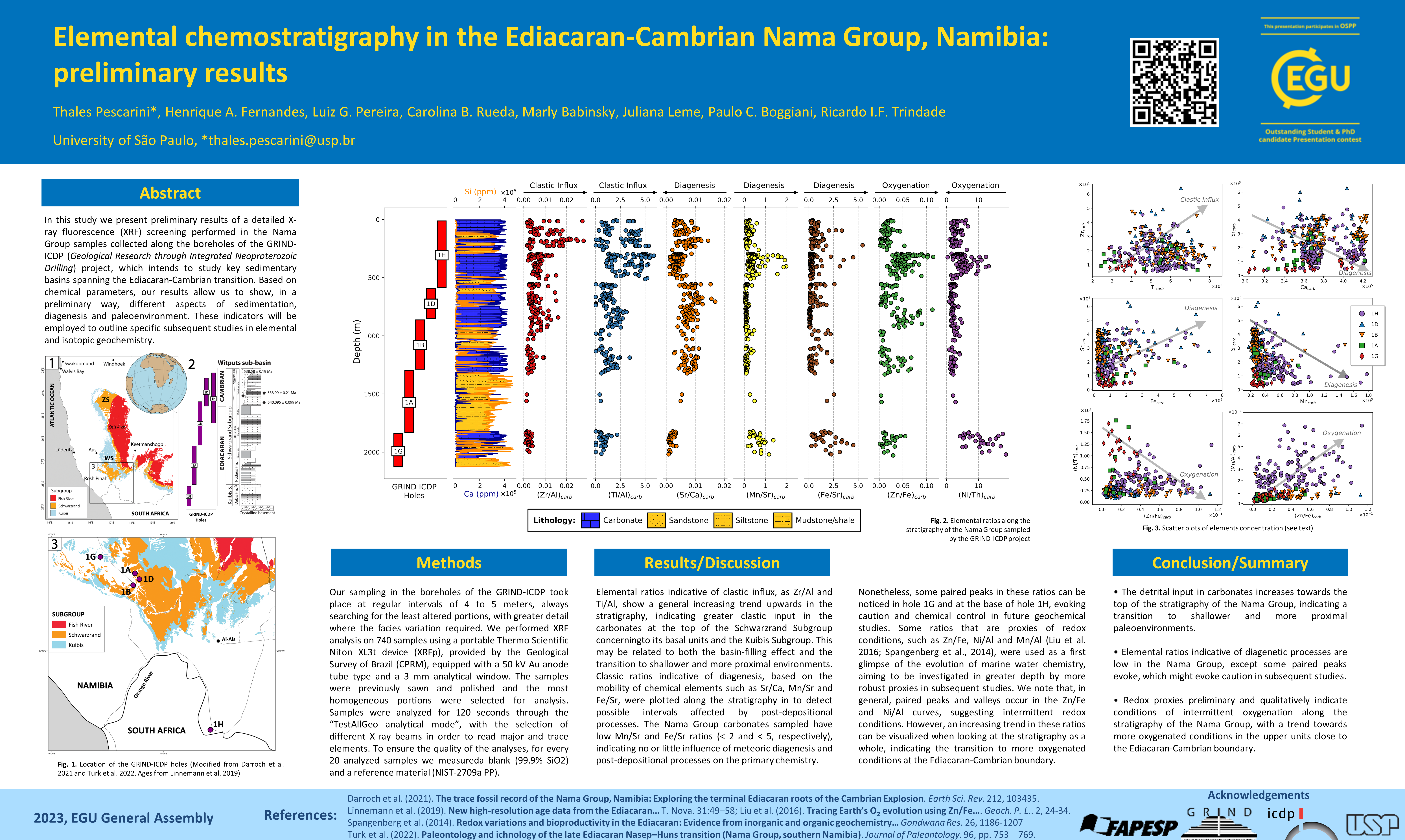
EGU23-9535 | ECS | Orals | BG5.4

Reconstructing the input of volcanic ash to the Pacific Ocean over the Cenozoic era 

Jack Longman, Ann Dunlea, Chloe Anderson, and Rachel Scudder

Volcanic ash is known to influence a range of biogeochemical processes once deposited in the oceans. These processes include the fertilisation of phytoplankton, and the enhancement of organic carbon burial, and the impact typically scales with the volume of ash. It has been shown that during periods of intense volcanic ash deposition, the impact on the ocean carbon cycle can be significant enough to cause global cooling. As a result, knowing the volume of ash entering the world’s oceans through time is vital to understanding the role explosive volcanism plays in setting global climate states. However, records of ash deposition consist of a small number of individual archives of ash input estimated via either layer counting or from multivariate statistical partitioning. Here, we compile the discontinuous and patchy records of volcanic ash deposition in the Pacific Ocean over the past 70 million years and synthesise all available data to produce a coherent record of ash accumulation rates. We show how the development of certain provinces, such as the Izu-Bonin Arc led to considerable upticks in ash input, and discuss how changing levels of ash deposition may have impacted Cenozoic climate change. Using a global biogeochemical model, we demonstrate mechanistically the role changing ash supply has in controlling global climate.

How to cite: Longman, J., Dunlea, A., Anderson, C., and Scudder, R.: Reconstructing the input of volcanic ash to the Pacific Ocean over the Cenozoic era, EGU General Assembly 2023, Vienna, Austria, 23–28 Apr 2023, EGU23-9535, https://doi.org/10.5194/egusphere-egu23-9535, 2023.

EGU23-9759 | Orals | BG5.4 | Highlight

INDITEK: A model to understand the emergence of marine biodiversity hotspots in the last 500 million years 

Carmen García-Comas and Pedro Cermeño

Life originated in the sea about 4 billion years ago and, for the first 3.5 billion years, it was exclusively microscopic. Something happened early in the Cambrian period that made multicellular life to thrive, giving rise to the spectacular biodiversity that has been this planet's hallmark for the past 500 million years. This staggering increase in diversity has raised a fundamental question among evolutionary ecologists: are there limits to the diversity of life? Some scientists say that global diversity increases to an equilibrium point or saturation level that is determined by the system’s carrying capacity. Alternatively, others claim that biodiversity is well below the saturation level and thus we can ignore the existence of any limit. These contrasting views have been fueled by interpretations of the fossil record which is severely biased in space and time. To theoretically test these contrasting views, we have developed a regional diversification model. In the model, we let 1 genus to diversify everywhere in the global ocean from 500 million years ago until present according to a model of paleogeography that constrains the diversification time and a paleo Earth System model that constrains the diversification rate as a function of seawater temperature and food supply. By externally imposing mass extinctions, we explore how the oceans filled with life. The regional model fits surprisingly well global fossil diversity curves and modern biodiversity distributions. According to the model, the ocean is far from saturation except for in the biodiversity hotspots, regions of extraordinarily high levels of diversity, which evolved under prolonged conditions of Earth system stability and maximum continental fragmentation. The model allows us to recreate many things, such as the history of biodiversity hotspots and the dynamics of the latitudinal biodiversity gradient. 

How to cite: García-Comas, C. and Cermeño, P.: INDITEK: A model to understand the emergence of marine biodiversity hotspots in the last 500 million years, EGU General Assembly 2023, Vienna, Austria, 23–28 Apr 2023, EGU23-9759, https://doi.org/10.5194/egusphere-egu23-9759, 2023.

EGU23-11473 | ECS | Posters on site | BG5.4

Preliminary results from U-Pb dating and geochemical characterization of GRIND-ECT carbonate samples from Namibia 

Marjorie Cantine, Axel Gerdes, Sören Eitel, Maria Ovtcharova, and Inigo Müller

Establishing geochronological controls on ancient sedimentary successions is critical for evaluating cause and effect, as well as rates of change, in ancient environments. Towards this goal, U-Pb dating of carbonate phases by in situ LA-ICP-MS offers a rapid and reasonably precise method for evaluating not only depositional ages but also the ages of post-depositional processes affecting carbonate rock. However, this technique is still in its first decade of application to carbonate rocks. Determining the best practices for applying this technique and evaluating the meaning, reliability, and robustness of the data it produces remain areas of interest.


In this study, we present the first results from U-Pb dating and geochemical characterization of samples from recent drillcores from Namibia, drilled by International Continental Scientific Drilling Program project GRIND-ECT. GRIND-ECT aims to capture, in drillcore, the Ediacaran-Cambrian transition in key successions worldwide. The Namibian portion of GRIND-ECT targets the Nama Group of southern Namibia, well-known for its abundant fossils and detailed geochemical and geochronological records from outcrop, with the goal of elucidating changes in the Earth system during the diversification of early animals. With both abundant interbedded ashes amenable to U-Pb zircon dating and abundant carbonate, these drillcores offer a natural experiment for comparing results from LA-ICP-MS carbonate dating and other geochronological techniques.


Our results show that a significant fraction of samples yield geologically meaningful ages when dated using LA-ICP-MS. These ages are consistent with depositional or early post-depositional ages. Microbially-influenced facies are often the most successful. Theses ages can be further refined using higher-precision techniques. Efforts to date vein calcites, which are often very low in U, have not yet yielded robust ages. Integration of Sr and trace and rare earth element data indicate the promise and the limitations of using these proxies as tests for “datability.”

How to cite: Cantine, M., Gerdes, A., Eitel, S., Ovtcharova, M., and Müller, I.: Preliminary results from U-Pb dating and geochemical characterization of GRIND-ECT carbonate samples from Namibia, EGU General Assembly 2023, Vienna, Austria, 23–28 Apr 2023, EGU23-11473, https://doi.org/10.5194/egusphere-egu23-11473, 2023.

EGU23-11907 | ECS | Orals | BG5.4

High-resolution carbon, oxygen and magnesium isotope chemostratigraphy of the Kuibis Subgroup, Nama Basin 

Gustavo Paula-Santos, Simone Kasemann, Fred Bowyer, Ricardo Trindade, Marly Babinski, Rachel Wood, and Juliana Leme

The Kuibis Subgroup (~551- <547.36 Ma) in the Nama Basin records an important fauna assemblage change during the Ediacaran. Current models support a transition from a more diverse ‘White Sea’ biotic assemblage to a less diverse ‘Nama’ biotic assemblage, for which the drivers remain unresolved. In spite of this decrease in diversity, the Nama assemblage hosts the first appearance of metazoan biomineralization in the geologic record. High resolution chemostratigraphic data are required to globally anchor the timeline of Earth System changes leading to this innovation of life. In order to track these changes at high-resolution, we performed a sampling campaign of Namibian cores from the ICDP project ‘Geological Research through Integrated Neoproterozoic Drilling: The Ediacaran-Cambrian Transition’ (GRIND-ECT), which focuses on terminal Ediacaran stratigraphy of the Witputs and Vioolsdrif sub-basins of southern Namibia. Here we present new Carbon and Oxygen isotope data for carbonate rocks of the Kuibis Subgroup retrieved from drill core 1G. This core records an approximately 200 m-thick succession of mixed carbonate-siliciclastic sedimentary rocks of that unit. Both dolostones and limestones within the lowermost 100 m display negative δ13C values between -5 and 0 ‰, consistent with laterally-correlative outcrop data that record the Basal Nama Excursion (BANE). The oxygen isotope profile recorded in core 1G is also very distinctive throughout the BANE. It starts with a negative shift of the δ18O values from -5 to -15 ‰, which then progressively increase to values around -12 ‰. The uppermost 100 m of core 1G display a gradual increase in δ13C values that reach +5 ‰ and are accompanied by increasing δ18O values that approach -10 ‰. The 0 ‰ crossing point (carbon isotope value) occurs at ~90 m depth, below strata that confidently record the first appearance of fossils of biomineralizing animals. Magnesium isotopic and paleontological data added to our high-resolution carbon isotope profile have the potential to refine the knowledge about the biological and environmental changes of this time period. 

How to cite: Paula-Santos, G., Kasemann, S., Bowyer, F., Trindade, R., Babinski, M., Wood, R., and Leme, J.: High-resolution carbon, oxygen and magnesium isotope chemostratigraphy of the Kuibis Subgroup, Nama Basin, EGU General Assembly 2023, Vienna, Austria, 23–28 Apr 2023, EGU23-11907, https://doi.org/10.5194/egusphere-egu23-11907, 2023.

EGU23-12004 | ECS | Posters on site | BG5.4

Thermal adaptation evolution and dispersal of the terrestrial biosphere regulates Earth’s long-term climate 

Julian Rogger, Benjamin Mills, Taras Gerya, and Loïc Pellissier

Sustained habitable conditions and the evolution of complex life on Earth depend on efficient climate regulation mechanisms that keep carbon fluxes between geologic reservoirs and the atmosphere-ocean system in balance. The terrestrial biosphere plays an important role in regulating the long-term climate by controlling burial rates of photosynthetically fixed CO2 as well as by mediating CO2 consumption through silicate mineral weathering during plant nutrient acquisition. These long-term carbon sinks balance out carbon inputs to the atmosphere-ocean system by processes including volcanism or the oxidative weathering of buried organic carbon. Current biogeochemical models of the Phanerozoic Earth neglect that the strength of the impact of the terrestrial biosphere on global carbon fluxes is subject to evolutionary dynamics and that it depends on how well the biosphere is adapted to prevailing environmental conditions [1]. Here, we develop a theoretical model to reconstruct global organic and inorganic carbon fluxes over the last 390 Myrs. The model includes eco-evolutionary processes underlying the thermal adaptation, such as the dispersal of terrestrial biomes in response to climatic changes and the in situ adaptive evolution towards the local environment. We show that the speed of evolutionary adaptation of the terrestrial biosphere to climatic shifts strongly affects the long-term atmosphere-ocean carbon mass balance. When considering a slow rate of thermal adaptation of the biosphere, resulting in reduced organic carbon burial and silicate weathering rates following temperature shifts, a closer balance of reconstructed Phanerozoic carbon inputs and outputs to and from the atmosphere-ocean system is obtained. Such a balance is a prerequisite to maintain habitable conditions on Earth’s surface on a multi-million-year timescale. We argue that the climate evolution of the Phanerozoic Earth is strongly defined by biological and evolutionary processes. Understanding these biological dynamics and how they shape the interactions between Earth’s biosphere, geosphere and the climate system may help to understand large shifts in Phanerozoic temperatures and the development of the atmospheric composition of the planet.

[1] Mills, B.J. et al. Modelling the long-term carbon cycle, atmospheric CO2, and Earth surface temperature from the late Neoproterozoic to present day. Gondwana Research 67, 172-186. DOI: 10.1016/j.gr.2018.12.001

How to cite: Rogger, J., Mills, B., Gerya, T., and Pellissier, L.: Thermal adaptation evolution and dispersal of the terrestrial biosphere regulates Earth’s long-term climate, EGU General Assembly 2023, Vienna, Austria, 23–28 Apr 2023, EGU23-12004, https://doi.org/10.5194/egusphere-egu23-12004, 2023.

EGU23-12883 | ECS | Posters on site | BG5.4

The Middle Eocene Climatic Optimum (MECO) impact on Southern Atlantic planktic foraminifera (Site 702) 

Silvia Sigismondi, Valeria Luciani, and Laia Alegret

Understanding the resilience of the ecosystems within the context of the ongoing global climate change is a
pressing challenge for humankind. The combination of the huge archive available in the geological record
with studies on modern biota is essential to formulate realistic predictions, and the Paleogene is one of the
most climatically dynamic periods in Earth´s history, offering this crucial opportunity. Here we focus on the
Middle Eocene Climatic Optimum (MECO), a global warming event during which marine bulk and benthic
carbonate δ 18 O values steadily declined by roughly 1‰ in over ~400 kyr, usually interpreted as a 3–6 °C
increase in global temperature followed by a rapid return to pre‐event conditions. This event record
temperatures and pCO2 that Earth will reach whether anthropogenic emissions will not stop (RCP8.5). A
number of characteristics, including greater‐than‐expected deep‐sea carbonate dissolution, a lack of globally
coherent negative δ 13 C excursion in marine carbonates, a duration longer than the characteristic timescale of
carbon cycle recovery, and the absence of a clear trigger mechanism, make the MECO one of the most
enigmatic events in the Cenozoic, dubbed a middle Eocene “carbon cycle conundrum”.
The paleoenvironmental and biotic consequences of the MECO are still poorly constrained, however, and
here we focus on the response of planktic foraminifera, which are extremely sensitive to the physical and
chemical state of the oceans. Quantitative studies of planktic foraminiferal assemblages from South Atlantic
ODP Site 702 allowed us to characterize the MECO at this key southern high-latitude setting. The magneto
and stable isotope stratigraphy are well constrained at this site, together with the calcareous nannofossils and
benthic foraminiferal response (Rivero-Cuesta et al., 2019, Paleoceanography and Paleoclimatology).
Our results indicate a pronounced southern migration of the warm index Acarinina coupled by a marked
decline in the abundance of the cold index Subbotina. Additionally, the low-latitude species Orbulinoides
beckmanni occurs only at the MECO peak. The post-MECO assemblages show a recovery of the pre-event
abundances, with the exception of the genus Chiloguembelina, which shows a striking increase in abundance
and suggests an intensification of the Oxygen Minimum Zone. A further result of our study is the greater
sensitivity of planktic foraminifera to the MECO with respect to calcareous nannofossils, as changes in
planktic foraminiferal assemblages started ~2 kyr before the calcareous nannofossil turnover.

How to cite: Sigismondi, S., Luciani, V., and Alegret, L.: The Middle Eocene Climatic Optimum (MECO) impact on Southern Atlantic planktic foraminifera (Site 702), EGU General Assembly 2023, Vienna, Austria, 23–28 Apr 2023, EGU23-12883, https://doi.org/10.5194/egusphere-egu23-12883, 2023.

EGU23-13901 | Orals | BG5.4

New proxy estimates reveal low atmospheric CO2 levels before the emergence of forested ecosystems 

Georg Feulner, Tais W. Dahl, Magnus A.R. Harding, Julia Brugger, Kion Norrman, Barry H. Lomax, and Christopher K. Junium

Traditionally, the evolution of trees and the establishment of the first forests during the Devonian (419–359 Ma) have been linked to an enhancement of terrestrial weathering processes and a subsequent reduction of atmospheric carbon dioxide (CO2) levels by one order of magnitude. However, empirical estimates of early-Devonian CO2 concentrations are sparse and carry large error bars. Here we use leaf carbon isotopes, stomata density, and stomata pore length from fossilized lycophytes to estimate atmospheric CO2 levels 410–380Ma based on a mechanistic model for gas exchange calibrated using their closest modern lycophyte relatives. We find that Earth's atmosphere contained about 525–715 ppm of CO2 before the emergence of forested ecosystems, much less than previously thought. Using a coupled climate model, we show that Earth was partially glaciated at these moderate CO2 levels and that this cool climate state is in principle agreement with available climate proxies and fossil evidence for the distribution terrestrial vegetation. Finally, we use a process-based biogeochemical model to demonstrate that our results are consistent with a scenario in which enhanced weathering, climate cooling, and atmospheric oxygenation are associated with the earlier emergence of shallow-rooted vascular ecosystems rather than the appearance of the first forests.

How to cite: Feulner, G., Dahl, T. W., Harding, M. A. R., Brugger, J., Norrman, K., Lomax, B. H., and Junium, C. K.: New proxy estimates reveal low atmospheric CO2 levels before the emergence of forested ecosystems, EGU General Assembly 2023, Vienna, Austria, 23–28 Apr 2023, EGU23-13901, https://doi.org/10.5194/egusphere-egu23-13901, 2023.

Aim: Using geochemical proxies to record changes in environmental conditions during the Ediacaran-Cambrian time

Methods: Thin section petrography combined with high-resolution analyses of trace elements and U-Pb, Sr, B and Li isotopes by LA-ICPMS (single and multi-collector)

Problem: Identification of pristine early diagenetic carbonate phases and their distinction from late diagenetic and altered carbonates. 

In this study, we use high spatial resolution multi-element and isotope analyses to identify pristine carbonate phases in samples from recent drill cores from Namibia, drilled by International Continental Scientific Drilling Program project GRIND-ECT. GRIND-ECT aims to capture, in drill core, the Ediacaran-Cambrian transition in key successions worldwide.

The method applied allows for relatively high sample throughput (>200) and precise detection of heterogeneous altered domains. Exclusion criteria are the presence or increased concentration of various trace elements (Al, Rb, LREE ...), heterogeneity of the 87Sr/86Sr isotope ratio, a lack of discernible populations in U/Pb isotope space, resulting in non-correlated scattering, and too young U-Pb dates.

To date, about 10-15% of the samples analyzed yielded a U-Pb date consistent with depositional age or an early post-depositional age. Geochronologic control of ancient sedimentary sequences is critical for evaluating cause and effect and rates of change in ancient environments. However, precision of LA-ICPMS ages (ca. 1-2%, e.g., 6-11 Ma) is insufficient to resolve changes in the Ediacaran-Cambrian oceans on timescales relevant for biological and environmental change. Therefore, the ages of these pre-characterized samples need to be refined using high-precision methods (Cantine et al., EGU 2023).

Analyses of Li and B isotopes are in progress on the pre-characterized, potentially pristine carbonate areas. We expect to see a change in the Li, B and Sr isotope records through Ediacaran-Cambrian time hopefully with significant anomalies. The correlation of the three isotope systems would be a confirmation for us that we are targeting pristine, early diagenetic carbonates.

How to cite: Gerdes, A., Cantine, M., and Eitel, S.: Ancient carbonates as archives for global environmental changes during Ediacaran-Cambrian time: a geochemical perspective, EGU General Assembly 2023, Vienna, Austria, 23–28 Apr 2023, EGU23-14217, https://doi.org/10.5194/egusphere-egu23-14217, 2023.

EGU23-14439 | ECS | Orals | BG5.4

Early Plant responses to Large Igneous Province Activity: the Devonian of Angarida, Siberia. 

Elizabeth Dowding, Nikolay Akulov, and Irina Mashchuk

Devonian plants in Siberia present protracted pioneer succession. During the Devonian Angarida was a large and semi-isolated continent within warm, arid zones of the northern hemisphere. Early plants in the Devonian did not originate upon Angarida, instead they are known to migrate to Angarida allowing a unique opportunity to study their changing biogeography and their influence upon the virgin landmass. In the Late Devonian, the Viluy-Yakutsk Large Igneous Province had two active phases and dramatically altered the physical and chemical environment of both the early plants and the marine systems. Our research into the survivourship dynamics of early plant communities upon the palaeocontinent Angarida have demonstrated that transgression and volcanogenic nutrient influx were key to the survival of colonising plants. Taxic proportions show that migrating taxa entered Angarida from the southwest, Kuznetsk and Minusinsk basins, dispersing across the continent in waves through central areas northwards. The patterns of dispersal are consistent throughout the Devonian and into the Early Carboniferous. Increased nutrient load from the active pulses of the Viluy-Yakutsk Large Igneous Province, biogeomorphic ecosystem engineering, and the increased biomass of Angaridan plants are assisted by Late Devonian transgression. These cumulative factors can be linked to the Late Devonian marine extinctions observed in Siberia.

How to cite: Dowding, E., Akulov, N., and Mashchuk, I.: Early Plant responses to Large Igneous Province Activity: the Devonian of Angarida, Siberia., EGU General Assembly 2023, Vienna, Austria, 23–28 Apr 2023, EGU23-14439, https://doi.org/10.5194/egusphere-egu23-14439, 2023.

EGU23-14992 | ECS | Posters on site | BG5.4

Unlocking the mystery of deep biosphere hosted by the Archaean granitic crust underneath the Deccan Traps, Koyna, India 

Rajendra Prasad Sahu, Sunanada Mandal, Swatilekha Sarkar, Debarshi Mukherjee, Sufia K Kazy, and Pinaki Sar

Life that inhabits deep within the continental crust remained enigmatic, and scientifically less explored. Recent scientific drilling of 3000-meter-deep scientific borehole at the Koyna seismogenic zone of the Deccan Traps, India provided an unprecedented opportunity to investigate the nature of life that evolved and existed within the extreme environment of Archean granitic basement. Rock core samples recovered from deep (up to ~2910 meter below surface), progressively hot (up to 74 °C), high pressure, alkaline, oligotrophic biosphere were analyzed through amplicon sequencing, metagenomics, and cultivation-based approaches. 16S rRNA gene amplicon sequencing showed considerable bacterial diversity. A significant proportion (50-63 %) of the microbial community, represented by the members of Actinobacteria, Gammaproteobacteria, Alphaproteobacteria, Bacilli and Clostridia was identified as endemic or core microbiome of this extreme realm. Relative abundance of different taxa of the core microbiome varied with depth in response to prevailing lithology and geochemistry. Ecological modeling depicted a major role dispersal limitation in explaining community variability suggesting the greater impact of stochasticity on the community assembly. Co-occurrence network analysis elucidated close interactions among autotrophic and organotrophic bacteria. Shotgun metagenomics revealed a major role of autotrophic carbon fixation via the Wood-Ljungdahl pathway and Rnf complex for energy and carbon metabolism. Presence of other mechanisms of energy generation such as ATPase, H2, CO, CH4 or sulfur oxidation system and the possibility of coupling of electron donors to NO3/SO42− reduction illustrated the metabolic versatility of these organisms in terms of utilizing diverse resources. Deeper analysis suggested the existence of an ‘acetate switch’, coordinating biosynthesis and cellular homeostasis. Reactivation of the rock-hosted microbiome using different nutrients (carbon source, e- donor and acceptor) and at elevated temperatures (up to 70-degree C) and anaerobic conditions showed patterns of differential taxa recruitment for utilizing different substrate regimes. Enrichment of strict anaerobic members of taxa Peptococcaceae, Clostridiaceae Family XIV, Clostridiaceae 2 and Moraxellaceae in H2+CO2 condition corroborated well with their ability for acetogenesis. Universal enrichment of Burkholderiaceae, Bacillaceae and Sphingomonadaceae suggested their abilities to use diverse substrates. Our data provided deeper insights into microbial life and its mechanisms of carbon and energy metabolism within the nutrient- and energy-limiting deep granitic crust.

How to cite: Sahu, R. P., Mandal, S., Sarkar, S., Mukherjee, D., Kazy, S. K., and Sar, P.: Unlocking the mystery of deep biosphere hosted by the Archaean granitic crust underneath the Deccan Traps, Koyna, India, EGU General Assembly 2023, Vienna, Austria, 23–28 Apr 2023, EGU23-14992, https://doi.org/10.5194/egusphere-egu23-14992, 2023.

EGU23-15364 | ECS | Posters on site | BG5.4

Environmental stabilisation and biological diversification in the aftermath of the Sturtian Snowball glaciation 

Fred Bowyer, Alexander Krause, Yafang Song, Kang-Jun Huang, Yong Fu, Bing Shen, Jin Li, Xiang-Kun Zhu, Michael Kipp, Lennart van Maldegem, Jochen Brocks, Graham Shields, Guillaume Le Hir, Benjamin Mills, and Simon Poulton

     The Cryogenian Period (720–635 Million years ago, Ma) hosts sedimentary and geochronological evidence for two long-lived global-scale glaciations during the Sturtian (ca. 717–660 Ma) and Marinoan (ca. 650–635 Ma) cryochrons. Radiometric and chemostratigraphic data, in addition to climate modelling, support an approximately synchronous global deglaciation from the Sturtian cryochron, followed by a non-glacial interval (ca. 660–650 Ma) with abundant globally-distributed marine sedimentary successions. The palaeontological record of Cryogenian non-glacial successions is dominated by microfossils and problematic macrofossils, some of which have been interpreted as possible sponge-grade organisms. Biomarker analyses also hint at the rise to dominance of green algae and the possible first appearance of demospongiae during this interval. Oxygen and nutrient availability can fuel biotic complexity, however Cryogenian non-glacial palaeoredox and palaeonutrient (e.g. phosphorus, P) dynamics are poorly understood. Furthermore, while regional lithostratigraphic and chemostratigraphic correlations of carbonate-dominated Cryogenian non-glacial sedimentary successions are well documented, the temporal calibration of globally distributed carbonate and siliciclastic successions has not been attempted. Without a global chronostratigraphic age framework, the regional versus global nature of geochemical responses to Earth System perturbations and the sequence of biotic events throughout this interval remain obscured.

     Here we present new high resolution palaeoredox and P phase association data from five globally distributed Cryogenian non-glacial drill core successions. The combination of Fe speciation and trace element palaeoredox reconstructions with P speciation data clearly show dynamic changes to bioavailable P recycling in response to local and global scale nutrient-driven palaeomarine redox conditions. We also present a new global Cryogenian non-glacial chronostratigraphic framework for the calibration, in relative time, of geochemical and palaeontological data from carbonate and siliciclastic-dominated successions. This enables our new data to be interpreted in the context of the highly dynamic global C and S cycles and biotic record throughout this interval. This approach, in combination with new insights from climate models that constrain changes to atmospheric CO2 and temperature, sheds new light on the mechanisms for global changes to ocean redox and nutrients, and possible drivers for a possible increase in biotic diversity throughout this interval.

How to cite: Bowyer, F., Krause, A., Song, Y., Huang, K.-J., Fu, Y., Shen, B., Li, J., Zhu, X.-K., Kipp, M., van Maldegem, L., Brocks, J., Shields, G., Le Hir, G., Mills, B., and Poulton, S.: Environmental stabilisation and biological diversification in the aftermath of the Sturtian Snowball glaciation, EGU General Assembly 2023, Vienna, Austria, 23–28 Apr 2023, EGU23-15364, https://doi.org/10.5194/egusphere-egu23-15364, 2023.

EGU23-15489 | ECS | Orals | BG5.4

Insights into the terminal Ediacaran marine carbonate record from shale-hosted carbonate carbon isotopes 

Mariana Yilales, Fred Bowyer, Rachel Wood, and Simon Poulton

The marine carbon isotope record (δ13C) used for chemostratigraphy and reconstruction of carbon cycle dynamics is constructed using carbonate rocks, but there is evidence that carbonate cements hosted within fine-grained clastics (shales and mudstones) in some settings may also express δ13C trends that covary with the record from carbonates. We present new carbon and oxygen isotopic data from shale-hosted carbonate cements (δ13Ccarb-sh and δ18Ocarb-sh, n = 107, <16 wt% CaCO3) of the terminal Ediacaran Nama Group, Namibia (≥550.5 to <539.6 Million years ago; Ma). These data are compared with the published carbon and oxygen isotopic record from coeval carbonates (δ13Ccarb and δ18Ocarb, n = 1611) and total organic carbon (TOC) concentrations. We show that δ13Ccarb-sh compositions in samples of intermediate to high CaCO3/TOC can approximate contemporaneous δ13Ccarb in open marine mixed carbonate-clastic settings. By contrast, δ13Ccarb-sh values in samples with low CaCO3/TOC that were deposited in clastic settings distant from the locus of carbonate deposition are more negative than contemporaneous δ13Ccarb. These data suggest that δ13Ccarb-sh may approach seawater composition in samples of low TOC when deposited in high dissolved inorganic carbon (DIC) settings, where carbonate can rapidly precipitate from seawater during early diagenesis. However, the use of δ13Ccarb-sh to infill gaps in the existing δ13Ccarb record remains uncertain, even when these criteria are fulfilled. Intervals of δ13C-δ18O co-variability in the Nama Group succession appear to correlate with units where seawater mixing with meteoric fluids was more likely during early diagenesis, such as clastic-dominated settings, which also show significant decreasing δ18O through time with gradual sub-basin infill.We further consider uncertainties in lithostratigraphic correlation of the upper Urusis Formation of the Nama Group that enable three new possible correlations to be proposed for δ13Ccarb-sh data within the terminal Ediacaran to lower Cambrian (<542.65 Ma to >535 Ma) regional and global δ13Ccarb records.

How to cite: Yilales, M., Bowyer, F., Wood, R., and Poulton, S.: Insights into the terminal Ediacaran marine carbonate record from shale-hosted carbonate carbon isotopes, EGU General Assembly 2023, Vienna, Austria, 23–28 Apr 2023, EGU23-15489, https://doi.org/10.5194/egusphere-egu23-15489, 2023.

The early evolution of macroscopic life, including the Cambrian ‘explosion’ of animals, took place over more than 100 million years against the backdrop of dynamic environmental changes like unstable redox conditions and nutrient supply. The terminal Ediacaran to early Cambrian transition is marked by the appearance of macroscopic biomineralizers, but also a seeming decline in diversity, in contrast to rich communities of macroscopic Ediacara-type biota preserved in older units worldwide. Our understanding of this biotic change as well as its environmental divers suffers from stratigraphic incompleteness, as continuous mid and upper Ediacaran, and Cambrian strata are rarely exposed in a continuous sequence in the same area, or represent different depositional settings.

The Mackenzie Mountains in the Northwest Territories, Canada are a home to a nearly continuous sedimentary succession from the Cryogenian to the Cambrian and as such, provide a great target to analyse biotic and environmental changes through time. We have investigated the interval of carbonates and siliciclastics through the Blueflower, Risky, Ingta, Backbone, and Vampire formations and present integrated palaeontological and geochemical data to produce a high resolution biostratigraphic and chemostratigraphic profile for the Ediacaran-Cambrian boundary interval.

The Ediacaran-Cambrian boundary occurs in the Ingta Formation, marked by sporadic trace fossils Treptichnus and Harlaniella. Simple surficial traces Planolites occur throughout the formation. Also common are well-preserved bacterial filamentous organic-walled microfossils in mudrocks, but the boundary interval lacks complex acritarchs or cuticular animal remains. Macroscopic carbonaceous fossil problematica were also recovered. Complex trace fossils occur in the overlying Backbone Ranges Formation and become more common in the Vampire Formation, but are absent from the lowermost Cambrian strata in the Mackenzie Mountains. The primary producer dominated environment and the absence of organically preserved animal remains in a setting conducive to organic preservation imply a true decline in diversity through the boundary interval – possibly a result of either phylogeny or ecology.

How to cite: Agic, H., Smith, M., and Kovalick, A.: Primary producer dominated environments of the Ediacaran-Cambrian transition: palaeontological insights from the Mackenzie Mountains, Canada, EGU General Assembly 2023, Vienna, Austria, 23–28 Apr 2023, EGU23-16040, https://doi.org/10.5194/egusphere-egu23-16040, 2023.

EGU23-16572 | ECS | Orals | BG5.4

Dating the first Siberian trilobites with a Bayesian, stratigraphic age model 

Kilian Eichenseer, Matthias Sinnesael, Martin R. Smith, and Andrew R. Millard

Trilobites are the most diverse animal phylum in the Cambrian, and are critical stratigraphic markers. Despite their significance, the exact sequence of trilobite appearances across the globe, and their respective ages, are difficult to reconstruct due to a scarcity of radiometric dates. Using visual correlation of carbon isotope (δ13C) excursions and integration of available U-Pb age constraints, Landing et al. (2021) have estimated the age of the first Siberian trilobites at roughly 521 million years ago (Ma), which would make them the world’s oldest trilobites. Here, we aim to provide a more precise date, with uncertainty, using a Bayesian stratigraphic age model that takes the global signature of δ13C excursions to correlate proxy records from multiple locations. Our model integrates radiometric dates across sections, using ages from well-dated sections to inform age estimates in sections with little or no age information. The model works by evaluating the fit of Bayesian splines to different alignments of the sections, using Markov chain Monte Carlo methods to obtain the posterior distributions. This approach provides an objective evaluation of different possible alignments, generating a probabilistic age-depth model. We apply this model to the lower Cambrian sections of the Anti-Atlas mountains in Morocco, and to the Sukharikha River section of the northwestern Siberian platform. The Moroccan sections provide a uniquely detailed δ13C record and multiple radiometric dates, and this age information is transferred to the Siberian section and the emergence of trilobites in the fossil record. Preliminary results indicate that the first appearance of Siberian trilobites is younger than previously estimated, and consequently closer in time to the first trilobites in Morocco and elsewhere.

Landing, E., Schmitz, M., Geyer, G., Trayler, R., & Bowring, S. (2021). Precise early Cambrian U–Pb zircon dates bracket the oldest trilobites and archaeocyaths in Moroccan West Gondwana. Geological Magazine, 158(2), 219-238.

How to cite: Eichenseer, K., Sinnesael, M., Smith, M. R., and Millard, A. R.: Dating the first Siberian trilobites with a Bayesian, stratigraphic age model, EGU General Assembly 2023, Vienna, Austria, 23–28 Apr 2023, EGU23-16572, https://doi.org/10.5194/egusphere-egu23-16572, 2023.

Oxygen levels in Earth’s oceans are dropping fast due to anthropogenic nutrient input and CO2 release, and the consequences of this for marine ecosystems are difficult to predict. The Cretaceous Period (66- 145 million years ago) witnessed numerous extreme ocean anoxic events (OAEs) – some regional, some global in scale – that are thought to have been caused by pulses of volcanism and CO2 release. If we knew the exact mechanisms by which volcanism triggered these Cretaceous OAEs, and the role of feedbacks and boundary conditions, they could provide vital information as to where potential future tipping points in the Earth system lie. Presently, however, our estimates of climate, atmospheric CO2 and carbon cycling in the Cretaceous are qualitative at best, preventing OAEs from being useful analogues. In this poster, I will introduce the planned PETRARCH project, funded through UKRI matching of an ERC Consolidator Grant, that will aim to fill that gap. PETRARCH will combine new and proven geochemical proxy archives with cutting-edge Earth system modelling to look at how marine life and changes in marine pelagic ecosystems may have interacted with environmental changes to drive pervasive global anoxia. To do this, we will calibrate boron isotopes in the silica shells of radiolarians as a new proxy archive for ocean pH and atmospheric CO2, combine this new radiolarian data with new measurements of carbonate microfossils to reconstruct Cretaceous marine carbon cycling, and use Earth System modelling, tuned to these data, to test what exact biogeochemical feedbacks and climate forcings tipped the Cretaceous Earth into profound, and sometimes global, ocean anoxia.

How to cite: Henehan, M.: PETRARCH: Pinpointing Earth-System Thresholds for Anoxia with new Reconstructions of the Cretaceous Hothouse, EGU General Assembly 2023, Vienna, Austria, 23–28 Apr 2023, EGU23-16599, https://doi.org/10.5194/egusphere-egu23-16599, 2023.

EGU23-17419 | Orals | BG5.4

TERRAFORM: Trait Ecology and Biogeochemical Cycles in Deep Time 

Christos Chondrogiannis, Richard Nair, William Matthaeus, Kamila Kwasniewska, Katie O’Dea, Catarina Barbosa, Antonietta Knettge, Bea Jackson, and Jennifer McElwain

Plants respond to environmental change but also impact the Earth system by altering biogeochemical fluxes. Plants and their distribution have also changed profoundly across deep time as major evolutionary groups have evolved, prospered or declined. However, the current representation of this change in models is simplistic. For example, a simple succession of biogeochemical impacts along with evolution of major plant groups (i.e.,sporophytes, gymnosperm, and angiosperms) is assumed through eras of deep time, whereas major plant innovations are known to have evolved through appearance of novel combinations of traits that show variation within these lineages.

In the TERRAFORM project we are integrating trait ecology of extinct plants, state-of-the-art weathering experiments, and multi-scale modeling to study the terrestrial biosphere’s impact on the carbon, nutrient and hydrological cycles in deep-time. We focus on the effects of evolution of plant traits on chemical weathering and the global silicate cycle and how it varies over time, we hope to track how plants have impacted major episodes of biosphere upheaval. Pursuant to that focus, we perform palaeo-Earth weathering and decomposition experiments to understand the difference in effect of plant evolutionary groups and their traits on  biogeochemical fluxes. We apply these empirical insights to plant fossils spanning episodes of major environmental change (Pennsylvanian-Permian glacial interglacial cycles; the Triassic-Jurassic mass extinction; Cretaceous OAEs) to evaluate the impact of environmental change on extinct plants and their traits. This knowledge will improve the chemical weathering and terrestrial ecosystem parameterization and performance of biogeochemical models, to evaluate the plant feedback on other components of the earth system. Ultimately we aim to understand how plants TERRAFORMed the Earth, and how plant functional traits and function evolved over the past 300 million years.

How to cite: Chondrogiannis, C., Nair, R., Matthaeus, W., Kwasniewska, K., O’Dea, K., Barbosa, C., Knettge, A., Jackson, B., and McElwain, J.: TERRAFORM: Trait Ecology and Biogeochemical Cycles in Deep Time, EGU General Assembly 2023, Vienna, Austria, 23–28 Apr 2023, EGU23-17419, https://doi.org/10.5194/egusphere-egu23-17419, 2023.

EGU23-17420 | Posters on site | BG5.4

Moisture Seasonality as a Differential Driver of Modeled Forest Distribution during the Pennsylvanian 

William Matthaeus, Joseph White, Sophia Macarewich, Jennifer McElwain, and Jonathan Wilson

Environmental restriction of forest distribution may be specific to the eco-physiological limits of era-appropriate plants. Accounting for major limiting factors in deep time will improve understanding of ecosystems dominated by extinct plants, surface processes, and Earth System function. Major plant taxa associated with Earth’s penultimate icehouse (the late Paleozoic ice age [LPIA]) are thought to have been limited by moisture seasonality based on evidence from fossil and geological records. We apply recently described methodologies­—climate modeling and ecosystem-process modeling—to simulate global arboreal vegetation in the late Paleozoic ice age. We will compare the intensity of modeled moisture seasonality with plant performance of major late Paleozoic plant taxa. Using National Center for Atmospheric Research’s Community Earth System Model version 1.2 (CESM) simulations, varying pCO2, pO2, and ice extent for the Pennsylvanian, and fossil-derived leaf C:N, maximum stomatal conductance, specific conductivity, and stem physiological limitations for several major Carboniferous plant groups, we will simulate global ecosystem processes at a 2-degree resolution with Paleo-BGC. We hypothesize that moisture seasonality patterns across Pangea will interact with modeled era-appropriate taxa—based on stem hydraulic hysteresis and leaf water limitations—to impact arboreal plant growth and forest cover. The simulated function of era-appropriate stem and leaf trait combinations may provide a mechanistic link to drought-tolerance evolution in lineages like the coniferophytes that persist across global ecological upheavals.

How to cite: Matthaeus, W., White, J., Macarewich, S., McElwain, J., and Wilson, J.: Moisture Seasonality as a Differential Driver of Modeled Forest Distribution during the Pennsylvanian, EGU General Assembly 2023, Vienna, Austria, 23–28 Apr 2023, EGU23-17420, https://doi.org/10.5194/egusphere-egu23-17420, 2023.

EGU23-274 | ECS | Orals | SSP4.2

Late quaternary carbonate (pteropod) preservation in the Indian Ocean sediments: inferences on the paleoclimate and paleoceanography 

Sreevidya Edayiliam, Sijin Kumar Adukkam Veedu, and Nagender Nath Bejugam

To evaluate the preservation pattern of pteropods and their relationship with climatic and oceanographic history in the Laccadive Sea, a temporal variation analysis of pteropod abundance was done. For that, we employed preservation indices from calcite (Globigerina bulloides%, Globorotalia menardii abundance), as well as aragonite (e.g., total pteropod abundance, Limacina Dissolution Index (LDX), fragmentation ratio). To determine if pteropod shells have been preserved over time, we used estimated pteropod abundance. The pteropod preservation record displays excellent preservation during cold stadials, evidenced by the lower values of aragonite dissolution proxies than during the interglacials/interstadials, similar to the preservation records from other northern Indian Ocean cores evidenced by the lower values of aragonite dissolution proxies than during the interglacials/interstadials. The shallow aragonite compensation depth (ACD), weaker oxygen minimum zone (OMZ), and the lower southwest monsoon (SWM)-induced productivity are thought to be the cause of the basin-wide pteropod preservation events during the cold stadials (ACD). Additionally, during an intense northeast monsoon (NEM), the advection of cold, low-saline waters from the Bay of Bengal to the Laccadive Sea, as well as the intrusion of southern-sourced intermediate water ventilation, may have caused a deep vertical mixing of oxygen-rich surface waters, raised the pH of thermocline waters and deepened the ACD. However, the local fluctuations in the water mass properties, such as the increased productivity maxima, the intense OMZ, and shallow ACD, as well as changes in the aragonite, are responsible for the poor pteropod abundance, poor preservation and strong dissolution during the Holocene, Bølling-Allerød (B/A) and interstadial periods.

The calcification proxy indicates that the aragonite undersaturation and reduced calcification occurred during 19-16.5 kyr, preferably due to the depletion in the oceanic alkalinity caused by enhanced upwelling-induced carbonate ion exchange between the intermediate and deep water. In contrast, the preferential dissolution of smaller shells in the sediments (marked by increased average shell size and higher values of Limacina dissolution index (LDX) corresponds to strengthened OMZ and shallower ACD, pointing towards the post-depositional dissolution of aragonite shells. Therefore, the overall decrease of pteropod content of the deposits in the stadial/interstadials suggests a combination of monsoon-associated changes in water column properties, variability in aragonite saturation, intermediate water ventilation and sediment rate.

How to cite: Edayiliam, S., Adukkam Veedu, S. K., and Bejugam, N. N.: Late quaternary carbonate (pteropod) preservation in the Indian Ocean sediments: inferences on the paleoclimate and paleoceanography, EGU General Assembly 2023, Vienna, Austria, 23–28 Apr 2023, EGU23-274, https://doi.org/10.5194/egusphere-egu23-274, 2023.

EGU23-618 | ECS | Posters virtual | SSP4.2

Reconstruction of a paleo-seagrass ecosystem using molluscan paleoecology and stable isotope geochemistry: A case study from the Quilon Limestone (Miocene), India. 

Venu Gopal Kella, Amitaprajna Mallik, Devapriya Chattopadhyay, and Naveen Gandhi

Seagrasses are a vital part of the marine ecosystem, owing to their contribution to oceanic primary productivity and supporting highly diverse marine ecosystems. The fossil record of seagrasses is rare because of their poor preservation potential. Sedimentological and taphonomic indicators are generally used to identify the paleo seagrass habitat. The fossil record of seagrass-associated taxa such as foraminifera, corals, bryozoans, molluscs, and sirenians can also provide indirect evidence of this specific habitat. These constitute Indirect Paleo-Seagrass Indicators (IPSIs). The early Miocene (Burdigalian) fossil assemblage of Quilon limestone of Kerala, India, has been interpreted as a seagrass habitat based on the species association of gastropods, bryozoans, and foraminifera. This is the only reported seagrass ecosystem from West Indian Province (WIP). In our study, we attempt to develop a new multi-proxy approach using morphology, ecology, and geochemical signatures of seagrass-associated molluscs from the Quilon Formation and evaluate its potential to reconstruct a paleo-seagrass ecosystem.

Our sample consisted of ~2000 specimens of microbivalves representing nine families of bivalves. We also included previously reported 16 families of macrobivalves in our ecological analysis. The molluscan community of the Quilon Formation is dominated by families that are mobile (67%), infaunal (65%), and suspension feeders (78%) in comparison to other ecological guilds. The seagrass ecosystem, characterized by soft substratum and high suspension load, favors these ecological strategies. The high proportional abundance of Lucinidae bivalves (8.9%) in the assemblage agrees with the expectation of dominance of chemosymbionts in the seagrass meadows. The small body size (<10mm ) and low predation intensity (drilling frequency 0.06, repair scar frequency 0.04) reported from this community also match the expected pattern of a seagrass ecosystem serving as a nursery.

We analyzed molluscan shells from Quilon limestone for stable isotope ratios. We also supplemented this data with published data of present and past seagrass-associated molluscs. Using this data, we evaluated the influence of ecological variables in shaping the stable isotope signature of molluscs in the seagrass ecosystem. The 𝛅13C values of bivalves ranged from -3 to 3 ‰  and of gastropods ranged from -1 to 4 ‰. Our results show that deposit feeders and grazers have 𝛅13C values in comparison to chemosymbionts. The herbivores and carnivores have comparable 𝛅13C and 𝛅18O isotopic values implying a limited role of diet in shaping the isotopic signature of seagrass molluscs. 

The multi-proxy results support the previous interpretation of Quilon limestone as a seagrass ecosystem. This study provides insight into using a multi-proxy approach of combining molluscan taxonomy, morphology, ecology, and geochemistry in developing a reliable IPSI for identifying paleo-seagrass ecosystems.

How to cite: Kella, V. G., Mallik, A., Chattopadhyay, D., and Gandhi, N.: Reconstruction of a paleo-seagrass ecosystem using molluscan paleoecology and stable isotope geochemistry: A case study from the Quilon Limestone (Miocene), India., EGU General Assembly 2023, Vienna, Austria, 23–28 Apr 2023, EGU23-618, https://doi.org/10.5194/egusphere-egu23-618, 2023.

EGU23-635 | ECS | Posters virtual | SSP4.2

Deglacial- Holocene carbonate preservation in the Bay of Bengal 

Gayathri Narath Meethal, Sreevidya Edayiliam, Bhoi Subhakanta, Sahoo Subham Kesari, and Sijinkumar Adukkam Veedu

Deep-sea carbonate dissolution/preservation history is important to better understand marine carbonate system and surface ocean productivity. To understand carbonate dissolution during the last deglacial and Holocene periods in the Eastern BoB, we analyzed foraminifera carbonate dissolution indices viz., perfect test ratio (PTR) of Globorotalia menardii, Menardii fragmentation index (MFI), percentage of total resistant species (RSP), and percentage of total susceptible species (SSP). The core yielded rich assemblages of planktonic foraminifera though retrieved from deeper water depth (3019 m) of the Eastern Bay of Bengal. In general, the preservation is better during last glacial period on record (16-11.7 ka) and poor during Holocene. During Holocene, carbonate dissolution is intense in the early Holocene (12.5 to 8 ka), marked by increased MFI, and decreased PTR values along with less abundance of susceptible species. A slight decrease in the MFI was seen from 8 to 4.9 ka. The late Holocene period was characterized by less MFI and high PTR values. In general, MFI (PTR) was high (low) during the early Holocene compared to the deglacial and mid to late Holocene periods. Interestingly, the dissolution record shows a good relationship with Indian summer monsoon variability. The intense dissolution of the early Holocene might be due to changes in water column chemistry due to the increased river runoff and direct precipitation. We compared our data with existing records from the Andaman Sea and the Central Indian Ocean. The assemblages from the Bay of Bengal show a high degree of dissolution and low preservation during interglacial periods. The result of this study explains that dissolution is more pronounced during the warm interglacial and interstadials and MFI and PTR can be a potential proxy for quantitatively tracking deep marine CaCO3 dissolution in the Bay of Bengal.


Keywords: Carbonate dissolution; Planktonic foraminifera, Globorotalia Menardii, deglacial, Holocene.


How to cite: Narath Meethal, G., Edayiliam, S., Subhakanta, B., Subham Kesari, S., and Adukkam Veedu, S.: Deglacial- Holocene carbonate preservation in the Bay of Bengal, EGU General Assembly 2023, Vienna, Austria, 23–28 Apr 2023, EGU23-635, https://doi.org/10.5194/egusphere-egu23-635, 2023.

Stable isotope (δ18O and δ13C) record of the shells of Crassostrea has served as trusted sclerochronological recorders for deciphering the life history and the interannual ambient seawater conditions including temperature and salinity. Several species of Crassostrea are found in modern estuarine system throughout the world. The Bay of Bengal (BOB) in the northern Indian ocean is one such region which experiences the lowest salinity in the tropics due to exceptional and complex hydrological dynamics associated to the Indian monsoon. In this study, we utilized three shells of the endemic species, that are cemented together.  We collected the specimens from Chandipur-on-sea BOB, in the eastern coast of India to understand the relationship between isotope signatures of the shells (δ18Oshell and δ13Cshell), growth history and the environmental parameters (temperature and salinity).

In terms of the microstructural variation within the shells, samples collected from the foliated layer as compared to the chalky calcite layer of the cross sectional hinge region demonstrates no significant difference in their isotopic values. The theoretical isotope profile model based on the satellite data for monthly temperature and salinity data provided the background pattern which when compared to the observed isotope values demonstrated no significant difference for Cha 2 and Cha 3, however, the isotope value of Cha 1 shifted significantly towards negative values. The isotope profile for all the individuals are sinusoidal with repeating δ18Oshell and δ13Cshell minima in the form of relatively sharper and narrower negative half cycles and demonstrates negative offset from the predicted model someimes. We infer the negative shifts and offset of the isotope minimas to be attributed to the lower salinity due to river runoff and precipitation during summer monsoon in this region which also leads to slow or limited growth of the oysters. The grey foliated calcitic bands within the chalky calcitic layers do not incorporate the amplitudes or a particular trend of the isotopic profiles representing no seasonal signature and hence cannot be utilised as age indicators for C.cuttackensis. However, the count of minimas in the isotope profiles revealed the age to be slightly more than 1 year for Cha1 and Cha3 whereas Cha 2 lived for three years atleast. The corresponding growth rates for length and height of the shells decreases with ontogeny, more so for the length than height validating the elongated shape of C.cuttackensis in their adulthood. When compared, the calculated growth rates for C.cuttackensis is highest among all other present and past Crassostrea species globally.

How to cite: Dutta, S. and Chattopadhyay, D.: Signature of monsoon driven salinity fluctuations in stable isotope (oxygen and carbon) record of bivalve shells: Insights from the sclerochronology of three confluent individuals from the Bay of Bengal, India, EGU General Assembly 2023, Vienna, Austria, 23–28 Apr 2023, EGU23-796, https://doi.org/10.5194/egusphere-egu23-796, 2023.

The Precambrian stromatolites are essential proxies for early life on earth. However, recent studies on abiogenic features having gross similarity with biogenic forms have made it difficult to prove their unequivocal biogenecity. Key morphological indicators of stromatolite biogenecity include- its morphological variations, biostrome development, growth through high-energy conditions, and lamina accretion through microbial precipitation, trapping, and binding. A representative outcrop of the Proterozoic stromatolites belonging to the Bhander Limestone and a small horizon present at the base of Sirbu Shale Member, Upper Vindhyan Group of Vindhyan Basin, central India is studied during the present endeavor. Six different stromatolite morphotypes were identified within the studied intervals. Among them, five morphotypes are present within the Bhander Limestone such as large laterally-linked domal stromatolites (S1), columnar stromatolites (both bioherm (S2) and biostrome (S3) type), small-headed stromatolites (S4) and stratiform stromatolites (S5).

Numerous cycles are observed between these morphotypes, especially between the columnar and the small-headed stromatolites. The thickness of the individual cycle varies between 32 cm to 162 cm. The cycles always start with the columnar morphotype (average thickness~57.71 cm) and end with the small-headed morphotype (average thickness ~16.90 cm). The former morphotype (average column height and diameter 7.39 cm and 3.38 cm) shows different variety-branched patterns, vertical and inclined nature. Vertically oriented columns are parallel in nature. The width of the inter-columnar area between the individual parallel columns is variable (average thickness~1.33 cm). The filling material is carbonate cement, stromatolite debris, and chunks. The presence of stromatolite debris within the inter-columnar area indicates agitation within the depositional site. The inclined and branched columnar morphotypes tend to develop bioherm (S2), while the vertically oriented, parallel-natured columnar stromatolites form the biostrome (S3). At the end of each cycle, microbial laminites (thickness ranging from 1 to 8.5 cm) is frequently observed. Occasionally microbial laminites are also present when columnar stromatolites transit to small-headed stromatolites. The latter morphotype has an average column diameter of 1.84 cm. The cyclic alternation of columnar and small-headed stromatolite morphotypes indicates a shift in water depth within the depositional zone, which could be caused by seasonal fluctuation, diurnal cycles, or tectonic factors. Gradual thickness increment of the small-headed morphotypes within the individual cycles towards the upper part of the studied interval indicates a progressive shallowing. A petrographic study reveals the presence of alternate dark-colored micritic and light-colored spar-bearing laminae. The dark micritic laminae attest deposition took place under microbial influence. The sixth morphotype is cabbage-shaped domal stromatolite (S6) (average column height and diameter are 27.11 cm and 20.75 cm, respectively), present only at the basal part of the Sirbu Shale. These domal stromatolites occur above an alternating sand-shale sequence bearing emergence features and form bioherms. Under the microscope, this morphotype shows the presence of ooids and peloids within the dark micritic laminae. Both macro and micro scale variations recorded within the studied stromatolites of the Meso-Neoproterozoic Vindhyan Basin are inkling towards their biogenic origin.

How to cite: Choudhuri, A., Jambhule, D., Sinha, S., and Srimani, S.: Morphological variability of stromatolites and their cyclicity as an indicator of biogenicity- example from a Proterozoic carbonate platform of Vindhyan Supergroup, India, EGU General Assembly 2023, Vienna, Austria, 23–28 Apr 2023, EGU23-2272, https://doi.org/10.5194/egusphere-egu23-2272, 2023.

EGU23-2432 | ECS | Posters virtual | SSP4.2

Paleoclimate and paleoenvironment reconstructions from Middle Eocene successions in Egypt: Geochemical and micropaleontological approaches 

Mostafa Mohamed Sayed, Petra Heinz, Ibrahim Mohamed Abd El-Gaied, and Michael Wagreich

Forty-three rock samples have been collected from two sections, exposed at south east Beni-Suef area, Egypt. These samples showed richness in benthic foraminiferal assemblages and only rare occurrences of index planktonic foraminifera. The studied outcrops were lithologically subdivided into two Middle Eocene rock units named from base to top as follow: (1) the Qarara Formation (Lutetian) and (2) the El Fashn Formation (Bartonian). The investigated rock samples yielded 160 foraminifera species and subspecies which belonging to 4 suborders, 19 superfamilies, 34 families and 59 genera. The stratigraphic distribution of the identified species allowed us to construct four local benthic biozones which are: (1) Bolivina carinata Lowest Occurrence Zone (Lutetian), (2) Bulimina jacksonensis Lowest Occurrence Zone, (3) Nonion scaphum Lowest Occurrence Zone and (4) Brizalina cooki / Nonionella insecta Concurrent-Range Zone (Bartonian). These biozones were described and discussed in detail and correlated to equivalents recorded before in Egypt. The rareness of index planktonic foraminifers through the studied sections did not allow a biozonation. The shale samples showed low TOC values which may be related to high sediment influx and/or subjected to oxidation conditions. Bulk rock geochemistry, consistend with the benthic foraminifera ecological preferences, showed that the studied sections were deposited in moderate to high oxygen levels, warm climatic conditions and typical shelf marine settings. The identified species showed strong similarities with southern Tethys areas such as Libya, reflecting migration via trans-Sahara seaway, and minor similarities with those identified from the northwestern Tethys (Italy, France, Spain, England) province attributed to the benthic nature which limit their ability to move for a long distance and related to cooler, latitudinal zoned climatic conditions which was unsuitable for their biological demands.

How to cite: Mohamed Sayed, M., Heinz, P., Mohamed Abd El-Gaied, I., and Wagreich, M.: Paleoclimate and paleoenvironment reconstructions from Middle Eocene successions in Egypt: Geochemical and micropaleontological approaches, EGU General Assembly 2023, Vienna, Austria, 23–28 Apr 2023, EGU23-2432, https://doi.org/10.5194/egusphere-egu23-2432, 2023.

EGU23-4915 | ECS | Posters on site | SSP4.2 | Highlight

A data-model comparison of shallow marine seasonality during the Mid-Pliocene 

Niels de Winter, Julia Tindall, Andy Johnson, Barbara Goudsmit, Nina Wichern, Fynn Huygen, Stijn Goolaerts, Frank Wesselingh, Philippe Claeys, and Martin Ziegler

Accurate projections of future climate scenarios require a detailed understanding of the behavior of Earth’s climate system under varying radiative forcing scenarios. The mid-Piacenzian Warm Period (mPWP; 3.3 – 3.0 Ma) was characterized by atmospheric CO2 concentrations comparable to present-day values (~400 ppmV), while global mean annual temperatures were roughly 2-3 degrees warmer compared to pre-industrial climate (Haywood et al., 2020). Seasonally resolved climate records from fossil bivalve shells offer a snapshot of short-term variability in temperature and salinity under the mild greenhouse conditions of the mPWP (Wichern et al., 2022).

In this study, we combine a large dataset of clumped isotope measurements incrementally sampled in fossil shells from the North Sea area during the mPWP with climate model simulations for the same time period using the PlioMIP model comparison framework. This combination of data and models allows us to test whether the climate models in PlioMIP can pick up the sub-annual scale variability in temperature and salinity (reconstructed via the oxygen isotope composition of the paleo-seawater). We show that, in contrast to continental reconstructions used in previous PlioMIP data-model comparisons (Tindall et al., 2022), our shallow marine data is reproduced well by PlioMIP models. On average, both model and data show considerably (4-5°C) warmer summer sea surface temperatures during the mPWP while winter temperatures remain relatively close to pre-industrial values. This suggests that the North Sea region can expect warming concentrated in the summer season in response to elevated atmospheric CO2 conditions.

References

Haywood, A. M., Tindall, J. C., Dowsett, H. J., Dolan, A. M., Foley, K. M., Hunter, S. J., Hill, D. J., Chan, W.-L., Abe-Ouchi, A., Stepanek, C., Lohmann, G., Chandan, D., Peltier, W. R., Tan, N., Contoux, C., Ramstein, G., Li, X., Zhang, Z., Guo, C., Nisancioglu, K. H., Zhang, Q., Li, Q., Kamae, Y., Chandler, M. A., Sohl, L. E., Otto-Bliesner, B. L., Feng, R., Brady, E. C., Von der Heydt, A. S., Baatsen, M. L. J., and Lunt, D. J.: A return to large-scale features of Pliocene climate: the Pliocene Model Intercomparison Project Phase 2, Climate of the Past, 2020.

Tindall, J. C., Haywood, A. M., Salzmann, U., Dolan, A. M., and Fletcher, T.: The warm winter paradox in the Pliocene northern high latitudes, Climate of the Past, 18, 1385–1405, https://doi.org/10.5194/cp-18-1385-2022, 2022.

Wichern, N. M. A., de Winter, N. J., Johnson, A. L. A., Goolaerts, S., Wesselingh, F., Hamers, M. F., Kaskes, P., Claeys, P., and Ziegler, M.: The fossil bivalve <em>Angulus benedeni benedeni</em>: a potential seasonally resolved stable isotope-based climate archive to investigate Pliocene temperatures in the southern North Sea basin, EGUsphere, 1–53, https://doi.org/10.5194/egusphere-2022-951, 2022.

How to cite: de Winter, N., Tindall, J., Johnson, A., Goudsmit, B., Wichern, N., Huygen, F., Goolaerts, S., Wesselingh, F., Claeys, P., and Ziegler, M.: A data-model comparison of shallow marine seasonality during the Mid-Pliocene, EGU General Assembly 2023, Vienna, Austria, 23–28 Apr 2023, EGU23-4915, https://doi.org/10.5194/egusphere-egu23-4915, 2023.

EGU23-5544 | ECS | Orals | SSP4.2

Developing a robust biogeochemical framework of the coccolith vital effects for more reliable paleoclimatic reconstructions 

Goulwen Le Guevel, Fabrice Minoletti, Carla Geisen, and Michael Hermoso

The major climatic forcing parameters on Earth climate are temperature and the atmospheric concentrations of CO2. Even if their evolutions covaried to the first-order, the geological record show periods with non-linear evolution between those two parameters. Such delinking requires accurate paleoclimate reconstructions with implications for the modelling studies of our future climate.

pCO2 and Sea Surface Temperature (SST) reconstructions are usually quantified using proxies relying on both the organic matter produced by coccolithophores (UK37’ index and δ13Calkenones) and calcite of foraminiferal tests (δ11B, δ18O, Mg/Ca). These proxies have been very useful for a variety of paleoclimatic advances, yet present unresolved and potentially important biases. As an example, alkenone carbon isotopes are not able to register low to moderate pCO2 levels (Badger et al., 2019). This is notoriously a major issue for paleoclimate reconstructions of the last 6 My (Plio-Pleistocene period).

Our approach is to use a unique archive – the coccoliths – for determination of coeval SST and pCO2. Coccoliths are small calcite plates produced by unicellular photosynthetic algae called coccolithophores. They are a very promising substrate to analyse for paleoclimate studies because they calcify in the uppermost water column and because their isotopic ratios are sensitive to both photosynthesis and calcification (Hermoso et al. 2020). Therefore, these isotopic ratios provide physiological and metabolic information about coccolithophores of the past. In order to infer paleoclimates from the sedimentary archives, we have to deconvolve the isotopic biological imprint (vital effect) from the environment signal. For the evaluation of the vital effects, we have undertaken a large-scaled culture experiments with various strains of coccolithophore grown under various CO2 concentrations and pH (Le Guevel et al. in prep). Even if we have managed culture until 1400ppm and 7.55 unit of pH, we were particularly interested in low pCO2 and high pH conditions because the bibliography is lacking of vital effect for Plio-Pleistocène applications. All the selected strains produce coccoliths within the size range of the one we find predominantly in the marine sediments throughout geological times.

We document a large decrease of the carbon differential vital effect with the CO2 concentration increase between Gephyrocapsa oceanica and Coccolithus braarudii. This is consistent with previous studies but the absolute values are slightly different and we provide a more precise dataset at low to moderate pCO2 than the previous ones (Rickaby et al., 2010; Hermoso et al., 2016). We propose the first study of the oxygen and carbon vital effect of the Helicosphaera carteri group with combined CO2/pH changes. Taken together, the culture data and measurements of the isotopic composition of the calcite biominerals allows better paleoreconstructions of SST and aqueous CO2.

How to cite: Le Guevel, G., Minoletti, F., Geisen, C., and Hermoso, M.: Developing a robust biogeochemical framework of the coccolith vital effects for more reliable paleoclimatic reconstructions, EGU General Assembly 2023, Vienna, Austria, 23–28 Apr 2023, EGU23-5544, https://doi.org/10.5194/egusphere-egu23-5544, 2023.

EGU23-6697 | ECS | Orals | SSP4.2

Reconstructing Holocene body size changes of Adriatic gobies using radiocarbon dating and sclerochronological analyses of modern and fossil otoliths 

Isabella Leonhard, Konstantina Agiadi, Rafal Nawrot, Emilia Jarochowska, and Martin Zuschin

Climate warming is expected to lead to a reduction in the body size of marine organisms, a trend already observed in commercial fishes, but the effects of temperature rise on size distribution in exploited populations are difficult to separate from the impact of overfishing and other anthropogenic stressors. We aim to test the hypothesis that fish body sizes, as well as growth rates changed during the late Holocene and Anthropocene in the northern Adriatic Sea due to environmental perturbations caused by climate warming. We perform sclerochronological analysis on modern otoliths from fish sampled alive, as well as radiocarbon-dated fossil otoliths of non-commercial, demersal gobies (Gobius niger Linnaeus, 1758) sampled from a sediment core taken off Piran (Slovenia) to quantify changes in body size and growth parameters throughout the Holocene. Otoliths are the aragonitic structures of the fish’ inner ear with species-specific morphology, and thanks to their incremental growth, they serve as unique environmental and life-history archive. Moreover, otolith size correlates with fish size. We use otoliths cut in half to perform both sclerochronology and radiocarbon dating, obtaining a high-resolution time series of changes in fish body size, growth dynamics and life history parameters. We employ backscatter electron (BSE) imaging and electron probe microanalysis (EPMA) to identify body sizes and growth dynamics, as well as to correlate their growth increments with climatic and other environmental parameters. The reconstructed changes in body size and growth rates of very common, non-commercial fish species over the last 7.000 years, can serve as an ecological baseline for evaluating the magnitude of ongoing temperature rise and future shifts in fish populations in response to global warming.

How to cite: Leonhard, I., Agiadi, K., Nawrot, R., Jarochowska, E., and Zuschin, M.: Reconstructing Holocene body size changes of Adriatic gobies using radiocarbon dating and sclerochronological analyses of modern and fossil otoliths, EGU General Assembly 2023, Vienna, Austria, 23–28 Apr 2023, EGU23-6697, https://doi.org/10.5194/egusphere-egu23-6697, 2023.

EGU23-9157 | ECS | Posters on site | SSP4.2

Mineralogical, elemental, stable and clumped isotope composition of modern bryozoan skeletons. 

Marie Pesnin, Thaler Caroline, Daëron Mathieu, Kadda Medjoubi, Nomade Sebastien, and Rollion-Bard Claire

Bryozoans are one of the most invasive phyla on Earth. Since their appearance in the Upper Ordovician period, a fair proportion of these colonial organisms have developed innovative adaptation strategies, like the ability to form a carbonate skeleton. Despite the fact that these reef builders can represent up to 80% of the carbonate production of some sedimentary formation, bryozoans have been poorly studied compared to other bio-carbonate archives. The diversity of bryozoan morphology is an impediment to their identification and their use for paleoenvironmental reconstruction. The morphology of the carbonate chambers (zoecium) varies not only from one species to another, but also as a function of physiological or environmental parameters. Moreover, depending on the species, bryozoan carbonate skeleton can be polycrystalline. The abundance of each carbonate polymorph can vary spatially within the colony, which has implications for the interpretation of the geochemical record. In order to retrieve useful paleoenvironmental information from this extensive record, we thus need to fill the gaps in our knowledge of bryozoan mineralization mechanisms.

In this contribution, we characterized the mineralogical and isotopic composition of different species of bryozoan living in the same microenvironments and identical species from different locations. Samples were collected from the Western Mediterranean (Marine station of Banyuls sur Mer, France) and North Atlantic (Marine station of Roscoff, France) coasts, where environmental parameters are continuously measured. Mineral characterization by XRD measurements were done on portions of each bryozoan colonies from base to the top and completed by 3D X-Ray diffraction imaging at a nanometric scale on a single zoecium. These mineralogical characterizations were matched with δ18O, δ13C analysis and clumped isotope (Δ47) measurements. Using environmental data (T, pH, S, δ18Ow and δ13CDIC) collected in situ, the measured isotopic signatures were compared to their respective expected values (assuming pseudo-equilibrium carbonate precipitation). This comparative work yields some unexpected discrepancies from the “equilibrium” line and between different species originated from the same site in both δ18O and δ13C compositions. Δ47measurements, performed on 4 selected species (Pentapora foliacea, Cellaria fistulosa, Sertella beaniana, Tubicellepora avicularis) revealed that the magnitude of apparent isotopic disequilibrium observed in bryozoan is not related to the mineralogical composition of the skeleton nor to the species but rather to the living environment of the organisms. Surprisingly only bryozoan originated from the Mediterranean Sea seems to precipitated their skeleton out of isotopic equilibrium for Δ47. These results permit to discuss the origin of this “isotopic vital effect”, its relation to environmental conditions, and the use of bryozoan as a new paleo-tracer.

Key words: Bryozoan – 3D X-Ray map - Clumped isotopes – Stable isotopes - Isotopic disequilibrium.

How to cite: Pesnin, M., Caroline, T., Mathieu, D., Medjoubi, K., Sebastien, N., and Claire, R.-B.: Mineralogical, elemental, stable and clumped isotope composition of modern bryozoan skeletons., EGU General Assembly 2023, Vienna, Austria, 23–28 Apr 2023, EGU23-9157, https://doi.org/10.5194/egusphere-egu23-9157, 2023.

EGU23-10717 | ECS | Orals | SSP4.2

The fate of Arsenic during early microbialite taphonomy: Implications for chemical biosignature preservation 

Clément G.L. Pollier, Caroline H. Koschik, Brooke E. Vitek, Zhenghui Wu, Erica P. Suosaari, R. Pamela Reid, and Amanda M. Oehlert

Organo-sedimentary structures built by benthic microbial communities, known as microbialites, dominated the fossil record for the first 3 billion years of Earth’s history. Various microbial metabolisms contribute to microbialite lithification, each of which can be based on biogeochemical cycling of elements capable of supporting life. Arsenic (As), a common element on the surface of Precambrian Earth, has been proposed to have supported the development of early life associated with the construction of primitive microbial carbonates. These As-based metabolisms have left evidence of their existence within the 2.7 Ga old Tumbiana stromatolites, showing the potential of this metalloid to serve as an archive of the dynamic interplay between microbes, minerals, and their environment of deposition throughout Earth’s history. However, significant changes in the geochemical composition of microbialites likely occur during early taphonomic modification and later diagenetic alteration. Therefore, establishing the mechanisms driving the arsenic geochemistry of ancient microbialites can be challenging.

Motivated by these challenges, our objective was to evaluate the mechanisms controlling the initial incorporation of arsenic into actively accreting microbialites, as well as the preservation of the [As] signal during early taphonomic alteration of the structure. Hamelin Pool (Western Australia) is one of the few modern systems that host As-based metabolisms in the microbial communities involved in microbialite accretion. Conventional terminology recognizes four types of microbial mats that produce recognizable internal microfabrics in Hamelin Pool microbialites: pustular, smooth, colloform, and transitional mat types. Over time, these initial microfabrics all follow a similar evolution subdivided into two successive stages: (1) precipitation of micrite along laminations and around clots and; (2) precipitation of aragonitic marine cement. Therefore, Hamelin Pool microbialite fabrics provide a unique and step-wise window into the processes that form ancient microfabrics, particularly highlighting the importance of their early taphonomic evolution in the fate of the As biosignal originally incorporated during initial accretion of the structure.

Based on microbialites collected from Hamelin Pool that have been characterized petrographically, we evaluated the evolution of [As] recorded in the Hamelin Pool microbialites at all stages of deposition and early taphonomic modifications. Results were interpreted in relation to the distinct microbial mats and their metabolisms, as well as the physicochemical and geological variability of the depositional environment. To accomplish this, we conducted a sequential leaching experiment to chemically isolate the organic matter and carbonate fractions, and measured As concentrations on a triple-quadrupole inductively coupled mass spectrometer (Agilent 8900 ICP-QQQ). Preliminary results show that elevated As concentrations are initially incorporated into microbial organic matter before being transferred to the carbonate fraction through successive stages of early taphonomic alteration. Because the carbonate fraction is diagenetically more resistant than the organic matter, this discovery could have major implications for the preservation of geochemical biosignatures in the geological record of microbialites. Our results serve as a first step towards improving the utility of [As] as an indicator of biogenicity in the fossil record of early Earth and, possibly, other planets such as Mars.

How to cite: Pollier, C. G. L., Koschik, C. H., Vitek, B. E., Wu, Z., Suosaari, E. P., Reid, R. P., and Oehlert, A. M.: The fate of Arsenic during early microbialite taphonomy: Implications for chemical biosignature preservation, EGU General Assembly 2023, Vienna, Austria, 23–28 Apr 2023, EGU23-10717, https://doi.org/10.5194/egusphere-egu23-10717, 2023.

EGU23-12060 | Posters on site | SSP4.2 | Highlight

Tropical Climate Variability and Coral Reefs - A Past to Future Perspective on Current Rates of Change at Ultra-High Resolution 

Thomas Felis, Miriam Pfeiffer, and Jessica Hargreaves and the SPP2299 Programme

Climate change, in particular the rise in tropical sea surface temperatures, is the greatest threat to coral reef ecosystems today and causes climatic extremes affecting the livelihood of tropical societies. Assessing how future warming will change coral reef ecosystems and tropical climate variability is therefore of extreme urgency. Ultra-high resolution (monthly, weekly) coral geochemistry provides a tool to understand the temporal response of corals and coral reefs to ongoing climate and environmental change, to reconstruct past tropical climate and environmental variability, and to use these data in conjunction with advanced statistical methods, earth system modelling and observed ecosystem responses for improved projections of future changes in tropical climate and coral reef ecosystems. The recently established Priority Programme “Tropical Climate Variability and Coral Reefs - A Past to Future Perspective on Current Rates of Change at Ultra-High Resolution” (SPP 2299, https://www.spp2299.tropicalclimatecorals.de/) of the German Research Foundation (DFG) aims to enhance our current understanding of tropical marine climate variability and its impact on coral reef ecosystems in a warming world, by quantifying climatic and environmental changes during both the ongoing warming and past warm periods on timescales relevant for society. The programme aims to provide an ultra-high resolution past to future perspective on current rates of change to project how tropical marine climate variability and coral reef ecosystems will change in a warming world. Information on the organisational structure and research topics of this collaborative programme, which involves ten universities and five research centres from all over Germany, will be provided.

How to cite: Felis, T., Pfeiffer, M., and Hargreaves, J. and the SPP2299 Programme: Tropical Climate Variability and Coral Reefs - A Past to Future Perspective on Current Rates of Change at Ultra-High Resolution, EGU General Assembly 2023, Vienna, Austria, 23–28 Apr 2023, EGU23-12060, https://doi.org/10.5194/egusphere-egu23-12060, 2023.

EGU23-12307 | ECS | Orals | SSP4.2

Novel investigative techniques on calcareous red algae build-ups: photogrammetry and CT-scan on Coralligenous from Marzamemi (Sicily) 

Pietro Bazzicalupo, Valentina Alice Bracchi, Andrea Giulia Varzi, Luca Fallati, Alessandra Savini, Antonietta Rosso, Rossana Sanfilippo, Adriano Guido, Mara Cipriani, and Daniela Maria Basso

Crustose coralline algae (CCA) form Coralligenous build-ups, which are ranked among the most important ecosystems in the Mediterranean shelf. Their skeletal framework hosts a variety of epi- and infaunal communities, which compete for space, contributing to the reef growth, or weaken the structure throughout bio-erosive activities. Investigating the relationship between the algal framework and these hosted communities is of extreme importance for ecological and palaeoecological purposes and monitoring goals. 

In this frame, the Italian project “CRESCIBLUREEF - Grown in the blue: new technologies for the knowledge and conservation of the Mediterranean reefs”, is aimed at investigating coralligenous reefs present in the  area off the Marzamemi village (South-East Sicily). 

Two build-ups have been collected: the first one at 37 m depth, from an area rich in coralligenous cover, and the second one at 36 m depth, from a submarine channel with sparsely distributed build-ups. We present here two new investigative techniques, so far seldom applied for the characterization of the Coralligenous. The first approach involved the quantification of the surficial cover, with the use of an image analysis software, both before and after the removal of their ephemeral canopy of unmineralized organisms.These models were then analysed using Object-Based Image Analysis (OBIA) algorithms that allowed the quantification of the surficial cover. Moreover, the analysis allowed the identification and categorisation of the organisms and materials on the external part of the build-ups, confirming the primary role of CCA as the major component of the samples. Afterwards, a Computed-Tomography (CT) scan was used - for the first time with Coralligenous - to reconstruct the inner structure of the build-ups and, together with radiocarbon dating, to infer the build-ups age and growth rate. CT analysis divided the framework into four main categories based on their density (Low, Medium, High and Ultra High). The structure’s cavities, either primary or developed through taphonomic processes, have been measured as porosity. The overall highly-resolved analysis points to a complex and nonlinear growth of the build-ups. The understanding of the structural density, porosity, growth rate, and surficial cover of the build-ups is shedding some light on the Coralligenous inception and growth. 

How to cite: Bazzicalupo, P., Bracchi, V. A., Varzi, A. G., Fallati, L., Savini, A., Rosso, A., Sanfilippo, R., Guido, A., Cipriani, M., and Basso, D. M.: Novel investigative techniques on calcareous red algae build-ups: photogrammetry and CT-scan on Coralligenous from Marzamemi (Sicily), EGU General Assembly 2023, Vienna, Austria, 23–28 Apr 2023, EGU23-12307, https://doi.org/10.5194/egusphere-egu23-12307, 2023.

EGU23-12561 | ECS | Posters virtual | SSP4.2 | Highlight

Multi-specific calibration of the B isotope proxy in calcareous red algae for pH reconstruction 

Giulia Piazza, Eduardo Paredes, Valentina Alice Bracchi, Leopoldo David Pena, Jason M. Hall-Spencer, Chiara Ferrara, Isabel Cacho, and Daniela Basso

Calcareous red algae have calcified cell walls constituted by high-Mg calcite or aragonite (Morse et al., 2006). They are considered suitable paleoclimate archives due to their worldwide distribution and their longevity through indeterminate growth (Kamenos et al., 2008). Boron isotopes (δ11B) measured in their calcified thallus are considered a pH proxy (Hemming and Hanson, 1992). In seawater, boron occurs as boric acid and borate ion. Both species are enriched in 11B as pH increases, with boric acid characterized by an enrichment factor of 27‰ compared to borate. The boron isotope proxy theory states that borate is exclusively incorporated in the mineral lattice (Hemming and Hanson, 1992). Therefore, if we measure δ11B in carbonates, we can derive the seawater pH at the time of precipitation. Literature data on δ11B in calcareous red algae are sparse, and the mechanisms of boron incorporation are still poorly known (Piazza et al., 2022). We tested the boron isotope-pH proxy on calcareous red algae grown at 1 m depth close to CO2 seeps off the coasts of Ischia (Italy), and Methana (Greece), which are both characterized by a broad range of natural pH in seawater (from 6.80 ± 0.43 to 8.08 ± 0.07 units). Environmental data characterizing the seawater during the algal growth were extracted from CMEMS products (Marine Copernicus Service Information), or provided by literature. The δ11B values in the algae (δ11Balgae) analysed by Multi Collector Inductively-Coupled Plasma Mass Spectrometry ranged from 22.23‰ to 26.59‰, calibrated over a range of δ11B in aqueous borate (δ11Bborate) extending from 12.68‰ to 18.05‰. A crystallographic control over boron incorporation was shown by the difference in the isotopic composition of carbonate polymorphs, with Mg-calcite enriched in 11B compared to aragonite. Values of δ11Balgae higher than δ11Bborate could be attributed to the up-regulation of the calcifying fluid pH exerted by the algae. We proposed a multi-specific calibration using literature data of boron isotopes in cultured coralline algae combined with our new data on wild-grown specimens, widening the range of pH considered for δ11B calibrations so far. The proposed calibration is particularly useful when experimental calibration is not possible, such as in the fossil record and in the case of ambiguous identifications.

References

Hemming N. G. & Hanson G. N. 1992. Boron isotopic composition and concentration in modern marine carbonates. Geochim. Cosmochim. Acta, 56, 537-543.

Kamenos N. A., Cusack M. & Moore P. G. 2008. Coralline algae are global paleothermometers with bi-weekly resolution. Geochim. Cosmochim. Acta, 72, 771-779.

Morse J. W., Andersson A. J. & Mackenzie F. T. 2006. Initial responses of carbonate-rich shelf sediments to rising atmospheric pCO2 and ‘‘ocean acidification’’: role of high Mg-calcites. Geochim. Cosmochim. Acta, 70, 5814-5830.

Piazza G., Bracchi V. A., Langone A., Meroni A. N. & Basso D. 2022. Growth rate rather than temperature affects the B / Ca ratio in the calcareous red alga Lithothamnion corallioides. Biogeosciences, 19, 1047-1065.

How to cite: Piazza, G., Paredes, E., Bracchi, V. A., Pena, L. D., Hall-Spencer, J. M., Ferrara, C., Cacho, I., and Basso, D.: Multi-specific calibration of the B isotope proxy in calcareous red algae for pH reconstruction, EGU General Assembly 2023, Vienna, Austria, 23–28 Apr 2023, EGU23-12561, https://doi.org/10.5194/egusphere-egu23-12561, 2023.

EGU23-15203 | ECS | Orals | SSP4.2 | Highlight

A new clumped isotope-temperature calibration of cultured coccoliths under different pCO2 and temperature conditions 

Alexander J. Clark, Ismael Torres Romero, Madalina Jaggi, Stefano M. Bernasconi, and Heather Stoll

Carbonate clumped isotope thermometry, based on the temperature-dependence of clumping of 13C and 18O in the carbonate molecule (Δ47) is a promising tool for paleoclimate reconstruction. In the last few years many discrepancies among Δ47-temperature calibrations have been resolved across the range of relevant paleoclimate temperatures (Meinicke et al., 2020; Anderson et al., 2021). However, there might be other environmental effects on biogenic carbonates from parameters such as the pCO2 and growth rates of the organisms that are still unresolved. We provide a new assessment of the temperature dependence of clumped isotopes in laboratory grown biogenic carbonate at well-constrained experimental conditions, with results from three species of coccolithophores across a growth temperature range of 6-27°C. The three cultured species cover a range of growth rates, growth conditions and species-specific carbon and oxygen vital effects. Because variations in pCO2 and media carbon chemistry are known to trigger vital effects in carbon and oxygen isotopes in coccoliths, we decoupled the temperature solubility effect on CO2 by manipulating culture CO2 independently. Three pCO2 levels at reduced, present day and elevated levels; 200, 400 and 1000 ppm respectively, were kept constant for at least two different temperatures through a continuous culturing set-up. Our new multi-parameter comparison, using updated standardization approaches, provides a critical test of previous conclusions (Katz et al., 2017) that coccolithophore clumped isotopes show little to no vital effects and are close to abiotic equilibrium. Thus, we have performed the first calibration of coccolith calcite and clumped isotopes combining different temperature and pCO2 conditions.

References:

Anderson, N. T., J. R. Kelson, S. Kele, M. Daëron, M. Bonifacie, J. Horita, T. J. Mackey, et al. 2021. "A Unified Clumped Isotope Thermometer Calibration (0.5–1,100°C) Using Carbonate‐Based Standardization." Geophysical Research Letters 48 (7).

Katz, A., M. Bonifacie, M. Hermoso, P. Cartigny, D. Calmels. 2017. “Laboratory-grown coccoliths exhibit no vital effect in clumped isotope (Δ47) composition on a range of geologically relevant temperatures.” Geochimica et Cosmochimica Acta 208: 335-353.

Meinicke, N., S.L. Ho, B. Hannisdal, D. Nürnberg, A. Tripati, R. Schiebel, and A.N. Meckler. 2020. "A robust calibration of the clumped isotopes to temperature relationship for foraminifers." Geochimica et Cosmochimica Acta 270: 160-183.

How to cite: Clark, A. J., Torres Romero, I., Jaggi, M., Bernasconi, S. M., and Stoll, H.: A new clumped isotope-temperature calibration of cultured coccoliths under different pCO2 and temperature conditions, EGU General Assembly 2023, Vienna, Austria, 23–28 Apr 2023, EGU23-15203, https://doi.org/10.5194/egusphere-egu23-15203, 2023.

EGU23-16355 | ECS | Posters on site | SSP4.2

Evaluation of the effect of calcification intensity on the isotopical composition of coccolith calcite 

Alba Gonzalez-Lanchas and Rosalind E.M. Rickaby

To understand how coccolithophore calcification rates evolved, it is critical to disentangle which environmental parameters controls the flow of energy from photosynthesis to calcification.

The values of coccolith vital effects, the offset of the isotopic composition of coccoliths from abiogenic calcite equilibrium, are not yet unilaterally understood. Models from observations in cultures indicate that such geochemical value is controlled, in some extent, by the changes in calcification intensity (McClelland et al., 2017). However, confirmation from observations in the natural environment remains scarce, up to date.

In order to explore the suitability of coccolith isotopical values to produce consistent estimations of calcification intensity, we analyze d13C values measured in size separated coccoliths from natural assemblages in core top records across different latitudes of the Atlantic Ocean. Micro separation of coccoliths and extraction from sediments are carried out with the application of the method by Minoletti et al. (2009) and serve to produce nearly monospecific size-separated coccolith fractions.

Our preliminary results allow investigation on the variance of size-separated coccolith vital effects together with independent estimations of PIC/POC production (Particulate Inorganic Carbon/Particulate Organic Carbon) and regional changes in environmental conditions trough the Atlantic Ocean.

References:

McClelland, H. L. O., Bruggeman, J., Hermoso, M., & Rickaby, R. E. M. (2017). The origin of carbon isotope vital effects in coccolith calcite. Nature communications, 8(1), 1-16.

Minoletti, F., Hermoso, M., & Gressier, V. (2009). Separation of sedimentary micron-sized particles for palaeoceanography and calcareous nannoplankton biogeochemistry. Nature protocols, 4(1), 14-24.


How to cite: Gonzalez-Lanchas, A. and Rickaby, R. E. M.: Evaluation of the effect of calcification intensity on the isotopical composition of coccolith calcite, EGU General Assembly 2023, Vienna, Austria, 23–28 Apr 2023, EGU23-16355, https://doi.org/10.5194/egusphere-egu23-16355, 2023.

Harmful algal bloom (HAB) is a known negative phenomenon that can result in a series of deleterious effects, such as beach fouling, paralytic shellfish poisoning, mass mortality of marine species and a threat to human health, especially if toxins pollute drinking water or occur near by the public resorts. In the South China the problem of HABs has an ultimately important meaning. For this study, we used a 1.5 m sediment core LX-2018-2 collected from the Zhanjiang Mangrove National Nature Reserve (109°03´E, 20°30´N), Guangdong Province, South China. High-resolution coastal environment reconstruction with a specific focus on the HABs history during the last ca 2500 yrs was attempted. Age control was performed with the five radiocarbon dates obtained from benthic foraminifera. A total number of 71 dinoflagellate cyst types was registered. The most common types found consistently throughout the sediment sequence were autotrophic Spiniferites spp., Spiniferites hyperacanthus and S. mirabilis, S. ramosus, Operculodinium centrocarpum sensu Wall and Dale 1966, Polysphaeridium zoharyi, and heterotrophic Brigantedinium ssp., cyst of Gymnodinium catenatum and cysts mixture of Protoperidinium. Three local dinoflagellate zones LX-1 to LX-3 were established based on the results of the constrained cluster analysis and data ordination; additionally, the middle zone LX-2 was derived into two subzones, LX-2a and LX-2b, based on the dynamics of toxic and heterotrophic cysts as well as on the significant changes (probability, P=0.89) in percentages of eutrophic indicators. The total cyst count varied from 106 to 410 cysts per slide with 177 cyst types on average. Dinocyst assemblages were characterized by the high values of the post-depositional degradation index (kt) that varies between 3.6 and 7.6 (averaging 5.4) which is relatively high and typical for the areas with selective dinoflagellate cyst preservation that is related to bottom-water oxygen concentrations.

How to cite: Anastasia, P.: Last ca 2500 Yr history of the harmful algal blooms in the South China reconstructed based on the sediment record of the organic-walled dinoflagellate cysts, EGU General Assembly 2023, Vienna, Austria, 23–28 Apr 2023, EGU23-2086, https://doi.org/10.5194/egusphere-egu23-2086, 2023.

EGU23-4427 | Posters virtual | SSP4.3

Response of larger benthic foraminifera to Eocene warming episodes in the Dinaric foreland basin 

Vlasta Cosovic, Katica Drobne, Đurđica Pezelj, Damir Bucković, Igor Felja, Dražen Kurtnjek, Marina Čančar, igor Pejnović, and Željko Ištuk

The study of Eocene deposits from the Dinaric foreland basin (Outer Dinarides, eastern Adriatic coast) documents a 300 m thick sequence of shallow-water carbonates originated on ramps that formed intermittently during the tectonic evolution of the basin. During the intense tectonic activity in this area, global sea-level changes, and warming events occurred (Early Eocene Climatic Optimum, EECO, Late Lutetian Thermal Maximum, LLTM and Middle Eocene Climatic Optimum, MECO). Up to 60% of all skeletal debris in these carbonates are larger benthic foraminifera (LBF). Ramp successions are rarely complete in terms of inner-, mid- and outer-ramp environments (availability of suitable benthic habitats for different LBF group) and very often stratigraphically incomplete. The LBF rich deposits document three distinctive groupings: i) the post - PETM phase (SBZ4 - SBZ10); ii) the EECO phase (from pre - to post - EECO phase, SBZ 10/11 - SBZ12/13); and iii) the late post - EECO phase including short-lived LLTM (SBZ13 - SBZ17). The studies of the dominant LBF (Drobne & Ćosović, 2009, 2010; Drobne et al., 2011; Pavlovec, 2012), showed no significant generic and species diversity across the foreland basin, from SBZ4 to SBZ17, but differences in species richness were found. The LBF assemblages included representatives of alveolinids, nummulitids, complex miliolids, conical agglutinated foraminifera, orthophragiminids, encrusting foraminifera and larger rotaliids. For this study, the diversity of the genera Alveolina, Assilina, Nummulites and conical foraminifera and complex miliolids was compared. The post-PETM stage showed similar species diversity of Alveolina, Nummulites, and Assilina (14-18-16) in contrast to the presence of three species of complex miliolids. In the EECO stage, representatives of Nummulites (32 species) were preferred over eighteen species of Alveolina, while the low species diversity showed conical foraminifera (8 species), Assilina (5 species) and complex miliolids (4 species). In the post - EECO and LLTM stages, Nummulites species were most abundant (39 species), Assilina less abundant (16 species), while the diversity of other groups decreased sharply (3 species of Alveolina and six species of complex miliolids). From the Ypresian to the Bartonian, LBF maintained high species diversity, with differences in species richness most likely due to competition (e.g., alveolinids vs. complex miliolids), local shifts in the paleoenvironment and long-term evolution, rather than global atmospheric or oceanic conditions.

The study was funded by the Croatian Science Foundation (HRZZ) through Project IP-2019-04-5775 (BREEMECO).

Drobne K., Ćosović V., 2009, Palaeobiogeography of the Late Cretaceous to Paleogene larger Miliolids from topical to subtropical sea belts (Neotethys to Caribbean). Bull. Soc. Geol. Fr., 180/4, 317-331.

Drobne K., Ćosović V., 2010, Paleogene conical agglutinated walls foraminifera in the Tethyan realm. Abstract book, Forams2010, 78-79, Bonn.

Drobne K., Ćosović V., Moro A., Bucković D., 2011, The role of the Paleogene Adriatic platform in the spatial distribution of alveolinids. Turkish Journal of Earth Sciences, 20/6, 721-751.

Pavlovec R., 2012, The Nummulitins from the Outer Dinarids. Folia Biologica and Geologica, 53/3, 85-109.


How to cite: Cosovic, V., Drobne, K., Pezelj, Đ., Bucković, D., Felja, I., Kurtnjek, D., Čančar, M., Pejnović, I., and Ištuk, Ž.: Response of larger benthic foraminifera to Eocene warming episodes in the Dinaric foreland basin, EGU General Assembly 2023, Vienna, Austria, 23–28 Apr 2023, EGU23-4427, https://doi.org/10.5194/egusphere-egu23-4427, 2023.

EGU23-4839 | ECS | Orals | SSP4.3

Selecting the best brachiopod biomineral archive of the Wuchiapingian climate change 

Marco Viaretti, Gaia Crippa, and Lucia Angiolini

The Late Permian was a time interval characterized by extreme environmental perturbations, culminating with the Siberian Traps-related gas emissions and the subsequent global warming and ocean acidification, which produced the most severe mass extinction of the Phanerozoic (Dal Corso et al., 2022). Evidence of these perturbations are recorded in fossil archives, as pristine brachiopod shells (Garbelli et al., 2017). Here, we show shell microstructural variations and stable isotopes profiles recorded by specimens of Araxilevis intermedius (Abich, 1878), a large-sized and thick-shelled brachiopod species abundant in the Upper Permian of Iran. Nine specimens of A. intermedius were selected from several Wuchiapingian beds of the Hambast Formation in the Abadeh Section and of the Julfa Formation in the Ali Bashi Mountains Main Valley section (Iran), following the correlation by Viaretti et al. (2021). Prior to the isotope analysis different screening tests were performed on the brachiopod shells from both sections: Scanning Electron Microscope microstructural analysis, cathodoluminescence (CL) and trace elements analyses. Specimens of A. intermedius are characterized by a three-layered shell, comprising a secondary layer of cross-bladed laminae and a tertiary columnar layer; the primary layer is not preserved. The specimens from the Hambast Formation of Abadeh show a partially altered shell, whereas those from the Julfa Formation of the Ali Bashi Mountains show a well-preserved microstructure, despite CL analysis indicating that all the specimens were non-luminescent, both the microstructurally well-preserved and the altered ones. After having checked the shell preservation, 12 to 29 powder samples were collected from the longitudinal shell section of each pristine specimen of A. intermedius using a sclerochronological approach. This method allowed to investigate the seasonal environmental changes recorded by the brachiopod shells of A. intermedius from Iran and to test if this species of the Class Strophomenata, abundant in this time interval also outside Iran, can be considered a good archive for paleoclimatic and paleoenvironmental reconstructions in the Late Permian.


Dal Corso J., Song H., Callegaro S., Chu D., Sun Y., Hilton J., Grasby S.E., Joachimski M.M. & Wignall P.B. 2022. Environmental crises at the Permian–Triassic mass extinction. Nat. Rev. Earth Environ, 3, 197-214.

Garbelli C., Angiolini L. & Shen S.Z. 2017. Biomineralization and global change: A new perspective for understanding the end-Permian extinction. Geology, 45(1), 19-22.

Viaretti M., Crippa G., Posenato R., Shen, S.Z. & Angiolini L. 2021. Lopingian brachiopods from the Abadeh section (Central Iran) and their biostratigraphic implications. Boll. Soc. Paleont. It., 60(3), 213-254.

How to cite: Viaretti, M., Crippa, G., and Angiolini, L.: Selecting the best brachiopod biomineral archive of the Wuchiapingian climate change, EGU General Assembly 2023, Vienna, Austria, 23–28 Apr 2023, EGU23-4839, https://doi.org/10.5194/egusphere-egu23-4839, 2023.

EGU23-5721 | Orals | SSP4.3

Assessing biotic response to anthropogenic forcing using mollusc assemblages from the Po-Adriatic System (Italy) 

Daniele Scarponi, Alexis Rojas, Rafał Nawrot, Alessandro Cheli, and Michał Kowalewski

Preserving adaptive capacities of coastal ecosystems in the Anthropocene requires an understanding of their natural variability prior to modern times. We quantified responses of nearshore molluscs assemblages to past environmental changes using 101 samples (~57300 specimens) retrieved from the subsurface Holocene succession and present-day seabed of the Po-Adriatic System (Italy). Present-day assemblages shifted in their faunal composition with respect to their mid-late Holocene counterparts. Major differences are observed in lower nearshore settings, where present-day samples show higher heterogeneity, reduced standardised richness, reduced relative abundance of Lentidium mediterraneum, and increased relative abundance of Varicorbula gibba, scavengers (genus Tritia), and deposit feeders (nuculid bivalves). A dominance of infaunal opportunistic species and shifts towards detritus-feeding and scavenging are often associated with disturbed benthic habitats. Our results suggest that the ongoing anthropogenic stressors (mainly bottom trawling and non-native species) are currently shifting benthic communities into novel states outside the range of natural variability archived in the fossil record.

How to cite: Scarponi, D., Rojas, A., Nawrot, R., Cheli, A., and Kowalewski, M.: Assessing biotic response to anthropogenic forcing using mollusc assemblages from the Po-Adriatic System (Italy), EGU General Assembly 2023, Vienna, Austria, 23–28 Apr 2023, EGU23-5721, https://doi.org/10.5194/egusphere-egu23-5721, 2023.

EGU23-6659 | ECS | Orals | SSP4.3

Benthic foraminiferal response to the paleoenvironmental changes during the Late Cretaceous Oceanic Anoxic Event 2 at Clot Chevalier (Vocontian Basin, SE France) 

Giulia Amaglio, Maria Rose Petrizzo, Ann Holbourn, Wolfgang Kuhnt, and Erik Wolfgring

The Cenomanian-Turonian boundary interval is characterized by environmental perturbations related to the Oceanic Anoxic Event 2 (OAE 2), affecting marine biota, including benthic and planktonic foraminifera. This study shows a continuous record of benthic foraminifera that, together with published planktonic foraminiferal and geochemical data, allow to interpret the paleoceanographic changes in surface and bottom waters across the OAE 2 interval in the Clot Chevalier section (Vocontian Basin, SE France). The Clot Chevalier section is located at an outer shelf-upper bathyal environment according to benthic foraminifera, and their composition and abundance changes allow the identification of seven distinct faunal intervals. Below the OAE 2 (middle Cenomanian), the seafloor shows moderately oxic conditions and oligotrophic regimes suggested by high species diversity and abundance of infaunal and epifaunal taxa. Within the OAE 2 (upper Cenomanian), characterized by the highest values of Total Organic Carbon (TOC), the benthic calcareous taxa (Gavelinella sp., Gyroidinoides sp., Praebulimina elata, Tappanina laciniosa) are abundant and radiolaria dominate the microfossil assemblages (> 50%) suggesting eutrophy and suboxic conditions at the seafloor. The lowest part of the OAE 2 shows high abundance of the benthic agglutinated taxa Ammobaculites sp., Ammodiscus cretaceus, Gaudryina sp., Textulariopsis bettenstaedti that gradually disappear close to the top of OAE 2. Moreover, at ~1 m above the onset of the OAE 2, and simultaneously to the Plenus Cold Event (PCE), a repopulation event and ventilation at the seafloor is documented by the occurrence of the oxic benthic foraminiferal taxa Frondicularia sp. and Ramulina aculeata. Above the OAE 2 (lowermost Turonian), calcareous and agglutinated taxa re-occur with high species diversity and abundance, identifying moderately oxic conditions and mesotrophic regimes. In conclusion, oxygen and organic carbon variations at the seafloor associated to the OAE 2 can be inferred by the benthic foraminiferal composition and distribution.

How to cite: Amaglio, G., Petrizzo, M. R., Holbourn, A., Kuhnt, W., and Wolfgring, E.: Benthic foraminiferal response to the paleoenvironmental changes during the Late Cretaceous Oceanic Anoxic Event 2 at Clot Chevalier (Vocontian Basin, SE France), EGU General Assembly 2023, Vienna, Austria, 23–28 Apr 2023, EGU23-6659, https://doi.org/10.5194/egusphere-egu23-6659, 2023.

EGU23-6767 | Posters on site | SSP4.3

Paleocene to Miocene larger foraminiferal biodiversity as a response to climate changes in the Neotethys 

Cesare Andrea Papazzoni and Andrea Benedetti

Modern global warming is proven to affect shallow water calcifiers among which are symbiont-bearing larger foraminifera (LF). To better understand the possible effects on modern faunas, we can explore the response of LF to past global events, referring to the last greenhouse megacycle terminated near the end of the Paleogene. Here we present a biodiversity analysis based on a comprehensive and critical review of the scientific literature on LF and other accompanying shallow-water foraminifera of the Neotethys. It has been obtained by compiling a list of over 1,300 species belonging to 215 genera in the interval from the Danian to the Langhian, currently subdivided into 26 biozones (Shallow Benthic Zones SBZ).

The results show that LF, after their abrupt extinction at the end of Cretaceous, underwent a rapid radiation, with high origination rates at both genus and species level in the Danian, followed by a rather constant biodiversity throughout the rest of the Paleocene. The Paleocene-Eocene Thermal Maximum (PETM) recorded one of the most important LF turnover ever recorded, followed by a rapid radiation of K-strategists species, mainly grouped in the genera Alveolina,Nummulites, Discocyclina, Orbitoclypeus and Assilina.

Immediately after the Early Eocene Climatic Optimum (EECO), roughly corresponds to the SBZ10 and 11, we see a second minor turnover, with a rapid differentiation in SBZ12. 

Within the general cooling trend recorded during the Lutetian and Bartonian, the Middle Eocene Climatic Optimum (MECO) seems having no effects on the final decline of most Eocene LF whose generalized extinction coincides with the Eocene/Oligocene transition (EOT) with a cooling event.

The Oligocene is characterized by the radiation of lepidocyclinids and miogypsinids in the Neotethys, but at the end of SBZ23, right after the Late Oligocene Warming Event (LOWE), a new extinction of LF set their diversity to very low levels. Therefore, our data cannot resolve their response to the last global warming event of the studied interval: the Middle Miocene Climatic Optimum (MMCO).

Study funded by the Italian Ministry of University and Research (MUR), funds PRIN 2017: project “Biota resilience to global change: biomineralization of planktic and benthic calcifiers in the past, present and future” (prot. 2017RX9XXY).

How to cite: Papazzoni, C. A. and Benedetti, A.: Paleocene to Miocene larger foraminiferal biodiversity as a response to climate changes in the Neotethys, EGU General Assembly 2023, Vienna, Austria, 23–28 Apr 2023, EGU23-6767, https://doi.org/10.5194/egusphere-egu23-6767, 2023.

EGU23-6982 | ECS | Orals | SSP4.3 | Highlight

Morphological plasticity and environmental heterogeneity drove resilience of high latitude marine calcifying taxa across the Cretaceous-Paleogene mass extinction 

James Witts, Heather Birch, Amy Flower, Calum MacFie, and Daniela Schmidt

The Cretaceous-Paleogene (K-Pg) boundary 66 Ma coincides with the most recent of the ‘Big Five’ Phanerozoic mass extinctions. The extinction was driven by rapid and extreme environmental changes, which included global cooling, surface ocean acidification, and productivity decline, following an extra-terrestrial impact at Chicxulub in the Gulf of Mexico. The excellent global fossil record of the K-Pg extinction and recovery allows examination into how severe environmental perturbations affect calcifying organisms across different oceanographic settings. Combining samples from the expanded shelf section on Seymour Island, Antarctica, and IODP sites 690 and 1135 (paleolatitude 65°S), we present new quantitative morphometric and μ-computed tomography data from large collections of well-preserved macro- and microfossil taxa (benthic molluscs, planktonic and benthic foraminifera) across the K-Pg boundary in the southern high latitudes. Planktonic foraminifera show large extinctions and a size decrease in survivors at the K-Pg boundary itself, but the magnitude of size change is smaller than at lower latitude localities. Surviving shallow marine bivalves from Seymour Island show increased variability of body size and volume at the K-Pg boundary persisting for ~300 kyrs into the Paleogene. Surviving deep-sea benthic foraminifera from Site 690 in the same ocean basin and at the same paleolatitude, respond to both events at the boundary itself and the initial re-stabilisation of the global carbon cycle some 300 kyrs after the K-Pg, with shifts in size, growth rate, and surface:volume ratio. These data reveal the importance of morphological plasticity for promoting resilience and survival in calcifiers across this mass extinction event. They also suggest that trait changes across the K-Pg event occur at different times in different environmental settings and groups, supporting the hypothesis that environmental heterogeneity plays an important role in modulating resilience.

How to cite: Witts, J., Birch, H., Flower, A., MacFie, C., and Schmidt, D.: Morphological plasticity and environmental heterogeneity drove resilience of high latitude marine calcifying taxa across the Cretaceous-Paleogene mass extinction, EGU General Assembly 2023, Vienna, Austria, 23–28 Apr 2023, EGU23-6982, https://doi.org/10.5194/egusphere-egu23-6982, 2023.

EGU23-7095 | ECS | Orals | SSP4.3

Short and long-term size changes of calcareous nannofossil Watznaueria barnesiae across the latest Barremian- late Cenomanian interval (Cretaceous) in the western Tethys. 

Chiara Bettoni, Cinzia Bottini, Silvia Castiglione, Elisabetta Erba, and Pasquale Raia

Calcareous nannofossil Watznaueria barnesiae is a resistant and tolerant species and previous morphometric studies have evidenced minor (Erba et al., 2010; Lubke et al.2016) or no size changes during Oceanic Anoxic Events (OAEs) (Bornemann et al. 2006; and Faucher et al. 2017b) as well as during the Cenomanian to Maastrichtian (Linnert et al. 2014). Here, we present the morphometric record from the western Tethys (Cismon core from the Belluno Basin; Piobbico core and the Monte Petrano section from Umbria-Marche Basin, Italy) across the latest Barremian- late Cenomanian which represents a relatively long-time interval (ca. 26 Myrs) marked by interludes of profound changes in the ocean and climatic conditions named (OAE 1a, 1b and 1d). Our study shows that indeed W. barnesiae experienced coccolith and central unit variations during the studied interval. Specifically, smaller coccoliths with also smaller central unit marked the early Aptian to early Albian. The middle Albian to the early Cenomanian was characterized by larger and rounded coccoliths without significant changes in the central unit dimension. Short-term size changes are detected in correspondence of OAE 1a and OAE 1b marked by W. barnesiae size decrease. Particularly, OAE 1a was characterized by the smallest and most elliptical specimens of the studied interval. During the OAE 1b W. barnesiae coccoliths were characterized by a moderate decrease in the mean size, because specimens were already smaller before the event. The morphometric data were correlated with calcareous nannofossil temperature and nutrient indices calculated on the same samples investigated for morphometry. Long-term size changes do not show a clear correspondence with temperature and nutrient variations. W. barnesiae size changes across the early Aptian to early Albian may be related to large igneous province activity. Short-term size variations during OAE 1a and OAE 1b were influenced by the combination of large CO2 emissions, temperature and fertility increase. In conclusion, although W. barnesiae is a resistant and tolerant species it shows morphometric changes both in short- and long-term, probably in response to partially different causes.


How to cite: Bettoni, C., Bottini, C., Castiglione, S., Erba, E., and Raia, P.: Short and long-term size changes of calcareous nannofossil Watznaueria barnesiae across the latest Barremian- late Cenomanian interval (Cretaceous) in the western Tethys., EGU General Assembly 2023, Vienna, Austria, 23–28 Apr 2023, EGU23-7095, https://doi.org/10.5194/egusphere-egu23-7095, 2023.

EGU23-7210 | Orals | SSP4.3 | Highlight

Intertidal lagoons in the western Arabian Gulf are summer dead zones 

Michael Kaminski, Sinatrya Diko Prayudi, Asmaa Korin, and Bassam S Tawabini

Summer temperatures in excess of 60°C, have been measured in surficial substrates in the exposed areas of intertidal mudflats along the coast of the Arabian Gulf in Bahrain and Saudi Arabia. The incoming flood tide in coastal lagoons may have a temperature as high as 42°C. As a result, large swaths of the intertidal zone in the western Arabian Gulf are barren of living meiofauna (e.g., foraminifera, ostracods, gastropods, and worms) during the hottest months of the year. Samples collected from the intertidal zone in summer yield only dead assemblages of foraminiferal, ostracod, and gastropod shells. Dead assemblages of the foraminifer Peneroplis collected from the upper reaches of the intertidal zone consist largely of juvenile specimens, implying that the living populations, when present, do not reach maturity. In summer, the full range of living meiofaunal organisms is only observed in tidal channels that remain submerged during low tide.

Our laboratory experiments have determined the upper temperature limit for the survival of gastropods and ostracods collected from coastal lagoons of the Western Arabian Gulf is in the range of 47 to 48.5 degrees C. At 50°C total mortality is observed. In Saudi Arabia, substrate temperatures exceeding the lethal temperature for these organisms are already observed in late April, and persist until late October.

The presence of a summer dead zone for intertidal calcifying organisms is consistent with predictions of climate models, which suggested that by 2050 portions of the Arabian Gulf may become too hot to support animal life. On the western coast of the Arabian Gulf, these predictions have already become a fact. 

How to cite: Kaminski, M., Prayudi, S. D., Korin, A., and Tawabini, B. S.: Intertidal lagoons in the western Arabian Gulf are summer dead zones, EGU General Assembly 2023, Vienna, Austria, 23–28 Apr 2023, EGU23-7210, https://doi.org/10.5194/egusphere-egu23-7210, 2023.

EGU23-7334 | ECS | Posters virtual | SSP4.3

Resilience of planktic and benthic foraminifera across the Middle Eocene Climatic Optimum (MECO) along a shallow water mixed siliciclastic and carbonate succession in NW Italy 

Antonella Gandolfi, Victor-Manuel Giraldo Gomez, Valeria Luciani, Michele Piazza, and Antonino Briguglio

The early Paleogene is characterized by several warming episodes that are evaluated as analogues to the ongoing climate change. Specifically, we focalize on the Middle Eocene Climatic Optimum (MECO, centered at ~40 Ma) which is one of the major Eocene global warming events, characterized by ~4–6°C warming, shifts in the global carbon cycle and rise in atmospheric pCO2. Even though the MECO is a still enigmatic event, studies on paleobiotic effects across this interval are yet rather limited. We present here new quantitative analysis on planktic and benthic foraminifera to evaluate the impact of the MECO on the investigated biotic groups along the Sealza section (Liguria, NW Italy). This succession is interpreted as the result of a drowning ramp that was affected by continuous tectonic activity and offers the exceptional opportunity to compare the biotic variations across the MECO in shallow-water assemblages with the deep-water communities. The MECO interval at Sealza is constrained by the stable isotope oxygen data and by the occurrence of the species Orbulinoides beckmanni that has a range mostly coincident with the MECO event. Planktic foraminiferal abundance is generally scarce, as expected from a shallow-water succession. The most abundant genus is Subbotina, which however records its lowest abundance within MECO interval. We interpret this record as a response to the MECO warming because this genus is a cold-water index. The genera Acarinina and Morozovelloides show low abundance in the lower part of the section, but they record an increase across the MECO interval, as expected by these warm indices. The most abundant genus among benthic foraminifera that are well preserved and easy recognizable, is the epifaunal? Cibicidoides, adapted to oxygenated conditions. This genus records a marked decrease across the MECO. Similarly, the opportunistic genus Heterolepa shows an increase in abundance across the MECO interval. Another abundant genus is Anomalinoides that is very abundant in the lower part of the section but also displays a decrease across the interval corresponding to the MECO but differently from Cibicidoides, it did not recover in the post-MECO and is absent at the top of the section. This suggests that Cibicidoides was more resilient than Anomalinoides which proved to be less flexible to the paleoenvironmental changes induced by the MECO warming. The decrease of Cibicidoides coupled to the increase in abundance across the MECO by the genera Uvigerina and Bolivina, infaunal forms tolerating low-oxygen conditions, possibly indicate less oxygenation at the bottom and a change in the quality of organic matter (i.e., more labile) reaching the seafloor.

How to cite: Gandolfi, A., Giraldo Gomez, V.-M., Luciani, V., Piazza, M., and Briguglio, A.: Resilience of planktic and benthic foraminifera across the Middle Eocene Climatic Optimum (MECO) along a shallow water mixed siliciclastic and carbonate succession in NW Italy, EGU General Assembly 2023, Vienna, Austria, 23–28 Apr 2023, EGU23-7334, https://doi.org/10.5194/egusphere-egu23-7334, 2023.

The Early Pleistocene was a time interval characterized by several climatic oscillations linked to glacial/interglacial cycles and by a progressive climatic cooling which culminated with the onset of Middle-Late Pleistocene large continental glaciations in the Northern Hemisphere. After the Last Glacial Maximum the Earth underwent a progressive warming, up to nowadays conditions. The Mediterranean area was strongly affected by these climatic changes both in marine and continental settings. The Lower Pleistocene Emilian marine successions (northern Italy) represent excellent case studies where to study how mollusk fossil assemblages changed over time in response to climate modifications.

In particular, the Venus-Ostrea assemblage, reported in several Lower Pleistocene marine successions of northern Italy (Arda, Stirone and Chero sections), has never been studied in detail. Here, the Venus-Ostrea assemblage of the Arda River section has been analyzed from a systematic and a paleoecological point of view, resulting in the identification of 23 taxa belonging to bivalves and gastropods. As the majority of the retrieved taxa is represented by living species, a comparison between their fossil and present-day environment has been carried out to observe if there were changes in their habitat from the Early Pleistocene to nowadays.

Three different species-specific responses to climate changes were observed: 1) some species, namely Turritellinella tricarinata, Aporrhais uttingeriana and Nassarius semistriatus, were unable to adapt to the climatic cooling and became extinct at the end of the Pleistocene; 2) other species have changed their bathymetric distributions from cooler Pleistocene to warmer present-day conditions; for instance, Venus nux, which during the Early Pleistocene was abundant in the Adriatic Sea at shallow water depths (20-40 m), currently lives in restricted areas of the Mediterranean Sea at water depths of 75-100 m, where seawater temperatures are cooler and thus more favorable for the proliferation of the species; 3) finally, other species do not show variations in their geographic or bathymetric distribution.

This study reveals the occurrence in the Lower Pleistocene marine successions of northern Italy of an association of taxa which is no longer present in the modern Adriatic Sea, stressing the importance that environmental and climatic conditions have on the distribution of organisms.

How to cite: Crippa, G.: The Venus-Ostrea assemblage in the Lower Pleistocene Arda River section: species-specific responses to climate change, EGU General Assembly 2023, Vienna, Austria, 23–28 Apr 2023, EGU23-7590, https://doi.org/10.5194/egusphere-egu23-7590, 2023.

EGU23-7874 | Orals | SSP4.3

Response of microfossils to the Late Cretaceous Oceanic Anoxic Event 2 at southern high latitudes 

Maria Rose Petrizzo, Giulia Amaglio, Erik Wolfgring, David K. Watkins, Kenneth G. MacLeod, Brian T. Huber, and Takashi Hasegawa

Oceanic Anoxic Event 2 (OAE 2), spanning the Cenomanian/Turonian boundary (93.9 Ma) was an episode of major perturbations in the global carbon cycle with a δ13C excursion of 2-3‰ documented worldwide. To investigate the response of biota to OAE 2 at high latitudes, we present data from Integrated Ocean Discovery Program (IODP) Sites U1513 and U1516 drilled in the Mentelle Basin (Indian Ocean, offshore SW Australia; paleolatitude of 59°-60° S in the mid-Cretaceous).

The distribution and variations in abundance of planktonic and benthic foraminifera, radiolaria, and calcipheres and their paleoecological preferences permit interpretation of their response to the dynamics of the water mass stratification during the OAE 2.

The lower OAE 2 interval is characterized by the abundance of the opportunistic Microhedbergella that alternates with common eutrophic radiolaria in the surface waters. The concomitant high abundance of benthic foraminifera, especially gavelinellids, might suggest episodes of enhanced oxygenation at the sea floor. The eutrophic feature of the water masses seems more pronounced at Site U1513 because of the rarity of the intermediate dwelling planispiral taxa and the consistent occurrences of the opportunistic and eutrophic calcispheres. In this interval biota indicate a reduced water mass stratification with alternating episodes of enhanced surface water productivity and variations of the thickness of the mixed layer.

Lithologies in the middle OAE 2 interval are characterized by a very low CaCO3 content and are marked by the near absence of calcareous foraminifera. Radiolaria are the sole microfossils present except for a couple of isolated samples that contain three benthic foraminifera at Site U1516 and calcispheres at Site U1513.The high abundance of radiolaria and the rarity of calcareous microfossils indicate very high fertility conditions and, possibly, shoaling of the CCD which resulted from the emission of volcanogenic CO2 from the Kerguelen Plateau Large Igneous Province making waters more corrosive.

Conditions moderate after this extreme perturbation as reflected by the sudden increase in abundance of foraminifera and return of carbonate deposition presumably after deepening of the CCD. At Site U1513 the dominance of Microhedbergella over the other planktonic foraminiferal genera, the presence of lower mixed layer planispiral and scattered keeled taxa, and the radiolaria distributions and abundances might suggest the presence of a thick mixed layer with significant thermal differences between surface and thermocline waters. Benthic agglutinated taxa, the epifaunal Gavelinella and Stensioeina and the opportunist Praebulimina show a significant increase in abundance that suggests the presence of oxic-dysoxic bottom waters. On the contrary at Site U1516 Microhedbergella is progressively replaced in abundance by Muricohedbergella to indicate a relatively stable water column with a thick mixed layer and a thin thermocline and frequent episodes of eutrophy toward the top.

At both sites the termination of OAE 2 does not correspond to modifications in the microfossils assemblages; rather, they maintain the same features observed in the underlying interval.

Finally, this study provides a complete record of the microfossil response to the palaeonvironmental perturbation associated to the OAE 2 at southern high latitudes.

How to cite: Petrizzo, M. R., Amaglio, G., Wolfgring, E., Watkins, D. K., MacLeod, K. G., Huber, B. T., and Hasegawa, T.: Response of microfossils to the Late Cretaceous Oceanic Anoxic Event 2 at southern high latitudes, EGU General Assembly 2023, Vienna, Austria, 23–28 Apr 2023, EGU23-7874, https://doi.org/10.5194/egusphere-egu23-7874, 2023.

EGU23-7934 | ECS | Orals | SSP4.3

Planktic foraminiferal changes and the Early Eocene Climatic Optimum (EECO, ~ 53-49 Ma): crisis or resilience strategy to global warming? 

Giulia Filippi, Silvia Sigismondi, Roberta D'Onofrio, Massimo Tiepolo, Enrico Cannaò, Gerald Dickens, Bridget Wade, Thomas Westerhold, and Valeria Luciani

Modern studies on marine ecosystems are limited in time so the evaluation of their stability under the ongoing CO2 emissions and global warming remains uncertain and necessarily requires a long-term perspective. The dynamic early Paleogene climate offers the crucial opportunity to detect relationships among calcareous plankton, past carbon cycle perturbations and climate. Specifically, the EECO (~53-49 Ma) represents a key interval to investigate the planktic foraminiferal resilience on a long-term perspective as it records the peak temperature and pCO2 of the entire Cenozoic. We investigated the Pacific Sites 1209-1210 and eastern Indian Ocean Site 762 following the evidence that the EECO marked impacted planktic foraminiferal assemblages at the Atlantic Oceans. Abrupt and permanent abundance decline (more than one-third) of the symbiont-bearing genus Morozovella occurred at the EECO beginning (J event, ~53 Ma) at sites 1209-1210, whereas Acarinina concomitantly increased, as from the Atlantic sites. Site 762 recorded the southern high-latitude migration of the warm Acarinina species coupled with the decline of the ‘cold’ subbotininds. Another major change documented at the Pacific and Indian Oceans revealed to be similar to the Atlantic record and involved the coiling direction (ability to add chambers clock- or counter-clockwise) of the genus Morozovella. Indeed, the morozovellid coiling direction is dominantly dextral below the EECO but became sinistral within the EECO, although this change is registered ~ 200 kyr later at the Pacific Ocean and ~ 200 kyr before at Site 762 where it occurred at the K/X event (~52.8 Ma). Therefore, the morozovellids crisis observed in the Atlantic and Pacific Oceans can be mainly read as the dextral forms decline. Searching for the driving causes of the observed modifications, we performed stable isotope analysis on sinistral and dextral morozovellids morphotypes (possibly cryptic species) from sites 1209-1210 and 762. Results show that the sinistral forms generally record lower d13C values, once again as recorded for the Atlantic Ocean. This evidence suggests a reduced symbiosis relationship and/or a slightly deeper habitat, probably a strategy to sustain the stressors induced by the EECO. Our record advises on a causal relationship to chemical-physical modifications in the surface waters, such as the temperature increase. The increased temperature of at least 1°C [Mg/Ca (LA)-ICP-MS] recorded by sinistral morozovellids within the EECO may have acted in the reduced photosymbiotic activity. Conversely, acarininids do not show preferential coiling nor below neither within the EECO and they reveal d13C values that imply major ecological flexibility, possibly enabling them to proliferate. The EECO also induced the virtual disappearance of the genus Chiloguembelina after the K/X event at all the Atlantic, Pacific and Indian sites investigated. This disappearance appears to be related to thermocline warming and Oxygen Minimum Zone enhanced oxygenation. Our records demonstrate the wide geographic and possibly global character of the striking modifications occurred in the planktic foraminiferal assemblages during the first ~800 kyr of the EECO. Our derived paleobiology gives new insights into planktic foraminiferal strategies adopted under long-term global warming.

How to cite: Filippi, G., Sigismondi, S., D'Onofrio, R., Tiepolo, M., Cannaò, E., Dickens, G., Wade, B., Westerhold, T., and Luciani, V.: Planktic foraminiferal changes and the Early Eocene Climatic Optimum (EECO, ~ 53-49 Ma): crisis or resilience strategy to global warming?, EGU General Assembly 2023, Vienna, Austria, 23–28 Apr 2023, EGU23-7934, https://doi.org/10.5194/egusphere-egu23-7934, 2023.

EGU23-8731 | Posters virtual | SSP4.3

Shallow-water sedimentary environments across the MECO as recorded in NW Italy: palaeodiversity and palaeoecological constraints. 

Antonino Briguglio, Victor Manuel Giraldo Gomez, Michele Piazza, Andrea Benedetti, Andrea Baucon, Erik Wofgring, Antonella Gandolfi, Cesare Andrea Papazzoni, and Johannes Pignatti

During this work we have sampled and analysed over 150 meters of sedimentary succession outcropping in three localities in NW Italy near Ventimiglia (Olivetta San Michele, Capo Mortola and Sealza) as they were deposited during the Bartonian and therefore possibly containing signals for the Middle Eocene Climatic Optimum (MECO) event.

The MECO has been identified in all three sections by means of both isotopic shifts and biostratigraphic markers (larger benthic foraminifera, planktonic foraminifera and nannofossils). The three sections have been studied for gamma ray emissions variations, microfacies analyses, Rockeval and lithostratigraphic variations. Even if the three sections are all deposited in a relatively similar environment and are separated by few kilometers today, they display three different sedimentary successions both before, during and after the MECO. We observed that each succession has its peculiar lithological variations that do not seem to correlate with the other sections. The only similarity is that they record a transgressive trend from very shallow deposits to deeper settings as testified by the nummulite rich calcarenites covered by planktonic foraminifera marls. In spite of this similarity, some successions have heterolithic conglomerates at their base, whereas others have thick Microcodium-rich successions almost barren of any body fossils. The successions develop very different taxonomic richness, from extremely rich in nummulites, to much more diverse with abundant corals, mollusks, echinoids and a highly diversified foraminiferal association. The MECO in two sections is characterized by a drastic change in faunal composition, whilst in the other does not seem to be characterized by any faunal variation. From a lithological perspective, we observed that a sharp increase in the marly component seems to be present exactly during the MECO; but again this is only true for two out of three sections. Data also cannot completely rule out whether the finer material can be either caused by enhanced runoff due to instable climatic conditions, or if tectonic activity has increased its stress on the sedimentary conditions, or, alternatively, both factors combined.

How to cite: Briguglio, A., Giraldo Gomez, V. M., Piazza, M., Benedetti, A., Baucon, A., Wofgring, E., Gandolfi, A., Papazzoni, C. A., and Pignatti, J.: Shallow-water sedimentary environments across the MECO as recorded in NW Italy: palaeodiversity and palaeoecological constraints., EGU General Assembly 2023, Vienna, Austria, 23–28 Apr 2023, EGU23-8731, https://doi.org/10.5194/egusphere-egu23-8731, 2023.

EGU23-10956 | Orals | SSP4.3

Calcareous nannoplankton response to the latest Cenomanian Oceanic Anoxic Event 2 

Cinzia Bottini and Elisabetta Erba

Oceanic Anoxic Event (OAE)2 (latest Cenomanian, ca. 94 Ma) represents a major palaeoceanographic phenomenon that took place during an interval of extreme global warmth. High-resolution climate records reveal considerable changes in temperature, carbon cycling, and ocean chemistry during this climatic perturbation. In particular, a transient fall in temperature has been detected in the English Chalk on the basis of invasion of boreal faunas and bulk oxygen-isotope excursions: it was called Plenus Cold Event (PCE) characterized by two cooler water intervals punctuated by an intervening warmer episode.

Being calcareous nannoplankton sensitive to changes in surface water conditions, the nannofossil record is ideal to implement our understanding of the paleoceanographic perturbations occurring during OAE 2, and specifically the climatic variability. Previous studies documented how some calcareous nannofossil species, in particular B. constans, underwent size reduction during OAE 2 in response to increased pCO2 and trace metal concentrations with a temporary size recovery in correspondence of the PCE.

Here, we integrate the nannofossil morphometric datum by reconstructing calcareous nannofossil abundance and assemblage composition in the same three sections (Eastbourne, UK; Clot Chevalier, France; Novara di Sicilia, Italy) previously studied for morphometries. In addition, we performed morphometrics of B. constans and nannofossil quantitative analyses on Tarfaya (Morocco) section. Correlation between the four studied sites is achieved by biostratigraphy and carbon-isotope stratigraphy (δ13Ccarb and δ13Corg).

Nannofossil temperature and nutrient index are calculated to detect if variations in temperature and/or nutrients a) are coeval and similar in the four sections; b) depend on the latitude and/or the paleoceanographic context; c) during the PCE are registered in all studied sections; d) correlate with the nannofossil size changes.

Results highlight some similarities in the fluctuations of the relative abundance of the cold-water species E. floralis in Eastbourne and Clot Chevalier around the PCE interval not mirrored at lower latitudinal sites possibly suggesting that the inflow of cooler waters did not reach the lower latitudes.

How to cite: Bottini, C. and Erba, E.: Calcareous nannoplankton response to the latest Cenomanian Oceanic Anoxic Event 2, EGU General Assembly 2023, Vienna, Austria, 23–28 Apr 2023, EGU23-10956, https://doi.org/10.5194/egusphere-egu23-10956, 2023.

EGU23-11574 | Posters virtual | SSP4.3

Benthic foraminiferal assemblage changes during OAE 2 in the southern high latitudes - IODP Site U1516, Indian Ocean 

Erik Wolfgring, Giulia Amaglio, and Maria Rose Petrizzo

At Site U1516 (Mentelle Basin, southeast Indian Ocean, offshore western Australia), the International Ocean Discovery Program (IODP) Expedition 369 recovered an almost complete record of the Upper Cretaceous, including the Oceanic Anoxic Event 2 (OAE 2). Benthic foraminiferal assemblages indicate a distal, outer neritic to bathyal depositional environment. For a better understanding of the paleoenvironmental changes across the OAE 2, we analysed 32 samples for benthic foraminiferal abundance data. The dataset represents one of the few deep water benthic foraminiferal records of the OAE 2 in the southern high latitudes.

The record of the OAE 2 can be subdivided in pre OAE 2, pre max-CIE, low CaCO3, and post low CaCO3 intervals. The interval of low CaCO3 content covers a prominent positive Carbon Isotope Excursion (CIE). The Cenomanian-Turonian boundary records an extreme decline in benthic foraminifera during OAE 2. The post low CaCO3 interval documents a strong repopulation event in benthic foraminifera.

During the pre OAE2 and pre-max-CIE intervals, taxa like the calcareous deep-water gavelinellids, lingulogavelinellids and gyroidinids are dominant. In the overlying low-carbonate interval, the microfossil record documents a substantial increase in Radiolaria while foraminifera become a rare faunal element. Remarkable changes in benthic foraminiferal assemblage composition are recorded in the initial low CaCO3 interval directly underlying the maximum CIE. Rather than acting as the trigger, it appears that the max CIE merely interrupted environmental change in the bottom waters.  Furthermore, the comparison of pre- and post-CIE benthic foraminiferal assemblages highlights a distinct repopulation event during the post max- CIE interval mainly represented by a profound increase in the abundance of agglutinated foraminifera and the calcareous epibenthic taxon Osangularia. The dataset collected at Site U1516 documents one of the most complete benthic foraminiferal records across the OAE 2 that registers the Late Cretaceous environmental changes in the Southern Hemisphere.

How to cite: Wolfgring, E., Amaglio, G., and Petrizzo, M. R.: Benthic foraminiferal assemblage changes during OAE 2 in the southern high latitudes - IODP Site U1516, Indian Ocean, EGU General Assembly 2023, Vienna, Austria, 23–28 Apr 2023, EGU23-11574, https://doi.org/10.5194/egusphere-egu23-11574, 2023.

EGU23-15742 | ECS | Posters virtual | SSP4.3 | Highlight

Assessing Chamelea gallina biomineralization dynamics in the Holocene of the Northern Adriatic (Italy) 

Alessandro Cheli, Arianna Mancuso, Giuseppe Falini, Stefano Goffredo, and Daniele Scarponi

This study investigates the variation of skeletal and growth parameters of the bivalve Chamelea gallina in the Holocene of the Po-Adriatic System (Italy). C. gallina is a valuable economic species in the Mediterranean Sea, expected to be impacted by numerous anthropogenic stressors that threaten the biological and economic sustainability of its fishery. Here, skeletal parameters (micro-density and apparent porosity) and growth parameters (bulk density, linear extension and net calcification rates) of C. gallina shells were investigated in four shoreface-related C. gallina shell-rich deposits. Two from present-day Adriatic shoreface seabeds and two from comparable settings of the middle Holocene, when regional sea temperatures were higher than today. In each horizon, 30 right valves of different sizes were measured and aged using three independent methods (shell surface growth rings, shell internal bands and 18O/16O ratio) to determine the Von Bertalanffy growth functions. Which, in turn, allowed us to estimate targeted parameters for each assemblage investigated. Differences in the skeletal and growth properties of C. gallina shells were also investigated in relation to animal sexual maturity. C. gallina appears to be sensitive to changes in environmental conditions, showing macro-scale variations in bulk and micro-density. Shells from the middle Holocene presented a denser exoskeleton than modern ones, probably because of different mineralization rates mainly driven by temperature. Nevertheless, linear extension and net calcification rates showed no differences between past and modern assemblages, also when immature and mature individuals were analyzed separately. C. gallina biomineralization dynamics evaluated on timescales well beyond ecological monitoring offer insights into its adaptive capacities to face near-future global warming.

How to cite: Cheli, A., Mancuso, A., Falini, G., Goffredo, S., and Scarponi, D.: Assessing Chamelea gallina biomineralization dynamics in the Holocene of the Northern Adriatic (Italy), EGU General Assembly 2023, Vienna, Austria, 23–28 Apr 2023, EGU23-15742, https://doi.org/10.5194/egusphere-egu23-15742, 2023.

Over the past two centuries, fossil fuel burning and other anthropogenic activities have caused the atmospheric CO2 concentration to rise from 280 ppm to 419 ppm. Over the same time interval, the surface oceans have absorbed more than 500 billion tons of carbon dioxide from the atmosphere, or approximately 30 % of the total anthropogenic carbon dioxide emissions. This absorption of CO2 from the atmosphere has benefitted human mankind significantly by reducing the greenhouse gas levels in the atmosphere. When anthropogenic CO2 is absorbed by seawater, chemical reactions occur that reduce seawater pH, concentrations of carbonate ions, and the saturation states of the biominerals aragonite and calcite in a process commonly referred to as ocean acidification. When the pH and carbonate saturation drop in seawater, carbonate biominerals in shells and skeletons may begin to dissolve, and the water become corrosive for this reason.

Atmospheric CO2, pH and carbonate saturation have fluctuated significantly over the Phanerozoic history in the oceans. This research presentation focuses on the on the abundance, biodiversity and biogeography of larger benthic symbiont-bearing foraminifera during the Phanerozoic. Benthic and planktic foraminifera produce approximately 20 % of the overall carbonate in modern oceans and as such they are major components of the carbonate budget. How did larger benthic foraminifera react to changes in the oceans over the course of the Phanerozoic history? How did high CO2 and low pH levels impact this important group and what lesson can we learn from the fossil record for future developments?

This presentation illustrates the reaction of modern and fossil larger benthic symbiont-bearing foraminifera (LBF) to major perturbations in the ocean systems. Larger symbiont-bearing foraminifera have an excellent fossil record, are ubiquitous components of tropical and subtropical biotas and contribute significantly to the carbonate produced in the tropical world's oceans. The fossil record of larger symbiont-bearing foraminifera provides a unique archive to assess the impact of decreasing pH and calcite saturation on environments in future oceans.


How to cite: Langer, M. R.: The fossil record of larger symbiont-bearing foraminifera: A unique archive to assess the impact of decreasing pH and calcite saturation, EGU General Assembly 2023, Vienna, Austria, 23–28 Apr 2023, EGU23-16549, https://doi.org/10.5194/egusphere-egu23-16549, 2023.

SSP5 – Short Courses

CC BY 4.0