EGU24-8168 | Orals | MAL13-CL | Hans Oeschger Medal Lecture
A slice through time — securing timelines of past climate, global volcanism and human societiesEGU24-3722 | Orals | CL1.2.5 | Milutin Milankovic Medal Lecture by Peter U. Clark
A Revisionist View of the Mid-Pleistocene TransitionEGU24-12777 | Orals | CL2.1 | Highlight | CL Division Outstanding ECS Award Lecture
The pattern effect: How radiative feedbacks depend on surface warming patterns and influence near-term projectionsCL0.1 – Inter- and Transdisciplinary Sessions
EGU24-109 | ECS | Orals | ITS2.3/CL0.1.1
A 25-year assessment of Hot and Dry Weather Compound Events in Europe using Earth ObservationEGU24-134 | ECS | Orals | ITS2.3/CL0.1.1 | Highlight
Revealing the role of long-term drought in the record-shattering April 2023 heatwave in the Western MediterraneanEGU24-185 | Orals | ITS2.3/CL0.1.1 | Highlight
Storyline attribution and projection of the 2020 spatially compounding flood-heat event in southern ChinaEGU24-955 | ECS | Posters on site | ITS2.3/CL0.1.1 | Highlight
A European Perspective on Joint Probabilities of Multi-HazardsEGU24-2346 | ECS | Posters on site | ITS2.3/CL0.1.1
Glo3DHydroClimEventSet(v1.0) : A global‐scale event set of hydroclimatic extremes detected with the 3D DBSCAN ‐based workflow (1951–2022)EGU24-2743 | ECS | Posters on site | ITS2.3/CL0.1.1
Long-term coupled variability of temperature and precipitationin eastern China and the underlying mechanismsEGU24-2962 | Orals | ITS2.3/CL0.1.1 | Highlight
Intensification and Poleward Shift of Compound Wind and Precipitation Extremes in a Warmer ClimateEGU24-3395 | Posters on site | ITS2.3/CL0.1.1
Global Warming Determines Future Increase in Compound Dry and Hot Days within Wheat Growing Seasons WorldwideEGU24-3689 | ECS | Posters on site | ITS2.3/CL0.1.1
Abrupt transitions between drought and pluvial events becoming more widespread and intenseEGU24-4229 | Orals | ITS2.3/CL0.1.1 | Highlight
Human influences on spatially compounding flooding and heatwave events in China and future increasing risksEGU24-4582 | Orals | ITS2.3/CL0.1.1
Increasing occurrence of sudden turns from drought to flood over China
EGU24-4843 | Posters on site | ITS2.3/CL0.1.1
Investigate the Effects of Compound Extreme Climate Events on Global crop Yield from 1982 to 2016EGU24-5030 | ECS | Orals | ITS2.3/CL0.1.1 | Highlight
Projecting Changes in the Drivers of Compound Flooding in Europe Using CMIP6 ModelsEGU24-5210 | ECS | Orals | ITS2.3/CL0.1.1
Compounding preconditions leading to wildfires differ across European climate regionsEGU24-5617 | ECS | Posters on site | ITS2.3/CL0.1.1
Preconditioned biosphere flux extremes in terrestrial carbon cycle models and reanalyses in the recent past, present, and futureEGU24-6635 | Posters on site | ITS2.3/CL0.1.1
Temporal Analysis of Large-Scale Winds in Austral ChileEGU24-8078 | ECS | Posters on site | ITS2.3/CL0.1.1
Characteristics of compound flooding along the Indian coastline: Seasonal and interannual variability
EGU24-8594 | ECS | Orals | ITS2.3/CL0.1.1
Reconstructing compound events from crop variability in EuropeEGU24-9167 | ECS | Posters on site | ITS2.3/CL0.1.1
Avoided impacts of climate change on compound hot-dry events under sustainable development versus fossil-fueled developmentEGU24-9271 | Posters on site | ITS2.3/CL0.1.1
Monitoring compound drought-heat events over Brazil’s Pantanal wetlandEGU24-11331 | ECS | Posters on site | ITS2.3/CL0.1.1
Time and period of emergence of compound events in FranceEGU24-12712 | ECS | Posters on site | ITS2.3/CL0.1.1
Compound variation in freeze-thaw index and wind climatic erosivity in the agro-pastoral ecotone in northern ChinaEGU24-12906 | ECS | Orals | ITS2.3/CL0.1.1 | Highlight
Summers full of extreme heat: using ensemble boosting storylines to quantify the drivers of heatwave clustersEGU24-13620 | ECS | Orals | ITS2.3/CL0.1.1
The risk to global coffee supply from synchronous climate hazardsEGU24-14205 | ECS | Orals | ITS2.3/CL0.1.1
Fast and Accurate Calculation of Wet-bulb Temperature for Humid-Heat ExtremesEGU24-14358 | ECS | Posters on site | ITS2.3/CL0.1.1
Compound occurrence of heat waves and drought in the Northern Hemisphere, atmospheric circulation patterns and impacts.EGU24-14371 | ECS | Posters virtual | ITS2.3/CL0.1.1
Pathways to temperature variability in South AsiaEGU24-14461 | ECS | Orals | ITS2.3/CL0.1.1
Accelerating Heatwaves Intensify Spatial Synchronization of Compound Drought and Heatwave EventsEGU24-15746 | ECS | Posters on site | ITS2.3/CL0.1.1
Determining the frequency of unfavorable conditions for sailing in Adriatic Sea channelsEGU24-16044 | ECS | Posters on site | ITS2.3/CL0.1.1
Spatio-temporal analysis of extreme sea level in the Korean PeninsulaEGU24-17562 | ECS | Posters on site | ITS2.3/CL0.1.1
Drivers of compound drought-heat extremes across recent decadesEGU24-18239 | ECS | Posters on site | ITS2.3/CL0.1.1
Changes in extreme precipitation patterns over the Greater Antilles and teleconnection with large-scale sea surface temperatureEGU24-18528 | ECS | Orals | ITS2.3/CL0.1.1
Interconnections and decadal predictability of global hot, dry and compound hot-dry eventsEGU24-20589 | ECS | Posters virtual | ITS2.3/CL0.1.1
On the use of probabilistic network models to assess spatially compound events in a warmer worldEGU24-20600 | ECS | Orals | ITS2.3/CL0.1.1
Assessing Multidimensional Climate Extremes and Associated Vulnerabilities Across the United StatesEGU24-2668 | ECS | Posters virtual | ITS2.1/CL0.1.2
Hominin response to oscillations in climate and local environments during the Mid-Pleistocene Climate Transition in northern ChinaEGU24-2955 | Posters on site | ITS2.1/CL0.1.2 | Highlight
Ancient DNAs: Influence of Sedimentary Deposition on Bacterial Communities in Arctic Holocene SedimentsEGU24-4247 | ECS | Posters on site | ITS2.1/CL0.1.2
Modeling and future prediction of spring phenology in grassland on the Qinghai-Tibetan PlateauEGU24-5928 | Posters on site | ITS2.1/CL0.1.2
Snapshots of Ireland’s Holocene climate and fauna from stalagmitesEGU24-6896 | ECS | Orals | ITS2.1/CL0.1.2
Climatic and ecological responses to medium-sized asteroid collisionEGU24-9488 | ECS | Posters virtual | ITS2.1/CL0.1.2
Enhancing Climate Resilience in IoT Devices: Challenges, innovations, and best practices.EGU24-10113 | ECS | Posters on site | ITS2.1/CL0.1.2
Microbial evidences of abrupt shifts in dunes ecosystems after passing an aridity thresholdEGU24-10236 | Orals | ITS2.1/CL0.1.2 | Highlight
Spatiotemporal relationships between human population and climate during the last glacial period in ChinaEGU24-12518 | ECS | Posters on site | ITS2.1/CL0.1.2
Strontium isotope turnover event mapped onto an elephant molar: implications for movement reconstructionsEGU24-12629 | ECS | Posters on site | ITS2.1/CL0.1.2
The impact of protected areas on biodiversity conservation under different climate and land use change projectionsEGU24-13260 | ECS | Orals | ITS2.1/CL0.1.2 | Highlight
Human adaptation to diverse biomes over the past 3 million yearsEGU24-14207 | Orals | ITS2.1/CL0.1.2 | Highlight
Decoding Cryptic Population Structures using Stable Isotope MarkersEGU24-14448 | Posters on site | ITS2.1/CL0.1.2
Concurrent Asian monsoon strengthening and early modern human dispersal to East Asia during the last interglacial
EGU24-18850 | ECS | Posters on site | ITS2.1/CL0.1.2
Testing the climate-niche paradigm for species extinction riskEGU24-19008 | ECS | Orals | ITS2.1/CL0.1.2 | Highlight
Anthropogenic intensification of climate extremes has altered vertebrate species abundanceEGU24-21192 | ECS | Orals | ITS2.1/CL0.1.2 | Highlight
29 million years of diverse mammalian enamel proteomes from Turkana in the East African Rift SystemEGU24-3476 | ECS | PICO | ITS2.12/CL0.1.4 | Highlight
Real-time forecast of temperature-related excess mortality at small-area level: A conceptual frameworkEGU24-5480 | ECS | PICO | ITS2.12/CL0.1.4 | Highlight
Health Benefits of Meeting 2-degree Warming Scenario in IndiaEGU24-6687 | PICO | ITS2.12/CL0.1.4 | Highlight
Connecting climate change and health to protect the most vulnerableEGU24-7794 | PICO | ITS2.12/CL0.1.4 | Highlight
Weather, influenza epidemics and mortality patterns in central EuropeEGU24-9746 | ECS | PICO | ITS2.12/CL0.1.4
Residential green space and summer heat stress: a repeated cross-sectional studyEGU24-10908 | ECS | PICO | ITS2.12/CL0.1.4
Reacting to climate change and temperature extremes: A case study on the tiger mosquito in ItalyEGU24-11803 | PICO | ITS2.12/CL0.1.4 | Highlight
Copernicus Health Hub: Health community accessing environmental information from the Copernicus ProgrammeEGU24-12490 | ECS | PICO | ITS2.12/CL0.1.4
Digital thermal 3D model for thermal comfort analysis at district scale.EGU24-13800 | ECS | PICO | ITS2.12/CL0.1.4 | Highlight
The exceedance of physiologically relevant thresholds in South AsiaEGU24-13976 | ECS | PICO | ITS2.12/CL0.1.4
Quantifying future risk of South Pacific Hospitals from climate changeEGU24-15152 | PICO | ITS2.12/CL0.1.4 | Highlight
Health-relevant compound ground-level ozone and temperature events in EuropeEGU24-16105 | ECS | PICO | ITS2.12/CL0.1.4 | Highlight
Increasing climate change changes household medical expendituresEGU24-16469 | PICO | ITS2.12/CL0.1.4
Health protection from heat waves in Croatia - today and in the futureEGU24-18312 | ECS | PICO | ITS2.12/CL0.1.4
Multiple factors drive the infection rate in the progress of the COVID-19 pandemicEGU24-19453 | ECS | PICO | ITS2.12/CL0.1.4
Assessing health risks in Croatia for cases of severe weather via UTCI and PETEGU24-20465 | ECS | PICO | ITS2.12/CL0.1.4 | Highlight
Health integration in climate-related policies: evidence and gaps in the EU policy contextEGU24-20931 | ECS | PICO | ITS2.12/CL0.1.4
How agricultural droughts are contributing to child undernutrition in sub-Saharan AfricaEGU24-947 | ECS | Orals | ITS4.1/CL0.1.7
Identifying the Transitions in the Stable Socio-Environmental System Due to Extreme EventsEGU24-2179 | ECS | Posters on site | ITS4.1/CL0.1.7
Analysis of the Fertilizer Footprint of Principal Crops in China: A Spatial Allocation PerspectiveEGU24-2326 | ECS | Posters on site | ITS4.1/CL0.1.7
Shifts in water availability due to environmental flowsEGU24-2773 | ECS | Orals | ITS4.1/CL0.1.7 | Highlight
Anthropocene Under Dark Skies: The Compounding Effects of Nuclear Winter and Overstepped Planetary BoundariesEGU24-6874 | Orals | ITS4.1/CL0.1.7 | Highlight
Assessing impacts of Earth system tipping points on human societiesEGU24-7633 | ECS | Orals | ITS4.1/CL0.1.7 | Highlight
Achieving net zero greenhouse gas emissions critical to limit climate tipping risksEGU24-7670 | ECS | Posters on site | ITS4.1/CL0.1.7
The InSEEDS Model - coupling LPJmL and copan:CORE towards an integrated human-earth system model of regenerative land-system changeEGU24-7905 | ECS | Orals | ITS4.1/CL0.1.7
Reviewing climate tipping point interactions and cascades under global warmingEGU24-10861 | Posters on site | ITS4.1/CL0.1.7
A tool for objective detection of abrupt transitions in CMIP6 modelsEGU24-12076 | ECS | Orals | ITS4.1/CL0.1.7 | Highlight
Interpretable Early Warning Signals in Large Human Groups, using Machine Learning in an Online Game-experimentEGU24-12856 | ECS | Posters on site | ITS4.1/CL0.1.7
Global terrestrial ecosystem resilience: a high-resolution multivariate analysis of patterns and driversEGU24-13292 | ECS | Orals | ITS4.1/CL0.1.7
Using biosphere metrics to assess the Planetary boundary for functional biosphere integrityEGU24-14873 | ECS | Posters on site | ITS4.1/CL0.1.7
Assessing historical and potential future Planetary Boundary transgressions in a consistent modelling frameworkEGU24-15331 | Orals | ITS4.1/CL0.1.7 | Highlight
Early opportunity signals of a tipping point in the UK’s second-hand electric vehicle marketEGU24-15457 | ECS | Posters on site | ITS4.1/CL0.1.7
Assessing the stability of glacial-interglacial cycles: a stochastic model analysis of Earth system resilienceEGU24-16017 | ECS | Orals | ITS4.1/CL0.1.7
Assessing the relationship between forest structural diversity and resilience in a warming climateEGU24-16345 | Orals | ITS4.1/CL0.1.7
Simulating glacial cycles from the Pleistocene to the end of the AnthropoceneEGU24-17019 | ECS | Posters on site | ITS4.1/CL0.1.7
Remote sensing-based detection of resilience loss in the terrestrial water cycleEGU24-18263 | ECS | Orals | ITS4.1/CL0.1.7
Resilience across the Amazon basin regions under increased drought frequency and severityEGU24-18581 | ECS | Posters on site | ITS4.1/CL0.1.7
Assessing the accuracy of GEDI for mapping resilience in the Amazon rainforest along a gradient of disturbance to recoveryEGU24-18673 | Orals | ITS4.1/CL0.1.7
Impacts and state-dependence of AMOC weakening in a warming climateEGU24-19468 | Orals | ITS4.1/CL0.1.7
Systematic detection of abrupt change and tipping points in TIPMIPEGU24-19685 | ECS | Posters on site | ITS4.1/CL0.1.7
Rapid dietary change can foster desired food system transformations: lessons from past evolutions of dietary patterns.EGU24-19730 | ECS | Posters on site | ITS4.1/CL0.1.7
Next steps towards the Tipping Point Modelling Intercomparison Project (TIPMIP)EGU24-20891 | Posters on site | ITS4.1/CL0.1.7
Clams reveal the North Atlantic subpolar gyre has destabilised over recent decadesEGU24-21005 * | Orals | ITS4.1/CL0.1.7 | Highlight
Evolution of the polycrisis: Anthropocene traps that challenge global sustainabilityEGU24-22274 | ECS | Orals | ITS4.1/CL0.1.7
Positive Tipping Points in the Food Systems: the Role of ScalesEGU24-1411 | Posters on site | ITS1.10/CL0.1.9
The North Atlantic climate variability in single-forcing large ensemble simulations with MPI-ESM-LREGU24-1657 | Orals | ITS1.10/CL0.1.9
Climatological Evaluation of the Mei-yu Front Representation in CMIP6EGU24-1711 | Orals | ITS1.10/CL0.1.9
Recognizing distinctiveness of SSP3-7.0 for use in impact assessmentsEGU24-1855 | Posters on site | ITS1.10/CL0.1.9
The impact of sea ice thickness biases on the projected summer sea ice-free Arctic in CMIP6 ensemble experimentsEGU24-2368 | Posters on site | ITS1.10/CL0.1.9
Changes in Day-to-day temperature variability in United States driven by cleaner airEGU24-2964 | Orals | ITS1.10/CL0.1.9 | Highlight
Reversibility of historical and future climate change with a complex earth system modelEGU24-4371 | Posters on site | ITS1.10/CL0.1.9
Anthropogenic forcing inconsistently exacerbates global droughtEGU24-6750 | ECS | Orals | ITS1.10/CL0.1.9
Why all emergent constraints are wrong but some are useful - a machine learning perspectiveEGU24-7881 | Posters on site | ITS1.10/CL0.1.9
Anthropogenic influence on extreme temperature changes over the mid–high latitudes of AsiaEGU24-8659 | ECS | Posters on site | ITS1.10/CL0.1.9
Studying the pre-industrial to present-day radiative forcing from wildfire aerosols using EC-EarthEGU24-8690 | ECS | Posters on site | ITS1.10/CL0.1.9
How your aerosol implementation choices affect your model’s climate system responseEGU24-9312 | ECS | Posters on site | ITS1.10/CL0.1.9
Historical volcanic sulfur emissions and stratospheric sulfate aerosol optical properties for CMIP7EGU24-9994 | Orals | ITS1.10/CL0.1.9 | Highlight
Biomass burning emissions since the pre-industrial and into the future; progress and challengesEGU24-10382 | ECS | Orals | ITS1.10/CL0.1.9
A key role of surface atmospheric circulation changes in setting global ocean warming magnitudeEGU24-11255 | ECS | Posters on site | ITS1.10/CL0.1.9
Radiative adjustments after a 4%-reduction of the solar constant, based on data from the abrupt-solm4p experiment (CFMIP from CMIP6)EGU24-14986 | ECS | Posters on site | ITS1.10/CL0.1.9
Assessing the Impact of Changing Warming Patterns on Transient Global Warming: A Multivariate Energy Budget ApproachEGU24-17153 | Posters on site | ITS1.10/CL0.1.9
NIMS/KMA Plans for Climate Change Projection Production and Utilization on CMIP7EGU24-4382 | ECS | Posters on site | ITS2.9/CL0.1.10
Effects of Long-Term Wetland Variations on Flood Risks in the Yangtze River BasinEGU24-4543 | ECS | Posters on site | ITS2.9/CL0.1.10
Flood frequency elasticity to extreme precipitation: a practical approach for Climate Change projection of flood probabilitiesEGU24-4720 | ECS | Posters on site | ITS2.9/CL0.1.10
Culture system and social resilience to flood impacts - An investigation of Achang communities in Yunnan, ChinaEGU24-5195 | Orals | ITS2.9/CL0.1.10 | Highlight
The unique 1432–2013 flood marks from the Děčín Castle Rock, Czech Republic, are scanned in 3D and utilizedEGU24-11182 | ECS | Posters on site | ITS2.9/CL0.1.10
Spatial signatures of flooding and blocking are related on the long-term scaleEGU24-11746 | Posters on site | ITS2.9/CL0.1.10
The October 1787 Ebro flood: the biggest flood event of NE Iberian Peninsula in the last 500 yearsEGU24-13047 | Posters on site | ITS2.9/CL0.1.10
Storm Daniel and the timing and magnitude of floods in Northeast LibyaEGU24-15063 | ECS | Posters on site | ITS2.9/CL0.1.10
India Water Model: A Transboundary Water Modeling System Over South Asia and a 75-year Daily Streamflow ReanalysisEGU24-17027 | ECS | Posters on site | ITS2.9/CL0.1.10
A comprehensive framework for the application of IF and TCIF theoretically derived distributions in Southern ItalyEGU24-17145 | Orals | ITS2.9/CL0.1.10 | Highlight
Can reservoirs and dams effectively reduce flood runoff in river basins? A case study of the Rhine basinEGU24-19193 | Posters virtual | ITS2.9/CL0.1.10 | Highlight
Shaping long-term human-environmental dynamics in a floodplain landscape of the Pannonian Plain (Central Europe) over the last millenniumEGU24-19865 | Orals | ITS2.9/CL0.1.10 | Highlight
What contradictory signals in flood trends can tell us about drivers of hydrological changeEGU24-21588 | Posters on site | ITS2.9/CL0.1.10
A 1500-year flood history in Romania using multi-archive reconstructionsEGU24-493 | ECS | Orals | ITS5.12/CL0.1.11
Nitrogen removal and carbon mineralization under coastal salinity intrusionEGU24-1790 | Posters on site | ITS5.12/CL0.1.11
Surface sediment permeability and reactivity in a shallow coastal environmentEGU24-3820 | Posters on site | ITS5.12/CL0.1.11
Collaborative Citizen Science to Support Coastal ManagementEGU24-7418 | ECS | Posters on site | ITS5.12/CL0.1.11
Iron mediated organic matter cycling in permeable surface sedimentsEGU24-9443 | ECS | Posters on site | ITS5.12/CL0.1.11
Salinity influence on plant traits and photosynthesis in selected peatland macrophytesEGU24-10491 | ECS | Posters on site | ITS5.12/CL0.1.11
Stratification in non-tidal shallow coastal lagoons during extreme summer heatwavesEGU24-11191 | ECS | Posters on site | ITS5.12/CL0.1.11
Seagrass meadows provide essential coastal protection against future marine stormsEGU24-11676 | Posters on site | ITS5.12/CL0.1.11
Estuaries under pressure – surveying the extreme shallow water environmentsEGU24-12502 | Orals | ITS5.12/CL0.1.11 | Highlight
Eutrophication and deoxygenation of coastal waters: how to improve water quality?EGU24-12994 | ECS | Posters on site | ITS5.12/CL0.1.11
Oxygen dynamics in the Baltic Sea under reduced nutrient inputEGU24-15795 | ECS | Orals | ITS5.12/CL0.1.11
Step-by-Step Strategies to Tackle Coastal Erosion: Insights from Calabaia Beach (Calabria, Italy)EGU24-15930 | Posters on site | ITS5.12/CL0.1.11
Pore-Size-Class Dependent Carbon Turnover in Peat SoilsEGU24-16829 | Orals | ITS5.12/CL0.1.11
Climate change and islands’ ecosystem services: a global meta-analysisEGU24-18394 | ECS | Posters on site | ITS5.12/CL0.1.11
Groundwater quality in two coastal fens and the influence of storm surge flooding and rewetting with seawaterEGU24-18426 | ECS | Posters virtual | ITS5.12/CL0.1.11
The influence of microtopography on soil carbon accumulation and nutrient release from a rewetted coastal peatlandEGU24-18697 | Posters on site | ITS5.12/CL0.1.11
Nitrogen fixation in the shallow waters off a coastal wetland with outcropping peatEGU24-19197 | ECS | Orals | ITS5.12/CL0.1.11
The importance of Seasonality for Seagrass as Coastal ProtectionEGU24-19604 | Posters on site | ITS5.12/CL0.1.11
AI classification of marine birds and mammals based on aerial imagery of the German North and Baltic SeasEGU24-19822 | ECS | PICO | ITS4.18/CL0.1.12 | Highlight
Visualizing change, cultivating resilience: An augmented reality driven approach to climate adaptation planning in Brazilian agricultureEGU24-3191 | Orals | ITS3.11/CL0.1.13 | Highlight
Attitudes on climate change and their relations to opinions about the economy, willingness to pay, and social trustEGU24-3312 | ECS | Posters on site | ITS3.11/CL0.1.13
Comparing Payments for Ecosystem Services in Europe and Asia: A Systematic Literature Review ApproachEGU24-3581 | ECS | Posters on site | ITS3.11/CL0.1.13 | Highlight
A Systems based approach to understanding the role of co-benefits in encouraging urban air quality interventionsEGU24-3787 | ECS | Posters on site | ITS3.11/CL0.1.13
Effectively enhancing perceptions of cultural ecosystem services: A case study of a karst cultural ecosystemEGU24-6058 | ECS | Posters on site | ITS3.11/CL0.1.13
Impacts of receiving international industrial transfer on China’s air quality and health exceed those of export tradeEGU24-8236 | ECS | Posters on site | ITS3.11/CL0.1.13
Research on Building-level Operational Carbon Emissions in Shenzhen Based on Multi-Source DataEGU24-10601 | ECS | Orals | ITS3.11/CL0.1.13
The Climate Potential of Garden Management: A Socio-Ecological PerspectiveEGU24-10989 | Posters on site | ITS3.11/CL0.1.13
Socio-Environmental Integration in Taiwan's Financial Industry: A Path to Low-Carbon TransitionEGU24-17770 | Orals | ITS3.11/CL0.1.13 | Highlight
Bringing the human dimension into the measurement of greenhouse gases emissionsEGU24-18487 | Orals | ITS3.11/CL0.1.13 | Highlight
Real-time Data Using Services: A Co-design Opportunity in ICOS Cities ProjectEGU24-18518 | Orals | ITS3.11/CL0.1.13
Ambiguity: Why does it hold a key role in the adaptation to climate change?EGU24-18735 | Posters on site | ITS3.11/CL0.1.13
Data from the European Social Survey in the Context of Climate and Air Quality in CitiesEGU24-19180 | Orals | ITS3.11/CL0.1.13
Participatory modelling and knowledge integration in LTSER platformsEGU24-19474 | Posters on site | ITS3.11/CL0.1.13
Impact of the 2021 Flood Disasters on human social and mental health, focusing on elderly people in GermanyEGU24-19646 | ECS | Posters on site | ITS3.11/CL0.1.13
Fostering Cultural Ecosystem Services: The Impact of Social Media and Online Intermediaries in Promoting Payment for Ecosystem ServicesEGU24-19756 | Posters on site | ITS3.11/CL0.1.13
Towards Sustainable Agriculture: Classifying the Environmental Impact of Italian Wheat FarmingEGU24-22034 | Posters on site | ITS3.11/CL0.1.13
Is the Corporate ESG Movement Sustainable? A Consumer Behavior View and EvidenceEGU24-1637 | ECS | Posters on site | ITS4.8/CL0.1.16
Climate Risk Assessment Framework for Real Estate InvestmentsEGU24-2381 | ECS | Orals | ITS4.8/CL0.1.16 | Highlight
Asset-level assessment of climate physical risk matters for adaptation financeEGU24-3055 | ECS | Orals | ITS4.8/CL0.1.16
Choose Your Model Wisely: Navigating Uncertainties in Future Global Tropical Cyclone RisksEGU24-4075 | Orals | ITS4.8/CL0.1.16 | Highlight
Measuring physical damages from natural hazards in the ECB top-down, economy-wide climate stress testEGU24-5217 | ECS | Orals | ITS4.8/CL0.1.16 | Highlight
The risks of climate tipping points for financial investorsEGU24-6194 | Posters on site | ITS4.8/CL0.1.16
Estimating Flood Risk under Global Warming: An Approach from the Insurance IndustryEGU24-6989 | ECS | Posters on site | ITS4.8/CL0.1.16
Advancing Corporate Governance through SBSC: Navigating Compliance with IFRS S2 in Port LogisticsEGU24-7412 | ECS | Orals | ITS4.8/CL0.1.16
The Impact of Compound Hot-and-Dry Events on Household Well-beingEGU24-11080 | Posters on site | ITS4.8/CL0.1.16
Beyond Single Company Risk Disclosure – Exploring the Efficient Frontier in Physical Risk ReportingEGU24-11284 | Orals | ITS4.8/CL0.1.16 | Highlight
Exploring the efficient frontier in physical risk reporting
EGU24-11534 | Posters on site | ITS4.8/CL0.1.16
Financial risk management needs to integrate compound events in physical climate risk assessmentEGU24-12339 | ECS | Orals | ITS4.8/CL0.1.16 | Highlight
Physical climate risk, sovereign credit ratings, and the benefits of adaptationEGU24-15905 | ECS | Orals | ITS4.8/CL0.1.16 | Highlight
Climate services for finance, lessons learned and feedback for the public sectorEGU24-17148 | ECS | Posters on site | ITS4.8/CL0.1.16
How do interest rates affect decarbonisation pathways? A stakeholder-driven multi-model analysis.EGU24-17265 | ECS | Posters on site | ITS4.8/CL0.1.16
Modelled Multidecadal Trends in (Very) Large Hail in Europe, the United States and GloballyEGU24-17399 | Orals | ITS4.8/CL0.1.16 | Highlight
The Tipping Point Modelling Intercomparison Project (TIPMIP)EGU24-18055 | Orals | ITS4.8/CL0.1.16
Countries with future highest exposure to unprecedented climate extremesEGU24-18364 | Orals | ITS4.8/CL0.1.16 | Highlight
Multi-hazards risk indicators for climate risk reportingEGU24-21474 * | Posters on site | ITS4.8/CL0.1.16 | Highlight
Greening the financial system: How can national meteorological services drive the transition?EGU24-1101 | ECS | Orals | ITS1.1/CL0.1.17
Monitoring The Development Of Land Heatwaves Using Spatiotemporal ModelsEGU24-1245 | Posters on site | ITS1.1/CL0.1.17
Seasonal prediction of typhoon track density using deep learning based on the CMIP datasetsEGU24-3307 | ECS | Posters virtual | ITS1.1/CL0.1.17
Comparative Study of Supervised Learning Algorithms on Rainfall Prediction using NEX-GDDP-CMIP6 DataEGU24-3499 | ECS | Orals | ITS1.1/CL0.1.17 | Highlight
A Hybrid Machine Learning Climate Simulation Using High Resolution Convection ModellingEGU24-3614 | Orals | ITS1.1/CL0.1.17
From climate to weather reconstruction with inexpensive neural networksEGU24-4460 | Orals | ITS1.1/CL0.1.17 | Highlight
Huge Ensembles of Weather Extremes using the Fourier Forecasting Neural NetworkEGU24-4507 | ECS | Posters on site | ITS1.1/CL0.1.17
Using IMERG precipitation patterns to index climate at the mesoscale: A basis rotation method based on climate bistability - an updateEGU24-5033 | ECS | Posters on site | ITS1.1/CL0.1.17
Causal inference of the CO2 fertilisation effect from ecosystem flux measurementsEGU24-5103 | ECS | Orals | ITS1.1/CL0.1.17
Reconstructing Historical Climate Fields With Deep LearningEGU24-5611 | ECS | Orals | ITS1.1/CL0.1.17 | Highlight
Advances and Prospects of Deep Learning for Medium-Range Extreme Weather ForecastingEGU24-5616 | ECS | Posters on site | ITS1.1/CL0.1.17
Rethinking Tropical Cyclone Genesis Potential Indices via Feature SelectionEGU24-6282 | ECS | Posters on site | ITS1.1/CL0.1.17
Identifying precipitation types over China using a machine learning algorithmEGU24-6655 | ECS | Orals | ITS1.1/CL0.1.17
Detecting spatio-temporal dynamics of western European heatwaves using deep learningEGU24-8010 | ECS | Posters on site | ITS1.1/CL0.1.17
Statistical Downscaling for urban meteorology at hectometric scaleEGU24-8955 | ECS | Posters on site | ITS1.1/CL0.1.17
A Systematic Framework for Data Augmentation for Tropical Cyclone Intensity Estimation Using Deep LearningEGU24-9110 | ECS | Orals | ITS1.1/CL0.1.17 | Highlight
Explainable AI for distinguishing future climate change scenariosEGU24-10129 | ECS | Orals | ITS1.1/CL0.1.17
Subseasonal to seasonal forecasts using Masked AutoencodersEGU24-10156 | Posters on site | ITS1.1/CL0.1.17
Heat wave vulnerability maps of Naples (Italy) from Landsat images and machine learningEGU24-10262 | ECS | Orals | ITS1.1/CL0.1.17 | Highlight
Machine learning-based emulation of a km-scale UK climate modelEGU24-10298 | ECS | Orals | ITS1.1/CL0.1.17 | Highlight
Downscaling precipitation simulations from Earth system models with generative deep learningEGU24-10325 | ECS | Orals | ITS1.1/CL0.1.17 | Highlight
Interpretable multiscale Machine Learning-Based Parameterizations of Convection for ICONEGU24-10328 | ECS | Posters on site | ITS1.1/CL0.1.17 | Highlight
Emulating Land-Processes in Climate Models Using Generative Machine LearningEGU24-10692 | ECS | Posters on site | ITS1.1/CL0.1.17
Down-scaling and bias correction of precipitation with generative machine learning modelsEGU24-10759 | ECS | Orals | ITS1.1/CL0.1.17 | Highlight
Is linear regression all you need? Clarifying use-cases for deep learning in climate emulationEGU24-10876 | ECS | Posters on site | ITS1.1/CL0.1.17 | Highlight
Physics-aware Machine Learning to Estimate Ice Thickness of Glaciers in West SvalbardEGU24-10922 | ECS | Orals | ITS1.1/CL0.1.17
Graph Neural Networks for Atmospheric Transport Modeling of CO2EGU24-11831 | ECS | Orals | ITS1.1/CL0.1.17
Analyzing Climate Scenarios Using Dynamic Mode Decomposition With ControlEGU24-12495 | Orals | ITS1.1/CL0.1.17
Hybrid neural differential equation models for atmospheric dynamicsEGU24-12600 | Posters on site | ITS1.1/CL0.1.17
Autoencoder-based model for improving reconstruction of heat waves using the analogue methodEGU24-12826 | ECS | Orals | ITS1.1/CL0.1.17
Comparing Machine Learning Methods for Dynamical SystemsEGU24-13138 | ECS | Posters on site | ITS1.1/CL0.1.17
Neural Network Driven Early Warning System for Groundwater Flooding: A Comprehensive Approach in Lowland Karst AreasEGU24-15144 | ECS | Orals | ITS1.1/CL0.1.17 | Highlight
A Graph Neural Network emulator for greenhouse gas emissions inferenceEGU24-15174 | ECS | Orals | ITS1.1/CL0.1.17 | Highlight
Using spatio-temporal neural networks to investigating teleconnections and enhance S2S forecasts of european extreme weatherEGU24-15586 | ECS | Posters on site | ITS1.1/CL0.1.17 | Highlight
Identifying Windows of Opportunity in Deep Learning Weather ModelsEGU24-17165 | ECS | Posters on site | ITS1.1/CL0.1.17
Conditioning Deep Learning Weather Prediction Models On Exogenous FieldsEGU24-17389 | ECS | Orals | ITS1.1/CL0.1.17
Analyzing Spatio-Temporal Machine Learning Models through Input PerturbationEGU24-17554 | ECS | Posters on site | ITS1.1/CL0.1.17
Using Cascaded Diffusion Models and Multi-Channel Data Integration for High-Resolution Statistical Downscaling of ERA5 over DenmarkEGU24-17601 | ECS | Orals | ITS1.1/CL0.1.17
Machine learning aerosol impacts on regional climate change.EGU24-17694 | ECS | Orals | ITS1.1/CL0.1.17
Spatio-temporal Nonlinear Quantile Regression for Heatwave Prediction and UnderstandingEGU24-19460 | ECS | Orals | ITS1.1/CL0.1.17 | Highlight
Earth Observation Applications through Neural Embedding Compression from Foundation ModelsEGU24-20342 | ECS | Posters on site | ITS1.1/CL0.1.17
Building A Machine Learning Model To Predict Sample Pesticide Content Utilizing Thermal Desorption MION-CIMS Analysis

EGU24-2691 | Orals | ITS1.3/CL0.1.18 | Highlight
Grand designs: quantifying many kinds of model uncertainty to improve projections of sea level riseEGU24-3520 | Orals | ITS1.3/CL0.1.18
Machine Learning for Nonorographic Gravity Waves in a Climate ModelEGU24-5048 | Orals | ITS1.3/CL0.1.18
Emulators for Predicting Tsunami Inundation Maps at High ResolutionEGU24-5852 | Posters on site | ITS1.3/CL0.1.18
CROMES - A fast and efficient machine learning emulator pipeline for gridded crop modelsEGU24-6622 | ECS | Posters virtual | ITS1.3/CL0.1.18
Comparison of SWAT and a deep learning model in nitrate load simulation at the Tuckahoe creek watershed in the United StatesEGU24-10087 | ECS | Orals | ITS1.3/CL0.1.18
Contribution of latent variables to emulate the physics of the IPSL modelEGU24-10749 | ECS | Orals | ITS1.3/CL0.1.18
Replacing parametrisations of melt ponds on sea ice with machine learning emulatorsEGU24-11880 | ECS | Posters on site | ITS1.3/CL0.1.18
Understanding geoscientific system behaviour from machine learning surrogatesEGU24-14744 | ECS | Orals | ITS1.3/CL0.1.18 | Highlight
End-to-end Learning in Hybrid Modeling Systems: How to Deal with Backpropagation Through Numerical SolversEGU24-14957 | ECS | Posters on site | ITS1.3/CL0.1.18
Exploring data-driven emulators for snow on sea iceEGU24-16148 | ECS | Orals | ITS1.3/CL0.1.18
Online deployment of pre-trained machine learning components within Earth System models via OASISEGU24-16149 | ECS | Orals | ITS1.3/CL0.1.18
Two Methods for Constraining Neural Differential EquationsEGU24-17852 | Orals | ITS1.3/CL0.1.18 | Highlight
FTorch - lowering the technical barrier of incorporating ML into Fortran modelsEGU24-18444 | ECS | Posters on site | ITS1.3/CL0.1.18
Rapid Computation of Physics-Based Ground Motions in the Spectral Domain using Neural NetworksEGU24-19255 | Posters on site | ITS1.3/CL0.1.18
A digital twin for volcanic deformation merging 3D numerical simulations and AIEGU24-19352 | ECS | Posters on site | ITS1.3/CL0.1.18
Learning phytoplankton bloom patterns - A long and rocky road from data to equationsEGU24-19502 | ECS | Posters on site | ITS1.3/CL0.1.18
SAIPy: A Python Package for single station Earthquake Monitoring using Deep LearningEGU24-20863 | ECS | Posters on site | ITS1.3/CL0.1.18
Partial land surface emulator forecasts ecosystem states at verified horizonsCL1.1 – Past Climate - Deep Time
EGU24-475 | ECS | Orals | CL1.1.1
Modelled asymmetric Antarctic glaciation during the Eocene-Oligocene TransitionEGU24-988 | ECS | Posters on site | CL1.1.1
Opportunistic Model Intercomparison of the Miocene Ocean Circulation – MioMIP1EGU24-2334 | ECS | Posters on site | CL1.1.1
Dramatic transition of abyssal oceanic carbon reservoir driven by deep ocean overturning circulation during the CenozoicEGU24-3209 | ECS | Orals | CL1.1.1 | Highlight
A unique look into European middle Eocene weather; Comparing a new synoptic-scale proxy record to simulated daily conditions.EGU24-4363 | ECS | Posters on site | CL1.1.1
Global impacts of a subaerial Barents Sea on the mid-Pliocene climateEGU24-4920 | ECS | Posters on site | CL1.1.1
Upper ocean temperature change caused by the closing of the Indonesian Seaway from the late Miocene to early PlioceneEGU24-4931 | ECS | Posters on site | CL1.1.1
Influence of Tropical Seaways on the Climate and Vegetation in Tropical Africa and South AmericaEGU24-5826 | ECS | Posters on site | CL1.1.1
Response of Late-Eocene warmth to incipient glaciation on AntarcticaEGU24-6286 | ECS | Orals | CL1.1.1 | Highlight
A wet or dry European and Northern African climate during the Miocene Climatic OptimumEGU24-6305 | ECS | Posters on site | CL1.1.1
Tropical cloud feedback in near-Snowball Earth waterbelt statesEGU24-7113 | Posters on site | CL1.1.1
Australia’s drift as a pacemaker for the seasonal variability of warm pool precipitationEGU24-7232 | ECS | Posters on site | CL1.1.1
North Pacific ENSO Teleconnection to Mediterranean Climates of North America in Late Cretaceous GreenhouseEGU24-7590 | ECS | Posters on site | CL1.1.1
Effects of Runoff Changes on the Climate Simulations of the Middle Miocene Climate OptimumEGU24-8512 | ECS | Orals | CL1.1.1
The role of paleogeography and CO2 on Eocene deep-sea temperatures: A model-proxy comparison studyEGU24-9441 | ECS | Orals | CL1.1.1
Transient modeling for the ocean redox condition during the mid-Cretaceous oceanic anoxic event 2EGU24-9688 | ECS | Posters on site | CL1.1.1
Sensitivity of mid-Miocene simulations to different continental configurationsEGU24-10538 | ECS | Posters on site | CL1.1.1
Impact of marine gateways on oceanic circulation and carbon cycle in the Late EoceneEGU24-11160 | ECS | Posters on site | CL1.1.1
Emergence of North Atlantic Deep Water during the Cenozoic: A Tale of Geological and Climatic ForcingsEGU24-11229 | ECS | Orals | CL1.1.1
Vegetation recovery and adaptation shapes the post-Large Igneous Province carbon-climate regulation systemEGU24-11330 | ECS | Posters on site | CL1.1.1
Modelling the Ocean Circulation during the mid-Cretaceous using an Energetically Consistent Internal Wave Model in the Community Earth System ModelEGU24-11853 | ECS | Posters on site | CL1.1.1
Exploring Radiative Forcing from Pliocene Boundary Conditions and CO2EGU24-12923 | ECS | Posters on site | CL1.1.1
Changes in equilibrium climate sensitivity and associated feedbacks through past greenhouse and icehouse climate simulationsEGU24-13051 | Orals | CL1.1.1 | Highlight
Connecting warming patterns of the paleo-ocean to our futureEGU24-16065 | ECS | Posters on site | CL1.1.1 | Highlight
Modelling the consequences of the Siberian trapsEGU24-17106 | ECS | Orals | CL1.1.1 | Highlight
Is the ocean losing its breath? Insights into ocean oxygenation from Cenozoic warm periods.EGU24-18842 | ECS | Orals | CL1.1.1
Unveiling the deep-time Earth dust emissions: Modelling and Diagnosing control factorsEGU24-19857 | Posters on site | CL1.1.1
Impacts of tidally driven internal mixing in the Early Eocene OceanEGU24-722 | ECS | Posters on site | CL1.1.2
pH variations during the last and current interglacial stages at the western Iberian marginEGU24-2999 | ECS | Posters on site | CL1.1.2 | Highlight
Deciphering orbital-scale precipitation changes in the northern East Asian monsoon region: insights into the roles of terrestrial and oceanic moisture sourcesEGU24-3705 | ECS | Orals | CL1.1.2
Detection of orbital signals in the sedimentary record through stochastic statistical modelingEGU24-5931 | ECS | Orals | CL1.1.2 | Highlight
The Precession Cycles in East Asian Stalagmite Records Before the MPT Constrained by Carbonate U-Pb DatingEGU24-6679 | ECS | Posters virtual | CL1.1.2 | Highlight
Investigating North Atlantic Deep-Water Ventilation Changes: Preliminary Results from IODP Expedition 397 Hole U1586AEGU24-6745 | Posters on site | CL1.1.2
Using lipid biomarker signatures to reconstruct marine primary production in the Iberian Margin over the last millenniumEGU24-6757 | ECS | Orals | CL1.1.2 | Highlight
The value of Iberian Margin paleotemperature records with a novel organic proxy to revisit the bipolar seesaw model
EGU24-12155 | ECS | Posters on site | CL1.1.2
Linear and non-linear Time Series Analysis of pan-African Hydroclimate spanning the past 1,200 kyrEGU24-13153 | ECS | Posters on site | CL1.1.2 | Highlight
Late Pliocene onset of millennial climate variability during the intensification of Northern Hemisphere GlaciationEGU24-15130 | ECS | Posters on site | CL1.1.2 | Highlight
On the impact of astronomical forcing on ocean anoxiaEGU24-16072 | ECS | Posters on site | CL1.1.2
Transition to glacial state through the lower Carboniferous and impact of orbital forcing on sedimentary records and anoxia expansionEGU24-16409 | ECS | Posters on site | CL1.1.2
Paleoceanographic and paleoclimatic analyses throughout the MIS 5 interval: preliminary results from calcareous nannoplanktonEGU24-16488 | ECS | Orals | CL1.1.2
Understanding Astronomically Forced Carbon Cycle Feedbacks Through the Lens of an Earth System ModelEGU24-16683 | ECS | Orals | CL1.1.2
Intensification of the Indonesian Throughflow in a Coupled GCM During the Last InterglacialEGU24-17195 | Orals | CL1.1.2 | Highlight
Pre-Cenozoic cyclostratigraphy and paleoclimate responses to astronomical forcingEGU24-17892 | Posters on site | CL1.1.2
Testing the deep water source variations in the Atlantic Iberian margin over the last deglaciationEGU24-18823 | Posters on site | CL1.1.2
Exploring the Plio/Pleistocene stratigraphy of the Upper Rhine Graben from a core taken at a Riedstadt/HesseEGU24-19840 | Orals | CL1.1.2 | Highlight
Precessional Climate Cyclicity on the Iberian margin: Miocene-recentEGU24-21881 | Orals | CL1.1.2
Combined high-and low-latitude forcing of orbital East Asian hydroclimateEGU24-1093 | ECS | Posters on site | CL1.1.4 | Highlight
Midges’ marks – what chironomid head capsules tell us about Eemian and Early Vistulian palaeoenvironment – results from Bispingen , northern GermanyEGU24-1163 | Posters on site | CL1.1.4
Effects of PETM in SouthWestern Anatolia: preliminarily resultsEGU24-2148 | ECS | Orals | CL1.1.4
The cessation of North Pacific Deep Water formation over Northern Hemisphere Glaciation.EGU24-2429 | Posters on site | CL1.1.4 | Highlight
Patterns and drivers of Holocene moisture variability in mid-latitude eastern North AmericaEGU24-2886 | Posters on site | CL1.1.4
Expanding PlioVAR to PlioMioVAR: Updates and Future DirectionsEGU24-3889 | ECS | Posters on site | CL1.1.4
Light and temperature limitation of poleward coral reef expansion during past warm climatesEGU24-4746 | Orals | CL1.1.4 | Highlight
An ice free Arctic during the Last Interglacial: CMIP6-PMIP4 progress on Arctic sea iceEGU24-5510 | Posters on site | CL1.1.4
Scanning the Ocean’s sedimentary barcode: optimising digital archives towards a deeper understanding of Earth ClimateEGU24-5580 | ECS | Posters on site | CL1.1.4
Revisiting the physical processes controlling the tropical atmospheric circulation changes during the Mid-Piacenzian Warm PeriodEGU24-5639 | Posters on site | CL1.1.4 | Highlight
Surface Ocean Cooling in the Eocene North Atlantic Coincides With Declining Atmospheric CO2EGU24-5765 | ECS | Posters on site | CL1.1.4
Early Eocene Climatic Optimum Pacific deep ocean temperatures from clumped isotope thermometryEGU24-5915 | ECS | Orals | CL1.1.4
Response of the Hydrological Cycle to Early Eocene Warmth: Insights from DeepMIP-EoceneEGU24-7500 | ECS | Posters on site | CL1.1.4
Micro XRF elemental mapping for paleoclimate reconstruction in the Indian Ocean -to find exact timings of climate change-EGU24-8156 | ECS | Orals | CL1.1.4
The sensitivity of the PETM carbon cycle perturbation to orbital configurationsEGU24-9148 | ECS | Posters on site | CL1.1.4
Pliocene-Pleistocene orbital cycle transition of summer sea surface temperature in the mid-latitude North AtlanticEGU24-10701 | ECS | Posters on site | CL1.1.4
Impact of the Early Eocene Climatic Optimum (EECO; ~53-49 Ma) on planktic foraminiferal assemblage (Pacific Ocean, sites 1209-1210).EGU24-12390 | ECS | Posters on site | CL1.1.4
Inter-basin comparison of deep ocean temperature change at the Eocene-Oligocene TransitionEGU24-12593 | Posters on site | CL1.1.4
Temperature reconstructions of euphotic oceans via coccolith clumped isotopesEGU24-13307 | ECS | Orals | CL1.1.4
Quantifying the State Dependency of Climate Sensitivity Across Cenozoic Warm IntervalsEGU24-15368 | ECS | Posters on site | CL1.1.4 | Highlight
Pattern of early-stage of global warming emerged in satellite measurementsEGU24-16298 | ECS | Posters on site | CL1.1.4
Mg/Ca surface-water paleotemperatures during the Early Eocene Climatic Optimum from the Pacific Ocean: impact on planktic foraminiferal assemblagesEGU24-16960 | ECS | Posters on site | CL1.1.4
Developing the coupled climate model ACCESS-ESM1.5 for the early EoceneEGU24-17069 | ECS | Posters on site | CL1.1.4
Exploring apparent calcareous nannofossil biozone diachroneity at the southern high-latitudes during the early EoceneEGU24-17733 | ECS | Orals | CL1.1.4
Reconstructing Early to Mid-Cretaceous Climate Dynamics: A Continuous Marine pCO2 RecordEGU24-19216 | Orals | CL1.1.4 | Highlight
Nile Basin vegetation and Mediterranean water column ecology during Sapropel formationEGU24-20177 | ECS | Orals | CL1.1.4
The ETM2 in the Tethys Realm: Extreme Planktic Foraminiferal DwarfismEGU24-344 | ECS | Posters on site | CL1.1.5
Paleoenvironmental and paleoecological changes during the early GABI in the Argentine Pampas: a stable isotope approachEGU24-462 | ECS | Posters on site | CL1.1.5
Paleoceanographic reconstruction of the NE shelf of Australia: Insights from surface and subsurface dynamics of the East Australian CurrentEGU24-2807 | ECS | Posters virtual | CL1.1.5
Stable isotopes and palaeo-hydrological implications of Tunisian laminar calcretes during the late Pliocene - early PleistoceneEGU24-6785 | ECS | Orals | CL1.1.5 | Highlight
High-resolution multi proxy records across the Plio-Pleistocene boundary: a central Mediterranean perspectiveEGU24-7606 | Posters on site | CL1.1.5 | Highlight
Spring distribution in Quaternary deposits, South Carpathians, Romania: isotope composition, chemistry and radiocarbon datingEGU24-7711 | Orals | CL1.1.5 | Highlight
A Versatile Water Vapor Generation Module for Vapor Isotope Calibration and Liquid Isotope MeasurementsEGU24-8232 | Posters on site | CL1.1.5 | Highlight
On the radiocesium distribution on the Romanian territory 30 years after the Chernobyl disastersEGU24-9747 | ECS | Orals | CL1.1.5
Westerly jet shifts over the last glacial cycle revealed by provenance of Japan Sea dustEGU24-9896 | ECS | Posters on site | CL1.1.5
Testing the efficacy of grain size-sorted sediment for biomarker analysis to reconstruct palaeoclimateEGU24-12864 | ECS | Posters on site | CL1.1.5
A radiogenic isotope framework to study palaeoaridity in the Middle EastEGU24-15805 | ECS | Orals | CL1.1.5
Investigating ophiolite weathering via lithium isotopes in the Indo-Burma range of northeast IndiaEGU24-18475 | ECS | Posters on site | CL1.1.5 | Highlight
Chromium isotope compositions of sediments from the global oceansEGU24-18743 | ECS | Posters on site | CL1.1.5
Interpolating proxy observations to high-resolution XRF dataEGU24-20288 | Posters virtual | CL1.1.5 | Highlight
From an Ocean-like to Methanogenesis-dominated carbon cycle in the Dziani Dzaha LakeEGU24-547 | ECS | Posters on site | BG5.3
Revisiting depositional models for the Ediacara Member of the Rawnsley Quartzite in South AustraliaEGU24-620 | ECS | Orals | BG5.3
Numerical modelling of magmatic CO2 emissions from the Neo-Tethyan margin during the Early CenozoicEGU24-3508 | ECS | Posters on site | BG5.3
Geogenomics and biogeodynamics in the Northern Apennines and Ligurian Alps (Italy)EGU24-4723 | Orals | BG5.3
Documenting the Co-Evolution of Earth and Life: A Mineral Evolution ApproachEGU24-5478 | ECS | Posters on site | BG5.3
Towards integrated models of mantle convection, surface dynamics and climate evolutionEGU24-7442 | Orals | BG5.3
Functional traits and trait diversity of leaves: palaeoecological perspectivesEGU24-10412 | ECS | Orals | BG5.3
Escarpment Retreat Drives Diversification of Eastern Madagascar through Allopatric SpeciationEGU24-10608 | Orals | BG5.3
On the time and space scales of geological, climatic, and biological changesEGU24-13629 | ECS | Orals | BG5.3
Ecosystem engineers impact marine biodiversity during the PhanerozoicEGU24-13765 | Posters on site | BG5.3
Antifeedant biomarkers in Cretaceous sediments from the North Sudetic Basin, PolandEGU24-14316 | ECS | Posters on site | BG5.3
Evaluation of the microgrowth patterns of shells of long-lived bivalve, Mercenaria stimpsoni as a paleoenvironmental proxyEGU24-15098 | ECS | Orals | BG5.3
Climatic controls on dinosaur evolution, diversity and biogeographyEGU24-15732 | ECS | Posters on site | BG5.3
Deciphering the dynamics of the Mulde Event—Bayesian ultra-high-resolution ostracod paleocommunity analysisEGU24-15917 | ECS | Orals | BG5.3
Stress, strain and crustal flow patterns in a corner collision: insights from coupled 3D numerical modelsEGU24-18509 | Orals | BG5.3
Exploring the Links between Testate Amoeba Traits and Eutrophication in LakesEGU24-18542 | Posters on site | BG5.3
Continuous 3D modelling over deep time – the SCION Earth Evolution ModelEGU24-19816 | ECS | Posters on site | BG5.3
Modelling the life-environment interface in ancient shelf seasEGU24-2507 | ECS | Orals | GD3.1
Paleogeographic affinity of Northern China block clusters in Archean-Paleoproterozoic supercraton solutionEGU24-4875 | ECS | Posters on site | GD3.1
Plume-induced continental crust growth rate in Early Earth:Insight from numerical modelingEGU24-5391 | ECS | Posters on site | GD3.1
Diverse P-T-t paths within the Neoarchean sagduction regime of North China Craton: insights from field data and numerical modelingEGU24-10677 | Posters on site | GD3.1
Geochemical and Nd isotopic constraints on the evolution of Neoarchean continental crust underlying the central Deccan TrapsEGU24-12762 | ECS | Orals | GD3.1
Boron isotopes in global TTGs trace the increase in deep crustal recycling in the MesoarcheanEGU24-12921 | Posters on site | GD3.1 | Highlight
Earth’s early tectonic modes and implications for habitabilityEGU24-19222 | ECS | Posters on site | GD3.1
Petrogenetic and Geochemical studies of Sittampundi Anorthosite Complex, Southern Granulite Terrain, India.EGU24-19385 | Orals | GD3.1 | Highlight
The conceptual model of the formation of Earth’s habitabilityCL1.2 – Past Climate - Last ~2.6 Ma
EGU24-99 | ECS | Orals | CL1.2.1 | Highlight
Reconstruction of floods in Poland in the pre-instrumental period (1001-1800)EGU24-1255 | ECS | Posters on site | CL1.2.1 | Highlight
Bridging History and Climate Science - ClimeApp: Data processing tool for the ModE-RA Global Climate ReanalysisEGU24-1378 | ECS | Posters on site | CL1.2.1
Assimilation of Written Climate and Weather Records into Paleoclimate Reanalysis using a Non-Linear Forward ModelEGU24-1508 | Posters on site | CL1.2.1
Late Holocene lake ecosystem change and the Southern Hemisphere Westerlies on sub-Antarctic Macquarie IslandEGU24-5249 | Posters on site | CL1.2.1
The Pacific Decadal Oscillation modulates global temperature trends since the mid-18th centuryEGU24-6471 | Orals | CL1.2.1 | Highlight
Application of machine-learning methods to the climate of the past millenniumEGU24-6686 | ECS | Posters on site | CL1.2.1
Shedding light on the devastating floods in June 1897 in Romania: early instrumental observations and synoptic analysisEGU24-6704 | ECS | Posters virtual | CL1.2.1
Analysis of Primary Productivity Variability in the Transitional Zone of the Mexican Pacific during the Late and Middle HoloceneEGU24-7024 | ECS | Posters on site | CL1.2.1
Dryland hydroclimatic response to large tropical volcanic eruptions during the last millenniumEGU24-9558 | ECS | Orals | CL1.2.1
Multiproxy analyses for a network of firn cores covering the last 40 years from coastal Adélie LandEGU24-10475 | ECS | Posters on site | CL1.2.1 | Highlight
An assessment of long-term variability in the NAO, Azores High, and Iceland Low using North Atlantic winds from historical whaling ship logbooks and reanalysesEGU24-10661 | ECS | Posters on site | CL1.2.1
Ice Borehole Thermometry: Paleo-Climate reconstruction using Bayesian modelingEGU24-10796 | ECS | Orals | CL1.2.1 | Highlight
The Use of a New Paleoclimate Archive to Reconstruct Holocene Sea-Ice Variability in the eastern Weddell Sea, AntarcticaEGU24-11470 | Posters on site | CL1.2.1
An evaluation of the Southern Annular Mode in the Twentieth Century ReanalysisEGU24-12244 | Posters on site | CL1.2.1
Sensitivity and linearity of surface temperature response to solar irradiation changesEGU24-12462 | ECS | Posters on site | CL1.2.1
Characterization and socioeconomic impacts of the late 19th Century drought episodes in Catalonia (NE Iberian Peninsula)EGU24-12754 | ECS | Posters on site | CL1.2.1
Regional effects of paleoclimate history on the subsurface temperature distribution in GermanyEGU24-13168 | ECS | Orals | CL1.2.1 | Highlight
Absence of Winter Warming in Eurasia following large, tropical volcanic eruptions during the Last MillenniumEGU24-14408 | ECS | Posters on site | CL1.2.1
A glimpse into the Hydroclimate and environmental trends of the past two millennia in Southern Transylvania, RomaniaEGU24-14496 | ECS | Posters on site | CL1.2.1
Climate Impacts of The Millennium Eruption of The Changbaishan VolcanoEGU24-14523 | ECS | Orals | CL1.2.1 | Highlight
Barley to Ice: Investigating late-winter and spring temperatures in Central Scandinavia for the last 300 years through agro- and cryophenological proxiesEGU24-14618 | Posters on site | CL1.2.1 | Highlight
The Atlantic Jet and European Hydroclimate Extremes During the Past 600 YearsEGU24-14935 | ECS | Orals | CL1.2.1 | Highlight
Climate of the eastern Mediterranean and Middle East in the 6th century CE with COSMO-CLMEGU24-16569 | ECS | Posters on site | CL1.2.1
Reconstructing the Sea-Surface Temperature at the Equatorial Pacific using tree-ring proxies from the Peruvian central Andes.EGU24-19162 | ECS | Posters on site | CL1.2.1
Extreme precipitation variations in the northeastern Tibetan Plateau during the last millenniumEGU24-19884 | ECS | Posters on site | CL1.2.1
Atlantic inflow insights from sediment core reconstructions of the Norwegian Atlantic Current over the past 1000 yearsEGU24-21057 | Posters on site | CL1.2.1
Observations of Greenland Ice Sheet mass loss over the past 2kaEGU24-4030 | Orals | CL1.2.2 | Highlight
Natural variability has dominated the movement of High Asia Polar Jet over the past six centuriesEGU24-4356 | ECS | Orals | CL1.2.2
Dwarf shrub δ18O from the Top of the World / Everest region record large-scale climate signalsEGU24-5939 | Posters on site | CL1.2.2
Growth and drought resilience of planted conifers and broadleaves in the semi-arid Northern China.EGU24-6784 | ECS | Posters on site | CL1.2.2
Shifting potential for high-resolution climate reconstructions under global warmingEGU24-8585 | Posters on site | CL1.2.2 | Highlight
Legacy of last millennium timber use on plant cover in Central Europe: insights from tree rings and pollenEGU24-9146 | Posters on site | CL1.2.2
Deep Learning-Based semantic segmentation for geomorphic processes signals in tree-ring recordsEGU24-12747 | Orals | CL1.2.2 | Highlight
Fennoscandian AND Yamalian tree-ring anatomy shows a warmer modern than medieval climateEGU24-14763 | ECS | Posters on site | CL1.2.2
Rapid detection of elements' radial translocation and mobility in tree rings by iTrax core scannerEGU24-16465 | ECS | Posters on site | CL1.2.2
Forest inventory tree core archive reveals changes in boreal wood traits over seven decadesEGU24-16567 | Posters on site | CL1.2.2
804 years drought reconstruction based on oak tree rings for Eastern EuropeEGU24-17143 | ECS | Posters on site | CL1.2.2
A multiproxy comparison of Scots pine wood in western NorwayEGU24-17581 | ECS | Posters on site | CL1.2.2
Predisposition of European beech to drought-induced die-off along a climate gradient in Northern BavariaEGU24-17582 | Orals | CL1.2.2
Increasing stem dimensions of European temperate tree species between 1990 and 2015EGU24-20751 | ECS | Posters on site | CL1.2.2
Determining influencing factors of climate-growth relationships of European beech across its ecological amplitudeEGU24-20980 | Posters on site | CL1.2.2
Contrasting water use strategies to climate warming in white birch and larch in a boreal permafrost regionEGU24-22320 | Posters on site | CL1.2.2
Novel provenance approaches for tracing Cedrela timber in BoliviaEGU24-3704 | Orals | CL1.2.3 | Highlight
High-resolution reconstruction of infiltration in the South Pacific based on stalagmites fabrics and chemistry.EGU24-4596 | Orals | CL1.2.3 | Highlight
A precipitation dipole between central Nepal and eastern India during the 4.2 ka eventEGU24-5107 | ECS | Posters on site | CL1.2.3 | Highlight
Increased millennial-scale monsoonal circulation amplitude across the mid-Pleistocene transition revealed via speleothem recordsEGU24-6289 | ECS | Posters on site | CL1.2.3
Paleoclimate reconstruction based on speleothems from the Crimean PeninsulaEGU24-7110 | ECS | Posters virtual | CL1.2.3
Holocene temperature changes in southeastern China reconstructed from stalagmite fluid inclusionsEGU24-7289 | Posters on site | CL1.2.3 | Highlight
New insights of the Heinrich events inferred by speleothems from Northeast BrazilEGU24-7735 | ECS | Posters on site | CL1.2.3
A history of storminess and flooding on the west coast of Scotland reconstructed from metamorphic cave-grown speleothemsEGU24-8463 | ECS | Orals | CL1.2.3 | Highlight
A new insight of the MIS 3 Dansgaard-Oeschger climate oscillations in western Europe from the study of a Belgium isotopically equilibrated speleothemEGU24-8504 | ECS | Posters on site | CL1.2.3
A Bayesian framework to model speleothem oxygen isotope data with age uncertaintiesEGU24-10607 | ECS | Posters on site | CL1.2.3 | Highlight
Variations in regional hydrological environment and human activities inferred from δ18O and δ2H of stalagmite fluid inclusions in southwest ChinaEGU24-11131 | ECS | Posters on site | CL1.2.3 | Highlight
Stalagmite-based cave flood records as a proxy for reconstruction of extreme rainfall frequency over the Holocene from two different cave sites in South-eastern BrazilEGU24-11252 | ECS | Posters on site | CL1.2.3 | Highlight
Examining the weakening of the AMOC using a Bermudan StalagmiteEGU24-11806 | ECS | Orals | CL1.2.3 | Highlight
What drives vegetation changes in South Sulawesi during the MIS 5e transition?EGU24-13062 | ECS | Posters on site | CL1.2.3
Where do tropical land temperatures sit on the bipolar see-saw?EGU24-13477 | ECS | Orals | CL1.2.3
Tropical Land Temperature Change across Termination II and the Last InterglacialEGU24-14277 | ECS | Orals | CL1.2.3
Hydroclimate Response to the 8.2ka Event Across California: Insights from A Southern Sierra Nevada StalagmiteEGU24-14529 | ECS | Posters on site | CL1.2.3
Multiproxy diagnostic criteria to identify subglacial speleothem growth: test cases from the European Alps and Western CaucasusEGU24-14861 | ECS | Posters on site | CL1.2.3 | Highlight
The first multi-proxy speleothem paleoclimate record from Georgia and calculations of temperature variations during the last ~ 13500 yearsEGU24-15117 | Orals | CL1.2.3 | Highlight
Towards a 500 kyr record of tropical land temperature from fluid inclusion microthermometry in Borneo speleothemsEGU24-15402 | ECS | Orals | CL1.2.3
North Atlantic teleconnection reflected in a Mid-Holocene Ecuadorian speleothemEGU24-16895 | ECS | Orals | CL1.2.3
Palaeoclimate evolution over the last 10,000 years in Caumont cave in Normandy, FranceEGU24-17584 | ECS | Orals | CL1.2.3
Classification of Phreatic Overgrowths on Speleothems (POS) from the Mallorca littoral cavesEGU24-17613 | ECS | Posters on site | CL1.2.3
Warm mean annual air temperatures during Miocene to Pleistocene central Arabian humid periodsEGU24-17753 | ECS | Posters on site | CL1.2.3 | Highlight
Central European lapse rate based on speleothem fluid inclusionsEGU24-17958 | ECS | Posters on site | CL1.2.3
A Late Holocene multi-proxy speleothem record from NW TürkiyeEGU24-18609 | ECS | Posters on site | CL1.2.3 | Highlight
Central Europe paleotemperature estimates over the last 300,000 years inferred from speleothem fluid inclusion water isotopes from Milandre Cave (Switzerland)EGU24-18793 | ECS | Posters on site | CL1.2.3
Fluid Inclusion Microthermometry in Borneo stalagmites: Investigating the role of fabric and open porosity on temperature reconstructionsEGU24-19221 | ECS | Posters on site | CL1.2.3 | Highlight
Hydrological and temperature variations in the Black Sea region during the last 650’000 years recorded by speleothem fluid inclusionsEGU24-19492 | Posters on site | CL1.2.3
Decoding the climatic signal recorded in speleothems from La Cova del Drac in MallorcaEGU24-20041 | ECS | Posters on site | CL1.2.3
Towards a comparison of interglacial climate variability in the tropics during the last 300.000 yearsEGU24-21841 | ECS | Posters on site | CL1.2.3
Speleothems in northeastern Namibia as archives of hydroclimatic changesEGU24-1813 | ECS | Posters on site | CL1.2.4
Identifying the natural and agricultural impacts on the glaciochemistry of the Aru ice core on the northwestern Tibetan PlateauEGU24-2650 | ECS | Posters on site | CL1.2.4
Evaluation of historical SO2 emissions based on an inversion of ice core records using atmospheric transport modelingEGU24-4497 | Orals | CL1.2.4 | Highlight
Plio-Pleistocene ice cores from the Allan Hills Blue Ice Area, Antarctica: recent results and prospects for future workEGU24-5333 | ECS | Posters on site | CL1.2.4 | Highlight
Reconciling ice core CO2 and land-use change following New World-Old World contactEGU24-8294 | Posters on site | CL1.2.4
Past local summer temperature revealed by the total air content record from the Antarctic EPICA Dome C ice coreEGU24-9440 | ECS | Posters on site | CL1.2.4
Recapturing sublimated ice core gas samples & implementing δ15N – N2 mass spectrometry measurementsEGU24-9515 | ECS | Orals | CL1.2.4
Air clathrate hydrates of the Antarctic EPICA Dronning Maud Land ice coreEGU24-9596 | ECS | Posters on site | CL1.2.4
Characterising dust particles in the RECAP ice core with a multi-method approach to investigate abrupt climate changesEGU24-9968 | Orals | CL1.2.4 | Highlight
Is temperate ice a good paleoclimatic archive? Insights from the Adamello temperate ice core (Italian Alps)EGU24-10139 | ECS | Posters on site | CL1.2.4
Investigating deconvolution techniques for deep ice core water isotope profile reconstructionEGU24-10996 | ECS | Orals | CL1.2.4
High obliquity favours centennial-scale variations in the carbon cycleEGU24-11175 | Posters on site | CL1.2.4
The Adamello Glacier: paleoenvironmental and paleoclimatic variations at subannual resolutionEGU24-11279 | Orals | CL1.2.4 | Highlight
Quantitative Insights on Impurities in Ice Cores at the Grain ScaleEGU24-12664 | ECS | Orals | CL1.2.4 | Highlight
Deep in Time : An Anthropologic Exploration of the Values of Antarctica’s Ice Core.EGU24-14084 | ECS | Posters on site | CL1.2.4
Atmospheric dust record preserved in an ice core from Trambau Glacier, Nepal HimalayaEGU24-14086 | Posters on site | CL1.2.4
Seasonally Resolved Age Scale based on Oxygen Isotope Record from SE-Dome II Ice Core, GreenlandEGU24-15612 | ECS | Orals | CL1.2.4
Study of local accumulation patterns from a snow trench at Dome CEGU24-15771 | ECS | Posters on site | CL1.2.4
Duplex Structures in the EastGRIP Ice Core - the Loss of Stratigraphic IntegrityEGU24-15921 | Posters on site | CL1.2.4 | Highlight
The March 2022 exceptional heatwave recorded in the isotopic composition of precipitation at Dome C, East AntarcticaEGU24-15946 | ECS | Orals | CL1.2.4
Chemical Analysis of Organic Matter in Cloudwater and Aerosol in High-Altitude AlpsEGU24-15991 | Posters on site | CL1.2.4
Extreme precipitation events in firn core isotopic records: where to find the best drilling site?EGU24-16302 | ECS | Orals | CL1.2.4
Improving our Understanding of Melt-Affected Ice Cores Through In-Situ Percolation Tracer ExperimentsEGU24-16598 | ECS | Orals | CL1.2.4
Re-assessment of methane cycle dynamics from the preindustrial to present-dayEGU24-16818 | ECS | Posters on site | CL1.2.4
A new 3D approach to linking high-resolution analysis on impurities for application to deep iceEGU24-17285 | Posters on site | CL1.2.4
Comparison of effective diffusion rates in multiple ice coresEGU24-17433 | ECS | Posters on site | CL1.2.4
Exploration of elemental details of single mineral dust particles in the EPICA Dome C ice core during interglacial and glacial periodsEGU24-17500 | Posters on site | CL1.2.4
Digital twins – fast flyby-X-ray CT measurements of polar firnEGU24-17885 | ECS | Posters on site | CL1.2.4
Surface processes and drivers of the snow water stable isotopic composition at Dome C, East Antarctica – a multi-datasets and modelling analysisEGU24-18685 | Posters on site | CL1.2.4
Minimizing the uncertainty in shallow borehole-temperature loggingEGU24-19981 | ECS | Posters on site | CL1.2.4
Towards continuous ice core measurements of N2O and CO2EGU24-21625 | ECS | Posters on site | CL1.2.4
Sulfur isotope compositions of the NEEM ice core reveal glacial-interglacial and millennial-scale variability in the sources of sulfate aerosolsEGU24-64 | ECS | Orals | CL1.2.5
The Largely Linear Response of Earth’s Ice Volume to Orbital ForcingEGU24-113 | ECS | Posters on site | CL1.2.5
Development of a Continuous Flow Analysis system for studying Allan Hills, Antarctica ice coresEGU24-511 | ECS | Orals | CL1.2.5
Precisely dated climate records challenge the Southern Hemisphere glacial aridity paradigmEGU24-3722 | Orals | CL1.2.5 | Milutin Milankovic Medal Lecture by Peter U. Clark
A Revisionist View of the Mid-Pleistocene TransitionEGU24-5630 | ECS | Orals | CL1.2.5
Inferring past temperature from δ15N measurements in air bubbles trapped in Antarctic iceEGU24-6781 | ECS | Orals | CL1.2.5
Late Pliocene and Early Pleistocene CO2 and CH4 from ice cores from the Allan Hills, AntarcticaEGU24-8041 | Orals | CL1.2.5
Progress report on Beyond EPICA – oldest ice (BE-OI) Little Dome C (LDC) activityEGU24-8220 | ECS | Posters on site | CL1.2.5
Stratigraphic correlation across the western to central Arctic Ocean for Quaternary Paleoenvironmental reconstructionEGU24-9245 | ECS | Posters on site | CL1.2.5
Simulating ice sheets during Pleistocene glacial cycles: A dance of CO2, ice and orbital cyclesEGU24-11973 | ECS | Posters on site | CL1.2.5
Sea-ice variability along the Antarctic continental margin since the Last Penultimate GlacialEGU24-13589 | ECS | Posters on site | CL1.2.5
Early Pleistocene Sediment Record from the Antarctic Zone of the Southern Ocean Dominated by ObliquityEGU24-14335 | ECS | Orals | CL1.2.5
Early-Mid Pleistocene ice core records of Antarctic and global coolingEGU24-14755 | Orals | CL1.2.5
Shutdown of Atlantic Meridional Overturning Circulation Induced by PrecessionEGU24-16061 | Posters on site | CL1.2.5
Insolation triggered abrupt cooling at the end of interglacials and implication for the futureEGU24-18855 | ECS | Posters on site | CL1.2.5
Conceptual Model of Global Ice Volume during the Quaternary for the Mid-Pleistocene TransitionEGU24-3128 | Orals | CL1.2.6
Bølling-Allerød warming as a part of orbitally induced climate oscillationEGU24-4269 | ECS | Posters on site | CL1.2.6
Impact of iron fertilisation on Southern Ocean ecosystems and global carbon cycle during the last glacial cycleEGU24-4451 | Posters on site | CL1.2.6
Simulating glacial-interglacial CO2 variations: What's right with CLIMBER?EGU24-4464 | ECS | Posters on site | CL1.2.6
Polar Twins: Glacial CO2 outgassing reduced in the Southern Ocean by upwelling of well-ventilated waters from the North PacificEGU24-5280 | ECS | Orals | CL1.2.6
Sensitivity of millennial-scale climate oscillations to boundary conditions in HadCM3 glacial simulationsEGU24-5426 | Orals | CL1.2.6
Impact of waxing and waning of Northern Ice sheets on Pleistocene climateEGU24-6599 | ECS | Posters virtual | CL1.2.6
A two-phased Heinrich Stadial 11 as revealed by alkenone-based temperature record from the western tropical North AtlanticEGU24-7339 | ECS | Posters on site | CL1.2.6
Millennial-scale Northern Hemisphere ice sheet growth controlled by stadial-versus-interstadial durationEGU24-8715 | ECS | Orals | CL1.2.6
Tracking the fate of meltwater from different Northern ice sheet sectors over Heinrich Stadial 1EGU24-9143 | Orals | CL1.2.6
Bipolar control on millennial atmospheric CO2 changes over the past glacial cycleEGU24-9411 | ECS | Orals | CL1.2.6
An Early Warming Over the Southern Ocean During the Last DeglaciationEGU24-9708 | ECS | Orals | CL1.2.6
Glacial-interglacial variability using a low-complexity, physically based modelEGU24-12199 | ECS | Orals | CL1.2.6
Reconstructing the global mean surface temperature of the last 130 thousand yearsEGU24-14882 | ECS | Orals | CL1.2.6
Impact of marine productivity on atmospheric pCO2 during the Last Glacial Maximum: a model-data comparisonEGU24-14929 | ECS | Orals | CL1.2.6
Significant change in the flow regime in the deep Southern Ocean through the MPTEGU24-15214 | Orals | CL1.2.6
Exploring the differing CO2 response to Dansgaard-Oeschger and Heinrich eventsEGU24-17501 | ECS | Posters on site | CL1.2.6
Constraining glacial ocean carbon cycle – A multi-model studyEGU24-17778 | ECS | Orals | CL1.2.6
Physical and biological controls on deep Pacific carbon storage over the last glacial cycleEGU24-17827 | ECS | Orals | CL1.2.6
A million-year reconstruction of global volcanism intensity: How does it link to glaciation?EGU24-299 | ECS | PICO | CL1.2.7
Sea ice distribution in the northeastern Nordic Seas during the Dansgaard-Oeschger eventsEGU24-5094 | ECS | PICO | CL1.2.7
Spontaneous Dansgaard–Oeschger type oscillations in three models: the impact of CO2EGU24-6161 | ECS | PICO | CL1.2.7
The Temporal Phasing of Rapid Dansgaard–Oeschger Warming Events Cannot Be Reliably DeterminedEGU24-12366 | PICO | CL1.2.7
Stadial to interstadial hydrographic changes in the northern Nordic SeasEGU24-22546 | PICO | CL1.2.7
Dansgaard-Oeschger events in climate models - criteria for model assessmentEGU24-810 | ECS | Posters on site | CL1.2.9 | Highlight
Investigating the drivers of abrupt Antarctic sea ice declineEGU24-894 | ECS | Orals | CL1.2.9
On the atmospheric response to idealized freshwater input around AntarcticaEGU24-1246 | Posters on site | CL1.2.9 | Highlight
The time of emergence of Arctic warming, wettening and sea ice meltingEGU24-2134 | Orals | CL1.2.9 | Highlight
Anomalous Arctic Warming Linked with Severe Winter Weather in Northern Hemisphere ContinentsEGU24-3767 | ECS | Posters on site | CL1.2.9
Different AMOC Stabilization between Past Interglacials and FutureEGU24-5768 | ECS | Posters on site | CL1.2.9 | Highlight
10Be/9Be in Arctic Ocean Sediments: Another clue towards a fresh Arctic hypothesisEGU24-6048 | ECS | Orals | CL1.2.9
Antarctic extreme high temperatures across seasons and their response to advectionEGU24-6507 | ECS | Orals | CL1.2.9 | Highlight
Response of winter climate and extreme weather to projected Arctic sea-ice loss in very large-ensemble climate model simulationsEGU24-6632 | ECS | Orals | CL1.2.9
Antarctic Bottom Water on Global Ocean General Circulation Model and Reanalysis outputsEGU24-7166 | ECS | Posters on site | CL1.2.9
An Open-Access Repository of Holocene Marine Limit and Relative Sea Level Data for all of GreenlandEGU24-8688 | Posters on site | CL1.2.9
Arctic Ocean freshwater export events and possible linkages with AMOC weakenings in the last 200 kaEGU24-10074 | ECS | Posters on site | CL1.2.9
Atmospheric circulation sensitivity to changes in Arctic soil thermodynamics and hydrologyEGU24-10111 | ECS | Posters on site | CL1.2.9
Surface air temperature sensitibily to changes in land surface model thermodynamics and hydrologyEGU24-12098 | ECS | Posters on site | CL1.2.9
The role of atmospheric circulation in extreme cold weather events over the Northern HemisphereEGU24-12738 | Posters on site | CL1.2.9
Evaluating the PolarRES regional models using tailor-made climate indices for Arctic reindeer herding communitiesEGU24-13775 | Orals | CL1.2.9 | Highlight
Impacts of projected Arctic sea ice loss on daily weather patterns over North AmericaEGU24-14159 | ECS | Orals | CL1.2.9
Sea-ice variability on the Southeast Greenland shelf during the Late HoloceneEGU24-14192 | ECS | Posters on site | CL1.2.9
Tracing glacial weathering and pyrite oxidation using rare earth elements in sedimentary iron oxidesEGU24-14777 | ECS | Posters on site | CL1.2.9
Holocene to Eemian sea ice and terrigenous influx variations in Baffin Bay – a lipid biomarker studyEGU24-14848 | ECS | Posters on site | CL1.2.9
Sea-ice and subsurface temperatures in the outer Labrador Sea across four Heinrich events during MIS 3EGU24-15461 | ECS | Orals | CL1.2.9
High Arctic lacustrine biomarkers suggest warmer-than-present Early Holocene and Younger Dryas summersEGU24-16391 | ECS | Posters on site | CL1.2.9 | Highlight
A Physics-informed Deep Learning Based Clustering to Investigate the Impact of Regional European Radiative Forcing on Arctic Climate and Upper Atmospheric DynamicsEGU24-17517 | ECS | Orals | CL1.2.9 | Highlight
Impact of the Greenland Ice Sheet on the Atmosphere and OceanEGU24-521 | ECS | Posters on site | CL1.2.10
Geochemical signals from biogenic varves reflect hydroclimate and lake oxygen conditions in central FinlandEGU24-4983 | ECS | Posters on site | CL1.2.10
Timing and climate dynamics of centennial-scale abrupt climate change during early Marine Isotope Stage 3 inferred from the INTIMATE networkEGU24-5613 | ECS | Orals | CL1.2.10
Abrupt onset and termination of the Holocene Humid Period across AsiaEGU24-8105 | Posters on site | CL1.2.10
Rigorous Identification of Variations and Changepoints in the Observed Rates of Radiocarbon Samples Over TimeEGU24-9635 | ECS | Posters on site | CL1.2.10
Is climate warming causing eutrophication and anoxia? Lessons learned from Late-Glacial sediments of Lakes Amsoldingen and Soppen, Switzerland.EGU24-10704 | ECS | Posters on site | CL1.2.10
Millennial-scale changes in hydroclimate during the last glacial period in central Europe reconstructed from leaf wax δDEGU24-10736 | Posters on site | CL1.2.10
Marine radiocarbon reservoir age simulations for the past 50000 years revisitedEGU24-11033 | ECS | Posters on site | CL1.2.10
Variations of the authigenic 10Be/9Be-ratio in marine sediments during the Laschamps event and their use for dating of marine sedimentsEGU24-12386 | ECS | Orals | CL1.2.10 | Highlight
Speleothem sulfur spike confines timing and impact of late Glacial Laacher See eruptionEGU24-12639 | Orals | CL1.2.10 | Highlight
Nordic Sea convection led abrupt North Atlantic warm events during Dansgaard-Oeschger cyclesEGU24-1135 | ECS | Orals | CL1.2.13 | Highlight
Exploring Ice Sheet-Climate Feedbacks Across the Last Glacial Cycle: Insights from a Transient Sensitivity EnsembleEGU24-1945 | Posters on site | CL1.2.13
Enhanced seasonality of surface air temperature over China during the mid-HoloceneEGU24-2362 | ECS | Posters on site | CL1.2.13
Response of large-scale Ocean Circulation to Global Internal Wave Parameterization IDEMIX under Last Glacial Maximum ConditionsEGU24-5380 | Posters on site | CL1.2.13
Indian Ocean variability changes in the Paleoclimate Modelling Intercomparison ProjectEGU24-5474 | ECS | Orals | CL1.2.13 | Highlight
Arctic sea-ice loss: Is the Last Interglacial (127 ka BP) a good analog of our future?EGU24-7693 | Posters on site | CL1.2.13
Mechanisms of reduced mid-Holocene precipitation in arid central Asia as simulated by PMIP3/4 modelsEGU24-8885 | Orals | CL1.2.13 | Highlight
Multidecadal to multicentennial variability in Holocene transient simulationsEGU24-9788 | ECS | Orals | CL1.2.13 | Highlight
Large scale atmospheric circulation patterns in DeepMIP simulationsEGU24-11263 | Orals | CL1.2.13
The impact of mid Holocene Saharan greening on the Euro-Atlantic climate variabilityEGU24-11691 | ECS | Posters on site | CL1.2.13
Development of the Isotope-enabled Fully Coupled Model MIROC6-isoEGU24-12117 | ECS | Posters on site | CL1.2.13
Quantifying the Australian monsoon since the Last Glacial Maximum using downscaled modelsEGU24-12827 | Posters on site | CL1.2.13 | Highlight
Palaeo-conditioning a coupled climate model to reproduce the Holocene greening of the Sahara and the warm poles of the EoceneEGU24-13780 | ECS | Posters on site | CL1.2.13
Multi-model assessment of the deglacial climatic evolution at high southern latitudesEGU24-14156 | ECS | Orals | CL1.2.13
Detection of tropical Pacific Ocean mean state changes between the LGM and HoloceneEGU24-15867 | ECS | Posters on site | CL1.2.13
Objective tuning of an EMIC using present-day observations and Last Glacial Maximum climate reconstructionsEGU24-16340 | ECS | Posters on site | CL1.2.13
Deglacial AMOC sensitivity in freshwater hosing experiments using CESMEGU24-17530 | ECS | Orals | CL1.2.13
Transient atmosphere-ocean-carbon simulations through the Penultimate Deglaciation and Last InterglacialEGU24-17867 | ECS | Posters on site | CL1.2.13
Surface air temperature response to strong volcanic clusters in the Last Glacial MaximumEGU24-19637 | ECS | Orals | CL1.2.13 | Highlight
Simulating high-resolution climate over East Asia for the Last Glacial Maximum utilising the pseudo-global warming approachEGU24-19737 | Posters on site | CL1.2.13
Dynamic Lake Modelling for Coupled Climate Model Simulations of the Last Glacial CycleEGU24-20074 | Posters on site | CL1.2.13
The water isotope signature for the Last interglacial in three water isotope enabled climate models.EGU24-20613 | Posters on site | CL1.2.13
Precessional effects on West Africa summer monsoon intensity and durationEGU24-21638 | Posters on site | CL1.2.13
Using Paleoclimate modeling to analyse the precipitations and temperatures during the Holocene over the Arabian PeninsulaEGU24-892 | ECS | Orals | CL1.2.14 | Highlight
Mid-Holocene environmental change in the Central Highlands of Madagascar: pre- and post-human settlementEGU24-4255 | ECS | Posters on site | CL1.2.14
Reconciling East Asia's mid-Holocene temperature discrepancy through vegetation-climate feedbackEGU24-4602 | Orals | CL1.2.14 | Highlight
Fire's legacy: unraveling long-term fire regime and grass-tree interactions in European temperate grassy ecosystemsEGU24-6575 | ECS | Posters virtual | CL1.2.14
Vegetation and Climate Patterns of Western Türkiye since the Late Glacial Period Based on Pollen Records in the Aegean SeaEGU24-6612 | ECS | Orals | CL1.2.14 | Highlight
Eco-evolutionary Modelling of Global Vegetation Dynamics and the Impact of CO2 during the late Quaternary: Insights from Contrasting PeriodsEGU24-8157 | ECS | Posters on site | CL1.2.14 | Highlight
Impact of human activity and fire on vegetation, hydrology, and carbon accumulation in Mustjärve bog, Northwest Estonia (PEATFLAMES)EGU24-10571 | ECS | Posters on site | CL1.2.14
Modelling terrestrial vegetation dynamics and carbon-nitrogen cycles over the last glacial using LPX-BernEGU24-11926 | ECS | Posters virtual | CL1.2.14
Variations of fire events and vegetation in the western Sierra Nevada archived in speleothems during Dansgaard–Oeschger (D–O) cyclesEGU24-12877 | Posters on site | CL1.2.14
Allerød interstadial vegetation and lacustrine palaeoenvironment of the central Mologa-Sheksna Lowland (East-European Plain)EGU24-13457 | Posters on site | CL1.2.14 | Highlight
StalFire Consortium: Defining the paleoclimate-fire relationship in California across temporal and spatial scalesEGU24-14386 | Orals | CL1.2.14 | Highlight
Holocene Land Cover Change in North America: Trends, Drivers, and FeedbacksEGU24-14971 | ECS | Orals | CL1.2.14
Northern African vegetation and land cover changes led to increased Arctic warming during the mid-HoloceneEGU24-15781 | ECS | Posters on site | CL1.2.14
An 8 ka record of drought and fire dynamics in the southern European Alps based on biomarker analysesEGU24-15834 | ECS | Posters on site | CL1.2.14
Vegetation responses in East Asia to rapid climate changes: comparisons among the Younger Dryas event, the 8.2ka event, and the 4.2ka eventEGU24-15920 | ECS | Posters on site | CL1.2.14
Vegetation response in SE France to the millennial-scale climate variability of the last glacial periodEGU24-16394 | ECS | Posters on site | CL1.2.14
Holocene Integrative Vegetation Evolution (HIVE) : dynamical modelling under transient climate conditions in EuropeEGU24-19277 | ECS | Posters on site | CL1.2.14
Impacts of forest cover and disturbance on Holocene forest biodiversityEGU24-1010 | ECS | Orals | GM10.4 | Highlight
A glacier-based reconstruction of the Last Glacial Maximum climate in the southern European AlpsEGU24-3491 | ECS | Posters on site | GM10.4
Quantification of landslide-induced changes in glacier dynamics – project outlineEGU24-3632 | ECS | Posters on site | GM10.4
Insights from Cirque Floor Altitudes in the Western Putorana Nature Reserve, Russian FederationEGU24-7690 | ECS | Orals | GM10.4
Glacial history of the King Haakon Trough System, sub-Antarctic South GeorgiaEGU24-10169 | ECS | Posters on site | GM10.4
Field observations of interlinked subglacial cavities in Kangerlussuaq - Greenland ice sheet western margin.EGU24-11008 | ECS | Posters on site | GM10.4
Application of a new statistically rigorous comparison tool of observed and modelled flow directions of the last British-Irish ice sheet over timeEGU24-11858 | ECS | Posters on site | GM10.4
Geomorphological Analysis of Cirques in the Western Islands of GreenlandEGU24-11985 | ECS | Posters on site | GM10.4 | Highlight
Luminescence rock surface dating of englacial transported debris from Mer de Glace glacier, French AlpsEGU24-12152 | ECS | Orals | GM10.4
Geomorphic evidence for along-margin ice flow from Melville Bugt slope, west GreenlandEGU24-13494 | ECS | Orals | GM10.4
First evidence and dating of Glacial Lake Yukon using paleomagnetic dating and cosmogenic nuclidesEGU24-13860 | Posters on site | GM10.4
Late Quaternary glacier-climate reconstruction in the Ahuriri River valley, Southern Alps of New ZealandEGU24-14426 | Orals | GM10.4 | Highlight
Reconstructing the deglacial dynamics of the northwestern Laurentide Ice SheetEGU24-15483 | Posters on site | GM10.4
The valley glacier network of the Valsugana (south-eastern Alps) during the LGM: Chronology and Equilibrium Line AltitudesEGU24-16440 | ECS | Posters on site | GM10.4 | Highlight
Deglaciation pattern of the last Scandinavian Ice Sheet across FennoscandiaEGU24-16566 | ECS | Posters on site | GM10.4
Early stage Quaternary overdeepening in Upper Swabia - GermanyEGU24-17599 | ECS | Posters on site | GM10.4
Unravelling the Patagonian Local Last Glacial Maximum and its Deglaciation History from a Modelling PerspectiveEGU24-20311 | Posters on site | GM10.4
Glacial cirque morphometry of Rila and Pirin Mountains (Bulgaria)EGU24-21174 | ECS | Posters on site | GM10.4
Reconstruction of palaeoglaciers and palaeoclimate in Zheduo Shan, Eastern Tibetan Plateau, during the Last Glacial MaximumCL2 – Present Climate – historical and direct observations period


EGU24-387 | ECS | Posters on site | CL2.1
Data-driven Estimation of Cloud Effects on Surface Irradiance atXianghe, a Suburban Site on the North China PlainEGU24-7893 | ECS | Orals | CL2.1
Projecting the Surface UV Radiation from CMIP6 Models and how Factors Influencing it are ChangingEGU24-10684 | ECS | Orals | CL2.1
Climate evolution in the spectral signatures of simulated and observed radiancesEGU24-12777 | Orals | CL2.1 | Highlight | CL Division Outstanding ECS Award Lecture
The pattern effect: How radiative feedbacks depend on surface warming patterns and influence near-term projectionsEGU24-14006 | Posters on site | CL2.1
Assessing the Variability of Radiation, Water and Energy in the Deep Tropics Over the Last 3 DecadesEGU24-14047 | ECS | Orals | CL2.1
A Spaceborne Camera To Augment Future Earth Radiation Budget Satellite ObservationsEGU24-15022 | ECS | Orals | CL2.1
In-situ Measurements of the Emissivity of Ice and Snow surfaces in the Mid- and Far-infraredEGU24-17804 | ECS | Posters on site | CL2.1
Effects of long-term changes in anthropogenic aerosol emissions on shortwave radiative flux and cloud variables over the North PacificEGU24-18254 | Posters on site | CL2.1
The Global Energy Balance Archive (GEBA) – Recent Developments, Current Database Access, Use for Research, Future ExpansionEGU24-19187 | ECS | Orals | CL2.1
Development of a hyperspectral spatio-temporal surface albedo dataset for EarthEGU24-1193 | ECS | Posters on site | CL2.3
Climate drivers of meteorological droughts in north-western Europe (1836-2022)EGU24-1722 | ECS | Orals | CL2.3
Revealing a systematic bias in percentile-based temperature extremesEGU24-2132 | ECS | Posters on site | CL2.3
A Regional Perspective of Storyline Simulations of the Recent European Summer HeatwavesEGU24-2258 | ECS | Posters on site | CL2.3
Storyline approach for the analysis of the 2012 drought in Serbia and possible future similar eventsEGU24-2286 | ECS | Posters on site | CL2.3
Extreme rainfall in Northern China in September 2021 tied to air–sea multi‐factorsEGU24-2365 | ECS | Orals | CL2.3
Sub-seasonal UK winter precipitation intensifies in-line with expected temperature scalingEGU24-3153 | ECS | Posters on site | CL2.3
A systematic bias in future heatwave diagnostics throughout the seasonal cycleEGU24-3174 | Orals | CL2.3
Storylines of East Asian cold extremes in 2020/2021 under different warming climateEGU24-4973 | ECS | Orals | CL2.3
Quantitative reconstruction of a single super rainstorm using daily resolved δ18O of land snail shellEGU24-6945 | ECS | Orals | CL2.3
Not as Rare as Expected: Assessing Singapore’s Unprecedented Droughts in a Changing Climate
EGU24-9911 | ECS | Posters on site | CL2.3
Attribution of European Heatwaves to Global Warming Using Spectrally Nudged StorylinesEGU24-11971 | Posters on site | CL2.3
Insights and Reflections: The 'Exploring Unprecedented Extremes' WorkshopEGU24-12519 | ECS | Orals | CL2.3
Storyline simulations suggest a northward expansion of European droughts in warmer climates.EGU24-16575 | ECS | Posters on site | CL2.3
Enhanced surface temperature over India during 1980–2020 and future projections: causal links of the drivers and trends
EGU24-17486 | ECS | Orals | CL2.3
Hydro-economic assessment of biophysical drought impacts on agricultureEGU24-17759 | Orals | CL2.3 | Highlight
A daily ensemble of Past and Future Weather for rapid attribution and future perspectivesEGU24-17905 | Posters on site | CL2.3
Climate projections over the Eastern Mediterranean Black Sea region using a pseudo global warming (PGW) approach.EGU24-19572 | ECS | Posters on site | CL2.3
Heatwaves and compound extremes under atmospheric blockingEGU24-19808 | Posters on site | CL2.3 | Highlight
Unveiling and communicating climate change by near-real-time attribution and projection of the current weather based on nudged storyline simulationsEGU24-175 | ECS | Orals | CL2.4
Why do oceanic nonlinearities play a weak role in Extreme El Niño events?EGU24-626 | ECS | Posters on site | CL2.4
Dynamical evolution of ENSO in a warming background: A review of recent trends & future projectionsEGU24-696 | ECS | Orals | CL2.4
Tropical SST Impacts on the Subtropical Atmospheric Circulation and Regional PrecipitationEGU24-1749 | ECS | Orals | CL2.4
Seasonality of Feedback Mechanisms Involved in Pacific Coastal Niño EventsEGU24-2466 | ECS | Posters on site | CL2.4
Asymmetric Influences of ENSO Phases on the Predictability of North Pacific Sea Surface TemperatureEGU24-2993 | Posters on site | CL2.4
El Niño Southern Oscillation and Tropical Basin Interaction in Idealized WorldsEGU24-4811 | ECS | Orals | CL2.4
Underestimated ENSO Asymmetry and Zonal Currents over the Equatorial Western Pacific in OMIP2 experimentsEGU24-4820 | ECS | Posters on site | CL2.4
Synchronous Decadal Climate Variability in the Tropical Central Pacific and Tropical South AtlanticEGU24-6660 | ECS | Orals | CL2.4
A Critical Role for Meridional Modes in Determining the Equatorial Pacific Response to Orbital PrecessionEGU24-7849 | ECS | Orals | CL2.4
On the decadal changes of Atlantic-Pacific interactions and the effects of external forcingEGU24-8442 | Posters on site | CL2.4
A Mechanism from Pathway Perspective for the Generation of a Warm SST Anomaly in the Western Equatorial PacificEGU24-8581 | ECS | Posters on site | CL2.4 | Highlight
Increased predictability of extreme El Niño from decadal interbasin interactionEGU24-9096 | ECS | Orals | CL2.4 | Highlight
Effects of Niño1+2 and Niño3.4 ENSO Events over Euro-Mediterranean Climate VariabilityEGU24-9334 | ECS | Orals | CL2.4
Characterizing Nonlinearities in ENSO Dynamics Using Hybrid Machine Learning ModelsEGU24-10200 | ECS | Orals | CL2.4 | Highlight
Roles of Tropical-Pacific Interannual–Interdecadal Variability in Forming the Super Long La Niña EventsEGU24-11374 | ECS | Orals | CL2.4 | Highlight
The El Niño response to tropical volcanic eruptions and geoengineeringEGU24-11643 | ECS | Orals | CL2.4
Dynamical systems analysis of the "El Niño Southern Oscillation" phenomenonEGU24-13140 | ECS | Posters on site | CL2.4
Enhancing early ENSO prediction: how the South American Monsoon onset connects the South Atlantic Subtropical Dipole and the South Pacific OscillationEGU24-13513 | ECS | Posters on site | CL2.4 | Highlight
Impact of summer-persistent ENSO events on the global climate and the occurrence of extreme weather eventsEGU24-13992 | ECS | Orals | CL2.4
Oceans outside the tropical Pacific influence ENSO when ENSO predictability is poorEGU24-15294 | ECS | Orals | CL2.4
Towards a better understanding of ENSO diversity: a paleoclimate perspectiveEGU24-17071 | ECS | Posters on site | CL2.4
Present and future of Extreme El Niño teleconnections over North America in CMIP6 modelsEGU24-17210 | ECS | Posters on site | CL2.4 | Highlight
Crying wolf with the 2023 El Niño: a predicted event that failed to materialize?EGU24-20761 | ECS | Orals | CL2.4
Visualizing the transition from LaNiño to ElNiño from NASA's model outputsEGU24-21415 | Posters on site | CL2.4
How closely related are the Interdecadal Pacific Oscillation and El Niño-Southern Oscillation?
EGU24-1457 | ECS | Posters on site | CL2.5
Dense network of wet bulb globe temperature observations to assess the effect of diverse micro-environments on heat stressEGU24-1643 | ECS | Orals | CL2.5
Quantifying the Effect of Urban Heat Advection using Crowd Weather StationsEGU24-1788 | Posters on site | CL2.5
A Global Database of quality-controlled Crowd Weather Station DataEGU24-1964 | ECS | Posters virtual | CL2.5
Establishment of Circular Open Data Ecosystems: Supporting the Transition to Urban Greening and SustainabilityEGU24-2159 | ECS | Orals | CL2.5
Assessing the quality of citizen-science rainfall data based on station setupEGU24-3181 | ECS | Posters on site | CL2.5
The cooling effect of a river as a contribution to climate change adaptation and resilienceEGU24-3829 | ECS | Posters on site | CL2.5 | Highlight
Fast analysis of urban meteorological observations with the user-friendly MetObs-toolkitEGU24-4061 | Posters on site | CL2.5
Modeling Urban Climate in East China with CLM5 coupling Local Climate Zone SchemesEGU24-4377 | ECS | Orals | CL2.5
Detection of urban effects on precipitation in the Seoul metropolitan area, South KoreaEGU24-5058 | Posters on site | CL2.5
The development of the Koreans’ climatic index for tourism (KCIT)EGU24-5096 | ECS | Orals | CL2.5
Which dataset should be used to get building footprint and height worldwide ?EGU24-5167 | ECS | Posters on site | CL2.5
Assessment of the optimal initial and boundary conditions for the LES-based model PALMEGU24-5568 | ECS | Posters on site | CL2.5
Contrasting interactions between urban heat islands and heat waves in Seoul, South Korea, and their associations with synoptic patternsEGU24-6178 | ECS | Orals | CL2.5
Sensitivity of the high-resolution regional climate model AROME to urban sprawl over Paris regionEGU24-6183 | ECS | Orals | CL2.5
Explicit representation of cities in the ORCHIDEE land surface modelEGU24-6559 | Posters virtual | CL2.5
Compound hot extremes at an urban site based on climatic and bioclimatic indicesEGU24-6988 | ECS | Posters on site | CL2.5
Synergistic effects between urban heat island and heat waves in ChinaEGU24-7058 | ECS | Orals | CL2.5
Assessing urban heat mitigation strategies in Singapore with a Digital Urban Climate Twin (DUCT)EGU24-7102 | ECS | Orals | CL2.5
Impacts of extreme heat days and nights on urban heat environment: a perspective of local climate zonesEGU24-8061 | ECS | Orals | CL2.5
Urban canopy parameters and local climate zones over Europe using OpenStreetMap dataEGU24-8258 | ECS | Posters on site | CL2.5
Assessing different urban heat metrics in varied settlements and their relation to thermal comfortEGU24-8402 | ECS | Orals | CL2.5
Urban Hydrometeorology: an overview and bibliometric analysis of published researchEGU24-8755 | ECS | Orals | CL2.5
Microclimatic effects of idealized urban planning projects on their surrounding areaEGU24-9290 | ECS | Posters on site | CL2.5
Interaction between Urban Heat Island and Sea-Breeze: a focus on ShanghaiEGU24-9351 | ECS | Posters on site | CL2.5
Mapping Urban Heat Islands Using Calibrated ENVI-met Model : Application to Sense-City DataEGU24-10422 | Posters on site | CL2.5 | Highlight
Urban turbulence fluxes for free! Estimating the surface fluxes for heat, moisture and momentum over cities from crowdsourced observations.EGU24-11609 | Orals | CL2.5
A new method for automatic identification and ranking the urban heat island hotspotsEGU24-12850 | Orals | CL2.5
High-resolution air temperature modeling during the summer 2022 heat waves over DijonEGU24-13001 | ECS | Posters on site | CL2.5
Multiscale characterization the Urban Heat Island (UHI) of the city of Milan (Italy)EGU24-13324 | ECS | Orals | CL2.5
Disagreements among current-generation global urban estimates across scalesEGU24-13679 | ECS | Orals | CL2.5
“GENIUS: Satellite Monitoring Platform for City Management and Planning”EGU24-14389 | Posters on site | CL2.5
ILS+Urban: an offline land-surface process model for global urban climate and energy simulationsEGU24-14394 | Orals | CL2.5 | Highlight
The University of Texas Austin City Climate CoLab - Localizing Climate Decision using Data and Community PartnershipsEGU24-15108 | ECS | Posters on site | CL2.5
Modelling Microclimatic Benefits of Urban Green Spaces: Insights from ENVI-met Simulations in Augsburg, GermanyEGU24-15290 | Posters on site | CL2.5 | Highlight
Transforming public spaces towards user-friendly, climate resilient and energy producing spaces - the BARTLETTEGU24-15412 | Orals | CL2.5 | Highlight
A public database of future heat stress in 140 cities to examine the potential for heat reduction via climate-smart urban developmentEGU24-15643 | Posters on site | CL2.5
Statistical modelling of Urban Heat Island using Local Climate Zone classification.EGU24-16110 | ECS | Orals | CL2.5 | Highlight
Downscaling climate projections to map future outdoor thermal comfort in cities based on a deep learning approachEGU24-16326 | ECS | Posters on site | CL2.5
Integrating Quality Control and Data Gathering in Space-Time Analysis for Temperature Assessment in European CitiesEGU24-16969 | ECS | Orals | CL2.5 | Highlight
Modelled outdoor temperature effects and heat-related mortality impact of cool roofs and rooftop photovoltaics in LondonEGU24-17406 | ECS | Orals | CL2.5
Climate sensitive designs for policy makers: how well can LES models represent urban microclimates?EGU24-17510 | ECS | Posters virtual | CL2.5
Exploring the impact of Local Climate Zones to the efficacy of cooling materials at the urban scaleEGU24-18972 | Posters on site | CL2.5
Extreme heat hazard in the urban areas of Romania in a changing climateEGU24-19264 | Posters on site | CL2.5
Sub-daily Land Surface Temperature data for urban heat monitoring from spaceenhanced by machine learningEGU24-19271 | Posters on site | CL2.5
Compound impact of extreme summer heat waves and droughts on surface urban heat island in BudapestEGU24-22023 | Posters on site | CL2.5
Mitigating Urban Heat Island Intensity in Urban Environments by optimal control method


EGU24-5499 | PICO | CL2.6
Destinations of Climate Monitoring information: State of the Climate reportsEGU24-5536 | PICO | CL2.6
A multi-dataset trend analysis of precipitation characteristics over EuropeEGU24-11518 | ECS | PICO | CL2.6
High-resolution climate reanalyses datasets for hydro-climatic impact studies over SwitzerlandEGU24-11519 | ECS | PICO | CL2.6
Towards monitoring climate change on a yearly basis using observational constraints.EGU24-12207 | ECS | PICO | CL2.6
Recent tendencies of extreme heat events in Italy: from 1991 to present daysEGU24-15289 | ECS | PICO | CL2.6
A new 0.5° x 0.5° REACHES-LME reanalysis temperature dataset for East Asia since the 14th centuryEGU24-15349 | ECS | PICO | CL2.6
The observed evolution of sub-daily to multi-day heavy precipitation in SwitzerlandEGU24-18474 | ECS | PICO | CL2.6
Greenland surface melt product from remotely sensed multi-sensor surface temperatures.EGU24-19560 | ECS | PICO | CL2.6
Satellite-based surface temperatures of the Arctic ocean and sea ice, 1982–2021.EGU24-1468 | ECS | Orals | CL2.7 | Highlight
The role of plant traits in climate warming responsiveness of tree speciesEGU24-2213 | ECS | Posters on site | CL2.7
Effect of elevated temperature on the morphology and phytochemical profile of Withania somnifera’s varietiesEGU24-2839 | ECS | Orals | CL2.7
Ecophysiological modelling of cessation of wood formation phenology in temperate and boreal forest treesEGU24-3141 | Orals | CL2.7 | Highlight
Spring phenology of Swiss grasslands under climate change – variability and trends since 1961EGU24-3469 | Posters on site | CL2.7
Temperature trends in olive growing season in producing areas of Extremadura (Spain)EGU24-3949 | Posters on site | CL2.7
Characterization of Evapotranspiration and effective precipitation in the Olive Areas of Extremadura, Spain. (1990-2021)EGU24-4051 | ECS | Posters on site | CL2.7
Changes in grapevine budburst and harvest dates in Croatia under current and future climate conditionsEGU24-4683 | Orals | CL2.7 | Highlight
Assessing winegrape suitability in a changing climate through phenology and thermal physiologyEGU24-4891 | Posters on site | CL2.7
Phenological responses to urban heat and light in the Greater Seoul areaEGU24-6301 | ECS | Orals | CL2.7
Leveraging Citizen Science and Machine Learning for Plant Phenology MonitoringEGU24-6333 | ECS | Posters on site | CL2.7
Phenological characterization of major winegrape varieties in the Iberian PeninsulaEGU24-6646 | Orals | CL2.7
Assessing wood formation phenology with dendrometers: opportunities and pitfallsEGU24-7233 | Posters on site | CL2.7 | Highlight
Enhanced secondary growth induced by warmer temperatures in early summer advances autumn leaf senescence in temperate saplingsEGU24-8438 | ECS | Posters on site | CL2.7
Parameterization and verification of the STICS model for grapevines in the region of CroatiaEGU24-9812 | Orals | CL2.7 | Highlight
Quantifying changes in temperature sensitivity of spring phenology over recent decadesEGU24-10021 | ECS | Posters on site | CL2.7
Analysis of meteorological variables influence on the growing season in EuropeEGU24-10858 | ECS | Orals | CL2.7
SwissPhenoCam: Country-scale automated tree-phenology tracking from webcam imagery.EGU24-10866 | Posters on site | CL2.7 | Highlight
Graphical representation of real time phenological information for the purpose of quality control, Citizen Science participation, media and climate impact monitoring
EGU24-14009 | Posters on site | CL2.7
Phenology and knowledge mobilization about the importance of trees in urban environments in southern Quebec, CanadaEGU24-14988 | ECS | Orals | CL2.7 | Highlight
Roe Deer and Plant Phenology Nexus – Match or Mismatch?EGU24-15091 | ECS | Posters on site | CL2.7
Exploring the role of functional traits in regulating the spatial and temporal variability in land surface phenology across temperate forestsEGU24-15552 | ECS | Orals | CL2.7
Intraspecific variation of spring and autumn phenology in Fagus sylvaticaEGU24-16853 | Posters on site | CL2.7
Phenological variability between species of floodplain forests and the role of the pollinatorsEGU24-17491 | Orals | CL2.7 | Highlight
Plant macrophenological dynamics - from individuals to plant group behaviour using citizen science dataEGU24-17609 | ECS | Posters on site | CL2.7
Are space-for-time substitution approaches appropriate in phenology research? Results from a macroecological approachEGU24-18358 | Posters on site | CL2.7 | Highlight
Consequences of three years of drought in CataloniaEGU24-18553 | ECS | Orals | CL2.7
Adapting Italian Agriculture to Climate Change: A MONICA Model Analysis of Chickpea and Lentil Phenology ShiftsEGU24-18867 | Orals | CL2.7
Modelling phenology in European beech forests as waves of photo-thermal responsesEGU24-18968 | ECS | Posters on site | CL2.7
Climate change-induced shifts in leaf phenology of trees: past and future trendsEGU24-19657 | Posters on site | CL2.7
Land surface phenology across major natural vegetation land cover types and biogeographical regions in the Iberian PeninsulaEGU24-22513 | Posters on site | CL2.7
Towards a global, remotely sensed monitoring of lake phytoplankton phenologyEGU24-234 | ECS | Posters on site | AS1.13
A tipping point in the contribution of extratropical cyclones to Antarctic surface mass balanceEGU24-788 | ECS | Posters on site | AS1.13
Characterization of cirrus clouds in the arctic depending on ambient conditionsEGU24-914 | ECS | Posters on site | AS1.13
Intense precipitation events during polar winter over the Academic Vernadsky station: clouds, precipitation and temperature extremesEGU24-1691 | ECS | Posters on site | AS1.13
The vertical structure of atmospheric rivers in Antarctica in the present-day and future
EGU24-3671 | ECS | Orals | AS1.13 | Highlight
Antarctic Atmospheric Rivers in Present and Future ClimatesEGU24-4752 | ECS | Orals | AS1.13
Open Water in Sea Ice Causes High Bias in Polar Low-Level Clouds in GFDL CM4EGU24-5220 | ECS | Posters on site | AS1.13
Clouds and precipitation in the initial phase of marine cold air outbreaks as observed by airborne remote sensingEGU24-6156 | ECS | Posters on site | AS1.13
Ice crystal numbers in Arctic clouds over sea ice and ocean: satellite retrievals and cloud-resolving modellingEGU24-6664 | Orals | AS1.13 | Highlight
Antarctic precipitation: distributed observations during the POPE and AWACA campaignsEGU24-9122 | Posters on site | AS1.13
Microphysical cloud properties in the initial phase of Arctic cold air outbreaksEGU24-9946 | ECS | Orals | AS1.13 | Highlight
Robust polar amplification in ice-free climates relies on ocean heat transport and cloud radiative effectsEGU24-10621 | ECS | Orals | AS1.13 | Highlight
Arctic Warm and Moist Air Intrusions in ICON SimulationsEGU24-11947 | ECS | Orals | AS1.13
Boundary-layer cloud modeling challenges on the North Slope of AlaskaEGU24-13193 | Posters on site | AS1.13
Atmospheric Rivers vis-à-vis the Summer Seasonal Cycle and Regional Greenland Surface MeltEGU24-13345 | ECS | Posters on site | AS1.13 | Highlight
Precipitation in the Arctic and Southern Ocean: new insights from aircraft and ship-borne measurementsEGU24-14968 | ECS | Orals | AS1.13
Insights into cloud biases over high-latitude oceans from a cloud-controlling factor frameworkEGU24-15625 | ECS | Posters on site | AS1.13
Studying Cloud Transformations in Cold Air Outbreaks using Large-Eddy Simulations Exclusively Driven by HALO-(AC)³ Campaign DataEGU24-16011 | ECS | Posters on site | AS1.13
Differential absorption G-band radar for Arctic clouds and water vapor observationsEGU24-16088 | ECS | Orals | AS1.13 | Highlight
Investigating potential sources of Ice Nucleating Particles around the Antarctic peninsulaEGU24-16503 | ECS | Posters on site | AS1.13
Investigating Arctic Clouds and Water Vapor over Sea Ice: Airborne Passive Microwave Observations during HALO-(AC)3EGU24-17876 | Posters on site | AS1.13 | Highlight
How can the proposed WIVERN satellite mission improve global snowfall measurements?EGU24-18277 | ECS | Posters on site | AS1.13
Investigating the role of air mass history of Arctic black carbon in GCMsEGU24-18940 | Posters on site | AS1.13
Liquid water path derived from airborne observations over the sea-ice-free Arctic oceanEGU24-22016 | ECS | Posters virtual | AS1.13
Snowfall particle size distribution and precipitation observations in the Southern Ocean and coastal AntarcticaEGU24-4289 | ECS | Orals | AS2.2
Modelling of urban lake breeze circulation: the implications on urban heat island mitigationEGU24-5608 | ECS | Orals | AS2.2
Impacts of urban development on the local weather: A comprehensive analysis from 1970 to 2020 in Madrid.EGU24-13329 | Posters on site | AS2.2
A Versatile Reduced Order Model of Urban Boundary Layer Dynamics in the Center of ParisEGU24-15662 | ECS | Posters on site | AS2.2
How does urbanization shape the record-breaking temperatures in Izmir, Turkey ?EGU24-16346 | ECS | Posters on site | AS2.2
Urban roughness sublayer characteristics: sensitivity to planetary boundary layer schemes and multi-layer urban modelsEGU24-16420 | Orals | AS2.2
Representing mean wind speed profile over urban canopy with building height variabilityEGU24-16891 | ECS | Orals | AS2.2
A systematic investigation of urban modifications of mixed layer height and cloud cover in Berlin, GermanyEGU24-17628 | ECS | Posters on site | AS2.2
Large-Eddy Simulations of Methane Dispersion at the Utrecht University CampusEGU24-18319 | ECS | Orals | AS2.2
Wind tunnel study on the influence of vegetation density and wind direction on urban canyon ventilationEGU24-18500 | Posters on site | AS2.2
Very-high-resolution simulations with Harmonie-AROME of a heatwave case for the city of Pari with different landuse datasets.EGU24-18976 | ECS | Posters on site | AS2.2
Integrating Airborne LiDAR Data into Urban Flow Models: A Focus on Buildings and TreesEGU24-19930 | Posters on site | AS2.2
Modelling the urban heat island in Birmingham, UK at the neighbourhood scaleEGU24-288 | ECS | Orals | AS3.10 | Highlight
Role of thin clouds in modulating the cloud radiative effect of marine low cloudsEGU24-638 | ECS | Posters on site | AS3.10 | Highlight
Aerosols enhance winter fog lifetime over North IndiaEGU24-907 | ECS | Posters on site | AS3.10
Aerosol optical and radiative properties over Asia: Ground-based AERONET observationsEGU24-1229 | ECS | Orals | AS3.10 | Highlight
Absorbing aerosols can strongly enhance extrem precipitationEGU24-1773 | ECS | Orals | AS3.10
Salting out, non‑ideality and synergism enhance surfactant efficiency in atmospheric aerosols
EGU24-1828 | ECS | Orals | AS3.10
Long term changes in fog frequency at Swedish airports and its potential driversEGU24-2079 | Posters on site | AS3.10
Weak Aerosol Hygroscopicity Measured over the Southern Tibetan Plateau: Implication for Cloud ActivationEGU24-2107 | ECS | Posters on site | AS3.10
The influence of submicron sized aerosol scavenging by snow in the Cb cloudEGU24-2679 | Posters on site | AS3.10
Radiative contributions of different cloud types to regional energy budget over the SACOL siteEGU24-2702 | ECS | Orals | AS3.10
Exploring the Influence of Turbulence on Droplet Size Growth and Precipitation in Warm CloudsEGU24-3278 | Orals | AS3.10 | Highlight
Reconciling Top-Down and Bottom-Up Estimates of the Effective Radiative Forcing from Aerosol-Cloud InteractionsEGU24-3659 | Posters on site | AS3.10
The effects of ice nucleation parameterizations in GFDL climate modelEGU24-3924 | ECS | Posters on site | AS3.10
Impact of biomass burning emission variability on precipitation over tropical oceansEGU24-4059 | Posters on site | AS3.10
Cloud Susceptibility to Aerosols: Comparing Cloud-Appearance vs. Cloud-Controlling Factors RegimesEGU24-4329 | ECS | Posters virtual | AS3.10 | Highlight
Comparing ML retrieved and invisible ship tracks to probe the meteorological dependence of cloud susceptibility to aerosolEGU24-4358 | ECS | Orals | AS3.10
Ice-nucleating particles in springtime cold-air outbreaks associated with Arctic hazeEGU24-4997 | ECS | Posters on site | AS3.10
A Comprehensive Method to Unveiling Uncertainty in Multi-Factor SystemsEGU24-5189 | Posters on site | AS3.10
Large-eddy simulations of the stratocumulus to cumulus transition in the Northeast Pacific using ICONEGU24-5460 | Orals | AS3.10 | Highlight
Aerosol size distribution variability over the Southern Ocean: implications for cloud droplet number concentrationsEGU24-5996 | ECS | Orals | AS3.10
Coupled 3D radiation deepens cumulus clouds without changing the mean surface solar irradianceEGU24-6013 | Posters on site | AS3.10
Determining the influence of fluorescent primary biological aerosol particles on low-level Arctic cloudsEGU24-6816 | ECS | Orals | AS3.10
Observations of ambient aerosol and warm cloud formation in a New Mexico summer deep-convection systemEGU24-6913 | ECS | Posters on site | AS3.10
Hysteresis in water content of ultrafine glassy organic aerosols: Evidence from laboratory and modelling studyEGU24-7148 | ECS | Posters on site | AS3.10
Probing pH of Particle in HCO3-/CO32- System through Optical Tweezers Coupled with Raman SpectroscopyEGU24-8451 | ECS | Posters on site | AS3.10
Comparison between model and observational cloud fraction adjustment using explainable machine learningEGU24-8917 | Orals | AS3.10
Cloud drop activation of insoluble particles: impact of surface propertiesEGU24-9408 | ECS | Posters on site | AS3.10
WRFChem Simulation of Aerosol perturbation on Outgoing Longwave Radiation over West Africa's Heterogeneous LandscapesEGU24-9453 | Posters on site | AS3.10
Ice-nucleating particles over the Labrador Sea during the M-Phase campaignsEGU24-11712 | ECS | Orals | AS3.10
A cloud-by-cloud approach for studying aerosol-cloud interaction in satellite observationsEGU24-12164 | Orals | AS3.10 | Highlight
Enabling Aerosol-cloud interactions at GLobal convection-permitting scalES (EAGLES)EGU24-12184 | ECS | Posters on site | AS3.10 | Highlight
In-situ optical characterization of ice fog and diamond dust events at DOME-C, Antarctica
EGU24-12776 | ECS | Posters on site | AS3.10
Study of cloud droplet formation and growth under turbulent conditions in LACIS-TEGU24-14768 | ECS | Posters on site | AS3.10
Cloud Condensation Nuclei (CCN) activity of sub-micron aerosols during the Southwest Monsoon over a pristine site in the Western Ghats, IndiaEGU24-15150 | Orals | AS3.10
Using a global aerosol model to interpret satellite-derived aerosol-cloud interactionsEGU24-15271 | Posters on site | AS3.10
Chemical characterization of sub-micrometer marine aerosol around the Ross Sea during CAIAC (2022-23 Antarctic summer)EGU24-15384 | ECS | Posters on site | AS3.10
A mesoscale model for aerosol-cloud interaction studies WRF-PMCAMx-UF with insights to secondary ice productionEGU24-15938 | Orals | AS3.10 | Highlight
Climate responses to regional aerosol emissions: Early multi-model results from RAMIP
EGU24-16133 | ECS | Posters on site | AS3.10
Exploring cloud fraction adjustments in the South Pacific marine stratocumulus cloud deck using 3 years of GOES 16 retrievalsEGU24-16381 | Posters on site | AS3.10
Temperature dependence of cloud drop activation of insoluble particlesEGU24-17218 | ECS | Posters on site | AS3.10
Air mass history linked to the development of Arctic mixed-phase cloudsEGU24-17504 | Posters on site | AS3.10
Cloud droplet formation characteristics at eleven locations throughout Greece during summer 2020 and 2021EGU24-17810 | ECS | Posters on site | AS3.10
An investigation of fog and low cloud life cycles and their interaction with biomass burning aerosols in the NamibEGU24-17813 | ECS | Orals | AS3.10
Typical signatures of the transition zone of cumulus cloud shadows in solar radiationEGU24-19429 | ECS | Posters on site | AS3.10
Local and long-range transported sources of natural aerosols in southern Greenlandic fjord systemsEGU24-20480 | ECS | Posters on site | AS3.10
The sensitivity of cloud micro- and macrophysical properties to cloud microphysics parameterisations and simulation setupEGU24-20572 | Orals | AS3.10 | Highlight
Aerosol effects on convective clouds in global km-scale models – from idealised aerosol perturbations to explicit aerosol modellingEGU24-21153 | Orals | AS3.10 | Highlight
Nonlinearity of the cloud response postpones climate penalty of mitigating air pollution in polluted regionsEGU24-21392 | Orals | AS3.10
Cloud condensation nuclei concentrations derived from the CAMS reanalysisEGU24-21400 | Orals | AS3.10 | Highlight
A dynamical-systems perspective on aerosol-stratocumulus interactionsEGU24-763 | ECS | Posters on site | BG1.1
The influence of pyrolysis time, moisture, and plant species on carbon bridgehead fraction of charcoalEGU24-1123 | ECS | Orals | BG1.1
Assessment of ecohydrological response of Himalayan Forest ecosystems to forest firesEGU24-1756 | ECS | Orals | BG1.1
Direct Estimation of Carbon Emissions from High Latitude Fires: The Adapted FREM ApproachEGU24-2099 | ECS | Orals | BG1.1
Exploring the effect of vegetation photosynthesis phenology on wildfire dynamicsEGU24-4071 | ECS | Posters on site | BG1.1 | Highlight
The Influence of Climate Teleconnections on Global Burned AreaEGU24-5191 | ECS | Orals | BG1.1 | Highlight
Impacts of land use change and interannual climate variability on biomass burning emissions, air quality and public health in AmazonEGU24-5236 | ECS | Posters on site | BG1.1 | Highlight
Are there lightning Fires in the Amazon Rainforest?EGU24-5494 | ECS | Orals | BG1.1 | Highlight
Half of global burned area is due to managed anthropogenic fire: findings from a coupled socio-ecological modelling approachEGU24-6761 | ECS | Posters on site | BG1.1 | Highlight
Measurement of Physicochemical Properties of Black Carbon and Brown Carbon and the Impacts of Canada Record-Breaking Wildfires in Summer 2023EGU24-7467 | ECS | Posters on site | BG1.1
The Impact of Wildfires on Atmospheric Nitrogen Deposition in the United States: A Multiple Linear Regression-based AnalysisEGU24-7895 | ECS | Posters on site | BG1.1
Vegetation types influence fine-scale drought impact on land surface cooling and burn patterns in the Siberian coastal tundraEGU24-8017 | ECS | Posters on site | BG1.1
Combining stand-level and remote sensing data to model post-fire recovery of Mediterranean tree-forest communities – A case study in Spain.EGU24-8303 | ECS | Orals | BG1.1 | Highlight
Impacts of Spring East Pacific SST and Arctic Sea Ice on Interannual Variability of Summer Burned Area in boreal North AmericaEGU24-8507 | ECS | Posters on site | BG1.1
Unravelling Variability: Discrepancies in Amazonian Biomass Burning Emissions Under Different Emission Factor ScenariosEGU24-8668 | ECS | Posters on site | BG1.1
Effect of long-range transported fire emissions on aerosol and cloud properties at high latitudes: In situ measurements and satellite observationsEGU24-9225 | ECS | Orals | BG1.1 | Highlight
Warming and cooling influences of North American boreal firesEGU24-9270 | ECS | Orals | BG1.1
What limits the growth of lightning fires in the remote northeast Siberian taiga?EGU24-10145 | ECS | Posters on site | BG1.1
Burned area and climate extremes in different land covers in southeastern AustraliaEGU24-10377 | ECS | Posters on site | BG1.1
Human land occupation regulates the effect of the climate on the burned area of the Cerrado biomeEGU24-10793 | ECS | Posters on site | BG1.1
A Decision Support System for Forest Fire Danger Notices in IrelandEGU24-10920 | ECS | Posters on site | BG1.1
Reconstructing 20th century burned area by combining global fire model input, satellite observations and machine learningEGU24-10947 | Orals | BG1.1 | Highlight
Burned area and fire emissions according to the fifth version of the Global Fire Emissions Database (GFED)EGU24-11206 | ECS | Posters on site | BG1.1 | Highlight
Global cloud-to-ground lightning data to inform wildfire ignition patternsEGU24-11432 | ECS | Posters on site | BG1.1 | Highlight
Northern high latitude peat fires: from lab to modellingEGU24-11599 | ECS | Orals | BG1.1
Comparison and validation of state-of-the-art fire emissions models for the AmazonEGU24-11809 | ECS | Posters on site | BG1.1
Analysing the effects of postfire oak afforestation on the provision of ecosystem servicesEGU24-11965 | ECS | Posters on site | BG1.1
Effects of 2018 wildfire on soil properties in a peatland within the Peak District National Park (central England)EGU24-12529 | ECS | Orals | BG1.1 | Highlight
GlobalRx: A global assemblage of regional prescribed fire records for use in assessments of climate change impactsEGU24-13237 | Posters on site | BG1.1
The role of fire radiative power to estimate fire-related smoke pollution.EGU24-13416 | ECS | Posters on site | BG1.1
Two decades of fire-induced albedo change and associated radiative effect over sub-Saharan AfricaEGU24-14202 | Posters on site | BG1.1 | Highlight
Evaluation of global fire simulations in CMIP6 Earth system modelsEGU24-14446 | ECS | Posters on site | BG1.1
Wildland Fire Smoke and Emissions Tradeoff Decision SupportEGU24-14748 | ECS | Posters virtual | BG1.1
Reconstructing human-fire-vegetation inter-relationships in a protected dry tropical forest, Mudumalai National Park, southern IndiaEGU24-14762 | Orals | BG1.1
Climate change has increased fire PM2.5 and its associated health burdenEGU24-15398 | Posters on site | BG1.1
Effects of recent increase in anomalous fires and smokes at high latitude regions on regional atmosphereEGU24-15436 | ECS | Posters on site | BG1.1
Investigation of spatiotemporal variability in South American wildfire emissions and its impacts on CO concentrationsEGU24-15518 | Posters on site | BG1.1
Integrating stakeholders’ opinion in land management to build climate resilience in the context of fire riskEGU24-16263 | ECS | Orals | BG1.1
Fire, permafrost, and people: Late Holocene fire regimes and their impacts on lake systems in Yakutia, SiberiaEGU24-16293 | ECS | Posters on site | BG1.1 | Highlight
Global atmospheric impacts of aerosols emitted from the 2023 Canadian wildfiresEGU24-16592 | ECS | Posters on site | BG1.1 | Highlight
Exploring the role of post-fire erosion as a carbon sink mechanismEGU24-17935 | Posters on site | BG1.1
The FLARE Workshop perspective on Fire’s Role in the Carbon CycleEGU24-18894 | ECS | Posters virtual | BG1.1
Mapping open burning of agricultural residues from Earth ObservationsEGU24-19223 | ECS | Posters virtual | BG1.1
Monitoring wildfires from satellite, integration in Copernicus services and characterizing atmospheric impacts from the regional to the global scalesEGU24-19716 | ECS | Posters on site | BG1.1
"Fire impacts in the Cerrado: Integrating LiDAR and field data to monitor vegetation structure and post-fire recovery."EGU24-20564 | ECS | Orals | BG1.1 | Highlight
Future global wildfire regimes under high and low climate mitigation effortsEGU24-381 | ECS | Posters on site | CR7.7
Effects of Arctic sea-ice concentration on turbulent surface fluxes in four atmospheric reanalysesEGU24-450 | ECS | Posters on site | CR7.7
Impact of stratospheric polar vortex variability on Antarctic surface climate and sea iceEGU24-2610 | Posters on site | CR7.7
Similarities and differences in circulation beneath the Filchner-Ronne and Ross Ice Shelves: Lagrangian point of viewEGU24-2781 | Posters on site | CR7.7
Two distinct declining trend of autumn Arctic sea ice concentration before and after 2002EGU24-5533 | ECS | Posters on site | CR7.7
Updated sea ice code and atmospheric forcing improve the Antarctic summer sea ice of an ocean modelEGU24-5813 | ECS | Orals | CR7.7
Antarctic sea ice sensitivity to the orographic gravity wave drag in a fully coupled climate modelEGU24-7523 | ECS | Posters on site | CR7.7
Amplified Interannual Variation of the Summer Sea Ice in the Weddell Sea, Antarctic After the Late 1990sEGU24-8422 | ECS | Posters on site | CR7.7
The impact of atmospheric forcing on wintertime sea-ice lead patterns in the Southern OceanEGU24-8652 | Posters on site | CR7.7
SSP3-7.0 projections of Antarctic sub-ice-shelf melting with the Energy Exascale Earth System ModelEGU24-9796 | ECS | Posters on site | CR7.7
Development of Polar Lows in Future Climate Scenarios over the Barents SeaEGU24-10555 | ECS | Posters on site | CR7.7
Towards an improved Antarctic sea-ice representation in HadGEM3-GC5EGU24-12637 | ECS | Orals | CR7.7
Does Strength Matter? An Exploration into Cyclone Strength and the Impact on Arctic Sea IceEGU24-14392 | ECS | Orals | CR7.7
Impact of Weakened Antarctic Circumpolar Current on the Northern Hemisphere ClimateEGU24-14537 | Posters on site | CR7.7
Should we worry about the massive increase of satellite reentry debris in the polar regions?EGU24-15589 | ECS | Posters on site | CR7.7
Advancing the understanding of cyclone impacts on Arctic sea-ice concentration and sea-ice lead formationEGU24-15744 | ECS | Orals | CR7.7
Topographically constrained tipping point for complete Greenland Ice Sheet meltEGU24-15858 | ECS | Orals | CR7.7
Contrasting trends of marine bromoform emissions in a future climateEGU24-16385 | ECS | Posters on site | CR7.7
Simulating Arctic aerosol-cloud interactions in a warm air intrusion event during the MOSAiC campaignEGU24-16632 | Posters on site | CR7.7
Bounding the contribution of open leads to sea spray aerosol emissions in the high ArcticEGU24-18887 | ECS | Orals | CR7.7
Do ice-ocean feedbacks influence a regime shift of the Filchner-Ronne ice shelf cavity?
EGU24-2738 | ECS | PICO | GM7.3
Application of Sedimentary Forward Simulation in the Kezilesu Group of the Kedong Structural BeltEGU24-3400 | ECS | PICO | GM7.3
Small endorheic basin sediments along a climatic gradient as paleoenvironmental archivesEGU24-11443 | PICO | GM7.3 | Highlight
Mineral dust in the climate system: Dust source types and their response to environmental changes in a changing climateEGU24-765 | ECS | Posters virtual | HS2.1.5
Origin, gradient, and recharge processes of perched aquifers of the Monahans and Kermit dune fields, northern Chihuahuan Desert, Texas, USAEGU24-2567 | ECS | Orals | HS2.1.5 | Highlight
GIRHAF (Gridded hIgh-resolution Rainfall for the Horn of AFrica): a new rainfall product for detailed applications in a region beset by climate hazardsEGU24-4462 | ECS | Posters on site | HS2.1.5
Modeling the impact of climate and land use changes on future water resources dynamics in central Sicily, ItalyEGU24-6984 | ECS | Posters on site | HS2.1.5
Westerly aridity in the western Tarim Basin driven by global cooling since the mid-Pleistocene transitionEGU24-7611 | ECS | Orals | HS2.1.5
Locating unsustainable water supplies for supporting ecological restoration in China's drylandsEGU24-10078 | ECS | Orals | HS2.1.5 | Highlight
Wheat irrigation in Marrakech conditions: A Simulation Study using SALTMEDEGU24-11799 | ECS | Orals | HS2.1.5 | Highlight
Exploring the mechanisms controlling dryland hydroclimate in past 'warmer worlds'EGU24-12194 | ECS | Orals | HS2.1.5
High resolution surface soil moisture microwave products: intercomparison and evaluation over SpainEGU24-13979 | Orals | HS2.1.5
Changes and attribution of natural runoff in the Yellow River over the past 500 yearsEGU24-14057 | ECS | Posters on site | HS2.1.5
Turbulent fluxes at kilometer scale determined by optical-microwave scintillometry in a heterogeneous oasis cropland of the Heihe River BasinEGU24-16291 | ECS | Orals | HS2.1.5
A New Perspective on Agricultural Drought Periods: A Mediterranean Semi-Arid ContextEGU24-17983 | ECS | Orals | HS2.1.5
Comparison of C-band radar and infrared thermal data for monitoring corn field in semi-arid area.EGU24-18295 | ECS | Posters on site | HS2.1.5
The relevance of Rossby wave breaking for precipitation in the world’s arid regionsEGU24-19511 | Posters on site | HS2.1.5
OurMED PRIMA-funded Project: Sustainable Water Storage and Distribution in the MediterraneanEGU24-20356 | ECS | Posters on site | HS2.1.5
Seasonal Water Turbidity Dynamics in Arid Central Asia: A Case Study of Lake Balkhash, Kazakhstan, Under Changing Environmental ConditionsEGU24-20999 | ECS | Orals | HS2.1.5
Soil and rock water dynamics in a semiarid karst savanna undergoing woody plant encroachmentEGU24-8049 | ECS | PICO | HS7.9 | Highlight
Global terrestrial moisture recycling in Shared Socioeconomic PathwaysEGU24-12725 | ECS | PICO | HS7.9 | Highlight
Hydrological implications of future tree cover change and climate changeEGU24-15039 | ECS | PICO | HS7.9
Fate and changes in moisture evaporated from the Tibetan Plateau (2000–2020)EGU24-16857 | ECS | PICO | HS7.9
Reconciling bilateral connections of atmospheric moisture within the hydrological cycleEGU24-17252 | ECS | PICO | HS7.9 | Highlight
Impacts of the Three Gorges Dam on regional precipitation: based on high resolution simulationEGU24-19575 | ECS | PICO | HS7.9
Analysis of moisture recycling at unprecedented resolution in the western Mediterranean regionEGU24-20936 | ECS | PICO | HS7.9 | Highlight
Atmospheric moisture recycling and its influence in the Sudd Region in the Upper Nile BasinEGU24-508 | ECS | Posters on site | OS1.10
Interactions Between a Marine Heatwave and Tropical Cyclone Amphan in the Bay of Bengal in 2020EGU24-1252 | ECS | Posters on site | OS1.10
Future Projections of Marine Heatwaves in the Indian Ocean under Different Socioeconomic PathwaysEGU24-1779 | ECS | Posters on site | OS1.10
Assessing Marine Heatwave Variability in the Luzon StraitEGU24-1883 | ECS | Orals | OS1.10
Extreme and compound ocean events are key drivers of projected low pelagic fish biomassEGU24-1925 * | ECS | Posters on site | OS1.10 | Highlight
Drivers of Global Marine Heatwaves in a Warming WorldEGU24-1948 | ECS | Posters on site | OS1.10
Frequent marine heatwaves hidden below the surface of the global oceanEGU24-2617 | ECS | Orals | OS1.10
Underestimated Arctic warming and potential ecosystem impact due to unresolved marine heatwavesEGU24-2720 | ECS | Orals | OS1.10
Significant reduction of potential exposure to extreme marine heatwaves by achieving carbon neutralityEGU24-3459 | ECS | Posters virtual | OS1.10
The atmospheric circulation anomalies associated with the formation of marine heatwaves in the Northeast PacificEGU24-4034 | ECS | Orals | OS1.10
Projected amplification of summer marine heatwaves in a warming Northeast Pacific OceanEGU24-4862 | ECS | Posters on site | OS1.10
Depth-dependent coastal Marine Heatwaves: a case study in Shark Bay, Western AustraliaEGU24-5083 | ECS | Orals | OS1.10
Long-term warming and interannual variability contributions’ to marine heatwaves in the MediterraneanEGU24-5286 | ECS | Posters virtual | OS1.10
Marine Heat Waves long-term trend assessment in the Northeast Atlantic region.EGU24-5681 | Posters on site | OS1.10
Global surface ocean temperature anomalies in 2023 and their climate contextEGU24-7402 | ECS | Orals | OS1.10 | Highlight
Future Intensification of Marine Heatwaves in Marine Protected AreasEGU24-8423 | ECS | Orals | OS1.10
Mechanism and Forecast Potential of North Pacific Marine Heatwaves inferred from Adjoint SensitivitiesEGU24-10707 | ECS | Orals | OS1.10
Investigating the role of air-sea heat flux for marine heatwaves in the Mediterranean SeaEGU24-12034 | ECS | Orals | OS1.10 | Highlight
The increased likelihood of plankton community changes following marine heatwavesEGU24-13423 | Posters on site | OS1.10
Marine heatwaves in the Red Sea: a study of their spatial characteristics, trends and relationships to climate modesEGU24-14495 | Posters on site | OS1.10
Unraveling the Indian Monsoon's Role in Fueling the Unprecedented 2022 Marine Heatwave in the Western North PacificEGU24-15499 * | ECS | Orals | OS1.10 | Highlight
Modelling marine heatwaves impact on shallow and upper mesophotic tropical coral reefsEGU24-16628 | ECS | Orals | OS1.10
Impact of Marine Heatwaves on Ocean Carbon Sink: A Case Study of Coastal Areas in California, USAEGU24-17696 | ECS | Orals | OS1.10
The need to adopt process-based or impact-based definitions for marine heatwavesCL3.1 – Future Climate – Climate change: From regional to global
EGU24-672 | ECS | Orals | CL3.1.1
Land-atmosphere coupling induced local moist convection initiation in central EuropeEGU24-1873 | ECS | Posters on site | CL3.1.1 | Highlight
Exploring the climate change influence on short-duration convective precipitation extremes in the southeastern Alpine forelandsEGU24-2517 | ECS | Posters on site | CL3.1.1
An Observational Analysis of the Evolution and Structures of an Extreme Wind Gust Event in East ChinaEGU24-2976 | ECS | Posters on site | CL3.1.1
Intensification of mesoscale convective systems in the East Asian rainband over the past two decadesEGU24-3707 | ECS | Posters on site | CL3.1.1
Combined Radar Quality Index for Quantitative Precipitation Estimation of Heavy Rainfall EventsEGU24-3771 | Posters on site | CL3.1.1
Summer and tropical consecutive days in normal periods 1961-1990 and 1991-2020.EGU24-4436 | ECS | Orals | CL3.1.1
How Could Lake-Effect Snow Storms Evolve in a Warming Future Climate?EGU24-4924 | Posters on site | CL3.1.1
The Analysis of Different Spatial-temporal Rainfall Characteristics and Drought Disaster Risk Assessment in Penghu AreaEGU24-6617 | ECS | Posters on site | CL3.1.1
Two-stage non-linear approach in the analysis of precipitation time seriesEGU24-8043 | ECS | Posters on site | CL3.1.1 | Highlight
Projected future changes of very extreme precipitation events over central European river catchments from ensemble climate simulationsEGU24-9342 | Posters on site | CL3.1.1
Convection-Permitting simulations over South America: a look at the uncertainty sources at the sub-daily time scaleEGU24-10599 | ECS | Orals | CL3.1.1
Heatwave analysis over the city of Valencia (Spain) for past and future climate change models and scenariosEGU24-11130 | ECS | Orals | CL3.1.1 | Highlight
How does 3°C global warming affect hail over Europe?EGU24-11157 | ECS | Orals | CL3.1.1 | Highlight
Evaluating sub-daily extreme precipitation from an ensemble of convection-permitting simulations: the role of topography.EGU24-11440 | ECS | Orals | CL3.1.1 | Highlight
High-resolution simulation of French Polynesia climateEGU24-12016 | ECS | Orals | CL3.1.1 | Highlight
Determining the intensity of future heatwave episodes at urban scales: the case study of the Metropolitan Area of BarcelonaEGU24-12321 | ECS | Posters on site | CL3.1.1 | Highlight
Changes in extreme precipitation in East Africa and Mount Kenya based on high-resolution regional climate model simulations for the end of the 21st centuryEGU24-12413 | Posters on site | CL3.1.1
A very High-resolution Climate Dataset for a High-altitude Region in Southern Spain: Sierra Nevada (HighResClimNevada)EGU24-12651 | Orals | CL3.1.1 | Highlight
The influence of high Mediterranean Sea surface temperature on Storm Daniel intense rainfallEGU24-12958 | ECS | Posters on site | CL3.1.1
Regional Climate Projection for Atlantic Canada under SSP245 and SSP585EGU24-14514 | ECS | Posters on site | CL3.1.1
Numerical analysis of urban heat island in the coastal tropical desert city Doha, QatarEGU24-16029 | ECS | Orals | CL3.1.1 | Highlight
Convection-Permitting Climate Models: Present and Future Insights on daily and sub-daily Extreme Precipitation in NorwayEGU24-17506 | ECS | Posters on site | CL3.1.1
Heavy and extreme precipitation events in the Sichuan Basin during the 2020 summer season in a set of kilometre-scale simulationsEGU24-18143 | ECS | Posters on site | CL3.1.1
Advancing regional to local climate knowledge: Insights from German NUKLEUS and UDAG Consortium ProjectsEGU24-18290 | ECS | Orals | CL3.1.1
Assessing Future Climate Extremes in Türkiye: A High Resolution CMIP6-based AnalysisEGU24-19523 | ECS | Posters on site | CL3.1.1 | Highlight
Scaling of Precipitation in the Alps: Insights from a Convection Permitting Regional Climate Model EnsembleEGU24-1716 | ECS | Orals | CL3.1.3
Attribution using analogues: a case study of the Western European flood event of July 2021EGU24-1917 | ECS | Orals | CL3.1.3
Human-induced climate change has decreased wheat production in northern KazakhstanEGU24-3100 | ECS | Orals | CL3.1.3
Direct and lagged climate change effects intensified the widespread 2022 European droughtEGU24-3785 | ECS | Orals | CL3.1.3
Disentangling forced trends in the North Atlantic jet in CESM2 using deep learningEGU24-3960 | ECS | Posters on site | CL3.1.3
Attributing the influence of climate change on the 2022 Pakistan floodsEGU24-4029 | Orals | CL3.1.3
Novel methods needed to attribute human health impacts of climate changeEGU24-4187 | ECS | Posters on site | CL3.1.3
Humid, warm and treed ecosystems show longer time-lag of vegetation response to climateEGU24-5240 | ECS | Posters on site | CL3.1.3
Different responses of cereals to interacting climatic indicators in Northern Europe.EGU24-5703 | Orals | CL3.1.3 | Highlight
Detecting climate milestones on the path to climate stabilizationEGU24-6720 | ECS | Posters on site | CL3.1.3
Future Precipitation Changes in North America in a Warmer ClimateEGU24-6807 | ECS | Posters on site | CL3.1.3
Identification of forced response and internal climate variability using ensemble linear dynamical modesEGU24-7224 | ECS | Orals | CL3.1.3
Detection and Attribution of the Weakening of Global Angular MomentumEGU24-7532 | ECS | Posters on site | CL3.1.3
A new technical framework for probability analysis of hydrological wet and dry encounter in changing environmentEGU24-8491 | ECS | Posters on site | CL3.1.3
The impact of Atlantic Multidecadal Variability on Baltic Sea temperatures limited to winterEGU24-9233 | Orals | CL3.1.3 | Highlight
Multi-method attribution of the 2023 boreal summer temperature extremes in the Mediterranean regionEGU24-9654 | ECS | Posters on site | CL3.1.3
Anthropogenic Influences on the Extremely Dry and Hot Summer of 2020 in Southern China and Projected Changes in the Likelihood of the EventEGU24-10578 | ECS | Posters on site | CL3.1.3
Estimation of the dynamical contribution to European temperature variations.EGU24-10870 | Orals | CL3.1.3
ClimateMeter: Putting Extreme Weather Phenomena in Climate PerspectiveEGU24-11020 | ECS | Orals | CL3.1.3
Half of the unprecedented global soybean production failure in 2012 is attributable to climate change.EGU24-11126 | ECS | Orals | CL3.1.3
Reconciling risk-based and storyline attribution with Bayes theoremEGU24-12127 | ECS | Orals | CL3.1.3
Enhanced global carbon cycle sensitivity to tropical temperature linked to internal climate variabilityEGU24-12807 | ECS | Orals | CL3.1.3
Children disproportionally exposed to attributable heatwaves at low-latitude low-income countriesEGU24-13114 | Posters on site | CL3.1.3
Attribution of hydrological trends and change points in the discharge of Mackenzie River during 1972-2020
EGU24-13745 | ECS | Orals | CL3.1.3
The Emergence of Low-Frequency Variability: Comparison of Historical Data and SimulationsEGU24-14299 | ECS | Posters virtual | CL3.1.3
Impacts of climate variability on rice yield and diseases in coastal Bangladesh: A systematic literature review with climate and crop data analysisEGU24-16821 | Posters on site | CL3.1.3
Anthropogenic Climate Change Attribution to a Giant Hail Event in August 2022 in Northeastern SpainEGU24-16870 | ECS | Posters on site | CL3.1.3
Statistical methods for estimating the forced component of historical SST and precipitation changes: A bias-variance tradeoffEGU24-17481 | ECS | Posters on site | CL3.1.3 | Highlight
How exceptional was the September 2023 global heat?EGU24-17768 | ECS | Orals | CL3.1.3
Collective attribution of historical heatwaves to anthropogenic climate changeEGU24-18512 | ECS | Orals | CL3.1.3
Exploring drivers of evapotranspiration in CMIP6: A Multivariate PerspectiveEGU24-20081 | Orals | CL3.1.3
Towards an operational forecast-based attribution system - beyond isolated eventsEGU24-20885 | ECS | Posters on site | CL3.1.3
Evaluation of Extreme Weather Events: Using ECMWF's Reforecast DataEGU24-918 | ECS | Orals | CL3.1.6
Potential Impact of Stratospheric Aerosol Injection on Horticulture Suitability in Africa?EGU24-2611 | ECS | Posters on site | CL3.1.6
Modelling the Impact of Surfactants on Anthropogenic CO2 Transfer between the Ocean and AtmosphereEGU24-4114 | ECS | Posters on site | CL3.1.6
Sensitivities of Marine Cloud Brightening Studied with a Lagrangian Cloud ModelEGU24-4373 | Orals | CL3.1.6 | Highlight
Developing an African Climate Intervention Research CoalitionEGU24-7258 | ECS | Orals | CL3.1.6
Exploring the impacts of changes in solar radiation on ecohydrological variablesEGU24-8269 | ECS | Orals | CL3.1.6
Evaluation of Some Atmospheric Transmittance Indices Over NigeriaEGU24-10285 | ECS | Orals | CL3.1.6
Assessing GFDL-ESM4.1 Climate Responses to CESM2-WACCM6 Geoengineering Forcing for 2.0°C Warming TargetEGU24-15763 | ECS | Orals | CL3.1.6 | Highlight
Could planetary scale solar radiation management prevent a West Antarctic Ice Sheet collapse?EGU24-15841 | ECS | Orals | CL3.1.6
Analysing the impact of solar radiation management on the terrestrial biosphere in CMIP6 modelsEGU24-19933 | ECS | Posters on site | CL3.1.6
Atmospheric circulation changes due to delayed stratospheric aerosol injection in high-res CESMEGU24-20697 | Orals | CL3.1.6
Diffuse radiation characterized gross primary production over the globeEGU24-1858 | Posters on site | OS2.5
Quantifying adaptation strategies: The gate index approach to extreme sea level scenarios in the western Baltic SeaEGU24-3340 | ECS | Orals | OS2.5
Seasonal to multiannual marine ecosystem prediction using a deep learning approachEGU24-6367 | Posters on site | OS2.5
Projecting the impacts of climate change in the Atlantic Ocean: a global ocean downscaling approachEGU24-7012 | ECS | Posters virtual | OS2.5
Temporal trends and causes of deoxygenation: a comparison of the Northwest Atlantic Shelf and Atlantic BasinEGU24-7495 | Orals | OS2.5
Transdisciplinary co-design to assess impacts of climate change on coastal schemes.EGU24-8413 | ECS | Posters on site | OS2.5
Probabilistic Assessment of Exposure to Coastal Hazards at a Nuclear Power Station Development Site in the UKEGU24-8719 | Orals | OS2.5
Using on-demand prediction services to build user-tailored coastal Digital TwinsEGU24-10061 | Posters on site | OS2.5
Adaptation to climate change: Regional sea surface temperature scenarios for the North Sea and the Baltic SeaEGU24-10202 | ECS | Posters on site | OS2.5
Critical decade for freshwater discharge into the Adriatic SeaEGU24-12416 | ECS | Orals | OS2.5
Forecasting of atmospheric variables based on ECMWF analysis data using Machine Learning approachesEGU24-13192 | ECS | Posters on site | OS2.5
The new ICATMAR high-frequency radar network: data analysis and preliminary results on the Catalan Coast turbulence characterization.EGU24-14266 | Orals | OS2.5 | Highlight
Advancing Marine Sustainability through Digital Twin What-If Scenarios in Nature Based SolutionsEGU24-16161 | ECS | Posters on site | OS2.5
Challenges and Strategies in the Development and Operation of High-Frequency Marine Radar Systems in TaiwanEGU24-18780 | ECS | Orals | OS2.5
Multi-model statistical system for monitoring the dispersion of pollutants: Mediterranean case study

EGU24-19020 | Orals | OS2.5
The Baltic Sea Observatory – A new holistic approach to understand the coastal oceanEGU24-19023 | ECS | Orals | OS2.5
Projecting future sea-level change along the coast of the Netherlands with a regional ocean modelEGU24-19232 | ECS | Orals | OS2.5
Oceanographic processes influence the high primary productivity in the Visayan Sea, PhilippinesEGU24-19635 | Posters on site | OS2.5
Numerical Study on the Circulation in the Gulf of Thailand and Its Seasonal Water Exchange with the South China SeaEGU24-19811 | ECS | Posters on site | OS2.5
Predicting massive floating macroalgal blooms in the regional seaEGU24-20826 | ECS | Posters on site | OS2.5
3D high-resolution Romanian Black Sea – Danube Delta coastal geomorphic surveys for change analysis
EGU24-446 | ECS | Posters on site | OS1.11
Untangling the Multi-model Spread in 21st Century AMOC ProjectionsEGU24-1969 | ECS | Orals | OS1.11
Crucial role of ocean dynamics for the CMIP models equatorial Pacific warming pattern diversityEGU24-3137 | Posters on site | OS1.11
Contrasting future changes in the North Atlantic and Nordic Seas overturning circulationsEGU24-5263 | ECS | Posters on site | OS1.11 | Highlight
AMOC tipping under Climate Change in the Community Earth System ModelEGU24-6654 | ECS | Orals | OS1.11
Understanding CMIP6 Inter-model Spread of Projected Change in Tropical Sea Surface Salinity
EGU24-11529 | ECS | Orals | OS1.11
The impact of Greenland ice sheet melt on the future North Atlantic ocean circulationEGU24-775 | ECS | Posters on site | OS1.1
The rapid life of Arctic sea-ice ridge consolidation and meltEGU24-929 | ECS | Posters on site | OS1.1 | Highlight
Potential effects of summer Cryosat-2 sea ice thickness observations on sea ice forecastEGU24-1673 | ECS | Orals | OS1.1
Arctic wetting: Performances of CMIP6 models and projections of precipitation changesEGU24-1892 | ECS | Orals | OS1.1
Observations of deep near-inertial internal waves in the Eurasian Basin.EGU24-1921 | Posters on site | OS1.1
Dynamical downscaling simulations and future projections of the Arctic Ocean based on FESOM and FIO-ESM.EGU24-1922 | Posters on site | OS1.1
Estimation of Sea Ice Production in the North Water Polynya Based on Ice Arch Duration in Winter During 2006–2019EGU24-2699 | Posters on site | OS1.1
Changes in ocean circulation and dissolved oxygen/nutrient distributions in the Canadian BasinEGU24-3080 | Posters on site | OS1.1
No emergence of deep convection in the Arctic Ocean across CMIP6 modelsEGU24-3959 | ECS | Posters on site | OS1.1
Arctic Wintertime Sea Ice Lead Detection from Sentinel-1 SAR ImagesEGU24-4291 | ECS | Orals | OS1.1
Arctic sea ice drift fields extraction based on feature tracking to MODIS imageryEGU24-8828 | Posters on site | OS1.1
Changes of mesoscale eddy activity in the Eurasian Basin from 1-km simulationsEGU24-9183 | ECS | Orals | OS1.1 | Highlight
Thin Ice, Large Impact: Temporal and spatial trends of Arctic thermodynamic and dynamic sea ice thickness changeEGU24-9293 | Posters on site | OS1.1
Analyzing Mesoscale Eddy Impact on the West Spitsbergen Current in the Fram StraitEGU24-9304 | ECS | Orals | OS1.1
Distribution and characteristics of subsurface eddies in the Aleutian Basin, Bering SeaEGU24-9400 | ECS | Posters on site | OS1.1
Spatial and temporal distribution of all Arctic Polynyas since 1979EGU24-10445 | ECS | Posters on site | OS1.1
Temporal and spatial variability of the oceanic front between the Atlantic Water and adjacent water masses north of SvalbardEGU24-10598 | ECS | Posters on site | OS1.1
Detecting Linear Kinematic Features in Arctic Sea Ice in a Warmer World Using High Resolution Model OutputEGU24-11917 | Orals | OS1.1 | Highlight
Atlantic Water warming increases melt below Northeast Greenland's last floating ice tongueEGU24-12163 | ECS | Orals | OS1.1
Atlantification at the gateway of the Arctic Ocean over the last thousand yearsEGU24-12688 | ECS | Posters on site | OS1.1
Variability of the Barents-Kara Sea Sea Ice Area and its Correlation with Atlantic Water Recirculation through the Barents Sea OpeningEGU24-14215 | ECS | Posters on site | OS1.1
Potential of diatoms in sediments as seeds for autumn blooms in the Pacific Arctic shelfEGU24-14505 | ECS | Posters on site | OS1.1
Winter to summer evolution of pCO2 in surface water of northern Greenland fjordsEGU24-15778 | Orals | OS1.1
Genesis and Decay of Baroclinic Eddies in the Seasonally Ice-Covered Arctic OceanEGU24-16897 | Orals | OS1.1
Assessing changes in winter sea ice deformation – from MOSAiC to the Fram StraitEGU24-17166 | ECS | Orals | OS1.1
The Northeast Water Polynya, Greenland; Climatology, Atmospheric Forcing and Ocean ResponseEGU24-18118 | Posters on site | OS1.1
Arctic Ocean simulations in two high-resolution coupled climate modelsEGU24-18702 | ECS | Posters on site | OS1.1
Observation of temporal and spatial variability of deep near-inertial waves in the western Arctic OceanEGU24-18990 | Posters on site | OS1.1
Extreme sea ice motion -- analysis of ice drifter buoy data in the Gulf of BothniaEGU24-19583 | Posters on site | OS1.1
Transports through the Arctic gateways linked to the ocean gyres in the Carbon Dioxide removal (CDR) CMIP6 simulationsEGU24-19973 | ECS | Posters on site | OS1.1
Exploring links between Mixed-Layer depth and Sea Ice concentration variability in the Greenland Sea.EGU24-20571 | Posters on site | OS1.1
A New Sea Ice Type Concentration Retrieval Algorithm from Microwave Remote Sensing DataEGU24-6251 | ECS | PICO | NP5.3 | Highlight
An evolving network approach to assess compounding heat and dry extremes in Europe.EGU24-10026 | PICO | NP5.3 | Highlight
Modeling the number of hospital admissions for malaria in South Africa by using climate variables as disease driversEGU24-12314 | ECS | PICO | NP5.3
Spatially coherent structure of forecast errors – A complex network approachEGU24-15381 | ECS | PICO | NP5.3 | Highlight
Understanding and predicting the spread of Phlebotomine sand flies in EuropeEGU24-17215 | ECS | PICO | NP5.3
Forecasting of Precipitation-Induced Landslides Using Atmospheric Rivers: Opportunities and ChallengesEGU24-21587 | PICO | NP5.3
Advances in Recurrence Analysis for Predictive Modeling and Dynamic Classification
CL3.2 – Future Climate – Climate and Society
EGU24-218 | Posters on site | CL3.2.1
Aligning climate scenarios to emissions inventories shifts global benchmarksEGU24-1645 | ECS | Posters on site | CL3.2.1
Spatial analysis of CDR implications for global biodiversity refugiaEGU24-3169 | ECS | Orals | CL3.2.1
Heat impacts during days and nights under climate overshoot: a single hazard multi-impact approachEGU24-5361 | ECS | Posters on site | CL3.2.1
Implications of biosphere variability for future emission budgets and carbon dioxide removalEGU24-5598 | ECS | Orals | CL3.2.1
Carbon dioxide removal: trade-offs and lags in large perturbed parameter simulationsEGU24-7147 | ECS | Posters on site | CL3.2.1
The variability determining the initial conditions for ensemble spread in the ZEC (CESM2) scenarioEGU24-7826 | ECS | Posters on site | CL3.2.1
How can overshoot risks be included in long-term adaptation planning?EGU24-11759 | ECS | Posters on site | CL3.2.1
Investigating the path dependence of climate changes in a 200-member ensemble of overshoot scenariosEGU24-12476 | Orals | CL3.2.1 | Highlight
Beyond the Peak: What we know and don't know about temperature overshootEGU24-13448 | Orals | CL3.2.1 | Highlight
Exploring climate stabilisation at different global warming levels in ACCESS-ESM-1.5EGU24-13603 | Orals | CL3.2.1
What explains the proportionality of global warming to cumulative carbon emissions?EGU24-16992 | ECS | Posters on site | CL3.2.1
Closing in on Zero Emissions Commitment (ZEC) uncertaintyEGU24-17012 | Posters on site | CL3.2.1
Pacific climate variability and its regional impacts in warmer, stabilised climatesEGU24-17377 | Posters on site | CL3.2.1 | Highlight
Early Warning of Crossing the 1.5°C Global Temperature Change ThresholdEGU24-17881 | ECS | Posters on site | CL3.2.1
Uncertainties in climate sensitivity and residual carbon emissions permit for a hothouse climate aheadEGU24-18510 | ECS | Posters on site | CL3.2.1
Temporal dynamics of terrestrial carbon dioxide removalEGU24-1753 | ECS | Posters virtual | CL3.2.2
Advanced sensing and IoT for monitoring climatic risks and natural hazards at underwater and coastal cultural heritageEGU24-1958 | ECS | Posters virtual | CL3.2.2
Unveiling the Hidden Data Ecosystems: A Pathway towards conservation and protection of Cultural Heritage sitesEGU24-2090 | Posters on site | CL3.2.2 | Highlight
THETIDA: Safeguarding and protecting Europe’s coastal and underwater cultural heritage from the effects of climate change and natural hazardsEGU24-2539 | Orals | CL3.2.2 | Highlight
R&I solutions and Blue Culture Technology Hubs supporting Underwater Cultural Heritage researchEGU24-3132 | ECS | Orals | CL3.2.2 | Highlight
Living Labs for participatory value, risk and impact assessments in coastal and underwater heritage sitesEGU24-3517 | Orals | CL3.2.2 | Highlight
Empowering Communities Through Digital Innovation and Crowdsourcing for Cultural Heritage PreservationEGU24-3792 | ECS | Orals | CL3.2.2
Augmented Reality localization technology for Ancient Greek Heritage Exploration and PreservationEGU24-3913 | ECS | Posters on site | CL3.2.2
Operational hydrodynamic modeling as a tool to predict risks on underwater cultural heritage sites. Demonstration for the Algarve Coast.EGU24-5614 | Posters on site | CL3.2.2 | Highlight
Recent past and future climate change over the TRIQUETRA cultural heritage sites and related damage riskEGU24-10181 | Posters on site | CL3.2.2
Remote sensing techniques for monitoring cultural heritage sitesEGU24-11315 | Posters on site | CL3.2.2
The ARCH Resilience Assessment Dashboard: An Online Scorecard Approach to Assess the Resilience of Historic AreasEGU24-13431 | Orals | CL3.2.2 | Highlight
Striving for the aspiring UNESCO Global Geopark Algarvensis: Connecting Climate Change Threats with Cultural and Natural HeritageEGU24-15540 | ECS | Orals | CL3.2.2 | Highlight
Using Impact Chains for Co-creating Cause-Effect Models of Climatic and Anthropogenic Hazards in Cultural LandscapesEGU24-17228 | Orals | CL3.2.2 | Highlight
The Green Cluster of Cultural Heritage: Climate Effects TeamEU funded projectsEGU24-18072 | ECS | Orals | CL3.2.2 | Highlight
Unveiling End Users Needs and Requirements for Coastal and Underwater Heritage Sites under the impacts of Climate ChangeEGU24-19282 | ECS | Orals | CL3.2.2
Risk of falling stone material on the Ramps of Piazzale Michelangelo in FlorenceEGU24-20296 | Orals | CL3.2.2 | Highlight
The EU R&I Task Force for Climate Neutral and Resilient Historic AreasEGU24-20699 | Posters on site | CL3.2.2
Digitalizing historical buildings of Western Greece – from point clouds, to building information modeling and 3D printingEGU24-1823 | ECS | Orals | CL3.2.3
Estimating Breakpoints between Climate States in Paleoclimate DataEGU24-1944 | ECS | Posters on site | CL3.2.3
Climate Shifts: Measuring the Impact on Overnight Stays in ItalyEGU24-6786 | ECS | Orals | CL3.2.3 | Highlight
Flipping the cost of tipping? Economic impacts of reduced AMOC carbon drawdownEGU24-8415 | Posters on site | CL3.2.3
Transparent framework to assess the revision of climate pledgesafter the first Global StocktakeEGU24-9046 | ECS | Posters on site | CL3.2.3
PRIME: Probabilistic Regional Impacts from Model patterns and EmissionsEGU24-13134 | ECS | Posters on site | CL3.2.3
DAC technologies implementation as a function of oil and gas priceEGU24-16863 | Orals | CL3.2.3 | Highlight
Long-Term Legacy of Climate Overshoot on Economic Productivity: An Emulator-Based Modeling ApproachEGU24-16997 | ECS | Posters on site | CL3.2.3 | Highlight
Risks of unavoidable impacts on forests at 1.5 with and without overshootEGU24-19046 | Orals | CL3.2.3
Trade-offs and Social Cost Estimates: Focus on CO2 and Contrail CirrusEGU24-7343 | ECS | PICO | CL3.2.4
Fires history and the human impact during the mid-late Holocene in the mid-eastern Silk RoadsEGU24-11012 | PICO | CL3.2.4 | Highlight
Responses of Tibetan antelope population to environment changes during the HoloceneEGU24-15973 | ECS | PICO | CL3.2.4
Synchronized responses of lake and vegetation dynamics to climate changeEGU24-18450 | PICO | CL3.2.4 | Highlight
High-resolution palaeoclimate simulation over China in the last millenniumEGU24-19201 | PICO | CL3.2.4 | Highlight
Early humans migration and adaptation in the Palaeolithic Tibetan PlateauEGU24-1575 | Orals | EOS1.8 | Highlight
Resources to give facts a fighting chance against misinformation
EGU24-2157 | Orals | EOS1.8
Unseen heat, a story about the potential heat extremes in the NetherlandsEGU24-3116 | Orals | EOS1.8 | Highlight
Design as a participatory foundation for impactful climate communicationsEGU24-3182 | ECS | Orals | EOS1.8
AI-Enhanced Academic Entrepreneurship in K-12 Climate Education in ChinaEGU24-3634 | ECS | Posters on site | EOS1.8
Homeopathy in Greece: A critical evaluation of institutional support versus scientific evidenceEGU24-8129 | Orals | EOS1.8 | Highlight
Bridging disciplines, shaping futures: the power of networking for climate change communicationEGU24-8799 | ECS | Orals | EOS1.8
Surfing the Climate Wave: Laura and Joan's Expedition in the DeltaEGU24-12511 | Orals | EOS1.8
Justice and urban transformation in light of accelerating climate changeEGU24-15618 | ECS | Orals | EOS1.8
Misinformation in scientific news in Bulgarian for future inoculationEGU24-17203 | ECS | Orals | EOS1.8 | Highlight
A Digital Academy against Climate Change Disinformation featuring trustworthy and fact-checked information and resources on climate change and media literacy.EGU24-17910 | Orals | EOS1.8 | Highlight
We Are the Possible: New Narratives Connecting Science, Health, Education and the ArtsEGU24-18318 | Posters on site | EOS1.8
A co-production methodology for high-quality climate services: An example from the health sector.EGU24-20900 | Orals | EOS1.8 | Highlight
Climate Narratives: Empowering Voices for a Sustainable Future.EGU24-3603 | ECS | Posters on site | EOS4.3
Bridging the gap between climate scenarios and law - a roadmap for mutual contributionsEGU24-5662 | ECS | Posters on site | EOS4.3
Litigation challenging over-reliance on carbon dioxide removal requires quantitative feasibility assessmentEGU24-8458 | ECS | Posters on site | EOS4.3
Save the Climate but Don’t Blame Us: Corporate Responses to Climate LitigationEGU24-12601 | ECS | Posters on site | EOS4.3
Towards Evaluating the Financial Responsibility of Carbon Majors for Climate-Related DamagesEGU24-15814 | ECS | Posters on site | EOS4.3
Quantifying the human-induced climate change impact on heat-related mortality events in Europe with Extreme Event Attribution MethodsEGU24-16721 | ECS | Posters on site | EOS4.3
Does climate change violate children’s rights? Investigating the use of scientific evidence in child and youth-led climate litigationEGU24-17250 | ECS | Posters on site | EOS4.3
From Glaciers to Courtrooms: Translating Natural Science Concepts into Legal Frameworks for Climate LitigationEGU24-21949 | Posters on site | EOS4.3
Challenging governments’ response to the climate crisis: the role of science in climate litigationEGU24-2186 | ECS | Posters on site | EOS5.2
Erasmus+ and eTwinning projects in developing school students' specific skills related to climate change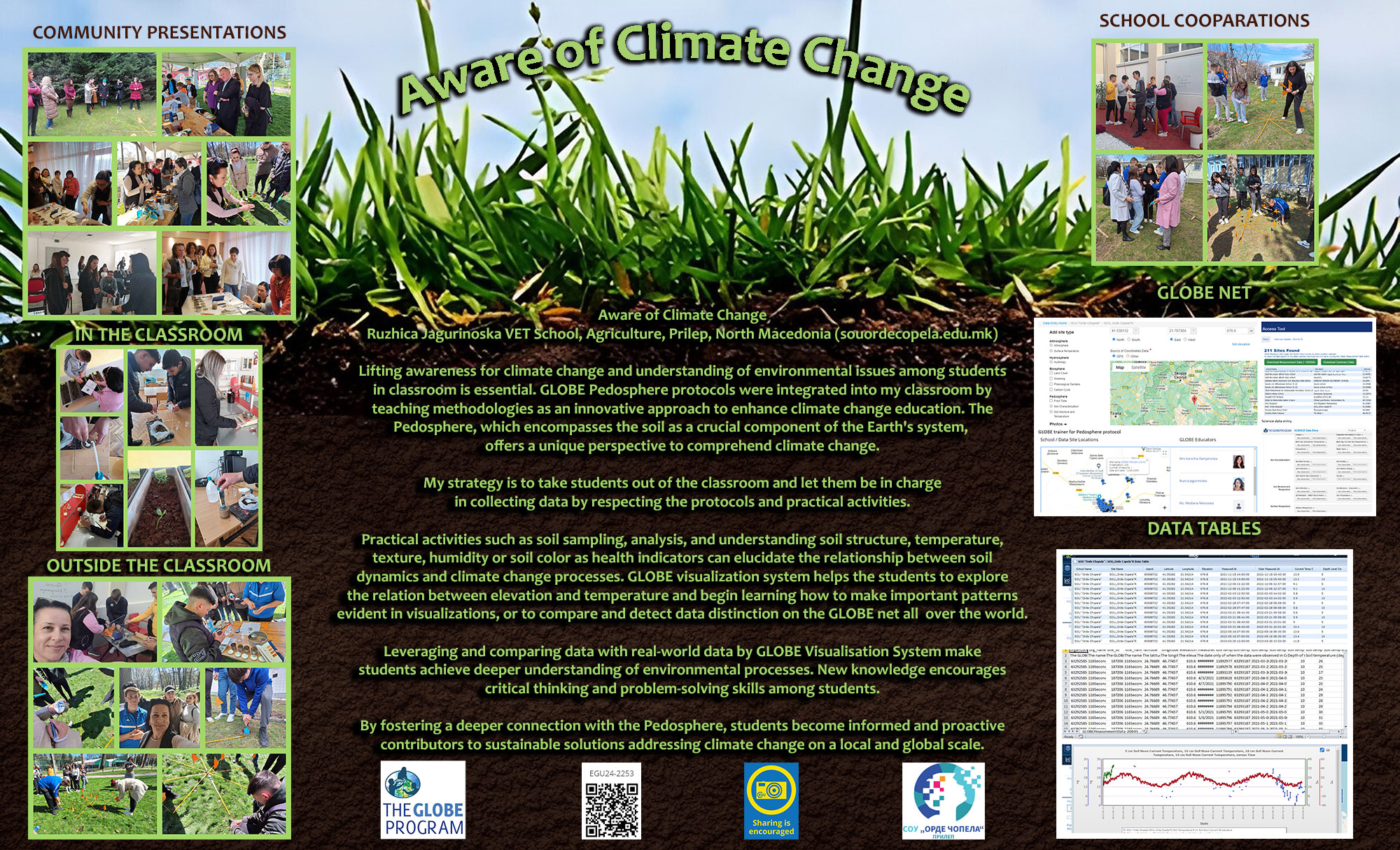
EGU24-2936 | Posters on site | EOS5.2
Gaming the Water Cycle: a student-led activity to explore climate change.EGU24-3179 | Posters on site | EOS5.2
Fisrt edition of an “Ocean Readings Prize, a better knowledge for a better preservation”.EGU24-3220 | Posters on site | EOS5.2
Teacher on board the deep sea vessel Pourquoi pas ? for SUPER MOUV campaign off the coast of Ecuador
EGU24-3347 | Posters on site | EOS5.2
ECOding: Putting climate solutions at the heart of tech educationEGU24-3871 | Posters on site | EOS5.2
Exploring the Complexity of Climate Change with an Interactive and Collaborative Learning Tool: The "Climate Fresk"EGU24-3943 | Posters on site | EOS5.2
Miedwie Lake as a source of life. Implementing SDGs in STEM lessons.
EGU24-4148 | Posters on site | EOS5.2
From plots to theory: young students build their good practice on climate changesEGU24-4396 | Posters on site | EOS5.2
The Role of Interdisciplinary PBL Activities: Climate of the PastEGU24-4443 | Posters on site | EOS5.2
Insight Education : When highschool students and teachers are involved in the science team.EGU24-4721 | Posters on site | EOS5.2
Teaching evolution for sustainability in the era of climate change: the Socio-Scientific Issues (SSI) approachEGU24-4722 | Posters on site | EOS5.2
Climate change and sustainability resources: making materials from biomassEGU24-4734 | Posters on site | EOS5.2
Reducing our school's carbon footprint through composting the canteen food wasteEGU24-4750 | Posters on site | EOS5.2
“Climate crisis and its impact: New ways to awaken curiosity and hope in the classroom environment”EGU24-4753 | Posters on site | EOS5.2
Critical thinking in high school science education: a focus on Fake News and Climate Change.EGU24-4765 | ECS | Posters on site | EOS5.2
Simulating and Studying Greenhouse Effect in your classroom with Arduino UNOEGU24-6738 | Posters on site | EOS5.2
Eco-Enigma Expedition Escape Room - The soils and climate change.EGU24-7367 | Posters on site | EOS5.2
Teaching Climate change at school: increasing sustainable minded students and communities.EGU24-9584 | Posters on site | EOS5.2
Unveiling the Biosphere: A Comprehensive Overview of GLOBE Program ProtocolsEGU24-9953 | Posters on site | EOS5.2
Lesson Proposal for Climate Change in geography: Utilization of "Mystery" as a Learning MethodEGU24-10910 | Posters on site | EOS5.2
School life as an ecological background for principled citizenshipEGU24-11644 | Posters on site | EOS5.2
The Importance of “Hands-On” Training for Basic and Secondary Level Science Teachers.EGU24-11909 | Posters on site | EOS5.2
An educational strategy to Climate Change integrating three interconnected PerspectivesEGU24-12128 | Posters on site | EOS5.2
Understanding Climate change within a sustainable school in Community of Madrid (Spain)EGU24-12636 | Posters on site | EOS5.2
Sustainable development training and outcomes (poster only session)EGU24-13071 | Posters on site | EOS5.2
Lithium: a problem or a contribution to reducing climate change?EGU24-13105 | Posters on site | EOS5.2
Raising awareness of global climate change through a school eco-teamEGU24-13130 | Posters on site | EOS5.2
The challenges of teaching climate change within the school science curriculumEGU24-13203 | Posters on site | EOS5.2
Fostering Sustainable Habits: A Classroom Initiative on Reducing Carbon Footprint by Decreasing Plastic and Increasing SeedsEGU24-14665 | ECS | Posters on site | EOS5.2
Creating School Seismology Labs For the Development of Students’EGU24-17945 | ECS | Posters on site | EOS5.2
Education for sustainable development within the geography curriculumEGU24-19968 | ECS | Posters on site | EOS5.2
SpaceEDUnity: Introducing natural hazards to younger generations utilizing advanced technologiesEGU24-20057 | ECS | Posters on site | EOS5.2
Aeolus Satellite: A Breath of Fresh Air for Climate Change EducationEGU24-1188 | ECS | Posters on site | ERE1.3
Stone decay in the underwater environment: examples from Mediterranean archaeological sitesEGU24-1312 | ECS | Orals | ERE1.3
Thermo-hygric weathering of Carrara Gioia marble monitored with Nonlinear Resonant Ultrasound SpectroscopyEGU24-2818 | Posters on site | ERE1.3
A multidisciplinary approach for the diagnostics of the stone building materials of architectural structuresEGU24-4340 | ECS | Posters on site | ERE1.3
Black Crusts as Geochemical Archives: Preliminary Results from Antwerp, BelgiumEGU24-7547 | ECS | Posters on site | ERE1.3
Biodeterioration of historical buildings and sites in north of Lake Tana, Ethiopia: a preliminary investigationEGU24-10672 | Orals | ERE1.3
Creating a holistic view on the situation of historic parks and gardensEGU24-12505 | Posters on site | ERE1.3
Sustainability and cultural heritage conservation: re-use of sand from deconstruction rendersEGU24-13376 | Posters on site | ERE1.3
Durability of Built Cultural Heritage Materials under different climate conditionsEGU24-13920 | ECS | Orals | ERE1.3
Vulnerability Index of Critical Infrastructure in Greater Kuala Lumpur Fault Zone, MalaysiaEGU24-15733 | Orals | ERE1.3
Condition assessment of limestone tombs Theban Necropolis (Luxor, Egypt)EGU24-16698 | ECS | Posters on site | ERE1.3
The influence of orientation and leaf area indices of a vertical green wall on historic building materialsEGU24-19203 | ECS | Posters on site | ERE1.3
Edge detection of magnetic data: Preliminary results of application to Episkopeion region in Olympos Ancient City (Antalya)EGU24-697 | ECS | PICO | HS7.3 | Highlight
Rainfall accumulation as a driver of higher Leptospirosis risk in northern South AmericaEGU24-3235 | ECS | PICO | HS7.3
Estimating the risk of crop yield loss due to changing regional air temperaturesEGU24-5462 | ECS | PICO | HS7.3
Influencing factors of durum wheat productivity under current and future climatic conditionsEGU24-9386 | ECS | PICO | HS7.3
Food security in a changing climate - how can Earth observation and machine learning help?EGU24-13868 | ECS | PICO | HS7.3
Recent patterns of crop yield growth, stagnation and their drivers in China’s drylandEGU24-18617 | ECS | PICO | HS7.3
Climate change impact on wheat yield in India: Study using CERES-wheat modelEGU24-20876 | ECS | PICO | HS7.3
Application of Machine Learning Approaches for Cotton Seasonal Yield EstimationEGU24-21145 | ECS | PICO | HS7.3
Climate Risk and Vulnerability Assessment (CRVA) for the Port of Heraklion in GreeceEGU24-2476 | ECS | Orals | NH11.2
TC-induced Increases in Extreme Rainfall over the Northeast United StatesEGU24-2771 | ECS | Posters on site | NH11.2
Population exposure to extreme precipitation under a changing climate in Eastern ChinaEGU24-3643 | ECS | Orals | NH11.2 | Highlight
Storylines of Hurricane Sandy under climate change to assess compound coastal flooding impacts in New York CityEGU24-3729 | Posters on site | NH11.2
Assessment of Landslide Susceptibility under Climate Change in the Laonong river watershed in TaiwanEGU24-5266 | ECS | Orals | NH11.2
Indian summer monsoon as a driver of summer heatwaves in the Eastern MediterraneanEGU24-5428 | Posters on site | NH11.2
Frameworks for considering extreme weather risks in future climates given major uncertaintiesEGU24-6242 | ECS | Orals | NH11.2 | Highlight
Global warming increases the proportion of more damaging heat extremesEGU24-7321 | ECS | Posters on site | NH11.2
Physical Drivers and Future Risks of the 2014-like Southeast Asia DroughtEGU24-7944 | ECS | Orals | NH11.2
Anticipating the unseen: a community review on how to better prepare for exceptional weather eventsEGU24-11146 | ECS | Orals | NH11.2
Projections of the large-scale drivers influencing the North Atlantic tropical cyclonesEGU24-12765 | Posters on site | NH11.2
Assessment of tropical cyclone hazard and risk in a changing climate by means of a new global hybrid modelEGU24-13248 | ECS | Orals | NH11.2
On the connection between the jet stream and high-impact, extreme storms in midlatitudesEGU24-15708 | ECS | Orals | NH11.2
Towards a storyline approach for examining future flood risk: A Central American case studyEGU24-17261 | ECS | Posters on site | NH11.2
Severe heat waves in Islamabad and its links with global mitigation benchmarksEGU24-21161 | Orals | NH11.2 | Highlight
Regional Information for Society within the World Climate Research ProgrammeCL4 – Climate studies across timescales
EGU24-1973 | ECS | Orals | CL4.1
Global South most affected by socio-ecosystem productivity decline due to compound heat and flash droughtsEGU24-2848 | Orals | CL4.1
Synergistic effect of land-atmosphere coupling and climate change on flash droughtsEGU24-3079 | ECS | Orals | CL4.1
Causal analysis of Heatwaves in India: Impact of Remote Soil MoistureEGU24-5226 | Posters on site | CL4.1
Using HydroTiles to represent different hydrological regimes in a global Earth System modelEGU24-5392 | ECS | Posters on site | CL4.1
Examining the impact of extreme land surface temperature and land cover on heatwave occurrence: The case of MENA regionEGU24-5644 | ECS | Orals | CL4.1 | Highlight
The relationship between forest fragmentation and extreme high temperatureEGU24-5756 | ECS | Posters on site | CL4.1
Deep Learning-Based Analyses of Feedback Mechanisms in the Land-Atmosphere Interactions during Droughts over the Vietnamese Mekong DeltaEGU24-6099 | ECS | Orals | CL4.1
How strong is land-atmosphere coupling in global storm-resolving simulations?EGU24-7942 | ECS | Orals | CL4.1
The cooling effect induced by the Three Gorges Reservoir operation in observations and model simulationsEGU24-9091 | ECS | Orals | CL4.1
Analysis of trends in surface energy fluxes under hot conditions using remote sensing productsEGU24-11141 | ECS | Posters on site | CL4.1
The drought response of European ecosystem processes via multiple components of the hydrological cycleEGU24-11693 | ECS | Orals | CL4.1
The turning point in vegetation decline in the Northern Hemisphere driven by hydroclimatic extremesEGU24-12392 | ECS | Posters virtual | CL4.1
Heatwaves and Droughts in Europe: A multi-year analysis using MODIS Land Surface Temperature AnomaliesEGU24-12955 | ECS | Posters on site | CL4.1
The influence of temperature–moisture coupling on the occurrence of compound hot and dry events over South America: historical and future perspectivesEGU24-13027 | ECS | Posters on site | CL4.1
Unveiling the influences of soil moisture on moist heat stress extremes: a global assessment using CMIP6 dataEGU24-13484 | ECS | Orals | CL4.1
Seasonal Variability of Deforestation-Induced Warming in the Congo Basin Using Remote-Sensing DataEGU24-14184 | ECS | Orals | CL4.1
Links between seasonal precipitation intermittency and soil moisture variabilityEGU24-16559 | Orals | CL4.1 | Highlight
Assessing extreme temperature volatilities across Germany between 1990 and 2022EGU24-16729 | ECS | Posters on site | CL4.1
Poleward migration of soil moisture–temperature coupling hotspots under global warmingEGU24-18231 | ECS | Orals | CL4.1
Summer Drought Prediction in Europe combining Climate Simulations and Remote SensingEGU24-18682 | ECS | Posters on site | CL4.1
Uncovering the moisture and heat sources to croplands during agricultural failure eventsEGU24-20049 | ECS | Orals | CL4.1
Impact of soil moisture data assimilation on short-term numerical weather predictionEGU24-5301 | ECS | Posters on site | CL4.2
Seasonal Diversity of Indo-Pacific Warm Pool Volume Expansion: The Role of Climatological Subsurface Temperature PatternsEGU24-5689 | ECS | Orals | CL4.2
South Pacific hydroclimate response to multi-decadal modes of variability in the IGCM4 climate modelEGU24-5817 | ECS | Orals | CL4.2
Indo-Pacific basin interactions and their impacts on Austral-Asian hydroclimate over the last millenniumEGU24-6517 | ECS | Posters on site | CL4.2
Bootstrapping Image Histogram for Simplifying Climate Snapshots: Exploring the Application to Indo-Pacific Warm Pool Expansion ResearchEGU24-8966 | ECS | Posters on site | CL4.2
Reconstructing South Pacific Convergence Zone precipitation over the past 60 ka using plant wax biomarkersEGU24-9887 | ECS | Posters on site | CL4.2
Sea surface temperatures across the low-latitude Indo-Pacific Ocean during the Holocene, Last Interglacial and Marine Isotope Stage 11EGU24-11409 | ECS | Orals | CL4.2
Forcing mechanisms of the half-precession cycle in western tropical Pacific temperatureEGU24-13006 | Posters on site | CL4.2
Central equatorial Pacific climate change over the last 7,000 years using a coral ensemble approachEGU24-14008 | ECS | Orals | CL4.2
Pan-regional characterization of the variability in the Indonesian SeasEGU24-14611 | Posters on site | CL4.2
Millennial scale monsoon variability over the last 250,000 years in the Arabian SeaEGU24-15391 | ECS | Posters on site | CL4.2
Reconstructing the Indonesian Throughflow variability and its climatology using long corals from the North-western coast of AustraliaEGU24-18460 | Posters on site | CL4.2
Surface and thermocline variability in the tropical eastern Indian Ocean since the Last Glacial MaximumEGU24-868 | ECS | Posters on site | CL4.3
Relationship of the predictability of North Pacific Mode and ENSO with predictability of PDOEGU24-1757 | Posters on site | CL4.3
Is the NAO signal-to-noise paradox exacerbated by severe winter windstorms?EGU24-1940 | ECS | Orals | CL4.3
Study of the Decadal Predictability of Mediterranean Sea Surface Temperature Based on ObservationsEGU24-4873 | ECS | Orals | CL4.3
Why does the Signal-to-Noise Paradox Exist in Seasonal Climate Predictability?EGU24-7134 | ECS | Orals | CL4.3
Towards the Predictability of Compound Dry and Hot Extremes through Complexity ScienceEGU24-8028 | ECS | Orals | CL4.3
Constraining near to mid-term climate projections by combining observations with decadal predictionsEGU24-9049 | Posters on site | CL4.3
Constraining internal variability in CMIP6 simulations to provide skillful near-term climate predictionsEGU24-9274 | ECS | Orals | CL4.3 | Highlight
The Role of the North Atlantic for Heat Wave Characteristics in EuropeEGU24-9690 | ECS | Orals | CL4.3
Hybrid statistical-dynamical seasonal prediction of summer extreme temperatures over EuropeEGU24-9905 | ECS | Orals | CL4.3
Optimization-based driver detection and prediction of seasonal heat extremesEGU24-11485 | ECS | Orals | CL4.3
Summer drought predictability in the Mediterranean region in seasonal forecastsEGU24-11930 | ECS | Posters on site | CL4.3
A global empirical system for probabilistic seasonal climate prediction based on generative AI and CMIP6 modelsEGU24-12969 | ECS | Orals | CL4.3
How unusual is the recent decade-long pause in Arctic summer sea ice retreat?EGU24-14341 | Posters on site | CL4.3
Compound Heat and Dry Events Influenced by the Pacific–Japan Pattern over Taiwan in SummerEGU24-14379 | Posters on site | CL4.3
Linkage between Temperature and Heatwaves in Summer Taiwan to the Pacific Meridional ModeEGU24-14688 | ECS | Orals | CL4.3
Exploring ML-based decadal predictions of the German Bight storm surge climateEGU24-15476 | Posters on site | CL4.3
Statistics of sudden stratospheric warmings using a large model ensembleEGU24-15974 | ECS | Posters virtual | CL4.3
Recalibrating DWD’s operational climate predictions: towards a user-oriented seamless climate serviceEGU24-16366 | ECS | Orals | CL4.3
Decadal predictions outperform projections in forecasting winter precipitation over the Mediterranean regionEGU24-16985 | Posters on site | CL4.3
Investigating signals in summer seasonal forecasts over the North Atlantic/European regionEGU24-17418 | Posters on site | CL4.3
Strengthening seasonal forecasting in the Middle East & North Africa (MENA) through the WISER Programme.EGU24-19251 | Orals | CL4.3 | Highlight
The opportunities and challenges of near-term climate predictionEGU24-19359 | ECS | Posters on site | CL4.3
Seasonal forecast of the late boreal winter temperature based on solar forcing and QBOEGU24-1089 | ECS | Posters on site | CL4.5
Evaluation of Mesoscale Eddy-Ice Interaction in the Southern Ocean using High-Resolution ModelsEGU24-2040 | ECS | Posters on site | CL4.5
The representation of tropical cyclones in high resolution coupled climate simulationsEGU24-2359 | ECS | Posters on site | CL4.5
Simulating the Earth system with interactive aerosols at the kilometer scaleEGU24-6596 | ECS | Orals | CL4.5
Improved northern hemispheric atmospheric blocking properties in two storm-resolving climate modelsEGU24-9221 | ECS | Orals | CL4.5
Autocorrelation – A Simple Diagnostic for Tropical Precipitation in Global Kilometer-Scale Climate ModelsEGU24-10275 | ECS | Posters on site | CL4.5
Precipitation impacting upper-ocean currents: an analysis using a km-scale Earth System modelEGU24-11656 | ECS | Posters on site | CL4.5
Climate storylines using the spectral nudged simulations with IFS-FESOMEGU24-17906 | ECS | Orals | CL4.5
Multifractal analysis for evaluating the representation of clouds in global km-scale modelsEGU24-18483 | Posters on site | CL4.5
Eulerian and Lagrangian Perspectives on Mesoscale Air-Sea InteractionsEGU24-18761 | Posters on site | CL4.5
Modelling of the Hunga Tonga eruption for testing the GPU port of ICONEGU24-18964 | ECS | Posters on site | CL4.5
On the detection and tracking of mesoscale ocean eddies: Parameter sensitivityEGU24-19072 | ECS | Orals | CL4.5
Surface irradiance variability over land in storm-resolving models.EGU24-19735 | ECS | Posters on site | CL4.5
Network of extremes in ocean eddy-resolving climate modelsEGU24-21956 | ECS | Posters on site | CL4.5
Storm Tracks and Jet Streams in ICON: Unravelling Climate Change Responses through Aquaplanet Horizontal Grid Spacing Sensitivity ExperimentsEGU24-522 | ECS | Posters on site | CL4.6
Deciphering the Multiscale Association between Indian Precipitation-Arctic Teleconnections Using Wavelet Analysis.EGU24-3098 | Orals | CL4.6 | Highlight
Remote mechanisms for shifting the tropical Pacific warming patternEGU24-3261 | ECS | Posters on site | CL4.6
Decadal variability of extreme precipitation in northern of OmanEGU24-9099 | ECS | Orals | CL4.6
Disentangling projected stationary wave changes: implications for future drying of the Mediterranean regionEGU24-12351 | Posters virtual | CL4.6
The comparative study on the effects of NAO and GBO on the Hydroclimate in Southeastern Europe
EGU24-14076 | ECS | Posters on site | CL4.6
Maximum summer temperatures for the Western Tianshan Mountains of China inferred from tree rings over the past 300 yearsEGU24-14093 | ECS | Orals | CL4.6
Investigating CMIP6 Models for Arctic Sea Ice Dynamics and Predictive Links with Monsoon PrecipitationEGU24-14473 | ECS | Posters on site | CL4.6
Disentangling the driving mechanisms of tripole mode of summer rainfall over eastern ChinaEGU24-15764 | ECS | Posters on site | CL4.6
Analysis of Sea Surface Pressure Climatology and Cyclogenesis Patterns over the Black SeaEGU24-15940 | ECS | Posters on site | CL4.6
Validation of Mediterranean cyclones in GCM simulations against reanalysisEGU24-16824 | ECS | Orals | CL4.6
Global changes in low-level circulation types under future anthropogenic forcingEGU24-18438 | ECS | Posters on site | CL4.6
Data Density Effects on North Antlantic Oscillation Reconstruction: Analysis and ApplicationEGU24-20851 | ECS | Posters on site | CL4.6
East Asian Subtropical Jet Impact on Monthly Near-surface Wind Speed Change over ChinaEGU24-21134 | ECS | Orals | CL4.6
No consistent improvement in tropical Pacific sea surface temperature pattern in high-resolution climate modelsEGU24-1322 | Posters virtual | CL4.9
British archaeology verifies 5th-Century rapid multi-metre sea-level rise and portends another before 2100
EGU24-2288 | Posters on site | CL4.9
Recent Sea Level Rise and Variability in Singapore Region Derived from Tide Gauges and Satellite AltimetryEGU24-3445 | ECS | Posters on site | CL4.9
Are multi-decadal sea-level oscillations augmenting rates of mean sea level?EGU24-3503 | Orals | CL4.9 | Highlight
Improving, evaluating and sharing projections of global mean sea level riseEGU24-4335 | ECS | Orals | CL4.9
Uncertainties in the projection of dynamic sea level in CMIP6 and FGOALS-g3 large ensembleEGU24-5010 | ECS | Orals | CL4.9
Mid Holocene relative sea-level changes from coral microatolls of Pulau Biola, SingaporeEGU24-6564 | Orals | CL4.9
Emulating Thermosteric Sea-Level Rise Using a Three-Layer Energy Balance ModelEGU24-6921 | Posters on site | CL4.9
Modelling dependence between the ice-sheet components of sea-level riseEGU24-8462 | ECS | Posters on site | CL4.9
Eddy variability contribution to decadal regional sea level trendsEGU24-9008 | Posters on site | CL4.9
Sea-level projections in recent IPCC reports: how we got here, where we are and where we’re goingEGU24-9936 | ECS | Posters on site | CL4.9
Linking the Permanent Service for Mean Sea Level’s (PSMSL) global mean sea level dataset to the ellipsoidEGU24-10137 | ECS | Posters on site | CL4.9
Reconstruction of the global ocean heat content and thermosteric sea-level rise with an improved configuration of the ISAS interpolation toolEGU24-10576 | ECS | Orals | CL4.9 | Highlight
Extreme sea-level projections along European coasts for climate adaptation servicesEGU24-10716 | Posters on site | CL4.9 | Highlight
Exploring multi-century sea level rise commitments from 21st century cumulative emissions to inform minimum coastal adaptation needsEGU24-13354 | ECS | Posters on site | CL4.9
GravIS Portal: User-friendly Ocean Bottom Pressure data from GRACE and GRACE-FOEGU24-14249 | ECS | Posters on site | CL4.9
Mid-Holocene relative sea-level reconstruction from digital surface models of coral microatolls at Pulau Semakau, southwestern SingaporeEGU24-15877 | ECS | Posters on site | CL4.9 | Highlight
Regional variations in relative sea level changes influenced by non-linear vertical land motionEGU24-15948 | ECS | Posters on site | CL4.9
Drivers of Late Holocene relative sea-level change in the Sunda Shelf: new insights from coral microatolls in SingaporeEGU24-16146 | Posters on site | CL4.9
Spatially variable sea level response to erosion and deposition in Aotearoa New ZealandEGU24-16387 | Posters on site | CL4.9
Sea-level scenarios for coastal adaptation: the example of FranceEGU24-16743 | ECS | Posters on site | CL4.9
Inferring climatic sea-level variations from microatolls in tectonically active regionsEGU24-17955 | ECS | Posters on site | CL4.9
Sea-level storylines to inform coastal adaptation planning and decision-making for the UK, South Africa and Southeast Asia
EGU24-18660 | ECS | Orals | CL4.9
Understanding the Regional Disparity of the Sea Level Rise during Altimetry EraEGU24-18693 | ECS | Posters on site | CL4.9
Loss of safe land on atolls highlights need for immediate emissions reductions to support coastal adaptationEGU24-19452 | Posters on site | CL4.9
The barystatic contribution to multi-decadal sea-level change in the 19th century.EGU24-20096 | ECS | Orals | CL4.9
Attributing low-frequency variations in ocean water mass redistribution during 2002-2020EGU24-21090 | ECS | Orals | CL4.9
Fast recovery of North Atlantic sea level in response to atmospheric CO2 removalEGU24-21107 | ECS | Orals | CL4.9
The defining roles of sterodynamic sea level in future climate projectionsEGU24-995 | ECS | Posters on site | CL4.10 | Highlight
Assessing the predictability of Euro-Mediterranean droughts through seasonal forecastsEGU24-1407 | ECS | Posters on site | CL4.10 | Highlight
Time Lag and Cumulative Effects of Extreme Climate on Coastal Vegetation in ChinaEGU24-4083 | Posters virtual | CL4.10 | Highlight
Enhancing Subseasonal Climate Predictions through Dynamical Downscaling: A Case Study in the Southern Plains of the United StatesEGU24-6494 | Posters virtual | CL4.10 | Highlight
Seasonal predictions of summer humid heat extremes in the southeastern United States driven by sea surface temperaturesEGU24-7918 | ECS | Orals | CL4.10
Generation of sea ice initial conditions for the next Météo-France seasonal forecasting systemEGU24-11927 | Posters virtual | CL4.10 | Highlight
Seasonal prediction of solar energy resources in the United StatesEGU24-11948 | Posters on site | CL4.10
What is the Target for Multi-Model and Perturbed-Physics Ensembles?EGU24-12988 | ECS | Posters on site | CL4.10
A CNN-based Downscaling Method of C3S Seasonal Forecast: Temperature and PrecipitationEGU24-13811 | ECS | Posters on site | CL4.10
Estimating Seasonal to Multi-year Predictability of Statistics of Climate Extremes using the CESM2-based Climate Prediction SystemEGU24-15488 | ECS | Orals | CL4.10
Phytoplankton predictability in the Tropical Atlantic - triggered by nutrient pulses from the SouthEGU24-15829 | Posters on site | CL4.10
The role of realistic vegetation variability in climate predictability and predictionEGU24-16402 | Orals | CL4.10
On the stationarity of the global spatial dependency of heat risk on drought.EGU24-16842 | Posters on site | CL4.10 | Highlight
Exploring Sources of Multi-year Predictability of Terrestrial EcosystemEGU24-18766 | Orals | CL4.10
Deciphering Prediction Windows of Opportunity: A Cross Time-Scale Causality FrameworkEGU24-1843 | ECS | Posters on site | CL4.12
Assessment of Future Precipitation Changes in Mediterranean Climate Regions from CMIP6 ensembleEGU24-1864 | ECS | Posters on site | CL4.12
Comparison and analysis of drought indices SPI and SPEI for Belgrade (Serbia)
EGU24-2544 | ECS | Orals | CL4.12
A synoptic circulation patterns evaluation framework for CMIP6 GCMs over the Euro-Mediterranean regionEGU24-5891 | ECS | Posters on site | CL4.12
An operational prototype for seasonal drought prediction in a Mediterranean regionEGU24-8085 | Posters on site | CL4.12 | Highlight
Climate Change Mitigation and Adaptation in the Eastern Mediterranean: The Need for CooperationEGU24-8253 | ECS | Posters on site | CL4.12 | Highlight
Categorization Framework of Adaptation Measures in Urban Dry Arid ClimateEGU24-13371 | ECS | Posters on site | CL4.12 | Highlight
Emerging extreme climate-related stresses over croplands and wheat-harvested areas in the southern Mediterranean region during the 21st centuryEGU24-15023 | ECS | Posters on site | CL4.12
Changes in Holocene sediment deposition in the Aegean Sea: climatic versus early anthropogenic forcingEGU24-15909 | ECS | Posters virtual | CL4.12
Holocene Sapropel Deposition in The Gulf of Kuşadası: Evidence from Sediment Cores Multi-Proxy DataEGU24-16866 | Posters on site | CL4.12
Mediterranean Climate Regions in CMIP6 experiments: assessment of future changes and associated uncertaintiesEGU24-17641 | ECS | Posters on site | CL4.12
Environmental conditions controlling Cold-water corals occurrence in western Melilla (western Mediterranean) since the last deglaciation.EGU24-18396 | Orals | CL4.12 | Highlight
Projected Increases in Population Exposure to Droughts in the Iberian Peninsula under 1.5ᵒ and 2ᵒC Global Warming LevelsEGU24-19598 | Posters on site | CL4.12
Heat content and temperature trends for different depth layers in the Mediterranean SeaEGU24-435 | Posters on site | CL4.14
Updating the assessment of climate change at decadal scale and consolidating with CMIP6 future projectionsEGU24-2422 | ECS | Orals | CL4.14
Substantial increase in daytime-nighttime compound heat waves and associated population exposure in ChinaEGU24-2635 | ECS | Posters on site | CL4.14
Intraseasonal Variability of Anticyclonic Rossby Wave Breaking and Its Impact on Tropical Cyclone Activity over the Western North PacificEGU24-2663 | Posters on site | CL4.14
Projected Increase in Probability of East Asian Heavy Rainy Summer in the 21st Century by CMIP5 ModelsEGU24-3060 | ECS | Posters on site | CL4.14
Capability of regional climate models to reproduce three-dimensional (3D) characteristics of heat wavesEGU24-3314 | ECS | Posters on site | CL4.14
Subseasonal Variability of Sea Level Pressure and Its Influence on Snowpack over Mid-High-Latitude Eurasia during Boreal WinterEGU24-3741 | ECS | Posters on site | CL4.14
Irreversibility of Extreme Precipitation in East Asia under Multi-Scenario to Carbon NeutralityEGU24-3810 | ECS | Posters on site | CL4.14
Subseasonal Modes of Winter Surface Air Temperature in Eurasia's Mid- and High-Latitudes: Contributions from the North Atlantic and Arctic RegionsEGU24-5060 | ECS | Posters on site | CL4.14
Which type of WNPSH indices can be better applied, defined by the geopotential height, the eddy geopotential height, or the stream function?EGU24-5352 | ECS | Posters on site | CL4.14
Detection and Characterization of Climate Extremes with Deep LearningEGU24-10648 | ECS | Orals | CL4.14 | Highlight
Recent extreme heatwaves dwarfed by projected future eventsEGU24-17194 | Orals | CL4.14 | Highlight
Emergence of strong trends in humid heat intensity and duration in recent decades over South AsiaEGU24-19636 | ECS | Orals | CL4.14
In-depth analysis of extreme event of rainfall erosivity over mainland ChinaEGU24-778 | ECS | Posters on site | AS1.19
The Record-Breaking Precipitation Event of December 2022 in Portugal: Synoptic BackgroundEGU24-963 | ECS | Posters on site | AS1.19
Coupling of Groundwater with Atmosphere: A New Anthropogenic Component in the Global Hydrological CycleEGU24-1515 | ECS | Posters on site | AS1.19
Quantifying the moisture and precipitation sources over Northwest China and investigating the source differences in dry and wet summer seasonsEGU24-6878 | ECS | Orals | AS1.19
Using stable water isotopes to improve our understanding of snow processes across scalesEGU24-11548 | Posters on site | AS1.19
Adjustment of the Marine Atmospheric Boundary-Layer to the North Brazil Current during the EUREC4A-OA ExperimentEGU24-14310 | Posters on site | AS1.19
Atmospheric moisture transport in Central Europe – rivers or streamsEGU24-15660 | ECS | Posters on site | AS1.19
Machine learning analysis for predicting spatial distribution and key influencers of stable isotope patterns in European precipitation
EGU24-16667 | ECS | Posters on site | AS1.19
Impact of increased evaporation from an increasingly ice-free Arctic on land precipitationEGU24-18497 | ECS | Posters on site | AS1.19
Changes in the concurrence of atmospheric rivers and explosive cyclones in the North AtlanticEGU24-18507 | ECS | Orals | AS1.19
Quantifying the contribution of oceanic evaporation to tropical cyclone development with WRF-ageEGU24-18906 | ECS | Posters on site | AS1.19
Computing precipitations with a 1D vertical (radiative-convective) model using zero parameterizations.EGU24-19539 | ECS | Posters on site | AS1.19
Antarctic water stable isotopes in the global atmospheric model LMDZ6: from climatology to boundary layer processesEGU24-19562 | ECS | Posters virtual | AS1.19
The role of Dry Intrusions in the formation and intensification of Atmospheric Rivers impacting FranceEGU24-1999 | ECS | Posters on site | AS1.35
Elevation-dependent warming in the Alps estimated from MAR simulations over 1961-2100EGU24-3382 | ECS | Posters on site | AS1.35
An ensemble of meteorological stations for estimating daily air temperature time series at Jungfraujoch since 1864EGU24-5260 | ECS | Posters on site | AS1.35
The frequency of summer light rain projections in typical terrain over eastern China constrained by surface wind speedEGU24-6068 | ECS | Posters on site | AS1.35
21st Century climate change in the European Alps and its elevation dependencyEGU24-6607 | ECS | Orals | AS1.35
Modelling the mountain boundary layer: Does higher resolution improve model performance?EGU24-8087 | ECS | Posters on site | AS1.35
Welcome to Fourier-Land: Deep-Learning based downscaling of near-surface winds and drifting snow using WRF simulations over synthetic topographiesEGU24-9427 | ECS | Posters on site | AS1.35
Climatic drivers of elevation-dependent warming (EDW): A concerted field and modeling assessment for an alpine national parkEGU24-11038 | ECS | Orals | AS1.35
Investigating a local windstorm using measurements and large-eddy simulationsEGU24-13935 | ECS | Posters on site | AS1.35
Future Projections of Summer precipitation-driving Mechanisms over the South American AltiplanoEGU24-14519 | ECS | Posters on site | AS1.35
Automatic identification of systematic model failures in ensemble precipitation forecastsEGU24-14933 | Posters on site | AS1.35
Orographic complexity and local microclimatic variations in the Dolomites (north-eastern Italy)EGU24-16067 | ECS | Posters on site | AS1.35
High-resolution model evaluation with self-supervised neural network approach targeted on severe storms over the AlpsEGU24-18557 | ECS | Orals | AS1.35
Testing the capability of the WRF model on representing temperature inversions in alpine basins and valleysEGU24-19261 | Posters on site | AS1.35
Analysis of surface temperature and precipitation trends and climate indices in Spanish mountain areasEGU24-823 | ECS | Orals | AS1.18 | Highlight
What drives variability of the Australian summer monsoon?EGU24-962 | ECS | Posters on site | AS1.18
Shifting precipitation pattern during Indian summer monsoonEGU24-1908 | ECS | Orals | AS1.18 | Highlight
Future land use influences on the global monsoon: An energetic perspectiveEGU24-3424 | ECS | Posters on site | AS1.18
Monsoon Break over the South China Sea during Summer: Statistical Features and Associated Atmospheric AnomaliesEGU24-3865 | ECS | Posters on site | AS1.18
Quantifying Contributions from Different Physical Processes to the Atmospheric Warming over the Tibetan PlateauEGU24-4822 | Orals | AS1.18 | Highlight
Climate change is not the primary cause of extreme monsoons in PakistanEGU24-7033 | ECS | Orals | AS1.18 | Highlight
The role of midlatitude dry air during the withdrawal of the Indian monsoonEGU24-7080 | ECS | Posters on site | AS1.18
Summer monsoon transition induced microseisms observed at the South China Sea seabedEGU24-7210 | Posters on site | AS1.18
Drought risks based on changes in atmospheric evaporative demand due to plant response to CO2 levelsEGU24-7608 | Posters on site | AS1.18
Future projection of East Asian Summer Monsoon precipitation under 1.5°C, 2°C, and 3°C global warming levelsEGU24-7856 | Orals | AS1.18 | Highlight
Locust infestation in China in 1358-1911 and its relation with changes in East Asian monsoon climateEGU24-8515 | Posters on site | AS1.18
Improving the prediction of East Asia summer monsoon precipitation using a Bayesian dynamic linear modelEGU24-8860 | ECS | Posters on site | AS1.18
Processes and mechanisms of the initial formation of the Siberian High during the autumn-to-winter transitionEGU24-9447 | ECS | Posters on site | AS1.18
Role of Anthropogenic Forcing and Decadal Oscillations on the Delayed Withdrawal of Indian Summer MonsoonEGU24-9454 | ECS | Posters on site | AS1.18
Trend and Variability in the Long-Term Relationship Between Eurasian Snow Cover and Indian Summer Monsoon RainfallEGU24-10229 | ECS | Orals | AS1.18
Synchronization patterns of heavy rainfalls between North India and the Sahel Zone on daily timescalesEGU24-10455 | Orals | AS1.18
Monsoon precipitation biases in storm-resolving NextGEMS Earth System ModelsEGU24-10696 | ECS | Posters on site | AS1.18 | Highlight
African monsoon changes in the Late Cenozoic from the climate modelling perspectiveEGU24-10904 | ECS | Posters on site | AS1.18
Future changes in the South American Monsoon System and its consequences over south-eastern PeruEGU24-11919 | ECS | Orals | AS1.18
Impact of Hindu Kush Himalayan snow cover change on Monsoon CirculationEGU24-13343 | Orals | AS1.18
Towards robust and actionable information on monsoon climate change in South AmericaEGU24-14603 | ECS | Orals | AS1.18
Role of spatial covariance in regulating interannual variability of Indian Summer Monsoon rainfallEGU24-15435 | ECS | Posters on site | AS1.18
Understanding the future Monsoon activity across the Ganga-Brahmaputra-Meghna basin using CMIP6 HighResMIP modelsEGU24-15851 | ECS | Posters on site | AS1.18 | Highlight
Monsoon Planet: Studying Monsoon Dynamics in an Idealized SetupEGU24-16112 | ECS | Posters on site | AS1.18
The impacts of northern hemisphere high-latitude climate on northeastern Australian summer monsoon evolution during the HoloceneEGU24-16770 | Posters on site | AS1.18
Exploring the role of evaporation in atmospheric heat transport and seasonal low-latitude precipitation biases in CMIP6EGU24-16987 | ECS | Orals | AS1.18
The role of water vapor and cloud radiative effects in monsoons: Perspectives from retrograde Earth simulationEGU24-17834 | ECS | Orals | AS1.18
Onset Periods: a novel approach to understand the onset of the monsoon seasonEGU24-19848 | Posters on site | AS1.18
Mid-Latitude Controls on Monsoon Onset and Progression (the MiLCMOP project)EGU24-20701 | ECS | Posters virtual | AS1.18
Using a causal discovery approach to analyse linkages among ENSO, circulation fields, and summer monsoon precipitation over the HimalayasEGU24-832 | ECS | Posters on site | AS3.12
Aerosol-cloud interactions constrain climatic trends in rainfall and temperature of IndiaEGU24-1924 | ECS | Orals | AS3.12
Precipitation regime changes in High Mountain Asia driven by cleaner airEGU24-3279 | Posters on site | AS3.12
Observational Constrained Attribution of Regional Aerosol Simulation Biases in the AerChemMIP modelsEGU24-3748 | ECS | Posters on site | AS3.12
Evaluation of CMIP6 model simulations of PM2.5 and its components over ChinaEGU24-7692 | ECS | Posters on site | AS3.12
Aligning experimental and model perspectives on atmospheric nanoparticle growthEGU24-7782 | ECS | Orals | AS3.12
The Local and Remote Impacts of Asian Aerosol Forcings on the East Asian Winter Monsoon and ENSOEGU24-12414 | ECS | Orals | AS3.12
The fast response of precipitation to historical black and sulfate aerosols in the GFDL ESM4 climate modelEGU24-15079 | Posters on site | AS3.12
An uncertain future for anthropogenic aerosols in Africa, and their climate and health impactsEGU24-16012 | ECS | Posters on site | AS3.12
Apportionment of absorption in complex aerosols in South AfricaEGU24-18153 | ECS | Orals | AS3.12 | Highlight
Why climate models underestimate the exacerbated summer warming in Western EuropeEGU24-20286 | Posters on site | AS3.12
Invisible, overlooked, climate relevant? Unprecedented levels of ultrafine particles and the hydrological cycleEGU24-20722 | Posters on site | AS3.12
Enhanced aerosol-induced near-term Arctic warming due to remote regional aerosol perturbations in RAMIPEGU24-21847 | Orals | AS3.12 | Highlight
Climate responses to a rapid phaseout of sulfur in shipping emissions: A large ensemble studyEGU24-430 | ECS | PICO | AS3.9
West African dust load modeling and its impact on solar radiation forecast during the dry seasonEGU24-989 | ECS | PICO | AS3.9 | Highlight
Atmospheric radioisotopes in cryoconite from the Flade Isblink ice cap, NE GreenlandEGU24-1776 | PICO | AS3.9 | Highlight
Assessment of the Impact of Coarse and Fine Dust on Solar Devices in the Middle EastEGU24-2280 | ECS | PICO | AS3.9
Different orbital rhythms in loess grain-size records across the Chinese Loess PlateauEGU24-3106 | PICO | AS3.9 | Highlight
African dust transport and deposition modelling verified through a successful citizen science campaign in FinlandEGU24-3981 | ECS | PICO | AS3.9
How dust sources affect downstream regions in East Asia during a dust storm event
EGU24-4799 | ECS | PICO | AS3.9
Modeling the Mercury Cycle in the Sea Ice Environment: A Buffer between the Polar Atmosphere and OceanEGU24-5573 | ECS | PICO | AS3.9
Stronger early-spring dust outbreaks across the Northern Hemispheric mid-latitudes in a warmer climateEGU24-7871 | ECS | PICO | AS3.9
Wind erosion in Western Sahel : Quantifying the impact of land use and land managementEGU24-8628 | PICO | AS3.9 | Highlight
Impact of Saharan mineral dust layers on cloud formation and cloud propertiesEGU24-8796 | PICO | AS3.9 | Highlight
Potential environmental impacts of natural and mining related dust in Greenland and SvalbardEGU24-9570 | ECS | PICO | AS3.9
On the importance of Mongolian cyclones to East Asian dust storm activitiesEGU24-11462 | ECS | PICO | AS3.9
Seasonal effects of wind-blown dust emissions on size-resolved aerosol acidity over the U.SEGU24-12203 | ECS | PICO | AS3.9
Black Carbon and Dust in the snow of Chilean Central Andes: From albedo reductions to radiative forcingEGU24-12289 | ECS | PICO | AS3.9
Image-based nowcasting of dust storms by predicting SEVIRI desert dust RGB compositesEGU24-14539 | ECS | PICO | AS3.9
Exploring the effects of mineral dust acidification on oxidative potential and limiting nutrient solubilityEGU24-16299 | PICO | AS3.9 | Highlight
Diverse and high pollution of microplastics in seasonal snow across Northeastern ChinaEGU24-16833 | ECS | PICO | AS3.9
Cumulative and relative impact of aerosol species on snowmelt runoff from the Hindu Kush Himalayan glaciersEGU24-18339 | ECS | PICO | AS3.9
Fire-driven dust emissions – applying a newly developed parameterization scheme in a global aerosol-modelEGU24-18893 | ECS | PICO | AS3.9
Size segregation process along the soil-saltation-dust continuum: observations in southern TunisiaEGU24-20949 | PICO | AS3.9
Radiative Forcing Assessment of Black Carbon in Snow from the Antarctic PeninsulaEGU24-3232 | Posters on site | AS4.2
A climatological satellite view of marine cold air outbreaks in the northeast AtlanticEGU24-3662 | ECS | Orals | AS4.2
Non-conservative nature of Boron in low salinity Arctic ice and ice melt zonesEGU24-4403 | ECS | Posters on site | AS4.2
Near-surface particle concentration profiles above the Arctic sea ice
EGU24-5124 | ECS | Orals | AS4.2 | Highlight
Is spring melting in the Arctic detectable by under-ice radiation?EGU24-5901 | ECS | Posters on site | AS4.2
Aerosol-Cloud-Precipitation Interactions in the Arctic: Insights from the ARTofMELT CampaignEGU24-5950 | ECS | Posters on site | AS4.2
What we can learn from aerosol size distribution measurements over the spring Arctic pack iceEGU24-11515 | ECS | Posters on site | AS4.2
Overview of SMÄLTA: Secondary Marine Aerosol precursors and Links to aerosol growth at ice-melT onset in the ArcticEGU24-12340 | ECS | Orals | AS4.2
Sea ice drift and wave pattern analysis of the early melt onset during the ARTofMELT cruise 2023EGU24-15627 | Orals | AS4.2 | Highlight
Arctic spring and the onset of sea-ice melt: Early impressions from the ARTofMELT expeditionEGU24-17589 | Posters on site | AS4.2
Intense formation of low liquid clouds over the Arctic sea-ice during May.EGU24-17977 | ECS | Posters on site | AS4.2
Springtime observations of black carbon aerosols in and outside of low-level Arctic cloudsEGU24-19851 | ECS | Orals | AS4.2
Characteristics of natural Arctic aerosols emitted from a wide range of local sources during ARTofMELT2023EGU24-19946 | Orals | AS4.2 | Highlight
Helicopter borne measurements during melt onset in the Fram strait as part of ARTofMELT23EGU24-20594 | Posters on site | AS4.2
Sea ice, snow caps, and freshwater lenses: The hurdles local Arctic aerosols must overcome to become airborne
EGU24-926 | ECS | Posters on site | CR2.2
Simulating the impact of an AMOC weakening on the Antarctic Ice Sheet using a coupled climate and ice sheet modelEGU24-1991 | ECS | Orals | CR2.2 | Highlight
When will the Antarctic ice shelves not be viable anymore?EGU24-4093 | ECS | Posters on site | CR2.2
Interactions between ocean circulation and the Northern Hemisphere ice sheets at 40 ky B.P. in an Earth System Model (iLOVECLIM-GRISLI)EGU24-5104 | ECS | Posters on site | CR2.2
Simulating Antarctic Ice Sheet evolution through the mid-Pleistocene transitionEGU24-5525 | Orals | CR2.2
Modeling the Antarctic Surface Mass Balance with a coarse temporal resolutionEGU24-5698 | ECS | Posters on site | CR2.2
Geoengineering's role in reducing future Antarctic mass loss is unclearEGU24-6140 | ECS | Orals | CR2.2
Long term ice-sheet albedo feedback constrained by most recent deglaciationEGU24-7415 | ECS | Orals | CR2.2 | Highlight
Stability regimes and safe overshoots in West and East AntarcticaEGU24-8333 | ECS | Orals | CR2.2
Coupled ensemble simulations of the Northern Hemisphere ice sheets at last two glacial maximaEGU24-10162 | ECS | Orals | CR2.2
A new climate and surface mass balance product for the Antarctic and Greenland ice sheet using RACMO2.4.1EGU24-10256 | ECS | Orals | CR2.2
Reconstructing the Greenland ice Sheet during the last two deglaciationsEGU24-12773 | ECS | Orals | CR2.2
Improved treatment of snow over ice sheets in the NASA GISS climate model: towards ice sheet–climate couplingEGU24-13618 | ECS | Orals | CR2.2
Reconstructing the coupled Greenland Ice Sheet–climate evolution during the Last Interglacial warm periodEGU24-15323 | ECS | Posters on site | CR2.2
Investigating the evolution and stability of the Greenland ice sheet using remapped surface mass balance forcingEGU24-15401 | Posters on site | CR2.2
Development and implementation of a refined climate index forcing for paleo ice-sheet modeling applicationsEGU24-15987 | ECS | Posters on site | CR2.2
Assessing Antarctic Ice Sheet dynamics under temporary overshoot and long-term temperature stabilization scenariosEGU24-16455 | ECS | Posters on site | CR2.2
Ice-dammed lake-glacier interactions: Modelling the impact on Fennoscandian Ice Sheet retreatEGU24-16702 | ECS | Posters on site | CR2.2
Isochronally constrained ice flow evolution of Dronning Maud Land, Antarctica during the Last Glacial PeriodEGU24-17391 | ECS | Orals | CR2.2
Critical thresholds of the Greenland Ice Sheet from the LGM to the futureEGU24-18501 | Posters on site | CR2.2
Protocol for a Last Interglacial Antarctic ice-sheet model inter-comparisonEGU24-19165 | Posters on site | CR2.2
Oceanic gateways in Antarctica - Impact of relative sea-level change on sub-shelf meltEGU24-20197 | ECS | Posters on site | CR2.2
Constraining projections of future freshwater fluxes from AntarcticaEGU24-20332 | ECS | Orals | CR2.2
The effect of Pacific climatology on the North American Ice Sheet at the Last Glacial MaximumEGU24-58 | ECS | Orals | HS2.4.2
Unveiling Hydrological Dynamics in Data-Scarce Regions:A Comprehensive Integrated ApproachEGU24-126 | ECS | Posters on site | HS2.4.2
Divergent patterns of rainfall regimes in dry and humid areas of ChinaEGU24-1420 | Orals | HS2.4.2 | Highlight
Storylines of climate variability for hydrological impact studiesEGU24-1538 | ECS | Posters on site | HS2.4.2
Small, flashy catchments response to variation in rainfall profile shapeEGU24-1918 | ECS | Posters on site | HS2.4.2
Evaporation and hydrology of the Orinoco and Amazon basins modulated by the AtlanticEGU24-2089 | ECS | Orals | HS2.4.2
Groundwater level reconstruction using long-term climate reanalysis data and deep neural networksEGU24-10340 | ECS | Orals | HS2.4.2
The Impact of GRACE Data Assimilation on Water Storage Dynamics in CLM3.5 and CLM5EGU24-10459 | ECS | Posters on site | HS2.4.2
Past, Present, and Future Impacts of Climate Change and Variability on Flood Hazards in Sub-Saharan AfricaEGU24-10963 | ECS | Orals | HS2.4.2
Future changes in tropical vertical velocity variance and precipitation variabilityEGU24-12189 | ECS | Orals | HS2.4.2
Surface and groundwater drought impact on natural vegetation growth and drought recovery.EGU24-14039 | ECS | Orals | HS2.4.2
Historical changes in the seasonality and timing of extreme precipitation eventsEGU24-14414 | ECS | Orals | HS2.4.2
Navigating Hydroclimatic Extremes: Understanding the Interplay of Climate Change and VariabilityEGU24-15252 | ECS | Orals | HS2.4.2
Spatiotemporal Variability in Hydrological Drought Recovery Time Estimations from GRACE and GRACE-FO DataEGU24-20247 | Posters on site | HS2.4.2
Towards a coupled km-scale Atmosphere-Land Reanalysis for EuropeEGU24-21583 | ECS | Posters on site | HS2.4.2 | Highlight
Influence of ENSO on extreme precipitation and peak river flow in the USEGU24-1830 | ECS | Posters on site | OS1.9
A Detailed Analysis of the Diahaline Overturning Circulation in a Marginal SeaEGU24-3002 | Posters on site | OS1.9
Long-Term Trends of the Atmospheric Circulation and Moist Static Energy Budget in the JRA-55 ReanalysisEGU24-4138 | ECS | Posters on site | OS1.9
Robust predictions of changes in evenness of global precipitation under global warmingEGU24-6938 | ECS | Posters on site | OS1.9
Modulation of Ocean Temperature Structure and Heat Content by Tropical CyclonesEGU24-7000 | ECS | Orals | OS1.9
Ocean heat uptake and interbasin redistribution driven by anthropogenic aerosols and greenhouse gases
EGU24-8399 | ECS | Posters on site | OS1.9
Future AMOC recovery modulated by atmospheric water vapor shortwave absorptionEGU24-10237 | ECS | Posters on site | OS1.9
New insights into seasonal to interannual salinity variability on the Northeast U.S. continental shelf and slopeEGU24-10440 | ECS | Posters on site | OS1.9
Linking midlatitude transient eddy moist static energy transport and extratropical cyclonesEGU24-11362 | ECS | Posters on site | OS1.9
Deep ocean hydrographic heterogeneity inferred from offshore geodetic experiments
EGU24-11925 | Posters virtual | OS1.9
Spontaneous equatorial flow reversals at the equator in moist shallow water turbulenceEGU24-13947 | ECS | Posters on site | OS1.9
An Argo Float Study of Temperature and Salinity in the Subpolar region of the Cambpell PlateauEGU24-14622 | ECS | Posters on site | OS1.9
Multidecadal meridional dipole mode in the Indian Ocean subsurface ocean heat contentEGU24-15419 | ECS | Posters on site | OS1.9
Multi-centennial evolution of the climate response and deep ocean heat uptake in a set of abrupt stabilization scenariosEGU24-16423 | ECS | Posters on site | OS1.9
Estimating Atlantic meridional heat transport through Bayesian modelling of altimetry, Argo and GRACE dataEGU24-16722 | ECS | Posters on site | OS1.9
On critical dependence of atmospheric circulation response to regional SST biases on background SSTEGU24-17118 | Posters on site | OS1.9
Heating rate and energy gradient from the tropics to the North PoleEGU24-19893 | Posters on site | OS1.9
Analysis of water mass transformations and the spurious thermohaline overturning circulation in numerical ocean modelsEGU24-20262 | ECS | Posters on site | OS1.9
Multi-scale temperature variability in the Arctic Mediterranean between 1958 to 2023 – from surface to abyssEGU24-2867 | ECS | Posters on site | NP1.5
Exploring Extreme Weather and Climate Events with Aeolus 2.0: A Multi-layer moist-convective Thermal Rotating Shallow Water (mcTRSW) Dynamical CoreEGU24-4539 | ECS | Posters on site | NP1.5
Extreme value methods in dynamical systems of different complexityEGU24-5570 | ECS | Orals | NP1.5
The critical precipitation threshold for the Amazon forest biomass in the LPJmL vegetation modelEGU24-8104 | ECS | Posters on site | NP1.5
Disentangling the dynamics of the subpolar gyre and its interaction with the AMOC in the CMIP6 ensembleEGU24-8117 | Posters on site | NP1.5
Using a simple model to measure the differences between climate model land surface simulations and FLUXNET observationsEGU24-8397 | ECS | Orals | NP1.5
AMOC Stability amid Tipping Ice Sheets from Conceptual to Intermediate Complexity ModelsEGU24-8729 | ECS | Orals | NP1.5
Quantifying risk of a noise-induced AMOC collapse from northern and tropical Atlantic Ocean variabilityEGU24-9253 | ECS | Posters on site | NP1.5
The impact of model resolution on variability in a coupled land atmosphere modelEGU24-14067 | ECS | Orals | NP1.5
A Forecast Test for Reducing Dynamical Dimensionality of Model EmulatorsEGU24-14439 | ECS | Posters on site | NP1.5
Nonlocal energy fluxes and fractional operators in updated, stochastic, Budyko-Sellers modelsEGU24-14831 | ECS | Orals | NP1.5
SPEEDY-NEMO: performance and applications of a fully-coupled intermediate-complexity climate model
EGU24-18360 | Posters on site | NP1.5
Eddy Saturation and Latitudinal Storm Track Shift in a Reduced Two-level Model of the AtmosphereEGU24-18412 | ECS | Orals | NP1.5
Rapid Emulation of Spatially Resolved Temperature Response Functions to Effective Radiative ForcingEGU24-22102 | Orals | NP1.5 | Highlight
From conceptual to complex earth system models: why are models so linear?EGU24-2344 | ECS | Orals | NP3.3
A North Atlantic Ocean-originated mode of the AMOC multicentennial variabilityEGU24-3084 | ECS | Posters on site | NP3.3
Spatio-temporal climate fingerprint in palaeoclimate data vs modelsEGU24-3157 | ECS | Posters on site | NP3.3
Power law error growth in a more realistic atmospheric Lorenz system with three spatiotemporal scalesEGU24-4074 | ECS | Posters on site | NP3.3
A model-data comparison of North Atlantic climate variability and its responses to natural forcing over the last millenniumEGU24-5384 | Orals | NP3.3
Continuous-time state-space time series models for delta-O-18 and delta-C-13EGU24-6672 | ECS | Posters on site | NP3.3
Unified scaling framework for Holocene, Quaternary and Phanerozoic geochronology variabilityEGU24-6829 | ECS | Orals | NP3.3
Tropical-polar teleconnections: Impacts of North Atlantic meltwater forcing on the Indian OceanEGU24-7152 | ECS | Posters on site | NP3.3
Thermohaline Circulation Determines the Multi-centennial Variability of Earth's Climate SystemEGU24-7409 | ECS | Posters virtual | NP3.3
Fractal approach in the Analysis of climate change due to the ozone layer holeEGU24-8571 | ECS | Posters on site | NP3.3
Unravelling succolarity to quantify multiscale petrophysical properties beyond porosityEGU24-8588 | ECS | Orals | NP3.3
Power-spectra of turbulent buoyant jets from laboratory measurementsEGU24-9251 | ECS | Orals | NP3.3
Complex network-based analysis of the spatial evolution of the flash droughts over IndiaEGU24-10986 | Orals | NP3.3
Tropical mountain ice core : A Goldilocks indicator for global temperature changeEGU24-14135 | ECS | Posters on site | NP3.3
Spatial coherence as a key metric for interpreting marine records of Holocene temperature variabilityEGU24-16097 | ECS | Posters on site | NP3.3
Climatic and environmental impacts of an Oruanui-like supereruption in the Southern Hemisphere extratropicsEGU24-16400 | Posters on site | NP3.3
Uncertainties in modelling diagenetic self-organisation in limestone-marl sequencesEGU24-16778 | ECS | Orals | NP3.3
Probability distributions as indicators of dissipative dynamics in river chemistryEGU24-17721 | ECS | Posters on site | NP3.3
Multifractal analysis of aerosol particle concentration during rain and dry conditions in nm and µm rangeEGU24-17984 | ECS | Orals | NP3.3
Observation of different multifractal phase transitions over three typhoon eventsEGU24-19055 | ECS | Posters on site | NP3.3
Role of size and height of ice sheet on millennial-scale climate variabilityCL5 – Tools for Climate studies
EGU24-1995 | ECS | PICO | CL5.2
Balloon drift estimation and improved position estimates for radiosondesEGU24-3369 | ECS | PICO | CL5.2
Observed climate extreme indices trends and variation in Gandhinagar, GujaratEGU24-5669 | PICO | CL5.2 | Highlight
When winter is weird: Quantifying the change in winters across the ArcticEGU24-19073 | ECS | PICO | CL5.2
Sampling errors in daily average temperatures from Greenland climate recordsEGU24-13250 | Posters on site | CL5.3
Assessing Gol-e-Zard Cave (GZS) and Bergen Speleothem Standards (BSS) for U/Th Geochronometry Using MC-ICP-MSEGU24-17301 | ECS | Posters on site | CL5.3
Refining the age-depth model of a marine sediment record in the Laptev Sea using Beryllium-10EGU24-18925 | Posters on site | CL5.3
μGraphiline: a high-throughput, low-maintenance, fully automated 14C graphitization systemEGU24-19089 | Posters on site | CL5.3
230Th/U and 234U/238U dating of cold-water corals: Approaching the disequilibrium theoryEGU24-21472 | ECS | Posters on site | CL5.3
Lyoluminescence: a potential tool for dating evaporites up to the Middle-Pleistocene?EGU24-807 | ECS | Posters on site | CL5.4
Using X-ray Fluorescence and Absorption Spectroscopy to Investigate Redox-Sensitive Metals in Late Cretaceous Pedogenic Carbonate NodulesEGU24-1524 | ECS | Orals | CL5.4
Robust land surface temperature record for north China over the past 21,000 yearsEGU24-5971 | ECS | Posters on site | CL5.4
A proxy system model framework for reconstructing past environmental conditions with cosmogenic noble gasesEGU24-6742 | ECS | Posters on site | CL5.4
Insolation and ice volume induced extreme cooling events in East Asia during glacial timesEGU24-9912 | ECS | Posters on site | CL5.4
Biogeochemical responses of lake Übeschi (Swiss Plateau) during Late-Glacial periods of rapid climate variationsEGU24-12108 | Posters on site | CL5.4
Stalagmites with ‘drip cups’ – are they suitable for palaeotemperature reconstructions?EGU24-13434 | Posters on site | CL5.4
Effects of prior calcite and prior aragonite precipitation on cave dripwater compositionsEGU24-13463 | ECS | Posters on site | CL5.4
Improved analysis of polycyclic aromatic hydrocarbons (PAHs) in speleothemsEGU24-18601 | ECS | Posters on site | CL5.4
A novel proxy approach to constraining atmospheric modes in central and southwestern Iran during Marine Isotope Stage 3EGU24-18659 | ECS | Posters on site | CL5.4
Comparison of Historical and Speleothem (Paleo)climate Records from Northwest Yucatán (Mexico)EGU24-19305 | Orals | CL5.4
Tools to unlock Palaeogene climate records from high-latitude coal seamsEGU24-20035 | ECS | Posters on site | CL5.4
Utility of foraminifera environmental DNA as proxies in relative sea-level reconstructions from Northern NorwayEGU24-28 | Orals | CL5.5 | Highlight
Climate model Selection by Independence, Performance, and Spread (ClimSIPS)EGU24-324 | Posters on site | CL5.5
Convection permitting regional climate modelling with RegCM5 over the Carpathian RegionEGU24-581 | ECS | Posters on site | CL5.5
Integrated Assessment of Climate Change and Land Use Impact on Runoff Dynamics in the Jhelum BasinEGU24-663 | ECS | Posters on site | CL5.5
The effect of different calibration periods based on bias-adjusted EURO-CORDEX simulations over HungaryEGU24-3119 | ECS | Orals | CL5.5 | Highlight
Changes in concurrent hot and dry extremes based on convection-permitting projections under the SSP5-8.5 scenarioEGU24-3896 | ECS | Orals | CL5.5
High-resolution climate model data over EURO-CORDEX with a focus on citiesEGU24-4982 | ECS | Posters on site | CL5.5
Projected changes in mean temperature, precipitation and extreme snowfall events over the Tibetan Plateau based on a set of RegCM4 simulationsEGU24-5482 | ECS | Orals | CL5.5 | Highlight
The role of convection-permitting RegCM5 simulations in representing synoptic-scale cyclones over Southeastern South AmericaEGU24-6796 | ECS | Orals | CL5.5 | Highlight
Improving Multi-model Ensembles of Climate Projections through Time Variability Correction and Ensemble Dependence TransformationEGU24-7207 | Posters on site | CL5.5
GCM selection for dynamical downscaling of extreme rainfall changes over BelgiumEGU24-7537 | ECS | Orals | CL5.5
GCM selection based on weather patterns for extreme heat: a case study over BelgiumEGU24-8855 | ECS | Orals | CL5.5
How do climate models represent wind resources in Southern Africa and predict their future changes?EGU24-8994 | ECS | Posters on site | CL5.5 | Highlight
Assessment of ensemble selection methods aligning decadal climate variability in a perfect-model frameworkEGU24-9010 | ECS | Posters on site | CL5.5
Snowfall over the Andes: a convection-permitting climate modelEGU24-9141 | ECS | Posters on site | CL5.5
On the relation of CMIP6 GCMs errors at RCM driving boundary condition zones and inner domain for Central EuropeEGU24-9624 | Orals | CL5.5 | Highlight
Dynamical downscaling of CMIP6 scenarios with ENEA-REG: an impact oriented application for the MED-CORDEX regionEGU24-11350 | Posters on site | CL5.5
Examining Patterns of Temperature and Precipitation Biases in a Dynamic Downscaling Process across EuropeEGU24-11420 | ECS | Posters on site | CL5.5
Reducing snow amount Uncertainty in CMIP6 Pan-Canadian Climate ProjectionsEGU24-12626 | ECS | Posters on site | CL5.5
Projected Changes in Energy and Hydrologic Budget over Asian Dust Source RegionsEGU24-15085 | ECS | Orals | CL5.5
Future projection of extreme precipitation and temperature indices in Central Asia using CORDEX-COREEGU24-15257 | ECS | Posters on site | CL5.5
Sensitivity study of WRF and RegCM models to different physics schemes during two extreme weather events over EuropeEGU24-16077 | Orals | CL5.5 | Highlight
Projected climate change signals for selected hotspot regions using regional climate simulations in southern AfricaEGU24-18422 | ECS | Orals | CL5.5 | Highlight
Effects of improved land surface processes in the regional climate model REMO on climate means and extremes in Mainland Southeast AsiaEGU24-19356 | Posters on site | CL5.5
A ranking-based sub-selection of the climate ensemble for climate impact studiesEGU24-19815 | ECS | Posters on site | CL5.5 | Highlight
Urban hot spots of Global Temperature of Emergence of several CIDs for the biggest cities in the CORDEX domainsEGU24-20302 | Orals | CL5.5 | Highlight
CORDEX Flagship Pilot Study URB-RCC – Case Studies on Urban Environment ImplementationEGU24-20375 | ECS | Posters on site | CL5.5
A multidecadal high resolution atmospheric and dust dataset for the Middle East and North AfricaEGU24-20532 | ECS | Posters on site | CL5.5
Assessment of CMIP6 Regional Climate Model Performance for Wind Speed in Ireland.EGU24-20718 | ECS | Posters on site | CL5.5 | Highlight
Exploring Variability and Uncertainty in Precipitation within Earth System Models Using Parametric Estimates from the Precipitation Emulator MESMER-M-TPEGU24-298 | ECS | Posters on site | CL5.6
Sensitivity of the CNRM-CM6-1 ocean-climate model to freshwater inputs from AntarcticaEGU24-1617 | Posters on site | CL5.6
ACCESS-NRI: Supporting Climate Science through Robust Model Evaluation and Community-Driven StrategiesEGU24-1740 | ECS | Posters on site | CL5.6
Introduction of tropospheric chemistry in the CNRM Earth System Model (ESM): towards methane emission-driven capability.EGU24-1912 | ECS | Posters on site | CL5.6
Evaluation of the EC-EARTH3-VEG climate model in reproducing the evolution of maximum and minimum air temperatures in BrazilEGU24-3432 | ECS | Orals | CL5.6
Evaluation of precipitation and ITCZ characteristics in CMIP6 modelsEGU24-3938 | Posters on site | CL5.6
Live monitoring, diagnostics and data management for the ACCESS suite of Earth-system simulations.EGU24-6106 | ECS | Orals | CL5.6
On the implementation of Leith viscosities in NEMO: Results from a forced global ocean modelEGU24-8947 | ECS | Posters on site | CL5.6
Monitoring and Benchmarking of Earth System Model Simulations with ESMValToolEGU24-9963 | Orals | CL5.6 | Highlight
Exploring the Role of Interactive Methane in Earth System Models used for Climate ProjectionsEGU24-10541 | ECS | Posters on site | CL5.6
Computationally efficient evaluation of Earth System Models in the presence of complex uncertaintiesEGU24-11464 | Posters on site | CL5.6 | Highlight
Are early warning signals present for climate tipping points detected in CMIP6?EGU24-16708 | Posters on site | CL5.6
Towards a coupled nitrogen cycle representation in NorESM – ocean biogeochemistryEGU24-19283 | ECS | Orals | CL5.6
Understanding uncertainties in the global Earth climate response with reduced complexity climate modelsEGU24-20894 | Posters on site | CL5.6
Methodological Developments in the International Land Model Benchmarking EffortEGU24-1191 | ECS | PICO | CL5.8
Are users drawing the same conclusions from different climate data portals?EGU24-16579 | PICO | CL5.8 | Highlight
The Evolution of Climate Services: Shifting Paradigms from commercial exploitation to Societal EngagementEGU24-17496 | PICO | CL5.8
Climate Predictions @ DWD – towards a seamless climate prediction websiteEGU24-5864 | Posters on site | CL5.9
Investigation of the Suess effect in the South-West Indian Ocean over the last two decades – A model-data studyEGU24-10048 | Posters on site | CL5.9
The Amazon plume in 2020-2023: its shelf carbon budget and water origin revisitedEGU24-10260 | Posters on site | CL5.9
Hydrogen and Oxygen Isotopes as Mass Proxies Along the South Atlantic OceanEGU24-10953 | Posters on site | CL5.9
Observation of Oxygen-18 in Ocean Waters in the Vicinity of IcelandEGU24-11848 | Posters on site | CL5.9
Monitoring hydrographic changes in the mid-latitudinal Northeast Atlantic Ocean using seawater stable isotope dataEGU24-12179 | Posters on site | CL5.9 | Highlight
Uncovering 'Hidden' Insights from the Ocean in the PAGES CoralHydro2k Seawater δ18O DatabaseEGU24-19941 | ECS | Posters on site | CL5.9
Investigating upper ocean salinity changes over the past three decades in the Indian sector of the Southern OceanEGU24-21082 | ECS | Posters virtual | CL5.9
Simultaneous Onboard Analysis of Seawater Dissolved Inorganic Carbon (DIC) Concentration and Stable Isotope Ratio (δ13C-DIC)EGU24-599 | ECS | Posters on site | AS1.22
Langragian analysis of the extreme-windstorm dynamics associated to post-tropical cyclone Leslie landfall in PortugalEGU24-1418 | ECS | Posters on site | AS1.22 | Highlight
Windstorm losses in Europe - What to gain from damage datasetsEGU24-1553 | ECS | Posters on site | AS1.22
An Investigation into the Role of the Ocean for Seasonal Predictability of European WindstormsEGU24-1736 | ECS | Posters on site | AS1.22 | Highlight
Intra-seasonal variability of temporal clustering of European winter windstormsEGU24-1974 | ECS | Posters virtual | AS1.22
Shifting of Western Disturbances winter precipitation over Western HimalayasEGU24-3675 | Orals | AS1.22 | Highlight
Poleward intensification of midlatitude extreme winds under warmer climateEGU24-3750 | ECS | Orals | AS1.22
Perturbation Energetics of the December 2022 Bomb Cyclone over North AmericaEGU24-5188 | ECS | Posters on site | AS1.22
A climatology of Mediterranean cyclones and compound weather extremesEGU24-6370 | ECS | Posters on site | AS1.22
A catastrophe model for Windstorm in Italy: developing a stochastic windstorm event set adjusted with open-access reanalysis datasetsEGU24-7310 | ECS | Orals | AS1.22
Unlocking the dynamics of extreme wind speeds of North Atlantic stormsEGU24-7801 | ECS | Posters on site | AS1.22
Environmental Characteristics Associated with the Tropical Transition of Mediterranean CyclonesEGU24-8101 | ECS | Posters on site | AS1.22
Past and future Mediterranean cyclone characteristics using a regional climate modelEGU24-11704 | Posters on site | AS1.22
Climate change signature on Euro-Mediterranean lee cyclogenesisEGU24-14720 | ECS | Posters on site | AS1.22
Mergers as the Maintenance Mechanism of Cutoff Lows: A Case Study over Europe in July 2021
EGU24-16593 | ECS | Posters on site | AS1.22
High-impact storms during the extended winters of 2018–2021 in the Iberian PeninsulaEGU24-16634 | ECS | Posters on site | AS1.22
Drivers of Cold Frontal Hourly Extreme Precipitation: A Climatological StudyEGU24-18002 | ECS | Orals | AS1.22
Power outages in windstorms: the influence of rainfall preconditioning, wind direction and seasonEGU24-19896 | ECS | Posters on site | AS1.22
Climate change's influence on Cut-off Lows in the futureEGU24-20374 | ECS | Orals | AS1.22
How do winter-time extratropical cyclones change in the future over South Africa?EGU24-385 | Posters on site | G3.1
Long-term gravity field changes from SLR data and the combination with GRACE for improving low-degree coefficientsEGU24-891 | ECS | Posters on site | G3.1
Vertical Land Motion Detection Using Satellite Altimetry Data at the Hadera Tide Gauge StationEGU24-5267 | ECS | Posters on site | G3.1
Reconciling ocean mass changes from 20 years of GRACE and GRACE Follow On observationsEGU24-7430 | ECS | Posters on site | G3.1
Regional modelling of water storage variations from combined GRACE/-FO and GNSS data in a Kalman filter frameworkEGU24-7669 | ECS | Orals | G3.1
Evaluation of extreme events in global coupled climate models by satellite gravimetryEGU24-8830 | Orals | G3.1 | Highlight
Will the MAGIC mission improve the observability of extreme hydrological events?
EGU24-10138 | ECS | Posters on site | G3.1
Reconstructing GRACE-like TWSA maps from 1992 on by combining data-driven methods with time-variable gravity fields from SLR range analysesEGU24-10234 | ECS | Posters on site | G3.1
Sub-Monthly Mass Change Signal in Greenland from GRACE-FO Laser Interferometry Data
EGU24-11433 | ECS | Posters on site | G3.1
Solid Earth’s response to climate change in Svalbard monitored by space geodesyEGU24-11913 | ECS | Orals | G3.1
The estimation of glacier changes in the Alps in 2002-2022 with the use of satellite gravimetry dataEGU24-11918 | ECS | Posters on site | G3.1
Estimating terrestrial water storage trends by developing a joint inversion scheme using GRACE and GRACE-FO dataEGU24-13313 | ECS | Posters on site | G3.1
On the uncertainty of the uncertainty of long-term trends derived from geophysical and climate time seriesEGU24-14655 | Orals | G3.1
The Big Soak: Change in Water in 2023 in North America's Pacific Mountain SystemEGU24-14952 | ECS | Posters on site | G3.1
Impact of Climate Change and Terrestrial Water Storage on the Himalayan SeismicityEGU24-15647 | ECS | Posters on site | G3.1
Spatio-temporal analysis of the ice mass changes over Greenland from GRACE and GRACE-FO.EGU24-17367 | Orals | G3.1
Assessing daily to interannual geocenter motion variations from Low Earth OrbitersEGU24-18031 | Posters on site | G3.1
Inferring North Atlantic Deep Water Transports from Ocean Bottom Pressure at the Western BoundaryEGU24-18783 | Posters on site | G3.1
A New Knowledge Portal on Mass Transport Satellite Missions: www.globalwaterstorage.infoEGU24-21332 | ECS | Orals | G3.1 | Highlight
Mass Balance of Greenland and Antarctic Ice Sheets since the 1970sEGU24-1988 | ECS | Posters on site | NP4.1
Predictive ability assessment of Bayesian Causal Reasoning (BCR) on runoff temporal seriesEGU24-3857 | ECS | Posters on site | NP4.1 | Highlight
Spatial-Temporal Analysis of Forest MortalityEGU24-4280 | ECS | Orals | NP4.1
Exploring Machine Learning Models to Detect Outliers in HydroMet SensorsEGU24-5268 | ECS | Orals | NP4.1
Unveiling Geological Patterns: Bayesian Exploration of Zircon-Derived Time Series DataEGU24-5733 | ECS | Posters on site | NP4.1
Comparative Study of Spring and Summer Light Effects on Phytoplankton Communities in Semi-Enclosed Fresh- and Brackish Aquatic Ecosystems.EGU24-6151 | Posters on site | NP4.1
Using information-theory metrics to detect regime changes in dynamical systemsEGU24-9537 | Posters on site | NP4.1
Wavelet-Induced Mode Extraction procedure: Application to climatic dataEGU24-10415 | ECS | Orals | NP4.1
Application of Transfer Learning techniques in one day ahead PV production predictionEGU24-11897 | Posters on site | NP4.1
Results of joint processing of magnetic observatory data of international Intermagnet network in a unified coordinate systemEGU24-12928 | Posters on site | NP4.1
Using the CLEAN Algorithm to Determine the Distribution of Ultra Low Frequency Waves at Geostationary OrbitEGU24-13593 | ECS | Posters on site | NP4.1
Characterizing Uncertainty in Spatially Interpolated Time Series of Near-Surface Air TemperatureEGU24-13879 | ECS | Posters on site | NP4.1
Understanding the role of vegetation responses to drought in regulating autumn senescenceEGU24-16981 | ECS | Orals | NP4.1
A machine-learning-based approach for predicting the geomagnetic secular variationEGU24-17344 | Posters on site | NP4.1
Introducing a new statistical theory to quantify the Gaussianity of the continuous seismic signalEGU24-17566 | ECS | Posters on site | NP4.1
Unveiling Climate-Induced Ocean Wave Activities Using Seismic Array Data in the North Sea RegionEGU24-18061 | ECS | Orals | NP4.1
A new methodology for time-series reconstruction of global scale historical Earth observation dataEGU24-18197 | ECS | Orals | NP4.1 | Highlight
The regularity of climate-related extreme events under global warmingEGU24-18210 | ECS | Posters on site | NP4.1
Long-term vegetation development in context of morphodynamic processes since mid-19th centuryEGU24-19601 | ECS | Posters on site | NP4.1
Discrimination of geomagnetic quasi-periodic signals by using SSA TransformEGU24-22262 | ECS | Posters on site | NP4.1
Temporal Interpolation of Sentinel-2 Multispectral Time Series in Context of Land Cover Classification with Machine Learning AlgorithmsEGU24-313 | ECS | Orals | OS1.3 | Highlight
Multi-decadal changes in water mass properties of the South Indian Ocean along 110°EEGU24-727 | ECS | Orals | OS1.3 | Highlight
Indian Summer Monsoon Rainfall trends over 1979-2022 driven by ocean warming and anomalous wind patterns.EGU24-1410 | ECS | Posters on site | OS1.3
Dynamical Response of the Arabian Sea Oxygen Minimum Zone to the Extreme Indian Ocean Dipole EventsEGU24-1583 | ECS | Orals | OS1.3
The Influence of Freshwater Input on the Evolution of the 1995 Benguela NiñoEGU24-3250 | Orals | OS1.3 | Highlight
Indian Ocean Dipole Intensifies Benguela Niño Through Congo River DischargeEGU24-3828 | ECS | Posters on site | OS1.3
Equatorial wave diagnosis for the Atlantic Niño with an ocean reanalysisEGU24-6857 | ECS | Orals | OS1.3
Seasonality of Mixing at Tropical Instability Wave Fronts in the Atlantic OceanEGU24-7178 | Orals | OS1.3 | Highlight
Winter Convective Mixing Mediating Coupling of N-gain and -loss in the Arabian SeaEGU24-7353 | ECS | Orals | OS1.3
Mechanisms of the Indian Ocean surface warming pattern in CMIP5 and 6 modelsEGU24-8544 | Posters on site | OS1.3
Changes in the Variability and Teleconnections of the Northeastern Tropical Atlantic Upwelling Region around 2000EGU24-8829 | ECS | Orals | OS1.3
An assessment of equatorial Atlantic interannual variability in OMIP simulationsEGU24-10500 | ECS | Posters on site | OS1.3
Decadal Variability of the Indonesian Throughflow’s Vertical Structure and the Impact on Heat and Salinity TransportEGU24-12377 | Posters on site | OS1.3 | Highlight
Developing a 3.5-million-year benchmark record of Indian Ocean Dipole variability
EGU24-14029 | Orals | OS1.3
Exploring 6-month lead predictability of the Atlantic zonal mode in CMIP6EGU24-14616 | ECS | Posters on site | OS1.3
Volcanic ash likely triggers N2 fixation in the Andaman SeaEGU24-15235 | ECS | Posters on site | OS1.3
Bayesian optimization of ocean mixed layer parameterizationsEGU24-17832 | ECS | Posters on site | OS1.3
The Atlantic sibling: a reconciling vision on the nature of El Niño’s “little brother”EGU24-19767 | Orals | OS1.3 | Highlight
Impact of the Atlantic Niño on California Ecosystem predictabilityEGU24-6216 | Posters on site | ESSI2.9
Pangeo environment in Galaxy Earth System supported by Fair-EaseEGU24-8058 | Posters on site | ESSI2.9
Beyond ESGF – Bringing regional climate model datasets to the cloud on AWS S3 using the Pangeo Forge ETL frameworkEGU24-8343 | ECS | Posters on site | ESSI2.9 | Highlight
Implementation of a reproducible pipeline for producing seasonal Arctic sea ice forecastsEGU24-9781 | Posters on site | ESSI2.9
Optimizing NetCDF performance for cloud computing : exploring a new chunking strategyEGU24-9795 | ECS | Orals | ESSI2.9
Unifying HPC and Cloud Systems; A Containerized Approach for the Integrated Forecast System (IFS)EGU24-10741 | Posters on site | ESSI2.9
Harnessing the Pangeo ecosystem for delivering the cloud-based Global Fish Tracking SystemEGU24-15366 | ECS | Posters on site | ESSI2.9
Enabling seamless integration of Copernicus and in-situ dataEGU24-15872 | Posters on site | ESSI2.9
Deploying Pangeo on HPC: our experience with the Remote Sensing Deployment Analysis environmenT on SURF infrastructureEGU24-20779 | Orals | ESSI2.9
Project Pythia: Building an Inclusive Geoscience Community with Cookbooks