Presentation type:

EOS1 – Science communication, engagement & outreach

EGU24-346 | Orals | EOS1.1

Decolonizing geoscience communication: a case study of a new human evolution exhibition at the Iziko South African Museum 

Robyn Pickering, Wendy Black, Tessa Campbell, Nkosingiphile Mazibuko, Amy Sephton, and Rebecca Ackermann

Communication with the public is a necessary part of geoscience outreach and museums are an established medium for this. However, in many places, including South Africa, even the physical structures of museums are colonial which can create an atmosphere of exclusion, rather than one of learning, discovery and inspiration. South Africa has a rich record of the history of life, from deep time to our own human origins and the public are fascinated with these stories. We need to acknowledge that, like most scientific disciplines, human evolution (or palaeoanthropology) itself has a colonial history. As a result, narratives of human origins are often racist and patriarchal, and demographic representation remains skewed to the Global North. The combination of this colonial legacy with our colonial museums means that human evolution narratives in this space tend to othering, which can alienate young people and impede both knowledge transfer and uptake of this field by young scholars. Here we present a case study of a new permanent human evolution museum exhibit, titled HUMANITY, at the Iziko South African Museum in Cape Town, South Africa. Our goal in producing this exhibit was to decolonize the narrative of human evolution and decenter Whiteness, specifically the Great White Explorer narrative of discovery, which is central to most museum displays on this theme. This exhibit was co-created, with active community engagement, and input from researchers, curators, artists, community leaders, educators, school teachers, university students and more. The exhibit does not fit traditional Western museum aesthetics of white walls, square information boards and objects on plinths. We flipped the order in which such exhibits are normally presented, i.e., starting in the deep past and working towards the present day. Our flipped approach has the advantage of starting with the visitor themselves and drawing people in, focusing on the biological and cultural diversity of people in South Africa today as a means for exploring how that diversity came to be. Throughout the exhibit, we weave a story of complex human interconnectedness, a narrative that is consistent with our current understanding of the braided stream analogy for human origins. The exhibit also addresses the negative legacies of palaeoanthropological practice and encourages critical reflection on race, skin color variation, and privilege. The biggest departure from previous exhibits comes from our intention to examine our own practice and to co-create an exhibit which speaks to a much broader audience. We believe this intentionality played a significant role in the success of the final installation and reaction from the public. We believe that being deliberate about moving away from colonial and Western norms is vital in the communication of science, in this case palaeosciences, to the public and scholars within the educational system. Our new HUMANITY exhibit could be a model for considering similar museum displays, especially those dealing with aspects of geosciences, palaeonthology and human origins, many of which have the same problems.

How to cite: Pickering, R., Black, W., Campbell, T., Mazibuko, N., Sephton, A., and Ackermann, R.: Decolonizing geoscience communication: a case study of a new human evolution exhibition at the Iziko South African Museum, EGU General Assembly 2024, Vienna, Austria, 14–19 Apr 2024, EGU24-346, https://doi.org/10.5194/egusphere-egu24-346, 2024.

EGU24-1438 | Orals | EOS1.1

Using mental models as a tool to understand perspectives of scientific uncertainty and effectively communicate natural hazards science advice. 

Emma Hudson-Doyle, Jessica Thompson, Stephen Hill, Matt Williams, Douglas Paton, Sara Harrison, Ann Bostrom, and Julia Becker

Science communication associated with natural hazards risk contains many levels of complex, interacting, uncertainties. These uncertainties arise due to variabilities between systems, lack of scientific knowledge, comprehension, incomplete information, and undifferentiated alternatives. Uncertainties also occur due to relationships, roles, responsibilities, and needs.   This is compounded by the evolving nature of response needs and changing communication networks. Further, varied understanding of what scientific uncertainty is, and where it comes from, affects people’s trust in and use of science advice. Thus, official guidelines, such as the International Panel on Climate Change and the World Meteorological Organisation, indicate that to communicate ethically, we should be open and transparent about any associated uncertainties. However, to communicate uncertainty effectively across diverse audiences, users, and decision-makers, we must understand and adapt to the different ways people perceive that uncertainty.

We thus conducted mental model interviews to understand perspectives of uncertainty associated with natural hazards science. Participants ranged from officials involved in decisions around natural hazards in Aotearoa NZ, through to scientists and the public. The interviews included three phases: an initial elicitation of free thoughts about uncertainty, a mental model mapping activity, and a semi-structured interview protocol to explore further questions about scientific processes and their personal philosophy of science. Two phases of data collection and analysis occurred. In phase 1, an initial qualitative analysis considering a cohort of 25 participants led to the construction of key themes, including: (a) understanding that, in addition to data sources, the ‘actors’ involved can also be sources of uncertainty; (b) acknowledging that factors such as governance and funding decisions partly determine uncertainty; (c) the influence of assumptions about expected human behaviours contributing to ‘known unknowns’; and (d) the difficulty of defining what uncertainty actually is.  Additional influences on perceived uncertainty were also recognised, and require further research, including: an individual’s understanding of societal factors; the role of emotions; using outcomes as a scaffold for interpretation; and the complex and noisy communications landscape.

To investigate how views on uncertainty varied with familiarity with, and experience in, science an additional 6 interviews were conducted with non-scientists. This enabled a secondary qualitative investigation in Phase 2, exploring how mental models of uncertainty varied with levels of science expertise. This considered all participants across both data collection periods (n=31). Participants were categorised across three cohorts: Scientists, Science-Literate, and Lay Public. A comparative qualitative analysis of their mental model maps identified an increase in map organisation with science experience, suggesting greater science training results in a more developed and structured mental model of uncertainty. There were also substantive differences, with Lay Public participants focused more on perceptions of control, safety, and trust, while Scientists focused more on formal models of risk and likelihood. These findings are presented to enhance hazard and risk communication, alongside the design of our interview methodology, which could be adapted for participatory and co-development research and to identify decision-relevant communication approaches.

How to cite: Hudson-Doyle, E., Thompson, J., Hill, S., Williams, M., Paton, D., Harrison, S., Bostrom, A., and Becker, J.: Using mental models as a tool to understand perspectives of scientific uncertainty and effectively communicate natural hazards science advice., EGU General Assembly 2024, Vienna, Austria, 14–19 Apr 2024, EGU24-1438, https://doi.org/10.5194/egusphere-egu24-1438, 2024.

EGU24-2760 | ECS | Orals | EOS1.1 | Katia and Maurice Krafft Award Lecture

Reclaiming the rocks: ukuthetha ngezifundo zomhlaba ngesiXhosa 

Sinelethu Hashibi and Rosalie Tostevin

South Africa has an exceptionally rich geological heritage, including tourist attractions such as Table Mountain and the Cradle of Humankind, as well as important economic deposits, such as gold, diamonds, coal, and Platinum-Group-metals. South Africa also has a rich cultural and linguistic heritage. Our people are known for their resilience, born from our uncomfortable and ugly past – apartheid. Although apartheid came to an end in 1994, its impact remains visible today, with widespread poverty, inequality, poor education, violence and corruption. English, despite only being a first language for 8% of the population, dominates scientific discourse in South Africa. This is partly a result of apartheid, whose aim was to exclude the majority of non-white South Africans from the scientific community. Given the poor education system, many South Africans, despite holding a grade 12 qualification, still struggle with the language, particularly at varsity level. IsiXhosa is the mother tongue of over 8 million people, and is mutually intelligible with Zulu, Northern Ndebele and Southern Ndebele, meaning it is potentially accessible to 23 million people. Classroom studies have demonstrated that people engage more and understand better when the conversation is in their native tongue1-3

Despite the fact that South Africa is an exporter of many geological resources, and the intertwined history of mining with the black community, geology remains inaccessible to most people. South Africans, and Africans in general, are big storytellers - stories about the constellations, the moon, and the universe as a whole. This project, Reclaiming the rocks: ukuthetha ngezifundo zomhlaba ngesiXhosa, is an open invitation to invite all South Africans to share in their rich geological history through storytelling. It is a statement that science, like music, knows no language. We have summarized the most compelling stories about South Africa’s geological history, translated them into isiXhosa, and host them on an open access website (chosindabazomhlaba.com), and on YouTube. Recently, we started a school drive, reading these stories to school children. This project has had an impact on the lives of many people, whether they spoke isiXhosa or not, geologists or not. Next, we plan to write a children’s book and expand the school drive. Our ultimate goal is to develop a Geological encyclopedia written in isiXhosa and the other South African languages.


1Benson, (2004) The importance of mother tongue-based schooling for educational quality. Paper commissioned for the EFA Global Monitoring Report 2005, The Quality Imperative, UNESCO, Paris

2King, K and Mackey, A (2007) The bilingual edge: Why, when, and how to teach your child a second language. New York: Collins.

3Salili, F and Tsui, A (2005) ‘The effects of medium of instruction on students’ motivation and learning’, in Hoosain, R and Salili, F (eds) Language in multicultural education (Series: Research in Multicultural Education and International Perspectives) 135-156. Greenwich, CT: Information Age Publishing.


How to cite: Hashibi, S. and Tostevin, R.: Reclaiming the rocks: ukuthetha ngezifundo zomhlaba ngesiXhosa, EGU General Assembly 2024, Vienna, Austria, 14–19 Apr 2024, EGU24-2760, https://doi.org/10.5194/egusphere-egu24-2760, 2024.

This presentation shares experiences of delivering educational and outreach content via YouTube. It examines the reach of videos, their longevity and the utility of the platform for sharing materials – based on a personal case-study of a relatively popular and content-rich YouTube channel.

In common with many university teachers, during the Covid pandemic I developed online educational resources, including a suite of videos. These not only covered content previously delivered through in-person lectures but also enacted worked demonstrations of practical exercises. The content supported teaching in the interpretation of geological maps, field techniques, structural geology/tectonics and the geological interpretation of seismic reflection profiles. Initially these videos were hosted through the university’s Panopto account but in April 2021 I decided to collate these and publish through YouTube. Even though teaching has returned to pre-pandemic norms, I still use the videos, largely to permit flipped learning activities and for providing debriefs on practical classes. I continue to populate the channel (a new video every c 2 weeks) – chiefly making short documentaries “on location” to share geo-sites, geological techniques and concepts (including the history and primary publications behind them), and practical exercise demonstrations. While students and professional geoscientists seeking educational materials remain key audiences, the videos also target “engaged amateurs” – especially those interested in discovering field locations. Moderated discussion and clarifications are delivered through the “comments” facility on YouTube. There is a parallel website (hosted on WordPress) that holds many of the practical exercises, creating an open-access resource for geological training.

But how effective is the channel at sharing geology with diverse audiences?

YouTube provides statistics on viewer demographics and view-times. As of January 2024, the Shear Zone Channel hosts 228 videos, with c 380k views and has attracted 5.78k subscribers. Unsurprisingly most users are based in the UK, with few based elsewhere in Europe. Significant user-communities live in North America, India, Indonesia and the Philippines. Through weeks there is a drop-off of views on Fridays. Annual viewing peaks occur in early-mid December, with a rapid drop-off through the festive season that follows, as might be expected for a student-dominated viewing population. Life-time views of individual videos are remarkably variable: some show steady accumulation, others plateau after a few days of publication, a few grow exponentially. These differences reflect video content, and presumably therefore, the type of viewer. The algorithms used by YouTube to expose content to site users, and the ways users search for content, preferentially display recent video along with popular content (watched, liked, commented upon) along with that from channels to which the user has subscribed. Interrogation of activity statistics shows few users explore hosting channels or their playlists. Many find channel content through YouTube (algorithm-based) recommendations.

Content exposure on YouTube, in common with many digital resources, is prone not only to recency bias but also herding, whereby viewing populations repeatedly access the same content. Content creators can modulate this by pairing with other social media platforms or soliciting peer-recommendations.

The channel is available at: https://www.youtube.com/channel/UCIUYjr1yPCZQWYl9cJCO1mA


How to cite: Butler, R.: Sharing outreach and educational materials through YouTube: a case study from the Shear Zone Channel, EGU General Assembly 2024, Vienna, Austria, 14–19 Apr 2024, EGU24-3201, https://doi.org/10.5194/egusphere-egu24-3201, 2024.

What started as an idea to incorporate geoeducation in community art practices evolved into youth-led educational workshops that integrated scientific and local knowledge to understand the physical, social, and cultural aspects of a landscape. The Nomad Projects are community art initiatives in the Philippines that explore the relationship of communities with their landscape through artistic practices and dialogue.

In 2023, The Nomad Projects launched the OpenEdu workshops which invites young professionals (artists, musicians, scientists, etc.) to share their expertise and knowledge relevant to the areas where partner communities reside. These workshops aimed to bring information about the landscape that may not be easily accessible to these communities that reside in them. However, due to the grassroots and participatory nature of these projects, the workshops evolved into a “pot-luck” style knowledge sharing where all participants share knowledge through dialogue. Young professionals with diverse backgrounds, from the humanities to the sciences, shared their expertise and also introduced scientific instruments while residents shared their experiences and their own understanding of their landscape. These workshops became a unique ‘format’ of geoeducation that integrates scientific theories and local knowledge for a holistic understanding of the landscape. These workshops also served as avenues to discuss landscape-related social issues such as landscape modification (i.e. dam-building, reclamation), sea level rise, and geohazards. These discussions strengthened calls for social justice, especially for these vulnerable communities that bear the brunt of irresponsible anthropogenic landscape modifications and climate change. Here we share best practices and reflections of two OpenEdu workshops : “Landscape as Classrooms” and “Wetlands as Classrooms”. 

Landscape as Classrooms was a small group-conversation facilitated by a geoscientist attended by young professionals like artists, academics and members of the Dumagat Remontado indigenous group. It was held outdoors with the participants sitting in a circle on a gravel bar at the Tinipak River. This allowed the discussion on river processes and river morphology where participants can see the actual landforms being discussed around them. This is one of the first ‘formal’ introductions of the geodiversity concept outside the Philippine academe. Geoheritage value of the area was recognized from the rare occurrence of a bedrock channel as well as the importance of the river’s geosystem services to the indigenous population that reside there. 

“Wetlands as Classrooms” included a bigger audience of community members of Sitio Apugan, a hamlet in the Pampanga delta at the coast of Manila Bay. This hamlet has experienced landscape changes through sea-level rise that are documented in the residents’ memories of their area. Presently, this hamlet is perpetually flooded and is one of the “sinking” villages in the Philippine coasts. The workshop was also facilitated by geoscientists and included discussions on delta morphologies, watersheds, groundwater, subsidence, and sea-level rise.

We present our experiences and reflections of organising, facilitating, and participating in these workshops to show examples of youth-led initiatives outside the traditional “top-down” and “bottom-up” approaches to geoeducation, where knowledge is shared by and for the participants through meaningful exchanges. 

How to cite: Irapta, P. N. and Valencia, V.: Filipino youth-led place-based geoducation through knowledge sharing between young professionals and residents : the Nomad Projects OpenEdu workshops, EGU General Assembly 2024, Vienna, Austria, 14–19 Apr 2024, EGU24-3519, https://doi.org/10.5194/egusphere-egu24-3519, 2024.

The term "Science Communication" describes the scientific field of theoretical knowledge and practical skills that focuses on issues of two-way communication between the "scientific laboratory" and society, but also on communication between scientists coming from different fields of expertise. Its integration into school environments and educational institutions is an absolutely innovative action in the educational landscape. In addition, it can be safely considered as an expression of leadership of the persons and agencies involved since the role of the people who are called upon to apply the principle of leadership consists mainly in the management and coordination of systems and groups both on a synchronous and a longitudinal level: Leaders should contribute catalytically in the areas of motivating, supporting and developing colleagues, cultivating solidarity, encouraging innovative actions, establishing and defending the appropriate work culture and, ultimately, shaping strategy and vision. In short, leaders are actually charged with the task of achieving the goals set at the collective level by exerting a positive influence on the behavior of his associates, an effect that can greatly activate the feelings of passion, excitement and assimilation that characterize the scientific phenomenon. A typical case of all the above mentioned is the project Connect (https://www.connect-science.net/), a three-year project (2020-2023) in which the Regional Directorate of Education of Crete participated, included in the European Program "Horizon 2020" in framework of the "Science with and for Society" (SwafS) module. It was aimed at schools and offered a model that strengthens children's confidence in their engagement with science as a method of solving everyday problems and at the same time brings them into contact with scientists by involving parents and the local community. In other words, Connect tried to foster the belief that “science is for me”. Its evaluation has shown that the successful exercise of leadership, both at the level of the project coordinators and at the level of the principals of the participating schools, has been the critical factor for the success of the project and the achievement of the goal, i.e. Communication of Science with society.

How to cite: Kartsonakis, E. and Kokkori, A.: The role of leadership in education as a decisive factor for the Communication of Sciences: The case of the European project Connect  (Horizon2020), EGU General Assembly 2024, Vienna, Austria, 14–19 Apr 2024, EGU24-6320, https://doi.org/10.5194/egusphere-egu24-6320, 2024.

In this paper, I focus on my personal experiences as an academic, educator, and researcher serving as an expert witness in environmental litigation. I discuss the relevance of my work in these roles within the context of two legal cases: the first, centered on soil erosion and sedimentation in small reservoirs, and the second, involving property damage from catastrophic flooding during two tropical storms.  

My objective is to demonstrate the extent and impact of the geosciences overall, and the field of geomorphology specifically, in contributing to legal proceedings related to environmental disputes. Throughout the years, I have collaborated with exceptional lawyers, each of whom has been invaluable in preparing me for cases, particularly in simplifying complex concepts and conveying them effectively. The ability to articulate the scientific process and principles to non-specialist audiences, such as lawyers, judges, and juries, in a lucid and comprehensible manner, is crucial to ensuring that the expert's testimony is relatable and compelling.

How to cite: Slattery, M.: Science communication and the law: Lessons learned from being an expert witness, EGU General Assembly 2024, Vienna, Austria, 14–19 Apr 2024, EGU24-6322, https://doi.org/10.5194/egusphere-egu24-6322, 2024.

EGU24-6332 | Posters on site | EOS1.1

#ClimateResearchNet - a collaboration of climate communicators 

Hazel Jeffery and Helena Martins

#ClimateResearchNet

Climate Science is an active field of research whose findings are constantly feeding our knowledge about the changing climate, future scenarios and possible solutions. The climate-research community plays a key role in informing policy- and decision-makers, business and society. Hence, climate researchers are frequently urged to engage in climate change dialogues, as they are crucial stakeholders.

There is often a long gap before published research results reach the policy universe and an even longer time before they reach the rest of society. This network aims to give climate research communication a push so that its results are shared faster, more efficiently and more broadly.

A group of EU and nationally-funded climate research projects identified the need to collaborate and build a community of climate communicators to increase the impact of our research. Currently, there are over 20 projects represented in our network.

Objectives of the Network

  • Increasing the impact of each member’s communication by:
  •        Reaching a broader and more diverse audience,
  •        Having a pool of valuable content to share regularly - to keep our social networks active.
  • Creating a community of practice to build common knowledge on best practices and to make climate-research communication more impactful.
  • Establish a strong presence of the climate research community in communication networks and on social media. 

Whilst the network is still in its infancy, there have been some initial achievements, including:

  •  A science-to-policy meeting with EU officials in Brussels, which involved research from 5 EU projects,
  • Submission of a Great Debate session at EGU2024 – “Unleashing your potential as an Early-Career researcher: bridging the research-policy divide”,
  • Network meetings where we have shared our experiences, provided project introductions, and mapped out stakeholder engagement, communications and early career researcher activities across the projects and identified some topics of common interest eg. participation in COPs.

We would love to engage with other projects, hearing about their experiences in managing communication of their project results, types of activities that have been impactful and how communication roles in projects can be better networked to provide a community of practice.

Authors: Hazel Jeffery, Mariana Rocha, Helena Martins, Sara Octenjak, Rosa Rodriguez Gasen

How to cite: Jeffery, H. and Martins, H.: #ClimateResearchNet - a collaboration of climate communicators, EGU General Assembly 2024, Vienna, Austria, 14–19 Apr 2024, EGU24-6332, https://doi.org/10.5194/egusphere-egu24-6332, 2024.

EGU24-6381 | ECS | Orals | EOS1.1

Remote sensing as a tool for science education and engagement: the case of the All-Ukrainian competition "Ecoview" 

Svitlana Babiichuk, Stanislav Dovgyi, and Lidiia Davybida

The war in Ukraine has harmed all areas of public life. Educational institutions have had to adapt to restrictions and threats to ensure the safety and accessibility of education in challenging conditions, working to restore children's inalienable right to access knowledge. The Junior Academy of Sciences of Ukraine (JASU) is the largest Ukrainian out-of-school organisation, with over 200,000 students annually, which supports the development of science education in regions. It is also a Category 2 Centre under the auspices of UNESCO and the first organisation in Ukraine to join the Copernicus Academy network. 

The All-Ukrainian Competition "Ecoview" has been organised annually since 2019 by the GIS and Remote Sensing Laboratory of the JASU. The Competition aims to promote science education and improve students' climate literacy and environmental awareness. Using remote sensing data is the main requirement for participation.

Between 2021 and 2023, over 1000 students of all ages from different regions of Ukraine registered to take part in the Competition. Participants commonly chose topics related to climate change, air pollution, deforestation, land cover change, and urbanisation. Since 2022, there has been an increase in the number of projects dedicated to studying the war effects on the environment in Ukraine. The study focused on various aspects including the destruction of settlement infrastructure, the impact of hostilities on nature reserves, and the pollution of the Black Sea caused by the sunken cruiser „Moskva”. The participants most commonly used open satellite monitoring data as sources of information for their research, processing them using NASA Giovanni, EO Browser, Google Earth, QGIS, etc.

Results of the entrance survey, conducted during registration, show a notable boost in participants' awareness of remote sensing, enhanced critical thinking, and improved ability to work with primary sources. Thus, when asked about their experience with satellite imagery, 9.5% of the total number of respondents answered in the affirmative in 2021, 19.7% in 2022 and 22.5% in 2023. Furthermore, the survey results show that an increasing number of participants are consistently fact-checking information published in the media or on the Internet (72.6% in 2021, 74.8% in 2022 and 85% in 2023). Knowledge of satellite imagery sources and analysis methods enables students to independently verify expert opinions and media-provided information, which contributes to the development of media literacy.

The results of the annual competition are inevitably covered in the media and on social networks. To assist potential participants in selecting their own project topic and research tools, a specialised video course titled „Ecoview: Satellite Data in Nature Research” has been developed. This course is available for public access on the GIS and Remote Sensing Laboratory`s YouTube channel (https://www.youtube.com/playlist?list=PLbqB1gQogHvsyFDiOO0y6EVAVdjQnveDI).

Based on the experience and results of the Competition "Ecoview" in Ukraine, it will be organised internationally in 2024. The event is aimed to establish relationships between participants from different countries and to create an international community of like-minded people interested in using remote sensing for environmental research and protection.

How to cite: Babiichuk, S., Dovgyi, S., and Davybida, L.: Remote sensing as a tool for science education and engagement: the case of the All-Ukrainian competition "Ecoview", EGU General Assembly 2024, Vienna, Austria, 14–19 Apr 2024, EGU24-6381, https://doi.org/10.5194/egusphere-egu24-6381, 2024.

EGU24-7951 | ECS | Posters on site | EOS1.1

"Quake Shake" - A New Citizen Earthquake Outreach Programme In Ireland. 

Laura Reilly

 "Quake Shake" transcends its catchy name; it is a captivating and educational earthquake outreach initiative tailored specifically for the Irish community. The programme is run by DIAS and co-financed by Geological Survey Ireland. Building on the success of the Seismology in Schools programme (SiS), Quake Shake aims to facilitate the operation of affordable seismometers called Raspberry Shakes in schools, homes, and public institutions. The overarching objective is to foster the development of an integrated community of citizen seismologists throughout Ireland. This poster provides a glimpse into the programmes development: to educate people from all walks of life in Ireland when it comes to earthquake awareness about both Irish and Global earthquakes.  It illustrates how Quake Shake is actively currently building a community of citizen seismologists across Ireland.

How to cite: Reilly, L.: "Quake Shake" - A New Citizen Earthquake Outreach Programme In Ireland., EGU General Assembly 2024, Vienna, Austria, 14–19 Apr 2024, EGU24-7951, https://doi.org/10.5194/egusphere-egu24-7951, 2024.

EGU24-9101 | Orals | EOS1.1

Climate and Media: an efficient and original training for journalists 

Gilles Ramstein, Bruno Lansard, and Olivier Aballain

During the COP21 which took place in Paris, many climate researchers enhanced their interactions with different population sectors, to explain future and past climate changes.

Our group organized a seminar in one of the most prestigious journalist school (ESJ in Lille). Researchers on modelling and documenting past and future climate changes, as well as researchers from human and social sciences, provided a series of seminars. After the session devoted to questions from the audience, journalists and professors of the ESJ came down from the amphitheater. They emphasized the idea that our responsibility as researchers was also to teach journalists the different aspects / impacts of climate change. Their main point was to argue that it was in fact pivotal to get a better understanding of climate issues from the population.

This event was the onset of a big project that officially begun in 2016. We took some time to finally build an original training course. The novelty of this formation is based on 3 major ideas:

  • Co-construction of the formation by experts and journalists. For each issue of this training (past and future climate changes, biodiversity, justice, social impacts, economy, energy…), the courses were delivered by two teachers; one scientific expert and one journalist.
  • The structuration in different themes. Indeed, in most media, there is only one journalist that is responsible for climate and environment. Now that climate changes have modified many aspects of life in general, it is necessary to take them into account.
  • The accessibility. We decided to train through online-only courses at the level of a Master’s degree. For this first step, we used the large network of ESJ Lille and a collaboration with French-speaking countries to deliver all the lessons in French. This strategy allows students and journalists from more than 20 countries to gain access to this training. For instance, we have students from Haiti, Cameroon, Senegal, Algeria, Ivory Coast, Vietnam, Cambodia, Belgium…


The present evolution of this training is as followed:

  • Thematic evolution. We are now building new teaching modules that are not based on large issues, but rather on regions which allow us to tackle all the associated impacts. The first one has been finished last year on the Mediterranean basin; and a new one will be developed on the polar region.
  • Audience evolution. At the beginning, we only had 15 students, most of them being master degree’s students. Now, we have more than 55 students (and more than 150 applications per year), mostly journalists and continuing-education profiles.

The next step, and the main reason for this talk, is to push for similar trainings in different countries. We already have a relationship with South Korea, and would like to provide an English version of our training to share our experience with other scientists and journalists from different countries.

How to cite: Ramstein, G., Lansard, B., and Aballain, O.: Climate and Media: an efficient and original training for journalists, EGU General Assembly 2024, Vienna, Austria, 14–19 Apr 2024, EGU24-9101, https://doi.org/10.5194/egusphere-egu24-9101, 2024.

EGU24-9402 | Orals | EOS1.1

Supporting Children’s Space Careers Education: “I’m a Space Person”  

Martin Archer, Cara Waters, Simon Foster, Antonio Portas, and Carol Davenport

Educational research shows participation issues across Science Technology Engineering and Mathematics (STEM) are largely due to whether students see these areas and their potential career opportunities as relevant and accessible to “people like me”. These perceptions form early and remain relatively stable with age, which has led to recommendations for increased provision and quality of careers education/engagement at both primary and secondary levels. Of STEM-related fields, the space sector is one of the most diverse and rapidly growing industries worldwide and of strategic priority to many countries. This highlights the need for space careers education in particular. We introduce a new space careers resource “I’m a Space Person”, which leverages personal attributes to help children identify with different space careers. Information about each of the 36 varied roles featured is distilled down onto a simple postcard format, with an accompanying website to enable further exploration. Resources for parents/carers and teachers are also provided to assist them in supporting children’s careers education. We present the development process of this resource and its usage thus far by the UK Space Agency in a nationwide roadshow. Finally, we discuss how the existing resources could be used and adapted for different countries and contexts.

How to cite: Archer, M., Waters, C., Foster, S., Portas, A., and Davenport, C.: Supporting Children’s Space Careers Education: “I’m a Space Person” , EGU General Assembly 2024, Vienna, Austria, 14–19 Apr 2024, EGU24-9402, https://doi.org/10.5194/egusphere-egu24-9402, 2024.

EGU24-9830 | Posters on site | EOS1.1

Engaging with Local Spaces: Student-created digital field tours to facilitate community learning 

Heidi Daxberger, Sarah Peirce, Katie Maloney, Andreia Hamid, Marco Esquivel Spindola, Teagan Sharrock, Magnus Roland Marun, Lingfei Liu, John Johnston, Kirsten Kennedy, Phillip Ruscica, Deana Schwarz, and Hazen Russell

The disciplines of geology and physical geography often rely on experiential learning and real-world observations, like those offered on field trips, to share knowledge and engage students. During the shift to online teaching during the COVID-19 pandemic, those in higher education had to quickly embrace innovative technologies (e.g., handheld LiDAR scanners, 3D scanner apps, affordable drones, and 360-cameras) and online applications such as ArcGIS StoryMaps to simulate these field investigations. 

Here, we are applying what we learned in higher education teaching to share knowledge and engage the general public with the geology and geomorphology of their region. Furthermore, we are employing a user-created content approach, whereby university students create educational content aimed at other students and the general public, to enhance their learning and professional development. 

Since 2020, undergraduate and graduate university students have collected photos, synthesized literature, and created digital content of outdoor spaces that can be explored freely online. This content includes digital tours of urban and natural spaces highlighting local points of interest, with a focus on geology and geomorphology (e.g., tour of the University Campus, regional geology of Southern Ontario), presented with ArcGIS StoryMaps.

Our goal is to equip all users with fundamental scientific knowledge, along with real-world observations and examples, so that they can recognize natural landforms and processes (like weathering and erosion) while deepening their understanding of the role and impact of human activities (e.g., erosion control) on the environment. To engage users and have them reflect on their learning, we will be incorporating interactive components such as knowledge check questions and citizen science contributions (e.g., photo submissions, and observational surveys) in the StoryMaps. 

To monitor professional development and learning progress of our student creators, we will include goal-setting and self-evaluation components throughout the project. Student creators will also be asked to evaluate whether participating in these projects enhanced their connection with their environment, provided opportunities to apply knowledge from their classes, and helped develop a sense of accomplishment given the finished products, their ability to share knowledge with others, and their ability to learn new skills and technologies.

Beyond regional geology and University campus tours, we are now expanding the network of sites into popular recreational spaces like parks and walking trails alongside interesting natural and designed landscapes, like urban rivers. These projects consider regional geology alongside surface processes, natural hazards, and environmental change, as well as the connections between historical and cultural context with the landscape.

How to cite: Daxberger, H., Peirce, S., Maloney, K., Hamid, A., Esquivel Spindola, M., Sharrock, T., Marun, M. R., Liu, L., Johnston, J., Kennedy, K., Ruscica, P., Schwarz, D., and Russell, H.: Engaging with Local Spaces: Student-created digital field tours to facilitate community learning, EGU General Assembly 2024, Vienna, Austria, 14–19 Apr 2024, EGU24-9830, https://doi.org/10.5194/egusphere-egu24-9830, 2024.

EGU24-10242 | ECS | Orals | EOS1.1

Creating safety through media narratives: A framework for investigating potential biases in describing adverse complex phenomena. 

Martina Ivaldi, Fabrizio Bracco, Marina Mantini, and Luca Ferraris

In the contemporary era dominated by media, communication channels significantly shape citizens’ perception and preparedness for environmental emergencies. Specifically, media narratives about floods contribute significantly to citizens’ comprehension of river conditions, warning systems, and appropriate behaviors for safety. However, if these narratives oversimplify events there is a risk of limiting citizens’ learning, potentially leading to distorted perceptions. Similarly, media descriptions that focus on assigning blame, spotlighting the negligent behavior of infrastructure managers, scientists, politicians, and others, may lead citizens to perceive the event solely because of individual mistakes or violations. This perspective has the potential to foster a sense of citizen disengagement during emergencies, instead of emphasizing the pivotal role that each individual plays in ensuring safety during floods. Moreover, when institutions errors occur, such as inaccurate predictions, public opinion may deem these institutions unreliable, nurturing mistrust. Distrust in institutions negatively affects the communication of risk to the population, risking the cultivation of a heightened sense of autonomy among citizens, which could potentially translate into risky behaviour.

In the aftermath of floods, individuals form explanations and beliefs that influence their behavior. Therefore, media narratives should consider multiple factors for a comprehensive understanding.

This research aims to investigate whether media descriptions of a flood event in the Marche Region, in Italy, on September 15-16, 2022, exhibit tendencies towards oversimplification of causal factors, individual culpability, signs of institutional distrust, or whether the narratives account for the complexity of the phenomenon through a systemic approach. The event was caused by a severe storm, resulting in injuries and fatalities eight years after a previous flood.

This research was conducted in three distinct phases. The initial phase involved the creation of a dataset through an extensive review of narratives provided by the Civil Protection Unit of Marche Region in articles published in both local and national newspapers. In the second phase, various themes were outlined based on the literature covering blame approach, systemic approach, and institutional distrust in the context of natural disasters. A framework organized into four categories was established: 1) simplistic descriptions of causes, 2) inclination to attribute blame to institutions, groups, individuals, 3) indicators of institutional distrust, and 4) systemic and multifactorial perspectives. In the third phase, independent judges were tasked with evaluating the presence of these categories of the framework within the media review. Inter-judge agreement was then calculated to validate the framework, ensuring a thorough analysis of the media narratives surrounding the flood event. We discuss the potential usefulness of the framework for the assessment of media narratives accuracy and as a guide for future accounts of complex natural disasters, for the sake of fostering in citizens a proper representation of the events, an accurate risk perception and, eventually, setting the ground for community resilience.

How to cite: Ivaldi, M., Bracco, F., Mantini, M., and Ferraris, L.: Creating safety through media narratives: A framework for investigating potential biases in describing adverse complex phenomena., EGU General Assembly 2024, Vienna, Austria, 14–19 Apr 2024, EGU24-10242, https://doi.org/10.5194/egusphere-egu24-10242, 2024.

EGU24-10867 | ECS | Orals | EOS1.1

"Up-Goer Five Challenge": A way to make science more accessible? 

Philipp Aglas-Leitner, Maxime Colin, Caroline Jane Muller, Yi-Ling Hwong, and Steven Sherwood

Scientists of all fields share a duty to communicate their findings to the public. This is especially true in a time where false claims spread like wildfire and the correct information has a hard time receiving the necessary attention. Therefore, a multitude of different science communication approaches has been developed, including the so-called "Up-Goer Five Challenge". In recent years, this particular approach, sparked by an XKCD comic blueprint of the Saturn V Rocket, has become very popular among many science communicators and has even made its way to several scientific conferences.

The aim of this challenge is to encourage scientists to describe their research or other complex scientific topics in very simple terms, by only using the thousand most commonly used words. Apart from encouraging scientists to rethink jargon-loaded presentation styles, this approach has the advantage of potentially reaching a very broad audience by making science more accessible and at the same time inspire researchers to improve their communication skills and even see their own work from a different angle. However, this communication method will, of course, also come with certain downsides, as for example, depending on the audience, a very rigid application of the rules of the game might end up being more of a hurdle than a beneficial way of presenting complex issues.

Here is an example describing an atmospheric phenomenon called "Convective Memory":

Each day, when we look up in the sky, we can see those white soft-looking flying things above our heads. Sometimes they are tiny. One piece here, and another further away. But on some days, they can get really big and dark. Even kind of angry-looking. And then we, very often, wonder "Why do you have to be above my head and not somewhere else?"

One of the reasons is that this flying sky water has a very good memory and obviously likes to stay where it is: "I very much enjoy it here. I don't care if those humans down there are annoyed with me."

This memory works a bit like the piece of paper that you take with you when you go shopping so you don’t forget what to buy. This way, you can’t easily forget what you wanted to buy and stick to the stuff you need. This will help you even if the store owner decides to move some or all of the shopping goods in the store to another place. Thanks to that store owner, it is possible that you end up with "new" stuff that was not planned but you will at least have your piece of paper (your memory) to get the stuff you really need (see Maxime Colin 2020). The white flying things in the sky are like people going shopping: with a good memory, they stick to what they are, and do not become "new" and bigger so easily.

In this talk, we present the "Up-Goer Five Challenge" as applied to Convective Memory, discuss some challenges faced in using it, and offer potential remedies.

How to cite: Aglas-Leitner, P., Colin, M., Muller, C. J., Hwong, Y.-L., and Sherwood, S.: "Up-Goer Five Challenge": A way to make science more accessible?, EGU General Assembly 2024, Vienna, Austria, 14–19 Apr 2024, EGU24-10867, https://doi.org/10.5194/egusphere-egu24-10867, 2024.

EGU24-11368 | ECS | Orals | EOS1.1

Hilfswerk International: An NGO in Central Asia as Science Communicator between the Society, Governments and the Private Business Sector 

Gisela Domej, Stoyanka Manolcheva, Umed Aslanov, and Shuhrat Qodirov

A commonly encountered hurdle to overcome in international project implementation - particularly between “Western” and developing countries - are communication standards as cultural and language barriers as well as country-specific political or hierarchical structures may differ considerably.

In this context, we present the Central Asia Mission of the Austrian NGO Hilfswerk International (HWI; www.hilfswerk.tj) and its role in general communication and decision-making at the interface between science, society, and governments. Drawing from the experience of two different project setups, we delineate its activities not only in outreach but also in feedback transfer.

First, we discuss the classic geoscientific PAMIR Project dedicated to a large-scale geohazard assessment in Central Asia. Besides the traditional expected scientific outcomes, one major aspect of the project was to improve the livelihoods of local communities. Here, Hilfswerk International gradually deepened communication links among relevant stakeholders and actively engaged in the design, implementation, and coordination of actions directly dedicated to mountain communities. Key outreach activities consisted of training and info-campaigns, involving specialized staff like social workers, publications in different languages, gathering feedback and evaluation of the perception of tasks, personal visits to residents and direct talks to local communities, adapted means of communication and science dissemination, school programs, emergency awareness building at different levels, respecting of typical hierarchies (e.g. the Kyrgyz Ayl Ykmyty or the Afghan Village Council), etc.

Second, we present the mechanism of operation of an agro-economic project series initially consisting of two different grant concepts: economic development of small farming in the framework of the EU Program “Central Asia Invest”, and food safety on academic levels within Erasmus+. Hilfswerk International individually designed communication strategies ultimately linking (initially non-complementary) project types and creating win-win situations through outreach. For example, experiences of local farming communities were incorporated into academic curricula, while agricultural standards elaborated on academic levels were brought back in adequate forms to respective units of produce, i.a., by tailored training for farmers, round-tables, or the creation of local working groups that nowadays sustain themselves.

From these – and other – projects, we conclude several essential points:

  • Science often serves as a neutral base for argumentation and a ground for mutual agreement; however, it needs to be communicated in a way understandable for all involved parties respecting mentalities, traditions, cultural differences, levels of education, and the local context.
  • Strategies of science communication are to be adapted for every project, requiring versatility and flexibility; here, NGOs as non-partial organizations might have a wider scope.
  • Cooperation through a neutral science communicator has a positive effect on the working climate and, in the long term, makes communication channels self-sustaining.

At the example of Hilfswerk International, we point out the beneficial role of NGOs in general communication and outreach as successful international cooperation will become increasingly important in times of climate change, environmental pollution, water security, and resource consumption.

How to cite: Domej, G., Manolcheva, S., Aslanov, U., and Qodirov, S.: Hilfswerk International: An NGO in Central Asia as Science Communicator between the Society, Governments and the Private Business Sector, EGU General Assembly 2024, Vienna, Austria, 14–19 Apr 2024, EGU24-11368, https://doi.org/10.5194/egusphere-egu24-11368, 2024.

In an area of widespread misinformation, it is crucial for scientists to reach out to the general public and explain their research topic to increase knowledge and, more importantly, to enhance curiosity and to stimulate people to pay more attention to their geophysical environment. The general aim of this research is testing an innovative approach to actively engage people on geosciences topics, in a funny and informal way, through short interactive food-related activities. As rainfall scientists, we carefully designed these activities to unveil part of the underlying complexity of this geophysical field. In particular, we focus on the  extreme variability of rainfall over wide ranges of scales in both space and time, of which people are usually unaware despite commonly experiencing rainfall. 


Each activity is designed with similar underlying concepts: 1) A single simple take home message on rainfall. 2) The studied feature is visible at first sight to strike people’s minds. 3) Real rainfall data is somehow mimicked with food. 4) The activity itself lasts a few minutes. 5) It is designed as a game to foster people's engagement. 


Various activities were designed with these specifications. An illustration is the rainfall drop size distribution variability which is highlighted through sweet or salty cookies (ex: macaron / “baci di dama”) representing drops variability in shape and in the actual size in their fall. Another illustration is the representation of rainfall monthly distribution and its variability, through the use of glasses with liquid (champagne, soda, water…) height corresponding to rainfall depth during a month. In each case, there is an incentive to engage in the game through the hope of getting the bigger cookie or most filled glass. Activities are implemented in informal settings (family, friends, lab meetings) during either snacks or dinner. In the former case, a single one is carried out while in the latter several ones -typically one per course- are. 


In order to evaluate if active engagement is indeed achieved, the following methodology is implemented. During the activity, a previously briefed outside observer fills a pre-defined grid to assess the level of engagement of people. After the activity, people are invited to let us know  about new ideas, observations, questions, and send us pictures on the topic of the activity. The latter step is much more qualitative. As a side product, how the “take home messages” are remembered by people is also partially assessed keeping the informal approach of the activity.  Implementation and interpretation of the activities in various contexts will be discussed in this presentation.

How to cite: Gires, A. and Dallan, E.: Actively engaging people on rainfall (or any geoscience topic) through short interactive food related activitie, EGU General Assembly 2024, Vienna, Austria, 14–19 Apr 2024, EGU24-11442, https://doi.org/10.5194/egusphere-egu24-11442, 2024.

EGU24-11655 | Posters on site | EOS1.1

Raising awareness to geo-hydrological hazard risks in African countries: A guide booklet for stakeholders, policy markers and the public at large 

Olivier Dewitte, Joseph Martial Akame, Diawara Bandiougou, Özlem Adiyaman Lopes, Antoine Dille, François Kervyn, Benoît Smets, Caroline Michellier, and Camille François

Many regions of Africa are exposed to a large variety of geo-hydrological hazards such as earthquakes, volcanic eruptions, landslides, floods, karst collapses and large urban gullies. Despite the soaring impacts on population, infrastructure and the environment associated with the occurrence of these hazard risks, most regions are under-studied. In addition to this lack of information, stakeholders, policy makers and the public at large remain relatively poorly aware of the hazard and risk problems, whether it is about their causes, their impact, and/or their mitigation. This overall lack of knowledge and awareness is associated with an aggravation of the impacts as the growing and vulnerable population of these regions, in search for new settlements and opportunities, is often moving towards areas that are more prone to natural hazards. This is in this context that UNESCO supports the preparation and dissemination of a guide booklet on geo-hydrological hazards for stakeholders, policy makers and the general public. The booklet targets ten African countries (Angola, Burundi, Cameroon, Central African Republic, Chad, Democratic Republic of the Congo, Equatorial Guinea, Gabon, Republic of the Congo, São Tomé and Príncipe) that are covered by the UNESCO regional office of Yaoundé. The aim of this work is to raise collective awareness of the need to prevent natural hazard risks at local, regional and national levels in order to ensure the protection of populations and promote the sustainable development of territories. In this way, UNESCO aims to guide and advise the ten African countries by providing them with useful and practical information.

How to cite: Dewitte, O., Akame, J. M., Bandiougou, D., Adiyaman Lopes, Ö., Dille, A., Kervyn, F., Smets, B., Michellier, C., and François, C.: Raising awareness to geo-hydrological hazard risks in African countries: A guide booklet for stakeholders, policy markers and the public at large, EGU General Assembly 2024, Vienna, Austria, 14–19 Apr 2024, EGU24-11655, https://doi.org/10.5194/egusphere-egu24-11655, 2024.

EGU24-11941 | ECS | Orals | EOS1.1

Communicating the KNMI’23 Climate Scenarios for the Dutch Caribbean   

Iris Keizer, Nadia Bloemendaal, Peter Siegmund, and Rein Haarsma

We share insights from the communication efforts surrounding the KNMI`23 climate scenarios for the Dutch Caribbean islands of Bonaire, Sint Eustatius, and Saba (the BES islands). The scenarios were published by the Royal Netherlands Meteorological Institute (KNMI) in October 2023. We focus on the approach used, lessons learned, and insights gained. We communicate our scenarios through various approaches, including a report aimed at the general public, active engagement with stakeholders, end-users, policy and decision makers, and local communities through presentations, workshops, and discussions. These interactions aim to increase awareness, understanding, and cooperation. We aim to provide valuable insights for policy and decision makers and scientists across disciplines. As a government institute, we are committed to conducting policy-relevant research that supports the development of climate plans tailored to each BES island. This presentation examines the challenges, successes and lessons learned from our communication initiatives.

How to cite: Keizer, I., Bloemendaal, N., Siegmund, P., and Haarsma, R.: Communicating the KNMI’23 Climate Scenarios for the Dutch Caribbean  , EGU General Assembly 2024, Vienna, Austria, 14–19 Apr 2024, EGU24-11941, https://doi.org/10.5194/egusphere-egu24-11941, 2024.

EGU24-11952 | ECS | Orals | EOS1.1

Connecting worlds: Mutual benefits of teacher–researcher interaction. 

Rory Selby-Smith, Siobhán Power, Fergus McAuliffe, Hannah Binner, and Elspeth Sinclair

Launched in 2021, the Geoscience for Leaving Certificate Geography Continuing Professional Development Course, run by iCRAG, the Science Foundation Ireland research centre in Applied Geosciences, and Geological Survey Ireland, a division of the Government of Ireland, has entered its third iteration. Addressing the absence of geoscience as a standalone subject in Irish schools, this course introduces post-primary teachers, and therefore their students, to geoscience through the non-compulsory subject of geography. 

In this course, teachers work in collaboration with geoscience researchers to produce an array of free, readily accessible geoscience resources via the iCRAG and Geological Survey Ireland websites. This addresses the shortage of specialised geoscience material available to Irish geography educators, thus ensuring that students have access to contemporary and accurate geoscience information. Furthermore, the involvement of teachers from a variety of educational contexts guarantees that the resulting lesson plans are versatile and suitable for a broad spectrum of educational settings.

In the 2023 iteration of the course, a diverse range of educational resources were developed, including field guides, a 6-week module and lesson plans. These materials integrated seven of the eight recognised active learning intelligences: Linguistic, Logical-mathematical, Visual-spatial, Bodily-kinaesthetic, Interpersonal, Intrapersonal and Naturalistic. With the support of researchers, teachers were able to incorporate essential geoscience skills such as field work, data collection, mapping/GIS, critical thinking and other scientific skills into the curriculum. The lessons were differentiated to meet the varied needs of students, whilst ensuring there was a focus on the Leaving Certificate exam (the final exam of the Irish secondary school system and main gateway to third level). Teachers reported significant benefits from their interactions with geoscientists, appreciating the opportunity to consult with specialists for in-depth inquiries and clarifications. Likewise, it is hoped that students reap the rewards of this educational approach, deepening their understanding of geoscience.

Researchers, from iCRAG and Geological Survey Ireland, participating in the program also derived significant benefits, particularly in gaining an understanding of how to distil complex scientific topics for a varied student audience, something that teachers are expert at. The preparation phase for their presentations underscored the importance of balancing technical accuracy with the existing curriculum constraints, an important consideration given the occasional misalignment between current geoscience knowledge and the content of the Leaving Certificate geography syllabus. This exposure to curriculum limitations gives researchers an insight into the public’s perception of science. Additionally, teachers exposed the researchers to a range of student perspectives, such as the diverse reactions to geothermal energy. Also, the observation of differentiated teaching methods, which are not often found in the traditional university lecturing styles, provided invaluable insights into the diversity of educational approaches.

The CPD course exemplifies a successful model of collaboration between teachers and geoscientists, enhancing geoscience education while providing mutual benefits. It not only enriches the teaching methodology but also offers researchers a unique perspective on the dissemination of scientific knowledge, thereby bridging the gap between academic research and practical classroom application.

How to cite: Selby-Smith, R., Power, S., McAuliffe, F., Binner, H., and Sinclair, E.: Connecting worlds: Mutual benefits of teacher–researcher interaction., EGU General Assembly 2024, Vienna, Austria, 14–19 Apr 2024, EGU24-11952, https://doi.org/10.5194/egusphere-egu24-11952, 2024.

EGU24-12003 | Orals | EOS1.1 | Highlight

Climate Change: Communicating What We Don’t Know 

David Stainforth

When it comes to communicating climate change, both our understanding of what we don’t know and the uncertainties in the science are themselves core elements of our knowledge. That’s to say, what we know about uncertainty is part of what we know. Failing to communicate uncertainty and the limits of our understanding is failing to communicate the full picture of climate change.

In 2023, after many years of writing, my book, “Predicting Our Climate Future: What we know, what we don’t know, and what we can’t know”, came out. The book is targeted at a public audience and addresses the many exciting, deep, conceptual and practical challenges that we face in climate change science and climate change social science. It aims to show that there are fundamental questions here that are simply fascinating in themselves: intrinsically interesting irrespective of the social relevance of the research.

In doing this it has to shine a spotlight on the many things that we don’t know - particularly our limited ability to describe the climate of the future at local scales, and the consequences of climate change for the societies in which we live. Some might be concerned that doing this could undermine trust in climate science and work against our ability to tackle climate change. In practice the opposite is true. Acknowledging and presenting the limits of our knowledge upfront, increases the credibility of climate change information. It also provides a handle for people and diverse disciplines to actively engage with climate science and to bring their values and attitudes to risk into the debate.

Of course it is also important to be clear about what we do know: what really isn’t open to debate and why. Here I will discuss how I approach this balancing act between communicating the exciting aspects of what we don’t know while being clear about what we do. I will also discuss my experience of presenting these issues to public, academic and business audiences.


Further materials:

Stainforth, D., “Predicting Our Climate Future: What we know, what we don’t know and what we can’t know”, Oxford University Press, 2023.
(https://global.oup.com/academic/product/predicting-our-climate-future-9780198812937)

Stainforth, D.A. The big idea: can we predict the climate of the future?, The Guardian, 30th Sept 2023
(https://www.theguardian.com/books/2023/oct/02/the-big-idea-can-we-predict-the-climate-of-the-future)

Podcast: Instant Genius - Can we predict the climate of the future?

Podcast: Challenging Climate - Models and uncertainty

Podcast: Empty Space Inbetween - In conversation with David Stainforth

How to cite: Stainforth, D.: Climate Change: Communicating What We Don’t Know, EGU General Assembly 2024, Vienna, Austria, 14–19 Apr 2024, EGU24-12003, https://doi.org/10.5194/egusphere-egu24-12003, 2024.

EGU24-12836 | Posters on site | EOS1.1

Enriching the inclusivity of geophysical data communication using tactile resources  

Adam Booth, Raymond Holt, and Briony Thomas

There is an increasing demand on the geoscience community for effective dissemination of data and inferences, equitably engaging a wide audience with communication resources. Geophysical surveys are widely applied to image subsurface structures, in disciplines spanning archaeological mapping, delineating environmental and engineering risk, and resource assessment. Many of these disciplines are of great interest to public stakeholders, whether they inspire curiosity, inform local planning decisions or extend to government policy.  

As informative as geophysical images can be, they are almost exclusively presented in visual formats. Our project explores how geoscience engagement can be enriched for users with a visual impairment and/or neurodiverse condition, by converting geophysical images into tactile surfaces. Working with a local heritage agency (Barnsley Museums, UK), our initial prototypes are tactile versions of geophysical data acquired over buried industrial archaeology at the Yorkshire village of Elsecar. Through a series of co-creative interviews, we are appreciating the requirements of visually-impaired users and progressively refining the design of the tactile models – while ensuring that production remains practical (i.e., cost effective, durable product). A key consideration is the amount of detail in a dataset that can be appreciated by touch alone, requiring a balance to be struck between offering the full complexity of the geophysical dataset versus presenting a simplified interpretation. Other issues to consider include ensuring sufficient relief such that features can be discerned (workshops suggest 4 mm is both effective for a user, and practical from a manufacturing standpoint), and how to convey distance and orientation.  

Three fabrication materials have been tested to date: plywood, swell paper and acrylic. Although plywood is cheap, it proves to be insufficiently robust and carries a grain that distracts from the features of interest. Swell paper (paper which, when heat-treated, swells to produce a low-relief topography) is also cheap, and may be valuable for large-scale outreach in which the outreach resources can be considered disposable (e.g., newsletters, schools programmes, etc). Acrylic shows the most promise for permanent installations, such as in museum exhibits: while expensive, it is robust and durable, and its translucency means it could be backlit to exaggerate contrast for users with residual sight. 

We envisage presenting tactile models of the archaeological site in Barnsley Museums’ exhibits, but our broader aim is to define a series of design considerations that would allow any geophysical dataset to be effectively reproduced as a tactile surface.  

How to cite: Booth, A., Holt, R., and Thomas, B.: Enriching the inclusivity of geophysical data communication using tactile resources , EGU General Assembly 2024, Vienna, Austria, 14–19 Apr 2024, EGU24-12836, https://doi.org/10.5194/egusphere-egu24-12836, 2024.

EGU24-12980 | ECS | Posters on site | EOS1.1

Phoebe Paints Rocks: Creative geologist and adventurer 

Phoebe Sleath

When on PhD fieldwork on the Pembrokeshire coast in SW Wales in 2021, in my breaks I would paint the view of the rocks and sea with watercolours. I noticed that when painting I was making useful geological recordings and interpretations, which I included in my research. I bought a sketchbook and started to paint whenever I was outside, both on fieldwork and adventurers into the hills hiking and climbing. By allowing me to take the time to properly look at the changing landscape, painting became a process that increased my understanding of geology, the world, and my place within both.

Through finding my creative voice as an artist, I also found my voice both as a scientist and a person. It became easier to communicate my research, helping with writing, discussions with colleagues and drawing figures. My research moved to explore the creative side of geology, the uncertainty in how we observe and interpret faults in mountain building areas, and the way geologists communicate their findings through drawings and illustrations. I am interested in connection and perspective of landscapes across time. As a qualified Mountain Leader I love sharing the outdoors with others, to share skills and stories.

Sharing my work with others on social media has led to lots of opportunities including exhibitions and events with the Scottish Mountaineering Press, the Scottish Geology Trust, North East Open Studies, Fort William Mountain Festival and Artist-in-Residence for the Dundee Mountain Film Festival. I find people are interested in my connection to the landscape, my painting process and how they can connect better with the landscapes they love and want to protect.

How to cite: Sleath, P.: Phoebe Paints Rocks: Creative geologist and adventurer, EGU General Assembly 2024, Vienna, Austria, 14–19 Apr 2024, EGU24-12980, https://doi.org/10.5194/egusphere-egu24-12980, 2024.

EGU24-13276 | Posters on site | EOS1.1

Raising Sand's Value Awareness: Science and Communication Initiatives. 

Teresa Drago, Jacqueline Santos, Emanuel Surducan, Ana Alberto, João Afonso, Ana Ramos, and Aurélie Fernandes

Sand is one of the most used resources in the world (50 billion tonnes per year). It plays a strategic key role in delivering geosystems services, maintaining biodiversity, supporting economic development, and securing livelihoods within communities (UNEP, 2022). Sand is everywhere in our societies: buildings, roads, dams and other infrastructures. Despite this “endless” use, sand is a finite resource, and its use occurs at a faster rate than its generation by geological processes. However, the importance of sand and the need of a sustainable management of this raw material are unknow to students at basic and secondary levels and to the public in general.

The EDUCOAST project (funded by EEAGrants) aims to promote nature-based education in coastal and marine geosciences through experimental learning. A series of initiatives to increase awareness on sand conservation were carried out as part of the EDUCOAST project. They included field and lab activities for basic and secondary school students at sandy environments (such as barrier islands and dunes) and observation of various types of sand from around the world under binocular microscope.  These “hands-on” activities focused on topics such as “what is the sand made of?” and “Let’s get to know sand better”. In total, about 500 students participated in these “hands-on” activities and the conducted surveys showed very positive feedback, where the students learnt more about these sandy environments (origin and their processes), the sand characteristics (grain-size, composition, carbonates contents) and the need for more sustainable management practices for the environmental conservation of the coastal systems.

Communication and outreach play an important role in achieving the proposed objectives. In this context, the project also participated in various initiatives such as the “European Research Night”, "Science in Summer" (promoted by the Portuguese Programme "Ciência Viva") and the "Week of Science and Technology" among others, making it possible to increase awareness in addressing issues like sand importance and conservation for approximately 700 people.

These initiatives contributed to highlight the importance of public awareness and the potential for positive change through informed and engaged students and general public.

This is a contribution of the EDUCOAST (EEAGrants, PT-INNOVATION-0067) and EMSO-PT (PINFRA/22157/2016) projects.

This work was funded by the Portuguese Fundação para a Ciência e a Tecnologia (FCT) I.P./MCTES through national funds (PIDDAC) – UIDB/50019/2020 (https://doi.org/10.54499/ UIDB/50019/2020), UIDP/50019/2020 (https://doi.org/10.54499/UIDP/50019/2020) and LA/P/0068/2020 (https://doi.org/10.54499/LA/P/0068/2020)

Reference: UNEP 2022. Sand and sustainability: 10 strategic recommendations to avert a crisis. GRID-Geneva, United Nations Environment Programme, Geneva, Switzerland

How to cite: Drago, T., Santos, J., Surducan, E., Alberto, A., Afonso, J., Ramos, A., and Fernandes, A.: Raising Sand's Value Awareness: Science and Communication Initiatives., EGU General Assembly 2024, Vienna, Austria, 14–19 Apr 2024, EGU24-13276, https://doi.org/10.5194/egusphere-egu24-13276, 2024.

EGU24-14964 | ECS | Posters virtual | EOS1.1

Strengthening the Bridge between Singapore and Norway: How Education Exchanges and Public Outreach are Applied in Climate Science 

Yu Ting Yan, Yun Fann Toh, Giuliana Paneiri, and Benjamin Horton

Universities have a critical role to play in the response and recovery from the climate crisis. As institutions, universities have been resilient to changes. This resilience supplies the human, intellectual, and financial capital to understand and address the major challenge of climate change. Singapore and Norway have education exchange programmes through various scholarship programs, research collaborations, and Erasmus+. In 2023, the third expedition of Advancing Knowledge of Methane in the Arctic (AKMA3) by the Arctic University of Norway (UiT) provided students from Singapore a platform to experience how offshore expeditions in the Arctic are conducted.

On board the Norwegian Research Vessel Kronprins Haakon, Singapore students used state-of-the-art research facilities to help collect samples and data from extreme environments (cold seeps) from high-latitudes seafloor. Daily interactions with international experts of different backgrounds help us to better understand the various aspects of the scientific work related to the expedition and outreach efforts undertaken to promote Arctic science to the public.

Here, we demonstrate how our learned experience in Norway can be applied to our research projects in Singapore. Despite the differences in geological location and polar and tropical climates, we strive to show how student collaboration can help build strength between the two countries. By highlighting the adaptability and transferability of acquired knowledge, this collaborative effort aims to transcend geographical boundaries and contribute to the global advancement of scientific understanding of climate change.

How to cite: Yan, Y. T., Toh, Y. F., Paneiri, G., and Horton, B.: Strengthening the Bridge between Singapore and Norway: How Education Exchanges and Public Outreach are Applied in Climate Science, EGU General Assembly 2024, Vienna, Austria, 14–19 Apr 2024, EGU24-14964, https://doi.org/10.5194/egusphere-egu24-14964, 2024.

EGU24-15324 | ECS | Orals | EOS1.1

Youth education and empowerment through outdoor experiential learning and peer-to-peer communication 

Jane Walden, Léa Rodari, and Kathrin Naegeli and the Girls on Ice Switzerland Team

Anthropogenic climate change is a daunting issue facing today’s society. In recent years, youth have shown a growing interest in preserving the planet by becoming involved in political demonstrations and school strikes. It is thus of paramount importance that youth are well-informed on the topic and equipped with the necessary skills to share information with their communities. We seek to educate youth, particularly those from traditionally underrepresented genders in the sciences, about geosciences, art, and mountaineering, especially in the context of ongoing climate change. 

At Girls on Ice Switzerland, we believe that first-hand experience is the key to both learning and motivating scientific concepts. We offer tuition-free glacier expeditions for teenage girls*, where the selection process is independent of academic performance, giving equal opportunities to all interested youth, and ensuring socio-cultural diversity within the team. During the week-long expedition, participants conduct artistic and scientific modules with professionals, learn new techniques and carry out an experiment in small groups, and finally present their work to the public. Following the expedition, school workshops led by participant-scientist tandems build upon the scientific content of the expedition, allowing participants to share their knowledge with peers and distribute scientific information to a broader audience. This fosters self-confidence in the participants, helping them to become scientific ambassadors for their peers, and also provides them with invaluable networking and mentoring opportunities through their interaction with female scientists. 

Through these steps, participants are exposed to the scientific process: experimental design and performance, resiliency in the face of unforeseen challenges, and analyzing and communicating findings. The expedition experience has been shown to be empowering for participants: it boosts their confidence, motivates them at a critical stage in their lives, and provides them the opportunity to learn from female role models. School workshops and expeditions allow former expedition participants to be leaders amongst their peers and further deepen their understanding of the topics. In this way, we prepare future generations of scientists and members of society to think critically, and this experience gives them the knowledge and power to dispense information within their communities as scientific ambassadors.

*cisgender girls and transgender, agender, nonbinary, intersex, and genderqueer youth

How to cite: Walden, J., Rodari, L., and Naegeli, K. and the Girls on Ice Switzerland Team: Youth education and empowerment through outdoor experiential learning and peer-to-peer communication, EGU General Assembly 2024, Vienna, Austria, 14–19 Apr 2024, EGU24-15324, https://doi.org/10.5194/egusphere-egu24-15324, 2024.

Imagine that you  a (semi-governmental) scientific institute, conducting important and state-of-the-art research that you want to share with society. In addition to the science enthusiast that follows your every move and reads the news outlets that regularly cover your stories, you want to include groups of people that do not automatically come in contact with your communication efforts. How do you improve the accessibility of your science communication, specifically towards groups of people that are not automatically included? I will share valuable insights from my empirical social study on climate communication accessibility at the KNMI, the Dutch research and information center for meteorology, climate, air quality, and seismology.

In my presentation at EGU 2024, I will describe several factors that play a role on the perceived accessibility of climate change communication. These insights are based on interviews and focus groups held with respondents living in low socio-economic status neighborhoods and rural areas. In addition,  focus groups and interviews with KNMI-employees involved in climate communication took place.

[J(8] blog-like articles written by KNMI-employees were presented to respondents to read and evaluate. These articles aim to create understanding and awareness of climate phenomena and concepts and have been a vital part of KNMI's communication efforts for 10 years. I have analyzed this data through the lens of a conceptual model containing theories on accessibility and equity, models of communication, and framing and narratives.

My research confirms well-known factors which influence accessibility to broader audiences. For example, the excessive use of scientific jargon has a negative impact on the understanding and accessibility of communication. In addition, my research probes deeper to identify aspects that explain why these well-known factors cannot easily be overcome and to uncover which other, less obvious factors, play a role. Aspects like cultural identity, social acceptance and peer pressure, literacies and capital, recognition, and equity all play a part in the machine of social inclusion and accessibility of climate communication. Challenges and opportunities arise both within the institution and in relation to the social groups included in this research.

Based on the results and conclusions of this study, I will provide recommendations on how to improve the accessibility of climate communication to communities  that are typically reached to a lesser extent. While they are based on communication practices of the KNMI, they are generally applicable to other scientific institutions and/or governmental institutions. On the EGU 2024, I will present my recommendations to improve climate communication accessibility, as well as the results that these recommendations are based on.

How to cite: Johannes, B.: How to make climate communication more accessible to more  communities? Results from a case study featuring KNMI, EGU General Assembly 2024, Vienna, Austria, 14–19 Apr 2024, EGU24-15622, https://doi.org/10.5194/egusphere-egu24-15622, 2024.

Geologists, Geoscientists, or Earth Scientists – however we identify or whatever we do in our daily work, we are needed for stable human habitation on our planet in the future. Although people who know and understand the Earth are needed, there has been a decline in the number of people considering the possibility of entering our professions. What are we doing about it in Ireland? 

Ireland has a relatively good education system and a population with an interest in natural science, and yet the Earth-related sciences do not feature strongly in the national curriculum at primary nor secondary level, there is no national science museum, and with teachers lacking the tools to inspire students, very few students are doing degrees in the Earth sciences and continuing in careers in those areas. 

Various professional, cultural, and educational organisations have been working separately and together to address this issue in the last few years, and while the feedback is encouraging, and progress is being made, there is a lot more to be done. Some of the activities include a temporary exhibition at the national museum, a primetime television series, professional scientists input to national curriculum development, sponsoring of national young scientist prize, co-creation of teaching resources, teacher workshops, and an increase in publicly funded outreach projects.

As we look towards the next phase of activities and plans in a crowded and busy field of science communications and messaging, we need to learn from international best practice, place ourselves in the global context, and work together in a co-ordinated way to inspire the next generations to enable humans to question, understand, and live sustainably on the Earth.  

How to cite: Power, S.: We need new generations of people who know about the Earth – what are we doing about It … in Ireland?, EGU General Assembly 2024, Vienna, Austria, 14–19 Apr 2024, EGU24-16522, https://doi.org/10.5194/egusphere-egu24-16522, 2024.

EGU24-17240 | Posters on site | EOS1.1

From research to outreach – an example from the Smøla island, Mid-Norway 

Guri Venvik, Øystein Nordgulen, Matthew Hodge, Eline Barkaas Garseth, and Per Terje Osmundsen

The BASE project, short for Basement Fracturing and Weathering on- and offshore Norway, is a research project funded by the Norwegian Research Council. While the project`s primary focus has been on disseminating its findings through scientific channels, there is growing interest emerging from local communities and schools. After several seasons of extensive fieldwork and a comprehensive core drilling campaign, we have observed an increased local curiosity and interest, particularly regarding the "why" and "what" behind our efforts. In our quest to synthesize the wealth of collected data, our goal is to contribute to a local geological exhibition showcasing updated bedrock information and delivering a compelling geological narrative of the Smøla island. This exhibition will illuminate the age of the rocks, the processes that formed them, and unravel the intricate story they convey. Our fieldwork has uncovered remarkable geological outcrops, which we believe should be shared with the broader community. In collaboration with the local “Friluftsliv” (outdoor life) community, we plan to create stops along their popular “Stikk UT!” routes. These routes and paths are clearly marked on maps and equipped with informative signs. We plan to incorporate geological insights about selected outcrops to enrich the experience for those who visit this remarkable area. Furthermore, in addition to our outreach efforts, we are dedicated to making our research relevant for primary and secondary school, with specific focus on 5th and 8th -grade pupils studying geology as part of their curriculum. To achieve this, we will employ a comprehensive approach that includes interactive storytelling on the Geological Surveys website, Geologisk arv (ngu.no) (Geoheritage), and we will provide ample information to teachers. By combining these strategies, our aim is not only to make geology accessible, but also to make it attractive and fascinating for the 5thand 8th -grade pupils. We hope to inspire the next generation of geologists and curious minds based on the captivating geological history of Smøla.  References (format style Heading)Geologisk arv (ngu.no)Stikk UT!

How to cite: Venvik, G., Nordgulen, Ø., Hodge, M., Barkaas Garseth, E., and Osmundsen, P. T.: From research to outreach – an example from the Smøla island, Mid-Norway, EGU General Assembly 2024, Vienna, Austria, 14–19 Apr 2024, EGU24-17240, https://doi.org/10.5194/egusphere-egu24-17240, 2024.

EGU24-17948 | Orals | EOS1.1

Know before you act. Effective risk education (should) starts from knowing gaps and preconceptions. A case study on sea level rise. 

Stefano Solarino, Gemma Musacchio, Maddalena De Lucia, Elena Eva, and Marco Anzidei

Nowadays everybody agrees that increasing preparedness for natural and not-natural hazards and fostering best practices is of paramount importance for a resilient society. Therefore, in the last years many scientific projects included a task, a work package - or were themselves - fully devoted to transferring the results of the studies carried on within the project to the society. This included intensive education activities to train people about a specific hazard.

However, educative and dissemination packages are often too generic or too specific, especially in cases where the natural hazard is not well known by the public or affects a limited area or population. In these cases, it may be helpful to carry out preparatory research to finely tune the educational aims/objectives.

We present the results of an online survey carried out in 2020–2021 to understand citizens’ level of knowledge about the phenomenon of sea level rise, including causes, effects and exacerbation, in order to finalize educational tools.

Since the last century, global warming has triggered sea level rise at an unprecedented rate. In the worst-case climate scenario, sea level could rise by up to 1.1 m above the current level, causing coastal flooding and cascading effects, thus affecting around one billion people worldwide and potentially becoming one of the most important climate issues in the future.

Our survey revealed that, although widespread and threatening, the phenomenon is not well known to citizens as it is often overshadowed by other effects of global warming. The results of our study were peculiar to prepare an educational campaign and set up initiatives for students and the public.

How to cite: Solarino, S., Musacchio, G., De Lucia, M., Eva, E., and Anzidei, M.: Know before you act. Effective risk education (should) starts from knowing gaps and preconceptions. A case study on sea level rise., EGU General Assembly 2024, Vienna, Austria, 14–19 Apr 2024, EGU24-17948, https://doi.org/10.5194/egusphere-egu24-17948, 2024.

EGU24-19052 | ECS | Orals | EOS1.1

uniWeather™: Advancing real-time outreach in urban environmental sciences through app and platform 

Gregor Feigel, Matthias Zeeman, Marvin Plein, Dirk Schindler, Andreas Matzarakis, Andreas Christen, and Swen Metzger

Research concerning the general public and influencing decision-making necessitates timely dissemination of easily accessible results and data, with a focus on directly verifiable hands-on exploration rather than authoritative assessments in order to raise awareness and engage the public. This applies, for instance, to the high spatial and temporal resolution street-level weather and thermal comfort monitoring network operated in the City of Freiburg. Germany, by the University of Freiburg, to raise awareness for the significant spatial and temporal differences in, e.g., outdoor heat stress patterns in urban areas, which are crucial for informed urban planning and climate resilience. 

Addressing this gap, the uniWeather™ app and platform were developed to provide end-users, stakeholder and the general public with free, easily accessible near-real-time data and interpretation. With regard to the FAIR principles, the platform is being developed to support data form other research organisations such as universities, government agencies or companies that operate environmental sensor networks to be provided free of charge. uniWeather™ aims to encourage the sharing and access to data in near real-time by providing an easy-to-integrate service for tailored visualisation and interpretation.

In June 2023, the uniWeather™ app and monitoring network were announced in a press release from the University of Freiburg and in a newspaper article providing access to maps and real-time data from 42 street-level weather stations in the Freiburg region within 60 seconds of measurement. The app was readily welcomed by the public, researchers and the city of Freiburg. The project was also well received at public outreach events such as the Eucor-MobiLab Roadshow 2023 in Freiburg (26-30 June 2023) and the exhibition DATEN:RAUM:FREIBURG (4-31 August 2023) of the city of Freiburg. With more than 1.5k users in the first few weeks and continued interest in further functionalities, the platform will be continued and further developed to address the needs of the general public and different scientific communities.

How to cite: Feigel, G., Zeeman, M., Plein, M., Schindler, D., Matzarakis, A., Christen, A., and Metzger, S.: uniWeather™: Advancing real-time outreach in urban environmental sciences through app and platform, EGU General Assembly 2024, Vienna, Austria, 14–19 Apr 2024, EGU24-19052, https://doi.org/10.5194/egusphere-egu24-19052, 2024.

EGU24-19582 | Posters on site | EOS1.1

Interactive visualisation system for compound weather and climate extremes in Hungary based on station data series 

Zsuzsanna Dezső, Márk Zoltán Mikes, and Rita Pongrácz

Due to climate change, the frequency and intensity of extreme weather events is expected to increase. Compound events, when several extreme events occur simultaneously or amplify each other, may also become more frequent in the future. To provide a realistic picture of the extremity of everyday weather events to citizens, it is important to show which phenomena are considered extreme in a given location and season. For this purpose, we developed an interactive visualisation system for the compound weather and climate extremes in Hungary. The system uses the daily measured data of 70 synoptic and climatological stations in Hungary from 2002 to the present, which are available in the database of the Hungarian Meteorological Service. The following extreme events and their intensities are calculated from the stations’ data series: days with extreme cold and warm mean temperatures, days with extreme warm maximum temperatures, days with extreme cold minimum temperatures, days with extreme daily temperature range, stormy days, days with extreme high precipitation, extreme rainy periods, extreme dry periods.The visualisation system allows users to view the extremity of weather events for a single station, regionally or nationally, with customised settings. This tool can be used as a communication platform from scientists towards non-professional users to raise climate change awareness with a special focus on extremes with high potential impacts.

Acknowledgements: Research leading to this study has been supported by the Hungarian National Research, Development and Innovation Fund (under grant K-129162) and the National Multidisciplinary Laboratory for Climate Change (RRF-2.3.1-21-2022-00014).

How to cite: Dezső, Z., Mikes, M. Z., and Pongrácz, R.: Interactive visualisation system for compound weather and climate extremes in Hungary based on station data series, EGU General Assembly 2024, Vienna, Austria, 14–19 Apr 2024, EGU24-19582, https://doi.org/10.5194/egusphere-egu24-19582, 2024.

EGU24-19634 | Posters on site | EOS1.1

Educational games to foster schoolchildren's understanding of natural hazards and raise their disaster risk awareness - Lessons learned from Central Africa 

Caroline Michellier, Innocent Bahati Mutazihara, Steven Bakulikira, Yves Ngunzi Kahashi, Blaise Mafuko Nyandwi, Bernardin Ulimwengu Biregeya, Matthieu Kervyn, and François Kervyn

Improving understanding and awareness of risks associated with natural hazards among the population at risk and DRR managers is essential for achieving the objectives of the Sendai Framework. This is particularly crucial in contexts where natural hazard risk knowledge is scarce and poorly disseminated, while the frequency of disasters and the severity of their impacts are high.

Highly interactive, educational games are an engaging method for exposing players to disaster risk situation by allowing them to observe and acquire knowledge, train their problem-solving and decision-making skills, and test different disaster risk reduction (DRR) strategies, while experiencing the consequences of disasters in a safe and entertaining environment.

Such an approach based on educational games is experimented in eastern DRC, with the Hazagora and Chukuwa games. Hazagora is a board game originally designed for secondary school children. It is used not only as a knowledge-building tool, but also to raise awareness regarding the potential impacts of disasters and how to reduce them, through active engagement of participants in discussion on DRR strategies. As such, this approach sits at the science-policy-practice interface, involving not only children, but also teachers, scientists, civil society organisations and civil protection representatives. Building on this experience, the Chukuwa card game was developed as a disaster risk awareness tool for primary school children, whose ability to take their new understanding back to their families is recognized as a vector for disseminating knowledge.

After several years of experimentation, some practical limitations linked to the contextualisation and institutionalisation of these games have however been identified. Based on the lessons learned, adaptations of the Hazagora game are being considered, as is the translation of the Chukuwa card game into local languages, alongside the strengthening of the involvement of secondary and primary education authorities and the integration of these tools into school (extra-)curricula.

Educational games are therefore an effective learning tool for introducing participants to the concepts of natural hazards, risks and disasters, as well as for actively and sustainably engaging them in discussions and reflections on DRR strategies conducive to strengthening the risk culture within the community.

How to cite: Michellier, C., Bahati Mutazihara, I., Bakulikira, S., Ngunzi Kahashi, Y., Mafuko Nyandwi, B., Ulimwengu Biregeya, B., Kervyn, M., and Kervyn, F.: Educational games to foster schoolchildren's understanding of natural hazards and raise their disaster risk awareness - Lessons learned from Central Africa, EGU General Assembly 2024, Vienna, Austria, 14–19 Apr 2024, EGU24-19634, https://doi.org/10.5194/egusphere-egu24-19634, 2024.

EGU24-20046 | Posters on site | EOS1.1

An exercise in the Civil Protection Operations Room to explain to high school students how an earthquake emergency is handled 

Antonella Peresan, Gabriele Peressi, Barbara Zar, and Carla Barnaba

Inspired by the constructive experiences acquired during the past years with high school students (e.g. Peresan et al, 2023 and references therein) the National Institute of Oceanography and Applied Geophysics (OGS), in collaboration with the Civil Protection of the Friuli Venezia Giulia Region (PCFVG) developed a new educational project on seismic risk awareness, prevention and mitigation. The students from a high school in Northeastern Italy, were mainly involved in communication activities, training and the development of a culture of civil protection and risk awareness, as well as self-protection measures to be taken in the event of a crisis.

The project was coordinated by OGS staff and an official from Regional Civil Protection. The involvement of these two bodies was essential in the event of an earthquake occurring in the Region: the OGS provides real-time earthquake parameters (epicentre, magnitude and ground shaking), while the Civil Protection has the task of coordinating the emergency management (including services and bodies responsible for maintaining roads and buildings).

The exercise in the operations room was especially  useful for students  to understand the most important aspects to consider in an emergency, how priorities are handled and how the decisions made by the decision makers are communicated. This type of exercise showed that actively involving students is the right way to teach them about complex issues (earthquakes) and turn them into active citizens. In fact, after this experience, two students signed up for their community's disaster response team.

Peresan A. et al, 2023. Earth Sci. Syst. Soc., 22 August 2023, https://doi.org/10.3389/esss.2023.10088

How to cite: Peresan, A., Peressi, G., Zar, B., and Barnaba, C.: An exercise in the Civil Protection Operations Room to explain to high school students how an earthquake emergency is handled, EGU General Assembly 2024, Vienna, Austria, 14–19 Apr 2024, EGU24-20046, https://doi.org/10.5194/egusphere-egu24-20046, 2024.

Today, our world of 8 billion people and countless other species faces planetary crises that are interconnected, complex, and existential in scale and comprehension, including climate change, biodiversity loss, pollution, nitrogen, and poverty. Scientists are at the heart of designing the studies to understand these threats, producing the data that calibrates them, and interpreting the those data. They are among the first members of society to recognise these threats and often the most committed to preventing their worst outcomes. For action on these crises, the general public, and policymakers representing them, need to understand the risks and also care about the outcomes: a job for the media, authors, artists and filmmakers. However, science and the media have very different communication styles and approaches, something that scientists often find uncomfortable. How can scientists best manage their public outreach, and work with the media to ensure their expertise and knowledge helps society navigate a better future?

How to cite: Vince, G.: Existential Threat: How Scientists Can Work With The Media To Communicate Complex Systemic Crises, EGU General Assembly 2024, Vienna, Austria, 14–19 Apr 2024, EGU24-21986, https://doi.org/10.5194/egusphere-egu24-21986, 2024.

EGU24-2541 | Orals | EOS1.3

Vesuvius, from risk to resource? A theatrical representation for the old and new Grand Tour 

Vincenzo De Novellis and Raffaele Somma

Interdisciplinary is one of the most efficient approaches when it comes to disseminating topics related to natural hazards; furthermore, when the leading actor is Mt. Vesuvius, due to its 2000-year history and to the exceptional quantity and quality of information available, the following approach becomes mandatory.

In the presence of natural phenomena responsible for human losses, it is natural to wonder about the causes and whether they can be foreseen. The objective is therefore to move from an awareness of emergency to a culture of prevention and risk mitigation; the key tool is to implement risk education at any social level to overcome the cultural barriers that consider the volcano only as a burden because of the problems it creates, and not as a resource in the name of security and prosperity. In this context, we created the theatrical representation “Dottò, ma quando scoppia il Vesuvio – il Nuovo Grand Tour” (i.e.: “Doc, when does Vesuvius erupt? – The New Grand Tour”) to stage all the aspects that the Vesuvius machine has been able to produce and preserve over time until today.

For the first time, a theatrical performance will allow the audience to learn the eruptive history of Mt. Vesuvius and to fully understand its functioning by means of a journey through time. This itinerant story is drawn up by the interplay between the two protagonists of the show, stuffed with spots of humour to keep high the audience’s attention. Meanwhile, several videos showing appealing images are projected in the background, accompanied by live performances of touching musical pieces.

The show is not limited to the description of the eruptive activity occurred over the centuries, but it is also focused on the cultural growth of the Vesuvian area, from the traditional Grand Tour of the XVIII century up to modern times, highlighting the numerous technological discoveries that were exhibited in Neapolitan lounges over time. The journey not only includes the last eruptive event of 1944 in the city of Naples overwhelmed by barbarities of the II World War, but also the period following the economic boom when, through the implementation of a new regulatory plan, the foundations to complete the wicked urban expansion in the Phlegrean Fields and Vesuvian areas were posed.  This choice has determined the uncontrolled expansion of the urban area of Naples and surroundings, bringing the volcanic risk threshold to today's unacceptable, yet growing, level.

In the final part of the show, an idea for the mitigation of the volcanic risk at Mt. Vesuvius is proposed, highlighting how the volcano itself can become a powerful economic resource for the territorial growth. In fact, while the need for a program to decongest areas at risk is clear, a fundamental and proposed paradigm is to update the tourist offer, connecting Mt. Vesuvius to all the areas of Campania region through low environmental impact transportation. This would trigger a “New Grand Tour” that, in turn, could improve tourist programs with a renewed cultural power.

How to cite: De Novellis, V. and Somma, R.: Vesuvius, from risk to resource? A theatrical representation for the old and new Grand Tour, EGU General Assembly 2024, Vienna, Austria, 14–19 Apr 2024, EGU24-2541, https://doi.org/10.5194/egusphere-egu24-2541, 2024.

EGU24-3691 | Posters on site | EOS1.3

Art and music as a teaching aid for STEM subjects 

Philip Heron, Fabio Crameri, Jamie Williams, Janeesa Lewis-Nimako, Sophia Narayan, Sara Hashemi, Elisabetta Canaletti, Kiona Osowski, Dalton Harrison, and Rosa Rantanen

Science, technology, engineering, and math (STEM) subjects have historically struggled to be inclusive and accessible to students from diverse backgrounds. Furthermore, STEM subjects have often been rigid in their teaching structure, creating barriers to education for students with more complex learning needs. Recently, there has been an increased need for compassionate pedagogy and adaptive education practices to provide multi-modal learning experiences. 

Our STEM outreach course, Think Like A Scientist, has been running in a number of English prisons since 2019, and started in Canada in 2023. Our students in prison often have diverse learning needs and the classroom presents numerous barriers (sensory, communication, processing, and regulation). This particularly impacts those considered with forms of neurodivergence (e.g., autism, ADHD, OCD, dyslexia, etc). In our teaching in prison, we have been conscious of creating different educational access points that is not focussed on rote learning and reading text (which some students struggle with). In particular, we have been using creative practices, including art, poetry and music, as a teaching aid for geoscience subjects such as climate change.

In this submission, we outline how we have created a collaborative space between artist and student to co-create unique art and music that stimulates learning and engagement. Although our outreach programme is tailored to the restrictive prison environment, the application of its core principles to education are fundamental EDI practices that could be beneficial to a wide audience. Our work aims to increase educational engagement for students under the neurodivergent umbrella, fostering a classroom environment that is inclusive and accessible to all. 


How to cite: Heron, P., Crameri, F., Williams, J., Lewis-Nimako, J., Narayan, S., Hashemi, S., Canaletti, E., Osowski, K., Harrison, D., and Rantanen, R.: Art and music as a teaching aid for STEM subjects, EGU General Assembly 2024, Vienna, Austria, 14–19 Apr 2024, EGU24-3691, https://doi.org/10.5194/egusphere-egu24-3691, 2024.

EGU24-5473 | Posters on site | EOS1.3

Memory of the Sea: an art-science collaboration across generations in two Arab villages in Israel 

Michael Lazar, Daniel Sher, Tamar Tenenbaum, Jasmine Mawasi, Kefayaa Ammash, Yara Soussan, and Nabaa Fawaz

People who live by and off the sea have a collective memory of it and how it has changed over the generations. This memory is a vital part of the connection between them and their environment, and can provide important scientific insights on how the sea has changed over time (e.g. species and habitat abundances, pollution, etc.). It can help guide the community as it searches for ways to responsibly harness the sea while conserving it for future generations. In this project, we explored means of recording the memory of the sea in collaboration with teenagers living near the coast of Israel from the two Arab villages of Jisr-az-Zarqa and Fureidis. The project included several field trips to the coast, each focusing on a different geological and ecological aspect, after which the teenagers interviewed and recorded their elders (parents, grandparents and/or fishermen) describing their memories of the coastal environment. These included songs about the sea, the role of women and their connection to the sea, descriptions of fish and plants, and more. The interviews were accompanied by photographic portraits, and initial scientific measurements were carried out by the students to assess current pollution in a nearby river. More advanced measurements are planned for the near future. A major challenge in the project was overcoming the language barrier and cultural differences between the academic researchers and the teenagers. This was facilitated by having the project led by educators from the villages themselves and/or other Arab communities. Efforts to finalize the interviews and translate the recordings into English and Hebrew are ongoing, and the more advanced scientific data has not yet been collected, with the project running into complications due to the current war between Israel and Gaza. The final aim is to have the project stay in the local communities as a cultural archive by housing the Memory of the Sea at a local museum in Jisr-az-Zarqa and in other venues around Israel.

How to cite: Lazar, M., Sher, D., Tenenbaum, T., Mawasi, J., Ammash, K., Soussan, Y., and Fawaz, N.: Memory of the Sea: an art-science collaboration across generations in two Arab villages in Israel, EGU General Assembly 2024, Vienna, Austria, 14–19 Apr 2024, EGU24-5473, https://doi.org/10.5194/egusphere-egu24-5473, 2024.

EGU24-6531 | Orals | EOS1.3

Phlegraean Fields: Mankind, Fear and New Sibyl 

Maurizio Zoccola, Vincenzo Ascione, and Vincenzo De Novellis

We propose a multimedia work structured with the scientific and artistic consultancy of a volcanology expert (who also plays the role of interpreter as an actor and narrator) and the creation of high-resolution visual content generated with the assistance of Artificial Intelligence (AI). Our goal is to describe science through art and simultaneously create art using the language of science. This multimedia project aims to narrate the fear of humans in the face of the dangers of a volcanic eruption, and we have chosen the location of the Phlegraean Fields with the continuously evolving phenomenon of bradyseism. The Phlegraean Fields are a land with a millennia-old history, rich in culture and mythology, and among these myths is that of the Cumaean Sibyl, to whom people turned to know their future and find answers to their problems. In this modern era, with its fears, humanity seeks answers from a new sibyl, an AI created by humans, which in our show is indeed the "NewSibyl." Scientific data on bradyseismic activity in the Phlegraean Fields have also been used for the generation of scores, sounds, and images through both traditional and non-traditional compositional processes. Furthermore, the musical component involves the fusion of sounds generated by traditional acoustic instruments, electronic instruments, and synthetic sounds generated by algorithms for sound synthesis.

Finally, this multimedia work that combines past and present, mythology and technology, science, and art through an interdisciplinary approach and the creative use of technology promises to offer the audience a memorable and stimulating experience. We want to emphasize that our performance is not just a regular report of a past event but represents an authentic artistic event to which we invite participation. Moreover, the proposed event serves as an example of how it is possible to unite art and scientific dissemination simultaneously. In fact, among the objectives of our participation in the conference, we intend to seek new scientific collaborations, dissemination opportunities, and the possibility of developing new projects within the realm of this artistic-scientific form, regardless of the theme.

How to cite: Zoccola, M., Ascione, V., and De Novellis, V.: Phlegraean Fields: Mankind, Fear and New Sibyl, EGU General Assembly 2024, Vienna, Austria, 14–19 Apr 2024, EGU24-6531, https://doi.org/10.5194/egusphere-egu24-6531, 2024.

EGU24-7920 | ECS | Posters on site | EOS1.3

Noise Variations: A Journey in Search of the Whispers of Glaciers 

Ugo Nanni, Clovis Tisserand, Pak Yan Lau, Giovanni Didomenico, and Amelia Nanni

Come with us to the High Arctic, where we follow two friends, Clovis (a sound artist), and Ugo (a polar researcher), teaming up to capture the sounds of glaciers. Clovis leaves his Italian home to join Ugo at the Ny Ålesund base in Svalbard. In the northernmost community, Ugo and his team study Arctic glacier stability by placing microphones beneath 350 meters of ice and investigating the vibrations of glaciers. Back from the Arctic in summer 2022, two musicians joined us to interpret these sounds, offering access to the imaginative worlds they can create.

Our project is non-fictional and takes a hybrid form, combining elements of an audio-documentary and a music album. We aim to listen to the daily life of scientists, to what the glaciers are saying, and share their voice beyond the polar worlds. Doing so, we raise the question of how to make people understand the reality of climate change and how the science behind it is obtained. We will present both the work behind this project and share with you audio pieces.

A preview of the project can be found here: https://soundcloud.com/ugonanni/song-of-glaciers-1

How to cite: Nanni, U., Tisserand, C., Lau, P. Y., Didomenico, G., and Nanni, A.: Noise Variations: A Journey in Search of the Whispers of Glaciers, EGU General Assembly 2024, Vienna, Austria, 14–19 Apr 2024, EGU24-7920, https://doi.org/10.5194/egusphere-egu24-7920, 2024.

EGU24-8045 | Orals | EOS1.3

Wildfires, floods, droughts, and the climate crisis: can art narrate the risk? 

Rita Visigalli, Barbara Alessandri, Marina Mantini, Andrea Palermo, Lara Polo, and Anna Romano

In the dialogue that the scientific community is called upon to have with society, art becomes an extraordinarily powerful tool for conveying information and knowledge. Through empathy and emotions, it can indeed help introduce and raise awareness among viewers about current challenges, the issues confronting the scientific world, the means it employs, and the results it achieves. It is no coincidence that numerous initiatives are flourishing everywhere, in various research fields, where the scientific message is, at least in part, conveyed through art. Environmental themes lend themselves well to this synergy. Throughout history, humanity has explored nature through its representation, among other methods. Natural phenomena have thus been well represented over time (think of the works of William Turner, Monet's winter landscapes, the Great Wave off Kanagawa, and so on). However, it is more challenging to find examples related to the study of risk management and mitigation.
 This is an incredibly topical field of research, exacerbated by the climate crisis, where floods, wildfires, and droughts are becoming more intense and frequent in various parts of the world, making it more urgent than ever to respond effectively, protecting communities and assets from these challenges.
 As part of its information and awareness-raising activities, CIMA Research Foundation has been addressing these themes through artistic means for several years, turning art into a vehicle for conveying messages and engaging society. Paintings and installations, photographs, and theatrical pieces have become a way to narrate drought, floods, loss of biodiversity, and the climate crisis to a broad audience of both young and adult individuals, transforming science into art and art into science. All initiatives and materials are collected on a website, making them as accessible and user-friendly as possible. Following this approach, we also contributed to the drafting of the guidelines for the development of the Museum of Science and Technology of Addis Ababa, where artistic language and participatory activities do not replace scientific knowledge but become a fundamental support.
 Can art help us engage society on these pressing and complex issues? Can we translate knowledge into awareness and, subsequently, action? Through the activities carried out by our "Art and Science" project, we aim to address these questions.

How to cite: Visigalli, R., Alessandri, B., Mantini, M., Palermo, A., Polo, L., and Romano, A.: Wildfires, floods, droughts, and the climate crisis: can art narrate the risk?, EGU General Assembly 2024, Vienna, Austria, 14–19 Apr 2024, EGU24-8045, https://doi.org/10.5194/egusphere-egu24-8045, 2024.

EGU24-8550 | Posters on site | EOS1.3

Musical messages – Creating a Bespoke Climate Story for the Outer Hebrides 

James Pope, Matthew Logan, Sandra Kennedy, Kathleen MacDonald, Alicia Matthews, Kathleen Milne, and Eleanor Pratt

Exposed to westerly and south-westerly Atlantic weather systems, the Outer Hebrides (off the west coast of Scotland) are a series of islands where the inhabitants are already well versed in coping with severe weather.  Headed by the Outer Hebrides Community Planning Partnership (OHCCP) Climate Change Working Group (CCWG), a range of adaptation planning documents are in production. Driven by a desire to engage with local communities, the CCWG alongside the Làn Thìde Climate Beacon, Adaptation Scotland and the Met Office created a project to explore the development of a storyline to communicate climate change information to the Outer Hebrides community.  Collaborating with a local artist, Tuil is Geil (Gaelic for “Flood and Wind”) was created through a combination of sonified climate data, local voices and field recordings of local weather.  Three themed pieces were created and these pieces (alongside a science presentation on projections of climate change for the Outer Hebrides) formed the centre of public engagement sessions when members of the public were able to share their thoughts about vulnerabilities and adaptation needs on the islands. As a project team we learned a number of important lessons around the process for creating a bespoke storyline for a community which included: i) The need to set appropriate boundaries and manage expectations, ii) The importance of local partner organisations and networks, iii) The need to bridge between science and art, and iv) The need to collaborate with the local community. We strongly believe that this approach has major community impact and it is the intention to support similar storyline projects in other regions of Scotland.

How to cite: Pope, J., Logan, M., Kennedy, S., MacDonald, K., Matthews, A., Milne, K., and Pratt, E.: Musical messages – Creating a Bespoke Climate Story for the Outer Hebrides, EGU General Assembly 2024, Vienna, Austria, 14–19 Apr 2024, EGU24-8550, https://doi.org/10.5194/egusphere-egu24-8550, 2024.

EGU24-9652 | Posters on site | EOS1.3

Scientific Clowns - What are they?  

George Sand França, Pedro Stenio Caroca da Silva Barreto, Leonardo Uieda, Carlos Alberto Moreno Chaves, Julianize de Fátima Myjnyk, and Tiziana Lanza

The art of clowning, an ancient practice, reveals remarkable potential to be explored in scientific outreach. In 2020, França et al. shared their experience integrating clowning into a show about scientific denial, which led to the creation of an innovative scientific workshop spanning two weeks. The aim is to reach high school teachers, undergraduate and graduate students, intending to disseminate geosciences unconventionally. In this context, we will present the experience in detail, highlighting the adopted approach, observed impacts, and the target audience we aim to reach. Additionally, we will explore strategies to expand this project and make it accessible to various locations. It is worth mentioning that during the pandemic, we ventured into our first foray into scientific outreach training through the scientific theater workshop. Despite being virtual, this hands-on approach proved surprisingly effective (link to the video: https://youtu.be/q0dkz8wtlxw?si=K63xn8XvzeVux3ri). Now, we will share the practical results obtained in the in-person and clown-focused format. We hope this initiative inspires new forms of scientific communication and contributes to the innovative and engaging promotion of geosciences.  França et al., 2020, Geoscience Communication - https://doi.org/10.5194/gc-4-297-2021

How to cite: França, G. S., Barreto, P. S. C. D. S., Uieda, L., Chaves, C. A. M., Myjnyk, J. D. F., and Lanza, T.: Scientific Clowns - What are they? , EGU General Assembly 2024, Vienna, Austria, 14–19 Apr 2024, EGU24-9652, https://doi.org/10.5194/egusphere-egu24-9652, 2024.

EGU24-10215 | Orals | EOS1.3

Artistic engagement with a deglaciating world 

Lindsey Nicholson

Artists, sometimes within activism, have produced work engaging with the timescales of glaciers, the environmental records stored inside them, their apparent remoteness, melting and its connection to human activities, as well as using the medium of ice in symbolic ways. By considering examples of how artists have worked with the theme of the ongoing deglaciation of Earth and its consequences, I showcase some ways in which artistic interventions have the power to raise awareness and translate scientific knowledge into graspable reality.

Thereafter, I provide a personal reflection of working at the interface of science and art in my own work as a glaciologist and as a practicing artist exploring properties of natural ice: I show a selection of my projects from recent years, in which I attempted to tackle the topics of human responsibility and choices; potential misplacement of ecological grief; and irreversibility through the lens of natural ice on Earth. Using these works as examples I discuss the extent to which integrating artistic and scientific research influences my practice of both. 

How to cite: Nicholson, L.: Artistic engagement with a deglaciating world, EGU General Assembly 2024, Vienna, Austria, 14–19 Apr 2024, EGU24-10215, https://doi.org/10.5194/egusphere-egu24-10215, 2024.

Humans often struggle to intuitively grasp probabilities, which challenges the effective communication of climate risk. Here, I want to explore the potential of (video) art to intuitively translate probability and other abstract mathematical concepts in the context of climate change.

Created as part of an interdisciplinary university course on Ecological Aesthetics, ‘Almost Surely’ is a video art piece bridging the probabilistic nature of scientific climate projections with their factual manifestation in the real world. The piece contrasts the technical language of statistics-based knowledge generation used by reports of the Intergovernmental Panel on Climate Change (IPCC) with scenes of nature and everyday life, where probabilities are translated into reality. In line with my Ph.D. research and the local context of making this piece in California, I focused on the impact of wildfire on familiar terrestrial landscapes such as Joshua Tree or Big Basin National Park.

I aim to reflect on my experience creating this film, navigating the intersection of art, art discourse, and science as a climate scientist, and discuss some of the challenges and questions I came across when translating precise scientific concepts into intuitively felt visuals and storylines.

How to cite: Layritz, L. S.: ‘Almost Surely’ – Exploring the potential of (video) art to communicate probabilities and climate risk, EGU General Assembly 2024, Vienna, Austria, 14–19 Apr 2024, EGU24-10516, https://doi.org/10.5194/egusphere-egu24-10516, 2024.

EGU24-11064 | Posters on site | EOS1.3

Geo Educational Games for Kids 

Sanja Panovska and Sabrina Sanchez

Fostering the next generation of global citizens and scientists is crucial to confront the global challenges humanity faces and continue scientific development. We aim to promote Earth, planetary, and space sciences to children ranging from 3 to 8 years old through an activity booklet. It contains games, drawings, colouring and simple logical tasks. The material is intended to support children in learning about the world around them and engage their curiosity and observational skills. Children will gain knowledge about geosciences, including the fundamental principles of the Earth system and associated processes. We cover as many different topics as possible, such as geodesy, mineralogy, volcanology, paleontology, geomagnetism, oceanography, atmospheric sciences, natural hazards, seismology, stratigraphy, planetary and solar systems sciences, etc. The activities are provided with short and simple explanations for children at reading age. For younger children, adults are encouraged to read and explain. Solutions will be presented in small boxes at the end, allowing children to evaluate their performance. The booklet will be publicly available in several languages to ensure accessibility and inclusivity on a global scale. We hope that it will serve as an amusing tool for outreach at different educational institutions and events in order to promote geosciences.

How to cite: Panovska, S. and Sanchez, S.: Geo Educational Games for Kids, EGU General Assembly 2024, Vienna, Austria, 14–19 Apr 2024, EGU24-11064, https://doi.org/10.5194/egusphere-egu24-11064, 2024.

EGU24-11314 | Orals | EOS1.3 | Highlight

 Ocean wave forecasting as an immersive public space 

Lise Autogena, Joshua Portway, and Jean Bidlot

HavObservatoriet is an artist-led research collaboration with the European Centre for Medium Range Weather Forecasts (ECMWF). In 2023 the project constructed a circular open-air ‘wave observatory’ in Vejle Klima Park, Denmark, in a newly landscaped harbour-facing area, designed to protect the city of Vejle against flooding. The observatory creates a public space within the park, sheltered from the wind and connected to the power of the ocean.

HavObservatoriet is designed to simulate the latest forecasts for the ocean surrounding Denmark as one single circular animated digital visualisation that envelops the viewer in a combined statistical model of the behaviour of the sea surface. The system is connected to the latest ECMWF near-term ocean wave spectrum forecasts. It converts the spectral data from these forecasts into an animated simulation of the ocean surface which is rendered using a non-photorealistic particle-based rendering system. The panoramic image of the sea that surrounds the viewer is displayed at 1:1 scale - so a 1meter high wave appears 1 meter high on the screen. Because the screen wraps around the viewer, you can see a wave approaching from one direction, feel it wash over the building, and then disappear in the opposite direction.

The screen shows the “view” from a single geographic location at a time, changing the location every few minutes to a new semi-random location around the coast of Denmark. Each selected geographic position of spectral data simulates the amplitude of waves at every wavelength and in every direction they travel. Sometimes the screen will be showing 10m high storm surges from the North Sea, or sometimes the tranquil waves from the east coast of Jutland.

This presentation will explore the visual and performative nature of this installation and its possible role in the urban landscape. It will discuss future possibilities of this collaboration, and the ways in which such artistic interpretations of environmental data might impact on public engagement.

(Note on environmental impact: To reduce power requirements for this project, a rendering technique was developed that only requires a small proportion of the LED screen to be illuminated at any one time. As most of the image is black and responds to ambient light conditions the observatory therefore requires very little power).

How to cite: Autogena, L., Portway, J., and Bidlot, J.:  Ocean wave forecasting as an immersive public space, EGU General Assembly 2024, Vienna, Austria, 14–19 Apr 2024, EGU24-11314, https://doi.org/10.5194/egusphere-egu24-11314, 2024.

EGU24-11416 | ECS | Orals | EOS1.3

Linking geology and art: observations to interpretations of the Sanetsch Fold, Helvetic Alps 

Phoebe Sleath, Rob Butler, and Clare Bond

Illustrations of field outcrops are a fundamental tool for scientists in both research and learning as an important method of documenting interpretations. Whether field sketches, photos, concept diagrams or virtual outcrops, researchers through time have used a variety of different ways to visualise outcrops. What do the views and annotations a researcher chooses to represent a field outcrop tell us about the evolution of understanding and uncertainty in geology?

Here we investigate a variety of illustrations of a well-studied outcrop in the Helvetic Alps of Switzerland, at the Col de Sanetsch. The Urgonian limestone is folded into a 500m high NW-facing fold pair, exposed in the South face of Spitzhorn (2807m). The fold has a complicated structural history, as it contains an array of SE-dipping normal faults which have been onlapped by Cenozoic turbidites before folding. Views of the outcrop are very accessible, by cable car or road, but the entire outcrop is a cliff and almost completely inaccessible.

During field mapping in 2022, watercolour sketches of the outcrop were completed from different viewpoints, along with photos and GPS points. We compare these with historical illustrations of the outcrop by other researchers, from sketches in field notebooks to photographs and figures in published papers. By analysing how the outcrop has been drawn and therefore how the researcher has percieved the geology, we can better understand how they have worked and where they fit in the evolution of ideas. This has implications for our own work, finding the right tools and the best perspective to clearly illustrate our work, understand the science and communicate interpretations.

How to cite: Sleath, P., Butler, R., and Bond, C.: Linking geology and art: observations to interpretations of the Sanetsch Fold, Helvetic Alps, EGU General Assembly 2024, Vienna, Austria, 14–19 Apr 2024, EGU24-11416, https://doi.org/10.5194/egusphere-egu24-11416, 2024.

EGU24-12172 | Orals | EOS1.3

Navigating the Art-Science Interface: Lessons from the "Of Each Absence" Art Exhibition 

Tamara Bandikova, Christina Schnadt Poberaj, Judith Welter, and Nicola Genovese

Connecting science and art, presenting climate change from an unusual perspective, initiating dialogue, and offering alternative viewpoints were the main goals of the art exhibition “Of Each Absence” organized by ETH Zurich in collaboration with the Zurich University of the Arts (ZHdK) to celebrate the 10th anniversary of the ETH outreach event “Klimarunde”. ETH-Klimarunde is a flagship public event organized annually by the Center for Climate Systems Modeling (C2SM) of ETH Zurich. It serves as a vital platform that fosters direct dialogue between scientific experts and the Swiss public on critical climate change issues. The artworks were created especially for this occasion by eight students of the Master of Fine Arts program at ZHdK. The artists were given creative autonomy while receiving guidance from ETH climate scientists, facilitating a symbiotic relationship that enhanced the connection between the artworks and climate change concepts.

The presentation addresses the successes and challenges of navigating the uncharted territory of this interdisciplinary collaboration between C2SM and ZHdK. It underscores the importance of open communication, mutual respect, and the harnessing of diverse perspectives to create – besides the artwork itself - a  joint language of science and art to address the topic of climate change in a truly extraordinary way.

How to cite: Bandikova, T., Schnadt Poberaj, C., Welter, J., and Genovese, N.: Navigating the Art-Science Interface: Lessons from the "Of Each Absence" Art Exhibition, EGU General Assembly 2024, Vienna, Austria, 14–19 Apr 2024, EGU24-12172, https://doi.org/10.5194/egusphere-egu24-12172, 2024.

EGU24-12225 | ECS | Orals | EOS1.3 | Highlight

The Power of Art to Engage People in Climate Action  

Danielle Smith

The Conservation Council of New Brunswick (CCNB) is the longest-standing environmental non-profit in New Brunswick Canada, whose mission is to create awareness of environmental problems and advocate solutions through research, education, and interventions in collaboration with others. CCNB has developed an innovative program "From Harm to Harmony," which harnesses the potent capabilities of community-engaged climate art. This program has emerged as a transformative force, effectively bridging the gap between the scientific intricacies of climate change and the broader public through artistic expression. By translating complex data into emotionally compelling narratives, this approach taps into the core of human emotions, inspiring awareness, empathy, and actionable responses.

This program represents a collaborative effort, bringing together artists, social institutions, environmental organizations, and community members to actively participate in the creative process. Through these collective endeavors, the program seeks to engage diverse audiences across various communities within New Brunswick, Canada aiming to create accessible and meaningful opportunities for learning and understanding the complexities of climate change.

The program's insights from our pilot initiatives highlight the potency of unconventional engagement methods in climate action. Unlike conventional strategies, which rely on factual arguments, this program harnesses the emotional resonance of creative processes, crucial for inspiring and sustaining personal changes, particularly in the realm of climate action. Recognizing the mounting eco-anxiety, especially among younger demographics, and the associated feelings of inefficacy, the program responds by exploring innovative avenues like community-engaged art. By prioritizing emotions as an entry point, this approach addresses eco-anxiety and establishes a robust foundation for deeper involvement in climate action, leveraging art's transformative potential across multiple fronts: simplifying complexities, fostering emotional connections, amplifying messages, inspiring action, engaging the public, and instigating cultural shifts.

Throughout my presentation, I will speak to the various avenues of engagement and education that we have employed, the indicators of the success of the program,  learning lessons, and plans for the future growth of the program. In conclusion, the pathway of community-engaged art for climate action resonates with individuals, offering a positive, love-based, collaborative, and community-building approach. It emerges as a promising and impactful avenue for engaging diverse communities in meaningful climate change dialogue and action.

How to cite: Smith, D.: The Power of Art to Engage People in Climate Action , EGU General Assembly 2024, Vienna, Austria, 14–19 Apr 2024, EGU24-12225, https://doi.org/10.5194/egusphere-egu24-12225, 2024.

EGU24-13963 | ECS | Orals | EOS1.3

The Virtual Water Gallery: Measuring attitude changes towards climate and water through art 

Louise Arnal and Corinne Schuster-Wallace

Water is life. Water-related challenges, such as droughts, floods, water quality degradation, permafrost thaw and glacier melt, exacerbated by climate change, affect everyone. Yet, it is challenging to communicate science on complex and highly volatile topics such as water and climate change. Conceptualizing water-related environmental and social issues in novel ways, for example using art, with engagement between diverse audiences may lead to comprehensive solutions to these complex challenges.

The Virtual Water Gallery (VWG) project, launched as part of the Global Water Futures (GWF) program in 2020 as a collaborative space merging science and art to address water challenges. Thirteen artists, representing diverse voices, teamed up with GWF scientists to explore specific challenges across Canada. The resulting artworks were exhibited on the VWG website (www.virtualwatergallery.ca) in 2021, with a first in-person exhibition in Canmore in 2022. Surveys were concurrently conducted to capture perspectives on climate change and water challenges, as well as on the role of art as a tool for engagement, from project participants, online and in-person gallery visitors.

Join us as we share key findings and lessons learned on the SciArt collaborations and exhibition. Participant survey results highlight the participating artists and scientists’ experiences during the co-creation process. Visitor survey results help clarify the impact of art on people's understanding of climate change and its effects on water resources, alongside insights into behaviour changes (e.g., energy conservation, recycling, dietary choices) as a result of visiting the exhibition.

How to cite: Arnal, L. and Schuster-Wallace, C.: The Virtual Water Gallery: Measuring attitude changes towards climate and water through art, EGU General Assembly 2024, Vienna, Austria, 14–19 Apr 2024, EGU24-13963, https://doi.org/10.5194/egusphere-egu24-13963, 2024.

EGU24-14001 | Orals | EOS1.3

Wildfire Art: Lessons in Science and Art 

Ken Van Rees

Over 18.5M ha of forests have burnt in Canada in 2023 far surpassing the previous record of 7.6 M ha set in 1989. How do we engage the public with the enormity of this natural disturbance on our landscapes and it possible causes? As a scientist and an artist, I was in a unique position to explore the possibilities of creating new ways of doing research in these landscapes. Almost 15 years ago a wildfire burnt my research plot and destroyed my monitoring equipment in northern Canada. As I examined the damaged equipment, charcoal imprints were made on my clothing which led to exploring how to capture charcoal markings in burnt forests. That fire changed my perceptions of research and art and began the journey of how I might use science and art to address environmental issues. On a sabbatical to Berlin, I was challenged to think about how science might inform art and how my art might inform my science.  My charcoal artwork the past 14 years has been a unique opportunity to look at wildfires and understanding the movement of charcoal in these burnt forests and how my artwork has revealed some of these transfers. This presentation will discuss how my charcoal artworks in burnt forests has driven my ideas about science and art with regards to natural disturbances and the communication of these disturbance events to the public.

How to cite: Van Rees, K.: Wildfire Art: Lessons in Science and Art, EGU General Assembly 2024, Vienna, Austria, 14–19 Apr 2024, EGU24-14001, https://doi.org/10.5194/egusphere-egu24-14001, 2024.

Over the last few decades, there has been a remarkable surge in both the quantity and diversity of Earth observation data. Strides in data-format standardization and cloud-processing environments have significantly enhanced the accessibility of specialized analyses. However, the current accessibility to access, process, and analyze Earth observation data is primarily confined to researchers, students in the fields of Earth science, related disciplines, and a limited number of science/geography educators. Given the existing circumstances, there is no fundamental anticipation of a substantial increase in the user base in the future. The stagnation in user engagement can be viewed as a bottleneck in the effective utilization of data.

To expand the societal impact of Earth observation data across a broader spectrum of fields, innovative proposals for utilization and exploration of user domains are imperative. This study aims to assess the potential for new data utilization in the field of arts. As a tangible example, a web tool has been developed that generates music data directly from Earth observation data, providing a comprehensive solution. This tool facilitates the prototyping of musical compositions, enabling the evaluation and discussion of potential applications of Earth science data in the realm of music through listening experiences.

Initially, the author utilized Google Earth Engine's Python API to access well-known Earth observational data sets such as ERA5, MODIS, and ArcticDEM. Imagining polar stereographic coordinates as two vinyl records, the author sampled physical quantities from latitude 60° followed to higher latitudes as if a record needle tracing the disc. The sampled values in the longitude direction are compiled into a table, and the author converts the table to a MIDI file using the Python module "Mido". Throughout this process, the author implements normalization and specify parameters, including the lowest note, range, and scale, for the musical representation. Playing the obtained MIDI file in a Digital Audio Workstation (DAW), Logic Pro, the author selected tones suitable for expression and conducted detailed arrangement and mixing during playback.

The result is a music piece named "Polar Stereographony", following the EDM style and employing a natural scale, which denotes a generally accessible finish. As the latitude gradually increases, tracing terrains and similar factors, a unique variation reminiscent of minimal music occurs, where musical patterns subtly change. The automatic generation of such fluctuating musical patterns allows for the creation of almost infinite new phrases by altering physical quantities and pitch ranges.

In music creation using the tool developed in this study, unintended sonic forms, yet those with a scientific foundation, can be obtained almost infinitely. As a method to achieve novel sounds, it introduces musicians to a new form of music creation. This signifies a transition from an era where only Earth scientists could utilize data to an era where artists can also freely leverage data. As an exemplary illustration of the societal contribution of Earth observation results inaccessible to scientists, this web tool is named "Polar Geosonif-i" and will be publicly available on the web for universal use.

How to cite: Nagai, H.: Polar Geosonif-i: a python-based comprehensive web tool for geo-data sonification in polar regions, EGU General Assembly 2024, Vienna, Austria, 14–19 Apr 2024, EGU24-14238, https://doi.org/10.5194/egusphere-egu24-14238, 2024.

EGU24-16393 | Orals | EOS1.3 | Highlight

The Harmony of the Abyss – Revealing the aesthetics and tempo of the mutation of deep ocean geological processes and their links to hydrothermal vents and associated life 

Marcia Maia, Yves Pignot, Ewan Peleter, Mathieu Rospabe, Manon Bickert, Marie-Anne Cambon, Pierre-Yves Raumer, Stefan Lalonde, Cedric Hamelin, Olivier Rouxel, Cecile Cathalot, Mathilde Cannat, and Sven Perbandt

The study of the geological processes associated with the formation of the ocean floor is fundamental to understand hydrothermal systems in terms of genesis, evolution, duration, cyclicity and spatial distribution as well as the colonization of these systems by living beings. In this project, we will use music to communicate about these processes to the public.

The ocean floor is constructed by the interaction in time and space of three major processes: volcanism, tectonics and hydrothermalism. This last process is fundamental in the cooling and transformation, through the alteration of rocks, of the oceanic floor. Finally, sedimentation gradually covers the floor constructed by these three processes. Instabilities and landslides will affect the sedimentary cover and volcanoes and thus modify the underwater landscape. Time is fundamental when studying these processes. The ocean floor is constantly changing. Eruptions occur suddenly, last a few hours or extend over several days. A fault can rupture, producing earthquakes which may cause major landslides. All of these processes have a direct impact on the distribution and dynamics of hydrothermal circulations. An earthquake can open new fractures allowing seawater to penetrate into the crust, creating new vents. Another earthquake or volcanic eruption can seal these circulation paths, leading to the cessation of the outflow of fluids and the death of the associated ecosystem. The lifespan of a hydrothermal site is therefore strongly dependent on this dynamic. In this dynamic landscape, organisms evolve, move, colonize chimneys, multiply and eventually disappear when the fluid output stops. It is this constant mutation, on variable time scales, ranging from a few years to a few tens of thousands of years, that we wish to transcribe into music.

Over the years, our team built an immense collection of images of the ocean floor and hydrothermal vents. These documents are rarely released to the general public. When exposed, they often speak little because even if the images are beautiful and impressive, the processes and time scales behind them are difficult to grasp. The idea of this project is to create a musical piece telling the stories of the formation of the ocean floor and of hydrothermal fields, on different time scales. We will tell a story of a changing landscape, of the creation of oases of life, from their beginning until the death of the colonies. We will interact with the composer through videos and images, accompanied by explanations of the processes. The exchanges allow the composer to explain his musical choices which will be his way of perceiving these complex developments. The production of this piece will be entrusted to the orchestra of the University of Brest. Here too, the interaction between researchers and the musicians is at the heart of the project. Discussions and scientific explanations of the images will accompany the musical work. The work will therefore be the result of group construction. It will be presented during the university Art & Science festival and during scientific events or maritime festivals.


How to cite: Maia, M., Pignot, Y., Peleter, E., Rospabe, M., Bickert, M., Cambon, M.-A., Raumer, P.-Y., Lalonde, S., Hamelin, C., Rouxel, O., Cathalot, C., Cannat, M., and Perbandt, S.: The Harmony of the Abyss – Revealing the aesthetics and tempo of the mutation of deep ocean geological processes and their links to hydrothermal vents and associated life, EGU General Assembly 2024, Vienna, Austria, 14–19 Apr 2024, EGU24-16393, https://doi.org/10.5194/egusphere-egu24-16393, 2024.

EGU24-16510 | ECS | Posters on site | EOS1.3

Promoting science through art via cartoons and fiber art  

Raul-David Șerban and Mihaela Șerban

Numerical models and satellite images are used to simulate the ground surface temperature (GST), the temperature measured at around 5 cm into the ground. GST is important for understanding the climate change impacts on various environments and has utility for multiple geosciences and economic applications. To better explain this approach to youth a cartoon booklet was created. Therefore, the marmot Marv is telling the “Story of Ground Surface Temperature” through an animated story with captivating comic strips. Marv is explaining why GST is important, why GST is highly variable in time and space, and how can better tackle the impacts of climate change on soil temperature. The comic strips are available online on Academia: https://www.academia.bz.it/strips/the-story-of-the-ground-surface-temperature. In addition, a 3D fiber-art object was also created to promote science through art. The fiber art object represents a miniature 3D model of a glaciated alpine valley with different rope colors and textures for each land cover type. The model is accompanied by a hanging satellite also built from rope and by a flyer that explains this mingle of science and art. This object can be exposed in art galleries, tourist info centers, or during conferences, workshops, and science fairs. These communication materials, help to promote the scientific work to a broader audience.

How to cite: Șerban, R.-D. and Șerban, M.: Promoting science through art via cartoons and fiber art , EGU General Assembly 2024, Vienna, Austria, 14–19 Apr 2024, EGU24-16510, https://doi.org/10.5194/egusphere-egu24-16510, 2024.

1. Climate Service and Art_portfolio

GERICS is a kind of living lab where natural, social and art scientists work confluently.

With Climate Service and Art at GERICS we dispose of:

  • Practical experience

in close collaboration with scientists and artists.

Pilot case: Artist fellows from HIDA’s (Helmholtz Information & Data Science Academy) Art meets Science program, see https://www.helmholtz-hida.de/en/new-horizons/art-meets-science/, worked for 3 months closely together with GERICS’s scientists to carry out their artistic research on a climate-related project.

  • A tailor-made network

Collaboration between scientists and artists is only meaningful and effective if both sides are willing to open up to each other and ideally have a common intersection (e.g. data affinity). On both sides, we have extensive contacts that meet this requirement. To make these contacts available to a wider audience and, not least, to promote cooperation between the arts and sciences, we are considering setting up a customized database.

  • Our research interest

is in measuring the impact of arts and culture towards the sustainable climate transition (“behavioural change for systemic transformations towards climate resilience”).

2. Project-based art-science collaborations

With this portfolio of experience and research interest, we embark on projects such as The Human-Tech Nexus (The HuT), funded by the European Union, https://thehut-nexus.eu

Pilot cases

2.1 ECCA

Together with Full Circle Playback Theatre Dublin (PT) and partners from the project (UNISA, CMCC, GWP-CEE) we developed "Staging EWS Stories" at ECCA 2023, see https://thehut-nexus.eu/the-hut-is-going-to-take-part-to-ecca-conference/.

Using the interactive and improvisational format of PT, participants of the session told their personal stories about extreme weather events and Early Warning Systems (EWS) they had experienced, which were then mirrored by the PT performers on stage.

The objective has been to build a community of "climate scientists, artists and activists" and using personal stories to change behavioural patterns in the long run.

A publication under the provisional working title "Pinning the butterfly" by the scientists and artists involved (Smetanova, Van Laake, Rianna, Pietruszka, Calvello, Schluensen-Rico) is in planning.

2.2 The HuT’s General Assembly in Valencia

For the last consortium meeting, we linked this year's organiser and The HuT partner UPV (University of Valencia) with its department of Industrial Design and co-curated an art-science project. One of the results, a greenhouse art installation by local artist Salva Mascarell decorated with scientific warnings and filled with heat is open to the public in the Botanical Garden of Valencia until January 2024, see https://thehut-nexus.eu/find-out-interesting-insights-after-the-last-general-assembly-of-the-hut/.

Ultimately, the aim was to raise awareness among the citizens of Valencia: droughts and heatwaves will shape the future of this city if the right measures are not taken.

Further art-science collaborations within this European project are foreseen on a regional level. The objective is always to involve the local community, where the fusion of art and science is a prerequisite from the very beginning.


How to cite: Schlünsen-Rico, A.: Art-science cross-fertilisation. The Human-Tech Nexus: good practice of project-based collaboration, EGU General Assembly 2024, Vienna, Austria, 14–19 Apr 2024, EGU24-17110, https://doi.org/10.5194/egusphere-egu24-17110, 2024.

EGU24-17685 | Posters on site | EOS1.3

A tale of a meteorite who was too magnetic - using comics to simplify complex ideas 

Sabrina Sanchez and Foteini Vervelidou

Somewhere in the vast landscape of the Sahara desert, a man stumbles upon an unusual kind of rock. After being passed around from dealers to collectors, the rock finds itself in a research laboratory. The rock is confused and does not remember where it comes from. The researcher invites the rock to a space journey, leading it back to its origins, the planet Mars. This is the story of an unusual friendship between a scientist and a meteorite, brought alive in the pages of a comic book. The book itself was born through the friendship between two planetary scientists who share a passion for planetary magnetic fields and a desire to communicate their passion to the public and inspire the next generation of planetary scientists.

Meteors and meteorites have always fascinated people, but a particular aspect of these space rocks remains enigmatic to the general public: their magnetic records. This comic book aims at communicating complex scientific concepts and laboratory protocols through illustrations infused with a touch of humor. Intended for teenagers and adults, the comic explores how planetary magnetic fields are generated, how rocks record them and how the magnetic record of rocks helps scientists decipher how planets form and evolve over time. Importantly, the comic also aims at spreading the following message: meteorites should not be exposed to magnets. Doing so comes at the risk of erasing billion years old of geological history. 

Though initially conceived for the web, the next stage of this project is to have the comic book printed and distributed at scientific outreach events, schools, and comics festivals. Ultimately, we hope that this comic book will find its place at the bookshelves of public libraries and teenage bedrooms.

How to cite: Sanchez, S. and Vervelidou, F.: A tale of a meteorite who was too magnetic - using comics to simplify complex ideas, EGU General Assembly 2024, Vienna, Austria, 14–19 Apr 2024, EGU24-17685, https://doi.org/10.5194/egusphere-egu24-17685, 2024.

The word «art» can be interpreted in very different ways. Institutions such as museums, galleries and art schools, and art critics are the pinnacle of contemporary art and set certain «trends», which are easily spotted in contemporary galleries. Conceptual artworks presented in these exhibitions often go on to generate thousands-to-millions of pounds at art auctions therefore creating an elitist art world.

How can contemporary visual arts (and can they) offer different ways of imag(in)ing the problem of climate change, which would create an experience beyond visual (i.e. emotive and behavioral)? Here, I review «historical» climate art and propose that climate art can be split into three categories: representations (emphasizing visualization and communication of climate change); performance and conceptual art (engagement through immersion and experience); and interventions such as public engagement and activism (invoking motivation to take action). What are the challenges associated with these categories?

According to the art world, the good art, i.e. the conceptual art, or “art for art’s sake” as originally described by Clement Greenberg in 1940, appeals and creates a desired experience for a limited amount of people with an attained cultural capital, and thus, I argue that it ultimately fails to communicate climate change to the wider public; yet it’s the preferred category of the art institutions. In the meantime, the bad art, which is more illustrative and communicates the climate message clearly, disinterests artistic institutions and critics. This slowed the development, and led to a decline of climate art produced, or displayed in galleries in the late 2000s and early 2010s; however an explosion of climate art popularity has since occurred in the last five years, likely because the issue of climate change has been brought to the forefront of political debate and contemporary culture. Therefore, it remains an open question how to best portray, communicate and create an “ultimate” experience of climate change through art and how to assess the success of these pieces (eg. art critics opinions, public opinions/ interpretations, amount of income generated); but it is clear that collaboration between scientists and artists is desperately needed to develop climate art.

How to cite: Radionovskaya, S.: Exploring the capacity of climate art to communicate climate change from a cultural perspective , EGU General Assembly 2024, Vienna, Austria, 14–19 Apr 2024, EGU24-19426, https://doi.org/10.5194/egusphere-egu24-19426, 2024.

EGU24-20592 | Orals | EOS1.3

Synergy in art-science collaborations: Finding a common language to convey ocean research through art 

Svenja Ryan, Caroline C. Ummenhofer, Deb Ehrens, Hong Xu, Linda Megathlin, and Meghan Getsinger

The ocean is at the heart of our climate system and understanding its role as a driver and modulator is critical in times of a changing climate, posing serious threats to our ecosystem and societies. This increases the need to communicate science in novel ways. Here we present outcomes, lessons-learned and future plans of artist-scientist collaborations as part of the Synergy II project – a collaboration between the Art League Rhode Island and the Woods Hole Oceanographic Institution. Self-selected pairs of scientists and artists collaborate with the goal to create a ‘common language’ using the arts to illustrate and communicate science. Through extensive conversations we examined the scientific and artistic process, and were surprised and delighted at the similarity of so many aspects of our work. We spoke in-depth about the challenges of communicating big ideas and numbers in meaningful ways and how we all had to be compelling storytellers. Produced artwork comprises a set of 3D kinetic sculptures created out of printed canvas, introducing the audience to a warming ocean and impacts of extreme temperatures on ecosystems and society more broadly. While the form captures the constantly moving and swirling motions of the ocean, the printed layers on the canvas also aim to convey the thrill of discovery and the complexity of our research, from data acquisition (now and in the past), coding to visualization and ultimately conveying a message. Other artwork highlights the role of ocean salinity in digitally layered 2D prints, capturing the central, yet underappreciated, role of the oceans for the global water cycle and ocean dynamics: the artwork conveys salinity as a critical metric tracking moisture export at the ocean’s surface, as well as different water masses being defined by different temperature and salinity compositions – and how new salinity sensing capabilities from space provide new insights into ocean dynamics and predictive capabilities for rainfall on land. As new collaborations begin, we strive to learn from our past experiences and venture into new exciting art projects that come together with existing artwork under the umbrella of Synergy II and expand on community engagement and outreach to involve K-12 education. These collaborations have added a new enriching dimension to all our work, both scientifically and artistically.

How to cite: Ryan, S., Ummenhofer, C. C., Ehrens, D., Xu, H., Megathlin, L., and Getsinger, M.: Synergy in art-science collaborations: Finding a common language to convey ocean research through art, EGU General Assembly 2024, Vienna, Austria, 14–19 Apr 2024, EGU24-20592, https://doi.org/10.5194/egusphere-egu24-20592, 2024.

EGU24-20608 | Posters on site | EOS1.3 | Highlight

Perspectives Through the Eyes of Primary School Students: A Visual Journey 

Giuliana D'Addezio

Starting in 2005, the Istituto Nazionale di Geofisica e Vulcanologia (INGV), initiated a project involving the creation of calendars designed for schools, featuring drawings from a contest for primary school children. Each year, schools eagerly participate by submitting pupils' drawings on specific themes, which vary annually and align with Earth science subjects. Engaging primary school children in this project serves a dual purpose: it brings them closer to science and provides an opportunity to explore their perspectives on the Earth, science, the environment, and sustainable behavior. In fact, children's artwork can offer valuable insights into their feelings and thoughts about the world and its workings. Drawing plays a crucial role in children's development, as it fosters imagination and serves as an effective means of expressing emotions.

Over the years, we have collected more than 35,000 drawings. We have decided to analyze this extensive and unique dataset by comparing drawings related to competitions with similar and comparable main topics, such as children's perceptions of science, scientists, and their views on the Planet Earth, its sustainability, and its future. The methodology involves a qualitative and statistical analysis of the drawings, representing the first comprehensive comparison of drawings created by primary school children across the entire Italian territory. This spans a decade or more, providing insights into how children's visions of Earth science subjects have evolved over time.

Furthermore, the results contribute to evaluating how science is portrayed, assessing whether it has fostered a shared understanding and a less stereotyped image. Additionally, we aim to examine how environmental science and sustainable behavior are conveyed to the future leaders of the world.


How to cite: D'Addezio, G.: Perspectives Through the Eyes of Primary School Students: A Visual Journey, EGU General Assembly 2024, Vienna, Austria, 14–19 Apr 2024, EGU24-20608, https://doi.org/10.5194/egusphere-egu24-20608, 2024.

EGU24-20694 | Orals | EOS1.3

The role of the arts in a community-based participatory research project 

Melina Macouin, Yann-Philippe Tastevin, and Claire Dutrait

Recycling metals such as iron and lead appears crucial for sustainable development, but metal recycling often results in poor quality of life for people living near recycling sites. Transdisciplinary approaches, involving researchers from the physical, natural, and social sciences and humanities working with non-academic partners, are now recognized as essential for tackling such a challenging Anthropocene issue. However, collaboration and understanding between partners are often hampered by the specific modes of communication and concepts used by each community.

We present here the beneficial role of the arts in a community-based participatory research project addressing the impacts of metal recycling activities in West Africa, particularly in terms of air pollution. In Senegal (Africa), the town of Sébikotane has become a rapidly growing urban center with three recycling plants (steel and lead batteries). The project aims to produce, jointly evaluate, and share knowledge on air quality in this urban area in transition, far from official measurements. The team includes researchers from geosciences, aerology, anthropology, literature, and botany. Artists, the city council, an NGO, and citizens are officially and actively involved in the project as non-academic partners.

We will show how the different artistic productions helped to implement and share knowledge along the project, especially the participatory part, and promoted efficient communication between all partners. Forum theater, live sketching, literature, and design provided effective artistic means to translate concepts and share knowledge. The collaboration between artists and scientists facilitated the elaboration of ethical rules governing the project's stance.

How to cite: Macouin, M., Tastevin, Y.-P., and Dutrait, C.: The role of the arts in a community-based participatory research project, EGU General Assembly 2024, Vienna, Austria, 14–19 Apr 2024, EGU24-20694, https://doi.org/10.5194/egusphere-egu24-20694, 2024.

EGU24-21540 | Orals | EOS1.3

ArtEO – connecting artists with data and experts to tell Earth’s story 

Ravi Kapur and Fransisca Tan

Art and artists, alongside the science and good leadership, are essential to the process of helping society find its way towards solutions to our greatest challenges. In past periods of crisis, from the Renaissance to the wars of the 20th century, art has been crucial to shifting public engagement and the views of decision makers. Yet the scale of artistic response to climate change, the greatest crisis of all, has been limited by the barriers faced by many artists to accessing data, imagery and evidence to inspire and be directly used in their artistic responses. New tools and services are needed to bring artists and environmental data closer together. A new not-for-profit initiative, ArtEO, has been established, by Imperative Space in conjunction with ESA and other partners in environmental science and the arts, to facilitate easier access to satellite Earth observation imagery and data, and to enable dialogue and expert support from climate scientists. Our presentation will outline the techniques and tools deployed by ArtEO showcase emerging artworks from the first phase of the initiative, and share research insights from the pilot-phase which can be scaled to support future art-science collaborations in the environmental sphere. 

How to cite: Kapur, R. and Tan, F.: ArtEO – connecting artists with data and experts to tell Earth’s story, EGU General Assembly 2024, Vienna, Austria, 14–19 Apr 2024, EGU24-21540, https://doi.org/10.5194/egusphere-egu24-21540, 2024.

EGU24-534 | ECS | Orals | EOS1.5 | Highlight

Unreal field trips? Gamification as key for unlocking the potential of virtual geological fields trips. 

Jan Alexander Thomann, Virginia Toy, Friedrich Hawemann, and Carlos Martínez-Pérez

Geological field work remains an essential part of geoscience education. The close-up, in-situ experience of geological excursions, allow the observation of our study object in 3D as well as in different scales – an immersion unattainable with classical classroom teaching. Despite the undeniable advantages of field-based teaching, it remains mentally, financially and physically challenging for everyone and inaccessible to some of us. In recent years, more and more “virtual field trips” were developed in the hope to transmit as much of the field experience as possible. The development of interactive virtual field trips is very similar to video game design, and yet the outcome is often far away from exciting, interactive, 3D video game worlds. We therefore attempted to stick to classical tools of video game design, such as the 3D modelling software ‘Blender’ and the ‘Unreal Engine 5’, one of the world's leading engines for video games. In this case study, we created a digital twin of an outcrop of Mesozoic sedimentary rocks using photogrammetry, to achieve a photorealistic 3D environment. Movement and interaction in this world are identical to classical, first-person perspective video games, a familiar setup for most students. The user can move around freely, discover hidden fossils and is guided towards the highlights of the outcrop.

This gamification approach was developed for university students, but with small modifications it could also be employed in outreach situations, such as in teaching in schools or as part of museum exhibitions where an interactive system can be more engaging than a static or linear system and can target an audience group that is not primary interested in the exhibition but attracted by the gamification aspect.

How to cite: Thomann, J. A., Toy, V., Hawemann, F., and Martínez-Pérez, C.: Unreal field trips? Gamification as key for unlocking the potential of virtual geological fields trips., EGU General Assembly 2024, Vienna, Austria, 14–19 Apr 2024, EGU24-534, https://doi.org/10.5194/egusphere-egu24-534, 2024.

EGU24-1593 | ECS | Posters on site | EOS1.5 | Highlight

Game-based learning: addressing curriculum gaps in water management education in Ugandan schools  

Brian Nalumenya, Matteo Rubinato, Michael Kennedy, and Jade Catterson

Increased urbanisation and inadequate awareness have affected the availability and subsequent use of freshwater resources in Uganda. Education can play a crucial role in providing support to and training for students on sustainable water use, both at home and at school. Thus, this research assesses the current state of Ugandan education on this subject, by identifying the water-related topics currently featured in the curriculum at different class levels, using questionnaires distributed in four schools. An initial trip to Uganda was made in June-July 2022 (see. Figure 1) to visit schools, deliver questionnaires and gain a deeper understanding of the Uganda National Curriculum on water resources. Two of the schools are located in urban areas, and the other two in rural areas. The locations were specifically selected in an effort to ascertain how students in urban and rural areas behave towards and manage water usage and resources due to the differing context in location.

Three separate questionnaires were designed for collecting responses from primary school pupils, secondary school students and teachers. Descriptive and thematic analysis were adopted to analyse the results. The results revealed that water sustainability topics are delivered in the science curriculum at primary level, as opposed to geography at secondary level, suggesting that there is discontinuity of water-related topics within different taught subjects. Furthermore a lack of integrated practical teaching was discovered within the courses currently taught in Ugandan schools. Therefore, in order to contribute to this knowledge-gap, three games, namely i) Water Conservation Snakes and Ladders (WCSL), ii) Water Awareness Quartet Cards (WAQC) and iii) Water Pollution Puzzle (WPP) were designed with the aim to create new material that can be utilised by schools to increase awareness of students on water resource management. A second trip was made to Uganda in July-August 2023 to four additional schools where students were introduced to and able to test the appropriateness of the games as and engaging tool for learning (Figure 2).

The impact of the games on student learning was measured by analysing pre-test and post-test questionnaire responses. The average score between a pre-test and a post-test of WAQC increased by 25% and it was the highest average score compared to 18% in WCSL and 14% in WPP. This indicates that the games significantly improved student learning on topics linked with the management and use of water resources. Furthermore, the results revealed that more water-related topics should be included in lower primary level Social studies lessons. An academic year in Uganda for example, runs from January to December and is divided into three (I, II and III) academic terms and it was found that in the academic term II, water-related topics are missing in primary three, four, five and six in the Science lessons. Finally, this study recommends that the Ugandan government integrate game-based learning as a teaching approach in Ugandan schools to increase student awareness of water resource management. Evidence shows that this teaching technique can positively shape knowledge and practice for school students. 

How to cite: Nalumenya, B., Rubinato, M., Kennedy, M., and Catterson, J.: Game-based learning: addressing curriculum gaps in water management education in Ugandan schools , EGU General Assembly 2024, Vienna, Austria, 14–19 Apr 2024, EGU24-1593, https://doi.org/10.5194/egusphere-egu24-1593, 2024.

EGU24-1742 | ECS | Posters on site | EOS1.5

The science literacy board game: a new tool for improving science literacy with informal youth education (SCIBORG) 

Laura E. Coulson, Konstantinos Lekkas, Cristina Morar, Lucia Matei, and Eva Feldbacher

In this age of fast-paced digital media, it is easy for scientific misinformation to propagate. The understanding of how scientific knowledge is created and evolves, a skill called civic science literacy, is critically important for the public. It gives people the tools to better understand how scientific knowledge changes over time and be better able to critically assess what is presented in the media (media literacy). This is especially important in the context of climate change science. However, many of the critical concepts of science literacy (i.e. peer review process, dynamic nature of scientific knowledge) are difficult to communicate. So many learning objectives need to be accomplished by traditional schooling that complex, interdisciplinary topics like scientific literacy have fallen to the wayside. Recognizing the need for innovative approaches, our SCIBORG project aims to develop science literacy skills through a fun and educational board game. Games are becoming a popular way to tackle complex topics as they can put the user in a first-person scenario, allowing them to engage fully in a situation. Additionally, games are fun and interactive and are an excellent way to engage youth and adults for informal educational purposes.

As part of the SCIBORG project, we will create a youth-oriented board game to convey selected concepts of scientific work and foster some of the skills required for science literacy in a fun, interactive, and inclusive way. The board game will specifically address these topics from the perspective of environmental science; however the science literacy skills gained can be used in any field. The board game will be co-created with youth and youth educators in several partner countries in Europe through a variety of workshops and play-testing events. It will be disseminated as a print and play board game and an online application.

How to cite: Coulson, L. E., Lekkas, K., Morar, C., Matei, L., and Feldbacher, E.: The science literacy board game: a new tool for improving science literacy with informal youth education (SCIBORG), EGU General Assembly 2024, Vienna, Austria, 14–19 Apr 2024, EGU24-1742, https://doi.org/10.5194/egusphere-egu24-1742, 2024.

EGU24-1785 | ECS | Posters on site | EOS1.5

Level Up Learning: A User-Friendly Game Engine Template for Virtual Reality Landslide Experiences 

Hanna Pfeffer and Martin Mergili

Landslides of variable type and magnitude manifest in different forms ranging from gradual, small-scale processes to abrupt, monumental events. These scenarios pose challenges for direct observation in educational contexts. Consequently, the common practice in the realm of science and hazard communication involves the presentation of numerical process simulations. Elevating interest in landslide processes – potentially supporting geoeducation in general and risk awareness building in particular –  strongly relies on expressive visualizations of these simulation outputs. Game Engines (GE) are versatile, modular software frameworks specifically dedicated to the creation of captivating audio-visual experiences. We seek to develop a user-friendly workflow for the creation of virtual reality (VR) landslide experiences. This approach is facilitated by the interoperability functionalities of the simulation tool r.avaflow with 3D software and the Game Engine Unreal Engine 5 (UE5). We present a custom software template for the implementation of gameplay features with UE5.

Our conception of an immersive, interactive VR experience comprises the representation of the environment and dynamic geomorphological process, intuitive player movement, and object interactions conveying an educative storyline. Customized gameplay elements are implemented via the Blueprint Visual Scripting system, a proprietary node-based algorithm editor specific to Unreal Engine. The following gameplay elements are incorporated:

  • Level design: The introduction of static landscapes into VR experiences, relies on elevation maps and surface textures derived from geospatial datasets. Landslide representations are imported based on presimulated process scenarios using the open-source mass flow tool, r.avaflow. Simulation results are seamlessly integrated as animated static meshes through automatically generated Python scripts. Spatialized soundscapes, orchestrated through Blueprints, enhance the immersive experience.
  • Player Movement: A realistic feeling is achieved by allowing the character to navigate the environment via Smooth Locomotion. The movement types walking, flying, sprinting, and jumping are supported.
  • Object Interactions: A grab system designed for arbitrary object models (meshes), incorporating hand animations and collision settings, enables users to pick up items strategically placed in the scene. Tailored Blueprints facilitate the definition and triggering of custom events, represented by animations (e.g. the release of a landslide).
  • Menu: A graphical user interface offers options for restarting or exiting the VR experience, along with language selection.

The developed template enhances the UE5 VR Template and is specifically tailored for geoscientists without prior game development experience. It addresses the requirements of applications in geoeducation and serious games. The incorporated functionalities are designed as generic gameplay elements, making them adaptable to diverse contexts beyond landslide education. Built on the OpenXR framework, the template supports platforms such as Oculus Touch, HTC Vive, Windows Mixed Reality, and Valve Index. The final version will be accessible for free through the EPIC Games Launcher, accompanied by a concise workflow guideline.

Acknowledgement: This work is part of the project "Moving mountains - landslides as geosystemservices in Austrian geoparks" (ESS22-24 - MOVEMONT) funded through the Earth System Sciences programme of the Austrian Academy of Sciences.

How to cite: Pfeffer, H. and Mergili, M.: Level Up Learning: A User-Friendly Game Engine Template for Virtual Reality Landslide Experiences, EGU General Assembly 2024, Vienna, Austria, 14–19 Apr 2024, EGU24-1785, https://doi.org/10.5194/egusphere-egu24-1785, 2024.

EGU24-2087 | Orals | EOS1.5

"Submersion": A board game for coastal risk exploration and adaptation planning 

Anne Chapuis, Clémence Foucher, Clara Burgard, Etienne Ducasse, Pierre Mathiot, Gabrielle Mondy, and Gaël Durand

In the face of climate change and rising sea levels, "Submersion" is a strategic collaborative board game designed by H2020-PROTECT to deepen understanding and foster proactive decision-making regarding the risk of coastal submersion. Tailored for a high-school audience and above, the game prompts players to manage a coastal city, grappling with the challenges posed by the risk of marine submersion. The objective is clear: safeguard the city's future by minimizing the impact of this risk.

The game unfolds in Mer-Ville, a picturesque coastal town threatened by climate-induced changes. Players, acting as members of the City Council, navigate the delicate balance between preserving the city's historical treasures, sustaining its economic activities, and implementing effective adaptation measures. As climate scenarios unfold, players must grapple with varying degrees of sea-level rise, emphasizing the importance of strategic planning and resource allocation.

Key Objectives:

  • Understanding Risk: Explore the concept of risk and its reduction strategies.
  • Adaptation Responses: Learn about diverse responses to the risk of marine submersion
  • Climate Scenarios: Grasp the impact of different climate scenarios on sea level rise and adaptation difficulty.
  • Limits of Adaptation: Understand the constraints and limitations associated with adaptation measures.
  • Temporal Aspect: Recognize that adaptation requires time and advance planning.

How to cite: Chapuis, A., Foucher, C., Burgard, C., Ducasse, E., Mathiot, P., Mondy, G., and Durand, G.: "Submersion": A board game for coastal risk exploration and adaptation planning, EGU General Assembly 2024, Vienna, Austria, 14–19 Apr 2024, EGU24-2087, https://doi.org/10.5194/egusphere-egu24-2087, 2024.

Geogames have huge potential to enhance learning, but a crucial aspect often overlooked is the debriefing process. Debriefing, a reflective discussion during and/or following the game, allows players to consolidate their understanding of the concepts explored, reflect on their strategies and decisions, and identify areas for improvement. This reflective process plays a pivotal role in maximizing the learning outcomes of geogames, helping players acquire knowledge and develop critical thinking and problem-solving skills. Additionally, debriefing encourages a collaborative learning environment, where players can deepen relationships while they share insights and build a stronger understanding of geoscience concepts. By incorporating a structured debriefing session into the geogame experience, educators and researchers can significantly enhance the learning outcomes.  (Shortened and modified version of a paragraph generated by Bard.)

That is the (rather bland) theory, but the practice is not easy, either to design or to facilitate.  My poster will present some of the practical aspects of debriefing.  We can also chat about the intricacies, about any challenges that you have faced or about ideas for debriefing your geogame or geosimulation.  We can also debrief a difficult debriefing that you experienced.  I will also give you the link to a downloadable 100-page chapter on the topic.

How to cite: Crookall, D.: How to debrief geo-simulation/games: Some ideas and actions to make your debriefing more effective, EGU General Assembly 2024, Vienna, Austria, 14–19 Apr 2024, EGU24-2605, https://doi.org/10.5194/egusphere-egu24-2605, 2024.

EGU24-2938 | ECS | Orals | EOS1.5

QUARTETnary - the card game about the geological time scale: crowdfunding, manufacturing, and educational value  

Iris van Zelst, Ronnie Peskens, and Lucia Perez-Diaz

QUARTETnary is an educational card game about the geological time scale. Consisting of 60 beautifully illustrated and colourful cards, QUARTETnary has players explore all the important events in the Earth’s history: from dinosaurs to humans and from the formation of the Alps to the formation of the Himalayas. 

Suitable for ages 8 and up, gameplay follows that of the classic card game ‘quartets’, where players aim to collect sets of four cards belonging to a specific group (in this case, a certain geological time unit). At the end of the game, the player with the most complete geological time line (i.e., the most quartets) wins the game! 

Here, we present the design of the fully finished card game (including prototypes to play at the Geoscience Game Night at EGU!) and our journey to get the game manufactured. Specifically, we will touch upon the following:

  • setting up our own company ‘The Silly Scientist’ to publish the game 
  • finding and selecting a printer 
  • playtesting the game (how to make a prototype?) and the design changes to the cards as a result of playtesting 
  • the preparation of and results from our crowdfunding campaign via Kickstarter 
  • distribution and shipping of QUARTETnary to Kickstarter backers and going towards retail

To assess the educational benefits of QUARTETnary, we also present preliminary results from surveys filled in by people before and after playing QUARTETnary. The surveys assess players’ knowledge of the geological time scale and the history of the Earth through both self-assessment (“How much do you know about Earth’s history?”) and objective questions testing knowledge of specific events (“Which geological time period(s) ended with a major mass extinction?”) and the order of events (“What happened in the same time period during which the Sahara was formed?”). Hence, through the surveys we are able to assess if and how a player’s knowledge on the history of the Earth improves through playing QUARTETnary. In addition, we gather subjective feedback through the surveys on what players think of QUARTETnary both in terms of being fun to play and as an educational tool. The subset of results shown here stem from playtesting QUARTETnary with colleagues and friends with a university and Earth science / astronomy background who generally played the game once between filling in the before and after surveys. Future data from the Kickstarter backers should give a more complete overview of the educational value of QUARTETnary with more diversity in (scholarly) backgrounds and the amounts of times QUARTETnary was played between surveys. 

How to cite: van Zelst, I., Peskens, R., and Perez-Diaz, L.: QUARTETnary - the card game about the geological time scale: crowdfunding, manufacturing, and educational value , EGU General Assembly 2024, Vienna, Austria, 14–19 Apr 2024, EGU24-2938, https://doi.org/10.5194/egusphere-egu24-2938, 2024.

EGU24-4047 | ECS | Posters on site | EOS1.5

Exploring Risk Perception through a game of Downward Counterfactuals  

Maria Vittoria Gargiulo, Gordon Woo, Raffaella Russo, Ferdinando Napolitano, Ortensia Amoroso, Bruno Massa, and Paolo Capuano

Italy, with its complex geological profile, faces significant seismic and volcanic hazards, particularly in the Campania region (Southern Italy). Here, the Campi Flegrei caldera, one of the most hazardous active volcanoes in the world, is located in a highly densely populated area close to the city of Naples. The caldera, thus, poses unique challenges with its submerged volcanic features, hydrothermal activity, and bradyseismic phenomena, including recent reports of inflation around Pozzuoli and increased seismic activity.

Recognizing the importance of public awareness, especially among the younger generation, serious games that blend serious and playful elements emerge as innovative tools for science communication. These games actively involve participants, making learning more engaging. Parallelly, incorporating downward counterfactual analysis in risk assessment enhances disaster preparedness by considering how situations could have been worse. This approach finds application in addressing extreme natural risks like volcanic eruptions.

To raise awareness, a democratic and egalitarian role-playing game was designed, providing an interactive and instructive experience. Participants engage in a roundtable of Counterfactuals in the Negative, imagining historical volcanic eruptions with worse outcomes, enhancing individual risk intelligence.

An evaluation protocol has been developed to assess the impact of this experience on risk perception, with this presentation focusing on the outcomes of the 2023 edition of "Futuro Remoto," where almost 200 participants joined the game.

This work has been supported by CORE ("sCience and human factor for Resilient sociEty") project, funded by the European Union’s Horizon 2020 - research and innovation program under grant agreement No 101021746.

How to cite: Gargiulo, M. V., Woo, G., Russo, R., Napolitano, F., Amoroso, O., Massa, B., and Capuano, P.: Exploring Risk Perception through a game of Downward Counterfactuals , EGU General Assembly 2024, Vienna, Austria, 14–19 Apr 2024, EGU24-4047, https://doi.org/10.5194/egusphere-egu24-4047, 2024.

Scientific methodological guides are usually rather boring. However, numerous methodological challenges and pitfalls can be encountered in carrying out a climate change impact study on hydrology, and there is an urgent need to transfer data and related expertise from scientists to practitioners. This communication presents a hopefully less boring white paper written in the style of an adventure gamebook (see Jackson & Livingstone, 1982). This book is tailored for French water managers and consultants in hydrology, taking into account their specific language, datasets, and institutional context. It gathers good practice and up-to-date knowledge from scientists, and real-life experience of studies designed by local water managers and conducted by consultants within the EU LIFE Eau&Climat project (2021-2024).

The book starts with the traditional warnings to the reader which is then invited to define her quest given the evolving context of the catchment of interest, and to prepare her equipment, gathering existing reports/adventurers’ accounts, collecting data/parchment maps, and listing available models/forest pathways. The core of the book is organized around two missions, the first of which consists in recovering the past evolution of water resources, through analyzing trends and potentially implement hydrological models. The second mission aims at composing the future of water resources in the catchment, through understanding and making use of possible climate and hydrology futures, through exploring the latest national climate and hydrology services and associated web portals to future worlds (see Kirk and Sangster, 2023, notably Part 4: “Portals and Worlds”). This book should serve as a basis for the reader to then develop robust adaptation strategies, in order for her to neither drown in a future flooding nor seeing her vital harvest compromised by recurring severe droughts.

This book is designed in R markdown with the bookdown package (Xie, 2023). This work is funded by the EU LIFE Eau&Climat project (LIFE19 GIC/FR/001259).

Jackson S. & Livingstone, I. (1982) The Warlock of Firetop Mountain. Puffin, Harmondsworth. 170 p. ISBN 978-978-0-14-031538-7

Kirk T. & Sangster M. (2023) Realms of Imagination. Essays from the Wide Worlds of Fantasy. British Library, London. 271 p. ISBN 978-978-0-7123-5449-3

Xie Y. (2023) bookdown: Authoring Books and Technical Documents with R Markdown. R package version 0.37, https://github.com/rstudio/bookdown

How to cite: Vidal, J.-P. and Héraut, L.: From a white paper to an adventure gamebook: engaging practitioners in climate change impact studies on hydrology, EGU General Assembly 2024, Vienna, Austria, 14–19 Apr 2024, EGU24-5877, https://doi.org/10.5194/egusphere-egu24-5877, 2024.

EGU24-6418 | ECS | Posters virtual | EOS1.5

Serious Games for Climate Action: Designing Analog Engagement Tools for Citizen Participation 

Ítalo Sousa de Sena, Micael da Silva e Sousa, and Chiara Cocco

This study presents the development of three analogue games as engagement tools for citizen participation in climate action. Our serious games (purpose beyond entertainment) were designed to communicate the intricate parts of climate adaptation and society, where negotiation and mechanisms play a role. We applied modern board game mechanisms (e.g., set collection, action points, etc.) that synthesised the Minecraft-like mechanics of moving and transforming resources over an orthogonal/voxel grid system. Our design approach connected analogue to digital games, preparing for hybrid approaches and delivering flexible game-based solutions like print & play versions that are easy to produce and adapt for different uses. The games require printing coloured A4 sheets of paper, 1cmx1cm coloured cubes, dice (D6), and one timer (e.g., smartphone).  The three games work as steps of a collaborative planning process. The first game (G1) delivers an ice-breaking exercise based on frenetic negotiations (Happy Village), the second game (G2) challenges the players to establish collaborative decision-making (Flooding game), the third game (G3) introduces the concept of semi-cooperation since each player as a hidden goal (Craft my Agenda). The games’ sequence optimises the learning process of the rules since each game departs from the previous one.  Happy Village (G1) is a competitive card game where negotiation is the core mechanic. Players must exchange cards among themselves to have options that allow them to deal with the flooding risk in their villages. The Flooding game (G2) is a fully cooperative board game where players collaborate to manage and allocate actions to change the coastal occupation and build flooding defences. Craft-my-Agenda (G3) is a semi-cooperative board game where each player has a secret agenda/role. Players can only achieve their goals by negotiating and collaborating with other players to design a climate action plan for a coastal area. We tested the game prototypes with different audiences (children and adults of different backgrounds, including teachers) and observed the results. Participants grasped G1 almost immediately, requiring 5 minutes to learn the rules. After playing the G1, players came up with several strategies that were possible despite the first perspective that water was a negative resource. G1 gameplay promoted bursts of excitement during the negotiation dynamics. In G2 and G3, excitement was noticed in specific moments of uncertainty. G2 was more complex and strategic because it requires a plan to deal with the increasing impact of flood. The collaboration was transversal to all playtesting groups. Players discussed their decisions, considering overall strategies before making any moves. Other groups discussed decisions while playing. Although the game was more complex, the repetition of turns and the challenge progression reduced the playability difficulty. In G2 and G3, the role of the game facilitator was crucial to support the gameplay. The flooding and uncertainty stress engaged the players. G3 was the game that confused the players more because of the hidden information and the competition. Players could not help each other directly and clearly. Despite this difficulty, participants considered G3 as that better simulated the political dimensions.

How to cite: Sousa de Sena, Í., da Silva e Sousa, M., and Cocco, C.: Serious Games for Climate Action: Designing Analog Engagement Tools for Citizen Participation, EGU General Assembly 2024, Vienna, Austria, 14–19 Apr 2024, EGU24-6418, https://doi.org/10.5194/egusphere-egu24-6418, 2024.

EGU24-8162 | Orals | EOS1.5 | Highlight

Daybreak: Communicating the climate crisis with a board game 

Matteo Menapace

Daybreak is a cooperative board game about stopping climate change, co-designed by Matt Leacock and Matteo Menapace, and published by CMYK.

In this talk, Menapace will discuss how he and Leacock set out to design a game that balances a foundation in climate science with a radical optimism, in which players cooperate to build an equitably decarbonized future, where all of us can not just survive, but thrive.

Menapace will share key lessons learned in effectively communicating complex scientific concepts related to climate change, and weave in prompts for scientists to incorporate games (in particular cooperative games) and playfulness in their work.

How to cite: Menapace, M.: Daybreak: Communicating the climate crisis with a board game, EGU General Assembly 2024, Vienna, Austria, 14–19 Apr 2024, EGU24-8162, https://doi.org/10.5194/egusphere-egu24-8162, 2024.

EGU24-9597 | Orals | EOS1.5 | Highlight

Interactive instant urban climate modelling with AI and LEGO-cities 

Andrei Covaci, Mohamed Firas Kooli, Hossein Dehghanipour, Camelia El Bakkali, Sara Top, and Lesley De Cruz

Due to climate change, extreme weather conditions such as heatwaves are becoming increasingly common. Additionally, urbanized areas cause elevated temperatures compared to rural areas, especially during clear and calm nights. This effect is known as the urban heat island. Both climate change and growing cities lead to more intense and frequent temperature extremes causing more frequent and more severe heat stress. Heat stress correlates with cardiovascular diseases and excess mortality [Liu et al., 2020]. A major challenge that cities face today is the implementation of climate adaptation measures to counteract the increased heat stress, for example, by planning more green spaces.  

To spread awareness and for science outreach purposes, we have created the 'Instant urban climate with AI' workshop. In this interactive workshop, participants can build their own simplified city using colour-coded LEGO blocks that represent different land use types.  The participants can insert their city in a box with a camera, which takes an aerial photo of the LEGO city and displays the corresponding temperature map. This allows the participants to investigate the impact of land use on the temperature in their city. 

To increase the game factor, the “Cool your city” game was introduced. The participants start from a default city map, which they then need to adapt with the aim to lower the average temperature as much as possible during hot summer nights. Participants looking for additional challenges can also rebuild parts of the city of Brussels and investigate how land usage in the city impacts the temperature for different weather conditions. 

To make the outcomes of the game realistic, we used a machine learning (ML) model trained on urban weather observations from the regional VLINDER network [Caluwaerts et al., 2021] to compute the temperature for the participants’ LEGO cities. With this project, we established connections from urban climate to other research domains, such as citizen science and artificial intelligence. By providing a low-threshold, fun and tangible way to explore these topics, we hope to make such transdisciplinary research accessible for audiences aged 4 to 104, regardless of socio-economic status, gender or language. The Instant Urban Climate with AI workshop was presented at two outreach events in Brussels, Belgium (the three-day I Love Science Festival and Day of the Sciences) with big turnover rates, over 150 participants per day, and overall positive feedback and engagement. 

Caluwaerts, S., Top, S., Vergauwen, T., Wauters, G., De Ridder, K., Hamdi, R., Mesuere, B., Van Schaeybroeck, B., Wouters, H. and Termonia, P., 2021. Engaging schools to explore meteorological observational gaps. Bulletin of the American Meteorological Society, 102(6), pp.E1126-E1132.  

Liu, J., Varghese, B. M., Hansen, A., Zhang, Y., Driscoll, T., Morgan, G., ... & Bi, P. (2022). Heat exposure and cardiovascular health outcomes: a systematic review and meta-analysis. The Lancet Planetary Health, 6(6), e484-e495.

How to cite: Covaci, A., Kooli, M. F., Dehghanipour, H., El Bakkali, C., Top, S., and De Cruz, L.: Interactive instant urban climate modelling with AI and LEGO-cities, EGU General Assembly 2024, Vienna, Austria, 14–19 Apr 2024, EGU24-9597, https://doi.org/10.5194/egusphere-egu24-9597, 2024.

EGU24-11214 | Posters on site | EOS1.5

Remote Sensing: a stellar occultation video game based on ALTIUS 

Antonin Berthelot, Noel Baker, Philippe Demoulin, Ghislain Franssens, Didier Fussen, Pierre Gramme, Nina Mateshvili, Didier Pieroux, Sotiris Sotiriadis, and Emmanuel Dekemper

ALTIUS (Atmospheric Limb Tracker for the Investigation of the Upcoming Stratosphere) is an atmospheric limb mission being implemented in ESA's Earth Watch programme and planned for launch in 2026. The primary objective of the mission is to measure high-resolution stratospheric ozone concentration profiles. The Royal Belgian Institute for Space Aeronomy (BISA) is responsible for the development of retrieval algorithms for ALTIUS.

In remote sensing, retrieval algorithms use the spectroscopic measurement data to determine atmospheric species concentrations. While being a crucial aspect of remote sensing, they are most often unknown to the public.

On top of its scientific activities, BISA is also regularly involved in scientific outreach activities, including its own open doors days. In this framework, a video game in the form of an interactive ozone retrieval application was developed by the scientists. The user replaces the retrieval algorithm and tries to figure out the shape of the stratospheric ozone density profile using measured data. It is used to explain to the public the principle of atmospheric ozone density retrievals and in particular the concept of stellar occultation.

Components typical of video games were added to make it more entertaining: a score is calculated based on the accuracy of the retrieved profile and the score is added to a wall of fame.

So far, the game was used during BISA’s and ESA’s open doors days as well as during a scientific conference (Limb Workshop) held in Brussels. Several scientists involved in teaching to university-level students also showed their interest for such tools.

A demonstration of the game will be performed and feedback from the various events where it was used will be given.

How to cite: Berthelot, A., Baker, N., Demoulin, P., Franssens, G., Fussen, D., Gramme, P., Mateshvili, N., Pieroux, D., Sotiriadis, S., and Dekemper, E.: Remote Sensing: a stellar occultation video game based on ALTIUS, EGU General Assembly 2024, Vienna, Austria, 14–19 Apr 2024, EGU24-11214, https://doi.org/10.5194/egusphere-egu24-11214, 2024.

Feeling the need for an interactive tool to make the human-induced climate change more tangible to the broad public, climate scientists from LSCE proposed to develop an educative game to raise middle and high school student awareness. A serious and educational, cooperative board game for up to 5 players, named ClimaTicTac (https://climatictac.ipsl.fr), has been created at IPSL with the help of ASTS, a scientific outreach association. This presentation describes the game mechanics and diffusion strategy.

The game is adapted to all players with good reading and abstraction capabilities (≈10+ years). It simulates essential processes related to climate change and associated impacts, mitigation, and adaptation. It is based on a world map including 30 cities vulnerable to climate change, which may become uninhabitable following damage accumulation, a timescale showing the rounds of play throughout the century, and a CO2 atmospheric concentration scale. Randomly drawn cards describe initial scenarios, and hazards and possible positive actions affecting CO2 emissions and three categories of damages to cities (on health, food, or infrastructures). To win the game, players must reach a double objective, with thresholds depending on the game difficulty level, on atmospheric CO2 concentration to limit global warming and on the number of cities rendered unliveable. Optional fun challenges (drawing, mime, word-of-mouth) are randomly proposed to counteract eco-anxiety. Rules have been designed to help players feel the climate change impact at both global and local levels, and realize the importance of early reduction of CO2 emissions, of collaboration for optimizing action strategies, and of inequalities in exposure to impacts. The game fully relies on current knowledge and realistic events, and the project team has been awarded the CNRS medal for scientific outreach.

The game has first been distributed by local authorities for open-licence use in middle schools. Science animators can carry game sessions for teenagers and adults, followed by discussions on climate change. Middle and high school teachers may also be trained. The game content has been translated into Catalan, English, Portuguese and Spanish (new translations welcome), and is available for self-printing and non-commercial use.

Following success towards a variety of public, the board game has been slightly adapted as a family game by Bioviva Editions for distribution in France, Belgium, Switzerland and Canada under the name Climat Tic-Tac (https://www.bioviva.com/fr/bioviva-famille/169-362-climat-tic-tac.html), including a semi-cooperative game option with lobbies. In addition, Climat Tic-Tac has been adapted by the association Games for Citizens as an electronic game available online on the Ikigai video game platform (https://ikigai.games/games/gameDetails/105). Challenges consist in quiz, gap-fill or timeline questions. Several connected players can share a game but a single player can simulate several players. Additional university-level educational content will be linked and an English video version named Climate-Tick-Tock is planned.

Finally, a multidisciplinary research project (EVABIO) is underway involving high school teenagers to investigate the impacts of play sessions. Integrating social psychology and experimental economics, it aims to analyze changes in explicit and implicit attitudes, transformations in social representations, enhancements in knowledge, and the extent to which the game influences pro-environmental behaviors.

How to cite: Dulac, F. and the Climate Tick-Tock Team: Climate Tick-Tock: sparking climate action through a cooperative and educational game on climate change in the 21st century, EGU General Assembly 2024, Vienna, Austria, 14–19 Apr 2024, EGU24-12424, https://doi.org/10.5194/egusphere-egu24-12424, 2024.

The teaching course ‘Environmental Impact Assessment’ is included in the master’s degree (2nd cycle degree) programs of ‘Human and Natural sciences’ and ‘Geological sciences and technologies’ of the University of Firenze (Italy). The course covers a multisciplinary program, including the following topics: EIA regulations, characterization of environmental components, identification of the possible sources of interference from human activities, resulting impacts, definition of possible measures of mitigation and compensation. Given the master's degree topics, the course doeas not cover sociological, political and psichological aspects (which may be relevant during EIA procedures). As a consequence, for several years now, the course has been complemented by a role playing game session (Segoni, 2022), in which the students play the roles of different characters involveved in a public debate concerning a geothermal plant project and learn how contrasting objectives, political reasons and communication strategies (sadly) may be more important than technical analysises when taking a decision about public works. During the years, this activity has always been very successful, therefore other elements of gamification have been progressively added to the lessons of the teaching course. The gamification elements include some playful collaborative activities concieved by the teacher and some games presented at the "Games for Geosciences" session during past EGU General Assemblies, such as "Cranky Uncle" (Winkler and Cook, 2022) (used for the lesson about climate change and related impacts) and "Dirty Matters" (Burak and Van Midden, 2023) (used in place of a frontal lesson to explain soil properties, impacts and mitigation measures). Last year, almost 50% of the lessons were interested by gamification elements and two lessons were actually turned into game sessions.  

This work summarizes the gamification process, reports on the feedback received from the students, gives credit to the colleagues whose games were introduced in the course, and seeks advices from the audience to further advance the gamification process of the course.     


References

Burak, E. and Van Midden, C.: Dirty Matters: The Soil Game, EGU General Assembly 2023, Vienna, Austria, 24–28 Apr 2023, EGU23-17593, https://doi.org/10.5194/egusphere-egu23-17593, 2023. 

Segoni, S.: A role-playing game to complement teaching activities in an ‘environmental impact assessment’teaching course, Environmental Research Communications4(5), 051003, 2022.

Winkler, B., and Cook, J. : Cranky Uncle-a multi-lingual critical thinking game to build resilience against climate misinformation, EGU General Assembly 2022, Vienna, Austria, 2022.

How to cite: Segoni, S.: Towards the complete gamification of an "Environmental Impact Assessment" MSc teaching course, EGU General Assembly 2024, Vienna, Austria, 14–19 Apr 2024, EGU24-13031, https://doi.org/10.5194/egusphere-egu24-13031, 2024.

EGU24-14061 | Posters on site | EOS1.5 | Highlight

Hydro-E-scape: A digital adventure in Hydrology for learning and assessment 

Lisa Gallagher, Elena Leonarduzzi, and Reed Maxwell

Welcome to Hydro-E-scape, a digital hydrology escape room game that combines the thrill of escape room puzzles with the challenge of unraveling the mysteries of water. In Hydro-E-scape, your knowledge of hydrological processes becomes the key to unlocking a series of puzzles, and your ability to navigate through the aquatic realm determines your success in helping Dr. Sandy Loam and her friends through various challenges. From calibrating a conceptual hydrological model to understanding the dynamics of groundwater movement, each challenge is carefully crafted to test your hydrological knowledge in a fun and captivating way.

But Hydro-E-scape is more than just a game—it's also an engaging tool for assessing and reinforcing learning. Participants not only have to rely on their problem-solving skills, but also on the knowledge they've gained about hydrological processes. The escape room style game provides a unique way for individuals to apply theoretical concepts in a practical context, solidifying their understanding while enjoying the excitement of the adventure.

We will discuss how this game-based approach for teaching and assessment has been used and what we have learned so far. Come dive into Hydro-E-scape and put your hydrological knowledge to the test!

How to cite: Gallagher, L., Leonarduzzi, E., and Maxwell, R.: Hydro-E-scape: A digital adventure in Hydrology for learning and assessment, EGU General Assembly 2024, Vienna, Austria, 14–19 Apr 2024, EGU24-14061, https://doi.org/10.5194/egusphere-egu24-14061, 2024.

EGU24-16700 | ECS | Orals | EOS1.5

Stygos - A Board Game Depicting the Challenging Life of Underground Organisms 

Julia Becher, Mareike Galle, and Moritz Haenel

Beneath the surface, concealed in the darkness beneath our feet, a complex and captivating ecosystem exists, largely unbeknown to the majority of people. In an environment devoid of light, characterized by cold temperatures, limited food supply, low oxygen concentrations, and limited space, the challenge of survival is profound. The authors seek to embark players on an enthralling journey through the life of a groundwater organism (Stygobiont), exploring this fascinating and hidden ecosystem and demonstrating its dependence on decisions made above ground.

The game design follows a round-based structure where players navigate along the board, comprised of different layers representing various underground settings. Their objective is to fulfill tasks (action cards) to earn points. Aquifer organisms move within different layers, reflecting diverse aquifer structures, land use settings, and the needs of these organisms. Players assume the roles of cooperative companions, assisting stygobionts in navigating their lives. When encountering a groundwater ally, players face critical decisions addressing the stygobionts' questions: Where can they find food? How much oxygen is crucial for survival? How should they spend their day—resting, swimming, or digging? How to deal with environmental disturbances? Through the use of action cards, various environmental events impact groundwater life, including temperature shifts due to climate change, contaminant pollution from agricultural practices or urbanization, and groundwater depletion resulting from human overuse. The players' task is to make decisions that will not only benefit the organisms but also contribute to their collective mission: maintaining water purity.

The overarching goal of the project is to create an easy-to-understand board game suitable for both children and adults, playable in workshops, teaching units, or at home. The game's design not only seeks to educate players about the diversity and complexity of groundwater ecosystems but also emphasizes how human decisions and events above ground profoundly impact the underground environment. Simultaneously, players gain insights into the vital functions of groundwater ecosystems, such as water purification.

This game presentation marks the initial phase of development. Embedded in the project "Stygos-Grundwasserleben," funded by iDiv (Deutsches Zentrum für integrative Biodiversitätsforschung Halle-Jena-Leipzig), which incorporates outreach activities to engage people interactively with groundwater ecosystems, the authors aspire to raise awareness about groundwater ecology and fostering a greater understanding among players of their role in preserving this vital natural resource.

How to cite: Becher, J., Galle, M., and Haenel, M.: Stygos - A Board Game Depicting the Challenging Life of Underground Organisms, EGU General Assembly 2024, Vienna, Austria, 14–19 Apr 2024, EGU24-16700, https://doi.org/10.5194/egusphere-egu24-16700, 2024.

EGU24-17108 | Posters on site | EOS1.5

WellPlaced: Cooperatively navigating challenges to land and water management to reach SDG6 

Rebekah Hinton and Kenneth Loades

Introducing 'WellPlaced,' an interactive and collaborative game designed as a unique tool for illustrating the intricate dynamics of land and water management, with a specific focus on the context of Malawi. Played on a hexagonal board, 'WellPlaced' revolves around the vital task of meeting the requirements of population centres, depicted as ‘villages’. Each village demands access to sanitation and water for health maintenance, requiring players to manage their finances, generated through agricultural activities on ’farm tiles’. The spatial component of the game reflects the spatial dynamics of land and water management, particularly regarding availability of water resources and risk of contamination. For example, all villages must be within an appropriate distance of water and sanitation facilities, but latrines cannot be placed adjacent to water-points. As the game progresses and the population grows, increasingly quicker, navigating the growing pressures on land and water use becomes even more challenging.

As players convert tiles to meet these requirements, they confront random environmental hazards including floods, droughts, waterborne disease, and contamination, with player decision making influencing the likelihood of encountering such challenges. For example, removing forest tiles, freeing up their valuable, riverside hexes as well as returning a small amount of money for ‘selling the lumber’, adds more flood risk cards to the pack, increasing the chance of players encountering more flooding. The probabilistic nature of such events helps to communicate risk in an engaging format. The ‘out of sight, out of mind’ nature of groundwater necessitates innovative and creative methods to explore and communicate groundwater challenges and management options effectively. Alongside random environmental hazards, overuse of groundwater can deplete the aquifer represented in the game, drawing attention to considerations of sustainable groundwater use.

Players must work together to navigate the needs of the growing population, keeping their population healthy throughout multiple rounds. Each player adopts a role, representing a stakeholder within the nexus and prompting conversations about different agendas and skillsets within land and water management decision making. Each game involves an engineer, sanitation officer, teacher, and farmer, each having specific capacities and skills. For example, water and sanitation management education programmes can be facilitated by the teacher, providing innovative solutions to problems experienced in the game.  

'WellPlaced' not only provides an engaging platform for understanding the complexities of land and water management in Malawi but also fosters collaborative conversations among players, representing various stakeholders, and serves as an innovative tool for exploring sustainable solutions and challenging decision-making scenarios.

How to cite: Hinton, R. and Loades, K.: WellPlaced: Cooperatively navigating challenges to land and water management to reach SDG6, EGU General Assembly 2024, Vienna, Austria, 14–19 Apr 2024, EGU24-17108, https://doi.org/10.5194/egusphere-egu24-17108, 2024.

Started as a project at a geoscientific hackathon in 2018 and released to the public in 2020, GST[AR] is an app-based attempt of utilizing Augmented Reality (AR) to bring 3D geological data to almost everyone with a smartphone or tablet. In this way, multiple european-based geological surveys already offer some of their models to experts and interested users alike today. 3D subsurface models especially are great for public engagement and education as they are easier to grasp and fun to interact with. GST[AR] joined the growing list of tools that allow users to visualize geological data without the need for expensive and proprietary software, but chose to do it with the rather novel technology of AR.

AR holds great potential since it is a fun and intuitive way to interact with 3D data and is readily available on most portable devices. Enabling users to directly manipulate a 3D scene is essential for user engagement, but also for gaining a deeper understanding of the spatial relations and dimensions. Simpler methods like creating an animation, or still image, of a 3D model fall short in that regard because they lack the interactive component. Compared to AR, Virtual Reality is allowing for a much higher level of immersion, but it also comes at the cost of a more convoluted and expensive setup and user isolation.

GST[AR] offers the user a list of multiple data sources, providing additional background information for some of them. After a model and a set of features have been selected, the downloaded 3D model can be placed in AR. The app then gives the user the means to scale or rotate the model, and even to look "below the surface" by highlighting individual parts. It is also possible to share a session with multiple peer devices to view the same model in the same physical space and spark a conversation. In these sessions every user is able to manipulate the model or place down markers to make sure that all peers know what specific part is being discussed at the moment.

While a connection to a running instance of GST Web to download subsurface models was required in the past, a tool has been developed that allows everyone to convert input data into an app friendly state and host it on their own machine. At the point of writing this abstract, this is limited to GoCad and Wavefront (OBJ) input files, but the plan is to expand that list in the future. A new way of opening models within the app by means of simply scanning a QR code aims to make it easier and faster to engage with potential users. In this presentation we will look into the capabilities of the app, ways for everyone to utilize their own models, and the potential this holds for conferences and education.

How to cite: Wieczoreck, B.: Putting geomodels in everyone's hands - An app for visualizing 3D subsurface geomodels in Augmented Reality, EGU General Assembly 2024, Vienna, Austria, 14–19 Apr 2024, EGU24-18689, https://doi.org/10.5194/egusphere-egu24-18689, 2024.

Over the last few years, the development of games for the engagement of communities in planning and the understanding of geological processes has increased in scope and ambition. Working from the perspective of planning and landscape design, Landscape Urbanism at the Architectural Association proposes a combination of physical and virtual environments to explore how games can help engage communities learn about complex legislative processes. Through game testing and site development, the course proves how settings offer an enriched virtual and digital experience and drive audiences of several ages into the same playing space, hence serving the purposes of informing as well as binding across age groups. The presentation shows two project cases which combine highly crafted board games with projective mapping and 3D simulation of real-world environments to bring people in contact with neighbourhood planning as well as food policy. The projects are developed through extensive research on the current planning framework, mapping techniques, game testing, bespoke crafting of board game tables and techniques to enhance the digital game experience through Godot or Unreal Engine. Testing these games in two real-life environments showcased both the limitations of the approach as well as the unexpected potential of this type of approach as part of a process of participatory planning.  

How to cite: Rico Carranza, E.: THE WORK OF LANDSCAPE URBANISM: Using digitally enriched board games to engage communities in UK planning , EGU General Assembly 2024, Vienna, Austria, 14–19 Apr 2024, EGU24-21654, https://doi.org/10.5194/egusphere-egu24-21654, 2024.

EGU24-1854 | ECS | Posters on site | EOS1.7

Communicating seismic risk: experiences from launching the Swiss and the European seismic risk models 

Michèle Marti, Nadja Valenzuela, Roth Philippe, Dallo Irina, Crowley Helen, Danicu Laurentiu, and Wiemer Stefan

Seismic risk describes the potential consequences of future earthquakes in terms of human and financial losses. As such, seismic risk models provide information that is crucial for earthquake mitigation and emergency response. For these models to be effective, their results must be accessible and comprehensible to a wide range of stakeholders including the general public. To achieve this, we applied a transdisciplinary approach to design and evaluate key outreach materials including seismic risk maps, scenario and rapid impact information. We conducted two representative online surveys with the general public (N1=580; N2=593), an online survey with students of European universities (N3=83), seven interviews with experts developing rapid impact assessments, and three workshops with about 150 representatives from cantonal authorities, first responders, and civil protection.

Although the initial product designs were well received by the target groups, which we attribute to the close interdisciplinary collaboration during the design process, they have been significantly improved based on user feedback. This enhanced stakeholders’ understanding and the usability of the products. For example, the insights from the user testing led to a new preferred colour scheme and legend for the seismic risk map and in a new standard for displaying loss distributions in rapid impact assessments. In this talk, we will present the strategy elaborated for designing useful seismic risk information and provide insights to key findings from our accompanying research using the examples of the Swiss and European seismic risk model releases in 2022 and 2023.

How to cite: Marti, M., Valenzuela, N., Philippe, R., Irina, D., Helen, C., Laurentiu, D., and Stefan, W.: Communicating seismic risk: experiences from launching the Swiss and the European seismic risk models, EGU General Assembly 2024, Vienna, Austria, 14–19 Apr 2024, EGU24-1854, https://doi.org/10.5194/egusphere-egu24-1854, 2024.

EGU24-1894 | ECS | Posters on site | EOS1.7

From model development to co-designing user-centered earthquake forecasts 

Irina Dallo, Michèle Marti, Leila Mizrahi, and Stefan Wiemer

Enhancing societies’ resilience is crucial for saving lives and mitigating losses caused by significant earthquakes. Earthquake forecasting offers an opportunity to inform societies – professionals and the general public – about the probability of earthquakes of certain magnitudes to occur. Particularly following a severe earthquake, earthquake forecasts (in this special case sometimes called aftershock forecasts) play a pivotal role in addressing the common question "What comes next?" posed by various stakeholders, including the media, the public, regional and national authorities. Earthquake forecasts allow to respond quantitatively to this question. Nevertheless, understanding how stakeholders utilize the often very low probabilities of future large earthquakes needs further research to ensure accurate interpretation and effective implementation of the provided forecasts.

At the conference, we will present the procedure applied by the Swiss Seismological Service at ETH Zurich in developing and validating the forecasting model, as well as the co-creation and testing of communication materials. In essence, our approach involved conducting an expert elicitation to understand common practices, fostering an international network for continuous knowledge exchange. In parallel, we began formulating and testing the earthquake forecast model tailored to Switzerland and started assessing the needs of Swiss end users. Our ongoing efforts involve designing forecast products intended for duty seismologists, enabling them to respond promptly to media inquiries and to public requests. We also test these products and more simplified prototypes with authorities and the public, providing for instance insights into the likely evolution of an earthquake sequence.

Some first insights from the international expert elicitation are that (i) societal stakeholders need support in interpreting the forecasts; (ii) scenarios are a common way to communicate earthquake forecasts; (iii) ideally, earthquake forecasts would be permanently communicated to society; (iv) information needs do not vary significantly between the different stakeholders; and (v) the way earthquake forecasts are communicated to society should be tested and co-designed with the intended users. Regarding the latter, stay tuned for the conference where we present the techniques and methods we have been using for the stakeholder testing in Switzerland.

This work was supported by the European Union’s Horizon 2020 research and innovation program under Grant Agreement Number 101021746, sCience and human factOr for Resilient sociEty (CORE), and the Swiss Seismological Service at ETH Zurich.

How to cite: Dallo, I., Marti, M., Mizrahi, L., and Wiemer, S.: From model development to co-designing user-centered earthquake forecasts, EGU General Assembly 2024, Vienna, Austria, 14–19 Apr 2024, EGU24-1894, https://doi.org/10.5194/egusphere-egu24-1894, 2024.

EGU24-5663 | Orals | EOS1.7

Employing ancient oral traditions in Central Java to warn of volcano–earthquake interaction 

Valentin Troll, Frances M. Deegan, and Nadhirah Seraphine

Merapi volcano in Central Java, Indonesia, is one of the most hazardous volcanoes in Southeast Asia, yet humans have inhabited the area around Merapi since ancient times. Responses to official hazard warnings are not always taken up by all community members, and some groups actively resist  engaging in protection measures initiated by official authorities. A relatively new strategy to raise hazard awareness and to improve communication with interest groups involves cultural communication tools, such as the use of local wisdom and ancient oral traditions. The local legends around Merapi volcano describe the interaction of the spirit kings that reside within Merapi volcano and the Queen of the South Sea, who resides in the Indian Ocean near Parangtritis, some 50 km SSE of the volcano. The royal palace in Yogyakarta is located half-way between Merapi volcano and Parangtritis beach and is believed to balance these opposing forces. In 2006 and 2010, Merapi erupted explosively and on both occasions, earthquakes shook the region and caused the eruptions to grow more intense. Notably, the 2006 earthquakes clustered along the Opak River fault system to the south of the volcano that reaches the sea at Parangtritis beach, the fabled residence of the Queen of the South Sea. We argue that local legends developed to rationalise the dynamic interaction between the volcano and the frequent regional earthquakes through the rich oral traditions and ceremonies in the districts around Merapi. These legends can thus be thought of as comprising an ancient hazard catalogue with respect to local eruptive behaviour and seismic phenomena. This realisation is now finding increasing use in communicating volcanic hazard knowledge to diverse local resident and interest groups, including local primary schools, showing considerable (and measurable) effects on hazard awareness and hazard preparedness (1). The use of cultural communication tools can thus help to further reduce casualties in times of future volcanic crisis.

How to cite: Troll, V., Deegan, F. M., and Seraphine, N.: Employing ancient oral traditions in Central Java to warn of volcano–earthquake interaction, EGU General Assembly 2024, Vienna, Austria, 14–19 Apr 2024, EGU24-5663, https://doi.org/10.5194/egusphere-egu24-5663, 2024.

EGU24-8051 | ECS | Orals | EOS1.7

Improving flood risk evaluation and communication by mapping the loss probability of pedestrians 

Tommaso Lazzarin, Albert S. Chen, and Daniele Viero

A proper evaluation and an effective communication of flood risk are important aspects to reinforce flood preparedness and to reduce the impacts of future flooding events. In particular, communicating the expected flood risk to different categories of people (i.e., non-technician, of different age and formation) is recognized as a real challenge.

Flood maps typically present flood scenarios using spatially distributed flow depth and velocity, which are unable to convey intelligible information on the associated hazard to the general public. Similarly, hazard indexes meant to express flood hazard by combining flow depth and velocity have important intrinsic limitations. These indexes were developed to identify the critical thresholds for human instability in floodwaters, based on experimental data or conceptual models. Accordingly, they can be used to detect flood-prone areas where pedestrians cannot cope with floodwaters, but they are unable to rate intermediate hazard degrees correctly. This is because a linear relationship between flow velocity and hazard is assumed, which is an oversimplification given that human stability in floodwaters is a matter of forces, which depends on the square of the velocity.

We propose using the concept of loss probability of people in floodwaters, LP, to pursue an intelligible and effective communication of flood risk. Defined as the probability of a pedestrian to be swept away by floodwaters, LP accounts for both hazard and vulnerability in a physics-based and data-consistent fashion. Its spatial distribution can be easily computed as a function of water depth and velocity.

A real case study application highlights that, in slow shallow waters, hazard indexes overestimate the risk perception, whereas LP correctly predicts low risk levels. On the other hand, LP identifies high risk conditions in slow and deep waters, for which hazard indexes generally provide a severe underestimation of the real danger.

How to cite: Lazzarin, T., Chen, A. S., and Viero, D.: Improving flood risk evaluation and communication by mapping the loss probability of pedestrians, EGU General Assembly 2024, Vienna, Austria, 14–19 Apr 2024, EGU24-8051, https://doi.org/10.5194/egusphere-egu24-8051, 2024.

EGU24-8414 | Orals | EOS1.7 | Highlight

Risk Communication as part of European civil protection mechanism. Roadmap basis from a national to a European Union Civil Protection communication and awareness.   

Marina Mantini, Nicola Rebora, Lara Polo, Margherita Andreaggi, Antonio Gioia, Chiara Franciosi, Luca Ferraris, and Marina Morando

Risks know no borders, as climate change taught us in the last years,. Also, risks increased in frequency and intensity. Europe is experiencing multiple types of disasters that affect communities in different countries and it requires a coordinated, cross-country, inclusive, and international response. Consequently, communication and awareness campaigns have been increasing proportionally. However, it is difficult to know what different countries are carrying on, there is no database aimed to systematically collect and categorize practices implemented across Europe.  

To increase preparedness and improve the cooperation inter-states and inter European citizens, it is essential to assess communication initiatives across Europe and to build a common culture of risk preparedness. Obviously, it is necessary to maintain the differences and specificities of different communities and cultural contexts.  

The challenge is indeed to communicate something that could happen to anybody, but in a completely different context from a social, linguistic, economic and cultural point of view.  

 This research study, realised as part of preparEU European flagship initiative, has the aim to collect the risk communication good practices already existent in Europe, finding gaps, needs and challenges. It’s a preliminary study essential to find an effective and participatory way to enhance the culture of risk prevention amongst the EU, putting in common knowledge and experiences across different territories.  

 The study involved 25 EU Civil Protection Mechanism participant states through desk research, high level interviews and a questionnaire directed to the Institutions and experts committed to risk preparedness and communication. Useful data and patterns have been collected until now but also questions and challenges about the main concepts and tools that should be put in place to raise a common European preparedness culture, that focuses on a community response and solidarity, respecting at the same time differences and specificities.  

How to cite: Mantini, M., Rebora, N., Polo, L., Andreaggi, M., Gioia, A., Franciosi, C., Ferraris, L., and Morando, M.: Risk Communication as part of European civil protection mechanism. Roadmap basis from a national to a European Union Civil Protection communication and awareness.  , EGU General Assembly 2024, Vienna, Austria, 14–19 Apr 2024, EGU24-8414, https://doi.org/10.5194/egusphere-egu24-8414, 2024.

EGU24-9507 | Orals | EOS1.7

Exploring the wonders of wetlands with the Kit ‘Salt Gardens’ 

A. Rita Carrasco and Ana Matias

The Kit Salt Gardens is an educational project on coastal geosciences composed of a box containing bricks and miniatures that exemplify the natural elements of the tidal wetlands (such as sediment, water, animal species, and typical vegetation). It allows hands-on activities related to wetlands ecogeomorphology and climate change. The Kit was developed for primary school students, assisted by a teacher/monitor, and the progression in the Kit is made in two levels. In the first level, for children aged 6 to 8 years old, concepts such as habitat composition, sediment, plants, and the effect of the tide on the environment, are explored. The Ria Formosa wetland's diversity inspired the natural elements that compose the Kit. Through storytelling, a narrative is created with various characters (animals) that inhabit the salt marshes (Alex the crab, Sam the seahorse, Cris the flamingo, and Manu the lost turtle) and the iconic plants (Zostera noltei, Spartina maritima, and Limoniastrum monopetalum). The first level guides the children through various games (e.g., building games, matching games) to the construction of the habitat, thus explaining how the marshes are formed. In the second level, for children aged 9 to 10, participants learn about climate change, sea-level rise, and climate scenarios (using climate cards). Students are invited to understand the physical (geomorphological) and ecological processes that regulate the formation of these environments, by constructing wetlands zones, while understanding the main threats (e.g., sediment supply, sea-level rise).

The aim is to promote children's literacy on coastal dynamics as they “build their marsh”, answer quizzes, and play with images and dices. The teacher/monitor can use the kit for other classroom activities. They can use it, for example, to explore the setting and characters for a new story, to serve as an introduction to a field trip to the coastal zone, or as an orientation exercise for group work. The handling of the Kit by the students is intended to generate critical thinking and creativity while empowering them with knowledge about the world around them.


Acknowledgments

The project was funded in 2022 by the British Society of Geomorphology and Wiley. A.R. Carrasco by the contract CEECINST/00052/2021/CP2792/CT0007 funded by Fundação para a Ciência e a Tecnologia (FCT). The authors also recognize the support of national funds through FCT, under project LA/P/0069/2020, granted to the Associate Laboratory ARNET, and project UID/00350/2020 granted to CIMA (https://doi.org/10.54499/UIDP/00350/2020).

How to cite: Carrasco, A. R. and Matias, A.: Exploring the wonders of wetlands with the Kit ‘Salt Gardens’, EGU General Assembly 2024, Vienna, Austria, 14–19 Apr 2024, EGU24-9507, https://doi.org/10.5194/egusphere-egu24-9507, 2024.

Scientists working on natural hazards and associated risks play a key role in population information with respect to disaster risk reduction. But they are not always familiar with the socio-cultural and informational contexts of at-risk communities, and identifying the right local partners and intermediaries can be a tricky and time consuming process. Sendai Framework and recent studies target school teachers as relevant mediators for disaster risk education and scientific information. Here, we document and analyze the experience of school teachers’ during the 2018 seismo-volcanic crisis in Mayotte, France and discuss the benefits and challenges of taking them as partners to better inform at-risk communities during and prior to a crisis. Mayotte case study is interesting because it corresponds to a multi-cultural context. It is an oversea French department characterized by important socio-cultural differences from mainland France, multilingualism, low levels of literacy and precarious living conditions (see Roinsard, 2014). Following the start of an unexpected seismic crisis in May 2018, submarine volcanism was discovered between 5 and 50 km off the east coast of this island where, in living memory, there had never been any volcanic activity. However, this discovery occurred in May 2019, a year after the first earthquakes worried the communities. The first months of the crisis were marked by major scientific uncertainties and a perceived lack of information from the inhabitants’ perspective (Fallou et al., 2020; Devès et al., 2022). Our study is built on 14 semi-directive interviews with school teachers and 18 focus groups with schoolers. This comprehensive set of qualitative data allows us to discuss the role of school teachers as intermediaries to spread information between scientists and at-risk communities, prior and following natural events.

How to cite: Le Vagueresse, L. and Devès, M.: School teachers as partners in a disaster risk reduction context: challenges and benefits highlighted by Mayotte case study in France, EGU General Assembly 2024, Vienna, Austria, 14–19 Apr 2024, EGU24-11197, https://doi.org/10.5194/egusphere-egu24-11197, 2024.

New Zealand is the second most hazardous country in the world according to the UN, and has had recent experiences of destructive earthquakes that have catalysed efforts to improve societal resilience. The Alpine Fault presents the most significant seismic hazard for the South Island, with a 75% probability of generating a magnitude 8 earthquake in the next 50 years (Howarth et al. 2021). An event of this scale will cause widespread damage, and lead to nationally significant economic and social disruption.  The AF8 [Alpine Fault magnitude 8] programme was established in 2016, as a partnership between science and emergency management to build societal awareness and preparedness for a future Alpine Fault earthquake disaster. The programme has used a scenario-based planning approach to improve readiness across local, regional and national contexts. The compelling ‘science story’ of the Alpine Fault is used as a platform to draw people into improving their individual, community and business preparedness. Since its inception, AF8 has had demonstrable impact on improving resilience, from the grassroots to the highest levels of government, and has been awarded for its collaborative governance by Local Government New Zealand. The programme is considered a leader in risk communication, using human-centred design principles to develop engaging digital education resources and social media campaigns. This paper will explore the key elements of the programme; scenario-based planning and effective risk communication to reveal insights that may support other collaborative, science-based risk reduction efforts globally.

How to cite: Orchiston, C.: Collaboration at the science-policy interface for effective earthquake risk communication in New Zealand  , EGU General Assembly 2024, Vienna, Austria, 14–19 Apr 2024, EGU24-12557, https://doi.org/10.5194/egusphere-egu24-12557, 2024.

EGU24-13243 | Posters on site | EOS1.7

Communicating uncertainties in flood early warnings 

Anastassi Stefanova, Jana Sallwey, Andy Philipp, and Uwe Mueller

A key problem in flood early warnings for small catchments is the increasing forecast uncertainty associated with decreasing catchment size. Forecasts for small catchments often are based on rainfall-runoff models and quantitative precipitation estimation, both of which are subject to considerable uncertainties. In the case of a flood event, these uncertainties must be communicated to the responsible authorities along with the actual flood alert, in order for them to respond appropriately.

This requires a reliable warning system that can easily adapt to the different needs of its users. Within the HoWa-PRO project (howa-pro.sachsen.de) an information platform (howapro.de) was developed meeting exactly these requirements. The platform is an interactive web-based application providing flood early warnings for small catchments (for now only in Saxony) along with forecast uncertainties. It uses a hydrological ensemble forecast system to calculate hourly predictions and presents these as coloured symbols and plots with uncertainty bands or data layers with various information on probabilities and daily sums.

The users of the HoWa information platform are flood risk managers at municipal and district level, who often have no scientific background and certainly, no knowledge of the uncertainties in hydrological forecasts. For this reason, we developed a modular training concept that takes into account the heterogeneous level of knowledge of various user groups, such as employees of water authorities or members of the water brigade and enables a flexible and user-adapted implementation of the training courses. Additionally, a serious game on flood forecasting was designed aiming to convey important key-massages in a playful way. The game can be played during the trainings or just for fun when browsing through the HoWa information platform.

Both, the information platform and the training concept were developed in collaboration with the target groups through workshops with intensive discussions and iterative improvements. Consequently, the products on the HoWa platform are visualized and explained in a user-oriented manner. Users' preferences and suggestions were considered in the presentation of warnings (What is presented? How is it presented?) and in communicating uncertainties (Which formulations are also understood by laypersons?). Subsequent to the user workshops, the training concept and information platform were gradually adapted.

This contribution provides an overview of the visualization of uncertainties on the HoWa information platform, the training modules on the topic of uncertainties, and the iterative adaptation process by means of a continuous user dialogue.

How to cite: Stefanova, A., Sallwey, J., Philipp, A., and Mueller, U.: Communicating uncertainties in flood early warnings, EGU General Assembly 2024, Vienna, Austria, 14–19 Apr 2024, EGU24-13243, https://doi.org/10.5194/egusphere-egu24-13243, 2024.

EGU24-17037 | Orals | EOS1.7

How do coastal experts communicate science? Insights from an international survey 

Ana Matias, Bruno Pinto, Neide P. Areia, and Ana Rita Carrasco

The communication of coastal issues and other scientific themes relies on the efforts of scientists and other professional groups such as science communicators working in universities, research centres, media outlets, and museums. Coastal Geoscience and Engineering (CGE) is a scientific field that addresses crucial issues of risk related to natural hazardous processes such as beach erosion and coastal flooding. These concerns have become increasingly relevant in the current global scenario marked by socio-demographic development along coastal areas facing the effects of climate change. Furthermore, communication by scientists and engineers in this field can contribute to informed participatory decision-making. In this study, the objective was to quantify and characterize science communication activities by experts on CGE. Using emails from experts pooled from three international conferences on coastal dynamics, data was collected using an online questionnaire, between September 2022 and March 2023. Socio-demographic data and insights were obtained into experts’ practices and perspectives on communication, including frequency, formats, topics, motivations, and barriers.

The number of valid responses was 133, primarily researchers from Europe, North America, and Oceania, mostly male (n = 71, 53.4%), with a mean age of 45.4 (SD = 11.2). Results revealed that nearly all participants (≈ 95%) actively engage in public communication, which is a high number compared with other studied groups, where rates of scientists that did not engage in public communication range between 11% and 27%. For most of the analysed aspects of science communication in the current study, differences in opinion according to gender, age, and professional category were not significant. Notably, a preference was observed for direct interaction with audiences at local and regional scales, such as through lectures, talks, and seminars (74%), over indirect ways of communicating, like media and social media. This preference is likely related to the heightened familiarity many audiences hold on the communicated themes, with a focus on coastal risk (75%) and climate change impacts (69%), and the preferred audiences that include the public sector (55%) and school students (43%). These findings align with the prevalent altruistic motives for communication pointed out by respondents: to engage with society (76%) and to help citizens take informed decisions (68%). While the current study provides valuable insights into CGE communication, further research is necessary to delve deeper into the analysis and further enhance our understanding of this important interconnection between coastal experts and society.

How to cite: Matias, A., Pinto, B., Areia, N. P., and Carrasco, A. R.: How do coastal experts communicate science? Insights from an international survey, EGU General Assembly 2024, Vienna, Austria, 14–19 Apr 2024, EGU24-17037, https://doi.org/10.5194/egusphere-egu24-17037, 2024.

Following the recent unrest phase occurred at Campi Flegrei Caldera in the last years, the population’s demand for information on the “bradyseism” phenomenon has significantly increased. The bradyseism consists in a slow subsidence or uplift ground movement that always has characterized the dynamics of the Campi Flegrei volcanic area. Generally, seismic activity accompanied ground uplifts whereas no seismic activity occurred during ground subsidence. In order to contribute towards the understanding of this particular phenomenon for the population residing in the Campi Flegrei area, we created an exhibition panel, which shows the general trend of the bradyseism since the year 34 A.D. up to modern times. The central panel shows a graph created by merging information from historical sources, geodetic levelling and GNSS data published in recent papers. The altimetric reference “0” of this panel is that of the average see level referred to the year 1900. To make the exhibition panel more incisive, we insert in the graph copies of vintage prints and postcards of the ruins of a monument located in proximity of the city of Pozzuoli’s harbor: The Macellum, best known as Serapeum. The peculiarity of this ancient Roman market is the presence, at various heights on the three still erected columns, of lithodome holes that are an indication of the sea level in the past. The images of the vintage prints (since about 1730) and of the postcards (since about 1850), well show the Serapeum in the phase of subsidence or ground uplift being its floor flooded with water (below sea level) or dry (above sea level). The vintage prints and postcards, inserted in correspondence of the date when realized, well support the trend in the graph. The exhibition panel was presented at “Notte dei Ricercatori” event (Napoli 29 September 2023) and in occasion of the “Futuro Remoto” event (Napoli 22-27 November 2023), receiving notable public success for the accompanying images that well helped in understanding the bradyseism phenomena.

How to cite: Milano, G. and Bellucci Sessa, E.: A contribution towards the understanding of the “bradyseism” phenomenon at the Campi Flegrei volcanic area (Southern Italy), EGU General Assembly 2024, Vienna, Austria, 14–19 Apr 2024, EGU24-17942, https://doi.org/10.5194/egusphere-egu24-17942, 2024.

EGU24-18191 | Posters virtual | EOS1.7 | Highlight

Technological and conceptual tools for risk communication during the different phases of disaster risk management of natural and human-made hazards 

Chrysoula Papathanasiou, Femke Mulder, Maureen Fordham, Lazaros Karagiannidis, and Angelos Amditis

Risk mitigation for natural and human-made hazards hinges on effective two-way communication between Civil Protection Authorities (CPAs) and the at-risk population. This work focuses on identifying the timing and methods of this communication. Effective communication is shaped by the information that is available, like forecast lead times and hazard observations, and the technical and conceptual tools that support it. It also requires that CPAs communicate with citizens at all stages of the disaster management cycle: before a hazard event (prevention and preparedness), during a hazard event (response), and after a hazard event (recovery and learning from the event). This is applicable to all hazard types. For efficient risk communication, the best approach is an integrated one, combining cutting-edge technology with targeted conceptual tools. Both were developed and tested in the RiskPACC project (www.riskpacc.eu). A notable innovation in RiskPACC is the active involvement of both CPAs and citizens in tool development, through co-creation and co-development activities that aid in tool design and finalization (Papathanasiou et al., 2023b). RiskPACC's conceptual framework focuses on facilitating effective two-way communication between CPAs and citizens. It provides guidance on building relationships for risk reduction and co-developing communication strategies, based on a shared understanding of local risks. This is supported by a resource repository and good practices, like participatory mapping. An example of a co-developed technology within RiskPACC is the Aeolian AR mobile app (Papathanasiou et al., 2023a), covering all disaster risk management phases and enabling bidirectional communication between citizens and CPAs.

Acknowledgments:

This research has been financed by European Unions’ Horizon 2020 research and innovation programme under Grant Agreement No 101019707, project RiskPACC (Integrating Risk Perception and Action to enhance Civil protection-Citizen interaction).


References:

Papathanasiou, Chrysoula; Sampson, Orestis; Douklias, Thanasis; Karagiannidis, Lazaros; Michalis, Panagiotis and Amditis, Angelos (2023).  Evolution of an ICT tool through co-creation for effective disaster risk management. SafeGreece 2023, Athens Greece, 25-27 September 2023. Retrievable at https://safegreece.org/safeattica2023/images/docs/safeattica2023_proceedings.pdf.

Papathanasiou, Chrysoula; Michalis, Panagiotis; Stavrou, Konstantinos; Tsougiannis, Evangelos; Anniés, Jeannette; Papageorgiou, Sofia; Ouzounoglou, Eleftherios; Amditis, Angelos (2023). Enhancement of local community resilience to natural and man-made disasters through the application of co-created novel technological tools. EGU General Assembly 2023, Vienna, Austria, 24–28 Apr 2023, EGU23-1381. Retrievable at https://doi.org/10.5194/egusphere-egu23-1381.

How to cite: Papathanasiou, C., Mulder, F., Fordham, M., Karagiannidis, L., and Amditis, A.: Technological and conceptual tools for risk communication during the different phases of disaster risk management of natural and human-made hazards, EGU General Assembly 2024, Vienna, Austria, 14–19 Apr 2024, EGU24-18191, https://doi.org/10.5194/egusphere-egu24-18191, 2024.

EGU24-19048 | Orals | EOS1.7 | Highlight

Exploring creative play to enhance multi-stakeholder climate and disaster risk communication and knowledge co-production 

Lydia Cumiskey, Dug Cubie, Janne Parviainen, Sukaina Bharwani, Pia-Johanna Schweizer, Benjamin Hofbauer, and Max Steinhausen

Climate Change Adaptation (CCA) and Disaster Risk Reduction (DRR) practitioners are increasingly encouraged to strengthen communication and engagement with multiple organisations and citizens to support inclusive and multi-level risk governance (Renn and Schweizer, 2009; Newig and Fritsch, 2009). Knowledge co-production processes and tools can support engagement across a wide range of stakeholders across the science-society interface, representing a diversity of disciplines, sectors, skills and knowledge types (Norstrom et al. 2020; Daniels et al. 2020). Such processes, encourage experimentation, creativity and learning in novel ways to help break down disciplinary barriers, encourage open dialogue, build trust and guide processes towards transdisciplinary solutions.

Creating spaces for play has been recognised to encourage, stimulate and facilitate creativity in organisational settings by creating a diversion and temporarily suspending obligations and pressures (Mainemelis and Ronson, 2006). Here we present the use of a Creative Play approach within knowledge co-production workshops for Real World Labs Risk-Tandem training as part of the Directed project (EU Horizon) and a workshop exploring risk communication strategies in Cork city as part of the Promoting Resilient Cities through Community Participation and Communication of Climate and Disaster Risks (PROCOMMS) UNIC seed-funded project. Creative play in this context involves the use of tactile materials, such as lollypop sticks, play doh, pipe cleaners and coloured card, to support the participants in their discussions and idea generation, to enable unstructured exploration of issues at hand. The Real World Lab training application helped identify target groups, knowledge capacities and needs and communication solutions. The PROCOMMS workshop also generated information on target groups and co-explored risk communication strategies to meet the needs of specific target groups including elderly, members of the Traveller community, businesses, and local residents. The results included 3D creations of risk communication solutions, such as awareness raising fridge magnets for the elderly. In both cases, the creative play approach enabled a fun and dynamic atmosphere, helping to encourage participation, break down disciplinary barriers, overcome formalities, communicate similarities and differences, and help frame and focus emerging ideas.

The session will also highlight plans for Directed Real World Labs to implement knowledge co-production processes and the ‘living’ good practices guide on risk communication and community engagement being developed by the PROCOMMS project.

References:

Daniels, E., et al. (2020). Refocusing the climate services lens: Introducing a framework for co-designing “transdisciplinary knowledge integration processes” to build climate resilience. Climate Services, 19. 100181. DOI: 10.1016/j.cliser.2020.100181

Directed Project (EU Horizon, 2022- 2026). Real World Labs. Available at: https://directedproject.eu/about/#real-world-labs

Mainemelis, C., & Ronson, S. (2006). Ideas are born in fields of play: Towards a theory of play and creativity in organizational settings. Research in organizational behavior, 27, 81-131.

Newig, J., and O. Fritsch. (2009). ‘Environmental Governance: Participatory, multi-level – and effective?’ Environmental Policy and Governance 19(3):197–214

Norström, A. V., Cvitanovic, C., Löf, M. F., West, S., Wyborn, C., et al. (2020). Principles for knowledge co-production in sustainability research. Nature Sustainability, 3(3). 182–90. DOI: 10.1038/s41893-019-0448-2

Renn, O., & Schweizer, P.-J. (2009). Inclusive risk governance: concepts and application to environmental policy making. Environmental Policy and Governance, 19(3), 174–185.

How to cite: Cumiskey, L., Cubie, D., Parviainen, J., Bharwani, S., Schweizer, P.-J., Hofbauer, B., and Steinhausen, M.: Exploring creative play to enhance multi-stakeholder climate and disaster risk communication and knowledge co-production, EGU General Assembly 2024, Vienna, Austria, 14–19 Apr 2024, EGU24-19048, https://doi.org/10.5194/egusphere-egu24-19048, 2024.

EGU24-19082 | ECS | Orals | EOS1.7 | Highlight

Informing adaptation: how do UK organisations view and use climate information? 

Denyse S. Dookie, Declan Conway, and Suraje Dessai

Comprehensively addressing adaptation requires raising the awareness on climate change, recognising the factors influencing engagement and adoption of adaptation options, and understanding perceptions of climate change. However, while there is an extensive literature on public (individual and social) awareness and perspectives on hazards, risk, and impacts, as well as the broader concern for climate change, there are limited insights on organisational perceptions. Nevertheless, there is an inherent importance of focusing on organisational preparedness, adaptation and resilience given the differential impacts of climate change on organisational structure and operations and noting that organisational adaptive capacity is poorly understood.

This research offers unique organisational insights through an analysis of a national survey of UK-based organisations’ perceptions about adapting to a changing climate. Administered in spring 2021, the survey examines the responses of 2,400 persons with organisational planning roles on awareness of climate change and its physical risks, as well as ongoing action and perceived challenges to adaptation by organisations in the UK. In this research phase, we focus on the specific awareness of climate information by organisations, including the private sector, local authorities, public health and education sectors, as well as the volunteer sector, and note the indicated frequency, ease of use, and reliability of specified climate information sources across the different sectors. This research offers a platform for dialogue on the need to increase and improve risk communication to interest groups including a variety of organisations, as well as balancing organisational concerns relating to uncertainty and financial bottom-line.

How to cite: Dookie, D. S., Conway, D., and Dessai, S.: Informing adaptation: how do UK organisations view and use climate information?, EGU General Assembly 2024, Vienna, Austria, 14–19 Apr 2024, EGU24-19082, https://doi.org/10.5194/egusphere-egu24-19082, 2024.

EGU24-20521 | ECS | Orals | EOS1.7

Cascade effects of Greece using historical data of natural hazards: An operational tool in education 

Michail-Christos Tsoutsos and Vassilios Vescoukis

Climate change constitute one of the main challenges mankind has to come up against, where of crucial importance is the undertaking of initiatives collaboratively by the countries in order to counter the consequences of climate crisis. The deterioration of the environmental conditions due to the alteration of climatic conditions has increased the likelihood of occurrence of various natural hazards (e.g. floods, storms, landslides, drought events, wildfires) from 2000 to 2019 as specified by the United Nations Office for Disaster Risk Reduction (UNDRR), which reinforced the multi-hazard profile of the hazard-prone areas. Greece has been affected by several disastrous events as stated in multiple data sources of natural hazards, where wildfires, floods and earthquakes have induced detrimental effects. However, there is a plethora both of hazard interrelations and types of hazards interactions that can exacerbate the implications caused by natural hazards. On the other hand, education and communication of hazard cascades will contribute substantially to the reduction of disasters, therefore it is indispensable dissemination activities of multi-hazard approaches to be implemented. The purpose of this research is to propose a service that leverages historical geospatial data or spatially referenced data, based on the literature of domino/triggering effect, in order to promote and assist preparedness actions for disaster chains in the context of education.


Acknowledgments

Authors acknowledge the financial support provided by the Research Committee of the National Technical University of Athens (N.T.U.A.), which awarded Michail-Christos Tsoutsos with a Doctoral Scholarship and, thus, enabled him to carry out the research required for this kind of study. Grant number: 65/219100.

How to cite: Tsoutsos, M.-C. and Vescoukis, V.: Cascade effects of Greece using historical data of natural hazards: An operational tool in education, EGU General Assembly 2024, Vienna, Austria, 14–19 Apr 2024, EGU24-20521, https://doi.org/10.5194/egusphere-egu24-20521, 2024.

EGU24-21551 | Orals | EOS1.7

Two decades of seismic risk communication in Europe: where did we head to? 

Gemma Musacchio, Angela Saraò, Susanna Falsaperla, and Anna Scolobig

Understanding what are the main characteristics of seismic risk communication
practice and research is essential to depict best practices and gaps that can provide
insights for future improvements. Towards this task, and focussing on the European
framework, a scoping review based on the analysis of scholarly literature databases,
was conducted. It reveals that, over the last 20 years, seismic risk communication has
been a research topic of increasing interest, trying to keep up with current risk
communication trends and yet mostly under-researched. Recommendations from
international disaster risk reduction frameworks show up also through the increasing
interest on the communication of seismic risk in Europe. However, it appears to be
practiced in an uneven way in the different European countries and not necessarily
linked to the level of hazard.
It mostly occurs in the pre-crisis phase of the disaster lifecycle when risk awareness
and capacity to cope with hazards can be effectively built.
An increasingly proactive, with an emphasis on a bottom-up strategy that relies on
youths to build the resilience of future generations is another key issue of the
communication of seismic risk in the last 2 decades.
Social media have had an increasing impact to provide timely and actionable
information in times of crisis and to engage citizens, in the pre-crisis and post-disaster
phase.
Our data highlights that the future agenda for the communication of seismic risk
should be set on building trust with the public, tailoring communication to its needs.
Actions are even more necessary to curb the spread of fake news and its negative
impact on disaster management and build the communication practices on a
theoretical background

How to cite: Musacchio, G., Saraò, A., Falsaperla, S., and Scolobig, A.: Two decades of seismic risk communication in Europe: where did we head to?, EGU General Assembly 2024, Vienna, Austria, 14–19 Apr 2024, EGU24-21551, https://doi.org/10.5194/egusphere-egu24-21551, 2024.

India finds itself in the throes of an unprecedented water crisis, posing a severe threat to millions of lives and livelihoods. Currently, a staggering 600 million Indians grapple with high to extreme water stress, leading to approximately two lakh deaths annually attributed to insufficient access to safe water. The gravity of the situation is exacerbated by projections indicating that, by 2030, the country’s water demand will surpass twice the available supply. This foretells a dire scenario of acute water scarcity affecting hundreds of millions of people and culminating in an estimated ~6% decline in the nation’s GDP. In light of these alarming statistics, the need for a localised, culturally infused, and literary approach to communicate scientific data on water scarcity to the general populace has become more crucial than ever. Contemporary Indian graphic novelist Sarnath Banerjee’s graphic narrative All Quiet in Vikaspuri (2015) has been read for this study to analyse the embodied experiences of water scarcity faced by the thirsty population in India’s one of the most polluted megacities who are in the quest, both mythical and physical, of finding and retaining water supply in Delhi. Through an experimental amalgamation of scientific data and graphic media, Banerjee explores how stories play crucial roles both in unveiling the historical consciousness of the postcolonial hydro-modernity marked by the resource extraction and hydrological exhaustion and in framing scarcity, not as natural but as socio-political production in twentieth and twenty-first-century India. This study does not merely engage with the data, research, and discussions around climate change and water crisis, which often remain abstract, full of jargon, and far removed from everyday lived realities. Rather, it underscores the urgency of visual communication in conferring long-lasting co-benefits upon the people and socio-ecological systems of which they are part.

How to cite: Rakshit, N. and Gaur, R.: Climate Disasters and Postcolonial Narratives: Mapping India’s Water Crisis in the Contemporary Indian Graphic Novels, EGU General Assembly 2024, Vienna, Austria, 14–19 Apr 2024, EGU24-773, https://doi.org/10.5194/egusphere-egu24-773, 2024.

EGU24-1575 | Orals | EOS1.8 | Highlight

Resources to give facts a fighting chance against misinformation 

Bärbel Winkler and John Cook

Skeptical Science is a volunteer-run website publishing refutations of climate misinformation. Some members of the Skeptical Science team actively research best-practices refutation techniques while other team members use the provided materials to share debunking techniques effectively either in writing or through presentations. In this submission, we highlight several of our publications and projects, designed to help to give facts a fighting chance against misinformation. While some of the resources are directly related to climate change such as the rebuttals to common climate myths, the employed techniques apply across different topics. They include the “FLICC-framework” which features a taxonomy of science denial rhetorical techniques (FLICC standing for fake experts, logical fallacies, impossible expectations, cherry picking, and conspiracy theories), the Debunking Handbook 2020 which summarizes research findings and expert advice about debunking misinformation, and the Conspiracy Theory Handbook distilling research findings and expert advice on dealing with conspiracy theories. We will also introduce the Cranky Uncle smartphone game,  which uses critical thinking, gamification, and cartoons to interactively explain science denial techniques and build resilience against misinformation.

How to cite: Winkler, B. and Cook, J.: Resources to give facts a fighting chance against misinformation, EGU General Assembly 2024, Vienna, Austria, 14–19 Apr 2024, EGU24-1575, https://doi.org/10.5194/egusphere-egu24-1575, 2024.

EGU24-2157 | Orals | EOS1.8

Unseen heat, a story about the potential heat extremes in the Netherlands 

Lisette Klok, Jan-Willem Anker, Sophie van der Horst, Timo Kelder, and Daniël Staal

Recent years have seen record-shattering extreme heat all over the world. Outliers have even surprised climate scientists. In the Netherlands too, it could get extremely hot in the near future. What could the impacts be if intense temperatures hit the Netherlands? For such a scenario, we developed the climate story ‘Unseen heat’ (unseenheat.com). With this story, about a young family in the Dutch city of Eindhoven, we want to depict what could happen if we face an unprecedented heat crisis.

The target audience of the story are professionals. With storytelling, matching pictures and sound, we want to make professionals aware of the possible risks of extreme heat. The aim is to start the conversation about how to prepare for a heat crisis.

In this presentation we would like to share our experiences regarding the developement of the storyline. The story is based on the latest scientific insights on exceptional weather events and impacts in the Netherlands, and numerous interviews. We will also explain how the story is currently being used by professionals, and we will present our lessons learned  on how the climate story can help to prepare for a heat crisis.

How to cite: Klok, L., Anker, J.-W., van der Horst, S., Kelder, T., and Staal, D.: Unseen heat, a story about the potential heat extremes in the Netherlands, EGU General Assembly 2024, Vienna, Austria, 14–19 Apr 2024, EGU24-2157, https://doi.org/10.5194/egusphere-egu24-2157, 2024.

EGU24-3116 | Orals | EOS1.8 | Highlight

Design as a participatory foundation for impactful climate communications 

Morelli Angela and Gabriel Johansen Tom

When addressing the intricacies of climate change and its profound impact on humanity and nature, we encounter extraordinary complexity. Whether the goal is to present scientific information to support decision-making processes, create seamless digital stories that capture the imagination of an audience, or produce data visualisations that help us discern, distinguish, learn and understand, Design can offer a systematic tool to tackle this complexity. Design provides the solid foundation of human-centered methodologies that equip us with the tools needed to meet our audience where they are, ensuring the participation of multiple stakeholders and the inclusion of diverse perspectives. This is key to building solutions that resonate with an audience, upholding principles of justice, equality, fairness, and transparency.

How to cite: Angela, M. and Tom, G. J.: Design as a participatory foundation for impactful climate communications, EGU General Assembly 2024, Vienna, Austria, 14–19 Apr 2024, EGU24-3116, https://doi.org/10.5194/egusphere-egu24-3116, 2024.

EGU24-3182 | ECS | Orals | EOS1.8

AI-Enhanced Academic Entrepreneurship in K-12 Climate Education in China 

Xiuli Chen and Joohan Ryoo

The main objective of this research is to establish the possible strategies that can be used in order to increase the number of people especially in K-12 education who are involved in climatology. The purpose is to analyze the creative utilization of artificial intelligence (AI) and academic entrepreneurship for teachers’ creation and sale of AI-based customized narrations on climate change issues. This is done by two means namely, application of AI tools through live streaming classes and e-training on content in teaching as well as mentoring them on business skills of disseminating and selling out such materials. There are three major areas where teachers require assistance such as producing better resource materials, generating income through them, and promoting students’ environmentally-related learning outcomes.

The research design involves both qualitative and quantitative approaches. Questionnaires given to 150 respondents who undertook online training will enable the collection of quantitative data indicating how effective the program is and whether AI tools are user-friendly. Thus, more than eighty percent of educators admitted that they could facilitate personalized climate stories using these programs; moreover, 85 percent said they were able to create personalized stories with their assistance. Furthermore, more than seventy percent anticipate an increase in interest among students about studying climate change. Interviews were conducted among various stakeholders including ten teacher entrepreneurs, ten students, and ten parents so as to collect qualitative data. These interviews aim at illustrating trust building through AI-infused materials which improve how we talk about climate change as well as encouraging sustainable behaviors among young people who learn. For instance eight out ten respondents confessed that they “knew nothing about global warming” but today they have knowledge concerning power plants discharging greenhouse gasses into the environment.. Thus this indicates a decline in numbers of children who perceive environmental conservation as a normal thing thus demonstrating that AI based instruction is efficient towards changing students attitudes for sustainability actions caused by it.

This study emphasizes that AI supports presentation of scientific knowledge to young people in an exciting way. Therefore, it is concerned with equipping teachers with competences in content development and entrepreneurship. Thus, climate education’s pedagogical efficiency, which improves its economic viability by presenting a way of imparting scientific truths on the subject matter, is thus also developed through this model.

How to cite: Chen, X. and Ryoo, J.: AI-Enhanced Academic Entrepreneurship in K-12 Climate Education in China, EGU General Assembly 2024, Vienna, Austria, 14–19 Apr 2024, EGU24-3182, https://doi.org/10.5194/egusphere-egu24-3182, 2024.

EGU24-3634 | ECS | Posters on site | EOS1.8

Homeopathy in Greece: A critical evaluation of institutional support versus scientific evidence 

Stamos Archontis and Andronikos Koutroumpelis

Our investigation presents a comprehensive fact-checking analysis of the standing of homeopathy in Greece, juxtaposing the support it receives from some official institutions with the prevailing scientific consensus. This work was prompted by a recent controversy surrounding the sponsorship of a homeopathic conference by the Ministry of Health and the Athens Medical Association. Notably, the official website of the organization hosting the event published articles making bold assertions about the effectiveness of homeopathy in treating COVID-19 and casting doubts on the safety of mRNA vaccines. Furthermore, the event highlighted a presentation claiming to treat a supposed case of vaccine-induced autism with homeopathy.

To address these claims, we conducted a detailed inquiry involving requests for official statements from relevant Greek authorities and professional associations. Our approach included a thorough review of national regulations, an extensive examination of medical literature, and an analysis of international medical recommendations regarding homeopathy. The findings revealed a stark contrast between institutional endorsements and the lack of empirical evidence supporting homeopathy’s efficacy in treating diseases.

Our work discusses the consequences of such a disparity between institutional support and scientific validation. The findings highlight the necessity of aligning health policies and endorsements with scientifically validated practices to maintain public trust and ensure the credibility of medical recommendations.

How to cite: Archontis, S. and Koutroumpelis, A.: Homeopathy in Greece: A critical evaluation of institutional support versus scientific evidence, EGU General Assembly 2024, Vienna, Austria, 14–19 Apr 2024, EGU24-3634, https://doi.org/10.5194/egusphere-egu24-3634, 2024.

EGU24-5397 | Orals | EOS1.8

How to make droughts newsworthy: lessons from the 2022/2023 snow deficit in the Italian Alps 

Francesco Avanzi, Marina Mantini, Annalisa Marighella, Silvia Porcu, Anna Romano, Luca Salvioli Mariani, Marina Caporlingua, Michela Finizio, Luca Galimberti, Ferdinando Cotugno, Federico Grazzini, Nicolas Lozito, Nick Breeze, Edoardo Cremonese, Marta Galvagno, Sara Favre, Paolo Pogliotti, Umberto Morra di Cella, Lauro Rossi, and Luca Ferraris

Winter 2021-2022 and 2022-2023 were characterized by extreme drought conditions across the Italian Alps, with a –60% in Snow Water Equivalent at peak accumulation compared to recent years. During summer 2022, this deficit in snow compounded the ongoing precipitation deficit and temperature anomaly in dictating historical lows in water supply across the Po river basin. In this context, in January 2022 CIMA Research Foundation initiated periodic communication actions on social media and its website (https://www.cimafoundation.org/en/) to report on the ongoing snow-drought conditions and the potential implications for water security. This effort started from dissemination on social media, such as threads on Twitter/X (https://twitter.com/CIMAFoundation/status/1646451722968088577) and on LinkedIn, and ended up in triggering a significant media coverage in the form of national/international newspapers, all-news TV outlets, blogs, podcasts, and official reports at various levels. The communication became a campaign that influenced drought storytelling in Italy, creating an unexpected “snowball effect”. In this case study, CIMA’s researchers got together with some of the journalists and science communicators who covered this event to discuss reasons for its newsworthiness and mediatic lessons learned for the future of the scientific communication in a warming climate. Working at the science-media interface, we learned the role that key messages, regularity in information release, visual identity, and simplicity play in driving communication. We also confirm the central role of a two-step methodology in which scientists create content that is delivered to the public by a mediator (whether a journalist or an organization), and the importance both for scientists to actively engage with such mediators to get the message across and for journalists to look at, and trust, specific sources of information. This activity is continuing in 2023/24 as snow conditions face increasing pressure from warming temperatures and aridity. In the long run, it will bring awareness to the citizenship on the crucial role of immediate and credible climate-change adaptation strategies at multiple levels. 

How to cite: Avanzi, F., Mantini, M., Marighella, A., Porcu, S., Romano, A., Salvioli Mariani, L., Caporlingua, M., Finizio, M., Galimberti, L., Cotugno, F., Grazzini, F., Lozito, N., Breeze, N., Cremonese, E., Galvagno, M., Favre, S., Pogliotti, P., Morra di Cella, U., Rossi, L., and Ferraris, L.: How to make droughts newsworthy: lessons from the 2022/2023 snow deficit in the Italian Alps, EGU General Assembly 2024, Vienna, Austria, 14–19 Apr 2024, EGU24-5397, https://doi.org/10.5194/egusphere-egu24-5397, 2024.

EGU24-8129 | Orals | EOS1.8 | Highlight

Bridging disciplines, shaping futures: the power of networking for climate change communication 

Ottavia Carlon, Alessandra Mazzai, Agnese Glauda, Davide Michielin, Francesco Bassetti, Selvaggia Santin, and Arianna Acierno

Facilitating meaningful cross-sectoral conversations is essential for the successful integration of various disciplines in climate change communication. To address the key challenges of our times, the exchange of ideas and best practices can be highly beneficial in a collaborative effort to enhance public engagement around climate science and solutions. By creating networks that bring together scientists, experts, and communication professionals, research institutions can collaboratively shape future climate narratives based on information trustworthiness. 

The CMCC Foundation’s approach to disseminating frontier science and showcasing exemplary climate change communication initiatives serves as a cutting-edge case study. With the biennial CMCC Climate Change Communication Award “Rebecca Ballestra”, CMCC aims to highlight innovative science-based communication projects worldwide, raising awareness about the changing climate and its societal impacts, through art, journalism, education and integrated campaigns. An ever-growing digital platform (www.cmccaward.eu) collects the best grassroots and upscaled initiatives that communicate threats and opportunities of current and future climate scenarios, empowering new voices and promoting interdisciplinary dialogue to trigger action. The first two editions of the Award have assembled over 300 initiatives from all around the globe, thus allowing to build a wide network of communication professionals and providing them with the opportunity to engage in dialogue and collaboration.

Building upon these connections, the Foresight Dialogues (https://www.cmccaward.eu/foresight-dialogues/), a series of online and in-person conversations with international experts, scientists and communication professionals, create a space for more in-depth discussions on the multifaceted role of communication in accelerating the climate transition. The topics covered include sociology in dialogue with Rebecca Huntley of the Australian agency 89 Degrees East; journalism, with Sarah Kaplan, climate reporter at Washington Post, and representatives from the American Climate Central network; disinformation, with Australian John Cook, founder of Skeptical Science, and the European Digital Media Observatory (EDMO); arts, with the Serbian Center for the Promotion of Science (CPN) and Carolina Aragon, past CMCC Award Winner and professor at UMass Amherst; photography, with authors of the projects “The Cooling Solutions” and “On the Trails of the Glaciers”; solutions, with the Futerra change agency and Ione Anderson, from Brasil; public engagement, with the European Science Engagement Association (EUSEA) and the Barcelona SuperComputing Center (BSC); architecture with the Stefano Boeri Architetti firm; and podcasts and films with the Italian authors of Bello Mondo, and the second edition Award winner from India, Faces of Climate Resilience. 

The Foresight Dialogues are an integral part of the CMCC’s editorial project, Foresight (https://www.climateforesight.eu/), an online multimedia magazine that combines in-house climate change expertise with external knowledge. Foresight gathers ideas from international climate experts, offering insights into the potential future of our society, economy, and planet by bridging science, policy, and public narratives.

Together, these initiatives contribute to framing the discourse on the communication of climate research, linking interdisciplinary knowledge to actionable outcomes. As the CMCC Foundation continues to enlarge its network and spotlight impactful climate communication projects, it cultivates a shared understanding of climate challenges, promoting a collective response for a sustainable future.

How to cite: Carlon, O., Mazzai, A., Glauda, A., Michielin, D., Bassetti, F., Santin, S., and Acierno, A.: Bridging disciplines, shaping futures: the power of networking for climate change communication, EGU General Assembly 2024, Vienna, Austria, 14–19 Apr 2024, EGU24-8129, https://doi.org/10.5194/egusphere-egu24-8129, 2024.

EGU24-8799 | ECS | Orals | EOS1.8

Surfing the Climate Wave: Laura and Joan's Expedition in the Delta  

Anna Boqué-Ciurana, Josep Maria López Madrid, Eloi Carbonell, Enric Aguilar, and Carlos Lozano

Embark on a compelling narrative that chronicles the experiences of Laura and Joan, students participating in a field trip to the Delta del Ebre, responding to a collaborative initiative spearheaded by the Center for Climate Change (C3) at the Universitat Rovira i Virgili (URV). This narrative is shaped by the surf-centric climate services thesis of Dr. Anna Boqué, emphasizing the seamless integration of academic research into pragmatic climate mitigation measures. 

 Notably, the realization of this initiative is indebted to the steadfast support of the Department of Research and Universities of the Generalitat de Catalunya. Laura and Joan, guided by insights from the URV's Climate Change Research Center, engage in data analysis and strategic formulation of climate crisis interventions, exemplifying the transformative potential of interdisciplinary collaboration. 

 This story, available in both Catalan and English, forms an integral part of a collection disseminated to educational institutions and libraries. The accompanying website offers a didactic guide and a diverse array of materials for a thorough exploration, underscoring the intersection of academic research, climate services, and community-driven initiatives. Join us in acknowledging the catalyzing impact of collaboration and recognizing the pivotal role played by the Generalitat de Catalunya in empowering students to contribute meaningfully to a resilient and sustainable future. 

We acknowledge Carlos Lozano, Montse Español, Xavier Gómez Cacho, and Jordi Sales for their contribution to this work. 


How to cite: Boqué-Ciurana, A., López Madrid, J. M., Carbonell, E., Aguilar, E., and Lozano, C.: Surfing the Climate Wave: Laura and Joan's Expedition in the Delta , EGU General Assembly 2024, Vienna, Austria, 14–19 Apr 2024, EGU24-8799, https://doi.org/10.5194/egusphere-egu24-8799, 2024.

The presentation intends to reflect about the relevance of narrating the climate crisis, by taking into account an ongoing initiative promoted by the Department of Environmental, Land and Infrastructure Engineering (DIATI) of Politecnico di Torino (PoliTo) called, indeed, “Narrare la crisi climatica”.

“Narrare la crisi climatica” is this year edition of an 8-year long initiative called “Conversazioni in Biblioteca” (Conversations in the Library). The Conversations aim to stimulate dialogue between hard sciences and social and human sciences, on topics related to environmental issues in the broader sense. The Conversations are open to the public, but they are also addressed to the wide PoliTo student community, to enhance their transdisciplinary skills.

With this year edition (the title can be translated into “Narrating the climate crisis”), we, as curator of the initiative, decided to invite, besides hard and social-human scientists, also people coming from what is usually called the “creative” domain (art, design, storytelling and writing, music, filmmaking, theater, etc.).

The presentation will analyze and discuss the way in which these three different forms of knowledge come together to dialogue around climate crisis and the way to narrate it.

We, as curators, have chosen the words “narrating” and “storytelling” knowing that human beings think, reason, understand and plan by telling stories to each other, and also knowing that the stories they tell themselves are not necessarily lies, quite the contrary. Even a scientific article, when it has to give an account of a transformation, a process, and the actions that have led to circumscribe it, highlight it, describe it, compare it, define it and perhaps explain it, will inevitably rely on a narrative.

We know that one of the strengths of narration is precisely its capacity to involve, to affabulate, to engage in a world, shared between the storyteller and those who participate in the narration and enjoy it, in order to come out, in the end, somewhat transformed - a transformation, therefore, that does not only concern the characters, events and facts narrated, but, on another level, also those who narrate and are narrated by them.

We know that these properties of narration do not only take place through words, which is why we decided to include in the conversation other expressive languages capable of creating a point of contact between scholars and the public.

Our interest in narration started also by considering Amitav Ghosh’s reflection about the inability of literature and art in general to deal with climate change and to narrate it, as a real imaginative failure (see Ghosh, The Great Derangement: Climate Change and the Unthinkable (2017)). We somehow wanted to probe if from 2017, when Ghosh published his reflection, up to now something was changed and if further change could be initiated by putting together three people for two hours discussing their experiences with the issue.

The presentation will analyze and reflect upon the interaction between the three forms of knowledge generated through the conversations.

How to cite: Vanin, E. and Mattozzi, A.: “Narrating the climate crisis” – an experiment in the form of a series of conversations, EGU General Assembly 2024, Vienna, Austria, 14–19 Apr 2024, EGU24-11888, https://doi.org/10.5194/egusphere-egu24-11888, 2024.

EGU24-12511 | Orals | EOS1.8

Justice and urban transformation in light of accelerating climate change  

Karsten Haustein, Hannes Zacher, Katja Liebal, Marie Eichholz, and Ulrike Mühlhaus

Climate change adaptation in urban spaces will only be successful if societal actors from science, politics and public find common ground, and join forces on a local level. One of the sectors that is notoriously difficult to transform in a sustainable way is transportation, and linked to it the way we design our cities. Bike infrastructure is almost universally under-developed (apart from notable exceptions such as Utrecht, NL, or Copenhagen, DK), putting marginalised people at a massive disadvantage in that they cannot freely choose which mode of transport to use. The structural privilege for motorists in virtually all post-war western societies is so prevalent, that even mentioning of the shear existence of those privileges is considered offensive and met with huge outcry and media frenzy in support of the status quo.

So how to address the issue, given the fact that a host of transformative steps are undoubtedly required to make urban spaces future proof? How are we raising awareness to the fact that the externalised costs of excessive car use in cities are vastly underappreciated - be it health related costs due to noise and air pollution, accidents, lack of exercise; environmental costs due to carbon emissions; infrastructural investments; or the lack of greenery due to parked cars, and so on? In short, how can we change the conversation such that justice and visionary thinking (rather than fear) become front and center of the discourse?

We show how tailored science communication can help to expose preconceived notions and thus reduce conflict between various actors. The strategy is based on solid evidence, which highlights the hidden costs of currently privileged modes of transport. Also, it demonstrates why certain arguments in support of the status quo are deeply flawed. Using expertise from colleagues in the social sciences (organizational psychology), we aim at understanding why decision makers act so hesitantly. Ultimately, a list of guiding principles when it comes to constructive dialogue - and identifying bad faith actors - will be developed (with the help of experienced societal actors) and disseminated amongst decision makers but also colleagues in disciplines with similar levels of public controversy. First results are presented at EGU’24.

How to cite: Haustein, K., Zacher, H., Liebal, K., Eichholz, M., and Mühlhaus, U.: Justice and urban transformation in light of accelerating climate change , EGU General Assembly 2024, Vienna, Austria, 14–19 Apr 2024, EGU24-12511, https://doi.org/10.5194/egusphere-egu24-12511, 2024.

The University of Graz Wegener Center has recently opened a new data portal termed Graz Climate Change Indicators (GCCI). It is accessible via https://gcci.earth (present version v2) and is currently receiving a substantial further upgrade (to GCCI v3) that will be released later in 2024. The data portal helps to bridge climate science, narratives and action and provides, in an easy-to-use way with focus on informative time series, reliable recent-past monitoring information jointly with current-state nowcasting and Paris-compliant future projection information, over the critical climate change timeframe from 1960 via the present to 2050.

In doing so, the GCCI portal focuses on three indicator classes that span the climate change problem, and projected solution pathways, from causes to impacts: greenhouse gas emissions (GEM-GHG Emissions Monitoring), global warming (CWM-Climate Warming Monitoring), and climate change impacts in terms of weather and climate extremes (EWM-Extreme Weather Monitoring, released spring 2024). The geographic domains included (GeoDomains) range from Global (GLO) via Europe (EUR) to Austria (AT), with the countries and regions within a domain (GeoRegions) covered by relevant indicator time series (GCCI v2 including GLO-EUR-AT domains for GEM and GLO for CWM).

We briefly introduce the overall GCCI design, including its open data and open science approach, which is made to enable broad uptake and to support climate solution narratives on “pathways to Paris”, also linking to the co-developed climate solutions framework “Carbon Management – carbsmart2Paris” (website https://carbmanage.earth). We then discuss climate action and policy relevant example use cases, from backing emission reduction policymaking to creating awareness for and understanding the links from emissions via greenhouse gas concentrations and radiative forcing to global warming in terms of global surface temperature increase and other changes. These exemplary uses and related narratives intend to highlight how the easy-to-use availability, and simple-to-add expandability, of scientifically reliable recent, current, and projected climate change key data may encourage and empower actors to exercise more climate-change-aware and climate-solutions-oriented decision making.

Overall, the GCCI data portal wants to bring, besides its value also for research and teaching, a clear added-value to policy makers, other stakeholders and the broader public, by helping science-back their climate narratives and action efforts towards reaching the Paris climate goals.

How to cite: Kirchengast, G. and Pichler, M.: Graz Climate Change Indicators: A data portal backing climate narratives towards reaching the Paris climate goals, EGU General Assembly 2024, Vienna, Austria, 14–19 Apr 2024, EGU24-12998, https://doi.org/10.5194/egusphere-egu24-12998, 2024.

Scientific news in Bulgaria is not a high priority as there are not many specialised media to systematically cover the information flow, and scientific discoveries in the daily news are mostly covered by editors of international news and often appear in the sections titled Curiosity. The present study does not go into an analysis of the causes and consequences of these biases, although the problem of misinformation in science is largely rooted in the lack of professionalism in the field, as science news is not directly related to political misinformation, but could influence the societal reception. Still, mis/disinformation often permeates science news as well. Till now, the misinformation in scientific news in the Bulgarian linguistic field has not been research topic, exceptions are the analyses related to the provocations around the Green Deal (CSD, 2023) and indirectly to climate change.

This study tries to identify and compare the main narratives related to misinformation and science in the online space and analyzes some interesting cases of fake news in the media space in Bulgaria. Lewandowsky defines several disinformation strategies in science news: undermine and question the scientific consensus, highlight scientific uncertainty and demand certainty as a condition for climate action, attack individual scientists to undermine their credibility, undermine institutions in general, such as peer review, pseudoscientific alternatives through a network of blogs (Lewandowsky, 2021). These strategies are also visible in the Bulgarian space, and identifying the main narratives can serve as a possible inoculation against future misinformation.

The methodology involves, on the one hand, the manual monitoring and identification of controversial news related to science from Bulgarian online media. Specific cases are analyzed in an attempt to typify the narratives. On the other hand, technology has also been used to extract the topics by keywords related to science and climate change from very large online media platforms. The results of both approaches provide a picture of possible narratives and issues related to the representation of scientific news in the Bulgarian linguistic field.

Among the most shared news stories emerged not those that were scientific, but pseudoscientific ones related to dubious health advice, astrology and conspiracy theories. In this sense, the strategy of questioning the scientific consensus, undermining institutions and usining pseudoscientific alternatives is obvious. Scientific hoaxes related to Bulgarian history, as well as to everything Bulgarian, have emerged as a characteristic feature of Bulgarian social networks. Generative artificial intelligence is also a frightening topic. On the other hand, a topic like Global Information Systems is hardly touched upon, except by highly profiled publications, which can be considered a good sign.

Based on the narratives found, future prebunking and inoculation could be done. The narratives can be compared with those emerging in the post-Soviet space in other European countries and Europe in general, and in this sense, the study is a step toward a more general understanding of the processes of mis and disinformation in the scientific news flow not only in Bulgarian.

How to cite: Margova, R.: Misinformation in scientific news in Bulgarian for future inoculation , EGU General Assembly 2024, Vienna, Austria, 14–19 Apr 2024, EGU24-15618, https://doi.org/10.5194/egusphere-egu24-15618, 2024.

EGU24-15895 | ECS | Orals | EOS1.8

GeoTraductores: one translation at a time 

Daniela Navarro-Perez, Anthony Ramírez-Salazar, Sofía Barragán-Montilla, Mariela Garcia Arredondo, Caryl-Sue Micalizio, Angelique Rosa Marín, and María Alejandra Gómez Correa

GeoTraductores, a collaborative initiative involving Eos.org, GeoLatinas, and Planeteando, aims to overcome the language barrier in climate change and Earth science communication within Spanish-speaking communities. To accomplish this, science articles from Eos.org have been translated into Spanish by approximately 40 volunteers as part of the Eos en Español project. Around 85% of our team comprises  Latin women,  who have translated over 150 articles, contributing to expanding the Spanish-speaking audience of Eos.org and solidifying the initiative’s success. This strategic translation effort not only enhances accessibility but also promotes the representation of Latin American Early Careers Scientists, many of whom reside and work in predominantly English-speaking countries.

Since 2020, the GeoTraductores initiative has been co-led by (1) members of the non-profit organization GeoLatinas dedicated to embracing, empowering, and inspiring Latinas in Earth and Planetary Sciences; (2) Planeteando, a Mexican scientific and social outreach project in Earth and Environmental Sciences; and (3) Eos.org, the science news magazine published by AGU. Each party plays a distinct role in the initiative: (1) volunteer recruitment of translators is handled by GeoLatinas and Planeteando, (2) proofreading and editing of the translated articles is mainly led by Planeteando, and (3) the articles and platforms to make the final Spanish translation available are provided by Eos.org. In a broader effort, all involved collaborators utilize their social media platforms to make this bilingual content more accessible to a wider readership.

Throughout this initiative, the GeoTraductores volunteers benefit by improving their English and translation skills, gaining visibility on social media, and making an altruistic contribution to the Latin American general public. Collaborators also benefit from engaging and gaining a wider audience to communicate science, as they foster the capacity building of volunteers, promoting a science communication co-production, and boosting each other. Overall, GeoTraductores is forging a pathway to democratize science, particularly in Latin America. Through establishing and strengthening a network of expert bilingual science communicators, this initiative addresses historical language barriers that impede the accessibility and dissemination of scientific information to the general public. By empowering volunteers and embracing diversity, GeoTraductores paves the way for expanding multilingual spaces within Earth and Planetary sciences one translation at a time.

How to cite: Navarro-Perez, D., Ramírez-Salazar, A., Barragán-Montilla, S., Garcia Arredondo, M., Micalizio, C.-S., Rosa Marín, A., and Gómez Correa, M. A.: GeoTraductores: one translation at a time, EGU General Assembly 2024, Vienna, Austria, 14–19 Apr 2024, EGU24-15895, https://doi.org/10.5194/egusphere-egu24-15895, 2024.

“Writing The Earth” was an interdisciplinary and collaborative programme between the Irish Writers Centre and the SFI Research Centre in Applied Geosciences, which brought six creative writers and ten geoscientists together to research and write about climate and geoscience in various genres or narrative forms to reach new public audiences.

In a collaborative process of talks, facilitated workshops and mentoring across six months, the programme brought the worlds of geoscience and creative writing together. New writings to have been created and performed for the public through the programme included: scenes from two new plays that explore the health of the planet and mass extinction through razor-sharp satire and earnest pathos. Other writings explored the intimate human connection between worker and object, consumer and extracted raw materials, and our relationship with groundwater through the lens of family history, mythology and science.

Writing the Earth sought to explore the commonality between geoscientists and writers as both narrators and observers of our world, and to create a safe space for deliberation, dialogue and creative expression on what can sometimes be complex, and contentions, geoscience topics. Central to the success of the programme, and in the creation of the new narrative writings, was the geoscientist-writer relationship. What a geoscientist does is to research and investigate a topic methodically, and to reach conclusions based on a series of observations which are often complex to explain to a general audience. What a writer often does is to make sense of our world, often the indecipherable parts of our existence, through language, imagery and emotion.  Whether scientist, or writer, both ultimately use the written word to describe the world to the reader.

We will share our experiences of running a creative, interdisciplinary programme, short extracts from the new writings, the results of the pre-, mid- and post-evaluation, and key takeaways on how to run a similar programme.

How to cite: McAuliffe, F., Bistany, V., and O'Rourke, F.: Writing the Earth: what happens when you bring creative writers and geoscientists together to explore climate and sustainability issues?, EGU General Assembly 2024, Vienna, Austria, 14–19 Apr 2024, EGU24-16502, https://doi.org/10.5194/egusphere-egu24-16502, 2024.

EGU24-17203 | ECS | Orals | EOS1.8 | Highlight

A Digital Academy against Climate Change Disinformation featuring trustworthy and fact-checked information and resources on climate change and media literacy. 

Spyridoula Markou, Adam Doulgerakis, Anna Triantafillou, Arianna Acierno, Mauro Buonocore, and Alfredo Reder

This paper reports on the design and development of a Digital Academy against Climate Change Disinformation providing citizens with trustworthy information and resources on climate change, as well as fact-checked information from credible sources. The objective of the Digital Academy is to enable citizens to browse through: a) trustworthy information, such as articles and scientific publications; b) fact-checks that debunk climate change disinformation; c) relevant resources, such as media literacy material; and d) reports on the state of disinformation around climate change.

The Digital Academy against Climate Change Disinformation is part of the AGORA project’s digital tools, delivered through the AGORA project’s Digital Agora living digital environment that enables stakeholders, scientists, experts, media and citizens to network and communicate, to find peers and other communities from other geographical or societal contexts to share challenges and needs, facilitating multidisciplinary, integrated approaches to societal transformation. Aspiring to play a crucial role in the collective efforts to tackle climate-related disinformation and drive societal transformation, the Digital Academy aims to enhance individual skills, foster collaboration, and provide credible sources for empowering local communities in addressing the climate crisis. 

The material (modules and resources) that is made available through the Digital Academy is structured in three main sections, namely (i) Climate Change, (ii) Media Literacy, and (iii) Resources. The Climate Change section includes modules, focusing on climate change, climate communication, and climate disinformation, and aims to equip users with a comprehensive understanding of climate-related challenges. Additionally, the Digital Academy actively counters climate change disinformation by providing debunks and reliable information. Recognizing the importance of media literacy in the digital age, the Media Literacy section includes modules on critical thinking, digital literacy, fact-checking, and verification, aspiring to empower users to navigate the digital landscape with confidence. The Resources section encompasses climate fact checks, reports on climate change and adaptation, and a wealth of tools and approaches. Case studies and stories within this section share experiences, highlighting enablers, barriers, and lessons learned from ongoing implementations.

In summary, the Digital Agora stands as a comprehensive platform, promoting informed decision-making, climate resilience, and media literacy. Through its diverse modules and extensive library of resources, the Digital Agora aims to create a resilient community equipped to address the challenges of climate change and disinformation.

Acknowledgement: The presented work is part of the AGORA Project and it is funded by the European Union through the European Union’s Horizon Europe Research and Innovation Actions under grant agreement No 101093921. Views and opinions expressed are, however, those of the author(s) only and do not necessarily reflect those of the European Union. Neither the European Union nor the granting authority can be held responsible for them.

How to cite: Markou, S., Doulgerakis, A., Triantafillou, A., Acierno, A., Buonocore, M., and Reder, A.: A Digital Academy against Climate Change Disinformation featuring trustworthy and fact-checked information and resources on climate change and media literacy., EGU General Assembly 2024, Vienna, Austria, 14–19 Apr 2024, EGU24-17203, https://doi.org/10.5194/egusphere-egu24-17203, 2024.

EGU24-17910 | Orals | EOS1.8 | Highlight

We Are the Possible: New Narratives Connecting Science, Health, Education and the Arts 

Cecilia Manosa Nyblon and Sally Flint

Our future is unwritten, it will be shaped by who we choose to be and the actions we take now individually and collectively. At the University of Exeter (UoE) we have pioneered a new way of communicating climate science that really engages people intellectually and emotionally in the lead up to and at major international negotiations to feel the drive to respond to the call to action. Building on the long term legacy, narrative, and impact of our UoE’s  We Are the Possible (UAE 2023), We Still Have a Chance (Egypt 2022) and One Chance Left  (UK 2021), delivered successfully at the diplomatic and public spaces at COP, we have connected the UK and our global partners at the heart of the international conversation on confronting the climate crisis with determination, imagination, and hope, bridging the gap between science and the public.


Our purpose is to use the platform of COP to communicate new climate narratives, linking science, health, arts, and education and build strategic partnerships to raise awareness of the urgent need for collective climate action among children, young people, policy makers and the public. To achieve our purpose, we co-create new narratives underpinned by world-class science. These new narratives are the bedrock for translation into sustainable theatre performances, large scale murals, music and soundscapes, digital visualisations and animation, education toolkits, workshops, storytelling events, and more. We will discuss the power of linking storytelling and new media possibilities to catalyse climate action and solutions with diverse audiences locally and globally.

How to cite: Manosa Nyblon, C. and Flint, S.: We Are the Possible: New Narratives Connecting Science, Health, Education and the Arts, EGU General Assembly 2024, Vienna, Austria, 14–19 Apr 2024, EGU24-17910, https://doi.org/10.5194/egusphere-egu24-17910, 2024.

EGU24-18318 | Posters on site | EOS1.8

A co-production methodology for high-quality climate services: An example from the health sector.  

Inés Martín del Real, Marta Terrado, Diana Urquiza, Paula Checchia Adell, Alba Llabrés-Brustenga, and Antonia Frangeskou

Appropriate co-production of climate services with a wide range of knowledge- and stakeholders, as well as optimal networking and the creation of lasting partnerships, has been identified as crucial for the success of climate services solutions. This requires the involvement of both providers and end users, enabling a multi-way knowledge exchange and continuous joint learning. Continuous engagement with diverse actors, including stakeholders, climate scientists, science communicators, social scientists and user experience experts, facilitates the production of quality, fit-for-purpose and reliable knowledge for climate risk management and the improvement of adaptive capacities (Bojovic et al. 2021).

This poster explains the application of the knowledge co-production framework for climate services developed by the Knowledge Integration Team (KIT) of the Earth System Services group at the Barcelona Supercomputing Center (BSC). It addresses the crucial role of participation, collaboration and communication in achieving successful co-production between climate service providers and users. Using an example from the health sector and illustrated through a cartoon, the poster explains what climate services are. Our approach not only enables user empowerment (who, in the case of this narrative, are health practitioners) but also encourages transformative learning for all involved in the process. 

The creation of high-quality climate services is fostered by the development of ‘standards’ for climate services. These standards should ensure relevance, credibility, legitimacy and authority, thus creating a two-way trust between the provider and the end user. Due to the complexity of climate services, to address their standardisation, Baldissera Pacchetti, M & St. Clair, A.L. (2023) proposes to break them into some high-level components, such as decision context, coproduction, knowledge systems and delivery mode. In terms of delivery, different products and services will be created to serve and accompany a variety of end users with specific needs. 

When considering health practitioners, Early Warning Advisory Systems as a delivery product support early actions to protect the region from existing and emerging climate-related health threats and help target effective interventions, if needed. Climate change together with other environmental and socio-economic changes influences the activity of vectors capable of transmitting infectious diseases in Europe. This poster will introduce the process of co-creating a seasonal indicator platform linking seasonal climate predictions with new climate change and eco-epidemiology indicators for different vector-borne diseases. This provides an example of good co-production practices connecting providers and end users through a more integrated OneHealth approach, and facilitating the uptake of climate services by society. 


References:

Baldissera Pacchetti, M & St. Clair, A.L. (2023), Framework to support the equitable standardisation of climate services, D1.2 of the Climateurope2 project

Bojovic, D., Clair, A. L. S., Christel, I., Terrado, M., Stanzel, P., Gonzalez, P., & Palin, E. J. (2021). Engagement, involvement and empowerment: Three realms of a coproduction framework for climate services. Global Environmental Change, 68, 102271.

How to cite: Martín del Real, I., Terrado, M., Urquiza, D., Checchia Adell, P., Llabrés-Brustenga, A., and Frangeskou, A.: A co-production methodology for high-quality climate services: An example from the health sector. , EGU General Assembly 2024, Vienna, Austria, 14–19 Apr 2024, EGU24-18318, https://doi.org/10.5194/egusphere-egu24-18318, 2024.


Climate change is seriously affecting glaciers across the entire planet and particularly the Alpine regions. Frequency and intensity of natural disasters as landslides, flash floods and avalanches are increasing and the dramatic retreat of Alpine glaciers inevitably compromises the water reserves endangering both economic activities and ecosystem services.

The Adamello glacier is the largest and deepest glacier in Italy: it represents one of the most valuable archives of the climatic, environmental, and human history of the Italian Alps. The ClimADA project (2022-2023), financed by Cariplo Foundation, Lombardy Region, and other public and private organizations is being developed by an extensive cooperation between universities and institutional bodies, coordinated by the Lombardy Foundation for the Environment, aiming at reconstructing its geo-ecological history and its dynamics in terms of mass and energy balances on the basis of field data, climate projections and mathematical models.  The ice cores extracted through a deep drilling that reached the bottom bedrock (225 m below the ice surface) are providing unique records of the glacier’s physical, chemical and biological history of the last 1000 years. Innovative optical fibre techniques have been employed to trace temperature and strain of the 3D ice mass profile providing relevant information of the glacier present and future dynamics.

The unfavourable projections based on plausible climate change scenarios are predicting an ever-increasing loss of ice mass and surface with a complete fusion of the entire glacier within the present century. The environmental, social and economic consequences of this scenario are raising great concern among the local communities, the tourism operators and the public opinion. To cope with this threat and to better exploit new potential opportunities for the local Alpine communities, the project has been promoting a intense dialogue between the scientific  community involved in the project, the local policy makers and the stakeholder organizations in order to design, discuss and develop an integrated climate change adaptation strategy capable to harmonize the local economic sustainable development and a more effective policies to protect the natural capital and the related ecosystem services.

For these reasons, the ClimADA project, organized a dense and effective campaign to raise awareness of the territory, of the public administrations and all citizens: the awareness campaign was structured into distinct but complementary and closely interconnected activities. The final objective of the project is to make the effects of climate change and its consequences on the territory, the environment and current and future water availability clear and understandable, stimulating important reflections on respect and protection of the environment in which we live and motivating adequate behaviours and actions.

Through the analysis of historical images and an intense photographic field surveys activity, the project has developed a large amount of information material: photographic comparisons, data, and analyses on the glacier, information panels (installed near the alpine refuges) and multimedia material (time -lapse videos, glaciological animations) to be used for educational (schools) and informative purposes. The involvement of local and national television media was also fundamental, with which the ClimADA project reached millions of viewers across the nation.

How to cite: Picco, S., Lapi, M., and Ballarin Denti, A.: ClimADA Project: a successful interaction between science community, decision makers and citizen to raise awareness and train expertise around the impact of climate change on the Alpine environment., EGU General Assembly 2024, Vienna, Austria, 14–19 Apr 2024, EGU24-18744, https://doi.org/10.5194/egusphere-egu24-18744, 2024.

Fondazione Lombardia per l‘Ambiente (FLA) - Lombardy Foundation for the Environment is an Italian private, non profit, foundation established in 1986 by the Lombardy Regional Administration and five major universities of Lombardy.


The foundation's work is functional to promote regional Environmental Education initiatives, to enhance and give them visibility. It is also precious to facilitate communication between Lombardy Region and the local entities dealing with these issues, as well as between educational supply and demand, from a networking and subsidiarity perspective.


It is a real mission, carried out through training activities, events, publications, collaborations aimed especially at schools, students and the younger generation.


In this context, correct information is promoted to this public and, more generally, to the citizenship, enhancing the foundation's vast scientific heritage. The goal is to support the growth of the culture of sustainability with trustable information.


This is a real antidote to the spread of fake news and misleading information, which is increasingly widespread in Italy in relation to climate change issues. The development of initiatives aimed at educators and students is also crucial to combat this problem at its root.


FLA organizes several initiatives annually, often in cooperation with organizations and associations in the sector, e.g. Regional Environmental Education Fair (Fiera di Educazione alla Sostenibilità Ambientale) that support the creation of the regional Environmental Education network and program and engaged one thousand students last October. Other activities are The Astronomy week with conferences and exhibition dedicated to the study of space.


FLA also promotes a tender on Environmental Education proposals to select high quality education projects for the development of environmental education and sustainability education on the territory. Around 200 projects were submitted at the three annual editions.


At the institutional level, FLA manages the regional environmental education portal on behalf of the Lombardy Region. It is a communication channel intended for a plurality of actors also and precisely to strengthen communication between the protagonists of this system of education and dissemination of a correct environmental culture, through the dissemination of documents, publications, and informative materials.


FLA also launched a journalism project called Redact-Us and developed in collaboration with Association Together and the newspaper Il Sussidiario.net, which trains students in the profession of journalist and communicator by providing the appropriate tools to communicate sustainability. As part of this activity, a survey was conducted on the interest and commitment of the younger generations in the environmental field.


In the last ten years, environmental education activities promoted by Lombardy Foundation for the Environment engaged more than 23.000 students in Lombardy and other Italian Regions.


This work is useful not only to promote correct information, but also to develop a special, evidence-based sensitivity towards nature.

How to cite: Picco, S. and macalli, S.: Environmental education and correct scientific information on climate change and natural issues: the case of Lombardy Foundation for the Environment, EGU General Assembly 2024, Vienna, Austria, 14–19 Apr 2024, EGU24-19620, https://doi.org/10.5194/egusphere-egu24-19620, 2024.

EGU24-20900 | Orals | EOS1.8 | Highlight

Climate Narratives: Empowering Voices for a Sustainable Future.  

Gaura Naithani

How a pan-European training programme is supporting scientists, journalists and content creators to reach younger audiences with their climate stories.

As heat records continue to be broken across Europe, hard-hitting, impactful climate and environmental journalism has never been more sorely needed. The European Journalism Centre (EJC) thus identified that investigating these topics and discussing potential solutions for environmental issues is a crucial public service, especially given the role played by the media in shaping the discourse around the climate crisis. 

However, the way Europeans are getting their news is also changing. More than a third (34%) of 15-24-year-olds in the EU follow news primarily on YouTube or other video platforms, compared to only 8% of people aged 55+, according to the Eurobarometer Media & News Survey 2022. With young people rapidly migrating from traditional print, broadcast, and digital to social and streaming platforms, independent journalists and freelancers need to keep up if they want to reach audiences where they are. Additionally, as climate science evolves, journalists must navigate interdisciplinary research and solutions-oriented approaches to communicate compelling stories to diverse audiences. EJC strongly believes that interdisciplinary collaboration between climate scientists,journalists and content creators is a stronger approach to respond to this critical global issue and counter news fatigue simultaneously.

To achieve this, in 2023, the EJC partnered with YouTube to develop an in-person training program that explored the vibrant intersection between journalism and climate science. For this, 21 video-first news creators, climate scientists, and journalists across Europe were mentored by EJC and experts from Deutsche Welle, Vice News, and YouTube. The main objective was to equip the participants with tools and knowledge to:

  • Debunk misinformation around climate change.
  • Develop creative storytelling formats to simplify complex climate stories.
  • Identify sustainable revenue models for their YouTube channels.
  • Navigate the platform’s algorithms to counter filter bubbles.
  • Collaborate with each other (journalists and non-journalists).

As a result:

  • UK-Based climate scientist Ella Gilbert recorded a 7.5% increase in the "Click Through Rate" on her videos after updating her thumbnails. Her content focuses on debunking climate fake news.
  • Dr. Adam Levy, a doctor in atmospheric physics at the University of Oxford, who runs the YouTube channel “Climate Adam,” collaborated with Germany-based “Migration Matters.” Together they produced a 10-minute-long video explaining climate migration across the globe. The video currently has over 23K views!
  • PhD scholar and freelance video presenter Roshan Salgado, who runs the YouTube channel “All About Climate,” also shared inputs from his research that focuses on communicating climate change in modern media. The bootcamp helped him transform his climate change facts into a compelling newsworthy script.

This bootcamp contributes towards EJC’s larger vision to foster a resilient digital news ecosystem in Europe, in which trustworthy climate content stands out and is trusted over disinformation.


How to cite: Naithani, G.: Climate Narratives: Empowering Voices for a Sustainable Future. , EGU General Assembly 2024, Vienna, Austria, 14–19 Apr 2024, EGU24-20900, https://doi.org/10.5194/egusphere-egu24-20900, 2024.

EOS2 – Higher education teaching & research

EGU24-3761 | ECS | Posters on site | EOS2.1

Organising an international summer school from scratch, towards establishing the traditionally held one – HydRoData Summer School 

Tamara Kuzmanić, Klaudija Lebar, Nejc Bezak, Mojca Vilfan, Mojca Šraj, and Matjaž Mikoš

The first international summer school HydRoData for Master and PhD students was held in September 2023 at the University of Ljubljana, Faculty of Civil and Geodetic Engineering. The summer school was organised by the UNESCO Chair on Water-related Disaster Risk Reduction, University of Ljubljana, Slovenia and Slovenian national IHP programme. The focus of the summer school was data in hydrology. The programme topics included data acquisition, data manipulation and analysis, data curation, data communication, FAIR data principles, and introduction to R programming for hydrology.

The teaching-learning process was structured as a combination of lectures, fieldwork, group work, ICT supported learning etc. In the scope of the summer school, participants partook the measurements of hydrological processes on several experimental plots, and visited meteorological station and radar during the field trip. To wrap everything up, the participants had the opportunity to show what they have learned in the competitive quiz in R programming.

The official part of the summer school was enriched by social events, enabling the participants to network and get to know each other in more relaxed set-up. Social events included ice breaker trivia quiz pizza party, and a visit to traditional Slovenian tavern.

The number of the applications exceeded the number of the available spots, and regardless on the new spots opening, a selection process was made. Finally, the 26 attending participants of 21 nationalities came from 19 universities. According to the feedback questionnaire, the participants evaluated the summer school execution with the average satisfaction grade 9.27 (out of 10). Here, the participant’s feedbacks that will assist in the improvement of the learning procedure, topic selection, schedule etc. will be presented more in detail along with the establishment and realization of the summer school.

Since the first edition of the summer school showed to be successful, the second HydRoData summer school is announced, with applications already open. The HydRoData summer school 2024 will be held from 2 September to 6 September in Ljubljana, Slovenia. More information and registration form can be found: https://www.unesco-floods.eu/unesco-floods-summer-school/.

How to cite: Kuzmanić, T., Lebar, K., Bezak, N., Vilfan, M., Šraj, M., and Mikoš, M.: Organising an international summer school from scratch, towards establishing the traditionally held one – HydRoData Summer School, EGU General Assembly 2024, Vienna, Austria, 14–19 Apr 2024, EGU24-3761, https://doi.org/10.5194/egusphere-egu24-3761, 2024.

This research aims to analyse the data that emerged from a long path of experiences, workshops, projects aimed at schools and a varied audience, with the aim of promoting interest in Geosciences. The fragility that characterizes in many countries the process of teaching and learning Geosciences throughout the educational cycle is certainly not a surprise, even in those countries where environmental emergencies, volcanoes, earthquakes, hydrogeological instability would require an in-depth knowledge of the dangers to reduce and when possible, prevent the risks. Some data will be provided, collected in the IGEO, International Geoscience education Organisation, where I am the contact person for Italy and at IESO, the Earth Sciences Olympiad has allowed me to interact with students and teachers from all over the world and especially through the COGE Committee of geoscience education of IUGS, as head of the GEFO committee with the aim of coordinating the work of field officers in many countries of the world outside Europe. The main role of field officers is to represent and promote IUGS-COGE initiatives among geoscience teachers and educators in their country, providing professional development through interactive workshops for teachers who have elements of geosciences in their curriculum. This can be done through workshops, proposing activities that use easy-to-build tools such as the materials of the ELI-Earth learning Idea repertoire presented at GIFT, which are particularly effective for understanding basic concepts and motivating students and teachers through manipulative approaches. It is clear, however, that the training and orientation path towards studies in the field of geosciences requires a significant progression of tools and concepts, which allows us to understand concepts of complexity and uniqueness, of flows and relationships, of interconnected systems that characterize the ES The research, in agreement with the GEFO COGE, is focusing on this: students 14-18 are often involved in field activities, conferences or academic lectures, but identify and develop activities dedicated to them that can motivate and excite them, making them passionate about this field of research, aware of the importance of these issues, which, in line with the objectives and goals of the 17 Sustainable Development Goals, SDGs, which are the responsibility of geosciences, from natural hazards, to global warming, to energy transition, to strategic minerals, are a priority. Some examples will be proposed, but research requires a considerable impulse and widespread collaboration between schools, universities , and research centres, combining scientific skills of the research world with methodological teaching skills of the education one.

How to cite: Occhipinti, S.: Experience and interpretation in the Geosciences learning process, EGU General Assembly 2024, Vienna, Austria, 14–19 Apr 2024, EGU24-3830, https://doi.org/10.5194/egusphere-egu24-3830, 2024.

EGU24-3835 | Orals | EOS2.1

Master your master thesis – overcome writer’s block and handle feedback like a pro 

Tom Arne Rydningen and Stine Bjordal-Olsen

The main challenge for master students is to start with the thesis writing. A common hard nut to crack for students at the beginning of the writing process is to decide which geological concepts to include in the introduction and background chapters, and how to present scientific content clearly without repetitions. They therefore often spend a lot of time in the initial stages of the work, and the challenges continue for the students in the later stages, where they struggle with separating new observations from results already presented by others. Furthermore, the master thesis is often the first time in their geoscientific career that the students are faced with constructive criticism on their written work. Although well-intended by the supervisor and aimed to help with the thesis work, this may sometimes be difficult to handle for the students.

The ability to structure a text efficiently, discuss problems in an advanced way by including new observations, and improve a scientific text through feedback are essential skills to master. These skills are highly valued both in academia and in other geoscientific workplaces. To address the challenges in the thesis work of the students, we have developed a scientific writing guide that aims to strengthen the master students conceptual understanding of how a scientific text should be structured. This guide also shows how feedback from the supervisor can be used to ease the writing process and improve the quality of the master thesis.

To illustrate how a text should be structured and address feedback, the guide includes short drafts from each section of a master thesis along with comments from the supervisor. Revised text and figures are shown side-by-side to the original draft, thus demonstrating an improved version of each chapter. Or put in simpler terms: the guide displays typical pitfalls and time thieves in the writing process, and by being aware of these the student and supervisor may save valuable time. The writing guide and condensed versions of chapter drafts are available on Instagram and can be found using this link: https://www.instagram.com/master_your_master/.

How to cite: Rydningen, T. A. and Bjordal-Olsen, S.: Master your master thesis – overcome writer’s block and handle feedback like a pro, EGU General Assembly 2024, Vienna, Austria, 14–19 Apr 2024, EGU24-3835, https://doi.org/10.5194/egusphere-egu24-3835, 2024.

EGU24-4738 | ECS | Orals | EOS2.1

The development and impact of VR fieldtrips on Geoscience Curricula 

Irene Loriga, Larissa Macedo, Therese Kenna, Ed Jarvis, Mohit Tunwal, and Aaron Lim

Ireland is well known for its vast and diverse geological heritage and landscape. However, it is unlikely that the average person will get to visit all of these sites due to remoteness and financial constraints. In addition, fieldwork itself can beconsiderably exclusive and dangerous for a large demographic of Irish Society. Many students with disabilities or financial constraints may never be able to practice field geosciences or gain basic field skills. This can exclude them from completing their degrees or hinder potential career opportunities. The COVID-19 Pandemic is a recent example of how a number of years of Irish geoscience graduates were not able to develop field skills due to social distancing constraints. But, technological and geospatial methods have advanced and digital skills have become as important as field skills. One solution is the creation of virtual reality (VR) fieldtrips with real world scales and geographic co-ordinates that not only give access to people globally and the excluded demographic mentioned above but can also act as an aid for pre-fieldtrip investigations. The VR field course can be accessed by anyone with a PC and VR headset. This project aims to acquire geospatially corrected photogrammetric data using a combination of low cost tools such a UAVs and smartphones. These data will be processed using well-developed photogrammetry workflows and be imported to Unity, an Open Source gaming engine, in which a student can navigate across the environment and record real geographic measurements (length and thickness of units, strike and dip, orientation, stratigraphic log and core samples). On a broader scale, this project will act as a pilot for a longer term aim where a catalogue of Irish and internationally recognised virtual fieldtrips will be made to support geoscience teaching in Ireland and abroad.

How to cite: Loriga, I., Macedo, L., Kenna, T., Jarvis, E., Tunwal, M., and Lim, A.: The development and impact of VR fieldtrips on Geoscience Curricula, EGU General Assembly 2024, Vienna, Austria, 14–19 Apr 2024, EGU24-4738, https://doi.org/10.5194/egusphere-egu24-4738, 2024.

Over the last 10 years, many universities worldwide have seen a decrease in enrolment in Earth Sciences bachelor’s and master’s degree programmes. Possible reasons for this decrease include the current image that secondary school students have of the Earth Sciences. Many of them consider the Earth Sciences as an old fashioned science, environmentally damaging and with insufficient emphasis on addressing societal problems. At Utrecht University, the Netherlands, the enrolment in the BSc Earth Sciences peaked in 2014 with an intake of 185, but has decreased since, in an irregular way, to 125 in 2022. For the current academic year, there has been a slight revival. A recent survey among 93 secondary school students confirmed that the Earth Sciences have an image problem, but also revealed low awareness of what the subject involves and what opportunities are available for graduates. Efforts are needed to change this. However, it is not a matter of simply improving publicity. We concluded that a modernization of our programme was also necessary, in order to reflect scientific advances of the last decades and the change in focus towards societal challenges, and to better prepare students for a professional career. As a result, we have constructed a fully integrated first year, including modular fieldwork covering topics across the full breadth of the Earth Sciences. After the first year, students choose one out of four ‘directions’. Each direction starts with its own set of foundation courses, followed by direction-related specialization electives. Seven skills learning lines are being implemented across the programme, providing the students with skills considered crucial for future Earth Sciences professionals. The students who started in September 2023 form the first cohort following the renewed BSc programme. Here we present the outline of the new programme and our first experiences. We address the issue of how to use our renewal in improving the image that secondary school students have of the Earth Sciences, expecting a positive effect on enrolment. More well-trained Earth Scientists are essential, not only to advance our science, but also to address the challenges society is faced with. 

How to cite: de Bresser, H., Kleinhans, M., and Mason, P.: A new bachelor curriculum in Earth Sciences at Utrecht University, the Netherlands, in response to the needs of society, EGU General Assembly 2024, Vienna, Austria, 14–19 Apr 2024, EGU24-7492, https://doi.org/10.5194/egusphere-egu24-7492, 2024.

In today’s world, we face many complex societal challenges such as climate change and disaster risk that require input from actors and stakeholders from different fields and disciplines. In higher education, this is made possible, in part, through transdisciplinary course programs. These programs offer courses that equip students and researchers with transdisciplinary competencies and expertise needed to co-create knowledge, develop and practice intercultural and problem-solving skills, and enable change collaboratively.

Despite such efforts, many higher education institutes have yet to adapt to the increasingly dynamic world. This is especially evident in geosciences, a field that plays an essential role in addressing key societal issues. While some advances have been made, there is still a significant lack of diversity and discipline integration in geosciences, where many courses are attended and taught by those working within the disciplinary boundaries. 

To address this issue, Global Awareness Education, a part of the Transdisciplinary Course Program at the University of Tübingen (Germany), has been offering courses on global issues related to geosciences. These courses engage students of all disciplines (not just geosciences) from both the University of Tübingen and CIVIS (an alliance of 11 leading universities across Europe). Topics covered include: disaster risk reduction, environmental impact assessment, environmental communication, global soil health, climate crisis, indigenous knowledge in climate change as well as art-science collaborative excursions. These courses are interactive and hands-on, and are taught by international teams of educators, researchers and practitioners from the social and natural sciences.

Here we focus on our recent (winter semester 2023/24) piloting of one course at the University of Tübingen titled Disaster Risk Reduction for a Resilient World. This course has been adapted from an online, self-led training module that was originally developed for natural hazard students and researchers interested in strengthening their engagement in disaster risk reduction (DRR). We altered the course to make it accessible to students from all disciplines. Specific topics include cascading multi-hazard environments, effective partnerships, stakeholder engagement, theory of change, cultural understanding and positionality, indigenous knowledge, equitable access to information, people-centered DRR, and DRR and sustainable development.

Using a survey questionnaire, we assessed students’ perspectives on their skills acquisition, knowledge and their levels of confidence to contribute more effectively to the integrated work needed to improve DRR activities. We also assessed what actions students plan to take as a result of completing the course. In this presentation, we share these results, discuss some challenges we faced in course implementation, and offer potential solutions to these challenges.

How to cite: Mohadjer, S., Gill, J., Schürmann, T., and Stengele, T.: Disaster risk reduction for a resilient world: An online transdisciplinary course to enhance global awareness in training and education , EGU General Assembly 2024, Vienna, Austria, 14–19 Apr 2024, EGU24-7712, https://doi.org/10.5194/egusphere-egu24-7712, 2024.

EGU24-8230 | Orals | EOS2.1

Visible Geology: a revolutionary shift in earth-related science education is here. 

Rachel Murtagh, Peter Joynt, and Holly Chapman

Seequent knows how important the study of earth-related sciences is to shape a better future for our planet. With dwindling interest from the younger digital native generation, widespread defunding, and departmental cuts, it is imperative the geoscience community respond rapidly and holistically with a digital-first mindset. That's why Seequent, as a world-leading, integrated subsurface software company are committed to investing in Visible Geology, proffering a revolutionary web-based application that is free and accessible to all.

Visible Geology helps students grasp fundamental geological concepts in a captivating and fun, digital environment. Move beyond traditional 2D and paper-based methods, and empower students with immersive 3D modelling, collaborative classroom features, and digitised stereonets unlike anything you’ve seen before.

For educators, Visible Geology’s simple, intuitive interface makes it’s effortless to modernize teaching practices and integrate into your curriculum. Plus, it’s fun – you’ll enjoy exploring topographies, intrusions, cross-sections, drill holes, and even stereonets just as much as your students.

In this presentation, I will introduce and demonstrate the Visible Geology application, showcasing several key features and workflows. I will share information and resources for the audience to not only avail of themselves but for them to contribute, add and evolve. I will present them with the opportunity to become a part of the effort to collaborate, strategize and advance geoscientific education in the most modern and exciting way. 


How to cite: Murtagh, R., Joynt, P., and Chapman, H.: Visible Geology: a revolutionary shift in earth-related science education is here., EGU General Assembly 2024, Vienna, Austria, 14–19 Apr 2024, EGU24-8230, https://doi.org/10.5194/egusphere-egu24-8230, 2024.

EGU24-8295 | ECS | Orals | EOS2.1

Education in climate expertise as an instrument for sustainable change and a pathway for climate-resilient future 

Kenneth Peltokangas, Laura Riuttanen, Tiina Nygård, Taina Ruuskanen, Mira Hulkkonen, Eeva Kuntsi-Reunanen, Hilppa Gregow, Jussi Kaurola, Kati Kulovesi, and Markku Kulmala

Introduction
The Specialisation programme in climate expertise is an education programme that aims to provide professionals from different fields with the know-how to drive systemic change towards a climate-resilient future. This two-year-long programme is meant to be carried out alongside work, teaching important and previously identified competencies necessary for effective climate action1, including both subject knowledge and general skills, like argumentation, problem-solving, critical thinking, collaboration, and effective communication2. Through education we hope to provide the basis for future collaboration, innovation, and understanding necessary to tackle climate change and related environmental as well as socio-economic problems.

Research
The programme is offered by the University of Helsinki, University of Eastern Finland, Finnish Meteorological Institute and was designed together with the Climate University network and Climate Leadership Coalition. The programme launches in spring 2024 with students from both public, and private sectors. 
The program's duration (2 years), scope (60 ECTS), as well as the large number of students (up to 50) from different backgrounds provide a unique opportunity for the students to network and exchange ideas, as well as providing a platform for us to explore the following questions: (1) how education shapes the agency and professional identities of climate experts, (2) how education meets the multidisciplinary needs of various stakeholders, and (3) how education translates to concrete climate actions?

Conclusions
The Specialisation programme in climate expertise aspires to find effective ways to address the needs of different stakeholders facing the current climate crisis, and to empower professionals with the necessary know-how to lead transformative climate actions within their respective fields. The programme is currently offered only in Finnish, but we hope to grow the programme in the future and to include international students, therefore expanding our multidisciplinary network of climate experts across national borders as well as societal sectors. 

More information: https://www.helsinki.fi/en/faculty-science/teaching-and-studying/continuous-learning-and-web-based-studies/specialisation-programme-climate-expertise

References
1.    Siponen, J., M. Santala, J. Salovaara, V.-M. Vesterinen, S. Tolppanen, A. Lauri, J. Lavonen and L. Riuttanen. Climate Competence – a view of professionals in the field (submitted).
2.    Riuttanen, L., Ruuskanen, T., Äijälä, M. and Lauri, A., 2021. Society needs experts with climate change competencies–what is the role of higher education in atmospheric and Earth system sciences?. Tellus B: Chemical and Physical Meteorology, 73(1), pp.1-14.

How to cite: Peltokangas, K., Riuttanen, L., Nygård, T., Ruuskanen, T., Hulkkonen, M., Kuntsi-Reunanen, E., Gregow, H., Kaurola, J., Kulovesi, K., and Kulmala, M.: Education in climate expertise as an instrument for sustainable change and a pathway for climate-resilient future, EGU General Assembly 2024, Vienna, Austria, 14–19 Apr 2024, EGU24-8295, https://doi.org/10.5194/egusphere-egu24-8295, 2024.

EGU24-8346 | Posters on site | EOS2.1

Geological activities at Galilei Science Department (Liceo Scientifico Statale "Galileo Galilei" - Potenza, Italy) 

Valentina Cantarelli, Irene Ierardi, Serena Zaza, Lucia Girolamo, and Luca Pandolfi

Since September 2023, the high school Liceo Scientifico “Galileo Galilei”, located in Potenza (Southern Italy), has been leading a project in collaboration with the Basilicata University aimed at promoting knowledge of geo sciences among high school pupils at a national level. The main objective is to enable the development of skills in the geological, geophysical and geochemical fields via the adoption of teaching practices that include laboratory-based work, with the aim to encourage high schoolers to continue their studies in these fields.
The project will increase exposure to geological and environmental topics by covering not only classical geological aspects like lithogenesis, continental drift and geological time, but also current challenges such as territorial planning, environmental problems, natural and anthropic risks and the exploitation of renewable energy sources. The project will last three years (40 hours annually for a total of 120 hours) and involve 11th graders and above. Each year, students will spend 17 hours at the Liceo Galilei, 15 hours at the laboratories of the University of Basilicata, and 8 hours in field excursions to the geosites of the Basilicata region (including the Latronico geothermal power plant, the Vulture volcano and Aliano's gullies among others).
At the end of this project, the expectation is that students will have expanded their understanding of Earth Sciences and will have increased their awareness of the central role that this discipline plays in political decisions concerning territorial planning and the management and use of natural resources.

How to cite: Cantarelli, V., Ierardi, I., Zaza, S., Girolamo, L., and Pandolfi, L.: Geological activities at Galilei Science Department (Liceo Scientifico Statale "Galileo Galilei" - Potenza, Italy), EGU General Assembly 2024, Vienna, Austria, 14–19 Apr 2024, EGU24-8346, https://doi.org/10.5194/egusphere-egu24-8346, 2024.

EGU24-10192 | Posters on site | EOS2.1

International summer school in Azerbaijan: advanced field studies on mud volcanism and fluid migration systems  

Adriano Mazzini, Grigorii Akhmanov, Ayten Khasayeva-Huseynova, Arif Huseynov, and Ibrahim Guliyev

Mud volcanism (also termed sedimentary volcanism) is a spectacular natural phenomenon that has attracted increasing attention for numerous onshore and offshore studies. Mud volcanoes (MVs)  indeed represent open windows to explore the deep biosphere and stratigraphy and to understand the geochemical reactions that occur during fluid migration. MVs are always associated with active petroleum systems, and the current likely underestimated budgets position MVs as the second natural source of methane in the atmosphere. Ultimately, the unpredictable eruptive events make sedimentary volcanism a critical natural geohazard. For these reasons, there is growing interest to intensify the studies for these structures.

Since 2018, the field course “Mud volcanism and petroleum systems” takes place annually in Azerbaijan. This summer school is organized by dedicated and enthusiastic scientists from the University of Oslo, the Lomonosov Moscow State University, and the Azerbaijan National Academy of Sciences. International experts and special guests are typically invited to share their new findings from multidisciplinary studies on fluid migrations systems, MVism and related phenomena. This intensive course has been refined throughout the years to provide the world's best training opportunity. The school prioritizes education and knowledge transfer to students and researchers interested in expanding their knowledge in fluid migration and solid transport mechanisms during MV processes. Activities start with one day of initial introductory lectures (workshop in Baku city), followed by four days of excursions and field exercises at various selected localities. The first field day explores a full migration of fluids from the source rocks, reservoir rocks and surface gas seepages visiting the most representative sites around Baku and completing field exploration and geological section logging. The second day is dedicated to Dashgil MV where the participants are involved in practical field mapping activities, shown the main surface degassing manifestations, and trained to conduct field measurements and sampling. The third day focuses on the different MV morphologies; several mud structures are visited, participants have the opportunity to distinguish and describe the main large- and small-scale features characterizing different eruption mechanisms and the resulting structures inside the carter and along the mud breccia flows. The fourth day on the field plans a visit at Lokbatan MV showing the association of MVism and petroleum systems. This is one of the most active volcanoes in Azerbaijan, with frequent eruptions reoccurring every ca. 5 years. Lokbatan is surrounded by dozens of production oil wells, highlighting the fact that MVism and hydrocarbon migration are usually connected. The location of MVs in petroleum basins, along anticline axes, strike slips, normal faults, and fault-related folds is also discussed. On the final day of the course, the school attendees provide an oral presentation, reporting on their learnings on techniques used, on field observations, and the data collected, and finally propose plans for potential future research. One moths later, the teams provide a more detailed written report that is complemented with interpretations of the data collected. All students are supervised and tutored in the field and during the report preparation and public presentation by experts from leading institutes.

How to cite: Mazzini, A., Akhmanov, G., Khasayeva-Huseynova, A., Huseynov, A., and Guliyev, I.: International summer school in Azerbaijan: advanced field studies on mud volcanism and fluid migration systems , EGU General Assembly 2024, Vienna, Austria, 14–19 Apr 2024, EGU24-10192, https://doi.org/10.5194/egusphere-egu24-10192, 2024.

EGU24-11410 | ECS | Posters on site | EOS2.1

Case Study How to Teach Elements of Meteorology from Kindergarten to School-Living Examination via Harmonised Curriculum 

Beáta Molnár, Tamás Weidinger, Tünde Vargová, Agnesa Mihályová, and Péter Tasnádi

Atmospheric phenomena have an important influence on our everyday lives. Observation and understanding of those phenomena are a fundamental goal of education and their use in various science subjects gives enormous motivation to students to learn sciences. Weather-related knowledge should appear at all levels of education in a systematically constructed way. There is a particularly good opportunity to develop the conceptual system in a gradual way where several age groups of students could be taught in the same school, creating a cyclical curriculum.

We present here an example of this educational process, which was conducted in a southern Slovakian Hungarian school, which provides education from kindergarten up to the school-leaving examination. The educational institution has three departments: a kindergarten, a primary, and a secondary school, encompassing the full spectrum of public education, aside from technical training.

This poster is going to demonstrate how meteorological knowledge can be introduced on different levels, and how the curriculum of each level, which is built upon each other, could be evolved via the expansion of the contents and deepening of the conceptual system. Since the study of meteorology is typically interdisciplinary, its teaching, taking into consideration the students’ characteristics of their age groups, requires the harmonization of the knowledge of different subjects.

Four levels of education were observed: kindergarten (ages 2 to 6), primary school (ages 7 to 10), lower secondary school (ages 11 to 15), and higher secondary school (ages 16 to 19). The following issues were investigated: i) the requirements of the state-issued curriculum, ii) the educational practice of our school, and iii) where the educational practice could be supplemented so that students understood the weather phenomena and the laws of physics behind them.

In kindergarten, children aged 2-6 can start to observe and record the current weather using pictograms. It is during this period that they first encounter the different types of water: ice, water and vapour. During the preschool years, they are introduced to changes of state, such as melting, freezing, and evaporation.

In primary school multiday observations can be made by the pupils, but this is more of a supplement to the learning process started in kindergarten. This concerns the changes and the different states of matter and also the types of precipitation. In language lessons, folk wisdom relating to the weather could be taught.

In secondary school, the tools for collecting meteorological data, the formation process for given types of precipitation, and the causes of airflow are introduced. In the optional courses, students familiarise themselves with phase diagrams, the process of cloud formation, the effects of air pollution, and the analysis of weather reports.

Finally, it should be emphasized that the analysis of historical meteorological records could strengthen the students’ connection to their homeland and lead to the development of cultural awareness within the region.

During the teaching process, the curriculum has been continuously improved according to the MER method. We shall currently report on our experiences regarding the first version.

How to cite: Molnár, B., Weidinger, T., Vargová, T., Mihályová, A., and Tasnádi, P.: Case Study How to Teach Elements of Meteorology from Kindergarten to School-Living Examination via Harmonised Curriculum, EGU General Assembly 2024, Vienna, Austria, 14–19 Apr 2024, EGU24-11410, https://doi.org/10.5194/egusphere-egu24-11410, 2024.

EGU24-11429 | ECS | Orals | EOS2.1 | Highlight

How to deal with water conflicts? The use of role play at engineering schools for fronting real situations 

Pedro Torralbo, Rafael Pimentel, Javier Aparicio, and María José Polo

Globalization, population growth and climate changes are directly impacting the global water cycle with consequences at the local scale. For instance, water extremes, scarcity and flooding, have overpassed the natural cycles to which water managers were used to. These breaking boundary conditions are particularly present in Mediterranean semiarid areas such as the Andalucia region, southern of Spain. These new scenarios require updated management strategies and skills in the water management field, Civil engineers have a crucial role, not only in the designing of new infrastructure but also in the planification and participation at the political debate from different perspectives. Therefore, these new skills and competences have to be developed during the undergraduate period. In fact, the use of new teaching methodologies and strategies has become a very common tool in the higher education system. Specifically, subjects such as Hydrology can create the right environment where students can be trained to propose solutions and resolve water management conflicts in which numerous interests are present. Therefore, the use of teaching strategies such as role play debates for the resolution of water conflicts appear as a fundamental methodology in the civil engineering field. 

This work presents the results of the implementation of role play in the subject of Hydrology in the Civil Engineering program at the University of Cordoba during the last 5 academic years. The role-play fronts students into a real water conflict scenario: A generalized drought and 10 months without rainfall make it impossible to meet the needs of both society and irrigation communities in two towns. One of the municipalities wants to build a small dam for water management and leisure activities; however, the vicinity municipality, which is located within the catchment, is not in favor of the construction of this infrastructure. All the agents involved in the water conflict are represented by students. The roles were assigned randomly to the students.

The experiment has two periods, the first one was a pilot case during the 2019-2020 to enable us the definition of the best assignment. The second period from 2020-2021 until 2023-2024 represents the 4 years study case, where students have faced the same hydrological scenario, in two phases, one face-to-face with oral debate, and another online and written in which the role of the first face-to-face part was changed.

The student performance results are complemented with three kinds of surveys, i) an quality improvement survey, ii) self-analysis of acquired competences and iii) a pre debate and post event survey that analyzes the student perspective on water management. The results obtained were very satisfactory. The competencies that the students consider to have improved the most are i) ability to argue and defend ideas, ii) ability to research information and iii) ability to develop a critical spirit. Moreover, overall satisfaction with the activity has been very high in all years.

How to cite: Torralbo, P., Pimentel, R., Aparicio, J., and Polo, M. J.: How to deal with water conflicts? The use of role play at engineering schools for fronting real situations, EGU General Assembly 2024, Vienna, Austria, 14–19 Apr 2024, EGU24-11429, https://doi.org/10.5194/egusphere-egu24-11429, 2024.

EGU24-12552 | Orals | EOS2.1

A Capacity Building Program for developing FAIR skills 

Erik Schultes and Barbara Magagna

GO FAIR is an international, bottom-up movement dedicated to adhering as closely as possible to the FAIR Guiding Principles in the implementation of data and services as outlined in the seminal paper from 2016 (https://doi.org/10.1038/sdata.2016.18).

Collaborating with a broad spectrum of stakeholders since 2018, the GO FAIR Foundation (GFF, see https://www.gofair.foundation/) has developed the Three Point FAIRification Framework (3PFF) that assists communities to better roadmap their FAIR aspirations. The 3PFF provides practical “how to” guidance to communities seeking to go FAIR. The main objective is to maximize the reuse of existing implementations, improve interoperability, and accelerate convergence on standards and technologies supporting FAIR data and services. 

3PFF refers to three key decision points of FAIRification:

-        FAIR Implementation Profile: A community effort facilitated by GFF to declare the use of FAIR-Enabling Resources addressing each of the FAIR Principles.

-        Machine Actionable Metadata as a central FAIR-Enabling Resource to meet domain-relevant metadata requirements. These can be specified and extended based on general standards in Metadata for Machines (M4M) workshops

-        FAIR Orchestration of FAIR-Enabling Resources on FAIR repositories such as FAIR Data Points or as FAIR Digital Objects.

3PFF workshops are in high demand within the international community including Environmental Research Infrastructures. More than 50 workshops facilitated by the GFF have been requested by stakeholders from a broad range of research areas. There is a clear need for training additional qualified facilitators who can subsequently lead these workshops locally from within their institutions. 

For this purpose, GFF has developed a FAIR Capacity Building Programme (https://osf.io/bthf8), to provide professional and qualified training for data stewards who aim to use 3PFF methods in their daily work. The FAIR Capacity Building Programme is designed to save costs and increase independence by embedding expertise within the organization.  The programme distinguishes between facilitators and trainers.

3PFF Event Facilitators: The GFF teaches and qualifies people in the facilitation of FAIR Awareness lectures, FIP workshops and Introductory M4M workshops. The Facilitator program consists of 80 hours of training, covering lectures, hands-on skill development, and participating with and assisting qualified instructors in conducting workshops. Facilitators also will also have developed skills to guide the creation of long-term FAIR governance structures that are essential for all organizations.

3PFF Event Trainers:  The 3PFF Trainer program delivers advanced instruction on methods and tools for individuals who are already qualified 3PFF Facilitators, but who also aim to train others in running 3PFF workshops. This “train-the-trainer” program consists of additional 80 hours of training and candidates must have a minimum of one year of experience as an active GFF Qualified 3PFF Facilitator before enrolling in the Trainer Module.

The GFF runs 3PFF training courses multiple times per year for 12-25 trainees, at a cost of € 4000 per student and training module.

How to cite: Schultes, E. and Magagna, B.: A Capacity Building Program for developing FAIR skills, EGU General Assembly 2024, Vienna, Austria, 14–19 Apr 2024, EGU24-12552, https://doi.org/10.5194/egusphere-egu24-12552, 2024.

EGU24-12930 | Orals | EOS2.1 | Highlight

Interactive Wellbeing Maps: Experiences from a compulsory undergraduate GIS assessment 

Sarah Owen, Gary Priestnall, and Liam Clark

Navigating the transition to university life can negatively impact on student wellbeing, with poor mental health and lower levels of life satisfaction increasingly reported amongst university students. Moving away from home, managing workloads and financial pressures are often identified as some of the top concerns impacting student wellbeing. Those from disadvantaged backgrounds, international students, mature students, LGBTQIA+ students and neurodiverse students have also been identified as more likely to be affected by wellbeing issues, alongside those who have experienced bereavement or trauma, asylum seekers and refugees, and students with underlying health conditions. 
Acknowledging these challenges, this paper describes and reflects on the design and implementation of a first-year undergraduate creative mapping exercise focusing on student wellbeing. This forms part of the assessment in a large (200+ students) compulsory GIS module in the School of Geography at the University of Nottingham. Students are asked to create an individual interactive wellbeing map appropriate to a first-year undergraduate student at the University using ArcGIS Online. They are supported to explore and reflect on what wellbeing is, what it looks like or means to them, and to become familiar with the support services, activities, places or facilities across the University of Nottingham's Park Campus that might support and nurture positive wellbeing experiences. Students are provided with GIS cartographic training in ArcGIS Online to facilitate the completion of their personalised digital wellbeing map that serves as a point of reference during their academic studies. This assessment was designed by the GIS team in the School of Geography in conjunction with the University of Nottingham’s Wellbeing and support team. It has successfully run over the last five years reaching over 1000 students and tackling contemporary topics including the COVID-19 pandemic and current cost-of-living crisis. 
This paper will focus specifically on how wellbeing was woven into the delivery of this compulsory first-year module GIS curriculum.  It will explore the decisions behind the GIS content included, software and technologies used, the placement of this wellbeing task in the wider pastoral School of Geography undergraduate programme alongside the choice to build creative opportunities into the assessment to further promote wellbeing. Experiences from the last five years will be shared from staff and student feedback, reflecting on some of the challenges and sensitivities encountered alongside showing some examples of the wellbeing maps themselves. It is hoped that this paper will inspire practitioners to consider the impact and position of their modules (particularly large first-year compulsory teaching groups) to tackle and raise awareness of student wellbeing, alongside the impact of creative assessment as a positive engagement opportunity for students. 

How to cite: Owen, S., Priestnall, G., and Clark, L.: Interactive Wellbeing Maps: Experiences from a compulsory undergraduate GIS assessment, EGU General Assembly 2024, Vienna, Austria, 14–19 Apr 2024, EGU24-12930, https://doi.org/10.5194/egusphere-egu24-12930, 2024.

EGU24-13146 | Posters on site | EOS2.1

EDUCOAST Summer Course: a Real-World Immersive Educational Experience. 

Teresa Drago, Rui Taborda, Tanya Silveira, Conceição Freitas, João Cascalho, Paulo Oliveira, César Andrade, Marcos Rosa, Jacqueline Santos, Ana Bastos, Vera Lopes, Miguel Inácio, Cláudio Sousa, Ana Ramos, João Afonso, Murray Gray, Nathália Lima, Rui Santos, Sebastião Teixeira, and Mafalda Carapuço

The acquisition of a formal postgraduate education, such as a Master's or Doctoral degree, is of significant importance for students aiming to deepen their knowledge and contribute to their respective fields. However, the difficulties associated with the incorporating real-world field activities into formal postgraduate education can be a substantial limitation. For example, this deficiency may impede the development of practical skills, hinder the ability to cope with real-world challenges, and limit the understanding of how theoretical concepts manifest themselves in real field conditions a key issue in geoscience training and practice.

Summer courses, as ideal co-curricular activities, have the potential to complement formal education by providing practical experiences that extend beyond theoretical knowledge. This is the case of the EDUCOAST summer course, funded by EEAGrants, which took place from September 10 to 16, 2023, and focused on "Coastal Geosystem Services – the Ria Formosa case study". This specialized program aimed at bridging the gap between theory and practice, providing 17 master and PhD students in geosciences with hands-on training.

The course, held at IPMA’s Tavira Station (Algarve, Portugal) provided a unique opportunity for participants to engage in "hands-on" training, focusing on changing coastal environments from a geoscientific perspective. The curriculum included state-of-the-art field and lab equipment and techniques.

During the course, participants conducted in-situ observations, collected and analyzed data to evaluate barrier island resilience and address carbon sequestration by salt marshes. The course also addressed the societal impact of coastal dynamics, considering both past and future trends. This immersive approach allowed students to apply theoretical knowledge in real-world coastal environments, fostering the collection of first-hand data and observations.

The EDUCOAST summer course successfully enhanced the participants' practical skills and problem-solving abilities. By engaging in field activities, students gained a comprehensive understanding of coastal dynamics, contributing to their readiness to face the challenges and opportunities of coastal and marine environments.

Programs that effectively bridge the gap between academia and the real world, such as EDUCOAST, play a crucial role in preparing graduates for the complexities of their professional journeys. The positive outcomes of the summer school suggest that hands-on activities in geosciences can significantly complement students' curricula, enhance their understanding of natural processes and foster a holistic approach to their education.

This is a contribution of the EDUCOAST (EEAGrants, PT-INNOVATION-0067) and EMSO-PT (PINFRA/22157/2016) projects.

This work was funded by the Portuguese Fundação para a Ciência e a Tecnologia (FCT) I.P./MCTES through national funds (PIDDAC) – UIDB/50019/2020 (https://doi.org/10.54499/UIDB/50019/2020), UIDP/50019/2020 (https://doi.org/10.54499/UIDP/50019/2020) and LA/P/ 0068/2020 (https://doi.org/10.54499/LA/P/0068/2020)

How to cite: Drago, T., Taborda, R., Silveira, T., Freitas, C., Cascalho, J., Oliveira, P., Andrade, C., Rosa, M., Santos, J., Bastos, A., Lopes, V., Inácio, M., Sousa, C., Ramos, A., Afonso, J., Gray, M., Lima, N., Santos, R., Teixeira, S., and Carapuço, M.: EDUCOAST Summer Course: a Real-World Immersive Educational Experience., EGU General Assembly 2024, Vienna, Austria, 14–19 Apr 2024, EGU24-13146, https://doi.org/10.5194/egusphere-egu24-13146, 2024.

EGU24-13622 | Orals | EOS2.1

Heliophysics Applications on Education and Research using Cloud Computing 

Savvas Raptis, Slava Merkin, Sandy Atunes, Brent Smith, Chris Jeschke, Eric Winter, and Michael Wiltberger

Cloud computing has gained substantial momentum across diverse applications in recent years, notably in scientific computing, collaborative research, and large-scale machine learning operations. Its integration of data and code within a unified system facilitates swift data transfer and sharing among various research groups. However, despite its prominence in research, cloud computing usage in education is still limited beyond computer science courses.

Embracing this technological shift presents an opportunity for graduate students and early-career researchers to familiarize themselves with these tools, contributing to open research and facilitating global collaboration.

In this work, we explore from a user perspective the use of cloud computing in two NASA projects, particularly the Center for Geospace Storms (CGS) and Heliocloud, shedding light on how these initiatives can benefit the scientific community. By bridging higher education with academic and research environments through workshops and tutorials, these efforts can play a pivotal role in educating the next generation of researchers.

How to cite: Raptis, S., Merkin, S., Atunes, S., Smith, B., Jeschke, C., Winter, E., and Wiltberger, M.: Heliophysics Applications on Education and Research using Cloud Computing, EGU General Assembly 2024, Vienna, Austria, 14–19 Apr 2024, EGU24-13622, https://doi.org/10.5194/egusphere-egu24-13622, 2024.

EGU24-14000 | ECS | Posters on site | EOS2.1

Developing a Cross-Cultural Framework for Sustainability Solutions in the US-Mexico Borderlands: Integrating Interdisciplinary and Community-Driven Research in Curriculum 

Caitlyn Hall, Kenneth Kokroko, Nadia Mexia-Alvarez, Aaron Bugaj, Lysette Davi, Laura Horley, Adrian Munguia-Vega, and Nicole Antebi

We are developing a framework to explore environmental sustainability and cultural resilience topics in curriculum emphasizing cross-cultural, international, and interdisciplinary approaches through community-driven research projects in the US-Mexico Borderlands. Structured as a circular process, the framework includes: 1) Community Relationship Building, 2) Scoping and Information Discovery, 3) Co-creation of Opportunities, 4) Development of Community-Driven Solutions, 5) Sharing of Lived Experiences, and 6) Multi-stakeholder Evaluation and Iteration. The framework focuses on capacitating students and community members to merge local narratives with research for sustainable practices in water and environmental conservation, green infrastructure, and science policy and communication. Our approach aims to develop actionable projects that confront currently felt challenges through collaboration with local communities, integrating their historical, environmental, and cultural contexts into developing sustainable solutions. Designed to be discipline-agnostic, the framework has been tested across various educational levels and subjects. It's been applied in introductory courses on water and environmental policy, advanced hydrology and environmental science, art and animation studios, and graduate-level landscape architecture courses. This wide applicability underscores our commitment to inclusive and sustainable educational practices that further traditional hydrology education and the integration of water-related science and concepts that transcend disciplinary boundaries. Our presentation will share its implementation in water-focused courses, highlighting successes, learnings, and strategies for community-based participatory research.

How to cite: Hall, C., Kokroko, K., Mexia-Alvarez, N., Bugaj, A., Davi, L., Horley, L., Munguia-Vega, A., and Antebi, N.: Developing a Cross-Cultural Framework for Sustainability Solutions in the US-Mexico Borderlands: Integrating Interdisciplinary and Community-Driven Research in Curriculum, EGU General Assembly 2024, Vienna, Austria, 14–19 Apr 2024, EGU24-14000, https://doi.org/10.5194/egusphere-egu24-14000, 2024.

EGU24-15348 | Orals | EOS2.1

CLUVEX - Climate University for Virtual Exchanges 

Hanna Lappalainen, Alexander Mahura, Alexander Baklanov, Laura Laura, Maria Dominguez, Valeriya Ovcharuk, Oleh Shablii, Segiy Stepanenko, Olga Schevchenko, Sergiy Snizhko, Alexander Markarov, Arsen Aproyan, Yvonne Billimore, and Piritta Puhto

Climate University for Virtual Exchanges (CLUVEX; https://www.atm.helsinki.fi/cluvex; 1 Jul 2023 – 30 Jun 2026) is a 3-year project conducted by two European Erasmus+ program countries Finland (UHEL) as the coordinator and Denmark (UCPH), and the Neighbourhood East countries - Ukraine (OSENU and TSNUK) and Armenia (YSU). Additionally, an art-and-science non-profit association, the BioArt Society (https://bioartsociety.fi), based in Finland, collaborates in this initiative.

CLUVEX aims to connect students from European and Neighbourhood East universities and involve them in climate-related topics, including ideas for adapting to and mitigating the effects of climate change and advancing the green agenda. Moreover, CLUVEX emphasizes the development of interdisciplinary, green, and soft skills among students. In practice, CLUVEX is responsible for designing and organizing a series of interactive online training events known as "Virtual Exchanges" (VE). These VEs are structured to include educational materials and engage students, professors, teachers, and researchers collaboratively in small groups. During the project, a total of 5 VE Calls will be initiated, spanning both the Spring and Autumn semesters and starting from Autumn 2024. Each VE Call will extend invitations to 500 students from CLUVEX Universities and other institutions in European and Neighbourhood East countries to participate in VE training weeks. The main motivation is to cultivate a new generation of young Climate Messengers who possess the skills and knowledge to foster climate awareness and sustainability strategies within their home organizations and future professional endeavours.

During VE week, various activities will take place, including plenary sessions, discussions, and exercises focused on specific climate change topics within smaller groups. CLUVEX is rooted in atmospheric sciences research and builds from the Climate University (https://climateuniversity.fi). The goal is that after participating in VE, participants will gain a deeper understanding of climate-related issues and foster meaningful connections with their peers. Note, CLUVEX also leverages its networks - Una Europa (alliance of 11 European universities) and the WMO’s Global Campus initiative in Europe and Neighbourhood East, to attract a diverse array of participants.

During first year of the project, the CLUVEX Partners are focused on designing the VE concept and exercises, training VE moderators/ facilitators, conducting a study to understand the challenges and opportunities associated with online learning and communication. As an exciting innovation, the BioArt Society will bring artistic perspectives by offering VE lectures and creative exercises that explore how contemporary art contributes to public discourse on climate change.

VE cooperation will serve as a valuable complement to traditional physical mobility opportunities in the field of climate change research. CLUVEX plays a vital role in addressing the complex web of decisions and issues related to climate change, where the Neighbourhood East region holds also significant position on a global scale. The emergence of new Climate Messengers, equipped with expertise in climate awareness and sustainability strategies, is highly relevant in today's labour markets. These individuals are well-positioned to contribute to the critical work of advancing climate-related initiatives in a world undergoing transformative changes.

This work is supported by the European Union ERASMUS+,  Project Number: 101111959

How to cite: Lappalainen, H., Mahura, A., Baklanov, A., Laura, L., Dominguez, M., Ovcharuk, V., Shablii, O., Stepanenko, S., Schevchenko, O., Snizhko, S., Markarov, A., Aproyan, A., Billimore, Y., and Puhto, P.: CLUVEX - Climate University for Virtual Exchanges, EGU General Assembly 2024, Vienna, Austria, 14–19 Apr 2024, EGU24-15348, https://doi.org/10.5194/egusphere-egu24-15348, 2024.

EGU24-16464 | Posters on site | EOS2.1

CloudEARTHi Initiative – Reshaping Education for a Resilient Future Amidst Societal Challenges 

Tamer Abu-Alam and the CloudEARTHi consortium

In an era marked by multifaceted challenges spanning economic, social, environmental, and political realms, the CloudEARTHi initiative emerges as a transformative force in education. This initiative recognizes that the traditional educational framework requires a comprehensive overhaul to effectively address these challenges and meet the diverse needs of various stakeholders. With a focus on resilience and adaptability, CloudEARTHi is pioneering a shift in educational paradigms to better equip future generations.

At the core of CloudEARTHi's approach is the involvement of diverse stakeholders in the course co-creation process. This collaborative effort ensures that education programs are not only academically robust but also practically relevant, addressing real-world issues. Recognizing the importance of soft skills, CloudEARTHi emphasizes communication, teamwork within inclusive and diverse groups, and problem-solving as integral components of its curriculum. Additionally, there is a strong focus on imparting knowledge about environmental challenges, sustainable solutions, and entrepreneurial skills, preparing students to be effective change-makers.

CloudEARTHi, a unique initiative with a consortium of 23 partners from 13 European countries, encompasses higher education institutes, NGOs, businesses, and governmental sectors. This diverse collaboration facilitates a multifaceted educational approach, enriching the learning experience with various perspectives and expertise. Supported by several EU programs and initiatives, including the EIT HEI Initiative, EIT RawMaterials, Erasmus+, European Horizon (EISMEA), and HKdir (The Norwegian Directorate for Higher Education and Skills), CloudEARTHi is well-positioned to lead a revolution in education systems across Europe.

This contribution aims to present the CloudEARTHi initiative, highlighting its innovative structures for involving different stakeholders in the educational process. We will discuss the initiative's progress, share insights, and invite contributions to further enhance this groundbreaking educational approach. Join us in shaping an education system that is resilient, inclusive, and capable of addressing the complex challenges of our society.

How to cite: Abu-Alam, T. and the CloudEARTHi consortium: CloudEARTHi Initiative – Reshaping Education for a Resilient Future Amidst Societal Challenges, EGU General Assembly 2024, Vienna, Austria, 14–19 Apr 2024, EGU24-16464, https://doi.org/10.5194/egusphere-egu24-16464, 2024.

EGU24-16918 | ECS | Orals | EOS2.1

ChatGPT in Geoscience Education: Revolutionizing Learning or Ethical Minefield? 

Subham Patra, T Sumit Singha, Megh Kanvinde, Angana Mazumder, and Swastika Kanjilal

The meteoric rise of AI language models like ChatGPT has undoubtedly reshaped various industries, and education stands poised to benefit from its advanced capabilities. This study delves into the specific realm of geoscience education, a field traditionally characterized by hands-on fieldwork, intricate visualizations, and rigorous scientific demands. We examine the potential and pitfalls of integrating ChatGPT into this unique domain, drawing insights from a survey of 94 geoscience students in Mumbai and rigorous performance tests of the model itself.

The survey paints a fascinating picture of ChatGPT's current landscape among geoscience students. While 64% reported not using it (or rarely) for academic purposes, and 59% remained unaware of its potential beyond text generation, its popularity for self-study and quick information access is undeniable. This hints at a nascent understanding of the model's capabilities, indicating a fertile ground for responsible integration. However, limitations and ethical concerns require immediate attention. The testing phase unearthed a double-edged sword. ChatGPT's ability to generate content proved impressive, demonstrably improving abstract writing quality and potentially offering personalized learning materials. However, its reliability came under scrutiny, particularly in interpreting geological visuals – a core skill in geoscience. Moreover, inherent biases woven into its responses raise ethical concerns about misinformation and the propagation of skewed perspectives within a field demanding precise objectivity. Pedagogically, ChatGPT presents a treasure trove of opportunities for educators. It can facilitate customization of learning paths tailored to individual needs, streamlining assessments that free up valuable teaching time, and engaging simulations that bring abstract concepts to life. Yet, harnessing this potential demands a balanced human-machine approach. Critical thinking, creativity, and ethical considerations remain the exclusive realm of human educators, necessitating a collaborative environment where AI complements, not replaces, human guidance. Ethically, the study throws up red flags. AI-generated plagiarism, the challenge of identifying ChatGPT-written content in assessments, and the potential misuse of student data demand immediate attention. Establishing clear guidelines for responsible AI use and fostering critical awareness among students are essential steps towards ethical integration. In conclusion, ChatGPT in geoscience education is a story still unfolding. While its potential to revolutionize learning is undeniable, navigating its limitations and ethical challenges requires careful consideration. Striking a harmonious balance between the power of AI and the irreplaceable role of human teachers is key to unlocking the full potential of this technology, ensuring geoscience education continues to produce skilled professionals equipped to understand and protect our planet in a responsible and ethical manner.

How to cite: Patra, S., Singha, T. S., Kanvinde, M., Mazumder, A., and Kanjilal, S.: ChatGPT in Geoscience Education: Revolutionizing Learning or Ethical Minefield?, EGU General Assembly 2024, Vienna, Austria, 14–19 Apr 2024, EGU24-16918, https://doi.org/10.5194/egusphere-egu24-16918, 2024.

EGU24-17633 | Orals | EOS2.1

Using WMO's Competencies for the Provision of Climate Services in Bachelor's Degree: The Experience of the URV's Bachelor in Geography, Territorial Analyis and Sustainabilty 

Jon Xavier Olano Pozo, Anna Boqué-Ciurana, Enric Aguilar, Joan Alberich, Javier Sigró, Aaron Gutiérrez, and Cimolai Caterina

In the previous decade, different WMO expert teams drafted the Competencies for the Provision of Climate Services (WMO, 2019). In awareness of the importance of Climate Services, the Universitat Rovira i Virgili's Bachelor's Degree on in Geography, Territorial Analysis features two courses specifically mapped to this competency framework. Strategically placed in the 2nd and 3rd year, these courses offer 12 ECTS, equipping students with core knowledge and skills for delivering climate services. The curriculum includes a participatory methodology, encouraging co-creation, user engagement, and responsiveness to user needs, as highlighted in research by Font et al. (2021). This approach, contrasting traditional educational models, fosters a dynamic, interactive learning environment. Students undertake a workflow in line with the WMO's framework for climate service provision. 

Project 3, the first course, focuses on the first two core competencies: C1 Create and Manage Climate Data Sets (covering quality control and data homogenization) and C2 Derive Products from Climate Data. This first course establishes an understanding of climate data management and product development and introduces the students to programming applications. The second course, "Project 5: Co-creation of Climate Services", further develops the coding skills and emphasizes communication skills (C5, Communicate Climatological Information with Users). It reviews database creation, and the development of products tailored to sectoral areas of local significance, like tourism or cultural events or high-priority areas identified by the Global Framework for Climate Services (GFCS), such as Health. The program's emphasis on co-creation and sector-specific applications highlights its commitment to practicality and real-world relevance in climate service fields. 

Competency development in these courses is assessed against various learning outcomes aligned with the WMO's guidelines for climate service provision. Student progress is evaluated through diverse criteria, adhering to a "learning by doing" approach. This methodology provides a hands-on experience and facilitates continuous skill improvement guided by instructor feedback. This experiential learning model is crucial for integrating theoretical knowledge with practical application, preparing students for professional challenges in climate-related fields. 

How to cite: Olano Pozo, J. X., Boqué-Ciurana, A., Aguilar, E., Alberich, J., Sigró, J., Gutiérrez, A., and Caterina, C.: Using WMO's Competencies for the Provision of Climate Services in Bachelor's Degree: The Experience of the URV's Bachelor in Geography, Territorial Analyis and Sustainabilty, EGU General Assembly 2024, Vienna, Austria, 14–19 Apr 2024, EGU24-17633, https://doi.org/10.5194/egusphere-egu24-17633, 2024.

EGU24-18160 | Posters virtual | EOS2.1

Reflecting on the use of Generative AI in Higher Education Teaching & Learning 

Elizabeth Petrie and Sebastian Mutz

Generative AI tools such as Chat GPT or Google Bard provide new capabilities that can potentially be used by both students and those teaching them. However, as with most new tools, they also come with pitfalls. As those capabilities are likely to also be increasingly integrated into the world of work, we need to look to inform students about sensible use and avoiding problems. We also need to think about how assessment interacts with learning and potentially redesign assessment. This work will reflect on issues and experiences with generative AI in a HE context focusing around an interdiscliplinary course in climate and sustainability.

.

How to cite: Petrie, E. and Mutz, S.: Reflecting on the use of Generative AI in Higher Education Teaching & Learning, EGU General Assembly 2024, Vienna, Austria, 14–19 Apr 2024, EGU24-18160, https://doi.org/10.5194/egusphere-egu24-18160, 2024.

EGU24-18508 | Orals | EOS2.1

Open Science and FAIR in Geoinformatics education: Reality check 

Ralf Löwner and Peter Löwe

The University of Applied Sciences in Neubrandenburg, Germany has developed an independent and unique profile with regard to applied research, development, and knowledge transfer. This especially applies to the Bachelor and Master programmes in Geomatics within the Landscape Sciences and Geomatics department.

Geoinformatics involves using all information that has a spatial reference. Some of the major areas are the recording and representation of the Earth’s surface (cartography and land registry), the processing of aerial photography and satellite and radar images, as well as geographic information systems. Application programs, databases, the Internet and software development form the basis for the use of geoinformatics in the geosciences, such as geodesy, geography, geology, geophysics and ecology.

Geoinformatics requires a high degree of interdisciplinary work and this means that graduates enjoy excellent and exciting career opportunities in various application areas such as environmental protection, environmental monitoring, landuse planning, tourism and leisure industry, agriculture, and forestry.

The curricula for both the undergraduate and postgraduate courses are strongly oriented towards the use of Free and Open Source Software (FOSS), open data and open standards. Since 2022 the studies include facultative seminars on Open Science / FAIR and Open Research Software. These courses reflect the paradigms of Open and FAIR and introduce the students to the values and best practices developed by the global open geospatial communities. The course provides a holistic overview and introduction to the organization, infrastructures and stakeholders of the OSGeo Foundation as an umbrella organization of quality-tested Free and Open Source Software (FOSS) projects, giving an overview of the software projects themselves (including OSGeoLive, QGIS and libraries such as gdal and proj), as well as the networked organizational structures such as GeoForAll, the national and regional OSGeo chapters, and the FOSS4G conference series, and providing opportunities for student participation and career building.

Taking this as a starting point, Neubrandenburg University of Applied Sciences is aiming to participate in the global GeoFoAll Labs community in the mid-term.

How to cite: Löwner, R. and Löwe, P.: Open Science and FAIR in Geoinformatics education: Reality check, EGU General Assembly 2024, Vienna, Austria, 14–19 Apr 2024, EGU24-18508, https://doi.org/10.5194/egusphere-egu24-18508, 2024.

The NATRISK international partnership for enhancing risk management & resilience to natural hazards through collaboration in research, education and innovation connects expertise from Brazil, India, and Norway. The partnership focuses on excellence in education and research to reduce risk and increase societal resilience to natural hazards in steep terrain. NATRISK aims to develop new links and strengthen existing ties between key research institutes, universities, and public agencies from the partner countries. NATRISK also aims to facilitate the exchange of researchers, practitioners, managers, and students, disseminate knowledge and expertise to municipalities and the business sector, and foster international education and research on natural hazards, risk, resilience, and associated disciplines.

The activities in NATRISK are based on four education packages for collective scientific advancement: 1. Understanding natural hazards, multihazards, & cascading effects, 2. Quantifying & assessing risk, 3. Mitigating, perceiving, & communicating risk, 4. Managing disaster risk & enhancing resilience. The target audience is graduate students, researchers and practitioners. Education packages consist of two components – an online module and an in-person research- and experience-based course. The online modules are standalone introductions to the scientific themes and are openly accessible to anyone. The modules promote international rapid accessibility, guiding interested parties towards an understanding of these complex topics in geohazards. The course is structured with both in-person lectures and field excursions.

The NATRISK partnership consists of three research institutes, four universities, and three public agencies: (1) the Natural Hazards Division – Norwegian Geotechnical Institute (NGI), (2) the Central Road Research Institute – Council of Scientific and Industrial Research (CRRI, India), (3) National Early Warning and Monitoring Centre for Natural Disasters (CEMADEN, Brazil); (4) the Department of Earth Science – University of Bergen (UiB, Norway), (5) the Department of Civil Engineering – Indian Institute of Technology Bombay (IITB), (6) the Department of Earthquake Engineering – Indian Institute of Technology Roorkee (IITR), (7) the Department of Civil Construction and the Department of Geography – Federal University of Rio de Janeiro (UFRJ); and (8) Ullensvang municipality (Norway), (9) Nova Friburgo Municipality (Brazil), and (10) the Building Materials and Technology Promotion Council (BMTPC, India).

The NATRISK partnership is financed by the Research Council of Norway (project number 337241) and is running from 2023 to 2028.

How to cite: Piciullo, L., Gilbert, G., and Oen, A.: NATRISK: Enhancing risk management and resilience to natural hazards in India, Brazil and Norway through collaborative education, research and innovation , EGU General Assembly 2024, Vienna, Austria, 14–19 Apr 2024, EGU24-19402, https://doi.org/10.5194/egusphere-egu24-19402, 2024.

The integral role of mathematics in atmospheric sciences is undeniable, representing the foundation upon which we comprehend, describe, and predict atmospheric dynamics. Yet, the way that atmospheric topics are commonly introduced in high school does not highlight this mathematical underpinning of the subject. Students often begin their undergraduate journey with insufficient preparation for the demanding quantitative components of the subject, compounded by an inadequate foundation in manipulating and analysing equations.

This disconnection is further exacerbated by prevalent instructional methods in frontal teaching. Notably, the widespread use of powerpoint presentations, while adept at conveying the visual components of atmospheric sciences, falls short in fostering students' abilities to engage with and internalize complex mathematical derivations and their practical applications. This results in high stress for students in the first semesters and a missed opportunity for a deeper comprehension of the subject matter.

Here I explore the challenges of teaching mathematical concepts to atmospheric science students. The study is based on a survey conducted among the students from undergraduate to doctoral levels, currently enrolled in the Atmospheric Sciences programmes at the University of Innsbruck.  The survey highlights the still irreplicable role of more traditional teaching methods, particularly the utilization of blackboards for equation derivations and creation of conceptual sketches, which are noticeably absent from powerpoint-centric approaches.  

A special focus is placed on first-semester bachelor's students who additionally received structured guidance on higher education study techniques, effective note-taking, and preparations for equation-intensive examinations through the newly introduced Buddy-Mentoring system at the University of Innsbruck. This group reported a notable enhancement in their educational experience, underlining the significance of tailored mentorship in bridging the academic transition from high school to university-level atmospheric sciences.


How to cite: Stiperski, I.: Going back to the Roots: The Challenge of Teaching Mathematics in Atmospheric Sciences, EGU General Assembly 2024, Vienna, Austria, 14–19 Apr 2024, EGU24-19920, https://doi.org/10.5194/egusphere-egu24-19920, 2024.

EGU24-20024 | ECS | Orals | EOS2.1

Developing and teaching a postgraduate module to research students: lessons from the COVID-19 pandemic 

Francisco de Melo Viríssimo, Tercio Ambrizzi, and Lívia Mosso Dutra

The onset of the COVID-19 pandemic in March 2020 represented a major break from the education world as we knew it. This was particularly true for the higher education sector, with lecturers around the world having to move their traditionally in-person activities to a virtual setting - in general without any previous experience or training. While many of the experiences have been widely reported at college- and undergraduate-level, not much has been said about teaching at postgraduate level, particularly at research-level degrees such as doctorates.

In this presentation, we will share our practitioner experience in designing a postgraduate research module in one of our areas of expertise, which is marine biogeochemistry modelling, and subsequently re-developing and delivering it under the constraints of the pandemic. We will discuss the challenges we faced, as well as the many of the opportunities that emerged from them, some of which led to innovative approaches that created a more authentic research experience to the students.

How to cite: de Melo Viríssimo, F., Ambrizzi, T., and Mosso Dutra, L.: Developing and teaching a postgraduate module to research students: lessons from the COVID-19 pandemic, EGU General Assembly 2024, Vienna, Austria, 14–19 Apr 2024, EGU24-20024, https://doi.org/10.5194/egusphere-egu24-20024, 2024.

EGU24-20099 | ECS | Posters on site | EOS2.1

Skills gap analysis in the space sector: Bridging the gap between curricula and job requirements for the future space workforce. 

Eva-Maria Steinbacher, Vanessa Streifeneder, and Stefan Lang

Within the project STARS*EU (Studies, methodologies and support services for the programming cycle of EU-funded research to foster the competitiveness of the EU-space industry), we assessed the skills gap between European curricula related to space and the employers needs in the space sector. Nowadays, the space sector is an important and strategic segment of the European Union, which currently undergoes transformation and industrialization. The space sector provides technological support, data and services to analyse, mitigate and adapted to challenges such as climate change, fulfilling the SDGs, supporting humanitarian help etc. Many start-ups have been founded in this sector in the recent years and European wide universities offer space curricula. However, there is still a growing need for skilled employees to support a competitive EU space sector.  Therefore, it is important to understand the sectors needs for  graduates to be successfully employed as well as the workforce shortage in the space sector.

The Stars*EU project partners conducted two skill analysis, one for the curricula landscape and one for the demands regarding jobs in the Research& Innovation sector, the space industry and universities. Therefore, we defined a schema describing the different hard skills gained in the curricula including STEAM&T categories (Science, Technology, Engineering, Mathematics & Transversal), knowledge domains (space science, space technology, aerospace engineering, computer science, management etc.) and knowledge areas (planetology, aerospace structures, artificial intelligence, project management etc.). This made it possible to compare different curricula as well as job requirements. To provide a better description (and comparison) of the taught and required skills, we applied an adapted Blooms Taxonomy. Soft skills were analysed based on interviews with employers and universities as well as workshops conducted within the project. A skill matrix was created to analyse the skill gap between offered (taught) skills and demanded skills from the space sector. We found that soft skills like teamwork and project management were only taught as a by-product in most curricula and are strongly required on the job market. Further, specific hard skills regarding new space technologies or software were often not include in the curricula. In general, more professional experience was requested, as well as programs to train employees from other sectors to switch to the space sector. On the other side, young graduates often choose not to go into the space sector due to the job insecurity and low wages compared to other sectors. Moreover, there are only a few examples for programs, which provide already working insight and experience during the studies to offer the students already working experience and additional skills during the studies.

How to cite: Steinbacher, E.-M., Streifeneder, V., and Lang, S.: Skills gap analysis in the space sector: Bridging the gap between curricula and job requirements for the future space workforce., EGU General Assembly 2024, Vienna, Austria, 14–19 Apr 2024, EGU24-20099, https://doi.org/10.5194/egusphere-egu24-20099, 2024.

EGU24-20359 | ECS | Posters on site | EOS2.1

Enhancing resilience to climate-driven geohazards through international collaboration – experience from the GEOMME partnership’s journey in research and education 

Graham Lewis Gilbert, Dieter Issler, Yoichi Ito, Ryoko Nishii, Satoru Yamaguchi, Hirofumi Niiya, Takahiro Tanabe, Tae-Hyuk Kwon, Enok Cheon, Joon-Young Park, Christopher D'Amboise, and Louise Vick

The GEOMME partnership is an international initiative with partners in South Korea, Japan, and Norway aiming to enhance societal resilience to climate-driven geohazards through research and education. The project is funded by the Research Council of Norway (project number 322469) and is running from 2021 to 2026. An overarching objective of GEOMME is to initiate collaborative activities which will improve the adaptive capacity of these nations to climate change through knowledge exchange and research-based education.

A unique feature of the partnership is the collaborative development and implementation of four specialized education packages, each aligned with one of the project's scientific themes: (1) understanding geohazards in a changing climate, (2) modelling geohazards at different spatial scales, (3) methodologies for monitoring and early warning, and (4) sustainable approaches to hazard and risk mitigation – including Nature-based Solutions. Each package consists of (1) an online module for wide accessibility – and to level set within the participant group prior to the in-person course, and (2) an intensive, in-person course providing experience-, practice-, and research-based learning. The target audiences are graduate students, practitioners, and researchers.

As of 2024, two education packages have been successfully developed. The first, titled “Geohazards in a Changing Climate,” focused understanding the impacts of climate change on hazards processes in the partner countries and culminated in a course in Norway in August 2022. The second, titled “Modelling Gravitational Mass Flows over Large Areas” was hosted in Niigata, Japan, in November 2023 and focused on snow avalanche and debris flow modelling, large-scale hazard mapping, and quantitative risk assessment – integrating Japan's unique context to explore both technical and social aspects of hazard and risk management.

The aim of this contribution is (1) to share the online learning resources developed by the partnership and (2) present experiences developing and implementing digital and in-person research-based teaching methodologies in an international consortium. 

How to cite: Gilbert, G. L., Issler, D., Ito, Y., Nishii, R., Yamaguchi, S., Niiya, H., Tanabe, T., Kwon, T.-H., Cheon, E., Park, J.-Y., D'Amboise, C., and Vick, L.: Enhancing resilience to climate-driven geohazards through international collaboration – experience from the GEOMME partnership’s journey in research and education, EGU General Assembly 2024, Vienna, Austria, 14–19 Apr 2024, EGU24-20359, https://doi.org/10.5194/egusphere-egu24-20359, 2024.

EGU24-20452 | Orals | EOS2.1

Actions to address the recruitment crisis into Geoscience related degrees in the UK 

Rebecca Williams, Mark Anderson, Sian Davies-Vollum, Roberto Loza Espejel, Stuart Fishwick, David Healy, Nick Koor, Graham McLeod, Amanda Owen, Munira Raji, and Pete Rowley

University Geoscience UK (UGUK) represents geoscience Higher Education providers and is the advocacy group for geoscience at UK Universities.  Since 2014, student numbers enrolling on a geoscience-related degrees in the UK have fallen by 43%. The reasons for this are complex and intersectional and need further research, but anecdotal evidence suggests that the main drivers for this decline are: [1] the similar decline in numbers of school-age students studying geology (triggered by changes to national educational policy and priorities); [2] perceptions that most geologists are white males; [3] perceived barriers of cost and demands of the fieldwork elements and relevance of a geoscience degree; [4] connection with pollution from extractive industries; and [5] paucity of appropriate career advice at school level. This demise has led to a number of University courses being withdrawn and the redesign of geoscience curricula to better reflect the roles geoscientists play in today's society. UGUK, in collaboration with the Geological Society of London (GSL), published a strategy to enhance student enrolment on geoscience programs in the UK in 2019. This strategy formed the basis for  actions to address this UK-wide (and indeed, global) problem. These are described by key themes around diversity and accessibility, linkages between schools and universities, educational routes in association with industry, and influencing policy: 

  • University diversity and accessibility in geoscience. Geoscience lacks diversity and has a reputation for being inaccessible to marginalised groups and those with diverse needs.  UGUK has developed and is running a series of EDI-focused webinars to help Schools and Universities tackle subjects such as inclusive fieldwork, racism in Geoscience and decolonising the curriculum.
  • University links with Schools. Geoscience appears across the school curriculum but is not necessarily recognised as such and in these cases is often taught by those with little or no experience of the subject. Our newly developed “TEACH EARTH” portal on the UGUK Website Earth Science provides non-geoscience STEM teachers access to teaching materials to help them deliver the geoscience aspects of their subject. Each resource is tagged to a subject and key stage of learning to facilitate use by teachers. The resources are flagged by a logo which highlights the linkage and overlap of Earth science/geoscience/geology.
  • Geoscience Industry. Additional training routes in geoscience will support and enhance the pipeline for those entering the industry. UGUK has spearheaded the successful development of a Degree Apprenticeship in Geoscience, submitted to the UK government Institute for Apprenticeships and Technical Education (IFATE) in July 2023 and approved in November 2023. Universities are now tasked with developing the new degree in conjunction with industrial partners.
  • Government Policy. Raising governmental awareness of geoscience and its role in our sustainable future is critical for the future of geoscience education. UGUK are actively working with Government lobby groups associated with the geoscience sector including the Ground Forum, Construction Industry Consortium, Critical Minerals Association, and the Subsurface Taskforce. These groups have direct access to the UK Government through various working committees.

How to cite: Williams, R., Anderson, M., Davies-Vollum, S., Loza Espejel, R., Fishwick, S., Healy, D., Koor, N., McLeod, G., Owen, A., Raji, M., and Rowley, P.: Actions to address the recruitment crisis into Geoscience related degrees in the UK, EGU General Assembly 2024, Vienna, Austria, 14–19 Apr 2024, EGU24-20452, https://doi.org/10.5194/egusphere-egu24-20452, 2024.

EGU24-20467 | Orals | EOS2.1

Extending the role of coach in educational research to develop young geoscientist in BMKG 

Aditya warman, Desy Purbandari, and Nelly Florida Riama

Geo-hydrometeorological disasters have a significant influence on economic development in Indonesia. Earthquakes, volcanic eruptions, tsunamis, floods, and droughts all pose major challenges to infrastructure, industry, agriculture, and livelihoods. Indonesia has an early warning system which was built in 2008. BMKG continuously improves this early warning system so that it can provide more accurate warnings to prevent fatalities and greater losses.

BMKG has 5 regions and 200 offices throughout Indonesia. Apart from operational facilities and instruments, BMKG also has 5000 employees, 90% of whom work in the operations division, and 10% in support units. The majority of employees are under 40 years of age. However, currently, only 16% of BMKG employees have a Master's qualification, while only 1% have a PhD.

Responding to these challenges and limitations, BMKG launched the "SDM Unggul" rogram in 2022. This progressive program aims to produce 500 PhD degrees by 2030. Through the program, young scientists of BMKG are expected to learn from leading researchers around the world, to gain important ideas, information, and competencies. Interacting with leading researchers exposes young scientists to cutting-edge research approaches, diverse viewpoints, and new ideas, allowing them to broaden their horizons and improve their skills. The main activity of the program is to prepare candidates to qualify for major scholarships in Indonesia and to be accepted at leading universities throughout the world. These activities include language preparation and scholarship assistance in the form of workshops, boot camps, training and coaching. 

In 2023, with the help of the coaches, BMKG created a Research Roadmap containing research topics for each field at BMKG, including Meteorology, Climatology and Geophysics. This roadmap identifies all the research that suits organizational needs and has the potential to provide more direct and relevant results. The findings from the research can be immediately implemented in organizational practices, creating an immediate positive impact. This research can also strengthen the organization's ability to respond to future challenges. 

Coaches also play a role in helping talents know the direction of their research because most talents are still unsure about their research direction they will take. The coaching process can be an effective strategy to help each person find the direction of their research. With guidance from coaches, they will be able to align their research direction with organizational needs and increase the relevance of research and have a greater impact at the organizational or societal level. The coaching process also helps individuals to identify their interests, skills, and goals in more depth. This can lead to a better understanding of the research areas that best suit their interests and potential.

Exposure to research before the education period allows candidates to develop a theoretical and practical understanding of the research process. This provides a solid foundation for the development of research competencies. By ensuring that talent is engaged in research throughout their educational path, organizations can ensure that they produce professionals who are competent and ready to face the demands of the user

How to cite: warman, A., Purbandari, D., and Riama, N. F.: Extending the role of coach in educational research to develop young geoscientist in BMKG, EGU General Assembly 2024, Vienna, Austria, 14–19 Apr 2024, EGU24-20467, https://doi.org/10.5194/egusphere-egu24-20467, 2024.

EGU24-20471 | Posters on site | EOS2.1

Erasmus Mundus Joint Master "Copernicus Master in Digital Earth-CDE”; Integrated work experience in geospatial curriculum to enhance graduate employability. 

Barbara Brunner-Maresch, Zahra Dabiri, Stefan Lang, Leila Chepkemoi Maritim, Mohamed Dhia Turki, Madeline Mulder, Jevaughn Henry, and Vitória Barbosa Ferreira

Copernicus Master in Digital Earth (CDE) is a distinct Erasmus Mundus Joint Master (EMJM) program in the geospatial domain. EMJM is co-funded by the European Union, and is coordinated by Paris-Lodron University Salzburg, Department of Geoinformatics, together with Palacky University Olomouc and University of South Brittany. CDE, as a unique role model for obtaining a joint Master’s degree in the EO*GI (Earth observation and Geoinformatics) discipline, is focusing on the European Union’s Copernicus EO programme, and received the quality seal from the Agency for Quality Assurance and Accreditation Austria1 under the European Approach “accreditation” 2022-2028. CDE aims at equipping students with knowledge and skills from spatial sciences and concepts from various geospatial disciplines, applying a “Digital Earth” perspective. The first year provides profound EO*GI application-oriented expertise based on relevant theories and methods. Within the second year, the student completes an alternative specialization track, GeoData Science or Geovisualisation leading to a joint Master’s Thesis.

Geospatial technologies and underlying concepts have become indispensable elements in today's information society; location connects ('joins') information assets and provides the context for perceptions, decisions and actions. A lack of qualifications has been identified by multiple actors as a key bottleneck and impediment for more broadly leveraging the potential of EO*GI to managing our world in all its geospatial facets, including addressing the Sustainable Development Goals and related ambitious policy frameworks such as the European Green Deal. Compulsory skills-based internships (work placement) and a research-based work placement twinned with the Master’s Thesis enable students to use the knowledge and skills they have gained during their studies and to increase their awareness of application areas within the sector, allowing the transition of skills from university to industry and vice versa. Adequate learning experiences shall be agreed upon prior to start. The added value has so far been emphasized by all students. Internships have taken place in numerous institutions; we highlighted some: Developing methodology for matching trajectories using different sensors with the cooperation of Salzburg Research4, studying and improving fire detection algorithm using Copernicus data with cooperation of ICube_SERTIT5, quantification of a natural and built-up environment with advanced EO methods with the cooperation of IFO Institute of Economic Research6 and DLR7, developing a platform for data access handling the Data Science for Social Development (DSSD)8, geospatial analysis for a sustainable and resilient future, or using EO and deep learning to support humanitarian aids within Spatial Services GmbH9.

The employability of graduates is closely linked to integrated work experiences and domain-specific skills and knowledge they gain from the postgraduate program. CDE alumni are confident in using key technologies pertinent to spatial information handling and upcoming trends in the Copernicus and Digital Earth field, improving key competence for STEM (Science, Technology, Engineering, and Mathematics) areas, communication and interpretation of outcomes in a decision support context.

The project is co-funded by the European Union, Erasmus+ Programme, Erasmus Mundus Joint Master: Copernicus Master in Digital Earth www.master-cde.eu.

1 https://www.master-cde.eu/programme/accreditation/

2 https://esco.ec.europa.eu/en

3 https://arcg.is/0Pev1H

4https://www.salzburgresearch.at/

5https://www.copernicus.eu/en/icube-sertit

6https://www.ifo.de/en

7https://www.dlr.de/en

8https://dssdglobal.org/

9https://www.spatial-services.com/

How to cite: Brunner-Maresch, B., Dabiri, Z., Lang, S., Maritim, L. C., Turki, M. D., Mulder, M., Henry, J., and Barbosa Ferreira, V.: Erasmus Mundus Joint Master "Copernicus Master in Digital Earth-CDE”; Integrated work experience in geospatial curriculum to enhance graduate employability., EGU General Assembly 2024, Vienna, Austria, 14–19 Apr 2024, EGU24-20471, https://doi.org/10.5194/egusphere-egu24-20471, 2024.

EGU24-337 | ECS | Posters on site | EOS2.4

Exploring the Depths: 3D Modeling of Ukraine's Caves through Terrestrial Laser Scanning and Digital Photogrammetry 

Mariia Oliinyk, Ihor Bubniak, Andrij Bubniak, Yevhenii Shylo, Anatolii Vivat, Valerii Mandzuk, and Taras Marko

This study presents a comprehensive exploration of Mlynky Cave in Ternopil Region and Medova Cave in Lviv, Ukraine, utilizing advanced geospatial technologies for 3D modeling. In the investigation of Mlynky Cave located in the Ternopil region, terrestrial laser scanning and digital photogrammetry techniques were employed. Concurrently, for the exploration of Medova Cave situated in the city of Lviv and renowned as a unique tourist attraction, a combination of terrestrial laser scanning and manual scanning using the Stonex X120 handheld laser scanner was implemented.

The application of terrestrial laser scanning and digital photogrammetry to Mlynky Cave facilitated the capture of high-resolution point clouds, resulting in a detailed three-dimensional representation of the cave's interior. The generated 3D model offers an immersive and navigable experience, allowing for remote exploration and analysis.

In contrast, the exploration of Medova Cave, being a distinctive tourist landmark in Lviv, involved a dual scanning approach. Terrestrial laser scanning contributed to the overall mapping of the cave, while the Stonex X120 handheld laser scanner was specifically employed for targeted and detailed scanning of intricate features. This combination of technologies resulted in a holistic 3D model that preserves the unique geological formations and historical significance of Medova Cave.

The findings from this research highlight the effectiveness of integrating various scanning methodologies, including terrestrial laser scanning and manual scanning with devices like the Stonex X120. The comprehensive 3D models not only contribute to scientific research and geological analysis but also serve as valuable tools for conservation efforts and educational purposes.

This study sets a precedent for the application of advanced scanning techniques in cave exploration, showcasing the adaptability of technology in addressing the diverse challenges encountered during fieldwork. As the boundaries of geospatial technology in subterranean environments continue to expand, this research contributes to the evolving methodologies in cave exploration, emphasizing the importance of a multi-faceted approach to documentation and preservation.

How to cite: Oliinyk, M., Bubniak, I., Bubniak, A., Shylo, Y., Vivat, A., Mandzuk, V., and Marko, T.: Exploring the Depths: 3D Modeling of Ukraine's Caves through Terrestrial Laser Scanning and Digital Photogrammetry, EGU General Assembly 2024, Vienna, Austria, 14–19 Apr 2024, EGU24-337, https://doi.org/10.5194/egusphere-egu24-337, 2024.

EGU24-646 | ECS | Orals | EOS2.4

A multidisciplinary and multi-institutional fieldwork in the Indian Himalaya for glacio-hydro-climatological studies 

Saurabh Vijay, Irfan Rashid, Argha Banerjee, and Chandan Sarangi

Himalaya is the longest mountain range in high-mountain Asia. The Himalaya is a home of thousands of glaciers that provide freshwater to a large population living in these countries. Glaciers are also a key indicator of regional and global climate change. Therefore, they are studied by a diverse set of researchers including glaciologists, climate scientists and hydrologists. Although satellite remote sensing and modelling communities have grown to address past, present and future changes in glaciers, field based studies are still vital. As the Himalayan range is shared by many bordering countries including India, China, Pakistan and Nepal, the strategies of conducting fieldwork vary depending on financial resources and trained manpower. As the fieldwork is time-consuming and expensive, new approaches are required.   

In this work, we show how we formed a  glaciological community of early-career permanent faculty or scientists in India to plan and conduct extensive fieldwork in a cost-effective manner. In the last three years, this group has conducted more than 5 joint field expeditions in the Indian Himalaya. Here, we highlight the challenges of multi-disciplinary and multi-institutional fieldwork. India is a huge country with diverse cultures, habits and languages. Different institutions have different policies of sharing field equipment. Proper planning and time management are critical, but not everyone, especially first-timers, do not understand their role in practice, which makes it very difficult for the field managers. Consistent measurements at the benchmark locations are very important, but this is often challenging as the institute/principal investigator-wise funding is limited and time-varying. Overcoming this scenario, this group developed a multi-institutional funding with efficient and resource sharing plan to set up a benchmark site in the Himalaya, which can be used for consistent monitoring for more than 10 years and address key science questions related to glaciology, hydrology and micro-climate. Such a project can be joined by any institute across the world and the partnering institute may add value by adding measurement plans and science objectives as well as benefit from existing capacities at the benchmark location. This group has previously hosted research partners from Germany and Australia. Some group members worked with several research groups and acted as a bridging partner between Indian and non-Indian researchers. A bridging partner played an important role to handle aspects related to expectations, working culture and training. 

In short, this study highlights the successes and challenges of such an efficient consortium that promote international collaboration, consistent monitoring and training of students in the field as well as knowledge and manpower exchange.     

How to cite: Vijay, S., Rashid, I., Banerjee, A., and Sarangi, C.: A multidisciplinary and multi-institutional fieldwork in the Indian Himalaya for glacio-hydro-climatological studies, EGU General Assembly 2024, Vienna, Austria, 14–19 Apr 2024, EGU24-646, https://doi.org/10.5194/egusphere-egu24-646, 2024.

EGU24-1090 | ECS | Posters on site | EOS2.4

Coming in from the cold: addressing the challenges experienced by women conducting remote polar fieldwork  

Elaine Runge, Maria Dance, Rebecca Julianne Duncan, Marjolein Gevers, Eleanor Maedhbh Honan, Florina Roana Schalamon, and Daniela Marianne Regina Walch

Title: Coming in from the cold: addressing the challenges experienced by women conducting remote polar fieldwork 

Authors:

1. Runge, Elaine – Danish Hydrological Institute, Marine & Coastal Field Services, Agern Allé 5, Hørsholm, Denmark

2. Dance, Maria - School of Geography and the Environment, University of Oxford, S Parks Rd, Oxford, UK

3. Duncan, Rebecca Julianne - School of Life Sciences, University Technology Sydney, Broadway Rd Ultimo, Sydney, Australia and Department of Arctic Biology, University Centre in Svalbard, Longyearbyen, Norway

4. Gevers, Marjolein - Institutes des dynamiques de la surface terrestre (IDYST), Université de Lausanne, Géopolis Mouline, 1015 Lausanne, Switzerland

5. Honan, Eleanor Maedhbh - Department of Geography, Durham University, Durham, DH1 3LE, UK

6. Schalamon, Florina Roana- Department of Geography and Regional Sciences, University of Graz, Heinrichstraße 36, 8010 Graz, Austria

7. Walch, Daniela Marianne Regina - Département de Biologie, Chimie et Géographie, Université du Québec à Rimouski, 300 Allée des Ursulines, QC G5L 3A1, Rimouski, Canada

Abstract:

Remote fieldwork is an important component of polar research within the physical and social sciences. Yet there is increasing recognition that the inherent logistical, physical, psychological, and interpersonal challenges of remote polar fieldwork are not felt equally across the polar research community, with minority groups often disproportionately affected. Although historically lacking diversity, the demographics of polar researchers have shifted and the way polar research is conducted has been changing in response. However, there are still barriers to equal participation. Removing these barriers would attract scientists from more diverse backgrounds and improve scientific outcomes. 

We explored the lived experiences of those who identify as women in polar fieldwork through a review of current literature and an anonymous survey, using existing networks to connect with women working in polar research. We synthesised and evaluated the literature and survey responses with regards to topics such as harassment, hygiene, inefficient communication, and gendered work expectations and responsibilities to form a holistic understanding of the key fieldwork challenges faced by women.  The majority of survey respondents (80%, n=373) had encountered negative experiences during fieldwork, with the most common and impactful issues relating to field team dynamics and communication, sexism, rest, and weather. Many other issues including fieldwork preparation, work expectations, harassment, and personal space and privacy were also raised by respondents. 

From the recent developments and critical points of action that we identified in the literature and the survey, we propose strategies to remove barriers to participation and improve the experiences of women in polar fieldwork. These include strategies that are applicable on both an individual and organisational level. A diverse polar research community is imperative in order to address the challenges presented by current unprecedented climate change. Although we focussed on women’s experiences, through this study, we seek to advance the discourse on challenges faced by minorities in polar research. 

How to cite: Runge, E., Dance, M., Duncan, R. J., Gevers, M., Honan, E. M., Schalamon, F. R., and Walch, D. M. R.: Coming in from the cold: addressing the challenges experienced by women conducting remote polar fieldwork , EGU General Assembly 2024, Vienna, Austria, 14–19 Apr 2024, EGU24-1090, https://doi.org/10.5194/egusphere-egu24-1090, 2024.

EGU24-2116 | Posters on site | EOS2.4

Virtual geology and virtual field trips 

Sara Carena, Anke Maria Friedrich, and Apoorv Avasthy

3D visualization skills are essential in geology, but although virtual 3D tools have been available for years, we have yet to fully integrate them in our courses. In addition, physical field trips not only present accessibility problems for students with limited mobility but can be a considerable financial burden on everyone. Covid restrictions accelerated and expanded a project we were already working on: creating a collection of 3D models of rocks and outcrops to be used as a training aid in the classroom. Travel restrictions, which at our institution included a yearlong complete ban of all field courses (including one-day trips), spurred us to expand the original concept to include also a full 3D virtual environment for students to carry out field trips and mapping exercises. In choosing our tools, we considered three factors: costs, time, and level of difficulty. That meant finding commercial software and hardware that was affordable, did not require programming or engineering skills, or special licenses (e.g. pilot license for large drone), using areas for which we already had a significant amount of material, and storing our 3D models on public platforms.

We created 3D models of hand samples and of key outcrops at several field locations that we normally visit in both Spain and Germany by acquiring photos and movies in the field using hand-held cameras and a small drone (which in Europe only requires insurance and operator's registration). We then processed imagery to produce scaled and georeferenced models with Metashape Pro. We used 3DVista Pro, originally designed for real estate showcasing, to produce immersive and interactive virtual field trips (VFTs). This software allowed us to link 3D models, which are stored on either Sketchfab or V3Geo, with videos, animations, photos, maps, text, and realistic sounds for each field scene. An e-learning module in the form of quizzes and game-like features can be incorporated too. We put together different types of VFT: show-and-tell standard VFTs and VFTs with a specific theme (e.g. unconformities), field exercises where students carry out measurements and observations both virtually and later in in the field, and complementary material for remote mapping courses. The reception from students has been positive, so we have kept using virtual tools after lockdown ended.

How to cite: Carena, S., Friedrich, A. M., and Avasthy, A.: Virtual geology and virtual field trips, EGU General Assembly 2024, Vienna, Austria, 14–19 Apr 2024, EGU24-2116, https://doi.org/10.5194/egusphere-egu24-2116, 2024.

EGU24-4152 | Posters on site | EOS2.4

Learning from the past to shape the future: Environmental change, health and ecosystem services of Lake Malawi 

Annett Junginger, Friedemann Schrenk, and Christian Albrecht

Freshwaters and their biodiversity are in a state of crises across the world. Yet, these ecosystems are of global significance and provide resources on which, unlike in Europe, the livelihoods of millions of people depend in sub-Saharan Africa. Academics and African universities, however, lack experts for meeting multifold challenges of saving hotspots of aquatic biodiversity. Two consecutive three-week field schools, funded by Volkswagen Foundation, have been conducted in Malawi between 2022 and 2023 and were based on a sustainable network of African and German partnerships initiated during previous field schools. For the first time, the field schools were initiated and conceptualized by former African participants, who now have been acting as field school lecturers. These field schools aimed at training M.Sc. and Ph.D. students from DR Congo, Zambia, Sierra Leone, Malawi, Tanzania, Uganda and Germany in paleo-limnology, aquatic ecosystem science, human health, sustainable resource use and conservation. All participating countries have important freshwater ecosystems often shared with neighboring countries experiencing strong and multifold anthropogenic pressure. The magnitude of these impacts can only be understood by a combination of paleo-limnological methods with actualistic ecological water analyses. The field schools have covered major aspects ranging from a) reconstructing past conditions, b) assessing the present state to c) planning the future. A One Health framework has been adopted, making use of a citizen science approach to translate our field work findings into public outreach projects. The ultimate goals of the field schools were: a) Establishment of permanent network of interdisciplinary collaboration in paleo-environmental and aquatic sciences between African and German universities, b) Establishment of a sustainable teaching and research program in paleo-environmental and aquatic sciences applicable at African universities such as in Malawi, and c) Initiation of a long-term collaboration and of joint research and teaching projects between African scientific partners in the participating countries. This collaborative approach opens new perspectives on further research for the sake of better management of African inland waters in general. Most importantly, this cooperation exposed and equipped young researcher with skills for further research work in their own countries.

How to cite: Junginger, A., Schrenk, F., and Albrecht, C.: Learning from the past to shape the future: Environmental change, health and ecosystem services of Lake Malawi, EGU General Assembly 2024, Vienna, Austria, 14–19 Apr 2024, EGU24-4152, https://doi.org/10.5194/egusphere-egu24-4152, 2024.

The DDE-Outcrop3D plays an important role in the digitization of geological resources. By digitally preserving, presenting, and reconstructing classic geological outcrops worldwide, the DDE-Outcrop3D Project broadens the user’s fieldwork visions and perspectives, allowing convenient access to fieldwork data, and helping users alleviate constraints imposed by time, distance, and financial resources. This project enables users to partake in immersive, online scientific explorations and educational endeavors, which has significance for public education in natural history museums. Firstly, digital outcrops provide scientific and reliable references for the exhibition scene designing of museum galleries related to geological environments and natural ecology. Secondly, digital outcrops visualize geological knowledge in multimedia forms within museum exhibits, enhancing interactivity with visitors and improving the knowledge density and display efficiency per unit area. Lastly, digital outcrops extend beyond museum confines, supporting museum-school collaborative scientific curricula aimed at cultivating autonomous geological research skills among K-12 students. This paper provides an in-depth example of the DDE-Outcrops3D application at the Chengdu Museum of Natural History (also known as the Museum of Chengdu University of Technology), offering a detailed exposition of the technology’s substantial value in public education for natural science museums.

How to cite: Guo, Y.: Visualization of DDE-Outcrop 3D to Promote Public Education in Natural History Museums, EGU General Assembly 2024, Vienna, Austria, 14–19 Apr 2024, EGU24-4239, https://doi.org/10.5194/egusphere-egu24-4239, 2024.

EGU24-5166 | Posters on site | EOS2.4 | Highlight

Advancing Chinese Landscape Painting Research with DDE-Outcrop 3D Technology 

Jingwen Luo, Huohua Xiong, Chao Zhang, and Yao Guo

       The article discusses how the DDE Outcrop-3D provides a new perspective on the research and dissemination of ancient Chinese landscape painting.By combining the digital outcrop record with the textbook Painting Manual of the Mustard Seed Garden(1679) 1from Qing Dynasty, artists would explain diverse techniques of “Cun” used in Chinese landscape painting in a more visualized way.With the painting method of rocks (painting technique of “Cun” ) from the textbook and geological features such as rock structures and stratigraphical age shown by DDE Outcrop-3D mixed, artists would create more realistic, detailed and emotional paintings, as well as more artistic expression for the record of geological information.

      In the past, beginners could only learn the techniques of landscape painting with Painting Manual of the Mustard Seed Garden and ancient paintings, while they can have a deeper and more intuitive understanding of the traditional landscape painting expression according to DDE Outcrop-3D nowadays, acquiring more passionate visual feelings and emotional expression than copying ancient paintings when learning and creating. Based on the record of digital outcrop, some conventional Chinese landscape painting teaching and creation tasks can be accomplished indoor with new inspiration.  Traditional Chinese painting techniques can be used to depict the mountains, rivers, lakes and on this planet recorded by DDE Outcrop-3D. New possibilities will be created for artists and scholars to spread Chinese landscape painting culture in a scientific way.

       At the same time, geologists can classify the different rocks and outcrops presented by ancient Chinese painters based on DDE outcrop-3D records, providing new views for the study and appreciation of ancient Chinese paintings.In the past, artists could only interpret Chinese painting from Chinese characterized perspectives such as images, brush manner or ink manner, so the audience could not be personally on the scene and understand the original concept of "enjoyable for traveling and living" in Chinese landscape painting better.

      As a cutting-edge technology providing 3D visualization of geological and other natural phenomena, the application of DDE Outcrop-3D in the interdisciplinary field marks that it can not only play an important role in geological science, but also has significance for research, education and dissemination of traditional Chinese paintin

 1.The book had published in Europe as name of “The Tao of Painting” in 1957 . The book introduces the painting methods of various shaped rocks in Chinese landscape painting in detail, and is a book that systematically summarizes the Chinese painting styles of different dynasties. Since the Qing Dynasty, the book has been one of the preliminary textbooks for Chinese landscape painting and a reference for every beginner who tries to learn Chinese painting.

How to cite: Luo, J., Xiong, H., Zhang, C., and Guo, Y.: Advancing Chinese Landscape Painting Research with DDE-Outcrop 3D Technology, EGU General Assembly 2024, Vienna, Austria, 14–19 Apr 2024, EGU24-5166, https://doi.org/10.5194/egusphere-egu24-5166, 2024.

EGU24-5636 | ECS | Posters on site | EOS2.4

Exploration and Application of High-Precision Inclined Photography Technology in Digital Collection of Geological Outcrops 

Zongqi Lin, Bingqian Wang, Yuqing Wu, Wenfeng Zhou, Xueli Peng, Yuhao Xu, Chenyu Wang, and Cai Wang

With the ongoing evolution of unmanned aerial vehicle (UAV) technology in geology, particularly the emergence of oblique photogrammetry, a novel approach for creating high-precision 3D models of geological outcrops has been introduced. This technique offers a more abundant and detailed perspective compared to traditional orthophotography. To guarantee optimal data collection, an extensive preliminary survey of the surrounding area of the geological outcrop was conducted using satellite imagery. We selected the DJI Mavic 3 drone, equipped with a 4/3 CMOS sensor and boasting an effective resolution of 20 million pixels. The incorporation of a Hasselblad lens significantly enhances the image quality. During the photography process, we meticulously controlled critical parameters such as the overlap rate of images, flight altitude, and the angle of photography. The overlap rate was typically maintained between 60-70%, necessitating systematic photography from macroscopic to microscopic levels and the continual adjustment of the drone camera's tilt to capture intricate details of the outcrop from various angles, enabling the construction of a more detailed and comprehensive 3D model.

Our project has digitally captured and modeled over 120 notable geological outcrops across 12 countries, including China, the United Arab Emirates, Italy, France, Germany, Spain, and Namibia, etc. We have amassed over 240,000 drone photos for 3D modeling, in excess of 7,000 panoramic shots, and more than 800 video segments featuring international experts discussing outcrops, culminating in 8000GB of data. The essence of our work is rooted in precise UAV oblique photography, and through extensive experimentation, we've established a systematic approach, achieving centimeter-level resolution.

Looking to the future, our goal is to further the digitalization of classical geological outcrops, field practice bases, and world geoparks. The data and models we produce are invaluable for geological research and education, offering a more vivid and intuitive understanding of complex geological phenomena to both the academic community and the public.

How to cite: Lin, Z., Wang, B., Wu, Y., Zhou, W., Peng, X., Xu, Y., Wang, C., and Wang, C.: Exploration and Application of High-Precision Inclined Photography Technology in Digital Collection of Geological Outcrops, EGU General Assembly 2024, Vienna, Austria, 14–19 Apr 2024, EGU24-5636, https://doi.org/10.5194/egusphere-egu24-5636, 2024.

EGU24-8622 | Posters on site | EOS2.4

Optimising airborne research 

Franco Marenco and Claire Ryder

Airborne platforms offer great opportunities for atmospheric research into the upper atmospheric layers, and they range from large and fully-equipped Atmospheric Research Aircraft (ARA) to small Unmanned Aerial Vehicles (UAVs) carrying only a few instruments on-board. Such mobile platforms permit to sample the atmosphere from a unique perspective and can be used to obtain better insight on processes, to map the atmosphere in three dimensions, to validate models and spaceborne sensors, and to assist decision-making during emergencies (e.g. volcanic eruptions). We have had the chance to work closely with the Facility for Airborne Atmospheric Measurements (FAAM) ARA and of developing research closely with the Unmanned Systems Research Laboratory (USRL) of the Cyprus Institute. In this presentation we will discuss some typical challenges of airborne research and how campaigns can be optimised. All platforms are obviously different, and teams work in different ways, but several aspects of the campaign optimisation process are common.

Teamwork and communications are important requisites for success. Moreover, flight planning is a complex process, involving the use of several (often ad hoc) products providing forecasts and situational awareness, but also a knowledge of the operational constrains and a continuous negotiation between the scientific, logistics and technical teams. A thorough preparation is a key to success, and is practiced both before and during a campaign. Unpredicted situations will systematically occur, and they require having a clear prospect of the scientific objectives, the operational processes and limits, and having done a prior “homework” to understand the preferred options. Decisions have to be taken at several stages: when planning a campaign, between flights during a campaign, and whilst a flight is being carried out. Each decision is a compromise between scientific objectives and operational constrains and it is vital to be able to make the right choices. The ultimate goal of this process is to have the aircraft in the right place at the right time, as many times as possible, but without forcing excessively onto the operational limits. For a scientist, learning to understand the technical jargon (e.g. familiarity with altitudes in feet, name of airborne manoeuvres, etc) and the operational processes (e.g. how air traffic control works, how long in advance decisions need to be made, etc) is as important as understanding the scientific objectives of the campaign. To concentrate on the decision-making process rather than on how to locate information, a good prior organisation is required. A “dry run” can help in practicing and simulating the campaign in advance, with uncertainties and decisions to be taken, so as to test the best compromises and solidify the teamwork.

Ultimately, airborne observations are sporadic, and some of them will be intrinsically inefficient because precious flight time can be lost during transits, when instruments fail, or when the targeted atmospheric conditions do not occur. The optimisation process aims to improve the overall efficiency and transform the uncertainties and unforeseen circumstances into a success.

How to cite: Marenco, F. and Ryder, C.: Optimising airborne research, EGU General Assembly 2024, Vienna, Austria, 14–19 Apr 2024, EGU24-8622, https://doi.org/10.5194/egusphere-egu24-8622, 2024.

EGU24-8989 | ECS | Orals | EOS2.4

Polar Impact's Guide to Inclusive Fieldwork Experiences 

Amruta Vurakaranam, Emma Robertson, Caleb Walcott, Prem Gill, Mariama C. Dryák-Vallies, Evan Quinter, and Alex Ihle

Fieldwork is a key element in natural sciences, including polar sciences, yet there is a notable lack of representation of minorities in polar field expeditions. Despite the historical involvement of ethnic minorities in such expeditions, their role as contributors and experts in polar scientific knowledge has often been overlooked. In our efforts to promote diversity and inclusivity in the sciences, it is important to reshape fieldwork spaces. This entails providing support to help individuals navigate these spaces, particularly if they are engaging in polar fieldwork for the first time. Establishing resources and support networks is pivotal in this process. We aim to develop a comprehensive fieldwork guide accommodating scientists from underrepresented backgrounds while remaining valuable to a broader audience. Although many fieldwork resources exist, there is an absence of a multi-faceted and inclusive Polar-specific guide. Existing fieldwork guides primarily prioritise physical safety, overlooking crucial aspects such as accessibility, mental health, and insights from underrepresented minority (URM) field scientists. This specialised resource is imperative as exclusionary or negative fieldwork experiences can significantly hinder the retention and career progression of scientists from underrepresented backgrounds. Drawing on our experience as an international volunteer organisation dedicated to promoting inclusivity and accessibility in polar sciences, Polar Impact is uniquely positioned to develop such a fieldwork guide. Our mission focuses on supporting, connecting, and highlighting the experiences of Black, Asian, Indigenous, people of colour, and minority ethnic professionals in the polar research community. It does so by utilising personal experiences from our members and field experts, extensive surveys, and insights from existing guides. Through this expertise, we aim to bridge knowledge and representation gaps, crafting a guide that nurtures a more supportive environment for all scientists in polar research.

How to cite: Vurakaranam, A., Robertson, E., Walcott, C., Gill, P., C. Dryák-Vallies, M., Quinter, E., and Ihle, A.: Polar Impact's Guide to Inclusive Fieldwork Experiences, EGU General Assembly 2024, Vienna, Austria, 14–19 Apr 2024, EGU24-8989, https://doi.org/10.5194/egusphere-egu24-8989, 2024.

EGU24-10548 | Orals | EOS2.4

Implementation of UNESCO’s Recommendation on Open Science through Outcrop Modelling in UNESCO Global Geoparks 

Antonio Abreu, Rania Sabo, Kristof Vandenberghe, and Eunhee Lee

Abstract

In 2015, UNESCO adopted its third designation (UNESCO Global Geoparks) to promote the conservation, education, and sustainable development of Earth's geological features, aligning with one of its mandates – geoscience. In a significant development in 2021, UNESCO adopted the Recommendation on Open Science, the first international standard setting instrument on open science. This sparked a growing interest in the potential availability of geological data from Geoparks through open data sources.

Geoparks face different challenges that demand an inclusive solution, and three-dimensional (3D) outcrop modelling emerges as a possible option for some of the issues, while allowing for the implementation of the UNESCO Recommendation on Open Science:

  • It can assist in the conservation and sustainable management of geological resources, through providing an open-source platform for informed decision-making.
  • Addressing educational challenges, 3D models become interactive tools for virtual field trips, extending the reach of UNESCO Global Geoparks to a broader audience.
  • For geotourism, outcrop modelling enhances promotional efforts by showcasing unique geological features, attracting, and retaining visitors.
  • These models offer detailed insights into geological structures, aiding risk management application via proactive mitigation of hazards.
  • 3D modelling overcomes accessibility limitations by enabling virtual exploration of otherwise hard-to-reach locations, fostering a more inclusive understanding of geological heritage.
  • The ease of sharing these models fosters collaboration among geologists and researchers, contributing to a collective knowledge base about geological formations located within UNESCO Global Geoparks.

Developing 3D outcrop modelling in Geoparks will require collaboration with a specialized organisation. Due to its proficient acumen in this domain, Deep-time Digital Earth (DDE) emerges as a compelling collaborator in this project. Working with DDE could allow the preparation of a digital inventory of interesting geological features and land/seascapes for a particular under-represented region, such as Africa. The implementation methodology is set to take place over a few phases, piloting selected UNESCO Global Geoparks. The first phase will include the identification of which UNESCO Global Geoparks are already implementing the technology and what is the interest of Geoparks in using this technology.

Overall, it is expected that 3D outcrop modelling will be instrumental in overcoming various challenges, making Geoparks more accessible, engaging, and sustainable.

How to cite: Abreu, A., Sabo, R., Vandenberghe, K., and Lee, E.: Implementation of UNESCO’s Recommendation on Open Science through Outcrop Modelling in UNESCO Global Geoparks, EGU General Assembly 2024, Vienna, Austria, 14–19 Apr 2024, EGU24-10548, https://doi.org/10.5194/egusphere-egu24-10548, 2024.

EGU24-11289 | Posters on site | EOS2.4

GoNorth – Fieldwork in the Arctic Ocean 

Margit Simon and Øyvind Paasche and the GoNorth consortium

In 2009 the United Nations' Shelf Commission supported the Norwegian claim for an extended continental shelf north of Svalbard, into the Nansen Basin.

Given that the scientific knowledge about the new-gained shelf areas is limited, it implied the necessity for new marine fieldwork and data-collection as this would provide expertise required by national authorities to reach sound and science-based decisions about the area in question.Hence the mission of the Norwegian GoNorth consortium was established. It continues to organize and launch a series of scientific expeditions deep into the Arctic Ocean to acquire new and essential knowledge about the oceanic areas, from the sea floor and subsea geology, through the water column, to the surface sea ice. The program is ambitious and strives for scientific excellence while at the same time being economically feasible and a key knowledge-provider. The program seeks, in other words, to bring Norway to the forefront as a responsible manager of the environment and the natural resources.

The first GoNorth expedition was carried out in 2022 with Norwegian research vessel Kronprins Haakon heading for the Nansen Basin and the northern part of the Knipovich Ridge. In 2023, during the summer-expedition with the RV Kronprins Haakon, GoNorth scientists did, in collaboration with scientists onboard the German icebreaker vessel Polarstern, target one of the slowest spreading areas of the global system of mid-ocean ridges: the Gakkel Ridge. An exciting summer-cruise is planned for 2024 in collaboration with the Swedish icebreaker ship Oden with destination Morris Jesup Rise and the Yermak-plateau. Here we will introduce the project history and goals, its recent successful field campaigns and discoveries made as well as present the outlook for future Polar Ocean explorations.


How to cite: Simon, M. and Paasche, Ø. and the GoNorth consortium: GoNorth – Fieldwork in the Arctic Ocean, EGU General Assembly 2024, Vienna, Austria, 14–19 Apr 2024, EGU24-11289, https://doi.org/10.5194/egusphere-egu24-11289, 2024.

Geological mapping is a cognitively daunting task. In part because field geology is a discipline that largely deals with the invisible. It is through geological mapping that geologists reveal the invisible geology hidden beneath the Earth's surface, as well as the invisible geology that once lay above ground and has been lost to erosion. The geological map lies precisely at the intersection between these two invisible worlds. It is also challenging because it requires advanced 3D thinking skills. Yet, the benefits of learning geological mapping are invaluable for the development of communication skills, critical thinking, resilience, and leadership. Geological mapping also compels students to embrace and navigate uncertainties through iterative hypothesis testing.
However, preparing and delivering high-quality field courses is expensive in terms of time and resources. On the students' side, accessing these courses is a growing challenge, as many of them face clashes with other curriculum commitments, part-time jobs, caregiving responsibilities, or financial constraints. Virtual Reality (VR) is emerging as a transformative technology to teach and learn about our natural world, enhance field experiences, and mitigate accessibility issues.
VR liberates teachers and learners from the tyranny of 2D devices in which our natural world is reduced to planar images. Broadcasting from the metaverse into a Zoom session, I will demonstrate how geological mapping can be effectively learned in VR. The virtual world I'll show replicates the landscape in central NSW, Australia, where our undergraduate students are introduced to geological mapping. At a 1:1 scale, this virtual world features a high-resolution satellite image draped over a lidar DEM (resolution 5 m). Georeferenced to a local magnetic field parallel to the natural prototype, students use a virtual GPS handset to locate themselves and a virtual geological compass to measure structural features. Other virtual tools include field notebooks, geological hammers, and digital cameras to collect geological data and conduct geological mapping. Photogrammetric models of actual outcrops and high-resolution photographs of fossils and microstructures are positioned accurately, providing students with realistic field-like encounters. The immersive experience is enhanced by 3D models of trees, bushes, shimmering waterways, a volumetric soundscape mimicking the real environment, realistic weather conditions, and time-dependent sunlight.
Once immersed in this virtual yet realistic environment, students experience field geology in a manner relatively close to reality. Important missing ingredients include physical and mental fatigue, as well as the anxiety triggered by potential risks such as getting lost, injuries, bee stings, snake bites, etc. Nevertheless, VR offers a very effective way to prepare students for geological mapping, its principles, and workflows. For students returning from the field, it also offers the possibility to revisit some outcrops or check outcrops they may have missed while in the field. Importantly, for students unable to attend field courses, VR offers an invaluable opportunity to grasp the essence of geological mapping principles, bridging the accessibility gap for a diverse student population.

How to cite: Rey, P.: Live From the Metaverse! An Introduction to Geological Mapping in Immersive Virtual Reality, EGU General Assembly 2024, Vienna, Austria, 14–19 Apr 2024, EGU24-13374, https://doi.org/10.5194/egusphere-egu24-13374, 2024.

EGU24-15319 | ECS | Posters on site | EOS2.4 | Highlight

Swiss Alps 3D: building a large-scale 3D underground model of the Central European Alps 

Ferdinando Musso Piantelli, Pauline Baland Baland, Anina Ursprung, and Roland Baumberger

The Swiss Geological Survey (SGS) is the competence centre for the subsurface and georesources of the Swiss Confederation. It provides up-to-date, high-quality spatial reference data for the whole of Switzerland in the form of nationwide geological datasets and 3D geological models. Between 2024 and 2030, the SGS is funding the Swiss Alps 3D project, which consists of eight research projects involving multiple universities and aims to develop a consistent large-scale 3D geological model of the main contacts and structures of the Swiss Alps.

In this poster we present the complete workflow that will be used for the construction of this 3D model and the project plan for the next 7 years. The main challenge for 3D modelling in Alpine regions is the lack of subsurface data (seismic, boreholes, etc.). However, the high relief, the sparse vegetation and the large number of scientific studies make these regions an excellent site for advanced surface-based 3D modelling. Based on the new Tectonic Map of Switzerland 1:500'000 (2024, in prep.), the area is divided into eight 3D modelling projects according to their paleogeographic origin and structural evolution. The resulting models will then be merged into a single large-scale 3D model.

At the beginning of each modelling project, a 1:25’000 scale geological map of the main structural and lithostratigraphic contacts will be produced by verifying and harmonising a 2D geological dataset compiled for the study (published maps, strike and dip data, tunnel and seismic data). 3D modelling software packages (e.g., Move™, SKUA-Gocad) will be then used to generate a network of regularly spaced (1000 m) geological cross sections throughout the area. By applying explicit or implicit 3D interpolation and meshing techniques between the cross sections and the surface outcrop lines (i.e., spline curve method), lithological and structural boundaries will be then interpolated to generate 3D surfaces of each horizon of the model. The workflow presented here offers the chance to gain validation approaches for domains only weakly constrained or with no subsurface data available, by generating a 3D model that integrates all accessible geological information and background knowledge.

Swiss Alps 3D will generate key knowledge by establishing an experienced modelling community and 3D visualization of the main structures and lithostratigraphic boundaries of the Central European Alps. The development of such a model will provide a framework model of the area as a basis for higher resolution 3D models to be used for infrastructure planning, groundwater studies, natural hazard assessment, education and research purposes. In addition, such models will provide access to strategic subsurface knowledge for geo-resource and geo-energy management and exploration.

How to cite: Musso Piantelli, F., Baland, P. B., Ursprung, A., and Baumberger, R.: Swiss Alps 3D: building a large-scale 3D underground model of the Central European Alps, EGU General Assembly 2024, Vienna, Austria, 14–19 Apr 2024, EGU24-15319, https://doi.org/10.5194/egusphere-egu24-15319, 2024.

EGU24-15882 | ECS | Orals | EOS2.4

Creating welcoming learning environments - towards institutional guidelines for more inclusive field courses in the geosciences  

Floreana Miesen, Léa Rodari, Natalie Emch, Georgina King, and Ian Delaney

Fieldwork is a cornerstone of many geoscience study programmes, enhancing student learning experiences and fostering lasting social bonds. However, field-based courses can impose significant mental, physical, and financial burdens on students. This may inadvertently exclude and discriminate against those who lack the means to participate or deviate from the stereotypical image of field scientists. In designing field courses that support a wide range of students, the geosciences community has the opportunity to create a more welcoming environment and benefit from a more diverse generation of geoscientists. 

We share experiences and insights from our journey to develop institutional guidelines for field courses, which acknowledge and promote diversity, accessibility, and student well-being. We reflect on navigating the hurdles encountered while drafting these guidelines and the means to gain support for them. We explore the cultural shifts needed to challenge more conventional approaches to field-based teaching, along with questioning who traditionally participates and how courses are structured. We contrast bottom-up and needs-based approaches with top-down directives, emphasising effective communication between students and field trip leaders, as well as the impact of hierarchical structures. 

By addressing issues like physical fitness requirements and financial limitations, we propose strategies to lower entry barriers. In doing so, we aim to support and attract students from diverse backgrounds. The presentation also underscores the significance of proper communication, before, during, and after field courses, setting expectations and addressing student's concerns or challenges. Finally, we advocate for a comprehensive approach to safety, including considerations of mental health, harassment, and discrimination in formal risk assessments, accompanied by adequate training for field trip leaders.

How to cite: Miesen, F., Rodari, L., Emch, N., King, G., and Delaney, I.: Creating welcoming learning environments - towards institutional guidelines for more inclusive field courses in the geosciences , EGU General Assembly 2024, Vienna, Austria, 14–19 Apr 2024, EGU24-15882, https://doi.org/10.5194/egusphere-egu24-15882, 2024.

EGU24-16189 | ECS | Posters on site | EOS2.4

From theory to real-world geomatics applications: glacier monitoring fieldworks through an innovative teaching program 

Federica Gaspari, Francesco Ioli, Federico Barbieri, Rebecca Fascia, Livio Pinto, and Lorenzo Rossi

Applying skills gained from university courses marks a pivotal step in crafting engaging and innovative teaching methods (Balletti et al., 2023). Over its 10 editions, the Summer School hosted by Politecnico di Milano's Section of Geodesy and Geomatics, within the Department of Civil and Environmental Engineering, has consistently aimed to bridge the divide between theory and practice. Focused on instructing students in the design and execution of topographic surveys, particularly in environmentally challenging alpine regions impacted by climate change, this program ensures hands-on learning experiences.

The Summer School is framed within a long-term monitoring activity of the Belvedere Glacier, a temperate debris-covered alpine glacier, located in the Anzasca Valley (municipality of Macugnaga – Italy). Since 2015 annual in-situ GNSS and UAV photogrammetry surveys have been performed to derive accurate 3D models of surface of the entire glacier, allowing the derivation of its velocity and volume variations over the last decade. In a week-long program, undergraduate and graduate students in Engineering, Geoinformatics and Architecture are encouraged to collaborate, with the supervision of young tutors who are passionate about the topic, to develop effective strategies for designing in-situ measuring surveys, fostering problem solving and team-working. The teaching materials used to introduce key theoretical concepts as well as to guide students through practical exercises with processing software is made openly accessible online with a dedicated website built on top of an open-source GitHub repository (https://tars4815.github.io/belvedere-summer-school/), providing the groundwork for developing collaborative online teaching and expanding the material for other future learning experiences  (Potůčková et al., 2023).

Adding value to the experience, students also contribute to an ongoing project regarding the monitoring of the glacier (Ioli et al., 2021; https://labmgf.dica.polimi.it/projects/belvedere/), providing valuable insights on the recent evolution of the natural site. The 2D and 3D georeferenced products are indeed published in an existing public repository on Zenodo (https://doi.org/10.5281/zenodo.7842348), sharing results with a wider scientific community.

The valuable experience and outcomes from various Summer School editions led the organizing team to secure the EGU 2023 Higher Education teaching grant program. This opportunity facilitated enhancements to the teaching material and bolstered support for in-situ experiences.

Bibliography:

Balletti, C., Capra, A., Calantropio, A., Chiabrando, F., Colucci, E., Furfaro, G., Guastella, A., Guerra, F., Lingua, A., Matrone, F., Menna, F., Nocerino, E., Teppati Losè, L., Vernier, P., Visintini, D. (2023): The SUNRISE summer school: an innovative learning-by-doing experience for the documentation of archaeological heritage, Int. Arch. Photogramm. Remote Sens. Spatial Inf. Sci., XLVIII-M-2-2023, 147–154

Ioli, F., Bianchi, A., Cina, A., De Michele, C., Maschio, P., Passoni, D., Pinto, L. (2021). Mid-term monitoring of glacier’s variations with UAVs: The example of the belvedere glacier. Remote Sensing, 14(1), 28.

Potůčková, M., Albrechtová, J., Anders, K., Červená, L., Dvořák, J., Gryguc, K., Höfle, B., Hunt, L., Lhotáková, Z., Marcinkowska-Ochtyra, A., Mayr, A., Neuwirthová, E., Ochtyra, A., Rutzinger, M., Šedová, A., Šrollerů, A., Kupková, L. (2023): E-TRAINEE: open e-learning course on time series analysis in remote sensing, Int. Arch. Photogramm. Remote Sens. Spatial Inf. Sci., XLVIII-1/W2-2023, 989–996

How to cite: Gaspari, F., Ioli, F., Barbieri, F., Fascia, R., Pinto, L., and Rossi, L.: From theory to real-world geomatics applications: glacier monitoring fieldworks through an innovative teaching program, EGU General Assembly 2024, Vienna, Austria, 14–19 Apr 2024, EGU24-16189, https://doi.org/10.5194/egusphere-egu24-16189, 2024.

EGU24-16328 | ECS | Orals | EOS2.4

DDE-Outcrop3D: A new pathway to the Deep-time Earth 

Xia Wang, Hanting Zhong, Jianhua Chen, Zongqi Lin, Bingqian Wang, Mingcai Hou, Yalin Li, and Chengshan Wang

Outcrops are the basics of geosciences. Investigation of geological outcrops is the bedrock of geological research, but the data acquisition based on traditional fieldwork is often limited by the size and accessibility of the outcrops. Especially in a hundreds-meter scale area, geological studies often rely on single-profile analysis, which makes it challenging to reveal the overall characteristics of systems with spatial heterogeneity (e.g., carbonate deposition, reef complex). For geological education, field excursions are necessary for the students, but the accessibility of the outcrops is seriously impacting the global equality of geological education because of regional conflicts or poverty. Geological heritage outcrops, important outcrops such as GSSP (Global Stratotype Section and Point), or outcrops with both scientific and commercial value need to be documented to prevent future destruction; besides the traditional solutions such as photography or videos, 3D digital outcrops can save more diversified geological information.

Utilizing UAVs allows for a cost-effective and highly efficient approach to investigating outcrops. Through close-range photogrammetry employing UAV-captured images, the creation of precise three-dimensional models for outcrops has become feasible, reaching an impressive level of accuracy at the centimeter scale. Under the Deep-time Digital Earth (DDE) framework, the DDE-Outcrop3D platform (outcrop3D.deep-time.org) is an open-access Web platform for real-scene 3D digital outcrops. It is based on the Cesium open-source 3D earth engine, providing functions for multiple data uploading, sharing, information editing, and community outreach. DDE-Outcrop3D platform has 124 digital outcrop models from Asia, Europe, and Africa, all accessible to the public. The latest versions of DDE-Outcrop 3D can provide a new pathway to scientific research and education, and aim to foster broader engagement among researchers, educators, and enthusiasts, providing a valuable resource for immersive exploration and enhanced understanding of geological outcrops.

Here, we present the main features of the DDE-Outcrop3D platform and its application scenarios on geological research and education, scientific communication, and preservation of geological heritages. 

Acknowledgement: This work is funded by “Deep-time Digital Earth”, an IUGS-recognized Big Science Program.

How to cite: Wang, X., Zhong, H., Chen, J., Lin, Z., Wang, B., Hou, M., Li, Y., and Wang, C.: DDE-Outcrop3D: A new pathway to the Deep-time Earth, EGU General Assembly 2024, Vienna, Austria, 14–19 Apr 2024, EGU24-16328, https://doi.org/10.5194/egusphere-egu24-16328, 2024.

EGU24-16411 | Posters virtual | EOS2.4

Svalbard Integrated Arctic Earth Observing System: Tools to help you do fieldwork in Svalbard 

Eleanor L. Jones, Ilkka S. O. Matero, Christiane Hübner, Rudolf Denkmann, Ashley Morris, Øystein Godøy, and Heikki Lihavainen

Svalbard Integrated Arctic Earth Observing System (SIOS) is an international consortium in which 28 member institutions from 10 countries cooperate to develop and maintain a regional Earth observing system in and around Svalbard. We will present some of the tools that this consortium uses to facilitate fieldwork within Earth System Science. Firstly, our Logistics Sharing Notice Board is a platform where you can offer spare logistical resources or ask for logistical support with your fieldwork. Secondly, our Observation Facility Catalogue can help you learn about existing infrastructure and measurements in Svalbard, and you can even enter your own instruments and infrastructure. In addition, our e-learning platform is a valuable resource for newcomers to research and fieldwork in Svalbard and our data catalogue provides an overview of and access to relevant existing datasets. Finally, SIOS offers funding to facilitate access to the research infrastructure owned by SIOS member institutions (our Access Programme), as well as to improve infrastructure in and around Svalbard (our Optimisation Programme).

How to cite: Jones, E. L., Matero, I. S. O., Hübner, C., Denkmann, R., Morris, A., Godøy, Ø., and Lihavainen, H.: Svalbard Integrated Arctic Earth Observing System: Tools to help you do fieldwork in Svalbard, EGU General Assembly 2024, Vienna, Austria, 14–19 Apr 2024, EGU24-16411, https://doi.org/10.5194/egusphere-egu24-16411, 2024.

EGU24-17802 | ECS | Orals | EOS2.4

ADVANCEing FieldSafety: A new course and toolkit for diverse and inclusive geoscience teams 

Mylene Jacquemart, Alice Hill, Alexandra Padilla, Allison Mattheis, Anne Gold, Alyse Thurber, Blair Schneider, Emily Geraghty Ward, Erika Marín-Spiotta, Kristy Tiampo, Mariama Dryák-Vallies, Meredith Hastings, and Ryan Cassotto

Field-based research is integral to many geoscientific studies. Harassment and discrimination in these settings are not new, but widespread recognition of their prevalence, different facets, and the harm they cause has led to demands for cultural change and increased training and preparation for researchers heading into the field. Here, we present a newly developed, widely accessible training program and resource hub for field researchers in preparation for successful and inclusive  field campaigns. This new collaboration, ADVANCEing FieldSafety, builds on the experiences from field safety trainings developed within the University of Colorado, Boulder's FieldSafe project and workplace climate trainings created by the AdvanceGeo Partnership. The ADVANCEing FieldSafety course offers numerous tools designed to create and maintain a positive team culture. The main elements of the training are informed by an intersectional framework and include strategies for creating and implementing codes of conduct, group dynamics and communication tools, allyship training, bystander intervention techniques, traditional and identity-focused risk assessment strategies, and evidence-based practices for inclusive mentorship in the field setting. The course will be offered as a Massive Open Online Course (MOOC) on coursera.org and will become available in 2024, allowing easy access and broad participation. The MOOC will have two pathways:  a Coursera certification and an ADVANCEing FieldSafety certification. The Coursera certificate is obtained by completing the fully online and self-paced course. The ADVANCEing FieldSafety certificate is obtained by completing the course and by participating in facilitated debriefs/reflections related to course topics. The ADVANCEing FieldSafety certification pathway is designed to help field teams meet the new field safety and harassment-mitigation requirements that have recently been implemented, for instance for field campaigns funded by the United States National Science Foundation. Additionally, an easily adaptable  toolkit is also in development such that references and resources can be easily taken into the field. Finally, we are conducting mixed-methods research to assess the effectiveness of the ADVANCEing FieldSafety training for participants and for implementing the management and support structures in field situations offered through the additional toolkit resources. Our goal is to build a stronger geoscience community that works proactively to create norms of inclusive and safe group behavior equipped with tools that promote anti-harassment and early intervention of exclusionary behaviors. 

How to cite: Jacquemart, M., Hill, A., Padilla, A., Mattheis, A., Gold, A., Thurber, A., Schneider, B., Geraghty Ward, E., Marín-Spiotta, E., Tiampo, K., Dryák-Vallies, M., Hastings, M., and Cassotto, R.: ADVANCEing FieldSafety: A new course and toolkit for diverse and inclusive geoscience teams, EGU General Assembly 2024, Vienna, Austria, 14–19 Apr 2024, EGU24-17802, https://doi.org/10.5194/egusphere-egu24-17802, 2024.

EGU24-18133 | Posters virtual | EOS2.4

Can Virtual Field Trips be used to prepare students for real fieldwork? 

Jan van Bever Donker, Delia Marshal, Rudy Maart, Luyanda Mayekiso, Henok Solomon, Matthew Huber, and Nompumelelo Mgabisa

As a result of significantly increased class sizes, heightened safety consciousness, significantly increased health and safety regulations, and limited staff resources, a project was started in 2017 to investigate ways and means to improve the impact of field instruction to undergraduate students.

This allowed us to hit the ground running when COVID-19 hit the world, as the lock down regulations triggered a switch to teaching remotely. This significantly accelerated the development of our Virtual Field Trips (VFTs), in this case to be able to provide suitable field evidence for the students as group travel to the field was not possible, except the fourth year small groups.

VFT’s were therefore developed for use at first year, second year, third year and fourth year level of instruction.  In close collaboration with the instructor responsible for teaching the various courses, three different sets of VFTs were developed:

A set of four VFTs for the first year introductory Earth Sciences course, illustrating sedimentary, structural, and igneous features in outcrops as well as hand specimen. Three VFTs were used during practical teaching sessions followed by a test, after which the VFTs were available on-line for self-study. This was followed by the fourth, more comprehensive tour, which was used as an end of practical course test. Comparison of the two test results demonstrated a significant learning gain.

One multi outcrop tour was prepared to illustrate the features the field geologist needs to look out for when applying structural geology to slope stability assessment in an engineering geological setting in the context of raising an existing storage dam wall to increase the storage lake capacity. This lecture was followed by a test prior to the VFT after which the same test was applied sfter the VFT. Comparing the results of the two tests demonstrated that the learning gain increased significantly in accordance with the level of education of the participants.

Finally, a set of seven tours was built to prepare the fourth-year students prior to going to the field by showing them the various sedimentary features they were to visit in the field. Here we used video explanations on the outcrop, 3D LIDAR specimen and drone videos for the spatial aspect.  In this case the final report prepared by the students after the field excursion was compared with the results of the previous year’s class where no VFT was available and again we could demonstrate a distinct learning gain.

In the last case to show the sedimentological features in preparation for the real field trip,  we could demonstrate a positive impact on the outcomes of the field excursion, thus providing an affirmative answer to the question whether VFTs can be used to prepare students for fieldwork.

How to cite: van Bever Donker, J., Marshal, D., Maart, R., Mayekiso, L., Solomon, H., Huber, M., and Mgabisa, N.: Can Virtual Field Trips be used to prepare students for real fieldwork?, EGU General Assembly 2024, Vienna, Austria, 14–19 Apr 2024, EGU24-18133, https://doi.org/10.5194/egusphere-egu24-18133, 2024.

EGU24-19026 | Orals | EOS2.4

Exploring the Curriculum Potential of Digital Outcrop Models: Guidance from Geoheritage Sites 

Edward Robeck, Lindsay Mossa, Lauren Brase, and Sequoyah McGee

Digital outcrop models (DOMs) provide a rich set of resources for geoscience education, including DOMs that are primarily developed for scientific purposes. This presentation will illustrate the initial stages of an analytical approach as applied to DOMs that is intended to enhance their use in educational settings. Several resulting principles will be offered for consideration and discussion, with the goal of informing the design and dissemination of DOMs to maximize their use in instruction.

Like other resources that aren’t first and foremost developed for use in education, the instructional applications of DOMs can be enhanced by making use of their inherent curriculum potential. The concept of curriculum potential posits that both materials designed for education and those designed primarily for other uses hold possibilities for instruction that are greater than what was intended by the people who created them. Elements of curriculum potential can be drawn out of resources in a variety of ways. For example, skilled educators often can intuitively recognize ways of using resources in instruction that are both novel and effective—and may extend past the intentions of the designers. Another way to bring curriculum potential to light is through analysis based on curriculum theory, instructional models, and other formal frameworks. Such analyses can identify principles to guide effective pedagogical applications of the materials. In instances where developers are open to the resources they are generating being applied across multiple use cases, such principles can provide guidance for broadening the benefits the materials offer to different user groups simultaneously.

It can be reasoned that one way to recognize possible uses of DOMs in education is to position them as analogs to other resources that are primarily developed for use outside of instruction and for which similar analyses have taken place. For example, geoheritage sites are analogous to DOMs in that geoheritage sites are selected and described for purposes (e.g., recognition, conservation) that are not primarily related to their role as educational resources. Therefore, what has been learned about how information associated with geoheritage sites can be disseminated in ways that facilitate their use in education may be suggestive of ways that DOMs can be presented to enhance their educational uses. This analytical crossover seems especially plausible since many DOMs focus on elements of geoheritage sites.

The education and outreach personnel at the American Geosciences Institute (AGI) have been exploring the curriculum potential of geoheritage sites using concepts from various frameworks in curriculum and instruction—including place-based education, phenomenon-based learning, pedagogical content knowledge, and others. The goal is to inform the dissemination of information about geoheritage sites (e.g., in textual descriptions, web portals) to enable the realization of their curriculum potential. One outcome is the recommendation that information be provided that contextualizes each geoheritage site across multiple values (e.g., aesthetic, educational, cultural, historical, scientific). Such information can be expected to foster both multi-disciplinary and interdisciplinary learning. A similar analytical approach can be applied to DOMs and can benefit from (and perhaps be accelerated by) what has been learned about geoheritage sites.

How to cite: Robeck, E., Mossa, L., Brase, L., and McGee, S.: Exploring the Curriculum Potential of Digital Outcrop Models: Guidance from Geoheritage Sites, EGU General Assembly 2024, Vienna, Austria, 14–19 Apr 2024, EGU24-19026, https://doi.org/10.5194/egusphere-egu24-19026, 2024.

EGU24-22115 | Orals | EOS2.4 | Highlight

Gear Hack for women: Polar Gear Revisited for Female FriendlyField Operations 

Leila Nour Johnson and Nighat Johnson-Amin

The Polar Regions have been a male preserve from the earliest exploratory journeys, with little or no possibility for women to participate either in exploration or research until quite recent times.

“Antarctica is often associated with images of masculine figures battling against the blizzard. The pervasiveness of heroic white masculine leadership and exploration in Antarctica and, more broadly, in Science, Technology, Engineering, Mathematics, and Medicine (STEMM) research cultures, has meant women have had lesser access to Antarctic research and fieldwork opportunities, with a marked increase since the 1980s. “

(Meredith Nash et al, PLoS One Published online 2019 . doi: 10.1371/journal.pone.0209983)

The hazardous environmental conditions and the proximity with predominantly male colleagues meant that women were initially only accepted on expeditions as spouses or possibly as support at headquarters.

“The situation is very different today, with many women taking on the challenge of research in the Arctic or Antarctic regions. However, many things have not changed and the expeditions remain largely male dominated. The presence and impact of female Antarctic researchers has increased rapidly. In the 1950s most countries did not allow women to work in Antarctica and there were few female Antarctic scientists.”

SCAR Website


While the number of women researchers in the Polar Regions has increased, women remain subject to the pervading culture. The equipment, and clothing available for the extreme conditions remains largely skewed towards male needs and capabilities. Interviews with female researchers has demonstrated that there exists a need to review the equipment used in the field to avoid difficult situations arising from the handling of biological and physiological needs.


The Gorgoneion Project was set up to address the issues raised by the women polar researchers who felt that their performance in the field and their safety was being compromised by clothing related issues. The lack of adapted clothing also prejudiced scientific performance, and createdgeneral unease.


Most of the women who were interviewed for the Gorgoneion Project reported very similar issues, namely:
Lack of adequate insulation in areas specific to the female anatomy.
Lack of dexterity due to wrongly proportioned protective gear, (e.g. gloves or boots).
Issues related to bodily functions and difficulties encountered in obtaining relief in the field.
Weight of clothing not adapted to the physical capabilities of women.
Difficulty to manage temperature control due to integrated layers which prohibit shedding.
Risks to blood circulation due to improper protection of extremities.


The cost of specialized polar gear can easily rise to 20 KEuros per person.

Consequently, it would be very useful to develop a new range of clothing aimed at women researchers. Solutions would
integrate the following:
Know-how from designers who specialize in women’s wear.
Use a sustainable approach employing natural fibres.
Learning from indigenous practices from the Arctic and Patagonia in the handling of cold weather.
Innovating to address the biological needs of women, in particular with regard to bodily functions and period handling.
Combining innovatory methods to provide targeted heat.

How to cite: Johnson, L. N. and Johnson-Amin, N.: Gear Hack for women: Polar Gear Revisited for Female FriendlyField Operations, EGU General Assembly 2024, Vienna, Austria, 14–19 Apr 2024, EGU24-22115, https://doi.org/10.5194/egusphere-egu24-22115, 2024.

EGU24-3636 | Posters virtual | EOS2.7

Sensors and citizen sciences : What contributions for environmental sciences? The OZCAR Community's case 

Sekedoua Kouadio, Fabrice Rodriguez, Celine Lutoff, Camille Morel, and Nicolas Cornet

The development of participatory science and research projects using sensors (measurement of temperature, relative humidity, pollutants in the air, vibrations in the ground, radiation, etc.) represents an unprecedented opportunity to deal with the societal and environmental challenges. In an ever-renewed perspective of co-construction, sharing and enhancement of scientific knowledge, science and participatory research continue to open the way to increasingly broad possibilities for dialogue and rapprochement between “science and society”. The scales of the actors' participation nevertheless remain to be questioned in order to grasp what is being built, according to a gradient that runs from manipulation to possible citizen control.

However, despite their origins dating back to the 17th century (in Europe), many theoretical, methodological and practical obstacles still remain to this day with regard to participatory sciences and more particularly when they involve the use of sensors. First of all, the provision of a "general public" version of these devices necessarily involves choices in the way of presenting the functionalities and the associated documents and therefore the non-presentation of certain others. In addition, although these tools are theoretically accessible to everyone, it can be noted that a part of the population still lives in indifference or even ignorance of the local and regional environmental issues that surround them ( Guermond, 2011 - https://www.cairn-int.info/article.php?ID_ARTICLE=E_EG_402_0097 )

Is it enough to make new data and tools available to generate enthusiasm and a real change in citizen practices around environmental issues by relying solely on a democratization of access to information?

This presentation aims to provide some answers to this question by discussing around three points:

  • Between citizen training in the use of sensors, effective cognitive capacity of the citizen to seize the relevant information that he can produce concerning his territory in order to bring it to the public debate, several difficulties remain. What are they?
  • The presentation proposes also to discuss theoretically and methodologically the sciences and participatory research mobilizing the use of sensors. It will be about knowledge production on these aspects, by looking at them in a fairly detailed way. 
  • We will conclude by sharing an experience of how citizen science is considered and envisioned in a community that was not used to working with citizens until recently: OZCAR (Critical Zone Observatories: Research and Application), a national distributed research infrastructure associating most of the French observation sites dedicated to the observation and monitoring of the Critical Zone.

How to cite: Kouadio, S., Rodriguez, F., Lutoff, C., Morel, C., and Cornet, N.: Sensors and citizen sciences : What contributions for environmental sciences? The OZCAR Community's case, EGU General Assembly 2024, Vienna, Austria, 14–19 Apr 2024, EGU24-3636, https://doi.org/10.5194/egusphere-egu24-3636, 2024.

EGU24-6147 | ECS | Posters on site | EOS2.7

Engaging a highly-qualified crowd in an information system for natural hazards in mountain areas 

Andreas Mayr, Michael Rosendorfer, Matthias Knaus, and Martin Rutzinger

In recent times, we find an increasing number of people exploring mountain areas where they expose themselves to a variety of hazardous natural processes (e.g., rock fall, collapsing seracs, landslides, or torrential floods) and adverse conditions (e.g., eroded trails). Ongoing climate change with its destabilizing impact on glaciers and permafrost makes such hazards even more ubiquitous. Moreover, remote mountain areas are not covered by standardized management schemes for natural hazards and there is usually no systematic monitoring. However, many relevant observations are made by experienced alpine professionals (such as guides, rescue teams, park rangers, geoscientists etc.). The “AlpsWatch” project intends to build on co-creation of information by this “highly-qualified crowd” to establish an interactive information platform for natural hazards in a mountainous pilot region (Tyrol, Austria). The project develops and implements an easy-to-use mobile app where expert users can readily document and share their qualified field observations. The collected observations are synchronized and structured in a spatio-temporal database, which, in turn, can be accessed by the expert users. Thereby, the project contributes to more informed decision making on the mountain and during planning of activities and, thus, enables mountain professionals to enhance the safety of themselves and of their clients. A focus of the project will be on standardization and structuring of the observations, as well as on possibilities to automatically trigger requests for human intervention via quality checks, further investigation, or warning via authorities. We are also investigating possibilities to combine the crowd-based field observations with remote sensing and geomorphological process models. Thereby, we aim to improve the understanding of geomorphological dynamics and to develop more advanced and spatially continuous information products for natural hazards in mountain areas.

How to cite: Mayr, A., Rosendorfer, M., Knaus, M., and Rutzinger, M.: Engaging a highly-qualified crowd in an information system for natural hazards in mountain areas, EGU General Assembly 2024, Vienna, Austria, 14–19 Apr 2024, EGU24-6147, https://doi.org/10.5194/egusphere-egu24-6147, 2024.

EGU24-7613 | ECS | Posters on site | EOS2.7

Into the Deep - Marine Image Analysis Hub for Citizen Scientists 

Caroline Johansen

Into the Deep is a Citizen Science Project that brings remote marine ecosystems directly to your laptop and allows adult learners to take part in real time research by annotating images of marine ecosystems. For this pilot, there are 4 data sets from different marine environments, and an intuitive image annotation tool called BiiGLE PARTY. In this session we will present how Citizen Scientists (CS) are being strategically recruited in two ways: through social media and through pre-existing partner networks. All participants are introduced to four ecosystems and each CS must first elect to follow a short course that was developed in close collaboration with the scientists and adult education experts. This dynamic, online course explains the importance of each ecosystem, detailing human impact on a habitat and gives them the information to answer a specific scientific question. The course is Non-Formal Education, achieving specific learning goals, but not formally evaluated. We will present key data aligning educational input and CS projects, showing how learning helps both maintain and actively engage adult learners in climate-positive action. Following the notion that when people are more educated about the topic (in this case marine ecosystems), it fosters a more positive attitude towards the ocean, and promotes greater compliance with measures put in place to protect it. After completing the short course, participants automatically enter the BiiGLE PARTY CS tool and can annotate images from the relevant habitation dataset with gamified prompts and point systems to keep them engaged. Statistical parameters and check points are incorporated into the program to exclude annotation outliers and cross-check for accuracy. The results of these annotations feedback to the scientific owner of the dataset and into ongoing research. We present some of the ways results provide valuable help to scientists, including training machine learning for automatic image detection. The main goal of Into the Deep is to provide an easy-to-use tool for both researchers and adult learners, and to facilitate the dialogue and continued commitment between CS and the researchers they assist. To this end, we will present an E-book and framework outlining how scientists can easily incorporate this tool for their own research purposes and information about how to reach interested CS.

How to cite: Johansen, C.: Into the Deep - Marine Image Analysis Hub for Citizen Scientists, EGU General Assembly 2024, Vienna, Austria, 14–19 Apr 2024, EGU24-7613, https://doi.org/10.5194/egusphere-egu24-7613, 2024.

EGU24-8921 | Posters on site | EOS2.7

Improving the effectiveness of citizen science projects for environmental monitoring through the targeted activation of selected stakeholder groups 

Uta Koedel, Sofia Schuetze, Christine Liang, Thora Hermann, Peter Dietrich, and Claudia Schuetze

The understanding the motivations and benefits of potentially participating individuals in citizen science (CS) is a key element in the success of CS projects This knowledge is essential for developing effective strategies to recruit, engage and retain CS participants, and ultimately to increase the data quality in environmental science projects. Marketing tools such as stakeholder analysis and Value Proposition Canvas (VPC) are recognised as valuable tools in CS. Similar to a customer-focused approach in a business context, these tools are able to improve the efficiency, effectiveness, engagement and evaluation of CS initiatives, when integrated into recruitment and communication processes. The presented poster highlights the use of quantitative measures, specifically key performance indicators (KPI's), to measure inputs, activities and outputs in CS projects. KPIs provide quantitative evidence of project success and play a critical role in helping stakeholders trust the reliability of citizen science data. The poster presentation shows the applicability of marketing tools in CS projects using exemplarily a case study focusing on the observation of urban climate effects. By involving diverse groups and taking into account their everyday activities, CS projects can broaden their data sources and increase their impact. It also highlights the need for continuous adaptation to ensure the relevance and success of CS initiatives, as future analyses of urban climate impacts may require targeting new groups to fill data gaps.

How to cite: Koedel, U., Schuetze, S., Liang, C., Hermann, T., Dietrich, P., and Schuetze, C.: Improving the effectiveness of citizen science projects for environmental monitoring through the targeted activation of selected stakeholder groups, EGU General Assembly 2024, Vienna, Austria, 14–19 Apr 2024, EGU24-8921, https://doi.org/10.5194/egusphere-egu24-8921, 2024.

EGU24-11489 | Posters on site | EOS2.7

Develop A Citizen Science Toolbox for Change in the Danube Basin Ecosystem  

Sandra Vries and Felix Gajdusek

Imagine that you run a museum along the Danube. You know that the Danube and its ecosystem play an important role in the area and for the people that live there. You would like to involve these people in an active way in the ecosystem recovery of the Danube and its basin, aiming to increase and change their awareness and knowledge. But how?

At this point the EU Horizon project DANUBE4all (https://www.danube4allproject.eu/) may step in, dedicated to developing a strategic Danube Basin Restoration Action Plan in close collaboration with stakeholders, by fostering Citizen Science as an element in community co-design. It will be able to trigger the change by integrating action on environmental concerns with social and economic wellbeing; embracing a science-to-people approach that actively integrates public interests and empowers all Danube basin inhabitants and communities to monitor the change in the ecosystem around the Danube.

For this, we are working on a Citizen Science Toolbox, a changemaker that can be used by communities, CSOs, museums, nature parks, and many other organizations in the Danube basin. We will share the set-up of this toolbox, which will consist of a decision tree of options of (existing) citizen science monitoring tools, programs, apps, and methods useful to contribute to ecosystem restoration. The decision tree will guide these museums and other community groups to choose what level of involvement they want and how they make use of the tools and methods. Next to that, there will be a sensor multi-tool connection kit for water quality monitoring added, where we assist people in how to make use of existing low-cost sensors, what quality they have, and what fitness for use. We focus in this Toolbox not only on the technical knowledge that these museums and their participants need, but also on how to relate to the actual need within the basin, and to connect them to researchers, research questions, and make it so that their collected citizen science data becomes valuable for the ecosystem restoration in the Danube Delta. To connect them to sustainable monitoring and research in the basin like for example the Join Danube Survey that is already organized along the Danube and where scientists collaborate to monitor the river status. 

How to cite: Vries, S. and Gajdusek, F.: Develop A Citizen Science Toolbox for Change in the Danube Basin Ecosystem , EGU General Assembly 2024, Vienna, Austria, 14–19 Apr 2024, EGU24-11489, https://doi.org/10.5194/egusphere-egu24-11489, 2024.

EGU24-15061 | ECS | Posters on site | EOS2.7

Participatory science at school: The Black Carbon educational experiment 

Laurence Delville, Jean-François Léon, Mélina Macouin, and Estelle Raynal

Black carbon (BC), also known as soot, is a fine particulate matter consisting of carbon particles produced from incomplete combustion of carbon-based fuels. BC contributes significantly to the air quality degradation and has various environmental impacts. BC is a short-lived climate agent and contributes to global warming.

Measuring BC using citizen science involves simple but precise methods to estimate its presence in the environment. The Black Carbon EDUcational program (BC-EDU) is an initiative supported by the Caliph'air project. Calisph’Air is an outreach activity of the Centre National d’Etudes Spatiales in the frame of the CALIPSO space research program. BC-EDU actively involves middle school teachers and students. The BC-EDU serves as an educational tool, raising students' awareness of pollution issues by studying soot particles in the ambient atmosphere.

BC atmospheric concentrations are measured daily using a light absorption technique on air filters thanks to a small aethalometer specifically designed for the students (manufactured by Staneo). The total BC deposit on the air filters is finally analyzed using a thermo-optical method (Sunset OC/EC analyzer).

We present the campaigns carried out with 8 middle schools in 2018 and new experimentations on indoor and outdoor BC concentrations in 2024 in France. We evaluate the students and teachers engagement in such a research-led initiative and the impact of crowd-based BC monitoring for understanding BC sources and transport in and around middle schools.

How to cite: Delville, L., Léon, J.-F., Macouin, M., and Raynal, E.: Participatory science at school: The Black Carbon educational experiment, EGU General Assembly 2024, Vienna, Austria, 14–19 Apr 2024, EGU24-15061, https://doi.org/10.5194/egusphere-egu24-15061, 2024.

EGU24-16755 | ECS | Posters on site | EOS2.7

Citizen Science Programs as Scientific Data Collection Approach of Soil Medium 

Tünde Takáts, Péter László, Katalin Takács, János Mészáros, Zsófia Adrienn Kovács, Sándor Koós, Kitti Balog, László Pásztor, and Mátyás Árvai

Community-engaged data collection and research, known as citizen science, is becoming increasingly popular in modern research. Citizen science programs, using social media platforms, provide an efficient means of rapidly gathering substantial and relevant data for scientific inquiries in a cost-effective manner.

In Hungary, the first citizen science program, titled "Life in Undies”, was launched in 2021 by the Institute for Soil Sciences. This initiative, inspired by the Canadian "Soil your Undies" challenge and other similar initiatives around the world, focused on collecting soil data by surveying the decomposition of cotton underpants. The percentage decomposition of the cotton underwear serves as an indirect indicator of soil health and contributes to the creation of a map illustrating seasonal microbiological activity in the soil.

The second, ongoing citizen science program is called "InvestiGATE for Your Soil". This initiative continuously collects primary soil data, including pH, CaCO3 content, soil texture, thickness of surface humic layer by easy measurement methods carried out with household tools following a strict tutorial. The aim is to build a comprehensive and diverse dataset of proxy variables, facilitating the creation of thematic soil.

In addition to the short introduction of the two initiatives, our poster will highlight innovations implemented in data collection to improve the efficiency of the data cleaning process.    Validation mechanisms have been incorporated to ensure the reliability of the collected data, contributing to the success not only of these citizen science programs but also of others.

Our poster will showcase the outcomes of these citizen science programs, featuring: 

  • A thematic map illustrating soil microbiological activity in the spring of 2021, derived from over a thousand data points collected nationwide.
  • A preliminary thematic map depicting key soil properties from our continually expanding database generated by the ongoing citizen science program.

Acknowledgement: This work has been carried out with the support of the Hungarian National Research, Development and Innovation Office K-131820 together with MEC N-140646.

How to cite: Takáts, T., László, P., Takács, K., Mészáros, J., Kovács, Z. A., Koós, S., Balog, K., Pásztor, L., and Árvai, M.: Citizen Science Programs as Scientific Data Collection Approach of Soil Medium, EGU General Assembly 2024, Vienna, Austria, 14–19 Apr 2024, EGU24-16755, https://doi.org/10.5194/egusphere-egu24-16755, 2024.

EGU24-18398 | Posters on site | EOS2.7

Student-Driven Coastal Monitoring through Low-Cost Open Source Devices: SECOSTA's Citizen Science Experience Integrating Technology and Education 

E. Alejandro Herrada, Joan Puigdefàbregas, Joan Villalonga-Llauger, Damià Gomis, and Gabriel Jordà

Although the term 'Citizen Science' was coined in 1989 [Kerson, 1989], it gained momentum in 2009, when it first appeared in academic papers [Bergerot, 2022]. Over the past decade, a paradigm shift has occurred driven by the widespread adoption of mobile devices, DIY sensors, and open data platforms. These elements act as catalysts to democratize science with a significant impact on environmental monitoring [Coulson et al., 2021; Brenton et al, 2018]. In this context, the SECOSTA project emerged in 2018 as a pioneering citizen science initiative with a dual mission: (i) educating high school students about the impact of the climate crisis on coastal regions and (ii) actively engaging them in scientific research to fill observational gaps in coastal oceanography.

SECOSTA involves the development of low-cost instrumentation based on ARDUINO open-source technology to collect crucial data for understanding coastal oceanography. After an initial phase in which educators are trained to guide students in constructing these devices, teachers initiate cross-disciplinary educational projects aided by a collection of educational resources selected by the SECOSTA team. Then, students actively participate in hands-on data collection, and their observations undergo rigorous processing, transforming them into valuable supplementary datasets for researchers.

We currently offer five distinct devices tailored for secondary schools, each varying in complexity regarding construction and operation. This enables teachers to choose devices that align seamlessly with the characteristics of their participating students and the specific requirements of their educational projects. This inclusive approach has been pivotal to SECOSTA's success, fostering a harmonious partnership among researchers, regional government bodies, and secondary schools. The initiative has engaged over 4,000 students from 35 educational institutions. Notably, the SECOSTA2022 Student Conference marked a significant milestone, with over 140 students from 10 schools presenting year-long research findings. The success continued into the SECOSTA2023 Student Conference, where 170 students from 12 schools showcased the ongoing positive impact of the project.

Our project exemplifies the practical implementation of technological advancements fostering citizen science initiatives in recent years. By providing secondary school students with accessible equipment, we enable them to actively participate in the scientific exploration and protection of the marine environment. To date, students have made substantial data contributions, including topographic records for 19 Balearic beaches and time-series data on sea level and water temperature, currently under analysis by the research team. This presentation not only unveils SECOSTA's phases, offering valuable insights for implementing citizen science initiatives in secondary schools, but also serves as a testament to SECOSTA's success. Additionally, it delves into the wider implications of marine technology, sparking a global movement where citizens actively contribute to addressing critical issues that threaten our society.

How to cite: Herrada, E. A., Puigdefàbregas, J., Villalonga-Llauger, J., Gomis, D., and Jordà, G.: Student-Driven Coastal Monitoring through Low-Cost Open Source Devices: SECOSTA's Citizen Science Experience Integrating Technology and Education, EGU General Assembly 2024, Vienna, Austria, 14–19 Apr 2024, EGU24-18398, https://doi.org/10.5194/egusphere-egu24-18398, 2024.

EGU24-20692 | ECS | Posters on site | EOS2.7

CS4Rivers: a transdisciplinary approach for monitoring freshwater habitats and their biodiversity. 

Alessio Polvani, Chiara Vitillo, Bruna Gumiero, Luisa Galgani, Francesco Di Grazia, Venere Stefania Sanna, Stefano Loppi, Fabrizio Monaci, Cristina Capineri, and Steven Arthur Loiselle

Freshwater ecosystems are crucial for life on our planet. These habitats are home to 10% of all known species, including a third of all vertebrates. In the last decades, most of the world’s freshwater ecosystems have suffered dramatic changes and negative impacts mainly due to anthropological activities and global warming. The assessment of riverine habitats quality could be helpful to preserve (or restore) freshwater ecosystems and to counteract biodiversity loss as well. Citizen Science is increasingly adopted in environmental monitoring projects. The increase in spatial and temporal resolution is just one of the strength points of participative projects: these can provide additional data for research purposes and monitoring agencies. In this context, a new CS-based research project called CS4Rivers has been created by the University of Siena and developed within the NBFC - National Biodiversity Future Center. CS4Rivers aims to monitor the biodiversity and the river habitats quality by using a transdisciplinary approach. During the project, several monitoring activities will be carried out: the freshwater chemical quality, the riparian vegetation, the macroinvertebrates, and the biodiversity target species in the fluvial corridor. For each activity, ad hoc sampling and monitoring protocols have been developed. Monitoring activities will be held on the Ombone River and its tributaries (Siena and Grosseto provinces, Tuscany, Italy). The project will last until December 2025. A pilot project has been already launched on the Idice River (Emilia-Romagna region, Italy). Future perspectives of this project will regard the export in national and international context of the transdisciplinary approach adopted in CS4Rivers.

How to cite: Polvani, A., Vitillo, C., Gumiero, B., Galgani, L., Di Grazia, F., Sanna, V. S., Loppi, S., Monaci, F., Capineri, C., and Loiselle, S. A.: CS4Rivers: a transdisciplinary approach for monitoring freshwater habitats and their biodiversity., EGU General Assembly 2024, Vienna, Austria, 14–19 Apr 2024, EGU24-20692, https://doi.org/10.5194/egusphere-egu24-20692, 2024.

EOS3 – Equality, diversity & inclusion

EGU24-410 | ECS | Orals | EOS3.1 | Highlight

Family-Friendly Conferences in the Geosciences 

Elena Päffgen, Leonie Esters, and Lisa Schielicke

Participation in (inter-) national conferences, seminars, and workshops such as the EGU General Assembly is important for professional exchange and personal networking, especially for early career scientists. Enabling scientists with family obligations to take part in conferences will increase gender equity and diversity, as women remain to be the main caregivers in most families.

The questions of family planning and kickstarting a professional career arise simultaneously in almost any field. What makes this particularly challenging for young families in academia is that this line of work frequently requires for parents to move, making traditional forms of supportive caregiving by extended family members often unavailable. The vital role conference attendance plays for an academic career only aggravates that challenge. Therefore, a lack of opportunities to attend conferences and workshops clearly puts young parents at a disadvantage, especially young women in academia.

The Project for Family-Friendly Conferences has been initiated by Leonie Esters and Lisa Schielicke from the Department of Geosciences at the University of Bonn in April 2023. Elena Päffgen joined as a research assistant (WHK) later the same year. With an initial duration of one and a half years the project is funded by the Gleichstellungsbüro (office for equal opportunities) of the university. Our principal goal is to find out, how conference and workshop participation can be made more family-friendly.

The present work analyses an online survey with 245 participants who were interviewed on the topic of family-friendly conferences. The survey was addressed to all scientists with a focus on geosciences, 58% of all participants claimed to have children, while 42% were childless. 61 comments expressing wishes and needs of parents and guardians we received from the participants underscore the urgency of the matter. Key concerns of the participants were clear communication (e.g., whether children could be brought along to the events in question), awareness among event-organizers, and easy access to financial assistance (e.g. for babysitting). For instance, more hybrid events, on-site childcare and designated family-friendly activities at conferences were named as possible improvements. However, considering that families and their challenges are diverse, a wide array of offers and flexibility are required to address their needs.

Our project aims to educate the wider academic community on family-specific challenges. Based on the results of this survey, we will provide conference organizers with guidelines to improve family-friendliness of conferences and facilitate their exchange among each other. Additionally, we want to keep parents informed about the offers for families that are already in place at conferences in our field of study. Overall, we are convinced that outcomes of our project will be beneficial for conference and workshop organizers likewise as for researchers who are parents and will contribute to gender equity and diversity in academia.

Children, parents and guardians are particularly welcome to the poster presentation and discussion.

If you would like to participate in our survey: https://www.empirio.de/s/VxLGGLxWv2


How to cite: Päffgen, E., Esters, L., and Schielicke, L.: Family-Friendly Conferences in the Geosciences, EGU General Assembly 2024, Vienna, Austria, 14–19 Apr 2024, EGU24-410, https://doi.org/10.5194/egusphere-egu24-410, 2024.

The European Geosciences Union (EGU) is the leading organisation supporting Earth, planetary and space science research in Europe, upholding and promoting the highest standards of scientific integrity, open science and open access research. EGU’s vision is to realise a sustainable and just future for humanity and the planet through advances in Earth, planetary and space sciences.

The EGU awards and medals programme acknowledges distinguished scientists every year for their exceptional research contribution to the Earth, planetary and space sciences. Furthermore, it recognises the awardees as role models for the following generation of early-career scientists, encouraging geoscience research. 

Except for EGU council and award committee members everyone (including non-EGU members) is eligible for receiving an EGU award. Nominations need to be submitted by EGU members online by 15 June every year. Each EGU medal or award is selected through a rigorous assessment of the candidates and their merits through the respective committee. The procedures for nomination, selection of candidates and the time schedule are described in detail on the EGU website. 

EGU is committed to recognizing scientific excellence providing equal opportunities. The processes and procedures that lead to the recognition of excellence must be transparent and free of biases. However, establishment of clear and transparent evaluation criteria and performance metrics to provide equal opportunities to researchers across gender, continents and ethnic groups can be challenging since the definition of scientific excellence is often elusive. 

The purpose of this presentation is to share the experiences and efforts of the European Geosciences Union to ensure equal opportunities. The presentation will showcase data and statistics to provide constructive directions towards the objective of offering equal opportunities to researchers from diverse demographic backgrounds.

How to cite: Blunier, T.: Equality of opportunities in EGU recognitions: The EGU Awards Committee experience, EGU General Assembly 2024, Vienna, Austria, 14–19 Apr 2024, EGU24-1620, https://doi.org/10.5194/egusphere-egu24-1620, 2024.

EGU24-9435 | ECS | Orals | EOS3.1 | Highlight

Navigating parenthood as an early career scientist: insights and challenges from hydrological sciences 

Diana Spieler, Lina Stein, and Rodolfo Nóbrega

Combining an academic career with caretaking responsibilities is an often-overlooked challenge. Juggling the workload, conference attendance, or the potential requirement to move to a new job all become more demanding when children or other caretaking responsibilities are a part of your life. We, members of the Young Hydrology Society (YHS), wanted to hear some views from academic parents in hydrology. What are the challenges they face, what is their advice to other parents and what systematic changes would they like to see? This non-scientific initiative gathered responses from academics within the hydrology community from different parts of the world at different career stages, including PhD candidates, postdoctoral researchers, assistant professors, and group leaders. The survey revealed diverse challenges and strategies employed by academic parents to balance their professional and personal lives. We identified a complex interplay of personal, institutional, and cultural factors that influence these experiences in academia. A common theme across responses was the strategic timing of parenthood, often aligned with phases of planning security, such as after having won a longer-term grant. Despite the varying international backgrounds, many responses highlighted the supportive role of national policies, particularly in countries like Sweden, which offer substantial parental support and flexible work arrangements. However, challenges such as reduced research productivity, lack of support to attend conferences, and the need to relocate were frequently mentioned as limiting factors for career development and progression. Among the strategies employed to minimise these challenges, we highlight adjusting work schedules, reducing workloads, and relying on support from partners and extended family. Childcare distribution varied, with many striving for an equitable split between partners, though this was often influenced by career demands and cultural standards or expectations. The responses also contained suggestions for systemic improvement, including extended childcare facilities at conferences, more flexible job contracts, and institutional support for parents, particularly during fieldwork and conferences. While there are notable advancements in some areas, there remains a significant need for systemic changes to better support academic parents and ensure a more inclusive and equitable academic environment. It is fundamental to highlight, however, that the results of this initiative do not capture the entire spectrum of experiences faced by those with caretaking responsibilities, and that our survey is likely to be biased towards ECS who still were engaged and successful in their work. We aim to release these results as a series of blog posts on the YHS webpage (https://younghs.com/blog/) to disseminate this topic with the main aim of offering valuable reassurance to current and future parents in academia facing similar challenges.

How to cite: Spieler, D., Stein, L., and Nóbrega, R.: Navigating parenthood as an early career scientist: insights and challenges from hydrological sciences, EGU General Assembly 2024, Vienna, Austria, 14–19 Apr 2024, EGU24-9435, https://doi.org/10.5194/egusphere-egu24-9435, 2024.

EGU24-9557 | Orals | EOS3.1

Diversity at a Small Geoscience Conference 

Alice Lefebvre and Renée Bernhard

Conferences are places where intellectual and communication standards are shown. Ultimately, they can contribute to create a sense of belonging or inadequateness. However, several analyses of specific diversity measures have demonstrated that large conferences often lack diversity in terms of gender, geographic location or race. The present contribution presents an analysis of the gender, country of affiliation and student status of the participants and presenters during four instances of a small European geoscience conference, as well as the length of presentation and number and tone of questions of the latest instance of this conference. We found that women make up about one-third of participants, session chairs, invited keynote speakers, and presenters (oral and poster) on average, but percentages vary greatly from one year to the next. Students represent around 30% of participants, but over 40% of poster presenters and 28% of long presentations. In total, only half of the participants asked a question, and most of the questions were asked by senior men. Around 25% of the questions were asked with a friendly tone; the remainder were neutrally asked. Friendly questions were asked more frequently after keynote lectures and long presentations than following short talks. We suggest concrete actions that can be taken to promote the development of an inclusive and supportive environment at small conferences.

How to cite: Lefebvre, A. and Bernhard, R.: Diversity at a Small Geoscience Conference, EGU General Assembly 2024, Vienna, Austria, 14–19 Apr 2024, EGU24-9557, https://doi.org/10.5194/egusphere-egu24-9557, 2024.

EGU24-10508 | ECS | Posters on site | EOS3.1 | Highlight

An Evaluation of the ADVANCEGeo Partnership Bystander Intervention Model 

Blair Schneider, Christine Bell, Stefanie Whitmire, Horinek Hannah, Meredith Hastings, Rebecca Barnes, Allison Mattheis, Billy Williams, and Erika Marin-Spiotta

The ADVANCEGeo Partnership program, funded by a National Science Foundation ADVANCE award in 2017, was designed to empower geoscientists to transform workplace climate, and has been recently adapted to other STEMM disciplines as well. To date, the ADVANCEGeo Partnership has led over 230 workshops to institutions across the USA and Europe, in both virtual and in-person formats. A main strategy of ADVANCEGeo for organizational climate change is to enact interventions at the individual and collective level through behavior change education informed by intersectionality and ethics of care frameworks. The program uses a community-based model for bystander intervention and workplace climate education designed to give members of the academic community the knowledge and tools to identify, prevent, and mitigate harm from exclusionary behaviors that directly affect the retention of historically excluded groups in STEMM. 

Evaluation data from 81 workshops held between 2018-2022 were analyzed using a transtheoretical framework of behavioral change. All of these workshops used a consistent structure and length of presentation (averaging 2.5 hours overall). Thirty six workshops were conducted in-person (44%) and forty five workshops were conducted virtually (56%) using the Zoom platform. The workshops were conducted for a variety of audiences, including institutional leadership, academic departments, professional societies, research groups, and student groups. Each workshop included the same core components, though some materials in the presentation portion were tailored to the needs of the audience as requested. Evaluation results show positive increases in participant knowledge, satisfaction, and intent to change behavior directly after the workshop. An additional follow up survey that was disseminated approximately 6 months after the workshop provides evidence of longitudinal behavior change. These results demonstrate that the ADVANCEGeo Bystander Intervention model design successfully shifts behaviors in workshop participants, with an aim to create more positive workplace climates for all seeking to be a part of STEMM.

How to cite: Schneider, B., Bell, C., Whitmire, S., Hannah, H., Hastings, M., Barnes, R., Mattheis, A., Williams, B., and Marin-Spiotta, E.: An Evaluation of the ADVANCEGeo Partnership Bystander Intervention Model, EGU General Assembly 2024, Vienna, Austria, 14–19 Apr 2024, EGU24-10508, https://doi.org/10.5194/egusphere-egu24-10508, 2024.

EGU24-11929 | ECS | Orals | EOS3.1 | Highlight

Promoting and Supporting Equity, Diversity, Inclusion, and Accessibility: A Collaborative Approach in the Hydrogeological Community and Beyond 

Luka Vucinic, Viviana Re, Barbara Zambelli, Theresa Frommen, Fatima Ajia, and Shrikant Limaye

The International Association of Hydrogeologists (IAH) is a scientific and educational charitable organisation for scientists, engineers, water managers and other professionals working in the fields of groundwater resources planning, management and protection. Comprising various commissions and networks, IAH engages in activities such as contributing to groundwater science, outreach, education, and training. While IAH takes meaningful steps towards equity, diversity, inclusion, and accessibility, recognising the importance of putting these principles into practice, it is essential to acknowledge that there are still numerous challenges and barriers that need to be addressed. It is worth noting that IAH shares similar challenges with many other organisations and associations in navigating the path towards greater equity, diversity, and inclusion. Therefore, the establishment of a dedicated working group became imperative to address and overcome these challenges effectively.

The Socio-Hydrogeology Network (IAH-SHG), an official IAH network, aims to integrate social sciences into hydrogeological research, and has two active working groups: the Working Group on Groundwater and Gender, and the newly established Equity, Diversity, Inclusion, and Accessibility (EDIA) Working Group. This group is designed to further enhance the EDIA landscape within the IAH and beyond. It is the result of collaborative endeavours, extensive discussions, and productive meetings within the IAH and IAH-SHG, and it builds on the work and experience of the Working Group on Groundwater and Gender and the IAH-SHG in general. We will showcase the key insights gained from our IAH-SHG experiences and demonstrate how we applied these lessons to facilitate the establishment of the EDIA Working Group.

By harnessing the power of collective effort, the EDIA Working Group aims to foster a positive impact that resonates throughout the IAH and wider hydrogeological community. We will present our experience regarding the pivotal role of networks, such as IAH-SHG, in advancing equity, diversity, inclusion, and addressing barriers within the geosciences. We will also share our plans for collaboration with other IAH commissions, networks, IAH members, and other individuals (i.e. membership in the IAH is not a prerequisite for individuals interested in joining the IAH-SHG or any of its working groups), as well as ideas and recommendations for new and innovative strategies to identify and overcome barriers. Furthermore, we will share the EDIA Working Group's experience so far, providing insights that may be valuable for other associations, organisations, and groups facing similar challenges.

How to cite: Vucinic, L., Re, V., Zambelli, B., Frommen, T., Ajia, F., and Limaye, S.: Promoting and Supporting Equity, Diversity, Inclusion, and Accessibility: A Collaborative Approach in the Hydrogeological Community and Beyond, EGU General Assembly 2024, Vienna, Austria, 14–19 Apr 2024, EGU24-11929, https://doi.org/10.5194/egusphere-egu24-11929, 2024.

EGU24-12182 | ECS | Orals | EOS3.1 | Highlight

Is my teaching gender-fair? A self-assessment questionnaire. 

Sílvia Poblador, Maria Anton-Pardo, Mireia Bartrons, Xavier Benito, Susana Bernal, Eliana Bohorquez Bedoya, Miguel Cañedo-Argüelles, Núria Catalán, Isabel Fernandes, Anna Freixa, Ana Genua-Olmedo, Elisabeth León-Palmero, Anna Lupon, Clara Mendoza-Lera, Ada Pastor, Pablo Rodríguez-Lozano, Aitziber Zufiaurre, and María del Mar Sánchez-Montoya

The study of inland waters - Limnology - is full of fascinating women who have vastly contributed to our understanding of these valuable ecosystems. Although women’s visibility was low during the early years of Limnology, it has increased over time. Nowadays, women represent half of the early-career limnologists in Europe. However, as in many other fields, their scientific contributions have been traditionally neglected from schools to universities (i.e., the Matilda effect). The project “Gender LimnoEdu”, developed by the Gender&Science AIL group and funded by EGU (2020), aims to increase the visibility of women in Limnology and related subjects - such as Ecology, Hydrology or other Geosciences - in academic courses and lectures. We have created a set of online ready-to-use resources: (1) a self-evaluation form to detect gender biases and raise self-awareness for teachers of Limnology and Geosciences courses (the form is applicable to a wide range of courses and disciplines), (2) teaching nutshells highlighting key female limnologists (and their history) to help lecturers to acknowledge the role of women in Limnology in their courses, and (3) a complete teaching unit about the past and present situation of women in the field of Limnology. All these resources are freely available (https://www.genderlimno.org). Here, we will present this toolbox of resources and guide you on how to use them for your teaching needs. Moreover, we will share the preliminary results of the self-evaluation form to showcase how gender-fair Limnology lessons in high-education courses are. We welcome everybody to take it! https://www.genderlimno.org/gender-fair-lessons.html

How to cite: Poblador, S., Anton-Pardo, M., Bartrons, M., Benito, X., Bernal, S., Bohorquez Bedoya, E., Cañedo-Argüelles, M., Catalán, N., Fernandes, I., Freixa, A., Genua-Olmedo, A., León-Palmero, E., Lupon, A., Mendoza-Lera, C., Pastor, A., Rodríguez-Lozano, P., Zufiaurre, A., and Sánchez-Montoya, M. M.: Is my teaching gender-fair? A self-assessment questionnaire., EGU General Assembly 2024, Vienna, Austria, 14–19 Apr 2024, EGU24-12182, https://doi.org/10.5194/egusphere-egu24-12182, 2024.

Many universities openly pledge commitments to improving diversity, with science, technology, engineering, and math (STEM) fields receiving significant attention. Despite these efforts, geoscience remains one of the least diverse fields in STEM. This recognition has prompted an increase in studies stressing the systemic lack of representation across the field and the barriers that exist for those within. However, much of this work has been limited by the use of demographic datasets that have been either passively collected or derived from government sources. Constraints include country-specific data collection policies, failures to collect field-specific data, and the absence of additional information necessary for intersectional analysis. Advancing diversity, equity, and inclusion (DEI) in our field requires meaningful datasets that clearly identify social inequalities. Limited, incomplete, or anecdotal data are too easily dismissed by those in power, stalling constructive efforts.

In Canada, demographic data is not regularly collected at academic institutions and is seldom field-specific. This absence of data undermines efforts to identify the current state of diversity in the field and prioritise initiatives for improvement. Collecting comprehensive demographic data is a crucial step in determining whether progress is evident. It can also help to highlight areas of concern, especially in fields lacking in diversity, such as geoscience. To address this absence of data, we disseminated a 22-question demographic survey to 35 academic geoscience departments across Canada in late 2022.

We received 482 eligible responses to the survey, accounting for approximately 20% of the research population. Overall, men make up a slight majority across all respondents (53%), and the percentage of individuals who identify as white (73%) is greater than the national average (67%). Additionally, results shows that research students (MSc and PhD) are a diverse group, while salaried positions (postdoc, research staff and faculty) lack diversity in a wide range of categories including, gender, race, LGBTQ+, Indigeneity, and disability. Moreover, tenured positions are overwhelmingly occupied by white men, with racial inequalities prominent in the data.

These data highlight several areas of concern in the academic career path. The transition from research student to salaried research remains a clear area of concern, while the tenure process appears to continually favour white able-bodied cisgender men. Moreover, the representation of Indigenous persons and those with self-identified disabilities remains very low. Solutions require institutional changes to recruitment, tenure applications, postdoctoral hiring, field work design, and mentoring practices. Importantly, they also require changes to how we collect and analyse demographic datasets in geoscience, as a continued reliance on data that is passively collected or obtained from government sources will continue to limit our abilities to identify areas of concern and create effective strategies.

How to cite: Jess, S., Heer, E., and Schoenbohm, L.: Active demographic data collection in geoscience: results, implications, and recommendations from a survey of Canadian academia  , EGU General Assembly 2024, Vienna, Austria, 14–19 Apr 2024, EGU24-12643, https://doi.org/10.5194/egusphere-egu24-12643, 2024.

EGU24-13028 | Orals | EOS3.1

Embedding EDI in Geoscience Publications – Examples from the AGU  

Matthew Giampoala, Mia Ricci, and Paige Wooden

The American Geophysical Union understands an expansive and inclusive geoscience community is key to furthering knowledge about the Earth and the universe and finding solutions to current societal challenges. Though the geosciences have historically been dominated by a few homogenous groups, the collaborative and global nature of our science impels us to change our systems to include historically marginalized voices. Supported by AGU’s 2018 Diversity and Inclusion Strategic Plan, in 2023, AGU Publications signed the Joint Commitment for Action on Inclusion and Diversity in PublishingSignatories agree to collect self-reported gender and race/ethnicity data, develop baselines, and set minimum standards for inclusion. We provide a demographic overview of our authors, reviewers, and editors over time, detail how we collect data while following privacy laws, and discuss how data informs our DEIA strategies. We provide reports to our journal editors who set baselines and develop journal goals. We launched various initiatives to increase diversity and equity and decrease bias in peer review processes, and used the data to assess outcomes of these initiatives. In addition, we present examples of policy and structural changes we have implemented to weave DEIA in the scientific publishing environment, including our equitable approach to Open Access, our Community Science Exchange, and the recently launched Inclusion in Global Research policy to improve equity and transparency in research collaborations.

How to cite: Giampoala, M., Ricci, M., and Wooden, P.: Embedding EDI in Geoscience Publications – Examples from the AGU , EGU General Assembly 2024, Vienna, Austria, 14–19 Apr 2024, EGU24-13028, https://doi.org/10.5194/egusphere-egu24-13028, 2024.

EGU24-14684 | Posters on site | EOS3.1

Nakkihomma: attitudes towards and distributions of academic household work 

Katja Anniina Lauri, Xuefei Li, Paulina Dukat, Nahid Atashi, Laura Karppinen, Katrianne Lehtipalo, Anna Lintunen, Dmitri Moisseev, Janne Mukkala, Tuomo Nieminen, Rosa Rantanen, Timo Vesala, Ilona Ylivinkka, and Hanna Vehkamäki

The equality and work well-being group at the Institute for Atmospheric and Earth System Research (INAR) at the University of Helsinki conducted a survey about academic household work (AHW) tasks among the institute’s staff in autumn 2023. The main aim of the survey was to find out how different AHW tasks are divided among the staff members and how the staff members consider these tasks.

Before the actual survey, we asked the staff to list tasks they consider AHW (nakkihomma in Finnish; direct translation: Frankfurter task). A few examples of AHW tasks we got: sending calendar invitations for meetings, making coffee for others, helping to organize social events at the institute, emotional service work (being involved in discussion with colleagues or students about their personal affairs or problems). For the survey, we grouped the proposed tasks in three categories (number of tasks in parentheses): research-related tasks (3), society-related tasks (4) and community-related tasks (29). The last category was further divided into four subcategories: tasks related to meetings (7), social events (6) and facilities (9), and miscellaneous (7). We asked which tasks the staff members consider as AHW, and how frequently they are committed to each task.

We received a total of 91 answers to the survey. This corresponds to 33% of our staff, but according to the background information we collected, the different groups in terms of gender, career stage, language status (Finnish/non-Finnish speaker) and staff group (research/technical/administrative) were represented well.

The general attitude towards AHW was surprisingly positive: 57% of respondents had a positive attitude while 35% had a neutral attitude. Senior research staff members use a considerable amount of time participating in different committee meetings while early-career researchers do not so much; however, they do a great deal of practical duties related to meetings. Furthermore, we found out that a lot of emotional service work is being done. Interestingly, early career researchers do not consider this generally as AHW while senior researchers do. Male staff members contribute more to technical writing and guiding tasks while female staff use more of their time in emotional service work and general collective AHW tasks. Finnish speakers contribute more to writing and guiding tasks while non-Finnish speakers are more frequently committed in “catering” AHW like making coffee. Technical and administrative personnel generally contribute more to AHW than research staff.

We hope that the results of this survey will help us developing a more equitable and inclusive atmosphere in our institute by enabling us to pay more attention in distributing AHW tasks in a more equal and just manner.

How to cite: Lauri, K. A., Li, X., Dukat, P., Atashi, N., Karppinen, L., Lehtipalo, K., Lintunen, A., Moisseev, D., Mukkala, J., Nieminen, T., Rantanen, R., Vesala, T., Ylivinkka, I., and Vehkamäki, H.: Nakkihomma: attitudes towards and distributions of academic household work, EGU General Assembly 2024, Vienna, Austria, 14–19 Apr 2024, EGU24-14684, https://doi.org/10.5194/egusphere-egu24-14684, 2024.

EGU24-16168 | Posters on site | EOS3.1

Inclusive excellence at the ERC: latest actions and results of sustained measures 

Claudia Jesus-Rydin, Luis Fariña-Busto, and Eystein Jansen

The European Research Council (ERC), Europe’s premiere funding agency for frontier research, views equality of opportunities as an essential priority and a vital mission to ensure fairness in the review process. The ERC monitors various demographic data yearly on every call and has taken actions to tackle imbalances and potential implicit and explicit biases.

The presentation focuses on ERC general historical data for the three individual funding schemes: Starting Grant, Consolidator Grant and Advanced Grant. Demographic geosciences data of proposals and grants, disaggregated by gender and country, is presented. After more than 14 years of existence and various specific actions to tackle societal imbalances, ERC data provides an insight of the impact of various actions.

In the first framework programme (FP7, 2007-2013), 25% of applicants were women. In the last years (Horizon 2020, 2014-2020), this percentage increased by 4%, with 29% of women applying for ERC grants. In the same periods of time, the share of women as grantees has also increased from 20% to 29%. In the last years, men and women enjoy equal success rates (data for non-binary applicants is also presented).

The most recent actions taken by the ERC to address gender and diversity (including disabilities and neo-colonialism) in its operations and processes are also presented.

The ERC knows that work to ensure inclusive excellence and equality of opportunities is never-ending. This presentation analyses the institutional efforts critically and discusses possible steps to consolidate the accomplished results.

How to cite: Jesus-Rydin, C., Fariña-Busto, L., and Jansen, E.: Inclusive excellence at the ERC: latest actions and results of sustained measures, EGU General Assembly 2024, Vienna, Austria, 14–19 Apr 2024, EGU24-16168, https://doi.org/10.5194/egusphere-egu24-16168, 2024.

EGU24-17197 | ECS | Orals | EOS3.1

Science Sisters: Interviews with diverse role models on career paths and academic life 

Marina Cano, Iris van Zelst, and Hinna Shivkumar

Science Sisters is a YouTube interview series and podcast hosted by Dr. Iris van Zelst. Lighthearted in tone, it explores different career paths, academic life, and science communication in the planetary and geosciences. The majority of the guests on the episodes are female and/or non-white to show a diverse range of role models in STEM and celebrate women in science. Together with the guest, Iris goes into the highs and lows of being a researcher and discusses issues in academia, such as the lack of permanent jobs in science and sexism. So far, two seasons of Science Sisters have been produced with topics including ethical fieldwork, switching careers, science communication, postdoc life, leadership, women in science, job applications, postdoc hopping, outreach, publishing, feeling incompetent, astronaut training, toxic academia, and how to build a research group.

Here, we present the project and some of the choicest nuggets of wisdom from the guests about academic life and careers. We also discuss the production phase of the series, highlighting for instance the considerations that go into selecting topics and guests, and the postproduction phase of editing and uploading the videos.

In addition, we present how we use Science Sisters as a way to start conversations in our own institutes. We organise a parallel seminar series where we watch the premieres of the episodes live on YouTube and afterwards have a discussion on the episode topic with the episode guest attending online. This has resulted in a greater understanding of each other and more cohesion within the institute. Early career scientists in particular say that Science Sisters is extremely useful to learn about life as a researcher and they enjoy the chatty, entertaining quality of the interviews.

How to cite: Cano, M., van Zelst, I., and Shivkumar, H.: Science Sisters: Interviews with diverse role models on career paths and academic life, EGU General Assembly 2024, Vienna, Austria, 14–19 Apr 2024, EGU24-17197, https://doi.org/10.5194/egusphere-egu24-17197, 2024.

EGU24-18544 | ECS | Orals | EOS3.1

Time’s up, bottom-up! A successful bottom-up approach for diversity and inclusions at Utrecht University 

Manon Verberne, Jana R. Cox, Frances E. Dunn, Merel Postma, and Tina Venema

Young Women of Geoscience (YWOG) is a group of young professionals (PhDs, postdocs, assistant professors and supporting staff) at Utrecht University with the aim to inspire, connect and support women and historically underrepresented groups in the field of geosciences, by creating an equal and inclusive working environment. We do this by opening up conversations and creating a safe and positive space for discussion. Now in our seventh year, the committee has established itself as a constant and stable presence within the faculty with regular events and initiatives that can easily be organized from our reputable base.

Our regular events consist of meet-and-greet sessions with senior staff members, that are well-attended by a variety of colleagues, which result in inspiring conversations. Additionally, book give-aways combined with book discussions are a recurring event, where books on diversity, inclusions and climate change are used to open conversations. These events often engage individuals who may not have initially identified with the committee's target audience, but afterwards their interest was sparked. In recent years we also organized successful events due to requests from staff members. Parenting during COVID was a successful online event with a panel discussion consisting of colleagues sharing tips and struggles. Additionally, this year we organized an event on pronouns, reaching a wide audience, from PhDs to supporting staff, professors and the faculty dean. It was also this session, with informative presentations and lively discussion, that led to immediate action from higher level staff on practical matters concerning pronouns in the workplace.

Our experience highlights the importance of a bottom-up approach in instigating meaningful change. The pronouns event is a prime example of this, opening the eyes of many attendees and making people feel the urgency for action. The event stemmed from a need within the faculty. However, to be able to organize such an event there must be a platform to do so. We have the opportunity to organize many events helped by funding through an Equality, Diversity and Inclusion (EDI) scheme and an internal award won by the committee. We aim to continue with the regular events like the meet-and-greets and book shares, and hope to organize more events that are based on the needs in the faculty to open conversations. YWOG's experience demonstrates the efficacy of a bottom-up approach, emphasizing the importance of diverse perspectives in fostering substantial changes toward a more inclusive working environment. The committee looks forward to sharing its experiences, connecting with other faculties and universities, and inspiring collective efforts to promote diversity and inclusion within geosciences.

How to cite: Verberne, M., Cox, J. R., Dunn, F. E., Postma, M., and Venema, T.: Time’s up, bottom-up! A successful bottom-up approach for diversity and inclusions at Utrecht University, EGU General Assembly 2024, Vienna, Austria, 14–19 Apr 2024, EGU24-18544, https://doi.org/10.5194/egusphere-egu24-18544, 2024.

EGU24-20027 | Orals | EOS3.1

Planning virtual and hybrid events: steps to improve inclusion and accessibility 

Aileen Doran, Victoria Dutch, Bridget Warren, Robert A. Watson, Kevin Murphy, Angus Aldis, Isabelle Cooper, Charlotte Cockram, Dyess Harp, Morgane Desmau, and Lydia Keppler

Over the last decade, the way we communicate and engage with one another has changed on a global scale. It is now easier than ever to network and collaborate with colleagues worldwide. But, the COVID-19 pandemic led to a rapid and unplanned move to virtual platforms, resulting in several accessibility challenges and the inadvertent exclusion of several people during online events. While virtual/hybrid events have strong potential to facilitate new opportunities and networks for everyone, they are also greatly positioned to increase the inclusion of groups traditionally excluded from purely in-person conferences. However, early and careful planning is needed to achieve this, with inclusion and accessibility considered from the start. Including a virtual element in a conference does not automatically equal inclusion or accessibility. Without effective planning, virtual and hybrid events will replicate many biases and exclusions inherent to in-person events.

This presentation will share lessons learned from previous events’ successes and failures, based on the combined experiences of several groups and individuals who have planned and run such events. This presentation is based on an EGU Sphere article, of the same title, that aims to provide guidance on planning online/hybrid events from an accessibility viewpoint based on the authors experiences. The goal of this presentation is to initiate discussion on event accessibility and inclusion and to help generate new ideas and knowledge from people outside of the authors network. Every event is unique and will require its own accessibility design, but early consideration is crucial to ensure everyone feels welcome and included. Our suggested accessibility considerations have been broken down into three stages of event planning: 1) Pre-event planning, 2) on the day/during the event, and 3) after the event.

Ensuring accessibility and inclusivity in designing and running virtual/hybrid events can help everyone engage more meaningfully, resulting in more impactful discussions including groups with limited access to in-person events. However, while this article is intended to act as a starting place for inclusion and accessibility in online and hybrid event planning, it is not a fully comprehensive guide. As more events are run, it is expected that new insights and experiences will be gained, helping to continually update standards.

How to cite: Doran, A., Dutch, V., Warren, B., Watson, R. A., Murphy, K., Aldis, A., Cooper, I., Cockram, C., Harp, D., Desmau, M., and Keppler, L.: Planning virtual and hybrid events: steps to improve inclusion and accessibility, EGU General Assembly 2024, Vienna, Austria, 14–19 Apr 2024, EGU24-20027, https://doi.org/10.5194/egusphere-egu24-20027, 2024.

EGU24-20337 | Posters on site | EOS3.1

The stagnation of low percentage of female scientists in Japan and JpGU's initiatives 

Rie Hori and Chiaki Oguchi

The percentage of female scientists in Japan is 17.5% in the 2021 survey. This percentage is the lowest among OECD countries. The percentages of female doctoral students in science and engineering graduate programs nationwide are 21.0% and 19.2%, indicating a gap between the percentage of female prospective researchers and the percentage of women actually employed. It is pointed out that this is due to gender bias at the time of recruitment. On the other hand, the percentage of female members of JpGU remains around 20%, which is higher than the average in Japan, but still low compared to the percentage of female geoscientists in EGU and AGU. One of the reasons for the low number of female scientists in Japan is the low percentage of female students entering science and engineering fields in Japan (27% in science and 16% in engineering). The Science Council of Japan's Subcommittee on Gender and Diversity in Science and Engineering analyzed this problem and pointed out that its cause lies in the environment of education system during elementary and junior high schools (Opinion of SCJ, 2023). In Japan, the following factors are considered to have contributed to the decline in the number of female students going on to study science and engineering, even though surveys such as PISA (2018) and TIMSS (2019) show that both male and female 15-year-olds have equal academic achievement and interested in science and mathematics in the early education stage. (1) The percentage of female science teachers in junior high school and above is significantly lower than in the OECD countries → Few role models. (2) Often exposed to obvious “implicit bias” that has no evidence to support it (for example, girls are not good at mathematics. Science and engineering professions are not suitable for girls).

JpGU and Japanese universities actively conduct outreach programs for female junior igh and high school students every year to foster future female scientists. However, only a small percentage of them in whole Japan participate in such events, and these initiatives does not give us a full solution.

How to cite: Hori, R. and Oguchi, C.: The stagnation of low percentage of female scientists in Japan and JpGU's initiatives, EGU General Assembly 2024, Vienna, Austria, 14–19 Apr 2024, EGU24-20337, https://doi.org/10.5194/egusphere-egu24-20337, 2024.

EGU24-22185 | Posters on site | EOS3.1

Signatures of Equality, Diversity and Inclusivity at EGU General Assemblies 

Johanna Stadmark, Alberto Montanari, and Caroline Slomp

The EGU recognises the importance of equality, diversity, and inclusion as a crucial foundation for scientific research to address fundamental scientific questions and societally relevant environmental challenges. The increasing diversity of our membership in all its facets fosters collaborative research and discovery that benefits humanity and our planet.

Since its founding, the EGU has worked to ensure equitable treatment for everyone in the community with the goal of increasing diversity. In autumn 2018, the EGU Council established a working group whose aim is to promote and support equality, diversity, and inclusion (EDI) in the Earth, planetary, and space sciences, with a focus on EGU activities. Less than three years later, the EDI group was upgraded into a committee and has delivered numerous actions.

The most recent achievements of EDI@EGU are the Champion(s) for Equality, Diversity and Inclusion Award that is bestowed to recognize excellent contributions to put into exemplary practice the principles of EDI. Furthermore, the EDI Committee is currently working on a new travel support scheme to promote diversity at the EGU General assemblies.

The above actions resulted in a more diverse attendance at EGU General Assemblies along the years. The total number of presenters has increased over the time period 2015-2023, and this increase was observed throughout all career stages. The proportion of women presenters has increased from 2015 to 2023. A similar trend was observed for the convenors, an increase in total numbers over the years and a higher proportion of women in 2023 than in 2015.

In the hybrid meeting in 2023 both early career scientists and more senior scientists to a higher extent participated physically in the meeting than online. While there were no differences in how women and men participated (online or physically), there are differences connected to the country affiliations. More than half of participants from countries in most of western Europe attended in Vienna, while participants from North America and Asia attended online.

Since EGU General Assembly is the largest geosciences conference in Europe understanding the demographic evolution and their participation to EGU activities, including the GA, of various groups is an important tool for EGU governing body to draw targeted actions to ensure that the current procedures are fair and that all in the community are being and feeling included. We therefore aim to analyse the changes in demographics with regards to gender, career stage as well as to geographical distribution of the presenters and convenors also in coming years to better understand the potential impacts of meetings organized online or physically, or as a combination of both these modes.

How to cite: Stadmark, J., Montanari, A., and Slomp, C.: Signatures of Equality, Diversity and Inclusivity at EGU General Assemblies, EGU General Assembly 2024, Vienna, Austria, 14–19 Apr 2024, EGU24-22185, https://doi.org/10.5194/egusphere-egu24-22185, 2024.

EOS4 – Geoethics, open science & policy

EGU24-36 | ECS | PICO | EOS4.1

Embedded research into collaborative multi-scale water resources planning in England and Wales 

Ali Leonard, Jaime Amezaga, Richard Blackwell, Elizabeth Lewis, and Chris Kilsby

My PhD research project is titled ‘Multi-scale water resources planning in England and Wales’. Proposed by an industry leader, it evaluates the importance of scale in water resources planning since the recent establishment of regional and national planning alongside continuing company scale planning.


The project is part of the Water and Infrastructure Resilience Centre of Doctoral Training (WIRe CDT). The WIRe CDT’s close ties with industrial partners allows research projects such as mine to be applied in a real life setting which helps increase the impact and allows for skills development across industry and academia. Through this academic-industrial partnership I can benefit from observing the multi-scale planning process in practice.


Firstly, observations of the planning process draw from placements embedded in the national reconciliation processes (focused on aligning inter-regional schemes) and regional and company planning. Secondly, semi-structured interviews are being conducted with participants from across the water industry including regional planning leads, regulators, government officials, and water resources planners from water companies and consultancies. Thirdly, lessons learned workshops are being carried out with leads of the five regional planning groups (WRW, WRSE, WRE, WReN, & WCWRG) and regulators, with findings being presented to a national planning coordination group (RCG). Finally, policy and planning documents and academic literature are reviewed and analysed.


The data is collated and organised thematically to identify successes, failures, and recommendations in an iterative and collaborative way that follows the planning cycle as it evolves. Lessons learned through this transition to a multi-scale approach have been fed-back in real time to decision makers involved in strategic water resources planning in England and Wales.


The recommendations acknowledge the existing gaps and aim to start framing a collaborative, multi-scale model of planning that starts the process of building a better understanding of water requirements and strategies and managing issues as they arise, recognising that time and resourcing is needed to start building the relationships and levels of trust and confidence required for the long term goal of truly integrated management.


The emerging governance frameworks are attempting to establish and integrate multiple scales for the first time since the sixties in England and Wales, and ultimately will be judged to have succeeded if there is confidence and trust that the process delivered aligned plans across scales that meet long term water supply needs. Success or failure, lessons learned from this transition to a multi-scale approach may provide wider insight for decision makers involved in complex, long-term, multi-stakeholder decision making under uncertainty.

How to cite: Leonard, A., Amezaga, J., Blackwell, R., Lewis, E., and Kilsby, C.: Embedded research into collaborative multi-scale water resources planning in England and Wales, EGU General Assembly 2024, Vienna, Austria, 14–19 Apr 2024, EGU24-36, https://doi.org/10.5194/egusphere-egu24-36, 2024.

EGU24-1414 | PICO | EOS4.1

Integrating knowledge and establishing exchange on sea level rise to advance policies 

Dr. Katharina Sielemann, Annette Kirschmann, Dr. Almut Brunner, and Marie Heidenreich

Achieving a successful science-policy dialogue requires aligning scientific data with the needs of decision-makers, ensuring political relevance, scientific expertise, and timeliness. Essential to this process are face-to-face interactions, which are crucial to develop a mutual understanding of the needs, requirements, and perspectives of both sides. This approach ensures that the information provided to policymakers is not only accurate but also actionable. Therefore, establishing a common understanding of the topic/issue and identifying mutual needs is central to this dialogue. Further, incorporating multiple perspectives and diverse expertise is key to increasing the credibility and impact of scientific information, providing a comprehensive view of complex issues.

In 2023, Helmholtz SynCom, together with scientists from the Helmholtz Centres AWI, GFZ, GEOMAR, and Hereon, has designed a parliamentary breakfast on the topic of sea level rise. This event aimed to inform political decision makers about the sources, impacts, and significance of sea level rise for Germany, with a further objective of fostering enduring relationships and promoting the dialogue between Helmholtz experts and federal politics. In summary, the parliamentary breakfast served as an effective instrument to initiate and strengthen the dialogue between science and politics. It also functioned as a platform to concisely present complex research topics, such as sea level rise, in a targeted manner from a holistic scientific perspective and to discuss the socio-political relevance and the current need for action with the responsible policymakers.

This case exemplifies how targeted, engaging events like parliamentary breakfasts can effectively bridge the gap between science and policy, fostering productive dialogues crucial for informed decision-making.

How to cite: Sielemann, Dr. K., Kirschmann, A., Brunner, Dr. A., and Heidenreich, M.: Integrating knowledge and establishing exchange on sea level rise to advance policies, EGU General Assembly 2024, Vienna, Austria, 14–19 Apr 2024, EGU24-1414, https://doi.org/10.5194/egusphere-egu24-1414, 2024.

The Deutsche Akademie der Naturforscher Leopoldina - founded in 1652 - is the world's oldest continuously existing academy of natural sciences and medicine and was appointed as the German National Academy of Sciences in 2008. In this capacity, the Leopoldina is commissioned with two major objectives: (1) representing the German scientific community internationally and (2) providing policymakers and the public with science-based advice. In recent years, the Leopoldina has increasingly focused on several aspects of the Earth System Science including climate change, sustainable development, biodiversity loss, and other challenges of the Anthropocene when human impact became a decisive force whose influence is drastically seen in all spheres of the planet.

The development of recommendations for adaptations of the scientific community in teaching and research as well as for societal change and policy-making are ongoing tasks of Leopoldina working groups. Such outcome of the Academy’s work is commonly communicated through rather classical channels such as statements, reports, fact sheets, workshops and symposia. In addition, interactive thematic websites are set up to enhance impact and increase audience.

One example is the Academy’s Report on Tomorrow’s Science: Earth System Science – Discovery, Diagnosis, and Solutions in Times of Global Change (2022). The report addresses German geosciences and the need to establish Earth System Science as the future operating framework for both education and research. Intense feedback from the community was received, which encouraged critical discussion. In addition, the main conclusions of the report were taken up by a private foundation, leading in substantial funding of new tenure-track junior professorships of Earth System Science at German universities starting this year. 

The challenges of the Anthropocene are currently being addressed by a new Leopoldina working group, which is attempting to incorporate interdisciplinary and transdisciplinary approaches into a conceptual and structural framework in order to give new impetus to basic research and tackle societal challenges.

In summary, the further development of Earth system sciences as one of the key disciplines to provide understanding and solutions for urgent challenges of our planet’s present and future is in the focus of the Leopoldina activity. It calls for questioning traditional patterns of thinking in teaching and research and building sustainable structures that meet the major challenges. Only in this way is it possible to gain the necessary understanding of the changes in our living environment and to develop a corresponding science.

Reference

German National Academy of Sciences Leopoldina (2022). Report on Tomorrow’s Science. Earth System Science – Discovery, Diagnosis, and Solutions in Times of Global Change. Leopoldina, Halle (Saale). 100 pp. https://doi.org/10.26164/leopoldina_03_00591

How to cite: Wetterich, S.: The Leopoldina’s perspective on community and policy advice and the case of Earth System Sciences, EGU General Assembly 2024, Vienna, Austria, 14–19 Apr 2024, EGU24-2119, https://doi.org/10.5194/egusphere-egu24-2119, 2024.

EGU24-4455 | PICO | EOS4.1

Scientific Support for the Treaty on the Prohibition of Nuclear Weapons 

Petra Seibert, Ivana Hughes, Noel Stott, Gerardo Suarez, and A. K. M. Raushan Kabir Zoardar

The Treaty on the Prohibition of Nuclear Weapons (TPNW) was negotiated and adopted in 2017, entered into force 2021, and currently has been signed by 93 states, of which 69 have ratified. The Treaty was born out of concern about the devastating impact of nuclear war and growing frustration among non-nuclear-weapon states about the lack of progress with serious nuclear disarmament [1, 2]. It is built on a solid scientific base, laid during a series of conferences on the humanitarian impact of nuclear weapons in 2013 and 2014, held in Norway, Mexico, and Austria [3]. The Treaty not only bans a wide range of activities related to nuclear weapons, but it also includes provisions for victim assistance and environmental remediation in places affected by nuclear weapons use and testing [4].

Recognising the importance of science for the implementation of the Treaty, the 1st Meeting of States Parties in summer 2022 decided to create a Scientific Advisory Group (SAG) of 15 members, nominated by States parties, but acting independently. It mandated the SAG to produce a ”Report on the status and developments regarding nuclear weapons, nuclear weapon risks, the humanitarian consequences of nuclear weapons, nuclear disarmament and related issues”, which was delivered in autumn 2023. Furthermore, the SAG was tasked to ”identify and engage scientific and technical institutions in States parties and more broadly to establish a network of experts to support the goals of the Treaty”.

The presentation will highlight some key points of our first report [7], and outline our current plans for building the Scientific Network. We also plan to offer a Townhall Meeting for those interested in network membership.

References

[1] Alexander Kmentt, The Treaty Prohibiting Nuclear Weapons, How it was Achieved and Why it Matters. Routledge 2021/2021. ISBN 9780367531959.

[2] Ray Acheson, Banning the Bomb, Smashing the Patriarchy. Rowman & Littlefield, 2021. ISBN 9781786614896.

[3] Vienna Conference on the Humanitarian Impact of Nuclear Weapons, 2014,

[4] United Nations Office for Disarmament Affairs, Treaty on the Prohibition of Nuclear Weapons,

[5] ICAN, Intersessional Progress on the TPNW – Scientific Advisory Group,

[6] Institutionalizing scientific and technical advice for the effective implementation of the Treaty
on the Prohibition of Nuclear Weapons, TPNW /MSP/2022/WP.6,

[7] Report of the Scientific Advisory Group on the status and developments regarding nuclear weapons, nuclear weapon risks, the humanitarian consequences of nuclear weapons nuclear disarmament and related issues, 2023,

How to cite: Seibert, P., Hughes, I., Stott, N., Suarez, G., and Kabir Zoardar, A. K. M. R.: Scientific Support for the Treaty on the Prohibition of Nuclear Weapons, EGU General Assembly 2024, Vienna, Austria, 14–19 Apr 2024, EGU24-4455, https://doi.org/10.5194/egusphere-egu24-4455, 2024.

EGU24-5052 | ECS | PICO | EOS4.1

‘EEmeetsEP’ - Helmholtz Earth and Environment meets the European Parliament and Stakeholders in Brussels 

Marylou Athanase, Alison Beamish, Séverine Furst, Almudena Garcia-Garcia, Marie Heidenreich, Hanna Joerss, Martina Klose, Mirjam Langhans, David Mengen, and Katharina Sielemann

In December 2023, the Helmholtz SynCom (Synthesis and Communication) traveled to Brussels with a delegation of selected scientists from the seven Helmholtz Earth and Environment Centres. This visit aimed at sharing current research findings and exchanging ideas with members of the European Parliament and other key stakeholders. The agenda included meetings with various entities such as the European Commission’s Directorate-General for Defence Industry and Space (DG DEFIS), the Directorate-General for Climate Action (DG CLIMA), the European Space Agency (ESA), and members of the European Parliament Niklas Nienaß and Jutta Paulus. 

This trip proved to be a valuable opportunity to connect European environmental and climate policy with fundamental research. When communicating scientific research, the importance of selecting a format suitable for the targeted audience constituted a key point. We discuss the lessons learned, and needs for user-oriented innovative tools for public outreach and for supporting policy decisions. Our exchanges also covered the potential impact of ongoing and upcoming European projects, like satellite-based Earth Observation missions and Digital Twins of the Earth, in providing crucial data for science-backed regulations. Lastly, we address the challenges faced in policymaking and the hurdles in integrating scientific discoveries into political decisions: we report suggested possibilities of including policy makers or the consideration of current regulatory questions within research projects.

How to cite: Athanase, M., Beamish, A., Furst, S., Garcia-Garcia, A., Heidenreich, M., Joerss, H., Klose, M., Langhans, M., Mengen, D., and Sielemann, K.: ‘EEmeetsEP’ - Helmholtz Earth and Environment meets the European Parliament and Stakeholders in Brussels, EGU General Assembly 2024, Vienna, Austria, 14–19 Apr 2024, EGU24-5052, https://doi.org/10.5194/egusphere-egu24-5052, 2024.

EGU24-6524 | PICO | EOS4.1

Connecting geothermal energy research and policy – an example from Ireland 

Aoife K. Braiden, Sarah Blake, and Koen Verbruggen

In recent years there is a growing focus, at both national and international levels, on increasing the impact of research and evidence for policy. For example, Ireland’s Civil Service Renewal 2030 Strategy includes 'Evidence-Informed Policy and Services' as one of three strategic themes. However, connecting researchers, research outputs and policy makers is not trivial. The lack of shared languages, timelines and priorities can result in missed opportunities, or worse, poorly informed policy.

There have been efforts by research funding agencies to focus research programmes on policy related topics or specify required outputs in funding call terms and conditions. However, this often yields impractical project outputs for policy makers, or results that are not effectively communicated to the relevant users. It can also deter researchers from some funding calls. 

Since 2015 Geological Survey Ireland has been developing and implementing a geothermal research programme to support the transition to renewable energy.  This has included shaping and funding research projects through national schemes and international co-funding programmes. Importantly, the outputs of these research projects have been used by Geological Survey Ireland to directly support the development of a new national geothermal energy framework, including government policy, developed by the Department of the Environment, Climate and Communications. Ireland’s policy statement for geothermal energy development was published by the Irish Government in July 2023.  This aims to promote the sustainable development of Ireland's geothermal resources in support of Ireland's climate action commitments by setting out;

  • the preferred approach to regulation, and
  • the scope of a strategy to promote the sustainable development of Ireland's geothermal resources to decarbonise the heating and cooling of buildings and for industrial uses and power generation.

The ongoing development of the regulations, further policy and the wider geothermal energy sector will require continued, bespoke research outputs and collaboration between academia, policy makers and expert national organisations and agencies.  This presentation will provide a case study for the type of collaborative work required to effecively integrate research into national policy. 

How to cite: Braiden, A. K., Blake, S., and Verbruggen, K.: Connecting geothermal energy research and policy – an example from Ireland, EGU General Assembly 2024, Vienna, Austria, 14–19 Apr 2024, EGU24-6524, https://doi.org/10.5194/egusphere-egu24-6524, 2024.

EGU24-7902 | PICO | EOS4.1

From Frontier Research to Public Action: Some examples from projects funded by the ERC 

David Gallego Torres, Julie Oppenheimer, Noélie Auvergne, Jannik Sielmann, and Eystein Jansen

The European Research Council (ERC) aims to fund ground-breaking “bottom-up” research, with no predefined objectives or priorities. Moreover, evaluating panels are specifically instructed to evaluate proposals only based on scientific merits, and that societal impact is not an evaluation criterion. Nevertheless, projects that are originally unrelated to policy can produce results that are relevant for evidence-based policies and other public actions: public interest outcomes don’t necessarily come exclusively from research designed for societal purposes.

In this presentation, we will showcase some examples of ERC-funded projects in Earth Sciences that resulted in societal/policy actions. Topics covered range from physical oceanography, to hydrology, fire monitoring, or atmospheric pollution. We will explain how the researchers expanded their activities beyond academia to engage in Science for Policy and other public services. Indeed, to bridge this gap between research and public action, ERC grantees followed a variety of paths: they created their own consultancies, they were invited after posting a “tweet”, or they focused on journalism and outreach, to name a few. Featured projects are only a few examples of how curiosity-driven research may have an impact beyond academic knowledge. The paths to influencing public policy are many, and the extra effort is worthwhile to ensure policy actions are based on the most advanced research knowledge.

How to cite: Gallego Torres, D., Oppenheimer, J., Auvergne, N., Sielmann, J., and Jansen, E.: From Frontier Research to Public Action: Some examples from projects funded by the ERC, EGU General Assembly 2024, Vienna, Austria, 14–19 Apr 2024, EGU24-7902, https://doi.org/10.5194/egusphere-egu24-7902, 2024.

EGU24-10786 | PICO | EOS4.1 | Highlight

Bridging the gap between scientists and policymakers: the experience of the H2020 CORE project  

Raffaella Russo, Maria Vittoria Gargiulo, Paolo Capuano, Andrew Staniforth, Dilanthi Amaratunga, Aino Ruggiero, Gabriella Duca, Irina Dallo, Nadejda Komendatova, Melissa Scott, Marie-Christine Bonnamour, Ortensia Amoroso, and Wojciech Piotrowicz

Shaping and favoring informed-based decisions is a pivotal responsibility for both scientists and policymakers. Lessons and insights drawn from analyzing past disasters should be documented and shared transparently, using clear and inclusive language. This facilitates identification of challenges that policymakers might face in implementing such findings, especially obstacles arising from end-users, such as citizens.

The H2020 CORE EU project entails developing public guidance for enhancing community readiness for emergencies, covering pre-event and post event-response knowledge, and consolidating findings into an accessible online repository, extending availability of findings beyond the project's duration.

The CORE project is aimed at building a chain of trust, credibility and citizen engagement, providing guidance and recommendations for policymakers and society, and distilling the project's essence into actionable advice, starting from case studies from Europe and beyond (i.e. L’Aquila earthquake,  Italy (2009), Manchester arena bombing, UK (2017), Venkatapuran industrial accident, India  (2020), Aude region flash flooding, France  (2018), Great east Japan earthquake and tsunami, Japan  (2011), Jerusalem wildfire, Israel (2021), and finally Covid-19 pandemic (2020-2023)).

Among its main achievements, CORE has produced a standardized system  template able to analyse disaster case studies, with the aim of fostering transparency and uniformity in data collection and simplifying comparisons across diverse EU regions. Moreover, the project has issued recommendations to governments aimed at enhancing companies' resilience in the face of supply chain disruptions to reduce goods shortages. Additionally, a safety culture toolkit within the Disaster Risk Reduction (DRR) context was developed, catering to diverse stakeholders, such as citizens, public authorities, and practitioners.

Furthermore, the project provided guidance to policymakers on understanding the public’s consumer behaviours of available information, identifying information needs, and determining preferred communication channels. Specifically, the initiative from CORE included recommendations to counter misinformation both before, during, and after disastrous events.

This work has been supported by the CORE ("sCience and human factor for Resilient sociEty") project, funded by the European Union’s Horizon 2020 research and innovation program under grant agreement No 101021746.

How to cite: Russo, R., Gargiulo, M. V., Capuano, P., Staniforth, A., Amaratunga, D., Ruggiero, A., Duca, G., Dallo, I., Komendatova, N., Scott, M., Bonnamour, M.-C., Amoroso, O., and Piotrowicz, W.: Bridging the gap between scientists and policymakers: the experience of the H2020 CORE project , EGU General Assembly 2024, Vienna, Austria, 14–19 Apr 2024, EGU24-10786, https://doi.org/10.5194/egusphere-egu24-10786, 2024.

EGU24-11604 | PICO | EOS4.1 | Highlight

From frontier research to biodiversity conservation and restoration policies 

Noélie Auvergne, Jannik Sielmann, Julie Oppenheimer, and David Gallego Torres

The European Research Council (ERC) is the premier European funding organisation for excellent frontier research. Since 2007, it provides researchers with the autonomy to pursue ambitious research projects, fostering advances at the forefront of knowledge, without any expectations beyond excellent science. However, many ERC research projects do have an impact beyond science, address societal and policy-relevant questions, and provide knowledge to solve related challenges. 

With this poster, we will showcase how ERC grantees work at the interface of science and policy in the field of biodiversity. 

A recent report presents the contribution of curiosity-driven research funded by the ERC to EU policies that aim to protect and restore biodiversity and ecosystems. More than 230 research projects from a wide range of scientific disciplines - from the life sciences to physical sciences and social sciences and the humanities - were identified as producing knowledge on biodiversity and ecosystems relevant to policymaking. A subset contributed to shape the scientific evidence cited in policy documents, such as reports of the Intergovernmental Science-Policy Platform on Biodiversity and Ecosystem Services (IPBES). We will present examples of research working on e.g., reconstructing the baselines of ecosystems and estimating the impact of human activities; land use planning and resource allocation in conservation biology; land-climate dynamics in the context of climate change; or on the social impact of greening cities.

The Feedback to Policy team at the ERC Executive Agency (ERCEA) aims to identify, analyse, and communicate research results with policy relevance to European Commission services. This communication is presented by ERCEA scientific officers and policy advisers working on themes related to earth science, green transition, and sustainability.

How to cite: Auvergne, N., Sielmann, J., Oppenheimer, J., and Gallego Torres, D.: From frontier research to biodiversity conservation and restoration policies, EGU General Assembly 2024, Vienna, Austria, 14–19 Apr 2024, EGU24-11604, https://doi.org/10.5194/egusphere-egu24-11604, 2024.

EGU24-12061 | PICO | EOS4.1

Bee – a tool to help policy and decision makers in understanding risks assessment and mitigation 

Massimo Carosella and Maria Vittoria Gargiulo

Disaster risk control and mitigation present both challenges and opportunities.

The critical aspect lies in the scientific research required to formulate policies that anticipate, manage, and alleviate catastrophic events, which increasingly affect human communities with unpredictable and uncontrollable consequences. Conversely, it is crucial to communicate scientific knowledge so that it addresses the needs of communities, policymakers, decision-makers, and practitioners while providing practical solutions. Identifying the most impactful science policy formats is essential for enhancing political discussions. Locating specific information or practical examples pertaining to a particular discipline or field of research can prove to be a daunting task.

An opportunity can come from the diffusion of communication devices that allow policy makers to share such knowledge with citizens establishing a mutual prompt and global communication exchange. Besides a widespread awareness in communities, the social value added is the minimal per-person-investment required to an organisation and no costs charged over the single citizen.
In such a context, we developed Bee, a software framework supporting the entire process for defining, implementing and managing a Risk Management model.

Both methodology and reference standards are globally accepted in the Risk Management area. The original strategic design choice was to make Bee fully customizable with regard to its functionality (through the development team in the pre-deployment process) and user-adjustable (at any time without developer’s intervention and costs) as to type of risks and data managed. Such features make it the tool of choice for diverse areas of application, even in the same organisation: it allows to receive any risk indicators through interfacing any data source, define any types of risk, select the most suitable risk assessment/incident management methodology (CRSA, FMECA/FMEA, RCA, FTA, etc.), assemble risk assessment checklists for any number and type of recipients, choose the most reliable risk scoring algorithm, and select the most effective actions to include in the risk mitigation action plan.

Nowadays such choice results in a strategic tool in the natural anthropogenic events related risk management and communication process, for both policy and decision makers and citizens communities.

On the first side it allows policy and decision makers, and pratictioners to have a easy-to-use tool to implement their knowledge and technologically support their event control policies; it eventually translates data detected by IoT sensors or coming from scientific documentation into evidence (alerts, dashboards, numeric reports and charts) of each risk’s likelihood and impact, suggestions about the actions needed to mitigate each risk, powerful action plan monitoring features.

On the community side, it is the solution for an effective bidirectional communication: policy makers can massively broadcast risk awareness and risk preparedness questionnaires to people over their smartphones; people answers can be processed and released in a risk scoring report; significant events address messages and alerts to all the citizens possibly affected; once the action plan is defined, recovery messages can be broadcasted to citizens, to make their participation to the mitigation process aware, controlled and effective while making the risk communication efforts consistently measurable for the policy makers.

How to cite: Carosella, M. and Gargiulo, M. V.: Bee – a tool to help policy and decision makers in understanding risks assessment and mitigation, EGU General Assembly 2024, Vienna, Austria, 14–19 Apr 2024, EGU24-12061, https://doi.org/10.5194/egusphere-egu24-12061, 2024.

In response to global net-zero transition pressures, Taiwan has adopted a multifaceted approach in its policies, expanding beyond energy efficiency to prioritize fairness and justice, especially for marginalized communities. This commitment is exemplified in the residential and commercial electricity-saving policy. Since 2012, the central government, in collaboration with municipal governments, has progressively introduced more comprehensive initiatives. Notably, "energy vulnerability care measures" were incorporated from the 2018 Municipal Energy Conservation Plan for the Residential and Commercial Sector, adapting to the changing landscape.


However, the conditions of energy vulnerability in Taiwan deviate from the conventional discourse on energy poverty, which typically addresses winter heating needs within liberalized electricity markets. Unique characteristics, such as low electricity prices and peak consumption for cooling in the summer, demand a distinct approach. Notably, energy-vulnerable care measures are situated within the broader framework of "energy conservation policies," with each county and city tasked with planning and executing these measures independently. In this context, bureaucratic inertia, rooted in a historical adherence to central directives, presents difficulties, especially in policies demanding local knowledge and frontline experience. The existing disparities in resources and capabilities among counties and cities further compound the challenges faced by local administrations.


This study aims to bridge the gap between the Western-centric discourse on energy poverty and the evaluation of vulnerable groups within Taiwan's net-zero transition. It seeks to comprehend the challenges faced by local governments in implementing these policies and aspires to enhance the well-being of energy-vulnerable groups. To achieve these goals, the researcher initially conducted a preliminary inventory by examining the energy-conservation reports of each county and city. Subsequently, semi-structured interviews were undertaken to investigate not only the designation and implementation of these measures but also the horizontal and vertical obstacles to collaboration between local and central governments. The interviewees included project organizers, unit supervisors, commissioned companies, and their cooperative organizations.


The findings underscore a dual path dependence in the decentralized approach, revealing both vertical and horizontal dimensions. Local bureaucrats advocate for a mandatory policy coupled with central government guidance to provide clearer direction and momentum for implementation. Meanwhile, local governments tend to emulate measures from successful peers, even if these may not be the most critical for them. Despite hierarchical dominance in policy design within local government structures, interviews highlight that companies commissioned for implementation play a pivotal role. These entities exhibit a better understanding of the needs of vulnerable populations and policy shortcomings, which also makes local governments more inclined to rely on their expertise. The research advocates for a dual strategy: reinforcing top-down bureaucratic energy education while expanding bottom-up decision-making authority to empower relevant talents. Simultaneously, integrate energy-vulnerable care measures, currently under the environmental system, with the social welfare system. This alignment leverages existing trust foundations, integrating frontline knowledge and resources to effectively address energy vulnerability in Taiwan.

How to cite: Chen, Y.-H.: How can bureaucrats help change light bulbs? Evaluation of pro-poor energy initiatives in Taiwan, EGU General Assembly 2024, Vienna, Austria, 14–19 Apr 2024, EGU24-14177, https://doi.org/10.5194/egusphere-egu24-14177, 2024.

The SDGs are ‘science intensive’, with implementation of their targets requiring contributions by scientists focused on understanding, monitoring, protecting, managing, and restoring the natural environment. This includes Earth (or geo-)scientists. Their understanding of the Earth’s structure, processes, and resources, and how life of all kinds interacts with Earth systems can help (in partnership with others) to provide essential services, the growth of green and diverse economies, the development of sustainable and resilient cities and infrastructure, and effective protection of environmental systems. To ensure the relevance of their work to policy priorities and the unimpeded flow of knowledge between Earth scientists and decision makers, actions are needed to strengthen the (Earth) science-policy interface. Here we set out three examples: 

(1) Improve coherence between development, science, and higher education strategies. Delivering the ambitions of the SDGs in any national context will require Earth scientists with specialised training in (for example) groundwater management, natural hazard analysis, and mining geology. After evaluating what Earth science contributions are required to deliver their SDG implementation strategies, national governments should take appropriate steps to ensure the need for this capacity is reflected in science and higher education strategies. 

(2) Increase participation of Earth scientists in national and international policy mechanisms. Thousands of Earth scientists gather each year at major Earth science conventions (i.e., traditional scientific meetings) but are typically underrepresented at key sustainability meetings, resulting in missed opportunities to inform implementation strategies. Awareness raising to increase both physical attendance and active participation at such meetings and contributions to interdisciplinary reports (e.g., the Global Sustainable Development Report) is required. 

(3) Support Earth scientists to actively reflect on, and embed into their work, key aspects of social and political context. Enhanced socio-political understanding (e.g., how government works), recognition of the complexity of policymaking, and an introduction to the practical skills required to contribute to ‘science diplomacy’ can help Earth scientists to understand the information requirements of decision-makers and how to nurture relationships with these communities. 

Geology for Global Development, a UK based charitable organisation in special consultative status with UN-ECOSOC since 2022, are contributing to each of (1)–(3) through three interrelated work programmes. They have established a research programme with one focus being ‘education for sustainable development’ (e.g., an analysis of current Earth science education courses in Kenya, contrasting with Kenya’s renewable energy ambitions). They are facilitating the Earth science community, particularly early-career researchers, to be active in national and international policy mechanisms (e.g., convening a side event on Earth science education at the UN STI Forum), and are publishing open-access learning resources for use in higher education settings (e.g., a module on ‘geoscience and sustainable development’). 

Collectively these actions (and the practical examples from the work of Geology for Global Development) help to enhance Earth science education, strengthen the science-policy interface, and increase the relevance and impact of Earth scientists’ contributions to the implementation of the SDGs. 

How to cite: Gill, J.: Geology for Global Development: An International Initiative to Strengthen the (Earth) Science-Policy Interface and Help Catalyze SDG Implementation, EGU General Assembly 2024, Vienna, Austria, 14–19 Apr 2024, EGU24-16003, https://doi.org/10.5194/egusphere-egu24-16003, 2024.

EGU24-19035 | ECS | PICO | EOS4.1 | Highlight

Reflecting on the role of science advice in theclimate crisis: The importance ofscience-society-policy interfaces 

Georg Sebastian Voelker and Luisa Wirth

Anthropogenic climate change is to date one of the most pressing and challenging issues for our societies and their global interactions and dynamics. Although the material and societal causes and effects of climate change are well understood from different branches and fields of science such as natural and social sciences and the humanities, the implementation of mitigation and adaptation measures generally falls behind the self-set political goals. So why does the knowledge-action gap exist and how can it be addressed from the science community?

In Germany, the recently increasing political awareness among politicians and in the society as a whole, is generally followed by progressing climate legislation. However, some recent climate-related policy proposals on the German federal level were associated with a large amount of misinformation, public mistrust, and a largely uninformed public and political debate. On the local level we observe a similar increase in political dissent on climate policy in the city of Frankfurt (Main).

Aiming to inform societal processes and enable the necessary transformation to net carbon neutrality, scientists are more and more invested in both direct communication with a broader audience and direct interaction with politicians and policy-makers in science-society and science-policy interfaces, respectively. Based on our experience with both mentioned information pathways in the role of the honest broker, we argue that there is an additional need for integrated knowledge brokering in science-society-policy interactions including a larger number of stakeholders. Finally, we want to challenge the idea of science only brokering knowledge to individual stakeholders and put forward the aim of science not only informing but mediating the debate between the different agents. We are reshaping the role of scientists from being an informant to taking an active role in societal change and the debate about it.

How to cite: Voelker, G. S. and Wirth, L.: Reflecting on the role of science advice in theclimate crisis: The importance ofscience-society-policy interfaces, EGU General Assembly 2024, Vienna, Austria, 14–19 Apr 2024, EGU24-19035, https://doi.org/10.5194/egusphere-egu24-19035, 2024.

A popular instrument of the Science-Policy Dialogue in political Berlin is the Parliamentary Evening. A Parliamentary Evening is a closed event for members of state parliaments and the German Bundestag, as well as employees of ministries. The goal is to facilitate information exchange between politics, administration, and science. Parliament members are invited both as speakers and guests. Discussions cover strategic and current issues within the intersection of politics, science, and society, as well as specific topics from various societal domains. The long-term objective of these events is to engage members of parliament and ministry staff in political and public projects, establish connections between parliamentarians and institutions, and enhance the knowledge of the participants. Last year, we organized a Parliamentary Evening on climate-resilient cities. Here, we report on the preparation, implementation, and follow-up of the event, as well as its impact and challenges.

How to cite: Lohkamp, M.: The Parliamentary Evening – a successful instrument of the Science-Policy Dialogue, EGU General Assembly 2024, Vienna, Austria, 14–19 Apr 2024, EGU24-20315, https://doi.org/10.5194/egusphere-egu24-20315, 2024.

EGU24-3603 | ECS | Posters on site | EOS4.3

Bridging the gap between climate scenarios and law - a roadmap for mutual contributions 

Haomiao Du, Edward Brans, Murray Scown, Hsing-Hsuan Chen, Vassilis Daioglou, Mark Roelfsema, Annisa Triyanti, Dries Hegger, Leila Niamir, Marleen van Rijswick, Liping Dai, Peter Driessen, Yann du Pont, Dennis van Berkel, and Detlef van Vuuren

To bridge the knowledge gap between climate scenarios and law, this presentation is aimed to demonstrate currently demanded mutual contributions by legal professionals and integrated assessment modellers on 1) how legal knowledge can be integrated into climate scenarios and 2) how scientific evidence generated from climate scenarios can better guide climate litigation cases. We expect that this could support judges in making trade-offs in climate-related court cases and could contribute to the acceptance of decisions by judges in such cases. Given the emissions gap and the measures that must be taken to comply with the Paris Agreement, the latter is likely becoming more relevant.

Regarding the first part, the results are based on an empirical research project on Improving the Integration of Legal Knowledge and Scholars in Climate Scenario Assessments (https://www.uu.nl/en/research/sustainability/improving-the-integration-of-legal-knowledge-and-scholars-in-climate-scenario-assessments) and a workshop  (https://www.uu.nl/en/research/sustainability/workshop-report-promoting-the-mutual-understanding-between-legal-and-governance-scholars-and-climate) resulted from this project held in May 2023. Via interviews and focus-group discussions with 24 experts in climate modelling, climate law and politics, and ethics, our research highlights four legal aspects for integration, which are: 1) implementation end enforcement of climate targets, 2) key normative principles, 3) legal uncertainties, and 4) the applicability of scenarios in regional and local legal contexts. Considering the challenges of integration due to epistemic distinctions between disciplines, experts held different opinions on the feasibility of integrating those four aspects. Regarding actionable steps for the short term, revising narratives and a ‘legal reality check’ are the most agreed ones. The former refers to adding legal obligations that safeguard justice, fairness and fundamental human rights - traceable to various treaties - to narratives of the global futures. The latter refers to scrutinising the ‘shared feasibility space’ between law on the one hand and modelled scenarios and emission reduction pathways on the other: it can be the compatibility of legal principles with modelled scenarios based on different assessment criteria (e.g. fair share of burdens), or to compare scenarios with and without regulatory boundary conditions in a specific jurisdiction on a specific mitigation solution (e.g. BECCS scenarios).

Regarding the second part, the currently ongoing research focuses on the adoption of authoritative scientific evidence from climate scenarios - typically the projections referred to in the IPCC reports - in climate litigation cases. First, inspired by the Daubert Criteria, this research explores the possibility of developing guidelines for judges to deal with scientific uncertainties contained in multiple projected futures and determining admissibility of scientific evidence. Second, seeing the increasing reference to ‘open norms’ (e.g. due diligence, fair share) and fundamental human rights (to private life or a healthy environment) in court cases, modelled scenarios could provide information for guiding judges in their interpretation of key concepts such as carbon budgets, fair share, emission gap, appropriate emission reduction obligations, and climate-induced harm and loss and damage. We expect that this could be beneficial to the supportability of judges' decisions in climate cases.

How to cite: Du, H., Brans, E., Scown, M., Chen, H.-H., Daioglou, V., Roelfsema, M., Triyanti, A., Hegger, D., Niamir, L., van Rijswick, M., Dai, L., Driessen, P., du Pont, Y., van Berkel, D., and van Vuuren, D.: Bridging the gap between climate scenarios and law - a roadmap for mutual contributions, EGU General Assembly 2024, Vienna, Austria, 14–19 Apr 2024, EGU24-3603, https://doi.org/10.5194/egusphere-egu24-3603, 2024.

EGU24-5662 | ECS | Posters on site | EOS4.3

Litigation challenging over-reliance on carbon dioxide removal requires quantitative feasibility assessment 

Oliver Perkins, Peter Alexander, Almut Arneth, Calum Brown, James Millington, and Mark Rounsevell

Carbon dioxide removal (CDR) is an emerging frontier in climate change litigation1. CDR must play an important role in achieving global climate targets, by compensating for hard-to-abate emissions (such as from international transport). Yet, over-reliance on CDR in government and corporate decarbonisation plans may serve as a strategy to commit to climate action on paper, whilst making inadequate present-day emissions’ reductions. Therefore, litigation may be necessary to highlight where CDR commitments contribute to a credible decarbonisation plan, and where they are primarily employed as a delaying tactic. Hence, litigation arguing that a given level of CDR deployment represents an unacceptable risk to the achievement of legal climate targets must have clarity around plausible levels of real-world delivery.

Land-based CDR methods, such as afforestation and bioenergy with carbon capture and storage, frequently appear in both modelled decarbonisation scenarios and government policies. Here, we argue that quantitative assessment of the feasible potential of land-based CDR is vital to the success of CDR-focused litigation. Firstly, we highlight key land system processes that will constrain real-world CDR delivery to levels well-below the techno-economic assessments presented in the IPCC 6th Assessment Report (AR6). These constraining processes include land tenure and food insecurity, monitoring and verification, and impermanence due to biophysical disturbances and policy change. Quantifying the likely impact of such factors can fast-track successful CDR litigation by demonstrating the scale of the gap between CDR pledges and plausible real-world potentials.

Further, after Perkins et al., 2, we outline research frameworks that can deliver a quantified feasible potential for land-based CDR within the IPCC AR7 process, and highlight emerging trans-disciplinary methods making progress towards this goal. These methods include geospatial coupled socio-ecological model ensembles, which can capture interactions and feedbacks between socio-economic and biophysical drivers in the land system at global scale. Typically, such ensembles include coupling of spatial agent-based models of land user behaviour with dynamic global vegetation models and non-equilibrium agricultural trade models - which can represent system shocks such as geopolitical instability and extreme weather events. We conclude by arguing that quantitative feasibility assessment must be made a high priority in CDR research to prevent widespread over-reliance on CDR in decarbonisation policies.

1. Stuart-Smith, R.F., Rajamani, L., Rogelj, J., and Wetzer, T. (2023). Legal limits to the use of CO2 removal. Science 382, 772–774. 10.1126/science.adi9332.

2. Perkins, O., Alexander, P., Arneth, A., Brown, C., Millington, J.D.A., and Rounsevell, M. (2023). Toward quantification of the feasible potential of land-based carbon dioxide removal. One Earth 6, 1638–1651. 10.1016/j.oneear.2023.11.011.

How to cite: Perkins, O., Alexander, P., Arneth, A., Brown, C., Millington, J., and Rounsevell, M.: Litigation challenging over-reliance on carbon dioxide removal requires quantitative feasibility assessment, EGU General Assembly 2024, Vienna, Austria, 14–19 Apr 2024, EGU24-5662, https://doi.org/10.5194/egusphere-egu24-5662, 2024.

EGU24-8458 | ECS | Posters on site | EOS4.3

Save the Climate but Don’t Blame Us: Corporate Responses to Climate Litigation 

Noah Walker-Crawford

Fossil fuel companies are no longer denying anthropogenic climate change in recent climate litigation but question the validity of climate science for establishing legal responsibility. Past research on social movement legal mobilization has primarily focused on plaintiffs’ perspectives, showing how they use the judicial process as a site of knowledge production. Drawing attention to the other side, I conduct an analysis of scientific disputes in major climate change lawsuits and develop a typology for studying defendants’ evidentiary arguments. Defendants build evidentiary counter-narratives, challenge the substantive quality of plaintiffs’ claims, and attack the scientific integrity of compromising evidence. Litigants’ legal narratives and factual claims are linked to broader normative concerns about how the underlying issues should be resolved. Fossil fuel companies’ legal arguments reflect broader strategies to evade responsibility for climate change.

How to cite: Walker-Crawford, N.: Save the Climate but Don’t Blame Us: Corporate Responses to Climate Litigation, EGU General Assembly 2024, Vienna, Austria, 14–19 Apr 2024, EGU24-8458, https://doi.org/10.5194/egusphere-egu24-8458, 2024.

EGU24-12601 | ECS | Posters on site | EOS4.3

Towards Evaluating the Financial Responsibility of Carbon Majors for Climate-Related Damages 

Marina Andrijevic, Carl-Friedrich Schleussner, Jarmo Kikstra, Richard Heede, Joeri Rogelj, Sylvia Schmidt, and Holly Simpkin

In light of the global energy crisis and escalating climate change impacts, the liability of major fossil fuel companies is receiving heightened scrutiny, particularly in the context of climate litigation. This study initially establishes the feasibility of attributing climate damages to these companies. Utilizing the social cost of carbon methodology, we evaluate the damages inflicted by the top 25 oil and gas emitters from 1985 to 2018, comparing these to their financial profits. Our central estimate suggests partial damages of approximately 20 trillion USD, with the companies’ financial gains surpassing this by 50%, totaling around 30 trillion USD. This indicates the potential of carbon majors to cover their attributed damages while maintaining significant profits. In our analysis, we also explore how varying approaches to assigning responsibility and handling uncertainties in climate damages can markedly influence these findings. Additionally, we explore the role of sovereign wealth funds in perpetuating fossil-fuel derived wealth and the ensuing liability questions.

How to cite: Andrijevic, M., Schleussner, C.-F., Kikstra, J., Heede, R., Rogelj, J., Schmidt, S., and Simpkin, H.: Towards Evaluating the Financial Responsibility of Carbon Majors for Climate-Related Damages, EGU General Assembly 2024, Vienna, Austria, 14–19 Apr 2024, EGU24-12601, https://doi.org/10.5194/egusphere-egu24-12601, 2024.

EGU24-15814 | ECS | Posters on site | EOS4.3

Quantifying the human-induced climate change impact on heat-related mortality events in Europe with Extreme Event Attribution Methods  

Thessa M Beck, Lukas Gudmundsson, Dominik L Schumacher, Sonia I Seneviratne, Hicham Achebak, and Joan Ballester

Numerous Extreme Event Attribution (EEA) studies have consistently shown that human-induced climate change has increased the likelihood of extreme heat events. The increasing relevance of these studies in the context of climate litigation underscores the demand for the quantification of climate change impacts. Heat, as the primary contributor to weather-related mortality on the European continent, has caused more than 61,000 heat-related deaths in Europe during the 2022 summer. We carry out this proof-of-concept study in which we apply Extreme Event Attribution methods combined with epidemiological models to quantify how anthropogenic warming has influenced extreme heat-related mortality events in Europe. In contrast to most health impact studies, we utilize open-access mortality data from Eurostat, which is available in near-real time.

Because of the complex, non-linear relationship between temperature and mortality, we conduct separate Extreme Event Attribution analyses for (i) temperature extremes and (ii) associated heat-related mortality events in 232 distinct administrative regions spanning over 35 European countries. Our findings reveal that the probability of the maximum weekly values observed in 2022 has increased 12-fold [95th CI 3.51-147.15] for temperature and tripled [95th CI 1.02-18.63] for mortality compared to the pre-industrial baseline. Notably, we identify significant geographical disparities, e.g. in Spain the mortality risk is even 30 times higher [95th CI 3.33 – 1218.14] due to anthropogenic warming.

We find a statistically significant trend in 70% [90%] of the regions at the 0.95 [0.90] significance level, and across all age and sex groups, except for women aged 65 years or less, indicating that anthropogenic warming affects almost the entire European population.

This study establishes a foundation for subsequent analyses, not only for heat-related mortality events observed on different temporal and spatial scales but also for enabling an examination of other weather events and associated health impacts. By combining climate sciences and techniques with epidemiology and health data, it is possible to calculate the contribution of climate change to changes in health risks and mortality burdens by sociodemographic categories, such as sex, age, socioeconomic level, or comorbidities, especially in vulnerable groups. This transdisciplinary work has to potential to provide key information for climate-related health lawsuits and opens the door to inter- and transdisciplinary perspectives on how to integrate geoscience and epidemiology insights in litigation.

How to cite: Beck, T. M., Gudmundsson, L., Schumacher, D. L., Seneviratne, S. I., Achebak, H., and Ballester, J.: Quantifying the human-induced climate change impact on heat-related mortality events in Europe with Extreme Event Attribution Methods , EGU General Assembly 2024, Vienna, Austria, 14–19 Apr 2024, EGU24-15814, https://doi.org/10.5194/egusphere-egu24-15814, 2024.

EGU24-16721 | ECS | Posters on site | EOS4.3

Does climate change violate children’s rights? Investigating the use of scientific evidence in child and youth-led climate litigation 

Rosa Pietroiusti, Sam Adelman, Annalisa Savaresi, and Wim Thiery

Climate change is already increasing the frequency, intensity and duration of many extreme weather events around the world, as well as driving impacts on communities through slow-onset changes, and will continue to do so with each additional degree of warming. Young and future generations will face an ever-greater number of such events during their lifetimes, raising concerns regarding the intergenerational inequity inherent in climate change. In response to these concerns, child and youth-led climate litigation is emerging as an avenue to push for more ambitious climate policies at national and regional scales, by applying legal duties and obligations in a forward-looking way and presenting courts with  scientific evidence of observed and projected climate risks and impacts. Recent complaints led by young people, including, for example, Sacchi et al. v. Argentina et al., lodged in 2019 with the United Nations Committee on the Rights of the Child and Duarte Agostinho et al. v. Portugal et al., which was heard in 2023 by the European Court of Human Rights, have broken new ground by bringing the rights of children and future generations to the fore. Based on a review of recent and ongoing cases, we will investigate (i) what harms are claimed by youth plaintiffs, and (ii) whether, how and to what extent scientific evidence is used to support their claims. By comparing the cases in relation to their claims, jurisdictional frameworks, reference to human and/or children’s rights, and status, we will shed light on how youth applicants have addressed the main challenges of this specific category of climate litigation, including meeting the victimhood requirement, and what role evidence from the geosciences and other scientific fields has played.

How to cite: Pietroiusti, R., Adelman, S., Savaresi, A., and Thiery, W.: Does climate change violate children’s rights? Investigating the use of scientific evidence in child and youth-led climate litigation, EGU General Assembly 2024, Vienna, Austria, 14–19 Apr 2024, EGU24-16721, https://doi.org/10.5194/egusphere-egu24-16721, 2024.

EGU24-17250 | ECS | Posters on site | EOS4.3

From Glaciers to Courtrooms: Translating Natural Science Concepts into Legal Frameworks for Climate Litigation 

Randy Muñoz, Christian Huggel, Wilfried Haeberli, Martin Mergili, Adam Emmer, Lukas Arenson, and Matthieu Sturzenegger

The integration of natural science concepts into climate change litigation, particularly in cases related to glacier lake outburst floods (GLOFs) in mountainous regions like the Andes, faces significant challenges due to the differing nature of scientific and legal frameworks.

Scientific understanding of climate change impacts on phenomena such as GLOFs relies heavily on scenarios, modeling, and projections that evolve over time with advancements in technology and knowledge. These models need to be comprehensive, and consider an array of factors including glacier retreat, temperature changes and various risk factors. However, legal standards often require definitive proof of causation. There may arise a discrepancy creating  a gap in case of prevailing uncertainties inherent to high-mountain processes which may not always meet the exacting evidentiary requirements of litigation.

An illustrative example of this challenge is the case of a citizen in Huaraz, in the Andes of Peru, using a major German energy producer over the risks of a catastrophic flood from a GLOF at Lake Palcacocha. The German court’s decision to admit this case is groundbreaking in climate litigation. It implies a recognition of legal responsibilities of large emitters for potential losses and damages caused by anthropogenic climate change globally, provided a causal relation between emissions and risk can be established. This case exemplifies the challenge in linking complex scientific causation with legal accountability.

In the Palcacocha case, the German court defined to distinguish between i) the hazard and risk posed to the plaintiff in Huaraz, and ii) the attribution to anthropogenic climate change and the emissions produced by the defendant. Here we report on the geoscientific studies undertaken to analyze the hazard situation posed by potential rock and ice avalanches, impacting the glacial lake and producing potentially devastating floods in the city of Huaraz. Critical among other are concepts and methods to quantify probability of occurrence of an event, and the effect of cascading slope and mass flow processes.

In conclusion, the challenges in adapting natural science concepts for climate change litigation, particularly regarding GLOFs, stem from different concepts, standards of proof, and conceptual understandings in science and law. Bridging this gap is essential for effective climate litigation and requires innovative interdisciplinary approaches that facilitate the translation of scientific findings into legally cogent arguments. The framework, methods and standards we applied in the case of Palcacocha could serve for other litigation cases in similar environments, highly impacted and vulnerable to anthropogenic climate change. 

How to cite: Muñoz, R., Huggel, C., Haeberli, W., Mergili, M., Emmer, A., Arenson, L., and Sturzenegger, M.: From Glaciers to Courtrooms: Translating Natural Science Concepts into Legal Frameworks for Climate Litigation, EGU General Assembly 2024, Vienna, Austria, 14–19 Apr 2024, EGU24-17250, https://doi.org/10.5194/egusphere-egu24-17250, 2024.

EGU24-18367 | ECS | Posters on site | EOS4.3

Contributions of carbon majors to historical heatwaves 

Yann Quilcaille, Lukas Gudmundsson, Thomas Gasser, and Sonia I. Seneviratne

While human-induced climate change shows no sign of slowing down, calls to steer to a more sustainable path grow louder. Countries are sued for their lack of ambitious climate action, and high-emitting companies for their responsibilities. However, climate litigation is often impeded by the lack of scientific evidence directly relevant to the legal cases. Available attribution research can provide support for claims, but some key elements are still missing. First, event attribution studies are limited to a few selected events, depending on available researchers’ time and interests. Second, the contributions of high-emitting companies to recent extreme events has not yet been quantified. Here, we fill in both of these gaps. We present the first collective attribution of 149 historical heatwaves reported over the 2000-2021 period. We apply a well-established extreme weather attribution (Philip et al., 2020) to heatwaves reported in the EM-DAT database (EM-DAT, 2023). For each listed heatwave, we identify the event in observational data (ERA5, BEST) and CMIP6 data, then we estimate its occurrence probabilities for present and pre-industrial climate conditions. Subsequently, we calculate the contributions in global mean surface temperature of 110 fossil fuels and cement companies using their CO2 and CH4 emissions (Heede, 2014) and the reduced-complexity Earth system model OSCAR (Gasser et al., 2017). These contributions combined to the collective attribution allow for the calculation of the contributions of these carbon majors to all of the analyzed historical heatwaves. These carbon majors represent 76% of the CO2 emissions over 1850-2021, and half of this 76% is due to only six actors (nation-state of China for coal & cement; nation-state of the Former Soviet Union for coal, oil and gas; Saudi Aramco; Chevron; ExxonMobil; Gazprom). In terms of global mean surface temperature, these six majors contribute to 0.30°C, while the others contribute to an additional 0.34°C. The majority of heatwaves are made substantially more probable and intense due to these six carbon majors. Though, other carbon majors cannot be neglected, as their sole contribution may be enough to make some heatwaves possible. This attribution of a large number of heatwaves and the link to the contributions of the carbon majors will provide useful resources for climate litigation, paving the way towards their legal responsibility.


EM-DAT, CRED / UCLouvain: www.emdat.be, last access: 09.01.2024.

Gasser, T., Ciais, P., Boucher, O., Quilcaille, Y., Tortora, M., Bopp, L., and Hauglustaine, D.: The compact Earth system model OSCAR v2.2: Description and first results, Geoscientific Model Development, 10, 271-319, 10.5194/gmd-10-271-2017, 2017.

Heede, R.: Tracing anthropogenic carbon dioxide and methane emissions to fossil fuel and cement producers, 1854–2010, Climatic Change, 122, 229-241, 10.1007/s10584-013-0986-y, 2014.

Philip, S., Kew, S., van Oldenborgh, G. J., Otto, F., Vautard, R., van der Wiel, K., King, A., Lott, F., Arrighi, J., Singh, R., and van Aalst, M.: A protocol for probabilistic extreme event attribution analyses, Adv. Stat. Clim. Meteorol. Oceanogr., 6, 177-203, 10.5194/ascmo-6-177-2020, 2020.

How to cite: Quilcaille, Y., Gudmundsson, L., Gasser, T., and Seneviratne, S. I.: Contributions of carbon majors to historical heatwaves, EGU General Assembly 2024, Vienna, Austria, 14–19 Apr 2024, EGU24-18367, https://doi.org/10.5194/egusphere-egu24-18367, 2024.

EGU24-20599 | Posters on site | EOS4.3

How stocks judge COPs: market impacts of climate conferences 

Robin Lamboll and Alaa Al Khourdajie

This study investigates the impact of Conference of the Parties (COP) meetings on the stock prices of oil companies and the broader implications for renewable energy sectors to examine the relationship between international climate negotiations and market responses in the energy sector. The analysis focuses on stock price movements and volatility within the oil and renewable energy industries. We look at the data of the 10 largest stocks in each category and investigate their behaviour during COP. The findings indicate that, with the exception of notable negative stock price movements during COPs 20 and 21 (before and during the signing of the Paris Agreement), COP meetings generally do not significantly influence the value of oil companies. There is also no impact on oil prices during COP itself, though some sign of disturbance in the period immediately afterwards. The study also addresses the renewable energy sector, finding no strong effects from most COP meetings but a notable decrease in stocks during COP6's failure. We conclude that the majority of COPs have not produced market signals indicating a green transition, although these signals are potentially detectable.

How to cite: Lamboll, R. and Al Khourdajie, A.: How stocks judge COPs: market impacts of climate conferences, EGU General Assembly 2024, Vienna, Austria, 14–19 Apr 2024, EGU24-20599, https://doi.org/10.5194/egusphere-egu24-20599, 2024.

The Climate Litigation Network supports national organisations that are taking litigation action against their governments in respect of the adequacy and implementation of national climate policies and targets. This presentation will provide an overview of the role in science in climate cases that challenge governments’ overall emissions reductions (“framework cases”) – of which there are more than 100 globally. Drawing from a litigator’s perspective, it will address common legal questions (i.e., harm, causation, foreseeability and remedies) that arise in such cases, and provide examples of how science has been used in case studies. 

Across framework cases, scientific evidence has been critical to success. For example, many cases, including those based on human rights or tort law, require claimants to show how they have been impacted or have suffered harm. In this regard, supporting studies range widely, depending on the facts of the case. These could include studies concerning extreme weather events, flooding, landslides, impacts on crop production and availability to water, and impacts on health or culture. To establish legal liability, claimants typically must show that the government’s actions can be causally linked to the harm, and that the harm was foreseeable. In this regard, attribution science and climate science generally can play a role in evidencing why government action (or lack of action) is contributing to climate change impacts. In terms of remedies, several cases have sought to push governments to adopt emissions reduction targets that reflect their “fair share” of the remaining global carbon budget. Numerous fair share methodologies have been developed by academics, many of which seek to reflect obligations and principles set out in the United Nations Framework Convention on Climate Change and international environmental law. In some cases, there may also be questions concerning loss and damage, which could require detailed analyses of how much damage has been incurred, or could be incurred in future, due to the impacts of climate change.

Drawing on case studies from specific cases, this presentation will highlight the current deployment of science in climate cases against governments and explore new frontiers.

How to cite: Williamson, A.: Challenging governments’ response to the climate crisis: the role of science in climate litigation, EGU General Assembly 2024, Vienna, Austria, 14–19 Apr 2024, EGU24-21949, https://doi.org/10.5194/egusphere-egu24-21949, 2024.

EGU24-758 | ECS | Orals | EOS4.4

Méditerranée 2000: Nurturing climate & ocean awareness 

Pimnutcha Promduangsri, Pariphat Promduangsri, and Estelle Bellanger

Humans have been suffering increasingly from the escalating impacts of climate and ocean change.  Well known examples are droughts, flooding, wildfires, acidification, heatwaves, sea-level rise, extreme storms and biodiversity loss.  If global average temperature rises by more than 1.5°C above pre-industrial levels, multiple climate tipping points will be triggered, and indeed, some already are.  This is and will be devastating for people around the world, especially those in coastal areas.  Thus, the need for immediate and informed action has become urgent.

This presentation will outline some of the many concrete, local actions in the area of climate and ocean, undertaken by Méditerranée 2000 (Med2000), an environmental association in the South of France.  Since 1989, the association has committed its efforts and educational programs to promoting sustainable development.  Each year, the association educates more than 25,000 young people and adults, led by a team of ten specialized speakers.  Med2000’s initiatives include awareness campaigns about climate and ocean change, hands-on educational activities in local schools and events for the general public.

How to cite: Promduangsri, P., Promduangsri, P., and Bellanger, E.: Méditerranée 2000: Nurturing climate & ocean awareness, EGU General Assembly 2024, Vienna, Austria, 14–19 Apr 2024, EGU24-758, https://doi.org/10.5194/egusphere-egu24-758, 2024.

Academic researchers have long been advocates of various causes in the public arena; their public advocacy to take normative positions regarding various moral, political or social issues is not new. Today, however, in the face of the many challenges facing our society, the question of researchers' public positions, particularly in relation to the environment and climate change, is being raised anew. A number of climate scientists are committed in a variety of ways, from signing op-eds to participating in the work of NGOs or think tanks, supporting legal actions or writing blog posts. In addition, the development of traditional and social media has significantly increased the public exposure of these researchers. At the same time, serious questions are being raised within the research community. Many of its members are debating the ways in which researchers can engage in such public advocacy, its advisability, and even its very principle. However, these debates are currently taking place in informal settings and, given the extensive individual experience of a number of colleagues, it is probably time to engage in this discussion in a more collective and organised way, as is done in other research communities.

Here are some examples of questions that might be discussed. How can researchers engage in public advocacy safely and responsibly? What is the role of the scientist versus the expert versus the citizen versus the activist? Can a researcher be neutral when taking a public stance? What is the risk of appearing naive, manipulated or irrelevant? How should researchers deal with vested interests and private actors? Should the climate community research geoengineering? For whom should researchers develop climate services?

Because addressing these issues involves a tension between personal values that may go beyond those shared by the scientific community, they are essentially novel ethical questions. Some may be so intimidating that many researchers choose not to engage publicly. Care must therefore be taken to organise the exchange properly, for example by creating safe internal spaces for debate or by inviting experts from other disciplines.

The French CNRS Ethics Committee has recently published on opinions on these issues[1], which I will use as a starting point for a broader discussion.


[1]  https://comite-ethique.cnrs.fr/en/comets-opinion-freedom-and-responsibility-academic-researchers-public-advocacy/

How to cite: Guilyardi, E.: Freedom and Responsibility: the Ethics of Academic Researchers’ Public Advocacy, EGU General Assembly 2024, Vienna, Austria, 14–19 Apr 2024, EGU24-1344, https://doi.org/10.5194/egusphere-egu24-1344, 2024.

EGU24-2053 | Orals | EOS4.4

Perceiving Cape-Town-Geoethics (CTG) through Symbolic Universes (SU) 

Martin Bohle, Rika Preiser, and Eduardo Marone

Cultural milieus determine the worldviews and practices of individuals and groups, including the reception of norms that guide them. Semiotic Cultural Psychological Theory (SCPT) methods, such as Symbolic Universes (SU), describe relationships of reception, worldviews and practice, which also applies to geo-philosophical matters [1]. This essay outlines how geoethics, for example, the Cape Town Geoethics (CTG), might be received in different cultural milieus.

The Cape Town Statement on Geoethics was proposed in 2016 at the 36th IGC [2] and is the most accessible resource on geoethics. It bundles various concepts in a Kantian/Aristotelian virtue ethics framework, illustrated, for example, by the Geoethical Promise [3].

The SU method describes the understanding, insights, and behaviour of groups of people expressing their respective cultural milieus. Extensive fieldwork identified five SU for people of European (Western) cultures [4]. The SUs called "Ordered Universe", "Interpersonal Bond", "Caring Society", "Niche of Belongingness", and "Others' World" categorise milieus, for example, in terms of relation to power and institutions or sources of trust. They corroborated with the Kohlberg hierarchy of the level of societal coordination [5] that is applicable to associate CTG and the worldviews of individuals and groups [6].

Comparing CTG and SU indicates: (1) CTG resonates most positively with people of the cultural milieu “Ordered Universe” (highest Kollberg level); (2) in other milieus, the reception of the CTG will be “measured”; (3) reception will be adverse for the milieu “Others' World” (lowest Kohlberg level). Hence, considering the quantitative distribution of SUs (in Europe), European citizens' reception of CTG is likely restrained.

Given complex-adaptive social-ecological systems of the World and Nature couple world views, human practices, and societal and natural systems [7] (see example: [8]), whether variants of CTG “fitted to different milieus” should be developed is of practical relevance. The perception of norms and their acceptance or rejection is a system feature, of which geoethics should not be agnostic.

[1] Bohle M (2019) “Homo Semioticus” Migrating Out of Area? In: Salvatore S, et al. (eds) Symbolic Universes in Time of (Post)Crisis. Springer Berlin Heidelberg, Cham, pp 295–307

[2] Di Capua G, et al. (2017) The Cape Town Statement on Geoethics. Ann Geophys 60:1–6. https://doi.org/10.4401/ag-7553

[3] Matteucci R, et al. (2014) The “Geoethical Promise”: A Proposal. Episodes 37:190–191. https://doi.org/10.18814/epiiugs/2014/v37i3/004

[4] Salvatore S, et al (2019) The Cultural Milieu and the Symbolic Universes of European Societies. In: Salvatore S, et al. (eds) Symbolic Universes in Time of (Post)crisis. Springer, Cham, pp 53–133

[5] Kohlberg L (1981) The Philosophy of Moral Development: Moral Stages and the Idea of Justice. Harber & Row, San Francisco

[6] Bohle M, Marone E (2022) Phronesis at the Human-Earth Nexus: Managed Retreat. Front Polit Sci 4:1–13. https://doi.org/10.3389/fpos.2022.819930

[7] Preiser R, Woermann M (2019) Complexity, philosophy and ethics. In: Galaz V (ed) Global Challenges, Governance, and Complexity. Edward Elgar Publishing., Cheltenham, pp 38–62

[8] Talukder B, et al. (2023) Complex Adaptive Systems-Based Conceptual Framework for Modeling the Health Impacts of Climate Change. J Clim Chang Heal 100292. https://doi.org/10.1016/j.joclim.2023.100292

How to cite: Bohle, M., Preiser, R., and Marone, E.: Perceiving Cape-Town-Geoethics (CTG) through Symbolic Universes (SU), EGU General Assembly 2024, Vienna, Austria, 14–19 Apr 2024, EGU24-2053, https://doi.org/10.5194/egusphere-egu24-2053, 2024.

EGU24-2607 | Posters on site | EOS4.4

Geoethics literacy:  Clarifying values, principles and behaviour 

David Crookall, Pimnutcha Promduangsri, and Pariphat Promduangsri

Learning about geoethics is not easy partly because the area is relatively new (having emerged in the early 2010s), the concepts are sometimes difficult to fathom and geoethics touches on such a wide area of geoscience phenomena and on such a variety of human issues.

Learning through active, participatory engagement has been developing since the 1960s, and is now deployed, albeit sporadically, across the full educational and training spectrum (from the humanities, through the social sciences to the hard sciences).  Methods that have developed in this learning paradigm include project work, internships, experiential learning, simulation/gaming, values clarification and many more.  We contend that participatory methods are an effective way in which to learn, as supported by much research.

Our poster invites you to participate in a game-like, values clarification exercise.  We have developed a new version of an exercise that we have used in several places (Austria, Costa Rica, France, online) to unravel the knotty relations among values, principles and behaviours related to geoethical issues and dilemmas.

It is possible to play alone, but it is more enlightening and engaging to play in pairs or small groups.  Please bring a friend or two to our poster and participate in our exercise.  The basic process of the exercise can be adapted to your own specific areas of interest.  We look forward to seeing you – please bring a pencil.

(This poster was originally intended as a workshop in a short course, but our SC proposal was declined.)

How to cite: Crookall, D., Promduangsri, P., and Promduangsri, P.: Geoethics literacy:  Clarifying values, principles and behaviour, EGU General Assembly 2024, Vienna, Austria, 14–19 Apr 2024, EGU24-2607, https://doi.org/10.5194/egusphere-egu24-2607, 2024.

EGU24-3568 | Posters on site | EOS4.4

Exploring the horizon of geosciences through the lens of geoethics 

Silvia Peppoloni and Giuseppe Di Capua

Geosciences play an indispensable role in the functioning of contemporary societies. Nevertheless, the technological aspects associated with the practical application of geoscientific knowledge, should not overshadow the fundamental contribution of geosciences to shaping human thought. Geosciences have not only influenced but continue to shape our perception of the world, its interrelationships, and evolution.

The ongoing ecological crisis, with its environmental, social, cultural, economic, and geopolitical implications, has stemmed from an imprudent trajectory in human development. Regrettably, there have been instances where geosciences have contributed to this irresponsible path. This oversight has led to an undervaluation of the social and cultural significance inherent in geological disciplines and the crucial role they can play in addressing current global challenges to support human societies.

Geoethics, as the ethics of responsibility towards the Earth system, is grounded in the comprehensive understanding provided by geoscientific knowledge of the complexity of reality. It stands out as the optimal tool for cultivating a new perspective on geosciences, recognizing them as fundamental disciplines crucial for addressing global environmental challenges. This recognition extends beyond technical considerations, emphasizing their cultural significance. By virtue of their epistemological foundations, the geosciences collectively represent an invaluable reservoir of knowledge for human civilization. They are indispensable for redefining the intricate relationship that binds us, as humans, to the Earth.

For this reason, geoethical thought should serve as a complementary element to knowledge in the education of geoscientists. It aims to furnish them with a principled framework and ethical values, offering guidance for any application of geoscientific knowledge to the natural environment and human communities. Additionally, geoethical thought is the ground on which to set a shared, global ethical foundation, facilitating the advancement of our interactions with nature. It seeks to actualize an ecological humanism that forms the basis for human well-being and a more sustainable development of socio-ecological systems. The geoethical perspective redefines the cultural significance and objectives of the geosciences. Geoeducation and communication emerge as fundamental tools for bridging the gap between geosciences and society. They play a crucial role in promoting geoscientific knowledge, highlighting not only its scientific value in providing technical solutions to the ecological crisis but also emphasizing the philosophical dimension of geosciences, the geosophy of living consciously and responsibly within the Earth system.

How to cite: Peppoloni, S. and Di Capua, G.: Exploring the horizon of geosciences through the lens of geoethics, EGU General Assembly 2024, Vienna, Austria, 14–19 Apr 2024, EGU24-3568, https://doi.org/10.5194/egusphere-egu24-3568, 2024.

EGU24-3586 | Posters on site | EOS4.4

An infrastructure for researching on geoethics and facilitating its international promotion 

Giuseppe Di Capua and Silvia Peppoloni

The development of the theoretical foundations of geoethics and its practical applications have had a notable boost in recent years, seeing the involvement of a growing number of scholars from different disciplines. This has increasingly necessitated the creation of spaces where reflections, discussions, results, and study materials can be shared. The network of scholar relationships has progressively developed physical and conceptual spaces for discussions. The goal has been to sustain conceptual consistency in geoethical thinking by anchoring reflections in the discipline's historical evolution and fostering further developments through open analysis, welcoming contributions from diverse disciplinary backgrounds. Today, what can be defined as a research infrastructure on geoethics and the promotion of its contents possesses a complex structure, serving as a convergence point for various cultural and scientific experiences.

At the core of this infrastructure lies the International Association for Promoting Geoethics - IAPG (https://www.geoethics.org), established in 2012. It consists of an Executive Committee, national sections, and Task Groups focusing on specific topics within geoethics. More recently, two new entities have augmented this infrastructure: i) the Commission on Geoethics of the International Union of Geological Sciences (IUGS), established in February 2023, that is the supporting branch of the IAPG to the IUGS and the IUGS body that officially deals with geoethics and social geosciences for the Union; ii) the Chair on Geoethics of the International Council for Philosophy and Human Sciences (CIPSH, an organization operating under the umbrella of UNESCO), established in December 2023, with the aim of expanding and reinforcing an international research network of institutions, not-governmental organizations, and individual scholars to foster interdisciplinary initiatives for bridging geosciences, humanities, and social sciences through geoethics.

The research infrastructure on geoethics has been enriched over time with two editorial initiatives: a) SpringerBriefs in Geoethics series by Springer Nature (https://www.springer.com/series/16482), founded in 2020 and supported by the IAPG, that envisions a series of short publications that aim to discuss ethical, social, and cultural implications of geosciences knowledge, education, research, practice and communication; b) the Journal of Geoethics and Social Geosciences (https://www.journalofgeoethics.eu/), a diamond open access publication of the National Institute of Geophysics and Volcanology (Rome, Italy) and supported by the IAPG, founded in 2021.

Finally, the research infrastructure on geoethics is complemented by the School on Geoethics and Natural Issues (the “Schola”), founded in 2019 (https://www.geoethics.org/geoethics-school). The “Schola” is a place for teaching and learning of the principles and values of geoethics in the light of the philosophy and history of Earth sciences. The intent is to provide background knowledge and the evaluation skills necessary to understand the complex relationship between human action on ecosystems and the decisions geoscientists make in the discipline that impact society, including improving the awareness of professionals, students, decision-makers, media operators, and the public on an accountable and ecologically sustainable development.

How to cite: Di Capua, G. and Peppoloni, S.: An infrastructure for researching on geoethics and facilitating its international promotion, EGU General Assembly 2024, Vienna, Austria, 14–19 Apr 2024, EGU24-3586, https://doi.org/10.5194/egusphere-egu24-3586, 2024.

The ocean has started to attract more attention in the recent past with the notions of Blue Economy and Blue Growth becoming rallying points for a new frontier for investments [1]. Many countries and institutions prepare policy papers promising to end poverty, a push for new technologies and profits to fund the development. A recent systematic review of the literature [2], however, found no trace of articulated ethics and justice notions in midst of all the lofty hope and hype surrounding the often blurred concepts. The increasing financialisation of technological developments accelerated through digitalisation and the internet are creating increasing injustices to humans and harm to nature. But, as Rushkoff argues [3], the possibilities for feedback and more circular reasoning have potential to teach everybody that there is no escape from the natural world, thus weaning us from the hyperbole of permanent exponential growth. Here it is argued that critically engaged ocean and geo-sciences with their inherent message of a changing planet through deep time can contribute to debunking the ahistorical promise of fixing self-created problems by starting on a presumed ‘clean slate’. We frequently observe a pattern of wanting to solve the damage provoked by one technology with more technology, e.g. deep sea mining [4] or further technology development in fisheries and aquaculture [5]. At country level, these deliberately disruptive industrial approaches often pay little attention to working with the affected small-scale wild food producers who account for a quarter of global production. Instead, harnessing a combination of traditional and indigenous knowledges and providing intelligible access to the sciences holds significant potential for less destructive pathways. That would also be consonant with the promotion of knowledge co-creation during the UN Ocean Decade in pursuit of a vision of ‘the science we need for the ocean we want’. Practice of co-creation will require some rethinking of the self-image of many sciences and adaptations to typical project formulation and flows. In return, this is expected to produce valuable new insights in addition to opportunities for cooperation and blue justice as steps towards transformations based on ethical principles.


[1] World Bank. (2016). Oceans 2030: Financing the blue economy for sustainable development. Blue Economy Development Framework, Growing the Blue Economy to Combat Poverty and Accelerate Prosperity. World Bank Group, Washington DC.

[2] Das, J. (2023). Blue Economy, Blue Growth, Social Equity and Small-scale Fisheries: A Global and National Level Review. Studies in Social Science Research, 4(1):45 p. DOI: https://doi.org/10.22158/sssr.v4n1p38

[3] Rushkoff, D. (2022). Survival of the richest. Escape fantasies of the tech billionaires. Scribepublications, UK, ISBN 978-1-915590-24-4, 212 p.

[4] Zenghui Liu, Kai Liu, Xuguang Chen, Zhengkuo Ma, Rui Lv, Changyun Wei, Ke Ma. (2023). Deep-sea rock mechanics and mining technology: State of the art and perspectives. International Journal of Mining Science and Technology, 33(9):1083-1115. https://doi.org/10.1016/j.ijmst.2023.07.007.

[5] FAO. (2022). The State of World Fisheries and Aquaculture 2022: Towards Blue Transformation. Rome, FAO. doi:10.4060/cc0461en

How to cite: Nauen, C. E.: Can geosciences help inserting social justice notions into Blue Economy narratives?, EGU General Assembly 2024, Vienna, Austria, 14–19 Apr 2024, EGU24-4054, https://doi.org/10.5194/egusphere-egu24-4054, 2024.

Science indicates that human impact on the planet's climate is clear. Over the past 30 years, climate change has shifted from being primarily a scientific concern to emerging as one of the defining environmental challenges within our society. However, science alone cannot guide us on how to address this crisis. This challenge is also about how we envision living together, what we collectively value, and the level of risk we are prepared to assume. It fundamentally pertains to the kind of society we aspire to, making education a pivotal component. Inspired by the Paris Agreement, the time has arrived for Climate Change Education. It derives its momentum from the aspirations and mobilization of the youth, making it the most potent transformative action in response to climate change.

Climate Change Education comes with unique and exciting opportunities. Firstly, it offers a chance to learn about science in general and climate science specifically, drawing from authoritative sources like IPCC reports. Secondly, it provides an avenue to acquire life skills, humanities knowledge, and insights into global citizenship, imparting a holistic perspective to the young generation on a global scale. Lastly, it fosters critical thinking, hopeful hearts, and empathy in an ever-evolving educational landscape. However, Climate Change Education presents numerous challenges as it strives to balance the development of cognitive, emotional, and practical aspects within existing educational systems. Educators need to be prepared for this unique combination of ‘head’, ‘heart’, and ‘hands’.

The mission of the Office for Climate Education (OCE) is precisely to empower educators in preparing young generations with a robust understanding of climate change and the skills needed to act as global citizens in a changing world. The OCE, driven by collaboration between climate science and educational communities, develops sets of pedagogical resources, offers teacher professional development opportunities, and facilitates networks of practice worldwide. As a pivotal participant in the newly established Greening Education Partnership, the OCE serves as a bridge between the global landscape of IPCC-based science and the specific needs of local primary and secondary educational systems in over 20 countries.

How to cite: Guilyardi, E. and Wilgenbus, D.: Exciting times for Climate Change Education – from global opportunities to local challenges, EGU General Assembly 2024, Vienna, Austria, 14–19 Apr 2024, EGU24-6101, https://doi.org/10.5194/egusphere-egu24-6101, 2024.

The National Association of State Boards of Geology (ASBOG) plays an essential role in supporting the licensing of applied geoscientists in more than 30 states in the United States [1] through promulgating model law, rules, and regulations for professional licensure, [2] by developing and implementing the Fundamentals of Geology (FG) and Practice of Geology (PG) exams, and [3] by providing related educational materials.  The content of the FG and PG exams is driven substantially by the results of Task Analysis Surveys (TAS) taken by practicing geologists and academic geologists.  Before 2023, the exams included content related to ethics reflected in the earlier TAS analytical summaries;  however, ethics content is not included in the 2023 TAS or, reportedly, in the current FG or PG exams.
     ASBOG has a history of including applied ethics in its products and organizational structure.  There is a "Code of Conduct/Harassment Policy and Performance Guidelines" for the ASBOG organization on its website (ASBOG.org).  The "Professional Geologist Model Licensure Law" states that each applicant must "submit a signed statement that the applicant has read and shall adhere to any code of professional conduct/ethics and rules established by the Board..." and that the application "be signed and sworn to by the applicant before a notary public" (ASBOG 2017, lines 844-847).  Its "Model Rules and Regulations" includes a sample "Code of Ethics" for licensed professional geologists (ASBOG 2019, p. 27-29).  
     Geoscience professional organizations in the US and internationally affirm the fundamental importance of ethics in academic and applied geoscience.  Virtually all professional organizations relevant to applied-geoscience practice in the United States (e.g., AAPG, AGI, AGU, AIPG, AEG, ASBOG, GSA, SIPES...) have some form of ethics code that their members are obligated to know and adhere to.  The International Association for the Promotion of Geoethics (IAPG -- www.geoethics.org) curates a list of codes of ethics/professional practice and provides publications and educational opportunities supporting geoethics.  Another essential resource is the "Teaching Geoethics" website (serc.carleton.edu/geoethics -- Mogk and Bruckner, 2014-23).
     Robert Tepel (1995) described the essential connection between licensure laws and professional ethics.  To the extent that there is a lack of ethics content in the current 2023 TAS, candidate handbook, exam preparation resources, and FG and PG exams, ASBOG sends a message that applied ethics might not be a core competency for licensed geoscientists -- a message for which there is essentially no support among geoscience professional organizations.
          I suggest that ASBOG collaborate with IAPG and other relevant organizations to address the problems or concerns that resulted in the reported elimination/reduction of ethics content in the application, preparation, and implementation of its FG and PG exams.  Licensed professional geoscientists must continue to understand that geoethics is foundational for their work within society.  For references and resources, visit CroninProjects.org/EGU-Geoethics2024/.

How to cite: Cronin, V.: The need to include ethics content in professional licensure exams in the US (and worldwide), EGU General Assembly 2024, Vienna, Austria, 14–19 Apr 2024, EGU24-6136, https://doi.org/10.5194/egusphere-egu24-6136, 2024.

EGU24-6573 | ECS | Orals | EOS4.4

Proposal for a Geoethics Code for the Geoscientist Community of Chile 

Hernán Bobadilla, Luisa Pinto Lincoñir, Pablo Ramirez, Thiare González, José Benado, Nilda Lay, Tania Villaseñor, Millarca Valenzuela, Mohammad Ayaz Alam, and Alejandro Pérez

The proposal of the Geoethics Code (hereinafter “Code”) of the Geological Society of Chile arises as a strategic objective of the Geoethics Group within this institution. The Code encapsulates the principles and values that ethically guide and protect the professional decisions of geoscientists in Chile to protect society and the environment. Likewise, it establishes standards of conduct from the personal to the environmental dimension of professional and scientific practice. Consequently, the Code serves as a valuable tool to the geoscientist community in Chile, facilitating reflection and decision-making within an ethical framework.

Grounded in the principles and values defined by the Geoethics Group of the Geological Society of Chile and the Cape Town Geoethics Declaration of the International Association Promoting Geoethics (IAPG) from 2016 (Di Capua et al., 2017), the Code is built upon four titles: a) Professional and scientific work; b) Geosciences and its relationship with society; c) Geosciences and its relationship with the environment; and d) Contribution to new generations of scientists and professionals in Geosciences.

The construction strategy of the Code underscores the pivotal role of the Chilean geoscientist community. Thus, the Code proposal was enriched through consultations, including surveys, meetings, discussions, and seminars, engaging the Geoscientist Community of Chile to understand their perspectives on pertinent topics and challenges. Furthermore, consultations and reflections were conducted to validate the Code proposal before and during the XVI Chilean Geological Congress in 2023. Ultimately, the Code underwent validation with experts from the IAPG, including geoscientists representing Latin America. Consequently, the Code authentically represents the concerns and challenges of the national geoscientific community while also resonating with the international geoscientific community.

Financing

This project is sponsored by the Geological Society of Chile.

Acknowledgements

To the geoscientist community of Chile, the IAPG experts and other professionals who have participated in the process of construction and reflection on the titles of the proposed Geoethics Code.

References

Di Capua, G., Peppoloni, S., Bobrowsky, P.T., 2017. The Cape Town Statement on Geoethics. Annals of Geophysics, 60, Fast Track 7: Geoethics at the heart of all geoscience. doi: 10.4401/ag-7553.

Keywords

Geoethics Code, Principles and Values, IAPG, Geoscientist Community.

How to cite: Bobadilla, H., Pinto Lincoñir, L., Ramirez, P., González, T., Benado, J., Lay, N., Villaseñor, T., Valenzuela, M., Alam, M. A., and Pérez, A.: Proposal for a Geoethics Code for the Geoscientist Community of Chile, EGU General Assembly 2024, Vienna, Austria, 14–19 Apr 2024, EGU24-6573, https://doi.org/10.5194/egusphere-egu24-6573, 2024.

EGU24-6593 | ECS | Posters on site | EOS4.4

Invitation to a research project on geography and climate education 

Pimnutcha Promduangsri

Educational approaches around the world are shaped by diverse geographical factors, including topography, climate, distance, urbanization and societal characteristics.  As a consequence, the methods employed for climate change education (CCedu) are expected to vary according to these geographical factors.

The United Nations Educational, Scientific and Cultural Organization (UNESCO) emphasizes the crucial role of CCedu in fostering an understanding of and effective response to the impacts of the climate crisis.  The Intergovernmental Panel on Climate Change (IPCC) highlights the importance of a globally conscious population for effectively addressing and adapting to climate change challenges.

However, rather than exploring the concept of CCedu or its effectiveness, my research project will focus on identifying the influence of geographical factors on climate change education/literacy.  In the long run, this project could potentially contribute to improving the effectiveness of CCedu.  I invite participants to visit my poster to discuss, share ideas and collaborate on this research project.

How to cite: Promduangsri, P.: Invitation to a research project on geography and climate education, EGU General Assembly 2024, Vienna, Austria, 14–19 Apr 2024, EGU24-6593, https://doi.org/10.5194/egusphere-egu24-6593, 2024.

Environmental (in)justice arising from Climate change and urbanization exhibit uneven distributions, specifically impacting disadvantaged communities. While studies in the USA highlight the elevated heat exposure faced by low-income and ethnic minority groups, similar insights are lacking for other countries. This knowledge gap impedes a comprehensive understanding of environmental (in)justice experienced by various socio-economic and ethnic groups and hampers the identification of inadequacy in urban planning policies.

This research seeks to bridge the gap between social and environmental sciences to address environmental (in)justice by establishing a link between extreme heat (at both regional and country level) and socio-economic disparities for Australia and New Zealand. Using remotely sensed satellite data for Land Surface temperature mapping for summer (night time) and Census data of countries, the analysis explores various socio-economic indicators—such as education levels, age demographics, and the proportion of foreign populations.

Australia and New Zealand serve as pertinent case studies due to their distinct socio-economic landscapes and Indigenous populations. By recognizing the unequal distribution of urban heat and its disproportionate impact on vulnerable communities, there emerges a critical mandate to prioritize equitable urban planning policies. This research underscores the urgency for policymakers and urban planners to prioritize environmental justice interventions and integrate strategies that aim to reduce race and class disparities concerning urban heat. The findings also serve as a template for similar analyses globally; fostering inclusive, equitable and resilient urban landscapes.

How to cite: Chawla, J. and Benz, S.: Examining Race and Class Disparities in Urban Heat in Australia and New Zealand: Towards Environmental Justice in Urban Planning, EGU General Assembly 2024, Vienna, Austria, 14–19 Apr 2024, EGU24-6662, https://doi.org/10.5194/egusphere-egu24-6662, 2024.

EGU24-7655 | Orals | EOS4.4

Delivering Critical Raw Materials: Ecological, Ethical and Societal Issues 

Richard Herrington and Sarah Gordon

Leaders across geographical and political boundaries are united behind a pledge to deliver a net zero carbon world by 2050.  Society’s conundrum is that mining is an essential part of that delivery, yet is an activity regarded by many as unpalatable. Projects that have fallen short on ecological, ethical, or social grounds, serve to confirm to many that mining is currently not an industry to be trusted, rather than being the industry that could and should be empowering significant societal development.

Examples of societal failure include the incidents around the 2012 miners’ strike at the Marikana platinum mine in South Africa which escalated into violence and loss of life.  Failure on ethical grounds was most recently highlighted by the settlement of corruption claims in the Democratic Republic of Congo (DRC) where international mining company staff bribed country officials to secure “improper business advantages.”  Ecological failures are all too common and most visible in the failure of tailings storage facilities such as the 2015 Mariana (Brazil), 2019 Brumadinho (Brazil), and 2022 Jagersfontein (South Africa) dam disasters.

The challenge for those who explore, extract, and process the raw materials so vital for the energy transition, is to do so whilst delivering on true Sustainability right from the start of any project.  Mining disasters are rarely a surprise.  The proactive management of both threats and opportunities is therefore key to the urgent delivery of materials to secure our net zero future in a responsible manner.  We must ensure that this delivery is achieved by projects with wholly net positive outcomes for the environment and people.

How to cite: Herrington, R. and Gordon, S.: Delivering Critical Raw Materials: Ecological, Ethical and Societal Issues, EGU General Assembly 2024, Vienna, Austria, 14–19 Apr 2024, EGU24-7655, https://doi.org/10.5194/egusphere-egu24-7655, 2024.

EGU24-8075 | Orals | EOS4.4

Can landslides provide geosystem services? 

Martin Mergili, Christian Bauer, Andreas Kellerer-Pirklbauer-Eulenstein, Jana Petermann, Hanna Pfeffer, Jörg Robl, and Andreas Schröder

The concepts of biodiversity and ecosystem services, focusing on the diversity of life and the services provided to humans by such diversity, in interaction with abiotic ecosystem components, are well established. Only recently, geosciences have started to challenge this rather biocentric view by highlighting that geodiversity – understood as the diversity of minerals, rocks, geological structures, soils, landforms, and hydrological conditions – provides substantial services to society and should be treated as equal partner to biodiversity. It was proposed to use the more general term natural services or, where geodiversity is much more relevant than biodiversity, geosystem services. Even though the term geosystem services is more and more employed in literature, it evolves only slowly into a commonly used concept with a clearly defined meaning. Interpretations range from all services associated with geodiversity which are independent of interactions with biotic nature, to the restriction to subsurface services. None or few of these concepts, however, include risks as negative services, or as costs of services, which is surprising as this would enable a more integrated vision on human-nature relationships. Only very recently, the potential of geosystem service maps to highlight both services and risks related to geomorphological processes was pointed out.

This work picks up landslides as a type of geomorphological process and landform, which is rather negatively connotated in society and associated with risks rather than with chances. We use landslides to develop a broader understanding of geosystem services, together with the common understanding of hazards and risks. We will (i) present a sound and integrated conceptual framework to consider landslides within the field of tension between risks and resources, and (ii) highlight a case study where landslides are used as cultural geosystem services for environmental education in the context of UNESCO Global Geoparks, which are considered important instruments for conserving and promoting geodiversity.

How to cite: Mergili, M., Bauer, C., Kellerer-Pirklbauer-Eulenstein, A., Petermann, J., Pfeffer, H., Robl, J., and Schröder, A.: Can landslides provide geosystem services?, EGU General Assembly 2024, Vienna, Austria, 14–19 Apr 2024, EGU24-8075, https://doi.org/10.5194/egusphere-egu24-8075, 2024.

EGU24-10646 | Posters virtual | EOS4.4

Protects and Heats 

Walter Tavecchio

The project “Protects and Heats” aims to safeguard the environment, to reduce the carbon dioxide emissions and the risk of collapse of buildings affected by earthquakes.

This is a new way to heat and cool buildings and at the same time mitigate the seismic vibrations.


The logic of the project is to create a discontinuity (Moat) in the ground in front of the structures to be protected, similar to damping methods that are implemented to dampen the vibrations produced by mechanical machines and without compromising the stability of the buildings themselves.

The project involves the construction of a double row of aligned micro piles and the insertion of HDPE and steel pipes inside the vertical drilling holes.

Closed circuit geothermal probes will be positioned, inside some vertical holes, with a low enthalpy closed circuit geothermal system.

The method of the project is achieved by combining two types of technologies:

-   The first concerns the interposition, between the direction of the seismic waves and the buildings, of a damping barrier.

The vertical barrier starting from the topographic surface will be positioned outside the buildings, generally orthogonal to the direction of the seismic waves.

-  The second concerns the installation of geo-exchange pipes, in the holes.

How to cite: Tavecchio, W.: Protects and Heats, EGU General Assembly 2024, Vienna, Austria, 14–19 Apr 2024, EGU24-10646, https://doi.org/10.5194/egusphere-egu24-10646, 2024.

EGU24-12918 | Orals | EOS4.4

The most consequential ethical decision for geoscience  

Emlyn Koster and Philip Gibbard

A geological definition of the Anthropocene, shorthand for humanity’s cumulative disruption of the Earth-Human Ecosystem, looms as the planet-and-people focused UN approaches its Summit of the Future in New York City on 22-23 September 2024. The International Union of Geological Sciences (IUGS) “aims to promote development of the Earth sciences through the support of broad-based scientific studies relevant to the entire Earth system”. With the UN recently declaring that the planet is in peril and in need of a rescue plan, Anthropocene considerations with a geoethical lens are urgently needed.

Each potential new interval in the Geological Time Scale begins with a working group mandated by the International Stratigraphic Commission (ICS), in the case of the Anthropocene also by its Subcommission on Quaternary Stratigraphy (SQS). The Anthropocene Working Group (AWG) was formed in 2009. In 2010, its first chair Jan Zalasiewicz with co-authors Mark Williams, Will Steffen and Paul Crutzen recognized that “the Anthropocene represents a new phase in both humankind and of the Earth, when natural forces and human forces become intertwined, so that the future of one determines the fate of the other”. In 2015, the AWG’s second and current chair Colin Waters with ten co-authors posed the question "Can nuclear weapons fallout mark the beginning of the Anthropocene Epoch?" in the Bulletin of the Atomic Scientists. This was affirmed in 2019 and the AWG presented its recommendation to the SQS in early 2024. The remaining review and decision steps are the ICS and IUGS. Reflecting concerns of other geoscience scholars as well as of other professions and an anxious public, an opposing mindset advocates for an Anthropocene event that spans the cumulative and ongoing environmental impacts of Homo sapiens. It views Geological Time Scale protocols as unsuitable for archaeological and contemporary developments, regards unemotive references to humanity’s most abhorrent invention as distasteful, and visualizes the Anthropocene Event as valuably informing a new zeitgeist for our troubled world.

In 1950 astronomer Fred Hoyle anticipated that humanity’s first view of the Earth from space would revolutionize the course of history. Insofar as a ‘giant leap of mankind’ did not result from NASA’s Apollo 1969 lunar mission with its estimated 600 million viewers, the Anthropocene Event fuels an opportunity for geoscience to inform a realistic outlook during NASA’s upcoming Artemis lunar mission. With unique knowledge of once pristine environments, current climate change and incipient sea level rise, ongoing biodiversity loss and ecosystem disruption, finite energy and mineral resources, the geoscience profession should arguably have already become a crucial asset in this troubled world.

How to cite: Koster, E. and Gibbard, P.: The most consequential ethical decision for geoscience , EGU General Assembly 2024, Vienna, Austria, 14–19 Apr 2024, EGU24-12918, https://doi.org/10.5194/egusphere-egu24-12918, 2024.

EGU24-13965 | Orals | EOS4.4

Ocean Futures: A New Paradigm and Teaching in the Age of Ocean Change 

Susanne Neuer, Stephanie Pfirman, Roberta Martin, Katie Kamelamela, Amy Maas, and Nick Bates

The new School of Ocean Futures (oceans.asu.edu) at Arizona State University (Tempe, AZ, USA) has embarked on a novel way of teaching ocean science with a forward-looking philosophy that centers on the current and future states of the ocean. While situated in Arizona State University’s main campus, it leverages the location of its two offshore campuses, the Center of Global Discovery and Conservation Science in Hilo, Hawaii, and the Bermuda Institute of Ocean Sciences (BIOS) in Bermuda. The Ocean Futures programs combine aspects of traditional ocean science teaching with ocean stewardship, partnerships, and Indigenous knowledge, and focus on the communities that live with the ocean and are affected by its rapid change. In this presentation we will introduce the curriculum of the new degree, as well as the challenges encountered, and best practices learned. Novel courses include “Introduction to Ocean Futures”, a capture course that aims at increasing the interdisciplinary knowledge of oceans, while actively seeking to increase diversity and retention in the field via inclusive pedagogical practices, the historical context of oceanography and an emphasis on developing a mindset of empowerment for change. It is followed by “Ocean Communities”, a course that immerses students through an ethnobotanical lens in global mountain to ocean cultural connections, while elaborating on how various human communities engage, exchange, and build relationships with regional resources. The students will receive hands-on aquatic knowledge through field courses at BIOS, the Sea of Cortez, Hawaii, and Antarctica. The curriculum culminates with an ocean workshop and capstone course that will allow the students to work directly with partners to address real-world challenges facing coastal communities and marine systems.


How to cite: Neuer, S., Pfirman, S., Martin, R., Kamelamela, K., Maas, A., and Bates, N.: Ocean Futures: A New Paradigm and Teaching in the Age of Ocean Change, EGU General Assembly 2024, Vienna, Austria, 14–19 Apr 2024, EGU24-13965, https://doi.org/10.5194/egusphere-egu24-13965, 2024.

In the Anthropocentric era, the human-driven climate crisis has become a serious global issue. To mitigate the impacts of climate change, it is crucial for humans to adopt a more sustainable way of living. Human behaviors are shaped by their culture, where religious beliefs play important roles. As a result, people turned to religions for addressing with climate change issues.

Seeming to be unrelated, religions and climate issues have found connections through social systems and communication. By endowing climate issues with religions meanings, religions are able to resonate with the ecological crisis and take meaningful actions. Through this "resonance," religions contribute to climate issues by shaping worldviews, establishing sustainable habits, initiating actions, and influencing policies.

Religious communities have recognized the severity of the human-driven climate crisis. Their call for action reflects the fact that Taiwanese society has failed to respond to the climate crisis due to its endless pursuit of consumerism. To deal with the challenges, religious communities have advocated for “Ecological Conversion”, which persuade people to save the nature for the sake of God.

How religions can empirically contribute to environment issues has been a long-discussed topic. However, previous literatures only focus on the Western-Christian World. Countries with religious beliefs other than Judeo-Christian ethics are seldom discussed. To explore the relationship between religion and climate in Asian contexts, this research will focus on Taiwan, a multicultural country with various religions.

Using the sample data from the 2020 Taiwan Social Change Survey, this study aims to explore the relationship between religion and climate by conducting factor analysis and ordinary least squares regressions.

The evidence reveals a weak connection between religions and people's climate attitudes in Taiwan. Among all the religions in Taiwan, Buddhists and Christians tend to have the most eco-friendly attitudes. The social networks within these two religious communities foster an eco-friendly atmosphere, which highlights the importance of environmental conservation. However, when it comes to peoples’ willingness to pay, faith holders are less likely to show their supports.

By illustrating the religion-climate relationship in Taiwan, this study demonstrates how these two fields intersect in a non-Western society. It also provides implications for how religions can inspire people's willingness to engage in environmental conservation efforts.

How to cite: Tsui, C. H.: Do religions matter? The empirical study of the religion-climate relation in Taiwan, EGU General Assembly 2024, Vienna, Austria, 14–19 Apr 2024, EGU24-14027, https://doi.org/10.5194/egusphere-egu24-14027, 2024.

EGU24-14752 | Posters on site | EOS4.4

Towards sustainable management of georesources: the importance of Cooperation Projects to boost education on responsible and sustainable mining. The example of the SUGERE and GEODES projects. 

Giovanna Antonella Dino, Susanna Mancini, Dolores Pereira, Manuela Lasagna, Francesca Gambino, Guido Prego, Domingos Gonçalves, Aida Jacinto, Daud Jamal, Josè Loite, Hélio Nganhane, Nelson Rodrigues, and Pedro Dinis

Sustainable and responsible management of geo-resources requires a rethinking and redesign of our production and consumption patterns. Awareness of the natural environment as a common good to be preserved, and knowledge of the close link between the natural environment and the socio-economic system are prerequisites for a profound change in human attitudes at both individual and societal levels. In this context, training and education of all actors involved in the management of geo-resources is an indispensable starting point for the acquisition of critical, ethical, and conscious thinking and the technical skills necessary to solve local problems and initiate sustainable development.

The present research focuses on two consequential ERASMUS+ projects: SUGERE and GEODES. Both had the common goal of the international standardization of Higher Education training and teaching in Earth Sciences and Mining Engineering.

SUGERE (Sustainable Sustainability and Wise Use of Geological Resources) was successfully completed in September 2023, involved 3 European universities (from Portugal, Spain, and Italy) and 6 non-European universities (from Mozambique, Cape Verde, and Angola). The objective was to enhance capacity building for the responsible and sustainable use of geological resources by supporting the didactic organization and standardization of 5 degree courses at Bachelor, Master and Doctorate levels in Earth Sciences and Mining Engineering. Both online and face-to-face training sessions were organized in European and African universities.

GEODES, started in June 2023, represents the continuation of the SUGERE project and involves a total of 9 partners. The same 3 European universities and 6 African institutions, formally attributing teaching and training roles to 2 universities that participated in SUGERE, already achieved a good standard in terms of infrastructures and have long teaching experience in the field of geosciences, and receiving 4 young institutions from less favored regions of Angola and Mozambique.

SUGERE and GEODES projects aim to strengthen the role of geosciences in the development of up-to-date strategies for the sustainable management of natural resources and to implement new collaborations thanks to an international network focused on local economic and social development and respect for the natural environment in the geological-mining context. The culture of sustainability and the deepening of skills in the field of geological mining form the basis for the development of the critical thinking necessary for local problem solving, the acquisition of ethical values and the technical skills that underpin sustainable development.

Deepening technical skills in geomining from a sustainable perspective is crucial for developing critical thinking and acquiring ethical values necessary for solving local problems. SUGERE and GEODES contribute to this outcome with a solid network of research, training, sharing and exchange of expertise and research activities between European and non-European universities interested in mining issues. A careful analysis of the local economic development of the countries involved in the projects is required to achieve the most effective methods for the exploration and sustainable exploitation of underground georesources.


How to cite: Dino, G. A., Mancini, S., Pereira, D., Lasagna, M., Gambino, F., Prego, G., Gonçalves, D., Jacinto, A., Jamal, D., Loite, J., Nganhane, H., Rodrigues, N., and Dinis, P.: Towards sustainable management of georesources: the importance of Cooperation Projects to boost education on responsible and sustainable mining. The example of the SUGERE and GEODES projects., EGU General Assembly 2024, Vienna, Austria, 14–19 Apr 2024, EGU24-14752, https://doi.org/10.5194/egusphere-egu24-14752, 2024.

Since time immemorial, nature, and by extension the ocean, have made positive contributions to the health of mankind. Whether it be fertile soil, pollination, medicine, taking part in mindfulness activities, or food, we as a species depend on the many services provided by the natural world.  Our environment can be linked to some fundamental determinants of health, such as clean air, clean water, and balanced nutrition, and emotional wellbeing.  Therefore, any environmental degradation as a result of climate change has undeniable tangible and intangible effects on human health all over the globe, and this is especially true in relation to mental health in populations occupying Large Ocean Island States (LOIS).   As climate change has led to an increase in extreme weather events, and the accompanying devastation, there has been a corresponding decrease in health and quality of life.  This presentation will explore how the impact of climate change and its corresponding impact on the ocean has enduring impacts, both physiologically and mentally.   Therefore, all of the processes and recommendations to combat climate
change will have important co-benefits to mental and physical health, and help to build resilience in the face of the dearth of resources faced by LOIS. This lack of resources must be urgently addressed, and solutions can be explored by fostering collaboration between mental health professionals and climate scientists to collect sufficient data. The resulting findings can be used to expedite access to the funds needed to implement the necessary levels of mitigation and adaptation specifically tailored to the infrastructural realities of LOIS.

How to cite: Alvarez de la Campa, S.: Climate Change, Ocean Health and Quality of Life - An Inextricable Connection in Large Ocean Island States, EGU General Assembly 2024, Vienna, Austria, 14–19 Apr 2024, EGU24-16730, https://doi.org/10.5194/egusphere-egu24-16730, 2024.

EGU24-17346 | Posters on site | EOS4.4

The importance of making geoethics a central concern of Sri Lankan education strategy 

Giuseppe Di Capua and Udaya Gunawardana

Like numerous regions worldwide, Sri Lanka faces significant environmental challenges that endanger its biodiversity, natural resources, and the well-being of its population. Predominant issues encompass water and air pollution, land degradation, deforestation, improper waste disposal, consequences of climate change, disaster risks, as well as the loss of biodiversity and geodiversity. The nexus between political, economic, and social factors contributes to these geo-environmental challenges, often exacerbated by the politicization of the environmental issues in Sri Lanka. However, it is crucial to acknowledge that human activities primarily drive these conditions. Gunnar Myrdal’s Soft State theory asserts that despite the existence of multiple governing bodies, regulations, and laws, humans strategically transcend the environment leading to the depletion of geo-environmental resources within a context of strong societal inequalities, particularly in developing countries influenced by the historical conditioning of colonial interests by developed nations. A philosophical exploration of this issue emphasizes the pivotal role of human indifference towards the environment and natural resources in causing these challenges. To address this issue effectively, a transformation in people's attitudes is imperative, and education emerges as the most potent tool for this purpose. However, a careful analysis of Sri Lanka's primary and secondary school curricula reveals an absence of a dedicated discipline addressing the philosophical and social dimensions of the geo-environmental matter. In light of this, the incorporation of subjects such as geoethics, which specifically addresses the ethical problems in the human-environment interaction, becomes paramount. Integrating geoethics into the educational framework, particularly at primary and secondary levels, stands as the foundation of a sustainable and responsible strategic approach to many societal and environmental problems. This educational strategy should envision as the most important solution to mitigate the majority of geo-environmental problems in Sri Lanka, fostering environmentally sensitive and responsible citizens.

How to cite: Di Capua, G. and Gunawardana, U.: The importance of making geoethics a central concern of Sri Lankan education strategy, EGU General Assembly 2024, Vienna, Austria, 14–19 Apr 2024, EGU24-17346, https://doi.org/10.5194/egusphere-egu24-17346, 2024.

EGU24-17614 | Orals | EOS4.4

Choice Question (MCQ) Peer Construction for Training Students as Climate Change decision-makers or Knowledge Spreaders 

Gérard Vidal, Charles-Henri Eyraud, Carole Larose, and Éric Lejan

After more than 40 years of reasoned alerts from the scientific community directed towards society, with minimal impact, a recent surge in the size and frequency of extraordinary climatic events has begun to reshape the perspectives of ordinary citizens. This situation underscores the challenge of directly influencing society with scientific evidence or models, emphasizing the crucial role of universities in training students who will occupy intermediate or elevated positions that may impact society at large.

While "Climate Fresk" has gained widespread popularity in higher education institutions as an effective tool for raising awareness about climate change and the intricate processes affecting our global earth ecosystem, concerns have arisen at the university level. The repetition of "Climate Fresk" or similar tools may be perceived as greenwashing practices, as university students are already well-acquainted with the issue. Hence, there is a need to surpass mere awareness in higher education.

As TASK Change Leaders at ENS-Lyon, we explored pedagogical and assessment tools provided by Sulitest. This initiative, extends beyond climate and ocean changes, it places a significant emphasis on various topics, including Sustainable Development Goals, earth limits, and driving processes of climate change. One of the major interest of the approach is to address all disciplines (scientific or non scientific).

We built a three-step strategy involving:

  • Administering a positioning test to enable students to assess their performance relative to the institution and the wider community.

  • Utilizing the looping tool from Sulitest, wherein small teams of students generate Multiple Choice Questions accompanied by a list of academic publications validating the terms of their questions. Subsequently, these questions are discussed in large interdisciplinary open groups, compelling students to articulate questions and answers intelligible across all disciplines.

  • Participating in the TASK to receive an assessment of their proficiency in sustainable development, evaluated by an external body.

This strategy, particularly the second step, empowers students to assume the role of a teacher or knowledge spreader in the face of a diverse peer community. It serves as a simulation of their potential future roles as educators, knowledge spreaders or decision-makers, instilling an understanding of the importance of providing validated sources and the challenges associated with crafting questions and answers comprehensible to all, preparing them for future teaching or decision-making scenarios. A notable byproduct is the creation of valuable pedagogical resources in a "connectivist MOOC flavor."

Beyond the training benefits, membership in the TASK Change Leaders group provides opportunities for discussions on the sustainability of education, green education, and competency frameworks, to apply to ourselves the concepts we are teaching.

How to cite: Vidal, G., Eyraud, C.-H., Larose, C., and Lejan, É.: Choice Question (MCQ) Peer Construction for Training Students as Climate Change decision-makers or Knowledge Spreaders, EGU General Assembly 2024, Vienna, Austria, 14–19 Apr 2024, EGU24-17614, https://doi.org/10.5194/egusphere-egu24-17614, 2024.

EGU24-20953 | Posters on site | EOS4.4

Shaping Thriving Ocean Futures – Education to advance healthy coastal communities and marine systems 

Susanne Neuer, Stephanie Pfirman, Roberta Martin, Katie Kamelamela, Amy Maas, Andrew Peters, and Nick Bates

The new Ocean Futures program at Arizona State University (Tempe, AZ, USA) prepares students to become coastal and marine stewards, community leaders, innovators, and researchers capable of shaping the future of the world's oceans.  The program is taught and mentored by faculty and community leaders in an environment that supports our students’ individual and collaborative strengths, creativity, and diversity.  Students learn and work across disciplines, exploring global and local ocean dynamics, ecosystems, and stressors, engaging with community contexts and livelihoods, and advancing culturally-appropriate, reciprocal stewardship.  In support of ASUʻs mission of embeddedness and linking innovation to public value, graduates of the School of Ocean Futures are equipped with the knowledge and skills to work with diverse communities and partners to create innovative solutions for our changing world.

The School of Ocean Futures educational goal is to build student capacity to apply knowledge of coastal and marine systems coupled with community partnerships to help shape thriving futures, both locally and globally.  Students engage in research and work with partners in Arizona, the Bermuda Institute of Ocean Sciences (BIOS) in Bermuda, the Center of Global Discovery and Conservation Science in Hilo, Hawaii, the Sea of Cortez, and Antarctica.

Ocean Futures education at ASU is based on an innovative “cascade” curriculum.  The cascade starts with core classes in Introduction to Ocean Futures and Ocean Communities, followed by foundational courses in sciences and mathematics, an upper-level core class in Oceanography, electives focused on partnerships, stewardship, and advanced problem-solving, and culminates in an applied workshop and capstone course where students work with partners to transfer knowledge to action in addressing problems facing coastal communities and marine systems.

How to cite: Neuer, S., Pfirman, S., Martin, R., Kamelamela, K., Maas, A., Peters, A., and Bates, N.: Shaping Thriving Ocean Futures – Education to advance healthy coastal communities and marine systems, EGU General Assembly 2024, Vienna, Austria, 14–19 Apr 2024, EGU24-20953, https://doi.org/10.5194/egusphere-egu24-20953, 2024.

Fifty years ago, Peter Berg developed a way to locate yourself within your bio-region, starting with your watershed. To begin, trace your water from precipitation to tap—and back to precipitation. Then, how much rain fell in your area last year? How much water does your household consume per month? What percentage of your town’s water supply goes to households? to manufacturing? to farming? to golf courses? to mining operations? to extinguishing fires? What pollutants affect your water supply? Once you can map your local water supplies, consider how manufacturing transistors, operating data storage centers and streaming videos impact international waters. With awareness of our daily lives’ impacts on local and international waters, we can create realistic limits.  

How to cite: Singer, K.: Mapping water from our tap to the watershed: A first step toward ecological limits  , EGU General Assembly 2024, Vienna, Austria, 14–19 Apr 2024, EGU24-21221, https://doi.org/10.5194/egusphere-egu24-21221, 2024.

This ongoing project integrates the concept of science diplomacy, conducting an in-depth exploration of the intricate interrelations among geo-bio-cultural diversity and its pivotal role in peace building, risk management, and climate action in Colombian cities and territories. Leveraging geodiversity assessment and its correlation with biodiversity, we explore how the bio-geo duplex interacts with ethnic diversity in Colombia. The aim is to develop initiatives aligned with the ancestral knowledge of indigenous, African-descended, farmers, and mixed-Colombian communities across cities and territories withing the geoethics concept.
In the realm of science diplomacy, our emphasis lies in cultivating international collaboration and knowledge exchange to tackle intricate societal challenges. We seek to foster dialogue and cooperation among traditional and nontraditional actors, advocating for the integration of scientific expertise with local and indigenous knowledge. The study provides a comprehensive analysis, considering historical, environmental, economic, social, and political contexts. It sheds light on how these interactions unfold and their diverse representations across Colombia, including the Caribbean, Pacific, and Andean regions.

How to cite: Marin-Ceron, M. I.: Science Diplomacy with Nontraditional Actors: Enhancing Geo-Bio-Cultural Diversity in Colombian Cities and Territories, EGU General Assembly 2024, Vienna, Austria, 14–19 Apr 2024, EGU24-22117, https://doi.org/10.5194/egusphere-egu24-22117, 2024.

EGU24-1795 | Orals | EOS4.5

Engaging with geoscientists’ conference mobility: a living lab approach 

Simone Rödder, Ella Karnik Hinks, Max Braun, and Youssef Ibrahim

Conference attendance forms a key part of academic life (Arsenault et al. 2019; Lassen 2022) and scholars of science have pointed to its functions for individual careers as well as for advancing knowledge production and integration Yet mega-conferences, such as EGU, constitute a significantly carbon-intensive aspect of scientific work, with estimates that the American counterpart, AGU, has a carbon footprint similar to that of the city of Edinburgh in one week (Klöwer et al. 2020). Advocating for sustainable transformations while simultaneously relying on air travel for mobility thus exposes academia, and especially climate scientists, to accusations of hypocrisy (Dey and Russell 2022, Nordhagen et al. 2014). How do geoscientists navigate the dilemma created by the competing demands of attending conferences for their scholarly, social, and professional development and their desire to lead an exemplary pathway?

By using the space of this session at EGU as a ‘living lab’, we as social scientists want to engage with geoscientists, gather their perceptions of academic travel and reflect on their own position in this incongruous mode of knowledge exchange. We will employ interactive methodologies such as Mentimeter mini-surveys and focused discussions to introduce reflective questions that geoscientists can ask themselves regarding the sociocultural aspects of conference attendance, the perceived impact on academic reputation, the challenges faced by early career scientists, and the complex navigation of the environmental tensions associated with high carbon footprint meetings. This contribution is informed by a research project that studies and compares academic conference and travel cultures across disciplines.  

References

Arsenault, Julien; Talbot, Julie; Boustani, Lama; Gonzalès, Rodolphe; Manaugh, Kevin (2019): The environmental footprint of academic and student mobility in a large research-oriented university. In Environ. Res. Lett. 14 (9), p. 95001. DOI: 10.1088/1748-9326/ab33e6.

Colin Dey; Shona Russell (2022): Still Flying in the Face of Low-carbon Scholarship? A Final Call for the CSEAR Community to Get on Board. In Social and Environmental Accountability Journal 42 (3), pp. 208–222. DOI: 10.1080/0969160X.2022.2094983.

Klöwer, Milan; Hopkins, Debbie; Allen, Myles; and Higham, James (2020): An analysis of ways to decarbonize conference travel after COVID-19. In Nature 583, pp. 356–359. DOI: 10.5281/ZENODO.3553784.

Lassen, Claus (2022): Aeromobilities and Academic Work. In Kristian Bjørkdahl (Ed.): Academic Flying and the Means of Communication. With assistance of Adrian Santiago Franco Duharte. Singapore: Springer Singapore Pte. Limited, pp. 269–296.

Nordhagen, Stella; Calverley, Dan; Foulds, Chris; O’Keefe, Laura; Wang, Xinfang (2014): Climate change research and credibility: balancing tensions across professional, personal, and public domains. In Climatic Change 125 (2), pp. 149–162. DOI: 10.1007/s10584-014-1167-3.

How to cite: Rödder, S., Karnik Hinks, E., Braun, M., and Ibrahim, Y.: Engaging with geoscientists’ conference mobility: a living lab approach, EGU General Assembly 2024, Vienna, Austria, 14–19 Apr 2024, EGU24-1795, https://doi.org/10.5194/egusphere-egu24-1795, 2024.

EGU24-4006 | ECS | Orals | EOS4.5

What responsibilities of geosciences in the turmoil of the Anthropocene? Example of a political ecology perspective. 

Gabriel Hes, Jean-Michel Hupé, Sylvain Kuppel, Iris-Amata Dion, Laure Laffont, and Marieke Van Lichtervelde

Given the ever-widening gap between current policies and the socio-economic transformations required to mitigate and adapt to the ongoing environmental and related social upheaval, a growing number of academics question their role within and beyond academia. Geoscientists are holding important responsibilities, some of them they could be regarded as accountable for: if, on the one hand, they bring strong disciplinary knowledge on climate change, and they contribute to modeling scenarios of socio-economic trajectories (and, therefore, sociological imagination); on the other hand, as geological survey is key to fossil fuel exploration and minerals extraction, they have close relationships with companies and institutions that are threatening the habitability of the planet. Accepting those responsibilities means a significant departure from the research-as-usual stance, which defines a barrier between knowledge and how society uses that knowledge. Geoscientists who do not consider such a barrier as relevant may act in many different ways, such as taking moral positions in the professional arena, learning from humanities within interdisciplinary studies, or adopting a situated knowledge standpoint in place of the illusory principle of scientific neutrality. We should emphasize that these behaviors do not necessarily undermine scientific integrity. But they do reflect an epistemic view different from research-as-usual, and which requires learning and careful practices. Under the Atécopol acronym (“Atelier d’écologie politique”), the Toulouse Studies in Political Ecology is a network of academics created 5 years ago to experiment those practices. The Atécopol collectives (now about 7 in France) take a political ecology perspective, in which environmental issues necessarily imply socio-economical choices. These choices convey representations and value systems that require scientists to take a reflexive and situated stand. The collectives bring together a diversity of disciplines and professional status, with the aim to create bridges between scientific knowledge and social and political debates at a regional scale and beyond. As such, they constitute an alternative way to conduct scientific research leveraging conscious, transformative actions: an ethical posture, transdisciplinarity, horizontality and reflexivity. The Atécopol collectives therefore intend to transform local organizations and institutions within the research community, and more broadly within society as a whole. The actions undertaken so far by the Atécopol collectives include (i) knowledge circulation, such as, training, communication and scientific events, (ii) appeals to the general public in the form of opinion columns and petitions, (iii) initiating local interdisciplinary research projects and (iv) challenging research policies. Here, we intend to share the outcomes of these experiences in order to pause, reflect upon and radically question research-as-usual in the field of geoscience.

How to cite: Hes, G., Hupé, J.-M., Kuppel, S., Dion, I.-A., Laffont, L., and Van Lichtervelde, M.: What responsibilities of geosciences in the turmoil of the Anthropocene? Example of a political ecology perspective., EGU General Assembly 2024, Vienna, Austria, 14–19 Apr 2024, EGU24-4006, https://doi.org/10.5194/egusphere-egu24-4006, 2024.

EGU24-8098 | Posters on site | EOS4.5

From carbon footprint to transition plan in a French geosciences laboratory 

Emilie Jardé, Laure Guérit, Val Kaupp, Annick Battais, Pierre Dietrich, Marion Fournereau, Géraldine Gourmil, Laurent Jeanneau, and Frédérique Moreau

As people from a research lab, we are committed to participate in limiting the increase of Earth's average temperature and try to resolve this dilemma: how can we carry on producing knowledge and ideas in a world of limited resources. We are aware of the need for an environmental transition that would be achieved for our professional aspect/life by a profound evolution of our research practices (ie: French CNRS ethics committee: “integrating environmental issues into research practices_ an ethical responsibility”, opinion n° 2022-43).

The Sustainable Development & Social Responsibility working group of the research laboratory “Géosciences Rennes” was created in 2021 to (i) estimate the annual C footprint by using GES1.5 (Research Consortium Laboratory 1.5) protocol, (ii) propose awareness-raising and training initiatives and communicate, (iii) propose actions to reduce our environmental impacts. Based on the GES1.5 toolkit, we have determined our environmental impact from 2019 to 2022 through the calculation of the C footprints of 3 main domains: purchases, scientific missions and operation of the premises whose respective C footprint are 879, 520 and 708 and 775 T CO2eq, corresponding to 5.8, 3.6, 5.1 and 5.1 T CO2eq/person. The purchase of goods and services is the main item, representing 48 ± 7 % (mean ± SD) of the total C footprint over the 4 years. Scientific missions represent 16 ± 8 %. Sanitary restrictions induced a drastic decrease of this C footprint in 2020 and 2021, but it has resumed and increased since.

These data were the corner stone of collaborative workshops (participatory workshops, surveys, suggestion boxes…) to invent our low-carbon laboratory and to vote a transition plan based on specific actions to collectively reduce the C footprint. The propositions do not intend to limit freedom to carry out research, but at transforming the way we do research to adapt to environmental constraints our societies are facing. 36 propositions were submitted to vote in autumn 2023 and 89% of the staff (about 150 persons) expressed an opinion. 26 propositions received more than 50% of “yes”, and will therefore be gradually implemented over 6 years (2024-2030) as the reduction targets are set for 2030 (ambition: -45% compared with 2019). The trajectory and relevancy of the adopted propositions will be re-evaluated annually by calculating the laboratory's C footprint.

Our experience shows that appropriation of the issues takes time, which we no longer have. It emphasizes the need to go further than awareness measures. In addition, working at the lab level results in an average that conceals the considerable heterogeneity in terms of staff status, thematic profiles and methods used (observation/experimentation/ modelling). Such heterogeneity generates a plurality of situations and it is uneasy to define just only strategy. More precise C footprints need to be defined, potentially on a one by one discipline basis, in order to identify avenues of research that will enable these disciplines to adapt to the conditions of a post-transition society.

How to cite: Jardé, E., Guérit, L., Kaupp, V., Battais, A., Dietrich, P., Fournereau, M., Gourmil, G., Jeanneau, L., and Moreau, F.: From carbon footprint to transition plan in a French geosciences laboratory, EGU General Assembly 2024, Vienna, Austria, 14–19 Apr 2024, EGU24-8098, https://doi.org/10.5194/egusphere-egu24-8098, 2024.

EGU24-8836 | ECS | Orals | EOS4.5

Climate Change Competence Needs in the Society 

Joula Siponen, Marianne Santala, Janne Salovaara, Sakari Tolppanen, Veli-Matti Vesterinen, Jari Lavonen, Katja Anniina Lauri, and Laura Riuttanen

The role of geoscientists is evolving in response to the changing world and the crises we are facing. Geoscientists, whom some of us authors identify as, possess crucial insight into phenomena of existential relevance. However, we seem to lack agency to contribute to the urgently needed transformation. Inspired by the question of what society demands, especially regarding climate change expertise, we approached individuals who play important roles in mitigation and adaptation in their organisations across different sectors of Finnish society. Using qualitative methodology, including a questionnaire to fifty-eight and in-depth expert interviews with twenty-four professionals—we developed a competency framework. This framework aims to support the development of higher education and continuous learning that is based on research and scientific knowledge on climate change and addresses the needs of society.

Our study revealed six categories of competencies: systemic climate change insight; visions and strategies in changing climate; compassionate climate leadership; active engagement in networks; courage and determination in climate action; and climate values and justice. These categories represent a combination of skills, knowledge, and attitudes useful for individuals aiming to drive climate change action, but also as basis for developing collective competence. For instance, a geoscientist might have strong systemic insight based on their training, but may lack compassionate leadership skills, meaning either that further education is needed or a group of differently skilled experts could fill the gaps to form a climate-competent team.

Competent experts and professionals must be educated hand in hand with societal transformation. Therefore education must be transdisciplinary, involving a multitude of actors and stakeholders. To respond to the societal needs, University of Helsinki is developing new continuous education to professionals in the field and a two-year 60-credits Specialisation programme in climate expertise is planned to start in spring 2024. 

How to cite: Siponen, J., Santala, M., Salovaara, J., Tolppanen, S., Vesterinen, V.-M., Lavonen, J., Lauri, K. A., and Riuttanen, L.: Climate Change Competence Needs in the Society, EGU General Assembly 2024, Vienna, Austria, 14–19 Apr 2024, EGU24-8836, https://doi.org/10.5194/egusphere-egu24-8836, 2024.

EGU24-9536 | ECS | Orals | EOS4.5 | Highlight

Going Beyond Research: A Large-scale Investigation of Climate Change Engagement by Scientists 

Fabian Dablander, Maien Sachisthal, Viktoria Cologna, Noel Strahm, Anna Bosshard, Nana-Maria Grüning, Alison Green, Cameron Brick, Adam Aron, and Jonas Haslbeck

Climate change is one of the greatest threats facing humanity. Scientists are well-positioned to help address it beyond conducting academic research, yet little is known about their engagement with the issue. We investigate scientists’ engagement with climate change using quantitative and qualitative analyses of a large-scale survey (N = 9,220) across 115 countries, all disciplines, and all career stages. We explore their beliefs about the role of scientists and scientific institutions in the context of climate change as well as their engagement in climate actions. These actions include forms of advocacy and activism ranging from signing petitions to engaging in civil disobedience and high-impact lifestyle changes such as reducing flying or adopting a plant-rich diet.

We find, for example, that 91% of surveyed scientists believe that fundamental changes to social, political, and economic systems are needed to address climate change; that a large majority of scientists feel a responsibility as scientists to address climate change; that more scientists agree than disagree that scientists should become more involved in advocacy and protest; and that the proportion of scientists who say they are willing to engage in these actions is substantial, suggesting that there is great potential for increased engagement by scientists on climate change beyond research. We also find that climate researchers engage in considerably more climate advocacy and activism than their peers in other research fields, but that this difference is significantly smaller for high-impact lifestyle changes.

Based on the qualitative and quantitative responses to our survey, we propose a two-stage model of engagement in advocacy and protest: Scientists must first overcome intellectual barriers (e.g., low levels of worry, lack of efficacy beliefs, lack of identification with activists) and practical barriers (e.g., lack of skills, fear of losing credibility, fear of repercussions) to be willing to engage, and then additional barriers (e.g., lack of time, lack of opportunity, not knowing any groups) to actually engage. Based on this model, we provide concrete recommendations for increasing scientists’ engagement with climate change.

Paper I: https://osf.io/preprints/psyarxiv/73w4s
Paper II: https://osf.io/preprints/psyarxiv/5fqtr

How to cite: Dablander, F., Sachisthal, M., Cologna, V., Strahm, N., Bosshard, A., Grüning, N.-M., Green, A., Brick, C., Aron, A., and Haslbeck, J.: Going Beyond Research: A Large-scale Investigation of Climate Change Engagement by Scientists, EGU General Assembly 2024, Vienna, Austria, 14–19 Apr 2024, EGU24-9536, https://doi.org/10.5194/egusphere-egu24-9536, 2024.

EGU24-9671 | Posters on site | EOS4.5

Geosciences for a Sustainable Planet: a new collaborative network to address societal and environmental challenges in the Anthropocene 

Juan Antonio Ballesteros-Canovas, Emilio L. Pueyo, Blas Valero Garcés, Concepción Ayala, Angeliki Karanasiou, Juan Tomás Vázquez Garrido, José María González-Jiménez, Eva Calvo, María del Pilar Mata Campo, José Javier Álvaro Blasco, and Ana Moreno

The Geosciences for a Sustainable Planet network is an initiative reinforced by the recent integration of the Spanish Geological Survey (IGME) and the Oceanographic Spanish Institute (IEO) within the Spanish Scientific Research Council (CSIC). The network is aimed to provide Geosciences in Spain with a collaborative framework, to maximize synergies and address sustainability and future challenges with a planetary perspective. The network shares the strategic vision for the study and care of planet Earth as the only home available for our future, as embraced by many international organizations (e. g. the European Geosciences Union (EGU), United Nations Environment Programme (UNEP), International Union of Geological Sciences (IUGS), and the European Marine Board (EMB)).

In Spain, Geosciences have played a fundamental role in properly assessing, managing, and seeking solutions for several natural and anthropogenic crises, e.g. the oil spill after the sinking of the Prestige petroleum vessel, the dumping of toxic mine sludge in Aznalcóllar, the eruption of the Cumbre Vieja volcano in La Palma island, the 2011 earthquake of Lorca, the environmental collapse of the Mar Menor oastal lagoon, or the decline in the groundwaters of Doñana National Park. Geoscientists have engaged as first responders with government agencies in emergency situations. Besides, geosciences is providing essential knowledge for public administration, as well as energy and mineral resources companies, water supply, contamination and waste elimination and reuse, and adaptation to geological and natural hazards. The network will enhance the capacity of the CSIC to respond to both, societal and public administration demands.

Geosciences also provide the temporal and spatial scale to place current climate and environmental crises in the appropriate context. The network will implement outreach activities to illustrate the interactions of surface processes and biosphere with climatic fluctuations, atmospheric CO2 variations, sea-level changes, biodiversity collapses, etc, during the evolution of life on Earth over millions of years. We believe an essential aspect of science's contribution to sustainability is improving the communication of trans-disciplinary knowledge to citizens, future generations, administrations, and companies so they can take informed decisions. The Geoscience network will focus on outreach actions, training new generations of Geoscientists and technology and knowledge transfer.

The Geosciences network seeks to facilitate the integration of research groups in the disciplines of Earth Sciences to improve our knowledge of the planet's geological processes across temporal scales ranging from millions of years to instrumental observation. This integration of basic and applied knowledge will enable Geosciences to provide tools to address the social challenges of the UN Sustainable Development Goals. Among them, we have selected four main areas: (1) energy and ecological transition, (2) access to water and geological resources, (3) mitigation and adaptation to geological hazards and risks, and (4) tools for solving environmental and climate crises. We believe that Geosciences network will offer the spatial dimension (from local to planetary) and temporal insight (natural variability beyond the human scale) to provide a common framework with a global, integrative, transversal, and multidisciplinary vision to tackle these challenges.

How to cite: Ballesteros-Canovas, J. A., Pueyo, E. L., Valero Garcés, B., Ayala, C., Karanasiou, A., Vázquez Garrido, J. T., González-Jiménez, J. M., Calvo, E., Mata Campo, M. P., Álvaro Blasco, J. J., and Moreno, A.: Geosciences for a Sustainable Planet: a new collaborative network to address societal and environmental challenges in the Anthropocene, EGU General Assembly 2024, Vienna, Austria, 14–19 Apr 2024, EGU24-9671, https://doi.org/10.5194/egusphere-egu24-9671, 2024.

EGU24-9910 | Posters on site | EOS4.5

An example of reflexive and ethical work on a geoscientific speculation bubble: the case of natural hydrogen 

Odin Marc, Loïs Monnier, and Mickael Coriat

Recently, in the context of intensifying calls for a rapid decarbonation of the economy and energy systems, there has been a growing interest in developing the use of hydrogen, either as a fuel or as an energy storage system. However, hydrogen production suffers from various drawbacks, due to its carbon footprint or cost, which has led the field of geosciences to renew its interest in the possibility to collect naturally occurring hydrogen (so called "white hydrogen"), found in gas reservoirs or in hydrothermal waters for example, or stimulate natural production of hydrogen before harvesting it (so called "orange hydrogen").
Querying the Web of Science database, the average number of annual scientific publications including "natural hydrogen" in their title or abstract, was steady around 2 between 1984 and 2016, it was 6 over 2017-2019, 16 over 2020-2022 and reaching 27 in 2023, thus appearing to follow an exponential growth. Similarly in media in France we retrieved 37 articles mentioning "natural hydrogen" between 2010 and 2019, with terms such as "infancy", "pilot project" or "future energy?" , while there were 44 between 2020-2022 and 227 in 2023 alone, with terms such as "rush", "game changer", "revolution" or "bright hopes".
This exponential growth and the rapid shift toward very enthusiastic vocabulary make us hypothesize that the rising interest in natural hydrogen is a process similar to an economic bubble, in which a commodities is over-valued during a transient period.
In this work we will present reflexive work based on an analysis of the recent scientific literature and on associated media coverage, on basic comparisons between energy available from recent H2 fluxes or estimated reservoirs and from other renewable energy sources, and on semi-directive interviews of some geoscientist specialists of hydrogen.
These elements allow us to confront this hypothesis and to gain insights on the intertwined effects that may favor the over-valuation of natural hydrogen. In particular, we also discuss reasons why geoscientists contribute, actively or not, to the growth of a speculative bubble, a mechanism generally associated with irrational market dynamics. We do so by exploring the potential roles of undeclared conflicts of interests, temptation to access facilitated research funding, lack of interdisciplinary analysis, and of the predominant belief that technological innovation or adjustments is needed and sufficient to address the ecological emergencies.

How to cite: Marc, O., Monnier, L., and Coriat, M.: An example of reflexive and ethical work on a geoscientific speculation bubble: the case of natural hydrogen, EGU General Assembly 2024, Vienna, Austria, 14–19 Apr 2024, EGU24-9910, https://doi.org/10.5194/egusphere-egu24-9910, 2024.

EGU24-11035 | Orals | EOS4.5

ClimarisQ: A game on the complexity of the climate systems and the extreme events 

Davide Faranda and the ClimarisQ team

ClimarisQ is a smartphone/web game from a scientific mediation project that highlights the complexity of the climate system and the urgency of collective action to limit climate change. It is available in four languages: English, French, Spanish and Italian. It is an app-game where players must make decisions to limit the frequency and impacts of extreme climate events and their impacts on human societies using real climate models. ClimarisQ is a game conceived by the CNRS researcher Davide Faranda through the CNRS – AMCSTI – ISC-PIF scientific mediation incubator on complex systems. The development of ClimarisQ, powered by the videogame company Opal Games, has been financially supported by the University of Paris-Saclay : La Diagonale Paris-Saclay.

The goal of the game is to explore the effects of mitigation and adaptation choices to extreme climate events at the local, regional and global levels. Can you achieve a greener trajectory than the IPCC RCP 4.5 emission scenario by playing ClimarisQ? Explore the feedback mechanisms (notably physical, but also economic and social) that produce extreme effects on the climate system.

In the game, you make decisions on a continental scale and see the impact of these decisions on the economy, politics and the environment. You will have to deal with extreme events (heat waves, cold waves, heavy rainfall and drought) generated by a real climate model. Then, you will have to try to balance the “popularity”, “ecology” and “finance” gauges as long as possible. Fulfill all the missions to explore different climates. The game-over displays both the PPM (parts per million) of CO2 deviation from the intermediate scenario of greenhouse gas emissions established by the IPCC (RCP4.5), as well as the number of survival game turns. These elements stimulate thinking about climate change and motivate the player to do better next time. Thanks to the hazards introduced by the extreme events and cards, every game is different!

How to cite: Faranda, D. and the ClimarisQ team: ClimarisQ: A game on the complexity of the climate systems and the extreme events, EGU General Assembly 2024, Vienna, Austria, 14–19 Apr 2024, EGU24-11035, https://doi.org/10.5194/egusphere-egu24-11035, 2024.

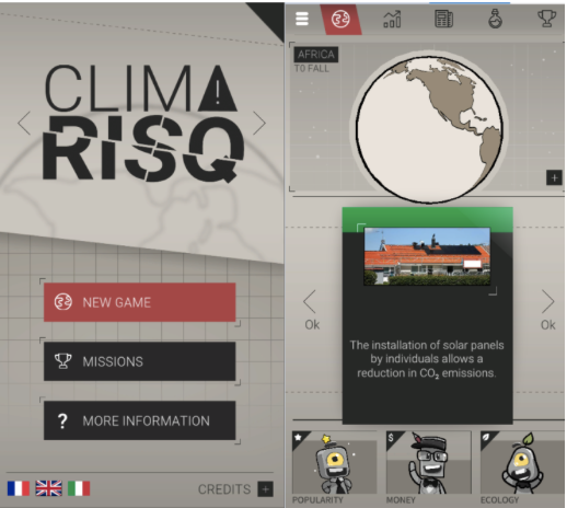
EGU24-11091 | Posters on site | EOS4.5 | Highlight

Climate Horizons: a graphic novel of key IPCC findings to reach a wider audience 

Iris-Amata Dion and Xavier Henrion

For over 30 years, the Intergovernmental Panel on Climate Change (IPCC) has been synthesizing the state of scientific knowledge on global climate change and communicating it through a series of reports. These reports highlight both the responsibility of humans in triggering this rapid climate change and the direct threat it represents for living organisms including humans. However, despite being freely available to all, many still lack basic understanding of the climate system and the associated anthropogenic forcings. One explanation to this is that these reports are not made intelligible to people outside the academic world and the decision-making sphere. The graphic novel format offers the advantage to blend art and science, making it easier for non-scientific readers to access the information contained in the IPCC reports. Therefore, we proposed an alternative way of presenting the IPCC findings through the collaboration between a climate scientist and a cartoonist. We interviewed 9 authors of the three main IPCC working groups to present the content of these reports in an accessible and intelligent graphic novel named Climate Horizons


In the story, two main characters engage in a dialogue with these IPCC co-authors allowing them to discover the complexity of natural ecosystems, climate inaction and political power struggles. While explaining their field of study, each author shares a vision of what their role as geoscientists should be in the face of urgent climate and environmental issues. Over the course of the story, the main characters gradually change the way they see the world, and go through a range of emotions (shock, denial, anger, acceptance, etc.) as they become aware of the major problem of climate change.

This approach by committed citizens and researchers responds to the need to be informed about possible solutions and encourages individual and collective reflection to imagine new possible horizons.

How to cite: Dion, I.-A. and Henrion, X.: Climate Horizons: a graphic novel of key IPCC findings to reach a wider audience, EGU General Assembly 2024, Vienna, Austria, 14–19 Apr 2024, EGU24-11091, https://doi.org/10.5194/egusphere-egu24-11091, 2024.

EGU24-11357 | Orals | EOS4.5

Is the definition of the Anthropocene a political question for and within the geosciences? 

Michael Wagreich, Colin Waters, Diana Hatzenbühler, and Eva Horn

The Anthropocene Working Group (AWG) of the Subcommission on Quaternary Stratigraphy (SQS) of the International Commission on Stratigraphy (ICS) was founded in 2009 to investigate the potential of the Anthropocene as a chronostratigraphic unit of the Geological Time Scale. After more than 14 years of work, many key publications and fierce discussions both within and outside the AWG, and several rounds of voting, the AWG concluded by great majority that the Anthropocene concept of Crutzen (2002) has stratigraphic reality and that a formal GSSP definition is pragmatic and suitable at the mid-twentieth century, coincident with the Great Acceleration of Earth System Sciences. The resulting  GSSP proposal  is located in Crawford Lake (Canada) sediment core with the base of the Anthropocene marked by an upturn in plutonium coincident with autumn 1952.  However, during the years of AWG investigations, criticisms from outside and a minority group within the AWG opposed to the majority consensus and published results of the AWG (see Zalasiewicz et al., in press), have undermined the significance, importance and usefulness of the Anthropocene as a (chrono)stratigraphic unit. However, beyond its debated geological implications but in it’s wider interdisciplinary and popular context, the term has evolved into a symbol emblematic of global change, the current climate, and ecological crisis. An argument of prominent geoscientists is that the AWG is politically and not scientifically motivated when dealing with the Anthropocene. Despite the AWG following established ICS protocols and procedures for stratigraphic working groups and founding their conclusions transparently through publications (e.g. Waters et al., 2016, 2023; Zalasiewicz et al., 2017), a political dimension is implicitly imposed on both AWG members, but also at their critics. To what extent would rejection of the Anthropocene proposal be interpreted outside of the sciences as a rejection of the scale of the current global crises? Research into the Anthropocene by the AWG has resulted in awareness and engagement of involved scientists in a crisis for which geology has some liability, but also in a wider interest of the humanities, media and arts on the stratigraphic work of the AWG. Hence, one may interpret geological research in the Anthropocene as a great and timely societal mission for the geosciences, resulting, hopefully, in a sustainable geological discipline emerging out of its historical linkage with the fossil energy sector.

Crutzen, P.J., 2002. Geology of Mankind. Nature 415: 23.

Waters, C.N. et al., 2016. The Anthropocene is functionally and stratigraphically distinct from the Holocene. Science 351(6269): 137.

Waters, C.N. et al., (Eds.), 2023. Candidate sites and other reference sections for the Global boundary Stratotype Section and Point of the Anthropocene series. The Anthropocene Review 10(1): 3–24.

Zalasiewicz, J. et al., 2017. The Working Group on the Anthropocene: Summary of evidence and interim recommendations. Anthropocene 19: 55–60.

Zalasiewicz, J. et al., in press. The Anthropocene within the Geological Time Scale: analysis of fundamental questions. Episodes.

How to cite: Wagreich, M., Waters, C., Hatzenbühler, D., and Horn, E.: Is the definition of the Anthropocene a political question for and within the geosciences?, EGU General Assembly 2024, Vienna, Austria, 14–19 Apr 2024, EGU24-11357, https://doi.org/10.5194/egusphere-egu24-11357, 2024.

EGU24-11767 | Posters on site | EOS4.5

“Slow science” concept: first insights of perceptions and suggestions in an oceanography laboratory 

Simon Barbot, Guillaume Roullet, and Guillaume Serazin

In the attempt to look back on our practices and to plan their evolution, a debate has been conducted in our lab to share the different perceptions about the “slow-science” concept. This debate surprisingly gathered more curiosity than expected and all profiles of scientists were represented from the BSc, PhD students and engineers to emeritus researchers. Suggestions have been made for future practices that would increase the quality of the scientific results and knowledge as well as better working conditions while reducing green gas emission. A generational inequity was pointed out to initiate the changes: early-career researchers are selected based on project-and-paper-productive metric, while established researchers have positions of influence throughout institutions. Although such changes would need institutional decisions and technical innovation for lowering the measurement’ impact, many suggestions are already feasible through hindsight and self-discipline.

How to cite: Barbot, S., Roullet, G., and Serazin, G.: “Slow science” concept: first insights of perceptions and suggestions in an oceanography laboratory, EGU General Assembly 2024, Vienna, Austria, 14–19 Apr 2024, EGU24-11767, https://doi.org/10.5194/egusphere-egu24-11767, 2024.

EGU24-12554 | Orals | EOS4.5

'Les Sacoches du Climat': An outreach cycling initiative for covering the last mile of climate communication in rural France 

Les Sacoches du Climat, Juliette Bernard, Antoine Bierjon, Julie Carles, Antoine Ehret, Rémi Gaillard, Alexandre Legay, Alban Planchat, and Christophe Cassou

Rural and medium-sized town populations already regularly face the tangible impacts of climate change, particularly in relation to their professional activities. However, they are often overlooked by the scientific community when it comes to knowledge sharing, even though they equally deserve attentive listening and consideration. 'Les Sacoches du Climat' (i.e. 'The Climate Panniers') is a French scientific outreach initiative led by a collective of young climate researchers specializing in various fields. The initiative was designed to raise awareness of climate issues in such regions, taking on the challenge of reaching the last mile in the large-scale French awareness campaign 'La Tournée du Climat et de la Biodiversité' (i.e. 'The Climate and Biodiversity Tour') — a traveling exhibition in major cities addressing climate and biodiversity issues led by a multidisciplinary team of scientists. 

Our journey unfolded over a week, navigating the landscapes of rural France on bicycles. During the day, we engaged with secondary school audiences, delivering an introduction to climate challenges followed by interactive discussions and workshops, with a particular emphasis on a sensitive approach. This educational endeavor was seamlessly intertwined with collaborative projects involving teaching staff. In the evening, we engaged adult audiences through conferences and debates, fostering collaboration with local communities and associations. Accompanied by esteemed French climatologists riding tandem with us, our collective presents here a brief retrospective of this journey and the messages derived from it. This initiative serves as an earnest call for climatologists to step beyond the traditional confines of research, immerse themselves in the field, and consider the impacts, adaptation, and vulnerability of territories in all their diversity and specificity in the face of climate change, fostering a responsible societal paradigm shift.

How to cite: du Climat, L. S., Bernard, J., Bierjon, A., Carles, J., Ehret, A., Gaillard, R., Legay, A., Planchat, A., and Cassou, C.: 'Les Sacoches du Climat': An outreach cycling initiative for covering the last mile of climate communication in rural France, EGU General Assembly 2024, Vienna, Austria, 14–19 Apr 2024, EGU24-12554, https://doi.org/10.5194/egusphere-egu24-12554, 2024.

EGU24-13761 | Orals | EOS4.5

Continuing wetland drainage: drivers, effects, and the role of science-based partnerships and understanding 

Helen Baulch, Phil Loring, Christopher Spence, Lauren Miranda, Don Selby, and Colin Whitfield

The prairie pothole region of North America has been described as a breadbasket for the world, and a ‘duck factory’ for North America, reflecting the tremendous ecosystem services associated with the vast agricultural lands, and millions of pothole wetlands in the region.  Pressure to increase agricultural outputs and profitability has led to accelerating wetland drainage, leading to a wicked problem worsened by the lack of enforcement of existing policy and vast numbers of unlicensed drainage projects.

Responsive to questions from partners, we embarked on a multi-dimensional research program to understand options for managing the drainage of prairie wetlands.  Novel ecosystem service models, based upon the unique hydrology of the region demonstrate important threats of drainage, including flooding, increased nutrient export, and profound impacts on habitat and biodiversity.  Expert-driven scenario development also shows potential for dire changes in the region associated with climate and land use change.  Importantly, there are fundamental differences among stakeholders in their understanding of how the system works, leading to divergent interpretations of the benefits, and consequences of drainage.  Not surprisingly, wetland drainage has led to conflict, as power dynamics and the effort to coordinate drainage approvals have contributed to winners, losers, and those without voice. However, in some cases drainage conflicts may simply be a resurgence of long-standing disputes over varied issues. 

While interdisciplinary and transdisciplinary work has helped understand the context of wetland drainage in this vast geographic area, problems, and possible ways forward, a weak policy environment is expected to persist because of local ideologies for limited government intervention, a highly politicised environment with strong power imbalances and strong government support of the agriculture sector.  Our work, guided by stakeholders since project inception to inform decision-making, demonstrates significant impacts of drainage with tangible policy implications, yet concerns have emerged about the role of science and representation of science in the policy process. While transdisciplinary research has clear benefits, it is not a panacea in complex, multi-sector, and conflict-prone arenas such as this. 

How to cite: Baulch, H., Loring, P., Spence, C., Miranda, L., Selby, D., and Whitfield, C.: Continuing wetland drainage: drivers, effects, and the role of science-based partnerships and understanding, EGU General Assembly 2024, Vienna, Austria, 14–19 Apr 2024, EGU24-13761, https://doi.org/10.5194/egusphere-egu24-13761, 2024.

EGU24-15634 | Orals | EOS4.5 | Highlight

Conference of the Parties or Conference of the People? Introducing a series of alternative grassroots COPs 

Sylvain Kuppel and the Scientifiques en rebellion collective

The Conferences of the Parties (COP) annually assess progress in dealing with climate change and towards legally-binding obligations to reduce or limit greenhouse gas emissions. Despite almost three decades of COPs and landmark treaties such as the Kyoto protocol (1997) and the Paris agreement (2015), global greenhouse gas emissions are a far cry from the emission pathways limiting global warming below 1.5-2°C as defined by the scientific consensus synthesized by the Intergovernmental Panel on Climate Change (IPCC). The failure at igniting state-level actions for climate mitigation stems from many factors, including a politico-economic hegemony, vested interests and techno-economic mindsets (Stoddard et al., 2021), well-embodied in the meager, voluntarism-based outcomes of increasingly questioned COPs. It may make sense that leading scientists still go to COPs to carry the voice of scientific consensus and convey the need for rapid action. However, scientists may also consider taking part in transformative changes through bottom-up initiatives where the conversation between scientists, collectives, citizens and media is more easily insulated from intense lobbying and greenwashing, allowing to focus on fact-based and ethics-driven endeavors, while showcasing unbridled perspectives for policymakers. Here we report the example of alternative COPs that took place in France in parallel to the COP28 in Dubai, organized by the Scientifiques en rebellion collective during the international Scientist Rebellion campaign “How much more climate failure can we take?”. Articulating a series of short events across French cities culminating with a 4-day alterCOP in Bordeaux, this grassroots initiative by scientists and activists was an invitation to take time to germinate new imaginations and popular initiatives, in a certain way “slowing down” to catalyze action considering the broader picture. Topics covered by this alterCOP took a systemic approach, beyond the climate breakdown, to include the other intertwined planetary boundaries (ecosystem health, water cycle, land use, etc.), discussing other economic systems (e.g. degrowth), international solidarity, and stimulating various world representations (present or desirable) and communication media, from artistic performances to a mock trial of a fossil fuel company.

References
Stoddard, I, et al. (2021). Three decades of climate mitigation: why haven't we bent the global emissions curve?. Annual Review of Environment and Resources 46, 653-689.

How to cite: Kuppel, S. and the Scientifiques en rebellion collective: Conference of the Parties or Conference of the People? Introducing a series of alternative grassroots COPs, EGU General Assembly 2024, Vienna, Austria, 14–19 Apr 2024, EGU24-15634, https://doi.org/10.5194/egusphere-egu24-15634, 2024.

The growing involvement of researchers in the public debate is triggering reflections in various scientific institutions. Here we report on the reflections of a working group of the University of Lausanne (UNIL) gathering researchers from all faculties, coordinated by the Competence Centre in Sustainability (CCD) and the Interdisciplinary Centre for Ethics Research (CIRE). Commissioned by UNIL’s Rectorate, the working group met thirteen times between April 2020 and May 2022 and independently defined the themes, approaches and methods that it deemed relevant to mobilize in this perspective. In particular, it conducted a literature review, a survey and focus groups with the UNIL community in the spring of 2021.

The working group's reflections were primarily aimed at clarifying the issues related to the engagement of scientists in the public debate and at better understanding the practices and perceptions of the UNIL community in this respect. They also aimed to propose answers to questions such as: should researchers be free to engage in public advocacy and activism? Is this compatible with the swiss legal framework and with notions such as science neutrality and academic freedom? What good practices should be followed when engaging in advocacy and/or activism? How should UNIL, as an institution, support its engaged researchers?

The main conclusion of the working group, published in a report in May 2022, is that participation in the public debate, advocacy and activism is compatible with research activities and as such should be supported by the academic institutions. However, it recommends a few good practices such as being as transparent as possible about the role that is endorsed (expert, researcher, activist, etc.) and about the nature of the statements that are made in public (scientific findings, personal opinion, political recommendation, etc.). In this brief oral, I will delve into the main conclusions of the working group’s report and address the questions mentioned above.

How to cite: Fragnière, A.: Exploring key issues in public engagement and activism. Findings of a working group at the University of Lausanne., EGU General Assembly 2024, Vienna, Austria, 14–19 Apr 2024, EGU24-16862, https://doi.org/10.5194/egusphere-egu24-16862, 2024.

EGU24-17314 | ECS | Orals | EOS4.5

An oceanography lab in its journey toward temperance 

Etienne Pauthenet, Simon Barbot, Pierre Amael Auger, and Eric Machu

The current ecological crisis requires changes in our way to make science in order to reduce the ecological footprint of scientific research activities. This is particularly crucial for setting a good example for the rest of society. Here we present the process engaged by an oceanography laboratory to reduce its environmental footprint. Using a tool developed by the French collective Labos 1point5, we calculated the carbon footprint of our laboratory separated by activities (missions, consumables, buildings, campaigns at sea, etc.). This exercise allows us first of all to quantify the contribution of the various components of our scientific activity. It also shows that the environmental footprint of our scientific activities is significant, and that it needs to be taken seriously by the community studying the Earth system. Reducing this footprint highlights different possible scales of action. Some actions involve internal laboratory processes, while others require broader societal changes. The measures implemented by our laboratory members to minimize our activities' impact will be presented, representing a part of a broader initiative under Labos 1point5.


How to cite: Pauthenet, E., Barbot, S., Auger, P. A., and Machu, E.: An oceanography lab in its journey toward temperance, EGU General Assembly 2024, Vienna, Austria, 14–19 Apr 2024, EGU24-17314, https://doi.org/10.5194/egusphere-egu24-17314, 2024.

EGU24-17840 | Orals | EOS4.5 | Highlight

The pivotal roles of the scientists in the initiative lead by the French government to train all civil servants on climate, biodiversity and natural resources issues 

Christophe Cassou, Luc Abbadie, Laurence Tubiana, Ulysse Dorioz, Jane Lecomte, and Claire Gouny and the GAES (Groupe d'Appui et d'Expertise Scientifique)

As anticipated by scientists for decades, impacts of climate change, biodiversity losses and natural resources scarcity, are increasingly challenging human societies in these early 2020s. To respond to this challenge, a large number of countries are undertaking profound societal shifts towards low-carbon and biodiversity-friendly lifestyles. So far, these efforts have been clearly insufficient to achieve sustainable development goals and more ambitious action will be needed at all decision levels.

In France, the government has taken the decisive step to train all civil servants on the three above-cited environmental issues. The aim of this unique and ambitious initiative is to engage as many state stakeholders and practioners as possible, by raising their awareness and knowledge about both environmental risks and challenges to be faced, in order to initiate an effective, societal-scale transition that has to be collective, collaborative and systemic by essence. This initiative is partly related to a "foot in the door" media operation carried out in June 2022, just after the presidential and legislative elections, and initiated by the scientific community to offer free training courses on climate and biodiversity issues to newly-elected members of parliament.

The ongoing inter-ministerial initiative is steered at national level by an interdisciplinary group of scientists who are responsible for framing training content and methods. Its operational implementation is ensured by regional committees of scientists to address local issues grounded in actionable reality, and to facilitate effective scaling-up. The ambition is to train 25,000 top managers civil servants by the end of 2024, and 5,7 million civil servants by 2027. Scientific knowledge is at the heart of the training program and the entire cursus runs over 28 hours in face-to-face to ensure cooperative dynamics during workshops, masterclasses, debates and field trips. More than 1,200 academics have volunteered to disseminate scientific facts as aid to decision-making, and to present the scientific methods that supports them. Training courses in scientific mediation will be offered to scientists engaged in the project, especially to early career researchers. The evaluation of the full initiative will be independently carried out through 3 PhD theses.

The ultimate aim of this initiative is to create shared and long-lasting spaces for dialogue and trust between public decision-makers and the scientific community. In this talk, we will describe and discuss the pivotal role played by the scientific community in this initiative. We will report the lessons learnt from the first training courses, as well as the successes and various obstacles that have been encountered.

How to cite: Cassou, C., Abbadie, L., Tubiana, L., Dorioz, U., Lecomte, J., and Gouny, C. and the GAES (Groupe d'Appui et d'Expertise Scientifique): The pivotal roles of the scientists in the initiative lead by the French government to train all civil servants on climate, biodiversity and natural resources issues, EGU General Assembly 2024, Vienna, Austria, 14–19 Apr 2024, EGU24-17840, https://doi.org/10.5194/egusphere-egu24-17840, 2024.

EGU24-18413 | Orals | EOS4.5

Reducing the carbon footprint of a research lab: how to move from individual initiatives to collective actions? 

Claire Lauvernet, Céline Berni, Marina Coquery, Leslie Gauthier, Louis Héraut, Matthieu Masson, Louise Mimeau, and Jean-Philippe Vidal and the Riverly Downstream team

This communication aims at exposing the steps taken by a research lab – in this case INRAE RiverLy – to reduce its carbon footprint. INRAE RiverLy is an interdisciplinary research unit for the functioning of hydrosystems. The environmental transition process originates in 2020 with the creation of the RiverLy Downstream group launched to address the downstream impacts of research practices (see Vidal et al., 2023).

The first step taken by the RiverLy Downstream group relates to monitoring the laboratory's carbon footprint and identifying the main emission sources. Yearly carbon accountings carried out since 2019 using the GES1.5 tool (https://apps.labos1point5.org/ges-1point5) show that purchases (equipment, consumables, etc.) account for the majority (>50%) of the lab footprint. They also highlight the impact of changes in individual practices related to business travel, with -63% of travel-related emissions in 2022 compared to 2019.

A second step focused on raising awareness through a Climate Day and testing the willingness to change within our research unit through an opinion poll. Results led to writing down a lab charter which was unanimously adopted by the lab council in October 2023. This charter sets a collective 10%/year cut-down trajectory with respect to the 2022 carbon accounting, while affirming the determination to preserve the positive impact of our research on society.

A third step now being undertaken by the RiverLy Downstream team is to come up with concrete collective actions to effectively reduce the lab footprint. Participatory workshops are being organised in January and February 2024 to specify agreed actions for the various research activities: long-distance travelling, purchasing scientific and IT equipment, setting up a research project, doing lab and field experiments, performing biological and chemical analyses, performing scientific computations, and organising seminars and conferences. Consolidated and agreed propositions will then be submitted to the lab council for formal acceptation and implementation.

The whole process benefits from rich interactions with the INRAE national to regional strategy for reducing its environmental footprint (https://www.inrae.fr/en/corporate-social-responsibility-inrae), and with the French national initiative Labos1point5 which set up a national network of labs in transition (https://apps.labos1point5.org/transition-1point5).

Vidal, J.-P., Berni, C., Coquery, M., Devers, A., Gauthier, L., Lauvernet, C., Masson, M., Mimeau, L., and Turlan, M. and the RiverLy Downstream team: How to collectively engage in reducing the carbon footprint of a research lab?, EGU General Assembly 2023, Vienna, Austria, 24–28 Apr 2023, EGU23-3462, https://doi.org/10.5194/egusphere-egu23-3462, 2023.

How to cite: Lauvernet, C., Berni, C., Coquery, M., Gauthier, L., Héraut, L., Masson, M., Mimeau, L., and Vidal, J.-P. and the Riverly Downstream team: Reducing the carbon footprint of a research lab: how to move from individual initiatives to collective actions?, EGU General Assembly 2024, Vienna, Austria, 14–19 Apr 2024, EGU24-18413, https://doi.org/10.5194/egusphere-egu24-18413, 2024.

Building transdisciplinary solutions at the first ever Climate Security Festival

In September 2023, the first ever Climate Security Festival was organized in Helsinki, Finland. The event gathered close to 100 participants including researchers, civil society actors, climate security experts, artists, activists, students and others at the Finnish Meteorological Institute for two days.

The idea of the festival was to bring people together and to enable discussing the risks related to climate change in an open and equal space. The two-day program was built around parallel workshop sessions, with the aim of strengthening and fostering cooperation between different sectors. The workshop topics were: 1) War and its effects on climate and the environment 2) Climate, death & (mental) wellbeing and 3) Who owns the climate security discussion? In addition, the festival included two keynote talks, joint discussion, a transdisciplinary poster session, artistic performances and side program; a safety walk, a photography exhibition and a collaboration movie screening and panel discussion in collaboration with Finland’s biggest film festival. The event was organized in person and participants were encouraged to leave aside their electronic devices, titles and prejudice.

Based on the encouraging results and feedback from participants, some key findings from the festival can be pointed out and utilized in building sustainable collaborations and co-creating climate solutions in geosciences and beyond. The results indicate, for example, the importance of;

  • embracing a truly transdisciplinary approach (including non-academic methods)
  • putting the work in building safer spaces for discussing ethical, fundamental and even painful topics in the context of climate change and geosciences
  • involving artists, art institutions and artistic methods in climate security related discussions and action in non-performative roles
  • expanding ownership of the discussion on climate change related risks beyond ‘traditional’ research and security/foreign political frameworks

Results are presented briefly with visual materials from the festival, workshop proceedings and participant feedback.

The festival was organized by the Safer Climate network (Institute for Atmospheric and Earth System Research, University of Helsinki) in collaboration with the Committee of 100 in Finland. The next festival will be organized in 2024.

How to cite: Rantanen, R.: Building transdisciplinary solutions at the first ever Climate Security Festival, EGU General Assembly 2024, Vienna, Austria, 14–19 Apr 2024, EGU24-18757, https://doi.org/10.5194/egusphere-egu24-18757, 2024.

With detailed understanding of planetary boundaries like the connection of continuously increasing global greenhouse gas emissions and the frequency and severity of climate change impacts (geo)scientists recognize the critical need for ambitious political action perhaps more urgently than non-experts. Yet, global policies have consistently failed to deliver on their ambitions, goals, and implementation, making necessary transformations elusive. We argue that (geo)scientists can have a considerable impact beyond the traditional avenues of publishing papers and reports or advising policy makers. Drawing inspiration from historical successes, particularly in non-violent civil disobedience, we explore the considerations of engaging in climate activism from the dual perspectives of scientists and civil servants. Using the example of scientists at public scientific institutions in the Netherlands, we delve into questions surrounding one’s rights, duties, and responsibilities. We aim to stimulate reflection on effective strategies for scientists to advocate for change in the critical arena of climate action and climate justice.

How to cite: Jüling, A. and Keizer, I.: Navigating the Intersection of Science, Activism, and Civil Service: Reflections on the role of scientists in civil service, EGU General Assembly 2024, Vienna, Austria, 14–19 Apr 2024, EGU24-18782, https://doi.org/10.5194/egusphere-egu24-18782, 2024.

EGU24-19128 | Posters on site | EOS4.5

IPSL climactions and the bottom-up ecological transformation of  a climate research institute (2016-2024) 

Lea Bonnefoy and the IPSL Climactions

For several decades now, research communities working on the climate, its changes, including current global warming, and its consequences have been recommending drastic reductions in human-made greenhouse gas emissions and, more generally, in the ecological footprint of human activities. This implies the implementation over the next 10 to 20 years of profound and rapid systemic transformations. The latest IPCC reports show that such transformations are only possible if they involve all parts/sectors of society. Given the existence of a range of ecological constraints and the foreseeable limits to scientific and technical advances, the transformations to be implemented must also include a strong component of sufficiency ("avoidance”).

Since 2016, IPSL scientists and support staff have been working together along these lines to transform the institute's professional practices.  This engagement is generally seen as : (i) a necessity: to initiate a transition in its research practices that will bring its professional behavior in line with the message of climate urgency that it has been diffusing for over 30 years; (ii) an opportunity: to accelerate the transition at a societal level by opening up new channels of exchange with society, encouraging collective action by example, and reinforcing the credibility of its warning message; (iii) a safeguard: collective bottom-up thinking at laboratory level to ensure that this transition takes place with maximum respect for our research practices and our well-being at work, and is not imposed by potentially inappropriate top-down measures.

Achievements include (i) the development of methodologies for calculating the carbon footprint generated by staff activities and professional practices, (ii) concrete contributions to the reduction of the environmental footprint of professional travels, digital and high performance computing activities, purchases and finally observation of the earth. We will present here our approach, methodologies, achievements, and reflections at this stage, with the hope to stimulate exchange with other ongoing or emerging initiatives in other parts of the world.  

How to cite: Bonnefoy, L. and the IPSL Climactions: IPSL climactions and the bottom-up ecological transformation of  a climate research institute (2016-2024), EGU General Assembly 2024, Vienna, Austria, 14–19 Apr 2024, EGU24-19128, https://doi.org/10.5194/egusphere-egu24-19128, 2024.

EGU24-19470 | Posters on site | EOS4.5 | Highlight

Scientific debunking of institutional and corporate communication 

Laurent Husson and the Scientifiques en Rébellion collective

Greenwashing sounds like a trivial manoeuvre that can easily be circumvented. In practice, private companies and institutions deploy a wealth of inventiveness to take away your vigilance. As a canonical example, it took forever before it was realized and admitted that the tobacco industry had a tremendous health burden. As scientists, we have the means to scrutinize the borderline communication, that stands half way between journalistic investigation and activism. That is the purpose of Scientist Rebellion in particular, which is particularly concerned with environmental challenges. Of course, it often requires to go beyond our daily scientific expertises, that we are trained for. Using two recent examples, I will showcase two case studies from Scientist Rebellion in France. The first one deals with the analysis of financial institutions regarding their oil and gas strategies, and the subsequent media coverage of activist communication, and an insider view on the impact of it had on the orientation of their strategies. The second one is an exploration of the governmental communication on adaptation strategies to climate change, with consideration on its political implications. 

How to cite: Husson, L. and the Scientifiques en Rébellion collective: Scientific debunking of institutional and corporate communication, EGU General Assembly 2024, Vienna, Austria, 14–19 Apr 2024, EGU24-19470, https://doi.org/10.5194/egusphere-egu24-19470, 2024.

EGU24-19960 | ECS | Orals | EOS4.5

Climate activism as a form of science communication and public engagement 

Arthur Oldeman, Iris Keizer, and André Jüling

The current state and future projections of the climate and environmental crises call for science to be able to have a deep impact on society, and to have it quickly. Here we discuss how scientists engaging in climate activism can contribute to educating the general public and press for urgent action, as well as under which conditions such scientific activism can be most effective.

Traditionally, science has mostly interacted with society by making scientific results public, without interfering in how politicians, business and the general public would make use of them. Similarly, the role of science educators has been often confined to spreading knowledge to students and broader audiences, independently of how this knowledge affects society. However, such communication and education efforts appear insufficient considering unambitious policies with regards to the current climate and ecological crises. As a result, many scientists, both within and outside academia, have been looking for other ways to communicate the urgency of the climate crisis. Notably, communication efforts have increasingly extended to public support of environmental action movements and participation in protests and civil disobedience actions.

In this work, we discuss how activism can be complementary to classical approaches of science communication and public education on the urgency of the climate and environmental crises. We will highlight recent examples of civil disobedience by scientists with a focus on the Netherlands. We also present the reaction from stakeholders such as politicians and representatives of companies, as well as the reception of such actions by the scientific community. We discuss the place of activism in the broader scientific community, where our viewpoint is that scientific activism can only become an efficient way of science communication and public engagement if (i) it is accepted and respected within the scientific community, and (ii) it adheres to rules allowing such communication to maintain or increase scientific reputation in society. We also stress the supportive role of universities and research institutes in enabling the engagement with activism, especially for early career scientists. Scientific institutions should emphasize that climate activism and advocacy is welcome among both researchers and educators, that their freedom of speech is protected, and that such activities are recognized as valuable.

How to cite: Oldeman, A., Keizer, I., and Jüling, A.: Climate activism as a form of science communication and public engagement, EGU General Assembly 2024, Vienna, Austria, 14–19 Apr 2024, EGU24-19960, https://doi.org/10.5194/egusphere-egu24-19960, 2024.

EGU24-20093 | Posters on site | EOS4.5

Beyond Traditional Science Advocacy: Should Scientists engage in Climate Action?  

Iris Keizer, Arthur Oldeman, and André Jüling

The current climate and environmental crisis requires immediate societal changes. Here, we propose a discussion on whether scientists should engage in climate action. Activism offers a new avenue for climate advocacy that goes beyond traditional methods. We explore how scientists engaging in climate activism can educate the general public and press for urgent action and the conditions under which scientific activism can be most effective. 


Using historical and recent examples of non-violent civil disobedience by scientists, including actions we joined and/or supported as members of Scientist Rebellion, we demonstrate how such activism can be effective in complementing classical approaches to public education about the urgency of the climate and environmental crises, as well as in pushing for critically needed political action. We invite all scientists to engage in a discussion on whether we should engage in climate action as we acknowledge the complexities around scientific values, ethics, authority, and integrity. 


How to cite: Keizer, I., Oldeman, A., and Jüling, A.: Beyond Traditional Science Advocacy: Should Scientists engage in Climate Action? , EGU General Assembly 2024, Vienna, Austria, 14–19 Apr 2024, EGU24-20093, https://doi.org/10.5194/egusphere-egu24-20093, 2024.

EGU24-20180 | ECS | Orals | EOS4.5 | Highlight

Mapping Fossil Ties: Decentralised research into ties between universities and the fossil fuel industry 

Maien Sachisthal, Aaron Pereira, and Linda Knoester

Universities are under increasing scrutiny from students, staff and society about their ties with the fossil fuel industry. Such ties include research cooperations and commissions, influence and participation in study programmes, sponsoring of students and student societies, sponsored professorships and staff ancilliary activities, presence at careers fairs and alumni networks. For fair and open discussion on what relationships between universities and the fossil fuel industry are appropriate, such relationships must be transparent - currently this is not the case. 

In the Netherlands, the Mapping Fossil Ties coalition - a research coalition of student and staff activists, NGOs and independent investigators - map these "fossil ties" and track the influence of fossil fuel companies in universities. We use a variety of methods: freedom of information (FOI) requests to universities and funding bodies, web scraping, and decentralised, crowdsourced information gathering on campus. From this, we could build a fuller picture of how Dutch academia interacts with and is influenced by the fossil industry, and can identify hidden, yet problematic ties. 

The collaborations, news coverage, and state of the debate are continually updated on a web portal (mappingfossilties.org) for the use of investigative journalists, (activist) student and university staff, NGOs, policymakers, and the public. In this talk we present our methodology, the impact that this research has had on the Dutch public debate, how this research underpins student and staff activism, and points for improvement and learning. Finally we discuss how we are replicating such research in other countries, and how others can do so too.

How to cite: Sachisthal, M., Pereira, A., and Knoester, L.: Mapping Fossil Ties: Decentralised research into ties between universities and the fossil fuel industry, EGU General Assembly 2024, Vienna, Austria, 14–19 Apr 2024, EGU24-20180, https://doi.org/10.5194/egusphere-egu24-20180, 2024.

EGU24-2080 | ECS | Orals | EOS4.7

Increasing the availability of Italian daily hydrological measurements with a citizen science approach: the SIREN project 

Paola Mazzoglio, Miriam Bertola, Luca Lombardo, Chiara Sacco, Alberto Viglione, Francesco Laio, and Pierluigi Claps

In Italy, the National Hydrological Service named “Servizio Idrografico e Mareografico Nazionale” (SIMN) was established to collect hydro-meteorological measurements. This Service was also in charge of publishing the Hydrological Yearbooks, a standardized collection of validated measurements available in printed volumes. The dismantlement of the SIMN, performed about 30 years ago, led to the decentralization of data collection to the regional level. This shift has resulted in challenges related to the availability of comprehensive national-scale datasets since historical hydrological measurements are usually available only in the printed Yearbooks. These volumes have seen limited efforts towards digitization over time, increasing the risk of losing a large (but, so far, little exploited) wealth of information related to the hydrology of the last century.
Despite advancements in Optical Character Recognition (OCR) software, machine learning, and artificial intelligence, manual transcription remains the most accurate digitization method in certain conditions, e.g., when the ink is partially damaged or when handwritten corrections are reported. Within the SIREN (Saving Italian hydRological mEasuremeNts) project, a citizen science initiative developed on the Zooniverse platform (https://www.zooniverse.org/projects/siren-project/siren-project), hundreds of volunteers are contributing to digitizing this amount of data. Being an expert is not fundamental for being part of this citizen science project: a tutorial automatically pops out when a volunteer enters the workflow, illustrating all the key characteristics of the Yearbooks and how to interpret them, enriched with a step-by-step description of all the phases of the digitization workflow. To minimize digitization errors, each table is digitized by at least 2 different volunteers, and discrepancies are manually checked and corrected.
The time series collected up to now are currently undergoing a detailed quality control procedure to ensure the reliability of the dataset that will be created. The final dataset will be made available on Zenodo in the upcoming months.
The SIREN project represents thus a collaborative effort to bridge the historical hydrological data gap, offering valuable insights for both local and national-scale analyses and aiding in the refinement of models predicting current and future hydrological trends.

How to cite: Mazzoglio, P., Bertola, M., Lombardo, L., Sacco, C., Viglione, A., Laio, F., and Claps, P.: Increasing the availability of Italian daily hydrological measurements with a citizen science approach: the SIREN project, EGU General Assembly 2024, Vienna, Austria, 14–19 Apr 2024, EGU24-2080, https://doi.org/10.5194/egusphere-egu24-2080, 2024.

Born in 1994 (Geller and Ohminato 1994) and grounded in the optimally accurate operator theory (Geller and Takeuchi 1994), the Direct Solution Method (DSM) has long been a reliable force in seismic wavefield computation for spherically symmetric planets, particularly excelling in high-frequency efficiency. However, as the nowaday seismology seeks greater realism in 3D heterogeneous media, DSM has been facing substantial hurdles in its extension.

This contribution first revisits the historical successes and failures of the DSM, spotlighting its efficiency in computing seismic wavefields in spherically symmetric planets. However, the shift towards more complex models exposes DSM's limitations due to its trial functions, prompting various attempts to adapt it to 3D heterogeneous media. Analysing these endeavours, we uncover pitfalls and missteps that have hindered the extension of DSM to 3D heterogeneous media. Out critical assessment identifies common challenges, offering insights into essential modifications needed to overcome them. This contribution acts as a guide, emphasising what to avoid and illuminating potential avenues to enhance the DSM's applicability in global seismology within 3D heterogeneous contexts.

We try to elucidate the shortcomings of previous efforts, providing valuable lessons for future endeavours. By steering researchers away from ineffective approaches, we aim to catalyse innovation, paving the way for the continued relevance and effectiveness of DSM in global seismology. This comprehensive exploration serves as a roadmap, directing attention towards necessary adjustments and innovations to sustain DSM's utility amidst the dynamic landscape of seismic wavefield computation.

How to cite: Fuji, N.: Navigating challenges: Revitalising the Direct Solution Method for 3D heterogeneous media in global seismology, EGU General Assembly 2024, Vienna, Austria, 14–19 Apr 2024, EGU24-5388, https://doi.org/10.5194/egusphere-egu24-5388, 2024.

EGU24-6386 | Orals | EOS4.7

Challenges to implement an open, free, participative gravity-modelling initiative 

György Hetényi, Matteo Scarponi, and Ludovic Baron

In January 2024, our team has launched an open, free, participative gravity-modelling initiative. The idea is to provide all the necessary, pre-processed input data to the community, so that modelling and inversion can be applied by anyone interested in constraining the shape of a geological-geophysical anomaly. This way we hope to step over hurdles related to personal biases. The full description can be found at https://zenodo.org/records/10390437

Beyond advertising the initiative, we would like to share some thoughts on the pathway to launching it: the motivation, the interest, the experienced past difficulties and further challenges on the horizon. By doing so, we hope to contribute to the goals of this session, and to foster further such (scientific and sharing) initiatives.

How to cite: Hetényi, G., Scarponi, M., and Baron, L.: Challenges to implement an open, free, participative gravity-modelling initiative, EGU General Assembly 2024, Vienna, Austria, 14–19 Apr 2024, EGU24-6386, https://doi.org/10.5194/egusphere-egu24-6386, 2024.

EGU24-7637 | Orals | EOS4.7

Svalbox – from an educational tool to systematic digitization of Svalbard 

Kim Senger, Peter Betlem, Rafael Horota, Tereza Mosočiová, Nil Rodes, and Aleksandra Smyrak-Sikora

Field teaching and research in the High Arctic is costly, both economically and in terms of environmental impact. In the Norwegian archipelago of Svalbard (74-81°N, 15-35°E), the field season is defined by the extreme annual daylight cycle, with a 4 month long polar night and midnight sun from late April to late August. The University Centre in Svalbard (UNIS) in Longyearbyen serves as Norway’s field university. Arctic Geology courses at UNIS make use of the excellent vegetation-free outcrops exhibiting various lithologies and tectono-magmatic structures.

At UNIS, geological fieldwork is mostly conducted in the snow free summer with focus on coastal localities accessible by hiking and boats. The snow-covered “spring” season in March and April allows access to inland locations on snowmobiles, but only steep cliffs are snow-free and accessible for investigations.  Irrespective of the time of the year, the harsh Arctic weather conditions, presence of wildlife (i.e. polar bears) and safe access to outcrops (e.g., strenuous hiking in steep terrain) routinely requires adjusting the field plans. In addition, the short field season(s) often only allow relatively short single field site visits. To make most efficient use of the field excursions, we have since 2016 built and developed Svalbox – an effort to systematically digitize Svalbard’s outcrops through digital outcrop models (DOMs) and photospheres integrated with other geoscientific data sets (maps, geophysical data, terrain models, borehole data etc.). 

Starting as an educational tool at UNIS to facilitate year-round (digital) fieldwork and quantitative analyses on outcrops, Svalbox has in recent years become an important resource for the wider geoscientific community. Svalbox comprises three main elements; 1) A database of freely accessible DOMs. 2) An open portal for visualising drone-based virtual field trips (VFTs) and 3) Thematic data packages integrating various data sets for UNIS courses or specific research projects. 

In this contribution, we present all these three Svalbox elements. The database itself, visualised via www.svalbox.no/map, offers a growing number of DOMs and photospheres (i.e. 360 images) from all over Svalbard. Both incorporate georeferenced photographs acquired with consumer cameras and drones (DJI Mavic 2 and 3 in particular). The DOMs are processed with structure-from-motion photogrammetry using the Metashape software. DOMs and photospheres are fully downloadable, including the processing reports  and all associated input data , facilitating reprocessing if needed. Curated data packages are integrated as VFTs and are accessible through a dedicated web portal, www.vrsvalbard.com/map with thematic groupings for specific UNIS courses and larger-scale research projects. 

Thematic data packages are generated from UNIS-internal databases (onshore and offshore seismic data, boreholes, digitized maps, cross sections, and sedimentary logs in publications etc.) and openly available datasets (digital terrain models, bathymetry, geophysical grids, maps etc.)  where data are spatially connected in single software projects (e.g., Petrel, GPlates) for specific courses or projects. 

At this stage, we strive for expanded usage of Svalbox beyond UNIS. In particular, we invite the geoscience and data analytics community to use the exponentially growing number of DOMs to test and train machine learning algorithms for (semi-)automatic interpretation of DOMs.

How to cite: Senger, K., Betlem, P., Horota, R., Mosočiová, T., Rodes, N., and Smyrak-Sikora, A.: Svalbox – from an educational tool to systematic digitization of Svalbard, EGU General Assembly 2024, Vienna, Austria, 14–19 Apr 2024, EGU24-7637, https://doi.org/10.5194/egusphere-egu24-7637, 2024.

The Deep Network is an initiative which brings together multidisciplinary practitioners who in some way support adults outside of formal learning environments. Deep Network members are supporting adults to become ocean literate and effectively motivating learners to actively participate in pro-climate action and marine sustainability. To achieve the ambitious targets set out in the SDGs, our adult population must learn not only to recognise economic, social, and environmental challenges but also act upon this knowledge. In this session, we will present specific barriers that adult learners experience and acknowledge the challenge of participation in non-formal education, and also address scientists’ limitations of time, funding, and partnerships for these types of initiatives. We will present how the Deep Network responds to these needs, providing space for informal and interactive collaboration between marine researchers, educators, and activists. Over 40 active participants from more than 10 countries participated in Deep Network online Hub Meetings to present their educational initiatives. They developed new partnerships and support the curation of an online library of inspiring practice. The overarching consensus in post-meeting evaluations was that learning about and recognizing the value in different methodologies and audiences of initiatives was inspiring and gave participants tangible ideas as well as hope and motivation to continue developing much needed educative materials for adult learners. This is also a strong motivator for participants to use the Deep Network as a springboard for future interdisciplinary collaborations. In this presentation we will detail the conclusions of the Deep Network meetings and show how practitioners learnt from and with each other to build capacity in marine sustainability and adult education. We conclude by making recommendations for future practice.

How to cite: Johansen, C.: The Deep Network - Curating and co-producing quality ocean-education information for adults, EGU General Assembly 2024, Vienna, Austria, 14–19 Apr 2024, EGU24-7704, https://doi.org/10.5194/egusphere-egu24-7704, 2024.

EGU24-7937 | Posters on site | EOS4.7 | Highlight

Geodynamica: Earth & Planets slinging Earth and (exo)planets’ structure and dynamics into Diamond Open Access  

Thibault Duretz, Maelis Arnould, Mandy Bethkenhagen, Mohamed Gouiza, Maffei Stefano, and van Zelst Iris

Over the past few years, different fields of Earth Sciences have witnessed the inception of several community-led diamond open access journals (e.g., Volcanica, Tektonika, Seismica). The aim is to remove the paywall barriers by publishing peer-reviewed articles at no cost to both authors and readers, thus offering a platform for true open science. Alternatives to classical for-profit scientific journals do exist: it is time to bring research on the dynamics of Earth and (exo)planets’ interior to the diamond open access arena. 

Therefore, we are pleased to announce the birth of a new diamond open access journal initiative called Geodynamica: Earth & Planets, with a target launch date in autumn 2024. Coordinated by a core committee of six scientists, the community-led Geodynamica: Earth & Planets journal aims at promoting academic discourse and disseminating research pertaining to the quantitative study of Earth and (exo-)planetary internal structure, dynamics, and evolution from observational to modeling perspectives. In this contribution, we will provide the vision behind this initiative, report on the structure of this journal, its scope, and the remarkable community effort that will make this new diamond open access journal a reality. 

How to cite: Duretz, T., Arnould, M., Bethkenhagen, M., Gouiza, M., Stefano, M., and Iris, V. Z.: Geodynamica: Earth & Planets slinging Earth and (exo)planets’ structure and dynamics into Diamond Open Access , EGU General Assembly 2024, Vienna, Austria, 14–19 Apr 2024, EGU24-7937, https://doi.org/10.5194/egusphere-egu24-7937, 2024.

EGU24-11365 | Orals | EOS4.7

Submap database & web-tool milestones from their birth to their current state and future developments 

Serge Lallemand, Nestor Cerpa, Michel Peyret, Arnauld Heuret, Diane Arcay, and Elenora van Rijsingen

Submap (www.submap.fr) is a web-tool for generating maps and cross-sections, and for displaying datasets of subduction zone areas. Maps and (cross-)sections rely on the (Py)GMT library and global geophysical databases. Submap is also a mean for sharing our own Submap database, which compiles data on subduction kinematics, on the characteristics of the convergent plates and on their geometry, as well as on the seismogenic characteristics of the subduction interface along 260 transects evenly distributed across all active oceanic subduction zones.

What makes this tool so special is that one can access over 200 tectonic parameters for every transect with a single click. , as new studies are produced by the Submap team or by the wider community.

The idea of developing such a tool arose from the subduction zone comparative study carried out by Arnauld Heuret during his PhD thesis in 2005. In a first version (2009), we proposed an aid to the rapid creation of MAPS and SECTIONS using global databases (topo-bathymetry, gravimetry, age of the seafloor, seismicity) using the GMT library in a way that was transparent to the user via a query page. We then added the possibility to extract a number of characteristic parameters for the 260 transects composing the Submap database (module Sub-DATA in 2013). This database has grown over years, incorporating, for instance, new parameters describing the seismogenic zone after we published a global study on this .

In 2023, we decided to fully redesign the web-tool. A major effort has been made to facilitate the use on all types of screens (computers, tablets). We enhanced the range and the rendering of documents made available for download, and the tool was made accessible to all audiences. In terms of content, a new module called MAP-Subquake now allows to plot the rupture envelopes for selected subduction earthquakes together with the roughness of the subducting seafloor facing the ruptures. The latter dataset comes from Submap team publications in 2018. Moreover, several parameters were revised or added to the Submap dataset, such as the sediment thickness in the trench or in the subduction channel, and the kinematics. We are currently working on the geometric characteristics of the volcanic arcs and on a better representation of the strain in the upper plate, planning to update the database by the end of the year.

Submap is primarily a useful working tool for research on subduction zones, as it lists and displays a vast amount of complementary data in an optimized format that facilitates comparative analysis. It is also a meaningful tool for teaching at secondary and higher-education levels, as a support for courses or as part of tutorials or individual work for high school and university students. It can be used to quickly obtain accurate documents to support workshops, for example to determine the best segmentation criteria in order to define the seismic hazard of a zone, or simply to study the lateral variations of certain parameters of a subduction zone.

How to cite: Lallemand, S., Cerpa, N., Peyret, M., Heuret, A., Arcay, D., and van Rijsingen, E.: Submap database & web-tool milestones from their birth to their current state and future developments, EGU General Assembly 2024, Vienna, Austria, 14–19 Apr 2024, EGU24-11365, https://doi.org/10.5194/egusphere-egu24-11365, 2024.

EGU24-12302 | ECS | Orals | EOS4.7

Scientific Content Curation In An Open Science Era  

Kaylin Bugbee, Deborah Smith, Stephanie Wingo, and Emily Foshee

Today’s open science environment, in combination with the Big Data era, means more scientific data, software, tools, documentation, publications and other resources are available than ever. The promise of the open science era is that scientists will spend less time reinventing the wheel and more time doing actionable research. Yet navigating this vast and complex information landscape can feel overwhelming to scientists trying to get their bearings. In this presentation, we define and discuss the importance of scientific content curation for enhancing discovery and use of scientific data and information. We also share two examples of scientific content curation in action: the Catalog of Archived Suborbital Earth Science Investigations (CASEI) and the Science Discovery Engine (SDE). 

How to cite: Bugbee, K., Smith, D., Wingo, S., and Foshee, E.: Scientific Content Curation In An Open Science Era , EGU General Assembly 2024, Vienna, Austria, 14–19 Apr 2024, EGU24-12302, https://doi.org/10.5194/egusphere-egu24-12302, 2024.

EGU24-13283 | ECS | Posters on site | EOS4.7

Automated Python workflow for generating Sentinel-1 PSI and SBAS interferometric stacks using SNAP on the Geospatial Computing Platform 

Amira Zaki, Ling Chang, Irene Manzella, Mark van der Meijde, Serkan Girgin, Hakan Tanyas, and Islam Fadel

SNAP (Sentinel Application Platform) is an ESA open-source package distinguished by its stability and user-friendly interface, especially while conducting interferometric SAR (InSAR) processing. However, SNAP-ESA is limited by the lack of a flexible algorithm to generate InSAR time series stacks for both Persistent Scatterer Interferometry (PSI) and Small Baseline Subset (SBAS) techniques. Moreover, another limitation is the computational requirement to generate InSAR time series interferometric stacks for the available data time span over large areas. In this research, we introduce an innovative automated Python Workflow built upon SNAP-ESA, namely SNAPWF. SNAPWF integrates the capabilities of open-source ASF-search and SNAP-ESA software, enabling network graph generation for PSI and SBAS. The generated network graphs are then utilized to generate the InSAR stacks using SNAP-ESA flexible Graph Processing Framework (GPF) through the Graph Processing Tool (GPT). SNAPWF has the capability to export the interferometric stacks to different file formats that enable further analysis in other available software packages. We implemented and tested SNAPWF on a dedicated geospatial cloud computing platform (GCP). The results demonstrated its capability to generate complete interferometric stacks for Sentinel-1 scenes for PSI and SBAS implemented for a study area across Kenya and Tanzania in 6 hours for one year of data. Moreover, the performance test results showed the possible utilization of the variable resources to accelerate the processing steps.

How to cite: Zaki, A., Chang, L., Manzella, I., Meijde, M. V. D., Girgin, S., Tanyas, H., and Fadel, I.: Automated Python workflow for generating Sentinel-1 PSI and SBAS interferometric stacks using SNAP on the Geospatial Computing Platform, EGU General Assembly 2024, Vienna, Austria, 14–19 Apr 2024, EGU24-13283, https://doi.org/10.5194/egusphere-egu24-13283, 2024.

EGU24-13649 | Posters on site | EOS4.7

Introducing the World Climate Research Program (WCRP) Academy 

Melissa Hart, Chris Lennard, Ma. Laurice Jamero, Lora Batino, Pablo Borges de Amorim, Feba Francis, and Dorcas Kalele

The WCRP Academy is the research training advisory and coordination arm of the World Climate Research Program. It is the flagship activity for WCRP´s mission: “to develop, share, and apply climate knowledge that contributes to societal well-being” and works to equip current and future climate scientists with the knowledge, skills and attributes required to tackle the world’s most pressing and challenging climate research questions. The Academy is a hub which connects training providers and users of training. Inclusion within the Academy implies that the training is of high quality and, as such, is a legitimate source of training and professional and capacity development platform that is targeted to climate scientists.


In this presentation, we will introduce the Academy and our catalogue of climate science training, which collates in-house WCRP training activities and educational materials to the global science community. Further, the WCRP Academy encourages and invites all research and expert groups, academic and research institutions, government agencies and non-government organizations who provide climate science training and education to register as training providers and contribute to our online training catalogue.

The WCRP Academy is building a global community of climate researchers at all career stages to provide global networking and development opportunities to facilitate lifelong learning, global equity, and skills matching for current and future research projects. 


How to cite: Hart, M., Lennard, C., Jamero, Ma. L., Batino, L., Borges de Amorim, P., Francis, F., and Kalele, D.: Introducing the World Climate Research Program (WCRP) Academy, EGU General Assembly 2024, Vienna, Austria, 14–19 Apr 2024, EGU24-13649, https://doi.org/10.5194/egusphere-egu24-13649, 2024.

EGU24-14670 | Orals | EOS4.7 | Highlight

Exchanging knowledge in community online seminars: lessons learned from the Rifts and Rifted Margins Seminar series 

Sascha Brune, J. Kim Welford, Folarin Kolawole, Derek Keir, and Gwenn Péron-Pinvidic

The Rifts and Rifted Margins Seminar is a community-based, international online seminar series. It unites multi-disciplinary expertise in the fields of geology, geophysics, and geochemistry, and aims at covering both fundamental and applied research aspects. The series caters primarily to the community working on active rifts and the one that focusses on rifted margins. We aim to bridge these communities while further, building links to neighboring disciplines.

The seminar series started in June 2020 and has hosted about 70 seminars with roughly 200 individual talks1. Each seminar session is structured as a one-hour Zoom meeting held on Monday afternoon European time. Originally a bi-weekly meeting, the seminar has switched to a monthly rhythm since summer 2022. If speakers agree, their presentations are recorded and shared on the seminar’s YouTube channel2.

We have encountered several challenges since the inception of this project – from technical hurdles to defining the scientific scope of the seminars. We have adopted a technical setup that utilises Zoom for video conferencing, accommodating over 100 attendees at times, DFN3 for broadcasting invitations to a mailing list of more than 700 subscribers, and YouTube for hosting seminar recordings that have gained approximately 40,000 views2. In contrast to the majority of other online seminars, we host three speakers per session, each at different career levels (senior, mid-level, and early career/student) and where possible, from different gender/ethnic groups, delivering a talk of 13-15 minutes length. These presentations concentrate on a single scientific subject, albeit from varied viewpoints. We believe that this setup ensures a more diverse perspective and enhances the discourse. On the downside, it complicates the scheduling of sessions.

In total, 10 researchers have contributed to organizing this seminar series since 2020. To meet individual time commitments and to ensure influx of new ideas, the initial team of organizers has been steadily replaced. The pandemic has seen the emergence of many online seminars which have played a key role in maintaining community connections during that time. The principal advantage of online seminars however endures beyond the pandemic: they enable the exchange of knowledge without the need for travel and with a minimal carbon footprint, accessible to anybody with an internet connection, and at no cost.


[1] https://www.gfz-potsdam.de/sektion/geodynamische-modellierung/projekte/rift-and-rifted-margins-online-seminar

[2] https://www.youtube.com/@riftandriftedmarginsonline1714/playlists

[3] https://www.dfn.de/

How to cite: Brune, S., Welford, J. K., Kolawole, F., Keir, D., and Péron-Pinvidic, G.: Exchanging knowledge in community online seminars: lessons learned from the Rifts and Rifted Margins Seminar series, EGU General Assembly 2024, Vienna, Austria, 14–19 Apr 2024, EGU24-14670, https://doi.org/10.5194/egusphere-egu24-14670, 2024.

EGU24-16433 | Orals | EOS4.7

Improving access to climate information: The Met Office Climate Data Portal 

Michael Sanderson, Alex Woods, Catherine Marshall, Laurie Stevens, Anthony Veal, Victoria Ramsey, Katie Hodge, Timothy Mitchell, Mathew Richardson, Jason Lowe, and Samuel Chapter

Across Europe, a wide variety of public and private organisations require climate hazard and impact data both to improve understanding of current and changing risks and inform adaptation measures. Climate hazard and impact data currently require considerable technical expertise to access, download and interrogate creating a barrier for policy makers, local authorities, non-governmental and citizen organisations, and other interested parties. In the UK, the Met Office, in partnership with ESRI, has created a Climate Data Portal to address this issue. It provides a selection of climate data and supporting documentation in user friendly, ready-to-use data formats. Built using ArcGIS Hub, Esri’s cloud-based data engagement platform, the portal makes it much easier for users to view climate data geospatially and analyse climate change projections alongside their own data. Datasets currently available include a selection of historical climate records, climate projections and climate change impact metrics. The authors have also been exploring ways to use the platform to provide bespoke information for different sectors, including Local Authorities which are elected bodies that provide a range of services for particular geographical areas. This presentation will include a brief demonstration of the portal.

How to cite: Sanderson, M., Woods, A., Marshall, C., Stevens, L., Veal, A., Ramsey, V., Hodge, K., Mitchell, T., Richardson, M., Lowe, J., and Chapter, S.: Improving access to climate information: The Met Office Climate Data Portal, EGU General Assembly 2024, Vienna, Austria, 14–19 Apr 2024, EGU24-16433, https://doi.org/10.5194/egusphere-egu24-16433, 2024.

EGU24-16816 | Posters on site | EOS4.7

The NFDI4Earth Living Handbook 

Dominik C. Hezel, Thomas Rose, Michael Finkel, Ira Gerloff, and Jie Xu

The NFDI4Earth – the National Research Data Infrastructure for the Earth System Sciences (ESS) – is currently building a web-based entry point – called OneStop4All – to serve ESS researchers with access to ESS data, means to process and analyse these, educational ESS material, and more. One core product of the OneStop4All is the NFDI4Earth Living Handbook (LHB). This NFDI4Earth LHB aims to structure and harmonise all information related to research data management and data science approaches in the ESS in a community-driven effort. It allows researchers, societies, funding agencies, companies, authorities, or the interested public to improve their knowledge about ESS research data, how these are best analysed and interpreted as well as managed to ensure their sustainability and reusability for future projects. The LHB has an encyclopedia-style, allowing all ESS community members to provide content on all levels and to all aspects of the LHB collaboratively. This means that, like e.g., for Wikipedia, LHB articles can be added, edited, and curated at any time and by any ESS community member, to make the LHB a living library with up-to-date information that evolves with the needs of the ESS community. 

An editorial board curates the LHB content. This editorial board is open for members and non-members of the NFDI4Earth alike. Its main task is supporting the authors and curating their contributions, as well as developing the NFDI4Earth Living Handbook further by e.g., optimising the editorial process, providing new features, or initiating coordinated contributions on specific topics. 

The LHB content is structured along the research data life cycle through "collections". Collections bundle topically related articles. They can be part of other collections, and articles – as well as collections themselves – can belong to more than one collection. This way, a network-like structure is implemented that allows to structure the sometimes heavily intertwined topics in a more appropriate way than a typical table of contents. In addition, links between articles allow for easy navigation between articles.


How to cite: Hezel, D. C., Rose, T., Finkel, M., Gerloff, I., and Xu, J.: The NFDI4Earth Living Handbook, EGU General Assembly 2024, Vienna, Austria, 14–19 Apr 2024, EGU24-16816, https://doi.org/10.5194/egusphere-egu24-16816, 2024.

EGU24-16864 | Orals | EOS4.7 | Highlight

Building and establishing the open collection of geoscience graphics 

Eivind Olavson Straume, Grace Shephard, and Fabio Crameri

Launched in early 2022, the s-Ink project makes high-quality (geo)scientific figures freely available via an always-on online platform, https://s-ink.org. The website hosts figures that can be searched and downloaded by everyone, including students, researchers, teachers, the media, and the public. Hosted content is intentionally broad in nature, and can include data visualisations, animations, artistic impressions, icons, templates, and more.

The open graphics collection, that is also designed for you to share your own graphics, is built around the fundamental principles of science: accuracy, accessibility, and acknowledgment. First, the graphics hosted on s-ink.org are subject to transparent and permanent community-review, versioned and therefore updatable to the latest understanding – an academic novelty. Second, s-Ink graphics are, without exception, universally readable, also to colour-blind viewers – an academic rarity. Third, all content has metadata and is licenced (e.g., via Creative Commons), so those who create the images and the sources they are based on will receive credit.

The s-Ink.org initiative is currently coordinated by three scientists, working on a volunteer-based approach with non-permanent contracts (one a free-lancer, two with the backing of employers). We are finding financial sponsors to cover the minimal costs involved and actively bridge other valuable community initiatives by hosting their graphical and providing our educational resources.

Both the collection and the contributing creators are ever-growing, and the rising views and downloads are signalling the demand. The open collection of geoscience graphics that we envisage (see Crameri et al., 2022) is of direct use well beyond to geoscience community. Indeed, somewhat of a holy grail to science communication.

Crameri, F., G.E. Shephard, and E.O. Straume (2022, Pre-print), The open collection of geoscience graphics, EarthArXiv, https://doi.org/10.31223/X51P78

How to cite: Straume, E. O., Shephard, G., and Crameri, F.: Building and establishing the open collection of geoscience graphics, EGU General Assembly 2024, Vienna, Austria, 14–19 Apr 2024, EGU24-16864, https://doi.org/10.5194/egusphere-egu24-16864, 2024.

EGU24-16894 | Posters on site | EOS4.7

Geomorphica: The Diamond Open-Access Journal for Geomorphology 

Katy Burrows, Roberto Fernandez, Matthieu Giaime, Guillaume Goodwin, Bastian Grimm, Larry Syu-Heng Lai, Sjoukje de Lange, Alice Lefebvre, and Melanie Stammler

Geomorphica (http://geomorphica.org) is a community-led and -driven scientific journal that fosters academic discourse and research advances in the field of geomorphology. It is hosted by Penn State University Libraries and supported by the International Association of Geomorphology. Geomorphica adds to the growing family of Diamond Open-Access journals in the Geosciences alongside Volcanica, Tektonika, Seismica, and Sedimentologika. Diamond Open-Access publishing is free to access and publish, with no subscription fees or article processing charges, promoting inclusivity and eliminating barriers in scientific communication.

Over the past two years, we have established an initiative with more than 30 volunteers who contribute to all functions including administration, editing, reviewing, typesetting, and visual branding. Geomorphica has been officially launched since June 2023 and is open for manuscript submissions related (but not limited) to landscapes and landforms, Earth’s and planetary near-surface processes, and the mechanisms, dynamics and timescales pertaining to these processes. Experts in related fields are encouraged to join our reviewer database (https://geomorphicaadmin.pythonanywhere.com/) to participate in the quality control of scientific advances or to get in contact if they are interested in volunteering. To reduce bias, we have developed a triple-anonymous review policy, whereby the authors, reviewers and the associate editor making the recommendation are anonymous to each other. The reviewer’s reports and authors’ rebuttals will become publicly available along with the published articles. In this presentation, we will introduce our diverse editorial board, celebrate our first article submissions, and share our experiences during recent progress. We welcome feedback from the broader community to help us continually improve Geomorphica and look forward to your involvement with the initiative.

How to cite: Burrows, K., Fernandez, R., Giaime, M., Goodwin, G., Grimm, B., Lai, L. S.-H., de Lange, S., Lefebvre, A., and Stammler, M.: Geomorphica: The Diamond Open-Access Journal for Geomorphology, EGU General Assembly 2024, Vienna, Austria, 14–19 Apr 2024, EGU24-16894, https://doi.org/10.5194/egusphere-egu24-16894, 2024.

EGU24-17098 | Posters on site | EOS4.7 | Highlight

Did This Really Happen?!: Creating Comics as a Resource for a More Inclusive Scientific Community 

Kirstie Wright, Lucia Perez-Diaz, Maëlis Arnould, Claire Mallard, and Nicolas Coltice

The “Did This Really Happen?!” project has been providing a safe space since 2016 for the submission of anonymised testimonies of real lived experiences of everyday sexism in scientific environments, including sexist biases and a range of micro and macro aggressions. These are, in turn, converted into comic strips by the DTRH team, as a way to increase awareness of these experiences and counter these behaviors.

It is apparent that, despite quotas, increased advocacy and movements like Me Too and Time’s Up, sexism in both science and the wider world is as prevalent as ever. Is this due to the expectation that as women and minorities are more common in the workplace, the fight for equality and inclusivity is seen to be “won” or the greater recognition of sexist behaviors and microaggressions? Or is it the rise of “incels” and the encouragement of “masculinity influencers” who subscribe to a brand of extreme misogyny? Whatever the root cause, how can we change things?

Since the project’s inception, we have received over 175 testimonies which have been turned into more than 60 comics, and counting! Topics have ranged from treating women as objects to questioning female competencies and confining males to stereotypical roles (Bocher et al., 2020). These have been disseminated not only by the project, but by members of the community who have used them to start conversations and challenge discrimination. In this presentation we explore how and where the comics the DTRH project has created were used, and their impact. We aim to understand the benefit of creating an open access resource, from the community, for the community. In addition, we will share our plans to continue and expand the DTRH project, with help from the IGNITE+ network.

How to cite: Wright, K., Perez-Diaz, L., Arnould, M., Mallard, C., and Coltice, N.: Did This Really Happen?!: Creating Comics as a Resource for a More Inclusive Scientific Community, EGU General Assembly 2024, Vienna, Austria, 14–19 Apr 2024, EGU24-17098, https://doi.org/10.5194/egusphere-egu24-17098, 2024.

EGU24-17536 | ECS | Orals | EOS4.7

FID GEO – a hub for the publication and the connection of diverse research results and groups in Germany 

Melanie Lorenz, Kirsten Elger, Inke Achterberg, and Malte Semmler

The Open Science movement has reached a point where the publication of research data and the creation of data management plans are required by both research funders and research institutions for the approval of research projects. Geoscientific data, in particular, are subject to various data laws. Examples for Germany are the Geological Data Act of 2020, the Geodata Access Act, the Data Use Act and the planned Research Data Act. In addition, all outputs along the lifecycle of research results – including samples, datasets, data reports, research software, scientific papers – are required to be made available/published according to the principles of Open Science and FAIR. This makes the research process increasingly transparent and visible, and at the same time makes the workflows more complex and challenging, especially in communities with low levels of digitalisation.

The Specialized Information Service for Geosciences is a library-based infrastructure funded by the German Research Foundation (DFG), which provides various services for the publication of different research results and for supporting the German-based geoscience community in handling their research processes. Research data and software can be published via our associated geosciences domain repository GFZ Data Services, hosted at the German Research Centre for Geosciences in Potsdam. Scientific contributions in the form of scientific articles, conference proceedings etc. can be published via our domain repository for texts and geological maps GEO-LEOe-docs, hosted at the Goettingen State and University Library. Another central service of FID GEO is consulting and training. Here we support our community by training them how to publish and link their research results in the best possible way and how to make the complex research processes involved more practicable. We inform and reach out to our community through conference presentations, workshops, individual and group consultations. In addition, FID GEO supports the digitisation and publication of older data, research results and publications.

Standardisation in the publication of research outputs in the geosciences takes place at very different levels. In geodesy and geophysics, for example, there are already well-established global standards, while in other disciplines there are even regional differences in the description of research results. This means that data curation alone is still very complex. Our experience in recent years has shown that information infrastructures such as FID GEO can act as a hub between different specialist groups so that they can learn from each other and benefit from their experiences.

How to cite: Lorenz, M., Elger, K., Achterberg, I., and Semmler, M.: FID GEO – a hub for the publication and the connection of diverse research results and groups in Germany, EGU General Assembly 2024, Vienna, Austria, 14–19 Apr 2024, EGU24-17536, https://doi.org/10.5194/egusphere-egu24-17536, 2024.

EGU24-17597 | Posters on site | EOS4.7

Towards a fair and inclusive next-generation of academic evaluation 

Fabio Crameri

Academia is in dire need of more openness and transparency, inclusivity and fairness (see Crameri 2023). While other branches of academia, such as publishing, are being lift onto a next level by the passionate early-career community, academic evaluation is lagging behind and stuck with its outdated focus on quantitative publication output.

Despite some whitewash, the ruling metric, the h-index, is still misused widely to rank us based upon numbers of papers published and number of received citations: Who published the most adequately-cited papers (only papers) wins permanent jobs, project funding, and awards (e.g., “publish or perish”). Something that is most easily achieved by an academic, who blends in, and works in, an established research entity and along an established line of research, and does not share methodologies. The impact is clear: huge competition between peers (often culminating in entire research groups that stop communicating with each another), self-centred (instead of community-centred) research focus, little attention to methodological correctness, and an disproportional brain-drain of valuable academics (see Crameri 2023).

Scientific evaluation built upon numeric metrics is advantageous: It’s time effective (saving precious research time), fair (directly comparable and less biased by subjective reviewer opinions), and does not require, and cannot be altered by, individual linguistic or other skills that are only tangential to actual research (unlike written CVs, for example). By taking a step back from the prejudiced search for a single-number metric, we realise that a multi-metric profile would serve us better: Our aim is to characterise, and not rank, academics.

A multi-metric profile, in contrast to traditional academic practices, has the potential to reshape academic incentives at large. When carefully designed, a numeric profile can prioritise the quality of research over its quantity and represent (and thereby foster) the openness of methodologies and tools through single, candid metrics. It offers a unique opportunity to promote academic diversity, encourage disruptive science, and enhance communication with the general public. Today, an evaluation based on a multi-metric profile allows for a nuanced assessment of research quality. This approach recognises pivotal contributions in method and tool development, teaching, and outreach, providing a comprehensive view of an academic's achievements. Instead of relying on a simplistic ranking, a multi-metric profile highlights individual strengths and weaknesses, facilitating the assembly of effective research teams. This not only improves the likelihood of research success but also enables supervisors and individual academics to leverage strengths and address areas for improvement.

ProAc 1.0.0 (www.fabiocrameri.ch/proac), the first and ready-to-be-used version of the academic profile, is geared towards making academic evaluation fairer and more time-effective, and science the best it can be: diverse, collaborative, disruptive. ProAc is neither perfect nor complete – it never will be. This is why it is designed for continuous improvements and adjustments. ProAc has been crafted truly independently of any traditional academic bounds, but with all your gain in mind. Despite this radical approach, I do hope for your expert feedback and support down along its exciting roadmap.

Crameri, Fabio (2023), Multi-metric academic profiling with ProAc (1.0.0), Zenodo, https://doi.org/10.5281/zenodo.4899015

How to cite: Crameri, F.: Towards a fair and inclusive next-generation of academic evaluation, EGU General Assembly 2024, Vienna, Austria, 14–19 Apr 2024, EGU24-17597, https://doi.org/10.5194/egusphere-egu24-17597, 2024.

EGU24-18124 | Orals | EOS4.7

Sketch-based geological modelling with flow diagnostics: the digital back-of-the-envelope for 3D geology and subsurface flow 

Carl Jacquemyn, Matthew D Jackson, Gary J Hampson, Dmytro Petrovskyy, and Sebastian Geiger

Sketch-based geological modelling with flow diagnostics provides an interactive and intuitive prototyping approach to quickly build geomodels and generate quantitative results to evaluate volumetrics and flow behaviour. This approach allows users to rapidly test the sensitivity of model outputs to different geological concepts and uncertain parameters, and informs selection of geological concepts, scales and resolutions to be investigated in more detailed models. Here we apply the sketching and prototyping approach to different aspects of geo-energy modelling and use in geoscience and engineering training.

Rapid Reservoir Modelling (RRM) is a free open-source sketch-based geological modelling tool with an intuitive interface that allows users to rapidly sketch geological models in 3D (bitbucket.org/rapidreservoirmodelling/rrm). Geological models that capture the essence of heterogeneity of interest and related uncertainty can be created within minutes. Geological operators ensure correct truncation relationships between these 3D surfaces by the modelling engine. Flow diagnostics then computes key indicators of predicted flow and storage behaviour within seconds. Example use cases and how models can be shared, will be discussed, including:

(1) Scenario screening to identify heterogeneities with the most impact on CO2 storage. Capturing uncertainty in geological concepts cannot be achieved by changing a numerical variable but can be varied easily by sketching the different concepts, such as lateral connectivity, continuity and geometry of geological heterogeneities that act as flow barriers and pathways. Capturing multiple different concepts in conventional modelling approaches is time-consuming and in practice not often carried out.

(2) Use of mini-models and hierarchical models to derive effective properties. Models with varying complexity of heterogeneity are sketched at smallest relevant scale, and effective properties are calculated. Calculated effective properties can then be used to populated models sketched at larger scale. Sketching is free of existing restrictive templates, realistic subsurface models can be generated easily.

(3) Training of geoscientists and engineers to investigate the impact of geological interpretations on storage volumes and connectivity. Geomodels addressing all three aspects are constructed and analysed quickly, using simple, geologically intuitive workflows that do not require prior geomodelling expertise. However, using conventional modelling packages, the learning curve to create or adapt a geological model is steep and long and can distract from training objectives. Using intuitive sketch-based approach the entry point to creating a geological model is much more accessible while still maintaining the key learning, i.e. impact of geology on subsurface applications.

How to cite: Jacquemyn, C., Jackson, M. D., Hampson, G. J., Petrovskyy, D., and Geiger, S.: Sketch-based geological modelling with flow diagnostics: the digital back-of-the-envelope for 3D geology and subsurface flow, EGU General Assembly 2024, Vienna, Austria, 14–19 Apr 2024, EGU24-18124, https://doi.org/10.5194/egusphere-egu24-18124, 2024.

EGU24-18520 | ECS | Posters on site | EOS4.7

A global dataset for lake physical variables from satellite measurements 

Marina Amadori, Monica Pinardi, Claudia Giardino, Mariano Bresciani, Rossana Caroni, Anne J. Greife, Stefan Simis, Jean-Francois Crétaux, Laura Carrea, Herve Yesou, Claude Duguay, Clément Albergel, and Andral Alice

The influence of climate change on freshwater ecosystems is becoming increasingly concerning worldwide. At the global level, lakes are facing rising temperatures, shifts in stratification phenology and precipitation patterns, and an increased frequency of extreme weather events. Understanding the long-term effects and the complex responses of lakes and inland waters in a changing environment is essential to managing water resources effectively and mitigating the effects of climate change. The preservation of freshwaters in good health status is a key issue for water potability, food and industry production, nature conservation, and recreation. To support the comprehension of this topic at a global scale, satellite technologies provide a unique source of data. Remote sensing can indeed enable long-term monitoring of freshwaters, supporting water managers' decisions providing data, and filling knowledge gaps to a better understanding of the regional and local areas most affected and threatened by health status degradation. With this aim, space agencies and the remote sensing community have joined the efforts to provide global, stable, consistent, and long-term products openly available and easily accessible to different kinds of users.

In this contribution, we present the latest release of the dataset from the Lakes_cci project (funded by the European Space Agency), which provides the most complete collection of the Essential Climate Variable LAKES consisting of six thematic products (lake water extent and level, lake ice cover and thickness, lake surface water temperature, lake water-leaving reflectance). The dataset spans the time range 1992 to 2022 and includes over 2000 relatively large lakes, which represent a small fraction of the number of lakes worldwide but a significant portion of the global freshwater surface. The dataset has been already adopted by 27 (to date) studies from several disciplines since 2019, including (but not limited to) limnology, hydrology, atmospheric physics and climatology, freshwater ecology, and biology. A WebGIS portal allows users to discover most of the variables and extract small sections of data for download or plotting. The portal has already been used as a resource for training and education. Products also come with example scripts to help new users familiarize themselves with data extraction as well as with basic analyses. 

With this contribution, we aim to discuss how this kind of product can be useful to the several research communities involved, their limits, potential improvements and chances to further joint research also respect to the research community's expectations and needs.  

How to cite: Amadori, M., Pinardi, M., Giardino, C., Bresciani, M., Caroni, R., Greife, A. J., Simis, S., Crétaux, J.-F., Carrea, L., Yesou, H., Duguay, C., Albergel, C., and Alice, A.: A global dataset for lake physical variables from satellite measurements, EGU General Assembly 2024, Vienna, Austria, 14–19 Apr 2024, EGU24-18520, https://doi.org/10.5194/egusphere-egu24-18520, 2024.

Although open science practices have become the standard in disseminating research to research communities, there is a strong discrepancy between declarative principles and actual practice. While this gap has been minimized in some science systems, by certain journal publishers, and in scientific disciplines, there is still a long pathway to fully realizing open science principles. One aspect of open science is the open research data policy, which includes integrating research data with articles, guided by FAIR (Findability, Accessibility, Interoperability, and Reuse) principles, particularly emphasizing the reproducibility of research for which open research data is a prerequisite.  This principle applies to the field of ocean sciences, which is rapidly evolving with new technological advancements.

Therefore, we conducted a comprehensive global analysis of research data availability in oceanography over the 5-year period (2018-2022). This analysis involved a randomized selection of 1000 scientific papers in total (200 per year) indexed in the Web of Science Core Collection under the category “Oceanography”. Our investigation encompasses a broad spectrum of oceanographic parameters, spanning sea surface temperatures, ocean currents, sea-level, salinity, and biological indicators, both measured and modelled. We aimed to examine data sharing principles associated with papers, both at a declarative level (i.e., following a data availability statement, if any) and in reality (i.e., checking whether the data is available from public repositories or provided by authors). Our analysis included bibliometric and publications data (e.g., number of authors, country of the corresponding author, multi-country authorship, publisher, journal, impact factor, number of citations, existence and form of a data availability statement, real data availability). Additionally, we contacted corresponding authors to inquire about the data availability, especially if the data was not already accessible from public repositories. With such approach, we aim to highlight the current state of data availability in oceanography and track changes since the introduction of FAIR principles to the research community, ultimately fostering a collaborative and open research culture.

How to cite: Dunic, N. and Vilibic, I.: Advancing Open Science in Oceanography: A Global Assessment of Data Availability and Sharing Practices, EGU General Assembly 2024, Vienna, Austria, 14–19 Apr 2024, EGU24-18547, https://doi.org/10.5194/egusphere-egu24-18547, 2024.

EGU24-18775 | ECS | Posters on site | EOS4.7

SoilPulse – A software package for semi-automated metadata management and publication 

Jan Devátý, Jonas Lenz, and Conrad Jackisch

Every model calibration/validation task is as good as the range of data available for the task and using other team’s data can greatly enhance the calibration outcome for wider range of conditions. Lot of data was gathered during the long research history on soil erosion, but the interoperability of this data is in many cases hindered by inhomogeneous data structure of the single datasets, if these are at least available digitally. The analysis and aggregation of existing digital data sets is a complicated task due to vastly heterogeneous field situations, various spatio-temporal scales involved, different experimental setups and equipment, and numerous repository types and structures. Resources often lack sufficient description in metadata making it hard for humans and impossible for computers to fully understand the structure and contents of the data set. The missing common data management and data structure format in soil erosion research can be seen as major drawback, which hampers data reusability and scientific exchange and progress. However, expecting all the research teams to adopt a common data management approach is naïve.

Within the NFDI4Earth pilot SoilPulse (soilpulse.github.io) we aim to develop a software library responsible for handling metadata from existing data sets of various types. The package will contain tools for metadata extraction (if already existing), creation (by parsing the data set and recognizing metadata elements), representing by a common general metadata scheme, storing the resource’s metadata image, and providing tools to query the storage to reach all available data sets fitting particular conditions.

The poster presents a SoilPulse package structure, intended process-flow of interactive dataset registration and recognition, and metadata mining tools overview. As SoilPulse is in active development we highly appreciate comments, hints and impulses to further improve the tool!

How to cite: Devátý, J., Lenz, J., and Jackisch, C.: SoilPulse – A software package for semi-automated metadata management and publication, EGU General Assembly 2024, Vienna, Austria, 14–19 Apr 2024, EGU24-18775, https://doi.org/10.5194/egusphere-egu24-18775, 2024.

EGU24-19376 | Posters on site | EOS4.7 | Highlight

Tektonika: one more year of open science  

Graeme Eagles, Lucía Pérez Díaz, Mohamed Gouiza, Clare Bond, David Fernández-Blanco, Dave McCarthy, Tony Doré, Janine Kavanagh, Robin Lacassin, Craig Magee, Gwenn Peron-Pinvidic, Renata Schmitt, and Kim Welford

Science, without effective dissemination, has a very short life and little impact. Yet, most scientific research is hidden away behind exclusive and expensive paywalls imposed by traditional publishers. Tektonika is an Earth Science community-led diamond open-access journal (DOAJ: free for authors, free for readers) publishing peer reviewed research in tectonics and structural geology. It is a grass-roots initiative driven by the enthusiasm and devotion of a wide and diverse spectrum of Earth Scientists from around the globe, intended to help shape a new landscape for publishing in the geosciences. 

Since its launch at EGU2022, Tektonika has been growing steadily thanks to a constant stream of new manuscript submissions, many of which have already been published as part of the journal’s first two issues (the first compiled in July 2023, and the second in January 2024). In order to meet the increasing demands of running a growing journal, the original team of editors was expanded in 2023 (from 6 to 8 Executive editors, and from 13 to 21 Associate Editors). 

Despite initial external skepticism, our experience over the last few years mirrors those of our sister journals, proving that community-driven DOAJs can not only succeed but thrive. The community support has been palpable throughout - from those submitting their work for publication, to others helping us reach a wider audience through social media, to the many that volunteer their time to support the editorial work, the review process, and the typesetting and pagination of the accepted research papers.

How to cite: Eagles, G., Pérez Díaz, L., Gouiza, M., Bond, C., Fernández-Blanco, D., McCarthy, D., Doré, T., Kavanagh, J., Lacassin, R., Magee, C., Peron-Pinvidic, G., Schmitt, R., and Welford, K.: Tektonika: one more year of open science , EGU General Assembly 2024, Vienna, Austria, 14–19 Apr 2024, EGU24-19376, https://doi.org/10.5194/egusphere-egu24-19376, 2024.

The “open era” of climate science is marked by an abundance of datasets across various environmental variables. While there are many evaluation studies, researchers and practitioners often still struggle to select the most suitable dataset or product for their study. The year 2023 marked the hottest year on record, resulting in a series of destructive hazard events, including heatwaves, wildfires, and floods. These conditions underscore the urgent need for enhanced preparedness in disaster risk reduction (DRR). In the field of natural hazards, environmental data are crucial for building more accurate models. We will take 'P' (precipitation) as an example in the presentation, as it's a major trigger for multiple hazards such as floods and landslides. There are dozens of publicly freely available global gridded P products available (including satellite, (re)analysis, gauge, and combinations thereof), but estimates  from different products at the same time and location can differ significantly. Currently, there is no effective platform that facilitates the sharing of quantitative information on the relative strengths and weaknesses of these P products between meteorologists and other stakeholders. To address this challenge, we propose the development of a web-based GIS platform which allows users to interactively explore the globe, click on different locations, and access various statistics and databases. Multiple P products and evaluation statistics can be accessed via the platform. We hope this platform will host multiple hazards-related datasets, fostering better collaboration between scientists in the fields of DRR and meteorology. Initially focusing on P data based on our expertise in precipitation and landslide hazard modeling, we aim to expand this resource by involving more scientists from related fields. Additionally, we plan to integrate a ChatGPT-based extension to streamline data access and enhance efficiency for researchers, practitioners, and laypeople. We want to contribute to the collective effort in creating a dynamic, accessible repository of resources and initiatives for the wider geoscience community.

How to cite: Wang, X., Beck, H., and Lombardo, L.: Towards an online GIS platform to enhance data and research sharing among meteorologists, natural hazard experts, governments, and the public, EGU General Assembly 2024, Vienna, Austria, 14–19 Apr 2024, EGU24-19782, https://doi.org/10.5194/egusphere-egu24-19782, 2024.

EGU24-20245 | ECS | Orals | EOS4.7

Applications of Atmospheric Composition Data: Open Source Training Materials by EUMETSAT 

Sabrina H. Szeto, Julia Wagemann, Madalina Ungur, Federico Fierli, Simone Mantovani, and Sally Wannop

This presentation provides an overview of the open source training materials produced by the EUMETSAT Atmospheric Composition training team. The training materials covered in this presentation include: (1) LTPy - the Learning Tool for Python on Atmospheric Composition Data, (2) FANGS - Fire Applications with Next-Generation Satellites, (3) Dust Aerosol Detection, Monitoring and Forecasting, and (4) a self-paced training course on Identifying and Quantifying Dust using Satellite Data. 

The first three sets of training materials were developed using Jupyter notebooks, which allow for a high-level of interactive learning, as it makes code, instructions and visualisations available in the same location. Executable notebooks are available on a dedicated Jupyterhub-based course platform which has the required programming environment and data already preinstalled. In addition, an accompanying Jupyter Book is also available for two of the training modules. The final self-paced training course consists of a series of mini-modules on the Moodle platform.

The Learning tool for Python on Atmospheric Composition Data is a Python-based training course on Atmospheric Composition Data. The training course covers notebooks on data access, handling and processing, visualisation, case studies and exercises. LTPy features data from six different satellites, including the Copernicus satellites Sentinel-3 and Sentinel-5 as well as the polar-orbiting meteorological satellite series, Metop, and five different model-based product types from the two Copernicus services on Atmosphere Monitoring (CAMS) and Emergency Management (CEMS). The course facilitates the uptake and use of atmospheric composition data and showcases possible application areas. 

FANGS - Fire Applications with Next-Generation Satellites features Python-based training material and application cases on fire detection and monitoring of the fire life-cycle. The training material makes use of proxy and simulated data, including data from precursor instruments of the Meteosat Third Generation (MTG) and EUMETSAT Polar System - Second Generation (EPS-SG) satellite missions. The training material consists of modular Jupyter notebook case studies on the 2020 wildfires in California, USA and the Mediterranean wildfires in 2021. In total, 24 notebooks were developed comprising five narrative notebooks and 19 workflow notebooks. 

The training course on ‘Dust Aerosol Detection, Monitoring and Forecasting’ provides a hands-on introduction to satellite-, ground- and model-based data used for dust monitoring and forecasting. This Python-based course is organised in three main chapters: (i) observations (satellite- and ground-based), (ii) forecast models and a (iii) practical case study. It features twelve different datasets derived from satellites, ground-based measurement networks and forecast models. The course material is developed in the form of well-described and modular Jupyter notebooks. In total, the course consists of 17 notebooks; 12 data workflows and five practical exercise notebooks.

This presentation finally introduces a self-paced training course on identifying and quantifying dust using satellite data. This course is targeted at two audiences, namely, forecasters and researchers. At the end of the self-paced course, learners would have gained the skills to either (1) visualise dust events using Level 1 and Level 2 satellite data or (2) plot and interpret a time series of dust aerosol optical depth (AOD). 

How to cite: Szeto, S. H., Wagemann, J., Ungur, M., Fierli, F., Mantovani, S., and Wannop, S.: Applications of Atmospheric Composition Data: Open Source Training Materials by EUMETSAT, EGU General Assembly 2024, Vienna, Austria, 14–19 Apr 2024, EGU24-20245, https://doi.org/10.5194/egusphere-egu24-20245, 2024.

NSF Unidata is a community data facility for the Earth Systems Sciences (ESS), established in 1984 by U.S. universities with sponsorship from the U. S. National Science Foundation. NSF Unidata exists to engage and serve researchers and educators who are advancing the frontiers of their fields; we support their efforts by creating opportunities for community members from many backgrounds and disciplines to share data, knowledge, methods, and expertise. As part of this effort, we strive to provide well-integrated data services and software tools that address the entire geoscientific data lifecycle, from locating and retrieving useful data, through the process of analyzing and visualizing data either locally or remotely, to curating and sharing the results. NSF Unidata currently serves more than 1,500 universities and colleges worldwide, which form the core of a member community spanning thousands of government and research institutions worldwide that rely on Unidata products and services.

Dramatic changes in the technological, scientific, educational, and public policy landscape are transforming the ways our community members conduct their research and educate new generations of scientists. To meet these challenges, Unidata is reimagining how the program can best fulfill its mission. This proposal provides a description of how Unidata plans to serve its community going forward by focusing on four types of activities:

  • Providing Data and Tools: ensuring fair and equitable access to ESS and other data from a variety of sources, along with cutting-edge tools to analyze and visualize that data.
  • Reducing Barriers to Participation: building partnerships with minority-serving institutions and under-resourced groups to increase engagement and collaboration, helping to build a larger, more inclusive community of ESS practitioners.
  • Fostering Community Action: engaging community members to advance adoption of initiatives like FAIR and CARE data principles to promote Open Science concepts, strengthening ESS teaching and research.
  • Providing Innovative Technical Solutions: guiding the ESS community toward technical solutions that leverage the most useful innovations in AI/ML, modern open source software, and cloud-centric data-proximate analysis.

Within these broad categories, Unidata proposes a variety of actions guided by the concept of convergence science, wherein individuals from across many disciplines collaborate to address “Grand Challenge” questions in areas such as climate change, ocean health, and natural disaster resilience. Unidata’s part in this endeavor centers on the creation of community hubs, which will bring together varied data, software tools for analysis and visualization, and learning resources to inform the community members who gather to find innovative courses of action with respect to these complex problems.

In this presentation, I’ll describe how NSF Unidata is reimagining its future activities in delivering a comprehensive suite of products and services to advance Earth Systems Science research and education by partnering with a broad range of users in the community.

How to cite: Ramamurthy, M.: NSF Unidata Reimagined:  Data Services to Advance Convergent Earth Systems Science, EGU General Assembly 2024, Vienna, Austria, 14–19 Apr 2024, EGU24-3617, https://doi.org/10.5194/egusphere-egu24-3617, 2024.

EGU24-4067 | ECS | Posters on site | ESSI2.8

SSHADE-BandList, a novel database of absorption and Raman bands of solids  

Lucia Mandon, Bernard Schmitt, Damien Albert, Manon Furrer, Philippe Bollard, Maria Gorbacheva, Lydie Bonal, and Olivier Poch

A critical missing database for the astrophysics and planetary science community using spectroscopy data is a compilation of band parameters (e.g., their position, width, intensity) of solids, for comparison with laboratory and field spectra, and observations of extraterrestrial objects. While many databases exist for gases [1], there's a scarcity for solids and liquids (mostly as tables in a few books and review papers), and the mode attributions of bands is not always clear.

The Solid Spectroscopy Hosting Architecture of Databases and Expertise (SSHADE) (https://www.sshade.eu/; [2]) is hosting data from 30 research groups in spectroscopy of solids across 15 countries. It provides spectra of solids relevant to astrophysics and planetary science (ices, minerals, carbonaceous matters, meteorites…) and over a wide range of wavelengths (mostly X-ray and VUV to sub-mm). Initial compilation of the “BandList” database [3], which is hosted in SSHADE, was publicly released in October 2021. It is an ongoing effort to provide the parameters (position, width, intensity, and their accuracy, shape) associated with electronic, vibration, and phonon bands of simple solids (ices, simple organics, minerals), in absorption and in Raman emission, and for different pressure and temperature. It also includes the solid composition and isotopic species involved, as well as the mode assignment (Fig. 1). The database is compilated from exhaustive review of the literature and laboratory measurements on well-characterized species, and as of early 2024, it consisted of over 1240 bands associated with 60 different band lists, including minerals and ices in different phases. An online search tool allows users to find specific bands or lists. Results can be displayed graphically using a spectra simulator with various unit and display options (Fig. 1), and data can be exported for further analysis. 


Figure 1. Absorption band list of natural calcite [4] from the SSHADE-BandList interface. (a) Bands displayed individually. (b) Sum of bands of whole band list.

Development of the SSHADE-BandList database interface and content will most likely last many years. This tool is expected to be crucial, aiding in the identification of unknown absorption bands in astrophysical and solar system objects, of best spectra to use in radiative transfer models, and in guiding the conception of new instruments.


References 

[1] Albert et al. (2020), Atoms 8(4)

[2] Schmitt et al. (2014), EPSC 2014

[3] Schmitt et al. (2022), EPSC 2022

[4] Leclef and Schmitt (2022), SSHADE/BANDLIST (OSUG Data Center)

How to cite: Mandon, L., Schmitt, B., Albert, D., Furrer, M., Bollard, P., Gorbacheva, M., Bonal, L., and Poch, O.: SSHADE-BandList, a novel database of absorption and Raman bands of solids , EGU General Assembly 2024, Vienna, Austria, 14–19 Apr 2024, EGU24-4067, https://doi.org/10.5194/egusphere-egu24-4067, 2024.

EGU24-5149 | Orals | ESSI2.8

The UK Environmental Data Service; transdisciplinary data sharing using common standardised approaches, from National to European 

Matthew Harrison, Stephen Mobbs, Emma Bee, Helen Peat, Helen Snaith, Sam Pepler, Martin Juckes, and Gordon Blair and the UKRI NERC Environmental Data Service

The Natural Environment Research Council Environmental Data Service (NERC EDS) provides integrated data services across the breadth of NERC’s data holdings and coordinates closer collaboration and development between NERC’s five environmental data centres. Data is central to modern understanding of our environment. Environmental science is underpinned by access to high quality sources of data and data services. As the principal funder of environmental science in the UK, NERC has supported comprehensive data services and policies since its creation over 50 years ago. Today NERC has five Environmental Data Centres embedded within its Research Centres:
• The British Oceanographic Data Centre (BODC) provides data and services across marine science and is embedded within the National Oceanography Centre.
• The Centre for Environmental Data Analysis (CEDA) provides both atmospheric and Earth Observation data and is embedded within the National Centre for Atmospheric Science and the National Centre for Earth Observation.
• The Environmental Information Data Centre (EIDC) supports the data requirements of the terrestrial and freshwater sciences and is embedded within the UK Centre for Ecology and Hydrology.
• The UK Polar Data Centre (PDC) is responsible for all of the UK’s polar data holdings and associated services and is embedded within the British Antarctic Survey.
• The National Geoscience Data Centre (NGDC) provides geoscience and subsurface data and services and is embedded within the British Geological Survey.
Each of the five environmental data centres specialises in data within a particular sub-discipline of environmental science and serves not only NERC’s science community but also a much broader community of users and stakeholders, which span research, industry, education, government and voluntary organisations. At the same time, science and its applications are becoming increasingly multi-disciplinary. Often users of NERC data will need to access the services provided by multiple data centres, they will also need to be interoperable in a European and global context.
In order to serve an ever-growing community of data users and stakeholders, in 2018 NERC created its Environmental Data Service to coordinate across the data centres. During its first five years the EDS has provided growing coordination between NERC’s data centres, both for user services and the development of new, discipline-independent services.
NERC has recently recommissioned its data services for the period 2023-2028. As a consequence, the EDS is embarking on an ambitious plan to deliver increasingly integrated services across the full breadth of NERC science and meeting the environmental data needs of stakeholders and users across the UK and beyond. This will require further development of common back-end services and front-end development of FAIR practices including standardised vocabularies and ontologies to support both disciplinary science and wider stakeholder engagement but increasingly an approach to transdiciplinarity to facilitate both next generation science and approaches to foster wider data engagement in responding to the grand societal challenges.

How to cite: Harrison, M., Mobbs, S., Bee, E., Peat, H., Snaith, H., Pepler, S., Juckes, M., and Blair, G. and the UKRI NERC Environmental Data Service: The UK Environmental Data Service; transdisciplinary data sharing using common standardised approaches, from National to European, EGU General Assembly 2024, Vienna, Austria, 14–19 Apr 2024, EGU24-5149, https://doi.org/10.5194/egusphere-egu24-5149, 2024.

EGU24-5393 | Posters on site | ESSI2.8

BITS: BluePrints for the Integration of Terminology Services in Earth System Sciences 

Alexander Wolodkin, Anette Ganske, Angelina Kraft, Andrea Lammer, Claudia Martens, Ichrak Salhi, Markus Stocker, Hannes Thiemann, and Claus Weiland

The BITS project is building a Terminology Service (TS) for Earth System Sciences (ESS TS). As a first step it will develop this service for the subfields of climate science (results from climate simulations) and geodiversity collections (representing Earth’s diversity of i.a. rocks, fossils, soils, sediments). The project will use the existing Terminology Service of the TIB – Leibniz Information Centre for Science and Technology, which currently contains  190 ontologies, more than 1.2 million terms and over 26,000 properties from a range of domains such as architecture, chemistry, computer science, mathematics and physics. It has implemented the ESS collection within the TIB TS by now, which already contains relevant terminologies for the ESS and to which further relevant terminologies will be added. 

The ESS TS will be integrated into the two different data repositories of the German Climate Computing Center (DKRZ) and the Senckenberg - Leibniz Institution for Biodiversity and Earth System Research (SGN):

  • DKRZ will use the TS to develop a more user-friendly search for its World Data Center for Climate (WDCC) repository. The terminologies will be used to suggest additional and more relevant search terms to users. This will help users who are unfamiliar with the terminology used by the climate community to find the right keywords for their data search and to get accurate and high quality search results.
  • SGN will use the TS to add standardised structured metadata to geothematic Digital Specimens in their digital collections. This will increase the FAIRness of collection data, i.e. foster self-contained discovery and processing of Digital Specimens by software agents or, in short, machines (machine actionability).  

The experience gained in building the ESS TS and integrating it into the repositories at DKRZ and SGN will be used to create blueprints to connect later on other Earth System Science repositories to the TS. We also aim to work closely with NFDI4Earth and the wider ESS community, and with TS4NFDI as the NFDI base service project for terminology services.

As BITS evolves, ESS TS will be supplemented by additional components e.g. to support FAIR semantic mappings (leveraging on SGN’s mapping.bio service). However, feedback from the wider ESS community about expectations for such a service and their needs is welcome and required for the project. Our aim is a Terminology Service, which serves as a valuable resource for researchers, students, professionals and developers in ESS, providing them with accurate and consistent terminology to enhance their work, improve communication and data sharing and advance knowledge in their respective fields.

How to cite: Wolodkin, A., Ganske, A., Kraft, A., Lammer, A., Martens, C., Salhi, I., Stocker, M., Thiemann, H., and Weiland, C.: BITS: BluePrints for the Integration of Terminology Services in Earth System Sciences, EGU General Assembly 2024, Vienna, Austria, 14–19 Apr 2024, EGU24-5393, https://doi.org/10.5194/egusphere-egu24-5393, 2024.

EGU24-10364 | Posters on site | ESSI2.8

Streamlining Data Pre-processing and Analysis through the V-FOR-WaTer Web Portal 

Marcus Strobl, Elnaz Azmi, Bischof Balazs, Safa Bouguezzi, Alexander Dolich, Sibylle K. Hassler, Mirko Mälicke, Ashish Manoj J, Jörg Meyer, Achim Streit, and Erwin Zehe

The rapid growth of environmental data and the complexity of data pre-processing tasks poses significant challenges to environmental scientists. Repetitive and error-prone manual data preparation methods not only consume valuable research time but also introduce potential data quality issues. Also, individually pre-processed datasets are hardly reproducible. The V-FOR-WaTer virtual research environment (VRE) addresses these challenges as a powerful tool that seamlessly integrates data access, data pre-processing, and data exploration capabilities.

V-FOR-WaTer has an automated data pre-processing workflow to improve data preparation by eliminating the need for manual data cleaning, standardization, harmonization, and formatting. This approach significantly reduces the risk of human error while freeing up researchers to focus on their actual research questions without being hampered by data preparation. The pre-processing tools integrated in the virtual research environment are designed to handle a wide range of data formats, ensuring consistent and reliable data preparation across diverse disciplines. This empowers researchers to seamlessly integrate data from various sources in a standardized manner.

The web portal's user-centric design facilitates data exploration and selection through map operations and filtering options, empowering researchers to efficiently identify and focus on relevant data for their analyses. The scalability and extensibility of the V-FOR-WaTer web portal ensures that it can accommodate the ever-growing volume of environmental data and adapt to the evolving research landscape. Its ability to integrate user-developed tools reflects the dynamic nature of environmental research and ensures that the virtual research environment stays up-to-date with the latest advancements in data processing. The comprehensive features and user-friendly interface position it as a valuable tool for environmental scientists, fostering collaboration, streamlining data analysis, and accelerating the advancement of knowledge in the field of hydrology.

How to cite: Strobl, M., Azmi, E., Balazs, B., Bouguezzi, S., Dolich, A., Hassler, S. K., Mälicke, M., Manoj J, A., Meyer, J., Streit, A., and Zehe, E.: Streamlining Data Pre-processing and Analysis through the V-FOR-WaTer Web Portal, EGU General Assembly 2024, Vienna, Austria, 14–19 Apr 2024, EGU24-10364, https://doi.org/10.5194/egusphere-egu24-10364, 2024.

EGU24-12266 | ECS | Orals | ESSI2.8

The Science Discovery Engine: Connecting Heterogeneous Scientific Data and Information  

Kaylin Bugbee, Ashish Acharya, Emily Foshee, Muthukumaran Ramasubramanian, Carson Davis, Bishwas Praveen, Kartik Nagaraja, Shravan Vishwanathan, Stephanie Wingo, and Rachel Wyatt

Transformative science often occurs at the boundaries of different disciplines. Making interdisciplinary science data, software and documentation discoverable and accessible is essential to enabling transformative science. However, connecting this diverse and heterogeneous information is often a challenge due to several factors including the dispersed and sometimes isolated nature of data and the semantic differences between topical areas. NASA’s Science Discovery Engine (SDE) has developed several approaches to tackling these challenges. The SDE is a unified, insightful search experience that enables discovery of NASA’s open science data across five topical areas: astrophysics, biological and physical sciences, Earth science, heliophysics and planetary science. In this presentation, we will discuss our efforts to develop a systematic scientific curation workflow to integrate diverse content into a single search environment. We will also share lessons learned from our work to create a metadata crosswalk across the five disciplines. 

How to cite: Bugbee, K., Acharya, A., Foshee, E., Ramasubramanian, M., Davis, C., Praveen, B., Nagaraja, K., Vishwanathan, S., Wingo, S., and Wyatt, R.: The Science Discovery Engine: Connecting Heterogeneous Scientific Data and Information , EGU General Assembly 2024, Vienna, Austria, 14–19 Apr 2024, EGU24-12266, https://doi.org/10.5194/egusphere-egu24-12266, 2024.

EGU24-12978 | ECS | Posters on site | ESSI2.8

Advancing Data Management: A Novel Digital Ecosystem for FAIR Time Series Data Management in Earth System Sciences 

Joost Hemmen, David Schäfer, Martin Abbrent, Florian Gransee, Tobias Kuhnert, Bert Palm, Maximilian Schaldach, Christian Schulz, Martin Schrön, Thomas Schnicke, and Jan Bumberger

Robust infrastructures for managing and accessing high volume data are an essential foundation for unraveling complex spatiotemporal processes in the earth system sciences. Addressing multifaceted research questions demands data from diverse sources; however, isolated solutions hinder effective collaboration and knowledge advancement.

We present a novel digital ecosystem for FAIR time series data management, deeply rooted in contemporary software engineering and developed at the Helmholtz Centre for Environmental Research (UFZ) in Leipzig, Germany. Designed to flexibly address discipline-specific requirements and workflows, the system emphasizes user-centric accessibility, ensuring the reliability, efficiency, and sustainability of time series data across different domains and scales.

Our time series ecosystem includes a user-centric web-based frontend for (real-time) data flow and metadata management, a versatile data integration layer, a robust time series database, efficient object storage, near real-time quality control, and comprehensive data visualization capabilities. Supporting modern and classical data transfer protocols, the system ensures compliance with OGC standards for data access, facilitating efficient progress in the data lifecycle through high-performance computing. This fully integrated and containerized solution enables swift deployment and seamless integration with existing services.

Illustrating the practical application of the system, we showcase its success in managing Cosmic Ray Neutron Sensing data from the TERENO project. This success story underscores the system's effectiveness in addressing challenges associated with time series data management in earth system sciences, fostering more efficient research and facilitating informed decision-making processes.

This contribution aligns seamlessly with the session's focus on connecting RDIs. We aim to promote transferable approaches, use existing standards, and facilitate collaborations transcending barriers among RDI providers, developers, and researchers. By presenting our experiences and best practices, this presentation invites engagement and discussions to collectively address the challenges in bringing research data infrastructures together.

How to cite: Hemmen, J., Schäfer, D., Abbrent, M., Gransee, F., Kuhnert, T., Palm, B., Schaldach, M., Schulz, C., Schrön, M., Schnicke, T., and Bumberger, J.: Advancing Data Management: A Novel Digital Ecosystem for FAIR Time Series Data Management in Earth System Sciences, EGU General Assembly 2024, Vienna, Austria, 14–19 Apr 2024, EGU24-12978, https://doi.org/10.5194/egusphere-egu24-12978, 2024.

EGU24-13522 | ECS | Orals | ESSI2.8

Developing cutting-edge geophysical data and software infrastructure to future-proof national scale geophysical assets for 2030 computation   

Nigel Rees, Lesley Wyborn, Rui Yang, Jo Croucher, Hannes Hollmann, Rebecca Farrington, Yue Sun, Yiling Liu, and Ben Evans

The 2030 Geophysics Collections Project was a collaborative effort between the National Computational Infrastructure (NCI), AuScope, Terrestrial Ecosystem Research Network (TERN) and the Australian Research Data Commons (ARDC) that aimed to create a nationally transparent, online geophysics data environment suitable for programmatic access on High Performance Computing (HPC) at the NCI. Key focus areas of this project included the publication of internationally standardised geophysical data on NCI’s Gadi Tier 1 research supercomputer, as well as the development of geophysics and AI-ML related specialised software environments that allow for efficient multi-physics processing, modeling and analysis at scale on HPC systems.

Raw and high-resolution versions of AuScope funded Magnetotelluric (MT), Passive Seismic (PS) and Distributed Acoustic Sensing (DAS) datasets are now accessible on HPC along with selected higher-level data products. These datasets have been structured to enable horizontal integration, allowing disparate datasets to be accessed in real-time as online web services from other repositories. Additionally, vertical integration has been established for MT data, linking the source field acquired datasets with derivative processed data products at the NCI repository, as well as linking to other derivative data products hosted by external data portals.

To support next-generation geophysical research at scale, these valuable datasets and accompanying metadata need to be captured in machine-readable formats and leverage international standards, vocabularies and identifiers. For MT, automations were developed that generate different MT processing levels at scale in internationally compliant high-performant data and metadata standards. By parallelising these automated processes across HPC clusters, one can rapidly generate different processing levels for entire geophysical surveys in a matter of minutes. 

In parallel with these data enhancements, the NCI-geophysics software environment was developed, which compiled and containerised a wide range of geophysical and data science related packages in Python, Julia and R. In addition, the NCI-AI-ML environment bundled together popular machine learning and data science packages and configured them for HPC GPU architectures. Standalone open source geophysical applications that support parallel computation have also been added to NCI’s Gadi supercomputer. 

The 2030 Geophysics Collections Project has made the first strides towards enabling a new era in Australian geophysical research, opening up the potential for rapid multi-physics geophysical analysis at scale with the computational tools available within the NCI. By establishing and continuing to build on this geophysical infrastructure, the nation will be better equipped to address the various geophysical challenges and opportunities in the decades ahead.

How to cite: Rees, N., Wyborn, L., Yang, R., Croucher, J., Hollmann, H., Farrington, R., Sun, Y., Liu, Y., and Evans, B.: Developing cutting-edge geophysical data and software infrastructure to future-proof national scale geophysical assets for 2030 computation  , EGU General Assembly 2024, Vienna, Austria, 14–19 Apr 2024, EGU24-13522, https://doi.org/10.5194/egusphere-egu24-13522, 2024.

EGU24-13651 | Posters on site | ESSI2.8

Why and How to Increase Dataset Compression in RDIs and MIPs like CMIP7 

Charles Zender

Research data infrastructures (RDIs) like the Coupled Model Intercomparison Project (CMIP) exemplify geoscientific dataset archive organization and applied informatics. The CMIP metadata and data policies have continuously co-evolved with mature and FAIR technologies (e.g., CF, OpenDAP, ESGF) that are, in turn, often adopted by other RDIs. Improved lossy and lossless compression support in the standard netCDF/HDF5 scientific software stack merit consideration for adoption in upcoming MIPs and RDIs like CMIP7. We have proposed a three point plan to CMIP7 to utilize modern lossy and lossless compression to reduce its storage and power requirements (and associated greenhouse gas emissions). The plan will boost the compression ratio of CMIP-like datasets by a factor of about three relative to CMIP6, preserve all scientifically meaningful data, and retain CF-compliance. We will present the plan, and discuss why and how to implement it in CMIP7 and other MIPs and RDIs.

How to cite: Zender, C.: Why and How to Increase Dataset Compression in RDIs and MIPs like CMIP7, EGU General Assembly 2024, Vienna, Austria, 14–19 Apr 2024, EGU24-13651, https://doi.org/10.5194/egusphere-egu24-13651, 2024.

CAESAR (Comprehensive Space Weather Studies for the ASPIS Prototype Realisation) is a project funded by ASI (Italian Space Agency) and INAF (Italian National Institute for Astrophysics) for the development of the prototype of ASPIS (ASI SPace weather InfraStructure). We report here design considerations, challenges and final status of the creation of a database for the ASPIS prototype, which will allow for the study of the chain of phenomena from the Sun to Earth and planetary environments. The database is aimed at handling the heterogeneity of metadata and data while storing and managing the interconnections of various Space Weather events. On top of the database, interfaces for users, including a graphical web interface and an advanced Python module (ASPIS.py), have been developed to facilitate data discovery, access, and analysis. The high-level metadata, to inform the discovery phase in the database, have been collected using an internally developed tool, ProSpecT (Product Specification Template). This tool utilises JSON Schema and JSONForms to create a web interface to guide the data providers in describing their "Products" and generate a JSON object with the necessary metadata. The metadata structure starts from the IVOA VOResource standard, tailored to suit the CAESAR project's requirements. At present, approximately 100 product descriptions in JSON format have been collected and used to create wiki-like documentation pages besides helping in examining formats and metadata details for the implementation of the database prototype. The graphical web interface helps the users discover, filter, and access the database content, while ASPIS.py also provides more advanced analysis tooling. Moreover, ASPIS.py sits on top of commonly used Python packages like SunPy, scikit-learn, matplotlib to help integrate research analysis with other tools and research domains. The database has been built keeping in mind adherence to FAIR principles and with the idea to make it easily interoperable with other research data infrastructures in the Space Weather or sibling research domains.

How to cite: Molinaro, M. and the CAESAR Team: Archive prototype for Space Weather phenomena chains from the Sun to the Earth: CAESAR for ASPIS, EGU General Assembly 2024, Vienna, Austria, 14–19 Apr 2024, EGU24-14586, https://doi.org/10.5194/egusphere-egu24-14586, 2024.

EGU24-15031 | Posters on site | ESSI2.8

Implementing a Distributed Processing Framework for Multi-Risk Analysis - A Lessons Learned Perspective 

Nils Brinckmann, Michael Langbein, Benjamin Proß, Arne Vogt, and Elisabeth Schöpfer

Analysing individual hazards and the associated risk is a challenging task in its own right. It requires a lot of expertise built up over dozens of years. Unfortunately, there are situations where that a single hazard can trigger following - often horrific - consequences. The history of international catastrophes is full of examples: The fires in San Francisco after the 1906 earthquake due to destroyed gas pipelines; the tsunami that destroyed the Fukushima nuclear power plant after the Tohoku earthquake, or the climatic effects of the Krakatau eruption in 1883.

In our RIESGOS project we have been working on an demonstrator app to analyse multi-risk-scenarios - with a strong focus on the earthquake-tsunami combination. This is an use case that is very relevant in our partner countries Ecuador, Peru and Chile - and the knowledge is provided here by the partner institutions of the RIESGOS consortium.

The technical approach is strongly focused to be standard based using OGC Web Processing Services, as well as to be distributed. This allows to use the specific expertise of each of the partner institution to be taken into account, to share the involved data & algorithms that have been built up and refined over years.

What we focus in this presentation is a deeper insight into the implementation perspective, with the benefits as well as strategies to overcome challenging
aspects that we encounted when working with the distributed risk analysis framework. These include requirements on interoperability, deployments of bundled versions for testing & transfer, monitoring and others.

How to cite: Brinckmann, N., Langbein, M., Proß, B., Vogt, A., and Schöpfer, E.: Implementing a Distributed Processing Framework for Multi-Risk Analysis - A Lessons Learned Perspective, EGU General Assembly 2024, Vienna, Austria, 14–19 Apr 2024, EGU24-15031, https://doi.org/10.5194/egusphere-egu24-15031, 2024.

EGU24-15740 | Orals | ESSI2.8

The European Weather Cloud (EWC) – Collaboration Platform for Meteorological Development from Research to Applications 

Roope Tervo, Joachim Saalmüller, Umberto Modigliani, Vasileios Baousis, Jörg Schulz, Mike Grant, Francesco Murdaca, Xavier Abellan, and Roberto Cuccu

The European Weather Cloud (EWC) is the cloud-based collaboration platform for meteorological application development and operations in Europe and to enable the digital transformation of the European Meteorological Infrastructure. It consists of data-proximate cloud infrastructure established by the EUMETSAT and ECMWF. The EWC is open and partners partners can federate the access to their data or infrastructure assets.

The EWC is available for EUMETSAT and ECMWF Member and Cooperating States and EUMETSAT Satellite Application Facilities (SAFs) covering both research and operational use cases. Resources are also available for research initiatives, undertaken by one or more EUMETSAT or ECMWF Member States, via specific EUMETSAT Research and Developoperament (R&D) calls and ECMWF Special Projects. Currently, EWC hosts 16 R&D calls and Special Projects, lasting 1-3 years.

The EWC focuses very much on the community taking an iterative user needs-based approach in the development. Notably, research projects and operational applications use the very same environment, which smooths the transition from research to operations (R2O). The hosted services will also be augmented with the Software Marketplace, providing EWC users with the ability to easily share and exploit meteorological applications, algorithms, and machine-learning models. The EWC facilitates a Rocket.chat-based discussion platform for users to discuss and work together, promoting in practice the fundamental collaborative nature of this cloud offering.  

EWC hosts over 132 diverse types of use cases containing, for example, data processing, data services, application development, training, EO and weather data image production, post-processing, and experimenting with cloud technologies. To name a few examples in more detail, the FEMDI project, consisting of 11 European meteorological services, develops data services employing EWC for distributing open meteorological data to fulfil the EU Open Data directive requirements. Second, the Norwegian Meteorological Institute (MET) is piloting an infrastructure federation to create water-quality products by locating the processing chain close to the data. Lastly, numerous projects are developing machine-learning-based models in EWC, including e.g. nowcasting, medium-term weather forecasting, and feature detection from climate data.  

The main data holding accessible to the EWC users is the sum of all online data and products available at ECMWF and EUMETSAT. Services to access the data support both pull and push paradigms for long time series and time-critical access respectively. The services are supported by related functions, such as display, reformat, etc., as per applicable policies. The data offering will be augmented over time based on user needs. 

From a technological viewpoint, the initiative offers services that carry the highest benefits from cloud technology taking the users’ needs, use cases, and existing software into account. EWC looks forward to further develop the service from the current infrastructure-as-a-service (IaaS) model toward platform-as-a-service (PaaS). The plan consists of a Kubernetes engine, a high-throughput batch processing engine, function-as-a-service (serverless) capabilities, and several auxiliary services to support collaborative development and operations. 

How to cite: Tervo, R., Saalmüller, J., Modigliani, U., Baousis, V., Schulz, J., Grant, M., Murdaca, F., Abellan, X., and Cuccu, R.: The European Weather Cloud (EWC) – Collaboration Platform for Meteorological Development from Research to Applications, EGU General Assembly 2024, Vienna, Austria, 14–19 Apr 2024, EGU24-15740, https://doi.org/10.5194/egusphere-egu24-15740, 2024.

There are many cutting-edge interdisciplinary scientific problems in the Earth and space sciences, such as solar-terrestrial complex system research and study of celestial bodies.The cross-disciplinary data discovery and access services, data analysis and fusion services are a common need for users of these cutting-edge problems.

This presentation introduces data services practices implemented by the NSSDC as a national-level data centre, in order to enhance findability and accessibility of data for interdisciplinary research and application. Basically, NSSDC has formed an multidisciplinary data resources system, including space astronomy, space physics and space environment, planetary science, space geoscience, etc. In order to share data, NSSDC customizes the data service system for each satellite project and ground-based observation project. To enhance the discoverability, NSSDC developed a data retrieval platform which proving a cross-system, cross-disciplinary, distributed data resource discovery service. Meantime, the data catalogues are synchronized to third-party platforms by harvesting or registration through the data retrieval platform. Besides, multidisciplinary analysis and fusion tools and IT infrastructure will be integrated a research data infrastructure in the field of solar-terrestrial space physics and astronomy.

Especially, NSSDC have established strategic cooperation with other National Science Data Centers in the fields of astronomy and high-energy physics. For the common community of specific cross-cutting scientific problems and applications, NSSDC has engaged in practices such as the co-construction of multi-source data resources, the interconnection of data infrastructures, and the construction of data application ecosystems. Finally, this presentation also will explain the NSSDC’s next practice plan in data new paradigm technology innovation cooperation with more interdisciplinary data centers.

How to cite: Xu, Q., Hu, X., and Zou, Z.: Chinese National Space Science Data Center (NSSDC)’s Data Services Practices for Interdisciplinary Research and Application, EGU General Assembly 2024, Vienna, Austria, 14–19 Apr 2024, EGU24-16205, https://doi.org/10.5194/egusphere-egu24-16205, 2024.

EGU24-16749 | Posters on site | ESSI2.8

Reaching the Data Space – Standard data procedures and defining responsibilities for common data elements 

Emanuel Soeding, Andrea Poersch, Yousef Razeghi, Dorothee Kottmeier, and Stanislav Malinovschii

At the Helmholtz Association, we strive to establish a well-formed harmonized data space, connecting information across distributed data infrastructures. This requires standardizing the description of data sets with suitable metadata to achieve interoperability and machine actionability.

One way to make connections between datasets and to avoid redundancy in metadata is the consistent use of Persistent Identifiers (PIDs). PIDs are an integral element of the FAIR principles (Wilkinson et al. 2016) and recommended to refer to data sets. But also to other meta data such as people, organizations, projects, laboratories, repositories, publications, vocabularies, samples, instruments, licenses, and methods should be commonly referenced by PIDs, but not for all of these agreed identifiers exist. Consistently integrating the existing PIDs into data infrastructures can create a high level of interoperability allowing to build connections between data sets from different repositories according to common meta information. In HMC we start this process by implementing PIDs for people (ORCID) and organizations (ROR) in data infrastructures.

Harmonizing PID metadata, however, is only the first step in setting up a data space. Here we shed some light on which strategies we recommend for the implementation within the Helmholtz Association and make suggestions, which stakeholder groups should be included in order to hold them responsible for maintaining them to shape the Helmholtz Data Space. The conclusions from this process do not only affect the implementation of PID metadata, but may also be used for the harmonization of vocabularies, digital objects, interfaces, licenses, quality flags and others, in order to connect our global data systems, to redefine stakeholder responsibility and to ultimately reach the data space.

How to cite: Soeding, E., Poersch, A., Razeghi, Y., Kottmeier, D., and Malinovschii, S.: Reaching the Data Space – Standard data procedures and defining responsibilities for common data elements, EGU General Assembly 2024, Vienna, Austria, 14–19 Apr 2024, EGU24-16749, https://doi.org/10.5194/egusphere-egu24-16749, 2024.

EGU24-17279 | Posters on site | ESSI2.8

Towards a user-friendly NFDI4Earth OneStop4All portal to support researchers in Earth System Sciences in Germany 

Ivonne Anders, Peter Braesicke, Auriol Degbelo, Sibylle K. Hassler, Christin Henzen, Ulrike Kleeberg, Marie Ryan, and Hannes Thiemann

The National Research Data Infrastructure (NFDI) aims to create a sustainable and networked infrastructure for research data and helps to overcome the challenges associated with the storage, management and processing, security, and provision of research data in Germany [1]. It thus plays an important role in promoting open science and the exchange of FAIR research data. One of the NFDI initiatives is NFDI4Earth, which focuses on Earth System Sciences (ESS) [2]. Within the many ESS sub-disciplines, there is a diverse range of relevant high-quality data, services, tools, software, data repositories, as well as training and learning materials. Thus, it is not easy for researchers to find these various useful resources. Additionally, there is a lack of knowledge on how to use them due to an enormous diversity of standards, platforms, etc.

The NFDI4Earth OneStop4All addresses these issues by serving as the primary user-friendly access point (Web portal) to the relevant ESS resources. It gives a coherent overview of the (distributed) resources for research data management (RDM), and data analysis/data science that are made available by the members of the NFDI4Earth as well as the Earth System Science (ESS) community. In particular, the OneStop4All provides access to data and software repositories, subject-specific RDM articles and a learning management system for open educational resources relevant to ESS researchers. In addition, it guides users through the NFDI4Earth resources according to their specific ESS RDM and data science needs and capabilities. The OneStop4All also promotes seamless access to a distributed user support network.

The design and development of the OneStop4All is centered on the needs of the users. A good user experience requires an understanding of user behaviour, goals, motivations, and expectations and incorporating this knowledge into every stage of the design process. To achieve this, we use methods from user-centered design (UCD), complemented by knowledge and experience in various ESS disciplines from the members of the NFDI4Earth consortium, their extended scientific networks and by directly involving the community. 

We present the process of developing the user interface concept for the OneStop4All concerning usability and user experience and first insights into the platform are given.


References

[1] Agreement between the Federal Government and the Länder concerning the Establishment and Funding of a National Research Data Infrastructure (NDFI) of 26 November 2018: PDF-Datei 

[2] NFDI4Earth Consortium. (2022, Juli 7). NFDI4Earth - National Research Data Infrastructure for Earth System Sciences. Zenodo. https://doi.org/10.5281/zenodo.6806081


How to cite: Anders, I., Braesicke, P., Degbelo, A., Hassler, S. K., Henzen, C., Kleeberg, U., Ryan, M., and Thiemann, H.: Towards a user-friendly NFDI4Earth OneStop4All portal to support researchers in Earth System Sciences in Germany, EGU General Assembly 2024, Vienna, Austria, 14–19 Apr 2024, EGU24-17279, https://doi.org/10.5194/egusphere-egu24-17279, 2024.

EGU24-17495 | Posters on site | ESSI2.8

The importance of interlinking Research Data Infrastructures and Research Data Management initiatives 

Valentina Protopopova-Kakar, Florian Ott, Kirsten Elger, Melanie Lorenz, and Wolfgang zu Castell

A core element of the National Research Data Infrastructure (NFDI) initiative in Germany is the ambition to harmonize the research data landscape not only on a national level, but to connect to and intertwine with international initiatives in Research Data Management (RDM).  In the context to increase the interoperability between different research data domains, metadata standardization, controlled vocabularies, application programming and the setup of different service interfaces are key areas of interest. As such, the NFDI is the German contributor to the European Open Science Cloud (EOSC), and strives to become a central contact point between German and international stakeholders. To achieve such a harmonized, interoperable and international data landscape, the NFDI Consortium for Earth System Sciences (NFDI4Earth) is open to promote common standards to the national Earth System Science (ESS) community and to support the development of new RDM pathways by connecting and actively participating in international initiatives. NFDI4Earth also strives to foster a cultural change towards increased awareness of FAIR (Findable, Accessible, Interoperable, Reusable) and Open Science principles in Germany. Having a user-friendly technical infrastructure, meaningful services, as well as up-to-date educational resources are all important elements in NFDI4Earth to advance the cultural shift in the ESS research community towards FAIR and open research data management.  Another important part of the cultural change is to acknowledge data and software publications as scientific merit and to recognize those as part of scientific achievements.  

How to cite: Protopopova-Kakar, V., Ott, F., Elger, K., Lorenz, M., and zu Castell, W.: The importance of interlinking Research Data Infrastructures and Research Data Management initiatives, EGU General Assembly 2024, Vienna, Austria, 14–19 Apr 2024, EGU24-17495, https://doi.org/10.5194/egusphere-egu24-17495, 2024.

EGU24-18037 | ECS | Posters on site | ESSI2.8

Towards more standards for sample descriptions: The FAIR WISH project 

Alexander Brauser, Kirsten Elger, Linda Baldewein, Simone Frenzel, Ulrike Kleeberg, Birgit Heim, Ben Norden, and Mareike Wieczorek

In many scientific disciplines, physical samples represent the origin of research results. They record unique events in history, support new hypotheses, and are often not reproducible. At the same time, samples are essential for reproducing and verifying research results and deriving new results by analysing existing samples with new methodology. Consequently, the inclusion of sample metadata in the digital data curation processes is an important step to provide the full provenance of research results. The largest challenge is the lack of standardisation and the large variety of sample types and individuals involved: Most samples are collected by individual researchers or small groups that may have internal agreements for sample descriptions, but these might only be used for one expedition or within a small community, and rarely reach beyond institutional boundaries.

The International Generic Sample Number (IGSN, www.igsn.org) is a globally unique, resolving, and persistent identifier (PID) for physical samples with a dedicated metadata schema supporting discovery functionality in the internet. IGSNs allow data and publications to be linked directly to the samples from which they originate and provide contextual information about a particular sample on the internet.

The aim of the project FAIR WISH (FAIR Workflows to establish IGSN for Samples in the Helmholtz Association), funded by the Helmholtz Metadata Collaboration (HMC) was to work towards more standardisation of rich sample descriptions. Project outcomes include (i) standardised, rich and discipline-specific IGSN metadata schemes for different physical sample types within the Earth and Environmental sciences (EaE), (ii) workflows to generate machine-readable IGSN metadata from different states of digitisation and (iii) the FAIR Samples Template.

The FAIR SAMPLES Template enables metadata collection and batch upload of samples at various sample hierarchies (parent, children at different hierarchy levels) at once. The ability to fill the FAIR SAMPLES Template by individual researchers or research teams or to create scripts to fill it out directly from databases for a wide range of sample types makes the template flexible with a wide applicability. The structured metadata, captured with the FAIR SAMPLES Template and converted into XML files, already represents an important step for the standardisation of rich sample descriptions and their provision in machine-readable form.

Standardised workflows for metadata documentation and compliance with international metadata standards address the challenges associated with reproducibility of samples and their insufficient documentation. The developments within the FAIR WISH project provide a foundation for a more collaborative and integrated scientific enterprise. Future efforts in this area can build on this framework to further improve the accessibility and interoperability of sample data and advance the collective understanding of Earth's environmental processes.

How to cite: Brauser, A., Elger, K., Baldewein, L., Frenzel, S., Kleeberg, U., Heim, B., Norden, B., and Wieczorek, M.: Towards more standards for sample descriptions: The FAIR WISH project, EGU General Assembly 2024, Vienna, Austria, 14–19 Apr 2024, EGU24-18037, https://doi.org/10.5194/egusphere-egu24-18037, 2024.

EGU24-18056 | Posters on site | ESSI2.8

Executable Book for the IPCC AR6 ATLAS products 

Antonio S. Cofiño and David Dominguez Roman

Internationally-coordinated climate model intercomparison projects (MIPs) explore the uncertainties inherent to climate change science. The Multi-MIP Climate Change ATLAS repository [1] is the backbone of the Sixth IPCC Assessment Report (AR6) Atlas Chapter, which provides a region-by-region assessment of climate change including also the innovative Interactive Atlas [2]. The Interactive Atlas complements the report by providing flexible spatial and temporal analyses of regional climate change, based on different MIPs.

The IPCC AR6 promotes best practises in traceability and reproducibility of the results shown in the report, including the adoption of the Findable, Accessible, Interoperable, and Reusable (FAIR) principles for scientific data. In particular, reproducibility and reusability are central in order to ensure the transparency of the final products. The ATLAS products are generated using free software community tools, based on the climate4R framework [3], for data post-processing (data access, regridding, aggregation, bias adjustment, etc.), evaluation and quality control (when applicable). All the ATLAS code is made publicly available as notebooks and scripts [1].

The Executable Book Project (EBP) [4] is an international collaboration between several universities and open source projects, to build tools that facilitate computational narratives (books, lectures, articles, etc …) using open source tools allowing users from scientific and academic communities to be able to: merge rich text content, output from live code, references, cross-references, equations, images, etc; execute content and cache results; combine into a document model, cached outputs and content files; build interactive (i.e. HTML) and publication-quality (PDF) outputs; and control everything from a simple interface. 

In this contribution, a demonstration of a computational book has been created using the JupyterBook ecosystem, binding the code scripts and the notebooks from the Multi-Model Intercomparison Project (Multi-MIP) Climate Change Atlas repository to improve its reproducibility and reusability. 

Acknowledgement: This work is partly supported by: project CORDyS (PID2020-116595RB-I00) funded by MCIN/AEI/10.13039/501100011033; Ministry for the Ecological Transition and the Demographic Challenge (MITECO) and the European Commission NextGenerationEU (Regulation EU 2020/2094), through CSIC's Interdisciplinary Thematic Platform Clima (PTI-Clima); and, the ENES-RI and IS-ENES3 project which is funded by the European Union’s Horizon 2020 research and innovation programme under grant agreement No 824084 

[1] https://github.com/SantanderMetGroup/ATLAS
[2] http://interactive-atlas.ipcc.ch
[3] https://github.com/SantanderMetGroup/climate4R
[4] https://executablebooks.org

How to cite: Cofiño, A. S. and Dominguez Roman, D.: Executable Book for the IPCC AR6 ATLAS products, EGU General Assembly 2024, Vienna, Austria, 14–19 Apr 2024, EGU24-18056, https://doi.org/10.5194/egusphere-egu24-18056, 2024.

EGU24-18182 | Posters on site | ESSI2.8

Case study Climate Change : How Earth System Science benefits from FAIRCORE4EOSC components 

Anna-Lena Flügel, Beate Krüss, Heinrich Widmann, Hannes Thiemann, Stephan Kindermann, and Fanny Adloff

Climate Change is one of the most pressing global challenges in which researchers from around the world and from various disciplines are working together. Due to the demands regarding the use of openly accessible data in their own as well as other research domains, providing services embedded in European and international infrastructures has always been crucial for climate model researchers.Therefore the Horizon Europe project FAIRCORE4EOSC established the case study “Climate Change” to demonstrate how researchers, the Earth System Science (ESS) community and wider user communities can benefit from the components developed in FAIRCORE4EOSC.

Within FAIRCORE4EOSC, the German Climate Computing Center (DKRZ) examines the possibility of integrating EOSC (European Open Science Cloud) and IS-ENES (Infrastructure for the European Network for Earth System Modelling) services within the Climate Change case study to address some of the data challenges of the ESS community. For example, a huge data space exists in ENES which cannot be found in EOSC, neither on fine-granular nor coarse-granular level. For some ENES data collections, DataCite DOIs are assigned, but these usually refer to thousands of data objects that need to be grouped into different levels of aggregation for which no PIDs are currently available. Additionally, data still miss context formed by producers, experiments, projects, devices, etc crucial for interdisciplinary re-use as well as metadata crosswalks.

To address these challenges, the Climate Change case study investigates the benefits of four FAIRCORE4EOSC components: RAiD (Research Activity Identifier Service), PIDGraph, DTR (Data Type Registry) and MSCR (Metadata Schema and Crosswalk Registry). The goal is to improve discoverability and reusability of data collections at all levels of granularity, and to link data to experiments and projects. 

In this case study, selected ENES data collections will receive identifiers using Kernel Information Types developed in FAIRCORE4EOSC as well as the DTR contents. The assignment of RAiDs to projects/experiments provides domain agnostic users with an aggregated view of the entities (data, software, people involved, etc.) from data generation by the Earth System modellers up to publication of final assessment reports by IPCC authors. These metadata will be supplied to Open Science Graphs and represented within the PIDGraph that visualises the context and interlinking for a specific research project based on DOIs and RAiDs. In addition to the identifiers, the scientific metadata are also made available. Improving information that enables meaningful crosswalks is important and supported by the features of the DTR and MSCR. The DTR offers the possibility to register and assign a PID to a data type (e.g. measurement unit, info type, schema) and ensures a machine actionable standardisation of PID metadata for data objects. The Climate Change case study will use DTRs for persistent Climate Forecast convention (CF) variable definitions. The MSCR can then be used to create machine actionable unit conversions or variable mappings based on DTR data types. This focus on improving the prerequisites for machine-aided analytics including semantic aspects is of high priority due to the commonly large data volumes and the high interdisciplinary requirements in climate science.

How to cite: Flügel, A.-L., Krüss, B., Widmann, H., Thiemann, H., Kindermann, S., and Adloff, F.: Case study Climate Change : How Earth System Science benefits from FAIRCORE4EOSC components, EGU General Assembly 2024, Vienna, Austria, 14–19 Apr 2024, EGU24-18182, https://doi.org/10.5194/egusphere-egu24-18182, 2024.

EGU24-18193 | ECS | Posters on site | ESSI2.8

Unified Vocabularies for Geo- and Cosmochemical Data Systems 

Leander Kallas, Marthe Klöcking, Lucia Profeta, Stephen Richard, Annika Johansson, Kerstin Lehnert, Manja Luzi-Helbing, Bärbel Sarbas, Hannah Sweets, Dieter Garbe-Schönberg, Matthias Willbold, and Gerhard Wörner

Global compilations of geo- and cosmochemical data are increasingly leveraged to address exciting new research questions through data-analytics and machine-learning approaches. These invaluable datasets are maintained and made accessible as synthesis databases, such as GEOROC and PetDB catering to terrestrial igneous and metamorphic rocks; AstroMat Data Synthesis encompassing diverse astromaterial samples; and GeoReM a comprehensive resource for geochemical, environmental and biological reference materials. The GEOROC and PetDB databases for igneous and metamorphic rocks collectively aggregate data from thousands of publications, combining over 42 million single data values (major and trace elements, stable and radiogenic isotope ratios, radiometric ages) for bulk rock, glass, as well as minerals and their inclusions.

The diverse focus of these data systems include data from different sources and metadata makes data integration and interoperability challenging. The DIGIS and EarthChem projects are working towards designing machine-readable unified vocabularies for their data systems to achieve full interoperability. These vocabularies, associated with primary chemical data as well as geospatial, analytical and sample metadata, encompass many categories describing geographic location, sampling technique, lithology and mineral types, geological and tectonic setting, as well as analytes, analytical methods, reference materials, and more.

Wherever possible, external machine- and/or human-readable external vocabularies from respected authorities are incorporated, such as MinDat’s "Subdivisions of Rock," the International Mineralogical Association’s "List of Minerals" (Warr, 2021), and the International Union of Pure and Applied Chemistry’s chemical terminologies. For remaining categories, a set of local vocabularies are developed by our group (e.g. analytical methods, see Richard et al. 2023). The collaborative effort between DIGIS, EarthChem, and the Astromaterials Data System is leading to an advanced vocabulary ecosystem relating samples, data, and analytical methods in geo- and cosmochemical research that reaches from local- to community-driven and, eventually global connections.

Establishing a globally accepted vocabulary not only contributes to building interoperability between our existing geo-and cosmochemistry synthesis databases, but will also help pave the way toward interoperability with the GeoReM database, linking data with analytical methods and reference materials to provide means for data quality control and assessment of analytical uncertainty.

Finally, the unified vocabularies of EarthChem, GEOROC, and GeoReM will advance the creation of a global network of geochemical data systems as promoted by the OneGeochemistry initiative (Klöcking et al., 2023; Prent et al. 2022), connecting and integrating the broadest range of geoanalytical data generated, for example, in studies of environmental samples, archeological artefacts, or geohealth matters.

We report on these goals, achievements, state of advance, and challenges and seek community engagement and feedback.


References

Klöcking, M. et al. (2023). Community recommendations for geochemical data, services and analytical capabilities in the 21st century. In Geochimica et Cosmochimica Acta (Vol. 351, pp. 192–205).

Prent, A. et al. (2023) Innovating and Networking Global Geochemical Data Resources Through OneGeochemistry. Elements 19, Issue 3, pp. 136–137.

Richard, S. et al. (2023) Analytical Methods for Geochemistry and Cosmochemistry. Concept Scheme for Analysis Methods in Geo- and Cosmochemistry. Research Vocabularies Australia.

Warr, L. N. (2021). IMA–CNMNC approved mineral symbols. Mineralogical Magazine, 85(3), 291-320.

How to cite: Kallas, L., Klöcking, M., Profeta, L., Richard, S., Johansson, A., Lehnert, K., Luzi-Helbing, M., Sarbas, B., Sweets, H., Garbe-Schönberg, D., Willbold, M., and Wörner, G.: Unified Vocabularies for Geo- and Cosmochemical Data Systems, EGU General Assembly 2024, Vienna, Austria, 14–19 Apr 2024, EGU24-18193, https://doi.org/10.5194/egusphere-egu24-18193, 2024.

EGU24-18751 | Posters on site | ESSI2.8

Benefits of Ontologies in Earth System Science 

Andrea Lammert, Claudia Martens, and Aenne Loehden

The exponential growth of data due to technological developments along with an increased recognition of research data as relevant research output during the last decades substantiates fundamental challenges in terms of interoperability, reproducibility and reuse of scientific information. Being cross-disciplinary at its core, research in Earth System Science comprises divergent domains such as Paleontology, Marine Science, Atmospheric Sciences and Molecular Biology in addition to different types of data such as observation and simulation data. Within the various disciplines, distinct methods and terms for indexing, cataloguing, describing and finding scientific data have been developed, resulting in several controlled Vocabularies, Taxonomies and Thesauri. However, given the semantic heterogeneity across scientific domains, effective utilisation and (re)use of data is impeded while the importance of enhanced and improved interoperability across research areas will increase even further, considering the global impact of Climate Change to literally all aspects of everyday life. There is thus a clear need to harmonise practices around the development and usage of semantics in representing and describing information and knowledge.

Using Ontologies (as a formal mechanism for defining terms and their relations) can help to address this issue, especially with regard to discovery, comprehension and metadata enrichment. If used and maintained, Ontologies also encourage metadata standardisation, idealiter across Disciplines. Examples for enhanced search options include (but are not limited to): term relations for variables as well as for topics and locations; Synonyms and Homonyms; autocomplete function for search terms; support of multiple languages. Indexing of research data can be improved using Ontologies e.g. by proposing terms for variable names or measurement units. Depending on their richness, ontologies ease e.g. finding, comprehension, processing, and reuse, both for human users as well as for automatic reasoning and processing.

Ontologies can represent different levels of granularity, connecting domain specific Vocabularies as e.g. Climate Forecast conventions with generic Taxonomies for e.g. Scientific Disciplines or Funding Policies, thus extending the reach of scientific data to other user groups such as Journalists, Politicians or Citizens.

For a beneficial usage of semantic artefacts, sustainability is the key: any kind of terminology service must be maintained to guarantee that terms and relations are offered in a persistent way. But if they are, Vocabularies, Taxonomies, Thesauri and Ontologies can serve as a driving force for improved visibility and findability of research output within and across different research areas. Why Ontologies matter, what they are, and how they can be used will be depicted on our Poster in an easy-to-understand way.

How to cite: Lammert, A., Martens, C., and Loehden, A.: Benefits of Ontologies in Earth System Science, EGU General Assembly 2024, Vienna, Austria, 14–19 Apr 2024, EGU24-18751, https://doi.org/10.5194/egusphere-egu24-18751, 2024.

EGU24-18756 | Orals | ESSI2.8

A Preoperational Climate Service Information System: Addressing Technical Challenges and Enhancing User Engagement 

Benedikt Gräler, Johannes Schnell, Katharina Demmich, Yagmur Yildiz, Merel Vogel, Julia Kraatz, Stefano Bagli, and Paolo Mazzoli

Given the global scope of the current climate crisis, it is important that it be addressed in all sectors of society. From the increased risk of extreme weather events, to the heightened variability in climate patterns, data and knowledge sharing among both citizens and scientists alike is necessary for the planning of a sustainable future. Thus, the I-CISK project aims to create a human-centered, co-designed, co-created, co-implemented, and co-evaluated climate service (CS), which allows citizens, stakeholders, and decision-makers to take climate-informed decisions into their own hands. 

With helpful insight and discussions with I-CISK partners, and input from the seven Living Labs (LL), in the project’s current stage, the first preoperational CSs have been developed. User-stories which were derived from these discussions aided in the creation of the preoperational CSs, therefore ensuring that the data and information being displayed were tailored to the needs of end-users. 

One key challenge faced during the development of the CSs was presenting weather and climate variables in a way that could be easily-understood by end-users, while simultaneously addressing the questions posed by different stakeholders. Within this challenge, scale raised a significant issue; often-times users preferred to have data visualized on a local scale, however most forecast data was only available at a larger scale. This meant that forecast data had to be spatially corrected to fit this requirement. Another issue faced during development was to provide visualizations that enabled end-users to readily understand uncertainty forecasts; since forecasts for future weather patterns are calculated using different climate models, this means that there is a level of uncertainty when comparing various forecasts. Thus, there is not a single “truth”, and it was imperative that this be made clear when creating the preoperational CSs. To achieve this end, functional and sketch-based mock-ups were designed and discussed with end-users, and within the consortium. Then, based on feedback, they were iteratively further developed. 

Alongside the challenge of how to clearly visualize climate information, another key challenge was finding the most robust and relevant data sources to serve local information needs. We found that to meet data requirements, this meant not only gathering forecast data, but also observed historical data. With these data both displayed in the preoperational CSs, users were therefore able to compare past and future weather patterns with their own personal experience. This further helped users to understand the information that was being relayed in the CSs, and boosted their ability to assess climate predictions. 

In this presentation, we present the general approach of co-designing the preoperational CSs, and what we derived from it. We will also present the technical set-up to integrate the various data sources, the Docker-based semi-automated concept to deploy the individual CS applications in the cloud, and finally, next steps to engage users in current functional CS mock-ups. This work highlights the importance of creating CSs with a human-centered approach, and demonstrates how it has been done within the I-CISK project framework.

How to cite: Gräler, B., Schnell, J., Demmich, K., Yildiz, Y., Vogel, M., Kraatz, J., Bagli, S., and Mazzoli, P.: A Preoperational Climate Service Information System: Addressing Technical Challenges and Enhancing User Engagement, EGU General Assembly 2024, Vienna, Austria, 14–19 Apr 2024, EGU24-18756, https://doi.org/10.5194/egusphere-egu24-18756, 2024.

EGU24-19436 | ECS | Posters on site | ESSI2.8

The role of research data repositories for large integrative research infrastructures 

Florian Ott, Kirsten Elger, Simone Frenzel, Alexander Brauser, and Melanie Lorenz

The ongoing digitalisation together with new methods for inter- and transdisciplinary research (e.g., AI, ML) triggered the development of large research infrastructures across the Earth and environmental sciences (e.g. EPOS, EnvriFAIR or the German NFDI), and to increasing demands for seamless data integration and visualisation that requires interoperability of data formats and the used of agreed metadata standards. Especially for data intensive disciplines in geophysics and geodesy, metadata standards are important and already in place and widely adopted (e.g. RineX/SineX formats for GNSS data and GeodesyML metadata for GNSS stations; mSEED format and FDSN metadata recommendations for seismological data). In addition, it becomes increasingly relevant to connect research outputs (papers, data, software, samples) with each other and with the originating researchers and institutions – in unique and machine-readable way. The use of persistent identifier (like DOI, ORCID, ROR, IGSN) and descriptive linked data vocabularies/ontologies in the metadata associated with research outcomes are strongly supporting these tasks.

In this presentation, we will elaborate the role and potential of domain-specific research data repositories for the process described above. Domain repositories are digital archives that manage and preserve curated research data (and/or software, sample descriptions) from specific scientific disciplines. The metadata associated with the DOI-referenced objects is specific for their domain and richer than generic metadata supposed to describe data across many scientific disciplines. They often offer data curation by domain researchers and data specialists and make sure that relevant persistent identifiers are included in the standardised XML or JSON metadata for data discovery that is complementing the disciplinary metadata described above.

Our example is GFZ Data Services, the domain repository for geosciences data, hosted at the GFZ German Research Centre for Geosciences. GFZ Data Services has several partnerships with large research international infrastructures, like EPOS, GEOROC, the World Heat Flow Database Project, and provides data publication services to several geodetic data services of the International Association for Geodesy (ICGEM, IGETS, ISG). Our examples clearly delineate the and the roles of each partner and the benefit of the partnership for the overarching task Open Science.

How to cite: Ott, F., Elger, K., Frenzel, S., Brauser, A., and Lorenz, M.: The role of research data repositories for large integrative research infrastructures, EGU General Assembly 2024, Vienna, Austria, 14–19 Apr 2024, EGU24-19436, https://doi.org/10.5194/egusphere-egu24-19436, 2024.

EGU24-19677 | Posters on site | ESSI2.8

A cascaded framework for unified access to and analysis of kilometer scale global simulations across a federation of data centers 

Kameswarrao Modali, Karsten Peters-von Gehlen, Florian Ziemen, Rajveer Saini, Simon Grasse, and Martin Schultz

As the High Performance Computing (HPC) marches into the exascale era, earth system models have transformed into a numerical regime wherein simulations with a 1 km spatial resolution on a global scale are a reality and are currently being performed at various HPC centers across the globe. In this contribution, we provide an overview of the strategy  and plans to adapt the data handling services and workflows available at the German Climate Computing Center (DKRZ) and the Jülich Supercomputing Center (JSC) to enable efficient data access, processing and sharing of output from such simulations using current and next generation Earth System Models. These activities are carried out in the framework of projects funded on an EU as well as national level, such as NextGEMS, WarmWorld and EERIE. 

With the increase in spatial resolution comes the inevitable jump in the volume of the output data. In particular, the throughput due to the enhanced computing power always surpasses the capacity of single-tier storage systems made up of homogeneous hardware  and necessitates multi-tier storage systems consisting of heterogeneous hardware . As a consequence, new issues arise for an efficient, user-friendly data management within each site. Sharing of model outputs that may be produced at different data centers and stored across different multi-tier storage systems poses additional challenges, both in terms of technical aspects (efficient data handling, data formats, reduction of unnecessary transfers) and semantic aspects (data discovery and selection across sites). Furthermore, there is an increasing need for scientifically operational solutions, which requires the development of long-term strategies that can be sustained within the different data centers. To achieve all of this, existing workflows need to be analyzed and largely rewritten. On the upside, this will allow the introduction of new concepts and technologies, for example using the recent zarr file format instead of the more traditional netCDF format.

More specifically, in WarmWorld, the strategy is to create an overarching user interface, to enable the discovery of the federated data, and implement the backend infrastructure for handling the movement of the data, across the storage tiers (SSD, HDD, tape, cloud), within as well as across the HPC centers, as necessitated by the analytical tasks. This approach will also leverage the benefits of community efforts  in redesigning the way km-scale models provide their output, i.e. on hierarchical grids and in relatively small chunks.

We present specific ongoing work to implement this data handling strategy across HPC centers and outline the vision for the handling of high-volume climate model simulation output in the exascale era to enable the efficient analysis of the information content from these simulations. 

How to cite: Modali, K., Peters-von Gehlen, K., Ziemen, F., Saini, R., Grasse, S., and Schultz, M.: A cascaded framework for unified access to and analysis of kilometer scale global simulations across a federation of data centers, EGU General Assembly 2024, Vienna, Austria, 14–19 Apr 2024, EGU24-19677, https://doi.org/10.5194/egusphere-egu24-19677, 2024.

EGU24-19849 | ECS | Posters on site | ESSI2.8

Geoluminate: A community-centric framework for the creation, deployment and ongoing development of decentralized geoscience data portals 

Samuel Jennings, Kirsten Elger, Sven Fuchs, Florian Neumann, Ben Norden, Simone Frenzel, Stephan Maes, and Nikolas Ott

An increasing pressure from governing bodies and funding agencies to disseminate research data in an open and FAIR (Findable, Accessible, Interoperable, and Reusable) format has led to an increase in online research portals of varying quality. The task of constructing and maintaining such portals is challenging, especially when left to individuals with limited understanding of modern web architecture. For those starting out on this endeavour, an over-abundance of online advice, coupled with the rapid evolution of “latest technologies”, can be overwhelming. The inevitable uncertainty leads to technologically-isolated portals with limited interoperability that ultimately hinders the exchange of geoscientific information.

To reduce uncertainty for new initiatives, Geoluminate (https://geoluminate.github.io/geoluminate/) – a new micro web framework – offers a simple but robust platform for the rapid creation and deployment of new geoscience research portals. The framework's simplicity ensures that even those with limited expertise in web development can create and maintain effective portals that exhibit consistency in both design and functionality. Geoluminate aims to foster interoperability, reliability and decentralization of geoscience portals by providing a consistent and stable foundation on which they are built.

Leveraging existing features of the Python-based Django Web Framework, Geoluminate offers a comfortable learning curve for those already familiar with Python programming. On top of the feature-rich ecosystem of Django, Geoluminate offers additional features specifically tailored to the needs of geoscientific research portals. Geoluminate is highly-opinionated and comes “batteries included” so that, as a research community, the focus can remain on designing data models that fit specific community needs and less on tedious implementation details.

Currently backed by the international geothermal community as part of the World Heat Flow Database Project (http://heatflow.world/project), Geoluminate is under active development at the GFZ German Research Centre for Geosciences in Potsdam. Under the guidance of the partner repository GFZ Data Services, all data models are intrinsically tied to existing standards of metadata collection (e.g. Datacite, IGSN, ROR, ORCID) such that data publishing is easily facilitated through established pathways.

Geoluminate champions the principles of open science and collaborative knowledge dissemination. This poster presentation aims to showcase the practical implementation and benefits of Geoluminate in creating geoscience research portals that align with FAIR data principles. By fostering a community-centric approach, Geoluminate contributes to the democratization of data management, enabling researchers to actively shape and enhance the landscape of those same portals they likely utilize in their own research.

How to cite: Jennings, S., Elger, K., Fuchs, S., Neumann, F., Norden, B., Frenzel, S., Maes, S., and Ott, N.: Geoluminate: A community-centric framework for the creation, deployment and ongoing development of decentralized geoscience data portals, EGU General Assembly 2024, Vienna, Austria, 14–19 Apr 2024, EGU24-19849, https://doi.org/10.5194/egusphere-egu24-19849, 2024.

EGU24-20127 | Orals | ESSI2.8

An interlinked research data infrastructure for time-series data from the Helmholtz Research Field Earth & Environment 

Christof Lorenz, Benjamin Louisot, Sabine Barthlott, Benjamin Ertl, Linda Baldewein, Ulrike Kleeberg, Marie Ryan, Nils Brinckmann, Marc Hanisch, Roland Koppe, Marc Adolf, Claas Faber, Andreas Lehmann, David Schäfer, Ralf Kunkel, Ulrich Loup, Jürgen Sorg, and Hylke van der Schaaf

Time-series data are crucial sources of reference information in all environmental sciences. And beyond typical research applications, the consistent and timely publication of such data is increasingly important for monitoring and issuing warnings, especially in times of growing frequencies of climatic extreme events. In this context, the seven Centres from the Helmholtz Research Field Earth and Environment (E&E) operate some of the largest environmental measurement-infrastructures worldwide. These infrastructures range from terrestrial observation systems in the TERENO observatories and ship-borne sensors to airborne and space-based systems, such as those integrated into the IAGOS infrastructures.

In order to streamline and standardize the usage of the huge amount of data from these infrastructures, the seven Centres have jointly initiated the STAMPLATE project. This initiantive aims to adopt the Open Geospatial Consortium (OGC) SensorThings API (STA) as a consistent and modern interface tailored for time-series data. We evaluate STA for representative use-cases from environmental sciences and enhance the core data model with additional crucial metadata such as data quality, data provenance and extended sensor metadata. After centre-wide implementation, the standardized STA interface also serves community-based tools, e.g., for data visualization, data access, quality assurance/quality control (QA/QC), or the management of monitoring systems. By connecting the different STA endpoints of the participating research Centres, we establish an interlinked research data infrastructure (RDI) and a digital ecosystem around the OGC SensorThings API tailored towards environmental time-series data.

In this presentation, we want to show the status of the project and give an overview of the current data inventory as well as linked tools and services. We will further demonstrate the practical application of our STA-based framework with simple and representative showcases. With our contribution, we want to promote STA for similar applications and communities beyond our research field. Ultimately, our goal is to provide an important building block towards fostering a more open, FAIR (Findable, Accessible, Interoperable, and Reusable), and harmonized research data landscape in the field of environmental sciences.

How to cite: Lorenz, C., Louisot, B., Barthlott, S., Ertl, B., Baldewein, L., Kleeberg, U., Ryan, M., Brinckmann, N., Hanisch, M., Koppe, R., Adolf, M., Faber, C., Lehmann, A., Schäfer, D., Kunkel, R., Loup, U., Sorg, J., and van der Schaaf, H.: An interlinked research data infrastructure for time-series data from the Helmholtz Research Field Earth & Environment, EGU General Assembly 2024, Vienna, Austria, 14–19 Apr 2024, EGU24-20127, https://doi.org/10.5194/egusphere-egu24-20127, 2024.

EGU24-20238 | ECS | Posters on site | ESSI2.8

When Metadata crosses Borders - Enabling Repository Providers with Joint Forces in Earth System Sciences 

Christin Henzen, Auriol Degbelo, Jonas Grieb, Robin Heß, Ralf Klammer, Roland Koppe, Christof Lorenz, and Claudia Müller

Research data in the Earth System Sciences (ESS) are managed in diverse repositories with varying aims, publishing, and curation approaches, as well as technical solutions. The resulting heterogeneity often hampers implementing interoperability and harvesting concepts. From the researchers' perspective on integrative data-driven research questions across repository borders, this leads to ineffective search and reuse of the data. We consider it is vital to train researchers to provide high-quality FAIR data and metadata. However, it is even more important to enable repository providers to act as multipliers, as this enables them to provide researchers with suitable repository solutions. This can be done, for example, by implementing fit-for-purpose metadata schemas and interfaces.

In Germany, several initiatives serve as umbrellas for joint activities with ESS repository providers. In collaboration of the German national data infrastructure for Earth System Sciences (NFDI4Earth) and the Helmholtz Metadata Collaboration (HMC), we have developed a roadmap that enables repository providers to meet the needs of researchers and technical requirements. 

As an initial step, we developed recommendations in a community-driven process across NFDI4Earth and HMC. These recommendations provide common steps to foster interoperability, particularly with regard to search and harvesting. Moreover, we have identified a first set of use cases for specific types of ESS data that complement the developed recommendations, e.g. underway measurements of seawater temperature. Through regular updates in the form of community consultations and workshops, we will identify further community needs, as well as support updates and developments of metadata standards, e.g. the implementation of underway measurements in GeoDCAT. In this contribution, we will describe our recommendations, use cases, and lessons learned from the activities for a community-driven process to enable repository providers.

How to cite: Henzen, C., Degbelo, A., Grieb, J., Heß, R., Klammer, R., Koppe, R., Lorenz, C., and Müller, C.: When Metadata crosses Borders - Enabling Repository Providers with Joint Forces in Earth System Sciences, EGU General Assembly 2024, Vienna, Austria, 14–19 Apr 2024, EGU24-20238, https://doi.org/10.5194/egusphere-egu24-20238, 2024.

EGU24-20387 | Posters on site | ESSI2.8

Towards Transparent Presentation of FAIR-enabling Data Repository Functions & Characteristics 

Robert Huber, Alejandra Gonzalez Beltran, Charlotte Neidiger, Robert Ulrich, and Hervé L’Hours

Identifying, finding and gaining a sufficient overview of the functions and characteristics of data repositories and their catalogues is essential for users of data repositories and catalogues in the environmental and geosciences, as well as in other domains. However, achieving this is not trivial within a reasonable amount of time and effort, especially for less experienced users.  This lack of  transparent, human- and machine-friendly exposure of essential data repository information impacts many possible stakeholders that need up to date and reliable information about data repositories to serve a broad range of users. These include, for example, search engines and registries such as GEOSS, re3data or FAIRsharing.  Researchers need to be able to find FAIR enabling trustworthy repositories to deposit, curate and preserve their own digital objects, as well as  to reliably find FAIR data already gathered by others in order to reuse it. Assessment bodies such as CoreTrustSeal need transparent access to data repositories’ functions and characteristics in order to facilitate their certification process. An  overview of the data and metadata standards, exchange services and interfaces offered by repositories is essential to data scientists in order to effectively integrate these into their workflows. 

In this study we present how seemingly self-evident information about how the identity, purpose ('this is a data repository'), mandate and areas of responsibility of data repositories is exposed to humans and machines via websites and/or catalogues. Our findings are that  such information is difficult to find and in  many cases, machine-readable metadata is not clear, not relevant or missing altogether. We also show that despite all the efforts and successes in developing  discipline specific standards over the last decades, these are insufficiently linked to from more domain agnostic standards. This absence of domain specific information in PID systems and search engines makes it to large extent invisible in the FAIR ecosystem. In particular, relevant metadata representations or links to discipline specific, standardised services, such as the Open Geospatial Consortium (OGC) suite of services, are rarely exposed.

In this paper, we seek to present the simple and effective methods being elaborated within the FAIR-IMPACT project to improve this situation by using existing and emerging methods and standards. To this end, we will show effective ways that repositories can expose services information and standards via typed-link-based sign-posting as currently summarised in the FAIRiCAT approach. We will evaluate the options for implementation across  domain-specific metadata as well as domain-independent formats such as DCAT or schema.org and show how they can be used in combination with FAIRiCAT in practice. We will also present methods for exposing the FAIR status of digital objects and the FAIR-enabling and trustworthiness status of  data repositories to improve cooperation and information exchange between data repositories, registries, assessment providers and certification authorities.

How to cite: Huber, R., Gonzalez Beltran, A., Neidiger, C., Ulrich, R., and L’Hours, H.: Towards Transparent Presentation of FAIR-enabling Data Repository Functions & Characteristics, EGU General Assembly 2024, Vienna, Austria, 14–19 Apr 2024, EGU24-20387, https://doi.org/10.5194/egusphere-egu24-20387, 2024.

EGU24-20760 | Orals | ESSI2.8

Joint ESA-NASA Multi-Mission Algorithm and Analysis Platform (MAAP) 

Clément Albinet, Aimee Barciauskas, Kathleen Baynes, George W. Chang, Brian M. Freitag, Laura Innice Duncanson, Gerald F. Guala, Hua Hook, Neha Hunka, Henri Laur, Marco Lavalle, Cristiano Lopes, Alex Mandel, David F. Moroni, Tamara Queune, Sujen Shah, and Nathan Marc Thomas

The scientific community is faced with a need for greatly improved data sharing, analysis, visualization and advanced collaboration based firmly on open science principles. Recent and upcoming launches of new satellite missions with more complex and voluminous data, as well as the ever more urgent need to better understand the global carbon budget and related ecological processes provided the immediate rationale for the ESA-NASA Multi-mission Algorithm and Analysis Platform (MAAP).

This highly collaborative joint project of ESA and NASA established a framework between ESA and NASA to share data, science algorithms and compute resources in order to foster and accelerate scientific research conducted by ESA and NASA EO data users. Presented to the public in October 2021 [1], the current version of MAAP provides a common cloud-based platform with computing capabilities co-located with the data, a collaborative coding and analysis environment, and a set of interoperable tools and algorithms developed to support, for example, the estimation and visualization of global above-ground biomass.

Data from the Global Ecosystem Dynamics Investigation (GEDI) mission on the International Space Station [2] and the Ice, Cloud, and Land Elevation Satellite-2 (ICESat-2) [3] have been instrumental pioneer products on MAAP, generating the first comprehensive map of Boreal above-ground biomass [4] and supporting the CEOS Biomass Harmonization Activity [5]. Crucially, the platform is being specifically designed to support the forthcoming ESA Biomass mission [6] and incorporate data from the upcoming NASA-ISRO SAR (NISAR) mission [7]. While these missions and the corresponding research leading up to launch, which includes airborne, field, and calibration/validation data collection and analyses, provide a wealth of information relating to global biomass, they also present data storing, processing and sharing challenges; the NISAR mission alone will produce around 40 petabytes of data per year, presenting a challenge that, without MAAP, would impose several accessibility limits on the scientific community and impact scientific progress.

Other challenges being addressed by MAAP include: 1) Enabling researchers to easily discover, process, visualize and analyze large volumes of data from both agencies; 2) Providing a wide variety of data in the same coordinate reference frame to enable comparison, analysis, data evaluation, and data generation; 3) Providing a version-controlled science algorithm development environment that supports tools, co-located data and processing resources; 4) Addressing intellectual property and sharing challenges related to collaborative algorithm development and sharing of data and algorithms.


REFERENCES

[1] https://www.nasa.gov/feature/nasa-esa-partnership-releases-platform-for-open-source-science-in-the-cloud

[2] https://science.nasa.gov/missions/gedi

[3] https://icesat-2.gsfc.nasa.gov/

[4] https://daac.ornl.gov/ABOVE/guides/Boreal_AGB_Density_ICESat2.html            

[5] https://iopscience.iop.org/article/10.1088/1748-9326/ad0b60

[6] T. Le Toan, S. Quegan, M. Davidson, H. Balzter, P. Paillou, K. Papathanassiou, S. Plummer, F. Rocca, S. Saatchi, H. Shugart and L. Ulander, “The BIOMASS Mission: Mapping global forest biomass to better understand the terrestrial carbon cycle”, Remote Sensing of Environment, Vol. 115, No. 11, pp. 2850-2860, June 2011.

[7] P.A. Rosen, S. Hensley, S. Shaffer, L. Veilleux, M. Chakraborty, T. Misra, R. Bhan, V. Raju Sagi and R. Satish, "The NASA-ISRO SAR mission - An international space partnership for science and societal benefit", IEEE Radar Conference (RadarCon), pp. 1610-1613, 10-15 May 2015.

How to cite: Albinet, C., Barciauskas, A., Baynes, K., Chang, G. W., Freitag, B. M., Duncanson, L. I., Guala, G. F., Hook, H., Hunka, N., Laur, H., Lavalle, M., Lopes, C., Mandel, A., Moroni, D. F., Queune, T., Shah, S., and Thomas, N. M.: Joint ESA-NASA Multi-Mission Algorithm and Analysis Platform (MAAP), EGU General Assembly 2024, Vienna, Austria, 14–19 Apr 2024, EGU24-20760, https://doi.org/10.5194/egusphere-egu24-20760, 2024.

EOS5 – Geosciences Information For Teachers

Natural disasters, a consequence of climate change in recent years, are becoming more frequent. We are witnessing more and more earthquakes, floods, and long periods of drought, affecting everyone on the planet. In this context, teaching specific content on climate change to schoolchildren is essential for building specific skills towards protecting nature. In recent years, Erasmus+ projects have become an opportunity for exchanges of experience between educational institutions to support children and young people in developing into responsible adults. Starting in 2021, as a result of the Erasmus+ accreditation obtained, the "Otilia Cazimir" Secondary School is an institution that supports students in the formation of specific skills to prevent natural disasters, a consequence of climate change. Thus, the three projects implemented so far, "Supporting Teachers for Implementing Leadership", "Hands on Our Future" and the one currently underway, pursue the objectives of sustainable development, thus supporting the formation of sustainable communities. The Romanian students, together with students from Germany, Portugal, and Lithuania, and their teachers, carried out activities to understand the effects of irresponsible environmental behavior and the consequences of these actions on climate change. Collaborative videos, inter-school visits, training courses for students and teachers, discussions with experts, and non-formal education clubs are some examples of relevant activities to train primary and secondary school students to develop the necessary skills for a sustainable future. Inclusion of all participants was ensured in the learning experiences, thus meeting diversity and responding to individual needs. In addition, the eTwinning project "Artificial Environment Resistant to Natural Disasters" implemented in the school year 2022-2023 started as a result of the earthquake in Turkey. Romanian students, together with Turkish and Georgian ones, learned more about natural disasters, how they occur, their causes, and how they can be prevented. They created experiments, drawings, videos, posters, and logos to understand how earthquakes, floods, vegetation fires, and droughts occur and proposed specific solutions to prevent them in the future. The results of the projects implemented in our school have been disseminated over time through social media, workshops, posters, and billboards, becoming sources of inspiration for other institutions to teach young generations. Therefore, Erasmus+ and eTwinning projects represent added value in the educational process, being an important contribution to the formation of generations responsible for the environment and climate change.


How to cite: Opria, S.: Erasmus+ and eTwinning projects in developing school students' specific skills related to climate change
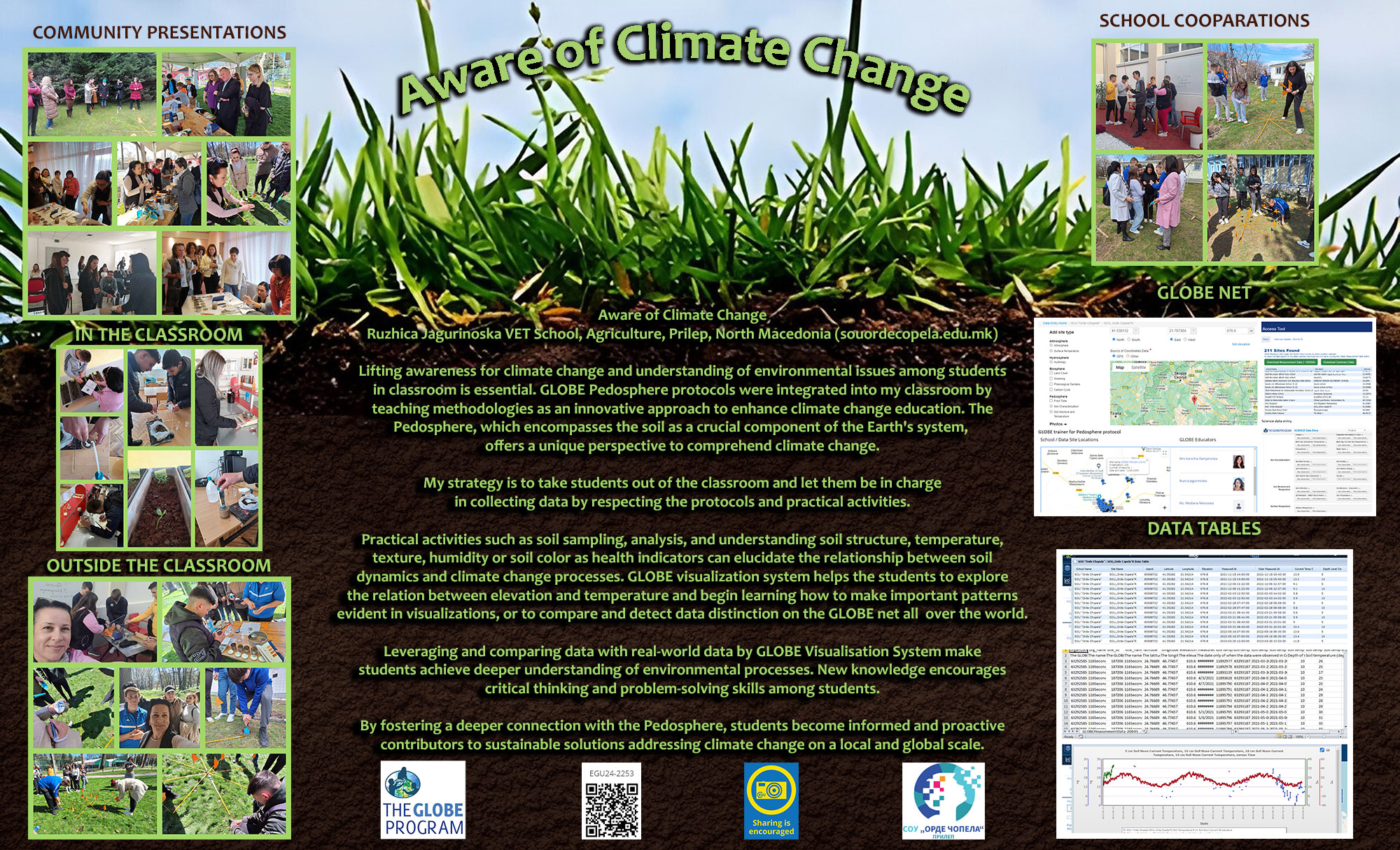
, EGU General Assembly 2024, Vienna, Austria, 14–19 Apr 2024, EGU24-2186, https://doi.org/10.5194/egusphere-egu24-2186, 2024.

EGU24-2253 | Posters on site | EOS5.2

 Aware of Climate Change 

Ruzhica Jagurinoska


Aware of Climate Change

Lifting аwareness for climate change and understanding of environmental issues among students in classroom is essential. GLOBE Pedosphere protocols were integrated into my classroom by teaching methodologies as an innovative approach to enhance climate change education. The Pedosphere, which encompasses the soil as a crucial component of the Earth's system, offers a unique perspective to comprehend climate change.

My strategy is to take students out of the classroom and let them be in charge in collecting data by respecting the protocols and practical activities.

Practical activities such as soil sampling, analysis, and understanding soil structure, temperature, texture, humidity or soil color as health indicators can elucidate the relationship between soil dynamics and climate change processes. GLOBE visualization system helps the students to explore the relation between elevation and temperature and begin learning how to make important patterns evident in visualizations, or to compare and detect data distinction on the GLOBE net all over the world.

Leveraging and comparing data with real-world data by GLOBE Visualisation System make students achieve deeper understanding of environmental processes. New knowledge encourages critical thinking and problem-solving skills among students.

By fostering a deeper connection with the Pedosphere, students become informed and proactive contributors to sustainable solutions addressing climate change on a local and global scale.

How to cite: Jagurinoska, R.:  Aware of Climate Change, EGU General Assembly 2024, Vienna, Austria, 14–19 Apr 2024, EGU24-2253, https://doi.org/10.5194/egusphere-egu24-2253, 2024.

EGU24-2803 | Posters on site | EOS5.2

My plan - responsibility and action for a green future! 

Marcu Hajnal and Branzei Daniela

        Education can encourage people to change their attitudes and behavior; it also helps them to make informed decisions. In the classroom, young people can be taught the impact of global warming and learn how to adapt to climate change. Education empowers all people, but especially motivates the young to take action. Not having a subject related to the ecology of the environment, we teachers are obliged to carry out actions to protect the environment in which we live and carry out our activities. For many years our school co-opted students in the international project PORTI VERZI-GREEN GATES, but We  have expanded this topic by getting involved in an eTwinning project My Plan@. During the My plan@ project, students from the 9 participating countries interacted and carried out activities through online meetings using the Zoom platform, through digital materials created with the help of teachers using different applications and tools web 2.0. such as Bookcreator, Canva, Postermywall, Genially, StoryJumper.The purpose of this project was to accumulate new knowledge about science and nature, combining art, to increase students' interest in educational activities in which they can use their knowledge of the English language. Among the objectives of the project are the following: receiving a scientific and age-appropriate education based on evidence, informing the target group: students and teachers about climate change, accustoming the child to correct recycling behaviors and the use of materials for making of useful objects in school activities, and the use of the English language in various contexts, the integration of technology in the teaching-learning process. In order to achieve the educational objectives of the project, we used means and teaching methods adapted to the age characteristics of the students.The project was conceived primarily through a transdisciplinary approach: science and art. The integrated approach of all activities (science, literature, art, music, English, IT) allowed our students to develop creativity, communication, research and decision making.The activities carried out were in accordance with the proposed general objective, and the results of the project exceeded our expectations. General purpose: the project connects art and science to encourage more open-minded and creative students. Students are artists, scientists and entertainers at the same time. At the beginning of the project, the logos were created by each of us partners, and then the winner was chosen by the vote. The logo created by Veronica Florea, our student, won the attention of the partners. Collaborative activities were carried out by making a journal THE FUTURE HISTORY, which captures pictures from nature and stories about the nature of the future without destruction and in harmony with man. We celebrated together WATER DAY - March 22 and EARTH DAY - April 22 with planting, recycling and games (puzzle) activities. Project dissemination was achieved through the organization and celebration of EUROPE DAY, eTWINNING DAY on May 9.We believe that the objective was achieved within the activities, the final products of the activities can be found both on Twinspace and on the school website. 

How to cite: Hajnal, M. and Daniela, B.: My plan - responsibility and action for a green future!, EGU General Assembly 2024, Vienna, Austria, 14–19 Apr 2024, EGU24-2803, https://doi.org/10.5194/egusphere-egu24-2803, 2024.

EGU24-2935 | Posters on site | EOS5.2

Eco-STEAM Challenge Green Hotel 

Danilo Borovnica and Miroslav Grujic

It is important to study climate change from the earliest school days. It is also a great opportunity for a STEM approach to learning and learning science through hands-on experiences. In this article, we will present some of our experiences in working with students.

With our students we participated in the Eco-STEAM Challenge together with 11 other schools from Serbia, Croatia and Bosnia and Herzegovina.

This competition, within the Scientik network, aimed to raise awareness about climate change and possible mitigation measures.

In the course of a month, students regularly measured the temperature and humidity of the air around our school in four selected places. Using the Arduino set, we made a temperature and air humidity device. We later processed the obtained data and made a proposal for improving the school environment in order to mitigate at least a little the effect of climate change in our micro environment.

Our school is located in the center and is surrounded on three sides by busy streets.

During April, the students also conducted an experiment testing the air quality in different parts of the school yard. They came to the conclusion that the air is most polluted in the part of the park that is next to the main street and the large parking lot.

Knowing that the air is not heated directly by the sun's rays, but rather by the foundation, which later emits the energy it has absorbed, we realize that it is important what materials we are surrounded by. Asphalt, concrete, brick are among those that heat the air the most. Guided by that knowledge, we came up with the idea of how to adjust our space (school yard) and thereby reduce heating, but also enable other species to come and live in our environment.

By measuring during the project, we came to the conclusion that in some days, in addition to high temperatures, we also had extremely low humidity. Plants have the effect of increasing air humidity, so our proposal for adjusting the yard will also take this into account.

We would make a natural environment (hotel) for insects out of metal construction and wood. In this way, we will encourage the presence of insects for which our climate is a natural habitat and strengthen urban biodiversity.

That's how the whole project got the name "Hotel in our school for insects is cool".

We had the opportunity to share our experience with colleagues from Serbia, Turkey and Portugal within the project Learn and Experience Science Together Online (lestoproject.com) where we created learning scenarios. One of the scenarios was created precisely on the topic of global warming.

How to cite: Borovnica, D. and Grujic, M.: Eco-STEAM Challenge Green Hotel, EGU General Assembly 2024, Vienna, Austria, 14–19 Apr 2024, EGU24-2935, https://doi.org/10.5194/egusphere-egu24-2935, 2024.

The water cycle plays an important part in climate change. This activity games the construction of the water cycle by students taking the role of a water molecule as it moves between reservoirs. The processes involved will be described and explained, however, students will have to work collaboratively in order to complete the water cycle in its entirety.

The factors that power the movement (gravity and state changes) will be determined and linked to changes in the amount of water found in each reservoir. Although gravity can’t be changed, the heat budget can, and this will affect the change in state of water, leading to unbalancing the water cycle.

Thought experiments and discussion on possible effects of climate change, especially through global warming, will allow students to understand its effects on the water cycle and the subsequent effects on the climate, in particular:

  • Positive feedback of decreasing albedo and increased water vapour in the atmosphere.
  • Increase in liquid water resulting in sea level rise and flood risk.

After using the Water Cycle Game, students will have a better understanding of the complexities in the water cycle, its effect on the climate, and have an appreciation of how climate change can have a local and global effect in a highly likely future.

How to cite: Blue, K.: Gaming the Water Cycle: a student-led activity to explore climate change., EGU General Assembly 2024, Vienna, Austria, 14–19 Apr 2024, EGU24-2936, https://doi.org/10.5194/egusphere-egu24-2936, 2024.

EGU24-3094 | Posters on site | EOS5.2

Green School Project 

Lara García

The fight against climate change is often associated with large-scale actions in urban areas. However, the school serves as an engine for change, where all staff, both teaching and non-teaching, can alter their attitudes, values, and behaviors regarding environmental education.
With this project, we aim to raise awareness and promote good environmental practices within our school. The objectives of our project include:

1. Promoting awareness among students about their role in the fight against climate change by emphasizing the value of plants as CO2 reducers.
2. Involving the families of students in the design and implementation of proposals.
3. Encouraging public discourse on utilizing private and public spaces as CO2 sinks.
 4. Integrating the fight against climate change into all areas of secondary education.

This project comprises some activities, ranging from awareness talks to planting vegetables in the green areas of the school and establishing a compost bin.

The main activity of this project involves experimentation.  In this activity, students measure CO2 and temperature values under different conditions, such as the presence or absence of plants. 

Analyzing the results allows them to become aware of the importance of plants as CO2 sinks, and thus, as tolls in the fight against climate change. 

How to cite: García, L.: Green School Project, EGU General Assembly 2024, Vienna, Austria, 14–19 Apr 2024, EGU24-3094, https://doi.org/10.5194/egusphere-egu24-3094, 2024.

EGU24-3179 | Posters on site | EOS5.2

Fisrt edition of an “Ocean Readings Prize, a better knowledge for a better preservation”. 

Helene Spilmont, Sophie Van Ommeslaeghe, Nathalie Jarnier, Katy Masset, and Aline Klawinski

Like the Goncourt for high school students, the aim is to have a book prize awarded by pupils on the theme of the environment and more particularly the Ocean.
The objectives of this project are:
- Get pupils to read / awaken the pleasure of reading in pupils
- Provide knowledge on ocean ecosystems, in partnership with Nausicaa, the largest aquarium in Europe located in Boulogne Sur Mer.
- Create a link between collège and lycée (key stage 4 and 5 pupils)
- Develop oral skills by arguing choices (when choosing the winner of the prize) and presenting their final work in Nausicaa.

The books (one manga, one novel, one graphic novel, one graphic documentary and one comic) were selected last June by the instigators of the project.


Set up :

A call for proposals was launched in June 2023 to secondary schools (collèges and lycées, key stage 4 and 5 pupils) in Boulogne sur Mer and the surrounding area. Thirteen colleagues from five different schools responded favorably (in total the project gathers 190 pupils).

Pupils from these schools work on these readings all along the school year. Various activities are carried out with their librarian teachers, science and French teachers.

Examples of activities carried out at the Branly high school are: cards game to discover the books, reading sheets, “speed reading”, and the production of a “bestiary” around the animals found in the books as final task.

At the same time, all these classes regularly visit Nausicaa during the school year, which is an occasion to supplement the knowledge provided by the readings, and to enrich the final works.

A collège-lycée meeting is planned for next April. On this occasion, pupils will present their final work and discuss about the readings to elect the winner of the prize.

The high point of the project will be on World Oceans Day (7th of june) in Nausicaa.

The winning author of the prize will be invited, as well as all the students who participated in the project. This day will be an opportunity to highlight work carried out during the year and to meet the prize-winning author. 

How to cite: Spilmont, H., Van Ommeslaeghe, S., Jarnier, N., Masset, K., and Klawinski, A.: Fisrt edition of an “Ocean Readings Prize, a better knowledge for a better preservation”., EGU General Assembly 2024, Vienna, Austria, 14–19 Apr 2024, EGU24-3179, https://doi.org/10.5194/egusphere-egu24-3179, 2024.

As a biology and geology teacher, I have followed virtually, with some of my students, the HIPER campaign off the coast of Ecuador in 2022-2023, and from the 28th of january 2024 to the 23rd of february 2024, I have the honnor to take part in the SUPER MOUV campaign on the french oceanographic ship Pourquoi pas ? in Ecuador.

The scientists left me an additional place on one of the most innovative ship in the Ifremer fleet, in order to spread geology tools use on board in destination to teachers and their students in college and highschool, not only in France but also all over the world in the french schools abroad or the french classes abroad : http://edumed.unice.fr/data-center/oceano/supermouv.php

During this campaign, the aim is to prepare some challenges connected to SUPER MOUV activities for schools :

- students can indeed discover geodynamic in Ecuador west coast which is located in the ring of fire, and shaken by several earthquakes due to the subduction of Nazca tectonic plate under south-america tectonic plate,

- they can also discover how rocks or fluids are collected by Nautile submarine, how sediments are collected by coring, how highligths geo-mechanical properties of rocks or methods for fluids analysis,…

- and furthermore, they can learn about life on board a deep sea vessel (way of life, different jobs,..) during videoconferencings between the ship and the pupils in their classrooms ! 

How to cite: Gendron, F.: Teacher on board the deep sea vessel Pourquoi pas ?  for SUPER MOUV campaign off the coast of Ecuador , EGU General Assembly 2024, Vienna, Austria, 14–19 Apr 2024, EGU24-3220, https://doi.org/10.5194/egusphere-egu24-3220, 2024.

EGU24-3241 | Posters on site | EOS5.2

Hands-On Climate: Engaging the Public with 3D Geo-Data 

Annamaria Lisotti

Despite the abundance of data on climate change, there remains a significant gap in public awareness and action. Recent trends in data communication have introduced the concept of data physicalization, which transcends traditional written and visual methods by engaging multiple senses, including touch and hearing. This innovative approach has shown potential in reaching diverse audiences and enhancing public engagement.

Our project, "Tangible Statistics" at IIS Cavazzi (Liceo scientifico), involved students aged 16-18 and demonstrated the successful impact of data physicalization. A key method employed was the translation of geolocalized data into 3D models using QGis, followed by 3D printing. This technique was showcased at Science on Stage Italia in Naples (September 22-24, 2023) and has proved applicable also to younger students as it was immediately replicated in a junior secondary school.

The project utilizes freely available tools such as QGis, Blender, FreeCad, and Cura for slicing. Training students in these tools, specifically for model creation and printing, is efficient (approximately 4 hours of lab work plus home application). This investment enriches curriculum across diverse subjects, facilitating the study and dissemination of data related to geography, environment, and more together with fostering data literacy of future responsible citizens.

Environmental monitoring data, such as extreme temperatures, precipitation, and fire risk indices, are particularly suitable for this technique. Beyond presenting raw data, the focus is on narration– a critical factor in making data resonate with the public. The creation of physical artifacts for storytelling enhances public exhibitions, outreach, and awareness campaigns. These artifacts foster emotional engagement in an otherwise distracted or statistically unskilled population. The tactile experience of touching these models enables deeper understanding and accessibility of complex data.

Moreover, these models, either scanned from the artifact with a cell phone free app or directly produced in digital format, can be integrated with data journalism pieces through QR codes. This integration allows readers to engage with augmented reality models while reading, providing a hands-on experience of data manipulation.

The potential of data to bring people together to address societal issues is huge. By understanding and improving our communities through data, we can spark civic dialogue, hold institutions accountable, and foster effective communication. Our project is a contribution in demonstrating that through creative data physicalization, we can transform the abstract into the tangible, making climate data more accessible and impactful for the general public starting from Education.

How to cite: Lisotti, A.: Hands-On Climate: Engaging the Public with 3D Geo-Data, EGU General Assembly 2024, Vienna, Austria, 14–19 Apr 2024, EGU24-3241, https://doi.org/10.5194/egusphere-egu24-3241, 2024.

EGU24-3256 | Posters on site | EOS5.2

Using digital technology to teach climate science 

Lydia Ait Ouferoukh

Understanding contemporary climate change requires studying the climate system, how it works and evolves.

Various tools, such as palynological studies, oxygen isotope ratios, numerical modelling, etc. can be used to trace the evolution of the climate. Much of this data is accessible through the publication of databases and numerical modelling. In addition, the increasingly powerful numerical tools are mainly available to classrooms: use of spreadsheets, graphs, free softwares such as SimClimat, etc.

Leveraging these tools in my lessons and the training of my students seemed natural to me in a world where digital technology and information are available to all.

The poster I am presenting showcases some numerical activities carried out with students from the Groupe scolaire Sainte Louise, in Paris, aimed at helping them grasp those fundamental concepts of climate system.

The integration of digital technology not only enhances the dynamism of learning but also motivates students to actively participate, opening up exciting educational possibilities.

How to cite: Ait Ouferoukh, L.: Using digital technology to teach climate science, EGU General Assembly 2024, Vienna, Austria, 14–19 Apr 2024, EGU24-3256, https://doi.org/10.5194/egusphere-egu24-3256, 2024.

EGU24-3347 | Posters on site | EOS5.2

ECOding: Putting climate solutions at the heart of tech education 

Selcuk Yusuf Arslan

Coding education is gaining more and more importance today. Coding improves general thinking skills by giving individuals the ability to solve problems. It also encourages creativity and innovation, giving students the opportunity to develop their own projects and create new solutions. One area where coding can be used is the climate crisis problem that threatens our planet. ECOding aims to integrate environmental and climate change education with an interdisciplinary approach while providing coding education to students. Within the scope of the project carried out in a vocational high school in Türkiye, while teaching coding to students in Object Oriented Programming, Internet of Things (IoT), Robotics, Artificial Intelligence and Machine Learning courses, the focus was on the environmental problems that our world faces. Coding examples shared with students, homework assignments, and project studies focused on the climate crisis. This situation not only raised students' awareness but also supported them to create technology-supported solutions to the climate crisis. Students measured their carbon footprints with the software they prepared and gave suggestions on how to reduce their carbon footprints according to their answers. A project that enables students to open the right waste bin in seconds for easier recycling of a waste shown on a camera with object recognition gave students the opportunity to participate in an international project competition. The students, who designed an educational software introducing hydrogen fuel cells using gamification, succeeded in winning the first prize in an international project competition. Within the scope of the project, which has been carried out for about 3 years, more than 200 students have received coding training with this approach. At the end of the academic year, the opinions of the students were taken and all of the students stated that seeking solutions to the climate crisis through coding made them happy, fun and instructive. More than half of the students stated that they developed a project idea for the climate crisis at the end of the course. The successes in the implementation process made the project visible in the international arena in a short time. In 2021, the project coordinator was awarded the Green Skills Award organised by the European Training Foundation (ETF) and UNESCO. Finally, the project coordinator was selected by JCI as one of the Ten Successful Young People of the World in the category of Environmental Protection and Moral Leadership. The project, which is frequently shared both in Türkiye and Europe, has started to be implemented in many schools.

How to cite: Arslan, S. Y.: ECOding: Putting climate solutions at the heart of tech education, EGU General Assembly 2024, Vienna, Austria, 14–19 Apr 2024, EGU24-3347, https://doi.org/10.5194/egusphere-egu24-3347, 2024.

EGU24-3374 | Posters on site | EOS5.2

Hot spot in the schoolyard 

Isabelle Veltz and Virginie Bour

Defined by Howard in 1818, an “Urban Heat Island” corresponds to an urbanized area where the temperature is higher than in natural or surrounding environments. With climate change, this phenomenon affects more than 80% of urban populations and is linked to the storage of heat in the asphalt during the day and the stagnation of air between homes. Water runs off the surface of the waterproofed soil and the vegetation must be watered constantly.

With the regular increase in temperatures, the Roosevelt high school in the city center of Reims (Champagne, France) becomes a furnace from spring to autumn. In fact, with its tarmac square schoolyard surrounded by high dark red brick buildings, we measure recurring morning temperatures above 30°C and afternoon peaks above 40°C in classrooms.

This work, carried out by students, aims to define adaptation strategies and propose feasible modifications in this enclosure, which is classified as a “historic monument” and which must therefore maintain its total integrity. Roosevelt high school contains the “War Room” which is the surrender room where the end of the Second World War was signed on May 7, 1945 and it’s impossible to change its appearance.

After identifying the causes favouring the “Heat Island” effect in their highschool, the student carried out measurements of albedo, runoff and impact of the scare vegetated areas were carried out. Analog and computer-assisted experiments have been developed to propose solutions to limit heat accumulation and soil drying and promotes humidification and CO2 trapping in the ground.

This work conducted by the students allowed them to propose non-invasive solutions improving the quality of life in their work environment.

Through its local and experimental approach, this work has made concrete highly mediatized notions whose causes and consequences are not always well associated. Moreover, the major role of soil and soil preservation, in modulating climate change, has been clearly highlighted.

How to cite: Veltz, I. and Bour, V.: Hot spot in the schoolyard, EGU General Assembly 2024, Vienna, Austria, 14–19 Apr 2024, EGU24-3374, https://doi.org/10.5194/egusphere-egu24-3374, 2024.

EGU24-3396 | Posters on site | EOS5.2

Struggling with climate changes 

Karolina Damjanoska

STRUGGLING WITH CLIMATE CHANGES
 
Karolina Damjanoska
Master of Science in Physics Education and Physics Teacher in High School “Orde Chopela”,
Prilep, North Macedonia.
 
e-mail: kdamjanoska08@gmail.com
My students from SOU "Orde Chopela" have participated in many projects as citizen scientists,
such as the Globe at night project, which has been going on for sixteen years. The project is
enables students to do light pollution measurements by observing diverse constellations in the
night sky. That way, they get educated about the importance of maintaining a healthy
environment as well as the human impact on a changing climate. Over the years, I have gotten a
significant experience in the field and my students have achieved excellent results in domestic
and international competitions, which has motivated me to continue passing on my knowledge to
colleagues in my country and abroad.
For many years, I have been a leader and SOU "Orde Chopela" school coordinator for the
GLOBE project. Additionally, I am an official trainer for the GLOBE project and its Atmosphere
protocol. Measurements made during this protocol closely relate to those in the GLOBE project,
due to the importance of the visibility of the night sky. Besides that, while implementing the
project, the students have had the chance to delve into taking care and contributing to a healthy
environment.
Active participation in projects like these, give the students a chance to be properly formed as
individuals who advocate for a healthy environment and are able to think and act appropriately.
Their awareness of preserving the environment is at a very high level, they work on authentic
problems for which they seek and find solutions. Ultimately, the goal is contributing to the
common good.

How to cite: Damjanoska, K.: Struggling with climate changes, EGU General Assembly 2024, Vienna, Austria, 14–19 Apr 2024, EGU24-3396, https://doi.org/10.5194/egusphere-egu24-3396, 2024.

EGU24-3803 | Posters on site | EOS5.2

Climate change and Cosmography  

Athanasios Vagenas

CLIMATE CHANGE AND COSMOGRAPHY

Introduction

A beautiful universe, with the small earth at its center mediating knowledge and carrying it everywhere. From schools, universities and science museums. In our museum this year, the theme of our museum is extantas and cosmography in general. In addition, climate change has unexpectedly arisen, following the heavy rainfall that characterizes our planet and especially our region (Mouzaki-Karditsas 2019).

https://kpem.gr/kyrio/mm/mm.html

Many times there are events that outweigh our personal promote and require collective efforts to get better results. Our school is directly connected to our society, because our students live in it almost all day long. Their concerns are our concerns. Thus, in the events that occurred in the Municipality of Karditsa and the Municipality of Mouzaki concerning the floods, as a school with published educational activities we will give the historical and social dimension of the problem. Our pedagogical approach is intended as another message to be a reminder of the mechanisms that can help our region. Students exhibit their photographic material.

Climate change. Recent Historical Document

It is very important, especially after the continuous disasters in recent years in Greece, neighboring countries and around the world caused by floods. It is also important in planning related to the environmental management of water resources and as applications of ecological engineering, which is necessary for our region and our country in general.

The effects of global warming are not evenly distributed over all latitudes and longitudes. Climatic phenomena such as droughts, floods are expected to occur more frequently. The picture I encounter on the way to my school where, farms still have water, plants muddy is nightmarish. The Headmaster of the school on the morning calling after a week of suspension only asked who has no books due to water ingress at home. There are rumors of students who have lost their homes. After the second week was over we began to discuss the damage everyone has suffered, and it is normal to have lost part of your home, furniture and clothing.

Social dimension of the European project OSOS (Open Schools for open Societies)

Everything that is happening today should end quickly. The school to find its normal rhythm. The idea of OSOS has entered our lives as a basic tool and not as an accumulated knowledge or as an interactive tool for solving exercises in various forums. That is how we will try to continue our coursework. To approach the physical teaching of the classroom with complementary activities outside of it. So we too offer interactively as a classroom group, as a school and as a science museum to our local community, to worry to hope for something better.

Five years later 2023 in the region of Trikala, Farkadona and Karditsa(Palamas) exactly the same flooding events occur. The photographic material describes IANOS and DANIEL.

The OSOS logo contained in four words captures a new vision for schools : Feel - Imagine - Create - Share.  

Thank you

How to cite: Vagenas, A.: Climate change and Cosmography , EGU General Assembly 2024, Vienna, Austria, 14–19 Apr 2024, EGU24-3803, https://doi.org/10.5194/egusphere-egu24-3803, 2024.

The « Climate Fresk » is a french innovative educational tool designed to raise awareness about the challenges of climate change. Developed by the French organization CliMates in 2018, it engages students in an interactive and collaborative learning experience.

This activity lasts around 3 hours and takes the form of a board game where students organized into groups of 4 to 7, working together to understand the complex dynamics of climate change. The game incorporates a set of 44 cards representing various factors related to climate change (e.g. greenhouse gas emissions, sea level rise, deforestation, ocean acidification, aerosol). The course is organized as follows:

  • Step 1: The students’ goal is to place cards on the board, creating connections between different aspects of climate change. Behind the cards lay explanations about the item to help them solving some complex issues (e. is ice melting and sea level rise connected?).
  • Step 2: The students will be given some sheet and materials to stick the cards on it, draw the links and add additional decorations of their choice.
  • Step 3: The different Fresks are displayed on the classroom walls, and the group can present them, explaining their layout choices or items that particularly moved them.
  • Step 4: A discussion about the solutions is engaged

The primary objective of the Climate Fresk is to enhance participants' understanding of the causes and consequences of climate change while fostering discussions about possible solutions. By actively involving individuals in the learning process, this activity aims at empowering them with knowledge and inspire collective action.

Teachers often find the Climate Fresk to be a valuable resource for education in high school settings. Additionaly to scientific knowledge, this approach encourages critical thinking, collaborative problem-solving but also creativity since the students will take some time to do a nice and efficent layout. The visual and interactive nature of the Climate Fresk makes it an effective tool for conveying complex scientific concepts in a simple and accessible educational tool. Moreover, it promotes active learning and brings a different learning experience based on creation of an mural fresco.

Other similar works have been created since, such as the Plastic Fresk, the Soil Fresk, the Digital Fresk.

How to cite: Widmann, M.: Exploring the Complexity of Climate Change with an Interactive and Collaborative Learning Tool: The "Climate Fresk", EGU General Assembly 2024, Vienna, Austria, 14–19 Apr 2024, EGU24-3871, https://doi.org/10.5194/egusphere-egu24-3871, 2024.

EGU24-3943 | Posters on site | EOS5.2

Miedwie Lake as a source of life. Implementing SDGs in STEM lessons. 

Ryszard Markowicz

The Project is based on the Miedwie Lake, which is 5th largest lake in Poland and it was conducted by 6 13yo students. The project had a lasting impact on the community, ensuring sustainable water use practices, and reducing the impact of climate change on the environment. The  objective of this project was to create awareness among the community about the importance of water resources from the Miedwie Lake. This project aims to educate the community about the negative impacts of climate change on water resources and how sustainable water use practices can mitigate these effects. Also, to show young people that they have a huge impact on their communities and they actually can change the world.

The project was focused on different stages.

  • Meeting with the Head of Kobylanka Municipality Mrs. Julita Pilecka. The mayor shared with us the problems as well as the development plans of the Kobylanka municipality, as well as gave us a glimpse of the threads concerning the city of Stargard.
  • TRIP TO THE WATER PRODUCTION PLANT IN ŻELEWO. The trip was held for educational purposes, to learn more about how water is purified and what needs to be done so that the water from Lake Miedwie can be brought to the inhabitants of Szczecin. 
  • Presentations and workshops for junior classes 1-3. Junior students were able to actively participate in the presentation.
  • Professor of hydrology Hubert H.G. Savenije from Delft University visited our school. Our meeting with the professor of hydrology was aimed at introducing and explaining why water is the blood of the Earth. 
  • Meeting with  Mr. Zenon Wiśniowski.  DIRECTOR OF THE POLISH GEOLOGICAL INSTITUTE – NATIONAL RESEARCH INSTITUTE 
  • Next was making a podcast. One of the project’s participants, conducted an interview with her grandfather, who’s the chief of Stargard District Fishing Guard. The interview was recorded and was played on the official conference.
  • FIRST STUDENTS CONFERENCE FOR ADULTS Observing and monitoring the key variables governing the global water cycle is essential to our understanding of the Earth’s climate, forecasting weather, predicting floods and droughts, and improving water management.  It was a summary of all work done in the project. Every student could show adults how much he has done and how much efort gave to make the project succesful.

Using SDGS:

  • Our activities helped us see that the health of residents cannot be threatened by poor water quality.
  • Educated themselves at all times during all activities in areas such as science, technology, math, engineering, hydrology, geology.
  • Our entire project involves researching, learning and exploring.. All our activities were about convincing ourselves of the safety of the population and making sure the water around us is clean.
  • In the laboratory we researched and learned about a whole list of vegetation and animals that live thanks to water.
  • The study of water and conversation with a geohydrologist showed us what life on land looks like and how the chain of life functions.

We did not sleep, we lost our tempers, but it was worth it. And this is what STEM education should like.

How to cite: Markowicz, R.: Miedwie Lake as a source of life. Implementing SDGs in STEM lessons., EGU General Assembly 2024, Vienna, Austria, 14–19 Apr 2024, EGU24-3943, https://doi.org/10.5194/egusphere-egu24-3943, 2024.

Our planet's changing climate is a diverse topic that allows students to brainstorm, discuss, and think about the best ways to protect our planet Earth. This project will be created by students in the seventh grade, age 12-13.Solar energy is the main source of life found on Earth. My  students and I will work together to develop a project based on solar energy, the types of energy that arise from it, and finally how we can use this energy while preserving the environment from pollution and preserving the natural ecosystem.Open discussion: Solar energy and how we can use it in our lives without harming our planet.Students will explain why food energy comes from the Sun.We will deal with the process of photosynthesis. Thanks to this process, plants receive energy from the Sun in orderto grow. The students will accompany this information with a graph where they show that the Sun is a source of energy for the plants and animals that we eat.We will talk about the importance of vegetation in our lives. For a planet to be as green and forested as possible as well as a rich atmosphere full of oxygen.We will use and discuss the Sun as a fuel energy source. Students will learn how biofuels and fossil fuels are created.A discussion on the benefits and negative consequences that have come as a result of their use by mankind.We will prepare sensitizing inform posters which we will stick around the city to make people aware of environmental protection and that changes will start with us. We will discuss the greenhouse effect, how we can help reduce the greenhouse effect, and how to regulate the climate on Earth.Wind and water energy and their importance in human life.Students will explain how wind and rain are formed thanks to solar energy. Students will answer the question: How can we use these energies for the benefit of humanity without harming the environment? They will give different ideas. These ideas will be illustrated with examples from everyday life. They will describe several methods of producing electricity from wind and water energy.Students will also collect information on the use of solar energy directly. Discussion on solar panels and the benefits of their use. Assess the importance of using solar panels by evaluating the preservation of the environment from pollution as well as the preservation of the natural ecosystem.We will visit a complex where solar panels are installed. Students will observe the construction of a solar panel. They will discuss with each other their construction, parts, and energy conversions in the solar panel. The tools for building the solar panel model will be prepared. Open discussion: How a solar panel is built. Students will bring the materials for the construction of the solar panel and will receive information about the types of panels, their use and purpose, and their advantages. They will build their own solar panel.

How to cite: Kaçi, L.: Solar energy, the types of energy that arise from it, and how we can use this energy while preserving the environment from pollution and preserving the natural ecosystem., EGU General Assembly 2024, Vienna, Austria, 14–19 Apr 2024, EGU24-4043, https://doi.org/10.5194/egusphere-egu24-4043, 2024.

Energy and climate changes are complex issues with rapidly developing science and the potential for controversy. The amount of time teachers are spending on these topics is going up significantly, but how can educators effectively bring these important subjects into their classrooms? My response applied to 11-14 year-old students is to start from plots nearly without any discussion before. Simple plots that show the most important indicators of climate change (i.e., time-behaviour of concentration of CO2, surface temperature, sea level, arctic sea ice extent, etc.).

Time plots do not end in the present time but are extrapolated to the next 20-30-40 years using models from qualified scientific literature, that show how the choices of decision-makers and also our behaviour can affect the climate changes. This becomes a powerful starting point for a discussion that will arise from students as soon as they realize on how the situation is rapidly changing. The discussion will naturally end-up with students that focus that a combination of strategies is needed to reduce greenhouse gas emissions. The most immediate strategy is conservation of oil, gas, and coal, which we rely on as fuels for most of our transportation, heating, cooling, etc. In students life that means to modify some habits in order to save energy and limit gas emissions. Student achieve this conclusion by their selves, while the teacher has only the role to coordinate the work.

Some strategies to keep this subject interesting and stimulating are used: plots are done by students not in their notebooks during desk-work but in high dimensions in the school-gym, using when possible the lines of basket of volleyball pitches and completing them with paper tape. This involves the students usually less interested in the activities in traditional classroom work and allows team work in groups of 3-4 students. This also reinforces math abilities and demonstrates how math theory merges with reality, a link that is not always caught by young students.

How to cite: Martelli, M.: From plots to theory: young students build their good practice on climate changes, EGU General Assembly 2024, Vienna, Austria, 14–19 Apr 2024, EGU24-4148, https://doi.org/10.5194/egusphere-egu24-4148, 2024.

EGU24-4396 | Posters on site | EOS5.2

The Role of Interdisciplinary PBL Activities: Climate of the Past 

Nuno Correia, Vanessa Neves, and Alexandre Gandra

Nowadays, in Portugal, the challenge of Natural Sciences (NS) for middle and high school teachers is to make science education more attractive to young students. One way to achieve that is through practical work. Unfortunately, this kind of work is not very common in geology teaching. 

The Curricular Autonomy and Flexibility Project (DACP) with Biology/Geology, Mathematics and Physical/Chemistry was intended to increase the quality of teaching and learning, based on the Students Profile at Completion of Compulsory Education reference document and the guiding documents for Essential Learnings, which will provide help in the planning and assessment of teaching and learning.

This work is an example carried out through the interaction of different learning environments, inside the classroom, and outdoors, and of different types of practical work, namely laboratory and fieldwork.  The organisation of the activities followed a pattern: the field trip to the Valongo Anticline (North of Portugal) and Problem-Based Learning (PBL).

The Valongo Anticline allows  the observation of evolution of life during the Paleozoic, based on animal and plant fossils, as well as the possibility of dating the strata from the fossils they contain. It also presents some particular lithology evidence, namely the presence of icebergs, the existence of submarine volcanism, and the presence of beaches. The tectonic action is evidenced by the existence of folds and faults.

The Problem Question (PQ) was based on an outcrop from the Paleozoic where we have the geo-trails that cover rocks of different ages of the region of Valongo. In this site it is possible to observe the variation in sedimentation environments (marine and continental) from nearly 540 to 300 M.y. Also, in this region we can find several outcrops with diamictites beds.  This   glaciomarine record of the Hirnantian (end-Ordovician) glaciation is evidence of the climate changes that occurred over Earth's history.  

In this poster we discuss some ideas about what students learn from different activities and which other factors influence their learning process as students. The idea of interdisciplinary learning is to allow students to realize that certain fundamental concepts don’t belong to a single science subject. On the contrary, these concepts can be applied in many subjects.

In conclusion, this poster presents some formal and non-formal educational practical activities that the students developed, in groups, during the year 2023 and 2024 and that can be used in the teaching of geology. 

How to cite: Correia, N., Neves, V., and Gandra, A.: The Role of Interdisciplinary PBL Activities: Climate of the Past, EGU General Assembly 2024, Vienna, Austria, 14–19 Apr 2024, EGU24-4396, https://doi.org/10.5194/egusphere-egu24-4396, 2024.

EGU24-4421 | Posters on site | EOS5.2

The Greenhouses Affect 

Gülperi Selcan Öncü

Recently, in the news programs on TV channels, we frequently come across news such as the melting of glaciers, weather events such as sudden and heavy rains and storms, the increase in atmospheric temperature and the increase in forest fires. At the same time, we observe some of these events in our immediate surroundings. There is also a sentence frequently mentioned by the public: the seasons are changing. The students asked questions such as why all these events occur and what has changed between the past and the present.

We all know that they need to understand global warming in order to understand these changes, but as a science teacher, I guided them on how to achieve this so that they can have the ability to use experimental methods within the project-based learning approach. They first conducted a preliminary literature review and then designed an experiment. In the experiment, they tested the hypothesis that the water inside a glass bowl covered with black cardboard heats up more than the transparent glass bowl. Thus, they tried to investigate the impact of greenhouse gases on climate change.

 In the experiment, two glass bell jars were used to represent the atmospheric layer. The inside of one of them was covered with pieces cut from black cardboard at intervals. Black cardboard was used to represent greenhouse gases because black color absorbs light. The same amount of water was filled into two beakers of the same size. A thermometer was placed inside them and the bell jars were turned upside down on the beakers and closed. Two thermometers were used to measure the temperature of the water in the beakers. The first mechanism (not coated) is also the control group. The second device (covered with black cardboard) is the experimental group.

 In the experiment and observation phase, the independent variable is the bell jars and the dependent variable is the water temperature. Control variables are bell jar size, beaker size, amount of water and environmental conditions. After the installation of the mechanisms, the initial temperature of the water was measured and recorded. The students carried out this research by placing the mechanisms in a sunny place on a sunny day. They recorded the data in tables they prepared at certain time intervals.

Later, they shared the results with the participants at the science festival. Thus, they tried to explain the causes of the global warming problem and draw attention to the necessary measures to prevent this problem.

How to cite: Öncü, G. S.: The Greenhouses Affect, EGU General Assembly 2024, Vienna, Austria, 14–19 Apr 2024, EGU24-4421, https://doi.org/10.5194/egusphere-egu24-4421, 2024.

EGU24-4432 | Posters on site | EOS5.2

Teaching Climate Change: using Earth Learning Ideas 

Pete Loader, Giulia Realdon, Guillaume Coupechoux, Xavier Juan, and Gina P. Correia

Global anthropogenic climate change is real and so it is essential to include this topic in our curricula to enable students to understand the scientific evidence and the possible effects this might have on our lives.

This poster provides an insight into some of the practical ways that climate change topics might be taught using the free online ‘Earthlearningidea’ website (https://www.earthlearningidea.com/English/Resources_and_Environment.html#clchange). As such, it is designed to reflect the GIFT 2024 workshop run by our EGU Geoscience Education Field Officers and to demonstrate the range of ELIs undertaken in their respective countries. It is also presented in fond memory of Professor Chris King who was the instigator and inspiration of this and so many other geoscience education projects in the UK and abroad.                                   

These climate change activities and others are available at the Earth learning website (https://www.earthlearningidea.com/), a repository containing more than 400 activities ready to use and translated into different languages. All are designed to develop students’ critical thinking and research skills, while developing their knowledge and understanding of Earth processes and products.

EGU Geoscience Education Field Officers (GEFO) are a team of geoscience teachers and researchers who provide professional development to schoolteachers who have elements of geoscience in their teaching curricula, through interactive hands-on workshops. The team is supported by the European Geosciences Union Education Committee and is active in eleven countries around Europe. (https://www.egu.eu/education/).

How to cite: Loader, P., Realdon, G., Coupechoux, G., Juan, X., and P. Correia, G.: Teaching Climate Change: using Earth Learning Ideas, EGU General Assembly 2024, Vienna, Austria, 14–19 Apr 2024, EGU24-4432, https://doi.org/10.5194/egusphere-egu24-4432, 2024.

EGU24-4440 | Posters on site | EOS5.2

HIPER motivated students follow the SUPER-MOUV sea campaign 

Jean Luc Berenguer, Faustine Gendron, Christelle Saliby, and Julien Balestra

The coasts of Ecuador and Colombia have been hit by several earthquakes of magnitude greater than 7.5 over the course of the 20th century. An earthquake of magnitude 7.8 struck near the town of Pedernales in April 2016. It was the most powerful earthquake to hit Ecuador in 70 years, claiming hundreds of lives and causing hundreds of millions of dollars in economic losses. The seismic data revealed the complex slip behaviour of this part of Ecuador's subduction zone. The shallow part of the megafault is characterised by slow-slip earthquakes that can last from a few days to a few months and do not generate seismic waves (asismic rupture), so are not felt by the population. What controls these slip events is still poorly understood, even though they play an important role in the seismic cycle that governs the periodic loading and release of the megafault. The aim of recent oceanographic missions (the HIPER and SUPER-MOUV expeditions) is to understand how structure, temperature and fluids affect slip behaviour and the transition from seismic to asismic rupture. Many schoolchildren were involved in these scientific missions, following the mission's progress on a daily basis. Each following school was in contact with an education team on board and on land. Working closely with the researchers, the pupils were able to follow the work on board the ships, solve weekly scientific puzzles and take part in live video conferences from the oceanographic ship. Allowing students, the future citizens of the world, to experience first-hand how science works... these are essential elements in strengthening the link between science and society. 

How to cite: Berenguer, J. L., Gendron, F., Saliby, C., and Balestra, J.: HIPER motivated students follow the SUPER-MOUV sea campaign, EGU General Assembly 2024, Vienna, Austria, 14–19 Apr 2024, EGU24-4440, https://doi.org/10.5194/egusphere-egu24-4440, 2024.

EGU24-4443 | Posters on site | EOS5.2

Insight Education : When highschool students and teachers are involved in the science team. 

Jean Luc Berenguer, Christelle Saliby, and Julien Balestra

InSight (Interior Exploration using Seismic Investigations, Geodesy and Heat Transport) is a discovery program, lead by NASA, that has landed a single lander on Mars and other sensors, such as a seismometer, a heat flow probe, and more others sensors that provided a lot of data.

The main payload is the seismometer called SEIS, that is the first seismometer (after Viking fail) to record signal with a very deep precision. The goal of this mission is to investigate the dynamics of Martian tectonic activity and understand all the processes that shaped the Red Planet.

Students were able to benefit from the data recorded by SEIS, and transmitted, with little delay, to schools by the science team. In this presentation, we will show all the practical activities done with kids, teens and students in France and other countries during the space mission (2018-2022).

This work has been done by a French team of teachers, in international cooperation with others countries (with UK, USA, Switzerland, Spain, Romania ...) and can be found on this specific website: https://insight.oca.eu

As the InSight mission draws to a close, a survey was conducted within the Education community to assess the impact of such an education component in a research programme.

How to cite: Berenguer, J. L., Saliby, C., and Balestra, J.: Insight Education : When highschool students and teachers are involved in the science team., EGU General Assembly 2024, Vienna, Austria, 14–19 Apr 2024, EGU24-4443, https://doi.org/10.5194/egusphere-egu24-4443, 2024.

EGU24-4448 | Posters on site | EOS5.2

Take a photo, post it, alert it! 

Mite Ristov

Encouraged by the problem of constantly air pollution, especially in the winter mounts, a group of students from the Josip Broz – Tito High School from Bitola, North Macedonia, under the mentorship of the geography teacher and in cooperation with the NGO Geosfera, conducted a school project. The main objectives of the project were: raising awareness among pupils about the harmful effects of PM particles on human health, identifying the city's air polluters, measuring PM particles concentrations in different locations around the city and informing the public and preparing draft mitigation measures of air pollution.

First, the students held an educative lecture in front of the rest of the pupils at the school about the harmful effects of PM particles on human health. Then, we started a campaign to involve students and all citizens of Bitola in identifying the city's air polluters. Through the social networks, instructions were given, such as through an online Аpp and the GPS signal from the smart phone, to take a picture from a suspicious air polluter and to post the image with the given geographic coordinates on our Facebook group. A working group of students, according to the given coordinates of the citizens, put the polluters on an interactive map of Google Maps. A link from the map was sent to the authorized environmental inspector in the municipality, with the goal of faster response and inspection to those polluters.

The absence of multiple measuring stations created numerous speculations among the citizens, but also with the institutions in the city, where the enormous air pollution originated, whether from the Thermal Power Plant Bitola or from the city itself.

Therefore, in cooperation with the NGO Geosfera, we decided to measure the current concentrations of PM10 particles in two periods of the day, between 14 and 15, and between 19 and 20 hours. The measurements were made with a mobile particle detector at 14 locations. After the measurements were made, using the Google Earth, two maps were created, showing the results of the measurements. The obtained results confirm the suspicions that the cause of enormous air pollution in Bitola is not TPP Bitola, but households that mostly warm their homes with firewood (over 60%, Source: State Statistical Office). Also, a large number of citizens of our Facebook group have commented that part of the problem are Forest enterprises, which usually supply wet firewood. According to the US EPA, wet wood produces three times more PM particles compare with dry wood.

The students from the school, in cooperation with the NGO Geosfera and the geography teacher, developed and submitted to the Municipality measures for reduction of air pollution. All these proposed measures were placed on an interactive map on Google Maps, through which all the citizens of Bitola will be able to visualize them.

The action received positive reviews from the public in the city and achieved the desired effect, which is raising awareness among young people and alerting the competent institutions to solving the accumulated problems.

How to cite: Ristov, M.: Take a photo, post it, alert it!, EGU General Assembly 2024, Vienna, Austria, 14–19 Apr 2024, EGU24-4448, https://doi.org/10.5194/egusphere-egu24-4448, 2024.

EGU24-4452 | Posters on site | EOS5.2

GIS for Gist of Europe 

Crina Aurelia Elefteriu


               In the context of global climate change, the importance of understanding and effectively managing the environment is becoming more urgent. The digitization of geography, through Geographic Information Systems (GIS), is an essential methodological component for identifying, monitoring and managing geographical phenomena with major impact on climate. Teaching climate change at school is based on examples of good practice, learned and applied through the Erasmus+ project "GIS for Gist of Europe".

             The project addresses the issue of climate change by including GIS in the curricular area sciences, the objectives and priorities of action being in the field of school education.The partners of the Erasmus + project ” GIS for Gist of Europe” bring to our project diversified experience and invaluable resources, these being EUROGEO VZW from Belgium, Riga Secondary School No. 25 from Latvia, Universidad de Zaragoza from Spain, Yenilikçi Eğitim Derneği from Turkey, Sint-Lodewijkscollege from Belgium. Each partner brings a unique perspective and meaningful skills to achieve our common goals.

            Through the LMS-Gis for Future platform, teachers are taught to digitize geography, as well as how to understand, use and apply geospatial technology. Topics related to exploiting desert infrastructure, climate migration of people, supporting alternative resources and desertification are easy to apply as a result of completing this course.

            The second product of the project materializes in a learning module because the technology of geographic information systems allows us to model and see very complicated relationships and ways to respond more intelligently. As there is a need to promote GIS knowledge, monitor elements of local interest and centralize urban issues, this climate change learning module can support the teaching of geosciences. Learning the working methodology in disciplines such as meteorology and synoptic, remote sensing and photointerpretation and applied informatics in geosciences.

            The third product of the project is based on case studies related to climate change. With the help of GIS, the integration of climate change leads to the formation of a new generation of young people prepared to understand and face the challenges of climate change.

            The project is not only limited to providing theoretical knowledge, but also provides the tools to turn this knowledge into concrete actions. By facilitating the understanding, monitoring and management of geographical phenomena associated with climate change, a generation of young people responsible and involved in environmental conservation is prepared.

            Thus, integrating GIS into school curricula is not only a necessity, but also an opportunity to actively contribute to the formation of a conscious society. Students become change agents, able to propose innovative solutions and participate in global efforts to combat climate change. In the end, this project not only achieves its goals, but also represents an investment in a sustainable future, where education plays a central role in saving our planet.

            Keywords: GIS, Erasmus+, climate change

How to cite: Elefteriu, C. A.: GIS for Gist of Europe, EGU General Assembly 2024, Vienna, Austria, 14–19 Apr 2024, EGU24-4452, https://doi.org/10.5194/egusphere-egu24-4452, 2024.

EGU24-4568 | Posters on site | EOS5.2

Augmented Reality Supported Renewable Energy Game 

Gülsüm Yasemin Uz

The aim of this project is to investigate the impact of game design with AR-VR-supported cards on elementary school students' knowledge of Energy Resources and to explore students' opinions about the game. The project used a single-group pre-test-post-test quasi-experimental model, with a sample of 12 students from the 5th grade. A game designed to be played using AR-VR-supported cards was created in the project. Unity software was used for the design of AR-VR-supported cards, and 3D apk files that can be loaded onto phones were generated. AR-VR target images for this application were selected from visuals in the Canva program. Physical environment prints necessary for the game were also printed on hard cardboard.

The designed game was played with 12 5th-grade students in different sessions. Before and after the game, an Energy Resources Information Survey and a Game Feedback Form were administered to the students to assess changes in their knowledge. The application steps of AR-VR cards and opinions about the game were also collected.

As a result of the project, it was concluded that the game with AR-VR-supported cards increased students' knowledge of energy resources, made them aware of the positive and negative characteristics of resources, and received positive feedback from the students regarding the designed game. The project also contributed to the educational environment by introducing a game design incorporating AR-VR-supported cards.

How to cite: Uz, G. Y.: Augmented Reality Supported Renewable Energy Game, EGU General Assembly 2024, Vienna, Austria, 14–19 Apr 2024, EGU24-4568, https://doi.org/10.5194/egusphere-egu24-4568, 2024.

EGU24-4603 | Posters on site | EOS5.2

"The changing climate of Our Planet" 

Fatbardha Sulaj

"The changing climate of Our Planet"

Autor : Fatbardha Sulaj ( teacher to Biology – chemistry) email: fatbardhasulaj@yahoo.com

Shkolla e Mesme e Bashkuar “Dervish Hekali” Hekal,Mallakatër,Albania.


To talk about a climate that is changing on Earth, we have to look back at school. because the School is the factory that produces global citizens and who must think globally, not individually.

Educating in students the love for the Earth and instilling the key concepts that play a role in stopping climate change on earth to new generations.. Their thinking should always be critical, always looking at the opposite side of the coin. Our people say: "whatever you sow, you will reap." 'so how do we treat the earth, we will get that behavior. Man's behavior towards it is like tribute. Which means if we abuse with technological booms for some benefits for the human being, then this is where the scary legend of climate change begins. This is where it starts. To think about our longevity and health, we must first think about the earth itself, the longevity of its systems and ecosystems.

If you see a fire, think about how much CO2 is added to the atmosphere, how the temperature increases, how the glaciers melt, how the sea level rises. Think of the greenhouse effect, think of everything with plants, animals and a series of links in the food chain.. If you are going to kape the time, then run to find a solution that the pollution increases in parallel with  ozone  broken,  with the smog burdens above  the cities

So try to listen to the cries of the our Planet, but to hear this you must first love the Earth, our Planet, and this is what a Global Citizen does.

Roosevelt said: A nation that destroys its soil destroys itself.

It is important to note that climate change today is driven by human activities and partly as a result of climate variations that occurred in the past. Studies focus on the extinction of species and the evolution of living things, changing ecosystems, industrial revolutions and technological booms. , the change of temperatures, is an exclusive panorama of the human creature.

So we create good things for life, forgetting that we become destroyers of the Globe

Climate change is not a segment, or a film sequence that happens somewhere and ends there, but a phenomenon that causes chain consequences.

Methodology to involve students in the topic"The changing climate of Our Planet "

  Tailor teaching methods to their interests and learning styles, fostering a sense of urgency, empowerment and personal connection to the subject. Some of the methods that are important to students about changing climate and make the topic attractive are:

1-Visual appearance

2-Interactive activities

3-Show documentaries or short films

4-Personal history

5-Data in real time

6-Gamification

7- Field trips

8-Invite climate specialist speakers or environmental activists

9-Emphasize the solutions

10-Emphasize the success stories of individuals

11-Open discussion

12- Call to action

This constitutes the final phase of the entire lecture to "The changing climate of Our Planet ".

How to cite: Sulaj, F.: "The changing climate of Our Planet", EGU General Assembly 2024, Vienna, Austria, 14–19 Apr 2024, EGU24-4603, https://doi.org/10.5194/egusphere-egu24-4603, 2024.

EGU24-4698 | Posters on site | EOS5.2

Microplastic Pollution Projects and Participatory Science 

Agnès Pointu

Plastics include different types of polymers, often mixed with additives which give them the desired properties (flexibility, rigidity, color, fire resistance, etc.). The diversity of properties and possible uses of plastics, combined with their strength and lightness, have made them a preferred material in many sectors (packaging, medical, construction, etc.). Their use has grown exponentially since the 1950s, today reaching 400 million tons per year.

Plastics are therefore present everywhere, whether in aquatic environments or in terrestrial environments. Today, the omnipresence of plastic waste at sea and on the coast has become a subject of major public, scientific and public health concern.

"Microplastic" refers to tiny plastic particles that measure less than 5 millimeters and that can be found in landfills, rivers, soils and mostly in oceans. These microplastics come from various sources such as the breakdown of larger plastic items (bags, tyres, bottles), microbeads in personal care products, and synthetic fibers from textiles. This widespread contamination rises a serious threat to marine life, ecosystems and human healthcare.

 Although microplastic pollution is major environmental concern, this topic is not yet included in school programs. In order to involve students to this crucial pollution problem, we are experimenting a science club with all volunteer students since September 2023.

The club is part of two national participatory science projects which consist in collecting data, conducting experiments, and analyzing results and communicate with researchers. The first project has been initiated by the Tara Ocean foundation. This project is an educational operation serving education in science and sustainable development which offers students the opportunity to contribute to the inventory of plastic pollution on beaches and banks in France.The database created feeds scientific research and contributes to political decision support at different levels. We had to choose a sampling site on the banks of the Seine which has to be approved by scientists. The, we will collect plastic samples and, back at school, we will sort plastic according to their size. The data collected are used to complete a database which is freely accessible by any researcher.

The second participatory project in which the club is involved is the “Plastizen” project, lead by the CNRS . It aims to study the fate of biodegradable plastic bags in the soil by taking into account different ecological factors (temperature, humidity, pH). Some samples of conventional plastic and biodegradable plastic are buried in the soil. pH of the soil is measured. Then, each month, the samples have to be removed, measured, pictured and the results are sent to CNRS.

These two projects allow discussing the scientific contents and methodologic approach of science with the students.  But we also plan to organize local cleanup events, and awareness campaigns (creation of informational posters, comic strips, …).

The poster will describe the challenges of this work, the way it has been driven and the first results. The exchanges with the students and their perception of these participatory projects will be summarized and discussed.


How to cite: Pointu, A.: Microplastic Pollution Projects and Participatory Science, EGU General Assembly 2024, Vienna, Austria, 14–19 Apr 2024, EGU24-4698, https://doi.org/10.5194/egusphere-egu24-4698, 2024.

EGU24-4721 | Posters on site | EOS5.2

Teaching evolution for sustainability in the era of climate change: the Socio-Scientific Issues (SSI) approach 

Giulia Realdon, Patricia Pessoa, and Xana Sá-Pinto

The concept of sustainable development has been at the centre of public debate since the 1980s, but the challenges to sustainability have become more urgent in recent years due to rapid environmental changes that threaten the planet's biological support systems (United Nations, 2015). These threats include, but are not limited to, global warming, with a growing number of extreme weather events causing natural disasters, rising sea levels and ocean acidification, environmental degradation, biodiversity loss, resource depletion and international migration driven by these factors.

Against the backdrop of a rapidly changing world, new approaches to sustainability education are needed. One such approach is based on the teaching of evolution using socio-scientific issues (SSI). In fact, understanding evolution is necessary to understand and predict ecosystem responses to rapid environmental change and their consequences for human societies, so that to devise possible solutions informed by evolutionary biology.

SSIs are ill-structured problems and dilemmas, controversial in nature, without immediate and clear solutions, which require evidence-based considerations and can be informed by various ideas and perspectives, such as economic, political, and ethical ones (Zeidler, 2014).

The SSI-based pedagogical approach uses controversial and personally relevant issues that require scientific reasoning but include social aspects that require "students to engage in dialogue, discussion, debate and argumentation; they integrate implicit and/or explicit ethical components that require some degree of moral reasoning" (Pessoa et al. in Sá-Pinto et al., 2023).

In this session, we intend to present a teaching resource produced within the COST Action EuroScitizen project.

This resource is an open access e-book entitled "Learning evolution through socio-scientific issues" http://www.euroscitizen.eu/2023/02/03/learning-evolution-through-socioscientific-issues/

It is the result of contributions from 34 authors and 29 reviewers from 15 different countries. The authors of this poster were involved as editors, authors and reviewers (Sá-Pinto and Pessoa) or as reviewer and coordinator of the Italian translation (Realdon).

The e-book comprises two parts:

- chapters addressing theoretical and methodological issues related to science literacy, SSI education approach and evolution education;

- chapters presenting good practice examples with the use of the SSI approach in formal and non-formal evolution education.

The resource focuses on a number of examples (biodiversity conservation, health issues, e.g. pandemics, antibiotic resistance, agriculture and pesticide resistance, ...), but the SSI approach can be profitably exploited in other diverse and interdisciplinary contexts, such as natural resource use (water, minerals, fossil fuels), energy production, land management, waste disposal, climate change mitigation and many others, all of which are related within the framework of sustainability education.


References

  • Sá-Pinto, X., Beniermann, A., Børsen, T., Georgiou, M., Jeffries, A., Pessoa, P., Sousa, B., & Zeidler, D.L. (Eds.). (2022) - Learning Evolution Through Socioscientific Issues. UA Editora, 219 pp.
  • United Nations. (2015) - Transforming our world: The 2030 agenda for sustainable development department of economic and social affairs. United Nations
  • Zeidler, D.L. (2014) - Socioscientific Issues as a Curriculum Emphasis: Theory, Research and Practice. In N. G. Lederman & S. K. Abell (Eds.), Handbook of Research on Science Education, Volume II, Routledge, 697- 726

How to cite: Realdon, G., Pessoa, P., and Sá-Pinto, X.: Teaching evolution for sustainability in the era of climate change: the Socio-Scientific Issues (SSI) approach, EGU General Assembly 2024, Vienna, Austria, 14–19 Apr 2024, EGU24-4721, https://doi.org/10.5194/egusphere-egu24-4721, 2024.

Can the 3Rs approach combat the escalating waste problem and the climate change? Are bio-based products the solution for a sustainable future? Through this project students will learn about bioeconomy, using their STEM skills and the results of the labs activities, they try to solve some challenges: to give new life to obsolete material. They were divided into working groups to explore the problem, develop labs activities and propose their ideas.

Keratin from wool

Sheep’s wool has always been used as an agricultural product by pastoral communities, but in recent years, it went from agricultural product to waste. Shearing the flocks is an act that farmers must perform at least once a year to maintain the animal welfare, but as wool has diminished its economic power, it has become just a cost. In 2015 it has been calculated that around 200,000 tonnes of coarse wool are produced each year in Europe, the disposal of which is a problem. It is no longer possible to abandon the wool in the pastures or left to burn slowly, with the consequent release of toxic gases and carbon dioxide into the atmosphere. In recent years, to revalue the product and the market, there has been increasing academic and industrial research aimed at exploiting wool particles as textile materials, filtration adsorbents, cosmetic materials, and biomaterials.

Wool fibers consist of 95%−98% proteins (about 80%−85% keratin), lipids (0.1%), and minerals (0.5%), using chemical and mechanical methods, it can be utilized as a natural source of keratin. The natural keratin can be used to produce a variety of cosmetics, creams, shampoos, hair conditioners and biomedical products. Several methods for keratin extraction and production of hydrolyzed keratin have been proposed in the scientific literature. They vary depending on the intended uses of the obtained product, whether for cosmetic, pharmaceutical, food use.

The activity proposed to the students is to explore the wool economy and the chemical composition and to develop experimental activities to extracts  keratin from wool using a suitable extraction solution and use keratin to prepare cosmetics.

Pectine from citrus peel

Pectin is yellowish, odorless powder soluble in pure water. It is an important cell wall polysaccharide that allows primary cell wall extension and plant growth. Pectin is used for different applications in dairy, confectionary, pharmaceutical and food and the industrial application of it is increasing.

A factory producing flavor, near our school, proposed to the students the challenge to reuse the citrus peel coming from a strong extraction of essential oils. Students analysedd the composition of peel and proposed to extract pectin using HCl solution and precipitation with ethanol.

Conclusion

The proposed activities fit a broader project on the valorization of waste. These are simple experiments that fail to exhaust the extensive literature related to the use of biomass from waste material but start from a material that is known to all and easy to find.

How to cite: Zambrotta, M.: Climate change and sustainability resources: making materials from biomass, EGU General Assembly 2024, Vienna, Austria, 14–19 Apr 2024, EGU24-4722, https://doi.org/10.5194/egusphere-egu24-4722, 2024.

EGU24-4734 | Posters on site | EOS5.2

Reducing our school's carbon footprint through composting the canteen food waste 

Marta Molinos Solsona

Over one-third of global food production is estimated to contribute to the waste stream, leading to greenhouse gas emissions. Composting food waste emerges as a sustainable solution, effectively mitigating emissions by sequestering carbon in the soil, while also offering various environmental, economic and social benefits. However, food waste management pathways are mainly landfilling and controlled combustion, only a little fraction ends up being composted.

Our secondary school is actively engaged in promoting recycling and sustainability within the scholar and local communities. With the active collaboration of students, we initially focused on separating light packing and paper, but we recognized that a substantial portion, approximately 40%, of our waste was organic waste from the school canteen. In response, we launched a composting initiative to convert this organic waste into valuable fertile soil.  Presently, four composters are consistently fed twice a week, yielding compost that enriches the soil in our school vegetable garden.

This poster shows the comprehensive procedure, detailing the collection of food waste and the employed composting methods, including vermicomposting. The final product is a nutrient-rich organic material that enhances soil structure, fertility, ad moisture retention.

This experience has not only significantly reduced our school’s waste output but has also played a pivotal role in raising awareness and educating students about climate change, waste-related issues, and the importance of local actions. Through active collaboration, we aim to install a sense of responsibility and environmental consciousness among students, fostering a sustainable mindset for the future.

How to cite: Molinos Solsona, M.: Reducing our school's carbon footprint through composting the canteen food waste, EGU General Assembly 2024, Vienna, Austria, 14–19 Apr 2024, EGU24-4734, https://doi.org/10.5194/egusphere-egu24-4734, 2024.

Teaching about the ongoing climate crisis feels many times emotionally exhausting. This is particularly because it is often sensed that a large number of our students are hopeless about climate change and its impact. In our experience, we have also recognized that classroom discussions may result in misleading conclusions, namely that “if there is hope, is not for us”.  

Therefore, in recent years, I have been trying to explore new methods to approach this subject. I have searched how students' interest about climate crisis, i.e., global warming and climate change, as well as their engagement as citizens to deal with climate crisis could be awakened.

The aspects that I have particularly explored are as follows:

1).Geological field studies together with scientists provides new insights into climate crisis

Since 2013, I have been working on several projects in collaboration with researchers at the Department of Geological Sciences at Stockholm University. This collaboration began when I participated in a Research Council. Since then, I have been co-leading several projects, which had resulted in that many of my students participated in scientific activities, including making observations, collecting data, and doing fieldwork. By doing fieldwork my students have got new insights into and the time to reflect over the present as well as the past climate changes. This is a way of learning that the “climate crisis” is in fact “a geological problem”.

2). Engagement creates hope

I have been involving my students in several cultural projects where they had the opportunity to express their thoughts about climate crisis to politicians, dream about future solutions, and to search why other people in the society make their voice heard through climate demonstrations. By participating and expressing their thoughts in such activities, my students realized that they could contribute making “Earth a wonderful planet to live on”. For examples, a group of them participated in a workshop co-organized by Stockholm University, the Researchers’ Desk, and Lava at Kulturhuset Stadsteatern. The students created textile messages to politicians and decision makers about climate change.

In another project, my students have participated in the research project “Utopian stories”, a collaboration between the Department of Literary Studies and the Centre of Digital Humanities at the University of Gothenburg and the Bolin Centre for Climate Research at Stockholm University and the Nobel Prize Museum.

How to cite: Bredberg, C.: “Climate crisis and its impact: New ways to awaken curiosity and hope in the classroom environment”, EGU General Assembly 2024, Vienna, Austria, 14–19 Apr 2024, EGU24-4750, https://doi.org/10.5194/egusphere-egu24-4750, 2024.

In France, during the COVID—19 pandemic, I received many questions from my students while we were “at home”, like “I have read that, is it true?” or “I am aware because I have read that …”. This questioned me a lot, especially since they spend more than 7 hours a day on their phones and social media!

In response, for their last grade in French curriculum focusing on the theme of climate change, I decided to have an approach based on what they read on social media, to warn them not about what they read but more about “how could you know this information is true?”, “How could you trust what you are reading?” or “Why do we want to trust this information (which is eventually wrong)?”. As I am also a user of their social media, I felt it was a good way.

My approach is based on the book “La démocratie des crédules” and “Apocalypse cognitive” written by Gerald Bronner, a famous French sociologist. This book adresses misinformation and cognitive biases and has received awards such as the “Europe Social Sciences Award”. It explains for example that nowadays, fake news are more and more present because we don’t have enough motivation to fight fake news online, allowing misinformation and their consequences to spread.

The lessons begin with students analyzing recent and controversial news. Then they must raise cards indicating, for example, the need for verification or identifying logical errors. They have several cards in hands, and they need to choose the better ones according to the information I show them. This interactive process forms the basis for further discussions, linking the lessons to the overarching theme.

One of the projects also involves students creating a forward-looking climate report, and it needs to be futuristic (for example, as if they made it in 2050). I will show some videos they made thanks to QR-code in the poster. Linked to that, the course incorporates elements inspired by the movie “Don’t look up”, offering a perspective on the challenges the world must face in order to trust scientists or to be really warned by the climate change. It’s also interesting for them because my high school is renowned for offering an artistic curriculum.

The culmination of the course is a Fake News competition, testing students' ability to discern misinformation within the context of climate change. This project not only evaluates their critical thinking skills but also empowers them to actively combat the spread of false information.

To resume, the goal of this lesson is to equip students with the tools to critically evaluate information not only information related to climate change, but also future scientific information they will encounter (vaccination, DNA editing …).

How to cite: Dubreu, E.: Critical thinking in high school science education: a focus on Fake News and Climate Change., EGU General Assembly 2024, Vienna, Austria, 14–19 Apr 2024, EGU24-4753, https://doi.org/10.5194/egusphere-egu24-4753, 2024.

EGU24-4765 | ECS | Posters on site | EOS5.2

Simulating and Studying Greenhouse Effect in your classroom with Arduino UNO 

Konstantinos Louvaris and Antonia - Zoi Mammi

The lesson employs a hands-on approach, involving a Greenhouse Effect Simulation using an Arduino UNO. This approach, following the principals of J. Bruno’s learning by discovery and trying to avoid the criticism to the original greenhouse effect experiments raised by a recent paper (M. Bertò et al, 2014) aims to make the subject more interesting for students, fostering practical skills in science and technology. Students experiment with modifying variables in a simulation setup, which includes a glass basin with limestone gravel, an infrared lamp, and a sprayer. The simulation introduces the concept of acid rain and its interaction with limestone, resulting in the release of CO2. Three scenarios are explored: one without CO2, one with water vapor but no CO2, and one with "acid rain on limestone," generating CO2. The sources of atmospheric CO2, including natural and anthropogenic processes, are discussed within this context.

To monitor temperature changes in the simulation, students use Arduino, a temperature sensor and an infrared sensor allowing them to analyze and understand the impact of different scenarios on temperature patterns. The lesson emphasizes the importance of monitoring temperature changes in correlation with climate patterns, providing students with a tangible connection to real-world challenges. Note that basic Arduino concepts are introduced to familiarize students with microcontrollers, sensors, and programming.


Subject: Geology - Geography, Chemistry, Informatics

Grade: 12-14 years old

Duration:  two class periods

General Objectives:

This lesson includes a brief overview of greenhouse effect and its causes and impacts on temperature patterns and climate change.

Lesson Plan - Objectives:

  • The students get familiar with greenhouse effect and systemic correlations.
  • The students experimenting with a Greenhouse Effect Simulation.
  • The students monitor the Temperature in Simulation

How to cite: Louvaris, K. and Mammi, A.-Z.: Simulating and Studying Greenhouse Effect in your classroom with Arduino UNO, EGU General Assembly 2024, Vienna, Austria, 14–19 Apr 2024, EGU24-4765, https://doi.org/10.5194/egusphere-egu24-4765, 2024.

EGU24-6146 | Posters on site | EOS5.2

CLIMAte change teachers’ acaDEMY (CLIMADEMY) 

Emmanouil Kartsonakis

The CLIMAte change teachers’ acaDEMY (CLIMADEMY) aims to create a European partnership of teacher’s education and training providers across Europe in order to develop the European and international dimensions of teacher’s education, contributing to the achievement of the objectives of the European Education Area. CLIMADEMY aims to offer a comprehensive program where teachers will interact and learn how to educate the next generation of European citizens on climate change issues.

Climate change is unequivocally attributed to human activities and is already affecting Europe, leading to heat waves, extreme drought and flood events, forest fires, biodiversity loss, decreasing crop yields and affect human health. The European Parliament acknowledges that ‘education for young people represents one of the most effective tools for compacting climate change’. However, climate change is not yet broadly incorporated in school science curricula.

CLIMADEMY aims to fill this gap by developing and establishing a network and community of practice to create innovative strategies and programs for preparatory and continuous professional development for serving and student teachers on climate change and its impacts. The consortium consists of four EU countries (Finland, Germany, Greece and Italy) and once operationally established, it will be open to new members.

Educational material focused on the drivers causing the human-induced climate perturbations, the impacts of climate change and the measures for sustainability, will be tailored for initial education and professional development and made openly available to all education institutions across Europe.

The material will be jointly developed, designed to be easily accessed, adopted and replicated, using modern educational practices and tools, with teachers acting both as trainees and co-designers. It will be the basis for the Teachers’ Academy for climate change education to be established through one common virtual Climate Auditorium (CLAUDI) and four hubs in separate countries with specific foci driven by the regional particularities.

The CLAUDI platform will host the material, online courses, and the forum where all teachers and learners meet and exchange ideas and experiences, thus building the Teachers'. The material will be developed in English, German, Italian, Greek and Finnish.

During the three years of CLIMADEMY, the first 200 serving and student teachers across Europe will have piloted the activities through online, physical and blended training and will be the seed that will lead to the growth of the network and distribute its aims. Substantially more teachers will be virtually trained and schools involved, contributing to the Education for Climate Coalition of the European Environment Agency.

Further information

CLIMAte change teacher’s academy (CLIMADEMY)

Programme: ERASMUS2027 (Teacher’s Academy)

Project ID: 101056066 EUROPEAN EDUCATION AND CULTURE EXECUTIVE AGENCY (EACEA)

Duration: 36 months (1 June 2022-31 May 2025)

Location: Greece, Italy, Germany, Finland

Webpage: https://climademy.eu

How to cite: Kartsonakis, E.: CLIMAte change teachers’ acaDEMY (CLIMADEMY), EGU General Assembly 2024, Vienna, Austria, 14–19 Apr 2024, EGU24-6146, https://doi.org/10.5194/egusphere-egu24-6146, 2024.

EGU24-6609 | Posters on site | EOS5.2

NASA GPM Mentorship Program - Educator Track 

Lisa Milani, Raffaella Barozzi, Michele Bononi, Ennio Cantoresi, Giulia Ciantra, Pancrazio di Angelo, Andrea Davì, Laura Insogna, Sara Milan, Anita Paganelli, Tania Patrizio, Ilaria Piccioni, Elisabetta Ricci, Luca Samiolo, Carla Ventura, Michela Zanella, Andrea Portier, Vasco Mantas, and Dorian Janney

The NASA’s Global Precipitation Measurement Mission (GPM) Mentorship Program from 2023 hosts a spin-off program dedicated to teachers and educators. During its first year this pilot effort connected a GPM expert with Italian middle- and high-school teachers to learn about the water cycle, climate change and precipitation through the lens of the GPM mission. Given the success of the first year, for the 2023-2024 school year the program has been extended to every school grade, from kindergarten to high school, involving students from 5 to 18 years old. The main focus of the project is to provide information and tools to teachers in order to be able to pass the scientific knowledge to their students. After three lectures about water cycle, weather and climate, and the GPM mission and its applications, the teachers aided by the GPM expert develop a practical project with the students. The project is multidisciplinary and focused on precipitation, from measurement using rain gauges deployed in the school yard, to data analysis comparing measured data with GPM satellite retrievals. Classroom discussions on precipitation trends and changes lead to climate change awareness and link this project to other programs on sustainability developed by the schools. This paper will provide an outline of the program and an overview of the practical projects led by the teachers. The program is in constant development, expanding into Portuguese-speaking communities and other countries such as Turkey, to develop educational material in different languages to reduce language barriers and increase exposure opportunities of Earth observation data.

How to cite: Milani, L., Barozzi, R., Bononi, M., Cantoresi, E., Ciantra, G., di Angelo, P., Davì, A., Insogna, L., Milan, S., Paganelli, A., Patrizio, T., Piccioni, I., Ricci, E., Samiolo, L., Ventura, C., Zanella, M., Portier, A., Mantas, V., and Janney, D.: NASA GPM Mentorship Program - Educator Track, EGU General Assembly 2024, Vienna, Austria, 14–19 Apr 2024, EGU24-6609, https://doi.org/10.5194/egusphere-egu24-6609, 2024.

EGU24-6621 | Posters on site | EOS5.2

World climate simulation 

Soumaya Thabet

The IPCC experts attribute unequivocal human influence to the observed climate change. The global temperature has increased by approximately 1.1 degrees celsius compared to the preindustrial era, with negative impacts on worldwide populations and ecosystems.

A world climate simulation is an in-person role-playing excercice of the UN climate change negotiations. The simulation aims to rise awarness among students about the issue of climate change by having them take on roles of responsability, allowing them to become active participants during the mock UN summit. Participants work in groups, with each group representing a specific nation, negociating bloc or an interest group. To achieve the objective of staying below 2 degrees celsius of warming above the preindustrial levels, participants must discuss strategies, negociate, make decisions and collaborate to propose greenhouse gaz emissions reductions, land use changes and climate finance pledges. They can predict the impact of their proposals on the global temperature by using a computer simulation of the dynamics of the climate C-ROADS.

The project unfolds in three parts :

  • Understanding climate change : students engage in activities about the reality of climate change and its origins.
  • Negociating at the international level : preparing for negociation and participating in a negociation simulation.
  • Taking action locally and globally for the climate : discovering projects to take action for the climate.

How to cite: Thabet, S.: World climate simulation, EGU General Assembly 2024, Vienna, Austria, 14–19 Apr 2024, EGU24-6621, https://doi.org/10.5194/egusphere-egu24-6621, 2024.

EGU24-6738 | Posters on site | EOS5.2

Eco-Enigma Expedition Escape Room - The soils and climate change.  

Elsa Salzedas and Kelly O'Hara

Present an ongoing project named “ Eco-Enigma Expedition Escape Room”. The aim is
to an immersive escape room experience designed to raise awareness and promote
action against climate change. The storyline is about a critical mission, 60 minutes to
Rescue the Planet. By solving a series of puzzles and challenges within a limited
timeframe to prevent an impending environmental catastrophe caused by climate
change. Each puzzle/challenge/enigma reveals important pieces of information or/and
action that can help mitigate the crisis. The Escape room is composed by 6 activities,
each of then relates action for change the climate or behavior to do it and a specific
ODS substantiable goal. In each activity, players will collect a code that will be use to
open the door that drove them to a healthy planet. The escape room will be created
with students from Hight School, given this project a Win-Win situation, not only the
have to investigate, gather information, be creative, reflecting STEAM experiental
learning context, and at the same time, we produce a game that can be played by all
school, representing more that 1000 students.

How to cite: Salzedas, E. and O'Hara, K.: Eco-Enigma Expedition Escape Room - The soils and climate change. , EGU General Assembly 2024, Vienna, Austria, 14–19 Apr 2024, EGU24-6738, https://doi.org/10.5194/egusphere-egu24-6738, 2024.

EGU24-6739 | Posters on site | EOS5.2

Erasmus+ project and Geoparks for dissemination of Geology 

Ana Rosa Aragón

An Erasmus+ project is a great opportunity to promote Science and Interculturality in schools. That kind of project connects interdisciplinary learning with a strong emotional context of friendship across the borders. Particullarly, I’ve already run two successful e-Twinning projects in the past (“Our S-COOLest world-2012” and “Knitting our Common European Future with Threads of our National Culture-2015”). Students and teachers keep  unforgetable feelings and learning experiences from those projects.

The Middle School IES Nuñez de Arce in Valladolid (Spain) has received funds from the Erasmus+ programme. Taking advantage of that chance, the Biology and Geology department is really interested in disseminating Geology and having geoparks as our main focus.

Objectives of our Erasmus+ partnership:

  • Stimulating scientific experiences and promoting passion for Geology and Earth Sciences
  • Appreciating our geological heritage (Geoparks are devoted to global understanding and sustainability)
  • Transnational exchanges and visits in different geological and cultural environments
  • To deep the understanding of climate change, both in the Earth history and in last decades, natural and human-induced climate change)
  • Students will develop various competences (autonomy, organization, cultural awareness, communication strategies, foreign languages)
  • Teaching innovation and developing good practices at school

Our school and the closest Geopark to us:

  • IES Nuñez de Arce (Valladolid, Spain) has about 1,000 middle-class students without any behavioral problems and education-concerned.
  • The students involved in the project would be 15 to17 year-old.
  • Las Loras Geopark is a bit more than one-hour far from our school.
  • Las Loras Geopark covers an area of 95,076 ha. and its nature, biological diversity and art are outstanding.
  • Some of the most relevant geological features of the area include limestone moors, fluvial canyons, karst and structural reliefs, Mesozoic  sedimentary palaeoenvironments, statigraphic sequences of the western edge of the Vascocantábrica basin, alpine folds, faults, diapiric structures, oil fields and active geological processes.

The project outlines:

  • Short international exchanges (1 week) between students (about 20 students aged 15–17 each country), 2 participant schools at a time.
  • Working on the project within international teams (PBL).
  • Several educational programmes have been developed by the Geopark over the years to support school teachers on site.

Not only teachers of languages are concerned in Erasmus+ projects: if you’re a teacher of Science, don’t hesitate to involve in an Erasmus+ team.

How to cite: Aragón, A. R.: Erasmus+ project and Geoparks for dissemination of Geology, EGU General Assembly 2024, Vienna, Austria, 14–19 Apr 2024, EGU24-6739, https://doi.org/10.5194/egusphere-egu24-6739, 2024.

EGU24-7367 | Posters on site | EOS5.2

Teaching Climate change at school: increasing sustainable minded students and communities. 

Elena Porazzi, Antonio Maiolino, Maria Martorana, and Paola Marra

The high school “Liceo Scientifico V. Sereni” teachers are aware of climate change impacts and aim, through their teachings, to increase students' awareness and attention towards this issue. This year students are involved in two main projects on climate change: “Green School” and “Green It Up”. The “Green School” project aims to reduce schools' environmental impact through the implementation of sustainable practices and environmental education to promote ecological awareness among students and school staff. Last year, the entire school participated led by the 4LES class; this year, the entire school is involved again, coordinated by the 2LES and 4A classes in Laveno and 4C in Luino. The main activities that engaged students included:

  • Initial analysis of water, energy, and paper consumption; interviews with school staff and class representatives to understand any difficulties in implementing serious waste separation.
  • Contacts with the Municipality to highlight issues (water leaks, lack of suitable bins for waste collection).
  • Creation of news broadcasts to inform about proposed good practices.
  • Meetings with experts on various subjects: bloggers for textile impact, a lake expert on temperature rise consequences.
  • Designing and implementing a challenge in various classes to identify and reward the most eco-friendly class.
  • Designing sustainable packaging for take-away food.

This year our school participates also to "Green It Up" with two classes: 2A in Luino and 3A in Laveno. “Green It Up” is an interdisciplinary educational project addressing biodiversity loss and climate change. It engages students in understanding the causes and effects of these issues while offering practical solutions for sustainable development. Through workshops and hands-on activities, students learn about environmental and social impacts of human actions and develop their own project on biodiversity. Community involvement is crucial: the project not only educates students but also encourages their active engagement in promoting sustainable practices within the school and the community. The project's impact is twofold: it educates and empowers students as change agents. Participants become ambassadors for eco-friendly solutions, positively influencing their communities and advocating for responsible lifestyles. The aim of both projects is to move students from climate change awareness to action.

How to cite: Porazzi, E., Maiolino, A., Martorana, M., and Marra, P.: Teaching Climate change at school: increasing sustainable minded students and communities., EGU General Assembly 2024, Vienna, Austria, 14–19 Apr 2024, EGU24-7367, https://doi.org/10.5194/egusphere-egu24-7367, 2024.

The study of Natural Science, covering Biology, Chemistry, and Earth Sciences, is mandatory in Italian Upper Secondary Schools, lasting 2 to 5 years, guided by National Guidelines (D.M. no. 211 of 7/10/2010), with a specific 4-year mandate for Earth Sciences activities. These activities emphasize "observation and experimentation in the classroom and in the field," employing multidisciplinary approaches. Despite the emphasis on Earth Sciences, research suggests Italian teachers tend to neglect this field compared to Chemistry and Biology. This bias may arise from a perception that the latter subjects are more crucial for university enrolment (Greco e Gualtieri, 2010; Occhipinti, 2014). Such attitudes may result from the diverse academic backgrounds of Natural Science educators, spanning Biology, Chemistry, Geology, and Agriculture (DPR 19/2016 and DM 259/2017).  

To understand the challenges in teaching Earth Science, a survey was conducted among Italian upper secondary school teachers last year (Gravina T. & Iannace A., 2023). Results highlighted the need for new teaching materials in Earth Science to align with National Guidelines, especially concerning the hours dedicated to Earth Science lessons.  

Consequently, we initiated the development of a specialized 5-year Earth science curriculum tailored for Liceo students (Classico, Linguistico, Scientifico, Scienze Umane). Here, we present the curriculum, designed to address the challenges faced in particular by teachers without a geological background, offering support in creating engaging and hands-on Earth science lessons. The curriculum underwent review by a group of Italian upper secondary school teachers to gather feedback and finalize it before implementation in schools next year. 


Gravina, T., & Iannace, A. (2023). Earth science teaching in Italian Upper secondary school: the floor to Natural Science teachers. In The Geoscience paradigm: resources, risk and future perspectives. Congresso congiunto SIMP, SGI, SOGEI, AIV, Potenza (Italy), 19-21 settembre 2023.  

Greco, R., & Gualtieri, A. F. (2010). Studio geologia perché... Risultati preliminari sull’indagine quali-quantitativa relativa alla scelta del corso di laurea in Scienze Geologiche. Geoitalia, 30, 38-41. 

Ministry of Education, Universities and Research. (2010). Ministerial Decree No. 211 of October 7, 2010. Official Gazette of the Italian Republic, General Series No. 292, December 12, 2010. 

Ministry of Education, Universities and Research. (2017). Ministerial Decree No. 259 of May 9, 2017. Official Gazette of the Italian Republic, General Series No. 126, May 31, 2017. 

Occhipinti, S. (2014). Models and guidelines for more effective tools and paths in active teaching-learning in Earth sciences: looking for a unifying principle (Dissertation). University of Camerino, International School of Advanced Studies (XXVI cycle).

How to cite: Gravina, T. and Iannace, A.: Revitalizing Earth Science Education in Italian Upper Secondary Schools: Crafting New Educational Materials Aligned with National Guidelines , EGU General Assembly 2024, Vienna, Austria, 14–19 Apr 2024, EGU24-7797, https://doi.org/10.5194/egusphere-egu24-7797, 2024.

The GLOBE Program (www.globe.gov) presents protocols delving into biosphere studies, emphasizing biometry, phenology, and the GLOBE Observer application. These protocols offer a multifaceted approach to understanding and monitoring global ecosystems. Biometry involves precise measurement and analysis, fostering a global network of students, educators, and citizen scientists. Standardized biometric protocols contribute invaluable data to scientific research, unraveling the intricate web of life.

In phenology, GLOBE introduces protocols to observe and record life cycle events, deepening understanding of interconnected relationships in ecosystems. Participants contribute to a comprehensive grasp of the biosphere's dynamic nature through systematic data collection and analysis, recognizing patterns and trends.

The GLOBE Observer application is pivotal, empowering global scientific participation. Users engage in real-time observations, capturing vital information related to land cover, clouds, and the urban environment. Democratizing scientific involvement, the application enhances spatial and temporal resolution of biosphere data.

In summary, GLOBE Program's biosphere protocols provide a systematic framework for studying our planet's living systems. Incorporating biometry and phenology methodologies, along with the GLOBE Observer application, the initiative fosters scientific literacy and contributes to a global understanding of the biosphere. Amidst the challenges of a changing world, GLOBE biosphere protocols stand as a beacon, guiding a more informed and interconnected global community.

Keywords: GLOBE Program, biosphere protocols, biometry, phenology, GLOBE Observer application, ecosystem monitoring, scientific literacy, global collaboration, citizen science, data collection.

How to cite: Aceska, N.:  Unveiling the Biosphere: A Comprehensive Overview of GLOBE Program Protocols, EGU General Assembly 2024, Vienna, Austria, 14–19 Apr 2024, EGU24-9584, https://doi.org/10.5194/egusphere-egu24-9584, 2024.

Miyagi Prefecture, in Japan, where my students and I live, faces the Pacific Ocean, named Sanriku east offing fishing ground, where we can see the "tidal current" where the Kuroshio and Oyashio currents meet. Therefore, both warm-water and cold-water fish species can be seen in the coastal waters. Miyagi Prefecture is also a place where different terrains intersect, such as the submerged coast of the Rias coast and the emergent coast of the coastal plain. Matsushima, one of the Three Views of Japan, is also a gift of such complex terrain. So, several fishing ports boasting some of the largest catches in Japan can be seen, and seafood is essential to our daily lives.

One of the brokers at the Shiogama wholesale market has always said this in recent years, "The sea is strange lately, the kinds of fish that are usually landed are often not landed." This is corroborated by data from the Fisheries Agency and others. The catch of cold-water fish species such as salmon is decreasing, and the catch of warm-water fish species such as yellowtail and gazami-Japanese blue crab- is increasing. The rise in sea temperature in coastal waters since 2014 also corroborates this. In other words, climate change is having an impact on the status of seafood landings.

On the other hand, this sea area has undergone significant crustal changes due to The 2011 off the Pacific coast of Tohoku Earthquake, and the seabed has been eroded by tsunamis, or conversely, inflow from land has been deposited on the seabed. As a result, the ecosystem of the seabed has changed significantly.

It is impossible to learn all of this in the curriculum of high school social studies geography in Japan, and collaboration with other subjects such as science is necessary. However, not only that, but I propose to learn with students about the impact of climate change from changes in the ocean using the learning method "Mystery" that originated in the UK, which can capture the complex relationship between the global environment and human life. This is because geography is a subject to learn about “RELATIONSHIPS WITHIN PLACES: Humans and Environments”.

How to cite: Yamauchi, H.: Lesson Proposal for Climate Change in geography: Utilization of "Mystery" as a Learning Method, EGU General Assembly 2024, Vienna, Austria, 14–19 Apr 2024, EGU24-9953, https://doi.org/10.5194/egusphere-egu24-9953, 2024.

EGU24-10910 | Posters on site | EOS5.2

School life as an ecological background for principled citizenship 

Edgar Fernandes and Maria João Rebola

The European Commission, in its guidelines for Learning for the green transition and sustainable development, encourages Member States to integrate sustainability across educational institutions and operations. Since 2022, Member States are urged to establish supportive learning environments that foster hands-on, interdisciplinary teaching and are relevant to local contexts. The Commission emphasizes active involvement of students, staff, local authorities, youth organizations, and the research and innovation community in promoting sustainability in education. This initiative aims to instill a comprehensive understanding of sustainability, aligning educational practices with the broader goals of environmental consciousness and climate action.

The Shire and the Real Food Garden: a students-based Eco-Team effort

CLIP's Eco-Team, comprising students and teachers, transformed an adjacent land into The Shire, focusing on planting endemic species strategically chosen with geospatial digital tools and expert databases, and the Real Food Garden, an organic vegetable garden. This initiative, involving students from Pre-K to Upper School, aimed at maximizing ecosystem services, enhancing climate change remediation strategies, and ensuring food security based on local produces. Regular curricular and extracurricular outdoor activities promoted physical sensory learning, fostering a more empirical and long-lasting understanding on how the environment works, and how they can be a part of its conservation and management. The students have been responsible for planning and managing these spaces and delivering the produce to the school bar and canteen, this way promoting ownership and emotional connection to their natural surroundings.

CLIP student: an environmentally conscient citizen

Throughout their academic path, students develop conceptual knowledge on their environment, entangling interdependence between its elements, and how human societies impact over it. However, in CLIP, year 9 students engage in the Ecothon, where they are invited to spend a whole school day researching about ecological issues related to areas like Resources Management, Sustainable Mobility and Waste Management, choose one to focus on, come up with an innovative solution, and pitch it to a jury. The winners bring their projects to national and international contests.

This inspires students to pursue subjects like Environmental Management, that demand not only for a theorical understanding of ecosystems processes and the dynamic interconnection and interdependence between biotic and abiotic factors, but a more experimental approach to learning about ecological management issues, with consequent elaboration of an investigative report. This Coursework results from fieldwork activities in natural environments in the region the school is located in. Samples are collected, and qualitative and quantitative data gathered and analysed through the application of in loco and lab techniques.

With the work done within these subjects and initiatives, CLIP students grow their ecological awareness while working on skills like organization of information, definition of coherent methodologies, analysis of results, taking conclusions over initial hypothesis and evaluating the work done, as well as improving their presentation and communication abilities. They are not afraid to feel challenged, they assume themselves as life-long learners, they think globally while acting locally, developing as principled and active citizens.

How to cite: Fernandes, E. and Rebola, M. J.: School life as an ecological background for principled citizenship, EGU General Assembly 2024, Vienna, Austria, 14–19 Apr 2024, EGU24-10910, https://doi.org/10.5194/egusphere-egu24-10910, 2024.

EGU24-11644 | Posters on site | EOS5.2

The Importance of “Hands-On” Training for Basic and Secondary Level Science Teachers. 

Francisco Fatela, Teresa Drago, Tanya Silveira, M. Conceição Freitas, Rui Taborda, João Cascalho, Jacqueline Santos, and Marcos Rosa

Awareness about coastal environments and concerns over its behaviour and evolution has recently become a main issue in several countries around the world which have dealt with rapidly changing coastlines owing to climate change. In Portugal this theme was introduced in curricula of basic and secondary schools, some years ago, highlighting the variety of coastal landforms and their changing patterns. However such as with other subjects, students are quite limited to book contents, and practical coastal observation and monitoring (in a perspective of citizen science) are usually absent from the pupils activities, preventing the schools communities from realizing that they may be part of the solution. With this in mind, the EDUCOAST project, funded by EEAGrants (https://www.eeagrants.gov.pt/en/programmes/blue-growth/projects/projects/educoast/) realized three editions of a training course under the theme “The Coastal Zones: a changing world”, specially conceived for teachers of these levels. It´s a hands-on course that aims to provide teachers with the necessary qualifications in coastal related subjects, contributing to updating of their knowledge and equipping them with field and lab-based teaching skills and tools.

The courses were taught at the Portuguese Institute for Sea and Atmosphere (IPMA) Tavira Station, that lies adjacent to the unique nature-based setting of Ria Formosa lagoonal system (South of Portugal). The 25 hours training focused, in four modules: (i) theorical sessions about morphodynamic characteristics of coastal zones, its evolution from the Last Glacial Maximum to the present day, and the prospective scenarios of its future; (ii) Field work on beach and salt marsh study methods guided by a know-how approach, using alternative methodologies that may be easily used and build by students; (iii) Lab treatment of sediment samples, and observation under binocular microscope; (iv) data processing of the obtained results, including altimetric beach profile and estuarine water parameters survey. Following each training course, participants evaluation was based on a final report corresponding to a field guide and subsequent lab protocols oriented for the students. These reports included direct application in school interdisciplinary activities from the classroom to the field work of STEAM. The final survey to assess the effectiveness of these course show that 100% of the teachers consider the overall formation activities excellent. The quality of teachers final outputs show that they are very enthusiastic, motivated, and even passionate about coastal zones study, when they feel their selves comfortable with field and laboratory methodology, as well as data processing. These activities, undoubtably contributed to the improvement of training, interest, and awareness of teachers in teaching their students about coastal geosciences and it also showed a positive outcome for the continuation of these or similar initiatives between schools and the scientific communities.

This is a contribution of the EDUCOAST (EEAGrants, PT-INNOVATION-0067) and EMSO-PT (PINFRA/ 22157/2016) projects.

This work was funded by the Portuguese Fundação para a Ciência e a Tecnologia (FCT) I.P./MCTES through national funds (PIDDAC) – UIDB/50019/2020 (https://doi.org/10.54499/UIDB/50019/2020), UIDP/50019/2020 (https://doi.org/10.54499/UIDP/50019/2020) and LA/P/0068/2020 (https://doi.org/10.54499/LA/P/0068/2020).

How to cite: Fatela, F., Drago, T., Silveira, T., Freitas, M. C., Taborda, R., Cascalho, J., Santos, J., and Rosa, M.: The Importance of “Hands-On” Training for Basic and Secondary Level Science Teachers., EGU General Assembly 2024, Vienna, Austria, 14–19 Apr 2024, EGU24-11644, https://doi.org/10.5194/egusphere-egu24-11644, 2024.

EGU24-11736 | Posters on site | EOS5.2

If there is a problem, we are the solution 

seyran esen


If there is a problem, we are the solution

As a physics teacher for seven years, I have discovered that students learn best by doing and enjoying the subject when they love it. By using the project-based learning (PBL) method, I observed that when they encountered a problem, they made the best use of their knowledge and skills and produced solutions. We discussed the problem of global warming for our world, and throughout the year, we aim to find solutions together as students by researching alternative solutions to solve this problem. Every year, we exhibit our work at the school's science fair and provide the opportunity for other students to examine the work done. In this way, they learn different solutions together. That's why I chose the topic "if there is a problem, we are the solution" for the poster session.

I plan to show examples of the projects my students have done, what problems or challenges they solved, how they worked and eventually developed a product or presentation, and how I guided them in my poster.

How to cite: esen, S.: If there is a problem, we are the solution, EGU General Assembly 2024, Vienna, Austria, 14–19 Apr 2024, EGU24-11736, https://doi.org/10.5194/egusphere-egu24-11736, 2024.

EGU24-11909 | Posters on site | EOS5.2

An educational strategy to Climate Change integrating three interconnected Perspectives 

Carole Larose, Gérard Vidal, Eric Le Jan, and Charles-Henri Eyraud

The format, illustrations and organization of the 6th assessment reports of the Intergovernmental Panel on Climate Change (IPCC) have changed to fit the evolution of people's perception on Climate Change (CC). Educators face the same changes in the educational world even though CC remains an abstract concept that is challenging for learners to understand. To facilitate the educational process, we propose to tackle simultaneously three complementary perspectives:

  • Climate,
  • Biodiversity,
  • Meteorology.

When carefully limited to a corresponding level of abstraction or difficulty, all the elements of one perspective enhance the understanding of the others, contributing to the consolidation of global knowledge. The pathway to CC is divided into three progressive conceptual leaps that correspond roughly to primary, middle and high school.

In primary school is built the basement of CC conceptual tower. Pupils rely mainly on their feelings and observations as they discover their planet: understanding the latitudinal and altitudinal zonation of "environments" from both biological and climatological perspectives. They perceive the effects of warm/cold dry/wet status of the atmosphere on life.

In middle school, they learn to measure temperatures, precipitations and describe meteorological situations, understand the origin of the climate zonation and the effects of solar radiation; they also learn how to recognize plants and biomes and discover the strong links between weather, seasons and ecological systems. They have a fist contact with risks threatening ecosystems.

In high school, students are initiated into models, come to understand that observations of the past can lead to formalizations and equations that enable to explain past phenomenon and open a window to the future. It's time to understand that the climate has changed in the earth's history, that the atmospheric behavior can be modeled for accurate weather forecast and long term climate projections, and time to understand that the evolution of ecological systems is linked to climate change.

A multidisciplinary approach carries many benefits and provide a transversal consolidation of knowledge, facilitating the understanding of Climate Change. It should maintain and gain a greater place in secondary school programs and teacher's training sessions.

How to cite: Larose, C., Vidal, G., Le Jan, E., and Eyraud, C.-H.: An educational strategy to Climate Change integrating three interconnected Perspectives, EGU General Assembly 2024, Vienna, Austria, 14–19 Apr 2024, EGU24-11909, https://doi.org/10.5194/egusphere-egu24-11909, 2024.

EGU24-11943 | Posters on site | EOS5.2

InsegnaciETNA 2023 

Carole Larose and Jean-Luc Berenguer

The 2023 edition of the Insegnaci Etna School brings together a number of schools from Eastern Sicily. It aims to teach various aspects of geosciences directly in the field, not only about the nearby Etna volcano, but also about earthquakes, tsunamis, meteorology, geo-environment and the relationships between all these elements and the inhabitants of this area. There were scientific conferences on Etna's eruptions, active faults, earthquakes and ground deformation and also presentations by students from local schools. There were three laboratories where teachers can carry out various practical didactic activities on earthquakes, seismic data analysis, the "Sismobox" experiments, and satellite images analysis. And finally, there was an excursion to the slopes of Etna above Bronte with the support of the Bronte section of the Club Alpino Italiano.

I am going to detail one of these laboratories organised by EduMed an educational observatory supported by the University of the Côte d'Azur in Nice, France.  This observatory and its European partners have extended the scope of their educational activities to all aspects of geosciences and geohazards in the Mediterranean.

In this workshop, the main goal is to allow teachers to analyse data from seismometers stations in Etna’s area.

How to cite: Larose, C. and Berenguer, J.-L.: InsegnaciETNA 2023, EGU General Assembly 2024, Vienna, Austria, 14–19 Apr 2024, EGU24-11943, https://doi.org/10.5194/egusphere-egu24-11943, 2024.

EGU24-12128 | Posters on site | EOS5.2

Understanding Climate change within a sustainable school in Community of Madrid (Spain) 

Isabel Lopez Perez, Laura Garcia Sevilla, Ana Martinez García, David Martinez Serrano, and Mariano Leon Colmenarejo

Our high school belongs to the network of Sustainable Schools of the Community of Madrid, so we develop lines of work in all the sustainable development goals (SDGs), with a transversal approach (SDG4 Quality Education) in a general goal named Planet (SDG6 Clean water and sanitation, SDG12 Responsible consumption and production, SDG13 Climate action, SDG14 Life below water and SDG15 Life on land) that we show in our poster.

We offer information of the facilities and the experiences that we do with our students, for example:

• Urban garden: study and caring of species that are more resilient to water scarcity.

• Amphibian pond: to mitigate the effect of loss of these spaces in urban or rural environments due to global warming.

• Insect hotel: refuge for insects in an urban environment.

• Composting of organic waste.

• Regeneration of the garden trees with species better adapted to high temperatures.

• Vertical garden: more efficient irrigation systems for extreme heat or cold (continental climate in the area).

• Bicycle parking to encourage the use of sustainable transport.

• Selective waste collection and recycling at the high school.

• Awareness of reducing energy and water consumption: electricity, heating, etc.

• Adaptation of the buildings to the increase in temperatures in summer.

instagram.com/marquesostenible

https://site.educa.madrid.org/ies.marquesdesantil.colmenarviejo/index.php/ecoescuela

How to cite: Lopez Perez, I., Garcia Sevilla, L., Martinez García, A., Martinez Serrano, D., and Leon Colmenarejo, M.: Understanding Climate change within a sustainable school in Community of Madrid (Spain), EGU General Assembly 2024, Vienna, Austria, 14–19 Apr 2024, EGU24-12128, https://doi.org/10.5194/egusphere-egu24-12128, 2024.

EGU24-12559 | Posters on site | EOS5.2

A geoday in our town 

Mª Inmaculada Benito

One of the challenges we secondary school teachers face is the difficulty that younger pupils have in imagining how an outcrop or geological structure has formed or explaining why certain geological hazards occur in certain areas. On the other hand, climate change is often associated with rising temperatures, but not with how it affects geologically related aspects, such as the depletion of aquifers through massive water extraction or subsidence. Presenting a field trip as a geoday can motivate pupils to learn geology.

A geoday, as explained on their website https://geolodia.es, is an outreach event in which geological field trips are conducted guided by expert geologists, free of charge, and open to the general public. The information about the chosen site, which is of great geological interest, allows us to see and understand how the Earth works and helps us to understand the value of our geological heritage and the need to protect it. 

The Baix Empordà region, in the province of Girona, is an area where it is easy to locate rocks from different periods, as well as landforms related to orogenies and distensions. Thus, with a simple explanation of the geological history, 3D representations using QGIS software, topographic and geological maps - students will be able to locate and identify the types of materials present in the town and surrounding area. They will also identify deformations and geological structures and discover how this knowledge has been used to exploit mineral resources. For example, a small outcrop allows them to see a fold, erosion, stratigraphic discontinuity, graded stratification, and a quartz dyke. Here students can apply the concepts seen in class and learn to deduce the series of events that gave rise to this set of structures. The teacher's task will be to provide clues to arrive at a good deductive result.

Geosciences must be understood in a transversal way. Thus, the geoday will be included in a transversal project -in preparation- on the Gavarres mountain range -https://n9.cl/7vshu-, which relates knowledge about forestry or agricultural exploitation according to the type of soil and climate, historical settlement of populations in high areas due to the incidence of floods, or exploitation of mineral deposits in specific areas. Similarly, geological risks can be studied by associating the massive extraction of groundwater and subsidence that can be detected in some areas of the town using online viewers.  Students will have to discuss whether climate change, which we have been experiencing for years, will bring about any noticeable changes in the management of natural resources and risk prevention. Finally, they should think of possible actions to slow down the loss of natural resources in our area.

Subject: Biology and Geology

Grade: 11-14 years old

Duration: 4 hours

Objectives: Students will: learn to identify geological structures, rocks, explain geological history by using topographic and geological maps and 3D printed terrains, and think about climate change and natural resources.

The poster presents photos of this activity.

How to cite: Benito, M. I.: A geoday in our town, EGU General Assembly 2024, Vienna, Austria, 14–19 Apr 2024, EGU24-12559, https://doi.org/10.5194/egusphere-egu24-12559, 2024.

EGU24-12636 | Posters on site | EOS5.2

Sustainable development training and outcomes (poster only session) 

Burcu Özdemir

Environmental education is a type of education that aims to increase individuals' environmental awareness, raise awareness on sustainability issues and use natural resources more effectively. Providing environmental education to students provides many advantages and this education has both short-term and long-term outcomes. Some of these outcomes can be listed as sustainable life skills, social responsibility, innovation and solution orientation.


In the short term, effects such as students' awareness, application to daily life, social participation, and basic environmental knowledge can be seen. In the long term; Students are expected to see effects such as sustainable living habits, leadership, innovation, environmentally friendly professions, and ecosystem protection.


Finally, regarding climate change education in schools, which is this year's theme, it can be used to raise awareness among students about climate change awareness, sustainable energy use, environmental footprint awareness, climate justice, and sustainable use of natural resources. These connections between environmental education and global warming enable individuals to act more consciously, responsibly and effectively against environmental problems. This can contribute to society's greater resilience against major environmental threats such as global warming and climate change.


Sustainable development training will be provided within the scope of science course. The training consists of various sub-headings. The duration of the training is determined as 20 lesson hours. Since the science course has 4 lesson hours each week, the training will be completed in a total of 5 weeks. As for the training implementation calendar, the practices will start after the semester break. The educational contents will be created by the researcher by scanning different sources and considering the science curriculum. The age level and readiness levels of the students will also be considered.


Teaching activities will be alternated individually or as a group according to the characteristics of the activities. During the creation of the groups, different applications designed by the researcher will be organized in order to enable students to interact with different people in the class. A student-centered approach will be adopted in the teaching process.


The aim of the training to be given is to raise awareness about the economical use of water resources, household solid waste materials, household liquid waste materials, recycling and reuse. In addition, local and global environmental problems, endangered living creatures, endangered species, unconscious hunting and conservation of species are among the targets. Finally, students are expected to be informed about energy resources and energy consumption. In line with these goals, it is expected that the cooperative learning of the students will develop in a positive way.

How to cite: Özdemir, B.: Sustainable development training and outcomes (poster only session), EGU General Assembly 2024, Vienna, Austria, 14–19 Apr 2024, EGU24-12636, https://doi.org/10.5194/egusphere-egu24-12636, 2024.

EGU24-13038 | Posters on site | EOS5.2

ClimActiC Project  

Carla Freitas, Marco Silva, Eugénia Martins, and Ana Carvalho

           Climate change is a recurring content in Natural Science and Biology/Geology programs. Despite being discussed almost daily in the media, the lack of perception among most students regarding the importance of their role as agents in resolving the problems associated with global warming is notable.

            The relevance of the topic leads to debates and the development of strategies in which the necessary awareness of the evident changes and of changing attitudes occurs, in an attempt to mitigate their consequences. To empower our young citizens to make decisions, the Basic and Secondary School of Macedo de Cavaleiros was part of the ClimActiC project - Citizenship for the Climate – Creating Bridges between Citizenship and Science for Climate Adaptation promoted by 4 Research Centers (Sciences of Education, Psychology, Physics, and Engineering) from the University of Porto. Our school was one of the 8 schools in the North of Portugal that participated in this initiative, which aimed to create spaces for co-creation between young people, scientists, activists, economic agents, and political decision-makers.

             During the 2021/2022 and 2022/2023 academic years, students and teachers of the school subject “A Nossa Terra”, taught by Natural Science teachers of 8th-year classes, administered questionnaires and participated in laboratories climate collaboratives; sessions with partners belonging to the Terras de Trás-os-Montes Intermunicipal Community; Environmental Non-Governmental Organizations and Higher Education Institutions and seminars where they presented the results of research work and awareness-raising actions in the community. Teachers also participated in training and education workshops on climate change through community profiles and research partnerships. During the 2 years of the project our country suffered successive heat waves and a lack of precipitation, with extreme drought situations in several regions. In our opinion this was the turning point in changing awareness about the consequences of climate change. We were able to prove this by analysing the questionnaires (with questions about global warming; agricultural techniques; water saving measures...) created by the students, with supervision from partners, and applied to around a hundred members of the educational community in each year. The impact of the drought was more visible in the second year, with a clear trend toward the need to save water in all age groups. After this diagnosis, co-creation spaces were created where young people could be heard and awareness-raising strategies were outlined. Throughout the year, young people created online games; theatre performances; conducted interviews and videos as community awareness strategies to change attitudes towards climate change, particularly drought. All students involved in the project participated in several actions to reduce the Greenhouse Effect with exhibitions and awareness sessions for younger students on the importance of preserving the native forest, sowing acorns and planting hundreds of native trees in areas destroyed by fires. This was a unique opportunity for more than 200 students to develop teamwork skills and become aware of the importance of changing attitudes towards climate change, internalizing the idea that each person's action can effectively make a difference.

How to cite: Freitas, C., Silva, M., Martins, E., and Carvalho, A.: ClimActiC Project , EGU General Assembly 2024, Vienna, Austria, 14–19 Apr 2024, EGU24-13038, https://doi.org/10.5194/egusphere-egu24-13038, 2024.

EGU24-13071 | Posters on site | EOS5.2

Lithium: a problem or a contribution to reducing climate change? 

Sofia Marques and José Belo

Portugal has some of the world's most important lithium reserves. Its exploitation in the country has been the target of public opposition. However, is this an informed opposition?

The work presented was developed with 10th year students within the scope of a DAC (Domain of Curricular Autonomy) involving the disciplines of Biology and Geology and Physics and Chemistry A.

Using lithium, its exploitation and applications as a basis, the aim was to work on essential learning in Physics and Chemistry A, studying the characteristics of metals, and in Biology and Geology, studying the impact of lithium exploitation on ecosystems. The applications of lithium were correlated with its potential to mitigate climate change and its effects on biodiversity.

The students carried out a group research project in class, produced a final product in the form of a powerpoint or using another tool of their choice and finally presented their work to the class in a joint lesson between the two subjects.

The assessment of the final product and presentation was carried out using an assessment rubric previously discussed with the students, resulting in a grade on a scale of 0 to 20 for the written communication and another for the oral communication. The grading was agreed between the Physics and Chemistry A and Biology and Geology teachers, and was integrated into the field of science communication in each of the subjects. There was also a formative assessment of the students' performance during the work and feedback was given by the teachers who accompanied the work. The students also carried out a self- and hetero-assessment of their performance.

How to cite: Marques, S. and Belo, J.: Lithium: a problem or a contribution to reducing climate change?, EGU General Assembly 2024, Vienna, Austria, 14–19 Apr 2024, EGU24-13071, https://doi.org/10.5194/egusphere-egu24-13071, 2024.

EGU24-13105 | Posters on site | EOS5.2

Raising awareness of global climate change through a school eco-team 

Roman Veselsky

The importance of the topic of global climate change is on the rise, so nowadays in most schools in the world we try to implement topics related to this change into our school curricula. Other means of raising awareness of this topic can be school activities that do not take place directly in the classroom. Undoubtedly, the work of the school's eco team ranks among them.

We founded the eco team at our school two years ago. Since its establishment, our eco team organized many interesting activities for students and teachers of our school, which are connected with concepts such as sustainability, ecology and, last but not least, global climate change.

We are aware that the creation and systematic work of a school eco-team must be well thought out. With this presentation, we want to point out the pitfalls of ecoteam work and introduce colleagues to the concept for managing and cooperation within an ecoteam. We will also present the activities that the eco team can offer to the school and from which both students and teachers can profit in their subjects. The work of a high-quality eco-team certainly has a positive impact on the knowledge, skills and attitudes of pupils in matters of environmental protection.

How to cite: Veselsky, R.: Raising awareness of global climate change through a school eco-team, EGU General Assembly 2024, Vienna, Austria, 14–19 Apr 2024, EGU24-13105, https://doi.org/10.5194/egusphere-egu24-13105, 2024.

The issue of climate change is a critical topic.  In particular, for the current generation of school age children, who need to be fully informed with the facts. However, in the English national secondary curriculum climate change may not follow a coherent path as it is currently spread over various subjects. For example, the evidence for climate change placed in the Science curriculum and the impact in Geography.

The argument has been made that the teaching of the causes and impacts of climate change should go beyond a basic understanding of how the climate system works. Within the Science curriculum, climate change is placed into the end of the GCSE Chemistry (ages 14-16) topics within a section on the Earth’s Atmosphere. The allocation of curriculum time within the exam syllabus suggests that no more than three hours teaching time should be used.  Another issue it that as Geography is not compulsory from the age of 14, the impacts are often taught well before the causes and the evidence. 

With the topic of climate change appearing at the end of the Chemistry GCSE curriculum, the implication is that it should be taught at the end of the course in year 11 (age 16).  A major barrier to the delivery is that in England, 32% of schools have insufficient numbers of Chemistry teachers. This shortage of chemistry teachers means there is a strong possibility that a non-specialist will be teaching climate change. Many schools move the topic into year 9 (age 14) as it perceived as easy to teach and easy for the students to understand. However, in the textbooks for example, where it is placed near the end of the book, the topic brings together concepts such as combustion and hydrocarbons.  These are concepts that the students have not yet been taught at the beginning of their GCSE course and so they may not be able to fully understand the evidence and causes for climate change at that stage.

The new Natural History GCSE, which is planned to be offered from 2025, will address some of the issues, but it will be a non-compulsory subject.  It has been suggested that leaving environmental education to non-compulsory subjects and to the final years of secondary education tells the students that it is not important and is not something they need to know.   The other major issue is that schools will only be able to offer it if they have the staff with a background in biology, geography and chemistry.  As there is already a increasing shortage of teachers in these subjects, it would appear unlikely that many schools will be able to introduce it in the near future.

How to cite: Parry, S.: The challenges of teaching climate change within the school science curriculum, EGU General Assembly 2024, Vienna, Austria, 14–19 Apr 2024, EGU24-13130, https://doi.org/10.5194/egusphere-egu24-13130, 2024.

EGU24-13145 | Posters on site | EOS5.2

Exploring climate change: A graphical journey through time 

Olaia Iglesias

Commonly, efforts to raise students' awareness of global warming often involve impactful videos or images that focus on consequences rather than causes. However, these resources, while realistic, can feel distant from students' daily lives, falling short of instigating the environmental consciousness educators seek. To address this challenge, we propose an alternative approach—utilizing graphs of real data records and their interpretation. This method could be even more impactful than images and allows us to work on various mathematical skills, such as graph description, pattern identification, and trend analysis.

This poster introduces an activity designed to be carried out over two or three sessions of one hour, and utilizing two famous graphs: The Keeling Curve and the Vostok ice core record. The prerequisite concepts needed to carry out the activity are the energy balance and the greenhouse effect. Initially, we must erase the CO2 values from the Y-axis of both graphs.

The Keeling Curve serves as the foundation for introducing concepts such as instrumental data and variation patterns, allowing us to observe the continuous increase in CO2 concentration throughout the entire record. The teacher assumes the role of a skeptic, posing the question: "Can we unequivocally attribute this increase to human activity?" This query prompts students to consider the data needed for certainty, leading them to the realization that preindustrial CO2 concentration data are crucial to answering the question.

Following this, we present the paleoclimatic record of atmospheric CO2 extracted from the Vostok ice core in Antarctica, covering the past 800,000 years. However, we omit the current outlier data (since 1950 to present), leaving it for participants to complete at the conclusion of the activity. During the session, students are guided to understand core concepts through graph interpretation. Upon observing the glacial-interglacial pattern, students are tasked with predicting CO2 fluctuations for the next 100,000 years by extending the graph. After that, they receive the erased CO2 Y-axis values from the graph and are tasked with finding the corresponding CO2 concentration for that specific day to add to the chart. This value entirely disrupts the predicted pattern, and the resulting graph often prompts cognitive dissonance, leaving a lasting impact on students.

This activity enhances scientific understanding of climate change and also emphasizes the seriousness of the current environmental emergency.


How to cite: Iglesias, O.: Exploring climate change: A graphical journey through time, EGU General Assembly 2024, Vienna, Austria, 14–19 Apr 2024, EGU24-13145, https://doi.org/10.5194/egusphere-egu24-13145, 2024.

This study aims to instill environmental awareness and sustainable consumption habits among 5th-grade gifted students over a three-month period. The primary objective is to investigate the impact of classroom activities on reducing carbon footprints and promoting respectful consumption. The research question guiding the study is whether altering eating habits toward sustainable choices can contribute to minimizing plastic waste and fostering healthier, environmentally friendly lifestyles.

The research begins with students conducting a comprehensive analysis of their classroom and school waste disposal habits, focusing particularly on plastic-packaged food and fruit waste. Using statistical data collected before and after the activities, students question the sustainability of their current consumption patterns and explore alternatives to decrease their carbon footprint. Utilizing tables and graphs, students compare the prevalence of packaged food versus natural fruits before and after the study.

The investigation takes a deeper dive into the sustainability of natural fruits by examining the life cycle of plants, including seed germination, plant growth, and the relationship between flowers and fruits.

The study extends beyond the classroom as students organize a school-wide campaign to raise awareness about the detrimental effects of plastic-packaged food on nature and personal health. Through the design of posters, slogans, and brochures, students advocate for a reduction in plastic consumption and an increase in the consumption of natural fruits and vegetables. The campaign also encourages all students to collect and deposit seeds from consumed fruits and vegetables into seed banks in their respective classrooms.

To further contribute to sustainable practices, students design and implement a microcontroller system using Arduino Uno to germinate the collected seeds. The system, equipped with humidity and heat sensors, ensures optimal conditions for seed germination. This innovative approach not only fosters a hands-on understanding of technology but also emphasizes the practical application of electronics in environmental sustainability.

The research concludes with the students planting the germinated seeds near the school premises, actively engaging in a campaign that promotes the importance of ecological responsibility and sustainable living to decrease the carbon footprint. The findings of this study suggest that integrating practical, student-driven activities into the curriculum can be an effective way to nurture environmentally conscious attitudes and behaviors in young learners.

How to cite: Gökce, A.: Fostering Sustainable Habits: A Classroom Initiative on Reducing Carbon Footprint by Decreasing Plastic and Increasing Seeds, EGU General Assembly 2024, Vienna, Austria, 14–19 Apr 2024, EGU24-13203, https://doi.org/10.5194/egusphere-egu24-13203, 2024.

EGU24-13234 | ECS | Posters on site | EOS5.2

What future for our beaches? 

Carla Crisostomo and Ana Nunes

Climate change is a global concern of society and, in particular, of the populations living in coastal areas. Individual awareness and collective actions must be promoted to prevent cliffs, slopes and beaches, unique geological formations, transformed into natural beauties, from disappearing in the short term.

With this in mind, our 11th grade Science and Technology students, as part of the disciplines of Physics and Chemistry A and Biology and Geology, of the portuguese curriculum, attended a lecture and visited an exhibition entitled "Do you know where you lay down your towel?" The exhibition focused on the geodiversity of the Municipality of Alcobaça was developed under the anual theme of the Blue Flag Programme, bringing to the local community, the results of a scientific research guided by Prof. Doctor Paulo Trincão, Director of the Science Museum of the University of Coimbra.

Following this visit, the 26 students, working in groups of 3 to 4 elements, collaboratively created scientific posters, interconnecting key learnings from Physics and Geology.

Physics explains the fall of debris from cliffs by the analysis of real rectilinear movements of free fall or on inclined planes. By rechearching and data collecting on the position of the debris in cliffs (considering a given reference frame and the inclination of the geological formations, as well as the forces to which they are subjected), Students realise the necessary precautions we must take, when choosing the right spot to lay down our towel or when walking along the cliffs.

On the other hand, Geology explains geological deformations based on the mobility of the lithosphere and the behaviour of the materials we learn to identify at local cliffs and landscapes.

The geological context of São Martinho do Porto, located in the municipality of Alcobaça, was the learning scenario, linking the curriculum to reality.

Following the scientific posters task, students will carry out a case study on coastal intervention, considering the vulnerability scenarios for the region and climate change. Using an application,[1] developed by researchers from the Faculty of Sciences in University of Lisbon, Students will discuss, in the form of Role-play, as local decision-makers in 2050, about prevention and mitigation strategies to climate change in the near future (eg. Heavy engineering works, dune protection, tourist pressure on local coastal ecossistems, walkways construction, building permits, etc).

Students will presente their work, at the end of the school year, to the educational community and municipality council.

Please note that students have laptops provided under the government program PADDE[2].


[1]Antunes C., Rocha C. e Catita C. (2017) Cenários de Subida do Nível do mar para Portugal Continental. In: www.snmportugal.pt, IDL/FCUL.

[2]The Action Plan for the Digital Development of Schools (PADDE) is based on the conceptual framework of the guiding documents developed by the European Commission, namely  DigCompEdu and  DigCompOrg. In this way, the areas of intervention of the PADDE will focus on the different domains of school organization in the field of digital technologies: Professional Engagement, Teaching and Learning, Learning Assessment, Continuous Professional Development and Leadership. Plan - Digital School (agrupspc.pt) 

How to cite: Crisostomo, C. and Nunes, A.: What future for our beaches?, EGU General Assembly 2024, Vienna, Austria, 14–19 Apr 2024, EGU24-13234, https://doi.org/10.5194/egusphere-egu24-13234, 2024.

EGU24-13443 | Posters on site | EOS5.2

Do you hear the noise pollution? 

Natalija Budinski

Petro Kuzmjak school is a small school in rural area and it is attended by 500 students from 7 to 18 years old and it is always something going on. Last yea,r in April, we have been part of one international project organized by Serbian Center for Science Promotion where students explored the level of noise pollution in our school.

Noise pollution is excessive, undesirable, or disturbing noise that interferes with normal activities and disrupt the balance of human or animal life. It is considered as a form of environmental pollution and some of the source of noise pollutions are: traffic, industry, aircrafts, public events, or household appliances. Constant exposure to noise can cause health issues, sleep disturbance, reduce quality of life, but also disrupt wildlife habitats, affecting animal communication, migration patterns, and overall well-being.

Implementation of noise regulations, sound barriers, and development of quieter technologies potentially mitigate noise pollution. To diminish noise pollution we need to raise public awareness and involve community, and that why is the project that we conducted in the school related to noise pollution has a great importance.

The role of researchers was taken by our eight grade students (15 years) who measured the level of noise in our school with the help of NOIXAPP application in the scope of their mathematical lessons. First step was introduction of application and setting the rules of the use of phone in the school.  NOIXAPP is an application developed by the National Institute of Oceanography and Applied Geophysics and it measures acoustic pollution in urban environments. The application uses mobile phone microphones to collect data on urban background noise and sends it to a platform that allows a full picture of the acoustic space of an area to be reconstructed. The solution is based on mobile application software, where it is possible to record, calculate the average values ​​of the sound pressure level. Georeferenced data is transferred and anonymized, integrated, validated and mapped on an open data web portal. Beside the measurement itself, students learned about noise pollution, which is one of the least discussed, although it is very important for people's health.

With this measurement, students evaluated the level of noise in our school. It was an additional motivation for students to take part in the research and to find out if our school is a pleasant and safe place in terms of noise. Students measured the noise in various parts of our school to get a more realistic picture. Measurements were made in the hall, school yard, corridor, hallway, etc. The results were presented graphically, and it was a way to connect collected real life data with mathematical knowledge.

How to cite: Budinski, N.: Do you hear the noise pollution?, EGU General Assembly 2024, Vienna, Austria, 14–19 Apr 2024, EGU24-13443, https://doi.org/10.5194/egusphere-egu24-13443, 2024.

EGU24-14601 | ECS | Posters on site | EOS5.2

The Green Curriculum To Fight Against Climate Change 

Hayriye Olğun

In the socioeconomically challenged Narlıdere Boarding Middle School, a project addressing environmental challenges was implemented. This self-sufficient model engaged students and parents in decision-making, focusing on UN Sustainable Development Goals. In this case, I improved a Green curriculum, including some implementations towards school and science lessons. These activities were implemented during one school year for 6th, 7th, and 8th-grade students. Here are the key concepts and applications of these implementations:

Waste management at school was the main goal. Within this scope, recycling bins were placed in the school based on the idea that not all waste is garbage. The recyclable waste was sent to the nearby Bitlis Solid Waste Management Facility (BIKA).

Domestic waste generated in the school canteen was evaluated as compost, and greenery was grown with the produced compost.

Soap was made from the accumulated waste oil in the school canteen, and the soaps produced were used in the school. In this context, students brought the waste oil accumulated in their homes to the waste oil collection point at the school to be evaluated in the same context.

An educational trip to BIKA for waste management and recycling was organized. Scientific knowledge was provided to the students in this field.

We conducted an analysis of local water sources and mapped them with students.

To be aware of our environment, we created a plant map of our local area using mobile applications. We collected rocks, classified them, and made an exhibition from them.

We also built an insect hotel to raise awareness of the little animals that we share our lives with. I aimed to make my students aware of nature.

The project notably increased environmental initiatives, aided national exhibition participation, and improved students' expressive abilities. Positive feedback and student engagement laid the foundation for broader project dissemination. This study highlights the significance of green skills in combating climate change for a sustainable future.Steps aligned with the Sustainable Development Goals enhanced students' environmental awareness and waste perception. Soap production from waste oil contributed to the economy and improved students' skills. There was a noticeable increase in environmental projects at school. Educational activities facilitated students' participation in national exhibitions. The science fair strengthened students' expression skills. Positive feedback throughout the process laid the groundwork for wider project dissemination. Embracing sustainable steps became the primary motivation for students. This study can be seen as a valuable step towards a sustainable future, emphasizing the importance of green skills in fostering awareness regarding climate change.

How to cite: Olğun, H.: The Green Curriculum To Fight Against Climate Change, EGU General Assembly 2024, Vienna, Austria, 14–19 Apr 2024, EGU24-14601, https://doi.org/10.5194/egusphere-egu24-14601, 2024.

EGU24-14665 | ECS | Posters on site | EOS5.2

Creating School Seismology Labs For the Development of Students’ 

Cristina Simionescu

Creating School Seismology Labs For the Development of Students’

Cristina Simionescu1,2, Dragos Tataru1, Eduard Nastase1, Bogdan Cerbu1, Adina Vanciu-Rau1 & SEISMOLAB project team


1National Institute for Earth Physics, Romania

2University of Bucharest, Faculty of Geology and Geophysics


Using the topic of seismology in school education allows teachers and students to dive into scientific topics and concepts while practicing and improving intellectual and soft skills (i.e. science understanding and knowledge, scientific reasoning, computational thinking and skills, geospatial understanding, collaborative problem solving, creativity, critical thinking, communication, etc.). 

Throughout the Erasmus Plus project, SEISMOLAB - Creating School Seismology Labs For the Development of Students’, over 2000 students and 100 teachers in 5 countries benefited from activities that reinforced their interest in science and were offered access to content tools and services for personalized science learning and citizen science.

One of the aims of this project is to bring together seismologists, pedagogues, curriculum developers, local authorities, advanced educational developers, and schools to join forces during the implementation and co-design, develop and validate an innovative professional development program for supporting the in-service training of teachers on topics related, but not limited to seismology education. 

In 2023 students had the opportunity to work with scientific concepts, handle and study specific seismological equipment and participate in meaningful and motivating science inquiry activities on earthquake disaster mitigation. They were guided to use concepts such as energy transfer, wave properties, and resonance to understand elementary models of earthquakes' causes and effects.

Teachers participated in a specially designed training program that supported them in the establishment and implementation of the SEISMO-Labs, including training on innovative methods such as inquiry-based and experiential learning and were given the specially created material - Seismo-Lab Demonstrators (educational scenarios for seismology). They were then able to develop “bottom-up” STEAM curricula, related to seismology, for their schools. 

In Romania, we organized 5 regional multiplier events in order to achieve a greater impact by accessing a more significant number of beneficiaries, national coverage, and the chance for teachers from rural areas to travel to participate in the workshops. From the 152 participants from over 60 school units, we selected 20 schools that were further engaged in the SEISMO-Lab network. The chosen schools also joined the Romanian Educational Seismic Network and responsible teachers participated in workshops and online support meetings that offered them the knowledge to implement seismology innovative activities with their students. Also, 20 semi-professional Raspberry seismometers were installed in the selected school units, allowing teachers to use data from the international Raspberry Shake network, in their lessons. 

Teachers received training on the approach and the pedagogical methodologies and they participated in an evaluation activity for mapping and monitoring the impact and effectiveness, both quantitatively and qualitatively, at the student, teacher, and school/institution level of the SEISMO-Labs.


ACKNOWLEDGEMENTS

This work was done in the framework of the project “Seismo-Lab” which has been funded with support from the European Commission under the Erasmus+ programme (Grant agreement number 2021-1-EL01-KA220-SCH-000032578).

How to cite: Simionescu, C.: Creating School Seismology Labs For the Development of Students’, EGU General Assembly 2024, Vienna, Austria, 14–19 Apr 2024, EGU24-14665, https://doi.org/10.5194/egusphere-egu24-14665, 2024.

EGU24-15679 | Posters on site | EOS5.2

Collect and analyze data to make informed choices 

Elena Rizzi

Good data collection is among the first phases of a correct scientific method. During the 2023/2024 school year, in two classes of the "Ilaria Alpi" secondary school in Chiavari (Genoa, Italy), we collected data on the consumption of water, food, energy and on the methods of travel of the pupils and their families. The objective was to understand the extent and type of consumption, with the aim of proposing positive daily actions to reduce consumption.

We created questionnaires and collected data. We then represented the data with different graphical methods and discussed them. We then moved on to the discussion and the proposal of actions, which we disseminated within our school and, in the case of mobility, to the administrators of our Municipality.

How to cite: Rizzi, E.: Collect and analyze data to make informed choices, EGU General Assembly 2024, Vienna, Austria, 14–19 Apr 2024, EGU24-15679, https://doi.org/10.5194/egusphere-egu24-15679, 2024.

EGU24-17091 | Posters on site | EOS5.2

GEO-Academy: GEO-Hub for Teachers in Europe 

Henry Boeree, Annalisa Donati, Alkyoni Baglatzi, Afroditi Riga, Gustavo A. Rojas, Nikolaus Albrecht, Seda Özdemir-Fritz, Gina P. Correia, Loukas Katikas, Angelos Lazoudis, Alexandra Moshou, Marinos Kavouras, and Maria Bezerianou

GEO-Academy is an Erasmus+ Teachers Academies initiative developing a blended competence-based network for teaching sustainable development using innovative geospatial technologies and modern pedagogical methodologies. Over the course of three years, GEO-Academy will collaborate to create a range of teaching materials and training resources, and also establish national GEO-Hubs connecting an international network of teachers across Europe. The overarching goal is to provide training activities to support teachers both in their professional development and learning as well as in educating the next generation of European citizens on sustainable development topics. The project draws from geospatial, climate science, and education expertise from across Europe (Austria, Bulgaria, Cyprus, France, Greece, Portugal, and Sweden).

Green, digital, and spatial competences based on highlighted skill needs in “Education for Sustainable Development (ESD)” will be addressed and developed. The project is aimed to establish evidence-based pedagogical models, along with a range of training activities and resources utilising cutting edge geo-technologies, such as Geographic Information Systems (GIS), Global Positioning Systems (GPS), Remote Sensing (RS) and Earth Observation (EO), data acquisition and processing, image analysis, and related location-based technologies. Materials and activities will be structured along five GEO-Concepts, designed to meet curricular demands and skill gaps. These GEO-Concepts are: (a) Cartography and development of spatial thinking skills, (b) Geographic Information Systems (GIS), Tools and techniques for Earth Sciences (c) Remote Sensing (RS), Earth Observation (EO) and Satellite applications (d) Visualisation and synthesis of information through the use of mapping technologies – Map Storytelling, and (e) STEAM education and robotics, coding for Urban Sustainability.

Considering teachers’ pivotal role in the whole process, the training material will be developed with small groups of teachers to ensure the highest effectiveness and relevance and will then be scaled up to larger audiences. The establishment of GEO-Hubs as school-based nodes will form a large community of practice, coordinated at the national level and linked at the project level under the GEOBSERVE Platform. This central hub, developed in seven languages, will host materials, training activities and serve as a central community hub for teachers to share examples and best practices. GEO-Hubs will also receive a suite of materials, including sensors for Arduino/Raspberry Pi/micro:bit, for incorporating them into practical projects with students.

Here we provide an overview of the project, explain its methodology and aims, and present the GEOBSERVE Platform, set to be launched in March 2024. Teachers present will be guided through how to connect to the platform and shown the possibilities of engaging through example materials. Finally, they will be invited to join the project as a GEO-Hub with their school/students, for which the process and benefits will be explained.

How to cite: Boeree, H., Donati, A., Baglatzi, A., Riga, A., Rojas, G. A., Albrecht, N., Özdemir-Fritz, S., Correia, G. P., Katikas, L., Lazoudis, A., Moshou, A., Kavouras, M., and Bezerianou, M.: GEO-Academy: GEO-Hub for Teachers in Europe, EGU General Assembly 2024, Vienna, Austria, 14–19 Apr 2024, EGU24-17091, https://doi.org/10.5194/egusphere-egu24-17091, 2024.

EGU24-17945 | ECS | Posters on site | EOS5.2

Education for sustainable development within the geography curriculum 

Laura Cristea

In the ever-changing world of education, the swift progress of technology requires a transformation in teaching methods to meet the evolving needs of learners. The significance of open education resources becomes crucial in such a scenario. At the same time, there is an increasing acknowledgment that more educated citizens play a vital role in reshaping the education paradigm towards sustainable development. There is a need therefore to adapt our educational systems. This involves embracing formal, non-formal, and informal approaches facilitated by Open Schooling and Open Learning activities. The ultimate objective is to nurture a lifelong learning process that corresponds to the dynamic demands of our changing society, enabling individuals to actively contribute to sustainable development throughout their lives.

Geography, with its interdisciplinary nature, offers a comprehensive perspective through which students can grasp the interconnectedness of environmental, social, and economic aspects. This presentation seeks to investigate how integrating geography into Open Learning can enrich students' holistic comprehension of sustainable development.

This presentation offers a perspective of  how the integration of geography within Open Learning environments for secondary schools can effectively contribute to Education for Sustainable Development, aiming to equip students to address contemporary global challenges and cultivate a lifelong commitment to sustainability.

How to cite: Cristea, L.: Education for sustainable development within the geography curriculum, EGU General Assembly 2024, Vienna, Austria, 14–19 Apr 2024, EGU24-17945, https://doi.org/10.5194/egusphere-egu24-17945, 2024.

EGU24-18773 | Posters on site | EOS5.2

Climademy: The Erasmus+ Climate Change Teachers’ Academy  

Maria Kanakidou, Nikos Kalivitis, Olivia Levrini, Giulia Tasquier, Laura Riuttanen, Mihalis Vrekoussis, Thalia Tsaknia, Athina Ginoudi, Giorgia Bellentani, Dimitris Stavrou, Emily Michailidi, Marius Dan, Jari Lavonen, Katja Lauri, Taina Ruuskanen, Annette Ladstätter-Weißenmayer, Emmanouil Zouraris, Simon Bittner, and Ioannis Pavlidis

Climademy is the Erasmus+ Climate Change Teachers’ Academy, which aims to provide a comprehensive framework where educators can learn how to teach the next generation of European citizens about climate change drivers, impacts and mitigation and adaptation measures, using an efficient methodology. Climademy aims to create a network of initial training and professional development organizations that will offer formal and non-formal education and training opportunities for in-service and training teachers.  The network supports and provides the necessary infrastructure, digital tools and resources, and promotes the educators’ climate competences.

In Climademy four national hubs have been established to offer training activities for teachers, with specific foci driven by the regional particularities: the Greek hub in the Mediterranean, focusing on the chemistry of the atmosphere, the Finnish hub in the Arctic, focusing on atmospheric physics, the German hub in continental Europe, focusing on satellite observations and modelling tools for climate change projections, and the Italian hub on the transformation of all information to knowledge and awareness through the environmental education process. The CLAUDI digital platform is at the heart of Climademy and hosts all educational material, online courses, provides links to open data, and supports the community forum. Material is available in English and in the national language inside each national hub areas. CLAUDI is openly available after registration and can be assessed through the Climademy website (https://climademy.eu)  and directly through http://claudi.chemistry.uoc.gr.

The Climademy activities carried out in the hubs have been enriched with a «pedagogical identity» through the development of a model to convey the message that the teachers do not only have to teach new scientific content, but also use new pedagogical approaches. Additionally, a Climademy competence framework was developed, combining the GreenComp and the University of Helsinki’s Competence Framework for Climate Change.

The first teachers who participated in the training activities also served as co-developers of the content and the methodology. The following 100 teachers to participate in the Climademy training activities have been recruited from the 4 countries.

How to cite: Kanakidou, M., Kalivitis, N., Levrini, O., Tasquier, G., Riuttanen, L., Vrekoussis, M., Tsaknia, T., Ginoudi, A., Bellentani, G., Stavrou, D., Michailidi, E., Dan, M., Lavonen, J., Lauri, K., Ruuskanen, T., Ladstätter-Weißenmayer, A., Zouraris, E., Bittner, S., and Pavlidis, I.: Climademy: The Erasmus+ Climate Change Teachers’ Academy , EGU General Assembly 2024, Vienna, Austria, 14–19 Apr 2024, EGU24-18773, https://doi.org/10.5194/egusphere-egu24-18773, 2024.

EGU24-19968 | ECS | Posters on site | EOS5.2

SpaceEDUnity: Introducing natural hazards to younger generations utilizing advanced technologies 

Eleftherios Theodoropoulos, Stavroula Sigourou, Foteini Salta, Eleni Loulli, Marianna Hadjichristodoulou, Christiana Papoutsa, and Charalampos (Haris) Kontoes

Natural hazards constitute significant risks for both the society and the environment. Thus, it is essential to emphasize in educating younger generations against the consequences of climate change. Addressing this crucial need, the SpaceEDUnity/Erasmus+ project*, was launched in May 2023. This innovative educational initiative strategically utilizes remote sensing and geoinformatics to provide a learning experience regarding natural hazards. SpaceEDUnity targets secondary education school students and teachers, having already reached over 700 students in Greece and Cyprus. The project's core lies in its approach to tailor content specifically to the geographical areas of the participating schools. This strategy focuses on natural disasters relevant to each region, significantly enhancing student engagement and understanding. The project's methodology integrates interactive presentations, quizzes and hands-on workshops. These workshops are particularly focused on applications, such as the monitoring of wildfires and mapping of flooded areas utilizing tools like the EO Browser, GIS, and SNAP software. This approach not only introduces students to the technological aspects of studying natural hazards, but also equips them with practical skills in satellite data processing. A key component of SpaceEDUnity is the development of extensive, user-friendly tutorials for teachers. The purpose of this educational material is to give teachers the opportunity to replicate each activity easily in classroom and therefore ensure sustainability and long-term impact of the project. By empowering teachers with these tools, SpaceEDUnity fosters a continuous learning environment, enhancing the resilience of local communities against natural disasters. SpaceEDUnity stands as a model for integrating science into school curriculums by focusing on localized natural hazards and providing hands-on experience with cutting-edge technologies. In addition, the project not only increases awareness of climate change, but also actively involves young citizens in the protection of their communities.

*SpaceEDUnity is co-funded by the European Union

How to cite: Theodoropoulos, E., Sigourou, S., Salta, F., Loulli, E., Hadjichristodoulou, M., Papoutsa, C., and Kontoes, C. (.: SpaceEDUnity: Introducing natural hazards to younger generations utilizing advanced technologies, EGU General Assembly 2024, Vienna, Austria, 14–19 Apr 2024, EGU24-19968, https://doi.org/10.5194/egusphere-egu24-19968, 2024.

EGU24-20057 | ECS | Posters on site | EOS5.2

Aeolus Satellite: A Breath of Fresh Air for Climate Change Education 

Panagiota Asimakopoulou, Ioanna Tsikoudi, Maria Tsichla, Panagiotis Nastos, Clara Cruz Niggebrugge, Maurane Gisiger, Thorsten Fehr, and Tommaso Parrinello

The field of Earth Observation (EO) is perpetually evolving attaining remarkable advancements that improve our understanding of the underlying physical phenomena behind climate change. One of the latest EO advancements is the Aeolus mission of the European Space Agency (ESA). Aeolus is the first satellite to deploy a Doppler wind lidar instrument, utilising laser technology to accurately measure wind profiles. This innovation significantly improved weather forecasting, atmospheric modeling, and climate research, enabling better predictions of extreme weather events and advancing our knowledge of atmospheric circulation patterns.

By following the rapid advancements in Earth Observation (EO), climate change and sustainability education has a promising opportunity to capitalize on these developments for the mutual benefit of EO and climate literacy. In this context, we designed an innovative educational programme, the "AeolusEdu[1]", with the support of the ESA Education office and the Greek ESERO office. We implemented AeolusEdu during the Aeolus Science Conference in Rhodes (May 2023), which attracted 150 6th grade students from the 1st, 12th, and 13th Primary Schools of Rhodes.

Throughout the program, students were engaged in an interactive learning experience, delving into the factors influencing winds, understanding the underlying physical principles of atmospheric circulation, and exploring the "Doppler Wind Lidar" technology employed for space-based wind monitoring through thoughtfully designed hands-on experiments. Additionally, students were able to interact with both historic and  modern ground-based instruments used in wind monitoring. At the program's conclusion, students had the unique opportunity to meet some of the world’s leading space and  weather experts involved in the Aeolus mission and discuss, in a notably extended Q&A session, their work and the motivations driving their careers as scientists.

According to the feedback received from participating teachers and students and the overwhelming applause and farewell scientists received, AeolusEdu admittedly captivated students and ignited their curiosity for EO and Earth System Science (see relevant ESA article[2]). The implementation of AeolusEdu illustrated that young school students can not only comprehend the fundamental concepts and principles behind atmospheric circulation, extreme weather events, and groundbreaking satellite technology but also find them genuinely exciting. The success of the first AeolusEdu pilot programme inspires us for future development of freely available EO-based information material for all teachers.


[1] https://www.aeolus2023.org/education

[2] https://www.esa.int/Education/Students_blown_away_by_Aeolus 


How to cite: Asimakopoulou, P., Tsikoudi, I., Tsichla, M., Nastos, P., Cruz Niggebrugge, C., Gisiger, M., Fehr, T., and Parrinello, T.: Aeolus Satellite: A Breath of Fresh Air for Climate Change Education, EGU General Assembly 2024, Vienna, Austria, 14–19 Apr 2024, EGU24-20057, https://doi.org/10.5194/egusphere-egu24-20057, 2024.

EGU24-20061 | Posters on site | EOS5.2

Ecological transition, what does it really mean? 

Claretta Christille, Marie Claire Courthod, and Susanna Occhipinti

Ecological transition is a process that aims to initiate a new economic, cultural and social system that will make human societies more sustainable. 
Important tool for the implementation of this transition is the United Nations 2030 Agenda, which sets out in detail the urgent ecological measures required to combat climate change and protect the environment; these include the reduction of greenhouse gas emissions, complete decarbonization, the adoption of advanced technological solutions and the use of renewable sources. Schools are called upon to raise students' awareness of these issues.
As part of teacher training, an experimental course was undertaken with experimental activities to reflect on some of the causes and consequences of environmental warming in order to gain a greater awareness of how seemingly disjointed phenomena are actually interdependent within the Earth's complex ecosystem. The course provided an opportunity to experiment with different teaching approaches including IBSE (inquiry-based science education).

How to cite: Christille, C., Courthod, M. C., and Occhipinti, S.: Ecological transition, what does it really mean?, EGU General Assembly 2024, Vienna, Austria, 14–19 Apr 2024, EGU24-20061, https://doi.org/10.5194/egusphere-egu24-20061, 2024.

CC BY 4.0