Presentation type:
SSP – Stratigraphy, Sedimentology & Palaeontology

EGU25-21959 | Orals | SSP2.1 | Highlight | Jean Baptiste Lamarck Medal Lecture

Patterns of Evolution in late Pleistocene Mammals and Birds from La Brea Tar Pits, California 

Donald R. Prothero

Conventional neo-Darwinian theory views organisms as responsive to their environments on neontological timescales, and able to readily change size or shape due to selection pressures (as exemplified by the famous case of Galápagos finches). But since 1863, it has been well established that Pleistocene animals and plants show limited morphologic change in response to the glacial-interglacial cycles. Rancho La Brea tar pits in Los Angeles, California, preserves a large and diverse fauna from many well-dated deposits, spanning 37,000 years. Pollen evidence shows that climate changed from oak-chaparral about 37 ka to snowy piñon-juniper-ponderosa pine forests during the peak glacial about 18 ka, then returned to the modern chaparral since the glacial-interglacial transition. We have studied all the sufficiently abundant mammals (dire wolves, saber-toothed cats, giant lions, Harlan’s ground sloths, camels, bison, and horses) and all the common birds (28 species, ranging from eagles, hawks, vultures, condors, owls, to yellow-billed magpies, ravens, and Western meadowlarks). We found complete stasis in size and robustness as measured by the major limb bones in all 28 species. There was no significant response even at 20 ka to 18 ka, during the peak glacial period, when climate and vegetation were very different at La Brea. The larger species might be so wide-ranging and versatile that they would not respond to environmental changes, but this is inadequate to explain stasis in even the smallest birds, such as meadowlarks and burrowing owls. While the Galápagos finch model suggests rapid morphological change in response to environmental change, the fossil record shows that such small-scale changes are transient and do not accumulate to result in speciation.


How to cite: Prothero, D. R.: Patterns of Evolution in late Pleistocene Mammals and Birds from La Brea Tar Pits, California, EGU General Assembly 2025, Vienna, Austria, 27 Apr–2 May 2025, EGU25-21959, https://doi.org/10.5194/egusphere-egu25-21959, 2025.

EGU25-770 | ECS | Posters virtual | VPS25

Alongshore Varying Dune Retreat at a Barrier Island 

Ronaldyn Dabu, Dano Roelvink, Ap van Dongeren, and Juan Garzon

This research investigates the alongshore variability of shoreline and dune line responses to storm events and long-term changes on Culatra Island, located in the Algarve region of Portugal utilizing a combination of LiDAR data, satellite imagery, and numerical models (ShorelineS and SnapWave). Using a dune model based on Larson et al. (2016), integrated within the ShorelineS framework, to analyze the dynamic interactions between dune erosion, overwash by waves, and dune growth driven by aeolian (wind) transport. These interactions are critical in understanding the long-term and storm-induced changes in shoreline positions.

The calibrated ShorelineS model, supported by SnapWave's wave data, reveals that longshore transport gradients are the predominant drivers of shoreline change, significantly influenced by southeast prevailing waves, shallow active heights at the ebb delta, and the presence of the western breakwater.

By simplifying these processes into a 1D sand balance equation, where dune interactions are treated as source and sink terms, the model effectively captures several key dynamics of coastal morphology. However, certain idealizations, such as the assumed dune vegetation lines and simplified coastal profiles, result in some processes, like overwash, not being fully represented.

To ensure the accuracy and reliability of the model outputs, extensive sensitivity analyses were conducted with parameters such as impact coefficient Cs, median grain size d50, wave output points distances, and sediment transport factor (qscal). Validation of the ShorelineS model against 2011 DEM data and satellite trends reveals varying degrees of accuracy. For shoreline positions, the model demonstrates a strong positive correlation with DEM data (R² = 0.78) and even better alignment with satellite trends (R² = 0.85). However, the model's predictions for dune positions exhibit higher variability and weaker correlations with DEM data (R² = 0.47), indicating significant discrepancies. Interestingly, the model shows a stronger positive correlation with satellite trends for dunes (slope = 0.96).

The research identifies several key factors contributing to alongshore variability in dune and shoreline responses during storm events, including initial berm width, storm duration, wave height, and cumulative sediment transport due to dune erosion. Notably, dune responses exhibit higher sensitivity to these coastal parameters compared to shoreline responses, with cumulative sediment transport being a significant driver of dune change (Corr: -0.86).

Overall, this study highlights the critical need for integrating comprehensive modeling approaches with empirical data to inform coastal management practices. It offers a robust framework for future research aimed at enhancing the sustainability and resilience of coastal environments.

How to cite: Dabu, R., Roelvink, D., van Dongeren, A., and Garzon, J.: Alongshore Varying Dune Retreat at a Barrier Island, EGU General Assembly 2025, Vienna, Austria, 27 Apr–2 May 2025, EGU25-770, https://doi.org/10.5194/egusphere-egu25-770, 2025.

As decision support methods (including as Artificial Intelligence supported decision making) progress, new ways and frameworks are emerging to enhance our understanding of sediment transport processes (via improved monitoring), but also better modeling those phenomena. This study offers a preliminary view of how deep learning models can link with real-time data from instrumented sediment particles, to predict the risk of bed surface destabilization in channels and rivers, which can lead to infrastructure scour. 
Specifically, three deep learning models are analyzed, herein: a) Long Short-Term Memory (LSTM), b) Gated Recurrent Units (GRU), and c) Transformers. These models were compared according to their accuracy, computational efficiency, and suitability for real-time applications.This study integrates data from specifically designed sediment stability monitoring sensors [1-3], with three deep learning models to predict the possibility that sediment is transported along the bed surface of the river [4], in real time. This is important for a series of applications, such as flood risk management, assessment of hazards to hydraulic infrastructure and water resource management, helping achieve resilient and sustainable development under a changing climate change. Future studies can explore further improving the efficiency of sensor enabled novel hydroinformatics approaches.


References
[1] Al-Obaidi, K., Xu, Y., & Valyrakis, M. (2020). The design and calibration of instrumented particles for assessing water infrastructure hazards. Journal of Sensor and Actuator Networks, 9(3), 36.
[2] AlObaidi, K., & Valyrakis, M. (2021). Linking the explicit probability of entrainment of instrumented particles to flow hydrodynamics. Earth Surface Processes and Landforms, 46(12), 2448-2465.
[3] Al-Obaidi, K., & Valyrakis, M. (2021). A sensory instrumented particle for environmental monitoring applications: Development and calibration. IEEE Sensors Journal, 21(8), 10153-10166.
[4] Valyrakis, M., Diplas, P., & Dancey, C. L. (2011). Prediction of coarse particle movement with adaptive neuro‐fuzzy inference systems. Hydrological Processes, 25(22), 3513-3524.

How to cite: Mavris, I. and Valyrakis, M.: Towards Enhancing River Bed Stability Assessment: A Comparative Study of LSTM, GRU, and Transformer Predictive Models, EGU General Assembly 2025, Vienna, Austria, 27 Apr–2 May 2025, EGU25-2032, https://doi.org/10.5194/egusphere-egu25-2032, 2025.

EGU25-2045 | ECS | Posters virtual | VPS25

Resilience of Mediterranean Mussels to Hydrodynamic Stresses: Insights for Climate Change Adaptation 

Eleni Karagianni and Manousos Valyrakis

The increasing frequency and magnitude of extreme weather events across the Earth's surface results in increasing pressure for living organisms and their habitats, including those in aquatic ecosystems. The main focus of this study is on the resilience of Mediterranean mussels (Mytilus galloprovincialis) against pronounced hydrodynamic stresses that may be experienced more frequently compared to the past. These mussels can be typically found in Mediterranean coasts and estuaries (such as in Greece, Spain, Italy, and Portugal), and they are also extensively farmed in the open sea using aquaculture practices. As such, they are of particular interest given their economic significance for Mediterranean countries, as well as their ecological role (offering significant ecosystem services as "ecosystem engineers", such as coastal protection).
The hydrodynamic stress of Mediterranean mussels is herein assessed indirectly using appropriately designed wave-flume experiments and analyzing video observations of the effects of wave motions of different characteristics on the Mediterranean mussels. For these experiments we embed specialised sensors to these mussels so they can record even minute displacements and changes in their orientation [1, 2]. Specifically, small, medium, and large mussels are exposed to two different configurations (similar to earlier studies [3]) on the surface of an artificial seabed, over which different wave fields are traversing. The movement of individual mussels was visually evaluated under varying wave intensities, transitioning from high to low energy and vice versa. These observations aim to determine the conditions and orientations under which these organisms drift relative to the wave flow direction or remain practically undisturbed. In the context of climate change and its impact on marine environments, this study may provide valuable insights into efforts to protect endangered marine species and enhance strategies for safeguarding aquaculture crops against damage caused by storms or significant wave fields.

References
[1] AlObaidi, K., & Valyrakis, M. (2021). Linking the explicit probability of entrainment of instrumented particles to flow hydrodynamics. Earth Surface Processes and Landforms, 46(12), 2448-2465.
[2] Al-Obaidi, K., & Valyrakis, M. (2021). A sensory instrumented particle for environmental monitoring applications: Development and calibration. IEEE Sensors Journal, 21(8), 10153-10166.
[3] Curley, E.A.M., Valyrakis, M., Thomas, R., Adams, C.E., & Stephen, A. (2021). Smart sensors to predict entrainment of freshwater mussels: A new tool in freshwater habitat assessment. Science of the Total Environment, 787, 147586.

How to cite: Karagianni, E. and Valyrakis, M.: Resilience of Mediterranean Mussels to Hydrodynamic Stresses: Insights for Climate Change Adaptation, EGU General Assembly 2025, Vienna, Austria, 27 Apr–2 May 2025, EGU25-2045, https://doi.org/10.5194/egusphere-egu25-2045, 2025.

EGU25-3094 | Posters virtual | VPS25

Flow transformation processes recorded in the Eocene early syn-rift deep-lacustrine fine grained sedimentary rock in the Qibei Sub-sag, Bohai Bay Basin, China 

Jiyang Wang, Jianhua Zhao, Zuhui You, Xiugang Pu, Keyu Liu, Wei Zhang, ZhanNan Shi, Wenzhong Han, and Zhihao Wang

Gravity flow is a key sedimentary process in deep-lacustrine environments, with transitional flow deposits commonly occurring in both distal and proximal zones of the turbidite systems. These deposits are crucial to understanding the sedimentary dynamics of fine-grained deep-water sediments. The transitional deposits between turbidity currents and mud-rich debris flows are particularly important for advancing our understanding of fine-grained sedimentation processes and have significant implications for unconventional oil and gas exploration.

The aim of this study is to describe transitional-flow facies, interpret their flow evolution and depositional processes, and assess their impact on the differential accumulation of organic matter in a fresh-water syn-rift deep-lacustrine system. Data were collected from the 111.39-m-thick Eocene  lacustrine oil-prone source rock succession, penetrated by the two wells in the Qibei Sub-sag, Bohai Bay Basin, China. Nine sedimentary facies were identified in the studied fine-grained succession, with various internal sedimentary structures (e.g., ripple cross lamination, low-angle cross lamination, wave lamination, parallel lamination, graded structure, deformed structure, and homogeneous structure) reflecting the dynamics of sedimentary processes in a deep-lacustrine depositional lobe distal environment. Millimeter-scale logging defined 5 bed types based on 2383 measured and recorded beds, with inferred transitional flow deposits exhibiting distinctive stacking patterns, from coarser grained turbidites to fine-grained debrites. A wide range of transitional-flow facies are recognized and can be assigned to turbulence-enhanced transitional flow, lower transitional plug flow, upper transitional plug flow and quasi-laminar plug flow. Despite the predominance of finning upward grain size trends, sedimentary structures in these heterolithic deposits may stack in varying orders, reflecting different flow dynamics.

The vertical facies trends of transitional flow deposit provide insights into the longitudinal flow evolution of flows, which were initially turbulent, but became increasingly laminar through deceleration and fine-grain entrainment. The assimilation of the lake-bottom mud into the density flows likely played a key role in modulating flow turbulence, helping to explain the common occurrence of transitional-flow facies indicated by sedimentological features such as sheared flame structures and deformed mud intrusions, which suggest interaction between the flow and the muddy lake floor.

Lacustrine organic matter was delivered to the lake floor by continuous settling, whereas terrestrial organic matter was transported via sediment density flows. The deep-lacustrine background mudstone is dominated by Type II1 kerogen, whereas the quasi-laminar plug flow mudstone is dominated by Type II1 and II2 kerogen, turbulence-enhanced transitional flow and lower transitional plug flow mudstones are dominated by Type II2 and III kerogen. These observations challenge the view that mud accumulates only from suspension fallout in distal basin-floor environments. This study suggests that composition, texture, and organic matter types of mud-dominated deep-lacustrine mudstones vary predictably in response to changes in depositional processes. The results have broader applicability to other deep-lacustrine sedimentary systems, highlighting the dynamic nature of transitional flows. Detailed microtextural and compositional analysis, combined with rigorous geochemical parameters, is essential for the understanding of the source-rock potential of basinal mudstones and fine-grained organic-rich sediments more general.

How to cite: Wang, J., Zhao, J., You, Z., Pu, X., Liu, K., Zhang, W., Shi, Z., Han, W., and Wang, Z.: Flow transformation processes recorded in the Eocene early syn-rift deep-lacustrine fine grained sedimentary rock in the Qibei Sub-sag, Bohai Bay Basin, China, EGU General Assembly 2025, Vienna, Austria, 27 Apr–2 May 2025, EGU25-3094, https://doi.org/10.5194/egusphere-egu25-3094, 2025.

This study aims to simulate the sedimentary processes of marine (lake) to terrestrial transitional clastic rocks and quantitatively analyze the impact of geological control factors on stratigraphic integrity. Most sedimentary strata exhibit discontinuities of different scales, represented by both temporal and spatial incompleteness. Defining and quantitatively characterizing "stratigraphic integrity" is of great importance for accurate stratigraphic correlation, reconstructing the depositional history of geological periods, and guiding oil and gas exploration.

2D physical water tank experiments can realistically simulate geological processes such as erosion, transport, deposition, and reworking of clastic materials. These experiments allow for the calculation of stratigraphic integrity at any given location. In this study, a narrow 3D water tank was used to approximate the 2D sedimentary processes, simulating the entire sedimentary sequence of marine (lake) to terrestrial transitional clastic rocks and calculating stratigraphic integrity.

A transparent glass water tank (1.5m×0.5m×0.05m) was chosen as the experimental setup. Based on a thorough review of relevant literature, multiple sedimentary bottom shapes were designed to replicate different real-world geological depositional environments. Specific time steps were set to quantitatively introduce different types of quartz sand, achieving visualization of the experimental results. A water level control curve was designed to change the water level over time, allowing for precise control of water height in the tank and effectively simulating the evolution of stratigraphic sequences. Finally, based on the experimental data, stratigraphic integrity was calculated for various depositional environments, enabling further analysis of the experimental results.

The experimental results clearly reveal the evolution of stratigraphy and depositional sequence features, which closely match actual geological conditions. This indicates that the experiment can realistically simulate the sedimentary processes of marine (lake) to terrestrial transitional clastic rocks. From an overall perspective, erosion near the sediment source is more pronounced and frequent, while at the distal end, the strata remain more complete due to prolonged subaqueous conditions, and erosion is less noticeable. The depositional sequence shows a typical progradation pattern, with thin oblique and wavy bedding structures. Stratigraphic integrity studies show that the integrity increases from the proximal to distal end. A comparison of integrity at the same location shows that horizontal surface fluctuations have a much stronger impact on stratigraphic integrity than changes in the bottom shape, with frequency variations in the water level control curve having a greater effect than changes in amplitude.

This study uses 2D physical water tank experiments to simulate and reconstruct the sedimentary processes of marine (lake) to terrestrial transitional clastic rocks. It also quantifies the influence of geological control factors on stratigraphic integrity. The results demonstrate that both the sedimentary bottom shape and water level change curves affect stratigraphic integrity, with water level changes having a more significant impact. This research is the first to combine 2D water tank simulations with stratigraphic integrity control factors, providing innovative experimental methods and technical tools for sedimentary physical modeling and stratigraphic integrity assessment.

How to cite: Fu, S. and Liu, J.: The Study of Stratigraphic Integrity of Marine (Lake) to Terrestrial Transitional Clastic Rocks Based on 2D Flume Experiments, EGU General Assembly 2025, Vienna, Austria, 27 Apr–2 May 2025, EGU25-7676, https://doi.org/10.5194/egusphere-egu25-7676, 2025.

EGU25-8615 | Posters virtual | VPS25

Assessing Long-Term Water Dynamics in the Danube Delta Lakes using Sentinel-1 Radar Imagery 

Andrei Toma and Albert Scrieciu

The EcoDaLLi project is an integrative initiative designed to contribute to the European Green Deal’s freshwater objectives by supporting the restoration, protection, and sustainable management of the Danube River Basin and its delta. As part of the broader mission "Restore Our Ocean, Seas & Waters by 2030," the project employs a systemic approach to ecosystem restoration through the implementation of innovative solutions and improved governance frameworks. By focusing on the Danube Basin, one of Europe’s most ecologically significant areas, EcoDaLLi aims to strengthen climate resilience, enhance biodiversity conservation, and promote sustainable water resource management. Additionally, Unitatea Executivă pentru Finanțarea Învățământului Superior, a Cercetării, Dezvoltării și Inovării (UEFISCDI) from Romania has awarded a special funding grant to support the present research.

A core scientific objective of the project is to document and analyze the dynamic behavior of the water surfaces in the Danube Basin. The present research relies on satellite radar imagery from the Sentinel-1 constellation, made available through the Copernicus Program. The radar data’s ability to penetrate cloud cover and record consistent surface reflections makes it highly suitable for long-term multi-temporal monitoring of water bodies, especially in a complex and variable environment such as the Danube Delta.

The initial phase involves the systematic collection of radar imagery, focusing on the VV polarization channel, which offers superior water isolation characteristics compared to other channels. In the second phase, a rigorous preprocessing workflow is applied to the raw imagery, including orbital corrections, radiometric normalization, and noise reduction. These steps are critical for ensuring data consistency and enabling precise extraction of water body extents. The processed data is then subjected to detailed geospatial analysis using advanced GIS tools, enabling the derivation of key hydrological metrics. These metrics include maximum and minimum water extent, presence and recurrence of water bodies, and seasonal variations.

The analysis will employ methodologies such as Continuous Change Detection and Classification (CCDC) to track and quantify spatial and temporal changes across the monitored lakes. Statistical models will further be used to correlate observed hydrological changes with climatic and environmental factors. The resulting datasets will provide a robust foundation for understanding the long-term hydrological dynamics of the Danube Delta’s lakes and their role in regional ecosystem functioning. Moreover, the results will offer guidelines for local and regional stakeholders, supporting evidence-based policy-making and adaptive management strategies.

Acknowledgments

This work was supported by a grant of the Ministry of Research, Innovation and Digitization, CNCS/CCCDI - UEFISCDI, project number PN-IV-P8-8.1-PRE-HE-ORG-2023-0089, within PNCDI IV.

How to cite: Toma, A. and Scrieciu, A.: Assessing Long-Term Water Dynamics in the Danube Delta Lakes using Sentinel-1 Radar Imagery, EGU General Assembly 2025, Vienna, Austria, 27 Apr–2 May 2025, EGU25-8615, https://doi.org/10.5194/egusphere-egu25-8615, 2025.

Due global warming, rock glaciers were increased after the glaciers retreated rapidly. Rock glaciers, as an important indicators of mountain permafrost, play a critical role in mountain hydrology. The Gaizi River Basin, located in Pamir plateau and even has the Muztag-Ata (7,509m) and Gongger (7,719m) massifs. Comprehensive studies on distribution characterizations of rock glaciers in this region are currently in the incipient stages. Using Chinese high spatial resolution GF-2 Satellite images and Google Earth, a total of 56 rock glaciers were identified. Their spatial distribution and relationship with local factors were studied. Following the guidelines of the International Permafrost Association, out of the 56 rock glaciers, 9 are glacier-connected, 16 are glacier-forefield connected, 19 are talus-connected, and 12 are debris-mantled slope-connected. The rock glaciers are situated at slopes of 12゜–37゜ and elevations between 3380 m and 5320 m a.s.l. and predominantly facing north, northwest, or northeast (54.5 %). The average annual precipitation ranges from 26 mm to 350 mm and annual air temperature of the rock glaciers ranges from -13.5 C to 3.9 C. The rock glaciers can be used to quantify water storages and investigate the extent of permafrost and therefore carry significance in study their response to climate change.

How to cite: Liu, Y.: The distribution characteristics of rock glaciers in the Gaizi River Basin, China, EGU General Assembly 2025, Vienna, Austria, 27 Apr–2 May 2025, EGU25-12331, https://doi.org/10.5194/egusphere-egu25-12331, 2025.

Glaciers have retreated since the maximum extent of the “Little Ice Age” around c. 1850. The barren forefields provide a unique opportunity to study the development of an emerging ecosystem from its early stages to better understand successional mechanisms, community assembly and underlying filtering processes. While previous studies have primarily focused on the Central Alps, there remains a knowledge gap regarding succession for the forefields in the Northern Limestone Alps. The aim of this new monitoring platform is to gain a more comprehensive understanding of vegetation dynamics in the context of ecosystem succession in glacier forefields of this region. To this end, the chronosequence approach is applied across four glacier forefields, namely Hallstätter Glacier, Great Gosau Glacier (both in Dachstein mountains, Austria), Watzmann Glacier and Blaueis (both in Berchtesgaden Alps, Germany). Integrated, interdisciplinary methods are used for long-term monitoring and assessment of succession processes. From Vegetation monitoring which follows GLORIA guidelines, selected trait measurements, analysis of ancient DNA pools in ice lake sediments, abiotic site characterization including temperature recording and substrate sampling, to remote sensing methods we want to provide a whole picture of this dynamic environment. First results shows that species richness, abundance increase with age. However, these trends occur at a much slower rate than observed in the Central Alps. Initial trait analyses based on database entries revealed only a few clear patterns along the age gradient. In-depth analyses using trait field measurements are still underway. Additionally, environmental parameters seem to play a role in shaping succession, indicating that abiotic factors may significantly influence the pace and pattern of ecosystem development in the glacier forefields of the Northern Limestone Alps.

How to cite: Hecht, C.: Monitoring and research on succession in glacier forefields of the Northern Limestone Alps, EGU General Assembly 2025, Vienna, Austria, 27 Apr–2 May 2025, EGU25-12335, https://doi.org/10.5194/egusphere-egu25-12335, 2025.

EGU25-12417 | ECS | Posters virtual | VPS25

Pleistocene morpho-stratigraphy and vertical land motions on the South Brazil-Uruguay coastal plain 

Ciro Cerrone, Luca Lämmle, Archimedes Perez Filho, Giovanni Scicchitano, Luigi Jovane, Gabriel T. Tagliaro, Jerry X. Mitrovica, Paolo Stocchi, and Alessio Rovere

Geological sea-level proxies (e.g., fossil intertidal or foreshore deposits) preserve crucial data that enable the reconstruction of historical sea-level fluctuations. This information is essential for assessing the extension and volume of ice sheets during previous warm periods.

The work aims to present the results of a morpho-stratigraphic field campaign conducted along the southern Brazilian coast, from Osório (Rio Grande do Sul) to Paranaguá (Paraná). A classical geological and geomorphological approach was coupled with a literature review of the geological sea-level proxies related to Marine Isotope Stage (MIS) 5 from the coast of Uruguay to São Paulo. Samples from shallow-water marine sand and aeolian deposits have been analysed using granulometric and micropaleontological methods, in addition to direct dating with the Optically Stimulated Luminescence (OSL) technique. The elevation of each proxy was measured with centimetric precision using a GNSS RTK station and referenced to the local geoid model (MAPGEO2015), with an associated error margin of only a few centimetres.

Preliminary findings indicate that vertical land movements, both associated with glacial isostatic adjustment and sediment isostatic rebound, may have played a key role in the accumulation of Late Pleistocene marine and aeolian deposits, positioning them several meters above sea level at odds with global mean sea level position.

This presentation contributes to the WARMCOASTS project, which received funding from the European Research Council under the European Union's Horizon 2020 research and innovation programme (grant agreement n. 802414).

How to cite: Cerrone, C., Lämmle, L., Perez Filho, A., Scicchitano, G., Jovane, L., Tagliaro, G. T., Mitrovica, J. X., Stocchi, P., and Rovere, A.: Pleistocene morpho-stratigraphy and vertical land motions on the South Brazil-Uruguay coastal plain, EGU General Assembly 2025, Vienna, Austria, 27 Apr–2 May 2025, EGU25-12417, https://doi.org/10.5194/egusphere-egu25-12417, 2025.

EGU25-13498 | ECS | Posters virtual | VPS25

Investigating Coastal Erosion Hotspots: A Multiscale Approach applied along the Basilicata Ionian coast (Southern Italy) 

Antonio Minervino Amodio, Giuseppe Corrado, Gianluigi Di Paola, Angela Rizzo, and Dario Gioia

Accurate assessment of coastal vulnerability is crucial for effective coastal risk management, especially in the context of increasing human pressure. One common approach to evaluating coastal erosion risk involves the use of geomorphological-based indices. These indices typically combine various physical factors such as: shoreline changes with historical and recent trends in coastline movement (erosion or accretion); dune and beach geometry (slope, dune height, and width); presence and type of vegetation, which can stabilize or destabilize the coastline; coastal infrastructure. the presence and type of human-made structures, such as seawalls and groins, which can impact coastal processes. These factors are often assigned weights or ranks to create a vulnerability classification, allowing for the identification of areas at higher risk of erosion. This approach provides a valuable framework for understanding the inherent susceptibility of a coastline to erosion. However, it is important to highlight that this is a simplified representation of complex coastal processes. Geomorphological indices offer a valuable tool for initial assessments of coastal vulnerability. Nevertheless, they should be used in conjunction with other data sources and analyses to gain a more comprehensive understanding of coastal processes. This study investigates coastal vulnerability along a coastline in Basilicata, southern Italy. The region faces significant coastal erosion due to a combination of natural factors and human impacts. To assess vulnerability, the study employs a multi-scale approach based on:  i) Coastal Erosion Susceptibility Index (CESI), this index evaluates the inherent susceptibility of the coastline to erosion based on factors like shoreline changes, dune and beach geometry, and vegetation. The results identified "hotspots" – areas with the highest level of susceptibility of coastal erosion; ii) High-resolution LiDAR Surveys, Unmanned Aerial Vehicles (UAVs) equipped with LiDAR sensors were used to create detailed 3D models of the coastline. By comparing LiDAR data from 2013 and 2023, we quantified the extent of coastal erosion and identified specific areas of significant change. This study demonstrates the effectiveness of integrating spatial data derived by indices with high-resolution LiDAR data for comprehensive coastal vulnerability assessment. This approach provides valuable insights for coastal managers in developing effective adaptation strategies to address the challenges posed by coastal erosion in the context of climate change and sea-level rise.

Founded by: Progetto PE 0000020 CHANGES, - CUP [B53C22003890006], Spoke 7, PNRR Missione 4 Componente 2 Investimento 1.3, finanziato dall’Unione europea – NextGenerationEU

How to cite: Minervino Amodio, A., Corrado, G., Di Paola, G., Rizzo, A., and Gioia, D.: Investigating Coastal Erosion Hotspots: A Multiscale Approach applied along the Basilicata Ionian coast (Southern Italy), EGU General Assembly 2025, Vienna, Austria, 27 Apr–2 May 2025, EGU25-13498, https://doi.org/10.5194/egusphere-egu25-13498, 2025.

EGU25-14644 | ECS | Posters virtual | VPS25

Multi-Hazard Risk Assessment in CZMA Areas: A Geospatial Framework Integrating Future Climate Projections 

Subash Poudel, Sunil Bista, and Rocky Talchabhadel

Coastal Zone Management Act (CZMA) areas in the United States are critical regions where coastal development and environmental conservation converge. Over 50 years, the CZMA has established a federal framework for state-level coastal management, fostering resilience to dynamic challenges. However, these regions increasingly face compounding risks from hazards such as sea-level rise, storm surges, and extreme precipitation, compounded by socio-economic vulnerabilities and geomorphological dynamics.

This study develops a geospatial framework for multi-hazard risk assessment in CZMA areas, integrating geomorphic and sedimentological characteristics with high-resolution datasets and socio-economic indicators to compute a detailed risk index. High-resolution datasets, including satellite-derived shoreline positions and wave and tidal records, are integrated with advanced geospatial and machine learning models, to enhance spatial and temporal projections. Future climate scenarios (2030, 2050, 2100) from CMIP6 datasets are used to assess long-term impacts of sea-level rise and extreme events, with scenario-based modeling addressing uncertainties across different emissions and socioeconomic pathways.

Preliminary findings reveal significant heterogeneity in risk distribution across CZMA areas, with low-elevation coastal plains, deltas, and lagoons identified as the most vulnerable due to geomorphic sensitivity and several challenges to protect them. Our comprehensive map highlights hotspots where erosion, flooding, and socio-economic disparities converge, enabling tailored adaptation strategies. This research bridges policy and science by integrating CZMA legal frameworks with geospatial and technological innovations, offering a scalable and transferable methodology for assessing and managing coastal multi-hazard risks globally.

How to cite: Poudel, S., Bista, S., and Talchabhadel, R.: Multi-Hazard Risk Assessment in CZMA Areas: A Geospatial Framework Integrating Future Climate Projections, EGU General Assembly 2025, Vienna, Austria, 27 Apr–2 May 2025, EGU25-14644, https://doi.org/10.5194/egusphere-egu25-14644, 2025.

EGU25-16446 | Posters virtual | VPS25

The Venus nux association during the Early Pleistocene of the Adriatic Sea: a comparative analysis with its Pliocene and Recent distribution 

Gaia Crippa, Andrea Chiari, Mattia Lombardi, and Daniele Scarponi

Interplay between environmental drivers and antagonistic biotic interactions shape the niche of species. Understanding the extent to which species retain parameters of their ecological niches amid long-term environmental changes is crucial for numerous palaeoecological inferences applicable to conservation efforts, sequence stratigraphic reconstructions, and macroevolutionary theory. 

The Venus nux association of the Arda and Stirone River sections (Early Pleistocene, western Emilia, northern Italy) has been here analyzed from a systematic and a paleoecological point of view, resulting in the identification of 23 mollusc taxa. As the majority of the retrieved taxa is represented by living species, a comparison between their fossil and present-day environment has been carried out, focusing also on the Venus nux association during the Pliocene of the same region. This research aimed to assess whether the overall bathymetric range and dominance of the bivalve Venus nux have changed over the last 5 million years in the Adriatic basin. Preliminary results indicate a shift in the ecological niche of this common species during a time marked by increasingly pronounced climatic oscillations.

Indeed, currently, V. nux is rarely retrieved in the Adriatic basin, but it is common in the Alboran Sea and the Ibero-Moroccan Gulf (southern Spain), where it thrives in muddy to muddy-sandy substrates at depths between 30 and 350 meters (Salas, 1996), but typically is abundant within 60 and 120 m depth ranges. Conversely, during the Pliocene and Pleistocene geological intervals, V. nux was common in the sedimentary successions of the Adriatic Basin, though it exhibited dominance at different depths and a potentially different bathymetric range. Specimens of V. nux from the Lower Pleistocene Arda and Stirone River sections reveal a shallower bathymetric distribution (20-40 meters of water depth), as evidenced by the co-occurrence in the mollusc association of shallow-water species, like Mytilus edulis and Ostrea edulis. During the warm Pliocene (Zanclean-Piacenzian transition), its bathymetric distribution was slightly deeper than in the cold Early Pleistocene, possibly mirroring current conditions. Although further detailed studies are necessary, it seems that over the past few million years, this species has changed its niche parameters, possibly due to climate shifts.


Salas, C. 1996. Marine bivalves from off the southern Iberian Peninsula collected by the Balgim and Fauna 1 expeditions. Haliotis 25: 33–100.


How to cite: Crippa, G., Chiari, A., Lombardi, M., and Scarponi, D.: The Venus nux association during the Early Pleistocene of the Adriatic Sea: a comparative analysis with its Pliocene and Recent distribution, EGU General Assembly 2025, Vienna, Austria, 27 Apr–2 May 2025, EGU25-16446, https://doi.org/10.5194/egusphere-egu25-16446, 2025.

The exploration of seabed topography is of paramount importance for a wide range of scientific and environmental applications. In deep water, sonar or multibeam technology among others are commonly used to map details of the sea floor, but applying these techniques in shallow waters is challenging due to the complex nature of the submerged terrain. Moreover, these techniques are costly and not accessible for small-scale projects. In recent years, underwater photogrammetry emerged as an effective solution for shallow water bathymetric mapping, bridging the gap between land topography and deep-water bathymetric measurements. Photogrammetry also enables a 3D or 4D visual representation of the submerged terrain, habitats, and objects.

Our research proposes a novel approach applying underwater photogrammetry to generate a 3D model of submerged terrain in shallow-waters over rocky coastline. Using underwater photographs and advanced land surveying techniques, we successfully generated a high-resolution, georeferenced 3D model with detailed geospatial maps covering 162 m2 at depths ranging from 1 to 5 meters below sea surface of a submerged upper subtidal zone of a rugged, rocky-coast landscape.

The proposed method offers a practical and affordable tool for shallow water bathymetric mapping over subtidal zones in rocky coasts, providing scientists with geospatial maps, measurements and visual representations for applications in marine research, coastal management, habitat monitoring, or underwater archeology.

How to cite: Elias, A. R. and Khalil, A.: 3D Mapping of Submerged Landscapes: A Cost-Effective Approach to Shallow-Water Bathymetry Using Underwater Photogrammetry, EGU General Assembly 2025, Vienna, Austria, 27 Apr–2 May 2025, EGU25-17381, https://doi.org/10.5194/egusphere-egu25-17381, 2025.

EGU25-17790 | Posters virtual | VPS25

Uplift history of the Taranto Gulf (southern Italy) from river profile inversion 

Dario Gioia, Ciro Cerrone, Giuseppe Corrado, Vincenzo De Santis, Antonio Minervino Amodio, and Marcello Schiattarella

Quantitative analysis of drainage networks is one of the most used approaches for the investigation of the response of landscape to tectonic forcing and crustal deformation in different geodynamic setting. Recently, river profile inversion has largely been used for the reconstruction of spatial and temporal distribution of uplift in tectonically-active landscapes. The calibration of the erodibility coefficient of the river profile is particularly effective in coastal landscapes, due to the diffuse presence of independent geomorphic markers of the tectonic uplift such as the marine terraces. In this work, we estimated the uplift history of a large sector of the Ionian sector of South-Apennine chain by inverse modelling of river profiles. The landscape is dominated by the presence of several well-preserved orders of marine terraces, which are deeply incised by a trellis-type fluvial net. Several factors such as uniform lithology and well-constrained chronology of several orders of marine terraces provided a favourable setting for the robust application of the modeling of river profiles. The study area includes a large sector of the Ionian coast between Taranto and northern Calabria. southern Italy. From a geological viewpoint, the studied catchments transversally drain the outer zone of the chain to the south and the foredeep-foreland system to the north. Middle Pleistocene deformation in the external sector of the chain has been already demonstrated while the late Quaternary activity of the frontal thrust belt is more debated. Our reconstruction of the spatial and temporal increase of uplift rates to the south can contribute to unravel the recent/active deformation along the buried front of the chain.

How to cite: Gioia, D., Cerrone, C., Corrado, G., De Santis, V., Minervino Amodio, A., and Schiattarella, M.: Uplift history of the Taranto Gulf (southern Italy) from river profile inversion, EGU General Assembly 2025, Vienna, Austria, 27 Apr–2 May 2025, EGU25-17790, https://doi.org/10.5194/egusphere-egu25-17790, 2025.

EGU25-20437 | Posters virtual | VPS25

Criteria to Map Areas of High Risk of Soil Hydric Erosion in Portugal using USLE 

Antonio Silva and Rui Reis

The Portuguese spatial planning legislation includes legal restrictions to land use in order to preserve the ecosystems. These restrictions are framed by the legal structure called National Ecological Reserve (NER), and have associated a cartographic representation. Among the land use protection areas included in the NER are the Areas of High Risk of Soil Hydric Erosion (AHRSHE). Our goal is to improve the models and derived cartography and to use the enhanced maps as a basis to test and apply new and more advanced technologies, data and methods.

Currently, AHRSHE are determined based on USLE. The computation of the LS factor in this equation has been a challenging issue and, since this action is a legal responsibility of the municipalities, we could face a situation where different municipalities use different methodologies and, eventually, the results being not comparable. Thus, efforts have being made in order to produce a common methodology to standardise and enhance the cartographic representation of the LS, namely, by improving its accuracy and precision and by harmonizing and making it compatible with the other USLE factors. For this purpose, several methods of LS computation have been tested to evaluate soil loss risk in different geomorphic contexts. Based on the test results USLE's second revision, RUSLE2 (USDA, 2008), was selected together with imposing a maximum value to unorganised runoff length (L).

The results of using RUSLE2 might be affected by the lack of information on detailed soil properties caused by different geomorphological contexts and the lack of resolution of the Digital Terrain Model (DTM) to accurately identify the AHRSHE. The lack of DTM resolution affects the slope values (S), the shape of the hydrographic network and, above all, the delimitation of the disorganized flow domain, where AHRSHE are mapped.

In order to reach an acceptable solution, tests were made with varying maximum unorganized runoff length (L) and using different formulas to determine S, according hillslope values and rainfall regime. The test results show that the more accurate LS is obtained when L is limited to 305 m and S is calculated according to slope thresholds: below and above 9% (Panagos, et al., 2015) or above 18% (Liu, 1994; 2002), and excluding areas where the USLE is not applicable, like plane surfaces, water, or surfaces with high slopes.

Another conclusion was that small resolution DTM are inappropriate which lead us to use in the tests a 10m pixel DTM. Even so, and in order to prevent unjustified land use restrictions, we suggest the need to validate the results (by sampling), at least in specific geomorphologic contexts. Otherwise, the likelihood to get biased results, with adverse practical effects, will be high.

The shape and accuracy of AHRSHE depend on the methodologies and georeferenced data used. Thus, we intend to use, in the near future, a very-high resolution DTM derived from aerial LiDAR and to work on the identification of differentiated geomorphological contexts in each municipality in order to further improve the AHRSHE mapping, which have substantial impacts in the NER.

How to cite: Silva, A. and Reis, R.: Criteria to Map Areas of High Risk of Soil Hydric Erosion in Portugal using USLE, EGU General Assembly 2025, Vienna, Austria, 27 Apr–2 May 2025, EGU25-20437, https://doi.org/10.5194/egusphere-egu25-20437, 2025.

EGU25-21258 | ECS | Posters virtual | VPS25

Biodiversity loss and the simplification of trophic webs: Lessons from cephalopods in deep time 

Zachary Burman, Kenneth De Baets, and John Warren Huntley

Anthropogenic global change and environmental degradation lead to not only declines in biodiversity but also the simplification of trophic webs and fundamental changes in biotic interactions as taxa are removed from ecosystems. These changes are currently playing out over time scales of decades and centuries. Still, it would be instructional to understand the relationships between biotic interactions, diversity, and environmental change through deep time. Here, focusing on cephalopods, we quantify the relationships between antagonistic interactions and estimates of diversity, origination rates, and extinction rates. We have compiled a database of antagonistic biotic interactions preserved on fossil cephalopods composed of 279 species occurrences and 148,846 specimens ranging in age from Silurian to Quaternary. Predation occurrences were sparse in the Paleozoic, with peaks in the Jurassic and Cretaceous. We constructed a Generalized Linear Model comparing predation frequency and parasitism prevalence (for samples whose n ≥ 10) to mean standing genus diversity and three-timer origination and extinction rates using data from the Paleobiology Database and the Shareholder Quorum Subsampling methodology available on the FossilWorks website. A significant positive relationship exists between the frequency/prevalence of antagonistic interactions and mean standing diversity. Origination and extinction rates both have significant negative relationships with antagonistic interactions with much higher coefficients than mean standing diversity. We interpret this to mean that the intensity of antagonistic biotic interactions is higher when diversity is elevated but, more importantly, stable. We think this reflects that many of these interactions are obligate and taxon-specific. Ongoing work will include proxy data for temperature and CO2 concentration. As with modern ecosystems, we see evidence for links between diversity loss and the simplification of trophic webs in deep time.

How to cite: Burman, Z., De Baets, K., and Huntley, J. W.: Biodiversity loss and the simplification of trophic webs: Lessons from cephalopods in deep time, EGU General Assembly 2025, Vienna, Austria, 27 Apr–2 May 2025, EGU25-21258, https://doi.org/10.5194/egusphere-egu25-21258, 2025.

EGU25-2380 | ECS | Posters virtual | VPS26

Siphon-Enhanced Micro-Hydroelectric System: Harnessing Elevated Flow Rates for Improved Power Generation 

Konstantinos Gkogkis and Manousos Valyrakis
A novel micro-hydroelectric system utilizing siphoning principles offers an innovative approach to small-scale renewable energy generation. This system harnesses the potential energy of water stored in an upstream tank, employing a siphon mechanism to create a flow rate greater than what would naturally occur in the watercourse.
 
The system comprises an upstream storage tank at a higher elevation, a siphon tube connecting the tank to a lower discharge point, a micro-turbine generator within the siphon tube, and a small-scale gearbox connected to the generator to improve efficiency at low speeds. Once primed, the siphon effect initiates a continuous water flow from higher to lower elevation.
 
This arrangement offers several advantages, including increased flow rate, controlled discharge, minimal environmental impact, and scalability for multiple installations in riverside areas. The system operates without harming riverbank ecosystems or wildlife and can be integrated into existing water storage systems. It also exploits previously non-viable energy sources, including ultra-low head applications, by utilizing the total head available below existing developments.
 
The higher flow rate achieved through siphoning enables the micro-turbine to generate more electricity than would be possible with natural water flow alone. This increased efficiency makes the system particularly suitable for remote or off-grid locations with limited hydroelectric potential.
 
Key considerations for implementation include careful sizing of components to match local topography and water availability, ensuring sufficient height differential between intake and discharge points, regular maintenance to prevent air locks and maintain siphon efficiency, and smart management of electricity production to address primarily local needs. This micro-hydroelectric siphon system may also serve as a possible alternative solution to high-risk environmental hydro projects.
 
In conclusion, this system may represent a promising solution for sustainable energy production in areas with modest water resources, offering enhanced power generation capabilities compared to conventional run-of-river schemes.

How to cite: Gkogkis, K. and Valyrakis, M.: Siphon-Enhanced Micro-Hydroelectric System: Harnessing Elevated Flow Rates for Improved Power Generation, EGU General Assembly 2025, Vienna, Austria, 27 Apr–2 May 2025, EGU25-2380, https://doi.org/10.5194/egusphere-egu25-2380, 2025.

EGU25-2558 | ECS | Posters virtual | VPS26

Harnessing Aerial Imaging Techniques to Monitor the Transport of Floating Macro-Plastics in Fluvial Systems 

George Kaloudis and Manousos Valyrakis

This research explores the transport dynamics of floating macro-plastics in riverine environments using drones for monitoring. Controlled flume experiments were conducted to evaluate the roles of vegetation density and release position on the movement and retention of plastic debris. Aerial imagery (captured by a DJI Mini 3 drone) was analyzed to determine transport patterns, revealing that plastics released in central flow zones moved faster with lower retention, while those near densely vegetated riparian areas experienced slower transport and higher trapping rates.
The findings demonstrate drones’ effectiveness in monitoring plastic pollution, providing a practical alternative to traditional methods in areas difficult to access. These insights emphasize the critical role of riparian vegetation in influencing plastic movement and retention, offering opportunities to design interventions that target pollution hotspots [1,2]. The study highlights the promise of drone-based approaches in advancing our understanding of plastic transport processes and informs strategies to mitigate the environmental impacts of plastic waste. Future research could enhance these findings by integrating drone data with other monitoring systems and refining analytical techniques for natural environments.

References
[1] van Emmerik T, Roebroek CTJ, de Wit W, Krooshof E, van Zoelen C, Fujita Y, Bruinsma J, Treilles R, Kieu-Le TC, Elshafie A, Christensen ND, Biermann L, Hees J, Meijer LJJ (2023) Seasonal dynamics of riverine macroplastic pollution, Nature Water, 1, 51-58
 
[2] Valyrakis M, Gilja G, Liu D, Latessa G (2024) Transport of Floating Plastics through the Fluvial Vector: The Impact of Riparian Zones, Water, 16, 1098

How to cite: Kaloudis, G. and Valyrakis, M.: Harnessing Aerial Imaging Techniques to Monitor the Transport of Floating Macro-Plastics in Fluvial Systems, EGU General Assembly 2025, Vienna, Austria, 27 Apr–2 May 2025, EGU25-2558, https://doi.org/10.5194/egusphere-egu25-2558, 2025.

EGU25-2655 | Posters virtual | VPS26

Diagenesis, reservoir-quality, and oil-bearing heterogeneity of the Eocene deep-lacustrine mudstone in the Qibei Sub-sag, Bohai Bay Basin, China 

Jiyang Wang, Jianhua Zhao, Zuhui You, Xiugang Pu, Keyu Liu, Wei Zhang, Zhannan Shi, Wenzhong Han, and Zhihao Wang

Lacustrine organic-rich Eocene mudstones are well developed and demonstrates significant exploration potential for shale oil in the Qibei Sub-sag, Bohai Bay Basin, China. However, their oil content displays strong heterogeneity, which poses challenges for effective exploration and development. Diagenesis implicates compaction, cementation, dissolution/re-precipitation processes that raises critical questions regarding reservoir quality and oil-bearing heterogeneity.

Integrated high‐resolution petrologic analysis, organic geochemistry, and pore throat structure characterization provide a powerful approach to investigate the diagenesis, reservoir and oil-bearing characteristics. The 50 samples were collected from the 111.39-m-thick Eocene the first Sub-member of the third Member of the Shahejie Formation lacustrine oil-prone source rock succession penetrated by the two wells in the Qibei Sub-sag. Six typical lithofacies were identified: laminated medium-grained calcareous shale, laminated fine-grained mixed shale, thin-bedded fine-grained mixed mudstone, thin-bedded medium-grained mixed mudstone, massive medium-grained mixed mudstone, and thin-bedded coarse-grained felsic mudstone.

The micritic calcite laminae formed during the sedimentary stage underwent recrystallization during the early to middle diagenetic stages, transforming into granular sparry calcite. Potassium feldspar dissolution and clay mineral transformation resulted in the formation of authigenic albite and quartz. These diagenetic processes promoted the development and preservation of intercrystalline/interparticle pores. As a result, the laminated medium-grained calcareous and laminated fine-grained mixed shale reservoirs exhibit superior reservoir properties, primarily characterized by interparticle pores, intercrystalline pores, clay mineral-associated pores, and bedding fractures. With a median pore throat diameter of 11.6 nm and an average porosity of 6.53%, these reservoirs are classified as Type I. The thin-bedded fine-grained mixed shale primarily develops clay mineral-associated pores and interparticle pores, with some bedding fractures. Its median pore throat diameter is 9.2 nm, and the average porosity is 5.56%, classifying it as a Type II reservoir. The thin-bedded medium-grained mixed and massive medium-grained mixed mudstones mainly develop interparticle pores and clay mineral-associated pores. These have a median pore throat diameter of 12.6 nm and an average porosity of 4.3%, classifying them as Type III reservoirs. In felsic mudstone, calcite cementation significantly reduced porosity during the early diagenetic stage. This results in the poorest porosity development in the thin-beded coarse-grained felsic mudstone, which has a median pore throat diameter of 15.9 nm and an average porosity of 3.26%, classifying it as Type IV reservoir.

The laminated medium-grained calcareous shale, laminated fine-grained mixed shale, and thin-bedded fine-grained mixed mudstone exhibit relatively high oil content and OSI values. The average oil content values are 2.48 mg/g, 2.64 mg/g, and 2.30 mg/g, respectively, and the average OSI values are 144 mg HC/g TOC, 163 mg HC/g TOC, and 168 mg HC/g TOC. These lithofacies are favorable for shale oil exploration and development. We suggest that addressing the challenges of mudstone diagenesis will significantly improve understanding and prediction of reservoir quality and oil-bearing heterogeneity in unconventional shale oil plays.

How to cite: Wang, J., Zhao, J., You, Z., Pu, X., Liu, K., Zhang, W., Shi, Z., Han, W., and Wang, Z.: Diagenesis, reservoir-quality, and oil-bearing heterogeneity of the Eocene deep-lacustrine mudstone in the Qibei Sub-sag, Bohai Bay Basin, China, EGU General Assembly 2025, Vienna, Austria, 27 Apr–2 May 2025, EGU25-2655, https://doi.org/10.5194/egusphere-egu25-2655, 2025.

EGU25-2783 | ECS | Posters virtual | VPS26

Sedimentary Characteristics and Sedimentary Model of Glutenite Fans in Shahejie Formation, Luojia area 

yichun yao and yongqiang yang


        Glutenite Fans is one of the most favorable reservoirs for exploration and development in recent years and is widely distributed in the world. In recent years, major breakthroughs have been made in oil and gas exploration of glutenite fans in Luojia area in Luoxie 180 and Luo25 Wells. The Jiyang exploration area is a high mature exploration area in the east, which has entered the exploration stage mainly to search for subtle oil and gas reservoirs, and Glutenite Fans, as an important part of subtle oil and gas reservoirs, has become the most realistic and valuable exploration target at present.

       The Luojia area has a complex structural background, with the development of fault structures in the area, and the development of two sets of glutenite fans bodies of different origin, and the lithology difference is great. The diagenesis is complex and the calcareous intercalation is widely developed, which is of great significance for reservoir reconstruction.

        This paper takes the sand conglomerate of Es3 and Es4 members in Luojia area of Zhanhua Depression as the research object, synthesizes seismic, logging, core, analysis and test data, and carries out the research on the genetic types, sedimentary characteristics and diagenesis of the sand conglomerate controlled by different tectonic activities and provenance.

How to cite: yao, Y. and yang, Y.: Sedimentary Characteristics and Sedimentary Model of Glutenite Fans in Shahejie Formation, Luojia area, EGU General Assembly 2025, Vienna, Austria, 27 Apr–2 May 2025, EGU25-2783, https://doi.org/10.5194/egusphere-egu25-2783, 2025.

The Permian Fengcheng Formation is an important hydrocarbon source rock development sequence and exploration sequence in the Junggar Basin. The Hashan tectonic belt, located on the northwestern margin of the Junggar Basin, is a large-scale thrust nappe superposed structure. Having undergone multiple tectonic movements and tectonic uplift and denudation, it has lost the stratigraphic distribution characteristics of a foreland basin. The Fengcheng Formation developed on multiple thrust tectonic steps, resulting in difficulties in stratigraphic correlation and unclear understanding of the distribution characteristics of the original sedimentary system and the development characteristics of favorable reservoirs. Therefore, clarifying the distribution laws and genesis of diagenesis and establishing a reservoir-forming model for high-quality reservoirs are of great significance for the effective sedimentary reservoir mechanism and the prediction of favorable gas-bearing areas in the study area.

How to cite: Li, Y.: Characteristics of Shale Reservoirs in the Permian Fengcheng Formation, Hashan Region , EGU General Assembly 2025, Vienna, Austria, 27 Apr–2 May 2025, EGU25-3009, https://doi.org/10.5194/egusphere-egu25-3009, 2025.

Shale oil, as one of the most important unconventional oil and gas resources, has become the key target of oil and gas exploration in recent years. The Fengcheng formation in Mahu Sag is the best source rock in the sag, which has great potential for shale oil resources and is the key area for shale oil exploration in Junggar Basin.

Volcanic activity was frequent during the sedimentary period of Fengcheng Formation in the northern part of Mahu Sag. The sediments are mainly composed of tuff material of volcanic activity, evaporation material of caustic lake and a small amount of detrital material. The terrigenous detrital material mainly comes from long-distance transport, while the pyroclastic material is closely related to the proximal volcanic activity. The lithofacies development of shale is characterized by frequent overlapping of various lithologies, diverse combination types and rapid changes. The microfabric of fine-grained sedimentary rocks is characterized, the lithofacies types of fine-grained sedimentary rocks are summarized, and the assemblage relationship and development law of lithofacies in different environments are analyzed. The formation process of lacustrine fine-grained sedimentary rocks is discussed from the perspective of provenance supply and sedimentary dynamics, and the lithofacies development model of fine-grained sedimentary rocks is established. To a certain extent, the theory of lacustrine sedimentology is enriched and perfected, and it can also provide basic geological basis for tight oil exploration in this area.

How to cite: zhuang, Y.: The origin and lithofacies development characteristics of fine particle composition in the shale of the second member of Fengcheng Formation in Mahu Sag, EGU General Assembly 2025, Vienna, Austria, 27 Apr–2 May 2025, EGU25-4626, https://doi.org/10.5194/egusphere-egu25-4626, 2025.

Abstract:Lake deltas are located in the complex zone of lake and river interaction, influenced by the dual effects of material exchange between the two. There are not only climate and water level influences, but also topography and geomorphology and waves and other lake hydrodynamic influences, resulting in a more complex lake delta evolution process. To explore the sedimentary characteristics and the impact of lake dynamics during different stages of delta development under the influence of coast current, the Muhuahe Delta in Daihai Lake is taken as the study object for modern sedimentary investigations. Through the analysis of high-precision satellite photos and the interpretation of profile information collected by UAV oblique photography, the sedimentary evolution of the delta in the study area was analyzed in detail. The results show that delta deposits are developed in the eastern gentle slope zone of Daihai, and the delta front subfacies are widely distributed. The profile shows that the sand bodies are affected by strong hydrodynamics, and a large number of wave-formed structures are developed and lateral migration is obvious on the plane. Satellite remote sensing data suggest the sedimentary sand bodies' development and distribution characteristics, indicating the control of coast current in the development and evolution of the delta. The delta is asymmetric, with well-developed sand dams at the delta front, growing parallel to the shoreline. Although influenced by provenance supply, during this period, the delta is controlled by littoral currents, and its expansion toward the lake basin is suppressed. Generally, coast current plays a significant role in modifying the plane distribution and scale of the delta front sand bodies. Reservoir heterogeneity is often generated due to different dominant hydrodynamic conditions, providing a reference for further exploration into the influence of coast current on reservoir development and distribution.

Keywords: coast current; gentle slope delta; sedimentary evolution

How to cite: Jiang, Y.: Sedimentary Evolution and Morphological Characteristics of Modern Lake Shoreline Delta under the Influence of Coast Current, EGU General Assembly 2025, Vienna, Austria, 27 Apr–2 May 2025, EGU25-4736, https://doi.org/10.5194/egusphere-egu25-4736, 2025.

On the basis of core observation and description, multi-scale microscopic analysis and related reservoir physical property analysis, the petrological characteristics, reservoir characteristics and diagenetic characteristics of the Lower Jurassic Sangonghe Formation in the central area of Junggar Basin are systematically studied, and the diagenetic evolution sequence of the reservoir is further established. The results show that the reservoir in the studied interval has undergone three diagenetic processes: compaction, cementation and dissolution during its development and evolution after burial. The reservoir mainly goes through two stages: early burial compaction and late tectonic compression. There are various types of cementation, including carbonate, siliceous, clay mineral, gypsum and anhydrite. The overall intensity of dissolution in the reservoir is low, and it mainly develops in the interior or edge of easily soluble components such as feldspar and rock cuttings, and also develops in the edge of clay mineral bonding. Diagenetic evolution sequence of the reservoir in the study area is as follows: early calcite cementation - early chlorite cementation - acid dissolution/quartz enlargement/kaolinite cementation - illite cementation - gypsum/anhydrite cementation - late calcite cementation - iron calcite/iron dolomite cementation, mechanical compaction has developed in the whole burial evolution process.

How to cite: Guo, T. and Zhang, L.: Reservoir characteristics and diagenetic evolution of Lower Jurassic Sangonghe Formation in the hinterland of Junggar Basin, EGU General Assembly 2025, Vienna, Austria, 27 Apr–2 May 2025, EGU25-4748, https://doi.org/10.5194/egusphere-egu25-4748, 2025.

EGU25-4788 | ECS | Posters virtual | VPS26

Middle-to-Late Holocene Climate Change in Lagoon Lake Mert (NW Black Sea) and Its Hydrological Connection with the Black Sea: evidences from multi-proxy records  

Cerennaz Yakupoglu, Kürşad Kadir Eriş, Nurgül Karlıoğlu Kılıç, Rüya Yılmaz Dağdeviren, Atike Nazik, Dursun Acar, Nurettin Yakupoğlu, Asen Sabuncu, and Erdem Kırkan

Coastal areas and related sedimentary environments are remarkable providers of valuable information about climatic changes and sea level oscillations. Lake Mert was formed as a shallow Black Sea coastal lagoon that contains various mixtures of marine and freshwater sources. This study presents sedimentological, geochemical and paleontological analyses of five sediment cores recovered from the lake which has been severely influenced by sea level change and local climate over the last 6.5 cal. ka BP. The environmental and climatic records obtained by multi-proxy analyses of the cores (µ-XRF, total organic carbon, stable isotope, pollen analysis and foram content) that are confidently correlated with other regional and global climate signals. In addition, Lake Mert also remains a challenge to identify and quantify dynamic changes in time on the coastal plain, thus, it possibly reflects hydrologic changes in the Black Sea since the middle Holocene. Analysis of lithology together with paleontological content of the studied cores reveal three main depositional units, each of them indicates varying areal facies distribution due to highly dynamic depositional settings in lake. Accordingly, the main lithofacies in the cores from bottom to top are defined as a relict lacustrine sediment older than 6.5 cal. ka BP (Unit 3), coastal and deltaic facies deposited between 6.5 to 4.5 cal. ka BP (Unit 2) and the younger lagoon-marine sediment (Unit 1).

Moreover, the correlation of well-dated sedimentological and geochemical proxies with the sea level and sea surface salinity records from the Black Sea allows us differentiate various phases of hydrologic changes due to connections with the Lake Mert during the middle-to-late Holocene. Our preliminary results suggest that the relict Mert Lake was first invaded by the Black Sea waters prior to 6.5 cal. ka BP, and then remained its fully connection until ~5.3 cal. ka BP due to subsequent inflow of the Mediterranean Sea via Bosporus. Furthermore, the decelerated sea level rise between 5.3 and 4.5 cal. ka BP gave rise to return semi-closed lagoon phase, restricting mixture with the Black Sea waters as inferred from stable oxygen isotope record. The later period, particularly after 3.5 cal. ka BP, was associated with more Euryhaline condition in the lake based on the paleontological content of the core sediment. The local climate changes are recorded in Lake Mert as a wet period between 6.5 and 4.5 cal. ka BP, a dry period between 4.5 and 2.9 cal. ka BP and wetter period after 2.9 cal. ka BP, respectively.

How to cite: Yakupoglu, C., Eriş, K. K., Karlıoğlu Kılıç, N., Yılmaz Dağdeviren, R., Nazik, A., Acar, D., Yakupoğlu, N., Sabuncu, A., and Kırkan, E.: Middle-to-Late Holocene Climate Change in Lagoon Lake Mert (NW Black Sea) and Its Hydrological Connection with the Black Sea: evidences from multi-proxy records , EGU General Assembly 2025, Vienna, Austria, 27 Apr–2 May 2025, EGU25-4788, https://doi.org/10.5194/egusphere-egu25-4788, 2025.

Calcareous nannofossils are essential for age dating and studying environmental changes. These microscopic (1–20µm) calcitic cell-wall fossils coverings are abundant in most post-Paleozoic marine sedimentary rocks, providing a continuous stratigraphic record of biotic change. This study aims to document the stratigraphic occurrence of calcareous nannofossils at the wide-spread shallow marine carbonates of related to the Qom Formation in the Nargesan, Band, and Qaleh-Gabri sections, southeast of Kerman province (East of Central Iran Basin). Samples were collected at 50-100cm intervals from the marly parts of the section to basal part of the Upper Red Formation. To preserve the small-sized coccoliths, samples were processed using simple smear slide method. The prepared slides were examined with an Olympus BX53 light microscope using cross-polarized light at a magnification 1500-2000X. Gypsum and Quartz plates were used to identify various species. In this study employed the standard calcareous nannofossil zonation by Martini 1971 for the Oligocene sediments. The studied interval ranges from the Lowest Appearance (LA) of Sphenolithus ciperoensis species to the Highest Appearance (HA) of the Sphenolithus distentus, corresponding to the NP24 zone defined by Martini 1971. The calcareous nannofossil assemblages exhibit moderate diversity and frequency, with moderately to well-preserved nannofossil specimens observed, such as: Sphenolithus ciperoensis, Sphenolithus conicus, Sphenolithus moriformis, Zygrhablithus bijugatus bijugatus, Helicosphaera recta, Helicosphaera euphratis, Reticulofenestra bisecta, Reticulofenestra dictyoda, Reticulofenestra minuta, Cyclicargolithus floridanus, Cyclicargolithus abisectus, Coccolithus pelagicus, Braarudosphaera bigelowii, etc. According to the above-mentioned calcareous nannofossil assemblages, the age of late Rupelian can be assigned for the studied samples from the surface sections. Furthermore, the high-resolution study of calcareous nannofossils indicates a significant decrease in the abundance and diversity of Oligocene nannofossils, mirroring trends observed at other low and middle latitudes sites. This record of calcareous nannofossils and bioevents provides valuable insights into the paleoenvironments of thatperiod. This research marks the first report of nannofossils from shallow-water carbonates (related to the Qom Formation) from Jiroft-Kerman area.

References

Martini, E. (1971) Standard Tertiary and Quaternary Calcareous Nannoplankton Zonation. Proceedings of the 2nd Planktonic Conference, Roma, 1970, 739-785.

How to cite: kiani shahvandi, M., Parandavar, M., and Heinz, P.: Investigation of shallow-water carbonate distributions related to the QomFormation in distant sections of the type area, southeast of Kerman, Iran: insight to calcareous nannofossils, EGU General Assembly 2025, Vienna, Austria, 27 Apr–2 May 2025, EGU25-7029, https://doi.org/10.5194/egusphere-egu25-7029, 2025.

Deep marine carbonate rocks in the Tarim Basin, Northwest China, have significant burial depths, ancient ages, and complex diagenetic evolution. Multi-stage tectonic activities and periodic sea-level changes create unconformities that expose carbonate rocks, resulting in interlayer, syn-sedimentary, and epigenetic karst systems. These processes, along with host rock composition and faulting, shape carbonate reservoir distribution and properties. Dissolution is most intense in shallow water grainstones and packstones, where fracturing enhances fluid flow, serving as both reservoirs and migration pathways. Consequently, carbonate reservoir characteristics in the northern Tarim Basin vary systematically from north to south, shaped by variations in unconformity size, diagenetic patterns and fault activity intensity, reflecting the basin’s evolution from deposition to deep burial. In the Yakela area, the northernmost region, significant uplift and erosion have exposed Cambrian, sometimes even Sinian bedrocks beneath Cretaceous layers, forming buried hill dolomite reservoirs. Moving south to the Tahe area, a paleokarstic erosion zone has developed large-scale dissolved fracture-cavity reservoirs due to the combined effects of faulting, surface karstification, and river system development near the base Carboniferous erosion surface. Further south, in the Tahe slope zone, reservoirs are shaped by a combination of dissolution and faulting, with bedding-parallel dissolution pores and enlarged fractures becoming more prominent as proximity to the paleoerosion surface decreases. This reflects a decrease in karstification intensity and an increase in fault-induced fluid pathways. In the Shunbei area where marine carbonates are deeply buried, structural features such as fault slip surfaces and open fractures dominate reservoir formation, with tectonic activity and fluid flow through fractures driving diagenetic alterations. The spatial variations in diagenetic pathways—from initial deposition and uplift in the north to deep burial in the south—highlight the interplay of dissolution, tectonics, and fluid migration across varying depths and time scales, providing insights into the mechanisms that control carbonate reservoir formation and evolution globally.

How to cite: Fan, T.: Orderly variations in the spatial and geological characteristics of carbonate reservoirs in the northern Tarim Basin, China, EGU General Assembly 2025, Vienna, Austria, 27 Apr–2 May 2025, EGU25-7580, https://doi.org/10.5194/egusphere-egu25-7580, 2025.

EGU25-11788 | ECS | Posters virtual | VPS26

Environmental changes since 39 ka reflected by diatom in core sediments from Dongzhaigang Harbor, Hainan Island 

Xiaoxiao Yang, Chaoqun Wang, Wenying Jiang, and Daogong Hu

    A 39,000-year record of sedimentary environmental changes, based on high-resolution grain size and diatom records from core ZK13-22, in the eastern shore of the Dongzhaigang harbor, Hainan Island, make it possible to study the relationship between environmental changes in the study area and the sea level changes in the South China Sea.

    The results show that during the period from 39.4 to 15.3 ka B.P., the grain size of the core ZK13-22 sediments was relatively coarse, and no diatoms were observed in the corresponding layer, suggesting that the study area was mainly in a terrestrial environment. Between 15.3 to 10.3 ka B.P., the grain size decreased during post-glacial period, the plankton species (Cyclotella striata and Paralica sulcata), which are marine species living in estuarine areas, was above 70% on average. The content of the benthic species Nitzschia cocconeiformis reached as high as 17%, indicating a rise in sea level in the South China Sea, marine waters intruded onto the Dongzhaigang harbor and reached the core site, and during this transgressive interval, the study area changed into an intertidal environment. From 10.3 to 7.6 ka B.P., the sediment particle size reached its lowest value throughout the borehole, while the species diversity and abundance of diatoms peaked, dominated by eurythermal intertidal and coastal planktonic species, the core site generally showed a enhanced marine influence and reduced freshwater input, shallow marine environment developed in situ. Between 8.0 to 7.6 ka B.P., the content of Rhizosolenia bergonii peaked, suggesting that the sea water temperature and salinity were relatively high during this period, possibly related to the intensified warm currents in the region. Since 7.6 ka B.P., the grain size increased significantly, diatoms only appeared at 4.4 ka B.P.. During this period, the relative abundances of Cyclotella striata and Paralica sulcata in the sediments climbed to 29% and 26% respectively. This change indicates enhanced hydrodynamic conditions, increased riverine influence, and sea level fluctuating decreases. Correspondingly, the the core site gradually shifted to an estuarine-intertidal environment. During the period from 4.4 to 3 ka B.P., the sediment grain size increased sharply, the study area transitioned to a terrestrial depositional environment.

How to cite: Yang, X., Wang, C., Jiang, W., and Hu, D.: Environmental changes since 39 ka reflected by diatom in core sediments from Dongzhaigang Harbor, Hainan Island, EGU General Assembly 2025, Vienna, Austria, 27 Apr–2 May 2025, EGU25-11788, https://doi.org/10.5194/egusphere-egu25-11788, 2025.

EGU25-16062 | Posters virtual | VPS26

Leveraging Digital-Physical Integration for Enhanced Infrastructure Management 

Panagiotis Michalis, Fotios Konstantinidis, Tina Katika, Andreas Michalis, and Manousos Valyrakis

The built environment (BE) across various sectors faces significant challenges due to increasing deterioration, ageing infrastructure, extreme climatic conditions, rising urban populations, and limited financial resources [1]. Digital transformation offers the potential to revolutionize current practices for managing and sharing key information, improving decision-making processes and enabling more efficient and sustainable BE in the long term. However, despite recent advancements in technology, critical infrastructure systems within the BE continue to rely on traditional management approaches in terms of technology, organizational structure, and institutional frameworks. Consequently, they fail to fully leverage emerging technologies that could enable advanced resource and risk management through real-time data integration and enahnced analytical methods.

Adopting technologies associated with Infrastructure 4.0 (CI4.0) [2] can accelerate the digitalization of BE, with a particular focus on infrastructure systems. This study highlights the foundational elements of a next-generation BE designed to foster an interconnected and collaborative ecosystem focused on cities, infrastructure, and societies. Several case studies are explored, including large residential developments, transportation networks, and buildings, demonstrating the transformative potential of digitalization in delivering real-time information to stakeholders, thereby enhancing decision-making processes.

These efforts rely on the acquisition of real-time data from the environment to predict both current and future conditions of the BE. For instance, advanced microcontrollers are utilized to monitor the declining performance of ageing infrastructure over waterways and to measure flood levels in real-time. Datasets are processed on high-performance cloud-based systems, utilizing deep learning algorithms to forecast infrastructure conditions and climatic risks. In emergency scenarios, such as river overflows, flash floods, or infrastructure failures, the system generates timely alerts. Moreover, predictive models provide early warnings about infrastructure deterioration, enabling critical stakeholders to respond proactively and adapt societal operations accordingly.

References

[1] Michalis, P., Vintzileou, E. (2022). The Growing Infrastructure Crisis: The Challenge of Scour Risk Assessment and the Development of a New Sensing System. Infrastructures, 7(5), 68. https://doi.org/10.3390/infrastructures7050068

[2] Xu, Y., AlObaidi, K., Michalis, P. and Valyrakis, M. (2020). Monitoring the potential for bridge protections destabilization, using instrumented particles. Proceedings of the International Conference on Fluvial Hydraulics River Flow, Delft, The Netherlands, 7–10 July 2020; pp. 1-8. eBook ISBN 9781003110958.

How to cite: Michalis, P., Konstantinidis, F., Katika, T., Michalis, A., and Valyrakis, M.: Leveraging Digital-Physical Integration for Enhanced Infrastructure Management, EGU General Assembly 2025, Vienna, Austria, 27 Apr–2 May 2025, EGU25-16062, https://doi.org/10.5194/egusphere-egu25-16062, 2025.

SSP1 – General Sessions

The Siwalik strata of the Indian subcontinent are renowned for their rich vertebrate fossil assemblages, particularly mammals, spanning approximately 18 to 0.22 million years ago. However, squamate reptiles well known for their diverse morphology and ecological adaptations, remain underexplored in this region, reflecting a significant gap in our knowledge of Miocene herpetofauna. A comprehensive study of Miocene squamate vertebral morphology in India has yet to be undertaken. This research examined the vertebral morphology of squamate fossil remains from Siwalik localities, including the Middle Miocene Ramnagar (Jammu) and Late Miocene Haritalyangar (Himachal Pradesh), for taxonomic identification and ecological insights through comparisons with extant taxa. The collected specimens were analysed using a micro-CT and a Stereozoom microscope (10X). Identification and examination were conducted based on key morphological characteristics, including overall size and shape, cotyle and condyle dimensions, the presence or absence of zygosphene and zygantrum, the number and arrangement of ventral keels, the presence of foramina, the shape of the neural canal, and the occurrence of hypapophyses. The examined samples reveal the presence of various taxa, including Acrochordus, Anguimorpha, Colubridae, Constrictores, Python, and Varanus. Notably, the presence of fully aquatic piscivore Acrochordus from Late Miocene Haritalyangar (10–8.5 Ma), based on a single probably surface-collected specimen, appears to be artifactual and requires further investigation. However, the high diversity of thermophilic lizards and snakes dominated by Python and colubrids during the Miocene period indicates elevated mean annual temperatures. The coexistence of terrestrial and semi-aquatic squamates suggests a seasonally wet, sub-humid to semi-arid climate.

How to cite: Deep, S.: A Comparative Analysis of Vertebral Morphology of Middle to Late Miocene Squamates from the Siwaliks of India: Paleoenvironmental Implications, EGU General Assembly 2025, Vienna, Austria, 27 Apr–2 May 2025, EGU25-261, https://doi.org/10.5194/egusphere-egu25-261, 2025.

EGU25-1570 | PICO | SSP1.1

Perissocytheridea (Ostracoda, Crustacea) from Western Amazonia (Middle Miocene) 

Maria Belen Zamudio, Martin Gross, Andres Salazar Rios, and Werner Piller

During the Miocene (c. 23–10 Ma), climatic and tectonic changes led to the development of a large wetland with shallow lakes and swamps in Western Amazonia (Hoorn et al. 2010). These new aquatic environments of the “Pebas” system were colonized by rapidly evolving endemic invertebrate faunas composed of mollusks and ostracods (Wesselingh, 2006; Purper, 1979; Sheppard & Bate, 1980, among others). The ‘Pebasian’ ostracods hold a highly endemic and diverse fauna, which led to the description of several new genera and species.

The goals of this study are to review the taxonomy of Amazonian Perissocytheridea species, analyze their intraspecific variability and ontogenetic development, and to identify evolutionary pathways.

We studied samples from eight localities in the Iquitos region (Peru) covering the Middle Miocene mollusk biozones MZ4–MZ9 (Wesselingh et al., 2006).

We identified two species: Perissocytheridea sp. 1 and Perissocytheridea sp. 2, both of which appear to be endemic to the Pebas system. Remarkably, the specimens belonging to Perissocytheridea sp. 2 display ‘inverse’ hinges. The two species co-occur in different stratigraphic sections, with Perissocytheridea sp. 2 being less abundant in all samples. Both species exhibit a kind of premature sexual dimorphism from the juvenile stages A-1 to A-3. Additionally, polymorphism was found in specimens of Perissocytheridea sp. 1, manifested in variations in surface ornamentation, in size and shape of the alar and caudal process.

So far, no chronological trend has been established and other features remain to be compared (e.g., inner lamella, pores).

Although there are many references to ‘Pebasian’ ostracods with ‘inverse’ hinges, all of them were documented in the genus Cyprideis (Purper & Pinto, 1983, 1985; Whatley et al. 1998; Gross et al. 2013, 2014). Here, ‘inverse’ Perissocytheridea is reported for the first time. The presence of these ‘inverse’ forms could explain reproductive isolation and therefore, sympatric speciation, as suggested for the ‘Cyprideis species flock’ (Gross et al. 2014). In any case, the trigger for the occurrence of these ‘inverse’ forms in ‘Pebasian’ ostracods is still unknown.

Finally, we prefer not to assign the specimens to already described Perissocytheridea species from the Pebas system, as potential synonyms are still under study.


How to cite: Zamudio, M. B., Gross, M., Salazar Rios, A., and Piller, W.: Perissocytheridea (Ostracoda, Crustacea) from Western Amazonia (Middle Miocene), EGU General Assembly 2025, Vienna, Austria, 27 Apr–2 May 2025, EGU25-1570, https://doi.org/10.5194/egusphere-egu25-1570, 2025.

EGU25-1925 | ECS | PICO | SSP1.1

Fusulinid Evolutionary Faunas of the late Paleozoic 

Shuhan Zhang, Yukun Shi, Shuzhong Shen, and Wolfgang Kiessling

Fusulinids, the earliest recorded group of larger benthic foraminifera, first appeared in the Early Carboniferous and flourished from the Late Carboniferous to the end of the Middle Permian. Their most notable diversification occurred during the Late Carboniferous to the earliest Permian, coinciding with the peak of the Late Paleozoic Ice Age (LPIA). Understanding in more detail the link between fusulinid diversification and climate changes could provide a unique perspective on evolutionary responses to climatic variability. Here, based on newly established patterns of high-temporal-resolution species richness and factor analysis, we recognize four evolutionary faunas akin Sepkoski’s evolutionary faunas. The four evolutionary faunas are pre-LPIA, early-LPIA, late-LPIA, and post-LPIA. These evolutionary faunas are characterized by long decline patterns (pre-LPIA and early-LPIA faunas), and extinction patterns with sudden eliminations of the whole fauna (late-LPIA and post-LPIA faunas). Further analyses revealed that the magnitude of climatic changes played a key role in shaping different diversity trajectories of fusulinid evolutionary faunas and the succession of faunas. Our findings offer insights into how different levels of climatic changes would influence global biodiversity over geological timescales.

How to cite: Zhang, S., Shi, Y., Shen, S., and Kiessling, W.: Fusulinid Evolutionary Faunas of the late Paleozoic, EGU General Assembly 2025, Vienna, Austria, 27 Apr–2 May 2025, EGU25-1925, https://doi.org/10.5194/egusphere-egu25-1925, 2025.

      At present, research on the sedimentary configuration of river facies at sea focuses on the identification and characterization of different levels of interlayers, and there are the following problems: (1) the accuracy of predicting and characterizing the heterogeneity of physical properties within different levels of configuration units in river facies reservoirs is low, and there is a lack of methods and means; (2) The remaining oil distribution pattern controlled by the differences in physical properties of different levels of configuration units in the later stage of ultra-high water content is unclear. After more than 20 years of development, Qinhuangdao 32-6 Oilfield has entered the late stage of ultra-high water cut development, with a comprehensive water cut of 96.8%. After long-term high fold water flooding, the advantageous seepage channels have developed, and the continuous deep tapping of the main sand body faces great challenges.
      In response to the above issues, this article uses sedimentary genesis models as constraints to quantitatively characterize and characterize configuration units at different levels. Based on this, the influence of different levels of configuration units in river facies on the distribution of remaining oil is studied, forming a set of multi-level quantitative characterization methods for the internal structure of reservoirs in different levels of configuration units in river facies. The specific steps are: (1) Summarize the quality difference patterns of different levels of configuration units in river facies, as well as the geological knowledge base including lithofacies and configuration unit types, configuration unit structural styles and parameters, reservoir physical property parameters, etc. (2) Establish two-dimensional and three-dimensional prototype geological models of reservoir quality differences in configuration units, and carry out simulation of fluvial facies sedimentation. (3) Based on the prototype geological model, 3D seismic forward simulation is conducted to study the seismic response characteristics of reservoir configuration unit quality differences, and a feature map is established. The quantitative characterization of reservoir configurations based on different levels of configuration units not only enriches the research content of reservoir configurations, but also provides theoretical support for the characterization of heterogeneity in fluvial reservoirs.

How to cite: li, S.: Quantitative characterization of reservoir quality differences in different levels of configuration units: a case study of typical fluvial sand bodies in Qinhuangdao 32-6 oilfield, EGU General Assembly 2025, Vienna, Austria, 27 Apr–2 May 2025, EGU25-3265, https://doi.org/10.5194/egusphere-egu25-3265, 2025.

The PG2 sandstone volatile oil reservoir, located in the Es1 formation of the Nanpu Depression is a lake-bottom fan sedimentary reservoir with significant internal heterogeneity. This heterogeneity is characterized by the development of interlayers and barrier layers, which result in complex seepage characteristics during the process of converting oil reservoirs into gas storage. The transportation and distribution patterns of the reservoir fluid are not well understood. Therefore, it is crucial to study the sedimentary architectural pattern and the distribution characteristics of architectural units to clarify the heterogeneity of the reservoir and the fluid transportation and distribution rules. This would provide theoretical support for the subsequent construction of the gas storage and help identify the favorable reservoir areas. To address these issues, this paper systematically quantifies and characterizes the architectural interfaces and units in a hierarchical order, guided by the sedimentary genetic model. On this basis, a multi-level architectural method is developed for quantitatively characterizing the internal structure of the reservoir. The specific steps are as follows: (1)After establishing that the seventh order consists of composite genetic units formed by multiple single-phase sandy debris flow events, while the eighth order is a single genetic unit formed by a single-phase sandy debris flow event, the architectural interface between the seventh and eighth orders of the reservoir is quantitatively characterized. As there are no horizontal well in the study area at the target interval, empirical formulas for single watercourses and beds in lake-bottom fans, developed by previous scholars, are applied. The structural unit boundaries in areas without wells are determined through a combination of empirical formulas, inter-well comparisons, and data from the geological knowledge base. This process is used to define the scale of the architecture units, and the relevant parameters are then statistical counted. (2)Based on the identification of architectural interfaces, the study focuses on the classification, recognition, and distribution of the seventh and eighth order architectural units. The distribution characteristics of these different architectural orders are depicted in detail, and a developmental model for the eighth-order architectural units is established. Finally, the results of the reservoir architectural characterization are verified using dynamic production data, which confirms that the method accurately characterizes the internal structure of the reservoir and quantitatively describes its internal heterogeneity and fluid transport and distribution patterns. This provides theoretical support for identifying favorable reservoir areas for converting oil reservoirs into gas storage.

How to cite: Li, X. K. and Zhang, X.: Architecture Characteristics of Lake-Bottom Fan Sedimentary Reservoir: A Case Study of the PG2 Oil Reservoir, EGU General Assembly 2025, Vienna, Austria, 27 Apr–2 May 2025, EGU25-3692, https://doi.org/10.5194/egusphere-egu25-3692, 2025.

Mollusc shells are composite structures built of calcium carbonate crystals (calcite and/or aragonite) and biopolymers (protein, polysaccharides and lipids). These two classes of materials create a great variety of microstructures characterised by complex architectures and unique material properties. The formation of shell microstructures is controlled by environmental and physiological factors and the variety of microstructures is believed to be of phylogenetic and adaptive biomechanical significance. Here, through SEM and XRD analyses, we provide for the first time a detailed characterisation, description and illustration of the shell microstructure and mineralogy of three mollusc species: the bivalves Anadara uropigimelana (Bory de Saint-Vincent, 1827) and Tivela stefaninii (Nardini, 1933), and the gastropod Oliva bulbosa (Röding, 1798). The specimens were collected in the Upper Holocene HAS1 settlement and in a shell midden in the Khor Rori Archaeological Park (Oman). These species frequently occur in archaeological assemblages and show clear growth lines and increments in their shells, making them excellent tools to be used for high resolution palaeoclimatic and palaeoenvironmental studies. However, data on their shell microstructure and mineralogy, that are fundamental for fossil shell preservation analyses, are lacking. Our results show that shells of Anadara uropigimelana are aragonitic with an outer crossed lamellar layer, an inner complex crossed lamellar layer and an irregular simple prismatic pallial myostracum; periodic bands of dendritic nondenticular composite prisms occur in the outer part of the outer layer, reflecting seasonal changes in water temperatures and growth rates. Tivela stefaninii shells are aragonitic and show an outer composite prismatic layer, a middle crossed lamellar layer, and an inner complex crossed lamellar layer. Shells of Oliva bulbosa are composed of an irregular alternation of aragonitic crossed lamellar layers; a transitional layer characterised by the occurrence of tidally controlled growth lines, a crossed lamellar callus and a myostracal layer are also described in Oliva bulbosa specimens. With this analysis, we are able to provide novel microstructural and mineralogical data on three poorly known mollusc species, which are useful for crystallographic, phylogenetic, evolutionary and palaeoenvironmental studies.

How to cite: Chiari, A., Dapiaggi, M., and Crippa, G.: Investigating the shell microstructure and mineralogy of three Upper Holocene mollusc species from the Khor Rori Archaeological Park (Dhofar, Oman), EGU General Assembly 2025, Vienna, Austria, 27 Apr–2 May 2025, EGU25-3699, https://doi.org/10.5194/egusphere-egu25-3699, 2025.

EGU25-3733 | ECS | PICO | SSP1.1

The influence of depositional conditions on the crystallo-chemical characteristics of Paleogene glauconites of Iraq 

Tarang Sarin, Santanu Banerjee, Nibras Zaki, Sherif Farouk, Khaled Al-Kahtany, and Ibrahim Q. Mohammed

Glauconites are abundant in Paleocene Alaji Formation and Eocene Jaddala Formation.  This study highlights the influence of depositional conditions on mineralogical and chemical composition of Palaeogene glauconites in Iraq. Petrographical, textural, mineralogical, and chemical characterization were done on Paleogene green clays. The green clays were examined in marl and limestone, in proximal (Kirkuk section), medial (B 12/7 and Gharaf sections), and distal (B 15/7 sections) sections of the basin, formed in middle shelf, outer shelf, and upper slope to upper-middle slope conditions, respectively. The green clays are found in an upward fining sequence and condensed sections. The sedimentary aspects indicate a transgressive systems tract and maximum flooding surface condition of formation of the green clays. The green clays appear light to dark green under microscope and are ~30 µm to ~1000 µm long. The green clays occur as pellets, and as infillings in foraminifera, algae, showing radiating cracks. The medium to poor sorting of green clays, showing radiating cracks indicates their authigenic origin. Microstructurally, the green clays show well-developed flaky and rosette structures. The presence of well-developed lamellar texture indicates evolved character of the green clays. The green clays show ~10 Å (001), 4.53 Å (020), 3.32 Å (003) and ~1.511 Å (060) reflections, which are characteristic of glauconite. The distal glauconites show better-developed spectra with narrower and more intense reflections and a 10 Å (001) reflection (FWHM: 0.43 °2θ), compared to the proximal glauconites with a 10.5 Å (001) reflection (FWHM: 1.11 °2θ). Upon glycolation, the distal glauconites show no shift in the d-spacing of (001) reflection (10.02 Å), with hardly any increase in peak width (FWHM: 0.54 °2θ), while the proximal glauconites show some shift in the d-spacing of (001) reflection (10.15 Å) with minor increase in peak width (FWHM: 1.33 °2θ). These mineralogical observations indicate better-ordered crystal structure in the distal glauconites, compared to the proximal glauconites, with lower smectite content in the distal glauconites. Medial and distal glauconites contain > 15% to ~27.5% Fe2O3(total), ~6% to ~10% K2O, ~2.5% to ~12.5% Al2O3, and ~4% to ~6% MgO, while the proximal glauconites show < 15% to ~10% Fe2O3(total), ~7% to ~8% K2O, > 12.5% to ~15% Al2O3, and ~6% to ~8% MgO. The chemical nature of the medial and distal green clays indicates a glauconite affinity, while the proximal green clays are High-Mg, Al-glauconites. The medial and distal glauconites formed in a deeper setting, where sedimentation rates are low and detrital Fe-rich particles are available. While, the proximal glauconites formed in a shallower setting close to the Zagros ophiolite belt, where sedimentation rates are high and Mg-Al-rich detrital particles are available. Lower sedimentation rates favor higher evolution of glauconites. Thus, the medial and distal glauconites formed on a Fe-rich precursor like Fe-Al smectite, while the proximal glauconites formed on an Mg-Al rich precursor like Mg-Al phyllosilicate, with higher evolution of the medial and distal glauconites. The high abundance of the glauconites is attributed to the Paleocene-Eocene thermal maximum, as warm seas favor higher kinetics of the reaction.

How to cite: Sarin, T., Banerjee, S., Zaki, N., Farouk, S., Al-Kahtany, K., and Mohammed, I. Q.: The influence of depositional conditions on the crystallo-chemical characteristics of Paleogene glauconites of Iraq, EGU General Assembly 2025, Vienna, Austria, 27 Apr–2 May 2025, EGU25-3733, https://doi.org/10.5194/egusphere-egu25-3733, 2025.

Fan deltas are usually constructed through episodic flood event with debris flow transforming to hyper-concentrated flow during sediments proceeding. However, the role of topography in controlling the flow transformation and sediments aggradation has been less studied. This constrains studies of sediment distribution and understanding of graded profile. For lake basin sequences, geomorphological control is much stronger than lake level rise and fall. Under extreme conditions, sediments can still prograde when the lake level rises. Therefore, describing the influence of geomorphology on the flow transformation and stacking pattern of the lobes can provide a deeper understanding of the controlling factors of the lake basin stratigraphy sequence. Xiligou lake (XLG) fan delta from Xisai Basin provides an optimal case for addressing this issue. Three lobes developed on the XLG fan delta with significant differences in their morphologies, architectures, lithofacies, sediment distributions and topographies. Through trenching, drone photography, and satellite data, we analyzed the structure of the sediments and the distribution of sedimentary facies. Based on the analysis of debris flow and hyper-concentrated flow deposits, two transformation models corresponding to different topographies were established. Sediment unloading is caused by a frictional reduction or a sudden momentum loss in the sediments flow's carrying capacity, allowing the debris flow transforms to hyper-concentrated flow and then to stream flow during the movement. The role of topography in controlling sediment flow transformation and sediment distribution is clarified through forces analysis of sediment grain. The topographic gradient of the linear slope is constant, so the direction of fluid movement is consistent with the topographic direction. Therefore, sediment flows move on linear slope without collision with the bed and there is no sudden loss of momentum. The gradual or sudden reduction in topographic gradient of concave slopes forces a constant or sudden change in the direction of fluid movement, which facilitates the unloading of sediments and the transformation of flow. The sudden change of topography forces unloading of viscous component, and the non-viscous component pass over to form hyper-concentrated flow, often accompanied by remobilized large gravels. The graded profile was an equilibrium between the dynamics and resistance of sediment transport. Changes in lake level affect the graded profile by changing the elevation of sediment transport, which is the total gravitational potential energy. The instantaneous graded profile and temporary graded profile are different scales of equilibrium corresponding to hydrodynamic equilibrium and depositional trend respectively. This study reveals the role of geomorphological dynamics in controlling sedimentary body progradation, thus providing a new perspective on the analysis of lake basin stratigraphy sequence.

How to cite: Li, S., Sun, H., and Li, P.: Morpho-dynamics in fan deltas: Effect of topography on flow transformation, facies distribution and graded profile evolution, EGU General Assembly 2025, Vienna, Austria, 27 Apr–2 May 2025, EGU25-4143, https://doi.org/10.5194/egusphere-egu25-4143, 2025.

  Due to the difficulty and high cost of core data, it is very important to use the logging data to continuously identify and divide the longitudinal upper stria structure types of a single well. The conventional logging resolution is mostly decimeter to meter level, while the high-resolution imaging logging resolution can reach 5 mm, and the imaging logging dynamic and static images obtained on the basis of the resistivity scale can clearly reflect the bedding changes of the formation, which is an important means for fine identification and characterization of the streak. However, it takes a lot of work to manually identify the type and thickness of the striae, and the thickness of the striae is difficult to observe intuitively with the naked eye.

  This study presents a machine learning and wavelet transform-based method for extracting and recognizing texture layer characteristics and thickness from imaging well logging images. Grayscale images are obtained from well logging slices, and grayscale curves are extracted at the fourth quartile. An average grayscale curve is constructed, and wavelet transform is applied to remove noise, yielding a transformed curve. Grayscale differences between pre- and post-transformation curves are calculated to form a difference curve. These grayscale values and differences serve as clustering features, classifying texture layers into four types. Texture layer thickness is then statistically analyzed based on these types. The method enables automated texture layer and thickness recognition, enhancing accuracy and efficiency in feature extraction.

How to cite: Li, X.: FMI image lamina features and thickness extraction and recognition method basedon machine learning, EGU General Assembly 2025, Vienna, Austria, 27 Apr–2 May 2025, EGU25-4678, https://doi.org/10.5194/egusphere-egu25-4678, 2025.

The determination of sedimentary facies and the fine division of sedimentary microfacies are of great significance for oil and gas exploration, it not only helps to find new blocks of oil and gas potential, but also points out the direction for the fine development of old oilfields. Taking the Shahejie Formation in Huanghua Depression as an example, the sedimentary environment and sedimentary model were studied by comprehensive utilization of core data, logging, seismic and analytical test data, and the following research results were obtained :

(1) Using core data to identify the development of fan delta facies deposits in the study area, and according to the type of lithofacies, the hydrodynamic conditions of the reduction fan deposition period are divided. Eight lithofacies types are identified in the study area, which are massive bedding pebbly sandstone facies, massive bedding sandstone facies, parallel bedding sandstone facies and wavy bedding sandstone facies formed under strong hydrodynamic conditions. Horizontal bedding siltstone facies, lenticular bedding siltstone facies, massive argillaceous siltstone facies and massive mudstone facies formed under weak hydrodynamic conditions ;

(2) Four types of sedimentary microfacies were identified by well-seismic combination method, and the spatial distribution characteristics of sedimentary microfacies were quantitatively characterized. That is, the source direction has the characteristics of contiguous distribution of fan delta sand bodies close to the source and dendritic distribution of sand bodies far from the source ; in the direction of vertical provenance, the lateral migration of fan delta sand bodies leads to the superposition of sand bodies. The cross-well sections along the source and vertical source reveal that the fan delta sand body is retrograded to the source area;

(3) The difference of reservoir quality is characterized by comprehensive utilization of logging and analysis test data. The study shows that there are five reservoir types in the retrograde fan delta facies, and the difference of reservoir quality is closely related to the type of sedimentary microfacies. There are also significant differences in reservoir quality within the same microfacies;

(4) Through comprehensive analysis, the development characteristics of retrograde fan delta facies sand bodies under ' model constraint and well-seismic combination ' are clarified. This kind of sedimentary model is helpful to better describe the reservoir, determine the potential block through the dominant facies, and lay a foundation for tapping the potential of remaining oil.

How to cite: Yang, Y. and Wei, T.: Study on sedimentary evolution characteristics and sand body distribution law of regressive fan delta, EGU General Assembly 2025, Vienna, Austria, 27 Apr–2 May 2025, EGU25-4733, https://doi.org/10.5194/egusphere-egu25-4733, 2025.

Accurate lithofacies identification plays a crucial role in the exploration and development of shale oil reservoirs, while existing methods all have their own shortcomings. In this paper, focusing on the shale oil reservoirs in the Weixinan Sag of the Beibu Gulf Basin, a particle swarm optimized random forest (PSO-RF) algorithm was proposed for lithofacies identification. Firstly, based on the core characteristics in the study area, nine lithofacies were classified with mineral composition, grain size, and sedimentary structure as the main factors. After that, principal component analysis method was used to reduce the dimensionality of the logging data and eliminate redundant information among the logging curves. Finally, particle swarm optimization algorithm was employed to search for the optimal hyperparameters of the random forest model, which is the PSO-RF algorithm. Compared with the results of core observations, the lithofacies identification results of cored wells in the study area demonstrated the effectiveness of the PSO-RF algorithm, achieving an overall accuracy of 90% on the test set. In Addition, the PSO-RF model showed excellent adaptability when applied to non-cored wells, with prediction results that outperform traditional machine learning algorithms. This study provides an effective method for lithofacies identification in the Beibu Gulf Basin and similar shale oil reservoirs.

How to cite: Li, Y., Zhao, M., and Wei, X.: Lithofacies Identification by a Particle Swarm Optimized Random Forest Algorithm in Shale Oil Reservoir, EGU General Assembly 2025, Vienna, Austria, 27 Apr–2 May 2025, EGU25-5450, https://doi.org/10.5194/egusphere-egu25-5450, 2025.

EGU25-6926 | ECS | PICO | SSP1.1

Paleo-communities across the mesophotic to deep zones of the Terrible and Nameless Banks, The Sicily Channel, Central Mediterranean 

Farkhondeh Kiani Harchegani, Giovanni Coletti, Or Bialik, Aaron Micallef, and Jörg Geldmacher

Mesophotic (30–150 m) and deep reef (> 150 m) paleo-communities are significantly less studied in the Central Mediterranean, limiting our understanding of their development across this region. The Terrible and Nameless Banks in the Sicily Channel present a valuable opportunity to investigate these ancient ecosystems, offering insights into the processes that shaped deeper reef communities around these structures.

Here, we examined carbonate rocks collected from mesophotic to deeper settings on the Terrible and Nameless Banks. We aimed to describe the carbonate bioconstruction surrounding these structures and to understand the processes that led to their evolution. Carbonate rocks and fossil samples have been collected using rectangular chain bag dredges during the R/V Meteor expedition M191. A total of 50 carbonate samples, including well-lithified carbonate crusts and dead benthic organisms, have been described, of which 20 have been cut and prepared for thin-section analysis.

Samples recovered from mesophotic depths of both Terrible and Nameless Banks show that paleo-reefs associated with these depths are mainly associated with coralline algae-rich facies. Highly bioeroded coralline boundstone is associated with fragments of corals, bryozoans, and serpulids. The free-living form of coralline algae, rhodoliths, are also significant contributors to mesophotic ecosystems. Rhodoliths are 2 to 5 cm in size, showing spheroidal to ellipsoidal morphologies, with growth forms ranging from encrusting, warty to fruticose, lumpy. Coralline algae typically encrust various lithified rocks, including sedimentary and volcanic rocks, which can serve as nuclei for their growth. These encrusted rocks are often further covered by fenestrate bryozoans and encrusting foraminifers. Coral species at this depth are represented by Corallium rubrum (red coral) and Dendrophyllia sp. In the deeper regions of the banks, down to a depth of 655 meters, the carbonate samples consist primarily of lithified, hard rocks, and no coralline algae have been observed. The paleo-communities are mainly represented by cold-water coral species such as Lophelia pertusa, Desmophyllum dianthus, and Dendrophyllia alternata. Additionally, colonies of deep-water oyster-coral framestone, possibly Neopycnodonte zibrowii-Desmophyllum association, are present.

Our initial results show that the presence of sufficient light in the mesophotic zone is an important factor for the thriving of coralline algae-related facies. The specific topography of the Terrible and Nameless Banks creates moderate to strong currents around these structures, prevents sediment burial, and promotes the rolling and shaping of rhodoliths into rounded forms. These currents also produce local upwelling around banks, bringing cool, nutrient-rich water from deeper depths to the mesophotic zone and enhancing the development of corals and bryozoans. In deeper waters, internal waves can play a significant role in nutrient delivery, sustaining the biogenic communities such as coral and oyster assemblages.

How to cite: Kiani Harchegani, F., Coletti, G., Bialik, O., Micallef, A., and Geldmacher, J.: Paleo-communities across the mesophotic to deep zones of the Terrible and Nameless Banks, The Sicily Channel, Central Mediterranean, EGU General Assembly 2025, Vienna, Austria, 27 Apr–2 May 2025, EGU25-6926, https://doi.org/10.5194/egusphere-egu25-6926, 2025.

EGU25-8136 | ECS | PICO | SSP1.1

Carnian clastic-carbonate succession from the Slovenian Basin (Southern Alps) 

Maja Pristavec, Boštjan Rožič, and Luka Gale

The Slovenian Basin (the eastern Southern Alps, Slovenia) formed during the Middle Triassic and lasted until the end of the Mesozoic. The oldest succession belongs to the Ladinian volcanic- and clastics-dominated Pseudozilian Formation, followed by the Carnian Amphiclina Formation, composed of shale, sandstone, subordinately conglomerate and bedded limestone. Several sections were documented by Skaberne et al. (2024) in the southern part of the Tolmin Nappe (subunit of the Southern Alps), but only one succession was logged from more northern parts of the Tolmin Nappe (Gale et al., 2017). Consequently, little is known about Carnian paleotopography of the basin. To augment current knowledge on the lateral differences within the Amphiclina Formation, a succession was logged on the Martinj Vrh hill, structurally situated in the middle part of the Tolmin Nappe. The entire succession is 47.3 m long and ends at the transition to the Norian-Rhaetian Bača Dolomite Formation. According to conodont data, this stratigraphic boundary corresponds to the Carnian-Norian boundary. The rocks were analysed using optical microscopy, XRD, and μ-EDRF. The outcrop consists of bedded fine-, medium- and coarse-grained sandstone, marlstone, mud-supported conglomeratic breccia, conglomeratic breccia with carbonate cement, and bedded limestone with occasional occurrences of dolomite. Parallel and cross-lamination, load casts, ball and flame structures, scour structures, slumps and synsedimentary faults are present. Limestone is mudstone-wackestone with radiolaria, filament and bioclastic wackestone, echinoderm-intraclastic packstone, filament-peloidal packstone-grainstone, intraclastic-peloid packstone-grainstone, peloidal grainstone, and rudstone. Position within the basinal area cannot be directly determined, although the sedimentary structures suggest that sedimentation took place on the basin slope. Comparison with previously published logs shows that sedimentation within the basin greatly varied and that no clear distinction can be drawn between different parts of the Tolmin Nappe. This is probably due to complex internal topography of the basin.

Gale et. al. 2017: Characterization of silicified fossil assemblage from upper Carnian "Amphiclina beds" at Crngrob (central Slovenia). Geologija, No. 60/1, pp. 61–75.

Skaberne et. al. 2024: Middle Triassic deeper-marine volcano-sedimentary successions in western Slovenia. Geologija, No. 67/1, pp. 71–103.

How to cite: Pristavec, M., Rožič, B., and Gale, L.: Carnian clastic-carbonate succession from the Slovenian Basin (Southern Alps), EGU General Assembly 2025, Vienna, Austria, 27 Apr–2 May 2025, EGU25-8136, https://doi.org/10.5194/egusphere-egu25-8136, 2025.

EGU25-8165 | PICO | SSP1.1

Productivity and upwelling changes in the Subarctic Pacific over the past five glacial cycles 

Zhengquan Yao, Xuefa Shi, and Qiuzhen Yin

The polar oceans are critical in regulating atmospheric CO2 concentrations (pCO2) during Pleistocene glacial cycles. However, the role of the subarctic Pacific, despite being the largest reservoir of respired carbon in the modern ocean, remains underexplored due to limited data. This study presents high-resolution export productivity records, normalized using 230Th, from the subarctic northwestern Pacific spanning the last five glacial cycles. These records reveal distinct glacial-interglacial patterns overlaid with variability driven by precession. Warm interglacial climates, coupled with high boreal summer insolation, facilitated the upwelling of nutrient-rich subsurface waters, leading to increased export productivity. Transient model simulations demonstrate that ice sheet dynamics and, to a lesser extent, precession significantly influence the strength and latitudinal shifts of the westerlies. Intensified and poleward-shifting northern westerlies during warmer intervals likely enhanced the upwelling of carbon- and nutrient-rich waters, releasing previously stored CO2 from the subarctic Pacific into the atmosphere. These findings underscore the substantial influence of the subarctic Pacific in regulating pCO2 variations during Pleistocene climate cycles, particularly on the precessional timescale (~20 kyr).

How to cite: Yao, Z., Shi, X., and Yin, Q.: Productivity and upwelling changes in the Subarctic Pacific over the past five glacial cycles, EGU General Assembly 2025, Vienna, Austria, 27 Apr–2 May 2025, EGU25-8165, https://doi.org/10.5194/egusphere-egu25-8165, 2025.

In the year 2014 the so far oldest Bavarian fossil (a typical archaeocyathid hollow horn formed sponge) with an age of ~520 ma was identified near Schwarzenbach/Wald (north-east Bavaria-Germany).

Recently, the Bavarian Environment Agency started the hunt for a new oldest Bavarian. In 1988 Reitz and Höll described one specimen of Acritarcha with moderately bad preservation of the Prasinit-Phyllit-Series (PPS) of north eastern Bavaria and claimed a pre-Cambrian age for the deposit. Nevertheless, recent studies show that a continuative pre-Cambrian or even Cambrian age of the PPS cannot be provided and therefore the biostratigraphic dating has to be checked intensely.

Therefore, analyses of three different outcrops (Sparneck and Schwarzenbach/Saale outcrop 1 and 2) have been conducted to test and/or verify the pre-Cambrian age.

If a pre-Cambrian age can be confirmed and suitable Acritarcha of the PPS can be found and identified, this will not only be the oldest Bavarian but also the oldest confirmed German (fossil) ever found.

How to cite: Kranner, M.: The hunt for the oldest Bavarian – Acritarcha of the Prasinit-Phyllit-Series (Münchberg Massif), EGU General Assembly 2025, Vienna, Austria, 27 Apr–2 May 2025, EGU25-8210, https://doi.org/10.5194/egusphere-egu25-8210, 2025.

EGU25-9547 | ECS | PICO | SSP1.1

Sedimentary Processes in the Theta Gap, NE Atlantic  

Tatiana Glazkova, Estefanía Llave, Adolfo Maestro, Alexander J. Dickson, Guillermo Francés, and F. Javier Hernández-Molina

Deep marine gaps are topographical choke-points where constricted bottom currents may interact with down-slope gravitational flows originating from surrounding topographic highs. Such gaps can provide unique insight into processes understudied in abyssal settings: pure contouritic systems and mixed (turbidite-contourite) systems. Here, we present a detailed study of the Theta Gap, a deep marine gap that connects the Biscay Abyssal Plain and the Iberian Abyssal Plain. Previous studies identified significant erosion and deposition of turbidites but only focussed on the area between the Finisterre and A Coruña Seamounts. The processes occurring between the Galicia Bank and the Finisterre Seamount are less defined. Our aim was to compare these two areas within the Theta Gap to determine if the south Theta Gap contributes to the exchange of Lower Deep Water between the abyssal plains and how this affects sediment deposition. To achieve this aim, we used sub-bottom profiles along with a detailed analysis of four sedimentary cores, to study the sedimentary facies across the two areas. Hydrological data was used to assess to what degree Lower Deep Water and associated bottom currents are contributing to sediment distribution in the gap. We found clear differences in turbidite deposition between the north and south Theta Gap. The same event often has thinner and coarser deposits in the north compared to the south. In the south, the turbidite sequences are thicker, more complete and include discontinuous silt laminae and mud/silt couplets. The distribution of iostherms and isopycnals in the Theta Gap suggest that Lower Deep Water flows north-eastwards through the south Theta Gap before recirculating and flowing south-westwards through the north Theta Gap. We hypothesise, the discrepancy in turbidite distribution is greatly controlled by these bottom currents which foster deposition in the south Theta Gap and, at times, prevent deposition in the north Theta Gap. Such bottom current – sediment interactions are understudied in abyssal settings and deep marine gaps, such as the Theta Gap, can provide unique insight into these processes of sediment transport and reworking.

How to cite: Glazkova, T., Llave, E., Maestro, A., Dickson, A. J., Francés, G., and Hernández-Molina, F. J.: Sedimentary Processes in the Theta Gap, NE Atlantic , EGU General Assembly 2025, Vienna, Austria, 27 Apr–2 May 2025, EGU25-9547, https://doi.org/10.5194/egusphere-egu25-9547, 2025.

EGU25-9690 | ECS | PICO | SSP1.1

Sedimentary dynamics of the Anglo-Paris Basin during the Aptian-Albian period 

Florence Seguin, Rémy Deschamps, Patricia Patrier, Eric Lasseur, Justine Briais, and Christine Souque

The Aptian-Albian deposits of the Anglo-Paris Basin consist of terrigenous sediments formed in shallow continental and coastal environments within an extensional intracratonic basin. The Aptian-Albian interval is rarely exposed, except in the Wessex Basin, where subsiding sub-basins developed during the Early Cretaceous and were later exposed due to tectonic inversion (Chadwick, 1993). Outcrops in southern England, Cap de la Hève (Normandy), and Burgundy quarries complement subsurface data from Paris Basin drill cores. Stratigraphic correlations from wireline logs and outcrops at the basin's margins have highlighted nine transgressive/regressive cycles constrained by biostratigraphy, showing subsidence variations between the Paris and Wessex Basins.

The Lower Aptian deposits are affected by the sub-Aptian discordance. In the Paris Basin, many ammonite-bearing zones are absent due to significant erosion, and the Lower Aptian deposits consist of marine shales. This interpretation is supported by signs of reworking, attributed to localized tidal influences, ruling out offshore deposition. In contrast, the Lower Aptian in the Wessex Basin is unaffected by the sub-Aptian unconformity and records thick sand layers resulting from deltaic progradation eastward, with significant subsidence located in the Isle of Wight (Channel Basin).

During the Upper Aptian, southern England and the English Channel are marked by lower subsidence and are characterized by estuarine deposits of the Sandrock Formation. In the Paris Basin, Late Aptian subsidence was also significant and accompanied by major hiatuses in ammonite’s zones, with the Sables Verts deposited in estuarine and tidal-dominated environments overlying an unconformity. The Wessex and Paris basins were separated by the "Hampshire-Dieppe” structural High (Jollivet-Castelot 2018), forming the northern boundary of the Paris Basin.

The onset of the Albian marks a shift in dynamics between the Paris and Wessex Basins. In the Wessex, reduced subsidence led to continental sedimentation (Monk’s Bay Sandstone Formation) over an erosion surface. Meanwhile, increased subsidence in the Paris Basin resulted in the deposition of the Sables des Drillons, indicating a shift from transgressive tidal-dominatedsands to regressive shoreface deposits. Structural highs in the northern basin continued to limit communication between the basins.

The Middle Albian is characterized by diachronous subsidence between the Paris and Wessex Basins. In Wessex, the Gault Clay Formation was deposited due to significant subsidence, while in the Paris Basin, this period corresponds to the deposition of the Sables de Frécambault, indicating littoral sands progradation followed by offshore clay deposits with Gault facies at the top of the Middle Albian. This marks the first communication between sub-basins, forming the Anglo-Paris Basin. The  top of the Middle Albian is marked by a significant regression, with incised valleys filled with fluvio-estuarine deposits, preceding the major Late Albian transgression marked by shale sedimentation with Gault facies, heralding the major Cenomanian transgression.

The Upper Albian is marked by homogeneous subsidence in both basins, strengthening communication with marine domains such as the North Atlantic and North Sea (Amédro and Matrion, 2014). In the Wessex, tidal-dominated shallow marine deposits (Upper Greensand Formation) transition eastward into outer platform deposits (Rawson, 2006), while in the Paris Basin, the Late Albian corresponds to outer platform deposits (Gault Formation).

How to cite: Seguin, F., Deschamps, R., Patrier, P., Lasseur, E., Briais, J., and Souque, C.: Sedimentary dynamics of the Anglo-Paris Basin during the Aptian-Albian period, EGU General Assembly 2025, Vienna, Austria, 27 Apr–2 May 2025, EGU25-9690, https://doi.org/10.5194/egusphere-egu25-9690, 2025.

EGU25-10350 | ECS | PICO | SSP1.1

The Middle Pleistocene uplift of the Central Anatolian Plateau (CAP) southern margin: New evidence from the Mut Basin (South Turkey)   

Selma Sari, Paola Cipollari, Domenico Cosentino, Elsa Gliozzi, Fabrizio Lirer, Süheyla Kanbur, Nazik Öğretmen, Massimo Mattei, Francesca Cifelli, and Costanza Faranda

The Central Anatolian Plateau (CAP) has played a dynamic role in the Africa-Eurasia convergence system since the mid-Mesozoic. It has been influenced by various geological processes, including lithospheric delamination, slab segmentation (specifically the Cyprus and Antalya slabs), tilting, and slab break-off. The southern margin of the CAP, marked by the Central Taurides, is unconformably overlain by Neogene marine sedimentary deposits from the Mut and Antalya basins. To better understand the mechanisms driving the Middle Pleistocene uplift, we present new evidence from a marine succession (Tol-1 section) of the Mut Basin, located at 1171 m a.s.l. Tol-1 section is approximately 71 m thick and consists of marls, clayey marls, and occasional calcarenite layers, indicating a shallowing-upward sequence. The calcareous nannofossil analysis revealed two key bioevents: the Last Occurrence (LO) of Pseudoemiliania lacunosa (0.46 Ma), in the midsection, and the First Occurrence (FO) of Emiliania huxleyi (0.26 Ma), near the top. Although the abundant reworked specimens, these taxa provide reliable chronological markers. The FO of E. huxleyi and the estimated sedimentation rate for the top of the Tol-1 section point to an age of ca. 0.21 Ma (Marine Isotope Stage, MIS 7) for the youngest marine deposits of the Mut Basin. Ostracod taphonomy suggests paleobathymetric conditions ranging from littoral to upper epibathyal environments (depths not exceeding 400 m). Paleomagnetic analysis confirms Brunhes' normal polarity, supporting a late Middle Pleistocene age for the Tol-1 section. So far, this section is identified as the youngest marine deposits reported at this elevation along the southern margin of the CAP. By combining our age constraints, the paleobathymetry of the top section (50 m b.s.l.), and the eustatic sea level during the late Middle Pleistocene (~-18.5 m), we estimate an uplift rate of ~5.9 m/kyr for the southern margin of the CAP. This uplift may be induced by the upwelling of low-density asthenospheric mantle following slab break-off as suggested in previous studies (Faccenna et al., 2006; Keskin, 2003; Cosentino et al., 2012; Schildgen et al., 2014; Öğretmen et al., 2018; Racano et al., 2020; 2021).

How to cite: Sari, S., Cipollari, P., Cosentino, D., Gliozzi, E., Lirer, F., Kanbur, S., Öğretmen, N., Mattei, M., Cifelli, F., and Faranda, C.: The Middle Pleistocene uplift of the Central Anatolian Plateau (CAP) southern margin: New evidence from the Mut Basin (South Turkey)  , EGU General Assembly 2025, Vienna, Austria, 27 Apr–2 May 2025, EGU25-10350, https://doi.org/10.5194/egusphere-egu25-10350, 2025.

We present heavy minerals, detrital zircon data and U-Pb tuff ages from the sedimentary units of the Yukon-Koyukuk Basin (YKB) in Alaska, to investigate and understand its evolution within a tectonic framework. Two basins in Southeast Asia, with similar tectonic settings, serve as modern analogues for comparison. The YKB started to form in middle to late Jurassic after the collision between an intraoceanic volcanic arc and the Arctic Alaska margin, which eventually led to the thrusting of the oceanic basement over the passive continental margin. The basin is flanked by the metamorphic rocks of the Seward Peninsula to the west, the Brooks Range to the north and the Ruby Terrane to the east.

Our results are from the whole stratigraphic column of the basin, from the lowermost Kv unit to the uppermost Ks unit:

  • Kv unit: basaltic and andesitic lava flows interbedded with volcanogenic sediments. K-Ar ages vary from 134 Ma and 118 Ma. A single U-Pb zircon age from a tuff is about 138 Ma.
  • Kvg unit: volcaniclastic greywacke with Albian molluscs are interbedded with tuffaceous layers. Two of these are dated at 112 Ma and 110 Ma (Albian).
  • Kmc unit: conglomerate and greywacke with a strong mafic and calcareous imprint. Cretaceous molluscs are widespread.
  • Kqc unit: quartz rich deposits with plant fossils of Cretaceous age.
  • Ks+Kms units: late Cretaceous fluvial to shallow marine and deep marine sandstone and shale layers.

We use QEMSCAN® (Quantitative Evaluation of Minerals by Scanning Electron Microscopy) for heavy mineral (HM) analysis, which, along with point counting, petrographic description, paleocurrent data and sedimentary features analysis, helps to constrain sediment provenance. Kv is the only unit reflecting a volcanic source, while the others display the progressive unroofing of the deeper and higher-grade metamorphic rocks surrounding the basin. U-Pb SIMS dating of tuffs and detrital zircons provide, for the first time, an absolute chronology for basin evolution.

The combined data indicate the YKB formed in a forearc/backarc setting prior to 138 Ma (deposition of the volcanic-rich Kv unit). With the progressive denudation of the Brooks Range, sedimentation shifted towards greater metamorphic input, leading to the deposition of the Kvg unit at 110 Ma. Ultimately, after the Late Cretaceous uplift of the Ruby Terrane, the main sediment source changed again, and the stratigraphically higher units were deposited from the Cenomanian to at least the Maastrichtian. The Savu Sea and the Taiwan margin in Southeast Asia show similarities in structure, metamorphic grade, sediment composition and tectonic setting, suggesting these are effective modern analogues that can enhance our understanding of both ancient and modern arc-continent collisional systems.

How to cite: Seminara, S., Pease, V., Toro, J., and Omma, J.: Provenance analyses: a tool to constrain tectonic changes. Parallelism between the ancient Yukon-Koyukuk Basin (Alaska) and modern Southeast Asia., EGU General Assembly 2025, Vienna, Austria, 27 Apr–2 May 2025, EGU25-12028, https://doi.org/10.5194/egusphere-egu25-12028, 2025.

The architecture of sedimentary basins is shaped by the interplay between relative sea-level changes and sediment supply combined with sediment transport processes. Relative sea-level changes are controlled by both eustatic sea-level variations and tectonics. While the effects of these factors on stratal stacking patterns have been a focus of extensive research, their distinct contributions remain incompletely understood.

In this study, we interpreted high-resolution seismic profiles together with deep well data from the South Adriatic Foredeep (SAF), focusing on tectonic and sedimentary processes and sea-level fluctuations over the last 5.3 Ma. The SAF is an active basin, bounded by the Dinaric/Albanian thrust front and Apennine thrust/Apulian platform. Furthermore, the sedimentary system was further analysed by the means of 3D stratigraphic numerical modelling with DionisosFlow that accounts for the variability of the sediment and water flux combined with climatic and sea level variations, and sediment compaction. A series of models were conducted testing different subsidence, sediment supply and water discharge values, eustatic curves and sediment compaction parameters on the overall basin morphology.

Based on the joint interpretation of the observational and model data, we propose a new stratigraphic model for the Miocene to Recent sedimentary evolution of the South Adriatic Foredeep. The basin is characterized by the variable length of the shelf around the basin margin with deposits of the deep-water gravity flow and bottom-currents on the slopes. The progradation of the shelf in NW reached up to 55 km, on top of the Apulian platform around 50 km, while at the footwall of the Dinaric thrust belt varies from 15 km to 30 km, with different thicknesses. The rate of the progradation at some places increased three times during Pleistocene, e.g. from 5,5 to 16 m/kry. Calculated subsidence also varies around the basin affecting the lateral change in accommodation space. Finally, the sedimentary architecture on the shelf is overprinted by compaction effects, which are most pronounced over basin confinements, sometimes causing significant deformation and subsequent aggradation.

A key characteristic is the pronounced variability in sediment deposition along basin margins, driven by local tectonic and climatic forcing, as well as variation in autogenic processes. We conclude that the overall progradation was shaped by variable long-term (> 100 kyr) versus short-term (<100 kry) forcing factors. In the long run, i.e. from the beginning of the Pleistocene, repeated glaciations led to greater water fluxes and sediment supply, resulting in higher progradation rates. The tectonic influence on the rates of accommodation space do not show abrupt changes over time. Short-term factors influencing the water flow and sediment discharge in combination with the fall and rise of sea level lead to high-frequency changes in stratigraphy and are responsible for the formation of clinoforms on the basin slopes.

Beicip-Franlab is acknowledged for providing an academic license for DionisosFlow. This study was supported by the Croatian Science Foundation as part of the Outgoing Mobility Program.

How to cite: Rukavina, D. and Balázs, A.: Tectonic and climatic forcing on shelf margin slope progradation in the Adriatic Sea: inferences from seismic and well data and 3D numerical forward modelling , EGU General Assembly 2025, Vienna, Austria, 27 Apr–2 May 2025, EGU25-12577, https://doi.org/10.5194/egusphere-egu25-12577, 2025.

Upper Cretaceous Blackhawk Formation of the Western Interior Seaway of the North America was used to develop the models for shoreface and wave dominated delta in the stratigraphic record. The hundred of meters thick continuous outcrops also served as a model for development of sequence stratigraphy and many geoscientists continue to train using delta deposits in the Book Cliffs area of Utah. However, the existing deltaic facies models do not consider the delta double-clinoform morphology, shoreline and subaqueous-delta components, that is now widely documented in modern delta systems.

River deltas prograding into a basin are reworked by waves and tidal currents and this causes the double clinoforms geometry as observed in modern delts (e.g., Mekong, Huanghe, Yangtze, Amazon, Atchafalaya). The directly river derived sediments form prograding mouth bars and reworked shorelines/interdistributary bays and these form the shoreline or subaerial delta clinoforms. The high energy around wave-dominated shorelines causes especially the large-volume finer grained portion of the sediment budget to bypass further onto the shelf, producing the subaqueous delta with a very gentle rollover from platform to subaqueous foreset in tens of meters water depth.

Fifteen published and 6 new measured sections in outcrops of Book Cliffs north of Green River, together with tens of well logs allow observation of the facies and architecture of the Kenilowrth Mbr. of the Blackhawk Fm. along depositional strike and dip. Kenilworth Mbr. has multiple parasequences tens of meters thick that coarsen and thicken up from cm thick silts to cm to dm thick parallel laminated and ripple cross-strata very fine sandstones within otherwise quite muddy successions. Thin sandstone beds have sharp to erosive bases suggesting emplacement as “event-beds” on the subaqueous-delta clinothems. Bioturbation is overall low to moderate but locally, in the mud intervals between very fine sandstones can be intense. The fine-grained coarsening-up units are capped by a few dm thick beds with ripple cross-lamination, low angle lamination and thin sets of hummocky strata. The total thickness of these deposits varies between 0.5m to 2m and are then overlain by structureless or cm thick laminated silts and very fine sandstones.  Stacking of 2 to 3 coarsening upward parasequences in a subaqueous delta unit can total 90m thick deposits. The overlying 10 to 15 m coarsening upward sandstone dominated unit with dm to m thick rippled and trough or hummocky stratified fine to medium grained sandstone is interpreted as the delta front or shoreline clinothem.

The proposed model of double-delta clinoforms triggered by observations on modern delta systems and numerical models has had a significant impact and allows us the reinterpretation of stratigraphy. A subaqueous platform that is kilometers to tens of kilometers wide allowed the transport of fine and very fine sands further into the basin. The generation of the subaqueous platform changes the conventional architecture of the delta deposits with multiple subaqueous lobes in addition to the “subaerial” delta lobes that define the shoreline. Coeval progradation of the shoreline and subaqueous delta clinoforms produces two coarsening upward successions to the compound delta.

How to cite: Olariu, C. and Steel, R.: Delta double clinoforms facies model for sequences of the Upper Cretaceous Blackhawk Formation in the Western Interior Seaway, Utah, USA, EGU General Assembly 2025, Vienna, Austria, 27 Apr–2 May 2025, EGU25-14638, https://doi.org/10.5194/egusphere-egu25-14638, 2025.

EGU25-14856 | PICO | SSP1.1

Initial stages of foreland basin formation along the Adriatic carbonate platform margin of the Dinarides (Gacko, Bosnia and Herzegovina) 

Borna Lužar-Oberiter, Krešimir Petrinjak, Duje Kukoč, Adriano Banak, Anja Kocjančič, Marija Bjelogrlić, Robert Šamarija, Šimun Aščić, Sanja Šuica, Iva Olić, Aleksandar Mezga, and Alan Moro

During much of the Mesozoic, deposition on the eastern part of the Adria microplate contrasted between two major paleogeographic domains: the deep-water realm of its subsided margin flanking the Neotethys Ocean and the shallow-water carbonate platform environments of its interior. Since the late Jurassic tectonic processes related to Europe-Adria convergence progressively affected both of these regions. Ophiolite obduction and continued nappe propagation involving Adria basement caused local uplift and subsidence related to lithosphere flexure and migration of foreland basin depocenters. The area of Gacko in Bosnia and Herzegovina offers a well exposed sedimentary record of initial foreland basin encroachment onto the margin of the long standing Adriatic Carbonate Platform.
Along a transect north of the town of Gacko, Lower Cretaceous shallow marine deposits are overlain by massive bioclastic floatstone - rudstone interpreted as deposited in a ramp environment, marking an early stage of foreland basin formation. Upwards the succession changes into a well-bedded Santonian-Campanian sequence of alternating pelagic wackestones, carbonate turbidites, hyperconcentrated density flows, and slumps deposited in a slope environment. Clast composition includes various bioclasts (benthic foraminifera, rudists), intraclasts of pelagic wackestone-packstones hosting Late Cretaceous foraminifera, and extraclasts of Cretaceous limestones. A dominance of pelagic sedimentation suggests continued relative deepening during the Campanian. Further in the succession sedimentation shifts to coarse grained carbonate breccias and calcarenites possibly indicating coeval tectonic influence along the basin flank. In the Maastrichtian and Paleocene, deposits are characterized by an alternation of marls, sandstones, calcarenites, and carbonate breccias. Thick (>10 m) megabeds consist of poorly sorted, clast-supported, angular carbonate clasts (up to 40 cm in size) in their lower segments, topped by several meter thick massive calcarenite upper segments. Their clast composition includes various carbonate lithoclasts, which together with E-NE-directed paleocurrent orientations suggest a dominant derivation of material from the carbonate platform realm to the SW. The siliciclastic component in the sandstones is largely composed of quartz and foliated quartz-mica lithoclasts, while the heavy mineral fraction includes Cr-spinel, zircon, garnet, rutile, and tourmaline, indicating contribution of material from units exposed in the advancing orogenic wedge.

How to cite: Lužar-Oberiter, B., Petrinjak, K., Kukoč, D., Banak, A., Kocjančič, A., Bjelogrlić, M., Šamarija, R., Aščić, Š., Šuica, S., Olić, I., Mezga, A., and Moro, A.: Initial stages of foreland basin formation along the Adriatic carbonate platform margin of the Dinarides (Gacko, Bosnia and Herzegovina), EGU General Assembly 2025, Vienna, Austria, 27 Apr–2 May 2025, EGU25-14856, https://doi.org/10.5194/egusphere-egu25-14856, 2025.

EGU25-17160 | ECS | PICO | SSP1.1

Spatiotemporal sediment dynamics within the Belgica Mound Drift during the last deglaciation, offshore Ireland 

Piet Reyniers, Pieterjan Vander Cruyssen, Nathan Vander Haeghen, and David Van Rooij

The Belgica Mound Drift, located in the Porcupine Seabight offshore west Ireland, is a small (~30 km²) contourite drift situated between the Irish Shelf to the east and cold-water coral mounds to the west. These contourite deposits are shaped by the dynamic interaction of the Mediterranean Outflow Water and the complex seabed topography. Despite significant advances in marine research, identifying and characterising contourites within the sedimentary record remains poorly understood. The relatively small size of the Belgica Mound Drift presents a unique opportunity to examine spatial and temporal sedimentological variability within a contourite drift. During the 2023-13 RV Belgica campaign, new sediment 3 m long cores were collected from the crest and the flanks of the drift, estimated to cover the last deglaciation. The cores were used for sedimentological and compositional analysis. The results of the medical CT scans and line-scan imaging, reveal that the cores from both locations exhibit similar sedimentary characteristics. Sedimentological analyses, including grain size, and magnetic susceptibility measurements (MS), coupled with compositional analysis via Itrax XRF scanning, suggest that the cores can be subdivided into two primary units. The top layer of unimodal fine sand has a mean grain size of 185 µm and relatively low MS values. The bottom part of the cores consists of bimodal sandy silt to silt with a mean grain size of 15 µm and relatively high MS. Additionally, the lower unit is heavily bioturbated, obscuring many primary sedimentary structures. The two distinct sedimentary layers indicate a clear change in depositional settings and the current regime of the Mediterranean Outflow Water in the Porcupine Seabight during the last deglaciation.

How to cite: Reyniers, P., Vander Cruyssen, P., Vander Haeghen, N., and Van Rooij, D.: Spatiotemporal sediment dynamics within the Belgica Mound Drift during the last deglaciation, offshore Ireland, EGU General Assembly 2025, Vienna, Austria, 27 Apr–2 May 2025, EGU25-17160, https://doi.org/10.5194/egusphere-egu25-17160, 2025.

EGU25-17212 | ECS | PICO | SSP1.1

Identifying Tilioideae pollen in the fossil record using electron microscopy 

Christian Geier, Johannes Martin Bouchal, Silvia Ulrich, and Friðgeir Grímsson

The Tilioideae (Malvacae) contains about 50 extant species assigned to the three genera, Craigia, Mortoniodendron, and Tilia. The pollen morphology and ultrastructure of Tilioideae is characteristic and pollen of this subfamily is relatively easy to recognize during routine light microscopy (LM) investigations. Tilioideae pollen is small to medium sized, circular to convex-triangular in outline, oblate, brevi(3)colporate with thickened nexine surrounding the endopori (costae), and has reticulate ornamentation that can range from perforate to reticulate. To assign fossil Tilioideae type pollen to extant genera, scanning electron microscopy (SEM) and transmission electron microscopy (TEM) has to be employed. Mortoniodendron pollen grains are small (20-33 µm in LM) and with a coarse reticulum in SEM with psilate or crested muri. The lumina are filled with free-standing columellae which form an internal tectum in TEM. Craigia pollen is medium sized (29-37 µm in LM) and has nano- to microreticulate ornamentation with psilate or striate muri and psilate to perforated lumina. In TEM, Craigia pollen has an indistinct internal tectum. Tilia pollen is large (30–52 µm in LM) and has a microreticulate ornamentation and lumina that are irregularly polygonal and funnel shaped. An internal tectum is rare in Tilia. The costae at the apertures in Mortoniodendron and Craigia pollen are of similar thickness and width. The costae in pollen of Mortoniodendron usually form acute angles to the interapertural wall, but the costae in Craigia pollen consistently form right to obtuse angles to the interapertural wall. Tilia has the most massive and widest costae, and in pollen of some Tilia species the sexine bulges outwards, which adds to the thickening of the aperture. The importance of accurately affiliating fossil Tilioideae pollen to extant genera (or to exclude them) lies in their climate preferences. Mortoniodendron occurs in fully humid to monsoonal tropical rainforest climate and biomes. Craigia grows in subtropical winter dry forests with warm to hot summers. Tilia thrives in temperate broadleaf to mixed deciduous and conifer forests in subtropical, warm temperate, and boreal climates, it is cold resistant but prefers abundant humidity. Using combined LM, SEM, and especially TEM, to investigate fossil Tilioideae type pollen makes it possible to correctly identify Craigia, Mortoniodendron, and Tilia pollen, and to exclude similar pollen from extinct taxa of the subfamily as well as other closely related fossil or extant Malvaceae.

How to cite: Geier, C., Bouchal, J. M., Ulrich, S., and Grímsson, F.: Identifying Tilioideae pollen in the fossil record using electron microscopy, EGU General Assembly 2025, Vienna, Austria, 27 Apr–2 May 2025, EGU25-17212, https://doi.org/10.5194/egusphere-egu25-17212, 2025.

EGU25-17246 | PICO | SSP1.1

Deciphering the geological history of the Forlandsundet Graben and its implications for Arctic-Atlantic connectivity 

Kasia K. Sliwinska, Emma Sheldon, Jørgen Bojesen-Koefoed, Sten-Andreas Grundvåg, Morgan Jones, Stig-Morten Knutsen, Maximilian Weber, Kim Senger, and Jan Sverre Laberg

The Fram Strait, located between Svalbard and Northeast Greenland, is the only deep oceanic passage linking the Arctic and Atlantic Oceans. Water exchange through the strait is crucial for the Atlantic Meridional Overturning Circulation, controlling global climate. Increased water exchange between the Arctic and Atlantic Oceans might have been one of the main factors driving global climate into an icehouse state at the Eocene-Oligocene Transition, around 34 million years ago. However, proxy evidence is scarce due to limited sedimentary archives from the region.

The <20 km-wide Forlandsundet Graben located on the western Svalbard margin is a pull-apart basin formed during the early Paleogene. It may represent a precursor to the Fram Strait, potentially allowing water exchange already during the Paleogene. The thickness and age of the graben fill are poorly constrained, necessitating a better stratigraphic framework to understand the events leading to the seaway’s opening and deep-water connection between the Atlantic to the Arctic Ocean.

Vintage 2D seismic data suggest the sedimentary succession in the graben may exceed 4 km. A petroleum exploration well (7811/5-1) drilled onshore at Sarstangen in 1974 reached metamorphic basement rocks at a depth of 1046 m, penetrating over 1 km of mostly marine mudstones and sandstones, initially dated as possibly Eocene and Oligocene.

To refine the stratigraphy and estimate paleo-environments and maturity of the sedimentary succession, we investigated three cored intervals of the 7811/5-1 well. Combined dinocyst and foraminifera assemblages suggest a middle Eocene age for the lowermost core interval  and an upper Eocene to early Oligocene age for the uppermost core interval. Foraminifera indicate outer neritic to upper bathyal water depths (100-500 m) in the Eocene. Pollen and spores are more common than marine dinocysts, and the uppermost core yields coal fragments. TOC, Tmax, and HI suggest inert kerogen of mixed origin, classified as type III/IV.

These findings enhance our understanding of the Forlandsundet Graben's stratigraphy and its role in Arctic-Atlantic water exchange during the Paleogene, providing crucial insights into the geological history and paleo-environments of the region.

How to cite: Sliwinska, K. K., Sheldon, E., Bojesen-Koefoed, J., Grundvåg, S.-A., Jones, M., Knutsen, S.-M., Weber, M., Senger, K., and Laberg, J. S.: Deciphering the geological history of the Forlandsundet Graben and its implications for Arctic-Atlantic connectivity, EGU General Assembly 2025, Vienna, Austria, 27 Apr–2 May 2025, EGU25-17246, https://doi.org/10.5194/egusphere-egu25-17246, 2025.

EGU25-17749 | ECS | PICO | SSP1.1

Spatial Variability in Sediment Composition and Seawater Properties along a transect in Eastern Offshore Abu Dhabi 

Salvador Rojas-Lequerica, Amna Aljaberi, Alyazyeh Alshehhi, Ahmed Abdelmaksoud, Omar Aldhanhani , Aisha Al Suwaidi, Sruthi Sreenivasan, Jaywun Environmental Agency Abu Dhabi, and Thomas Steuber

Sedimentology of coastal carbonate sediments and evaporites of Abu Dhabi has been intensively studied. However, information about deeper subtidal deposits and seasonal variations of water properties is more limited. This investigation explores the sediment composition of six cores and water column properties (temperature, salinity, dissolved oxygen, pH) along a 150 km long SSE-NNW transect in offshore eastern Abu Dhabi, with water depths ranging from 11 to 45 meters. Situated in the southeastern Arabian Gulf, the transect includes diverse oceanographic and sedimentological zones, serving as a crucial benchmark for understanding seasonal variability and regional environmental dynamics.

CTD surveys conducted in August 2024 captured temperature, salinity, pH, and dissolved oxygen profiles during the warmest part of the seasonal cycle. Temperature profiles revealed stratification of the distal water body, with surface temperatures reaching 36°C and a thermocline between 10 and 28 meters. The proximal water body showed no temperature stratification and uniform temperatures from 35-36°C from the coast to 80 km offshore and down to 28m water depth. Salinity ranged from 39 PSU offshore to 45 PSU nearshore, with a uniform surface layer and increasing stratification with depth. Dissolved oxygen peaked at 5 ml/l in surface waters, declining to 2 ml/l at the bottom, indicating significant stratification but no hypoxia in the deep-water body. Surface pH values were high (above 8.45), decreasing gradually to 8.2 in bottom waters.

The grain size distribution of the cores reveals a correlation between core penetration depth and sediment characteristics. Coarse-grained sediments yielded shorter cores (10–20 cm), while muddy sediments at the deepest site produced a 50 cm core. Grain size analysis identified a progression of mean grain size from fine and medium sand in shallower cores to coarse sand further offshore and muddy sediments at greater depths (> 40m), illustrating dynamic sedimentary processes

The sediment composition predominantly includes small bivalves, gastropods, benthic foraminifera, echinoid spines, ostracods, and occasional planktonic components such as pteropods. The high abundance of micromollusks (bivalves and gastropods < 2mm) compared to similar carbonate depositional settings highlights their potential role in carbonate production.

Further analyses include the quantification of sediment compositions across grain-size fractions and stable isotope analyses of bioclasts to determine seasonal carbonate production patterns. Analyses of seawater and sediments provide insights into nutrient dynamics, seawater acidification and oxygenation, enhancing the understanding of the response of already extreme marine environment of the Arabian Gulf to climate change.

How to cite: Rojas-Lequerica, S., Aljaberi, A., Alshehhi, A., Abdelmaksoud, A., Aldhanhani , O., Al Suwaidi, A., Sreenivasan, S., Environmental Agency Abu Dhabi, J., and Steuber, T.: Spatial Variability in Sediment Composition and Seawater Properties along a transect in Eastern Offshore Abu Dhabi, EGU General Assembly 2025, Vienna, Austria, 27 Apr–2 May 2025, EGU25-17749, https://doi.org/10.5194/egusphere-egu25-17749, 2025.

EGU25-19127 | ECS | PICO | SSP1.1

Microvertebrate assemblage from the Upper Cretaceous site of Lo Hueco (Cuenca, Spain): A preliminary approach. 

Jonathan Silvino Cabrera Hernández, Francisco Ortega, and Angélica Torices

The Konzentrat-Lagerstätteof ‘Lo Hueco’ in Central Spain represents an extremely rich and diverse upper Campanian-lower Maastrichtian fossil assemblage comprising more than 10,000 fossil remains: This has made it, in recent years, one of the most relevant European fossil sites for the study of continental vertebrate faunas. The stratigraphic succession in ‘Lo Hueco’ is primarily characterized by six levels separated by transitional boundaries of green (V), grey (G1), red (R1), grey (G2), red (R2) and brown (M) beds of marly mudstones. The sample of microvertebrates remains analysed here was obtained from the screenwashing and sorting of the sediments from the G2 bed, as it corresponds to one of the richest lithosomes in terms of abundance and diversity of vertebrate microfossils from the site. Among these fossil materials, the most prevailing are the fish, especially the conical teeth and ganoid scales from Lepisosteidae. Other fish remain, though less abundant, include lanceolate teeth attributed to Amiidae and two types of molariform teeth. The first type consists of oval and flattened teeth from Pycnodontidae, while the second type correspond to circular dome-shaped teeth similar to those of Paralbulinae. The Lissamphibia material is represented by appendicular elements such as humeri, radioulnae and tibiofibulae assigned to Anura. However, one humerus probably belongs to discoglosids due to some similarities. One small fragment with a pleurodont tooth is attributed to a scincomorph lizard. Crocodiles remain correspond to at least six tooth morphotypes that can be assigned to Allodaposuchidae teeth and Atoposauridae-like teeth. Allodaposuchids are represented by cf. “Agaresuchus” sp. and others. The atoposauridae teeth are considered as to cf. “Theriosuchus” sp. Theropod tooth specimens, despite being among the least abundant fossil remains, constitute an important part of the diversity reported here, pointing out the presence of cf. Dromeosaurinae, cf. Velociraptorinae, cf. Troodontidae and cf. Richardoestesia sp. This vertebrate assemblage is consistent with upper Campanian-lower Maastrichtian coastal shallow flooded muddy plains, which also provides a unique set of fauna that distinguishes it from other Iberian Peninsula localities.

How to cite: Cabrera Hernández, J. S., Ortega, F., and Torices, A.: Microvertebrate assemblage from the Upper Cretaceous site of Lo Hueco (Cuenca, Spain): A preliminary approach., EGU General Assembly 2025, Vienna, Austria, 27 Apr–2 May 2025, EGU25-19127, https://doi.org/10.5194/egusphere-egu25-19127, 2025.

One of the important hydrocarbon reservoir targets in the Midyan Basin, Northwest of Saudi Arabia along the Red Sea is the deep-sea sandstone turbidites of the Miocene Burqan Formation. This study leverages well-exposed outcrops to comprehensively assess the reservoir characteristics of this formation. A multi-faceted approach integrating field observations (sedimentology, stratigraphy, structural geology) with detailed measurements and advanced techniques (photomosaics, LiDAR) was employed to characterize reservoir heterogeneity, quality, and architecture. Fieldwork encompassed vertical and lateral outcrop profiling across a 25 km transect, capturing the spatial distribution and geometry of sandstone bodies. LiDAR facilitated high-resolution documentation of sedimentological, stratigraphic, and structural features, including strata geometry, fault networks, and fracture distributions. Laboratory analyses complemented field observations, examining lithofacies textures, composition, and petrophysical properties. Results demonstrate significant lateral and vertical variability in reservoir characteristics. Sandstone body thicknesses decrease from proximal (1.5-5 m) to distal zones (0.4-1 m), accompanied by an increasing shale-to-sandstone ratio. Sandstone bodies exhibit lateral extents ranging from 80 to over 130 meters. Lithofacies include conglomerates, pebbly sandstones, and coarse- to medium-grained sandstones, interbedded with finer-grained units. Proximal regions display well-developed stacked sand bodies, while distal areas exhibit greater shale and mudstone interbedding, potentially forming baffles. The tectonically active setting, characterized by rifting and faulting, has significantly impacted reservoir architecture, influencing seal relationships, continuity, and the distribution of internal barriers. This outcrop-based study provides a valuable framework for understanding the impact of geological heterogeneities on reservoir quality and architecture within the Burqan Formation. The findings have critical implications for exploration and development activities in the geologically complex Red Sea region and analogous hydrocarbon provinces.

How to cite: Osman, M. and Abdullatif, O.: Characterization of the Miocene Turbidite Sandstone Reservoirs in the Burqan Formation, Red Sea Region: Insights from Outcrop and Structural Analyses, EGU General Assembly 2025, Vienna, Austria, 27 Apr–2 May 2025, EGU25-19835, https://doi.org/10.5194/egusphere-egu25-19835, 2025.

Prograding clinoforms of different scales usually occur in special carbonate sedimentary systems. Since carbonates are mainly generated in situ by biochemical processes within the basin, prograding clinoform sediments are less common than terrigenous clastic sedimentary systems. Carbonate prograding clinoforms have not received much attention in research, resulting in a lack of investigation into their sedimentary process, genetic mechanism and controlling factors. The investigation utilized integrated analysis of cores, thin sections, 3-D seismic and well logging data to explain the sedimentary process, genetic mechanism, controlling factors of carbonate clinoforms and its relationship with the development of favorable reservoirs. The result shows that there are five vertically overlapped clinoforms advancing from WWS to NNE. which occurs as S-shaped lens, with thick middle parts and thin ends. Well logging and seismic characteristics have provided the basis for establishing a sequence-stratigraphic framework. Two regionally third-order sequences (Sq1-Sq2) are developed in the Stage-3 succession, Sq1 incorporates three clinoforms (C1-C3); Sq2 incorporates two clinoforms (C4-C5). In the Sq1, the vertically aggradational thickness of the clinoforms were large, about 70~160 m, and the study area was dominated by the outer middle-ramp deposits. In the Sq2, the vertically aggradational thickness of the clinoforms were small, about 3~40 m, and shallow shoal deposits were developed in the edge of the clinoforms. The clinoforms can be further divided into 21 2rd-clinoforms. Four main types of clinoform architecture were recognized: falling (progradational pattern), flat (progradational pattern), rising (progradational and aggradational pattern) and backstepping (retrogradational pattern) edge trajectories. The present study revealed that the formation of clinoforms were controlled by the change of eustasy. Due to the broad ramp sedimentary background and sea-level fall, the sedimentary accommodation space continued to decrease, which ultimately lead to the formation of the prograding clinoforms. Reservoirs dominated by high-energy shoal are developed at the edge of the clinoforms.

How to cite: He, Q., Shi, K., Liu, B., Wu, C., Adam, M., and Mountney, N.: Stratigraphic evolution of Stage-3 clinoforms from northern Tarim Basin: Evaluating controlling factors on a distal steepening carbonate ramp growth and shallow-water sedimentation, EGU General Assembly 2025, Vienna, Austria, 27 Apr–2 May 2025, EGU25-20201, https://doi.org/10.5194/egusphere-egu25-20201, 2025.

EGU25-20438 | ECS | PICO | SSP1.1

Reservoir characterization of a mixed siliciclastic-carbonate succession, Middle Cretaceous, southeastern Iraq 

Min Gao, Domenico Chiarella, Haiying Han, Chaozhong Ning, and Zhou Lyu

Mixed siliciclastic-carbonate deposits accumulated in the passive continental margin of the Arabian plate are commonly found in the Mesozoic stratigraphic interval in southeastern Iraq. As important hydrocarbon reservoirs in the area, the Cretaceous strata have attracted great interests of researchers to study their sedimentary features, depositional processes and petrophysical properties. However, in-depth studies considering the systematic evolution of a mixed siliciclastic-carbonate succession in the context of sequence stratigraphy and its control on the petrophysical properties of the rocks are still rare. In this study, two representative formations (i.e., the Nahr Umr and the Mishrif formations) that constitute a seismic-scale strata mixing (sensu Chiarella et al., 2017) were fully investigated. An integrated dataset, including core and thin section descriptions, well logs, and results from core experiments (e.g., XRD analysis, grain size distribution, porosity, and permeability measurements), was employed to perform a detailed analysis of sedimentary facies, interpret depositional environments, and evaluate petrophysical properties. The Nahr Umr Formation is dominated by siliciclastic sediments with sedimentary facies interpreted as distributary channel, tidal channel, tidal flat, tide-modified mouth bar, bay, lower shoreface, offshore transition and offshore. The assemblage of sedimentary structures observed in this formation, including cross-bedding, ripple cross-lamination, lenticular bedding, and wavy bedding, indicates a tide-influenced deltaic environment. This interpretation is further supported by the bimodal grain size distribution revealed through analysis, reflecting the combined influences of fluvial and tidal processes. The Mishrif Formation is dominated by carbonate sediments deposited in a carbonate platform environment, with sedimentary facies interpreted as high-energy shoal, low-energy shoal, tidal channel, lagoon, subtidal, swamp and incised valley. Local depositional environments transitioned among open platform, semi-restricted platform, and platform margin settings in response to relative sea-level fluctuations. The petrophysical properties of the studied formations are influenced by both sedimentary and diagenetic processes. High-quality reservoirs are typically associated with sedimentary facies such as distributary channels, tidal channels, and bioclastic shoals. Diagenetic dissolution has played an important role in enhancing reservoir quality.

How to cite: Gao, M., Chiarella, D., Han, H., Ning, C., and Lyu, Z.: Reservoir characterization of a mixed siliciclastic-carbonate succession, Middle Cretaceous, southeastern Iraq, EGU General Assembly 2025, Vienna, Austria, 27 Apr–2 May 2025, EGU25-20438, https://doi.org/10.5194/egusphere-egu25-20438, 2025.

The Herbert Schaffer fossil collection, acquired in 2024 by the Upper Austrian State Cultural Organization (OÖ Landes-Kultur GmbH), represents the most significant private paleontological collection in Austria. By early 2025, the staggering amount of approximately 60 tons of fossil material had been recovered from Würting Castle in Upper Austria. This remarkable collection is unique not only for its size and unusual history but also because nearly all objects remain scientifically unstudied and undescribed. The collection’s breadth and quality offer unparalleled opportunities for paleontological research, making it a treasure of national importance for understanding the geological and biological history of Austria.

Among the most noteworthy objects are the fossils from the site of Traun-Pucking, comprising remains of multiple odontocete individuals. More than 5,000 boxes containing primarily Syngnathidae, Labridae, and other Percomorphaceae from the site of St. Margarethen, Burgenland, were retrieved from the upper floors of Würting Castle in Offenhausen. Also stored in the halls of the castle’s second floor was an unprepared Jurassic crocodile from the clays near Peterborough, UK, as well as a ca. 3.5-meter-long Ichthyosaurus from the world-famous Lagerstätte of Holzmaden, Germany. Furthermore, the Schaffer collection includes fossils from the following localities in vast quantities: Eggenburg, Lower Austria; Nefgraben near Rußbach, Upper Austria; Bad Adelholzen, Germany; Schlaifhausen, Germany; and Weistal near Hallein, Salzburg. A complete list of all fossil sites recorded can be provided by the authors.

Efforts to preserve, catalog, and digitize the collection are currently underway, ensuring its accessibility for scientific study and public engagement. This initiative not only honors Herbert Schaffer’s legacy but also seeks to establish a foundation for interdisciplinary research in paleontology and paleoecology at the Biodiversity Research Center Linz of the OÖLKG. By presenting an overview of the collection and its immense scientific potential, this contribution seeks to highlight its value, raise awareness within the scientific community, and attract researchers to contribute to the study and comprehensive analysis of this extraordinary paleontological treasure.

How to cite: Wöger, J., zucali, K., and reiter, E.:  The Exceptional Fossil Collection of Herbert Schaffer from Würting Castle: Conservation, Digitalization, and Identification of Fossil from Europe and Northern Africa, EGU General Assembly 2025, Vienna, Austria, 27 Apr–2 May 2025, EGU25-21901, https://doi.org/10.5194/egusphere-egu25-21901, 2025.

The Latest Devonian Hangenberg Event (ca.359 Ma) was one of the largest crises of the biosphere. It was directly responsible for the extinction of about 50 % of marine genera mainly from the pelagic realm such as ammonoids, conodonts and placoderm fish. This extinction is linked to worldwide anoxia caused by global climate changes, but its direct cause remains unidentified and still a topic of many scientific studies. Recently discovered mercury spikes, detected at the the D/C boundary in many parts of the world, present convincing evidence of increased volcanic and hydrothermal activity. Newly, tellurium, along Hg anomalies, has been successfully used to confirm Siberian volcanism at the end of the Permian. Today, the global volcanic tellurium flux often shows greater enrichment in Te compared to other volatile elements like mercury, thallium, or bismuth. Therefore tellurium may prove to be a much more promising indicator of volcanism. There is a lot of data on the Hg chemostratigraphy at the crucial intervals during Phanerozoic. In contrast, our knowledge of tellurium cycles during critical intervals of mass extinctions, LIPs emplacements and biotic crises, is entirely lacking. To investigate this issue, we have examined a succession of deep-water, pelagic sedimentary rocks, encompassing the Devonian–Carboniferous boundary interval in the Novchomok section (southern Uzbekistan) using tellurium chemostratigraphy. Previous studies of this section at the Devonian-Carboniferous boundary, had detected the Hg and Hg/TOC anomalies in marly shales, marls, and carbonates, occurring independently of the facies changes, which imply a volcanic origins of those anomalies. Additionally, the presence of negative δ13Corg excursions reflects a massive release of isotopically light carbon from volcanogenic and thermogenic devolatilization. Our preliminary results of Te contents and Te/Th ratios at the Devonian–Carboniferous boundary in the Tian-Shan are promising. Here we report for the first time large anomalous Te spikes (with maximum values reaching 930 ppb) and an increase in Te/Th ratios, which closely correspond with Hg spikes and a negative shift in ẟ13Corg, and indicate that Te could be promising volcanic activity proxy in deep time intervals.

How to cite: Książak, D. and Rakociński, M.: Tellurium anomalies as signs of intensive volcanic activity around the Devonian-Carboniferous boundary in The South Tian-Shan (southern Uzbekistan), EGU General Assembly 2025, Vienna, Austria, 27 Apr–2 May 2025, EGU25-236, https://doi.org/10.5194/egusphere-egu25-236, 2025.

The end-Permian event (EPE, c. 252.3–251.9 Ma) resulted in the catastrophic collapse of continental ecosystems, including the extinction of peat-forming Glossopteridales in southern Gondwana. The Sydney Basin, positioned at high southern latitudes (c. 70°S), preserves a detailed Early Triassic continental succession, offering unique insights into past ecosystem destabilisation and recovery dynamics in the wake of the EPE. Here, we present a high-resolution, age-controlled analysis of floral and environmental trends in the region, integrating palynology, geochemistry, and sedimentology.

Palynological data, aided by non-metric multidimensional analysis, revealed distinct floral shifts linked to key climatic events, including the late Smithian thermal maximum (LSTM, c. 250.3–249.6 Ma) and the Smithian-Spathian cooling event (SSE, c. 249.6–249.2 Ma). Carbon isotopic compositions of bulk organic matter (δ13Corg) were used to correlate these shifts with global carbon cycle perturbations. Visible and infrared spectroscopy (HyLogger), combined with sedimentological analysis, determined sediment composition and provenance, while X-ray fluorescence (XRF) provided weathering proxies such as the chemical index of alteration.

The palynological record reveals the ebb and flow of several distinct floristic communities during the first five million years following the EPE. Initial post-collapse ecosystems were dominated by peltasperm seed ferns for c. 200,000 years. This ecosystem was supplanted by voltzialean conifers, which thrived for c. 1.5 million years until their decline during the hyperthermal LSTM. The LSTM interval is demarcated in the Sydney Basin as occurring near the end of a major global negative δ13Corg excursion c. 250.2 Ma. Weathering indices and sedimentology of this interval evidenced drier conditions were at play, likely connected with the co-occurrent global rise in temperature. Furthermore, stress-tolerant isoëtalean lycophytes, such as Pleuromeia, became dominant, reflected by a prolonged acme of associated spores (e.g., Densoisporites nejburgii). Intriguingly, while pleuromeians proliferated at low latitudes soon after the EPE, their dominance in the Sydney Basin is recorded only during the LSTM c. 1.7 million years later, perhaps signalling another phase of gymnosperm ecosystem decline and a delayed upsurge of stress-tolerant floras at south polar latitudes.

The SSE, recognised by a major global positive δ13Corg excursion c. 249.4 Ma, saw the expansion of umkomasialean seed ferns dominated by the iconic Triassic Gondwanan plant Dicroidium. However, the landscape also saw the intermittent emergence of other pleuromeian spores (i.e., Aratrisporites), in addition to fluctuating floristic diversity following the SSE for c. 1.5 million years. Sedimentological data from this interval show widespread Fe-rich mudrocks ("red beds"), likely reflecting better-drained floodplains. HyLogger and XRF data suggest humid, seasonal environments punctuated by drought periods. Although gymnosperm pollen gradually became the most abundant plant microfossil—denoting the long-term reestablishment of gymnospermous forests—the Sydney Basin apparently still lacked the necessary environmental conditions required for coal formation until well into the Middle Triassic.

These findings reveal a staggered, non-linear recovery of high-latitude ecosystems, with alternating dominance of gymnosperm and lycophyte floras persisting until the Early–Middle Triassic boundary (c. 247.2 Ma).


How to cite: Amores, M., Frank, T., Fielding, C., Hren, M., and Mays, C.: The late Smithian thermal maximum and the Smithian-Spathian event were the two primary drivers of Early Triassic floristic changes at high southern latitudes  , EGU General Assembly 2025, Vienna, Austria, 27 Apr–2 May 2025, EGU25-488, https://doi.org/10.5194/egusphere-egu25-488, 2025.

EGU25-3100 | Orals | SSP1.2

How mid-Cretaceous events affected marine top predators 

Valentin Fischer, Francesco Della Giustina, Rebecca Bennion, and Jamie MacLaren

The highest trophic niches in Mesozoic oceans were occupied by multiple, loosely related clades of marine reptiles, which evolved a series of craniodental and postcranial morphologies. The Jurassic and Early Cretaceous are characterized by relative stability of higher taxonomic levels, with three main clades dominated trophic chains: ichthyosaurians, plesiosaurians, and thalattosuchian crocodyliformes. This macroevolutionary picture changes drastically during the ‘middle’ Cretaceous: ichthyosaurians, thalattosuchians, and pliosaurid plesiosaurians disappear, whereas mosasaurids and peculiar xenopsarian plesiosaurians diversify, alongside acanthomorph teleosts, neoselachian sharks, marine turtles, and marine birds. This shift created the unique and somewhat short-lived oceanic trophic webs of the Late Cretaceous. Many of these clade turnovers (although not all) are concentrated during the Cenomanian-Turonian interval, a time known for its climatic volatility.

Project SEASCAPE explores the long-term impact of environmental changes on extinct oceanic top predators. To do so, we combine two main datasets and approaches. Firstly, we carry out phylogeny-informed analyses of extinction selectivity, using a new informal supertree sampling 370 marine reptile lineages. Secondly, we compute macroevolutionary functional landscapes before and after the event(s), based on (to our knowledge) the largest sample of 2D and 3D data on marine reptiles ever assembled. We found that lineages’ extinctions are both elevated and selective during the ‘middle Cretaceous’, targeting different clades at each boundary. Our macroevolutionary functional landscapes show that the weak morphological and functional convergence between Early and Late Cretaceous marine reptiles resulted in assemblages that are clearly dissimilar not only in terms of phenotypes, but also exhibiting biomechanical and functional divergences. This highlights the importance of past extinction events in reshaping the highest tiers of marine trophic webs.

How to cite: Fischer, V., Della Giustina, F., Bennion, R., and MacLaren, J.: How mid-Cretaceous events affected marine top predators, EGU General Assembly 2025, Vienna, Austria, 27 Apr–2 May 2025, EGU25-3100, https://doi.org/10.5194/egusphere-egu25-3100, 2025.

EGU25-3121 | Orals | SSP1.2

A high-resolution age model for Early Triassic Carbon isotope fluctuations  

Urs Schaltegger, Marc Leu, André Navin Paul, Philipp Widmann, Torsten Vennemann, and Hugo Bucher

The Early Triassic is a key interval to understand biotic and environmental recovery after the major disturbance of the planetary system at the Permo-Triassic Boundary (PTB). The collapse of biodiversity and the dramatic change of the global carbon cycle are thought to be the result of intrusions of mafic melts of the Siberian Large Igneous Province (S-LIP) into sediments rich in organic matter and evaporites. However, the Early Triassic is marked by a long record of global carbon cycle perturbations, suggesting that severe climatic instability and delayed biotic recovery may go beyond S-LIP volcanism.

To further explore this question, we compiled and constructed a continuous stratigraphic record in the platform-slope sequences of the Nanpanjiang Basin, South China, where bio- and chemostratigraphic control is supported by precise geochronology. We present here a U-Pb zircon-based Bayesian age model integrated with δ¹³C isotope data, providing precise temporal calibration of the carbon cycle fluctuations and of lithostratigraphic and biostratigraphic boundaries over 5.5 million years. This record is calibrated to absolute age via the Bayesian age model relying on 20 published and 6 new high-precision ID-TIMS U-Pb ages of volcanic zircon in interbedded ashes.

Our compilation covers six major δ¹³C excursions, three negative (termed N1 to N3) and three positive ones (termed P1 to P3): The initial sharp negative excursion N1 at the PTB (~252.02 Ma) reflects rapid input of volcanogenic CO₂ from the Siberian Large Igneous Province (S-LIP) activity. An early Griesbachian positive peak P1 (~251.88 Ma) is associated with transient recovery of organic carbon burial in microbial-rich environments. A negative δ¹³C shift (N2) in the Dienerian (~251.40 Ma) coincides with ecological stress and enhanced weathering. A sharp positive excursion P2 at the Dienerian-Smithian transition (~250.39 Ma) reflects carbon sequestration in a dynamic climate regime. The largest negative excursion N3 is found during the middle Smithian thermal maximum (~249.56 Ma) and correlates with the climax of global warming and marine anoxia. The Smithian-Spathian boundary positive excursion P3 (~249.33 Ma) marks a cooling phase and coincides with significant biotic turnover, particularly affecting nektonic faunas. The Spathian interval features a stepwise decrease in δ¹³C (N4; ~248.14 Ma), followed by a broad positive excursion near the Spathian-Anisian boundary (P4; ~246.88 Ma), reflecting stabilization of carbon cycling as ecosystems began recovering. The positive excursions P1 to P4 coincide with 100ky-long gaps in the sedimentary record, related to low sea-level and possibly to presence of continental ice.

Published and new U-Pb zircon and baddeleyite dates put the minimum estimate for intrusive as well as extrusive S-LIP activity into the Dienerian (ca. 251.0-250.0 Ma), pointing to a non-volcanic trigger of the P2, P3, P4, N3, N4 isotope excursions. In summary, the robust U-Pb calibrated early Triassic carbon isotope record is interpreted to reflect the interplay of volcanic influence, intrinsic carbon cycle feedback, and other extrinsic factors, which appear to have paced the alternation between extreme warming and transient cooling phases during the Early Triassic post-extinction recovery, and post-recovery period.

How to cite: Schaltegger, U., Leu, M., Paul, A. N., Widmann, P., Vennemann, T., and Bucher, H.: A high-resolution age model for Early Triassic Carbon isotope fluctuations , EGU General Assembly 2025, Vienna, Austria, 27 Apr–2 May 2025, EGU25-3121, https://doi.org/10.5194/egusphere-egu25-3121, 2025.

EGU25-3672 | ECS | Orals | SSP1.2

Using extra-terrestrial 3He to reconstruct terrigenous fluxes and their impacts on marine primary productivity and carbon burial during OAE2 

Blandine Godet, Pierre-Henri Blard, Guillaume Suan, Baptiste Suchéras-Marx, Laurent Riquier, Bouchaïb Tibari, and Mathieu Martinez

The Mesozoic was punctuated by several Oceanic Anoxic Events (OAE) characterised by widespread black shale deposition and global carbon cycle perturbations. Among them, the OAE2 spanning the Cenomanian-Turonian boundary (~ 94 Ma), has been identified as one of the most severe OAE of the Mesozoic. The OAE2 is characterised by a global > 2‰ positive carbon isotope excursion (CIE) recorded in both inorganic and organic sedimentary material. This CIE is interpreted as a massive burial of 13C-depeleted organic carbon driven by a global decrease in seafloor oxygenation. Previous models suggested that volcanism related to Large Igneous Provinces (LIPs) increased atmospheric CO2 concentrations, thereby increasing, through enhanced continental weathering, oceanic nutrient and primary production in superficial waters, ultimately leading to higher oxygen consumption at depth. However, the role of enhanced weathering and accelerated continental fluxes on marine primary productivity and organic carbon burial during OAE2 remains highly debated, largely due to the difficulty of reconstructing highly resolved changes in terrigenous and organic fluxes from sedimentary records. In this study, we use new extra-terrestrial 3He (3HeET) measurements from hemipelagic marine samples from Pont d’Issole (Vocontian Basin) and Cuba (Western Interior Basin) sections to reconstruct carbonate, organic carbon and terrigenous sedimentation rates and fluxes across the OAE2.

Our results from Pont d’Issole reveal that over 70 % of the 3He in the analysed samples is extra-terrestrial in origin. Assuming a constant flux of 3HeET-bearing Interplanetary Dust Particles, we used 3HeET concentrationsto reconstruct relative changes in sedimentation rates at an unprecedented high resolution (every 15 cm/ 5 ka). Our preliminary results indicate constant terrigenous fluxes (ca 1.6 g/cm²/ka) across different carbonate-rich and carbonate-poor lithologies prior to and across the OAE2 onset. On the contrary, carbonate fluxes plummet (from 26 to 1 g/cm²/ka) prior the CIE. This decrease occurs exactly at the level recording a marked shift towards more radiogenic osmium isotope values, pointing to a possible volcanically triggered collapse of carbonate productivity. Sediments from the Plenus Cold Event (colder and more oxygenated period within the OAE) interval and Cenomanian-Turonian boundary show more modest but significant changes in both terrigenous and carbonate fluxes (from 0.4 to 3 g/cm²/ka and from 0.8 to 11 g/cm²/ka, respectively). Our data also show that organic matter accumulation occurred mostly as short orbitally paced pulses across the entire OAE2 interval with varying responses to changes in terrigenous fluxes. Ongoing 3HeET analyses from Cuba will provide comparative data from a different setting that will be pivotal to determine whether the reconstructed fluxes have a local or geographically widespread significance. The implication of 3HeET data from both locations will be discussed in the context of the debated role of increased detrital input on marine primary productivity and organic carbon burial during the OAE2.

How to cite: Godet, B., Blard, P.-H., Suan, G., Suchéras-Marx, B., Riquier, L., Tibari, B., and Martinez, M.: Using extra-terrestrial 3He to reconstruct terrigenous fluxes and their impacts on marine primary productivity and carbon burial during OAE2, EGU General Assembly 2025, Vienna, Austria, 27 Apr–2 May 2025, EGU25-3672, https://doi.org/10.5194/egusphere-egu25-3672, 2025.

EGU25-5002 | ECS | Posters on site | SSP1.2

Discovery of evidence of the Chicxulub impact in East Asia 

Hayu Ota, Junichiro Kuroda, Keiichi Hayashi, Hiroyuki Hoshi, Ken Sawada, Hiroshi Nishi, Akira Ishikawa, and Reishi Takashima

The Cretaceous-Paleogene boundary (K-Pg boundary) at 66 million years ago marks one of the most severe mass extinctions through Phanerozoic. A clear peak in abundances of platinum group elements (PGEs) such as iridium (Ir) and osmium (Os) has been observed in clay beds at the K-Pg boundary around the world and is one of the most important pieces of evidence of a massive meteorite impact that could have triggered the mass extinction. A sharp decline in osmium isotope ratio (187Os/188Os) can also be used to detect an extraterrestrial impact. Even though the northwest Pacific is considered to have suffered almost no direct tsunami-like damage, a complete K-Pg boundary has not yet been discovered. Therefore, the discovery of the K-Pg boundary in this region is essential for understanding the environmental changes and ecosystems of the time in distal sites from the impact site, the Yucatan Peninsula in the Gulf of Mexico.

We conducted detailed field surveys and sampling in the Shiranuka Hills, Hokkaido, Japan. Our primary study area was a tributary of the Kawaruppu River, where analysis of magnetostratigraphy, biostratigraphy (foraminifera and calcareous nannofossils), zircon U-Pb dating have identified sedimentary layers from the Upper Cretaceous to the lowermost Paleogene (Takashima et al., 2024). In this study, we measured PGE concentrations and 187Os/188Os ratios to constrain the stratigraphic position of the K-Pg boundary. The 187Os/188Os ratio in the stratigraphic interval of the Upper Cretaceous was approximately 0.6, while that in the interval of the lower Paleogene was approximately 0.4. These values are consistent with those of seawater recorded in pelagic sedimentary rocks (Ravizza and Peucker-Ehrenbrink, 2003; Robinson et al., 2009). Notably, a distinct decrease in the 187Os/188Os ratio was observed in the stratigraphic level between the two intervals, reaching approximately 0.235. High Os concentration has also been confirmed at the same level. These results allow us to identify the K-Pg boundary at that level.

This section was deposited in a tectonically active continental margin, resulting in extremely high sedimentation rates. Our magnetostratigraphic and Os isotope stratigraphic data revealed that the sedimentation rate in this section was at least 40 cm/kyr during the Upper Cretaceous and 24 cm/kyr during the lowermost Paleogene. Consequently, it is expected to provide the highest-resolution record in the world of both terrestrial and marine paleoenvironmental changes across the K-Pg boundary.

[References]
Ravizza, G., & Peucker-Ehrenbrink, B., 2003, Chemostratigraphic evidence of Deccan volcanism from the marine osmium isotope record: Science, 302(5649), p. 1392-1395.
Robinson, N., Ravizza, G., Coccioni, R., Peucker-Ehrenbrink, B., and Norris, R., 2009, A high-resolution marine 187Os/188Os record for the late Maastrichtian: Distinguishing the chemical fingerprints of Deccan volcanism and the KP impact event: Earth and Planetary Science Letters, v. 281, p. 159-168.
Takashima, R., Ota, H., Kuroda, J., Schmitz, M., Hayashi, K., et al., 2024, Integrated stratigraphy and radiometric ages across the K-Pg boundary in Shiranuka Hill, Hokkaido, Japan: Abstract T16-O-12 presented at 131st Annual Meeting of the Geological Society of Japan, Yamagata University, 8-10 September.

How to cite: Ota, H., Kuroda, J., Hayashi, K., Hoshi, H., Sawada, K., Nishi, H., Ishikawa, A., and Takashima, R.: Discovery of evidence of the Chicxulub impact in East Asia, EGU General Assembly 2025, Vienna, Austria, 27 Apr–2 May 2025, EGU25-5002, https://doi.org/10.5194/egusphere-egu25-5002, 2025.

EGU25-6018 | ECS | Orals | SSP1.2

Strong climate seasonality at the onset of the Carnian Pluvial Episode in Northwestern Tethys (Late Triassic) 

Greta Alverà, Jacopo Dal Corso, Daoliang Chu, Giuseppe Cruciani, Guido Roghi, Marcello Caggiati, Haijun Song, Huyue Song, Li Tian, Yong Du, Tastulek Haserbek, and Piero Gianolla

The Late Triassic “megamonsoon” circulation was profoundly perturbed by large igneous province (LIP) volcanism during the so-called Carnian Pluvial Episode (CPE). C-isotope excursions in sedimentary records indicate large CO2 emissions into the exogenic reservoirs of the C-cycle during the CPE. The consequent global warming would have strongly intensified the “megamonsoon”, enhancing the hydrological cycle and perturbing global environment for a relatively long time (1.2–2.5 Myr). However, the pattern of the climate change during the rapid (maximum 110 Kyr) initial Negative C-isotope excursion (NCIE1) of the CPE remains poorly understood. Here, we performed high-resolution C-isotope analyses, major (XRF) and trace (ICP-MS) element analyses, clay mineralogy (XRD) and palynology across CIE-1 in a marine succession from the Dolomites (Italy). We show that in the northwestern Tethys the transition to more persistent wet conditions was interrupted by episodic intervals with “megadroughts” linked to discrete rapid emissions of CO2 in the atmosphere–ocean system. These rapid (<50 Kyr) climate swings severely stressed the floral communities and triggered major changes in silicate chemical weathering, resulted in changes in nutrient delivery and redox conditions in the basin.

How to cite: Alverà, G., Dal Corso, J., Chu, D., Cruciani, G., Roghi, G., Caggiati, M., Song, H., Song, H., Tian, L., Du, Y., Haserbek, T., and Gianolla, P.: Strong climate seasonality at the onset of the Carnian Pluvial Episode in Northwestern Tethys (Late Triassic), EGU General Assembly 2025, Vienna, Austria, 27 Apr–2 May 2025, EGU25-6018, https://doi.org/10.5194/egusphere-egu25-6018, 2025.

EGU25-10220 | ECS | Orals | SSP1.2

Um Sohryngkew River Section, Meghalaya: Re-evaluating stress and recovery in the Cretaceous-Paleogene interval 

Subham Patra, Priyeshu Srivastava, Jahnavi Punekar, Suman Rawat, Ana Paula de Martini, Rita Catanzariti, Arun Bhadran, Drishya Girishbai, Bashisha Iangrai, and Luigi Jovane

The Cretaceous-Paleogene (K/Pg) boundary marks a pivotal moment in Earth's history, defined by one of the five major mass extinction events and significant disruptions in global biogeochemical cycles, including shifts in carbon cycling and ocean chemistry. The Um Sohryngkew River section in Meghalaya, India, represents the most complete K/Pg sequence in the region and is comparable to global shallow marine sites. Its proximity to the Deccan volcanic province makes it a critical location for investigating the environmental stressors associated with Large Igneous Province (LIP) volcanism and their role in mass extinction and biotic recovery.

Late Maastrichtian planktic foraminiferal assemblages at Meghalaya reveal persistent stress, with species richness ranging from 6 to 13 taxa and consistently low absolute abundances (~14 individuals/g). A significant increase in abundance is observed 2.5 meters below the K/Pg boundary, from ~14/g to ~250/g. However, this interval is characterized by a population dominated by opportunistic taxa, particularly Guembelitria spp., which account for over 90% of individuals. While similar patterns are reported at coeval sites like Egypt, the prolonged dominance of Guembelitria spp. at Um Sohryngkew highlights the intense and sustained environmental stress, likely exacerbated by its proximity to the Deccan volcanic province. Assemblages are further characterized by small test sizes (<120 µm), with genera such as Planoheterohelix (8-12k µm2) and Rugoglobigerina (10-20k µm2) being 2–4 times smaller than counterparts at sites like Bidart. Test sizes of Guembelitria, Planoheterohelix, and Rugoglobigerina show further reductions of 10.6%, 10.2%, and 29.2%, respectively, around 60 cm below the K/Pg boundary. This decline aligns with increased test fragmentation, leaching, and elevated mercury levels, strongly indicating intensified volcanic activity and associated calcification stress. The absolute abundance of planktic foraminifera collapses at the K/Pg boundary, marked by a one cm-thick red clay layer enriched in Platinum Group Elements and a pronounced negative carbon isotope excursion. A brief recovery episode occurs ~2.75 meters above the boundary, with a significant increase in species richness and a rise in absolute abundance from ~2 to ~70 individuals/g. However, recovery can be tracked at 13 meters above the boundary, based on greater species richness, higher abundance (~2500 individuals/g), improved test preservation, and larger foraminiferal test sizes. Future studies, including detailed biostratigraphy, chemostratigraphy, and age modeling, will be crucial in refining the timing of extinction triggers, environmental changes, and the pace of recovery.

How to cite: Patra, S., Srivastava, P., Punekar, J., Rawat, S., Martini, A. P. D., Catanzariti, R., Bhadran, A., Girishbai, D., Iangrai, B., and Jovane, L.: Um Sohryngkew River Section, Meghalaya: Re-evaluating stress and recovery in the Cretaceous-Paleogene interval, EGU General Assembly 2025, Vienna, Austria, 27 Apr–2 May 2025, EGU25-10220, https://doi.org/10.5194/egusphere-egu25-10220, 2025.

EGU25-10654 | ECS | Posters on site | SSP1.2

Thermal Impact of Deccan Volcanism on Organic Sediments: A Key Factor in Late Cretaceous Climate Instability 

Baumann Nils, Thierry Adatte, Rilla McKeegan, Blair Schoene, Gerta Keller, Michael P. Eddy, Marcel Regelous, and Syed Khadri


The Chicxulub impact in Mexico and Deccan volcanism in India are both associated with the end-Cretaceous mass extinction, but the precise timing of the impact, volcanic eruptions, and environmental changes remains debated, hindering a comprehensive understanding of their respective roles. Geochronological data from Malwa Plateau basalts, located on the northern margin of the Deccan Large Igneous Province (LIP), show that the first pulse of Deccan volcanism coincided with a ∼200 kyr warming event in the Late Maastrichtian, recorded globally in contemporaneous stratigraphic sections. This warming, estimated at 2.5–8°C, has been inferred from δ18O studies on benthic foraminifera, pedogenic carbonate, bivalve shells, and leaf morphology. The timing of this excursion corresponds to the early decline in oceanic 187Os/188Os ratios and rising mercury (Hg) concentrations. The first phase of Deccan volcanism erupted through organic-rich Permian sediments in the Narmada-Tapti rift basin. Direct CO2 emissions from basalt are unlikely to account for the scale of warming observed, unless the eruption rates were extremely high, which conflicts with evidence suggesting lower eruption rates and a longer eruption duration. It is likely that thermal contact metamorphism of the sedimentary rocks was a significant source of CO2 that contributed to the Late Maastrichtian warming event. This study aims to investigate the fate of carbon (C), mercury (Hg), tellurium (Te), and sulfur (S) during the contact metamorphism associated with the first pulse of Deccan volcanism and to assess the role of this process in the global cycles of C, Hg, and S.Our data were derived from measurements of contact aureoles around dikes and sills intruding into organic-rich Permian coal deposits in the Narmada-Tapti rift basin. We focused on total organic carbon (TOC), Hg, Te, and S concentrations. While sediments farther from the intrusions show high TOC (>20%) and notable levels of Hg, Te, and S, samples from the aureoles (5-10 m thick) exhibit a near-total loss of these elements. Vitrinite reflectance values >5% indicate temperatures above 300°C in the aureoles. We present strong evidence for thermal alteration of coals and shales due to dike-sediment interactions, leading to the production of CH4 and CO2 gases. Furthermore, all analyzed sections show significant depletion of TOC, with a distinct zone of negligible Hg levels near the contact areas. Scaling these findings with data from Mittal et al. (2021) and Kubo Hutchison et al. (2023), assuming 50% TOC loss in the contact aureoles, a median dike width of 10 m, a median dike length of 1000 m, and a coal density of 1500 kg/m³, we estimate that approximately 900 Gt of carbon may have been emitted—comparable to the total extrusive outgassing from the Deccan Traps. Our preliminary results suggest that large igneous province (LIP)-scale sill and dike emplacement in organic-rich sedimentary rocks can significantly perturb global C, S, Te, and Hg cycles. Deccan volcanism likely contributed to climate instability during the Late Cretaceous and may have amplified the environmental impacts of the Chicxulub impact.

How to cite: Nils, B., Adatte, T., McKeegan, R., Schoene, B., Keller, G., Eddy, M. P., Regelous, M., and Khadri, S.: Thermal Impact of Deccan Volcanism on Organic Sediments: A Key Factor in Late Cretaceous Climate Instability, EGU General Assembly 2025, Vienna, Austria, 27 Apr–2 May 2025, EGU25-10654, https://doi.org/10.5194/egusphere-egu25-10654, 2025.

EGU25-10786 | ECS | Orals | SSP1.2

Flood basalt weathering has a limited role in driving global cooling during the Mesozoic 

Jack Longman, Benjamin Mills, and Andrew Merdith

The emplacement of large igneous provinces (LIPs) is known to be a driver of climate change in Earth’s past. However, the balance of climate warming through CO2 emission and cooling through weathering is poorly understood.

Our study is focussed on the period between 300 and 150 million years ago (Ma), when the supercontinent Pangaea began to rift and break apart, a process which initiated many of the Earth system and evolutionary upheavals that led to the planet’s current configuration. During this time some of the largest LIPs in Earth history were emplaced, sometimes coinciding with mass extinctions. For example, the Siberian Traps (252 Ma), which is the largest continental LIP by volume, and widely thought to be the driver of the End-Permian Mass Extinction7,16–18. Later in the Mesozoic, the Central Atlantic Magmatic Province (CAMP; 201 Ma), the largest continental LIP by area, has been linked to the end-Triassic. Further, the Karoo and Ferrar LIPs (183 Ma) have been implicated in the end-Pliensbachian extinction, and Toarcian anoxic event respectively. To determine if major LIPs could have led to cooling on multimillion year timescales, and to investigate the cumulative impact of numerous LIP emplacements, we use a long-term climate-biogeochemical model (SCION) integrated with the record of LIP emplacement between 300 and 150 Ma. SCION uses a 3D emulated climate, which allows us to move beyond simple consideration of latitude bands to consider intersections of LIPs with local temperature, relief and hydrology, which is essential for estimating weathering—especially considering the prevalence of extensive aridity in Pangaea.

Of the seven LIPs during the breakup phase of Pangea, only the Central Atlantic Magmatic Province (CAMP) drives noticeable long-term cooling in the model, a minor effect (around 1°C) despite emplacement of a very large surface area in the humid tropics. Similarly, only the CAMP imparts a significant change in the long-term Sr isotope record whereas the other LIPs of this period do not. Due to limited areal extents, and emplacement outside tropical weathering zones, we conclude most LIPs have no significant global cooling effect on multimillion year timescales.


How to cite: Longman, J., Mills, B., and Merdith, A.: Flood basalt weathering has a limited role in driving global cooling during the Mesozoic, EGU General Assembly 2025, Vienna, Austria, 27 Apr–2 May 2025, EGU25-10786, https://doi.org/10.5194/egusphere-egu25-10786, 2025.

EGU25-11056 | ECS | Orals | SSP1.2

Modeling the Consequences of the Siberian Traps 

Antonin Pierron, Guillaume Le Hir, Frédéric Fluteau, Clément Ganino, Pierre Maffre, and Yves Goddéris

The impact of the Siberian Traps emplacement led to the extinction of 90% of marine species and 75% of terrestrial species. Due to the 3-5 Mkm³ of magma emitted over about 1Myr as determined by U-Pb dating. The extensive volcanic activity released massive quantities of gases into the atmosphere, particularly carbon dioxide (CO2) and sulfur dioxide (SO2). These emissions came from two main sources: magmatic emissions resulting directly from volcanic activity and thermogenic emissions produced by the intrusion of magmas into carbonate-rich, evaporite-rich, or organic matter-rich sediments within the Tunguska basin. The cumulative carbon emissions from the Siberian Traps are estimated to range between 21 000 and 105 600 Gt.

In the present study we considered the amplitude and timing from CO2 and SO2 degassing on the temperature, pH, δ¹³C and their implications for environmental perturbations during the Siberian Traps and the end-Permian mass extinction. We tested various scenarios and their consequences exploring the role of the volcanic sequence duration, mean size of lava flows, metamorphism and the biosphere.

We reconstructed the large igneous province (LIP) volcanic sequence in which we account for both magmatic and thermogenic emissions throughout the entire duration of the LIP emplacement. The SILLi 1.0 model (Iyer et al. 2018) was employed for the thermogenic emission. Parameters considered in the reconstructed sequence include, the duration of emplacement, the volume of lava flows and sills, the characteristics and age of the sediments intruded by sills, and the isotopic (δ13C) signature of sediments, organic matter and magma.

The environmental consequences of the reconstructed emission sequences were simulated using the biogeochemical model GEOCLIM. This model considers for both the short-term and long-term processes related to volatile emissions allowing for the calculation of changes in ocean temperature and pH, as well as disruptions in the carbon, oxygen, phosphorus, and alkalinity cycles.

We highlight the prevailing role of thermogenic gases to observe any significative changes in pCO2, temperature, pH and HCO32- δ¹³C these changes are specifically enhanced when coal bearing sediment are intruded. When intruded coal bearing sediment can cause the pCO2 and HCO32- δ¹³C to peak up to more than 100ppm and 0.4‰ respectively, over the span of a few centuries.

We demonstrate that the size distribution of flows has very limited impact on the long term tendencies but has a visible one on the short term and that the overall duration of the magmatic sequence has a significant effect. We also show that the collapse of primary productivity amplifies the environmental changes (3 Pal in PCO2, 2°C in temperature and a decrease of more than 1.5‰ in HCO32- δ¹³C) and that the combination of both volcanic processes (magmatic degassing and contact metamorphism degassing) and the biosphere are needed to partly explain the data.

How to cite: Pierron, A., Le Hir, G., Fluteau, F., Ganino, C., Maffre, P., and Goddéris, Y.: Modeling the Consequences of the Siberian Traps, EGU General Assembly 2025, Vienna, Austria, 27 Apr–2 May 2025, EGU25-11056, https://doi.org/10.5194/egusphere-egu25-11056, 2025.

EGU25-11910 | Orals | SSP1.2

Can cadmium be used as another proxy for volcanism? 

Stephen Grasby

The primary source of Cadmium (Cd) to the environment is volcanic emissions, emitted to the atmosphere in a wide range of particle size and chemical compounds that are easily dispersed by wind. Higher temperature emission sources also release elemental gaseous Cd that then cools and becomes bound to ash particles. Atmospheric transport of volcanic Cd emissions is a function of particle size as well as plume height, with transport of thousands of km possible. In the modern, Cd anomalies in Antarctic ice records are shown to be sourced from long-range transport of volcanic emissions, and Cd anomalies found in Greenland ice cores are shown to be generated by the Laki and Hekla eruptions.

When deposited into oceans Cd is highly soluble and has vertical concentration profiles strongly similar to those of nutrients (e.g. P), suggesting that despite its toxicity to higher life Cd acts as a nutrient for phytoplankton by replacing the Zn cofactor in the enzyme carbonic anhydrase under Zn limited conditions. Cd is exported to sediment as organic matter (OM) bound metal and is subsequently buried or fixed as insoluble Cd sulfide.

Studies of Cd in the geologic record are limited and tend to be focused on use of Cd as an indicator of nutrient levels or paleo-environmental conditions. Enhanced Cd concentrations have also been related to increased drawdown during ocean anoxic events (OAEs) related to enhanced OM preservation and the strong affinity of Cd for sulfide as well as an indicator of basin restriction. Examination of use as a proxy for volcanism has been limited.

Records of Cd levels in sediments deposited during Oceanic Anoxic Event 3 in Arctic Canada, show that at low concentrations (< 10 ppm) Cd has a negative correlation with Zn, consistent with Zn replacement. In contrast, at Cd concentrations above 10 ppm there is strong positive correlation with Zn, suggests a common source enriching both metals. Above 10 ppm, Cd concentrations also show a strong correlation with heulandite, a low temperature alteration product of volcanic glass, suggesting a volcanic origin. This is consistent with abundant bentonite beds with geochemical markers consistent with arc volcanism. This may explain the anomalous high Cd concentrations in late Cretaceous mudstones of northern Canada, and suggest that Cd could be another geochemical marker for enhanced volcanism. However, use of Cd may be more nuanced than other geochemical makers, such as Hg or Te, given its nutrient like properties.

These high Cd levels in OAE3 sediments contaminate surface and groundwaters in the modern, with linkage to human health issues, showing long term impact of volcanism on the environment.


How to cite: Grasby, S.: Can cadmium be used as another proxy for volcanism?, EGU General Assembly 2025, Vienna, Austria, 27 Apr–2 May 2025, EGU25-11910, https://doi.org/10.5194/egusphere-egu25-11910, 2025.

EGU25-13354 | ECS | Orals | SSP1.2

Insights into thermal stress during the Permian-Triassic mass extinction using ostracods from the Southern Alps (Italy) 

Mónica Alejandra Gómez Correa, Anja Frank, Michael Wiedenbeck, Jana Gliwa, Dieter Korn, Herwig Prinoth, Evelyn Kustatscher, and William J. Foster

Ostracods are among the most abundant microfossils recorded across the Permian/Triassic boundary (252 million years ago). Their fossil record provides an opportunity to assess the impact of environmental changes on the ecosystem and to understand the main drivers behind the biggest mass extinction event in Earth's history. Previous studies have suggested that rapid temperature increase, widespread anoxia, and ocean acidification were the environmental changes driving the extinction. This study uses secondary ion mass spectrometry (SIMS) to measure the geochemical signal of Changhsingian (late Permian) ostracods from the Southern Alps in Italy. We measured the oxygen isotope ratio (δ18Oostracod) as a proxy for temperature and the carbon isotope ratio (δ13Costracod) to assess carbon cycle perturbations. We compared isotopic signals from ostracods found in two shallow-water sections with corresponding sediment data (δ13Ccarb). Our results show that the δ18Oostracod and δ13Costracod values are similar in the two examined species, and these values parallel the δ13Ccarb recorded in the host sediments. Our findings highlight the value of ostracods as indicators of temperature change, providing insights into the environmental changes preceding the extinction event and its potential drivers. Further analyses of these microfossils will enhance our understanding of the marine ecosystems' response to dramatic climate warming during the Permian-Triassic mass extinction.

How to cite: Gómez Correa, M. A., Frank, A., Wiedenbeck, M., Gliwa, J., Korn, D., Prinoth, H., Kustatscher, E., and Foster, W. J.: Insights into thermal stress during the Permian-Triassic mass extinction using ostracods from the Southern Alps (Italy), EGU General Assembly 2025, Vienna, Austria, 27 Apr–2 May 2025, EGU25-13354, https://doi.org/10.5194/egusphere-egu25-13354, 2025.

EGU25-15284 | Posters on site | SSP1.2

The Carnian Pluvial Episode: Timing and Mechanism 

Marwa Mohamed Shahid, Aisha Al Suwaidi, Frantz Ossa Ossa, and Micha Ruhl

The Carnian Pluvial Episode (CPE) is marked by major changes in the climate to significantly more wet and humid conditions, followed by a return to an arid state. This episode is recorded in several stratigraphic sections around the world. The climatic shift is thought to have been driven by perturbation of the global carbon cycle, associated with the emplacement of the Wrangellian Terrain Large Igneous Province (WT-LIP) in the Northern Panthalssic ocean (~231-225 Ma). The event is often linked to the rise and diversification of dinosaurs, major biotic shifts on land along with the establishment of modern ecosystems making it a critical event in Earth's history. Detailed studies of the CPE that examine geochemical evidence of the link to the emplacement of Wrangellia are limited. Here, we present new high-resolution geochemical data, combined with lithological description, of the Carnian in the Knocksoghey Formation sampled throughout the Mercia Mudstone from the Carnduff-2 core, Northern Ireland. The Knocksoghey Formation represents continental sediments, marked by an abrupt shift to increased coarse-grained siliciclastics at the presumed onset of the CPE. These sandy sections are followed by an abundance of anhydrite nodules, with reddish brown mudstones displaying green reduction spots.  Multiple proxies, including changes in carbon isotope and elemental compositions, weathering proxies, Hg/TOC variations, and astrochronology, are utilized to assess the temporal link between the emplacement of the WT-LIP and the onset and pulses of the CPE and to determine the potential mechanisms driving the event. The lithological change to increase coarse-grained siliciclastics is preceded by higher Hg concentrations, as well as a negative carbon isotopic excursion in the range of ~3-4 ‰, which points to an increased volcanic activity. This interval, which appears to represent wetter conditions, is followed by sedimentological evidence of more arid conditions marked by increased gypsum followed by a second increase in Hg/TOC. Altogether, further evidence of wetter conditions close to the Carnian–Norian Boundary suggests that volcanism was closely linked to the alternations between an arid and humid climate during the CPE.

How to cite: Mohamed Shahid, M., Al Suwaidi, A., Ossa Ossa, F., and Ruhl, M.: The Carnian Pluvial Episode: Timing and Mechanism, EGU General Assembly 2025, Vienna, Austria, 27 Apr–2 May 2025, EGU25-15284, https://doi.org/10.5194/egusphere-egu25-15284, 2025.

EGU25-15797 | Orals | SSP1.2

The Norian Record of Climatic and Environmental Change in the Paleo-Antarctic  

Aisha Al Suwaidi, Indodeep Ghoshal, Calum Fox, Naohiko Ohkouchi, Nanako Ogawa, Hisami Suga, Marwa Painkal, and Micha Ruhl

Late Triassic Norian records from high-latitude localities and the Paleo-Antarctic circle are extremely limited and relatively understudied. Here, we present new geochemical proxy data measured on samples representing fluvial-lacustrine sediments of the Parmeener Supergroup, Unit 4 from Tasmania, Australia, of Early-Mid Norian age (~216-223 Ma). These records offer a unique opportunity to reconstruct the Norian climate and environmental conditions close to the paleo-South Pole and during an interval of major global climatic and ecological condition transitions following the arid conditions of the Early–Middle Triassic and Carnian Pluvial Episode. The TOC values for these Norian age sediments were found to be generally low (0.1-4%). However, steep increases in the TOC values of up to 30-40% were observed, corresponding to the deposition of several coal seams. XRF and Hylogging data from this part of the core show a rapid increase in kaolinite, smectite, and other clay minerals, suggesting an elevated weathering pattern. Preliminary stable isotope results from this study show δ13Corg values varying from -27.5‰ to -23‰ (vs. VPDB). One steep negative δ13Corg excursion, with values reaching as low as -27.5‰, was observed in the upper part of the core. This negative excursion also coincides with the occurrence of two volcanic tuff layers, likely from the proto-Pacific convergent margin along the Antarctic Peninsula. Previous studies of cores from nearby localities have dated stratigraphically equivalent tuffs to 217.84±0.19 Ma (Calver et al. 2021; DOI: 10.1080/08120099.2021.1888804). Hg/TOC values also show a relative increase associated with the volcanics. δ13Corg data from the core is comparable to other global records (e.g. Sakahogi, Japan;  Pignola-Abriola, Italy; and Kennecott Point, British Columbia), which show similar trends of δ13Corg profile, though somewhat lighter values for the Norian.

This multiproxy analysis from Tasmania provides a distinctive and continuous record of climate change in the high-latitude Southern Hemisphere during the Norian, shedding light on the significant climatic and environmental changes that occurred during this time.

How to cite: Al Suwaidi, A., Ghoshal, I., Fox, C., Ohkouchi, N., Ogawa, N., Suga, H., Painkal, M., and Ruhl, M.: The Norian Record of Climatic and Environmental Change in the Paleo-Antarctic , EGU General Assembly 2025, Vienna, Austria, 27 Apr–2 May 2025, EGU25-15797, https://doi.org/10.5194/egusphere-egu25-15797, 2025.

EGU25-16641 | ECS | Orals | SSP1.2

Assessing the role of anoxia as an extinction driver in shallow marine basins during the Permian–Triassic mass extinction. 

Anja Frank, Stephen Grasby, Stella Buchwald, Monica Alejandra Gomez Correa, Baran Karapunar, Evelyn Kustatscher, Herwig Prinoth, and William Foster

The Permian–Triassic mass extinction led to the loss of 80-90% of marine species making it the most catastrophic extinction of the Phanerozoic. The Permian-Triassic transition is characterized by a major clime warming event, major environmental upheaval and a high magnitude mass extinction event. The associated expansion of oxygen minimum zones, even into shallow waters, is commonly considered as a global driver of this extinction. However, while the intensification of deep-water anoxia has been demonstrated utilising U isotopes at multiple sites globally, recent studies have shown increasing evidence for spatial and temporal variability in shallow marine redox conditions across the Permian–Triassic transition. This highlights the need to constrain local redox conditions for shallow marine basins to determine if they were affected by anoxia and to link local redox changes, if any, back to the timing of the extinction event. Here, we present redox sensitive element (Re, V, U and Mo) and rare earth elements and yttrium (REY) data from three shallow marine basins, located in the western Paleotethys (Dolomites, Italy), Neotethys (Antalya, Türkiye), and the Barents Sea (Svalbard, Norway) to understand the role of oxygen availability as an extinction driver in different environmental and latitudinal settings. At all three sites, redox sensitive metal enrichments were observed before the onset of the extinction, suggesting deoxygenation, potentially creating anoxic conditions. However, these enrichments appear to be lithology- rather than redox-driven in the Svalbard section and are not persistent within the Dolomites sections, suggesting only episodic deoxygenation. Furthermore, the Dolomites and Antalya sections generally display lower metal enrichments starting at the extinction onset, suggesting lower oxygenation before the extinction than during it. Seawater-like REY patterns were not preserved at all sections, however, all three localities included sections characterized by negative Ce anomalies typical for oxic seawater conditions during the extinction. This suggests that anoxia was not a driving extinction factor in these shallow marine ecosystems, indicating other extinction mechanisms should be considered.

How to cite: Frank, A., Grasby, S., Buchwald, S., Gomez Correa, M. A., Karapunar, B., Kustatscher, E., Prinoth, H., and Foster, W.: Assessing the role of anoxia as an extinction driver in shallow marine basins during the Permian–Triassic mass extinction., EGU General Assembly 2025, Vienna, Austria, 27 Apr–2 May 2025, EGU25-16641, https://doi.org/10.5194/egusphere-egu25-16641, 2025.

EGU25-16711 | ECS | Orals | SSP1.2

New climate reconstruction of the Lau Extinction Event (Late Silurian) from boron isotopes in brachiopods 

Blair Harbour, Hana Jurikova, James Rae, Jacek Raddatz, Sigitas Radzevicius, Leho Ainsaar, Aivo Lepland, and Tony Prave

The Ludfordian (~424 Ma) “Lau Event” was the last of three Silurian mass extinctions. It is characterized by one of the largest carbon isotope excursions of the Phanerozoic with bulk rock δ13C increasing to ~8‰ in less than 1.5 million years [1]. Possible explanations include enhanced burial of organic matter driven by marine anoxia, changes to weathering rates, and/or increased nutrient flux to the ocean [2]. However, the underlying driving mechanism remains debated. To better inform on the environmental and climatic conditions during the Lau Event, we investigated the boron, strontium, carbon and oxygen isotopic composition of well-preserved brachiopod specimens recovered from four drill cores in the Baltic Basin of central Lithuania: Vidukle-61, Bebirva-111, Bebirva-108 and Bebirva-110, which define a deeper to shallow shelf transect in the palaeo-tropics of the Rheic Ocean. All cores yielded abundant specimens which were screened by optical microscope inspection to identify pristine clean shell parts for sampling. Trace element analyses confirmed excellent preservation and no clay contamination as evident by Mn/Ca and Al/Ca analyses both <300 µmol/mol for most samples (n=65). Preliminary brachiopod carbon isotope data reveal a δ13C increase by approximately 8‰, corroborating the bulk rock pattern, with brachiopod δ18O values ranging from approximately –7‰ to –2.5‰. Boron isotope analyses are ongoing and will be used to assess changes in seawater pH and atmospheric CO2 levels. Further constraints on seawater chemistry and the age of the samples will be provided from paired 87Sr/86Sr analyses. Our multi-proxy records will provide new knowledge to enhance understanding of this enigmatic event and in assessing the effects of climate changes on past ecosystems.


References

[1] Cramer B.D. & Jarvis I. (2020) Chapter 11 – Carbon Isotope Stratigraphy. Geologic Time Scale 2020, 309-343, https://doi.org/10.1016/B978-0-12-824360-2.00011-5.

[2] Zhang, F, Frýda, J., Fakhraee, M., et al. (2022) Marine anoxia as a trigger for the largest Phanerozoic positive carbon isotope excursion: Evidence from carbonate barium isotope record. Earth and Planetary Science Letters, 584, https://doi.org/10.1016/j.epsl.2022.117421.

[3] Jurikova, H., Garbelli, C., Whiteford, R. et al. (2025) Rapid rise in atmospheric CO2 marked the end of the Late Palaeozoic Ice Age. Nat. Geosci., https://doi.org/10.1038/s41561-024-01610-2.

How to cite: Harbour, B., Jurikova, H., Rae, J., Raddatz, J., Radzevicius, S., Ainsaar, L., Lepland, A., and Prave, T.: New climate reconstruction of the Lau Extinction Event (Late Silurian) from boron isotopes in brachiopods, EGU General Assembly 2025, Vienna, Austria, 27 Apr–2 May 2025, EGU25-16711, https://doi.org/10.5194/egusphere-egu25-16711, 2025.

EGU25-16763 | Orals | SSP1.2

Multiple geochemical and paleobiological parameters define a “climatic whiplash” during CAMP volcanism 

Jessica Whiteside, Paul Olsen, and Morgan Schaller

Eruptions of the Central Atlantic Magmatic Province (CAMP) at 201.6 Ma are linked to the end-Triassic extinction (ETE) on land via competing radiative forcings, which caused extreme alternations in warming and cooling and humidity and aridity (climatic whiplash) [c.f., (1)]. Although ETE effects on land-plant diversity are often described as minor, tropical flora exhibit significant changes in plant physiognomy, paralleling pCO2 and hydrological variations recorded from the same strata.

Most dramatic is the extirpation of the vesicate pollen group exemplified by Patinasporites and Enzonalosporites, known to have low latitudinal preferences. In the Late Triassic Pangean tropics, this likely voltzialian conifer group remained a major component of the palynoflora up to the ETE and the time of the earliest known CAMP lavas, whereas it is progressively rarer or absent in older, more northerly Late Triassic strata, and virtually absent in the paleoarctic. This trend is consistent with the northward drift of central Pangea, but the diachronous last appearances have resulted in some biostratigraphic mischief, if other markers are ignored. Also dramatic is the tropical expansion of the dipteridaceous fern Clathropteris meniscoides. This tough-leaved fern is abundant at mid- to high-latitudes in Late Triassic and Early Jurassic continental units of Pangea but absent from tropical Late Triassic-Early Jurassic assemblages except during the earliest to peak CAMP eruptive interval, where it becomes common or even dominant. In fact, its spores (Granulatisporites and Converrucosisporites) comprise the "fern spike" in the Newark Basin at the ETE (2, 3).

Both of these floral phenomena are inconsistent with warming as an extinction driver during the CAMP episode and instead are consistent with CAMP-driven mega-volcanic winters. A similar pattern is seen among continental tetrapods, where insulated forms (e.g., pterosaurs, dinosaurs, mammals) preferentially survive while all large non-insulated pseudosuchians perish (4).

Cheirolepidaceous conifer leaf and stomatal morphology from deposits show trends related to CAMP events (5). These include short, scale-like leaves with thickened cuticle and sunken stomata that are traditionally interpreted as adaptations to heat and evaporative stress, but are also seen in cold-adapted conifers, suggesting these traits are "poly-tolerance" (6) adaptations. In fact, tropical conifer assemblages directly associated with the ETE have the thickest and shortest leaves of all tropical forms, suggesting adaptations to freezing.

Further, hydrological conditions based on hydrogen isotope data captured in n-alkanes suggest amplified precession and obliquity pacing (7). This observation is consistent with both amplification of the hydrological system during times of CAMP-driven high pCO2 seen in pedogenic carbonates, molecular proxies from chlorophyll degradation products, and volcanic winters reflected in the floral disruption patterns. From these collective observations, we suggest that "climatic whiplash" at seasonal- and Milankovitch-timescales was a critical driver of the continental ETE and associated floral responses, and that such processes may have panned out elsewhere in Earth history.

References:

1, Swain+ 2025 Nature Rev Earth Env 6:35-50. 2, Olsen+ 2002 Science 296:1305. 3, Fowell+ 1994 GSA Spec Pap 288:197. 4, Olsen+ 2022 Sci Adv 8:eabo6342.  5, Cornet 1977 PhD thesis, PA State. 6, McCulloh+ 2022Tree Phys  43:1-15. 7, Landwehrs+ 2022 PNAS 119:e2203818119.

How to cite: Whiteside, J., Olsen, P., and Schaller, M.: Multiple geochemical and paleobiological parameters define a “climatic whiplash” during CAMP volcanism, EGU General Assembly 2025, Vienna, Austria, 27 Apr–2 May 2025, EGU25-16763, https://doi.org/10.5194/egusphere-egu25-16763, 2025.

EGU25-17654 | Orals | SSP1.2

Continental-scale wildfires during end-Triassic greenhouse warming 

Bas van de Schootbrugge, Teuntje Hollaar, Matthew Kent, Barry Lomax, William Meredith, Sofie Lindström, Remco Bos, Cindy Looy, Jeff Benca, Ivo Duijnstee, Stephen Hesselbo, Sylvain Richoz, Thijs Vandenbroucke, Jurre Vermeer, Natascha Kuhlmann, Claire Belcher, Irene Waajen, Francien Peterse, and Klaas Nierop

Two-hundred-million years ago, the emission of an estimated 100,000 Gt of CO2 during pulsed eruptions in the Central Atlantic Magmatic Province had dire consequences for the biosphere and resulted in the end-Triassic extinction. The exact causes for the extinction of organisms remain enigmatic, but a complex and drawn-out scenario is emerging that is in line with the pulsed activity in the CAMP. Palynological assemblages obtained from the immediate extinction interval from multiple locations exhibit a remarkable darkening of pollen and spores that is at odds with simple thermal maturation during burial. Here, we investigate this latest Triassic “dark zone”, using the Palynomorph Darkening Index (PDI) obtained from trilete fern spores in the Schandelah-1 core (North Germany) and Classopollis pollen in drill cores from Denmark (Stenlille-4), the United Kingdom (ICDP Prees-2), and Luxemburg (Elvange). Coinciding with a collapse of forest vegetation and the spread of a pioneer fern vegetation, the fern spores’ PDI reaches peak darkness in the uppermost Triletes Beds from Germany and equivalents elsewhere. This darkening event is mimicked in highest PDI values in Classopollis from the upper Lilstock Formation in the Prees-2 core and equivalent beds in the Elvange and Stenlille-4 cores. Controlled heating experiments of Lycopodium spores followed by PDI analyses suggest that latest Triassic darkening of palynomorphs is consistent with frequent surface fires carried in fern savannahs. The ensuing extreme soil erosion during wetter intervals resulted in mass removal of charred organic material in coastal sediments. The impact of continental-scale wildfires during the height of the end-Triassic mass-extinction suggests intense climate change exerting heat stress on vegetation as a major factor in the collapse of terrestrial ecosystems.


How to cite: van de Schootbrugge, B., Hollaar, T., Kent, M., Lomax, B., Meredith, W., Lindström, S., Bos, R., Looy, C., Benca, J., Duijnstee, I., Hesselbo, S., Richoz, S., Vandenbroucke, T., Vermeer, J., Kuhlmann, N., Belcher, C., Waajen, I., Peterse, F., and Nierop, K.: Continental-scale wildfires during end-Triassic greenhouse warming, EGU General Assembly 2025, Vienna, Austria, 27 Apr–2 May 2025, EGU25-17654, https://doi.org/10.5194/egusphere-egu25-17654, 2025.

The relationship between Large Igneous Provinces (LIPs) and major mass extinctions has long been recognized. The K/Pg boundary (KPB) extinction is particularly notable due to the near-simultaneous occurrence of two major catastrophic events: the Deccan volcanism and the Chicxulub impact. To gain a clearer understanding of how volcanic activity drives environmental stress, this study investigates the influence of the Deccan volcanism on ecosystems. Our approach includes detailed species counts alongside isotopic and geochemical analyses of two well-preserved sections from the Mudurnu-Göynük and Haymana basins in Central Anatolia (Turkey).

In the Haymana Basin, δ¹³C measurements from the late Maastrichtian display cyclical fluctuations, reflecting precession-driven climate changes. Each cycle ends with a rapid cooling event, indicated by a positive shift in δ¹⁸O values. Spectral analyses of high-resolution δ¹³C and δ¹⁸O isotopic records from planktonic and benthic foraminifera further confirm the influence of orbital forcing, particularly precession cycles, on Late Cretaceous climate variability. The precession-driven cycles reveal climate variations that influenced primary productivity and ocean stratification. During precessional highs, both planktonic and benthic δ¹³C values increase, accompanied by a decrease in Δ¹³Cplanktonic-benthic values and a shift towards more positive δ¹⁸O values, suggesting enhanced water column mixing. Notably, benthic δ¹³C values are consistently heavier than their planktonic counterparts, which may reflect local upwelling conditions. However, the decreasing trend in productivity marker trace elements such as nickel (Ni) and copper (Cu) raises questions about the persistence and extent of upwelling in the Haymana Basin during this period.

Concurrently, a quantitative analysis of planktic foraminifera reveals a progressive decline in species diversity throughout the late Maastrichtian, with an accelerated decline just before the K/Pg boundary. In the Göynük and Okçular sections, this decline in biodiversity coincides with intervals of low magnetic susceptibility, suggesting a possible link to ocean acidification during the late Maastrichtian. The K/Pg boundary is marked by a distinct reddish oxidized layer, 2-3 mm thick, which signals a sequence of critical events: the abrupt disappearance of large, specialized foraminiferal taxa (e.g., globotruncanids, racemiguembelinids, planoglobulinids), an increase in mercury (Hg) levels, and elevated concentrations of trace elements such as iridium (Ir), tellurium (Te), nickel (Ni), chromium (Cr), and cobalt (Co).

In terms of the faunal response, we observe peaks in Thoracosphaera and Guembelitria cretacea, indicating a collapsed ecosystem following the K/Pg boundary event. In conclusion, our comprehensive analysis of paleontological, isotopic, and geochemical data demonstrates that the detrimental effects of Deccan volcanism began prior to the Chicxulub impact, predisposing marine ecosystems to the K/Pg mass extinction event.

How to cite: Karabeyoglu, U., Adatte, T., Thibault, N., Spangenberg, J., and Regelous, M.: Deccan Volcanism, Precession-Driven Climate Variability, and the Chicxulub Impact, Drivers of Ecosystem Stress and Mass Extinction at the K/Pg Boundary: Insights from the Eastern Tethys Region, EGU General Assembly 2025, Vienna, Austria, 27 Apr–2 May 2025, EGU25-18650, https://doi.org/10.5194/egusphere-egu25-18650, 2025.

EGU25-18808 | ECS | Posters on site | SSP1.2

Impact of elevated UV-B radiation on Toarcian spores and pollen mutagenesis. 

Ramon De Luca, Aisha Al-Suwaidi, Andrea Ceriani, Amalia Spina, Marta Gasparrini, and Eric Lasseur

Studies on extant spores belonging to the family of clubmosses (e.g., Lycopodium) have shown that micro-FTIR spectroscopic analyses can reveal the quantity of UV-absorbing compounds (UACs) in the organic walls of the spores and thus be used to reconstruct UV-B radiation and the ozone layer degradation rates at the time of formation of the spore. Here, we present new data from Toarcian age sporomorphs from marine organic-rich marls to shales, deposited in the offshore to shoreface environments from a core from the Paris Basin, France, to evaluate the applicability of this method in the geological record. Our results are integrated with existing high-resolution geochemical and geodynamic data from the core to provide a comprehensive understanding of the system. Understanding the fluctuations in UV-B radiation during the Early Toarcian would allow us to understand whether Karoo and Ferrar Large Igneous Province activity resulted in the release of halides that triggered a depletion of the ozone column in the atmosphere, leading to increased UV-B exposure on Earth’s surface, potentially contributing to environmental and ecological perturbations on land and in the oceans. A quantitative palynofacies analysis performed on 32 samples from the core revealed the presence of anoxic conditions during the deposition of the deeper portion of the core, reflected in the abundance of AOM and lack of sporomorphs and marine elements in the palynological record. On the other hand, the palynological record shows a decrease in AOM and an increase in sporomorphs and marine elements at the passage from the Bifrons Zone to the Variabilis Zone, marking a shift to a shallower marine depositional environment characterised by enhanced continental inputs and decreased oxygen depletion. Previous studies of the early Toarcian Carbon Isotope Interval have revealed teratological pollen and spores from localities in the northern hemisphere, linking these mutations to prolonged exposure to enhanced UV-B radiation. Using micro-FTIR, sporomorph morphology analysis (via SEM), palynofacies models and integrating this with existing data we are able to better link changes in vegetation with LIP activity. Understanding the impact of volcanic activity on atmospheric chemistry and ozone thickness, which increases UV-B rays reaching Earth, would help us grasp their effects on life and how UV-B changes influence mutagenesis in organisms and eventually have a role in extinction events.

How to cite: De Luca, R., Al-Suwaidi, A., Ceriani, A., Spina, A., Gasparrini, M., and Lasseur, E.: Impact of elevated UV-B radiation on Toarcian spores and pollen mutagenesis., EGU General Assembly 2025, Vienna, Austria, 27 Apr–2 May 2025, EGU25-18808, https://doi.org/10.5194/egusphere-egu25-18808, 2025.

EGU25-1488 | Orals | SSP1.3 | Highlight

The impact of the Messinian Salinity Crisis on Mediterranean marine biodiversity 

Konstantina Agiadi, Niklas Hohmann, Marta Coll, Iuliana Vasiliev, Angelo Camerlenghi, and Daniel Garcia-Castellanos and the expert team

The Messinian Salinity Crisis was the most extreme paleoenvironmental perturbation that has ever taken place in the Mediterranean. Approximately 7 million years ago, the straits connecting the Mediterranean Sea to the Atlantic Ocean started to restrict, and by 5.5 million years they closed. High-amplitude fluctuations in both temperature and salinity gave place to a hypersaline isolated Mediterranean, where marine organisms struggled to survive. In our recently published studies, we assembled and revised the marine fossil record from before and after the crisis in order to quantify the effect of the crisis on the biodiversity of the Mediterranean. We documented for the first time a clear perturbation of the biota even during the restriction phase, as well as a high degree of reorganisation of the marine ecosystem after the crisis, with most of the change in the taxonomic composition attributed to species turnover. Only a handful of endemic Mediterranean species may have survived the crisis. Furthermore, the present-day NW-to-SE decreasing gradient in species richness first appeared after the Messinian salinity crisis, suggesting that neither the distance from the Atlantic source nor the temperature gradient are the causes of the gradient today. Finally, we propose a model for the disruption in marine functional connectivity patterns, which is associated with the formation of a large evaporitic basin. This model can now be tested against the diverse ecosystem structures of the past that are associated with marginal marine basins formed due to the birth and death of the oceans.

How to cite: Agiadi, K., Hohmann, N., Coll, M., Vasiliev, I., Camerlenghi, A., and Garcia-Castellanos, D. and the expert team: The impact of the Messinian Salinity Crisis on Mediterranean marine biodiversity, EGU General Assembly 2025, Vienna, Austria, 27 Apr–2 May 2025, EGU25-1488, https://doi.org/10.5194/egusphere-egu25-1488, 2025.

EGU25-2260 | Orals | SSP1.3

Neogloboquadrinids in the mid-latitudinal, subtropical NE Atlantic during the Early-to-Middle Pleistocene: evidence for “not (sub)polar” variants and one extinction 

Antje Voelker, Monica Duque-Castaño, Aline Mega, Erin O'Neill, Emilia Salgueiro, and Teresa Rodrigues

The Gulf of Cadiz (NE Atlantic) is dominantly influenced by subtropical gyre waters that are advected by the Azores Current, as reflected by the strong contribution of subtropical species to the planktonic foraminifera fauna. Late Pleistocene sediment records from the Gulf of Cadiz also revealed incursions of subpolar waters based on the presence of Neogloboquadrina pachyderma during abrupt stadial events when the Atlantic meridional overturning circulation was reduced and the subarctic front moved into the lower mid-latitudes of the North Atlantic. To expand our regional knowledge on the interplay between climate variability and planktonic foraminifera faunas, we generated planktonic foraminifera assemblage and other paleoclimate data at millennial-scale resolution between Marine Isotope Stage (MIS) 52 (1.54 Ma) and MIS 18 (0.74 Ma) at IODP Site U1387 (36°48´N, 7°43´W) on the southern Portuguese margin. Here we focus on the evolution of the Neogloboquadrinids, namely N. atlantica dextral, N. incompta and N. pachyderma.

N. atlantica dextral was present continuously since MIS 52 until early MIS 40, when it went extinct around 1.3 Ma ago. This extinction event falls into the period when abundances of N. pachyderma were greatly reduced in the North Atlantic and the Mediterranean Sea, where this period was dated between 1.37 and 1.21 Ma (Lourens et al., 1996, doi:10.1029/96PA02691). At Site U1387, the onset of low N. pachyderma abundances coincided exactly with the Mediterranean Sea date, but abundances started to increase already around 1.22 Ma, i.e. with the first abrupt cold events during the MIS 37/MIS 36 transition.

On the southern Portuguese margin, MIS 36 was a peculiar glacial period with relative warm sea-surface temperatures throughout. We, nevertheless, observed the continuous presence of N. pachyderma and N. incompta. In late MIS 36 and extending into MIS 35, a larger sized N. incompta variant with 4 to 4.5 chambers and a thicker shell structure, more reminiscent of N. dutertrei or N. atlantica, appeared. This variant co-occurred with noticeable contributions of tropical species in the assemblages leading us to interpret it as a subtropical gyre variant. During late MIS 35, also larger sized N. pachyderma specimens started appearing in the assemblages and their contributions became prominent during MIS 28, in particular between 1.01 and 1 Ma, before slowly diminishing towards the end of the early Pleistocene. Already since MIS 52, we detected the co-occurrence of N. pachyderma with subtropical and tropical species. During some of the warmer interglacial periods like MIS 51, MIS 49, MIS 47, and MIS 31, when the subtropical fauna dominated (≥30 %), N. pachyderma specimens were present nearly continuously. Given the strong influence of subtropical waters reflected in the faunas, we believe that those N. pachyderma specimens also present a subtropical gyre variant, potentially predecessors of the modern-day genotypes found in the mid-latitudinal subtropical North Atlantic. Overall, the Site U1387 time series reveal that the early Pleistocene appears to be an important period for Neogloboquadrinid evolution and that the potential occurrence of subtropical water variants cannot be overlooked when interpreting faunal data from that period.

How to cite: Voelker, A., Duque-Castaño, M., Mega, A., O'Neill, E., Salgueiro, E., and Rodrigues, T.: Neogloboquadrinids in the mid-latitudinal, subtropical NE Atlantic during the Early-to-Middle Pleistocene: evidence for “not (sub)polar” variants and one extinction, EGU General Assembly 2025, Vienna, Austria, 27 Apr–2 May 2025, EGU25-2260, https://doi.org/10.5194/egusphere-egu25-2260, 2025.

EGU25-3249 | Posters on site | SSP1.3

Land-to-sea indicators of the largest megaflood in the geological record 

Aaron Micallef, Giovanni Barreca, Christian Hübscher, Angelo Camerlenghi, Paul Carling, Jose Maria Abril Hernandez, Raúl Periáñez, Daniel Garcia-Castellanos, Jonathan Ford, Benedikt Haimerl, Matthias Hartge, Jonas Preine, and Antonio Caruso

The termination of the Messinian salinity crisis 5.33 million years ago is often attributed to the Zanclean megaflood, a catastrophic event that rapidly refilled the Mediterranean Sea. This study provides compelling evidence for this megaflood, tracing its impact from an onshore shallow marine corridor in southeastern Sicily to the offshore Noto Canyon. Key indicators include (i) over 300 streamlined, asymmetrical erosional ridges aligned with the flood direction, (ii) a poorly sorted breccia layer situated between the Messinian and Lower Zanclean Trubi Formations, (iii) soft-sediment deformation and clastic injections within the breccia and underlying layers, and (iv) a 20 km-wide erosional channel linking the ridges to Noto Canyon. Numerical modeling reveals how the excavation of the channel and canyon influenced the flow's velocity and direction. These findings confirm that the Messinian salinity crisis ended with a catastrophic flood, highlighting a significant Mediterranean sea-level drop prior to the event.

How to cite: Micallef, A., Barreca, G., Hübscher, C., Camerlenghi, A., Carling, P., Abril Hernandez, J. M., Periáñez, R., Garcia-Castellanos, D., Ford, J., Haimerl, B., Hartge, M., Preine, J., and Caruso, A.: Land-to-sea indicators of the largest megaflood in the geological record, EGU General Assembly 2025, Vienna, Austria, 27 Apr–2 May 2025, EGU25-3249, https://doi.org/10.5194/egusphere-egu25-3249, 2025.

EGU25-4440 | Orals | SSP1.3

Gypsum as an archive of biosignatures: what can we learn from the late Miocene Mediterranean salt giant? 

Francesco Dela Pierre, Enrico Nallino, Marcello Natalicchio, Luca Pellegrino, Giovanni Aloisi, Daniel Birgel, Laetitia Guibourdenche, and Joern Peckmann

Because of its fast growth, gypsum can rapidly entrap biogenic material and biomolecules, allowing for excellent preservation at geological time scale. The characterization of biota having thrived in the gypsum-mother brines can contribute to elucidate the paleoenvironmental conditions in the water column and at the seafloor during the formation of ancient salt giants; such reconstruction is challenged by the absence of modern analogues. A prominent example are the primary gypsum deposits that accumulated in the Mediterranean basin about 6 Ma ago, during the Messinian salinity crisis (MSC), when this basin turned into the youngest salt giant in Earth history following its partial isolation from the Atlantic Ocean. Two main types of gypsum are recognized: a) bottom-grown selenite, consisting of vertically-oriented twinned crystals and b) laminar gypsum cumulate, formed by the accumulation at the seafloor of tiny gypsum crystals nucleated in the water column, mixed with organic-rich material. Biosignatures in both types of gypsum were investigated through optical, electron and confocal laser scanning microscopy, Raman spectroscopy, and lipid biomarker analyses. Bottom grown gypsum is typified by abundant diatom remains that indicate deposition in a marine basin influenced by freshwater input. Other abundant components are filamentous microfossils corresponding to remains of sulfide oxidizing bacteria. These biogenic remains are commonly coated by microbial dolomite microcrystals and authigenic clays, which suggest that organic matter and biogenic silica underwent severe early diagenetic alteration. Planktic diatoms, calcareous nannofossils and early diagenetic dolomite are also recognized in cumulate gypsum deposits. Such composition suggests high primary productivity in the water column, inducing the export of organic matter to the seafloor and the formation of dolomite following bacterial sulfate reduction. The mechanisms promoting gypsum nucleation in the water column are instead still enigmatic. The late Miocene gypsum represents an excellent archive of biosignatures, including bacterial cells. The microbial assemblage indicates that gypsum formed in relatively deep, stratified marine basins with intermittent sulfidic bottom-water conditions, promoting intense microbially-mediated early diagenetic processes at the expenses of organic matter and biogenic silica. Such circumstances imply that the paucity of skeletal remains in the MSC sedimentary record may be the result of a taphonomic bias rather than of inhospitable hypersaline conditions induced by massive evaporation of the Mediterranean water mass.

How to cite: Dela Pierre, F., Nallino, E., Natalicchio, M., Pellegrino, L., Aloisi, G., Birgel, D., Guibourdenche, L., and Peckmann, J.: Gypsum as an archive of biosignatures: what can we learn from the late Miocene Mediterranean salt giant?, EGU General Assembly 2025, Vienna, Austria, 27 Apr–2 May 2025, EGU25-4440, https://doi.org/10.5194/egusphere-egu25-4440, 2025.

EGU25-5060 | Orals | SSP1.3

Paleoclimate reconstructions need better age models 

Thomas Westerhold, Claudia Agnini, Eleni Anagnostou, Frits Hilgen, Bärbel Hönisch, Nele Meckler, Heiko Pälike, Bridget Wade, Sindia Sosdian, and Jennifer Kasbohm

Timing is important for comprehending Earth's biological and climatic processes shaping evolution, extinction, and recovery. Causes and consequences of changing climate can be unraveled only if geological proxy data from different regions are synchronized in time so that causality arguments can be tested rigorously. Many key climate proxy records of the last 100 million years come from deep ocean sediments, but they are currently not sufficiently synchronized across regions on Milankovitch cycle level. The acquisition of accurate chronological data that allow for synchronization across regions is of paramount importance for meaningful interpretations of proxy records.

Here we make the case to form an international coordination network to synchronize regional climate records of the last 100 million years. This network will contribute to revise and recalibrate the dating tools available to paleoclimatologists - that is, the local and regional information obtained from bio-, magneto-, and chemo-stratigraphy as well as radioisotopic geochronology - with the synchronizing tool of astrochronology. Cross-fertilization of expertise is needed to generate new age models for sediment records from which key climate events have been or can be reconstructed, including micropaleontological studies of scientific ocean drilling legacy material. We invite the scientific community to recognize this shortcoming, to join our efforts, and to help raise funds to make the envisaged Time Integrated Matrix for Earth Sciences (TIMES) program a reality.

How to cite: Westerhold, T., Agnini, C., Anagnostou, E., Hilgen, F., Hönisch, B., Meckler, N., Pälike, H., Wade, B., Sosdian, S., and Kasbohm, J.: Paleoclimate reconstructions need better age models, EGU General Assembly 2025, Vienna, Austria, 27 Apr–2 May 2025, EGU25-5060, https://doi.org/10.5194/egusphere-egu25-5060, 2025.

During the Messinian, the Mediterranean Basin became highly sensitive to environmental changes due to the gradual restriction of water exchange with the Atlantic Ocean. This led to the widespread deposition of organic-rich layers known as sapropels, indicating significant disturbances in the carbon and oxygen cycles. These sediments formed under conditions of oxygen depletion, likely due to periodic weakening of the thermohaline circulation. Understanding the causes and extent of this circulation weakening in the past is crucial for predicting present and future deoxygenation trends in the Mediterranean under climate warming.

For this purpose, we investigate a Messinian sapropel-bearing succession cropping out at Monte dei Corvi (Ancona, central Italy) with mineralogical, petrographic, micropaleontological and stable carbon and oxygen isotopic analyses. Our findings reveal that sapropel deposition occurred due to increased sea surface buoyancy, which inhibited thermohaline circulation, consequently reducing bottom-water oxygen content and impacting bioturbating organisms. Within the lithological cycle, the recovery of an efficient thermohaline circulation is recorded by thin packstone layers underlying the marly limestone/marlstone, which record intense bottom currents activity. The accumulation of marly limestone/marlstone during periods of high primary productivity and organic carbon export to the seafloor led to bottom hypoxia but not organic matter preservation. Furthermore, the latter was deposited with surficial seawater density in the range of modern Adriatic, suggesting that primary productivity can promote bottom hypoxia even with similar modern deep oxygen renewal rates. These lithological changes were likely influenced by variations in the Adriatic Deep Water formation system paced by precession-driven climatic and oceanographic changes.

Integration of previously published Sea Surface Temperature (SST) data with our new isotopic data indicates that variations in Sea Surface Salinity (SSS) primarily controlled sapropel deposition, with the SSTs of sapropel deposits aligning closely with projected SST in the Eastern Mediterranean at the end of this century under climate warming. In this future scenario, warming will be coupled with an SSS increase, which likely counteract the density loss provided by temperature, making the bottom deoxygenation in the Eastern Mediterranean abysses unlikely. However, we caution that additional factors such as winter heat waves and eutrophication could exacerbate Mediterranean oxygen depletion and should be considered in model-based projections.


How to cite: Mancini, A. M. and Negri, A.: The climatic and oceanographic setting during the Messinian in Northern Adriatic Sea: what can be learned for present and future deoxygenation dynamics?, EGU General Assembly 2025, Vienna, Austria, 27 Apr–2 May 2025, EGU25-6386, https://doi.org/10.5194/egusphere-egu25-6386, 2025.

EGU25-6494 | Posters on site | SSP1.3

The DSDP/ODP Microslide Archive at the European Micropalaeontological Reference Centre in Kraków Poland  

Michael A. Kaminski and Justyna Kowal-Kasprzyk

The European Micropalaeontological Reference Centre (EMRC) was established in 2015 in order to provide a permanent archive for published micropaleontological collections. The centre is housed in the office of Micropress Europe on the second floor in the main building of the AGH University of Krakow, next to the grand staircase. The EMRC originally was set up using the Heron-Allen Library at the Natural History Museum as a model – as a research centre containing collections of archived microslides, microscopes, a library of micropaleontological books and journals, and a large collection of reprints. The centre provides a welcoming atmosphere for visitors who wish to carry out micropalaeontological research or simply view collections.

Since its establishment, a number of Micropalaeontologists have deposited type slides or their entire published collections at the EMRC. The foraminiferal collection now consists of 25 wooden cabinets, each housing on between 1,000 and 2,000 microscope slides. One cabinet is reserved for primary type specimens (holotypes, paratypes and metatypes). The EMRC collection now houses the holotypes of over 60 species of foraminifera, and >250 paratypes and metatypes.

In 2023, we acquired the microslide collection of D.G. Jenkins, which includes the shipboard micropalaeontological samples from DSDP Legs 9 and 29. In the summer of 2024, we archived the first shipment of micropalaeontological samples and slides from the collections of W.A. Berggren, who participated in several of the early DSDP expeditions. These include slides and residues from the JOIDES Expedition cores (the precursor of the Deep Sea Drilling Project expeditions) and the early DSDP expeditions (Legs 1, 2, 3, 4, 12, 13, 14, 15, 22, 72). The Berggren collection at the EMRC includes the shipboard micropalaeontological samples from DSDP Leg 12 as well as a sizable collection of picked faunal slides from DSDP Site 516 used by Berggren to revise the Miocene zonation of planktonic foraminifera, which was published in the DSDP Leg 72 volume. The Kaminski Collection at the EMRC contains the shipboard micropalaeontological slides from ODP Legs 105 and 123, and numerous picked slides from DSDP/ODP Sites 263, 643, 767, 959, from the ACEX Expedition to the Arctic Ocean, and from the Leg 323 sites in the Bering Sea. The Gradstein Collection contains the slides from DSDP Leg 44. The newly acquired Brent Wilson Collection contains slides from DSDP Sites 148 and 926. The EMRC has quickly become a major repository tasked with helping preserve our worldwide DSDP/ODP heritage. A complete list of slide collections housed at the EMRC will be made available on the Micropress Europe website.

Micropaleontologists can arrange to visit the European Micropalaeontological Reference Centre by contacting the Curator, Dr. Justyna Kowal-Kasprzyk, at the AGH University of Krakow [j.kowal.kasprzyk@gmail.com].

How to cite: Kaminski, M. A. and Kowal-Kasprzyk, J.: The DSDP/ODP Microslide Archive at the European Micropalaeontological Reference Centre in Kraków Poland , EGU General Assembly 2025, Vienna, Austria, 27 Apr–2 May 2025, EGU25-6494, https://doi.org/10.5194/egusphere-egu25-6494, 2025.

The Levant Basin is the only deep Mediterranean basin where the entire section representing the Messinian Salinity Crisis (MSC) has been penetrated by wells tied to high-resolution 3D seismic surveys. Based on the new data from the Levant, a series of recent studies challenge the desiccation paradigm dominating the MSC literature for >50 years.

The first study (Gvirtzman et al., 2017) identified the transition from Stage 2 to Stage 3 of the MSC as an Intra-Messinian Truncation Surface (IMTS), separating the nearly 2 km thick salt sequence from the overlying ~100 m thick upper clastic-rich anhydrite unit. The origin of the flat IMTS was interpreted as a result of submarine dissolution in odds with previous interpretations that argued for subaerial erosion.

Two following studies (Manzi et al., 2018, 2021) identified the Stage 1 deposits below the salt as a 10s-of-m thick (below seismic resolution) foraminifera-barren interval (FBI), composed of shales with no evaporites. This unit indicates that during Stage 1, salinity in the deep basin progressively increased and marine organisms gradually disappeared, but still with no salt deposition.

The identification of Stage 1 deposits (shale) below the salt and Stage 3 deposits (sand+shale+anhydrite) above the salt, leads to the conclusion that the entire salt sequence was deposited during Stage 2, i.e., within a short period of 60 kyr. At that time, sedimentation rate jumped by three order of magnitude compared to the pre- and post-MSC deposits, reaching a few cm/yr like the modern Dead Sea and artificial salinas.

Following the suggestion that the top salt was truncated in deep waters by dissolution, Moneron and Gvirtzman (2022) further showed that the Stage 3 unit overlying the truncation surface contains a dense net of channels, characterized by submarine aggradation characteristics (levee height, channel depth, and channel-floodplain coupling). This adds up to the conclusion that evidence previously interpreted as indications for subaerial exposure (erosion and fluvial channels), are better explained by submarine processes (dissolution and turbidite channels).

Finally, based on the reconstruction of the Messinian Nile River, Gvirtzman et al. (2022) estimate the amplitude of the MSC sea-level drop by ~600 m. Accordingly, salt was deposited in a water depth of >1 km in the Levant Basin and probably >2 km in the Herodotus Basin. This limited drawdown of ~600 meters representing geomorphological equilibrium of River Nile, cannot rule out shorter (<10 kyr) and stronger (1.7–2.1 km) event as recently deduced from Chlorine isotopes constrain (Aloisi et al., 2024). Note, however, that even during maximal drawdown, the Ionian and Herodotus basins remained filled with >1 km-deep brine. 

How to cite: Gvirtzman, Z.: Three MSC Stages separated by two major unconformities: Reviewing 10 years of research on the Messinian Section of the Levant Basin , EGU General Assembly 2025, Vienna, Austria, 27 Apr–2 May 2025, EGU25-6854, https://doi.org/10.5194/egusphere-egu25-6854, 2025.

EGU25-7790 | Orals | SSP1.3

Insight into the Turonian to Santonian Foraminiferal Biostratigraphy in the Southern Hemisphere  

Ibrahim Hilali, Erik Wolfgring, Anna Waskowska, and Michael Kaminski


The majority of micropaleontological observations of Cretaceous successions were conducted on deposits in the Atlantic and Tethyan oceans. However, the southern high-latitude Cretaceous formations remains understudied. During expedition Leg 369 of the International Ocean Discovery Program (IODP), 73 cores were collected from Site 1512 in the Australian Bight, targeting deposits of the Turonian to Santonian interval.

Twenty-nine samples were analyzed using plain polarized light microscope. From each sample, approximately 300 foraminifera specimens were extracted and classified into distinct groups based on their morphological characteristics. These groupings enabled further analysis, which involved sorting the specimens according to taxonomic types. To highlight key distinguishing features, selected taxa were examined using scanning electron microscopy (SEM). A total of fifty-nine taxa were identified, forty-two of which were formally defined at the species level. Species identification depended on established taxonomic frameworks.

Several of the southern-latitude taxa exhibit significant variation in morphology compared to the formerly described planktonic, calcareous, and agglutinated foraminifera from the Northern Hemisphere. Seven newly reported species were identified in the current material: Sculptobaculites sp. 1, Bulbobaculites sp. 1, Bulbobaculites sp. 2, Bulbobaculites sp. 3, Gerochammina sp. 1, Rectogerochammina sp. 1, and Praedorothia sp. 1. In addition, two Turonian biozones defined in the Northern Hemisphere were recognized. The first is planktonic Whiteinella brittonensis foraminiferal biozone consisting of Whiteinella brittonensis, Whiteinella aumalensis, Whiteinella baltica, Muricohedbergella delrioensis, and infrequently observed Planohedbergella prairiehillensis. The second is Bulbobaculites problematicus biozone characterized by agglutinated foraminifera, including Bulbobaculites problematicus, Spiroplectammina navarroana, Eobigenerina variabilis, Textulariopsis rioensis, Textulariopsis texhomensis, and Gerochammina lenis.

The establishment of these biozones provides valuable connections to those in the Northern Hemisphere during the Turonian age. Additionally, this research sheds light on the enigmatic 'Austral Province', a previously understudied region of Late Cretaceous foraminifera. By analyzing the faunal composition, we gain insights into key drivers of foraminifera distribution, including ocean circulation patterns (paleoceanography) and climate conditions (paleoclimate). These findings have significant implications for understanding the dynamics of the Tethys and Atlantic oceans.


How to cite: Hilali, I., Wolfgring, E., Waskowska, A., and Kaminski, M.: Insight into the Turonian to Santonian Foraminiferal Biostratigraphy in the Southern Hemisphere , EGU General Assembly 2025, Vienna, Austria, 27 Apr–2 May 2025, EGU25-7790, https://doi.org/10.5194/egusphere-egu25-7790, 2025.

The ANZIC* Continent and Ocean Research & Education (CORE) grant, previously known as the ANZIC-IODP Legacy Analytical Funding (AILAF) scheme, began in 2012 with a visionary initiative: to provide "Special Funding" for innovative analytical research in Australia and New Zealand on existing samples collected throughout the DSDP, ODP, IODP I, and IODP II—many during expeditions undertaken by the JOIDES Resolution. Since its inception, this grant program has been pivotal in advancing scientific research related to ocean drilling and micropaleontology, creating a bridge between archived materials and groundbreaking new discoveries.

In this talk we will highlight three exemplary micropalaeontology projects from the ANZIC community that were supported by the CORE grant scheme, showcasing the enduring value of archived ocean drilling materials:

  • Improving Species Identification from Short Sedimentary Ancient DNA (sedaDNA) Sequences. This project develops ‘sedaDNA-at-1.0,’ a new bioinformatics tool for assembling short sedaDNA sequences into longer fragments, enabling more accurate species-level identification. By comparing outputs from traditional and enhanced computational approaches, this tool provides a valuable resource for sedaDNA researchers, with implications for reconstructing past ecosystems.
  • Ecosystem Change Through the Neogene in Australia: Documenting the rise of C4 vegetation by using leaf wax isotope ratios from marine sediments collected during DSDP Leg 90 and ODP Leg 122, this project documents the timing of the C3 to C4 plant transition in central and northwestern Australia. The transition occurred at ~3.5 Ma, significantly later than on other continents, highlighting regional variations in vegetation thresholds and offering insights into the future vulnerabilities of Australian ecosystems.
  • Extension of Stable Isotope Records at Site U1361 on Wilkes Land Continental Rise, East Antarctica: This project presents a complete ~4-million-year nitrogen and organic carbon isotope record from IODP Site U1361. The results highlight an isotopically light period between ~1.6–0.35 million years, followed by an increase in the last 0.35 Ma. These findings provide new insights into ocean circulation changes in the Indo-Pacific Sector of the Southern Ocean during the Mid-Pleistocene and Mid-Brunhes Transitions.

These three projects represent just a fraction of the outcomes from more than 100 CORE-funded studies, totaling nearly $2 million in grants. Collectively, these initiatives demonstrate the diverse scientific potential of archived materials and reinforce the enduring legacy of the JOIDES Resolution.

The CORE grant is particularly valuable for early-career researchers (ECRs) and students, offering them an opportunity to conduct meaningful research without requiring extensive sea-time. By leveraging the extensive archives of IODP’s sub-seafloor samples, recipients are addressing globally significant questions, advancing our understanding of Earth's processes, and developing critical research skills.


*ANZIC: Australian & New Zealand International Scientific Drilling Consortium

How to cite: Kachovich, S., Lawler, K.-A., and Hackney, R.: DNA to deep time: micropaleontology examples from the ANZIC Continent and Ocean Research & Education (CORE) grant scheme unlocking the secrets of ocean archives, EGU General Assembly 2025, Vienna, Austria, 27 Apr–2 May 2025, EGU25-7863, https://doi.org/10.5194/egusphere-egu25-7863, 2025.

EGU25-8334 | ECS | Posters on site | SSP1.3

Paleocene to Eocene Deep-Water Agglutinated Foraminiferal Acmes: A Global Perspective 

Asmaa Korin, Syouma Hikmahitar, Laia Alegret, Anna Waskowska, and Michael Kaminski

Deep-water agglutinated foraminifera (DWAF) are crucial tools for paleoenvironmental analysis and biostratigraphic correlation in deep marine environments below the carbonate compensation depth (CCD). This study investigates the DWAF acmes in the Paleocene–Eocene sediments of IODP Hole U1511B, which was collected from the Tasman Abyssal Plain during Expedition 371. Cosmopolitan taxa, which have been previously documented from regions such as the Carpathians, Boreal North Atlantic, and Western Tethys, dominate the assemblages, which consist of 89 species across 43 genera. The identified acmes—Rzehakina, Spiroplectammina, Reticulophragmium, Trochammina, ammodiscids, and Karrerulina—display remarkable similarities to previously recognized events in the western Tethys and North Atlantic. The stratigraphy of Site U1511B exhibits a coarsening-upward sequence of greenish-gray Paleocene claystones that transition into reddish-brown Eocene sediments. The Paleocene/Eocene boundary is delineated by a hiatus. These acmes are associated with periods of ecological instability, such as the Paleocene–Eocene Thermal Maximum (PETM) and Early Eocene Climatic Optimum (EECO), which are indicative of changes in sedimentary regimes, oxygenation, and trophic conditions. The global extent of these faunal responses to climatic and oceanographic changes is illustrated by the observed DWAF successions, which align closely with acmes from the Western Tethys, Polish Carpathians, and Boreal North Atlantic, despite the semi-isolated position of the Tasman Sea during the Paleogene. The utility of DWAF as biostratigraphic indicators in abyssal environments devoid of calcareous fossils is emphasized by the presence of well-known acmes, including Rzehakina fissistomata and Spiroplectammina spectabilis. This research supports the hypothesis that DWAF acmes are triggered by substantial paleoenvironmental changes, such as global oligotrophy, sediment flux fluctuations, and organic matter redistribution during significant climatic events. The discovery of these acmes at Site U1511B contributes to the refinement of the Paleocene–Eocene stratigraphic framework in the abyssal ocean and the advancement of our understanding of global paleoceanographic events during the Paleogene.

How to cite: Korin, A., Hikmahitar, S., Alegret, L., Waskowska, A., and Kaminski, M.: Paleocene to Eocene Deep-Water Agglutinated Foraminiferal Acmes: A Global Perspective, EGU General Assembly 2025, Vienna, Austria, 27 Apr–2 May 2025, EGU25-8334, https://doi.org/10.5194/egusphere-egu25-8334, 2025.

EGU25-12427 | Posters on site | SSP1.3

Chlorine isotopes constrain a major drawdown of the Mediterranean Sea during the Messinian Salinity Crisis 

Giovanni Aloisi, Jimmy Moneron, Laetitia Guibourdenche, Angelo Camerlenghi, Ittai Gavrieli, Gérard Bardoux, Pierre Agrinier, Ronja Ebner, and Zohar Gvirtzman

Hydrological restriction from the Atlantic Ocean transformed the Mediterranean Sea into a giant saline basin during the Messinian Salinity Crisis (5.97 – 5.33 million years ago). It is still unclear if the deposition of nearly one million km3 of evaporite salts during this event was triggered by a major (≥ 1 km) evaporative drawdown, or if it took place in a brine-filled Mediterranean connected to the Atlantic. Here we present evidence for a two-phase accumulation of the Mediterranean salt layer based on the chlorine stable isotope composition of halite. During the first phase, lasting approximately 35 kyr, halite deposition occurred only in the eastern Mediterranean, triggered by the restriction of Mediterranean outflow to the Atlantic, in an otherwise brine-filled Mediterranean basin. During the second phase, halite accumulation occurred across the entire Mediterranean, driven by a rapid (< 10 kyr) evaporative drawdown event during which sea-level dropped 1.7-2.1 km and ~0.85 km in the eastern and western Mediterranean, respectively. During this extreme drawdown event, the eastern Mediterranean basin lost up to 83% of its water volume, and large parts of its margins were desiccated, while its deep Ionian and Herodotus sub-basins remained filled with > 1 km-deep brine.

How to cite: Aloisi, G., Moneron, J., Guibourdenche, L., Camerlenghi, A., Gavrieli, I., Bardoux, G., Agrinier, P., Ebner, R., and Gvirtzman, Z.: Chlorine isotopes constrain a major drawdown of the Mediterranean Sea during the Messinian Salinity Crisis, EGU General Assembly 2025, Vienna, Austria, 27 Apr–2 May 2025, EGU25-12427, https://doi.org/10.5194/egusphere-egu25-12427, 2025.

EGU25-12863 | Posters on site | SSP1.3

Organic geochemistry as a proxy for unravelling water’s conditions in the Messinian succession of the Sorbas basin (Spain) 

Andrea Schito, Nuria Sierra Ramirez, Stephen Bowden, Luis Gibert Beotas, and Enrique Gomez Rivas

The Messinian Salinity Crisis (MSC) resulted in the generation of the last “Salt Giant” on Earth and was one of the biggest ecological crises in recent geological history. Given the large volume of data collected, and the high-resolution of the astronomically tuned and dated sedimentary successions, the MSC offers a unique opportunity to study the effect of short-term environmental variability and its impact on biological communities, particularly the resilience of microbial communities. The late Miocene Sorbas basin in south-western Spain hosts one of the most complete records of the MSC and has been used as a reference for astronomical tuning. However, in the absence of sedimentological and micropaleontological data from the shaly pre-evaporitic successions, it is hard to understand the impact of the extreme salinities, anoxia, and desiccation on the aquatic biosphere and on water conditions (i.e. temperatures, salinities and stratification). In this study, new constraints have been derived from the analyses of organic debris in shales from both pre- and inter-evaporitic deposits from a new 176,5-m drill core section in the Sorbas basin.

Our results from the analysis of the pre-evaporitic Abad formation and the black shales of the Yesares member, deposited in the inter-evaporitic cycles, reveal differences in biomarker-composition that can be related to changes in water conditions before and after the onset of the MSC. Squalane, framboidal pyrite, and sulphur reducing bacteria in the Abad formation suggest the presence of oxygen-restricted and saline waters before the precipitation of primary gypsum. After the establishment of hypersaline conditions (i.e. gypsum precipitation), a new phase of anoxia developed in the basin with the precipitation of marls and organic-rich laminites in the first inter-evaporitic eventof the Yesares member. Here the presence of isorenieratene-derivatives in the form of aryl isoprenoids can be interpreted as evidence of green sulphur bacteria. These bacteria use sulfur as an electron donor under anoxic conditions and perform photosynthesis underlow-light conditions, meaning that anoxia at this time extended up to the photic zone (<200m). Our data suggest that if a chemocline was present before gypsum precipitation it was weaker and perturbed by seasonal variation, while the chemocline was more stable during the inter-evaporitic stage.


How to cite: Schito, A., Sierra Ramirez, N., Bowden, S., Gibert Beotas, L., and Gomez Rivas, E.: Organic geochemistry as a proxy for unravelling water’s conditions in the Messinian succession of the Sorbas basin (Spain), EGU General Assembly 2025, Vienna, Austria, 27 Apr–2 May 2025, EGU25-12863, https://doi.org/10.5194/egusphere-egu25-12863, 2025.

EGU25-12903 | Posters on site | SSP1.3

Maria Bianca Cita 

Angelo Camerlenghi, Elisabetta Erba, Alberto Malinverno, Isabella Premoli Silva, and Giovanni Aloisi

Maria Bianca Cita has often been called the Lady of the abyss, or the Lady of the Mediterranean. Passionate, determined, self-confident and respected in the world, Maria Bianca was a trailblazer in the disciplines of stratigraphy, micropaleontology and marine geology in Italy and internationally.

She began her research activity with a free teaching position in Geology in 1955 at the University of Milano, and later she approached stratigraphy and micropaleontology when these disciplines where under rapid evolution, in particular studying planktonic foraminifera of Mesozoic and Cenozoic formations.  She became the first in Italy to face the problems of the Cretaceous/Paleogene boundary as early as the mid 1950s. Her studies introduced the applicability of planktonic foraminiferal zonation, established in Trinidad in 1957, to the Italian and Mediterranean area, a premise that led this zonation to become the stratigraphic worldwide "standard" for the Cretaceous - Recent interval.

In the late 1960s, she became involved in scientific ocean drilling aboard the Glomar Challenger for the Deep Sea Drilling Project (DSDP), sensing that this project would revolutionize our knowledge of the history of our planet. If the Italian scientific community has had and has today the privilege to participate in scientific ocean drilling programs, it owes it largely to Maria Bianca Cita, who successfully brought Italy to the Ocean Drilling Program (ODP) in 1986.

In Italy, aboard the CNR oceanographic vessel Bannock, her extraordinary intuition for geology led to a series of scientific discoveries. These include the Eastern Mediterranean anoxic basins, discovered in a 1984 expedition that generated dozens of studies and publications all over the world, the mud volcanoes then studied and drilled for decades, the 'Homogenite' megaturbidite attributed to the Minoan eruption of Santorini (hypothesis later revised, but all observations and deposition models remained hers). An incubator of lines of research that have spread globally.

The greatest scientific challenge for Maria Bianca Cita was the formulation of the theory of the desiccation of the Mediterranean Sea during the long-known Messinian salinity crisis, which according to her and co-authors Bill Ryan and Ken Hsü had involved two extraordinary processes that, although still debated, have been successively supported by a host of multidisciplinary evidence: 1) that the level of the Mediterranean dropped well below the eustatic variations during the evaporitic phase,  and 2) that the end of the salinity crisis occurred due to a mega-flood in Gibraltar. A theory that has left its mark on the scientific community, on future generations of researchers, and on public opinion.

Those who shared research in the laboratory, cruises, participation in scientific meetings, and teaching wish to remember her attitude, made of commitment, curiosity, openness and a staunch dedication to pass these values on to younger generations.

How to cite: Camerlenghi, A., Erba, E., Malinverno, A., Premoli Silva, I., and Aloisi, G.: Maria Bianca Cita, EGU General Assembly 2025, Vienna, Austria, 27 Apr–2 May 2025, EGU25-12903, https://doi.org/10.5194/egusphere-egu25-12903, 2025.

EGU25-14451 | ECS | Orals | SSP1.3

Benthic foraminifera and paleoenvironmental turnover across the mid-Maastrichtian event in the Tropical Atlantic Ocean (ODP Site 1258) 

German Patarroyo, Karlos Kochhann, Laia Alegret, and Gerson Fauth

In recent years, there has been an increasing number of studies describing significant disturbances of the global carbon cycle during the latest Cretaceous. One example of these disturbances is the Mid-Maastrichtian Event (MME), which was likely related to changes in deep ocean circulation, particularly in the Atlantic realm.

To track and characterize the influence of the MME in deep-water environments in the equatorial South American margin, we conducted micropaleontological (benthic foraminifers) and geochemical analyses of sediments from Ocean Drilling Program (ODP) Site 1258 (Demerara Rise, offshore Suriname). Both geochemical tracers and benthic foraminiferal assemblages suggest the occurrence of paleoenvironmental reorganizations during the entire Maastrichtian, related to changes of intermediate to deep-water oxygenation and surface productivity. Benthic foraminiferal assemblages, characterized by typical deep-sea taxa (Aragonia, Nuttallides truempyi, Coryphostoma, Strictocostella, among others), indicate suboxic bottom water conditions with some oxygenation pulses, which correlate with changes in elemental ratios of redox-sensitive trace metals (Ni/Al, Cu/Al). Sediment elemental ratios (log(Fe/Ca), Si/Ti, Fe/K) indicate fluctuations in the silica and carbonate export via surface productivity, and a probable hydroclimate disturbance since the early Maastrichtian. During the MME, three phases of environmental evolution occurred: (1) high surface productivity and reduced bottom water oxygenation during subinterval MME1, (2) moderate surface productivity and increased bottom water oxygenation in subinterval MME2, and (3) recovery in surface productivity, suboxic conditions in the deep-sea, and more humid conditions during subinterval MME3. These paleoenvironmental disturbances were probably caused by increased influence of high-latitude deep-waters (North Atlantic source instead of the Southern Ocean) on low latitudes, which likely influenced latitudinal migrations of the Paleo-Intertropical Convergence Zone.  

How to cite: Patarroyo, G., Kochhann, K., Alegret, L., and Fauth, G.: Benthic foraminifera and paleoenvironmental turnover across the mid-Maastrichtian event in the Tropical Atlantic Ocean (ODP Site 1258), EGU General Assembly 2025, Vienna, Austria, 27 Apr–2 May 2025, EGU25-14451, https://doi.org/10.5194/egusphere-egu25-14451, 2025.

EGU25-15434 | Posters on site | SSP1.3

Salt Tectonics and Hypersaline Anoxic Basins: Processes and Forms Shaping Significant Extreme Environments in The Mediterranean Sea 

Chiara Tessarolo, Alessandra Savini, Gert De Lange, and Cesare Corselli

Deep-sea hypersaline anoxic basins (DHABs) in the Mediterranean Sea are extreme environments shaped by the interplay of salt tectonics and sedimentary processes over geological time scales. The foundational work of Maria Bianca Cita, who first provided evidence of the Messinian Salinity Crisis and contributed to the discovery of Mediterranean DHABs, has profoundly influenced our understanding of these unique settings. Her research revealed the dramatic environmental shifts that shaped the Mediterranean, laying the groundwork for investigating the relationship between salt tectonics and hypersaline basins.

Currently, eight main DHABs are recognized in the eastern Mediterranean, but a comprehensive geomorphological characterization of these features and their surrounding regions remains lacking. The seafloor in these areas is often described as exhibiting a "cobblestone topography," reflecting the complex terrain generated by salt tectonic deformation. However, high-resolution multibeam surveys from recent studies reveal a significant diversity of landforms that could characterize hundreds of square kilometers in the eastern Mediterranean Basin.

Using data collected during recent European-funded research cruises in the Mediterranean, we conducted a detailed geomorphometric analysis to better characterize the salt-tectonic-associated landforms mapped in the Levantine Basin. Our results confirm spatial patterns reflecting the influence of tectonic forces and sedimentary dynamics in shaping the DHABs, consistent with previous studies, while also unveiling a broader variety of submarine landforms associated with salt tectonics. This study highlights an underestimated ecological and environmental variability in the extreme environments of the deep Mediterranean. By focusing on these underexplored morphologies, we honor the legacy of Maria Bianca Cita and deepen our understanding of the unique ecosystems and geological processes that define the Mediterranean deep sea.

How to cite: Tessarolo, C., Savini, A., De Lange, G., and Corselli, C.: Salt Tectonics and Hypersaline Anoxic Basins: Processes and Forms Shaping Significant Extreme Environments in The Mediterranean Sea, EGU General Assembly 2025, Vienna, Austria, 27 Apr–2 May 2025, EGU25-15434, https://doi.org/10.5194/egusphere-egu25-15434, 2025.

EGU25-15698 | Posters on site | SSP1.3

The significance of Benthic Foraminiferal Deep-Sea Drilling data in the Cretaceous Austral Realm 

Erik Wolfgring, Giulia Amaglio, Michael Kaminski, Maria Rose Petrizzo, and David Watkins

Benthic foraminiferal studies from the Cretaceous of Australia provide critical insights into paleoenvironmental and biostratigraphic correlations across the Southern Hemisphere. This study contextualizes data from International Ocean Discovery Programme (IODP) Sites U1512, U1513, U1514 and U1516 , and significant data from other sources. We present the significance of calcareous and agglutinated benthic foraminiferal data for our understanding of palaeoenvironmental dynamics in the mid- to Upper Cretaceous sediments of the southern hemisphere, relying on complementary data from planktonic foraminifera as well as calcareous nannofossils.
In the Albian, the benthic foraminiferal record at Site U1513 illustrates transitions from neritic to upper bathyal environments, initially marked by the dominance of agglutinated taxa such as Ammodiscus and Haplophragmoides. The shift to calcareous benthic foraminifera, including the markers Gavelinella intermedia and Osangularia schloenbachi, reflects increasing marine influence. These assemblages correlate with records from the Kerguelen Plateau, the Great Artesian Basin, and South America, providing a coherent framework for Southern Hemisphere biostratigraphy during the Albian.
The Cenomanian-Turonian interval captures the impact of Oceanic Anoxic Event 2 (OAE 2). At Sites U1513, U1516, and U1512, a reduced diversity in calcareous benthic foraminifera and the increased dominance of agglutinated taxa highlights the environmental stress linked to dysoxic conditions. These changes are mirrored across the Southern Hemisphere, with parallels in South Africa and Walvis Ridge.
The Coniacian and Santonian successions at Site U1513 document stable bathyal environments dominated by calcareous benthic taxa such as Gavelinella berthelini and Notoplanulina rakauroana. These assemblages exhibit remarkable correlations with other Southern Hemisphere records, including the Falkland Plateau and New Zealand. This synthesis underscores the significance of calcareous and agglutinated benthic foraminifera for correlations through the Southern Hemisphere and helps to improve our understanding of the interplay between local and global paleoenvironmental dynamics, and oceanographic and climatic developments during the Cretaceous. 

How to cite: Wolfgring, E., Amaglio, G., Kaminski, M., Petrizzo, M. R., and Watkins, D.: The significance of Benthic Foraminiferal Deep-Sea Drilling data in the Cretaceous Austral Realm, EGU General Assembly 2025, Vienna, Austria, 27 Apr–2 May 2025, EGU25-15698, https://doi.org/10.5194/egusphere-egu25-15698, 2025.

EGU25-15868 | Orals | SSP1.3

Late Quaternary dinoflagellate cysts record abrupt climate changes along the California margin 

Vera Pospelova, Manuel Bringué, and Kenneth N. Mertens

Understanding abrupt environmental changes, including those caused by the rapidly warming oceans, requires a compilation of paleoenvironmental data obtained from marine sedimentary archives, such as Ocean Drilling Program (ODP) cores. Dinoflagellate cysts serve as sensitive and reliable indicators of past environments, and their application has gained prominence over the last decades, especially for high-resolution studies in the northeastern Pacific Ocean. Dinoflagellates are one of the most diverse and abundant groups of microalgae in coastal environments and are major primary producers. Many dinoflagellates form highly resistant organic-walled resting cysts that accumulate in sediments throughout their life cycle. The records of these microfossils provide valuable information about upper water masses at the time of cyst deposition.

In this presentation, we summarize insights gained from two high-resolution dinoflagellate cyst sedimentary records — one from the California Margin (ODP Hole 1017E) and the other one from the Santa Barbara Basin (SBB; ODP Hole 893A). Census data of cysts from the Holocene and the Last Interglacial (Over and Pospelova, 2022) enable us to identify shifts in ecosystems responding to climate change. These data were used for quantitative and qualitative reconstructions of past sea-surface temperatures, salinity, primary productivity, and potentially significant forest fires during the warm Dansgaard-Oeschger interstadial event 2 (~23,000 years ago).

How to cite: Pospelova, V., Bringué, M., and Mertens, K. N.: Late Quaternary dinoflagellate cysts record abrupt climate changes along the California margin, EGU General Assembly 2025, Vienna, Austria, 27 Apr–2 May 2025, EGU25-15868, https://doi.org/10.5194/egusphere-egu25-15868, 2025.

EGU25-18087 | Posters on site | SSP1.3

Paleoenvironmental changes during MIS 1-5 in the Gulf of Corinth (eastern Mediterranean): IODP Expedition 381 

Olga Koukousioura, Konstantinos Panagiotopoulos, Eugenia Fatourou, Aikaterini Kafetzidou, Paula Diz, Katerina Kouli, and Patrick Grunert

Abundances and assemblage composition of benthic foraminiferal, dinoflagellate cysts and pollen were analysed together with sedimentological and geochemical proxies to investigate paleoenvironmental changes recorded in the Gulf of Corinth during MIS 1-5. The Gulf of Corinth is a relatively young (<5 Ma) and active continental rift zone in the eastern Mediterranean Sea, currently connected to the Ionian Sea through a shallow sill (60 m of depth) and to the Aegean Sea via the Corinth Canal (Isthmus; 6 km-wide). The coring sites of the IODP Expedition 381 are located in the central part of the gulf and the Alkyonides Gulf, a shallow semi-enclosed sub-basin within the northeastern part of the Gulf of Corinth. The closed drainage system and the high sedimentation rates make the study area ideal for investigating the complex interactions between sedimentary input, tectonics and climate through the basin’s evolution.

The benthic foraminiferal, dinocyst and pollen records are highly variable during both the Last Interglacial Complex and the Holocene. Mesotrophic to eutrophic marine conditions prevailed, as indicated by the high abundance of infaunal foraminiferal species (Bolivina spp., Melonis affinis, Bulimina spp., Cassidulina carinata, Valvulineria bradyana), with marine dinocysts (Nemaosphaeropsis labyrinthus, Spinifireties ramosus) and montane trees likely occurring during high sea-levels. During glacial and interstadial intervals, benthic foraminifers are mostly absent whereas abundant brackish dinocysts (Pyxidinopsis psilata) indicate a sea-level drop below sill level and the subsequent (semi-)isolation of the basin. Steppic pollen taxa predominate during the same intervals. Inorganic carbon content and elemental values varied following the inferred sea-level fluctuations, as well as the benthic foraminiferal oxygen isotope record which is discontinuous and conditionally limited to the presence of well-preserved benthic foraminifera. The beginning of the Holocene is marked by the re-establishment of marine conditions as the sea-level rose above the sill and the basin re-connected with the Mediterranean Sea.

This study is funded through projects GR 5285/3-1 “Late Quaternary dynamics of marine paleoenvironments and ecosystems in the Gulf of Corinth (eastern Mediterranean)” and PA 2664/8-1 “Linking marine and terrestrial ecosystem responses to climate variability since the Last interglacial in the Eastern Mediterranean” of the Deutsche Forschungsgemeinschaft (DFG).

How to cite: Koukousioura, O., Panagiotopoulos, K., Fatourou, E., Kafetzidou, A., Diz, P., Kouli, K., and Grunert, P.: Paleoenvironmental changes during MIS 1-5 in the Gulf of Corinth (eastern Mediterranean): IODP Expedition 381, EGU General Assembly 2025, Vienna, Austria, 27 Apr–2 May 2025, EGU25-18087, https://doi.org/10.5194/egusphere-egu25-18087, 2025.

EGU25-20036 | ECS | Posters on site | SSP1.3

Interplay of positive structural inversion and salt tectonics: The case study of the central Algerian margin, Western Mediterranean 

Gaia Travan, Virginie Gaullier, Jacques Déverchère, and Bruno Vendeville

Convergence between African and European plates generates compressional strain, primarily concentrated along the northern African margin. This is testified on the Algerian margin by numerous earthquakes (e.g. Bougrine et al., 2019) and by the presence of active folds and thrusts. Multi-channel seismic reflection profiles from the MARADJA I survey reveal north-verging thrusts rooted below the Messinian units, and the geometries of the Messinian salt structures. This study examines the characteristics o+ salt tectonics offshore Algiers and Dellys, focusing on the effect of the positive structural inversion of the former passive margin on geometries, timing, and mechanisms o+ salt deformation. The interpretation of seismic refection and multi-beam bathymetric data of the MARADJA I survey, along with its comparison with analogue models, allowed us to reconstruct the salt tectonics processes on the margin and to identify the predominant role of a plateau uplift on salt deformation. Early and ubiquitous salt deformation by downbuilding was followed by a major phase of plateau uplift (end of Messinian Crisis), leading to westward gravity gliding and a slowdown of the salt deformation above the plateau. Km-tall salt structures were developed and thick minibasins deposited. Salt tectonics is nowadays active only where the relationship between salt and overburden thickness is favorable.

How to cite: Travan, G., Gaullier, V., Déverchère, J., and Vendeville, B.: Interplay of positive structural inversion and salt tectonics: The case study of the central Algerian margin, Western Mediterranean, EGU General Assembly 2025, Vienna, Austria, 27 Apr–2 May 2025, EGU25-20036, https://doi.org/10.5194/egusphere-egu25-20036, 2025.

EGU25-326 | Orals | ITS5.1/SSP1.7

IODP Expedition 403, Eastern Fram Strait Paleo-Archive: challenges and achievements of the last IODP expedition 

Renata Giulia Lucchi, Kristen K. St John, and Thomas A. Ronge and the IODP Exp-403 Science Party

The Fram Strait gateway connecting the North Atlantic and Arctic Oceans is an area of high importance for understanding relationships between ocean currents and ice sheet dynamics during past climate transitions; such information is valuable for informing predictive models of future global change. IODP Expedition 403 was motivated by the necessity of retrieving continuous, high-resolution depositional sequences containing the record of the paleoceanographic characteristics of the warm, northward flowing West Spitsbergen Current (WSC) and the cryosphere evolution of the paleo-Svalbard Barents Sea Ice Sheet (SBSIS). Over 5.3 km of sediment records were recovered by drilling 7 sites located along the (S to N) pathway of the WSC, and at (E to W) proximal to distal settings relative to the paleo-SBSIS terminus. The initial age models based on paleomagnetic reversals and microfossils indicate the recovery of expanded Pleistocene and Pliocene sequences in the paleo-SBSIS proximal zone, and in the more distal setting, with recovery of 600+ m sequences that extend into to the mid-Pliocene and the early Pliocene/late Miocene. Preliminary comparisons between lithologies and well-established lithofacies from shallow piston cores of the western Svalbard margin, suggest that the Exp403 site records can be used to constrain the history of shelf edge glaciation, paleo-meltwater events, iceberg calving events, and warm periods dominated by persistent bottom water flow. Physical properties data support this tentative conclusion and suggest that orbital patterns and marine isotope stages (MIS) can be depicted in the records from all site locations despite the diagenetic overprint that complicates the identification of primary depositional signals and stratigraphy. We report also about the challenges faced during Exp-403, the last expedition of the RV JOIDES Resolution under the historical ODP/IODP international program.

How to cite: Lucchi, R. G., St John, K. K., and Ronge, T. A. and the IODP Exp-403 Science Party: IODP Expedition 403, Eastern Fram Strait Paleo-Archive: challenges and achievements of the last IODP expedition, EGU General Assembly 2025, Vienna, Austria, 27 Apr–2 May 2025, EGU25-326, https://doi.org/10.5194/egusphere-egu25-326, 2025.

EGU25-2373 | ECS | Posters on site | ITS5.1/SSP1.7

Plio-Pleistocene Glacial-Interglacial Climate Variability as Recorded in the North-Atlantic Björn and Gardar Drift Sediments 

Matthias Sinnesael, Rhea Irwin, Ahmed Magzoub, Ross Parnell-Turner, Anne Briais, and Leah LeVay and the Expedition 395 Scientists

International Ocean Discovery Program (IODP) Expedition 395 recovered near-continuous sedimentary records from several major contourite drift bodies in the North Atlantic Ocean. These drifts deposits are influenced by deep-water currents, and studying their composition can inform us on past changes in ocean circulation. Drift sedimentation is a dynamic process that can lead to spatial variation in deposition and preservation through time. Here, we correlate on a glacial-interglacial timescale new IODP Expedition 395 records with Ocean Drilling Program (ODP) records previously cored nearby to assess the degree of variability between sites on the same drift body. We correlate IODP Site U1554 with ODP Site 984 for Björn Drift, and IODP Site U1564 with ODP Site 983 for Gardar Drift. Variations in magnetic susceptibility measured on sediment cores show striking resemblances between the paired sites. The clearly expressed glacial-interglacial scale variability enables astronomical tuning of the records. Furthermore, we explore the possibility of using multiple volcanic ash layers as additional markers for stratigraphic correlation. This work will contribute to the construction of high-resolution age models for the Expedition 395 records, as well as to a better understanding of the evolution of Björn and Gardar Drifts through space and time.

How to cite: Sinnesael, M., Irwin, R., Magzoub, A., Parnell-Turner, R., Briais, A., and LeVay, L. and the Expedition 395 Scientists: Plio-Pleistocene Glacial-Interglacial Climate Variability as Recorded in the North-Atlantic Björn and Gardar Drift Sediments, EGU General Assembly 2025, Vienna, Austria, 27 Apr–2 May 2025, EGU25-2373, https://doi.org/10.5194/egusphere-egu25-2373, 2025.

EGU25-4722 | Orals | ITS5.1/SSP1.7

An over 500,000 years lacustrine core in the high-altitude lake Nam Co of the Tibet Plateau 

Liping Zhu, Torsten Haberzettl, Junbo Wang, Hendrik Vogel, Leon Clarke, Andy Henderson, Volkhard Spiess, Jianting Ju, and Marie-Luise Adolph

Located in the heart of the Tibetan Plateau, Nam Co is a closed lake spanning over 2,000 square kilometers and situated at an elevation exceeding 4,700 meters. The sediment thickness within the lake exceeds 700 meters, providing comprehensive insights into the climate and environmental conditions covering several glacial and interglacial cycles. With the support of the International Continental Scientific Drilling Program (ICDP) and China's Second Tibet Integrated Expedition Project (STEP), the Namcore drilling project aims to achieve: (1) Reconstructing the long-term climate change history across multiple glacial-interglacial stages and elucidating its relationship with global atmospheric circulation patterns; (2) Investigating the evolution and resilience of high-altitude terrestrial and lacustrine ecosystems under glacial and interglacial climate conditions; (3) Understanding the metabolic factors influencing lake sediment microbial communities in various glacial-interglacial environments; (4) Providing fundamental observation data on paleomagnetic changes to simulate the paleomagnetic field prior to the Holocene epoch. Depending on a stable and wind-resistant drilling barge manufactured in China, and a skilled drilling team as well as the long-term used drilling equipment provided by ICDP, the field campaign was successfully conducted from June 6 to July 17 of 2024, resulting in the retrieval of a total length of 950 meters of lake core. The deepest depth reached by the drill exceeded 510 meters. Based on seismic survey data, it is anticipated that the age of the lake core surpasses MIS 13 stage (approximately 550,000 yrs BP). Furthermore, the average resolution achieved is as high as 10 yrs cm-1. A combination of multiple dating methods will be employed in order to establish a robust deposition time series. 14C will be utilized for sediments less than 50,000 yrs BP while OSL and post-IR IRSL method will be employed to date back approximately 200,000 yrs BP. For more older deposits, amino acid racemization (AAR), uranium/thorium ratio (U/Th), cosmic ray Beryllium isotope (10Be/9Be), as well as geomagnetic polarity analysis, thermochronology assessment and cyclic stratigraphy will be integrated to obtain reliable chronological sequences of cores. Proxies will be utilized to indicate climate and environmental changes, such as geochemical indicators, pollen, biomarkers, sedaDNA, environmental magnetic indicators, etc. for reconstructing paleo-temperature, precipitation, water level, vegetation, aquatic biodiversity and other changes in the lake basin. The relationship between these changes and atmospheric circulation changes and glacial activities in the lake basins will be also discussed.

How to cite: Zhu, L., Haberzettl, T., Wang, J., Vogel, H., Clarke, L., Henderson, A., Spiess, V., Ju, J., and Adolph, M.-L.: An over 500,000 years lacustrine core in the high-altitude lake Nam Co of the Tibet Plateau, EGU General Assembly 2025, Vienna, Austria, 27 Apr–2 May 2025, EGU25-4722, https://doi.org/10.5194/egusphere-egu25-4722, 2025.

EGU25-6556 | ECS | Orals | ITS5.1/SSP1.7

Seismic cyclostratigraphy: hypothesis testing for orbital cyclicity at ODP Site 1084 using seismic reflection data 

Jonathan Ford, Angelo Camerlenghi, Michele Rebesco, Gabriele Uenzelmann-Neben, and Estella Weigelt

Orbital forcing may be preserved as cyclical variation in acoustic impedance in marine sediments due to paleoclimate-related changes in grain size, sorting and lithology. If seismic images of such deposits have the relevant bandwidth, this cyclicity may be imaged as distinct peaks in the power spectra of the seismic traces. In principle this could allow the application of cyclostratigraphic techniques to seismic data. It is still unclear, however, if in practice the statistical power is high enough to reliably discriminate orbital cyclicity from seismic data alone, and how the false detection rate compares to directly sampled data such as outcrop, drill core or borehole logs.

In this study we compare the discriminatory power for cyclostratigraphic analyses between seismic data and an equivalent borehole log. We develop a method for spectral background estimation that accounts for some of the amplitude and frequency filtering effects inherent to seismic data. We forward model the seismic response using 1-D visco-acoustic full-wavefield seismic modelling that includes the contribution of multiples and seismic absorption, which we combine with Monte Carlo ensemble modelling using sedimentary noise models to quantify the discriminatory power of both seismic and borehole significance testing approaches.

We demonstrate this on two examples: i) a simplified model with constant background velocity, sedimentation rate and known seismic source wavelet, and ii) a real-world example based on ODP Site 1084 (Cape Basin, ODP Leg 175). We observe in both cases that the sensitivity and specificity (related to the true and false detection rates) for the seismic case are strongly dependent on the spectral frequency, compared to the largely frequency-independent results for the borehole cyclostratigraphy. For the ODP Site 1084 example we observe a seismic spectral peak corresponding to 95 kyr eccentricity with an uncalibrated confidence level of >95%. Our Monte Carlo ensemble modelling, however, shows that the false positive rate at this frequency and confidence level is around 25%, compared to around 5% for the equivalent borehole cyclostratigraphy. We also demonstrate eccentricity modulation and bundling analysis (TimeOpt) applied to the seismic data, which can successfully invert for the sedimentation rate for the simplified seismic synthetic example.

Our results suggest that reliably identifying Milanković cyclicity from seismic data is possible but is strongly dependent on the sedimentation rate, the geophysical properties of the subsurface and the spectral frequency in question. Where the age model is known (i.e., from a co-located borehole) and an orbital signal is well-preserved in the acoustic impedance, for typical airgun seismic bandwidths, sedimentation rates around 20 cm ka-1 and seismic velocities around 1600 ms-1 it should be generally possible to identify eccentricity and obliquity cyclicity in seismic data. This opens the door to widespread use of seismic cyclostratigraphy to identify the preservation of cyclicity directly from seismic data, to extrapolate astronomically-tuned age models away from (and below) boreholes and to screen for the preservation of cyclicity prior to drilling. Similar principles could be applied to other methods such as sub-bottom profilers to identify, for example, higher frequency precessional cyclicity.

How to cite: Ford, J., Camerlenghi, A., Rebesco, M., Uenzelmann-Neben, G., and Weigelt, E.: Seismic cyclostratigraphy: hypothesis testing for orbital cyclicity at ODP Site 1084 using seismic reflection data, EGU General Assembly 2025, Vienna, Austria, 27 Apr–2 May 2025, EGU25-6556, https://doi.org/10.5194/egusphere-egu25-6556, 2025.

EGU25-7417 | Orals | ITS5.1/SSP1.7

Sensivity of the West Antarctic Ice Sheet to 2° Celsius of Warming. The SWAIS2C project 

Tina van de Flierdt, RIchard Levy, Gavin Dunbar, Huw Horgan, Denise Kulhanek, Molly Patterson, and the SWAIS2C Science Team

The West Antarctic Ice Sheet (WAIS) is currently experiencing accelerated mass loss. It contains enough ice to raise global sea levels by up to five meters if completely melted. Yet we do not know under which environmental conditions a total collapse will occur.

Here we present an overview of the SWAIS2C (Sensivity of the West Antarctic Ice Sheet to 2 Degrees Celsius of Warming)  project. The project aims to unravel past and present factors influencing WAIS dynamics and to reconstruct WAIS response to warmer temperatures, including those exceeding the +2°C target outlined in the Paris Climate Agreement. SWAIS2C (ICDP project 5072) targets two sites, chosen to obtain geological data close to the centre of the WAIS to improve model-based projections of future sea level contributions from Antarctica. The first site is close to the grounding line of the Kamb Ice Stream site (KIS3) and sensitive to ocean forcing of ice shelf and ice sheet collapse. The second site on the Crary Ice Rise (CIR) demarks a pinning point of the ice shelf and offers a complementary view on processes that can (de)stabilise the WAIS. Data obtained at these sites will enable us to answer the overarching question under which climatic conditions we will lose the WAIS.

 In the first two field seasons of the SWAIS2C project in 2023/24 and 2024/25, equipment was traversed more than 800 km across the Ross Ice Shelf to the remote KIS3 field site. Hot water drilling was successfully completed in both years and penetrated ~580 m of ice to provide access to the 55 m deep ocean cavity and seafloor beneath. Oceanographic measurements were made beneath the ice shelf,  videos of the seafloor and ice shelf were recorded, and a long-term oceanographic mooring was installed. Gravity and hammer coring during both seasons yielded a total of 9.5 m of unconsolidated diamict sediment, including the longest sediment core from the Siple Cost, measuring 1.92 m. All of the cored material was x-rayed in the field. During each drilling season, one or two cores were extruded in a sterile environment and sampled for microbiology, geochemistry, pore water or ancient DNA work.

Deep drilling was attempted in both years using the Antarctic Intermediate Depth Drill (AIDD). In our first season, Glass Reinforced Epoxy (GRE) formed part of our sea riser. It was chosen for its light weight and thermal properties, but deployment proved challenging. In our second season, we replaced the GRE sea riser with HRQ steel pipe. We successfully lowered the sea riser to the sea floor, which marked a major project milestone. After deploying 450 m of NQ drill string inside the riser, we had to call off operations, just a couple of hours short of retrieving our first sediment core. Our next drilling attempt will be at Crary Ice Rise in 2025/26, where we hope to recover 200 m of sediment core, and perform a range of geophysical surveys.

Deep field work in Antarctica is challenging, but the questions we are trying to answer for humanity are worth it.

How to cite: van de Flierdt, T., Levy, R., Dunbar, G., Horgan, H., Kulhanek, D., Patterson, M., and SWAIS2C Science Team, T.: Sensivity of the West Antarctic Ice Sheet to 2° Celsius of Warming. The SWAIS2C project, EGU General Assembly 2025, Vienna, Austria, 27 Apr–2 May 2025, EGU25-7417, https://doi.org/10.5194/egusphere-egu25-7417, 2025.

EGU25-7975 | Orals | ITS5.1/SSP1.7

Sequence and cyclostratigraphic analysis of Paleocene carbonate sediments in the Chicxulub impact crater: Implications for sea level change and climate dynamics 

David De Vleeschouwer, Katherine O’Malley, Christopher M. Lowery, Sean P.S. Gulick, and Michael T. Whalen

The early Paleogene represents a greenhouse Earth experiencing large-scale global environmental changes after the Cretaceous-Paleogene extinction. Understanding climate and ocean dynamics during this recovery phase is challenging due to the scarcity of continuous, carbonate-rich sedimentary records. The Paleocene interval of International Ocean Discovery Program−International Continental Scientific Drilling Program (IODP-ICDP) Site M0077 from within the Chicxulub crater provides such an archive. Sequence and cyclostratigraphic analyses reveal condensed and rhythmic bedding, transitioning between marl or argillaceous wackestone and foraminiferal packstones. These 5−33-cm-thick cycles document low-amplitude sea-level changes or local environmental shifts in the Chicxulub basin associated with sea level. The cycles exhibit retrogradational, progradational, or aggradational facies stacking patterns, indicative of transgressive, highstand, and shelf margin systems tracts. Progradational packages align with global sea-level events, suggesting a eustatic driver. Cyclostratigraphy on the sediments’ color reflectance reveals 10 cm and 20 cm periodicities, interpreted as 41 k.y. obliquity and 100 k.y. eccentricity signatures. These climate-driven cycles resemble Paleogene hyperthermals, intensifying the hydrologic cycle and erosion of fine-grained siliciclastic sediments in the Chicxulub hinterland. Thereby, hyperthermals correspond to marl or argillaceous wackestone facies. Moreover, sequence boundaries tend to correspond to minima in the 1.2 m.y. obliquity modulation cycle. This longer-term astronomical control on sea level and climate offers insights into potential drivers of eustatic sea-level change in the Paleocene greenhouse world. The phase relationship between sea level and the 1.2 m.y. obliquity cycle indicates increased water storage in continental reservoirs during periods of astronomically suppressed seasonality (i.e., 1.2 m.y. obliquity minima). Thus, the carbonate sedimentological study of the Paleocene Chicxulub sequences provides unique insights into both local and global environmental dynamics.

How to cite: De Vleeschouwer, D., O’Malley, K., Lowery, C. M., Gulick, S. P. S., and Whalen, M. T.: Sequence and cyclostratigraphic analysis of Paleocene carbonate sediments in the Chicxulub impact crater: Implications for sea level change and climate dynamics, EGU General Assembly 2025, Vienna, Austria, 27 Apr–2 May 2025, EGU25-7975, https://doi.org/10.5194/egusphere-egu25-7975, 2025.

EGU25-8141 | Posters on site | ITS5.1/SSP1.7

Installation of Borehole Observatories at Reykjanes Ridge with the sea floor drill rig MARUM-MeBo70 

Tim Freudenthal, Kopf Achim, Bergenthal Markus, and Zabel Matthias

Based on site-survey work during research expedition M183 (2022), the sea floor drill rig MARUM-MeBo70 was deployed in summer 2023 on the research vessel MARIA S. MERIAN (MSM119) in order to install observatories for the investigation of hydrothermal circulation in young oceanic crust. In-situ heat flow and fluid chemistry had inferred crustal fluid circulation along the ridge flank. The expedition went to the southernmost tip of Reykjanes Ridge – a part of the Mid-Atlantic Ridge. We were able to set two pairs of observatories in 1500 and 1700 m water depth, respectively. At each site two holes with 103 mm diameter were drilled through a 5 to 30 m sediment cover and an additional 5 to 13 m into the underlying ocean crust. The drill string was lifted by one drill pipe before a last prepared rod – the observatory rod - was screwed onto the drill string. The observatory rod sealed the drill pipe from sea water and was equipped with temperature sensors. One type – the injection observatory – also contained a system for releasing a tracer to the base of the borehole where it has contact to the fluid circulation system within the upper ocean crust. The second type – the monitoring observatory – was installed in a distance of a few tens of meters and contained an additional osmo-sampler for sampling the fluids from the upper crustal aquifer the base of the bore hole. The osmo-samplers will be recovered during an upcoming expedition in September 2025 (research expedition M213). This experiment will help to better understand the relevance of hydrothermal circulation in the flanks of ocean ridges for the exchange of elements and heat  between the ocean crust and the oceans. 

How to cite: Freudenthal, T., Achim, K., Markus, B., and Matthias, Z.: Installation of Borehole Observatories at Reykjanes Ridge with the sea floor drill rig MARUM-MeBo70, EGU General Assembly 2025, Vienna, Austria, 27 Apr–2 May 2025, EGU25-8141, https://doi.org/10.5194/egusphere-egu25-8141, 2025.

EGU25-8251 | Orals | ITS5.1/SSP1.7

Deep Dust – An ICDP Drilling Project to Probe Continental Climate from the Late-Paleozoic  Icehouse to the end-Permian Hothouse 

Georg Feulner, Gerilyn S. Soreghan, Heather Bedle, Kathleen Benison, Sylvie Bourquin, Natsuko Hamamura, Linda Hinnov, Andrea Moscariello, Anders Noren, Lily Pfeifer, Jahandar Ramezani, Amalia Spina, and Christian Zeeden

The Permian witnessed some of the most profound climatic, biotic, and tectonic events in Earth’s history. Global orogeny leading to the assembly of Pangea culminated by middle Permian time, and included multiple orogenic belts in the equatorial Central Pangean Mountains, from the Variscan-Hercynian system in the East to the Ancestral Rocky Mountains in the West. Earth’s penultimate global icehouse peaked in early Permian time, transitioning to full greenhouse conditions by late Permian time, constituting the only example of icehouse collapse on a fully vegetated Earth. The Late Paleozoic Ice Age was the longest and most intense glaciation of the Phanerozoic. Reconstructions of atmospheric composition in the Permian record the lowest CO2 and highest O2 levels of the Phanerozoic, with average CO2 levels comparable to the Quaternary, rapidly warming climate. Fundamental shifts occurred in atmospheric circulation: a global megamonsoon developed, and the tropics became anomalously arid with time. Extreme environments are well documented in the form of voluminous dust deposits, acid-saline lakes and groundwaters, extreme continental temperatures and aridity, and major shifts in biodiversity, ultimately culminating in the largest extinction of Earth history at the Permian-Triassic boundary.

The Deep Dust project seeks to elucidate paleoclimatic conditions and forcings through the Permian at temporal scales ranging from millennia to Milankovitch cycles and beyond by acquiring continuous core in continental lowlands known to harbor stratigraphically complete records dominated by loess and lacustrine strata. Our initial site is in the midcontinental U.S.— the Anadarko Basin (Oklahoma), which harbors a complete continental Permian section from western equatorial Pangaea. We will also address the nature and character of the modern and fossil microbial biosphere, the chemistry of saline lake waters and groundwaters, Mars-analog conditions, and exhumation histories of source regions. Importantly, data from Deep Dust will be integrated with Earth-system modelling. This is crucial for putting the (necessarily local) drill core data into the broader global context and for understanding relevant mechanisms and feedbacks of the Permian Earth system.

How to cite: Feulner, G., Soreghan, G. S., Bedle, H., Benison, K., Bourquin, S., Hamamura, N., Hinnov, L., Moscariello, A., Noren, A., Pfeifer, L., Ramezani, J., Spina, A., and Zeeden, C.: Deep Dust – An ICDP Drilling Project to Probe Continental Climate from the Late-Paleozoic  Icehouse to the end-Permian Hothouse, EGU General Assembly 2025, Vienna, Austria, 27 Apr–2 May 2025, EGU25-8251, https://doi.org/10.5194/egusphere-egu25-8251, 2025.

EGU25-9036 | Orals | ITS5.1/SSP1.7

The International Ocean Drilling Programme (IODP3) 

Gilbert Camoin and Nobu Eguchi

The International Ocean Drilling Programme (IODP3)

After decades of unified international programmes, from DSDP to the International Ocean Discovery Program that ended on 30 September 2024, post-2024 scientific ocean drilling initiatives will see a transition from a single international programme operated by independent platform providers to independent ocean drilling programmes.

Through a two-year long process of exchange of views and ambitions, ECORD and Japan agreed to build a joint scientific ocean drilling programme: the International Ocean Drilling Programme - IODP3(IODP-cubed).

IODP3 consists of an international scientific collaboration addressing important questions in Earth, Ocean, Environmental and Life sciences described in the ‘2050 Science Framework: Exploring Earth by Scientific Ocean Drilling, based on the study of rock and/or sediment cores, borehole imaging, in-situ observatory data, and related geophysical imaging obtained from the subseafloor.

IODP3 will adopt a transparent, open, flexible, and international modus operandi, programme-wide standard policies and guidelines, sustainable management, and publicly accessible knowledge-based resources.

IODP3 will implement and fund two types of expeditions: offshore expeditions and Scientific Projects using Ocean Drilling ARChives (SPARCs).

Proposals supporting these expeditions will be submitted through a bottom-up process to the IODP3 Science Office by teams of proponents belonging to the international research community. All proposals will be evaluated by the Science Evaluation Panel (SEP) in a fair, open, and transparent manner, in terms of both scientific excellence and completeness and quality of the site characterization data packages. The Safety and Environment Advisory (SEA) Group will provide independent advice regarding potential safety and environmental issues associated with the proposed IODP3 drill sites.

IODP3 offshore expeditions and SPARCs will be scheduled by the MSP Facility Board (MSP-FB), based on their scientific merit and operational constraints within the limits of the available resources.

Offshore expeditions will be implemented by the IODP3 Operators, the ECORD Science Operator (ESO) and/or JAMSTEC-MarE3, following an expanded Mission Specific Platform (MSP) concept by diversifying drilling and coring technologies and applying them to all drilling environments, as determined by scientific priorities, operational efficiency, and better value for money. The duration of IODP3 expeditions will be flexible and be determined by scientific requirements and available funds.

Land-to-Sea Transects (L2S), requiring scientific drilling at both onshore and offshore sites to be implemented jointly with the International Scientific Continental Drilling Program (ICDP) are one of prime objectives for IODP3.

Scientific Projects using Ocean Drilling ARChives (SPARCs) are international and multidisciplinary projects that have objectives originating from or that are based on ocean drilling archives (i.e. cores, samples, and data from current and past scientific ocean drilling programmes) without new drilling or other operations at sea. Each SPARC will have a funded duration of three years and will receive €300,000 for its implementation.

How to cite: Camoin, G. and Eguchi, N.: The International Ocean Drilling Programme (IODP3), EGU General Assembly 2025, Vienna, Austria, 27 Apr–2 May 2025, EGU25-9036, https://doi.org/10.5194/egusphere-egu25-9036, 2025.

EGU25-9111 | ECS | Orals | ITS5.1/SSP1.7

Decrypting Milanković-driven sedimentary rhythms in nearshore strata of the Archean Moodies Group, South Africa 

Nina Wichern, Dennis Schreiber, Marcello Gugliotta, Christoph Heubeck, and David De Vleeschouwer

To advance the next generation of astronomical solutions, there is a need to establish constraints on the Earth-Moon distance and the related precession and obliquity parameters throughout Earth's history. These constraints can be derived by extracting precise precession and/or obliquity signals from geological records. The recently drilled ICDP BASE cores from the Moodies Group in the Barberton Greenstone Belt (South Africa) provide a unique opportunity to determine an Earth-Moon distance datapoint at 3.2 Ga using cyclostratigraphy. In this study, we present initial cyclostratigraphic results from BASE Site 5A, which represents a relatively deeper and quieter depositional environment with finer-grained sediments compared to other ICDP BASE drill sites. To detect a potential Milanković signal, we performed time-series analyses on a suite of elemental proxies obtained via XRF core scanning, tracing temporal changes in redox conditions and siliciclastic input.

BASE Site 5A reveals superimposed cycles of 4–6 meters and 30–50 meters, visible in both redox-sensitive elements and siliciclastic elemental proxies. However, interpreting this sedimentary cyclicity is challenging due to the absence of radio-isotopic age constraints at this site. Existing U-Pb ages from the Barberton Supergroup suggest extremely high sedimentation rates of approximately 25 to 1000 cm/kyr for the Moodies Group as a whole (Heubeck et al., 2013). Given that Site 5A was selected for its finer-grained sediments, its sedimentation rates may be on the lower end of this range. Additionally, variations in lithology, ranging from sandstones of varying grain sizes to jaspilites and siltstones, complicate sedimentation rate estimates and duration calculations for this interval. Nevertheless, preliminary evolutive time-series analyses (evolutive harmonic analysis, evolutive TimeOpt and eASM) suggest no significant sedimentation rate changes, except near the stratigraphic top of the record. Sedimentation rates estimated by these evolutive analyses range from 35 to 55 cm/kyr, corresponding to a total duration of 820–1300 kyr for the 450-meter-long Site 5A core. Based on these derived sedimentation rates, the 4–6-meter cycles could potentially correspond to precession, while the 30–50-meter cycles may reflect short ~100-kyr eccentricity cycles. However, we emphasize that these interpretations are preliminary and remain inconclusive. At this stage, these results provide only an indication of potential astronomical Milanković forcing, which will require thorough scrutiny against additional sedimentological and statistical analyses before an inference on Earth-Moon distance can be made.

Heubeck, C., Engelhardt, J., Byerly, G. R., Zeh, A., Sell, B., Luber, T., and Lowe, D. R.: Timing of deposition and deformation of the Moodies Group (Barberton Greenstone Belt, South Africa): Very-high-resolution of Archaean surface processes, Precambrian Research, 231, 236–262, https://doi.org/10.1016/j.precamres.2013.03.021, 2013.

How to cite: Wichern, N., Schreiber, D., Gugliotta, M., Heubeck, C., and De Vleeschouwer, D.: Decrypting Milanković-driven sedimentary rhythms in nearshore strata of the Archean Moodies Group, South Africa, EGU General Assembly 2025, Vienna, Austria, 27 Apr–2 May 2025, EGU25-9111, https://doi.org/10.5194/egusphere-egu25-9111, 2025.

EGU25-10354 | Posters on site | ITS5.1/SSP1.7

The Gulf Coast Repository: Instrumented Facility for Analysis of Scientific Ocean Drilling Cores 

Laurel Childress, Michelle Penkrot, Lisa Crowder, and Mitchell Malone

With the conclusion of the International Ocean Discovery Program (IODP), the laboratories and instruments of the JOIDES Resolution (JR) are now operational in the newly renovated laboratory space of the Gulf Coast Repository (GCR) at Texas A&M University. The facility is available to academic researchers (U.S. and abroad), as well as commercial customers. This includes individual researchers, small and large research teams, and legacy projects such as Scientific Projects using Ocean Drilling ARChives (SPARCS). The instrumented facility can be used to make new measurements on the over 150 km of core housed at the GCR. Additionally, the facility can process new cores acquired by future scientific ocean drilling coring projects conducted from mission-specific platforms, on cores collected from other coring projects, and on discrete geologic samples. The instrumented GCR maintains an almost identical suite of analytical capabilities as those that were available on the JR. This includes multi-sensor loggers for measuring P-wave velocity, magnetic susceptibility, density, natural gamma ray counts, and color reflectance. Imaging and X-radiography loggers, a superconducting rock magnetometer, microscopes and SEM-EDS, as well as ICP-OES, CHNS, and XRD analysis are also available. The previous GCR instrumentation, including two XRF core scanners and a new hyperspectral scanner remain available. Other peripheral devices, such as a core splitter, allow for the processing of new cores. Workshops, educational and training exercises can also be held at the GCR. To provide long-term viability and equitable access to instrumentation, a user-fee model will support maintenance and repair of instruments and replacement of consumables. Combined with experienced technical and science staff, the instrumented GCR will facilitate new scientific ocean drilling research, training, and outreach opportunities in the onshore environment.

How to cite: Childress, L., Penkrot, M., Crowder, L., and Malone, M.: The Gulf Coast Repository: Instrumented Facility for Analysis of Scientific Ocean Drilling Cores, EGU General Assembly 2025, Vienna, Austria, 27 Apr–2 May 2025, EGU25-10354, https://doi.org/10.5194/egusphere-egu25-10354, 2025.

EGU25-10999 | Posters on site | ITS5.1/SSP1.7

Chemical and thermal state of oceanic lithosphere reconstructed by petit-spot mantle xenoliths from the northwestern Pacific 

Norikatsu Akizawa, Akira Ishikawa, Yuka Niwa, Olivier Alard, Yoann Greau, Naoto Hirano, and Shiki Machida and the YK20-14S/YK21-07S/YK24-10S scientific teams

The oceanic lithosphere cools as it spreads away from the mid-ocean ridges, and subducts into the mantle at the subduction zones. In the context of Earth’s material cycle, quantitative chemical and thermal state of the oceanic lithosphere is desired to be estimated to elucidate material flux into the mantle. As a step toward reconstructing the chemical and thermal state of oceanic lithosphere, we present geochemical data set of mantle xenoliths from petti-spots in the northwestern Pacific, where no seismic anomaly is imaged. The petit-spot-borne mantle xenoliths provide us unique chemical and thermal information avoiding modifications derived from the mantle plumes.

The petit-spot mantle xenoliths include lherzolites, harzburgites, and dunites collected at petit-spot Sites A and B in the northwestern Pacific, using deep-submergence vehicle Shinkai 6500 during four expeditions of YK05-06, YK20-14S, YK21-07S, and YK24-10S. They are small in size ranging from 1 to 5 cm in diameter, except for a lherzolite with 15 cm-long diameter. The peridotites show variation in terms of the presence of spinel and garnet, and degree of melt depletion. Some of the peridotites include fine-grained mineral aggregates, which are broken-down products after pyrope-rich garnets considering their average bulk chemical compositions. Rare-earth elements (REE) of clinopyroxene are evaluated with a one-dimensional, steady-state, decompressional melting model. The results indicate that fractional melting in the garnet-stable region is required before conventional fractional melting in the spinel-stable region. Geothermobarometric pressure-temperature estimation results indicate that the peridotite xenoliths were derived from ~2.5 GPa where asthenosphere/lithosphere boundary is expected based on the geophysical investigations.

Abyssal peridotites recovered from the mid-ocean ridges are known to undergo melting from the garnet-stable region to the spinel-stable region. Thus, depleted spinel dunite/harzburgite layer is expected to be perched atop fertile spinel/garnet harzburgite-lherzolite layers as a melting column in the mid-ocean ridge. Since the petit-spot peridotite xenoliths cover a long range of the oceanic stratigraphy deep down to the lithosphere/asthenosphere boundary, we present more detailed chemical and thermal state of the whole oceanic lithosphere in the presentation. In addition, we attempt to present a perspective vision for future petit-spot drilling.

How to cite: Akizawa, N., Ishikawa, A., Niwa, Y., Alard, O., Greau, Y., Hirano, N., and Machida, S. and the YK20-14S/YK21-07S/YK24-10S scientific teams: Chemical and thermal state of oceanic lithosphere reconstructed by petit-spot mantle xenoliths from the northwestern Pacific, EGU General Assembly 2025, Vienna, Austria, 27 Apr–2 May 2025, EGU25-10999, https://doi.org/10.5194/egusphere-egu25-10999, 2025.

EGU25-11443 | ECS | Posters on site | ITS5.1/SSP1.7

Consolidation state of sediments in the Hellenic Arc Volcanic Field, Greece: Evidence for excess pore pressure caused by huge eruptions and mass wasting (IODP Expedition 398) 

Takeru Yoshimoto, Yuzuru Yamamoto, Michael Manga, Sarah Beethe, Iona McIntosh, Adam Woodhouse, Shun Chiyonobu, Olga Koukousioura, Tim Druitt, Steffen Kutterolf, and Thomas Ronge and the IODP Exp. 398 Scientists

The consolidation state of sediments provides crucial information about the pore pressure in sediments, as well as the loading and unloading history of sedimentary basins. We performed consolidation tests on mudstones and calcareous oozes just below the thick volcaniclastics in the Hellenic Arc Volcanic Field, Greece. These sediments were sampled from the International Ocean Discovery Program (IODP) Expedition 398 in the Christiana, Santorini, and Kolumbo (CSK) volcanic field.

To understand the in-situ stress and pore pressure, we compared the preconsolidation stress (pc) from the consolidation test with the in-situ effective overburden stress (σ’v) calculated from the shipboard bulk density measurement of core samples. The overconsolidation ratio (OCR = pc/σ’v) is used to identify the state of underconsolidation (OCR < 1) or overconsolidation (OCR > 1) at each drill site.

In the IODP Sites U1589, U1590 and U1593 in the Anydros Basin, underconsolidation states were identified in the interval 200-600 m below sea floor (OCR = 0.59 to 0.85). A maximum of 40% of the effective in-situ overburden is supported by the excess pore pressure at 200 mbsf. These underconsolidated intervals are overlain by >200 m of volcaniclastics derived from the Santorini and the Kolumbo volcanoes. Therefore, the rapid sediment supply (0.8-1.0 m/ky) from the submarine volcanoes apparently leads to the excess pore pressure, which can make sedimentary basins unstable.

On the other hand, measurements from IODP Sites U1591 and U1598 in the Christiana Basin, and Sites U1592 and U1599 in the Anafi Basin showed normal consolidation (i.e., OCR = 1) and overconsolidation (OCR =1.27-2.52) states. Sediments which showed overconsolidation are mostly composed of dolomitic mudstones. The effect of cementation is identified from their consolidation curves, implying that the intergranular bonding contributes to the overconsolidation of sediments. In the presentation, the maximum amount of erosion is calculated to explain the overconsolidation states in the Cristiana and Anafi basins.

How to cite: Yoshimoto, T., Yamamoto, Y., Manga, M., Beethe, S., McIntosh, I., Woodhouse, A., Chiyonobu, S., Koukousioura, O., Druitt, T., Kutterolf, S., and Ronge, T. and the IODP Exp. 398 Scientists: Consolidation state of sediments in the Hellenic Arc Volcanic Field, Greece: Evidence for excess pore pressure caused by huge eruptions and mass wasting (IODP Expedition 398), EGU General Assembly 2025, Vienna, Austria, 27 Apr–2 May 2025, EGU25-11443, https://doi.org/10.5194/egusphere-egu25-11443, 2025.

EGU25-11595 | Orals | ITS5.1/SSP1.7

New results from IODP Expedition 401 and their implications for the next phase of IMMAGE Land-2-Sea drilling 

Wout Krijgsman, Rachel Flecker, Emmanuelle Ducassou, Trevor Williams, and Expedition 401 Science Party

IMMAGE is a Land-2-Sea drilling project designed to recover a complete record of Atlantic-Mediterranean exchange from around 8 million years ago, to its current configuration with a gateway through the Gibraltar Strait. The aim of the project is to evaluate the influence of Mediterranean-Atlantic exchange on local, regional and global climate before, during and after the formation of a salt giant – the Messinian Salinity Crisis (MSC). This is being achieved by targeting Miocene offshore sediments on either side of the Gibraltar Strait with IODP Expedition 401 and recovering Miocene successions from the two precursor connections now exposed on land in southern Spain and northern Morocco with ICDP.

Expedition 401 (December 2023-February 2024) drilled three Atlantic sites (U1385, U1609 and U1610) and one in the Alborán Sea (U1611). The Atlantic sites record strong precessional cyclicity in NGR and XRF data. These records have been astronomically tuned and correlated with Mediterranean Late Miocene-Pliocene sequences that include the MSC. Changes in the character of the Atlantic signals correlate with Mediterranean-Atlantic gateway changes associated with progressive restriction of exchange that led to evaporite precipitation in the Mediterranean and the abrupt termination of the MSC with the Zanclean deluge.

The influence of gateway changes in the Alborán Basin are less obvious. The Messinian sequence recovered from the Site U1611 includes 150 m of near continuous subaqueous sediments through the MSC. Initial sedimentological, faunal and geochemical results suggest during the Miocene the basin was mostly highly stratified with anomalous but not extreme salinity even during the MSC. Sediments deposited by bottom currents which are commonly associated with gateway exchange only occur in the Pliocene. This suggests that the Gibraltar Strait only started functioning as the Mediterranean-Atlantic gateway from 5.33 Ma and that during the Messinian the Mediterranean-Atlantic connection must have been elsewhere. Future ICDP drilling of the fossil gateways through Morocco and Spain are required to identify and characterise this enigmatic gateway.

How to cite: Krijgsman, W., Flecker, R., Ducassou, E., Williams, T., and 401 Science Party, E.: New results from IODP Expedition 401 and their implications for the next phase of IMMAGE Land-2-Sea drilling, EGU General Assembly 2025, Vienna, Austria, 27 Apr–2 May 2025, EGU25-11595, https://doi.org/10.5194/egusphere-egu25-11595, 2025.

EGU25-11809 | Orals | ITS5.1/SSP1.7

ICDP project DOVE: Drilling Overdeepened Alpine Valleys to decipher (a)synchroneities of glaciations around the Alps 

Flavio Anselmetti, Milos Bavec, Christian Crouzet, Markus Fiebig, Gerald Gabriel, Eva Mencin Gale, Giovanni Monegato, Andrej Novak, Frank Preusser, Giancarlo Scardia, Pierre Valla, and Dove Scientific Team

The ICDP project DOVE (Drilling Overdeepened Alpine Valleys) Phase-1 investigates a series of drill cores from glacially overdeepened troughs at several locations along the northern front of the Alps. These basins provide an excellent but yet underexplored archive with regard to the age, extent, and nature of past glaciations. Drilling operations started in 2021 when two sites were drilled in the Northern Alpine foreland. In addition, DOVE analyses included four legacy sites providing a combined 1750 m of cored Quaternary sediment and over 40 m of underlying bedrock cores. A unified characterization of the sedimentary infill of these troughs allowed recognition of various orders of glacial sequences, which were defined by depositional pattern (lithology, sedimentology, geotechnics), wire-line logging data (petrophysics) and seismic data (seismic sequence stratigraphy and facies analysis). Several geochronological methods were employed and luminescence dating proved to allow assigning the glacial sequences to respective marine isotope stages (MIS).

This glacial sequence stratigraphy is interpreted in terms of glacial advance and retreat cycles into basins carved by this or by older glaciations. All drilled overdeepened glacial troughs contain more than one glacial advance-retreat leading to a stacked preserved record of past ice advances. Correlation of the glacial sequence stratigraphy across the northern Alpine arch emphasizes that most sediments were deposited during MIS 6, indicating a strong erosional and depositional pulse during the penultimate glaciation with two-to-three ice advances. Some troughs contain older sequences (i.e. MIS 8) indicating that MIS 6 might have reoccupied pre-existing basins formed by older glaciations. Erosion and infilling patterns during MIS 2 clearly contrast that from MIS 6 and older glacial cycles as many troughs remained underfilled since the Last Glaciation Maximum (LGM) and contain still lakes today. Moreover, it is important to note that during the last glacial cycle, a desynchrony of glaciations has been observed across the Alps, i.e. more extensive glaciation during MIS 4 as well as an earlier onset of the last glacial advance in the western Alps. This can be explained by shifts of the polar front over the North Atlantic that caused different regional maxima of precipitation, which triggered spatial offsets in the timing of past glaciations.

Overall, the overarching pattern emerging from DOVE Phase-1 so far is the dominance of MIS 6-dated sedimentary fills of overdeepenings with older sequences only preserved in a few selected sites. MIS 6 played obviously a key role in landscape evolution along the northern margin of the Alps. This consistent pattern is very surprising and poses the question if it also occurs around the entire Alpine arch, or whether it is restricted to the northern Alpine sections that were covered in DOVE Phase-1. Thus, a prolongation within DOVE Phase-2 is currently planned to comprise four sites in overdeepened troughs in the southern and western areas (Slovenia, Italy, France).

How to cite: Anselmetti, F., Bavec, M., Crouzet, C., Fiebig, M., Gabriel, G., Mencin Gale, E., Monegato, G., Novak, A., Preusser, F., Scardia, G., Valla, P., and Scientific Team, D.: ICDP project DOVE: Drilling Overdeepened Alpine Valleys to decipher (a)synchroneities of glaciations around the Alps, EGU General Assembly 2025, Vienna, Austria, 27 Apr–2 May 2025, EGU25-11809, https://doi.org/10.5194/egusphere-egu25-11809, 2025.

EGU25-11853 | ECS | Posters on site | ITS5.1/SSP1.7

Morphology of the Belize Barrier Reef as indicators for postglacial Atlantic sea-level changes 

Siro Hosmann, Stefano C Fabbri, Flavio S Anselmetti, and Eberhard Gischler

The mixed carbonate-siliciclastic barrier and atoll reef system offshore Belize is the largest modern tropical reef complex in the Atlantic Ocean, highly sensitive to past and future sea-level changes. The deglaciation and increasing temperatures after the Last Glacial Maximum caused a rise in sea level characterized by multiple melt-water pulses and stillstands, which left their characteristic marks in the morphology and growth pattern of the Belize Barrier Reef. Such postglacial sea-level change indicators provide thus critical details to reconstruct how sea level rose from the full glacial to Late Holocene levels. We present a study that was done within the framework of the active IODP proposal “Postglacial Atlantic sea-level and climate reconstruction through drilling the Belize Barrier Reef (BBRdrill)”. To gain better insight into the morphological details, we acquired a high-resolution (1 x 1 m) topographic dataset of the Belize Barrier Reef with a state-of-the-art multibeam bathymetric device. Moreover, by investigating the entire point cloud of sonar reflections, we were even able to visualize the rarely investigated overhanging reef walls in great detail.

Concise morphological features indicating stagnant or slow-change phases were mapped in detail. They comprise elongated ridges at various water depths, indicating reef build-up to past sea level, which are aligned in single or multiple parallel lines, connecting hook-like structures, or complex honeycomb patterns. We hypothesize that older, postglacial and glacial reefs are stacked more or less vertically below the outermost ridge and the wall. The walls contain various erosional notches indicating still stands of sea level causing enhanced erosion in the quasi-vertical structure. This vertical stacking of the barrier reef crests gets affected towards the submarine outflow area of the English Cay Channel, where turbid waters likely challenged reef growth so that the aggradation eventually stopped and reefs drowned forming a reef line deepening towards the channel.

We provide a statistical distribution of features indicative for sea levels over 100 km length of Belize Barrier Reef, indicating the different slow-downs or stillstands of sea levels since the last glacial maximum. Several levels of erosional notches could be mapped at water depths of ~ -60 to -110 m, whereas the single or multiple reef crest occurs within a range of ~ -15 to -40 m water depth relating to sea levels ~13-16 ka and ~8-11 ka, respectively. The bathymetric distribution of notches and reefs suggests also the existence of a vertical tectonic displacement in the reef.

"BBRdrill" proposes to drill these morphological features in order to i) reconstruct the LGM and postglacial sea-level rise in the western Atlantic ii) reconstruct environmental parameters using corals, coralline algae, and cryptic microbialites; iii) elucidate reef paleoecology in relation to postglacial sea-level rise and associated environmental changes; and iv) assess microbial life in a barrier-reef system.

How to cite: Hosmann, S., Fabbri, S. C., Anselmetti, F. S., and Gischler, E.: Morphology of the Belize Barrier Reef as indicators for postglacial Atlantic sea-level changes, EGU General Assembly 2025, Vienna, Austria, 27 Apr–2 May 2025, EGU25-11853, https://doi.org/10.5194/egusphere-egu25-11853, 2025.

EGU25-12058 | Orals | ITS5.1/SSP1.7

Tyrrhenian magmatism and mantle exhumation: first results from IODP Exp. 402 

Nevio Zitellini and the Exp. 402 Science Party

We report the first results of the International Ocean Discovery Program Expedition 402 in the Tyrrhenian Sea (February 9 to April 8, 2024).  Almost 40 years have passed since the discovery of exposed mantle west of Iberia by ODP but key questions remain unanswered, such as the nature of the mantle, whether it is subcontinental or formed by ultraslow seafloor spreading, or how models can explain the apparent lack of melting. Since then, the mantle has only been probed at mid-ocean ridges, because obtaining samples and data from drilling in magma-poor COTs is a major challenge, as the exposed mantle is typically buried under kilometers of sediment.

The Tyrrhenian Basin is the youngest of the western Mediterranean, formed from the Middle Miocene to recent times by continental extension associated with the ESE-SE rollback of the subducting slab and with the migrating Apennine subduction system. The Tyrrhenian is an outstanding location to test COT formation models by drilling because of its thin sedimentary cover, the presence within a few tens of kilometers of the conjugate pair of COT margins, and the availability of high-quality geophysical data suggesting the presence of serpentinized mantle rocks in its center. A surprising key feature of the basin is the lack of seafloor spreading after mantle exhumation, which allows for the first time a close look into the early stages of the exhumation process.

The main objective of the IODP Exp. 402 was to determine the nature of the geological basement in the central part of the Tyrrhenian Basin and in the conjugate margins to the west and east. The objectives included the kinematics of the opening, the deformation mechanisms of the crust and mantle, and the relationship of the melted products to the exhumed mantle.

The samples and data collected during Exp.402 provide an extensive new data set to determine mantle heterogeneity, the nature and history of melt production and impregnation, and the extent and evolution of serpentinization and carbonate formation; to constrain the geometry and timing of deformation that led to mantle exhumation; to study fluid-rock interactions between seawater, sediment, and the serpentinizing mantle; and to constrain geodynamic models of rifting and COT formation.

How to cite: Zitellini, N. and the Exp. 402 Science Party: Tyrrhenian magmatism and mantle exhumation: first results from IODP Exp. 402, EGU General Assembly 2025, Vienna, Austria, 27 Apr–2 May 2025, EGU25-12058, https://doi.org/10.5194/egusphere-egu25-12058, 2025.

EGU25-13173 | Orals | ITS5.1/SSP1.7

21st Century Drilling Workshops Project - Building capacity in the digital domain using scientific ocean drilling legacy material 

Anna Joy Drury, Gerald Auer, Beth Christensen, Junichiro Kuroda, Yusuke Kubo, David De Vleeschouwer, Thomas Westerhold, Ursula Röhl, Laurel Childress, and Minoru Ikehara and the 21st Century Drilling Workshops Team Members (in alphabetical order)

The success of 55+ years of scientific ocean drilling through the International Ocean Discovery Program (IODP) and its predecessors has provided the international scientific ocean drilling (ISOD) community with a wealth of legacy material and data. These physical and digital archives are stored in the three IODP core repositories and several programme databases. Greater utilisation of legacy archives is anticipated as ISOD enters its next phase starting in 2025. For instance, advances in dedicated Earth Science software now make it possible to generate digital representations of cores and use these as a primary data source (e.g., through packages like Code for Ocean Drilling Data, or CODD; Wilkens et al., 2017). There is significant scope for integrating these “virtual cores” and data derived from them following the re-analysis of physical “legacy core” stored in IODP’s core repositories. This integration offers one pathway to increase the capacity and utilisation of legacy material in the future.

The 21st Century Drilling Workshops Project aimed to test best practices for the re-analysis and integration of physical and digital IODP/ODP/DSDP legacy material through four global workshops hosted at all three core repositories. These workshops also tested best practices for training early career researchers in hands-on core analysis. Finally, the linked workshops also addressed the scientific objectives of tracing changes in ice-rafted debris (IRD) and biological responses to shifting Antarctic fronts in the Southern Ocean due to Miocene ice volume variability. To achieve this, the four workshops targeted five sites spread across the Indian, Atlantic and Pacific sectors of the Southern Ocean.

The first workshop was hosted as part of J-DESC’s RECORD ReC23-01 at the Kochi Core Centre (KCC, Japan) in August 2023. Two ECORD MagellanPlus 21st Century Drilling Workshops were held at the Bremen Core Repository (BCR, Germany) in April and November 2024. The final USSSP 21st Century Drilling workshop was held in February 2025 at the Gulf Coast Repository (GCR, USA). RECORD ReC23-01 investigated DSDP Site 266 (Indian Ocean Sector), MagellanPlus Workshop 1 and 2 respectively investigated ODP Site 704 and ODP Sites 1090 and 1092 (Atlantic Ocean Sector), while the USSSP Workshop will investigate a Pacific Sector site. The target sites were carefully chosen to address the scientific objectives while ensuring coverage of sites spanning IODP’s entire history. This approach enabled the workshops to identify potential differences in the analytical requirements of legacy material depending on the age of the cores.

Through the four workshops, we have brought together ~80 researchers (early career to experienced) from a wide range of IODP and non-IODP countries. Though linked by common goals, each workshop had its own specific focus and developed a path tailored toward participant needs and site-specific requirements. By conducting the workshops sequentially, we had the opportunity to evaluate our approaches and adapt them as appropriate. Here, we aim to illustrate initial research highlights alongside several case studies highlighting best practice approaches for investigating digital and physical legacy material to provide powerful research and training opportunities for the next generation researchers engaged with ISOD.

How to cite: Drury, A. J., Auer, G., Christensen, B., Kuroda, J., Kubo, Y., De Vleeschouwer, D., Westerhold, T., Röhl, U., Childress, L., and Ikehara, M. and the 21st Century Drilling Workshops Team Members (in alphabetical order): 21st Century Drilling Workshops Project - Building capacity in the digital domain using scientific ocean drilling legacy material, EGU General Assembly 2025, Vienna, Austria, 27 Apr–2 May 2025, EGU25-13173, https://doi.org/10.5194/egusphere-egu25-13173, 2025.

EGU25-13865 | ECS | Orals | ITS5.1/SSP1.7

Synthesis of the laboratory frictional properties of a major shallow subduction zone: the Nankai Trough, offshore SW Japan 

Junli Zhang, Daniel Faulkner, Hanaya Okuda, John Bedford, Matt Ikari, Anja Schleicher, and Takehiro Hirose

The Nankai Trough subduction zone, located off the southern coast of southwestern Japan, has a well-documented history of large Mw > 8 earthquakes and significant tsunamis (e.g., Ando, 1975; Garrett et al., 2016). This region has been the focus of extensive research, including numerous scientific ocean drilling expeditions conducted through the Deep Sea Drilling Project (DSDP), the Ocean Drilling Program (ODP), the Integrated Ocean Drilling Program (IODP), and the International Ocean Discovery Program (IODP).

In this study, we compile all available friction data and shipboard routine X-ray diffraction (XRD) analyses from across the Nankai Trough. Our findings reveal that while individual friction studies show systematic variations related to mineralogy (e.g., Ikari et al., 2018), temperature (e.g., den Hartog et al., 2012), and pore-fluid pressure (e.g., Bedford et al., 2021), only the correlation between friction and clay mineral content is consistently observed across the entire dataset. Specifically, the friction coefficient measured over velocity scales from nanometers per second to millimeters per second generally remains below 0.6, which is lower than the typical ‘Byerlee’ friction value of 0.85 under normal stress conditions below 200 MPa (Byerlee, 1978), and exhibits an inverse correlation with clay mineral content. The rate-and-state friction parameter (a-b) varies significantly between -0.01 and 0.02, showing no clear relationship with clay mineral content. This lack of correlation is likely due to the diverse experimental conditions across different studies. However, it is notable that velocity-weakening behavior becomes less frequent at the higher end of this velocity scale (>10 μm/s), which may help explain the widespread occurrence of slow slip events in the Nankai Trough. In contrast, samples tested at higher velocity scales (centimeters per second to meters per second) display pronounced frictional weakening, with the friction coefficient dropping to very low values (~0.1) once slip velocities exceed 0.1 m/s.

The wide variation in experimental friction data reflects the complex and heterogeneous frictional properties of the Nankai Trough and aligns with the diverse seismic behaviors observed in the region. The dataset compiled in this study serves as a robust basis for constraining the frictional characteristics of the shallow portion of the Nankai Trough subduction zone.

How to cite: Zhang, J., Faulkner, D., Okuda, H., Bedford, J., Ikari, M., Schleicher, A., and Hirose, T.: Synthesis of the laboratory frictional properties of a major shallow subduction zone: the Nankai Trough, offshore SW Japan, EGU General Assembly 2025, Vienna, Austria, 27 Apr–2 May 2025, EGU25-13865, https://doi.org/10.5194/egusphere-egu25-13865, 2025.

EGU25-14232 | Orals | ITS5.1/SSP1.7

After IODP: The Next Phase of U.S. Scientific Ocean Drilling 

Carl Brenner and Kevin Johnson

Scientific ocean drilling has a rich history in the United States, beginning with Project Mohole in 1961. In 1966, the National Science Foundation (NSF) funded the establishment of the Deep Sea Drilling Project (DSDP), which, beginning in 1968, carried out coring expeditions aboard the purpose-built drilling vessel Glomar Challenger, managed by the Scripps Institution of Oceanography. The program became international in 1975 when the Federal Republic of Germany, United Kingdom, France, Japan, and the Soviet Union joined DSDP.

DSDP concluded in 1983 and was succeeded by the Ocean Drilling Program (ODP). The workhorse vessel for ODP (1985-2003) and the subsequent Integrated Ocean Drilling Program (IODP-1; 2003-13) and International Ocean Discovery Program (IODP-2; 2013-24) was the JOIDES Resolution (JR), owned by Siem Offshore and leased and managed by Texas A&M University. Expeditions during IODP-1 and IODP-2 were also implemented by the European Consortium for Ocean Research Drilling using a mission specific platform model, and by Japan aboard the riser-equipped drilling vessel Chikyu.

Because of a long-term decline in available funds, the lease agreement for the JR ended in 2024; thus, for the first time in more than 50 years, the U.S. is without a dedicated platform for scientific ocean drilling. In this presentation we describe U.S. plans for a Subseafloor Sampling Program (S3P) to succeed IODP-2. S3P will follow a mission specific platform approach. Proponents will submit drilling proposals directly to NSF, which will employ a semiannual review panel to evaluate them in the context of the internationally developed guiding document, “2050 Science Framework: Exploring Earth by Scientific Ocean Drilling.” In addition, the U.S. community is developing a list of near and intermediate term science priorities through the FOCUS (“Future Ocean Drilling in the U.S.”) workshop effort.

A newly created Scientific Drilling Coordination Office (SODCO) will identify and procure appropriate platforms for projects that are positively reviewed and selected for drilling; it is hoped that up to two expeditions per year can be implemented. SODCO will also assist the U.S. community through planning and training workshops, pre-drilling activities, support for technological innovation, and science communication and outreach. A robust advisory committee structure will ensure that the U.S. subseafloor sampling effort is open, broad-based, community-driven, and motivated by achieving the highest quality science at acceptable risk.

International collaboration in ocean drilling remains a priority for the U.S. For example, NSF is contributing significant funds toward IODP3/NSF Expedition 501 (New England Shelf Hydrogeology) and will support the participation of around a dozen U.S. scientists. Similarly, the U.S. is interested in providing opportunities for non-U.S. scientists aboard S3P expeditions. The exact mechanisms and policies for mutual participation remain to be developed; the U.S. will take a flexible approach that emphasizes transparency, reciprocity, and the interests of potential partners.

How to cite: Brenner, C. and Johnson, K.: After IODP: The Next Phase of U.S. Scientific Ocean Drilling, EGU General Assembly 2025, Vienna, Austria, 27 Apr–2 May 2025, EGU25-14232, https://doi.org/10.5194/egusphere-egu25-14232, 2025.

EGU25-14554 | Orals | ITS5.1/SSP1.7

China's Scientific Ocean Drilling: Past and Future 

Shouting Tuo, Wentao Wang, and Zhimin Jian

China has been an active participant in scientific ocean drilling programs over the past decades, significantly contributing to advances in marine science, talent development and technological innovation. With the officially conclusion of the International Ocean Discovery Program (IODP) in 2024, China is gearing up for a new phase of ocean exploration. This presentation will comprehensively review China's achievements in ocean drilling and outline its ambitious future plans.

Under the leadership of the Ministry of Science and Technology and the National Natural Science Foundation of China, a new China Multifunctional Platform (CMP) will be established. The CMP will be jointly operated by the Science Center at Tongji University and the Platform Center at the Guangzhou Marine Geological Survey. It will operate with high flexibility, selectively deploying appropriate drilling ships or subsea drilling rigs such as the DV Meng Xiang for deep-water drilling, the "Haiyang Dizhi Shihao" for shallow-water drilling, and the "Hainiu" for shallow target layer drilling, based on specific scientific goals and drilling requirements.

China's ocean drilling strategy is founded on the principles of openness and inclusivity. Proposals for drilling missions will be solicited globally, evaluated by an international panel of experts, and the best projects will be selected for implementation. In keeping with the tradition of scientific ocean drilling programs, all data and samples collected during China-led expeditions will be shared openly, enabling scientists from around the globe to contribute to groundbreaking research. China's commitment to international cooperation extends to maintaining and expanding partnerships with current IODP members, including the United States, Japan, 14 European countries, Canada (ECORD), Australia and New Zealand (ANZIC), India, and others. By broadening the scope of collaboration, China aims to create opportunities for more countries, particularly developing nations, to engage in ocean drilling and contribute to the collective understanding of our oceans.

How to cite: Tuo, S., Wang, W., and Jian, Z.: China's Scientific Ocean Drilling: Past and Future, EGU General Assembly 2025, Vienna, Austria, 27 Apr–2 May 2025, EGU25-14554, https://doi.org/10.5194/egusphere-egu25-14554, 2025.

Since 2004, the U.S. office of the International Ocean Discovery Program (IODP) has utilized the JOIDES Resolution (JR) and its related facilities and scientists to reach out to educators and the general public in efforts to raise awareness and knowledge about the interdisciplinary fields of the program, including climate and ecosystem evolution, palaeoceanography, the deep biosphere, sustainable georesources, deep crustal and tectonic processes, geodynamics and geohazards. Over these past few decades, IODP has strived to not just push the bounds of scientific knowledge, but also make these findings accessible to the public. Towards these goals, the program has hosted the School of Rock (SOR) professional development program – focusing on the training and education of educators – as well as Onboard Outreach Officers (professional education and outreach personnel embedded into expedition science parties). Together, these two programs have generated a vast library of resources – developed through partnerships with shipboard educators and scientists – available to educators worldwide. Topics addressed range from seafloor spreading and plate tectonics, to microbiology and climate change. The materials are easy to filter (e.g. by grade level) to meet the needs of learners in varied settings.

The JR’s Onboard Outreach (OOO) program has also served as a pivotal bridge between the scientific endeavors of the JOIDES Resolution and the public. This program evolved significantly over the past 15 years, leveraging both advancements in technology and changing needs and attitudes towards public outreach. Through the efforts of Outreach Officers, the importance of deep sea ocean drilling has been disseminated to the general public on a global scale.

School of Rock has also served as a fruitful generative vehicle for new ideas, including a community-driven, travelling informal exhibit program, and mechanisms for developing long-lasting relationships between K12 educators and university faculty.  Beyond its legacy of a significant body of educational resources, SOR has also impacted how professional development is done by serving as a template for teacher/researcher collaboration and exchange of knowledge —  spawning and inspiring new programs such as STEMSEAS and JR Academy (for undergraduate students). In this presentation, we will share highlights of this legacy, plans for the future of scientific ocean drilling education and outreach in a post-JR world, and new efforts to shape the next generation of geoscientists.

How to cite: Cooper, S., White, L., and Thesenga, D.: IODP Education and Outreach: An Enduring Legacy from Two Decades of IODP programming and opportunities in the U.S. and beyond, EGU General Assembly 2025, Vienna, Austria, 27 Apr–2 May 2025, EGU25-14962, https://doi.org/10.5194/egusphere-egu25-14962, 2025.

EGU25-15640 | Orals | ITS5.1/SSP1.7

The GeoLaB-1 well 

Fiorenza Deon, Jen Carsten Grimmer, Julia Mitzscherling, Said Kamrani-mehni, Rüdiger Giese, Florian Bauer, Xheni Garipi, Lukas Seib, Ali Dashti, Noah Louis Schmidt, Navid Bahrami Dashtaki, Stefan Lüth, Ingo Sass, Thomas Kohl, Bastian Rudolph, and Olaf Kolditz

The exploration well GeoLaB-1 will be drilled in February 2025 into the Tromm pluton in the Odenwald (SW Germany) with a maximum depth of 500 m. An only 20-30 cm thin veneer of Quaternary sediments is expected on top of a few m of weathered granite, followed by massive granites and quartz-monzonites until final depth. The drilling plan involves full coring and a comprehensive logging program of the Tromm pluton. Drilling is accompanied by 2D-seismic, gravimetric, geoelectric, and magnetic surveys. The cores will provide basic information about the compositional heterogeneities of the Tromm pluton, particularly their mineralogy, fracture network, hydrothermal alteration, and their microbiology with depth. The focus of the investigations will be on petrography and mineralogy, petrophysical properties, quantitative analysis of fracture networks, the native upper crustal microbiome, hydrochemistry, hydrotesting, and geomechanical modelling. Borehole completion includes implementation of glass fiber optic cables and geophones for later monitoring.

The results will influence the site selection and design for the construction of the GeoLaB research underground infrastructure. Furthermore, it will allow the evaluation of potential future impacts from tunnel construction and laboratory operation.

How to cite: Deon, F., Grimmer, J. C., Mitzscherling, J., Kamrani-mehni, S., Giese, R., Bauer, F., Garipi, X., Seib, L., Dashti, A., Schmidt, N. L., Bahrami Dashtaki, N., Lüth, S., Sass, I., Kohl, T., Rudolph, B., and Kolditz, O.: The GeoLaB-1 well, EGU General Assembly 2025, Vienna, Austria, 27 Apr–2 May 2025, EGU25-15640, https://doi.org/10.5194/egusphere-egu25-15640, 2025.

EGU25-16325 | ECS | Posters on site | ITS5.1/SSP1.7

Insights into geophysical downhole logging data from the ICDP project ‘The Nam Co Drilling Project, Tibet (NamCore)’ 

Arne Ulfers, Torsten Haberzettl, Junbo Wang, Liping Zhu, Leon Clark, Andrew C. G. Henderson, Hendrik Vogel, Jianting Ju, Marie-Luise Adolph, Mathias Vinnepand, Christian Zeeden, and the NamCore Science Team

The Tibetan Plateau is part of a region often referred to as the ‘Third Pole’ because its ice fields are the world’s largest outside the polar regions.  Almost one third of the world's population depends on the water supply from the Tibetan Plateau and future climate change will have a large impact on the region, affecting the water cycle, water resources, ecology and the economy. To assess predictive climate model scenarios, it is crucial to improve our understanding of the timing, duration and intensity of past climatic variability and its environmental impact in this sensitive area over long geologic time scales. For this, we use a sequence of lacustrine sediments from the Tibetan Plateau, which was acquired during the drilling campaign for the international ICDP project ‘The Nam Co Drilling Project, Tibet (NamCore)’ that was carried out in June/July 2024. The lake is located 4700 m above sea level, has a maximum depth of approximately 100 m, and covers an area of more than 2000 m2. In contrast to much younger and often incomplete climate archives on the Tibetan Plateau, the sedimentary sequence of Nam Co contains continuous information on climate history with age estimations of more than one million years. The investigation of this sequence will cover several cycles of glacial and interglacial stages.

The LIAG Institute for Applied Geophysics completed geophysical downhole measurements at the drill site in the central area of the lake. This involved multi-tool logging of two boreholes down to a depth of 185 m and 360 m below lake floor, respectively. Preliminary analyses reveal several lithological units that can be characterised by their physical properties. In addition, certain sections exhibit cyclic variations in the sedimentary sequence. This is beneficial for cyclostratigraphy and time series analyses, which in turn can lead to the creation of a robust time-depth scale.

Information on depositional age and lithology will be combined to derive statements on the relationship between aridity and precipitation in the past and to interpret these in the context of global climate development.

How to cite: Ulfers, A., Haberzettl, T., Wang, J., Zhu, L., Clark, L., Henderson, A. C. G., Vogel, H., Ju, J., Adolph, M.-L., Vinnepand, M., Zeeden, C., and NamCore Science Team, T.: Insights into geophysical downhole logging data from the ICDP project ‘The Nam Co Drilling Project, Tibet (NamCore)’, EGU General Assembly 2025, Vienna, Austria, 27 Apr–2 May 2025, EGU25-16325, https://doi.org/10.5194/egusphere-egu25-16325, 2025.

EGU25-16330 | ECS | Posters on site | ITS5.1/SSP1.7

Multiple interglacial sequences in a Darwin-type barrier-reef lagoon: Implications for paleoclimate, sea-level changes and subsidence since the Late-Pleistocene 

Martin H. Felder, Siro Hosmann, Gilbert Camoin, Anton Eisenhauer, Eberhard Gischler, Cindy De Jonge, Katrina Kremer, David Lecchini, Glenn Milne, Hendrik Vogel, and Flavio S. Anselmetti

Charles Darwin described in 1842 the island of Bora Bora (Society Islands, Central South Pacific) as key example for a subsiding basaltic oceanic island with related reef development. He recognized that the Bora Bora lagoon developed between an outer barrier reef with a sand apron and an inner fringing reef attached to the shore of the volcanic island. In order to quantify past sea-level and paleoenvironmental changes and island subsidence, the lagoonal sediments were cored in 2024 in the context of the Bora2coring project. Previous shorter cores indicated that the Holocene lagoonal sediments are of a mixed-carbonate-siliciclastic nature: the carbonate fraction is formed in-situ in the shallow-water depositional environment, whereas the siliciclastic fraction originates from the volcanic island. A recent seismic survey documented that below the Holocene sequence, several stacked depositional sequences occur, which must reflect the combined effect of sea-level fluctuations and ongoing island subsidence. To unravel the complex depositional history, a full suite of sedimentological, paleontological, petrophysical and geochemical analysis of the cores are conducted. In addition, samples of recent soil and lagoonal sediment will provide a data set to calibrate the measured proxies from the cores.

A total of 33 m of sediment cores were recovered and spliced into a composite section with a length of 18.2 m. The composite section reveals variable lithologies. A 4.5 m thick Holocene carbonate mud overlays a stiff, red to grey-bluish mottled, carbonate-free clay, forming the next underlying sequence. Coarse-grained carbonate sediments reappear at a depth of 9 m. Below this second carbonate unit, carbonate-free, grey-to-brown clay occurs, with occasional interbeds of white carbonate. Downcore, the clay becomes reddish again.

These sediments will be interpreted in the context of the interplay between sea-level, island subsidence and resulting accommodation space. A permanent connection to the open ocean seems to have existed only during the Holocene. In contrast, the deposition of siliciclastic fines during glacial phases suggests a distal alluvial or even shallow lacustrine depositional environment with no carbonate production within the lagoon. The occurrence of carbonates in 9 m depth indicate an older marine transgression and regression cycle presumably during an interglacial period overlying another glacial sequence.

All the different analyses will eventually merge toward an improved knowledge of island subsidence and the chronology and amplitudes of sea-level changes. The siliciclastic fines will additionally serve as an excellent proxy for hydroclimate-dependent weathering and erosion processes on the island.

How to cite: Felder, M. H., Hosmann, S., Camoin, G., Eisenhauer, A., Gischler, E., De Jonge, C., Kremer, K., Lecchini, D., Milne, G., Vogel, H., and S. Anselmetti, F.: Multiple interglacial sequences in a Darwin-type barrier-reef lagoon: Implications for paleoclimate, sea-level changes and subsidence since the Late-Pleistocene, EGU General Assembly 2025, Vienna, Austria, 27 Apr–2 May 2025, EGU25-16330, https://doi.org/10.5194/egusphere-egu25-16330, 2025.

EGU25-16584 | Orals | ITS5.1/SSP1.7

Preliminary assessment of IODP Expedition 405 JTRACK in the Japan trench: investigating slip and tracking fault healing after a Mw9 earthquake 

Marianne Conin, Shuichi Kodaira, Patrick Fulton, James Kirkpatrick, Christine Regalla, Kohtaro Ujiie, Natsumi Okutsu, Lena Maeda, Sean Toczko, and Nobu Eguchi and the IODP Expedition 405 Scientists

IODP Expedition 405 “Tracking Tsunamigenic Slip Across the Japan Trench” (JTRACK) was a challenging but successful 4-month expedition (September 6 to December 24, 2024 – 56 scientists) that revisited and drilled the large co-seismic slip region of the 2011 Mw 9.0 Tohoku-oki earthquake, 12 years after IODP Expedition 343 “JFAST” had done so. One of the expedition’s primary objectives is to evaluate temporal variations in stress state, fluid flow, and physical properties in the thirteen years since the Tohoku-oki earthquake. This will allow an assessment of how faults heal and reload after a major earthquake, and the role of fluids in such processes. The second objective is to investigate the compositional, structural, mechanical, hydrological, and frictional properties of the rocks in and around the shallow plate boundary, to assess the role of each of those components on the plate boundary location and slip behavior, and to understand the long-term evolution of this prism. Two sites were successfully drilled. At Site C0019, located ~8km landward of the trench axis, drilling intersected the frontal prism, décollement, and subducted plate at the JFAST location. Drilling at Site C0026 intersected the sediment sequence and underlying oceanic crust of the incoming Pacific Plate, thus serving as a reference site. Operations consisted of: 1) collecting logging while drilling (LWD) data at C0019 and C0026 from the seafloor to oceanic crust; 2) coring at C0019 through the entire frontal prism, décollement, and oceanic crust, and at C0026 through the incoming sediment sequence; 3) installing temperature sensors in two borehole observatories to characterize fault zone hydrogeology by re-instrumenting the existing observatory in borehole C0019D (JFAST observatory) and the developing and instrumenting a new observatory borehole C0019P (JTRACK observatory). Overall, Expedition 405 was a huge operational success. Under 7 km of water, it successfully recovered cores from multiple shallow hydraulic piston coring system (HPCS) holes at each site, as well as three deep small-diameter rotary core barrel (SD-RCB) holes at Site C0019 to ~950 mbsf and one SD-RBD hole at Site C0026 to ~300 mbsf. Together, the boreholes provide continuous records of the subsurface from the seafloor to the deep sedimentary rocks and mafic volcanic rocks of the oceanic crust, documenting the Pacific oceanic plate as never before. The plate boundary fault zone was drilled and sampled in multiple holes, providing a unique dataset from an active fault zone that constrains its lateral heterogeneity. Measurements and observations made provide key data to evaluate the controls on shallow tsunamigenic slip and the temporal variations in stress and physical properties and conditions that occur following a great subduction zone earthquake. Overall, the range of data gathered during the expedition is vast, encompassing sedimentary and volcanic processes, paleoseismology, paleoclimate and paleo-oceanography, earthquake mechanics, and tectonic processes at convergent margins.

How to cite: Conin, M., Kodaira, S., Fulton, P., Kirkpatrick, J., Regalla, C., Ujiie, K., Okutsu, N., Maeda, L., Toczko, S., and Eguchi, N. and the IODP Expedition 405 Scientists: Preliminary assessment of IODP Expedition 405 JTRACK in the Japan trench: investigating slip and tracking fault healing after a Mw9 earthquake, EGU General Assembly 2025, Vienna, Austria, 27 Apr–2 May 2025, EGU25-16584, https://doi.org/10.5194/egusphere-egu25-16584, 2025.

EGU25-16604 | Orals | ITS5.1/SSP1.7

From the lower crust towards the crust–mantle transition zone: Initial results from the ICDP DIVE project 

Othmar Müntener, Hetényi György, Greenwood Andrew, Ziberna Luca, Zanetti Alberto, Pistone Mattia, Giovanelli Donato, and Venier Marco and the DIVE Drilling Project Science team

We report initial results from the first phase of the ICDP-funded ‘Drilling the Ivrea-Verbano zonE‘ (DIVE) project in Val d’Ossola (northern Italy). Characterized by pronounced geophysical anomalies, the exposed Ivrea-Verbano Zone offers unique opportunities to test geophysical and petrologic models about the lower continental crust (LCC) and its transition to the upper mantle. From October 2022 to April 2024 two boreholes of respectively 578.5 and 909.5 m depth were drilled using continuous diamond double tube wireline coring. Core recovery was ~100% for both boreholes. During and after drilling, geophysical logs were acquired, providing natural and spectral gamma ray, magnetic susceptibility, electrical resistivity (SPR and DLL), spontaneous potential, sonic, acoustic and optic televiewer data. Retrieved rock cores were described and classified by the DIVE drilling project science team and later shipped to the BGR Rock Core Repository in Spandau-Berlin, where core density and magnetic susceptibility were measured with a multi-sensor core logger followed by XRF scans.

Here we summarize core descriptions, initial geochemical results, geophysical logging data, drill hole fluid chemistry and gas compositions, and preliminary microbiological investigations. The two boreholes sampled two fundamentally different compositions of the lower continental crust: one (5071_1_B) mostly consists of metasedimentary rocks and a few amphibolites, and the second hole (5071_1_A) mostly captures a variety of gabbroic rocks with intercalations of granulite facies metasediments, pyroxenite, and intrusive gabbronorite. This is in agreement with the expected structural positions but allow to study the continental lower crust across numerous spatial scales.

In borehole 5071_1_A, several zones of ultramylonites, cataclasites, fault gauges and pseudotachylites were recovered documenting important episodes of semi-brittle behaviour of the LCC after assembly in the Lower Permian. Along the entire drillholes fractures and open cracks were observed and sampled, some of them filled with precipitates of quartz, carbonates, sulfides, graphite, and oxides.

Continuous monitoring of borehole fluids and gases provide evidence of varying gas mixtures including H2, CH4, and CO2, indicating diverse fluid sources and microbial activities in the deep crust. At the current stage, we are evaluating the biotic and abiotic contributions. Some of these open fractures are potentially promising hosts for microbial communities and are currently under investigation. Additional samples for microbiological studies were taken every 20 m from the drillcores and are currently cultivated for further investigations and also analyzed for bulk rock major and trace elements.

The two drillholes of DIVE provide unprecedented details of the variability of lower continental crust. Metasedimentary sections of the drilled LCC are important reservoirs for volatile and radiogenic heat producing elements, while dominantly mafic sections of the lower continental crust are depleted in these elements. Measured seismic velocities and densities are affected by numerous fractures but metasedimentary rocks are uniformly lower in density (2.5-2.8 g/cm3) compared to the mafic section (2.8-3.4 g/cm3) indicating that the lowermost part of the drilled section enters the continental crust–mantle transition zone.

How to cite: Müntener, O., György, H., Andrew, G., Luca, Z., Alberto, Z., Mattia, P., Donato, G., and Marco, V. and the DIVE Drilling Project Science team: From the lower crust towards the crust–mantle transition zone: Initial results from the ICDP DIVE project, EGU General Assembly 2025, Vienna, Austria, 27 Apr–2 May 2025, EGU25-16604, https://doi.org/10.5194/egusphere-egu25-16604, 2025.

EGU25-17257 | ECS | Orals | ITS5.1/SSP1.7

A million years of contrasting climate system influences shaped potential hominin habitats across Africa – Novel perspectives from Lake Bosumtwi (Ghana, West Africa) 

Mathias Vinnepand, Stefanie Kaboth-Bahr, William Gosling, Anders Noren, Mohammad Paknia, Thomas Wonik, Mathieu Martinez, Simona Pierdominici, Jochem Kück, Arne Ulfers, Sylvester Danour, Kweku Afrifa, and Christian Zeeden

After the climatic and environmental context of hominin evolution in East Africa centred the spotlight for decades, West Africa gains increasing interest considering a pan-African early human history. However, long and continuous continental climate records from this area illuminating regional hydroclimatic impacts and differences across Africa are missing. This is a major shortcoming as fundamental offsets in W-E hydroclimates are expectable that may have influenced human dispersal. Here we present the million-year-old hydroclimate record from Lake Bosumtwi in tropical West Africa, suggesting that this area has been strongly impacted by hemispheric system interactions (N-S-Atlantic, 100 ka cycles) and local insolation including half-precession. Comparing our findings with records from tropical East Africa governed by an Indian Ocean signal (20 ka, 400 ka cycles), we can confirm strongly contrasting hydroclimatic trends. To understand the meaning of these, we compare hydroclimatic signals from Lake Bosumtwi and Chew Bahir (tropical East Africa) providing us with important relative (moister-dryer) information with climate model output data delivering mean annual precipitation (MAP) estimates. This reveals striking similarities between the considered geoscientific data and climate models raising confidence that the MAP estimates can be reliably used to infer supported biomes. Whilst modelled MAP at Lake Bosumtwi varies between 1050 mm (wet savannah) and 1550 mm (rainforest), Chew Bahir may have been characterised by thorn to dry savannah conditions (550-750 mm/a). In this context, cross-Africa climate modelling suggests that large W-E savannah corridors supporting migration of large mammals and humans spread during periods, when the differences between MAP at both end-members have been low. In contrast, these corridors are interrupted by conditions supporting rainforests, when δMAP is high. These phases coincide with major steps in the evolution of the mega-fauna and hominins providing us with a basis for discussing new perspectives on climate and human co-evolution scenarios.

How to cite: Vinnepand, M., Kaboth-Bahr, S., Gosling, W., Noren, A., Paknia, M., Wonik, T., Martinez, M., Pierdominici, S., Kück, J., Ulfers, A., Danour, S., Afrifa, K., and Zeeden, C.: A million years of contrasting climate system influences shaped potential hominin habitats across Africa – Novel perspectives from Lake Bosumtwi (Ghana, West Africa), EGU General Assembly 2025, Vienna, Austria, 27 Apr–2 May 2025, EGU25-17257, https://doi.org/10.5194/egusphere-egu25-17257, 2025.

EGU25-20836 | Orals | ITS5.1/SSP1.7

Unravelling Greenland Ice Sheet and Arctic climate history over the last 30 Million years – Results from IODP Expedition 400 

Paul C. Knutz, Anne Jennings, and Laurel B. Childress and the IODP Expedition 400 Scientists

Understanding the history of the northern Greenland Ice Sheet (NGrIS) and its connection to long-term changes in the Arctic is crucial for assessing glacial instability thresholds and the cryosphere's response to greenhouse gas emissions. To fill knowledge gaps in the evolution of the GrIS and its climate role, IODP Expedition 400 collected sedimentary records from Sites U1603–U1608 along the northwest Greenland margin and into Baffin Bay. These sites recover a range of deep ocean-to-shelf depositional settings and lithofacies which form proximal archives of NGrIS evolution through the late Cenozoic era.  Across six sites, 2299 meters of core material were recovered, and wireline logging was conducted at four sites. The expedition targeted high-accumulation contourite drifts within, and below, a well-mapped trough mouth fan system. At Site U1607, deep time objectives were achieved with cores extending to 978 meters below the seafloor, capturing Miocene and late Oligocene sediments. This presentation summarizes the initial results in alignment with the key scientific objectives pursued by the expedition scientists: (1) evaluating near-complete NGrIS deglaciations during the Pleistocene and mid-Pleistocene orbital shifts, (2) examining NGrIS expansion timing and links to Pliocene marine heat transport, and (3) studying climate-ecosystem conditions under higher atmospheric CO2 levels over the past 30 million years. The X400 shipboard results, and the ensuing post-cruise research, will enable the assessment of the forcings—oceanic, atmospheric, orbital, and tectonic—affecting the GrIS over various timescales and improve models of glacial inception and interglacial transitions.

How to cite: Knutz, P. C., Jennings, A., and Childress, L. B. and the IODP Expedition 400 Scientists: Unravelling Greenland Ice Sheet and Arctic climate history over the last 30 Million years – Results from IODP Expedition 400, EGU General Assembly 2025, Vienna, Austria, 27 Apr–2 May 2025, EGU25-20836, https://doi.org/10.5194/egusphere-egu25-20836, 2025.

EGU25-646 | ECS | Posters on site | CL5.1

Progress exploring the characteristics of yellow stimulated luminescence on potassium feldspar  

Gwynlyn Buchanan, Frank Preusser, Kathryn Fitzsimmons, and Tobias Lauer

We investigate the characteristics of low-temperature yellow stimulated luminescence (YSL), to compare its utility for dating with infrared stimulated luminescence (IRSL) stimulated at 50 °C (IR50), post-IR50 yellow stimulated luminescence (pIR-YSL) and pIRIR290. Altogether, eleven samples from a range of depositional environments and known ages were tested. Thermal stability, bleachability, dose recovery, fading tests and equivalent dose estimation were undertaken. The pIR-YSL signal is stable up to 150 °C but susceptible to thermal transfer at higher temperatures and both the pIR-YSL and YSL50 signals bleach out at a rate and extent that is similar to the IR50 signal. Dose recovery tests on four of the young intermediate samples illustrate that the pIR-YSL signal can be both recovered and fully reset. Fading tests show that all three signals suffer from significant fading and equivalent dose estimations of the saturated samples IR50, IR-YSL and YSL50 signals significantly underestimate relative to the pIRIR290 signal. Elevated temperature signal combinations are additionally evaluated with the aim of further understanding the effect of elevated temperatures on the fading rate and ultimately the utility of YSL signals for dating.

How to cite: Buchanan, G., Preusser, F., Fitzsimmons, K., and Lauer, T.: Progress exploring the characteristics of yellow stimulated luminescence on potassium feldspar , EGU General Assembly 2025, Vienna, Austria, 27 Apr–2 May 2025, EGU25-646, https://doi.org/10.5194/egusphere-egu25-646, 2025.

EGU25-1384 | ECS | Posters on site | CL5.1

Optically Stimulated Luminescence and in situ 10Be / 26Al cosmogenic dating of the Upper and Lower Units from ‘La Falaise de la Mine d'Or’ at Pénestin (SW Brittany, France) within the cron-BRET Project. 

Carlos Arce Chamorro, Benjamin Sautter, Guillaume Guérin, François Guillocheau, Steven Binnie, Tibor Dunai, and David Menier

The sedimentary units overlying the so-called ‘Falaise de la Mine d'Or’ on the South-East coast of Brittany (France) have been studied for decades to reconstruct the evolution of fossil fluvial valleys in Brittany during the Pliocene and Quaternary (Guillocheau et al., 1998; Menier et al., 2006). However, published numerical ages are insufficient to provide a precise age of each of the units described, whose chronology relies on correlations with ESR dating of fluvial sediments from the interior of Central Brittany (Laurent et al., 1996). Thanks to the cron-BRET Project of the MSCA-Bienvenüe Bretagne Programme carried out by the Geo-Ocean Laboratory of the Université de Bretagne Sud in collaboration with the Cosmogenic Nuclide Laboratory of the University of Cologne (Germany), it has been possible to date the lower unit (U1), mainly composed of quartzite gravels and pebbles. In situ 10Be and 26Al concentrations produced within the quartz of these clasts become controlled by differential rates of decay when shielded from production at the surface (Dunai, 2010). The fact that the sediments are buried under a sedimentary shield of more than three metres, allows for the calculation of a burial age from the concentration of 10Be and 26Al by using the isochron method (Balco and Rovey, 2008; Granger et al., 2022). Preliminary results provide numerical data that place the formation of this unit 2.72 ± 0.19 million years ago, at the Plio-Quaternary boundary. Our study also includes the dating of the upper unit (U3) mainly composed of sand-sized materials (90-2000 µm), by analysis of the optically stimulated luminescence (OSL) signal of quartz (Murray et al., 2021) at the RenDaL Luminescence Laboratory (Géosciences- Univ. Rennes). The calculation of the palaeodose using Bayesian procedures (BayLum; Philippe et al., 2019) and of the natural dose rate from high-resolution gamma spectrometry (HRGs) measurements provides a burial age range between 263 and 408 ky. These data will be complemented by the dating of the materials composing unit U2 by analysing the infrared stimulated luminescence signal (IRSL) of potassium feldspar to extend the available dates and the knowledge of the landscape evolution of this coastal area linked to glacioeustatic oscillations and neotectonics during the Pleistocene.

How to cite: Arce Chamorro, C., Sautter, B., Guérin, G., Guillocheau, F., Binnie, S., Dunai, T., and Menier, D.: Optically Stimulated Luminescence and in situ 10Be / 26Al cosmogenic dating of the Upper and Lower Units from ‘La Falaise de la Mine d'Or’ at Pénestin (SW Brittany, France) within the cron-BRET Project., EGU General Assembly 2025, Vienna, Austria, 27 Apr–2 May 2025, EGU25-1384, https://doi.org/10.5194/egusphere-egu25-1384, 2025.

EGU25-1725 | ECS | Posters on site | CL5.1

Volcanogenic CO2 emissions affect radiocarbon dating in a case study from the Laacher See crater lake, Germany 

Lola Claeys, Stijn Albers, Irka Hajdas, and Marc De Batist

Lake sediments form a valuable and often continuous record for reconstructing past climate and the occurrence and impact of natural hazards. The interpretation of this record, however, relies heavily on a robust chronology formed by age-dating the sediments. For recent (i.e. Quaternary) lake sediments, radiocarbon dating of organic material is a fundamental dating technique. However, constructing a lake sediment chronology can be challenging, since the use of radiocarbon dating is dependent on many factors, including the type of material to be dated, depositional circumstances and possible contamination of 14C. Volcanogenic CO2, for instance, is depleted in 14C. This implies that in regions with surface exhalations of volcanic CO2 the concentration of 14C in the surrounding atmosphere is diluted. For this study, the effect of volcanogenic CO2 gas emissions on the use of radiocarbon dating was investigated in the Laacher See volcanic crater in western Germany. This crater was formed after the eruption of the Laacher See Volcano around 13 ka BP. It contains multiple degassing vents emitting CO2 of magmatic origin, in the form of underwater bubble seeps in the lake (“wet mofettes”) and onshore soil degassing (“dry mofettes”). Living plant material, i.e. leaves of Taraxacum genus plants, were sampled in several locations in the crater and dated to examine their range in radiocarbon ages and spatial variability. Additionally, a > 4 m long sediment core taken in the lake was sampled for organic material and bulk sediment to assess the offset of radiocarbon ages to their true or expected ages. Our results show that all dated samples exceed their true or expected ages, with the Taraxacum samples giving variable radiocarbon ages of up to 9000 a BP. Along a transect of sampled Taraxacum plants, the radiocarbon ages decrease with an increasing distance from the degassing vents along the lake shore. The radiocarbon ages of the sediment core samples show that organic material deposited in the lake is also affected by volcanogenic CO2 emissions, with some radiocarbon ages exceeding the age of the Laacher See eruption that formed the crater, although no regular offset could be determined for these samples with regard to their depth in the core. Furthermore, the radiocarbon ages do not correspond to a 210Pb/137Cs age-depth model that was established for the top of the core. Radiocarbon dating is shown to not provide reliable results for establishing a chronology for the sedimentary infill of Laacher See. Further research is required to better understand the influence of volcanogenic CO2 on organic material, such as effects of temporal and spatial variations in CO2 flux. In the case of Laacher See, other age-dating techniques should be considered to establish an age-depth model with reliable, non-14C dependent ages.

How to cite: Claeys, L., Albers, S., Hajdas, I., and De Batist, M.: Volcanogenic CO2 emissions affect radiocarbon dating in a case study from the Laacher See crater lake, Germany, EGU General Assembly 2025, Vienna, Austria, 27 Apr–2 May 2025, EGU25-1725, https://doi.org/10.5194/egusphere-egu25-1725, 2025.

EGU25-1998 | Orals | CL5.1

Chronology and environmental changes from a sediment core spanning the last 487 kafrom Lake Acıgöl (SW Anatolia) 

Hüseyin Çaldırak, Zeki Bora Ön, Serkan Akkiraz, M. Namık Çağatay, Bassam Ghaleb, Sabine Wulf, K. Kadir Eriş, Dursun Acar, Jerome Kaiser, and Sena Akçer Ön

This study details the construction of an age-depth model for the uppermost 128 meters of the 600 m long Acıgöl2009-B03 sediment core, retrieved from hypersaline Lake Acıgöl in southwestern Anatolia. The model matches the arboreal pollen record from Acıgöl2009-B03 with the LR04 benthic δ18O stack marine oxygen isotope record. Initial correlation employs the Dynamic Time Warping algorithm, refined through manual tuning. Validation of the model's accuracy incorporates multiple chronological constraints, including three radiocarbon dates, three U/Th dates, and the Kos Plateau Tuff, dated at 161.3 ± 0.1 ka. According to this model, the upper 128 meters of the Acıgöl2009-B03 sequence spans approximately the last 487,000 years, encompassing Marine Isotope Stages (MIS) 1 to 12 and part of MIS 13. Our model serves as an update to the previously published, linearly constructed, age model as being used more anchor point and an efficient algorithm for similarity measurements which lies on a robust statistical foundation. In this period, arboreal pollen data suggest increasing (decreasing) arboreal vegetation input during interglacial (glacial) periods.

How to cite: Çaldırak, H., Ön, Z. B., Akkiraz, S., Çağatay, M. N., Ghaleb, B., Wulf, S., Eriş, K. K., Acar, D., Kaiser, J., and Akçer Ön, S.: Chronology and environmental changes from a sediment core spanning the last 487 kafrom Lake Acıgöl (SW Anatolia), EGU General Assembly 2025, Vienna, Austria, 27 Apr–2 May 2025, EGU25-1998, https://doi.org/10.5194/egusphere-egu25-1998, 2025.

EGU25-2273 | ECS | Posters on site | CL5.1

Luminescence dating of feldspar using a novel infra-red photoluminescence signal – first dating results from loess samples 

Janina J. Nett, Tony Reimann, and Svenja Riedesel

Luminescence dating has long been used for dating sediments both in geological as well as archaeological context. Following numerous advances in feldspar and quartz luminescence dating in recent decades, a new method for feldspar dating is currently under development: Infrared photoluminescence (IRPL) is a novel technique, which allows the direct and non-destructive measurement of luminescence emitted by trapped electrons in feldspars (Prasad et al., 2017). IRPL arises from radiative excited state to ground state relaxation of trapped electrons within the principal trap in feldspar.

IRPL measurements enable the investigation of two emissions, one at 880 nm and another one at 955 nm (Kumar et al., 2018, 2021). Whilst most research on IRPL has focussed on understanding the physical processes leading to the IRPL emission in feldspars, yet little is known with regard to the application of IRPL as a dating technique. We build upon a first measurement protocol for sediment dating developed by Kumar et al. (2021) and combine the IRPL measurements with a modified post-IR IRSL protocol (pIRIR225 with IR stimulation at 50°C, 90°C, 225°C), which allows a comparison of the IRPL signals with three IRSL signals. This integration of the IRPL measurements in a pIRIR protocol might possibly reduce fading to a negligible level due to the successive IRSL and IRPL measurement steps.

First promising results on loess samples with known (independent) age from the Balta Alba Kurgan loess-paleosol sequence in Romania (Scheidt et al., 2021) will be presented. We conducted dose recovery tests, bleaching experiments and equivalent dose measurements using different test doses and will show first results of fading measurements. The dose recovery tests are within 10% of unity for most of the measurements suggesting sufficient performance of our novel IRPL/pIRIR protocol. However, IRPL equivalent doses seem to slightly underestimate previously measured pIRIR290 equivalent doses. Possible reasons will be discussed within the EGU presentation.


References

Kumar, R., Kook, M., Murray, A.S. & Jain, M. (2021). Towards direct measurement of electrons in metastable states in K-feldspar: Do infrared-photoluminescence and radioluminescence probe the same trap? Radiation Measurements 120, P. 7-13.

Kumar, R., Kook, M., & Jain, M. (2021). Sediment dating using infrared photoluminescence. Quaternary Geochronology 62, 101147.

Prasad, A.K., Poolton, N.R.J., Kook, M. et al. (2017) Optical dating in a new light: A direct, non-destructive probe of trapped electrons. Sci Rep 7, 12097.

Scheidt, S., Berg, S., Hambach, U., Klasen, N., Pötter, S., Stolz, A., ... & Nett, J. J. (2021). Chronological assessment of the Balta Alba Kurgan loess-paleosol section (Romania)–a comparative study on different dating methods for a robust and precise age model. Frontiers in Earth Science, 8, 598448.

How to cite: Nett, J. J., Reimann, T., and Riedesel, S.: Luminescence dating of feldspar using a novel infra-red photoluminescence signal – first dating results from loess samples, EGU General Assembly 2025, Vienna, Austria, 27 Apr–2 May 2025, EGU25-2273, https://doi.org/10.5194/egusphere-egu25-2273, 2025.

EGU25-3717 | Posters on site | CL5.1

Rock Luminescence Dating Method for Studying the Temporal and Spatial Evolution of the Maying River, Qilian Mountains 

Furong Cui, Huiping Zhang, Jinfeng Liu, and Jintang Qin

    Fluvial depositional systems are critical for understanding the interplay between tectonics and climate. Accurately determining the ages of these formations is essential for exploring the spatial and temporal evolution of river deposits. In arid and semi-arid regions, these systems predominantly consist of coarse materials and cobbles. Traditional age determination methods often focus on well-sorted fine sediments, while dating poorly sorted cobble layers presents a significant challenge. Recently, optically stimulation luminescence (OSL) is increasingly are used to determine the burial age of rocks. This new method relies on resetting of the latent geological OSL signals with depth into the rock surface, and the re-accumulation of new signals after the burial (Sohbati et al.,2015).

     This study aims to investigate buried cobbles from terrace and alluvial gravel profiles along the Maying River, located at the foothills of the Qilian Mountains. We will utilize a Risø Luminescence Imager, complemented by in-situ measurement techniques (Sellwood et al.,2022). This integrated methodology will enhance our understanding of luminescence signal bleaching characteristics on rock surfaces, allowing for the rapid and accurate selection of samples for age dating. This approach not only mitigates the limitations of cobble dating across millennial to hundred-thousand-year timescales, but also provides novel insights into the late Quaternary geomorphology and tectonic evolution of rivers at the front of the Qilian Mountains.

Key words: Rock surface luminescence dating, Risø Luminescence Imager, Buried age

References

  • Sohbati, R., Murray, A.S., Porat, N., Jain, M., Avner, U., 2015. Age of a prehistoric “Rodedian” cult site constrained by sediment and rock surface luminescence dating techniques. Quat. Geochronol. 30, 90-99.
  • Sellwood, E. L., Kook, M., Jain, M., 2022, A 2D imaging system for mapping luminescence-depth profiles for rock surface dating. Radiat. Meas. 150, 106697.


How to cite: Cui, F., Zhang, H., Liu, J., and Qin, J.: Rock Luminescence Dating Method for Studying the Temporal and Spatial Evolution of the Maying River, Qilian Mountains, EGU General Assembly 2025, Vienna, Austria, 27 Apr–2 May 2025, EGU25-3717, https://doi.org/10.5194/egusphere-egu25-3717, 2025.

EGU25-4772 | Orals | CL5.1

Reconstructing dike history using luminescence dating 

Chang Huang, Roy van Beek, Elizabeth Chamberlain, Jakob Wallinga, Jelle Moree, Frédéric Cruz, Pieter Laloo, and Eric Norde

Dikes are among the most significant ancient human-made earthworks for flood control, land reclamation, and water management for millennia. However, determining the age of dike construction and development based on traditional dating methods (e.g., historical documents, archaeological find materials, and radiocarbon dating), is challenging, due to the paucity of materials and historical records. Luminescence dating may provide an alternative as it uses ubiquitous quartz or feldspar minerals to directly determine the burial age of sediments. In this study, we applied quartz optically stimulated luminescence (OSL) and feldspar single-grain post-infrared infrared stimulated luminescence (pIRIR) dating on two dikes: the Waal dike (near Wolferen-Sprok) in the Netherlands and the Scheldt dike (near Bornem) in Belgium. Our results confirm that luminescence dating provides reliable age estimates, consistent with other independent proxy data such as radiocarbon dating, archaeological artifacts, and historical evidence, and may refine site chronologies. Based on the age results, the history of dike construction and evolution was reconstructed. Additionally, the well-reset OSL signals for dike-related sediments suggest that fresh flood deposits were used for construction. This study highlights the potential of luminescence dating as a robust tool for reconstructing the history of dike construction and understanding ancient engineering.

How to cite: Huang, C., van Beek, R., Chamberlain, E., Wallinga, J., Moree, J., Cruz, F., Laloo, P., and Norde, E.: Reconstructing dike history using luminescence dating, EGU General Assembly 2025, Vienna, Austria, 27 Apr–2 May 2025, EGU25-4772, https://doi.org/10.5194/egusphere-egu25-4772, 2025.

EGU25-5262 | Orals | CL5.1

Cosmogenic exposure dating the Pre-Columbian archaeological structures at Tiwanaku, Bolivia  

David Fink, Vladimir Levchenko, and Toshiyuki Fujioka

We use in-situ cosmogenic 10Be in an attempt to date the construction of the Kalasasaya Platform temple at the UNESCO Heritage archaeological site at the ancient city of Tiwanaku, Bolivia. The unique site is located within the altiplano valley of Tiwanaku at 3870 masl near the southern shores of Lake Titicaca. The monuments at Tiwanaku were constructed as ceremonial and civic buildings of exceptional precision and quality by an Andean civilization, who were precursors of the Inca Empire. The date of construction of Tiwanaku is unknown. Earliest settlement is believed to be at least ~3,000 years ago and archeological evidence supports a drought-based empire collapse in the first half of the 12th century. Radiocarbon dating of construction material and other debris range from 300 to 950 AD (ie 1700 to 1050 years ago). At its apogee Tiwanaku is estimated to have extended over an area of as much as 6km2 and to have housed between 70,000 and 125,000 inhabitants.We gained permission to sample the very tops of 3 of the Kalasasaya pillars, and multi-meter sized excavated sandstone blocks and adjacent unmodified bedrock outcrop at a known quarry site which was used for sourcing material for Tiwanaku construction.  The pillars, ~5 meters tall and of square meter section, frame the outer perimeter wall of the 120m square Kalasasaya Platform and are made of andesite and sandstone. Samples at the quarry site, about 15 km distant and at 4300 masl,   were taken from  surfaces of the cavity from where blocks originated, select faces from the extracted blocks and  unmodified  bedrock outcrop. We were able to re-orient extracted blocks back into their original excavated cavity and thus determine pre-excavated buried and post-excavated exposed faces which allowed us to measure how long ago the block was carved out of bedrock and rotated in the process. Our results show that the cosmogenic signal in platform pillar tops is dominated by inheritance but that blocks had been quarried as recently as 1500-3000 tears ago, the age range depending on choice of attenuation length and estimating shielding. Details of sampling, site descriptions and 10Be-age calculations will be presented.

How to cite: Fink, D., Levchenko, V., and Fujioka, T.: Cosmogenic exposure dating the Pre-Columbian archaeological structures at Tiwanaku, Bolivia , EGU General Assembly 2025, Vienna, Austria, 27 Apr–2 May 2025, EGU25-5262, https://doi.org/10.5194/egusphere-egu25-5262, 2025.

EGU25-6277 | Orals | CL5.1

Optimized U-Th Chronometry for Carbonates Using MC-ICP-MS: Advancements in Precision and Applications 

Altug Hasözbek, Ali Pourmand, Arash Sharifi, Ana Isabel Ortega, Josep Parés Casanova, Josep Vallverdú Poch, and Silviu Constantin

U-Th geochronology is a key tool in Quaternary geology, widely applied to carbonate matrices with significant advancements achieved through MC-ICP-MS technology. However, 230Th dating remains challenging for samples with low-uranium concentrations and high-detrital thorium content which often reflecting open-system behavior. These factors increase uncertainties in age calculations. This study introduces an optimized U-Th dating methodology that integrates refined wet chemistry protocols and 10¹³-ohm amplifiers, significantly reducing expanded uncertainties.

The study employs a four-step validation process: i) testing 10¹³-ohm amplifiers using the NBL U-reference material (CRM 112A), and Th-reference material (IRMM035) of IRMM, ii) application to low-U (10–15 ppb) speleothem samples from the Cueva Fantasma (Atapuerca paleontological-archeological site, Burgos, Spain), iii) analysis of open-system shell samples from Turkey, iv) analysis of the internal speleothem standard (BSS2) of CENIEH.

Initial results using CRM 112A and IRMM035 reveal a tenfold improvement in signal-to-noise ratios with the 10¹³-ohm amplifiers. This configuration enables the use of Faraday cups instead of SEM detectors for U and Th-standard analyses, even at very low intensities (0.002–0.007V), a critical improvement for minimizing uncertainty budgets during bracketing sequences in U-Th dating. Comparative analyses of real samples from Atapuerca, Turkey, and the CENIEH speleothem standard (BSS2) show that the refined methodology reduces U-Th age uncertainties from 2–3% to 0.5–1%.

Beyond improved precision for younger, low-U samples, the method reduces the required sample size from ~100-150 mg to 40–50 mg, substantially lowering the influence of detrital Th contamination. The broader significance of this optimized approach lies in its application to environmental reconstruction during the Quaternary, offering robust tools for deciphering climate archives, paleoenvironments, and archaeological contexts.

How to cite: Hasözbek, A., Pourmand, A., Sharifi, A., Isabel Ortega, A., Parés Casanova, J., Vallverdú Poch, J., and Constantin, S.: Optimized U-Th Chronometry for Carbonates Using MC-ICP-MS: Advancements in Precision and Applications, EGU General Assembly 2025, Vienna, Austria, 27 Apr–2 May 2025, EGU25-6277, https://doi.org/10.5194/egusphere-egu25-6277, 2025.

EGU25-6728 | Orals | CL5.1

The Paleochrono-1.1 probabilistic model to derive a common age model for several paleoclimatic sites using absolute and relative dating constraints 

Frédéric Parrenin, Bouchet Marie, Buizert Christo, Capron Emilie, Corrick Ellen, Russell Drysdale, Kenji Kawamura, Amaëlle Landais, Robert Mulvaney, Ikumi Oyabu, and Sune Rasmussen

Past climate and environmental changes can be reconstructed using paleoclimate archives such as ice cores, lake and marine sediment cores, speleothems, tree rings and corals. The dating of these natural archives is crucial for deciphering the temporal sequence of events and rates of change during past climate changes. It is also essential to provide quantified estimates of the absolute and relative errors associated with the inferred chronologies. However, this task is complex since it involves combining different dating approaches at different paleoclimatic sites and often on different types of archives. Here we present Paleochrono-1.1, a new probabilistic model to derive a common and optimised chronology for several paleoclimatic sites with potentially different types of archives. Paleochrono-1.1 is based on the inversion of an archiving model: a varying deposition rate (also named growth rate, sedimentation rate or accumulation rate) and also, for ice cores, a lock-in-depth of air (since, in the absence of significant surface melt, the air is trapped in the ice at about 50-120 m below the surface) and a thinning function (since glacier ice undergoes flow). Paleochrono-1.1 integrates several types of chronological information: prior knowledge of the archiving process, independently dated horizons, depth intervals of known duration, undated stratigraphic links between records, and, for ice cores, Δdepth observations (depth differences between events recorded synchronously in the gas and solid phases of a certain core). The optimization is formulated as a least-squares problem, assuming that all probability densities are near-Gaussian and that the model is nearly linear in the vicinity of the best solution. Paleochrono-1.1 is the successor of IceChrono, which produces common and optimized chronologies for ice-cores. Paleochrono-1.1 outperforms IceChrono in terms of computational efficiency, ease of use, and accuracy. We demonstrate the ability of Paleochrono-1.1 in an experiment involving only the MSL speleothem in Hulu Cave (China) and compare the resulting age model with the SISALv2 age models. We then demonstrate the multi-archive capabilities of Paleochrono in a new ice-core–speleothem dating experiment, which  combines the Antarctic Ice Core Chronology 2023 dating experiment, based on records from five polar ice cores, with data from two speleothems from Hulu Cave dated using uranium/thorium radiometric techniques. We analyse the performance of Paleochrono-1.1 in terms of computing time and memory usage in various dating experiments. Paleochrono-1.1 is freely available under the MIT open-source license.

How to cite: Parrenin, F., Marie, B., Christo, B., Emilie, C., Ellen, C., Drysdale, R., Kawamura, K., Landais, A., Mulvaney, R., Oyabu, I., and Rasmussen, S.: The Paleochrono-1.1 probabilistic model to derive a common age model for several paleoclimatic sites using absolute and relative dating constraints, EGU General Assembly 2025, Vienna, Austria, 27 Apr–2 May 2025, EGU25-6728, https://doi.org/10.5194/egusphere-egu25-6728, 2025.

EGU25-8761 | Orals | CL5.1

Using OTOR(X) fit functions to improve estimation of high natural luminescence doses 

Barbara Mauz, Sebastian Kreutzer, and John L. Lawless

While highly desired, it remains a challenge for luminescence dating to determine high doses, hence high ages (e.g., >300 ka). The challenge is to project a natural dose close to saturation to a dose-response curve generated with high laboratory doses. The single saturating exponential (SSE) function mostly delivers poor fits to this type of dose responses. Other functions, e.g., the single saturating exponential plus linear function, are then often employed, but these include constants that have no direct physical meaning. Such an approach is inconsistent with the OSL/IRSL measurement parameters (e.g. detection wavelength) by which the signal from a dosimeter’s specific trap-hole pair is targeted out of a broad light spectrum. It is therefore beneficial to employ a physically based model that allows to interpret observations obtained from high laboratory dose responses.

Here we employ the analytical expression, Lambert W, developed by Pagonis et al. (2020) which is an exact solution of the well-studied OTOR (one trap one recombination centre) model, and extended by Lawless and Timar-Gabor (2024) to the OTORX model. We compare results obtained from SSE fits, in particular the characteristic saturation dose (“D0”) parameter, with those obtained from the OTOR(X) functions. Well-bleached fine-grained polymineral samples irradiated up to ~5000 Gy were used and measured using the pIRIR225 protocol.

For the SSE function the results point to the 80% rule of thumb: at ca 80% of the saturation dose the SSE-fitted dose response tend to underestimate the natural dose. The OTOR(X) functions reveal that this is due to the ratio of trapping rate versus recombination rate of free electrons which changes as the regenerated dose response approaches saturation. Consequently, the shape of the dose response curve flattens out in a way that the SSE function is unable to predict. We show here how the change of shape affects the dose interpolation point and how the accuracy of dose estimate is tested using the 63% (D0) and 80% dose values. We conclude that the OTOR(X) functions provide accurate estimates of natural doses close to saturation.

How to cite: Mauz, B., Kreutzer, S., and Lawless, J. L.: Using OTOR(X) fit functions to improve estimation of high natural luminescence doses, EGU General Assembly 2025, Vienna, Austria, 27 Apr–2 May 2025, EGU25-8761, https://doi.org/10.5194/egusphere-egu25-8761, 2025.

EGU25-12582 | Orals | CL5.1

Reconstructing Late Glacial–Early Holocene dune formation and wildfire dynamics using radiocarbon and OSL dating: Łaskarzew, Poland 

Natalia Piotrowska, Piotr Moska, Robert J. Sokołowski, Grzegorz Poręba, Paweł Zieliński, Przemysław Mroczek, Michał Łopuch, Zdzisław Jary, Alicja Ustrzycka, Andrzej Wojtalak, Agnieszka Szymak, Konrad Tudyka, Jerzy Raczyk, Marcin Krawczyk, Grzegorz Adamiec, and Jacek Skurzyński

The chronology of Late Glacial and Early Holocene dune formation and wildfire activity at the Łaskarzew site, eastern Poland, was established using AMS radiocarbon (14C) and optically stimulated luminescence (OSL) dating. Situated within the European Sand Belt, the profile preserves 13 aeolian-soil cycles characterised by alternating phases of aeolian deposition, soil formation, and wildfire episodes, demonstrating the dynamic response of aeolian systems to short-term climatic oscillations. A total of 26 charcoal samples, collected from palaeosols and charcoal layers, were radiocarbon-dated, and cross-referenced with OSL ages of quartz grains, resulting in a robust chronological framework. Dune formation began during the Oldest Dryas, with intensified aeolian activity and four wildfire events recorded during the Allerød interstadial, a period marked by rapid vegetation regeneration and recurring fire episodes. The absence of Younger Dryas sediments reflects extreme environmental conditions, including aridity, limited vegetation, and intensified aeolian erosion. The Holocene sequence, enriched with charcoal-rich deposits, records nine independent wildfire episodes over approximately 4500 years, linked to warm climatic conditions that favoured the expansion of fire-prone pine forests and shaped dune environments. Aeolian activity persisted through this period, accumulating approximately three metres of sediment, before ceasing around 7 ka BP as vegetation stabilised the landscape. The integration of radiocarbon and luminescence dating techniques provided a detailed Late Quaternary chronology, offering valuable insights into the interplay of fire, vegetation, and aeolian processes within the European Sand Belt.

How to cite: Piotrowska, N., Moska, P., Sokołowski, R. J., Poręba, G., Zieliński, P., Mroczek, P., Łopuch, M., Jary, Z., Ustrzycka, A., Wojtalak, A., Szymak, A., Tudyka, K., Raczyk, J., Krawczyk, M., Adamiec, G., and Skurzyński, J.: Reconstructing Late Glacial–Early Holocene dune formation and wildfire dynamics using radiocarbon and OSL dating: Łaskarzew, Poland, EGU General Assembly 2025, Vienna, Austria, 27 Apr–2 May 2025, EGU25-12582, https://doi.org/10.5194/egusphere-egu25-12582, 2025.

EGU25-12656 | ECS | Posters on site | CL5.1

Investigating the cyclicity of Neanderthal occupations at Chez-Pinaud, SW France, using high-resolution OSL dating and Bayesian analysis. 

Elaine Sellwood, Hugues Malservet, and Guillaume Guérin

The Middle Palaeolithic site of Chez-Pinaud in Jonzac (SW France) provides an unparalleled insight into the hunting and butchering behaviour of Neanderthals from ~60 ka 1 ago. Excavations in the late 1990’s and early 2000’s uncovered a 6-meter sedimentary sequence comprising apparently alternating thin sterile layers and artefact-rich deposits, hosting densely packed accumulations of large ungulate bone fragments and lithics of the Quina Mousterian industry 2 . These periodic deposits suggest repeated occupation and abandonment of the site, where Neanderthals were not inhabiting for long periods.  Despite these observations we are still limited in a obtaining a full occupational history of the site, predominantly due to limitations in existing dating methods.

In this study a novel sampling approach was applied to improve the chronological resolution of this site, combining high-resolution Optically stimulated luminescence (OSL) dating and Bayesian modelling. A 40 x 40 x 40 cm sediment block was removed from the main Quina-bearing layer (Layer 22 2). Under controlled orange light at the RenDaL OSL laboratory at Université de Rennes, the block was carefully excavated by scraping away sediment in horizontal layers. Coordinates of artefacts were recorded and samples for OSL dating were collected at ~1 cm intervals down the block.  Single-grain quartz OSL data were analysed using the BayLum R package 3, incorporating Bayesian statistical modelling to reduce age uncertainties and to investigate the models capacity to handle OSL ages in close temporal and spatial distribution.

Our results indicate that the top of the section represents more modern deposits (~2 ka), which are void of bone fragments. These ages suggest sediment mixing from surface disturbances such as collapsing limestone or anthropogenic activities. Beyond this modern layer, two artefact-rich occupational layers separated by a thin sterile layer are identified through plotting the 3D distribution of the artefacts. The corresponding Bayesian ages for these layers vary between 58 – 80 ka, and do not increase linearly with depth and are thus difficult to correlate directly with the individual artefact bearing layers. These varying ages raise questions over dose rates when we consider the complexity of the heterogeneous sediments in the block. Continuing modelling will be conducted with BayLum as well as further investigation into the dose rate of the samples in attempts to further investigate and increase precision of the ages.

This work underscores the value of combining precise excavation methods with Bayesian analytical approaches for OSL data to construct precise chronologies, especially in important prehistoric archaeological contexts which host well preserved and challenging chronologies.


References:

1 Richter, D. et al. Thermoluminescence dates for the Middle Palaeolithic site of Chez-Pinaud Jonzac (France). Journal of Archaeological Science 40, 1176–1185 (2013).

2 Airvaux, J. & Soressi, M. Le site paléolithique de chez-Pinaud à Jonzac, Charente-Maritime. Prehistoire du Sud-Ouest 8, (2004).

3 Philippe, A., Guérin, G. & Kreutzer, S. BayLum - An R package for Bayesian analysis of OSL ages: An introduction. Quaternary Geochronology 49, 16–24 (2019).

How to cite: Sellwood, E., Malservet, H., and Guérin, G.: Investigating the cyclicity of Neanderthal occupations at Chez-Pinaud, SW France, using high-resolution OSL dating and Bayesian analysis., EGU General Assembly 2025, Vienna, Austria, 27 Apr–2 May 2025, EGU25-12656, https://doi.org/10.5194/egusphere-egu25-12656, 2025.

EGU25-12755 | ECS | Posters on site | CL5.1

Sediment provenance and erosion rates in the Andes-Amazon fluvial system: a study using luminescence and cosmogenic nuclides technics 

Gabriella Brandino de Campos, Carolina Barbosa Leite Cruz, Priscila Emerich Souza, Anarda Luísa Souza Simões, Caio Breda, Renan Cassimiro Brito, Bodo Bookhagen, Andre Oliveira Sawakuchi, and Fabiano Nascimento Pupim

Continental sedimentary deposits are essential geological records for understanding landscape evolution over time. In this context, the “modern analog” approach is employed in the Andes-Amazon system to deepen the understanding of past changes and the factors influencing them. This methodology involves studying contemporary fluvial deposits using advanced techniques and methods to identify how natural processes shape the current landscape. The main objective of this study is to determine the spatial variability and environmental controls of the sediment provenance and the erosion rates in modern deposits of the Ucayali, Maranõn, Napo, Madre de Dios, Huallaga, and Solimões rivers in the Andes-Amazon fluvial system. This approach will involve luminescence sensitivity signatures of quartz and feldspar grains, which can indicate grain source and transport process; the latitudinal gradient of erosion rates using in situ cosmogenic nuclides; the relationship between sedimentary variability and tectonic, topographic, lithologic, and climatic controls using Geographic Information Systems (GIS). The new cosmogenic nuclide and luminescence data will be used together to evaluate the compatibility of these methods in analyzing sediment provenance and erosion rates. This comparison will assess whether these methods and approaches can be consistently integrated, contributing to a more comprehensive understanding of sedimentary and erosive processes in the Andes-Amazon fluvial system. (FAPESP #2023/16318-1)

How to cite: Brandino de Campos, G., Barbosa Leite Cruz, C., Emerich Souza, P., Luísa Souza Simões, A., Breda, C., Cassimiro Brito, R., Bookhagen, B., Oliveira Sawakuchi, A., and Nascimento Pupim, F.: Sediment provenance and erosion rates in the Andes-Amazon fluvial system: a study using luminescence and cosmogenic nuclides technics, EGU General Assembly 2025, Vienna, Austria, 27 Apr–2 May 2025, EGU25-12755, https://doi.org/10.5194/egusphere-egu25-12755, 2025.

EGU25-12806 | Posters on site | CL5.1

Different 14C ages for various fractions of peat 

Irka Hajdas, Jochem Braakhekke, Giovanni Monegato, Franco Gianotti, Marcus Christl, and Susan Ivy Ochs

Since the 19th century, various authors have assigned the glacial landforms in the lower valleys of northern Italy to different ice ages (Penck and Brückner 1909). This study was part of a project that involved a broad geomorphological analysis and the first-time absolute in-situ exposure dating of erratic boulders using 10Be and 36Cl (Braakhekke et al. 2020). In addition to the cosmogenic analysis, seven radiocarbon samples were taken from a fluvial terrace outcropping 6 meters high along the Ticino River. Where possible, the samples were sieved to separate a bulk fraction (<125 μm) from the undefined organic fragments. Some samples were partly dissolved during the subsequent ABA preparation of all fractions. This way, we obtained up to four ages per initial sample: one each for the insoluble bulk fraction, the humic acid of the bulk, the organic fragments, and the humic acid of the organic fragments. The obtained radiocarbon ages vary significantly, with the extreme being thousands of 14C years between the insoluble bulk fraction and the organic fragments for the same sample. For all samples, radiocarbon analysis of the bulk fractions gave much younger ages than the hand-selected macro remains. Here, we discuss the age differences and possible sources of old and young carbon found in samples. The ages of the organic fragments showed the most consistency over the whole profile, and these fragments are least likely contaminated by younger material. Based on our results obtained on macro remains, this deposit is dated to MIS3 age. About 3 meters of fine-grained sediment were deposited here during ca. 8 ky. This could tell us more about the sediment budgets during some of the (Greenland) stadial-interstadial oscillations at the outlet of a major lake (e.g., Lake Maggiore) and the erosive power of glaciers during a phase preceding the global Last Glacial Maximum.

References

Braakhekke J, Ivy‐Ochs S, Monegato G, Gianotti F, Martin S, Casale S, and Christl M. 2020. Timing and flow pattern of the Orta glacier (European Alps) during the last glacial maximum. Boreas 49: 315-332.

Penck A, and Brückner E. 1909. "Die alpen im Eiszeitalter." Tauchnitz.

How to cite: Hajdas, I., Braakhekke, J., Monegato, G., Gianotti, F., Christl, M., and Ivy Ochs, S.: Different 14C ages for various fractions of peat, EGU General Assembly 2025, Vienna, Austria, 27 Apr–2 May 2025, EGU25-12806, https://doi.org/10.5194/egusphere-egu25-12806, 2025.

Anthropogenic carbonates such as lime mortars and plasters have been receiving growing attention as they are an invaluable source of information for archaeologists, conservators, and restorers of cultural heritage. Taking into account the production process, the age of mortars reflects the age of the building. Two physical dating methods currently enable us to date mortars: radiocarbon (14C) dating and optically stimulated luminescence (OSL). Fast development in 14C and OSL mortar dating naturally widens the scope of performed analysis, and promotes the search for different methods which may be applied to these materials. In this study we present the analysis of historical lime mortars in order to assess the possibility of future dating by Electron Spin Resonance (ESR) spectroscopy. ESR dating has been applied to various geological and archaeological materials, but there are virtually no examples of dating carbonates younger than 10 000 years. Since carbonate crystals are formed during the mortar production, this moment can be regarded as the zero point for the accumulation of trapped charges, and their concentration in a measured sample should reflect the age of the mortar.

Our previous works on samples from Sveta Petka church in Budinjak, Croatia, and an ancient settlement Hippos, Israel, show the growth of signals related to the paramagnetic centres with the dose of laboratory radiation. However, in order to obtain the age of the samples the natural material should exhibit measurable ESR signals of the centres suitable for dating. In the relatively young (as far as ESR dating is concerned) materials the signals are very weak, however detailed analyses showed presence of such signals in several investigated mortar samples. In this work we investigate ESR signals in natural and laboratory-irradiated carbonate lime binders from several different archaeological sites, with ages ranging from about 2000 to 500 years old. The samples have been previously dated by 14C method, which means they had undergone extensive characterisation and preparation, ensuring the selection of binder, which reflects the true age of the mortar. We analyse the spectra with the aid of ESR simulations in order to identify the paramagnetic centres present in the samples, and compare them to the centres commonly found in carbonates and used for ESR dating. The goal of this work is a qualitative analysis of the natural signals found in a variety of mortars, assessing their potential suitability for ESR dating. This study is a first part of the ongoing project focused on establishing ESR as a method of dating anthropogenic carbonates in a form of lime mortars, and comprises the preliminary analysis of the subject, which will be followed by future in-depth studies.

How to cite: Kabacińska, Z. and Michalska, D.: Towards Electron Spin Resonance dating of anthropogenic carbonates: ESR signals of 14C-dated historical lime mortars, EGU General Assembly 2025, Vienna, Austria, 27 Apr–2 May 2025, EGU25-13244, https://doi.org/10.5194/egusphere-egu25-13244, 2025.

EGU25-13277 | ECS | Posters on site | CL5.1

High resolution luminescence dating of the Khovaling Loess Plateau sites (Tajikistan) 

Natalia Taratunina, Jan-Pieter Buylaert, Amélie Challier, Andrew Murray, Peter Sosin, and Redzhep Kurbanov

We have studied the loess-palaeosol sequences of the Khovaling Loess Plateau in Tajikistan, which form the most complete record of subaerial sedimentation in Central Asia. Studied sections contain several layers with Early and Middle Palaeolithic tools, and therefore record some of the earliest events of hominin dispersal into Central Asia.

As part of a major NordForsk funded project ‘Timing and Ecology of the Human Occupation in Central Asia’ (THOCA; www.thoca.org), we applied high-resolution luminescence dating to the upper parts of three sections of Khovaling loess plateau (Khonako-II, Kuldara, and Obi-Mazar) in order to: (1) provide an independent timescale for palaeoclimatic studies; (2) assess the completeness of the sedimentary record; and (3) investigate the main stages of dust accumulation over this interval.

The luminescence chronology extends back to ~250 ka and reveals distinct erosional hiatuses ranging in duration from ~7 ka to a full glacial-interglacial cycle (~100 ka). Some of these breaks were not identifiable in the field. These discontinuities had not been previously recognized, potentially leading to significant errors in palaeosol identification and, consequently, in the presumed chronology. Now, we have a better understanding of the aeolian sedimentation in the region and the stages of loess/palaeosol formation. The new chronology provides a reliable correlation of regional features with global events and relates them to climate change, soil cover development, and the evolution of Early and Middle Paleolithic.

How to cite: Taratunina, N., Buylaert, J.-P., Challier, A., Murray, A., Sosin, P., and Kurbanov, R.: High resolution luminescence dating of the Khovaling Loess Plateau sites (Tajikistan), EGU General Assembly 2025, Vienna, Austria, 27 Apr–2 May 2025, EGU25-13277, https://doi.org/10.5194/egusphere-egu25-13277, 2025.

EGU25-14514 | Orals | CL5.1

“Ice carbon” as a possible source of apparent age in paleosol dating 

Elya Zazovskaya, Nikita Mergelov, Andrey Dolgikh, Sofiia Turchinskaia, Alexandr Dobryanskiy, and Maria Bronnikova

Surface and buried paleosols are a significant archive of information about environmental change and are widely used in paleogeographic reconstructions. Soil features and their profiles change over time as a result of environmental change. The soil memory is the palimpsest-like, as opposed to the book-like, sedimentary record (Targulian and Goryachkin, 2004). The palimpsest-like memory of the soil requires informed and well-adapted strategies for deciphering and interpreting the information it contains. The question of soil age and its synchronization with reconstructed events remains one of the most controversial issues in paleosol interpretations. The complexity of the interpretation of obtained radiocarbon dates is related to the heterogeneous and heterochronous of soil organic matter (SOM). At present, there are many approaches to dating SOM, but for the paleosol for paleogeographic reconstructions, 14C dating is most often performed on total organic carbon (bulk carbon). This choice of dating fraction is usually related to the poor preservation of SOM and its low carbon concentration in paleosols. Dates obtained for SOM in buried soils are based on the assumption that SOM was formed "in situ". However, due to various natural processes, paleosols can contain carbon from a number of potential sources.
For buried soils formed in periglacial landscapes, a significant source of carbon is the supraglacial material: cryoconites and other organo-mineral formations that form on the surface and in the body of the glacier and enter the landscape during glacial melting. Our studies on glaciers and in periglacial landscapes of different natural zones (Svalbard, Franz Josef Land Archipelago, Polar Urals, Altai, Kamchatka) have shown that supraglacial material can have a radiocarbon age ranging from modern to very ancient (several thousand, sometimes tens of thousands of years). The largest dataset we have obtained for supraglacial objects is represented by carbon pools aged 1000 to 10,000 radiocarbon years, BP and >10,000 radiocarbon years, BP. The pool with an age of >10,000 radiocarbon years is associated with the presence of a "dead carbon" source near the studied glacier. Dates in the range of 10,000-20,000 radiocarbon years may also reflect the age of soils and sediments formed during the last deglaciation and buried within the body of the glacier as it advanced. Soils formed in the periglacial zone inherit the isotopic composition of SOM from supraglacial material and become carriers of "apparent" / inherited 14C age. The presence of cryoconite material in buried paleosols can be diagnosed by studying their micromorphology and identifying morphological structures characteristic of cryoconites. We have shown this for soils formed on cryoconite material in Svalbard and for lenses of buried fine-grained material in marginal glacial formations (Keiva) on the Koly Peninsula.  When 14C dating paleosol series (traditional paleoarchives are studied in foothills and mountainous areas), it is necessary to consider the ice-carbon contribution to SOM in order to make correct paleo-reconstruction.

How to cite: Zazovskaya, E., Mergelov, N., Dolgikh, A., Turchinskaia, S., Dobryanskiy, A., and Bronnikova, M.: “Ice carbon” as a possible source of apparent age in paleosol dating, EGU General Assembly 2025, Vienna, Austria, 27 Apr–2 May 2025, EGU25-14514, https://doi.org/10.5194/egusphere-egu25-14514, 2025.

EGU25-15342 | ECS | Orals | CL5.1

Performance of SAR-SGC method for equivalent dose determination of quartz OSL 

Xiaojun Zhou, Yuexin Liu, Xinqi Feng, and Zhongping Lai

Abstract: The SAR-SGC method, integrating single aliquot regenerative (SAR) and standardised growth curve (SGC) protocols with advantages of saving machine measurement time. It has gained widespread application in recent years over diverse sediment types, including glacial, aeolian, fluvial, lacustrine, deltaic, and marine sediments. The method constructs inter-aliquot SGCs using conventional SAR measurements and determines SGC Des by inserting the LN/TN values of additional aliquots into the SGC. The final SAR-SGC De is obtained by calculating the arithmetic mean of the SAR Des and SGC Des. However, the optimal number of SAR and SGC aliquots for reducing machine time while retaining precision, is still ambiguous. To address this issue, we systematically investigated how varying the number of SAR aliquots and additional LN/TN​ measurements influences the stability and consistency of equivalent dose derived from SAR-SGC method with SAR protocol. We examined the minimal SAR-SGC combinations for three samples (JNZK01-G09, MW10-G16 and XBG06-G07, with an equivalent dose of ~44 Gy (with largest scatter in inter-aliquot SAR growth curves), ~46Gy and ~55Gy (with marginal scatter in inter-aliquot SAR growth curves) in the lower Yellow River plain, utilizing a Risø TL/OSL-DA-20 reader with a 90Sr/90Y beta source. Through extensive statistical evaluations, SAR-SGC estimation of the equivalent dose obtained with differing aliquot combinations shows that equivalent dose could be accurately estimated within acceptable uncertainty (<10%) using 6–15 SAR aliquots and additional 12–30 LN/TN aliquots. For samples with dispersed growth curves, we recommend a minimum of 6 SAR and 12 LN/TN aliquots for reliable age determination. And samples with concentrated growth curves may suffice with 4 SAR and 10 LN/TN aliquots. This study demonstrates that the combined SAR-SGC method significantly reduces machine time (at least 70%) compared to the SAR protocol alone while maintaining acceptable precision. These findings provide valuable guidance for luminescence dating laboratories and researchers in optimizing instrument usage under time constraints.

Key words: SAR-SGC method; Standardized growth curve; Single aliquot regenerative protocol; Equivalent dose; Luminescence dating; Statistical analysis; Machine time optimization

How to cite: Zhou, X., Liu, Y., Feng, X., and Lai, Z.: Performance of SAR-SGC method for equivalent dose determination of quartz OSL, EGU General Assembly 2025, Vienna, Austria, 27 Apr–2 May 2025, EGU25-15342, https://doi.org/10.5194/egusphere-egu25-15342, 2025.

EGU25-19154 | ECS | Posters on site | CL5.1

A way to date stone fish weirs ? Some perspectives. 

Arthur Jumaucourt, Guillaume Guérin, Daniel Le Bris, Pierre Stephan, Iness Bernier, and Yvan Pailler

Stone fish traps and weirs are the most common archaeological remains in fluvial and coastal environments. In Brittany, almost 800 of them were identified by Daire and Langouët (2014). Usually, these are made of numerous erected stones, that more or less precisely outline an alignment. Dating these remains represents a real archaeological issue, since stone fish traps have been raised for millennia, presumably from the early Neolithic to the Middle Ages. However, it is also a challenge as there is no organic matter preserved in the core of these structures.


In this presentation, we assess the age of fish weirs found in Brittany by comparing their altitude with the sea-level rise estimation curve since the last glaciation 20 000 years ago. A software named CHRONOE was developed in R in order to improve the reliability of the data, among which tidal curves (García-Artola et al. 2018). Statistical analysis – using the R package ArchaeoPhases (Philippe and Vibet 2020) – of the ages determined by CHRONOE for a corpus of    diverse stone fishing weirs, identifies periods of intensification and rarefaction of fishing using such structures. Thus, it is possible to discuss the evolution of fishing practices in human societies along the coasts of Brittany.


This work is the first step of a PhD Thesis; it will be followed by direct dating of stone fish traps. Indeed, rock surface luminescence dating \autocite{soh12} has been shown to reliably estimate the last time a rock surface was exposed to light (Sohbati et al. 2012) has been shown to reliably estimate the last time a rock surface was exposed to light (Freiesleben et al. 2015). Therefore, it will be applied to a few of these structures, after careful selection based on their presumed age. The bottom surface of sampled rocks from fish weirs will be sampled for OSL intensity profiling and burial dating. The numerical absolute ages given by obtained with OSL will then be compared to those assessed with CHRONOE, to discuss the reliability of the underlying assumptions and refine the model. Eventually, CHRONOE may hold the potential to date any submerged object whose utility (or existence) is linked with the intertidal zone.

Keywords : geochronology, OSL, archaeology, fish weirs.


References

Daire, M.-Y., & Langouët, L. (2014). Se nourrir le long des côtes bretonnes : Réflexions à partir d'une analyse diachronique des barrages de pêcheries. Actes des congrès nationaux des sociétés historiques et scientifiques, 138 (2), 105133.

Freiesleben, T., et al. (2015). Mathematical model quantifies multiple daylight exposure and burial events for rock surfaces using luminescence dating. Radiation Measurements, 81, 1622.

García-Artola, A., et al. (2018). Holocene sea-level database from the atlantic coast of europe. Quaternary Science Reviews, 196, 177192.

Philippe, A., & Vibet, M.-A. (2020). Analysis of archaeological phases using the R package ArchaeoPhases. Journal of Statistical Software, 93, 125.

Sohbati, R., et al. (2012). Optically stimulated luminescence (OSL) as a chronometer for surface exposure dating. Journal of Geophysical Research: Solid Earth, 117, 2012JB009383.

How to cite: Jumaucourt, A., Guérin, G., Le Bris, D., Stephan, P., Bernier, I., and Pailler, Y.: A way to date stone fish weirs ? Some perspectives., EGU General Assembly 2025, Vienna, Austria, 27 Apr–2 May 2025, EGU25-19154, https://doi.org/10.5194/egusphere-egu25-19154, 2025.

EGU25-21256 | ECS | Posters on site | CL5.1

Applying portable OSL to obtain a detailed chronology of littoral sedimentary sequences from the northern shore of Lake Schweriner See, Germany 

Maksim Ruchkin, Sebastian Lorenz, Marie-Luise Adolph, and Torsten Haberzettl

Holocene sedimentary sequences lacking organic remnants or containing redeposited organic material pose a challenge for detailed chronological investigations, as radiocarbon dating is unsuitable. Optically stimulated luminescence (OSL) can be used instead, but high-resolution OSL is costly. A more cost-effective and efficient approach involves the combination of low-resolution OSL dating with portable OSL (pOSL) profiling in 5–10 cm increments (e.g. Sanderson and Murphy, 2010; Brill et al. 2016). This method has been employed in the analysis of cored lacustrine sedimentary sequences from the northern shore of Lake Schweriner See, Germany.

In well-bleached Holocene sediments, quartz equivalent doses and portable post-infrared blue-light stimulated luminescence signals (further pOSL) from the polymineral fraction are linearly correlated (e.g. Brill et al., 2016). We used the obtained linear functions to estimate equivalent doses (Des) in quartz for each pOSL signal. The dose rates were then interpolated between full OSL samples, and the ages were calculated by dividing the Des by the corresponding dose rates. Finally, both the quartz full OSL ages and the ages derived from the pOSL signals were incorporated into a Bayesian age-depth model to obtain a continuous chronology.

The pOSL-to-De ratio is also a useful tool in the identification of incompletely bleached samples. Poorly bleached sediments exhibit a higher pOSL-to-De ratio in comparison to well bleached sediments because pOSL is a composite of signals from quartz and feldspars, which require a greater exposure time for complete bleaching than OSL from pure quartz (e.g. Murray et al., 2012). In the littoral sequences studied, elevated pOSL-to-De ratios were found to correspond with high quartz Deoverdispersion (OD), which is another indicator of poor bleaching. One particular sample was observed to exhibit a high pOSL-to-De ratio yet low OD (15%), which may be attributed to distinct OSL sensitivity linked to a specific sediment source.

Our results demonstrate that the proposed approach suits littoral sediments and improves chronological frameworks for lacustrine sequences. A potential avenue for further refinement of age-depth models lies in the measurement of dose rates for all pOSL samples, as opposed to their estimation through interpolation.

References

Brill, D., Jankaew, K., & Brückner, H. (2016). Towards increasing the spatial resolution of luminescence chronologies – Portable luminescence reader measurements and standardized growth curves applied to a beach-ridge plain (Phra Thong, Thailand). Quaternary Geochronology, 36, 134–147.

Murray, A. S., Thomsen, K. J., Masuda, N., Buylaert, J.-P., & Jain, M. (2012). Identifying well-bleached quartz using the different bleaching rates of quartz and feldspar luminescence signals. Radiation Measurements, 47(9), 688–695.

Sanderson, D. C. W., & Murphy, S. (2010). Using simple portable OSL measurements and laboratory characterisation to help understand complex and heterogeneous sediment sequences for luminescence dating. Quaternary Geochronology, 5(2–3), 299–305.

How to cite: Ruchkin, M., Lorenz, S., Adolph, M.-L., and Haberzettl, T.: Applying portable OSL to obtain a detailed chronology of littoral sedimentary sequences from the northern shore of Lake Schweriner See, Germany, EGU General Assembly 2025, Vienna, Austria, 27 Apr–2 May 2025, EGU25-21256, https://doi.org/10.5194/egusphere-egu25-21256, 2025.

EGU25-464 | ECS | Orals | EMRP3.4

Biogenic magnetite as an index for Fe availability  

Victor Piedrahita, Andrew Roberts, Eelco Rohling, David Heslop, Simone Galeotti, Fabio Florindo, Liu Yan, and Jinhua Li

Magnetotactic bacteria produce biogenic magnetite in aquatic environments with reduced oxygen (O2) and high Fe concentrations. Increased biogenic magnetite contents in geological archives have been associated with marine deoxygenation, Fe fertilization and productivity. However, these conditions, which depend on amplified nutrient supply to marine settings, enhance organic matter production and subsequent magnetic mineral dissolution due to reductive diagenesis. This suggests that the paleoenvironmental significance of biogenic magnetite content variability remains elusive, and more records are needed to clarify the mechanisms that control the abundance of magnetotactic bacteria biomineralization products in sedimentary records. Accelerated nutrient input from the continents to the oceans and reduced seawater O2 concentrations are recurrent during global warming events due to temperature controls on both O2 solubility and hydroclimate. This has motivated the generation of multiple early Eocene biogenic magnetite records, which based on rock magnetic and electron microscopy experiments, have related biogenic magnetite contents with productivity and seawater O2 variability. Here, we present new geochemical and rock magnetic data from the Contessa Road section (Gubbio, Italy), which records a series of early Eocene global warming events. Our new data reveal that biogenic magnetite content variability cannot be directly used as an index for increased productivity and/or marine deoxygenation; alternatively, it can be seen an index for Fe availability in marine settings. Our observations indicate that biogenic magnetite does not exclusively reveal a specific process, which suggests that its content variability may depend on different local paleoenvironmental conditions.

How to cite: Piedrahita, V., Roberts, A., Rohling, E., Heslop, D., Galeotti, S., Florindo, F., Yan, L., and Li, J.: Biogenic magnetite as an index for Fe availability , EGU General Assembly 2025, Vienna, Austria, 27 Apr–2 May 2025, EGU25-464, https://doi.org/10.5194/egusphere-egu25-464, 2025.

Marine anoxia events, as indicated by geochemical proxies, have been widely studied as a possible mechanism driving the end-Permian mass extinction, which also inhibited the subsequent biotic recovery. However, redox changes in the aftermath of extinction and their further ecological effects are still controversial. Here, we report the characteristics of rock magnetic changes in several sections of the Permian-Triassic transition in South China and reinterpret the changes in redox conditions during this period. Our study shows that the magnetic mineral assemblages and magnetic characteristics considerably altered in the aftermath of the extinction, implying significant environmental changes. In microbialite sections developed in the shallow-water carbonate platform after the extinction, the variation of magnetic mineral assemblages records the fluctuated redox conditions under oxic and euxinic conditions, which explains the cleavage between continuous oxic or euxinic conditions suggested by paleontological and pyrite framboid evidence in earlier work, respectively. Due to the sensitivity of magnetite and hematite to the redox change, their preservation and the relative change between these two minerals have the potential to reflect the redox state. Hence, we propose a new magnetic proxy to reflect the redox conditions in the ancient ocean. This proxy correlates well with other geochemical redox proxies and the abundance changes of aerobic fossils, supporting its considerable reliability. In all, our study indicates that the microbialites were affected by frequent anoxia events while the photosynthetic oxygen production of cyanobacteria in the microbialites may be the key factor for buffer effect. Under the rapid increase in ocean temperature and an overall seawater oxygen depletion during the Permian-Triassic transition, microbialite and the microbes within it thus provide a more favorable habitat for the surviving metazoans.

How to cite: xiong, W. and wang, T.: Fluctuated redox condition in Lower Triassic microbialite: evidence from magnetic mineral assamblage, EGU General Assembly 2025, Vienna, Austria, 27 Apr–2 May 2025, EGU25-805, https://doi.org/10.5194/egusphere-egu25-805, 2025.

Knowledge of the seismogenic environment of fault zones is critical for understanding the processes and mechanisms of large earthquakes. We conducted a rock magnetic study of the fault rocks and protoliths to investigate the seismogenic environment of earthquakes in the Motuo fault zone, eastern Himalaya syntaxis. The results indicate that magnetite is the principal magnetic carrier in the fault rocks and protolith, while the protolith has a higher content of paramagnetic minerals than the fault rocks. The fault rocks are characterized by a high magnetic susceptibility relative to the protolith in the Motuo fault zone. This is likely due to the thermal alteration of paramagnetic minerals to magnetite caused by coseismic frictional heating with concomitant hydrothermal fluid circulation. The high magnetic susceptibility of the fault rocks and neoformed magnetite indicate that large earthquakes with frictional heating temperatures > 500°C have occurred in the Motuo fault zone in the past, and that the fault maintained an oxidizing environment with weak fluid action during these earthquakes. Our results reveal the seismogenic environment of the Motuo fault zone, and they are potentially important for the evaluation of the regional stability and the selection of major construction sites in the eastern Himalaya syntaxis.

How to cite: Cao, Y.: Rock Magnetic Evidence for the Seismogenic Environment of Large Earthquakes in the Motuo Fault Zone, Eastern Himalaya Syntaxis, EGU General Assembly 2025, Vienna, Austria, 27 Apr–2 May 2025, EGU25-1274, https://doi.org/10.5194/egusphere-egu25-1274, 2025.

EGU25-4372 | ECS | Orals | EMRP3.4

Explaining the Intensely Negative Magnetic Anomalies in the Vredefort Impact Structure, South Africa 

Iuliia Sleptsova, Stuart Gilder, Maxime Le Goff, Fabian Dellefant, Claudia Trepmann, Florian Lhuillier, and Susan Webb

The 2024 Ma Vredefort (South Africa) impact structure comprises a 40-50 km central region of Archean basement rocks surrounded by a 15-20 km wide collar of late Archaean to early Proterozoic Witwatersrand Supergroup sedimentary and volcanic rocks. The collar is characterized by a ring of prominent, negative (<-5,500 nT) aeromagnetic anomalies surrounding much of the structure where the strata dip near-vertical to overturned. To better understand the origin of this magnetic feature, we undertook a ground magnetic survey throughout the Vredefort structure using a three-axis fluxgate magnetometer mounted on a mountain bicycle. The upward continuation of our profiles to 150 m matches the aeromagnetic data in shape and amplitude. The near-ground magnetic measurements allowed us to pinpoint the rocks responsible for the intensely negative anomalies. Field observations and microfabric analyses of six outcrops confirmed that the magnetic signal correlates with specific metamorphosed banded iron formations (BIFs) at the base of the supergroup, 10 to 100 m thick, as the main producer of the strongly negative magnetic anomalies. Paleomagnetic samples collected from the rocks at the surface that produce the most intense anomalies (up to -22,000 nT) have extremely high natural remanent magnetization intensities (up to >1000 A/m) likely arising from lightning strikes. Stepwise demagnetization and rock magnetic experiments distinguish one site as likely having escaped remagnetization from lightning that possesses the established 2.02 Ga paleodirection at Vredefort. Thermoremanent magnetizations (TRM) imparted on 41 samples using a 40 μT field yielded an average intensity of 25 A/m. Using the results of TRM experiments and the paleodirection enabled us to successfully model the prominent negative anomalies in the metasediments only when accounting for the post-impact orientation of the BIFs. We interpret the strongly negative magnetic anomaly in the collar region as being formed directly after crater exhumation and uplift of the rocks. This interpretation implies that Bushveld-related metamorphism created the up to mm-sized magnetite and garnet crystals in the BIFs, which resided at temperatures higher than the Curie temperature of magnetite (580°C) until the impact rapidly brought the BIFs close to the surface where magnetite cooled to acquire a thermal remanence in the 2.02 Ga field.

How to cite: Sleptsova, I., Gilder, S., Le Goff, M., Dellefant, F., Trepmann, C., Lhuillier, F., and Webb, S.: Explaining the Intensely Negative Magnetic Anomalies in the Vredefort Impact Structure, South Africa, EGU General Assembly 2025, Vienna, Austria, 27 Apr–2 May 2025, EGU25-4372, https://doi.org/10.5194/egusphere-egu25-4372, 2025.

EGU25-5355 | Orals | EMRP3.4

Magnetic Constraints on the Role of Artificial Fire in Neolithic Burnt Clay in Southern China under Climatic Impacts 

Guanhua Li, Guishan Chen, Zhilong Cheng, Yingyu Huang, Junrong Fang, Wei Ge, and Changfa Zhan

Understanding how human activities mitigate the negative impacts of climate change and promote sustainable development is a critical scientific question (e.g., Lamb and Steinberger, 2017). Throughout history, humans have made many attempts to adapt to climate change, particularly through their adoption of settlement environments and the evolution of building materials (e.g., Olsson, 2024). The controlled use of fire, a hallmark of human civilization, has been instrumental in developing ceramic building materials since the Neolithic period (e.g., Jones, 2021). While numerous burned clay artifacts from the Neolithic period have been found worldwide (e.g., Pérez-Monserrat et al., 2022), little is known about their detailed characteristics and the potential influence of climate change on artificial fire usage. This study focuses on a Neolithic site in eastern Fujian, South China. By magnetic and geochemical analysis, we aim to reconstruct the firing temperatures and, consequently, the technological characteristics of artificial fire used in Neolithic house construction in the context of climate change. Magnetic results suggest an average ancient firing temperature of approximately 620°C, consistent with findings from other Eurasian Neolithic sites (e.g., Jordanova et al., 2020). The magnetic properties of burnt clay may reflect the characteristics of the in-situ clay source, offering insights into the geological background. However, the artificially controlled fires result in differences in the structure, geochemical characteristics, and color of the various layers of the burned clay. Furthermore, a potential link between temporal variations in ancient firing temperatures and surrounding paleoenvironmental changes is suggested, potentially influenced by feedback mechanisms between temperature-moisture conditions and human activities. In addition, this study would potentially contribute to further studies on artificial fire usage evolution in cultural relics from an interdisciplinary perspective under specific environmental conditions.

References

Jones, R., 2021. The Decoration and Firing of Ancient Greek Pottery: A Review of Recent Investigations. Advances in Archaeomaterials. 2, 67–127.

Jordanova, N., Jordanova, D., Lesigyarski, D., et al., 2020. Imprints of paleo-environmental conditions and human activities in mineral magnetic properties of fired clay remains from Neolithic houses. Journal of Archaeological Science: Reports. 33,102473.

Lamb, W. F., Steinberger, J. K., 2017. Human well‐being and climate change mitigation. Wiley Interdisciplinary Reviews: Climate Change. 8(6): e485.

Olsson, O. 2024. Human Capital Evolution in a Cooling Climate[M]//Paleoeconomics: Climate Change and Economic Development in Prehistory. Cham: Springer Nature Switzerland. 39-58.

Pérez-Monserrat, E. M., Causarano, M., Maritan, L., et al., 2022. Roman brick production technologies in Padua (Northern Italy) along the Late Antiquity and Medieval Times: Durable bricks on high humid environs. Journal of Cultural Heritage. 54,12-20.


How to cite: Li, G., Chen, G., Cheng, Z., Huang, Y., Fang, J., Ge, W., and Zhan, C.: Magnetic Constraints on the Role of Artificial Fire in Neolithic Burnt Clay in Southern China under Climatic Impacts, EGU General Assembly 2025, Vienna, Austria, 27 Apr–2 May 2025, EGU25-5355, https://doi.org/10.5194/egusphere-egu25-5355, 2025.

EGU25-10133 | ECS | Orals | EMRP3.4

PSD: Possibly Single Domain? 

Brendan Cych, Greig Paterson, Lesleis Nagy, and Wyn Williams

Néel's theory of single domain magnetizations has been widely applied in paleomagnetism since its conception in the 1940s. When applying this theory, paleomagnetists typically assume that all magnetic particles are composed of magnetite, and are shaped like highly elongate needles. Even in the SD size range, natural samples exhibit a much wider range of morphologies, causing a gap between theory and experiments. Although these assumptions were necessary in the 1940s, computing power today means they are no longer required.


To understand the behaviour of other types of SD particles, we have created a new software package called the Single Domain Comprehensive Calculator (SDCC). The SDCC can derive the magnetic properties of SD particles from first principles, without making the assumptions of Néel. The package provides a simple python scripting interface to simulate almost any paleomagnetic experiments, with assemblages of particles of different sizes, shapes and compositions.


Simulations with the SDCC show that single domain particles exhibit a much wider range of experimental behaviour than has previously been discussed. In particular, we show that the relationship between blocking temperature and relaxation time is strongly dependent on the shape and composition of the particle. This causes viscously acquired remanences to unblock over a wide range of temperatures on laboratory timescales. To demonstrate this, we ran a simulation where an assemblage of SD particles acquired a viscous overprint over a primary thermal remanence. On simulated thermal demagnetization, the two magnetizations exhibited overlapping unblocking spectra, which would lead to problematic behaviour in paleomagnetic experiments.

How to cite: Cych, B., Paterson, G., Nagy, L., and Williams, W.: PSD: Possibly Single Domain?, EGU General Assembly 2025, Vienna, Austria, 27 Apr–2 May 2025, EGU25-10133, https://doi.org/10.5194/egusphere-egu25-10133, 2025.

EGU25-10426 | Orals | EMRP3.4

Magnetic response and bioaccessibility of heavy metal pollution inoutdoor dustfall in Shanghai, China 

Guan Wang, Fan Yang, Yangyang Wang, Feifan Ren, Yumei Hou, ShiGuang Su, and Wenxin Li

 Toxic metal content testing, environmental magnetic monitoring and in vitro bioaccessibility experiments each have their own advantages and are often used independently for environmental monitoring, but there are few studies that combine the three to evaluate the hazards of toxic metals to humans. This paper investigated the total content, magnetic properties and bioaccessibility of nine potentially toxic metal elements (Zn, Sn, Pb, Cu, Fe, Ni, Cr, Sr, Mn) in dustfall from different functional zones in Shanghai, China, and systematically compared the related results. The results show that these nine metal elements have different degrees of contamination and enrichment in outdoor dustfall, and their content distribution shows the following trend: Zn > Sn > Pb > Cu > Fe > Ni > Cr > Sr > Mn. Magnetic characteristics χlf and SIRM are mostly positively correlated with the metal elements, indicating that the higher the content of magnetic minerals in the sample, the higher the concentration of metal elements. It was also found that χlf, SIRM, and χARM can well reflect the characteristics of dustfall pollution. The magnetic minerals have a certain degree of enrichment, and the particle size of the magnetic minerals is relatively coarse, mainly in the form of coarse multi-domain and pseudo-single-domain particles, which are largely derived from anthropogenic pollution. The χlf and PM10 concentrations in the precipitation show relatively similar spatial trends, so χlf, SIRM, and χARM can be used as air pollution indices to facilitate the evaluation of metal elements pollution in dustfall. The overall trend in gastric bioaccessibility is Pb > Zn > Mn > Cu > Cr. Due to the increase in the pH of digestive fluid, the bioavailability of toxic metals decreases significantly from the gastric stage to the intestinal stage. χlf, SIRM, and χARM/SIRM are all related to the bioaccessibility of toxic metals in the intestinal stage, so they can be used as toxicity indicators to evaluate the bioaccessibility of toxic metals in dustfall.

How to cite: Wang, G., Yang, F., Wang, Y., Ren, F., Hou, Y., Su, S., and Li, W.: Magnetic response and bioaccessibility of heavy metal pollution inoutdoor dustfall in Shanghai, China, EGU General Assembly 2025, Vienna, Austria, 27 Apr–2 May 2025, EGU25-10426, https://doi.org/10.5194/egusphere-egu25-10426, 2025.

EGU25-10493 | ECS | Orals | EMRP3.4

Unveiling factors affecting the magnetic signature of MORBs and their long-term variation 

Claudio Robustelli Test, Chiara Amadori, Michelle Harris, Thomas Belgrano, Mallika Jonnalagadda, Aled Evans, Lewis Grant, Elmar Albers, Rosalind Coggon, Damon Teagle, and Elena Zanella and the The South Atlantic Transect IODP Expedition 390 & 393 Scientists

Marine magnetic anomalies provide fundamental information on plate tectonics, seafloor spreading, and geomagnetic field variations over time. It has long been debated whether the long-term variations of the marine magnetic anomalies are related to records of paleointensity variations or the progressive off-axis hydrothermal oxidation of magnetic minerals in mid-ocean-ridge basalts (MORBs). However, these processes are highly dependent on rock type and textures. Moreover, the style and extent of off-axis low-temperature alteration in MORBs varies and can be pervasive through the rock matrix or localized in vein halos, leading to significant heterogeneities in the upper crust. Studying the magnetic properties of both fresh and altered MORBs from transects covering a range of crustal ages is essential to assess and constrain the factors affecting the origin and evolution of magnetic anomalies.

In this study, we combined rock magnetic investigation with petrography and geochemical data to characterize the magnetic behaviour of basalts formed between ~7 and 61 Ma across the western flank of the Mid-Atlantic Ridge, recovered during the South Atlantic Transect (SAT) ocean drilling expeditions. This transect provides the opportunity to test the influence of primary and secondary factors on the magnetic signature of MORBs.

Our results show the strong influence of primary igneous features on the intensity of the remanent magnetization of MORBs. For example, the grain sizes and concentrations of magnetic minerals change according to different emplacement styles, with finer and coarser-grained magnetite in basaltic pillows and massive lava flows, respectively. Moreover, the combination of rock magnetic and major elements analyses reveals variation in primary and alteration mineral assemblages (clay minerals and goethite), composition (e.g., changes in Ti-content) and grain-size across the alteration halos, which in turn affects the intensity of the magnetic signature.

Overall, the variation of magnetic properties across the ridge flank testifies to a complex interplay of factors such as the nature of volcanic units and the style and evolution of hydrothermal alteration on the nature and long-term variation of the marine magnetic anomalies.

How to cite: Robustelli Test, C., Amadori, C., Harris, M., Belgrano, T., Jonnalagadda, M., Evans, A., Grant, L., Albers, E., Coggon, R., Teagle, D., and Zanella, E. and the The South Atlantic Transect IODP Expedition 390 & 393 Scientists: Unveiling factors affecting the magnetic signature of MORBs and their long-term variation, EGU General Assembly 2025, Vienna, Austria, 27 Apr–2 May 2025, EGU25-10493, https://doi.org/10.5194/egusphere-egu25-10493, 2025.

EGU25-13770 | ECS | Posters on site | EMRP3.4

Mineralogical and magnetic evidence of flooding events recorded in a stalagmite from the Moinhos Velhos-Contenda Cave, Portugal 

Rafael Dinis, Eric Font, Ana Sofia P. S. Reboleira, Joana Ribeiro, Elsa Gomes, and Luís Vilhena

The Moinhos Velhos-Contenda Cave, located in the Estremenho Karst Massif, Central Portugal, is the second-largest and the most visited cave of Portugal. Here we provide new paleomagnetic, rock magnetic and mineralogical data from a stalagmite (GMA-III) collected in Moinhos Velhos Cave, at about ~60m depth. Besides, cave sediments, surface soils and another (clean/whitish) stalagmite (GMA-IV) was collected. This speleothem is mushroom-shaped with dark-reddish laminations, hypothesized to be related to flooding periods. However, how the flooding events are recorded in the calcite laminae of the stalagmite and how the respective conditions affected the quality of the paleomagnetic signal is poorly constrained. After stepwise alternating field demagnetization, the viscous remanent magnetization was cleaned below 10mT, followed by a natural remanent magnetization pointing to the origin. After 100mT, more than 90% of the magnetization was cleaned, suggesting low to medium coercive magnetic minerals as main magnetic carriers of the natural remanence. Sample-based mean directions show an average declination of ~353º and a mean inclination of 38.5º. Isothermal Remanent Magnetization (IRM) curves shows the presence of two components – the first one with a mean coercivity of ~30mT and a DP of ~0.26, typical of pedogenic/detrital magnetite, contributing to ~94% of the total remanence; and the second one with a mean coercivity of ~245mT and a DP of ~0.30, interpreted as being hematite, contributing to ~6% of the total remanence. Plot of kARM/IRM versus the mean demagnetization field (MDF) show three distinct clusters, corresponding to the GMA-III and GMA-IV stalagmites, while the third cluster corresponds to the soils and cave sediments. All clusters are close to the pedogenic-detrital zone of the diagram. Notably, the GMA-III stalagmite has significantly lower values of kARM/IRM than the GMA-IV stalagmite. Cisowski test on GMA-III samples shows an interaction degree close to 0.5, suggesting the presence of non-interacting single-domain magnetite. Under binocular microscope, the reddish horizons show the presence of opaque materials and dissolution features, suggesting the occurrence of hiatus of precipitation. Analysis of these horizons under scanning electron microscopy (SEM) coupled to energy dispersive spectra show the presence of large (~50-100 micrometers) crystals of Ti-bearing iron oxides, quartz, and carbon-rich particles. Sylvite is also observed in the form of small (~2 micrometer) crystals and filling fractures, suggesting evaporitic conditions. Polarized light observations indicate that Ti-iron oxides correspond to titano-hematite, probably with a detrital origin. Oil immersion objective microscopy observation of carbon-rich particles classifies them as fossil organic matter particles, with grain size between 60 to 300 micrometers. The association of hematite, quartz grains and organic matter particles deposited onto dissolution surfaces confirm a detrital origin, presumably during flooding periods. Although magnetite was not observed under SEM and optical microscope, it carries the natural remanent magnetization, suggesting that hematite deposited by flood events has no or few implications in the quality of the paleomagnetic directions.


This project is funded by Portuguese Fundação para a Ciência e Tecnologia, FCT, I.P./MCTES through national funds (PIDDAC): UID/50019/2025, UIDB/50019/2020 (https://doi.org/10.54499/UIDB/50019/2020), LA/P/0068/2020 (https://doi.org/10.54499/LA/P/0068/2020), and PTDC/CTA-GEO/0125/2021, and is part of the Ph.D. of Rafael Dinis (FCT-10216.2022.BD).

How to cite: Dinis, R., Font, E., P. S. Reboleira, A. S., Ribeiro, J., Gomes, E., and Vilhena, L.: Mineralogical and magnetic evidence of flooding events recorded in a stalagmite from the Moinhos Velhos-Contenda Cave, Portugal, EGU General Assembly 2025, Vienna, Austria, 27 Apr–2 May 2025, EGU25-13770, https://doi.org/10.5194/egusphere-egu25-13770, 2025.

Nihewan Basin is one of a series of well-developed East Asian Cenozoic basins in Hebei Province, North China, which are rich sources of mammalian faunas and Paleolithic sites. During the past decades, detailed magnetostratigraphic dating was conducted on the Nihewan Formation and associated mammalian faunas and Paleolithic sites, and the results have contributed significantly to our understanding of the chronostratigraphy of the Nihewan Basin. However, the information about the local regional environments in the Nihewan Basin is limited. In this study, 456 oriented samples were collected from the fluvio-lacustrine sequences of Xiashagou section (thickness 260 m) for detailed rock magnetic and magnetic fabric studies. We try to rebuild the environmental evolution process of Xiashagou area and then discuss the evolution of the paleolake, and provide some new instructions for the environmental changes in Nihewan Basin. We selected 12 typical samples to measure hysteresis loops,isothermal remanence magnetization acquisition and its back-field demagnetization characteristics. The results show that the magnetic minerals in the fluvio-lacustrine sequences are mainly Pseudo-Single Domain (PSD) magnetite particles and a small amount of hematite. The results of magnetic fabric are typical for a primary sedimentary magnetic fabric, which show that the original sedimentary fabric has been preserved in the Xiashagou deposits.

The magnetic foliation (F) of sediments was found to be larger than the magnetic lineation (L).  F and anisotropy degree (Pj) and the flow velocity function (Fs) in the magnetic fabric parameters are more obviously sensitive to environmental changes. There is no long-term stable flow direction in Xiashagou area. According to magnetostratigraphic age framework of fluvio-lacustrine sequences in the Xiashagou section and the top age of fluviol-acustrine sediments in the Haojiatai section, the age of the magnetic fabric parameters and magnetic susceptibility change curves in the Xiashagou section is from 2.7 Ma to 0.3 Ma. The analysis of the lithology and the periodic changes of the parameters of the Xiashagou section showed that the environment of the lake has undergone several significant changes during the period of 2.7~0.3 Ma,which occurred at 2.4 Ma,1.9 Ma,1.3 Ma and 0.9 Ma. So the environmental evolutions of the Nihewan paleolake are divided into five stages.

How to cite: Liu, P., Li, J., and Gao, X.: Charcteristics analysis of magnetic fabric in Xiashagou section and the environmental changes of the Nihewan Lake, EGU General Assembly 2025, Vienna, Austria, 27 Apr–2 May 2025, EGU25-16484, https://doi.org/10.5194/egusphere-egu25-16484, 2025.

EGU25-17203 | Posters on site | EMRP3.4

The Journey of Pumice: Rock Magnetic and Geochemical Insights from Coastal Stranding Samples 

Julie Carlut, Aude Isambert, Geoffrey Garcia da Fonseca, Claire Carvallo, Fréderic Fluteau, Pascale Besson, and Yann Libier

We investigated the rock magnetic and geochemical properties of a collection of pumice samples gathered from the shores of Japan and France. These pumices exhibit a vitreous matrix with a foam-like texture, resulting in low density that allows them to float and drift far from their point of origin to distant coastlines.

A range of analytical techniques was employed, including major and trace element geochemical analyses, SEM and FEG-SEM imaging, EDS-X analyses, and rock magnetic experiments such as thermomagnetic analyses, hysteresis loops, coercivity measurements, and FORC diagrams. The collected pumices display contrasting geochemical signatures and magnetic properties.

The origin of the Japanese pumices was unambiguously traced to the 2021 Fukutoku-Okanoba (FOB) eruption. In contrast, the origin of the pumices found along the French coastline remained uncertain prior to this study. Their geochemical and magnetic properties place most of them slightly outside the range of natural volcanic pumices. We therefore favor an anthropogenic origin.

The concentrations of elements such as arsenic, mercury, and nickel were analyzed to assess potential biohazard risks associated with these pumices. While some metal levels, such as barium and nickel, were found to exceed European hazardous limits, they remain at trace levels. To further explore possible sources, we used oceanic current modeling, which helped us narrow down likely points of origin for these anthropogenic pumices. This finding raises questions about the drift of floating materials across oceans and their impact on coastal environments.


How to cite: Carlut, J., Isambert, A., Garcia da Fonseca, G., Carvallo, C., Fluteau, F., Besson, P., and Libier, Y.: The Journey of Pumice: Rock Magnetic and Geochemical Insights from Coastal Stranding Samples, EGU General Assembly 2025, Vienna, Austria, 27 Apr–2 May 2025, EGU25-17203, https://doi.org/10.5194/egusphere-egu25-17203, 2025.

EGU25-17536 | Orals | EMRP3.4

The Potential of the Quantum Diamond Microscope and Micromagnetic Tomography for Paleomagnetic Measurements 

Lennart de Groot, Frenk Out, Rosa de Boer, Martha Kosters, Ge Bian, David Cortés-Ortuño, and Karl Fabian

The Quantum Diamond Microscope holds the potential to revolutionize our field of research. It enables measurements on micrometer scale, going beyond the measurements on bulk rocks that we as a field of research have been using so far. An inherent limitation of QDM observations, however, is that it measures magnetic flux in one direction, usually perpendicular to the surface of a sample. A QDM image is therefore a set of one-dimensional measurements, characterizing the magnetic flux in a plane very close to a polished surface of a sample. Following the potential theory of Kellogg, this geometry precludes making reliable three-dimensional interpretations of these magnetic measurements unless additional information is added.

The required additional constraints can be in the form of imposed boundary conditions, or additional data. If the magnetic sources are assumed to be well separated and of dipolar nature, it is possible to determine the magnetic moment and location of the magnetic sources. This works well in samples with a very low concentration of very small magnetic particles that behave single-domain-like, such as speleothems. In the vast majority of geological materials, however, the sources are not sufficiently well isolated, and complex magnetic anomalies as measured from especially the larger particles are expressions of multidomain states in the grains. Such samples require additional data to reliably determine the magnetic moments of the magnetic grains in them.

Micromagnetic Tomography combines QDM data with information on the location of the magnetic sources in the sample material that is obtained by NanoCT scans. NanoCT measurements can identify iron-oxide bearing grains by their attenuation contrast that is much higher than the other minerals present in geological materials. Currently it is possible to routinely acquire NanoCT scans with a resolution down to 350 nm, enabling the identification of potentially magnetic grains well into the range of vortex domain states.

In this contribution we will present the potential and pitfalls of the interpretation of QDM data, the current state-of-the-art of Micromagnetic Tomography, and their practical applications for paleomagnetic studies on various types of geological samples.

How to cite: de Groot, L., Out, F., de Boer, R., Kosters, M., Bian, G., Cortés-Ortuño, D., and Fabian, K.: The Potential of the Quantum Diamond Microscope and Micromagnetic Tomography for Paleomagnetic Measurements, EGU General Assembly 2025, Vienna, Austria, 27 Apr–2 May 2025, EGU25-17536, https://doi.org/10.5194/egusphere-egu25-17536, 2025.

EGU25-17992 | ECS | Posters on site | EMRP3.4

Magnetic Behavior of Single Magnetite Grains: Insights from Micromagnetics and Micromagnetometry 

Ge Bian, Wyn Williams, Rosa de Boer, Karl Fabian, and Lennart de Groot

Paleomagnetic signals from bulk rock samples are often affected by the magnetic properties of individual minerals and the limitations of laboratory methods. Focusing on understanding single magnetic grains enhances the reliability of these signals and refines their interpretation. Advances in micromagnetometry have significantly improved magnetic field imaging capabilities, enabling detailed analyses at the grain level. In this study, quantum scanning microscopy (QDM) and magnetic force microscopy (MFM) were employed to measure magnetic stray fields and domain states of a ~4.5 µm3 large single magnetite grain. Micromagnetic simulations using MERRILL (Conbhuí et al. 2018) were conducted to investigate the grain’s magnetic configurations under varying external fields. The aim was to understand the grain's magnetic behavior in response to these fields and to establish correlations between experimental observations and simulation results.

Four hundred simulations revealed that the magnetite grain, due to its size, symmetry and crystallographic orientation, developed multi-vortex structures with magnetization concentrated near its boundaries. The vortex cores exhibited intricate configurations and were not aligned with specific crystallographic axes. Mean magnetization varied by approximately 38% after exposing to the external field ranged from 100 to 150 mT. The average dipole moment orientations shifted by up to 40° across this field range. After exposure to an external field of 700 mT, the dipole moment orientations became highly stable.

Surface scans showed the evolution of magnetic domains under different external field strengths, particularly at scan heights below 400 nm. At 300 nm, the stray field intensity reached 5 mT, with Bz extremes localized at the grain corners. At scan heights exceeding 500 nm, the stray field patterns transitioned into dipole configurations, obscuring domain-level details. Despite variations in domain structures, dipoles exhibited consistent shapes at higher scan heights. These findings highlight the magnetite grain's response to external fields, with simulations providing valuable insights into its magnetic domain state developments. Systematic analyses with experiements and simulations will enable the differentiation of magnetically stable and unstable grains based on their shape, size, and composition, improving the assessment of magnetic grains as reliable paleomagnetic recorders.

Reference: Ó Conbhuí et al. (2018). Geochemistry, Geophysics, Geosystems, 19, 1080–1106.

How to cite: Bian, G., Williams, W., de Boer, R., Fabian, K., and de Groot, L.: Magnetic Behavior of Single Magnetite Grains: Insights from Micromagnetics and Micromagnetometry, EGU General Assembly 2025, Vienna, Austria, 27 Apr–2 May 2025, EGU25-17992, https://doi.org/10.5194/egusphere-egu25-17992, 2025.

EGU25-18109 | Orals | EMRP3.4

Paleomagnetic and rock magnetic study of baked clays by spontaneous combustion 

Juan José Villalaín, Antonio M. Casas-Sainz, Mario Sánchez-Gómez, Pablo Calvín, Laura Yenes, Marcos Marcén, and Luis Alfonso Pérez-Valera

Under certain conditions, buried rocks rich in organic matter can undergo spontaneous combustion if their temperature is raised to a certain ignition threshold and oxygen is supplied. Although spontaneous combustion is not very common, it has been described by several authors (Alastuey et al., 1993; Svensen et al., 2003; Abad et al., 2019). In the geological record, these phenomena can be observed due to the pyrometamorphic processes they generate, characterised by very high temperature and low pressure. When the altered rocks are clays, the result are natural clinkers. In this work we carry out a palaeomagnetic and rock magnetism study of these very rare materials. Specifically, we study stratiform bodies of baked clays by spontaneous combustion from 1) the Lower Cretaceous Escucha Formation near Utrillas (Iberian Ranges) and 2) lake sediments from the upper Miocene Molinicos Basin (Betic Cordillera).

Rock magnetism analysis indicates that natural baked clays are characterised by the presence of a very rare mineral phase of high coercivity, low unlocking temperature and thermal stability so-called HCSLT. This phase has only been described in controlled laboratory conditions (Petersen et al., 1987) and in some well-heated archaeological materials (McIntosh 2007). Recently, it has been shown that HCSLT is carried by ε-Fe2O3, a rare metastable polymorph of Fe2O3 with ferrimagnetic behaviour at room temperature (López-Sánchez et al., 2019; Dejoie et al., 2014). In the samples analysed, this phase coexists with magnetite, hematite or maghemite. The palaeomagnetic study indicates that the NRM is carried by the HCSLT phase with the same palaeomagnetic direction as the other high-temperature magnetic phases. The analysis of the directions of the characteristic component provides information about the timing of the spontaneous combustion that generated the carrier minerals and their magnetization.

References:

Abad, I., Sánchez-Gómez, M., Reolid, M., Sánchez-Vizcaíno, V.L. (2019). Minerals, 2019, 9(12), 748

Alastuey, A., Bastida, J., Fernández-Turiel, J.L., Querol, X., Signes, M. (1993). Cuadernos de Geología Ibérica, 17, 171–184.

Dejoie, C., P. Sciau, W. Li, L. Noé, A. Mehta, K. Chen, H. Luo, M. Kunz, N. Tamura, and Z. Liu (2014).  Sci. Rep., 4, 4941

López-Sánchez, J., McIntosh, G., Osete, M.L., del Campo, A., Villalaín, J.J., Pérez, L., Kovacheva, M., Rodríguez de la Fuente, O. (2017). Geochemistry, Geophysics, Geosystems, 18 (7), pp. 2646-2656.

McIntosh, G., M. Kovacheva, G. Catanzariti, M. L. Osete, and L. Casas (2007). Geophys. Res. Lett., 34, L21302.

Petersen, N., N. Schembera, E. Schmidbauer, and H. Vali (1987). Phys. Chem. Miner., 14, 118–121.

Svensen, H.; Dysthe, D.G.; Bandlien, E.H.; Sacko, S.; Coulibaly, H.; Planke, S. (2003). Geology, 31, 581–584.Díaz García, F. (1993). Revista de la Sociedad Geológica de España 6, 105-114.

How to cite: Villalaín, J. J., Casas-Sainz, A. M., Sánchez-Gómez, M., Calvín, P., Yenes, L., Marcén, M., and Pérez-Valera, L. A.: Paleomagnetic and rock magnetic study of baked clays by spontaneous combustion, EGU General Assembly 2025, Vienna, Austria, 27 Apr–2 May 2025, EGU25-18109, https://doi.org/10.5194/egusphere-egu25-18109, 2025.

EGU25-18301 | ECS | Posters on site | EMRP3.4

New insights into the origin of magnetic inclination shallowing in stalagmites 

Elisa María Sánchez-Moreno, Eric Font, Pablo Calvín, Stéphane Faucher, Pascale Sénéchal, and Luca A. Dimuccio

Speleothems can provide high-resolution records to reconstruct the ancient Earth's magnetic field. However, little is known about the influence of speleothem morphologies on the natural remanent magnetisation record. A previous study by Ponte et al. (2017) showed that the magnetic inclination recorded in stalagmites decreases according to the slope of the calcite laminae. Magnetic inclination is 5º lower at the bottom of the stalagmite than at the top. The authors suggest that magnetic particles are re-orientated due to particle rolling during the deposition onto the flank of the stalagmite, resulting in magnetic inclination shallowing. In this scenario, magnetic inclinations are expected to be deeper on the other flank of the stalagmite. Still only half of the stalagmite was available for the study of Ponte et al. (2017). Here, we present new data on a cone-shaped stalagmite from Central Portugal, labelled LM1. We use alternating field demagnetisation, anisotropy of magnetic susceptibility (AMS), anisotropy of anhysteretic remanent magnetisation (AARM), and X-ray microtomography to investigate the orientation of the calcite and magnetic fabrics along the flanks of three detrital-rich calcite layers and their relationship with paleomagnetic directions. We show that magnetic inclination varies up to more than 10° depending on the slope of the calcite laminae. In contrast, magnetic declination is almost constant, corroborating previous results by Ponte et al. (2017). Orientation of the k1 of the calcite fabric determined by AMS shows a striking correlation with the k1 of the magnetic fabric obtained by AARM, suggesting that the orientation of the magnetic particles is mainly controlled by the growth direction of the calcite crystals, which is perpendicular to the surface of the stalagmite. However, magnetic inclinations are not symmetrical between both flanks, suggesting that the particle rolling hypothesis is invalid in this case. In addition, the fact that the maximum variations of the remanent magnetic inclination do not exceed 10º indicates that not all the magnetic carriers are reoriented according to the calcite fabric and that the mechanisms responsible for the acquisition of the detrital remanent magnetisation are more complex than previously thought.     


Acknowledgments: PTDC/CTA-GEO/0125/2021 Foundation of Sciences and Technology (Portugal) and BU037P23 Junta de Castilla y León (Spain). This project has received funding from the European Union’s Horizon 2020 research and innovation programme under grant agreement No 101005611 for Transnational Access conducted at DMEX-UPPA-FRANCE.

How to cite: Sánchez-Moreno, E. M., Font, E., Calvín, P., Faucher, S., Sénéchal, P., and Dimuccio, L. A.: New insights into the origin of magnetic inclination shallowing in stalagmites, EGU General Assembly 2025, Vienna, Austria, 27 Apr–2 May 2025, EGU25-18301, https://doi.org/10.5194/egusphere-egu25-18301, 2025.

EGU25-18553 | Posters on site | EMRP3.4

Magnetic Hysteresis Properties of Magnetite: Trends With Particle Size and Shape 

Greig Paterson, Roberto Moreno, Adrian Muxworthy, Les Nagy, Wyn Williams, and Lisa Tauxe

Magnetic hysteresis measurements are widely used in Earth and planetary sciences with the aim of identifying geologically meaningful magnetic recorders, and to study variations in present and past environments. The interpretation of hysteresis data in terms of domain state and paleomagnetic stability are major motivations behind undertaking these measurements, but are fraught with challenges and ambiguities. We have undertaken a systematic micromagnetic study to quantify the magnetic hysteresis behavior of room-temperature magnetite as a function of particle size (45–195 nm; equivalent spherical volume diameter) and shape (oblate, prolate and equant); our models span uniformly magnetized single domain (SD) to non-uniformly magnetized single vortex (SV) states. Within our models the reduced magnetization associated with SV particles marks a clear boundary between SD (≥0.5) and SV (<0.5) magnetite. We further identify particle sizes and shapes with unexpectedly low coercivity and coercivity of remanence. These low coercivity regions correspond to magnetite particles that typically have multiple possible magnetic domain state configurations, which have been previously linked to a zone of unstable magnetic recorders. Of all the hysteresis parameters investigated, transient hysteresis is most sensitive to particles that exhibit such domain state multiplicity. When experimental transient hysteresis is compared to paleointensity behavior, we show that increasing transience corresponds to more curved Arai plots and less accurate paleointensity results. We therefore strongly suggest that transient behavior should be more routinely measured during rock magnetic investigations.

How to cite: Paterson, G., Moreno, R., Muxworthy, A., Nagy, L., Williams, W., and Tauxe, L.: Magnetic Hysteresis Properties of Magnetite: Trends With Particle Size and Shape, EGU General Assembly 2025, Vienna, Austria, 27 Apr–2 May 2025, EGU25-18553, https://doi.org/10.5194/egusphere-egu25-18553, 2025.

EGU25-19138 | ECS | Orals | EMRP3.4

Compositional insights into exsolved mineral phases: Atom Probe Tomography at the exsolution boundary. 

Hristo Gergov, Adrian Muxworthy, Richard J. Harrison, and Wyn Williams

Understanding the nanoscale composition and exsolution behaviour of iron oxides is crucial for interpreting paleomagnetic signals and the thermochemical history of volcanic rocks. This study employs Atom Probe Tomography (APT) and Transmission Electron Microscopy (TEM) to investigate the nanoscale features of exsolved iron oxides within a volcanic basalt sample.

We investigate an intergrowth of ilmenite, titanohematite, and rutile, using 3D chemical mapping to precisely determine exsolution boundaries and quantify compositional transitions between the minerals with atomic-scale precision. TEM analyses complement these findings, offering structural and morphological context to the chemical variations. Preliminary results reveal distinct exsolution zones characterized by well-defined compositional gradients and interfacial features. These findings offer novel perspectives on the nanoscale architecture of exsolved iron oxides, providing a foundation for more accurate interpretations of paleomagnetic data.

While this study currently focuses on ilmenite-titanohematite-rutile systems, ongoing research will incorporate data from a magnetite-ilmenite assemblage, expanding our understanding of the broader mineralogical and magnetic structure of the sample. This research will be particularly valuable for researchers who may not be extensively familiar with the capabilities of APT in resolving nanoscale compositions and mineral phase relationships within geological samples.

How to cite: Gergov, H., Muxworthy, A., J. Harrison, R., and Williams, W.: Compositional insights into exsolved mineral phases: Atom Probe Tomography at the exsolution boundary., EGU General Assembly 2025, Vienna, Austria, 27 Apr–2 May 2025, EGU25-19138, https://doi.org/10.5194/egusphere-egu25-19138, 2025.

The behaviour of the geomagnetic field through time provides insight into the formation and evolution of Earth’s interior. However, for certain geological periods the Earth’s magnetic field behaviour is poorly understood. For instance, the Devonian period remains enigmatic as palaeomagnetic records of this time are ambiguous. Devonian bulk rock samples often yield scattered magnetic directions, even when ideal magnetic carriers are present. This may be explained by partial remagnetisation or by complex, non-dipolar magnetic field behaviour.

We conducted a palaeomagnetic study on Middle Devonian pillow basalts from the Rhenish Massif, Germany and encountered inconclusive bulk magnetic behaviour. Directions obtained through alternating field (AF) demagnetisation are scattered and do not cluster around a common mean. While some of these results can be attributed to partial overprints, not all findings can be explained with this mechanism. To investigate this further, we analysed the individual magnetic grain behaviour in the samples using Micromagnetic Tomography (de Groot et al., 2018; 2021).

With MMT, we measured the natural remanent magnetisation (NRM) of the samples, and we conducted an AF demagnetisation sequence. With this, we studied the individual grains in the samples across five demagnetisation states. This approach aimed to identify the magnetically stable grains in the samples that are capable of preserving interpretable geomagnetic signals.

Our findings may improve the understanding of Middle Devonian geomagnetic field behaviour and enable the use of previously uninterpretable samples in reconstructing long-term geomagnetic field behaviour.

How to cite: de Boer, R. and de Groot, L.: Deciphering Middle Devonian geomagnetic field behaviour through analysis of individual remanence carriers., EGU General Assembly 2025, Vienna, Austria, 27 Apr–2 May 2025, EGU25-19482, https://doi.org/10.5194/egusphere-egu25-19482, 2025.

EGU25-20296 | ECS | Posters on site | EMRP3.4

Origin of hematite in a stalagmite from the Cerâmica Cave, Central Portugal 

Ana Raquel Brás, Eric Font, Joshua Feinberg, Rafael Dinis, Ana Sofia Reboleira, and Thierry Adatte

Magnetic particles trapped into speleothems usually originate from the soils capping the cave and are transported into the cave by dripwaters. However, authigenic magnetic particles may also precipitate under conditions likely to prevail during speleothem growth. Here we investigate the magnetic mineralogy of a stalagmite from the Cerâmica Cave, Central Portugal, characterized by brown to red calcite laminations. We also analyzed the host carbonate, the cave sediments, and the soils capping the cave. We measured concentration- and grain size-dependent magnetic proxies, including natural remanent magnetization, anhysteretic remanent magnetization, isothermal remanent magnetization, mass-specific magnetic susceptibility, FORC, and hysteresis curves.  Results show that magnetic and hematite are the main magnetic carriers in all samples. A gradual enrichment of hematite relative to magnetite is observed following the transportation path from the soils to the cave sediments up to the stalagmite. The higher contribution of hematite relative to magnetite in the speleothem may reflect the precipitation of authentic hematite during speleothem growth or the selective transport of finer particles from the soil to the cave. 


This project is funded by Portuguese Fundação para a Ciência e Tecnologia, FCT, I.P./MCTES through national funds (PIDDAC): UID/50019/2025, UIDB/50019/2020 (https://doi.org/10.54499/UIDB/50019/2020), LA/P/0068/2020 (https://doi.org/10.54499/LA/P/0068/2020), and PTDC/CTA-GEO/0125/2021, and is part of the Ph.D. of Ana Raquel Bras (2024.03482.BD).

How to cite: Brás, A. R., Font, E., Feinberg, J., Dinis, R., Reboleira, A. S., and Adatte, T.: Origin of hematite in a stalagmite from the Cerâmica Cave, Central Portugal, EGU General Assembly 2025, Vienna, Austria, 27 Apr–2 May 2025, EGU25-20296, https://doi.org/10.5194/egusphere-egu25-20296, 2025.

EGU25-21031 | Posters on site | EMRP3.4

Rock magnetic proxies to infer terrigenous provenance variation on Björn Drift IODP Site U1554, preliminary results. 

Anita Di Chiara, Deepa Dweyer, Sara Friedman, Sara Satolli, Raquel Bonilla-Alba, Sidney R Hemming, Troy Rasbury, Boris Th Karatsolis, Matthias Sinnesael, Ross Parnell-Turner, Anne Briais, Leah Levay, and Expedition 395Scientists

Reconstructing the North Atlantic Deep Water (NADW) formation and strength over time is fundamental to understanding North Atlantic and global ocean circulation and climate evolution. A multi-proxy approach on sedimentary core records can provide the temporal resolution needed to investigate NADW history for the last 12 Ma (from Upper Miocene to Pleistocene).

Here, we focus on the Björn Drift, located in the eastern flank of the Reykjanes Ridge, where the accumulation rate and provenance of sediment in the Iceland-Scotland Overflow Water (ISOW) path are sensitive to variations in the strength of NADW production as well as sediment production processes. IODP expeditions 384, 395C, and 395 drilled site U1554 (holes A-H) on the Björn Drift (60°7.5'N, 26°42.1'W, 1870 mbsl). A preliminary biostratigraphic and magnetostratigraphic age model defines the age of the basement-sediment interface at approx. 12 Ma and a maximum ≥10 cm/kyr accumulation rate. Preliminary rock magnetic analyses on selected discrete samples consist of bulk magnetic susceptibility, Anysteretic remanent Magnetization (ARM), and Isothermal Remanent Magnetization (IRM). These are compared with Nd-Sr isotopes (measured on the same samples) and used as proxies to examine sediment provenance in the Björn Drift. The aim is to determine changes to the endmember components before and after drift development. Correlations of these components with previous studies targeting IODP and ODP cores from the North Atlantic suggest that terrigenous sediment has a dominance of Icelandic source contribution in interglacial intervals and a dominance of European continental source contribution during glacial intervals.

How to cite: Di Chiara, A., Dweyer, D., Friedman, S., Satolli, S., Bonilla-Alba, R., Hemming, S. R., Rasbury, T., Karatsolis, B. T., Sinnesael, M., Parnell-Turner, R., Briais, A., Levay, L., and 395Scientists, E.: Rock magnetic proxies to infer terrigenous provenance variation on Björn Drift IODP Site U1554, preliminary results., EGU General Assembly 2025, Vienna, Austria, 27 Apr–2 May 2025, EGU25-21031, https://doi.org/10.5194/egusphere-egu25-21031, 2025.

EGU25-229 | ECS | Posters on site | GM6.2

High-resolution mineralogical record of soil genesis and dust influx in a relict palaeosol 

Omid Bayat, Michael Plötze, Alireza Karimi, and Markus Egli

Evidence of profound climatic changes and wetter conditions during the late Quaternary are mentioned by several authors for the deserts of central Iran (e.g. Khademi and Mermut, 1999; Jalilian et al., 2022). The region today is strongly influenced by aeolian and desertification processes which are mainly attributed to human activities. To examine the role of chemical weathering (under moist conditions) and long-term dust influx (under dry conditions) on soil genesis, we studied the mineralogical composition of soil materials in a relict paleosol of an arid region of eastern Isfahan, central Iran. A high-resolution sampling strategy (10 cm interval) and qualitative and quantitative X-ray diffraction method were applied. The paleosol is located on an upper terrace with a flat surface having a gravelly structure and neither groundwater influence nor input of materials from adjust landforms. The results showed that quartz, calcite, Na-plagioclase and chlorite are dominant minerals in the clast fraction of the paleosol. The comparison of the mineralogical composition of soil materials and gravels revealed that K-feldspar, gypsum, smectite and palygorskite in the soil matrix were not inherited from the gravels but were provided by dust influx and/or pedogenesis processes. K-feldspar was absent in the gravels and was added by dust influx as its neoformation in the soil environment is unlikely. This hypothesis is supported by the exponential increase of its amount towards the soil surface and the maximum accumulation of the mineral in the surface dust-derived (vesicular) horizon. Smectite is also absent in both the clast fraction and the vesicular horizon and showed a maximum abundance in the middle and lower parts of the pedon where pedogenic calcite deposition occurred ~29 ka, suggesting a pedogenic origin of the mineral under the semiarid and seasonal climate. Palygorskite is absent in gravels but occur in the surface vesicular horizon and was relatively uniformly distributed throughout the pedon. It seems that palygorskite has both exogenic (from dust) and endogenic (by pedogenic processes) sources in the paleosol. Scanning electron microscopy (SEM) images support this postulation. SEM images exhibited dense fibers of palygorskite in the soil matrix and broken and small pieces of palygorskite in the dust-derived horizon. The investigated paleosol provided evidence of environmental changes from a semi-arid and seasonal climate during the time of smectite pedogenesis to an arid and dust deposition environment. Consequently, the palaeosol exhibited a mostly natural trend of aridification and desertification in this region during the late Quaternary.

Jalilian, T., Lak, R., Taghian A. and J. Darvishi Khatooni, 2022, Evolution of sedimentary environments and geography of the Gavkhouni Playa during the Late Quaternary, International Journal of Environmental Science and Technology, 19, 1555–1572.

Khademi, H. and A. R. Mermut, 1999, Submicroscopy and stable isotope geochemistry of carbonates and associated palygorskite in Iranian Aridisols, European Journal of Soil Science, 50 (2), 207-216.


How to cite: Bayat, O., Plötze, M., Karimi, A., and Egli, M.: High-resolution mineralogical record of soil genesis and dust influx in a relict palaeosol, EGU General Assembly 2025, Vienna, Austria, 27 Apr–2 May 2025, EGU25-229, https://doi.org/10.5194/egusphere-egu25-229, 2025.

EGU25-506 | ECS | Orals | GM6.2 | Highlight

Hydrological fluctuations in the Tarim Basin, northwest China, over the past millennium 

Kangkang Li, Xiaoguang Qin, Gill Plunkett, and David Brown

Reconstruction of hydrological fluctuations in arid regions has proven challenging due to a lack of reliable chronologic constraints on sparse geological archives. The aim of this study was to establish an independent record of hydrologic changes in the hyper-arid Tarim Basin, northwest China, with high spatiotemporal resolution. This paper presents comprehensive radiocarbon and tree-ring data sets of subfossilized medieval forest in the Tarim Basin compiled from geomorphological investigations of the palaeochannels of the Tarim River, the longest endorheic river in China, crossing the world’s second-largest shifting sand desert. This study describes the centennial-scale dynamics in the Tarim River flow over the past millennium, offering a robust long-term context for hydrological assessment in the extensive drylands of the Asian interior. Subsequently, we consider the role of the river-based hydrological fluctuations in connectivity of the ancient continental Silk Road networks.

How to cite: Li, K., Qin, X., Plunkett, G., and Brown, D.: Hydrological fluctuations in the Tarim Basin, northwest China, over the past millennium, EGU General Assembly 2025, Vienna, Austria, 27 Apr–2 May 2025, EGU25-506, https://doi.org/10.5194/egusphere-egu25-506, 2025.

EGU25-754 | ECS | Posters on site | GM6.2

Quantifying input volumes in Australia’s largest playa lake using SWOT data 

Atul Kumar Rai, Timothy J. Cohen, Moshe Armon, and Samuel K. Marx

Australia's drylands, covering nearly 70% of the continent exhibit the most variable precipitation and streamflow regimes globally. The endorheic Lake Eyre Basin (LEB) terminates at Kati Thanda-Lake Eyre (KT–LE), Australia’s largest lake and drains 1.14 M km2. This basin experiences remarkable ecological fluctuations with spectacular boom and bust cycles during extreme flooding events. This vast unregulated river basin, despite its ecological significance, has limited stream gauges and no lake monitoring, making the lake's water balance a real challenge due to its vast size, remote location and complex lake geometry. Recent observations reveal significant water loss in endorheic basins worldwide, emphasizing the urgency for improved freshwater monitoring solutions for KT – LE and its basin. Therefore, in this study, we present a space-based monitoring solution to estimate the storage volume of the KT–LE as an alternative to in situ measurements.  To do so, we utilized the data from the Surface Water and Ocean Topography (SWOT) satellite, launched in December 2022, to monitor the 2024 KT-LE filling event. The duration of this event was between March and October 2024. The predicted maximum lake storage volume (recorded on 1st May) reached 0.82 Km3 with a predicted average depth of -14.2 metres AHD (Australian Height Datum). We cross-compared the volume estimates from three bathymetry digital elevation models to evaluate the derived estimates in the absence of in situ data. We achieved the accuracy of the derived water surface elevation estimates with a root mean square error (RMSE) of <0.6 meters. This research highlights the potential of SWOT data for addressing critical data gaps in hydrological monitoring and advancing water balance assessments in arid and semi-arid regions and in large wide and shallow playa lakes.

How to cite: Rai, A. K., Cohen, T. J., Armon, M., and Marx, S. K.: Quantifying input volumes in Australia’s largest playa lake using SWOT data, EGU General Assembly 2025, Vienna, Austria, 27 Apr–2 May 2025, EGU25-754, https://doi.org/10.5194/egusphere-egu25-754, 2025.

Effective water resource management in arid and data-scarce regions necessitates innovative approaches that incorporate advanced hydrological modeling and remote sensing technologies. This study focuses on developing nature-based solutions for groundwater recharge, specifically identifying aquifer recharge zones to combat water scarcity in areas characterized by low precipitation and limited streamflow data.

Utilizing the Soil and Water Assessment Tool Plus (SWAT+), this research integrates remote sensing datasets with observed hydrological data for model calibration, aiming to estimate water availability and optimize storage potential. A comprehensive water balance approach is employed to evaluate precipitation, evapotranspiration, runoff, and infiltration dynamics, which enables precise estimation of water availability for recharge efforts.

By coupling SWAT+ with a groundwater module, the study analyzes infiltration capacity at a grid scale, facilitating the identification of high-potential groundwater recharge zones. The integration of remote sensing-derived parameters, including land use, soil type, and topography, enhances the model's ability to simulate water flow dynamics across watersheds.

This methodology is applied to Balochistan, Pakistan’s most vulnerable province to floods and droughts, where groundwater overexploitation and insufficient infrastructure exacerbate water challenges. The study’s findings provide insights into sustainable aquifer recharge strategies, supported by spatial analyses and thematic maps. These results inform the development of targeted interventions for water conservation, flood mitigation, and drought resilience in one of the world’s most water-stressed regions. This approach highlights the transformative potential of combining nature-based solutions with advanced hydrological modeling to secure water resources in arid regions.

How to cite: Naseer, A., Hafeez, M., Arshad, M., and Faizi, F.: Developing Nature-Based Solutions for Sustainable Groundwater Recharge through Advanced Hydrological Modelling and Water Availability Assessment in Arid Regions, EGU General Assembly 2025, Vienna, Austria, 27 Apr–2 May 2025, EGU25-1434, https://doi.org/10.5194/egusphere-egu25-1434, 2025.

Several studies demonstrated that >~100 absolute ages of sand at certain spatial/vertical resolutions are required for constructing a reliable chronological framework for palaeoenvironmental and palaeoclimatic interpretations of dunefield construction (Telfer and Hesse, 2013). As acquiring abundant absolute ages demands significant field and lab resources, several methodological approaches, such as port-OSL-OSL age estimates, have attempted to partly overcome this necessity (Stone et al., 2019).

Arid-zone encroaching dunes in the past and present, often dam drainage systems and generate proximal upstream, dune-dammed waterbodies that when dry, form playas. These waterbodies that are often seasonal, deposit distinct, low-energy, fluvial, fine-grained sediments (LFFDs), often as couplets. This recurring aeolian-dominated aeolian-fluvial (AF) process gradually leads to amplified LFFD accumulation, and partly configures dunefield, and particularly dunefield margin landscape evolution.

The INQUA DuneAtlas of global dunefield chronological data includes some dated samples that are non-dune sediments such as interdune and LFFD samples. However, the complementary contribution of such sediments to interpreting dunefield chronologies has not been fully assessed (Lancaster et al., 2016). Furthermore, and surprisingly, DuneAtlas dune sand samples that date to the LGM are sparse. We demonstrate that OSL ages, partly supported by port-OSL profiling, mainly of sandy units within LFFDs, improves the resolution and reliability of dating dunefield construction events and morphological maintenance of existing dunes, and in some cases even reveals periods of dune mobilization that are absent in dated dune cores.

Spatially dense, OSL-dated dune cores and sections of the ~103 km2 sized northwestern Negev dunefield (Israel) study area, revealed that the dunefield was constructed in two main sand incursion and vegetated linear dune (VLD) buildup/extension periods during the Heinrich 1 (H1) and Younger Dryas (YD) (Roskin et al., 2011; Thomas and Bailey, 2019). In this study, exposed, OSL-dated LFFD sections along the dunefield margins revealed that dune-dammed waterbodies destroyed earlier dunefield-margin dunes, partly erode others, but also preserve remains of eroded dunes between LFFD units. The LFFD sections revealed for the 1st time, significant and initial dune incursion and damming during the LGM, and also LFFD deposition thru the early Holocene (Robins et. al., 2022, 2023). The extent and relative thickness of H1-dated LFFDs suggest that dune encroachment then was greater than during the YD of the climate may have been slightly wetter. Early Holocene sediments may imply partial dune buildup or equilibrium-like dune maintenance in the early Holocene and, or also, a lag between YD dune-damming and later fluvial dune-breaching - when LFFD stratigraphic buildup gradually neared dune crest elevation leading to an outburst flood.

Altogether, studying and dating dune-dammed LFFDs are proposed to not only be a complementary, but rather a primary approach to date dunefield evolution and interpret past forcing drivers of sand mobilization and stabilization, and palaeohydrology.


References

Lancaster, N., et al., 2016. QI 

Robins, L., et al., 2022. QSR 

Robins, L., et al., 2023. QSR

Roskin, J., et al., 2011. QSR 

Stone, A. et al. 2019. QG 

Telfer, M.W. and Hesse, P.P., 2013. QSR 

Thomas, D.S. and Bailey, R.M., 2019. AR 

How to cite: Roskin, J., Robins, L., and Greenbaum, N.: OSL-dated, dune-dammed waterbody sediments along dunefield fringes improves resolution and reliability of dunefield evolution chronologies, EGU General Assembly 2025, Vienna, Austria, 27 Apr–2 May 2025, EGU25-2344, https://doi.org/10.5194/egusphere-egu25-2344, 2025.

EGU25-3123 | Orals | GM6.2

Paleoclimate and landscape evolution in an extreme continental interior – Interplay between aeolian, fluvial, and lacustrine systems in the Basin of the Great Lakes, Western Mongolia 

Frank Lehmkuhl, Dennis Wolf, Manfred Frechen, Neda Rahimzadeh, Sumiko Tskamato, Ochirbat Batkhishig, Lewis A. Owen, and Karl Wegmann

Neogene tectonics, geomorphological processes, and Quaternary climate change control landscape evolution in the internally drained basins of the Basin of Great Lakes (BGL), western Mongolia. The interplay of aeolian, fluvial, and lacustrine processes has resulted in a variety of landforms, such as large dune fields, beach bars, and alluvial fans. Their associated sedimentary archives and sediment transport pathways reflect mid-to-late Quaternary landscape evolution. The ongoing project analyzes geomorphological processes and sedimentary records. Different dating methods constrain the timing of landforms and deposits.

(1) Aeolian and fluvial dynamics: Mongolia's three largest dune fields, resulting from a long-term Quaternary sediment cycle, are located in the BGL. Rivers transport sediment into endorheic lakes. During lake-level low stands, winds transport the sand eastwards along the dune fields. The lakes exhibit different paleolake levels, and sandy plains with mobilized sand at their eastern ends exist. Three climatic and paleoclimatic implications are derived from a mapping approach1. (i) The fundamental west-east orientation of the dune fields is a result of the westerly winds that prevailed during the arid periods of the Quaternary. (ii) The highest lake levels occurred during pluvial phases caused by increased moisture supply. (iii) In the modern semi-arid climate, wind systems from north to northwest predominate, while in the southernmost dune field, minor winds from the southeast occur. Preliminary dating results give mid-Pleistocene dates for the core of the dune fields and Holocene dates for the youngest and smaller dunes.

(2) Lake level fluctuations: The first comprehensive late Quaternary chronology of lake level variations for the Khyargas Lake in the BGL is presented. The data is based on a geomorphological approach supported by luminescence dating. The lake is the ultimate sink of a sequential water and sediment cascade from the adjacent Mongolian Altai and Khangai Mountains. Several intercalated lakes repeatedly merged to form a large paleolake, as evidenced by various shoreline features. Twelve paleolake levels between +7m and +188m above the modern lake level (a.m.l.) are identified from well-preserved paleoshoreline sequences. Calculations of paleolake extent and water volumes emphasize times of enhanced inflow and gradual capture and subsequent reduced inflow and abandonment of upstream-located lakes. Three distinct phases of lake level dynamics can be differentiated: (i) A transgression to a maximum level of +129m (a.m.l.) during Marine Isotope Stage 5c primarily controlled by enhanced atmospheric moisture supply. (ii) A post-Last Glacial Maximum lake expansion to a level of +118m (a.m.l.) around 14 ka, ultimately controlled by glacial meltwater pulses. This period was followed by a rapid lake level drop during the Late Glacial–Holocene transition in response to decreasing meltwater supply and a drier climate. (iii) Small-scale lake level fluctuations throughout the Late Holocene reflect a hydro-climatically controlled equilibrium between ~ 2.6 and 0.7 ka.

The final project phase will obtain TCN dating of paleoshorelines and alluvial fan activity.

1 Lehmkuhl, F. et al. Aeolian sediments in western Mongolia: Distribution and (paleo)climatic implications. Geomorphology 465, 109407 (2024).

How to cite: Lehmkuhl, F., Wolf, D., Frechen, M., Rahimzadeh, N., Tskamato, S., Batkhishig, O., Owen, L. A., and Wegmann, K.: Paleoclimate and landscape evolution in an extreme continental interior – Interplay between aeolian, fluvial, and lacustrine systems in the Basin of the Great Lakes, Western Mongolia, EGU General Assembly 2025, Vienna, Austria, 27 Apr–2 May 2025, EGU25-3123, https://doi.org/10.5194/egusphere-egu25-3123, 2025.

EGU25-4036 | ECS | Posters on site | GM6.2

Activity and stability of surfaces and soils in the Atacama Desert, Chile 

Linda Maßon, Simon Matthias May, Svenja Riedesel, Marijn van der Meij, Johanna Steiner, Stephan Opitz, and Tony Reimann

The hyperarid conditions of the central Atacama, characterized by extremely low precipitation and high evaporation rates, create a unique environment where soil stability is generally thought to be exceptionally high due to the widespread gypsum and salt enrichment. Terrestrial cosmogenic nuclide-based surface exposure ages suggest that many surfaces underwent limited to no changes since the Neogene or early Pleistocene. However, a number of recent studies also underline the younger landscape-scale geomorphodynamic activity, as evidenced by e.g., the incision of the Rio Loa canyon during the late Pleistocene, or by growth of calcium-sulphate wedges and associated patterned grounds in the Central Depression at the onset of the Holocene. Despite this discrepancy, there is a limited understanding of past and present soil dynamics under this extreme hyperaridity, including subsurface turbation processes driven by both biological and salt dynamics (bioturbation, haloturbation). So far, no geochronological framework exists for these important subsurface soil processes, and the factors controlling these processes are still unknown.

Our study aims at providing new insights into the dynamics of subsurface soil processes in the hyperarid Atacama Desert. We use feldspar single grain luminescence dating techniques combined with sedimentological and geochemical analyses to decipher the activity or inactivity of soil material conveyance processes. We present results from investigations of four soil profiles. All profiles are situated in alluvial (fan) deposits along a west-to-east climatic transect stretching from the fog-affected western slopes of the Coastal Cordillera near sea level to the hyperarid core of the Atacama Desert at approximately 2000 m above sea level. Even though all studied profiles are situated in alluvial (fan) deposits, the geomorphic setting and thus the (sub)recent sedimentation dynamics differed considerably between the profiles. Soil dynamics in the form of vertical grain transport as well as material exchange and mixing were only detected in the coastal profiles where sufficient moisture supply supports the presence of vegetation and associated soil fauna. In these lower elevations, alluvial (fan) surfaces appear geomorphologically stable since their deposition, but our profiles exhibit evidence of significant post-depositional soil material reworking. In the hyperarid region above fog occurrence, that is only affected by rare episodic rain, post-depositional turbation processes seem to be absent or restricted to the surface layer. However, in these hyperarid regions, sediment (re)deposition seems to have taken place on relatively recent time scales, thereby adding more data on late Pleistocene to Holocene surface activity in the driest non-polar desert on Earth, that are likely driven by aeolian dust and/or episodic alluvial processes.

How to cite: Maßon, L., May, S. M., Riedesel, S., van der Meij, M., Steiner, J., Opitz, S., and Reimann, T.: Activity and stability of surfaces and soils in the Atacama Desert, Chile, EGU General Assembly 2025, Vienna, Austria, 27 Apr–2 May 2025, EGU25-4036, https://doi.org/10.5194/egusphere-egu25-4036, 2025.

Last major fluvial modification along the hyperarid coast of the Atacama Desert is relatively young. It has been found that the coastal alluvial fans (CAFs) were formed during the Late Pleistocene and Holocene. No remnants older than the last interglacial period could be constrained as yet. However, robust geochronological frameworks by numerical dating using radiocarbon dating, trapped charge dating techniques, and in situ terrestrial cosmogenic nuclides are restricted to few sites. This is related to both the geomorphic and stratigraphic complexity of the multi-stage CAFs as well as the high costs of those numerical dating methods. Consequently, it has remained unclear so far to what extent fan aggradation and progradation is controlled by large-scale allogenic versus individual autogenic forcing.

As a first study, an application of the cost-effective Schmidt hammer exposure-age dating (SHD) technique was explored for constraining the age of terminal aggradation of the CAF generations along the south-central coast of the Atacama Desert (24°15’S–25°15°S) using an 10Be exposure-dated telescopic alluvial fan featuring four control surfaces (after Walk et al., 2023) for age calibration. Apart from the calibration site, SHD was applied on, in total, 19 depositional lobes from 11 CAFs featuring at least one phase of progradation following main channel incision. Morphostratigraphies are primarily based on in-field mapping. Rebound (R) values were systematically assessed using an electronic N-type Schmidt hammer for each abandoned fan generation (Q1–Q3) by randomly sampling 50 surface boulders of comparable lithology. For calibration with recent deposits (Q4), multiple impacts were exerted on a careful selection of few boulders. Linear age calibration and error propagation follows the two-point solution by Matthews and Winkler (2022), adapted to a segmented approach for four control surfaces and complemented by Deming regression.

Calibration results in a negative and significant linear relationship between 10Be exposure ages and R values, presenting a robust regional calibration model for SHD of fan boulders exposed at least since the last interglacial period. SHD of the 19 fan surface generations yield ages of terminal aggradation ranging between the mid MIS 4 (late MIS 3) and early to mid MIS 5. The age range exceeds the usual dating range reported for SHD applied in (sub)humid regions by up to one order of magnitude, which can be explained by the comparatively low weathering rates at the arid-hyperarid transition. The relative age uncertainties amount to 3–20% (10–24%) and allow to deduce a spatial heterogeneity in the Late Quaternary fan morphodynamics. While the CAFs south of 24°53’S show a systematic response probably related to palaeoclimatic changes of the SE Pacific, those to the north are decoupled – indicating a potential control by individual autogenic forcing.

References
Matthews, J.A., Winkler, S. (2022): Schmidt-hammer exposure-age dating: a review of principles and practice. Earth-Science Reviews 230, 104038. DOI:10.1016/j.earscirev.2022.104038

Walk, J., Schulte, P., Bartz, M., Binnie, A., Kehl, M., Mörchen, R., … Lehmkuhl, F. (2023): Pedogenesis at the coastal arid-hyperarid transition deduced from a Late Quaternary chronosequence at Paposo, Atacama Desert. Catena 228, 107171. DOI: 10.1016/j.catena.2023.107171

How to cite: Walk, J.: Expansion of the Late Quaternary morphochronology of Atacama’s coastal alluvial fans (northern Chile) by Schmidt hammer exposure-age dating, EGU General Assembly 2025, Vienna, Austria, 27 Apr–2 May 2025, EGU25-4535, https://doi.org/10.5194/egusphere-egu25-4535, 2025.

EGU25-4557 | ECS | Orals | GM6.2

Linking structural and functional connectivity in drylands under varying rainfall and soil conditions 

Octavia Crompton, Gabriel Katul, and Sally Thompson

On dryland hillslopes, vegetation water availability is often subsidized by the redistribution of rainfall runoff from bare soil (sources) to vegetation patches (sinks). In regions where rainfall volumes are too low to support spatially continuous plant growth, such functional connectivity between bare soil and vegetated areas enables the establishment and persistence of dryland ecosystems. Increasing the connectivity within bare soil areas can intensify runoff and increase water losses from hillslopes, disrupting this redistribution and reducing the water available to sustain ecosystem function. Inferring functional connectivity (from bare to vegetated, or within bare areas) from structural landscape features is an attractive approach to enable rapid, scalable characterization of dryland ecosystem function from remote observations. Such inference, however, would rely on metrics of structural connectivity, which describe the contiguity of bare soil areas. Unfortunately, several studies have observed non-stationarity in the relations between functional and structural connectivity metrics as rainfall conditions vary. Consequently, the suitability of using structural connectivity to provide a reliable proxy for functional connectivity remains uncertain.

Here rainfall runoff simulations across a large range of dryland hillslopes, under varying soil and rainfall conditions are used to establish relations between structural and functional connectivity metrics. The results identify that the relations very between two hydrologic limits -- a 'local' limit, in which functional connectivity is related to structural connectivity, and a 'global' limit, in which functional connectivity is most related to the hillslope vegetation fraction, regardless of the structural connectivity of bare soil areas. The transition between these limits within the simulations depends on rainfall intensity and duration, and soil permeability. While the local limit may strengthen positive feedbacks between vegetation and water availability, the implications of these limits for dryland functioning need further exploration, particularly considering the timescale separation between storm runoff production and vegetation growth.

How to cite: Crompton, O., Katul, G., and Thompson, S.: Linking structural and functional connectivity in drylands under varying rainfall and soil conditions, EGU General Assembly 2025, Vienna, Austria, 27 Apr–2 May 2025, EGU25-4557, https://doi.org/10.5194/egusphere-egu25-4557, 2025.

EGU25-4741 | ECS | Posters on site | GM6.2

Geomorphic diversity of dryland rivers and their controls in the semi-arid region, Western India 

Anukritika Raj and Vikrant Jain

Drylands cover approximately 41% of the global land area and support diverse fluvial systems. Identifying the geomorphic diversity of dryland rivers and their maintenance is essential for sustaining ecosystems in arid and semi-arid regions. Furthermore, amidst climate change and the anticipated expansion of dryland areas, gaining insights into this diversity is crucial for developing adaptive and effective management strategies for dryland rivers.  However, dryland rivers are often generalized, with studies focusing more on their distinct characteristics than the inherent geomorphic diversity that shapes river character and behaviour. A comprehensive understanding of the occurrence, spatial distribution, and major controls on channel morphological diversity of dryland rivers is still lacking. To address this gap, we have examined the geomorphic diversity within and across two semi-arid dryland river basins in western India: the Mahi River Basin (MRB) and the West Banas River Basin (WBRB). We employed River Styles classification for geomorphic characterization, combined with hydrological analysis, total stream power and specific stream power assessment for a more comprehensive evaluation. Hydrological analysis indicates that MRB and WBRB are monsoon-dominated rivers. MRB is a perennial dryland river with high flow permanence downstream, whereas WBRB is intermittent, with discharge decreasing downstream. Geomorphic characterization shows that MRB predominantly exhibits a confined, terrace margin controlled, meandering, gravel bed River Style. Only a small section of the estuarine zone exhibits a partly confined, terrace margin controlled, fine-grained bed River Style. Terraces impose antecedent confinement on the contemporary river processes in the MRB, limiting floodplain development. On the contrary, WBRB predominantly features laterally unconfined, continuous channel, low sinuosity, gravel-to-sand bed River Style with extensive floodplain development. The midstream section shows a partly confined, terrace margin controlled, gravel bed River Style in the pediment zone. Stream power analysis showed high stream power even in the mid-to-downstream pediment zone of both basins, primarily driven by site-specific structural controls influencing current channel processes. Field investigations indicated that erosion processes, notably plucking, predominantly shape the reaches with higher stream power. The maximum specific stream power in the pediment zone is 98 W/m² and 255 W/m² in the WBRB and MRB, respectively. Geomorphic diversity within the basin is primarily shaped by geological control in the rocky uplands, while the pediment and alluvial zones reflect a combination of geological controls and Holocene climatic imprints. Although both basins are in semi-arid regions, the observed geomorphic diversity across the basin is governed by stream power distribution patterns with underlying geological controls and valley evolution at the millennial time scale. Insights from this study can enhance ground-level river management practices by incorporating the diversity of dryland rivers and contributing to the global inventory, thereby enriching our understanding of dryland river systems.

How to cite: Raj, A. and Jain, V.: Geomorphic diversity of dryland rivers and their controls in the semi-arid region, Western India, EGU General Assembly 2025, Vienna, Austria, 27 Apr–2 May 2025, EGU25-4741, https://doi.org/10.5194/egusphere-egu25-4741, 2025.

EGU25-7661 | Posters on site | GM6.2

Spatial variations in the provenance of eolian deposits on the Mu Us desert and the Chinese Loess Plateau 

Mei Sheng, Xisheng Wang, and Shuanhong Zhang

Whether the provenance of eolian deposits on the extensive Chinese Loess Plateau (CLP) is spatiotemporally heterogeneous/homogeneous is highly controversial. Here we present detrital zircon U-Pb ages for the eolian dust from the central-eastern Mu Us desert, its underlying Cretaceous sandstones, and the loess from the northeastern CLP. The comparable detrital zircon U-Pb age signatures between the eolian deposits from eastern Mu Us and Cretaceous sandstones suggests that eolian deposits in the eastern Mu Us are largely the product of weathering and recycling of regional bedrock. Typical loess on the northeastern CLP show relatively consistent zircon age spectra with those from the eastern Mu Us, indicating significant contributions of the western North China Craton (NCC) to the loess on the northeastern CLP. Temporal consistencies of U-Pb age spectra for a 13.6 m-thick eolian sand-loess sequence in the eastern Mu Us desert reveals that there is no apparent provenance shift at least since the last interglacial. Comparison of detrital zircon U-Pb age spectra of Late Pleistocene loess developed on the northeastern, eastern, and west-central CLP demonstrates that the contributions from the western NCC increase significantly for the loess on the eastern-northeastern CLP, while the west-central CLP received more eolian dust from the northeastern Tibetan Plateau (NTP) and the Central Asian Orogenic Belt (CAOB). The contribution of detritus from the NTP decreases, and the contribution from the western NCC outweighs that from the NTP on the eastern-northeastern CLP. Our new detrital zircon data provide robust evidence for the spatial heterogeneity of provenance across the CLP, regardless of the general characteristics of multiple recycling and thorough mixing of Chinese loess.

How to cite: Sheng, M., Wang, X., and Zhang, S.: Spatial variations in the provenance of eolian deposits on the Mu Us desert and the Chinese Loess Plateau, EGU General Assembly 2025, Vienna, Austria, 27 Apr–2 May 2025, EGU25-7661, https://doi.org/10.5194/egusphere-egu25-7661, 2025.

The high-accumulation-rate eolian deposits in the eastern Hexi Corridor retain invaluable archives of rapid climatic fluctuations in the transitional zone of the northwestern Chinese Loess Plateau, the Tengger Desert, and the northern foothills of the Qilian Mountains. High-resolution mineral magnetic and bulk grain size analyses for the Shagou loess–paleosol sequences since the last interglacial reveal that loess accumulation in northwestern limit of the East Asian summer monsoon is essentially continuous at multi-centennial scales, and variations in magnetic granulometry of the last glacial loess are predominated by the intensity of the East Asian winter monsoon (EAWM). Based on Greenland Ice Core Chronology, the complete recording of all Dansgaard–Oeschger (D–O) cycles and Heinrich events substantiates a rapid response of the EAWM to the northern high-latitude abrupt climatic changes, regulated by the strength of the Atlantic Meridional Overturning Circulation (AMOC) and Arctic sea-ice extent. A synthesis of various high-resolution paleo-proxy records from the Northern Hemisphere further suggests the generally identical phasing of stadial–interstadial oscillations and tight coupling of the atmosphere-ice-ocean system. We propose that the relatively stronger D–O signals in low-latitude tropical marine sequences compared with middle-latitude land-based paleo-records may be accounted for by northward transport of heat and moisture originated from the warmest tropical oceans during interstadials, and the more significant influence of oceanic processes than that of atmospheric processes in propagating the northern high-latitude climatic signals during stadials. This study highlights the pivotal role of AMOC in modulating millennial-scale regional and global climate.

How to cite: Wang, X., Sheng, M., and Yi, S.: Links of abrupt climate events in the eastern Hexi Corridor to Atlantic meridional overturning circulation changes during the last glacial:magnetoclimatological evidence of the Shagou loess record, EGU General Assembly 2025, Vienna, Austria, 27 Apr–2 May 2025, EGU25-7789, https://doi.org/10.5194/egusphere-egu25-7789, 2025.

Identifying reliable indicators of environmental changes is crucial for effective ecosystem management, particularly in drylands which are prone to climate change impacts. Here, we report on how we are integrating time-series remote sensing, advanced data science techniques, and ground-based observations to identify, map, and assess the sensitivity of a diverse suite of wetlands in drylands to environmental perturbations.  We are particularly interested in potential ‘sentinel wetlands’: natural features that are highly sensitive to subtle climatic changes. These wetlands may act as early warning systems, reflecting the cumulative effects of various climate stressors on their hydrodynamic state.

We have developed a method to automatically map different surface waterbodies (including a range of low- and high-altitude wetlands) and characterise their wetness dynamics at pixel-scale using time-series multispectral satellite data. We have applied the method to drylands spanning three different continents (western and northern India, southwest Spain, Argentinian Patagonia) and validated the mapped wetness dynamics of key features such as floodplain and valley-bottom wetlands, interdunal depressions, playas and pans through extensive field visits (~10 000 km of road trip).

From our field visits, we conclude that not all wetlands are good candidates for serving as sentinel wetlands. The best candidates are those wetlands which are devoid of direct human interventions, sit within endorheic catchments, and are relatively small in size (<10 km2). Each dryland visited hosts several such candidates. We classify these candidates in two categories: controls and targets. Controls are sentinel wetlands with in-situ hydrometeorological data logging stations (e.g. interdunal wetlands in Doñana National Park, Southwest Spain), while targets are the remaining sentinel wetlands that we plan to use as a distributed sensor array. Our field visits reveal that in some wetlands, there has been an increase in wetness frequency in recent years.  In the case of low-altitude wetlands, it is almost exclusively because of human interventions (i.e. these are non-sentinel wetlands) and in the high-altitude wetlands, it is because of increased glacier meltwater supply (i.e. these are sentinel wetlands).  By contrast, most sentinel wetlands in low-altitude regions are exhibiting reduced wetness frequency, in some cases dramatically. The next steps are to monitor and evaluate a wider set of hydrodynamic responses to stressors, including by tracking subtle changes at pixel scale and correlating these changes with local to regional climate.  The results will help further demonstrate how wetlands in drylands can act as robust indicators of climate change.

Knowing the wetness dynamics of sentinel and non-sentinel wetlands will help us to identify and separate the various climate and direct human stressors that might impact future water availability and hence water security in the world’s diverse drylands. This separation is crucial for developing targeted management strategies. By further characterising the sensitivity of sentinel wetlands, our research will enhance predictive models of waterbody responses to climate change and provide actionable insights for sustaining water resources amidst ongoing climate changes.

How to cite: Singh, M. and Tooth, S.: Time-series remote sensing and multi-continental field work reveals that wetlands in drylands can be robust indicators of climate change, EGU General Assembly 2025, Vienna, Austria, 27 Apr–2 May 2025, EGU25-11577, https://doi.org/10.5194/egusphere-egu25-11577, 2025.

EGU25-12167 | Orals | GM6.2

Isochronous provenance variability during the last glacial maximum revealed by heavy mineral analysis of loess deposits 

Nils Keno Lünsdorf, Marie-Christin Speck, Olivier Moine, Pierre Antoine, Markus Fuchs, and Frank Lehmkuhl

Loess-Paleosol-Sequences (LPS) are important sedimentary archives that enable to infer climatological parameters during the Quaternary at high temporal resolution. Three isochronous, central European LPS sites (Nussloch, Münzenberg, Hecklingen) were accessed at high temporal resolution by means of heavy mineral, single-grain sedimentary provenance analysis (SPA) using a highly automated, correlative workflow guided by machine learning (Lünsdorf et al., 2023). The goals of this study are (1) to investigate if regional differences exists between the LPS in terms of heavy mineral composition (i.e. Alpine vs. Fennoscandinavian provenance) and (2) if short lived processes that affected the source-to-sink system can be detected.

The studied LPS compose a transect from SW to NE Germany and synchronicity of the archives was controlled by presence of the Eltville tephra (ET; ca. 23.2 – 25.6 ka, Zens et al. 2017) and/or precise OSL age modeling. Thus, the LPS recorded sedimentation during the last glacial maximum. From each LPS 1 m of sediment was continuously sampled in 5 cm intervals, whenever possible centered on the ET. 120 heavy mineral aliquots of the grain size fractions 10 – 30 µm and 30 – 62 µm were analyzed by optical microscopy, Raman spectroscopy and electron probe micro analysis (EPMA) at the single grain level. Resulting in a correlated dataset of optically derived grain parameters (size, shape, roundness, color, etc.), mineralogy and chemical composition for each individual grain analyzed.

First preliminary results suggest that the three LPS are readily differentiated based on heavy mineral composition, supporting a Southern, Alpine and Northern, Fennoscandinavian loess provenance. While heavy mineral ratios and garnet chemical composition reveal abrupt changes in the Southern (Nussloch) and Northern (Hecklingen) LPS. It is assumed that the abrupt changes at the Nussloch site are related to variation in storm intensity with periods of high storm activity reflecting a distal source and periods of low storm activity a more local source. A reasonable explanation for the abrupt change in provenance indicators at the Hecklingen site is the advancement of the Scandinavian Ice Sheet, potentially changing the fluvial drainage pattern and introducing more moraine material to the deflation area.

How to cite: Lünsdorf, N. K., Speck, M.-C., Moine, O., Antoine, P., Fuchs, M., and Lehmkuhl, F.: Isochronous provenance variability during the last glacial maximum revealed by heavy mineral analysis of loess deposits, EGU General Assembly 2025, Vienna, Austria, 27 Apr–2 May 2025, EGU25-12167, https://doi.org/10.5194/egusphere-egu25-12167, 2025.

EGU25-14669 | ECS | Orals | GM6.2

Unraveling the Link between Rainfall and Groundwater: A Regional Approach 

Zafira Feroz and Madan Kumar Jha

Groundwater serves as an unsung hero in the worldwide freshwater crisis, supporting agriculture, sustaining communities, and mitigating the effects of climate variability. India leads the world in groundwater consumption. It extracts approximately 250 km³  annually, surpassing the combined withdrawals of China and the United States. Groundwater extraction is expected to escalate in the coming future due to agricultural demands, thereby stressing the already over-exploited groundwater reserves. These findings emphasize the critical need for in-depth research on groundwater systems. The present study focuses on the agro-ecological zones (AEZs) of India, as classified by the National Bureau of Soil Survey and Land Use Planning (NBSS&LUP). AEZs are characterized by unique climatic, soil, and hydrological properties, providing an ideal framework for analyzing groundwater trends at a regional scale. The intricate relationship between rainfall and groundwater levels across different agro-ecological zones was analyzed. The Mann-Whitney U test results reveal significant (p < 0.05) differences in groundwater-levels between normal and dry (deficient rainfall) years in Zones 3, 10, 16, and 19, as well as between normal and wet (excess rainfall) years in Zones 3, 10, 11, 15, 16, and 17, highlighting the pronounced impact of rainfall variability on groundwater availability in these regions. A decline in water table over the two decades (1996-2016) is observed in 57.42% of the total geographical area. Furthermore, regression analysis demonstrated strong correlations (r > 0.7) between annual rainfall and post-monsoon groundwater levels in ten out of the eighteen AEZs considered for the analysis. In addition, Zone 11 ‘Central Highlands’ and Zone 16 ‘Deccan Plateau (Karnataka)’ exhibited stronger correlations at a lag of 1 month, highlighting the delayed response of groundwater to rainfall in these regions. It was also observed that the total area where groundwater extraction during monsoon exceeds recharge, expands from 0.68% in 1996, to 1.21% in 2006, and to 3.89% in 2016. The findings of this study emphasize the need for adaptive, zone-specific strategies to ensure sustainable groundwater management under the changing climate and socio-economic conditions.


How to cite: Feroz, Z. and Jha, M. K.: Unraveling the Link between Rainfall and Groundwater: A Regional Approach, EGU General Assembly 2025, Vienna, Austria, 27 Apr–2 May 2025, EGU25-14669, https://doi.org/10.5194/egusphere-egu25-14669, 2025.

EGU25-15509 | ECS | Posters on site | GM6.2

Alluvial Fan Retreat: Tank Experiments 

Haein Shin and Wonsuck Kim

Conventional interpretations of alluvial fan margins attribute their changes to environmental factors such as tectonic activity or climate variations. Under steady dynamic conditions, fan margin (s) is expected to grow continuously, following the time (t) dependence of s~t(1/3), based on the mass conservation. However, this study aims to propose a new concept that challenges this conventional understanding. A key finding of this research is that the alluvial fan margin can retreat even under constant upstream boundary conditions, a phenomenon significantly influenced by ‘groundwater infiltration’. This study focuses on investigating the role of infiltration process in alluvial fan evolution. Seven tank experiments with varying sediment and water discharge rates were conducted, enabling analysis of fan retreat under constant upstream boundary conditions. Fans typically exhibited continuous progradation, but a critical point was observed where runoff water no longer reached the fan margin, resulting in fan retreat. At this stage, all runoff water infiltrated into the sediment deposit. Applying Darcy’s Law, we found a strong correlation between deposit thickness (dh) and infiltration rate, assuming constant hydraulic conductivity (Ks). Based on these experimental results, a computational model was developed to simulate the alluvial fan trajectories under similar conditions. The findings provide insights into field-scale applications by accounting for infiltration processes on alluvial fans.

How to cite: Shin, H. and Kim, W.: Alluvial Fan Retreat: Tank Experiments, EGU General Assembly 2025, Vienna, Austria, 27 Apr–2 May 2025, EGU25-15509, https://doi.org/10.5194/egusphere-egu25-15509, 2025.

EGU25-17392 | ECS | Posters on site | GM6.2

Evaluating Aquifer Recharge in Volcanic Islands: A Case Study of Maspalomas, Gran Canaria 

Rodrigo Sariago, Miguel Ángel Marazuela, Jorge Martínez-León, Jon Jimenez, Carlos Baquedano, Samanta Gasco, Gerardo Meixueiro Rios, Juan Carlos Santamarta García-Gil, and Alejandro García-Gil

In recent decades, the need to quantify and understand water resources in drylands, such as insular volcanic systems, has grown, along with the obligation to assess how climate change might impact them in the future. These resources are constrained not only by climatic, geographic, and geological factors, but also by increasing demand from agronomic, urban, and tourism areas. This, is mostly relevant in the Canary Islands, especially in the coastal region of Maspalomas located in the southern part of Gran Canaria, where an exponential increase in freshwater demand has been observed from 1960 to the present.

Within the framework of the NATALIE project a hydrological model was developed using the Soil and Water Assessment Tool (SWAT) software to estimate the infiltration and recharge rate of Maspalomas aquifers. The water balance results show an average annual precipitation of 272 mm, of which 68% evapotranspires (181 mm/yr). The infiltration rate is estimated at 19% of the precipitation (50.65 mm/yr), equivalent to an annual aquifer recharge of 8.2 hm³.

Gran Canaria faces a unique challenge in water resource management due to strong anthropogenic pressure and the impact of climate change on reserves and available resources. Climate projections towards 2100 suggest a drop of 22.2% in annual precipitation, which would represent a reduction of 34.63 mm/yr in infiltration, i.e., a decrease of 2.59 hm³/yr in groundwater reserves. These results will be key to both prevent scarcity and improve fresh water resource management in volcanic islands.

Keywords: Water resources, Maspalomas, SWAT, recharge rate, climate projection


How to cite: Sariago, R., Marazuela, M. Á., Martínez-León, J., Jimenez, J., Baquedano, C., Gasco, S., Meixueiro Rios, G., Santamarta García-Gil, J. C., and García-Gil, A.: Evaluating Aquifer Recharge in Volcanic Islands: A Case Study of Maspalomas, Gran Canaria, EGU General Assembly 2025, Vienna, Austria, 27 Apr–2 May 2025, EGU25-17392, https://doi.org/10.5194/egusphere-egu25-17392, 2025.

We geochemically-fingerprinted a large set of sediments collected from potential source areas (PSAs) in southeastern and southcentral Australia and to compare these data with the record obtained from X-ray Fluorescence (XRF) scanning on a long deep-sea sediment core MD03-2607 obtained offshore Kangaroo Island, South Australia. The entire data set of samples collected on land as well as the downcore measurements were unmixed using the numerical end-member method AnalySize. In this approach, we successfully use the elements Al, Fe, K, Mn, S, Sr and Y to define end members. In addition, the on-land occurrences of the chemical ratios of Zr/Zn, Ti/Rb, Ti/Y and Zr/Rb are used to support the provenance of the chemical end-members. Three main PSA’s are defined: Murray River Basin (MRB), Darling River Basin (DRB) and Kati Thanda – Lake Eyre District (LED), of which the MRB is represented in two different chemical end members. The downcore contributions of these end members in the sediment core are consequently interpreted in terms of fluvial (MRB and DRB) versus aeolian (LED) input.  Consequently, the downcore dominance of sediment-transport modes are interpreted in terms of river runoff versus aeolian input over the last 125 kyr. The downcore palaeoclimate proxies show a dominance of MRB during the interglacial intervals versus a dominance of both LED (dust) and DRB input during the glacial ones, suggesting increased seasonal contrasts during glacial austral winter. See: www.nioz.nl/dust

How to cite: Stuut, J.-B., De Deckker, P., and Hennekam, R.: Provenancing dryland sediments recovered from the marine realm to reconstruct Late Quaternary Australian climate variability  , EGU General Assembly 2025, Vienna, Austria, 27 Apr–2 May 2025, EGU25-17564, https://doi.org/10.5194/egusphere-egu25-17564, 2025.

In semi-arid regions, the growing demand for water, particularly for irrigation, accelerates the overexploitation of water resources, often leading to severe scarcity that constrains sustainable economic development. This issue is particularly acute in the Merguellil watershed in central Tunisia, where the impacts of climate change exacerbate the challenges. This study employs the Water Evaluation and Planning (WEAP) system model to analyze current and future trends in surface and groundwater resources in the Merguellil watershed, assessing the combined effects of climate change and human activities on these resources. The primary objective is to identify critical thresholds, evaluate sustainable solutions and guide adaptive water management strategies. An essential element of the study is estimating the demand for irrigation water in the Kairouan plain using high-resolution Landsat 8 imagery to calculate crop evapotranspiration (ETC). Once the required input data from 2000 to 2020 are introduced in the WEAP model, the impact of different scenarios (Climatic and anthropogenic) for the actual and future water balance were evaluated until 2050. The simulation results under the RCP 4.5 climate scenario indicate a significant decline in aquifer levels across the basin; the Kairouan aquifers being particularly impacted. Additionally, scenarios involving the expansion of irrigated areas show a substantial increase in agricultural water requirements. To address these pressing challenges, this study explores multiple management strategies, including improving the efficiency and satisfaction levels of public irrigation systems, optimizing reservoir management during drought periods, and interconnecting existing water infrastructures. Notably, the findings highlight the importance of gradually increasing water transfers to the El Haouareb Dam to meet irrigation demands effectively. Finally, we conclude by emphasizing the importance of proactive and adaptive measures in order to mitigate the adverse impacts of climate change and human activities on water resources in this area. This study highlights the need for integrated, resilient, and sustainable water management practices to ensure the long-term viability of water resources in this vulnerable region.

How to cite: Ataallah, H., Oueslati, I., Le Page, M., and Lili Chabaane, Z.: Sustainable Water Resource Management in the Merguellil Watershed (Tunisia): Assessing the Impacts of Climate Change and Human Activities Using the WEAP Model, EGU General Assembly 2025, Vienna, Austria, 27 Apr–2 May 2025, EGU25-19705, https://doi.org/10.5194/egusphere-egu25-19705, 2025.

EGU25-4 | ECS | PICO | TS5.1

Harmonic dynamic of the Earth (D) 

xianwu xin

, Are the Vibrationand Equation and Wave Equation of Tidal Forc. These Physicale Equations are the basis for further study of the Wave theory of the Earth. Due to a combination of the Earth Rotation and Tidal Forces, the Earth to Wave constantly. The Wave of the Earth produce many Physical Effect, such as: Harmonic Motion of the Earth, Ocean Tides, and so on. Harmonic Dynamics of the Earth (D) studies only two Physical Effects of crustal Wave Processes: Fatigue Effect and Surge Effect. The Fatigue Fracture of Continents forms Peninsulas or Islands, such as: Madagascar and the Malay Peninsula. Continental Surge Effects create Plateaus and Mountain Ranges, such as the Andes and the Brazilian Highlands.

The Topography of the Ocean Floor records the Move Trackway of the Continents. Reconstructing Continents along their Move Trackway on the Ocean Floor is not the same as " fitting " two Continent Masses into one. For the Reconstruction of the Antarctic Continent and South America: Where the two Continents were connected earlier, they have been pulled in two tails by the Ocean Floor of the Drake Passage. The Continent connecting North and South America has also been severely deformed. The Ocean Floor and the Continents all are constantly contraction and deformation. This contraction makes room for the New Ocean Floor. The area where the two Continents joined before 250Ma is already con not fully " fitting " now. For example, the Continent Side of the Mariana Trench cannot accommodate the Continent of the middle and lower Yangtze River plain and Wuyi Mountain. The Side of Gulf of Mexico of the North American Continent cannot accommodate the Northern tip of South America. Ocean Ridges often develop from Early Rifts in Continents. Therefore, the Ocean Ridge can be used as evidence that the Continent Mass was connected ever to the Continent: The Indian Ocean Ridge at 90° E is the evidence of Australia and Asia once connected. The Southwest Indian Ocean Ridge is the evidence of Antarctica and Africa once connected. The Mid-Atlantic Ridge is evidence that the Americas were once connected to Asia and Africa.

The Reconstruction of Ancient Continent needs to follow three basic constraints: (1) Regression point by point based on time. It follows the Calculation Results of the Harmonic Dynamics of the Earth. Because every centimeter of Continental Drift requires a huge Driving Force. (2) Pay attention to the correspondence between the Topography of the Ocean Floor and the location of the Continent. (3) To consider the " fitting " of the Shape, Geological Structure, Paleomagnetism, and Ancient Plant and Animal communities between Continent Masses. This Reconstruction Method is beneficial for determining the Paleogeographic Location of each City. Provide clearer information on Continental Drift.


How to cite: xin, X.: Harmonic dynamic of the Earth (D), EGU General Assembly 2025, Vienna, Austria, 27 Apr–2 May 2025, EGU25-4, https://doi.org/10.5194/egusphere-egu25-4, 2025.

EGU25-758 | ECS | PICO | TS5.1

Linear Inversion of Fluvial Long Profiles to deduct the Upliftmet history:A case study of Siang Basin 

Uma Narayan M, Rishikesh Bharti, and Archana M Nair

Longitudinal river profiles record the uplift history of any tectonically active area. The tectonic forcing causes variation in the topography in the form of channel slope adjustments. The change in the gradient tends to migrate along the river profile at a definite rate. Thus, linear inverse modelling of the river profile can decrypt the spatiotemporal variability of the tectonic uplift rate. This approach relies on the analytical solution of the linear stream incision model. The inversion scheme is applied to the Siang Basin, a sub-basin of the tectonically active  Brahmaputra river system, to provide insight into the uplift history and paleo topography of the basin. The V-shaped Siang valley, located south of the Eastern Himalayan Syntaxis, undergoes a sudden change in slope descending from the Tsangpo gorge. The inversion is performed in the Siang Basin, assuming that the uniform tectonic uplift rate is time-independent but space-invariant. Inversion results reveal a temporal pattern of uplift acceleration between 1-2 Myr ago towards the present. The elevation profile indicates the occurrence of some prominent features that have rejuvenated the topography and increased erosion rates in the past. The base level plot also revealed a drastic fall in the base level since the past 2 Myrs. These results provide insights into the evolutionary history of the Siang Basin.

How to cite: Narayan M, U., Bharti, R., and M Nair, A.: Linear Inversion of Fluvial Long Profiles to deduct the Upliftmet history:A case study of Siang Basin, EGU General Assembly 2025, Vienna, Austria, 27 Apr–2 May 2025, EGU25-758, https://doi.org/10.5194/egusphere-egu25-758, 2025.

EGU25-1092 | ECS | PICO | TS5.1

Exploring the resurgence stage of Ischia caldera by coupling 2D numerical modelling and high-resolution remote sensing 

Argelia Silva Fragoso, John Naliboff, Gianluca Norini, Daniel Douglas, Rosa Nappi, Gianluca Groppelli, and Alessandro Michetti

Ischia Island, Italy, is a densely populated, active resurgent volcanic caldera that has undergone rapid deformation during the Holocene. The northern sector of the island, particularly the Casamicciola area, is notable for destructive shallow earthquakes, among the most severe in the Italian seismic catalog; for instance, the 1883 event claimed more than 2300 lives.

Dense vegetation has historically hindered detailed mapping efforts, but the application of drone-based LiDAR has facilitated us a high-resolution neotectonic mapping. Previously, we investigated the fault geometries along the Casamicciola Holocene Graben fault by integrating high-resolution remote sensing data with field-based mapping techniques in the epicentral area of the 1883, Mw 5.0, and 2017, Md 4.0, earthquakes.

The identified fault structures served as initial conditions for numerical simulations using the mantle convection and lithospheric dynamics code ASPECT. The simulations incorporated the effects of fault strength variations, high geothermal gradients, and contrasts in viscosity and mechanical properties on Holocene deformation distribution. Three primary scenarios were tested: (1) deformation driven by regional NE-SW extensional tectonic stress, (2) deformation caused by pressurization of a magmatic intrusion driving resurgence, and (3) deformation resulting from magma depressurization associated with subsidence.

Results reveal that the high deformation rates are primarily driven by shallow magmatic intrusions (~2 km depth) that induce resurgence of the caldera floor, with minimal contribution from regional tectonic stress. Modelled cumulative slip rates during the Holocene, range from 5.0 mm/yr to 31.12 mm/yr, closely matching rates derived from geological data. Additionally, velocity profiles simulating magma intrusion elucidate how the geometry, pressure, and volume of magma govern the asymmetric uplift of the caldera floor. These findings provide insights into the relationship between magmatic processes and earthquake occurrences in the Casamicciola Holocene Graben.

How to cite: Silva Fragoso, A., Naliboff, J., Norini, G., Douglas, D., Nappi, R., Groppelli, G., and Michetti, A.: Exploring the resurgence stage of Ischia caldera by coupling 2D numerical modelling and high-resolution remote sensing, EGU General Assembly 2025, Vienna, Austria, 27 Apr–2 May 2025, EGU25-1092, https://doi.org/10.5194/egusphere-egu25-1092, 2025.

EGU25-1865 | PICO | TS5.1

2-D Numerical modelling Experements on slab breakoff mechanism beneath the Java Trench  

Weiwei Ding, Dan Liang, and Xiongwei Niu

We conducted a series of numerical modelling experiments to investigate the mechanism of slab breakoff beneath the Java Trench. The subduction of seamounts, which are characterized by overthickened and buoyant crust, can be a key factor conducive to slab detachment. The modeling experiments explored a range of variable parameters, including whether seamount is involved in the subduction process, the geometry and rheological properties of the seamount, the convergence rate, and the age of subducting oceanic lithosphere. The modelling results demonstrate that the presence of seamount significantly affects the slab breakoff process. Slab breakoff typically occurs at the edges of the subducting seamount. The specific geometry and rheological strength of the seamount emerges as the internal factors in determining whether the slab breakoff will occur. Additionally, the slab age and convergence rate are the external effective controlling factors on the timing and depth of slab breakoff. The evolution of surface elevation caused by seamount subduction differs from that of general oceanic lithosphere subduction, featuring an additional uplift event related to the slab breakoff. Based on our findings, we infer that the participation of seamounts in the subduction process beneath the Java Trench (110°E) has led to the development of low-velocity zone in the mantle wedge and high potassium volcanoes in the Java Island, which has further resulted in a compressional tectonic region in the overriding continental crust. 

How to cite: Ding, W., Liang, D., and Niu, X.: 2-D Numerical modelling Experements on slab breakoff mechanism beneath the Java Trench , EGU General Assembly 2025, Vienna, Austria, 27 Apr–2 May 2025, EGU25-1865, https://doi.org/10.5194/egusphere-egu25-1865, 2025.

EGU25-3129 | ECS | PICO | TS5.1

A Thermal Model of the Flamanville Granitic Diapir Deforming Aureole 

Yiyi Chen, Bo Wang, Guillaume Richard, Jiashuo Liu, Romain Augier, Hugues Raimbourg, Laurent Guillou-Frottier, Aurélien Canizares, and Yan Chen

Diapiric intrusions induce significant thermal and mechanical changes in the surrounding host rock, including heating and deformation. While previous studies have focused on intrusion formation, few models detail the thermal field evolution during progressive pluton boundary migration, even less, with the associated host-rock deformation. This study aims to simulate the Flamanville granitic diapir's growth and cooling processes to investigate the coupling between thermal evolution and deformation in the aureole during contact metamorphism. The Flamanville intrusion, located in Normandy, northwest France, is a homogeneous, coarse-grained granodioritic diapir with an elliptical geometry, measuring 7.4 km (E-W) by 4.5 km (N-S), and a maximum depth of over 3 km. The pluton intruded Cambrian to Devonian meta-sediments around 318 ± 1.5 Ma. The contact metamorphic aureole extends up to 1 km from the pluton boundary, where intense deformation is characterized by radial shortening, concentric stretching, boudinage, and shear structures. A thermal model is constructed using OpenFOAM 11, an open-source computational fluid dynamics (CFD) platform. To accurately capture the dynamic emplacement of the Flamanville pluton, a custom solver is developed to incorporate an adequate advection term into the thermal diffusion equation, representing the gradual migration of the Flamanville pluton boundary during its emplacement. The solver accounts for the spatial variation in deformation intensity within the aureole, where deformation decreases systematically with increasing distance from the diapir, reflecting observed field patterns of shortening, stretching, and shear structures. Approximately 90 host-rock samples were collected across the aureole to determine maximum metamorphic temperatures using the Laser Raman Spectroscopy Carbon Geothermometer (RSCM) method. The temperatures, ranging from 250°C to 650°C, provide a robust dataset for validating the thermal model and defining the thermal variation in the aureole. This numerical model will simulate the thermal evolution of the host rock during diapiric growth and cooling. By comparing the results with Raman-derived temperature profiles, it is expected to facilitate a quantitative analysis of the evolution of the thermal field within the aureole, offering advanced insights into the thermal regimes governing aureole deformation and contact metamorphism processes.


Key words: Numerical modeling; thermal evolution; aureole deformation; Flamanville granitic diapir; contact metamorphism; Raman Spectroscopy Carbon Geothermometer (RSCM)

How to cite: Chen, Y., Wang, B., Richard, G., Liu, J., Augier, R., Raimbourg, H., Guillou-Frottier, L., Canizares, A., and Chen, Y.: A Thermal Model of the Flamanville Granitic Diapir Deforming Aureole, EGU General Assembly 2025, Vienna, Austria, 27 Apr–2 May 2025, EGU25-3129, https://doi.org/10.5194/egusphere-egu25-3129, 2025.

EGU25-3159 | ECS | PICO | TS5.1

Modeling Taiwan’s landscape evolution 

Carolin Krug and Sean D. Willett

Mountain regions are globally recognized as biodiversity hotspots. Taiwan is a vivid example, offering an ideal landscape to study the interplay between mountain building and biodiversity. The island resulted from an active arc-continent collision that created a high-relief landscape. The high rates of tectonic uplift, shortening, and extension together with its location in the typhoon belt with high rates of precipitation and erosion results in some of the highest rates of landscape change globally. The short tectonic history and extensive tectonic and geomorphic research provide an opportunity for exploring how mountain building has influenced the island's biodiversity. In this study, we use the landscape evolution model ‘Divide and Capture’ (DAC) to simulate Taiwan’s topography from the onset of uplift to the present day. Landscape evolution modeling predicts the river network patterns, erosion rates, and physical geography in response to tectonic and climatic forcing. We subdivide Taiwan into four major geological domains (Western Foothills, Hsuehshan Range, Central Range, and the extensional Ilan back-arc) and apply horizontal and vertical velocities to each domain subject to a sea level boundary condition that changes in time to simulate the island shape. The resulting model is constrained to fit the exhumation history estimated from low-temperature thermochronometry. Cooling ages from apatite and zircon fission track and helium dating are converted to erosion rates using a thermal model (GLIDE), and used for calibration of the landscape evolution model. The model improves our understanding of Taiwan’s geomorphic history and lays the groundwork for future studies on the interconnection between tectonics, landscape evolution, physical geography, and biodiversity.

How to cite: Krug, C. and Willett, S. D.: Modeling Taiwan’s landscape evolution, EGU General Assembly 2025, Vienna, Austria, 27 Apr–2 May 2025, EGU25-3159, https://doi.org/10.5194/egusphere-egu25-3159, 2025.

EGU25-4669 | ECS | PICO | TS5.1

Numerical Simulation of the Deformation of the Hutubi Anticline in the Southern Margin of the Junggar Basin 

Lijie Cui, Yongrui Chen, Yawen Huang, Yuxi Niu, Ye Tao, Ying Liu, and Zening Chen

The structural deformation of foreland thrust zones is notably complex and remains a central focus in structural geology. This study investigates the deformation characteristics and formation mechanisms of the Hutubi anticline, located in the southern margin of the Junggar Basin, through numerical simulations using Underworld software. By designing three experimental setups, we analyzed the key controlling factors of the anticline's development.

The primary findings are as follows: (1) the simulation results of Experiment 1 exhibit a high degree of similarity to seismic profile characteristics, indicating that the high brittleness of the stratigraphy, pre-existing paleo-uplifts, and faults are the primary controlling factors for the formation of the Hutubi anticline. Furthermore, the localized depression above the paleo-uplift is attributed to lateral adjustments within the plastic layer, which provides a significant structural indicator for identifying paleo-uplifts; (2)Experiment 2 shows that under high-brittleness stratigraphic conditions, pre-existing faults do not play a dominant role in controlling paleo-uplift formation, highlighting other key mechanisms in such settings; (3)Experiment 3 indicates that in high-plasticity stratigraphic environments, multiple uplifts are prone to formation, with pre-existing faults influencing the specific locations of individual uplifts.

Overall, these results provide critical insights into the formation mechanisms of the Hutubi anticline and underscore the value of numerical simulations in experimental design. The findings not only advance the understanding of thrust tectonics in the southern Junggar Basin but also provide a solid foundation for further detailed studies of regional structural evolution.

How to cite: Cui, L., Chen, Y., Huang, Y., Niu, Y., Tao, Y., Liu, Y., and Chen, Z.: Numerical Simulation of the Deformation of the Hutubi Anticline in the Southern Margin of the Junggar Basin, EGU General Assembly 2025, Vienna, Austria, 27 Apr–2 May 2025, EGU25-4669, https://doi.org/10.5194/egusphere-egu25-4669, 2025.

EGU25-7471 | PICO | TS5.1 | Highlight

Analogue modelling in Geosciences uncovered: a textbook for modern minds 

Francesca Funiciello, Susanne Buiter, Fabio Corbi, Riccardo Reitano, Matthias Rosenau, Michael Rudolf, Ernst Willingshofer, and Frank Zwaan and the Authors of the book

Analogue modeling for Earth Sciences started over two centuries ago as an explorative technique that allowed for the first time unfolding and visualizing a wide range of tectonic processes. While this character remains a compelling feature of analogue models, this experimental methodology has evolved over the last few decades into a quantitative, reproducible and reliable method. Most recent developments aredispersed across scientific journal articles, many behind pay-walls and sometimes hidden in appendices, but no open-access overview exists that brings all this knowledge together.

In the context of the EU research infrastructure EPOS, we are preparing the first comprehensive guide (SPRINGER will publish that as open access) on the state-of-the-art in analogue modeling of geologic processes. This community-built book will be organized into three sections. The first section will serve as a “cookbook” for building analogue models, offering up-to-date guide on scaling down models, selecting suitable analog materials, collecting experimental data, and interpreting those results. The second section will focus on a variety of tectonic processes that can be reproduced in the lab and analyzed using analogue modelling. The final section will emphasize the importance of sharing experimental research data through Open Access data publications and illustrate how analogue models can enhance the Earth Science teaching experience in classrooms. This book will fill a significant gap in the scholarly literature and will serve as a reference and guide for both early-career and experienced researchers as well as reaching out to a broader community of educational and academic teachers. In this presentation, we will share our journey toward this community-effort and give examples of the different sections of the book.

How to cite: Funiciello, F., Buiter, S., Corbi, F., Reitano, R., Rosenau, M., Rudolf, M., Willingshofer, E., and Zwaan, F. and the Authors of the book: Analogue modelling in Geosciences uncovered: a textbook for modern minds, EGU General Assembly 2025, Vienna, Austria, 27 Apr–2 May 2025, EGU25-7471, https://doi.org/10.5194/egusphere-egu25-7471, 2025.

EGU25-10571 | ECS | PICO | TS5.1

Analogue Modelling of Intrusion Dynamics in Relation to Internal and Surface Deformation 

Andrew Mitchell, Stephen Lane, Jennie Gilbert, Hugh Tuffen, and Michael James

Volcano deformation can be a key signal of volcanic unrest and often precedes an eruption. Understanding the relationship between magmatic intrusions and subsequent deformation is crucial for predicting temporal and spatial eruption patterns and thus reducing the impacts of volcanic hazards by enhancing preparedness.

Laboratory analogue models enable the direct study of model volcano subsurface changes. A 2D experimental approach enables subsurface intrusions to be tracked through time and directly compared to the surface displacements. In this study, golden syrup, a viscous fluid, was injected as a magma analogue into a cone-shaped granular material representing an analogue edifice. Images were taken to capture the time-series evolution of the intrusions and associated deformation. The relationship between subsurface intrusions and subsequent surface deformation was investigated by analysing the frame-by-frame pixel displacements using Particle Image Velocimetry (PIV).

Initial findings indicated that the internal compaction of granular material accommodated the radial deformation resulting from the intrusions. Transitions to surface displacement correlated with increased strain rate from the intrusions. Material cohesion influenced material compaction; injections into high cohesion material produced surface deformation when the intrusion approached near-surface regions, compared to injections into low cohesion material (that produced surface deformation when the intrusion was deeper). These findings highlight the role of material (host rock) strength in accommodating deformation via compaction.

In the experiments, an “eruption” occurred when the golden syrup breached the surface of the analogue edifice, and this terminated the experiment. The extrusion location was consistent for each experiment and occurred along the edges of the deforming section at the surface. This finding may improve our ability to locate eruption locations based on surface deformation patterns, enhancing preparedness for deforming volcanoes and their potential eruption location.

How to cite: Mitchell, A., Lane, S., Gilbert, J., Tuffen, H., and James, M.: Analogue Modelling of Intrusion Dynamics in Relation to Internal and Surface Deformation, EGU General Assembly 2025, Vienna, Austria, 27 Apr–2 May 2025, EGU25-10571, https://doi.org/10.5194/egusphere-egu25-10571, 2025.

EGU25-10756 | ECS | PICO | TS5.1

Analogue modeling of strike-slip faults: a new insight from different kinematic constrains 

Catarina A. Reis, João C. Duarte, Filipe M. Rosas, Miguel João, and Afonso Gomes

Strike-slip faults are subvertical faults with horizontal movement. They are a fundamental expression of plate tectonics and play a fundamental role in the dynamics of our planet. Transform faults are one of the three types of terrestrial plate boundaries and transcurrent faults occur almost in all tectonic environments on Earth. Understanding their kinematics and dynamics is, therefore, essential for advancing knowledge of plate’s deformation and their seismicity. However, the kinematics and dynamics of the different types of strike-slip faults are still not fully understood. In this study, we use analogue models to investigate four distinct types of strike-slip movement. The strike-slip systems are simulated by deforming a sand-cake on top of two rigid basal acrylic plates. We impose four movements to these plates: 1) two plates moving in opposite directions; 2) one plate stopped and another moving; 3) two plates moving in the same direction but at different velocities and 4) two plates moving in alternating manner in the same direction. The results show some unexpected and insightful outcomes that shed new lights on how some of these systems work. These experiments can be used to gain knowledge on natural prototypes and have implications for our understanding of how strike slip faults operate in different tectonics environments, with important implications for seismic hazards.

How to cite: A. Reis, C., C. Duarte, J., M. Rosas, F., João, M., and Gomes, A.: Analogue modeling of strike-slip faults: a new insight from different kinematic constrains, EGU General Assembly 2025, Vienna, Austria, 27 Apr–2 May 2025, EGU25-10756, https://doi.org/10.5194/egusphere-egu25-10756, 2025.

EGU25-14030 | PICO | TS5.1

A rapid tectonic plate reorganization event dynamically modelled by subduction cessation 

julian Lowman, Joshua Guerrero, Chad Fairservice, Pejvak Javaheri, and Paul Tackley

The linearity of current-day ocean floor fracture zones demonstrates the longevity of periods of relatively steady plate motion, characterized by little to very slow movement of the associated Euler poles that describe the motion of the plates on a spherical surface. However, the geologic record also holds evidence that periods of nearly steady plate motion have been interrupted by comparatively rapid plate reorganization events, occurring in less than 10 Myr, that are well described by considering the associated change in the history of the Euler vector directions and/or magnitudes of the affected plates. One category of proposals for the driving mechanism for plate reorganization events makes a case for deeper mantle derived forces instigating surface motion change. A key factor in starting the initiation of mantle driven plate reorganization events may be the mantle’s radiogenically derived internal heating, which acts to form unstable reservoirs of buoyancy below the oldest sections of a plate, adjacent to mature slabs. The potential for internal heating to produce focused hot parcels in the mantle, capable of disrupting the steadiness of convection patterns, was described in previous numerical studies of thermal convection in momentum free fluids. Determination of the degree of success of plate generation is dependent on identifying all potential plate boundaries and inverting the implied intra-plate velocities to test their agreement on a common rotation axis (i.e., the plate’s Euler pole). Here, we utilize an iterative method for implementing a previously described tool for identifying potential plate boundaries in the output of a 3D numerical model of mantle convection. Post-processing model output for a period simulating nearly 150 Myr of evolution we track the history of several neighbouring plates and find that they maintain rigidity well demonstrated by Euler vector fitting of the intra-plate velocities. We find that generally, as their sizes and position change, the plates exhibit motion that changes direction and magnitude slowly. However, we also find that steady evolution can be punctuated by major but relatively short duration reorganization events, that we identify as being driven by the impact of mantle internal heating on the loss of slab-pull at a mature convergent plate boundary.

How to cite: Lowman, J., Guerrero, J., Fairservice, C., Javaheri, P., and Tackley, P.: A rapid tectonic plate reorganization event dynamically modelled by subduction cessation, EGU General Assembly 2025, Vienna, Austria, 27 Apr–2 May 2025, EGU25-14030, https://doi.org/10.5194/egusphere-egu25-14030, 2025.

EGU25-14708 | PICO | TS5.1

Modelling inversion of two stages shortening overprinted pre-existing grabens: A case study of Huoerguosi-Manasi-Tugulu fold-and-thrust belt, northern Tian Shan, China 

Delong Ma, Hemin Koyi, Dengfa He, Yanpeng Sun, Shuxin Pan, Yongqiang Qu, Hongbin Wang, Yanjun Wang, Jian Cui, and Shaohang Yang

The Huoerguosi-Manasi-Tugulu (HMT) fold-and-thrust belt, which is located in the southern Junggar Basin, has formed in response to contraction during Late Cenozoic. However, the tectonic environment for its formation before Late Cenozoic is still controversial. In this paper, we conducted geometric and kinematic analysis of seismic profiles and outcrop data to reveal the Late Jurassic deformation characteristics in this area. Angular unconformity between Cretaceous and Jurassic is well preserved in Qigu anticline belt south to the HMT fold-and-thrust belt. This unconformity also exists in the HMT fold-and-thrust belt, indicating that HMT fold-and-thrust belt started to active during Late Jurassic. We use surface data, recently collected and processed subsurface seismic refection data, isopach map of Lower Jurassic and balanced sections to propose pre-existing half-graben system developed in the Lower Jurassic with this fold-and-thrust belt. We also use results of a series of scaled sandbox analogue models, where industrial CT apparatus was used to monitor deformation, to simulate the evolution of this fold and thrust belt. We suggest that the segmented shape of the HMT fold-and-thrust belt is a response to the presence of thrust ramps, which were formed during early Jurassic. During late Jurassic and Cenozoic shortening, the Lower Jurassic syn-rift sediments served as major detachment horizon, making a pre-existing normal fault act as a stress concentration zone leading to steeping of a thrust-ramp over the normal fault and cover detachment overstep the underlying half-grabens. Modeling results reveal that the presented structural framework has close resemblance with paleostructures especially in the intracontinental environment, which underwent a complex multicycle evolution process, and provide a new prospective for the interpretation of natural examples.

How to cite: Ma, D., Koyi, H., He, D., Sun, Y., Pan, S., Qu, Y., Wang, H., Wang, Y., Cui, J., and Yang, S.: Modelling inversion of two stages shortening overprinted pre-existing grabens: A case study of Huoerguosi-Manasi-Tugulu fold-and-thrust belt, northern Tian Shan, China, EGU General Assembly 2025, Vienna, Austria, 27 Apr–2 May 2025, EGU25-14708, https://doi.org/10.5194/egusphere-egu25-14708, 2025.

EGU25-16959 | ECS | PICO | TS5.1

To tear or not to tear? A comparison between analogue modelling and field observations along the Kefalonia Transform Fault System 

Silvia Crosetto, Ágnes Király, Silvia Brizzi, Francesca Funiciello, and Claudio Faccenna

The Central Mediterranean is a great natural laboratory for many processes related to subduction. Along the Dinaric-Hellenic margin, the rigid Adria microplate indents the Eastern Alps and Dinarides in the north, while the southern part subducts beneath the advancing Hellenides. The Kefalonia Transform Fault System (KTFS) marks the current position of this unique transition between subduction of more buoyant continental lithosphere and less buoyant oceanic lithosphere. The resulting differential convergence is thought to have caused vertical tearing or bending of the subducting slab, although the lack of detailed seismological investigations leaves an open question concerning this geometry.

Slab tears have a significant role in surface evolution around subduction zones. They affect mantle flow, stress propagation within the subducting plate, as well as dynamic topography and volcanism on the surface. However, most models of slab tears investigate their evolution by pre-cutting the subducting lithosphere. We investigated the mechanisms underlying the dynamic formation of a vertical slab tear to interpret geodetic, tomographic, and tectonic observations from around the KTFS. To achieve this, we built a setup with a geometry inspired by the natural subduction system, varied the continental domain's rheology, and introduced an ocean-continent transition zone composed of non-Newtonian analogue materials that allow for strain localisation and slab detachment.

In particular, we wanted to: i) explore how the subducting plate deforms when a tear is forming; ii) observe how the mantle flow reacts to such changes in subduction dynamics; iii) estimate what are the resulting effects on the stress distribution and surface strain on the overriding plate.

We analysed two experimental end-members (i.e., model (A) ocean and continent in lateral contact Vs model (B) separated by non-Newtonian, transitional material) and compared them with the natural observations and the geometry of the subduction system. In both models the rigidity of the continental segment has a critical role in the type of deformation we observe during continental subduction, and controls the amount of stretching, rotation, and continental subduction. The transition zone in model (B) localises deformation, minimising shear and extensional deformation of the continent.

At the end of the experiment, the subduction front geometry of model (B) better reproduces the actual eastern Adriatic margin in correspondence of the KTFS, and the deformation observed on the continental plate is consistent with the structures observed on the field, indicating a certain level of coupling between slab and overriding plate. This similarity without achieving slab tearing suggests that a slab bend may be sufficient to reach the present natural configuration. Consequently, a slab tear may be absent or its extent be limited to a deeper section of the slab.

How to cite: Crosetto, S., Király, Á., Brizzi, S., Funiciello, F., and Faccenna, C.: To tear or not to tear? A comparison between analogue modelling and field observations along the Kefalonia Transform Fault System, EGU General Assembly 2025, Vienna, Austria, 27 Apr–2 May 2025, EGU25-16959, https://doi.org/10.5194/egusphere-egu25-16959, 2025.

EGU25-18844 | ECS | PICO | TS5.1

Insights into plume-ridge-transform fault interactions as derived from 3D numerical geodynamic modelling of the Azores Triple Junction 

Jaime Almeida, João Duarte, Filipe Rosas, Rui Fernandes, and Ricardo Ramalho

Title:

Insights into plume-ridge-transform fault interactions as derived from 3D numerical geodynamic modelling of the Azores Triple Junction


Authors: J. Almeida; J. Duarte; F. Rosas; R. Fernandes; R. Ramalho


The Azores archipelago is located at the centre of the Northern Atlantic Ocean and is characterized by a large bathymetric plateau bisected by the Mid Atlantic Ridge (MAR). Over the last 10 Myr, the interaction between the Azores plume, the MAR, and the Gloria Fault zone has led to a complex tectonic history, namely the transition from a R-R-T to a diffuse R-R-R triple junction. The implied tectonic stresses are presently accommodated along several right-lateral oblique extensional structures, which includes the Terceira intra-oceanic rift. To this day, a full understanding of the geodynamic mechanisms behind this change in triple junction configuration is still lacking.

With the present work, we explore how the Azores system was shaped by the complex plume-ridge-transform-fault interactions by conducting 3D viscoelastoplastic geodynamic models. Prior publications concerning this region argued that most NW-SE oriented features – such as the Terceira Rift – form due to the onset of the right-lateral motion between Eurasia and Nubia during the Early Miocene. We thus designed an initial model setup which follows plate reconstructions for Azores and implemented a complying shift from extensional to right-lateral shear tectonic conditions. We further assessed the role of the Azores plume by imposing a thermal anomaly close to the MAR to gain additional insight on the main geodynamic processes which govern this system.

Our results suggest that the primary controlling mechanism behind the formation of the Terceira Rift is the change in tectonic forcing imposed by the change in motion between Eurasia and Nubia during the Early Miocene, acting in tandem with the strain localization effects of the Azores Plateau. The shift towards a relative right-lateral motion between these plates induces a rotation of the local stress field, promoting the localization of transtensional shear along the NE edge of the plateau, closely mirroring the present-day location of the Terceira Rift.

This work was funded by the Portuguese Fundação para a Ciência e a Tecnologia (FCT) I.P./MCTES through projects GEMMA (https://doi.org/10.54499/PTDC/CTA-GEO/2083/2021) and through national funds (PIDDAC) – UID/50019/2025 and LA/P/0068/2020 (https://doi.org/10.54499/LA/P/0068/2020).

How to cite: Almeida, J., Duarte, J., Rosas, F., Fernandes, R., and Ramalho, R.: Insights into plume-ridge-transform fault interactions as derived from 3D numerical geodynamic modelling of the Azores Triple Junction, EGU General Assembly 2025, Vienna, Austria, 27 Apr–2 May 2025, EGU25-18844, https://doi.org/10.5194/egusphere-egu25-18844, 2025.

EGU25-19272 | ECS | PICO | TS5.1

Rifting, Cenozoic volcanic and tectonic processes control the landscape of Madagascar  

Egor Uchusov, Romano Clementucci, Yanyan Wang, and Sean Willett

Madagascar’s topography is defined by three distinct features: the western remnant escarpment, a central dissected plateau, and the eastern great escarpment. The modern landscape reflects a complex geological history shaped by multiple phases of rifting. The western escarpment dates back approximately 170 Myr, coinciding with Madagascar’s initial separation from Africa. A second phase of rifting, around 90 Myr ago, marked Madagascar’s separation from the Seychelles-India block, leading to the formation of the eastern escarpment. A final phase of landscape evolution resulted from Late Cenozoic volcanic and tectonic extension of Madagascar’s interior, which led to the westward migration of the water divide away from the escarpment. 

Building on this geological context, we constructed a landscape evolution model to understand how these rifting phases and subsequent processes influence Madagascar's topography using the Divide and Capture (DAC) code. We test the first-order topography by generating two phases of rifting, including the formation of rift escarpments and flexural tilting. We assume that rifting thinned the crust, inducing unloading at each margin with flexural uplift and tilting in response. We find that each rifting phase results in the formation of an escarpment with divide-type river profiles, but that westward flexural tilting during the second phase shifts the main divide eastward, accelerating the disintegration of the western escarpment and creating detached landforms and knickzone-type river profiles. 

Next, we investigate how second-order topographic features can be explained by volcanic activity, intraplate extension, and rock erodibility contrasts. In our model, volcanic activity affects the landscape by steadily building up less erosive topographic edifices. This feature is located on the plateau closer to the eastern escarpment, simulating the real-world scenario. The volcanic topographic highs can locally deflect the topographic gradient such that the major divide “jumps” from its original location and becomes locally pinned to the top of the volcanic edifices. We also explored the influence of surface subsidence in the graben due to intraplate extension on the landscape. We kinematically lowered the plateau surface in the specified rectangular “graben” area by assuming the graben’s longitudinal axis is parallel to the major divide. We find that the progressive retreat of the escarpment erodes the nearest flank of the graben, capturing the enclosed basin of the graben and causing the divide to jump to the furthest flank. These processes reshape the escarpment river morphology but remain confined locally to the graben-affected area. Rock erodibility contrast in the plateau basement is modeled by specifying various shapes of vertical blocks composed of more erosion-resistant rock. These blocks are assumed to have the same initial height as their surroundings and are applied at model initialization. During plateau incision, these blocks erode at a slower rate, causing the escarpment retreat to slow down upon encountering them. As a result, they are left behind as remnant escarpments detached from the plateau. 

How to cite: Uchusov, E., Clementucci, R., Wang, Y., and Willett, S.: Rifting, Cenozoic volcanic and tectonic processes control the landscape of Madagascar , EGU General Assembly 2025, Vienna, Austria, 27 Apr–2 May 2025, EGU25-19272, https://doi.org/10.5194/egusphere-egu25-19272, 2025.

EGU25-764 | ECS | Orals | CL4.3

Radiogenic Pb and Nd isotopic variability of fine lithic materials in weathering profiles of Deccan Trap, India 

Shivam Sahu, Satinder Pal Singh, and Kumar Batuk Joshi

Radiogenic isotopes are widely used for sediment provenance. Sedimentary processes are often neglected but may influence the radiogenic Sr isotope-based provenance [1]. This study explores the radiogenic Pb-Nd isotopic systematics in fine lithic materials from the critical zone of Deccan Basalt (Raigad, Maharashtra). An insignificant Pb and Nd isotope variability of fine lithic materials (<20 mm, <5 mm, and <2 mm) is highlighted in the soil (n=5) and saprolite (n=10) samples. The fine soil and saprolite materials also show statistically insignificant differences in CIA (Chemical Index of Alteration) irrespective of the grain size. However, the soil materials (206Pb/204Pb 17.422±0.513, 207Pb/204Pb 15.354±0.104, 208Pb/204Pb 37.843±0.409, and eNd –14.4±2.4) are isotopically different as compared to the saprolite materials (206Pb/204Pb 16.823±0.063, 207Pb/204Pb 15.219±0.013, 208Pb/204Pb 37.374±0.056, and eNd –15.7±1.0). The less radiogenic Nd isotopes suggest altered basalt as the source rock composition. Further, the mass balance suggests that one topsoil sample has a significant contribution of ~75–80 % dyke materials exposed nearby. Whereas the other soil samples show <10 % and <6 % contributions from the dyke and UCC-type materials, respectively. These data reaffirms the robust use of Pb and Nd isotopes in sediment provenance. 

Reference:

[1] Dasch, E.J., 1969. Strontium isotopes in weathering profiles, deep-sea sediments, and sedimentary rocks. Geochimica et Cosmochimica Acta, 33(12): 1521-1552.

How to cite: Sahu, S., Singh, S. P., and Joshi, K. B.: Radiogenic Pb and Nd isotopic variability of fine lithic materials in weathering profiles of Deccan Trap, India, EGU General Assembly 2025, Vienna, Austria, 27 Apr–2 May 2025, EGU25-764, https://doi.org/10.5194/egusphere-egu25-764, 2025.

EGU25-1813 | Orals | CL4.3 | Milutin Milanković Medal Lecture

Understanding Paleoclimatic Inference of Stable Water Isotopes using iTRACE Simulation 

Zhengyu Liu

Stable water isotopes (δ18O) in precipitation are one of the most abundant paleoclimate proxies and have been used to infer temperature changes at high latitude and hydrological changes in the tropics. In spite of much progress, however, fundamental questions on the paleoclimate interpretation of stable water isotopes still remain open. Combing water isotope observations and an isotope-enabled TRAnsient ClimatE simulation of the last 21,000 years (iTREACE-21), I will discuss some recent progresses towards the understanding of paleoclimatic inferences of  δ18O.

I will first discuss the δ18O for the pan-Asian monsoon region. We show that the widespread δ18O variability that is coherent over the Asian monsoon continental region is accompanied by a coherent hydroclimate footprint, with spatially opposite signs in rainfall. This footprint is generated as a dynamically coherent response of the Asian monsoon system to meltwater forcing and insolation forcing, reinforced by atmospheric teleconnections. As such, a widespread δ18O depletion in the Asian monsoon region is accompanied by a northward migration of the westerly jet and enhanced southwesterly monsoon wind, as well as increased rainfall from South Asia to northern China, but decreased rainfall in southern China. 

I will then discuss the temperature effect of polar ice core δ18O, quantitatively, in a new framework called the Unified Slope Equations (USE) that illustrates the general relationship between spatial and temporal δ18O-temperature slopes. The application of USE to the Antarctica in model simulations and observations shows that the comparable Antarctica-mean spatial slope with deglacial temporal slope in δ18O-surface temperature is caused accidentally by the compensation responses between the δ18O-inversion layer temperature relation and the inversion layer temperature itself.  This finding further leads us to propose a paleothermometer that is more accurate and robust than the spatial slope as the present day seasonal slope of -inversion layer temperature, suggesting the possibility of reconstructing past polar temperature changes using present observations.

I will finally discuss the climate interpretation of tropical alpine ice core δ18O by combining proxy records with climate models, modern satellite measurements and radiative-convective equilibrium theory. I show that the tropical ice core δ18O is an indicator of the temperature of the middle and upper troposphere, with a glacial cooling of ~7oC . Furthermore, it severs as a Goldilocks indicator of global mean surface temperature change, providing the first estimate of glacial stage cooling that is independent of marine proxies as ~6oC .


How to cite: Liu, Z.: Understanding Paleoclimatic Inference of Stable Water Isotopes using iTRACE Simulation, EGU General Assembly 2025, Vienna, Austria, 27 Apr–2 May 2025, EGU25-1813, https://doi.org/10.5194/egusphere-egu25-1813, 2025.

EGU25-1984 | Posters on site | CL4.3

Factors controlling Mg isotopes in meltwater and suspended sediments of Arctic rivers 

Jong-Sik Ryu, Hyoun Soo Lim, Hyeongseok Song, Ok-Sun Kim, Minjune Yang, and Nathalie Vigier

Enhanced chemical weathering in glacial regions, driven by climate change, is projected to increase the delivery of dissolved and particulate matter to the ocean, significantly disrupting biogeochemical cycles of critical elements which exert a strong influence on the global carbon cycle. This study investigates the elemental and Mg isotope geochemistry of meltwater, suspended particulate matter (SPM), and bedrock samples from Ny-Âlesund, Svalbard, in order to elucidate the link between glacial weathering processes and Mg isotope variations within this glacial environment. Magnesium isotopic compositions (δ26Mg) in meltwaters and SPMs exhibit significant variability, in which meltwater δ26Mg values are in isotopic equilibrium with corresponding SPM values, yielding two distinct isotope fractionation factors depending on the drainage lithology.

A global comparison of water δ26Mg values in Arctic rivers reveals that variability in waterδ26Mg can be attributed to two primary factors, which are a global isotopic equilibrium state that is consistent with what is observed in Svalbard, and an influence of drainage lithology (silicates versus dolomite). Globally, riverine Mg, on average, exhibits a consistent Mg isotopic signature that closely resembles that of the upper continental crust, regardless of the diverse environmental conditions encountered by these river systems. This observation strongly suggests that dynamic interactions between erosion and weathering processes rapidly drive the system towards isotopic equilibrium, which is well supported by this study. 

Overall, this study highlights that the difference in δ26Mg between waters and SPMs can be used as a novel indicator for predicting weathering disequilibrium induced by global warming and other factors influencing the Earth's surface evolution.

How to cite: Ryu, J.-S., Lim, H. S., Song, H., Kim, O.-S., Yang, M., and Vigier, N.: Factors controlling Mg isotopes in meltwater and suspended sediments of Arctic rivers, EGU General Assembly 2025, Vienna, Austria, 27 Apr–2 May 2025, EGU25-1984, https://doi.org/10.5194/egusphere-egu25-1984, 2025.

EGU25-3043 | ECS | Posters on site | CL4.3

Tracing sediment sources in the western Philippine Sea since 143 ka with Sr and Nd isotopes 

Wei-Chieh Wang and Yi-Wei Liu

Tracing the sources and transport pathways of marine sediments provides criticle insights into regional atmospheric and oceanic circulation patterns. Strontium (Sr) and neodymium (Nd) isotopes proxies, when applied to thick and well-dated marine sediment cores, offer a powerful tool for evaluating regional climate dynamics over glacial-interglacial cycles. In this study, we present 13 paired Sr and Nd isotope records for each of two size fractions of lithogenic sediments spanning the past 143 ka, collected from the Benham Rise in the western Philippine Sea. Our goal is to assess the contributions of Asian dust and Southeast Asian volcanogenic sediments under varying global climate conditions. Preliminary results indicate distinct isotopic signatures between size fractions. Volcanogenic Sr isotopic ratios (⁸⁷Sr/⁸⁶Sr = 0.705 to 0.707) were found in sediment grain size >20 μm, while more radiogenic strontium isotope signatures (⁸⁷Sr/⁸⁶Sr = 0.709 to 0.711) were found in sediments in the 2–20 μm fraction. The differences in Sr isotopic signatures between size fractions may partly result from the size effect. Coupled with εNd values, although with some fluctuations, we found shifts in sediment sources over the past 134 ka, indicating decreased contributions of Asian dust source towards the Las Interglacial Highstand. These findings contribute to a deeper understanding of sedimentary processes and environmental shifts in the western Pacific region, offering new perspectives on regional climate.


Keywords: Strontium and neodymium isotopes; Marine sediments; source and transport pathways, Last glacial-interglacial cycle

How to cite: Wang, W.-C. and Liu, Y.-W.: Tracing sediment sources in the western Philippine Sea since 143 ka with Sr and Nd isotopes, EGU General Assembly 2025, Vienna, Austria, 27 Apr–2 May 2025, EGU25-3043, https://doi.org/10.5194/egusphere-egu25-3043, 2025.

EGU25-3149 | Posters on site | CL4.3

Dynamics change in carbon cycle in contemporary environment in urban area in Gliwice, Poland 

Barbara Sensuła, Alicja Ustrzycka, and Adam Michczyński

The primary aim of our study is to monitor carbon dioxide concentrations and carry out advanced analyses of the carbon cycle through mass spectrometry-based research in the biosphere within an urban environment in the southern region of Poland. Sampling sites within urban agglomerations are crucial for examining both the similarities and differences between urban areas, including the levels of CO2 and their sources. Preliminary findings (Sensuła et al., 2023) suggest that continuous monitoring is essential, and incorporating additional research on carbon isotopes in the air may significantly contribute to understanding the carbon cycle in the studied areas.

In 2022, a new laboratory setup was established in Gliwice (Silesia, Poland) to monitor CO2 levels, enabling precise measurement of CO2 concentrations in the atmosphere. This system allows for high-time-resolution measurements of the CO2 molar fraction, as well as the collection and analysis of air samples. Furthermore, the extraction of CO2 from these samples, followed by 14C analysis via the MICADAS system, provides valuable data on the isotopic composition of both atmospheric and biospheric samples.

This study presents initial results in the form of a database documenting the molar fraction of CO2 and 14CO2 in atmospheric air samples from the urban area of Gliwice, Poland, covering the period from August 2023 to April 2025. CO2 concentrations have been measured using a low-cost system (CARBOCAP GMP-343), while 14C concentrations were determined through the MICADAS technique. Our observations in 2024 indicate that the 14C values in the air samples ranged from -55‰ to -24‰, while the monthly CO2 molar fraction varied between 428 and 469 ppm, depending on seasonal changes.

Additionally, since 2019 till 2024 we have investigated pine needles as potential archives of radiocarbon in contemporary environments. This examination focused on the radiocarbon concentration variations in pine needles of different ages, with thirty needle samples collected seasonally in Gliwice. The 14C concentrations in these samples were determined using a liquid scintillation counter, revealing a mean 14C fraction of 99.83 (69) pMC.

In January 2025, we began calibrating a new system based on the CRDS (cavity ring-down spectrometer) technique to analyze the stable isotopic composition of atmospheric gases (CO2 and CH4).

This work was supported by the following contracts and grants: the Initiative of Excellence – Research University programme implemented at the Silesian University of Technology, in the years 2022-2024 as part of a grant for cutting-edge research grant no.: 14/020 / SDU / 10-21- 03; project title: Analysis of CO2 changes in the atmospheric air: construction of a new module to monitor CO2 concentration in the air; EU funds FSD - 10.25 Development of higher education focused on the needs of the green economy European Funds for Silesia 2021-2027 : The modern methods of
the monitoring of the level and isotopic composition of atmospheric CO2 (project no.FESL.10.25-IZ.01-06C9/23-00) implemented at the Silesian University of Technology (2024-2026).

How to cite: Sensuła, B., Ustrzycka, A., and Michczyński, A.: Dynamics change in carbon cycle in contemporary environment in urban area in Gliwice, Poland, EGU General Assembly 2025, Vienna, Austria, 27 Apr–2 May 2025, EGU25-3149, https://doi.org/10.5194/egusphere-egu25-3149, 2025.

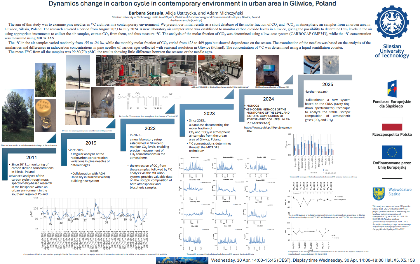
EGU25-3260 | Posters on site | CL4.3

Chironomid-based Holocene summer temperature dynamics from southern Spain  

Gonzalo Jiménez-Moreno, Narcís Prats, Oliver Heiri, Antonio García-Alix, R. Scott Anderson, Francisco J. Jiménez-Espejo, and Carmen Pérez-Martínez

This study presents a reconstruction of Holocene mean July air temperatures based on chironomid assemblages preserved in the sedimentary record of Laguna de la Mosca (LdlMo), an alpine lake in the Sierra Nevada of southern Spain. The LdlMo record reveals that the highest temperatures occurred during the Early and early-Middle Holocene, between 8500 and 7000 cal yr BP, followed by a significant cooling event. During the Middle Holocene, temperatures stabilized, but a second major cooling event occurred at approximately 4200 cal yr BP, possibly associated with the 4.2 kyr event. Throughout the Late Holocene, temperatures generally remained low, punctuated by warming episodes between 2300–1600 cal yr BP during the Iberian Roman Humid Period (IRHP) and around 1000 cal yr BP during the Medieval Climate Anomaly (MCA). The lowest temperatures were recorded at the end of the Little Ice Age (LIA), circa 1800 CE. Since ~1955 CE, a rapid and pronounced warming trend of 2.5°C has been observed, driven by anthropogenic climate change. This study shows the amplification of recent warming at high elevations, highlighting the vulnerability of these fragile and unique alpine environments to the impact of climate change.

This work was funded by grants BIOD22_001 and BIOD22_002, funded by Consejería de Universidad, Investigación e Innovación and Gobierno de España and Unión Europea – NextGenerationEU and PID2021-125619OB-C21 funded by the Ministerio de Ciencia e Innovacion of Spain, the Agencia Estatal de Investigacion and the Fondo Europeo de Desarrollo Regional FEDER MCIN/AEI/10.13039/501100011033/FEDER, UE

How to cite: Jiménez-Moreno, G., Prats, N., Heiri, O., García-Alix, A., Anderson, R. S., Jiménez-Espejo, F. J., and Pérez-Martínez, C.: Chironomid-based Holocene summer temperature dynamics from southern Spain , EGU General Assembly 2025, Vienna, Austria, 27 Apr–2 May 2025, EGU25-3260, https://doi.org/10.5194/egusphere-egu25-3260, 2025.

EGU25-4264 | ECS | Posters on site | CL4.3

Does the Largest Recorded Negative Carbon Isotope Excursion from the Neoproterozoic Krol Formation (India) Represent a Globally Synchronous Diagenetic Event? 

Debashish Pradhan, Melinda Kumar Bera, Ankita Nandi, and Ravikant Vadlamani

The "Shuram Excursion (SE)" stands as the largest known negative carbon isotope excursion (CIE) in geological history and is thought to represent the largest carbon cycle perturbation, possibly pivotal in the evolution of complex life forms and, thereafter, the Cambrian biotic explosion. Apart from the Shuram Formation at its type locality in Oman (the maximum depleted stable carbon isotopic ratio [δ13C value] in carbonate [peak δ13CCarbonate] of ~ –12 ‰), comparable negative CIE of similar ages has also been documented from different parts of the globe, among which the well constrained globally recognized SE sections are the Wonoka Formation of Australia (peak δ13CCarbonate of ~ −10 ‰), the Doushantuo Formation of South China (peak δ13CCarbonate of ~ −14 ‰), and the Rainstorm Member in the Johnnie Formation of Death Valley, California (peak δ13CCarbonate of ~ −11‰). Considering the inherent problem with the exact depositional age estimation for sedimentary rocks, although all the global locations show similar CIE patterns, the peak δ13CCarbonate values, and stratigraphic thicknesses vary from section to section. Because of these disparities, two distinct perspectives exist regarding the origin of the SE. While one group argues that a globally synchronous diagenetic event is responsible for the SE CIE, the other suggests it is a record of the temporal variation in the primary δ13C composition of the seawater dissolved inorganic carbon (DIC) and, hence, represents the actual carbon cycle perturbation. Based on the preliminary data obtained by other studies from the late Neoproterozoic Lesser Himalayan Krol Formation, previous workers tentatively suggested that the succession may contain the SE. However, because of the composite nature of the studied sections and the large spread in carbonate δ13C values in lithologically correlative stratigraphic (temporal) intervals, the proposition was not confirmed. So, the current study tries to recognize the possible SE CIE in the Lesser Himalayan Krol Formation, India, by studying continuously measured structurally undisturbed sections by employing vigorous fieldwork, detailed high-resolution carbonate δ13C data, and Pb-Pb dating of the carbonates after careful thin section and cathodoluminescence (CL) based screening for any possible diagenetic alterations. The transmitted light and CL-based petrographic observation, along with bulk and fabric-specific (micro-sampling) carbonate δ13C data, suggests the presence of distinct negative CIE with a peak δ13CCarbonate value of ~ –10.7 ‰ (CIE magnitude of ~10.7 ‰) in the Lesser Himalayan Krol Formation. The depositional age of ~560 ± 12 Ma, estimated by Pb-Pb dating of the carbonate across this CIE, further suggests the possible presence of SE CIE in the investigated section.

How to cite: Pradhan, D., Bera, M. K., Nandi, A., and Vadlamani, R.: Does the Largest Recorded Negative Carbon Isotope Excursion from the Neoproterozoic Krol Formation (India) Represent a Globally Synchronous Diagenetic Event?, EGU General Assembly 2025, Vienna, Austria, 27 Apr–2 May 2025, EGU25-4264, https://doi.org/10.5194/egusphere-egu25-4264, 2025.

EGU25-4937 | ECS | Orals | CL4.3

41Ca dating of marine deposits from Middle and Late Pleistocene 

Wei-Wei Sun, Michael Bender, En-Qing Huang, Huang Huang, Wei Jiang, Zheng-Tian Lu, Jun Tian, Tian Xia, Yu-Zhen Yan, Gun-Min Yang, and Hui-Min Zhu

41Ca (half-life = 99 ka) is a cosmogenic radionuclide that has long been proposed as a promising dating tracer for geological and archaeological samples from Middle and Late Pleistocene [1]. Calcium is abundant and has a residence time of 800 ka in the oceans, much longer than the half-life of 41Ca. This has led to the expectation of a uniform distribution of 41Ca/Ca ratios in oceans around the globe. Ocean deposits acquire the global seawater value of 41Ca/Ca upon the initial formation. Since ocean deposits are shielded from cosmic rays by overlying seawater, no cosmogenic 41Ca is produced as deposits grow older. These conditions are ideal for 41Ca dating of marine deposits.

However, the 41Ca/Ca ratio is typically less than 1015 in the environment, posing significant challenges for their measurements. Recent advances in Atom Trap Trace Analysis (ATTA) [2] have enabled the detection of 41Ca in geological samples [3]. The lowest 41Ca/Ca ratio measured so far is 3 × 10⁻¹⁸, found in a foraminifer sample from the Pacific Ocean.

We measured the 41Ca/Ca ratios in seawater samples from various depths in oceans around the world and mapped the spatial distribution of 41Ca. This work identifies the critical initial 41Ca/Ca value for 41Ca dating of marine deposits. Building on these findings, we performed 41Ca dating on foraminifera and coral samples from the Pacific, South China Sea, and Southern Ocean, and compared the results with those obtained from other dating methods. Meanwhile, we are exploring the feasibility of applying 41Ca dating to other geological and archaeological samples.


References:

[1] Raisbeck, G., Yiou, F. Possible use of 41Ca for radioactive dating. Nature 277, 42–44 (1979).

[2] A Primer on Atom Trap Trace Analysis (ATTA). http://atta.ustc.edu.cn/en-us/events/attaprimer.html

[3] Xia, TY., Sun, WW., Ebser, S. et al. Atom-trap trace analysis of 41Ca/Ca down to the 10–17 level. Nat. Phys. 19, 904–908 (2023)

How to cite: Sun, W.-W., Bender, M., Huang, E.-Q., Huang, H., Jiang, W., Lu, Z.-T., Tian, J., Xia, T., Yan, Y.-Z., Yang, G.-M., and Zhu, H.-M.: 41Ca dating of marine deposits from Middle and Late Pleistocene, EGU General Assembly 2025, Vienna, Austria, 27 Apr–2 May 2025, EGU25-4937, https://doi.org/10.5194/egusphere-egu25-4937, 2025.

EGU25-5402 | Orals | CL4.3

Basin-scale environmental changes in the Okhotsk Sea over the last 30,000 years 

Jianjun Zou, Qingchao Wang, and Xuefa Shi

The Sea of Okhotsk, situated at the northern boundary of the East Asian summer monsoon's domain, represents the southernmost region in the Northern Hemisphere where perennial sea ice develops year-round. It serves as a critical source of ventilation for modern North Pacific Intermediate Water and is highly sensitive to global climate change, making it an ideal natural laboratory for studying environmental changes. Despite its importance, our understanding of the basin-scale environmental evolution of the Sea of Okhotsk remains limited. This study addresses these gaps by compiling paleoenvironmental records from several sediment cores in the Sea of Okhotsk. We recalibrated the age models of these cores to reconstruct the histories of sea surface temperature (SST), sea ice activity, surface productivity, and intermediate water ventilation since 30 ka. Based on the reconstruction, we propose the conceptual modes of environmental evolution: the "glacial type," dominated by sea ice, and the "interglacial type," controlled by both sea ice and ocean currents. During the Last Glacial period (30 - 18 ka), the Sea of Okhotsk experienced low SSTs, extensive sea ice coverage, weak intermediate water ventilation, and reduced surface productivity. In contrast, the Late Holocene (< 6 ka) was characterized by higher SSTs, diminished sea ice, robust intermediate water ventilation, and increased surface productivity, with siliceous ooze being the dominant sediment component. Notably, during the Bølling-Allerød (14.7 - 13 ka) and Preboreal (11 - 9.7 ka) warm periods, the marine environment resembled the "interglacial type" but featured anoxic intermediate waters. During Heinrich Stadial 1 (18 - 14.7 ka) and the Younger Dryas (13 - 11.7 ka), environmental regimes were generally similar to the "glacial type" but with enhanced intermediate water ventilation. Since 30 ka, the evolution of environmental factors in the Sea of Okhotsk has been shaped by external forcings, internal feedbacks, and climate processes at both high and low latitudes, underscoring the complex interplay of factors influencing this dynamic region.

How to cite: Zou, J., Wang, Q., and Shi, X.: Basin-scale environmental changes in the Okhotsk Sea over the last 30,000 years, EGU General Assembly 2025, Vienna, Austria, 27 Apr–2 May 2025, EGU25-5402, https://doi.org/10.5194/egusphere-egu25-5402, 2025.

EGU25-5723 | Orals | CL4.3

Visualizing and quantifying biomineral preservation in fossils 

Živilė Žigaitė-Moro, Matthew Cowen, Marc de Rafélis, Loïc Ségalen, Benjamin Kear, and Maïtena Dumont

Palaeoclimatic reconstructions rely heavily on accurate interpretation of isotopic signal, retrieved primarily from fossil biominerals. Evaluating whether these geochemical proxies reflect original environment is often a challenge. In our recent study we have attempted to illustrate fossil vertebrate dental tissue geochemistry and, by inference, its extent of diagenetic alteration, using quantitative, semi-quantitative and optical tools to evaluate bioapatite preservation. Here we present visual comparisons of elemental compositions in fish and plesiosaur dental remains ranging in age from Silurian to Cretaceous, based on a combination of micro-scale optical cathodoluminescence (CL) observations (optical images and scanning electron microscope) with in-situ minor, trace and rare earth element (REE) compositions (EDS, maps and REE profiles), as a tool for assessing diagenetic processes and biomineral preservation during fossilization of vertebrate dental apatite. Tissue-selective REE values have been obtained using laser ablation-inductively coupled plasma-mass spectrometry (LA-ICP-MS), indicating areas of potential REE enrichment, combined with cathodoluminescence (CL) analysis. Energy dispersive X-ray spectroscopy (EDS) mapping was also used to identify major elemental components and identify areas of contamination or diagenetic replacement. We conclude that the relative abilities of different dental tissues to resist alteration and proximity to the exposure surface largely determine the REE composition and, accordingly, the inferred quality of preserved bioapatite.

How to cite: Žigaitė-Moro, Ž., Cowen, M., de Rafélis, M., Ségalen, L., Kear, B., and Dumont, M.: Visualizing and quantifying biomineral preservation in fossils, EGU General Assembly 2025, Vienna, Austria, 27 Apr–2 May 2025, EGU25-5723, https://doi.org/10.5194/egusphere-egu25-5723, 2025.

EGU25-6511 | Posters on site | CL4.3

Can shallow marine carbonate faithfully preserve the true signal of carbon cycle perturbation? 

Trupti Dadabhau Raskar, Arpita Samanta, and Melinda Kumar Bera

The carbon cycle perturbations in geological history are preserved in the form of changes in stable carbon isotope ratios (δ13C values) in different carbon-bearing sedimentary archives. The carbon cycle perturbation that occurred across the Paleocene-Eocene boundary (~56 Ma) is known as the Paleocene Eocene thermal Maximum (PETM). After more than three decades of research, the exact magnitude of the negative carbon isotope excursion (CIE) is still fuzzy. The shallow marine sedimentary archive, deposited far above the lysocline, is considered to be the best archive to quantify the carbon cycle perturbation because the deep marine (carbonate) was likely to be affected by carbonate dissolution and terrestrial sedimentary records influenced by different climatic parameters. However, different biotic and abiotic processes could influence the magnitude of the CIE during the perturbed carbon cycle-climate state in a shallow marine environment. For this reason, the present study investigated the early Paleogene marine carbonate rocks deposited in the eastern Tethyan Sea (Ladakh, NW India) to check the possible presence of the PETM CIE and test whether shallow marine carbonate is a good archive for measuring the CIE magnitude. The presence of age-diagnostic larger benthic foraminifera and detailed micro-facies analysis indicates the investigated shallow marine carbonate rocks were deposited during the ~56 to 54 Ma (Shallow Benthic Zone - 4 to 7) and are likely to hold the PETM CIE. The secular variation in the δ13C values of unaltered bulk carbonate, screened through the cathodoluminescence microscopic study, reveals a PETM CIE magnitude of -3.6 ‰.  The observed CIE magnitude is similar to the globally accepted CIE magnitude (-4 ± 0.4 ‰) for PETM and suggests that shallow marine carbonate can be used to assess the magnitude of PETM and other carbon cycle perturbations.

How to cite: Dadabhau Raskar, T., Samanta, A., and Kumar Bera, M.: Can shallow marine carbonate faithfully preserve the true signal of carbon cycle perturbation?, EGU General Assembly 2025, Vienna, Austria, 27 Apr–2 May 2025, EGU25-6511, https://doi.org/10.5194/egusphere-egu25-6511, 2025.

EGU25-8827 | Posters on site | CL4.3

Ursus spelaeus (Rosenmüller, 1794) during the MIS 3: temporal population distributions and relationship with climatic fluctuations 

Ana-Voica Bojar, Victor Barbu, Natalia Piotrowska, Hans-Peter Bojar, Andrei Smeu, Fatima Pawełczyk, and Ovidiu Guja

Ursus spelaeus, the Late Pleistocene a cave bear is known from numerous accumulations found in the fossil sector of caves situated in the Carpathian and Apuseni Mountains. In this study, we present approximate population variation in time using the temporal distribution and interval frequencies of radiocarbon ages from literature. Most of the dated skeletons were preserved in caves. The data suggest that, during the entire Marine Isotope Stage 3 (MIS 3) interval,  caves were serving as a shelter for U. spelaeus, with the oldest dated bone indicating ages over 60,000 and the youngest ones less than 30.000 years cal BP. Histogram plots of over 110 radiocarbon data from different caves of the Carpathian and Apuseni Mountains as Cioclovina Uscată, Peștera (Cave) cu Oase, Peștera Muierii, or Peștera Urșilor, respectively, show a maximum expansion of the cave bear population between 50,000 and 40,000, a decline between 40,000 and 35,000 and a partial recovery from 35,000–30,000 years cal BP. Radiocarbon data of Homo sapiens remains, younger than 35,000 years cal BP, support the fact that H. sapiens accessed the same caves where the cave bear persisted to hibernate. Besides general cool conditions and restricted food sources, the presence of H. sapiens constituted an additional stress factor driving the cave bear to extinction (Bojar et al., 2024).

References

Ana-Voica Bojar, Natalia Piotrowska, Victor Barbu, Hans-Peter Bojar, Fatima Pawełczyk, Andrei Smeu & Ovidiu Guja: Ursus spelaeus (Rosenmüller, 1794) during the MIS 3: new evidence from the Cioclovina Uscată Cave and radiocarbon age overview for the Carpathians, Isotopes in Environmental and Health Studies, DOI: 10.1080/10256016.2024.2376730

How to cite: Bojar, A.-V., Barbu, V., Piotrowska, N., Bojar, H.-P., Smeu, A., Pawełczyk, F., and Guja, O.: Ursus spelaeus (Rosenmüller, 1794) during the MIS 3: temporal population distributions and relationship with climatic fluctuations, EGU General Assembly 2025, Vienna, Austria, 27 Apr–2 May 2025, EGU25-8827, https://doi.org/10.5194/egusphere-egu25-8827, 2025.

EGU25-9061 | Orals | CL4.3

Ancient speleothem giant preserved in a high-Alpine cave (Dolomites, N Italy): rare insights into the Neogene 

Christoph Spötl, Gabriella Koltai, Robert Scholger, Jian Wang, Maria Knipping, and Hai Cheng

Conturines cave opens at 2775 m a.s.l. in the Dolomites (Northern Italy), hundreds of meters above the modern tree line. The cave is about 200 m long and comprises a single ascending paleophreatic conduit. The entrance of the cave is located at the base of the headwall of a former glacial cirque, testifying its pre-Pleistocene origin. Large parts of the cave floor are covered by an extensive (up to 3.5 m thick) flowstone and large stalagmite formations are present in the inner part of the passage, where the flowstone starts. All these large formations are inactive, partly corroded and dissected by fractures. The catchment area is a sharp ridge devoid of vegetation and soil, and the dripping water in the cave is undersaturated with respect to calcite, leading to the slow demise of these large speleothems.


Several drill cores covering the entire stratigraphy of the flowstone were obtained along the course of the gallery, the longest reaching bedrock at 3.5 m depth. Multi-proxy analyses of the two longest cores drilled approximately 5 m apart in the proximal part of the flowstone replicate well. Multiple magnetic reversals are preserved in the flowstone stratigraphy. According to preliminary U-Pb dating, speleothem deposition began ca. 5.5 - 5.0 Ma ago, likely coincident with the end of the Messinian Salinity Crisis in the Mediterranean, and continued intermittently until around 3 Ma. This uplifted ancient speleothem record provides a rare window into the Neogene at high resolution.

How to cite: Spötl, C., Koltai, G., Scholger, R., Wang, J., Knipping, M., and Cheng, H.: Ancient speleothem giant preserved in a high-Alpine cave (Dolomites, N Italy): rare insights into the Neogene, EGU General Assembly 2025, Vienna, Austria, 27 Apr–2 May 2025, EGU25-9061, https://doi.org/10.5194/egusphere-egu25-9061, 2025.

EGU25-10131 | Orals | CL4.3

Comparative analysis of gypsum from four different deposits of Badenian age in Romania 

Delia-Georgeta Dumitras, Octavian G. Duliu, Peter Istvan Luffi, Stefan Marincea, Doina Smaranda Sirbu Radasanu, Aurora Maruta Iancu, and Diana Persa

LA-ICP-MS, and XRD were used to investigate representative samples of gypsum collected from four deposits, all of them of Badenian age: Cheia (Transilvanian Basin, Cluj county), Ivancauti (Moldavian Platform, Botosani county), Negresti (Moldavide, Neamt county) and Moinesti (Moldavide, Bacau county) deposits were selected. The main objective of this study consisted of a geochemical, crystallo-chemical and economical potential detailed characterization of these deposits.

Accordingly, the LA-ICP-MS permitted determining the mass fractions of 21 elements including 10 REE (La, Ce, Nd, Sm, Eu, Gd, Er, Yb and Lu), as well as of Mg, P, Ti, Fe, Ni, Sr, Y, Ba, Pb, Th and U. Their content was interpreted considering their presence in the upper continental crust (UCC), sea water and chondrites.

Concerning the investigated elements, excepting for the REE ones, the LA-ICP-MS determinations evidenced in the case of Sr and U contents comparable with the UCC ones. It worth mentioning the presence of Sr of which mass fractions of 930 ± 47 and 545 ± 100 mg/kg in the Ivancauti and Cheia samples exceeded the UCC one of 330 mg/kg by a factor up to three, in good agreement with reported data concerning the lagunar Mediterranean gypsum.

At its turn, the U showed mass fractions varying between 1.76 ± 0.94 mg/kg in the case of Moinesti deposit and 2.93 ± 0.8 mg/kg for the Cheia samples, having the same order of magnitude as the UCC one of 2.7 mg/kg. On contrary, the maximum value of Th mass fraction of 68 ± 31 mg/kg was 155 times smaller than the value reported for UCC one. By comparing the ratio of the mass fractions of Th and U in investigated samples with the same ration of the sea water, the gypsum samples ratio of 0.02 significantly overpasses the sea water ratio of 0.0015, suggesting rather a terrigenous origin.

The great variability of the mass fractions of the investigated 11 elements makes possible the discriminant analysis of their distribution by considered elements as variable and deposits as cases. Indeed, a Root 2 vs. Root 2 bi-plot evidenced the presence of four clusters, the Negresti and Moinesti ones relatively closer and differing by the Ivancauti and Cheia ones with respect of Root 1, while Root 2 discriminates only the Cheia one with respect with the other three, i.e. Ivancauti, Negresti and Moinesti.

Likely, the investigated REE distribution showed for all of them mass fractions lower with one order of magnitude and more than the corresponding UCC values, e.g., varying from 5.59 ± 2.82 mg/kg for Yb in Ivancauti samples to 0.21 ± 0.04 mg/kg in the case of Lu in Moinesti gypsum. A peculiarity which we observed for all samples consisted of positive Ce and Eu anomalies. If the Ce anomaly could be associated to an oxidative depositional medium, the positive Eu anomaly could be associated to an increased content of Sr, but these facts need more investigations to be elucidated, especially as this anomaly was evidenced for all investigated samples, regardless the deposit.

How to cite: Dumitras, D.-G., Duliu, O. G., Luffi, P. I., Marincea, S., Sirbu Radasanu, D. S., Iancu, A. M., and Persa, D.: Comparative analysis of gypsum from four different deposits of Badenian age in Romania, EGU General Assembly 2025, Vienna, Austria, 27 Apr–2 May 2025, EGU25-10131, https://doi.org/10.5194/egusphere-egu25-10131, 2025.

EGU25-11318 | ECS | Orals | CL4.3

Late Holocene Climate Contrasts in NW Iberian Lakes 

Uxía Fernández-Pérez, Roberto Bao, Enno Schefuß, Teresa Rodrigues, Alberto Sáez, Pedro Raposeiro, Ricardo Prego, Rafael Carballeira, and Armand Hernández

This study explores Late Holocene climate variability and environmental transitions in the NW Iberian Peninsula by analyzing organic biomarkers (n-alkanes) and their isotopic signatures (δ¹³C and δD) from two contrasting lake systems: Lake Ocelo, a mountain lake (1517 m a.s.l.) located at a crucial point between the Atlantic and Mediterranean bioclimatic regions, and Lake Doniños, a coastal back-barrier perched lake (2.5 m a.s.l.) within the sub-Atlantic climatic domain. Lakes at varying altitudes provide complementary paleoenvironmental records that capture diverse ecosystem responses to past climate changes across vertical gradients.

In both Lake Ocelo and Lake Doniños, δD values reflect hydrological variability. In Ocelo, long-chain n-alkanes indicate terrestrial vegetation as the main source of organic matter. δD values (~-190‰ to ~-160‰) reflect wetter and cooler conditions during the Older Subatlantic (OSA; ca. 800-200 BCE), the Dark Ages (DA; ca. 300-750 CE) and Little Ice Age (LIA; ca. 1300-1900 CE), contrasted with warmer and drier conditions during the Roman Warm Period (RWP; ca. 200 BCE-300 CE), Medieval Climate Anomaly (MCA; ca. 750-1100 CE) and the Industrial Era (IE; ca. 1850 CE-present). Similary, in Doniños, δD values during the MCA became more positive, suggesting drier conditions. The MCA-LIA transition (ca. 1100–1300 CE) in Ocelo shows a shifts to wetter and cooler conditions, with δD and δ¹³C values declining. In Doniños, between 1200 CE and 1585 CE, δD became more positive, suggesting episodic drying and marine influence, likely linked to increased storminess. Also, δ¹³C rose sharply between 1400 CE and 1550 CE, during the LIA, possibly indicating increased nutrient input associated with climatic fluctuations or marine incursions. After a hiatus spanning 1585-1700 CE, δD stabilized at its most positive levels, marking reduced hydrological variability and arid conditions. Post-1850 CE, δD and δ¹³C trended toward more negative levels, reflecting increased meteoric water input due to wetter climate conditions or anthropogenic watershed. Additionally, the lowering of δ¹³C values during the IE may also reflect the Suess effect from fossil fuel combustion.

In Ocelo, δ¹³C data align with δD trends, reflecting shifts in vegetation composition and water stress, with relative enrichment in δ¹³C during the RWP and MCA suggesting warmer and drier conditions, while more negative δ¹³C during the LIA and DA reflects cooler and wetter conditions.

These findings emphasize the utility of biomarkers in reconstructing regional climate variability and the contrasting responses of mountain and coastal lakes to Late Holocene transitions. Despite their geographical proximity (185 km), both lakes reflect different climatic influences: Lake Ocelo records broader fluctuations linked to its bioclimatic position, while Lake Doniños is influenced by local processes, including marine intrusions and anthropogenic impacts. Similarities include drier conditions during the RWP and MCA in both lakes, while differences emerge during the LIA, where marine influence and storminess played a larger role in Lake Doniños. 

This work is supported by Grants PID2019-107424RB-I00 and PID2022-139775OB funded by MCIN/AEI/10.13039/501100011033, with the latter also co-funded by “ERDF A way of making Europe”. Xunta de Galicia also supports this work through projects ED431F 2022/18 and ED431B 2024/03.

How to cite: Fernández-Pérez, U., Bao, R., Schefuß, E., Rodrigues, T., Sáez, A., Raposeiro, P., Prego, R., Carballeira, R., and Hernández, A.: Late Holocene Climate Contrasts in NW Iberian Lakes, EGU General Assembly 2025, Vienna, Austria, 27 Apr–2 May 2025, EGU25-11318, https://doi.org/10.5194/egusphere-egu25-11318, 2025.

EGU25-11350 | Posters on site | CL4.3

High precision stable isotope analysis of carbonate and water samples for paleoclimate applications using the Elementar iso DUAL INLET 

Mike Seed, Calum Preece, Kathrin Rosenthal, and Sam Barker

Paleoclimate research is important for understanding past, current and future climate, providing the data needed to model and predict current and future climate change scenarios. Stable isotope analysis provides an essential tool for gathering past climate information from natural archives such as waters including ice-cores, ground waters, and biological waters; and carbonate materials such as foraminifera and other fossilized carbonates. Due to the often limited and small sample sizes available for stable isotope analysis it is vital that highly precise and accurate analysis can be carried out on the smallest of sample sizes.

Dual inlet technology remains the most precise, accurate and sensitive technique for pure gas, carbonate and water analysis. The Elementar iso DUAL INLET is a valuable tool for paleoclimate applications, enabling the analysis of pure gas samples within an incredibly compact footprint via our powerful lyticOS software suite. The 14-ultra low dead volume valves with bodies machined from a single block of high purity stainless steel and dedicated turbomolecular pump for the changeover valve guarantees zero residual memory effects between reference and sample gas.

The iso DUAL INLET can be optionally enhanced for the automated analysis of carbonate and water samples. With the iso AQUA PREP enhancement, up to 180 water samples can be analysed achieving δ18O precision better than 0.05‰ (1σ, n=10) and δD precision better than 1‰ (1σ, n=10), for any environmental water sample. The iso CARB PREP enhancement enables automated analysis of up to 180 micro-fossil samples for 13C and 18O down to 20μg sample size. For the highest productivity, both carbonate and water analysis can be performed with the iso MULTI PREP enhancement with switching between modes needing simply a change of needle. The IRMS collector configuration can also be upgraded for “clumped isotope analysis” of carbonate materials.

We will highlight the performance of the iso DUAL INLET with carbonate and water functionality across a range of sample types for paleoclimate applications, supporting researchers building a detailed understanding of the past to better inform policy makers for the future.

How to cite: Seed, M., Preece, C., Rosenthal, K., and Barker, S.: High precision stable isotope analysis of carbonate and water samples for paleoclimate applications using the Elementar iso DUAL INLET, EGU General Assembly 2025, Vienna, Austria, 27 Apr–2 May 2025, EGU25-11350, https://doi.org/10.5194/egusphere-egu25-11350, 2025.

EGU25-11461 | Orals | CL4.3

Heightened instability in lake circulation triggered by mid-Holocene warmth; insights from the varved sediments of Lake Nautajärvi, southern Finland  

Paul Lincoln, Rik Tjallingii, Emilia Kosonen, Antti Ojala, Ashley Abrook, and Celia Martin-Puertas

Future climate projections are expected to have a substantial impact on boreal lake circulation regimes, with warmer climates and higher organic loads leading to intensified thermo-stratification and brownification. Understanding lake sensitivity to warmer climates is therefore critical for mitigating potential ecological and societal impacts. The Holocene Thermal Maximum (HTM; ca 7-5 ka BP) provides a valuable analogue to investigate lake responses to warmer climates devoid of major anthropogenic influences.

In this presentation we present high-resolution micro-X-ray core scanning profiles (μ-XRF) of the annually laminated (varved) sediments from Lake Nautajärvi (NAU-23) in southern Finland to elucidate changes in lake circulation and sedimentation patterns. Principal component analysis (PCA) identifies two key components in the μ-XRF data associated with the nature of the sediments, i.e. detrital vs organic sedimentation (PC1), and hypolimnetic oxidation (PC2). Using these results, we will show that during the HTM, the lake became more sensitive to changes in oxygenation and mixing intensity. These changes were triggered by a warmer climate, which increased organic matter and redox sensitive metal solute concentrations in the water column, strengthening lake stratification and weakening dimictic circulation patterns. Superimposed on HTM weakened circulation are distinct phases of increased oxidation and iron-rich varve formation that do not happen when the background conditions are cooler (i.e. the early and late Holocene). This is driven by temporary strengthening of the mixing regime in response to climatic variability and storminess cycles across southern Scandinavia. These findings demonstrate that whilst warmer conditions weaken boreal lake circulation regimes, they can also make them increasingly vulnerable to short term oscillations in prevalent climatic conditions and weather patterns, which could have significant impacts on lake water quality and aquatic ecosystems. These findings underscore the non-stationary nature of lake sensitivity to short-term climatic variability and emphasize the potential for similar shifts to occur under future warming scenarios.

How to cite: Lincoln, P., Tjallingii, R., Kosonen, E., Ojala, A., Abrook, A., and Martin-Puertas, C.: Heightened instability in lake circulation triggered by mid-Holocene warmth; insights from the varved sediments of Lake Nautajärvi, southern Finland , EGU General Assembly 2025, Vienna, Austria, 27 Apr–2 May 2025, EGU25-11461, https://doi.org/10.5194/egusphere-egu25-11461, 2025.

EGU25-11502 | ECS | Orals | CL4.3

Seasonal bias in temperature-sensitive biomarkers: a multi-proxy assessment of branched GDGT suitability for Holocene climate reconstruction 

Ashley Abrook, Peter Langdon, Gordon Inglis, Achim Brauer, Paul Lincoln, Antti Ojala, and Celia Martin-Puertas

Understanding the evolution of Holocene climate is key for predicting what different futures may look like. However, global proxy and model-based climate reconstructions disagree on the general evolution of climate over the past 11.7 thousand years. Proxy-based reconstructions demonstrate a Holocene Climatic Optimum in the mid-Holocene, whilst model-based approaches show a trend of increasing temperatures throughout. This disagreement is largely believed to relate to seasonal biases within the proxy-based reconstructions, although model based-reconstructions are not without their flaws. Here we use a series of annually laminated (varved) lake sediment records from Europe (Diss Mere, United Kingdom; Meerfelder Maar, Germany; Lake Nautajärvi, Finland) to explore whether organic proxies are seasonally biased. To achieve this, we generate high-resolution (multi-decadal) branched glycerol dialkyl glycerol tetraether (brGDGT) lipid reconstructions of mean temperature of months above freezing (MAF; approximating MAAT in temperate locations) across the Holocene including the last 200-years and the mid-Holocene. We contrast our biomarker data with chironomid-inferred July summer temperature estimates from the same sample horizons within each lake to ascertain whether summer signals have an important imprint on the GDGT data. We show that brGDGTs are likely produced in situ within lake waters and that the varved nature of each lake does not impede brGDGT based climate reconstruction. We show that 1) GDGT-based temperatures record dominant climate variability at each site; 2) the mid-Holocene is warmer than present and pre-industrial mean annual temperatures; 3) biomarker and chironomid reconstructions from Diss Mere and Meerfelder Maar are more closely aligned than Nautajärvi suggesting location specific complexities; and 4) that biomarker and chironomid temperatures converge and diverge at various points in each record. Each of these results suggest seasonal biases exist within the GDGT-based climate reconstructions which may be non-stationary. Our data therefore reveals the need to generate multiple proxy-proxy assessments of climate from different archives to ascertain the influence of mean annual versus summer climate parameters. 

How to cite: Abrook, A., Langdon, P., Inglis, G., Brauer, A., Lincoln, P., Ojala, A., and Martin-Puertas, C.: Seasonal bias in temperature-sensitive biomarkers: a multi-proxy assessment of branched GDGT suitability for Holocene climate reconstruction, EGU General Assembly 2025, Vienna, Austria, 27 Apr–2 May 2025, EGU25-11502, https://doi.org/10.5194/egusphere-egu25-11502, 2025.

EGU25-11588 | ECS | Orals | CL4.3

Potentials and limitations of using cosmogenic Beryllium isotopes for the synchronization of marine sediment and ice cores 

Julia Loftfield, Norbert Nowaczyk, Lester Lembke-Jene, Thomas Frederichs, Johannes Lachner, Frank Lamy, Georg Rugel, Konstanze Stübner, and Florian Adolphi

Variations in the atmospheric production rate of cosmogenic 10Be lead to global changes in 10Be depositional fluxes. This may serve as a powerful tool for synchronizing various paleoclimate archives. For a robust synchronization, however, it is essential to understand the pathways of 10Be from its production in the upper atmosphere to its deposition in sediments and ice. While 10Be is deposited in ice within one to two years after production, its deposition in marine sediments is less direct, complicating its use for synchronization. To address this issue, we investigate the response of the authigenic 10Be/9Be ratio in marine sediments to a rapid increase in atmospheric 10Be production. We analyzed the 10Be/9Be ratios of three sediment cores from the Southern Ocean, all under the depositional regime of the Antarctic Circumpolar Current (ACC). We compared these records that encompass the period of the geomagnetic field minimum around the Laschamps excursion (~41 ka BP) to 10Be records from ice cores. All cores show an increase in the 10Be/9Be ratio during the Laschamps excursion. However, the marine records exhibit site-specific differences in amplitude and response time. We discuss the causes of these discrepancies and the roles of local residence time of Be in the water column, bioturbation of sediments, diagenetic Be fluxes, re-mobilization of sediments, and varying terrestrial Be sources. We argue that the attainable precision of a 10Be-based synchronization depends on the prior knowledge of these factors. Especially, the marine residence time of 10Be sets an upper limit on the achievable resolution from marine sediment 10Be/9Be records and leads to a temporal shift of the recorded 10Be/9Be changes relative to the increase in atmospheric 10Be-production. Additionally, terrestrial input of 10Be can lead to non-production influences on the 10Be/9Be ratio in sediments, even in pelagic settings. Nevertheless, under ideal conditions, marine sediments can capture 10Be/9Be signals that closely align with those in ice cores, highlighting the potential of 10Be/9Be ratios as a future chronostratigraphic tool for the synchronization of marine sediment records with other paleoclimate archives, e.g. ice cores.

How to cite: Loftfield, J., Nowaczyk, N., Lembke-Jene, L., Frederichs, T., Lachner, J., Lamy, F., Rugel, G., Stübner, K., and Adolphi, F.: Potentials and limitations of using cosmogenic Beryllium isotopes for the synchronization of marine sediment and ice cores, EGU General Assembly 2025, Vienna, Austria, 27 Apr–2 May 2025, EGU25-11588, https://doi.org/10.5194/egusphere-egu25-11588, 2025.

Recent retrogressive thaw slump activity in the Richardson Mountains (northwestern Canada), induced by climate warming, has exposed a stratigraphic record of landscape evolution and permafrost development since the last glaciation. Horizontal profiles of five relict ice wedges and one rejuvenation-stage (ca. modern) ice wedge were collected from the headwalls of four thaw slumps in the Willow Creek area of the Richardson Mountains to study post-glacial changes in winter climate. The ice wedges contain vertically elongated bubbles, indicating a likely snowmelt origin. δ2H and δ18O measurements, sampled every ~1.5 cm across the profiles (n = 325), fall well within the range of local winter precipitation values, thereby confirming winter precipitation as the probable source water. Detrital plant macrofossils from several pristine ice samples were AMS 14C dated (n = 16) and confirm at least 2 generations of relict wedge ice dating to the Younger Dryas (YD) and Late Holocene; this is only the second study from the Western Arctic to document YD wedge ice. YD wedge ice is ~2.2‰ more negative in δ18O compared to Late Holocene wedge ice, which could be explained by one or a combination of plausible factors: (i) winter temperatures were up to ~5°C colder on average (e.g., assuming a δ18Oprecip-T sensitivity of 0.41‰·°C-1); (ii) a greater proportion of snow fell during the coldest winter months; or (iii) the moisture source region varied in response to changing atmospheric circulation, moderated by the collapse of the last ice sheet. However, no significant difference is observed in dexcess between YD and Late Holocene wedge ice, which may suggest the precipitation seasonality and moisture source region were comparable. Conversely, the rejuvenation-stage wedge ice, which likely formed in the last few decades, is 1.7‰ more positive in δ18O than Late Holocene wedge ice, while dexcess is statistically indifferent. The strong increase in δ18O in modern wedge ice relative to Late Holocene wedge ice reflects the impact of recent Arctic warming, especially in winter, a pattern that has been previously observed in other ice wedge records from the Canadian and Siberian Arctic. In summary, this study provided insights on winter climate variability in the northwestern Canadian Arctic, with a focus on the YD, Late Holocene and recent times, and demonstrates the potential to use ice wedges to further our knowledge of cold-season climate dynamics in the circum-Arctic more broadly.

How to cite: Porter, T., Changulani, A., Opel, T., and Meyer, H.: Younger Dryas and Holocene winter conditions in the Richardson Mountains, Canadian Arctic, reconstructed from precipitation isotopes in relict ice wedges, EGU General Assembly 2025, Vienna, Austria, 27 Apr–2 May 2025, EGU25-13380, https://doi.org/10.5194/egusphere-egu25-13380, 2025.

EGU25-13426 | ECS | Orals | CL4.3

Clumped isotope constraints on formation environment of Triassic carbonates in Makhtesh Ramon 

Shlomit Cooper-Frumkin, Hagit Affek, Yael Ebert, and Uri Ryb

Despite prolonged research, the formation environments of dolomite remain debated. Previous studies have associated the apparent decrease in dolomite abundance during the Cenozoic with a global transition in marine carbonate depositional environments leading from warm, saline, shallow platforms in which dolomite formation was possibly mediated by microbial activity, to deeper and cooler environments in which dolomite formation was largely inhibited. Others suggested that large volumes of pre-Cenozoic dolomites reflect dolomitization at elevated burial temperatures of these rocks, whereas most Cenozoic carbonate platforms did not reach sufficient thermal maturity. A third, hybrid model suggests that Mg-rich dolomite precursor minerals precipitated in shallow environments and later underwent deep diagenesis to a more ordered and stoichiometric dolomite. The combination of carbonate oxygen (δ18O) and clumped (TΔ47) isotope analysis can be used to constrain and distinguish among these formation environments.

Here, we combine δ18O and TΔ47 measurements in marine carbonate rocks from the Triassic Ramon Gr. in Makhtesh Ramon, southern Israel, to constrain their formation environments. The studied section records a transition from a carbonate platform, dominated by fossil-rich limestone (top Gvanim and Saharonim Fm.), to a shallow saline evaporitic lagoon (Mohila Fm.) dominated by alterations of laminar dolomite and evaporitic gypsum, with much sparser fossils relative to top Gvanim and Saharonim Fm. Calcite samples in the Gvanim and Saharonim Fm. recorded δ18O and TΔ47 values from -8.41 to -2.17 ‰ VPDB, and from 29 to 98 °C, respectively. Two calcite samples recorded TΔ47 values of 152-231 °C, associated with isotopic solid-state reordering in response to local heating near igneous intrusions. Dolomite samples at the top Saharonim and Mohila Fms. recorded δ18O and TΔ47 values from -4.77 to -1.59 ‰ VPDB and from 36 to 74 °C, respectively. These results indicate that carbonate minerals recrystallized in burial-diagenetic environments in an open system with respect to δ18O. The observation that dolomite, associated by stratigraphic context and texture with deposition at (or near) the surface, has been recrystallized at depth, supports a multi-step dolomite formation process, in which carbonates were first enriched in Mg2+ in the lagoon and later recrystallized in high-temperature, deep-diagenetic environment. 

How to cite: Cooper-Frumkin, S., Affek, H., Ebert, Y., and Ryb, U.: Clumped isotope constraints on formation environment of Triassic carbonates in Makhtesh Ramon, EGU General Assembly 2025, Vienna, Austria, 27 Apr–2 May 2025, EGU25-13426, https://doi.org/10.5194/egusphere-egu25-13426, 2025.

Marine ferromanganese polymetallic crusts and nodules are an important mineral resource widely distributed on the seafloor. They are regarded as strategic reserve resources and have attracted much attention. During the mineralization process, the iron-manganese oxide/hydroxide colloids generated by the oxidation of Fe2+ and Mn2+ in the ambient seawater adsorb metal ions and oxidize the metal ions to a high valence state or form metal complexes to be enriched in iron-manganese minerals. They grow slowly at a rate of several mm/Myr, recording and preserving important information on paleo-ocean and paleoclimate changes. They are ideal objects and response media for studying global ocean evolution and environmental changes and are also helpful in exploring the source-sink process of marine substances. Therefore, based on the precise chronology of polymetallic crusts and nodules from the South China Sea (SCS), this study used in-situ Pb isotope analysis technology to analyze the variation characteristics of Pb isotope composition of polymetallic crusts and nodules, to reveal the growth and mineralization history and environmental evolution of crusts and nodules in the study area. 

The results show that: (1) The growth ages of SCS polymetallic crusts and nodules are about 1.16-3.46 Ma and an average growth rate of 3.19-6.07 mm/Myr using the 10Be/9Be isotope method. (2) The Pb isotope characteristics of SCS polymetallic crusts and nodules are related to their growth area: the Pb source of crusts and nodules growing in the northern SCS is mainly affected by the input of terrigenous materials; the crusts and nodules growing in the central SCS are less affected by terrigenous materials and are gradually affected by the weathering/alteration of seamount substrates and the input of volcanic activities. (3) Through the coupling of the mineralization chronology framework of SCS polymetallic crusts and nodules with the Pb isotope compositions of their profiles, it is found that the rapid formation and large-scale expansion of the northern hemisphere ice sheet around 3.5 Ma caused the deep water of the SCS to become extremely oxidized, thus promoting the mineralization of SCS crusts and nodules. The tectonic activities in the SCS since 2.8 Ma have had a greater impact on the SCS polymetallic crusts and nodules. Events such as the closure of the Lehe Waterway and the successive closure of the Taitung Waterway have led to the strengthening of the closure of the SCS, the lack of ventilation, and the reduction of oxidation of the seawater, which has slowed the growth rate of polymetallic crusts and nodules. In addition, the uplift of Taiwan and the subsidence of the northern SCS have led to an increase in the input of terrigenous materials, which has led to a decrease in the content of metal elements in the mineralization of polymetallic crusts and nodules. Therefore, the mineralization of SCS polymetallic crusts and nodules is subject to joint control of the tectonic evolution of the SCS and changes in the marine environment such as global climate change.

How to cite: Guan, Y., Ren, Y., Feng, A., and Zhou, X.: Metallogenic environment evolution of the polymetallic crusts and nodules from the South China Sea: Insights from in-situ Pb isotopes and elemental geochemistry, EGU General Assembly 2025, Vienna, Austria, 27 Apr–2 May 2025, EGU25-14366, https://doi.org/10.5194/egusphere-egu25-14366, 2025.

EGU25-15151 | ECS | Posters on site | CL4.3

Modern isotope dynamics in lakes of semiarid regions: A framework for interpreting lacustrine paleoclimate archives  

Claudia Voigt, Fernando Gázquez, Miguel Rodríguez-Rodríguez, Hana Jurikova, Lucía Martegani, Jorge Cañada-Pasadas, and Elvira Ruíz-Caballero

The isotope composition of lake sediments, including gypsum, carbonate, and biogenic silicate, provides a powerful means to reconstruct past hydrological and climatic changes. Triple oxygen isotope measurements in such minerals are an emerging tool for quantitative paleoclimate reconstructions in lacustrine environments. However, robust interpretations of these archives require a detailed understanding of the processes driving lake water isotope variability and mineral formation. Long-term changes in climate and hydrological conditions, especially in semiarid and arid regions, often challenge the interpretation of lacustrine records. Here, we synthesize key findings from multiple studies on the processes controlling triple oxygen and hydrogen isotope variability in semiarid lakes. The presented data include results from several Andalusian wetlands and artificial salt pans in Spain. We explore how factors such as groundwater connectivity, transitions between permanent and ephemeral stages, lake water salinity, climate seasonality, and seasonal and interannual variations in mineral formation influence the isotope composition of lake water and discuss their implications for paleoclimate reconstructions. Our findings provide a framework for interpreting lacustrine archives in complex hydrological settings.


Acknowledgements:

This research was supported by the European Commission (Marie Curie postdoctoral fellowship, grant no. 101063961) and the project PID2021-123980OA-I00 (GYPCLIMATE), funded by the Ministerio de Ciencia e Innovación of Spain, the Agencia Estatal de Investigación and the Fondo Europeo de Desarrollo Regional FEDER.

How to cite: Voigt, C., Gázquez, F., Rodríguez-Rodríguez, M., Jurikova, H., Martegani, L., Cañada-Pasadas, J., and Ruíz-Caballero, E.: Modern isotope dynamics in lakes of semiarid regions: A framework for interpreting lacustrine paleoclimate archives , EGU General Assembly 2025, Vienna, Austria, 27 Apr–2 May 2025, EGU25-15151, https://doi.org/10.5194/egusphere-egu25-15151, 2025.

EGU25-15935 | ECS | Posters on site | CL4.3

Exploring Fossil-Bound Nitrogen Isotopes in Modern and Paleozoic Sea Urchins: A New Window into Benthic Ecosystems 

Alexandra Auderset, Aaron L. Bieler, Alfredo Martínez-García, and Jeffrey R. Thompson

Nitrogen isotopic composition (δ¹⁵N) measured on organic matter within biominerals (fossil-bound) is an emerging proxy for reconstructing marine trophic conditions in deep time. While previously applied to foraminifera, diatoms, corals, shark teeth, and fish otoliths, the application of δ¹⁵N to other shallow-water marine taxa has been relatively limited. To evaluate the potential of sea urchins as a new model for paleoenvironmental and paleoecological reconstructions, we herein investigate fossil-bound δ¹⁵N in modern and fossil sea urchin biominerals and, for extant samples, its relationship to tissue δ¹⁵N.

Our findings indicate a δ¹⁵N difference of up to 3 ‰ between plates and spines within an individual sea urchin, with an observed nitrogen isotope gradient from the aboral surface to oral surface in both test plates and spines. In addition, we directly compare the δ¹⁵N signature of the gonads, gut content and body wall tissue with the biomineral-bound δ¹⁵N of the teeth, hemipyramids, rotulae, compasses, perignathic girdle, plates and spines. We suggest that biomineral-bound δ¹⁵N preserves trophic signals while also capturing internal isotopic gradients.

Extending this method, we analysed δ¹⁵N in various echinoid genera from the Carboniferous (Mississippian and Pennsylvanian) across multiple localities spanning the globe as a means of understanding their, previously poorly-defined, role in Paleozoic ecosystems. This study is a first step towards the application of fossil-bound nitrogen isotopes to this diverse group, providing new insights into trophic conditions and ecological structures in Paleozoic marine benthic ecosystems.

How to cite: Auderset, A., Bieler, A. L., Martínez-García, A., and Thompson, J. R.: Exploring Fossil-Bound Nitrogen Isotopes in Modern and Paleozoic Sea Urchins: A New Window into Benthic Ecosystems, EGU General Assembly 2025, Vienna, Austria, 27 Apr–2 May 2025, EGU25-15935, https://doi.org/10.5194/egusphere-egu25-15935, 2025.

EGU25-16107 | ECS | Orals | CL4.3

North Atlantic Freshening and Abrupt Cooling During the Last Glacial Maximum and Deglaciation recorded by Iberian Speleothem 

Laura Endres, Carlos Pérez-Mejias, Ruza Ivanovic, Lauren Gregoire, Anna Hughes, Hai Cheng, and Heather Stoll

The last deglaciation represents a valuable test case for understanding abrupt climate events as it triggers cascading feedback among Earth system components, particularly involving the ice sheets. Constraining the timing, magnitude, and order of these events within the critical North Atlantic realm remains challenging.

Here, we present a new U-Th-dated stalagmite from northwestern Iberia spanning the Last Glacial Maximum (LGM) and the entire last deglaciation (24-12 ka BP). Given its coastal and moisture-replete cave location, stable isotopes (δ18O, δ13C) capture both the influence of the Northern Hemisphere ice sheet’s meltwater inflow on surface ocean chemistry, and regional surface air temperature changes via their effects on local vegetation.  Since both stable isotopes are measured on the exact same samples, this allows a direct and high-resolution study of the temporal relationship between Northern Hemisphere meltwater ocean in-flux and temperature change in the North Atlantic realm, advancing speleothem applications in ocean and cryosphere studies.

We have compared our results to meltwater histories derived from the ice sheet model GLAC-1D, and our findings confirm/reveal gradual meltwater inflow during the LGM and early deglaciation (~20.8-18.2 ka BP), followed by a set of abrupt increases in meltwater starting at 18.04±0.16, 16.22±0.24 and 15.44±0.19 ka BP. In our record, abrupt cooling begins at 17.18±0.16 ka BP, indicating that the peak weakening of deep Atlantic convection lagged the first abrupt meltwater pulse by ~850 years. This suggests a non-linear connection between surface ocean freshening and the consequential disruption to the early deglacial Atlantic meridional overturning circulation. In contrast, a brief cooling phase, synchronous with a response in global archives, aligns with the meltwater pulse at 16.22 ka BP, whereas no cooling is associated with the 15.44 ka BP pulse. The transition into the Bølling-Allerød period, featuring two warm phases, is marked by rapid warming starting at 14.78±0.12 ka BP concurrent with a decline in meltwater anomalies, likely related to the re-strengthening of deep Atlantic convection. Remarkably, our record does not show a freshwater signal coincident with the classically cited onset of MWP 1a (~14.6 ka BP), suggesting that this event happened earlier or that the freshwater anomaly was rapidly advected out of the surface North Atlantic by a strong AMOC.

How to cite: Endres, L., Pérez-Mejias, C., Ivanovic, R., Gregoire, L., Hughes, A., Cheng, H., and Stoll, H.: North Atlantic Freshening and Abrupt Cooling During the Last Glacial Maximum and Deglaciation recorded by Iberian Speleothem, EGU General Assembly 2025, Vienna, Austria, 27 Apr–2 May 2025, EGU25-16107, https://doi.org/10.5194/egusphere-egu25-16107, 2025.

EGU25-16395 | Orals | CL4.3

South Asian summer and winter monsoon evolution during the last deglaciation 

Igor Obreht, Andreas Lückge, Mahyar Mohtadi, Petra Zahajská, Enno Schefuß, Denis Scholz, Lars Wörmer, Florian Adolphi, Martin Grosjean, and Kai-Uwe Hinrichs

The South Asian monsoon (SAM) system significantly influences the hydroclimate of the Indian subcontinent, affecting nearly two billion people. However, much of our paleoclimate knowledge is centered on the summer monsoon (SASM), while the winter monsoon (SAWM) remains poorly understood. This study investigates seasonal monsoon variability during the last deglaciation, focusing on abrupt climate transitions that provide natural experiments for understanding past monsoon dynamics. We analyzed sediment core SO130-289KL from the Northeastern Arabian Sea, a region sensitive to both the SASM and the SAWM. Laminated sediments deposited during the Bølling–Allerød Interstadial (~14,690–12,890 years BP) offer a rare high-resolution archive for reconstructing past climate variability at ~decadal timescales.

To overcome the limitations of traditional analytical techniques, we employed mass spectrometry imaging and hyperspectral imaging, achieving micrometer-scale spatial resolution. SST reconstructions rely on two independent biomarkers: the alkenone-based UK’37 index and the GDGT-based Crenarchaeol-Caldarchaeol Tetraether (CCaT) index. Hyperspectral imaging quantified chloropigments-a as a proxy for primary production, while leaf wax hydrogen (δD C31) and carbon (δ¹³C31) isotopes provide insights into atmospheric moisture and terrestrial vegetation dynamics in lower resolution.

Our results reveal distinct seasonal responses of the SAM system to deglacial climate changes. Alkenone-based SSTs, which are more sensitive to change in SAWM winds, show a progressive weakening of the northeastern boreal winter winds during the Allerød, aligning with a progressive cooling trend in the Southern Hemisphere. This weakening likely reflects a boreal winter (austral summer) northward shift of the Intertropical Convergence Zone (ITCZ) towards the equator driven by decreasing Southern Hemisphere austral summer temperatures. In contrast, CCaT-derived SSTs, linked to SASM wind strength, closely correlate with Northern Hemisphere temperature proxies, demonstrating that SASM variability was primarily controlled by boreal summer conditions.

Seasonal precipitation patterns reconstructed from leaf wax isotopes highlight hydroclimatic changes during the Bølling-Allerød. Lower δD C31 values during the Bølling indicate increased summer precipitation, while the early Allerød more positive δD C31 suggest decrease in precipitation. Following concurrent decreases in δ¹³C31 and δD C31 values during the mid to late Allerød suggest reduced seasonality with enhanced precipitation in both summer and winter.

The reconstructed seasonal evolution of SASM and SAWM has significant implications for other paleoclimate archives, such as speleothem δ¹⁸O values, traditionally interpreted as summer monsoon proxies. Our findings suggest that speleothem δ¹⁸O values reflect a combined signal of summer and winter precipitation. During the Bølling-Allerød, depleted δ¹⁸O values may indicate an increased contribution from isotopically lighter winter precipitation associated with subtropical westerly jets, rather than solely stronger summer monsoon rainfall. The observed decrease in δ¹⁸O values during the late Allerød likely reflects enhanced winter precipitation from isotopically depleted far-distance moisture sources.

Our findings underscore the dual hemispheric influence on the SAM. SASM strength was directly linked to Northern Hemisphere forcing, particularly shifts in Atlantic Meridional Overturning Circulation and associated ITCZ migrations, while SAWM variability was modulated by both Northern and Southern Hemisphere climate changes.

How to cite: Obreht, I., Lückge, A., Mohtadi, M., Zahajská, P., Schefuß, E., Scholz, D., Wörmer, L., Adolphi, F., Grosjean, M., and Hinrichs, K.-U.: South Asian summer and winter monsoon evolution during the last deglaciation, EGU General Assembly 2025, Vienna, Austria, 27 Apr–2 May 2025, EGU25-16395, https://doi.org/10.5194/egusphere-egu25-16395, 2025.

EGU25-18756 | ECS | Orals | CL4.3

Hydroclimatic variability during the onset of the Last Interglacial in Lake Van and Iimplications for the Eastern Mediterranean  

Anaïs Urban, Cecile Blanchet, Dirk Sachse, Birgit Schröder, Sylvia Pinkerneil, Markus Schwab, Rebecca Kearney, Ola Kwiecien, Achim Brauer, and Rik Tjallingii

The Mediterranean region is highly sensitive to climate change and warms faster than the global average. Models forecast a pronounced drying trend, coupled with an increase in the frequency and intensity of extreme rainfall events. Past Interglacials can be used as analogues to better understand and estimate regional hydroclimatic responses to global warming.

The Lake Van (Eastern Anatolia, Turkey) sediment record, ICDP site 5034, serves as a key archive to reconstruct hydrological changes in the Eastern Mediterranean. This terminal lake is the largest soda lake in the world and has experienced significant lake-level changes over Glacial-Interglacial transitions (~105 m above modern lake levels during MIS5e). Sediments covering the transition from MIS6 to MIS5e are finely laminated and, in parts, even annually laminated or varved. Therefore, these sediments enable detailed analyses of hydroclimatic variability during Termination II through XRF, microfacies analysis, stable isotope analysis, and δD on leaf wax biomarkers.

Within MIS5e, first results show a significant increase in the bulk organic δ13C signal over a period of several hundred years during a stage associated with higher lake levels. This shift aligns with a change in alkenone composition and precedes a change in stratification, as suggested by a transition from varved to non-varved lithology. The external and internal drivers of these changes are further investigated by XRF core scanning, element mapping, and comprehensive biomarker analyses to explore this proxy behavior.

Ultimately, the data obtained will be compared to other lacustrine records, such as the ICDP Core 5017 from the Dead Sea, to contribute to a more comprehensive understanding of regional variations in the hydroclimatic response during this warming phase in the Eastern Mediterranean.

How to cite: Urban, A., Blanchet, C., Sachse, D., Schröder, B., Pinkerneil, S., Schwab, M., Kearney, R., Kwiecien, O., Brauer, A., and Tjallingii, R.: Hydroclimatic variability during the onset of the Last Interglacial in Lake Van and Iimplications for the Eastern Mediterranean , EGU General Assembly 2025, Vienna, Austria, 27 Apr–2 May 2025, EGU25-18756, https://doi.org/10.5194/egusphere-egu25-18756, 2025.

EGU25-19988 | Posters on site | CL4.3

Chronological and seasonal constraints for the Holocene S1 tephra in the Eastern Mediterranean 

Markus J. Schwab, Rebecca J. Kearney, Katharina Pflug, Cecile Blanchet, Ina Neugebauer, Valby van Schijndel, Oona Appelt, Rik Tjallingii, and Achim Brauer

The eastern Mediterranean region experienced large hydroclimatic shifts throughout the Holocene (11.6 ka to present). The region is located between the contrasting humid Mediterranean climate and the Saharo-Arabian desert belt. The important palaeoclimatic record of the Dead Sea (Levant) ICDP Dead Sea Deep Drilling Project (DSDDP) core provides detailed reconstructions into the hydroclimatic variability during this time. However, chronological uncertainties have prevented detailed insight into the regional climatic (a)synchronies with other palaeoclimatic records in the region. The use of tephra horizons as time-synchronous markers can provide insight into the spatial and temporal environmental response of this region to past abrupt climatic change. The identification of a widely dispersed volcanic ash from a volcanic eruption is a particularly powerful chronological tool to be used, as seen with the S1 tephra from Mt. Erciyes (Turkey). 

            Here, we present the identification of a microtephra layer, visible only in thin section analysis, within varved sediments of the Dead Sea DSDDP record. Using major, minor and trace element analysis, this tephra has been identified as the S1 tephra. Though the S1 tephra has been found in the Dead Sea Ein Gedi shallow water core before (Neugebauer et al., 2017), this is the first time a ‘visible’ tephra layer has been found in the deep ICDP sediment lake record. Through thin section micro facies and XRF analysis, we can now confirm the season of the S1 eruption from Mt. Erciyes happened during the winter. The discovery of the S1 tephra in the well-dated part of the DSDDP record and at other sites across the Mediterranean, we have used Bayesian age-modelling to refine the age for this key tephrostratigraphic marker. As a result, this will enable further detailed insights into the timing of the African Humid period across the eastern Mediterranean region during the early Holocene.

How to cite: Schwab, M. J., Kearney, R. J., Pflug, K., Blanchet, C., Neugebauer, I., van Schijndel, V., Appelt, O., Tjallingii, R., and Brauer, A.: Chronological and seasonal constraints for the Holocene S1 tephra in the Eastern Mediterranean, EGU General Assembly 2025, Vienna, Austria, 27 Apr–2 May 2025, EGU25-19988, https://doi.org/10.5194/egusphere-egu25-19988, 2025.

Hydroclimatic variations on the Tibetan Plateau since the Last Glacial Maximum (LGM) are still debated. Here, we reconstruct climatic and hydrological variability in the southwestern Tibetan  Plateau since the late LGM using climate proxies based on molecular distributions of n-alkanes, hydrogen and carbon isotopic composition of terrestrial n-alkanes and δ18Ocarbonate at Lake Zabuye. Our findings indicate that the δD-nC31 signal in this lake was primarily influenced by temperature from late the LGM to early deglaciation period, shifting to a predominance of precipitation influence from the Heinrich event 1 (H1) to the Holocene period. In contrast, the carbonate δ18O was found to be primarily governed by evaporative processes. Through comprehensive analysis of all proxies, we suggest that Lake Zabuye was dominated by the mid-latitude Westerlies with cold and moist conditions from late LGM to early deglaciation. The H1 and Younger Dryas (YD) periods were characterized by low temperature and reduced precipitation due to the influence of the moderately intensified Westerlies. The Indian Ocean Summer Monsoon (IOSM) intensified during the Bølling/Allerød (B/A) period, and its strength was comparable to that of the Westerlies, resulting in plentiful rainfall and high evaporation. The IOSM was dominant during the Holocene, characterized by abundant rainfall and high evaporation.     

How to cite: Ling, Y., Tian, L., and Bendle, J.:  Hydroclimatic Evolution of the Southwestern Tibetan Plateau Since the Last Glacial Maximum Inferred from Multi-Proxy Data in Lake Zabuye, EGU General Assembly 2025, Vienna, Austria, 27 Apr–2 May 2025, EGU25-21525, https://doi.org/10.5194/egusphere-egu25-21525, 2025.

SSP2 – Stratigraphy, Earth Systems History and Climate Geology

EGU25-351 | ECS | Orals | SSP2.1

Millennial-scale climate cycles detected in the middle Cambrian GSSP (ca. 509 Ma) of the basal Wuliuan Stage 

Yifei Zhang, Qiang Fang, Meinan Shi, Congcong Gai, Shihong Zhang, Tianshui Yang, Haiyan Li, and Huaichun Wu

The middle Cambrian was a critical period of Earth’s history, marked by explosive diversification of metazoans and several profound changes in Earth’s surface environments and global climate. A valid temporal framework for the middle Cambrian period and across the major bio-events is yet poorly constrained, and millennial-scale climate variability (MCV) are not fully addressed. Here, high-resolution spectral gamma-ray logs, of Potassium, Uranium, Thorium and magnetic susceptibility records are utilized to conduct a cyclostratigraphic analysis of the global stratotype section for the Wuliuan Stage in South China. A ∼1.1 Myr-long high-resolution astronomical time scale across the Wuliuan-Stage 4 is developed by astronomical tuning of gamma-ray logs to the ~100-kyr short-eccentricity cycles. We report semi-precession cycles of 11.7–7.9 kyr, which were probably associated with the twice-annual passage of the intertropical convergence zone across the intertropical zone, consistent with the paleogeographical location of South China near the equator during the middle Cambrian. Furthermore, our results suggest that MCV (with periods of 4-7 kyr) is modulated by eccentricity, obliquity, and precession cycles and can be directly generated by the harmonization between fundamental orbital cycles (e.g., obliquity and precession cycles). These results describe one of the oldest known geological candidates for solar-influenced climate change modulated by Milankovitch forcing.

How to cite: Zhang, Y., Fang, Q., Shi, M., Gai, C., Zhang, S., Yang, T., Li, H., and Wu, H.: Millennial-scale climate cycles detected in the middle Cambrian GSSP (ca. 509 Ma) of the basal Wuliuan Stage, EGU General Assembly 2025, Vienna, Austria, 27 Apr–2 May 2025, EGU25-351, https://doi.org/10.5194/egusphere-egu25-351, 2025.

EGU25-3085 | Posters on site | SSP2.1

Geological Characterization of Seismic Data, Lithofacies Delineation within the Stratigraphic Framework of Upper Miocene Sediments in Northern Banat, Serbia 

Vladislav Gajić, Ivan Dulić, Janko Sovilj, Goran Bogićević, and Irina Savić

Key Words: Stratigraphy, Upper Miocene, Pannonian Basin, Seismic Attributes, Lithotype Analysis, Palynology

The Upper Miocene deposits in the southeastern part of the Pannonian Basin can be categorized into three sedimentary and tectonic cycles based on the regional Neogene stratigraphy (Horváth et al., 2015). The first cycle is characterized by deep-water marlstones, claystones, and sandstone turbidites corresponding to the regional Endrőd and Szolnok formations. Overlying these, the second cycle includes sediments deposited in a delta plain environment, represented by the clastic and marly progradational series of the Algyő Formation (Magyar et al., 2013). Finally, the third cycle consists of shallow-water, transitional, and terrestrial deposits attributed to the Újfalu Formation.

The primary objective of this research was to determine progradational directions and identify sedimentary bodies within the Upper Miocene characterized by distinct lithological properties. A significant challenge involved the geological interpretation of seismic data, which, being in the time domain, has a much lower vertical resolution compared to well data. Detailed lithological analysis of well data was performed using cluster (lithotype) analysis, which groups rocks based on the physical characteristics observed in well logs. Since seismic data also reflect variations in rock physical properties, combining cluster analysis with seismic facies maps provided a robust foundation for the development of an initial 3D lithofacies model. The ultimate goal of this approach was to produce seismic facies maps that, when integrated with lithotype analysis, enhance the petroleum system model with detailed lithological and spatial distribution data. Calibration of the results culminated in the creation of final lithology facies maps.

This multidisciplinary study also incorporated palynological and sedimentological analyses of the Algyő and Újfalu formations. Sedimentological investigations involved analyzing sedimentary bodies delineated using interpreted horizons and seismic attributes. The studied sedimentary sequences, stratigraphically dated to the Upper Miocene-Pliocene (second and third cycle deposits), were characterized using seismic attributes such as "mean amplitude" and "RMS amplitude." These attributes facilitated the identification of sedimentary bodies and corroborated their characteristics as determined by lithotype analysis.

References:

  • Magyar, I., Radivojević, D., Sztanó, O., Synak, R., Ujszászi, K., & Pócsik, M. (2013). Progradation of the paleo-Danube shelf margin across the Pannonian Basin during the Late Miocene and Early Pliocene. Global and Planetary Change, 103, 168–173.
  • Horváth, F., Musitz, B., Balázs, A., Végh, A., Uhrin, A., Nádor, A., Koroknai, B., Pap, N., Tóth, T., & Wórum, G. (2015). Evolution of the Pannonian Basin and its geothermal resources. Geothermics, 53, 328–352.

How to cite: Gajić, V., Dulić, I., Sovilj, J., Bogićević, G., and Savić, I.: Geological Characterization of Seismic Data, Lithofacies Delineation within the Stratigraphic Framework of Upper Miocene Sediments in Northern Banat, Serbia, EGU General Assembly 2025, Vienna, Austria, 27 Apr–2 May 2025, EGU25-3085, https://doi.org/10.5194/egusphere-egu25-3085, 2025.

EGU25-4546 | Orals | SSP2.1

Decoding the ELPE hyperthermal: a new biotic and paleoclimate record from South Atlantic IODP Sites U1556/U1557 

Jaume Dinarès-Turell, Sergio Bonomo, Suhyun Kim, and Kiho Yang

Extreme climate warmth (hyperthermal) events occur throughout the geologic record. In particular, several transient events are well documented for the early Eocene with the Paleocene-Eocene Thermal Maximum (PETM; ~56 Ma) standing as the major star. Yet, earlier short-lived (104–105 years) warming events, correlated with abrupt negative carbon isotope excursions (CIEs), also struck in the Paleocene producing noticeable environmental disturbances (e.g., DAN-C2 event in the Danian, ~65.2 Ma and the ELPE event in the early late Paleocene, ~59 Ma). The Early Late Paleocene Hyperthermal Event (ELPE), also known as the mid-Paleocene biotic event (MPBE), was first discovered during ODP Leg 178 Shatsky Rise in the northern Atlantic as a prominent clay-rich ooze close to the first occurrence (FO) of the nannofossil Heliolithus kleinpellii, a marker for the base of nannofossil Zone CNP8 (=NP6), and the base of chron C26n. It was interpreted as an abrupt warming that possibly caused a brief switch in the source of deep waters at Shatsky Rise.The base of C26n marks the Selandian/Thanetian stage boundary as defined in the Selandian GSSP in the hemipelagic relatively expanded section at Zumaia that provides an astronomical template including the first documented ELPE event from a land section.

Here, a conspicuous ~40 cm clay-rich layer occurring at Hole U1556A (located ~1250 km west of the Mid-Atlantic Ridge at a 5002 m water depth) in interval 390-U1556A-29X-5, 70-110 cm (270.7 to 271.1 m CSF-B) (also occurring in Holes U1556C and U1557B) is investigated at high resolution. Paleomagnetic directional data is presented from four U-channel samples from sections 390-U1556A-29X3 to 390-U1556A-29X6 that confirm the presence of chron C26n, also in agreement with the FO of H. kleinpellii. Rockmagnetic and bulk rock stable isotope (d13C and d18O) measurements (155 samples) along with calcareous nannofossil determinations (80 samples) and XRD bulk mineral analysis (51 samples) were achieved spanning cores 390-U1556A-29X and 390-U1556A-30X at variable resolution (average 9 cm but 1.5–3 cm along critical intervals, shipboard age model indicating 0.49 cm/ky).

Quantitative analyses on calcareous nannofossils are carried out following the random settling technique to obtain the relative (%) and absolute abundance (coccoliths*gr-1) data. The relative nannofossil fragmentation was also determined. Calcareous nannofossil assemblages are well to moderate preserved and diversified, and allowed determination of key biostratigraphic datums, and the main calcareous nannofossil dissolution events. During the ELPE, the total clay content reached up to 70 wt.%. Additionally, increased quartz and feldspar contents during this period suggests wind-driven sediment transport. Orbital chronology and paleoclimatic/paleoceanographic proxy data encompassing the ELPE event will be examined.

How to cite: Dinarès-Turell, J., Bonomo, S., Kim, S., and Yang, K.: Decoding the ELPE hyperthermal: a new biotic and paleoclimate record from South Atlantic IODP Sites U1556/U1557, EGU General Assembly 2025, Vienna, Austria, 27 Apr–2 May 2025, EGU25-4546, https://doi.org/10.5194/egusphere-egu25-4546, 2025.

EGU25-5891 | ECS | Posters on site | SSP2.1

Rapid changes in continental sedimentation triggered by monsoon-type event during EECO hyperthermals, Minervois Basin, Southern France 

Cindy Boyrie, Flavia Girard, Johan Yans, Grégory Ballas, Fabrice Lihoreau, Mouloud Benammi, Hélène Bourget, Géraldine Garcia, Christine Leredde, Aimée Pellissier-Tanon, Xavier Valentin, and Rodolphe Tabuce

Recent studies on early Eocene climate have established that climatic fluctuations characterized by negative carbon isotopic excursions (CIE, hyperthermals) in the atmosphere associated to global warming, are responsible for drastically changes in the terrestrial sedimentary record of sub-tropical basins. Here we present a key sedimentary record to understand geological and climatological changes in order to evaluate the impact of hyperthermals on sediment transport and deposition in alluvial setting during Early Eocene Climatic Optimum (EECO). Based on an integrative study combining sedimentology, sequential stratigraphy, magnetostratigraphy and chemostratigraphy (δ13C), we propose a detailed constrained chronostratigraphic framework of continental sedimentary series of the French Minervois Basin. Using facies association analysis, the sedimentary succession is divided into three continental sequences bounded by subaerial unconformity deposited through the development of an endoreic underfilled basin. Sequences are composed of cyclically siliciclastic fluvial and carbonated palustrine-shallow lacustrine deposits. Palustrine-shallow lacustrine systems reflect arid climate conditions during EECO which are interrupted by sudden arrivals of detrital fluxes reflecting intense and extreme rainfall events in the hinterland. The latter coincide to CIEs corresponding to transient hyperthermals identified as C24n.1nH1/K/ETM3, C23rH2/M, and C23n.2nH1/N-C23n.2nH2/O interval. Extreme monsoon-type events triggered by intense warm-ups during hyperthermals are proposed to explain sudden detrital inputs in the basin. Finally, we present a new model in which variation in continental stratigraphic architecture enable us to emphasize hydrological changes associated to transient hyperthermals, and that the corresponding sedimentary response is almost identical to that of more intense events such as the PETM.

How to cite: Boyrie, C., Girard, F., Yans, J., Ballas, G., Lihoreau, F., Benammi, M., Bourget, H., Garcia, G., Leredde, C., Pellissier-Tanon, A., Valentin, X., and Tabuce, R.: Rapid changes in continental sedimentation triggered by monsoon-type event during EECO hyperthermals, Minervois Basin, Southern France, EGU General Assembly 2025, Vienna, Austria, 27 Apr–2 May 2025, EGU25-5891, https://doi.org/10.5194/egusphere-egu25-5891, 2025.

EGU25-6527 | Orals | SSP2.1

Astronomically calibrated integrated stratigraphy of the Induan Stage in the aftermath of the Permian–Triassic mass extinction 

Haotian Zhang, Kaixuan Ji, Yan Chen, James Ogg, Zhiming Sun, Paul Wignall, Meng Wang, Haoxun Zhang, Xiaoyu Zhang, Yang Zhang, Keke Huang, and Mingsong Li

Accurately estimating the duration of the Induan Stage (Early Triassic) is crucial for understanding biotic recovery and environmental upheavals following the Permian–Triassic Mass Extinction. However, considerable uncertainties remain due to discrepancies between astrochronological and radiometric dating methods. In this study, we present an integrated stratigraphic framework for the Induan Stage by combining cyclostratigraphy, magnetostratigraphy, radiometric dating, biostratigraphy, and chemostratigraphy. By analyzing gamma ray series from marine deposits at the Xiejiacao, Chaohu, and Daxiakou sections in South China, and correlating them with biostratigraphic, magnetostratigraphic, geochemical, and radiometric data, we establish a composite 405-kyr eccentricity cycle-calibrated time scale. Our results estimate the Induan duration at 1.55 ± 0.2 Myr. Anchoring this time scale to the Permian–Triassic boundary at 251.902 ± 0.024 Ma, we propose an estimated age of 250.35 ± 0.2 Ma for the Induan–Olenekian boundary. By reconciling discrepancies between astrochronology and radiometric dating, our results provide a robust temporal framework for stratigraphic correlations, carbon cycle perturbations, and biotic and environmental changes in the aftermath of the mass extinction.

How to cite: Zhang, H., Ji, K., Chen, Y., Ogg, J., Sun, Z., Wignall, P., Wang, M., Zhang, H., Zhang, X., Zhang, Y., Huang, K., and Li, M.: Astronomically calibrated integrated stratigraphy of the Induan Stage in the aftermath of the Permian–Triassic mass extinction, EGU General Assembly 2025, Vienna, Austria, 27 Apr–2 May 2025, EGU25-6527, https://doi.org/10.5194/egusphere-egu25-6527, 2025.

EGU25-7309 | Orals | SSP2.1

Cyclostratigraphic constraints on the evolution of the Earth-Moon system over the last 650 million years 

Alberto Malinverno, Yujing Wu, Stephen Meyers, and Linda Hinnov

Astronomical cycles in the Earth’s orbit and axis orientation have been widely recognized to drive climatic changes that result in cyclic sediment deposition. The developing discipline of astrochronology uses these cycles to progressively refine the geological time scale. Astronomy therefore informs geology. Conversely, can the geological record provide astronomical information?

We present here the results of applying a Bayesian inversion method to estimate the Earth’s axial precession frequency in 34 high-quality cyclostratigraphic records spanning the past 650 million years. Sediment cycles record the Earth’s axial precession frequency (via climatic precession and obliquity), which is a function of the lunar distance and of the Earth’s spin rate. Through time, tidal energy dissipation progressively slows down the Earth’s rotation, transferring angular momentum to the Moon’s orbit and increasing lunar distance. Our analysis reveals that the axial precession frequency has decreased markedly in geologic time (by about 30% between 650 Ma and the present). From the estimated variation in the axial precession frequency and angular momentum conservation in the Earth-Moon-Sun system, we calculate the corresponding evolution of the length of day and lunar distance. The results indicate an interval of high tidal energy dissipation between ~300 to 200 Ma and are in general agreement with independently calculated tidal evolution models. Moreover, our analysis provides an improved determination of the past frequencies of obliquity and climatic precession for astrochronology applications.

How to cite: Malinverno, A., Wu, Y., Meyers, S., and Hinnov, L.: Cyclostratigraphic constraints on the evolution of the Earth-Moon system over the last 650 million years, EGU General Assembly 2025, Vienna, Austria, 27 Apr–2 May 2025, EGU25-7309, https://doi.org/10.5194/egusphere-egu25-7309, 2025.

EGU25-7496 | ECS | Orals | SSP2.1

A new exceptionally preserved ichnofauna from the lower Permian of the Southern Alps: insights into the continental ecosystems after the Artinskian warming event 

Rudy Scarani, Lorenzo Marchetti, Cristiano Dal Sasso, Marco Cattaneo, Elio Della Ferrera, Stefano Bonizzoni, Stefano Rossi, Massimo Merati, and Ausonio Ronchi

In the central portion of the Orobic Basin (Trabuchello-Cabianca anticline), on the Valtellina side of the Orobic Alps, the Val D’Ambria (Sondrio, Italy) represents a site of exceptional paleontological richness, both for the high quality and quantity of data.

This sedimentary basin is renowned for its geological complexity and the preservation of a thick stratigraphic sequence dating back to the early Permian. The fossils found at the site belong to the Kungurian Pizzo del Diavolo Formation and are characterized by remarkable diversity, consisting primarily of tetrapod footprints, invertebrate traces, and sparse macroflora remains. The vertebrate footprints represent a diverse ichnofauna, with at least eight different ichnogenera identified, including Amphisauropus, Batrachichnus, Dimetropus, Dromopus, Erpetopus, Hyloidichnus, Limnopus, and Varanopus. Among these, Dromopus and Erpetopus are the most common, whereas footprints assigned to Dimetropus are the rarest and, therefore, of particular interest. These fossil tracks suggest that the area was frequented by a community of terrestrial animals, including reptiles, amphibians and rare synapsids.

In addition to the tetrapod footprints, the discovery of invertebrate traces and macroflora remains provides crucial data for interpreting the depositional environments, as well as the climatic and ecological conditions of the early Permian in the Southern Alps. The combination of these paleontological data, stratigraphic logs, and detailed descriptions of sedimentary facies will allow for a more precise reconstruction of the paleoenvironmental and palaeoecological evolution of the Orobic Basin during the time interval in which these biotas thrived.

Preliminary analyses suggest that the Orobic Basin, located in the paleoequatorial domain, may have hosted diverse depositional settings, under alternating semi-humid and dry seasonal conditions. These frequent changes are characteristic of specific present-day fluvial-lacustrine landscapes, which feature extensive alluvial sand-to-mud flats, playa and ephemeral lakes, situated not far from the basin margins. Further analyses of palynological data and other methodologies, such as C and O stable isotopic analyses as paleoenvironmental indicators on clay deposits and geochemical analyses on volcanic deposits, are expected to provide a better understanding of the climate change during this time interval in the studied area.

Since the late Pennsylvanian, the Palaeozoic was interested by global warming and progressive depletion of the Southern Pole glaciers, which culminated in the Artinskian Warming Event and the subsequent establishment of greenhouse-like-conditions that lasted for the rest of the Permian. Thanks to the different data gathered in the Val D’Ambria locality, its rich fossil record can highlight the consequence of the increased aridity and seasonality on the low-latitude biota during the Kungurian, and potentially provide information regarding the purported Olson’s Extinction (or Olson’s Gap).

The ongoing field research at this site will provide increasingly detailed insights into the biodiversity of this region during the early Permian, enriching our understanding of the dynamics of life and climate change at the end of the Paleozoic Era.

How to cite: Scarani, R., Marchetti, L., Dal Sasso, C., Cattaneo, M., Della Ferrera, E., Bonizzoni, S., Rossi, S., Merati, M., and Ronchi, A.: A new exceptionally preserved ichnofauna from the lower Permian of the Southern Alps: insights into the continental ecosystems after the Artinskian warming event, EGU General Assembly 2025, Vienna, Austria, 27 Apr–2 May 2025, EGU25-7496, https://doi.org/10.5194/egusphere-egu25-7496, 2025.

EGU25-7783 | Posters on site | SSP2.1

Seismic stratigraphy and depositional history in the SW margin of the Ulleung Basin, East Sea 

Bo-Ram Lee, Dong-Geun Yoo, Seom-Kyu Jung, and Jin-Hyung Cho

Interpretion of the 2D seismic data set revealed the depositional history and structural forming processes in the southwestern margin of the Ulleung Basin, East Sea. Based on the seismic facies and sediment succession with various unique structures in the study area, they were divided into five depositional sequences (DS1 to DS5), separated by erosional unconformities (H1–H5). The lower two depositional sequences (DS1-DS2) show deformed succession with faults and folds, whereas the upper three depositional sequences (DS3-DS5) indicate non-deformed succession. DS1 and DS2, regarded as the late Miocene strata, comprise hummocky and chaotic seismic facies. During the late Miocene, the Dolgorae Thrust Belt (DTB) and Gorae Structure (GS) were created sequentially and are strongly associated with the creation of the DS1 and DS2. On the other hand, the upper three sequences (DS3–DS5), which are part of the Plio-Quaternary strata, are acoustically distinguished by reflection configurations that are both well-stratified and progressive. Since the Pliocene, the tectonic movement associated with the regional structures (US, DTB, and GS) has been nearly stopped. On the other hand, a portion of the GS has been developed until now. As a result of these findings, it was determined that DS1 and DS2 were mainly controlled by tectonic activity. The sedimentation of the upper three sequences (DS3-DS5) after the Pliocene was driven primarily by periodic and repeated sea-level changes rather than by tectonic activity.

How to cite: Lee, B.-R., Yoo, D.-G., Jung, S.-K., and Cho, J.-H.: Seismic stratigraphy and depositional history in the SW margin of the Ulleung Basin, East Sea, EGU General Assembly 2025, Vienna, Austria, 27 Apr–2 May 2025, EGU25-7783, https://doi.org/10.5194/egusphere-egu25-7783, 2025.

EGU25-8188 | Posters on site | SSP2.1

New carbon isotope records from the Pliensbachian-Toarcian boundary interval in Germany 

André Bornemann, Martin Blumenberg, Ralf Littke, Thomas Mann, and Jochen Erbacher

The Pliensbachian-Toarcian boundary interval has attracted great scientific interest over the last decade, because it comprises carbon cycle disturbances of magnitudes rarely observed else during the Phanerozoic, and because it is accompanied by well-documented biotic changes. This interval covers lithostratigraphically the basal part of the Posidonia Shale Formation and the top of the Amaltheen Clay Formation. The Posidonia Shale is one of the most pronounced black shales and hydrocarbon source rocks in western Europe and the North Sea. Carbon cycle changes have previously been recorded in organic and inorganic carbon isotope data from various terrestrial and marine settings.

In our contribution, we will present results from recent drill cores along (i) a SW-NE transect across the South German Basin and (ii) a NW-SE transect along the Hils Syncline in the Lower Saxony Basin. In addition to detailed sedimentary descriptions, all cores have been studied using high-resolution XRF core scanning and organic carbon isotope stratigraphy. These new results will be compared to the Mochras key site in Wales, as well as other records from Germany, in order to identify differences and potential stratigraphic gaps in the sedimentary successions.

How to cite: Bornemann, A., Blumenberg, M., Littke, R., Mann, T., and Erbacher, J.: New carbon isotope records from the Pliensbachian-Toarcian boundary interval in Germany, EGU General Assembly 2025, Vienna, Austria, 27 Apr–2 May 2025, EGU25-8188, https://doi.org/10.5194/egusphere-egu25-8188, 2025.

EGU25-9179 | ECS | Posters on site | SSP2.1

Late Eocene impact layers in the Southern Ocean: A geochemical and geochronological archive of the Popigai impact event 

Manfred Vogt, Mario Trieloff, and Steve M. Bohaty

Traces of large extraterrestrial impacts preserved in distinct sedimentary layers can be used as event horizons for stratigraphic correlation and to assess relationships, e.g., to extinctions in the fossil record and to paleoenvironmental changes associated with the event [1]. During the Late Eocene, the two largest post-K/Pg impact structures - Popigai (Russia; ~100 km diameter) and Chesapeake Bay (USA; ~85 km diameter) - are thought to have formed as a result of nearly simultaneous impact events ca. 35–36 Mya [1–3] and may have caused significant biotic disruptions and altered climate conditions on a global scale [3,4]. A more detailed assessment of the exact timing of these events and impact-induced effects, however, requires high-resolution stratigraphic correlation and more accurate age data than currently available.

The two Late Eocene impacts have been stratigraphically associated with two distinct impact layers identified in contemporaneous deposits around the globe: (a) Chesapeake Bay with the North American tektite layer, and (b) Popigai with the clinopyroxene (cpx)-bearing spherule layer [2,3]. The occurrence of cpx-spherules at several deep-sea Southern Ocean sites drilled by the Ocean Drilling Program (ODP) was previously correlated to the Popigai impact [3]. However, a lack of geochemical data at some sites, as well as an absence of absolute age data, hitherto prevented rigorous verification that recovered spherules derived from the same or possibly multiple events.

Here, we report new geochemical data (major oxide compositions) of cpx-spherules and glassy microtektites collected from ODP Hole 689D (Maud Rise, South Atlantic) and from ODP Hole 738B (Kerguelen Plateau, Southern Indian Ocean). Site 738 previously had not been evaluated compositionally. The investigated samples from both sites display similar compositional ranges for Al2O3, MgO, FeO, CaO, Na2O, K2O and TiO2 versus SiO2 compared to reported literature data [3,5] for the cpx-spherule layer associated with the Popigai impact. Hence, our results confirm the provenance of the impacto-clastic layer at the studied Southern Ocean sites. Additionally, large glassy microtektites (200–700 µm in diameter) were recovered from these sites and are currently being prepared for high-precision 40Ar-39Ar analysis. This continuing direction of research will potentially yield the first radiometric ages for the impact layer and provide a new geochronological framework for assessing the timing and effects of Late Eocene impact events.

[1] Glass, B.P. and Simonson, B.M. (2013), Distal Impact Layers: Springer, 716 pp. [2] Koeberl, C. (2009), Geol. Soc. Am. Spec. Pap. 452: 17-26. [3] Liu, S. et al. (2009), Geol. Soc. Am. Spec. Pap. 452: 37-70. [4] Vonhof, H.B. et al. (2000), Geology 28: 687-690. [5] Glass, B.P. et al. (2004), Geochim. Cosmochim. Ac. 68: 3971-4006.

How to cite: Vogt, M., Trieloff, M., and Bohaty, S. M.: Late Eocene impact layers in the Southern Ocean: A geochemical and geochronological archive of the Popigai impact event, EGU General Assembly 2025, Vienna, Austria, 27 Apr–2 May 2025, EGU25-9179, https://doi.org/10.5194/egusphere-egu25-9179, 2025.

EGU25-10073 | Orals | SSP2.1

Tracing Volcanic Activity in the Deccan and North Atlantic Igneous Provinces Using Tellurium and Mercury Proxies (Late Cretaceous–Early Eocene) 

Thierry Adatte, Nils Baumann, Marcel Regelous, Hassan Khozyem, Annette Regelous, and Karsten Haase

Late Maastrichtian to Early Eocene sediments from Wadi Nukhul, Egypt (67–55.5 Ma) were deposited during the eruptions of the Deccan Traps and the North Atlantic Igneous Province (NAIP). Using tellurium (Te) and mercury (Hg) as proxies for volcanic activity, we investigate the timing of flood basalt volcanism relative to environmental changes and extinction events. Te enrichments are observed during the latest Maastrichtian, earliest Danian, and Late Paleocene to Early Eocene, indicating increased volcanic inputs. In the Late Maastrichtian, a Te peak aligns with the Maastrichtian Warming Event, while a larger Te peak begins 120–80 kyr before the Cretaceous/Paleogene boundary (KPB), continuing into the Danian. The highest Te values (70–30 kyr before the KPB) suggest association with eruptions of the Deccan Wai Subgroup, independent of the Chicxulub impact. This suggests that Deccan volcanism caused climate instability, amplifying the environmental effects of the impact. A 6 Myr period of low Te during the Paleocene is followed by a sharp increase beginning at 57.5 Ma, peaking at the Paleocene-Eocene boundary (PEB, 56 Ma), coinciding with NAIP’s highest eruptive rates. In contrast, Hg variations during this period are less consistent. Our findings highlight Te as a robust proxy, complementing Hg, for tracking large volcanic events in Earth’s history.

How to cite: Adatte, T., Baumann, N., Regelous, M., Khozyem, H., Regelous, A., and Haase, K.: Tracing Volcanic Activity in the Deccan and North Atlantic Igneous Provinces Using Tellurium and Mercury Proxies (Late Cretaceous–Early Eocene), EGU General Assembly 2025, Vienna, Austria, 27 Apr–2 May 2025, EGU25-10073, https://doi.org/10.5194/egusphere-egu25-10073, 2025.

EGU25-10277 | Orals | SSP2.1

Obliquity pacing of tropical lacustrine cyclostratigraphy of the great end-Triassic hyperthermal and mass extinction: competing radiative balance forcings induced by the Central Atlantic Magmatic Province (CAMP)  

Paul Olsen, Sean Kinney, David Tibbits, Yanan Fang, Clara Chang, Morgan Schaller, Bennett Slibeck, Jessica Whiteside, and Dennis Kent

Paleotropical lacustrine strata of eastern North America are only known place where vertebrate and floral records of the end-Triassic extinction (ETE) (1) are directly interbedded with U-Pb zircon CA-TIMS-dated lavas of the CAMP (2) and a high-resolution, orbitally paced, lacustrine cyclostratigraphy (3, 4). New, continuous XRF elemental scans of Newark and Hartford rift basin cores (5) confirm previous work in showing expected climatic-precession-dominance modulated by eccentricity for most of the section (6, 7), but an emerging major surprise is that the 500 kyr interval around the Triassic-Jurassic transition is very strongly obliquity-dominated. Tied by sub-Milankovitch magnetic polarity stratigraphy [chron E23r (3)] to rich outcrop-based biostratigraphy, this new Mn/Fe, K/Al, Zr/Rb, S and Na chemostratigraphy requires a revision of environmental interpretations of the proximal cause of the continental ETE. We argue that despite the clear record of pulsed massive pCO2 increases tied to CAMP emplacement, CAMP eruptions produced extreme, sulfur-driven, mega-volcanic winters that were proximal drivers of extinction on land (8) — not the giant hyperthermal itself. We hypothesize that these extreme cold events, superimposed on a background of polar latest Triassic-earliest Jurassic cooling (9) and wintertime freezing (10, 11), enhanced polar ice-albedo feedback and possibly glaciation (12). This amplified Earth System sensitivity to obliquity forcing, perhaps not unlike the initiation of the “40 kyr” world of the Late Neogene [e.g. (13)]. Onset of this Triassic-Jurassic obliquity pacing modality marked the continental phase of the ETE, but in light of these competing radiative balance forcings, interpretations of end-Triassic sea-level drop (12) and marine extinctions require reevaluation as well, considering factors beyond global warming alone (14).

1, Olsen+ 2002 Science 296:1305. 2, Blackburn+ 2013 Science 340:941–945. 3, Kent & Olsen 1999 JGR 104:12831-12841. 4, Olsen & Kent 1996 PPP 122:1-26. 5, Kinney+ 2002 Abstract PP25D-0899, AGU Fall Meeting. 6, Van Houten 1962 AJS 260:561. 7, Olsen 1986 Science 234:842. 8, Kent+ 2024 PNAS 121:e2415486121. 9, Judd+ 2024 Science 385:eadk3705. 10, Olsen+ 2022 Science Adv. 8:eabo6342. 11, Chang+ 2024 GSL Spec Pap. 538:114. 12, Schoene+ 2010 Geology 38:387. 13, Westerhold+ 2020 Science 369:1383-1387. 14, Funded by NSF & the Heising-Simons Foundation.


How to cite: Olsen, P., Kinney, S., Tibbits, D., Fang, Y., Chang, C., Schaller, M., Slibeck, B., Whiteside, J., and Kent, D.: Obliquity pacing of tropical lacustrine cyclostratigraphy of the great end-Triassic hyperthermal and mass extinction: competing radiative balance forcings induced by the Central Atlantic Magmatic Province (CAMP) , EGU General Assembly 2025, Vienna, Austria, 27 Apr–2 May 2025, EGU25-10277, https://doi.org/10.5194/egusphere-egu25-10277, 2025.

EGU25-10774 | Posters on site | SSP2.1

The Late Toarcian to Early Aalenian Opalinuston-Formation in Southern Germany – a sequence stratigraphic approach 

Jochen Erbacher, Thomas Mann, Géraldine Nicole Zimmerli, Martin Blumenberg, André Bornemann, and Rainer Dohrmann

The Opalinuston-Formation in Southern Germany comprises a thick sequence of Late Toarcian to Early Aalenian claystones. In parts of Bavaria and Baden-Württemberg, the formation has the potential for hosting high-level radioactive waste. However, in contrast to Switzerland where the Opalinuston-Formation has been studied in detail, there is a general lack of coherent geological data in Germany. We present new data from the research project "Sequence Stratigraphy of the Aalenian in Southern Germany" (SEPIA) on the geological variability of the Opalinuston-Formation based on four drill cores, each of which penetrated through the entire formation, and parts of the over- and underlying rock strata. In order to investigate different depositional environments of the Opalinuston-Formation on a basin scale, the drill cores obtained constitute a transect through the entire Southern German basin in the Middle Jurassic, from the eastern edge of the Black Forest in the Wutach area to the western boundary of the Bohemian Massif in Upper Franconia. Cores were examined in high resolution for their petrophysical properties and element distribution using non-destructive analytical tools such as XRF core scanner and multi-sensor core logger. Furthermore, one sample per core meter was taken for a precise biostratigraphic classification of the rocks and a geochemical-mineralogical and sedimentological characterization. Initial results show that the Opalinuston-Formation in Southern Germany, which appears often homogeneous in macroscopic terms, exhibits notable variability. Particularly with regard to the element distribution (especially Si/Al ratio), a distinct cyclicity becomes visible, which is interpreted as changes in grain size due to relative sea-level fluctuations during deposition. In summary, our preliminary results highlight the geological variability of the Opalinuston-Formation in Southern Germany and allow for a discussion of the possibilities of a sequence stratigraphic approach in order to finally identify the most suitable parts of sub-areas in claystone formations, elsewhere.

How to cite: Erbacher, J., Mann, T., Zimmerli, G. N., Blumenberg, M., Bornemann, A., and Dohrmann, R.: The Late Toarcian to Early Aalenian Opalinuston-Formation in Southern Germany – a sequence stratigraphic approach, EGU General Assembly 2025, Vienna, Austria, 27 Apr–2 May 2025, EGU25-10774, https://doi.org/10.5194/egusphere-egu25-10774, 2025.

EGU25-13546 | Orals | SSP2.1

AstroGeoFit. A Genetic Algorithm and Bayesian approach for  the Astronomical Calibration of the Geological Timescale 

Jacques Laskar, Nam Hoang, Nathan Hara, Yujing Wu, Arsen Sultanov, Matthias Sinnesael, Thomas Westerhold, and Pau Bujons

Variations in Earth's orbit and axial tilt induce climatic changes on its surface, which are recorded in sedimentary deposits. These cyclical variations are driven by the main secular frequencies of the solar system. Analyzing these cycles in sedimentary records can help establish an astronomical time scale for the geological record by correlating geological proxies with computed variations in insolation on the Earth's surface, in accordance with the laws of celestial mechanics. A critical aspect of this analysis is the estimation of the sedimentary deposition rate, which determines the time-depth transfer function, relating geological depth to relative or absolute time.

We propose a novel approach for constructing astronomical time scales for geological stratigraphic records. The AstroGeoFit method establishes a time-depth transfer function throughout the record, accommodating variable sedimentation rates, and extracts the primary astronomical signal from the geological sequence. This is achieved using a genetic algorithm that adapts to a wide range of sedimentation rate variations. This statistical analysis enables the reconstruction of an astronomical signal (e.g., eccentricity and/or precession) purely from the stratigraphic sequence with minimal personal bias. When this template is correlated with an astronomical solution, an absolute time scale is obtained for the entire record. In addition, we show that quantitative uncertainties can be estimated at each stage of the AstroGeoFit process with the Bayesian approach.

The publication of the AstroGeoFit approach will be associated to an open source python package that fully implement the AstroGeoFit algorithm.

Ref: J. Laskar, N. Hoang, N. Hara, Y. Wu, A.Sultanov, M. Sinnesael, T. Westerhold, P. Bujons, AstroGeoFit. A Genetic Algorithm and Bayesian approach for  the Astronomical Calibration of the Geological Timescale, 2025, in revision.


How to cite: Laskar, J., Hoang, N., Hara, N., Wu, Y., Sultanov, A., Sinnesael, M., Westerhold, T., and Bujons, P.: AstroGeoFit. A Genetic Algorithm and Bayesian approach for  the Astronomical Calibration of the Geological Timescale, EGU General Assembly 2025, Vienna, Austria, 27 Apr–2 May 2025, EGU25-13546, https://doi.org/10.5194/egusphere-egu25-13546, 2025.

EGU25-13786 | Posters on site | SSP2.1

Initial Results of the Cyclostratigraphy Intercomparison Project 2 

Christian Zeeden, Matthias Sinnesael, David De Vleeschouwer, Anne-Christine Da Silva, Michel Crucifix, and Philippe Claeys

The study of astronomical climate forcing and the application of cyclostratigraphy grew spectacularly over the last decades. In cyclostratigraphy a wide range in methods are used to assess cyclicity and orbitally forced cyclicity. However, comparative studies between these different approaches remain too rare. Different geological datasets clearly require specific approaches. With the growing importance of the field, questions arise about reproducibility, uncertainties and standardization of methods and reporting of results. To address these questions, we initiated a framework for analysing and comparing cyclostratigraphic investigations within the community. The aims are to investigate and quantify reproducibility of, and uncertainties related to, cyclostratigraphic studies and to provide a platform to discuss the merits and pitfalls of different methodologies, and their applicability. After a successful first Cyclostratigraphy Intercomparison Project (CIP) workshop in 2018, activities shifted online during Covid-19 with the development of the www.cyclostratigraphy.org website that hosts a growing suite of cyclostratigraphy-related educational and communication materials. In 2024, a second intercomparison workshop took place in-person during the summer in Brussels, Belgium. Participants analysed real cyclostratigraphic data before and during the meeting. The compiled results were presented and discussed during the workshop, state-of the art keynote lectures were given followed by topical debates. One relevant outcome of these efforts to be discussed in this session is that spectral analysis must always be considered in the context of background knowledge, and complementary data analyses are often needed to reach a conclusion.


Literature:

Sinnesael, M., De Vleeschouwer, D., Zeeden, C., Batenburg, S. J., Da Silva, A.-C., de Winter, N. J., Dinarès-Turell, J., Drury, A. J., Gambacorta, G., Hilgen, F. J., Hinnov, L. A., Hudson, A. J. L., Kemp, D. B., Lantink, M. L., Laurin, J., Li, M., Liebrand, D., Ma, C., Meyers, S. R., Monkenbusch, J., Montanari, A., Nohl, T., Pälike, H., Pas, D., Ruhl, M., Thibault, N., Vahlenkamp, M., Valero, L., Wouters, S., Wu, H., and Claeys, P.: The Cyclostratigraphy Intercomparison Project (CIP): consistency, merits and pitfalls, Earth-Sci. Rev., 102965, https://doi.org/10.1016/j.earscirev.2019.102965, 2019.

How to cite: Zeeden, C., Sinnesael, M., De Vleeschouwer, D., Da Silva, A.-C., Crucifix, M., and Claeys, P.: Initial Results of the Cyclostratigraphy Intercomparison Project 2, EGU General Assembly 2025, Vienna, Austria, 27 Apr–2 May 2025, EGU25-13786, https://doi.org/10.5194/egusphere-egu25-13786, 2025.

The end-Triassic mass extinction (ETME) and global climatic perturbation coincide with the onset of Central Atlantic Magmatic Province (CAMP) emplacement. The associated perturbation to the global carbon cycle is reflected by a ~ 3 – 6 ‰ negative carbon isotope excursion (CIE) coinciding with the ETME. The magnitude and duration of the negative CIE are however poorly constrained. Furthermore, the Early Jurassic Hettangian stage, marking the initial recovery phase following the end-Triassic mass extinction, has been the subject of significant debate over its precise timing and duration. Estimated Hettangian stage durations derived from cyclostratigraphic and U-Pb geochronological analyses vary between a ‘short Hettangian’ of 1.8 – 2.5 Myr, and a ‘long Hettangian’ of 3.9 – 4.4 Myr. Poor time constraints for the Triassic–Jurassic interval impact understanding of the timing and rate of biogeochemical cycling, environmental and biological recovery after the end-Triassic mass extinction, and global climatic perturbation.

We here conducted carbon isotopic and cyclostratigraphic analysis of the well-preserved, biostratigraphically complete, and expanded Hettangian succession in the Carnduff-2 core of the Larne Basin (Northern Ireland), nearby the Waterloo Bay outcrop. The studied sedimentary succession (~120 m in core) stratigraphically spans the upper Rhaetian (upper Triassic), including the end-Triassic mass extinction, Hettangian, and lower Sinemurian (lower Jurassic), and consists of predominantly mudstone, with varying degrees of limestone and silt throughout the succession. Cyclostratigraphic analyses of elemental and carbonate concentration data show a hierarchy of dominant frequencies, interpreted to reflect long and short eccentricity, obliquity, and precession. These observations suggest a total duration of ~2.2 Myr for the Hettangian Stage with a sedimentation rate of ~ 4.1 cm/kyr, confirming the ‘short-Hettangian’ hypothesis. The negative carbon isotope excursion (CIE) duration, which coincides with the ETME, is estimated at ~290 kyr. The first occurrence of the Jurassic ammonite Psiloceras tillmanni, marking the onset of Hettangian biotic recovery after the ETME across the British Isles, ~320 kyr after the end-Triassic negative CIE, suggesting a prolonged period of biotic demise in response to CAMP induced climatic and environmental upheaval at this time.

Key Words: end-Triassic mass extinction, Early Jurassic, Hettangian stage, Milankovitch cycles


How to cite: Perera, A., Ruhl, M., Xu, W., Silva, R. L., Raine, R., and Goodhue, R.: “Short” or “Long” Hettangian? Astronomical chronometry on the duration of lower Jurassic Hettangian stage and the recovery dynamics following the end – Triassic mass extinction. , EGU General Assembly 2025, Vienna, Austria, 27 Apr–2 May 2025, EGU25-13954, https://doi.org/10.5194/egusphere-egu25-13954, 2025.

EGU25-14761 | Posters on site | SSP2.1

Late Quaternary transgressive systems tract in a low-gradient environmental setting: Korea Strait shelf, SE Korea 

Dong-Geun Yoo, Gwang-Soo Lee, Seok-Hwi Hong, Gil-Young Kim, Bo-Ram Lee, Seom-Kyu Jung, and Jin Hyung Cho

On the basis of high-resolution seismic and sediment data, the late Quaternary transgressive deposits in this area consist of five sedimentary units deposited during the post-glacial transgression between about 15 and 6 ka BP: ancient beach/shoreface complex (unit P1), estuarine deposits (unit P2), mid-shelf sand sheet (unit M1), sand ridge system (unit M2), and inner-shelf sand sheet (unit M3). They are paralic and marine separated by a ravinement surface. The lower paralic component below the ravinement surface consists of two sedimentary units (P1 and P2) preserved from shoreface erosion. The top surface of the paralic unit is truncated by a sharp erosional surface. This surface is overlain by three sedimentary units (M1, M2, and M3), which were produced by shoreface erosion that shifted landward during transgression. The transgressive deposits in this area, considering geometries and distribution patterns, can be divided into three types (I, II, and III). Type I overlying the lowstand systems tract is confined to the shelf margin, and consists of a thick paralic unit P1 and a relatively thin marine unit M1. Type II on the mid shelf has no paralic component and the marine units M1 or M2 directly overlies the sequence boundary. Type III, found in the inner shelf, includes a thick paralic (unit P2) and a thin marine (unit M3) component. It is completely covered by the highstand systems tract.

How to cite: Yoo, D.-G., Lee, G.-S., Hong, S.-H., Kim, G.-Y., Lee, B.-R., Jung, S.-K., and Cho, J. H.: Late Quaternary transgressive systems tract in a low-gradient environmental setting: Korea Strait shelf, SE Korea, EGU General Assembly 2025, Vienna, Austria, 27 Apr–2 May 2025, EGU25-14761, https://doi.org/10.5194/egusphere-egu25-14761, 2025.

EGU25-14829 | Posters on site | SSP2.1

Evolution of fluvio-estuarine system in response to sea-level changes since MIS 6, southeastern Korea 

Seok-Hwi Hong, Dong-Geun Yoo, Gwang-Soo Lee, Woo Hun Ryang, and Jin Cheul Kim

The MIS 6 deposits in coastal regions are important in determining evolution of depositional systems over one cycle in response to sea-level changes. It is known to be the most extensive glaciation with weathering and erosional processes since about 400 ka. However, it is difficult to preserve whole deposits, despite weathering and erosional processes during the glacial periods. We carefully conducted core analyses of sedimentary facies, grain size, and age dating from two cores. This study reconstructed the development of an incised-valley fill in response to sea-level changes since the late Pleistocene. Seven facies associations are defined in the cores: braided river, tributary channel and land swamp, mud flat to marsh, fluvial channel and floodplain, central basin to bayhead prodelta, bayhead delta front, and bayhead delta plain. Stratigraphy and evolution of the Nakdong incised-valley fill can be divided into five stages since the Penultimate Glacial Maximum. Over all sedimentary analyses indicate that depositional environments of each stage are corresponding to relationships between sediment supplies and accommodation spaces in response to the sea-level changes in the Nakdong incised-valley system. The Nakdong incised-valley fills also note that fluvial environments occurred in an incised-valley system during Last Glacial Maximum periods. It can be possible to reveal a fully depositional history more than one cycle through two glacial traces. Additionally, the biased geomorphology influenced the architecture and preservation of the Nakdong incised-valley deposits characterized by asymmetric development of depositional successions since the Penultimate Glacial Maximum. 

How to cite: Hong, S.-H., Yoo, D.-G., Lee, G.-S., Ryang, W. H., and Kim, J. C.: Evolution of fluvio-estuarine system in response to sea-level changes since MIS 6, southeastern Korea, EGU General Assembly 2025, Vienna, Austria, 27 Apr–2 May 2025, EGU25-14829, https://doi.org/10.5194/egusphere-egu25-14829, 2025.

EGU25-14944 | ECS | Posters on site | SSP2.1

New Insights into the Paleocene-Eocene Thermal Maximum (PETM) in the UAE: Geological and Paleoclimatic findings from the Muthaymimah Formation 

Alanoud Al Ali, Alexander Whittaker, Gregory Price, Osman Abdelghany, Mahmoud Faris, Marc Davies, Richard Reynolds, and Mahmoud Abu Saima

The Paleocene/Eocene Thermal Maximum (PETM) marks a short but intense climate warming that occurred 56 million years ago and lasted for about ca.100 - 200 k years. It represents a significant change in the carbon cycle and Earth’s climate.

PETM sites from the Arabian Platform occupy an important low latitude site for recording this excursion. However, to date, specific information about the PETM event in the region is relatively rare as the previous studies have mostly focused on hydrocarbon production and related investigative approaches to biostratigraphy, diagenesis, mineralogy, and geochemistry. High-resolution and integrated approaches are necessary to understand how the low latitude and shallow marine deposits respond to abrupt climatic changes such as the PETM, and therefore to tie regional stratigraphy to the global stratigraphic models and correlate the shallow marine to different depositional environments.

The objective of the study is to use a multidisciplinary approach and integration of field observations, sedimentology, paleontology and stable isotopes analyses to record the depositional and sedimentological changes of the Paleocene-Eocene interval within the Muthaymimah Formation in the UAE, for the first time. In this study four stratigraphic sections of Muthaymimah Formation have been analysed, Qarn El Barr, Malieha & Thanyes outcrops in the central region of Sharjah Emirate and Mundassah section, southeast of Al Ain city, Abu Dhabi Emirate.

We examined sedimentological changes across the Muthaymimah Formation using field observations and stratigraphic logging. Initially 64 samples were analyzed for their calcareous nanoplanktons content to determine calcareous nanoplankton assemblages and the age of each stratigraphic section and in order to identify a biozonation and to locate the Palaeocene/Eocene boundary. According to previously published work in the region, the Paleocene/Eocene boundary is located between biozones NP9b and NP10. Our preliminary investigation showed that biozones NP7/8, NP9a and NP10 are represented in Mundassah section, bracketing the PETM. Biozones NP3 and NP7/8 are described in the lower part of the Malieha section. Biozone NP10 was located at Qarn El Barr, while Paleocene sediments have been tentatively identified above the well-defined late Cretaceous sediments at Thanyes.

Based on the findings of this lower resolution preliminary data set, we carried out a further detailed investigation to better constrain the Paleocene/Eocene boundary in the studied sections. A total of 213 samples from four logged sections are used to produce a high-resolution biozonation of the calcareous nannoplankton analyses for Muthaymimah Formation. In addition, we constructed the first chemostratigraphic sections using Carbon and Oxygen stable isotope ratio analysis of the Muthaymimah Formation in the UAE. A total of 534 further samples have been collected from the key four outcrops in November 2024. We focused on the Mundassah stratigraphic section, where the PETM has already been bracketed by our lower resolution analysis, collecting 403 samples. In addition, 51 samples from the Qarn El Barr stratigraphic section, 23 from the Malieha stratigraphic section, and 57 samples from Thanyes stratigraphic section were collected.

Based on these analyses, we establish the first detailed record of the PETM from the field outcrops in the UAE.

How to cite: Al Ali, A., Whittaker, A., Price, G., Abdelghany, O., Faris, M., Davies, M., Reynolds, R., and Abu Saima, M.: New Insights into the Paleocene-Eocene Thermal Maximum (PETM) in the UAE: Geological and Paleoclimatic findings from the Muthaymimah Formation, EGU General Assembly 2025, Vienna, Austria, 27 Apr–2 May 2025, EGU25-14944, https://doi.org/10.5194/egusphere-egu25-14944, 2025.

EGU25-15198 | ECS | Orals | SSP2.1

Unravelling the base Bathonian-Callovian boundary event: New insights from the SE France Basin 

Alicia Fantasia, Léonard Gavillet, Stéphane Bodin, Stephen P. Hesselbo, Emanuela Mattioli, and Thierry Adatte

Global perturbations to the Jurassic environment have been extensively documented over the last decades, notably those that were associated with major events such as mass extinctions, global environmental crisis and hyperthermal events that often mark stage boundaries. However, much less attention has been given to background times and to lesser palaeoenvironmental and palaeoclimatic events. As such, the long-term secular evolution in the Jurassic carbon cycle and palaeoenvironmental response, that provide the broader context, is very poorly understood. One such understudied time interval is the Bathonian-Callovian transition (Middle Jurassic). Although at first it may appear as a relatively stable time, there is evidence for biotic turnover, climate warming, dramatic sea-level rise, and carbon cycle disturbance. A positive excursion in the carbon isotope ratio (CIE) has been documented in Europe and Greenland, but the current state of records does not yet allow determination of the exact causes and nature of the isotope shift and the environmental changes across the Bathonian-Callovian boundary. As for other Mesozoic positive CIEs, it has been proposed that increased burial of organic matter due to elevated primary productivity might have generated the positive shift. The lack of continuous well-dated records with robust stable carbon isotope chemostratigraphy and environmental context complicate the attribution of a Global Boundary Stratotype Section and Point for the Bathonian-Callovian.

This study aims to tackle this lack of empirical data by providing a multi-proxy dataset combining sedimentological observations, nannofossil biostratigraphy, mineralogical and geochemical analyses. The Ravin des Vas section in SE France has been selected because it encompasses the Bathonian-Callovian boundary and comprises an extended 100 m-thick homogeneous succession of dark marls, with little lithological change, which is an advantage for geochemical analysis. Organic carbon isotope analysis reveals a pronounced positive excursion at the base of the Callovian, associated with an increase in organic carbon content. This excursion can be correlated to other coeval sites, confirming the likely global nature of this carbon cycle perturbation. Whole-rock and clay mineralogy will be used to determine the climatic and weathering conditions, and phosphorus content will inform on the nutrient availability. Altogether, the new dataset from France will give new insights into our understanding of the palaeoclimatic and palaeoenvironmental conditions across the Bathonian-Callovian boundary, and hence provide a reference framework for further studies on this yet poorly known time interval.

How to cite: Fantasia, A., Gavillet, L., Bodin, S., Hesselbo, S. P., Mattioli, E., and Adatte, T.: Unravelling the base Bathonian-Callovian boundary event: New insights from the SE France Basin, EGU General Assembly 2025, Vienna, Austria, 27 Apr–2 May 2025, EGU25-15198, https://doi.org/10.5194/egusphere-egu25-15198, 2025.

EGU25-17106 | ECS | Orals | SSP2.1

The WaverideR Package: a tool for cyclostratigraphy, the updated version 

Michiel Arts and Anne-Christine Da-Silva

The WaverideR  R package was initially developed to use the Continuous Wavelet Transform (CWT) to conduct cyclostratigraphic analyses. In the initial release of the R package, the functions mainly focussed on plotting wavelet scalograms, extracting astronomical cycles from the CWT and to create simple age-models. Over time the WaverideR R package has seen some major updates in capabilities regarding both functionality and visualisation of cyclostratigraphic results. Enhanced visualisation options now allow users to customise wavelet scalograms, with flexible plotting directions and an array colour palettes to create personalised outputs. Existing functions have also been updated, resulting in the elimination of bugs and enhanced computational efficiency.  New functionalities have also been added, including Monte-Carlo modelling functions that allow the use of multi-proxy datasets to create an astrochronology including uncertainty, calculate the duration of a hiatus and anchor an astrochronology to a single absolute age date. In conclusion the updated WaverideR package contains many new functionalities that are complementary to existing cyclostratigraphy R codes/packages. 

How to cite: Arts, M. and Da-Silva, A.-C.: The WaverideR Package: a tool for cyclostratigraphy, the updated version, EGU General Assembly 2025, Vienna, Austria, 27 Apr–2 May 2025, EGU25-17106, https://doi.org/10.5194/egusphere-egu25-17106, 2025.

EGU25-18388 | ECS | Posters on site | SSP2.1

Sequence stratigraphy of Gadvan Formation (Barremian-Aptian) in the Persian Gulf, Iran 

Anna Yari Nejad, Mohammad Mehdi Farahpour, Bizhan Yousefi Yeganeh, Michael Wagreich, and Mohammadreza Yosefpour Kejani

The Gadvan Formation of Barremian to Aptian age, is considered as a subordinate oil reservoir with proven oil-bearing intervals, in some well-known field structures, in the Persian Gulf. However, this formation has received limited geoscientific attention, with relatively few studies and data available so far. In the offshore area, regional geological and stratigraphic understanding has primarily been based on reports from drilled wells and limited industrial subsurface data, along with correlations to outcrop exposures. In this study, we investigate the Gadvan Formation using multiple stratigraphic approaches, including biostratigraphy, and both sample-based and log-based sequence stratigraphy. Our analysis reveals that the formation can be consistently interpreted to consist of two 3rd-order sequences, in the studied locations. By correlating data, we provide generalized sequence stratigraphic interpretations that can help predict the distribution of key reservoir layers, in inter-well areas in this region. These findings contribute to a more comprehensive understanding of the Gadvan Formation stratigraphy, in the Persian Gulf.

How to cite: Yari Nejad, A., Farahpour, M. M., Yousefi Yeganeh, B., Wagreich, M., and Yosefpour Kejani, M.: Sequence stratigraphy of Gadvan Formation (Barremian-Aptian) in the Persian Gulf, Iran, EGU General Assembly 2025, Vienna, Austria, 27 Apr–2 May 2025, EGU25-18388, https://doi.org/10.5194/egusphere-egu25-18388, 2025.

EGU25-19350 | ECS | Posters on site | SSP2.1

Isolated teeth of small theropods from the “El Gallo” formation, Baja California, Mexico. 

Mirella López-Miguel, Angélica Torices, Vanessa Alexandra García-Gil, and Marisol Montellano-Ballesteros

In this work, 44 isolated small theropod teeth from different microsites of “El Gallo” formation, Baja California, Mexico are studied. Isolated theropod teeth constitute important evidence to analyse their diversity, since they are quite common in the fossil record. For their identification, a morphological comparison and multivariate and cladistic analyses were performed, comparing them with previously described small theropod teeth from Late Cretaceous North America formations. This dental material can be assigned mainly to two families: Dromaeosauridae, Troodontidae; and one subfamily: Saurornitholestinae. Also, some of the teeth were assigned to Richardoestesia and two specimens were indeterminate. Dromaeosaurids represent the most abundant group of theropods in “El Gallo” followed by the Richardoestesia dental morphotype. This diversity pattern is similar to the one reported in the Aguja Formation of Texas for the same period of time. The use of multivariate statistical techniques and cladistic analyses allowed us to evaluate the similarity between specimens, however, taxonomical assignments are difficult due to the lack of knowledge of intraspecific morphological and / or ontogenetic variation that can lead to misinterpretations. Even so, the sample of 44 specimens yields valuable information that allows suggesting the presence of certain taxa and providing knowledge of the diversity of the continental Cretaceous fauna in Mexico.

How to cite: López-Miguel, M., Torices, A., García-Gil, V. A., and Montellano-Ballesteros, M.: Isolated teeth of small theropods from the “El Gallo” formation, Baja California, Mexico., EGU General Assembly 2025, Vienna, Austria, 27 Apr–2 May 2025, EGU25-19350, https://doi.org/10.5194/egusphere-egu25-19350, 2025.

EGU25-19492 | Orals | SSP2.1

Impact of EECO Hyperthermals on Planktic Foraminiferal Communities 

Valeria Luciani, Giulia Filippi, Silvia Sigismondi, and Daniela Schmidt

Due to their environmental sensitivity, planktic foraminifera are important proxies for reconstructing past climatic and oceanographic shifts, offering critical insights into marine ecosystem responses during intervals of rapid warming. Early Eocene hyperthermal (~50-200kyrs) episodes provide a unique opportunity to explore the effects of extreme heat on planktic foraminifera, a group of marine calcifiers highly sensitive to temperature, pH, and nutrient levels changes that may induce evolutionary modifications and variations in abundance and test size. Here we disentangle the global-scale impacts of Eocene Climatic Optimum (EECO,~53-49 Ma) hyperthermals on planktic foraminiferal communities, offering insights into their adaptability or loss of resilience under climatically related environmental stress.

We reveal significant modifications in PF assemblages during two major hyperthermals of the EECO, the J event (53.26 Ma), which marks the beginning of the EECO, and the K/X event (52.86 Ma). Following the J event, the symbiont-bearing genus Morozovella experienced a permanent decline in abundance and diversity at low-latitude locations while Acarinina thrived globally. At the same time, size in another symbiont bearing taxon Acarinina exhibits a reduction at tropical Pacific sites while Morozovella is becoming larger. Our stable isotope analyses reveal that Acarinina displays lower δ13C values than Morozovella, a feature likely linked to a reduction in photosymbiotic activity or change in symbiont and habitat deepening. This ecological strategy probably enabled Acarinina to succeed under the EECO environmental conditions.

Approximately 400kyr later, during the K/X event, a switch in Morozovella coiling direction – a dominance clockwise (dextral) or counterclockwise (sinistral) morphotypes- from dextral to sinistral was observed in the Atlantic, Pacific and Indian Oceans. This coiling shift represents a valuable biostratigraphic tool. It is   linked to an evolutionary turnover in Morozovella species, with M. crater and M. aragonensis becoming dominant. These two morphotypes may represent cryptic species, akin to living taxa, and their change can be interpreted as a further evolutionary change in the taxon. The K/X event is characterized by the disappearance of the Oxygen Deficient Zone (ODZ)-dwelling genus Chiloguembelina, indicating ODZ contraction during the EECO, as also supported by published Foraminifera-bound nitrogen isotope data from the Atlantic and tropical Pacific.

The J and K/X events appear to represent turning points for foraminiferal assemblages. δ13C records distinct long-term decrease (J) and increase (K/X), consistent with respectively enhanced and lowered fluxes in carbon inputs

Across the studied hyperthermals PF communities shifted to a new configuration that was never fully recovered, reflecting loss of resilience.

The environmental impacts of these relatively slow, compared to modern warming events underscore the potential for more severe and rapid ecosystem consequences in the modern context.  Our findings provide critical insights into the mechanisms and limits of marine ecosystem resilience.

How to cite: Luciani, V., Filippi, G., Sigismondi, S., and Schmidt, D.: Impact of EECO Hyperthermals on Planktic Foraminiferal Communities, EGU General Assembly 2025, Vienna, Austria, 27 Apr–2 May 2025, EGU25-19492, https://doi.org/10.5194/egusphere-egu25-19492, 2025.

EGU25-20508 | Orals | SSP2.1

Records of the early Aptian OAE 1a  (Southern Iberian Paleomargin, Western Tethys): multiproxy evidence from expanded successions 

Jose Manuel Castro, Gines A. de Gea, Maria Luisa Quijano, Cristina Sequero, Pedro A. Ruiz-Ortiz, Luis O'Dogherty, Sandro Froehner, Rafael Martinez-Rodriguez, Sietske Batenburg, David Naafs, and Richard Pancost

The early Aptian OAE 1a is one of the most prominent hyperthermal events in Earth’s history. This event is associated with global environmental and biotic perturbations, including global rise in temperatures, ocean oxygen depletion, and widespread deposition of organic-rich marine sediments.

The onset of OAE 1a coincided with a major disturbance of the global carbon cycle, recorded with a marked negative spike in the C-isotope record. A complex response of the environmental and biotic system occurred, ultimately triggered by volcanism of the Ontong-Java Plateau.

In this study, we present two expanded records of OAE 1a from the Southern Iberian Palaeomargin (SIP, Western Tethys): the Carbonero and Cau sections, which comprise high-resolution C-isotope records that have served as the basis for a precise stratigraphic correlation.

The Carbonero section is composed of black shales, radiolarites and marls, deposited on a fault-bounded, highly subsiding sector of the pelagic basin of the SIP. The Cau section (also studied in a core), consists of an alternance of hemipelagic marls and marly limestones deposited in the distal platform settings of the SIP. Previous studies have provided with multiproxy evidence, including stratigraphy and sedimentology, biostratigraphy (ammonites, planktonic foraminifera, calcareous nannofossils and radiolaria), C-O and Re-Os isotope stratigraphy, elemental composition and biomarker distributions. The time model has been based on a combination of biostratigraphy and cyclostratigraphy. Atmospheric CO2 concentrations records across OAE 1a have been derived from bulk and compound-specific C-isotope data from the Cau section. The high-resolution C-isotope stratigraphy from the Cau core has been used to refine the previously defined C-isotope segments of the Aptian, and to correlate the succession with other records worldwide.

The onset of the OAE 1a has been studied at ultrahigh-resolution scale (0.2–0.5 kyr spacing) revealing a succession of sharp C-isotope negative spikes, interpreted as a record of pulses of volcanism and methane emissions. The largest spike was rapid (<10 kyr) and marks the base of OAE 1a, which occurs within a longer-term falling C-isotope trend. The C-isotope profile across OAE 1a records the negative (C3/Ap3), positive (C4/Ap4), steady (C5/Ap5), and positive (C6/Ap6) segments that were defined from Cismon (Italy) and subsequently recognized worldwide.

Our results illustrate a complex evolution of environmental and biotic changes throughout the OAE 1a event, with an estimated duration of ca. 1.47 Ma. Moreover, the unprecedented resolution of the study of the onset of the event reveals rapid environmental and biotic changes at the scale of the thousands of years, providing valuable insights on the mechanisms acting at shorter time intervals and enabling comparisons with more recent hyperthermal events.


How to cite: Castro, J. M., de Gea, G. A., Quijano, M. L., Sequero, C., Ruiz-Ortiz, P. A., O'Dogherty, L., Froehner, S., Martinez-Rodriguez, R., Batenburg, S., Naafs, D., and Pancost, R.: Records of the early Aptian OAE 1a  (Southern Iberian Paleomargin, Western Tethys): multiproxy evidence from expanded successions, EGU General Assembly 2025, Vienna, Austria, 27 Apr–2 May 2025, EGU25-20508, https://doi.org/10.5194/egusphere-egu25-20508, 2025.

EGU25-20743 | Orals | SSP2.1

U-Pb Dating of Fossils and Calcite: dating the Sedimentary and Paleontological record 

Heriberto Rochin-Banaga, Donald W. Davis, and Sandra Kamo

We studied the feasibility of using laser ablation inductively coupled plasma mass spectrometry (LA–ICPMS) for U–Pb dating of fossils (vertebrate-invertebrate) and pedogenic calcite. U–Pb dating of hydrogenic and fossil material can be challenging because samples often contain low U levels and variable amounts of non-radiogenic Pb. Our improved processing methods (UtilChron) give accurate U–Pb ages for low U samples. Line scans using LA–ICPMS provide the widest range of ratios available for defining the radiogenic to common Pb mixing line, hence the best age estimate for calcite and fossil material. For example, the first accurate U–Pb age on fossilized soft tissue, yielded an age of 3.16 ± 0.08 Ma consistent with its late Pliocene stratigraphy while coexisting shark teeth are variably reset by late-diagenesis. U–Pb dating on a paleosol sample from the Katberg Formation, Karoo Basin, South Africa yielded an age of 252 ± 3 Ma, which overlaps with a previous high-precision U–Pb zircon date from a volcanic ash deposit 2 meters above the paleosol demonstrating, for the first time, the reliability of using LA–ICPMS dating on terrestrial pedogenic calcite. Processing LA–ICPMS data at the single cycle level allows more precise absolute dating of fossils and carbonates. In some cases, separate regression of totally reset and partially reset domains can resolve ages of early and late diagenesis. Apatite fossils such as teeth or bones contain high U content, but they are more susceptible to late diagenetic alteration whereas calcitic invertebrate fossils like belemnites or rugose corals seem to be more stable but usually show low U content. Our research has demonstrated that pedogenic carbonate nodules and fossils can potentially be dated with meaningful precision, providing another mechanism to constrain the age of sedimentary sequences and study events associated with fossil extinctions.

How to cite: Rochin-Banaga, H., Davis, D. W., and Kamo, S.: U-Pb Dating of Fossils and Calcite: dating the Sedimentary and Paleontological record, EGU General Assembly 2025, Vienna, Austria, 27 Apr–2 May 2025, EGU25-20743, https://doi.org/10.5194/egusphere-egu25-20743, 2025.

Over geological time, climatic fluctuations and hyperthermal events profoundly influenced carbonate systems and the related marine ecosystems. During the Eocene, approximately 40.1 Ma, a significant warming phase, the Middle Eocene Climatic Optimum (MECO), occurred persisting for around 500,000 years. Within this context, the composition and calcification rates of marine organisms, such as corals and larger benthic foraminifera (LBF), were shaped by variations in global CO2 levels and oceanographic conditions, exerting a profound influence on photic-zone carbonate factories.

The Middle Eocene Monte Saraceno sequence (Gargano Promontory) and the San Domino Formation (Tremiti Islands), cropping out along the eastern margin of the Apulia Carbonate Platform (southern Italy), represent case studies to explore the carbonate factory responses to climatic variations as the MECO event. In this areas, Middle Eocene deposits are mainly characterized by two distinct intervals with different modes of carbonate production. In particular, a well-exposed section belonged to the Monte Saraceno sequence reveals a lower interval with clinostratified, thick beds of rudstone to floatstone, predominantly formed by LBF belonging to the genus Nummulites, indicating an early Bartonian age (Shallow Benthic Zone 17). The upper interval, separated from the lower by a sharp boundary, is characterized by branching coral floatstone to rudstone with a packstone matrix associated with bivalve, gastropods, and rare, small LBF. Here, the Heterostegina sp. and Glomalveolina ungaroi occurrences define a late Bartonian age (Shallow Benthic Zone 18). Likewise, in the Tremiti Islands, the San Domino Fm is characterized by abundant LBF in the lower intervals covered by coral-rich facies exhibiting a great diversity in coral species and morphologies.

Integration of biostratigraphy, stable-isotope, and sedimentological evidences of the Monte Saraceno sequence indicates that the lower clinostratified interval, featuring abundant Nummulites and an absence of corals, corresponds to the MECO event. Conversely, the abrupt transition in the late Bartonian to a coral-dominated carbonate factory, accompanied by a marked decline in LBF abundance and size, is likely attributable to a temperature drop that fostered conditions more favorable for coral growth. Analogously, the coral factory flourishing, occurred within upper interval of the San Domino Fm, is associated to colder environments probably reaching the late Bartonian-Priabonian ages.

Therefore, this study provides compelling evidence of how the environmental changes can impact on marine carbonate production, highlighting how these studies can be a powerful tool in understanding the relationship between climate dynamics and carbonate systems across geological timescales, including the past, present, and future.

How to cite: Morabito, C. and Morsilli, M.: Impact of the MECO (Middle Eocene Climatic Optimum) on shallow-water carbonate systems: a case study from the Apulia Carbonate Platform (Gargano Promontory and Tremiti Islands, Italy), EGU General Assembly 2025, Vienna, Austria, 27 Apr–2 May 2025, EGU25-21136, https://doi.org/10.5194/egusphere-egu25-21136, 2025.

EGU25-21959 | Orals | SSP2.1 | Highlight | Jean Baptiste Lamarck Medal Lecture

Patterns of Evolution in late Pleistocene Mammals and Birds from La Brea Tar Pits, California 

Donald R. Prothero

Conventional neo-Darwinian theory views organisms as responsive to their environments on neontological timescales, and able to readily change size or shape due to selection pressures (as exemplified by the famous case of Galápagos finches). But since 1863, it has been well established that Pleistocene animals and plants show limited morphologic change in response to the glacial-interglacial cycles. Rancho La Brea tar pits in Los Angeles, California, preserves a large and diverse fauna from many well-dated deposits, spanning 37,000 years. Pollen evidence shows that climate changed from oak-chaparral about 37 ka to snowy piñon-juniper-ponderosa pine forests during the peak glacial about 18 ka, then returned to the modern chaparral since the glacial-interglacial transition. We have studied all the sufficiently abundant mammals (dire wolves, saber-toothed cats, giant lions, Harlan’s ground sloths, camels, bison, and horses) and all the common birds (28 species, ranging from eagles, hawks, vultures, condors, owls, to yellow-billed magpies, ravens, and Western meadowlarks). We found complete stasis in size and robustness as measured by the major limb bones in all 28 species. There was no significant response even at 20 ka to 18 ka, during the peak glacial period, when climate and vegetation were very different at La Brea. The larger species might be so wide-ranging and versatile that they would not respond to environmental changes, but this is inadequate to explain stasis in even the smallest birds, such as meadowlarks and burrowing owls. While the Galápagos finch model suggests rapid morphological change in response to environmental change, the fossil record shows that such small-scale changes are transient and do not accumulate to result in speciation.


How to cite: Prothero, D. R.: Patterns of Evolution in late Pleistocene Mammals and Birds from La Brea Tar Pits, California, EGU General Assembly 2025, Vienna, Austria, 27 Apr–2 May 2025, EGU25-21959, https://doi.org/10.5194/egusphere-egu25-21959, 2025.

As the terminal zone for marine sulfate reduction, the sulfate-methane transition zone (SMTZ) facilitates anaerobic oxidation of methane coupled with sulfate reduction (AOM-SR), integrating the biogeochemical cycles of carbon and sulfur. This process indirectly influences the redox balance of surface geological environments. To investigate the biogeochemical characteristics within paleo-SMTZs, we examined two representative nodules from the Early Silurian, South China. The diagenetic barite and 34S-enriched euhedral pyrite within these nodules indicate a close association with SMTZ. The sedimentary microtextural evidence of the authigenic growth sequence of framboidal pyrite and pronounced heterogeneity δ34Spyr suggests a multi-stage genesis of nodules. In Type-1 nodules, δ34Spyr at the edges are as low as 8.6‰. significantly less than the 18.8‰ observed at the centers. At the grain scale, the δ34S within individual pyrite grain ranges from -1.9‰ to 29.1‰. We propose that the formation of Type-1 nodules occurred in three stages: (1) nodule embryos with 34S-depleted pyrite edges formed in the sulfate reduction zone based on a diffusion-precipitation model; (2) within the SMTZ, barite dissolution and reprecipitation promote nodule growth, forming 34S-enriched euhedral pyrite and causing strong heterogeneity in the sulfur isotope distribution within some pyrite grains.; and (3) below the SMTZ, sulfate depletion leads to extensive replacement of barite by other minerals. The pronounced concentric structure in Type-2 nodules indicates multiple formation episodes; the initial stage aligns with that of Type-1 nodules, while needle-shaped minerals at the edges formed in response to vertical spatial shifts within SMTZ. Additionally, calcite, typically associated with SMTZs, is notably rare within these nodules. Instead, quartz replaces calcite as the nodule matrix and commonly undergoes pseudomorphic replacement of barite. We suggest that the substantial enrichment of quartz over calcite within nodules results from microbial activity altering pore water pH and alkalinity, serving as a petrographic fingerprint of organoclastic sulfate reduction within paleo-SMTZs.

How to cite: Tang, Q., Liang, C., Ji, S., Cao, Y., and Liu, K.: Lithofacies and in-situ sulfur isotope characteristics of nodules across the Ordovician-Silurian boundary marine shale in South China: Indicative significance for sedimentary environment, EGU General Assembly 2025, Vienna, Austria, 27 Apr–2 May 2025, EGU25-107, https://doi.org/10.5194/egusphere-egu25-107, 2025.

EGU25-116 | ECS | Posters on site | CL1.1.1

Lower CO2 consumption from chemical weathering during warmer climates in North New Guinea 

Yifan Du and Peter D. Clift

New Guinea represents an important potential influence over the consumption of atmospheric CO2 and global climate because of its large size, rapid erosion and strongly mafic composition. A new sediment record documenting erosion in northern New Guinea since 350 ka shows that stronger rain during interglacial times erodes more accreted continental crust than mafic arc crust. Although sediment is altered more during interglacials, this change in provenance results in a greater impact on the amount of CO2 consumed per unit weight. Thus silicate weathering is less efficient at removing CO2 when global climate is warmer, leaving more greenhouse gas in the atmosphere. New Guinea’s climatically modulated erosion thus acts as an amplifier of global climate variations on orbital timescales.

How to cite: Du, Y. and Clift, P. D.: Lower CO2 consumption from chemical weathering during warmer climates in North New Guinea, EGU General Assembly 2025, Vienna, Austria, 27 Apr–2 May 2025, EGU25-116, https://doi.org/10.5194/egusphere-egu25-116, 2025.

EGU25-1205 | ECS | Posters on site | CL1.1.1

Orbitally-paced climate change and organic carbon burial during the late Ordovician-early Silurian 

Jixuan Wang, Guanghui Yuan, Zhonggui Hu, Jiuzhen Hu, and Quansheng Cai

Climate change and organic carbon burial events in the Late Ordovician-Early Silurian are well-documented, yet the mechanisms driving these events remain debated. Through high-resolution gamma-ray logging (GR) and trace element records, we establish a 12.6 Myr astronomical timescale for the Late Ordovician-Early Silurian Wufeng-Longmaxi Formation in the Sichuan Basin. Million-year-scale sea level fluctuations are reconstructed by modeling sedimentary noise in the 405 kyr-tuned GR series. Energy decomposition analysis of astronomical orbital parameters suggests that changes in land-sea water exchange, driven by enhanced tropical water vapor and heat within a ~2.1 Myr eccentricity-modulated gyre, likely served as the primary driver of seawater deposition. Maxima in total organic carbon coincides with peaks in the long-term 1.1 Myr obliquity modulation cycle, with the long-term 2.1 Myr eccentricity cycle occurring at a maximum or minimum. This long-term trajectory may have driven carbon cycle perturbations and differential organic matter enrichment by influencing various climate-related factors. During the Late Ordovician-Early Silurian, a new resonance state emerged, characterized by ~2.1 Myr eccentricity and ~1.1–1.0 Myr inclination, likely associated with long-term Earth-Mars resonance and potentially constraining the chaotic evolution of the solar system over geological timescales.

How to cite: Wang, J., Yuan, G., Hu, Z., Hu, J., and Cai, Q.: Orbitally-paced climate change and organic carbon burial during the late Ordovician-early Silurian, EGU General Assembly 2025, Vienna, Austria, 27 Apr–2 May 2025, EGU25-1205, https://doi.org/10.5194/egusphere-egu25-1205, 2025.

EGU25-1207 | ECS | Posters on site | CL1.1.1

Evidence for the enhancement of east–west climatic contrast in northern China under past global warming: paleovegetation records and numerical simulations 

Xiaofang Huang, Shiling Yang, Wenying Jiang, Minghu Ding, Yongda Wang, Minmin Sun, and Shihao Zhang

The response of vegetation to past global warming, as revealed by geological records, can provide insights into future changes. We used pollen records to reconstruct spatial changes in the boundary between steppe and forest/forest-steppe for the Last Glacial Maximum (LGM), mid-Holocene, Last Interglacial (LIG), and mid-Pliocene, representing major changes in global temperature. The results showed that in the region east of 110° E, the trend of the boundary between steppe and forest/forest-steppe rotated anticlockwise by around 30°, 5° and 10°, during the warm periods of the mid-Holocene, LIG, and mid-Pliocene, relative to the LGM, mid-Holocene, and LIG, respectively. However, in the region west of 110° E, the boundary remained stationary during the mid-Holocene compared with the LGM, while it shifted northward during the LIG relative to the mid-Holocene, and it shifted southward during the mid-Pliocene relative to the LIG. Overall, our results indicate an enhanced east-west climatic contrast in northern China under past global warming. Climate simulation results showed that the warming-induced northward shift and westward extension of the western Pacific subtropical high promoted the northwestward displacement of the East-Asian monsoon rainfall belt. This suggests that in the future, under a warmer climate, the eastern region of northern China will become wetter, and that the extent of sandy desert will decrease. 

How to cite: Huang, X., Yang, S., Jiang, W., Ding, M., Wang, Y., Sun, M., and Zhang, S.: Evidence for the enhancement of east–west climatic contrast in northern China under past global warming: paleovegetation records and numerical simulations, EGU General Assembly 2025, Vienna, Austria, 27 Apr–2 May 2025, EGU25-1207, https://doi.org/10.5194/egusphere-egu25-1207, 2025.

EGU25-1269 | ECS | Orals | CL1.1.1

 The late Eocene rise of eastern Tibet and its impact on climate and biodiversity  

Zhongyu Xiong, Lin Ding, Alexander Farnsworth, Chenyuan Zhao, and Xiaolong Tian

The rise of the Tibet Plateau played a significant role in Asian climate evolution, especially the eastern Tibet which forms the transitional area where the South Asian Monsoon and East Asian Monsoon systems interact, and the formation of modern high-relief topography of eastern Tibet potentially makes its the cradle of Hengduan Mountain biodiversity hotspot.

We reconstruct the uplifting history of the eastern Tibet in three Cenozoic basins, including Gonjo, Relu and Markam basins based on multiple proxies. These basins are NW-SE directed basins with an elevation of ~4000 m at present. Today, the climate in these basins is semi-humid monsoonal with a mean annual air temperature of 0-5 ℃ and annual precipitation of 400-600 mm/yr. Aeolian deposits are pervasively developed at the bottom of the eastern Tibet Cenozoic basins before early Eocene (>50 Ma), especially in the Gonjo and Relu basins. Fluvial and lacustrine strata were deposited in the middle part of Gonjo Basin and the lower part of Relu Basin (50-45 Ma). Large number of lacustrine sediments (45-34 Ma) exists in the middle of the Relu Basin and the top of the Markam Basin. Oxygen and clumped isotopes from the Gonjo Basin suggested an earlier uplift from 0.7 km to 3.8 km during the middle Eocene (50-40 Ma; Xiong et al., 2020). The CLAMP and clumped isotope results for the Relu Basin indicated a rise in elevation from 0.6 km to 3.7 km between 45 to 34 Ma (He et al., 2022). The Markam Basin remained at a moderate elevation of 2.6 km between 42 to 39 Ma, then rose rapidly to 3.8 km by 36 Ma as indicated by CLAMP and oxygen isotope paleoaltimetry (Zhao et al., 2023). Combined with published paleoelevation results, the elevational history of eastern Tibet revealed as: During the early Eocene, it remained as lowland, and then underwent moderate to quick rise in the middle Eocene, approached to near present elevations by the latest Eocene of ~35 Ma.

The rise of the eastern Tibet during warm-house period significantly changed the climate as well as the biodiversity within and around Tibet. Before the rise of eastern Tibet, the climate was dry with typical intermountain desert system. Accompany with the rise of eastern Tibet, a Mediterranean climate developed in eastern Tibet characterized by bi-modal precipitation with two peaks during the spring (MAM) and autumn (SON) seasons, and a lower precipitation in the summer (JJA) seasons (He et al., 2022; Chen et al., 2023). Another line of evidence that supports the Mediterranean-like climate comes from the plant fossils. A typical semi-arid or arid flora that includes Palm, Eucalyptus, Palibinia and Quercus shows some similarity to Mediterranean vegetation. This flora co-evolved with the rise of eastern Tibet in the Relu and Markam basins, and even dispersed to the southeastern China. The high-relief topography, coupled with this distinctive Mediterranean climate system, significantly contributes to the development of the highly diversified species.

How to cite: Xiong, Z., Ding, L., Farnsworth, A., Zhao, C., and Tian, X.:  The late Eocene rise of eastern Tibet and its impact on climate and biodiversity , EGU General Assembly 2025, Vienna, Austria, 27 Apr–2 May 2025, EGU25-1269, https://doi.org/10.5194/egusphere-egu25-1269, 2025.

EGU25-1919 | ECS | Posters on site | CL1.1.1

CRETACEOUS OCEAN RED BEDS (CORBe) AND OXYGENATION: UNVEILING THE UPPER APTIAN AND UPPER ALBIAN PALEOCLIMATE AND PALEOCEANOGRAPHY 

Stephanie Leone, Manoel Damaceno, Martino Giorgioni, and Luigi Jovane

Cretaceous Oceanic Red Beds (CORBs) represent important archives of paleoceanographic and paleoclimatic conditions during Earth’s greenhouse intervals. In this study, we focus on Upper Aptian and Upper Albian CORBs from the Trento Plateau (Southern Alps, NE Italy), integrating geochemical (ICP-OES, ICP-MS), rare earth element (REE), and thermomagnetic analyses to elucidate local and global factors controlling their deposition. Aptian CORBs exhibit higher and more variable oxygenation, favoring hematite formation and enrichment in light rare earth elements (LREEs), whereas Albian CORBs reflect slightly lower O2 levels and greater climatic stability. The absence of redox-sensitive elements such as Mo and Cr confirms that anoxia was not a limiting factor in either interval. Thermomagnetic data reveal incomplete magnetite oxidation in both Aptian and Albian samples, indicative of reduced oxygen availability during deposition. These depositional differences are linked to local tectonic subsidence of the Trento Plateau, which influenced sedimentation rates, as well as global climatic shifts following major Oceanic Anoxic Events (OAEs). Our multi-proxy approach highlights that, despite contrasting oxygenation histories, both intervals maintained sufficiently oxic bottom waters—whether through higher dissolved O2 or lower sedimentation rates—to enable the formation of CORBs. Our findings advance the understanding of mid-Cretaceous paleoceanography, demonstrating that CORBs can form under varying yet consistently oxic conditions, shaped by the interplay of tectonics, sediment supply, and climate feedbacks.


How to cite: Leone, S., Damaceno, M., Giorgioni, M., and Jovane, L.: CRETACEOUS OCEAN RED BEDS (CORBe) AND OXYGENATION: UNVEILING THE UPPER APTIAN AND UPPER ALBIAN PALEOCLIMATE AND PALEOCEANOGRAPHY, EGU General Assembly 2025, Vienna, Austria, 27 Apr–2 May 2025, EGU25-1919, https://doi.org/10.5194/egusphere-egu25-1919, 2025.

EGU25-2832 | ECS | Posters on site | CL1.1.1

Paleogeography and boundary condition sensitivities in mid-Miocene climate simulations with CESM1.2 

Martin Renoult and Agatha de Boer

The Langhian (15.98–13.82 Ma) was a stage of the mid-Miocene characterized by atmospheric CO2 levels higher than those of the present day and significantly warmer surface temperatures. Growing interest in the mid-Miocene arises from its potential as an analog for future climate scenarios. In this study, we conducted Langhian simulations using the climate model CESM1.2 and a new and unpublished geography, comparing them to simulations submitted for the Miocene Modeling Intercomparison Project Phase 1 (MioMIP), which utilizes the geography of Burls et al. (2021). The global mean surface temperature anomaly is similar for both geographies, averaging +5.5°C relative to pre-industrial levels, but exhibits strong local differences due to variations in ice sheets, topography, and bathymetry. A notable feature of our simulations is significant cooling in the northern Atlantic Ocean, driven by a collapse of the Atlantic meridional overturning circulation. Conversely, a strong Pacific meridional overturning circulation emerges, a phenomenon less commonly observed in other Miocene simulations. We further explore the sensitivity of the Langhian climate by varying CO2 concentrations, removing the Antarctic ice sheet, adjusting cloud parametrization, and incorporating dynamic vegetation. This study reveals a wide range of climate responses, emphasizing the critical influence of geography and other uncertain boundary conditions in achieving realistic Miocene climate simulations and improving data-model comparisons.

How to cite: Renoult, M. and de Boer, A.: Paleogeography and boundary condition sensitivities in mid-Miocene climate simulations with CESM1.2, EGU General Assembly 2025, Vienna, Austria, 27 Apr–2 May 2025, EGU25-2832, https://doi.org/10.5194/egusphere-egu25-2832, 2025.

EGU25-3420 | ECS | Posters on site | CL1.1.1

Elucidating the mechanisms of 400-kyr tropical hydroclimate variability during the Plio-Pleistocene 

Jyoti Jadhav, Axel Timmermann, Nitesh Sinha, and Kyung-Sook Yun

The control of the eccentricity on annual mean insolation is minimal. Yet, substantial variability in eccentricity timescales, especially the 400-kyr cycle, has been observed in tropical hydroclimate records. As suggested, this variability may have been significantly driven by long-term carbon cycle changes during the Plio-Pleistocene.

We present results from well-dated high-resolution paleoclimate proxies during the Plio-Pleistocene and an unprecedented transient climate simulation conducted with NCAR’s realistic Community Earth System Model version 1.2; the latter covers the climate history of the past 3Myr. The analyses of existing carbon isotope records (i.e., planktic and benthic δ13C) from deep marine sediment cores and other paleoclimatic (terrigenous dust flux) archives from the tropical ocean during the Pliocene and early Pleistocene (>1.5 Myr) reveal clear 400-kyr climate signals, suggesting eccentricity-paced changes in the long-term carbon cycle. Our model simulates 400-kyr variability in tropical hydroclimate. However, the climatic control on the robust feature of the carbon cycle (i.e., the 400-kyr oscillation) and its role and dynamics during the Plio-Pleistocene needs to be better understood. Our study investigates the interaction processes between various paleoenvironmental records and further focuses on different hypotheses following the antiphase relation of marine δ13C with the eccentricity cycle. First, we provide a combined perspective on the role of atmospheric circulation and, thus, dust in the dynamic of the carbon cycle and productivity. Also, come up with causes and links with the pacing of the carbon cycle and the ocean’s role. Second, assess the ecosystem response (vegetation) to changes in precipitation in connection with changes in atmospheric CO2.

How to cite: Jadhav, J., Timmermann, A., Sinha, N., and Yun, K.-S.: Elucidating the mechanisms of 400-kyr tropical hydroclimate variability during the Plio-Pleistocene, EGU General Assembly 2025, Vienna, Austria, 27 Apr–2 May 2025, EGU25-3420, https://doi.org/10.5194/egusphere-egu25-3420, 2025.

EGU25-4630 | ECS | Orals | CL1.1.1

Hydroclimatic change at the immediate start of the Carnian Pluvial Episode (Late Triassic) 

Yizhou Huang, Jacopo Dal Corso, Piero Gianolla, Daniel Lunt, Alexander Farnsworth, Guido Roghi, Yuhang Wang, David Naafs, Xinyue Dang, Michael Benton, and Richard Pancost

The Carnian Pluvial Episode was marked by episodic climate perturbations and multiple negative carbon isotope excursions (NCIEs) in (in)organic carbon. Its onset (NCIE-1) corresponds to an extended period of climate disruption, including global warming and an intensified hydrological cycle, as evidenced by increased siliciclastic inputs into marine basins and hygrophytic palynological assemblages. To investigate climatic/biotic changes of NCIE-1, we analyzed plant, algal, and bacterial lipid biomarkers and δ2H of leaf-wax n-alkanes from the Dolomites (Italy) in northwestern Tethys. Coeval δ2H reductions in n-alkanes by up to ca. 40‰ align with NCIE-1, indicating increased rainfall and altered hydroclimate in this initial carbon cycle perturbation. Concurrently, elevated biomarker concentrations reveal enhanced terrestrial inputs and marine primary production, with shifts in land plant communities via n-alkane distributions and alterations in marine algal communities by sterane assemblages. The biomarker dataset emphasizes the immediate impact of the NCIE-1 on both the terrestrial and marine ecosystems. Such a hydroclimate-biotic change in Dolomites suggests a complicated interaction amongst carbon and hydrological cycle via atmospheric-ocean dynamics during Carnian urgent to be investigated.

How to cite: Huang, Y., Dal Corso, J., Gianolla, P., Lunt, D., Farnsworth, A., Roghi, G., Wang, Y., Naafs, D., Dang, X., Benton, M., and Pancost, R.: Hydroclimatic change at the immediate start of the Carnian Pluvial Episode (Late Triassic), EGU General Assembly 2025, Vienna, Austria, 27 Apr–2 May 2025, EGU25-4630, https://doi.org/10.5194/egusphere-egu25-4630, 2025.

EGU25-4792 | Orals | CL1.1.1

Persistently active El Niño–Southern Oscillation since the Mesozoic 

Yongyun Hu, Xiang Li, Shineng Hu, and Wenju Cai

 The El Niño–Southern Oscillation (ENSO), originating in the central and eastern equatorial Pacific, is a defining mode of interannual climate variability with profound impact on global climate and ecosystems. However, an understanding of how the ENSO might have evolved over geological timescales is still lacking, despite a well-accepted recognition that such an understanding has direct implications for constraining human-induced future ENSO changes. Here, using climate simulations, we show that ENSO has been a leading mode of tropical sea surface temperature (SST) variability in the past 250 My but with substantial variations in amplitude across geological periods. We show this result by performing and analyzing a series of coupled time-slice climate simulations forced by paleogeography, atmospheric CO2 concentrations, and solar radiation for the past 250 My, in 10-My intervals. The variations in ENSO amplitude across geological periods are little related to mean equatorial zonal SST gradient or global mean surface temperature of the respective periods but are primarily determined by interperiod difference in the background thermocline depth, according to a linear stability analysis. In addition, variations in atmospheric noise serve as an independent contributing factor to ENSO variations across intergeological periods. The two factors together explain about 76% of the interperiod variations in ENSO amplitude over the past 250 My. Our findings support the importance of changing ocean vertical thermal structure and atmospheric noise in influencing projected future ENSO change and its uncertainty.

How to cite: Hu, Y., Li, X., Hu, S., and Cai, W.: Persistently active El Niño–Southern Oscillation since the Mesozoic, EGU General Assembly 2025, Vienna, Austria, 27 Apr–2 May 2025, EGU25-4792, https://doi.org/10.5194/egusphere-egu25-4792, 2025.

EGU25-5667 | Orals | CL1.1.1

High-resolution records of the mid-Pleistocene Transition in pelagic sediments of the western Pacific 

Haifeng Wang, Liang Yi, Yong Yang, and Gaowen He

The Mid-Pleistocene Transition (MPT), which occurred approximately 1.25 to 0.85 million years ago, marks a critical geological period characterized by a shift in Earth's glacial cycles from a roughly 41 kyr periodicity to a 100 kyr periodicity. However, the stratigraphic framework is constrained by low sedimentation rates, the absence of high-resolution isotope stratigraphy, and low-resolution or absent biostratigraphic control. In this study, we examined four piston cores collected from the western-central Pacific to more accurately determine the geochronology of the surficial sediments in the deep sea. Through integrated magnetostratigraphy, a proposed chronology since the Pliocene was established, and astronomical tuning was also conducted in one of the four cores. In conjunction with XRF scanning, the geochemical properties were studied to reveal regional changes since the MPT. Our findings indicate the following paleoceanographic evolution: concurrent with global cooling and aridification in Asia, there has been an increase in wind and dust flux in the western Pacific, an enhancement in biological productivity, and a reduction in the degree of seabed redox post the MPT. Additionally, we also found that throughout the MPT (approximately 1.2 to 0.7 Ma), the deep-sea paleoceanographic environment of the Western Pacific has maintained relative stability.

How to cite: Wang, H., Yi, L., Yang, Y., and He, G.: High-resolution records of the mid-Pleistocene Transition in pelagic sediments of the western Pacific, EGU General Assembly 2025, Vienna, Austria, 27 Apr–2 May 2025, EGU25-5667, https://doi.org/10.5194/egusphere-egu25-5667, 2025.

EGU25-5818 | ECS | Orals | CL1.1.1

Late Paleozoic climate transition from a long-term climate modelling perspective  

Chloé Marcilly, Trond H. Torsvik, and Morgan T. Jones

The Late Paleozoic Ice Age (LPIA) represents Earth's longest icehouse period in the Phanerozoic and the only recorded greenhouse–icehouse–greenhouse cycle on a vegetated Earth. Sedimentary archives provide evidence of glaciation events, but the mechanisms driving the LPIA's onset (~330 Ma) and end (~260 Ma) remain debated. Here we investigate the climatic transitions associated with the LPIA using both non-dimensional (COPSE) and spatially resolved climate models, emphasizing the interplay between paleogeography, silicate weathering, and solid Earth degassing. By integrating new paleogeographic reconstructions constrained by fossil and lithological climatic paleo-indicators, we identify high-weatherability zones and assess their evolving influence on carbon fluxes. Additionally, the Variscan orogeny's role is examined to evaluate how physical erosion enhances chemical weathering and CO₂ drawdown.

Simulations highlight that maintaining icehouse conditions required not only a decrease in solid Earth degassing but also an enhancement in silicate weathering driven by the combined effects of increased topography and runoff. These processes amplified the consumption of CO2, supporting the initiation of a widespread glaciation. In contrast, the transition back to greenhouse conditions appears driven by a progressive decrease in exposed land for high intensity weathering. Climate sensitivity played a significant role in modulating these transitions, and model adjustments to this parameter improved alignment with CO₂ proxy data.

Our findings provide new insights into the interactions between tectonics, paleogeography, and biogeochemical processes in shaping Earth's climatic history. By leveraging geological evidence to refine long-term carbon cycle models, this work underscores the critical importance of accurately representing the paleogeography to understand ancient climate transitions and inform projections of future climate change.

How to cite: Marcilly, C., Torsvik, T. H., and Jones, M. T.: Late Paleozoic climate transition from a long-term climate modelling perspective , EGU General Assembly 2025, Vienna, Austria, 27 Apr–2 May 2025, EGU25-5818, https://doi.org/10.5194/egusphere-egu25-5818, 2025.

EGU25-5831 | Orals | CL1.1.1 | Highlight

Carbon-cycle modelling and Phanerozoic climate change 

Trond Torsvik, Dana Royer, Chloe Marcilly, and Stephanie Werner

Greenhouse gases trap heat in the Earth’s atmosphere and warm our planet and on geological time-scales CO2 is the most influential greenhouse gas in modulating atmospheric temperature. During most of the Phanerozoic (past 540 million years), our planet was warmer than today, and a greenhouse-dominated climate (80%) was only interrupted by three periods of cold glacial conditions during the end-Ordovician (Hirnantian) glaciation, the Permo-Carboniferous (~330-260 Ma) and the second half of the Cenozoic (34-0 Ma). Icehouses are characterized by lower CO2 concentrations and temperatures, and a modern CO2 threshold for continental-scale glacial inception is estimated to 500 ppm. But with a fainter sun, the glacial inception threshold during the Hirnantian (445 Ma) glaciation was probably closer to 1000 ppm.

CO2 concentrations cannot be measured in deep time, and we therefore must rely on proxies, or models. For the past 450 million years, CO2 proxies during greenhouse climates average ~1100 ppm whilst the Phanerozoic icehouse intervals average ~480 ppm. But a proxy-based picture of CO2 concentrations before 450 Ma is lacking and thus CO2 levels for most of Earth’s history must be estimated from carbon-cycle models. Models are also important for capturing the processes (sources and sinks) that can explain shifting greenhouse and icehouse climates and can loosely be classified as inverse or forward models, pending on whether isotopic proxy data are parametrized or predicted from the model, respectively. Both model types, however, incorporate several biological and geological/tectonic forcing parameters that should be similar in all models.

Carbon-cycle models predict very different atmospheric CO2 levels for large of the Phanerozoic, differing by more than 4000 ppm and model-proxy differences can exceed 5000 ppm. Many of the relatively large, modelled differences in atmospheric CO2 are arguable caused by differences in time-dependent parametrization of plate tectonic degassing and silicate weathering, and benchmarking of carbon-cycle models are urgently required. In this contribution we focus on carbon-cycle modelling with GEOCARB_NET — a user-friendly version of the GEOCARB model. In GEOCARB_NET input parameters can easily be changed, tested, and compared with other models (e.g., COPSE, SCION and GEOCLIM). The system also contains databases for CO2 proxies and temperatures that be visualized together with CO2 predictions. We highlight how key input parameters can seriously affect reconstructed CO2 levels but also how models and proxies can better be reconciled.

How to cite: Torsvik, T., Royer, D., Marcilly, C., and Werner, S.: Carbon-cycle modelling and Phanerozoic climate change, EGU General Assembly 2025, Vienna, Austria, 27 Apr–2 May 2025, EGU25-5831, https://doi.org/10.5194/egusphere-egu25-5831, 2025.

The Approximate Partial Radiative Perturbation (APRP) method is a powerful tool for investigating the effects of changes in cloud characteristics, driven by increased CO2 levels, on planetary albedo. The northern polar region is particularly sensitive to climate change. However, the summer temperature rise over the Arctic Ocean is relatively mild, and the mechanisms that suppress temperature increases are not fully understood.

We apply the APRP method to an ensemble of models participating in the Eocene Deep-Time Model Intercomparison Project (DeepMIP) and compare the effects of summer cloud feedback changes in the polar region to CO2 level increases from 1× pre-industrial (PI) level to 3/4× PI for both Eocene and modern conditions across the ensemble.

Our results reveal a wide range of results, both in magnitude and in sign (warming/cooling) of radiative changes, between models and even within the same models across different timeslices. Changes in cloud scattering are the primary contributors to the inter-model spread of cumulative APRP cloud effects. This spread is further amplified by differences in the sign of APRP cloud absorption effects.

In contrast, the models provide relatively consistent results for APRP cloud fraction effects, with most simulating modest positive feedback from cloud fraction changes due to CO2 increases. Nevertheless, the cumulative APRP cloud effects are minor compared to the net ocean-atmosphere energy flux changes over an ice-free Arctic Ocean. These fluxes might play a dominant role in inhibiting summer temperature increases in the polar region under elevated CO2 levels.

How to cite: Niezgodzki, I., Knorr, G., Lunt, D., and Lohmann, G.: Comparison of APRP cloud feedbacks to CO2 level rise on the summer Arctic climate across the Eocene Deep-Time Model Intercomparison Project ensemble, EGU General Assembly 2025, Vienna, Austria, 27 Apr–2 May 2025, EGU25-6251, https://doi.org/10.5194/egusphere-egu25-6251, 2025.

EGU25-6438 | ECS | Posters on site | CL1.1.1

The Eocene-Oligocene Transition in Central Anatolia: lake retreats and increased aridity 

Paul Botté, Alexis Licht, Leny Montheil, Anne-Lise Jourdan, François Demory, Mustafa Kaya, Faruk Ocakoğlu, Mehmet Serkan Akkiraz, Deniz İbilioğlu, Pauline Coster, Grégoire Métais, Benjamin Raynaud, and K. Christopher Beard

The Eocene-Oligocene Transition (EOT; ~34 Ma) is one of the most significant climate shifts of the Cenozoic era, representing the transition from the last warmhouse state to a coolhouse state. The EOT had a significant impact on terrestrial ecosystems and was synchronous with the "Grande Coupure", a major episode of faunal turnover in western Europe associated with the influx of multiple clades of Asian tetrapods. The impact of the EOT displays considerable regional variability in sedimentary records, and its role in the opening of dispersal corridors for the Grande Coupure remains unclear.

In this study, we use sedimentology, magnetostratigraphy, biostratigraphy, and U-Pb geochronology to date a section comprising the EOT in the Çiçekdağı Basin, in central Anatolia, a region that sits on Balkanatolia, a biogeographic province proposed as a secondary dispersal pathway for the Grande Coupure that remains largely understudied. We then analyze stable and clumped isotopes from pedogenic carbonates to investigate the local paleoenvironmental evolution through the EOT.

Our record captures a fluvio-lacustrine system spanning the Priabonian and the lower Rupelian, including the Oi-1 glaciation (~33.65Ma). Our sedimentological analyses reveal significant paleoenvironmental changes, including a major sedimentary unconformity in the latest Priabonian interpreted as a lake retreat related to a regional increase in aridity. This event also marks the onset of a long-term aridity trend in our stable isotope data. Furthermore, the stable and clumped isotopes analysis provide preliminary surface temperature estimates (Δ₄₇)discuss the implications of these paleoclimatic findings for understanding the environmental drivers behind faunal dispersals of the Grande Coupure.


Keywords: Paleogene, EOT, Pedogenic carbonates, Anatolia, Clumped isotopes, Stable isotopes, Dispersals.

How to cite: Botté, P., Licht, A., Montheil, L., Jourdan, A.-L., Demory, F., Kaya, M., Ocakoğlu, F., Akkiraz, M. S., İbilioğlu, D., Coster, P., Métais, G., Raynaud, B., and Beard, K. C.: The Eocene-Oligocene Transition in Central Anatolia: lake retreats and increased aridity, EGU General Assembly 2025, Vienna, Austria, 27 Apr–2 May 2025, EGU25-6438, https://doi.org/10.5194/egusphere-egu25-6438, 2025.

The surface productivity variations are still unclear through the Ordovician-Silurian crisis, which is belong to one of the “Big Five” extinction. Here, we present barium (Ba) concentration and isotope data from organic matter-enriched anoxic siliceous sediments of various facies (X sites from proximal to distal regions) during the OST from South China. Our data show that both raw Ba and ratios of Ba to aluminum (Ba/Al) are higher than that in numerous ancient black shales and modern high productivity area, document elevated Ba accumulations during this interval. Besides, a larger gradient (~ 1 ‰) of Ba isotope (138Ba) gradient between the shallow-water to deep-water sites, additional support higher marine productivity was the reason of the higher Ba burial in these sediments. These data provide evidence that elevated organic carbon fluxes from the surface ocean (other than redox conditions) was likely the main control on accumulation of these organic matter-enriched sediments, and thus provide the sources of “shale gas” during this interval.

How to cite: Shen, J.: The oceanic primary productivity variations during the Ordovician and Silurian transtion, EGU General Assembly 2025, Vienna, Austria, 27 Apr–2 May 2025, EGU25-7465, https://doi.org/10.5194/egusphere-egu25-7465, 2025.

The South China Craton experienced large changes in climate, eustasy and environmental conditions during the Late Ordovician Hirnantian Ice Age, but their impact on the watermass architecture of the Yangtze Sea has not yet been thoroughly evaluated. Here, we reconstruct the salinity-redox structure of the Yangtze Sea based on five Upper Ordovician-Lower Silurian shale successions representing a lateral transect from a deep-water area of the Inner Yangtze Sea (IYS; Shuanghe section) across the shallow Hunan-Hubei Arch (Pengye, Jiaoye and Qiliao sections) to the relatively deep-water Outer Yangtze Sea (OYS; Wangjiawan Section). Carbon isotope (13Corg) profiles show that the Guanyinqiao Bed (recording the peak Hirnantian glaciation) thins and is less completely preserved at sites on the flanks of the Hunan-Hubei Arch than in deeper water areas to the SW and NE, reflecting bathymetric influences. Watermass salinities were mainly marine at Shuanghe and brackish at the other four study sites, with little variation among Interval I (pre-glaciation), Interval II (Hirnantian glaciation) and Interval III (post-glaciation). Redox proxies document mainly euxinia at Shuanghe and Wangjiawan and suboxia at the other sites during Interval I, with shifts towards more reducing (mostly euxinic) conditions at most sites during Intervals II and III, which shows that all the study sections were deep enough to remain below the redoxcline during the glacio-eustatic lowstand. Two features of the Shuanghe section mark it as being unusual: it alone exhibits fully marine salinities implying greater proximity to the open ocean than the other four sites, and it exhibits an especially large shift towards more reducing conditions during Interval III (i.e. the post-Hirnantian transgression), implying greater water depths. These features are difficult to reconcile with the standard palaeogeographical model for the Ordovician-Silurian South China Craton, which is characterized by a geographically enclosed and restricted IYS and a more open OYS, arguing instead for the SW end of the IYS to have been connected to the global ocean and the OYS to have been a restricted oceanic cul-de-sac. A review of sedimentological and facies data for the IYS region suggests that our re-interpretation of the Ordovician-Silurian palaeogeography of the South China Craton is viable, although further vetting of this hypothesis is needed.

How to cite: Wang, X., Liu, Z., and Shen, J.: Watermass architecture of the Ordovician-Silurian Yangtze Sea (South China) and its palaeogeographical implications, EGU General Assembly 2025, Vienna, Austria, 27 Apr–2 May 2025, EGU25-7655, https://doi.org/10.5194/egusphere-egu25-7655, 2025.

EGU25-7762 | Orals | CL1.1.1

Carbon-Climate Coupling Dynamics Revealed by Decadal-Resolution Middle Miocene Records 

Yige Zhang, Daianne Starr, Qin Leng, Duo Chan, Jeffrey Sachnik, Jiaqi Liang, Hong Yang, Yangyang Xu, Bumsoo Kim, Ruoxia Shen, Ran Feng, and Ann Pearson

Contemporary global warming is known to lag behind the rapid increase in atmospheric CO2 levels. This delay, largely due to heat uptake and storage in the vast ocean interior, remains one of the key uncertainties in projecting climate change in future decades. Here, we present decadal-resolution paleoclimate reconstructions of atmospheric CO2 and temperature to evaluate the carbon-climate coupling dynamics over an approximately 700-year time window of the middle Miocene, 16 million years ago. The middle Miocene is characterized by perturbations in the global carbon cycle caused by volcanic degassing, and global warming of about 6ºC relative to today. By analyzing fossil leaves and lipid biomarkers from the annually-varved Clarkia Lake deposit in Idaho, USA, we establish concurrent and continuous CO2 and temperature records that capture short-term fluctuations superimposed on long-term warming and CO2 increasing trends. Statistical analysis shows that CO2 consistently lead temperature variation on a multi-decadal scale. Climate model emulators further confirm the role of ocean heat storage in shaping this delayed transient response. High temporal resolution reconstructions can provide constraints on Earth’s climate changes from a distant greenhouse world yet on societally relevant time scales, offering critical insights to improve our understanding of carbon-climate coupling dynamics. Such paleoclimate constraints are crucial for reducing uncertainties in projecting the near-term climate change under increasing CO2 levels.

How to cite: Zhang, Y., Starr, D., Leng, Q., Chan, D., Sachnik, J., Liang, J., Yang, H., Xu, Y., Kim, B., Shen, R., Feng, R., and Pearson, A.: Carbon-Climate Coupling Dynamics Revealed by Decadal-Resolution Middle Miocene Records, EGU General Assembly 2025, Vienna, Austria, 27 Apr–2 May 2025, EGU25-7762, https://doi.org/10.5194/egusphere-egu25-7762, 2025.

EGU25-7951 | Posters on site | CL1.1.1

Carbonate Compensation Depth and Carbonate Carbon Flux in the Indian Ocean over the Cenozoic  

Faranak Dalvand, Adriana Dutkiewicz, Nicky M. Wright, and R. Dietmar Müller

The Indian Ocean, a crucial component of the global thermohaline circulation with a carbonate saturation state intermediate between the Atlantic and Pacific oceans, plays a vital role in climate variability. It serves as a major sink for atmospheric carbon dioxide (CO₂), sequestering approximately 20% of the world's anthropogenic carbon. However, a major gap exists in understanding the deep carbon cycle of the Indian Ocean because the evolution of deep-sea carbonate carbon reservoirs, as a key contributor to the long-term global carbon cycle, remains unknown across this ocean over the Cenozoic. Here, we present new regional carbonate compensation depth (CCD) reconstructions incorporating dynamic topography and eustasy impacts to quantify the storage and fluxes of carbonate carbon to the Indian seafloor since the early Cenozoic. The CCD is defined as the water depth at which carbonate supply from the surface is balanced with its dissolution, leading to the absence of carbonate components below the CCD. Due to the complexity of carbonate distribution across the Indian Ocean, we model the Cenozoic CCD across six regions: western North Indian, western and eastern equatorial Indian, western and eastern South Indian, and the Indian sector of the Southern Ocean. Utilizing updated age models and backtracking with lithology-specific decompaction from 118 deep-sea drill sites (DSDP, ODP, and IODP expeditions), we compute the CCD through a linear reduced major-axis regression of the carbonate accumulation rate (CAR) versus paleo-water depth. The regression analysis is carried out in 0.5 My time intervals. Our results illustrate distinct CCD patterns across the Indian Ocean, fluctuating regionally by ~1.5–2.5 km over the Cenozoic. The western equatorial Indian shows a long-term deepening trend from ~2.7 km at 44 Ma to ~4.9 at present, while the eastern equatorial maintains a deep CCD fluctuating between ~4.2 km and ~4.8 km since 19 Ma. The relatively shallow CCD of the Indian sector of the Southern Ocean, between ~2–4 km since 43 Ma, experiences pronounced variability across the Indian Ocean, indicating significant oceanographic changes and the complexity of diverse factors influencing the carbonate system in this high-latitude region. The highly variable CCDs across the Indian Ocean result in substantial regional heterogeneity in carbonate carbon flux corresponding to distinct oceanography characteristics such as deep-water carbonate chemistry and gradients of carbonate rain rate. The regional CCD models for the Indian Ocean are utilized to estimate the evolution of deep-sea carbonate carbon reservoir across the entire Indian during the Cenozoic in the context of the long-term global carbon cycle.

How to cite: Dalvand, F., Dutkiewicz, A., Wright, N. M., and Müller, R. D.: Carbonate Compensation Depth and Carbonate Carbon Flux in the Indian Ocean over the Cenozoic , EGU General Assembly 2025, Vienna, Austria, 27 Apr–2 May 2025, EGU25-7951, https://doi.org/10.5194/egusphere-egu25-7951, 2025.

Two prominent forcing factors occurring during the Cenozoic are the Indian Asian collision and the atmospheric drawdown of carbon dioxide concentration from 4 to 1 PAL. Both of them have been intensively studied, but only a few studies were devoted to disantengling them and to explore their impact on the meridional ocean circulation. Indeed, there are some interactions between these two factors and other important features occurred during this period, especially concerning the geometry of straits (Tan et al., GRL 2022). In this study, we simulate, with a coupled GCM model (CESM version 1.0.5), the response to both of these factors with idealized boundary conditions. Using four long-lasting simulations with two different values of pCO2 (4 and 1 PAL) mixed with the presence or absence of TP, we demonstrate that the ocean heat transport in North Pacific and Atlantic ocean is differently impacted by the uplift of the TP. Such a response has been pointed out by Su et al., Climate of the Past 2018 and depicts a large increase of AMOC and decrease of PMOC from Eocene to present-day, but in this study, they only used a pCO2 of 1 PAL.

This last feature was a severe limitation to compare these simulations to data. Moreover, the sea-ice response played an important role, which would be undoubtedly reduced at a CO2 concentration of 4 PAL. In this new study, we disentangle the effect of the pCO2 decrease from 4 to 1 PAL and the uplift of the Tibetan Plateau. We pin-point the important result that, even with 4 PAL CO2, the Tibetan Plateau uplift led to major changes of the meridional ocean circulation, including pronounced differences in North Pacific and North Atlantic.

Moreover, our simulation with present-day TP and 1 PAL corresponding to the pre-industrial and the other extreme simulation, no TP and 4 PAL corresponding to the early Eocene, can be, therefore, compared to data, especially over the northern hemisphere, for which the Pacific and Atlantic ocean model response is largely different. Thanks to the availability of data over North Atlantic, it is possible to show that the simulated cooling is in agreement with these reconstructions using different marine proxies. In contrast, over North Pacific, not enough sea surface temperature reconstructions (SST) are yet available over 30°N to assess the SST cooling inferred by the simulation. (Hollis, GMD 2019 ;   Lunt et al., Climate of the Past 2021).

In summary, this study claims for more data in North Pacific during the early Eocene. More importantly, it pin-points the important role of the Tibetan Plateau uplift on building a modern circulation in North Atlantic.

How to cite: Ramstein, G., Su, B., Phan, C., and Tremblin, M.: Disentangling the role of two prominent climate forcing factors in the large decrease of temperatures since the Eocene : a pCO2 drawdown and the Tibetan Plateau uplift, EGU General Assembly 2025, Vienna, Austria, 27 Apr–2 May 2025, EGU25-8270, https://doi.org/10.5194/egusphere-egu25-8270, 2025.

The late Miocene was an important stage for the formation of modern-like ecological and environmental patterns. Proxy data from the middle to late Miocene reveal that large-scale cooling and drying occurred, however, the reasons for this climate transition remain unclear. Through a compilation of proxy data and climate simulations, our results indicate that atmospheric CO2 decline markedly decreased the temperature and reduced the precipitation in most of the land area, while the paleogeographic changes enhanced cooling at northern high latitudes and increased precipitation in East Asia, East Africa and South America. In comparison, vegetation changes accelerated cooling at northern high latitudes and modulated precipitation at low- and mid-latitude continents. This deepens the understanding of the mechanism of the late Miocene climate transition.

How to cite: Zhang, R.: The role of vegetation feedback during the late Miocene climate transition, EGU General Assembly 2025, Vienna, Austria, 27 Apr–2 May 2025, EGU25-8336, https://doi.org/10.5194/egusphere-egu25-8336, 2025.

EGU25-8497 | ECS | Posters on site | CL1.1.1

Input and output fluxes of surface CO2 throughout the lower Cenozoic 

Luca Castrogiovanni, Pietro Sternai, Claudia Pasquero, Nicola Piana Agostinetti, Bram Vaes, and Jack Longman

Long-term Cenozoic climate trends result from changes in the geological carbon cycle and associated surface input and output CO2 fluxes largely due to magmatic emissions and weathering of silicate minerals (Berner & Lasaga, 1989). Proxy records allow to detect absolute values of CO2 in different reservoirs to define major Cenozoic climatic events (e.g., PETM, EECO or MECO). However, interpreting the proxy-based time history of surface CO2 budget in terms of input and output CO2 fluxes is critical to assess the responsible processes behind the surface-deep carbon exchange and associated long term climate trends. Here, we use a newly developed technique (Castrogiovanni et al., 2024) based on a reversible-jump Markov chain Monte Carlo algorithm (rj-McMC) to invert the CO2 time series from the Proxy Integration Project (CENCO2PIP) (Hönisch et al., 2023) and obtain estimates of the surface input and output CO2 fluxes throughout the lower Cenozoic. We base the inversion on a general formulation of the geological carbon cycle and use the temperature time history from Hansen et al., 2023 as a further constraint to the inversion scheme. Results indicate a marked peak in the emission rate of CO2 at ˜56 Ma (PETM), enhanced CO2 emissions between 54-50 Ma (EECO) and at ˜40 Ma (MECO), whereas the output CO2 term associated to weathering responds to such variations of the input CO2 term. We conclude that magmatic CO2 emissions related to the closure of the Neo-Tethyan ocean and opening of the Nort-East Atlantic Ocean played a key role in driving lower Cenozoic climate trends.


References

Berner, R. A., & Lasaga, A. C. (1989). Modeling the Geochemical Carbon Cycle. 260(3), 74–81. https://doi.org/10.2307/24987179

Castrogiovanni, L., Sternai, P., Piana Agostinetti, N., & Pasquero, C. (2024). A reversible-jump Markov chain Monte Carlo algorithm to estimate paleo surface CO2 fluxes linking temperature to atmospheric CO2 concentration time series. Computers & Geosciences, 105838. https://doi.org/10.1016/J.CAGEO.2024.105838

Hansen, J. E., Sato, M., Simons, L., Nazarenko, L. S., Sangha, I., Kharecha, P., Zachos, J. C., von Schuckmann, K., Loeb, N. G., Osman, M. B., Jin, Q., Tselioudis, G., Jeong, E., Lacis, A., Ruedy, R., Russell, G., Cao, J., & Li, J. (2023). Global warming in the pipeline. Oxford Open Climate Change, 3 (1). https://doi.org/10.1093/OXFCLM/KGAD008

Hönisch, B., Royer, D. L., Breecker, D. O., Polissar, P. J., Bowen, G. J., Henehan, M. J., Cui, Y., Steinthorsdottir, M., McElwain, J. C., Kohn, M. J., Pearson, A., Phelps, S. R., Uno, K. T., Ridgwell, A., Anagnostou, E., Austermann, J., Badger, M. P. S., Barclay, R. S., Bijl, P. K., … Zhang, L. (2023). Toward a Cenozoic history of atmospheric CO2. Science, 382 (6675). https://doi.org/10.1126/SCIENCE.ADI5177/SUPPL_FILE/SCIENCE.ADI5177_SM.PDF


How to cite: Castrogiovanni, L., Sternai, P., Pasquero, C., Piana Agostinetti, N., Vaes, B., and Longman, J.: Input and output fluxes of surface CO2 throughout the lower Cenozoic, EGU General Assembly 2025, Vienna, Austria, 27 Apr–2 May 2025, EGU25-8497, https://doi.org/10.5194/egusphere-egu25-8497, 2025.

EGU25-10515 | Orals | CL1.1.1

Spatial patterns and mechanisms of the temperature response in East Asia to mid-Piacenzian warming 

Haibin Wu, Lixin Chen, Yong Sun, Wenchao Zhang, Yanyan Yu, and Chunxia Zhang

The mid-Piacenzian (3.264–3.025 Ma) is regarded as being the most recent warm period with atmospheric CO2 levels comparable to those of the present-day, thus reconstruction of corresponding climate change provides a good reference for our understanding the current and future global warming. In this study, we undertook climate reconstructions for East Asia using the modern analogue technique, based on fossil pollen records. The results show significant spatial variations in paleoclimate, with a warmer zone in the northwest and a colder zone in the eastern monsoonal regional. To better understand the data–model discrepancies, particularly with respect to the overall warming trend indicated by the simulations, we decomposed the physical processes in the simulation based on the surface energy budget equation. Our findings suggest that the cooling effects of cloud radiative forcing, non-surface albedo feedbacks induced by clear-sky shortwave radiation, and latent heat flux contributed to the cooling trend in the eastern zone. In contrast, the warming observed in the northwestern zone was driven primarily by increased clear-sky downward longwave radiation. These results highlight the complex responses of different regions to climatic change and the key role of cloud and radiation processes in controlling regional climate.

How to cite: Wu, H., Chen, L., Sun, Y., Zhang, W., Yu, Y., and Zhang, C.: Spatial patterns and mechanisms of the temperature response in East Asia to mid-Piacenzian warming, EGU General Assembly 2025, Vienna, Austria, 27 Apr–2 May 2025, EGU25-10515, https://doi.org/10.5194/egusphere-egu25-10515, 2025.

EGU25-11732 | ECS | Orals | CL1.1.1

The effect of land distribution on Neo-Archean atmospheric circulation and surface climate 

Anya Taylor, Stephen Thomson, Sophie-Berenice Wilmes, Nathan Mayne, and Mattias Green

The continental distribution and surface conditions of a planet strongly impact its climate. Continents on Earth are believed to have emerged above sea level in the Archean Eon, although the exact timing and emerged surface area are widely debated. We use the Isca climate model, a framework for the modelling of idealised planetary atmospheres, to explore the climatic impact of various land-ocean configurations on a 2.7 Ga Archean Earth. We find that the addition of land consistently produces a global cooling and introduces hemispheric asymmetry to the large-scale atmospheric circulation and equator-to-pole temperature gradient. The magnitude of the climate response increases with overall land fraction, while the degree of hemispheric asymmetry is more sensitive to the difference in land fraction between hemispheres. These effects are driven by changes in the surface energy balance, which are caused by the distribution of land and associated changes in albedo and the availability of water for evaporation. These results are comparable to similar work on tidally-locked exoplanets, and further highlight the importance of including land in climate simulations for Archean Earth and Earth-like exoplanets, particularly if the goal is an assessment of a planet’s habitability.

How to cite: Taylor, A., Thomson, S., Wilmes, S.-B., Mayne, N., and Green, M.: The effect of land distribution on Neo-Archean atmospheric circulation and surface climate, EGU General Assembly 2025, Vienna, Austria, 27 Apr–2 May 2025, EGU25-11732, https://doi.org/10.5194/egusphere-egu25-11732, 2025.

EGU25-13232 | ECS | Orals | CL1.1.1

Lipid biomarker chemostratigraphy in Arctic Canada: Evaluating microbiology ecology and carbon cycling during Hirnantian cooling 

Nathan Marshall, Chris Holmden, Michael Melchin, and Gordon Love

The Late Ordovician Mass Extinction (LOME) event is one of the most well-known climatic and environmental transition events in the Phanerozoic Eon. The Hirnantian glaciation and associated cooling during the latest Ordovician is widely considered to be the key driver for the major mass extinction event as well as changes in the climate and oceanographic systems1. Evidence from sedimentological, faunal, and geochemical data from around the globe has demonstrated that the transition from pre-glacial, to glacial, and post-glacial times was associated changes in carbon cycling, a large drop in eustatic sea level, and a series of extinction pulses2. The extinction patterns of marine fauna and perturbations to the carbon cycle have been well documented. However, the effects on the microbial communities that underpin marine food webs and mediate essential biogeochemical cycles are poorly constrained. New pristine outcrop samples have provided an opportunity for a detailed microbial lipid biomarker and stable isotope investigation on a succession that spans the Late Ordovician (Katian Stage) to Early Silurian (Rhudanian stage) time interval3. Here, we investigate how the significant environmental changes associated with the LOME and HICE affected the microbial communities.

Lipid biomarker and stable isotope (δ13Corganic, δ13Ccarbonate, δ15Ntotal) stratigraphic records were acquired from a 10-m interval of outcrop section from Cornwallis Island, Nunavut, Canada. Rock extracts were analyzed for a suite of branched and polycyclic hydrocarbon biomarkers utilizing the sensitivity and selectivity of Metastable Reaction Monitoring-Gas Chromatography-Mass Spectrometry (MRM-GC-MS). Baseline conditions, prior to the HICE, exhibit typical Ordovician marine biomarker characteristics which have been observed from various lithologies and different Ordovician marine depositional settings. These characteristics include low hopane/sterane (H/St) ratios, high relative abundance of C29 steranes from green algae, and high abundances of 3-methylhopanes (many times the Phanerozoic average), likely sourced from methanotrophic bacteria4. The rising and falling limbs of the HICE locally at our site are associated with a significant increase in total organic carbon (TOC) content (<9.5 wt.%) and are concomitant with an increase in the absolute abundances of regular steranes from marine algae. The observed jump in algal productivity and increased TOC content coincides with facies and biofacies indicators of a brief rise and then fall of global sea level documented in number of other sections, globally. By contrast, the biomarkers in the peak interval of the HICE locally, is associated with bacterial dominated productivity in an oligotrophic marine setting as indicated by high H/St ratios and low TOC content (≥0.3 wt.%). Low TOC content is a hallmark of the sea level low stand interval in many other sections, globally. These findings support and advance findings from earlier studies that Hirnantian climate and oceanographic changes caused major structural changes to marine food webs, particularly in low latitude regions where most of the graptolite extinctions have been documented.

1Finnegan, S. et al. Science (2011)

2Finnegan, S. et al. PNAS (2012)

3Melchin, M. J. & Holmden, C. Palaeogeography, Palaeoclimatology, Palaeoecology (2006)

4Rohrssen, M. et al. Geology (2013)

How to cite: Marshall, N., Holmden, C., Melchin, M., and Love, G.: Lipid biomarker chemostratigraphy in Arctic Canada: Evaluating microbiology ecology and carbon cycling during Hirnantian cooling, EGU General Assembly 2025, Vienna, Austria, 27 Apr–2 May 2025, EGU25-13232, https://doi.org/10.5194/egusphere-egu25-13232, 2025.

EGU25-13510 | ECS | Orals | CL1.1.1

Vegetation response to varying CO2 conditions during the Mid-Pliocene Warm Period. 

Elke Zeller, Sophia Macarewich, Jed O. Kaplan, Anta-Clarisse Sarr, Feng Zhu, Jiang Zhu, Bette Otto-Bliesner, Maya E. Tessler, Dan Amrhein, Jane W. Baldwin, Dervla Meegan-Kumar, Christopher J. Poulsen, and Jessica E. Tierney

The Mid-Pliocene Warm Period (mPWP) provides a valuable analog for near-future climate warming with an estimated global mean temperature  2.5–4°C higher than today and atmospheric CO₂ concentrations ranging from 360 to 420 ppm. Vegetation changes during the mPWP were significant, playing a crucial role in the climate through feedback mechanisms. Studying the climate-vegetation interactions provides insights into their strength, temporal dynamics, and their role in extreme events. We plan to investigate these interactions by examining vegetation changes under various climate scenarios, including distinct vegetation configurations. As a first step in this research, we will develop a set of vegetation scenarios from exploratory model runs which will then be used as boundary conditions in future runs—in combination with other varying conditions such as varying GHG levels, paleogeography, orbital configurations, and aerosol emissions— to incorporate vegetation dynamics in the mPWP experiments.

Here, we present preliminary results regarding the changes in spatial coverage of different vegetation during mPWP scenario runs and our proposed vegetation scenarios. The vegetation scenarios are developed from mPWP simulations with varying atmospheric CO₂ concentrations of 350 ppm, 400 ppm, and 490 ppm. These simulations were performed with the Community Earth System Model version 1.2, a fully coupled climate model, and Biome4, an offline equilibrium vegetation model. We will show the responses of paleo vegetation to climates under different CO₂ levels and quantify the stability of vegetation around the globe within the different scenarios. Based on these results, we will propose a set of vegetation scenarios for use in future studies.

How to cite: Zeller, E., Macarewich, S., Kaplan, J. O., Sarr, A.-C., Zhu, F., Zhu, J., Otto-Bliesner, B., Tessler, M. E., Amrhein, D., Baldwin, J. W., Meegan-Kumar, D., Poulsen, C. J., and Tierney, J. E.: Vegetation response to varying CO2 conditions during the Mid-Pliocene Warm Period., EGU General Assembly 2025, Vienna, Austria, 27 Apr–2 May 2025, EGU25-13510, https://doi.org/10.5194/egusphere-egu25-13510, 2025.

EGU25-14215 | ECS | Posters on site | CL1.1.1

Enhanced acidification of intermediate water in the South China Sea during the Pliocene-Pleistocene transition 

Man Zhao, Jiantao Cao, and Guodong Jia

Ocean interior acidification is predicted to exacerbate in the future due to persistent emissions of anthropogenic carbon dioxide (CO₂), which may excert disastrous impact on marine ecosystems. However, whether this trend is ubiquitous in the global oceans is not well understood. In this study, we reconstruct the pH changes of intermediate water in the northern South China Sea (SCS) since the Pliocene using bacterial branched glycerol dialkyl glycerol tetraethers. The results indicate a significant decline in pH during the Pliocene-Pleistocene transition, when atmospheric CO₂ was decreasing and thus not conductive to pH drop. We examined the controlling factors and found that weakened vertical mixing between intermediate and deep waters during this period played a crucial role in the decrease of intermediate water pH, rather than the influence by changes in atmospheric CO₂. Our findings highlight the effect of stratification of the ocean interior on the balance of the carbonate system in the SCS, which has been overlooked in modern observations and projections.

How to cite: Zhao, M., Cao, J., and Jia, G.: Enhanced acidification of intermediate water in the South China Sea during the Pliocene-Pleistocene transition, EGU General Assembly 2025, Vienna, Austria, 27 Apr–2 May 2025, EGU25-14215, https://doi.org/10.5194/egusphere-egu25-14215, 2025.

EGU25-14249 | ECS | Orals | CL1.1.1

The origin of the modern-like East Asian Monsoon: insights from new data synthesis and climate modelling 

Zhilin He, Zhongshi Zhang, Zhengtang Guo, Ning Tan, Zijian Zhang, Chunxia Zhang, Haibin Wu, and Chenglong Deng

It is debated as to whether the modern-like East Asian monsoon formed during the late Oligocene–early Miocene or the Eocene. To resolve this dispute requires a comprehensive and updated synthesis of the available geological records and a reliable modelling study. Here, we investigate Cenozoic climate patterns over East Asia by compiling geological records and conducting climate modelling for key geological periods based on our improved paleogeographies. Geological records suggest that a zonal (semi-)arid climate pattern was dominant over tectonic timescales during most of the Paleogene in large areas of East Asia, with marked fluctuations between dry and wet conditions over orbital timescales, and a modern-like monsoon-dominated climate pattern has formed since the late Oligocene–early Miocene (ca. 28–22 Ma). Our simulations show that a zonal dry belt extended across East Asia during the late Eocene, and a monsoon-dominated pattern had already formed over East Asia by the early Miocene. In addition, our simulations further indicate a strong sensitivity of East Asian rainfall to orbital forcing, which can explain the seemingly unstable character (i.e., wet–dry fluctuations) of the dry belt across East Asia during the Eocene. Furthermore, our results suggest that paleogeographic changes, particularly uplift of the Tibetan Plateau to moderate–high elevations and its paleolatitude approaching present-day location during the late Oligocene–early Miocene, rather than atmospheric CO2 levels, played a crucial role in the establishment of the modern-like East Asian monsoon.

How to cite: He, Z., Zhang, Z., Guo, Z., Tan, N., Zhang, Z., Zhang, C., Wu, H., and Deng, C.: The origin of the modern-like East Asian Monsoon: insights from new data synthesis and climate modelling, EGU General Assembly 2025, Vienna, Austria, 27 Apr–2 May 2025, EGU25-14249, https://doi.org/10.5194/egusphere-egu25-14249, 2025.

EGU25-14653 | ECS | Orals | CL1.1.1

Continental Rigidity in the Tropics Shapes Earth’s Climate state 

Feng Cheng, Andrew Zuza, Zhangjun Li, Yiduo Liu, Marc Jolivet, Zhaojie Guo, and Wenjiao Xiao

Global pCO₂ levels have fluctuated significantly throughout the Phanerozoic, closely aligning with Earth’s warm, ice-free periods and cold, glacial climates. However, the extent to which these variations in pCO₂ are linked to weathering processes remains a topic of active debate. In this study, we quantify the effective elastic thickness of all major modern terrains and reconstruct their paleogeographic positions over the past 250 million years. We then estimate the weighted average continental effective elastic thickness within the tropics (e.g., within 10°, 15°, and 20° of the equator) and compare these values to global pCO₂ levels over time. Our analysis reveals a strong positive correlation between global pCO₂ levels and the weighted average continental effective elastic thickness in the tropics. We propose that variations in the mechanical strength of continents at low latitudes are linked to transitions between cold and warm climatic states. Specifically, when non-rigid continents drift into tropical regions, weakened and deformed rocks become more susceptible to exhumation and erosion in the warm, wet tropics, thereby enhancing Earth’s capacity for carbon sequestration through chemical weathering. Conversely, when rigid continents dominate the tropics, exhumation and erosion are inhibited, leading to relatively high atmospheric pCO₂ levels. If validated, we apply this correlation between continental rigidity and global pCO₂ to project future pCO₂ levels based on the assembly of the next supercontinent. Our findings suggest that, excluding human influence, global pCO₂ levels could increase fivefold over the next 250 million years. This underscores the critical role of continental strength, beyond just lithology or rock composition, in the tropics in driving physical and chemical weathering processes that shape Earth's climate state.

How to cite: Cheng, F., Zuza, A., Li, Z., Liu, Y., Jolivet, M., Guo, Z., and Xiao, W.: Continental Rigidity in the Tropics Shapes Earth’s Climate state, EGU General Assembly 2025, Vienna, Austria, 27 Apr–2 May 2025, EGU25-14653, https://doi.org/10.5194/egusphere-egu25-14653, 2025.

EGU25-15065 | ECS | Orals | CL1.1.1

Loss of vegetation-mediated carbon sequestration during the Paleocene-Eocene Thermal Maximum 

Julian Rogger, Vera Korasidis, Gabriel Bowen, Christine Shields, Taras Gerya, and Loïc Pellissier

The Paleocene-Eocene Thermal Maximum (PETM) around 56 million years ago was a 5-6°C global warming event, representing one of the most important geologic analogues to present-day climate change. Considering that the carbon release rate that triggered the PETM was likely around a magnitude lower than current anthropogenic carbon emissions, it is of major importance to identify the climatic, geologic and biological factors that drove the severity and 200 kyr long duration of the PETM hyperthermal. Based on carbon isotope records of the period, it was suggested that a loss and a 70-100 kyr lagged regrowth of biospheric organic carbon stocks may have contributed to the long duration of the carbon cycle perturbation. In this work, we aim to identify the biological mechanisms that could explain such a sustained loss of vegetation-mediated carbon sequestration on land, and whether these dynamics can be expected under current anthropogenic carbon release. We developed a new, eco-evolutionary vegetation model, grounded in principles of eco-evolutionary optimality, to simulate changes in vegetation structures and traits, organic carbon sequestration and vegetation-mediated silicate weathering enhancement throughout the PETM climatic excursion. By comparing modelled vegetation dynamics with vegetation reconstructions derived from palynofloral records, we show that the PETM warming may have exceeded the capacity of vegetation systems to respond to the environmental changes through evolutionary adaptation of functional traits and climatic tolerances, resulting in reduced fitness and functioning. The magnitude of the warming and the creation of previously non-existent climatic environments during the period further resulted in a limited capacity of plants to avoid the warming-induced stress through dispersal and migration. Our results show that a global warming of similar magnitude as during the PETM could result in a long-lasting loss of vegetation-mediated carbon sequestration and a reduction in the efficiency of the Earth system to regulate perturbations.

How to cite: Rogger, J., Korasidis, V., Bowen, G., Shields, C., Gerya, T., and Pellissier, L.: Loss of vegetation-mediated carbon sequestration during the Paleocene-Eocene Thermal Maximum, EGU General Assembly 2025, Vienna, Austria, 27 Apr–2 May 2025, EGU25-15065, https://doi.org/10.5194/egusphere-egu25-15065, 2025.

EGU25-15107 | Orals | CL1.1.1

Late Ordovician and early Silurian warming sustained by enhanced clay formation  

Yanfang Li, Hui Tian, He Sun, Peng Cheng, Tengfei Li, and Haitao Gao

The Ordovician–Silurian transition (O-S) was a period of dramatic climatic, environmental, and biological changes marked by severe mass extinction, glaciation, intense volcanism, marine anoxia, and widespread deposition of organic-rich shale. Silicate weathering has been proposed as a potential driver for the extreme climate change and invoked as a driver for marine anoxia during this time. However, the changes in chemical weathering across O-S transition are poorly constrained. Here, we present high-resolution Li isotope (δ7Li) records of marine shales from South China, spanning the Upper Ordovician to Lower Silurian to track changes in continental weathering across the O-S transition. We find significant positive δ7Li excursions in the Late Ordovician (Katian stage) and early Silurian (Rhuddanian stage), reflecting a shift to incongruent weathering, associated with secondary clay formation. Clay formation can retain cations on the continents, resulting in inefficient atmospheric CO2 consumption through silicate weathering. We therefore propose that enhanced clay formation may have sustained the long-term greenhouse conditions during Early Silurian, although volcanic degassing may have acted as a trigger. The greenhouse conditions would have reduced the thermohaline circulation and oxygen solubility, facilitating the development of prolonged anoxia throughout the Early Silurian and delayed the biotic recovery of marine ecosystems during this period. Marina anoxia could enhance the burial of huge amounts of organic matter in the sedimentary record as globally distributed organic-rich black shales, which ultimately caused the drawdown of atmospheric CO2 and allowed the climate recovery.

How to cite: Li, Y., Tian, H., Sun, H., Cheng, P., Li, T., and Gao, H.: Late Ordovician and early Silurian warming sustained by enhanced clay formation , EGU General Assembly 2025, Vienna, Austria, 27 Apr–2 May 2025, EGU25-15107, https://doi.org/10.5194/egusphere-egu25-15107, 2025.

During the Ordovician-Silurian boundary interval, the Hirnantian Glaciation and the first major biodiversity crisis of the Phanerozoic, the Late Ordovician Mass Extinction (LOME), occurred. As one of the Phanerozoic “Big Five” extinction events, LOME is widely regarded as being closely linked to environmental changes such as anoxia induced by the Hirnantian Glaciation. However, due to the lack of high temporal resolution data in most previous studies, evolutionary patterns of different clades remain unclear. Trilobites, one of the most diverse clades during the Paleozoic, suffered catastrophic losses during this event, never recovering to the same level of dominance in the marine ecosystem and ultimately disappearing during the end-Permian Mass Extinction. Although previous studies (stage- or biozone-level, generally ~1-3 Myr) based on individual or limited number of stratigraphic sections suggested marine anoxia as the driver of benthic extinctions or the main cause of biodiversity decline, the vast morphological and occurrence data of trilobites have not been fully utilized to depict the morphological evolution of marine life due to technical constraints, hindering our understanding of the evolutionary history of life during this critical interval.

Here we compiled global trilobite fossil records and morphological descriptions spanning LOME from literature. Using the newly developed quantitative stratigraphic method, HORSE, we analyzed tens of thousands of fossil records to generate a global high-resolution trilobite diversity curve (~25 kyr as imputed temporal resolution) which has never been achieved before. The manual, labor-intensive annotation hindered the development of image-based large-scale annotated fossil datasets, thereby limiting large-scale morphological data analysis. However, high-dimensional embeddings extracted from morphological descriptions with large language models (LLMs) quantified global trilobite morphological similarities and allowed the generation of a high-resolution morphological disparity curve. Comparison between these two curves revealed that, while severe biodiversity losses are a defining feature of mass extinction events, its impacts on morphological disparity are more complicated. Although greater morphological disparity typically indicates higher ecological or functional diversity, the coupled diversity and disparity dynamics during the glaciation could be explained by either the intensity of extinctions or strong internal constraints. This study aims to reveal in significant detail the connections between marine biodiversity changes and morphological evolution during the Hirnantian Glaciation and LOME, as well as the relationships between these biotic changes and abiotic factors, thereby enhancing our understanding of the patterns and underlying mechanisms of the Late Ordovician Mass Extinction.

How to cite: Shen, H., Chu, T., and Fan, J.: AI-Powered Analysis of Global Trilobite Diversity and Morphology During the Late Ordovician Mass Extinction, EGU General Assembly 2025, Vienna, Austria, 27 Apr–2 May 2025, EGU25-15140, https://doi.org/10.5194/egusphere-egu25-15140, 2025.

EGU25-16029 | ECS | Orals | CL1.1.1

Impact of marine gateways on oceanic circulation and carbon cycle in the Late Eocene 

Emma Fabre, Jean-Baptiste Ladant, Pierre Sepulchre, and Yannick Donnadieu

The Late Eocene is a period of global cooling and high-latitude tectonic changes culminating in the Eocene Oligocene Transition (34 Ma ago), one of the major climatic shifts of the Cenozoic. Across the Late Eocene, the Earth went from a largely ice-free greenhouse during the early Eocene climatic optimum to an icehouse with the ice sheet inception over Antarctica. This long-term cooling happened simultaneously with a decrease in the atmospheric content in carbon dioxide whose causes are still unclear. During the same period, marine gateways surrounding Antarctica (Drake Passage and Tasman Gateway) opened and deepened and Atlantic-Artic gateways changed configurations, thereby allowing the onset of oceanic currents such as the circumpolar current isolating Antarctica.

Here, we investigate how coupled changes in the configuration of these gateways impact the oceanic circulation and carbon cycle, in particular the distribution of δ13C. Applying for the first time the carbon isotopes-enabled version of PISCES (Buchanan et al. 2021) to the Late Eocene,  we present and analyze a set of experiments with different gateways configurations with a specific focus on the reorganization of ocean circulation and its consequence on carbon isotopes distribution and gradients. We then compare our model results to available proxy data and discuss hypotheses regarding Late Eocene δ13C changes.

How to cite: Fabre, E., Ladant, J.-B., Sepulchre, P., and Donnadieu, Y.: Impact of marine gateways on oceanic circulation and carbon cycle in the Late Eocene, EGU General Assembly 2025, Vienna, Austria, 27 Apr–2 May 2025, EGU25-16029, https://doi.org/10.5194/egusphere-egu25-16029, 2025.

EGU25-16077 | ECS | Orals | CL1.1.1

The impact of paleogeographic boundary conditions on early Cenozoic climate simulations 

Bram Vaes, Pietro Sternai, Alexis Licht, Pierre Maffre, Thomas Chalk, Erwan Pineau, and Yannick Donnadieu

Studying warm climates of the geological past is essential to improving our understanding of the Earth’s climate and carbon cycle under elevated atmospheric CO2 levels. A major challenge in simulating past climates lies in the accurate reconstruction of the paleogeography ­– the spatial distribution of land, mountains, oceans, and their bathymetry. However, the impact of paleogeography and its uncertainty on modelled paleoclimates and model-data misfits is poorly quantified. Here, we quantify the impact of paleogeographic boundary conditions on the simulation of early Cenozoic climates (66 to 34 million years ago) using the IPSL-CM5A2 Earth System Model. We performed a series of paleoclimate simulations for key time slices, such as the early and middle Eocene climatic optima (EECO and MECO), using the most recent paleogeographic reconstructions and with varying atmospheric CO2 concentrations. We tested alternative paleogeographic scenarios, with particular focus on the different reconstructions of the Neo-Tethyan region and the India-Asia collision. In addition, we evaluate the impact of using different global reference frames, including the latest paleomagnetic reference frame of Vaes et al. (2023, Earth-Science Reviews). We show that the choice of reference frame and paleogeographic reconstruction can significantly impact global ocean circulation as well as regional temperature and precipitation patterns. To assess how paleogeography affects model-data comparisons, we compared model predictions against available paleoclimate proxy records. We find that changes in paleogeographic boundary conditions lead to notable differences in the reconstructed position of proxy sites. This may affect interpretations of past climates based on proxy records, such as reconstructions of latitudinal temperature gradients or climate sensitivity calculations. Our findings highlight the importance of paleogeography for paleoclimate modelling, and we discuss how future improvement of paleogeographic reconstructions may contribute to advancing our understanding of past climates and the carbon cycle.

How to cite: Vaes, B., Sternai, P., Licht, A., Maffre, P., Chalk, T., Pineau, E., and Donnadieu, Y.: The impact of paleogeographic boundary conditions on early Cenozoic climate simulations, EGU General Assembly 2025, Vienna, Austria, 27 Apr–2 May 2025, EGU25-16077, https://doi.org/10.5194/egusphere-egu25-16077, 2025.

EGU25-16102 | ECS | Posters on site | CL1.1.1

80-Million-Year Atmospheric CO2 Record from the Late Palaeozoic Ice Age 

Hana Jurikova, Claudio Garbelli, Ross Whiteford, Theodore Reeves, Gemma Laker, Volker Liebetrau, Marcus Gutjahr, Anton Eisenhauer, Kotryna Savickaite, Melanie Leng, Dawid Adam Iurino, Marco Viaretti, Adam Tomašových, Yuchen Zhang, Wen-qian Wang, Guang Rong Shi, Shu-zhong Shen, James Rae, and Lucia Angiolini

Atmospheric CO2 is thought to play a fundamental role in Earth’s climate regulation. Yet, for much of Earth’s deep geological past, atmospheric CO2 has been poorly constrained, hindering our understanding of transitions between cool and warm climates. Beginning ~370 million years ago in the Late Devonian and ending ~260 million years ago in the Permian, the Late Palaeozoic Ice Age was the last major glaciation preceding the current Late Cenozoic Ice Age and possibly the most intense glaciation witnessed by complex lifeforms. From the onset of the main phase of the Late Palaeozoic Ice Age in the mid-Mississippian ~330 million years ago, the Earth is thought to have sustained glacial conditions, with continental ice accumulating in high to mid-latitudes. However, open questions remain about the role of CO2 and nature of Earth’s climate during the onset and demise of glacial conditions.

This presentation will showcase an 80-million-year-long boron isotope record within a proxy framework for robust quantification of CO2, paired with new strontium, carbon and oxygen isotope records. Our records reveal that the main phase of the Late Palaeozoic Ice Age glaciation was maintained by prolonged low CO2, unprecedented in Earth’s history. About 294 million years ago, atmospheric CO2 rose abruptly (4-fold), releasing the Earth from its penultimate ice age and transforming the Early Permian into a warmer world. Our findings demonstrate the central role of CO2 in driving Earth’ geological climatic and environmental transitions [1].

[1] Jurikova H., Garbelli C., Whiteford R., Reeves T., Laker G.M., Liebetrau V., Gutjahr M., Eisenhauer A., Savickaite K., Leng M.J., Iurino D.A., Viaretti M., Tomašových A., Zhang Y., Wang W., Shi G.R., Shen S., Rae J.W.B., Angiolini L. (2025) Rapid rise in atmospheric CO2 marked the end of the Late Palaeozoic Ice Age. Nature Geosci., https://doi.org/10.1038/s41561-024-01610-2.

How to cite: Jurikova, H., Garbelli, C., Whiteford, R., Reeves, T., Laker, G., Liebetrau, V., Gutjahr, M., Eisenhauer, A., Savickaite, K., Leng, M., Iurino, D. A., Viaretti, M., Tomašových, A., Zhang, Y., Wang, W., Shi, G. R., Shen, S., Rae, J., and Angiolini, L.: 80-Million-Year Atmospheric CO2 Record from the Late Palaeozoic Ice Age, EGU General Assembly 2025, Vienna, Austria, 27 Apr–2 May 2025, EGU25-16102, https://doi.org/10.5194/egusphere-egu25-16102, 2025.

EGU25-16228 | ECS | Orals | CL1.1.1

Global vegetation of the warm Early Eocene: insights from a model - data comparison 

Julia Brugger, Nick Thompson, Ulrich Salzmann, Torsten Utescher, Matthew Forrest, Daniel J. Lunt, Kira Rehfeld, and Thomas Hickler

The Early Eocene, with CO2 levels exceeding 800 ppm, is a well-suited period for studying the effects of elevated atmospheric CO2 concentrations on climate, vegetation and their interplay. Here, we present insights from a model – data comparison using simulations with a dynamic global vegetation model (LPJ-GUESS) and a comprehensive global paleobotanical data set. The vegetation model is driven by climate input from four climate models of the Deep-Time Model Intercomparison Project Phase 1 (DeepMIP 1) under varying CO2 concentrations. Using climate input from two models with CO2 concentrations between three to six times pre-industrial CO2, we successfully replicate the extension of tropical, sub-tropical and temperate forests into higher latitudes, consistent with the paleobotanical record. Notably, tropical forest extent as suggested by paleobotanical data is also captured at CO2 concentrations exceeding four times pre-industrial CO2, contrasting with previous modeling results. However, input from the other two climate models produce excessively dry conditions in subtropical regions, misaligning with the paleobotanical evidence. Our vegetation distribution results will inform the next phase of the DeepMIP (DeepMIP 2). In addition, our comparison provides insights into the performance of climate and vegetation models under high CO2 concentrations, with implications for simulating future climate change and its impacts.

How to cite: Brugger, J., Thompson, N., Salzmann, U., Utescher, T., Forrest, M., Lunt, D. J., Rehfeld, K., and Hickler, T.: Global vegetation of the warm Early Eocene: insights from a model - data comparison, EGU General Assembly 2025, Vienna, Austria, 27 Apr–2 May 2025, EGU25-16228, https://doi.org/10.5194/egusphere-egu25-16228, 2025.

EGU25-16652 | ECS | Posters on site | CL1.1.1

Quantifying net carbon cycle feedbacks across the Paleocene-Eocene Thermal Maximum 

Pam Vervoort, Daniel Doherty, Sarah E. Greene, Stephen M. Jones, Tom Dunkley Jones, Daniel Gaskell, and Andy Ridgwell

The Paleocene-Eocene Thermal Maximum (PETM, 56 Ma) is perhaps the most extensively studied paleoclimate event of massive carbon release because the intense global warming and widespread ocean acidification bear resemblance to the predicted worst-case near-future Earth conditions. While emission rate and carbon source were different from today’s perturbation, valuable lessons can be learned from studying the PETM. For instance, whether climate or carbon cycle feedbacks amplify or mitigate the environmental disruption, and what feedback processes contributed to the global climate response. In this study, we quantify the magnitude and sign of ‘net’ carbon cycle feedbacks by integrating: (1) estimates of volcanic carbon emissions from the North Atlantic Igneous Province (active ~56 Ma and considered a major source of carbon release), and (2) the net global environmental response recorded in paleoclimate records such as δ18O (temperature), δ11B (ocean pH), and δ13C (carbon cycle). The difference between the environmental response to volcanic emissions alone and the recorded global response is attributed to feedback processes. Our Earth system model results suggest that carbon release from positive carbon cycle feedbacks (e.g. non-volcanic) likely approached or exceeded volcanic emission rates at the onset of the PETM, raising pCO2 by 1330 ppm and the global temperature by 4.4°C. The ‘net’ feedback emissions are negative during the PETM recovery. Carbon isotopes indicate that a sustained low emission flux of isotopically light carbon is required to slow down the δ13C recovery driven by organic carbon burial, potentially pointing to additional thermogenic or biogenic methane release during the recovery phase.

How to cite: Vervoort, P., Doherty, D., Greene, S. E., Jones, S. M., Dunkley Jones, T., Gaskell, D., and Ridgwell, A.: Quantifying net carbon cycle feedbacks across the Paleocene-Eocene Thermal Maximum, EGU General Assembly 2025, Vienna, Austria, 27 Apr–2 May 2025, EGU25-16652, https://doi.org/10.5194/egusphere-egu25-16652, 2025.

The Late Paleocene – Early Eocene period is characterised by several short-term warming episodes superimposed on already high temperatures and CO2 levels. These hyperthermal events are associated with negative carbon isotope excursions, which are thought to represent significant changes in the carbon cycle through input of isotopically light carbon into the exogenic carbon pool. Next to carbon release from melting permafrost, one large-scale carbon reservoir that might have been the source of this disturbance is marine methane hydrates. To study the potential role of this carbon reservoir in more detail, we expand the carbon cycle box model LOSCAR to include a methane hydrate reservoir. By adapting the carbon cycling parameterisations in the original LOSCAR ocean boxes to allow for organic carbon burial, and by determining a temperature-dependent gas hydrate stability zone in the sediment, we model the time-varying volume of marine methane gas hydrates. In order to investigate the dynamic response between methane hydrates and temperature fluctuations in the Eocene, we run simulations using the Early Eocene as a background state and orbital solutions plus noise as forcing, shedding new light on the role of methane hydrates in late Paleocene – early Eocene climate fluctuations.

How to cite: Elbertsen, M. and Cramwinckel, M.: Assessing the role of methane hydrates in the Late Paleocene – Early Eocene hyperthermals using a carbon cycle box model, EGU General Assembly 2025, Vienna, Austria, 27 Apr–2 May 2025, EGU25-17767, https://doi.org/10.5194/egusphere-egu25-17767, 2025.

EGU25-20307 | ECS | Orals | CL1.1.1

Enhanced continental weathering and carbon-cycle perturbations linked to volcanism during the P1 Glaciation of the Late Paleozoic Ice Age 

Luojing Wang, Dawei Lv, Junlin Li, Zhihui Zhang, John Isbell, Munira Raji, Wenxu Du, Zekuan Li, and Dongxu Jiang

The late Paleozoic ice age (LPIA) was the longest-lived glaciation of the Phanerozoic, and the demise of LPIA is the Earth’s only recorded transition from an icehouse to a greenhouse state. The P1 glaciation (Asselian-Sakmarian) was the most extensive phase of the LPIA, characterized by rapid climate change and several significant events, including widespread aridification in the low latitudes of Pangaea, episodic glacial expansion in Gondwana, and considerable fluctuations in CO2 concentrations. This study investigates the early Asselian warming event and its connection to volcanic activity during the Early Permian, using data from two stratigraphic sections in the North China Craton (NCC). We analyzed organic carbon isotopes (δ13Corg), total organic carbon (TOC), total sulfur (TS), aluminum, mercury content, and chemical weathering indices to track climate and carbon isotope changes during P1 Glaciation of the LPIA. Our results suggest that the early Asselian climate warming may have been driven by volcanic activity through the release of greenhouse gases. This study also contributes to understanding the correlation between volcanism and carbon perturbations during the LPIA.

How to cite: Wang, L., Lv, D., Li, J., Zhang, Z., Isbell, J., Raji, M., Du, W., Li, Z., and Jiang, D.: Enhanced continental weathering and carbon-cycle perturbations linked to volcanism during the P1 Glaciation of the Late Paleozoic Ice Age, EGU General Assembly 2025, Vienna, Austria, 27 Apr–2 May 2025, EGU25-20307, https://doi.org/10.5194/egusphere-egu25-20307, 2025.

The bauxite is a critical paleoclimatic proxy, and it is also the main material for refining aluminum. Therefore, it is of great scientific, economic and strategic significance to study the mineralization of bauxites. The formation of bauxites is largely affected by intense chemical weathering, closely related to temperature, precipitation and vegetation cover. In paleoclimatic studies, bauxites are used to qualitatively indicate warm, humid and vegetated environmental conditions, but how bauxites in the deep time were quantitatively related to temperature and precipitation has not been established, which limits the paleoenvironmental indication of bauxites and the metallogenic prediction. Here, we combine geological records with climate simulations to establish the quantitative relationships of bauxites with temperature and precipitation since the Mesozoic era. The Earth system model CESM1.2.2 and the vegetation model BIOME4 were combined to simulate the climate and vegetation distribution. Then the environmental information of the paleo-locations of bauxites is extracted, and the quantitative relationships between bauxites, and temperature, precipitation and vegetation are established. We show that bauxites formed with an annual mean temperature of 24.8 °C and precipitation of 1097 mm y-1 after 250 Ma. The climatic variations of bauxites are due to land distribution, climate states, and vegetation coverage. Our research results provide a new understanding of the mineralization of bauxites, and also offer a reference for the exploration of bauxites.

How to cite: Bao, X.: Quantitative constraints on the environmental conditions of bauxite formation since Mesozoic , EGU General Assembly 2025, Vienna, Austria, 27 Apr–2 May 2025, EGU25-20484, https://doi.org/10.5194/egusphere-egu25-20484, 2025.

EGU25-20768 | ECS | Orals | CL1.1.1

Late Carboniferous ice sheets in a coupled Earth-system model 

Julius Eberhard, Georg Feulner, Matteo Willeit, Hannah Sophia Davies, Benoît Bovy, Jean Braun, and Stefan Petri

The Late Paleozoic Ice Age (LPIA) was the latest phase of widespread glaciation on Earth before the current Late Cenozoic Ice Age. At its peak around 300 million years ago, ice sheets in southern Pangea reached their maximal extents. This knowledge comes from a plethora of geological evidence but has so far not been explored by fully three-dimensional coupled models of land ice and climate. Here we present results from the first peak-LPIA simulations with interactive ice sheets using CLIMBER-X, a fast coupled Earth-system model featuring a statistical–dynamical atmosphere and a frictional–geostrophic ocean. For a range of likely greenhouse-gas concentrations, we investigate how orbital geometry, topography, and the initialization of ice sheets affect the growth and distribution of land ice during the late Carboniferous. We find an especially distinct dependency on orbital geometry, with ice covering almost whole Gondwana in one case and being limited to the South American part in another, while keeping the greenhouse gases constant. We then plan to use the precipitation and ice-sheet cover output from the climate model to calibrate landscape evolution modeling with Fastscape and thereby obtain estimates of the global sediment flux during the LPIA. 

How to cite: Eberhard, J., Feulner, G., Willeit, M., Davies, H. S., Bovy, B., Braun, J., and Petri, S.: Late Carboniferous ice sheets in a coupled Earth-system model, EGU General Assembly 2025, Vienna, Austria, 27 Apr–2 May 2025, EGU25-20768, https://doi.org/10.5194/egusphere-egu25-20768, 2025.

The Ordovician-Silurian transition was a time of marked upheaval in global climate, ocean oxygenation and marine biodiversity. Geochemical and sedimentary evidence for anoxia in the late Hirnantian and Rhuddanian has led to the coining of a Hirnantian oceanic anoxic event, linked to globally widespread organic carbon burial and potentially a second pulse of the Late Ordovician Mass Extinction. Evidence from stable uranium isotopes indicates that a late Hirnantian shift towards more expanded anoxic marine conditions was global in nature, supporting widespread sedimentological data. However, how stable was the inferred early-middle Hirnantian background state of near-modern ocean oxygenation? If the late Katian was in fact characterised by a warm climate and expanded anoxic marine conditions (as hinted at by geochemical data), should we actually be reframing our discussion of late Ordovician ocean oxygenation and discussing a late Ordovician oceanic oxygenation event (or OOE) similar to those discussed in the late Neoproterozoic?


We integrate an updated synthesis of geochemical data across the Ordovician-Silurian with a new stage-by-stage series of 3D biogeochemical models to provide an updated perspective on the end-Ordovician Earth system. Our intermediate complexity Earth system modelling framework builds on global circulation and long-term carbon cycle modelling by coupling cGENIE to existing SCION and HADCM3L simulations. This enables us to present new reconstructions of 3D ocean biogeochemistry over key intervals of the Phanerozoic, including dissolved oxygen in shelf environments, volume of oxygen minimum zones and seafloor redox. Here, we find that circulation in icehouse climates has a dramatic impact on reconstructed ocean oxygenation. We further integrate this series with a sensitivity analysis interrogating the importance of Earth system boundary conditions to these predictions of non-linear climatic drivers of ocean oxygenation. Finally, we place this experimental analysis in the context of our knowledge of the Ordovician-Silurian Earth system and highlight future directions to reconcile data and model perspectives.

How to cite: Stockey, R.: Reconsidering the Hirnantian oceanic anoxic event – exploring the evidence for and implications of a late Ordovician oceanic oxygenation event, EGU General Assembly 2025, Vienna, Austria, 27 Apr–2 May 2025, EGU25-21433, https://doi.org/10.5194/egusphere-egu25-21433, 2025.

EGU25-21799 | Orals | CL1.1.1

Palaeogeographic reconstructions shape understanding of deep-time climate change 

Xiaoli Ma, Lewis A. Jones, Kilian Eichenseer, and Junxuan Fan

Oxygen isotope compositions (δ18O) have been widely used to reconstruct deep-time climate dynamics, which have been shown to vary through time and space. Reconstruction of the spatial pattern of these records relies on robust estimates of palaeolocations derived from Global Plate Models (GPMs). However, several different GPMs exist which vary in their palaeogeographic reconstruction, potentially impacting estimates of deep-time latitudinal temperature gradients and latitudinal-band temperatures. Since global mean temperatures are calculated as the sum of area-weighted latitudinal-band temperatures, variations in GPMs may also influence global mean temperature estimates. Here, we tested whether GPM choice impacts reconstructions of Early Palaeozoic climate by analysing an extensive Ordovician δ18O dataset compiled from bulk rocks, brachiopods, and conodonts. Using four open-access GPMs to reconstruct the paleogeographic distribution of sampled localities from our Ordovician δ18O dataset, we quantified discrepancies in palaeolatitudinal-band temperatures and global mean temperatures. Our results indicate that variations in GPM palaeogeographic reconstructions alone can lead to large differences (3–3.5°C) in palaeolatitudinal-band temperature and global-mean temperature estimates. Our findings suggest that GPM choice can substantially impact reconstructions of deep-time climate dynamics and careful consideration of the differences in palaeogeographic reconstructions between GPMs is required.

How to cite: Ma, X., Jones, L. A., Eichenseer, K., and Fan, J.: Palaeogeographic reconstructions shape understanding of deep-time climate change, EGU General Assembly 2025, Vienna, Austria, 27 Apr–2 May 2025, EGU25-21799, https://doi.org/10.5194/egusphere-egu25-21799, 2025.

EGU25-21897 | ECS | Orals | CL1.1.1

Assessing the Impact of Vegetation Data on HadCM3L Phanerozoic Climate Simulations 

Tianyi Chu, Daniel J. Lunt, and Junxuan Fan

Climate-model simulations are important tools for testing hypotheses about the drivers of shifts in climate and ecosystem distributions throughout the Phanerozoic. Initial simulations of Phanerozoic climates have been carried out using the HadCM3L climate model, with 109 time slices across the 540 million years. Each time slice represents a distinct stage, with CO2 concentrations prescribed to align the modeled global mean surface temperatures (GMST) with estimates of past GMST.

However, these simulations utilized modern plant functional types (PFT) and globally homogeneous surface properties across all Phanerozoic timescales. In reality, vegetation has evolved through time. So, use of modern PFT may introduce significant errors in climatically relevant variables (e.g., albedo). Consequently, the estimated values of modeled temperatures through time may be inaccurate.

The aim of this project is to implement more realistic representations of vegetation in the simulations, by utilizing PFTs that are appropriate for each time slice. For example, the early Ordovician would be characterized by low-lying, sparse vegetation dominated by bryophyte-like plants, which likely exhibited simple anatomy and physiology, were restricted to moist lowland habitats, and lacked deep anchoring structures.

As a first step towards this aim, we have set up a series of simulations that are simple continuations of the existing simulations, run for 110 years, but including more vegetation-specific outputs. Our analysis included visualizations of the Phanerozoic vegetation fraction, which pointed out clear inaccuracies, such as the unrealistic representation of vegetation during the early Phanerozoic. These findings emphasize the limitations of the original model’s assumptions about vegetation. Furthermore, we demonstrated that vegetation significantly influences surface temperature and found strong relationships between climate variables (such as precipitation and surface air temperature) and vegetation distribution. Our results underscore the need to make realistic adjustments to vegetation parameters in HadCM3L simulations.

How to cite: Chu, T., Lunt, D. J., and Fan, J.: Assessing the Impact of Vegetation Data on HadCM3L Phanerozoic Climate Simulations, EGU General Assembly 2025, Vienna, Austria, 27 Apr–2 May 2025, EGU25-21897, https://doi.org/10.5194/egusphere-egu25-21897, 2025.

EGU25-896 | ECS | Posters on site | CL1.2.3

A Multiproxy Approach to study Vegetation and Temperature Changes since the Last Glacial in Central Vietnam. 

Chloe Snowling, Annabel Wolf, Sebastian F M Breitenbach, James Bendle, Alfredo Martínez-García, Johanna Schäfer, David McGee, Adam B Jost, Deb Limbert, and Vasile Ersek

Speleothems are invaluable archives of past climate variability and offer important insights into monsoon dynamics across Southeast Asia. Different isotope systems have been employed to characterise autumn monsoon in this region, but multiple influencing factors render the interpretation of isotope proxy records ambiguous. To gain novel insights into regional vegetation and temperature changes, novel proxies are required. Here, we combine traditional speleothem stable isotopes (δ¹⁸O and δ¹³C) with speleothem thermometry (TEX86) and lignin oxidation products (LOP) analyses, to provide a more comprehensive understanding of past environmental changes in Central Vietnam. Specifically, we aim to:

1. Reconstruct cave air temperature variations using TEX86.

2. Assess vegetation and environmental changes through LOP analysis.

3. Evaluate the response of these proxies to known climate forcing mechanisms, including Northern Hemisphere summer insolation, sea surface temperature anomalies, and shifts in the Intertropical Convergence Zone.

A stalagmite record from Central Vietnam, spanning the last glacial and onset of the Holocene (35 – 10 ka BP), provides a unique opportunity to reconstruct glacial to Holocene temperature changes and the response of regional hydroclimate and vegetation. Preliminary TEX86 results suggest a temperature shift of at least 2°C from fully glacial to Holocene conditions. LOP results suggest that the vegetation in Central Vietnam changed from hardwood deciduous vegetation types (0.37 S/V, 0.33 C/V) to an increase in softwood vegetation types (0.1 S/V, 0.11 C/V), respectively.  Our findings have implications beyond Southeast Asia's paleoclimate. Validating these novel biomarker systems (TEX86 and LOP) against more traditional stable isotope ratios (δ¹⁸O and δ¹³C), we aim to elucidate changes in moisture budget and sources, and seasonality.

How to cite: Snowling, C., Wolf, A., Breitenbach, S. F. M., Bendle, J., Martínez-García, A., Schäfer, J., McGee, D., Jost, A. B., Limbert, D., and Ersek, V.: A Multiproxy Approach to study Vegetation and Temperature Changes since the Last Glacial in Central Vietnam., EGU General Assembly 2025, Vienna, Austria, 27 Apr–2 May 2025, EGU25-896, https://doi.org/10.5194/egusphere-egu25-896, 2025.

The caves of the eastern part of the Yorkshire Dales karst in northern England have received little scientific attention as compared to the classic karst of the Three Peaks area to the west. This is especially true of the valley of Nidderdale, which has no through road, and as much of the area was purchased in the nineteenth century in order to provide water for the growing city of Bradford has been relatively little visited. The Manchester Hole/Goyden Pot/Nidd Heads cave system has developed beneath a cover of clastic strata with only very limited outcrop of limestone occurring in the valley bottom. U-series dates from Goyden Pot show cave development occurred prior to Marine Isotope Stage 3. The presence of detrital thorium, in the speleothem samples, probably due to the nature of the catchment, limits precision however; this study confirms there is a long history of cave development in the area.

The curious nature of the speleothem in the system has been commented upon since the earliest days of cave exploration. They appear to be undergoing re-dissolution because of the chemically aggressive nature of the water in the valley although one early explorer made an alternative suggestion of it being due to animal wastes leaking in from the farm above. The chemically aggressive nature of the water may also account, at least in part, for the very large passage size in the system – being some of the largest stream passage development in the region. Such a situation of very chemically aggressive waters entering the limestone aquifer at discrete points where the limestone was first exposed due to valley incision may account for the very large size of some of the relict passage fragments found at very high altitudes within the Great Scar Limestone of the Yorkshire karst. 

How to cite: Murphy, P.: U-series and Urine – understanding cave development in Nidderdale, North Yorkshire, UK, EGU General Assembly 2025, Vienna, Austria, 27 Apr–2 May 2025, EGU25-1116, https://doi.org/10.5194/egusphere-egu25-1116, 2025.

EGU25-5196 | ECS | Orals | CL1.2.3

Late Holocene climate variability and cultural transitions in the southeastern Iberian Peninsula recorded by speleothems 

Elvira Ruíz-Caballero, Fernando Gázquez, Andrea Columbu, Ángel Fernández-Cortés, Eneko Iriarte, Hu Hsun-Ming, Shen Chuan-Chou, Giovanni Zanchetta, and José María Calaforra

Speleothems serve as valuable archives for paleoclimate reconstructions; however, high-resolution stalagmite records from the southern Iberian Peninsula remain limited. We investigate two stalagmites from Larga Cave (Sierra de los Filabres range, Almería, 1980 m a.s.l.) using geochronology (U-Th dating), stable isotope analysis (δ¹⁸O and δ¹³C), trace element composition, micromorphology, and petrography. Additionally, environmental monitoring of the cave and modern calcite farming on glass substrates have been ongoing since November 2022, to obtain a better understanding of the cave's ventilation dynamics and how the climatic signal is recorded in the speleothems.

The ages of stalagmites CL-1 and CL-3 span from approximately 5,000 to 1,000 years BP, encompassing the late phase of the Los Millares culture and the rise and fall of the El Argar civilization in southeastern Iberia. Stalagmite CL-1 contains fragments of macroscopic endolithic charcoal, which have also been identified at various locations within the cave. Radiocarbon dating of this charcoal indicates an age of 3,900 calibrated years BP, suggesting that the cave was occupied either permanently or temporarily during the Early to Middle Bronze Age.

The decline of the El Argar civilization appears to coincide with a relatively drier period, as indicated by shifts in δ¹⁸O and δ¹³C values. This stage is further characterized by successive speleothem layers exhibiting retraction patterns, typically associated with reduced drip rates. Further geochemical analyses of these and other speleothems from Larga Cave will provide deeper insights into the extent to which ancient civilizations in southeastern Iberia were influenced by climatic conditions.

How to cite: Ruíz-Caballero, E., Gázquez, F., Columbu, A., Fernández-Cortés, Á., Iriarte, E., Hsun-Ming, H., Chuan-Chou, S., Zanchetta, G., and Calaforra, J. M.: Late Holocene climate variability and cultural transitions in the southeastern Iberian Peninsula recorded by speleothems, EGU General Assembly 2025, Vienna, Austria, 27 Apr–2 May 2025, EGU25-5196, https://doi.org/10.5194/egusphere-egu25-5196, 2025.

EGU25-7077 | ECS | Posters on site | CL1.2.3

Cavern pearls of the Lluis Auroux's Collection: geochemical and mineralogical characterization on caves from the Geoparc Orígens (Catalan Pyrenees) 

Mercè Cisneros, Jordi Ibáñez-Insa, Josep Roqué, Abigail Jiménez, Soledad Álvarez, Lluís Auroux, and Santiago Giralt

The unequivocal global warming of the climate system and the clear influence of human activities underscore the urgency of addressing the current challenge of Earth's warming. Not only many ecosystems but the whole Earth System is being affected, and in some cases, knowledge about the impact of climate change remains limited. A good example of this are the cave pearls, which are highly interesting due to their particular geochemical fingerprint and also from the perspective of natural heritage.

The mountain regions of the Catalan Pyrenees are experiencing more pronounced temperature increases than the rest of the territory, which intensifies the impacts of climate change in this area. Regarding precipitation, and as is the case throughout the rest of Catalonia, all projections seem to indicate a significant reduction in the annual number of days with light precipitation (20 fewer days) and an increase in the maximum duration of dry spells (20 more days). In this context, one might wonder how this 'new hydroclimatic variability' is altering the environmental conditions of karst cavities. Frequent observations by speleologists reveal a widespread trend toward drier conditions inside caves. More intense droughts could lead to a reduction in the water level of the gours where the pearls grow, a reduction that could significantly hinder their growth.

Cave pearls, technically known as pisolites or oolites depending on their size, represent a type of speleothem growth that is much less known than stalagmites and stalactites. They form rare, difficult-to-find deposits that are still poorly studied and are located on the floors of certain underground cavities. Unlike other stone formations, they are not attached to the rock due to the vibration of the water in the basin where they are found, a vibration caused by the dripping that sustains it. These are complex processes, highly sensitive to environmental variations. As such, they present a potential vulnerability, yet still unknown, to situations arising from the current climate emergency, drought, and human access. The scientific understanding of this heritage (particularly as a record of climate change) and its dissemination must contribute to preserving them from the current irreversible damage and mass spoliation.

This study aims to carry out a geochemical and mineralogical characterization of cave pearls from 15 cavities located within the Orígens Geopark, in the Catalan Pyrennes (NE Spain). The cavities are made of different lithologies (limestones, conglomerates, and sandstones) and include various geomorphological units. The methodology incorporates elemental and mineralogical analyses at both macro and micro scales using XRF, SEM-EDS, XRD, and Raman Spectroscopy, alongside crystallography, X-ray tomography, and advanced 3D imaging techniques. Innovative approaches to imaging and microanalysis will also be utilized.

Our data and analysis show the high richness and geochemical variability of cave pearls in the Orígens Geopark, with high potential to extract useful information about the impact of climate change on karstic systems.

How to cite: Cisneros, M., Ibáñez-Insa, J., Roqué, J., Jiménez, A., Álvarez, S., Auroux, L., and Giralt, S.: Cavern pearls of the Lluis Auroux's Collection: geochemical and mineralogical characterization on caves from the Geoparc Orígens (Catalan Pyrenees), EGU General Assembly 2025, Vienna, Austria, 27 Apr–2 May 2025, EGU25-7077, https://doi.org/10.5194/egusphere-egu25-7077, 2025.

We present a high–resolution record of unstable hydro-climate conditions in the last interglacial MIS5e (~131-116 ka) in the southern Levant by analyzing the simultaneous behavior of Sr, C, and O isotopes in a stalagmite from the Har Nof cave in Jerusalem, Israel [1]. These data are compared and integrated with data from other surrounding speleothems and the contemporaneous charcoal, fungal spores, and pollen data retrieved from the ICDP Dead Sea deep drill core.

The following environmental patterns are observed during MIS5e:

  • During early MIS5e (~131-125 ka) on the rising flank of the northern hemisphere (33 N and 65 N) insolation curves, Jerusalem and the Judea Hills were experiencing a moderate Mediterranean-like climate. Desert dust accumulated in the vicinity of the cave. Salt deposition was occurring in the Dead Sea basin.
  • Approaching the peak northern hemisphere insolation, and during the interval of peak insolation and Sapropel event S5 (127.5-122 ka), temperatures rose and rains arrived to the region from both Mediterranean and tropical sources. The end of this period was characterized by widespread fires, loss of C3 vegetation, fungal proliferation, and complete soil removal from hill-slopes. Savannah-like C4 grasses penetrated to soil-accumulation sites in the valleys. The main rainfall season appears to have shifted from winter to summer.
  • At 122-120.5 ka, high 87Sr/86Sr ratios indicate contributions of sea salts. Extremely high δ13C values indicate no vegetation above the cave, suggesting an arid environment.
  • At 5-118 ka, on the declining flank of the insolation curve, the area was under unstable conditions with occasional storms, and high-intensity rainfall accompanied by sea salt. Soil was formed and savannah-like C4 vegetation developed.
  • At ~118-116 ka, the sedimentation rate of Har Nof AF12 stalagmite is extremely low. The region was characterized by arid conditions and major salt deposition was occurring in the Dead Sea. Still, occasional floods reached the Dead Sea with some moisture coming mainly from southern sources.

This detailed record of environmental changes shows that the northward expansion of climatic belts over the southern Levant during MIS5e caused dramatic environmental changes, crossing a tipping point threshold, and was associated with a major ecologic disruption. Such abrupt changes are characterized by nonlinear, threshold-type responses at rates that are large relative to background variability and forcing.

The evidence from the caves and Dead Sea sediments presented here for the MIS5e period suggests that global warming can be associated with periods of increased instability in the south Levant, an area lying at the desert fringe. The tipping point threshold manifested in MIS 5e of the Levant include complete loss of vegetation and soil, devastating fires and a shift of precipitation from winter to summer. These extreme events send a warning message that elevated greenhouse gases may increase desertification and instability of Levant climate.

[1] Frumkin, A., Stein, M. and Goldstein, S.L., Palaeogeography, Palaeoclimatology, Palaeoecology 586, 110761, 2022. 

How to cite: Frumkin, A. and Stein, M.: The last interglacial (MIS5e) in Jerusalem, Israel from speleothem Sr, C and O isotopes , EGU General Assembly 2025, Vienna, Austria, 27 Apr–2 May 2025, EGU25-7795, https://doi.org/10.5194/egusphere-egu25-7795, 2025.

EGU25-8705 | Posters on site | CL1.2.3

Hydroclimate Variations in Southeastern China During the Last Glacial Period: Insights from Multi-Proxy Stalagmite Records 

Miaomiao Wang, Haiwei Zhang, Xiaomei Zhang, and Hai Cheng

During the Last Glacial Period, millennial-scale abrupt climate events were closely linked to the weakening of the Atlantic Meridional Overturning Circulation (AMOC). This weakening is also significantly associated with the increasing frequency of modern extreme climate events in the context of global warming. However, geological records detailing regional climate responses in southeastern China during these events, particularly the Heinrich cold events, remain limited. In this study, we analyze climate characteristics during the Heinrich Stadials (HS1-HS4) using multiple proxies from the stalagmite YXG01, which was collected from Yindi Cave in Huangshi City, Hubei Province (located in the lower reaches of the Yangtze River). The proxies include δ¹³C, δ¹⁸O, Mg/Ca, Sr/Ca, and Ba/Ca, and the dating spans from 47.47 to 11.92 ka BP. Our results show that during HS1-HS4, δ¹⁸O values in the stalagmite exhibit significant positive excursions, indicating a weakening of the East Asian summer monsoon (EASM). In contrast, δ¹³C, Mg/Ca, Sr/Ca, and Ba/Ca ratios show negative excursions. Furthermore, stalagmite growth rates significantly increased during these stadials, reflecting more favorable hydroclimatic conditions. On the orbital timescale, our δ¹⁸O variations also show inverse relationships with δ¹³C, Mg/Ca, Sr/Ca, and Ba/Ca ratios, suggesting that the stalagmite δ¹⁸O variations are anticorrelated with changes in rainfall in southeastern China. These findings support the hypothesis of a "tripole precipitation pattern" in monsoonal China, where stronger EASM periods correspond to more precipitation in North and South China and less in Central-East China, while weaker EASM periods show the opposite pattern. Nevertheless, during the Last Glacial Period, both on the orbital timescale and during Heinrich Stadials (HSs), the robustness of the tripole precipitation pattern in monsoonal China still needs to be further validated through the use of well-dated and reliable precipitation proxies.

How to cite: Wang, M., Zhang, H., Zhang, X., and Cheng, H.: Hydroclimate Variations in Southeastern China During the Last Glacial Period: Insights from Multi-Proxy Stalagmite Records, EGU General Assembly 2025, Vienna, Austria, 27 Apr–2 May 2025, EGU25-8705, https://doi.org/10.5194/egusphere-egu25-8705, 2025.

EGU25-8706 | Posters on site | CL1.2.3

The 2.8 ka abrupt climate event in East Asian Monsoon region: High-resolution stalagmite records from southern China 

Xiaomei Zhang, Haiwei Zhang, Miaomiao Wang, and Hai Cheng

Using 15 230Th dating of a stalagmite (SN33) from Shennong Cave, Jiangxi Province, southeastern China, along with 140 δ18O results, we reconstructed the evolution of the East Asian Summer Monsoon (EASM) during the Late Holocene between 3.2 and 2.5 ka B.P., with an average resolution of 4 yrs. During this interval, a pronounced positive δ18O excursion was observed between 2.97 and 2.68 ka B.P., marking the occurrence of the 2.8 ka weak monsoon event in southeastern China. This event began at 2965 ± 13 a B.P. and ended at 2677 ± 47 a B.P., characterized by an asymmetric "double-plunging" structure. Through centennial-scale variations in δ13C, trace elements, δ234U, and growth rate of stalagmite SN33, we infer that southeastern China was in a wetter state during 2.8 ka event. Comparison with other geological records further supports that, while southeastern China indeed experienced humid conditions during this period, other regions were in a state of drought. The 2.8 ka B.P. climatic anomaly had profound impacts on agriculture, population migration, and cultural transitions in the East Asian monsoon region. In China, populations migrated to the warmer and more humid region in southeastern of lower reaches of the Yangtze River Valley (YRV), facilitating the development of agriculture and culture in this region. Meanwhile, the collapse of the Zhou Dynasty in China and the decline of the Songguk-ri culture in Korea were also responses to the cooler and drier climate conditions during the 2.8 ka event.This precipitation pattern may have been influenced by a strengthened westerly jet stream and the Western Pacific Subtropical High (WPSH) during 2.8 ka B.P..  The internal dynamics and transitional characteristics between the 2.8 ka and 8.2 ka events suggest that both weak monsoon events in the Holocene may have been driven by a common mechanism, likely associated with a weakening of the Atlantic Meridional Overturning Circulation (AMOC). Additionally, the significant decline in solar activity during the latter phase of the 2.8 ka event indicates that centennial-scale variations in East Asian monsoon circulation were likely co-driven by solar activity and high-latitude climatic changes in the Northern Hemisphere.

How to cite: Zhang, X., Zhang, H., Wang, M., and Cheng, H.: The 2.8 ka abrupt climate event in East Asian Monsoon region: High-resolution stalagmite records from southern China, EGU General Assembly 2025, Vienna, Austria, 27 Apr–2 May 2025, EGU25-8706, https://doi.org/10.5194/egusphere-egu25-8706, 2025.

EGU25-8924 | ECS | Orals | CL1.2.3

Palaeoclimate reconstruction using high-resolution proxy data from Holocene stalagmites from the Kingdom of Tonga 

Hesam Zareh Parvar Ghoochani Nejad, Andrea Borsato, Danielle Verdon-Kidd, Silvia Frisia, Dan Sinclair, Pauline C. Treble, Hai Cheng, and Russell Drysdale

Insufficient palaeoclimate data from the South Pacific lead to conflicting theories regarding the region's responses to Holocene climate fluctuations. To address this gap in knowledge we present preliminary results from five stalagmites collected from two different caves in the Kingdom of Tonga.

Despite their vicinity, Ana Hulu (on Tongatapu Island) and Ana Maui (on ‘Eua Island) caves differ significantly in their microclimatic settings. Ana Hulu is a warm (24.2 °C) and shallow coastal cave, whereas Ana Maui is a deep and relatively cooler cave opening deep in the forest at 188 m above sea level. These differences are likely underpinned in the formation of the well-laminated and coloured stalagmites retrieved from Ana Hulu and the colourless, faint-laminated stalagmites from Ana Maui.

The set of U-series dated stalagmites provides an almost continuous record spanning the entire Holocene up to the end of the Younger Dryas (ca. 12,500 years ago). The stalagmites show different growth rates varying from 50 to 300 µm/year. The high-resolution chronology can offer the potential for annually resolved records of infiltration (rainfall) variability, which are likely to be related to shifts of the South Pacific Convergence Zone (SPCZ), the most important tropical South Pacific cloud belt..

However, an interpretation of SPCZ shifts based solely on speleothem δ13C and δ18O values is challenging. The potential influence of enhanced evaporation and degassing effects, which may arise from warm temperatures and low cave air pCO2, must be accounted for. A multi-proxy approach on coeval stalagmites has been shown to provide critical information about the role of local hydrology. Thus, we combined the stable isotope ratios values time-series with petrographic observations, high-resolution LA-ICP-MS trace elements data, and synchrotron-radiation XRF elemental mapping. This multi-proxy approach, along with an assessment of crystallization pathways leading to fabrics, is expected to enable robust reconstructions of coeval changes in infiltration regimes and hydroclimate dynamics across the South Pacific.

How to cite: Zareh Parvar Ghoochani Nejad, H., Borsato, A., Verdon-Kidd, D., Frisia, S., Sinclair, D., C. Treble, P., Cheng, H., and Drysdale, R.: Palaeoclimate reconstruction using high-resolution proxy data from Holocene stalagmites from the Kingdom of Tonga, EGU General Assembly 2025, Vienna, Austria, 27 Apr–2 May 2025, EGU25-8924, https://doi.org/10.5194/egusphere-egu25-8924, 2025.

EGU25-9236 | Orals | CL1.2.3

Absolute paleotemperatures during the Laschamps geomagnetic excursion 

Eric Font, Stéphane Affolter, Elisa Sanchez-Moreno, Yusuke Yokoyama, Claude Hillaire-Marcel, and Dominik Fleitmann

The link between geomagnetic excursions and climate is an exciting but still unresolved topic. The idea reposes on the increased solar and cosmic ray radiation in response to the weakened magnetic field during the transitional fields accompanying a geomagnetic reversal or excursion. However, a direct climate response to the variations of the Earth magnetic field is not yet demonstrated in the geological record. A major limitation resides in the fact that paleomagnetic data are usually extracted from igneous or sedimentary rocks, which usually provide no or poor-quality paleoclimate information. Recent advances in speleothem magnetism fill this gap and open a new door to investigate the link between climate and the variation of the Earth magnetic field in the same geological archive. Here we document absolute paleotemperatures based on water isotopes in fluid inclusions from a Portuguese stalagmite that recorded the Laschamps geomagnetic excursion (~42 kyrs). The stalagmite was dated by radiocarbon method. Paleomagnetic data show the complete record of the Laschamps geomagnetic excursion, with paleomagnetic poles moving from the north pole down to the south pole and returning to the original position in ~3000 kyrs. Paleointensity data show a weakened magnetic field associated with the migration of the paleomagnetic pole. Absolute paleotemperatures were calculated using the fluid inclusion hydrogen isotope (d2H) and the calcite-water isotope fractionation paleothermometer on 19 samples encompassing the Laschamps event. The data show increased absolute temperatures just before and during the Laschamps. However, a strong correlation is noted between the absolute temperature calculated here and the oxygen isotope composition of the NGRIP ice core. Although the relation between paleotemperatures and the Laschamps event is not yet fully demonstrated in this case, the combination of paleomagnetic techniques coupled to isotope composition in speleothems offers new and promising perspectives to investigate the relationship between climate and the Earth magnetic field.


This project is funded by Portuguese Fundação para a Ciência e Tecnologia, FCT, I.P./MCTES through national funds (PIDDAC): UID/50019/2025, UIDB/50019/2020 (https://doi.org/10.54499/UIDB/50019/2020), LA/P/0068/2020 (https://doi.org/10.54499/LA/P/0068/2020), and PTDC/CTA-GEO/0125/2021.

How to cite: Font, E., Affolter, S., Sanchez-Moreno, E., Yokoyama, Y., Hillaire-Marcel, C., and Fleitmann, D.: Absolute paleotemperatures during the Laschamps geomagnetic excursion, EGU General Assembly 2025, Vienna, Austria, 27 Apr–2 May 2025, EGU25-9236, https://doi.org/10.5194/egusphere-egu25-9236, 2025.

EGU25-10612 | ECS | Orals | CL1.2.3

Calibration of stalagmite trace elements with instrumental rainfall record from the Australian tropics 

Andrei Munteanu, Marco Roman, Mara Bortolini, Elena Argiriadis, and Rhawn F. Denniston

Stalagmites serve as valuable archives that significantly enhance our understanding of past climate and environmental changes. The trace element records preserved within stalagmites have been used to reconstruct past rainfall patterns at regional scale [1]. However, interpreting these geochemical proxies is challenging, as the functioning of the cave system, within its specific climatological and geological context, must be taken into account. Comparing instrumental climate measurements with these proxies from stalagmites that grew during the 20th century provides an opportunity to investigate how stalagmite geochemistry responds to variations in rainfall.

In this study, we present results from a stalagmite collected from cave KNI-51, located in the Kimberley region of northeast Western Australia. Previous uranium–thorium disequilibrium dating of the stalagmite has yielded a high-precision age model (2 sd errors of ±1–2 years over much of the last century) and revealed rapid growth (1–2 mm/yr) [2], allowing for nearly annual resolution of geochemical records. We examined trace element variations related to historical annual rainfall fluctuations, retrieved from five stations near the cave area between 1915 and 2007. Comprehensive statistical analyses, accounting for stationarity and autocorrelation in the time series data, revealed significant correlations when comparing certain trace elements to both total annual rainfall and the rainfall recorded during the monsoon season (December to March). Notably, some trace elements exhibited a stronger response to rainfall occurring during the monsoon period. Furthermore, we applied rolling window correlation to assess the evolution and stability of these correlations over time, identifying intervals where the relationship between the time series appeared weaker or stronger.

The multi-annual calibration provided critical insights into how the stalagmite recorded rainfall variability through trace elements fluctuations and represents a key step in defining the response times of the cave and stalagmite "recording systems" to changes in climate and water balance in the Kimberley region. The disclosed correspondence between the instrumental rainfall record and the trace element signals encoded in the stalagmite demonstrates that rainfall time series can be successfully reconstructed from stalagmites. This marks an important milestone in the development of a calibrated trace element–rainfall transfer function, which can be applied to past stalagmite geochemical records.

[1]         S. F. Warken et al., “Reconstruction of late Holocene autumn/winter precipitation variability in SW Romania from a high-resolution speleothem trace element record,” Earth Planet. Sci. Lett., vol. 499, pp. 122–133, 2018, doi: https://doi.org/10.1016/j.epsl.2018.07.027.

[2]         R. F. Denniston et al., “Expansion and contraction of the indo-pacific tropical rain belt over the last three millennia,” Sci. Rep., vol. 6, pp. 1–9, 2016, doi: 10.1038/srep34485.

How to cite: Munteanu, A., Roman, M., Bortolini, M., Argiriadis, E., and Denniston, R. F.: Calibration of stalagmite trace elements with instrumental rainfall record from the Australian tropics, EGU General Assembly 2025, Vienna, Austria, 27 Apr–2 May 2025, EGU25-10612, https://doi.org/10.5194/egusphere-egu25-10612, 2025.

EGU25-11210 | ECS | Posters on site | CL1.2.3

A seasonally resolved late Holocene paleoclimate record from Sofular Cave, Northern Türkiye. 

Alice Paine, Frederick Held, Hai Cheng, and Dominik Fleitmann

Understanding how climate change manifests across the Mediterranean basin is critical for predicting the impacts of future climate change. The Black Sea region (BSR) is one of the most vulnerable areas of the Mediterranean climate change hotspot, owing to its high sensitivity to both local and global-scale climate feedbacks1. However, few paleoclimate records exist with sufficient resolution, and length, to fully assess significance of these feedbacks on timescales exceeding the window of instrumental observation2. Here, we present a ~230-year-long, seasonally-resolved stable isotope record record of effective moisture and temperature variability from stalagmite So-11, which grew in Sofular Cave (Northern Türkiye) between 1779 and 2008 CE. The sample contains 229 continuous, well-developed laminae couplets with a mean wavelength of ~0.95 mm a-1, suggesting that each dark-to-light couplet corresponds to one calendar year. This assumption is supported by two U-Th ages, which show good agreement with the layer-counted chronology generated using the date of collection (2008 CE) as an upper anchor point. Minima in δ13C closely track the dense, dark, compact calcite layers, and are typically followed by a distinct δ13C peak in conjunction with formation of white, porous calcite layers. We interpret these oscillations as seasonal changes in effective moisture, with the lowest δ13C values corresponding to high drip rates, lower CO2 degassing, and weaker fractionation during winter months – reflecting the high responsivity of the Sofular Cave system to transient changes in local precipitation3,4. Marked changes in the geochemistry of So-11 also coincide with the Little Ice Age (1850 to 1870 CE), and the progressive increase in global atmospheric CO2 in response to increased fossil fuel combustion during the 20th and 21st centuries5. Our results underscore how high-resolution, speleothem-based paleoclimate reconstructions can provide important context not only for constraint of global circulation model (GCM) simulations, but also closer examination of human-climate-environment interactions during the Late Holocene. 

~~

1Giorgi, F. (2006) Geophysical Research Letters 33(8):  L08707
2Burstyn, Y. et al. (2019) Quaternary 2:16
3Göktürk et al. (2011) Quaternary Science Reviews 30: 2433-2445
4Rudzka, D. et al. (2011) Geochimica et. Cosmochimica Acta 75 : 4321–4339
5Bauska, T. K. et al. (2015) Nature Geoscience 8: 383–387

How to cite: Paine, A., Held, F., Cheng, H., and Fleitmann, D.: A seasonally resolved late Holocene paleoclimate record from Sofular Cave, Northern Türkiye., EGU General Assembly 2025, Vienna, Austria, 27 Apr–2 May 2025, EGU25-11210, https://doi.org/10.5194/egusphere-egu25-11210, 2025.

EGU25-11557 | Orals | CL1.2.3

Investigation of the Global Meteoric Water Line in the past using speleothem fluid inclusions 

Stéphane Affolter and Dominik Fleitmann

The paleoclimate role of speleothem fluid inclusions – and namely its direct link to past precipitation – has been recognized since decades (Affolter et al., 2025). Water isotopes contained in speleothem fluid inclusions offer a unique opportunity to reconstruct and study the past water cycle. The analyses of water extracted from the speleothem calcite matrix allow a precise determination of its hydrogen (δ2H) and oxygen (δ18O) isotopes. The relationship between δ2H and δ18O isotope ratios in meteoric waters is called the Global Meteoric Water Line (GMWL). Here, we explore this relationship in the past based on speleothem fluid inclusion water.

Based on a compilation of existing data covering essentially mid- to low-latitude area, as well as new data, we developed a Global Meteoric Water Line for the past (paleo-GMWL). Results show a remarkable similarity between the paleo-GMWL inferred from the speleothem fluid inclusion water in the past, and the present-day GMWL. This demonstrates the long-term GMWL stability, at least during temperate periods when speleothems at mid- and high-latitudes grew, i.e. when mean annual air temperatures and cave air temperatures were above the freezing point.

Similarly, we analyzed the spatial distribution of δ2H by comparing speleothem fluid inclusion and recent rainfall δ2H isotope values. Results show the suitability of fluid inclusion water isotopes for the reconstruction of a global network of isotopes in precipitation in the past. However, challenges such as temporal and spatial gaps in the speleothem record remain in many regions of the world.  Nevertheless, our study highlights the high potential of speleothem fluid inclusions to investigate the spatial and temporal variability of water isotopes in the past. The fact that speleothem fluid inclusion water isotopes fall on the GMWL delineates the quality of this proxy and its ability to reconstruct the past water cycle.


Affolter, S., Kipfer, T., Hofmeister, E., Leuenberger, M. and Fleitmann, D., 2025. Paleoclimatic significance of water isotopes in speleothem fluid inclusions. Earth-Science Reviews, 261: 105026.


How to cite: Affolter, S. and Fleitmann, D.: Investigation of the Global Meteoric Water Line in the past using speleothem fluid inclusions, EGU General Assembly 2025, Vienna, Austria, 27 Apr–2 May 2025, EGU25-11557, https://doi.org/10.5194/egusphere-egu25-11557, 2025.

EGU25-14105 | ECS | Posters on site | CL1.2.3

Interhemispheric monsoon response to bipolar forcing during Heinrich Stadial 4 

Rui Zhang, Haiwei Zhang, Xiyu Dong, Christoph Spötl, Carlos Pérez-Mejíasa, Francisco W. Cruz, and Hai Cheng

Heinrich Stadial 4 (HS4) the most prominent iceberg collapse event of the Last Glacial is marked by significant changes in both high- and low-latitude records, making it a key example for studying millennial-scale events. Based on an improved chronological, we present high-resolution, annually laminated speleothem record from southeastern China, spanning the HS4, which allows us to quantify the temporal relationship of Heinrich Event 4 (HE4) with unprecedented age precision across the Asian Monsoon region, South American Monsoon region, and polar regions. Our data suggests that during the onset of HS4, the East Asian Summer Monsoon (EASM) and northern high-latitude climate experienced two rapid stages of change, tightly coupled by the rapid southward migration of the Intertropical Convergence Zone over the Pacific. In contrast, controlled by low temperatures in Antarctica, the strengthened cross-equatorial flow led to a gradual weakening of the Indian Summer Monsoon (ISM). Our records precisely date the onset of HE4 at 39.70 ± 0.06 ka BP, significantly narrowing the uncertainty in Greenland ice cores (GISP2 and GRIP) for this period. Following HE4 onset, northern high-latitude cooling and EASM weakening occurred, followed by a marked strengthening of the South American Summer Monsoon and a rapid increase in atmospheric methane about 100 years later. Atmospheric CO2 rises and Antarctic warming after HE4 caused a weakening of the cross-equatorial flow, eventually triggering a significant decline in ISM.

How to cite: Zhang, R., Zhang, H., Dong, X., Spötl, C., Pérez-Mejíasa, C., W. Cruz, F., and Cheng, H.: Interhemispheric monsoon response to bipolar forcing during Heinrich Stadial 4, EGU General Assembly 2025, Vienna, Austria, 27 Apr–2 May 2025, EGU25-14105, https://doi.org/10.5194/egusphere-egu25-14105, 2025.

EGU25-14953 | Posters on site | CL1.2.3

Quantifying evaporation during fluid inclusion isotope analysis in speleothem samples 

Jasper A. Wassenburg, Hubert B. Vonhof, Sayak Basu, Daniel M. Cleary, Yun Seok Yang, Yuna Oh, Hai Cheng, and Christoph Spoetl

Speleothem fluid inclusion isotope analysis provides the oxygen and hydrogen isotope compositions of the parent water from which the carbonate was precipitated. In contrast to the carbonate isotopes, it is not affected by kinetic isotope effects or cave air temperature. However, in-cave evaporation has been identified as a potential control on drip water isotopes if drip rates are slow and or relative humidity in the cave is low.

Rainfall isotope compositions generally plot close to the global meteoric water line (GMWL) in a plot of d2Hversus d18O that can be described by the following regression equation: d2H = 8*d18O + 10. A lower deuterium excess (d-excess) value indicates post-condensation evaporation, and different fractions of evaporation typically result in so-called evaporation lines with shallower slopes. Recently it was shown that in-crusher evaporation results in water loss during analysis, which may significantly affect the speleothem fluid inclusion isotope composition. For fluid inclusion isotope compositions that have low d-excess values, it is thus key to find out where evaporation took place.

In this study, we examine the effect of analytical evaporation by quantifying the water loss during analysis. We target two layers with different calcite fabrics from a flowstone of Touhami Cave (GTOF2), Morocco, as well as a speleothem from Scladina Cave, Belgium. The Moroccan fluid inclusion isotope data agree well with the drip water isotope composition from a cave nearby. The white opaque layer from GTOF2 has high water contents of 3.4 µl/g, whereas the second transparent layer has only 0.12 µl/g. The speleothem from Scladina Cave yielded 2.0 µl/g. We observed that all replicates lose water up to 39% by evaporation, but only the Scladina speleothem shows a clear relationship between fractional water loss and d-excess. The replicates of the low water content layer in GTOF2 plot on an evaporation line, but the slope is steeper compared to the evaporation line from the Scladina speleothem. We suggest that the Touhami Cave flowstone may have been affected by in-cave evaporation.

How to cite: Wassenburg, J. A., Vonhof, H. B., Basu, S., Cleary, D. M., Yang, Y. S., Oh, Y., Cheng, H., and Spoetl, C.: Quantifying evaporation during fluid inclusion isotope analysis in speleothem samples, EGU General Assembly 2025, Vienna, Austria, 27 Apr–2 May 2025, EGU25-14953, https://doi.org/10.5194/egusphere-egu25-14953, 2025.

EGU25-15460 | Posters on site | CL1.2.3

Radiocarbon evidence for aged speleothem organic matter: what does this mean for the interpretation of speleothem biomarker records? 

Franziska Lechleitner, Rowan Sarah, Gang Xue, Tim Huber, Marc Luetscher, Giulia Guidobaldi, Negar Haghipour, Laura Endres, Heather Stoll, Aurea C. Chiaia-Hernández, and Sergio Cirelli

The application of organic carbon-based proxies, particularly biomarkers, to speleothem archives has greatly increased due to methodological and analytical advances. These reconstructions rely on the critical assumption that the analyzed proxy shares the same age as the surrounding archive matrix, as direct measurement of the biomarker age remains challenging due to very low concentrations.

We have developed a dataset of globally distributed bulk organic carbon radiocarbon ages from speleothems. Comparison with coupled carbonate radiocarbon ages, and where applicable, U-Th ages, shows that the speleothem organic carbon fraction is predominantly older than the depositional age (by 600 - 15,000 years). This discrepancy seems largely unaffected by climate conditions and ecosystem type, suggesting that aging of organic matter through storage and reworking is a widely occurring feature of karst systems.

Radiocarbon measurements of drip water organic carbon in a temperate karst system in Switzerland confirm that dissolved organic carbon ages in the karst system (and is not, for example, related to processes during incorporation into the speleothem carbonate matrix), with a strong influence of hydrology. Fluorescence and high resolution mass spectrometry allow us to investigate the processing and transformation of organic matter in the subsurface.

Our results remain so far constrained to the bulk organic carbon phase, and therefore we can only infer on how different biomarkers are affected by pre-aging in the karst system. Nevertheless, we highlight the complexity of carbon transport and transformation in the karst subsurface, underscoring the need for careful screening of samples and biomarkers used for paleoenvironmental reconstructions from speleothem organic matter.

How to cite: Lechleitner, F., Sarah, R., Xue, G., Huber, T., Luetscher, M., Guidobaldi, G., Haghipour, N., Endres, L., Stoll, H., Chiaia-Hernández, A. C., and Cirelli, S.: Radiocarbon evidence for aged speleothem organic matter: what does this mean for the interpretation of speleothem biomarker records?, EGU General Assembly 2025, Vienna, Austria, 27 Apr–2 May 2025, EGU25-15460, https://doi.org/10.5194/egusphere-egu25-15460, 2025.

EGU25-16094 | ECS | Orals | CL1.2.3 | Highlight

A six-million-year speleothem derived clumped isotope temperature record of continental Eurasia 

Stuart Umbo, Sevasti Modestou, Thomas Opel, Franziska Lechleitner, Anton Vaks, Tzahi Golan, Andrew Mason, Jade Margerum, Ola Kwiecien, Alexandr Osintsev, and Sebastian Breitenbach

Our understanding of global temperature in the recent geological past is predominantly derived from oceanic proxies and modelling reconstructions1–3. Terrestrial proxy data, particularly in continental environments, is sparse and based largely on palaeobotanical and palaeozoological data which can be difficult to accurately date4.

We present approximately 30 temperature reconstructions over a six-million-year interval from Botovskaya Cave (N 55.3°, E 105.3°) in Siberia, ca. 300 km west of Lake Baikal. We provide chronological constraint with U-series techniques5 and multi-annual absolute temperature estimates from clumped isotope analyses of speleothems (carbonate cave deposits, e.g. stalagmites and flowstones). Clumped isotope analysis directly infers quantitative paleotemperature estimates, overcoming difficulties associated with conventional stable isotope (δ18O) techniques which require knowledge of the isotopic composition of carbonate precipitation waters – which is often unknown. By targeting subaqueous material, we overcome dis-equilibrium effects which have hindered widespread application of clumped isotopes to speleothems6,7.

Our record is the longest palaeotemperature timeseries from continental Eurasia and suggests a ca. 4 – 5°C temperature drop between the Messinian (7.24 – 5.33 Ma) and the present day, coincident with declining atmospheric carbon dioxide8, and in agreement with existing estimates of global temperature over the same interval9,10.

References

1. Clark, P. U. et al, Global and Regional Temperature Change over the Past 4.5 Million Years. Science (2024).

2. Herbert, T. D. et al. Late Miocene global cooling and the rise of modern ecosystems. Nat Geosci (2016).

3. Judd, E. J. et al. A 485-million-year history of Earth’s surface temperature. Science, (2024).

4. Bradshaw, C. D. et al. The relative roles of CO2 and palaeogeography in determining late Miocene climate: Results from a terrestrial model-data comparison. Climate of the Past (2012).

5. Mason, A. J. et al, Simplified isotope dilution approach for the U-Pb dating of speleogenic and other low-232Th carbonates by multi-collector ICP-MS. Geochronology (2022).

6. Daëron, M. et al. 13C18O clumping in speleothems: Observations from natural caves and precipitation experiments. Geochim Cosmochim Acta (2011).

7. Affek, H. P. et al, Glacial/interglacial temperature variations in Soreq cave speleothems as recorded by ‘clumped isotope’ thermometry. Geochim Cosmochim Acta (2008).

8. Rae, J. W. B., et al. Atmospheric CO2 over the past 66 million years from marine archives. Annual Review of Earth and Planetary Sciences. (2021).

9. Westerhold, T. et al. An astronomically dated record of Earth’s climate and its predictability over the last 66 million years. Science (2020).

10. Pound, M. J. et al, Global vegetation dynamics and latitudinal temperature gradients during the Mid to Late Miocene (15.97-5.33Ma). Earth-Science Reviews (2012).

How to cite: Umbo, S., Modestou, S., Opel, T., Lechleitner, F., Vaks, A., Golan, T., Mason, A., Margerum, J., Kwiecien, O., Osintsev, A., and Breitenbach, S.: A six-million-year speleothem derived clumped isotope temperature record of continental Eurasia, EGU General Assembly 2025, Vienna, Austria, 27 Apr–2 May 2025, EGU25-16094, https://doi.org/10.5194/egusphere-egu25-16094, 2025.

EGU25-16788 | Posters on site | CL1.2.3

Unveiling the biogeochemical role of bat guano in shaping cave morphology in the Madingou region, Republic of the Congo 

Pascale Lahogue, Nicy Bazebizonza, Sophie Verheyden, Mathieu Boudin, Florent Boudzoumou, and Imen Arfaoui

The research investigated cave deposits and stalagmites in two caves within the karst area of the Madingou region, Republic of the Congo, with a focus on biocorrosion features and guano deposits prevalent in these sites. A systematic inventory of biocorrosion features in the studied caves was complemented by geochemical analyses of sediments and corroded speleothems, providing valuable insights into the underlying processes. To monitor environmental conditions, a seasonally based approach was employed, involving temperature recording, punctual CO₂ measurements, and in-situ parameter monitoring during each sampling period. These efforts contribute to a detailed understanding of speleogenesis processes, particularly the influence of bat guano-induced corrosion.

Field studies revealed remarkable observations of cave morphology, highlighting intriguing biocorrosion features such as cupolas, guano-holes in the ground, and bell holes in the roof. These features closely resemble similar formations documented in other regions, including France and Slovakia. The observed elements have sparked reflections on their significance in the late morphological evolution of caves. Understanding the role of bat guano in shapingmorphology could shed light on the broader processes influencing cave evolution in various contexts.

Two samples were collected from the dark-colored superficial sediments, along with two core samples from monitored stalagmites and one sample from a corroded speleothem, all from two bordering caves in the Madingou region. These samples underwent elementary chemical analysis, revealing that the sediments contained 11% CaO and 24% P₂O₅, while the corroded speleothem exhibited 55% CaO and 47% P₂O₅. The high phosphate (P₂O₅) and calcium oxide (CaO) concentrations, confirm the direct impact of biocorrosion driven by bat guano on the evolution of cave features.

The process of biocorrosion is further supported by environmental parameters, including an elevated CO₂ concentration that vary between 480 and 500 ppm, higher than the atmospheric average (~400 ppm), and cave temperatures ranging between 19°C and 25°C. These conditions, which are ideal for microbial activity, accelerate the decomposition of bat guano and promote the formation of phosphoric acid and carbonic acid. These acids enhance carbonate dissolution and the precipitation of phosphate minerals, leading to significant chemical and structural alterations in the cave system over time. The impact of bat guano on cave evolution is also temporally contextualized by C-14 dating, which places the deposition of the superficial sediment layer at 1956 ± 28 BP. This dating aligns with a period of guano accumulation and biocorrosion activity, highlighting the longstanding influence of bat colonies on the cave's geochemical environment.

In summary, the high phosphate content within sediment and speleothems, carbonate corrosion, coupled with the radiocarbon-dated guano deposits, suggest that biocorrosion induced by bat guano decomposition has been a primary driver of recent cave morphology evolution in the Madingou region for at least two millennia. This biogeochemical activity reflects a dynamic interplay of biological and chemical processes under specific environmental conditions, resulting in both chemical modification and structural caves features reshaping.

How to cite: Lahogue, P., Bazebizonza, N., Verheyden, S., Boudin, M., Boudzoumou, F., and Arfaoui, I.: Unveiling the biogeochemical role of bat guano in shaping cave morphology in the Madingou region, Republic of the Congo, EGU General Assembly 2025, Vienna, Austria, 27 Apr–2 May 2025, EGU25-16788, https://doi.org/10.5194/egusphere-egu25-16788, 2025.

EGU25-17008 | Posters on site | CL1.2.3

Comparing climate variability with historical datasets from Cyprus: significance, strengths and limitations  

Carole Nehme and the ANR HIGH-PASM project

Comparing long-term climate variability with documentary data for the last millennium is challenging in regions where well-resolved natural records are lacking. In Cyprus, historical data of famine outbreaks, plagues and locust waves were retrieved from a variety of historical documents. These events are considered as societal indicators as they reflect the vulnerability of the Cypriot society towards environmental and climatic change from the late Lusignan’s to the Early British colonial period. The aim of this study within the HIGH-PASM project is to explore the relationship between local climate variability and locust waves, plagues and famine outbreaks.

An 8 cm-high actively growing stalagmite was collected from Hot cave in the Kyrenia range (Cyprus). U-Th dating and lamina counting were combined to produce an age model of the last ~700 years. We applied high-resolution stable isotopic (ẟ18O, ẟ13C) and trace element (Mg, Sr) analyses to establish climate proxy records and compare them to historical records and observational data. First, statistical analyses (normalization, volatility) were conducted on the isotope time-series to evaluate the intensity of humid/dry peaks and to identify periods with strong/weak fluctuations. Second, 875 recorded events were compiled from various historical sources (primary, secondary, compilations) and homogenized. Third, both natural (continuous) time-series and historical (discrete) data were compared using several statistical methods. 

The comparison between the occurrence of these three types of historical events shows that 36% of locust waves and famines occurred within the same year and a similar synchronicity was found between famines and plague outbreaks. Plagues and locust waves, however, did not occur significantly synchronously. Statistical analyses between the ẟ13C volatility index and the number of locust waves, plagues, and famines show whether certain combinations of dry/wet and volatile/non-volatile conditions promote any of the three different disasters. Early results show that all three types of events occurred during wet and non-volatile (low signal oscillation) periods. This is consistent with the ecological niches of Dociostaurus maroccanus (locust specie) and Yersinina pestis (zoonotic bacterium that causes plague) which require a slightly wet climate to proliferate. However, this applies less to famines, as many famines also occurred during dry periods (e.g., in the 19th century).

How to cite: Nehme, C. and the ANR HIGH-PASM project: Comparing climate variability with historical datasets from Cyprus: significance, strengths and limitations , EGU General Assembly 2025, Vienna, Austria, 27 Apr–2 May 2025, EGU25-17008, https://doi.org/10.5194/egusphere-egu25-17008, 2025.

EGU25-17146 | Posters on site | CL1.2.3

Constraining the climate of the Western Caucasus from the Late Pleistocene to Holocene through isotopic analysis of speleothems 

Manuel Rührer, Thomas Schneck, Olga Chervyatsova, Roman Dbar, Evgeniy Zakharov, Yuri Dublyansky, Christoph Spötl, and Jonathan Baker

Global climate evolution since the Last Glacial Maximum is well understood but large areas of continental Eurasia are still underrepresented, masking regional disparities. While some regions have high-resolution paleoclimate records, there are significant spatial and seasonal differences in reconstructed trends, particularly with regard to Early Holocene temperature. The Western Caucasus region of the Eastern Black Sea margin, comprising modern Russia and Georgia, is of high historical and archeological significance with abundant Paleolithic sites. It served as a corridor for migration and settlement of early modern humans and Neanderthal alike, influencing the development of agriculture and major cultural achievements. Although the abundance of limestone caves within the rich karst terrain provides ample opportunity for paleoclimatic reconstruction from speleothem analysis, this approach has scarcely been utilized. Here we present novel speleothem records from three caves—Vorontsovskaya, Novoafonskaya, and Abrskil—that collectively span the last 34,000 years with minor hiatuses.

By analyzing high-resolution stable isotope data (δ¹⁸O, δ¹³C) from speleothems in these caves, we aim to evaluate the regional response to major climate events from the Late Pleistocene to the Holocene. Our approach involves high-precision Uranium-Thorium dating and micromilling for isotopic analysis corresponding to multidecadal resolution. Preliminary results indicate semi-continuous data, which will allow us to identify key perturbations and trends, such as the Younger Dryas, Heinrich, and Dansgaard-Oeschger events. These will be correlated with other regional and global data sources to provide a clearer picture of past regional climate dynamics and their connection to global climate trends. Understanding the climatic conditions and moisture sources—such as influences from the Black Sea via westerly wind systems, Mediterranean, and continental sources—may help clarify the susceptibility of regional agriculture to drought while contributing to a better understanding of global climate evolution. Additionally, identifying the link between regional climate processes and larger-scale climatic shifts can provide valuable insights for predicting future climate scenarios in the region.

How to cite: Rührer, M., Schneck, T., Chervyatsova, O., Dbar, R., Zakharov, E., Dublyansky, Y., Spötl, C., and Baker, J.: Constraining the climate of the Western Caucasus from the Late Pleistocene to Holocene through isotopic analysis of speleothems, EGU General Assembly 2025, Vienna, Austria, 27 Apr–2 May 2025, EGU25-17146, https://doi.org/10.5194/egusphere-egu25-17146, 2025.

EGU25-17668 | Posters on site | CL1.2.3

Floods and water availability reconstructions from speleothems through Laser-induced break down spectrometry (LIBS) with implications for archaeological work and citizen engagement in the UNESCO global geopark Famenne-Ardenne.  

Sophie Verheyden, Christian Burlet, Serge Delaby, Hai Cheng, Xue Jia, Possum Pincé, Koen Deforce, Christophe Snoeck, Philippe Crombé, Hans Vandendriessche, Hannah Leonard, Giacomo Capuzzo, Matthieu Boudin, and Marine Wojcieszak

Our work on a speleothem in the Hotton cave reveals a 5000-year record of past floods in the Hotton cave through deposition of detrital layers in a flowstone covered by mud during the exceptional 2021 flood. The palaeorecord reveals other such exceptional floods around 1550 CE (Common Era), 30 CE and 350 BCE (Before Common Era). Further down, a period between 3.3 BCE and 2.6 BCE shows ‘dirty calcite’ with several smaller detrital layers indicating a period with much more regular floods. In the frame of the Leap Project (learning from the past - The impact of abrupt climate changes on society and environment in Belgium - www.leap-belgium.be), we investigate possible relations between the environmental  changes and past human activities. In order to construct high resolution trace element curves as a proxy for past water availability, a procedure for LIBS analysis of speleothems is set up at the Institute of Natural Sciences in Brussels, Belgium. A 2D spectral image of a few millimeters broad is taken along the growth axis of the speleothem. A curve is constructed by averaging the data along horizontal lines of the 2D analysis. It is a rapid and minimal destructive method to obtain trace elemental curves of Mg, Sr, Ba, and other elements such as Pb, Cu, Zn,.. Up to now the method is rather qualitative, but a semi-quantitative analysis is in progress.

The interest of these climate and environmental related data, is that they are very visual, concrete traces of past climate changes. Speleothems and their records of floods are a strong educational tool for citizens that feel not concerned about climate change. The dissemination of our results through events organized by the UNESCO Global Geopark Famenne-Ardenne aims at engaging inhabitants with climate science and awareness.

How to cite: Verheyden, S., Burlet, C., Delaby, S., Cheng, H., Jia, X., Pincé, P., Deforce, K., Snoeck, C., Crombé, P., Vandendriessche, H., Leonard, H., Capuzzo, G., Boudin, M., and Wojcieszak, M.: Floods and water availability reconstructions from speleothems through Laser-induced break down spectrometry (LIBS) with implications for archaeological work and citizen engagement in the UNESCO global geopark Famenne-Ardenne. , EGU General Assembly 2025, Vienna, Austria, 27 Apr–2 May 2025, EGU25-17668, https://doi.org/10.5194/egusphere-egu25-17668, 2025.

EGU25-18074 | Posters on site | CL1.2.3

Cryogenic carbonate synthesis by controlled solution freezing 

Péter Németh, Attila Demény, Anett Lázár, Gabriella Koltai, Yuri Dublyansky, and Christoph Spötl

Cave carbonates offer insights into past environmental and climate change. A unique type of these deposits, cryogenic cave carbonates (CCCs), form by a mechanism known as cryogenic crystallization. CCCs may form through: (1) rapid freezing of thin water films on ice surfaces, creating small crystals (typically, <1 mm), and (2) slow freezing of water in pools, creating larger crystals (up to several cm in size). These two types of CCC show distinct stable isotope compositions. From a paleoclimatological point of view, CCCs of the second type are an indicator of past permafrost conditions1. However, the details of their formation are still not fully understood, as no actively forming CCCs of this type have been observed in nature.

To study how the freezing proceeds and how it influences the geochemical signature and morphology of the cryogenic crystallization products, we employed several methods for forming cryogenic carbonates under controlled conditions in the laboratory. (1) Cryogenic carbonates were produced via bottom-up solution freezing, by lowering a plastic bottle filled with a Ca-bicarbonate solution into a -15 °C medium. The freezing times for the bottom and top layers varied between three and ten hours. (2) Cryogenic carbonates were also precipitated from a saturated Ca-bicarbonate solution via slow (several days) and uniform freezing at -2 °C in a freezer. To control the direction of freezing and enhance the top-down freezing process, the flask containing the bicarbonate solution was placed in an insulated box. After the experiments, the first- and last-formed carbonates were separated by sampling of the formed ice. Marked differences in the crystal size and the oxygen and carbon isotope compositions of the first- and last-formed carbonates were observed. The δ13C and δ18O values of synthetic cryogenic carbonates align with the field of the fast-forming natural CCCs. However, when compared with parent solutions, they are closer to the values of the field of CCCs² forming in freezing pools. The results highlight the importance of knowing the C isotopic composition of the solution’s dissolved inorganic carbon in isotope-based classification of CCCs, and are relevant for understanding the environment in which CCCs form.

We acknowledge the financial support of the NKFIH ANN141894 grant.

References:

1 Žák, K., Onac, B.P., Kadebskaya, O., Filippi, M., Dublyansky, Y., Luetscher, M. (2018): Cryogenic mineral formation in caves, in: Perşoiu, A., Lauritzen, S.-E. (Eds.), Ice Caves, 123-162, Elsevier, Amsterdam.

2 Spötl, C., Koltai G. & Dublyansky Y. (2023) Mode of formation of cryogenic cave carbonates: Experimental evidence from an Alpine ice cave. Chemical Geology, 638, 121712. DOI: 10.1016/j.chemgeo.2023.121712.

How to cite: Németh, P., Demény, A., Lázár, A., Koltai, G., Dublyansky, Y., and Spötl, C.: Cryogenic carbonate synthesis by controlled solution freezing, EGU General Assembly 2025, Vienna, Austria, 27 Apr–2 May 2025, EGU25-18074, https://doi.org/10.5194/egusphere-egu25-18074, 2025.

EGU25-18153 | ECS | Posters on site | CL1.2.3

Sterol Biomarkers for Paleoenvironmental and Anthropogenic Tracing in Speleothems 

Johanna Schäfer and Thorsten Hoffmann

Speleothems, renowned for their potential as continuous paleoenvironmental archives spanning thousands of years, are particularly valuable due to reliable age determination via the 230Th/U230Th/U-method. The closed-system nature of cave environments and the chemical stability of speleothems allow for the preservation and analysis of organic substances alongside traditional proxies such as stable isotopes and trace elements. Among organic compounds, sterols emerge as promising biomarkers owing to their chemical stability in oxygen-limited environments, and distinct origins from plants, animals, and microbial processes.

Cholesterol and sitosterol, representing sterols derived from animals and plants, respectively, are precursors to stanols, which are microbially reduced sterols, often traceable to faecal inputs. Notably, coprostanol serves as a key marker for human activity due to its predominance in human faeces. Despite the widespread application of sterol-based biomarkers in soil and sediment studies, their use in speleothem research remains nascent, largely due to the challenges posed by the complex mineral matrix and low concentrations of organic analytes.

To overcome these obstacles, a method combining stir bar sorptive extraction (SBSE) with a polydimethylsiloxane (PDMS) phase was developed, following acid dissolution of speleothem samples. Subsequent analysis was performed using high-performance liquid chromatography coupled with atmospheric pressure chemical ionization high-resolution orbitrap mass spectrometry (HPLC-APCI-HRMS), which provides exceptional resolution and sensitivity. This novel methodology not only enhances the extraction and analysis of sterols from speleothems but also establishes a pathway for expanding their use in paleoenvironmental and anthropogenic reconstructions.

How to cite: Schäfer, J. and Hoffmann, T.: Sterol Biomarkers for Paleoenvironmental and Anthropogenic Tracing in Speleothems, EGU General Assembly 2025, Vienna, Austria, 27 Apr–2 May 2025, EGU25-18153, https://doi.org/10.5194/egusphere-egu25-18153, 2025.

Calcium isotopes (δ44Ca) in speleothems are thought to solely record changes in prior carbonate precipitation (PCP) along the seepage water flowpath. This unique sensitivity makes  d44Ca a useful tool for both reconstructing past hydroclimate and exploring the influence of PCP on other proxies where it can be one of several influences. Here we present δ44Ca records for two partially coeval stalagmites from Lake Shasta Caverns (LSC) in northern California that grew between 37,000 and 14,000 years BP. Both δ44Ca records display similar mean values and temporal variations, and significant positive correlations with δ13C (r = 0.74, 0.73) and δ18O (r =0.49, 0.77), suggesting PCP also influences these traditional stable isotope proxies. However, neither stalagmite displays significant correlations between d44Ca and trace element proxies (Mg/Ca, Sr/Ca, Ba/Ca) indicating these do not solely reflect PCP at this site.

LSC sits on the boundary between two hydroclimate regimes in the northwestern and southwestern United States (US). Stalagmite δ44Ca and δ13C suggest wetter conditions during warm Dansgaard-Oeschger interstadials, similar to paleoclimate archives from the Pacific northwest. However, LSC proxies also indicate wet conditions during colder Heinrich Stadials, similar to archives from the US southwest. Values for the fraction of Ca remaining in solution after PCP (f) calculated using a Rayleigh fractionation model for δ44Ca calibrated with modern monitoring data indicate that 0 to ~60% of dissolved Ca is lost to PCP. We compare stalagmite f values with modern PCP rates and measured rainfall to generate quantitative estimates of past rainfall. However, unreasonable f values during the wettest intervals indicate that the calcite-water calcium isotopic fractionation factor may have varied in the past, particularly during intervals of faster stalagmite growth. Using calculated f values, we estimate the δ13C of dissolved inorganic carbon prior to PCP which agrees with modern dripwater values. Notably, these δ13C estimates are higher during wetter warm interstadials and cold Heinrich Stadials, when PCP is lowest. This suggests that during wet intervals, seepage water has little time to equilibrate with soil CO2 leading to lower carbonate saturation and less PCP, likely a result of sparse soils and steep terrane above LSC. 

How to cite: Oster, J., Scarpitti, E., de Wet, C., and Griffith, E.: Calcium isotope ratios (δ44Ca) in coeval California stalagmites record hydroclimate shifts and reveal soil-to-cave carbon transformations during the last glacial period, EGU General Assembly 2025, Vienna, Austria, 27 Apr–2 May 2025, EGU25-20160, https://doi.org/10.5194/egusphere-egu25-20160, 2025.

EGU25-20167 | Posters on site | CL1.2.3

Novel proxy constraints on subglacial speleothem growth in the Northern Alps bounding the MIS-11 Interglacial 

Jonathan Baker, Gina Moseley, Alexandre Honiat, Peter Wynn, R. Lawrence Edwards, and Christoph Spötl

Late Pleistocene climate of the European Alps was characterized by orbitally forced, high-magnitude oscillations in temperature and glacial ice extent. Beyond the Last Glacial Maximum, however, the geographic extent of continental glaciation is notably difficult to constrain, due to the erosion and reworking of associated surficial deposits. Subglacial speleothem growth occurs when warm-based ice sheets cover karst terrain, providing a thermal buffer to ground temperature and a source of liquid water infiltration. In place of carbonic-acid dissolution from the soil zone, the oxidation of sulfide minerals provides a source of acidity to facilitate carbonate dissolution and vadose-zone precipitation. The proxy identification of subglacial processes can therefore serve to constrain ice-sheet evolution from absolutely dated speleothems, but these techniques have yet to be systematically developed. Herein we present a novel composite record of climatic change across MIS-12, -11, and -10 from three stalagmites in Klaus Cramer Cave, a high-elevation site located in the northern Alps of western Austria. Stable-isotope values of oxygen (carbon) are low (high) during glacial episodes that bound the MIS-11 interglacial. When warm-based ice is likely to be present above the cave, δ13C exceeds +4‰, signaling that sulfuric-acid dissolution became dominant in the epikarst. To investigate this process further, we measured δ34S and δ18O in speleothem sulfate, which confirm that pyrite was the primary sulfur source and elucidate redox conditions in both subglacial and soil-dominated systems. Glacial periods also exhibit abrupt and dramatic contrasts to MIS-11 with regard to major- and trace-element concentrations, including a ~20-fold increase in sulfur concomitant with elevated Mg and Sr. This pattern is consistent with a marked increase in prior calcite precipitation associated with sulfuric-acid dissolution that would have elevated initial Ca2+ in the system. Finally, we assess trace elements in the context of provenance analysis as a potential indicator of enhanced glacial weathering at the ice-rock interface. Collectively, this suite of geochemical proxies can identify precisely when warm-based ice advanced or retreated across the specific location and elevation of Klaus Cramer Cave in the total absence of evidence from conventional glacial geomorphology.

How to cite: Baker, J., Moseley, G., Honiat, A., Wynn, P., Edwards, R. L., and Spötl, C.: Novel proxy constraints on subglacial speleothem growth in the Northern Alps bounding the MIS-11 Interglacial, EGU General Assembly 2025, Vienna, Austria, 27 Apr–2 May 2025, EGU25-20167, https://doi.org/10.5194/egusphere-egu25-20167, 2025.

EGU25-20198 | ECS | Orals | CL1.2.3

Climate instability in the European Alps across MIS 10 and 11 

Alexandre Honiat, Jonathan Baker, Martin Trüssel, R. Lawrence Edwards, and Christoph Spötl

The MIS 10 glacial period was characterized by vast ice sheets and cold climates, but reconstructing its history is challenging due to erosion and burial under modern glaciers. In contrast, the preceding MIS 11 interglacial lacks clear markers for some substages, despite its well-defined peak. As MIS 11 is often considered a partial analogue to the Holocene, understanding its transition into MIS 10 could provide valuable insights into future climate scenarios.

Research on MIS 10 and MIS 11a/b is limited by their temporal remoteness and the scarcity of well-preserved records. While studies tend to focus on more recent ice ages, terrestrial data such as lake sediments and loess sequences are rare. Although ice cores offer detailed records, they primarily cover younger periods. Subglacial speleothems, however, have emerged as a valuable alternative, providing high-resolution, U/Th dated archives even for older glacial climates.

This study examines subglacial speleothems from the Schratten karst in Switzerland’s Melchsee-Frutt region. Stable-isotope data reveal distinct patterns: stable signals during warm interglacial periods and unstable signals during colder phases, linked to moisture sources from the North Atlantic. These findings provide the first high-resolution reconstruction of MIS 10 and MIS 11a/b climate events for this region.

The study highlights the underexplored potential of subglacial speleothems as critical tools for studying glacial-interglacial transitions and improving our understanding of ancient climates, with implications for future scenarios.

How to cite: Honiat, A., Baker, J., Trüssel, M., Edwards, R. L., and Spötl, C.: Climate instability in the European Alps across MIS 10 and 11, EGU General Assembly 2025, Vienna, Austria, 27 Apr–2 May 2025, EGU25-20198, https://doi.org/10.5194/egusphere-egu25-20198, 2025.

SSP3 – Sedimentology: processes, products, diagenesis

This study focuses on the carbonate-laminated mud-shale from the upper segment of the Sha-4 Formation in the Fengshen area of the Dongying Depression. Employing a comprehensive suite of analytical techniques, including X-ray whole-rock diffraction, pyrolysis experiments, core scanning, thin-section analysis, and well logging curve analysis, we conducted an in-depth investigation of mudstone samples from a depth range of 3573.00m to 3637.86m. The research revealed that the primary mineral compositions of the mud-shale in this region include carbonate minerals (such as calcite and dolomite), clay minerals, quartz, along with minor amounts of feldspar, anhydrite, siderite, and pyrite. Quartz, as the most common terrigenous detrital mineral, comprises between 4% and 35% of the samples, with an average content of 22.72%.

By integrating thin-section identification with core scanning results, three fundamental types of laminae were identified: felsic laminae, clay mineral laminae, and carbonate laminae. Further, three binary combinations of laminae were distinguished: "organic-rich + micritic calcitic," "organic-rich + aragonitic," and "organic-rich + felsic." These distinct laminae types reflect the diagenetic processes occurring under different depositional environments.

The study found that the distribution of carbonate laminae within the mud-shale exhibits pronounced heterogeneity, with individual layer thicknesses primarily ranging from 1mm to 10mm, a development frequency of 50 to 350 layers per meter, and occupying 7% to 100% of the total mud-shale thickness. Notably, the thickness distribution of carbonate laminae shows a power-law characteristic, conforming to fractal geometry principles, which can be described using the N-S (Number-Size) model. According to this model, the number of layers and cumulative thickness of carbonate laminae in different thickness intervals can be calculated, with estimated values closely matching the actual measurements, thereby validating the effectiveness of the N-S model.

Moreover, the study demonstrated a positive correlation between the fractal dimension value D of carbonate laminae and their heterogeneity; that is, carbonate laminae with stronger heterogeneity have higher fractal dimension values D, and vice versa. This characteristic makes the fractal dimension value D an effective indicator for determining shale lithofacies types and their depositional environments, aiding in the reconstruction of paleoenvironments and identifying potential hydrocarbon enrichment zones, providing crucial scientific support for the exploration and development of shale oil and gas resources.

In summary, this study not only deepens our understanding of the types of laminae and their vertical heterogeneity in the mud-shale of the upper segment of the Sha-4 Formation in the Fengshen area of the Dongying Depression but also establishes a distribution model for carbonate laminae based on fractal characteristics. This provides valuable reference materials for subsequent geological studies and assessments of hydrocarbon resources.

How to cite: Feng, C., Zhang, L., and Yan, Y.: Types of Carbonate Laminations and Characteristics of Vertical Heterogeneity Distribution in the Fengshen Area of the Dongying Depression, China, EGU General Assembly 2025, Vienna, Austria, 27 Apr–2 May 2025, EGU25-1358, https://doi.org/10.5194/egusphere-egu25-1358, 2025.

EGU25-1389 | ECS | Orals | SSP3.3

Seismic and sedimentological characterization of the post-eruption infill of the Laacher See caldera lake in Germany 

Stijn Albers, Thomas Vandorpe, Corentin Caudron, Bernd Schmidt, Maarten Van Daele, Joachim Ritter, Klaus Reicherter, and Marc De Batist

The East Eifel Volcanic Field (EEVF) in the west of Germany has received increased scientific attention in recent years due to new findings on ongoing deep magma-related seismicity and regional uplift. The most recent volcanic event in the EEVF was the eruption of the Laacher See Volcano around 13 ka BP, which is well-studied in central Europe due to the Laacher See Tephra frequently being used as a regional chronostratigraphic marker. This eruption event featured several phreatomagmatic and Plinian phases, as well as vent migration and magma chamber collapse, resulting in the formation of a caldera which subsequently filled with groundwater to form a lake. Present-day activity of the Laacher See system is evidenced by degassing vents in the lake and along its shores, emitting CO2 of magmatic origin. Although the Laacher See Eruption has been the topic of many studies in the past, the structure and infill of the caldera has not yet been fully documented. During two surveys at Laacher See in 2019 and 2021, several types of geophysical data were collected to investigate the lake floor and subsurface. High-resolution seismic reflection profiles were acquired with different acoustic sources, using different frequencies. These profiles were used to construct a seismic stratigraphy of the lake's sedimentary infill. Additionally, a multibeam echosounder was used to produce a high-resolution bathymetric map of the lake floor. Our results show two vent-shaped subbasins within the caldera depression, which are mostly filled with acoustically laminated sediment, reaching a thickness of at least 50 m in the northernmost subbasin. Several stratigraphic units can be distinguished, which are not always evenly distributed across the different subbasins, pointing at different phases of basin infill. In the central part of the lake, we identify a large gas accumulation zone through enhanced reflections and acoustic blanking, preventing visualization of the basin infill and structure underneath. Along the slopes of the lake, the lake sediments often contain mass-transport deposits, occurring along at least 9 different stratigraphic horizons. In order to reconstruct the sedimentation history of the lake since the 13 ka BP eruption, a total of 4 sediment cores were taken during coring surveys in 2019 and 2023, with recoveries between ~3.5 and ~8.5 meter below the lake floor. These sediment cores will be integrated with the reflection seismic data to further characterize different phases of sedimentation in the lake. The acquired data shows promising results that will help to reconstruct the sedimentary evolution of Laacher See since its eruption and aid in a better understanding of the caldera formation and structure, and its sedimentary infill history.

How to cite: Albers, S., Vandorpe, T., Caudron, C., Schmidt, B., Van Daele, M., Ritter, J., Reicherter, K., and De Batist, M.: Seismic and sedimentological characterization of the post-eruption infill of the Laacher See caldera lake in Germany, EGU General Assembly 2025, Vienna, Austria, 27 Apr–2 May 2025, EGU25-1389, https://doi.org/10.5194/egusphere-egu25-1389, 2025.

EGU25-1911 | Posters on site | SSP3.3

Insight in tectonic evolution of the Drmno Basin (SE Pannonian Superbasin) 

Anastasia Ninić, Stefan Stanković, Janko Sovilj, and Dejan Radivojević

Key words: seismic interpretation, asymmetric simple – shearing, core complex, flower structure, 
detachment

The Drmno Basin, local depression at the southeastern edge of the Pannonian Superbasin in Serbia,
represents a peri - Pannonian part of the Drmno - Zagajica – Plandište regional structure. Drmno 
Basin is formed by regional normal faulting during the Early Miocene extensional field in the Western 
Carpathian area, and is closely related with regional fault – Morava detachment, one of the prominent 
structures in this part of Serbo – Macedonian tectonic unit.
Although main tectonic regime of this part of the Pannonian Basin is already described in the earlier 
studies (Marović et al., 2007; Matenco and Radivojević, 2012), detailed observations of the tectonic 
conditions and deformations styles in the Drmno Basin are yet to be defined. In order to give more 
perspective to basin – scaled structures and their characteristics, we conducted detailed tectonic 
interpretation of available 2D and 3D seismic data, as well as geophysical logging and well core data
from the Drmno Basin. 
The sediments within the basin are deformed by a series of listric faults converging with Morava
detachment in the deeper parts of the basin. They usually have asymmetric simple shearing 
characteristics, with half – graben basin architecture and many synthetic, and few antithetic faults. 
On the northwestern part of the basin, metamorphic core complex Gaj has been uplifted by extension 
in the footwall block of the Morava detachment. At the younger part of basin fill strike slip structures 
can be recognized, pointing to basin deforming tectonic. The presence of negative flower structures 
can be connected with reactivation of predisposed fault surfaces as result of changed tectonic 
conditions, from extensional which created normal faults, to transtensional that created strike – slip 
movements.
Based on the fault tracking seismic attribute, that is utilized on 3D seismic cube of this area, main 
fault strike directions are recognized. The older, listric faults primarily have strike directions of east –
west and northeast – southwest. Younger, transtensional tectonic structures exhibit similar strike 
directions due to the reactivation of existing fault surfaces. 
All tectonic structures clearly indicate regional extensional field in the first tectonic phase, creating
accommodation space, which persisted during the basin thermal subsidence. The extensional phase 
is characterized by domination of listric faults created on the asymmetrical simple shearing model, 
as well as presence of core complex closely connected to detachment. Unlike other depressions in 
this part of the Pannonian Superbasin, the Early Miocene sediments in the Drmno Basin have 
significant thickness, indicating an earlier basin opening. The second, transtensional phase had 
influence on sediments in the upper part of the basin, creating negative flower structures.

References:
1. Marović, M., Toljić, M., Rundić, L. and Milivojević, J. 2007. Neoalpine Tectonic of Serbia. 
Serbian Geological Society, Belgrade.
2. Matenco, L. and Radivojević, D. 2012. On the formation ́ and evolution of the Pannonian 
Basin: constraints derived from the structure of the junction area between the Carpathians 
and Dinarides. Tectonics, 31, 2–31, https://doi.org/10.1029/2012TC003206

How to cite: Ninić, A., Stanković, S., Sovilj, J., and Radivojević, D.: Insight in tectonic evolution of the Drmno Basin (SE Pannonian Superbasin), EGU General Assembly 2025, Vienna, Austria, 27 Apr–2 May 2025, EGU25-1911, https://doi.org/10.5194/egusphere-egu25-1911, 2025.

EGU25-2461 | ECS | Orals | SSP3.3

Modeling earthquake-induced seiche process and subsequent homogenite deposits in lacustrine setting 

Muhammad Naveed Zafar, Pierre Sabatier, Denys Dutykh, Hervé Jomard, William Rapuc, Patrick Lajeunesse, and Emmanuel Chapron

Earthquakes imprint their signatures on lake sediments through event deposits, which serve as paleoseismological archives. Among these deposits, homogenite layers are commonly associated with lake oscillations, i.e., seiches. Here, we investigate the seiche mechanism and the formation of homogenite related sediment deposit within a lacustrine environment. This study focuses on the 1822 CE earthquake in the Western European Alps, which triggered subaqueous landslides in Lake Bourget (France). This event caused oscillations in the lake's water, which subsequently resulted in the formation of a homogenite layer in the deep basin. The underlying mechanism is resolved by presenting the first comprehensive numerical model via coupling coseismic displacement, seismic wave propagation, and mass movement with the tsunami model. The numerical simulations show excellent agreement with the geological and historical observations. The water disturbances caused by subaqueous landslides generated small tsunami waves with a maximum runup height of approximately 2.5 m. By analyzing the tsunami signals via Fourier spectral analysis and fast iterative filtering, we determined that seismic waves are the primary drivers of seiche, which excite the natural modes of Lake Bourget. Our findings confirm that the sediments found in the deep basin originated from one main subaqueous landslide and from tsunami erosion of littoral sands (backwash). However, the seismically induced seiche was solely responsible for keeping the fine-grained sediment cloud in suspension for several days and led to the formation of the homogenite layer (or seiche deposit) with typical grain orientation characteristics and could also be effective in identifying whether landslides or delta collapses (linked to homogenite/megaturbidites) in closed lakes were triggered by seismic or nonseismic sources which is crucial for reconstructing the history of past earthquakes and associated hazards.

How to cite: Zafar, M. N., Sabatier, P., Dutykh, D., Jomard, H., Rapuc, W., Lajeunesse, P., and Chapron, E.: Modeling earthquake-induced seiche process and subsequent homogenite deposits in lacustrine setting, EGU General Assembly 2025, Vienna, Austria, 27 Apr–2 May 2025, EGU25-2461, https://doi.org/10.5194/egusphere-egu25-2461, 2025.

EGU25-4966 | ECS | Orals | SSP3.3

Unravelling the Winds of the Past: Atmospheric Drivers of Beach Ridge Formation in Kati Thanda-Lake Eyre, Australia 

Moshe Armon, Areti-Panagiota Bantouna, Michael Sprenger, and Tim Cohen

Paleolake beach ridges, formed by wave-piled sediment, are exceptional markers of ancient lake-stands, providing critical proxies for paleohydrology. In dryland environments, where water is presently scarce and lakes are predominantly shallow and ephemeral, these proxies offer evidence of past wetter periods and potential insights into future hydrological scenarios. However, the atmospheric conditions responsible for the wind- and wave-storms that create beach ridges in shallow lakes remain uncertain. To investigate these conditions, we analysed the largest desert lake in the world, Kati Thanda-Lake Eyre (KT-LE) in Australia. We explored the factors behind ridge formation by combining wave modelling simulations driven by atmospheric reanalysis data with optically stimulated luminescence (OSL) dating of the lake’s historical shorelines. Our analysis focused on 12 of the most intense wind- and wave-storms, selected from a dataset of over 1,000 identified windstorms recorded between 1950 and 2023. We found that significant lake waves are predominantly generated by a synoptic dipole pattern, characterised by a high-pressure gradient between a cyclone and an anticyclone over southern Australia, often amplified by the passage of an atmospheric front. This pattern produces high-magnitude (>10 m s-1) southerly winds, driving waves that can exceed 0.75 m in significant wave height. Despite these findings, wave simulations based on historical water depth observations suggest that no single storm was likely responsible for the formation of KT-LE's modern beach ridge. This conclusion is further supported by OSL dating and high-resolution topographic analyses, showing composite barrier landforms with regressional features. The OSL chronology indicates that some sections of the modern barrier or paleo-shoreline are effectively “modern,” as evidenced by their very low residual OSL signal, while other locations preserve beach deposits that are centuries old. These findings suggest that the formation of the modern shoreline is most likely the result of cumulative sediment deposition over multiple windstorms, rather than a single large storm event. While the precise mechanisms behind the construction of such shorelines during the late-Pleistocene and Holocene remain uncertain, our study identifies potential atmospheric conditions involved and highlights the processes shaping desert lake systems.

How to cite: Armon, M., Bantouna, A.-P., Sprenger, M., and Cohen, T.: Unravelling the Winds of the Past: Atmospheric Drivers of Beach Ridge Formation in Kati Thanda-Lake Eyre, Australia, EGU General Assembly 2025, Vienna, Austria, 27 Apr–2 May 2025, EGU25-4966, https://doi.org/10.5194/egusphere-egu25-4966, 2025.

EGU25-6150 | ECS | Orals | SSP3.3

Impact of extreme coastal events on a brackish lake on the Burin Peninsula, Newfoundland, Canada 

Krzysztof Pleskot, Les Cwynar, Piotr Kołaczek, Agnieszka Gruszczyńska, Magdalena Suchora, Cyprian Kowalczyk, and Mikołaj Kokociński

The impacts of extreme coastal events (ECEs), such as marine inundations or extreme wind events, on lake ecosystems vary widely from minimal to catastrophic. Accurately predicting the response of a specific system remains challenging due to a limited understanding of the attributes that drive the resilience of lakes. In an attempt to better understand the possible impacts of ECEs on shallow brackish lakes, we employed a paleolimnological approach to reconstruct the responses of Broad Pond to four ECEs identifiable from clear sedimentary markers and dated to ca. 1740, 1790, 1862, and 1993 CE. We aimed to evaluate the overall impacts of ECEs on Broad Pond and their specific effects on various hydrobiont groups. We investigated the sediment core covering the last ca. 400 years by examining terrestrial and aquatic pollen, spores and nonpollen palynomorphs, cladocerans, chironomids, and diatoms. Overall, Broad Pond exhibited resilient responses to ECEs, as indicated by mostly limited compositional turnovers in our proxy records. Statistically significant relationships between species composition and ECEs were observed only for diatoms. The only prolonged change identified is the spread of previously near-absent chironomids in the aftermath of a slight lake refreshment likely associated with the ca. 1740 CE event. This event was also followed by a short-lived (ca. 15 years) five-fold increase in the abundance of Scenedesmus that could have been triggered by the effects of the ECE on nutrient availability. The impact of the remaining three ECEs was discernible only in the diatom record, consistently showing a decline in two calcifobic and oligotrophic species, Achnanthidium petersenii and Platessa oblongella, also evident for the ca. 1740 CE event. The relatively minor ecosystem alteration induced by ECEs in Broad Pond lacks a single explanation and requires consideration of multiple site- and event-specific factors.

How to cite: Pleskot, K., Cwynar, L., Kołaczek, P., Gruszczyńska, A., Suchora, M., Kowalczyk, C., and Kokociński, M.: Impact of extreme coastal events on a brackish lake on the Burin Peninsula, Newfoundland, Canada, EGU General Assembly 2025, Vienna, Austria, 27 Apr–2 May 2025, EGU25-6150, https://doi.org/10.5194/egusphere-egu25-6150, 2025.

EGU25-6184 | ECS | Posters on site | SSP3.3

Sedimentary Evidence of High Sublacustrine Groundwater Discharge and Subaqueous Landslide Events in Hintersteiner See, Austria  

Hannah Rössl, Katharina Kaiser, Martin Schletterer, Jasper Moernaut, and Michael Strasser

Sublacustrine spring activity in karstic lakes, including variations in discharge rates and patterns, has been shown in previous studies to correlate with both climate change and local neotectonic activity. This study aims at better understanding the influence of the interplay between karst groundwater dynamics and environmental drivers on sediment deposits in the small groundwater-fed lake Hintersteiner See (lake surface = 56.6 ha, max. depth = 39.78 m), located at the foothills of the mountain massif Wilder Kaiser in the Northern Calcareous Alps.

Recent multibeam bathymetry mapping has revealed multiple pockmarks and the lake´s sedimentary record is hypothesized to comprise a high-resolution record for paleo-environmental, paleo-hydrogeological and, possibly, paleoseismic activity.

Here, we present initial results from high-resolution reflection seismic, water column sampling and sediment coring surveys, along with subsequent multi-method stratigraphic, sedimentological and geochemical analyses, to investigate sedimentary evidence of high sublacustrine groundwater discharge and subaqueous landslides events in Hintersteiner See.

Mapped pockmarks are up to 8.5 m in diameter and 3 m deep and occur predominantly on the northwestern, more gently dipping and terraced slope, characterized by buried scarps and irregular bulges. A seismic profile across this pockmark evidences reflector truncation and interbedded high-amplitude reflection adjacent to the pockmark, indicating variable ground-water discharge activity eroding overlying lake sediments and possible sediment extrusion events. In the deep and flat depocenter of the lake seismic profiles indicate several stratigraphic horizons comprising Mass Transport Deposits (MTDs), some of which indicating that multiple simultaneous slope failures have occurred, possibly caused by past earthquakes.

Sediment cores recovered adjacent to the pockmarks, on both sides, show a 5 cm thick layer with increased density and magnetic susceptibility values, comprising a sharp coarser base and upward fining, and composed mainly of detrital carbonate silt. This layer stratigraphically correlates with the high-amplitude reflection in the seismic data and is interpreted to be genetically linked to an elevated groundwater discharge and sediment expulsion event in the pockmark. Ongoing analyses, including radiocarbon dating, aim to establish a precise temporal framework for the observed sedimentary events, to improve our understanding of high groundwater discharge and subsurface sediment mobilization processes and test links to environmental and tectonic drivers.

How to cite: Rössl, H., Kaiser, K., Schletterer, M., Moernaut, J., and Strasser, M.: Sedimentary Evidence of High Sublacustrine Groundwater Discharge and Subaqueous Landslide Events in Hintersteiner See, Austria , EGU General Assembly 2025, Vienna, Austria, 27 Apr–2 May 2025, EGU25-6184, https://doi.org/10.5194/egusphere-egu25-6184, 2025.

High-quality source rocks are the material basis for the formation of oil and gas enrichment. Exploring the development mechanism of high-quality source rocks is of great significance for the selection of potential hydrocarbon-rich depressions. By comprehensively applying geochemical and seismic data, and combining the tectonic evolution and sedimentary background of the depression, the paleolake environment and development model of the high-quality source rocks of the Wenchang Formation in the hydrocarbon-rich depression of the Zhu I Depression were analyzed.

The research shows that the coupling of medium and small-scale sedimentary material input and fault activity controlled the development of deep and semi-deep lakes; a warm and humid climate was a prerequisite for the vigorous growth of aquatic planktonic algae; the input of nutrients such as deep hydrothermal activities, volcanic ash, and granitic sedimentary materials enhanced the initial productivity of the lake basin; and two development models of high-quality source rocks were formed: the "productivity - preservation conditions" co-controlled type and the "preservation conditions" mainly controlled type. Among them, when there is both magmatic activity and terrestrial input of nutrients in the deep and semi-deep lakes, it has a high initial productivity and good preservation conditions, which is the best model for the development of high-quality source rocks.

How to cite: Li, H., Liu, H., Peng, G., and Long, Z.: Paleolacustrine environment and development pattern of high-quality source rock of Eocene the hydrocarbon-rich depression of Zhu I depression, EGU General Assembly 2025, Vienna, Austria, 27 Apr–2 May 2025, EGU25-8262, https://doi.org/10.5194/egusphere-egu25-8262, 2025.

The Es4S section of the Paleocene in the Dongying Depression of the Bohai Bay Basin represents semi-saline lake-phase deposition, characterized by the development of thick shale layers spanning hundreds of meters. Due to paleoenvironmental fluctuations, the shale facies exhibit frequent and complex changes within the high-frequency lake-phase gyres, leading to significant heterogeneity in the shale reservoirs. This complexity poses challenges to the systematic exploration and development of shale oil resources. To investigate the relationships between shale lithological assemblages, high-frequency cycles (HF cycles), and paleoenvironmental changes, core samples from coring wells in the study area were analyzed using various methods, including core observation, XRF and GR scanning, thin-section analysis, XRD of whole-rock samples, and organic carbon and elemental geochemistry studies. The following insights were obtained: (i) Within the six-stage high-frequency sedimentary cycles, shale primarily deposits carbonate minerals during arid phases and clay minerals during wet phases. Grain layer thickness increases under conditions of extreme drought or extreme wetness. (ii) Shales showed an increased deposition of feldspathic minerals during periods of strong source supply, whereas carbonate mineral deposition was dominant during weaker source supply conditions. (iii) A palaeoclimate indicator and a palaeo-source indicator were developed based on mineral content ratios. Using these indicators, the Es4S section was classified into four four-level sedimentary cycles. The palaeoclimate evolution exhibited a progression from arid to semi-arid, semi-arid to semi-humid, and back to semi-arid conditions, accompanied by a gradual weakening of material source supply. This study introduces a novel approach to reconstructing palaeoenvironments in lacustrine shales, offering valuable insights for guiding shale facies development.

How to cite: Yin, Z., Wang, G., Zhang, Y., and Bai, Y.: Paleoenvironmental reconstruction of lacustrine shale under high-frequency cyclonic constraints --an example from the upper subsection of the fourth section of the Shahejie Formation (Es4S) in the Dongying Depression, EGU General Assembly 2025, Vienna, Austria, 27 Apr–2 May 2025, EGU25-8381, https://doi.org/10.5194/egusphere-egu25-8381, 2025.

EGU25-10424 | ECS | Posters on site | SSP3.3

Sedimentary and Geochemical Records of Paleoenvironmental transition in the Campanian Gosau Group, Grünbach-Neue Welt, Austria 

Xinxuan Xiang, Eun Young Lee, and Wagreich Michael

In Grünbach-Neue Welt (Lower Austria), the Campanian portion of the Gosau Group is exposed along the boundary between the Northern Calcareous Alps and the Vienna Basin, including the Grünbach Formation (Lower Campanian) and the Piesting Formation (Upper Campanian). The paleoenvironment exhibits transitions from terrestrial to shallow marine settings, driven primarily by subsidence and relative sea-level fluctuations. However, the detailed processes governing this depositional environment transition have not been thoroughly studied. To address this gap, this study collected sediment samples from the transitional section across the two formations, including two artificial trenches and one outcrop in Maiersdorf, as well as one outcrop in the Lupard Quarry. Lithological, paleontological, mineralogical, and geochemical characteristics were analyzed comprehensively to reconstruct the paleoenvironmental evolution. The upper Grünbach Formation, characterized by variable clastic beds interspersed with coal layers, was deposited in a predominantly terrestrial environment with occasional marine influences. In contrast, the lower Piesting Formation, composed of fine- to coarse-grained sandstones containing orbitoids and bivalve fragments, indicates deposition in a shallow marine environment. Geochemical analyses corroborate the environmental transition of the strata, highlighting a shift from terrestrial conditions with intermittent marine influences to a shallow marine setting with ongoing terrestrial input. The sediment source remained strongly altered and relatively consistent during the mid-Campanian, although changes in depositional environment and the effects of marine transgression likely affected sediment composition. This study provides a detailed examination of the paleoenvironmental and provenance characteristics of the Campanian Gosau Group in Austria. It offers better insights into the change of depositional environments driven by tectonic subsidence, sea-level fluctuation, and associated marine transgressions during the Campanian.

How to cite: Xiang, X., Lee, E. Y., and Michael, W.: Sedimentary and Geochemical Records of Paleoenvironmental transition in the Campanian Gosau Group, Grünbach-Neue Welt, Austria, EGU General Assembly 2025, Vienna, Austria, 27 Apr–2 May 2025, EGU25-10424, https://doi.org/10.5194/egusphere-egu25-10424, 2025.

EGU25-10439 | ECS | Orals | SSP3.3

Reconstructing Landscape Changes in the Northern Ecuadorian Andes using Lake Sediment Archives 

Lisa Feist, Bjarne Heyer, Volker Karius, Agnieszka Halaś, Michal Słowiński, Liseth Pérez, Patricia Mothes, Elizabeth Velarde-Cruz, Alejandra Valdés-Uribe, Ana Mariscal Chávez, and Elisabeth Dietze

Lake sediments are excellent natural archives of environmental change. These records provide valuable insights for predicting the potential impacts of future changes, particularly in the context of anthropogenic climate change and biodiversity loss. Tropical high-mountain regions, known as biodiversity hotspots, are particularly vulnerable to climate change, with profound implications for the ecosystems and millions of people who rely on their resources and services. To better understand the landscape evolution and past environmental change in the northern Andes, we analyzed lake sediment archives from three areas near Ecuador's capital, Quito, located at elevations of 3000-4000 m a.s.l. Our pilot study combined sub-bottom profiling (SBP) with a multi-proxy analysis of short sediment cores from lakes San Pablo, Muertepungo (SBP only), and Caricocha and Chiriyacu in the Mojanda Lake Region. All of these lakes are of different volcanic origins: Caricocha is a caldera lake, San Pablo developed from a flank collapse, and Muertepungo was formed by blockage from a lava flow.

In this contribution, we focus on SBP data to understand the bathymetry (first record for Muertepungo), morphology, and sediment infill characteristics of the studied lakes, providing a first interpretation of the sedimentary evolution. An Innomar “compact” parametric sediment profiler was used to record sub-bottom profiles in lakes with maximum water depths ranging from a few meters to more than 100 m. Stratigraphic correlation was supported by five short sediment cores collected from different water depths. Radiocarbon and tephra analysis was used to establish a chronological framework. Preliminary results indicate differences in sediment properties and thicknesses, as well as distinct layering patters, possibly linked to past environmental conditions such as shifts in water levels, temperature, trophic state and other factors.

The long-term goal of the pilot study is to integrate the findings on lake evolution with local knowledge, fostering a collaborative transdisciplinary approach to address the impacts of climate change and biodiversity loss while supporting adaptative strategies for the future.

How to cite: Feist, L., Heyer, B., Karius, V., Halaś, A., Słowiński, M., Pérez, L., Mothes, P., Velarde-Cruz, E., Valdés-Uribe, A., Mariscal Chávez, A., and Dietze, E.: Reconstructing Landscape Changes in the Northern Ecuadorian Andes using Lake Sediment Archives, EGU General Assembly 2025, Vienna, Austria, 27 Apr–2 May 2025, EGU25-10439, https://doi.org/10.5194/egusphere-egu25-10439, 2025.

EGU25-11016 | Orals | SSP3.3

Diatom-bound nitrogen isotope ratios: A novel proxy in limnogeology for the reconstruction of the lacustrine nitrogen cycle 

Anja S. Studer, Jules Millet, Jochem Baan, and Moritz F. Lehmann

Nitrogen (N) is a central component of all organisms, making it a key element in the production of organic matter in lakes. However, excessive bioavailable N originating from waste water or fertilizer input can exacerbate eutrophication, reduce oxygen levels, and promote the growth of toxic algal blooms. Understanding the sources, sinks, and internal cycling of N in lacustrine environments, both today and in the past, is crucial for providing paleolimnological information that can be related to past environmental changes. Traditionally, past changes in the lacustrine N cycle have been reconstructed using bulk sedimentary N isotope (δ15N) analyses. While this approach is relatively inexpensive and fast, it is widely known that bulk sediment δ15N values can be biased by diagenetic alteration and external organic and inorganic (e.g., clay-bound) N input. Here, we introduce a proxy that is relatively new to limnogeology, overcomes these issues, and has successfully been applied in paleoceanographic reconstructions for over two decades: diatom-bound nitrogen isotope ratios. The siliceous shells (called frustules) of diatoms contain small amounts of organic matter, whose nitrogen isotope composition is thought to be protected from diagenetic alteration and bacterial degradation. Previous studies have shown that the diatom-bound N isotopic composition correlates with the N isotopic composition of nitrate in the surface waters, which the diatoms assimilated during growth. Since the N isotopic composition of surface-water nitrate directly depends on N inputs/outputs (i.e., size of N fluxes and their respective δ15N), as well as internal N cycling processes, which all have a distinct impact on the N isotopic signature, diatom-bound δ15N can be used to infer past changes in the lacustrine N cycle.

Here, we present the first lacustrine application of the diatom-bound N isotope paleo-proxy, reconstructing nutrient cycling and paleoenvironmental conditions over the past centuries in Swiss lakes. In Lake Lugano (Switzerland), for example, we demonstrated that denitrification and N2 fixation were tightly coupled during the peak eutrophication period, and that changing redox conditions in the sediment influenced the extent of N-isotopic alteration of the bulk sediment (Studer et al., 2024). Furthermore, we will present our team's recent efforts to further ground-truth the diatom-bound N isotope proxy, including (i) data from natural lacustrine environments that provide insights into the acquisition of the diatom-bound N isotope signature during diatom growth, and (ii) data from degradation experiments under controlled laboratory conditions that address the resilience of the diatom-bound N isotope signature against early diagenetic alteration.


References

Studer, A.S., Wörmer, L., Vogel, H., Dubois, N., Hinrichs, K.-U., Bartosiewicz, M., Lepori, F., Lehmann, M.F. 2024. First lacustrine application of the diatom-bound nitrogen isotope paleo-proxy reveals coupling of denitrification and N2 fixation in a hyper-eutrophic lake. Limnology and Oceanography, 69, 1797-1809. https://doi.org/10.1002/lno.12627

How to cite: Studer, A. S., Millet, J., Baan, J., and Lehmann, M. F.: Diatom-bound nitrogen isotope ratios: A novel proxy in limnogeology for the reconstruction of the lacustrine nitrogen cycle, EGU General Assembly 2025, Vienna, Austria, 27 Apr–2 May 2025, EGU25-11016, https://doi.org/10.5194/egusphere-egu25-11016, 2025.

EGU25-14197 | ECS | Posters on site | SSP3.3

Determining seasonal variability in the Omo-Turkana Basin from the Pleistocene to modern using ostracod stable isotope analysis 

Andrew Fredericks, Catherine C Beck, Zelalem K Bedaso, and Jeroen H. J. L. van der Lubbe

Located in the eastern branch of the East African Rift System, the Turkana Basin preserves an exceptional archive of eastern African climate and primate (especially hominin) evolution over the last 20 Ma. As a desert lake, Lake Turkana experiences intense evaporative loss that results in 18O enrichment relative to its tributaries. During the wet season, the discharge from the Omo River increases causing the entire lake to become less enriched in 18O, especially near the river’s mouth. Ostracods, a class of sand-sized crustaceans that produce molts every few months, record the δ18O and temperature fluctuations in their shells. By analyzing δ18O from a large number of individual ostracod valves, we determined the spread in δ18O from an assemblage to reconstruct past seasonal intensity. We attribute the spread in δ18O to seasonal runoff changes rather than evaporation as water temperatures remain relatively constant throughout the year. 

Previous studies indicate that increased tropical solar insolation intensifies the eastern African monsoon and boosts overall humidity. The mechanisms through which this increase in rainfall manifests over seasonal timescales remain poorly understood. If high insolation is correlated with a large δ18O spread in the lake, it would suggest a stronger seasonal signal with concentrated rainfall in the wet season (low δ18O) and intense evaporation (leading to 18O enrichment) in the dry season. We compared the δ18O spread among Limnocythere from the Galana Boi (Southwest Turkana 13-11 kyrs) and Kibish (Omo River-Kibish Member II, 194-104 kyrs) Formations. The dominance of Limnocythere in both the Kibish (100% of ostracods) and Galana Boi (87% of ostracods) assemblages suggests that waters were alkaline with high concentrations of sodium carbonate. The Limnocythere from Kibish (n = 25) showed a larger standard deviation in δ18O (2.3‰ vs. 0.9‰, p < 0.001) and a lower mean δ18O (-5.1‰ vs. 0.9‰, p < 0.001) compared to those from Galana Boi (n = 53). The difference in mean δ18O is due to the Limnocythere in Kibish living more proximal to the Omo River. We interpret the larger standard deviation in the Kibish assemblage as evidence of heightened seasonal variability in Omo discharge. 

How to cite: Fredericks, A., Beck, C. C., Bedaso, Z. K., and van der Lubbe, J. H. J. L.: Determining seasonal variability in the Omo-Turkana Basin from the Pleistocene to modern using ostracod stable isotope analysis, EGU General Assembly 2025, Vienna, Austria, 27 Apr–2 May 2025, EGU25-14197, https://doi.org/10.5194/egusphere-egu25-14197, 2025.

EGU25-14694 | ECS | Posters on site | SSP3.3 | Highlight

Diagnostic sedimentary imprints of lacustrine tsunami: evidence from tsunamigenic fault-contact delta collapse in Lake Rotoroa, New Zealand 

Katie E. Hughes, Jamie D. Howarth, Sean J. Fitzsimons, Adelaine Moody, and Xiaoming Wang

Mass movements on slopes adjacent to and beneath lakes and fjords can produce destructive tsunami. Reconstructing past events is crucial for understanding the extent and frequency of this hazard. Current reconstruction approaches involve identifying large landslide deposits preserved on the lakebed and analysing landslide dimensions and dynamics to estimate tsunami magnitude. However, in active tectonic settings, much of the morphological evidence is eroded or buried over time, which impedes the development of long event records that are needed to quantify lacustrine tsunami hazard.

This study tested the hypothesis that lake tsunami leave diagnostic sedimentary imprints in the stratigraphic record of lakes that can be reliably used to develop long records of tsunami frequency. The hypothesis was tested by examining the sedimentological signature and spatial heterogeneity of deposits produced by a coseismic tsunamigenic delta collapse in Lake Rotoroa, New Zealand.  Extensive bathymetric mapping, seismic imaging, sediment coring and numerical modelling were used to establish evidence of a destructive lacustrine tsunami generated by the catastrophic collapse of D’Urville and Sabine River deltas between 800 - 979 CE. The delta collapse was triggered directly by the rupture of the northern section of the Alpine Fault, where the fault ruptured through the delta fronts instigating the deep-seated delta collapse with heightened tsunamigenic capacity.

Six 6-m long sediment cores distributed across the lake basin were examined to characterise the tsunami deposit. A lithofacies model for lake tsunami deposits was then developed by correlating the textural and structural characteristics of the event deposit to numerical tsunami simulations and sediment transport principles. The findings from Lake Rotoroa show that lacustrine tsunami lead to the formation of megaturbidite deposits with distinct subunits that preserve evidence of high-velocity bottom currents, prolonged water column motion, and tsunami backwash. Comparisons to historic event deposits within Lake Rotoroa and globally highlighted that lacustrine tsunami deposits consistently display diagnostic sedimentary signatures that are distinct from other event deposits.

We conclude that lake tsunami deposits can be differentiated from turbidites produced by non-tsunamigenic mass-wasting, demonstrating that lake sediment records can be used to reconstruct the frequency of lake tsunami over millennial time scales.  This research presents a promising new avenue for the quantitative reconstruction of lacustrine tsunami hazard in active tectonic settings.

How to cite: Hughes, K. E., Howarth, J. D., Fitzsimons, S. J., Moody, A., and Wang, X.: Diagnostic sedimentary imprints of lacustrine tsunami: evidence from tsunamigenic fault-contact delta collapse in Lake Rotoroa, New Zealand, EGU General Assembly 2025, Vienna, Austria, 27 Apr–2 May 2025, EGU25-14694, https://doi.org/10.5194/egusphere-egu25-14694, 2025.

EGU25-16245 | Orals | SSP3.3

Constraining the environmental and anthropogenic impacts on Lake Baikal: the world’s oldest lake 

George Swann, Sarah Roberts, Virginia Panizzo, Anson Mackay, Elena Vologina, Natalia Piotrowska, Michael Sturm, and Suzanne McGowan

Lake Baikal is the world's oldest lake, lying in a rift zone in south eastern Siberia that began to form over 20 million years ago. In addition to containing c. 20% of global surface freshwater, the lake contains a high degree of biodiversity with over 2,500 flora and fauna, the majority of which are endemic. As such, Lake Baikal is cited as the “most outstanding example of a freshwater ecosystem” and this, together with its high level of endemicity, led to the lake being designated a World Heritage Site in 1996.

Industrial development, changes in catchment land-use and anthropogenic climate change raise serious concerns over the future sustainability of the lake's unique ecosystem. This presentation combines new chlorophyll and carotenoid pigment analyses from sediment cores across the lake, together with geochemical and observational records from the region, to document how the ecosystem and limnological conditions of Lake Baikal have evolved over the last 2,000 years.

With results showing that significant changes in the lake ecosystem began in the 20th Century, we assess the extent to which these changes can be attributed to economic development in Lake Baikal’s catchment and/or to global anthropogenic climate change. Our findings show a clear link between changes in the lake biotic assemblages and climate change, driven by declines in seasonal lake ice-cover over the last 100 years.

How to cite: Swann, G., Roberts, S., Panizzo, V., Mackay, A., Vologina, E., Piotrowska, N., Sturm, M., and McGowan, S.: Constraining the environmental and anthropogenic impacts on Lake Baikal: the world’s oldest lake, EGU General Assembly 2025, Vienna, Austria, 27 Apr–2 May 2025, EGU25-16245, https://doi.org/10.5194/egusphere-egu25-16245, 2025.

EGU25-16714 | ECS | Posters on site | SSP3.3

The role of the arid climate and hydrothermal fluids in depositional processes in saline alkaline lakes: inferences from Ibar intramountain basin (Serbia) 

Nevena Andrić-Tomašević, Benjamin. F. Walter, Vladimir Simić, Mohsin Raza, Dragana Životić, Željana Novković, Jochen Kolb, Axel Gerdes, and Aratz Beranoaguirre

Saline-alkaline lakes commonly occur in semi-arid tectonically active regions, and their deposition is influenced by tectonic, surface and hydrothermal processes, and climate. This study explores the effects of climate and hydrothermal fluid flow on the formation of the saline-alkaline succession of the Ibar Basin, southern Serbia, using sedimentological analysis, U-Pb geochronology of carbonates (via LA-ICP-MS), geochemistry, and fluid inclusion analysis.

The basin’s predominantly clastic sedimentation includes alluvial fan, floodplain, delta, marginal, and profundal lake facies. Microbiolites and littoral to sublittoral oil shales are deposited in areas lacking the clastic input. Stratigraphically, the basin transitioned from alluvial to lacustrine environments, whose Early to Middle Miocene onset at ~ 17 Myrs is revealed by U-Pb dating of microbiolites.

The hydrologically closed lake phase is associated with borate-rich facies, primarily colemanite with secondary ulexite, within profundal lake settings. Syn-depositional colemanite precipitated near the sediment-water interface in a deep lake environment. Post-depositional colemanite and associated calcite filled the pore space within the microlites or intrabasinal breccias. Primary fluid inclusions in post-depositional colemanite and calcite reveal brine evolution under evaporitic, redox conditions, with diagenetic temperatures reaching 200–220°C.

High Ca²⁺/Na⁺ ratios in the brine promoted colemanite precipitation. Subsequent Ca²⁺ depletion and clay breakdown led to ulexite and borax formation. B, Ca, and Na were transported into the basin by streams carrying weathered volcanic material and thermal fluids leaching basement rocks. The arid climate-induced evaporation-initiated precipitation of syndepositional colemanite, while subsequent enrichment and growth of post-depositional colemanite and calcite were driven by fluid reflux during diagenesis.


How to cite: Andrić-Tomašević, N., Walter, B. F., Simić, V., Raza, M., Životić, D., Novković, Ž., Kolb, J., Gerdes, A., and Beranoaguirre, A.: The role of the arid climate and hydrothermal fluids in depositional processes in saline alkaline lakes: inferences from Ibar intramountain basin (Serbia), EGU General Assembly 2025, Vienna, Austria, 27 Apr–2 May 2025, EGU25-16714, https://doi.org/10.5194/egusphere-egu25-16714, 2025.

EGU25-18011 | ECS | Posters on site | SSP3.3

Insights from a promising lacustrine archive for reconstructing Pliocene hydroclimate in the Eastern Mediterranean: the Erk-el-Ahmar paleolake 

Mohd Danish, John Greenlee, Shah Parth, Olaopa Olabayo, Nimer Taha, and Nicolas Waldmann

The Pliocene (5.33-2.58 Ma) was comparatively warmer (1.8-3.6C) than today and was characterized by elevated CO2 concentrations (400 ppmv). Thus, this interval can serve as an excellent analogue for comparing present conditions. Yet, while most studies rely on marine archives, continental data dating back to this interval is scarce, particularly from the eastern Mediterranean. Sediments from the Erk-el-Ahmar Fm. (~4.5-3.15 Ma, Jordan Valley, Israel) highlights as one of the few continuous lacustrine archives in the region that date back to that time. In the present contribution we reconstruct the limnological setting and how this responded to the regional changing hydroclimatic conditions. To achieve the goals, a multi-proxy approach has been applied to both cores and outcrop samples, including: grain size, magnetic properties, elemental geochemistry, mineralogy, and analysis of biological remains.

The ~150 m long sedimentary record consist of well-layered clay intercalated with silt, and sand units with scattered mollusk shells, ostracod bivalves, and occasional mammalian bone fragments. The identified sedimentary facies intercalate exhibiting a general fining upward pattern, with interpreted shorter drier periods transitioning to longer intervals of increase in wetness. The drier phases are characterized by high authigenic Ca, coarser sediments, and an increase in total inorganic carbon content. Conversely, the wetter phases are typified by high detrital signature (e.g., Al, Si, and Ti), finer sediments, and high total organic carbon content. These cycles reflect fluctuations in the lake hypsometry, which stand for the hydroclimate balance of the region with the local environment becoming drier through time. In addition, the sedimentary archive appears to record several event layers, testifying to the ever-present influence of tectonism on this perennial water body.

How to cite: Danish, M., Greenlee, J., Parth, S., Olabayo, O., Taha, N., and Waldmann, N.: Insights from a promising lacustrine archive for reconstructing Pliocene hydroclimate in the Eastern Mediterranean: the Erk-el-Ahmar paleolake, EGU General Assembly 2025, Vienna, Austria, 27 Apr–2 May 2025, EGU25-18011, https://doi.org/10.5194/egusphere-egu25-18011, 2025.

EGU25-18861 | Posters on site | SSP3.3

Lacustrine archives in Jura lakes since the Late Glacial Period 

Brahimsamba Bomou, Anne-Marie Rachoud-Schneider, Jean-Nicolas Haas, Eric Font, Damien Zappa, Marina Gärtner, Jorge Spangenberg, Vincent Bichet, and Thierry Adatte

During the retreat of the Würm ice sheet in the Jura region, numerous glacial paleolakes took place in the French and Swiss Jura. Lake deposits are excellent continental archives for recording climatic fluctuations as well as extreme events such as volcanism through the deposition of tephra layers. Two sites were investigated: the Amburnex Valley site (Switzerland) and the Lake Val (France). During the Late Glacial period, both sites were glacial lakes characterized by significant accumulation of lacustrine sediments allowing a better and complete paleoclimatic and paleoenvironmental evolution record.

The main goal of this study is to reconstruct the paleoclimatic and the paleoenvironmental evolution recorded in lacustrine sediments deposits since the last 19’000 years, and to determine whether major volcanic events have been recorded during this period. The Amburnex core exhibit a basal morainic deposit from the Würm period, overlain by three meters of lacustrine deposits and four meters of peatland deposits. The Lake Val core consists of the same lithological succession. A multiproxy approach based on palynological, mineralogical and geochemical analyses (TOC, Nitrogen, Phosphorus, stable isotopes) have been used to characterize the hydrological and climatic fluctuations, the trophic level and the origin of organic matter in order to reconstruct the paleoenvironmental and paleoclimatic evolution of this area.

The Bølling-Allerød, the Younger Dryas and the beginning of the Preboreal period have been recognized in the Amburnex site, by palynological analyses and carbon 14 dating. During the Oldest Dryas, oligotrophic conditions took place as suggested by the very low concentrations in nitrogen and organic matter. Then, during the warmer Bølling period, an enrichment in total organic carbon (TOC) implying the development of eutrophic conditions. Later in the Allerød period, low TOC and phosphorus contents, associated with varved carbonate deposits, indicate a return to more oligotrophic conditions. New organic matter enrichments are observed in the interval corresponding to the colder Younger Dryas period. These trends are quite consistent with those observed in the Lake Val and reflect significant changes in runoff and nutrient inputs at least at regional scale.

Tephra layers are absent in the Amburnex core. The latter are indeed not always well preserved in sediments due to mineralogical transformation. But thanks to magnetic susceptibility and to phosphorus anomalies (linked to apatite present in ash deposits), two fallouts of atmospheric volcanism such as the Laacher See Tephra event (Eifel, Germany) and the Vedde Ash tephra event (Iceland) have been highlighted.

How to cite: Bomou, B., Rachoud-Schneider, A.-M., Haas, J.-N., Font, E., Zappa, D., Gärtner, M., Spangenberg, J., Bichet, V., and Adatte, T.: Lacustrine archives in Jura lakes since the Late Glacial Period, EGU General Assembly 2025, Vienna, Austria, 27 Apr–2 May 2025, EGU25-18861, https://doi.org/10.5194/egusphere-egu25-18861, 2025.

EGU25-19132 | ECS | Orals | SSP3.3

Depositional evolution of the Valjevo-Mionica Basin (Internal Dinarides, Serbia) revealed through U-Pb zircon dating: correlation with regional tectonics and Miocene climate change 

Robert Šamarija, Nevena Andrić-Tomašević, Oleg Mandic, Katarina Bradić-Milinović, Armin Zeh, Ljupko Rundić, Branislav Potić, Ana Arifović, and Matthias Schwotzer

Intramountain basins serve as records of paleoclimatic, paleobiogeographic and tectonic histories of past continental environments. This offers a crucial glimpse into the evolution orogens during and after the main mountain-building phase, and their effect on modifying local climatic and environmental conditions. In this work, we test the hypothesis that the Dinarides significantly influenced the development of a rain shadow, leaving the range's eastern flank (Internal Dinarides) dry during the Miocene Climatic Optimum. We do so by looking at the lacustrine successions of the Serbian Lake System (SLS), stretching across the eastern flank of the mountain range. We conducted outcrop and core logging in the Valjevo-Mionica Basin (VMB, western Serbia), as well as LA-ICP-MS U-Pb dating of intercalated tuff layers, to assess the effects of global vs regional climate change on basin development and the correlation with regional tectonic events. The basin fill consists of polymict conglomerates and sandstones in the lower part, followed by laminated marls with microbial mat intercalations and tufa deposits. In the middle part, laminated to massive marls predominate. The upper part comprises dolomitic marlstones with evaporitic minerals (notably searlesite and analcime), and sandstone intercalations, pointing to an arid climate. Radiometric dating of intercalated volcanic ash horizons implies lacustrine conditions developing after ~14.5 Ma and persisting until the Sarmatian, correlating with the global cooling trend of the Middle Miocene climatic transition (MMCT) and opening of the neighbouring Pannonian Basin. In contrast to several other intramountain basins in the region, our new data from the VMB suggest the arid phase in the Internal Dinarides was likely induced by the MMCT, post-dating the MCO. Considering published sedimentological, radiometric and paleontological datasets, this study implies that a prolonged arid phase affected the Internal Dinarides during MCO and MMCT. During the MCO, the arid phase was likely caused by tectonic influences on the local climate. Later, the MMCT helped maintain the arid environment.

How to cite: Šamarija, R., Andrić-Tomašević, N., Mandic, O., Bradić-Milinović, K., Zeh, A., Rundić, L., Potić, B., Arifović, A., and Schwotzer, M.: Depositional evolution of the Valjevo-Mionica Basin (Internal Dinarides, Serbia) revealed through U-Pb zircon dating: correlation with regional tectonics and Miocene climate change, EGU General Assembly 2025, Vienna, Austria, 27 Apr–2 May 2025, EGU25-19132, https://doi.org/10.5194/egusphere-egu25-19132, 2025.

EGU25-21322 | Posters on site | SSP3.3

A 7,500-year-long record of extreme wave events from tidal Lake Hamana, south-central Japan 

Marc De Batist, Evelien Boes, Osamu Fujiwara, Yusuke Yokoyama, Yosuke Miyairi, Masanobu Shishikura, Philipp Kempf, Sabine Schmidt, Atsunori Nakamura, Vanessa M.A. Heyvaert, and Helmut Brückner and the QuakeRecNankai team

Tidal Lake Hamana is located near the Nankai-Suruga Trough, which is repeatedly affected by tsunamogenic megathrust earthquakes. The lake represents a good sedimentary archive for past earthquakes and extreme wave events (EWEs), triggered by tsunamis and tropical storms (typhoons). By applying a broad range of surveying methods, sedimentological analyses and dating techniques, a 7.5-kyr-long record of ≥ 22 megathrust and EWE deposits was extracted. Event deposits are embedded in fine-grained (silty) lacustrine sediments and have a thickness between 1 and ~50 cm. They are often sandy and typically display an erosive base, a fining-upward sequence, semi-parallel to chaotic or deformational layering, stronger X-ray attenuation, an increased magnetic susceptibility and high values for ratios of Ca/Fe and Sr/Fe. They correspond to strong reflectors on seismic images and are interpreted as products of EWEs (sandy, fining-upward) and earthquake shaking (silty, deformed). Most event layers become thinner or even disappear and/or become finer-grained towards ocean-distal lake sites. Radionuclide dating and independent tephrostratigraphy show that ages of event deposits go back to 7.5 ka BP, with main recurrence modes of 150-200 years. Especially going back beyond 5 ka BP, the Lake Hamana record adds complementary information to existing megathrust and EWE records along the Eastern Nankai Trough.

How to cite: De Batist, M., Boes, E., Fujiwara, O., Yokoyama, Y., Miyairi, Y., Shishikura, M., Kempf, P., Schmidt, S., Nakamura, A., Heyvaert, V. M. A., and Brückner, H. and the QuakeRecNankai team: A 7,500-year-long record of extreme wave events from tidal Lake Hamana, south-central Japan, EGU General Assembly 2025, Vienna, Austria, 27 Apr–2 May 2025, EGU25-21322, https://doi.org/10.5194/egusphere-egu25-21322, 2025.

Purpose: The Bonan Sag is located in the Bohai Bay Basin in eastern China, where the chlorite content is high in the lower part of the fourth member of the Shahejie Formation. In this paper, the genesis of chlorite in the study area was analyzed by means of casting thin section observation, scanning electron microscope, EPMA and LA-ICP-MS, and its influence on reservoir was discussed.

Experimental samples and analysis methods: In this paper, several samples of Well H1 and Well H2 in the lower part of the fourth member of Shahejie Formation in Bonan sag are selected. Firstly, the morphology and size of chlorite in the sample were observed and described in detail by casting thin sections and scanning electron microscopy. Then, the thin sections were polished, and the different forms of chlorite were subjected to electron probe and laser ablation with the assistance of scanning electron microscopy. The elemental composition of chlorite was measured and analyzed.

Result: Well H1 is mostly coated chlorite, attached to the edge of the particles, inhibiting the secondary enlargement and cementation of quartz and other particles, which is conducive to pore development. The H2 well is mostly rose-like chlorite, which is mainly filled in the middle of the pores, plugging the pores and reducing the porosity and permeability of the reservoir.

The Fe/(Fe + Mg) values of chlorite are generally 0.3-0.7, but they can be clearly divided into two categories: one category has an average value of 0.37, which is significantly smaller than the standard chlorite, and most of them are coated chlorite (relatively rich in Si); the average value of the other type is 0.66, which is significantly larger than that of the standard chlorite, often showing a rose-like (relatively rich in Fe).

Conclusion: The content of quartz and feldspar in well H1 is high, which is coated chlorite rich in Si. It is formed by the dissolution of feldspar and quartz during diagenesis, which has a positive effect on reservoir physical properties. The content of magmatic rock debris and metamorphic rock debris in well H2 is higher, which is Fe-rich in rose chlorite. It is formed by the alteration of magmatic rock and metamorphic rock debris during diagenesis, which has a negative effect on reservoir physical properties.

Keywords: Bonan Sag; Tight sandstone; Reservoir; Chlorite genesis;


How to cite: Zhang, H., Liu, G., Liu, K., Chen, J., and Wang, S.: The genesis of chlorite in tight sandstone reservoirs and its influence on reservoir properties: A case study of the lower fourth member of Shahejie Formation in Bonan Sag, EGU General Assembly 2025, Vienna, Austria, 27 Apr–2 May 2025, EGU25-25, https://doi.org/10.5194/egusphere-egu25-25, 2025.

Focusing on the shale oil reservoirs of the second member of the Kongdian Formation in Cangdong Sag, eastern China, this study explores the origin and distribution of analcime, aligns the fluid evolution stage with different analcime types, and constructs a new micron-scale water-rock reaction sequence. The study identifies six types of analcime based on occurrence characteristics (occurring as laminae, lens, fracture filling, bioshell filling, vein marginal crystal and cement). The above six types of analcime is further classified into hydrothermal fluid origin analcime (HFOA: include analcime cement, vein marginal crystal, lens, fracture filling and bioshell filling) and connate fluid origin analcime (CFOA: analcime laminae) based on major elemental indicators (Si/Al and 10K/(10K + Na)). HFOA has lower ∑REE (rare earth element) and strong positive correlation between ∑REE and LILEs (large ionic lithophilic elements); while CFOA has higher ∑REE and weak positive correlation between ∑REE and LILEs. Different analcime types correlate with varying fluid properties and transport stages. HFOA forms during magmatic hydrothermal fluid (MHF) upwelling. After the MHF entering and mixing with the lake water, thermal repulsions between the crystal particles made it move to form fine grained sedimentary layer, the connate fluid trapped in pores directly precipitate to form CFOA, or form CFOA by modifying clay minerals and feldspars. Through this study, we systematically analyzed the fluid evolution and activity characteristics of the faulted lake basin by using analcime distributed in micron-scale laminae and fractures, hoping to provide new perspectives for the study of diagenetic processes in sedimentary basins.

How to cite: Wang, J., Liang, C., Cao, Y., and Liu, K.: Fluid evolution and tracing at micron-scale of shales in faulted lake basin: A new perspective based on analcime, EGU General Assembly 2025, Vienna, Austria, 27 Apr–2 May 2025, EGU25-189, https://doi.org/10.5194/egusphere-egu25-189, 2025.

Late Archean Banded Iron Formations (BIFs) serve as exceptional reservoirs of primordial aquatic precipitates, offering a valuable window into the ancient ocean water chemistry and biogeochemical cycles that operated prior to the Great Oxygenation Event (GOE) around 2.4 Ga. It is generally believed that the primordial mineralogy of these BIFs was dramatically modified to Fe-oxides (magnetite and/or hematite) during subsequent hydrothermal and metamorphic episodes. While the earlier consensus does not clearly support an authigenic to early diagenetic origin for magnetite, some experimental studies suggest its stability within microbially influenced primary authigenic to early diagenetic environments. Despite being affected by several post-diagenetic alteration events, the central part of the Chitradurga Schist Belt (CSB) in the Western Dharwar Craton (WDC), particularly around the Chitradurga district, adequately preserves a wide array of primary mineral assemblages, with locally developed dispersed magnetite grains. Detailed petrographic observations supported by SEM-EDS analysis of the cherty Banded Iron Formation (BIF), stratigraphically positioned atop the shallow-water unstable shelf association of the Vanivilas Formation within the Chitradurga Group (3.0–2.6 Ga), offer a valuable opportunity to investigate the origin of these magnetite grains, their association with primary mineral assemblages, and their diagenetic modifications.

The primary mineral assemblages are present as submicron-scale lump-like structures (10–50 µm) embedded within silica (SiO₂) matrix, intervened by a network of silica-filled shrinkage cracks. Based on mineralogy and texture, three microfacies have been identified: a) silicate-carbonate-phosphate-bearing green lumpy microfacies (greenalite + siderite + apatite ± magnetite), b) silicate-oxide-bearing red lumpy microfacies (greenalite + hematite ± siderite), and c) silicate-sulphide-bearing black lumpy microfacies (greenalite + pyrite). Magnetite occasionally appears as a primary lump-forming mineral in the first microfacies, whereas in the second variety, it develops along the periphery of associated Fe³⁺-bearing mineral phases. The coexistence of euhedral-shaped, submicron-sized magnetite (1–5 µm) within these primary lumps, along with greenalite, suggests their origin through the reduction of a primary Fe³⁺-bearing oxy-hydroxide phase, formed in near-surface `oases' of O₂-rich seawater through cyanobacterial oxidation of hydrothermally sourced Fe²⁺. The reduction of this Fe³⁺-bearing oxy-hydroxide phase to form a metastable Fe²⁺-bearing hydrous green clay (greenalite) and more stable magnetite can occur either during settling through the water column or during authigenic to early diagenetic stages via dissimilatory iron reduction (DIR) at the sediment-water interface.

The possibility of DIR is further supported by textural evidence within silicate-oxide-bearing microfacies, where subhedral to anhedral magnetite is present along the periphery of these Fe³⁺-bearing lumps. The presence of Fe³⁺-bearing phases in the core reflects the signature of an incomplete reaction involving Fe³⁺ oxy-hydroxides and organic matter to form magnetite. Our findings reevaluate the debate over the origin of magnetite in Late Archean BIFs, suggesting that magnetite can form within biologically influenced microenvironments, even during authigenesis and/or early diagenetic stages.

How to cite: Bose, S., Sen, A., Samanta, P., and Mukhopadhyay, S.: Possible origin of authigenic to early diagenetic magnetite through ‘Dissimilatory Iron Reduction’ (DIR) within Late Archean Banded Iron Formation from Chitradurga Schist Belt (CSB), Western Dharwar Craton (WDC), India, EGU General Assembly 2025, Vienna, Austria, 27 Apr–2 May 2025, EGU25-671, https://doi.org/10.5194/egusphere-egu25-671, 2025.

EGU25-682 | ECS | Orals | SSP3.4

Role of syn-sedimentary biogenic and epigenetic hydrothermal uranium enrichment in the formation of sediment-hosted uranium mineralization: evidence from the Neoproterozoic Badami Group, Southern India 

Arunava Sen, Dipak C. Pal, Pradip Samanta, Eva E. Stüeken, Soumyadeep Bose, Nipun Ghosh, and Soumik Mukhopadhyay

This study investigates sedimentary and hydrothermal uranium (U) mineralization in the Neoproterozoic Cave-Temple Arenite Member of the Kerur Formation, Badami Group, Karnataka, within the South Indian Shield (SIS). The studied succession comprises three fluvio-alluvial depositional cycles, with the middle cycle recording evidence of marine sedimentation. Uranium enrichment occurs across the fluvial sediments of the 1st and 2nd cycles, as well as the marine sediments of the 2nd cycle. The higher grade of mineralization, however, is restricted to the lowermost fluvio-alluvial segment of the 1st cycle, where significant hydrothermal enrichment is evident.

Three distinct modes of U-mineralization have been identified. The first one (the primary mode) represents syn-depositional, microbially induced sedimentary uranium accumulation within organic matter (OM)-rich clay laminae of marine shales, siltstones, and fine sandstones of the 2nd cycle. This mode is characterized by microcrystalline uranium-(calcium)-phosphosilicate (UPS) phases, often intermingled with uranium titanates, and is associated with microcrystalline sedimentary pyrites, often clustered as framboidal aggregates, and kerogenous OM. Provenance analyses and petrography of U-bearing sedimentary rocks suggest U-sourcing from the Archean-Palaeoproterozoic granitic and felsic basement rock suites of the Dharwar Craton. A positive correlation (r = +0.8, ρ < 0.01; n = 26) is observed between bulk rock OM content (TOC%) and uranium enrichment in the primary mode. Micro-RAMAN spectroscopy confirms the association of UPS phases and sedimentary pyrites with OM-rich matrices and clay-rich organic laminae, while the carbon and sulfur isotopic analyses of the bulk reinforce the biogenicity of the host sediment. The enrichment of redox-sensitive trace elements like V, Mo, Cu, Co, Ni, and As within the clay- and OM-rich sedimentary rocks further indicates the presence of active redox cycling along with biogeochemical and paleoproductivity processes during the syn-to-meta-depositional phases.

The remaining two modes correspond to secondary, post-depositional hydrothermal uranium enrichment within the fluvial sandstones of the 1st cycle and the fluvio-marine sedimentary rocks of the 2nd cycle. These modes manifest as uranium phosphosilicate and uranium silicate phases, associated with hydrothermal pyrites in fractures, micro-veinlets, or intergranular patches. Unlike the primary, syn-sedimentary mode, the hydrothermal mineralization does not show any distinct correlation between uranium concentration and TOC%. Isocon mass balance further suggests that uranium, iron, and high field strength elements (HFSEs) were mobilized from these sediments hosting the primary mode, likely facilitated by organometallic ligands, such as siderophores associated with OM, during the epigenetic hydrothermal process under oxygenated hydrothermal conditions. Mobilized uranium was subsequently trapped by pyrites in hydrothermal fractures, forming the secondary modes of U-mineralization.

This dual mechanism highlights an initial microbially mediated, OM-induced uranium accumulation, acting as a vast, low-grade source for later hydrothermal remobilization and enrichment. The findings emphasize the interplay of depositional environments, microbial activity, and hydrothermal remobilization of biogenic accumulation in uranium mineralization, with implications for sediment-hosted uranium exploration.

How to cite: Sen, A., Pal, D. C., Samanta, P., Stüeken, E. E., Bose, S., Ghosh, N., and Mukhopadhyay, S.: Role of syn-sedimentary biogenic and epigenetic hydrothermal uranium enrichment in the formation of sediment-hosted uranium mineralization: evidence from the Neoproterozoic Badami Group, Southern India, EGU General Assembly 2025, Vienna, Austria, 27 Apr–2 May 2025, EGU25-682, https://doi.org/10.5194/egusphere-egu25-682, 2025.

The Proterozoic millimeter-sized ministromatolites have been recognized for their potential biological origin, yet concrete biotic proof has been elusive, which has sparked debates about their possible chemical origins. Recently, unique ministromatolites were identified in a microbial dolostone layer within the Mesoproterozoic Wumishan Formation at Lingyuan in Northern China. Examination of thin sections of these ministromatolites has uncovered a wealth of coccoidal microfossils, measuring 10 to 30 micrometers in size. Petrofabric analysis indicates that these ministromatolites underwent three episodes of diagenetic silicification, with the microfossils being exclusively preserved in early diagenetic chert. This finding supports the hypothesis that silicification occurring concurrently with mat development is crucial for the exceptional preservation of microfossils, which suggests that the scarcity of microfossils in most Precambrian carbonate stromatolites may be attributed to the absence of hydrochemical conditions conducive to early silicification. While chemically-formed fibrous carbonate minerals predominate in these ministromatolites, the abundance of microfossils suggests that the contribution of microorganisms to the formation of ministromatolites was previously underestimated. Consequently, this study proposes that Mesoproterozoic ministromatolites are not merely chemical byproducts but rather intricate mixtures of both biological and chemical components.

How to cite: Wang, T. and Xiong, W.: Fossil evidence provides new insights into the origin of the Mesoproterozoic ministromatolites, EGU General Assembly 2025, Vienna, Austria, 27 Apr–2 May 2025, EGU25-845, https://doi.org/10.5194/egusphere-egu25-845, 2025.

EGU25-1153 | ECS | Orals | SSP3.4

Dolomite Crystal Morphology as an Effective Indicator of Microbial Origins: Evidence from Experimental Simulations and Sedimentary Records 

Yanyang Zhao, Zuozhen Han, Chao Han, Zhaopeng Wang, and Xiao Gao

Dolomite formation remains one of the most intriguing puzzles in sedimentary geology, often referred to as the “dolomite problem” . Growing evidence suggests that microbial mediation plays a critical role in overcoming kinetic barriers to dolomite precipitation. This study explores the potential of dolomite crystal morphology as a diagnostic tool for identifying microbial contributions, integrating findings from laboratory simulations and sedimentary records.

Controlled experiments reveal that microbial processes produce distinct proto-dolomite crystal morphologies under varying environmental conditions. Cyanobacterium Leptolyngbya boryana induces proto-dolomite precipitation in brackish water, forming characteristic “double-spherical” crystals with hollow interiors and organic inclusions. In contrast, the halophilic bacterium Vibrio harveyi promotes the formation of single-spherical proto-dolomite crystals with unique "pinhole" features on their surfaces, indicative of microbial residue. These results highlight the species-specific influence of microbes on crystal morphology and the critical role of environmental conditions such as Mg/Ca ratios in shaping these mineralization pathways. Sedimentary dolomites from the SG-1 borehole in the Qaidam Basin (NE Tibetan Plateau) predominantly exhibit single-spherical morphologies with surface pinholes, closely resembling those produced by Vibrio harveyi in the laboratory. Although cyanobacterial fossils are present in the sediments, the observed dolomite features strongly suggest that halophilic bacteria were the primary mediators of dolomite precipitation in this system.

This study demonstrates that dolomite crystal morphology can serve as a proxy for microbial mediation in carbonate systems. By integrating experimental and sedimentary evidence, these findings advance our understanding of biogenic dolomite genesis and provide insights into reconstructing paleoenvironmental and biogeochemical conditions.


How to cite: Zhao, Y., Han, Z., Han, C., Wang, Z., and Gao, X.: Dolomite Crystal Morphology as an Effective Indicator of Microbial Origins: Evidence from Experimental Simulations and Sedimentary Records, EGU General Assembly 2025, Vienna, Austria, 27 Apr–2 May 2025, EGU25-1153, https://doi.org/10.5194/egusphere-egu25-1153, 2025.

EGU25-2823 | Orals | SSP3.4

Characterization and genesis of authigenic calcite in multiple diagenetic stages of shales 

Yuegang Wang, Yingchang Cao, Junran Wang, and Chao Liang

  Authigenic calcite abundantly forms during various diagenesis stages of shales. It meticulously records information on diagenetic fluid (organic/inorganic) migration and fluid-rock interactions, is important for understanding the burial diagenetic evolution, tectonic history, burial history, hydrocarbon generation and accumulation in sedimentary basins. During early burial diagenesis, the sulfate-methane transition zone maintains high porewater alkalinity through anaerobic oxidation of methane, promoting calcite nodule formation. Upon entering the hydrocarbon generation window, periodic opening and closing of fractures occur at lamina interfaces due to overpressure from hydrocarbon phase transitions and crystallization forces. In these fractures, calcite solubility decreases with fluid pressure reduction, leading to fibrous vein precipitation under strong overpressure conditions and bladed or equant crystal formation under weak overpressure conditions. Recrystallization processes controlled by the Ostwald mechanism. Additionally, authigenic calcite preserves characteristics reflecting multiple sources and distinct evolution stages, resulting in notable isotope fractionation features, the carbon isotope features represent cumulative results of various processes. Utilizing physical and numerical simulations based on burial conditions aids in analyzing authigenic calcite genesis and reconstructing the diagenetic environment in which it formed.

How to cite: Wang, Y., Cao, Y., Wang, J., and Liang, C.: Characterization and genesis of authigenic calcite in multiple diagenetic stages of shales, EGU General Assembly 2025, Vienna, Austria, 27 Apr–2 May 2025, EGU25-2823, https://doi.org/10.5194/egusphere-egu25-2823, 2025.

EGU25-3102 | ECS | Orals | SSP3.4

Chitin detected in 1.0 Ga old acritarch-like fossils from Lakhanda Lagerstätte and its implication for skeleton biomineralization 

Neha Mehta, Andrey Bekker, Jehan Waeytens, Victor Podkovyrov, Louise Conrad, Kitty Baert, and Steeve Bonneville

The co-evolution of life and minerals has profoundly shaped Earth's biological and geological history, with skeletal biomineralization emerging in eukaryotes over 800 Ma. Chitin, a key organic scaffold in modern biomineralization, was previously identified in fossils as old as the Cambrian (~505 Ma). Here, we extend this record by demonstrating the presence of fossilized chitin in 1-Ga acritarch-like fossils from the Lakhanda Lagerstätte, Siberia. These large spherical fossils (100–200 µm) align with the characteristics of acritarchs, organic-walled microfossils interpreted as cysts of planktonic protists. Spectroscopic analyses using nano-infrared spectroscopy of acritarch-like fossils showed molecular features diagnostic of chitin, including amide I and II bands and polysaccharide-related bands. These findings push back the timeline for chitin utilization in protists by 500 Ma, demonstrating its role in early biomineralization processes. This discovery highlights the significance of chitin in early protist evolution and its role in shaping biomineralization pathways. It also underscores the potential of advanced spectroscopy techniques to reveal the chemical and biological signatures of ancient life with unprecedented precision.

How to cite: Mehta, N., Bekker, A., Waeytens, J., Podkovyrov, V., Conrad, L., Baert, K., and Bonneville, S.: Chitin detected in 1.0 Ga old acritarch-like fossils from Lakhanda Lagerstätte and its implication for skeleton biomineralization, EGU General Assembly 2025, Vienna, Austria, 27 Apr–2 May 2025, EGU25-3102, https://doi.org/10.5194/egusphere-egu25-3102, 2025.

EGU25-3153 | ECS | Orals | SSP3.4

Geochemical and Petrographic characterization of dolomitized carbonates in Kawagarh Formation, Northern Pakistan  

Saif Ur Rehman, Muhammad Jawad Munawar, and Naveed Ahsan

Late Cretaceous Kawagarh Formation, from Hazara Basin of northern Pakistan, exhibit extensive diagenesis including dolomitization, which significantly impacts its reservoir potential. In this study we investigated the processes that drove dolomitization in Kawagarh Formation through integration of petrographic analysis and carbon-oxygen isotope geochemistry. Thin sections optical microscopy revealed various dolomite textures, including planar-euhedral and non-planar-anhedral crystals, as well as evidence of recrystallization and porosity enhancement. Multiple textural indicated the multiple phases of dolomitization associated with variable diagenetic conditions.

Carbon (δ¹³C ) and oxygen (δ¹⁸O) isotope analysis of dolomite showed the distinct geochemical signatures indicative of dolomitizing fluid sources. These isotopes suggested a mixed origin, involving marine and meteoric fluids, with potential contributions from hypersaline brines during burial diagenesis. The spatial and isotopic variability suggested that dolomitization was influenced by tectonic activity and stratigraphic controls, which resulted in highly heterogeneous in porosity and permeability.

The findings from this study provided new insights into the diagenetic history of the Kawagarh Formation and enriched our conception of dolomitization mechanisms in analogous settings. The study highlighted the critical role of integrated petrographic and isotopic approaches in unraveling complex diagenetic processes, with implications for reservoir characterization and hydrocarbon exploration.

How to cite: Rehman, S. U., Munawar, M. J., and Ahsan, N.: Geochemical and Petrographic characterization of dolomitized carbonates in Kawagarh Formation, Northern Pakistan , EGU General Assembly 2025, Vienna, Austria, 27 Apr–2 May 2025, EGU25-3153, https://doi.org/10.5194/egusphere-egu25-3153, 2025.

The reconstruction of the burial depth experienced by sedimentary successions before their uplift is crucial for various geological applications, such as thermal history analysis, subsidence reconstruction in sedimentary basins, reservoir quality prediction and, more in general, the tectonic evolution of fold-and-thrust belts. A commonly used method for addressing this problem in clastic sequences is low-temperature thermochronology (LTT), including techniques such as (U-Th)/He and fission-track analysis (AFT) on apatite grains, or organic matter maturity indices. However, these methods have two main limitations: 1) they are T-dependent, requiring knowledge or, more commonly, assumptions about the geothermal gradient for the studied sedimentary sequence over the considered time span, which can be challenging for deep-time analysis; and 2) these techniques are most effective at temperature higher than 60°-80° for (U-Th)/He and 120° for AFT. This means that for regions with a normal geothermal gradient of 30°C/km or lower (e.g., foreland basins), low-T thermochronology is less reliable for determining burial depth of less than 2-4 km experienced by rocks before exhumation.

In this contribution we aim to address these limitations by filling the “blind window” of LTT and avoiding uncertainties related to the past geothermal gradient. We do this by using the degree of compaction in sand-sized clastic rocks (COPL-CEPL indexes analysis) as a proxy to estimate the minimum burial depth experienced by exhumed clastic sequences. We apply a compaction-driven approach coupled with diagenetic modelling to estimate the burial depth of clastic units exposed in the eastern Tertiary Piedmont Basin (TPB) which occupies an episutural position on the tectonic junction between the Alps and the Northern Apennines collisional belts. Due to its complex tectonic setting, the studied sedimentary succession has undergone a largely unknown post-depositional history, making it possible to test several regional burial/exhumation scenarios for the Eocene-lower Miocene sequence. Our results suggests that the eastern part of the TPB underwent to more burial than previously expected; this implies that it continued to subside and accumulate sediment until the end of the Miocene, with uplift and erosion likely beginning at the end of Miocene due to the combined effects of Northern Apennines contractional tectonic phase and the Messinian Salinity Crisis. Overall, this case of study demonstrates that the quantitative study of the degree of compaction coupled with diagenetic modelling can be a reliable tool for maximum burial reconstruction in the depth-temperature window where current low-T thermochronological methods hardly work.

How to cite: Stendardi, F., Tamburelli, S., and Di Giulio, A.: Reconstructing the burial history of uplifted clastic sequences using compactional indices and diagenetic modeling (a northern Italy case of study) , EGU General Assembly 2025, Vienna, Austria, 27 Apr–2 May 2025, EGU25-3679, https://doi.org/10.5194/egusphere-egu25-3679, 2025.

EGU25-4473 | ECS | Posters on site | SSP3.4

Leaching of Legacy Paper mill Sludge promotes Lithification through cementation of fluvial sediments 

Md Jahangir Alam and John M. MacDonald

This study explores the formation of anthropogenic conglomeratic rock caused by the lithification of fluvial sediment through calcium leaching from historical paper mill sludge (PMS) deposits near Penicuik, Scotland. Calcium-rich waste generated by historic paper mill activities accumulated along the stream bank, resulting in localized cementation of sediment. Field observations identified lithified stream bed deposits beneath the PMS heaps, where natural sedimentary clasts were bound by calcium carbonate (CaCO₃). Microstructural analysis using Scanning Electron Microscopy (SEM) and Energy-Dispersive X-ray Spectroscopy (EDX) revealed that the cementing material is predominantly calcite. This was further corroborated by X-ray Diffraction (XRD), confirming a calcite-rich mineralogical composition. Stable isotope analysis (δ¹³C and δ¹⁸O) suggested a mixed carbon source, with approximately 40% derived from atmospheric CO₂ and 60% from lithogenic origins, highlighting complex geochemical processes. The results demonstrate that calcium ions (Ca²⁺) leached from PMS dissolved into pore water, subsequently migrating into adjacent fluvial sediments. This facilitated the precipitation of calcite, binding sediment grains into a cohesive structure and forming an anthropogenic conglomerate. This process mimics natural lithification mechanisms but occurs at the Earth's surface over significantly shorter timescales, bridging natural and anthropogenic geological systems. This anthropogenic lithification challenges conventional sedimentary rock classifications and has broader implications for waste management, pollutant immobilization, and carbon sequestration. By illustrating the interaction of industrial waste with natural sedimentary environments, the study emphasizes human influence on geological processes and provides insights into the evolving role of industrial byproducts in shaping modern sedimentary systems.

How to cite: Alam, M. J. and MacDonald, J. M.: Leaching of Legacy Paper mill Sludge promotes Lithification through cementation of fluvial sediments, EGU General Assembly 2025, Vienna, Austria, 27 Apr–2 May 2025, EGU25-4473, https://doi.org/10.5194/egusphere-egu25-4473, 2025.

EGU25-4528 | ECS | Posters on site | SSP3.4

The impact of fault-controlled hydrothermal silicification on the petrophysical properties of sandstones: insights from the Kornos-Aghios Ioannis Normal Fault (Lemnos Island, Greece) 

Luigi Berio, Fabrizio Balsamo, Fabrizio Storti, Francisco Hilario Bezerra, Marcio Fernando Brito, and Marcos Allyson Felipe Rodrigues

Circulation of silica-bearing hydrothermal fluids along faults affects petrophysical and mechanical properties of fault-related rocks by modifying their texture and mineralogy, with strong implications on geofluid storage and seismicity in the shallow crust. However, in the subsurface, it is extremely difficult to predict the geometry of silicified rock volumes along and around fault zones as well as their petrophysical properties and, therefore, outcrop analogues can provide important insights. The Kornos-Aghios Ioannis Fault (KAIF) on Lemnos Island (Greece) is a silicified extensional fault system active at shallow depth (<1 km) that is well exposed over 10 km length and juxtaposes volcanic rocks against turbidite sandstones. In this study, we investigate the distribution, petrophysics and mineralogy of silicified rocks along two across-fault transects through a multi-analytical approach that combines data from X-ray diffraction analysis, Hg-intrusion porosimeter, digital image analysis, X-ray micro-computed tomography and unsteady-state gas permeameter. The permeability of silicified fault cores (i.e. breccias, cataclasites, ultracataclasites), characterized by quartz contents >70 wt. %, decayed of 3 orders of magnitude (from 100 to 10-3 mD) with respect to pristine host rocks as pore space was occluded by silica cements. In fault damage zones, porosity of massively silicified sandstones strongly varies in the range 2-13% because of the presence of dissolution intragranular and intercrystalline pores whose formation is strongly controlled by the mineralogy (i.e. microcrystalline silica, sulphides and feldspars are preferentially dissolved). However, permeability of these massively silicified rocks remains low (<0.01 mD), regardless of their porosity, due to the low connectivity of the pore network. In the silicified volume characterized by reduced permeability, that extends 100’s of meters from the master fault plane being locally greater than the damage zone, the permeability drop produced by cementation is partially counterbalanced by higher fracture density and connectivity because of increased rock brittleness (UCS increases up to 30% compared to pristine host rocks). Moreover, all the samples analyzed show that porosity values are sensitive to pressure and strongly decrease with increasing confining pressure (up to 17 MPa). Our results show that hydrothermal silicification along faults may strongly degrade the reservoir quality in the surrounding area (100’s of meters from the master fault plane) where its effect is only locally counterbalanced by an excess permeability produced by dissolution, fractures and subsidiary faults. However, the intensity and extension of silicification are heterogeneous along-fault strike and fault segments not affected by hydrothermal silicification can interrupt the along-strike continuity of low-permeability silicified fault rocks.

How to cite: Berio, L., Balsamo, F., Storti, F., Bezerra, F. H., Brito, M. F., and Rodrigues, M. A. F.: The impact of fault-controlled hydrothermal silicification on the petrophysical properties of sandstones: insights from the Kornos-Aghios Ioannis Normal Fault (Lemnos Island, Greece), EGU General Assembly 2025, Vienna, Austria, 27 Apr–2 May 2025, EGU25-4528, https://doi.org/10.5194/egusphere-egu25-4528, 2025.

Carbonates are ubiquitous in Earth surface systems, such as sediments and cements. Contents of minor cations in carbonates can be considered as proxies of environment of formation involving stages of nucleation, growth and transformation. Thermodynamic models of carbonate solid solutions can help with this, also setting reference levels for kinetics and for interpreting the measurable variations of their composition (Rd values of metals) in time (growth rate) and in space (zoning). This message is illustrated on a few topics from my past studies facilitated by GEMS codes (https://gems.web.psi.ch).

Authigenic rhodochrosites in anoxic sediments of Baltic Sea deeps [1]. A (Mn, Ca, Mg, Sr, Ba, Fe)CO3 solid solution model was refined using the sediment profiles data and Gibbs Energy Minimization (GEM) “dual thermodynamic” (DualTG) approach to estimate all binary regular interaction parameters, consistent with the  predictions in (Lippmann 1980). In the underlying thermodynamic model, porewater pH, pe, alkalinity, dissolved Mn, Fe, and S levels were controlled by equilibrium with rhodochrosite-mackinawite-greigite mineral buffer. The model matched well the observed porewater- and carbonate composition, predicting its non-linear response to variations in Mn loading, alkalinity and salinity of the sediment-porewater system.

EuIII coprecipitation in calcite under widely different conditions (Rd datasets for high pCO2; normal seawater; high-pH solutions) [2]. No binary solid solution with any of seven EuIII endmember candidates could reproduce all three datasets. This was only possible with a ternary EuH(CO3)2 – EuO(OH) – CaCO3 ideal solid solution constructed with DualTG approach, and consistent with TRLFS data.

Sr in calcite and Ca in strontianite [3]. (Ca,Sr)CO3 solid solution system with non-isostructural endmembers was investigated in a stepwise approach from atomistic to thermodynamic modelling. Binary solid solution phases with calcite- or aragonite structure have nearly symmetric moderate non-ideality. However, calculations of equilibria including both phases resulted in strongly asymmetric ‘‘miscibility gap” with ~0.3% Sr in calcite and ~3.0% Ca in strontianite. The same picture was obtained using a DQF binary solid solution model in GEM calculations of Lippmann diagrams.

Growth rate dependence of uptake of divalent ions (Rd) in calcite [4]. These facts cannot be explained by equilibrium aqueous – solid solution partitioning, and need to consider intricate relations between speciation, particle growth, adsorption, surface entrapment, and solid solution formation. Two existing Growth Surface Entrapment- (Watson 2004) and Surface Reaction Kinetics (DePaolo 2011) models could be merged into a simple Unified Uptake Kinetics equation implemented and used in GEMS.

These studies benefited from DualTG calculations that use capabilities of GEM to compute chemical potentials of elements in (meta)stable systems [5]. Aspects of DualTG “streamlining” to obtain saturation index SI of solid solutions are discussed.

References

[1] Kulik D.A., Kersten M., Heiser, U., Neumann T. (2000): Aquat. Geochem. 6, 147-199.

[2] Curti E., Kulik D.A., Tits J. (2005): Geoch. Cosmoch. Acta 69, 1721-1737.

[3] Kulik D.A., Vinograd V.L., Paulsen N., Winkler B. (2010): Phys. Chem. Earth 35, 217-232.

[4] Thien B.M.J., Kulik D.A., Curti E. (2014): Appl. Geochem. 41, 135-150.

[5] Kulik D.A. (2006): Chem. Geol. 225, 189 – 212.


How to cite: Kulik, D.: Carbonates as (meta)stable solid solutions: Thermodynamic and kinetic insights , EGU General Assembly 2025, Vienna, Austria, 27 Apr–2 May 2025, EGU25-6064, https://doi.org/10.5194/egusphere-egu25-6064, 2025.

Jurassic Shaximiao Formation is an important tight gas reservoir in southwest Sichuan. In this study, thin section identification, scanning electron microscopy (SEM), X-ray diffraction (XRD), Cathodolumines- cence(CL), electron probe analysis, fluid inclusions and isotopic analysis were used to investigate the characteristics of the reservoir and the influence of diagenesis on the reservoir. And the following research results are obtained.First, the reservoir rock types of Shaximiao Formation in this area are primarily feldspathic sandstone and lithic feldspathic sandstone and secondarily lithic sandstone and feldspathic lithic sandstone. Second, the reservoir performance of feldspathic sandstones is much better than that of lithic sandstones. Feldspathic sandstones are mainly vertically distributed in the first and second sub-members of the second Member of Shaximiao Formation and laterally the most developed in the eastern area.Third, the reservoir Spaces in southwest Sichuan are mainly primary intergranular pores and secondary intergranular pores. Compaction plays a dominant role in the reduction of porosity, and due to the protective effect of chlorite coating, the porosity in southwest Sichuan is reduced by 23.45%. Cementation played a secondary role in the reduction of porosity, which reduced the porosity of southwest Sichuan by 12.4% respectively. On the contrary, dissolution plays a positive role in the increase of porosity, which increases the porosity of southwest Sichuan by 4.52%.In conclusion, Compaction and cementation lead to reservoir densification in Shaximiaoformation. Chlorite cementation protects the primary porosity to a certain extent, and dissolution is the main factor to increase the porosity.

How to cite: Li, J. and Qiu, L.: The influence of sandstone diagenesis on reservoir of Shaximiao Formation in southwest Sichuan, EGU General Assembly 2025, Vienna, Austria, 27 Apr–2 May 2025, EGU25-6530, https://doi.org/10.5194/egusphere-egu25-6530, 2025.

EGU25-6901 | Posters on site | SSP3.4

 Ostwald’s step rule: rule of thumb or strict physical law? 

Patrick Meister

In his 1897 article, Friedrich Wilhelm Ostwald wrote that “during departure from any state, and the transition to a more stable one, not the under given circumstances most stable state is reached, but the nearest one“. The word “nearest” essentially gave rise to the widespread interpretation that during a phase transition not the thermodynamically most stable but a metastable phase forms first, which is usually referred to as Ostwald’s step rule. It is considered a general rule rather than strict physical law, although its precise physical basis seems not fully understood on a mechanistic level, despite its potential importance for mineral formation under Earth’s surface conditions.

While Ostwald’s step rule is commonly explained through the classical nucleation theory, there are several inconsistencies that are not explained by this theory. One is that a transition to the stable phase cannot be forced by strongly increasing the driving force (supersaturation), and also adding seed crystals may not help. This conundrum particularly applies to the two most abundant minerals in Earth’s sedimentary record, dolomite and quartz (Meister et al., 2014), which are observed not to precipitate directly from aqueous solution as long as the solution remains supersaturated with respect to one of their metastable polymorphs.

Here, an alternative concept is proposed that would be consistent with Ostwald’s (1897) original formulation and with several observations from natural environments and laboratory experiments. The difference lies in the translation of the word “nearest”, not in a thermodynamic sense as “having a similar Gibbs energy”, but kinetically as “having the smallest energy barrier”. In the latter case, Ostwald’s step rule would become an actual physical law, equivalent to the Arrhenius law. This goes along with the concept that not the thermodynamic barrier of nucleation but some kinetic barrier, not affected by supersaturation, is responsible for the efficient inhibition of the phase. Inhibition (giving rise to Ostwald’s step rule) would then not be a matter of nucleation but of growth.

Meister et al. (2014) Early diagenetic quartz formation at a deep iron oxidation front in the Eastern Equatorial Pacific. GCA 137, 188–207.


How to cite: Meister, P.:  Ostwald’s step rule: rule of thumb or strict physical law?, EGU General Assembly 2025, Vienna, Austria, 27 Apr–2 May 2025, EGU25-6901, https://doi.org/10.5194/egusphere-egu25-6901, 2025.

Two areas in Sweden are currently being investigated by the Swedish geological survey as possible sites for geological storage of CO2. One of them is in the Baltic Basin south of Gotland, where Cambrian sandstone from the Faludden Member (Borgholm Formation) has been recognized as a suitable storage reservoir. The Faludden reservoir is a well-sorted, fine- and medium-grained quartz arenite with high porosity and permeability. Here, we report new results obtained from scanning electron microscope analyses of the secondary mineralogy of the Faludden sandstone and implications for its CO2 storage potential. Our study shows that there are several phases of secondary mineralization in the sandstone, which to a varying degree affects the interaction with injection and storage of CO2. The results provide information on the diagenetic history of the reservoir and assessment of depth-related P-T mineralizations. The most common secondary mineralization is a patchy carbonate cement. The patches, embedding several detrital grains, are round to irregular with individual diameters of up to 5 mm. The carbonate is mostly dolomite with microscale variations towards more Mn- and Fe-rich compositions. Calcite is also present, especially in connection to occasional microfractures. In general, patchy cementation is favorable for CO2 storage since it can prevent compaction, while still allowing a relatively high porosity and permeability. Quartz cement in the Faludden sandstone is limited to scattered occurrences of fringed overgrowths at the edges of detrital quartz grains. However, we observe that the amount of secondary quartz is increasing with depth in the Baltic Basin. Subcropping lower Cambrian sandstone beds, such as the När and Viklau sandstone members are often more or less completely cemented with quartz. Thus, the process of secondary quartz mineralization is an important factor to consider when assessing the optimal depth range for CO2 storage in the basin. Other secondary minerals in the Faludden sandstone include pyrite, apatite, iron(titanium)oxides and small amounts of clay minerals (illite and kaolinite). In some samples there is evidence of dissolution of both quartz cement and dolomite, introducing a secondary microporosity. This study confirms that the sandstone from the Faludden Member is a suitable reservoir rock for CO2 storage. A thorough understanding of geological processes, including reservoir diagenesis, is essential for predicting the physiochemical interactions between the injected CO2 and the reservoir rock.

How to cite: Lindgren, P., Erlström, M., and Lindström, S.: Impact of diagenesis on the suitability of reservoir rocks for CO2 storage - Examples from a Cambrian sandstone in the Baltic Sea, EGU General Assembly 2025, Vienna, Austria, 27 Apr–2 May 2025, EGU25-10495, https://doi.org/10.5194/egusphere-egu25-10495, 2025.

EGU25-11167 | ECS | Orals | SSP3.4

Zoned spherical concretions from Atsuta Formation, Japan: a record of rapid geochemical shifts in early diagenesis 

Alvin Praet, Hidekazu Yoshida, Yusuke Muramiya, Akihiro Kano, Taro Kido, Nagayoshi Katsuta, and Ayako Umemura

Introduction

Carbonate concretions form at shallow burial depths (Raiswell, 1971), with most bicarbonate ions derived from the anaerobic oxidation of organic matter (Claypool and Kaplan, 1974). Specifically, spherical carbonate concretions are proposed to grow concentrically through the diffusion-driven outward migration of the carbonate supersaturation front (Yoshida et al., 2018). Consequently, the center-to-edge isotopic and geochemical profiles of spherical carbonate concretions provide valuable records of pore-water evolution. Zoned spherical concretions, which exhibit distinct zonation, can potentially preserve traces of multiple diagenetic processes. This presents a unique opportunity to reconstruct the temporal and spatial evolution of the pore-water environment at higher resolution. This study presents a detailed analysis of zoned spherical concretions from the Miocene marine sediments of the Atsuta Formation, Japan, to elucidate their formation processes.

Results and Discussion

Well-preserved zoned spherical concretions from the Atsuta Formation are subdivided into two distinct zones: a spherical nucleus (Inner-Concretion) and an outer crust (Outer-Concretion) (Fig. 1). Its spherical shape and the presence of fossilized mud shrimp claws at the center suggest a concentric growth mode. Both the Inner- and Outer-Concretion are inferred to have formed rapidly at shallow burial depths, based on the following evidence:

  • Fossilized fecal pellets and mud shrimp claws were found in both the Inner- and Outer-Concretions, exhibiting no signs of compaction.
  • The carbonate content was 83.0 ± 0.5 wt% in the Inner-Concretion and 79.4 ± 0.1 wt% in the Outer-Concretion, indicating precipitation within porous sediments prior to significant compaction.
  • The average stable oxygen isotope ratios (δ18O) were +0.63 ± 0.77‰ (n = 76) in the Inner-Concretion and +0.92 ± 0.48‰ (n = 44) in the Outer-Concretion, suggesting the absence of isotopic fractionation effects related to burial depth.

Detailed measurements of stable carbon isotope ratios (δ13C) (n = 129) revealed characteristic trends in each zone, with abrupt changes at their boundaries. The δ13C values in the Inner-Concretion steadily increased from -15‰ near the center to +10‰ toward the edge, reflecting isotopic fractionation associated with enhanced methanogenesis. In contrast, δ13C in the Outer-Concretion was approximately -15‰ and relatively constant. The presence of pyrite throughout the concretion suggests that at least the Outer-Concretion formed within the sulfate reduction zone.

These findings collectively indicate a shift in dominant organic matter degradation processes from methanogenesis to sulfate reduction, a trend that deviates from the classical geochemical sequence of sedimentary environments (Berner, 1981). A plausible hypothesis is that methanogenesis occurred entirely within the sulfate reduction zone, potentially as a localized microenvironment around organic matter during the formation of the Inner-Concretion.

How to cite: Praet, A., Yoshida, H., Muramiya, Y., Kano, A., Kido, T., Katsuta, N., and Umemura, A.: Zoned spherical concretions from Atsuta Formation, Japan: a record of rapid geochemical shifts in early diagenesis, EGU General Assembly 2025, Vienna, Austria, 27 Apr–2 May 2025, EGU25-11167, https://doi.org/10.5194/egusphere-egu25-11167, 2025.

EGU25-12855 | ECS | Posters on site | SSP3.4

The Role of Dolomitization and Clay Rims in Shaping Sandstone Evolution: Insights from the Groningen Gas Field 

Sebastian Mulder and Johannes Miocic

The Groningen gas field, Europe’s largest onshore gas reservoir, has undergone extensive compaction due to prolonged gas extraction, leading to surface subsidence and seismicity. Understanding the diagenetic processes controlling reservoir quality is essential for managing these risks. This study investigates the role of dolomitization and associated diagenetic alterations in shaping the petrophysical and geomechanical properties of the Rotliegend sandstones. Detailed petrographic analysis, incorporating optical and scanning electron microscopy, reveals that early dolomite cementation significantly reduced primary porosity while preserving intergranular volume (IGV) and enhancing mechanical stability by inhibiting grain rearrangement and compaction during burial. Dolomite cementation was particularly prominent in zones proximal to mudstone interbeds, indicating its strong depositional and diagenetic control. Authigenic clays, including illite, smectite, and chlorite, were found to inhibit late-stage quartz cementation, preserving reservoir quality in specific zones. Burial depth and prolonged thermal exposure intensified quartz overgrowths and illite development, particularly in deeper sections of the reservoir. Clustering patterns among authigenic minerals revealed strong positive and negative associations: Illite, illite-smectite, and chlorite frequently co-occur in fine-grained sandstones, particularly in northern wells, where their abundance reduces pore space and permeability. Conversely, high dolomite content negatively correlates with clay minerals and quartz cement, reflecting the inhibitory role of early dolomitization on subsequent diagenetic mineral development. Quartz cementation plays a minor role in compaction due to shallow burial conditions and the presence of clay rims around grains, which limited growth of quartz cements. Mechanical compaction primarily affected sandstones lacking dolomite, where authigenic clay content and quartz cementation are higher, correlating with higher porosity and permeability than sandstones that are dolomitized. This study highlights the interplay between depositional setting, diagenetic timing, and burial history in shaping reservoir quality and stability. By linking petrographic trends to geomechanical behavior, these findings provide critical insights into mitigating subsurface risks associated with gas extraction in Groningen and analogous reservoirs worldwide.

How to cite: Mulder, S. and Miocic, J.: The Role of Dolomitization and Clay Rims in Shaping Sandstone Evolution: Insights from the Groningen Gas Field, EGU General Assembly 2025, Vienna, Austria, 27 Apr–2 May 2025, EGU25-12855, https://doi.org/10.5194/egusphere-egu25-12855, 2025.

EGU25-13621 | ECS | Orals | SSP3.4

Investigating the Water Organization at the Calcite (10.4)-Water Interface at High pH 

Tobias Dickbreder, Frank Heberling, and Ellen Backus

Calcite, the most abundant carbonate mineral in Earth’s crust, is at the heart of many environmental and technological processes. As part of the geological carbonate-silicate cycle, calcite dissolution and precipitation are central for the regulation of atmospheric carbon dioxide levels on geological timescales. Moreover, calcite is involved in buffering of sea- and freshwater pH values and biomineralization of marine organisms. Important technological applications of calcite are the use in concrete and as a storage material for anthropogenic carbon. Since most processes on calcite take place in an aqueous environment, they are governed by the structure and properties of the calcite-water interface. Consequently, there has been a large body of research establishing a detailed understanding of the interface between the most-stable calcite (10.4) surface and water. This includes the development of so-called surface complexation models describing the surface speciation and properties of the calcite-water interface in thermodynamic equilibrium with aqueous solutions of varying composition. An important part of these models is the description of the species at the interface, which heavily depends on the protonation and deprotonation of surface-bound water and interfacial carbonate groups. However, the de-/protonation of calcite is difficult to quantify experimentally due to calcite dissolution and carbonate buffering. Here, we apply interface-sensitive vibrational sum frequency generation (SFG) spectroscopy to directly assess the water species present at the calcite-water interface at high pH. With SFG spectroscopy, we can measure the vibrational spectrum of interfacial species, providing insights into the molecular organization and chemical environment at the interface. We aim to quantify the change of hydroxyl species present at the interface with increasing pH to quantify the deprotonation constant of surface-bound water contributing to the development of more-accurate surface complexation models.

How to cite: Dickbreder, T., Heberling, F., and Backus, E.: Investigating the Water Organization at the Calcite (10.4)-Water Interface at High pH, EGU General Assembly 2025, Vienna, Austria, 27 Apr–2 May 2025, EGU25-13621, https://doi.org/10.5194/egusphere-egu25-13621, 2025.

Marine carbonates are archives of geochemical proxies, such as e.g. Sr and U-Pb isotopes, which potentially can be utilized in the reconstruction of past climate conditions, ancient seawater composition and/or their alteration during burial and fluid interaction, if interpreted accurately. The ability to confidently reconstruct environmental conditions in the past times is of great importance since they can be linked with changes in the biosphere. For example, the Ediacaran-Cambrian transition was a period where significant evolutionary change modified the biosphere towards appearance of extant animal clades and the establishment of metazoan-dominated ecosystems. Any contribution towards an intact, continuous record of environmental conditions through multiple proxies will help to understand better the timing, nature and sequence of events that preceded or accompanied such changes in biodiversity. However, carbonate rocks are susceptible to numerous post-depositional processes (such as: oxidative weathering, diagenesis, burial, lithification, deformation, dissolution and reprecipitation), which may alter the geochemical record. Additionally, detrital components may increase the complexity of the geochemical signature and the carbonate composition, particularly in shallow marine settings with variable continental run-off.

Thus, we have to understand and identify the presence or absence of such processes, before extracting meaningful geological information from these archives. Laser Ablation – Inductively Coupled Plasma – Mass Spectrometry (LA-ICP-MS), is a tool that offers spatial resolution when performing geochemical analyses, which may help to interpret the geochemical data more confidently. In this work, we combine observations from Sr and U-Pb isotopic systematics supported by trace element abundances to identify domains that are indicative of post-depositional processes, over protracted time and variable in their extent. The sample material is taken from drill cores in Namibia, obtained within the frame of the GRIND project, which aims to investigate the late Edicaran period. Situated in the south of Namibia, the Gariep belt was geologically active during the Pan African orogenesis and possibly affected by the Atlantic Ocean opening.  

How to cite: Paul, A. N., Gerdes, A., Cantine, M., and Ovtcharova, M.: Progress in the evaluation of U-Pb dates of late Ediacaran carbonate rock from drill cores through simultaneous Sr isotope analysis (Laser Ablation – Split Stream – Inductively Coupled Plasma – Mass Spectrometry), EGU General Assembly 2025, Vienna, Austria, 27 Apr–2 May 2025, EGU25-15410, https://doi.org/10.5194/egusphere-egu25-15410, 2025.

EGU25-15488 | Orals | SSP3.4

Fluid flow history and paragenesis along a syn-rift basin bounding fault: the Helmsdale Fault (NE Scotland) 

Matteo Demurtas, Ian Sharp, Leonardo Pasqualetto, Yves Stephan Krüger, Kerstin Drost, Anna Nele Meckler, and Atle Rotevatn

Within syn-rift basinal settings, the juxtaposition of rift-related clastic deposits in the hanging wall of basin-bounding normal faults against a footwall of crystalline basement is a recurrent structural setting where plays for hydrocarbon exploration or carbon storage can be found. Here, fault-controlled fluid flow can significantly influence and change the petrophysical properties of the fault zone and host rocks over time by means of mineralization and cementation, ultimately controlling fluid pathways. Investigating the timing and extent of fluid flow along major faults permits us to better understand the host rock properties and if these can potentially be favourable for subsurface extraction and storage.

Here, we present a detailed investigation of the timing and paragenesis of fluid flow along the well exposed Helmsdale Fault in NE Scotland. The Helmsdale Fault is a major tectonic feature that bounds the western side of the Inner Moray Firth Basin, which developed during rifting in the Late Jurassic. The hanging wall consists of the Late Jurassic (Kimmeridgian-Tithonian) Helmsdale Boulder Beds that are made of alternating debris flow to fault scarp deposits, whereas the footwall is composed of the Helmsdale Granite (Silurian-Devonian). There is ample evidence of paleo-fluid flow along the Helmsdale Fault in the form of calcite cementation and widespread calcite veining in both the hanging wall and in the footwall, locally making up to 5 m thick fault cores of stacked crack-seal veins. U-Pb calcite dating of fossils, veins and cements shows an initial fluid flow event that quickly follows diagenesis in the hanging wall and spans from 147 to 113 Ma, followed by a later reactivation of the fault system between 86-60 Ma. The spatial distribution of the dated calcite veins shows a clear localization over time of fluid flow along the main faults within the footwall.

Carbonate stable isotope analysis, combined with the salinity of the fluid inclusions in the calcite veins, has revealed a marine fluid composition of the calcite vein network over time, irrespective of the structural domain within the fault zone. Furthermore, clumped isotope thermometry shows a gradual temperature increase towards the footwall (35 to 65 °C), but fluid inclusion microthermometry on secondary fluid inclusions also reveals that these fluids could originally have been much hotter (up to c. 80 °C). The variability in the data suggests that two fluid pathways were active at different moments in time, with one being locally sourced in the hanging wall sediments, and the second percolating upwards along the main faults within the Helmsdale Granite. Occurrence of calcite veins derived from meteoric fluids is documented in the youngest dated vein network (60 Ma) and likely related to the later stages of regional uplift.

Our results suggest that the evolution over time of the petrophysical properties of the hanging wall with progressive mineralization and cementation exert a critical control on future fluid pathways as well as localization and style of subsequent fault deformation.

How to cite: Demurtas, M., Sharp, I., Pasqualetto, L., Krüger, Y. S., Drost, K., Meckler, A. N., and Rotevatn, A.: Fluid flow history and paragenesis along a syn-rift basin bounding fault: the Helmsdale Fault (NE Scotland), EGU General Assembly 2025, Vienna, Austria, 27 Apr–2 May 2025, EGU25-15488, https://doi.org/10.5194/egusphere-egu25-15488, 2025.

EGU25-16523 | ECS | Posters on site | SSP3.4

Arsenic — an indicator for post-depositional water exchange in sediments at neutral to alkaline conditions 

Donjá Aßbichler, Natalie Weichselgartner, Natalie Diesner, Melvin Kayalar, Carolin Otte, Maria Kellner, Helia Henning, and Saskia Tautenhahn

Sediment archives are invaluable for reconstructing past environmental conditions. Clastic sediments are formed through physical processes, such as weathering of rocks, during which minerals are released from the parent material, transported, and eventually deposited. However, both transport and depositional processes—such as abrasion, mixing, or chemical dissolution—can alter the original signals preserved in the sediment. Water plays a central role in these transformations by promoting processes like dissolution and recrystallization of minerals. This is particularly relevant for sediments deposited in stagnant waters such as lakes or marine basins. Similarly, infiltration of surface water flows into sediments, enhances chemical reactions and facilitates the transformation of minerals. Fine-grained sediments, such as sands or clays, are especially reactive due to their large specific surface area, which increases their interaction with fluids.

To determine the original composition, isotopic signatures, or depositional and source age of the sediment and the contained minerals, it is crucial to know whether, and to what extent, chemical alterations have occurred during and after the deposition. A critical factor in the analysis is whether the sediment layer represents a closed or open system. In closed systems, the original chemical signatures are preserved, as no significant element exchange occurs with the surrounding environment. In contrast, in open systems, interactions with water can lead to the loss or accumulation of elements, which can alter the sediment's original composition at the time of deposition, making it difficult to interpret its geochemical and mineralogical history.

In a comprehensive mineralogical and geochemical study combined with field observations, we analyzed solids and eluates of 250 sediment samples from the Miocene the Northern Alpine Foreland basin. Additionally, we separated and analyzed the mineral chemistry of over 30 samples (also clay fraction) using SEM. We examined the mineral textures with high-resolution microscopy. Furthermore, we performed extensive leaching experiments to study the mobilization behavior of the contained elements under “open system conditions”.

The results of this study revealed the following: 1) A significant proportion of the minerals in the sediments are newly formed. 2) Experiments showed that processes like dissolution and precipitation can proceed very quickly (within hours to days), depending on factors such as pH, Eh and concentration of dissolved elements. However, these processes can be halted when the sediment runs dry or when chemical equilibrium in the system is achieved. 3) In open-system sediment profiles, water infiltration causes the leaching of elements that are transported to deeper stratigraphic layers, where they precipitate and form new mineral phases.

A key observation is the elution behavior of arsenic: In sediments known to represent open systems, arsenate is not mobilized in the elution tests, because it is fixed in the mineral phases or is already desorbed during the water exchange. In closed systems, elevated arsenic concentrations in the eluate indicate that these sediments have not undergone significant post-depositional water exchanges. The analysis demonstrated that arsenic is predominantly adsorbed on phyllosilicates. Accordingly, an elution test is a reliable indicator of water exchange in sediments after their deposit.

How to cite: Aßbichler, D., Weichselgartner, N., Diesner, N., Kayalar, M., Otte, C., Kellner, M., Henning, H., and Tautenhahn, S.: Arsenic — an indicator for post-depositional water exchange in sediments at neutral to alkaline conditions, EGU General Assembly 2025, Vienna, Austria, 27 Apr–2 May 2025, EGU25-16523, https://doi.org/10.5194/egusphere-egu25-16523, 2025.

EGU25-16554 | Posters on site | SSP3.4

Heterogeneous cementation and compaction in a sandstone and the role of temperature – an example from the Etjo Formation, Namibia 

Eric Salomon, Harald Stollhofen, Luca Caracciolo, Linda M. Bonnell, and Robert H. Lander

Diagenetic processes alter petrophysical properties, such as porosity and permeability, of clastic sediments. An understanding of these processes is therefore pivotal for any reservoir quality assessments. Thermal exposure is among the crucial factors influencing diagenesis and can vary significantly in widespread formations, e.g. due to regional variations of the burial history. Especially quartz overgrowth is controlled by temperature and we here demonstrate the effect of spatial thermal exposure variability on the degree of cementation. Our field example is from the aeolian Jurassic Etjo sandstone that was buried by the Lower Cretaceous Paraná-Etendeka Large Igneous Province in Namibia and we show data from outcrops lying >100 km apart from each other – named Waterberg, Mt. Etjo, and Gamsberg. 

Our petrographic analysis shows significant differences in the degree of compaction and cementation between the localities (Salomon et al., 2024). Waterberg samples have a mean quartz cement volume of 6.5 % and intergranular volume (IGV) of 23.7 %. Mt. Etjo samples have a higher quartz cement volume (15.4 %), but lower IGV (19.7 %). As Waterberg samples had an on average 72 % larger nucleation surface area available for quartz cement growth than samples from Mt. Etjo, we argue that the latter locality has experienced a higher thermal exposure. This is supported by a kaolinite-to-illite transformation that only occurs at Mt. Etjo. We attribute the temperature differences to the localities’ position underneath the volcanic cover with Mt. Etjo being closer to the volcanic center than Waterberg. Gamsberg samples have a very high mean IGV of 30.7 % and very high mean quartz cement volumes of 24.3 %. Here, two quartz growth generations are evident and separated by an exhumation period of the sandstone. The origin of the first generation is yet unclear, whereas the second one is also attributed to the Etendeka burial. 

Our case study serves as a prime example for the variability in diagenetic character within a sandstone formation, depending on its geographic position. It underscores the importance of understanding spatial variabilities in the burial/temperature history when predicting the diagenetic properties of a reservoir rock. 

Reference: Salomon, E., Stollhofen, H., Caracciolo, L., Bonnell, L.M., Lander, R.H., Kittel, M., 2024. Burial of a sand sea: Heterogeneous compaction and cementation of the jurassic Etjo Formation, Namibia and what it tells. Marine and Petroleum Geology, 168, 107044.

How to cite: Salomon, E., Stollhofen, H., Caracciolo, L., Bonnell, L. M., and Lander, R. H.: Heterogeneous cementation and compaction in a sandstone and the role of temperature – an example from the Etjo Formation, Namibia, EGU General Assembly 2025, Vienna, Austria, 27 Apr–2 May 2025, EGU25-16554, https://doi.org/10.5194/egusphere-egu25-16554, 2025.

EGU25-17405 | Orals | SSP3.4

Authigenic carbonate and native sulfur formation in Messinian (upper Miocene) marine sediments 

Marcello Natalicchio, Daniel Birgel, Stefano Giunti, Laetitia Guibourdenche, Luca Pellegrino, Giovanni Aloisi, Jörn Peckmann, and Francesco Dela Pierre

Carbonate concretions accompanied by elemental sulfur are found in many upper Miocene marine successions across the Mediterranean area (e.g. SE-Spain, Sicily, Apennine, Cyprus). Most of these rocks are characterized by molds of evaporitic minerals (mostly gypsum) suggesting an early (syngenetic) or late (epigenetic) diagenetic origin. In contrast to these findings, a case study from the Ripa dello Zolfo area in northern Italy lacks evidence of carbonate and sulfur replacement of preexisting sulfate minerals. An integrated approach including sedimentological, petrographical, stable isotope (carbon, oxygen, and multiple sulfur isotopes), and lipid biomarker analyses was used for the study of three main lithofacies: a) laminated lithofacies representing aphotic carbonate stromatolites enclosing fossils of filamentous sulfide-oxidizing bacteria; b) brecciated lithofacies deriving from the brecciation of carbonate stromatolites by mud injections; c) sulfur-bearing lithofacies deriving from the precipitation of thin laminae of elemental sulfur at or close to the sediment-water interface. The δ13C and δ18O values of authigenic carbonate minerals and δ13C of lipid biomarkers indicate that the initial formation of the laminated lithofacies was favored by organoclastic sulfate reduction in the shallow subsurface close to the sediment-water interface, producing sulfide that sustained dense microbial mats of sulfide-oxidizing bacteria at the seafloor. Calcification of the mats and consequent formation of stromatolites were possibly favored by nitrate-driven sulfide oxidation at the seafloor. The subsequent brecciation of the stromatolites was apparently the consequence of sulfate-driven anaerobic oxidation of methane (SD-AOM) in an underlying sulfate-methane transition zone (SMTZ). Focused fluid flow from a deeper zone was not only causing the brecciation of the stromatolites, but also delivered bicarbonate ions for the subsequent precipitation of additional, 13C-depleted calcite (δ13C values as low as -52‰). Along with bicarbonate, also hydrogen sulfide was produced by SD-AOM within an SMTZ in a zone below the stromatolites and was transported upwards. The oxidation of hydrogen sulfide at or close to the seafloor promoted the formation of elemental sulfur characterized by δ34S and Δ33S values close to coeval seawater sulfate. This study highlights that a multi-proxy approach has great potential for the reconstruction of spatially and temporarily separated biogeochemical processes in the shallow subsurface or at the seafloor (i.e., anaerobic oxidation of methane, sulfate reduction, sulfide oxidation) – processes that may induce the syngenetic formation of authigenic carbonate and sulfur deposits in marine sediments.

How to cite: Natalicchio, M., Birgel, D., Giunti, S., Guibourdenche, L., Pellegrino, L., Aloisi, G., Peckmann, J., and Dela Pierre, F.: Authigenic carbonate and native sulfur formation in Messinian (upper Miocene) marine sediments, EGU General Assembly 2025, Vienna, Austria, 27 Apr–2 May 2025, EGU25-17405, https://doi.org/10.5194/egusphere-egu25-17405, 2025.

EGU25-17872 | Orals | SSP3.4

Controls on barite precipitation and preservation in Mediterranean sediments: from sapropel deposition to modern sedimentation 

Francisca Martinez-Ruiz, Ricardo Monedero-Contreras, Luis Monasterio-Guillot, Adina Paytan, and Crisogono Vasconcelos

Mediterranean sediments have registered some of the most exceptional Ba records in marine basins. Although Organic Rich Layers (ORLs) are less well studied, both sapropels and ORLs are characterized by marked increases in Ba content in response to productivity oscillations, as demonstrated by numerous data sets and sediment records. During sapropel deposition, barite was abundantly produced in the water column due to increased productivity and associated microbial processes involved in organic matter degradation. In this scenario, bacterial activity and extracellular polymeric substances (EPS) have been shown to be the main control of barite precipitation in the water column, which is further supported by experimental work and observations from microenvironments of intense organic matter mineralization in the ocean water column. Once accumulated in marine sediments, barite tends to be well preserved in both eastern and western Mediterranean basins, where the availability of sulphate in pore waters prevented dissolution. Thus, differences in barite abundance in sapropels compared to ORLs support differences in productivity rates, and also differences in primary producers and microbial processes. Indeed, differences in productivity types between modern eastern and western basins also support that such differences over time may have led to spatial differences in barite formation. The general decline in productivity, and hence microbial activity, across the Mediterranean basins during the Holocene is indicated by the remarkably low Ba content in recent sediments. Dissolution of barite through the water column is also important in modern environments and is still poorly understood in the past. Overall, a better understanding of the microbial processes involved in barite production and the factors controlling its preservation is required to further constrain the information captured by Ba proxies.

How to cite: Martinez-Ruiz, F., Monedero-Contreras, R., Monasterio-Guillot, L., Paytan, A., and Vasconcelos, C.: Controls on barite precipitation and preservation in Mediterranean sediments: from sapropel deposition to modern sedimentation, EGU General Assembly 2025, Vienna, Austria, 27 Apr–2 May 2025, EGU25-17872, https://doi.org/10.5194/egusphere-egu25-17872, 2025.

EGU25-18386 | ECS | Posters on site | SSP3.4

Tight Reservoir Potential of the Early Eocene Bou Dabbous Formation in Northwestern Tunisia 

Imen Arfaoui, Hamdi Omar, Ajendra Singh, Mouna Rachdi, Mabrouk Montacer, François Baudin, Frédéric Collin, and Frédéric Boulvain

Early Eocene limestones in Tunisia exhibit notable variations in facies and thickness, indicative of a depositional environment primarily within a platform setting. Most planktonic-rich microfacies are deposited in slope-basin areas conducive to preserving organic matter. This study focuses on the Bou Dabbous Formation, a known source-rock explored in various wells across Tunisia. It aims to evaluate its potential as a tight reservoir through a comprehensive analysis of core samples from two outcrop analogs: Oued Kasseb (OK) and Ragoubet Tassera (TS) sections in northwestern Tunisia.

Rock-Eval pyrolysis of 42 samples revealed variable organic richness, with higher Total Organic Carbon (TOC) in the OK section (max TOC = 2.75 wt.%) compared to the TS section (max TOC = 1.11 wt.%). Tmax values ranged from 433°C to 454°C, indicating a predominantly mature to marginally mature stage of hydrocarbon generation. Hydrogen Index (HI) values classified the organic matter primarily as Type II, with some Type II/III, suggesting a planktonic marine origin under anoxic to suboxic conditions.

Inorganic analysis, including XRF and XRD analyses, showed significant lithological variations between massive limestone and marly limestone layers. Major oxides such as MgO and SiO2 varied notably, with silica-rich layers prominent in the TS section and magnesian limestones in the OK section. Trace elements like Sr and S highlighted diagenetic processes and variations in paleoclimate, suggesting semi-humid conditions during deposition. The presence of pyrite, influenced by anoxic conditions and diagenesis, further supports these findings. The complex diagenetic processes affecting the Bou Dabbous limestones impact their petrophysical properties, including fractures, silicification, and cementation.

The region's significant tectonic activity has resulted in a complex fracture network, as observed in field studies and thin-section analyses. These fractures, partially filled with calcite and asphaltene, are attributed to compaction and tectonic stresses. Stylolites, formed by chemical compaction and bitumen-filled fractures, indicate the circulation of acidic solutions related to petroleum generation processes. These processes altered the primary pore system by either enhancing reservoir properties (such as fracturing and oxidation) or reducing and destroying porosity through cementation, mechanical and chemical compaction, and the precipitation of asphaltene, phosphate, and pyrite. This emphasizes the complexity of diagenetic controls on the porosity evolution. The brittleness index (BI) for the Bou Dabbous Formation, determined based on carbonate fractions, detrital content, and TOC percentages, was high, ranging from 0.84 to 0.98. This suggests a high fracturing sensitivity among the studied area's rocks.

Overall, the findings indicate that the Bou Dabbous limestones have potential as a tight reservoir with favorable conditions for unconventional hydrocarbon exploration, influenced by its significant organic content, mature hydrocarbon generation, and brittleness characteristics. These results underscore the formation's importance in regional petroleum exploration and development. Further investigations should be conducted on borehole cuttings, along with rigorous fracturing simulations, to realistically evaluate the potential of the Bou Dabbous Formation in Tunisia as an unconventional hydrocarbon reservoir within the explored petroleum system.

How to cite: Arfaoui, I., Omar, H., Singh, A., Rachdi, M., Montacer, M., Baudin, F., Collin, F., and Boulvain, F.: Tight Reservoir Potential of the Early Eocene Bou Dabbous Formation in Northwestern Tunisia, EGU General Assembly 2025, Vienna, Austria, 27 Apr–2 May 2025, EGU25-18386, https://doi.org/10.5194/egusphere-egu25-18386, 2025.

EGU25-19852 | ECS | Posters on site | SSP3.4

Characteristics of ferromanganese micronodules in surface sediments of the tropical North Pacific Ocean 

Huan Zhang, Yanhui Dong, Yuan Peng, Junming Zhou, and Fengyou Chu

In addition to the widely acknowledged marine ferromanganese deposits, i.e., polymetallic nodules and cobalt-rich crusts, Fe-Mn (oxyhydr)oxides ubiquitously precipitate as micronodules in the oxic aquatic environments. Due to their micrometer-scale or even smaller size, ferromanganese micronodules have received limited attention until they were found to be one of the important rare earth elements and yttrium (REY)-holding phases in the deep-sea REY-rich mud, and noteworthily estimated to preserved a ~1.28-7.62 Tt Mn budget, exceeding that of nodules and crusts by at least two orders of magnitude. Combined with the increasing demands for critical elements in high-tech industries, the economic and scientific potential of micronodules, which could strongly scavenge trace elements from ambient environments, deserve to be revised.

In our study, Fe-Mn micronodules were hand-picked from surface sediments of the North-Western (NW) Pacific and the North-Eastern (NE) Pacific Clarion-Clipperton Fracture Zone (CCFZ) for morphological and in-situ geochemical analyses with field-emission scanning electron microscope (SEM), electron probe microanalyzer (EPMA) and laser ablation (LA) inductively coupled plasma mass spectrometry (ICP-MS). The characteristic microbial-like mineralization structures, including the irregular aggregates of rod microbial-like particulates, biofilm, and the phalanxes of ellipsoid microorganisms, were commonly observed in micronodules. Their Mn/Fe ratios most frequently fall in the range of < 10 (46.1%), with a maximum value (reaching 698) that is much higher than the published EMPA data of polymetallic nodules. Unlike the continuous variation of elemental contents in nodules, the concentrations of some elements in micronodules, such as Al, Ca, K, Co, Ni, Cu, Sr, Mo and REYs other than Ce, showed a mutative tendency, being slowed down or even reversed, with the increase of Mn/Fe ratio in the ranges of Mn/Fe < 10 and Mn/Fe > 10. Whereas, the declining tendencies in Ce contents and Ce anomaly remained generally stable.

Considering the loose structure of Fe-Mn (oxyhydr)oxides, and after multiple comparisons, Mn/Fe < 5 is used here to distinguish hydrogenetic and mixed hydrogenetic-early diagenetic type (grouped into hydrogenetic type hereafter) from diagenetic type. Amounts of geochemical data of hydrogenetic Fe-Mn deposits (including micronodules, (macro)nodules and crusts) were collected. Comparative analyses reveal that both the hydrogenetic crusts (n = 289) and nodules (n = 159) have weaker positive Ce anomalies (avg. 2.23 and 2.97, respectively) than our hydrogenetic micronodules (n = 204, avg. 6.27). Combined with the similar Ce content in all three hydrogenetic ferromanganese deposit types, and the lower concentrations of other REYs in hydrogenetic micronodules, the migration of REYs (except for Ce) from micronodules to porewater is indicated.

All these findings demonstrated that the precipitation and aggregation of micronodules were predominantly controlled by the redox state of ambient pore water, even in surface sediments, and were largely influenced by microbial activities. The potential of ferromanganese micronodules to serve as a buffer in the enrichment of REYs and critical elements in pelagic sediments and an archive of the ambient redox conditions enhanced their value of further comprehensive and in-depth studies.

How to cite: Zhang, H., Dong, Y., Peng, Y., Zhou, J., and Chu, F.: Characteristics of ferromanganese micronodules in surface sediments of the tropical North Pacific Ocean, EGU General Assembly 2025, Vienna, Austria, 27 Apr–2 May 2025, EGU25-19852, https://doi.org/10.5194/egusphere-egu25-19852, 2025.

EGU25-20419 | ECS | Posters on site | SSP3.4

Minerals & microorganisms, a possible relationship: an awareness project of GEOMICROBIology 

Luca Pellegrino, Marcello Natalicchio, Giorgio Carnevale, Simona Cavagna, Francesco Dela Pierre, Francesca Lozar, Enrico Nallino, Linda Pastero, Cristina Varese, and Jules Danis Walter

The growing awareness of the relationships between minerals and microorganisms has deeply impacted the geosciences in the last decades. Microorganisms have been recognized to play a critical role in element cycles, resulting in the precipitation of minerals and in the formation of peculiar rocks (e.g. stromatolites and thrombolites) that punctuate the geological record. Moreover, the Earth history was characterized by episodes of massive accumulation of mineralized remains of microorganisms on the ocean floors, resulting in the formation of biogenous oozes that represent natural archives of past climatic and oceanographic variability. Finally, the rapid growth of minerals can act as a trap for microorganisms that can be perfectly preserved within the crystal lattice or fluid inclusions for millions of years. Such strict connections between the geosphere and the biosphere are mostly unknown to the general audience, although the impact of microbial (microorganisms) and nanoscopic (viruses) life on our society is emerging more and more. The project “Minerals & Microbes, a possible relationship: GEOMICROBIology for dummies” aims at showing the microbial life enclosed in minerals and rocks. Improving people awareness about the role of microorganisms in shaping the Earth will contribute to understand the importance of life as a “geological force”. The project GEOMICROBI aspires to raise such awareness throughout imaging (mostly by SEM high-definition photomicrographs) the "invisible life" hidden within minerals and rocks. Main target of the project is the creation of a photographic exhibition accompanied by informative conferences on the theme "Minerals & Microorganisms". This poster is intended to attract the attention of the international sedimentological community showing the first results of this dissemination initiative on mineral-microorganism interactions.

How to cite: Pellegrino, L., Natalicchio, M., Carnevale, G., Cavagna, S., Dela Pierre, F., Lozar, F., Nallino, E., Pastero, L., Varese, C., and Walter, J. D.: Minerals & microorganisms, a possible relationship: an awareness project of GEOMICROBIology, EGU General Assembly 2025, Vienna, Austria, 27 Apr–2 May 2025, EGU25-20419, https://doi.org/10.5194/egusphere-egu25-20419, 2025.

EGU25-1067 | ECS | Orals | SSP3.8

Multiproxy evaluation of the Paleohydrology of the Sakarya River during the Last Milennium, NW Anatolia 

Hilal Okur, Mehmet Korhan Erturaç, Meltem Çelen, Eren Şahiner, Zeki Bora Ön, Sena Akçer Ön, Nesibe Köse, Hüseyin Tuncay Güner, Nurgül Karlıoğlu Kılıç, and Mehmet Salim Öncel

Paleohydrology studies are an emerging field of research linked to paleoclimatology and hazard estimation studies. Understanding the patterns of extreme events in the context of global change is of great importance, especially for regions where extreme events are an integral part of the hydrological regime, due to their social (e.g., vulnerability) and political (resilience and adaptation) implications. For many regions of the world where the instrumental record is very short and there are no historical records of hydrological events. These instrumental records can be extended by hundreds to thousands of years by reconstructing especially paleoflood events using fluvial archives.

We present the first detailed paleohydrology study in Anatolia. Our research focuses on the lower reaches of the Sakarya River at Adapazarı Basin, NW Anatolia, Türkiye. Here, the due unique tectonic setting controlled by the North Anatolian Fault, deposition of a 4.5-meter-thick fine-grained floodplain sediment since CE 1350 was possible. This timing constraint corresponds to the reign of the Ottoman Empire as well as to the Little Ice Age (LIA), an intermitted period(s) of cold and dry climate defined for the northern Europe. The characterization of past flow regimes of the river and the detailed identification of paleohydrology events within the studied section have been facilitated through a multidisciplinary and multi-proxy approach (grain size, mineralogy, geochemistry). All identified events have been precisely dated using age-depth model based on dendrochronology, radiocarbon, luminescence, and event-based dating techniques.

The focus sedimentary record revealed that the Sakarya River experienced distinct long-duration regular flow and drought episodes with intermittent flooding events for the last 600 years. Within this time frame, with intervals of uncertainty, three dry and three regular hydrological regimes have been identified from the year CE 1350 to 1950. Within these hydrological regimes, 9 periods of extreme drought and 10 flood events have been identified. These episodes are closely comparable with the published local and regional paleo-climatic record.

How to cite: Okur, H., Erturaç, M. K., Çelen, M., Şahiner, E., Ön, Z. B., Akçer Ön, S., Köse, N., Güner, H. T., Karlıoğlu Kılıç, N., and Öncel, M. S.: Multiproxy evaluation of the Paleohydrology of the Sakarya River during the Last Milennium, NW Anatolia, EGU General Assembly 2025, Vienna, Austria, 27 Apr–2 May 2025, EGU25-1067, https://doi.org/10.5194/egusphere-egu25-1067, 2025.

EGU25-1438 | Posters on site | SSP3.8

Climatic versus Anthropogenic Influences on Sediment Delivery to the Gulf of Mexico Marginal Sea since 5000 y BP 

Peter Clift, Bailey Wycoff, Andrew Carter, Samuel Mũnoz, and Tammy Rittenouer

We present a compilation of provenance data derived from the lower reaches of the Mississippi river showing how the source of sediment supplied to the lower reaches has changed through time in the recent geologic past. We integrate data from a late Holocene point bar, its associated oxbow lake (False River) and the channel plug that infilled since ~500 y BP, as well as another oxbow located upstream at Lake St John. Another finer grained sediment record was derived from coring close to the Mississippi south of New Orleans. The sediments were analysed for an array of major elements, Sr and Nd isotopes, as well as detrital zircon U-Pb geochronology. Grain size is a critical factor in controlling the provenance because suspended sediment is transported rapidly through the river compared to coarse-grained material which travels more slowly as bedload. The radiogenic isotope signature of the fine-grained sediment shows a long-term shift since 4.5 ka towards more radiogenic signatures indicative of more erosion from ancient continental crust, likely the Appalachians and Mid Continent rather than the Rocky Mountain foreland, although this remains the dominant source of material supplied to the Gulf of Mexico. While some of this shift may be anthropogenic, the trend suggests long-term drying of the continental interior and reduced erosion of the foreland. Nonetheless, sand-silt sized zircon U-Pb ages indicate that between 1600 and ~1920 CE flood sediments were dominated by supply from the Missouri River, which is largely sourced from the Rocky Mountain foreland. From 500 BCE until 1600 CE supply was more skewed to the Upper Mississippi and Red River, and with some input from the Arkansas River, also derived from the west. Coarse grained sediments deposited in the lower reaches during the last 10 years show a high degree of variability which we interpret to reflect reduced sediment buffering driven by the inability of the lower reaches to meander and recycle flood sediments in the way expected prior to the installation of levees. The modern tributaries all carry sediment that is much more altered than was true in the recent geological past and reflects heightened soil erosion driven by agriculture. The modern Mississippi is a poor analogue for the natural state of the river when compared to ancient geological deposits.

How to cite: Clift, P., Wycoff, B., Carter, A., Mũnoz, S., and Rittenouer, T.: Climatic versus Anthropogenic Influences on Sediment Delivery to the Gulf of Mexico Marginal Sea since 5000 y BP, EGU General Assembly 2025, Vienna, Austria, 27 Apr–2 May 2025, EGU25-1438, https://doi.org/10.5194/egusphere-egu25-1438, 2025.

EGU25-1688 | ECS | Posters on site | SSP3.8

Sedimentary and diagenetic processes at the origin of the 3D architecture of heterogeneous lacustrine and palustrine limestones. 

Thibaut Jamey, Simon Andrieu, Céline Mallet, Gautier Laurent, Eglantine Husson, and Mohamed Azaroual

Lacustrine and palustrine carbonates form in lakes and swamps of various shapes and sizes. They can accumulate through chemical or biological processes and are constantly under the influence of external alteration sources such as meteoric waters, vegetation or fauna. Thus, there are the result of a complex primary fabric later modified by early and late diagenesis processes which makes them highly heterogeneous.

Their study is mainly motivated by their ability to act as a reservoir for underground water or for Carbon Capture & Storage (CCS), which both require a precise understanding of their structure and variability of permeable bodies.

The 3D architecture and the scale of heterogeneity of such carbonates remains a question as depositional and alteration processes can occur on centimetre scales or less (e.g., roots), to metre and kilometre scale (e.g., subaerial exposure). This variability cannot be assessed without any large, pluri-directional outcrop or without a high density of cored boreholes.

The O-ZNS platform (“Observatoire des transferts dans la Zone Non-Saturée”) located near Orleans, France, is an observatory of the vadose zone of the Beauce aquifer. The host rocks are aquitanian lacustrine and palustrine limestones (the Beauce Limestones formation).

The observatory offers an exceptional 20 m deep and 6 m diameter well surrounded by eight cored boreholes (20-25 m deep) within a radius of 30 m, which were described at a centimetric scale (1:6).

Our study focuses on the control of the 3D architecture of the sedimentary facies by understanding the chronology of the successive depositional environments. Also, it aims to consider the diagenetic overprint of the Beauce Limestones to decipher what is the impact of the primary fabric on secondary processes that finally lead to the heterogeneities we observe today.

This contribution will present: (1) How the 16 sedimentary facies distributed in 4 depositional environments (lake, lake margins, external palustrine, internal palustrine) vary at a decametric scale, (2) the paleo-environmental evolution of the site, located at the transition between lacustrine and palustrine settings, built thanks to the correlation of 8 transgressive-regressive cycles, and (3) the link between sedimentary facies, diagenesis and petrophysical properties (porosity, permeability).

How to cite: Jamey, T., Andrieu, S., Mallet, C., Laurent, G., Husson, E., and Azaroual, M.: Sedimentary and diagenetic processes at the origin of the 3D architecture of heterogeneous lacustrine and palustrine limestones., EGU General Assembly 2025, Vienna, Austria, 27 Apr–2 May 2025, EGU25-1688, https://doi.org/10.5194/egusphere-egu25-1688, 2025.

International Ocean Discovery Program (IODP) Site U1417, located in the Surveyor Fan (Gulf of Alaska), preserves hemi-pelagic sediments influenced by glacial and fluvi­al depositional processes from the Cordilleran Ice Sheet in the Chugach–St. Elias Mountains and Coastal Mountains. A total of 441 samples from the late Miocene to early Pleistocene were used to measure the biogenic opal content and calculate its flux to trace the degree of diatom productivity in surface water and depositional history. In general, the biogenic opal content confirms the division of the lithostratigraphic units and subunits: diatom-bearing clay-rich intervals versus clast-rich terrigenous intervals. Despite large fluctuations from the late Miocene to early Pleistocene, the variation of biogenic opal content and deposition of biogenic opal flux might have been controlled by global climate change, such as the high levels during the Late Miocene Biogenic Bloom (LMBB) and mid-Pliocene Warmth (MPW) and its abrupt decline at the Northern Hemisphere Glaciation (NHG). These variations of surface water productivity may be attributed to the basin-to-basin redistribution of nutrients by global thermohaline circulation and the related Pacific Ocean ventilation in response to global climate change.

How to cite: Khim, B.-K., Kim, S., and Asahi, H.: Biogenic opal deposition in the Surveyor Fan (IODP Site U1417) of the North Pacific during the late Miocene to early Pleistocene, EGU General Assembly 2025, Vienna, Austria, 27 Apr–2 May 2025, EGU25-1739, https://doi.org/10.5194/egusphere-egu25-1739, 2025.

East Asian summer monsoon (EASM) played key role in controlling the hydroclimate of East Asia continent regions. However, the Late Holocene changes of EASM in its northern margins are still unclear, which urgently needs to be revealed in the field of climate research. Here we systematically analyze the grain size of peat ash from core ZB-7 in the Zhibian peatland and core DFHN-2 in the Dongfanghongnan peatland to address this issue. Results show that the silt fraction occupies the most component of peat ash in cores ZB-7 and DFHN-2. The grain size distribution curves of peat ash of two cores display single peak pattern. The probability cumulative curves of two cores exhibit as two-sections mode. Three end-members (EMs) displaying single peak are identified in cores ZB-7 and DFHN-2. The EM2 of core ZB-7 and EM1 of core DFHN-2 represent the contributions of surface runoff. The EM2 of core ZB-7 demonstrates a series of periodicities, such as 1000a, 500a, 210a, 110a, 88a and 66a during the Late Holocene. The correlation relationship analyses indicate that the EM2 of core ZB-7 and total solar insolation (TSI) show opposite phase with El Niño-Southern Oscillation (ENSO) activities. Furthermore, five evolutionary stages of the EASM in northern margins were identified. Less ENSO activities and declined TSI regulated the decreased precipitation during stage 1 (4338-3479 cal. yr BP). The frequent ENSO activities and declined TSI induced low precipitation in stage 2 (3479-2297 cal. yr BP). In stage 3 (2297-949 cal. yr BP), the continuously decreasing ENSO activities resulted in high precipitation. Frequent ENSO activities and low TSI induced low precipitation during stage 4 (949-231 cal. yr BP). While the increase in TSI and decrease in ENSO activities regulated increased precipitation during stage 5 (231 cal. yr BP-Present). This study would expand our predictions on the future hydroclimate changes in monsoon northern margins.

How to cite: Zhang, M.: Late Holocene variations and driving mechanisms of the East Asian summer monsoon in northern margins: Evidence from peat ash grain size, EGU General Assembly 2025, Vienna, Austria, 27 Apr–2 May 2025, EGU25-2109, https://doi.org/10.5194/egusphere-egu25-2109, 2025.

EGU25-2703 | ECS | Orals | SSP3.8

Bedding-parallel fibrous calcite veins in Permian carbonate, central Thailand 

Tindikorn Kanta and Piyaphong Chenrai

Bedding-parallel fibrous calcite veins (BPCVs) are prevalent in sedimentary basins and typically formed in petroleum source rock. This study examines the development of BPCVs in the Permian carbonate of the Khao Khwang Formation in central Thailand using petrographic, geochemical, and isotopic investigations, as well as total organic carbon (TOC) evaluation. Five rock specimens, comprising ten veins and five host rocks, were examined. The findings indicate that BPCVs display cone-in-cone and beef structures, categorizing them as unitaxial veins. The geochemical analyses and stable isotope compositions indicate that local fluid sources derived from inorganic carbonates and diagenetic formation fluids in the microbial methanogenic zone. Oxygen isotope analysis indicates that vein development occurred at late diagenetic stage. In situ U-Pb dating reveals that fibrous calcite veins originated from the Early to Middle Permian. The development of BPCVs linked to petroleum source rock provides critical insights into the history of fluids and petroleum generation within sedimentary basins.

How to cite: Kanta, T. and Chenrai, P.: Bedding-parallel fibrous calcite veins in Permian carbonate, central Thailand, EGU General Assembly 2025, Vienna, Austria, 27 Apr–2 May 2025, EGU25-2703, https://doi.org/10.5194/egusphere-egu25-2703, 2025.

EGU25-4791 | ECS | Posters on site | SSP3.8

Modern Sedimentary Mechanisms and Evolution of Extreme Event Layers Offshore Southwestern Taiwan 

Bo-Hong Wang and Chih-Chieh Su

Taiwan is located in the western Pacific typhoon corridor and the Pacific Ring of Fire, where typhoons and earthquakes frequently happen, making submarine geohazards prone to occur. As the second longest river in Taiwan, the annual sediment load of the Gaoping River averages approximately 35.61 million tons, making it the dominant contributor of terrestrial sediments offshore southwestern Taiwan. Su et al. (2018) pointed out that the sedimentation rate in most areas offshore southwestern Taiwan is less than 0.5 cm/year, and the upper continental slope in the northern part is relatively more stable compared to the southern part. Natural disasters significantly influence sediment distribution and sedimentation processes off the southwestern Taiwan. In 2005, Typhoon Haitang caused heavy rainfall, leading to the rapid transport of large amounts of suspended materials from the Gaoping River to the offshore area of southwestern Taiwan. Based on the radionuclides data published by Huh et al. (2009), a distinct Typhoon Haitang event layer can be observed, and the high-activity layer associated with the 1963 global fallout can also be identified. In this study, we intend to integrate the findings of Huh et al. (2009) regarding the application of radionuclides with 13 box core samples collected in 2023 from the same locations (the shelf and slope areas on the northern and southern sides of the Gaoping Canyon). We aim to utilize the multi-tracer approach and grain size distribution to assess modern sedimentary event records, sediment transport pathways, and potential disaster risks offshore southwestern Taiwan. Additionally, we plan to analyze the correlation of sedimentary sequences across different coring sites, as well as their temporal variations in sedimentary records at the same site. The current results indicate a positive correlation between sediment porosity and water depth. Grain size analysis shows that the median grain size and sorting decrease as water depth increases. The higher sand content observed on the northern shelf is due to northward coastal currents and overflow effects at the canyon head. Future research will focus on investigating hydrodynamic differences across various layers to better understand sedimentary dynamics over the past two decades. This study will further examine how bioturbation affects radioactive dating results, which will help to establish a more accurate chronological model for sedimentary records.


References

Chih-An Huh, Hui-Ling Lin, Saulwood Lin, Ya-Wen Huang, Modern     accumulation rates and a budget of sediment off the Gaoping (Kaoping) River, SW Taiwan: A tidal and flood dominated depositional environment around a submarine canyon, Journal of Marine Systems, Volume 76, Issue 4, 2009, Pages 405-416, ISSN 0924-7963, https://doi.org/10.1016/j.jmarsys.2007.07.009

Su, C.-C., S.-T. Hsu, H.-H. Hsu, J.-Y. Lin, and J.-J. Dong, 2018: Sedimentological characteristics and seafloor failure offshore SW Taiwan. Terr. Atmos. Ocean. Sci., 29, 65-76, doi: 10.3319/TAO.2017.06.21.01

How to cite: Wang, B.-H. and Su, C.-C.: Modern Sedimentary Mechanisms and Evolution of Extreme Event Layers Offshore Southwestern Taiwan, EGU General Assembly 2025, Vienna, Austria, 27 Apr–2 May 2025, EGU25-4791, https://doi.org/10.5194/egusphere-egu25-4791, 2025.

EGU25-5284 | ECS | Posters on site | SSP3.8

Study on the long-term shoreline extraction and analysis method on the east coast of Korea using Python toolkit 

Ho-Jun Yoo, Tae-Soon Kang, Dong-Soo Hur, and Sung-Soon Yoon

  In recent years, with the development of computer vision analysis and the free release of satellite images, it has become possible to observe and evaluate coastal and shoreline changes through satellite images. However, the shorelines obtained by satellite detection are instantaneous at the time of satellite capture, and some correction processes are required to validate them with actual monitoring data and ensure their reliability.

  In this study, Landsat and Sentinel-2 satellite images, along with a Python toolkit, were used to analyze shoreline data over a 40-year period on the east coast of Korea. Validation was performed using national research monitoring data collected bi-quarterly over approximately 10 years for 9 sites. Data containing changes greater than the standard deviation and errors in the data itself were removed from the shoreline results. The accuracy of the shoreline data was corrected by comparing it with monitoring data and reflecting the conditions of offshore external forces.

  All of the shoreline changes over the past 40 years have shown a relatively stable change of less than 3m per year. However, there has been rapid continuous change over the past 10 years. This is likely due to recent coastal development, including direct and indirect impacts from artificial structures, nourishment effects, and natural erosion.

  Continuous collection and analysis of shoreline change data are necessary to ensure the stability and management of coastal buffer zones, including coastal hinterlands and sandy beaches, long-term equilibrium, and continuous shoreline changes caused by extreme typhoons, human impacts, and changes in artificial structures. Ensuring coastal resilience and stability through satellite data and analysis methods is crucial. We plan to detect continuous shoreline changes on both the east and west coasts of Korea. Furthermore, research will be needed on digital twin-based data display to ensure convenience for stakeholders and respond effectively to coastal erosion.

How to cite: Yoo, H.-J., Kang, T.-S., Hur, D.-S., and Yoon, S.-S.: Study on the long-term shoreline extraction and analysis method on the east coast of Korea using Python toolkit, EGU General Assembly 2025, Vienna, Austria, 27 Apr–2 May 2025, EGU25-5284, https://doi.org/10.5194/egusphere-egu25-5284, 2025.

       The Dangerous Grounds, located along the southern margin of the South China Sea, has undergone substantial tectonic and paleogeographic changes during the Cenozoic, spanning three distinct evolutionary stages: continental rifting, breakup from South China and southward drift, and collision with Borneo. This study utilized a robust dataset comprising 67 seismic reflection profiles, complemented by drilling and dredging data, to quantitatively reconstruct the sedimentary filling history of the Dangerous Grounds. By correlating sediment budget outcomes with the spatial distribution characteristics of sediment thickness, we have gained valuable insights into the region’ s geological evolution.

       Our findings reveal a progressive increase in sediment budgets across the three tectonic stages, despite relatively stable sediment budgets during the southward drift stage associated with seafloor spreading. Spatial analysis of sediment distribution, as revealed by sediment isopath maps, shows a continued decrease in the north and expansion in the south and west, suggesting the influence of regional tectonic transitions and variations in paleogeographic environment. By integrating the temporal and spatial distribution of depocenters with drilling results and sediment provenance geochemical analyses, we provides a comprehensive regional perspective on the factors controlling sediment budget trends, including regional tectonic transitions, variations in paleogeographic environment (such as climate, sea level, and sedimentary facies, and the evolution of local river systems).

       The sedimentary inputs to the Dangerous Grounds have shifted over time, with Paleocene-Eocene sediments primarily originating from the north. From the Oligocene to the Early Miocene, northern sediment supply progressively declined, while inputs from the southwest, transported through river systems originating in the Indochina and Malay Peninsulas, gradually increased. Since the Mid-Miocene, the collision with Borneo has led to enhanced sediment supply from the south, with sediments predominantly accumulating along slope edges, channel outlets, and within the Nansha Trough.

How to cite: Wang, F. and Ding, W.: Impacts of Tectonic-Paleogeographic Transitions on Cenozoic Sedimentary Distribution in the Dangerous Grounds, South China Sea, EGU General Assembly 2025, Vienna, Austria, 27 Apr–2 May 2025, EGU25-5567, https://doi.org/10.5194/egusphere-egu25-5567, 2025.

Grain-size of clastic sediment is generally considered to be the result mainly of physical processes active during transport and deposition (e.g. grain-size sorting by dimension/density, sediment by-pass); less importance is generally given to other factors, such as the parent rock lithology. In this work, we investigate the control exerted by the parent rock lithology on the grain-size of daughter sediments. Our approach combines fieldwork-based sediment characterization (in-situ grain-size measurements and petrographic analysis of pebbles > 2 cm), laboratory analyses (sieving, measurement and petrographic point counting at the microscope on grains < 2 cm) and geospatial statistics of the source area.

To do so, we selected as study site a sandy-gravelly bar of the Avisio River, located in Valle di Fassa (Dolomites, Italy) which is sourced by a relatively small catchment area made by very different parent rocks. This allows us to disregard the effect of sediment transport from the source to the sampled depositional site, i.e. to consider the analysed samples representative of the sediment produced at the source by the studied catchment. The lithologies exposed in the catchment area are mainly represented by (i) dolostones, (ii) mafic to intermediate volcanics and (iii) limestones and sandstones, which all outcrop in similar proportions. From the fluvial bar, we collected sand and gravel samples analysing their dimensional (pebble measurements and grain-sizes sieving) and compositional properties (rock identification and sedimentary petrography). We analysed both the overall grain-size and composition of the collected samples and the composition of each grain-size fraction between 16 cm and 0.075 mm contained in each sample. Moreover, we performed a GIS-based geospatial analysis of the sediments source area to quantify the rock type distribution and have the true geology of the source region to be compared with its image provided by its daughter sediments.

Our results show a significant relationship between grain-size and sediment composition: gravels are mainly made by dolostone pebbles, while sands are mainly composed of volcanic grains. This trend persists across the separated grain-size portions: sediment fractions > 1 mm are richer in dolostone grains, while sediments fractions < 1 mm are richer in volcanic grains, and proves that dolostone and volcanic rocks feed at the source daughter sediments with dramatically different grain-size curves. Moreover, none of the samples shows the same proportion of the compositional distribution derived from the GIS-based geospatial analysis (i.e., similar proportion between the three lithologies considered).

These findings indicate that since their origin, sediment grain-size is strongly controlled by different weathering effects on the diverse parent rocks and therefore distinct grain-sizes provide very different geologic scenarios for the same source rock geology. This, while often overlooked, significantly impact provenance studies aimed to paleo-geologic reconstructions and must be also carefully considered in facies tract models, challenging the assumption that grain-size variations along depositional systems are solely due to physical processes acting on sediments having at the origin a simple grain-size distribution.

How to cite: Pezzoli, S., Menegoni, N., and Di Giulio, A.: Parent rocks control on grain-size of daughter sediments and implications for provenance studies: insights from the Avisio River (Dolomites, Italy), EGU General Assembly 2025, Vienna, Austria, 27 Apr–2 May 2025, EGU25-6440, https://doi.org/10.5194/egusphere-egu25-6440, 2025.

EGU25-6880 | Orals | SSP3.8

Ayeyarwady-Thanlwin Rivers Shelf Sediment Dispersal: A High-Discharge Tidally-Dominated Monsoon-Influenced Tectonically-Active Setting 

Steven Kuehl, Evan Flynn, Day Wa Aung, Ko Yi Hla, and Courtney Harris

The Ayeyarwady-Thanlwin rank among the world’s top three river systems in terms of sediment load, and discharge into the energetic shelf environment of the Northern Andaman Sea.  The fate of this material has been investigated through a range of interdisciplinary studies since a 2017 field campaign to the present, and here we synthesize the resulting findings based on a combination of sedimentological, geochemical and oceanographic insights.  With no dams along the mainstems, this system has remained in a relatively steady-state condition during the past century, despite increasing human pressure, primarily from land-use changes and river sand mining. Tectonic setting plays a first-order control on the fate of the rivers’ sediment, with the formation of a mid-shelf pull-apart basin, the Martaban Depression, that serves as the major depocenter for this system.  Oceanographic conditions conspire to feed the rivers’ sediment into the Depression through the action of tides, waves and monsoon-driven circulation.  Extreme tides up to 7 m in amplitude keep sediment in suspension in an extensive shallow embayment, the Gulf of Martaban, before this material is released to the offshore Depression, likely because of some combination of spring-neap excursions, near-bed turbidity flows, or rapid offshore transport during cyclones.  Monsoon winds drive circulation toward the east during the SW Monsoon, coincident with the period of highest river discharge, further focusing sediment discharged from the numerous western Ayeyarwady distributaries into the Gulf.  Modeling results suggest surface and bottom net transport toward the Gulf may occur throughout the year.

Seabed geochemistry contributes much toward our understanding of shelf circulation and sediment dispersal patterns, and the preservation of the immense sediment-associated terrestrial organic carbon discharged by the rivers.  Core-scanning XRF elemental ratios show pronounced east-west trends that are attributed to three distinct sources: the Ayeyarwady, Thanlwin, and small rivers draining the Indo-Burman Range (IBR).  Distinct geochemical signatures on the shelf fronting the IBR suggest that sediment dispersal from the Ayeyarwady-Thanlwin is largely constrained to the Andaman Sea shelf. Downcore profiles of stable carbon isotopes from the Northern Andaman Sea show remarkably uniform values during the past century, suggesting that land-use changes evident in the catchment, especially during the past 50 years, are not preserved in the offshore record.  We suggest that extensive tidal reworking in the Gulf efficiently mutes such signals in the downcore record. Organic carbon studies further suggest that very little remineralization of terrestrial organic matter occurs during transport from the Gulf to the Depression, despite reworking and consequent oxidation in the Gulf.  Based on geochemical budgets of particle-reactive radionuclides scavenged from seawater, we estimate that significant onshore flow of open ocean water must occur, along with the substantial input of marine organic matter.  The absence of an observed “sediment priming” effect reflets the recalcitrant nature of this carbon pool.  The Ayeyarwady-Thanlwin system represents an end member within the family of such systems, and underscores the role of tectonic and oceanographic conditions in determining sediment dispersal and accumulation patterns in the marine environment.

How to cite: Kuehl, S., Flynn, E., Wa Aung, D., Yi Hla, K., and Harris, C.: Ayeyarwady-Thanlwin Rivers Shelf Sediment Dispersal: A High-Discharge Tidally-Dominated Monsoon-Influenced Tectonically-Active Setting, EGU General Assembly 2025, Vienna, Austria, 27 Apr–2 May 2025, EGU25-6880, https://doi.org/10.5194/egusphere-egu25-6880, 2025.

EGU25-7363 | Orals | SSP3.8

Continental input and its relationship with biological sedimentary constituents over the MIS 6 to MIS 1 in the SW Gulf of Mexico 

Elsa Arellano-Torres, Sandra M. Villafuerte-Bazaldua, Priyadarsi Roy, and Juan José Kasper-Zubillaga

To unveil the relationship between reconstructed paleoclimatic and paleoceanographic changes based on geochemical proxies, we analyzed the marine sediment Core RC10-265PC retrieved from the Gulf of Mexico (GoM). The core spans the interval from Marine Isotope Stage (MIS)-6 to MIS-1 at a glacial to interglacial scale resolution. We studied the relationship between changes in biogenic constituents as proxies of primary productivity and those in continental terrigenous contributions as a source of micronutrients. The core constituents were identified and described by determining carbon content, the elemental concentration by X-ray fluorescence (XRF), and the mineral phases by X-ray diffraction (XRD). The biological constituents include total organic carbon (TOC) and calcium carbonate (CaCO3), whereas terrigenous constituents mainly include the major elements Si, Fe, K, Al, and Ti. In the core, we observed four ash deposits with high Si, K, and Zr concentrations but low in Al, Fe and Ca. Although they were a few cm thick, they did not contribute to increasing primary production. The XRD analysis in the bulk sediments shows that the most abundant mineral phases are calcite, phyllosilicates, quartz, feldspar, and pyroxene. Overall, increases in terrigenous components occurred during the early MIS-6, from MIS-5e to MIS-2, and during MIS-1. In parallel, a decrease in CaCO3 occurred, sometimes coincident with TOC increases. The former suggests a dilution of calcareous by terrigenous components that possibly arrived at the basin by riverine inputs. Such an input increase is not in tune with the latitudinal displacement of the Intertropical Convergence Zone nor with orbital periodicities. However, neighbouring evidence suggests moisture and runoff increase at the regional level, revealing that the oligotrophic oceanographic conditions in the GoM have remained for approximately 180 ka. Such findings expose several ecological implications if eutrophic conditions emerge under modern climate change.

How to cite: Arellano-Torres, E., Villafuerte-Bazaldua, S. M., Roy, P., and Kasper-Zubillaga, J. J.: Continental input and its relationship with biological sedimentary constituents over the MIS 6 to MIS 1 in the SW Gulf of Mexico, EGU General Assembly 2025, Vienna, Austria, 27 Apr–2 May 2025, EGU25-7363, https://doi.org/10.5194/egusphere-egu25-7363, 2025.

The Ayeyarwady and Thanlwin Rivers deliver ~485 Mt of sediment/year to the northern Andaman Sea. The Ayeyarwady river mouths empty via the Ayeyarwady Delta, while the Thanlwin empties into the Gulf of Martaban located east of the delta. The Gulf of Martaban is a macrotidal, shallow embayment, and the abundant sediment supply and tidal energy make it one the world’s largest perennially turbid zones. Seasonal monsoons bring high precipitation during summer when winds are energetic and from the southwest (SW), and dry during winter when winds are moderate and from the northeast (NE). Surface circulation implies that sediment would be trapped in the northern Andaman Sea during SW monsoon and exported to the Bay of Bengal during the NE monsoon. A clinoform depocenter has been found seaward of the Gulf, and a second depocenter on the northwest side of the delta in the Bay of Bengal. The phasing and timing of sediment delivery to these depocenters has relevance for sediment budget, event preservation, and carbon cycling, however, the sediment delivery mechanisms to these depocenters remain a question.

To address this, a coupled hydrodynamic and sediment transport numerical model was used to quantify suspended sediment dispersal offshore of the Ayeyarwady delta and within the Gulf of Martaban. Based on the Regional Ocean Modeling System (ROMS), it accounted for suspended sediment fluxes and used SWAN (Shallow Waves Nearshore) for waves. Open boundary and atmospheric conditions were derived from available global model products to account for larger scale ocean conditions and winds. The model has been run using different versions of initial sediment bed grain size distributions, based on either simple assumptions or historical and recent grain size observations. The magnitude of suspended sediment flux shows sensitivity to the initial grain size distribution, but the overall seasonal and tidal trends are less sensitive.

Model applications to date have focused on quantifying the variability of suspended sediment flux over tidal and seasonal timescales. The model has been run for two one-month cases: one each representative of the winter and the summer monsoon. Results indicated that offshore of the delta, surface currents flowed eastward during the summer monsoon and westward during the winter monsoon. The bottom currents offshore of the delta, however, showed less dependence on seasonal signals and were westward on average for both the summer and winter model runs. Within the macrotidal Gulf of Martaban, turbidity was maintained by asymmetric tidal trapping. Sediment export from the Gulf primarily directed toward the Martaban Depression Clinoform, with very little sediment delivered westward to the Bay of Bengal.  Sediment export was larger during the summer than the winter monsoon, and especially high during spring tides that extended the turbid area to the vicinity of the clinoform.  

How to cite: Harris, C. and Du, Z.: Seasonal and tidal variability in suspended sediment dispersal offshore of the Ayeyarwady delta, Myanmar: results from a numerical model, EGU General Assembly 2025, Vienna, Austria, 27 Apr–2 May 2025, EGU25-7518, https://doi.org/10.5194/egusphere-egu25-7518, 2025.

EGU25-7649 | Orals | SSP3.8

Sediment source to sink process and controlling mechanism from the Bengal Bay to the East Siberian Sea of Asian continental margin  

Xuefa Shi, Shuqing Qiao, Shengfa Liu, Jianjun Zou, Yanguang Liu, Zhengquan Yao, Kunshan Wang, Limin Hu, and Jingrui Li

The Asian continental margin is located at the convergence and collision boundary of the Eurasian, Pacific and Indo-Australian plates, and is subjected to the strongest land-sea interactions and the most frequent exchanges of material and energy. The rivers in the Asian continental margin contributes about two-thirds of the global sediments from rivers to the ocean, which has a great impact on the sedimentation, biogeochemical processes and marine ecology of the marginal seas and the global oceans. Through international cooperation, we have studied the sediment source to sink system and paleoenvironment in the Asian continental margin from the East Siberian shelf in the north to the Bay of Bengal in the south. We compiled a serial of sediment type map with different scales of the Asian continental margin, and elaborated the distribution pattern of the sediments; We established a set of effective provenance tracing index system to elucidate the properties of fluvial sediments, identified the sediments provenance in Bay of Bengal, east China seas, Sea of Japan, and East Siberian Sea, described the transport and deposition processes of the fluvial sediment in the sea, and established the sedimentation model for the key areas; The source, input mode and burial of organic carbon on the shelf at different latitudes and their response to natural processes and human activities have been quantitatively evaluated; The controlling mechanism of sediment source-sink process impacted by the Asian monsoon, sea level change, uplift of Tibetan Plateau, sea current and sea ice variations has been revealed.

How to cite: Shi, X., Qiao, S., Liu, S., Zou, J., Liu, Y., Yao, Z., Wang, K., Hu, L., and Li, J.: Sediment source to sink process and controlling mechanism from the Bengal Bay to the East Siberian Sea of Asian continental margin , EGU General Assembly 2025, Vienna, Austria, 27 Apr–2 May 2025, EGU25-7649, https://doi.org/10.5194/egusphere-egu25-7649, 2025.

EGU25-8410 | ECS | Orals | SSP3.8 | Highlight

Sedimentary Signatures of Typhoon: Insight from Core Record in the South China Sea 

Yu-Huang Chen, Chih-Chieh Su, Pai-Sen Yu, Tai-Wei Hsu, Sheng-Ting Hsu, Hsing-Chien Juan, and Yuan-Pin Chang

Sedimentary records of event deposits are crucial for regional natural disaster risk assessments and hazard history reconstructions. This study aims to identify deep-sea typhoon deposits through immediate post-event sampling following super typhoon Haiyan (2013) and typhoon Morakot (2009). After super typhoon Haiyan passed through the South China Sea in 2013, five gravity cores were collected along the typhoon path in the southern South China Sea Basin (>3800 mbsl). The results showed that Super Typhoon Haiyan deposits with clear graded bedding are preserved at the top of all cores. The thickness of the typhoon layers ranges from 20 to 240 cm and is related to changes in typhoon intensity. The lack of river-connected submarine canyon systems limited the transportation of terrestrial sediments from land to sea. Super Typhoon Haiyan-induced large surface waves played an important role in carrying suspended sediment from the Philippines. A distinctive feature is that Mn-rich layers were found at the bottom of the typhoon layers, potentially linked to the soil and rock composition of the Palawan region, which experienced tsunami-like storm surges caused by super typhoon Haiyan. Similar Mn-rich layer characteristics were also observed in the typhoon Morakot (2009) layer in the sediment cores from the lower reach of Gaoping submarine canyon. These Mn-rich layers may serve as a proxy for sediment export from large-scale extreme terrigenous events. This study provides the first sedimentary record of extreme typhoon events in the deep basin of South China Sea, which may shed light on reconstructing regional hazard history.

How to cite: Chen, Y.-H., Su, C.-C., Yu, P.-S., Hsu, T.-W., Hsu, S.-T., Juan, H.-C., and Chang, Y.-P.: Sedimentary Signatures of Typhoon: Insight from Core Record in the South China Sea, EGU General Assembly 2025, Vienna, Austria, 27 Apr–2 May 2025, EGU25-8410, https://doi.org/10.5194/egusphere-egu25-8410, 2025.

EGU25-8426 | ECS | Orals | SSP3.8

Relative influence of allogenic forcings on shallow-marine sedimentary archives, Taiwan Western Foreland Basin 

Amy I. Hsieh, Romain Vaucher, James A. MacEachern, Christian Zeeden, Chuqiao Huang, Andrew T. Lin, Ludvig Löwemark, and Shahin E. Dashtgard

An analysis of allogenic forcing on shallow-marine strata of the Miocene–Pliocene Kueichulin Formation in the Taiwan Western Foreland Basin shows that changes in the sedimentary record were predominantly driven by: 1) orogenesis and basin subsidence, 2) precession-driven changes in hydroclimate, and 3) obliquity-driven changes in atmospheric and ocean circulation.

The transition from a wave-dominated open shelf to a tide-dominated shallow-marine deltaic environment was influenced by a combination of basin subsidence and the denudation of Taiwan. The rapid deepening of the Western Foreland Basin near 5400 Ka and low sedimentation rates resulted in the formation of lower offshore to distal delta front environments, characterized by limited fluvial and storm influences. Shallow-marine deltaic environments formed as sediment from Taiwan filled the Western Foreland Basin, as a result of accelerated uplift after 4920 Ka, and rapid erosion of the orogen by tropical cyclone precipitation intensified. Tidal currents also intensified as the paleo-Taiwan Strait became shallower and narrower with continued uplift and southwest migration of Taiwan. The sedimentary record also shows a strong link between sedimentation and hydroclimate, driven by eccentricity-modulated precession. Tropical cyclone deposition corresponds to precession maxima, with amalgamated beds that form during periods of sea-level minima. Periods of high obliquity and associated changes in atmospheric and ocean circulation also resulted in a strengthening of tidal currents, recorded as a prevalence of tidal beds in the stratal record.

The findings of this study demonstrate the effectiveness of shallow-marine strata as a paleoenvironmental archive with the potential to resolve the influence of competing allogenic controls on sedimentary systems, which is crucial for understanding how depositional systems responded to climate change, tectonic activity, and sea-level fluctuations throughout Earth’s history.

How to cite: Hsieh, A. I., Vaucher, R., MacEachern, J. A., Zeeden, C., Huang, C., Lin, A. T., Löwemark, L., and Dashtgard, S. E.: Relative influence of allogenic forcings on shallow-marine sedimentary archives, Taiwan Western Foreland Basin, EGU General Assembly 2025, Vienna, Austria, 27 Apr–2 May 2025, EGU25-8426, https://doi.org/10.5194/egusphere-egu25-8426, 2025.

EGU25-8616 | ECS | Orals | SSP3.8

Controls on sedimentary deposits in the coastal environments of the Paris Basin at the Eocene-Oligocene transition. 

Mathilde Beernaert, Laurence Le Callonnec, Fabrice Minoletti, Hugues Bauer, Didier Merle, Jean-Paul Baut, and Bertrand Génault

The Eocene-Oligocene Transition (‘EOT’) marks a global deterioration in climate associated with the establishment of the Antarctic polar ice cap, but is poorly constrained in continental areas. In Europe, a marked seasonality and a major replacement of European flora and fauna by Asian species (the ‘Grande Coupure’ described by Stehlin, 1909) were recorded during this period. Deposits at the ocean-continent interface are recorded in the Paris Basin at the EOT, from the lagoon-marine to the lacustrine domains. Lithology and facies distribution are therefore controlled by mechanisms on a global and local scale (tectono and glacio-eustatism, climate, tectonic), which need to be differentiated and highlighted. We present a mineralogical, elemental and isotopic geochemistry record of three Upper Priabonian to Upper Rupelian sections located in the northern Paris basin (Cormeilles-en-Parisis, Le Pin-Villeparisis and Saint-Soupplets), near the Bray anticline. Cormeilles-en-Parisis, the westernmost, is located in the Saint-Denis synclinal and shows the most complete sedimentary sequence, more clayey and carbonaceous. It is fossiliferous but not very diverse. The Saint-Soupplets section, located on the eastern flank of the perianticlinal end of the Bray, shows the same sequence of formations as the Cormeilles-en-Parisis section, but is characterised by sandier deposits with current and erosive figures. The Le Pin-Villeparisis section, located on the western flank of the Bray anticline and between the two other sections, is truncated in its upper part and relatively condensed. It is essentially clayey and mostly barren of fossils.

In the Upper Priabonian, the sedimentary record shows a tectonic pulse at the origin of terrigenous inputs and the creation of positive topography, then the Late Eocene regression and the decrease of the tectonic activity inducing the progradation of continental deposits. In the Lower Rupelian, the long-term increase in detrital terrigenous deposits and the environmental changes suggested by floral and faunal data are probably due to the combination of tectonics and eustatism. To the west (Cormeilles-en-Parisis section), a few evaporitic levels show a lagoonal environment that is almost always submerged. To the east, the sections are incomplete (erosive levels and missing formations), influenced by the structure of the anticline, which forms a topographic barrier and a positive relief. The absence of certain formations and the presence of a clearly lacustrine formation at the top of the Le Pin-Villeparisis section show the proximity of the coastline, which is more prone to emersion when subjected to tectonic uplift. 


Reference: 

Stehlin, H., 1909. Remarque sur les faunules de mammifères des couches éocènes et oligocènes du Bassin de Paris. Bull. Société Géologique Fr. 19, 488–520.

How to cite: Beernaert, M., Le Callonnec, L., Minoletti, F., Bauer, H., Merle, D., Baut, J.-P., and Génault, B.: Controls on sedimentary deposits in the coastal environments of the Paris Basin at the Eocene-Oligocene transition., EGU General Assembly 2025, Vienna, Austria, 27 Apr–2 May 2025, EGU25-8616, https://doi.org/10.5194/egusphere-egu25-8616, 2025.

EGU25-9213 | Orals | SSP3.8

Interstitial soluble salts in Dead Sea lakes sediments as monitors of the East Mediterranean-Levant hydroclimate during the past ~ 100 kyr 

Mordechai Stein, Omri Khalifa, Pamela Schimmer, Amitai Katz, and Boaz Lazar

Temporal variations in the Na/Cl, Mg/Cl, Br/Cl, Br/Mg ratios of deep brines that filled the Dead Sea Basin during the past ~100 kyr were retrieved from soluble salts within the lake’s sediments. The soluble salts were extracted from cores drilled in the Dead Sea floor and sediments of the last glacial from the high margins of the Dead Sea. The variations in these elemental ratios (e.g., declining/rising Na/Cl ratios) reflect processes of halite precipitation/dissolution during arid/wet periods in the drainage basin, respectively, and exchanges between the epilimnion and hypolimnion brine. Ions of Na+ and Cl- were mainly supplied to the brines by the dissolution of the Mount Sedom salt diapir and halite deposits at the lake’s margins (e.g., halite which precipitated during arid periods of the last interglacial). The main observations are: (1) Between ~100-30 ka the deep lake’s hypolimnion evolved through a steady “enrichment” by Na+ and Cl- ions, due to continuous dissolution of marginal halite and/or from the Mt. Sedom salt diapir. Towards the end of this period, between ~43-30 ka, the Amiaz plain, a marginal basin, that comprised a semi-isolated water body, witnessed frequent episodes of halite precipitation/dissolution with temporal patterns that resemble millennial temperature (δ18O) variations in the Greenland ice core; (2) Between ~30-18 ka (MIS 2), when Lake Lisan reached its highest stands and maximum spatial expansion, the soluble salts indicate on frequent changes in the composition of the hypolimnion, reflecting centennial dissolution cycles of the Mt. Sedom salt diapir; (3) Between ~18-9 ka, when the lake declined to low levels, the variations in the elemental ratios reveal several episodes of enhanced supply of freshwater to the shrinking lake, causing massive halite dissolution and supply of Na+ and Cl- to the hypolimnion. The long-term (~100 kyr) pattern in the elemental ratios of the hypolimnion resembles global CO2 concentrations and sea temperature trends, while the short-term fluctuations in these ratios are correlated with short warm/cold cycles in the Greenland ice core δ18O data, indicating a strong impact of the global climate engines on the regional hydro-climate in long and short time scales.

How to cite: Stein, M., Khalifa, O., Schimmer, P., Katz, A., and Lazar, B.: Interstitial soluble salts in Dead Sea lakes sediments as monitors of the East Mediterranean-Levant hydroclimate during the past ~ 100 kyr, EGU General Assembly 2025, Vienna, Austria, 27 Apr–2 May 2025, EGU25-9213, https://doi.org/10.5194/egusphere-egu25-9213, 2025.

EGU25-9273 | ECS | Orals | SSP3.8

Elementome trajectories: a framework for studying ecosystem biogeochemical shifts in paleoenvironmental records. 

Javier de la Casa Sánchez, Josep Peñuelas, Miquel de Cáceres, Jordi Sardans, Sergi Pla-Rabés, Mario Benavente, Santiago Giralt, Armand Hernández, Pedro Raposeiro, Álvaro Castilla-Beltrán, Lea de Nascimento, and Sandra Nogué

X-ray fluorescence (XRF) and other advanced analytical techniques provide detailed information on geochemical composition in chronologically dated sedimentary sequences. These methods yield high-resolution data on elemental concentrations and ratios, enabling the reconstruction of past environmental conditions. In this contribution, we introduce a novel approach that uses multivariate analysis of all available biogeochemical and geochemical data (elementome) to characterize the trajectories of elemental composition over time and link them to drivers of environmental change. Our analysis of records from Atlantic islands, characterizing the magnitude, graduality and direction of biogeochemical shifts in paleoecological records from several archipelagos, shed light to a potential modern-time shift towards organic-dominated elementomes; and on the effect of human arrival and climate changes on the stability of ecosystem elementomes. Moving ahead, elementome trajectories hold promise as descriptive tools for paleoecology, but also in the interpretation of biogeochemical shifts at any timescale.

How to cite: de la Casa Sánchez, J., Peñuelas, J., de Cáceres, M., Sardans, J., Pla-Rabés, S., Benavente, M., Giralt, S., Hernández, A., Raposeiro, P., Castilla-Beltrán, Á., de Nascimento, L., and Nogué, S.: Elementome trajectories: a framework for studying ecosystem biogeochemical shifts in paleoenvironmental records., EGU General Assembly 2025, Vienna, Austria, 27 Apr–2 May 2025, EGU25-9273, https://doi.org/10.5194/egusphere-egu25-9273, 2025.

EGU25-9382 | ECS | Orals | SSP3.8

Sediment recycling in the South Pyrenean Foreland Basin: impact of grain size and source rock distribution on compositional signatures 

Marta Roigé, David Gómez-Gras, Xavier Coll, Daniel Stockli, Antonio Teixell, Salvador Boya, and Miquel Poyatos-Moré

Sedimentary provenance studies have long played a crucial role in elucidating source-to-sink processes across various tectonic settings throughout geological time. Foreland basins, in particular, record the erosional and exhumation history of their source areas, offering valuable insights into the chronology of deformation and the evolution of drainage areas. However, detrital signatures do not always fairly represent the composition of their drainage areas. Therefore, efforts are needed to better understand the factors controlling signal propagation from primary sources to ultimate sinks. The Jaca-Pamplona basin in the southern Pyrenees provides an excellent opportunity to explore the propagation and distribution of provenance signals in a setting with multiple source areas. We present combined data from detrital zircon U-Pb dating, sandstone petrography, and pebble point counting which allow us to infer the source area composition, its evolution, and the controls on provenance signal propagation. Our results indicate that alluvial fans had a source area composed of the North Pyrenean Zone and earlier, deep-marine synorogenic deposits, as evidenced by the overwhelming presence of recycled turbidite clasts. However, detrital zircon U-Pb age data from these alluvial fan deposits show a dominant Cadomian signature, while the turbidites exhibit a dominant Variscan signature, highlighting the complexity introduced by sediment recycling. We propose that the areal distribution of source rocks in the drainage area, transport distance, and differential weathering processes can explain this compositional effect. This is further supported by the clear grain-size dependence of the petrographic detrital modes, which show a positive correlation between grain size and the amount of recycled grains. Therefore, this study underscores the importance of integrating various provenance techniques to improve provenance reconstructions and to identify the intrinsic factors controlling the propagation and representativity of sediment sources.

How to cite: Roigé, M., Gómez-Gras, D., Coll, X., Stockli, D., Teixell, A., Boya, S., and Poyatos-Moré, M.: Sediment recycling in the South Pyrenean Foreland Basin: impact of grain size and source rock distribution on compositional signatures, EGU General Assembly 2025, Vienna, Austria, 27 Apr–2 May 2025, EGU25-9382, https://doi.org/10.5194/egusphere-egu25-9382, 2025.

EGU25-9822 | ECS | Posters on site | SSP3.8

A multi-proxy reconstruction of past erosion dynamics based on lake sediments from the northern Ecuadorian Andes 

Bjarne Heyer, Lisa Feist, Volker Karius, Agnieszka Halaś, Michal Słowiński, Liseth Pérez, Patricia Mothes, Elizabeth Velarde-Cruz, Alejandra Valdés-Uribe, Ana Mariscal Chávez, and Elisabeth Dietze

Lake sediments in mountain areas worldwide have been analysed to reconstruct erosion dynamics on local to regional scales. In the tropical Andes, an area of globally-relevant biodiversity hotspots and carbon sinks, long-term erosion patterns in response to climate and land use change are poorly known. In this study we examine the local erosion history as archived in a high-elevation (<3,700m asl) caldera lake north of Ecuador’s capital Quito. A multi-proxy approach was conducted on a 72 cm-long lake sediment core retrieved from Caricocha in the Mojanda Lake Region, including visual core description, X-ray fluorescence (XRF) core-scanning, magnetic susceptibility (MS), C/N and grain-size analyses. Two radiocarbon dates were combined with tephra-stratigraphy to derive a viable timeframe for sediment accumulation. Data obtained from XRF, MS, C/N and grain-size analyses were evaluated using multivariate statistical methods. Results from cluster and principal component analysis revealed at least 3 stratigraphic units alternating with at least 8 tephra layers. We will discuss a multi-proxy approach to identify different sedimentary environments, sources of material and underlying patterns in this volcanically active region. Including log-transformed element ratios of the XRF data we report on the challenges to disentangle proxies for past erosion dynamics from further palaeoenvironmental conditions, of relevance for future land use under climate change.

How to cite: Heyer, B., Feist, L., Karius, V., Halaś, A., Słowiński, M., Pérez, L., Mothes, P., Velarde-Cruz, E., Valdés-Uribe, A., Mariscal Chávez, A., and Dietze, E.: A multi-proxy reconstruction of past erosion dynamics based on lake sediments from the northern Ecuadorian Andes, EGU General Assembly 2025, Vienna, Austria, 27 Apr–2 May 2025, EGU25-9822, https://doi.org/10.5194/egusphere-egu25-9822, 2025.

EGU25-11379 | ECS | Posters on site | SSP3.8

Superposition and Intra-Stratal Bedding: Comparing the effects of different diagenetic models on stratigraphy. 

Theresa Nohl, Axel Munnecke, and V. Paul Wright

The principles of stratigraphy, rooted in the foundational works of Nicolaus Steno, William Smith, and Johannes Walther, assert that sedimentary layers are deposited sequentially and preserve a temporal and environmental record. While these principles have guided stratigraphic interpretation for centuries, carbonate successions challenge their straightforward application due to the impact of diagenetic processes. This was clear to earlier work on diagenetic bedding by e.g. Robin Bathurst or Werner Ricken, who discussed the implications for their models. More recent work on early diagenetic transformations, including dissolution, cementation, and differential compaction, can modify or completely obscure primary depositional features, resulting as well in a specific type of secondary “diagenetic bedding,” introducing intra-stratal lithological patterns that mimic primary bedding but are unrelated to depositional events.

Here we compare the mechanisms behind a variety of types of diagenetic bedding, with a focus on their implications for stratigraphy, paleoenvironmental reconstruction, and geochronology. We demonstrate how secondary features can disrupt traditional stratigraphic assumptions, obscure temporal resolution by combining distinct depositional layers into single beds or splitting original layers into multiple diagenetic units, and explore how differential preservation of aragonitic and calcitic components introduces spatial and temporal variability in fossil records, potentially disrupting correlations across stratigraphic sections. We summarise for the individual diagenetic models the key features to identify diagenetic bedding and the potential implications for stratigraphic applications.

How to cite: Nohl, T., Munnecke, A., and Wright, V. P.: Superposition and Intra-Stratal Bedding: Comparing the effects of different diagenetic models on stratigraphy., EGU General Assembly 2025, Vienna, Austria, 27 Apr–2 May 2025, EGU25-11379, https://doi.org/10.5194/egusphere-egu25-11379, 2025.

EGU25-11785 | Posters on site | SSP3.8

Facies modeling of Cenozoic successions in the Gunsan Basin using statistical methods 

Changyoon Lee and Sun Young Park

The Gunsan Basin is located between the eastern Chinese coast and the Korean Peninsula. The basin originated during the Cretaceous due to tectonic activity. After several rifting events, the final rift occurred during the Oligocene. Since the Miocene, the postrift phase has been ongoing to the present day. This study focuses on the interval of the final rifting event of the Cenozoic. The Gunsan Basin remains a frontier basin for hydrocarbon exploration, with only five wells drilled between 1975 and 1991. The study area is located in the eastern sag, known as the East Subbasin, approximately 26 km from the nearest well. Typically, more than 10 wells are needed near a reservoir to predict sand bodies effectively. In this study, we employed geostatistics to generate facies models. The Sequential Indicator Simulation (SIS), one of the stochastic methods, is particularly effective for modeling facies in areas with sparse well data. The pixel-based SIS approach is using trend maps, especially when lateral information is unavailable. These trend maps, derived from the RMS (Root Mean Square) attribute, are based on amplitude and help delineate facies. During the Miocene, the paleoenvironments in the depocenter and margin were lacustrine and littoral, respectively, and the lithology was interpreted as mudstone and sandstone. The transition from littoral to lacustrine environments is attributed to thermal subsidence. Through attribute analysis, we indirectly infer the rift system and the associated facies changes.

How to cite: Lee, C. and Park, S. Y.: Facies modeling of Cenozoic successions in the Gunsan Basin using statistical methods, EGU General Assembly 2025, Vienna, Austria, 27 Apr–2 May 2025, EGU25-11785, https://doi.org/10.5194/egusphere-egu25-11785, 2025.

EGU25-11902 | ECS | Orals | SSP3.8

Spatial and temporal evolution of tidal channels' submarine geomorphology in the northern Venice Lagoon, Italy 

Taha Lahami, Irene Guarneri, Daphnie Galvez, Antonio Petrizzo, Mariacristina Prampolini, Valentina Grande, Giorgio Castellan, Federica Rizzetto, Federica Foglini, and Fantina Madricardo

Tidal environments are highly dynamic systems whose evolution is shaped by a complex interplay of natural and anthropogenic factors. These systems respond to intricate hydrodynamic processes such as tidal asymmetry, sedimentation, and channel morphodynamics. These environments are characterised by the presence of tidal channels, which are critical for ecosystem functioning as they facilitate the exchange of water, sediments, and nutrients. Despite their importance, the spatial and temporal evolution of tidal channels remains insufficiently studied, particularly in terms of their morphological and sedimentological characteristics. Information on their evolution is particularly relevant in densely populated areas, where natural processes are closely connected with anthropogenic pressures.

This study aims to explore the tidal channel seafloor characteristics and spatiotemporal evolution focussing on a case study from the northern Venice Lagoon.

With this aim, high-resolution MultiBeam Echo-Sounder (MBES) bathymetry and backscatter data were acquired over an eight-year period, in 2013 and 2021. Ground truth sediment samples and seabed video footage were collected to characterize the substrate and validate the maps produced from the MBES acoustic data. Morphological features were analyzed in a GIS environment using bathymetric data.  The analysis identified both erosional and depositional features, finding depositional features dominating the study area. A seafloor sediment map was generated by classifying backscatter data using the unsupervised Jenks Natural Breaks algorithm. To assess changes over time, data from 2013 were compared to those gathered in 2021. Our findings suggest that deposition processes were predominant, with an overall net sediment accumulation of 542.7 · 10³ m³, strongly influenced by anthropogenic activity, related to the recent operation of mobile barriers at the lagoon inlets and salt marsh restauration efforts in the area.

In the context of rising mean sea levels and associated adaptation measures, this work not only enhances understanding of highly valuable and vulnerable transitional environments but also helps to assess the long-term impact of anthropogenic interventions.

Aknowledgements

This work was partially carried out within the Research Program Venezia 2021, with the contribution of the Provveditorato for the Public Works of Veneto, Trentino Alto Adige and Friuli Venezia Giulia, provided through the concessionary of State Consorzio Venezia Nuova and coordinated by CORILA. The authors acknowledge the facilities of the International Centre for Advanced Studies on River-Sea Systems DANUBIUS-RI (https://www.danubius-ri.eu/ ) in undertaking this research.

How to cite: Lahami, T., Guarneri, I., Galvez, D., Petrizzo, A., Prampolini, M., Grande, V., Castellan, G., Rizzetto, F., Foglini, F., and Madricardo, F.: Spatial and temporal evolution of tidal channels' submarine geomorphology in the northern Venice Lagoon, Italy, EGU General Assembly 2025, Vienna, Austria, 27 Apr–2 May 2025, EGU25-11902, https://doi.org/10.5194/egusphere-egu25-11902, 2025.

EGU25-11989 | ECS | Posters on site | SSP3.8

Tephrochronological analysis of the Plio-Pleistocene Chemeron Formation, Baringo Basin, Kenya: Refining stratigraphy and constraining chronology of vertebrate fossil sites 

Adeera Batlay, Catherine Beck, John Kingston, Emma Mbua, Matthew M. Skinner, Tracy Kivell, and Habiba Chirchir

Tephrochronology provides a stratigraphic approach to correlating geologic and paleoenvironmental events using volcanic ash layers. Stratigraphic correlation, especially over local and regional scales, plays a vital role in tracing the evolutionary trajectory of our hominin relatives across space and time in eastern Africa. The goal of this study is to employ tephrochronology to distinguish tephra layers within the Chemeron Formation at the site of Sinibo, Kenya. The Chemeron Formation is a sequence of Plio-Pleistocene sediments spanning the 5.3 to 1.6 Ma interval in the eastern foothills of the Tugen Hills — a fault block in the Baringo Basin of the Kenyan Rift Valley. This formation is an ideal site for the application of tephrochronology, as it comprises multiple tuff units interbedded with fluvial and lacustrine deposits that yield mammalian fossils, including hominins. In this project tephra layers from the Sinibo section are differentiated by analysing the geochemistry of volcanic glass shards from the tephra and establishing potential isochronous volcanic events in the stratigraphic record. Tephra samples analysed in this study were collected in the field and analysed for major element geochemistry using an Electron Microprobe. Distinct tephras were reconfirmed, including the Lokochot and Tulu Bor tuffs that are found broadly across eastern Africa. Ultimately, the tephra sequence from the relatively continuous section at Sinibo will be used to constrain the chronostratigraphy of fossil sites in structurally disrupted sequences in the Chemeron Formation. This work builds upon previous analyses (Namwamba, 1993) and is integrated with existing stratigraphy.

How to cite: Batlay, A., Beck, C., Kingston, J., Mbua, E., Skinner, M. M., Kivell, T., and Chirchir, H.: Tephrochronological analysis of the Plio-Pleistocene Chemeron Formation, Baringo Basin, Kenya: Refining stratigraphy and constraining chronology of vertebrate fossil sites, EGU General Assembly 2025, Vienna, Austria, 27 Apr–2 May 2025, EGU25-11989, https://doi.org/10.5194/egusphere-egu25-11989, 2025.

The relationship between depositional environments and transportation processes associated with the general properties of formed siliciclastic sediments has greatly interested researchers. The grain shape properties of the sediments reflect the transport mechanisms of different geomorphological and sedimentary environments. The spread of new, high-resolution analytical methods has made it possible to quickly examine the grain shape properties of a large number of individual mineral grains. We investigated three sediment types from different environments (aeolian, fluvial, glacial, [n=27]) using automated image analysis (Malvern Morphologi G3-ID). During the analysis and data processing (e.g. Kruskal-Wallis, MANOVA, PCA) we examined four variables related to grain shape, which were the following: HS circularity (form, roundness), convexity (surface texture), solidity (roundness) and elongation (form). Our vital aim was to determine the key variables that can help to distinguish certain geomorphological environments and define the possible limits and boundaries of each granulometric feature of the medium sand fraction (250-500 µm). Five groups were distinguished according to the three types of environment (p<0.001; α=0.05). The grains from the aeolian and glacial sediments each formed a separate group, while the grains from the fluvial environments were classified into three groups. HS circularity was the most effective attribute, and the elongation variable proved to be the least influential parameter in differentiating sedimentary environments. However, the high values (mean: 0.24-0.3) of the elongation variable indicate a very fresh state of grains from glacial and certain fluvial samples. The HS circularity value changes slowly over time, and a large amount of energy is needed to increase the roundness value, but relatively less time and presumably shorter distance are required to decrease the surface roughness. We tried to interpret the results by comparing the granulometric properties of recent sediment grains with paleo sediments (aeolian and fluvial, n=15). One additional group was formed containing the highest granulometric values of the investigated samples, and the other sediments were classified into the recent fluvial and aeolian groups. Although according to their stratigraphic position, they should have been classified into the opposite sediment groups, indicating that the paleo-aeolian sediments bear the transport features of the fluvial medium and vice versa. By increasing the number of samples and documentation of grains in various geomorphological environments makes it possible to delineate preliminary grain shape boundaries (e.g. for solidity glacial-fluvial: 0.95; fluvial-aeolian: 0.97). However, this may also have a hindering effect, as the grouping methods hide the differences in some parameters within the classified sediments. Presumably, for example, the aeolian environments may be as diverse as the fluvial ones and need to be studied separately. It is important to note that the presented granulometric fingerprinting method can only provide comprehensive and detailed insights into the depositional environment of the mineral particles when applied together with other proxies.

Support of the National Research, Development and Innovation Office (Hungary) under contract NKFIH FK138692 is gratefully acknowledged.

How to cite: Gresina, F., Farkas, B., Magyar, G., Szalai, Z., and Varga, G.: Comparison of recent sediments from different geomorphological environments using automated static image analysis with insight into its applicability to paleo archives, EGU General Assembly 2025, Vienna, Austria, 27 Apr–2 May 2025, EGU25-12819, https://doi.org/10.5194/egusphere-egu25-12819, 2025.

Alum Shale is a finely laminated organic-rich sedimentary rock which has recorded an anoxic-euxinic period which lasted for more than 20 My during tthe Cambrian and early Ordovician in the current-day Scandinavian region. A younger section (Tremadocian) of Alum Shale formation is located in Estonia, eastern part of the Baltic Paleobasin.

A 10-meter section of Alum Shale (black shale) and associated sediments (glauconitic sandstone, grey shale, sandstone) were scanned in core PED-403 with a Geotek XRF analyser, attached to automated Geotek-MSCL workstation. The concentrations of Mo, U, Ti, Al, S, and Si were analysed and corrected by measuring in-house reference samples.

Mo and U mostly co-vary in the sediments, but certain sections indicate a preferential uptake of Mo instead of U, indicating periods where particulate shuttle was active during slightly more oxic periods. Fine laminae also contain very low Mo and U enrichments, pointing to short-lived oxygenated conditions instead of prevailing perennial oxygen minium zone conditions on the shelf. Suble redox changes do not correlate with sedimentary textures described in the core. Systematic cyclicity was detected in the case of Ti, Al and Si. Sørensen et. Al. (2020) have demonstrated that astronomically forced climate cycles have been recorded in Cambrian-age Scandinavian Alum Shale cores. With follow-up analyses we wish to reveal whether cycles detected in the Estonian core have similar forcings.

This study was supported by EGT-TWINN project (GA no 101079459).

How to cite: Vind, J., Plado, J., and Põldsaar, K.: Millimeter-scale scanning of redox-sensitive elements in Tremadocian Alum Shale for revealing subtle redox variations and cyclicity, northwestern Estonia, Baltic Palaeobasin, EGU General Assembly 2025, Vienna, Austria, 27 Apr–2 May 2025, EGU25-13006, https://doi.org/10.5194/egusphere-egu25-13006, 2025.

EGU25-14906 | ECS | Posters on site | SSP3.8

Subsurface dissection of Holocene inter-reef Halimeda bioherms: morphology, facies and latitudinal variations in the northern Great Barrier Reef 

Zsanett Szilagyi, Luke Nothdurft, Jody Webster, Mardi McNeil, Juan Carlos Braga, Trevor Graham, Bethany C. Behrens, Yusuke Yokoyama, Robin Beamen, Victorien Paumard, Jeffrey Shragge, Sarah Goh, Jacquelin Reeves, Lara Picton, and Helen Bostock

Halimeda, calcareous green algae, bioherms are among the largest inter-reef biogenic structures in the Great Barrier Reef, spanning over >6000 km2 of the continental shelf – an area exceeding the adjacent coral reefs at equivalent latitudes1. Previous studies have shown the peculiar circular to reticulate shapes, the internal structure and volume of these accumulations, underscoring their significant contribution to the global neritic carbonate factory throughout the Holocene2,3. However, a comprehensive understanding of the formation and development of these uniquely shaped bioherms has been hindered by the absence of densely spaced core samples that target bioherm morphologies.

This study presents new data from the 2022 RV Investigator voyage IN2022_V07 “Halimeda bioherms: Origins, function and fate in the northern Great Barrier Reef (HALO)”. Forty-two densely spaced vibrocores were collected (up to 6 m length) over 3 inter-reef sites between lat 15⁰ 48’ 45” S and lat 13⁰ 21’ 11” S. Core locations to target bioherm morphotypes were collected with the aid of 50 cm resolution multibeam bathymetry data, and closely spaced sub-bottom profiles collected during the voyage. A total of almost 200 m of cores have been scanned with high-resolution CT, 50 m of core have been split, logged, scanned with multi-sensor core logger (magnetic susceptibility, spectrophotometer, X-ray fluorescence) and subsampled for grain size, composition and microfossil analysis to show a variety of facies ranging from estuarine to coral-rich deposits. Selected cores have been sub-sampled for radiocarbon dating of Halimeda grains, benthic foraminifers, and organic rich mud (23 samples), spanning from 12 ka to present, aligning with previous findings3. Initial observations revealed further facies complexity than previously thought in morphotypes, including Halimeda floatstone-rudstone and Foraminiferal wackestone-packstone facies in the south, while having facies minor mud matrix and richer in coral, mollusc, rhodolith and lithified clumps abundance towards north. This new dataset significantly advances our understanding of Halimeda bioherm morphology, development, and regional influences, providing new insights into their formation processes and ecological significance.


References:

  • McNeil, M. A., Webster, J. M., Beaman, R. J., and Graham, T. L., 2016, New constraints on the spatial distribution and morphology of the Halimeda bioherms of the Great Barrier Reef, Australia: Coral Reefs, v. 35, no. 4, p. 1343-1355. doi: 10.1007/s00338-016-1492-2
  • McNeil, M., Nothdurft, L. D., Dyriw, N. J., Webster, J. M., and Beaman, R. J., 2021, Morphotype differentiation in the Great Barrier Reef Halimeda bioherm carbonate factory: Internal architecture and surface geomorphometrics: The Depositional Record, v. 7, p. 176– 199. doi: https://doi.org/10.1002/dep2.122
  • McNeil, M., Nothdurft, L. D., Hua, Q., Webster, J. M., and Moss, P., 2022, Evolution of the inter-reef Halimeda carbonate factory in response to Holocene sea-level and environmental change in the Great Barrier Reef: Quaternary Science Reviews, v. 277. doi: 10.1016/j.quascirev.2021.107347

How to cite: Szilagyi, Z., Nothdurft, L., Webster, J., McNeil, M., Braga, J. C., Graham, T., Behrens, B. C., Yokoyama, Y., Beamen, R., Paumard, V., Shragge, J., Goh, S., Reeves, J., Picton, L., and Bostock, H.: Subsurface dissection of Holocene inter-reef Halimeda bioherms: morphology, facies and latitudinal variations in the northern Great Barrier Reef, EGU General Assembly 2025, Vienna, Austria, 27 Apr–2 May 2025, EGU25-14906, https://doi.org/10.5194/egusphere-egu25-14906, 2025.

EGU25-15355 | ECS | Orals | SSP3.8

Luminescence dating of core DLC70-2 from the North Yellow Sea in China and its implication for late Quaternary transgressions 

Nan Tang, Zhongbo Wang, Penghui Lin, Yuexin Liu, Zonghui Wu, Haozheng Tian, Xi Mei, Jun Sun, Jianghao Qi, Rihui Li, Shuyu Wu, Hongxian Chu, and Zhongping Lai

Reliable chronology is crucial for reconstructing the sedimentary history and sea level fluctuations. However, the lack of robust ages for late Quaternary deposits on the North Yellow Sea (NYS) shelf hampered our understanding of its sedimentary processes. In this study, quartz optically stimulated luminescence (OSL) and feldspar post-infrared infrared stimulated luminescence (post-IR IRSL) dating protocol were utilized to establish a detailed chronostratigraphy for the upmost 30 m of core DLC70-2 from the central NYS. Based on lithology features and dating results, three transgressive layers (hereafter referred as T1, T2 and T3, respectively from top to bottom) were identified. The consistency between two OSL dates (10.3-6.7 ka) and six radiocarbon (14C) dates (10.4-4.9 cal ka BP) indicates that the T1 layer deposited during MIS 1. Five quartz samples yielded saturation ages of >53 ka, combined with one feldspar pIRIR290 age of 76±7 ka from the top of the T2, suggested that the T2 layer should have formed no later than MIS 5. For T3 layer, two saturated quartz ages of >71 ka and a feldspar corrected age (191±17 ka) revealed that the T3 layer has formed at least during MIS 7. 
Based on the renewed chronostratigraphy of core DLC70-2, we reconstruct a comprehensive late Quaternary stratigraphy using ten previously published cores from the Bohai Sea and Yellow Sea. The occurrence of cold-water species Buccella frigida and Protelphidium tuberculatum during MIS 5 indicates there existed a cold-water mass (cyclonic eddy) similar to present-day marine circulation. Additionally, the late Quaternary stratigraphic correlation is supported by the previously chronostratigraphic reconstruction of coastal loess. These findings will enhance our comprehending on the sedimentary processes and their paleo-environment changes on the eastern Chinese shelves during late Quaternary.
Key words: luminescence dating; North Yellow Sea; late Quaternary; stratigraphic construction; transgressive deposits; core DLC70-2

How to cite: Tang, N., Wang, Z., Lin, P., Liu, Y., Wu, Z., Tian, H., Mei, X., Sun, J., Qi, J., Li, R., Wu, S., Chu, H., and Lai, Z.: Luminescence dating of core DLC70-2 from the North Yellow Sea in China and its implication for late Quaternary transgressions, EGU General Assembly 2025, Vienna, Austria, 27 Apr–2 May 2025, EGU25-15355, https://doi.org/10.5194/egusphere-egu25-15355, 2025.

High-resolution (millennial-scale) chronology is becoming more and more important in sedimentary process reconstruction, which could uncover unexpected events, in particular hiatus. It is assumed that sediments in  endorheic basin should be continuous. However, Our large luminescence chronology data revealed that, since late Quaternary, hiatus were common in the cores of the endorheic Qaidam Basin in the Tibetan Plateau, especially in the Last Glaciation Maximum (LGM) during which the endorheic lakes dried up and then the wind erosion was dominant.

Our large dataset of luminescence dating in deltas/fluvial-plains also displayed similar discontinuous pattern in core sediments, demonstrating unexpected hiatus which was omitted by previous studies, as well as the impacts of human activities revealed by changes of sedimentation rate.

It is strongly recommended the wider application of high-resolution chronostratigraphic methods in sedimentary research, and dense sampling for optically stimulated luminescence (OSL) dating. The combination of Single Aliquot Regeneration (SAR) protocol (Murray and Wintle, 2003) and Standardized Growth Curve (SGC) protocol (Roberts and Duller, 2004; Lai, 2006), SAR-SGC (Lai and Ou, 2013), routine used in our laboratory, will be of great help in this regard, which could save machine measurement time for at least 70%.

Key words: Luminescence chronology; high resolution; hiatus; sedimentary process.


References

Lai, Z.P., 2006, Testing the use of an OSL standardized growth curve (SGC) for determination on quartz from the Chinese Loess Plateau: Radiation Measurements, 41, 9–16, doi:10.1016/j.radmeas.2005.06.031.

Lai, Z.P, Ou, X.J., 2013. Basic procedures of optically stimulated luminescence (OSL) dating. Progress in Geograpgy, 32, 683-693 (in Chinese with English abstract).

Murray, A.S., and Wintle, A.G., 2003, The single aliquot regenerative dose protocol: potential for improvements in reliability: Radiation Measurements, 37, 377–381, doi:10.1016/S1350-4487(03)00053-2.

Roberts, H.M., and Duller, G.A.T., 2004, Standardised growth curves for optical dating of sediment using multiple-grain aliquots: Radiation Measurements, 38, 241–252, doi:10.1016/j.radmeas.2003.10.001.

How to cite: Lai, Z.: Chronological data is the best proxy in sedimentary process reconstruction, EGU General Assembly 2025, Vienna, Austria, 27 Apr–2 May 2025, EGU25-15450, https://doi.org/10.5194/egusphere-egu25-15450, 2025.

EGU25-15862 | Orals | SSP3.8

Submarine geomorphology of tidal channels in the northern Venice Lagoon, Italy 

Mariacristina Prampolini, Taha Lahami, Giorgio Castellan, Daphnie Galvez, Antonio Petrizzo, Valentina Grande, Christian Ferrarin, Federica Foglini, Federica Rizzetto, and Fantina Madricardo

The morphodynamics of coastal tidal wetlands and salt marshes are closely tied to the tidal channel networks that link these ecosystems to the sea. Tidal channels, shaped by strong currents and dynamic bathymetry, are vital for sediment transport and key ecological functions in coastal environments. They act as pathways for sediment, nutrients, and organic matter, supporting the health and resilience of tidal wetlands. These networks provide essential ecosystem services, including erosion control and habitats for fish and shellfish, which are crucial for biodiversity and fisheries.

However, tidal wetlands face growing threats from human activities. Dredging disrupts sediment transport and alters flow patterns, leading to habitat loss. Increased navigation accelerates bank erosion and raises water turbidity, degrading habitat quality. Coastal infrastructure, such as seawalls and dikes, further fragments these ecosystems, disrupting natural hydrological processes. Climate change exacerbates these pressures through rising sea levels and more frequent storms, accelerating wetland degradation.

Understanding the geomorphology and sediment dynamics of tidal channels is critical for managing these ecosystems, to mitigate natural and human-induced changes, enhance biodiversity, and promote sustainable management. Geomorphological studies often rely on satellite imagery and aerial surveys to analyze channel morphology and path changes. Seismic surveys and laboratory experiments contribute to understanding large-scale and fine-scale geomorphic processes. However, few studies employ high-resolution multibeam echosounder systems to document the detailed underwater morphology of tidal channels, with limited work on their three-dimensional structures.

This study aims to deliver a detailed 3D mapping of the seafloor morphology and sediment distribution in the tidal channels of the northern Venice Lagoon (Italy), one of the most studied coastal lagoons globally. While many studies have explored the migration and evolution of Venetian tidal channels, fewer have focused on high-resolution 3D mapping of their underwater features. We conducted morphometric analyses and classified channel substrates by means of high-resolution multibeam echosounder data validated with grab samples and video footage. The approach integrated bathymetric derivatives, expert geomorphic interpretation, and supervised classification of acoustic backscatter to produce a comprehensive understanding of tidal channel features.

The findings reveal fine-scale details of tidal channel seafloor geomorphology, providing new insights into their structure and functioning. This research enhances our understanding of tidal channel dynamics and offers valuable information for preserving and managing these critical ecosystems effectively.

How to cite: Prampolini, M., Lahami, T., Castellan, G., Galvez, D., Petrizzo, A., Grande, V., Ferrarin, C., Foglini, F., Rizzetto, F., and Madricardo, F.: Submarine geomorphology of tidal channels in the northern Venice Lagoon, Italy, EGU General Assembly 2025, Vienna, Austria, 27 Apr–2 May 2025, EGU25-15862, https://doi.org/10.5194/egusphere-egu25-15862, 2025.

EGU25-18440 | ECS | Posters on site | SSP3.8

A new sediment mobility and seabed disturbance geo-spatial toolbox (Sed-mob-bed Tool) 

Shauna Creane, Aelita Totska, and Mark Coughlan

On continental shelf seas, the spatial and temporal interaction between hydrodynamic processes and seabed substrate impacts seabed evolution and sediment distribution. For instance, when the magnitude of bed shear stress, induced by waves and/or currents, is greater than the threshold of movement, sediment is mobilised, giving rise to a range of dynamic bedforms and intricate local and regional sediment transport systems. These processes have direct implications for a wide range of offshore economic exploits (e.g., siting renewable energy and telecommunication infrastructure).

This area of research is currently at the forefront of policy and society due to the ongoing climate crisis. For instance, the Renewable Energy Directive (Directive (EU) 2023/2413) sets the European Union renewable energy target to at least 42.5 % by 2030. With offshore renewables playing a key role in reaching this objective (111 GW by 2030), the demand on the seabed is increasing. A common challenge in exploiting such offshore resources is characterising and monitoring Europe’s variable and dynamic seabed which poses significant risks to the siting and installation of engineering structures. The fiscal implications of poor background knowledge of geological and geotechnical risk before construction onset are well demonstrated by previous projects in Europe. To promote the growth of this sector in a sustainable and economically efficient manner, alongside other existing and prospective industries, the development of integrated geo-spatial tools that facilitate the interrogation of key oceanographic and geological datasets to generate standardised indicators are paramount.

To date, the characterisation and description of sediment mobilisation and seabed disturbance has been carried out using a labour and expertise intensive process. This Project will develop a ‘Sediment mobility and seabed disturbance geo-spatial toolbox (Sed-mob-bed Tool)’, a time-saving, reliable and repeatable means of qualifying and quantifying sediment mobility for a range of sediment types. This novel Sed-mob-bed Tool will facilitate the interrogation of spatial oceanographic and sedimentological datasets to produce a set of standardised sediment mobility and seabed disturbance indices (e.g., Mobilisation Frequency Index (MFI), Seabed Disturbance Index (SDI) and Sediment Mobility Index (SMI)) applicable to international end-users. Several research questions will be addressed, including:

  • What are the key physical processes, sedimentological characteristics and parameters critical to sediment mobility?
  • What are the most effective geospatial tools to garner this information?
  • Can this be applied in a way that is geostatisically robust?
  • How well do these approaches perform (i) in differing seabed morphological settings, and (ii) at scale?

The developed tool will be tested under several different environmental and seabed conditions. This includes an application to Irish Waters as a case study, leveraging the wealth of existing national and European level datasets (e.g., INFOMAR, EPA, EMODnet, GSI, Marine Institute). The results of which will be of particular interest to a cross-disciplinary group of practitioners including marine archaeologists, oceanographers, marine geoscientists, and engineers. The methodology and results from this work will ultimately provide a scientific knowledge base for the sustainable growth of the marine economy.

How to cite: Creane, S., Totska, A., and Coughlan, M.: A new sediment mobility and seabed disturbance geo-spatial toolbox (Sed-mob-bed Tool), EGU General Assembly 2025, Vienna, Austria, 27 Apr–2 May 2025, EGU25-18440, https://doi.org/10.5194/egusphere-egu25-18440, 2025.

Seismic data around the crest of the Bonga North Field is only of questionable quality because of recent shale flows, uplift and faulting. A 3D seismic data was reprocessed to improve seismic resolution across the diapirs. A well in the field encountered several gas flows which were neither predicted nor fully understood. Better knowledge of potential fluid pathways in the shallow section at Bonga North field is therefore required to help de-risk future drilling operations. The information derived from the 3D high resolution seismic data, well logs and end of well reports were used for this project. The shallow faults and other potential fluid migration pathways in and around the crest of the structures were mapped to better predict and mitigate potential hazards above the reservoir section. Eight stratigraphic units were mapped and analyzed for potential geohazards. Semblance slices, seafloor topography maps, dip/traverse sections and sub-volume sculpturing were created to capture the study intervals and observe structural and amplitude variations. The results showed that the Bonga North Field is highly faulted with fault density increasing towards the crest of the shale-induced structure where the BN3 well is situated. Faults are partially sealing and extend to the seafloor. The seafloor and near-surface assessment revealed potential hazards, including pockmarks (fluid escape features), shale intrusions, gas chimneys and near-surface faulting. In the subsurface; faults, shallow water flow (SWF), expulsion chimneys and seismic amplitude anomalies which may be indicative of shallow gas-filled sands were identified as the main geohazards. The BN1 and BN2 wells were drilled without problems but the BN3 well is closest to all these hazards. It is therefore recommended that; (1) the drill centers be moved farther to the northwest where there is lower risk of encountering hazards, (2) a high resolution seabed survey be conducted, (3) a working gas sensor, ROV and camera monitor be incorporated into the well drilling operations, (4) a kill-weight mud be made available to ensure well control and prevent blow-out in future wells.

How to cite: Ejairu, K.: Analysis of fluid movement along faults and shale diapirs in deep water settings, Bonga North Field, OML-118, offshore, Niger Delta. , EGU General Assembly 2025, Vienna, Austria, 27 Apr–2 May 2025, EGU25-66, https://doi.org/10.5194/egusphere-egu25-66, 2025.

EGU25-268 | ECS | Orals | GM8.1

Evolution and kinematics of a giant fossil landslide mass transport complex off the west coast of North Island, New Zealand 

Ishika Bhattacharya, Sudipta Sarkar, Utpal Singh, and Jhanvee Khanna

Submarine landslides pose significant risks to offshore infrastructure, such as seafloor telecommunication cables and oil and gas pipelines. To address geohazards associated with mass transport processes, it is crucial to understand the origin and behaviour of ancient mass transport complexes (MTCs). This study investigates the evolutionary stages and kinematics of a giant fossil MTC in the Taranaki Basin, off the West Coast of North Island, New Zealand. The submarine landslide occurred during the Pleistocene, covering an area of ~ 21,856 km² and evacuating 3,713 km³ of sediment in a NW direction. The landslide has been mapped in this study in greater detail, using a regional grid of 2D seismic reflection lines, allowing us to define its extent more accurately.

The MTC consists of four distinct failure events (A-D), each characterized by distinct headwall, translational, and toe domains. MTC A, B, C, and D span areas of 16,512 km², 2,318 km², 1,287 km2 and 1,277 km² respectively. The MTC A is characterized by disintegrated extensional blocks and debris flow with an extensive runout of 328 km. MTC D is a frontally emergent slide complex with a shorter runout of 55 km. Both MTC A and MTC D are slope-attached failures, and mobilised 700 to 900 meters thick sediments near the headscarp region, whereas MTC B and MTC D mobilized 100-200 m thick sediments downslope.

A 3D prestack depth migrated seismic volume provides insight into the internal architecture of the MTC D. It is a faulted coherent slide block, which features thrusts, pop-up blocks and fault inversion zone, located behind a frontal ramp. The basal shear plane lies within a turbidite layer, sandwiched between two pre-existing MTCs. 3D seismic analysis reveals that, during sliding, part of the underlying older MTC was eroded and remobilized, due to shear softening, and was incorporated into the overlying MTC D. The remobilized MTC above the basal shear plane shows linear zones of thinning and stratal welding, where fault blocks became attached to the basal shear plane, creating high-friction pinning areas that inhibited further translation. Slide cessation is evidenced by transformation of earlier extensional faults into thrusting, stratal folding, and formation of backthrust.

In our study, we document for the first time the complex interaction between an older MTC and a more recent submarine landslide, highlighting its role in halting the slide. The insights gained from the study have important implications for geohazard assessments, emphasizing the need to account for the interplay between older and newer MTCs to better constrain the risk of submarine landslides.

How to cite: Bhattacharya, I., Sarkar, S., Singh, U., and Khanna, J.: Evolution and kinematics of a giant fossil landslide mass transport complex off the west coast of North Island, New Zealand, EGU General Assembly 2025, Vienna, Austria, 27 Apr–2 May 2025, EGU25-268, https://doi.org/10.5194/egusphere-egu25-268, 2025.

EGU25-1055 | ECS | Orals | GM8.1

Structural and Oceanographic Controls on Pockmark Distribution and Morphology in the Northwestern Sicily Offshore: Insights from Seismic and Machine Learning Approaches  

Eshaan Srivastava, Francesco Caldareri, Mariagiada Maiorana, Nicolò Parrino, Priyadarshi Chinmoy Kumar, and Attilio Sulli

Pockmarks, seafloor depressions, provide valuable insights into subsurface fluid migration and geological processes, representing a critical factor in seafloor morphological evolution. This study investigates the distribution and morphology of pockmarks in the Northwestern Sicily offshore (Sicily Straits) by integrating 2D seismic reflection profiles, multibeam bathymetric data, and advanced analytical techniques. Our primary aim is to discriminate actively degassing pockmarks and examine their spatial relationships with geological structures and stress-field-oriented tectonic features.

              While previous studies emphasized the role of subsurface fluid migration mechanisms, our findings highlight a significant correlation between pockmark locations and structural highs, with pockmarks clustering along the flanks of folds demarcated by fault zones. This spatial association suggests that structural elements act as primary conduits for fluid migration, focusing fluid escape at specific seafloor locations.

              To achieve these insights, we employed machine learning-based seismic attribute analysis and bathymetric processing. One toolchain automatically extracted seismic anomalies indicative of fluid pathways, such as bright spots, acoustic blanking zones, and gas chimneys. Another toolchain used morphometric wavelength analysis to classify and map pockmarks, enabling detailed morphological and spatial characterization.

              Our results reveal that while oceanographic processes such as the Adventure Bank Vortex play a role in shaping the morphology of elongated pockmarks, their spatial distribution is primarily influenced by structural controls. These findings refine the previous interpretations and provide a more nuanced understanding of the interplay between tectonic and oceanographic factors in shaping pockmark fields. This study underscores the importance of integrating structural, morphometric, and fluid-migration analyses to comprehensively assess pockmark dynamics and their implications for seabed evolution and geohazards.

How to cite: Srivastava, E., Caldareri, F., Maiorana, M., Parrino, N., Chinmoy Kumar, P., and Sulli, A.: Structural and Oceanographic Controls on Pockmark Distribution and Morphology in the Northwestern Sicily Offshore: Insights from Seismic and Machine Learning Approaches , EGU General Assembly 2025, Vienna, Austria, 27 Apr–2 May 2025, EGU25-1055, https://doi.org/10.5194/egusphere-egu25-1055, 2025.

EGU25-1537 | Posters on site | GM8.1

A new cold seep, southwest of Svalbard 

Valerie K. Bellec, Shyam Chand, Jochen Knies, Lilja R. Bjarnadòttir, Aivo Lepland, Arunima Sen, and Terje Thorsnes

West of Svalbard, several cold seeps are well known and described such as the Vestnesa Ridge and its large pockmarks which have been known for decades. Many seeps have also been found in various areas on the continental shelf west of Svalbard, but without specific morphological signatures. In 2017, a conspicuous seafloor structure at 800 m depth, caught our attention. The structure had a crater-like feature in its center, with adjacent ridges. A first sub-bottom profiler line was acquired the same year, indicating a possible seep. In 2019, a first video transect confirmed the presence of extensive microbial mats and carbonate crusts, indicating an active methane seep. Finally in 2022, eight more video transects allowed an extensive morphological study of the structure. Together with bacterial mats and carbonate crusts, small sediment mounds, domes often covered by microbial mats, and hummocky seafloor colonised by siboglinid tubeworms cover large areas of the structure. These features are linked to different stages of seepages, some of them active and others either dormant or extinct. Examples of observed active seepages are free gas bubbles flowing from a broken carbonate crust at the center of the structure, and plumes close to its eastern limit. Thick carbonate crusts indicate a long seepage history in the center of the structure and on top of the ridges. The sources of the seeps are likely to be Miocene old organic-rich deposits, or Paleocene hydrocarbon reservoirs.

How to cite: Bellec, V. K., Chand, S., Knies, J., Bjarnadòttir, L. R., Lepland, A., Sen, A., and Thorsnes, T.: A new cold seep, southwest of Svalbard, EGU General Assembly 2025, Vienna, Austria, 27 Apr–2 May 2025, EGU25-1537, https://doi.org/10.5194/egusphere-egu25-1537, 2025.

The relationship between the Messinian salt layer in the eastern Mediterranean region and the formation of the offshore tectonic structures is understudied. The objective of this study is to leverage 3D seismic reflection data from the northern Levant basin offshore Lebanon in order to map the Messinian salt layer and understand its effect on the structures around it. For that, we used current 3D time seismic reflection data to map the seafloor and the top and base of the salt layer, and we generated their corresponding bathymetric and structural maps. We generated isochron maps of the salt layer and the post-salt sedimentary section in an attempt to detect the variations in the lateral thicknesses of these layers. The presented maps helped to understand the impact of the Messinian salt deformation on the geological structures both in the pre-salt and post-salt sections. In addition, we assess the distribution and geometries of the salt structures, and discuss the thick and thin salt deposits. We also relate the movement of the Messinian salt in the subsurface to the formation of bathymetric features along the seafloor. The results enable geoscientists to have solid knowledge about the salt tectonics of the Messinian salt layer in the Levant basin, and allow hydrocarbon explorers to build on this knowledge and pursue further investigations on the hydrocarbon potential in relation to the Messinian salt deformation.

How to cite: Nemer, T., Sarieddine, K., and Faysal, R.: Seismic interpretation of the Messinian salt of the Levant basin offshore Lebanon: new insight into the geology and tectonics of the eastern Mediterranean region, EGU General Assembly 2025, Vienna, Austria, 27 Apr–2 May 2025, EGU25-2388, https://doi.org/10.5194/egusphere-egu25-2388, 2025.

EGU25-2448 | Posters on site | GM8.1

Preliminary Submarine Geomorphology Study of the Taiwan Bank 

Liwen Chen

Taiwan's unique natural conditions make it an ideal location for harnessing marine energy and conducting seafloor mining. However, its position at the oblique collision zone between the Eurasian Plate and the Philippine Sea Plate creates a highly active marine environment, which poses potential geohazards. The rapid erosion and deposition caused by extreme events make offshore southwestern Taiwan an excellent site for studying submarine geomorphology and seafloor instabilities. This research is vital not only for safeguarding marine resources but also for understanding potential marine geohazards. The Taiwan Bank, situated in the Taiwan Strait, is particularly notable for its abundant marine biological and non-biological resources. To protect the marine environment, we have conducted various geophysical and geological surveys to better understand the spatial and temporal variations of the seafloor. The most remarkable finding of our research is detecting the seafloor variations caused by human activities and extreme events. Additionally, subsurface seabed mapping has revealed numerous large faults and substantial sand wave bases that enable regional sand wave migration—both of which are critical factors that could compromise the seafloor stability. 

How to cite: Chen, L.: Preliminary Submarine Geomorphology Study of the Taiwan Bank, EGU General Assembly 2025, Vienna, Austria, 27 Apr–2 May 2025, EGU25-2448, https://doi.org/10.5194/egusphere-egu25-2448, 2025.

EGU25-2509 | ECS | Posters on site | GM8.1

Accurate Recognition of Deep-Sea Small-Size Polymetallic Nodules Based on Multi-source Data and Deep Learning Model 

Mingwei Wang, Ziyin Wu, Dineng Zhao, Jianbing Chen, Haiyang Hu, and Xiang Meng

Solid mineral resources are the fundamental material basis for maintaining the sustainable development of human society. The international seabed area contains vast and potentially valuable mineral resources, and deep-sea polymetallic nodules are one of the important ocean mineral resources. Taking the Peru Basin in the eastern Pacific Ocean as an example, this study aims to identify and classify small-scale polymetallic nodules occurred in the deep sea. Improving the resolution of deep-sea hydroacoustic images by utilizing super-resolution reconstruction methods. On this basis, the superpixel segmentation method is applied to construct a deep-sea object sample enhancement model, and the multi-dimensional heterogeneous features of the seabed objects are deeply explored to achieve effective construction of training samples. Under the constraint of geological seabed samples, an accurate seabed polymetallic nodule recognition model was thus established to achieve intelligent classification of seabed minerals based on multi-source data (including bathymetric data, backscatter data, etc.). Ultimately, by utilizing the model's generalization ability, the recognition and classification of untrained samples can be achieved, thereby advancing the application of the proposed algorithm in large-scale deep-sea mineral resource exploration.

How to cite: Wang, M., Wu, Z., Zhao, D., Chen, J., Hu, H., and Meng, X.: Accurate Recognition of Deep-Sea Small-Size Polymetallic Nodules Based on Multi-source Data and Deep Learning Model, EGU General Assembly 2025, Vienna, Austria, 27 Apr–2 May 2025, EGU25-2509, https://doi.org/10.5194/egusphere-egu25-2509, 2025.

EGU25-3147 | Posters on site | GM8.1

Discovery and characterization of a mud volcano field in the south Alboran Sea: New insights into Western Mediterranean mud volcanism 

Hector Perea, Walter Menapace, Laia Martí, Galderic Lastras, Ariadna Canari, and Sara Martínez Loriente and the STRENGTH cruise participants

Mud volcanoes (MVs) are significant geologic and ecological features, widely distributed across the Gibraltar Strait region. While initial discoveries during UNESCO TTR expeditions in the 1990s documented mud volcanism on both sides of the Strait, subsequent studies east of Gibraltar have primarily concentrated on the Ceuta contourite drift, where rapidly deposited sediments created conditions for shale diapirism and related expulsion structures. Here, we report the discovery of a previously unknown field of mud volcanoes on the Moroccan continental slope, west of Melilla. This finding arises from the STRENGTH Leg 3 expedition aboard the R/V Sarmiento de Gamboa in April 2023. Collected bathymetric data and imagery from a towed side-scan sonar revealed 15 distinct MVs, characterized by conical morphologies, basal moats, and mud flows extruded from summit emission sites. These features, reaching up to 30 meters in height and 300 meters in diameter, are interpreted as dormant MVs due to the absence of active mud expulsion. Nevertheless, ROV observations documented extensive biological colonization, including corals, sponges, and other sessile organisms, highlighting their role as ecological hotspots, due to the more competent substrate MVs provide. Geophysical data, particularly sparker profiles, have provided detailed seismic imaging of the upper ~300 meters below the seafloor. These profiles revealed extensive fluid migration pathways feeding the MVs, with distinct gas-related wipeouts both beneath the MVs structures and laterally within surrounding sediments at a consistent depth. These subsurface anomalies combined with the presence of sessile organisms (colonizing carbonate crusts deposited by authigenic mineral precipitation) suggests ongoing fluid dynamics despite their apparent dormancy. Sediment cores from several MVs were retrieved for geochemical and geochronological analyses, which will shed light on the origin and evolution of these features. This discovery expands our understanding of mud volcanism in the region and provides a foundation for future interdisciplinary studies of fluid migration, tectonics, and cold-seeps associated ecosystems.

How to cite: Perea, H., Menapace, W., Martí, L., Lastras, G., Canari, A., and Martínez Loriente, S. and the STRENGTH cruise participants: Discovery and characterization of a mud volcano field in the south Alboran Sea: New insights into Western Mediterranean mud volcanism, EGU General Assembly 2025, Vienna, Austria, 27 Apr–2 May 2025, EGU25-3147, https://doi.org/10.5194/egusphere-egu25-3147, 2025.

EGU25-3161 | ECS | Posters on site | GM8.1

Characterization of a Giant Pockmark Field in the Gulf of Oman: A New Contributor to the Arabian Sea Carbon Flux 

Ahmed Abdelmaksoud, Mohammed Ali, Aisha Alsuwaidi, Omar Aldhanhani, and Jaywun Environment Agency Abu Dhabi

Recent discoveries of marine gas seeps and pockmarks along the northeastern Arabian continental margin in the Gulf of Oman indicate a significant carbon flux into the Arabian Sea and atmosphere. However, detailed statistical analyses of these pockmarks and the volumes of gases released into seawater or the atmosphere remain unexplored. This study addresses these gaps using newly acquired high-resolution multibeam bathymetry and wideband echosounding data. Active seeps are detected through wideband echosounding, while semiautomated picking identifies the number, diameters, depths, and trends of existing pockmarks. The volumes of circular pockmarks are calculated, and for pockmarks eroded by bottom currents (e.g., crescent-shaped and elongated ones), initial volumes are estimated based on the smallest circular pockmarks, representing the most recent formations. The total volume of all pockmarks provides an estimate of the gases released into the sea, thereby assessing the contribution of this pockmark field to the global carbon reservoir and present/paleo-climate changes.

How to cite: Abdelmaksoud, A., Ali, M., Alsuwaidi, A., Aldhanhani, O., and Environment Agency Abu Dhabi, J.: Characterization of a Giant Pockmark Field in the Gulf of Oman: A New Contributor to the Arabian Sea Carbon Flux, EGU General Assembly 2025, Vienna, Austria, 27 Apr–2 May 2025, EGU25-3161, https://doi.org/10.5194/egusphere-egu25-3161, 2025.

EGU25-3319 | ECS | Orals | GM8.1

Neogene evolution of the margin adjacent to the La Plata River Delta: Sedimentary pathways, clinoforms and the origins of the Rio Grande Cone 

Gabriel Tagliaro, Adolfo Britzke, Mateus Campeche Gama, Gabrielle Bonifatto, Pedro Bauli, André Negrão, and Luigi Jovane

The Neogene evolution of the Pelotas Basin, located off the southern coast of Brazil and Uruguay, presents an intriguing case of high terrigenous sedimentation in an area without major river systems. This unusual sedimentation is exemplified by the Rio Grande Cone, one of the largest submarine fan-like feature on Earth. While most continental margins with high terrigenous input are associated with large deltas and rivers, the Pelotas Basin defies this pattern, making its sedimentary pathways enigmatic. To understand the region’s sedimentary history, we analyze 13 exploratory wells and 700 seismic lines to perform seismic-stratigraphic and clinoform analysis. Our findings reveal three distinct depositional environments: (1) on the shelf, upper Miocene to Pliocene fluvial channels delivered sand onto a mud-dominated shelf; (2) on the slope, sediment instability led to structural deformation and several phases of mass transport deposition; (3) on the slope and abyssal plain, large contourite drifts formed due to the reworking of sediments by bottom currents. Clinoform analysis shows that deltaic environments existed on the inner platform during the Neogene, with three separate shelf-slope sedimentary pathways. However, the limited extent of these incised valleys suggests that additional sedimentary pathways may have contributed to sediment transport into the basin. We propose that the desiccation of an epicontinental sea over the La Plata Basin during the Miocene played a key role in enabling the influx of large volumes of fine sediments into the region. The drying of this sea likely allowed for the transport of sediments via the La Plata plume, which carried sediment-laden water into the margin. Additionally, the intensification of ocean currents during the middle Miocene contributed to the formation of contourite drifts and submarine megaslides, such as the Rio Grande Cone. In summary, the Neogene evolution of the Pelotas Basin was driven by a combination of factors: anomalous fine sediment input, sea-level changes, slope instability, and the intensification of bottom currents. These processes led to the creation of submarine megaslides and widespread contourite drifts, providing new insights into the complex evolution of the SW Atlantic margin.

How to cite: Tagliaro, G., Britzke, A., Campeche Gama, M., Bonifatto, G., Bauli, P., Negrão, A., and Jovane, L.: Neogene evolution of the margin adjacent to the La Plata River Delta: Sedimentary pathways, clinoforms and the origins of the Rio Grande Cone, EGU General Assembly 2025, Vienna, Austria, 27 Apr–2 May 2025, EGU25-3319, https://doi.org/10.5194/egusphere-egu25-3319, 2025.

EGU25-4509 | Posters on site | GM8.1

Long-term observation of fluid venting features in the Amazon Fan 

Adolpho Herbert Augustin, Luiz Frederico Rodrigues, Jose Antonio Cupertino, Daniel Praeg, Sebastién Migeon, Dennis James Miller, Farid Chemale Junior, and Monique Aparecida Marchese Rizzi

Discoveries of gas venting from the deep seafloor attract growing attention from the scientific community and the energy industry, given their implications for the energy transition and greenhouse gas emissions. Understanding the dynamics of gas hydrate systems and associated exudation processes is essential for assessing their potential environmental and economic impacts. The Amazon River culminates in one of the world’s largest deep-sea fans, offering a natural laboratory to study gas migration and expulsion within a rapidly-deposited and gravitationally collapsing depocentre. Gas venting has been documented within an upper slope compressional belt during a decade-long observational study involving campaigns in 2013 and 2023, which acquired hydroacoustic data and core samples that included gas hydrates. This study integrates these datasets with exploration 2D and 3D seismic data to investigate seafloor gas venting features and their connections to active fault systems. Over the 10-year observation period, within the same area of 1549 km² (water depths 900-1800m), water column gas flares increased in number, with 34 new flares identified in 2023; 17 flares observed in 2013 disappeared, while 13 remained active in 2023. The flares rise from seafloor mounds, and in some cases depressions, interpreted as mud volcanoes and possibly pockmarks. These seafloor vents are commonly associated with acoustically chaotic subsurface vertical zones interpreted as fluid escape conduits. In the case of mud volcanoes, conduits of kilometric vertical extent rise from anticlines and are associated with deformation of surrounding layers and extrusion of material onto the seafloor. Most venting structures lie above and pass through bottom simulating reflection (BSR) patches that cross-cut the tops of buried or seafloor anticlines; the BSR in places exhibits ‘pluming’ behavior, rising toward seafloor vents. The seafloor with the upper slope compressional belt is offset by both normal faults, observed above the crests of buried anticlines, and by thrust-faults within the anticlines which extend downward to shale detachments in upper Miocene and older formations. Bright spot reflections, often observed adjacent to faults, highlight zones of gas migration along these structures. Our findings underscore the widespread distribution of upper slope fluid vents linked to complex subsurface geological structures including active folds and faults. The temporal variability of gas venting, characterized by the emergence, persistence, and disappearance of gas flares, highlights the dynamic nature of these processes and their significance for understanding methane cycling and its implications.

How to cite: Augustin, A. H., Rodrigues, L. F., Cupertino, J. A., Praeg, D., Migeon, S., Miller, D. J., Chemale Junior, F., and Rizzi, M. A. M.: Long-term observation of fluid venting features in the Amazon Fan, EGU General Assembly 2025, Vienna, Austria, 27 Apr–2 May 2025, EGU25-4509, https://doi.org/10.5194/egusphere-egu25-4509, 2025.

EGU25-4558 | ECS | Orals | GM8.1

Using quantitative seafloor geomorphology to unravel the deformation of Eratosthenes Seamount at the verge of subduction 

Aleksei Nelaev, Sergei Freiman, Michael Lazar, and Uri Schattner

The bending of a subducting plate leads to extension in its upper crust through faulting. The geometry of these faults represents the convergence orientation (i.e., normal or oblique). The Eratosthenes Seamount (ESM) in the eastern Mediterranean is a natural laboratory for unraveling the tension of a subducting plate. While most of the basin is covered by extensive sedimentation that obscures the faulting pattern, ESM stands out above its surrounding relief and provides a window into the faulting pattern close to the subduction trench of the Cyprus Arc. Previous studies provided reliable sedimentologic, structural, and tectonic constraints for ESM development and incipient collision with the Cyprus arc. However, the lack of high-resolution bathymetric data prevented its quantitative geomorphological analysis. The present study analyses the bathymetry of ESM and its surrounding trench and encircling cliffs through geomorphological and statistical methods. Results show that fault orientations and extensional nature confirm previous indications of tension across the bending plate. Nonetheless, it challenges the claim for incipient collision. The pattern and distribution of slope channels and slides attest to ongoing directional instability despite the lack of an immediate sediment source. Combined analysis of the seamount and cliffs indicates an overall northward tilt that developed since the early Pliocene.

How to cite: Nelaev, A., Freiman, S., Lazar, M., and Schattner, U.: Using quantitative seafloor geomorphology to unravel the deformation of Eratosthenes Seamount at the verge of subduction, EGU General Assembly 2025, Vienna, Austria, 27 Apr–2 May 2025, EGU25-4558, https://doi.org/10.5194/egusphere-egu25-4558, 2025.

In the Krishna-Godavari (K-G) offshore basin, India, a 130 m thick fracture-filling and near-seafloor paleo-cold seep-related gas hydrate-bearing layer (GHBL) was encountered by drilling at Site NGHP-01-10 (Site 10) and nearby piston sampling of authigenic carbonates and shells. Our analyses of drilling cores and pore-water show that authigenic carbonates and shells are widely distributed within 200 mbsf at Site 10, with two separate intervals of high chloride concentrations up to 663 mM. This indicates that the GHBL is a young system of multistage formation related to periodically active cold seeps. This study combines core, well logging and seismic data to gain insight into the fine characteristics and detailed formation process of such a thick system. Seismic imaging of new chimney-like structures, growth faults and multiple stacked mass transport deposits (MTDs) illustrates that the system is located in the chaotic reflection strata. Synthetic seismogram shows that multiple MTDs repeatedly control the paleo-cold seeps and further influence the hydrae system. Based on a buried vent with a high amplitude reflection consistent with seafloor polarity, and its high density and high velocity similar to authigenic carbonates, a new and larger paleo-cold seep-related hydrate system is defined to the southeast of Site 10. These two thick systems probably formed in stages due to the clear stratifications on the seismic data, 2D anisotropic saturations and internal chimney-like structures. They are originated from diapirism and growth faulting, and their lateral extent depends on the fracture zone width of the anticline ridge. After formation, they are then buried by multiple MTDs and have already been upshifted by sedimentation. Although the cold seep near Site 10 is not active and the hydrate system is currently only in the chloride diffusion stage, the underlying gas accumulation means that new hydrate systems and cold seeps may form in the future. Our results suggest that the processes of formation, sedimentation, upward shift and diffusion of hydrate systems have been circulating near Site 10, which could better interpret the formation and dynamic evolution of the multilayered or thick GHBL found at drill sites around the world.

How to cite: Qian, J.: Characteristics of periodically active cold seep-related gas hydrate systems in the Krishna-Godavari offshore basin, India, EGU General Assembly 2025, Vienna, Austria, 27 Apr–2 May 2025, EGU25-5721, https://doi.org/10.5194/egusphere-egu25-5721, 2025.

EGU25-6982 | ECS | Orals | GM8.1

Geomorphological and Tectonic Evolution of the central English Channel: Insights from High-Resolution Marine Geophysical Data 

Juliette Thomas, David Graindorge, Anne Duperret, and Stéphane Baize

The Cotentin Peninsula (CP), located in north-western France, represents the northern extension of the North Armorican Domain (NAD), which forms a structural rim in the central Channel. The NAD, including the Cotentin and the Channel Islands, has been shaped by major geodynamic processes such as the Icartian (~2 Ga), Cadomian (~580 Ma), and Hercynian (~300 Ma) orogenies. Subsequently, the development of Meso-Cenozoic sedimentary basins, although modest in extent and thickness, further influenced the area. The NAD, in particular, experienced differential evolution due to extensive Meso-Cenozoic sedimentation, and successive Cenozoic tectonic inversions associated with the Alpine orogeny. The area is also characterized by the evolution of the Channel River and its associated troughs.


The English Channel reflects complex interactions between tectonics and surface processes. Moderate and diffuse seismic activity, including historical earthquakes near Jersey, highlights the region’s ongoing deformation (e.g. Beucler et al., 2021). The strongest tidal currents in Europe takes place in the Alderney Race, between Alderney and the CP. They greatly participate in shaping the morphology of the submarine floor (Furgerot et al., 2019).


While onshore fault-controlled Meso-Cenozoic sedimentary basins are well-studied, their offshore counterparts remain less understood, despite geological mapping efforts in the 1970’s. Recent high-resolution multibeam bathymetric data and seismic reflection surveys (EMECHAT1 in 2022 and EMECHAT2 in 2024) have provided new insights into the submarine structural framework, especially around the Cap de la Hague and in the central English Channel. These studies have identified major faults, including the La Hague Offshore Fault (LHOF) and the La Hague Deep Faults (LHDF1 and LHDF2), and refined the location of sedimentary basins (Kaci et al, 2024).


The seismic profiles offer crucial information about the geometry of geological layers, seismic facies, and apparent thickness, as well as fault characteristics such as alignment, dip, and displacement. These data also reveal the interactions between tectonics and sedimentation in the central Channel, highlighting the evolution of the Channel River system. Additionally, the 51 rock cores collected during EMECHAT2 will establish a stratigraphic framework for dating seabed units and understanding associated geological events.


The project aims to explain the differential post-Hercynian evolution of the northern and southern compartments by producing a marine geological map off the north-western Cotentin, extending onshore data, and analyzing the interactions between faults, sedimentary basins, and troughs (especially the Hurd Deep and the La Hague Trough). A final goal is to pinpoint ongoing deformation to confirm or refute the presence of active faults in this area and to correlate them with historical and instrumental seismic activity.


This work, part of a thesis on Channel troughs funded by UBO and ASNR (ex IRSN), contributes to understanding the geomorphological and tectonic dynamics at the land-sea interface in this key region.


How to cite: Thomas, J., Graindorge, D., Duperret, A., and Baize, S.: Geomorphological and Tectonic Evolution of the central English Channel: Insights from High-Resolution Marine Geophysical Data, EGU General Assembly 2025, Vienna, Austria, 27 Apr–2 May 2025, EGU25-6982, https://doi.org/10.5194/egusphere-egu25-6982, 2025.

EGU25-8184 | Posters on site | GM8.1

A study on homogenites and other event beds from perched basins offshore SW Taiwan: reconstructing recurrence intervals and lithofacies analysis 

Radha Krishna Pillutla, Andrew Tien-Shun Lin, Jen-Chu Yeh, Chih-Chieh Su, Shu-Kun Hsu, Nathalie Babonneau, Gueorgui Ratzov, Serge Lallemand, and Ludvig Löwemark

Three giant piston cores, MD18-3548 (20.08 m), MD18-3552 (45.98 m), and MD18-3547 (35.27 m), were collected from perched basins in offshore SW Taiwan, with the objective of studying event beds. Detailed grain-size analysis (1 cm resolution), 14C AMS dating, and X-CT-scan of the above-mentioned cores were performed, and the lithofacies were carefully delineated. Four distinct lithofacies were identified, namely hemipelagic sediments, homogenites with a silty basal layer, turbidites, and thin silty layers. Homogenites were documented for the first time from offshore SW Taiwan, and they considerably differed from the homogenites reported in other regions of the world, leading to a new facies description: “homogenites with a silty basal layer”. All homogenite units are floored by a thin (usually less than 10 cm thick), coarsening-upward first and then fining-upward unit, capped by a thick structureless mud devoid of bioturbation. A total of 49 14C AMS dating were carried out from planktonic foraminfera. The depositional ages of the event beds were interpolated from the sedimentation rate of hemipelagites with the youngest event being ~70 BP cal yrs and the oldest event being ~23 BP cal kyrs. The average thickness of homogenite units is ~100 cm, while the thickest homogenite is ~225 cm, and the thinnest homogenite is ~40 cm.

We consider large earthquakes to be responsible for the deposition of homogenite units, as the recent 2006 Hengchun doublet quake (7.0 Mw) did not produce any homogenites in our location. In offshore SW Taiwan, the splay fault or out-of-sequence-thrust fault are causative faults for large destructive earthquakes. In total, seventy-one event beds were identified from the above-mentioned cores, twenty-one homogenites with a silty basal layer, twenty-four turbidites, and twenty-six thin silty layers. Three major clusters, along with two outliers, were identified. The average recurrence (excluding the outliers) interval for homogenites with a silty basal layer is ~200-2000 years, whereas the average recurrence interval for turbidites and thin silty layers is ~200-500 years. The average recurrence interval of all the event beds interval for all the three cores is ~534 years.

Keywords: perched basins; homogenites; event bed clusters; X-CT image; 14C dating; grain size

How to cite: Pillutla, R. K., Lin, A. T.-S., Yeh, J.-C., Su, C.-C., Hsu, S.-K., Babonneau, N., Ratzov, G., Lallemand, S., and Löwemark, L.: A study on homogenites and other event beds from perched basins offshore SW Taiwan: reconstructing recurrence intervals and lithofacies analysis, EGU General Assembly 2025, Vienna, Austria, 27 Apr–2 May 2025, EGU25-8184, https://doi.org/10.5194/egusphere-egu25-8184, 2025.

EGU25-8547 | ECS | Orals | GM8.1

Machine Learning techniques for the detection of geomorphological features in nearshore environments 

Angelo Sozio, Giovanni Scardino, Francesca Parisi, Giuseppe Pirulli, Alessandro Fiscarelli, Giovanni Barracane, and Giovanni Scicchitano

Marine geophysical surveys provide crucial data and information for monitoring purposes and engineering application support on coastal and marine environments. Habitats associated to these specific natural contexts represent highly sensitive ecosystems that have been constantly threatened by human activities over the past few decades. Indeed, as stated by the European Commission, the 79% of the European coastal seabed is disturbed due to bottom trawling. Moreover, due to the ever-increasing demand of food and resources from the sea, issues as pollution, biodiversity loss, seabed damage, the spread of non-indigenous species, and similar phenomena are ever more serious. For this reason, the Marine Strategy Framework Directive (MSFD) were defined in 2008 by the European Commission to protect and keep safe its coasts, seas, and the ocean, ensuring their sustainable use. To this aim, marine geophysical techniques provide valuable tools for the assessment of biocenosis health status and distribution on a large scale. On the other hand, also engineering and industrial applications, such as offshore renewable energy production, onshore facilities, pipe installations or harbour maintenance, require high-resolution bathymetrical and sea-floor data for safe and sustainable operations, only obtainable with geophysical surveys.

Concerning the nearshore environment investigation, standard marine survey techniques used so far consist of methodologies exploiting the propagation of acoustic waves in the water column, i.e., Side Scan Sonar (SSS), Single and Multi-beam Echo Sounder (SBES/MBES) and Sub-bottom Profiler (SBP). Moreover, camera acquisitions and sub-marine stereo-photogrammetry are increasingly used for the analysis of seafloor morphology, although limited to optimal water conditions. Recently, thanks to the AI techniques improvements, Machine Learning (ML) techniques, coupled with GIS software, represent valuable tools for interpreting and mapping sub-merged morphological features on geophysical data using a multidisciplinary approach.

In this context, our research proposes a Computer Vision implementation using Convolutional Neural Networks (CNNs) for the detection and classification of marine morphological features in nearshore sectors of the Italian coastal environment.  Two different CNNs algorithms were used for the automatic segmentation and classification considering one considering the most marine morphological features of the study area and recognizable on SSS orthomosaics. The latter were acquired in two coastal sites of the Apulia Region (Southern Italy): Torre Guaceto Beach (Brindisi), on the Adriatic coast, and Leporano beach (Taranto) on the Ionian seaside. The first CNN algorithm is U-Net while the second one is a Mask-RCNN-based algorithm, already used in previous works to detect Beah Litter items on the emerged section of a beach. The training datasets were suitably processed to make them available for both algorithms, which process data in a slightly different way. Moreover, the training dataset based on the nearshore environment of the Apulian coastal sector will make it possible to map seabeds with similar morphological characteristics. This multidisciplinary approach represents an early stage of a first and promising integration tool to the classical manual image screening of marine seafloor morphology on a large homogeneous seabed, characterizing most of the Mediterranean coasts. Further development will concern additional geophysical surveys that will increase the dataset for a higher detection accuracy.

How to cite: Sozio, A., Scardino, G., Parisi, F., Pirulli, G., Fiscarelli, A., Barracane, G., and Scicchitano, G.: Machine Learning techniques for the detection of geomorphological features in nearshore environments, EGU General Assembly 2025, Vienna, Austria, 27 Apr–2 May 2025, EGU25-8547, https://doi.org/10.5194/egusphere-egu25-8547, 2025.

EGU25-9031 | Orals | GM8.1

Style and timing of the Tuaheni North landslide off the Hikurangi Margin 

Alexey Portnov, Jess Hillman, Sally Watson, Ann Cook, Andreas Laake, and Francisco Lobo

Submarine landslides are hazardous events capable of triggering deadly tsunamis and destroying costly seafloor infrastructure worldwide. Accurate landslide dating provides insights into their origins, recurrence patterns, and potential links to climate change. However, a comprehensive record of well-dated submarine landslides is currently lacking, limiting our ability to analyze past slope failures and quantify future risks.

This study investigates the morphology and timing of Tuaheni North, a significant landslide within the Tuaheni Landslide Complex on New Zealand's Hikurangi Margin. We provide insights into the timing and style of Tuaheni North’s slope failures, which may help identify their causes and recurrence patterns. Our analysis reveals a clear correlation between two major source volumes from Tuaheni North and corresponding downslope mass transport deposits (MTDs), indicating two distinct events. An intermediate layer separating the stacked MTDs suggests a significant time gap between the failures.

We introduce a novel method for dating submarine landslides that does not rely on sediment core analyses. Instead, we use seismic and bathymetry data to map bottom simulating reflections (BSRs) beneath the slide-impacted seafloor. BSRs are non-stratigraphic reflections marking the base of the temperature-sensitive gas hydrate stability zone. Submarine landslides disturb the sediment temperature field, and BSR depth serves as a proxy for dating these disturbances. Our findings suggest that Tuaheni North underwent several slope failures, displacing approximately 11.2 km³ of sediment. We estimate the ages of the two major slope failures at ~37 ka and ~23 ka, highlighting a substantial time gap between them.

New Zealand's Hikurangi Margin, known for its extensive gas hydrate and landslide activity, has over 2,200 recently identified slope failures. The 2-D age-dating method developed in this study can be applied to similar regions where gas hydrates and landslides coexist, both within New Zealand and globally. Additionally, we offer a publicly available interactive Windows application to facilitate similar studies.

How to cite: Portnov, A., Hillman, J., Watson, S., Cook, A., Laake, A., and Lobo, F.: Style and timing of the Tuaheni North landslide off the Hikurangi Margin, EGU General Assembly 2025, Vienna, Austria, 27 Apr–2 May 2025, EGU25-9031, https://doi.org/10.5194/egusphere-egu25-9031, 2025.

EGU25-9756 | ECS | Orals | GM8.1

Buried Late Pleistocene and Holocene channel systems in the southern North Sea 

Despo Kyriakoudi, Morgan Vervoort, Ruth Plets, Thomas Mestdagh, Tine Missiaen, and Marc De Batist

The southern North Sea region has been profoundly impacted by dynamic climatic fluctuations during the Quaternary. Global sea levels varied significantly during the Last Glacial Cycle (115-11.7 ka BP), globally dropping by ∼130 m below present levels at the Last Glacial Maximum (ca. 26 to 19 ka BP). These environmental shifts resulted in diverse glacial and post-glacial depositional environments, the remnants of which are now sparsely and patchily preserved offshore. This study specifically examines the Late Pleistocene and Holocene depositional systems southeast of Dogger Bank and Oyster Ground to unravel their intricate sedimentary and geomorphological evolution.

To achieve this, we integrated high-resolution 2D acoustic reflection data, acquired through the WALDO project surveys between 2022 and 2023 with extant lower-resolution petroleum exploration 3D seismic data. This multi-scale dataset enabled the detailed mapping of the primary stratigraphic units and key geomorphological features preserved in the region. The regional stratigraphy is dominated by glacial-age sequences and numerous buried valley-like incisions that erode the older stratigraphic units. The incisions are highly complex, showing significant variations in dimensions and orientation, and multiple infill phases. Cutting from levels around 35-50 m below MSL down to 90 m below MSL, the incisions illustrate diverse morphologies, including straight, meandering and braided patterns. They reflect shifts in hydrodynamic conditions, sediment transport pathways, and the interaction between glacial, fluvial, and marine processes. Even though previous studies in adjacent areas identified similar features, our data reveal unrecognised complexity in channel morphologies and infill, offering new insights into the glacial and post-glacial processes.

Our findings illustrate that the region experienced a multi-stage geological evolution since the last glaciation. Although the erosional and depositional processes that shape such features are crucial for paleolandscape reconstruction, they are often challenging to identify. A preliminary interpretation suggests their genesis may have resulted from glacial processes (e.g. subglacial or proglacial meltwater channels), with later modification by fluvial activity after deglaciation. These findings underscore the interplay between ice sheet dynamics, sea-level oscillations, and climatic variability in shaping the region during the last glacial period and Holocene. Integrating 2D and 3D datasets has proven invaluable for accurately mapping these depositional systems, offering a more detailed paleolandscape reconstruction.


How to cite: Kyriakoudi, D., Vervoort, M., Plets, R., Mestdagh, T., Missiaen, T., and De Batist, M.: Buried Late Pleistocene and Holocene channel systems in the southern North Sea, EGU General Assembly 2025, Vienna, Austria, 27 Apr–2 May 2025, EGU25-9756, https://doi.org/10.5194/egusphere-egu25-9756, 2025.

EGU25-10243 | ECS | Orals | GM8.1

The geomorphology of the Axial Channel, southern North Sea: a complex glacio-fluvial and marine story 

Morgan Vervoort, Despina Kyriakoudi, Ruth Plets, Thomas Mestdagh, Tine Missiaen, and Marc De Batist

The Axial Channel is a prominent geomorphological feature seen on the present-day bathymetry of the southern North Sea. The 150 km long depression extends from the Norfolk Banks in the north to the Dover Strait in the south. It is believed to be a remnant of a large and complex drainage system that existed during the late Pleistocene, when ice sheets occupied parts of the North Sea region during three major glaciations: the Elsterian/Anglian (MIS12), Saalian/Wolstonian (MIS10-6) and Weichselian/Devensian (MIS5d-2) glaciations. The existence of these ice sheets was accompanied by a large fall in global sea level, causing the southern North Sea region to emerge and become isolated from the Atlantic. As a northern drainage route was blocked by coalescing ice sheets during their maximum expansion, glacial meltwater but also river water from the major West-European rivers (e.g. Scheldt, Meuse-Rhine, Elbe) followed a southern drainage route towards the Dover Strait. Understanding the evolution of the present-day Axial Channel is crucial to understanding the paleogeographic changes that affected the region over the course of multiple glacial-interglacial cycles.

A first step in understanding this evolution was performed by analysing the present-day bathymetry of this region and mapping the preserved geomorphological features. Available offshore bathymetry data were compiled in the region from 53° to 51° latitude North. This included the EMODnet Digital Bathymetry (DTM) map, at 20 m resolution, supplemented by high-resolution (up to 1 m resolution) bathymetry blocks from the UK Admirality Seabed Mapping Service (UK Hydrographic Office data ©Crown copyright and database right), covering most of the eastern part of the study area. Furthermore, in the framework of the WALDO project, seismic reflection data, including multi-channel sparker and high-resolution parametric sub-bottom profiler (TOPAS) data, have been gathered in the Axial Channel region.

Our bathymetric mapping revealed numerous geomorphological features on the plateau in the western part of the Axial Channel region. Our preliminary interpretation suggests a glacial origin for some features, such as the observed elongated deeps and north-south oriented scours. Furthermore, multiple palaeovalley systems, including a major west-east system, on this same plateau are witnesses of dry, not fully marine inundated periods in the southern North Sea. Our mapping further revealed multiple incisional phases shaping the present-day Axial Channel, including a distinct western escarpment, i.e. the eastern edge of the plateau. The seismic-reflection data were gathered to further investigate the incisional and infilling stages. It revealed additional incisional phases that could not be observed from bathymetric data alone. Furthermore, the reflection data allowed several infilling stages to be discerned in the northern part of the Axial Channel region, while no infilling sediments could be identified towards the south. This study illustrates the importance of combining bathymetric and seismic data to understand the evolution of large geomorphological features such as the Axial Channel.

How to cite: Vervoort, M., Kyriakoudi, D., Plets, R., Mestdagh, T., Missiaen, T., and De Batist, M.: The geomorphology of the Axial Channel, southern North Sea: a complex glacio-fluvial and marine story, EGU General Assembly 2025, Vienna, Austria, 27 Apr–2 May 2025, EGU25-10243, https://doi.org/10.5194/egusphere-egu25-10243, 2025.

EGU25-10644 | Posters on site | GM8.1

Distribution and Controlling Factors of Submarine Channels on Antarctic Continental Margin 

Hua Huang and Xiaoxia Huang

Submarine channels are widely distributed along the Antarctic continental margin and are important for sediment transport from Antarctica to the Southern Ocean. In addition, the distribution and morphological characteristics of channels have a profound impact on the instability of the Antarctic ice sheet and the Southern Ocean circulation. However, the origin and formation of these channels, which involve complex mechanisms, remain poorly understood in Antarctica. In this study, a total of 2,177 channels were identified along the Antarctic margin using bathymetry and seismic reflection data, and their morphology was quantified in terms of channel width, length and depth, and channel spacing. For the first time, we conducted a systematic comparative analysis of six regions along the Antarctic continental margin with the aim of identifying the main controlling factors, including continental slope gradient, shelf width, glacial trough size, ice flow velocity. Submarine channels on the East Antarctic continental margin are more closely spaced, cutting deeper and shorter on narrower continental shelves and steeper continental slopes. In addition, Ice sheet dynamics have important impacts on the morphology, sediment transport mechanism, current patterns, and evolution of submarine channels through direct and indirect means. These effects are important for understanding the evolution of marine sedimentary systems and the study of global climate change.

How to cite: Huang, H. and Huang, X.: Distribution and Controlling Factors of Submarine Channels on Antarctic Continental Margin, EGU General Assembly 2025, Vienna, Austria, 27 Apr–2 May 2025, EGU25-10644, https://doi.org/10.5194/egusphere-egu25-10644, 2025.

EGU25-11655 | Orals | GM8.1

Morphology of pockmark-like features relative to the methane hydrate stability zone on the central Nile deep-sea fan 

Sébastien Migeon, Daniel Praeg, Jenny Trevisan, Alexandre Dano, Marcelo Ketzer, and Miriam Römer

The expulsion of gas-rich fluids from submarine sedimentary accumulations may result in the formation of seafloor depressions, or pockmarks, of metric to kilometric size. Methane flux drives biogeochemical processes favouring the precipitation of authigenic carbonates, which over time can form seafloor pavements of high acoustic reflectivity. In deep waters, it has been proposed that seafloor morphology may be influenced by gas hydrate formation and dissolution to form depressions of complex internal relief, referred to as ‘gas hydrate pockmarks’. In contrast, seafloor vents of positive relief are typically assumed to record sediment expulsion as mud volcanoes. The central province of the Nile fan, which contains evidence of a gas hydrate system, provides an interesting setting to study the morphology of seafloor fluid vents : in addition to a dozen mud volcanoes (kilometric widths), it contains hundreds of smaller (decametric widths) sub-circular high-backscatter features that have been shown to correspond to fractured carbonate pavements. Originally referred to as pockmarks, many of these features have been found to be of metric-scale positive relief. Here we present a morphometric analysis of pockmark-like features across the central Nile fan using available multibeam sonar and 3D seismic seafloor datasets. Seafloor morphologies were captured for analysis using a semi-automated training approach adapted to data types : multibeam data (20-25 m grids of bathymetry and backscatter) were used to capture high backscatter patches across an 1135 km2 area of the mid- to lower slope (water depths 1525-2395 m); 3D seismic seafloor data (8 m grid) were used to capture sub-circular features (of +ve or -ve relief) across a 3275 km2 area of the upper slope (water depths 137-1655 m). Water column data indicate the upper limit of the methane hydrate stability zone (MHSZ) to lie in depths of 1230 ± 25 m. We identify a total of 1309 pockmark-like features in water depths of 189-2382 m, comprising three main morphotypes : negative relief (depressions, 70%), mixed relief (complex or flat, 18%) and positive relief (domes, 12%). Their depth distribution shows a striking relationship with the MHSZ limit : of 971 features above the MHSZ, almost all (93%) are depressions, with widths of 58-408 m and depths up to 20 m; in contrast, of 338 features within the MHSZ, almost all are of positive or mixed relief (43% and 50% respectively), with widths of 54-790 m and relief up to 20 m, while only 7% are depressions. We suggest pockmark-like features within the MHSZ to be carbonate pavements formed above gas hydrate pockmarks, their domal or mixed relief and fractured character reflecting the evolution of near-surface gas hydrate lenses. Depressions above the MHSZ are pockmarks uninfluenced by gas hydrate dynamics. Interestingly, almost all features within the MHSZ lie outwith an area of bottom simulating reflection (BSR) patches indicating the presence of gas and/or gas hydrates at depth. Our findings suggest a key role of gas hydrate dynamics on the morphology of deep-water fluid vents. This study is a contribution of the MEGA project (ANR-22-CE01-0031).

How to cite: Migeon, S., Praeg, D., Trevisan, J., Dano, A., Ketzer, M., and Römer, M.: Morphology of pockmark-like features relative to the methane hydrate stability zone on the central Nile deep-sea fan, EGU General Assembly 2025, Vienna, Austria, 27 Apr–2 May 2025, EGU25-11655, https://doi.org/10.5194/egusphere-egu25-11655, 2025.

EGU25-12205 | ECS | Orals | GM8.1

Can offshore groundwater flow within shelf sediments generate fluid deformation structures? 

Irena Schulten, Vittorio Maselli, Christian Hensen, Edward King, Mark Schmidt, Thomas Harald Müller, Aaron Micallef, Christian Berndt, Craig John Brown, Fernando Cordoba-Ramirez, Judith Elger, Sebastian Hölz, Antonia Kotliarov, Barret Kurylyk, Holly Michael, Katleen Robert, Shengchao Yu, and Mladen Nedimovic

Geochemical and oceanographic studies using in-situ measurements have long established the presence of groundwater flow to the seafloor, which likely originates in the deeper sub-bottom. This raises the question: What is the impact of such a flow on the sediment stratigraphy as imaged by high-resolution seismic data? In this study from the Gulf of St. Lawrence (Atlantic Canada), high-resolution seismic data indicate the presence of localized dome-shaped, semi-transparent features (50-200 m-wide, <15 m-long) that do not extend to the seafloor. In proximity to these structures, low-salinity pore water has been extracted from a 3-m-long gravity core. A pore water transport model constrained using geophysical and geochemical data indicates a potential freshwater source at 60-80 m depth, but also suggests freshwater advection from a depth of 30 m sub-bottom depth, which is where the seismic structures are visible. We, therefore, interpret the dome-shaped features as a consequence of sediment deformation caused by groundwater fluid flow. In this regard, the dome-shaped features resemble fluid plumes observed in seismic reflection profiles elsewhere, but here they are often of large dimensions (1 km-wide), extend through the sediment package to the seafloor and are often related to gas. Furthermore, similar features in sub-bottom profiles often appear to be neglected in descriptions and interpreted as artefacts. Given that the dome-shaped features are only present in specific parts of the basin where the advection is supposed to be strongest, we argue that similar features observed elsewhere are possibly not artifacts and should be considered as deformational features related to fluid flow and potentially even offshore freshened groundwater. Easy access to freshwater resources becomes increasingly challenging nowadays in many parts of the world, particularly in coastal regions. It is therefore important to have additional indicators that can help detecting the presence of offshore freshened groundwater and especially locations with active advection, which can then be sampled in more detail.

How to cite: Schulten, I., Maselli, V., Hensen, C., King, E., Schmidt, M., Müller, T. H., Micallef, A., Berndt, C., Brown, C. J., Cordoba-Ramirez, F., Elger, J., Hölz, S., Kotliarov, A., Kurylyk, B., Michael, H., Robert, K., Yu, S., and Nedimovic, M.: Can offshore groundwater flow within shelf sediments generate fluid deformation structures?, EGU General Assembly 2025, Vienna, Austria, 27 Apr–2 May 2025, EGU25-12205, https://doi.org/10.5194/egusphere-egu25-12205, 2025.

EGU25-13468 | ECS | Orals | GM8.1

Miocene coastal and shelf processes inferred from the geomorphological analysis of 3D seismic reflection data offshore New Jersey 

Aldiyar Mukhatzhanov, Gregory Mountain, Kenneth Miller, and James Browning

We present findings from the first academic high-resolution, high-density (3.125x6.25 m line spacing) conventional 3D seismic reflection data (550 km2) acquired on the shallow New Jersey continental shelf. This dataset enables us to identify and describe geomorphological evidence of coastal and marine processes during the Miocene. By combining seismic geomorphological analysis (performed on 3D data in map view) with quantitative geometric analysis of clinoforms (performed on 2D seismic profiles), we examine the interplay between change in margin architecture and dominant processes during major climatic perturbations, including the Miocene Climate Optimum (MCO, 17 - 13.8 Ma), and subsequent global cooling during the Middle Miocene Climate Transition (MMCT, ca. 13.8-12.8 Ma).

Our analysis shows that during the pre-MCO, clinoforms exhibited moderate lateral shifts of rollover points basinward (up to ~7 km; up to 6 km/Myr) with mostly flat clinoform rollover trajectories. Sediment thicknesses were similar on clinoform topsets and bottomsets. During the MCO, clinoforms transitioned to high aggradation-to-progradation ratios with steep rollover trajectories. In stark contrast, the MMCT and post-MMCT intervals are marked by rapid dramatic progradation (up to 35 km in 0.4Myr) and flat to falling rollover trajectories. During the MMCT, sediments primarily bypassed the topset domain. Topsets of the post-MMCT interval are, however, thick and are associated with relatively small-scale, low-angle clinoforms that we interpret as subaerial delta fronts.

Surprisingly, we have not detected signs of subaerial exposure, such as incised valleys, fluvial or tidal channels, barrier islands and beaches, etc., during the pre-MCO, the MCO, and the MMCT intervals. The first signs of subaerial exposure appeared ~12 Ma, where we identified remnants of meander bends within a NNW-SSE-trending channel belt. This channel belt appears to be truncated by an overlying fluvial system trending NW-SE comprising relatively narrow (~20-120 m), up to ~10-12 m deep anastomosing, low-sinuosity channels. The NW-SE fluvial system also cuts through a series of >10 km-long, tens-of-meters-wide, closely spaced, parallel linear to arcuate, positive-relief features. We interpret these as beach ridges that formed on the regressive coast (as opposed to the Holocene transgressive New Jersey coast). Our seismic analysis suggests the Lower to Middle Miocene paleoshelf topsets remained submerged until at least the late Middle Miocene (ca. 12 Ma) following the MMCT and drop in global mean geocentric sea level, which resulted in major shifts in shelf processes and stratal architecture.

How to cite: Mukhatzhanov, A., Mountain, G., Miller, K., and Browning, J.: Miocene coastal and shelf processes inferred from the geomorphological analysis of 3D seismic reflection data offshore New Jersey, EGU General Assembly 2025, Vienna, Austria, 27 Apr–2 May 2025, EGU25-13468, https://doi.org/10.5194/egusphere-egu25-13468, 2025.

EGU25-14810 | Orals | GM8.1

Submarine landslides in the southern margin of the Alboran Sea 

Sara Lafuerza, Elia d'Acremont, Laurent Emmanuel, Alain Rabaute, Léa Vidil, and Sylvie Leroy and the Albacore Team

In the southern margin of the Alboran Sea, several submarine landslides (ranging from 0.01 to 15 km³ in volume) are preserved within the sedimentary (contouritic) cover of the past million years. Historical earthquake records indicate that regional seismicity is predominantly associated with strike-slip faults, which exhibit minimal or no vertical displacement, thereby limiting the potential for significant tsunami generation. Consequently, submarine landslides emerge as the primary candidates for tsunami triggering in the area. To better understand the occurrence of submarine landslides and their associated risks in the Alboran Sea, three French research projects were conducted: (i) the ANR Albamar project (2018-2023), (ii) the CNRS-IRD Alarm project (2018-2021) and the (iii) French fleet cruise Albacore (2021, https://doi.org/10.17600/18001351). The purpose of this communication is twofold: (i) to present the major findings of these projects and (ii) to analyze the causal factors of a selected landslide event.

The spatial distribution of submarine landslides does not appear to be directly linked to the active Al Idrissi Fault System (AIFS), which has been responsible for three moderate earthquakes (6.0 < Mw < 6.4) over the past 30 years. Instead, the head scarps of landslides exhibiting seafloor expressions, located west of the AIFS, coincide with the edges of the thickest contourite drifts in this margin. This observation suggests that landslide initiation may be related to localized high sedimentation rates, which potentially induce elevated pore water pressures at the drift edges, driving upward fluid flow. Furthermore, the edges of these contourite drifts are intersected by blind thrust faults, which were initiated during the Tortonian due to Eurasian-African plate convergence. Evidence of recent activity along these faults implies that tectonic processes could also facilitate fluid migration. These combined mechanisms—sedimentation-driven fluid overpressure and tectonically induced fluid flow—likely act to reduce effective stresses along the contourite edges, thereby preconditioning the slopes to a metastable state. Although the spatial separation between the investigated landslides and the AIFS does not provide direct evidence for earthquake-triggered failures, the possibility of long-distance earthquake effects on fluid-influenced metastable slopes remains an open question. This is further supported by the presence of pockmarks, which indicate fluid expulsion in the region. The integration of sediment core data, including age dating of recent landslides, with in situ geotechnical measurements collected during the Albacore cruise, has significantly improved our understanding of the timing and mechanisms of landslide events. For the most recent landslides, which are dispersed across tens of kilometers, sediment drape analyses suggest ages ranging from 5 to 6 kyr. This likely points to a period of increased landslide activity during that time.

How to cite: Lafuerza, S., d'Acremont, E., Emmanuel, L., Rabaute, A., Vidil, L., and Leroy, S. and the Albacore Team: Submarine landslides in the southern margin of the Alboran Sea, EGU General Assembly 2025, Vienna, Austria, 27 Apr–2 May 2025, EGU25-14810, https://doi.org/10.5194/egusphere-egu25-14810, 2025.

EGU25-14916 | Posters on site | GM8.1

Enigmatic deep-water seafloor depressions east of Tortue Island, Northern Haiti margin 

Alana Oliveira de Sa, Sara Lafuerza, Sylvie Leroy, Elia d'Acremont, Emmannuelle Ducassou, Kelly Fauquembergue, Remy Deschamps, Sébastien Zaragosi, José Luis Granja-Buña, Roberte Momplaisir, and Dominique Boisson

A widespread area of seafloor depressions—ranging from circular and arcuate to elongated in shape—has been identified along the northern coast of Haiti, at water depths of 600–2000 m. These features are characterized by wavelengths spanning several hundred meters and heights of tens of meters and are associated with a series of narrow ridges exhibiting varied morphologies. Our integrated analysis, utilizing multichannel seismic reflection, high-resolution bathymetry, and sedimentological and geochemical evaluations of surface sediment cores, indicates that along-slope bottom currents significantly influence sedimentary processes in the region. Sediment cores reveal deposits comprising hemipelagites, silty and sandy contourites, fine-grained turbidites, and reworked sand layers, indicative of sedimentation within a contourite drift system. This interpretation is further supported by seismic reflection data, which display wavy reflectors and aggradational stacking patterns typical of contourite drifts.

The seafloor depressions are likely erosional features that formed on the surface of a contourite drift, shaped by the interaction of bottom currents with irregular seafloor topography. Initial disturbance of the equilibrium seafloor appears to have been triggered by mass-wasting events. Subsequently, the quasi-steady flow of along-slope bottom currents influenced sediment distribution and played a critical role in the development and reshaping of the seafloor depressions through erosion along their flanks. The resulting rugged seafloor morphology likely facilitated the destabilization of bottom currents, leading to the formation of erosive eddies that further shaped the current configuration of the depressions. This study emphasizes the dynamic interplay between sedimentary processes and hydrodynamic activity, demonstrating how their combined effects govern slope sedimentation and seafloor geomorphology, producing distinctive erosional features.

How to cite: Oliveira de Sa, A., Lafuerza, S., Leroy, S., d'Acremont, E., Ducassou, E., Fauquembergue, K., Deschamps, R., Zaragosi, S., Granja-Buña, J. L., Momplaisir, R., and Boisson, D.: Enigmatic deep-water seafloor depressions east of Tortue Island, Northern Haiti margin, EGU General Assembly 2025, Vienna, Austria, 27 Apr–2 May 2025, EGU25-14916, https://doi.org/10.5194/egusphere-egu25-14916, 2025.

EGU25-16254 | ECS | Orals | GM8.1

Upper Miocene paleo-pockmarks and their correlation to methane-derived authigenic carbonates through 3D seismic data in External Western Patras Gulf, Greece 

Aikaterini Stathopoulou, George Papatheodorou, Efthymios Tripsanas, Ioannis Oikonomopoulos, Sotirios Kokkalas, Maria Geraga, and Aristofanis Stefatos

This study focuses on the 3D seismic investigation of high-amplitude elliptical reflections (HAER) within Miocene stratigraphic interval, in Western Patras Gulf, in a sedimentary basin that is affected by salt tectonics.

Miocene basins across Western Greece have been attributed to the formation of foreland and piggy-back basins of a westward advancing fold-and-thrust belt. The base and top of the Miocene basin in the study area are marked by two regional unconformities. The lower unconformity has formed during Burdigalian, following uplift related to an early compressional phase. The upper unconformity is related to the sea-level fall during the Messinian Salinity Crisis (MSC). A salt diapiric wall of NW-SE orientation along the eastern side of the basin is interpreted of Triassic age. The different deformation style between the underlying Miocene and the overlying Pliocene – Quaternary strata indicates that the salt wall went through at least two stages of re-activation, one during late Miocene and another one during Pleistocene. Seismic stratigraphy and neighboring outcrop data onshore Kephalonia Island, reveal a basin infill ranging from fluvial to lagoonal and progradational deposits to more hemipelagic mud-dominated deposits towards the top.

HAER are structures of circular to elliptical shape, that appear as patches of high amplitude anomalies at the upper Miocene stratigraphic level. Due to their seismic signal, indicative of hard lithologies, they are interpreted as methane-derived authigenic carbonates (MDAC), precipitated on top of paleo-pockmarks. Our interpretation infers that those paleo-pockmarks develop through the gas escape along a fault network associated with a late Miocene diapiric re-activation.  The presence of those paleo-pockmarks, combined with the underlying Mesozoic sequence, raises two major questions: 1) the origin of the paleo-pockmarks is thermogenic or biogenic, and 2) is it possible for the Miocene subsidence to result in thermal maturation of Mesozoic source rocks in the area?

A preliminary thermal maturity modeling indicates that there is a late kick during Neogene, and thus, a thermogenic origin for the paleo-pockmarks seems reasonable. This is also supported by multiple present-day oil seeps and gas-escape structures along Western Greece. The absence of paleo-pockmarks within the Pliocene – Quaternary section is attributed to the extensive erosion during MSC and the reduction of Pliocene - Quaternary sedimentation rates.

How to cite: Stathopoulou, A., Papatheodorou, G., Tripsanas, E., Oikonomopoulos, I., Kokkalas, S., Geraga, M., and Stefatos, A.: Upper Miocene paleo-pockmarks and their correlation to methane-derived authigenic carbonates through 3D seismic data in External Western Patras Gulf, Greece, EGU General Assembly 2025, Vienna, Austria, 27 Apr–2 May 2025, EGU25-16254, https://doi.org/10.5194/egusphere-egu25-16254, 2025.

EGU25-16394 | Orals | GM8.1

Continental slope processes reflected in a Holocene multi-proxy record at the southeastern Mediterranean  

Revital Bookman, Yael Harmon, Yizhaq Makovsky, Mor Kanari, Elisabetta Boaretto, Ed Garrett, and Simona Avnaim-Katav

Continental margins sedimentary records reveal regional climate-ocean trends and identify mass transport deposits (MTD) and reflect the regional paleoclimate and paleoseismicity. This study used two radiocarbon-dated piston cores collected from the shelf edge (122 m) and mid-slope (588 m) offshore Israel at the southeastern Mediterranean Sea. CT scanning showed Holocene sediment evolution, capturing a shift in grain size and geochemistry, while detecting MTD units. The core from the shelf edge recorded the post glacial sea level flooding at 10-11 ka BP, with early Holocene sediments marked by coarser grains, high biogenic material, and abundant foraminifera. Sapropel S1, dated to 6-9 ka BP, is characterized by low Ti/Al, high Si/Al, and high TOC, reflecting increased Nile discharge and precipitation in the source region.

Benthic foraminifera disappearance in the slope core indicated bottom water anoxia, interrupted by re-oxygenation linked to the ~8.2 ka BP cold event. Toward the mid-Holocene, increased Ti/Al and Fe ratios indicate higher weathering rates in the Nile watershed due to reduced rainfall and vegetation, correlating with regional aridification caused by orbital changes.

Four MTD units with higher bulk density and reduced porosity were accompanied with higher Ca/Fe ratios. Radiocarbon dates within these units indicated the deposition of recycled older sediments from the early Holocene, while the mass transport events occurred between 6.2 and 1.8 Ka BP. Distinct changes are also observed in the benthic foraminifera taxonomy in association with the MTD including the total number of individuals per gram dry sediment (BF/g), species richness, dominance, and species composition. Furthermore, within all the MTD units a noticeable increase in broken BF shells and older radiocarbon ages, which indicate on recycled sediment turbulent mass transport.

How to cite: Bookman, R., Harmon, Y., Makovsky, Y., Kanari, M., Boaretto, E., Garrett, E., and Avnaim-Katav, S.: Continental slope processes reflected in a Holocene multi-proxy record at the southeastern Mediterranean , EGU General Assembly 2025, Vienna, Austria, 27 Apr–2 May 2025, EGU25-16394, https://doi.org/10.5194/egusphere-egu25-16394, 2025.

EGU25-16457 | Posters on site | GM8.1

Ship wake induced seabed modification in the Baltic Sea 

Jacob Geersen, Peter Feldens, Jens Schneider von Deimling, Luisa Rollwage, Lenya Baumann, Sebastian Krastel, Christian Winter, and Patrick Westfeld

The Baltic Sea is one of the busiest marine regions in terms of commercial shipping. Increased marine traffic over the last decades already led to increased number of bigger ships and more powerful propulsions systems. This development has put a number of environmental effects of shipping, such as air pollution, marine noise or accidental discharges of hazardous substances, on the discussion list. What has, however, only marginally been studied is the possible effect of commercial shipping on sedimentation patterns and seafloor morphology. Here we use AIS data from the last 20 years to identify hotspots of marine traffic in the Baltic Sea. Subsequently we collect multibeam bathymetric data from different sources and databases to investigate seafloor morphology in some traffic hotspots. We further collect seabed sediment samples and time-lapse bathymetric data in the Bay of Kiel, where Kiel Canal, one of the most heavily used artificial waterways on the globe, commences. First results indicate that ships can erode hard substrate such as basal till, most likely through interaction of their wake with the seafloor. In addition to eroding the hard seafloor, the wakes may also mobilize and locally redistribute mobile sands.

How to cite: Geersen, J., Feldens, P., Schneider von Deimling, J., Rollwage, L., Baumann, L., Krastel, S., Winter, C., and Westfeld, P.: Ship wake induced seabed modification in the Baltic Sea, EGU General Assembly 2025, Vienna, Austria, 27 Apr–2 May 2025, EGU25-16457, https://doi.org/10.5194/egusphere-egu25-16457, 2025.

EGU25-16879 | ECS | Posters on site | GM8.1

A spatiotemporal analysis of seabed morphodynamics in a constrained flow environment: A case study of an open tunnel valley in the Western Irish Sea 

Muireann Walsh, Shauna Creane, Katrien Van Landeghem, Jennifer Keenahan, and Mark Coughlan

Seabed morphodynamics examines the processes that change the seabed topography. It is a dynamic system of sediment being eroded, transported, and deposited over different spatial and temporal scales. These dynamics have consequences for the siting of offshore engineering infrastructure such as renewable energy cables and foundations, as well as changes in seafloor habitats. Therefore, understanding seabed morphodynamics supports sustainable marine spatial planning.

Continental shelves can exhibit a range of geomorphological features that are composed of or covered in mobile sediment. These features can be subjected to sediment dynamic processes, creating an evolving seabed landscape. The Western Irish Sea is defined by sediment banks forming bathymetric highs, open tunnel valleys forming bathymetric lows, and sediment wave assemblages, amongst others. Previous studies in the area (Creane et al., 2021, 2022, 2023a, 2023b) have shown the influence of sediment banks on sub-regional hydrodynamic and sediment transport regimes. In particular, highlighting the system of sediment exchange between neighbouring banks and sediment wave assemblages. It has also been suggested that an open tunnel valley, the Wicklow Trough, is a potential source of sediment for the Arklow Bank, a sediment bank neighbouring it. To date, there is an absence of work conducted on the role of open tunnel valleys on such sub-regional systems and their potential role as a sediment sink or source in association with surrounding seabed features. As such, the Wicklow Trough offers an ideal site to investigate the influence of large-scale bathymetric lows on sub-regional seabed morphodynamics and flow regimes, as well as an opportunity to define the relationship between the Wicklow Trough and Arklow Bank.

The Wicklow Trough has a length of 18 km, a width of 2 km, and a maximum depth of 82 m, with an internal morphology composed of enclosed deeps, ridges, and sediment wave assemblages. The Western Irish Sea has been mapped and ground-truthed by the INFOMAR programme, providing sub-regional available data and context of the Wicklow Trough in the surrounding seabed. Localised repeat bathymetry surveys within the Wicklow Trough have provided data to measure local changes in morphology through sediment wave migration. In addition, extensive sediment samples provided an understanding of sediment grain size distribution, with Acoustic Doppler Current Profile (ADCP) data providing an insight into current flow. The compilation of results and data is presented here and will form a foundational understanding for a local and sub-regional hydrodynamic and morphodynamic numerical model. The findings of which will have important implications for understanding the role of large bathymetric lows in sub-regional flow regimes and sediment transport pathways.


How to cite: Walsh, M., Creane, S., Van Landeghem, K., Keenahan, J., and Coughlan, M.: A spatiotemporal analysis of seabed morphodynamics in a constrained flow environment: A case study of an open tunnel valley in the Western Irish Sea, EGU General Assembly 2025, Vienna, Austria, 27 Apr–2 May 2025, EGU25-16879, https://doi.org/10.5194/egusphere-egu25-16879, 2025.

EGU25-17204 | ECS | Orals | GM8.1

Gas-charged sediments and seabed related features in Thermaikos and Patras Gulfs, Greece: New findings and preliminary results 

Nikos Giannopoulos, George Papatheodorou, Dimitris Christodoulou, Maria Geraga, Xenophon Dimas, Aurelia Hubert-Ferrari, and Basile Caterina

Seabed fluid flows refer to the migration of gases and liquids through the seabed and seawater and is often associated with energy resources, benthic ecosystems, global climate and marine geohazards. Pockmarks are 'crater-like' depressions on the seafloor formed by fluid seepage. Two high-resolution marine remote sensing surveys (sub-bottom profiling, multi-beam bathymetry and side-scan sonar) have been conducted in the inner Thermaikos and central Patras Gulfs, each characterized by distinct geological settings. These new datasets have revealed acoustic anomalies indicative of gas-charged sediments and potential gas seepages.

The Thermaikos Gulf is in the northern part of the Aegean Sea, northeastern Greece. The Thermaikos Basin is part of the wider Axios basin, which extends from North Macedonia territory to the North Sporades Islands. It is characterized by extensive sedimentary deposits derived from major rivers, including Axios, Aliakmonas and Loudias and features moderate tectonic activity. Moreover, a gas field, the Epanomi Gas Field with gas and small quantities of light oil, have been discovered, onland, southeast of the Gulf. The Patras Gulf, a semi-closed basin situated in western Greece, lies within one of the most seismically active areas in the Mediterranean. It is controlled by extensive faults forming an asymmetric graben. An active and very well-documented pockmark field is located at the southeastern part of the Patras Gulf.

Seismic profiles acquired in the inner Thermaikos Gulf, have, for the first time, unveiled shallow zones of acoustic turbidity and enhanced reflectors in two distinct areas: near the city of Thessaloniki and in the western part of the inner gulf. Moreover, a pockmark and several intrasedimentary gas pockets were identified in the northern part and across extensive portions of the region, respectively. The dataset, obtained from the central Patras Gulf, revealed elongated seabed depressions exhibiting underlying columnar disturbances. These features were accompanied by gas flares detected in both seismic profiles and side-scan sonographs, indicative of gas emissions that appear to reach the sea-air interface. Furthermore, a new pockmark field was discovered at depths ranging from 70 to 90 meters, with no apparent association to the major faults of the Gulf. Ground-truthing surveys further documented the presence of bacterial mats and gas bubble emissions, reinforcing the evidence of active seepage activity.

Acknowledgments. The Thermaikos project is founded by the Athanasios C. Laskaridis Charitable Foundation.

How to cite: Giannopoulos, N., Papatheodorou, G., Christodoulou, D., Geraga, M., Dimas, X., Hubert-Ferrari, A., and Caterina, B.: Gas-charged sediments and seabed related features in Thermaikos and Patras Gulfs, Greece: New findings and preliminary results, EGU General Assembly 2025, Vienna, Austria, 27 Apr–2 May 2025, EGU25-17204, https://doi.org/10.5194/egusphere-egu25-17204, 2025.

EGU25-18527 | ECS | Posters on site | GM8.1

The seal bypass system of the northern Kattegat may contribute to the development of the bubbling reefs 

Max Lackner, Christian Hübscher, and Elisabeth Seidel

The famous “bubbling reefs” in the Kattegat are, among other features, carbonate-cemented sandstone columns that rise to 4 meters above the seafloor. The carbonate cement is depleted in δ¹³C, indicating its formation through microbial methane oxidation. However, it is remarkable that the biogenic methane concentration in the Pleistocene sediments is particularly high in this specific area, which calls for an additional Methane source.

In this study, we test the hypothesis, that fluids from Triassic and Lower Jurassic hydrocarbon reservoirs are migrating upward, providing an alternative explanatory model for the origin of near-surface methane. This hypothesis is based on the observation that the bubbling reefs are located in a region underlain by Mesozoic hydrocarbon source rock.

High-resolution reflection seismic data collected by the University of Hamburg in 2013 and 2015 reveal a fluid bypass system similar to that described in the Skagerrak (Grob et al., 2020). Phase-reversed reflections and seismic attributes in certain sections of the Lower Jurassic and Upper Triassic (Gassum and Fjerritslev formation) indicate hydrocarbon accumulations. Localized vertical attenuation of reflection amplitudes and warped reflections suggest vertical migration pathways, commonly called pipes, partly related to faults north of the Sorgenfrei-Tornquist Zone. The present-day depth of the source rock is up to 900 m. However, before the inversion-related uplift in the Late Cretaceous – Paleocene, the source rock was about 1000 m deeper and, consequently, well within the oil and gas window.

We conclude that the assumption that thermogenic methane contributes to forming the bubbling reefs appears plausible. Since the isotopic signature also indicates biogenic gas, thermogenic gas cannot be the sole gas source.


References:

Grob, H., Seidel, E., Hübscher, C., 2020. Seismic amplitude and attribute data from Mesozoic strata in the Skagerrak (Danish-Norwegian North Sea): Indicators for fluid migration and seal bypass systems. Marine and Petroleum Geology 121, 104596, https://doi.org/10.1016/j.marpetgeo.2020.104596.

Petersen, H., Nielsen, L., Bistrup, T., Thomsen, E., 2003. Burial depth and post-Early Cretaceous uplift of Lower-Middle Jurassic strata in the Fennoscandian Border Zone based on organic maturity, Geological Survey of Denmark and Greenland Bulletin., https://doi.org/10.34194/geusb.v1.4686.

How to cite: Lackner, M., Hübscher, C., and Seidel, E.: The seal bypass system of the northern Kattegat may contribute to the development of the bubbling reefs, EGU General Assembly 2025, Vienna, Austria, 27 Apr–2 May 2025, EGU25-18527, https://doi.org/10.5194/egusphere-egu25-18527, 2025.

EGU25-18832 | ECS | Orals | GM8.1

Anomalous Seafloor Morphologies: Insights from the CORSUB Project (Tyrrhenian Sea, Italy) 

Pietro Bazzicalupo, Renato Tonielli, Valentina Grande, Sara Innangi, Daniela Basso, Marcello Felsani, Davide Vernazzani, Serena Gherardi, Gabriella Di Martino, Marco Cuffaro, Marco Sacchi, Gemma Aiello, and Valentina Alice Bracchi

The CORSUB project aims to explore and investigate unidentified morphological features located between 75 and 100 meters depth off the Punta Licosa Promontory (Tyrrhenian Sea, Campania, Italy), on submerged terraces. These features were firstly observed during a survey in 2004,where a biogenic origin was hypothesized, but no further research had been conducted. The CORSUB project adopts an interdisciplinary, integrated approach that combines geophysical, stratigraphical, sedimentological and palaeontological analyses to investigate the formation, evolution, and ecological significance of these submerged morphologies.

As part of the “TREMOR” oceanographic cruise, organized by the Italian National Research Council (CNR) aboard the CNR research vessel Gaia Blu in December 2024, the CORSUB team collected high-resolution multibeam bathymetry data, chirp profiles, and box-corer sediment samples (n=4) from the project areas.

The preliminary results indicate that the anomalous morphologies are located between 75 and 85 meters depth and consist of clusters of subcircular features, with sub-metric diameters. Interestingly, the edge is sunken, while the central area is gently raised. Chirp profiles revealed that the sedimentary cover over these features is relatively thin, with a rocky substrate likely corresponding to the Cilento Flysch Unit identified beneath. 

Box-corer samples revealed a composition of coarse detrital sand and gravel at the top, predominantly biogenic in origin, transitioning to muddy-sandy sediment at the base. Notably, all samples contained dead, centimeter-sized boxwork rhodoliths, ranging from 8 to 20 cm above the top of the box-corer. Live rhodoliths were found in only one sample, and these showed clear evidence of ongoing mudding.

These preliminary findings suggest several potential interpretations. The observed structures may have a biogenic origin, possibly linked to the development of rhodolith beds in the past. Alternatively, their location on the flanks of the submerged terraces may indicate a strong correlation with glacial and post-glacial sea-level changes. The morphologies could have originated as erosional features during the Last Glacial Maximum, when sea levels were as much as 120 meters lower than today, subsequently providing a substrate for biological colonization as sea levels rose during the deglaciation and into the Holocene.

The ongoing analyses of both remote sensing data and collected samples, which also include dating, will allow for a more accurate determination of the nature and evolutionary history of these structures.

CORSUB is funded as part of the PRIN 2022 program under Mission 4 of the Italian Piano Nazionale di Ripresa e Resilienza (PNRR). Principal Investigator: Professor Valentina Alice Bracchi. A special thank to the scientific crew of the TREMOR survey.

How to cite: Bazzicalupo, P., Tonielli, R., Grande, V., Innangi, S., Basso, D., Felsani, M., Vernazzani, D., Gherardi, S., Di Martino, G., Cuffaro, M., Sacchi, M., Aiello, G., and Bracchi, V. A.: Anomalous Seafloor Morphologies: Insights from the CORSUB Project (Tyrrhenian Sea, Italy), EGU General Assembly 2025, Vienna, Austria, 27 Apr–2 May 2025, EGU25-18832, https://doi.org/10.5194/egusphere-egu25-18832, 2025.

EGU25-19454 | Orals | GM8.1 | Highlight

 Seafloor evidence of structurally-controlled fluid expulsion from the upper Amazon deep-sea  

Daniel Praeg, Sébastien Migeon, Cleverson Guizan Silva, Tadeu dos Reis, Adolpho Augustin, Jenny Trevisan, Alexandre Dano, Aurélien Gay, Marcelo Ketzer, Pâmela Palhano, Maria Pivel, Jeffrey Poort, Christian Stranne, and Vikram Unnithan

The Amazon River culminates in one a deep-sea fan up to 10 km thick, a dynamic setting in which the rapid deposition of organic-rich sediment drives linked processes of methanogenesis, fluid migration and venting, gas hydrate formation, and large-scale slope instability. Growth of the fan over the last 8 Ma has been accompanied by its gravitational collapse on shale detachments to form extensional and compressional belts across the shelf and upper slope (<2250 m water depth), and by recurrent slope failure to form fan-wide megaslides. The upper slope compressional belt contains a ‘leaky’ gas hydrate system characterised by elongate bottom-simulating reflection (BSR) patches that are aligned with the crests of thrust-fold anticlines, and in places rise towards sub-circular seafloor fluid vents. Ongoing fluid venting from the fan is indicated by sea surface oil slicks reported on the shelf and upper slope, and water column gas flares observed on multibeam imagery obtained in 2016 across part of the thrust-fold belt. The extent of degassing across the vast fan area in water depths of 2500-4500 m is unknown due to a lack of water column data below the compressional front. The 2023 AMARYLLIS-AMAGAS I campaign acquired acoustic data (multibeam imagery, Chirp profiles) along multiple transects of the fan in water depths of 100-4200 m, and cores and heat flow data from sites in the thrust-fold belt. Here we present information on fluid expulsion from the Amazon fan based on seafloor data both from the campaign, and 3D seismic datasets on the upper slope (ANP Brazil). Multibeam imagery reveal hundreds of water column gas flares in water depths of 100-1900 m, with a peak in abundance near the upper limit of the MHSZ (565 ± 65 m water depth). Gas is observed to rise from areas of smooth seafloor in places, but mainly from sub-circular mounds and depressions. Bathymetric grids from multibeam and 3D seismic (4-50 m resolution) were used to capture sub-circular seafloor morphologies for morphometric analysis using a semi-automated training approach. Over 500 features were identified in water depths of 275-2265 m, identified as domes (59%), complex forms (28%) and depressions (13%); the vast majority (>96%) are <50 m in relief (mean 16 m) and <1 km wide (mean 500 m). Cores of alternating lighter hemipelagic and darker muds interpreted as mud extrusion were recovered both from domes and depressions; gas hydrates were cored in several domes with gas flares. Subbottom data reveal chaotic facies defining structures deeply-rooted in thrust-folds. We interpret the seafloor features as differing expressions of relatively small-scale mud volcanism, many actively venting gas. Our results indicate widespread fluid expulsion from the Amazon fan within the extensional and compressional belts, and a lack of evidence for venting in greater water depths. The primary control on degassing of the fan appears to be gravity tectonism, which provides pathways for fluid escape within and above the MHSZ. This is a contribution to studies of gas hydrate dynamics and slope stability in the context of the MEGA project (ANR-22-CE01-0031).

How to cite: Praeg, D., Migeon, S., Guizan Silva, C., dos Reis, T., Augustin, A., Trevisan, J., Dano, A., Gay, A., Ketzer, M., Palhano, P., Pivel, M., Poort, J., Stranne, C., and Unnithan, V.:  Seafloor evidence of structurally-controlled fluid expulsion from the upper Amazon deep-sea , EGU General Assembly 2025, Vienna, Austria, 27 Apr–2 May 2025, EGU25-19454, https://doi.org/10.5194/egusphere-egu25-19454, 2025.

EGU25-21531 | Posters on site | GM8.1

Bridging the Gap Between Land and Sea: Integrating Technological Innovation with Geomorphological Contexts for Seamless Coastal Models 

Alessandra Savini, Varvara Antoniou, Fabio Luca Bonali, Clara Drummer, Luca Fallati, Susanna Falsaperla, Adam Gauci, Felix Gross, Hans-Balder Havenith, Juri Klusak, Sebastian Krastel, Iver Martens, Aaron Micallef, Paraskevi Nomikou, Giuliana Panieri, Danilo Reitano, Julian Teege, Alessandro Tibaldi, Andrea Giulia Varzi, and Fabio Vitello and the EU Erasmus+ BridgET team

Cutting-edge developments in ocean mapping sensors, underwater robotic systems, and aerial platforms have transformed the integration of terrestrial and marine geospatial data, addressing the long-standing challenge in coastal geomorphology of creating seamless, high-resolution digital terrain models (DTMs).

The EU ERASMUS+ project BridgET (Bridging the gap between the land and the sea in a virtual Environment for innovative Teaching and community involvement in the science of climate change-induced marine and coastal geohazard) sought to tackle these challenges by testing a wide range of seafloor and coastal mapping technologies. These efforts culminated in three summer schools conducted in diverse geomorphological settings: Santorini (Greece), Mt. Etna and its offshore domain (Italy), and the Magoodhoo reef in the Republic of Maldives. The resulting datasets underscored the critical role of geomorphic processes in guiding the selection of appropriate technologies to achieve reliable and informative integration of multisource and multiscale geospatial data.

This integration is essential for the sustainable management of coastal regions, particularly in addressing the impacts of climate change, sea-level rise, and geohazards. Moreover, the project highlighted the transformative potential of seamless DTMs, particularly when combined with immersive Virtual Reality (VR) tools, to enhance understanding and decision-making in coastal zone management. BridgET demonstrates the importance of technological innovation in marine and coastal geosciences to effectively address emerging environmental challenges.

How to cite: Savini, A., Antoniou, V., Bonali, F. L., Drummer, C., Fallati, L., Falsaperla, S., Gauci, A., Gross, F., Havenith, H.-B., Klusak, J., Krastel, S., Martens, I., Micallef, A., Nomikou, P., Panieri, G., Reitano, D., Teege, J., Tibaldi, A., Varzi, A. G., and Vitello, F. and the EU Erasmus+ BridgET team: Bridging the Gap Between Land and Sea: Integrating Technological Innovation with Geomorphological Contexts for Seamless Coastal Models, EGU General Assembly 2025, Vienna, Austria, 27 Apr–2 May 2025, EGU25-21531, https://doi.org/10.5194/egusphere-egu25-21531, 2025.

EGU25-1277 | Orals | GM5.2

Multiscalar interaction between river erosion and landslide activity, and the implication for landslide hazards and fluvial sediment dynamics in soft rock landscapes.  

Samuel McColl, Ian Fuller, Chris Massey, Andrew Neverman, Hugh Smith, and Forrest Willams

Thousands of large (> 2 ha) rock slope failures affect the Neogene marine sedimentary cover rocks of Aotearoa New Zealand. These soft rock slope failures damage lifeline infrastructure, entire suburbs, agricultural land, and deliver disproportionate volumes of fine sediment to rivers. Most of the landslides are primed by, and adjacent to, major river corridors suggesting the interaction and coupling with rivers. The millennial-scale longevity of the landslides, their propensity to reactivate, and 10% being active today, provides an opportunity to explore the evolution of the landslides and their response to fluvial processes over a range of time scales from the late-glacial to present day. Here we present a range of case-studies along with results from local monitoring and regional statistical analyses that explore the relationship between fluvial erosion processes and that of landslide activation, reactivation, and active movement rates. We show that at regional scales, and millennial timescales, fluvial incision and stream power explain the density and position of landslides in the landscapes. At decadal scales, and for active landslides, undercutting by major storms can switch landslides between dormant and temporarily-active states. For active landslides, on daily to seasonal timescales, stream flow can control the rate of landslide movement and sediment delivery, the effect varies with the competency of the river. Our local and regional analyses suggest that the soft rock landslides are a highly disproportionate source of sediment delivery to rivers, contributing to some 10 – 30 % of the modelled catchment sediment loads (despite representing only ~0.2 % of the total area of these catchments). Soft rock landslides tend to deliver weak, fine-grained sediment which is readily eroded and suspended, while providing minimal contribution of coarse bedload. Consequently, their impact on river morphology is considerably different in geometry and more transient compared to that of rapid and hard rock landslides.

How to cite: McColl, S., Fuller, I., Massey, C., Neverman, A., Smith, H., and Willams, F.: Multiscalar interaction between river erosion and landslide activity, and the implication for landslide hazards and fluvial sediment dynamics in soft rock landscapes. , EGU General Assembly 2025, Vienna, Austria, 27 Apr–2 May 2025, EGU25-1277, https://doi.org/10.5194/egusphere-egu25-1277, 2025.

An often quoted type example of the adaption of a geomorphic system due to external forcing, can be found in south-eastern Tibet. In this area, it is hypothesised that uplift of Tibet resulted in a major drainage reorganisation; prior to plateau uplift, it is proposed that a continental-scale drainage network including the upper Yangtze, Mekong and Salween, used to flow into the palaeo-Red River (Clark et al, 2004). Since documentation of the timing of uplift of Tibet is important to understanding broad research questions related to crustal deformation processes and the impact of the Himalaya-Tibet orogen on climate, the evolution of this geomorphic system is well studied. Yet the timing of proposed drainage reorganisation is still debated, with a range of suggested timings between Eocene and Pleistocene, if indeed major reorganisation occurred at all.

The most commonly used approach to determining the timing of this proposed drainage reorganization involves source to sink provenance studies, with interrogation of sedimentary archives. Using this approach, the majority of studies have used detrital zircon U-Pb dating as a provenance tool. Proposed recognition of “characteristic” zircons of upper Yangtze provenance in the palaeo-Red River archive, and their subsequent disappearance up section, has been used to argue that the upper Yangtze used to flow into the Red River, with subsequent river capture of the upper Yangtze away from the Red River into its present course due to Tibetan plateau uplift.

In order for this approach to document river capture, the detrital zircon U-Pb signature of the upper Yangtze must be identifiable in the palaeo-Red River repository. Previous compilations used to characterise the zircon U-Pb signatures of the various contributing terranes to the upper Yangtze and Red River drainage basins were largely comprised of data from igneous rocks. However, this neglects the contribution of zircons from older sedimentary rocks of these terranes. We compiled all published detrital zircon U-Pb data (n=29,545) from Late Triassic and younger sedimentary rocks from these terranes (Li et al, 2024). Our compilation shows that the zircon U-Pb spectra from these various terranes are similar, and there is no unique characteristic of the upper Yangtze.  Therefore the similarity in zircon U-Pb signature between the upper Yangtze region, and Cenozoic rocks from palaeo-Red River basins may result from similarity in the various local hinterland source regions, rather than requiring that the upper Yangtze used to flow into the Red River.  

This case study highlights the importance of consideration of the adequacy of source region characterisation and the impact of recycling, when using sedimentary archives to document geomorphic evolution.

How to cite: Li, S., Najman, Y., Vermeesch, P., Barfod, D., Millar, I., and Carter, A.: A critical appraisal of the interrogation of sedimentary archives to investigate the proposed forcing of drainage network reorganisation by plateau uplift in Southeast Tibet., EGU General Assembly 2025, Vienna, Austria, 27 Apr–2 May 2025, EGU25-1400, https://doi.org/10.5194/egusphere-egu25-1400, 2025.

EGU25-1699 | Orals | GM5.2

Climate-driven rockfall activity over the last 10 ka in the Rwenzori Mountains (Uganda): Insights from 10Be dating 

Audrey Margirier, Konstanze Stübner, Salome Oehler, Johannes Lachner, Georg Rugel, Pontien Niyonzima, Rosemary Nalwanga, and Christoph Schmidt

Constraining the timing of landslides is crucial for deciphering their triggering mechanisms. Recent years have seen a high number of landslides in tropical regions emphasizing the need to explore the links between climate and slope instability over longer timescales. While considerable data exists for alpine, arctic, and arid regions, limited preservation of geomorphological features accounts for the lack of data in tropical environments (e.g., Pánek, 2019). The Rwenzori Mountains in Uganda offer a natural laboratory for such a study. The upper part of the range features multiple rockfall deposits that disrupt the glacially sculpted landscape, while the lower elevations are characterized by recent debris flows and active landslides. However, no chronological data currently exist for the major rockfall deposits in the Rwenzori Mountains. To address this gap, we used in-situ produced 10Be dating to establish the chronology for seven individual rockfall deposits. The concentrations of 10Be are relatively consistent, ranging from 1.61 ± 0.11 × 10⁴ to 2.96 ± 0.08 × 10⁵ atoms per gram of quartz. The resulting 10Be ages range from 0.8 ± 0.1 ka to 9.2 ± 0.6 ka, clustering during three distinct periods: 9–8 ka, 6–4.5 ka, and 2–1 ka. The 9–8 ka and 6–4.5 ka clusters correspond to periods of enhanced precipitation during the African Humid Period (~10–5 ka; Mason et al., 2024). They specifically align with the onset of warmer temperatures and a temperature optimum based on local lake records (Garelick et al., 2022). The more recent cluster (2–1 ka) aligns with a brief temperature increase (Garelick et al., 2022). These findings suggest that increased temperatures and precipitation create favourable conditions for triggering rockfall in the Rwenzori Mountains, highlighting the interplay between climate and slope instability in tropical glacial landscapes.

How to cite: Margirier, A., Stübner, K., Oehler, S., Lachner, J., Rugel, G., Niyonzima, P., Nalwanga, R., and Schmidt, C.: Climate-driven rockfall activity over the last 10 ka in the Rwenzori Mountains (Uganda): Insights from 10Be dating, EGU General Assembly 2025, Vienna, Austria, 27 Apr–2 May 2025, EGU25-1699, https://doi.org/10.5194/egusphere-egu25-1699, 2025.

The extreme outburst floods that have occurred within orogenic terrain on the Tibetan Plateau during the Late Quaternary are closely linked to tectonic and climatic factors. Such floods likely induced very rapid, short-term geomorphic impacts on the evolution of mountain drainage systems and patterns of sedimentary movement. We report here the discovery of multistage glacially-dammed lake outburst floods that occurred along the middle-lower reaches of the Yarlung Tsangpo River in the Himalayan orogenic belt since the Middle Pleistocene by combining comprehensive geomorphic, stratigraphic and geochronologic investigations. The differential uplift of the active north-trending rift zones and the Namche Barwa Syntaxis has resulted in localized topographic lift and the formation of river knickpoints, contributing to the development and stabilization of glacial dams. River damming and outburst events have also been influenced by glacial-interglacial climate fluctuations since the Middle Pleistocene. Based on the analysis of the knickpoint migration process, the repeated glacial dams had been effective in impeding headward river erosion during glacial periods. The focused erosion and extensive mobilization of sediment by low-frequency, high-energy floods have resulted in a repeated pattern of material transport and deposition from the Tibetan Plateau interior to its exterior. Furthermore, the dammed lake and outburst floods may have significantly impacted any downstream prehistoric human settlements.

How to cite: Wang, H., Wang, P., Hu, G., and Liu, T.: Impact of Late Quaternary dammed lake-outburst floods along the Yarlung Tsangpo River on the sedimentary and landscape evolution, Southern Tibet, EGU General Assembly 2025, Vienna, Austria, 27 Apr–2 May 2025, EGU25-2976, https://doi.org/10.5194/egusphere-egu25-2976, 2025.

Lake sediment cores reflect changing climate conditions as well as the complexities of spatial sediment sourcing, transport and deposition. In alpine valleys, glacier advance and retreat is often the primary driver of sediment flux. The source region of transportable sediment within the basin (valley floor, hillslopes, glacier headwall, channels) also evolves with the glacier footprint and therefore with climate. Runoff and sediment transport is likely to be enhanced due to ice loss during glacial retreat. Sediment transport and deposition in proglacial lakes near human infrastructure may complicate interpretation of lacustrine records. A sequence of lakes within two major valleys in the Many Glacier region of Glacier National Park, Montana, USA have multiple sediment sources which include glacial erosion, hillslope processes, and fluvial environments between lakes. In addition, the arrival of Euro-Americans in the region and the creation of a National Park with its concomitant infrastructure and visitation has likely affected sedimentation. We focus on a transect of cores from Fishercap Lake in the Swiftcurrent Valley to better understand variability in deposition rates and sources in the lake during the late Holocene and into the present, and compare this to sedimentation in adjacent (upstream and downstream) lakes to better understand the role of basin hypsometry and human impacts on subalpine valleys.

Fishercap Lake is less than 0.25 square km, shallow (~0.8 m), with a dense gravel layer less than a meter below the sediment-water interface that is uniform across the lake. Ground penetrating radar shows the gravel layer is a complex braided channel, reflecting a period of lake desiccation. Radiocarbon ages at the gravel unit are between ~1300-1660 AD; the most upvalley reach of the lake is 1-m deep with a basal age of 4400 radiocarbon years. High resolution C/N analyses of this core show changing organic sources over the late Holocene in response to climate variability during this time. Lead-210 ages in Fishercap Lake and two adjacent lakes show sedimentation rates are significantly higher in the last two centuries in all three lakes compared to late Holocene rates. Differences in the depositional records likely reflect lake morphology, basin hydrology, glacier proximity and geomorphic sources of sediment, despite identical climate forcing during this time. These observations have implications for our interpretations of lake core records of climate change in alpine valleys.

How to cite: MacGregor, K. R. and Myrbo, A.: Patterns of deposition in subalpine lakes during the late Holocene and Anthropocene, Glacier National Park, Montana, USA, EGU General Assembly 2025, Vienna, Austria, 27 Apr–2 May 2025, EGU25-3787, https://doi.org/10.5194/egusphere-egu25-3787, 2025.

Coastal areas represent complex, nonlinear depositional systems that form important stratigraphic records. These records are frequently used to reconstruct past natural hazards, including earthquakes, tsunamis, and storms, as well as to investigate processes associated with sea-level changes and the impacts of climate change. Of course, the underlying assumption is that understanding past events and processes can improve our ability to anticipate future environmental changes, hazards, and their consequences. While the geologic record provides tangible evidence of past phenomena, the inherent complexity and nonlinearity of coastal systems introduce significant uncertainties. These uncertainties affect what is preserved, how it is recorded, and ultimately how the record is interpreted. Often, we address these challenges through qualitative assumptions, which may inadvertently introduce biases into our interpretations.

In this study, we develop and apply a Monte Carlo-based stratigraphy generation model to explore and quantify uncertainties associated with coastal depositional environments and their responses to natural hazards. This approach provides a systematic framework to better understand how a stratigraphic record is formed due to changing environments, and how earthquakes, tsunamis, and storms influence the stratigraphic record. To analyze the impacts of these uncertainties, we employ Shannon’s entropy as our main quantitative tool.

Our findings shed light on the environmental conditions under which key events are most likely to be missed or misinterpreted within the geologic record. Additionally, we demonstrate how identical hazard sequences can produce differing stratigraphic signatures depending on varying and dynamic environmental contexts. These results underscore the remarkable complexity of the stratigraphic record and its susceptibility to potential  interpretation biases. By quantifying uncertainty and variability, our work offers critical insights into the processes governing the preservation and interpretation of coastal stratigraphy, with implications for advancing hazard assessment and stratigraphic analysis.

How to cite: Weiss, R. and Dura, T.: Where have all the hazards gone? Studying complexity, uncertainty, and nonlinearity in coastal stratigraphy through Monte-Carlo simulations, EGU General Assembly 2025, Vienna, Austria, 27 Apr–2 May 2025, EGU25-5248, https://doi.org/10.5194/egusphere-egu25-5248, 2025.

EGU25-5970 | ECS | Posters on site | GM5.2

Rapid proglacial delta growth from meltwater pulses in Lituya Bay, Alaska 

Natalie Lützow, Katie E. Hughes, Mark Zimmermann, Oliver Korup, Bodo Bookhagen, Gal Bdolach, Martin Truffer, John J. Clague, Marten Geertsema, Bretwood Higman, Eva Kwoll, and Georg Veh

Over past decades, sustained meltwater discharge has formed rapidly growing proglacial deltas in the fjords and bays along the glaciated coast of Alaska. These deltas are efficient traps of glaciofluvial sediment, buffering sediment flux from land to the ocean and altering coastal ecosystems. In addition to seasonal meltwater discharge, rates of proglacial sediment transport in Alaska can be elevated by episodic Glacier Lake Outburst Floods (GLOFs). Here we explore the contribution of GLOFs to sediment accumulation on two deltas that simultaneously formed at the head of Lituya Bay, Glacier Bay National Park, Alaska. Both deltas share a similar tectonic, climatic, and glaciologic setting. However, one of them, Lituya delta, is frequently flooded during outbursts of an ice-dammed lake, while the other, Crillon delta, had no reported lake outburst floods. Our goal is to quantify the competing roles in sedimentation during average seasonal and extreme GLOF discharges. To this end, we tracked the growth of the two deltas from a time series of satellite images, measured clast sizes on the deltas, and conducted a multi-beam depth survey of Lituya Bay. We find that the lake outburst floods cover most of Lituya delta almost every year, transporting boulders up to 7 m in diameter and carving deeply incised channels into the delta. By contrast, the average clast size on Crillon delta is approximately one order of magnitude smaller and the distributary channels are less deep than on Lituya delta. In the past six decades, both deltas have rapidly prograded into the bay. However, Lituya delta grew 45% more in area than Crillon delta under comparable catchment properties, suggesting that the geomorphic work during outburst floods greatly surpasses that of the 'normal' glaciofluvial discharge from Crillon Glacier. Overall, we find that at least 0.57 km3 of sediment accumulated in Lituya Bay between 1959 and 2023, one of the highest sedimentation rates in the coastal mountain ranges of Alaska. Out of this volume, 0.23 km3 of sediment accumulated within the exposed area of Lituya delta alone, nearly twice the volume compared to Crillon delta with 0.13 km3. In our contribution, we will assess the spatial and temporal variability of delta growth and discuss the relative contributions of glacier advance and retreat, sediment sources, and outburst floods. Thereby, our work enhances the understanding of how GLOFs and shifting climatic and glaciological conditions impact coastal sedimentation.

How to cite: Lützow, N., Hughes, K. E., Zimmermann, M., Korup, O., Bookhagen, B., Bdolach, G., Truffer, M., Clague, J. J., Geertsema, M., Higman, B., Kwoll, E., and Veh, G.: Rapid proglacial delta growth from meltwater pulses in Lituya Bay, Alaska, EGU General Assembly 2025, Vienna, Austria, 27 Apr–2 May 2025, EGU25-5970, https://doi.org/10.5194/egusphere-egu25-5970, 2025.

EGU25-6916 | ECS | Posters on site | GM5.2

Fluvial Evolution of the Eastern Andean Piedmont: Late Quaternary Sedimentary Records from the Caquetá and Guaviare Rivers, Colombia 

Caio Breda, Bodo Bookhagen, Mauricio Parra, André Sawakuchi, Carolina Cruz, Priscila Souza, Gaspar Monsalve, Agustin Cardona, and Fabiano Pupim

The sedimentary record of fluvial systems is crucial for understanding the impact of climate change on landscapes over time. While fluvial dynamics in temperate and arid/semi-arid regions have been well-studied, research on Quaternary fluvial processes in tropical mountainous areas is still limited. This study proposes an evolutionary model for the piedmont regions of the Eastern Andean Cordillera, on Caquetá (1°N) and Guaviare (4°N) rivers basin in Colombia, which are characterized by increased tectonic activity in the northern part of the region during the late Cenozoic. We employ a combination of geomorphological mapping and luminescence dating (OSL and IRSL) to investigate sediments forming alluvial fans and river terraces. Our results reveal three levels of river terraces and three alluvial fan units in the Caquetá River basin, as well as eight river terrace levels and six alluvial fan units in the Guaviare River basin. The sedimentary deposits of the alluvial fans and river terraces in both areas are primarily coarse-grained, dominated by conglomerates and sandy-conglomeratic units (Gm, Gt, Sgm). The floodplains of the Caquetá River are composed mainly of fine-grained sediments (silt and clay). In contrast, the Guaviare River floodplains are predominantly coarse-grained and conglomeratic. This difference is attributed to increased tectonic activity in the northern region, which has intensified erosion and sediment transport. The OSL dating in the Caquetá River basin has allowed the identification of three evolutionary phases: (i) 120 to 65 ka, marked by active alluvial fans with braided distributary channels; (ii) 65 to 15 ka, characterized by valley incision and drainage reorganization, leading to the formation of tributary networks like modern systems; and (iii) the last 15 ka, dominated by low terraces and meandering floodplains. In the Guaviare River basin, OSL and IRSL data suggest that the distributary system remained active from at least 300 ka to 50 ka, with floodplains forming during the early Holocene (10 ka). Tectonic activity, including faulting, has also been recorded on river terraces (4°N) dating to at least 110 ka. Paleoenvironmental and palynological data indicate that the shift from distributary to tributary systems is linked to changes in precipitation patterns in the Northern Tropical Andes, driven by the shifting position of the Intertropical Convergence Zone (ITCZ) due to insolation cycles. Decreased rainfall, associated with northern ITCZ positions, supported alluvial deposition in both distributary and tributary systems. A phase of valley incision during MIS 3, followed by a reduced precession and obliquity signal amplitude, promoted the transition to a more stable landscape with a dominant tributary fluvial pattern. The integration of cosmogenic nuclides (10Be and 26Al; in preparation), alongside OSL and IRSL dating, will further enhance our understanding of paleo-erosion and erosion rates, improving the robustness of the proposed paleoenvironmental model for the Colombian Eastern Andean Cordillera. (FAPESP grant #2021/14947-6)

How to cite: Breda, C., Bookhagen, B., Parra, M., Sawakuchi, A., Cruz, C., Souza, P., Monsalve, G., Cardona, A., and Pupim, F.: Fluvial Evolution of the Eastern Andean Piedmont: Late Quaternary Sedimentary Records from the Caquetá and Guaviare Rivers, Colombia, EGU General Assembly 2025, Vienna, Austria, 27 Apr–2 May 2025, EGU25-6916, https://doi.org/10.5194/egusphere-egu25-6916, 2025.

EGU25-7505 | ECS | Posters on site | GM5.2

How do earthquake triggered landslides contribute to landscape evolution? 

Paul Morgan, Benjamin Campforts, Gregory Tucker, Susannah Morey, and Alison Duvall

Earthquakes can trigger the failure of tens of thousands of landslides throughout tectonically active landscapes.  Predicting the location and magnitude of landslides triggered by seismic shaking remains challenging and adds to the risk of those living in these steep landscapes. In addition to the serious human impact, the geomorphic consequences of the simultaneous triggering of thousands of landslides are likely significant. Moreover, the long-term impact of earthquake triggered landslides on landscape evolution remains relatively unexplored, including the potential for geomorphic patterns or processes to be used to identify regions of landsliding. Here we present first findings on the use of a numerical landscape evolution model to explore how earthquake triggered landslides modulate sediment transport processes and feedbacks, the morphometric implications of these feedbacks, and the strength of these impacts when compared to other geomorphic processes. We implement the landscape evolution model using the Landlab modeling ecosystem and simulate fluvial and hillslope processes as well as explicit landsliding. While analyzing landslide behavior through various timescales (From hundreds of years to tens of thousands of years), we focus on the spatial occurrence and clustering of landslides, test the impact of environmental factors such as precipitation variability and investigate the impact of spatially and temporally varying earthquake triggers. We propose the use of topographic signatures including hilltop concavity, drainage density, and slope-area relationships as ways to validate our models.

How to cite: Morgan, P., Campforts, B., Tucker, G., Morey, S., and Duvall, A.: How do earthquake triggered landslides contribute to landscape evolution?, EGU General Assembly 2025, Vienna, Austria, 27 Apr–2 May 2025, EGU25-7505, https://doi.org/10.5194/egusphere-egu25-7505, 2025.

EGU25-9910 | ECS | Posters on site | GM5.2

Coupling glacier and debris flow processes to long-term landscape evolution model for drainage divide migration 

Dingzhu Liu, Hui Tang, Jingtao Lai, and Jens Turowski

Both glaciers and debris flows can shape the landscape in high mountain areas close to drainage divides. As the glacier erodes the landscape, it leads to drainage divide migration and an asymmetric landscape. During divide migration, catastrophic mass movement events, such as rock avalanches and debris flows, may intensify. The intensive erosion ability induced by debris flow could trigger effects on the landscape as well. However, we still cannot quantify the effects of debris flow on divide migration in glacier-dominated regions. Here, we propose a new numerical framework combining erosion from glaciers, fluvial processes, and debris flows in a long-term landscape evolution framework. Our preliminary results show that debris flow processes can slow down divide migration speed within the glacier-dominated regions. An intensive erosion ability of debris flow can make the divide move to the glacier side. Under the effects of debris flow, the effects trigger a longer glacier response time. Debris flow and glacier work together to decrease the divide’s elevation. Our new model can help us to understand the effects of debris flows and glaciers on long-term landscape evolution under climate changes.

How to cite: Liu, D., Tang, H., Lai, J., and Turowski, J.: Coupling glacier and debris flow processes to long-term landscape evolution model for drainage divide migration, EGU General Assembly 2025, Vienna, Austria, 27 Apr–2 May 2025, EGU25-9910, https://doi.org/10.5194/egusphere-egu25-9910, 2025.

EGU25-10386 | ECS | Posters on site | GM5.2

Intermittent World: A Global Analysis of River Water and Sediment Intermittency  

Jonah McLeod, Vamsi Ganti, Alex Whittaker, Becky Bell, Gary Hampson, Louise Slater, and Yinxue Liu

We present the largest river intermittency dataset to-date, and the first to document both water and sediment transport intermittency globally. River intermittency describes the ratio between long-term average and instantaneous maximum transport rates of water or sediment (Paola et al., 1992). It is an important way of quantifying the distribution of river activity through time, and is especially useful when interpreting the frequency of threshold-surpassing events in the geologic past. Patterns of sediment flux are key to understanding transient landscape response to external drivers such as climate change in the past or future. But sediment intermittency is much more challenging to estimate than water intermittency, and interpretations of stratigraphy are limited without absolute constraints on modern-day intermittency.  

Using a range of inputs from published datasets and empirical-theoretical transport models, we calculated and compiled water and sediment transport intermittency factors for over 300 river reaches worldwide. This new dataset spans 6 continents and all climate zones except polar, and describes discharge rates, catchment and bed characteristics, and planform morphology, among other geomorphic variables. We find that sediment transport intermittency factor (Is) is significantly more variable than water discharge intermittency factor (Iw) worldwide. Both Is and Iw behave as a predictable function of climate zone, with rivers in arid and cold climates more intermittent (lower Is and Iw) than those in tropical and temperate climates. However, river planform dominates the control on sediment intermittency. Braided rivers are on average 100x more intermittent than meandering rivers: with increasing channel count, Is values become consistently lower. This raises important questions about the connections between fluvial morphology, climate and the rates and patterns of transport, and demonstrates the extent to which river planform is intrinsically linked to geomorphic response to environmental change.  

How to cite: McLeod, J., Ganti, V., Whittaker, A., Bell, B., Hampson, G., Slater, L., and Liu, Y.: Intermittent World: A Global Analysis of River Water and Sediment Intermittency , EGU General Assembly 2025, Vienna, Austria, 27 Apr–2 May 2025, EGU25-10386, https://doi.org/10.5194/egusphere-egu25-10386, 2025.

EGU25-10963 | ECS | Posters on site | GM5.2

Tracking tectonic versus lithological impacts on sediment generation in catchments 

Ziqiang Zhou, Alexander Whittaker, Rebecca Bell, Gary Hampson, Reha Chandresh, Stephen Watkins, and Jesse Zondervan

Hillslope and channel processes in upland catchments combine to erode landscapes and release sediments. This underpins the genetic link between sediment generation and landscape drivers, such as tectonics and lithology, mediated by hillslope and channel processes; however, this link has yet to be thoroughly analysed from a process-based framework. Here, we focus on two well-constrained catchments in terms of tectonics and lithology in the Gulf of Corinth, Greece, to track how tectonic and lithological impacts on sediment grain size are translated through channel and hillslope processes. Topographic analysis reveals that both tectonic forcing and lithological variations can be translated into topography through bi-directional hillslope-channel couplings. In catchment 1, normal faulting initiated >600 ka is manifested by steepened hillslopes and concentrated mass wasting downstream of knickpoints. In catchment 2, which is perturbed only by active faulting <100 ka, the stronger and mass-wasting-prone bedrock steepens hillslopes and triggers pervasive mass wasting. Combined with the observation that mass wasting produces coarser grains, our data therefore show that both tectonic and lithological forcing are expressed in sediment grain size at the hillslope scale. However, if the bedrock is friable, tectonically induced coarsening of hillslope sediments can be erased by intense abrasion after they reach river channels. This is well-illustrated in catchment 1, where sandstone-siltstone-dominated tributaries do not export coarse sediments, despite intensive mass wasting driven by knickpoints. In contrast, lithologically controlled coarsening of hillslope sediments is preserved in catchment 2, as the sediments in this catchment are resistant to abrasion. In both catchments, selective transport filters out hillslope sediments coarser than the threshold for entrainment, but its impact attenuates rather than obliterates the forcing imprinted in coarse sediments. This non-obliteration effect arises because coarse sediment input itself can increase the entrainment threshold by influencing channel steepness. In short, our study demonstrates the central role of hillslope and channel processes in transmitting tectonics and lithology into sediment grain size.

How to cite: Zhou, Z., Whittaker, A., Bell, R., Hampson, G., Chandresh, R., Watkins, S., and Zondervan, J.: Tracking tectonic versus lithological impacts on sediment generation in catchments, EGU General Assembly 2025, Vienna, Austria, 27 Apr–2 May 2025, EGU25-10963, https://doi.org/10.5194/egusphere-egu25-10963, 2025.

EGU25-11048 | ECS | Orals | GM5.2

The impact of the Eocene-Oligocene transition on a midlatitude fluvial system (Almazán Basin, Spain) 

Jinxiang Li, Luis Valero, Jonah S. McLeod, Elisabet Beamud, Joaina Guàrdia, and Miguel Garcés

The EOT (Eocene-Oligocene Transition) stands out among the greatest reorganizations of the global climate during the Cenozoic era, marking a shift from the Late Eocene “greenhouse” state to “icehouse” conditions on the Oligocene (34-33.5 Ma). While its temporal framework is well established and its global characteristics are increasingly understood, further research is required to assess the regional imprints of this major climatic shift. In this regard, records from epicontinental basins are particularly valuable, as they provide excellent archives to complement global perspectives of environmental change.

This study aims to shed light on how the signals produced by the EOT were transmitted and archived, focusing on changes in the weathering products, sediment production, and water discharge in fluvial systems. To achieve this, we investigated the Paleogene record of the Almazán Basin in central Spain. The EOT is identified within an outstanding exposed fluvial system (Gómara Fm.), supported by a well-defined chronostratigraphic framework.

We applied a multiproxy approach that includes sedimentology, rock magnetism, geochemistry and paleohydraulic estimates to selected stratigraphic intervals encompassing the EOT. New demagnetized samples enhanced the resolution of the EOT. Magnetic properties were measured on discrete samples, across the EOT in order to understand changes in weathering conditions. In addition, we measured paleochannel parameters to provide paleohydraulic estimates enabling assessments of shifts in slope and water discharge.

All analyses and measurements were integrated within a comprehensive stratigraphic framework. We will discuss the meaning of the observed shifts and the changes in magnitude. The findings are discussed in the context of environmental changes associated with the EOT, highlighting their implications for understanding regional responses to this critical climatic transition.

How to cite: Li, J., Valero, L., McLeod, J. S., Beamud, E., Guàrdia, J., and Garcés, M.: The impact of the Eocene-Oligocene transition on a midlatitude fluvial system (Almazán Basin, Spain), EGU General Assembly 2025, Vienna, Austria, 27 Apr–2 May 2025, EGU25-11048, https://doi.org/10.5194/egusphere-egu25-11048, 2025.

EGU25-12268 | ECS | Posters on site | GM5.2

Orogen-wide erosional patterns in the Alps: Insights from unmixing modeling of modern-day and Miocene orogenic fluvial sediments 

Roland Neofitu, Laura Stutenbecker, Christoph Glotzbach, and Sarah Falkowski

It is hypothesized that lithospheric reorganisation, including slab breakoff and tearing, leads to shifts in crustal buoyancy, which then influences rock uplift, erosion and weathering on the surface. This process can be ideally studied in compressional orogenic settings with complex fluvial drainage systems, such as the European Alps. Changes in uplift and erosion can be studied using sedimentary provenance techniques, such as major element geochemistry and petrographic point counting. First we use modern-day fluvial sands to understand how major element geochemistry and petrography reflect the modern erosional pattern of the Alps. In a second step, the signatures of modern river sands are compared to those of sandstones deposited in the Alpine foreland basin, which was a major sedimentary sink throughout the Oligocene and Miocene.

Here, we present two datasets consisting of major element geochemistry (ca. n=180) and petrography (ca. n=200) data of modern Alpine rivers. We use smaller rivers draining specific source rock types within the orogen to define geochemical and petrographic end-member lithological fingerprints. These fingerprints are subsequently used to deconvolve via unmixing modeling 9 larger fluvial drainage basins in the Alps: the Adige, Dora Baltea, Drau, Enns, Inn, Mur, Rhine, Rhone andSalzach rivers. We compare themodeled relative contributions of specific source rocks/areas with the modern-day erosion patterns in those drainage basins based on geological maps and published erosion rates. The comparison with detrital spectra in foreland basin deposits provides insights into the change of watershed locations and river networks from the Miocene to today. 

How to cite: Neofitu, R., Stutenbecker, L., Glotzbach, C., and Falkowski, S.: Orogen-wide erosional patterns in the Alps: Insights from unmixing modeling of modern-day and Miocene orogenic fluvial sediments, EGU General Assembly 2025, Vienna, Austria, 27 Apr–2 May 2025, EGU25-12268, https://doi.org/10.5194/egusphere-egu25-12268, 2025.

The regionally significant lower-middle Triassic Sherwood Sandstone Group (SSG) of the British Isles records the early stages of the breakup of Pangea and is an important aquifer and subsurface reservoir. It was deposited by a major north-flowing river system, which was sourced in northern France and flowed towards the East Irish Sea Basin, and reaches a maximum thickness of 1.6 km. However, the vertical and lateral amalgamation of fluvial sandstones and conglomerates of the SSG, coupled with its interpreted arid continental environment of deposition, have traditionally rendered the impacts of climate and tectonics on sedimentation uncertain. Developing a better understanding of these interactions for this palaeodrainage system is key to appraising source-to-sink sediment routing trends. This would allow improved predictions to be made of the volumetrics and heterogeneity of sandstone reservoir fairways for carbon capture and storage (CCS).

To this end, we apply quantitative paleohydrological methods to reconstruct key characteristics of the fluvial system throughout its depositional fairway using both architectural and bedform-based analyses. We collected outcrop measurements from 37 key field sites across England from south to north, of dune-scale bedforms (n=1278), architectural elements (n=270), palaeocurrent (n=820), and grain size (n=157). From these data, bankfull flow depths, palaeoslopes, unit discharge and river planform are quantified from empirical-numerical approaches.

We firstly illustrate the temporal evolution of the fluvial system through the chronostratigraphically dated Devon coast section in the south-west of England. Our results quantitatively develop on previously inferred climatic trends in the British Isles. We recover median bankfull flow depths of 1.5 to 2m, and palaeoslopes of 0.0006 to 0.001. The lowest SSG unit illustrates the presence of large, pebble-grade rivers with high bankfull discharge: a consequence of the fluvial system’s response to the Permo-Triassic Extinction at 252 Ma. The upper SSG reflects a return to more uniform hydrological and sedimentological conditions and a decrease in palaeoslope, due to progressive topographic decay and a climatic recovery by the mid-Triassic.

To the north, the spatial variation of sedimentological and palaeohydraulic character indicates that the fluvial system that deposited the SSG was more complex than previously interpreted. Results indicate the trunk river was fed by multiple tributaries that drained local sediment sources in addition to the typically identified source from northern France. These findings may have substantial implications for palaeoclimate, regional drainage patterns and CCS, with reservoir properties in the SSG likely variable as a result.

How to cite: Yan, X., Hampson, G. J., and Whittaker, A. C.: A new perspective of the Sherwood Sandstone: spatio-temporal dynamics of a fluvial system revealed by quantitative paleohydrology, EGU General Assembly 2025, Vienna, Austria, 27 Apr–2 May 2025, EGU25-12318, https://doi.org/10.5194/egusphere-egu25-12318, 2025.

EGU25-12603 | ECS | Posters on site | GM5.2

Geophysics, geology and geomorphology: controversial data on the provenance of ring-shaped landforms on the East European plain 

Dmitrii Sadokov, Nikita Bobrov, and Vladimir Karpinskiy

A number of outstanding ring-shaped geological landforms have been known from the central Mologa-Sheksna Lowland (NW Russia), closely contouring the presumed local margins of the Ostashkov (Late Weichselian) glaciations advance, settled within the lacustrine-alluvial bogged plains. Visual examination of these landforms does not provide clear evidence on their genesis in frames of the accepted regional palaeogeographic context.

The “Bor-Timonino” (3.5 km across) and “Yana” (250 m across) sites are most well-preserved ring-shaped landforms in the contemporary relief, exhibit circling slightly elevated sand rims and flat-disk central parts filled with water and peat, respectively.These two landforms were investigated in 2018-2021 using ground penetrating radar (GPR), electric resistivity tomography (ERT), transient electromagnetic method (TEM), magnetic survey (MS) and auger drilling. The results show no clear correspondence of electric and magnetic properties of the constituent Quaternary deposits to the visible surface symmetry of the landforms. Only within the upper 5-10 m of the “Bor-Timonino” site, sandy rim base was traced uniformly around the landform, thus repeating its symmetry. In the deeper part of the section (down to 100 m) no structural patterns corresponding to the present-day relief were observed; it represents the sequence of practically undisturbed layers. A thin (10-30 cm) layer of buried peatsoil has been discovered at depth range of about 1.5 – 4.5 meters below ground surface at several sites within and beyond the ring-shaped landforms, overlain by the sandy deposits of the rims. This peatsoil has Late Glacial age (13.4 – 12.4 cal. ka BP), which indicates that the “Bor-Timonino” landform is presumably older.

Supported by the regional geological setting, several apparent ways of the ring-shaped landforms’ origins are suggested, i.e., cryogenic, fluvial, glacial or their combinations. It is possible, though not supported by direct evidence, that late Paleozoic paleokarst occurrences could have caused sinkhole formation at an early stage, which subsequently had been undergoing transformation leading to the ultimate appearance of “rim-disk” landforms. Impact, tectonic or volcanic processes are perceived to be unlikely to form such objects.

Nevertheless notable geophysical investigation has been carried out, there is no certainty about genesis of the ring-shaped landforms of the Mologa-Sheksna Lowland. Additional drilling of sand rims and terraces with subsequent lithological, geochronological, geochemical and mineralogical analyses are necessary to progress in this research. Except for their significance for fundamental geology or paleogeography, the ring-shaped landforms also wield great potential as prime sites of regional geoheritage, which is enforced by their position on the territory of Darwin Nature Biosphere Reserve.

How to cite: Sadokov, D., Bobrov, N., and Karpinskiy, V.: Geophysics, geology and geomorphology: controversial data on the provenance of ring-shaped landforms on the East European plain, EGU General Assembly 2025, Vienna, Austria, 27 Apr–2 May 2025, EGU25-12603, https://doi.org/10.5194/egusphere-egu25-12603, 2025.

EGU25-13272 | Orals | GM5.2

Fire-to-debris flow sequences in small catchments: sediment dynamics and impacts on urban settlements 

Staefano Luigi Gariano and Giuseppe Esposito

Wildfires are among the natural or anthropogenic disturbances affecting mountain catchments. Wildfire’s role as a geomorphic agent has been recognized in many landscapes worldwide, especially where sediment transport increased in response to post-fire intense rainfall. Vegetation removal, changes to soil hydraulic properties, and degradation of outcropping rocks have been identified as direct effects of fires on hillslopes. These effects can lead to rain-induced enhanced runoff and soil erosion processes, with consequent formation of overland flows entraining sediments and ash progressively downstream. According to a cascading mechanism, overland flows can then generate high-magnitude debris flows. This kind of hydro-geomorphic response has been commonly observed in burned catchments, sometimes together with shallow landslides. Notably, when catchments include urban settlements, post-fire debris flows pose significant hazards to life and property.

Every year, the Mediterranean basin is affected by thousands of wildfires that spread through different topographic settings, from lowland to steep mountains. Accordingly, post-fire debris flows are more likely to occur in catchments with high relief and hillslope-to-channel connectivity, where severe wildfires burn dry vegetation over steep hillslopes covered by erodible soils. These conditions are quite common in southern Italy, where intense rainstorms associated with convective cells occur in the late summer-autumn period, such as after wildfires of the summer season. In the Campania region, more than a hundred post-fire debris flows have been documented in the last two decades. This contribution focuses on one of the last events that occurred on August 27, 2024. The scientific relevance of this event is due to new insights on both mechanisms controlling the hydro-geomorphic response, and a better comprehension of the impacts on urban settlements. Specifically, a preliminary analysis of the following points is presented: 1) predisposing and triggering conditions of debris flows; 2) sediment source areas; 3) the role played by human modifications of the natural drainage network; 4) impacts on people and urban structures. In addition, a series of weak points that are hampering the implementation of effective strategies for risk reduction are discussed. This and other minor events recorded during the Autumn of 2024 in the region suggest that accurate prediction tools need to be developed, together with in-depth analyses of natural factors that control the post-fire sediment cascade. This is crucial to protect people living in post-fire settings that, according to the climate change scenarios, may be exposed to more severe geo-hydrological risk conditions in the next years.

How to cite: Gariano, S. L. and Esposito, G.: Fire-to-debris flow sequences in small catchments: sediment dynamics and impacts on urban settlements, EGU General Assembly 2025, Vienna, Austria, 27 Apr–2 May 2025, EGU25-13272, https://doi.org/10.5194/egusphere-egu25-13272, 2025.

EGU25-14201 | Orals | GM5.2

Translating high-resolution climate change projections into erosion-vegetation feedbacks, sediment dynamics, and multi-century topographic evolution of dryland catchments 

Yuval Shmilovitz, Matthew W Rossi, Victor Gensini, Walker Ashley, Alex Haberlie, and Gregory E Tucker

Changes in the properties of severe climatic events like rainstorms and droughts are expected to impact erosion rates significantly under modern global warming. Also over the recent geologic past and especially in drylands catchments, hydrological and vegetation transitions following changes in spatiotemporal properties of climatic phenomena have been suggested as triggers for periods of enhanced erosion that affected societies' sustainability and left pronounced topographic imprints. However, these potential drivers remain incompletely understood and quantified. This is, in part, because the discrete events that trigger erosion are hard to observe and the fine-scale processes needed to model erosion are computationally intensive to run over landscape evolution timescales.

To address this, we developed a new catchment-scale landscape evolution model based on the Landlab toolkit that explicitly represents episodic failures, sub-minute hydrology, overland-driven sediment transport, and erosion-vegetation links. We validated the model against event-based runoff and sediment records from the Lucky Hills site in the Walnut Gulch Experimental Watershed, Arizona, USA. After validation, we conducted a set of stochastic numerical experiments of landscape evolution in response to changes in sub-daily rainfall distribution, without considering changes in vegetation properties. We ran an additional set of simulations that integrated the landscape evolution model with historical and future climate records for the High Plains of Colorado, driven by a convection-permitting weather model (CPM). This experimental set allows us to explore changes in vegetation cover and its influence on sediment yield and topographic evolution under modern global warming.

We found that changes in the tail of the sub-daily rainfall distribution—changes similar to recent observations under modern global warming—could raise the total sediment yield by ~40% and alter the catchment morphology. Modeled sediment yield increased in response to the rising frequency of rare, high-magnitude storms, even when there was no significant change in the mean storm properties or annual rainfall. Further, we found that catchment erosion could increase even under a reduction in the mean conditions if the sub-daily rainfall distribution shifted toward a heavier tail. Numerical experiments driven by the CPM data confirm that under projected future conditions in the High Plains, erosion is expected to increase, even though the mean conditions become drier. Our simulations also reveal that the presence of vegetation impacts the morphology of the catchment, reducing channel density and preserving gullies' headcuts. Overall, this study contributes insight into the role of rainstorm properties and vegetation cover on landscape evolution, illuminates potential climatic triggers for past aggradation and degradation stages in low-order catchments, and provides valuable information for erosion risks under anthropogenic climatic and environmental changes.

How to cite: Shmilovitz, Y., Rossi, M. W., Gensini, V., Ashley, W., Haberlie, A., and Tucker, G. E.: Translating high-resolution climate change projections into erosion-vegetation feedbacks, sediment dynamics, and multi-century topographic evolution of dryland catchments, EGU General Assembly 2025, Vienna, Austria, 27 Apr–2 May 2025, EGU25-14201, https://doi.org/10.5194/egusphere-egu25-14201, 2025.

EGU25-16764 | ECS | Posters on site | GM5.2

The response of paralic peatlands to short-lived climatic or eustatic events 

Gijs van Dijk, Hemmo Abels, Marieke Cuperus, Frits Hilgen, Wout Krijgsman, Jasper Maars, Sam de Vries, and Klaudia Kuiper

Coastal plains act as significant carbon sinks where they accumulate organic material in extensive peatlands. Coal-bearing stratigraphy thus provides a crucial paleoclimatic archive for carbon cycle dynamics over geological time. To better understand the rate of carbon uptake from the atmosphere into the terrestrial biosphere we turn to the geological record. Our aim is to investigate whether upstream climate forcing, or downstream climate-induced sea-level fluctuation acted as fundamental control on deposition in ancient paralic peatlands. Such potential allogenic controls need to be disentangled from autogenic forcing which is often prevalent in paralic successions. To filter out allogenic controls on coal-bearing stratigraphy we study the spatial extent, chronology (by means of magnetostratigraphy), isochronicity, and facies architecture of coal-bearing successions in the geological record.

Our work focusses on the Paleocene Fort Union Formation exposed in Eastern Montana and Western North Dakota (Williston Basin, USA). This formation is remarkable because facies associations remain strikingly uniform over 100’s of km’s distance, across proximal to distal transects. We focus on the lowermost Ludlow Member, exposed in the Little Missouri River Valley (ND) and across the northeastern flank of the Cedar Creek Anticline (MT). We use a combined approach of magnetostratigraphic correlation and sedimentological facies comparison to constrain the extent and temporal evolution of changing landscapes reflected in the studied stratigraphy. We show that distinct facies changes occurring in the Ludlow Member over stratigraphic thicknesses of only a few meters to a few tens of meters are laterally continuous and traceable over 100’s of km’s. Such findings have implications for understanding the sensitivity of peat-forming landscapes to short-lived climatic or eustatic changes and can ultimately inform us about the rates and volumes of carbon that gets sequestered in the terrestrial biosphere during distinct phases of changing climate or sea-level.

How to cite: van Dijk, G., Abels, H., Cuperus, M., Hilgen, F., Krijgsman, W., Maars, J., de Vries, S., and Kuiper, K.: The response of paralic peatlands to short-lived climatic or eustatic events, EGU General Assembly 2025, Vienna, Austria, 27 Apr–2 May 2025, EGU25-16764, https://doi.org/10.5194/egusphere-egu25-16764, 2025.

EGU25-17769 | ECS | Posters on site | GM5.2

Landscape sensitivity to global warming and signal propagation from source to sink: An integrative study of the PETM in the Southern Pyrenees (Spain) 

Marine Prieur, Rocío Jaimes-Gutierrez, Cécile Robin, Alexander C. Whittaker, Jean Braun, Charlotte Fillon, Fritz Schlunegger, Tor O. Sømme, and Sébastien Castelltort

Sedimentary systems are affected by environmental conditions. Given current global warming, accurate predictions of the sensitivity of Earth surface processes to climate are urgently needed. To do so, the geological record provides various climate events from which we must read the narratives of how surface processes have adjusted.

Here, we take the example of the Paleocene-Eocene Thermal Maximum (PETM, ~ 56 Ma), the Cenozoic's most rapid and intense global warming. This event was caused by a massive release of carbon into the atmosphere, which led to global temperature rises of 5-8°C and hydroclimate disruptions. In turn, increased erosion rates and sediment transport are hypothesized from worldwide observations of siliciclastic progradation in the oceans and coarser sediments recorded in the alluvial plains. We need to quantify the increases in sediment flux and track the propagation of this Qs response signal from mountainous catchments to the oceans.

The PETM is well-recorded in the South Pyrenean Foreland Basin, from alluvial to oceanic depositional environments. These settings allow an integrative study of the response of sedimentary systems to the PETM from source to sink. First, a doubling of the sediment fluxes from the hinterland catchment is calculated from sedimentary volumes deposited and preserved in the Tremp basin, located at the foothill of the Pyrenees. Erosion models indicate that this doubling in sediment flux likely resulted from a doubling of the intensity of extreme rainfall events, with a minor impact from mean annual precipitation rates and temperatures.

The propagation of the hinterland Qs response signal to the alluvial plain is studied from fluvial channels in three localities in the Tremp Basin. The adjustment of the morphology of fluvial channels to the PETM varies from the Claret axial system to the Esplugafreda and Serraduy transverse systems. However, the total channel belt of all three systems widened by a factor of 8 during the PETM global warming. Moreover, paleohydraulic reconstructions indicate a 1.8-fold increase in flood-related bedload sediment flux. Therefore, the Qs signal of coarse sediments is slightly buffered downstream. On the contrary, enhanced channel mobility led to a 3-fold increase in the delivery of fine-grained sediments to the ocean during the warming event (Prieur et al., 2024). Therefore, the propagation of the PETM-related Qs signal along the South Pyrenean sedimentary system was enhanced due to increased dynamics of fluvial systems.

This integrative study shows the global response of a sedimentary system to a climatic perturbation from source to sink. Extreme rainfall events mainly drive the sensitivity of hinterland erosion, and this signal propagates to the alluvial plain and the ocean, implying modifications of the sedimentary systems' morphology and dynamics. Analog quantitative studies focusing on various climate changes worldwide are needed to frame the sensitivity of sedimentary systems to global warming.

This research was funded by the S2S-FUTURE European Marie Skłodowska-Curie ITN (grant agreement No 860383).

Prieur et al. (2024) Fingerprinting enhanced floodplain reworking during the Paleocene-Eocene Thermal Maximum in the Southern Pyrenees (Spain): Implications for channel dynamics and carbon burial. Geology, 52(9), 651-655. doi: 10.1130/G52180.1

How to cite: Prieur, M., Jaimes-Gutierrez, R., Robin, C., Whittaker, A. C., Braun, J., Fillon, C., Schlunegger, F., Sømme, T. O., and Castelltort, S.: Landscape sensitivity to global warming and signal propagation from source to sink: An integrative study of the PETM in the Southern Pyrenees (Spain), EGU General Assembly 2025, Vienna, Austria, 27 Apr–2 May 2025, EGU25-17769, https://doi.org/10.5194/egusphere-egu25-17769, 2025.

EGU25-18215 | Orals | GM5.2

Quantification of source-to-sink transport time of turbidite sands from continental erosional to marine depositional environments  

Julien Charreau, Etienne Large, Sophie Hage, Bernard Dennielou, Samuel Toucanne, and Pierre-Henri Blard

Turbidity currents are the final link of the sedimentary source-to-sink chain as they transport continental sediments to deep sea depocenters through underwater land sliding events. Their triggers are numerous: floods, storms, earthquakes, or simple destabilization of continental slope sediments due to overload. Turbidite sediments generally originate from widespread drainages, making them ideal targets for geological reconstructions integrated over large areas and are thus key sedimentary archives to track past, large-scale continental processes.

To interpret the information contained within turbidites, it is however crucial to correctly date them. In most studies, turbidites are considered as instantaneous deposits and dated using foraminifera of the over and underlying hemipelagic layers, and the absolute age of the sediments they transport is rarely constrained.

In this work, we bring new light on the age of the material remobilized by turbidity currents by using 14C on both foraminifera and vegetal debris contained in turbidites from three different cores of the Ogowé turbiditic system, western Africa. Two of these turbidites from two different cores are also investigated at higher resolution with 20 foraminifera samples and 38 vegetal debris samples (~1 sample every 5 cm vs. 1 sample/turbidite for the rest of the cores). The radiocarbon ages measured in the turbidites, when compared to the depositional ages of under- and overlying hemipelagic layers provide quantitative information on the total transportation time from the source to the depositional environments, including both the duration of transport on land, and the potential storage of the sediments onshore and offshore (on the continental margin). To compare these results to a smaller, highly-connected turbiditic system, we apply the same method to turbidite sands from the Var turbiditic system, southeast France. To compare these results we apply the same method to turbidite sands of the Var system in SW France. The Var drainage is smaller than that of the Ogowé, is affected by significant relief (maximum altitude of 2916 m) and steep slopes, and possesses no continental margin, creating a very efficient connection from continent to the deep sea.

Our results shed new light on the transport and residence time of turbidites which varies from 1 ka to 15 ka, on the residence time of sediments on the continental slopes or margins ranging from null to about 7 ka, and on the depositional sequences and mechanisms of turbidites. We are able to show that the transport time of sediments in such distal environments can vary on the order of 10 ka and is therefore important to constrain.

How to cite: Charreau, J., Large, E., Hage, S., Dennielou, B., Toucanne, S., and Blard, P.-H.: Quantification of source-to-sink transport time of turbidite sands from continental erosional to marine depositional environments , EGU General Assembly 2025, Vienna, Austria, 27 Apr–2 May 2025, EGU25-18215, https://doi.org/10.5194/egusphere-egu25-18215, 2025.

EGU25-18673 | ECS | Posters on site | GM5.2

Catastrophic remobilization of shelf sediments into deep-marine settings: high-resolution stratigraphic studies of Miocene megabeds in the Cilento Group, Southern Apennines, Italy 

Dawon Kim, Andrea Fildani, Martina Forzese, Chiara Giustolisi, Alessandro Iannace, Rosanna Maniscalco, Mariano Parente, Rosalda Punturo, Alessio Relvini, Alessio Valente, and Kei Ogata

Mass transport deposits (MTDs) play a crucial role in source-to-sink systems. They document the rapid, en-masse transport and burial of large volumes of sediments and organic matter from shallow-marine to deep-marine environments. Understanding the distribution, composition, and formation of MTDs is essential, as it forms the basis for elucidating their role in sedimentary basin evolution and biogeochemical cycles.

The wedge-top siliciclastic successions of the Miocene Cilento Group, Southern Apennines (Italy), record multiple episodic, large-scale mass transport events within a fragmented foreland basin system. This study focuses on two megaturbidites, integrating high-resolution stratigraphic logging and petrographic analysis to characterize their sedimentary architecture and assess the transport and depositional processes that shaped them.

These megabeds have consistent lateral extents spanning tens of kilometers, with an average total thickness of 55 meters. A westward thinning trend likely reflects the influence of basin physiography and flow direction. Distinctive coarser-grained turbiditic beds in the uppermost sections exhibit lateral, localized, and channelized features, suggesting coeval gravity flows superimposed on the main depositional event. Petrographic analysis shows that the megaturbidites are predominantly composed of quartz-rich siliciclastic sediments in a calcite-rich matrix, with grain sizes ranging from fine sand to silt. The megaturbidites also contain benthic and planktonic foraminifera reworked from various water depths, along with terrigenous organic matter. These findings indicate complex sediment sources and transport pathways extending from the continental shelf (i.e., a foramol-type platform) to the basin plain.

This study provides information about the source of organic matters, preservation mechanisms, and basin morphology. These insights will contribute to a better understanding of the tectonic-climatic dynamics of the central Mediterranean during the middle to late Miocene and the implications of spatial and temporal variability in sediment transfer in source-to-sink systems.


How to cite: Kim, D., Fildani, A., Forzese, M., Giustolisi, C., Iannace, A., Maniscalco, R., Parente, M., Punturo, R., Relvini, A., Valente, A., and Ogata, K.: Catastrophic remobilization of shelf sediments into deep-marine settings: high-resolution stratigraphic studies of Miocene megabeds in the Cilento Group, Southern Apennines, Italy, EGU General Assembly 2025, Vienna, Austria, 27 Apr–2 May 2025, EGU25-18673, https://doi.org/10.5194/egusphere-egu25-18673, 2025.

EGU25-19414 | ECS | Orals | GM5.2

From Overland Flow to Landslides: Deciphering Sediment Flux and Erosion Histories with Cosmogenic 10Be, 26Al, and 14C 

Chantal Schmidt, David Mair, Fritz Schlunegger, Brian McArdell, Marcus Christl, Negar Haghipour, and Naki Akçar

Quantifying erosion in a catchment across different spatial and time scales is key to understand landslide hazards and the role in long-term sediment generation. In this context, disentangling the contributions of localized landslides to catchment-wide erosion remains challenging due to their stochastic nature and the occurrence of sediment storage. To address this, we measured cosmogenic 10Be, 26Al and 14C concentrations in detrital quartz across a dense network of nested sub-catchments to quantify denudation rates, assess sediment production variability, and trace the source-to-sink cascade within a 12 km2 basin.

The study area, the Gürbe catchment, is located at the northern margin of the Swiss Alps and comprises two distinct geomorphological zones. The upper zone, (c. 1,800–1,200 m a.s.l.), is characterized by steeply dipping Mesozoic limestone cliffs transitioning into Mesozoic-Cenozoic Flysch hills overlain by till. Mapping indicates that sediment production here is dominated by overland flow and channel erosion, with minimal connectivity between hillslopes and channels. In contrast, the lower zone, starting at an elevation of 1,200 m a.s.l. and extending to the Gürbe fan at c. 800 m a.s.l., is underlain by Flysch bedrock, partially mantled by till and interspersed with Neogene Molasse formations. The boundary between the upper and lower zone is marked by a glacially conditioned knickzone, indicating the onset of intensive channel incision. Mapping shows that this lower zone is characterized by a complex topography with pronounced scarps and depressions indicative of deep-seated landslides, some of which are directly coupled to the Gürbe trunk channel, while others supply material via tributary excavation.

Cosmogenic nuclide concentrations reveal distinct patterns. In the upper zone, 10Be and 26Al concentrations are high, yielding denudation rates of c. 0.1 mm/yr. However, concentrations are lowest in the lower zone tributaries leading to a concentration decrease downstream along the Gürbe trunk channel.Accordingly, 10Be and 26Al-based denudation rates calculated for the tributaries in the lower zone are significantly higher, reaching values up to 0.3 mm/yr.In addition, 26Al/10Be ratios in the upper zone align with the surface production ratio 6.75, consistent with sediment production through overland flow erosion. Contrarily, in the tributary material, 26Al/10Be ratios are up to 8.8, suggesting that a significant proportion of this sediment originates from deep-seated landslides. The 14C derived denudation rates are two to three times higher than the 10Be derived denudation rates ranging from 0.2 mm/yr in the upper zone to 1 mm/yr in the most active tributary of the lower zone. We interpret the 14C data as a combined effect of sediment storage and subsequent stochastic, unpredictable and rapid release of substantial amounts of deep material into the system, leading to apparent 14C-based erosion rates that are much higher than the long-term averages measured with in-situ 10Be.

In summary, this study demonstrates that by combining field-based mapping with the analysis of multiple cosmogenic nuclides, it is possible to (i) identify the origin of the sediment, (ii) determine the corresponding mechanisms of sediment generation, and (iii) estimate the time scale for sediment transfer across a geomorphologically diverse catchment.

How to cite: Schmidt, C., Mair, D., Schlunegger, F., McArdell, B., Christl, M., Haghipour, N., and Akçar, N.: From Overland Flow to Landslides: Deciphering Sediment Flux and Erosion Histories with Cosmogenic 10Be, 26Al, and 14C, EGU General Assembly 2025, Vienna, Austria, 27 Apr–2 May 2025, EGU25-19414, https://doi.org/10.5194/egusphere-egu25-19414, 2025.

EGU25-19424 | ECS | Posters on site | GM5.2

Stable giants? Persistence and hazard potential of world's largest glacier lakes 

Georg Veh and Jonathan Carrivick

Between 1990 and 2020, retreating glaciers have created accommodation space for ~20,000 new glacier lakes globally (+38%), increasing the total glacier lake area by ~2,000 km² (+9%). Among these, large glacier lakes (>1 km2) have drawn substantial attention due to their roles in hydropower production, freshwater supply, tourism, and landscape protection. Researchers have also stressed their high hazard potential, given that their dams might collapse and release catastrophic outburst floods. Any sustainable use and effective hazard mitigation of large glacier lakes thus require a deeper understanding of their geomorphic setting and long-term dynamics.
Using a global catalogue of large lakes mapped within 10 km of contemporary glaciers (Zhang et al., 2024), we find that large lakes comprised only 3.8% (n = 2,781) of global lake abundance in 2020 but accounted for 77% of the total lake area. While the total area of large lakes has grown by 35% overall since 1990, only 14% of individual lakes have significantly expanded. By contrast, the majority remained either stable (73%) or even shrank (13%), suggesting that large glacier lakes can be persistent features in high mountain landscapes. Greenland, Arctic Canada, Patagonia, Alaska, and Western Canada host three-quarters of these lakes, often in low-relief, widely deglaciated catchments disconnected from their parent glaciers. More than half of all large lakes are surrounded by tundra, forests, or grasslands, likely reducing geomorphic activity on adjacent slopes. Where Little Ice Age (LIA) glacier outlines are available, we observe that large lakes have formed both before (e.g., Scandinavia, European Alps) or after (e.g., Southern Andes, Himalayas) this period. Importantly, only a handful of large proglacial lakes had historic outbursts, underscoring their stability on centennial timescales.
Average erosion rates in their feeding catchments suggest that many large lakes may persist for another 103–105 years before being entirely filled with sediments, all other constraints held constant. While some large lakes may still occasionally produce catastrophic outbursts, our analysis points to the smaller, disproportionally more abundant lakes in similar geomorphic settings, which have a comparable, if not higher hazard potential. These findings call for focused research on the dynamics of these smaller glacier lakes to better inform hazard assessments and mitigation strategies.

How to cite: Veh, G. and Carrivick, J.: Stable giants? Persistence and hazard potential of world's largest glacier lakes, EGU General Assembly 2025, Vienna, Austria, 27 Apr–2 May 2025, EGU25-19424, https://doi.org/10.5194/egusphere-egu25-19424, 2025.

EGU25-19886 | ECS | Orals | GM5.2

Sediment Transport and Flood Risk: Impact of River Confinement with Embankments on River Morphology and Flood Dynamics in Sediment-rich Himalayan Rivers 

Saraswati Thapa, Hugh D. Sinclair, Maggie J. Creed, Alistair G. L. Borthwick, C. Scott Watson, and Manoranjan Muthusamy

Human settlements have historically concentrated near rivers due to their transportation benefits and fertile lands, despite the inherent flood risks. To mitigate these flood risks, societies have implemented various interventions, including flood control structures such as embankments. Although these structures can reduce the frequency of small or moderate floodplain inundation, which can support economic growth, they also create a false sense of security, leading to increased settlement in floodplains. This, in turn, can exacerbate the impact of high flood events that exceed the design capacity of flood protection structures. The increasing frequency of flood hazards, driven by changing climatic conditions and changes in land use, raises critical questions about whether these flood control structures alone can serve as long-term sustainable solutions for flood mitigation. In this context, this research investigates how flood control embankments and sediment transport affect river morphology, channel capacity, and flood inundation by simulating various extreme flood scenarios in Himalayan river reaches in Nepal. The results show that river embankments can reduce the extent of floods for low-flow or high-frequency floods, up to the designed discharge. However, in rivers with moderate to high sediment transport rates, the construction of embankments and channel confinement can significantly alter sediment mobility, potentially increasing downstream flood risks and compromising embankment stability during extreme events. This research highlights the importance of evaluating multiple aspects of river embankments, particularly their impact on river morphology, sediment mobility, and flood risk management in sediment-rich rivers undergoing rapid urbanisation and climate change. In these contexts, sediment transport effects should be considered in embankment design and floodplain planning.

Keywords: River embankments, Sediment transport, Flooding, River morphology, Himalayan Rivers

How to cite: Thapa, S., Sinclair, H. D., Creed, M. J., Borthwick, A. G. L., Watson, C. S., and Muthusamy, M.: Sediment Transport and Flood Risk: Impact of River Confinement with Embankments on River Morphology and Flood Dynamics in Sediment-rich Himalayan Rivers, EGU General Assembly 2025, Vienna, Austria, 27 Apr–2 May 2025, EGU25-19886, https://doi.org/10.5194/egusphere-egu25-19886, 2025.

EGU25-21581 | ECS | Orals | GM5.2

Duricrust Influence on the Geological Record: Insights from Numerical Modelling 

Caroline Fenske, Jean Braun, François Guillocheau, and Cécile Robin

Duricrusts are hard mineral layers that develop in regions with contrasting climatic conditions, ranging from tropical to arid environments. These formations are distributed worldwide and can be found, e.g. in Europe, Africa, and South America. Typically found capping hills, inverting landscapes, and shielding underlying softer material, duricrusts play a crucial role in preserving landscapes and altering sedimentary archives. They act as both sources and sinks within geomorphic and sedimentary systems, depending on the spatial and temporal scale of analysis. This research focuses on the influence of duricrusts on landscapes and how they impact the sedimentary record.

Duricrust formation is explained by two main hypotheses: the hydrological hypothesis and the laterisation hypothesis. The hydrological hypothesis suggests that duricrust-forming elements are transported from distant sources and accumulate through processes associated with water table fluctuations. In contrast, the laterisation hypothesis attributes their formation to in-situ processes, where the underlying material undergoes leaching of soluble elements and compaction and cementation of less soluble ones.

Recently, we introduced two new numerical models (EGU abstracts: Fenske et al., 2022, 2023, 2024). These models incorporate a dimensionless hardening factor, κ, to account for reduced surface erodibility, i.e. a distinctive feature of duricrusts. Using independently constrained parameters derived from field data, hydrology, climate, and geochronology, our models successfully reproduce observed conditions for duricrust formation. Additionally, we improved the computation of regolith and duricrust ages to better align modelled results with empirical data.

Simulations demonstrate that, according to the hydrological model, duricrust thickness depends on the water table fluctuation range, λ. Duricrust formation is highlighted when two dimensionless numbers, W and Rt, exceed 0.1 and 1, respectively, indicating that duricrusts form preferentially under stable tectonic conditions. Conversely, according to the laterisation model, duricrust thickness is driven by vertical material supply, such as uplift or base-level drop, and duricrust formation occurs when Ω > Ωmin. This suggests that duricrusts evolve continuously in tectonically active cratonic environments. Tracing these dimensionless parameters and the computed ages through time provides tectonic and climatic constraints on duricrust formation across the geological timescale.

To illustrate these findings, we present a case study of Kaw Mountain in the Guiana Shield. The geological record preserved in duricrust ages enables the simulation of different stages of uplift since the Cretaceous, including a quiescent, dry 20-million-year period during the Oligo-Miocene, followed by a wetter and more active period after the Mid-Miocene Climatic Optimum. Additionally, the presence of duricrusts increases slope steepness, which accelerates erosion. This explains the typical topography observed at Kaw Mountain, with limited extensive duricrust covers in a mountainous region while accounting for the persistence of flat surfaces over time. In areas suitable for duricrust formation, achieving topographic steady-state is unlikely.

These results confirm the ability of our models to simulate duricrust formation under real-world conditions. The established tectonic and environmental parameters for duricrust formation serve as valuable tracers to reconstruct past conditions. Furthermore, these models have significant potential for future applications in understanding how duricrusts influence topographies and the geochronological record.

How to cite: Fenske, C., Braun, J., Guillocheau, F., and Robin, C.: Duricrust Influence on the Geological Record: Insights from Numerical Modelling, EGU General Assembly 2025, Vienna, Austria, 27 Apr–2 May 2025, EGU25-21581, https://doi.org/10.5194/egusphere-egu25-21581, 2025.

EGU25-304 | Posters on site | TS4.2

Investigation of Andaman Sea using seismic data and gravity modelling 

Harshad Kumar Srivastav and Dibakar Ghosal

On December 26, 2004, a 9.1 Mw megathrust earthquake struck along a 1300 km rupture extending from Sumatra to the Andaman-Nicobar region. This event occurred along the Sunda subduction zone, where the Indo-Australian Plate subducts obliquely beneath the Southeast Asian Plate. The oblique convergence has resulted in a sliver fault system comprising the Sagaing Fault, Andaman Sea Transform Fault (ASTF), Andaman Sea Spreading Center (ASSC), Andaman Nicobar Fault (ANF), West Andaman Fault (WAF), and Great Sumatra Fault (GSF). Key morphotectonic features in this region include the volcanic arc hosting Barren Island (BI) and Narcondam Island (NI) and the volcanic-origin Alcock Rise (AR). Additional significant faults include the Diligent Fault (DF), East Marginal Fault (EMF), and Cocos Fault (CF). The ANF, an active strike-slip fault north of the WAF, significantly influences basin morphology and generates earthquakes above 10°N latitude. This study focused on (1) analyzing the geometry and impact of ANF branches on basin morphology and (2) understanding the crustal architecture and the role of underplating in the Andaman volcanics. Three 2D seismic reflection lines between AR and NI revealed a positive flower structure in the basin, indicating the presence of an ANF branch. Fluid evidence was identified within a ~90 km² area at ~650 m depth below the seafloor through velocity, polarity, Q attenuation, and AVA analyses, although well data is unavailable to confirm the fluid type. The findings suggest that fluid migration is influenced by the crustal-scale ANF and associated depocenter variations.

To further explore the crustal architecture beneath NI, BI, and AR, four gravity profiles were extracted from satellite-derived free-air gravity data, followed by forward gravity modeling. The Moho depths beneath BI and NI were found to be ~17.67 km and ~17.58 km, respectively. Beneath AR, the Moho depth varies from 16.4 km to 17 km, reaching 19.4 km north of AR and Narcondam, connecting to the Burma region. The thickness of the underplated layer ranges from 1.5 to 2.7 km beneath AR and is less than 2 km beneath NI. This underplated layer beneath AR likely originates from the magma chamber associated with the Andaman Sea Spreading Center.

How to cite: Srivastav, H. K. and Ghosal, D.: Investigation of Andaman Sea using seismic data and gravity modelling, EGU General Assembly 2025, Vienna, Austria, 27 Apr–2 May 2025, EGU25-304, https://doi.org/10.5194/egusphere-egu25-304, 2025.

EGU25-1137 | ECS | Posters on site | TS4.2

Detrital Zircon Geochronology Indicates Synchronous Evolution Of Western Anatolian Supradetachment Basins 

Cem Ozyalcin, Xutong Guan, Joel Saylor, and Levent Erkızan

Western Turkey underwent episodic N-S extension following a Late Cretaceous–Paleogene compressional regime. This extension resulted in the formation of the N-S-oriented Selendi and Gördes basins, as well as the E-W-trending Alaşehir Basin. However, the timing of basin formation is debated, hampering geodynamic model development or links to causal mechanisms. Here, we test whether N-S- and E-W-trending basins formed synchronously by determining maximum depositional ages from detrital zircon or stratigraphic ages from zircon-bearing tuffs in the basin fill of the Gördes and Alaşehir Basins.

Existing basin chronology for the Gördes Basin is inferential and inconsistent. Previous research suggests the onset of sediment accumulation in the Gördes Basin occurred between 24.1 and 21.7 Ma. However, the older age is based on K-Ar dating of dikes that cross-cut the basement of the Gördes Basin and are lithologically correlated to clasts in the lower basin fill. The younger age comes from the tuffaceous uppermost formation and, therefore, represents a minimum age for the basin fill. K-Ar ages from volcanic domes underlying the oldest stratigraphy in the center of the Gördes Basin range from 18.4 ± 0.8 Ma to 16.3 ± 0.5 Ma, implausibly implying they erupted after the surrounding basin fill was deposited. This discrepancy suggests that either the age of the basin fill or the conclusion that the igneous rocks are volcanic is incorrect.

The age of the Alaşehir Basin is based primarily on palynological biostratigraphy and magnetostratigraphy. Both yield middle Miocene ages (~16.4–14.4 Ma), but it is unclear whether these represent the oldest stratigraphy in the basin. Detrital zircon provenance data indicate that the earliest basin-filling sediments in the Gördes Basin were derived from a mixture of sources with affinities to the Tauride and Anatolide belts. Sediment provenance changes rapidly upsection, and within 50 meters, the Anatolide source is absent. In the Alaşehir Basin, the Anatolide source is never present, and sediment provenance is dominated by Tauride sources from the onset of basin filling.

Preliminary chronostratigraphic data indicate that the onset of sediment accumulation in the Alaşehir and Gördes basins may be synchronous but also highlight significant problems with the stratigraphic model for the Gördes Basin. Data from a sandstone in what is considered the lowermost formation of the Gördes Basin yield a maximum depositional age of 17.5 ± 0.2 Ma, younger than the oldest reported K-Ar ages of 21.7–20.5 Ma. A stratigraphically higher tuffaceous sample from the same formation yields an upward-younging age of 16.9 ± 1.7 Ma. However, two ignimbrite samples from what is considered a younger formation yield ages of 18.2 ± 2.8 Ma. These age inversions and stratigraphic inconsistencies indicate significant issues with the stratigraphic model for the basin. In comparison, a sandstone sample from the lowermost formation of the Alaşehir Basin yields an age of 19.0 ± 2.9 Ma. We conclude that the onset of sedimentation in the two basins is synchronous within the resolution of our methods, but significant work is needed to determine more precise basin chronologies and resolve apparent age inversions in the Gördes Basin.

How to cite: Ozyalcin, C., Guan, X., Saylor, J., and Erkızan, L.: Detrital Zircon Geochronology Indicates Synchronous Evolution Of Western Anatolian Supradetachment Basins, EGU General Assembly 2025, Vienna, Austria, 27 Apr–2 May 2025, EGU25-1137, https://doi.org/10.5194/egusphere-egu25-1137, 2025.

EGU25-1278 | ECS | Posters on site | TS4.2

Volume and provenance of sediments in the Rotliegend Polish Trough - Southern Permian Basin 

Beatriz Hadler Boggiani, Claire Mallard, Tristan Salles, and Nicholas Atwood

The Southern Permian Basins (SPB) have been extensively explored for ore deposits, yet the understanding of remaining undiscovered copper potential remains poorly constrained. This study employs goSPL, an open-source landscape and stratigraphic evolution model, to reconstruct the Permian sedimentary evolution of the Polish Trough in the southeastern SPB. To do so, we integrate paleogeographic reconstructions, sediment provenance analyses, and accumulation processes to assess the impacts of key tectonic events and paleoclimate on basin evolution. We simulate early sediment deposition under six tectonic regimes evaluating their influence on the provenance of the Upper Rotliegend red beds and their potential as a copper source for stratiform sediment-hosted copper deposits in the Kuperscheifer shale. Our results show that a variable subsidence scenario best matches observed sedimentation rates (~200 m/Myr), replicates the ~15 Myr hiatus found in the basin, and accurately captures depositional depth and sediment volumes (~19,000 km³), particularly during periods when the basin subsided below sea level. Provenance analyses indicate that sediments were predominantly sourced from the Bohemian and Carpathian Massifs, with up to 50% originating from the Fenno-Scandian Shield and Carpathian Massif during the Permian. Using paleo-lithology map, we estimate that approximately 1,000 km³ of sediments in the Upper Rotliegend red beds potentially held 50 to 155 Mt of ore which considerably discovered copper resource estimates in the basin. These findings highlight the importance of the red beds as a primary source for the Kupferschiefer copper deposits and suggest the red beds have potential for supplying additional undiscovered copper deposits. The method developed here can be used to assess red bed copper source potential for other basins worldwide, including those in frontier copper regions.

How to cite: Hadler Boggiani, B., Mallard, C., Salles, T., and Atwood, N.: Volume and provenance of sediments in the Rotliegend Polish Trough - Southern Permian Basin, EGU General Assembly 2025, Vienna, Austria, 27 Apr–2 May 2025, EGU25-1278, https://doi.org/10.5194/egusphere-egu25-1278, 2025.

Basin-filling strata form casts of the surface topography, preserving records of tectonic events that are the foundation of our understanding of orogen dynamics today. Prevailing models for basin formation have proven useful for the interpretation of the vast majority of the sedimentary record, from continental scale deposystems like foreland basins to fault-bound deposystems along rifts and thrusts. However, the persistence of high-elevation, hinterland depocenters for millions of years, often without obvious causes of tectonic subsidence, presents a sedimentological conundrum. Non-tectonic topographic depressions on high plateaus, such as those created by aeolian excavation or volcanic damming, are finite in volume and likely to be quickly filled over geologic time. The maintenance of depression therefore generally requires the generation of new accommodation. When these enigmatic, long-lived lacustrine depocenters on high plateaus are also paired with adjacent, coeval mantle-derived magmatism, which is evidence of the disturbance of thermodynamic equilibrium at the base of the lithosphere, it bears consideration whether these basins are the surface symptoms of deeper mantle dynamics. If so, they would constitute a new class of tectonic basins: dynamic rebound basins due to lithospheric removal. Such basins should share some hallmark characteristics: anomalous patterns of intrabasinal deformation that are difficult to explain given the regional tectonic setting, convex-up subsidence curves representing the coeval acceleration of accommodation space across the entire basin, evidence of the rapid deepening of a hydrologically closed basin around the end of the depositional record, subsequent rapid rebound (basin inversion/exhumation), and mostly importantly, sedimentologic/stratigraphic patterns fundamentally inconsistent with classic models for other tectonic basins.

How to cite: He, J.: Towards a new class of tectonic basins: Dynamic rebound basins and lithospheric dripping, EGU General Assembly 2025, Vienna, Austria, 27 Apr–2 May 2025, EGU25-2427, https://doi.org/10.5194/egusphere-egu25-2427, 2025.

EGU25-2562 | Orals | TS4.2

Late Eocene-Early Oligocene Eastward Growth of the Tibetan Plateau: Insights from Crustal Shortening of the Sichuan Basin 

Qianqian Feng, Nansheng Qiu, Hemin Koyi, and Tenger Borjigin

The effect of the eastward growth of the Tibetan Plateau on the morphotectonic evolution of South China is still a matter of debate. Here, we report new apatite fission track, apatite (U-Th-Sm)/He and zircon (U-Th)/He dates and analog model reconstruct the Mesozoic-Cenozoic tectonic evolution of the southeastern Sichuan fold-thrust belt (SS-FTB), on the eastern margin of the Tibetan Plateau. Combined interpretation of thermochronology data and results of analog modeling show that the SS-FTB experienced an early northwestward progressive deformation between 100 Ma and 80 Ma forming several large-scale anticlines. A later accelerated cooling initiated between ∼35 Ma and 20 Ma, identified across the belt, implies that a crustal shortening and exhumation since the late Eocene-early Oligocene may have been widespread along the Sichuan Basin. This latter exhumation was a response to the far-field effect of the eastward growth of the Tibetan Plateau, which is accounted for the counterclockwise rotation axes of pre-existing anticlines and formation of a younger anticlines, hence the curved geometry of the belt.

How to cite: Feng, Q., Qiu, N., Koyi, H., and Borjigin, T.: Late Eocene-Early Oligocene Eastward Growth of the Tibetan Plateau: Insights from Crustal Shortening of the Sichuan Basin, EGU General Assembly 2025, Vienna, Austria, 27 Apr–2 May 2025, EGU25-2562, https://doi.org/10.5194/egusphere-egu25-2562, 2025.

EGU25-3296 | Posters on site | TS4.2

A window into Alps and Apennines interactions and the development of the Northern Apennines fold-and-thrust belt 

Daniel Barrera, Francesca Stendardi, Ada De Matteo, Paola Bellotti, Samuele Pezzoli, Giovanni Toscani, Barbara Carrapa, and Andrea Di Giulio

The tectonic framework of Northern Italy is characterized by the complex interaction between the south-verging Southern Alps, the north-verging Northern Apennines, and their shared foreland basin, the Po-Plain Basin. The Neogene evolution of the Northern Apennines gives rise to three buried structural arcs, each one with an increasing amount of shortening, from W-E, the Monferrato arc, the Emilian Arc, and the Ferrara arc. The eastern Emilian Arc is composed of three main thrust systems and related anticlines that, from south to north, are named Stradella-Belgioioso, San Colombano and Casalpusterlengo-Zorlesco structures, and the Caviaga-Soresina structures. The western Emilian Arc is defined by the prolongation of the Caviaga-Soresina, Cortemaggiore and Salsomaggiore structures. In the outcropping Northern Apennines, the Bobbio Tectonic Window preserves a record of the interactions between the buried front of the Emilian Arc with the buried front of the Southern Alps. 

Existing studies have focused on fault slip rate reconstructions based on the interpretation of seismic lines along the Emilian arc, but a comprehensive 3D model of the entire arc is still lacking. We developed a model that integrates the structural and exhumation history of the Emilian Arc and the Southern Alps. 

Our study sheds important information on the spatio-temporal evolution of the Bobbio Tectonic Window, with implications on our understanding of out-of-sequence deformation in the Northern Apennines. Specifically, more than 1300 TWT seismic reflection profiles and 200 wells with log information and 42 wells with time-depth curves (courtesy of ENI E&P), have been integrated to build a detailed 3D tectonic model of the Emilian Arc. A set of balanced cross-sections were also developed to calculate fault slip rates. Moreover, sandstones from the core of the Bobbio Tectonic Window (San Salvatore Sandstones) were analyzed for apatite (U-Th)/He low-T thermochronology to 1) constrain cooling and exhumation history, 2) assess relationships between deformation and exhumation of the Emilian Arc in response to Alps-Alpine tectonics.

Our preliminary thermochronological results from the Bobbio Tectonic Window show a Pliocene cooling signal between ca. 2 and 4 Ma. We interpret these results to represent out-of-sequence thrusting within the inner Apennine fold-and-thrust belt as a result of the collision between the frontal part of the Emilian Arc with the Southern Alps.  This study shows how far field geological structures can influence the kinematics of thrust systems and helps explain the generally decreasing Plio-Pleistocene tectonic activity of the Northern Apennine's buried thrust front. 


How to cite: Barrera, D., Stendardi, F., De Matteo, A., Bellotti, P., Pezzoli, S., Toscani, G., Carrapa, B., and Di Giulio, A.: A window into Alps and Apennines interactions and the development of the Northern Apennines fold-and-thrust belt, EGU General Assembly 2025, Vienna, Austria, 27 Apr–2 May 2025, EGU25-3296, https://doi.org/10.5194/egusphere-egu25-3296, 2025.

Many of the Earth's highest mountain peaks are located at the dissected fringe of large orogenic plateaus such as the Tibetan Plateau or the Altiplano. The striking spatial coexistence of exceptionally high peaks with rivers that incise the edge of the plateau led Wager to propose the co-evolution of valleys and mountain peaks more than a hundred years ago: focused erosion in valleys triggers the rise of mountain peaks due to erosional unloading and isostatically driven uplift. In addition to this interaction between localized erosion and ridgeline uplift, precipitation gradients due to orography introduce additional complexity. Amplified by rising ridgelines, the plateau slope forms a strong orographic barrier with wet conditions at the windward and dry conditions towards the plateau center. This in turn affects the spatial pattern of erosion and isostatically driven uplift.

We propose that the co-evolution of topography and precipitation (a) controls the spatial distribution and maximum height of mountain peaks that prominently tower above the plateau elevation and (b) limit the longevity of orogenic plateaus.  In this study, we compare the spatial distribution of mountain peaks along the Tibetan Plateau with results of a numerical model. The model considers orographic precipitation based on the advection and diffusion of moisture and its reaction on topographic barriers, fluvial erosion based on the stream power law, and flexural isostasy including viscous relaxation to account for erosional unloading and isostatic compensation. Our findings reveal that climatic factors (i.e. how far precipitation extends over the ridgeline), tectonic conditions (i.e. the pace and spatial pattern of plateau uplift) and lithospheric parameters (i.e. length-scale of lithospheric flexure) represent principal controls of the coupled precipitation­­-topography system. Only a few parameter combinations lead the evolution of peaks exceeding 8 km while maintaining the longevity of the plateau in the rain shadow of the ridgeline. Our experiments show that rapid plateau uplift is required, so that the main precipitation falls on the southern slope of the plateau even in the early phase of topography evolution. The longevity of the plateau requires the formation of a drainage divide in the rain shadow immediately behind the ridgeline of the highest mountains. Whether a drainage divide forms and where its position is depends on the ratio of the length scales for lithospheric flexure and orographic precipitation. Without the emergence of such a drainage divide, the plateau is rapidly dissected by river systems, without the formation of mountain peaks exceeding 8 km.

How to cite: Robl, J. and Hergarten, S.: From plateaus to mountain peaks: identifying climatic and tectonic controls on peak elevation and plateau longevity, EGU General Assembly 2025, Vienna, Austria, 27 Apr–2 May 2025, EGU25-3430, https://doi.org/10.5194/egusphere-egu25-3430, 2025.

EGU25-4308 | ECS | Posters on site | TS4.2

The demise of the Northern Alpine Foreland Basin: what caused its erosion? 

Valentin Rime and Tristan Salles

The Northern Alpine Foreland Basin (NAFB), also called Molasse basin, records the geological evolution of the Alpine orogenic belt. The basin accumulated sediments almost continuously for over 25 Myr, beginning in the Eocene. However, sedimentation ceased approximately at 5 Ma, accompanied by the erosion of up to several kilometres of sediments. The cause of this drastic shift in basin dynamics remains elusive.

Data suggests that the erosion pattern of the NAFB vary spatially and temporally and are unlikely to be explained by a single mechanism. Preliminary findings suggest that internal (i.e. Alpine) tectonics might play a primary role. Significant erosion in the western part of the basin correlates with pronounced vertical tectonic activity, including uplift associated with the thrusting of the Jura Mountains and subsidence due to the bending of the upper plate. In contrast, areas of lower erosion in the central basin correspond to more limited thrusting of the Alpine front and moderate subsidence of the basin. Meanwhile, the eastern basin likely experienced erosion earlier in its history, possibly driven by tectonic reorganisation and the cessation of convergence.

These interpretations are, however, based on correlations, and the quantitative impact of these tectonic movements on sedimentation dynamics has yet to be tested. Similarly, other external factors — such as tectonic activity in the European Cenozoic Rift System, filling of the Pannonian basin, climatic changes, and base-level shifts related to the Messinian Salinity Crisis — and their compounding effects must be tested.

Here, landscape evolution numerical modelling is used to better understand the basin dynamics. The goSPL code allows to model landscape evolution at continental scale accounting for different tectonic, climatic, and sea-level forcing conditions. This code is used to test the relative contributions of both internal and external mechanisms mentioned above and their interactions. The anticipated results will provide a quantitative assessment of the relative contributions of these factors on the dynamics of the Northern Alpine Foreland Basin since the Miocene.

How to cite: Rime, V. and Salles, T.: The demise of the Northern Alpine Foreland Basin: what caused its erosion?, EGU General Assembly 2025, Vienna, Austria, 27 Apr–2 May 2025, EGU25-4308, https://doi.org/10.5194/egusphere-egu25-4308, 2025.

Geomorphological approaches are essential for advancing our understanding of fault dynamics and assessing better their seismic hazard, especially offshore where direct geological observations are inherently challenging. This study employs high-resolution bathymetric data (1 m) to conduct a detailed quantitative morphometric analysis of individual fault scarps along the North-South Faults (NSF). Our analysis provides a comprehensive characterization of this fault system, including key morphotectonic features such as tectonic depressions, horst and graben structures, half grabens, and pockmarks. Specifically, the fault scarps morphometric analysis derived from evaluating diverse bathymetric profiles across each fault scarp, reveals distinct patterns of vertical displacement, fault growth, and connectivity along the NSF. Vertical displacement ranges from centimetres to decametres, with the largest scarp and fault displacements consistently located in the southern area. This spatial distribution highlights a progressive northward propagation of the fault system, reflecting its evolving dynamics. The presence of relay ramps, stepovers, and interconnected segments indicates that the NSF is an incipient fault system developing within a left-lateral transtensional regime. Our findings support the interpretation of the NSF as the northern extension of the Al-Idrissi Fault, emphasizing its role within the broader tectonic framework of the Alboran Sea. Furthermore, the potential connection between the faults within the NSF suggests that this system could generate earthquakes up to magnitude Mw 6.1. Considering this, and based on the proposed location and the calculated focal mechanism of the 1910 Adra earthquake, we also hypothesize that the NSF may represent an alternative source for this event. This research highlights the importance of surface process analysis in unravelling fault evolution and its broader implications for regional geodynamics.

How to cite: Canari, A., Perea, H., and Martínez-Loriente, S.: Deciphering the dynamics of the North-South Faults in the Alboran Sea (Western Mediterranean) based on a high-resolution morphometric analysis, EGU General Assembly 2025, Vienna, Austria, 27 Apr–2 May 2025, EGU25-4463, https://doi.org/10.5194/egusphere-egu25-4463, 2025.

EGU25-6549 | Orals | TS4.2

Spatial patterns of erosion rates and topographic steepness in the Three Rivers Region, southeastern Tibet 

Xianjun Fang, Sean D. Willett, Rong Yang, Dirk Scherler, Negar Haghipour, and Marcus Christl

We conduct a new analysis of the geomorphology, calibrated to basin-averaged erosion rates, for the Three Rivers Region (TRR), the southeastern part of the Tibetan Plateau, drained by three major rivers that flow in parallel from north to south —the Salween, Mekong, and Yangtze. We combined DEM analysis of channel steepness indices of the trunk rivers and the tributaries with cosmogenic nuclide concentrations, measured in modern river sands collected from tributaries of these three major rivers. Our analysis reveals surprisingly low erosion rates for a high-relief mountain region, with an exception of the Meili Mountains, where significantly higher rates correlate with high river steepness. This localized anomaly appears to be related to high rock uplift rates associated with a compressive stepover structure linking the Parlung and Zhongdian strike-slip faults. In addition to this local process, we identify a broader west-to-east gradient of decreasing erosion rate and river steepness. This gradient cannot be explained by tectonic models favoring north-south movement but instead reflects the influence of the Indian Plate and Burma's indentation into South China. To further investigate these dynamics, we developed a kinematic model using GPS velocity data to reconstruct the relative positions of India, Burma, and the TRR over 20 Ma. The model estimates approximately 120 km of maximum TRR shortening, offering insights into the geomorphic evolution of this region.

How to cite: Fang, X., Willett, S. D., Yang, R., Scherler, D., Haghipour, N., and Christl, M.: Spatial patterns of erosion rates and topographic steepness in the Three Rivers Region, southeastern Tibet, EGU General Assembly 2025, Vienna, Austria, 27 Apr–2 May 2025, EGU25-6549, https://doi.org/10.5194/egusphere-egu25-6549, 2025.

EGU25-7110 | Orals | TS4.2

Mantle waves and the organised destabilisation of craton surfaces 

Thomas Gernon, Thea Hincks, Sascha Brune, Jean Braun, Stephen Jones, Derek Keir, Alice Cunningham, and Anne Glerum

Many cratonic continental fragments dispersed during the rifting and break-up of Gondwana are bound by steep topographic landforms known as ‘great escarpments’, which rim elevated plateaus in the craton interior. In terms of formation, escarpments and plateaus are traditionally considered distinct owing to their spatial separation, occasionally spanning more than a thousand kilometres. We integrate geological observations, statistical analysis, geodynamic simulations, and landscape-evolution models to develop a physical model that mechanistically links both phenomena to continental rifting (Gernon et al., 2023, 2024). Escarpments primarily initiate at rift-border faults and slowly retreat at about 1 km  Myr−1 through headward erosion. Simultaneously, rifting generates convective instabilities in the mantle—a ‘mantle wave’—that migrates cratonward at a faster rate of about 15–20  km  Myr−1 along the lithospheric root, progressively removing cratonic keels, driving isostatic uplift of craton interiors and forming a stable, elevated plateau. This process forces a synchronized wave of denudation, documented in thermochronology studies, which persists for tens of millions of years and migrates across the craton at a comparable or slower pace. We interpret the observed sequence of rifting, escarpment formation and exhumation of craton interiors as an evolving record of geodynamic mantle processes tied to continental break-up, upending the prevailing notion of cratons as geologically stable terrains.

References

Gernon, T.M., Jones, S.M., Brune, S., Hincks, T.K., Palmer, M.R., Schumacher, J.C., Primiceri, R.M., Field, M., Griffin, W.L., O’Reilly, S.Y., Keir, D., Spencer, C.J., Merdith, A. & Glerum, A. Rift-induced disruption of cratonic keels drives kimberlite volcanism. Nature 620, 344–350, doi: 10.1038/s41586-023-06193-3 (2023).

Gernon, T.M., Hincks, T.K., Brune, S., Braun, J., Jones, S.M., Keir, D., Cunningham, A., & Glerum, A., Coevolution of craton margins and interiors during continental breakup. Nature 632, 327–335, doi: 10.1038/s41586-024-07717-1 (2024).

How to cite: Gernon, T., Hincks, T., Brune, S., Braun, J., Jones, S., Keir, D., Cunningham, A., and Glerum, A.: Mantle waves and the organised destabilisation of craton surfaces, EGU General Assembly 2025, Vienna, Austria, 27 Apr–2 May 2025, EGU25-7110, https://doi.org/10.5194/egusphere-egu25-7110, 2025.

EGU25-7190 | ECS | Posters on site | TS4.2

Neogene stabilization of the northwestern Tibetan Plateau 

Zhiyuan He

The Tibetan Plateau, often referred to as the ‘Roof of the World,’ is the largest and highest orogenic plateau on Earth, shaped by the Cenozoic collision between the Indian and Asian plates. Despite its high-elevation, low-relief topography, the timing and spatial variability of uplift across different regions remain topics of significant debate. Earlier models suggested uniform plateau-wide uplift, but emerging evidence points to diachronous evolution. This study presents the first thermochronological constraints on the tectonic history of the northwestern Tibetan Plateau within the western Songpan-Ganzi terrane, a region previously lacking detailed investigation. Apatite fission track and apatite (U-Th)/He dating of Mesozoic basement rocks from the Hehribaé Tso and Keliya regions identify a phase of moderate to rapid exhumation from the late Eocene to Oligocene, followed by prolonged Neogene tectonic stability. Thermal history modeling indicates that this sector of the plateau reached near-modern topography by the late Oligocene, earlier than the Hoh-Xil region to the east, where uplift persisted into the Miocene. This asynchrony highlights spatially heterogeneous plateau growth, challenging the notion of uniform uplift and emphasizing the role of localized tectonic processes in plateau evolution. The findings refine models of continental deformation and plateau stabilization, offering new insights into the mechanisms controlling orogenic plateau dynamics.

How to cite: He, Z.: Neogene stabilization of the northwestern Tibetan Plateau, EGU General Assembly 2025, Vienna, Austria, 27 Apr–2 May 2025, EGU25-7190, https://doi.org/10.5194/egusphere-egu25-7190, 2025.

EGU25-7952 | ECS | Posters on site | TS4.2

Assessing the role of convergence rate, lithospheric thickness and surface processes in affecting subduction dynamics with 2D thermo-mechanical numerical modelling 

Fabiola Caso, Francesco Giuntoli, Alessandro Petroccia, Simone Pilia, and Pietro Sternai

Numerical modelling is widely used to investigate subduction dynamics, but the relative contribution of different parameters, such as convergence rates, lithosphere rheology and the surface mass redistribution by surface processes, in driving the overriding plate topographic evolution and overall strain remains elusive. We investigate the behaviour of the overriding continental plate during ocean-continent subduction by an extensive parametric study on key physical parameters using a 2D fully coupled thermo-mechanical and landscape evolution numerical model.

The examined parameters include the convergence rate, different crust, mantle and thermal lithospheric thicknesses, and erosion rates, also accounting for asymmetric orographic effects. Our modelling results show that a fast convergence velocity (>5 cm/yr) and a thick sub-continental lithospheric mantle promote compression of the overriding continental plate in the initial stages of subduction, when the slab dip angle is gentle, and back-arc extension during advanced stages. Conversely, a slow convergence velocity (1 cm/yr) and a thin sub-continental lithospheric mantle promote widespread extension since the initial stages of subduction, with wide back-arc extension. However, erosion and orographic effects can drastically change the subduction dynamics and associated overriding plate strain distribution, with particular effects on the location, size and fate of continental fragmentation due to back-arc extension and rifting. This continental fragmentation may produce microcontinents whose fate can change in response to the investigated parameters. Our extensive parametric study highlights hitherto unrecognized dynamics such as erosion-induced microcontinent subduction, with strong implications for plate kinematic reconstructions and our current understanding of tectonics-climate interactions.

How to cite: Caso, F., Giuntoli, F., Petroccia, A., Pilia, S., and Sternai, P.: Assessing the role of convergence rate, lithospheric thickness and surface processes in affecting subduction dynamics with 2D thermo-mechanical numerical modelling, EGU General Assembly 2025, Vienna, Austria, 27 Apr–2 May 2025, EGU25-7952, https://doi.org/10.5194/egusphere-egu25-7952, 2025.

EGU25-8331 | Posters on site | TS4.2

Morphotectonic Analysis of the Yenişehir (Bursa) Pull-Apart Basin  

K. Ömer Taş, Günay Beyhan, and H. Haluk Selim

The Yenişehir Basin, located in northwestern Türkiye, is a major geological structure formed by complex tectonic processes. This study focuses on the evolution of the basin and examines the structural and morphometric features, tectonic activity, and geophysical results. The active southern branch of the North Anatolian Fault Zone (NAFZ) has been responsible for formation of the Yenişehir Basin as a pull-apart basin. The rotation of the surrounding uplift areas, especially the Gemlik-İznik and İnegöl-Bilecik uplifts, played a crucial role in the development of the basin. The morphometric analysis of the study highlights the impact of tectonic activity on the topography of the basin, including the presence of features such as pressure ridges, relict hills, stream offsets and alluvial fans. Structural elements, including the Yenişehir Fault Zone, the Hayriye-Ayaz Fault and the Sungurpaşa Fault Zone, contribute to the boundaries of the basin and its ongoing tectonic evolution. Gravimetric analyzes confirm an increase in gravity anomalies within the basin, consistent with tectonic activity and structural evolution. In addition, the relative tectonic activity levels provide valuable insights into the evolution of fault systems and their influence on the geomorphology of the region. The results highlight the ongoing tectonic processes, including the extension of the basin and the role of faults in shaping the topography, and contribute to our understanding of the dynamic geological history of the region.

How to cite: Taş, K. Ö., Beyhan, G., and Selim, H. H.: Morphotectonic Analysis of the Yenişehir (Bursa) Pull-Apart Basin , EGU General Assembly 2025, Vienna, Austria, 27 Apr–2 May 2025, EGU25-8331, https://doi.org/10.5194/egusphere-egu25-8331, 2025.

EGU25-8734 | ECS | Posters on site | TS4.2

Impact of river incision on lower crustal flow: insights from thermo-mechanical models 

Thomas Geffroy, Philippe Yamato, Philippe Steer, Benjamin Guillaume, and Thibault Duretz

Crustal deformation is highly influenced by surface processes, such as erosion and sedimentation, particularly in tectonically active regions. While these processes have been intensively studied in large-scale erosive settings and tectonically active areas, the specific effect of river incision on valley morphology and crustal deformation remains poorly constrained. In this study, we show that valley incision can have a significant impact on the morphological and tectonic evolution of orogenic systems. Using a two-dimensional thermo-mechanical model and inspired by the case study of the Nanga Parbat Haramosh Massif (NPHM), we investigated the effects of varying incision rates and topographic diffusion coefficient on crustal deformation in the absence of imposed tectonic boundary forces. Our results indicate that with the lowest incision rates (between 10 and 70mm.yr-1), surface processes predominantly govern the morphology of the valley, with limited tectonic feedback. Conversely, at higher incision rates (over 90mm.yr-1), the tectonic response becomes increasingly significant, impacting the long-term regional deformation and the morphology of the valley. Over a timescale of 10 million years, this dynamic interplay can lead to substantial crustal deformation involving the exhumation of the lower crust (at rates up to 3mm.yr-1) . Our reference model is in very good agreement with natural observations from the NPHM, suggesting that valley incision alone can drive significant crustal deformation, even in the absence of far field stresses (shortening). These results offer valuable insights into the interplay between surface processes and crustal deformation, highlighting the critical role of river incision in shaping mountainous landscapes and promoting the exhumation of deep crustal materials in actively deforming orogenic areas.

How to cite: Geffroy, T., Yamato, P., Steer, P., Guillaume, B., and Duretz, T.: Impact of river incision on lower crustal flow: insights from thermo-mechanical models, EGU General Assembly 2025, Vienna, Austria, 27 Apr–2 May 2025, EGU25-8734, https://doi.org/10.5194/egusphere-egu25-8734, 2025.

EGU25-8912 | ECS | Posters on site | TS4.2

Slow Propagation of Slab Tearing at Collisional Boundaries: Implications for Foreland Basin Evolution and Adjacent Mountain Uplift 

Giridas Maiti, Attila Balázs, Lucas Eskens, Taras Gerya, and Nevena Andrić-Tomašević

Slab detachment and its lateral propagation (slab tearing) have been hypothesized to cause along-strike migration of foreland basin depocenters, sedimentary facies belts and adjacent mountain uplift in many collisional orogens. However, existing numerical models of continental collision suggest that lateral propagation of slab tearing is a geologically very fast process (up to 120 cm yr-1), often inconsistent with tear velocity estimated from foreland basin depocenter migration data ( <20 cm yr-1). Moreover, the spatial and temporal effects of slab tearing on surface processes including the along-strike differential evolution of foreland basins and lateral facies belt migration remain poorly understood. Here, we present 3D thermo-mechanical numerical models, coupled with surface processes, such as diffusion-controlled erosion and sedimentation, to address under what conditions lateral migration of slab detachment along-plate boundaries slows down, if so, how it influences the evolution of foreland basins and the adjacent mountain topography. Our results indicate that lateral crustal heterogeneities, such as micro-continents, can trigger the initiation of slab detachment at one end earlier than the other. However, once a slab tear begins, it propagates to the opposite end almost instantaneously. Strikingly, an asymmetric oceanic age along the strike of the subducting passive margin, resulting in lateral lithospheric strength variations,  plays the most significant role in slowing down the lateral propagation of slab tearing (8-12 cm yr-1)—to rates similar to those obtained from collisional orogens. Finally, we compare our model results with Alps-Carpathians mountain chain and adjacent foreland basins, and emphasize the necessity to take into account subducting passive margin’s structural and oceanic age heterogeneities to explain slower slab tear propagation and observed surface geological fingerprints.  

How to cite: Maiti, G., Balázs, A., Eskens, L., Gerya, T., and Andrić-Tomašević, N.: Slow Propagation of Slab Tearing at Collisional Boundaries: Implications for Foreland Basin Evolution and Adjacent Mountain Uplift, EGU General Assembly 2025, Vienna, Austria, 27 Apr–2 May 2025, EGU25-8912, https://doi.org/10.5194/egusphere-egu25-8912, 2025.

The rates and kinematics of tectonic processes are generally thought to be reflected in the resulting landscape - with sites of rapid burial and exhumation typically being more rugged or high-relief. Although the plate boundary transition that occurs at the Mendocino triple junction (MTJ; northern California) represents a fundamental plate boundary change from subduction to translation, the landscape of the northern California coast ranges is relatively subdued or low-relief. Additionally, the MTJ region is marked by high levels of seismicity  indicating significant active deformation, but at the surface the effects are relatively minimal.  At present, the MTJ region is characterized by an abrupt change in crustal structure from a small, but deep, sedimentary basin - the Eel River Basin (ERB), north of the triple junction, to the exhumed Franciscan subduction complex (basement) to the south.  

New crustal seismic tomography for the region coupled with new low-T thermochronologic data and existing geophysical data (heat flow, seismicity, gravity) allow us to understand the cause of this basin-basement juxtaposition. Based on integrative modeling of the thermochronologic data with heat flow and other thermal indicators (vitrinite reflectance) we conclude that the ERB - Franciscan crust system migrates with the MTJ and represents the sequential occurrence of two extreme tectonic events. The ERB forms in advance of the MTJ, filling rapidly over a few million years to a maximum thickness of ~8-10 km. This basin is then rapidly exhumed and eroded in ~ 1 million years as the MTJ migrates, with exhumation rates on the order of order 8-10 mm/yr. In spite of these extreme exhumation rates, the resulting landscape is quite subdued, as a result of the migrating locus of tectonic activity, which leads to extreme but short-lived tectonic activity at any single location as the plate boundary system migrates. The Franciscan basement rocks record this burial/exhumation thermal history, but the lack of significant relief means that such tectonics could be easily missed in investigations of plate boundary evolution.

How to cite: Furlong, K. P., McKenzie, K., and Herman, M.: Hidden Extreme Rate Burial/Exhumation in a Migrating Basin-Orogen System at the Mendocino Triple Junction, California, USA, EGU General Assembly 2025, Vienna, Austria, 27 Apr–2 May 2025, EGU25-12310, https://doi.org/10.5194/egusphere-egu25-12310, 2025.

EGU25-14415 | ECS | Posters on site | TS4.2

Drivers of asymmetric morpho-structural evolution along the western Colombian Andes across multiple temporal scales 

Santiago León, Claudio Faccenna, and Taylor Schildgen

The western Colombian Andes comprise several intermontane and forearc basins, whose evolution has been closely related to the growth of the Central and Western Cordilleras. Available tectonostratigraphic constraints suggest a highly asymmetrical Neogene basin evolution, characterized by limited connectivity among depocenters and a localized sedimentary provenance. Such a configuration is interpreted as the product of the along-strike tectonic segmentation of the Pacific continental margin, as indicated by the presence of contrasting subduction geometries and the occurrence of spatially variable morpho-structural and magmatic styles along the Colombian Andes. It is still uncertain whether spatiotemporal variations in subduction geometry remain a primary driver of recent landscape evolution, or whether there are other significant controlling factors, such as lithological and structural variations, and climatic or vegetation gradients. Here, we use catchment-averaged denudation rates and morphometric analyses of the Colombian Western Cordillera to evaluate the along- and across-strike symmetry of recent erosion patterns, temporal variations in rock uplift, and their primary controls. We also integrate available geomorphological data and erosion rate estimates for the Central Cordillera to assess the drivers of the asymmetric tectono-structural and topographic configuration of the western Colombian Andes. We intend to highlight the value of combining morphometric, structural, and sedimentological data to identify the impacts of tectonic, magmatic, and surface processes on landscape evolution across multiple temporal scales

How to cite: León, S., Faccenna, C., and Schildgen, T.: Drivers of asymmetric morpho-structural evolution along the western Colombian Andes across multiple temporal scales, EGU General Assembly 2025, Vienna, Austria, 27 Apr–2 May 2025, EGU25-14415, https://doi.org/10.5194/egusphere-egu25-14415, 2025.

EGU25-14529 | Posters on site | TS4.2

Paleolatitudes of the UHP terrane exhumation: Implications for interaction with climate-driven surface processes 

Lilong Yan, Kaijun Zhang, Lingsen Zeng, and Li-E Gao

How the ultrahigh-pressure (UHP) terranes are exhumed to shallow levels is among the most interesting but challenging topics in geosciences. In particular, little is known about how do climate-driven surface processes contribute to the UHP terrane exhumation. We investigate the paleolatitudes where the UHP terranes were exhumed. Our results show that all the UHP terranes in continental collision zones or oceanic accretionary wedges were exhumed within low latitudes (0°–30°), and the average paleolatitude for exhumations of the investigated 43 UHP terranes is ~5.1° N. Given that high temperature and precipitation of low latitudes would cause intense denudation, more sediment input at low latitudes into subduction zone could not only increase the buoyancy of deeply subducted mafic-ultramafic rocks, but also lubricate the subduction zone and reduce the downward friction in subduction channels, finally making it easier to exhume UHP rocks in low latitude regions. In contrast, those UHP xenoliths in mantle-derived igneous rocks could be brought to surface at higher paleolatitudes. Furthermore, the pattern of frequency for the UHP terranes exhumed at convergent boundaries is consistent with that of interglacial stages throughout the Earth history, indicating that the UHP exhumation is also controlled by the climate and thus suggesting that the exhumed UHP terranes may be useful paleoclimate indicators.

How to cite: Yan, L., Zhang, K., Zeng, L., and Gao, L.-E.: Paleolatitudes of the UHP terrane exhumation: Implications for interaction with climate-driven surface processes, EGU General Assembly 2025, Vienna, Austria, 27 Apr–2 May 2025, EGU25-14529, https://doi.org/10.5194/egusphere-egu25-14529, 2025.

EGU25-14794 | ECS | Posters on site | TS4.2

River network response to thrust sheet propagation into a foreland 

Yutong Jiang, Yanyan Wang, Sean D. Willett, and Honghua Lu

Orogenic growth, characterized by formation and forward propagation of foreland fold-thrust belts, is a process predicted by wedge models of thrust sheet systems. During this process, the drainage network is disrupted by differential uplift and shortening across thrust ramps and lateral structures linking thrusts. Transverse rivers are often diverted into longitudinal reaches parallel to thrust faults, where they converge into larger river systems, thereby altering the river network patterns. Whether these patterns contain fingerprints of past tectonic events can be elucidated through numerical modeling of coupled tectonics and river network evolution.

To investigate the effects of isolated thrust sheet propagation on drainage networks, we use a numerical two-dimensional landscape evolution model, the Divide and Capture model (DAC), which integrates numerical solution of fluvial incision and analytical hillslope processes for both diffusive and slope-limited processes on an adaptive grid. As a Lagrangian reference-frame model, river channel courses are accurately tracked, even with topographic advection. We model a growing bivergent, orogenic wedge as a shortening region with  multiple isolated thrust sheets, consisting of a shortening structure with flat-ramp-flat geometry.  Faults have finite strike length and strike-slip linking structures, constructed to build a strain-compatible model with equal convergence along strike.  Convergence velocity is oriented perpendicular to the thrust sheets and is absorbed by each fault through a specified slip rate.

The modeling results reveal a non-steady and dynamic landscape, characterized by locally high uplift rates and significant relief above ramp structures. The river network responds dynamically to the propagation and displacement of thrust sheets. Interestingly, the largest transients and river capture events are not associated with the uplift zones, but rather with the strike-slip linking structures. Rivers draining the uplift blocks are relatively stable, but longitudinal rivers parallel to thrusts are often blocked, forming unstable closed basins or are forced to cross transfer structures,  undergo significant offset and eventual river capture events. We conclude that horizontal advection, and its variation across a complex 3-D fold-and-thrust system, rather than localized uplift, dominates the reshaping of a river network above the propagated thrust foreland.

How to cite: Jiang, Y., Wang, Y., Willett, S. D., and Lu, H.: River network response to thrust sheet propagation into a foreland, EGU General Assembly 2025, Vienna, Austria, 27 Apr–2 May 2025, EGU25-14794, https://doi.org/10.5194/egusphere-egu25-14794, 2025.

The basement nature of Junggar Basin is an important topic concerning the basin evolution and continental growth of CAOB, but it still remains highly controversial, with views varying from the existence of pre-Cambrian basement as its continental block to a basement of Paleozoic oceanic crust or oceanic island arc complexes. Here, we focus on the deep architecture of Junggar Basin and its nature, using deep seismic reflection together with zircon Hf isotopic analysis carried out on Late Paleozoic strata, in order to provide new constraints on the basement nature of Junggar Basin. Most Carboniferous volcanic rocks, obtained from seven wells within Junggar Basin, have positive εHf(t) values except for minor negative εHf(t) values in the western Junggar Basin, suggesting that the Junggar Basin is mainly dominated by juvenile crust without the large-scale pre-Cambrian basement, if exist, it is limited and only located in the western part of Junggar Basin. Moreover, the 2D seismic profile suggests that Junggar Basin has duplex basement structure according to the differences in wave velocity. The upper part is Hercynian folded basement, whereas the lower part is the ancient crystalline basement. Furthermore, the deep seismic reflection profiles and drilling data confirm that the basement of Junggar Basin is chiefly composed of Hercynian folded basement. These Hercynian volcanic rocks have typical arc-like geochemical characteristics with low TiO2 contents, enrichment in LILEs and depletion in HFSE, suggesting that they are products of subduction-related magmatism. These results, in combination with previous data in the East and West Junggar terrane, imply that the Junggar Basin probably have a collaged basement of Paleozoic juvenile crust with limited pre-Cambrian basement.

How to cite: Li, D. and He, D.: Appraising the basement nature of Junggar Basin through borehole core and deep seismic reflection data, EGU General Assembly 2025, Vienna, Austria, 27 Apr–2 May 2025, EGU25-15026, https://doi.org/10.5194/egusphere-egu25-15026, 2025.

EGU25-15072 | Orals | TS4.2

Diverse responses of coupled mountain-basin system to periodic climate change 

Xiaoping Yuan, Tianyu Luo, and Xiaoming Shen

Fluvial erosion and deposition rates are influenced by channel slope, upstream water discharge, and sediment flux. In mountain belts, fluvial processes primarily generate sediment through the incision of bedrock, with the eroded material being transported downstream by the fluvial discharge. As sediment reaches the low-gradient foreland basin, the reduced channel slope significantly diminishes the river's transport capacity, resulting in part of sediment being deposited in the basin, while the remainder is transported further through the basin's drainage network, eventually reaching more distant locations such as oceans or large lakes. The processes of sediment generation, transfer, and preservation are highly sensitive to precipitation rate change. Therefore, variations in sediment flux within rivers and changes in basin sediment thickness can provide insights into past climate conditions. 

Using a fluvial erosion-deposition landscape evolution model, we investigate how erosion-dominated regions (mountain belts) and deposition-dominated areas (foreland basins) respond to periodic variations in precipitation rates. The model results indicate that landscape response is highly sensitive to the ratio of forcing period (P) to response time (τ). Mountain regions typically respond to medium- to high-frequency signals in the form of fluctuations in sediment flux, which can be amplified through sedimentation processes. As the forcing period increases, peak sediment flux and peak precipitation rates may become in-phase, lag, or lead. These differences result from variations in the migration distance of knickpoints, as demonstrated by river elevation profiles and χ-plots. In contrast, basins are more responsive to low-frequency signals in the form of changes in sediment thickness, with basin elevation adjustments consistently lagging behind the forcing. Our work provides insights into understanding the response of the mountain-basin system to precipitation rate variations on different time scales and offers explanations for their different responses to precipitation rate change.

How to cite: Yuan, X., Luo, T., and Shen, X.: Diverse responses of coupled mountain-basin system to periodic climate change, EGU General Assembly 2025, Vienna, Austria, 27 Apr–2 May 2025, EGU25-15072, https://doi.org/10.5194/egusphere-egu25-15072, 2025.

EGU25-15876 | ECS | Orals | TS4.2

High-elevation western Anatolian topography delayed faunal migration during the early Miocene 

Xutong Guan, Joel Saylor, Cem Özyalçın, Ilya Bindeman, Kurt Sundell, and Chelsea Mackaman-Lofland

Anatolia is a major thoroughfare for faunal migration and its paleogeography impacted faunal dispersals from, and to, Africa, Europe, and Asia. For example, the first appearance of hominoids in central Anatolia was 2-6 Myr after the formation of the "Gomphotherium Landbridge" according to fossil records, yet the arrival of hominoids at a far more distant location in China occurred only 1-2 Myr after the formation of the landbridge. Furthermore, in the early Miocene, the populations of small mammals in Europe and Anatolia differed greatly. Mineral barometry-based crustal thickness calculations and Airy isostatic considerations suggest paleoelevations of 3.5–4.1 km in early Miocene western Anatolia. This presents the possibility that the observed delays in faunal dispersion and differences in faunal populations were the result of topographic barriers in western Anatolia. Nevertheless, the hypothesis that high elevations posed migration barriers in western Anatolia lacks supporting paleoelevation data. To test the hypothesis, we first established a new geochronological model for the Gördes Basin based on U-Pb ages from sandstones and tuffs collected from new stratigraphic sections and then measured hydrogen isotopic ratios of 13 volcanic glass samples and oxygen isotopic ratios of 28 carbonate samples from that basin. The onset of the sedimentation of the Gördes Basin at 18-19 Ma based on both maximum depositional ages (sandstone) and true depositional ages (tuffs) is younger than previously estimated at 21-20 Ma. We calculated the paleowater isotopic compositions with standard isotopic fractionation during precipitation and a 15°C precipitation temperature for CO3. Volcanic glass samples have δDpaleowater(pw) values ranging from -113.7 to -67.5‰ and δ18Opw values ranging from -12.9 to -6.1‰. Hydration by primarily ambient waters rather than magmatic water is indicated by a slight negative trend between δD and weight percentage H2O. The analysis of the δ18O and δ13C of alluvial carbonate samples and microphotographs demonstrate that they are not diagenetic. Paleoelevation was calculated using alluvial carbonate materials and volcanic glass samples with wt% H2O> 2. A 16 Ma paleosol sample in a marginal marine environment was chosen as a low-elevation baseline for determining Miocene paleoelevations. Calculated paleoelevations of 19-16 Ma western Anatolia are 3.6 ± 0.7 and 4.3 ± 0.9 km (1σ), based on the most negative δ values of -12.9‰ and -113.7‰ for δ18Opw and δDpw, respectively. Paleoelevations calculated based on the most negative quartile are 3.2 ± 0.5 km and 3.9 ± 0.6 km (2σ) for δ18Opw and δDpw, respectively.We conclude that the early Miocene topography in western Anatolia was approximately 2-3 km higher than the current topography, based on independent oxygen and hydrogen isotopic compositions of carbonate and volcanic glass paleoelevation proxies. Moreover, independent estimations based on Airy isostacy agree with the calculated paleoelevations. These factors together support the model of extreme early Miocene paleoelevations in western Anatolia and the hypothesis that early Miocene faunal dispersal was hampered by high relief. If that is the case, extensional deformation throughout the Miocene-Pliocene could cause a decrease in paleoelevation and an establishment of faunal migration corridors in the western Anatolia. 

How to cite: Guan, X., Saylor, J., Özyalçın, C., Bindeman, I., Sundell, K., and Mackaman-Lofland, C.: High-elevation western Anatolian topography delayed faunal migration during the early Miocene, EGU General Assembly 2025, Vienna, Austria, 27 Apr–2 May 2025, EGU25-15876, https://doi.org/10.5194/egusphere-egu25-15876, 2025.

EGU25-16005 | ECS | Posters on site | TS4.2

Modelling the influence of pre-collisional rift linkage during mountain building 

Sebastian G. Wolf, Ritske S. Huismans, Josep Anton Muñoz, and Dave A. May

It is well documented that many mountain belts, like the Pyrenees, European Alps, Greater Caucasus, or Atlas, form to a large degree by the inversion of pre-collisional extensional basins. Looking at present-day extensional systems, we observe that one of their first order characteristics is rift segmentation with offset sub-basins that are linked through transfer zones. However, the impact of rift segmentation and linkage structures on subsequent mountain building remains unknown. Here, we use the 3D thermo-mechanical geodynamic model pTatin3D that is coupled to the fluvial landscape evolution model FastScape to investigate the effects of offset rift basins on subsequent basin inversion and mountain building. Presenting numerical models and a work minimization analysis, we show that rift linkage during extension depends on rift basin offset. The inversion of offset rift basins during mountain building can be subdivided into a juvenile and a mature stage. During the juvenile stage, extensional structures are reactivated, forming a mountain belt that resembles the basin structure. Further growth during the mature stage is determined by the emerging subduction polarity, which depends on pre-collisional basin offset and the nature of pre-existing weaknesses. Small offsets or pre-existing weaknesses that dip in the same direction lead to same-polarity subduction, which preserves the extensional template in the mountain belt. Basin offsets larger than ~30 km favour opposite polarity subduction, which eradicates the pre-collisional basin structure. Based on first-order model characteristics, we propose a simple template, in which mountain belt topography and dominant valley orientations can be used to infer deformation at depth. Comparison with the Greater Caucasus, Atlas, and Pyrenees shows that the Greater Caucasus is a type-example of a mature same-polarity subduction orogen, the Atlas is a juvenile inversion orogen where subduction polarity does not play a significant role, and the Pyrenees are a mature same-polarity orogen, which exhibits several additional complexities.

How to cite: Wolf, S. G., Huismans, R. S., Muñoz, J. A., and May, D. A.: Modelling the influence of pre-collisional rift linkage during mountain building, EGU General Assembly 2025, Vienna, Austria, 27 Apr–2 May 2025, EGU25-16005, https://doi.org/10.5194/egusphere-egu25-16005, 2025.

We present a backwards-in-time approach for both linear and non-linear cases of the stream power (SP) equation to constrain uplift, erosional histories, and paleo-topography. Our approach does not assume that every source of change in a river profile can be accounted for. Instead, we use existing dynamic topography models, coupled with a backward-in-time erosion model and flexural isostasy, to focus on the large-scale perturbations affecting the river profile. This allows us to resolve best-fit dynamic topography models based on observed stream profiles. Here, we focus on the Western Highlands of Cameroon, a slow-eroding setting which is thought to have undergone large-scale topographic changes since at least the Miocene, due to its proximity along the enigmatic Cameroon Volcanic Line (CVL). We show that large scale perturbations (knickzones) in 3 of the largest rivers draining the highlands south of the CVL can be explained by up to 400 m of relative uplift due to dynamic topography over the past 30 Myr. These models suggest that a mantle source is largely responsible for recent uplift in the CVL region, as opposed to a purely lithospheric process suggested by others.

How to cite: Ruetenik, G. and Moucha, R.: Backwards-in-time river profile modeling: constraints on Dynamic Topography in the Western Highlands of Cameroon, EGU General Assembly 2025, Vienna, Austria, 27 Apr–2 May 2025, EGU25-18423, https://doi.org/10.5194/egusphere-egu25-18423, 2025.

EGU25-18815 | ECS | Orals | TS4.2

Madagascar's landscape evolution: a tale of two rifts and drainage divide migration 

Romano Clementucci, Egor Uchusov, Yanyan Wang, and Sean Willett


The topography of Madagascar reflects a dynamic history of water divide migration, driven by rifting on both coasts, but modified by late Cenozoic volcanism and extensional tectonics. These geological events have produced distinct geomorphic landscapes and histories. We reconstruct how rifting created coastal escarpments, as well as long-wavelength tilting, that shifted the water divide, changing drainage area and erosion patterns since Cretaceous rifting. We document a westward-tilted plateau with sinuous remnant escarpments on the western margin and a linear escarpment approximately corresponding to the modern drainage divide on the eastern margin, formed during the corresponding rifting phases, separated by 80 Ma. We suggest that the western topographic remnants are part of the older, western escarpment that was destroyed during Indian Ocean rifting, which formed the younger, eastern escarpment and tilted the existing topography, causing the water divide to jump to the eastern margin. Currently, the eastern escarpment corresponds to the insular water divide in the south, but not in the central or northern regions, where the escarpment corresponds to a large, regional knickzone, several tens of kms downstream from the water divide. We argue that knickzone-type river profiles correspond to the late Cenozoic volcanic and tectonic activity that shifted the divide inland from its post-rifting position at the escarpment. These findings highlight the profound, long-term impact of drainage divide migration in shaping Madagascar’s topography and hydrology.

How to cite: Clementucci, R., Uchusov, E., Wang, Y., and Willett, S.: Madagascar's landscape evolution: a tale of two rifts and drainage divide migration, EGU General Assembly 2025, Vienna, Austria, 27 Apr–2 May 2025, EGU25-18815, https://doi.org/10.5194/egusphere-egu25-18815, 2025.

EGU25-18879 | ECS | Posters on site | TS4.2

4D burial-exhumation patterns in a continental corner collision: insights from coupled 3D numerical modelling 

Luuk van Agtmaal, Attila Balázs, Dave May, and Taras Gerya

With the advent of increasing computational resources, 3D geodynamic models have become more complex, for example by coupling with various types of surface process models. This allows us to model highly 3D tectonic settings more accurately, such as continental corner collisions. Such settings are sensitive to surface-tectonics interactions. However complex numerical models may be, they are only useful if we can compare them to observations. Burial-exhumation cycle or PT-t (pressure, temperature, time) analysis is one of the few ways of comparing model evolution to nature. It is common in 2D studies, but has barely been used  in 3D modelling studies (Fischer et al., 2021). 

Here we showcase our newly developed post-processing analysis that accurately tracks markers’ position and properties and the surface above it either forward or backward in time. We apply this method to high-resolution 3D models of the eastern corner of the India-Asia collision, conducted with I3VIS-FDSPM(Gerya & Yuen, 2007; Munch et al., 2022). In these models a strongly curved structure with high exhumation (a syntaxis) develops similar to the Eastern Himalya Syntaxis (Burg et al., 1998). We vary controlling parameters such as surface process intensity to measure their effects on exhumation and metamorphic evolution. 

Our novel analysis reveals that exhumation can take place perpendicular to the direction of convergence (termed lateral exhumation) under certain conditions and that rocks can undergo multiple cycles of burial-exhumation under continued convergence. We also quantify the partitioning between surface-driven and tectonically driven exhumation. 


Burg, J.-P., Nievergelt, P., Oberli, F., Seward, D., Davy, P., Maurin, J.-C., Diao, Z., & Meier, M. (1998). The Namche Barwa syntaxis: Evidence for exhumation related to compressional crustal folding. Journal of Asian Earth Sciences, 16(2), 239–252. https://doi.org/10.1016/S0743-9547(98)00002-6

Fischer, R., Rüpke, L., & Gerya, T. (2021). Cyclic tectono-magmatic evolution of TTG source regions in plume-lid tectonics. Gondwana Research, 99, 93–109. https://doi.org/10.1016/j.gr.2021.06.019

Gerya, T. V., & Yuen, D. A. (2007). Robust characteristics method for modelling multiphase visco-elasto-plastic thermo-mechanical problems. Physics of the Earth and Planetary Interiors, 163(1), 83–105. https://doi.org/10.1016/j.pepi.2007.04.015

Munch, J., Ueda, K., Schnydrig, S., May, D. A., & Gerya, T. V. (2022). Contrasting influence of sediments vs surface processes on retreating subduction zones dynamics. Tectonophysics, 836, 229410. https://doi.org/10.1016/j.tecto.2022.229410

How to cite: van Agtmaal, L., Balázs, A., May, D., and Gerya, T.: 4D burial-exhumation patterns in a continental corner collision: insights from coupled 3D numerical modelling, EGU General Assembly 2025, Vienna, Austria, 27 Apr–2 May 2025, EGU25-18879, https://doi.org/10.5194/egusphere-egu25-18879, 2025.

The influence of evaporites on the tectonic style of rift basins, as well as subsequent basin inversion and fold-and-thrust belt evolution, has gained increasing attention from both the scientific community and industry. Salt deposits play a crucial role in hydrogen and CO₂ storage and are associated with geohazards such as landslides. Despite this, the impact of pre-rift décollement layers on the subsidence, thermal evolution, fault spacing, rift linkage, and erosion-deposition patterns throughout the Wilson cycle remains insufficiently explored.

This study employs high-resolution (300–400 m), lithospheric-scale 3D thermo-mechanical models using I3ELVIS to simulate the successive stages of rifting and subsequent contraction. The models incorporate simplified erosion and sedimentation processes through diffusion, with a specific focus on the role of pre-rift evaporitic décollement layers. An low-viscosity evaporitic layer is defined at the base of the pre-rift sedimentary sequence, and the effects of varying evaporite thickness, density, and erosion-sedimentation rates are systematically analyzed. Plate divergence, simulating a 2 cm/yr lithospheric extension rate, transitions to a 1 cm/yr convergence rate to model basin inversion. Extension-to-contraction transitions are implemented after varying degrees of extension, either during continental rifting or following crustal break-up.

The rift basins in the models exhibit diverse salt tectonic structures, including salt diapirs, minibasins, and rollover structures. Additionally, localized contractional structures form along the tilted flanks of half-graben depocenters. Basin inversion reactivates salt structures along inherited basin margins, promoting the development of diapirs above the rising orogenic core. Thin-skinned thrust sequences are efficiently decoupled from basement-involved structures by the inherited evaporitic décollement layer. Although the models are not site-specific, the results align with observations from rifted (passive) margins and regions such as the Atlas and Carpathians Mountains.

How to cite: Balázs, A.: Salt Tectonics During Lithospheric-Scale Rift and Basin Inversion Stages: Insights from High-Resolution Numerical Modeling, EGU General Assembly 2025, Vienna, Austria, 27 Apr–2 May 2025, EGU25-20012, https://doi.org/10.5194/egusphere-egu25-20012, 2025.

Jingshan Group metasedimentary rocks are widespread east of the Wulian-Yantai fault. Only a few studies focus on the provenance, depositional age, metamorphic timing and tectonic affinity of these rocks. Two Jingshan Group metasedimentary rocks and one associated gneissic trondhjemite were selected for SHRIMP U-Pb dating. Zircons from the metasedimentary rock near Xujiadian town show a major U-Pb age cluster at 2.55-2.45 Ga, with minor clusters at 2.2-2.0 Ga and ~2.72 Ga and a few >3.0 Ga. The sample was metamorphosed at ~1.86 Ga. Detrital zircon cores from the other metasedimentary rock collected at Huxi village likely crystallized at ~2.56 Ga, whereas the rims yield two metamorphic ages of 2.47 Ga and 231 Ma. A gneissic trondhjemite that may have intruded the second metasedimentary rock was emplaced at 2.51 Ga and metamorphosed at 2.47 Ga. According to these results, the depositional ages of the metasedimentary rocks from Xujiadian town and Huxi village can be constrained to 2.1-1.86 Ga and 2.56-2.47 Ga (possibly 2.56-2.51 Ga), respectively. Our studies indicate that small volumes of late Archean to early Paleoproterozoic (~2.5 Ga) supracrustal rocks can be distinguished from the metasedimentary rocks described as belonging to the mid-late Paleoproterozoic Jingshan Group. The two metasedimentary rocks presented in this study were derived from the Jiaobei terrane. Combining our results with published data, basement rocks located east of the Wulian-Yantai fault have a Jiaobei terrane affinity, implying that the suture zone between the Jiaobei terrane and the Sulu orogeny lies east of the Wulian-Yantai fault and is probably represented by the Muping-Jimo fault. The weighted mean age of 230.8 ± 5.5 Ma obtained from zircon metamorphic rims of biotite-muscovite schist (JS02) reported here provides robust evidence that the basement rocks of the Jiaobei terrane were involved in the Triassic subduction of the Yangtze Craton.

How to cite: Xie, S., Wang, F., Schertl, H.-P., and Liu, F.: Depositional age, provenance and metamorphic timing of metasedimentary rocks from the eastern margin of the Jiaobei terrane, North China Craton: evidence from SHRIMP zircon U-Pb dating, EGU General Assembly 2025, Vienna, Austria, 27 Apr–2 May 2025, EGU25-20081, https://doi.org/10.5194/egusphere-egu25-20081, 2025.

EGU25-22 | Posters on site | TS2.1

Timing of Permian rifting in the Saih Hatat Dome (Sultanate of Oman) 

Wilfried Bauer, Muhammad Qasim, Joachim Jacobs, Ivan Callegari, and Andreas Scharf

The Saih Hatat Dome (SHD) in NE Oman forms a tectonic window revealing in an area of approximately 95 km by 50 km the par-autochthonous Neoproterozoic basement of the Arabian Plate and its Cambrian to Early Cretaceous cover. The SHD is surrounded by the allochthonous Samail Ophiolite and underlying nappes consisting of mostly sedimentary rocks from the Neo-Tethyan Hawasina Basin.

Within this dome, the Hulw Window exposes rocks that were subducted to depths of >30 km during the Late Cretaceous (Agard et al. 2010) and were subsequently exhumed and tectonically emplaced beneath low-grade metamorphic rocks, forming what is referred to as the "Lower Plate". The Hulw Window consists of marbles, metadolostones, and calcareous micaschists, with embedded mafic and felsic metavolcanic rocks. The entire Hulw unit underwent Late Cretaceous high-pressure/low-temperature metamorphism.

Earlier studies assumed Pre-Permian ages for the protolith for the metamorphic rocks of the Hulw unit (e.g. Miller at al. 2002). Newly obtained U-Pb zircon LA-ICP-MS data from felsic metavolcanic rocks yield ages of 283 ±2.9 Ma and 269 ±3.7 Ma, indicating an Early to Middle Permian volcanism.

Two blueschist-facies quartzites from the southern Hulw unit contain concordant detrital zircons, ranging in age between c. 530 and 2872 Ma with age clusters around 750 to 850 Ma and 1010 to 1164 Ma. The latter ages are not known from an Arabian source and might be derived from an Indian source. The maximum depositional age of the sediments is therefore Early Cambrian.

Field studies in the central part of the SHD revealed numerous mafic dykes, some reaching widths of up to 4 m. These dykes are oriented WNW-ESE and NE-SW. Zircons from one dolerite dyke yields an age of 267 ± 3.7 Ma, indicating that the mafic and felsic magmatism occurred simultaneously.

Whole-rock geochemical data of the mafic volcanic rocks demonstrate a significant partial melting trend, suggesting an increasing degree of upper mantle melting. The felsic metavolcanic rocks are classified as subalkaline to mildly alkaline rhyodacites, which are derived from crustal melting typical of early rift stages.

Overall, the SHD displays a progressive increase in Permian subvolcanic and volcanic rocks from the southeast toward the northwest, characteristic of rift-related crustal extension. This extension ultimately led to the opening of the Neotethys and the separation of the African/Arabian Plate from the Central Iranian/Qiantang blocks and the Indian Plate at a triple junction (Torsvik et al. 2014).


References

Agard, P., Searle, M.P., Alsop, G.I., Dubacq, B., 2010. Crustal stacking and expulsion tectonics during continental subduction: P-T deformation constraints from Oman. J. Struct. Geol. 26, 451-473.

Miller, J.M., Gray, D.R., Gregory, R.T., 2002. Geometry and significance of internal windows and regional isoclinal folds in northeast Saih Hatat, Sultanate of Oman. J. Struct. Geol. 24, 359-386.

Torsvik, T.H., van der Voo, R., Doubrovine, P.V., Burke, K., Steinberger, B., Ashwal, L.D., Trønnes, R.G., Webb, S.J., Bull, A.L. 2014. Deep mantle structure as a reference frame for movements in and on the Earth. Proc. Natl. Acad. Sci. USA 111, 8735–8740.

How to cite: Bauer, W., Qasim, M., Jacobs, J., Callegari, I., and Scharf, A.: Timing of Permian rifting in the Saih Hatat Dome (Sultanate of Oman), EGU General Assembly 2025, Vienna, Austria, 27 Apr–2 May 2025, EGU25-22, https://doi.org/10.5194/egusphere-egu25-22, 2025.

As the front edge of the continental collision zone, the Indo-Eurasian continental collision belt has great significance for studying the plate collision process, plateau uplifting mechanism and orogenic activities within the plateau. Several models have been proposed to explain north-south compression collision and east-west extension based on geological and geophysical observations. Among them, the distance and shape of subducted India's lower crust and its geometry under the southern Tibet rift are still controversial. To address these issues, we analyze arrival times of P- and S-wave from 35,193 local and regional earthquakes recorded by 575 permanent and temporary stations, and apply an improved double-difference tomography method to obtain high-resolution 3-D P- and S-wave velocity structures of the crust and upper mantle and the locations of the relocated events in the Indo-Eurasian continental collision zone. The east-west velocity profiles reveal that there exists a discrete high-velocity layer dipping eastward at depths of 40-60 km beneath the Longgar rift (LGR), Tingri-Nyima rift (TNR), Xianza-Dinggye rift (XDR), and Yadong-Gulu rift (YGR), which suggests that the subducted Indian lower crust had experienced tearing. On the basis of comprehensive analysis about seismicity, source mechanism of large earthquake in the mantle, and tomographic images, we propose a new dynamic model to present India-Eurasia collision and North-South rifts formation. The significant character of this model is that, the rifts do not cut through the crust vertically but obliquely.


How to cite: Pei, S. and Li, J.: Oblique Rifting in the Southern Tibetan Plateau Revealed From 3‐D High‐Resolution Seismic Travel‐Time Tomography Around the India–Eurasia Continental Collision Zone, EGU General Assembly 2025, Vienna, Austria, 27 Apr–2 May 2025, EGU25-1935, https://doi.org/10.5194/egusphere-egu25-1935, 2025.

EGU25-2549 | ECS | Orals | TS2.1

The magmatic plumbing systems during the continent-ocean transition: the example of the Erta Ale rift, in Afar 

Juliette Pin, Gilles Chazot, Lydéric France, Bénédicte Abily, Andrey Gurenko, Hervé Bertrand, and Alexandra Loppin

The Afar region provides a rare onshore glimpse into the dynamic processes of magmatic continental rifting and the progression towards continental break-up. This area features multiple active magmatic segments distinguished by varied morphologies, crustal thicknesses, rates of magma production, and magmatic-tectonic styles. In the Erta Ale Range rift segment, extension is accommodated magmatically, making it an ideal location to study the magmatic behavior of a mature rift segment. The Erta Ale Range includes sub-segments with magma compositions ranging from basalts to rhyolites, but only the Erta Ale Volcano (EAV) sub-segment is currently active, where only basaltic compositions have been reported so far. Our analyses of major and trace elements, along with isotopic studies of olivine crystals, interstitial glasses, and melt inclusions, combined with oxy-thermo-barometry and thermodynamic modeling, delineate the evolution of magma beneath EAV. We reveal extensive in-situ fractional crystallization within a shallow magmatic reservoir, evidenced by unique cognate gabbroic and microgabbroic blocks. These cognate samples uncover previously unknown mushy and evolved parts (up to 75 wt.% SiO2) of the EAV plumbing system. These findings highlight a sophisticated, transcrustal magmatic plumbing system that contrasts with typical oceanic rift systems, indicating a transitional phase in rift evolution. Our results suggest a magmatic plumbing system that extends up to 12 km in depth, accommodating the rift's extensional dynamics through both magmatic differentiation and tectonic processes. This system is indicative of a rift in an advanced stage of development yet not fully matured to oceanic spreading. Our findings contribute to refining the conceptual models of rift evolution by providing detailed insights into the magmatic and tectonic processes at a critical junction of the Afar rift system. The study emphasizes the complex nature of magmatic systems during the transitional phases of break-up and highlights the need for reconsidering the criteria used to determine the stages of continental break-up. We discuss this model within the geological contexts of the Erta Ale Range rift segment and the larger Afar region, and highlight contrasts with mature oceanic systems to argue that the region is not in the final stages of continental break-up.


Pin, Chazot, France, Abily, Gurenko, Bertrand, Loppin, 2024. Protracted magma evolution and transcrustal magmatic plumbing system architecture at Erta Ale volcano (Afar, Ethiopia). Journal of Petrology 65, egae118. https://doi.org/10.1093/petrology/egae118

How to cite: Pin, J., Chazot, G., France, L., Abily, B., Gurenko, A., Bertrand, H., and Loppin, A.: The magmatic plumbing systems during the continent-ocean transition: the example of the Erta Ale rift, in Afar, EGU General Assembly 2025, Vienna, Austria, 27 Apr–2 May 2025, EGU25-2549, https://doi.org/10.5194/egusphere-egu25-2549, 2025.

Recent studies have highlighted the impact of thermal blanketing on the evolution of rifted margins. This has been achieved by employing 2D geodynamics models in conjunction with models of superficial processes, specifically erosion and sedimentation. The findings of Andrés‐Martínez et al. (2019) and Pérez‐Gussinyé et al. (2020) demonstrate how the sediment transport can influence the architecture over geologic time and how pure ductile deformation can be caused due higher fluvial coefficients. Although this approach is more realistic and can simulate how the mass is distributed along the rifting, with the erosion of uplifted regions deposited in the local basins, it complicates parametric analysis. The deposition is highly sensitive to the input parameters of the superficial dynamics, making it difficult to establish a direct correlation between the input parameters and the outputs. For these reasons, this study aims to establish a link between the response of the margins width and architecture to the basin depths, enabling a clearer connection between the thermal blanketing, sediments thickness and the resulting architecture in a parametric approach. To reach it, a 2D thermomechanical geodynamic model was used, varying the basin thickness (2-7 km) for fixed Moho depths (35-45 km). The effects of heat flow, mechanical and thermal subsidence, and crustal thickness in the basement were analyzed, and each scenario was compared to a control model in which no varied diffusivity was assumed (there was no blanketing effect) and to a model in which no pre/syn rift basin was present. The findings are in accordance with the results of previous studies, which indicate that crustal deformation is affected by larger sediment packages, resulting in greater extension (approximately 100 km) and slower rifting (approximately 4.5 million years) compared to control scenarios. In the models with thicker sedimentary packages, the results suggest a higher thermal flux in the break-up point, with a lower heat flux in proximal domains, accompanied by an increased subsidence in the distal margin and a lower uplift in the proximal domain. The subsidence observed in the central ridge was particularly pronounced in these models with great basins, with a notable reduction in uplift along the rift shoulders.

Funded by Petrobras Project 2022/00157-6 and Brazilian National Agency for Petroleum Project PHR43.1 (2024/10598-5).

References

Andrés‐Martínez, M., Pérez‐Gussinyé, M., Armitage, J., & Morgan, J. P. (2019). Thermomechanical Implications of Sediment Transport for the Architecture and Evolution of Continental Rifts and Margins. Tectonics, 38(2), 641–665. https://doi.org/10.1029/2018TC005346

Pérez‐Gussinyé, M., Andrés‐Martínez, M., Araújo, M., Xin, Y., Armitage, J., & Morgan, J. P. (2020). Lithospheric Strength and Rift Migration Controls on Synrift Stratigraphy and Breakup Unconformities at Rifted Margins: Examples From Numerical Models, the Atlantic and South China Sea Margins. Tectonics, 39(12). https://doi.org/10.1029/2020TC006255

How to cite: Bueno, J., Sacek, V., and Paes de Almeida, R.: The impact of thermal blanketing of pre-rift basins on rifted margins subsidence and basement heat flow: Insights from 2D thermomechanical modeling., EGU General Assembly 2025, Vienna, Austria, 27 Apr–2 May 2025, EGU25-2915, https://doi.org/10.5194/egusphere-egu25-2915, 2025.

Northeastern Oman is located near a Late Paleozoic rift-rift-rift triple junction as part of the Pangea breakup. Above a major and plate-wide unconformity (“basal Saiq Unconformity” or “Hercynian Unconformity”), Late Permian shelf carbonates deposited in much of Arabia and northeastern Oman. In the southeastern Saih Hatat area of NE Oman, near Quriyat, a ~10-100-m-thick conglomerate to sandstone siliciclastic unit (basal Saiq) is sandwiched between the unconformity and the carbonates. We investigated 519 detrital zircons from 7 samples of different intervals within the ~80 m thick basal Saiq. The composite age distribution depicts Archean (2.998±0.007 Ga) to early Mesozoic ages (248±3 Ma). Minor age peaks are at ~2.3-2.6 Ga and 1.6-1.9 Ga. The majority of detrital zircons yield a Neoproterozoic to Paleozoic age (~0.3-1.0 Ga), with most of the ages between ~0.7-0.8 Ga. One sample from the middle part of the section contains zircon grains with a major age distribution of ~300-500 Ma and a peak at ~460-480 Ma. The same sample and a further sample from the lower part of the section contains a significant amount of zircon grains with ages at ~330-350 Ma. The youngest measured ages of 248±3 and 254±3 Ma are detected from two grains of two samples.

Our Precambrian detrital age distribution pattern is similar to patterns known from NW India and eastern Oman (comp. Gomez-Perez & Morton, in press). The Archean and Mesoproterozoic ages likely to have a Neoproterozoic Indian origin. Tonian to Cryogenian ages are the dominant ages, reflect crustal growth of the Omani crystalline basement, with identical U-Pb zircon ages from igneous basement rocks and with flysch-type rocks, formed in the surroundings of a volcanic arc outcropping at the surface in northeastern Oman (Bauer et al., 2025). Infra-Cambrian ages were produced during the final closure of the Mozambique Ocean, as part of the Angudan Orogeny (Gomez-Perez & Morton, in press). Ordovician ages of two samples reflect a regional to local alkaline magmatic event related to continental rifting. Abundant lower to mid-Carboniferous zircon ages (~330-350 Ma) within two samples documents for the first time that the Hercynian event in Oman produced magmatic rocks, beside known rock tilting. Finally, two Permian/Triassic zircon grains ages are derived from volcanic rocks during the Pangea rifting, overlapping in age with the depositional ages of the shallow-marine carbonate of the Saiq Formation. This suggests that the Pangea rifting produced minor acidic igneous rocks in NE Oman.


References

Bauer, W., Jacobs, J., Callegari, I., Scharf, A., Schmidt, J., Mattern, F., 2025. New constraints on the Neoproterozoic geological evolution of the SE corner of the Arabian Plate (NE Oman). In: Scharf, A., Al-Kindi, M. and Racey, A. (eds.) Geology, Tectonics and Natural Resources of Arabia and its Surroundings. Geological Society, London, Special Publication, 550(1), 49.

Gomez-Perez, I. & Morton, A. 2025. Neoproterozoic-Early Paleozoic tectonic evolution of Oman revisited: implications for the consolidation of Gondwana. In: Scharf, A., Al-Kindi, M. and Racey, A. (eds.) Geology, Tectonics and Natural Resources of Arabia and its Surroundings. Geological Society, London, Special Publications, 550(1).

How to cite: Scharf, A., Qasim, M., Callegari, I., and Bauer, W.: Detrital zircon U-Pb geochronology of the basal Saiq siliclastics – A complete magmatic record from the Archean to the Permian/Triassic of NE Sultanate of Oman, EGU General Assembly 2025, Vienna, Austria, 27 Apr–2 May 2025, EGU25-3424, https://doi.org/10.5194/egusphere-egu25-3424, 2025.

EGU25-3745 | ECS | Posters on site | TS2.1

New insights on segmentation of fault and magmatic systems in the Main Ethiopian Rift 

Conor Farrell, Derek Keir, Giacomo Corti, Federico Sani, and Daniele Maestrelli

Magma-rich continental rifts comprise en-echelon magmatic segments where magmatism and extension are localised, similar to slow and ultra-slow spreading centres. While rift segmentation is clear in mid-ocean ridges, it is less so in continental rifts like the Main Ethiopian Rift (MER). Faulting within the MER initiated at ~11Ma at the border faults which define the overall NE trend of the MER and are oblique (30°-45°) to the E-W extension direction. However, since ~2Ma extension has localised to the right-stepping Wonji Fault Belt (magmatic segments), in which small offset faults and alignments of volcanic features strike roughly orthogonal to the extension direction. Despite this general framework, there is a lack of quantitative analysis to understand rift segmentation and its relationship to volcanic systems, and how segments interact. It is unclear how the ratio of magmatic to tectonic processes varies along rift segments.

Using optical satellite imagery and SRTM digital elevation data with a resolution of 1 arc-second, we map fault traces, calderas, and volcanic craters in the central and northern MER at a scale of 1:100,000. We also map scoria cones in the same region using optical imagery at 1:20,000. This data is integrated with existing MER datasets, including previously mapped fault traces, digital elevation models, mafic intrusions derived from gravity data, InSAR-derived locations of magma bodies, and recent dyke intrusions between Fentale and Dofan to define the magmatic segments. We investigate characteristics and scales of MER magmatic segments by analysing fault trace patterns, along-segment displacement variations, elevation profiles, the distribution of volcanic activity, and shallow crustal density structures.

How to cite: Farrell, C., Keir, D., Corti, G., Sani, F., and Maestrelli, D.: New insights on segmentation of fault and magmatic systems in the Main Ethiopian Rift, EGU General Assembly 2025, Vienna, Austria, 27 Apr–2 May 2025, EGU25-3745, https://doi.org/10.5194/egusphere-egu25-3745, 2025.

EGU25-3906 | Posters on site | TS2.1

Asymmetric distribution of marine heat flow in the Chukchi Basin (Chukchi Abyssal Plain) as possible evidence for asymmetric rifting 

Young-Gyun Kim, Jong Kuk Hong, Young Keun Jin, and Byung Dal So

The Chukchi Basin, a sub-basin of the Amerasia Basin in the Arctic Ocean, remains enigmatic regarding its formation age and tectonic processes. Among the various hypotheses proposed, seafloor spreading or hyper-extended rifting during the Cretaceous are currently prominent, both supported by gravity and deep seismic survey data. Recent marine heat flow (MHF) observation efforts using the IBRV Araon from 2018 to 2024 have resulted in a comprehensive dataset covering the basin along and across the inferred N-S oriented spreading axis in the basin center. The formation age inferred from the newly observed MHF was the Early to Late Cretaceous, which is slightly older than the timing of Northwind Basin to the east. Notably, the MHF distribution revealed an asymmetric increase toward the eastern margin perpendicular to the axis and toward to southern margin parallel to the axis. Because MHF distribution often reflects deep tectonic structure such as the Moho depth or the lithosphere-asthenosphere-boundary, this asymmetric pattern suggests a difference in the depth of these boundaries within the basin. The observed discrepancy between the inferred spreading axis and the MHF distribution indicates that the Chukchi Basin may have undergone asymmetric rifting, challenging the conventional notion of symmetric rifting. Our future research will integrate gravity and magnetic anomaly data with numerical modeling to better constrain the deep structure and formation processes of the basin.

How to cite: Kim, Y.-G., Hong, J. K., Jin, Y. K., and So, B. D.: Asymmetric distribution of marine heat flow in the Chukchi Basin (Chukchi Abyssal Plain) as possible evidence for asymmetric rifting, EGU General Assembly 2025, Vienna, Austria, 27 Apr–2 May 2025, EGU25-3906, https://doi.org/10.5194/egusphere-egu25-3906, 2025.

EGU25-3968 | Orals | TS2.1 | Highlight

The September to November 2024 Fentale dike in the Ethiopian rift 

Derek Keir, Alessandro La Rosa, Carolina Pagli, Hua Wang, Atalay Ayele, Elias Lewi, Fernando Monterroso, and Martina Raggiunti

Dikes can contribute to rifting, but the space-time behavior and role of magma in young and slowly extending continental rifts is unclear. We use observations and modelling of InSAR and seismicity during the September to November 2024 Fentale intrusion in the Main Ethiopian rift (MER) to understand magma-assisted rifting at slow extension rates (5 mm/yr). From 2021 to mid-2024, the Fentale Volcanic Complex (FVC) uplifted up to 6 cm. From mid-September 2024, upper crustal diking started northwards along the rift, initially with subdued seismicity. From late-September to early November, dike opening increased to ~2m and propagated a total of ~14km north, causing increased seismicity from normal faulting. The dike made ~90% of the total geodetic moment, with the rest from faulting. The character of the event is similar to rifting episodes at mid-ocean ridges and demonstrates that episodic diking can occur in young, slow extending continent rifts but must be more infrequent. This marks the start of a major rifting episode.

How to cite: Keir, D., La Rosa, A., Pagli, C., Wang, H., Ayele, A., Lewi, E., Monterroso, F., and Raggiunti, M.: The September to November 2024 Fentale dike in the Ethiopian rift, EGU General Assembly 2025, Vienna, Austria, 27 Apr–2 May 2025, EGU25-3968, https://doi.org/10.5194/egusphere-egu25-3968, 2025.

EGU25-5129 | Orals | TS2.1

The structure and breakup mechanism of the South China Sea 

Zhen Sun and Tianyue Peng

As one of the largest marginal seas in the Western Pacific, the structure and evolution of the South China Sea will provide important reference to the marginal sea research. In order to decode the continent-ocean transition and seafloor spreading process of the South China Sea, 3 normal and 1 extended IODP drilling expeditions were carried out from distal margin to the relict ridge of the South China Sea. However, large controversies still exist due to the lack of enough drill site-coordinated geophysical investigation to calibrate the drilling results. 30 active source OBSs were deployed along the 300 km long drilling transect and then a 3D network with 60 OBSs were deployed in the Continent-Ocean transition zone. The velocity models deduced from the OBSs suggest that thick and widespread magmatic underplating occurred below the northern continental margin, with the thickest underplating occurred below the continental slope where the crustal thickness is over 20 km. Correlated with the sedimentary history, the strong magmatic underplating is supposed to happen at late Eocene and caused strong uplift and erosion of early syn-rift sequences. Quantitative analysis suggests that up to 10 km thick magmatic underplating below the thick crust requires a highly attenuated if not fully devastated mantle lithosphere below the continental slope during Eocene. Therefore, the breakup of South China Sea is supposed to experience an earlier mantle breakup and then a crust breakup to generate the spreading ocean. In comparison with Atlantic, the mantle below the northern continental margin might be wetter to generate such large amount of syn-rift magmatic underplating. Forward mathematical modeling suggests that a pre-rift subduction may provide the mechanism of both unsteady lithospheric and more saturated mantle. This might explain why marginal sea basin usually has much wider underplating and more magma supply than the same spreading rate passive continental margin and ocean.

How to cite: Sun, Z. and Peng, T.: The structure and breakup mechanism of the South China Sea, EGU General Assembly 2025, Vienna, Austria, 27 Apr–2 May 2025, EGU25-5129, https://doi.org/10.5194/egusphere-egu25-5129, 2025.

EGU25-5492 | Posters on site | TS2.1

Tectonic evolution of the proto-Korean Peninsula in the Boring Billion: Implication for the disruption of the Columbia Supercontinent 

Yirang Jang, Vinod O. Samuel, Sanghoon Kwon, and Madhava W. Santosh

The Middle Proterozoic period (1800–800 Ma), often called the "Boring Billion", was characterized by a stable environment with low atmospheric oxygen levels and globally anoxic oceans. In East Asia, this period has been frequently linked to the breakup of the Columbia supercontinent at ca. 1400 Ma, as evidenced by widespread litho-stratigraphic evidence (e.g., Bayan Obo, Yanliao, Xionger rift systems) of rifting in the North China Craton. Similar Mesoproterozoic rift-related lithologies have been identified in the Hwanghae Rift Zone (HRZ) on the northern Korean Peninsula (Jon et al., 2011; Han et al., 2013), suggesting that the Korean Peninsula may have been a part of the global-scale rift system associated with the disruption of the Columbia Supercontinent.

From this point of view, this study examines the tectonic evolution of banded-iron formation (BIF)-bearing metamorphosed sedimentary and volcanic successions in the Western Gyeonggi Massif of the Korean Peninsula. The meta-sedimentary sequences consist of quartzite, biotite-muscovite schist, BIF, and marble, while the volcanic suite comprises amphibolite and meta-gabbro, occurring as clasts, boudins, and blocks within the marble beds. All the rock types exhibit amphibolite facies metamorphic alterations and deformations. Intercalation of quartzite with Algoma-type BIF suggests siliciclastic sedimentation concurrent hydrothermal Fe input from deep-seated faults in a matured continental shelf environment. The carbonate deposition indicates biological activities on the volcanic atoll in the calm marine environment, following active volcanism. The dismembered amphibolite blocks or lenses show massive, igneous textures, and sub-alkaline basaltic composition, with trace and rare earth element patterns resembling ocean island basalt (OIB) and enriched mid-ocean ridge basalt (E-MORB), indicative of rifting of continental landmass similar to modern-day Iceland driven by plume-ridge interactions. U-Pb zircon dating of dismembered amphibolite blocks or lenses reveals ca. 1419 Ma protolith age followed by ca. 251 Ma metamorphism. These findings represent the earliest Mesoproterozoic volcanism and sedimentation recorded in the central-western margin of the Korean Peninsula, which has been considered part of the Permo-Triassic collisional belt. We propose that the central-western margin of the Korean Peninsula witnessed rifting concurrently with its northwestern margin, coinciding with rifting in the North China Craton (e.g., Bayan Obo, Yanliao, Xionger rift systems) as part of the global rift system associated with the disruption of Columbia supercontinent during the "Boring Billion".

How to cite: Jang, Y., Samuel, V. O., Kwon, S., and Santosh, M. W.: Tectonic evolution of the proto-Korean Peninsula in the Boring Billion: Implication for the disruption of the Columbia Supercontinent, EGU General Assembly 2025, Vienna, Austria, 27 Apr–2 May 2025, EGU25-5492, https://doi.org/10.5194/egusphere-egu25-5492, 2025.

EGU25-5777 | ECS | Posters on site | TS2.1

Inter-event strain localization modulated by background stresses across the Natron Basin, East African Rift 

Ivan Navarrete, Jean-Arthur Olive, Eric Calais, Manon Dalaison, and Albert de Monserrat

While it is well documented that continental extension involves discrete tectonic or magmatic rifting events, little is known about how deformation accumulates between these events. Here we focus on strain localization across the Natron Basin, which is part of the eastern branch of the East African Rift, that experienced a major tectono-magmatic event in 2007.

A cross-rift profile of horizontal GNSS velocities (2013–2017) reveals a gradual transition between the rigid Tanzanian Craton and the Somalian Plate, with ~2 mm/yr of extension distributed across ~100 km (stretching zone). Such a pattern is commonly interpreted through the lens of dislocations in an elastic half-space. Here, an east-dipping border fault locked down to ~10 km may explain the observed width of the stretching zone, provided it extends to great depths, and creeps at a constant rate of ~3 mm/yr. The extent to which this is compatible with a hot lower crust riddled with magmatic intrusions is still debatable.

We thus explore an alternative model where the width of the stretching zone is entirely determined by the history of past, finite deformation, and the corresponding ambient stress state. We use a 2-D thermo-mechanical model to stretch a visco-elasto-viscoplastic brittle layer, first creating a major border fault that slips continuously, flexing its footwall and hanging wall. We then artificially “lock” this fault by instantaneously strengthening it, drastically reduce our computational time steps, and continue stretching the layer. While the system should behave as an homogeneous, elastic layer under far-field extension, i.e., produce a linear displacement profile, we obtain an arctangent-shaped profile with a characteristic stretching zone width. 
This suggests that strain localization is controlled by the heterogeneous distribution of pre-existing stresses. Specifically, regions of high stresses that accrued during flexure of the fault blocks are brought to failure first during inter-event stretching, prompting the localization of elasto-plastic strain in a wide zone centered on the border fault. This process explains the width of velocity gradients in rift zones without invoking a deep, continuously creeping fault. 

We therefore suggest that long-term stress buildup plays a key role in short-term strain localization, and discuss its implications for active deformation in magma-rich continental rift settings like the Natron Basin.

How to cite: Navarrete, I., Olive, J.-A., Calais, E., Dalaison, M., and de Monserrat, A.: Inter-event strain localization modulated by background stresses across the Natron Basin, East African Rift, EGU General Assembly 2025, Vienna, Austria, 27 Apr–2 May 2025, EGU25-5777, https://doi.org/10.5194/egusphere-egu25-5777, 2025.

EGU25-6051 | Posters on site | TS2.1

High-resolution digital outcrop models of low-angle normal faulting: the  fossil distal Adriatic rifted margin (SE Switzerland) 

Leïla Morzelle, Geoffroy Mohn, Peter Betlem, and Julie Tugend

Low-angle normal faults (LANFs), characterized by dips of less than 30°, are frequently observed in rifted margins. Despite extensive research, the mechanical processes governing LANFs remain poorly constrained, raising critical questions about the angle at which they initiate, their evolution during extension, their three-dimensional geometry, and related deformation in the hanging-wall and footwall. Addressing these issues is essential for understanding extensional processes in such tectonic settings, including thinning of the continental crust and the exhumation of mantle material in rifted margins.

The Err and Bernina extensional detachment systems, within the lower Austroalpine nappes of the Central Alps, offer a rare natural laboratory for studying LANFs. Formed during the Jurassic rifting in the distal Adriatic rifted margin preceding the formation of the Alpine Tethys, these LANFs are exceptionally well-preserved despite the subsequent deformations from the Alpine orogeny.

This study presents results from extensive field campaigns conducted between 2022 and 2024, during which high-resolution data were collected over a ~100 km² area using Unmanned Aerial Vehicle (UAV) surveys supplemented by field mapping. Rigorous quality control and processing ensured the generation of 3D high-resolution digital outcrop models (DOMs) of the Err and Bernina extensional detachment systems, implementing differential positioning and SwissTopo terrain data for a resulting spatial error of less than 1 meter. The DOMs provide centimetre to decimetre-scale details that facilitate mapping of the spatial evolution of LANFs and the tectono-sedimentary architecture of the overlying allochthonous blocks. Detailed interpretations reveal their internal structure, including lithological changes, deformation patterns, and fault structures at various scales. Additionally, we characterized the sedimentary basins formed during the Jurassic extension, shedding light on their development and spatial relationships with the detachment systems. Comparison of our findings with seismic data across present-day low-angle normal fault systems bridges the scale-gap between detailed field-based analyses and large-scale seismic interpretations, providing crucial new insights to the evolution of LANFs.

How to cite: Morzelle, L., Mohn, G., Betlem, P., and Tugend, J.: High-resolution digital outcrop models of low-angle normal faulting: the  fossil distal Adriatic rifted margin (SE Switzerland), EGU General Assembly 2025, Vienna, Austria, 27 Apr–2 May 2025, EGU25-6051, https://doi.org/10.5194/egusphere-egu25-6051, 2025.

EGU25-6181 | Orals | TS2.1

Afar triple junction fed by single asymmetric mantle upwelling 

Emma J. Watts, Rhiannon Rees, Philip Jonathan, Derek Keir, Rex N. Taylor, Melanie Siegburg, Emma L. Chambers, Carolina Pagli, Matthew J. Cooper, Agnes Michalik, J. Andrew Milton, Thea K. Hinks, Ermias F. Gebru, Atalay Ayele, Bekele Abebe, and Thomas M. Gernon

The arrival of upwellings within the mantle from Earths deep interior are commonly observed worldwide, but their role in driving volcanism during continental breakup has long been debated. Given that only a small fraction of Earth’s upwellings are situated under continents and a limited number of them are associated with active continental rifting, our understanding of these processes remains incomplete.

Here, we investigate the interplay between continental breakup and mantle upwellings using the classic magma-rich continental rifting case study of the Afar triple junction in East Africa. Some studies previously proposed that the region is underlain by mantle upwelling(s), yet others argue for limited involvement of mantle plumes.  Several discrete segments of the rift have been studied in terms of magma petrogenesis. However, until now, a paucity of high-precision geochemical data across the broader region has hampered our ability to test the models and evaluate the spatial characteristics and structure of this upwelling in the recent geologic past.

Within this study, we present extensive new geochemical and isotopic data spanning the region and integrate these with existing geochemical and geophysical datasets shedding light on the spatial characteristics of the mantle beneath Afar.  By combining geophysics and geochemistry using statistical approaches, our multi-disciplinary approach shows that Afar is underlain by a single, asymmetric heterogeneous mantle upwelling. Our findings not only validate the heterogeneous characteristics of mantle upwellings, but demonstrates their susceptibility to the dynamics of the overriding plates. This integrated approach yields valuable insights into the spatial complexity of mantle upwellings.

How to cite: Watts, E. J., Rees, R., Jonathan, P., Keir, D., Taylor, R. N., Siegburg, M., Chambers, E. L., Pagli, C., Cooper, M. J., Michalik, A., Milton, J. A., Hinks, T. K., Gebru, E. F., Ayele, A., Abebe, B., and Gernon, T. M.: Afar triple junction fed by single asymmetric mantle upwelling, EGU General Assembly 2025, Vienna, Austria, 27 Apr–2 May 2025, EGU25-6181, https://doi.org/10.5194/egusphere-egu25-6181, 2025.

EGU25-6348 | ECS | Posters on site | TS2.1

Tectonic Evolution of the Pripyat-Dniepr-Donets-Donbas Basin: Insights into Intracontinental Rifting Mechanisms and Structural Dynamics 

Ali Nasiri, Sergiy Stovba, Sergey Drachev, Randell Stephenson, and Stanislaw Mazur

The Dniepr-Donets Basin (DDB) represents a significant intracontinental rift system in Europe, whose formation remains an ongoing topic of research. Central to this investigation is whether the basin developed through passive rifting—driven by far-field tectonic stresses such as back-arc extension—or active rifting, which involves localized thermal anomalies from processes like mantle plume activity. This research seeks to address these competing models through integrated geological and geophysical analyses, contributing to our understanding of continental rift evolution.

This project involves interpretation of 23 regional seismic reflection and refraction profiles including “classical” seismic profiles: DOBRE’99 and Georift-2013. The seismic data will be calibrated by c. 4000 wells with stratigraphy. Seismic analysis will be focused on mapping of 14 key stratigraphic horizons covering the entire area of the DDB (~76,900 km2). The spatial orientation of structural elements will be resolved using potential field anomaly maps. Integration of the interpreted surfaces with the borehole stratigraphy will allow for determining the age of major unconformities and faulting. The evolution of the DDB will be quantitatively analysed using cross-section balancing technique along selected regional seismic profiles.

A key aspect of this work involves constructing a three-dimensional structural model of the DDB using borehole and seismic data. This model, still under development, aims to provide detailed insights into the basin’s geometry, sedimentary layer distribution, and fault system configuration. Particular emphasis is placed on identifying structural asymmetries, which could suggest the operation of simple-shear mechanisms often linked to passive rifting. By correlating surface geological features with deep crustal structures, this research is gradually building a comprehensive picture of the basin’s evolution.

Potential field data are also being analyzed to investigate mantle processes and their influence on rifting. Variations in gravity and magnetic fields are being studied for evidence of deep-seated magmatic intrusions and high-density bodies. This approach aims to evaluate whether mantle plume activity or crustal thinning contributed to the rifting mechanism, helping to distinguish between active and passive processes.

This ongoing research integrates data across crustal and mantle processes, with the goal of correlating mantle dynamics, surface volcanism, sedimentation patterns, and tectonic evolution. The findings aim to advance our understanding of intracontinental rifting and provide insights into the conditions under which rifting transitions to full continental break-up or remains an intracontinental feature, as in the case of the DDB.

How to cite: Nasiri, A., Stovba, S., Drachev, S., Stephenson, R., and Mazur, S.: Tectonic Evolution of the Pripyat-Dniepr-Donets-Donbas Basin: Insights into Intracontinental Rifting Mechanisms and Structural Dynamics, EGU General Assembly 2025, Vienna, Austria, 27 Apr–2 May 2025, EGU25-6348, https://doi.org/10.5194/egusphere-egu25-6348, 2025.

Rifted margins mark the transition between a thick-crusted (35 ± 5 km) continental domain and a thinner-crusted (0–8 km) (proto-)oceanic domain. Yet, the mechanisms of crustal thinning during rifting are incompletely understood, especially the consequences and fingerprints of the so-called necking phase during which the continental crust is thinned from its initial thickness to ca. 10 km in only a few million years.

One major difficulty in studying necking arises from the necking phase being only transient in the timeframe of continental rifting and often followed by further extension and thermal relaxation. As a result, the structural, stratigraphic and thermal signatures of the necking process are partially dismembered and overprinted in present-day rifted margins. Hence, studying the necking process requires to identify and track its fingerprints in present-day rifted margins.

In this contribution, we synthesize data from the best calibrated necking domains worldwide to define general recognition criteria and hence clarify the definition of necking. We show that necking domains commonly display: (1) deformed (from cataclasites to black gouges) basement directly overlain by undeformed syn-rift sediments; (2) exhumation of deep continental crust; (3) syn-rift basement erosion and adjacent sandstone deposition; and (4) syn-rift and syn-tectonic shallow-water deposits rapidly followed by syn-rift but post-tectonic deep-water deposits. We argue that these fingerprints cannot be explained by high-angle normal faults by themselves and discuss the possible additional and/or alternative processes.

How to cite: Chenin, P. and Manatschal, G.: Fingerprints of necking domains at rifted margins: insights from the best documented examples worldwide, EGU General Assembly 2025, Vienna, Austria, 27 Apr–2 May 2025, EGU25-6434, https://doi.org/10.5194/egusphere-egu25-6434, 2025.

EGU25-6786 | Orals | TS2.1

Inherited transform weaknesses control structure and morphology of highly oblique rift-transform systems 

Thomas Theunissen, Ritske S. Huismans, Delphine Rouby, Sebastian G. Wolf, and Dave A. May

The factors controlling the structure and morphology of oblique rifted margins remain enigmatic. Key features requiring explanation include: (1) long transform fault systems (>300 km) with transpression or transtension, (2) rift segments with varying asymmetry and obliquity, and (3) complex, variable drainage systems along the rift. We use large-scale 3D coupled thermo-mechanical and surface process models to explore how inherited transform weakness zones influence the structure and morphology of oblique rifted passive margins. Our results show that the orientation of inherited weaknesses determines the degree of transpression or transtension along transform faults, while the extent of over- or underlap among weaknesses controls segment obliquity and asymmetry, shaping fluvial drainage networks. These findings provide a conceptual framework to interpret the key structural and morphological characteristics of oblique rifted margins in the Equatorial Atlantic, North Atlantic/Arctic, and Mozambique regions.

How to cite: Theunissen, T., Huismans, R. S., Rouby, D., Wolf, S. G., and May, D. A.: Inherited transform weaknesses control structure and morphology of highly oblique rift-transform systems, EGU General Assembly 2025, Vienna, Austria, 27 Apr–2 May 2025, EGU25-6786, https://doi.org/10.5194/egusphere-egu25-6786, 2025.

Post-cratonization rifting has emerged as a prominent research focus in structural geology due to its association with significant hydrocarbon accumulations. Such rift systems are extensively developed within and along the margins of cratonic regions during the Mesoproterozoic to Neoproterozoic, notably in areas such as the Siberian Craton, Australian Craton, and North American Craton. The genesis of these rift systems is typically attributed to extensional tectonic regimes that evolved during the post-orogenic reconfiguration of cratonic lithosphere. These systems represent critical tectono-sedimentary processes that influence crustal thinning, fault block development, and the formation of accommodation space, playing a key role in hydrocarbon source rock maturation, reservoir development, and trap formation. Recent advancements in natural gas exploration within the Ediacaran strata of the Sichuan Basin have revealed the substantial hydrocarbon resource potential of the Neoproterozoic sequences in the Upper Yangtze Craton. These exploration successes are intimately associated with the development of deep-seated extensional rift systems in the Yangtze Craton, which are interpreted as the result of rapid lithospheric extension following cratonization during the early Neoproterozoic. Despite these breakthroughs, a comprehensive understanding of the structural geometry, kinematic evolution, and petroleum systems of these rift systems remains limited, highlighting the need for further systematic investigation. This study integrates two-dimensional and three-dimensional seismic data with magnetotelluric data, deep borehole records, and field outcrop observations to construct, for the first time, a three-dimensional structural model of the Neoproterozoic rift systems in southwestern Sichuan Basin. The results reveal two distinct rifting phases during the Early to Middle Neoproterozoic, with rift dimensions ranging from 3-8 km in width and 7-23 km in length. The rift systems and associated fault networks predominantly display NE and NNE trends, with faults generally dipping northwestward. These faults governed the development of half-grabens during both rift phases, each accompanied by sedimentary deposits reaching thicknesses of 2–3 km. The stratigraphic sequences within the rifts exhibit strong correlations with the Neoproterozoic strata exposed along the western margin of the Yangtze Craton. Chronological evidence indicates that the first rift phase (800–720 Ma) was characterized by independently developed sub-rift basins. The second rift phase (720–635 Ma) inherited and expanded upon the earlier rifting, culminating in the development of a unified, large-scale half-graben that overlies the sub-rifts of the first phase. During the late syn-rift stage, significant compressional uplift along the western Yangtze Craton margin induced structural inversion of several pre-existing rift normal faults in southwestern Sichuan and the formation of pre-Ediacaran reverse faults. This compressional event eroded over 3 km of rift-related sequences. The Neoproterozoic rifting and subsequent compressional deformation along the western Yangtze Craton margin are closely tied to subduction and rollback dynamics of the Pan-Oceanic plate. This study emphasizes the excellent conditions for hydrocarbon source rock and reservoir formation in the Neoproterozoic of southwestern Sichuan, highlighting its vast potential as a target for future hydrocarbon exploration.

How to cite: Lu, G. and He, D.: 3D Structure, Evolution, and Geodynamic Model of the Neoproterozoic Rift Basins in Southwestern Sichuan Basin, South China, EGU General Assembly 2025, Vienna, Austria, 27 Apr–2 May 2025, EGU25-7068, https://doi.org/10.5194/egusphere-egu25-7068, 2025.

EGU25-7282 | ECS | Posters on site | TS2.1

The Interplay Between Extensional Rate and Heat Flux in Asymmetric Rift Systems 

Sara dos Santos Souza, Claudio Alejandro Salazar-Mora, João Paulo de Souza Bueno, Victor Sacek, and Mario Neto Cavalcanti de Araujo

The thermal and deformational history of a rift are directly correlated. Increased stretching, whether by faulting or by lower crustal flow, results in elevated heat flux,  which has significant implications for the asymmetrical evolution of the heat distribution in the basins (Lescoutre et al., 2019). Since the extensional rate also controls the amount of stretching, it also becomes an important parameter for understanding the thermal evolution. In natural rift systems, acceleration is a kinematic evolution inherent to all rifting processes (Brune et al., 2016). However, the role of the extensional rate in the evolution of the thermal flux is not clear. Ten thermo-mechanical numerical models were developed using a weak and decoupled rheology for the lithosphere. The models were run with extension rates varying from 1 to 5 cm/year with intervals of 0.5 cm/year, and one model with acceleration was simulated with values estimated by Araujo et al., 2022 for the Santos-Benguela conjugates, between Brazil and Africa. Results show that the heat flux values along the widest margin of the conjugated pair increases as the constant velocity rises. In contrast to the wide margins, the narrow margins show a simple thermal evolution. The thermal evolution of the wide margin cools from the necking zone to the end of the distal domain in velocities of 2 cm/year, following the rift migration evolution. In the models with 2.5 cm/year or higher, the thermal flux evolves similarly to the deformation process described in Souza et al., 2025 - where rift migration is not well established and two rifting sites are active simultaneously. In the acceleration model, thermal flux remains high throughout the distal domain of the widest margin, driven by rift migration. In all constant velocity cases, rifting time decreases with increasing velocity, as expected. However, the acceleration model yields a rifting duration consistent with that observed in the Santos region, where the extension rates were based.

Funded by Petrobras Project 2022/00157-6.


Araujo, M. N., Pérez-Gussinyé, M., & Muldashev, I. (2023). Oceanward rift migration during formation of Santos–Benguela ultra-wide rifted margins. J. Geol. Soc. London, Special Publications.

Brune, S., Williams, S. E., Butterworth, N. P., & Müller, R. D. (2016). Abrupt plate accelerations shape rifted continental margins. Nature536(7615), 201-204.

Lescoutre, R., Tugend, J., Brune, S., Masini, E., & Manatschal, G. (2019). Thermal evolution of asymmetric hyperextended magma‐poor rift systems: Results from numerical modeling and Pyrenean field observations. Geochemistry, Geophysics, Geosystems20(10), 4567-4587.

Souza, S. dos S., Salazar-Mora, C. A., Sacek, V., & de Araujo, M. N. C. (2025). Kinematic and rheological controls on ultra-wide asymmetric rifted margins evolution. Marine and Petroleum Geology171, 107171.

How to cite: dos Santos Souza, S., Salazar-Mora, C. A., de Souza Bueno, J. P., Sacek, V., and Neto Cavalcanti de Araujo, M.: The Interplay Between Extensional Rate and Heat Flux in Asymmetric Rift Systems, EGU General Assembly 2025, Vienna, Austria, 27 Apr–2 May 2025, EGU25-7282, https://doi.org/10.5194/egusphere-egu25-7282, 2025.

EGU25-7891 | Posters on site | TS2.1

Lithosphere Extension Prior to Continental Breakup in the South China Sea: Comparison with the Atlantic Type Rifted Margin 

Cuimei Zhang, Nick Kusznir, Gianreto Manatschal, Pauline Chenin, Brian Taylor, Zhen Sun, Sanzhong Li, Yanhui Suo, and Zhongxian Zhao

Total continental lithosphere extension prior to breakup and sea-floor spreading in the South China Sea (SCS), a marginal ocean basin, ranges from approximately 360 km in the NE to 580 km in the SW. In contrast, total continental lithosphere extension prior to breakup for the Iberia-Newfoundland rifted margins is no more than 180km. SCS extension leading to continental breakup is between x2 and x3 greater than for the Atlantic margin type.

In the case of Atlantic type margins, lithosphere deformation transitions from initially wide rifting to more localised stretching and thinning, a process termed necking. The necking domain at rifted continental margins, so produced, typically has crustal thickness of 25 km proximally decreasing to 10 km distally. Further lithosphere stretching and thinning due to hyper-extension and the onset of decompression melting results in the rupture and separation of continental lithosphere, the creation of a divergent plate boundary, and the initiation of sea-floor spreading.

The SCS shows very wide domains of thinned continental crust with thicknesses between 25 and 10 km; widths of thinned crust much greater than those of Atlantic type margins. These wide regions of thinned crust on the SCS margin take the form of crustal boudinage with multiple sag basins underlain by highly thinned crust separated by basement highs underlain by less thinned crust.

The localisation of lithosphere deformation before breakup, during the formation of Atlantic type margins, is due to failure of the initially strong cold lithospheric mantle lid. The same mechanism of localisation cannot occur to generate necking in the SCS; the SCS was formed by rifting of volcanic arc lithosphere in which the lithospheric mantle was already hot.

We attribute the very wide regions of continental crust with thicknesses between 25 and 10 km in the SCS, very much wider than for Atlantic type margins, to a weak inherited lithosphere rheology which favours extensional boudinage of the continental crust rather than crustal rupture and separation, and distributed rather than focused decompression melting of wet mantle from the inherited volcanic arc setting.

How to cite: Zhang, C., Kusznir, N., Manatschal, G., Chenin, P., Taylor, B., Sun, Z., Li, S., Suo, Y., and Zhao, Z.: Lithosphere Extension Prior to Continental Breakup in the South China Sea: Comparison with the Atlantic Type Rifted Margin, EGU General Assembly 2025, Vienna, Austria, 27 Apr–2 May 2025, EGU25-7891, https://doi.org/10.5194/egusphere-egu25-7891, 2025.

EGU25-8638 | ECS | Orals | TS2.1

How to date rifting thanks to vertical movements? 

Roxane Mathey, Julia Autin, Gianreto Manatschal, Daniel Sauter, Pauline Chenin, and Duncan Erratt

Syn-rift sequences, breakup unconformities and magnetic anomalies have been widely used to date rifting. However, it is generally accepted that rift systems are diachronous, both along dip and strike, and that the rifting processes are complex and difficult to date, in particular at magma-poor rifted margins. Therefore, new approaches need to be developed to date rifting. In our study we use the stratigraphic record of vertical movements to date a specific rift event and its propagation. In this work, we focus on two origins of uplift during rifting. First, the necking process, which corresponds to onset of localized deformation and significant differential crustal thinning over 4 to 14 my. Necking may result in a characteristic, fast and short-lived uplift limited to the future distal margin, followed by its fast subsidence (Chenin et al., 2018). Second, dynamic topography, which refers to a large wavelength (from 1,000 to 4,500 km) and fast (35 to 400 m.Ma-1) uplift (Jones et al., 2012), due to convection/heterogeneities within the asthenospheric mantle, not necessarily linked to rifting.  In our study, we use the example of the widely studied Late Jurassic to Early Cretaceous southern North-Atlantic magma-poor rift system, forming the present-day West Iberian margin, its conjugate the Newfoundland margin, and the Bay of Biscay rifted margin. Thanks to the specific and characteristic fingerprints of each of the two types of vertical movements, they can be used to date rifting in an absolute and relative way. The necking signal dates a distinct event at a rift-segment scale, allowing to date the along strike diachronous evolution of the rift system. In contrast, the dynamic topography uplift occurs over a very wide area and is linked to simultaneous uplift and well-defined erosional unconformities that are time equivalent to a sudden increase in sedimentation rates offshore. Then, dynamic topography events occurring during rift propagation, could be considered as isochrons across a large area, allowing for along strike time correlations  

                Our preliminary results show a northward propagation of necking, which is consistent with the northward propagation of continental breakup already documented along the Iberian/Newfoundland conjugated margins. Secondly, we identify a dynamic topography event. Indeed, a Barremian to Aptian/Albian event can be defined by a large-scale uplift (e.g., Massif Central, Provence (France) and Southern England) that occurs at the same time of an increase in sedimentation rates and a change in seismic facies documented at the distal margins in the southern North Atlantic. The identification of these two types of events thanks to geological fingerprints and their relatively short duration, allows us to date rifting in the Iberian-Bay of Biscay system. While vertical movements associated with necking allow us to directly date the onset of crustal thinning and rift localisation, dynamic topography does not date a particular rift moment, but allows us to define an isochronous event that can be used for along strike time correlations and thus, for relative dating within propagating rift systems.

How to cite: Mathey, R., Autin, J., Manatschal, G., Sauter, D., Chenin, P., and Erratt, D.: How to date rifting thanks to vertical movements?, EGU General Assembly 2025, Vienna, Austria, 27 Apr–2 May 2025, EGU25-8638, https://doi.org/10.5194/egusphere-egu25-8638, 2025.

EGU25-8867 | ECS | Posters on site | TS2.1

Modeling dike-fault interactions in continental rifts on geological time scales 

Menno Fraters, Sascha Brune, Eleonora Rivalta, Rene Gassmöller, Sibiao Liu, and Ameha Atnafu Muluneh

Normal faulting in continental rifts creates pronounced relief which evolves over time. At the same time, many rifts are marked by decompression melting and the ascent of magma that intrudes into the brittle crust in the form of dikes and sills and that extrudes along volcanic fields. It is clear that magmatic intrusions and normal faulting interact in magmatic rifts such as the Kenya Rift, the Main Ethiopian Rift, the Afar triple junction, and in the Icelandic plate boundary. However, the interplay between tectonic and magmatic processes, the evolving topography and the rift-related stress field, as well as the impact of these processes on dike-fault interactions remains difficult to isolate from observations.

Previous modeling studies of time-dependent magma-tectonic interactions in extensional tectonic settings fell into one of two categories: (1) simple models where diking is represented by a prescribed fixed rectangular zone of horizontal divergence (e.g., Buck et al.,  2005), (2) complex setups where magma ascent is represented by porous flow and fluid-driven fracture (e.g., Li et al. 2023). While the former approach can be applied to model of tens of millions of years of dike injection along spreading ridges, the simplicity prevents applications to continental rifts where magmatism manifests over broad areas. The latter approach allows to study the evolution of individual dikes, but its computational costs prevent application to lithospheric-scale rifts over geological times scales. 

Here, we propose a numerical workflow that can be categorized as a model of intermediate complexity. We nucleate the dikes at the brittle/ductile transition above magma-forming regions. The dikes are then propagated perpendicular to the minimum compressive stress, similar to the approach of Maccaferri et al. (2014), until they reach their freezing depth or the surface. In this presentation, we show how we have approached this problem and how we implemented it in the open-source community geodynamics model ASPECT. We show how the generated dikes are being focused in specific regions, and how the dilation and heat injection during magma intrusion through dikes influence the long-term rifting evolution.

References:

Buck, W. Roger, Luc L. Lavier, and Alexei N. B. Poliakov. “Modes of Faulting at Mid-Ocean Ridges.” Nature 434, no. 7034 (April 2005): 719–23. https://doi.org/10.1038/nature03358.

Li, Yuan, Adina E Pusok, Timothy Davis, Dave A May, and Richard F Katz. “Continuum Approximation of Dyking with a Theory for Poro-Viscoelastic–Viscoplastic Deformation.” Geophysical Journal International 234, no. 3 (September 1, 2023): 2007–31. https://doi.org/10.1093/gji/ggad173.

Maccaferri, Francesco, Eleonora Rivalta, Derek Keir, and Valerio Acocella. “Off-Rift Volcanism in Rift Zones Determined by Crustal Unloading.” Nature Geoscience 7, no. 4 (April 2014): 297–300. https://doi.org/10.1038/ngeo2110.

How to cite: Fraters, M., Brune, S., Rivalta, E., Gassmöller, R., Liu, S., and Atnafu Muluneh, A.: Modeling dike-fault interactions in continental rifts on geological time scales, EGU General Assembly 2025, Vienna, Austria, 27 Apr–2 May 2025, EGU25-8867, https://doi.org/10.5194/egusphere-egu25-8867, 2025.

EGU25-8908 | ECS | Posters on site | TS2.1

Geophysical, Geological, and Geodynamic Insights into the Northeastern Brazilian Rifted Margin 

Erkan Gün, Marta Pérez-Gussinyé, Javier García-Pintado, Raghu Ram Gudipati, Leila Mezri, and Mario Neto Araújo

The northeastern Brazilian rifted margin exhibits a diverse range of extensional structures, from failed onshore and offshore rifts and basins to South Atlantic seafloor spreading and continental breakup, making it an ideal natural laboratory for studying rifted margins.

Previous studies on the northeastern Brazilian rifted margin present conflicting interpretations of the basement structure in the Camamu, Almada, Jequitinhonha, Jacuípe, Sergipe, and Alagoas basins. Proposed models include: (a) hyperextended continental crust transitioning directly to oceanic crust; (b) hyperextended continental crust with exhumed lower crust and an immediate switch to oceanic crust; (c) hyperextended continental crust, exhumed mantle, and a direct transition to oceanic crust; and (d) hyperextended continental crust transitioning to proto-oceanic crust and then to normal oceanic crust. Additionally, there is ongoing debate about whether the Sergipe-Alagoas and Jequitinhonha-Almada-Camamu basins are magma-poor or more magmatic than previously thought.

The lithosphere in northeastern Brazil comprises diverse tectonic units, ranging from cratons to orogenic belts, which have undergone multiple orogenic deformations and metamorphic events. This structural and compositional heterogeneity likely exerted a first-order geologic control on the evolution of rifts, basin boundaries, and crustal structures during the opening of the South Atlantic. Analyses of basement rocks, structural trends (e.g., foliation, shear zones, and faults), and contact relationships between geologic units suggest significant geological influences on rift development.

To address these conflicting interpretations, this study adopts a thermo-mechanical approach using a newly developed numerical modeling technique, Kinedyn, which integrates seismic reflection profiles with geodynamic models. The results are expected to resolve discrepancies in previous studies and provide a more realistic reconstruction of rift evolution in the northeastern Brazilian rifted margin.

How to cite: Gün, E., Pérez-Gussinyé, M., García-Pintado, J., Gudipati, R. R., Mezri, L., and Araújo, M. N.: Geophysical, Geological, and Geodynamic Insights into the Northeastern Brazilian Rifted Margin, EGU General Assembly 2025, Vienna, Austria, 27 Apr–2 May 2025, EGU25-8908, https://doi.org/10.5194/egusphere-egu25-8908, 2025.

EGU25-9069 | ECS | Orals | TS2.1

Plate tectonic modeling of multi-rifting events in the NE Atlantic 

Peter Haas, Mansour M. Abdelmalak, Grace E. Shephard, Jan Inge Faleide, and Christian Berndt

The rifted margins of the NE Atlantic are among the most extensively studied regions in the world thanks to the extensive geological and geophysical data available for this area. Despite this extensive research, uncertainties remain regarding the timing and mechanisms of rifting. Key questions include the volume of magma, recognized as underplated layer in the lower crust, the precise position of the Jan Mayen Microcontinent, and the extent of rifting that preceded the final opening of the NE Atlantic in the Paleogene. These uncertainties have significant implications for plate reconstruction models.

In this contribution, we combine interpreted seismic stratigraphy with plate rotations to define a new plate reconstruction model of the study area, spanning from mid-Permian to early Eocene. Stretching and pre-drift extension for individual rifting events are derived from a set of conjugate crustal transects evenly distributed along the NE conjugate margins, allowing to identify “restored” position of the continent-ocean boundaries (COB) back in time. Using an optimization approach, we derive Euler Poles that best-fit fixed and rotated restored COBs of the Eurasian and North American plates. Our approach incorporates uncertainties in COB location and the amount of magma added to the lower crust.

First results indicate a tighter pre-break-up fit between Greenland and Eurasia than previously suggested, implying that earlier models underestimated stretching. Implementing the obtained Euler Poles to plate reconstruction software GPlates highlights the four distinct rifting events. Our new plate reconstruction model offers improved insights into passive margins affected by multiple rifting events and can inform further studies on paleogeography, rift dynamics and break-up kinematics in the NE Atlantic region.

How to cite: Haas, P., Abdelmalak, M. M., Shephard, G. E., Faleide, J. I., and Berndt, C.: Plate tectonic modeling of multi-rifting events in the NE Atlantic, EGU General Assembly 2025, Vienna, Austria, 27 Apr–2 May 2025, EGU25-9069, https://doi.org/10.5194/egusphere-egu25-9069, 2025.

EGU25-9481 | ECS | Posters on site | TS2.1

Magmatic controls on detachment fault formation at South China Sea rifted margin 

Peng Yang, Marta Pérez-Gussinyé, Shaowen Liu, Javier García-Pintado, and Gudipati RaghuRam

Lithospheric thinning initiates continental rifting and eventual break-up, driven by the interplay of tectonic, magmatic and surface processes. Recent findings from IODP expeditions and seismic surveys reveal that the northern South China Sea (SCS) margin exhibits distinctive features not typically alinged with classic magma-poor or magma-rich margins, including widespread detachment, syn-rift magmatism and a notably rapid transition from continental margin to seafloor spreading. However, the role of magmatism in the formation of detachments, which is key for elucidating the evolution of rifted margins, remains poorly understood. Here we use 2D numerical models to simulate the thermo-mechanical evolution of continental rifting, incorporating melt generation, emplacement and associated heat release. Our models reproduce the main observations from the northern SCS margin, including the hyper-extended crust, crustal boudinage, lower crust exhumation and dome structure. Particularly, we demonstrate that the thermal weakening related to the magmatism promotes the ductile lower crustal flow, which converges beneath a ‘rolling-hinge’ type detachment, facilitating the formation of core complex. Unlike magma-poor margins, the initial elevated lithospheric temperature by prior plate subduction and syn-rift magmatism from decompressing melting shape the ‘intermediate’ nature of the SCS margin. This work could provide valuable insights into how tectonic deformation and magmatism interact in continental rift systems around the globe.

How to cite: Yang, P., Pérez-Gussinyé, M., Liu, S., García-Pintado, J., and RaghuRam, G.: Magmatic controls on detachment fault formation at South China Sea rifted margin, EGU General Assembly 2025, Vienna, Austria, 27 Apr–2 May 2025, EGU25-9481, https://doi.org/10.5194/egusphere-egu25-9481, 2025.

EGU25-10113 | ECS | Posters on site | TS2.1

Modelling of lithospheric weakening and strengthening processes and their impact on rift success and failure 

Tina Neumann, Sascha Brune, Susanne Buiter, Derek Neuharth, and Chris Jackson

Rift systems play a crucial role in the Wilson cycle, where the extension and breakup of continental plates can lead to the formation of new oceans. Earth's rift systems exhibit various stages, from initiation to breakup, with the latter representing 'successful' rifting, as observed along the Atlantic margins. Whereas rifted margins can record successful extensional plate dynamics, deformation can also stop at earlier stages or shift to more favourable locations, resulting in 'failed' rifts, such as the North Sea or the Atlas rift. However, the mechanisms that control whether a rift fails or is successful are not very well known.

Understanding the dynamics of continental extension and tectonic processes in rift systems requires examining their initial conditions and subsequent evolution, with the latter influenced by both strengthening and weakening processes of the lithosphere. Here we numerically simulate rift evolution using geodynamic finite-element 2D ASPECT models incorporating shear zone (“fault”) dynamics and strain softening within a visco-plastic rheological framework. We use the landscape evolution model FastScape to simulate surface processes.

To understand which processes lead to the success or failure of a rift, we explore the role of strengthening and weakening processes. Our modelled strengthening processes comprise (1) lithospheric cooling, which enhances the strength of ductile domains via temperature-dependent viscosity, (2) gravitational potential energy gradients that impose a degree of compression outboard of high-elevation domains; and (3) fault healing, which strengthens frictionally weakened regions over time as a function of temperature. We also account for the following weakening processes: (1) frictional softening, which causes an increase in fault activity; (2) lithospheric necking, which thins and thereby heats the lithosphere beneath the rift centre; (3) erosion and sedimentation, as simulated by FastScape, which alters the distributions of surface loads in a way that increases fault longevity. Within the framework of these processes, we examine the effects of crustal thickness, extension rate, rheology, and friction angle, on the spatial and temporal occurrence of rift success and failure. To quantify the results, we analyse fault geometry and dynamics, as well as the forces required for continued extensional plate motion.

Preliminary results indicate the existence of a lower limit for the full extension velocity to achieve breakup. For models with typical continental lithosphere this limit is ~2 mm/yr. Lithosphere that is extending at a smaller velocity thins temporarily but strengthening mechanisms ultimately outweigh weakening processes resulting in relocalisation of deformation. Our analysis highlights the internal and external processes that influence rift systems at different evolutionary stages and provides criteria for understanding and predicting rift evolution.

How to cite: Neumann, T., Brune, S., Buiter, S., Neuharth, D., and Jackson, C.: Modelling of lithospheric weakening and strengthening processes and their impact on rift success and failure, EGU General Assembly 2025, Vienna, Austria, 27 Apr–2 May 2025, EGU25-10113, https://doi.org/10.5194/egusphere-egu25-10113, 2025.

EGU25-10665 | ECS | Orals | TS2.1

Geodynamic modelling of salt tectonics and translation speed at rifted continental margins 

Xuesong Ding, Zhichen Wang, Sascha Brune, Tim Dooley, Lorena Moscardelli, Derek Neuharth, Anne Glerum, Delphine Rouby, Naiara Fernandez, and Mike Hudec

Salt tectonics at rifted margins involve intricate interactions between weak, ductile evaporite layers and brittle sedimentary rocks. Fully coupled geodynamic and surface process modeling can provide new insights into the dynamic controls on salt tectonics. We adopt such a modeling tool (ASPECT + FastScape) to investigate the evolution of salt-detached systems on magma-poor rifted margins.  

Firstly, we investigate the controls on the temporal changes in the seaward translation velocity of salt and overlying sediments and the impacts of salt translation on the deformation of salt and overburden. Our modeling results indicate that translation velocities of salt and overburden first quickly increase to a peak value, controlled by highly nonlinear salt rheology, then slowly drop as the salt layer thins and welds. Thicker salt deposits generate higher peak translation velocities. Moreover, rapid salt translation creates wide, low-amplitude rollovers in the upslope extensional domain, irregularly spaced collapsed diapirs in the midslope domain, and complex diapir structures in the downslope contractional domain. Slow translation, on the other hand, produces regularly spaced salt pillows and diapirs in all domains. Asymmetric minibasins in translational and compressional domains interact with adjacent diapirs, forming strongly upturned and overturned strata. 

Secondly, we investigate the dominant controls on salt-detached systems at different stages of rifting. We test three scenarios in which salt deposition occurs at early (scenario 1), middle (scenario 2), and late (scenario 3) stage of rifting, respectively. In scenario 1, salt is subject to continued extension, is offset by basement faults, and is separated into disconnected subbasins. In scenarios 2 and 3, the initial salt basin is more extensive than in scenario 1. A large-scale shear zone develops within the salt layer, assisting seaward translation of salt. Salt diapirs form preferentially on the slope and in deep water. We also find that submarine sediment transport efficiency strongly affects the final salt tectonic architecture. Our models show that less efficient marine sediment diffusion results in larger base-salt relief and hence promotes salt diapirism and minibasin formation. 

How to cite: Ding, X., Wang, Z., Brune, S., Dooley, T., Moscardelli, L., Neuharth, D., Glerum, A., Rouby, D., Fernandez, N., and Hudec, M.: Geodynamic modelling of salt tectonics and translation speed at rifted continental margins, EGU General Assembly 2025, Vienna, Austria, 27 Apr–2 May 2025, EGU25-10665, https://doi.org/10.5194/egusphere-egu25-10665, 2025.

EGU25-10746 | Posters on site | TS2.1

Paleo-depth of hydrothermal venting along the Mid-Norwegian volcanic margin during Paleogene continental breakup 

Julie Tugend, Geoffroy Mohn, Nick, J. Kusznir, Sverre Planke, Christian Berndt, Dmitrii Zastrozhnov, and John, M. Millett

Volcanic rifted margins commonly form in association with the emplacement of Large Igneous Provinces. The intense associated volcanic activity coincides with shifts in the global carbon cycle and rapid climate change during several key geological periods and crises. The Mid-Norwegian and NE-Greenland conjugate rifted margins formed after late Paleocene to early Eocene continental breakup in association with the emplacement of the North Atlantic Igneous Province (NAIP). The NAIP and early opening of the North Atlantic occurred contemporaneous to a rapid 5-6 °C global warming episode known as the Paleocene Eocene Thermal Maximum (PETM). The rapid global warming documented during the PETM is hypothesized to result from the release of thermogenic gases into the atmosphere through thousands of hydrothermal vents. The gases were generated by contact metamorphism of carbon-rich sediments during the extensive sill emplacement from the NAIP. The potential climatic impact of these hydrothermally released greenhouse gases is dependent on the water depth at which they were released. Unless it is released in a shallow marine environment most methane, known for its significantly greater global warming potential compared to carbon dioxide, will be oxidized and dissolved in the ocean before it reaches the atmosphere.

First results of IODP Expedition 396 conducted on the Mid-Norwegian volcanic margin have documented the shallow marine to potentially sub-aerial setting of at least one of the hydrothermal vents (i.e. Modgunn vent). However, a comprehensive regional assessment of the water depth at which hydrothermal venting occurred remains necessary to validate the overall impact on paleoclimate and the PETM. To do so, we apply 3D flexural-backstripping and decompaction to remove the loading effects of sedimentary sequences and determine the sediment-corrected bathymetry down to the top Palaeocene surface at which most of the vents are mapped. Reverse subsidence cannot be directly modelled without knowing the detailed distribution of syn- and post-rift thermal subsidence from Cretaceous and Paleocene rifting as well as any mantle plume dynamic uplift during NAIP emplacement. Because these tectonic and geodynamic components of subsidence cannot be deterministically predicted at the required accuracy, we use local palaeobathymetric constraints from seismic observations and drilled biostratigraphic data, combined with our flexural backstripping and decompaction results to calibrate palaeobathymetric variations of the Paleocene venting surface at the time of the PETM.

Our results predict that hydrothermal venting occurred within a range of palaeo-water depths showing the complex palaeo-structure of the top Paleocene surface. Key post-Paleocene tectonic influences such as a well-documented Miocene doming episode influence the margin history, and hence, at this location, our palaeobathymetric results represent shallowest estimates and must be interpreted with caution. However, most of the vents (>80%) restore to bathymetries shallower than 500 meters, i.e., in sub-aerial to shallow marine conditions. Our work aims to confirm and extend initial results of IODP Expedition 396 from the Modgunn vent. Shallow water-depth hydrothermal venting most likely occurred during magma-rich continental breakup and NAIP emplacement; a large part of the released hydrogenic gas could have directly contributed to the global warming recorded by the PETM. 

How to cite: Tugend, J., Mohn, G., Kusznir, N. J., Planke, S., Berndt, C., Zastrozhnov, D., and Millett, J. M.: Paleo-depth of hydrothermal venting along the Mid-Norwegian volcanic margin during Paleogene continental breakup, EGU General Assembly 2025, Vienna, Austria, 27 Apr–2 May 2025, EGU25-10746, https://doi.org/10.5194/egusphere-egu25-10746, 2025.

EGU25-11099 | ECS | Orals | TS2.1

Tectonic Segmentation During Rifting of the Brazil Equatorial Margin 

Julia Fonseca, Cesar Ranero, Paola Vannucchi, David Iacopini, and Helenice Vital

The margins bounding the Equatorial Atlantic were formed during the Cretaceous due to the breakup of Gondwana. Rifting led to the development of sedimentary basins between West Africa and South America. We have used a grid of ~10,000 km of 2D seismic data to investigate the crustal structure along ~600 km of the NE Brazilian margin, containing the eastern Ceará and Potiguar Basins. The dataset is provided by the Brazilian National Agency of Petroleum (ANP).

We have interpreted fault structure and sediment units and mapped key horizons (top synrift, top basement, and Moho), across the entire seismic grid to produce surface and thickness maps of the main units. The basement thickness, synrift thickness, and Moho structure maps revealed that the margin tectonic structure is divided into three main tectonic domains: the Southern, Central, and Northern segments. The Southern Segment is characterized by abrupt lateral basement thinning and steep faults forming a main fault system indicating strike-slip kinematics. In contrast, main extension in the Central and Northern Segments is associated with normal faulting kinematics. These two segments represent different styles of faulting because the focalization of the extensional deformation is decoupled and occurred farther outboard along the Central Segment. The Northern Segment displays a comparatively thinner basement and thicker synrift deposits across much of the margin, compared to the Central Segment. These differences appear to imply that crustal extension occurred at different rates.

The three segments are separated by tectonic boundaries defined in seismic images by abrupt lateral changes in basement structure. The main segments may also contain sub-segments where changes in structure are more subdued. The imaged segment boundaries form a consistent linear structure visible from under the continental shelf to the deep-water basin. Their geometry indicates the evolution over time of continental segmentation during rifting. Furthermore, the orientation of these boundaries is similar for all segments supporting that they approximately correspond to flow lines indicating the opening direction during rifting. Most segment boundaries during rifting spatially correlate with fracture zones on the oceanic plate, indicating a relationship between continental tectonic segmentation and oceanic magmatic segmentation. We propose that the tectonic segmentation of the margin appeared during Barremian-Aptian time as a lithospheric-scale response of the mode of deformation caused by a change in plate kinematics that imposed a change in opening direction.

How to cite: Fonseca, J., Ranero, C., Vannucchi, P., Iacopini, D., and Vital, H.: Tectonic Segmentation During Rifting of the Brazil Equatorial Margin, EGU General Assembly 2025, Vienna, Austria, 27 Apr–2 May 2025, EGU25-11099, https://doi.org/10.5194/egusphere-egu25-11099, 2025.

EGU25-11717 | ECS | Posters on site | TS2.1

Structural Evolution of the Black Sea Basin Using 2D Sectioned and 3D Computational Models 

Armagan Kaykun and Russell Pysklywec

Recent hydrocarbon discoveries in the Black Sea Basin (BSB) rekindled debate on whether the basin rifted open as one east-west oriented basin, or as two separate basins named Eastern and Western Black Sea Basins. Supporting the two-basin idea is the semi-parallel ridge and depression geometry of the BSB with NW-SE orientation in the eastern portion of the Black Sea Basin, and W-E orientation in the western portion of the Black Sea Basin. On the other hand, interpretations for a single basin configuration are supported by the regional structure of the BSB being consistent with  geodynamic models of rifting of the basin by slab roll-back about a hinge point located on the eastern edge of the basin.

To help resolve the tectonic uncertainty, we built a new structural framework for the BSB by reinterpreting 24 long-offset 2D seismic lines acquired by GWL in 2011. This in turn allowed us to develop  two sectioned 2D computational models representing the western and eastern parts of the BSB to model the variation in the kinematics of the basin formation. Our interpretations of continuous normal, inverted, and strike slip fault systems that define the ridge and depression geometry lead us to support a model in which the BSB opened as a single basin. The 2D sectioned models were extended to 3D to test whether the rifting occurred with increasing velocities towards west. We compare our findings with the structural elements that we interpreted on the seismic sections such as strike slip fault systems that have been active throughout the basin formation and the tectonic inversion of the Late Eocene era. Ultimately, this provides better insight of the timing of all the tectonic events of the BSB during the extensional and subsequent compressional stages of the basin’s evolution.

How to cite: Kaykun, A. and Pysklywec, R.: Structural Evolution of the Black Sea Basin Using 2D Sectioned and 3D Computational Models, EGU General Assembly 2025, Vienna, Austria, 27 Apr–2 May 2025, EGU25-11717, https://doi.org/10.5194/egusphere-egu25-11717, 2025.

EGU25-12592 | ECS | Posters on site | TS2.1

Tectonic Architecture of the Equatorial Atlantic Margin: Insights from the Central Segment of Brazilian Counterpart 

Alanny Christiny Costa de Melo, David Lopes de Castro, and Diógenes Custódio Oliveira

The sedimentary basins of the Brazilian Equatorial Margin (BEM) are considered a key frontier for petroleum exploration. The BEM is characterized by transform tectonics, featuring oblique and divergent brittle structures occurring on the Foz do Amazonas, Pará-Maranhão, Barreirinhas, Ceará, and Potiguar basins. This tectonic pattern is also recognized in the West African marginal basins (Ghana, Ivory Coast, and Liberia), including those of Cote d’Ivoire and Ghana. The central sector of the BEM, where the divergent segments of the Pará-Maranhão Basin meet the transform segment of the Barreirinhas Basin. To better understand the tectonic framework, a comprehensive dataset, including seismic data, in addition to well data (gamma-ray, density, sonic profiles, checkshots, and biostratigraphy), was analyzed across 80,000 km². These data, reinterpreted considering modern understanding of the BEM evolution, provided insights into the structural and stratigraphic characteristics of the margin. The basins were classified based on the obliquity of their segments relative to the rift extension direction. This obliquity, defined by the angle between the transform faults and segment direction, was used to delineate four distinct crustal domains: the continental thinning domain, the hyper-extended continental domain, the mantle exhumation domain, and the oceanic domain. Each domain reflects different geological processes contributing to crustal evolution. The Pará-Maranhão divergent segment, which connects with the Barreirinhas transform segment, is oriented NW-SE with a 53° obliquity. This segment has a wider continental thinning domain due to its higher obliquity. The sequence of crustal thinning progresses from continental to oceanic, marked by normal faults, horsts, and grabens, indicating tectonic extension. The sedimentation in this region is mainly controlled by thermal and tectonic subsidence, with distinct rift (syn-rift), post-rift, and continental shelf sequences. Fault blocks rotate, creating listric faults and rollover systems that affect sedimentation. In contrast, the West Barreirinhas segment, which is aligned with the Romanche Fracture Zone, has a 0° obliquity. This transform margin features a narrow continental crust neck, with differential subsidence and steep post-rift slopes. Listric faults and large negative flower structures are characteristic of this segment. Overall, the variation in obliquity across the margin segments significantly influences the width of the crustal thinning domain, with higher obliquities resulting in wider thinning zones. The presence of thinned continental crust and exhumed mantle in the deep-water region, prior to the first occurrence of oceanic crust, is similar to the analysis of the African conjugate margin, which is associated with a hydrocarbon system based on Upper Cretaceous turbiditic sandstone reservoirs. The same potential reservoirs are also found in the Brazilian counterpart.

How to cite: Costa de Melo, A. C., de Castro, D. L., and Oliveira, D. C.: Tectonic Architecture of the Equatorial Atlantic Margin: Insights from the Central Segment of Brazilian Counterpart, EGU General Assembly 2025, Vienna, Austria, 27 Apr–2 May 2025, EGU25-12592, https://doi.org/10.5194/egusphere-egu25-12592, 2025.

EGU25-13337 | Orals | TS2.1

Basin modelling of the complex multi-rift system on Southern Vøring Margin : mechanisms and implications 

Mansour M. Abdelmalak, Jan Inge Faleide, Ivar Midtkandal, Anca Druga, Mauro Aldinucci, Dmitry Zastrozhnov, Filippos Tsikalas, and Sébastien Gac

Passive continental margins and sedimentary basins are key domains for understanding long-term geological processes driven by complex Earth dynamics, such as continental rifting, magmatism, and sub-lithospheric interactions. These processes shape regions and leave distinct, spatially variable imprints in the sedimentary record. Deciphering these records helps us understand the dynamic relationships between geological processes on passive margins and quantify the interplay among tectonic, magmatic, and sedimentary forces that influence basin architecture.

In this study, we model the thermal-kinematic history of the southern Vøring Basin, offshoreMid-Norway, along a regional 2-D transect, integrating basin- and lithosphere-scale processes through time-forward basin modeling and an automated inverse basin reconstruction approach. The results indicate that the evolution of the inner Vøring Margin can be explained by standard lithosphere extension models. However, these models fail to account for key observations at the outer volcanic province, such as regional uplift at breakup, excess magmatism, and higher geothermal gradients. These discrepancies suggest additional processes are involved. Excess magmatism and uplift may be linked to sub-lithospheric mantle processes, such as the arrival of the Icelandic mantle plume or small-scale convection. Melt retention in the asthenosphere, along with mantle phase transitions during extension, could enhance uplift.

The best-fit model must explain the following key observations at both the inner and outer margins: (1) observed stratigraphy and subsidence, (2) beta factors along the transect, (3) vitrinite reflectance, particularly the high %Ro values at the outer margin, (4) base Eocene paleobathymetry, with an emergent outer margin and structural highs, and (5) the interpreted magmatic underplate beneath the outer margin.

We test various tectono-thermal models that include or exclude these processes. Models incorporating a plume emplaced at Eocene time, accounting for magmatic processes like melt retention and underplating, successfully reproduce the observations at the outer volcanic margin. This supports the contribution of the hot Icelandic plume to the Vøring Margin's evolution.

How to cite: Abdelmalak, M. M., Faleide, J. I., Midtkandal, I., Druga, A., Aldinucci, M., Zastrozhnov, D., Tsikalas, F., and Gac, S.: Basin modelling of the complex multi-rift system on Southern Vøring Margin : mechanisms and implications, EGU General Assembly 2025, Vienna, Austria, 27 Apr–2 May 2025, EGU25-13337, https://doi.org/10.5194/egusphere-egu25-13337, 2025.

EGU25-13571 | Orals | TS2.1

Process interactions in continental rifts 

Sascha Brune

Continental rifts and rifted margins are governed by the complex interplay of a range of factors: thermo-mechanical processes control deformation at depth modulated by the emplacement of melt, while erosion and sedimentation reshape surface topography. Understanding the intricate links between geodynamic, magmatic and surface processes is essential to unravelling how rifts evolve, how they interact with the Earth system and under which conditions georesources are generated.

This presentation highlights latest technical advances and insights into the interaction of rift processes. It uses a recently established framework in which the open-source geodynamic software ASPECT is bi-directionally coupled to the landscape evolution code FastScape. This approach captures the dynamic interaction between faulting, surface loading, isostasy, rift-shoulder erosion and intra-basin sedimentation from rift initiation to rifted margin formation. In addition, dikes are incorporated via a one-way coupling scheme using two approaches: (1) a post-processing technique that infers potential diking pathways based on the modelled tectonic stress field, or (2) via user-defined input where dikes are represented as thin vertical domains with prescribed horizontal dilation.

These models reproduce the common finding that melts often rise sub-vertically to the surface in the form of dikes. However, compressional domains associated with block rotation are surprisingly common features in our models that result in the deflection of ascending melt. This process could explain the formation of sills in sedimentary basins and basement rocks, as well as the horizontal offset between melting zones in crust and mantle: features observed in several magmatic rifts. Our models suggest a complex interaction between diking, faulting, and sedimentation, which are compared to selected regions in the eastern branch of the East African Rift. These results illustrate how advances in numerical modelling techniques, combined with multidisciplinary field data can lead to new insights into the process interactions that control the structure and evolution of individual rift segments.

How to cite: Brune, S.: Process interactions in continental rifts, EGU General Assembly 2025, Vienna, Austria, 27 Apr–2 May 2025, EGU25-13571, https://doi.org/10.5194/egusphere-egu25-13571, 2025.

EGU25-13989 | Orals | TS2.1

A basin-to-plate deformable plate framework to capture the multi-phase rifting of the Northeast Atlantic 

Grace E. Shephard, Mansour M. Abdelmalak, Jan Inge Faleide, Edward Clennett, Sebastien Gac, Sabin Zahirovic, Peter Haas, Carmen Gaina, and Trond H. Torsvik

The Northeast Atlantic is a key region where advances in plate tectonics have been developed, tested, and refined. Final breakup and the onset of seafloor spreading started around magnetic Chron C24n (~55 Ma; earliest Eocene). However, prior to breakup, the Northeast Atlantic’s margins underwent at least four discrete phases of lithospheric-scale rifting and basin formation, extending back to mid-Permian times (ca. 264 Ma) following the Caledonian orogeny. The total amounts of extension are in the order of several hundred kilometers and therefore relevant to implement in regional and global plate tectonic reconstructions. Recently, deformable plate models using the GPlates software have emerged as a tool to capture such non-rigid domains. However, deformable models to-date have been largely constructed in an overall rigid plate framework, applying pre-existing Euler rotations from the surrounding plates to the intervening rift. Here we detail why, and how, a basin-to-plate scale approach should be considered in future regional and global refinements of deforming reconstructions, using the multi-phase Northeast Atlantic rifting as a focus site.

            We place basin-scale observations based on extensive seismic, stratigraphic and geophysical interpretations for the Norwegian margin and its Greenland conjugate (Abdelmalak et al. 2023) into new digital plate tectonic model (Shephard et al., in review). Central to our methodology is identification and restoration of rift basin hinges, and accounting for their along-margin variability. In this presentation we will detail the timing, location, amount and direction of extension across four discrete rift phases and their associated time-dependent rotations. A conjugate profile from the Foster and Northern Vøring margins (totalling 282 km of extension at average rates ranging between 0.13-0.58 cm/yr during rifting) yields the best fit accounting for along-margin heterogeneity whilst retaining the overall rigid framework requirements. We compare our results to previous regional models, including Barnett-Moore et al. (2018) and Müller et al (2019), and showcase some of the GPlates scalar field functionality including crustal stretching and tectonic subsidence. Finally, we have also developed an external routine for a backward-restored crustal thickness workflow which successively restores present-day thickness in conjunction with our deformable model.

How to cite: Shephard, G. E., Abdelmalak, M. M., Faleide, J. I., Clennett, E., Gac, S., Zahirovic, S., Haas, P., Gaina, C., and Torsvik, T. H.: A basin-to-plate deformable plate framework to capture the multi-phase rifting of the Northeast Atlantic, EGU General Assembly 2025, Vienna, Austria, 27 Apr–2 May 2025, EGU25-13989, https://doi.org/10.5194/egusphere-egu25-13989, 2025.

EGU25-14609 | Orals | TS2.1

Magma-poor To Volcanic Margins: New Models 

Luc Lavier

We use a newly developed model formulation to explore the potential structural evolution of a spectrum of margins from Volcanic to Magma-poor. We assume that the melt is incompressible, and we simulate melt migration as magmatic intrusions and volcanic extrusions as volume change and stress change in the brittle and ductile crust. We also model heat transfer generated by melt migration, latent heat of recrystallization, melt production and hydrothermal circulation.

Based on our simulation and observations of passive margins, we propose models for the formation of volcanic and magma-poor margins. While magma-poor margins evolution follows well-known stages, we show that volcanic margins represent a wide spectrum of behavior from purely accretionary and volcanic to mixed extensional and volcanic. The nature and extent of seaward dipping reflectors (SDRs), the crustal composition and structure, the subsidence of the margins vary as a function of the mantle potential temperature in the asthenosphere and the initial geothermal signature of the lithosphere.

We can resume our main findings which diverge strongly from existing models for volcanic margins: (1) For mantle potential temperatures (Tp) greater than 1400oC, we find that volcanic margins form through the accretion of intrusive magmatic and extrusive volcanic product of melt production in the asthenosphere. This system forms an accretionary center of thickness and width increasing with Tp. On both side of the accretionary axis, two symmetrical SDRs basins form. Subsidence of these basins increase with decreasing Tp. Increasing subsidence generated by far field extension leads to an increase in clastic sedimentation and controls SDRs composition. Decreasing Tp and increased subsidence leads to the formation of clastic rich SDRs while increasing Tp and decreased subsidence leads to formation of mainly volcanic/mafic SDRs. (2) The exhaustion of melt production leads to ridge jumps and the formation of eccentric accretionary center. When subsidence is more pronounced for a lower Tp we simulate periods of uplift and subsidence correlated with periods of higher and subdued melt production, respectively. This process may result in cyclical periods of mafic followed by clastic sedimentation. (3) For Tp lower than 1400oC, intermediate margins form with both volcanic and extensional processes occurring concurrently. This processes eventually lead to the asymmetric propagation of volcanic centers which may lead to seafloor spreading.

How to cite: Lavier, L.: Magma-poor To Volcanic Margins: New Models, EGU General Assembly 2025, Vienna, Austria, 27 Apr–2 May 2025, EGU25-14609, https://doi.org/10.5194/egusphere-egu25-14609, 2025.

EGU25-14789 | Orals | TS2.1

Evolution of Quadruple Junction: Example from Afro-Arabia plate boundary 

Thamer Aldaajani, Balazs Attila, Taras Gerya, Philip Ball, Khalid Almalki, and Essam Abd El-Motaal

A quadruple junction is a distinctive phenomenon in plate tectonics characterized by the convergence of four tectonic plate boundaries at a single geographic location. While such occurrences are infrequent within the realm of plate tectonics, they provide a valuable opportunity to explore the processes involved in the evolution of the solid Earth. In this context, we examine the Afro-Arabia plate boundary as a pertinent example of a quadruple junction. The establishment of the Makkah Madinah Transform Zone (MMTZ) as a significant tectonic boundary has profoundly influenced the geological framework of western Arabia, offering a fresh perspective on the geodynamics of the broader Red Sea area, particularly with the advent of the central Red Sea triple junction. The MMTZ is estimated to have an age ranging from 27 to 30 million years, inferred from the configuration of plate boundaries surrounding the southern Red Sea, Sirhan, eastern Mediterranean, and the Zagros orogenic zone. In our reconstruction of the Red Sea, we apply a rotation of 6.7 degrees for Arabia relative to Africa, utilizing the topographic alignment of both rift flanks to facilitate basin closure. We establish a connection between the MMTZ plate boundary and the Ader Ribad depression in Sudan, grounded in both spatial and temporal analyses. Chronological investigations of the Ader Ribad depression indicate an exhumation event occurring approximately 31 million years ago, coinciding with the timeline of the MMTZ. The coexistence of these two plate boundaries exemplifies a unique tectonic scenario of a quadruple junction. We present reconstructions of the Afro-Arabia plate and 3D thermo-mechanical numerical models with the code I3ELVIS of the Afro-Arabia plate boundary to substantiate our hypothesis. The code implements a marker-in-cell approach with finite differences  method. The model consists of upper and lower continental crust, lithospheric and sublithospheric mantle until 220 km depth. Multi-directional extension is simulated by imposing variable divergence velocities on the right and rear model sides. Extensional and transtensional deformation is initially localized along implemented rheological and thermal weaknesses.

How to cite: Aldaajani, T., Attila, B., Gerya, T., Ball, P., Almalki, K., and Abd El-Motaal, E.: Evolution of Quadruple Junction: Example from Afro-Arabia plate boundary, EGU General Assembly 2025, Vienna, Austria, 27 Apr–2 May 2025, EGU25-14789, https://doi.org/10.5194/egusphere-egu25-14789, 2025.

EGU25-15767 | ECS | Posters on site | TS2.1

Constraining Exhumation and Rift Evolution in the Vosges and Black Forest Using Apatite (U-Th)/He Thermochronology 

Fabian Christopher Dremel, Nicolas Villamizar-Escalante, Bianca Heberer, Lea Schönleber, Bjarne Friedrichs, Jörg Robl, and Christoph von Hagke

Within Central Europe, remnants of the Variscan orogeny are found today at elevations exceeding 1000 m. Among these remnants are the Black Forest and Vosges Mountains that are separated by the N-NE-oriented Upper Rhine Graben. Subsidence of the Upper Rhine Graben began during the Eocene and was accompanied by the uplift of Variscan basement, which is now exposed in the Vosges Mountains and Black Forest at the western and eastern rift flanks, respectively. Overlying Mesozoic sediments have been extensively eroded, exposing the Variscan bedrock and confining the younger sediments to isolated, higher-elevation areas. The unloading of the lithosphere due to the erosion of 2 km of sediments amplifies the uplift due to flexural isostatic adjustment.

The Black Forest has been the focus of several low-temperature thermochronology studies, including zircon and apatite fission track analyses as well as apatite (U-Th)/He dating. In contrast, the Vosges Mountains have received significantly less attention, with no published apatite (U-Th)/He ages available. Results from previous fission track studies suggest a complex thermal history for the region, including a transient heating episode during the initial rifting phase, as well as recent hydrothermal events that have influenced the thermochronological measurements. However, the total amount of exhumation and the timing and extent of rock uplift remain so far unconstrained.

In this study, we aim to further constrain the thermal evolution of the region using more than 30 new apatite (U-Th)/He ages from two E-W profiles across the Upper Rhine Graben and its rift flanks. Samples were collected from outcrops previously dated using apatite fission tracks or, where unavailable, along new horizontal and vertical profiles. The southern profile spans the highest peaks, connecting the eastern edge of the Black Forest with the western edge of the Vosges Mountains. The second profile is located along the northern borders of the two mountain ranges.

How to cite: Dremel, F. C., Villamizar-Escalante, N., Heberer, B., Schönleber, L., Friedrichs, B., Robl, J., and von Hagke, C.: Constraining Exhumation and Rift Evolution in the Vosges and Black Forest Using Apatite (U-Th)/He Thermochronology, EGU General Assembly 2025, Vienna, Austria, 27 Apr–2 May 2025, EGU25-15767, https://doi.org/10.5194/egusphere-egu25-15767, 2025.

EGU25-15994 | ECS | Orals | TS2.1

Deconvoluted evolution of the intra-plate Rhine Graben during the Cenozoic 

Camille Ourliac, Catherine Homberg, Justine Briais, Cécile Allanic, Sylvie Schueller, Anne Verlaguet, and Agathe Faure

The European Cenozoic Rift Intraplate System (ECRIS) is a deep crustal discontinuity. On the surface, its longest segment, the Rhine Basin, is a large scale asymmetric rift that has been largely studied by sedimentary and tectonic inquiries for its oil and geothermal potential. However, the mechanism behind its development is still under discussion. Different scenarios co-exist, among them an East-West Oligocene extension of unknown origin (Bergerat, 1985), a transtensive opening, associated with a North-South compression linked to the Pyrenean orogeny (Bourgeois et al., 2007) and an opening caused by the alpine slap pull (Merle and Michon, 2001).

This study focuses on the reinterpretation of 1500km of seismic lines and 330 boreholes in the Rhine Graben French part. Four evolutive isochrones and structural maps are proposed, showing the evolution of the fault activity and sedimentary deposition during the Cenozoic. They have been constructed through a seismic stratigraphy analysis that allowed to map five stratigraphic interpolated horizons within the Cenozoic sedimentary pile, including a newly interpolated intra-Chattian horizon. Furthermore, the 3D fault networks active during each period have been constructed, sorting the faults regarding their periods of activity and correlating their expression from one seismic profile to another, including their geometry, their measured throw values, and impact on the sedimentary filling of the Graben.

The first isochrone/structural map extends from the Lutetian to the end of Priabonian (Eocene), lasting 10Ma. It displays a North-South succession of small basins constrained by NS to N40° faults, except in the Erstein transfer zone, where a N70° Variscan suture marks the bedrock. Here, faults adopt a N150° trend. The major West border faults are segmented, alternating with onlap zones.

The second map is of Rupelian (Oligocene) age, lasting 2.9Ma. It displays three larger basins, the Strasbourg, Selestat and the Dannemarie basins, separated by EW thresholds of lower subsidence. In those basins, the three time faster subsidence indicate the climax of the rifting. Interestingly, intra-basin active faults are less numerous during this step and are only reactivated faults from the first step.

The third map points to a transition phase of Rupelian-Chattian age (Oligocene) lasting 4.4Ma. It is characterized by a global slowing down of the subsidence and the tectonic activity except for a small basin at the North-Eastern limit of our study area, constrained by a N10 fault.

The last map is of Chattian to Late Miocene age, lasting 21.1Ma. It is characterized by a new high subsidence in the North, lasting from Chattian to mid-Miocene, but also by the re-activation of the former faults and the development of newly formed normal or transtensive faults. This extensive event is followed by a transtpressive event (supposedly Late Miocene) illustrated by faults-flanked anticlines structures, interpreted as positive flower structures linked to the Alpine orogeny.

This study points to the complex structure of the Rhine basin, involving several sub-basins and fault kinematics evolving in space and time, and the major role of deep structural inheritances in governing the graben asymmetry and fault expression in the sedimentary cover.

How to cite: Ourliac, C., Homberg, C., Briais, J., Allanic, C., Schueller, S., Verlaguet, A., and Faure, A.: Deconvoluted evolution of the intra-plate Rhine Graben during the Cenozoic, EGU General Assembly 2025, Vienna, Austria, 27 Apr–2 May 2025, EGU25-15994, https://doi.org/10.5194/egusphere-egu25-15994, 2025.

EGU25-16095 | Orals | TS2.1

Migration of deformation, basin subsidence, magmatism in extensional basins: comparative constraints from numerical models and observations (Pannonian Basin) 

László Fodor, Attila Balázs, Éva Oravecz, Szabolcs Harangi, Sierd A.P.L. Cloetingh, Taras Gerya, and Réka Lukács

Numerical models are essential tools for investigating a variety of Earth phenomena, providing insights into the role of different surface to deep Earth processes. As with many laboratory approaches the effectiveness of the models can be assessed by comparing their results with natural case studies of the same phenomenon, which helps to constrain the large number of model parameters.

This presentation will take the example of the Pannonian Basin system having been formed within the Alpine–Carpathian–Dinaric orogenic belt, where geological data are abundant, and the temporal resolution of basin evolution including magmatic events are very good and in the range of the numerical modelling results.

We used 3D coupled thermo-mechanical and surface processes numerical models (I3ELVIS-FDSPM code) to simulate continental rifting and to shed light on the temporal evolution of the entire rift system. Namely, the extensional deformation starts than migrates from the (western) basin margins, from inherited lithospheric weakness zones towards the basin centre, but an early jump from the western margin toward the opposite basin part is also present in some experiments. This is followed by a second jump of basin formation toward the basin centre, between the first and second generations of basins. This is in good agreement with the compilation of the ages for the onset of basin subsidence and migration of activity of some major bounding faults including low-angle detachments of metamorphic core complexes. This migration is driven and supported by mantle flow and asthenospheric upwelling, eventually affected by thermal relaxation. Based on detailed geological and geophysical mapping, we point out the role of inherited weakness zone(s) – mostly former suture zones – within the crust and mantle lithosphere. Consequences are contrasting subsidence and uplift patterns and a variable heat flow evolution in different sub-basins.

The migration of basin formation shows remarkably similar migration of the magmatic activity. This started with granodioritic–dacitic products around 18.6 Ma along the western basin margin, then jumped toward the opposite basin part around 17.3–16.8 Ma and stepped back toward the basin centre around 15.3 Ma with a change toward andesitic volcanism. Geochemical characteristics indicate increasing mantle component in the melts during the continuing extension until ca. 14.4 Ma. The magma generation in the lower crust and mantle (by decompressional melting) is predicted by numerical models.

The evolution of basin formation and magmatism between ~14.9 and ~11.5 Ma is marked by the migration from the basin centre toward the eastern margin and is probably due to subduction roll-back, steepening of the slab and its detachment. This process is combined with self-consistent evolution of mantle processes deriving from the rifting of the overriding lithosphere.

The research was supported by the National Research, Development and Innovation Office project number K134873 granted to László Fodor and no. 145905 granted to Réka Lukács and MTA–HUN-REN CSFK Lendület "Momentum" PannonianVolcano Research Group

How to cite: Fodor, L., Balázs, A., Oravecz, É., Harangi, S., Cloetingh, S. A. P. L., Gerya, T., and Lukács, R.: Migration of deformation, basin subsidence, magmatism in extensional basins: comparative constraints from numerical models and observations (Pannonian Basin), EGU General Assembly 2025, Vienna, Austria, 27 Apr–2 May 2025, EGU25-16095, https://doi.org/10.5194/egusphere-egu25-16095, 2025.

EGU25-16548 | Orals | TS2.1

Rifting and Breakup during Marginal Sea Basin formation: Differences from Atlantic-type margins 

Geoffroy Mohn, Jean-Claude Ringenbach, Julie Tugend, Etienne Legeay, Nick Kusznir, William Vetel, and François Sapin

The rifting and continental breakup styles of Marginal Sea Basins is illustrated by well-constrained Western Pacific examples consisting of the South China Sea (SCS), the Coral Sea (CS) and the Woodlark Basin. In these examples, rifting directly followed an orogenic event which provided a strong thermal and structural inheritance as initial conditions to their formation. In the SCS and the CS especially, the rifting style is characterized by wide rifting forming a succession of sub-basins with thin continental crust, controlled by low-angle normal faults. The formation and development of extensional faults are enhanced by the reactivation of former thrust faults.

The final stages of rifting and continental breakup are contemporaneous with significant magmatic activity in the distalmost part of these margins with the emplacement of volcanoes, dykes and sills. Continent-Ocean transitions (COTs) are characterized by a sharp juxtaposition of the continental crust against igneous oceanic crust suggesting that a rapid shift from rifting to magmatic spreading occurred. High extension rates prevent conductive cooling allowing the focusing of volcanic activity into sharp COTs, quickly evolving to oceanic magmatic accretion.

The rifting style and mode of continental breakup during the formation of Marginal Sea Basins and their margins differs significantly from that of Atlantic-type margins. In the latter, these differences are influenced by transient high mantle temperatures, which lead to thick magmatic crust (i.e. magma-rich margins), or low-extension rates and mantle depletion, which result in subcontinental mantle exhumation (i.e. magma-poor margins). The evolution of Marginal Seas Basins is also controlled by the initial rheological conditions inherited from the previous orogenic event, where a combination of elevated geothermal gradients and rapid extension rates are driven by kinematic boundary conditions. These conditions are influenced by the presence of nearby subduction zones.

How to cite: Mohn, G., Ringenbach, J.-C., Tugend, J., Legeay, E., Kusznir, N., Vetel, W., and Sapin, F.: Rifting and Breakup during Marginal Sea Basin formation: Differences from Atlantic-type margins, EGU General Assembly 2025, Vienna, Austria, 27 Apr–2 May 2025, EGU25-16548, https://doi.org/10.5194/egusphere-egu25-16548, 2025.

EGU25-16706 | ECS | Posters on site | TS2.1

Decoding rheological controls on rifting and continental break-up 

Sandrine Ritter, Attila Balázs, and Taras Gerya

Normal faults and extensional detachments, their formation and migration are coupled to the formation of rifted margins, eventually leading to crustal break-up and the birth of new oceanic plates. Where and how this process occurs depends on the composition of the lithospheric layers and thus on different aspects of crustal and mantle elastic, plastic and viscous rheology. Among such indicators, the role of the shear modulus of the various lithospheric layers and thermal expansion, i.e. the relation between temperature related volume changes are not well understood. The latter, together with compressibility (i.e. the relative volume change due to pressure change), becomes particularly important during coseismic slip events, when the rock undergoes a sudden change in temperature and pressure. The influence of such parameters, under the assumption of elasticity, on continental break-up and subsequent formation of oceanic crust leading to a fully developed spreading center is still not well understood and requires further investigation.

 In our study, we aim to better understand the influence of different rheological parameters (such as shear modulus, compressibility or thermal expansion), assuming a visco-elastic-plastic rheology. A particular interest lies in the contribution of elastic, plastic and viscous deformation during break up and rifting. For this purpose, we perform a series of high-resolution pseudo-2D models (i.e., models based on a fully 3D code with a shortened third dimension) based on the petrological-thermomechanical model code i3ELVIS. These models include elasto-visco-plastic rheology with strain weakening, partial mantle melting, oceanic crustal growth, thermal contraction, and mantle grain size evolution.

How to cite: Ritter, S., Balázs, A., and Gerya, T.: Decoding rheological controls on rifting and continental break-up, EGU General Assembly 2025, Vienna, Austria, 27 Apr–2 May 2025, EGU25-16706, https://doi.org/10.5194/egusphere-egu25-16706, 2025.

EGU25-17309 | Orals | TS2.1

The Central High Atlas Jurassic diapiric province (Morocco): a field analogue for salt rift basins preceding continental break-up 

Mar Moragas, Eduard Saura, Juan Diego Martín-Martín, Jaume Vergés, Philippe Razin, Carine Grélaud, Gregoire Messager, and David Hunt

Continental passive margins are often defined by early salt-related rift systems buried beneath thick sedimentary successions, with structural and sedimentary architectures only directly observable when inverted in orogenic systems where primary salt structures are overprinted by compression. The Central High Atlas diapiric province (Morocco) is an inverted salt-related rift basin with active salt tectonics since early Mesozoic times that provides an exceptional view of early syn-rift sediments and structure. For the first time, regional balanced and restored cross-sections of the Central High Atlas showing the diapiric nature of the basin and the role of salt tectonics during its evolution are presented. The constructed cross-sections across the Central High Atlas include seven salt walls and six intervening elongated minibasins with associated halokinetic depositional sequences, providing evidence of diachronous diapiric growth from Early Jurassic to Cenozoic times. Several of these diapirs bifurcate or amalgamate along strike, so the number of major structures varies laterally. The comparison of the restored and balanced cross-sections allows estimating a shortening of about 38 km, 21 km accumulated in the Atlassic fold and thrust belt frontal domains, and 17 within the Jurassic rift basin.

During the Early Jurassic rifting, shallow water carbonate platforms nucleated both along the margins of the High Atlas Basin and around most salt walls (i.e., highs) within the basin, while intervening minibasins underwent higher subsidence rates and were filled with deeper-water limestones and marls. Subsequently, a longitudinal mixed clastic carbonate deltaic system prograded eastwards filling the minibasins between the long rising salt walls. During this stage, shallow marine shoals and reef patches developed attached to the diapiric walls, evidencing continuous diapir rise.

Throughout the whole rift basin, where local diapir uplift rate is similar to regional subsidence rate, shallow deposition environments or even local subaerial conditions occurred. Thus, platform development was enhanced and karstic processes could develop around salt structures in central parts of the basin. The lessons learnt in the Central High Atlas serve as a valuable analog and provide insights for understanding the early stages of rifting, salt tectonics, and the subsequent evolution of passive margins on a worldwide scale.

How to cite: Moragas, M., Saura, E., Martín-Martín, J. D., Vergés, J., Razin, P., Grélaud, C., Messager, G., and Hunt, D.: The Central High Atlas Jurassic diapiric province (Morocco): a field analogue for salt rift basins preceding continental break-up, EGU General Assembly 2025, Vienna, Austria, 27 Apr–2 May 2025, EGU25-17309, https://doi.org/10.5194/egusphere-egu25-17309, 2025.

EGU25-17748 | Posters on site | TS2.1

Magmatic evolution of Paranja-Etendeka related mafic intrusive rocks in Western Namibia - impact on lithosphere heating and weakening? 

Jörg A. Pfänder, Philipp Holaschke, Andreas Klügel, Joachim Krause, Stefan Jung, and Thorsten Nagel

Countless studies have been conducted in order to determine the magmatic evolution and genetic heritage of extrusive magmatic rocks associated to continental intraplate magmatism, which in case of large igneous provinces (LIPs) is frequently linked to mantle plumes associated to continental breakup and rifting. By contrast, less attention is paid to the plumbing systems of LIPs, to magma transport, storage and differentiation en route to the surface, and to the volume and composition of the plutonic portion of intraplate magmatism. Studying the origin and magmatic evolution of LIP related plutonic rocks as counterparts of more evolved extrusive series, however, provides crucial knowledge about their volume and heat budget and will have direct implications on estimates about lithospheric strength.

Here we present mineral and whole-rock geochemical and petrological data from different types of gabbros from Western Namibia which are thought to represent a deeper crustal section of a plumbing system that fed the Paranja-Etendeka LIP ~132 Ma ago. Magmatism at this time broadly coincides with Gondwana breakup and opening of the South Atlantic. Intense differentiation and cooling of larger volumes of primary mafic magmas within the lithosphere and crust might have reduced lithospheric strength and thus might have supported or even triggered continental breakup.

Major- and trace element systematics and thermodynamic modelling suggest that the gabbro parental magma developed from a tholeiitic picritic melt with up to 18wt% MgO by >10% olivine fractionation. The picritic primary magma was formed by ~14% partial mantle melting. Liquidus temperatures have been as high as ~1525°C (3 GPa) and mantle potential temperatures in the order of 1455-1470°C, significantly higher than estimates for the convecting mantle (1280-1340°C; McKenzie & Bickle, 1988) but consistent with estimates assigned to the Tristan mantle plume head upon impacting the Gondwana lithosphere (Gibson et al., 2005). Clinopyroxene trace element data reveal that the REE concentration variation between the gabbro parental magmas was nearly an order of magnitude, inconsistent with gabbro formation by pure fractional crystallization from a common magma, but in support of substantial assimilation of Pan-African continental crust accompanied by high crystallization rates. These observations imply intense heat exchange between the plumbing system and ambient lithosphere, which possibly led to marked local heating and lithosphere weakening.

McKenzie, D., Bickle, M.J., 1988, The volume and composition of melt generated by extension of the lithosphere, J. Petrol., 29, 625-679.

Gibson, S.A., Thompson, R.N., Day, J.A., Humphries, S.E., Dickin, A.P., 2005, Melt-generation processes associated with the Tristan mantle plume: Constraints on the origin of EM-1.

How to cite: Pfänder, J. A., Holaschke, P., Klügel, A., Krause, J., Jung, S., and Nagel, T.: Magmatic evolution of Paranja-Etendeka related mafic intrusive rocks in Western Namibia - impact on lithosphere heating and weakening?, EGU General Assembly 2025, Vienna, Austria, 27 Apr–2 May 2025, EGU25-17748, https://doi.org/10.5194/egusphere-egu25-17748, 2025.

EGU25-17843 | Orals | TS2.1

Physically-consistent magma pathways in continental rifts 

Eleonora Rivalta

Magmatism and volcanism are fundamental components of all tectonic environments on Earth, and play a particularly crucial role in the evolution of magma-assisted continental rifting. Magmatism alters the rheological behaviour of the lithosphere by building networks of intrusions, thereby modifying how plates accommodate tectonic extension. The geochemical footprint of the eruptive products is affected by both the architecture of magma ascent pathways and by the timescales of magma storage and ascent. Volcanism, the surface manifestation of magmatism, results in the construction of large volcanic edifices or distributed volcanic fields. Volcanism is observed to shift during the lifetime of rift systems, eventually focusing on the rift axis in mature rifts. Surface eruptive vents are fed through complex magma plumbing systems, which we can observe through geophysical imaging. 

Geodynamic modelling of the temporal evolution of lithospheric rheology and the magma evolution during ascent and storage demand for physics-based models of ascent pathways that incorporate the time scale of ascent and conditions for arrest. Such physics-based models would help better constrain the parameters of geodynamic codes by providing the tools to compare predicted magma pathways, magma evolution and distribution of volcanism with geological, geophysical and geochemical observations. However, this poses a challenge in linking the ductile deformation of the lithosphere and diking, which occur over vastly different spatial and temporal scales. The stress field has the dominant control on dike pathways and velocity: dikes open perpendicular to the axis of least compression to minimize work against the elastic stress field. Thus, an accurately calibrated stress field is fundamental for physically-consistent magma pathways. The stress field in the lithosphere evolves due to changing far-field stresses, new magmatic intrusions, growing surface loads, formation of basins, erosion and sedimentation; how can these be properly incorporated in geodynamic models? What rules do dikes follow when they propagate in a stressed medium? In this talk, I will present an evaluation of the dominant factors affecting the stress field, and propose guidelines for a physically consistent incorporation of magma pathways in geodynamic models.

How to cite: Rivalta, E.: Physically-consistent magma pathways in continental rifts, EGU General Assembly 2025, Vienna, Austria, 27 Apr–2 May 2025, EGU25-17843, https://doi.org/10.5194/egusphere-egu25-17843, 2025.

EGU25-18056 | Posters on site | TS2.1

Crustal asymmetries within the Corinth and North Evia Gulf rifts (Greece): Moho depth variations and structural inheritances 

Frank Chanier, Fabien Caroir, and Christel Tiberi

The Hellenides in Continental Greece is a tertiary alpine belt with complex tectonic units distributed into two major crustal domains: the External Zones and the Internal Zones, whose geological histories diverged mainly during the late Jurassic, when the internal zones got loaded by the emplacement of large ophiolitic nappes. The Frontal Thrust of the Internal Zones, later partly reactivated as the Main Pelagonian Detachment, marks the boundary between these two major tectonic domains. Since the Miocene, the entire Greek territory has been affected by back-arc extension associated with the southward slab roll-back of the Ionian subduction (Africa Plate). This extension has led to the exhumation of core-complexes and by the formation of numerous extensional basins in the Aegean Sea and two major rifts on mainland Greece: the Corinth Rift from about 4 Ma, and the Sperchios – North Evia Gulf Rift considered to open since 3.5 Ma. The first one is located within the External Zones, while the later developed mainly within the Internal Zones. The Corinth Rift has been extensively studied through various techniques and datasets, whereas the Sperchios – Northern Evia Gulf Rift has been less well-investigated.

We present new crustal cross-sections through the Sperchios – North Evia Gulf Rift interpreted from the analysis of recently acquired seismic data and from filed-based tectonic analysis. These sections reveal (1) the location and variability of major normal faults, and associated depocenters, and (2) the presence of a magmatic chamber in the eastern part of the rift. On the basis of existing data and on new data from receiver functions, we propose an improved version of the Moho depth map in this area. This updated map shows significant latitudinal asymmetries within the rifts, along with longitudinal asymmetries across the entire region. We propose two new Moho depth cross-sections to account for these depth variations and asymmetries: one through the western parts of the rifts and another through the eastern portions. In the west, our results show crustal thickening beneath the western domains of both rifts and crustal thinning beneath some particular zones of the Hellenides, particularly beneath the highly elevated Parnassus zone. To the east, the crustal configuration differs, with a shallower Moho beneath the rifts and a slight crustal thickening between them, under the Kifissos Basin. Furthermore, within the Sperchios – North Evia Gulf Rift, depocenters and major faults are not localized along the same rift boundary. To the west, deformation is largely controlled by faults forming the southern boundary of the rift, whereas in the east, major faults and associated depocenters are located along the northern boundary. We propose that the crustal thickening and thinning observed are related to the presence of deep detachments beneath the Corinth Rift and the western part of the Sperchios – North Evia Gulf Rift, including the Main Pelagonian Detachment that seems particularly important to constrain the present crustal geometries.

How to cite: Chanier, F., Caroir, F., and Tiberi, C.: Crustal asymmetries within the Corinth and North Evia Gulf rifts (Greece): Moho depth variations and structural inheritances, EGU General Assembly 2025, Vienna, Austria, 27 Apr–2 May 2025, EGU25-18056, https://doi.org/10.5194/egusphere-egu25-18056, 2025.

EGU25-18237 | ECS | Orals | TS2.1

Unexpected post-breakup altitude of the distal continental margin of the Demerara Plateau (French Guiana): New constraints from LA-ICP-MS U-Pb calcite dating 

Charline Coudun, Dorian Bienveignant, Christophe Basile, Igor Girault, Fabienne Giraud, Adrien Vezinet, Lies Loncke, David Graindorge, Frauke Klingelhoefer, Julien Léger, Alessandro Menini, and Arnauld Heuret

The Demerara Plateau is a submarine bathymetric high, 230 km-long and 170 km-wide, lying between 1000 and 3000 m-depth, and located north of French Guiana and Suriname shelves. On its northeastern border, the Bastille Plateau is a 16 km-long, 9 km-wide relief, at the intersection of the Cretaceous transform and divergent margins of the Demerara Plateau. It represents a crucial witness for understanding the early stages of the Equatorial Atlantic opening. Seismic profiles from GUYAPLACa (2003) and MARGATSb (2016) cruises reveal that the Bastille Plateau is a continentward tilted block with a planar top surface culminating at bathymetric depths of 3650 m, 15 km from the continent-ocean boundary. In 2016, the DRADEMc cruise dredged the rocks outcropping along the northern slope of the Bastille Plateau, retrieving mostly trachy-basalts and a single rudstone sample. During the DIADEMd campaign (2023), a dredge on the southern slope and two Nautile submarine dives confirmed that the Bastille Plateau was almost entirely made up of magmatic material. Three pelagic carbonates were sampled during one Nautile dive and came directly from the top of the Bastille Plateau, between 3745 m and 3685 m-depth.

We combine petrology with absolute U-Pb dating on calcite for the rudstone, and biostratigraphic dating of the pelagic carbonates deposited at the top of the Bastille Plateau to constrain the chronology of the rifting of the Equatorial Atlantic along the Demerara Plateau. We interpret the rudstone as deposited on a subaerial unconformity surface, similar in seismic lines to the post-rift unconformity. U-Pb analyses on calcite date this post-rift unconformity as Mid-Albian and constrain a continental break-up at 106 ± 9 Ma. Unexpectedly, post-rift subsidence did not follow the break-up, with marine transgression occurring circa 103 Ma on the Demerara Plateau, but later than 98 ± 3 Ma on the Bastille Plateau, closer to the continent-ocean boundary, possibly in relation with the vicinity of the Sierra Leone hotspot. Biostratigraphic ages indicate that subsidence was rapid from the Cenomanian onward, resulting in the early establishment of a deep-sea current acceleration zone along the outer margin of the Demerara Plateau.

a https://doi.org/10.17600/3010050

b https://doi.org/10.17600/16001400

c https://doi.org/10.17600/16001900

d https://doi.org/10.17600/18000672

How to cite: Coudun, C., Bienveignant, D., Basile, C., Girault, I., Giraud, F., Vezinet, A., Loncke, L., Graindorge, D., Klingelhoefer, F., Léger, J., Menini, A., and Heuret, A.: Unexpected post-breakup altitude of the distal continental margin of the Demerara Plateau (French Guiana): New constraints from LA-ICP-MS U-Pb calcite dating, EGU General Assembly 2025, Vienna, Austria, 27 Apr–2 May 2025, EGU25-18237, https://doi.org/10.5194/egusphere-egu25-18237, 2025.

EGU25-167 | ECS | Posters on site | GMPV1.3

Mercury Isotope Geochemistry in Ediacaran Cap Carbonates and Cretaceous Oceanic Red Beds 

Ruiyang Sun and Runsheng Yin

       Mercury (Hg), a highly volatile metal, is capable of tracing volcanism through geological history as LIP events transiently emit large amounts of Hg. There are two indicators that make Hg a unique tool for geochemistry, the Hg to total organic carbon ratio (Hg/TOC) and mass-independent fractionation (Hg-MIF, defined as Δ199Hg). Owing to the affinity of Hg to organic matter, anomalous high Hg/TOC ratios in sediments can better reveal large volcanic eruptions. The anomaly of Hg-MIF is mainly observed in Hg photoreactions, providing a fingerprints of specific reaction pathways of Hg. Volcanic Hg usually has Δ199Hg ~ 0, but photochemical processes in the surface environment can alter this signal, resulting in positive Δ199Hg in marine systems (e.g., seawater and marine sediments) and negative Δ199Hg in terrestrial systems (e.g., soil and vegetation).

         Here, we examined the Hg records in Ediacaran cap carbonates in South China and Upper Cretaceous oceanic red beds (ORBs) in southern Tibet and the North Atlantic, to obtain their sedimentary material sources and the cause of the termination of Marinoan glaciation and Cretaceous oceanic anoxic events.

       (1) The cap carbonates show higher Hg concentrations (4.9 to 405 ppb), most of which are comparable to that observed in carbonates deposited during non-LIPs periods. The lack of Hg/TOC anomalies in these cap carbonates suggests that background volcanic activity, rather than a short-term large igneous province event, drove the Marinoan deglaciation. The cap carbonates show positive Δ199Hg values (0.18 to 0.34 ‰) in slope settings and slightly negative to slightly positive Δ199Hg values (0.16 to 0.11 ‰) in shelf settings, suggesting a binary mixing of seawater- and terrestrial-derived Hg in early Ediacaran Ocean. We infer that the accumulation of greenhouse gases, due to ongoing volcanic emissions of CO2 and enhanced release of gas hydrates, triggered global warming. This warming led to melting of sea ice cover, enhanced terrestrial inputs, and large-scale dissolution of atmospheric CO2 into seawater, driving widespread deposition of Ediacaran cap carbonates.

       (2) In southern Tibet and the North Atlantic, black/gray shales (typical deposition of oceanic anoxic events) show much higher Hg concentrations and Hg/TOC values than ORBs, indicating enhanced Hg flux to global oceans during time of black/gray shale deposition. Black/gray shales show lower Fe3+/Fe2+ and positive Δ199Hg, suggesting a significant input of Hg into the anoxic/dysoxic ocean via atmospheric deposition. The isotope values are consistent with a volcanic source for this excess Hg. ORBs show high Fe3+/Fe2+ and negative shifts of Δ199Hg, suggesting that the dominant source of Hg into the oxic oceans was via terrestrial runoff. These results suggest that volcanism was an important driver of the climate/ocean dynamics during the Late Cretaceous.

       To sum up, in addition to indicating short-strong volcanic activities, Hg can also trace the source of sedimentary materials under weak magmatism. Moreover, Hg offers a more accurate depiction of the interactions and exchanges among the Earth’s atmosphere-ocean-land system.


How to cite: Sun, R. and Yin, R.: Mercury Isotope Geochemistry in Ediacaran Cap Carbonates and Cretaceous Oceanic Red Beds, EGU General Assembly 2025, Vienna, Austria, 27 Apr–2 May 2025, EGU25-167, https://doi.org/10.5194/egusphere-egu25-167, 2025.

EGU25-962 | ECS | Orals | GMPV1.3

Reconstructing the Cenozoic provenance evolution of Mallorca (Balearic Promontory):  insights from detrital zircon U-Pb and (U-Th)/He double-dating 

Sabí Peris, Albert Griera, David Gómez-Gras, Marta Roigé, Danny Stockli, and Antonio Teixell

The Balearic Promontory (BP) is a NE-SW oriented continental block located in the centre of the Western Mediterranean that corresponds to the northern prolongation of the Betic-Balearic front. The BP represents a unique case study, as it records two distinct compressive periods from the Alpine orogeny, as well as exhibits evidences of volcanism and back-arc extension related to the opening of the Western Mediterranean. Mallorca is the only island of the BP that preserves an almost complete Cenozoic sedimentary record, which encompasses a significant shift in the geodynamic evolution, evolving from northern derived deposits during the Paleogene (“Catalanide-Pyrenean”) to a southern source area during the Early Miocene (“Betic”). As both source areas currently correspond to marine basins, the Cenozoic detrital deposits therein represent the only remnants whose provenance study can contribute to decipher the hinterland tectonic evolution. Nevertheless, the majority of these deposits are carbonate-dominated, and thus, techniques such as detrital geochronology and thermochronology may prove useful in instances where traditional provenance analysis are challenging. The present study seeks to provide a new perspective on the provenance evolution of Mallorca for the first time from two different timings and settings. By using detrital zircon (DZ) double dating we characterized the Paleogene and Neogene provenance and exhumation history. Our findings suggest an evolution from predominantly Mesozoic-derived DZ during the Paleogene, to a mixed Mesozoic and late Palaeozoic DZ during the Neogene. The presence of only two Eocene ZHe ages in early Miocene DZ may suggest a gradual exhumation process within the hinterland rather than a fast dismantling related to the “Betic” compression. Furthermore, the identification of Oligo-Miocene aged zircons related with synsedimentary volcanism enabled us to establish a maximal depositional age (MDA) for some samples, thus providing a more precise chronostratigraphic constraint.

How to cite: Peris, S., Griera, A., Gómez-Gras, D., Roigé, M., Stockli, D., and Teixell, A.: Reconstructing the Cenozoic provenance evolution of Mallorca (Balearic Promontory):  insights from detrital zircon U-Pb and (U-Th)/He double-dating, EGU General Assembly 2025, Vienna, Austria, 27 Apr–2 May 2025, EGU25-962, https://doi.org/10.5194/egusphere-egu25-962, 2025.

EGU25-1479 | Orals | GMPV1.3

Tracing quartz provenance: a multi-disciplinary investigation of luminescence sensitisation mechanisms of quartz from granite source rocks and derived sediments 

Daniela Constantin, Aditi Dave, Șerban Grecu, Zuzanna Kabacińska, Andris Antuzevics, Anca Barla, Petru Urdea, Mihai Ducea, and Alida Timar-Gabor

Quartz optically stimulated luminescence (OSL) sensitivity as well as some electron spin resonance (ESR) and cathodoluminescence (CL) signals have been empirically proposed as provenance indicators. Sensitivity is defined as luminescence emitted in response to a given dose per unit mass. While it is largely believed to be acquired by earth surface processes, recent studies bring evidence that sensitisation processes depend on source geology.
Here we combine OSL and thermoluminescence (TL), ESR and CL analyses to understand the mechanisms of quartz OSL sensitisation. We investigate granites and their derived sediments from catchments draining simple lithologies of known age that display contrasting OSL sensitisation behaviour both in nature and during irradiation and light exposure laboratory experiments. The sample displaying increased OSL sensitisation is characterised by TL emission at intermediate temperatures (150-250 °C), Ti-related signals in CL, and Ti and Ge lithium compensated signals in ESR. The insensitive samples either lack or exhibit very weak such characteristics and contain several times less amount of trace titanium measured by laser ablation inductively coupled plasma mass spectrometry (LA-ICP-MS).
We demonstrate that the OSL sensitisation results as an effect of the existence of certain defects and impurities in the quartz crystal in the parent rock, such as titanium and germanium. However, the degree of sensitisation reached in nature is significantly higher than in the laboratory.  As such, the existence of this precursor represents the potential for sensitisation, which can later be amplified by environmental factors during sedimentary history.

This study is funded by the European Research Council Consolidator Grant - PROGRESS, (ERC-CoG-101043356) awarded to Prof. Alida Timar-Gabor. 

How to cite: Constantin, D., Dave, A., Grecu, Ș., Kabacińska, Z., Antuzevics, A., Barla, A., Urdea, P., Ducea, M., and Timar-Gabor, A.: Tracing quartz provenance: a multi-disciplinary investigation of luminescence sensitisation mechanisms of quartz from granite source rocks and derived sediments, EGU General Assembly 2025, Vienna, Austria, 27 Apr–2 May 2025, EGU25-1479, https://doi.org/10.5194/egusphere-egu25-1479, 2025.

Provenance Characteristics and Tectonic Implication of the Laiyang Group in Lingshan Island of Riqingwei Basin

JIANG, Yushen and ZHOU, Yaoqi, China University of Petroleum (east)

Abstract: Lingshan Island is located on the suture zone of the Sulu orogenic belt and is an important research area of the Riqingwei Basin. There are turbidites of Laiyang Group of Lower Cretaceous, terrigenous clastic rocks of Qingshan Group and igneous rocks in Lingshan Island from top to bottom. There are significant debates about the sedimentary environment, sediment source, and provenance direction of the Laiyang Group sedimentary strata in the Lingshan Island. The stratigraphic features of Lingshan Island section are investigated in detail and analyzed by various methods, and the following conclusions are drawn:

(1) Analysis of the sandstone detrital components has shown that the predominant rock type in the study area is lithic feldspathic sandstone with overall low maturity, and the grain composition of sandstone shows that the source rocks may have the characteristics of volcanic rocks, granite and metamorphic rocks. The sedimentary source of the Laiyang Group sandstones in Lingshan Island is relatively close with a short transportation distance and fast sedimentation rate, and is mainly from the cutting of arc-island region, which is affected by tectonic uplift to some extent.

(2) The results of paleocurrent analysis show that the ancient water flow in Lingshan Island area is generally oriented in the northwest-southeast direction with an average azimuth of 160 °, suggesting that the sandstone deposits in the study area mainly come from the northern provenance.

(3) Analysis of the principal and trace elements in mudstone has revealed that, from bottom to top, there is a trend of change in properties of the source rock from felsic to intermediate, and a trend of decreasing weathering in the source area; The provenance mainly comes from felsic source area, and the overall chemical weathering and recycling degree is low. It is speculated that the clastic materials of mudstone directly come from the strong weathering and deposition of igneous rocks.

(4) Results of heavy mineral components analysis have shown that the sedimentary strata in the study area are influenced by source rocks such as acid magmatic rocks and metamorphic rocks to a certain extent, and from the change of heavy mineral characteristics in different horizons, it records the first-stage tectonic uplift movement.

Based on the above analysis results and the tectonic position of the study area, it can be concluded that the sedimentary strata of Laiyang Group in Lingshan Island area are influenced to some extent by source rocks such as acid magmatic rocks and metamorphic rocks, and the source rocks are mainly metamorphic sedimentary rocks, intermediate-acid volcanic rocks, metamorphic rocks and sedimentary rocks. The change of provenance reflects a period of tectonic uplift. The main source of provenance in Lingshan Island area is from the Sulu orogenic belt, which may be partly from metamorphic sedimentary rocks of Yangtze platform in the early stage and mainly from Sulu orogenic belt in the later stage.

How to cite: Jiang, Y. and Zhou, Y.: Provenance Characteristics and Tectonic Implication of the Laiyang Group in Lingshan Island of Riqingwei Basin, EGU General Assembly 2025, Vienna, Austria, 27 Apr–2 May 2025, EGU25-1981, https://doi.org/10.5194/egusphere-egu25-1981, 2025.

EGU25-4081 | Posters on site | GMPV1.3

Endmember modelling of detrital zircon petrochronology data via multivariate Tucker-1 tensor decomposition 

Joel E. Saylor, Nicholas Richardson, Naomi Graham, Robert G. Lee, and Michael P. Friedlander

Detrital petrochronology is a powerful method of characterizing sediment and potentially sediment sources. The recently developed Tucker-1 decomposition method holds promise of using detrital petrochronology to identify both sediment-source characteristics and the proportions in which sources are present in sink samples even when sediment sources are unknown or unavailable for sampling. However, the correlation between endmember characteristics and lithological sources or proportions and sedimentary processes has not been established. Herein we present a case study of the recently developed Tucker-1 decomposition method to a multivariate geochemical data set from detrital zircons in till samples collected above the Cu-bearing Guichon Creek Batholith (GCB) in southern British Columbia, Canada. Data include a suite of eleven variables, including age, Ce anomaly, CeN/NdN, DyN/YbN, ΔFMQ, Eu anomaly, ΣHREE/ΣMREE, Hf, Th/U, Ti temperature, and YbN/GdN, from 12 samples from collected at a range of distances in the down ice-flow direction from the GCB.

We demonstrate that endmember modelling using the Tucker-1 decomposition method successfully deconvolves the multivariate data sets into two endmembers in which the geochemical distributions are consistent with derivation from either non-oxidized and relatively anhydrous (i.e., low ore potential, Source 1) or oxidized and hydrous (i.e., potential ore bodies, Source 2) igneous rocks. Furthermore, we demonstrate that the proportions of the Source 2 endmember decrease with increasing distance from the ore bodies, as expected due to downstream zircon mixing and dilution.

Finally, we attribute each of the zircon grains to either the Source 1 or 2 endmember based on maximization of the likelihood that their measured multivariate geochemistry was drawn from one or the other of the learned multivariate endmembers. We compared these grain attributions to the results of an independent Classification and Regression Tree (CART) analysis designed to characterize zircon grains as either “fertile” or “barren” with respect to copper based on their geochemistry. We find that there is ~80% overlap between the source attributions based on the CART analysis and the grain-source identification based on the Tucker-1 decomposition.

We conclude that the novel Tucker-1 decomposition approach provides a flexible, precise, and accurate method of characterizing multivariate sediment sources even when those sources are unknown. It thus provides a basis for future petrochronological interpretations with applied and pure geoscience applications. All of the analyses presented herein can be freely accessed through a web application (https://dzgrainalyzer.eoas.ubc.ca/) or open-source Julia code (https://github.com/MPF-Optimization-Laboratory/MatrixTensorFactor.jl).

How to cite: Saylor, J. E., Richardson, N., Graham, N., Lee, R. G., and Friedlander, M. P.: Endmember modelling of detrital zircon petrochronology data via multivariate Tucker-1 tensor decomposition, EGU General Assembly 2025, Vienna, Austria, 27 Apr–2 May 2025, EGU25-4081, https://doi.org/10.5194/egusphere-egu25-4081, 2025.

Thirty-three surface sediment samples were collected from the Hupo Basin including Hupo Bank, located offshore along the East Coast of Korea, to investigate the provenance of fine-grained sediments using geochemical elements, particularly focused on REEs compositions. Cluster analysis of the surface sediments identified three distinct groups: (1) the inner offshore area of the northwestern Hupo Bank, (2) the area extending from the inner offshore of the southwestern Hupo Basin to the eastern slope of the Hupo Bank, and (3) a single sediment deposit on the eastern slope of the Hupo Bank.

Additionally, the sediments from the southwestern Hupo Basin to the eastern slope of the Hupo Bank were further classified into two subgroups based on their UCC-normalized (Upper Continental Crust-normalized) REE patterns. A comprehensive analysis of the UCC-normalized REE patterns, combined with satellite imagery, suggested that most of the sediments on the northwestern Hupo Bank were predominantly supplied by small nearby streams during typhoon seasons. However, some sediments covered on southern Hupo Basin were likely transported from the southern area via the East Korea Warm Current during the heavy rainy season.

How to cite: Um, I.: Provenance and Transport Mechanisms of Fine-Grained Sediments in the Hupo Basin, Offshore East Coast of Korea, EGU General Assembly 2025, Vienna, Austria, 27 Apr–2 May 2025, EGU25-5457, https://doi.org/10.5194/egusphere-egu25-5457, 2025.

To address the controversial and insufficient understanding of the source, sedimentary architecture and reservoir quality differences of the Extension Formation in the Huachi area of the Ordos Basin. This paper is based on the analysis of heavy minerals and their assemblage characteristics, cathodoluminescence imaging of quartz grains, zircon U-Pb geochronology (LA-ICP-MS). It also combines the analyses and test data of core, logging, scanning electron microscope, cast thin section, high-pressure mercury injection (HPMI), constant-rate mercury injection (CRMI) and so on. This basic principles and methods of sedimentology, stratigraphic stratigraphy, sedimentary basin analysis and reservoir sedimentology have been applied to systematically study the relationship between the provenance directions, provenance types, sedimentary system spreading, sedimentary configuration, and reservoir quality in the Chang 3 member of the Yanchang Formation in the study area. The study shows that the Chang 3 of the Huachi area is located in the sedimentary centre of the lake basin, and is influenced by provenance from both the northeast and southwest directions, and is in a mixed-source area along the Qingcheng-Heshui area; The area develops a delta front subfacies, and underwater distributary channel is the main microfacies. The single sand body has three vertical combination modes: downcut superimposed type, superimposed contact type and mudstone separated type, and three lateral combination modes: side cut superimposed type, butt type and mudstone embedded type. The delta front in the study area has an evolutionary pattern of advanced accumulation and backward accumulation, and the single sandbody of the tangential and overlapping relationship developed in the late progradation stage has the best connectivity, with good pore throat structural characteristics and good reservoir quality. In conclusion, under the background of shallow water, low accommodation space, rapid uplift-slow curtain settlement tectonics, the direction, proximity, and type of the source of shallow-water delta are the key factors influencing the distribution of sedimentary micro-phase, and also the material basis for the sedimentary configuration and reservoir quality.

How to cite: Zhang, H.: study on shallow water delta provenance, sedimentary architecture and reservoir quality differences--a case of the Chang 3 member of Yanchang formation in Huachi area of Ordos Basin, EGU General Assembly 2025, Vienna, Austria, 27 Apr–2 May 2025, EGU25-5497, https://doi.org/10.5194/egusphere-egu25-5497, 2025.

EGU25-6282 | Orals | GMPV1.3

 Single quartz δ18O: a new proxy in sediment provenance studies (Bengal Fan, IODP Expedition 354). 

Mara Limonta, Christian France-Lanord, Albert Galy, Andrey Gurenko, Nordine Bouden, and Eduardo Garzanti

Quartz is the most stable and abundant mineral in sedimentary rocks and remains stable during weathering and diagenetic processes [1], thus being a good provenance tracer. Traditional and advanced techniques to determine quartz origin, such as petrography and cathodo-luminescence and laser ablation spectrometry have obtained limited success.

The aim of the study is to implement a new protocol to analyze the oxygen isotopic signatures of single detrital grains of quartz, with primary application in source-to-sink studies, and to assess their role as a provenance fingerprint of different magmatic, metamorphic and sedimentary domains. While single grain approach is standard in detrital thermochronology [e.g. 2,3], it has not been applied on major minerals using classic isotopic tracers.

This new protocol is tested on modern sediments of Ganga-Brahmaputra rivers and turbidites from the Bengal Fan (IODP Expedition 354). Single grain isotopic fingerprint allows us to define oxygen isotopic signature of magmatic and metamorphic source rocks of different Himalayan tectonic domains (Greater Himalaya, Lesser Himalaya, Tethys Himalaya and Trans-Himalayan Batholiths) and to detect and quantify their relative contribution in Bengal turbidites and to highlight sediment mixing from specific sources thus enhancing provenance resolution with respect to bulk approaches.

Around 200 quartz grains in each sand sample from rivers draining exclusively a single Himalayan tectonic domain have been analyzed by ion microprobe LG-SIMS to better characterize their oxygen isotopic variability, thus providing a good fingerprint of the source rocks in the detrital record. Around 150 quartz grains from each Bengal Fan turbiditic sample have been analyzed to quantify the contribution of different Himalayan tectonic domains in Bengal Fan turbidites through time.

The new data, combined with data obtained with other bulk-sediment to single-mineral approaches, allow us to enhance provenance resolution and highlight the erosional evolution of the Himalayan-Tibetan orogen through time.

This new method can be profitably applied in any sediment-provenance study as a precious complement to traditional methods applied to the same quartz grains (luminescence, OH-defects, and petrographic characteristics) as well as classic techniques (e.g., petrography, heavy minerals, elemental geochemistry, isotope geochemistry) to discriminate detrital quartz derived from felsic igneous, metamorphic, or sedimentary sources.

Key words: Oxygen isotopes, Ion Probe LG-SIMS, Provenance analysis, Single-grain techniques, Himalayan orogen, Bengal fan

[1] Clayton, Jackson & Sridhar (1978), Geochimica et Cosmochimica Acta 42(10), 1517-1522.

[2] Blum, Rogers, Gleason, Najman, Cruz & Fox (2018), Scientific Reports 8(1), 7973.

[3] Chew, Najman, Mark, Barfod, Carter, Parrish, & Gemignani (2019), Bulletin of the Geological Society of America 131; 9-10.

How to cite: Limonta, M., France-Lanord, C., Galy, A., Gurenko, A., Bouden, N., and Garzanti, E.:  Single quartz δ18O: a new proxy in sediment provenance studies (Bengal Fan, IODP Expedition 354)., EGU General Assembly 2025, Vienna, Austria, 27 Apr–2 May 2025, EGU25-6282, https://doi.org/10.5194/egusphere-egu25-6282, 2025.

EGU25-8608 | ECS | Posters on site | GMPV1.3

U-Pb ages of detrital zircons from synorogenic clastic sedimentary rocks in the Dinarides (Croatia) 

Sanja Šuica, Borna Lužar-Oberiter, Iva Olić, and Armin Zeh

In northwestern Croatia, synorogenic clastic formations record important events in the evolution of the Dinarides, including the Dinaride-Alpine transitional area, a region characterized by considerable geological complexity resulting from a severe and long-lasting Mesozoic and Cenozoic deformational history. Our study concentrates on the provenance of Cretaceous sandstones which occur on Mt. Ivanščica, Mt. Medvednica, and Žumberak Mts, with the intent of providing new insights into the evolution of the orogen and possible paleogeographic connections with neighboring tectonic units. Uranium-lead ages of detrital zircon populations place new constraints on the nature of source terrains being exhumed and eroded during the early stage of convergence of the Adria plate margin. Construction of the nascent mountain belt in this stage involved obduction of Neotethyan ophiolites and inclusion of basement units within propagating nappe structures. Zircon age spectra of Early Cretaceous sandstones from Mt. Ivanščica reveal Permo-Triassic, Variscan, Caledonian and Pan-African populations, and one grain with concordant Middle/Late Jurassic age. In Late Cretaceous sandstones from Mt. Medvednica and Žumberak Mts the spectra are dominated by Variscan, Caledonian and Pan-African ages, but in different proportions. Permo-Triassic zircons are completely absent in Mt. Medvednica sandstones, and reflected by only one grain in Late Cretaceous Žumberak Mts sandstone. Permo-Triassic zircons with a mode at ~240 Ma were probably derived from volcano-sedimentary sequence outcropping in northwestern Croatia, while Variscan and pre-Variscan zircons could have been derived both from reworked igneous/metaigneous or sedimentary/metasedimentary sources. The absence of Permo-Triassic zircons in Late Cretaceous clastic sequences precludes the resedimentation of Early Cretaceous sandstones. Significant variations in the age spectra of Late Cretaceous zircon populations point to diverse catchment areas. These results hint towards change in predominant source rocks from Early to Late Cretaceous, as well as local variability during the Late Cretaceous. The presented work is supported by the Croatian Science Foundation project SECret (HRZZ IPS-2023-02-2683).

How to cite: Šuica, S., Lužar-Oberiter, B., Olić, I., and Zeh, A.: U-Pb ages of detrital zircons from synorogenic clastic sedimentary rocks in the Dinarides (Croatia), EGU General Assembly 2025, Vienna, Austria, 27 Apr–2 May 2025, EGU25-8608, https://doi.org/10.5194/egusphere-egu25-8608, 2025.

EGU25-13697 | Posters on site | GMPV1.3

Himalayan source-to-sink dynamics and the detrital zircon Hf isotope record in Bengal Fan Turbidites (IODP Exp. 354) 

James Gleason, Yani Najman, Devon Orme, Kurt Sundell, and Mike Blum

Ocean drill cores recovered by IODP Expedition 354 Bengal Fan (BF) shed light on the world’s largest source-to-sink (S2S) sedimentary system, providing insight into its geodynamic history during the Late Cenozoic. Here, we investigate Hf isotopic compositions of detrital zircon (DZ) grains (N = 1300) by laser ablation multi-collector ICP-MS in Miocene through Pleistocene age turbidites from the middle BF. Prominent DZ age populations in BF turbidites at ca. 25 Ma, 50 Ma and 120 Ma are a close match for modern DZ ages obtained from Brahmaputra River sands, suggesting strong ties to Tibetan sources within the paleo-Brahmaputra drainage area. Previous studies documented increased proportions of young U-Pb DZ age populations (< 300 Ma) in BF turbidites, showing they nearly double in abundance starting in the Late Pliocene (ca. 2.7 Ma). We obtained Hf isotope compositions on individual U-Pb dated DZ grains, with an emphasis on placing further constraints on the provenance of the < 300 Ma DZ age group. BF turbidite sands all contain DZ showing a wide range of hafnium isotopic compositions (εHf   = +20 to -30); however, Pleistocene turbidites contain a higher proportion (by 2:1) of more negative εHf DZ signatures compared to Miocene/Pliocene-age turbidites. This is reflected in the εHf signatures of the ca. 25, 50 and 120 Ma DZ U-Pb age groups, which all trend more negative in Pleistocene turbidites compared with Miocene/Pliocene -age turbidites. The effect is most pronounced for the ca. 50 Ma DZ age group; comparison with published zircon U-Pb and zircon Hf isotope data from bedrock sources indicate that the ca. 50 Ma DZ age group is derived from the Gangdese or Bomi Chayu batholiths of the Lhasa Terrane, whilst the ca. 120 Ma DZ age group is primarily sourced from the Bomi Chayu batholith; the ≤25 Ma DZ age group carries the signature of sources in the Namche Barwa massif (eastern Himalayan syntaxis portion of the Brahmaputra drainage). We hypothesize that greater integration of the Lhasa Terrane into the Yarlung-Brahmaputra river drainage system changed the dynamics of paleo-sediment transport to the Bengal Fan starting in the Late Pliocene. A growing U-Pb age and Hf isotope database from modern Himalayan river sands will help place further constraints on sediment routing, tectonic and climatic influences in the Himalaya-Bengal Fan S2S system since the mid-Miocene when delivery of turbidite sands to the middle Bengal Fan rapidly intensified.

How to cite: Gleason, J., Najman, Y., Orme, D., Sundell, K., and Blum, M.: Himalayan source-to-sink dynamics and the detrital zircon Hf isotope record in Bengal Fan Turbidites (IODP Exp. 354), EGU General Assembly 2025, Vienna, Austria, 27 Apr–2 May 2025, EGU25-13697, https://doi.org/10.5194/egusphere-egu25-13697, 2025.

The Ediacaran to Cambrian transition witnessed a key interval in the Earth’s history for biological revolution, environmental change and tectonic evolution. Wells and seismic data show that a Lower Cambrian thick siliciclastic rock succession occurs in the NW Yangtze Block, South China. The provenance and tectonic setting for the thick Cambrian sedimentary successions are very crucial for understanding the Ediacaran-Cambrian transition. Here, a Cambrian outcrop section (ca. 800-m-thick) in the middle Longmenshan fold-thrust belt, NW Yangtze Block, which is composed of mixed carbonate-siliciclastic strata, was investigated to constrain depositional ages, sedimentary environments, provenance and tectonic settings, through integrating field-based sedimentology, petrography, whole-rock element geochemistry, detrital zircon U-Pb dating, zircon trace elements and Hf isotopes, and carbonate stable C isotope data. The sedimentary succession is thought to accumulate during the Terreneunian to Epoch 2 time (i.e., Age 2 to Age 4, ca. 524-509 Ma) by comparison of our new carbonate stable C isotopic data and the global Cambrian δ13C curve and by the detrital zircon U-Pb age evidence (the youngest age peaks ranging from 538 to 518 Ma). The investigated strata have coarsening-upward trends and indicate complex, variable sedimentary environments (including slope-basin, deep-water shelf and fan delta settings) with hydrothermal inputs. Sandstones from the lower Qiongzhusi Formation have abundant volcanic lithic fragments and detrital zircons therein are dominated by Ediacaran to Cambrian ages. However, sandstones from the upper Canglangpu Formation consist of variable lithic fragments (including chert, metamorphic, volcanic and sedimentary clasts) and indicate diverse detrital zircon U-Pb ages (1000-500 Ma and minor 2600-2100 Ma). Both geochemical data of fine-grained sedimentary rocks and petrographic data of the sandstones reveal the deposits were relatively immature and were derived from proximal sources. Additionally, trace elements of the zircon grains with 650–500 Ma ages indicate a continental arc origin. All the results point to nearby arc-related source terranes for the Cambrian clastic records, rather than distant orogen sources as previously proposed. The geological and geochemical evidence, combining published geophysical data, imply the development of an early Cambrian orogen northwest to the study area. We suggest that the underestimated arc settings were formed in response to the subduction of the Proto-Tethys ocean beneath the NW Yangtze Block, which resulted in continental collision and uplift of northwest microterranes that provided siliciclastic sediments to fill the foreland basin southeastward.

How to cite: Gu, Z. and Jian, X.: Sedimentary provenance analysis unravels the Early Cambrian orogeny in the NW Yangtze Block, South China, EGU General Assembly 2025, Vienna, Austria, 27 Apr–2 May 2025, EGU25-13916, https://doi.org/10.5194/egusphere-egu25-13916, 2025.

EGU25-14070 | ECS | Orals | GMPV1.3

In-situ Lu-Hf for provenance analysis – a methodological perspective  

Renée Tamblyn, Jack Gillespie, and Alexander Simpson

The development of in-situ Lu-Hf LA–ICP–MS/MS geochronology has opened avenues to dating garnet, apatite, xenotime, calcite and epidote-group minerals. Of these phases, garnet and apatite are particularly relevant to provenance analysis, as both can be dated in situ by the U–Pb, Sm–Nd and Lu–Hf systems, are often present in sediments, and retain geochronological as well as geochemical information during erosion, transport and sedimentation. Garnet and apatite also have the benefit of forming in different geological settings to minerals more widely used in provenance analysis, such as zircon. Zircon usually forms during high-temperature processes such as anatexis and magmatic crystallisation, and has a bias towards more felsic rock compositions. Conversely, garnet is a dominantly metamorphic mineral, and usually retains information about the prograde (and sub-anatectic) history of metamorphic rocks, but may also form in hydrothermal settings, and is stable across a wide variety of lithological compositions. Apatite also forms in a wide variety of rock lithologies during metamorphism and magmatism, and therefore can represent more intermediate and mafic magmatic events which are not sampled by zircon. In situ Lu–Hf geochronology therefore provides an excellent tool to understand the timing and conditions of mountain building and magmatic events from the detrital record, but not without methodological and geological caveats and limitations. The application of the method itself, data handling and analytical interpretations will be presented and discussed.

How to cite: Tamblyn, R., Gillespie, J., and Simpson, A.: In-situ Lu-Hf for provenance analysis – a methodological perspective , EGU General Assembly 2025, Vienna, Austria, 27 Apr–2 May 2025, EGU25-14070, https://doi.org/10.5194/egusphere-egu25-14070, 2025.

EGU25-14108 | ECS | Posters on site | GMPV1.3

Sandstone petrography and geochemistry of the Icheonri Formation in southeast Korea: Implications for provenance and tectonic setting 

Heeseon Yang, Kyeongtae Kim, Hyun Joo Kim, Yong-Un Chae, Hyoun Soo Lim, and Young Ji Joo

 The Gyeongsang Basin, situated in the southeastern part of the Korean Peninsula, is a non-marine sedimentary basin that formed as a result of the subduction of the Paleo-Pacific Plate beneath the East Asian continent during the Cretaceous. While numerous studies of the basin fill (Gyeongsang Supergroup) of the Gyeongsang Basin have revealed the tectonic history of East Asia, most of them have focused on the western part of the basin, with less attention paid to the strata in the eastern part of the basin. However, the geological units currently consisting the Japanese islands originally developed along the eastern margin of the Korean Peninsula during the Cretaceous. The Icheonri Formation, distributed in the southeastern part of the Gyeongsang Basin, probably records the composition and tectonic settings of the provenance along the continental margin. This study investigates the provenance and tectonic history of the Icheonri Formation based on sandstone petrography, detrital mineral chemistry, and whole-rock geochemistry of sandstones and mudrocks. The analyzed sandstone samples of the Icheonri Formation are very fine- to coarse-grained, subangular, and poorly sorted. They are mainly composed of quartz, plagioclase, and rock fragments, with minor grains including chromian spinel, pyroxene, and epidote. Based on the modal composition, the sandstones are classified as feldspathic litharenite, derived from a transitional arc provenance. In addition, volcanic rock fragments are nearly absent in the studied samples, indicating weak volcanic activity in the southeastern part of the Gyeongsang Basin during deposition of the Icheonri Formation, contrary to previous interpretations from the western part of the basin. Whole-rock geochemistry suggests that the source rock composition is felsic to intermediate, derived from a continental arc. Furthermore, the occurrence of detrital Cr-spinels suggests the presence of ultramafic bodies exposed in the provenance. The composition of Cr-spinel grains from the Icheonri Formation indicates that they were originated from mantle-wedge peridotites. Together with the occurrence of highly weatherable pyroxene, this suggests that forearc peridotite containing Cr-spinels and pyroxene-bearing mafic rocks were exposed near the Icheonri depocenter. Previous studies have reported Cr-spinels from forearc peridotite in sandstones from the western Gyeongsang Basin and interpreted that the peridotite was exposed along at least two fault zones that developed in the west of the basin as a result of oblique convergence. In conclusion, while subduction zones and volcanic arcs developed around the basin, the Icheonri sediments were derived from eroded volcanic arc or basement during the cessation of volcanism rather than from active volcanoes. Moreover, the forearc peridotite is interpreted to have been exposed by protrusion along fault zones that probably formed around the eastern part of the basin as a result of subduction tectonics. Our result contributes to a better understanding not only of the Cretaceous tectonic developments along the East Asian continental margin, but also of the nature of arc-related sedimentary basins and basin fills.

How to cite: Yang, H., Kim, K., Kim, H. J., Chae, Y.-U., Lim, H. S., and Joo, Y. J.: Sandstone petrography and geochemistry of the Icheonri Formation in southeast Korea: Implications for provenance and tectonic setting, EGU General Assembly 2025, Vienna, Austria, 27 Apr–2 May 2025, EGU25-14108, https://doi.org/10.5194/egusphere-egu25-14108, 2025.

Turbiditic sediments found in accretionary complexes (ACs), originally deposited in a trench environment, document processes and environmental conditions governing sediment production and deposition in a subducting continental margin, including tectonic setting and paleogeographic configuration. Along the East Asian continent, subduction of the Paleo-Pacific plate has continued since the late Paleozoic, resulting in the development of numerous ACs containing Paleozoic and Mesozoic sediments that now make up a large part of the Japanese Islands. The Ashio terrane, distributed in central Japan, consists of Upper Paleozoic-Jurassic pelagic and turbiditic sediments and is considered equivalent to the Mino-Tamba terrane, the AC covering a large area of the main island. This study examines the sandstone petrography and whole-rock geochemistry of turbiditic sandstone and shale of the Ashio terrane to interpret their provenance and tectonic history. The sandstones of the Ashio terrane, classified as lithic arkose to feldspathic litharenite, are sub-angular to sub-rounded and poorly sorted. The major framework grains are quartz, plagioclase, K-feldspar, and lithic fragments (metamorphic and sedimentary, including chert), with minor amounts of mica, garnet, and heavy minerals. In the Qt-F-L diagram of provenance tectonic setting, they are all interpreted to have been derived from a recycled orogen provenance. Based on the presence of chert grains, we hypothesize that at least part of the pre-Jurassic ACs was probably uplifted and exposed in the hinterland during deposition of the Ashio terrane sediment. Furthermore, the presence of easily weatherable feldspar and metamorphic lithic fragments suggests that not only the ACs sediment but also metamorphic and/or igneous rocks were exposed in the source area. The detrital garnet assemblages in the Ashio terrane sandstones are characterized by a pyrope-rich almandine garnet with low grossular content, reflecting their origin in granulite-facies metamorphic rocks. Such detrital garnets have been previously reported from Jurassic to Cretaceous sandstones of Japan with rare occurrences in Permian sandstones, suggesting that the Ashio terrane garnets were likely first-cycle detritus from a nearby high-grade metamorphic basement. Based on their rare earth element patterns, the source rock composition of the Ashio terrane sediments seems felsic and more fractionated than the upper continental crust (UCC), which is known to be similar to granodiorite. In the A-CN-K compositional space, the Ashio terrane sediments suggest weathering from granodioritic source rocks, and the scatter of the samples along the weathering trend indicates that non-steady-state weathering conditions in the source area. In a tectonic discrimination diagram based on chemistry, their composition resembles sediments derived from a passive continental margin, which is consistent with the sandstone modal composition. Previous studies of Cretaceous Japanese ACs suggested sediment recycling and supply from uplifted pre-existing ACs, supporting our interpretation of the Ashio terrane provenance. Additionally, the compositional difference between the sandstones of the Mino terrane (arkosic) and Ashio terrane (lithic) infer a heterogenous nature of depositional conditions in a subduction zone. These findings provide paleogeographic information and more comprehensive interpretations of the environmental conditions surrounding the subduction zone along the East Asian continental margin during the Mesozoic.

How to cite: Kim, K., Lee, Y. I., and Joo, Y. J.: Sandstone petrography and whole rock geochemistry of the Ashio terrane, a Jurassic accretionary complex in Japan: Implications for provenance and tectonic setting, EGU General Assembly 2025, Vienna, Austria, 27 Apr–2 May 2025, EGU25-14110, https://doi.org/10.5194/egusphere-egu25-14110, 2025.

EGU25-14755 | ECS | Posters on site | GMPV1.3

Chemical discrimination of rutile from different metamorphic source rocks 

Jan Schönig, Thomas Zack, Delia Rösel, Horst Marschall, Hilmar von Eynatten, Keno Lünsdorf, Mona Lueder, Matthias Konrad-Schmolke, and Jesse Walters

Rutile belongs to the group of ultra-stable minerals during processes of the sedimentary cycle, along with zircon and tourmaline. While detrital zircon mostly derives from felsic igneous rocks and tourmaline is hardly datable, rutile is mainly sourced from metamorphic rocks and routinely datable by U−Pb chronology. Thus, combining detrital rutile age information with trace-element based discrimination of different metamorphic source rocks has a high potential to gain time-resolved insights into the geodynamic evolution of the hinterland. However, trace-element based approaches are so far limited to (i) bivariate discrimination of mafic and felsic metamorphic source rocks by considering Cr and Nb concentrations (Zack et al. 2004a; Meinhold et al. 2008; Triebold et al. 2007, 2012), (ii) temperature information by considering Zr concentrations (e.g., Zack et al. 2004b; Kohn 2020) and assuming the same pressure conditions for all detrital grains, (iii) identification of fluid alteration based on e.g., W, Sn, V, Sb, Cr, Nb, Fe (Agangi et al. 2020; Pereira et al. 2021; Pereira & Storey 2023); and (iv) identifying very specific sources like mafic low-temperature/high-pressure rocks by considering H2O concentrations in combination with Zr, Nb, W, and Sn (Lueder et al. 2024).

Here we compiled a dataset of 2,335 rutile trace-element analyses (16 elements) from 110 metamorphic rock samples of a wide range of pressure−temperature conditions. Using a modified version of the original random forest algorithm (Breiman 2001) for dealing with the hierarchically structured data, we trained three multivariate discrimination models. Under the assumption of a metamorphic source, the first model discriminates felsic and mafic rutile with a classification success rate of >90 %, which is a strong improvement compared to Cr versus Nb plots (72−86 % success on the same dataset). The second and third models discriminate rutile from rocks that formed under low and high temperature/pressure gradients (≤ 350 °C/GPa versus >350 °C/GPa) for felsic (>91 % success) and mafic rocks (>93 % success), respectively. We are currently integrating the three models to achieve a simultaneous prediction of composition and temperature/pressure gradients of the metamorphic source rock, taking rutile provenance analysis to a new level.

How to cite: Schönig, J., Zack, T., Rösel, D., Marschall, H., von Eynatten, H., Lünsdorf, K., Lueder, M., Konrad-Schmolke, M., and Walters, J.: Chemical discrimination of rutile from different metamorphic source rocks, EGU General Assembly 2025, Vienna, Austria, 27 Apr–2 May 2025, EGU25-14755, https://doi.org/10.5194/egusphere-egu25-14755, 2025.

EGU25-15518 | Orals | GMPV1.3

Permo-Triassic sediment provenance and paleodrainage in Central to Western Europe 

Hilmar von Eynatten, Kristina Sass, István Dunkl, and Jan Schönig

Relief degradation and drainage evolution in the aftermath of major orogenies have been extensively studied for young mountain belts. For ancient orogenic settings such reconstructions often remain enigmatic with respect to, e.g., exhumation and erosion rates, sediment dispersal paths and sediment budgets as well as associated paleolandscapes and sediment routing systems. Sedimentary provenance analysis provides an essential tool to constrain these complex systems in space and time.

Here we present a multi-method provenance study from the Black Forest, the Palatinate Forest and the Vosges (SW Germany and NE France) that includies heavy mineral assemblage data from 100 sandstone samples as well as detrital zircon U-Pb geochronology and grain-size measurements from 40 selected samples. The samples cover approximately 10 to 15 Myrs from Zechstein to Upper Bundsandstein strata (Wuchiapingian to early Anisian). Additional data comprise detrital tourmaline and garnet geochemistry as well as detrital monazite geochronology.

The heavy mineral assemblages are rather uniform, dominated by the stable phases zircon, tourmaline and rutile (along with other TiO2-polymorphs) and complemented by variable apatite content as well as minor monazite. Zircon U-Pb ages range from ~0.25 to 3.5 Ga, showing prominent Variscan (30%), Caledonian (23%) and Cadomian (28%) age components, along with older ages (19%). Grain-size data indicate an overall decrease of zircon size with increasing U-Pb age. The zircon age distributions suggest an increase of Cadomian and older ages at the expense of Variscan ages with decreasing stratigraphic age of the samples. This observation is independent of zircon grain size. It is interpreted to reflect a change from more local sources in Late Permian time to a significantly enlarged catchment area in the Early Triassic that includes tapping new source regions. This comes along with a homogenization of sediment composition across the entire drainage and depositional area in the late Olenekian to early Anisian. Our study serves as an example of heavy-mineral based fingerprints for regional-scale drainage basin widening due to relief planation in the aftermath of major orogenic phases. 

How to cite: von Eynatten, H., Sass, K., Dunkl, I., and Schönig, J.: Permo-Triassic sediment provenance and paleodrainage in Central to Western Europe, EGU General Assembly 2025, Vienna, Austria, 27 Apr–2 May 2025, EGU25-15518, https://doi.org/10.5194/egusphere-egu25-15518, 2025.

Provenance analysis is a critical connection between the sedimentary basin and the orogenic belt. Methods such as petrological analysis of clastic rocks, heavy mineral analysis, geochemical analysis, and isotopic dating methods are all based on core analysis. However, core analysis is expensive and limited in quantity.

Well logging data are easy to obtain and can reflect much information. Moreover, the logging data has longitudinal continuity, which can record the formation properties continuously. A new quantitative method for provenance analysis based on well logging data is proposed. The new method mainly relies on the assumption that terrigenous clastic rocks are the products of weathering, fragmentation, transport, and deposition of the original rocks in the provenance area, and the composition and combination of clastic minerals in the rocks can reflect the characteristics of the source area. Then, different clastic minerals have different physical properties, and logging responses, so clastic rocks from different provenances may have different logging responses. The difference in logging response can be used to analyze the source-sink system.

A case study is introduced. Jiyang Depression of the Bohai Bay Basin is a faulted lake basin in the Paleogene. The northern part of Dongying sag is the Chenjiazhuang uplift, and the western part is the Binxian uplift, both parts are important provenance areas. Sedimentary systems such as near-shore subaqueous fan and fan delta are widely developed in the steep slope zone of the faulted lacustrine basin. The logging and drilling lithology analysis shows that well A has a 50m conglomerate layer in Shahejie Formation. The logging data show that the logging response of the top 30m conglomerate layer is different from that of the bottom 20m conglomerate layer. The core analysis shows that the top conglomerate is dominated by granitic gneiss rock, while the bottom conglomerate is dominated by carbonate rock. two provenance systems are developed in Dongying Sag.

This method can achieve good results on coarse-grained sediments, but this method may be restricted to deposits mainly composed of fine sandstone, silty, and shale. In the future, multiple methods should be combined to improve the result of provenance analysis.

How to cite: Qiu, T.: A new method for provenance analysis in sedimentary basins based on logging data, EGU General Assembly 2025, Vienna, Austria, 27 Apr–2 May 2025, EGU25-15816, https://doi.org/10.5194/egusphere-egu25-15816, 2025.

EGU25-18573 | ECS | Orals | GMPV1.3

Provenance and drainage evolution of the Northern Calabria forearc, southern Italy 

Sarah Feil, Hilmar von Eynatten, David Chew, Jan Schönig, István Dunkl, Luca Caracciolo, and Francesco Muto

Northern Calabria, situated at the southern end of the Italian Peninsula, is geologically complex due to its position at the convergence of the Eurasian and African plates. This complexity arises from significant deformation processes, including thrusting, folding, and extensive faulting associated with the closure of the Tethys Ocean and subsequent collisional and extensional tectonics. Thrusting during the Alpine orogeny resulted in a series of extensive nappe stacking, followed by structural reorganization and exhumation of these stacks during the Oligocene to Miocene, reflecting ongoing tectonic activity. Along the eastern margin of northern Calabria, fore-arc basins developed in response to the retreating subduction zone and evolution of the Calabrian arc. From north to south these are termed Rossano, Ciro, Crotone, and Catanzaro sub-basins. Analysing the stratigraphic record of these basins in terms of provenance shifts and changing drainage patters, will aid in further characterising the main exhumation phase of the northern Calabrian Massif, encompassing the Sila Massif and the Coastal Chain (Catena Costiera).

A multi-proxy provenance study was designed combining heavy mineral analysis (via semi-automated Raman spectroscopy), garnet chemistry (via electron microprobe), and apatite trace element analysis and U-Pb geochronology (both via LA-ICP-MS). A collection of siliciclastic samples spanning ~15 Ma from Aquitanian to Messinian in age from the four pre-mentioned sub-basins were selected for measurement. The results present a wide range of both high grade to low grade metamorphics and granitoids, with strong contrasts present spatially and temporally. A high contribution of high-pressure metamorphic phases like lawsonite, glaucophane, and kyanite was identified in samples from the Rossano basin. Paired with the presence of garnets from greenschist/blueschist-facies rocks and apatite derived from mafic igneous rocks, sourcing is likely from Liguride units currently exposed in northern and western regions of northern Calabria (e.g. Catena Costiera, northern Crati valley). Occurrence of andalusite in the Serravallian/ Tortonian samples of the Ciro and Crotone basins points to sourcing directly from the Sila Massif plutonic rocks and/or its high-temperature metamorphic rims. Furthermore, large proportions of Ca-rich garnets in Crotone, and the oldest sample from Ciro, suggest metasomatic host-rocks also reflect this sourcing pattern. Apatite geochronology from Crotone shows one singular significant peak around 300 Ma, referring to the Variscan orogeny and further underlining a significant input from Sila granitoid rocks. The shift in sediment sourcing patterns from the lower to middle Miocene in the Rossano, Ciro, and Crotone basins indicate the exhumation of the Calabrian arc, along with its subsequent increasing and then decreasing relief, played a pivotal role in controlling the timing and direction of sediment transport.

How to cite: Feil, S., von Eynatten, H., Chew, D., Schönig, J., Dunkl, I., Caracciolo, L., and Muto, F.: Provenance and drainage evolution of the Northern Calabria forearc, southern Italy, EGU General Assembly 2025, Vienna, Austria, 27 Apr–2 May 2025, EGU25-18573, https://doi.org/10.5194/egusphere-egu25-18573, 2025.

EGU25-18697 | ECS | Posters on site | GMPV1.3

Tracing Alpine Tethys Closure: Insights from Detrital Rutile Geochronology in the Outer Western Carpathians and Eastern Alps 

Ludwik de Doliwa Zieliński, Jakub Bazarnik, Ellen Kooijman, Karolina Kośmińska, Tomáš Potočný, Stanisław Mazur, and Jarosław Majka

The collision between Europe and Alcapa (a segment of Adria) led to the formation and subsequent erosion of high-pressure rocks in the Carpathian and Alpine arcs. Metamorphic rutile, which forms under relatively high pressures, is a reliable indicator of subduction environment during orogeny. To enhance our understanding of the Alpine Tethys Ocean's closure in the Western Carpathians, U-Pb geochronology was performed on detrital rutile from medium-grained sandstones within the Magura and Silesian Nappes.

Twelve samples were collected along a transect in the Magura Nappe, with an additional three samples from the Silesian Nappe serving as a reference. An additional profile of three samples was collected from the Altengbach-Formation of the Rhenodanubian Flysch in the Greifensteiner-Decke for comparison. From each sandstone, approximately 200 rutile grains were extracted, and about half were selected for detailed analysis. The dated rutile grains exhibit significant variation in age and physical characteristics, indicating multiple source origins.

In the Magura transect the most prominent age peaks align with the Variscan (c. 400–280 Ma) and Alpine (c. 160–90 Ma) tectonic events, both of which are well-represented except oldest dated sample. Notably in the Magura transect, four distinct Alpine maxima were identified in the rutile dataset. Among these, the two dominant peaks at 137–126 Ma and 115–105 Ma appear in most samples. Two additional samples, deposited during the Eocene–Oligocene and the Late Cretaceous–Paleocene, reveal the youngest age peak at 94–90 Ma. A peak at 193–184 Ma is observed in these two samples and in another sandstone dated between the Paleocene and Eocene.

The Silesian samples consistently exhibit a prominent Variscan peak. Only the sample deposited in the Oligocene reflects Alpine tectonic events, with one dominant peak at 95 Ma and two minor peaks at 26 Ma and 180 Ma.

In the Altlengbach-Formation the Alpine peaks appear in the two youngest samples, whereas the Variscan peaks are prominent in all samples. The oldest sample is Lower Cretaceous whhereas the other two are Upper Cretaceous–Paleocene.

For the Carpathian samples, we tentatively propose that key tectonic events include the Jurassic subduction of the Meliata Ocean (~180–155 Ma) and the Cretaceous nappes stacking and exhumation of the Veporic and Gemeric megaunits (140–90 Ma). The widespread presence of Alpine-age rutile in all but the oldest sandstone indicates an open sedimentary pathway from the southern and central Alcapa to a basin located north of the alleged Oravic (Czorsztyn) continental sliver within the Alpine Tethys Ocean. The absence of Alpine ages in the oldest sandstone may reflect either a physical barrier separating the basin from the orogen or the unavailability of rutile-bearing rocks at the surface during that time.

More broadly, we suggest that the synorogenic deposits of the Outer Western Carpathians contain detritus derived from previously subducted, exhumed, and imbricated oceanic and continental crustal domains. Age peaks in the ~180–105 Ma range are probably related to the closure of the Neotethys Ocean (Meliata branch), while the youngest peak at 94–90 Ma possibly corresponds to the subduction of the Alpine Tethys beneath Alcapa.

Research is funded by the NSC, Poland, project no. 2021/43/B/ST10/02312.

How to cite: de Doliwa Zieliński, L., Bazarnik, J., Kooijman, E., Kośmińska, K., Potočný, T., Mazur, S., and Majka, J.: Tracing Alpine Tethys Closure: Insights from Detrital Rutile Geochronology in the Outer Western Carpathians and Eastern Alps, EGU General Assembly 2025, Vienna, Austria, 27 Apr–2 May 2025, EGU25-18697, https://doi.org/10.5194/egusphere-egu25-18697, 2025.

EGU25-18786 | ECS | Orals | GMPV1.3

Detrital zircons in modern African rivers: does the Sink truly reflect the Source? 

Guido Pastore, Eduardo Garzanti, Pieter Vermeesch, Alberto Resentini, and Giovanni Vezzoli

Detrital zircon geochronology is becoming increasingly popular in provenance studies relying on the growing availability of accurate techniques and extensive datasets. This large amount of data is currently employed in ancient settings to describe source-to-sink scenarios deriving tectonic and (eventually) climatic implications. The study of modern sediments of African river systems offers the opportunity to observe how the zircon signal is propagated along these vast sediment highways and how the mere interpretation the zircon signal in the deep sea may lead to a significant misfit of interpretations in the source-to-sink system.
One of the factors linking major river systems is the highly segmented nature of sediment transport. Even though this phenomenon is currently enhanced by effect of dams, geomorphic barriers prove to be highly effective. In Niger River, for example, the exclusively Archean-Paleoproterozoic age signal from Leo-Man Shield in Guinea is unable to cross the natural barrier of sand dunes of the Inner Delta. Similarly, old zircons characterising the sands of the Victoria Nile and Albert Nile sink in Lake Victoria and the Sudd marshes. The recent evolution of the Zambezi River demonstrates that zircon geochronology alone is insufficient for depicting the routing system. Paired observations of bulk petrography, elemental, and isotope geochemistry effectively reveals that provenance signals are extremely segment along the river course.
Undoubtedly, the high durability of zircon through sedimentary cycles is effective in indicating the major episodes of crustal growth at continental scale. However, it simultaneously highlights the pitfall of not considering recycling as one of the main features for zircon provenance. In the Orange River, the Pan-African age cluster is dominant from the headwaters all the way to the mouth and transported by ocean currents as far as Angola. This occurs even though the Pan-African basement is only minimally exposed in the catchment, whereas zircon signal is stored in the Karoo Supergroup sandstones.

How to cite: Pastore, G., Garzanti, E., Vermeesch, P., Resentini, A., and Vezzoli, G.: Detrital zircons in modern African rivers: does the Sink truly reflect the Source?, EGU General Assembly 2025, Vienna, Austria, 27 Apr–2 May 2025, EGU25-18786, https://doi.org/10.5194/egusphere-egu25-18786, 2025.

EGU25-20283 | Posters on site | GMPV1.3

Early Triassic Legoupil Formation in Schmidt Peninsula, Antarctic Peninsula 

Yingchun Cui and Xuejiao Wang

The metasedimentary Legoupil Formation, located at Cape Legoupil and the Schmidt Peninsula, antarctica could give a hint for the tectonic evolution of Antarctic Peninsula. In this contribution, we constrain the sedimentary provenance of the Legoupil Formation through geochemistry and detrital zircon U-Pb geochronology. The petrography and geochemical features indicate that the provenance of the Legoupil Formation could be felsic rocks. Detrital zircon grains record a steady supply of Permian and Ordovician material into the Legoupil Formation. The youngest concordant zircon ages of 262 Ma suggest that the depositional time of Legoupil Formation is no older than Late Permian. The detrital zircon age spectrum of Legoupil Formation suggests that the Legoupil Formation sediments should be derived from regional sources endemic to western Gondwana prior to its breakup.

How to cite: Cui, Y. and Wang, X.: Early Triassic Legoupil Formation in Schmidt Peninsula, Antarctic Peninsula, EGU General Assembly 2025, Vienna, Austria, 27 Apr–2 May 2025, EGU25-20283, https://doi.org/10.5194/egusphere-egu25-20283, 2025.

SSP4 – Palaeontology, Palaeoecology and Evolution of Life

EGU25-224 | ECS | Orals | SSP4.1

Glacial-deglacial bloom of giant diatoms in the tropical western Pacific through utilization of subsurface nutrients 

Wenqin Cai, Enqing Huang, Shuangquan Liu, and Jun Tian

During the Pleistocene epoch, diatom mat blooming occurred in the global ocean for serval times, particularly during several glacial periods (MIS 14, 12, 6, 4, 2). One intriguing phenomenon related to these blooming is the deposition of Ethmodiscus rex diatom mats in tropical-subtropical oligotrophic marine zones. However, the causal mechanism of this occurrence, known as the " Ethmodiscus rex problem " remains under debate and it is crucial to understand this mechanism. This study investigates the diatom mat core GT01, which was enriched in E. rex and retrieved from the Mariana Trench’s Challenger Deep in the Western equatorial Pacific Ocean. We aim to determine the geological age of the diatom blooming event through AMS 14C dating and to explore the nitrogen source of the diatom bloom using δ13C, δ15Norg, and other proxies, and conduct a semi quantitative assessment of the sea surface productivity status during that period.


By comparing the nitrogen isotope signals and considering the isotopic fractionation effects of diatom biology and remineralization, it is suggested that the main source of nitrogen nutrients for E. rex diatom bursts is subsurface nitrate rather than the "new nitrogen". This viewpoint aligns with the findings of previous biological studies on Ethmodiscus species. Based on the nitrogen nutrient source, there is a further hypothesis that E. rex diatoms may also uptake nutrients such as phosphate concurrently with subsurface nitrate. The carbon isotope signal indicates a significant increase in marine primary productivity during the flourishing of E. rex diatoms. The extensive remineralization of organic matter during deposition, along with the substantial production of respired carbon, may have contributed to the reduction of atmospheric CO2 concentration during glacial periods.


As primary producer in the ocean, diatoms are crucial in coupling nitrogen and carbon cycles in marine ecosystems. Investigating the nutrient sources and productivity of diatom mats is vital for gaining insights into the oceanic carbon and nitrogen cycles. These findings enhance our understanding of global biogeochemical cycles and their broader implications for past marine productivity and climate regulation.

How to cite: Cai, W., Huang, E., Liu, S., and Tian, J.: Glacial-deglacial bloom of giant diatoms in the tropical western Pacific through utilization of subsurface nutrients, EGU General Assembly 2025, Vienna, Austria, 27 Apr–2 May 2025, EGU25-224, https://doi.org/10.5194/egusphere-egu25-224, 2025.

EGU25-247 | Orals | SSP4.1

Radiolarian Microfossils as a Tool for Reconstructing Sea Surface Temperature of the past in the Northwest Pacific 

Kenji Matsuzaki, Takuya Itaki, Yoshimi Kubota, Kyung Eun Lee, Isao Motoyama, Takuya Sagawa, Keiji Horikawa, Masafumi Murayama, and Hajime Obata

We investigate the suitability of radiolarian species as palaeoceanographic proxies in the Northwest Pacific Ocean using 33 new core-top samples collected since 2021 during Joint Usage/Research Center for Atmosphere and Ocean Science (JURCAOS, Japan), combined with existing datasets published by authors of this study. The main target of this study is to review the suitability of radiolarian species as a paleoceanographic proxy and to develop a robust methodology to estimate past Sea Surface Temperature based on radiolarian species abundances. For this purpose, we compiled our new data from the East China Sea and Central Northwest Pacific with previous datasets obtained in the same area, Japanese coast, and Japan Sea. Our analysis revealed considerable differences between Sea of Japan and Northwest Pacific radiolarian assemblages, suggesting different responses of biota to environmental changes in this marginal sea; thus, we excluded Sea of Japan data from Northwest Pacific Sea Surface Temperature (SST) reconstructions. Factor Analysis identified four radiolarian assemblages in the Northwest Pacific and East China Sea, each associated with specific water masses and SST ranges: Subtropical, Sea of Okhotsk-related subarctic, Oyashio Current to transitional zone-related, and coastal water assemblages. Warm-water species (e.g., Tetrapyle circularis/fruticosa, Dictyocoryne tetrathalamus) showed strong correlation with temperatures above 24°C, while cold-water species (e.g., Lithomelissa setosa, Ceratospyris borealis) were linked to temperatures below 14°C. Literature review suggests these radiolarian-based SST reconstructions primarily reflect summer conditions. Using weighted averaging partial least squares analysis, we reconstructed past summer SSTs at IODP Site U1429 in the northern East China Sea with high precision (R²=0.97, ±1.4°C). These reconstructions align well with Globigerinoides ruber Mg/Ca-based summer SSTs, despite minor glacial period discrepancies, while showing consistent offsets from alkenone-based estimates, likely due to seasonal biases.

How to cite: Matsuzaki, K., Itaki, T., Kubota, Y., Lee, K. E., Motoyama, I., Sagawa, T., Horikawa, K., Murayama, M., and Obata, H.: Radiolarian Microfossils as a Tool for Reconstructing Sea Surface Temperature of the past in the Northwest Pacific, EGU General Assembly 2025, Vienna, Austria, 27 Apr–2 May 2025, EGU25-247, https://doi.org/10.5194/egusphere-egu25-247, 2025.

Eocene is one of the most eventful epochs of Earth’s geologic history, ranging from a series of global warming events in the early Eocene (~56-47 Ma) to an icehouse transition at the end of Eocene to Oligocene. Kutch, a pericratonic rift basin at the western boundary of India, hosts thick sedimentary strata with intervening marine deposits of Eocene with hiatus at Lutetian (~47-42 Ma) and Priabonian (~37-33 Ma). Given Kutch's equatorial paleolatitudinal position (~10°S-10°N) during the Eocene, it is particularly interesting to investigate the basin's response to global climatic perturbations. Bulk sediment samples from Naredi (Ypresian), Harudi, and Fulra Limestone (Bartonian) formations are collected at 0.5-meter intervals or at lithological changes, whichever provided a finer resolution. Stable isotope analyses of organic carbon (δ¹³Corg) from the samples are performed. A pronounced negative δ¹³Corg excursion indicative of Eocene Thermal Maximum (ETM2) is recorded from the first fossil-bearing shale beds with the occurrence of larger benthic foraminifera (LBF). The Assilina Limestone Unit, the topmost fossiliferous bed of the Naredi Formation, records the Early Eocene Climatic Optimum (EECO). The top of Naredi and basal Harudi Formation has relatively lower δ¹³Corg values in the range of -24 to -26‰ (VPDB). δ¹³Corg values are relatively higher from the overlying coquina shell beds, and another negative excursion (~1.5‰ VPDB) has been observed concurrently to the Nummulites obtusus bed. This negative excursion is likely linked to the Middle Eocene Climatic Optimum (MECO) warming event. An abundance of other LBFs like Nummulites spectabilis and Nummulites vredenburgi have been noticed at this level. No major shift in the δ¹³Corg profile has been noticed in the overlying carbonate platform deposit of the Fulra Limestone Formation. The limestone is highly fossiliferous, dominated by diverse species of LBF such as Discocyclina, Assilina and Nummulites. This investigation indicates a correlation between sea-level rise and global warming events during the Eocene epoch in the paleo-equatorial Kutch Basin. Elevated temperatures and increased nutrient input during the EECO and MECO fostered the growth and diversification of LBF like Nummulites and Assilina. These warm, nutrient-rich conditions enabled LBF to achieve high diversity, abundance, larger sizes, and an expanded latitudinal range in the middle Eocene, demonstrating their adaptability to global warming. The observed negative δ¹³C excursion in the Naredi and Harudi formations is likely linked to sea-level fluctuations and changes in terrestrial carbon input to the marine environment. This study contributes to a better understanding of the complex interplay between climate change, sea-level fluctuations, and carbon cycling at the Kutch Basin during the Eocene.

How to cite: Chaudhuri, S., Mitra, A., and Claeys, P.: Paleoclimate and paleoenvironmental reconstructions of the Kutch Basin, India, during the Eocene: Insights from geochemical and micropaleontological signatures, EGU General Assembly 2025, Vienna, Austria, 27 Apr–2 May 2025, EGU25-690, https://doi.org/10.5194/egusphere-egu25-690, 2025.

This study examines the sedimentation of the calcified microbes in the late Miaolingian and Furongian microbialites in response to relative sea-level changes. The microbialites mainly bulge out as undifferentiated microbial boundstones observed as leiolitic bioherms in the upper reaches of four third-order depositional sequences, as recognized through the Gushan, Changshan and Fengshan formations. A flat-bedded biostromal thrombolite also developed in the lower Furongian strata, with a variety of poorly-preserved calcimicrobes. In geologic record, the variety of microbialites is widely attributed to the microbial mats of diverse size and bionetwork. The cyanobacteria are believed to predominate other mat-building microorganisms in mediating a sophisticated in-situ carbonate precipitation across the Miaolingian-Furongian boundary interval. A rapid shift in the microbialite microfabric from Miaolingian to Furongian is observed in the study area, which is marked by a substantial increase in the diversity and abundance of calcified microbes. The Miaolingian leiolitic bioherms hold abundant crust-forming structures in the mixed ground mass of micrite and microspar. With reduced occurrence, these possible microbial structures with uncertain biological affinity extend upward across Miaolingian-Furongian boundary. The Furongian leiolitic bioherms are unique as they developed in response to forced regression during third-order relative sea level fall. The well-preserved calcimicrobes recovered from these bioherms include Girvanella, Subtifloria, Epiphyton and Renalcis confirm the recovery phase of microbial carbonate abundance and the intense cyanobacteria calcification episode of Cambrian-Early Ordovician. The recovery of Epiphyton from the Furongian microbialites in the study area contradicts the possible decline in Epiphyton abundance at the end of Miaolingian series, as reported from other parts of the North China Platform. This study offers significant implications towards the sedimentation pattern in the shallow skeleton-deficient sea during Furongian before the metazoan radiation of the middle Ordovician.

How to cite: Latif, K., Riaz, M., and Xiao, E.: Late Miaolingian to Furongian Transition in Calcified Microbes from the North China Platform (Shanxi Province): Implications for Microbialite Development, EGU General Assembly 2025, Vienna, Austria, 27 Apr–2 May 2025, EGU25-937, https://doi.org/10.5194/egusphere-egu25-937, 2025.

EGU25-1398 | ECS | Posters on site | SSP4.1

An Analysis of Floridian Foraminifera in Past Hurricane Sediment. 

Savannah Watson, Christopher Dellapena, and Timothy Dellapenna

Foraminifera are benthic microorganisms that are used as environmental proxies due to their sensitivity to changes in their surrounding living conditions. This study focuses on shifts in species abundance and diversity of foraminiferal assemblages from western Florida. This research has explored how Floridian hurricane activity and other related factors, including resuspended sediment contaminants, influenced these shifts. Samples were taken from vibracore PR-30, a sediment core taken along a barrier island, a location particularly vulnerable to hurricane events. These factors have all been analyzed in a comprehensive survey of the foraminifera present and XRF scans of potential contaminants in the sediment. We hypothesized that foraminiferal assemblages would decline in abundance and diversity in response to these factors. The preliminary data from a few of the samples has proven to be consistent in diversity and abundance with small variations between samples. This could suggest a strong resilience and ability to recover in Flordian ecosystems or that this period of time in the sediment had not yet experienced a severe weather event, leaving little data. More data collection and analysis will be necessary to achieve a comprehensive understanding of the vibracore foraminifera and the effects of hurricanes on marine ecosystems. The results of this study will help create a strengthened understanding of ecosystem resilience and recovery. As climatic events intensify, a strong understanding of the resilience of marine ecosystems will be key to understanding the long lasting effects caused by severe weather events. 

How to cite: Watson, S., Dellapena, C., and Dellapenna, T.: An Analysis of Floridian Foraminifera in Past Hurricane Sediment., EGU General Assembly 2025, Vienna, Austria, 27 Apr–2 May 2025, EGU25-1398, https://doi.org/10.5194/egusphere-egu25-1398, 2025.

EGU25-2258 | ECS | Orals | SSP4.1

Global sea level controlled the deep low-salinity pool evolution in the Japan Sea since the last glacial period 

Zhi Dong, Xuefa Shi, Jianjun Zou, Shizhu Wang, Yanguang Liu, and Xinqing Zou

Understanding past changes in oceanic circulation and the corresponding heat, salt delivery variations are essential for assessing the climatic roles of ocean dynamic processes since the last glacial period. Unravelling salinity budget variation in the North Pacific and its controls is important to better understand the North Pacific Intermediate/Deep Water formation and associated climate impacts. The Tsushima Warm Current (TWC), the northernmost Kuroshio branch entering the semi-closed Japan Sea through the shallow strait, is regarded as a fundamental component for oceanographic changes in the Japan Sea.

To obtain a comprehensive history of the Japan Sea salinity budget, this study reconstructed the evolution history of the TWC inflow by compiling paleo-hydrographic records in the Japan Sea, including the radiolarian, diatom, coccolithophore, and planktonic foraminiferal assemblages. Following a persistent but weakened TWC inflow during Marine Isotope Stage 3, radiolarian assemblage data revealed that the TWC taxa disappeared since ~30 thousand years ago (ka). The synchronous onset of the low salinity anomaly event was in response to the cutoff of saline TWC inflow due to the rapid fall in global sea level at 30 ka. Extreme restriction of seawater exchange caused a persistent freshening of the glacial Japan Sea and formed a low-salinity water mass in the upper ocean. The compiled microfossil data confirmed that the Japan Sea accumulated excess freshwater during the glacial sea-level lowstands and the low-salinity pool extended downward to ~900 m depths. Coinciding with the peak of the low salinity anomaly event (minimum values of ∼20 psu), re-emerging TWC inflow after 19 ka reflected the reconnection of the open ocean to the Japan Sea. The persistent TWC inflow mainly drove the reduction in magnitude of the deep low-salinity pool during the last deglaciation. As a large and isolated freshwater sink for the glacial North Pacific, the deep low-salinity pool evolution could potentially have strong impacts on the North Pacific salinity budget and subsequent large-scale circulation.

How to cite: Dong, Z., Shi, X., Zou, J., Wang, S., Liu, Y., and Zou, X.: Global sea level controlled the deep low-salinity pool evolution in the Japan Sea since the last glacial period, EGU General Assembly 2025, Vienna, Austria, 27 Apr–2 May 2025, EGU25-2258, https://doi.org/10.5194/egusphere-egu25-2258, 2025.

In 2023, Plymouth City Council created the Plymouth Sound National Marine Park. While this declaration carries no conservation status, it is based on the European recognition of the area as a Special Area of Conservation in 2005 by Natural England. Marine Research Plymouth, in collaboration with Plymouth City Council, is promoting research into the development of Plymouth Sound since the Last Glacial Maximum. In 1988, two boreholes were drilled into the palaeo-channel of the River Tamar in the middle of Plymouth Sound. The buried channel, which had been located during a geophysical survey, recorded a succession of gravels, saltmarsh, inter-tidal mud flats and open marine sands: all of which contain diagnostic microfossil assemblages. A comparable succession has been recorded near Jersey in another series of marine boreholes in the base of which there is a peat that has been carbon dated as 8300 years b.p.

The Plymouth Sound and Jersey data record the Holocene rise in sea-level following the Last Glacial Maximum (LGM) (20,000–18,000 years b.p.) when the British-Irish ice sheet extended as far south as the north coast of Cornwall. At the LGM, sea level was 125–130 m below the present day and the coastline was almost at the edge of the Continental Shelf. The amelioration in climate and the Holocene sea-level rise generated the present sub-environments of Plymouth Sound and the other rias in South-West England. The present glacial/interglacial cycle is, however, only the latest of a series of climate cycles, numbering perhaps 20+ over the last 2 million years.

Before, and after, the LGM – when permafrost was extensive in South-West England – the caves of South Devon hosted both a significant megafauna and hominin remains and the combination of this terrestrial palaeontology and the marine (foraminiferal) record makes the area of great significance in understanding the Late Pleistocene and Holocene.

How to cite: Hart, M. and Smart, C.: Plymouth Sound Boreholes: a record of sea level rise in the Plymouth Sound National Marine Park (South-West England, U.K.) since the Last Glacial Maximum, EGU General Assembly 2025, Vienna, Austria, 27 Apr–2 May 2025, EGU25-2883, https://doi.org/10.5194/egusphere-egu25-2883, 2025.

The ocean productivity plays a crucial role in the ocean carbon cycle by influencing atmospheric CO2 levels. Although upper water column mixing associated with East Asian monsoon and terrestrial weathering input are the primary sources of surface water nutrients in the northern South China Sea (SCS), their contributions to paleo-productivity changes in the northern SCS during the late Pleistocene remains contentious. This study reconstructs paleo-productivity, East Asian monsoon dynamics, and terrestrial nutrient matter inputs over the past 350kyr, using multiple proxies, including the relative abundance of planktonic foraminifer Globigerina bulloides, sediment TOC content, TOC/TN ratio, the ratio of mixed-layer species to thermocline species, the thermal gradient of the upper water column and δ18Oresidual from International Ocean Discovery Program (IODP) Site U1505. The results reveal a distinct glacial-interglacial cyclicity with higher paleo-productivity attributed to increased terrestrial nutrient inputs and intensified East Asian winter monsoon during glacial lowstands. Furthermore, paleo-productivity exhibits a pronounced ~23 kyr cyclicity and is coupled with enhanced East Asian summer monsoon intensity during periods of low-latitude insolation maximum, suggesting a precession forcing on paleo-productivity via East Asian summer monsoon intensity and insolation maximum.

How to cite: Xu, Y., Li, B.-H., and Cui, Q.: Planktonic Foraminifera Reveal Late Pleistocene Paleo-Productivity Changes in the Northern South China Sea, EGU General Assembly 2025, Vienna, Austria, 27 Apr–2 May 2025, EGU25-2985, https://doi.org/10.5194/egusphere-egu25-2985, 2025.

Charophytes, a group of green algae, are one of the main components found in continental carbonate microfacies. The combination of the palaeontologic (taxonomic and taphonomic) study with the sedimentologic analysis has demonstrates that the charophyte microfacies are highly diverse, representing a broad diversity of environments. However, the integration of these palaeoecological data with geochemical proxies (stable isotopes and elementary geochemistry) has not been poorly explored

Sixty-three thin sections from different levels were obtained along the 50 m-thick carbonate section of La Pedrera de MeiàKonservat-Lagerstätte (Southern Pyrenees, Spain). Two thin sections were obtained from charophyte-rich beds, which is demonstrated as useful to study charophytes in thin sections. A combined sedimentological study and taphonomic analysis of the fossils was performed to make palaeoecological inferences. The results were latter integrated with the palaeoenvironmental proxies, mainly elementary geochemistry and δ18O previously described in the same facies with the objective of refining the palaeoenvironmental reconstruction of the lake.

According to the palaeoecologial analysis, two communities are distinguished. Monospecific Echinochara sp.-Charaxis spicatus meadows solely occurred in temporary lakes formed during the early stages of the infilling. These meadows were associated to high Al, K, Fe and Ti concentrations, which suggests that the infilling of these lakes was associated to meteoric waters. The δ18O indicates intermittent periods of evaporation, which favoured the formation of cyanobacterial crusts around charophyte remains and the formation of mud-cracks visible in thin sections under the microscope.

The second charophyte assemblage coincides with the last stage of the lake infilling and was characterized by having two distinct communities, freshwater and brackish. The freshwater community as composed of mixed meadows with Atopochara-Clavatoraxis, Clavatoroidae utricles -Clavatoraxis, and Ascidiella-Favargerella plants while the meadows of brackish settings were composed of Porocharacean – Charaxis sp. and Echinochara sp.-Charaxis spicatus plants. This latter flora was associated to miliolids and broken dasycladaleans, suggesting brackish conditions. The Sr/Ba ratios are high suggesting marine influence, but REE+Y concentrations, and δ18O values previously reported for these lacustrine carbonates suggest predominantly freshwater conditions. These geochemical results suggest the establishment of dominantly freshwater environments with rare brackish to marine influence. This interpretation aligns with the presence of distinct brackish and freshwater charophyte assemblages, along with organisms exhibiting marine affinities, such as miliolids and dasycladaleans.

The present work demonstrates the value of cross-validation between geochemical and palaeontological and palaeoecological data of lacustrine settings that contain benthic organisms, such as charophytes and ostracods. In addition, this work also provides insights to understand the palaeoenvironmental conditions necessary for the thriving of these organisms in fossil lakes.

How to cite: Perez-Cano, J., Gil-Delgado, A., Oms, O., and Mercedes-Martín, R.: Integrating Charophyte Paleoecology and Geochemical Proxies in the La Pedrera de Meià Konservat-Lagerstätte (Southern Pyrenees, Spain): A Tool for better understanding fossil lacustrine settings, EGU General Assembly 2025, Vienna, Austria, 27 Apr–2 May 2025, EGU25-4519, https://doi.org/10.5194/egusphere-egu25-4519, 2025.

The Late Pleistocene Szekou Formation in southern Taiwan preserves an exceptional fossil assemblage that includes marine vertebrates, mollusks, and microfossils, which offers a unique peek into the paleo-lagoon environment during a period of rapid tectonic uplift and sea-level fluctuations. Previous studies utilizing sedimentological and lithofacies analyses, fossil assemblages, and stable isotope analyses, suggests a semi-open to open lagoonal system surrounded by barrier islands that provide partial isolation from the open ocean. However, the stratigraphic complexities, inconsistent sampling, and limited dating methods have led to contradictory interpretations and coarse age estimates, with the stratigraphic age roughly constrained between 30,000 and 260,000 years.

Recently, the National Museum of Natural Science's discovery of numerous in-situ preserved cetacean fossils, combined with new core data from the Geological Survey and Mining Management Agency, has provided new chronological evidence to further clarify the paleoenvironmental conditions. We integrated GNSS-based sampling location and elevation data to ensure accuracy. Carbon isotope ratio (δ13C) range from -22‰ to -25‰, while organic carbon-to-total nitrogen ratios (C/N) range between 7 and 29, suggesting C3 terrestrial plants or marine dissolved organic carbon as primary organic matter source(s). Additionally, foraminiferal assemblages indicate that the lagoon's water depth (60 meter) exceeded earlier estimates of 20 meters.

By integrating stratigraphically continuous core materials, stable isotope ratios and foraminifera data, this study reconciles prior discrepancies in paleoenvironmental interpretations of the Szekou formation. It reconstructs the sequential evolution of the Szekou lagoon, from its initial formation to later stages of development, emphasizing the influence of rapid uplift and sea level fluctuations on lagoon-ocean connectivity. Ultimately, this research seeks to contribute to broader understanding of evolution of coastal lagoons during the Late Pleistocene in southern Taiwan.

How to cite: Chen, Z.-D., Yang, T.-R., and Löwemark, L.: Integrating Microfossil and Geochemical Evidence to Refine our understanding of the Paleoenvironmental Evolution of the Szekou Formation, EGU General Assembly 2025, Vienna, Austria, 27 Apr–2 May 2025, EGU25-4797, https://doi.org/10.5194/egusphere-egu25-4797, 2025.

Calcareous nannofossils are essential tools for reconstructing palaeoenvironmental conditions and understanding evolutionary trends in plankton organisms during the Late Cretaceous. This study presents a comparative morphometric analysis of the Aspidolithus enormis - parcus group from the Lower Campanian and distant sections of the deep-water Rhenodanubian Supergroup (Loibichl, Eastern Alps, Austria) and the pelagic Smoky Hill Member of the Niobrara Formation (Western Interior Seaway, Kansas, USA). The aim is to refine our understanding of the evolutionary trends within this group, particularly in response to changing palaeoceanographic and climatic conditions.

Morphometric analysis of Aspidolithus taxa in both sections reveals that A. enormis (“small A. parcus”) can be clearly distinguished from A. parcus based on the total length of the coccolith, with a threshold of approximately 8.5 µm. A. enormis consistently exhibits a smaller coccolith size (< 8.5 µm), while A. parcus is characterized by a larger size (> 8.5 µm). However, despite clear size differences between A. enormis and A. parcus, statistical differentiation between the subspecies of A. parcus (A. parcus parcus, A. parcus expansus, and A. parcus constrictus) based on the ratio of central area width to external ring width (b/a) was not observed in either of the studied sections.

Interestingly, both the sections exhibit a similar pattern in which size variation in the b/a ratio correlates with sea surface temperature, with larger central areas associated with higher temperatures.

These findings reinforce the hypothesis that the Aspidolithus group exhibits regional consistency in response to environmental fluctuations, highlighting the applicability of nannofossil morphometry for palaeoenvironmental reconstructions and stratigraphic correlation.

How to cite: Granero Ordóñez, P., Wagreich, M., and Wierzbicki, A.: Morphometric and Palaeoenvironmental Analysis of Aspidolithus (Calcareous Nannofossils): Rhenodanubian Flysch Zone (Eastern Alps, Austria) vs. Niobrara Formation (Kansas, USA), EGU General Assembly 2025, Vienna, Austria, 27 Apr–2 May 2025, EGU25-5844, https://doi.org/10.5194/egusphere-egu25-5844, 2025.

EGU25-6742 | Orals | SSP4.1

A novel method for improved estimates of absolute microfossil abundance: A big step towards a deep-time terrestrial productivity proxy 

Chris Mays, Michael Hren, Marcos Amores, Richard Tyson, and Anthony Mays

A holy grail of both palaeoecology and biogeochemistry has been an accurate proxy of past biological productivity. Such a metric would offer a way to identify and quantify Earth’s deep-time ecosystem and carbon cycle function (and dysfunction). Plants have been the principal contributors to the terrestrial carbon cycle for hundreds of millions of years. We hypothesise that their absolute abundances in the fossil record can indicate ecosystem-mediated changes in carbon sequestration rates (='terrestrial net ecosystem productivity').

Many key parameters of biological systems—e.g., productivity, population sizes, biomass—are best expressed as absolute values. Unlike proportional data (e.g., percentages), absolute values provide standardized metrics for comparing the functioning of organisms, species and ecosystems across time and space. Since it is generally impractical to count entire populations, statistically significant abundance estimates require an accurate and precise sampling method. These typically entail more data collection effort (or time) than proportional data.

Firstly, we present a new method for precise estimates of microfossil concentrations: the ‘field-of-view subsampling’ (FOVS) method. It applies ecological quadrat sampling principles to microfossil samples spiked with exotic markers (e.g., Lycopodium spores). We tested the new FOVS method against the traditional ‘linear method’ with two case studies: 1, computer simulations; and 2, observational data of terrestrial organic microfossils from the end-Permian event (EPE; c. 252 Ma) records of eastern Australia. Four output parameters were measured: 1, absolute abundance (measured as specimens per unit sample size [e.g., sediment mass]); 2, accuracy (measured as variance from an idealised data set); 3, precision (measured as statistical error); and 4, data collection effort (measured as time). The FOVS method consistently provided estimates with greater accuracy, and higher precision and/or reduced effort under almost all conditions.

Secondly, we assessed the potential application of this method (and others) for gauging palaeoproductivity. As a result of this review, we: 1, identified the factors that influence the preservation of land-derived organic carbon in the fossil record; 2, adapted and applied a framework of modern ecosystem productivity to prehistoric settings by incorporating post-burial impacts; and 3, explored the conditions under which terrestrial organic microfossil concentrations may provide valid estimates of relative changes in palaeoproductivity.

Lastly, we demonstrate how refined estimates of deep-time terrestrial productivity may be achieved in the future. This would lead to more precise land carbon cycle models since the emergence of large land plants >360 million years ago.

Although we have explored a narrow application of the new method to palaeoproductivity, the range of potential applications is far broader. In the microfossil realm, the method can be immediately applied to any study using exotic markers (e.g., Lycopodium spores) for absolute abundances. Given its demonstrable increased efficiency, we recommend the FOVS method as the new standard for such absolute abundance estimates.

How to cite: Mays, C., Hren, M., Amores, M., Tyson, R., and Mays, A.: A novel method for improved estimates of absolute microfossil abundance: A big step towards a deep-time terrestrial productivity proxy, EGU General Assembly 2025, Vienna, Austria, 27 Apr–2 May 2025, EGU25-6742, https://doi.org/10.5194/egusphere-egu25-6742, 2025.

EGU25-6986 | ECS | Posters on site | SSP4.1

Abyssal record of Eocene warming in the Tasman Sea 

Irene Peñalver Clavel, Elisa Laita, Edoardo Dallanave, Rupert Sutherland, Thomas Westerhold, Gerald R. Dickens, Blanca Bauluz, and Laia Alegret

The Middle Eocene Climatic Optimum (MECO) was a global warming period that interrupted the gradual cooling trend of the middle-late Eocene at around 40 Ma. It is characterized by high temperatures, increased pCO2 levels in the atmosphere, and marine carbonate dissolution. Its gradual onset, rapid termination, long duration (500 kyr), and the lack of a global negative carbon isotope excursion clearly differentiate the MECO from other Eocene hyperthermals, making its study of utmost interest to understand the effects of warming on the carbon cycle. Herein, we present the first record of the benthic foraminiferal response to the MECO at abyssal depths, and we reconstruct the paleoenvironmental impact. The Eocene sediment samples from International Ocean Discovery Program Site U1511 in the Tasman Abyssal Plain (Southwest Pacific Ocean) were deposited below the CCD and contain well-preserved agglutinated benthic foraminifera. The foraminiferal assemblages show low diversity values across the whole study interval. The MECO is characterized by the dominance of the opportunistic species Spiroplectammina spectabilis, which points to environmental instability and changes in food availability, likely linked to water column stratification associated with warming. Mineralogical analyses show an increase in smectite content during the MECO, suggesting changes in deep-water sources. These findings are consistent with previously documented changes in ocean circulation and nutrient dynamics in the region during the MECO.

How to cite: Peñalver Clavel, I., Laita, E., Dallanave, E., Sutherland, R., Westerhold, T., Dickens, G. R., Bauluz, B., and Alegret, L.: Abyssal record of Eocene warming in the Tasman Sea, EGU General Assembly 2025, Vienna, Austria, 27 Apr–2 May 2025, EGU25-6986, https://doi.org/10.5194/egusphere-egu25-6986, 2025.

EGU25-7355 | ECS | Orals | SSP4.1

A comparative study of lacustrine ostracods and mollusks of the Dinarides and Serbian Lake Systems 

Katja Mužek, Oleg Mandic, Valentina Hajek-Tadesse, Nevena Andrić-Tomašević, and Ljupko Rundić

Intramontane basins serve as exceptional archives of long-term climate, depositional and environmental changes. Additionally, these basins are biodiversity hotspots, harboring freshwater lacustrine fauna, making them invaluable for studying the interplay between paleoenvironmental dynamics and evolutionary processes.

During Miocene, a multitude of intramontane basins emerged within the Dinarides mountain range. The basins were filled with a series of long-lived lakes, hosting endemic lacustrine fauna significant for understanding Neogene paleoenvironments and paleogeography. Two freshwater systems, representing distinct paleobiogeographic entities, occupied areas corresponding to present-day Croatia and Bosnia and Herzegovina (Dinarides Lake System, DLS) and Serbia, Kosovo, and North Macedonia (Serbian Lake System, SLS). Faunal samples were collected from various localities within the DLS and a single locality in the SLS. Within the DLS, key sites include the Kupres, Livno, and Tomislavgrad basins in Bosnia and Herzegovina, whereas the samples retrieved from the SLS belong to the Valjevo-Mionica Basin in western Serbia.

This research aims to comprehensively revise and provide detailed taxonomic descriptions of the freshwater benthic assemblages from both the DLS and SLS. Comparative analysis of ostracod and mollusk compositions has been used to investigate evolutionary connections between species in these intramontane lacustrine systems. The ostracod fauna is of particular interest due to the absence of in-depth descriptions and detailed figures. In contrast, mollusk assemblages have been thoroughly revised and described in previous publications. Correlation within the DLS is based on ostracod and mollusk samples from the Table section (Livno Basin), the Kongora section (Tomislavgrad Basin), and the Fatelj section (Kupres Basin). A taxonomic analysis was conducted using samples from the Ribnica section of the Valjevo-Mionica Basin to compare this fauna with that of the SLS.

The future direction of this research involves expanding comparative taxonomic analyses with other Neogene long-lived lakes, aiming to provide deeper insights into evolutionary patterns and further our understanding of faunal developments.

How to cite: Mužek, K., Mandic, O., Hajek-Tadesse, V., Andrić-Tomašević, N., and Rundić, L.: A comparative study of lacustrine ostracods and mollusks of the Dinarides and Serbian Lake Systems, EGU General Assembly 2025, Vienna, Austria, 27 Apr–2 May 2025, EGU25-7355, https://doi.org/10.5194/egusphere-egu25-7355, 2025.

EGU25-8064 | ECS | Posters on site | SSP4.1

Micropaleontological insight into the Badenian Sea from the North Croatian Basin 

Monika Milošević, Viktória Baranyi, Vlasta Ćosović, Valentina Hajek-Tadesse, Ines Galović, and Mirjana Miknić

During the Badenian (Langhian-early Serravallian), a diverse biocenosis inhabited the warm marine environments of the epicontinental Central Paratethys Sea. The investigated site in the southeastern part of the Pannonian Basin (North Croatian Basin) provides a unique insight into the palaeoenvironmental evolution of that part of the sea, including changes in water depth, salinity, oxygen, and nutrient levels. A multi-micropaleontological study integrated benthic and planktonic foraminifera, ostracods, calcareous nannoplankton, palynological assemblages, and diversity proxies. This approach encompasses biostratigraphic dating and detailed paleoenvironmental reconstruction.

The studied sediments described a transition from an oligotrophic deeper marine environment, frequently influenced by terrigenous input  (river discharge) to shallow marine habitats. A short-lived eutrophication event, likely triggered by high nutrient activity and transport into the marine basin, occurred slightly above the volcanoclastic layer, correlative to dated tuff in the vicinity (14.4 ± 0.03 Ma, Marković et al., 2021). Following the overall shallowing trend, the environment stabilized into a shallow, oligotrophic state.

This research contributes to a refined understanding of the Miocene environmental history of the southern Pannonian Basin, adding more pieces to  the puzzle called the evolutionary history of the  Central Paratethys. By integrated multiple proxy groups, we aimed to elucidate the timing and character of key environmental changes within this region.


Marković, F.; Kuiper, K.; Ćorić, S.; Hajek-Tadesse, V.; Kučenjak, M.H.; Bakrač, K.; Pezelj, Đ. & Kovačić, M. (2021): Middle Miocene marine flooding: New 40Ar/39Ar age constraints with integrated biostratigraphy on tuffs from the North Croatian Basin. Geologia Croatica, 74(3), 237–252. 


ACKNOWLEDGMENTS

This research was conducted in the scope of the internal research project „RAMPA - Development of Miocene paleoenvironments in Croatia and their connection with global events“at the Croatian Geological Survey, funded by the National Recovery and Resilience Plan 2021–2026 of the European Union – NextGenerationEU, and monitored by the Ministry of Science and Education of the Republic of Croatia.

Partly this research was also supported by the internal research project WEGETA – Weathering and vegetation intertwined-multiproxy approach to understand the fate of terrestrial ecosystems in times of global climate change“ at the Croatian Geological Survey, funded by the National Recovery and Resilience Plan 2021–2026 of the European Union – NextGenerationEU, and monitored by the Ministry of Science and Education of the Republic of Croatia and „PYROSKA – Miocene syn-rift evolution of the North Croatian Basin (Carpathian-Pannonian Region): a multi-proxy approach, correlation and integration of sedimentary and volcanic record“ at the Croatian Geological Survey, funded by Croatian Science Foundation, Installation Research projects (UIO-2019-04-7761).


How to cite: Milošević, M., Baranyi, V., Ćosović, V., Hajek-Tadesse, V., Galović, I., and Miknić, M.: Micropaleontological insight into the Badenian Sea from the North Croatian Basin, EGU General Assembly 2025, Vienna, Austria, 27 Apr–2 May 2025, EGU25-8064, https://doi.org/10.5194/egusphere-egu25-8064, 2025.

EGU25-8192 | ECS | Orals | SSP4.1

Deciphering continental and oceanic climate signals in early Pliocene sediments from the Iberian Margin  

Laura Martín García, Francisco J. Jiménez-Espejo, Diana Ochoa, Timothy Helbert, William Clark, and José-Abel Flores

The Iberian Margin, including the Portugal Shelf, is a distinctive area in our planet, characterized by a narrow continental shelf where detrital sediments transported by rivers record continental climate patterns. Ocean dynamics in this region are strongly influenced by the Mediterranean Outflow Water (MOW), and the North Atlantic subtropical gyre, both key components of the Atlantic Meridional Overturning Circulation (AMOC) and essential for understanding climate dynamics.

Past research has demonstrated that sedimentary processes from this region are driven by astronomically-forced climatic mechanisms. This study assesses the interaction of continental and oceanic processes along the Iberian Margin during the early Pliocene, an interval of significant palaeoceanographic interest marked by the reestablishment of the MOW after the Messinian Salinity Crisis.

For this, a high-resolution study of calcareous nannofossils assemblages and X-ray fluorescence (XRF) analyses were carried out on sedimentary material retrieved from the 397 IODP expedition (site 1587, southwestern Iberian Margin). Calcareous nannofossils assemblages reveal changes in paleoenvironmental parameters such as productivity and sea surface temperatures, while XRF data indicate changes in continental input.

Based on spectral and wavelet analyses of the XRF data, we identify a robust astronomical signal of precessional origin in the sediments. Moreover, the abundance of Reticulofenestra minuta and Reticulofenestra pseudoumbilicus larger than 7 µm correlates with eccentricity-driven orbital changes. In contrast, Reticulofenestra producta, R. haqii y R. minutula exhibit declining abundance at the base of the Pliocene, suggesting modulation by oceanic mechanisms independent of astronomical forcing. These findings thus evidence the role of orbital-driven climate processes (eccentricity and precession) shaping the continental input. Furthermore, the calcareous nannofossil association reflects distinct ocean dynamics associated to the North Atlantic and processes that determine variability in productivity in the region.

How to cite: Martín García, L., Jiménez-Espejo, F. J., Ochoa, D., Helbert, T., Clark, W., and Flores, J.-A.: Deciphering continental and oceanic climate signals in early Pliocene sediments from the Iberian Margin , EGU General Assembly 2025, Vienna, Austria, 27 Apr–2 May 2025, EGU25-8192, https://doi.org/10.5194/egusphere-egu25-8192, 2025.

EGU25-8200 | ECS | Orals | SSP4.1

Coccolithophore paleoproductivity variability as a proxy of ocean surface dynamics and climate variability in the Gulf of Cadiz during the Mid-Brunhes Event (MIS 12-11) 

María González-Martín, Andrés Salvador Rigual-Hernández, Alba González-Lanchas, Bárbara Balestra, and José Abel Flores

This study focuses on high-resolution analyses of coccolithophore assemblages from a sediment core retrieved at IODP Site U1386, located in the Gulf of Cádiz. This area plays a crucial role in studying the Atlantic-Mediterranean water exchange. Our samples span the Termination V period (MIS 12-11, 434-404 kyr) that roughly corresponds with Mid-Brunhes Event, a major global climatic shift in glacial-interglacial cycles during the Quaternary. The main objective is to reconstruct coccolithophore paleoproductivity variations and use it as an indicator of surface ocean dynamics and environmental conditions during this critical interval of global environmental change.

Our results reveal higher paleoproductivity during the interglacial period (MIS 11), with an average of 8.33 × 10⁹ coccoliths/g, compared to lower paleoproductivity during the glacial period (MIS 12), with an average of 4.23 × 10⁹ coccoliths/g. This difference is also reflected in nannoplankton assemblage composition: with cold-water species such as Coccolithus pelagicus subsp. pelagicus dominating during the glacial, and an increase in warm-water species during the interglacial. These patterns are consistent with a cooling in sea surface temperatures (SST) during the glacial period and warming during the interglacial, and with benthic δ¹⁸O values, which were higher in the glacial and lower in the interglacial, reflecting an increase in Northern Hemisphere ice cover during the cold period. Our data, along with previous studies, suggest that MIS 12 in the study region was characterized by severe climatic conditions, with intensified circulation of subpolar surface water masses into the study region and a potential southward migration of the polar front. In contrast, during MIS 11, the climate was warmer, with intensified influence from subtropical surface water masses. Additionally, we observe a significant decrease in paleoproductivity around 430 kyr, coincident with severe SST cooling and peaks in ice-rafted debris (IRD), which could correlate with Heinrich type Event 4 (Ht-4), previously observed in the Iberian margin.

How to cite: González-Martín, M., Rigual-Hernández, A. S., González-Lanchas, A., Balestra, B., and Flores, J. A.: Coccolithophore paleoproductivity variability as a proxy of ocean surface dynamics and climate variability in the Gulf of Cadiz during the Mid-Brunhes Event (MIS 12-11), EGU General Assembly 2025, Vienna, Austria, 27 Apr–2 May 2025, EGU25-8200, https://doi.org/10.5194/egusphere-egu25-8200, 2025.

EGU25-8820 | Orals | SSP4.1

A Miocene Climatic Optimum Tropical Barrier Reef: Combining biomarker and facies analysis to understand conditions of reef survival.  

Benjamin Petrick, Lars Reuning, Lorenz Schwark, Or Bialik, and Miriam Pfeiffer

One of the key questions is how and if large complex reef systems can survive under future climate change scenarios. It is known that during the Middle Miocene, there were extensive reefs across the Indo-Pacific. Since the Middle Miocene was a time of global temperatures and CO2 similar to end-of-century predictions, this is an ideal time interval to study. However, there has been a lack of multi-million-year proxy records from these ecosystems for the Miocene. For the first time, we present an SST record from a site (IODP U1464) near the large Miocene Barrier Reef on the NW Shelf of Australia. In this study, we use biomarkers to reconstruct oceanic conditions and look at the changing environments from a carbonate facies perspective. Our research shows that the reef system might have initiated at temperatures that were close to modern summer values in the region. However, during the height of the Miocene Climatic Optimum, when summer temperatures reached 34°C, the reef system was at its maximum extent. Arid conditions, heat-tolerant corals, and a low local subsidence rate allowed the barrier reef to tolerate the hot summer conditions. When the sea level dropped, and sabkhas covered the site during the Middle Miocene climate transition, cooler SSTs allowed for faster reef growth. However, starting at 12 Ma, higher summer SSTs and increased local subsidence led to the end of the barrier system and the continuous collapse of the reef between 11-7 Ma. This suggests that a reduction in stressing conditions is critical for reef survival in a warmer world. Predictions for rapidly changing oceanic conditions coupled with sea-level rise indicate that future climate change will harm modern large complex reefs, much like during the Late Miocene.

How to cite: Petrick, B., Reuning, L., Schwark, L., Bialik, O., and Pfeiffer, M.: A Miocene Climatic Optimum Tropical Barrier Reef: Combining biomarker and facies analysis to understand conditions of reef survival. , EGU General Assembly 2025, Vienna, Austria, 27 Apr–2 May 2025, EGU25-8820, https://doi.org/10.5194/egusphere-egu25-8820, 2025.

EGU25-8949 | Orals | SSP4.1

Contrasting changes in phytoplankton assemblage and size to environmental shifts in the Mediterranean Sea using novel deep-learning protocols 

Camille Godbillot, Baptiste Pesenti, Karine Leblanc, Luc Beaufort, Cristele Chevalier, Julien Di Pane, Xavier Durrieu de Madron, and Thibault de Garidel-Thoron

Understanding the spatial and temporal changes in phytoplankton assemblages is essential in the context of climate change, due to their impact on carbon burial and the marine food web. Here we investigate the effects of environmental shifts in the Mediterranean Sea on phytoplankton taxonomy and size structure using an AI-based approach. We analyzed two sediment trap series from the northwestern Mediterranean Sea between 2010 and 2018: one in the oligotrophic Ligurian Sea and the other in the Gulf of Lion, a region where deep convection occurs regularly in the winter. We used novel deep-learning protocols for image analysis to generate data for phytoplankton particle fluxes, size distributions, and relative assemblages, with a focus on coccolithophores and diatoms. This automated approach enabled the rapid, high-throughput processing of microscope images, producing a standardized dataset across both time series. Our results show a general decline of phytoplankton fluxes towards the seafloor, mirroring the decrease in vertical mixing that affects the water column. Both sites show a shift towards phytoplankton species associated with stratified and nutrient-depleted conditions, but with contrasting patterns despite their proximity: In the Ligurian Sea, deep-dwelling coccolithophore species become increasingly dominant, while in the Gulf of Lion, summer-associated siliceous species, including large diatoms and silicoflagellates, show an increase. These contrasting trends likely result from differences in nutrient inputs and surface pH changes between the sites. We find that the increasing dominance of smaller phytoplankton in the Ligurian Sea leads to a reduction in carbon burial efficiency, while in the Gulf of Lion, the enhanced contribution of larger diatoms may sustain relatively higher export and burial rates in the future. These findings highlight the heterogeneous responses of phytoplankton communities to the increasing surface temperatures and stratification in the Mediterranean Sea, and their contrasting impact on carbon burial. 

How to cite: Godbillot, C., Pesenti, B., Leblanc, K., Beaufort, L., Chevalier, C., Di Pane, J., Durrieu de Madron, X., and de Garidel-Thoron, T.: Contrasting changes in phytoplankton assemblage and size to environmental shifts in the Mediterranean Sea using novel deep-learning protocols, EGU General Assembly 2025, Vienna, Austria, 27 Apr–2 May 2025, EGU25-8949, https://doi.org/10.5194/egusphere-egu25-8949, 2025.

This study examines the paleoenvironmental evolution of the Qom Formation using biostratigraphy and petrography within a sequence stratigraphic framework to figure out spatial and temporal distribution of the depositional characteristics. The upper part of the Qom Formation (members e and f) was deposited in the northern branch of the Tethyan Seaway in the Central Iran Basin, and investigated along the Dochah and Jujukzar sections. Calcareous nannofossils and large benthic foraminifera indicate the succession was deposited during the early to middle Burdigalian in the Central Iran Basin. According to nannofossil assemblages two biozones NN2 (Discoaster Druggii zone) and lower part of NN4 (Sphenolithus heteromorphus zone) of Burdigalian age are identified in both members of the Qom succession. With respect to nannofossil zones, a hiatus (NN3, ca. 19-18 Ma) is recognized, related to erosion. Based on large benthic foraminifera, SBZ25 biozone including Borelis melo curdica (Burdigalian) is recognized in the member f of the Qom Formation. Based on petrography, ten depositional facies were deposited in four facies belts including lagoon, shoal, mid ramp, and basin, propagated in a ramp-type platform in the Qom Basin. Regarding stacking pattern of facies, three 3rd-orderdepositional sequences were formed at the time, driven by relative sea-level changes. Regarding the sequence stratigraphic context, the upper part of the member e and member f are stratigraphically equivalent as evident by biostratigraphic and sedimentary evidence, which has not been investigated in previous studies. This study underscores and evaluates the sequence stratigraphy and sedimentary model of the Qom Basin in a high-resolution scale.

Key words: Qom Formation, Biostratigraphy, Sequence stratigraphy, Tethyan Seaway

How to cite: Sharifi-Yazdi, M., Ćorić, S., and Wagreich, M.: Biostratigraphy and depositional characteristics of the northern part of the Tethyan Seaway (Burdigalian, Central Iran) in a sequence stratigraphic framework, EGU General Assembly 2025, Vienna, Austria, 27 Apr–2 May 2025, EGU25-9166, https://doi.org/10.5194/egusphere-egu25-9166, 2025.

EGU25-9838 | Orals | SSP4.1

Calcareous nannoplankton response to Oceanic Anoxic Event 2 (Cenomanian-Turonian, Late Cretaceous) 

Cinzia Bottini, Edna Tungo, Elisabetta Erba, and Gerson Fauth

The Cenomanian/Turonian boundary interval was marked by an extreme environmental change coinciding with Oceanic Anoxic Event 2 (OAE 2; ~94 Ma) characterized by global warming, accelerated hydrological cycle, enhanced production and bu­rial of organic matter and high concentrations of CO2. The causes are linked to Large Igneous Provinces (LIPs) activity, which released vast amounts of greenhouse gases into the ocean-atmosphere system as well as toxic metals responsible of altered chemistry and structure of the oceans. Also, the OAE 2 experienced a significant brief period of cooling (ca. 40 kyr) occurred known as the Plenus Cold Event (PCE), firstly identified and described in the Eastbourne section (Sussex, England). In its complex, the OAE 2 represents a key case study to understand the dynamics of oceanic process as well as the response of biota to climate change.

In this work we present data on calcareous nannofossils from the Eastbourne section, which is a reference section for OAE 2, with the general aim to implement our understanding of the effects of OAE 2 perturbation on calcareous nannoplankton. Specifically, 44 samples were analysed for morphometry of Eprolithus floralis and assemblage composition. For each sample nannofossil temperature and nutrient indices were also calculated.

We selected Eprolithus floralis because is a nannolith taxon, heavily calcified and with a reconstructed preference of cooler waters. Previous morphometric investigations focused on coccolith taxa (i.e. Biscutum constans, Discorhabdus ignotus, Zeugrhabdotus erectus and Watznaueria barnesiae) predominantly associated with fertility fluctuations in surface waters.

Results show that E. floralis underwent significant size variations across OAE 2 with a decrease in the total diameter during OAE 2 of ca. 0.5 μm. Minimum sizes are reached in the latest part of OAE 2 (chemostratigraphic peak B), with specimens ca. 1 μm smaller than in pre- and post-OAE 2 intervals.

Two distinct E. floralis morphotypes were separated, one with spiky and one with rounded elements. The latter morphogroup, more abundant during OAE 2, has a relatively smaller (ca. 0.2 μm) total average diameter.

The diaphragm diameter also shows size changes but with opposite trends, thus specimens have larger diameter during OAE 2 except for peak B which is characterized by the smallest values.

Our findings indicate that morphometric fluctuations are unrelated to abundance. Moreover, although E. floralis is as a cold-water species, its abiundance is unrelated to temperature fluctuations across OAE 2, including the PCE.

The main size patterns of E. floralis are partially similar to those of B. constans, D. ignotus and Z. erectus possibly suggesting that common environmental stressors affected all these species. We speculate that also E. floralis used the strategy to reduce the average size to cope with excess CO2 and/or toxic metals. Moreover, we do see a change in the dominance of the morphotypes probably suggesting that those with rounded shape and smaller size were better adaptable to/ less stressed by the OAE 2 perturbation.

How to cite: Bottini, C., Tungo, E., Erba, E., and Fauth, G.: Calcareous nannoplankton response to Oceanic Anoxic Event 2 (Cenomanian-Turonian, Late Cretaceous), EGU General Assembly 2025, Vienna, Austria, 27 Apr–2 May 2025, EGU25-9838, https://doi.org/10.5194/egusphere-egu25-9838, 2025.

Foraminifera's diverse reproductive strategies contribute greatly to their capacity for evolutionary change and their remarkable success throughout Earth's history. This includes sexual reproduction (where genetic material from two individuals is combined), asexual reproduction (where offspring are produced from a single parent) and multiple fission events, giving them the ability to evolve and thrive over time, and the potential to adapt to new environments, develop new traits and diversify into new species. Previous laboratory studies have consistently shown that foraminifera can each produce a large number of offspring from a single reproductive event, but finding foraminifera during their reproductive phase in nature is a rarity.


Here we report on symbiont-bearing foraminifera of the genus Peneroplis in a reproductive state from two natural sites in the Pacific Ocean that are in the process of releasing their juveniles. Findings of adult Peneroplis parent shells with pre-emergent juveniles contained within the test provided a rare opportunity to examine the range of morphologic variability within a single brood of offspring resulting. The adult specimens were complete and contained numerous calcified megalospheric juveniles. We examined the parental test and the megalospheric juveniles by high-resolution Scanning Electron Microscopy to document the quantity, morphology, and size range of the juveniles and to provide novel insight into the reproductive biology and ontogenetic constraints of P. pertusus. The juveniles are non-uniform and highly heterogenous, varying in size, ornamentation, position of the flexostyle, and extent of test deformations. We also report on morphological features in normal and deformed juvenile tests as displayed in the proloculus and the flexostyle. To test whether the juvenile test deformations are expressed in adults, more than 100 specimens of P. pertusus were examined. Previous studies suggested that juvenile test deformities can be carried through into the adult. Our study shows, however, that test abnormalities among juveniles are not expressed in adults of natural population, indicating that they are either transitioning to normal growth forms or are not viable. The small juveniles ultimately become the proloculus and associated juvenile chamber(s) of adults, features that are used in the taxonomy of some larger foraminifera. Morphological features of juveniles and prolocular size across contemporary populations and among populations through time may be used to infer ecological and paleoecological conditions. Results of this study inform such investigations.

How to cite: Langer, M. R., Trubin, I., Tian, S. Y., and Goldstein, S. T.: Size range, morphotypes, and test deformations in juvenile megalospheres of the symbiont-bearing foraminifer Peneroplis: Windows on evolutionary processes and past environments, EGU General Assembly 2025, Vienna, Austria, 27 Apr–2 May 2025, EGU25-9929, https://doi.org/10.5194/egusphere-egu25-9929, 2025.

EGU25-10620 | ECS | Orals | SSP4.1

South eastern Indian Ocean (ODP Site 752) paleoceanographic conditions during the Middle to Late Miocene based on calcareous nannofossils assemblages 

Xabier Puentes Jorge, Arianna V. Del Gaudio, Werner E. Piller, David De Vleeschower, Tamara Hechemer, Jing Lyu, and Gerald Auer

The Middle to Late Miocene represents an important time interval on a global scale. Due to continental reorganisation in the Indian Ocean (IO) a near-modern monsoonal wind system was established, a series of climatic changes linked to the Middle Miocene Climatic Transition occurred and the subsequent shift of the region dominated by the Westerlies to the north took place during the Late Miocene. However, how these processes and forcing mechanisms interact and affect the surface ocean dynamics in the southern subtropical IO is poorly understood. In this regard, Ocean Drilling Program (ODP) Site 752, located on the west flank of Broken Ridge (30° 53.475ˈS/93° 34.652ˈE), represents a key location to study how the above-mentioned processes may have affected the surface currents in the eastern sector of the subtropical IO during the Middle to Late Miocene.

In order to ascertain changes in the surface ocean conditions and their connection to surface currents dynamics between 7.31 and 16.06 Ma, we evaluated the overall changes in the calcareous nannofossil assemblage at Site 752. For this purpose, we performed a quantitative study on 122 calcareous nannofossil samples (with a temporal resolution of ~60 kyr) and performed statistical analyses to observe variations in the assemblage composition. The UPGMA (Bray-Curtis) clustering ordination analyses revealed a total of 5 clusters (Cluster 1-5), defined at a cut-off distance of ~0.76 and a cophenetic correlation coefficient of 0.75. Additionally, Cluster 5 was divided into two sub-clusters (Cluster 5a-5b), at a cut-off distance of ~0.77.

Cluster 1 indicates high nutrient availability due to the abundance of Reticulofenestra minuta. Cluster 2 also indicates high nutrient supply in the region, as per the high abundance of R. minuta, differing from Cluster 1 by the presence of Calcidiscus leptoporus and Coccolithus pelagicus, both indicative of cold surface waters with a deep mixed layer. Cluster 3 is characterised by the concomitant presence of species typical of warm/cold stratified/mixed regions, such as Discoaster spp., C. pelagicus and R. pseudoumbilicus. Cluster 4 is dominated by Reticulofenestra haqii and Reticulofenestra producta, which thrive in warm and oligo/mesotrophic conditions. Reticulofenestra producta is also abundant in Cluster 5a. However, the high abundances of Reticulofenestra perplexa and R. pseudoumbilicus indicate more moderate nutrient conditions with relatively cold surface waters compared to Clusters 1 to 4. Lastly, Cluster 5b is characterised by an increase in the abundance of R. pseudoumbilicus and the common presence of R. haqii, indicating warmer surface water conditions compared with Cluster 5a.

Temporal progression from Cluster 4 to Cluster 2 over our study interval reflects a distinct shift to higher nutrient palaeoceanographic conditions at the Broken Ridge between 15–8 Ma. This change in surface water nutrient availability can be linked to an invigoration of the Antarctic Circumpolar Current and the Southern Indian Ocean Current at ODP Site 752. These shifts indicate the impact of the Middle to Late Miocene northward migration of the Westerlies (from 40 to 30º S) on mid-latitude paleoceanographic conditions and confirm the proposed shift in global nutrient cycling around 11 Ma ago.

How to cite: Puentes Jorge, X., V. Del Gaudio, A., E. Piller, W., De Vleeschower, D., Hechemer, T., Lyu, J., and Auer, G.: South eastern Indian Ocean (ODP Site 752) paleoceanographic conditions during the Middle to Late Miocene based on calcareous nannofossils assemblages, EGU General Assembly 2025, Vienna, Austria, 27 Apr–2 May 2025, EGU25-10620, https://doi.org/10.5194/egusphere-egu25-10620, 2025.

EGU25-10717 | Orals | SSP4.1

Coccolithophore calcite production from nannofossil records  

Alba González-Lanchas, Baumann Karl-Heinz, Stoll Heather M., Flores José-Abel, Fuertes Miguel Angel, and Rickaby Rosalind E.M.

The production, export and accumulation of calcite (CaCO3) are key components of the marine carbon system and the global carbon cycle. Coccolithophores are responsible for ~20-80% of the open ocean CaCO3 production. Over geological timescales, their activity significantly influences the global carbon cycle, impacting long-term climate evolution. Despite the critical importance of this group, an integrated understanding of the environmental factors that control their CaCO3 production remains incomplete. This uncertainty arises from difficulties extrapolating laboratory-based findings to natural settings and challenges interpreting fossil records. We present new profiles of the distribution of key coccolithophore species and groups in the modern Atlantic Ocean alongside detailed morphometric analyses at the individual coccolith level. Applying a suite of advanced micropaleontological and morphometric techniques on well-preserved surface sediment materials, we explore different pathways for reconstructing coccolithophore physiology and CaCO3 production from nannofossil records. This research provides new insights into the dominant environmental controls over coccolithophore CaCO3 production in response to natural oceanic forcing. Relationships between coccolithophore assemblage structure, group-specific physiology, morphometric variability and CaCO3 production with the environment contribute to the understanding of the role of coccolithophores in the marine carbon cycle and provide a basis for a novel application of nannofossil assemblages for the reconstruction of past oceanic physicochemical conditions.

How to cite: González-Lanchas, A., Karl-Heinz, B., Heather M., S., José-Abel, F., Miguel Angel, F., and Rosalind E.M., R.: Coccolithophore calcite production from nannofossil records , EGU General Assembly 2025, Vienna, Austria, 27 Apr–2 May 2025, EGU25-10717, https://doi.org/10.5194/egusphere-egu25-10717, 2025.

EGU25-10772 | ECS | Posters on site | SSP4.1

Micro X-ray CT Scanning of planktonic foraminifera tests (Globigerina bulloides) for Paleoceanographic reconstructions of ocean carbonate chemistry 

Saran Lee-Takeda, Shinya Iwasaki, Katsunori Kimoto, Naomi Harada, and IODP Expedition 395 Science Party

The carbonate ion concentration ([CO₃²⁻]) in the deep ocean is a key parameter for reconstructing ocean carbonate chemistry and understanding its role in the global carbon cycle. The dissolution of planktonic foraminiferal tests has long been used as a proxy for past deep ocean [CO₃²⁻] variability (Lohmann, 1995; Broecker and Clark, 2001a,b, 2003). However, traditional dissolution proxies, such as size-normalized weight (SNW), have inherent limitations in quantitatively constraining past fluctuations in deep-sea carbonate chemistry. For instance, fossil tests are often filled with sediments, making it difficult to clean them without damaging the original shell. Additionally, the initial size-normalized weight (SNW) values are influenced by ambient environmental conditions (such as the surface water [CO₃²⁻]) during calcification (Barker and Elderfield, 2002; Broecker and Clark, 2004).

  To address these limitations, a new quantitative approach has been developed to reconstruct bottom water saturation with respect to calcite (Δ[CO₃²⁻]) using micro X-ray computed tomography (MXCT) to separately evaluate the density of the test surface and interior. This method has been employed to reconstruct ocean carbon storage during the Last Glacial Period (Iwasaki et al., 2022). Δ[CO₃²⁻] represents the difference between the carbonate ion concentration at saturation and the in situ carbonate ion concentration, providing an effective method for reconstructing past carbonate ion levels. This technique enables high-resolution, non-destructive three-dimensional analysis of foraminiferal test microstructures, offering more precise constraints on past ocean carbonate chemistry (Iwasaki et al., 2023; Kimoto et al., 2023).

  In this study, we applied MXCT technology at the Japan Agency for Marine-Earth Science and Technology (JAMSTEC) to investigate foraminiferal test dissolution patterns in the North Atlantic on orbital timescales. We constructed three-dimensional models of Globigerina bulloides to examine its dissolution processes from the Pliocene to the Pleistocene. Previous dissolution experiments have shown that the inner calcite of G. bulloides dissolves selectively, and dissolution intensity can be evaluated using CT histogram patterns (Iwasaki et al., 2015). Our research results are consistent with previous studies showing that as shell dissolution progresses, the shape of the CT value histogram shifts toward a bimodal distribution. These findings contribute to improving alternative dissolution-based proxies and enhancing our understanding of the oceanic carbonate system’s response to climatic and oceanographic changes.

How to cite: Lee-Takeda, S., Iwasaki, S., Kimoto, K., Harada, N., and 395 Science Party, I. E.: Micro X-ray CT Scanning of planktonic foraminifera tests (Globigerina bulloides) for Paleoceanographic reconstructions of ocean carbonate chemistry, EGU General Assembly 2025, Vienna, Austria, 27 Apr–2 May 2025, EGU25-10772, https://doi.org/10.5194/egusphere-egu25-10772, 2025.

EGU25-11038 | ECS | Orals | SSP4.1

Benthic foraminiferal assemblage response to the Early-Middle Pleistocene sea-level variations in the south-eastern Indian Ocean 

Anna Arrigoni, Werner E. Piller, Briony Mamo, Benjamin Petrick, and Gerald Auer

One of the most studied and debated time intervals in our planet‘s recent climate history is the Early-Middle-Pleistocene Transition (EMPT). It represents a significant reorganization in the global climate system between 1.2-0.7 Ma, without any considerable variation in the orbital parameters controlling Earth’s insolation. This climate rearrangement is exemplified by a strengthening of ice ages and a switch in the periodicity of the glacial/interglacial changes from 41 kyr to a quasi-100 kyr cyclicity. The causes of the onset of this global climatic transition remain unclear, and its impact on equatorial to mid-latitude shelf areas is, to date, scarcely investigated.

IODP Site U1460 (27°22.4949′S, 112°55.4296′E; 214.5 mbsl) is located in the south-eastern Indian Ocean, on the uppermost slope of the Carnarvon Ramp. The study area is of particular interest, as it allowed the recovery of an expanded EMPT section and appears to have never been exposed to sub-aerial conditions during the sea-level lowstands during the glacial phases. Therefore, it is well-suited to assess the sensitivity of the western Australian carbonatic platform at high resolution to the EMPT sea level fluctuations.

The studied sedimentary sequence represents a time interval between 639.91 and 1092.34 ka, from marine isotope stage (MIS) 16 to MIS 32. For this period, we reconstructed the plankton/benthos (P/B) ratio to qualitatively establish the eustatic fluctuations in the region, as highstand and lowstand stages correspond to higher and lower values of the P/B ratio, respectively.

The P/B ratio has been coupled with a benthic foraminiferal assemblage study to ascertain the ecological variations in the area and their link to the glacial-interglacial-induced sea level oscillations. Benthic foraminiferal assemblages revealed a polyspecific and highly diversified assemblage. Specifically, within the studied interval, we recorded more than 318 species, most of which are represented by <1% abundance. Preliminary data allowed to distinguish a first part of the record (MIS 27-23) dominated by Cibicidoides spp., Heterolepa spp., Trifarina bradyi, and nodosarids, from the most recent interval (MIS 22-16), which recorded abundant agglutinated tests (e.g., Gaudryina spp., Textularia spp., Spirotextularia spp.), Cibicidoides spp., Heterolepa spp., Siphogenerina spp., uvigerinids and bolivinids. Other common taxa are Lenticulina spp., Nuttallides umbonifer, cassidulinids and lagenids.

Benthic assemblage analysis revealed that diversity remains high throughout the record (average Shannon H´ = 4.24) but tends to decrease during interglacial intervals (average Shannon H´ = 4.001). Such a diversity decrease supports the persistence of warmer, more tropical conditions during interglacials at the study Site. Agglutinated tests’ abundance increases towards the most recent part of the record, but no significant changes in their abundance are noticeable at the glacial-interglacial turns. Conversely, the increase of dominance during the interglacial phases (MIS 17, MIS 19 and MIS 21) in the youngest part of the record seems to be linked to an increase in the uvigerinids abundance and a concomitant decrease in Cibicides/Cibicidoides abundance. The oldest part of the record (between 1092.34-755.59 ka) registered an important decline in the number of uvigerinids and a contemporary increase in the abundance of Trifarina bradyi and cassidulinids.

How to cite: Arrigoni, A., Piller, W. E., Mamo, B., Petrick, B., and Auer, G.: Benthic foraminiferal assemblage response to the Early-Middle Pleistocene sea-level variations in the south-eastern Indian Ocean, EGU General Assembly 2025, Vienna, Austria, 27 Apr–2 May 2025, EGU25-11038, https://doi.org/10.5194/egusphere-egu25-11038, 2025.

EGU25-11634 | Orals | SSP4.1

The Laboratory of Historical Geology and Biogeosciences (National and Kapodistrian University of Athens) Micropaleontology collection: a first glance 

Maria Triantaphyllou, Vasiliki-Grigoria Dimou, Elisavet Skampa, Katerina Kouli, Theodora Tsourou, George Kontakiotis, Eva Besiou, Margarita Dimiza, Elizabeth Stathopoulou, Hara Drinia, and Assimina Antonarakou

 
The curation of Micropaleontology collection at the Laboratory of Historical Geology and Biogeosciences (HG-BioGeoSci), National and Kapodistrian University of Athens (NKUA), undergoes the auspices of the newly introduced MSc programme in Industrial and Environmental Applications in Micropaleontology (IdEA-M, https://idea-m.com/) at the Department of Geology and Geoenvironment. Originated as ‘Laboratory of Geology and Paleontology’ in 1906, HG-BioGeoSci incorporated micropaleontological collections mainly since the mid ’70s, when Professor Michael D. Dermitzakis established Micropaleontology as an educational discipline in the Greek academic domain. The scope of this project is to create a free access database of all micropaleontological objects stored in the HG-BioGeoSci, not only for educational purposes but also benefiting all interested parties to visit and study the collections. The Micropaleontology collection comprises the main microfossil groups/proxies (nannofossils and coccolithophores, foraminifera, pollen, dinoflagellates and other palynomorphs, ostracods, siliceous microfossils etc.), dated from the Paleozoic to the present day. In terms of geographic distribution, the majority of the micropaleontological items comes from the Greek territory and the broader Mediterranean area as also other locations worldwide, including samples collected by the global deep-sea drilling programs (DSDP, ODP, IODP, ICDP). The material mostly refers to microscope slides, isolated specimens or species assemblages, thin sections, mounted SEM stubs and filtered water samples. Except from the microfossil content, the raw material comprising rock samples, marine and terrestrial core records, surface sediments, sediment traps, as well as sample residues is also documented in a digital database. The database displays a 2 level classification where all different types of microfossils are documented, labeled with a unique Laboratory code and linked to all available data, i.e., lithology/material type, sampling date and methods, preparation date and analysis techniques, biozone/ biostratigraphic assignment, applied biozonal scheme, age, paleoenvironment type, owner, analyst, references list, repository and notes (e.g., field notes, photos, original drawings, derived publications etc.).
Up to now, more than 8.000 calcareous nannoplankton preparations have been entered associated with more than 20.000 entries of sample residues and raw samples, while it is estimated that the total amount of the Micropaleontology collection at HG-BioGeoSci will exceed 130.000 entities.

How to cite: Triantaphyllou, M., Dimou, V.-G., Skampa, E., Kouli, K., Tsourou, T., Kontakiotis, G., Besiou, E., Dimiza, M., Stathopoulou, E., Drinia, H., and Antonarakou, A.: The Laboratory of Historical Geology and Biogeosciences (National and Kapodistrian University of Athens) Micropaleontology collection: a first glance, EGU General Assembly 2025, Vienna, Austria, 27 Apr–2 May 2025, EGU25-11634, https://doi.org/10.5194/egusphere-egu25-11634, 2025.

EGU25-12328 | Orals | SSP4.1

Phytoplankton Communities across the Eocene-Oligocene Transition: A Paleo-Atlantic Meridional Transect 

Jorijntje Henderiks, Manuela Bordiga, and Steve M. Bohaty

Marine phytoplankton play a fundamental role in marine ecosystems and are sensitive to changes in ocean temperature and associated ocean properties (such as dissolved CO2 and nutrient availability). Fossil time series recovered from the deep-sea are unique archives of the long-term adaptation and evolution of marine algae with mineralized parts, such as coccolithophores and diatoms. For example, ample evidence exists for long-term compositional overturn and extinctions in marine plankton communities across the Eocene Oligocene transition (EOT; ~34.5-33.7 Ma), when a globally warm and largely ice-free climate shifted to an overall cooler state with major ice sheets on Antarctica. Early studies already highlighted how coccolithophore species compositions and their latitudinal contrasts drastically changed from the late Eocene to the early Oligocene. Here, we revisit these meridional gradients in species composition across a north-south transect in the Atlantic and Southern Ocean, in order to detail the cell size distribution of ancient coccolithophores and to determine the timing of phytoplankton community shifts on a common age scale. Calcareous nannofossil census counts confirm the existence of distinct regional signatures and ecological gradients between sites. Coccolithophore communities in the Southern Ocean stood out with lowest species richness and largest cells, whereas the Atlantic sites hosted more species with smaller cells. A decrease in mean cell size across the EOT was most pronounced in the Southern Ocean, where communities became dominated by medium-sized Reticulofenestra daviesii during the early Oligocene. In the Atlantic, phylogenetically related taxa (small Reticulofenestra spp. and Cyclicargolithus floridanus) increased in prominence in the cooler and glaciated world. The compositional changes and decrease in mean cell size of common taxa are consistent with increased cellular growth rates, major changes in the mixed layer depth and (seasonally) increased nutrient entrainment into the upper photic zone. This is supported by regional gradients in δ13C between surface- and deep-sea carbonates (indicating alleviation of nutrient-limitation) and abrupt increases in siliceous microfossils in the Southern Ocean and equatorial Atlantic sedimentary archives, although the latter may relate to changes in seafloor preservation of silica because of changes in deep water mass properties.

How to cite: Henderiks, J., Bordiga, M., and Bohaty, S. M.: Phytoplankton Communities across the Eocene-Oligocene Transition: A Paleo-Atlantic Meridional Transect, EGU General Assembly 2025, Vienna, Austria, 27 Apr–2 May 2025, EGU25-12328, https://doi.org/10.5194/egusphere-egu25-12328, 2025.

During the Cenomanian, one of the largest transgressions took place in the southern Tethys, where huge sequences of calcareous sediments were deposited on a wide platform. In Israel, the Cretaceous Judea Group is the most lithologically diverse and least studied in terms of the calcareous nannofossils. Three sections of the Kefar Shaul Fm. in the Judea Mts and CT2 borehole in Mt Carmel area were selected for the palaeocological reconstruction of the Albian-Cenomanian basin.

The 237.6 m deep borehole CT2 (32.7°N 34.98°E) penetrates the Yagur (dolomite), Isfiye (dolomitised chalk), Tavasim Tuff and Arqan (micritic carbonates, chalk) formations, which have been probed at 2 m intervals, with 97 samples for palaeoecological analysis. The Kefar Shaul sections (31°44'42"N 35°08'13"E; 31°45'12"N 35°07'16"E; 31°35'23"N 35°23'56"E) are represented by soft light yellowish very clayey marls and argillaceous limestones (~30 m); 40 samples for biostratigraphic and palaeoecological analysis have been taken at 0.3–1 m intervals.

The entire succession of borehole CT2 belongs to (sub)zones NC9b, UC0a–b (all Upper Albian), UC0c (Upper Albian – Lower Cenomanian), UC1, UC2 (Lower Cenomanian), and UC3 (Middle – Upper Cenomanian).

In the combined Kefar Shaul section of the Jerusalem Area, Subzone UC3d (Upper Cenomanian), undivided interval of Subzone UC3e – Zone UC4 (Upper Cenomanian) and Subzone UC5a (Upper Cenomanian) are recognized.

The quantitative analysis of nannofossils suggests that the general dominance of Watznaueria spp. throughout the whole successions in the Carmel and Jerusalem areas points to quite warm, open marine or coastal, generally oligotrophic conditions. Due to poor nutrient supply, the productivity of the calcareous nannoplankton was quite low. Low values of the Shannon index, Evenness and Species richness can be interpreted as reflecting unstable environment.

In the Carmel area, the Upper Albian Isfiye Fm. accumulated under temperate, oligotrophic conditions. The lower part of the Arqan Fm. (Upper Albian) was deposited under temperate climate but mesotrophic conditions. The higher (Lower Cenomanian) part of the Arqan Fm. was deposited in oligotrophic waters and relatively warm climate. The uppermost (Middle–Upper Cenomanian) part of the Arqan Fm. was accumulated during a progressively cooling period, yet characterized by alternating warming and cooling phases and oligotrophic conditions.

In borehole CT2, the Oceanic Anoxic Event 1d is recorded in the Isfiye Fm. and Middle Cenomanian Event I is detected in the Arqan Fm.; both datums corroborate well with the globally recorded carbon isotopic anomalies. The oxygen isotope analysis suggests temperate (~26°C) conditions during the Late Albian–Early Cenomanian followed by warming in the late Early Cenomanian, with temperatures gradually increasing to ~32°C towards the Middle Cenomanian.

The Kefar Shaul Fm. corresponds to the upper part (Middle–Upper Cenomanian) of the Arqan Fm. in the Carmel area and reflects oligotrophic conditions with mesotrophic phases, during a progressively warming period with episodes of cooling. The oxygen isotope data indicate approximate temperatures of 29–33℃ for the Late Cenomanian. The Kefar Shaul Fm. probably represents the deepest open marine facies of the Judea Group.

The project is supported by the Israel Ministry of National Infrastructure.

How to cite: Ovechkina, M.: Calcareous nannofossils and stable isotopes as proxies for understanding paleoenvironmental evolution of the Levant Basin during the Albian–Cenomanian, EGU General Assembly 2025, Vienna, Austria, 27 Apr–2 May 2025, EGU25-12449, https://doi.org/10.5194/egusphere-egu25-12449, 2025.

EGU25-14574 | ECS | Posters on site | SSP4.1

Linking foraminiferal distribution to coastal dynamics in Singapore 

Yu Ting Yan, Stephen Chua, Abang Nugraha, Isaac Lai, Koi Siek, Benjamin Horton, and Adam Switzer

Singapore is a highly urbanized country, where much of its natural coastline has been modified to protect against erosion and rising sea levels. While coastal developments play a crucial role to safeguard against sea level changes, they can significantly affect the coastal dynamics and ecological health of the coastal environments. To assess and monitor the impact of urbanization and environmental changes on these coastal systems, foraminifera serve as valuable environmental indicators. Here, we collected 20 surface sediment samples over a year period from five study sites of Singapore and Johor Straits to characterise the foraminiferal assemblages and sediment composition of different coastal environments (e.g., highly engineered coastlines, sandy beach). Foraminiferal assemblages show strong relationship with sediment type and organic content. In the Johor Strait, where sediments are predominantly muddy with higher organic content, there is a low diversity assemblage dominated by agglutinated taxa (e.g., Ammobaculites sp.). Conversely in the Singapore Strait, where sediments are generally coarser with lower organic content, there is a high diversity assemblage dominated by calcareous taxa (e.g., Elphidium sp.). This study presents important baseline data to understand the coastal dynamics and for environmental monitoring in Singapore, and therefore, help provide a framework for interpreting past coastal and climatic changes and inform coastal management decisions in the face of urbanization and warming climate.

How to cite: Yan, Y. T., Chua, S., Nugraha, A., Lai, I., Siek, K., Horton, B., and Switzer, A.: Linking foraminiferal distribution to coastal dynamics in Singapore, EGU General Assembly 2025, Vienna, Austria, 27 Apr–2 May 2025, EGU25-14574, https://doi.org/10.5194/egusphere-egu25-14574, 2025.

EGU25-14824 | ECS | Posters on site | SSP4.1

Holocene climate fluctuations and vegetation dynamics in northeastern Taiwan reconstructed through pollen analysis from Shenmihu Lake 

Xin-An Chen, Ludvig Löwemark, and Liang-Chi Wang

Shenmihu is a lake in northeastern Taiwan at an elevation of approximately 1100 meters, marking the boundary between broadleaf and coniferous forests. Pasania currently dominates the surrounding vegetation. This study aims to reconstruct environmental changes in the Shenmihu catchment over the past 10000 years during the Holocene through pollen analysis. Because plants produce pollen, which is often preserved in sediments, pollen analysis is a crucial proxy for investigating how vegetation distributions have responded to shifts in climate and human agricultural activities.

The results show that, although Pasania generally dominates the region, Alnus populations increased between 4900 and 900 cal BP, becoming the main species from 3500 to 1400 cal BP. This shift was likely driven by cooler climates and significant disturbances, such as typhoons that triggered landslides. These findings underscore the importance of climate fluctuations and extreme weather events in shaping local vegetation over time. Additionally, human agricultural activities likely played a role in altering plant communities, illustrating the complex interplay between natural and anthropogenic factors.

To understand broader regional trends, pollen data from Shenmihu were compared with records from Cuifeng Lake and Retreat Lake, both located in northeastern Taiwan. Through this comparative approach, the study aims to document past climate fluctuations in northeastern Taiwan and assess how vegetation distribution evolved throughout the Holocene.

How to cite: Chen, X.-A., Löwemark, L., and Wang, L.-C.: Holocene climate fluctuations and vegetation dynamics in northeastern Taiwan reconstructed through pollen analysis from Shenmihu Lake, EGU General Assembly 2025, Vienna, Austria, 27 Apr–2 May 2025, EGU25-14824, https://doi.org/10.5194/egusphere-egu25-14824, 2025.

EGU25-15159 | ECS | Posters on site | SSP4.1

Benthic foraminifera as paleoceanographic tracers in the southeastern Indian Ocean during the Middle to Late Miocene: New insights from ODP Site 752 

Tamara Hechemer, Werner E. Piller, Xabier Puentes-Jorge, Christoph Hauzenberger, Jassin Petersen, Patrick Grunert, Arianna V. Del Gaudio, David De Vleeschouwer, Or M. Bialik, Anna Joy Drury, Beth Christensen, Jing Lyu, and Gerald Auer

The Miocene Climatic Optimum (MCO) represents a climate period characterized by lower ice volumes and temperatures that were 3-4°C warmer than today. Indian Ocean Sub-Antarctic Mode Water (SAMW) is primarily formed south of 30°S and is the main return path for deep waters to the surface, migrating and intermixing northwards at Intermediate Water (IW) depths. The modern SAMW transports nutrients into the lower latitudes, strongly impacting mid- and low latitude productivity. During warmer climates, decreasing sea ice may increase nutrient trapping in the Southern Ocean, reducing the nutrient flux through SAMW into the lower latitudes. To better understand trajectories of nutrient fluxes in future climate change scenarios studies in past warm climate analogues of the near future – such as the MCO – are necessary. Thus, we use Ocean Drilling Project (ODP) Site 752, located on Broken Ridge in the southeastern Indian Ocean at a water depth of 1086.3 m, as a key location for understanding changes in IW conditions.                                               

This study aims to reconstruct paleoenvironmental conditions and bottom-water oxygenation at ODP Site 752 during the Middle to Late Miocene (15-8 Ma) using benthic foraminifera assemblages as a proxy for bottom-water-oxygenation and the enhanced Benthic Foraminifera Oxygen Index (eBFOI) for calculating dissolved oxygen content. We combine these assemblage data with Mg/Ca ratios of Cibicidoides wuellerstorfi and Cibicidoides mundulus as a proxy for bottom water temperatures (BWT). For reconstructing sea surface temperatures (SST), and temperatures from the open ocean thermocline, the Mg/Ca data were additionally gathered on the foraminifera species Globigerina bulloides (SST) and Globorotalia menardii (thermocline). We aim to analyze temperature variability through the water column to investigate influxes from cooler water bodies by increasing SAMW intensity and compare our new temperature data with our benthic foraminiferal assemblages. Therefore, we  provide novel insights into Late Miocene IW circulation changes and deep water mass variation with the progressive northward shift of the Subantarctic Tropical Front (SAF).

We present a high-resolution record of benthic foraminifera, tracing paleoenvironmental changes in deep water masses in addition to IW variation in the southeastern Indian Ocean. After the MCO, benthic foraminifera assemblages, and respectively the eBFOI indicate a relatively high oxic environment.  Starting around 11 Ma, we first detect an increase of dysoxic conditions and deep infaunal foraminifera, e.g. the genus Bolivina spp., with minimal variation in the dissolved oxygen content of the bottom water. Such an assemblage shift is contemporary with increased current winnowing following the northward migration of the SAF. Furthermore, the higher abundance of epiphytic species Cibicidoides wuellerstorfi and Lobatula lobatula, and also Vulvulina pennatula as an elevated epifauna, support an increase in bottom current energy at Broken Ridge from 15 to 11 Ma. Combined, our assemblages and Mg/Ca paleotemperature data suggest that the strengthening of the SAMW and Antarctic Intermediate Water formation in the Late Miocene, since about 11 Ma, resulted in notable changes in bottom water conditions at Broken Ridge, including the increase of current winnowing.

How to cite: Hechemer, T., E. Piller, W., Puentes-Jorge, X., Hauzenberger, C., Petersen, J., Grunert, P., V. Del Gaudio, A., De Vleeschouwer, D., M. Bialik, O., Drury, A. J., Christensen, B., Lyu, J., and Auer, G.: Benthic foraminifera as paleoceanographic tracers in the southeastern Indian Ocean during the Middle to Late Miocene: New insights from ODP Site 752, EGU General Assembly 2025, Vienna, Austria, 27 Apr–2 May 2025, EGU25-15159, https://doi.org/10.5194/egusphere-egu25-15159, 2025.

EGU25-15553 | ECS | Orals | SSP4.1

A Late Miocene paleobotanical record from the Peruvian Pisco Formation 

Diana Ochoa, Juan-Felipe Montenegro, Rodolfo Salas-Gismondi, Matthieu Carre, and Jose-Abel Flores

Coastal xeric ecosystems face a major threat under the current global warming trend. Changes in water availability and precipitation patterns can contribute to the development of new landscapes and affect existing biotic interactions. The late Miocene, characterized by warm climates and comparable pCO2 values (∼400 ppm), presents an opportunity to understand future warming scenarios for dry coastal ecosystems. In this study, we present the first-known late Miocene paleobotanical record from the Peruvian coast (15ºS), where a non-vegetated desert is found today. Recalibrated leaf-based precipitation estimates indicate that coastal rainfall values were 4 times higher than today; while significant wetter conditions compared to the present existed on the western slopes during the austral summer. The combined paleobotanical record reveals a diverse community dominated by elements typical of modern dry forests rather than desert-like habitats, including a mixture of lowland and Andean wooded taxa. These findings suggest a substantial shift in the ecosystem that allowed the development of a greener woodland landscape along the central Peruvian coastal region during the warmth of the late Miocene. Although the sources of extra humidity remain uncertain, warmer sea surface temperatures in the eastern Pacific and local convection may have contributed to the additional moisture. Moreover, intensified or even a permanent El-Niño state during the warmer late Miocene could have potentially served as an additional moisture source. Regardless of the mechanism, our results provide compelling evidence of reduced aridity, leading to a greening of the coastal Peruvian desert and large-scale biome and landscape changes in response to the Miocene greenhouse climate.

How to cite: Ochoa, D., Montenegro, J.-F., Salas-Gismondi, R., Carre, M., and Flores, J.-A.: A Late Miocene paleobotanical record from the Peruvian Pisco Formation, EGU General Assembly 2025, Vienna, Austria, 27 Apr–2 May 2025, EGU25-15553, https://doi.org/10.5194/egusphere-egu25-15553, 2025.

The Ross Sea is a globally significant annual atmospheric CO2 sink and hosts the largest phytoplankton bloom. It is characterized by a shallow carbonate compensation depth (CCD) and crucial water mass transformations. This study investigates the distribution of calcareous foraminifera and microtektites to evaluate carbonate preservation in surface sediments approximately 0.8 million years old.

In the western Ross Sea (WRS), pale-yellow microtektites originating from northern Victoria Land are distributed along the pathway of cold shelf water (SW), influenced by terrestrial input from the Victoria Land shelf. Calcareous benthic and pelagic foraminifera dominate in the central and eastern Ross Sea (CRS and ERS), following the pathways of warm Modified Circumpolar Deep Water (MCDW) and/or Circumpolar Deep Water (CDW). Surface sediments in these regions contain few diatoms and a higher proportion of >125 μm sediment fractions.

In the CRS, foraminiferal assemblages are dominated by Trifarina earlandi, with common occurrences of Ehrenbergina glabra, Globocassidulina biora, and Cibicides spp., along with abundant Neogloboquadrina pachyderma. In the ERS, G. biora dominates, accompanied by E. glabra and N. pachyderma. The Ross Sea’s shallow CCD, ranging from 350–400 m to 500–550 m, coexists with calcareous foraminiferal assemblages in sediments at depths of 400–600 m, suggesting that CCD depth is not the primary factor governing carbonate preservation.

The distribution of calcareous foraminifera aligns with water current pathways, highlighting water temperature as the key determinant of their survival. The temperature of MCDW, modulated by mixing with cold SW, plays a critical role in carbonate preservation.

How to cite: Wang, X.: Interactions Between Water Masses and Carbonate Preservation in the Ross Sea: Evidence from Foraminiferal and Microtektite Distribution, EGU General Assembly 2025, Vienna, Austria, 27 Apr–2 May 2025, EGU25-15615, https://doi.org/10.5194/egusphere-egu25-15615, 2025.

EGU25-16502 | Orals | SSP4.1

East China Sea climate and Kuroshio variability since the Last Glacial Maximum 

Stephen Obrochta, Yoshiya Hatakeyama, Sochichiro Oda, Soma Sato, Anjalia Wardani, Rizkysafira Ishendriati, Seira Izawa, Yuri Miyakoshi, Takahiro Inanobe, Yuto Kujiraoka, Yoshimi Kubota, Takuya Sagawa, Hideko Takayanagi, Yusuke Yokoyama, and Yosuke Miyairi

The Kuroshio is crucial in transporting heat and materials poleward. Its variability interacts with the global climate system and affects local and regional climates. However, long-term Kuroshio variability remains poorly understood, especially during the last glacial time. Here, we use a depth sediment cores recovered from the northern Okinawa Trough to investigate past Kuroshio variability. Radiocarbon results indicate that the recovered cores range in age from modern to ~50 ka. Bottom water temperature on the eastern edge of the trough at a relatively shallow site (~300 mbsl) was stable during the past 12 ka, with little increase during the Holocene. We estimate that this site experience ~60 m sea level rise. Based on World Ocean Atlas data for the site, an increase in depth of 60 m corresponds roughly to a 2˚C temperature decrease. Thus, Holocene warming was likely offset by rising sea level. The results further suggest that the vertical temperature gradient and thus the temperature structure was similar at 12 ka to the late Holocene, probably related to the existence of the Kuroshio main axis since that time.

How to cite: Obrochta, S., Hatakeyama, Y., Oda, S., Sato, S., Wardani, A., Ishendriati, R., Izawa, S., Miyakoshi, Y., Inanobe, T., Kujiraoka, Y., Kubota, Y., Sagawa, T., Takayanagi, H., Yokoyama, Y., and Miyairi, Y.: East China Sea climate and Kuroshio variability since the Last Glacial Maximum, EGU General Assembly 2025, Vienna, Austria, 27 Apr–2 May 2025, EGU25-16502, https://doi.org/10.5194/egusphere-egu25-16502, 2025.

The Fergana Basin, one of the largest depressions in Central Asia, is situated within the intermountain range of the southwestern Tien Shan. The final stage of marine sedimentation in the basin, represented by middle Eocene layers, marks the onset of the Asian aridification. This shift in paleoenvironmental conditions coincided with significant global changes, including the restriction of the Peri-Tethys, the isolation of Asian realms, and alterations in oceanographic and climatic systems. Microfossil assemblages provide important information about changes in the palaeoenvironment. Despite the abundance and importance of foraminifera and ostracods in the Fergana Basin, the paleoenvironmental conditions, species diversity, and paleobiogeography remain poorly understood, largely due to the outdated literature, most of which is in Russian. The present study focuses on foraminiferal and ostracod assemblages to gain new insights into environmental changes within the Fergana Basin and its connections to other marine basins during the middle Eocene. The material analyzed in this study comprises foraminifera and ostracods collected from the Sauk-Tanga section (40° 2'50.82"N, 70°15'42.70"E) and the Chamangul section (40° 1'50.34"N, 70°26'7.82"E), both located in the southern part of the Fergana Basin. The study site is located within the Madygen Geopark in the Batken Region of Kyrgyzstan, and the sections comprise an expanded middle Eocene clay sequence.

A total of 17 foraminiferal species and 11 ostracod species were identified. The foraminiferal community is characterized by three distinct assemblages: one dominated by Cribroelphidium, one comprising a combination of Ammonia, Cribroelphidium, and Nonion, and another dominated solely by Nonion. A comprehensive analysis of the micropaleontological assemblages indicates that conditions were shallow and fully marine during the Middle Eocene epoch. The environmental conditions are marked by elevated oxygen levels within the water column, extending from the intertidal zone to the high subtidal regions, in contrast to the low oxygen conditions prevalent within the sediments. The microfauna recovered is comparable to faunal communities in Europe and western Siberia, as well as neighboring regions such as the Tajik and Tarim basins. However, it differs significantly from the microfauna of the Turan Basin. The findings indicate that the Fergana Basin functioned as a transitional zone between the western Peri-Tethys and the easternmost realms, contradicting previous hypothesis that it merely served as a gulf. This novel perspective contributes to a more comprehensive understanding of the region's paleogeography and its significance in broader paleoenvironmental changes.

How to cite: Trubin, Y., Winkler, A., and Langer, M.: Paleoenvironmental reconstruction and transitional role of the Fergana Sea (Central Asia) during the middle Eocene through the lens of Micropaleontology, EGU General Assembly 2025, Vienna, Austria, 27 Apr–2 May 2025, EGU25-17334, https://doi.org/10.5194/egusphere-egu25-17334, 2025.

EGU25-17546 | ECS | Posters on site | SSP4.1

Orbitally driven nannoplankton evidence of surface ocean cooling and productivity in the Late Cretaceous greenhouse world  

Deborah Tangunan, Paul R. Bown, Andrew S. Gale, Maria Rose Petrizzo, James D. Witts, and Richard J. Twitchett

The Mid-Cenomanian Event (MCE) was a period of significant climatic and oceanographic perturbation, marked by a global carbon isotope excursion (CIE) and ecological shifts in marine systems. Current evidence from macrofauna and neodymium isotopes highlights increased Boreal influences in northwest European epicontinental seas during this interval. Here we use calcareous nannoplankton from the Lydden Spout section (Dover, east Kent, United Kingdom) to reconstruct the surface water conditions and evaluate their response to MCE. We found a notable increase in the high productivity taxa Biscutum constans and small Zeugrhabdotus spp., coinciding with the double-peaked CIE that characterises the MCE. The most significant changes in the productivity and stratification indices also occur at these CIE levels, suggesting enhanced nutrient availability, possibly driven by intensified upwelling or terrestrial nutrient runoff. A relative decline in the generalist taxon Watznaureia barnesiae underscores reduced water column stratification. This change in surface water nutrient dynamics and stratification is also evident in planktonic foraminifera, which show the disappearance of thermocline-dwelling oligotrophic rotaliporids for the duration of the CIE and emergence of meso-eutrophic taxa (Petrizzo and Gale, 2023).

The nannofossil temperature indices indicate transient warming maxima immediately preceding and midway through the MCE (between the two CIE peaks), a short cooling interval just above the MCE onset and a step down to cooler conditions from the upper MCE.  The cold-water species Repagulum parvidentatum increased to higher levels and then peak values coincident with the two CIE maxima, and a second cold water/high latitude specialist, Seribiscutum primitivum has a consistent first appearance coincident with the lower CIE peak and persists until just after the event termination. This surface water cooling is also indicated by bulk sediment δ¹⁸O records showing episodes of cooler sea surface temperatures (SSTs; Petrizzo and Gale, 2023), which coincide with precession-paced high-amplitude cooling cycles during the low to mid-MCE. Additionally, the occurrences of Boreal-affiliated macrofossil taxa, such as the belemnite Praectinocamax and the bivalves Chlamys arlesiensis and Oxytoma seminudum, are interpreted as marking the incursion of cooler Boreal waters into the proto-Atlantic during this interval (Gale and Kennedy, 2022).

Our analysis suggests that orbital forcing, and particularly precession and eccentricity cycles, played a significant role in modulating climatic and oceanographic conditions during the MCE. Orbital forcing, particularly 100 kyr and 405 kyr eccentricity cycles, modulated carbon cycle, climatic, and ecological changes, with precession-driven variations influencing terrigenous input and productivity. The interplay between orbital forcing and nannoplankton diversity further supports the influence of orbital pacing on the carbon cycle. The 405 kyr eccentricity maxima correspond with minima in nannoplankton diversity and communities indicative of cooler SSTs and higher productivity.  This suggests that eccentricity maxima were associated with enhanced nutrient availability, fostering increased primary productivity and communities dominated by fewer opportunistic taxa, resulting in lower overall diversity. These findings highlight the complexity of climatic and oceanographic dynamics during the MCE, revealing transient cooling episodes that disrupt the predominantly warm conditions of the Cenomanian.

How to cite: Tangunan, D., Bown, P. R., Gale, A. S., Petrizzo, M. R., Witts, J. D., and Twitchett, R. J.: Orbitally driven nannoplankton evidence of surface ocean cooling and productivity in the Late Cretaceous greenhouse world , EGU General Assembly 2025, Vienna, Austria, 27 Apr–2 May 2025, EGU25-17546, https://doi.org/10.5194/egusphere-egu25-17546, 2025.

EGU25-18723 | ECS | Posters on site | SSP4.1

The reversal of valve overlap in Cyprideis (Ostracoda, Crustacea) as a mechanism for sympatric speciation in the Pebas System (Miocene) of Western Amazonia  

Andres Salazar Rios, Martin Gross, Maria Belen Zamudio, and Werner E. Piller

During the Miocene, a huge (~1 million km2), long-lived (~10 myr) aquatic environment, the so-called Pebas System (Hoorn et al., 2010), existed in Western Amazonia, which is known for its highly diverse and endemic mollusk and ostracod faunas (Gross et al., 2014; Nuttall, 1990; Purper, 1979; Wesselingh, 2006). In the latter group, the asymmetrical-shelled genus Cyprideis is the most relevant, both in terms of abundance and number of endemic taxa, generating a flock of species in the Pebas System (Gross et al., 2014; Whatley et al., 1998). Although the understanding of certain aspects of this flock, such as taxonomy, has improved in recent years, the mechanisms responsible for this speciation remain elusive. In this study, we focus on a peculiar feature of the Cyprideis species flock, as about one-third of its species have a ‘reversed’ hinge and valve overlap compared to what is typical for the genus.

Several outcrops (Marañón Basin, Peru) and boreholes (Solimões Basin, Brazil) yielded abundant and well-preserved material of some little known species (Cyprideis caraionae Purper & Pinto, 1985, Cyprideis krsticae Purper & Pinto, 1985 and Cyprideis retrobispinosa Purper & Pinto, 1983) with complete ‘populations’ (males, females and juvenile stages) within the samples, allowing us to understand the variation of these species over a broad temporal span (~16-13 Ma). Our analyses demonstrate that the development of a shell reversal from previous ‘normal’ shelled Cyprideis species is an effective mechanism for reproductive isolation of the populations, and hence, of sympatric speciation in the Pebas biome.

How to cite: Salazar Rios, A., Gross, M., Zamudio, M. B., and Piller, W. E.: The reversal of valve overlap in Cyprideis (Ostracoda, Crustacea) as a mechanism for sympatric speciation in the Pebas System (Miocene) of Western Amazonia , EGU General Assembly 2025, Vienna, Austria, 27 Apr–2 May 2025, EGU25-18723, https://doi.org/10.5194/egusphere-egu25-18723, 2025.

EGU25-20071 | ECS | Posters on site | SSP4.1

Palaeoenvironment of the Sarmatian-Pannonian boundary in the Vienna Basin 

Niklas Schmied, Christopher Berndt, Martin Maslo, and Petra Heinz

Ostracods and foraminifers are often used as proxies to reconstruct paleoenvironments and their changes through time. In this study, they are utilized to give insights on the environmental transitions at the Sarmatian-Pannonian-boundary of the Vienna Basin at which various layers of accumulated ascidian spiculae were previously observed.
A drill core was taken during the expansion of the subway network in Vienna. It originates from the depth range of 38-42 meters below surface which is suggested to represent the transition from the Sarmatian to the Pannonian stages at this location. Selected 5cm segments were extracted from the core and processed. The preparation included wet sieving with 125 and 250µm mesh size. After oven-drying, the remaining sediment was split, and the microfossils were picked. Ostracods and foraminifers were identified using literature and paleoenvironmental changes were inferred based on variations in their assemblages along the core.
Preliminary results reveal distinct patterns in the assemblages of ostracods and foraminifers. At 42m below surface no ostracods and very few foraminifers are present indicating high sedimentation rates. At 40,5m below surface the identified ostracods species belong to Loxoconchidae and Leptocytheridae families and foraminifers belong to the families Elphidiidae and Miliolidae. At 38m below surface no foraminifers are present, and the ostracods belong to Candonidae families which are associated with lacustrine waters.

How to cite: Schmied, N., Berndt, C., Maslo, M., and Heinz, P.: Palaeoenvironment of the Sarmatian-Pannonian boundary in the Vienna Basin, EGU General Assembly 2025, Vienna, Austria, 27 Apr–2 May 2025, EGU25-20071, https://doi.org/10.5194/egusphere-egu25-20071, 2025.

Moyano strongly pointed out that the origins and evolutionary history of the Bryozoa both Antarctica and magellanic South America could not be understood without reference to the still  poorly known but very  extensive Paleocene and Lower Miocene  faunas of Patagonia (see Moyano, 1983.

The taxonomic studies with the extensive use of SEM of more than 110 bryozoan specimens of the Early Paleocene (Danian) and the Lower Miocene of the southern South America  (Patagonia) from the Canu’s collections (1908-1911) at the Bernardino Rivadavia Museum have revealed that cyclostomes and cheilostomes  have their taxonomical  counterparts among the late Early Eocene fauna of Seymour Island, Antarctic Peninsula (Hara, 2008). One of the example is the  anascan  microporoidean  represented by austral Aspidostoma Hincks, 1881 genus, known from the Paleogene and the Neogene strata of the triangle Antarctica-South America-Australia-New Zealand. It shows their  earliest  fossil record in the Lower Danian of Patagonia, therefore Patagonia should be  consider as an important place of origin and migration route of this genus. A rich occurrence of Aspidostoma  has been also described from the late Early Eocene, clastic sediments of the La Meseta Fm. on Seymour Island  (Hara 2001).  Other bryozoans such as umbonulomorph (lepraliellids) represented by  multilaminar, massive Celleporaria  Lamouroux, 1821  occur also in the shallow-water Roca Fm. of Patagonia and predated  the rich  occurrence of this genus from the late Early Eocene of the La Meseta Fm. (Seymour Island). Particularly important for taxonomy and closest biogeographical connection of South America-Antarctic during the Early Paleocene up to the Lower Miocene has the  common occurrence of several  globular, multilaminar cyclostomes of CerioporaReptomulticava, as well as reticulate colonies of Reticresis, branched microporidean Aspidostoma, and nodular multilaminar umbonulomorphs of Celleporaria and  Osthimosia.

Biogeographical  comparision of the southern South America  bryozan fauna  of the Early Paleocene age is interesting because  the Canu’s collections contains important  information  that some of the taxa have the earliest  fossil records in the Patagonian  shallow-water  Roca Fm., which predated  the younger New Zealand and Antarctic  bryozans ranging from the latest Paleocene- Early Eocene.

The Southern Ocean  bryozoans seems to be a product of the long period of evolution in situ, possibly streaching back to late Cretaceous, therefore the reconstruction of the Cenozoic ecosystem,  possible migration routes and  paleobiogeography  of the Weddellian Province of the southern hemisphere should be refer to the Antarctic fauna, possibly of the Createous age. 

Hara U., 2001 – Bryozoa from the Eocene of Seymour Island, Antarctic Peninsula. Palaeontologia Polonica. In: Palaeontological Results of the Polish Antarctic Expeditions, Part III, 60: 33–156.

Hara U., 2008. Biogeographical relationship of the Cenozoic South America -Antarctic  bryozoan biota: an example  of austral Aspidostoma genus in Antarctica: a Keystone in Changing  World – Online Proceedings of the 10th ISEAS, edited  by A. K. Cooper and C.R.Raymond et al. USGS open File Report 2007-xxx, Extended Abstract yyy, 1-5.

Moyano, G.H.,I., 1983. Southern Pacific  Bryozoa : a general view with emphasis on Chilian species. Gayana, Zoologia, 46, 1-45.


How to cite: Hara, U.: Biogeographical links of the South American-Antarctic bryozoan biota in Cenozoic (Early Paleocene-Miocene), EGU General Assembly 2025, Vienna, Austria, 27 Apr–2 May 2025, EGU25-20474, https://doi.org/10.5194/egusphere-egu25-20474, 2025.

EGU25-21237 | ECS | Orals | SSP4.1 | Highlight

High-latitude paleoecological response to early Eocene warming events 

Heather L. Jones, Bryan Niederbockstruck, Denise K. Kulhanek, and Ursula Röhl

As atmospheric carbon dioxide continues to rise at unprecedented rates, it is imperative that we better understand the potential long-term effects of warming on marine communities. Calcareous nannoplankton are likely particularly sensitive to the effects of rising CO2, and as one of the most important groups of mineralizing phytoplankton, their response to climatic change will have a knock-on effect on both marine food web dynamics and biogeochemical cycling.

As calcareous nannoplankton have a rich global fossil record spanning the last ~220 million years of Earth history, it is possible to examine how they were affected by high CO2 conditions in the geological past. These data can then be fed into Earth System Models, allowing for better predictions as to how modern communities might be affected by – and recover from – current global climate change. The earliest Eocene ca. 52 - 56 million years ago (Ma) is an excellent case study as to how the Earth system might respond to ‘worst-case’ climate scenarios. Additionally, as the high CO2 world of the early Eocene was punctuated by transient warming events of different magnitudes and durations, it is possible to examine potential threshold paleoecological responses to warming, as well as the recovery rates following individual events.

Here, we present new high-resolution data documenting changes in early Eocene calcareous nannoplankton community composition from two high-latitude International Ocean Discovery Program (IODP) sites (Site U1553 and Site U1514) in the historically understudied Southern Hemisphere. As well as elucidating how climatically sensitive, high-latitude communities were affected by high CO2 conditions, direct comparison of our data with published lower latitude records will reveal any ocean basin- or region-specific responses to warming.

How to cite: Jones, H. L., Niederbockstruck, B., Kulhanek, D. K., and Röhl, U.: High-latitude paleoecological response to early Eocene warming events, EGU General Assembly 2025, Vienna, Austria, 27 Apr–2 May 2025, EGU25-21237, https://doi.org/10.5194/egusphere-egu25-21237, 2025.

EGU25-234 | ECS | Orals | SSP4.2

Oyster shells reveal low seasonality with winter precipitation in Bartonian India 

Aniket Mitra, Inigo A. Müller, Niels J. de Winter, Philippe Claeys, Béatrice A. Ledésert, and Kalyan Halder

A long-term cooling trend from middle Lutetian onwards (~44 Ma) was briefly interrupted by a short-lived warming event in the early Bartonian (~41 Ma), known as the Middle Eocene Climatic Optimum (MECO). At this stage, the Himalayan orogenesis was ongoing, and the mountain had not yet attained its current elevation, which now plays a crucial role in shaping Asia's seasonality and monsoon patterns. The Indian Subcontinent reached tropical latitudes in Eocene during its long voyage from the southern to the northern hemisphere, after its disjunction from Gondwanaland in the Early Jurassic. Given that seasonal temperature variation is relatively small at the tropics in the modern climate, exploring seasonality and monsoon patterns in the ice-free world of the early Bartonian can teach us about the response of seasonal variability to warming.

Kutch, a pericratonic rift basin located along the western margin of the Indian subcontinent, was at 6–7°N during the early Bartonian. The Harudi and Fulra Limestone formations, two successive Bartonian stratigraphic units (corresponding to SBZ 17), preserve sedimentary deposits with a moderate diversity of bivalves. Two oyster species—Flemingostrea sp. from upper Harudi Formation, and Pycnodonte sp. from basal Fulra Limestone—have been utilised to reconstruct the Bartonian climate and seasonality.

Dorso-ventral cross-sections of the shells underwent μXRF mapping, revealing the resilifers as the most pristine regions of the shells. High-resolution (25 µm) quantitative trace element profiles, conducted on the resilifers, show low concentrations of Mn and Fe indicative of good shell preservation. Incrementally sampled stable isotope (δ¹⁸Ocarb and δ¹³Ccarb) profiles display a sinusoidal pattern indicative of seasonal fluctuations throughout the oysters' growth. Subsamples corresponding to two of the lowest and highest δ¹⁸Ocarb values from each shell were further analysed for clumped isotopes (Δ47).

Clumped isotope thermometry, combined with δ¹⁸O records indicates that tropics experienced minimal seasonal temperature fluctuations (~3°C on average) in a range of 29±3°C to 36±2.8°C (95% Cl) in the early Bartonian. The oxygen isotope composition of the prevailing water body shows evidence for increased freshwater input during colder months.

This study suggests that early Bartonian seasonality range at tropical latitudes was similar than the modern one, but at a roughly 4 degree warmer level, with eventually higher precipitation during the colder season.  

How to cite: Mitra, A., Müller, I. A., de Winter, N. J., Claeys, P., Ledésert, B. A., and Halder, K.: Oyster shells reveal low seasonality with winter precipitation in Bartonian India, EGU General Assembly 2025, Vienna, Austria, 27 Apr–2 May 2025, EGU25-234, https://doi.org/10.5194/egusphere-egu25-234, 2025.

EGU25-1076 | ECS | Posters on site | SSP4.2

Interaction between depositional environment and associated taphonomic conservation of the Upper Jurassic bivalves of Kutch, Gujarat, India 

Ranita Saha, Shubhabrata Paul, Shiladri Shekhar Das, Subhendu Bardhan, Debattam Sarkar, Debarati Chattopadhyay, Arkaprava Mukhopadhyay, Arghya Poddar, Akash Char, Rudranil Basak, and Adrish Mahata

Kutch, a pericratonic basin at the western margin of India, provides a unique opportunity for paleontologists to study the interaction between depositional environments and taphonomic preservation of the bivalve shells, which prevail an enigmatic story in the true sense. Kutch holds thick marine sediments of approximately 3000 meters ranging from the Middle Jurassic to the Early Cretaceous period. However, this study represents a case study showing the relationship between the change in depositional environment and taphonomic preservation at the temporal scale from spatially distant two areas of Kutch, Wagad Uplift, and Lakhapar. Bharodiya and Kakarva, two localities of eastern Wagad Uplift and Lakhapar of the Kutch Mainland, preserve two differentially preserved bivalve shells regarding the depositional environment and associated energy conditions at different temporal intervals. The Kimmeridgian rocks from the Wagad Uplift show a convex upward-oriented shell, high degree of fragmentation and disarticulation, and size sorting, and suggest a transgressive lag deposit that has been reworked and deposited in a high energy condition. The taphonomic features of the Lakhapar area display a high diversity of bivalve fauna, a low degree of disarticulation and fragmentation, and a lack of any preferred orientation, indicating a maximum flooding zone sequence with low energy sediment starved offshore depositional environment. These two changes in deposition environment from the Kimmeridgian to the Tithonian period resulted in an inverse relationship between species richness and energy condition. The high-energy environment preferred to preserve large thick shelled bivalves and the low-energy condition preserved the small-sized taxa with more diverse compositions. Hence, the paleontological signals can be disentangled with the help of the preservation potential and taphonomic signatures.                

How to cite: Saha, R., Paul, S., Das, S. S., Bardhan, S., Sarkar, D., Chattopadhyay, D., Mukhopadhyay, A., Poddar, A., Char, A., Basak, R., and Mahata, A.: Interaction between depositional environment and associated taphonomic conservation of the Upper Jurassic bivalves of Kutch, Gujarat, India, EGU General Assembly 2025, Vienna, Austria, 27 Apr–2 May 2025, EGU25-1076, https://doi.org/10.5194/egusphere-egu25-1076, 2025.

EGU25-2932 | Orals | SSP4.2

Oxygen isotopes in tooth enamel: Strengthening the foundation of a foundational proxy method 

Gabriel Bowen, Kirsten Verostick, Benjamin Rivera, and Chris Stantis

Oxygen isotopes measured in the phosphate or carbonate groups of tooth enamel hydroxyapatite have been used as proxies for paleo-climate, seasonality, and migration throughout more than a half-century of research. Despite many successful applications, the fundamental relationships between enamel isotope ratios and environmental forcing factors remain relatively poorly documented and sometimes ambiguous. We revisit these relationships in the context of a new large-scale study of tooth enamel from modern humans. We reaffirm that geographic variation in the oxygen isotope ratio of environmental (drinking) water is the primary driver of variation in tooth enamel carbonate δ18O values and quantitatively predicts a large fraction (~70%) of the isotopic variance among individual USA residents. This is true regardless of whether individuals resided in a single or multiple locations during the period of tooth growth. We also highlight results from meta-analysis and new experimental work that demonstrate how inconsistencies in experimental and laboratory procedures can substantially obscure the relationship between tooth enamel and environmental δ18O. Collectively, these results suggest substantial promise for the future utility of enamel oxygen isotope data in modern and paleo- context, but emphasize that mindful sample selection and preparation are required to derive robust inferences from these data.

How to cite: Bowen, G., Verostick, K., Rivera, B., and Stantis, C.: Oxygen isotopes in tooth enamel: Strengthening the foundation of a foundational proxy method, EGU General Assembly 2025, Vienna, Austria, 27 Apr–2 May 2025, EGU25-2932, https://doi.org/10.5194/egusphere-egu25-2932, 2025.

EGU25-3025 | Posters on site | SSP4.2

Calibrating Greenland coralline algal proxies with high-resolution in situ water temperature 

Steffen Hetzinger, Jochen Halfar, and Alexandra Tsay

Geochemical paleoproxies from marine archives are typically calibrated with temperatures from satellite- or ship-based observations that are spatially averaged over large areas, or with temperature data measured at a distance to the sampling site. These observations do not necessarily reflect local conditions and averaging effects potentially reduce variability. However, this is often the only viable option as no other direct observations are available in most settings. In subarctic and arctic regions in situ observations are even rarer and the availability of subannual-resolution surface ocean climate archives is very limited as well, especially when compared to the tropics. Encrusting coralline algae are important shallow-marine calcifiers that provide high-resolution archives of past ocean and environmental variability, but only few calibration studies of algal proxies exist from the climatically important high-latitude regions. At the same time these regions have experienced the most drastic changes in recent decades, e.g. Arctic surface temperature warming is more than twice as large as the global average.

Here, we present results from calibrating subannual-resolution coralline algal proxies with four years of continuous in situ measured temperature in Disko Bay, Greenland. Sensors were deployed in summer 2019 at sites of sample collection, recording water temperature in hourly resolution, providing data from the same water depth where the corallines grow. Coralline algal samples (Clathromorphum compactum) were retrieved together with sensors in summer of 2023. Temperature cycles are matched to coralline growth increments and geochemical data analyzed by Laser Ablation ICP-MS. The four year overlap makes our record the longest continuous calibration interval for coralline algae from high-latitudes. We align element/Ca-ratios with sclerochronological results and compare temperature measurements and proxies to high-resolution satellite observations and reanalysis data. Pairing of sub-seasonal resolution element/Ca-ratio time series measured in the uppermost years of algal growth with high-resolution in situ temperature allows us to directly connect individual short-time variability and warming/cooling recorded in the algal record to real-time observations. Water temperature plays a major role in controlling underlying processes in recently observed regional and large-scale Arctic and Greenland Ice Sheet (GIS) change. Coralline algal samples resolve ultra-high-resolution Disko Bay environmental variability in close proximity to Jakobshavn Glavier, one of the largest GIS glaciers, which delivers a significant amount of freshwater to the coastal West-Greenland surface ocean. Our study is testing proxy-temperature relationships on multiple algal samples, facilitating intra- and intersample comparisons, and thus helps to improve calibration of long-term algal proxy records used for paleo-reconstructions.


How to cite: Hetzinger, S., Halfar, J., and Tsay, A.: Calibrating Greenland coralline algal proxies with high-resolution in situ water temperature, EGU General Assembly 2025, Vienna, Austria, 27 Apr–2 May 2025, EGU25-3025, https://doi.org/10.5194/egusphere-egu25-3025, 2025.

EGU25-4215 | Orals | SSP4.2

Nature of the Beast? Resolving the paleoecological history of the wolf (Canis lupus L., 1758)  

Angela Lamb, Fabienne Pigière, Diksha Bista, Amanda Burtt, and Danielle Schreve

The wolf (Canis lupus L. 1758) was a keystone predator throughout the Pleistocene in Europe and is a prime candidate for exploring past carnivore community and herbivore interactions, having persisted through multiple climatic cycles during the Quaternary. Wolves play a vital role in maintaining biodiversity, particularly in keeping mammalian herbivore and medium-sized carnivore numbers in check and thereby limiting over-browsing on vegetation and over-predation on small vertebrates respectively. Wolves further exert important indirect controls on ecosystem structure, riparian environments and the activities of foundation species such as beaver, as well as subduing mesocarnivore numbers, with associated benefits for birds and small mammals. The ripples from their activity can therefore be felt in diverse positive ways throughout the ecosystem but serious concerns exist as to the viability of European wolf populations under different scenarios of environmental and climate change. Although predatory behaviour is well documented in modern wolves, the short time scales (years to decades) of neoecological studies do not allow longer term patterns and any ensuing morphological responses to be captured. A continuous chronological perspective is therefore essential to progress our understanding. Our current project combines the study of diet and morphology in modern European wolves with that of British Pleistocene wolves, where a rich fossil record offers a chronologically well-resolved series of specimens spanning tens to hundreds of thousands of years. A key goal is therefore to understand how wolves have adapted to changing circumstances so that current and future conservation policy can be appropriately tailored. Here, we present variation in British fossil wolf diets to assess the impact of forcing factors such as changes in climate, environment, prey community and carnivore competition on feeding behaviour and the rates of change at which these occur. A multiproxy and multiscalar approach is adopted, combining direct measurement of wolf paleodiet through stable isotope analysis and dental microwear texture analysis. A more comprehensive understanding of carnivore community ecology and interactions in Pleistocene Britain will contribute to scientific understanding of the practicalities of re-wilding using extirpated, native large carnivores.

How to cite: Lamb, A., Pigière, F., Bista, D., Burtt, A., and Schreve, D.: Nature of the Beast? Resolving the paleoecological history of the wolf (Canis lupus L., 1758) , EGU General Assembly 2025, Vienna, Austria, 27 Apr–2 May 2025, EGU25-4215, https://doi.org/10.5194/egusphere-egu25-4215, 2025.

EGU25-4520 | ECS | Posters on site | SSP4.2

Using data assimilation to combine model outcomes and reconstructions of seasonality during past warm periods 

Niels de Winter, Barbara Goudsmit-Harzevoort, Brendan Oerlemans, Rob Witbaard, Pepijn Bakker, Julia Tindall, Alexander Farnsworth, and Martin Ziegler

Anthropogenic global change necessitates the improvement of our understanding of the dynamics of warmer climates in the past. Combining information from Earth’s climate history with numerical simulations of past climate helps us to identify gaps in our knowledge of climate mechanisms and improves projections for future climate1,2. Data assimilation is a valuable tool to reconcile information from climate reconstructions and models in a consistent statistical framework3. These data assimilation efforts have focused mostly on climate variability on geological timescales (thousands to millions of years). However, seasonal changes in climate parameters such as temperature and precipitation are a defining characteristic of climate zones and have a dominant impact on the impact of climate on nature and human society4.

This work lays the foundations for applying data assimilation techniques to compare and combine reconstructions and model information on a seasonal scale. We use seasonal-scale temperature reconstructions from incrementally grown fossil mollusc shells which record seasonality in their living environment during modern5, Pliocene4 and Cretaceous periods6. We combine these data with model outcomes from the same periods to arrive at a combined estimate of seasonal temperature variability and discuss the methodological choices that lead to this result. Using this data analysis product allows us to more easily interrogate the outcomes from climate models with various boundary conditions using proxy-based information on select climate variables. The aim is to lay the foundation for data assimilation for estimating short-term climate variability in the geological past from skeletal carbonate archives and comparing model and reconstruction outcomes.


References

  • Hakim, G. J. et al. The last millennium climate reanalysis project: Framework and first results. Journal of Geophysical Research: Atmospheres 121, 6745–6764 (2016).
  • Tierney, J. E. et al. Past climates inform our future. Science 370, (2020).
  • Dirren, S. & Hakim, G. J. Toward the assimilation of time-averaged observations. Geophysical Research Letters 32, (2005).
  • de Winter, N. J. et al. Amplified seasonality in western Europe in a warmer world. Science Advances 10, eadl6717 (2024).
  • Caldarescu, D. E. et al. Clumped isotope thermometry in bivalve shells: A tool for reconstructing seasonal upwelling. Geochimica et Cosmochimica Acta 294, 174–191 (2021).
  • de Winter, N. J. et al. Absolute seasonal temperature estimates from clumped isotopes in bivalve shells suggest warm and variable greenhouse climate. Commun Earth Environ 2, 1–8 (2021).

How to cite: de Winter, N., Goudsmit-Harzevoort, B., Oerlemans, B., Witbaard, R., Bakker, P., Tindall, J., Farnsworth, A., and Ziegler, M.: Using data assimilation to combine model outcomes and reconstructions of seasonality during past warm periods, EGU General Assembly 2025, Vienna, Austria, 27 Apr–2 May 2025, EGU25-4520, https://doi.org/10.5194/egusphere-egu25-4520, 2025.

EGU25-4571 | ECS | Orals | SSP4.2

Spatial patterns of trematode-induced pits on bivalve skeletons: Challenges and prospects for research on parasite-host dynamics 

Alexis Rojas-Briceno, John Warren Huntley, and Daniele Scarponi

Interactions between the parasitic larvae of digenean trematodes (mainly gymnophallids) and bivalves often result in characteristic shell malformations, i.e., pit-like traces. Tracking these traces through the Holocene and modern marine death assemblages has made studying parasite-host responses to natural and anthropogenic environmental change possible (e.g., Fitzgerald et al., 2024). Despite major breakthroughs, empirical explorations of parasite-host dynamics in the geological record are primarily based on trace occurrence data, overlooking that trace spatial patterns on the host skeleton could carry ecological information and potentially document different aspects of the parasite-host interactions (e.g., infective behavior, association with specific host anatomy, spatial relationships of traces with different qualitative properties such as size class, etc.). The Spatial Point Pattern Analysis of Traces (SPPAT) (Rojas et al. 2020) has been increasingly employed to overcome similar challenges in studying predatory traces on bivalve prey. Although this approach holds considerable promise for research on trematode–host dynamics, several assumptions and caveats need to be considered (e.g., the number of traces required to capture the parasite-host dynamics accurately, the reliability of point patterns constructed from multiple host skeletons in describing parasite interactions). Here, we introduce a spatially explicit framework for extracting information from spatial patterns of trematode-induced pits on bivalve shells using SPPAT, address methodological questions involved in assembling a point pattern of traces from multiple host specimens, and discuss critical issues related to drawing inferences from pooled point data. We illustrate our approach using a case study on late Holocene samples of the commercially relevant bivalve Chamelea gallina from the northern Adriatic of Italy. This species holds high commercial value in the seafood industry and is increasingly used in climate change research. The C. gallina case study reveals that trematode-induced malformations on bivalve shells are not random; they show an aggregated pattern for metacercaria traces of the same size, while an independent pattern arises when examining metacercaria-related traces of two distinct size classes. Our case study demonstrates the value of spatial information from parasite-induced traces, enhancing our understanding of parasite-host dynamics over time.

Rojas A, Dietl GP, Kowalewski M, Portell RW, Hendy A, Blackburn JK. 2020 Spatial point pattern analysis of traces (SPPAT): An approach for visualizing and quantifying site-selectivity patterns of drilling predators. Paleobiology 46, 259–271. https://doi.org/10.1017/pab.2020.15

Fitzgerald, E., Ryan, D., Scarponi, D., and Huntley, J. W. 2024: A sea of change: Tracing parasitic dynamics through the past millennia in the northern Adriatic, Italy. Geology; 52 (8): 610–614. https://doi.org/10.1130/G52187.1


How to cite: Rojas-Briceno, A., Huntley, J. W., and Scarponi, D.: Spatial patterns of trematode-induced pits on bivalve skeletons: Challenges and prospects for research on parasite-host dynamics, EGU General Assembly 2025, Vienna, Austria, 27 Apr–2 May 2025, EGU25-4571, https://doi.org/10.5194/egusphere-egu25-4571, 2025.

Time-averaging is the hard limit to the resolution of the fossil record, and it is of fundamental importance to interpreting fossil assemblages, especially when comparing fossil and living assemblages. To accurately estimate time-averaging, it is essential to separate the variation in fossil ages from the uncertainties in the estimates of those individual ages. Here, I use simulations as well as ~100 previously published, dated assemblages from the Holocene of Australia to examine the effectiveness of different analytical methods used to separate dating uncertainty from the variation associated with different aged fossils (time-averaging). In the vast majority (88%) of assemblages, the variation due to time-averaging exceeds the variation associated with age-estimation error, and  time-averaging estimates that correct for age-estimation error are not different from time-averaging estimates that ignore age-estimation error. 

Despite their parametric roots, error-corrected IQR and Estimated Time Averaging (ETA) perform well across a wide range of simulated assemblage age distributions, and relatively modest sample sizes (N ~12) yield reasonable time-averaging estimates. When reporting time-averaging estimates, age-estimation error should be explicitly reported and corrected for if age-estimation error represents more than 40% of the total assemblage age variation. While ETA estimates are not directly comparable to most published time-averaging values, ETA is an effective method for removing the impact of dating uncertainty from time-averaging estimates. A consensus on the reporting of time-averaging estimates is overdue. 

How to cite: Kosnik, M.: Quantifing time-averaging and the temporal resolution of the fossil record, EGU General Assembly 2025, Vienna, Austria, 27 Apr–2 May 2025, EGU25-4790, https://doi.org/10.5194/egusphere-egu25-4790, 2025.

EGU25-5563 | ECS | Orals | SSP4.2

Reconstructing Seasonality in Northwest Europe during the Early to Middle Eocene using Clumped Isotope Thermometry on Fossil Mollusks 

Barbara Goudsmit-Harzevoort, Niels de Winter, Johan Vellekoop, Frank Wesselingh, Rob Witbaard, and Martin Ziegler

The early to middle Eocene (56 – 41 Ma) is characterized by high atmospheric CO2 concentrations between 1,000 and 1,500 ppm, making it the warmest interval of the Cenozoic [1,2]. The future atmospheric CO2 concentration could reach similar levels around 2100, based on the high CO2 emissions scenario SSP5-8.5 [3]. By studying the Eocene climate, we gain understanding of how our climate system could operate under these extreme conditions.

An important aspect of climate is the seasonal temperature variability: the differences between summer and winter temperatures. Past seasonality can be reconstructed from sub-annually resolved climate archives such as the incremental growth bands of mollusk shells. We performed clumped isotope analysis on micro-samples of 11 fossil shells of early to middle Eocene age from shallow marine settings in northwestern Europe: 8 bivalves (species Venericor planicosta) and 3 gastropods (Haustator solanderi).

We obtained seasonal shell chronologies from the variability in the oxygen isotope records of the micro-samples, and we used the corresponding clumped isotope records to reconstruct the seasonal temperature variability of the seawater independent of its isotopic composition [4].

Our results suggest a moderate seasonal temperature variability of approximately 6 – 7 °C during both the early (56 – 48 Ma) and middle (48 – 41 Ma) Eocene. A comparison with Eocene climate model simulations suggests that models overestimate the observed seasonality due to colder winter temperatures in the model simulations compared to the reconstructions. This temperature record sheds light on the role of seasonality in mid-latitude shallow marine environments in hothouse climates and can aid our understanding of regional and seasonal scale model-data discrepancies.


[1] Rae, J. W. B., Zhang, Y. G., Liu, X. et al. (2021). Atmospheric CO2 over the past 66 million years from marine archives. Annual Review of Earth and Planetary Sciences, 49(1). https://doi.org/10.1146/annurev-earth-082420-063026

[2] The Cenozoic CO2 Proxy Integration Project Consortium (2023). Toward a Cenozoic history of atmospheric CO2. Science, 382(6675). https://doi.org/10.1126/science.adi5177

[3] Chen, D., Rojas, M., Samset, B. H. et al. (2021). Framing, context, and methods. In V. Masson-Delmotte, et al. (Eds.), Climate change 2021: The physical science basis. Contribution of Working Group I to the Sixth Assessment Report of the Intergovernmental Panel on Climate Change (pp. 147–286). Cambridge University Press.

[4] de Winter, N.J., Agterhuis, T., & Ziegler, M. (2021). Optimizing sampling strategies in high-resolution paleoclimate records. Climate of the Past, 17(3). https://doi.org/10.5194/cp-17-1315-2021

How to cite: Goudsmit-Harzevoort, B., de Winter, N., Vellekoop, J., Wesselingh, F., Witbaard, R., and Ziegler, M.: Reconstructing Seasonality in Northwest Europe during the Early to Middle Eocene using Clumped Isotope Thermometry on Fossil Mollusks, EGU General Assembly 2025, Vienna, Austria, 27 Apr–2 May 2025, EGU25-5563, https://doi.org/10.5194/egusphere-egu25-5563, 2025.

Reconstructing past biodiversity changes, and integrating these with modern biodiversity assessments, requires that fossil assemblages accurately capture key aspects of diversity (as represented by biodiversity metrics, for example). This is particularly true for the plant fossil record, where separate organs such as sporomorphs (pollen and spores) and leaves have to be used as proxies for understanding vegetation composition and diversity change through time. Although much attention has been focused on how well fossil plant assemblages capture variations in species richness, other aspects of diversity have until recently been relatively overlooked.

Here, I focus on phylogenetic diversity (PD), which represents the amount of evolutionary history contained in an assemblage of taxa. It can therefore provide a more detailed assessment of biodiversity gains and losses through time and space, and their underlying causes and consequences, relative to simple counts of the number of species present in a sample, and as such is used both as a conservation metric and as a tool to understand community assembly. To date, however, PD has been underexplored by palaeoecologists, and it is not currently known how well variations in vegetation PD across broad spatial scales are captured by sporomorph assemblage data. I compare estimates of seed plant PD from vegetation data and surface pollen samples from across North and South America. The results indicate a relatively low concordance between vegetation and pollen PD, and differing relationships with climate data, suggesting that sporomorph data cannot be used as a straightforward PD record. Other data sources (e.g. aDNA data for late Quaternary datasets, macrofossil data in deeper time settings) need to be considered for reconstructing vegetation PD through time. More generally, how well sporomorph data captures other aspects of plant biodiversity, and how successfully the plant fossil record can be used for conservation-relevant questions, ought to be critically (re-)assessed.

How to cite: Jardine, P.: How well does palynological data represent vegetation phylogenetic diversity?, EGU General Assembly 2025, Vienna, Austria, 27 Apr–2 May 2025, EGU25-5945, https://doi.org/10.5194/egusphere-egu25-5945, 2025.

EGU25-6564 | Orals | SSP4.2

Using paleodata to map parasite diversity throughout Holocene 

Kenneth De Baets and Karina Vanadzina

Parasites make up a significant portion of the global biomass and are integral to the healthy functioning of modern ecosystems. Despite their importance today, past changes in parasite distribution and diversity remain largely unexplored due to their limited preservation potential in the fossil record. Using information from more than 700 archaeological and paleoparasitological studies, we compiled a comprehensive database of parasite finds from the Holocene to address this knowledge gap. Our aim was to provide high-resolution spatial and temporal data on parasite occurrences to facilitate their use beyond archaeological literature, e.g., in macroevolutionary analyses and in ecological modelling of future trends in parasite distribution. The database includes more than 3,000 occurrences, which, along with information on their locality, age, taxonomic identity of the parasite and its potential hosts within relational database framework, allows users to build comprehensive profiles of parasite diversity on different geographical scales or spanning a particular time period. The majority of parasite finds consist of resistant eggs or trace evidence of intestinal helminths, such as nematodes (particularly genera Ascaris and Trichuris) and flatworms (genera Dibothriocephalus, Taenia and Fasciola), recovered from sediment samples and coprolites associated with human settlements or burials. Most parasite finds have been identified to at least the genus level and are mostly concentrated in the late Holocene period, with a significant increase in occurrences at the start of the Middle Ages. Using various modelling approaches, we demonstrate that the presence of the most common genera of intestinal parasites in archaeological record throughout the Holocene correlate with increases in human population density and seasonality.

How to cite: De Baets, K. and Vanadzina, K.: Using paleodata to map parasite diversity throughout Holocene, EGU General Assembly 2025, Vienna, Austria, 27 Apr–2 May 2025, EGU25-6564, https://doi.org/10.5194/egusphere-egu25-6564, 2025.

EGU25-7336 | Orals | SSP4.2

Shells in the seagrass: Holocene mollusks as a tool for identifying unaltered habitats 

Michal Kowalewski, Louis Grimmelbein, Savanna Barry, Sahale Casebolt, Alexander Hyman, Katherine Cummings, and Thomas Frazer

Surficial accumulations of marine mollusk shells archive information about ecosystems from previous centuries and millennia and can be used not only to measure recent human impacts but also detect habitats that have remained relatively unaltered. In this case study, we applied this near-time conservation paleobiology approach to assess the status of seagrass meadows that form structured habitats along the northern Gulf coast of Florida. Previous studies suggest that seagrass habitats in the study area may have remained relatively unaltered. We tested the “pristine seagrass” hypothesis by comparing living mollusks to the surficial mollusk accumulations time-averaged over the last three millennia. Samples were collected hierarchically at six estuaries (21 sites total) and live-dead comparisons were carried out at five observational scales: (1) size fractions within quadrats, (2) quadrats within sites, (3) sites within estuaries, (4) estuaries, and (5) the entire study area. At all scales, the species rank abundances of live and dead mollusks were positively and significantly correlated suggesting concordance in faunal composition. Similarly, local species richness and species evenness were congruent when comparing live and dead samples. Non-metric Multidimensional Scaling (NMDS) ordinations and pairwise Bray-Curtis similarities indicated consistent trends in the distribution of past and present mollusk faunas along a spatial gradient in productivity. The results support the hypothesis that seagrass habitats in the study area have not been notably modified by human activities and reinforce the urgency for continued conservation of the seagrass ecosystem of the northern Gulf coast of Florida. The results also suggest that the studied seagrass system can serve as a comparative benchmark for evaluating changes in other seagrass ecosystems that have been more strongly affected by human activities.

How to cite: Kowalewski, M., Grimmelbein, L., Barry, S., Casebolt, S., Hyman, A., Cummings, K., and Frazer, T.: Shells in the seagrass: Holocene mollusks as a tool for identifying unaltered habitats, EGU General Assembly 2025, Vienna, Austria, 27 Apr–2 May 2025, EGU25-7336, https://doi.org/10.5194/egusphere-egu25-7336, 2025.

Dead-shell and fossil assemblages are tantalizing sources for information on past ecosystem-response to natural and anthropogenic perturbations. However, assessing the effects of interspecific differences in preservation on species abundances time-averaged dead-shell assemblages is hampered by the lack of long-term compositional data on present-day living assemblages. Here, we compare a unique, multidecadal-scale dataset of living assemblages (N~500,000) with surficial time-averaged death assemblages (N~40,000) from the southern California shelf to estimate the compositional bias that might arise from inherent differences in skeletal durability. We show that shell thickness is, among other four traits considered (shell size, mineralogy, organic content, and mode of life), the most important trait modifying molluscan species abundances. Using this as the null benchmark for live-dead discordance that is taphonomic in origin, the remainder of mismatch, such as the greater abundance of epifaunal suspension-feeders and siphonate deposit-feeders in death assemblages owes in fact to their ecological decline in recent centuries, even though their thicker shells and other attributes make them more preservable relative to thin-shelled remains of infaunal chemosymbiotic and detritus-feeders. Applying a correction factor informed by shell thickness sharpens the ability of live-dead mismatch to detect ecosystems modulated by human stressors, crucial to management and conservation decisions.

How to cite: Tomašových, A. and Kidwell, S. M.: Correcting for durability bias in estimating the composition of death and fossil assemblages: implications for understanding past ecological changes, EGU General Assembly 2025, Vienna, Austria, 27 Apr–2 May 2025, EGU25-7812, https://doi.org/10.5194/egusphere-egu25-7812, 2025.

EGU25-8510 | ECS | Orals | SSP4.2

Dietary niche partitioning among large sharks in the Late Cretaceous Western Interior Seaway of North America documented by zinc isotopes 

Jeremy McCormack, Michael L. Griffiths, Harry Maisch IV, Martin A. Becker, Wolfgang Müller, Jade Knighton, Robert Eagle, and Kenshu Shimada

The Western Interior Seaway (WIS) was a major epicontinental sea that divided North America during the Late Cretaceous with a rich ecosystem that hosted a wide variety of marine life. The seaway was home to a diverse range of species, from microscopic planktonic organisms to giant reptiles and sharks. However, food web structures and trophic interactions among Late Cretaceous marine taxa remain largely ambiguous due to the challenges in reconstructing ecological interactions in the fossil record. Fossil evidence of predator-prey interactions such as preserved bite marks, stomach content or faeces is limited. For sharks, trophic interactions can be inferred from morphological comparisons of teeth with modern counterparts. Yet, none of these methods alone can decisively identify the overall diet nor can they quantify a species’ trophic position. Thanks to recent methodological advancements, an animal’s trophic position can now be reconstructed on geologic timescales by analysing geochemical proxies preserved in dental enamel(oid). Among these novel proxies are zinc isotope ratios (66Zn/64Zn), reported as δ66Zn value, a trophic-level proxy that is increasingly applied to address archaeological and palaeobiological research questions.

Here we use enamel(oid) δ66Zn values to investigate the food web structures and trophic positions among lamniform sharks within the WIS. We focus on specimen from two Upper Cretaceous localities in the U.S., the Tocito Sandstone-Mulatto Tongue of the Mancos Shale in New Mexico and the Codell Sandstone Member of the Carlile Shale in Kansas. The fossil assemblages are dated to the Turonian-Coniacian transition, just prior to the radiation of Mosasauroidea (extinct marine lizards) to becoming the dominant marine predator of the WIS. Our results demonstrate well-preserved enamel(oid) δ66Zn values in both localities, but locality-specific differences in the diagenetic modification of dentine δ66Zn values. We highlight significant resource partitioning among the 16 analysed taxa within the WIS. Archaeolamna cf. A. kopingensis, Cretodus sp. and Cretoxyrhina mantelli occupied very high trophic positions, whereas Cretalamna cf. C appendiculata was likely foraging opportunistically across several trophic levels. We expand the use of enamel(oid) δ66Zn analyses to Mesozoic fossils and demonstrate that the analyses of enameloid δ66Zn values of multiple taxa within fossil assemblages enables robust reconstructions of food web dynamics and trophic interactions, providing new avenues for palaeobiological and evolutionary research in deep time.

How to cite: McCormack, J., Griffiths, M. L., Maisch IV, H., Becker, M. A., Müller, W., Knighton, J., Eagle, R., and Shimada, K.: Dietary niche partitioning among large sharks in the Late Cretaceous Western Interior Seaway of North America documented by zinc isotopes, EGU General Assembly 2025, Vienna, Austria, 27 Apr–2 May 2025, EGU25-8510, https://doi.org/10.5194/egusphere-egu25-8510, 2025.

EGU25-8996 | ECS | Orals | SSP4.2

Advancements in the Study and Conservation of Coralligenous Bioconstructions: Integrating ROV-Based Sampling, Geobiology and Geochemistry 

Giuseppe Maruca, Mara Cipriani, Rocco Dominici, Carmine Apollaro, Giovanni Vespasiano, Francesco Perri, Gianpietro Imbrogno, Fabio Bruno, Antonio Lagudi, Valentina Alice Bracchi, Daniela Basso, Antonietta Rosso, Rossana Sanfilippo, and Adriano Guido

Among the bioconstructed habitats of the Mediterranean Sea, Coralligenous is undoubtedly the most important ecosystem because of its extent, complexity and heterogeneity, which supports very high levels of biodiversity. Coralligenous is a hard-biogenic substrate mainly produced by the superposition of several generation of calcareous red algae, living in dim light conditions. Coralligenous contributes to seascape shaping through geological times, producing various morphotypes and causing geomorphological changes of the seafloor. Nevertheless, these bioconstructions are characterized by a low accretion rate and a high sensitivity to natural and anthropic impacts, including climate changes. For all these reasons, Coralligenous has since long time been the object of special interest by the UNEP RAC/SPA and considered among the priority habitats for monitoring and conservation by the EU. Recent technological advances have enhanced the study and preservation of these ecosystems. An innovative minimally invasive ROV-based coring systems have been developed under the “FISR- CRESCIBLUREEF” project and upgraded in the frame of the project “Tech4You PP2.3.1 Action 1 (CUP H23C22000370006) with integration of robotic and AI-based computer vision technologies for accurate 3D reconstruction, sampling, and mapping of these marine bioconstructions.

Using the protocol proposed by Cipriani et al. (2024), coralligenous core samples, collected from Marzamemi (Sicily, Italy) with ROV-based technologies, were compared with data obtained from coralligenous build-ups sampled in the same area by scuba-divers. Comparison between microfacies of core-samples and those of “tale quale” build-ups revealed no significant differences in term of abundance and relationship between skeletal frame-builders and non-skeletal carbonate components, despite the much smaller size of the core sample. These results allow to consider the ROV-based system as a powerful tool to obtain representative samples of bioconstructions for geobiological, environmental and paleoenvironmental studies without making invasive sampling, which would damage these fragile and delicate ecosystems.

Moreover, an integrated geochemical/geobiological approach has been utilized in order to identify possible proxies for short- and long-term environmental studies. This multidisciplinary approach showed an evident relationship between chemical composition of the carbonate minerals and the waters in which Coralligenous forms. Positive anomalies in heavy metals were found in bioconstructions and surrounding seawaters. Such enrichments could result from pollutants introduced into the marine system by human activities and recorded by the components of the bioconstructions. These data allow to consider coralligenous build-ups as environmental database that continuously record environmental disturbance, enabling temporal reconstruction of the marine environment over time.

Although coralligenous bioconstructions are present along almost all Mediterranean continental shelf, their distribution is still underestimated and has been mapped only in few areas. For this reason, a protocol for benthic habitat mapping were also proposed and tested in shallow coastal waters of Isola Capo Rizzuto Marine Protected Area (Calabria, Italy). The method has proven capable not only of identifying coralligenous bioconstructions, but also of quantitatively defining their 3D distribution in terms of covered surface, volume and thickness. Combining this mapping protocol with minimally invasive sampling systems and geobiological-geochemical characterization of marine bioconstructions, a potent instrument for monitoring, protecting and enhancing these delicate ecosystems could be obtained.

How to cite: Maruca, G., Cipriani, M., Dominici, R., Apollaro, C., Vespasiano, G., Perri, F., Imbrogno, G., Bruno, F., Lagudi, A., Bracchi, V. A., Basso, D., Rosso, A., Sanfilippo, R., and Guido, A.: Advancements in the Study and Conservation of Coralligenous Bioconstructions: Integrating ROV-Based Sampling, Geobiology and Geochemistry, EGU General Assembly 2025, Vienna, Austria, 27 Apr–2 May 2025, EGU25-8996, https://doi.org/10.5194/egusphere-egu25-8996, 2025.

EGU25-11409 | ECS | Posters on site | SSP4.2

Surviving the heat: Long-term growth patterns of Adriatic gobies reconsructed from otolith analysis  

Isabella Leonhard, Emilia Jarochowska, Rafał Nawrot, Lovrenc Lipej, and Martin Zuschin

Marine fishes are increasingly affected by climate warming and anthropogenic stressors, particularly since the beginning of the Industrial Revolution. The widely accepted Temperature-Size Rule (TSR) predicts that aquatic ectotherms grow faster, mature earlier, but attain smaller adult sizes under warmer conditions. However, its universal applicability remains controversial, and growth responses vary among species, ontogenetic ages and ecosystems. Fossil fish remains offer a unique opportunity to understand long-term growth and body size variability, providing historical baseline data, predating significant human impacts. Otoliths,  incrementally grown CaCO3 structures in the inner ear of teleost fishes, are well-preserved in the fossil record and exhibit species-specific morphologies. These biominerals preserve detailed records of growth, age, life history, and environmental conditions in the form of daily, seasonal, and annual growth bands that can be analyzed through sclerochronological analyses. Our study focuses on the black goby (Gobius niger Linnaeus, 1758), a non-commercial, resident demersal species that is highly abundant in temperate shelf regions of the Atlantic and Mediterranean Sea, today and in the geological past. We use fossil otoliths from Holocene sediment cores off the coast of Piran (Slovenia) in the northern Adriatic Sea and modern otoliths from living populations caught in the same area to test whether anthropogenic climate warming has altered the growth patterns of this species, as predicted by the TSR. To assess growth patterns over the past millennia, sclerochronological analyses, including light microscopy and backscatter electron imaging of incremental records, are combined with radiocarbon dating on the same specimens. Our first results reveal no significant differences in overall growth patterns between fossil and modern populations. However, modern otoliths exhibit greater structural complexity and stress-related features, such as vaterite formations, alongside more variable growth patterns. Our study highlights the importance of integrating fossil and modern data to examine long-term growth trends and to expand our knowledge beyond commercially important and charismatic species to inform conservation and management strategies today.

How to cite: Leonhard, I., Jarochowska, E., Nawrot, R., Lipej, L., and Zuschin, M.: Surviving the heat: Long-term growth patterns of Adriatic gobies reconsructed from otolith analysis , EGU General Assembly 2025, Vienna, Austria, 27 Apr–2 May 2025, EGU25-11409, https://doi.org/10.5194/egusphere-egu25-11409, 2025.

EGU25-12336 | Orals | SSP4.2

Collapse of a bivalve fishery documented by historical records and paleontological data 

Rafał Nawrot, Melita Peharda, Hana Uvanović, Adam Tomašových, Sebastian Zemann, and Martin Zuschin

Archival data sources can bridge the gap between the paleoecological and ecological time-series and provide a socio-economic context for the understanding of long-term changes in populations of exploited marine species. Detailed fishery statistics from the eastern Adriatic Sea extend back to the early 1870s when the Austro-Hungarian maritime administration initiated a systematic and centralized reporting of annual landings. Here we combine these data with early naturalist accounts to track changes in the Ark shell (Arca noae) populations in that area over the last 150 years. Our results indicate that the collapse of the Ark shell fishery in the 1950s was preceded by at least 80 years of intensive exploitation. During that time A. noae fishery was one of the most important in the eastern Adriatic with the annual catch regularly exceeding 200 t and reaching as much as ~780 t in 1879. At the same time it was one of the cheapest marine products available on the market, consumed primarily by the poor. Historical testimonies indicate that by the late 19th century, fishery administrators and naturalists were well aware of the adverse effects of overexploatiation of marine populations and destructive fishing practices. However, A. noae was explicitly excluded from the regulations establishing legal size limits and no-catch periods that were introduced in the 1880s to protect the Mediterranean mussel (Mytilus galloprovincialis) and European flat oyster (Ostrea edulis), two bivalve species characterized by lower annual landings but much higher market value. Following a mass mortality event in the late 1940s, the annual catch of A. noae rapidly declined and has remained below ~30 t until today – an order of magnitude lower compared to the late 19th and early 20th century. Decades-long, intense harvesting of A. noae may be one the major drivers of the significant shift in its life history characteristics, which was previously documented by sclerochronological analyses of modern and fossil (middle to late Holocene) shells of this species.

How to cite: Nawrot, R., Peharda, M., Uvanović, H., Tomašových, A., Zemann, S., and Zuschin, M.: Collapse of a bivalve fishery documented by historical records and paleontological data, EGU General Assembly 2025, Vienna, Austria, 27 Apr–2 May 2025, EGU25-12336, https://doi.org/10.5194/egusphere-egu25-12336, 2025.

EGU25-12822 | ECS | Posters on site | SSP4.2

Reconstructing Holocene primary productivity in the northern Adriatic Sea using δ15N of bivalves 

Lukas Schweigl, Simone Moretti, and Daniele Scarponi

Primary productivity is a critical parameter of marine ecosystems, yet in many coastal areas, it has been significantly altered by human activities. The Northern Adriatic Sea (NAS), a shallow epicontinental sea bordered by the Italian and Balkan peninsulas, exemplifies this phenomenon. In the 20th century, eutrophication caused by substantial fertilizer use, industrial discharge, and high riverine input led to frequent algal blooms, bottom hypoxia, and mucilage events. Over the past three decades, however, environmental regulations and declining river discharge have reduced nutrient input, leading to decreased eutrophication.

These shifts in primary productivity have profoundly impacted marine communities. Understanding how communities respond to such changes is essential as climate change and anthropogenic pressures continue to shape the NAS. Fortunately, the NAS provides historical analogs due to marked fluctuations in freshwater, sediment, and nutrient input during the Holocene.

This study employs nitrogen stable isotope values (δ15N) in shell-bound organic matter of bivalves as a proxy for past primary productivity. δ15N is fractionated by primary producers and reflects nutrient dynamics within an ecosystem. As low-level consumers, bivalves offer δ15N values indicative of the food web base, providing a more stable proxy than primary producers, which are highly sensitive to short-term environmental fluctuations. The robust (sub)fossil record of bivalves allows correlations between changes in primary productivity and community turnovers over time.

Our research focuses on Varicorbula gibba, an infaunal filter feeder abundant in the NAS throughout the Holocene and increasingly dominant during 20th-century eutrophication due to its opportunistic nature. The first step of this study involves calibrating δ15N values from live bivalves against water samples collected across a productivity gradient in the NAS. This calibration will assess how well shell-bound δ15N reflects variations in primary productivity along an onshore-offshore gradient.

δ15N analysis is conducted using the denitrifier method, wherein nitrogen species from bivalve and water samples are oxidized, bacterially transformed into N₂O, and analyzed via mass spectrometry. Understanding how δ15N of V. gibba relates to its environment enables us to extend this analysis to (sub)fossil specimens, reconstructing Holocene primary productivity changes and their ecological impacts.

By providing a historical baseline, this study offers valuable insights into the NAS's past ecosystem dynamics and serves as an analog for predicting future changes under ongoing environmental pressures.

How to cite: Schweigl, L., Moretti, S., and Scarponi, D.: Reconstructing Holocene primary productivity in the northern Adriatic Sea using δ15N of bivalves, EGU General Assembly 2025, Vienna, Austria, 27 Apr–2 May 2025, EGU25-12822, https://doi.org/10.5194/egusphere-egu25-12822, 2025.

EGU25-13199 | ECS | Posters on site | SSP4.2

Can we improve the accuracy of climate reconstructions from fossil shells by measuring internal water in their carbonate? 

Brendan Oerlemans, Barbara Goudsmit-Harzevoort, Jeroen H.J.L. van der Lubbe, Rob Witbaard, Jan van Gils, Pieter Z. Vroon, Melita Peharda, Didier M. Roche, and Niels J. de Winter

Bivalve mollusc shells have proven to be promising recorders of environmental variability on short time-scales: incremental growth over their lifetimes (~ 1 – 100 years) allows for high resolution temporal sampling in their carbonate shells1. Seasonal and even daily environmental variability have successfully been reconstructed using fossil shells, e.g. 2–4.

However, these shells are not made up of pure carbonates but also contain organic matter and internal fluids5. Understanding the formation pathways and associated isotopic and trace elemental fractionation of these components of the shell carbonate system is important to deconvolute the bulk carbonate chemical signal. Furthermore, measurements of oxygen isotopes (δ¹⁸O) of internal fluids and carbonate coupled with clumped isotope (Δ₄₇, Δ₄₈) measurements of the carbonate can constrain disequilibrium precipitation and diagenetic alteration processes6,7. Accounting for these processes allows for improved δ¹⁸O-based temperature reconstructions. As it is yet not well-constrained where internal fluids are present in biogenic carbonates, their significance for shell formation and as an environmental indicator is currently largely unknown8.  

Utilizing bivalve molluscs cultivated under closely monitored environmental conditions, we develop a method to quantify the different components of the shell carbonate system, analyse their respective isotopic and elemental signatures and correlate these with conditions experienced during growth. Modern bivalve shells collected from a wide range of present-day climate zones allow us to assess the performance of mollusc shells as archives for environmental conditions. This approach aims to provide a robust framework for improved future mollusc-based climate reconstructions and more accurate interpretation of chemical and isotope proxies in carbonate archives from past climates and environments.


1. Ivany, L. C. Reconstructing paleoseasonality from accretionary skeletal carbonates - challenges and opportunities. Paleontol. Soc. Pap. 18, (2012).

2. de Winter, N. J. et al. Amplified seasonality in western Europe in a warmer world. Sci. Adv. 10, eadl6717 (2024).

3. Kniest, J. F. et al. Dual clumped isotopes from Mid-Eocene bivalve shell reveal a hot and summer wet climate of the Paris Basin. Commun. Earth Environ. 5, 1–10 (2024).

4. Arndt, I. et al. 20,000 days in the life of a giant clam reveal late Miocene tropical climate variability. Palaeogeogr. Palaeoclimatol. Palaeoecol. 112711 (2025) doi:10.1016/j.palaeo.2024.112711.

5. Lécuyer, C. & O’Neil, J. R. Stable isotope compositions of fluid inclusions in biogenic carbonates. Geochim. Cosmochim. Acta 58, 353–363 (1994).

6. Nooitgedacht, C. W., van der Lubbe, H. J. L., Ziegler, M. & Staudigel, P. T. Internal water facilitates thermal resetting of clumped isotopes in biogenic aragonite. Geochem. Geophys. Geosystems 22, e2021GC009730 (2021).

7. Staudigel, P. et al. Fingerprinting kinetic isotope effects and diagenetic exchange reactions using fluid inclusion and dual-clumped isotope analysis. Geochem. Geophys. Geosystems 24, e2022GC010766 (2023).

8. de Graaf, S. et al. Analytical artefacts preclude reliable isotope ratio measurement of internal water in coral skeletons. Geostand. Geoanalytical Res. 46, 563–577 (2022).

How to cite: Oerlemans, B., Goudsmit-Harzevoort, B., van der Lubbe, J. H. J. L., Witbaard, R., van Gils, J., Vroon, P. Z., Peharda, M., Roche, D. M., and de Winter, N. J.: Can we improve the accuracy of climate reconstructions from fossil shells by measuring internal water in their carbonate?, EGU General Assembly 2025, Vienna, Austria, 27 Apr–2 May 2025, EGU25-13199, https://doi.org/10.5194/egusphere-egu25-13199, 2025.

EGU25-13458 | ECS | Orals | SSP4.2

 Past seawater temperature in Paleo-Tokyo Bay during MIS 9 reconstructed from oxygen isotopes of fossil shells of Mercenaria stimpsoni (Bivalvia) 

Shiono Miki, Bernd R. Schöne, Tomoki Chiba, Christoph Gey, Daniel Vigelius, and Kotaro Shirai

Paleo-Tokyo Bay, which existed in Central Japan during MIS 9 when climate was globally warm and sea level was high, potentially provides an analogue to the contemporary global warming trends. Although a large number of well-preserved shells is available from marine deposits of Paleo-Tokyo Bay (Yabu Formation, Shimosa Group), seawater temperature in Paleo-Tokyo Bay has so far largely remained unknown. The majority of shells found in respective strata belong to the cold-water bivalve, Mercenaria stimpsoni, with a lifespan exceeding 100 years. This is interesting as the global climate during MIS 9 was warm. Recently, Miki et al. (2024) quantified past seawater temperature using fossil shells of this species, but they used only one individual of MIS 9. Hence, a detailed understanding of seawater temperature and its influence on shell growth is still missing.

Here, we aimed to further substantiate seawater temperature conditions of Paleo-Tokyo Bay during MIS 9 using oxygen isotope data of five additional M. stimpsoni shells collected from two outcrops (Semata and Takakura). We also assessed how the paleoenvironmental conditions affected the growth rate of the bivalves.

Samples were cleaned with tap water and then cut along the maximum growth axis to obtain two slices of shells. One slice was polished and stained with Mutvei’s solution for growth pattern analysis. The other slice was used for isotope analysis. Shells were sampled with a computer-controlled micromilling system at low drill speed to produce CaCO3 powder for oxygen isotope analysis. Isotope analysis was performed by means of CF-IRMS (continuous flow – isotope ratio mass spectrometry; Thermo Fisher MAT 253; reaction temperature: 72 °C). The analytical precision was better than ±0.10 ‰. δ18O-derived temperature was computed using two different paleothermometry equations, i.e., expression by (i) Grossman and Ku (1986, Chem. Geol. Isot. Geosci. Sect.) with the scale correction by Gonfiantini et al. (1995, IAEA Rep.) and (ii) Kim et al. (2007, Geochim. Cosmochim. Acta). For the latter, the oxygen isotope data were adjusted for different acid fractionation factors of aragonite (shell) and calcite (reference materials) (Kim et al., 2007, Chem. Geol.). The δ18Oseawater value was assumed to be 0 ‰ in all calculations.

The seasonal changes in seawater temperature during consecutive five to seven years were reconstructed from five specimens. All shells recorded maximum seawater temperatures above 18 or 20 °C (first value using the equation by Grossman & Ku, 1986; second value Kim et al., 2007). Such temperatures were probably highly stressful for specimens of this cold-water species resulting in growth cessation and formation of dark bands. Seasonal shell growth started at a temperature of 12 to 16 °C. Those values were clearly higher than those of modern shells (approximately 10 °C). Fossil M. stimpsoni seem to have been adapted to warmer seawater than modern specimens. In conclusion, fossil shells from Paleo-Tokyo Bay (Shimosa Group) can provide snapshots of a warmer world and a key insight into its influence on the bivalves.

How to cite: Miki, S., R. Schöne, B., Chiba, T., Gey, C., Vigelius, D., and Shirai, K.:  Past seawater temperature in Paleo-Tokyo Bay during MIS 9 reconstructed from oxygen isotopes of fossil shells of Mercenaria stimpsoni (Bivalvia), EGU General Assembly 2025, Vienna, Austria, 27 Apr–2 May 2025, EGU25-13458, https://doi.org/10.5194/egusphere-egu25-13458, 2025.

Museums worldwide have organized collections of hundreds of corals, yet most studies of coral museum records in the United States focus on DNA for symbiosis and taxonomic investigations. Few researchers have explored processing these collections for insights into ecological resilience, particularly for marine species in and near the Caribbean. This study utilizes two large coral reef databases from natural history museums to track the presence and absence of Floridian coral reef genera and their traits from 1887 to 2024 in response to acute and chronic disturbances. The aim is to identify coral genera and their characteristic traits to better understand the influence of sea surface temperature anomalies and hurricane exposure. These findings are then compared to available in-situ studies to assess whether coral museum records can reliably inform future modeling and enhance understanding of species retention or loss on regional and paleoecological scales. This research serves as a case study for applying similar approaches to other regions in the Caribbean and global reef locations.

How to cite: Griffith, A.: Tracking Reef Resilience Through Museum Collections: Presence-Absence Analysis of Floridian Coral Traits Over Time, EGU General Assembly 2025, Vienna, Austria, 27 Apr–2 May 2025, EGU25-14048, https://doi.org/10.5194/egusphere-egu25-14048, 2025.

The species richness and shell size distribution of major clades and functional groups among gastropods, a key element of the Modern Evolutionary Fauna (MEF), underlines the dominant role at modern tropical latitudes of carnivorous Caenogastropoda and Heterobranchia, including small-sized ectoparasites and micrograzers. The escalation hypothesis emphasises prey-predator interactions as gastropods’ macroevolutionary drivers during the Mesozoic Marine Revolution, but overlooks the significance of the highly-diversified smaller species. The early Mesozoic roots of the Neogastropoda, active predators particularly diversified since the Cretaceous and eminent extant members of the MEF, are poorly understood. I revise the tropical fossil record of the Permian-Triassic mass extinction (PTME), the major in animal history, and the Triassic rise of the MEF. The study suggests that non-carnivorous species dominated the gastropod fauna immediately before and after the PTME; Permian micrograzers mainly fed on sponges and waned during the rise of the MEF; ectoparasites and micrograzing carnivores diversified in the second part of the Middle Triassic; larger predators are lacking throught the interval. Patterns of gastropod species richness, size and form, the fossil record of reef-builders and other benthic invertebrates, and an analysis of stem neogastropods jointly highlight a Middle Triassic revolution of small-sized gastropods triggered by the emergence of scleractinian corals and the diversification of echinoderms. Habitat heterogeneity and new food sources offered niches for the early radiation of modern gastropod clades, pointing the Triassic as a laboratory to understand macroevolutionary processes in the wake of a major biotic crisis.

How to cite: Dominici, S.: Gastropods in deep time and the early Modern Evolutionary Fauna, EGU General Assembly 2025, Vienna, Austria, 27 Apr–2 May 2025, EGU25-14980, https://doi.org/10.5194/egusphere-egu25-14980, 2025.

EGU25-17130 | ECS | Posters on site | SSP4.2

A long-due taxonomic re-evaluation of the Late Cretaceous (Coniacian-Santonian) brachiopods of Ariyalur, India, and their implications. 

Adrish Mahata, Arghya Poddar, Shubhabrata Paul, Debahuti Mukherjee, Arkaprava Mukhopadhyay, and Debarati Chattopadhyay

The present study provides a long-due taxonomic evaluation of the brachiopods of the Ariyalur sub-basin, Cauvery Basin, India. After the seminal works of Stoliczka (1872), this is the first study on the Late Cretaceous Trichinopoly Group brachiopods. 1507 specimens were collected from the medium-sized sandstone units of the Anaipadi Member and Kulakkanattam Member of the Garudamangalam Formation. Based on their morphology, six rhynchonellid and two terebratulid species are identified. The terebratulids, Sahnithyris andurensis, and Carneithyris carnea are distinctly differentiated based on their body size, shape, and plication. The rhynchonellids,  Sillakkudirhynchia plicatiloides, Protegulorhynchia cranifera, Tegulorhynchia squamosa, Orbirhynchia nutans, Orbirhynchia multicostata, Orbirhynchia arrialoorensis are mainly distinguished by the ornamentation pattern, pedicle opening, convexity of both valves and sulcus patterns . Small rhynchonellids dominate our collected samples, and bigger terebratulids represent only 3% of the brachiopod assemblage. Among rhynchonellids, Sillakkudirhynchia plicatiloides, Protegulorhynchia cranifera, Tegulorhynchia squamosa are dominant species. Sillakkudirhynchia plicatiloides shows a right-skewed, Protegulorhynchia cranifera shows a left-skewed, Tegulorhynchia squamosa shows a bell-shaped size distribution due to their difference in mortality rate, recruitment. This study reports the first brachiopod drilling predation from Coniacian.   A drilling frequency of 4.3% was observed with predators showing valve selectivity, taxon selectivity, and size (8-17mm) selectivity of prey. A biogeographic study is carried out with the help of six genera and thirteen locations incorporated into four biogeographic regions. India shows its closest similarity (Jaccard = 0.84, Dice = 0.90) with Antarctica and its association with the Austral region. Based on the brachiopod genera distribution, cluster analysis depicts the Austral region’s biogeographic connections with the Central European Region. This indicates probable active seaways through Eastern Tethys to the South Atlantic Ocean during the Late Cretaceous.

How to cite: Mahata, A., Poddar, A., Paul, S., Mukherjee, D., Mukhopadhyay, A., and Chattopadhyay, D.: A long-due taxonomic re-evaluation of the Late Cretaceous (Coniacian-Santonian) brachiopods of Ariyalur, India, and their implications., EGU General Assembly 2025, Vienna, Austria, 27 Apr–2 May 2025, EGU25-17130, https://doi.org/10.5194/egusphere-egu25-17130, 2025.

EGU25-17778 | ECS | Orals | SSP4.2

Palaeoclimate and palaeoecology at the end of the Late Palaeozoic Ice Age: Insights from the Lower Permian Bioarchive of Oman 

Marco Viaretti, Gaia Crippa, Hana Jurikova, James W.B. Rae, and Lucia Angiolini

The late Sakmarian (Early Permian) is a key time-interval to unravel deep time climate changes at the transition from icehouse to greenhouse conditions. Very recent data (Jurikova et al., 2025) showed that the demise of the Late Palaeozoic Ice Age (LPIA) was caused by an increase in atmospheric CO2 linked to volcanic activity, peaking in the late Sakmarian. To understand how this CO2 increase impacted the climate at the seasonal scale and how it affected marine ecosystems, we performed a sclerochemical analysis on a carefully screened shell of the brachiopod Pachycyrtella omanensis from the Saiwan Fm. in Oman. This specimen thrived at ~45°S, in shallow water settings along the Gondwanan margin, in the context of the deglaciation from the LPIA and Early Permian warming.

High-resolution δ18O, δ13C and δ11B sclerochemical analyses along the shell growth axis revealed oscillating profiles, characterized by at least three main periodic cycles each. Preliminary profile analysis points towards broad coupling of main internal δ13C and δ11B cycles, showing a maximum signal amplitude of ~3‰ and 5‰, respectively, which might be representative of growth cycles punctuated with growth halts in between.

Periodicity in the δ18O profile showed a maximum signal amplitude of 3.2‰ and might correspond to seasonal variations in seawater temperature. Based on the average δ18O and signal amplitude, and assuming a δ18Osw value of –0.5‰, this specimen recorded an average temperature of 25.5°C with a temperature seasonality of 15°C. The average temperature recorded by P. omanensis is much higher than what is observed at similar latitudes and depths nowadays, as is the seasonal variation. The relatively higher average temperature could be explained by the warming and increasing CO2 conditions during the Early Permian. Elevated seasonality is not expected under these conditions, but it may have been magnified by seasonally variable δ18Osw reflecting a dynamic coastal environment, which could also explain the observed internal cyclicity in δ13C and δ11B.

This study underlines the potential of sclerochemical analyses in well-preserved fossil brachiopods for providing news insights into deep-time environmental change at annual/ seasonal scale. Our results also lend support to the hypothesis that P. omanensis might have been an opportunistic species that exploited dynamic environments subjected to seasonal stressors with oscillating but abundant food resources. These findings suggest a potential analogue scenario for future marine ecosystems under the current warming icehouse.


Jurikova H., Garbelli C., Whiteford R., Reeves T., Laker G., Liebetrau V., Gutjahr M., Eisenhauer A., Savickaite K., Leng M.J., Iurino D.A., Viaretti M., Tomašových A., Zhang Y., Wang W., Shi G.R., Shen S.Z., Rae J.W.B. & Angiolini L. (2025). Rapid rise in atmospheric CO2 ended the Late Palaeozoic Ice Age. Nature Geoscience.


How to cite: Viaretti, M., Crippa, G., Jurikova, H., Rae, J. W. B., and Angiolini, L.: Palaeoclimate and palaeoecology at the end of the Late Palaeozoic Ice Age: Insights from the Lower Permian Bioarchive of Oman, EGU General Assembly 2025, Vienna, Austria, 27 Apr–2 May 2025, EGU25-17778, https://doi.org/10.5194/egusphere-egu25-17778, 2025.

EGU25-18178 | ECS | Posters on site | SSP4.2

Still in the shadow of the dinosaurs: evidence for avian predation driving nocturnality in small mammals 

Simona Bekeraitė, Ivona Juchnevičiūtė, and Andrrej Spiridonov


This study investigates the extent of evolutionary pressure by predatory birds on small mammals. Using neontological datasets of predatory bird and small mammal body masses, diets and activity patterns, we show that small mammals are significantly more likely to be nocturnal than the larger-sized species. We apply allometric scaling laws and estimate potential prey body size distributions of vertebrate-feeding hypercarnivorous birds. Using species-level mammal and bird phylogenetic trees we investigate the timelines of temporal niche change in mammals and compare them with the diversification histories of diurnal predatory birds. Our preliminary results suggest that bird predation pressure has been restricting a significant fraction of small mammals to the nocturnal niche, giving support to the nocturnal bottleneck hypothesis.

This study was supported by the grant S-MIP-24-62 BretEvoGeneralized.

How to cite: Bekeraitė, S., Juchnevičiūtė, I., and Spiridonov, A.: Still in the shadow of the dinosaurs: evidence for avian predation driving nocturnality in small mammals, EGU General Assembly 2025, Vienna, Austria, 27 Apr–2 May 2025, EGU25-18178, https://doi.org/10.5194/egusphere-egu25-18178, 2025.

EGU25-18559 | ECS | Posters on site | SSP4.2

Porpoise pasts: A journey through skull size variation in European waters 

Shirin N. Rahman, Richard Sabin, Bram Langeveld, Lonneke IJsseldijk, and Emilia Jarochowska

Commercial whaling peaked between the 1700s and 1800s, leading to declines in whale populations worldwide. While it is well constrained that baleen whales have shrunk in body size over the past centuries - likely due to whaling pressure and climate change – smaller toothed whale species, which were not the primary targets during the whaling era, have been largely understudied in this regard.

However, one of the major challenges in the face of global change and increasing anthropogenic influence is predicting population declines in order to establish suitable conservation strategies before a collapse can take place. Tracking declines in body sizes over large temporal scales has proven to be a reliable indicator preceding such population declines and collapses.

In this study we investigate body sizes of the harbour porpoise (Phocoena phocoena), which is one of the smallest toothed cetacean species and a common inhabitant of European waters. We use skull sizes as proxies for estimating body sizes of individuals collected from Scotland, England and the Netherlands, with collection dates spanning from the 17th century to the present. The aim of this study is to assess whether a decline in harbour porpoise body sizes over time and additionally, if possible morphospecies from different regions of the North Sea, can be identified.

How to cite: Rahman, S. N., Sabin, R., Langeveld, B., IJsseldijk, L., and Jarochowska, E.: Porpoise pasts: A journey through skull size variation in European waters, EGU General Assembly 2025, Vienna, Austria, 27 Apr–2 May 2025, EGU25-18559, https://doi.org/10.5194/egusphere-egu25-18559, 2025.

EGU25-19619 | ECS | Orals | SSP4.2

Tracing Holocene dynamics of lagoon’s ecological quality: a stratigraphic-based, benthic foraminiferal approach from the Po Plain (N Adriatic Sea) 

Amanda Vecchi, Giulia Barbieri, Éric Armynot du Châtelet, Fabrizio Frontalini, Ilaria Mazzini, Simone da Prato, Stefano Claudio Vaiani, and Veronica Rossi

Lagoonal environments are highly biodiverse coastal ecosystems, extremely susceptible to multiple anthropogenic and natural stressors (eutrophication, contaminants, storms and floods, relative sea-level rise among others). Given their ecological importance, effective monitoring and restoration strategies are essential to safeguard their integrity. The quantitative assessment of the Ecological Quality Status (EcoQS) represents a fundamental step in designing action plans through an ecosystem-based approach that incorporates biological indicators, as mandated by the EU Water Framework Directive (2000) and the Marine Strategy Framework Directive (2008/56/EC).

This study aims to contextualize the EcoQS of a modern lagoon (Bellocchio Lagoon) belonging to the Po coastal plain (N Adriatic Sea), by comparing current values with pristine reference conditions from the past. To achieve this purpose, we integrated analyses of benthic foraminiferal assemblages from sediment cores and modern samples to reconstruct environmental changes and EcoQS temporal trends mainly applying the Foram-AMBI index, which is based on species sensitivity to organic-matter enrichment.

Reference conditions were reconstructed analyzing the foraminiferal assemblages encased within the well-dated sedimentary successions of a near-site humid area, whose Holocene record reflects depositional environments comparable, though on a different scale, to the Bellocchio Lagoon.

A reliable comparison of past and present environments was based on the identification of three distinct biofacies within the Bellocchio Lagoon, by means of cluster analyses based on the benthic foraminiferal thanatocoenoses. Each biofacies corresponds to a sub environment (i.e. inner lagoon, outer lagoon, and salt marsh - channels) characterized by a typifying foraminiferal content and a set of environmental parameters (i.e. sand, calcium carbonate and total organic matter content). Using the Modern Analogue Matching technique, cores assemblages were compared to the biofacies, enabling the identification of modern analogues for past depositional settings. The reconstruction of long-term ecosystems’ dynamics and the assessment of the Ecological Quality Ratio, calculated comparing the EcoQS derived from core samples with the EcoQS of modern biocoenoses, allow to evaluate the present-day ecological conditions in the context of the natural and human forcing factors that have affected lagoonal environments over time.

How to cite: Vecchi, A., Barbieri, G., Armynot du Châtelet, É., Frontalini, F., Mazzini, I., da Prato, S., Vaiani, S. C., and Rossi, V.: Tracing Holocene dynamics of lagoon’s ecological quality: a stratigraphic-based, benthic foraminiferal approach from the Po Plain (N Adriatic Sea), EGU General Assembly 2025, Vienna, Austria, 27 Apr–2 May 2025, EGU25-19619, https://doi.org/10.5194/egusphere-egu25-19619, 2025.

EGU25-19989 | Posters on site | SSP4.2

Resolving the conodont trophic enigma with the photogrammetry and dental topography analysis 

Przemysław Świś, Paweł Bącal, Tomasz Szczygielski, and Sergi López-Torres

Conodonts were an extinct group of marine chordates and a crucial part of past ecosystems for approximately 300 million years. They were the earliest vertebrates that developed mineralized tissues in the form of an oral apparatus composed of conodont elements. Those dental parts currently find utility in biostratigraphy, paleoclimatology, and evolutionary biology.  Their remains have profoundly influenced disciplines such as stratigraphy, paleoclimatology, and evolutionary biology. However, the understanding of the paleoecology of conodonts and their role in ancient ecosystems is far from being fully resolved. Herein, we adopted a new method of electron scanning microscope and three-dimensional topography to describe transformation of conodont elements during ontogeny. Our findings reveal significant morphological differences between juvenile and adult specimens, with two out of three dental topographic metrics showing notable variation across ontogenetic stages.

How to cite: Świś, P., Bącal, P., Szczygielski, T., and López-Torres, S.: Resolving the conodont trophic enigma with the photogrammetry and dental topography analysis, EGU General Assembly 2025, Vienna, Austria, 27 Apr–2 May 2025, EGU25-19989, https://doi.org/10.5194/egusphere-egu25-19989, 2025.

The Upper Cretaceous Coon Creek Formation (CCF) of western Tennessee is renowned for its diverse assemblage of exceptionally well-preserved shallow marine fossils, particularly shelled mollusks. Microfossils, including calcareous nannoplankton and dinoflagellates, confirm a late Campanian age for the site and indicate both warm- and cool-water taxa, suggesting shifting climatic conditions recorded within the sedimentary sequence. The formation, consisting of approximately 8 meters of glauconitic, clayey sands, was deposited in a shallow marine environment with significant terrestrial input, as evidenced by stable carbon isotope studies of arthropod fossils, fossilized wood, and abundant clay. However, the variability in the strength or influence of this terrestrial input over seasonal or longer timescales remains unclear. Recent investigations have revealed that some mollusk shells from the CCF may preserve evidence of harmful toxins, such as brevetoxin and saxitoxin, which are commonly associated with harmful algal blooms (HABs) in modern aquatic environments.

To further explore the relationship between paleoenvironmental parameters and HABs, we collected mollusk shells, sediments, and microfossils from multiple horizons within the CCF for geochemical and algal toxin analyses. SEM imaging confirmed the exceptional preservation of primary aragonite prisms and fibers in the fossilized shells. Using LA-ICP-MS, trace elements such as phosphorus, barium, magnesium, and strontium were measured along shell growth axes. Multiple transects were conducted at different points in the same shell to assess the reproducibility of trace element time series within a single specimen. Additionally, stable isotope analyses (δ¹⁸O and δ¹³C) were performed parallel to the trace element analyses to correlate these records within each shell.

The trace element and stable isotope records within CCF bivalves exhibit cyclic variations, suggesting seasonal environmental changes within this warm coastal ecosystem. Temperature estimates derived from δ¹⁸O are concordant with previous estimates and align with other regional records. Some trace elements, including barium and phosphorus, display transient spikes that may reflect episodes of increased terrestrial input and/or algal blooms, although direct evidence for these events remains limited. By investigating the chemistry of these ancient mollusks and comparing them to modern environments, this study aims to shed light on the potential occurrence of HABs during a prior greenhouse climate and evaluate the role of terrestrial runoff in influencing nutrient cycles and marine ecosystem health. These results provide valuable insights into the environmental and climatic conditions of the Cretaceous and contribute to a broader understanding of how terrestrial input may have driven nutrient dynamics and the development of algal blooms in shallow marine settings.


How to cite: Kelley, N., Oster, J., and Kovalski, A.: Trace Element and Stable Isotope Records Reveal Seasonal and Episodic Environmental Fluctuations in the Upper Cretaceous Coon Creek Formation, EGU General Assembly 2025, Vienna, Austria, 27 Apr–2 May 2025, EGU25-20254, https://doi.org/10.5194/egusphere-egu25-20254, 2025.

EGU25-21450 | ECS | Orals | SSP4.2

Red Sea Rhodoliths as Environmental Archives: A Novel Method to Overcome Historical Challenges in Climate Reconstruction 

Lena Li, Juan Pablo Bernal Tamayo, Viswasanthi Chandra, Steffen Hetzinger, and Maggie D. Johnson

Global environmental change threatens the persistence of coral reef systems. Long term in-situ environmental data is required to contextualize reef-scale thermal variability and future organismal resilience. These data can be derived from skeletal growth patterns of various marine calcifiers, most commonly corals, bivalves, and foraminifera. Free-living coralline algae, or rhodoliths, are largely underutilized biogenic archives which record environmental data in their growth increments. Many traditional attempts to utilize rhodoliths as (paleo-) environmental proxies have failed to produce viable reconstruction data due to difficulties in physical sectioning from nonlinear branching patterns and gaps in the resulting chronologies from unpredictable growth interruptions. Here we present a novel method of non-destructively deriving reef-scale annual mean sea temperatures using composite increment width profiles from microtomography scans of rhodoliths from the central Red Sea. Compiled profiles of rhodolith growth increment width were strongly positively coupled with mean annual temperature (R = 0.63), with a positive relationship between resemblance to corresponding temperature profiles and number of branches compiled. By circumventing inaccuracies in chronologies from unpredictable growth interruptions in rhodoliths, this novel method allows for the derivation of more accurate reconstructions of mean annual reef-scale sea temperatures using a previously inaccessible archive.

How to cite: Li, L., Bernal Tamayo, J. P., Chandra, V., Hetzinger, S., and Johnson, M. D.: Red Sea Rhodoliths as Environmental Archives: A Novel Method to Overcome Historical Challenges in Climate Reconstruction, EGU General Assembly 2025, Vienna, Austria, 27 Apr–2 May 2025, EGU25-21450, https://doi.org/10.5194/egusphere-egu25-21450, 2025.

EGU25-21661 | Posters on site | SSP4.2

Late Quaternary to modern patterns in the distribution of trematode-induced pits in Chamelea gallina (Po-Adriatic system, northern Italy) 

Alexis Rojas-Briceno, John Warren Huntley, Lukas Schweigl, and Daniele Scarponi

Chamelea gallina, found in both late Holocene and recent shoreface environments of the Adriatic Sea in Italy, reveals a significant reduction (by an order of magnitude) in parasite-host intensity and abundance before and after notable human impacts. This reduction parallels the increasing human influence on the Adriatic, which has transitioned into an urban sea (Fitzgerald et al. 2024). Despite these findings, empirical studies of parasite-host dynamics often overlook the spatial information inherent in trace locations. Quantifying these spatial patterns in antagonistic interactions provides valuable insights into the relationships between parasites and hosts, helping us understand whether these interactions have remained stable over time or whether they indicate substantial disruptions in ecological functions due to environmental changes.

We employ Spatial Point Pattern Analysis of Traces (SPPAT) to assess variations in the spatial distribution of trematode-induced pits in C. gallina-rich assemblages from shoreface settings of the Po-Adriatic system (northern Italy) across three different geological time periods: the Holocene Climatic Optimum (~7.5ka B.P.), Late Holocene (~2.5ka B.P.), and modern settings. Preliminary results indicate that these traces are significantly clustered in all analyzed geological intervals (as per the DCLF test of Complete Spatial Randomness: HCO: u = 0.006761147, rank = 1, p-value = 0.001; Late Holocene: u = 0.011823097, rank = 1, p-value = 0.001; modern: u = 0.006127347, rank = 1, p-value = 0.001). Additionally, all Holocene spatial patterns exhibit marginally significant segregation at larger distances due to the clustering of pits near the shell edge. However, distance-based statistics and Kernel Density Mapping reveal some variations in the patterns, characterized by the aggregation of pits at medium to short distances, along with some differences in the maximum clustering distance (HCO: 0.58; Late Holocene: 0.39; modern: 0.47).

Although our results are preliminary and subject to the limitations of the data, we demonstrate how the spatial information inherent in parasite-induced traces can complement previous studies on parasite-host dynamics across changing environments and aid in reconstructing the persistence of this critical ecological interaction through time amidst significant anthropogenic changes.


Fitzgerald, E., Ryan, D., Scarponi, D., and Huntley, J. W. 2024: A sea of change: Tracing parasitic dynamics through the past millennia in the northern Adriatic, Italy. Geology; 52 (8): 610–614. https://doi.org/10.1130/G52187.1

Rojas A, Dietl GP, Kowalewski M, Portell RW, Hendy A, and Blackburn JK. 2020: Spatial point pattern analysis of traces (SPPAT): An approach for visualizing and quantifying site-selectivity patterns of drilling predators. Paleobiology; 46(2):259-271. doi:10.1017/pab.2020.15  

How to cite: Rojas-Briceno, A., Huntley, J. W., Schweigl, L., and Scarponi, D.: Late Quaternary to modern patterns in the distribution of trematode-induced pits in Chamelea gallina (Po-Adriatic system, northern Italy), EGU General Assembly 2025, Vienna, Austria, 27 Apr–2 May 2025, EGU25-21661, https://doi.org/10.5194/egusphere-egu25-21661, 2025.

CC BY 4.0