EGU26-3780 | Orals | MAL19-CL | Highlight | Hans Oeschger Medal Lecture
The added value of yet another attribution studyEGU26-279 | ECS | Posters virtual | VPS7
Sedimentary Environment Evolution and Response to Mesozoic Toarcian Oceanic Anoxic Event (T-OAE) in the Eastern TethysEGU26-633 | ECS | Posters virtual | VPS7
Microbially Induced Sedimentary Structures in a Mesoproterozoic Erg System: A Case Study from the Mangabeira Formation, BrazilEGU26-1007 | ECS | Posters virtual | VPS7
Uncovering Causal Pathways of Agricultural Droughts using Climate and Vegetation SignalsEGU26-1934 | ECS | Posters virtual | VPS7
From Divers to Communities: An IoT-Based Crowdsourcing Sensing Approach to Protect Underwater Heritage SitesEGU26-1982 | Posters virtual | VPS7
Underwater Operations for Data Collection in Integrated Cultural Heritage Monitoring and Protection
EGU26-3862 | Posters virtual | VPS7
Connecting Citizens, Science, and Vulnerable Heritage: An AR-Based Approach to Climate ResilienceEGU26-4120 | ECS | Posters virtual | VPS7
Seasonal and Interannual Variability of Tide-Gauge Records along the Angolan Coast for the period 2015 – 2020EGU26-4208 | Posters virtual | VPS7
Reconstruction of Japan's Cold-Season Climate in the Past Few Hundred Years Using High-Resolution Multi-ProxyEGU26-4441 | ECS | Posters virtual | VPS7
Intensified dominance of El Niño-like convection relevant for global atmospheric circulation variationsEGU26-5292 | Posters virtual | VPS7
ABSTRACT - Overall Contribution of EM4C to the TRIQUETRA ProjectEGU26-8903 | ECS | Posters virtual | VPS7
Astronomically Driven Climate Change as an Amplifier of Carbon Cycle Instability and Ecological Crisis at the Norian-Rhaetian BoundaryEGU26-9183 | Posters virtual | VPS7
Digital Integration of Environmental, Socio-Economic and Hazard Data for Heritage ResilienceEGU26-11292 | Posters virtual | VPS7
Urban Flood Risk Assessment Using High-Resolution 3D Building Models and Multi-Temporal Meteorological DataEGU26-12459 | ECS | Posters virtual | VPS7
Oyster shells record seasonal climate variability in the middle Eocene Paris Basin under higher-than-modern temperatures and seasonal rainfall patternsEGU26-14400 | ECS | Posters virtual | VPS7
Development of a Multi-Criteria Framework for Identifying Intra-Urban Heat Islands in Support of Urban Heat Mitigation in Athens, GreeceEGU26-14428 | Posters virtual | VPS7
Controls on Ash-Fall Deposit Preservation in Low-Energy Depositional Systems of the Rio Bonito Formation, Paraná Basin, BrazilEGU26-17979 | Posters virtual | VPS7
Sharp turnovers in Pliocene hydroclimate variability in the Levantine Corridor, East Mediterranean
EGU26-19525 | ECS | Posters virtual | VPS7
Optimizing Aerosol Emissions over Europe using Surface Black Carbon MeasurementsEGU26-20603 | ECS | Posters virtual | VPS7
How climate change rewrites metal decay: forecasting ancient shipwreck corrosion under acidified seawaterEGU26-21729 | ECS | Posters virtual | VPS7
When Adaptation Follows Hazard, Not Vulnerability: Flood Loss and Damage in AssamEGU26-21797 | ECS | Posters virtual | VPS7
Heatwave and Air pollution, a synergetic effect or not: A case StudyCL0 – Inter- and Transdisciplinary Sessions
EGU26-380 | ECS | Posters on site | ITS2.11/CL0.1
Regularization of a conceptual model for Dansgaard–Oeschger eventsEGU26-7352 | ECS | Posters on site | ITS2.11/CL0.1
Reconstructing 15,000 years of Arctic sea ice dynamics: High-resolution bromine records from the late Glacial to the HoloceneEGU26-13770 | Posters on site | ITS2.11/CL0.1
Potential reconstruction of 19th century flood variability in the northeastern Amazon using tree-ring δO18EGU26-17548 | ECS | Posters on site | ITS2.11/CL0.1
Extremes of the past: what interglacial periods reveal about weather of the futureEGU26-18085 | ECS | Orals | ITS2.11/CL0.1
Mid-Holocene ENSO constraints point to future weakening of Walker CirculationEGU26-18521 | ECS | Posters on site | ITS2.11/CL0.1
Devicing early-warning signals using linear response: A Koopman operator approachEGU26-19670 | ECS | Posters on site | ITS2.11/CL0.1
Dansgaard-Oeschger Events as Laboratory for Extremes Variability under AMOC CollapseEGU26-21541 | Posters on site | ITS2.11/CL0.1
Abrupt Pleistocene transitions in deep ocean drilling records west and south of GreenlandEGU26-21842 | ECS | Orals | ITS2.11/CL0.1 | Highlight
Assessing Resilience Capacities and Vulnerability in Agropastoral Societies using an adapted Lotka-Volterra modelling frameworkEGU26-594 | ECS | Orals | ITS1.8/CL0.2
Physics-informed neural networks predict changes in terrestrial water storage and sea levelEGU26-821 | ECS | Posters on site | ITS1.8/CL0.2
A Generative-driven Model for Precipitation Downscaling Over Himalayan RegionEGU26-2500 | Posters on site | ITS1.8/CL0.2
Emulating absolute annual temperatures and variability from the CESM2 Large Ensemble using a diffusion modelEGU26-4507 | ECS | Posters on site | ITS1.8/CL0.2
Next-Generation Climate Projections: Insights from Blending Bias Correction with Super Resolution over Complex TerrainEGU26-4964 | ECS | Posters on site | ITS1.8/CL0.2
GAP: a unified deep generative framework for emulating weather and climateEGU26-5928 | ECS | Posters on site | ITS1.8/CL0.2
Synthetic Physics-Aware Storm Generation via Diffusion Models for Risk Analysis of Catastrophic EventsEGU26-6357 | ECS | Posters on site | ITS1.8/CL0.2
Integrated Analysis of Feature Selection and Deep Learning Models for Water Quality Forecasting Based on Meteorological ParametersEGU26-6363 | ECS | Posters on site | ITS1.8/CL0.2
Spatiotemporal Prediction of PM2.5 in Taiwan Using iTransformer and Large-Scale Atmospheric Pressure FeaturesEGU26-6364 | ECS | Posters on site | ITS1.8/CL0.2
Improving the Typhoon Type Index by Integrating Strong Wind and Heavy Rainfall Using Machine LearningEGU26-7473 | ECS | Orals | ITS1.8/CL0.2
Field-Space Attention for Structure-Preserving Earth System TransformersEGU26-7678 | ECS | Posters on site | ITS1.8/CL0.2
Kernel Taylor Diagram for Earth System Model EvaluationEGU26-7971 | ECS | Orals | ITS1.8/CL0.2
CloudDiff: A Conditional Diffusion Model to Generate Mesoscale Cloud StructuresEGU26-8307 | ECS | Posters on site | ITS1.8/CL0.2
Deep-AeroGP: deep kernel learning for projecting the regional climate response to anthropogenic aerosol emission changesEGU26-9427 | ECS | Posters on site | ITS1.8/CL0.2
Using Explainable AI to uncover physically meaningful features in km-scale climate models on a regional scaleEGU26-9940 | ECS | Orals | ITS1.8/CL0.2
SHRUG-FM: Reliability-Aware Foundation Models for Earth ObservationEGU26-10055 | ECS | Posters on site | ITS1.8/CL0.2
Granger PCA: Extracting Granger-causal patterns in climate fieldsEGU26-10825 | ECS | Orals | ITS1.8/CL0.2
Advances in generative climate emulation to support impact-assessmentEGU26-11185 | ECS | Posters on site | ITS1.8/CL0.2
Modeling of burned areas on a global scale using statistical learning methodsEGU26-11509 | ECS | Posters on site | ITS1.8/CL0.2
Testing the realism of interannual to centennial climate variability in a generative coupled atmosphere-ocean deep learning modelEGU26-12050 | ECS | Orals | ITS1.8/CL0.2
Can ML-based statistical downscaling models reliably extrapolate into the future?EGU26-12404 | Posters on site | ITS1.8/CL0.2
Deep Learning Downscaling of Precipitation and Temperature Climate Data for Future Wildfire Risk AssessmentEGU26-12407 | ECS | Posters on site | ITS1.8/CL0.2
Benchmarking Deterministic and Generative Machine Learning Models for Statistical Climate Downscaling over EuropeEGU26-12592 | ECS | Posters on site | ITS1.8/CL0.2
Generative Emulation on the Sphere: Bridging the Resolution Gap with Field-Space DiffusionEGU26-13326 | ECS | Posters on site | ITS1.8/CL0.2
Explainable Cloud Feedback Evaluation in Earth System ModelsEGU26-13676 | ECS | Orals | ITS1.8/CL0.2
Impact-based drought detection via Interpretable Machine Learning and Causal DiscoveryEGU26-13744 | ECS | Orals | ITS1.8/CL0.2
CLIMASIM — Climate Simulation with Scientific Machine LearningEGU26-14198 | Posters on site | ITS1.8/CL0.2
Leveraging Earth Embeddings for Generalizable Precipitation Downscaling Across GeographiesEGU26-15130 | ECS | Orals | ITS1.8/CL0.2
Assessing physical realism in diffusion models for tropical cyclonesEGU26-15554 | Posters on site | ITS1.8/CL0.2
Probabilistic Monthly Precipitation Forecasting over Morocco Using xLSTM and Large-Scale Climate PredictorsEGU26-16552 | ECS | Posters on site | ITS1.8/CL0.2
ML-LES: Modeling cold-pool dynamics with graph-based neural network at hecto-meter grid-spacingsEGU26-18374 | ECS | Posters on site | ITS1.8/CL0.2
Machine learning emulation of stereo-based cloud-top height retrieval from Sentinel-2EGU26-18613 | ECS | Posters on site | ITS1.8/CL0.2
Machine learning based dynamic numerical climate multi-model ensemble weighting for high impact weather affecting the energy infrastructureEGU26-19617 | ECS | Posters on site | ITS1.8/CL0.2
Explainable AI for Identifying Precursors of Extreme Oceanic Events in the North AtlanticEGU26-19697 | Posters on site | ITS1.8/CL0.2
A deep learning framework for gridding daily climate variables from a sparse station networkEGU26-19718 | ECS | Posters on site | ITS1.8/CL0.2
CLIM4cities - from Citizen Science, Machine Learning and Earth Observation towards Urban Climate ServicesEGU26-19946 | ECS | Posters on site | ITS1.8/CL0.2
Fast emulation of climate models for precipitation and flood impact modelling using autoregressive video diffusionEGU26-2982 | ECS | Posters on site | ITS1.7/CL0.3
Towards Generative Machine Learning-based Downscaling for Atmosphere-Surface Coupling in the Bern3D EMICEGU26-9688 | ECS | Orals | ITS1.7/CL0.3
A Unified Data-Driven Framework for High-Resolution Land Surface Boundary ConditionsEGU26-12174 | ECS | Posters on site | ITS1.7/CL0.3
Coupling of NEMO to a neural network emulator of PISCESEGU26-12294 | ECS | Posters on site | ITS1.7/CL0.3
Learning Spatiotemporal Precipitation Fields with Probabilistic Neural ProcessesEGU26-12770 | ECS | Posters on site | ITS1.7/CL0.3
Towards model-independent machine learning parameterisations of meso-scale eddiesEGU26-13183 | ECS | Posters on site | ITS1.7/CL0.3
Separating Epistemic and Aleatoric Uncertainties in Weather and Climate ModelsEGU26-17216 | ECS | Posters on site | ITS1.7/CL0.3
Generalization ability of emulators in reproducing the physical parameterizations of the IPSL modelEGU26-17576 | ECS | Orals | ITS1.7/CL0.3
mloz: A Highly Efficient Machine Learning-Based Ozone Parameterization for CMIP SimulationsEGU26-18440 | ECS | Orals | ITS1.7/CL0.3 | Highlight
Reassessing the Scaling of AI-Powered Climate Models Against Dynamical CounterpartsEGU26-18986 | ECS | Posters on site | ITS1.7/CL0.3
Beyond the Training Data: Confidence-Guided Mixing of Parameterizations in a Hybrid AI-Climate ModelEGU26-19396 | ECS | Orals | ITS1.7/CL0.3
Transferring knowledge across regions: unsupervised domain adaptation for km-scale super-resolutionEGU26-20353 | ECS | Posters on site | ITS1.7/CL0.3
Beyond In-Distribution Skill: Towards Robust ML Parameterisations for Non-Stationary Climate SystemsEGU26-603 | ECS | Posters on site | ITS2.5/CL0.5
Phase Shift of AMOC and Multidecadal Global Mean Surface Temperature Under Anthropogenic ForcingEGU26-1299 | ECS | Posters on site | ITS2.5/CL0.5
Deglacial ocean density de-stratification with a weaker Atlantic Meridional Overturning CirculationEGU26-1849 | ECS | Posters on site | ITS2.5/CL0.5
A weakened AMOC warms winters and drives summer multidecadal variability over EuropeEGU26-3811 | ECS | Posters on site | ITS2.5/CL0.5
An analysis of the imprint of the global ocean circulation on AMOC dynamics and surface climate during the time period 1958-2014EGU26-5291 | Posters on site | ITS2.5/CL0.5
The Atlantic meridional overturning circulation in multi-decadal end of century climate predictionsEGU26-5641 | ECS | Posters on site | ITS2.5/CL0.5
Nordic Overturning Increases as AMOC Weakens in Response to Global WarmingEGU26-7116 | Posters on site | ITS2.5/CL0.5
Rapid climatic response to the Hudson Bay Ice Saddle collapse (~8.6 ka) recorded in IrelandEGU26-9875 | ECS | Posters on site | ITS2.5/CL0.5
Radiative Forcing Path Dependent Temperature Thresholds for AMOC TippingEGU26-10253 | ECS | Posters on site | ITS2.5/CL0.5
Millennial-Scale Oscillation of the AMOC in a Two-hemisphere Box ModelEGU26-10492 | ECS | Posters on site | ITS2.5/CL0.5
A Constructed Closure of the Bering Strait to prevent an AMOC tippingEGU26-10948 | ECS | Posters on site | ITS2.5/CL0.5
Investigating the multicentennial oscillation of the AMOC using simplified ocean modelEGU26-11388 | ECS | Orals | ITS2.5/CL0.5
The Role of the AMOC in Shaping Internal Climate VariabilityEGU26-11518 | ECS | Posters on site | ITS2.5/CL0.5
Could Europe actually cool if the AMOC weakens in a warming climate?EGU26-12946 | ECS | Posters on site | ITS2.5/CL0.5
Response of European Temperature Extremes to a Weakened AMOCEGU26-14045 | ECS | Posters on site | ITS2.5/CL0.5
A Resilient Atlantic Meridional Overturning Circulation in the Near FutureEGU26-14940 | ECS | Orals | ITS2.5/CL0.5
Terrestrial Vegetation Carbon Responses to an AMOC Collapse in an Earth System ModelEGU26-17273 | ECS | Posters on site | ITS2.5/CL0.5
Investigating the impact of millennial scale climate events on southern Australia during the Last Glacial PeriodEGU26-17467 | ECS | Posters on site | ITS2.5/CL0.5
Understanding AMOC changes resulting from varying historical radiative forcingsEGU26-18114 | ECS | Posters on site | ITS2.5/CL0.5
Assessing the effect of AMOC-induced temperature patterns on the global social cost of carbonEGU26-20190 | Orals | ITS2.5/CL0.5
Understanding Drought Risk in the Northern Hemisphere under AMOC weakeningEGU26-21430 | ECS | Posters on site | ITS2.5/CL0.5
Leveraging the signal-to-noise paradox to improve seasonal forecasts of the AMOC and its impactsEGU26-22272 | Orals | ITS2.5/CL0.5 | Highlight
Climate and Carbon Cycle Responses to a 21st century AMOC collapse under a 2°C stabilization pathwayEGU26-5610 | Posters on site | ITS5.1/CL0.6
The influence of geomechanical properties on rock strength in the ICDP COSC-2 borehole, at Are, SwedenEGU26-10351 | ECS | Posters on site | ITS5.1/CL0.6
Sediment cycling on the Marion Plateau since the MioceneEGU26-10916 | ECS | Posters on site | ITS5.1/CL0.6
Towards SEE-MORE - A multi-use borehole for optimisation of Subsurface Energy Exploration and MOnitoring of low-enthalpy geothermal REsourcesEGU26-12539 | Posters on site | ITS5.1/CL0.6
A national hub for continental scientific drilling: the C-DRILL core repository at CNR (Italy)EGU26-13464 | ECS | Posters on site | ITS5.1/CL0.6
Ostracods from sediment cores of the ICDP NamCore drilling project provide insights into long-term lacustrine evolution on the Tibetan PlateauEGU26-15363 * | Orals | ITS5.1/CL0.6 | Highlight
SWAIS2C – The Sensitivity of the West Antarctic Ice Sheet to 2 degrees of Warming - Results from Crary Ice Rise.EGU26-3230 | ECS | Posters on site | ITS2.1/CL0.7
Regional compound drought and heatwave events over China and evaluation of ERA5-Land dataset based on classification approachEGU26-4770 | Orals | ITS2.1/CL0.7
Hydrological drought but not flood synchronicity increases over EuropeEGU26-7906 | ECS | Orals | ITS2.1/CL0.7
Climate change attribution of the compound 2013/14 winter storms flooding in Somerset, UKEGU26-8320 | ECS | Posters on site | ITS2.1/CL0.7
Analysis of hot and dry compound events in Hungary in 1971-2025EGU26-10559 | ECS | Posters on site | ITS2.1/CL0.7
Spatiotemporal Patterns of Compound Heatwave–Drought Severity Across EuropeEGU26-14314 | Orals | ITS2.1/CL0.7 | Highlight
Compound extreme events in a warming climate: Implications for climate change adaptation and mitigationEGU26-14496 | ECS | Posters on site | ITS2.1/CL0.7
The Attribution of Temporally Compounding Events: A Study on North-East KenyaEGU26-16419 | ECS | Orals | ITS2.1/CL0.7
Harnessing machine learning for quantifying and attributing compound heatwave changes in metropolisEGU26-17338 | ECS | Posters on site | ITS2.1/CL0.7
Spatiotemporal variability and future projections of compound climate events in the eastern part of the Baltic Sea regionEGU26-17670 | Orals | ITS2.1/CL0.7
The May 2023 Flood Events in Emilia-Romagna, Italy: A Compound-Event PerspectiveEGU26-17822 | ECS | Orals | ITS2.1/CL0.7
More frequent and intense compound low-flow and heatwave events in European rivers since 1960EGU26-18635 | ECS | Posters on site | ITS2.1/CL0.7
Probabilistic Storylines: Conditional Likelihoods of the 1997 California New Year’s Flood Under Global Warming LevelsEGU26-19037 | Posters on site | ITS2.1/CL0.7
Temporal evolution of extreme weather in Romania (1940-2024)EGU26-21490 | ECS | Orals | ITS2.1/CL0.7
Historical Evidence of Compound Heatwave and Extreme Precipitation in Pakistan, 1980-2024EGU26-21668 | Posters on site | ITS2.1/CL0.7
A mutivariate Framework for Assessing Compound Agroclimatic ExtremesEGU26-22138 | ECS | Posters on site | ITS2.1/CL0.7
Learning Compound Climate Extremes: Generative AI for Hot–Dry Event RiskEGU26-1635 | ECS | Orals | ITS4.17/CL0.8
Hydroclimatic Extremes and Climate Variability as Drivers of Malaria Risk in Sub-Saharan AfricaEGU26-2147 | ECS | Posters on site | ITS4.17/CL0.8
Climate change and diabetes: preliminary results on patients with type 1 and type 2 diabetes in the Abruzzo Region (Italy)EGU26-6736 | ECS | Orals | ITS4.17/CL0.8
Healthcare Disruptions and Health System Resilience under Climate Change in MalawiEGU26-6928 | Orals | ITS4.17/CL0.8 | Highlight
Beyond single-hazard alerts: Rethinking heat and air pollution Early Warnings Systems in high-exposure settingsEGU26-7085 | Posters on site | ITS4.17/CL0.8
Effects of Temperature and Air Pollution on Urgent Hospital Admissions in the Czech RepublicEGU26-7274 | ECS | Orals | ITS4.17/CL0.8
PsyCourse x Weather: the impact of weather changes on mental healthEGU26-9786 | Posters on site | ITS4.17/CL0.8
Assessing the health risk of air pollution exposure in Sri LankaEGU26-12862 | ECS | Posters on site | ITS4.17/CL0.8
Cumulative Lifetime Heatwave Exposure for Canadian Children in a Warming ClimateEGU26-13289 | ECS | Orals | ITS4.17/CL0.8
Simulating Mosquito Populations through the Integration of Climate and Water Resource ModellingEGU26-18547 | ECS | Posters on site | ITS4.17/CL0.8
Human West Nile Virus infections in Europe: weather or climate?EGU26-21766 | Posters on site | ITS4.17/CL0.8
Extreme Post-Monsoon Air Pollution in Delhi: Aerosol Dynamics, Fire Emissions, and Meteorological ControlsEGU26-21788 | Posters on site | ITS4.17/CL0.8
Health Risks to Riverine Women in the Amazon Under Compound Dry HazardsEGU26-22398 | ECS | Posters on site | ITS4.17/CL0.8
Assessing Uncertainties in Mean Radiant Temperature Measurements in Controlled or Outdoor Conditions.EGU26-5812 | ECS | Orals | ITS4.19/CL0.10 | Highlight
Comparing machine learning and statistical models for quantification of heat-attributable mortality across EuropeEGU26-7335 | ECS | Posters on site | ITS4.19/CL0.10
Escalating population and land exposure to human-perceived heatwaves in China under a warming climateEGU26-7881 | ECS | Posters on site | ITS4.19/CL0.10
Inferring daily lethal heat mortality from weekly death records using machine learningEGU26-8134 | ECS | Posters on site | ITS4.19/CL0.10
Local and Remote Sea-Surface Temperature Forcing of Extreme Humid-Heat in the Coastal Arabian PeninsulaEGU26-11872 | ECS | Orals | ITS4.19/CL0.10
Quantifying Missed Heat Stress by Temperature-Only Definitions over EuropeEGU26-15042 | ECS | Orals | ITS4.19/CL0.10
Evolution of Intense Heat Wave Hazard and Heat-Related Mortality in EuropeEGU26-15756 | ECS | Orals | ITS4.19/CL0.10
Rural land cover management reverses urban humid heat effects across climatesEGU26-20590 | Orals | ITS4.19/CL0.10
Heterogenous effects of Heat-Humidity Events on cognitive performanceEGU26-21325 | Orals | ITS4.19/CL0.10
When Faith Meets Heat: Climate Change Risks During the Hajj PilgrimageEGU26-21517 | ECS | Posters on site | ITS4.19/CL0.10
Microclimate analysis in Basse Santa Su, The Gambia: modeling temperature, humidity, and heat stress in an extreme climateEGU26-1164 | ECS | Posters on site | ITS4.4/CL0.11
Actors and Responsibilities in Coastal Risk: A Literature ReviewEGU26-2002 | Posters on site | ITS4.4/CL0.11
Multi-Generational CMIP Consensus on Regional Climate RiskEGU26-2247 | Posters on site | ITS4.4/CL0.11
Atmospheric drivers of weather-related insurance losses using ERA5 reanalysisEGU26-2922 | ECS | Posters on site | ITS4.4/CL0.11
An Machine Learning-Based Adaptive Prediction Model for Floods in the Headwater Region of the Tarim River BasinEGU26-4424 | ECS | Posters on site | ITS4.4/CL0.11
Threshold-governed dynamics of tourism vulnerability and resilience under climate extremes and economic developmentEGU26-9429 | Posters on site | ITS4.4/CL0.11
Modelling the Increasing Risk of Damage from Derechos to European ForestsEGU26-13395 | ECS | Posters on site | ITS4.4/CL0.11
Beyond direct damage: Cascading disruptions and adaptation in flood-affected socio-economic networks across European citiesEGU26-15187 | Orals | ITS4.4/CL0.11
An Interdisciplinary Approach to Asset-Specific Climate Risk Financial ModelingEGU26-16262 | Posters on site | ITS4.4/CL0.11
Impacts of extreme heat stress on global pesticide applicationEGU26-16410 | ECS | Posters on site | ITS4.4/CL0.11
Precipitation downscaling based on ensemble learning for climate risk assessmentEGU26-17062 | ECS | Posters on site | ITS4.4/CL0.11
From Climate Data to Actionable Risk Information: A Co-Developed Framework for Local Climate ResilienceEGU26-17975 | ECS | Posters on site | ITS4.4/CL0.11
Financial Meteorology and Climate Risk: An Interdisciplinary Perspective on Physical and Transition RisksEGU26-20960 | ECS | Posters on site | ITS4.4/CL0.11
scClim: An interdisciplinary project for assessing hail risk and impacts across Europe in a changing climateEGU26-2216 | ECS | Posters on site | ITS4.2/CL0.12
PONDS - A Python Package for Generating Synthetic Datasets with Spatio-Temporal ShiftsEGU26-2788 | ECS | Posters on site | ITS4.2/CL0.12
The Largest Crop Production Shocks: Magnitude, Causes and FrequencyEGU26-3395 | ECS | Posters on site | ITS4.2/CL0.12 | Highlight
Observationally constrained climate sensitivity implies high climate tipping riskEGU26-4451 | ECS | Posters on site | ITS4.2/CL0.12
Future Simulations Project a Significant Decrease in Habitability Space of Safe and Just Earth System BoundariesEGU26-6621 | ECS | Posters on site | ITS4.2/CL0.12
A data-driven modelling approach to quantify the safe operating space of the Amazon rainforest under global warming and deforestationEGU26-7125 | ECS | Posters on site | ITS4.2/CL0.12
Cumulative drought stress and forest functional changes in drought-prone Mediterranean forestsEGU26-8302 | ECS | Posters on site | ITS4.2/CL0.12
Digital Earth Twin’s Systemic Integration and Transformational PathwaysEGU26-9787 | ECS | Orals | ITS4.2/CL0.12
Tracing moisture pathways to understand AMOC–Amazon tipping interactionsEGU26-12218 | ECS | Posters on site | ITS4.2/CL0.12
Ocean Acidification in the Planetary Boundaries FrameworkEGU26-13363 | ECS | Orals | ITS4.2/CL0.12
Towards modelling the Anthropocene: A systematic review of World-Earth modelsEGU26-14279 | ECS | Posters on site | ITS4.2/CL0.12
Earlier warning on global warming: a new method for timely tracking and forecasting of global surface temperature change and accelerationsEGU26-14794 | Posters on site | ITS4.2/CL0.12
An overview of the PROMOTE project: Progressing Earth System Modelling for Tipping Point Early Warning SystemsEGU26-15173 | ECS | Posters on site | ITS4.2/CL0.12
Global time use for human-Earth system interactionsEGU26-15460 | ECS | Posters on site | ITS4.2/CL0.12
Assessing multiple stressors on marine ecosystems in the context of the Planetary Boundaries frameworkEGU26-15605 | ECS | Posters on site | ITS4.2/CL0.12
Assessing planetary boundary transgressions in China’s functional biosphere integrityEGU26-16197 | ECS | Orals | ITS4.2/CL0.12
Regionally divergent drivers behind transgressions of the freshwater change planetary boundaryEGU26-20651 | ECS | Posters on site | ITS4.2/CL0.12
Positive tipping cascades in the power system driven by adoption of grid-scale batteriesEGU26-20679 | ECS | Posters on site | ITS4.2/CL0.12
A causal framework for anticipating and managing ecological regime shiftsEGU26-21313 | ECS | Orals | ITS4.2/CL0.12
Reversibility after reversals? Hysteretic ecosystem stress responses under CO2 removalEGU26-4009 | ECS | Posters on site | ITS4.37/CL0.13
Socio-Hydrological Storylines under Deep Uncertainty: Applying DAPP and ABM to Compound Water Stress and SubsidenceEGU26-6337 | ECS | Posters on site | ITS4.37/CL0.13
Scenario-Based Identification of Critical Thresholds in Interdependent Urban Water–Energy Systems under Climate ExtremesEGU26-7062 | Orals | ITS4.37/CL0.13
Introducing FLEX: a simplified framework for future scenario explorationEGU26-7336 | Posters on site | ITS4.37/CL0.13
Exploring Unprecedented Flood Events Using Counterfactual and Stochastic ApproachesEGU26-7451 | ECS | Posters on site | ITS4.37/CL0.13
Piloting climate storylines in adaptation finance as a tool to shift the political economy of adaptation policy and bankabilityEGU26-7517 | ECS | Posters on site | ITS4.37/CL0.13
Storyline of the winter 2023/2024 flood events in Nord-Pas-de-Calais (France)EGU26-7535 | ECS | Posters on site | ITS4.37/CL0.13
Downscaled Population Projections Under Shared Socioeconomic Pathways: A European Wide Application for Age, Gender and EducationEGU26-8221 | ECS | Posters on site | ITS4.37/CL0.13
Could the 2018 Amsterdam heatwave have been more extreme? A climate risk storyline of plausible extreme heatEGU26-9957 | Posters on site | ITS4.37/CL0.13
Reanalysis-Based Attribution and Storylines of Extremes (ReBASE)EGU26-10258 | ECS | Posters on site | ITS4.37/CL0.13
Change of return periods for low-flow extremes across storylines in a warming Danube River BasinEGU26-11681 | ECS | Posters on site | ITS4.37/CL0.13
From Classical Urban Growth Models to Data-Driven Methods: Predicting Urban Expansion and Built-Up Intensity in AccraEGU26-12217 | ECS | Posters on site | ITS4.37/CL0.13
Refining Flood Evacuation ABM with local stakeholders in the Paris AreaEGU26-12976 | Orals | ITS4.37/CL0.13 | Highlight
Are our societies prepared for today's climate-fueled extremes? A case study of hurricane Kirk (2025)EGU26-13846 | Posters on site | ITS4.37/CL0.13
From Narratives to Quantification: Co-Developing Stress-Test Scenarios for Climate Adaptation and MitigationEGU26-14856 | ECS | Posters on site | ITS4.37/CL0.13
CMIP7-ScenarioMIP emissions set and probabilistic climate outcomesEGU26-15223 | ECS | Posters on site | ITS4.37/CL0.13
Storyline-Based Modelling of Cascading Critical Infrastructure Impacts and Recovery in Small Island Developing StatesEGU26-17887 | Posters on site | ITS4.37/CL0.13
Challenges in using event storylines for climate risk assessments. The example of a severe landslide event in Austria.EGU26-19318 | ECS | Posters on site | ITS4.37/CL0.13
Sport adaptation to extreme heat in a warming world: Can Cortina d’Ampezzo continue to host the Winter Olympic Games?EGU26-4847 | Orals | ITS4.23/CL0.14
New national projections and climate assessment report for NorwayEGU26-7584 | ECS | Orals | ITS4.23/CL0.14
Public mandate, private algorithms: the urgent case for Public Climate Services in the AI ageEGU26-12385 | Posters on site | ITS4.23/CL0.14
Belgian National Climate Scenarios derived from convection-permitting regional climate modelsEGU26-12549 | ECS | Orals | ITS4.23/CL0.14
AMOC Storylines to inform Ireland’s National Climate ProjectionsEGU26-14502 | ECS | Posters on site | ITS4.23/CL0.14
Beyond Opportunistic Selection: A Customizable, Multi-Objective Framework for Country-Scale CMIP6 Sub-EnsemblesEGU26-17393 | Orals | ITS4.23/CL0.14
The French reference trajectory for climate changeadaptation (TRACC)EGU26-17860 | ECS | Posters on site | ITS4.23/CL0.14
Narrowing the gap between climate services and adaptation to sea-level rise: perspective of local state authorities in FranceEGU26-19662 | Posters on site | ITS4.23/CL0.14
Use.AT and Klimaszenarien.AT – a scientifically sound approach for user friendly, useful and usable climate scenariosEGU26-23058 | Posters on site | ITS4.23/CL0.14
Event-based learning? Revisiting the 1976 drought and heatwave in a changing climateEGU26-23081 | Posters on site | ITS4.23/CL0.14
Towards a new package of UK Climate Information for national risk assessment and adaptation planningEGU26-2605 | ECS | Posters on site | ITS4.7/CL0.15
RECLAIM: Resilience and wellbeing through adaptation to place lossEGU26-6589 | Posters on site | ITS4.7/CL0.15
Protection Proportional to Need? Measuring Governance Barriers to Equitable Heat Adaptation Delivery in SeoulEGU26-6827 | ECS | Posters on site | ITS4.7/CL0.15 | Highlight
Towards a Framework for Measuring Adaptation Effectiveness and Resilience Using Outcome IndicatorsEGU26-11497 | ECS | Posters on site | ITS4.7/CL0.15
Mismatch between household flood preparedness and objective flood risk in the NetherlandsEGU26-15772 | ECS | Orals | ITS4.7/CL0.15
Bridging Adaptation Theory and Measurement: A Multi-Scalar KPI Framework for Urban ResilienceEGU26-16474 | Posters on site | ITS4.7/CL0.15
A Pathway-Based Methodology for Setting Quantitative Targets of Urban Heat AdaptationEGU26-19289 | ECS | Orals | ITS4.7/CL0.15
From Activities to Impacts: Accessible M&E Framework for Climate Adaptation Across RegionsEGU26-19478 | ECS | Posters on site | ITS4.7/CL0.15
Learning from adaptation in practice: Lessons on effectiveness and sustainability through beneficiary perspectives in the AndesEGU26-21814 | ECS | Orals | ITS4.7/CL0.15
Assessing adaptation targets and indicators in Austria: A multi-level policy document analysisEGU26-21884 | Posters on site | ITS4.7/CL0.15
Legislating climate change adaptation: Exploring provisions in European national climate lawsEGU26-995 | ECS | Orals | ITS4.18/CL0.17
Temperature-related neonatal deaths attributable to climate change in KenyaEGU26-2754 | ECS | Orals | ITS4.18/CL0.17
Assessment of the Relationship Between Drought and MalnutritionEGU26-4887 | ECS | Posters on site | ITS4.18/CL0.17
Reconstructing mortality burden from temperature extremes using age-specific mortality rates over 130 years in the city of Madrid, SpainEGU26-5959 | ECS | Orals | ITS4.18/CL0.17
Closing the Cooling Gap Could Halve Global Heat-related Health and Economic LossesEGU26-7529 | ECS | Orals | ITS4.18/CL0.17
Emerging transmission regimes of vector-borne diseases under climate changeEGU26-8042 * | ECS | Orals | ITS4.18/CL0.17 | Highlight
Impact of humidity on heat-related hospitalization risk on a global scale: a multicounty time-series studyEGU26-10593 | ECS | Orals | ITS4.18/CL0.17
Synergistic health effects of temperature and air pollution: a continental-scale European studyEGU26-12683 | ECS | Posters on site | ITS4.18/CL0.17
Optimizing Air Pollution Warning Systems: A Global Assessment of PM2.5-Mortality Nonlinearity and Alert ThresholdsEGU26-13367 | Posters on site | ITS4.18/CL0.17
Rural Heat Islands: Interdisciplinary mapping, prediction, and mitigation of farmworker heat stressEGU26-13467 | ECS | Posters on site | ITS4.18/CL0.17
Unraveling social and environmental drivers of heat-related hospitalizations in the Netherlands through Random Forest analysisEGU26-13472 | ECS | Orals | ITS4.18/CL0.17
The loss of lifetime related to heat exposure attributable to human-induced climate changeEGU26-16492 | ECS | Posters on site | ITS4.18/CL0.17
A Decade of the Paris Agreement: Unequal Heat Burdens and Urban ResilienceEGU26-17267 | ECS | Posters on site | ITS4.18/CL0.17
Mean-state warming loads Germany’s extreme-summer heat burdenEGU26-18375 | ECS | Posters on site | ITS4.18/CL0.17
Changing humid heat exposure in Germany – where senior citizens will be most affected and whyEGU26-3607 | ECS | Posters on site | ITS2.4/CL0.18
Seasonal variation of volatilized tetrachloroethene and trichloroethene concentrations in sewer systems in contaminated coastal landscapesEGU26-4818 | Posters on site | ITS2.4/CL0.18
Exploring the contributions of major emission sources to PM2.5 andattributable health burdens in ChinaEGU26-5496 | ECS | Orals | ITS2.4/CL0.18
Modeling Indoor Heat Vulnerability and Future Cooling Needs: Insights from the NOLA HEAT-MAP StudyEGU26-5815 | ECS | Posters on site | ITS2.4/CL0.18
The Role of Climate Change in the Expansion of DengueEGU26-6288 | ECS | Posters on site | ITS2.4/CL0.18
Cause-specific hospitalization risk and cost attributable to tropical cyclones in South KoreaEGU26-6334 | ECS | Posters on site | ITS2.4/CL0.18
Footprints of Climate Predictabilityin Multi-year Malaria Risk over AfricaEGU26-9433 | ECS | Posters on site | ITS2.4/CL0.18
Quantifying temperature-related mortality from km-scale global warming simulation data with different spatial resolutionsEGU26-15827 | Posters on site | ITS2.4/CL0.18
Heat-Related Risks of Kidney Disease Among People With Disabilities: A Nationwide Case-Crossover Study in South KoreaEGU26-16627 | ECS | Posters on site | ITS2.4/CL0.18
Future Changes in Extreme Heat Events and Their Impacts on Mortality Using Kilometer-Scale Global Climate SimulationsEGU26-16738 | Posters on site | ITS2.4/CL0.18
Hysteresis in Heat-Related Labor Productivity under CO₂ Overshoot Scenarios: Economic and Policy ImplicationsEGU26-17704 | ECS | Orals | ITS2.4/CL0.18
A causal-based analysis on the role of seasonal climate patterns in dengue disease transmissionEGU26-18756 | Posters on site | ITS2.4/CL0.18
Climate change impact on historical contamination – underwater munitionsEGU26-20111 * | ECS | Orals | ITS2.4/CL0.18 | Highlight
Attributing preterm births to anthropogenic climate change: a multi-country analysisEGU26-21231 | Orals | ITS4.33/CL0.19 | Highlight
Results and impact from 12 years cooperation on climate change related land use changeEGU26-1527 | ECS | Posters on site | ITS4.26/CL0.20
Changes in environmental and economic benefits caused by land use policies in the East Asian monsoon regionEGU26-2829 | ECS | Posters on site | ITS4.26/CL0.20
Ecological Network Modeling and Optimization for Photovoltaic Development on the Western Sichuan PlateauEGU26-4083 | Posters on site | ITS4.26/CL0.20
China’s Energy Transition: A Decade of Carbon-Neutral ProgressEGU26-8472 | Orals | ITS4.26/CL0.20 | Highlight
Just Transition and Sustainable Development: Comparative analysis of coal-powered plant phase-outEGU26-8508 | Posters on site | ITS4.26/CL0.20
Introducing GeoCPC: A Geo-referenced Climate Policy Conflict Event DatasetEGU26-13928 | ECS | Orals | ITS4.26/CL0.20
Carbon Dioxide Removal via Ocean Alkalinity Enhancement: Uneven Costs and Optimal RegionsEGU26-17526 | ECS | Orals | ITS4.26/CL0.20
A High-Efficiency Clean Cookstove Designed for Processed Biomass fuelEGU26-20629 | ECS | Posters on site | ITS4.26/CL0.20
Effects of basalt application on crop growth and carbon sequestration through enhanced rock weatheringEGU26-21664 | ECS | Posters on site | ITS4.26/CL0.20
Carbon Storage Potential in Urban Parks and Green Corridors: A ReviewEGU26-22386 | ECS | Orals | ITS4.26/CL0.20
Corporate Climate Adaptation Disclosures: Components and PrioritiesEGU26-3538 | ECS | PICO | ITS4.20/CL0.23
An Agent-Based Model for Simulating Flood Governance and Community ResilienceEGU26-3744 | ECS | PICO | ITS4.20/CL0.23
Assessment of Population Size Impact on Flood Resilience through Scale-adjusted TransformationEGU26-21058 | PICO | ITS4.20/CL0.23 | Highlight
Destination Risk Scan: A Scalable Framework for Quantifying Climate Risk and Resilience in Tourism DestinationsEGU26-1277 | ECS | Posters on site | ITS3.3/CL0.24
Food in the city: Barriers, drivers, and stakeholders for acceptance of zero-acreage farmingEGU26-4357 | ECS | Posters on site | ITS3.3/CL0.24
No ‘‘true" greenery: Deciphering the bias of satellite and street view imagery in urban greenery measurementEGU26-4769 | ECS | Posters on site | ITS3.3/CL0.24
Farm size reshapes food security and environmental sustainability through crop structure and tradeEGU26-5370 | ECS | Posters on site | ITS3.3/CL0.24
Inequality reduction of conservation responsibility: An unexpected outcome of achieving the 30×30 biodiversity target in ChinaEGU26-6067 | ECS | Posters on site | ITS3.3/CL0.24
Assessing local progress toward sustainable development goals in a context of violence: Perspectives from EcuadorEGU26-7620 | ECS | Posters on site | ITS3.3/CL0.24
Integrating public opinion and political dynamics into (agent-based) integrated assessment modellingEGU26-8305 | Posters on site | ITS3.3/CL0.24
Supporting Participatory Earth and Environmental Science through the Community Science ExchangeEGU26-9917 | ECS | Posters on site | ITS3.3/CL0.24
Linking Socio-Ecological-Technological Systems and Water Governance Networks in the Context of Climate ChangeEGU26-13328 | ECS | Posters on site | ITS3.3/CL0.24
Mapping Change at the Arctic Coast: A Socio-Ecological Ecosystem Services Approach in a Rapidly Warming EnvironmentEGU26-13448 | ECS | Posters on site | ITS3.3/CL0.24
Tilling the heights: A historical account of the evolution of steep slope agriculture in the Rwenzori mountains, UgandaEGU26-13874 | Posters on site | ITS3.3/CL0.24
Comparing perceived and actual drinking water quality across rural Northern KazakhstanEGU26-14607 | ECS | Orals | ITS3.3/CL0.24
The cultural and cognitive dimensions of traditional irrigation knowledge in SpainEGU26-15255 | Orals | ITS3.3/CL0.24
Cumulative Burden and Uncertainty in Environmental Justice ScreeningEGU26-16863 | ECS | Posters on site | ITS3.3/CL0.24
Enabling People-Centric Energy Transition through Circular Economy: Evidence from Rajhara, India.EGU26-17079 | ECS | Orals | ITS3.3/CL0.24
Without social fit - no technical fix: inclusive digital extension for smallholders in Kenya and UgandaEGU26-17733 | Posters on site | ITS3.3/CL0.24
Assessing Community-Scale Multi-Sensory Environmental Comfort: A Case Study of Daxue Community, TaipeiEGU26-17990 | ECS | Orals | ITS3.3/CL0.24
Interdisciplinarity for evaluating cartographic representations of shoreline dynamicsEGU26-18775 | ECS | Posters on site | ITS3.3/CL0.24
Community-based methodologies for climate-resilient cultural heritage and sustainable tourism: STECCI projectEGU26-18782 | ECS | Posters on site | ITS3.3/CL0.24
Urban Long-Term Ecological Monitoring: Identifying Best Practices and Existing EffortsEGU26-19339 | ECS | Orals | ITS3.3/CL0.24
Crossing the sands: the role of traditional caravan trading in the 21st centuryEGU26-19590 | ECS | Orals | ITS3.3/CL0.24
Project SOLO: co-creating research and innovation roadmaps to restore European soilsEGU26-20156 | Posters on site | ITS3.3/CL0.24
A century of infrastructure and institutions mediating water allocation in JordanEGU26-20217 | ECS | Orals | ITS3.3/CL0.24
Revisiting the Role of Indigenous Peoples and their Knowledge in Sustainable Forest GovernanceEGU26-20461 | ECS | Orals | ITS3.3/CL0.24
Socioecological Trade-offs of Conservation on the Qinghai-Tibetan PlateauEGU26-20569 | ECS | Posters on site | ITS3.3/CL0.24
Beyond Data Collection: Reflecting on Community-Based Participatory Practices in Environmental ScienceEGU26-21277 | ECS | Posters on site | ITS3.3/CL0.24
Operationalising epistemic justice to diagnose municipal climate adaptation evidence systemsCL1.1 – Past Climate - Deep Time
EGU26-2001 | ECS | Orals | CL1.1.1
Quantifying PETM Carbonate Burndown and Alkalinity Feedbacks through CyclostratigraphyEGU26-4416 | ECS | Orals | CL1.1.1
The transformation and burial of methane-derived organic carbon in the South China SeaEGU26-4725 | ECS | Posters on site | CL1.1.1
Reconstructing pelagic fish productivity and export productivity during the Paleocene-Eocene Thermal MaximumEGU26-5416 | Posters on site | CL1.1.1
The impact of paleogeography and atmospheric CO2 concentrations on Miocene warmth in AWI-ESMEGU26-5914 | ECS | Posters on site | CL1.1.1
Input and output fluxes of surface CO2 throughout the CenozoicEGU26-8129 | ECS | Orals | CL1.1.1
Isotopic Imprints of Coccolithophore Blooms Overthe Past Million YearsEGU26-8803 | Posters on site | CL1.1.1
Diagnosing deglacial ocean carbon cycle change through radiocarbon and stable carbon isotopesEGU26-8941 | ECS | Orals | CL1.1.1
Radiocarbon evidence for the last glacial-interglacial ventilation changes in the northern Indian OceanEGU26-9562 | ECS | Orals | CL1.1.1
Global reconstruction of ocean export productivity from the late Eocene to the early OligoceneEGU26-10145 | ECS | Posters on site | CL1.1.1
Mercury Isotopic Evidence that global carbon cycle disturbance decoupled from volcanism during the Oceanic Anoxic Event 1bEGU26-13087 | ECS | Orals | CL1.1.1
Revisiting radiocarbon production and the glacial carbon cycle during the Laschamps geomagnetic excursionEGU26-14111 | ECS | Posters on site | CL1.1.1
Methane–Climate Interactions over Phanerozoic Timescales in an Earth System Modelling FrameworkEGU26-14466 | Posters on site | CL1.1.1
Decoupling of Neogene Seawater Lithium Isotopes from Uplift-driven WeatheringEGU26-15949 | Posters on site | CL1.1.1
A Giant Arctic Continent During the Early Mesozoic: its Climatic, Eustatic, and Biotic ImplicationsEGU26-16243 | Orals | CL1.1.1
Impact of Ocean Physical Conditions on Ocean Carbon Pumps and Atmospheric CO2EGU26-16785 | ECS | Posters on site | CL1.1.1
Quantifying spatiotemporal variability in Neogene organic carbon burial: a case for ocean model upsamplingEGU26-16908 | ECS | Orals | CL1.1.1
Late Ordovician Climate Reconstruction Based on State-Dependent Climate SensitivityEGU26-16949 | ECS | Posters on site | CL1.1.1
Multi-proxy reconstruction of late Maastrichtian surface-ocean dynamics in the tropical PacificEGU26-18128 | ECS | Posters on site | CL1.1.1
Refining Phanerozoic Extreme Climate Simulations with Equilibrium Climate Sensitivity (ECS) in cGENIEEGU26-18315 | Orals | CL1.1.1
Pacific and Atlantic Modes of Overturning in the Miocene Climatic OptimumEGU26-18645 | ECS | Posters on site | CL1.1.1
Model-dependent latitudinal temperature gradient drives Late Ordovician climate stabilityEGU26-18913 | Posters on site | CL1.1.1
Diapycnal mixing in the Early Eocene: insights from the DeepMIP intercomparison project phase 1EGU26-19878 * | ECS | Orals | CL1.1.1 | Highlight
How old is the world’s oldest desert? Investigating the coevolution of landscape and climate in the development of the Namib DesertEGU26-19938 | ECS | Orals | CL1.1.1
Reconstructing Late Palaeozoic Land-Ice Distributions: A Machine Learning Framework for Model-Data ComparisonEGU26-21846 | ECS | Posters on site | CL1.1.1
The oxidation of petrogenic organic carbon: a source of CO2 during transient warming events?EGU26-22682 | ECS | Posters on site | CL1.1.1
Biogenic magnetite reveals marine deoxygenation during the Paleocene-Eocene Thermal MaximumEGU26-305 | ECS | Posters on site | CL1.1.2
Unravelling the impact of the Eocene Thermal Maximum 2 (ETM2) : A high-resolution shallow marine record from BelgiumEGU26-1424 | ECS | Posters on site | CL1.1.2
BENTHICS: Benthic Foraminiferal Temperature-Based High-Resolution Ice-Volume Reconstructions during Cenozoic SnapshotsEGU26-2851 | Orals | CL1.1.2
Reconstructing Late Miocene Arctic Climate from North Greenland SpeleothemsEGU26-3542 | Posters on site | CL1.1.2
Paleoclimatic conditions during Marine Isotope Stage 31 – a global database for PMIP InterglacialsEGU26-4308 | ECS | Orals | CL1.1.2
Neogene Australian hydroclimate variability exceeds model predictionsEGU26-6048 | Posters on site | CL1.1.2
A modern-like rate of climate change observed in the latest PaleoceneEGU26-7307 | ECS | Posters on site | CL1.1.2
Similar Tropical Upper-Ocean Temperatures in the Late Miocene and Pleistocene InterglacialsEGU26-11064 | ECS | Posters on site | CL1.1.2
Reconstructing Late Miocene and Early Pliocene Sea Surface Temperatures: A Comparison of △47 and Mg/Ca ThermometryEGU26-11918 | ECS | Posters on site | CL1.1.2
Gulfstream Variability in a Globally Warming World – The Forgotten Danish ArchiveEGU26-14189 | ECS | Posters on site | CL1.1.2
Neogene U.S. Southwest Temperatures Paced by Global ClimateEGU26-14704 | ECS | Orals | CL1.1.2 | Highlight
Testing the role of large igneous province volcanism in the Miocene Climate Optimum with a new boron isotope record from the Western Pacific Warm PoolEGU26-18266 | Orals | CL1.1.2
Multistage process of North Pacific cooling during the past 10 million yearsEGU26-18622 | ECS | Posters on site | CL1.1.2
Reduced precipitation variability over mid–latitude East Asia during the Pliocene-Pleistocene TransitionEGU26-19376 | Posters on site | CL1.1.2
Globally warm deep ocean during the Early Eocene Climatic Optimum indicates high climate sensitivity to greenhouse gasesEGU26-20142 | ECS | Orals | CL1.1.2
New constraints on the duration of the onset of the PETM carbon isotope excursionEGU26-20224 | ECS | Posters on site | CL1.1.2
More Ice in Warmer Worlds? Reassessing Plio-Pleistocene Climate RelationshipsEGU26-20368 | Posters on site | CL1.1.2
Impact of the Late Lutetian Thermal Maximum (41.52 Ma) on plankticforaminiferal assemblages (Site 1263, Atlantic Ocean)EGU26-299 | ECS | Orals | CL1.1.7
Altered Ocean Temperature Gradients Are Key to Miocene South Asian Monsoon EvolutionEGU26-2230 | Posters on site | CL1.1.7
Structural geology, deformation history, and tectonic evolution of the Eastern Tibetan PlateauEGU26-15129 | ECS | Posters on site | CL1.1.7
Towards a better understanding of the impact of topography evolution on Asian climate over the past 50 MaEGU26-16095 | Orals | CL1.1.7
Expansion of the Asian Monsoon into the Mongolian Steppe at Insolation MaximaEGU26-16361 | ECS | Posters on site | CL1.1.7
Coupled Climate–Vegetation Dynamics over the last 15 ka in the Central Ganga Plain: A Multi‑Proxy Record from Kanwar Wetland, IndiaEGU26-21415 | ECS | Posters on site | CL1.1.7
Plio–Pleistocene Paleoclimate Insights into Alpine Permafrost Stability and Ice-Age Megafaunal Dispersal in AsiaEGU26-507 | ECS | Posters on site | BG5.1
Black and white: the bias that shaped plate tectonics and the ongoing > 100 years old divide of the geoscience communityEGU26-3338 | ECS | Posters on site | BG5.1
Early Cenozoic mammal radiation coincides with increased terrestrial habitabilityEGU26-4337 | ECS | Posters on site | BG5.1
A Plate-Tectonic Framework for Predicting Ore Deposit FormationEGU26-5361 | ECS | Posters on site | BG5.1
Tracking the spatial extent of redox variability in the mid-Proterozoic oceanEGU26-6597 | ECS | Orals | BG5.1
Distinguishing Snowball Earth climate modes using field data and climate simulationsEGU26-7068 | ECS | Posters on site | BG5.1
How palaeogeographic reconstructions influence climate: the Permian-Triassic Boundary case studyEGU26-7546 | ECS | Posters on site | BG5.1
Climate Sensitivity in a Pre-Plant World: Why High CO₂ May Not Have Been Sufficient to Maintain a Paleozoic HothouseEGU26-7612 | ECS | Orals | BG5.1
Effect of the Milankovitch cycles on climate multistability for the last 1 MyrEGU26-7891 | ECS | Orals | BG5.1
Timing and magnitude of Phanerozoic plant diversification are linked to paleogeography and atmospheric CO2EGU26-8575 | Posters on site | BG5.1
Global correlation of small shelly fossils from North Greenland and their importance for early Cambrian ecosystem changeEGU26-9305 | ECS | Orals | BG5.1
Geodynamic controls on long-term carbon cycle: insights from fully integrated virtual planetsEGU26-10596 | ECS | Posters on site | BG5.1
Numerical Simulation of True Polar Wander during Supercontinent AssemblyEGU26-11212 | ECS | Posters on site | BG5.1
Modelling the Phanerozoic: Discrepancies and conformity with the geological recordEGU26-11296 | ECS | Posters on site | BG5.1
Influence of terrestrial productivity by photosynthetic microbial mats on biogeochemical cycles over the Neoproterozoic landscapeEGU26-11517 | ECS | Posters on site | BG5.1
Modelling the changes in marine ecosystem and carbon cycle after the K/Pg boundary eventEGU26-11558 | ECS | Posters on site | BG5.1
Paleolatitude bias in reconstructions of Cenozoic greenhouse climatesEGU26-13853 | ECS | Orals | BG5.1
Phanerozoic paleogeography and its impact on long-term climatic change and habitabilityEGU26-14220 | Posters on site | BG5.1
Reconstructing volcanic ash input to the Pacific Ocean: how does it link to Cenozoic climate?EGU26-15410 | ECS | Orals | BG5.1
Biogeodynamic controls on Caribbean community structure during the formation of the Isthmus of PanamaEGU26-15492 | Posters on site | BG5.1
Current state and future directions in paleogeography reconstructions throughout the CenozoicEGU26-16017 | ECS | Posters on site | BG5.1
Tectonic and climatic influence on sediment-hosted ore deposits in deep timeEGU26-16603 | ECS | Posters on site | BG5.1
Linking paleogeography and Earth system dynamics to evolutionary innovation during the Cambrian ExplosionEGU26-18914 | Posters on site | BG5.1
Understanding the drivers of the Phanerozoic strontium isotope recordEGU26-1483 | Orals | SSP4.4
Late Triassic Konservat-Lagerstätten within the Carnian Pluvial Episode in AustriaEGU26-1822 | Orals | SSP4.4
High Ecological and Environmental Fidelity of Marine Benthic Fossil AssemblagesEGU26-4067 | ECS | Posters on site | SSP4.4
How the differential preservation of ostracods (Crustacea) can obliterate records in conservation paleobiology studiesEGU26-4310 | ECS | Orals | SSP4.4
Ammonite suture complexity as a paleoclimate indicator comparable to δ18O stable isotope ratiosEGU26-4962 | ECS | Posters on site | SSP4.4
Effects of long-term climate change on the functional diversity of molluscan assemblages in the Adriatic SeaEGU26-5206 * | Orals | SSP4.4 | Highlight
Determining the correlates of extinction for marine invertebratesEGU26-8869 | ECS | Posters on site | SSP4.4
Potential Impacts of Transitional Wetland Habitats on Megafaunal Distributions in North America during the Last DeglaciationEGU26-9149 | ECS | Orals | SSP4.4
Vegetation evolution and its driving mechanism on the Chinese Loess Plateau over the past 34 kyrEGU26-10494 | ECS | Posters on site | SSP4.4
Provincialism of bivalves across the K/Pg mass extinction boundaryEGU26-13327 | ECS | Orals | SSP4.4
Testing the biomineral archive: microstructural patterns of modern brachiopod shellsEGU26-13535 | ECS | Posters on site | SSP4.4
Stacking coral δ13C records: spatial and temporal variability of the Pacific ocean’s carbon pump along the AnthropoceneEGU26-13784 | Posters on site | SSP4.4
Evaluating the decline in size of brachiopod assemblages during the Pliensbachian/Toarcian boundary event (Eastern Morocco)EGU26-14592 | ECS | Posters on site | SSP4.4
Iron-mediated mineralization and microbial overprints in soft tissue–like structures from a theropod dinosaur boneEGU26-17160 | ECS | Orals | SSP4.4
Turtle tracks morphology: A neoichnological approach to fossil interpretationEGU26-19030 | ECS | Posters on site | SSP4.4
Prevalence of trematode-induced traces in Donax hanleyanus from a near-pristine coastal region in southern BrazilEGU26-19458 | ECS | Posters on site | SSP4.4
Condensed shellbeds record drastic ecological shifts during the late Holocene; A multiproxy study from Galway Bay, Western Ireland.EGU26-19836 | ECS | Posters on site | SSP4.4
Cladocora caespitosa and Pinna nobilis: useful climatic archives to reconstruct Last Interglacial paleotemperaturesEGU26-21825 | Posters on site | SSP4.4
StripesCounter: A new image software for increment measurement in paleoclimate archivesEGU26-23018 | Posters on site | SSP4.4
Quantifying the limits of paleontological resolution using a global compilation of individually-dated skeletal remainsEGU26-1262 | ECS | Posters on site | SSP1.1
Paleoclimate reconstruction from Permian paleosols of the Rio do Rasto Formation, Paraná Basin, BrazilEGU26-5239 | ECS | Posters on site | SSP1.1
Why did ammonoids go extinct but nautiloids survive the end-Cretaceous mass extinction?EGU26-5652 | Posters on site | SSP1.1
Mercury accumulation and mutagenesis in ferns surviving mass-extinctionEGU26-7975 | Posters on site | SSP1.1
Decoding Late Maastrichtian Events: Volcanism, Ocean Changes, and the Chicxulub Impact in Central Anatolia, TurkeyEGU26-9703 | ECS | Orals | SSP1.1
The Cretaceous-Paleogene boundary at Gubbio: an overview of recent stratigraphic and proxy record updatesEGU26-10613 | Posters on site | SSP1.1
From Volcanic Source to Sedimentary Sink - Tellurium as a proxy for LIP volcanismEGU26-10627 | Orals | SSP1.1 | Highlight
Magmatism and continental weathering linked to carbon cycle change and climatic disturbance across the Triassic–Jurassic transitionEGU26-11783 | Posters on site | SSP1.1
Sediment deformation structures in the Rhaetian of LuxembourgEGU26-11955 | ECS | Orals | SSP1.1
Terrestrial plant extinction during the Permian–Triassic ecosystem crisisEGU26-13529 | ECS | Posters on site | SSP1.1
High-resolution mercury (Hg) records across the K/Pg boundary: Assessing Deccan volcanism as a global climatic driverEGU26-14681 | Posters on site | SSP1.1
The role of mercury biomethylation during end-Devonian and OAE 2 (Cretaceous) biotic perturbationsEGU26-16830 | ECS | Orals | SSP1.1
Multiproxy Geochemical Records of the Carnian Pluvial Episode in LaurasiaEGU26-21297 | ECS | Orals | SSP1.1
Tracking Cambrian environmental perturbation using a new bradoriid arthropod databaseCL1.2 – Past Climate - Last ~2.6 Ma
EGU26-1150 | ECS | Posters on site | CL1.2.1
Tracing signatures of dual moisture sources in tree-rings: insights from xylem and leaf water isotopic studyEGU26-2545 | Posters on site | CL1.2.1
Differential radial stem growth responses of Alnus alnobetula to short-term cold stressEGU26-3764 | ECS | Posters on site | CL1.2.1
The link between δ18O in precipitation and tree-ring cellulose across time, space and speciesEGU26-5090 | ECS | Orals | CL1.2.1
Can oxygen isotopes in tree rings be used to detect stomatal responses to global change?EGU26-5475 | Posters on site | CL1.2.1
Drought adaptation and recovery in Scots pine: δ13C evidence from laser ablation and CSIAEGU26-5882 | ECS | Posters on site | CL1.2.1
Reconstructing past climate variability on Holy Mount Athos, Greece using monastic archives and dendrochronologyEGU26-7130 | ECS | Posters on site | CL1.2.1
Evidence and Theoretic Basis for Enhancing Forest Drought Resilience through the Protection of Old TreesEGU26-7197 | ECS | Posters on site | CL1.2.1
The MedFireAtlas: A regional historical fire database for the Mediterranean BasinEGU26-8178 | ECS | Posters on site | CL1.2.1
Oaks and extremes: Contrasting responses of Quercus robur to drought in Southeastern Europe, shaped by the CarpathiansEGU26-8763 | ECS | Orals | CL1.2.1
Emerging trans-Eurasian heatwave-drought train in a warming climateEGU26-9314 * | Orals | CL1.2.1 | Highlight
Woodlands of Antiquity: Roman forest exploitation and timber economy between the Alps and the AtlanticEGU26-12930 | ECS | Posters on site | CL1.2.1
Exploring the potential of multiple tropical tree species for dendroclimatology in the Ecuadorian AndesEGU26-14315 | Posters on site | CL1.2.1
Estimating tree-ring growth using the radiocarbon bomb pulseEGU26-15820 | ECS | Posters on site | CL1.2.1
Species- and region-specific climate sensitivities of European tree provenances across a continental gradientEGU26-16456 | Orals | CL1.2.1
Advancing Tree-Ring Isotope Analysis: A Comparative Assessment of LA-CRDS and LA-IRMSEGU26-18490 | ECS | Orals | CL1.2.1
Unveiling secrets from the past: wood anatomy to disentangle masting and droughtEGU26-18852 | ECS | Orals | CL1.2.1
How do oak and pine cope with edge effects along railway tracks?EGU26-20447 | ECS | Posters on site | CL1.2.1
Combined wood cellulose extraction method for radiocarbon and stable isotope analysisEGU26-335 | ECS | Orals | CL1.2.2
Reconstructing Cold Extremes in Medieval Poland (11th–15th Centuries) from Documentary EvidenceEGU26-649 | ECS | Posters on site | CL1.2.2
Thermal conditions in Nain (Labrador) from the late 18th century to the Second World War based on Moravian missionaries’ observationsEGU26-806 | ECS | Posters on site | CL1.2.2
Reconstruction and Analysis of Heavy Rainfall /Rainstorm Events in Northern China over the Past 650 YearsEGU26-2226 | ECS | Posters on site | CL1.2.2
An Ensemble Kalman Smoother for Online Paleoclimate Data AssimilationEGU26-2317 | ECS | Posters on site | CL1.2.2
Scandinavian pattern and temperature changes govern European summer droughts over the past millenniumEGU26-4543 | Posters on site | CL1.2.2
Imprints of climate variability drivers in multi-centennial central European temperature seriesEGU26-5969 | Posters on site | CL1.2.2
The road to assimilating climate hindcasts into paleo-reanalysesEGU26-6141 | Orals | CL1.2.2
A global synthesis of climate indices reconstructed from historical archivesEGU26-6545 * | ECS | Orals | CL1.2.2 | Highlight
Recent permafrost retreat is very likely unprecedented in the Common EraEGU26-10072 | ECS | Posters on site | CL1.2.2
Large spectral differences in paleo data assimilation reconstructionsEGU26-18416 | Orals | CL1.2.2
A New Dataset of Global Climate and Hydroclimate Reconstructions over the Common EraEGU26-18860 | ECS | Posters on site | CL1.2.2
Regional climate–harvest relationships in Sweden 1818–1870EGU26-20440 | ECS | Posters on site | CL1.2.2
Quantifying Extreme Drought Risk using Palaeoclimate and Model Observations from the Last MillenniumEGU26-21050 | Posters on site | CL1.2.2
Reconstructing 400 years of streamflow in the upper Llobregat basin (Catalonia, Spain) using stable isotopes in tree ringsEGU26-837 | ECS | Posters on site | CL1.2.3
Using stalagmite geochemistry to reconstruct paleoclimate in the Philippines during Heinrich EventsEGU26-1039 | ECS | Orals | CL1.2.3
Identifying Cave Carbonate Isotope Fractionation Mechanisms through Triple Oxygen Isotope AnalysisEGU26-3142 | ECS | Posters on site | CL1.2.3
Holocene temperature variability in the Black Sea region recorded by speleothem fluid inclusions from Sofular Cave in northern TürkiyeEGU26-3642 | ECS | Orals | CL1.2.3
Climatic controls on speleothem initial δ234U: evidence from Ejulve Cave over the last 260 kaEGU26-3993 | ECS | Posters on site | CL1.2.3
A LIBS hyperspectral imaging methodology for high-resolution element profiling of speleothems: applications within the LEAP projectEGU26-4828 | ECS | Posters on site | CL1.2.3
Influence of fluid Mg/Ca ratios on speleothem petrography – Insights from cave analogue experimentsEGU26-4830 | ECS | Posters on site | CL1.2.3
Kinetic carbon isotope effects during calcite precipitation: role of water–air exchange geometry and precipitation rateEGU26-4850 | ECS | Posters on site | CL1.2.3
Daily rainfall δ18O suggests Southern Thailand speleothem 18O records controlled by extreme winter monsoon eventsEGU26-5348 | Posters on site | CL1.2.3
Magnesium isotope time-series analyses of dolostone cave dripwater and speleothems: Proxy calibration and applicationEGU26-7468 | ECS | Posters on site | CL1.2.3
Implementing a cave and climate monitoring system across the Swabian Alb, southwestern GermanyEGU26-8808 | ECS | Orals | CL1.2.3
A speleothem mineralogy perspective on interannual wet-dry cycles in Botswana during the Late HoloceneEGU26-10573 | Posters on site | CL1.2.3
Exploring sub-annual to decadal hydroclimate variability and tropical cyclone activity on the northeastern Yucatán peninsulaEGU26-10789 | ECS | Posters on site | CL1.2.3
Assessing millennial to orbital-scale controls of Caribbean hydroclimate variability via data-model-comparisonsEGU26-11197 | ECS | Posters on site | CL1.2.3
Tropical Climate Variability During Interglacials of the Last 300,000 Years: Evaluation of High-Resolution LA-ICP-MS Trace-Element DataEGU26-11483 | ECS | Posters on site | CL1.2.3
Pluvial periods in northern Arabia over the last 10 million yearsEGU26-11764 | ECS | Orals | CL1.2.3
Millennial-scale temperature and precipitation dynamics during Marine Isotope Stage 11a and 10EGU26-12750 | ECS | Posters on site | CL1.2.3
Quantitative paleotemperature reconstruction from Cueva Victoria speleothems using nucleation-assisted fluid inclusion microthermometryEGU26-12788 * | Orals | CL1.2.3 | Highlight
Speleothems used by Neanderthals, in the Bruniquel Cave, Southern France.EGU26-13872 | ECS | Posters on site | CL1.2.3
Is the 4.2-ka event visible in speleothem records from southwest Asia?EGU26-14611 | ECS | Orals | CL1.2.3
Residual stresses preserved in calcite from cave stalagmites and its impact on fluid inclusionsEGU26-16045 | ECS | Orals | CL1.2.3
Speleothem reconstructions of Holocene interannual climate variability in BotswanaEGU26-17746 | Posters on site | CL1.2.3
A climatic link between speleothem formation in south-eastern Spain and Eastern Mediterranean sapropel deposition?EGU26-18529 | Posters on site | CL1.2.3
Evaluating the limits and potential of fluid-calcite δ¹⁸O and Δ₄₇ thermometry in modern speleothems from BorneoEGU26-19071 | ECS | Posters on site | CL1.2.3
Moisture Source Dynamics during the Penultimate Glacial Inception (MIS 7-6) in Northern Vietnam StalagmiteEGU26-19357 | Orals | CL1.2.3
A speleothem record of the Mid-Brunhes Transition from southern EuropeEGU26-20247 | ECS | Posters on site | CL1.2.3
Northern Alpine temperature lapse rates from the mid Holocene and MIS 5 based on speleothem fluid inclusionsEGU26-20339 | ECS | Posters on site | CL1.2.3
Absolute paleotemperature evolution for MIS6 – MIS5 transition and moisture source changes based on Central European stalagmitesEGU26-20349 | ECS | Posters on site | CL1.2.3
Reconstructing coastal eastern African climate from speleothems: Implications for human biogeographyEGU26-20503 | ECS | Posters on site | CL1.2.3
Multi-centennial hydroclimate shifts of Southeastern Brazil hydroclimate in response to North Atlantic cooling events over the past 7,500 yearsEGU26-20601 | ECS | Posters on site | CL1.2.3
Exploring past environments based on temperature reconstructions from Pliocene Arabian speleothemsEGU26-20606 | ECS | Posters on site | CL1.2.3
450,000 Years of Climate Variability: A Speleothem Composite from the Northern European AlpsEGU26-20937 | Posters on site | CL1.2.3
Tropical South American temperature responses to rapid high-latitude climate shifts since the last deglaciationEGU26-20944 | ECS | Posters on site | CL1.2.3
Multi-proxy temperature records from a northern Borneo stalagmite reveal sample-specific challengesEGU26-21838 | Posters on site | CL1.2.3
Spatial behaviour of water isotopes in past global precipitation recorded in speleothem fluid inclusionsEGU26-21886 | Posters on site | CL1.2.3
Precession of the Earth's rotation axis drives naturally asynchronous precipitation variation at low-latitudesEGU26-3718 | ECS | Orals | CL1.2.7
Improving the CH4 budget using new dual-isotope CH4 records over the last glacial cycleEGU26-5517 | ECS | Posters on site | CL1.2.7
Preserving glacier climate archives in a warming world: the Ice Memory project and the Italian contributionEGU26-5609 | Posters on site | CL1.2.7
Optimizing Laser Ablation–CRDS Coupling for Spatially-Resolved Millimetric Isotopic Measurements on Ice CoresEGU26-6202 | Posters on site | CL1.2.7
High-resolution analyses of mineral dust at Dome Fuji, Antarctica during 35-53 kyrBPEGU26-6988 | Posters on site | CL1.2.7
Spatial variability of climate change signature in Antarctica revealed by ice coresEGU26-8223 | Posters on site | CL1.2.7
Investigating the preservation of rapid climate signals in the ice matrix using 2D LA-ICP-MSEGU26-8410 | ECS | Orals | CL1.2.7
Fidelity and stratigraphy of the Antarctic Allan Hills old ice archive from Continuous Flow AnalysisEGU26-9377 | Posters on site | CL1.2.7
Gas extraction from CFA for 81Kr dating of the Beyond EPICA oldest iceEGU26-9646 | ECS | Posters on site | CL1.2.7
Is the penultimate deglaciation (Termination II) recorded in the folded ice in the deepest part of the Greenland NEEM ice core?EGU26-9799 | ECS | Posters on site | CL1.2.7
Investigating the CH4 isotopic signature of debris rich basal ice: insight from Camp Century ice core.EGU26-12002 | ECS | Orals | CL1.2.7
Dating an Amazonic ice core:disentangling a complex chemical recordEGU26-12071 | ECS | Posters on site | CL1.2.7
Centimeter-scale diffusion and in situ production effects on greenhouse gas records in the TALDICE ice coreEGU26-12832 | ECS | Orals | CL1.2.7
Raman non-destructive analysis of visible tephra layers in ice coresEGU26-13148 | ECS | Posters on site | CL1.2.7
PO14C dating of glacier ice – recent improvements for an easier device handlingEGU26-15040 | ECS | Posters on site | CL1.2.7
A Multiport CO₂ Extraction System for Accurate and Precise Measurements from Small Ice Core SamplesEGU26-15278 | Orals | CL1.2.7
Photochemical Modification of Greenhouse Gas Concentrations in Antarctic Blue IceEGU26-17244 | ECS | Posters on site | CL1.2.7
Past and Recent Extreme Warm Events in Greenland derived from Firn Core Melt LayersEGU26-17427 | ECS | Posters on site | CL1.2.7
Unfolding reasons and consequences for the demise of the Greenland Ice Sheet: Perspective from biomarkers stored into basal iceEGU26-18172 | ECS | Posters on site | CL1.2.7
Aerosol data from the EGRIP ice core covering the Last Glacial MaximumEGU26-19191 * | ECS | Orals | CL1.2.7 | Highlight
39Ar and 14C on ice - Dating the remainders of Alpine glaciers amid rapid mass lossEGU26-19279 | ECS | Posters on site | CL1.2.7
BURNice: Global biomass burning reconstruction using ethane in polar ice coresEGU26-19939 | ECS | Posters on site | CL1.2.7
Microbial Analyses of a Pre-Industrial Ice Core from Weißseespitze, TyrolEGU26-4844 | ECS | Posters on site | CL1.2.8
Millennial scale resolution Mean Ocean Temperature over the MIS 9 glacial inceptionEGU26-5685 | ECS | Posters on site | CL1.2.8
The Beyond EPICA Oldest Ice Impurities Continuous Flow AnalysisEGU26-5716 | ECS | Posters on site | CL1.2.8
First Δ¹⁷O of O₂ Data from Beyond EPICA Ice Core across the Mid-Pleistocene Transition (1.2 to 0.7 million years)EGU26-7071 | ECS | Orals | CL1.2.8
Post-depositional geochemical processes in EPICA Dome C ice: implications for BE-OIC dust analysisEGU26-7227 | ECS | Posters on site | CL1.2.8
Quasi-non-destructive water isotope measurements in ice cores using femtosecond laser ablationEGU26-7309 | ECS | Orals | CL1.2.8
Orbital Dating of the Beyond EPICA Ice Core and Identification of Possible Stratigraphic DisturbancesEGU26-7849 | ECS | Posters on site | CL1.2.8
Exploring orbital-paced forcings impacts on the Mid-Pleistocene Transition using snapshot simulationsEGU26-9284 | ECS | Posters on site | CL1.2.8
Assessing the issue of the water isotope signal loss in the BEOIC ice core. A model and high-resolution data perspective.EGU26-11375 | ECS | Posters on site | CL1.2.8
Multi-GHG analysis with the BigCIM: a novel system for fast and discrete ice core reconstructionsEGU26-12810 | ECS | Posters on site | CL1.2.8
High-resolution ẟ18O and ẟ2H profiles from 700 to 800 kyr BP in the Beyond EPICA ice core: insights from a comparison with EPICA Dome CEGU26-12940 | Posters on site | CL1.2.8
Coordinating Analytical Strengths for LA-ICP-MS Analysis of the Beyond EPICA CoreEGU26-13238 | ECS | Orals | CL1.2.8
The Oldest Antarctic 10Be Ice Core Record: New Insights Into Geomagnetic and Solar Variability Across the MPTEGU26-13905 | Posters on site | CL1.2.8
Multi-gas component measurements of Beyond EPICA ice older than 700 kyrEGU26-14467 | Posters on site | CL1.2.8
Ultra-High-resolution ẟ18O and ẟ2H measurements on the Beyond EPICA ice core: new insights into signal preservationEGU26-15092 | ECS | Posters on site | CL1.2.8
Characterisation and Correlation of Visible Tephra Horizons in the Beyond EPICA Oldest Ice CoreEGU26-15296 | Orals | CL1.2.8
New insights from the basal section of the Beyond EPICA ice core (Little Dome C)EGU26-18791 | ECS | Posters on site | CL1.2.8
New Constrains on the History of the Greenland Ice Sheet from Krypton-81 Age EstimatesEGU26-19245 | ECS | Orals | CL1.2.8
Halogen Records from the Beyond EPICA Ice Core: Insights from the Holocene to the Mid-Pleistocene TransitionEGU26-20885 | ECS | Posters on site | CL1.2.8
Inferring climate variability from replicated Antarctic ice-core water isotope recordsEGU26-21616 | Posters on site | CL1.2.8
Visual stratigraphy of the BEOIC oldest-ice section – preliminary results from linescan imagesEGU26-22482 | Posters on site | CL1.2.8
Windblown diatoms at Little Dome C and their potential for reconstructing Southern Hemisphere Westerly Winds during the MPTEGU26-103 | ECS | Posters on site | CL1.2.9
Eastern Brazil Hydroclimate Weakening Linked to Stronger AMOC During the PleistoceneEGU26-104 | ECS | Posters on site | CL1.2.9
Stability of the Equatorial Atlantic mid-depth circulation across the mid-Pleistocene transitionEGU26-154 | ECS | Orals | CL1.2.9
Increased precipitation during the Little Ice Age promoted human settling in eastern South AmericaEGU26-216 | ECS | Posters on site | CL1.2.9
Advancing Paleoclimate Proxies: Insights from a Novel Luminescence Scanner Applied to Stalagmites and CoralsEGU26-281 | ECS | Orals | CL1.2.9
Climate and Human Impacts on Neotropical Vegetation and Fire Regimes since the Last Glacial MaximumEGU26-384 | ECS | Posters on site | CL1.2.9
Reconstructing bottom currents along the Brazilian margin from the Last Glacial Maximum to the HoloceneEGU26-835 | ECS | Posters on site | CL1.2.9
Planktonic foraminifera luminescence as a new paleoclimate proxy for oceanic and atmospheric conditions off South AmericaEGU26-1091 | ECS | Posters on site | CL1.2.9
Upper-ocean variability in the Equatorial Atlantic across the Mid-Pleistocene TransitionEGU26-3112 * | ECS | Orals | CL1.2.9 | Highlight
AMOC weakening modulates global warming impacts on precipitation over BrazilEGU26-5684 | ECS | Posters on site | CL1.2.9
Millennial and orbital-scale variability of Amazon Basin precipitation over the last 200 kyrEGU26-5796 | ECS | Posters on site | CL1.2.9
Reconstructing South Atlantic climate during MIS 11 and Termination VEGU26-6035 | ECS | Orals | CL1.2.9
Atlantic ITCZ dynamics during millennial-scale North Atlantic cold eventsEGU26-6411 | ECS | Posters on site | CL1.2.9
Natural variability of the Amazonian hydroclimate over the last two glacial cycles (220,000 years).EGU26-7217 | ECS | Posters on site | CL1.2.9
AMOC-driven shifts in Amazon sediment sources since the Last Glacial MaximumEGU26-7767 | Posters on site | CL1.2.9
Ventilation decreases during Heinrich stadials in the deep water masses of the western tropical AtlanticEGU26-8237 | ECS | Posters on site | CL1.2.9
Meridional shifts in the northern boundary of the South Atlantic Subtropical Gyre during Termination V and MIS 11: a multiproxy approachEGU26-8413 | ECS | Posters on site | CL1.2.9
Surface and subsurface Agulhas Leakage dynamics across Termination V and MIS 11EGU26-11608 | Posters on site | CL1.2.9
Magnetic fingerprinting of modern continental sediments in Northeastern BrazilEGU26-16941 | Posters on site | CL1.2.9
Legacy of Northern Hemisphere deglaciation on Tropical Rainbelt Migration during the Early Last Interglacial PeriodEGU26-18850 | ECS | Posters on site | CL1.2.9
Assessing late Quaternary paleohydrology in the Bolivian Amazon through plant waxesEGU26-19453 | ECS | Posters on site | CL1.2.9
Climate and vegetation dynamics during the last deglaciation in Northeastern Brazil inferred from molecular biomarkers and their isotopic compositionEGU26-19837 | Posters on site | CL1.2.9
Climate–Floodplain Interactions in the Amazon Basin Revealed by Organic Geochemical ProxiesEGU26-6041 | ECS | PICO | GM6.2
Linking Dune Dynamics to Facies Heterogeneity in Preserved Aeolian Systems
EGU26-20574 | ECS | PICO | GM6.2
Potential dust source areas of Quaternary vega sediments on Lanzarote (Canary Islands)EGU26-21262 | ECS | PICO | GM6.2
Exploring the palaeoenvironmental context of surface archaeology in the Namib Sand SeaEGU26-456 | ECS | Orals | BG2.7
Reconstructing human-environment interactions in the Maya lowlands using lipid biomarkersEGU26-1451 | ECS | Posters on site | BG2.7
Seasonality of Group I alkenone production and in-situ UK37-Temperature calibrations for mid-latitude Swiss lakesEGU26-3374 | ECS | Orals | BG2.7
Towards quantifying Younger Dryas cooling in Europe using lipid biomarkers archived in lake sedimentsEGU26-3820 | ECS | Orals | BG2.7
Understanding Microbial Lipid (GDGTs and 3-OH FAs) Responses Across Arctic Ecological GradientsEGU26-7259 | Posters on site | BG2.7
Isotope dilution to enhance δD measurability in low-abundance n-alkane samplesEGU26-7288 | ECS | Posters on site | BG2.7
Reconstructing sea surface temperature and atmospheric CO₂ across the Tortonian using alkenone εp records from South Atlantic ODP Site 1088EGU26-7314 | ECS | Posters on site | BG2.7
Phylogenetic effects of alkenone unsaturation in cultured Group II and Group III haptophytesEGU26-7602 | ECS | Posters on site | BG2.7
Sedimentary faecal biomarkers in European lakes: tracing land-use activity during the medieval agricultural revolutionEGU26-9089 | Posters on site | BG2.7
Lipid Biomarkers Respond to Seasonal Blooms of Methane Oxidizing Bacteria in a Eutrophic LakeEGU26-10003 | ECS | Posters on site | BG2.7
Beyond microbes: mapping soil food web biodiversity via lipid fingerprintingEGU26-11129 | ECS | Posters on site | BG2.7
A Workflow for Combining microscale Imaging Techniques in PaleoclimatologyEGU26-12957 | ECS | Posters on site | BG2.7
Intact polar lipids as biomarkers for nitrogen fixation and nitrification in European soilsEGU26-17016 | ECS | Orals | BG2.7
Environmental and ecological change across Angkor’s transition inferred from untargeted molecular fingerprintsEGU26-17853 | ECS | Posters on site | BG2.7
Assessing sedimentary proxies to reconstruct the occurrence and extent of harmful algal bloomsEGU26-18675 | ECS | Orals | BG2.7
Source-to-sink controls on lipid biomarkers and temperature signals in the Atlantic Iberian marginEGU26-19917 | ECS | Orals | BG2.7
Development of a global lacustrine temperature calibration based on 3-hydroxy fatty acid membrane lipidsEGU26-20912 | ECS | Posters on site | BG2.7
Holocene temperature and environmental reconstruction from Llanos de Moxos in western Amazon based on GDGTsCL2 – Present Climate – Historical and Direct Observations
EGU26-382 | ECS | Orals | CL2.1
Assessment of forcing changes across CMIP eras using reduced-complexity climate modelsEGU26-409 | ECS | Posters on site | CL2.1
Dark Brown Carbon over the Indo-Gangetic Plain: An Overlooked Yet Major Driver of Regional Radiative ForcingEGU26-1543 | ECS | Orals | CL2.1
How cloud geometry and solar zenith angle control 3D radiative effectsEGU26-1554 | ECS | Orals | CL2.1
Ground heat flux at daily scale? Estimates from machine learning models and Earth observation productsEGU26-2407 | ECS | Orals | CL2.1
Integrating Topographic Effects into Global Downward Shortwave RadiationEGU26-2707 | ECS | Orals | CL2.1
Evolution of land surface temperature in Beijing and its multi-source driving mechanismsEGU26-3342 | Posters on site | CL2.1
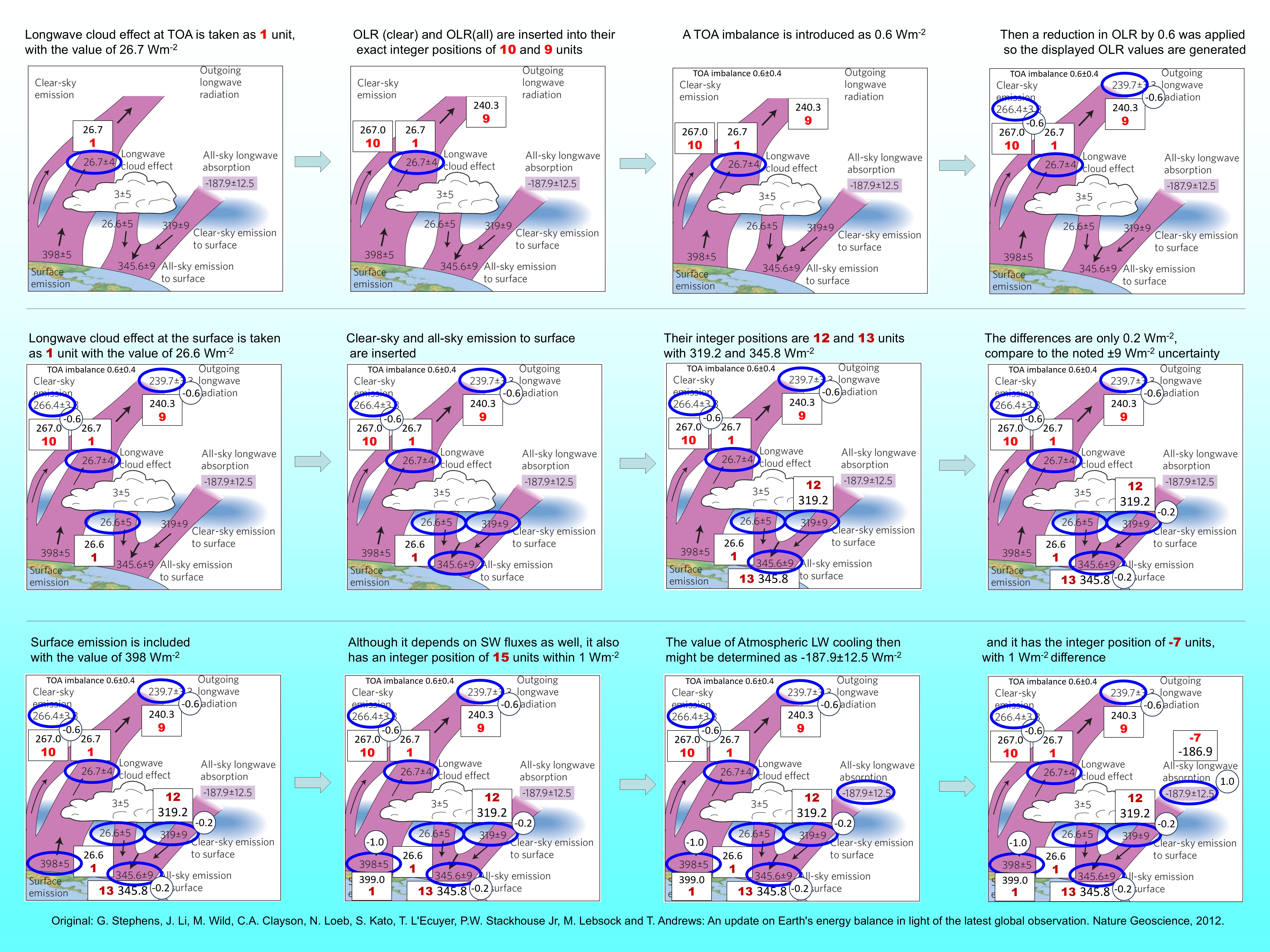
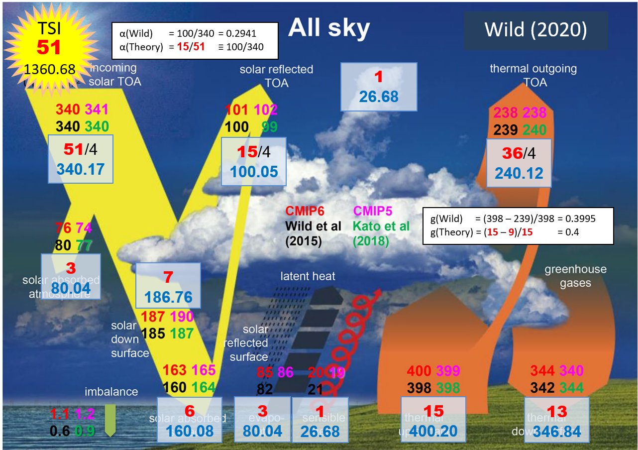
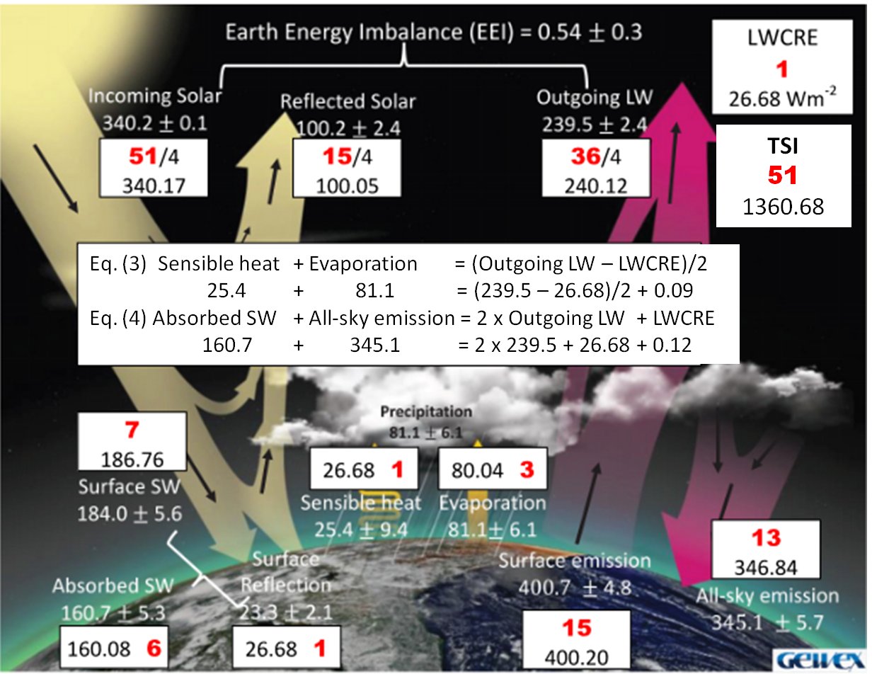
Towards Reassessing the Cryosphere Contribution to Earth’s Energy ImbalanceEGU26-3513 | ECS | Orals | CL2.1
Stratospheric Temperature Adjustment Damps the State Dependence of CO2 Radiative ForcingEGU26-4028 * | Orals | CL2.1 | Highlight
The Atmosphere’s Substantial Role in Interannual Variability of Earth’s Energy ImbalanceEGU26-4554 | ECS | Posters on site | CL2.1
Understanding the Atmospheric Energy Budget using Global Precipitation ObservationsEGU26-4877 | ECS | Orals | CL2.1
Attribution of Land Surface Albedo Changes in China over the Last 40 YearsEGU26-7093 | ECS | Posters on site | CL2.1
Contrasting Energy And Water Balance Regimes Between A Rewetted Peatland And An Abandoned Peat Extraction Area In EstoniaEGU26-7194 | Posters on site | CL2.1
Assessing changes and variability of surface and top-of-the-atmosphere shortwave and longwave radiation with satellite dataEGU26-8351 | ECS | Orals | CL2.1
The energetic expression of monthly atmospheric heat transport variabilityEGU26-8776 | ECS | Posters on site | CL2.1
Understanding the Impact of Arctic Cloud Fraction on Surface Shortwave Radiation: Recent ProgressEGU26-9120 | ECS | Orals | CL2.1
The impact of vegetation response to CO2 on energy fluxes at Earth's surface and top of atmosphereEGU26-9729 | Posters on site | CL2.1
The radiation and energy budget over Antarctic Sea Ice: Insights from the SURFEIT ProjectEGU26-10955 | ECS | Posters on site | CL2.1
Assessing the impact of 3d cloud structures on broadband fluxes derived from synthetic satellite radiancesEGU26-13181 | ECS | Posters on site | CL2.1
Spatial solar irradiance emulation of Monte Carlo ray tracing with multi-view all-sky imageryEGU26-13929 | ECS | Posters on site | CL2.1
Quantifying radiative effects of the cloud–clear-sky transition using ground-based infrared imageryEGU26-14365 | ECS | Orals | CL2.1
Biases in Historical SSTs Propagate to Key Metrics of Radiative Balance and Global ChangeEGU26-15081 | ECS | Orals | CL2.1
Two decades of AERONET analysis of fine and coarse-mode aerosols impacts on radiative forcingEGU26-17301 | ECS | Orals | CL2.1
Attributing temperature trends across altitudes using a surface energy balance approachEGU26-17419 | ECS | Posters on site | CL2.1
Sampling the Earth's energy imbalance with the Earth Climate Observatory (ECO) constellation - insights regarding shortwave anisotropyEGU26-17592 | ECS | Posters on site | CL2.1
Simple functional representations of gas absorption for efficient climate model radiation schemesEGU26-17875 | ECS | Orals | CL2.1
From dusk till dawn: the role of the atmospheric limb in observations of Earth’s energy imbalanceEGU26-20034 | ECS | Orals | CL2.1
An Inverse Approach for Ocean Heat Content Estimation Using Altimetry, Gravimetry, and In-situ DataEGU26-20760 | ECS | Orals | CL2.1
Towards ground-to-space spectral radiative closure in the thermal infrared with PREFIREEGU26-21756 | ECS | Posters on site | CL2.1
Decadal-Scale Observations of the Impact of South Asian Pollution Outflow on the Radiation over the Northern Indian OceanEGU26-898 | ECS | Posters on site | CL2.3
Risk Assessment of Extreme Precipitation in Ulaanbaatar, MongoliaEGU26-2782 | ECS | Orals | CL2.3
Transferability of land-cover and urban-form effects on near-surface air temperature across European citiesEGU26-4601 | ECS | Posters on site | CL2.3
Impacts of Surface Radiative Properties on the Urban Microclimate and Outdoor Thermal Comfort in a High-Density Urban AreaEGU26-5149 | Posters on site | CL2.3
Impacts of Urbanization on Sunshine Duration across China: The Role of Clean Air PoliciesEGU26-5694 | ECS | Orals | CL2.3
Crowd-Grid & Recent Heat Packs: From Crowdsourced Observations to a Prototype Climate ServiceEGU26-5920 | ECS | Posters on site | CL2.3
High-Resolution Land Surface Temperature Mapping for Urban Climate Applications Using Satellite Fusion and Machine Learning in Google Earth EngineEGU26-6767 | ECS | Orals | CL2.3
Microclimate measurements for quantifying climate adaptation impact of urban redevelopmentEGU26-8231 * | ECS | Orals | CL2.3 | Highlight
SciWalK: An interdisciplinary Urban Climate and Biodiversity Learning Lab integrating Microclimate Measurement and Adaptation StrategiesEGU26-9757 | ECS | Orals | CL2.3
Analysis of thermo-pluviometric long-period trends for an ultra-centenary urban data seriesEGU26-10141 | ECS | Orals | CL2.3
An Open-Source Framework for Accessible Community Land Model Urban SimulationsEGU26-10179 | ECS | Posters on site | CL2.3
Learning Urban Climate Dynamics via Physics-Guided Urban Surface–Atmosphere InteractionsEGU26-10983 | ECS | Orals | CL2.3
Observed impact of fragmented urban areas on downwind precipitationEGU26-11316 | ECS | Orals | CL2.3
How regional spatial planning shapes suburban heat stress: Scenario-based PALM simulations around Graz, AustriaEGU26-11362 | ECS | Posters on site | CL2.3
SMART-TWIN: Transforming urban climate science into planning practice using a geospatial digital twinEGU26-11376 | ECS | Posters on site | CL2.3
SMART-TWIN: Setup and Application of the Urban Climate Model PALM-4U for the City of WürzburgEGU26-11400 | ECS | Posters on site | CL2.3
Comparing Deep Learning-based downscaling and the SURFEX land surface model on representing temperature extremes and the urban heat island in ParisEGU26-11487 | ECS | Orals | CL2.3
Can measurement and reanalysis data act as suitable forcing data for neighborhood-level PALM-4U simulations?EGU26-11576 * | Orals | CL2.3 | Highlight
Integrated urban climate studies – first experiences and results from the interdisciplinary project inteGREENEGU26-11586 | Orals | CL2.3
From Climate Knowledge to Planning Practice: Urban Climatic Maps in German CitiesEGU26-11968 | Orals | CL2.3
Machine Learning in Urban Morphology and Urban Climate: Prospects and ApplicationsEGU26-12239 | ECS | Orals | CL2.3
Localizing Convection‑Permitting Regional Climate Model Output for Urban Climate Impact AssessmentEGU26-12371 | ECS | Orals | CL2.3
Characterization of thermally-driven flows and their interaction with the urban heat island in MadridEGU26-12414 | ECS | Posters on site | CL2.3
Deep Learning-Driven Downscaling for the Urban Climate of the Megacity of São Paulo at High ResolutionEGU26-12443 | ECS | Orals | CL2.3
High-resolution modelling of heat stress across Ireland using the Universal Thermal Climate IndexEGU26-13311 | ECS | Orals | CL2.3
Meter-scale radiative transfer process modelling in complex urban environments: a PALM model validation studyEGU26-13641 | ECS | Posters on site | CL2.3
Digital Strategy for Evaluating Thermal Comfort and Air Quality in Urban Planning of RD920 in the Île-de-France RegionEGU26-13649 | ECS | Orals | CL2.3
Multi-scale observations and urban canopy modelling of heat exposure in a Mediterranean coastal cityEGU26-13797 | ECS | Posters on site | CL2.3
A 2-m temperature deep learning emulator of the UrbClim model for European citiesEGU26-14185 | Posters on site | CL2.3
Coupling Urban Energy and Microclimate Models to Quantify High Albedo Pavement Cooling Effects in AntwerpEGU26-14329 | Posters on site | CL2.3
From Urban Hydrometeorological Observations to Action Across Three European CitiesEGU26-14886 | ECS | Posters on site | CL2.3
Transferable Land Use Regression Models for Urban Heat Island Assessment Using Street-Level Air Temperature DataEGU26-15726 | ECS | Orals | CL2.3
Leveraging temperature–mortality risk relationship to identify most effective urban heat adaptation sitesEGU26-15807 | ECS | Posters on site | CL2.3
Assessing urban heatwave conditions using a three-dimensional zone-based air temperature frameworkEGU26-18723 | ECS | Posters on site | CL2.3
Unprecedented warming over the past 30 years in Berlin, Germany, unaffected by urban effectsEGU26-18981 | ECS | Orals | CL2.3
High-density thermo-hygrometric observations for urban heat and thermal exposure assessment in Valencia (Spain)EGU26-19656 | ECS | Posters on site | CL2.3
Impact of urban form and antecedent weather on urban green space cooling deficits derived from multi-decadal Landsat LSTEGU26-19983 | ECS | Orals | CL2.3
Quantifying the Cooling Reach of Urban Vegetation: A Linear Park Case Study in São PauloEGU26-20283 | Orals | CL2.3
A study on optical and thermal signatures of the tree canopy-urban surface systemsEGU26-20329 | ECS | Posters on site | CL2.3
Urban heat extremes in REMO2020-TEB convection-permitting regional climate simulations over EuropeEGU26-20489 | ECS | Posters on site | CL2.3
Urban Heat Effects and Targeted Adaptation under Extreme Events in the Lakeside City: A Case Study of Konstanz, GermanyEGU26-20780 | Orals | CL2.3
Urban influences on cloud patterns over Europe from satellite observationsEGU26-21184 | ECS | Orals | CL2.3
An Operational Uncertainty-Aware Framework for Urban Heat Mapping in City-Scale Digital TwinsEGU26-22596 | Posters on site | CL2.3
Long-term impact of urban areas on meteorological conditions on Prague urban climateEGU26-564 | ECS | Orals | CL2.4
Two Decades of Phenocam Studies: Progress and Challenges in Tropical Phenology EcosystemsEGU26-2871 | ECS | Posters on site | CL2.4
Artificial light reduced the temperature responsiveness of Ginkgo budburstEGU26-3758 | Posters on site | CL2.4
Agroclimatic characterization and climate change trends in Spanish wine-growing regionsEGU26-3795 | Posters on site | CL2.4
Thermal requirements and climate trends of Japanese plum (Prunus salicina Lindl.) in the main producing regions of SpainEGU26-3881 | ECS | Orals | CL2.4
Synchronization in Phenological Time uncovers two-Phase Temperature Control of Leaf Fall TimingEGU26-7713 | ECS | Posters on site | CL2.4
Summer daytime cooling, not nighttime cooling, induces earlier bud set and leaf senescence in European beechEGU26-8634 | ECS | Posters on site | CL2.4
Understory leaf phenology exhibits greater sensitivity than overstory to extreme drought in a subtropical forestEGU26-8824 | ECS | Orals | CL2.4
Latitudinal differences in induction of endodormancy in extratropical treesEGU26-9015 | Posters on site | CL2.4
Provenance-specific chilling and forcing requirements regulate spring phenology of three European temperate tree speciesEGU26-11392 | ECS | Posters on site | CL2.4
Floral vs. vegetative structure fingerprints identified by terrestrial laser scanning intensityEGU26-11811 | ECS | Orals | CL2.4
Trait–climate mediation, not herbivory avoidance, shapes leaf emergence strategies in global dry tropicsEGU26-12004 | ECS | Orals | CL2.4
Bud traits capture inter-species differences in bud temperature dynamicsEGU26-12746 | Posters on site | CL2.4
Expanding DWD phenology monitoring through crowdsourced plant reports and AI-enabled data partnershipEGU26-12782 | Posters on site | CL2.4
From field observations to AI-based phenology: an overview of advances in monitoring ecosystem responses to climate changeEGU26-13207 | ECS | Posters on site | CL2.4
The SwissPhenoCam dataset: Country-scale phenology monitoring at the individual tree levelEGU26-14519 | ECS | Posters on site | CL2.4
Snowmelt timing has a stronger effect on northern spring green-up in non-forest than forest ecosystemsEGU26-15822 | ECS | Orals | CL2.4
Cold hardiness dynamics contain adaptive traits that provide phenology information during the dormant seasonEGU26-16670 | ECS | Orals | CL2.4
A novel data-driven phenology model reveals how and why seasonal timing shifts under climate changeEGU26-16727 | ECS | Posters on site | CL2.4
The Increased Effect of Spring Leaf Unfolding on Autumn Senescence in the Northern and Southern HemispheresEGU26-17035 | ECS | Posters on site | CL2.4
Airborne pollen concentrations in and around Ingolstadt, Germany: a three-year observational studyEGU26-17557 * | ECS | Orals | CL2.4 | Highlight
Who Is Heard? A New Bioacoustic Indicator to Assess Climate Change Impacts on Alpine Bird CommunitiesEGU26-18459 | Posters on site | CL2.4
Homogenizing pheno-cam data to understand Sentinel-1 backscatter dynamicsEGU26-18555 | ECS | Posters on site | CL2.4
Spatial Trends in Tree Phenology in the Bohemian Forest Ecosystem over the Last Two DecadesEGU26-19649 | Posters on site | CL2.4
Simulating grapevine phenology with IVINE and UTOPIA models: a case study on the Timorasso cultivarEGU26-20740 | ECS | Orals | CL2.4
Is flowering phenology driving rapid changes in forest trees reproductive synchrony?EGU26-21647 | ECS | Posters on site | CL2.4
Assessing Heatwave Impacts on Western Greece and Peloponnese Vineyards Through Remote SensingEGU26-1416 | ECS | Posters on site | CL2.5 | Highlight
Detecting and calibrating large biases in global onshore wind power assessment across temporal scalesEGU26-10439 | Posters on site | CL2.5
Overview and latest updates of the GCOM-C/SGLI products and expanding data accessibilityEGU26-13633 | ECS | Posters on site | CL2.5
Go with the floe: Spatio-temporal evolution of Arctic sea ice albedo using satellite imagery in a Lagrangian frameworkEGU26-15031 | ECS | Posters on site | CL2.5
Impact of Arctic Sea Ice Heterogeneity on Surface Reflectance Evaluated with Airborne ImageryEGU26-15353 | Posters on site | CL2.5
Observation and Warning Algorithms for Low-Level Wind Shear at Airports in Xinjiang, ChinaEGU26-15449 | ECS | Posters on site | CL2.5
Extended-range Forecast Skill and Source Attribution of Daily Wind Power Density over Tropical LandsEGU26-15848 | Posters on site | CL2.5
Bias-Corrected MOST Hub-Height Wind Estimates from Dynamical Downscaling for Offshore Wind AssessmentEGU26-16277 | Posters on site | CL2.5
Consistent Multi-Mission Time Series for Global Assessment of Ecosystems Dynamics and DisturbanceEGU26-21636 | ECS | Posters on site | CL2.5
Recent decline in wind energy potential in South Asia and its projected recoveryEGU26-1669 | Posters on site | CL2.7
Meteorological observations in the expeditions by H. Clapperton into the interior of Africa, 1822-1827.EGU26-3028 | Orals | CL2.7 | Highlight
Unlocking the gold mine - making international climate data from the National Meteorological Archive available for climate scienceEGU26-3807 | ECS | Posters on site | CL2.7
The Reassessment of Monthly Minimum Temperature Extremes Across IrelandEGU26-4579 | ECS | Orals | CL2.7
Forgotten storms of the past: extreme rainfall events in New South Wales during the 19th centuryEGU26-7221 | ECS | Orals | CL2.7
HIST-DAILY: A dataset of daily and sub-daily European weather observations before 1900EGU26-10352 | Posters on site | CL2.7
The ReData Project: Scanning and Digitization of Historical Daily Weather Bulletins through Citizen ScientistsEGU26-10795 | ECS | Orals | CL2.7
Data rescue of historical meteorological observations from the Island of Ireland (1783 – 1939)EGU26-11001 | ECS | Posters on site | CL2.7
Cli-DaRe@Images: Citizen Science for Italian Climate Data Rescue with ImagesEGU26-11652 | ECS | Posters on site | CL2.7
Retrieval of unexploited historical snow data from hydrological yearbooks in the Italian AlpsEGU26-12088 | Posters on site | CL2.7
Digitization of Historical Meteorological Data from Africa: Extending the Dieci e Lode ProjectEGU26-12213 | ECS | Posters on site | CL2.7
The Cli-DaRe project for the recovery of historical Italian meteorological data and construction of long-term precipitation seriesEGU26-21478 | Orals | CL2.7
How Reliable Are Automated Homogenization Methods for Early Climate Records?EGU26-260 | ECS | Orals | AS1.34
Using Backwards Trajectories to Estimate Atmospheric Rivers’ Contributions to Colorado’s Wettest DaysEGU26-1034 | ECS | Posters on site | AS1.34
Structural Characteristics of Moisture Transport Systems over the Indian Subcontinent during the Summer MonsoonEGU26-3564 | ECS | Posters on site | AS1.34
Global Atmospheric River Historical Data Record: Combining AR Detection and Intensity CategorizationEGU26-3710 | ECS | Posters on site | AS1.34
Atmospheric Rivers as Drivers of Precipitation Variability and Flood ExtremesEGU26-4283 | ECS | Posters on site | AS1.34 | Highlight
Impeded Arctic sea ice recovery: The role of declining southeastern North Atlantic atmospheric riversEGU26-4381 | ECS | Posters on site | AS1.34
Dynamic Factors Dominate the Summer Precipitation Intensity of Atmospheric Rivers Landfalling Eastern ChinaEGU26-9462 | Orals | AS1.34
Impacts of Thermal Heating over the Tibetan Plateau on Atmospheric River ActivityEGU26-9523 | ECS | Posters on site | AS1.34
Improving Atmospheric River Forecast Over Himalayas using Convolutional Neural NetworkEGU26-9930 | ECS | Posters on site | AS1.34
Multi-Model Evaluation of Atmospheric River Forecast Skill and Uncertainty over the HimalayasEGU26-10210 | Posters on site | AS1.34
Atmospheric rivers around Antarctica are behind daily global temperature spikes and dipsEGU26-11549 | ECS | Orals | AS1.34
Anatomy of atmospheric rivers: the internal signature of extreme eventsEGU26-11748 | ECS | Orals | AS1.34
Atmospheric rivers and energy transport in a hierarchy of idealized modelsEGU26-18467 | Posters on site | AS1.34
Major differences between two atmospheric reanalyses seen by an aerosol atmospheric river detection algorithmEGU26-18470 | ECS | Posters on site | AS1.34
Network Analysis of Atmospheric River Moisture Transport: Connectivity, Trend, and ClimatologyEGU26-22609 | ECS | Posters on site | AS1.34
Landfalling Atmospheric Rivers in Ireland: Statistical and Machine Learning InsightsEGU26-2300 | Orals | AS1.20
Characterizing Blocking Mobility and Its Role in Northern Hemisphere Cold ExtremesEGU26-2492 | ECS | Posters on site | AS1.20
The Influence of Tropopause Potential Vorticity Circulation Forcing on the Development of the East Asian Cold Wave in December 2023EGU26-2689 | ECS | Orals | AS1.20
Resolution Sensitivity of Rossby Wave Breaking and Warm Conveyor Belts in Global ICON SimulationsEGU26-3038 | ECS | Posters on site | AS1.20
Quantifying the influence of Barents-Kara sea ice loss on Ural blockingEGU26-3695 | ECS | Posters on site | AS1.20
The importance of polar and singular waveguides for the occurrence of Rossby wave resonanceEGU26-4663 | Posters on site | AS1.20
Interdecadal changes and the role of Philippine Sea convection in the intensification of Indian spring heatwavesEGU26-4697 | ECS | Orals | AS1.20
The theory and climatological characteristics of nonstationary horizontally Rossby wavesEGU26-6203 | ECS | Posters on site | AS1.20
MJO modulation on the cold extreme over the North America in a recent decadeEGU26-6369 | ECS | Posters on site | AS1.20
A manipulator of the extreme precipitation in South China behind the tropical sea surface temperature: the polar front jetEGU26-6800 | ECS | Orals | AS1.20
Seasonal and regional jet stream changes, their drivers, and how to connect them.EGU26-8490 | ECS | Orals | AS1.20
Rossby wave phase tracing and its application to the structure of the Pacific–Japan teleconnectionEGU26-11470 | ECS | Posters on site | AS1.20
Decadal changes in the teleconnection of winter precipitation across Eurasian mountainous regionsEGU26-12607 | ECS | Posters on site | AS1.20
Comparison of Different Blocking Indices and Analysis of Underlying Dynamics and Synoptic SituationsEGU26-14616 | Posters on site | AS1.20
Method dependence of Antarctic atmospheric blocking and implications for large-scale circulation and climate extremesEGU26-15695 | ECS | Posters on site | AS1.20
Influences of planetary- and synoptic-scale Rossby waves on the intraseasonal variability of Yangtze River Basin precipitation in summerEGU26-16164 | Posters on site | AS1.20
A role of cold air outbreak in an early winter heavy snowfall event over the Korean PeninsulaEGU26-20078 | ECS | Posters on site | AS1.20
Dynamical linkage between blocking predictability and jet stream quasi-stationary statesEGU26-20138 | ECS | Orals | AS1.20
Linking jet stream and Rossby wave spectra changes within internal variability and climate change responsesEGU26-21982 | ECS | Posters on site | AS1.20
Decadal Evolution of Mid-latitude Jet Stream Dynamics: Spatio-temporal Trends and Seasonal Oscillations over North America and the North Pacific OceanEGU26-23268 | Posters on site | AS1.20
Atmospheric waveguides, quasi-stationary waves, and temperature extremesEGU26-2115 | ECS | PICO | HS7.9
Atmospheric Feedbacks to Improved Subsurface Hydrology in a km-Scale Earth System Model (ICON–JSBACH)EGU26-6959 | PICO | HS7.9
Global trends in atmospheric dryness dominated by Clausius-Clapeyron scalingEGU26-10910 | ECS | PICO | HS7.9
Climatological Drivers of Pan Evaporation in the Riau Islands, IndonesiaEGU26-18321 | ECS | PICO | HS7.9
Deep root vegetation adaptations to drought and their modulation of evapotranspiration (ET) in AfricaEGU26-18978 | ECS | PICO | HS7.9
Irrigation boosts precipitation on cropland for international trade through atmospheric moisture transportEGU26-1783 | Orals | AS1.38
Dust Storms and Long-Range Transport of Dust by Kelvin Waves in East AsiaEGU26-2133 | ECS | Posters on site | AS1.38
Role of North Atlantic warming in the extremely hot summer of 2023 in North ChinaEGU26-2506 | Posters on site | AS1.38
Synoptic background and microphysical characteristics of a rare needle snow eventEGU26-3017 | ECS | Posters on site | AS1.38
The role of moisture source and temperature anomalies in the 2022 European DroughtEGU26-4218 | ECS | Posters on site | AS1.38
Convection-Permitting RegCM Simulations of the September 2024 Czechia Floods: Sensitivity to Microphysics and Soil MoistureEGU26-5137 | Orals | AS1.38
Examining extreme weather events in the Middle East: Trends and future outlooks.EGU26-5391 | ECS | Posters on site | AS1.38
Environment-dependent hail hazard maps from high-resolution modellingEGU26-6320 | ECS | Posters on site | AS1.38
Recently Intensified Extreme Precipitation in Late Spring in the Hengduan MountainsEGU26-6393 | ECS | Posters on site | AS1.38
Recent global intensification of per capita exposure to extreme precipitationEGU26-6588 | ECS | Orals | AS1.38
Assessing the performance of the CERRA dataset in reproducing extreme weather events in PolandEGU26-6658 | ECS | Orals | AS1.38
Stable decline in global surface relative humidity masks the distinct intensification of extremesEGU26-6961 | ECS | Posters on site | AS1.38
Coherent Modes of Northern Hemisphere Wind Extremes and Their Links to Global Large-Scale DriversEGU26-8991 | ECS | Orals | AS1.38
Sensitivity of extreme 2022 Pakistan precipitation to physics parametrization options in WRFEGU26-9971 | Orals | AS1.38
Climate Extremes in Europe: A Comparative Analysis of Climate Model DatasetsEGU26-11774 | Posters on site | AS1.38
Performance of two global models in forecasting extreme rainfall volumes over southern BrazilEGU26-12007 | Orals | AS1.38
Effect of Low-Level Jets on the Movement of the Mei-Yu Front and Heavy RainfallEGU26-13517 | ECS | Posters on site | AS1.38
Moisture sources of extreme precipitation events in Northern EuropeEGU26-15335 | ECS | Posters on site | AS1.38
The effect of remapping techniques in assessing extreme precipitation events in CMIP6 models over West AfricaEGU26-16899 | Posters on site | AS1.38
Availability of Newly Developled Reginal Climate Data for Improving Reproducibility of Extreme EventsEGU26-18338 | ECS | Orals | AS1.38
The 2023 record-breaking heatwave in North Africa: characteristics and driving mechanismsEGU26-2363 | ECS | Orals | BG1.1
Extratropical lightning fires burn increasingly more severe than human-ignited firesEGU26-3494 | ECS | Posters on site | BG1.1
Climate-cooling impacts from post-fire snow-albedo for the 2023 Canadian fires seasonEGU26-4268 | Orals | BG1.1
Increasing global human exposure to wildland fires despite declining burned areaEGU26-4614 | ECS | Orals | BG1.1
Strong Shortwave Absorption by Wildfire Brown Carbon from Global Observations and ModelingEGU26-5840 | Orals | BG1.1
Quantifying Downwind Deposition of Wildfire-Emitted Particles to EcosystemsEGU26-5864 | ECS | Orals | BG1.1
Prescribed Fire Opportunities in the European Mediterranean under Climate ChangeEGU26-8017 | ECS | Orals | BG1.1
Annual Litter Fuel Load Estimation from Optimality-Derived Litterfall and Decomposition DynamicsEGU26-9005 | ECS | Orals | BG1.1
Impacts of 2023 Canadian wildfire emissions on solar power over North America and EuropeEGU26-9088 | Posters on site | BG1.1
Impacts of the 2019 extreme Indonesian wildfires on black carbon across Southeast AsiaEGU26-10325 | ECS | Orals | BG1.1 | Highlight
Tropical Small-Scale Nuclear War Fire Emissions Cause Greater Ozone Depletion Than Extratropical Large-Scale ConflictsEGU26-11423 | Posters on site | BG1.1
Integrating the Global Forest Fire Emissions Prediction System version 1.0 to GEOS-ChemEGU26-11440 | Orals | BG1.1
A global CO fire emissions assessment and its connection with drought eventsEGU26-14942 | ECS | Orals | BG1.1
Wildfire-driven Stratospheric Perturbations:Modelling Insights from the Australian WildfiresEGU26-15336 | ECS | Orals | BG1.1
Analysis of long-term fire-related deforestation and cover change dynamics in South American ecosystemsEGU26-17500 | Orals | BG1.1
Environmental factors disrupting the adaptive advantage of fire-trait syndromesEGU26-18115 | ECS | Posters on site | BG1.1
Top-down carbon monoxide fire emissions over South America correlated with global climate indicesEGU26-18182 | ECS | Orals | BG1.1
How forest management, land abandonment, and protected areas affect wildfire occurrenceEGU26-18932 | Posters on site | BG1.1
Trends in fire activity and associated fire-induced soil-dust emissions over the last two decadesEGU26-19257 | Posters on site | BG1.1
Critical analysis of Fire Radiaive Power derived by hyperspectral sensors from spaceEGU26-192 | ECS | PICO | AS3.5
Evaluation of WRF-Chem aeolian dust emission and land surface models over the dust belt.EGU26-943 | ECS | PICO | AS3.5
UAV observations to reveal new insights into dust particle morphology and orientationEGU26-3933 | ECS | PICO | AS3.5
Seasonal variability of mineral dust composition on an alpine snowpack in the Tateyama Mountains, JapanEGU26-5689 | ECS | PICO | AS3.5
Re-evaluating Dust Emission Potential from Burned Surfaces on Vegetated Dunes in the Southwest KalahariEGU26-10600 | ECS | PICO | AS3.5
Improving dust emission in WRF-Chem GOCART scheme using a high-resolution erodibility datasetEGU26-11564 | PICO | AS3.5
Dust-driven droplet freezing explains cloud-top phase in the northern extratropics.EGU26-12288 | ECS | PICO | AS3.5
The chemical and mineralogical composition of southern African dust aerosolsEGU26-14556 | ECS | PICO | AS3.5
Loess deposits record stable Mid-Pleistocene hydroclimate during phases of human occupation of Central AsiaEGU26-18628 | ECS | PICO | AS3.5
How well do climate models represent dust events over the Mediterranean, North Africa, and the Middle East?EGU26-19364 | ECS | PICO | AS3.5 | Highlight
Experimental Characterisation of the Electric and Magnetic Fields Generated by Dust DevilsEGU26-19688 | ECS | PICO | AS3.5
The Pb, Nd, and Sr isotopic characterisation of dust sources in North Africa and Western Asia.EGU26-1797 | ECS | Posters on site | AS3.23
Record growth of stratospheric aerosols from 2019 Raikoke eruption with sulfate-coating of submicronic ashEGU26-6092 | Posters on site | AS3.23
Seasonal Timing Controls ENSO Responses to Tropical Volcanic EruptionsEGU26-7896 | ECS | Orals | AS3.23
Evaluation of the CMIP7 historical stratospheric aerosol forcing datasetEGU26-8219 | ECS | Posters on site | AS3.23
Stratospheric Aerosol Particle Size Explains Divergent Limb and Solar Occultation Measurements After the Hunga EruptionEGU26-9285 | ECS | Posters on site | AS3.23
Water vapor impacts from the 2022 Hunga eruption on the Arctic stratospheric polar vortex and surface temperaturesEGU26-9868 | ECS | Posters on site | AS3.23
Exploring the role of SO2 emission altitude in the 1912 eruption of Katmai/NovaruptaEGU26-11343 | ECS | Posters on site | AS3.23
Towards a transfer function for tropospheric volcanic sulfur emissions: The Holuhraun 2014-2015 eruptionEGU26-13104 | ECS | Posters on site | AS3.23
Evolution of optical parameters of volcanic and wildfire plumes in the stratosphere from CALIOP and ATLID observationsEGU26-13126 | Orals | AS3.23 | Highlight
Do CMIP6 models agree on the climate response in Eurasian winter to major volcanic eruptions since 1850?EGU26-14229 | Posters on site | AS3.23
Using simple models to understand the global mean temperature response to volcanic aerosol forcingEGU26-14419 | ECS | Posters on site | AS3.23
Trajectory hunting for linking stratospheric aerosol extinction measurements: validation with OSIRIS and application to the 2022 Hunga Tonga eruptionEGU26-17112 | ECS | Posters on site | AS3.23
An assessment of the stratospheric temperature response to volcanic sulfate injections from recent Model Intercomparison ProjectsEGU26-17957 | ECS | Posters on site | AS3.23
Simulated modulation of stratospheric polar vortices by the Hunga Tonga-Hunga Ha’apai eruptionEGU26-21627 | Posters on site | AS3.23
Measurements and interactive modeling of the 1960s stratospheric aerosol layerEGU26-22524 | Orals | AS3.23
Residence time of Hunga stratospheric water vapour perturbation quantified at 9 yearsCL3.1 – Future Climate – Climate Change: From Regional to Global
EGU26-1779 | Posters on site | CL3.1.1
Influence of the previous North Atlantic Oscillation (NAO) on the spring dust aerosols over North ChinaEGU26-1782 | Posters on site | CL3.1.1
Low-frequency features during the two typical extreme cold events in ChinaEGU26-2505 | Posters on site | CL3.1.1
Winter cold extremes over the eastern North America: Pacific origins of interannual-to-decadal variabilityEGU26-2717 | ECS | Posters on site | CL3.1.1
Increased Interannual Variability of Snowfall Frequency in Eurasia during Autumn after 2000EGU26-3311 | ECS | Orals | CL3.1.1
Extreme storm track seasons and their influence on wind and precipitation extremesEGU26-3912 | ECS | Posters on site | CL3.1.1
Dynamic and Thermodynamic Drivers of Precipitation Change in Mediterranean-type ClimatesEGU26-4093 | ECS | Orals | CL3.1.1
Robust Identification of Impactful Boreal Summer Anticyclones and Implications for Future ClimateEGU26-4856 | ECS | Posters on site | CL3.1.1
Bridging Regional Hydroclimatic Extremes and Atmospheric Blocking: A German Case StudyEGU26-4905 | ECS | Posters on site | CL3.1.1
Interdecadal variation in the relationship between November Barents Sea Ice and the subsequent March Eurasian surface air temperatureEGU26-5040 | ECS | Orals | CL3.1.1
Contributions of synoptic and planetary-scale drivers to precipitation extremesEGU26-5268 | ECS | Orals | CL3.1.1
Role of the atmospheric circulation in the observed warming over Europe using a neural network.EGU26-5678 | ECS | Orals | CL3.1.1
Role of the stratosphere in the January 2025 Pan-Atlantic Event: A Case Study of Storm ÉowynEGU26-7026 | ECS | Orals | CL3.1.1
Data-Driven Discovery of Non-Linear Weather Regimes driving Regional Precipitation Extremes in EuropeEGU26-7876 | Posters on site | CL3.1.1
Increasing March Daily Temperature Variation over East Asia: Roles of Atmospheric Circulation and Global WarmingEGU26-8303 | ECS | Orals | CL3.1.1
Trends in Northern Hemisphere cold spells across the winter periods 1980/81-2024/25EGU26-9731 | ECS | Orals | CL3.1.1
Variability of Hot Days in the Middle Latitudes of Europe between 1973 and 2024EGU26-12363 | ECS | Orals | CL3.1.1
Northern Hemisphere warming hotspots linked to intensified tripole wind anomaly patternsEGU26-13081 | ECS | Orals | CL3.1.1
IArctic land surface hydrology influences on regional and hemispheric temperature and circulation responsesEGU26-14213 | ECS | Posters on site | CL3.1.1
Pathways and processes leading to the warming of air masses in northern hemispheric summer anticyclonesEGU26-14620 | ECS | Orals | CL3.1.1
How Eddy Heat Fluxes Shape the Resolution-Dependent Atmospheric Response to North Atlantic SST AnomaliesEGU26-14690 | Posters on site | CL3.1.1
The influence of circulation types on drought variability in CroatiaEGU26-15011 | ECS | Posters on site | CL3.1.1
Flood discharge in Europe influenced by atmospheric blockingEGU26-15469 | Posters on site | CL3.1.1
Causes of inter-model uncertainty in projecting future summer extreme precipitation changes over eastern ChinaEGU26-16564 | ECS | Posters on site | CL3.1.1
Summer warming in the Northern Hemisphere midlatitudes amplified by tropical-extratropical interactionsEGU26-17908 | ECS | Posters on site | CL3.1.1
Enhanced Impact of Arctic Sea Ice on Asian Cold Extremes: Interannual Variability Driven by ENSO and NAOEGU26-18725 | ECS | Orals | CL3.1.1
AI reconstruction of European temperature and precipitation anomalies from Euro-Atlantic weather regimesEGU26-19853 | ECS | Orals | CL3.1.1
Identifying Climatological Regions and Driving Mechanisms of FrontogenesisEGU26-20140 | ECS | Posters on site | CL3.1.1
Circulation versus background warming: drivers of European hot and wet extremes since 1980EGU26-21038 | ECS | Posters on site | CL3.1.1
Strengthened Influence of Preceding Winter ENSO on the Following Early Autumn Precipitation in Southeast China since the Early 2000sEGU26-22703 | Posters on site | CL3.1.1
Synoptic circulation types related to the boundary layer height in Augsburg, GermanyEGU26-3322 | ECS | Orals | CL3.1.2
Increased frequency and intensification of convective downdrafts with warming in km-scale simulationsEGU26-4031 | ECS | Posters on site | CL3.1.2
A multi-year sensitivity analysis of microphysical parameterization in convection-permitting simulations over the Black Sea BasinEGU26-9494 | ECS | Orals | CL3.1.2
Towards global km-scale climate simulations at the Met Office Hadley CentreEGU26-9810 | Posters on site | CL3.1.2
Fewer but More Intense: Future Changes in Extreme Precipitation Cells from Global Kilometer-Scale Climate ModelingEGU26-11191 | Posters on site | CL3.1.2
Microphysics-based 1-km city-scale ensemble simulations of future extreme precipitation events over IstanbulEGU26-11223 | Posters on site | CL3.1.2
Usefulness of very-high-resolution simulations for a national climate serviceEGU26-13404 | ECS | Posters on site | CL3.1.2
Sensitivity Analysis of ICOsahedral Nonhydrostatic (ICON) Simulations at Convection Permitting Resolutions over Western TürkiyeEGU26-15160 | ECS | Posters on site | CL3.1.2
Added value of convection-permitting models for precipitation in the CORDEX FPS-Convection ensembleEGU26-17647 | ECS | Posters on site | CL3.1.2
Do Short-Duration Rainfall Extremes Intensify Faster? Evidence From CPM Simulations Over EuropeEGU26-825 | ECS | Orals | CL3.1.3
Attributing the 2023 São Sebastião Record Rainfall Using a Forecast-Based FrameworkEGU26-1592 | ECS | Orals | CL3.1.3
Attribution of compound flooding: The case of the subsequent hurricanes Eta and Iota in HondurasEGU26-3108 | ECS | Posters on site | CL3.1.3
Impact attribution methods for complex extremes; learnings from the COMPASS Use CasesEGU26-3652 | ECS | Posters on site | CL3.1.3
Anthropogenic and atmospheric circulation drivers of the record-breaking low sunshine event over Southeast China in 2024EGU26-3896 | ECS | Posters on site | CL3.1.3
Dynamical adjustment reveals detectable and attributable changes in European winter rainfallEGU26-4082 | ECS | Orals | CL3.1.3
Multi-method extreme event attribution: Motivation, case study, and implicationsEGU26-5201 | ECS | Orals | CL3.1.3
Attributing the 2022 European maize failure on anthropogenic climate changeEGU26-7004 | ECS | Orals | CL3.1.3
Heat-related mortality attributable to human-induced climate change in Brazil’s low-income population.EGU26-7268 | ECS | Posters on site | CL3.1.3
Testing An Optimal Fingerprinting Method to Separate the Greenhouse Gas and Aerosol Forced Responses in ObservationsEGU26-7273 | Orals | CL3.1.3
Attributing the July 2021 Ahr flood across the hydrological impact chainEGU26-7833 | Posters on site | CL3.1.3
Climate change attribution of Serbian summer heatwaves in 2024 and 2025EGU26-8696 | Posters on site | CL3.1.3
Detection and Attribution of Climate Change over the Tibetan PlateauEGU26-9054 * | ECS | Orals | CL3.1.3 | Highlight
Educational Losses and Damages Attributable to Anthropogenic Climate Change: End-to-End Attribution Evidence from South AfricaEGU26-11290 | ECS | Orals | CL3.1.3
Constructing DAMIP-based detrended reanalyses for event attribution: design of the ATTRICI-DAMIP datasetEGU26-11834 | ECS | Posters on site | CL3.1.3
Improvements in the representation of heat extremes in Western Europe in the new EURO-CORDEX generationEGU26-11842 | ECS | Orals | CL3.1.3
From Observation to Attribution: Evaluating Nudged-Circulation CESM2 Burnt Area SimulationsEGU26-11860 | ECS | Orals | CL3.1.3
An enhanced methodology to evaluate natural variability in ClimaMeterEGU26-11925 | ECS | Orals | CL3.1.3
A framework for the automated detection and attribution of heatwavesEGU26-12189 | ECS | Posters on site | CL3.1.3
Using global spectrally nudged storylines to attribute anthropogenic amplification of the 2024 Valencia DANA extreme precipitation eventEGU26-13172 | ECS | Posters on site | CL3.1.3
Capturing uncertainty from internal variability in climate attribution within single realisationsEGU26-14488 | ECS | Posters on site | CL3.1.3
Attribution of extreme river flow conditions: A new framework using global climate model-driven river discharge simulationsEGU26-14634 | Posters on site | CL3.1.3
Extreme Precipitation Events in Peru: A Data-Driven Classification and Large-Scale Ocean Controls over the past four decadesEGU26-15221 | ECS | Posters on site | CL3.1.3
Assessing the contribution of elevated CO₂–induced surface resistance changes to referenceevapotranspiration trends over South AsiaEGU26-17150 | Orals | CL3.1.3
Understanding the model uncertainty of future changes in extreme precipitation eventsEGU26-17246 | ECS | Orals | CL3.1.3
Climate change modifies atmospheric river precipitation: a global storyline approachEGU26-17616 | ECS | Posters on site | CL3.1.3
Drivers of Uneven Urban Heatwave Hazard Across Europe: Mechanisms and Risk AssessmentEGU26-18252 | ECS | Posters on site | CL3.1.3
Emerging evidence of anthropogenic influence on weather extremes at the regional scale: Formalising and iterating the IPCC Hexagon mapsEGU26-18669 | ECS | Orals | CL3.1.3
Beyond Attributing Precipitation Extremes: Warming Partly Counteracts Climate Change-Driven Flood IncreasesEGU26-18753 | ECS | Orals | CL3.1.3
Event attribution of climate change impacts on child undernutrition via crop production in IndiaEGU26-19199 | ECS | Posters on site | CL3.1.3
Revisiting probabilistic extreme-event attribution under multiple forcings and nonlinear responses to global warmingEGU26-19213 | Orals | CL3.1.3
On the use of different climate counterfactuals in health impact attributionEGU26-19298 | Posters on site | CL3.1.3
Non-stationary time series attribution for heatwaves over EuropeEGU26-20355 | ECS | Orals | CL3.1.3
Global Patterns of Detection and Emergence in Extreme Sea LevelsEGU26-21624 | ECS | Orals | CL3.1.3
Attribution of Dengue Outbreak Risk to Climate Change-Driven Changes in Extreme Events in ColombiaEGU26-22711 | Orals | CL3.1.3
Estimating the sea level rise responsibility of industrial carbon producersEGU26-740 | ECS | Posters on site | CL3.1.4
A Bayesian Non-Stationary Framework for Bivariate Compound Flood Risk Assessment Along the Indian CoastEGU26-757 | ECS | Posters on site | CL3.1.4
Aridification is Driven by Water-Cycle Acceleration Over the Mediterranean RegionEGU26-1181 | ECS | Orals | CL3.1.4
Weakened sea breeze circulation driven by atmospheric heatwaves in the western MediterraneanEGU26-2084 | Posters on site | CL3.1.4
Potential Global Sequestration of Atmospheric Carbon Dioxide by Drylands ForestationEGU26-3650 | ECS | Posters on site | CL3.1.4
A Modular Framework Relating European Flood Losses to Rainfall Return PeriodsEGU26-10098 | ECS | Orals | CL3.1.4
Heatwave statistics under changing baselines: threshold sensitivity across Mediterranean climate regimesEGU26-10147 | ECS | Posters on site | CL3.1.4
A Climate-Informed Generalized Extreme Value Model for Global Precipitation ExtremesEGU26-11019 | Posters on site | CL3.1.4
Weather-State-based evaluation of Mediterranean precipitation in climate models using satellite observationsEGU26-11495 | ECS | Posters on site | CL3.1.4
Towards Robust Tail Risk Estimation for Freezing Rain Hazard: A Bayesian Extreme Value ApproachEGU26-14430 | ECS | Posters on site | CL3.1.4
Dominant Spatio-Temporal Modes of Mediterranean Heat Budget VariabilityEGU26-15177 * | Posters on site | CL3.1.4 | Highlight
California Water Supply & Distribution Basics; Context for Climate & Drought ResilienceEGU26-16062 | Posters on site | CL3.1.4
Revisiting the Historical Wintertime Drying of the Mediterranean in the LESFMIP SimulationsEGU26-19239 | Posters on site | CL3.1.4
Future changes and associated uncertainties over the Mediterranean Climate RegionsEGU26-3591 | Posters on site | CL3.1.5
The Impact of Aerosol Size on the Efficacy of Marine Cloud BrighteningEGU26-3837 | ECS | Posters on site | CL3.1.5
Not All 1.5°C Worlds Are Equal: Mitigation versus Solar Radiation ModificationEGU26-6807 | ECS | Orals | CL3.1.5
Surface temperature dependence of stratospheric sulfate aerosol clear-sky forcing and feedbackEGU26-8144 | Posters on site | CL3.1.5
AI for Safe Climate Cooling: Deep Learning and XAI for Rapid SRM Risk AssessmentEGU26-8392 | Posters on site | CL3.1.5
Effect of Solar Radiation Modification on Freezing Level Heights across the worldEGU26-8458 | Posters on site | CL3.1.5
Influence of Stratospheric Aerosol Geoengineering on Chlorophyll Concentration in the Congolese Upwelling SystemEGU26-9275 | Posters on site | CL3.1.5
Legacy of stratospheric aerosol injection for limiting global warmingEGU26-9663 | Posters on site | CL3.1.5
Quantifying and understanding uncertainties in regional impacts of solar geoengineeringEGU26-11499 | ECS | Orals | CL3.1.5
From Qualitative to Quantitative: A Systematic Framework for Measuring SAI EfficacyEGU26-13659 | ECS | Posters on site | CL3.1.5
Impact of SAI on extra-tropical cyclones in a high-resolution simulationEGU26-14171 | ECS | Orals | CL3.1.5
Trajectories of Atmospheric Rivers in the Southern Hemisphere under CMIP6 and Solar Radiation ModificationEGU26-20438 | ECS | Posters on site | CL3.1.5
Water isotopologues as tracers of mixed-phase cloud processes at the Pi Chamber laboratoryEGU26-20764 | ECS | Orals | CL3.1.5
A framework for understanding and narrowing modeling uncertainties for Stratospheric Aerosol Injection (SAI)EGU26-22164 | ECS | Posters on site | CL3.1.5
Understanding the role of mean state biases in the stratospheric response to SAIEGU26-3907 | ECS | Posters on site | CL3.1.6
Temperature variability projections remain uncertain after constraining them to best performing Large Ensembles of individual Climate ModelsEGU26-4672 | ECS | Orals | CL3.1.6
Emergence of decadal linkage between Western Australian coast and Western–central tropical PacificEGU26-9105 | ECS | Posters on site | CL3.1.6
Internal Climate Dynamics Underpin the Recent Decadal Reversal of Eurasian Summer Diurnal Temperature RangeEGU26-10143 | ECS | Posters on site | CL3.1.6
Change in Equatorial SST Variability in CMIP6Climate ModelsEGU26-15550 | ECS | Orals | CL3.1.6
A surrogate modeling framework for inferring internal variability and forced change in surface ozoneEGU26-15774 | ECS | Posters on site | CL3.1.6
An Assessment of Multivariate Bias Correction Effects and Model Consistency in CMIP6 Monthly Precipitation TrendsEGU26-16058 | ECS | Posters on site | CL3.1.6
The Disappearing Subsurface Western Boundary Current in the Northern Hemisphere Under a Warming ClimateEGU26-17120 | ECS | Orals | CL3.1.6
Recent Temperature and Energy Imbalance Trends Point to Higher Estimates of Future WarmingEGU26-18229 | Posters on site | CL3.1.6
A New Statistical Approach for Rapid Attribution of Extreme Weather EventsEGU26-19985 | Posters on site | CL3.1.6
Large-ensemble climate model data for impact attribution and projectionsEGU26-20747 | Orals | CL3.1.6
Using climate model analogs form large ensembles to attribute drought eventsEGU26-90 | ECS | Posters on site | AS3.9
Analyzing Temporal Aerosol Distribution over Pakistan Using MODIS Data and Their Socio-Economic ImpactsEGU26-764 | ECS | Posters on site | AS3.9
Spatial Shift of Heatwave Hotspots in India: Unraveling the Roles of AerosolsEGU26-1989 | Posters on site | AS3.9
Instant and Delayed Effects of Autumn Black Carbon Aerosols Over South Asia on Arctic and Eurasian Surface Air TemperatureEGU26-2042 | Posters on site | AS3.9
Increasing weather extremes in China attributed to rising greenhouse gases and declining aerosolsEGU26-2945 | Posters on site | AS3.9
Enhanced Springtime Frontal Precipitation in Southern China Induced by Anthropogenic Aerosol MitigationEGU26-3371 | Posters on site | AS3.9
From muted to rapid surface warming over India under changing aerosol emissionsEGU26-3770 | ECS | Posters on site | AS3.9
The Variable Impact of Aerosol Reduction on Tropical Cyclone PrecipitationEGU26-5555 | ECS | Orals | AS3.9 | Highlight
Nuclear Conflict in Eastern Europe: Climate Disruption & Radiological FalloutEGU26-6629 | Posters on site | AS3.9
Rapid adjustments to black carbon cause precipitation invigoration in monsoon regionsEGU26-12557 | Posters on site | AS3.9
Strengthening of the East Asian Summer Monsoon in response to local and remote reductions in anthropogenic aerosolEGU26-14479 | Orals | AS3.9
Observational Constraints on Atmospheric Black Carbon in the Climate SystemEGU26-15915 | ECS | Orals | AS3.9
Aerosol Emissions Drive Observed and Modeled Hydrological Trends in Arid and Semiarid RegionsEGU26-17612 | ECS | Posters on site | AS3.9
Airborne characterization of black carbon properties in fresh and aged wildfire plumes over southern FranceEGU26-17775 | ECS | Posters on site | AS3.9
Multi-decadal source apportionment of South Asia wintertime and summertime sulfate using δ³⁴S–SO₄²⁻ and emission-inventory-based model estimatesEGU26-20632 | ECS | Posters on site | AS3.9
Advancing Carbonaceous Aerosol Characterization in India to Improve Regional Climate Risk AssessmentEGU26-11 | ECS | Posters on site | AS1.27
Causal inference and mediation for summer precipitation over middle and lower reaches of the Yangtze RiverEGU26-172 | ECS | Posters on site | AS1.27
Understanding Future changes in Semi-Permanent Systems and associated Rainfall during the Indian Summer MonsoonEGU26-1105 | ECS | Posters on site | AS1.27
QBW Dynamics and Multiscale Interactions in Contrasting Indian Summer Monsoon YearsEGU26-1289 | ECS | Posters on site | AS1.27
A Monsoon Bridge Across Continents: Untangling the Strengthening Link Between Indian and Sahel RainfallEGU26-1399 | ECS | Posters on site | AS1.27
Contrasting Effects of Aerosols and Greenhouse Gases on Subseasonal Variability of the Indian Summer MonsoonEGU26-2130 | Posters on site | AS1.27
Fading influence of El Niño-Southern Oscillation on East Asian Summer Monsoon Northern Boundary after the late-1980sEGU26-2136 | ECS | Posters on site | AS1.27
Evolving subseasonal impacts of the Western Pacific pattern on winter temperature over South KoreaEGU26-2763 | ECS | Orals | AS1.27
Can monsoon low pressure systems propagate even under reduced mean monsoon precipitation?EGU26-2941 | ECS | Orals | AS1.27
Anatomy of moist heatwaves in India during the summer monsoon seasonEGU26-3603 | ECS | Posters on site | AS1.27
Strengthening linkage between the Boreal Summer Intraseasonal Oscillation and extreme rainfall events over IndiaEGU26-3634 | Posters on site | AS1.27
Atmospheric Stabilization Weakened Proto-Low-Level Jet over the IndianOcean during the Eocene HothouseEGU26-7065 | ECS | Orals | AS1.27
A novel constraining method for a better description of the Indian monsoon precipitation changeEGU26-7070 | Posters on site | AS1.27
Summer PM2.5 concentrations in the northern subtropics modulated by the Hadley circulation edge locationEGU26-7201 | Posters on site | AS1.27
Western North Pacific Tropical cyclones act to suppress its adjacent Hadley circulationEGU26-7218 | Posters on site | AS1.27
Summer tropical Atlantic drives autumn North American Arctic warming through western Pacific BridgeEGU26-7402 | Orals | AS1.27 | Highlight
The 2025 Indian summer monsoon and its 17 western disturbances – beyond unprecedented?EGU26-8197 | Posters on site | AS1.27
Glacial Changes in Indian Summer Monsoon δ¹⁸O Driven by Circulation and Moisture-Source ShiftsEGU26-9006 | Orals | AS1.27
Weakened influence of ENSO on the East Asian summer monsoon since the early 2000sEGU26-9416 | Posters on site | AS1.27
Insignificant future changes in decadal variability of East Asian summer monsoon rainfallEGU26-10366 | ECS | Posters on site | AS1.27
Investigating monsoon dynamics in CMIP6 models using a combination of novel and classic energetic frameworksEGU26-11139 | Orals | AS1.27
Monsoon hysteresis reveals atmospheric memory: implications for Arctic winter sea iceEGU26-12911 | Orals | AS1.27
The height of the Himalaya exceeded a climate tipping point 11 million years agoEGU26-14438 | ECS | Orals | AS1.27
Robustness of the South American monsoon system to an AMOC collapse in a kilometer-scale atmosphere-only modelEGU26-14692 | ECS | Posters on site | AS1.27
Atlantic-Pacific constructive interference drives decadal East Asian Summer Monsoon variationsEGU26-15250 | ECS | Posters on site | AS1.27
How ENSO modifies the Boreal summer intraseasonal oscillation (BSISO) in the Asian monsoon regionEGU26-15994 | ECS | Posters on site | AS1.27
Seasonal-Intraseasonal Coupling and Systematic CMIP6 Biases in the Indian Summer MonsoonEGU26-16982 | ECS | Posters on site | AS1.27
Proxy-Model Constraints on Holocene Indian Summer Monsoon Variability and Seasonality in Northwest IndiaEGU26-17955 | Posters on site | AS1.27
Dynamics and evolution of a case study monsoon depression in a high-resolution simulation of the Met Office Unified ModelEGU26-18476 | ECS | Posters on site | AS1.27
Centennial variability of the Afro-Asian monsoon during the HoloceneEGU26-1551 | ECS | Orals | AS1.28
Interactions between the tropical moist margin and extratropical Rossby waves for rainfall extremesEGU26-2900 | ECS | Posters on site | AS1.28
Downstream development of the extratropical transition of tropical cyclones in the Southern HemisphereEGU26-3247 | ECS | Posters on site | AS1.28
Process-based understanding of improved MJO propagation across the Maritime Continent in GloSea6EGU26-3922 | Posters on site | AS1.28 | Highlight
The 2024 Hajj heat disaster: a glimpse into the futureEGU26-4642 | ECS | Orals | AS1.28
The Energy-Pump Mechanism Behind Dubai ‘16•4’ Record-Breaking RainfallEGU26-6352 | Posters on site | AS1.28
Abrupt climate change in the Arabian Peninsula mediated by the subtropical jet stream dynamicsEGU26-9468 | ECS | Posters on site | AS1.28
Sub-seasonal predictability of heavy precipitation–associated cyclones in the SaharaEGU26-9909 | Posters on site | AS1.28
The influence of El Niño-Southern Oscillation on cool-season precipitation variability in the arid Middle EastEGU26-11724 | ECS | Posters on site | AS1.28
A tropical Pacific convection ENSO index suitable for measuring the impact of ENSO on the East Asian winter monsoonEGU26-13690 | ECS | Orals | AS1.28
Mechanisms of South Pacific hydroclimate variability on decadal to multi-decadal time scalesEGU26-13880 | ECS | Orals | AS1.28
Seasonal and synoptic scale circulation linked to dry spring conditions in BrazilEGU26-20465 | Posters on site | AS1.28
The Link Between Rossby Wave Breaking and the Maintenance of Tropical-Extratropical Cloud Bands over the South PacificEGU26-1933 | ECS | Posters on site | AS4.1
Influence of pacific decadal oscillation on decadal precipitation variation over the Yellow River BasinEGU26-2444 | ECS | Posters on site | AS4.1
Simultaneous Megapluvials in Southwestern North and South America During the Last MillenniumEGU26-3501 | ECS | Posters on site | AS4.1
Decadal Oceanic Variability Amplified Recent Heatwave in the Northern HemisphereEGU26-3743 | Posters on site | AS4.1
Impacts of Arctic and tropical climate variability on spring wildfires in West Siberia and the predictive roleEGU26-3783 | ECS | Posters on site | AS4.1
Positive AMO–La Niña synergy enhances recent East Asian dust activity via hydrothermal anomaliesEGU26-3904 | ECS | Posters on site | AS4.1
Analysis of the Impact of Urbanization on Groundwater in the Arid and Semi-Arid Yellow River BasinEGU26-5232 | ECS | Posters on site | AS4.1
Enhanced global extreme droughts driven by the Indian Ocean and Pacific Ocean on decadal timescalesEGU26-8387 | ECS | Posters on site | AS4.1
Escalating risks of anomalously hot–dry growing seasons in arid Northwest China under human influenceEGU26-8996 | ECS | Posters on site | AS4.1
External and internal controls on decadal precipitation variability over North AmericaEGU26-10245 | ECS | Posters on site | AS4.1
Modeling the multi-scale temporal variability of fog harvesting potential in the coastal Atacama regionEGU26-11720 | Posters on site | AS4.1
How much we know about precipitation climatology over Tianshan Mountains––the Central Asian water towerEGU26-21717 | ECS | Posters on site | AS4.1
Elevation-dependent wheat yields variations under climate changesEGU26-2818 | ECS | Posters on site | AS1.19
How Cyclone Dynamics Shape Hydroclimate Trends in the MediterraneanEGU26-2977 | Orals | AS1.19 | Highlight
The importance of diabatic processes for the dynamics of synoptic-scale extratropical weather systemsEGU26-3416 | ECS | Orals | AS1.19
Extreme cyclones in the western Mediterranean under future climate changeEGU26-4918 | Posters on site | AS1.19
Trends in Severe Convective Storm Activity over Europe (1983–2024)EGU26-6779 | ECS | Posters on site | AS1.19
Spatial clustering of severe European winter windstorms on intra-seasonal timescalesEGU26-7050 | ECS | Posters on site | AS1.19
What favours the midlatitude survival of cyclones of tropical origin (CTOs)?EGU26-7271 | ECS | Posters on site | AS1.19
Thermodynamic drivers intensify future European frontal precipitation extremes, while frontal dynamics remain largely unchangedEGU26-7768 | ECS | Posters on site | AS1.19
The impact of secondary ice production on the dynamics of extratropical cyclonesEGU26-8260 | ECS | Orals | AS1.19
On the dissipation of negative potential vorticity in the upper troposphereEGU26-8442 | ECS | Posters on site | AS1.19
Observing mesoscale frontal convection and dry intrusions during NAWDIC using multi-dropsonde measurementsEGU26-12653 | ECS | Posters on site | AS1.19
Explosive cyclogenesis and high-impact winds in storm Éowyn in January 2025: sensitivities to simulation setup and latent heatingEGU26-12757 | ECS | Posters on site | AS1.19
A June 2023 case study on the effect of cold-frontal convective cells on frontal synoptic flowEGU26-13117 | ECS | Posters on site | AS1.19
Sensitivity of Extratropical Cyclone Poleward Motion to Low-Level Potential VorticityEGU26-13145 | ECS | Posters on site | AS1.19
Tracing Moist Diabatic Processes with Water Isotopes: Overview of NAWDICiso’s Multi-Platform ObservationsEGU26-13935 | ECS | Orals | AS1.19
A Lagrangian climatology of coupled extratropical cyclones and mesoscale convective systemsEGU26-16684 | ECS | Posters on site | AS1.19
The sensitivity analysis of Arctic cyclone structure and characteristics in ensemble forecastEGU26-17992 | Posters on site | AS1.19
Impact of the distribution of sea surface temperature on the maintenance of storm tracksEGU26-18028 | ECS | Posters on site | AS1.19
Forecast errors attributed to synoptic features and the role of diabatic heating for extratropical cyclonesEGU26-20660 | ECS | Posters on site | AS1.19
Latent heating contribution to storm intensification across seasons and climates - A potential vorticity approachEGU26-20835 | ECS | Posters on site | AS1.19
A climatology of North Atlantic extratropical cyclones using piecewise potential vorticity inversionEGU26-21033 | ECS | Posters on site | AS1.19
Impact of eddy-rich ocean resolutions in the representation of midlatitude storm in global climate modelsEGU26-23197 | Posters on site | AS1.19
Diabatics processes across scales in the extratropics: Workshop summary and research prioritiesEGU26-2245 | Posters on site | AS1.23
Kilometer-Scale Convection-Permitting Simulations in Representing Winter Precipitation over the Indian HimalayasEGU26-3384 | ECS | Posters on site | AS1.23
Systematic analysis of flow-orography interactionin idealized numerical simulationsEGU26-4515 | ECS | Orals | AS1.23
Future alpine precipitation extremes under high-impact atmospheric circulation patternsEGU26-4643 | ECS | Posters on site | AS1.23
Convection-Permitting Projections of Summer Extreme Precipitation Over the Tibetan PlateauEGU26-4921 | ECS | Posters on site | AS1.23
From Global to Regional: The Added Value of High-Resolution Dynamical Downscaling for Precipitation in Southwest Asia's Complex TerrainEGU26-6475 | ECS | Posters on site | AS1.23
ERA5L Temperature validation in the Extended European Alpine RegionEGU26-6869 | ECS | Posters on site | AS1.23
Exploring the complex dynamic of summer extreme events in the European Alpine Region using the high-resolution CORDEX-FPS ensembleEGU26-8111 | ECS | Posters on site | AS1.23
Anabatic Flows over Idealized Mountain Ridges and the Relation between Slope Angle and Turbulence AnisotropyEGU26-8916 | Posters on site | AS1.23
East Asian Spring Precipitation and its Dry Trend revealed by CMIP6 High-Resolution Coupled ModelsEGU26-9157 | ECS | Orals | AS1.23
Impact of black carbon on slope and valley winds in idealised simulationsEGU26-10153 | ECS | Posters on site | AS1.23
Missing drag due to orographic gravity waves in a global numerical weather prediction modelEGU26-10268 | ECS | Posters on site | AS1.23
Differences in the Dominant Modes of the Interannual Variability of Eastern Tibetan Plateau Precipitation between Early and Peak SummersEGU26-11637 | ECS | Orals | AS1.23
Coupling between Free Tropospheric Warming and Elevated Surface WarmingEGU26-12250 | Posters on site | AS1.23
Optimizing Meteorological Station Placement for High-Resolution Field Reconstruction in Mountainous TerrainEGU26-13277 | ECS | Posters on site | AS1.23
Representing local-scale temperature patterns in complex terrain: performance of high-resolution datasetsEGU26-13515 | ECS | Posters on site | AS1.23
Recent high-altitude observations (2013-2024) of extreme air temperatures and associated atmospheric circulation patterns in the tropical AndesEGU26-14380 | Orals | AS1.23
Is bias correction necessary for CPRCM-driven flood simulation in mountainous region?EGU26-15032 | Posters on site | AS1.23
CIMAs: A multi-source climate dataset for high-mountain environments in the Iberian Central SystemEGU26-15938 | ECS | Orals | AS1.23
Ground validation of high-resolution WRF model precipitation estimates over ColombiaEGU26-16406 | Posters on site | AS1.23
SPARTACUS version 3: An improved gridded climate dataset for Austria at daily resolutionEGU26-16598 | ECS | Orals | AS1.23
Modelling the black carbon dynamics over Almaty, Kazakhstan, during winter and summer seasons.EGU26-20304 | ECS | Orals | AS1.23
Large scale atmospheric drivers of intraseasonal snowfall variability on Kilimanjaro's glaciersEGU26-21196 | ECS | Posters on site | AS1.23
High-resolution WRF modeling in the Pyrenees: Sensitivity to static data for complex terrainEGU26-6771 | ECS | Orals | AS4.2
Spatial and temporal patterns of fog and low clouds in the Polar regionsEGU26-10742 | ECS | Orals | AS4.2
How can EarthCARE satellite observations help improve Greenland’s clouds in the regional climate model RACMO?EGU26-11006 | ECS | Posters on site | AS4.2
Quantifying drivers of the thermal-infrared radiative effect of Arctic low-level clouds in cold air outbreaksEGU26-12413 | ECS | Posters on site | AS4.2
Atmospheric transport characteristics during warm-air intrusions – focusing on aerosol, energy, and moisture transportEGU26-12546 | ECS | Orals | AS4.2
Quantifying the temporal variability of water vapor in Ny-Ålesund and its relation to weather systemsEGU26-14343 | ECS | Posters on site | AS4.2
New insights into Arctic mixed-phase clouds from airborne and EarthCARE observationsEGU26-14797 | Posters on site | AS4.2
Toward enhanced retrievals of supercooled droplet properties in Antarctic cloudsEGU26-15936 | ECS | Orals | AS4.2 | Highlight
Observed cloud and atmospheric drivers of surface radiation change 2001-2023 on the North Slope of AlaskaEGU26-16990 | ECS | Posters on site | AS4.2
Model analysis of convective precipitation in the ArcticEGU26-17535 | ECS | Posters on site | AS4.2
Cloud state transitions at Ny-Ålesund: A machine learning supported statistical analysisEGU26-17911 | Posters on site | AS4.2
A decade beneath Arctic clouds: Continuous radar observations at Ny-Ålesund, SvalbardEGU26-18430 | ECS | Posters on site | AS4.2
Exploring Aerosol-Cloud Interactions in Arctic Mixed-Phase Clouds Using ICON-LEMCL3.2 – Future Climate – Climate and Society
EGU26-718 * | ECS | Orals | CL3.2.1 | Highlight
Heatwave Differences Between Overshoot and Non-Overshoot Conditions Under Identical Emissions and WarmingEGU26-2709 | ECS | Orals | CL3.2.1
Understanding mechanisms of the Zero Emission Commitment using MIROC-ES2LEGU26-5638 | ECS | Orals | CL3.2.1
Asymmetric Responses of Temperature to Increasing vs Decreasing CO2 ConcentrationsEGU26-6802 | ECS | Orals | CL3.2.1
State Dependence of Zero Emissions Commitment (ZEC) in Multi-Model TIPMIP SimulationsEGU26-11614 | Posters on site | CL3.2.1
Comparison of Compound Marine Extremes Under Overshooting vs straight-stabilization ScenariosEGU26-11739 | ECS | Orals | CL3.2.1
Systematic comparison of emulation techniques for regional climate under temperature overshoot scenariosEGU26-13648 | ECS | Orals | CL3.2.1
Peak warming and remaining carbon budgets under different methane emission targetsEGU26-14793 | ECS | Posters on site | CL3.2.1
Indirect Effects of Non-CO2 Forcings on Carbon Budgets in Overshoot pathwaysEGU26-15018 | ECS | Orals | CL3.2.1
Non-CO2 effects of carbon dioxide removal methods influence temperature response in overshoot scenariosEGU26-15351 | ECS | Orals | CL3.2.1
The Role of Carbon Cycle Feedbacks in the Land and Ocean Response to Zero EmissionsEGU26-15451 | ECS | Posters on site | CL3.2.1
Modelling solar radiation modification in process-based integrated assessment modelsEGU26-15764 | Posters on site | CL3.2.1
Exploring the Critical Role of Mycorrhizal Fungi in Forest Carbon Sequestration: Evidence from Taiwan SpruceEGU26-17472 | ECS | Orals | CL3.2.1
Assessing the reversibility of temperature and precipitation extremes under AMOC weakening and recoveryEGU26-17772 | ECS | Orals | CL3.2.1
Investigating local drivers of heat extremes in a net-zero climate modelEGU26-18277 | ECS | Posters on site | CL3.2.1
Atmospheric temperature response to ambitious climate mitigation scenarios from RESCUEEGU26-19913 | Posters on site | CL3.2.1
Is permafrost thaw reversible in policy-relevant overshoot scenarios?EGU26-20234 | ECS | Posters on site | CL3.2.1
Probabilistic assessment of land-based carbon dioxide removal and biospheric feedbacks under overshoot pathwaysEGU26-20544 | Orals | CL3.2.1
Impacts of land-use-environment interactions on sources and sinks of CO2EGU26-20551 | ECS | Orals | CL3.2.1
Weaker than expected future ocean carbon uptake due to carbon-climate feedbacksEGU26-22552 | ECS | Orals | CL3.2.1
Irreversibility of permafrost region carbon pool changes under temperature overshoot scenariosEGU26-1535 | ECS | Orals | CL3.2.4
Regional aerosol changes modulate the odds of record-breaking heat extremesEGU26-2212 * | Orals | CL3.2.4 | Highlight
Challenges and Opportunities for Understanding Societal Impacts of Climate ExtremesEGU26-2537 | ECS | Orals | CL3.2.4
Dry and moist convective upper bounds for extreme surface temperaturesEGU26-2749 | Posters on site | CL3.2.4
Co-occurrence of large hail and heatwaves in European regions in current and future climate scenariosEGU26-2967 | ECS | Posters on site | CL3.2.4
Separating dynamic and thermodynamic contributions in Mediterranean extreme precipitation (in a storyline approach)EGU26-3456 | ECS | Orals | CL3.2.4
Demonstrating the plausibility of worst-case month-long heatwave storylines in Western EuropeEGU26-3579 | ECS | Posters on site | CL3.2.4
ERA5-Based Validation of Thermodynamic Extreme Heatwave Drivers of the Paris region in CMIP6 simulations.EGU26-4864 | ECS | Posters on site | CL3.2.4
Assessing the UNSEEN Flood-Relevant Winter Extreme Precipitation Over the Island of Ireland in the Present ClimateEGU26-5916 | ECS | Posters on site | CL3.2.4
Identify the worst-case scenario where extreme weather has the greatest impact on the global staple crop tradeEGU26-8004 | ECS | Posters on site | CL3.2.4
Better serving impact assessments via AI: Reconstructing daily extremes from spatiotemporal downscaling of monthly fieldsEGU26-8241 | ECS | Posters on site | CL3.2.4
A process-based physical climate storyline for the Hercules storm in Portugal: extreme coastal flooding under climate changeEGU26-9800 | ECS | Posters on site | CL3.2.4
Sensitivity of Storm Boris rainfall intensification to wind nudging strength in event-based climate-change storyline simulationsEGU26-10410 | ECS | Orals | CL3.2.4
Extreme rainfall attribution distorted by structural warming biases in climate modelsEGU26-10755 | ECS | Posters on site | CL3.2.4
Ensemble boosting of extreme precipitation in the AlpsEGU26-11244 | ECS | Posters on site | CL3.2.4
Investigating Climate Change Impacts on the 2020 extreme Meiyu Through Global Variable-Resolution Ensemble Subseasonal HindcastsEGU26-11790 | Posters on site | CL3.2.4
Exploring the changing dynamics of atmospheric blocking with a modified event-based storyline approachEGU26-12438 | Orals | CL3.2.4
Surface flux contributions to Mediterranean heatwaves: a new Lagrangian diagnosticEGU26-12603 | ECS | Posters on site | CL3.2.4
The influence of sea surface temperatures on moisture sources of Central European Storm Boris in September 2024EGU26-12831 | ECS | Posters on site | CL3.2.4
Towards actionable storylines: development of a reproducible workflowEGU26-13076 | ECS | Orals | CL3.2.4
Global characterisation of the vertical temperature anomaly structure of heat extremes over land in ERA5EGU26-13386 | Posters on site | CL3.2.4
An emergent constraint for the future frequency of European windstormsEGU26-13482 | ECS | Orals | CL3.2.4
Global projections of short-duration rainfall extremes using temperature-covariate modelsEGU26-13840 * | ECS | Orals | CL3.2.4 | Highlight
Behind or ahead of committed warming: what it means for future hot extremesEGU26-14325 | ECS | Orals | CL3.2.4
A combined storyline-statistical approach for conditional attribution of climate extremes to global warmingEGU26-14525 | Posters on site | CL3.2.4
Extreme weather events in agriculturally important regions in the Bay of BengalEGU26-14618 | ECS | Orals | CL3.2.4
Evolution of global climate and regional hot extremes following CO2 emissions cessation.EGU26-14884 | ECS | Posters on site | CL3.2.4
Emerging intra-annual sequences of climate extremes in EuropeEGU26-15041 | ECS | Orals | CL3.2.4
Amplified socioeconomic impacts of compound drought–heatwave eventsEGU26-15607 | ECS | Orals | CL3.2.4
Intensification of Short-Duration Extreme Precipitation in Greater SydneyEGU26-18203 | ECS | Orals | CL3.2.4
Heat extremes in subseasonal hindcasts: a General Extreme Value perspectiveEGU26-18736 | ECS | Orals | CL3.2.4
An Up-HILL Battle: Building consensus on terminology for high impact climate events and tipping point risks.EGU26-19875 | ECS | Posters on site | CL3.2.4
Using Stochastic Data to Simulate and Communicate Alternative Multi-Hazard Weather Extreme EventsEGU26-19952 | ECS | Posters on site | CL3.2.4
Circulation pathways and surface drivers of extreme summer heat stress over EuropeEGU26-21160 | ECS | Posters on site | CL3.2.4
The influence of soil moisture on the extreme precipitation event in July 2021 in Western EuropeEGU26-21435 | ECS | Orals | CL3.2.4
Robust response of Antarctic sea ice to large-scale wind anomalies across different climate backgroundsEGU26-4007 | ECS | Orals | CL3.2.6
Reanalysis Datasets for Climate Services in Italy: Validation and Inter-ComparisonEGU26-4686 | Posters on site | CL3.2.6
Advancing Climate Prediction for the Pacific Islands: Validation of Updates to the PICASO Forecast SystemEGU26-6991 * | Posters on site | CL3.2.6 | Highlight
Climate Services as Public Infrastructure: Lessons from European Research PartnershipsEGU26-10087 | Posters on site | CL3.2.6
Co-developing seamless climate information for the wine sectorEGU26-11307 | ECS | Posters on site | CL3.2.6
Analog climates for Franconian viticulture – Using in depth principal component analysis and a multitude of indicatorsEGU26-12230 | ECS | Orals | CL3.2.6
Assessing the value of climate services for public authorities in EuropeEGU26-12283 | ECS | Posters on site | CL3.2.6
Strengthening Climate Services through Innovative Business ModelsEGU26-16818 | Posters on site | CL3.2.6
Adaptation to climate change: Regional scenarios for the North Sea and the Baltic SeaEGU26-18209 | ECS | Posters on site | CL3.2.6
From Projections to Policy: Embedding Climate Services in National Decision-Making in IrelandEGU26-1491 | ECS | Orals | CL3.2.8
pH-Equilibrated Ocean Alkalinization: Mesoscale Evaluation of Long-Term StabilityEGU26-1980 | ECS | Orals | CL3.2.8
Certification and MRV requirements to operationalise geological offsets in the aviation sectorEGU26-2948 | Posters on site | CL3.2.8
A Fundamental Study on Soil-Based Carbon Dioxide Removal Using Amine-Functionalized Modified Red MudEGU26-5667 | ECS | Orals | CL3.2.8
The impacts of ocean- and land-based Carbon Dioxide Removal on Planetary BoundariesEGU26-6763 | ECS | Posters on site | CL3.2.8
Baseline Assessment of Carbonate System Parameters and Trace Metals in the North Sea: Implications for Monitoring Ocean Alkalinity EnhancementEGU26-7055 | Orals | CL3.2.8
Advancing Monitoring Reporting and Verification for marine Carbon Dioxide RemovalEGU26-10111 | ECS | Posters on site | CL3.2.8
Temporary carbon dioxide removal to offset short-lived climate forcersEGU26-13642 | ECS | Posters on site | CL3.2.8
Understanding the ethics and scalibility of emerging Direct Air Capture approachesEGU26-14134 | ECS | Orals | CL3.2.8
Carbon Dioxide Removal by Construction Waste: Experimental Assessment of CO2 Capture EfficiencyEGU26-14750 | ECS | Orals | CL3.2.8
Subnational Patterns in Carbon Dioxide Removal Deployment in the United StatesEGU26-15868 | Orals | CL3.2.8
Dusting the rust off ocean iron fertilization research studies for mCDREGU26-17442 | Posters on site | CL3.2.8
Equivalence between carbon dioxide emissions and removals: A framework for net-zero accountingEGU26-17542 | Orals | CL3.2.8 | Highlight
Toward Credible Carbon Dioxide Removal: Harmonized Accounting and Data Gaps Across Six CDR ApproachesEGU26-17876 | ECS | Orals | CL3.2.8
Climate impacts of afforestation in temperate regions: a regional assessment in MongoliaEGU26-17966 | ECS | Orals | CL3.2.8
Challenges of efficiency calculations for OAE in the Earth System Model FOCIEGU26-18169 | Orals | CL3.2.8
Using the Seasonal Cycle in the Ocean Carbonate System for Monitoring and Guiding OAEEGU26-19189 | ECS | Orals | CL3.2.8
Quantifying Humidity-Driven Regeneration Heat Penalties in Indoor DAC with Amine-Functionalized SorbentsEGU26-20568 | ECS | Orals | CL3.2.8
Incorporating Geological Carbon Storage Constraints in Integrated Assessment ModelsEGU26-21964 | ECS | Orals | CL3.2.8
Quantifying pCO₂ Evasion at River Steps: Hydraulic Controls Under Baseline and Alkalinity-Dosed ConditionsEGU26-813 | ECS | Posters on site | CL3.2.9
The Little Ice Age, Agricultural Disasters, and Social Resilience Dynamic: A Case Review of Ming Dynasty China in East EurasiaEGU26-12775 | Posters on site | CL3.2.9
Extreme floods in the summer of 1880 in the Austrian monarchy and their impact on water management in Bohemia and AustriaEGU26-12884 | Posters on site | CL3.2.9
Medieval Danube island monasteries: flood resilience, mitigation, prevention and adaption in the Middle Danube regionEGU26-13159 * | ECS | Posters on site | CL3.2.9 | Highlight
Transitions under Climate Stress: Drought, Governance, and the Emergence of the Mediterranean Climate in Early Modern SpainEGU26-16200 | ECS | Posters on site | CL3.2.9
Seasonal and Regional Heterogeneity of Volcanic Impacts on Climate and Society in East Asia (1368–1912)EGU26-18763 | Posters on site | CL3.2.9
Cross-lingual access to textual evidence and impacts of weather and climate extreme eventsEGU26-23012 | Posters on site | CL3.2.9
Benchmarking Open-Source LLMs for Drought Impact Extraction in Historical NewspapersEGU26-23259 | Posters on site | CL3.2.9
Community adaptation to drought stress: historical examples from the Mediterranean and Central EuropeEGU26-3548 | ECS | Orals | CL3.2.10
Insights into social factors shaping coastal flooding vulnerabilityEGU26-5836 | ECS | Orals | CL3.2.10
From Urban Heat to Human Impact: A Machine Learning Framework for Equity-Sensitive Climate AdaptationEGU26-9271 | ECS | Posters on site | CL3.2.10
Effectiveness of the mitigation and adaptation policies and governance across Europe: Insights from the CROSSEU projectEGU26-14243 | ECS | Orals | CL3.2.10
Neighborhood-level Effects of Urban Greening on Heat Mitigation and Property PricesEGU26-15983 | Orals | CL3.2.10
Spatial Analysis of Coastal Vulnerability Indicators Along the Kerala Coast, IndiaEGU26-16254 | ECS | Posters on site | CL3.2.10
Improving Government-Provided Urban Flood Vulnerability Assessment for Adaptation Decision SupportEGU26-16988 | ECS | Orals | CL3.2.10
Impacts of drought patterns on global and European hydropower plant shortfallsEGU26-17461 | ECS | Orals | CL3.2.10
Leveraging Earth Observation to Assess Socio-economic VulnerabilityEGU26-19402 | ECS | Posters on site | CL3.2.10
Projected Temperature-Related Mortality in the Czech Republic Under Climate and Demographic Change with Adaptation ScenariosEGU26-19737 | ECS | Posters on site | CL3.2.10
When Climate Hazard Granularity Challenges Risk Pooling: A Spatial PerspectiveEGU26-20119 | ECS | Posters on site | CL3.2.10
Projecting the adaptation solution space to inform a climate-resilient EuropeEGU26-21144 | ECS | Orals | CL3.2.10
Probabilistic Assessment of Future Climate Risks and Adaptation Across European ScenariosEGU26-3060 | ECS | Orals | CL3.2.11
SD-WISHEES: Innovation Pathways for Uptake of Research and Innovation in Heritage ResilienceEGU26-3967 | Posters on site | CL3.2.11
The role of non-invasive diagnostic techniques in assessing the resilience of the Cultural HeritageEGU26-10321 | Posters on site | CL3.2.11
Flood risk management for cultural heritage through building-scale inundation and vulnerability modellingEGU26-10732 | Orals | CL3.2.11 | Highlight
When heat meets living heritage: castells and correfocs as lighthouses of climate risk in Mediterranean intangible cultural heritageEGU26-11885 | Posters on site | CL3.2.11
The Development of an Operational Numerical Framework for Assessing Risks to Underwater Cultural HeritageEGU26-19579 | Posters on site | CL3.2.11
Coupling Micro-Scale Stone Decay Measurements with Bedrock Fracture Analysis at the Castle of MykonosEGU26-2862 | Posters on site | NP1.3
Investigating the Role of Climate Change in the 3 May 2025 Western Europe Hailstorm Using Atmospheric AnaloguesEGU26-2952 | Posters on site | NP1.3
Was the 13 December 2024 severe thunderstorm over Rome-Fiumicino airport intensified by climate change?EGU26-3128 | ECS | Orals | NP1.3
Heatwave-generating Rossby waves and the persistence of temperature extremes in a changing climateEGU26-3562 | ECS | Orals | NP1.3
Validation of reanalysis products for extreme event attribution at regional and national levelsEGU26-12488 | ECS | Orals | NP1.3
Characterization of aviation turbulence associated with Mediterranean tropical-like cyclones (Medicanes)EGU26-12606 | ECS | Posters on site | NP1.3
Attribution of the Impacts of the 2024 Extreme Floods in Rio Grande do Sul, Brazil, to Climate ChangeEGU26-13596 | ECS | Orals | NP1.3
Impact of Sudden Stratospheric Warming on the Genesis of Mediterranean Cyclones and Associated PrecipitationEGU26-13622 | Orals | NP1.3
Surface temperature extremes mirrored in top of atmosphere radiative fluxesEGU26-14086 | Orals | NP1.3 | Highlight
Emerging evidence of Greenland Ice Sheet melt influence on recent Euro-Mediterranean record-breaking heat and convective stormsEGU26-14429 | ECS | Orals | NP1.3
From Mapping to Action: ADAPT-TOOLS and What We Learn from the Mediterranean CCA ToolscapeEGU26-14907 | Posters on site | NP1.3
Exploring Sudden Stratospheric Warming Dynamics: A Data-Driven Analysis Using a Low-Dimensional Stochastic ModelEGU26-17367 | Posters on site | NP1.3
Mediterranean Extreme Events in a changing climate on multiple spatiotemporal scalesEGU26-17874 | ECS | Posters on site | NP1.3
Satellite-Based Analysis of Urban Heat Island Dynamics under Extreme Heatwave Conditions and Mitigation Strategies in ThessalonikiEGU26-18062 | ECS | Orals | NP1.3
Attribution of Austral Summer Extreme Temperature Events in Antarctica Using a Circulation Analogue MethodEGU26-18916 | Posters on site | NP1.3
ClimateFieldQA: Evaluating Vision–Language Models on Tropical Cyclone Hazard Fields with Physics-Aware Visual AbstractionsEGU26-18955 | Orals | NP1.3
Sea surface temperature anomalies associated with Mediterranean tropical-like cyclonesEGU26-18974 | ECS | Posters on site | NP1.3
Future Warm–Dry and Warm–Wet Compound Climate Extremes in Mediterranean Metropolitan Areas under Climate ChangeEGU26-19395 | Orals | NP1.3
Heatwave response in quasi-equilibrium versus transient climate scenariosEGU26-19415 | ECS | Orals | NP1.3
Rareness Amplified INtensification of Extreme rainfall (RAINE): how the worst events get worse the fastestEGU26-20508 | ECS | Orals | NP1.3
Predicting extreme events by identifying precursors on the chaotic attractor manifoldEGU26-21564 | ECS | Orals | NP1.3
Worst-Case European Heat and Drought Storylines generated using Ensemble BoostingEGU26-23150 | Posters on site | NP1.3
Attribution study of the 2023-2024 Drought on the South of Africa.EGU26-36 | ECS | Posters on site | EOS4.1
Geoethical Consideration in the Understanding of Population Representation and Perception of Flooding Risk Management in Bukavu, DR CongoEGU26-387 | ECS | Posters on site | EOS4.1
From play to principle or not: Geoethical aspects of climate change simulation/gamesEGU26-1745 | Posters on site | EOS4.1
A Geoethics-Informed Flow Process for Applying the Relational Geoscientific Pragmatism (RGP) FrameworkEGU26-1896 | Orals | EOS4.1 | Highlight
Fostering the ethical use of Artificial Intelligence in the GeosciencesEGU26-4110 | Orals | EOS4.1
Results of the Skeptical Science experiment and impacts on relaunched websiteEGU26-5020 | Posters on site | EOS4.1
Transformative Agency in Climate Education (TRACE): A Project Linking Climate Literacy, Individual and Collective ActionEGU26-5948 | Posters on site | EOS4.1
Regenerative agriculture: searching for meaning via definition and philosophyEGU26-7691 | Posters on site | EOS4.1
From Training to Action: Building concrete pathways for Workplace Well-BeingEGU26-10881 | Posters on site | EOS4.1
How can education address the planetary crisis and steer it in a positive direction?EGU26-11674 | Posters on site | EOS4.1
Spatial quantification of the impact of the Russo–Ukrainian War on landscape fires and greenhouse gas emissions (2022-2025)EGU26-11682 | ECS | Posters on site | EOS4.1
Bridging science and education: The Handbook for Climate Change Adaptation StrategiesEGU26-12580 | ECS | Orals | EOS4.1
Worker Co-operative Research Laboratories; An Alternative Model for Ambitious ScienceEGU26-14156 | Posters on site | EOS4.1
Building an Ethical and Responsible Workforce: An AI/ML Training Strategy for Earth System ScienceEGU26-20237 | Posters on site | EOS4.1
Buy Hard: Climate, Hazards, and Natural Resources across Geopolitical fault linesEGU26-21981 | ECS | Orals | EOS4.1
Political Education in Science: Two Years of Palestine Space InstituteEGU26-22232 | Posters on site | EOS4.1
Community-based propagation: Systems science insights for rapid scaling of climate action and cooperationEGU26-22677 | Posters on site | EOS4.1
Designing for impact: How interactive climate simulations foster learning, engagement and actionEGU26-22759 | Orals | EOS4.1
Interactive simulation with En-ROADS spurs climate action among decision-makersEGU26-539 * | ECS | PICO | EOS4.7 | Highlight
Linking Emissions from Fossil Fuel Megaprojects to Lifetime Climate Impacts Across Generations: a Framework for Climate LitigationEGU26-10007 | ECS | PICO | EOS4.7
A counterfactual emissions scenarios database for end-to-end climate impact attributionEGU26-12163 | ECS | PICO | EOS4.7
Tracking and attributing losses and damages from extreme weather events globallyEGU26-13136 | PICO | EOS4.7
Accountability for climate damage caused by Russia’s war against UkraineEGU26-13442 | ECS | PICO | EOS4.7
Evidence for corporate climate accountability: Integrating science, law, and policyEGU26-22974 | ECS | PICO | EOS4.7
Insurance Subrogation and Climate Accountability: New Opportunities for Attribution Science?CL4 – Climate Studies Across Timescales
EGU26-2482 | ECS | Orals | CL4.1 | Highlight
Orbital and millennial-scale climate forcing of the Northern Hemisphere aridity and its influence on human evolution over the past 3.6 MyrEGU26-3163 | Posters on site | CL4.1
Orbitally paced climate–carbon-cycle interactions and spatial heterogeneity of the late Triassic Carnian pluvial episodeEGU26-3324 | ECS | Posters on site | CL4.1
Turning the North Pacific Over: Earth System Model Experiments Reveal Precession-Driven Deep-Water Formation in the Early EoceneEGU26-5128 | Orals | CL4.1
Orbital Forcing of Arabian Peninsula Hydroclimate from the Last Glacial to PresentEGU26-5994 | ECS | Orals | CL4.1
Forcing mechanisms of the half-precession cycle in the western equatorial Pacific temperatureEGU26-13838 | Orals | CL4.1 | Highlight
Orbital forcing of the Eocene Hyperthermals and the Paleocene-Eocene Thermal MaximumEGU26-14209 | Posters on site | CL4.1
Seeking an accurate astronomical solution from ~66-67 Ma Cretaceous-Paleogene boundary-interval cyclostratigraphyEGU26-14328 | ECS | Posters on site | CL4.1
On the Dominance of Obliquity in the Early Pleistocene Glacial Cycles: Insights from an Energy-Balance Climate ModelEGU26-15496 | ECS | Posters on site | CL4.1
Orbital Pacing of Sedimentation and Reservoir Architecture in Pre-Salt CarbonatesEGU26-17093 | ECS | Posters on site | CL4.1
Enhancing spectral fidelity in cyclostratigraphic studies using superletsEGU26-18073 | ECS | Posters on site | CL4.1
Modelling the response and impacts of terrestrial feedbacks to orbital forcingEGU26-21535 | ECS | Orals | CL4.1 | Highlight
On the origin of precession and obliquity cycles within the Mesoproterozoic Hakatai Shale (Grand Canyon)EGU26-508 | ECS | Posters on site | CL4.2
Future Trends in Upper-Atmospheric Shear Instability from Climate ChangeEGU26-3869 | ECS | Posters on site | CL4.2
Resolution Dependence of Tropical Poleward Energy Transport in Aquaplanet GCMsEGU26-5049 | Posters on site | CL4.2
A robust classification of tropospheric wind profiles from ERA reanalyses (1940–2024)EGU26-5314 | ECS | Posters on site | CL4.2
North Atlantic variability in a warmer world: what can the Pliocene tell us?EGU26-5844 | ECS | Orals | CL4.2
Dependence of inter-hemispheric teleconnections on the climatological ITCZ patternEGU26-5907 | ECS | Orals | CL4.2
Revisiting the origin of the Walker circulation: the importance of landEGU26-6613 | ECS | Orals | CL4.2
The latent heating feedback on the midlatitude circulation in a warming worldEGU26-6707 | ECS | Orals | CL4.2
Recent summertime North American weather regime trends in a very large seasonal model ensembleEGU26-7616 | ECS | Posters on site | CL4.2
Projected Changes in Northern Hemisphere Weather Regimes Using a Deep Learning–Based Classification ApproachEGU26-7965 | Posters on site | CL4.2
Is the coupling of the jet stream strength in the Atlantic sector and NAO too weak in the circulation models?EGU26-11503 | Posters on site | CL4.2
Local and global energy conservation in the Community Atmosphere Model (CAM)EGU26-11941 | ECS | Orals | CL4.2 | Highlight
Reduced subseasonal variability of the North Atlantic jet stream due to climate changeEGU26-12553 | ECS | Orals | CL4.2
Diabatic processes on synoptic timescales drive variability in midlatitude storm tracksEGU26-12676 | ECS | Orals | CL4.2
Square Island on Aqua Planet: mechanisms of expansion of subtropical continental dry zones under CO2 increaseEGU26-13451 | ECS | Posters on site | CL4.2
An in-depth analysis of the North Pacific storm track bias in CESM2-LENSEGU26-14250 | Orals | CL4.2
Enhanced Highland Warming Intensifies Midlatitude Moist Heat and ConvectionEGU26-15850 | ECS | Posters on site | CL4.2
Simulated Southern Hemisphere Response in the PlioMIP3 Ensemble: A Preliminary AnalysisEGU26-15986 | ECS | Orals | CL4.2
Does ENSO set the footprint of extreme rainfall? Insights from dynamical eddy length scalesEGU26-16173 | ECS | Posters on site | CL4.2
The Role of ENSO in Modulating the Tropical Upper Tropospheric HumidityEGU26-16925 | ECS | Orals | CL4.2
Impact of Jet Stream Orientation on Northern Hemisphere Winter Storm ActivityEGU26-19069 | ECS | Orals | CL4.2
Unlocking Dynamical Insights across the Model Hierarchy with Interpretable Machine LearningEGU26-19328 | ECS | Posters on site | CL4.2
Past trends in near-cloud turbulence diagnosed from reanalysis dataEGU26-21108 | ECS | Orals | CL4.2
The dynamics of extreme wave-activity events in a warming climate.EGU26-353 | ECS | Orals | CL4.4
A westward shift of heatwave hotspotscaused by warming-enhanced land–aircouplingEGU26-700 | ECS | Orals | CL4.4
Fluxes, Feedbacks, and Memory: Untangling Chamoli’s Seasonal Land–Atmosphere CouplingEGU26-1052 | ECS | Posters on site | CL4.4
Analysis of the Relationship Between Soil Moisture and Precipitation Across Heat Stress CategoriesEGU26-1932 | Orals | CL4.4
Oceanic-versus-terrestrial influences on land humidity: simulations and theoryEGU26-4364 | ECS | Posters on site | CL4.4
Urban irrigation reduces moist heat stress in Beijing, ChinaEGU26-4627 | ECS | Posters on site | CL4.4
Maritime Continent Deforestation-Induced Extreme Rainfall Regime Shifts During the Early Summer Monsoon SeasonEGU26-4802 | ECS | Orals | CL4.4
Mesoscale soil moisture heterogeneity can locally amplify humid heatEGU26-5957 | ECS | Orals | CL4.4
Amplified future drying of tropical land constrained by physical theoryEGU26-5979 | Posters on site | CL4.4
Impacts of Rural-Urban Surface Heterogeneity on Precipitation Events in the Central Great PlainsEGU26-6000 | ECS | Posters on site | CL4.4
Asymmetric causal coupling between ecosystem photosynthesis and respiration underlies ecosystem carbon sink losses during heatwavesEGU26-7512 | ECS | Posters on site | CL4.4
Climate Warming Favors the Early Emergence of Rapid Flash DroughtEGU26-8187 | ECS | Posters on site | CL4.4
How stomatal function shapes evapotranspiration in a rising CO2 worldEGU26-8398 | ECS | Orals | CL4.4
Land-atmosphere Teleconnections Between Spring Soil Moisture and Summertime ClimateEGU26-8485 | ECS | Orals | CL4.4
Has agricultural irrigation masked intense warming in the central United States?EGU26-8630 | ECS | Posters on site | CL4.4
Identifying the Restructuring of Forced Responses and Internal Variability in Soil Moisture–Precipitation Coupling MechanismsEGU26-8794 | ECS | Posters on site | CL4.4
Hydro-thermal heterogeneity contributes to the asymmetry of vegetation sensitivity to precipitation across northern mid-latitudesEGU26-8906 | ECS | Orals | CL4.4
Observational evidence of increased extreme rainfall due to irrigation practiceEGU26-10059 | Posters on site | CL4.4
Impacts of insect-driven tree mortality on land-surface water and energy exchangesEGU26-10354 | ECS | Orals | CL4.4
Inter-annually varying vegetation improves seasonal forecasts of near-surface temperature in East AfricaEGU26-10824 | Posters on site | CL4.4
Enhanced Representation of Landscape Heterogeneities in ICON-LAND: Implications for Hydrology and Carbon ProcessesEGU26-12254 | ECS | Posters on site | CL4.4
Regional perspective of terrestrial carbon dioxide removal on land-atmosphere coupling and heat extremesEGU26-12389 | ECS | Orals | CL4.4
Revisiting Land-Atmosphere Coupling Across Spatial Scales: From Coarse to Kilometer-Scale SimulationsEGU26-13807 | ECS | Posters on site | CL4.4
Contribution of evaporative sources and atmospheric circulation to the spatiotemporal variability of moisture transportEGU26-15125 | ECS | Posters on site | CL4.4
How do land-use changes shape future extreme temperatures across Europe?EGU26-16256 | ECS | Posters on site | CL4.4
Evaluating land-atmosphere interactions controlling precipitation over Central Africa in CESMEGU26-17132 | ECS | Orals | CL4.4
Quantifying Land-Surface Effects on Cloud Occurrence Using Neural NetworksEGU26-17634 | Posters on site | CL4.4
Vegetation–atmosphere feedback in the Mediterranean region from Regional Climate Model simulations: the Apulia case studyEGU26-17817 | ECS | Orals | CL4.4
Summer Land-Atmosphere Coupling over Europe: A Comparative Evaluation of Observation-based DatasetsEGU26-17995 | Posters on site | CL4.4
Impacts of high temperatures with varied hit timing on soil moisture droughtEGU26-19185 | ECS | Posters on site | CL4.4
Multivariate Climate Extremes and Their Impacts on Arctic Land–Atmosphere Carbon Exchange under Future Climate ChangeEGU26-19261 | ECS | Orals | CL4.4
Uncertainties in land-atmosphere coupling still a big obstacle for accurate climate projectionsEGU26-19934 | Orals | CL4.4
The Role of Land-Surface Dynamics in Climate Persistence and Convective ExtremesEGU26-1056 | ECS | Posters on site | CL4.5
Dynamical vs. thermodynamical contributions to climate change: an analysis of idealized nudged model simulationsEGU26-1279 | ECS | Posters on site | CL4.5
Productivity Changes in the North-west Indian Ocean (Arabian Sea) over the last 55 kyr: Interplay between Monsoon and UpwellingEGU26-5923 | ECS | Posters on site | CL4.5
Relation of Tropical–Extra-tropical Ventilation to Equatorial Pacific Ocean Heat Content VariabilityEGU26-6007 | ECS | Posters on site | CL4.5
Coherent interdecadal cycles in global rainfall, temperature, and cloud coverEGU26-7843 | ECS | Posters on site | CL4.5
Disentangling the influence of climate memory on multi-year droughts using model experimentsEGU26-9043 | ECS | Posters on site | CL4.5
Mapping Climate Connectivity and Hot Spots over Türkiye Using a Station-Based Network FrameworkEGU26-9989 | ECS | Orals | CL4.5
Megadroughts and megapluvials in CESM2: can they be explained by oceanic internal variability ?EGU26-10757 | ECS | Posters on site | CL4.5
Decadal circulation variability in storm track regions: a comparison of reanalysis and model dataEGU26-10875 | ECS | Orals | CL4.5
Nordic precipitation trends and North Atlantic circulation patterns in CMIP6 modelsEGU26-11535 | ECS | Posters on site | CL4.5
Inter-basin Teleconnections in the Annual Mean Sea Surface Temperature FieldEGU26-13000 | Posters on site | CL4.5 | Highlight
Quantifying future Arctic and Antarctic climate change from a storyline perspective using global variable-resolution modelsEGU26-18307 | ECS | Orals | CL4.5
SST Dataset Choice Affects Estimates of Historical Climate VariabilityEGU26-1967 | ECS | Orals | CL4.6
Holocene Evolution of Saharan Vegetation Revealed by Paleoclimate Simulations and Machine LearningEGU26-2017 | ECS | Posters on site | CL4.6
Opposite terrestrial and marine South Asian summer monsoon rainfall response at Mid-HoloceneEGU26-2110 | Posters on site | CL4.6
Simulations and assimilations of Asian summer monsoon since LGMEGU26-2184 | ECS | Orals | CL4.6
Downscaling Simulation Study of Regional Climate in China Since the Last Glacial MaximumEGU26-2389 | Posters on site | CL4.6
Variation of the summer westerly jet in East Asia during the last deglaciationEGU26-3149 | ECS | Posters on site | CL4.6
Ocean Heat Content in Warm Climates: Pliocene Simulations and Future ComparisonEGU26-3252 | ECS | Posters on site | CL4.6
Precession-Induced Regime Shift of Summer Precipitation Leading Modes over Eastern China across the Last InterglacialEGU26-3930 | ECS | Posters on site | CL4.6
Continental shelf area inundation drove reduced temperature seasonality in East Asia during the last deglaciationEGU26-4869 | Posters on site | CL4.6
Novel implementation of nitrogen isotopes in the Bern3D model to constrain its past utilizationEGU26-7008 | ECS | Posters on site | CL4.6
Quantifying Tropical Cyclones impacting Australia in the late Quaternary using downscaled modelsEGU26-7214 | ECS | Orals | CL4.6
Miocene African topography induces decoupling of Somali Jet and South Asian summer monsoon rainfallEGU26-9408 | ECS | Posters on site | CL4.6
Transient Simulation and Dynamics of the 4.2 ka BP Event in the East Asian Monsoon RegionEGU26-10249 | ECS | Orals | CL4.6
Unlocking Multi-Millennial Eocene Simulations with a New EC-Earth4 ConfigurationEGU26-10533 | ECS | Orals | CL4.6
Green Sahara may have Diminished Atlantic Tropical Cyclones: Insights from the Mid-HoloceneEGU26-10949 | ECS | Orals | CL4.6
Large-Scale Ocean Circulation During the Early and Middle Miocene: Insights from MioMIP1 SimulationsEGU26-13141 | ECS | Posters on site | CL4.6 | Highlight
Paleoclimate Pattern Effects in the Pliocene and Last Glacial Maximum Help Constrain Modern Climate SensitivityEGU26-16033 | Posters on site | CL4.6
Rapid reorganization of monsoon seasonality during the 2.8 ka eventEGU26-18642 | ECS | Posters on site | CL4.6
European seasonal temperature changes since the Last Glacial Maximum: Insights from model simulationsEGU26-18741 | ECS | Posters on site | CL4.6
Accounting for habitat-depth and seasonality effects on the UK′37 temperature proxy: calibration and insights into model-data comparisonEGU26-21261 | Posters on site | CL4.6
Impact of an open Central American Seaway on the Pacific oxygen minimum zone from simulations with global climate modelsEGU26-3606 * | Orals | CL4.7 | Highlight
Rainfall Recovery in the Sahel: the Roles of Storm Frequency, Intensity, and Efficiency.EGU26-3814 | ECS | Orals | CL4.7
The global Sahel Monsoon Ocean-Pressure Index reconciles its regional and large-scale featuresEGU26-6867 | ECS | Posters on site | CL4.7
Drivers of drought in Cape Town: Explaining past and future regional precipitation changes through large-scale dynamicsEGU26-10837 | ECS | Orals | CL4.7
From Paper to Proof: Revealing Congo Basin Warming Through Rescued Climate ArchivesEGU26-11631 | ECS | Orals | CL4.7
Occurrence rhythms and mechanisms of Green Sahara periods over the QuaternaryEGU26-14091 | Orals | CL4.7
A Dual Speleothem Perspective on Glacial–Interglacial Hydroclimate in Northern NamibiaEGU26-15012 | Posters on site | CL4.7
Climate-Driven or Not? Explaining Seasonal NDVI Variability in the SahelEGU26-15293 | Posters on site | CL4.7
Internal Variability Storylines for near-term Summer Rainfall in the SahelEGU26-16145 | ECS | Posters on site | CL4.7
The Role of the Atlantic Meridional Overturning Circulation in the Projection of Sahel PrecipitationEGU26-16458 | ECS | Posters on site | CL4.7
Interannual Variability of the Leading Seasonal Rainfall Modes over Southern AfricaEGU26-16464 | ECS | Orals | CL4.7
Future changes in mean and extreme precipitation over North-East Africa and ArabiaEGU26-18414 | ECS | Posters on site | CL4.7
Dry air episodes in the northern margins of basin Congo forests: detection and climatologyEGU26-20529 | ECS | Posters on site | CL4.7
Palaeoclimate Reconstruction of Southwestern Gabon using laminated StalagmitesEGU26-21332 | Posters on site | CL4.7
The decline in tropical-extratropical cloud bands and the delay of the southern African monsoon.EGU26-3347 | Posters on site | CL4.8
The Belgica Fan, Bellingshausen Sea, documents dynamics of the West Antarctic Ice SheetEGU26-5325 | Orals | CL4.8
Subantarctic hydrography and intermediate-water carbon sequestration during MIS 11EGU26-5900 | Orals | CL4.8
Southern hemispheric Heinrich events as source of glacial climate variabilityEGU26-10239 | ECS | Posters on site | CL4.8
Middle Pleistocene West Antarctic Ice Sheet variability in the Ross Sea inferred from diatom assemblagesEGU26-11611 | ECS | Posters on site | CL4.8
Polar Front System variability and its control on export rain ratio over the past 800 ka: implication for atmospheric pCO2 changesEGU26-12164 | ECS | Posters on site | CL4.8
Impact of Late Neogene Dynamic Topography on Antarctic and Greenland Ice-Sheet StabilityEGU26-12944 | ECS | Posters on site | CL4.8
Intensified coupling between the East Antarctic Ice Sheet and the Antarctic Circumpolar Current during the Late MioceneEGU26-13595 | Orals | CL4.8
Millennial-scale glacier fluctuations in southern New Zealand during the past 200 kaEGU26-15222 | ECS | Orals | CL4.8
Coupled Southern Ocean temperatures and East Antarctic hydroclimate during Miocene global warmthEGU26-15766 | ECS | Posters on site | CL4.8
Subantarctic Indian Ocean export production and frontal dynamics over the last glacial-interglacial cycleEGU26-15782 | ECS | Orals | CL4.8
Zonally asymmetric variability of the Antarctic Circumpolar Current strength on orbital timescalesEGU26-16892 | Posters on site | CL4.8
Central Ross Sea cryosphere and ocean variability during the early and middle Miocene: palynology from IODP 374 Site U1521EGU26-17683 | Posters on site | CL4.8
Southern Ocean sediment records reveal future scenarios of the circum-Antarctic frontal systemEGU26-17809 | ECS | Posters on site | CL4.8
Millennial-timescale East Antarctic Ice Sheet variability and recurrent seafloor oxidation pulses during the Miocene Climatic Optimum at Prydz BayEGU26-18006 | Posters on site | CL4.8
Changes in sea surface temperatures and dust input at the Lord Howe Rise (Tasman Sea) over the past 580EGU26-18376 | ECS | Posters on site | CL4.8
Expanding surface sediment proxy calibration to improve reconstructions of ocean-ice interactions in West AntarcticaEGU26-19500 | ECS | Posters on site | CL4.8
Exploring the links between model biases in Southern Ocean sea ice and deep ocean circulation in glacial simulationsEGU26-19647 | Orals | CL4.8
High-resolution heavy mineral analysis of marine sediments in the Ross Sea, AntarcticaEGU26-20610 | ECS | Orals | CL4.8 | Highlight
Properties and impact of South Pacific dust over the last four million yearsEGU26-494 | ECS | Posters on site | CL4.9 | Highlight
Enhancing seasonal forecast of health-related heat-stress indicators through teleconnection-based subsamplingEGU26-6362 | ECS | Posters on site | CL4.9
Decadal predictability of summer precipitation in Northwestern China originated from the North Atlantic OceanEGU26-11486 | ECS | Posters on site | CL4.9
Using casual discovery to assess the effect of Indian summer monsoon on summer heat extremes in the eastern MediterraneanEGU26-12661 | ECS | Orals | CL4.9
A hybrid statistical-dynamical approach for seasonal prediction of the boreal winter stratosphereEGU26-12748 | ECS | Posters on site | CL4.9
Hybrid seasonal rainfall predictions in sub-Saharan Africa through a teleconnection-based subsampling, informed by AI modelEGU26-13645 | Orals | CL4.9
Understanding Atmospheric Oscillations and Climate Change Using a Hierarchy of ModelsEGU26-13995 | Posters on site | CL4.9
Bias adjustment of the NEX-GDDP-CMIP6 climate data and predicted change in the future climate of IcelandEGU26-15590 | ECS | Orals | CL4.9
Linking the Pacific Meridional Mode to Decadal Heatwave Prediction in Taiwan and East AsiaEGU26-16795 | ECS | Posters on site | CL4.9
Physical consistency of high-resolution meteorological fields from deep learning-based downscalingEGU26-19046 | ECS | Posters on site | CL4.9
Can Thermosteric Heights be used as causal indicators of Indian Summer Monsoon Onset?EGU26-22174 | Orals | CL4.9
A hybrid statistical–dynamical framework for a coupled multidecadal NAO–AMV oscillationEGU26-22842 | Orals | CL4.9
WRF Supermodelling for Improved Simulation of Extreme Precipitation in West AfricaEGU26-22911 | ECS | Orals | CL4.9
Hierarchical Testing of a Hybrid Machine Learning-Physics Global Atmosphere ModelEGU26-22955 | ECS | Orals | CL4.9
An Interactive Hybrid Framework Coupling Machine Learning and Dynamical Models for Arctic Sea Ice PredictionEGU26-226 | ECS | Orals | CL4.10
Assessment of climate change contribution to seasonal forecast anomaliesEGU26-2773 | ECS | Orals | CL4.10
Processes controlling the seasonal cycle of surface temperature: theory and idealised simulationsEGU26-3095 | ECS | Orals | CL4.10
Large potential of performance-based model weighting to improve decadal climate forecast skillEGU26-3266 | ECS | Orals | CL4.10
Multi-year La Niñas Break the Interannual Symmetric GMST Responses to Strong ENSO EventsEGU26-4613 | ECS | Orals | CL4.10
Seasonal predictability of North Atlantic sea surface temperature under different AMV phasesEGU26-7969 | Posters on site | CL4.10
Comparison of Correction Methods for Seasonal Forecasts of Temperature over Central EuropeEGU26-9079 | Posters on site | CL4.10
Tailored seasonal climate forecasts for crop breeding in the Nordic and Baltic regionsEGU26-9265 | ECS | Orals | CL4.10
Decadal predictions of wind and solar power indicators to support the renewable energy sectorEGU26-9858 | ECS | Posters on site | CL4.10
Recalibrating counts of extreme temperature days in decadal predictionsEGU26-10491 | ECS | Orals | CL4.10
Unprecedented suppression of local upwelling in the Gulf of Panama predicted a season in advanceEGU26-10937 | ECS | Posters on site | CL4.10
Effect of SST change of the Mediterranean sea and Atlantic Ocean over Western Europe over a 30-years periodEGU26-15785 | Posters on site | CL4.10
Sources of biases in climate prediction: role of initial condition uncertainties of external forcingEGU26-17142 | Posters on site | CL4.10
Initializing climate predictions using climate states from an atmosphere- ocean coupled assimilation systemEGU26-17343 | ECS | Posters on site | CL4.10
The Pacific-North American Pattern as a Dominant Driver of Trans-Pacific Flight Time VariabilityEGU26-17982 | Posters on site | CL4.10
Does insufficient oceanic resolution contribute to the signal to noise problem in seasonal forecasts?EGU26-18707 | Orals | CL4.10
How are midlatitude seasonal forecasts affected by stochastic sea ice perturbations?EGU26-19310 | ECS | Orals | CL4.10
Tropical-extratropical cloudbands over South America in state-of-the-art seasonal forecast systems.EGU26-19534 | ECS | Orals | CL4.10
Exploring the limits of multi-annual predictability for compound hot-dry extremesEGU26-20776 | ECS | Posters on site | CL4.10
Decadal Climate Risk Prediction to Inform Social Science Data CollectionEGU26-21421 | ECS | Orals | CL4.10
Statistical improvement of TAG Index Prediction Skill in DCPP-A Hindcast Experiments Using Deep LearningEGU26-21781 | ECS | Posters on site | CL4.10
LLM-Assisted Workflow Orchestration for Decadal Prediction AnalysisEGU26-23065 | Orals | CL4.10
Towards impact-ready decadal climate services: The promise of hybrid approachesEGU26-1468 | ECS | Orals | CL4.11
Universality in Cloud Condensate Vertical Profiles and Implications for Cloud FeedbacksEGU26-1534 | ECS | Posters on site | CL4.11
A surface energy balance perspective on the pattern effectEGU26-4063 | ECS | Posters on site | CL4.11
Mechanisms for high cloud reductions with climate warming in HadGEM3-GC3.1-LLEGU26-4585 | ECS | Orals | CL4.11
Linear and non-linear energy balance model calibration across consecutive abrupt CO2 doubling experimentsEGU26-5029 | ECS | Posters on site | CL4.11
Energy balance climate models as a tool for investigating the linkage between the energy imbalance and the hydrological cycleEGU26-6680 | ECS | Posters on site | CL4.11
How the hydrological cycle affects the global cloud feedbackEGU26-8388 | ECS | Posters on site | CL4.11
Surface Warming Patterns, Cloud Feedbacks, and Inter-basin Energy Redistribution During ENSOEGU26-9233 | ECS | Posters on site | CL4.11
Interdecadal Pacific Oscillation Modulates Hydrological Sensitivity Residuals Derived from Energy Budget DecompositionEGU26-10667 | ECS | Posters on site | CL4.11
Climate models with moderate climate sensitivity best simulate the magnitude of Earth’s energy imbalanceEGU26-11982 | Posters on site | CL4.11
Revisiting the Apparent Negativity of Lapse-Rate Feedback Through a Physics-Based Climate Feedback FrameworkEGU26-12772 | ECS | Orals | CL4.11
Cloud radiative effects due to deep convective clouds in the tropics: Insights from Himawari-8 observationsEGU26-13300 | ECS | Orals | CL4.11
The magnitude of land–ocean warming contrast depends on the pattern of SST warmingEGU26-21179 | ECS | Posters on site | CL4.11
Modulation of El Niño Decay by Negative High Cloud FeedbackEGU26-3382 | ECS | Posters on site | CL4.13
Documenting the transition from late Holocene relative sea-level fall to observed modern rise in Vesterålen, Northern NorwayEGU26-3396 | Orals | CL4.13
Evidence of increased deep ocean warming from a sea level budget approachEGU26-3430 | ECS | Orals | CL4.13
Abrupt trend change in global mean sea level and its components in the early 2010sEGU26-4116 | ECS | Posters on site | CL4.13
Intrinsic ocean variability partly randomizes the mean seasonal cycle of sea levelEGU26-4577 | Posters on site | CL4.13
Ocean dynamical processes underlying sea-level change and variabilityin the Southern OceanEGU26-8862 | Posters on site | CL4.13
Multi-Decadal Sea Level Rise along the Korean Coasts Based on L2-Quality Reprocessed Tide Gauge ObservationsEGU26-10322 | ECS | Orals | CL4.13
Feedback-based sea level rise impact modelling for integrated assessment models with FRISIAv1.0EGU26-10482 | ECS | Posters on site | CL4.13
The Impact of Delays and Interruptions on Optimal Sea-Level Rise Adaptation under UncertaintyEGU26-11299 | ECS | Posters on site | CL4.13
Priorities in coastal protection due to extreme sea levels under sea level riseEGU26-13410 | Posters on site | CL4.13
Review of Sea-Level Budget Components and Their Consistency in the Recent LiteratureEGU26-13445 | ECS | Posters on site | CL4.13
Mediation of sea level from the open ocean to the coastEGU26-13655 | ECS | Orals | CL4.13
2023-2024 El Niño amplifies record sea level surges in African marine domainsEGU26-17399 | Posters on site | CL4.13
Robust trends in Baltic sea level from satellite altimetry observationsEGU26-18937 | ECS | Posters on site | CL4.13
Multi-century sea-level projections and human impacts under the indicative ScenarioMIP-CMIP7 forcingsEGU26-20445 | Orals | CL4.13 | Highlight
On the predictability of Antarctica's contribution to sea level riseEGU26-21975 | Posters on site | CL4.13
High-Resolution Modeling Confirms a La Niña-like Forced Sea Level Response in CESMEGU26-1842 | ECS | Posters on site | CL4.14
Climate simulations with global storm-resolving models from transient states.EGU26-3999 | ECS | Orals | CL4.14 | Highlight
What do kilometre-scale global simulations add to our understanding of heatwaves?EGU26-5541 | ECS | Posters on site | CL4.14
Ventilation by mesoscale eddies has a negligible impact on the rate at which anthropogenic carbon is sequestered within the global oceanEGU26-5941 | Posters on site | CL4.14
Does a warmer climate lead to more bumpy flights in the tropics? Insights from a global km-scale global modelEGU26-7340 | ECS | Posters on site | CL4.14
Excessive equatorial light rain causes modeling dry bias of Indian summer monsoon rainfallEGU26-8397 | Posters on site | CL4.14
Resolving regional climate change with global kilometer-scale climate simulationsEGU26-8863 | ECS | Posters on site | CL4.14
The simulation of the South China Sea by the variable resolution version of the global ocean general circulation model LICOM3.0EGU26-9431 | Orals | CL4.14
Resolution control on SST–precipitation coupling in Western Boundary CurrentsEGU26-9694 | Posters on site | CL4.14
A hierarchy of high-resolution IFS-NEMO configurations for analysing climate variability and changeEGU26-12354 | ECS | Orals | CL4.14
Upscale influences of tropical convection on atmospheric circulation in kilometre-scale climate simulationsEGU26-12773 | Posters on site | CL4.14
Do km-scale global models reshape our understanding of local changes in temperature and precipitation extremes?EGU26-14566 | Posters on site | CL4.14
Coupling techniques in the new high-resolution SHiELD: implicit land-atmosphere coupling.EGU26-15560 | Posters on site | CL4.14
UXarray: A Python package for the analysis of kilometer-scale atmosphere and ocean model outputsEGU26-18545 | ECS | Posters on site | CL4.14
A model-based assessment of the climate impacts of the observed AMOC weakening and their sensitivity to model resolutionEGU26-19900 | Posters on site | CL4.14
Global 2.8 km coupled simulations with the Integrated Forecasting SystemEGU26-20852 | ECS | Orals | CL4.14
Increased Dry Spells in Response to Explicitly Resolved Convection in High-Resolution Earth System ModelsEGU26-21481 | ECS | Orals | CL4.14
Eddies and Fronts: Distinct roles of mesoscale SST features in modulating the North Atlantic AtmosphereEGU26-501 | ECS | Posters on site | CL4.15
Climatic and environmental variability of the Early–Middle Pleistocene transition in the western MediterraneanEGU26-2478 | ECS | Orals | CL4.15
Role of Climate, Culture, and Waterways in Shaping the Hominin Population DynamicsEGU26-2986 | Posters on site | CL4.15
Understanding multi-hazard disturbance regimes as macro-ecological drivers of biodiversityEGU26-3069 | ECS | Posters on site | CL4.15
Modelling climate-based human existence potential and dispersal of Homo sapiens into East Asia (80–30 ka)EGU26-6843 | ECS | Posters on site | CL4.15
Occupation and settlement through time: Applying the human existence potential model to European societiesEGU26-7184 | ECS | Posters on site | CL4.15
Learning the Green Wave: A Hybrid Machine Learning Framework for Reconstructing Past Vegetation DynamicsEGU26-8569 | ECS | Posters on site | CL4.15
Tracking Holocene climate, fire, and human activities in southern Korea using pollen and charcoal records.EGU26-8730 | Posters on site | CL4.15
A predator-prey model for Pleistocene global vegetation and wildfire dynamicsEGU26-8838 | ECS | Orals | CL4.15
A coupled vegetation–mammal modeling framework for Earth system modelsEGU26-9467 | ECS | Orals | CL4.15
Past Climate and Cultural Impacts on African Human Genetic DiversityEGU26-13603 | ECS | Orals | CL4.15
Reconstructing the Environmental History of the Bear River Massacre Site, Idaho, USAEGU26-13794 | ECS | Posters on site | CL4.15
Vegetation related climate uncertainty during the mid-Pleistocene warm periodEGU26-16560 | ECS | Posters on site | CL4.15
Enhanced late Holocene flaming fires in the NE Tibetan Plateau: coupled impacts of climate and human activitiesEGU26-18520 | ECS | Orals | CL4.15
Exploring Holocene growing season variability in Central Europe: Evidence from Vegetation ProxiesEGU26-19420 | ECS | Posters on site | CL4.15
Environmental scenarios for hominin habitats in East Africa during the Plio-Pleistocene (4-1 Ma)EGU26-19430 | Posters on site | CL4.15
Paleoclimatic Evidence across the Ordos Region and Yellow River LoopEGU26-19819 | ECS | Posters on site | CL4.15
Coupled climate-human drivers of Late Quaternary megafaunal declineEGU26-546 | ECS | Orals | CL4.16
Pre-Extinction Stress in the Salt Range: Wordian Eustasy and its Role in the End-Guadalupian CrisisEGU26-2702 | Posters on site | CL4.16
Banded Iron Formations as archives for ca. 3.5 Ga old marine environments: Insights from REE and Hf-Nd isotope signaturesEGU26-2744 | ECS | Posters on site | CL4.16
A reconstruction of Lower Danube-Black Sea climate history. First insights from novel loess-paleosol sequences.EGU26-3482 | Orals | CL4.16
Water-Induced Mantle Overturns Leading to the Oxidation of Archean Upper MantleEGU26-5153 | ECS | Posters on site | CL4.16
Tracking phosphorus redox speciation in microbial carbonates through Earth’s history and beyondEGU26-7870 | ECS | Posters on site | CL4.16
A not so tranquil basin: recording of the west-European geodynamics amidst marine incursions and retreats in the Paris Basin.EGU26-10177 | Posters on site | CL4.16
Carbon isotope excursions during the Oxfordian: multi-proxy constraints on carbon cycle dynamicsEGU26-11051 | ECS | Posters on site | CL4.16
An evaluation of phases in banded iron formation of the 3.25 Ga Fig Tree Group (Barberton Greenstone Belt) suitable as a seawater archiveEGU26-11598 | ECS | Posters on site | CL4.16
Investigating the controlling factors of nucleoside bacteriohopanepolyol abundances in soilsEGU26-12194 | Posters on site | CL4.16
Effect of pH and temperature on oxygen and carbon isotope fractionation during ACC transformation to crystalline carbonates.EGU26-12719 | Posters on site | CL4.16
Progress on supergene mineral dating utilising the 40Ar/39Ar technique and terrestrial weathering in Great Britain & IrelandEGU26-14831 | Orals | CL4.16
Evidence and significance of the oldest Paleoarchean to Mesoproterozoic evaporitesEGU26-18474 | ECS | Posters on site | CL4.16
Late Miocene to Pleistocene deep water Productivity in the Southeast Atlantic: Evidence from Benthic Foraminiferal AssemblagesEGU26-18713 | ECS | Posters on site | CL4.16
Zr/Hf ratios in Banded Iron Formations as tracers of Early Ocean evolutionEGU26-22506 | Orals | CL4.16
Epsilon-Nd-Signatures and Radiogenic Overprinting in Cold-Water Corals near the AzoresEGU26-2576 | Posters on site | CR2.2
Extending the range and reach of physically-based Greenland ice sheet sea-level projectionsEGU26-4033 | ECS | Orals | CR2.2
Simulation of the Greenland ice-sheet deglaciation constrained by past and present observablesEGU26-7003 | ECS | Posters on site | CR2.2
ADMIRE: Improving Antarctic mass balance projections by coupling a Deep Learning basal melt emulator with the Kori-ULB ice sheet modelEGU26-7112 | ECS | Posters on site | CR2.2
Exploring ice-atmosphere feedbacks in Antarctica using coupled simulationsEGU26-7333 | ECS | Orals | CR2.2
The contribution of the Antarctic Ice Sheet to global sea level from the Last Glacial Cycle to the futureEGU26-7719 | ECS | Orals | CR2.2
Impacts of freshwater fluxes on ice shelves tipping points in UKESMEGU26-8750 | Posters on site | CR2.2
Developments and evaluation of ice sheet model IcIES2 for Antarctic configurationEGU26-9160 | ECS | Posters on site | CR2.2
Surface melt outweighs ice discharge over the next three centuries in fully coupled MAR-GISM simulationsEGU26-9804 | ECS | Posters on site | CR2.2
The impact of ice sheet thermal memory in Antarctica’s response to climate warmingEGU26-10519 | ECS | Posters on site | CR2.2
Sub-Ice Shelf Topography in Antarctica: Aerogeophysical Modelling and Implications for Ice Shelf Stability – A Case Study at the Evans Ice StreamEGU26-10967 | ECS | Posters on site | CR2.2
Modeling the Greenland ice sheet and Antarctic ice sheet during the mid-Piacenzian Warm PeriodEGU26-11397 | ECS | Posters on site | CR2.2
Extent and Dynamics of the Western Patagonian Ice Sheet Between 16 and 42 kyr cal BPEGU26-12014 | ECS | Orals | CR2.2
Sources of oceanic and volcanic heat melting a subglacial channel in Kamb Ice Stream,West AntarcticaEGU26-12182 | ECS | Orals | CR2.2
Seasonal climate impacts on LGM glaciers in the Vosges(France): Insights from GRISLI modeling and paleo-extentEGU26-14253 | ECS | Posters on site | CR2.2
Exploring Earth System Model Forcings for Ice Sheet Tipping Point Experiments in TIPMIP-ICEEGU26-15767 | ECS | Orals | CR2.2
Multiphase glaciations in East Siberia during the late Quaternary revealed by Arctic zircon U-Pb agesEGU26-16956 * | Orals | CR2.2 | Highlight
Modelling Ice-Sheet Contributions to Sea Level: Progress, Uncertainty, and OutlookEGU26-17308 | ECS | Posters on site | CR2.2
Timing and drivers of Patagonian Ice Sheet variability during the last glacial cycleEGU26-19541 | ECS | Orals | CR2.2
Understanding extreme weather risks to ice-sheet stability as a potential climate tipping pointEGU26-20275 | ECS | Orals | CR2.2
European Alpine ice-field dynamics in context of past rapid climate changeEGU26-20859 | Posters on site | CR2.2
Climatic proxy based statistical reconstruction of European Ice Sheet for period of 0 to 800 kaEGU26-21588 | Orals | CR2.2
Antarctic Ice Sheet tipping in the last 800,000 years warns of future ice lossEGU26-2011 | ECS | Posters on site | AS1.17
Understanding the Driving Mechanisms of two Extreme Precipitation and Drought Events in Australia from a Moisture Source PerspectiveEGU26-6722 | ECS | Posters on site | AS1.17
Future changes in moisture sources in Central American region using high-resolution numerical simulations.EGU26-12139 | ECS | Posters on site | AS1.17
Imprint of atmospheric rivers on stable-oxygen isotopes ratio in Greenland ice cores: an assessmentEGU26-13555 | ECS | Orals | AS1.17
Drivers of marine cold air outbreak intensity along the Gulf Stream and Kuroshio Current in a warmer climateEGU26-14048 | Posters on site | AS1.17
Following the Isotopic Fingerprints of Atmospheric Water Vapor with Balloon-Borne SamplingEGU26-14175 | ECS | Orals | AS1.17
Intercomparison of moisture tracking methods simulating sources of extreme precipitation eventsEGU26-14557 | ECS | Posters on site | AS1.17
Moisture Transport by Extratropical Cyclones and Fronts in High-Resolution Climate Change SimulationsEGU26-18510 | ECS | Posters on site | AS1.17
Insights into Northwest Himalayan water cycle from continuous atmospheric water vapor and event-based rainwater isotopesCL5 – Tools for Climate Studies
EGU26-4682 | Posters on site | CL5.1
Pre-aged terrigenous organic carbon biases ocean ventilation-age reconstructions in the North AtlanticEGU26-10406 | Posters on site | CL5.1
CYCLIM: semi-automated cycle counting for robust age model generationEGU26-10522 | ECS | Orals | CL5.1
The Earth's past: recovering the geological record from a Uranium depositEGU26-10530 | Posters on site | CL5.1
Radiocarbon dating of sediments from Lake Żarnowieckie (North Poland)EGU26-15509 | ECS | Posters on site | CL5.1
Carbonate–organic ¹⁴C age offsets in the East Sea shelf sedimentEGU26-19856 | Posters on site | CL5.1
Breaking the Limits: Refining Human Evolution Timelines with High-RESOLUTION Radiocarbon DatingEGU26-20096 | ECS | Orals | CL5.1
Impacts on precision of the half-lives of U234 and Th230 using the Neptune MC-ICPMS with high ohmic resistorsEGU26-21019 | Posters on site | CL5.1
Balancing chronology and conservation: Near-Infrared spectroscopy for cellulose assessment in archaeological woodEGU26-21308 | Orals | CL5.1
Radiocarbon chronology of Late Pleistocene occupations at Piekary III (southern Poland)EGU26-4519 | Posters on site | CL5.2
Summer temperatures in southern Siberia not seen since the Holocene Thermal MaximumEGU26-5173 | Posters on site | CL5.2
Changes in monsoon precipitation in East Asia under a 2°C interglacial warmingEGU26-7934 | ECS | Posters on site | CL5.2
Sterol Biomarkers as Indicators of Environmental Change and Anthropogenic Signals in Speleothem RecordsEGU26-9806 | ECS | Posters on site | CL5.2
Rapid enumeration of rare microscopic particles in sedimentary archives using imaging flow cytometryEGU26-11184 | ECS | Posters on site | CL5.2
Strontium Isotopes Reveal Long-Term Drying of the Chinese Loess Plateau Well Before the Toba Super-EruptionEGU26-11964 | ECS | Posters on site | CL5.2
Modern Soil–Palaeosol Proxy Relationships in European Loess: Implications for Quantitative Climate Transfer FunctionsEGU26-14800 | ECS | Orals | CL5.2
A framework for interpreting Li isotopes in speleothems using records from the U.K., Siberia, and South AfricaEGU26-18309 | ECS | Posters on site | CL5.2
Pollen record of human activity in the White Forest area (Mazovia, Poland)EGU26-19358 | Orals | CL5.2
Quantifying global aridity of the Late Quaternary from closed-basin lakesEGU26-301 | ECS | Posters on site | CL5.6
Using Case Studies to Test and Tune a Regional Climate Model for Severe Weather Applications in the United StatesEGU26-348 | ECS | Posters on site | CL5.6
Projected changes of heatwave occurrences and characteristics in Hungary using raw and bias-corrected EURO-CORDEX simulationsEGU26-1954 | ECS | Posters on site | CL5.6
EURO-SUPREME: A large-ensemble dataset of sub-daily precipitation extremes from EURO-CORDEXEGU26-2769 | ECS | Posters on site | CL5.6
Regionalization of FuXi-ENS global predictions in South Korea through dynamical downscaling and model output statisticsEGU26-3125 | ECS | Posters on site | CL5.6
Precipitation and Its Future Changes in the Greater Alpine Region: High-resolution Bias-adjusted Versus Dynamically Downscaled DatasetsEGU26-5212 | Posters on site | CL5.6
The evaluation of wind extremes from regional climate models and reanalysis over BelgiumEGU26-5520 | ECS | Posters on site | CL5.6
A storyline-based ICON experiment to assess the role of sea surface temperature anomalies in Storm Boris, a high-impact Central European cycloneEGU26-6185 | Orals | CL5.6 | Highlight
How Well Do We Simulate Deep Convective Storms in Kilometer-Scale Regional Climate Models?EGU26-6245 | ECS | Posters on site | CL5.6
Irrigation effects on humid heat stress under global warming : Focusing on dynamic vegetation feedbacks in a regional climate modelEGU26-10280 | ECS | Orals | CL5.6
Implementation of a new version of the regional climate model REMO over South AsiaEGU26-11108 | ECS | Orals | CL5.6
Mesoscale Convective Systems over Europe: A Comparison of CMIP5 and CMIP6-driven EURO-CORDEX EnsemblesEGU26-13236 | ECS | Posters on site | CL5.6
From GCM to RCM: How Well Does Dynamical Downscaling Reproduce Southern Tropical South American Moisture Transport and Rainfall?EGU26-13397 | ECS | Posters on site | CL5.6
Predominant decline in rainfed maize yield potential by 2055 under RCP8.5 in Sudano–Sahelian CameroonEGU26-14246 | ECS | Posters on site | CL5.6
From Global to Regional Climate Models: Consistency assessment of the hydrological cycleEGU26-14386 | Posters on site | CL5.6
High-Resolution Climate Projections for Ireland - An RCM-CMIP6 Multi-Model EnsembleEGU26-14522 | Orals | CL5.6
Perks and perils of objectively calibrating regional Earth system modelsEGU26-15651 | ECS | Posters on site | CL5.6
Does downscaling method matter? Assessing compound hot-dry event impacts on renewable power in Southern ChinaEGU26-16757 | Posters on site | CL5.6
Contrasting Arctic Climate Change Patterns from Storyline-Driven Regional Climate SimulationsEGU26-18347 | ECS | Posters on site | CL5.6
Same model, different answers? Structural uncertainty in Arctic climate change across downscaling approaches, forcings, and scenariosEGU26-19093 | Posters on site | CL5.6
MCDM-Based Ranking and Trend-Preserving Bias Correction of CMIP6 Models for Regional Downscaling over Northeast IndiaEGU26-23171 | ECS | Posters on site | CL5.6
Dynamical downscaling of EC-Earth3-Veg over the EURO-CORDEX domain with WRF: A contribution to CORDEX-CORE Phase IIEGU26-1168 | ECS | Posters on site | CL5.7
Constraining Future Temperature Projections using a Localized Spatiotemporal Emergent Constraint ApproachEGU26-3397 | ECS | Orals | CL5.7
Which model do you choose? Effects and drivers of climate model selectionEGU26-4700 | ECS | Posters on site | CL5.7
Observation-based evaluation of DestinE Climate DT simulationsEGU26-5489 | ECS | Posters on site | CL5.7
Combining different views on internal climate variability of temperature over EuropeEGU26-6525 | Orals | CL5.7 | Highlight
The importance and future development of perturbed parameter ensembles in climate scienceEGU26-10365 | ECS | Posters on site | CL5.7
Bayesian History Matching and Uncertainty Analysis in Atmospheric ModellingEGU26-11904 | Posters on site | CL5.7
Surface alignment to improve observational constraint and reduce predicted aerosol radiative forcing uncertaintyEGU26-12785 | ECS | Posters on site | CL5.7
ECtuner: a semi-automatic GCM tuning tool and its application to the EC-Earth4 modelEGU26-17495 | ECS | Posters on site | CL5.7
A perturbed parameter ensemble for the coupled Earth system model NorESM3EGU26-17760 | ECS | Posters on site | CL5.7
Machine-Learning-Based History Matching for Parameter Tuning of an Atmosphere-Ocean Coupled Model: Reducing the Double ITCZ BiasEGU26-19715 | ECS | Posters on site | CL5.7
Exploring Climate Feedbacks and Variability in an Objective Tuning of a Climate Model of Intermediate ComplexityEGU26-20996 | ECS | Orals | CL5.7
Dual observational constraint of Arctic cloud-forming aerosols reveals structural error in UKESMEGU26-1232 | ECS | Orals | CL5.8
Evaluating Divergent Evapotranspiration Feedbacks to Warming Across Water- and Energy-Limited RegimesEGU26-2092 | Posters on site | CL5.8
Unequal Canopies, Unequal Benefits: Environmental Justice Implications of Street Tree Air Pollution MitigationEGU26-2682 | ECS | Posters on site | CL5.8
Constraining Flash Drought Projections Through Land-Atmosphere CouplingEGU26-2684 | ECS | Posters on site | CL5.8
The impact of intraseasonal oscillations on the 2024 abrupt drought-to-flood transition over central ChinaEGU26-4437 | ECS | Orals | CL5.8
An AI-Based GRACE Terrestrial Water Storage Data Assimilation Improves Hydrological SimulationEGU26-6580 | ECS | Orals | CL5.8
Widespread Time-Lagged and Cumulative Effects Modulate Climatic Controls on Ecosystem Water Use EfficiencyEGU26-7919 | ECS | Posters on site | CL5.8
A dynamic representation of wetlands for the ISBA land surface modelEGU26-8456 | ECS | Posters on site | CL5.8
C4MIP Multi-Model Projections of Moisture Convergence and Extreme Precipitation Risks over East AsiaEGU26-9964 | ECS | Posters on site | CL5.8
How do climate factors influence plant-based carbon sequestration in land surface model, and how does this change under global warming?EGU26-14172 | ECS | Posters on site | CL5.8
Benchmarking machine learning-based emulators and traditional methods to calibrate land model parameters for 124 global flux tower sitesEGU26-17003 | Posters on site | CL5.8
Irrigation–climate feedbacks in coupled climate simulations: First results using an integrated hydrological modelling toolEGU26-17882 | ECS | Posters on site | CL5.8 | Highlight
Rapid Forecasting Method for Flood Process by Using on Physically Based Numerical and AI ModelEGU26-18864 | ECS | Posters on site | CL5.8
Global amplification of water whiplash revealed by terrestrial water storageEGU26-19214 | ECS | Orals | CL5.8
Introducing Groundwater Dynamics into the ECLand Land Surface Model: Implementation and EffectsEGU26-19820 | Posters on site | CL5.8
Surface Soil Moisture–Vegetation Feedbacks in Water-Limited Regions across Land Surface ModelsEGU26-647 | ECS | Posters on site | CL5.10
Recurrent Neural Networks and Geostatistics Applied to the Prediction of Severe Rainfall Events and Anomaly DetectionEGU26-1040 | ECS | Posters on site | CL5.10
Advanced Hybrid Deep Learning for Sub-Seasonal to Seasonal Forecasting of Soil Moisture Drought Over IndiaEGU26-1388 | ECS | Posters on site | CL5.10
Sub-seasonal prediction of storminess in the North Sea with machine learning methodsEGU26-4211 | Posters on site | CL5.10
A Wavelet-Embedded AI Framework for Unified Representation of Sub-Grid Physics in NWPEGU26-5045 | ECS | Posters on site | CL5.10
A Self-Supervised Analogue Framework for Probabilistic Subseasonal Forecasting of Heat ExtremesEGU26-6433 | ECS | Posters on site | CL5.10
Climate Vulnerability of Wastewater Treatment Plants to Extreme Weather: An Effect-Size-Based Sensitivity Analysis of Influent and PerformanceEGU26-7714 | ECS | Posters on site | CL5.10
AI-enhanced national-scale assessment of meteorological risk hotspots for wind and hydropowerEGU26-9693 | ECS | Orals | CL5.10
Improving Subseasonal Weather Forecast Using Tropical Weighting: A Fine-Tuned 2D TransformerEGU26-10474 | Orals | CL5.10 | Highlight
Uncertainty-Aware AI Forecasting of European Droughts: The Role of Internal Climate VariabilityEGU26-12019 | Posters on site | CL5.10
Coupled Multi-Resolution Generative Modelling for High-Resolution Hourly Regional Weather ForecastingEGU26-12958 | ECS | Posters on site | CL5.10
A Spatio-Temporal Deep Learning Framework for Integrating NWP Products to Improve Short-Range Monsoon Rainfall Forecasts over IndiaEGU26-14208 | ECS | Posters on site | CL5.10
Prediction of Tropical Easterly Waves Using Deep LearningEGU26-16083 | ECS | Orals | CL5.10
Decision-oriented benchmarking of AI weather models for subseasonal monsoon onset forecasts in IndiaEGU26-18057 | ECS | Posters on site | CL5.10
Weather and Climate Foundation Models Enhance Subseasonal-to-Seasonal (S2S) Precipitation Prediction Using Multi-Source Satellite ObservationsEGU26-18232 | ECS | Orals | CL5.10
MAR.ia: How diffusion-based approaches can reproduce extreme weather eventsEGU26-20210 | ECS | Orals | CL5.10
Masked Token Models as a paradigm for probabilistic forecasts in weather and climateEGU26-20578 | ECS | Posters on site | CL5.10
A Technical Framework for Whole-Process Forecasting of Rainstorm-Induced Flash Floods Coupling Artificial Intelligence and Physical MechanismsEGU26-20891 | ECS | Posters on site | CL5.10
Forecasting satellite-retrieved land surface temperature from reanalysis with multi-modal deep learningEGU26-21263 | ECS | Posters on site | CL5.10
Assessing Stochastic Interpolants for Downscaling of Climate ExtremesEGU26-719 | ECS | Posters on site | AS5.1
Does AI Learn Physics? Assessing the Physical Fidelity of Data-Driven Tropical Cyclone ForecastsEGU26-2452 | ECS | Posters on site | AS5.1
Climate Grey-Box Flow Matching for Robust Climate and Weather PredictionEGU26-4301 * | Orals | AS5.1 | Highlight
Numerical models outperform AI weather forecasts of record-breaking extremesEGU26-5719 | ECS | Posters on site | AS5.1
An AI-based framework for high-resolution climate dataset over Italy: from historical reconstruction to an operational chainEGU26-6394 | ECS | Orals | AS5.1
A review of spatially explicit climate emulators for enhancing modelling agilityEGU26-7801 | Posters on site | AS5.1
Bridging Physics and Machine Learning to Enhance Weather Forecasting at ECCCEGU26-8656 | Posters on site | AS5.1
Harnessing Data-Driven Weather Prediction (DWP) Model for Climate ModelingEGU26-9811 | ECS | Posters on site | AS5.1
Explaining neural networks for detection of atmospheric features in gridded dataEGU26-12464 | Posters on site | AS5.1
Attribution of convective rainfall events using AI-downscaling – how extreme can we go?EGU26-13814 | ECS | Orals | AS5.1
Statistical Calibration of ArchesWeatherGen for Enhanced Sub-Seasonal and Longer PredictionsEGU26-15037 | ECS | Orals | AS5.1
Evaluating ArchesWeather and ArchesWeatherGen under Multi-Decadal AMIP-style climate simulationsEGU26-15189 | ECS | Posters on site | AS5.1
How can AI tools be used to explore unprecedented future climate and weather extremes?EGU26-16518 | ECS | Posters on site | AS5.1
Probabilistic Deep Learning Identifies Windows of Opportunity and Precursors for Western North Pacific Subtropical High PredictionEGU26-16579 | ECS | Posters on site | AS5.1
Data-driven global ocean model resolving atmospherically forced ocean dynamicsEGU26-16636 | Posters on site | AS5.1
How can climate model emulators be aligned more closely with the needs of applied researchers?EGU26-17080 | Posters on site | AS5.1
Deep learning-Based Global Ocean prediction model on the HEALPix MeshEGU26-17113 | ECS | Posters on site | AS5.1
Evaluating machine learning approaches to improve observational daily precipitation datasetsEGU26-18038 | ECS | Posters on site | AS5.1
Architectural Sensitivity of AI Weather Prediction Models to 3D Structural and Seasonal Climate ForcingEGU26-18557 | ECS | Posters on site | AS5.1
Bias-Correcting Arctic ERA5 Surface Air Temperatures using Deep LearningEGU26-19650 | ECS | Posters on site | AS5.1
Global Evaluation of Probabilistic AI Weather Forecasts Across Extremes and RegimesEGU26-20173 | ECS | Posters on site | AS5.1
Exploring Adversarial Attacks in AI Weather Models for Generation of High-resolution Tropical CyclonesEGU26-2310 | ECS | Posters on site | NP1.2
Reduced Complexity Model Intercomparison Project Phase 3: protocol and preliminary resultsEGU26-4264 | Posters on site | NP1.2
METEOR 1.5 a spatial emulator for fast and relevant responses to impact questionsEGU26-5437 | ECS | Orals | NP1.2
When and where higher-resolution climate data improve impact model performanceEGU26-5816 | ECS | Posters on site | NP1.2
Defining an early warning method for an AMOC collapse based on ensemble statisticsEGU26-6189 | Posters on site | NP1.2
Why offline aridity diagnostics overestimate future drying: the role of feedback-inflated evaporative demandEGU26-6930 | ECS | Posters on site | NP1.2
Barotropic waves in a sloping two- and multiple-basin Arctic ocean modelEGU26-7143 | ECS | Posters on site | NP1.2
Jax-esm: a differentiable coupler for jax-based Earth system modelsEGU26-7983 | ECS | Posters on site | NP1.2
Multi-stability of the Global Overturning Circulation: A Conceptual ApproachEGU26-8370 | ECS | Posters on site | NP1.2
Quantifying AMOC Uncertainty in European Climate Damage ProjectionsEGU26-12408 | ECS | Posters on site | NP1.2
Revealing Probabilistic Patterns of Climate Extremes and Impacts Through Emulator-Based Risk AnalysisEGU26-12585 | Posters on site | NP1.2
Parsimonious models emulating millennium-long Earth system model simulationsEGU26-13950 | Orals | NP1.2 | Highlight
Understanding regional discrepancies using the climate model hierarchyEGU26-14266 | ECS | Orals | NP1.2
Rate-dependent Tipping of the AMOC under CO2 increase in an Intermediate Complexity ModelEGU26-14741 | Posters on site | NP1.2
Coupled ESM-IAM Emulator: Exploring Uncertainties in Temperature Target PathwaysEGU26-15472 | ECS | Posters on site | NP1.2
Low Uncertainty Regional Climate Projections without Irrelevant Weather DetailsEGU26-16369 | Posters on site | NP1.2
The future is in the past? A flexible resampling approach to generate multivariate time seriesEGU26-16498 | ECS | Posters on site | NP1.2
Assessing Climate-Driven Greenhouse Gas Emissions from Feitsui Reservoir Using G-RES Under Multiple SSP ScenariosEGU26-16747 | ECS | Orals | NP1.2
The effect of freshwater biases on AMOC stability across the model complexity spectrumEGU26-17291 | ECS | Posters on site | NP1.2
Using Ice Cores and Gaussian Process Emulation to Recover Changes in the Greenland Ice Sheet During the HoloceneEGU26-20117 | Posters on site | NP1.2
Applying GWP* to Long-Term Climate Pathways and Fluorinated GasesEGU26-20145 | Posters on site | NP1.2
Investigating the possibility of rare spontaneous AMOC transitions in the intermediate complexity climate model FAMOUS.EGU26-21970 | ECS | Posters on site | NP1.2
Simulating NAO-driven AMOC collapse in the PlaSim-LSG Climate ModelEGU26-730 | ECS | Posters on site | GM2.4
Propagation of Base-Level Signals into an Active Himalayan Catchment: Morpho-Sedimentary and OSL Evidence from the Satluj River ValleyEGU26-1787 | ECS | Posters on site | GM2.4
Accelerated uplift of the Rhenish Massif (central Europe) since 700–800 ka revealed by isochron-burial dating of strath terracesEGU26-4552 | Posters on site | GM2.4
Reconstructing virtual velocity and fluvial dynamics using MET-IRSL from single grains of sandEGU26-5323 | Posters on site | GM2.4
A gradient boosted decision tree approach for high-resolution luminescence chronologiesEGU26-5853 | Posters on site | GM2.4
Radiofluorescence as a tool to estimate the degree of friction-induced heat caused by co-seismic slipEGU26-8126 | ECS | Orals | GM2.4
Quartz luminescence and ESR thermochronometry of drill-core sediments from the Anadarko Basin, USAEGU26-9469 | ECS | Posters on site | GM2.4
Dating DK: Cosmogenic 10Be depth profiling of glacial outwash plains in DenmarkEGU26-12912 | ECS | Posters on site | GM2.4
Understanding key assumptions in cosmogenic nuclide-derived catchment-average denudation ratesEGU26-14441 | ECS | Posters on site | GM2.4 | Highlight
From Free-Flowing to Fragmented: Using Calibrated Models to Assess Impacts of Multiple Dams on Watershed EvolutionEGU26-15487 | Orals | GM2.4
Estimating sediment transport scales with luminescence as a sediment tracerEGU26-16746 | Posters on site | GM2.4
Putting rates on the buzz-saw? Constraining the timing and rate of cirque valley incision, Rhône valley, Switzerland.EGU26-18749 | ECS | Orals | GM2.4
Controls on moraine exposure-age clustering and implications for sampling strategyEGU26-22489 | Posters on site | GM2.4
Geomorphic imprint of an Early Pleistocene uplift phase of the Andean forearc and its underlying mechanismsEGU26-22933 | Posters on site | GM2.4
The Python time machine – an open source software application for luminescence-based rock surface datingEGU26-512 | ECS | Posters on site | NP1.1
Hybrid metaheuristic optimization for variational data assimilation in turbulence reanalysisEGU26-1540 | ECS | Posters on site | NP1.1
Quasipotential analysis of tipping points for a box model of the Atlantic Meridional Overturning CirculationEGU26-2772 | ECS | Orals | NP1.1
Regime persistence through noise - A data-driven approach using deterministic trajectoriesEGU26-4078 | ECS | Posters on site | NP1.1
Residual Ordering of Koopman Spectra for the Identification of Tropical Fundamental ModesEGU26-4975 | ECS | Posters on site | NP1.1
Analysis of Forecast Error Growth in Atmospheric Multiscale Lorenz SystemsEGU26-5109 | Orals | NP1.1
Assessment of the predictability of cold-wet-windy Pan Atlantic compound extremesEGU26-5179 | ECS | Posters on site | NP1.1
A dynamical systems analysis of deep ocean convection with applications to the subpolar North AtlanticEGU26-5296 | ECS | Orals | NP1.1
Changes in atmospheric circulation patterns are associated with increased European heat-related mortalityEGU26-6704 | Orals | NP1.1
A Novel Sequential Data Assimilation by Conditional Denoising Score MatchingEGU26-7147 | Posters on site | NP1.1
Stable gradient-wind balance at high Rossby numbers: A semi-implicit method applied to high-resolution Ocean satellite dataEGU26-7720 | ECS | Orals | NP1.1
Accelerated Bayesian Optimisation for bias correction in an Intermediate Complexity Climate ModelEGU26-9418 | ECS | Posters on site | NP1.1
Barotropic-Baroclinic Splitting for Multilayer Shallow Water Models with ExchangesEGU26-9626 | Orals | NP1.1
Can we define climate by means of an ensemble? A tale of time scales of convergenceEGU26-10906 | ECS | Posters on site | NP1.1
A Diagnostic Framework for Spectral Biases in Fast Radiative Transfer Models: An ANOVA-based Uncertainty Decomposition of RTTOVEGU26-11347 | ECS | Posters on site | NP1.1
Nonlinear Atmospheric Inversion with Interpretable Bias Correction via Gaussian Process PriorEGU26-11361 | ECS | Orals | NP1.1
Dimension reduction Kalman filtering: examples from high-dimensional dynamical systemsEGU26-11431 | ECS | Posters on site | NP1.1
A path-integral approach to coupled discrete-continuous problemsEGU26-11895 | ECS | Orals | NP1.1
Dynamic Mode Decomposition with Control for Forced Response EstimationEGU26-12246 | Orals | NP1.1 | Highlight
How stable is the Atlantic meridional ocean circulation when interacting with polar ice sheets?EGU26-12391 | ECS | Posters on site | NP1.1
Towards inverse estimation of Spanish NOx emissions with TROPOMI observations using a variational autoencoderEGU26-13629 | ECS | Orals | NP1.1
Extracting persistent topological modes of variability in complex dynamics from dataEGU26-14157 | Orals | NP1.1
A generalisation of the signal-to-noise ratio using proper scoring rulesEGU26-14650 | ECS | Orals | NP1.1
Comparing Rare-Event Algorithms and Direct Sampling for Estimating the Probability of CO₂-Driven AMOC TippingEGU26-15666 | ECS | Orals | NP1.1
Data-driven identification of atmospheric drivers of anomalous Antarctic sea ice lossEGU26-15971 | ECS | Posters on site | NP1.1
A Bayesian-Gauss-Newton Inversion Framework for Electrical Resistivity Tomography with Improved Parameter Estimation and Uncertainty QuantificationEGU26-17941 | Orals | NP1.1
Atmospheric noise removes sea-ice tipping points in a simple stochastic modelEGU26-19315 | ECS | Posters on site | NP1.1
Detecting Rapid Changes and Tipping Points in the Abyssal Ocean Circulation via Deep Learning and Satellite ObservationsEGU26-19654 | ECS | Posters on site | NP1.1
A Linear State-Space Model of the Lorenz-63 System and Its ApplicationsEGU26-21740 | ECS | Orals | NP1.1
Evaluation of data assimilation methods suitable for frontal structuresEGU26-1897 | ECS | Posters on site | EOS4.4
The Unreliable Narrator: LSTM Internal States Fluctuate with Software Environments Despite Robust PredictionsEGU26-2771 | Posters on site | EOS4.4
New EGU Manuscript Types: Limitations, Errors, Surprises, and Shortcomings as Opportunities for New Science (LESSONS)EGU26-3077 | ECS | Posters on site | EOS4.4
False Starts and Silver Linings: A Photocatalytic Journey with Layered Double HydroxidesEGU26-4196 | Orals | EOS4.4
How useful is a new roof on a shabby house? An example from glacier modelingEGU26-4587 | Posters on site | EOS4.4
The importance of describing simple methods in climate sensitivity literatureEGU26-5771 | Posters on site | EOS4.4
Self-falsification as a driver of scientific progress: Insights from long-term experimental researchEGU26-6794 | ECS | Orals | EOS4.4
Back to square one (again and again): Finding a bug in a complex global atmospheric modelEGU26-8228 | Orals | EOS4.4
How Not to Measure a Cloud: Lessons from Fifteen Years of Fieldwork FailuresEGU26-8359 | ECS | Posters on site | EOS4.4
Do trees save lives under climate change? It’s complicatedEGU26-10401 | ECS | Orals | EOS4.4
The empty mine: Why better tools do not help you find new diamondsEGU26-14374 | Orals | EOS4.4
The dangerous temptation of optimality in hydrological and water resources modellingEGU26-14763 | Posters on site | EOS4.4
Rocking and Shocking the PARIOTM: How Sensitive Is ISP-Based Particle-Size Analysis to Mechanical Disturbance?EGU26-14852 | Posters on site | EOS4.4
Some Norwegian soils behave differently: is it an inheritance from marine sedimentation?EGU26-16619 | Orals | EOS4.4
The unknown knowns – the inconvenient knowledge in hydrogeology we do not like to useEGU26-17373 | Posters on site | EOS4.4
The Hidden Propagator: How Free-Slip Boundaries Corrupt 3D SimulationsEGU26-18600 | Posters on site | EOS4.4
Data Disaster to Data Resilience: Lessons from CEDA’s Data RecoveryEGU26-19755 | ECS | Posters on site | EOS4.4
Opposite cloud responses to extreme Arctic pollution: sensitivity to cloud microphysics, or a bug?EGU26-19776 | Posters on site | EOS4.4
Pervasive violation of statistical assumptions in studies linking solar variability to climateEGU26-20375 | ECS | Posters on site | EOS4.4
From Field to File: challenges and recommendations for handling hydrological dataEGU26-21915 | Posters on site | EOS4.4
Re-evaluating the WALRUS rainfall-runoff model design after twelve years of applicationEGU26-631 | ECS | Posters on site | G3.1
Length of Day Variability and Climate Indicators: Insights from ENSO EventsEGU26-4049 | Posters on site | G3.1
Estimation of surface hydrological diffusivity and atmospheric flux bias using GRACE satellite dataEGU26-8826 | ECS | Orals | G3.1 | Highlight
Resolving land subsidence contribution to present and future relative sea level change using satellite geodesyEGU26-9263 | ECS | Orals | G3.1
Scientific Scenarios of Climate Change for Decadal Forecasts of Earth’s Surface Movements in GermanyEGU26-9761 | ECS | Posters on site | G3.1
A study of the potential for using trends of GPS displacements to determine TWS trends in PolandEGU26-10838 | ECS | Posters on site | G3.1
Impact of non-tidal loading corrections and processing strategy on Antarctic GNSS vertical time seriesEGU26-10903 | Posters on site | G3.1
Multi-year regional water mass solutions by inversion of hydrology-related GRACE(-FO) KBRR residualsEGU26-11806 | ECS | Orals | G3.1
TUD-L2B-EWH_UNC: A Monthly Global Level-2B GRACE(-FO) EWH Uncertainty ProductEGU26-12466 | ECS | Posters on site | G3.1
Improving the representation of water, energy and carbon cycles in land surface modelling: Assimilation of MAGIC TWSA dataEGU26-12707 | ECS | Posters on site | G3.1
Study of changes induced by global warming in Svalbard based on spatial geodetic data and in situ geophysical measurementsEGU26-12852 | ECS | Posters on site | G3.1
Quantifying mass signatures of drought and flood events using water fluxes and terrestrial water storage anomaliesEGU26-15089 | ECS | Posters on site | G3.1
Snow Accumulation Monitoring using GNSS-Interferometric Reflectometry for AntarcticaEGU26-16019 | ECS | Posters on site | G3.1
Spatially refined global terrestrial water storage trends and annual cycles from GRACE and GRACE-FOEGU26-16439 | ECS | Orals | G3.1
Reconstructing terrestrial water storage anomalies based on climate data and pre-GRACE satellite observationsEGU26-18146 | ECS | Posters on site | G3.1
Uncertainties in Antarctic elevation change estimates by comparing radar and laser altimetryEGU26-18774 | Posters on site | G3.1
How is the global and regional sea level budget closed from the latest observations?EGU26-1762 | Posters on site | G5.2
PWV-GNSS JUMP as a tool for nowcasting in Brazil: an overview, the challenges, and opportunitiesEGU26-1945 | Posters on site | G5.2
Implementing and testing the rigorous GNSS tropospheric gradient operator in the WRF data assimilation systemEGU26-5181 | ECS | Orals | G5.2
GNSS Zenith Wet Delay prediction from ERA5 using Machine Learning with cross-station generalizationEGU26-5618 | ECS | Posters on site | G5.2
Gap-free GNSS-R Wind Field Reconstruction Using a Physics-Informed 4DVarNet SchemeEGU26-6330 | ECS | Orals | G5.2
Monitoring melt pond using Tianmu-1 GNSS-R Data: A Wind-concerned Model studyEGU26-6706 | ECS | Orals | G5.2
Integrating GNSS-Derived Atmospheric Delays into Large Weather Foundation ModelsEGU26-7012 | ECS | Posters on site | G5.2
Evaluation of Real-Time ZWD and Tropospheric Gradients Derived from GFZ Real-Time Orbit and Clock ProductsEGU26-7942 | Posters on site | G5.2
SPOTGINS: a new global GNSS tropospheric delay data set derived using GINS softwareEGU26-8338 | ECS | Posters on site | G5.2
Preliminary Result of Synergy between Optical Satellite and GNSS-R Technique to Retrieve Vegetation ParametersEGU26-8966 | ECS | Orals | G5.2
Development and Validation of an Enhanced GPS Tomography Algorithm for Reunion IslandEGU26-10747 | ECS | Orals | G5.2
Vertical adjustment of water vapor in the lower troposphere by assimilating GNSS tropospheric gradientsEGU26-10828 | ECS | Posters on site | G5.2
Impact of Vertical Grid Design on GNSS Tomographic Reconstruction of Tropospheric Wet RefractivityEGU26-11819 | Posters on site | G5.2
Combining ground- and space-based GNSS observations to mitigate data gaps in numerical weather predictionEGU26-11916 | Posters on site | G5.2
Understanding and reducing ZTD outliers in GNSS PPP-derived productsEGU26-12531 | ECS | Orals | G5.2
Intercomparison of total column water vapor trends from ground-based radiometry and multi-GNSS solutionsEGU26-17177 | ECS | Posters on site | G5.2
Extreme Weather Events and Atmospheric Water Vapor Trends from Homogenized GNSS Tropospheric Observations over TürkiyeEGU26-17674 | ECS | Posters on site | G5.2
Systematic Dry Bias and Geographic Dependencies in a High-Resolution NWM's Zenith Total Delay Revealed by GNSS and Radiosonde ValidationEGU26-18365 | ECS | Orals | G5.2
Geometry-Aware PPP for Reliable GNSS Tropospheric Sensing in Dense Urban EnvironmentEGU26-19192 | ECS | Orals | G5.2
Comparison of different deep learning architectures for the retrieval of thermodynamic profiles from GNSS-ROEGU26-19400 | ECS | Orals | G5.2
On the consistency and variability of GNSS-estimated tropospheric gradientsEGU26-20327 | ECS | Orals | G5.2
Wet Path Delay for Satellite Altimetry computed from External Water Vapor DataEGU26-20644 | Orals | G5.2
Sea ice detection using GNSS-Reflectometry from sub-orbital rocket flightEGU26-21020 | Posters on site | G5.2
Assessment of correlation length and spatial resolution for GNSS-based Precipitable Water Vapor maps